Embed Size (px)
Citation preview
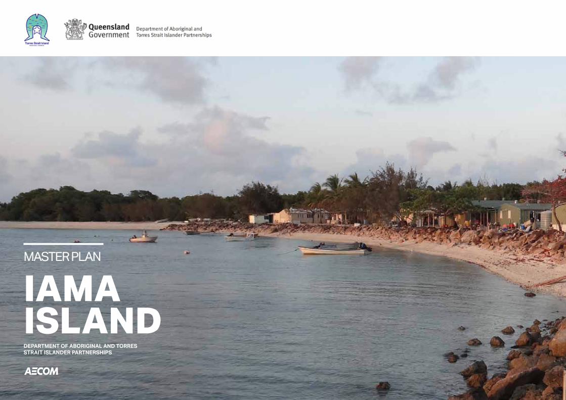
IAMA ISLAND
MASTER PLAN
DEPARTMENT OF ABORIGINAL AND TORRES STRAIT ISLANDER PARTNERSHIPS
IAMA ISLAND • MASTER PLAN REPORT02
Project No.: 60536712
AECOM in Australia and New Zealand is certified to ISO9001, ISO14001 AS/NZS4801 and OHSAS18001.
© AECOM Australia Pty Ltd (AECOM). All rights reserved.
AECOM has prepared this document for the sole use of the Client and for a specific purpose, each as expressly stated in the document. No other party should rely on this document without the prior written consent of AECOM. AECOM undertakes no duty, nor accepts any responsibility, to any third party who may rely upon or use this document.
This document has been prepared based on the Client’s description of its requirements and AECOM’s experience, having regard to assumptions that AECOM can reasonably be expected to make in accordance with sound professional principles. AECOM may also have relied upon information provided by the Client and other third parties to prepare this document, some of which may not have been verified. Subject to the above conditions, this document may be transmitted, reproduced or disseminated only in its entirety.
CLIENT
PREPARED BY
QUALITY INFORMATION
REVISION HISTORY
Department of Aboriginal and Torres Strait Islander Partnerships
AECOM Australia Pty LtdLevel 8, 540 Wickham Street, PO Box 1307,Fortitude Valley QLD 4006, AustraliaT +61 7 3553 2000 F +61 7 3553 2050 Www.aecom.comABN 20 093 846 925
DocumentRefDatePrepared byReviewed by
Iama Island Master Plan ReportProject No.: 60536712
26-June-2020Brian Gibbs, Bronwyn van Gool & Sophie Gadaloff Dr Mike Gillen & James Jentz
RevAuthorisedName/Position Signature
1 Brian Gibbs - Project Manager
Original signed
2
Revision Date Details 13-May-2020 Working Draft
26-Jun-2020 Final Brian Gibbs - Project Manager
Final
In partnership with - Torres Strait Island Regional Council
IAMA ISLAND • MASTER PLAN REPORT 03
APPENDIX G. COMMUNITY ENGAGEMENT INFORMATION PACK
P4 01. INTRODUCTIONProject BackgroundReport Purpose
P5 02. COMMUNITY OVERVIEWLocation Community & Governance Land Use CategoriesLand Use, Facilities & Services Tenure Demographics Population Housing
P11 03. INFRASTRUCTURE REVIEWWater Supply Stormwater Electricity Supply & Communications Transport Sewerage
04. METHODOLOGY
P16
P17 05. PLANNING REVIEWOverview State Planning Policy Vegetation Management Act 1999Nature Conservation Act 1992Torres Strait and Northern Peninsula Area Regional Plan 2009-2029Planning Scheme Local Area Plan
P26 08. CONCEPT DEVELOPMENT
Overview Areas of Interest‘Have Your Say’Option Development
APPENDIX A. PLANS
APPENDIX B. INFRASTRUCTURE ASSESSMENT
APPENDIX D. VEGETATION MAPPING
APPENDIX E. STATE POLICY DOCUMENTS
APPENDIX F. LOCAL POLICY DOCUMENTS
09. PREFERRED OPTION
P30
P40 10. INFRASTRUCTURE REQUIREMENTSWater Supply Stormwater Electricity Supply & Communications Transport Sewerage
13. REFERENCES
P53
P50 12. SUMMARYAction Plan
06. CLIMATE CHANGE & RESILIENCE
P22
Climate change and planning
07. STAKEHOLDER CONSULTATION
P24
Overview
11. KEY REFERENCES
P48
Torres Strait Island Regional Council Corporate Plan 2020-2025Torres Strait Island Regional Council Operational Plan 2019-2020Activate! Queensland 2019-2029Crime Prevention Through Environmental Design (CPTED)Healthy By Design Water Sensitive Urban Design Coastal Blue Carbon: An Introduction for Policy Makers
APPENDIX C. NATIVE TITLE VISION MAPPING
IAMA ISLAND • MASTER PLAN REPORT04
PROJECT BACKGROUND The availability and cost of community residential housing in remote indigenous communities is affected by a range of factors including availability of residential land, unmet demand for housing and cost of building, limited housing choice options, and tenure restrictions on land. Housing is also periodically required for Government agencies, Councils and NGOs.
Industrial activity is one of the key pillars of employment in all communities. Councils recognise the need to provide diversity in local employment opportunities, and as such encourage growth by having suitable sites available for use by small business.
The right combination of housing choice and employment opportunity is a key ingredient in the achievement of successful and vibrant communities with a diversified economy. A practical, long term plan for the delivery of new housing, industry and other employment generating land use is intended to provide a clear indication of future growth and development within the community.
In consultation with the Remote Indigenous Land and Infrastructure Program Office (RILIPO), within the Department of Aboriginal and Torres Strait Islander Partnerships (DATSIP), Torres Strait Island Regional Council (TSIRC) have identified the need to prepare Future Residential and Industrial Land Use Master Plan for Iama Island in line with their Town Planning Scheme.
INTRODUCTION01REPORT PURPOSEThe document encompasses the aspirations and hopes for Iama Island and as such should be reviewed on an annual basis allowing for the update and addition of new priorities. Information in support of the community’s growth should be added as annexures to this document allowing for a central repository of knowledge.
This report contains an overview of investigations and stakeholder consultation undertaken in the Iama Island community. It seeks to provide Council and DATSIP with a readily accessible and easily interpreted summary of the preferred master plan option, associated infrastructure requirements and implementation strategy.
It should be noted that the preferred option and action plan do not represent a funding commitment. It is intended that this report will be utilised by the Torres Shire Regional Council as an evidence base to support future applications for a range of potential funding and/or grants. It is also a document which can be used to guide future investment and growth decisions with a clear understanding of the positive outcomes that can be leveraged for the community.
Future development should reflect planning scheme assessment benchmarks and consider the following design approaches:
• Disaster Resilience - Resilient Queensland 2018-2021
• Crime Prevention through Environmental Design (CPTED) - designing the built environment to create safer neighbourhoods by increasing the perceived likelihood of detection and apprehension
• Healthy by Design - practical guidance in designing walkable and ultimately more liveable communities
• Water Sensitive Urban Design (WSUD) - land planning and engineering approach which integrates the urban water cycle into urban design to minimise environmental degradation and improve aesthetic and recreational appeal.
• Climate Change - carbon neutrality, carbon reduction, carbon farming, water security and energy efficiency.
IAMA ISLAND • MASTER PLAN REPORT 05
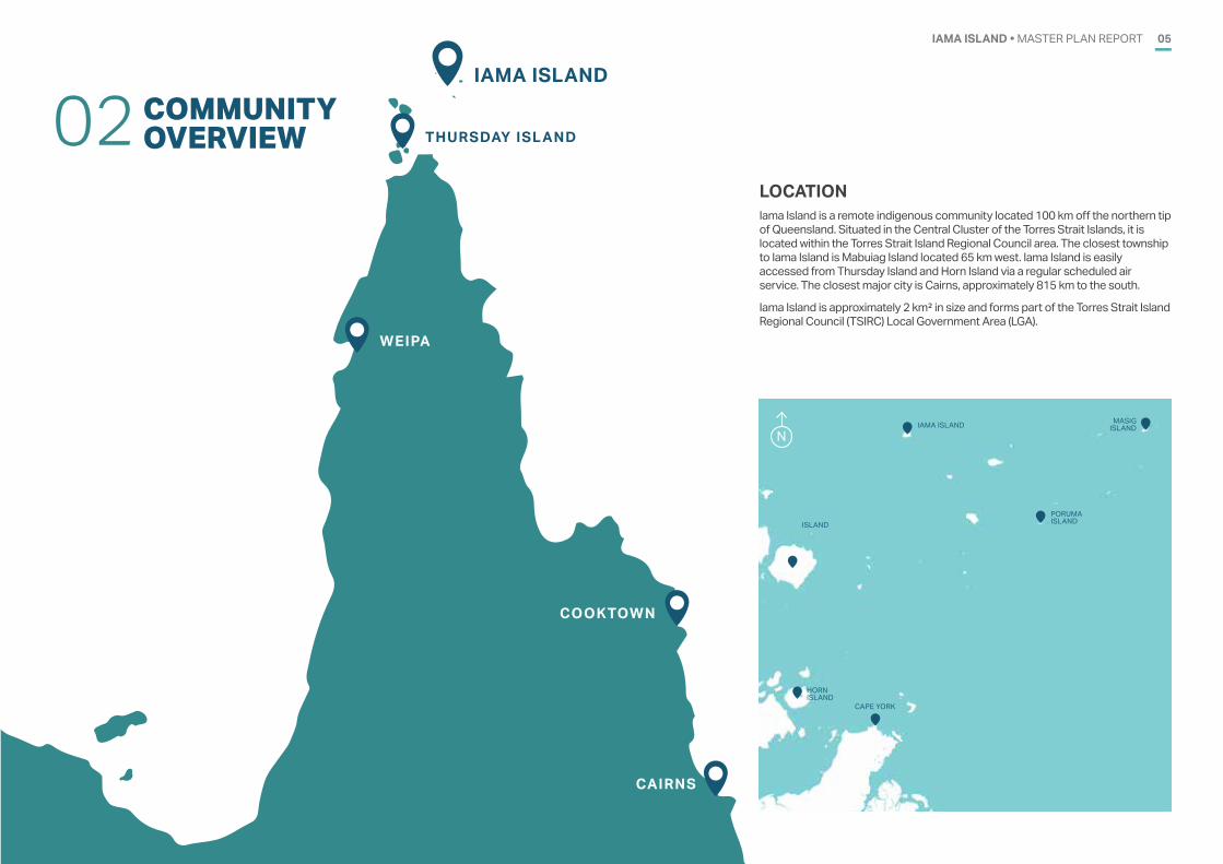
LOCATIONIama Island is a remote indigenous community located 100 km off the northern tip of Queensland. Situated in the Central Cluster of the Torres Strait Islands, it is located within the Torres Strait Island Regional Council area. The closest township to Iama Island is Mabuiag Island located 65 km west. Iama Island is easily accessed from Thursday Island and Horn Island via a regular scheduled air service. The closest major city is Cairns, approximately 815 km to the south.
Iama Island is approximately 2 km² in size and forms part of the Torres Strait Island Regional Council (TSIRC) Local Government Area (LGA).
COOKTOWN
WEIPA
CAIRNS
IAMA ISLAND
THURSDAY ISLAND
N
HORN ISLAND
ISLAND
CAPE YORK
IAMA ISLAND
PORUMA ISLAND
MASIG ISLAND
COMMUNITYOVERVIEW02
IAMA ISLAND • MASTER PLAN REPORT06
COMMUNITY & GOVERNANCEIama Island (also Yam, Yama or Turtle-backed Island) is an island of the Bourke Isles.
The original inhabitants traded and fought widely in their sailing canoes. In 1792, they came aboard William Bligh’s two ships seeking iron. Bligh named Tudu ‘Warrior Island’ after an attack they later made.
The London Missionary Society established a station at Iama’s western end establishing a permanent village with people settling around the mission.
Many of the men took jobs on pearling luggers and a pearling station operated on Tudu during the 1870s. Pacific Islanders working at Nagi Station later settled on Iama. During the WWII, many Iama men enlisted in the army.
An airstrip was built in 1974 and the island’s connection to the Torres Strait telephone exchange occurred in 1980.
Iama Island also has interesting pre-history records found in local legends in Papua and the Torres Strait.
The language of Iama is Kulkalgau Ya, a dialect of the Western-Central Torres Strait Language Kala Lagaw Ya.
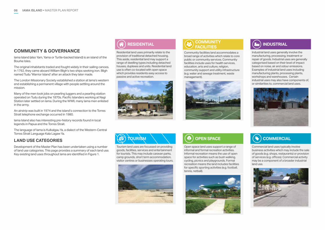
LAND USE CATEGORIESDevelopment of the Master Plan has been undertaken using a number of land use categories. This page provides a summary of each land use. Key existing land uses throughout Iama are identified in Figure 1.
RESIDENTIALResidential land uses primarily relate to the provision of traditional detached housing. This aside, residential land may support a range of dwelling types including detached houses, duplexes and units. Residential land use is often co-located with open space which provides residents easy access to passive and active recreation.
COMMUNITY FACILITIES
Community facilities land accommodates a broad range of activities which relate to core public or community services. Community facilities include uses for health services, education, arts and culture, religion, community support and utility infrastructure (e.g. water and sewage treatment, waste management).
OPEN SPACEOpen space land uses support a range of informal and formal recreation activities. Informal recreation means the use of open space for activities such as bush walking, cycling, picnics and playgrounds. Formal recreation means the land includes facilities for specific sporting activities (e.g. football, tennis, netball).
INDUSTRIALIndustrial land uses generally involve the manufacturing, processing, treatment or repair of goods. Industrial uses are generally categorised based on their level of impact based on noise, air and odour emissions. Examples of industrial land uses including manufacturing plants, processing plants, workshops and warehouses. Certain industrial uses may also have components of, or similarities to, commercial land uses.
COMMERCIALCommercial land uses typically involve business activities which may include the sale of goods (e.g. shops, restaurants) or provision of services (e.g. offices). Commercial activity may be a component of a broader industrial land use.
TOURISMTourism land uses are focussed on providing goods, facilities, services and entertainment for tourists. This may include caravan parks, camp grounds, short term accommodation, visitor centres or businesses operating tours.
IAMA ISLAND • MASTER PLAN REPORT 07
N
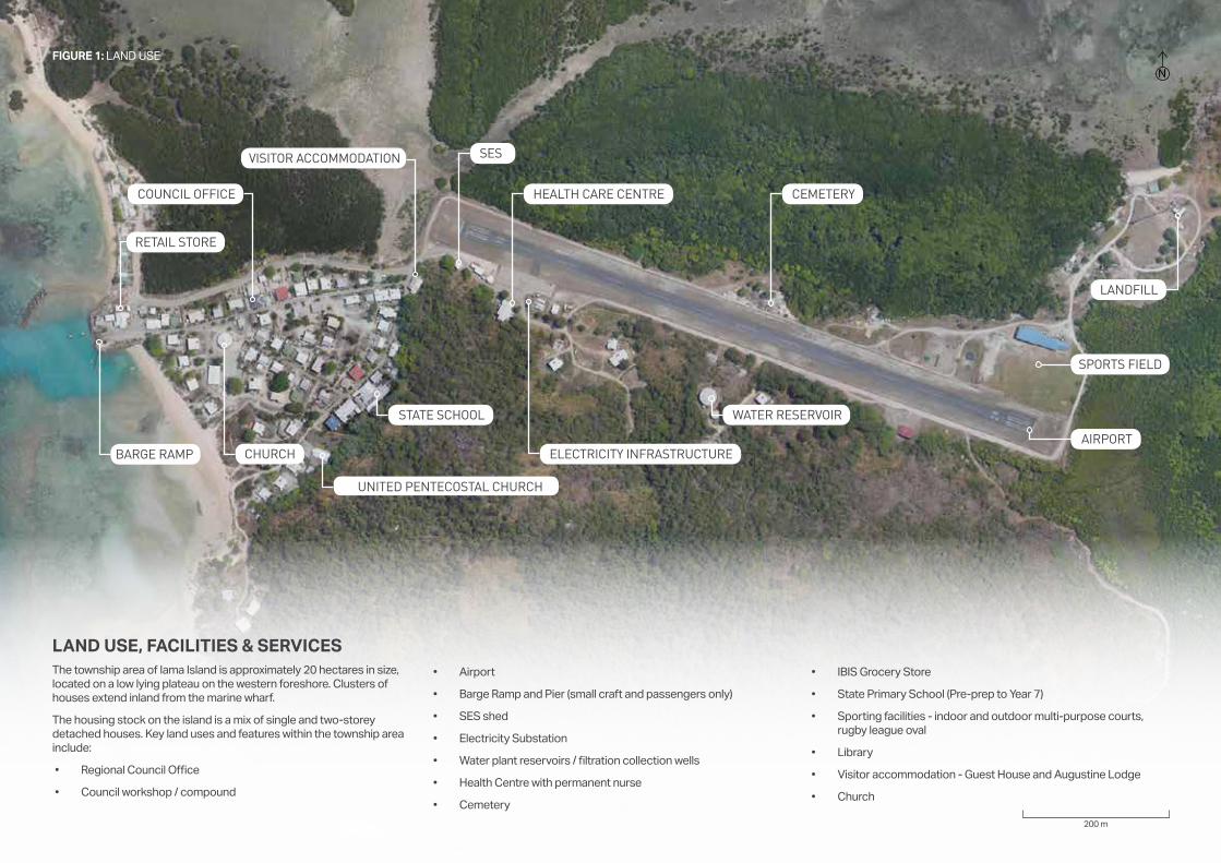
LAND USE, FACILITIES & SERVICES The township area of Iama Island is approximately 20 hectares in size, located on a low lying plateau on the western foreshore. Clusters of houses extend inland from the marine wharf.
The housing stock on the island is a mix of single and two-storey detached houses. Key land uses and features within the township area include:
• Regional Council Office
• Council workshop / compound
• Airport
• Barge Ramp and Pier (small craft and passengers only)
• SES shed
• Electricity Substation
• Water plant reservoirs / filtration collection wells
• Health Centre with permanent nurse
• Cemetery
• IBIS Grocery Store
• State Primary School (Pre-prep to Year 7)
• Sporting facilities - indoor and outdoor multi-purpose courts, rugby league oval
• Library
• Visitor accommodation - Guest House and Augustine Lodge
• Church
CEMETERY
200 m
LANDFILL
SPORTS FIELD
AIRPORT
WATER RESERVOIRSTATE SCHOOL
ELECTRICITY INFRASTRUCTURE
HEALTH CARE CENTRE
VISITOR ACCOMMODATION
COUNCIL OFFICE
CHURCHBARGE RAMP
RETAIL STORE
FIGURE 1: LAND USE
UNITED PENTECOSTAL CHURCH
SES
IAMA ISLAND • MASTER PLAN REPORT08
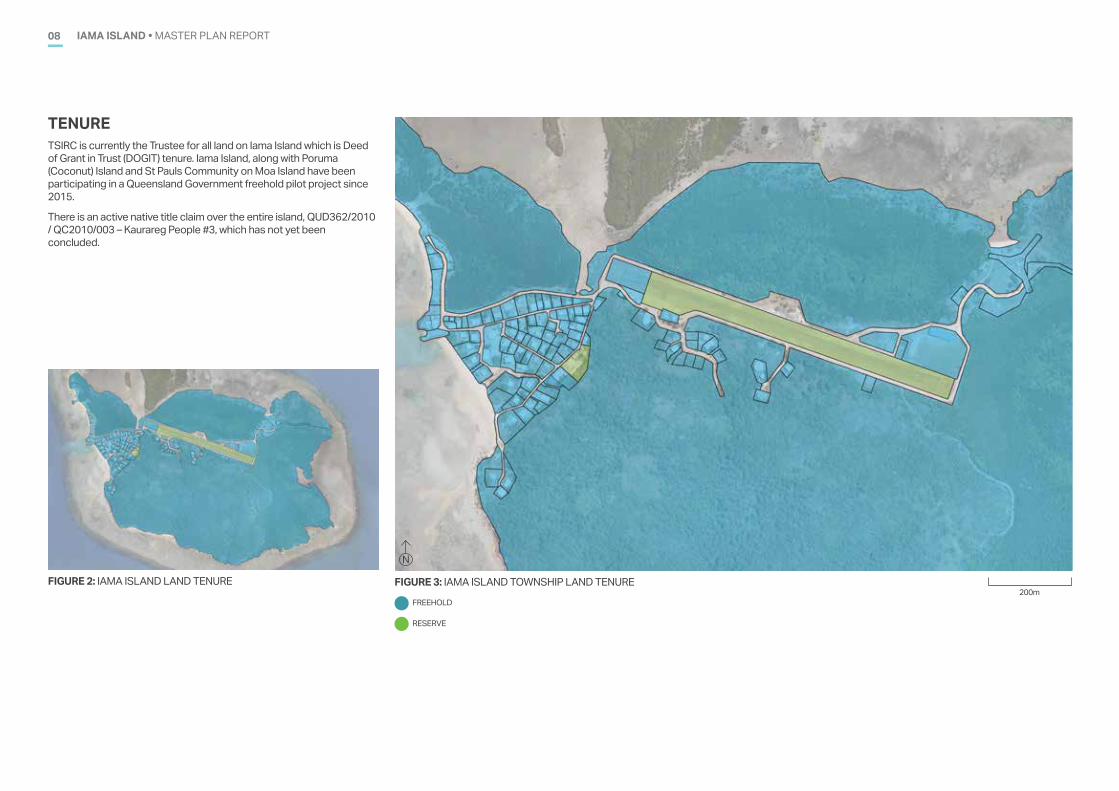
TENURETSIRC is currently the Trustee for all land on Iama Island which is Deed of Grant in Trust (DOGIT) tenure. Iama Island, along with Poruma (Coconut) Island and St Pauls Community on Moa Island have been participating in a Queensland Government freehold pilot project since 2015.
There is an active native title claim over the entire island, QUD362/2010 / QC2010/003 – Kaurareg People #3, which has not yet been concluded.
FIGURE 3: IAMA ISLAND TOWNSHIP LAND TENUREFIGURE 2: IAMA ISLAND LAND TENURE
N
200mFREEHOLD
RESERVE
IAMA ISLAND • MASTER PLAN REPORT 09
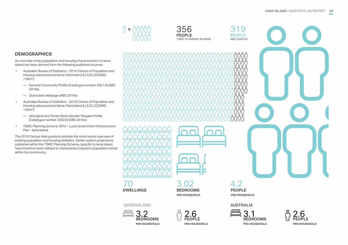
DEMOGRAPHICSAn overview of key population and housing characteristics on Iama Island has been derived from the following published sources:
• Australian Bureau of Statistics – 2016 Census of Population and Housing data products (Iama (Yam) Island (L) (UCL322060) 1.9km2):
— General Community Profile (Catalogue number 2001.0) (ABS 2016a)
— Quickstats webpage (ABS 2016b)
• Australian Bureau of Statistics – 2016 Census of Population and Housing data products (Iama (Yam) Island (L) (UCL322060) 1.9km2):
— Aboriginal and Torres Strait Islander Peoples Profile (Catalogue number 2002.0) (ABS 2016c)
• TSIRC Planning Scheme 2016 - Local Government Infrastructure Plan - Iama Island.
The 2016 Census data products provide the most recent overview of existing population and housing statistics. Earlier custom projections, published within the TSIRC Planning Scheme, specific to Iama Island, have therefore been utilised to characterise long term population trends within the community.
PEOPLE PEOPLE
DWELLINGS BEDROOMSPER HOUSEHOLD
PEOPLEPER HOUSEHOLD
319356
70 3.02 4.2
TSIRC PLANNING SCHEME ABS CENSUS
=
BEDROOMSPER HOUSEHOLD
3.2 2.6PEOPLEPER HOUSEHOLD
QUEENSLAND
BEDROOMSPER HOUSEHOLD
3.1 2.6PEOPLEPER HOUSEHOLD
AUSTRALIA
IAMA ISLAND • MASTER PLAN REPORT10
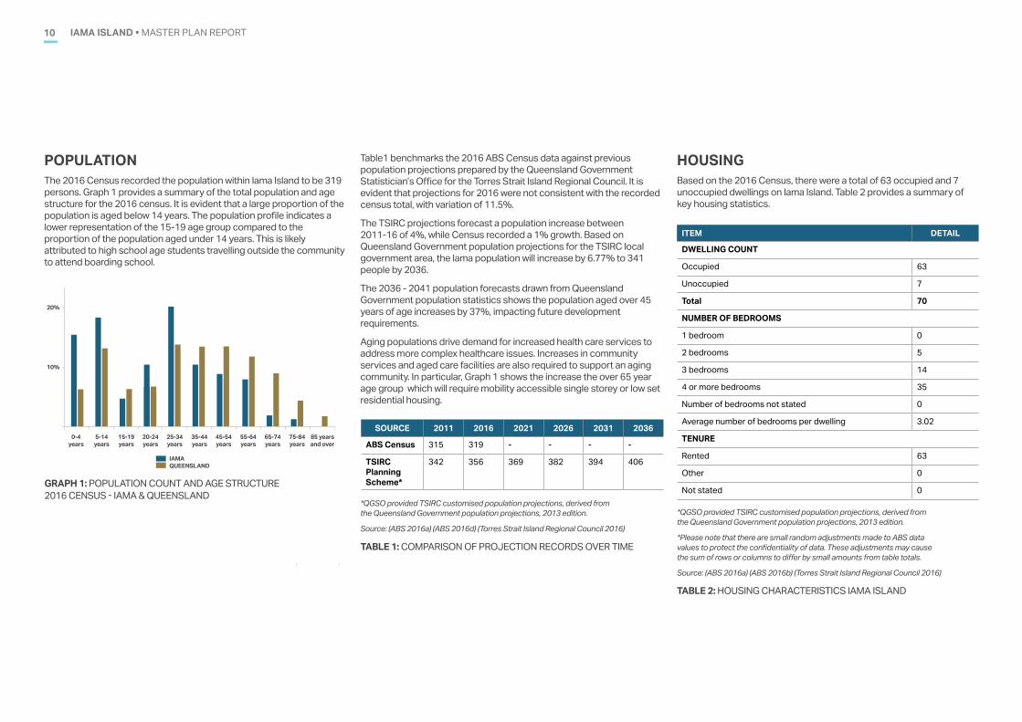
HOUSINGBased on the 2016 Census, there were a total of 63 occupied and 7 unoccupied dwellings on Iama Island. Table 2 provides a summary of key housing statistics.
POPULATIONThe 2016 Census recorded the population within Iama Island to be 319 persons. Graph 1 provides a summary of the total population and age structure for the 2016 census. It is evident that a large proportion of the population is aged below 14 years. The population profile indicates a lower representation of the 15-19 age group compared to the proportion of the population aged under 14 years. This is likely attributed to high school age students travelling outside the community to attend boarding school.
TABLE 2: HOUSING CHARACTERISTICS IAMA ISLAND
TABLE 1: COMPARISON OF PROJECTION RECORDS OVER TIME
*QGSO provided TSIRC customised population projections, derived from the Queensland Government population projections, 2013 edition.
Source: (ABS 2016a) (ABS 2016d) (Torres Strait Island Regional Council 2016)
*QGSO provided TSIRC customised population projections, derived from the Queensland Government population projections, 2013 edition.
*Please note that there are small random adjustments made to ABS data values to protect the confidentiality of data. These adjustments may cause the sum of rows or columns to differ by small amounts from table totals.
Source: (ABS 2016a) (ABS 2016b) (Torres Strait Island Regional Council 2016)
ITEM DETAIL
DWELLING COUNT
Occupied 63
Unoccupied 7
Total 70
NUMBER OF BEDROOMS
1 bedroom 0
2 bedrooms 5
3 bedrooms 14
4 or more bedrooms 35
Number of bedrooms not stated 0
Average number of bedrooms per dwelling 3.02
TENURE
Rented 63
Other 0
Not stated 0
SOURCE 2011 2016 2021 2026 2031 2036
ABS Census 315 319 - - - -
TSIRC Planning Scheme*
342 356 369 382 394 406
Table1 benchmarks the 2016 ABS Census data against previous population projections prepared by the Queensland Government Statistician’s Office for the Torres Strait Island Regional Council. It is evident that projections for 2016 were not consistent with the recorded census total, with variation of 11.5%.
The TSIRC projections forecast a population increase between 2011-16 of 4%, while Census recorded a 1% growth. Based on Queensland Government population projections for the TSIRC local government area, the Iama population will increase by 6.77% to 341 people by 2036.
The 2036 - 2041 population forecasts drawn from Queensland Government population statistics shows the population aged over 45 years of age increases by 37%, impacting future development requirements.
Aging populations drive demand for increased health care services to address more complex healthcare issues. Increases in community services and aged care facilities are also required to support an aging community. In particular, Graph 1 shows the increase the over 65 year age group which will require mobility accessible single storey or low set residential housing.
20%
10%
5-14years
15-19years
20-24years
25-34years
35-44years
45-54years
55-64years
65-74years
75-84years
85 years and over
0-4years
IAMAQUEENSLAND
GRAPH 1: POPULATION COUNT AND AGE STRUCTURE 2016 CENSUS - IAMA & QUEENSLAND
IAMA ISLAND • MASTER PLAN REPORT 11
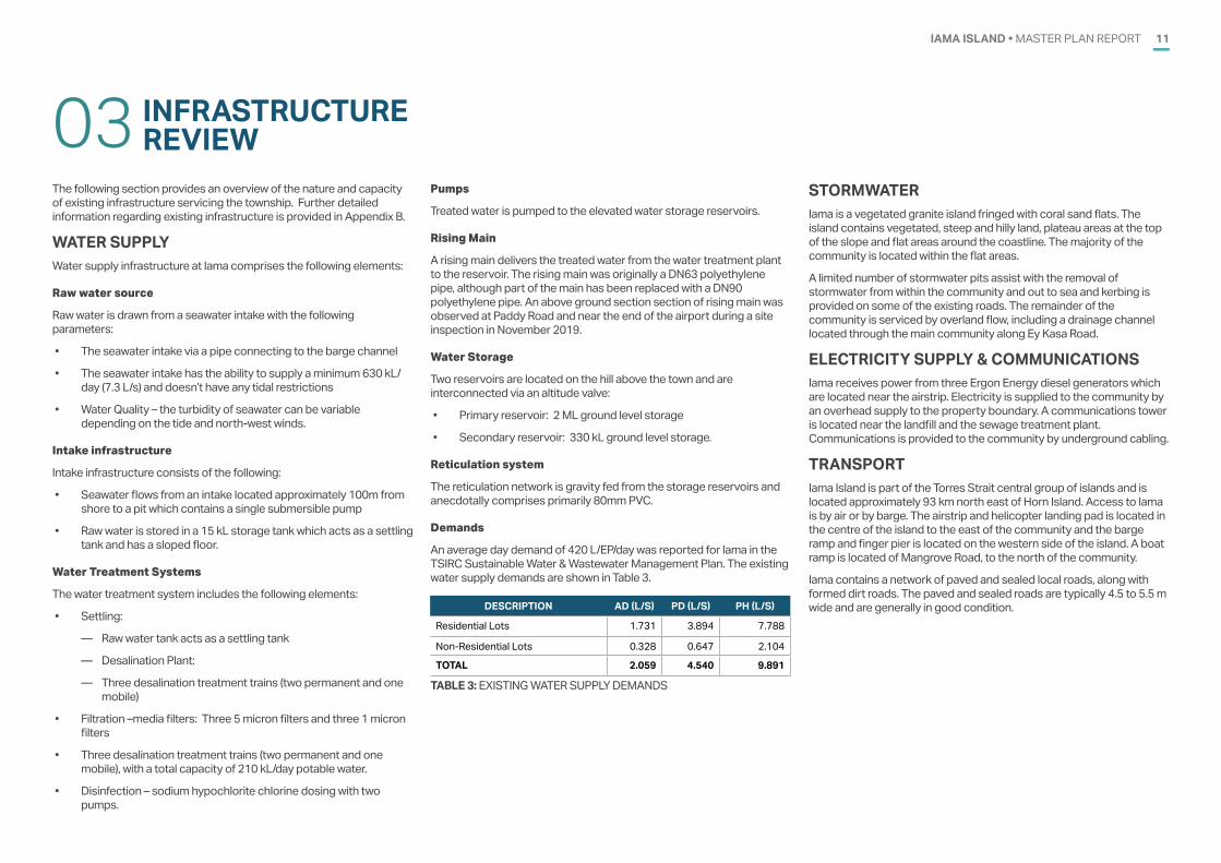
INFRASTRUCTURE REVIEW03
The following section provides an overview of the nature and capacity of existing infrastructure servicing the township. Further detailed information regarding existing infrastructure is provided in Appendix B.
WATER SUPPLYWater supply infrastructure at Iama comprises the following elements:
Raw water source
Raw water is drawn from a seawater intake with the following parameters:
• The seawater intake via a pipe connecting to the barge channel
• The seawater intake has the ability to supply a minimum 630 kL/day (7.3 L/s) and doesn’t have any tidal restrictions
• Water Quality – the turbidity of seawater can be variable depending on the tide and north-west winds.
Intake infrastructure
Intake infrastructure consists of the following:
• Seawater flows from an intake located approximately 100m from shore to a pit which contains a single submersible pump
• Raw water is stored in a 15 kL storage tank which acts as a settling tank and has a sloped floor.
Water Treatment Systems
The water treatment system includes the following elements:
• Settling:
— Raw water tank acts as a settling tank
— Desalination Plant:
— Three desalination treatment trains (two permanent and one mobile)
• Filtration –media filters: Three 5 micron filters and three 1 micron filters
• Three desalination treatment trains (two permanent and one mobile), with a total capacity of 210 kL/day potable water.
• Disinfection – sodium hypochlorite chlorine dosing with two pumps.
Pumps
Treated water is pumped to the elevated water storage reservoirs.
Rising Main
A rising main delivers the treated water from the water treatment plant to the reservoir. The rising main was originally a DN63 polyethylene pipe, although part of the main has been replaced with a DN90 polyethylene pipe. An above ground section section of rising main was observed at Paddy Road and near the end of the airport during a site inspection in November 2019.
Water Storage
Two reservoirs are located on the hill above the town and are interconnected via an altitude valve:
• Primary reservoir: 2 ML ground level storage
• Secondary reservoir: 330 kL ground level storage.
Reticulation system
The reticulation network is gravity fed from the storage reservoirs and anecdotally comprises primarily 80mm PVC.
Demands
An average day demand of 420 L/EP/day was reported for Iama in the TSIRC Sustainable Water & Wastewater Management Plan. The existing water supply demands are shown in Table 3.
TABLE 3: EXISTING WATER SUPPLY DEMANDS
DESCRIPTION AD (L/S) PD (L/S) PH (L/S)
Residential Lots 1.731 3.894 7.788
Non-Residential Lots 0.328 0.647 2.104
TOTAL 2.059 4.540 9.891
STORMWATERIama is a vegetated granite island fringed with coral sand flats. The island contains vegetated, steep and hilly land, plateau areas at the top of the slope and flat areas around the coastline. The majority of the community is located within the flat areas.
A limited number of stormwater pits assist with the removal of stormwater from within the community and out to sea and kerbing is provided on some of the existing roads. The remainder of the community is serviced by overland flow, including a drainage channel located through the main community along Ey Kasa Road.
ELECTRICITY SUPPLY & COMMUNICATIONSIama receives power from three Ergon Energy diesel generators which are located near the airstrip. Electricity is supplied to the community by an overhead supply to the property boundary. A communications tower is located near the landfill and the sewage treatment plant. Communications is provided to the community by underground cabling.
TRANSPORTIama Island is part of the Torres Strait central group of islands and is located approximately 93 km north east of Horn Island. Access to Iama is by air or by barge. The airstrip and helicopter landing pad is located in the centre of the island to the east of the community and the barge ramp and finger pier is located on the western side of the island. A boat ramp is located of Mangrove Road, to the north of the community.
Iama contains a network of paved and sealed local roads, along with formed dirt roads. The paved and sealed roads are typically 4.5 to 5.5 m wide and are generally in good condition.
IAMA ISLAND • MASTER PLAN REPORT12
SEWERAGEThe existing sewerage infrastructure at Iama includes the following elements:
Collection system
• A conventional gravity sewerage system that flows into two pumping stations. The sewerage reticulation network was installed circa 2000. The system consists of approximately 1,666m of 150mm diameter PVC gravity mains and 40 manholes
• Two wastewater pump stations as follows:
— Pump Station No. 1 located on Ey Kasa Road. This pump station consists of a wet well and valve chamber fitted with Duty/standby submersible sewage pumps.
— Pump Station No. 2 located behind lots on “Gaurab Village” Road. This pump station appears to be a lift station.
• Rising Mains: A rising main of approximately 1,650 m length located between pump station No. 1 and the sewage treatment plant.
Wastewater treatment plant
Located on the eastern edge of the island close to the airport, built circa 2000 with a capacity of 450 EP at 270 L/EP/day. The WWTP is an Enviroflow (Modified Lutzack-Ettinger (MLE)) style packaged plant.
Effluent Disposal
Effluent is disposed of via the ocean effluent outfall, a 593 m long 110mm diameter polyethylene main.
Existing Flows
An Average Dry Weather Flow (ADWF) of 270 L/EP/day was adopted based on value used in the design of the plant. The existing wastewater flows for are shown in Table 4.
TABLE 4: EXISTING WASTEWATER FLOWS
DESCRIPTION ADWF (L/S) PWWF (L/S)
Residential Lots 0.522 2.609Non-Residential Lots 0.216 1.073TOTAL 0.738 3.683
IAMA ISLAND • MASTER PLAN REPORT 13
IAMA �YAM� ISLANDBASE PLAN
FOR DISCUSSION PURPOSES ONLY
200 m
LEGEND Property boundaries
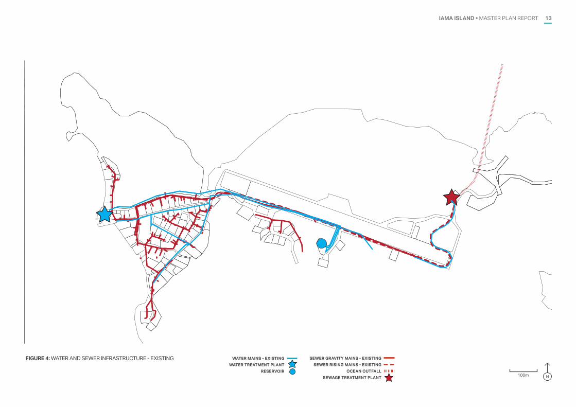
FIGURE 4: WATER AND SEWER INFRASTRUCTURE - EXISTING WATER MAINS - EXISTINGWATER TREATMENT PLANT
RESERVOIR
SEWER GRAVITY MAINS - EXISTINGSEWER RISING MAINS - EXISTING
OCEAN OUTFALLSEWAGE TREATMENT PLANT 100m N
IAMA ISLAND • MASTER PLAN REPORT14
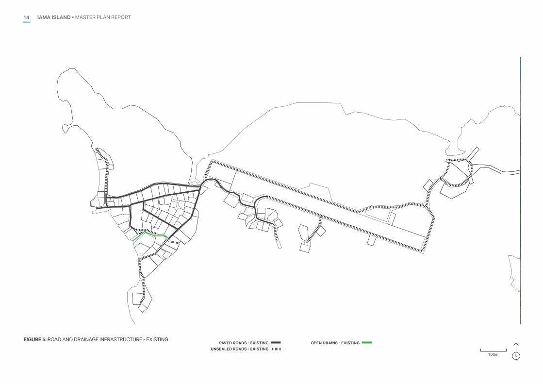
FIGURE 5: ROAD AND DRAINAGE INFRASTRUCTURE - EXISTINGPAVED ROADS - EXISTING
UNSEALED ROADS - EXISTING
IAMA �YAM� ISLANDBASE PLAN
FOR DISCUSSION PURPOSES ONLY
200 m
LEGEND Property boundaries
100m N
OPEN DRAINS - EXISTING
IAMA ISLAND • MASTER PLAN REPORT 15
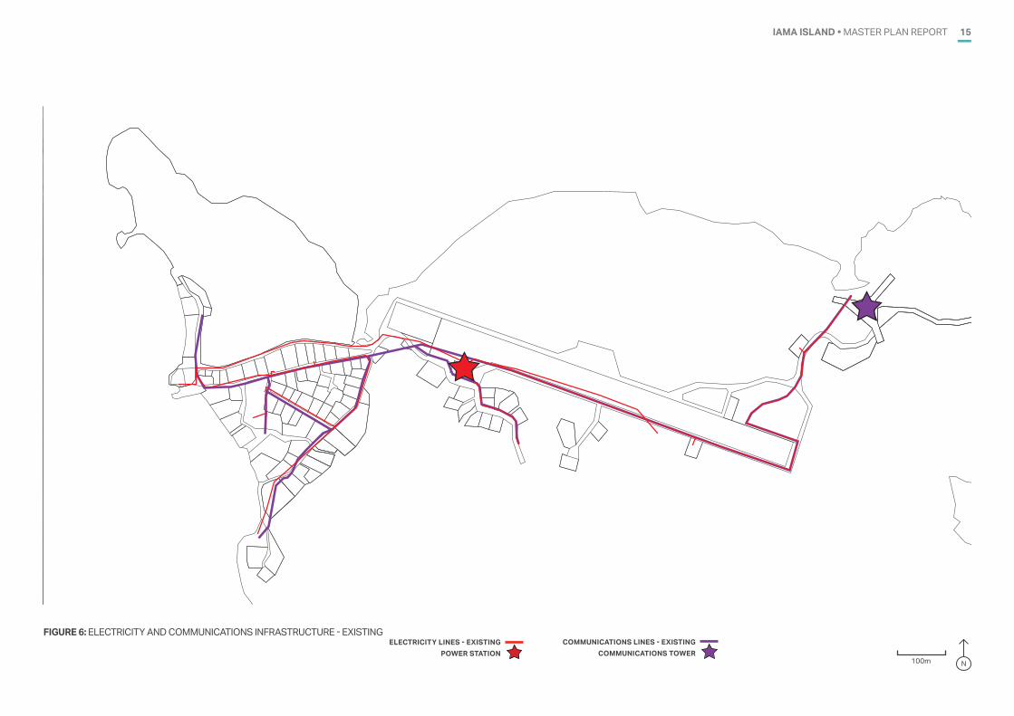
FIGURE 6: ELECTRICITY AND COMMUNICATIONS INFRASTRUCTURE - EXISTINGELECTRICITY LINES - EXISTING
POWER STATIONCOMMUNICATIONS LINES - EXISTING
COMMUNICATIONS TOWER
IAMA �YAM� ISLANDBASE PLAN
FOR DISCUSSION PURPOSES ONLY
200 m
LEGEND Property boundaries
100m N
IAMA ISLAND • MASTER PLAN REPORT16
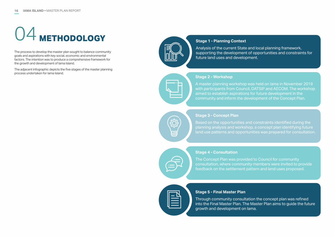
METHODOLOGY04 Stage 1 - Planning ContextAnalysis of the current State and local planning framework, supporting the development of opportunities and constraints for future land uses and development.
Stage 2 - WorkshopA master planning workshop was held on Iama in November 2019 with participants from Council, DATSIP and AECOM. The workshop aimed to establish aspirations for future development in the community and inform the development of the Concept Plan.
Stage 3 - Concept PlanBased on the opportunities and constraints identified during the planning analysis and workshop, a concept plan identifying future land use patterns and opportunities was prepared for consultation.
Stage 4 - ConsultationThe Concept Plan was provided to Council for community consultation, where community members were invited to provide feedback on the settlement pattern and land uses proposed.
Stage 5 - Final Master PlanThrough community consultation the concept plan was refined into the Final Master Plan. The Master Plan aims to guide the future growth and development on Iama.
The process to develop the master plan sought to balance community goals and aspirations with key social, economic and environmental factors. The intention was to produce a comprehensive framework for the growth and development of Iama Island.
The adjacent infographic depicts the five stages of the master planning process undertaken for Iama Island.
IAMA ISLAND • MASTER PLAN REPORT 17
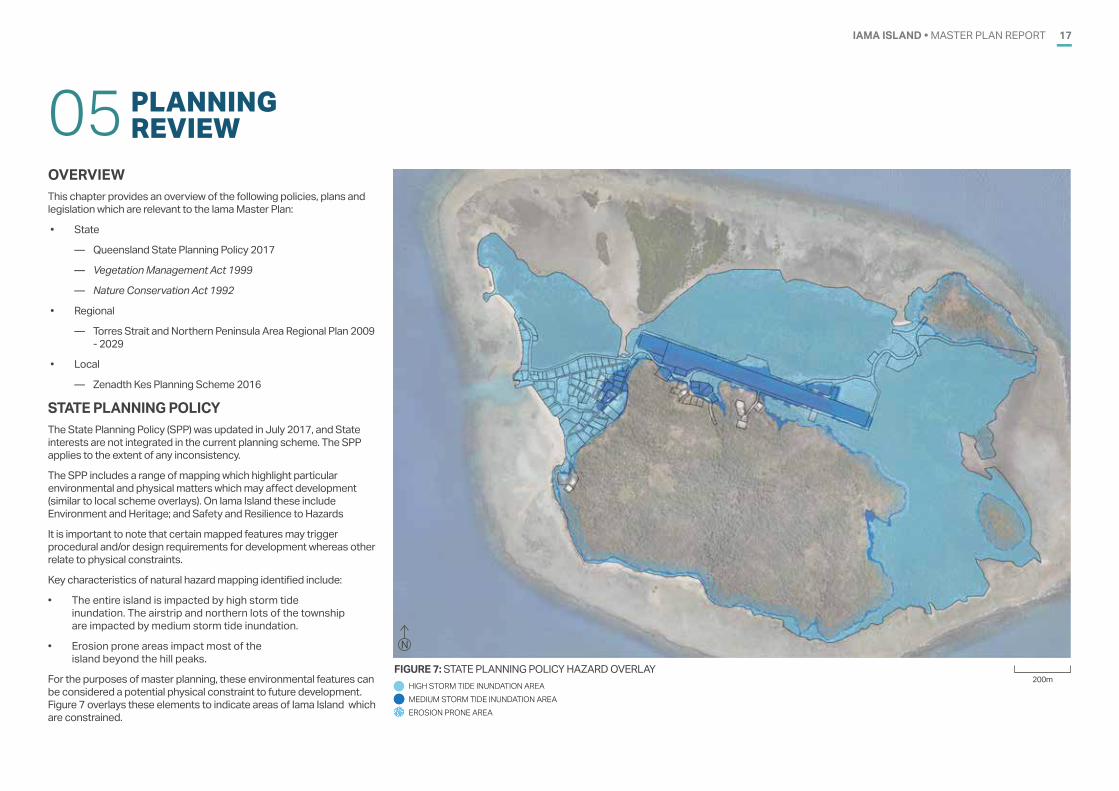
OVERVIEWThis chapter provides an overview of the following policies, plans and legislation which are relevant to the Iama Master Plan:
• State
— Queensland State Planning Policy 2017
— Vegetation Management Act 1999
— Nature Conservation Act 1992
• Regional
— Torres Strait and Northern Peninsula Area Regional Plan 2009 - 2029
• Local
— Zenadth Kes Planning Scheme 2016
STATE PLANNING POLICYThe State Planning Policy (SPP) was updated in July 2017, and State interests are not integrated in the current planning scheme. The SPP applies to the extent of any inconsistency.
The SPP includes a range of mapping which highlight particular environmental and physical matters which may affect development (similar to local scheme overlays). On Iama Island these include Environment and Heritage; and Safety and Resilience to Hazards
It is important to note that certain mapped features may trigger procedural and/or design requirements for development whereas other relate to physical constraints.
Key characteristics of natural hazard mapping identified include:
• The entire island is impacted by high storm tide inundation. The airstrip and northern lots of the township are impacted by medium storm tide inundation.
• Erosion prone areas impact most of the island beyond the hill peaks.
For the purposes of master planning, these environmental features can be considered a potential physical constraint to future development. Figure 7 overlays these elements to indicate areas of Iama Island which are constrained.
PLANNINGREVIEW05
FIGURE 7: STATE PLANNING POLICY HAZARD OVERLAY
N
200mHIGH STORM TIDE INUNDATION AREA MEDIUM STORM TIDE INUNDATION AREA EROSION PRONE AREA
IAMA ISLAND • MASTER PLAN REPORT18
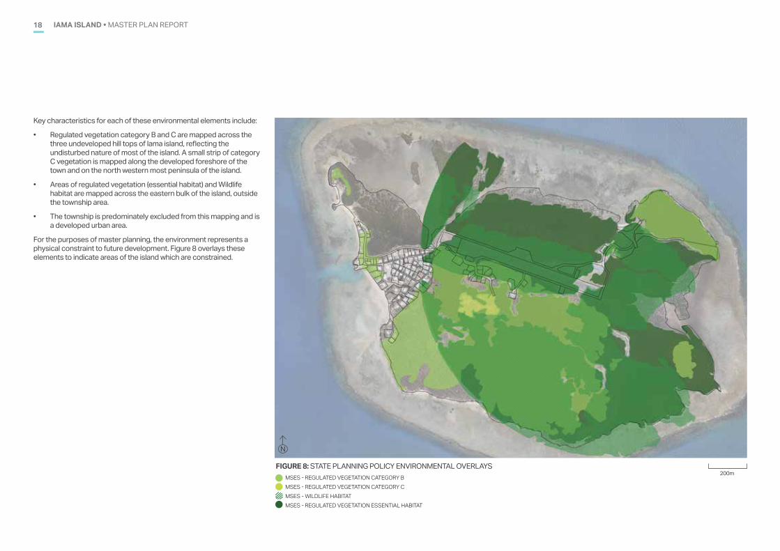
Key characteristics for each of these environmental elements include:
• Regulated vegetation category B and C are mapped across the three undeveloped hill tops of Iama island, reflecting the undisturbed nature of most of the island. A small strip of category C vegetation is mapped along the developed foreshore of the town and on the north western most peninsula of the island.
• Areas of regulated vegetation (essential habitat) and Wildlife habitat are mapped across the eastern bulk of the island, outside the township area.
• The township is predominately excluded from this mapping and is a developed urban area.
For the purposes of master planning, the environment represents a physical constraint to future development. Figure 8 overlays these elements to indicate areas of the island which are constrained.
FIGURE 8: STATE PLANNING POLICY ENVIRONMENTAL OVERLAYSMSES - REGULATED VEGETATION CATEGORY BMSES - REGULATED VEGETATION CATEGORY CMSES - WILDLIFE HABITAT MSES - REGULATED VEGETATION ESSENTIAL HABITAT
N
200m
IAMA ISLAND • MASTER PLAN REPORT 19
VEGETATION MANAGEMENT ACT 1999The majority of land surrounding the township is mapped as Category B Regulated Vegetation which is regulated under the Vegetation Management Act 1999. The existing township, parts of the airport and ridge lines are within the Category X area. Clearing of vegetation within a Category X area does not require approval under the Vegetation Management Act 1999.
Vegetation on the hill slopes to the east of the township area are predominately mapped as Of Concern Regional Ecosystems. Appendix C contains a copy of regional ecosystem mapping for the township and surrounding area. Clearing vegetation in these areas would generally not be supported unless the land is located within an urban zone.
NATURE CONSERVATION ACT 1992The protected plants flora survey trigger map identifies high risk areas under the Nature Conservation Act 1992 which are likely to contain endangered, vulnerable or near threatened flora species. A flora survey is required prior to any vegetation clearing in mapped high risk areas.
The existing township, airport, marine facilities and landfill are not located within a high risk area.
The rest of the island’s hill slopes are mapped within a high risk area. Appendix C contains a copy of the flora survey trigger map for Iama.
TORRES STRAIT AND NORTHERN PENINSULA AREA REGIONAL PLAN 2009 - 2029Iama is within the Torres Strait region, and is subject to the Torres Strait and Northern Peninsula Area Regional Plan (the Regional Plan) 2009-2029. The plan provides direction for land use and development with a planning horizon of 2029. The plan aims to identify and maximise the opportunities and resources to secure the future of the region and provide adequate, appropriate and coordinated service delivery for the Council areas within the region and support the implementation of the local Planning Scheme.
The opportunities available to Iama include :
• Achieve sustainable industries owned and operated by local people (marine based, tourism, arts and craft, construction)
• Training a significant number of community members to undertake environmental and natural resource management
• Enhancing the liveability of the townships to increase attraction and retention of workers and families
• Localised energy generation through alternative and renewable technologies
• Improving the security and reliability of community water supplies
• Regionally significant projects providing social infrastructure supporting resident and non-resident populations
The challenges impacting Iama within the regional plan include:
• High cost of living due to population size and reliance on imports
• Remoteness, limited infrastructure and access to markets
• Securing and maintaining basic infrastructure for the community
• Maintaining viable communities with employment opportunities
• Low health and education standards and outcomes
• Preparing and implementing a community plans and planning scheme
• Absence of secure individual title
• Climatic conditions and seasonal water availability
IAMA ISLAND • MASTER PLAN REPORT20
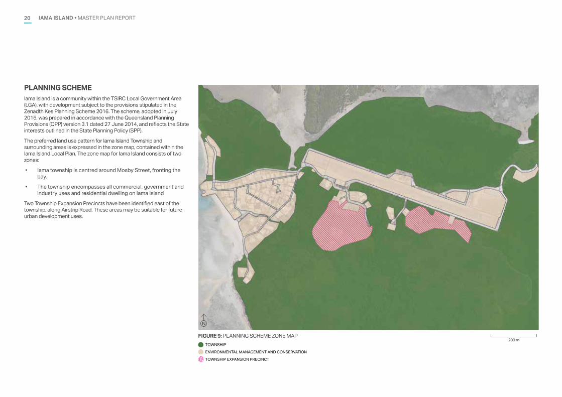
PLANNING SCHEMEIama Island is a community within the TSIRC Local Government Area (LGA), with development subject to the provisions stipulated in the Zenadth Kes Planning Scheme 2016. The scheme, adopted in July 2016, was prepared in accordance with the Queensland Planning Provisions (QPP) version 3.1 dated 27 June 2014, and reflects the State interests outlined in the State Planning Policy (SPP).
The preferred land use pattern for Iama Island Township and surrounding areas is expressed in the zone map, contained within the Iama Island Local Plan. The zone map for Iama Island consists of two zones:
• Iama township is centred around Mosby Street, fronting the bay.
• The township encompasses all commercial, government and industry uses and residential dwelling on Iama Island
Two Township Expansion Precincts have been identified east of the township, along Airstrip Road. These areas may be suitable for future urban development uses.
N
200 mFIGURE 9: PLANNING SCHEME ZONE MAP
TOWNSHIP
ENVIRONMENTAL MANAGEMENT AND CONSERVATION
TOWNSHIP EXPANSION PRECINCT
IAMA ISLAND • MASTER PLAN REPORT 21
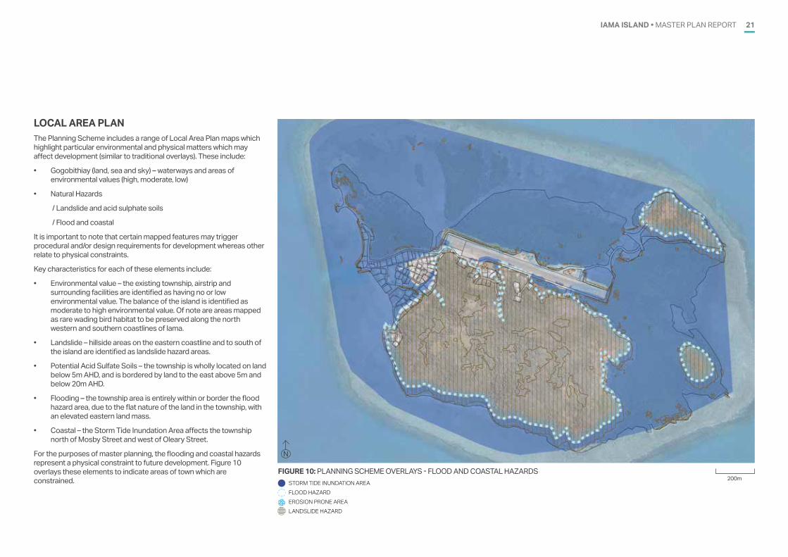
LOCAL AREA PLAN The Planning Scheme includes a range of Local Area Plan maps which highlight particular environmental and physical matters which may affect development (similar to traditional overlays). These include:
• Gogobithiay (land, sea and sky) – waterways and areas of environmental values (high, moderate, low)
• Natural Hazards
/ Landslide and acid sulphate soils
/ Flood and coastal
It is important to note that certain mapped features may trigger procedural and/or design requirements for development whereas other relate to physical constraints.
Key characteristics for each of these elements include:
• Environmental value – the existing township, airstrip and surrounding facilities are identified as having no or low environmental value. The balance of the island is identified as moderate to high environmental value. Of note are areas mapped as rare wading bird habitat to be preserved along the north western and southern coastlines of Iama.
• Landslide – hillside areas on the eastern coastline and to south of the island are identified as landslide hazard areas.
• Potential Acid Sulfate Soils – the township is wholly located on land below 5m AHD, and is bordered by land to the east above 5m and below 20m AHD.
• Flooding – the township area is entirely within or border the flood hazard area, due to the flat nature of the land in the township, with an elevated eastern land mass.
• Coastal – the Storm Tide Inundation Area affects the township north of Mosby Street and west of Oleary Street.
For the purposes of master planning, the flooding and coastal hazards represent a physical constraint to future development. Figure 10 overlays these elements to indicate areas of town which are constrained.
FIGURE 10: PLANNING SCHEME OVERLAYS - FLOOD AND COASTAL HAZARDS
N
200mSTORM TIDE INUNDATION AREA FLOOD HAZARDEROSION PRONE AREALANDSLIDE HAZARD
IAMA ISLAND • MASTER PLAN REPORT22
CLIMATE CHANGE AND RESILIENCE 06
CLIMATE CHANGE & PLANNING Climate change is now a key consideration when undertaking community planning, with climate adaptation strategies common place for Queensland communities. The increased risk of natural hazards including bush fires, drought, flood and changed precipitation patterns needs consideration when planning for the future vitality and safety of Queensland communities.
The Queensland Government has developed two key strategies that identify the risks that climate change poses to Queensland communities including:
• Queensland Climate Transition Strategy
• Resilient Queensland 2018-2021.
Queensland Climate Transition Strategy
The Queensland Climate Transition Strategy identifies the Queensland Government’s commitment to addressing and mitigating climate change risks for Queensland. The strategy outlines three climate change commitments as follows:
• 50% renewable energy for Queensland by 2030
• Zero net emissions by 2050
• Interim emissions reduction target of 30% below 2005 levels by 2030.
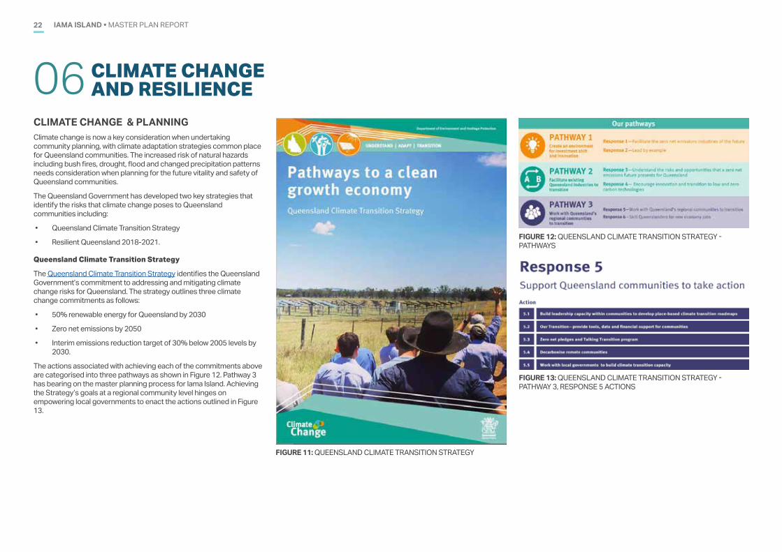
The actions associated with achieving each of the commitments above are categorised into three pathways as shown in Figure 12. Pathway 3 has bearing on the master planning process for Iama Island. Achieving the Strategy’s goals at a regional community level hinges on empowering local governments to enact the actions outlined in Figure 13.
FIGURE 11: QUEENSLAND CLIMATE TRANSITION STRATEGY
FIGURE 12: QUEENSLAND CLIMATE TRANSITION STRATEGY - PATHWAYS
FIGURE 13: QUEENSLAND CLIMATE TRANSITION STRATEGY - PATHWAY 3, RESPONSE 5 ACTIONS
IAMA ISLAND • MASTER PLAN REPORT 23
Resilient Queensland 2018-21
The Queensland Strategy for Disaster Resilience 2017, originally developed in 2014, was updated in 2017 to reflect international best practice on climate change risk and delivering a comprehensive, all-hazards approach to mitigating risk and building disaster resilience in Queensland. The strategy provides an overarching framework to achieve its four key objectives:
• Queenslander understand their disaster risk
• Strengthened disaster risk management
• Queenslander are invested in disaster risk reduction
• There is a continuous improvement in disaster preparedness, response and recovery.
The aim of the strategy is to build Queensland’s disaster resilience through a collaborative whole of government approach to disaster resilience that is regionally coordinated, locally led and supported by state resources.
Resilient Queensland 2018-21 provides a set of actions aligned with the Queensland Strategy for Disaster Resilience 2017. The actions relevant to local governments include:
• Contribute to the development of local and regional resilience and recovery plans
• Talk to the Queensland Government about developing a community resilience assessment and a prioritised action plan.
The full set of actions associated with the strategy should be reviewed when considering implementation of this master plan. The strategy is included in Appendix D.
FIGURE 15: RESILIENT QUEENSLAND 2018-21 DRIVERS FOR DISASTER RESILIENCESource: Queensland Government, 2018. Resilient Queensland 2018-21 Delivering the Queensland Strategy for Disaster Resilience: Summary, May 2018
FIGURE 14: RESILIENT QUEENSLAND 2018-21 DRIVERS FOR DISASTER RESILIENCESource: Queensland Government, 2018. Resilient Queensland 2018-21 Delivering the Queensland Strategy for Disaster Resilience
IAMA ISLAND • MASTER PLAN REPORT24
STAKEHOLDER CONSULTATION07
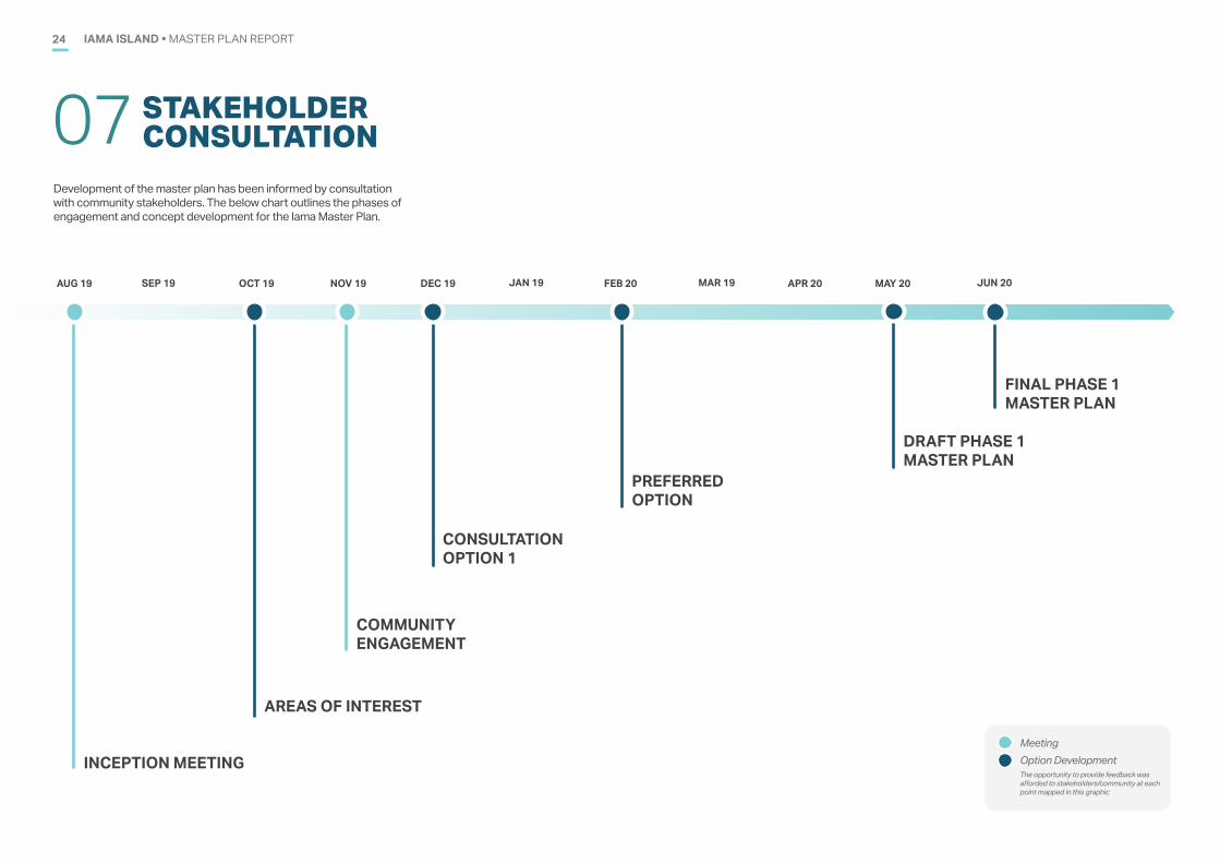
Development of the master plan has been informed by consultation with community stakeholders. The below chart outlines the phases of engagement and concept development for the Iama Master Plan.
INCEPTION MEETING
AUG 19 NOV 19 DEC 19 FEB 20 APR 20 MAY 20
MeetingOption DevelopmentThe opportunity to provide feedback was afforded to stakeholders/community at each point mapped in this graphic
AREAS OF INTEREST
CONSULTATION OPTION 1
COMMUNITY ENGAGEMENT
OCT 19
PREFERRED OPTION
DRAFT PHASE 1 MASTER PLAN
FINAL PHASE 1 MASTER PLAN
SEP 19 JAN 19 MAR 19 JUN 20
IAMA ISLAND • MASTER PLAN REPORT 25IAMA ISLAND • MASTER PLAN REPORT25
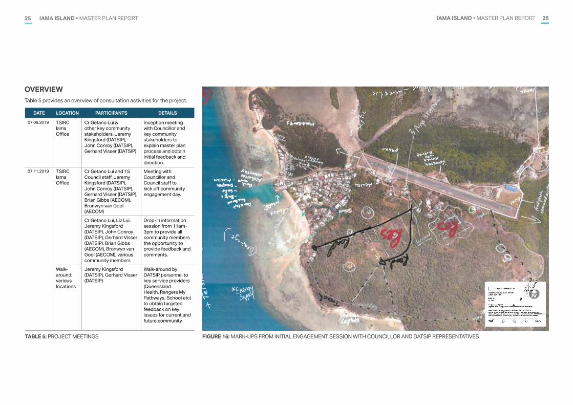
OVERVIEW Table 5 provides an overview of consultation activities for the project.
DATE LOCATION PARTICIPANTS DETAILS
07.08.2019 TSIRC Iama Office
Cr Getano Lui & other key community stakeholders, Jeremy Kingsford (DATSIP), John Conroy (DATSIP), Gerhard Visser (DATSIP)
Inception meeting with Councillor and key community stakeholders to explain master plan process and obtain initial feedback and direction.
07.11.2019 TSIRC Iama Office
Cr Getano Lui and 15 Council staff, Jeremy Kingsford (DATSIP), John Conroy (DATSIP), Gerhard Visser (DATSIP), Brian Gibbs (AECOM), Bronwyn van Gool (AECOM)
Meeting with Councillor and Council staff to kick off community engagement day.
Cr Getano Lui, Liz Lui, Jeremy Kingsford (DATSIP), John Conroy (DATSIP), Gerhard Visser (DATSIP), Brian Gibbs (AECOM), Bronwyn van Gool (AECOM), various community members
Drop-in information session from 11am-3pm to provide all community members the opportunity to provide feedback and comments.
Walk-around: various locations
Jeremy Kingsford (DATSIP), Gerhard Visser (DATSIP)
Walk-around by DATSIP personnel to key service providers (Queensland Health, Rangers My Pathways, School etc) to obtain targeted feedback on key issues for current and future community
TABLE 5: PROJECT MEETINGS FIGURE 16: MARK-UPS FROM INITIAL ENGAGEMENT SESSION WITH COUNCILLOR AND DATSIP REPRESENTATIVES
IAMA ISLAND • MASTER PLAN REPORT26
CONCEPT DEVELOPMENT08
OVERVIEW As part of the master planning process, it is also important to understand how Iama Island functions now, and in the future, within the broader Torres Strait region (encompassing island communities within both Torres Shire Council and Torres Strait Island Regional Council).
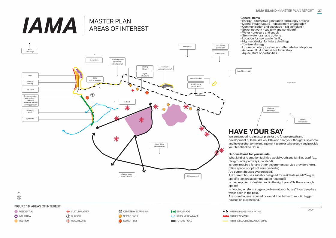
To facilitate discussion and engagement with Council and community stakeholders an initial “areas of interest” figure (Figure 18) was prepared based on the initial engagement with Cr. Lui and key community representatives.
Key questions which will influence the future planning and development on Iama Island therefore include:
• What kind of recreation facilities would youth and families use?
• Is the barge ramp and jetty adequate?
• Is there sufficient industrial land?
• Are current houses overcrowded and meet resident needs?
• Is room required for any other government service providers?
• Is flooding or storm surge impacting residential dwellings?
AREAS OF INTEREST Based on an understanding of the regional context of Iama Island, an initial concept for the township was developed to facilitate initial discussions with Council (Figure 19).
Items for consideration included:
• Innovative, climate responsive design for future residential housing
• Marine Facility - upgrade of infrastructure including provision of a harbour and rockwall, creation of a central barge shipping hub
• Need for an Esplanade
• Aviation Facility - extension of runway for CASA compliance
• Residential Expansion - subdivision for residential lots south east of town
• Coastal Zone - are cost-effective strategies and solutions available to address potential risks posed by coastal processes?
• Cemetery expansion or relocation
• Relocation of utility infrastructure
• Aquaculture opportunities
‘HAVE YOUR SAY’A Community “Have Your Say” day was held on 7 November 2019. A drop-in area was established under the Council building where any members of the public were able to come and provide feedback. DATSIP representatives also walked throughout the community, visiting key service providers such as the School and Health Clinic to discuss the master plan. Appendix E contains a copy of the information pack distributed on the day.
IAMA (YAM) ISLAND ENGAGEMENT APPROACH
INCEPTION MEETINGFULL COUNCIL, CEO & MAYOR
WHAT IS A MASTER PLAN AND WHAT DOES IT DO? The Master Plan is a Non Statutory Document. The Master Plan is a Policy Document. The Master Plan is a living document that can be updated by Council as part of its Policies.The Master Plan is a supporting document for decisions in terms of the Zenadth Kes Planning Scheme (planning scheme for the Torres Strait Island Regional Council) and the Planning Act 2016.The Master Plan principles and directions carries a lot of credibility when quoted as part of Reasons for Decisions as the Master Plan reflects the Communities aspirations and was consulted with the Community.The Master Plan provides relevant information when applying for Grants. It shows that project are “shovel ready” and have been scoped for cost of development.
ONE-ON-ONE SESSIONCOUNCILLOR
• What is master planning?
• Base plans• Constraints
2 WKS
2 WKS
4 WKS
2 WKS
4 WKS
1 WK
• Document outlining master plan process and outcomes
• Infrastructure assessment
• Costing
Meeting/community engagement session
Activity/deliverable
Councillor confirmation/comment by email/phone
PREFFERED OPTION
DRAFT MASTERPLAN
AREAS OF
INTEREST
TARGETED COMMUNITY CONSULTATIONTRADITIONAL OWNERS, AGENCIES & COMMUNITY REPRESENTATIVES
CONCEPT OPTIONS
1,2 & 3
• Demographics• Ideas and
aspirations
• Aspirations • Future
development areas
• Committed projects
• Different land uses • Density scenarios
(e.g. lot sizes)
• Single option as agreed by Councillor, stakeholders and community
COMMENT/SIGN-OFF
FULL COUNCIL/COUNCILLOR
WE ARE HEREOn-island consultation occured on 7th of August 2019 when DATSIP met with Cr Lui and other key stakeholders to gather initial feedback
FIGURE 17: ENGAGEMENT APPROACH
IAMA ISLAND • MASTER PLAN REPORT 27
FIGURE 18: AREAS OF INTEREST
General Items• Energy - alternative generation and supply options • Marine infrastructure - replacement or upgrade?• Communication and coverage - is it sufficient? • Sewer network - capacity and condition? • Water - pressure and supply• Stormwater drainage options• Location for new waste facility• High-set design for future dwellings• Tourism strategy• Future cemetery location and alternate burial options• Achieve CASA compliance for airstrip • Aquaculture opportunities
HAVE YOUR SAYWe are preparing a master plan for the future growth and development of Iama. We would like to hear your thoughts, so come and have a chat to the engagement team or take a copy and provide your feedback to Cr Lui. Our questions for you include:What kind of recreation facilities would youth and families use? (e.g. playgrounds, pathways, parkland)Is room required for any other government service providers? (e.g. office space, shopfront service desks)Are current houses overcrowded? Are current houses suitably designed for residents needs? (e.g. is specific seniors accommodation required?)Is the proposed industrial land in the right place? Is there enough space?Is flooding or storm surge a problem at your house? How deep has water been in the past?Are more houses required or would it be better to rebuild bigger houses on current land?
Lorem ipsum
IAMA MASTER PLAN AREAS OF INTEREST
A clubhouse +exercise track?
Poor Anchorage
TSIRCO�ces + Depot
Mangroves
IBIS Shop
Fuel
Fisheries Industry
Develop a marina with harbour?
Rockwall?Central hub of barge
shipping services?
Esplanade?
Waiting House
Ergon relocation?
Swimming pool?
Future TelstraInfrastructure?
Cemetery expand / relocate?
School
Aquaculture?
Tidal energy generation?
Capture water runo� from hill?
CASA compliance for airstrip
Extend airstrip?
Vertical land�ll?
Possible aquaculture?
Optional boat ramp?
Mangroves
Dirt access roads
Land�ll too small
IAMA �YAM� ISLANDAREAS OF INTEREST
FOR DISCUSSION PURPOSES ONLY
LEGEND Residential IndustrialTourism
Cultural areaChurchHealthcare
Cemetery expansionSeptic tankSewer pump
Esplanade Resolve drainageFuture road
Future pedestrian pathsFuture seawall Future flood mitigation bund
200 m
N
200mRESIDENTIAL
INDUSTRIAL
TOURISM +
CULTURAL AREA
CHURCH
HEALTHCARE
CEMETERY EXPANSION
SEPTIC TANK
SEWER PUMP
ESPLANADE
RESOLVE DRAINAGE
FUTURE ROAD
FUTURE PEDESTRIAN PATHS
FUTURE SEAWALL
FUTURE FLOOD MITIGATION BUND
IAMA ISLAND • MASTER PLAN REPORT28
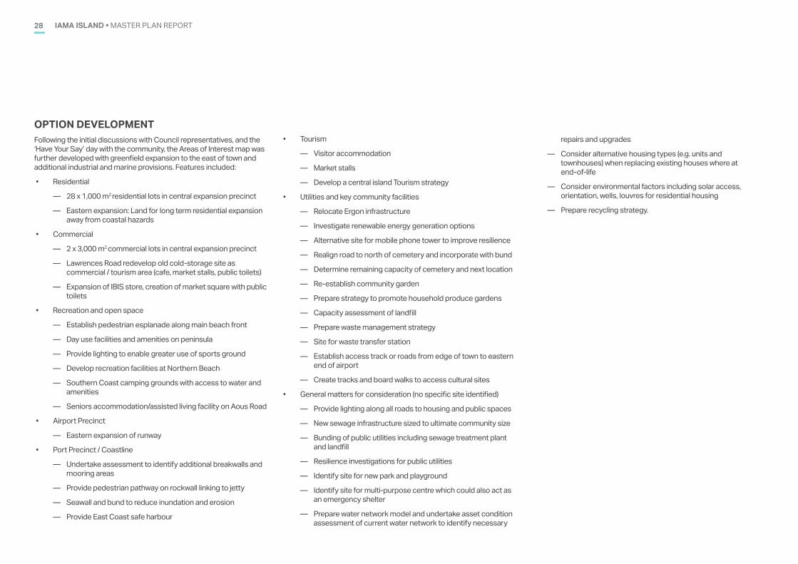
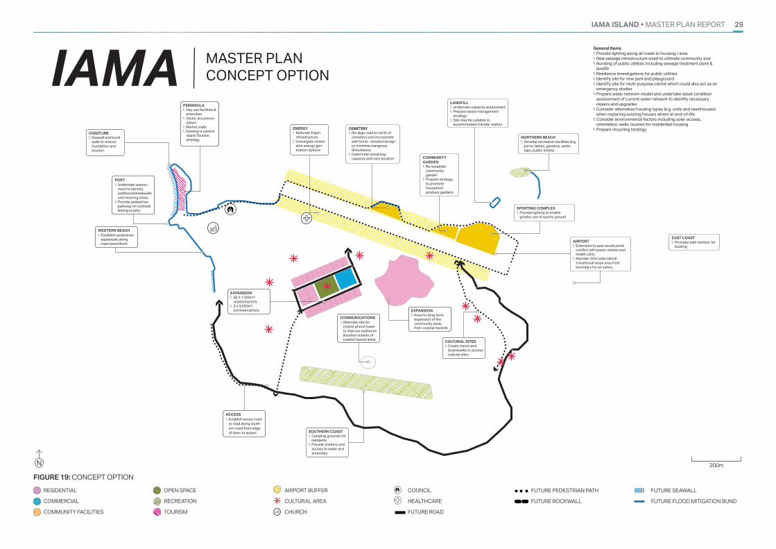
OPTION DEVELOPMENT Following the initial discussions with Council representatives, and the ‘Have Your Say’ day with the community, the Areas of Interest map was further developed with greenfield expansion to the east of town and additional industrial and marine provisions. Features included:
• Residential
— 28 x 1,000 m2 residential lots in central expansion precinct
— Eastern expansion: Land for long term residential expansion away from coastal hazards
• Commercial
— 2 x 3,000 m2 commercial lots in central expansion precinct
— Lawrences Road redevelop old cold-storage site as commercial / tourism area (cafe, market stalls, public toilets)
— Expansion of IBIS store, creation of market square with public toilets
• Recreation and open space
— Establish pedestrian esplanade along main beach front
— Day use facilities and amenities on peninsula
— Provide lighting to enable greater use of sports ground
— Develop recreation facilities at Northern Beach
— Southern Coast camping grounds with access to water and amenities
— Seniors accommodation/assisted living facility on Aous Road
• Airport Precinct
— Eastern expansion of runway
• Port Precinct / Coastline
— Undertake assessment to identify additional breakwalls and mooring areas
— Provide pedestrian pathway on rockwall linking to jetty
— Seawall and bund to reduce inundation and erosion
— Provide East Coast safe harbour
• Tourism
— Visitor accommodation
— Market stalls
— Develop a central island Tourism strategy
• Utilities and key community facilities
— Relocate Ergon infrastructure
— Investigate renewable energy generation options
— Alternative site for mobile phone tower to improve resilience
— Realign road to north of cemetery and incorporate with bund
— Determine remaining capacity of cemetery and next location
— Re-establish community garden
— Prepare strategy to promote household produce gardens
— Capacity assessment of landfill
— Prepare waste management strategy
— Site for waste transfer station
— Establish access track or roads from edge of town to eastern end of airport
— Create tracks and board walks to access cultural sites
• General matters for consideration (no specific site identified)
— Provide lighting along all roads to housing and public spaces
— New sewage infrastructure sized to ultimate community size
— Bunding of public utilities including sewage treatment plant and landfill
— Resilience investigations for public utilities
— Identify site for new park and playground
— Identify site for multi-purpose centre which could also act as an emergency shelter
— Prepare water network model and undertake asset condition assessment of current water network to identify necessary
repairs and upgrades
— Consider alternative housing types (e.g. units and townhouses) when replacing existing houses where at end-of-life
— Consider environmental factors including solar access, orientation, wells, louvres for residential housing
— Prepare recycling strategy.
IAMA ISLAND • MASTER PLAN REPORT 29
FIGURE 19: CONCEPT OPTION
CULTURAL SITES\ Create tracks and
boardwalks to access cultural sites
ENERGY \ Relocate Ergon
infrastructure\ Investigate renew-
able energy gen-eration options
PENINSULA\ Day use facilities &
amenities \ Visitor accommo-
dation \ Market stalls \ Develop a central
island Tourism strategy
FUEL SUPPLY
- 24 hour fuel supply?- Fuel card? - Relocate Fuel?
SOUTHERN COAST\ Camping grounds for
residents\ Provide shelters and
access to water and amenities
COMMUNICATIONS\ Alternate site for
mobile phone tower to improve resilience (located outside of coastal hazard area)
CEMETERY\ Re-align road to north of
cemetery and incorporate with bund - detailed design to minimise mangrove disturbance
\ Determine remaining capacity and next location
General Items\ Provide lighting along all roads to housing / area \ New sewage infrastructure sized to ultimate community size \ Bunding of public utilities including sewage treatment plant &
landfill \ Resilience investigations for public utilities \ Identify site for new park and playground \ Identify site for multi-purpose centre which could also act as an
emergency shelter \ Prepare water network model and undertake asset condition
assessment of current water network to identify necessary repairs and upgrades
\ Consider alternative housing types (e.g. units and townhouses) when replacing existing houses where at end-of-life
\ Consider environmental factors including solar access, orientation, wells, louvres for residential housing
\ Prepare recycling strategy
IAMA MASTER PLAN CONCEPT OPTION
IAMA ISLANDCONCEPT OPTION � 2 DECEMBER 2019
FOR DISCUSSION PURPOSES ONLY
LEGEND
Residential
Commerical
Community facilities
Open space
Recreation
Tourism
Airport buffer
Cultural area
Church
Council
Healthcare
Future road
Future pedestrian path
Future rockwall
200 m
Future seawall
Future flood mitigation bund
COMMUNITY GARDEN\ Re-establish
community garden
\ Prepare strategy to promote household produce gardens
LANDFILL\ Undertake capacity assessment\ Prepare waste management
strategy \ Site may be suitable to
accommodate transfer station
NORTHERN BEACH\ Develop recreation facilities (e.g.
picnic tables, gazebos, water taps, public toilets)
SPORTING COMPLEX\ Provide lighting to enable
greater use of sports ground
AIRPORT\ Extension to east would avoid
conflict with power station and health clinic
\ Maintain 50m wide lateral transitional slope area from boundary for air safety
EAST COAST\ Provides safe harbour for
boating
ACCESS\ Establish access track
or road along south-ern coast from edge of town to airport
WESTERN BEACH\ Establish pedestrian
esplanade along main beachfront
PORT\ Undertake assess-
ment to identify additional breakwalls and mooring areas
\ Provide pedestrian pathway on rockwall linking to jetty
EXPANSION\ 28 X 1,000m²
residential lots \ 2 x 3,000m²
commercial lots EXPANSION\ Area for long-term
expansion of the community away from coastal hazards
COASTLINE\ Seawall and bund
walls to reduce inundation and erosion
N 200m
RESIDENTIAL
COMMERCIAL
COMMUNITY FACILITIES
OPEN SPACE
RECREATION
TOURISM
AIRPORT BUFFER
CULTURAL AREA
CHURCH
COUNCIL
HEALTHCARE
FUTURE ROAD
FUTURE PEDESTRIAN PATH
FUTURE ROCKWALL
FUTURE SEAWALL
FUTURE FLOOD MITIGATION BUND
IAMA ISLAND • MASTER PLAN REPORT30
PREFERRED OPTION09
IAMA ISLAND • MASTER PLAN REPORT 30
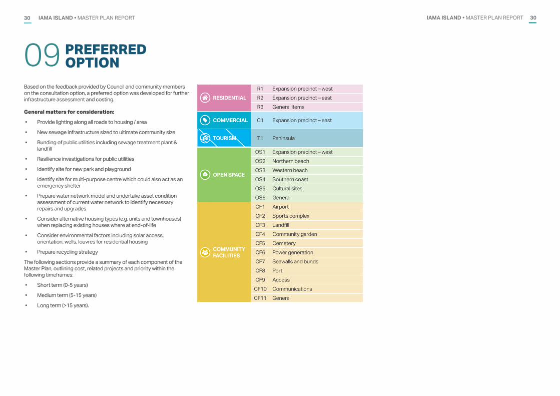
Based on the feedback provided by Council and community members on the consultation option, a preferred option was developed for further infrastructure assessment and costing.
General matters for consideration:
• Provide lighting along all roads to housing / area
• New sewage infrastructure sized to ultimate community size
• Bunding of public utilities including sewage treatment plant & landfill
• Resilience investigations for public utilities
• Identify site for new park and playground
• Identify site for multi-purpose centre which could also act as an emergency shelter
• Prepare water network model and undertake asset condition assessment of current water network to identify necessary repairs and upgrades
• Consider alternative housing types (e.g. units and townhouses) when replacing existing houses where at end-of-life
• Consider environmental factors including solar access, orientation, wells, louvres for residential housing
• Prepare recycling strategy
The following sections provide a summary of each component of the Master Plan, outlining cost, related projects and priority within the following timeframes:
• Short term (0-5 years)
• Medium term (5-15 years)
• Long term (>15 years).
RESIDENTIAL R1 Expansion precinct – west R2 Expansion precinct – east R3 General items
COMMERCIAL C1 Expansion precinct – east
TOURISM T1 Peninsula
OPEN SPACE
OS1 Expansion precinct – west OS2 Northern beachOS3 Western beachOS4 Southern coastOS5 Cultural sitesOS6 General
COMMUNITY FACILITIES
CF1 AirportCF2 Sports complexCF3 Landfill CF4 Community gardenCF5 CemeteryCF6 Power generationCF7 Seawalls and bundsCF8 PortCF9 Access
CF10 CommunicationsCF11 General
IAMA ISLAND • MASTER PLAN REPORT 31
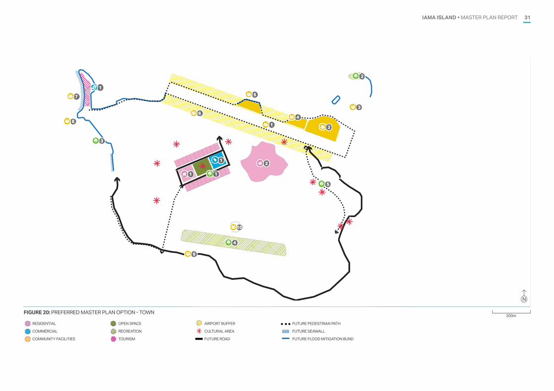
FIGURE 20: PREFERRED MASTER PLAN OPTION - TOWN
1
21
3
1 2
3
4
1
2
5
1
4
5
6
8
7
9
10
200m
N
RESIDENTIAL
COMMERCIAL
COMMUNITY FACILITIES
OPEN SPACE
RECREATION
TOURISM
AIRPORT BUFFER
CULTURAL AREA
FUTURE ROAD
FUTURE PEDESTRIAN PATH
FUTURE SEAWALL
FUTURE FLOOD MITIGATION BUND
IAMA ISLAND • MASTER PLAN REPORT32
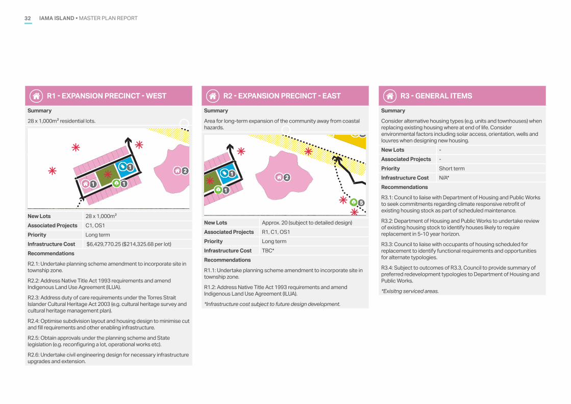
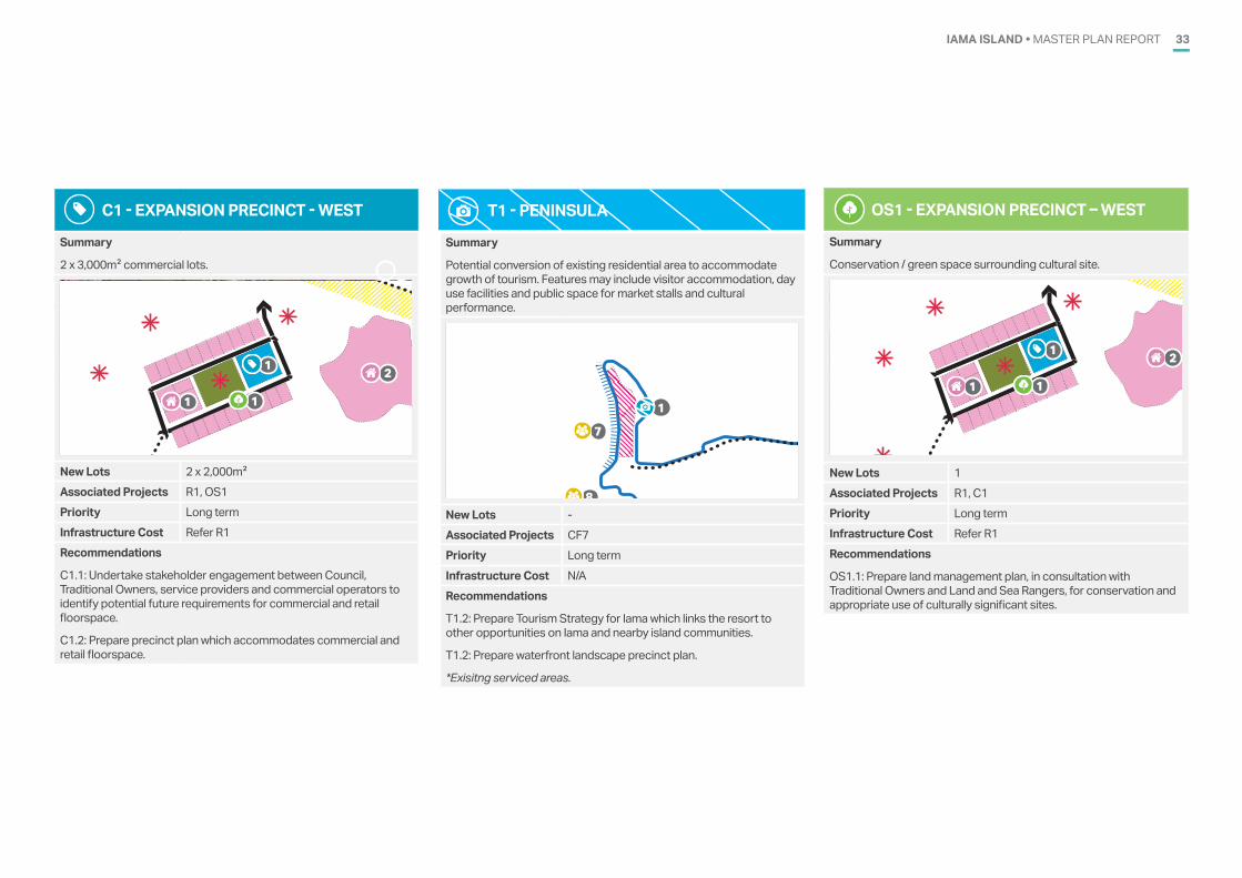
R1 - EXPANSION PRECINCT - WEST
Summary
28 x 1,000m2 residential lots.
1
21
3
1 2
3
4
1
2
5
1
4
5
6
8
7
9
10
New Lots 28 x 1,000m2Associated Projects C1, OS1Priority Long termInfrastructure Cost $6,429,770.25 ($214,325.68 per lot) Recommendations
R2.1: Undertake planning scheme amendment to incorporate site in township zone.
R2.2: Address Native Title Act 1993 requirements and amend Indigenous Land Use Agreement (ILUA).
R2.3: Address duty of care requirements under the Torres Strait Islander Cultural Heritage Act 2003 (e.g. cultural heritage survey and cultural heritage management plan).
R2.4: Optimise subdivision layout and housing design to minimise cut and fill requirements and other enabling infrastructure.
R2.5: Obtain approvals under the planning scheme and State legislation (e.g. reconfiguring a lot, operational works etc).
R2.6: Undertake civil engineering design for necessary infrastructure upgrades and extension.
R2 - EXPANSION PRECINCT - EAST
Summary
Area for long-term expansion of the community away from coastal hazards.
1
21
3
1 2
3
4
1
2
5
1
4
5
6
8
7
9
10
New Lots Approx. 20 (subject to detailed design)Associated Projects R1, C1, OS1Priority Long termInfrastructure Cost TBC*Recommendations
R1.1: Undertake planning scheme amendment to incorporate site in township zone.
R1.2: Address Native Title Act 1993 requirements and amend Indigenous Land Use Agreement (ILUA).
*Infrastructure cost subject to future design development.
R3 - GENERAL ITEMS
Summary
Consider alternative housing types (e.g. units and townhouses) when replacing existing housing where at end of life. Consider environmental factors including solar access, orientation, wells and louvres when designing new housing. New Lots -Associated Projects -Priority Short termInfrastructure Cost N/A*Recommendations
R3.1: Council to liaise with Department of Housing and Public Works to seek commitments regarding climate responsive retrofit of existing housing stock as part of scheduled maintenance.
R3.2: Department of Housing and Public Works to undertake review of existing housing stock to identify houses likely to require replacement in 5-10 year horizon.
R3.3: Council to liaise with occupants of housing scheduled for replacement to identify functional requirements and opportunities for alternate typologies.
R3.4: Subject to outcomes of R3.3, Council to provide summary of preferred redevelopment typologies to Department of Housing and Public Works.
*Exisitng serviced areas.
IAMA ISLAND • MASTER PLAN REPORT 33
C1 - EXPANSION PRECINCT - WEST
Summary
2 x 3,000m2 commercial lots.
1
21
3
1 2
3
4
1
2
5
1
4
5
6
8
7
9
10
New Lots 2 x 2,000m2Associated Projects R1, OS1Priority Long termInfrastructure Cost Refer R1Recommendations
C1.1: Undertake stakeholder engagement between Council, Traditional Owners, service providers and commercial operators to identify potential future requirements for commercial and retail floorspace.
C1.2: Prepare precinct plan which accommodates commercial and retail floorspace.
T1 - PENINSULA
Summary
Potential conversion of existing residential area to accommodate growth of tourism. Features may include visitor accommodation, day use facilities and public space for market stalls and cultural performance.
1
21
3
1 2
3
4
1
2
5
1
4
5
6
8
7
9
10
New Lots -Associated Projects CF7Priority Long termInfrastructure Cost N/ARecommendations
T1.2: Prepare Tourism Strategy for Iama which links the resort to other opportunities on Iama and nearby island communities.
T1.2: Prepare waterfront landscape precinct plan.
*Exisitng serviced areas.
OS1 - EXPANSION PRECINCT – WEST
Summary
Conservation / green space surrounding cultural site.
1
21
3
1 2
3
4
1
2
5
1
4
5
6
8
7
9
10
New Lots 1Associated Projects R1, C1Priority Long termInfrastructure Cost Refer R1Recommendations
OS1.1: Prepare land management plan, in consultation with Traditional Owners and Land and Sea Rangers, for conservation and appropriate use of culturally significant sites.
IAMA ISLAND • MASTER PLAN REPORT34
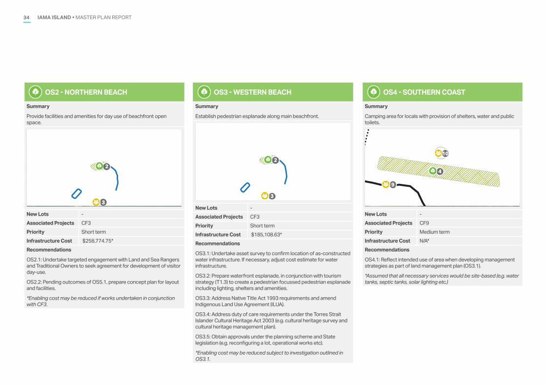
OS2 - NORTHERN BEACH
Summary
Provide facilities and amenities for day use of beachfront open space.
1
21
3
1 2
3
4
1
2
5
1
4
5
6
8
7
9
10
New Lots -Associated Projects CF3Priority Short termInfrastructure Cost $258,774.75*Recommendations
OS2.1: Undertake targeted engagement with Land and Sea Rangers and Traditional Owners to seek agreement for development of visitor day-use.
OS2.2: Pending outcomes of OS5.1, prepare concept plan for layout and facilities.
*Enabling cost may be reduced if works undertaken in conjunction with CF3.
OS3 - WESTERN BEACH
Summary
Establish pedestrian esplanade along main beachfront.
1
21
3
1 2
3
4
1
2
5
1
4
5
6
8
7
9
10
New Lots -Associated Projects CF3Priority Short termInfrastructure Cost $185,108.63*Recommendations
OS3.1: Undertake asset survey to confirm location of as-constructed water infrastructure. If necessary, adjust cost estimate for water infrastructure.
OS3.2: Prepare waterfront esplanade, in conjunction with tourism strategy (T1.3) to create a pedestrian focussed pedestrian esplanade including lighting, shelters and amenities.
OS3.3: Address Native Title Act 1993 requirements and amend Indigenous Land Use Agreement (ILUA).
OS3.4: Address duty of care requirements under the Torres Strait Islander Cultural Heritage Act 2003 (e.g. cultural heritage survey and cultural heritage management plan).
OS3.5: Obtain approvals under the planning scheme and State legislation (e.g. reconfiguring a lot, operational works etc).
*Enabling cost may be reduced subject to investigation outlined in OS3.1.
OS4 - SOUTHERN COAST
Summary
Camping area for locals with provision of shelters, water and public toilets.
1
21
3
1 2
3
4
1
2
5
1
4
5
6
8
7
9
10
New Lots -Associated Projects CF9Priority Medium termInfrastructure Cost N/A*Recommendations
OS4.1: Reflect intended use of area when developing management strategies as part of land management plan (OS3.1).
*Assumed that all necessary services would be site-based (e.g. water tanks, septic tanks, solar lighting etc.)
IAMA ISLAND • MASTER PLAN REPORT 35
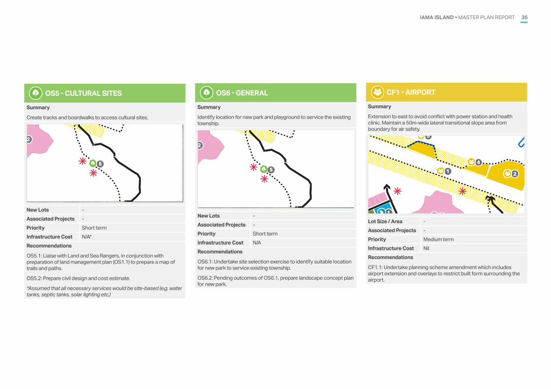
OS5 - CULTURAL SITES
Summary
Create tracks and boardwalks to access cultural sites.
1
21
3
1 2
3
4
1
2
5
1
4
5
6
8
7
9
10New Lots -Associated Projects -Priority Short termInfrastructure Cost N/A*Recommendations
OS5.1: Liaise with Land and Sea Rangers, in conjunction with preparation of land management plan (OS1.1) to prepare a map of trails and paths.
OS5.2: Prepare civil design and cost estimate.
*Assumed that all necessary services would be site-based (e.g. water tanks, septic tanks, solar lighting etc.)
OS6 - GENERAL
Summary
Identify location for new park and playground to service the existing township.
1
21
3
1 2
3
4
1
2
5
1
4
5
6
8
7
9
10New Lots -Associated Projects -Priority Short termInfrastructure Cost N/ARecommendations
OS6.1: Undertake site selection exercise to identify suitable location for new park to service existing township.
OS6.2: Pending outcomes of OS6.1, prepare landscape concept plan for new park.
CF1 - AIRPORT
Summary
Extension to east to avoid conflict with power station and health clinic. Maintain a 50m-wide lateral transitional slope area from boundary for air safety.
1
21
3
1 2
3
4
1
2
5
1
4
5
6
8
7
9
10
Lot Size / Area -Associated Projects -Priority Medium termInfrastructure Cost NilRecommendations
CF1.1: Undertake planning scheme amendment which includes airport extension and overlays to restrict built form surrounding the airport.
IAMA ISLAND • MASTER PLAN REPORT36
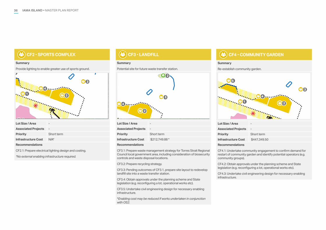
CF2 - SPORTS COMPLEX
Summary
Provide lighting to enable greater use of sports ground.
1
21
3
1 2
3
4
1
2
5
1
4
5
6
8
7
9
10
Lot Size / Area -Associated Projects -Priority Short termInfrastructure Cost N/A*Recommendations
CF2.1: Prepare electrical lighting design and costing.
*No external enabling infrastructure required.
CF3 - LANDFILL
Summary
Potential site for future waste transfer station.
1
21
3
1 2
3
4
1
2
5
1
4
5
6
8
7
9
10
Lot Size / Area -Associated Projects -Priority Short termInfrastructure Cost $212,749.88 *Recommendations
CF3.1: Prepare waste management strategy for Torres Strait Regional Council local government area, including consideration of biosecurity controls and waste disposal locations.
CF3.2: Prepare recycling strategy.
CF3.3: Pending outcomes of CF3.1, prepare site layout to redevelop landfill site into a waste transfer station.
CF3.4: Obtain approvals under the planning scheme and State legislation (e.g. reconfiguring a lot, operational works etc).
CF3.5: Undertake civil engineering design for necessary enabling infrastructure.
*Enabling cost may be reduced if works undertaken in conjunction with OS2.
CF4 - COMMUNITY GARDEN
Summary
Re-establish community garden.
1
21
3
1 2
3
4
1
2
5
1
4
5
6
8
7
9
10
Lot Size / Area -Associated Projects -Priority Short termInfrastructure Cost $447,349.50Recommendations
CF4.1: Undertake community engagement to confirm demand for restart of community garden and identify potential operators (e.g. community groups).
CF4.2: Obtain approvals under the planning scheme and State legislation (e.g. reconfiguring a lot, operational works etc).
CF4.3: Undertake civil engineering design for necessary enabling infrastructure.
IAMA ISLAND • MASTER PLAN REPORT 37
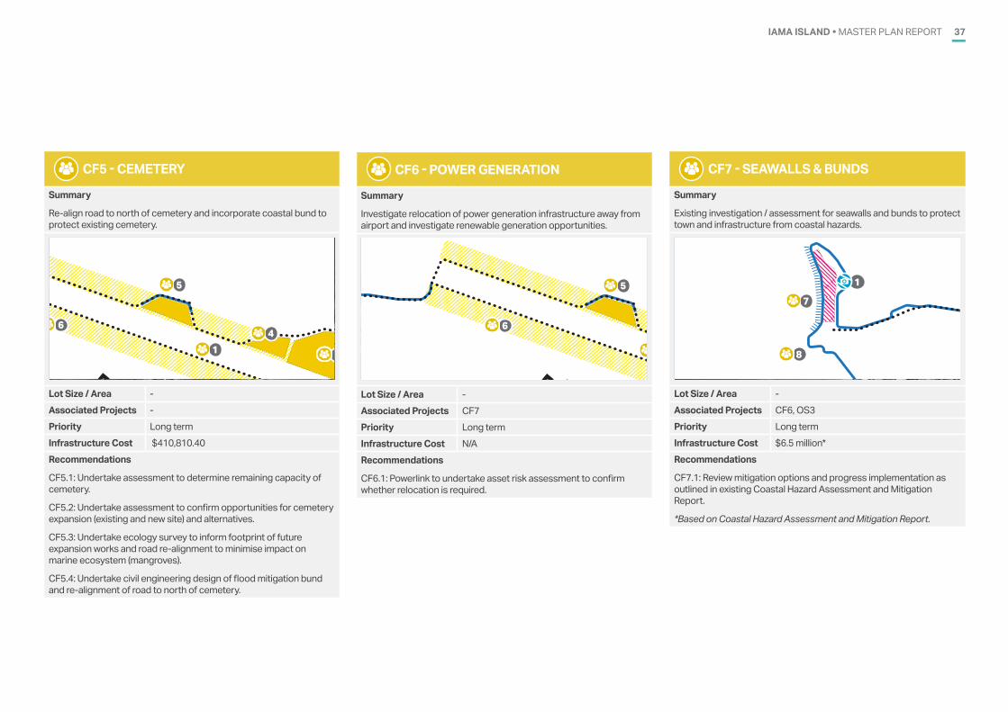
CF5 - CEMETERY
Summary
Re-align road to north of cemetery and incorporate coastal bund to protect existing cemetery.
1
21
3
1 2
3
4
1
2
5
1
4
5
6
8
7
9
10
Lot Size / Area -Associated Projects -Priority Long termInfrastructure Cost $410,810.40 Recommendations
CF5.1: Undertake assessment to determine remaining capacity of cemetery.
CF5.2: Undertake assessment to confirm opportunities for cemetery expansion (existing and new site) and alternatives.
CF5.3: Undertake ecology survey to inform footprint of future expansion works and road re-alignment to minimise impact on marine ecosystem (mangroves).
CF5.4: Undertake civil engineering design of flood mitigation bund and re-alignment of road to north of cemetery.
CF6 - POWER GENERATION
Summary
Investigate relocation of power generation infrastructure away from airport and investigate renewable generation opportunities.
1
21
3
1 2
3
4
1
2
5
1
4
5
6
8
7
9
10
Lot Size / Area -Associated Projects CF7Priority Long termInfrastructure Cost N/ARecommendations
CF6.1: Powerlink to undertake asset risk assessment to confirm whether relocation is required.
CF7 - SEAWALLS & BUNDS
Summary
Existing investigation / assessment for seawalls and bunds to protect town and infrastructure from coastal hazards.
1
21
3
1 2
3
4
1
2
5
1
4
5
6
8
7
9
10
Lot Size / Area -Associated Projects CF6, OS3Priority Long termInfrastructure Cost $6.5 million*Recommendations
CF7.1: Review mitigation options and progress implementation as outlined in existing Coastal Hazard Assessment and Mitigation Report.
*Based on Coastal Hazard Assessment and Mitigation Report.
IAMA ISLAND • MASTER PLAN REPORT38
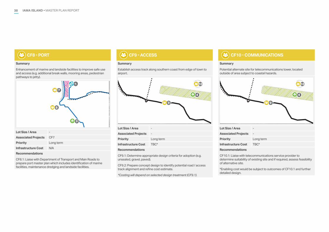
CF8 - PORT
Summary
Enhancement of marine and landside facilities to improve safe use and access (e.g. additional break walls, mooring areas, pedestrian pathways to jetty).
1
21
3
1 2
3
4
1
2
5
1
4
5
6
8
7
9
10
Lot Size / Area -Associated Projects CF7Priority Long termInfrastructure Cost N/ARecommendations
CF8.1: Liaise with Department of Transport and Main Roads to prepare port master plan which includes identification of marine facilities, maintenance dredging and landside facilities.
CF9 - ACCESS
Summary
Establish access track along southern coast from edge of town to airport.
1
21
3
1 2
3
4
1
2
5
1
4
5
6
8
7
9
10
Lot Size / Area -Associated Projects -Priority Long termInfrastructure Cost TBC*Recommendations
CF9.1: Determine appropriate design criteria for adoption (e.g. unsealed, gravel, paved).
CF9.2: Prepare concept design to identify potential road / access track alignment and refine cost estimate.
*Costing will depend on selected design treatment (CF9.1).
CF10 - COMMUNICATIONS
Summary
Potential alternate site for telecommunications tower, located outside of area subject to coastal hazards.
1
21
3
1 2
3
4
1
2
5
1
4
5
6
8
7
9
10
Lot Size / Area -Associated Projects -Priority Long termInfrastructure Cost TBC*Recommendations
CF10.1: Liaise with telecommunications service provider to determine suitability of existing site and if required, assess feasibility of alternative site.
*Enabling cost would be subject to outcomes of CF10.1 and further detailed design.
IAMA ISLAND • MASTER PLAN REPORT 39
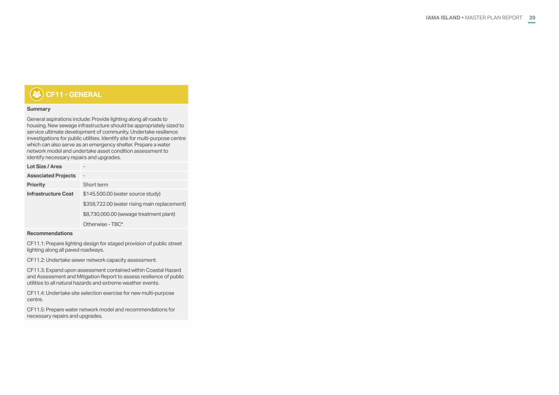
CF11 - GENERAL
Summary
General aspirations include: Provide lighting along all roads to housing. New sewage infrastructure should be appropriately sized to service ultimate development of community. Undertake resilience investigations for public utilities. Identify site for multi-purpose centre which can also serve as an emergency shelter. Prepare a water network model and undertake asset condition assessment to identify necessary repairs and upgrades. Lot Size / Area -Associated Projects -Priority Short termInfrastructure Cost $145,500.00 (water source study)
$358,722.00 (water rising main replacement)
$8,730,000.00 (sewage treatment plant)
Otherwise - TBC*Recommendations
CF11.1: Prepare lighting design for staged provision of public street lighting along all paved roadways.
CF11.2: Undertake sewer network capacity assessment.
CF11.3: Expand upon assessment contained within Coastal Hazard and Assessment and Mitigation Report to assess resilience of public utilities to all natural hazards and extreme weather events.
CF11.4: Undertake site selection exercise for new multi-purpose centre.
CF11.5: Prepare water network model and recommendations for necessary repairs and upgrades.
IAMA ISLAND • MASTER PLAN REPORT40
INFRASTRUCTURE REQUIREMENTS10
The following sections provide an overview of proposed infrastructure to support the preferred master plan layout. Refer to Appendix B for further details. The following elements of the master plan do not require enabling infrastructure as they are located in a serviced area or the nature of the item does not require enabling infrastructure:
• R2 – Expansion Precinct - East - area for long-term expansion of the community away from coastal hazards. No enabling infrastructure identified at this stage
• R3 – Residential General Items– existing serviced lots
• T1- Peninsula Tourism area – new use of existing area. Assume the existing dirt road is sufficient
• OS1 – Expansion Precinct - West – green space surrounding a cultural site
• OS4 – Southern Coast – camping area for locals serviced by on-site water and sewer and solar lighting without any sealed access road
• OS5 – Cultural sites – tracks and boardwalks to cultural sites. No connections to services
• OS6 – General, new park and playground – site and infrastructure requirements to be determined as part of further investigation
• CF1 – Airport – no enabling infrastructure
• CF2 – Sports complex – no enabling infrastructure
• CF6 – Power generation – site and infrastructure requirements to be determined as part of further investigation
• CF7 – Seawalls and bunds – no enabling infrastructure
• CF8 – Port – no enabling infrastructure at this stage
• CF9 – Access – assume unsealed access track. No enabling infrastructure
• CF10 – Communication – item relates to further investigations
• CF11 – General – no enabling infrastructure at this stage, item relates to further investigations.
WATER The assessment indicated that the existing water source is under capacity for the existing population on Iama. An upgrade to the water source will be required prior to implementing any of the proposed developments in the master plan. A water source study is recommended to identify suitable options. The section of the rising main located on Mangrove Road was upgraded in approximately 2015/2016. A downstream section was observed located above ground when the island was visited in later 2019. The upgrade section of the rising main needs to be replaced as a priority. Any remaining sections of the original main needs to be upgraded to DN90 to provide sufficient capacity for the proposed development.
Sufficient reservoir storage is available for the proposed developments within the master plan. A review of the capacity of the remaining trunk components of the water supply network is required to confirm sufficient capacity is available.
Extension of water mains will be required to service proposed sites R1, C1, OS2, OS3, CF3 and CF4. It has been assumed that due to the limited demand generation, the community garden (CF4) would include rainwater tanks or bore water for watering of the gardens.
SEWERAGEThe existing sewage treatment plant has a capacity of 450 EP, which is nearing capacity, with an existing load equivalent to 425 EP when residential and non-residential loads are considered. An upgraded sewage treatment plant with a capacity of 655 EP will be required to accommodate the master plan.
Gravity mains will be required to connect proposed sites R1, C1, OS2, OS3 CF3 and CF4 to the sewage treatment plant. A small packaged pump station and short rising main will also be required for development area R1.
ROADS Extensions of sealed roads will be required to provide access to the development areas R1, C1 and CF5. It has been assumed that several proposed uses including OS2, CF3, CF4, and T1 can operate with existing unsealed road access.
STORMWATERAny infill developments can be serviced by the existing system. Developments located on the hill will require drainage infrastructure,
including kerb and channelling, underground drainage pipes, open channels and culverts.
The development sites on the top of the hill are located within undulating ground. It is assumed that elevated houses on stilts will be used in this region. Some earthworks will still be required in this region.
ELECTRICITY The capacity of the electricity supply to Iama will need to be confirmed to ensure that sufficient capacity is available for the community following the implementation of the proposed development. Extensions of the existing electrical system will be required to provide power to developments R1, C1, CF3 and CF4. It is assumed that the electrical supply will require the installation of overhead supply and new poles. Poles will be required every 80 m and at changes in direction.
COMMUNICATIONS Extensions of the existing communications system with the installation of pits and conduits will be required to provide communications to developments R1, C1, CF3 and CF4.
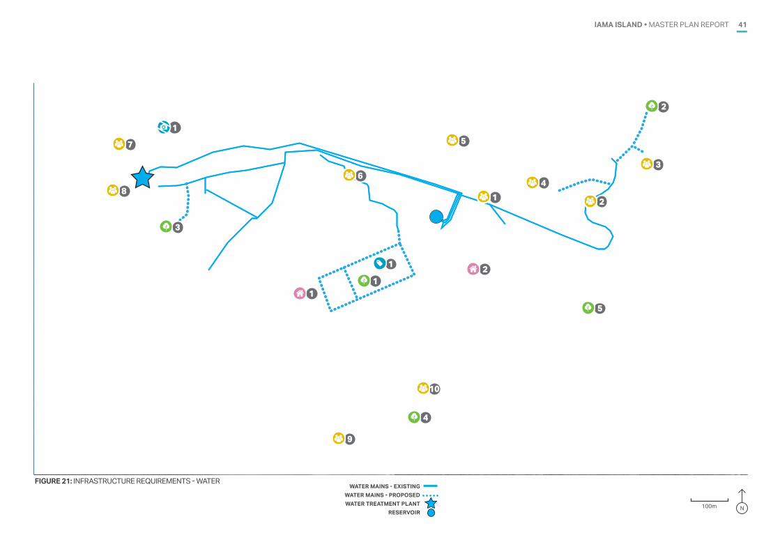
IAMA ISLAND • MASTER PLAN REPORT 41
FIGURE 21: INFRASTRUCTURE REQUIREMENTS - WATER WATER MAINS - EXISTING
WATER MAINS - PROPOSEDWATER TREATMENT PLANT
RESERVOIR
IAMA �YAM� ISLANDBASE PLAN
FOR DISCUSSION PURPOSES ONLY
200 m
LEGEND Property boundaries
1
21
3
1 2
3
4
1
2
5
1
4
5
6
8
7
9
10
100m N
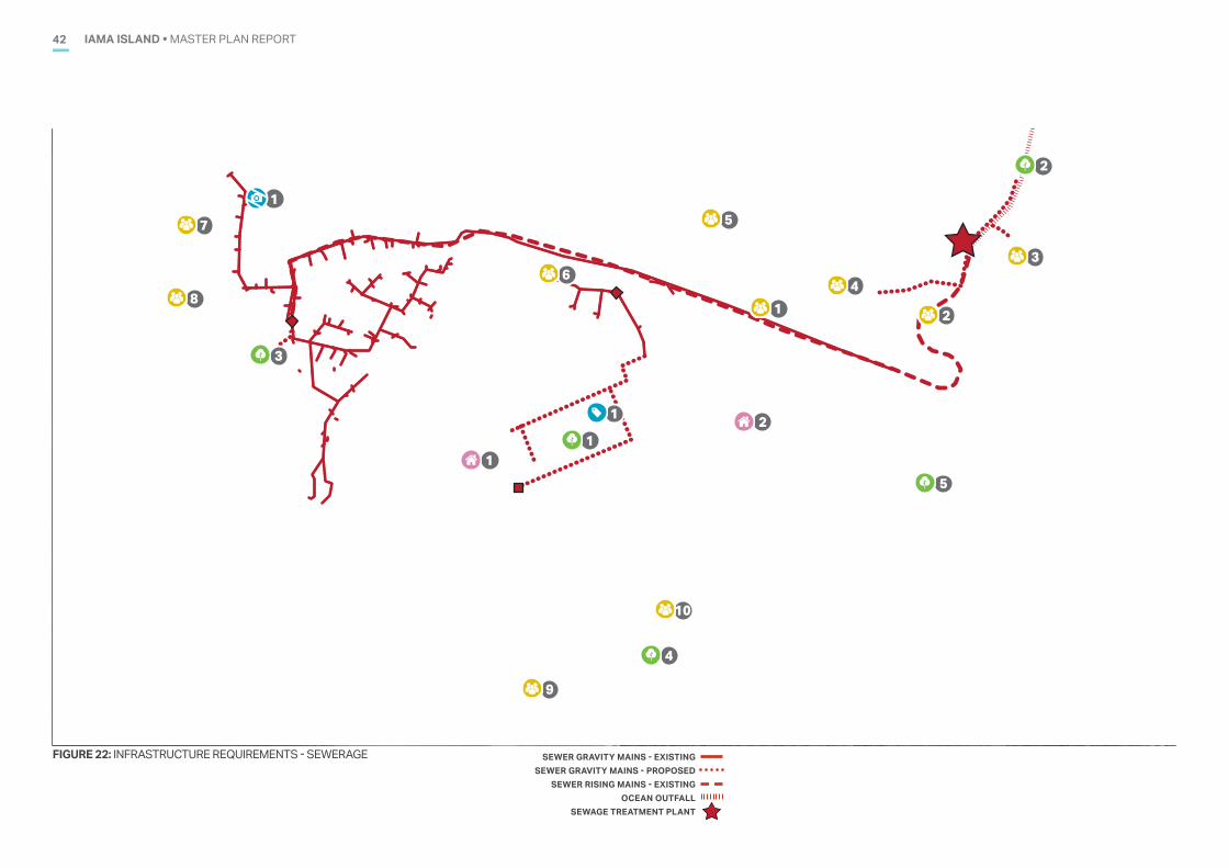
IAMA ISLAND • MASTER PLAN REPORT42
FIGURE 22: INFRASTRUCTURE REQUIREMENTS - SEWERAGE SEWER GRAVITY MAINS - EXISTINGSEWER GRAVITY MAINS - PROPOSED
SEWER RISING MAINS - EXISTINGOCEAN OUTFALL
SEWAGE TREATMENT PLANT
IAMA �YAM� ISLANDBASE PLAN
FOR DISCUSSION PURPOSES ONLY
200 m
LEGEND Property boundaries
1
21
3
1 2
3
4
1
2
5
1
4
5
6
8
7
9
10
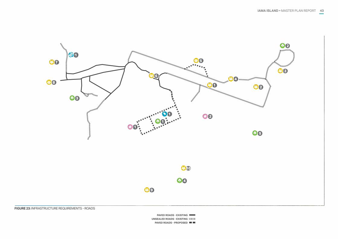
IAMA ISLAND • MASTER PLAN REPORT 43
FIGURE 23: INFRASTRUCTURE REQUIREMENTS - ROADS
PAVED ROADS - EXISTINGUNSEALED ROADS - EXISTING
PAVED ROADS - PROPOSED
IAMA �YAM� ISLANDBASE PLAN
FOR DISCUSSION PURPOSES ONLY
200 m
LEGEND Property boundaries
1
21
3
1 2
3
4
1
2
5
1
4
5
6
8
7
9
10
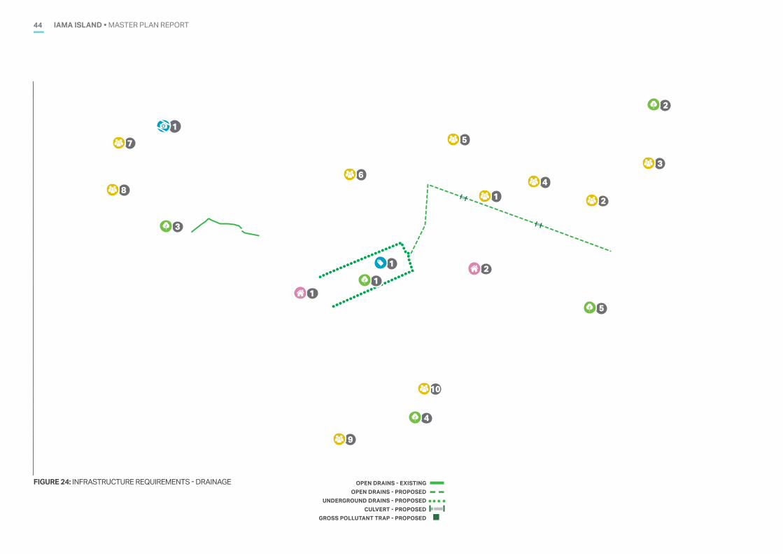
IAMA ISLAND • MASTER PLAN REPORT44
FIGURE 24: INFRASTRUCTURE REQUIREMENTS - DRAINAGE
IAMA �YAM� ISLANDBASE PLAN
FOR DISCUSSION PURPOSES ONLY
200 m
LEGEND Property boundaries
1
21
3
1 2
3
4
1
2
5
1
4
5
6
8
7
9
10
OPEN DRAINS - EXISTINGOPEN DRAINS - PROPOSED
UNDERGROUND DRAINS - PROPOSEDCULVERT - PROPOSED
GROSS POLLUTANT TRAP - PROPOSED
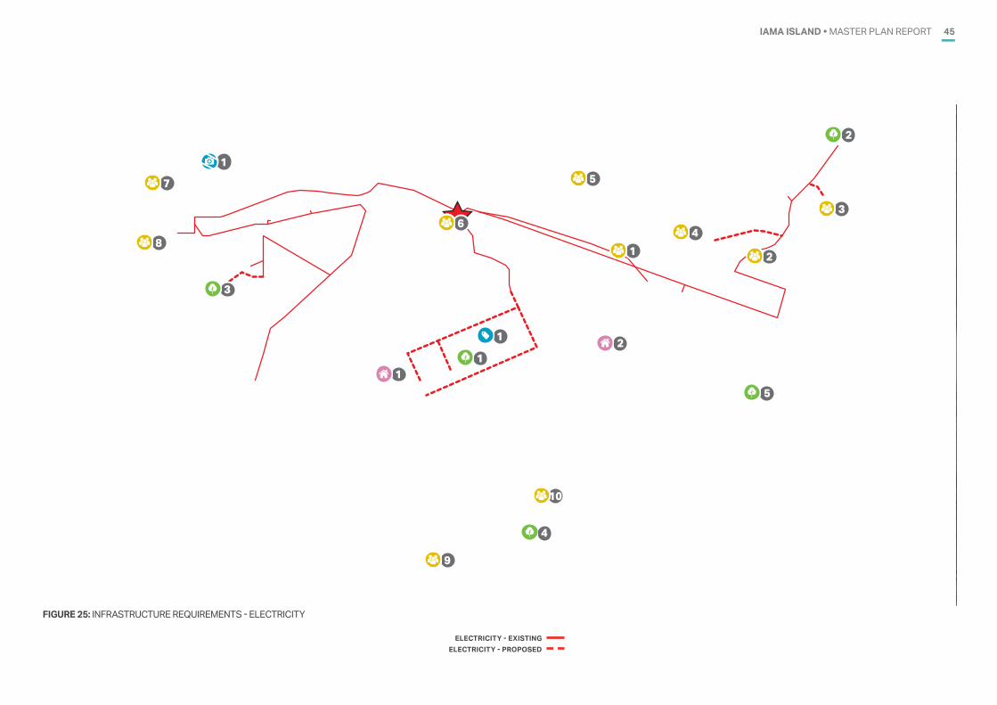
IAMA ISLAND • MASTER PLAN REPORT 45
FIGURE 25: INFRASTRUCTURE REQUIREMENTS - ELECTRICITY
ELECTRICITY - EXISTINGELECTRICITY - PROPOSED
IAMA �YAM� ISLANDBASE PLAN
FOR DISCUSSION PURPOSES ONLY
200 m
LEGEND Property boundaries
1
21
3
1 2
3
4
1
2
5
1
4
5
6
8
7
9
10
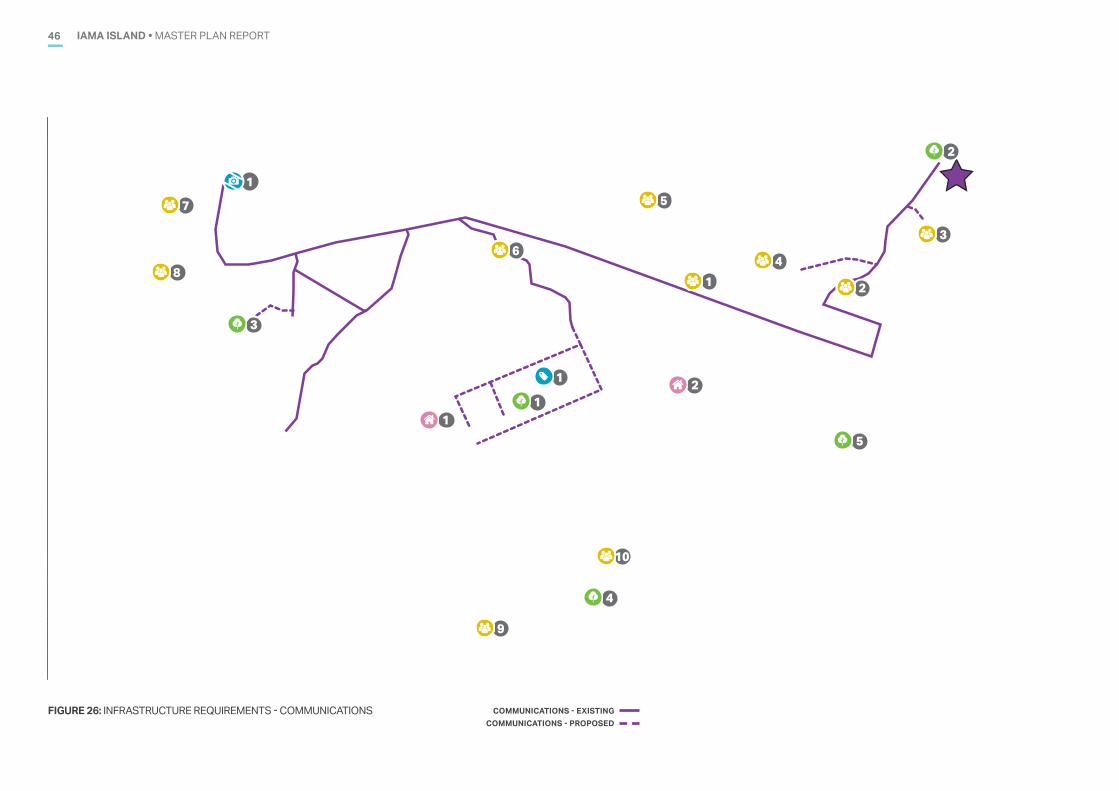
IAMA ISLAND • MASTER PLAN REPORT46
FIGURE 26: INFRASTRUCTURE REQUIREMENTS - COMMUNICATIONS COMMUNICATIONS - EXISTINGCOMMUNICATIONS - PROPOSED
IAMA �YAM� ISLANDBASE PLAN
FOR DISCUSSION PURPOSES ONLY
200 m
LEGEND Property boundaries
1
21
3
1 2
3
4
1
2
5
1
4
5
6
8
7
9
10
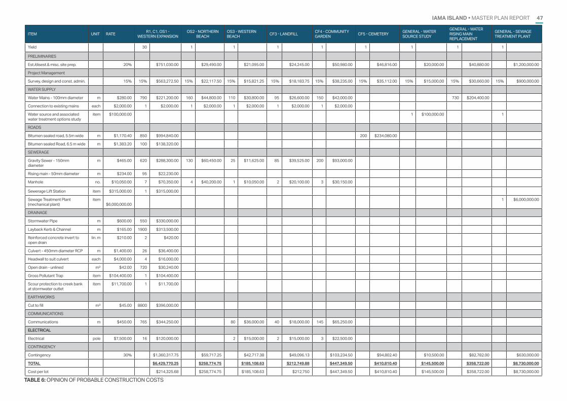
IAMA ISLAND • MASTER PLAN REPORT 47
TABLE 6: OPINION OF PROBABLE CONSTRUCTION COSTS
ITEM UNIT RATE R1, C1, OS1 - WESTERN EXPANSION
OS2 - NORTHERN BEACH
OS3 - WESTERN BEACH CF3 - LANDFILL CF4 - COMMUNITY
GARDEN CF5 - CEMETERY GENERAL - WATER SOURCE STUDY
GENERAL - WATER RISING MAIN REPLACEMENT
GENERAL - SEWAGE TREATMENT PLANT
Yield 30 1 1 1 1 1 1 1 1
PRELIMINARIES
Est./disest.& misc. site prep. 20% $751,030.00 $29,490.00 $21,095.00 $24,245.00 $50,980.00 $46,816.00 $20,000.00 $40,880.00 $1,200,000.00
Project Management
Survey, design and const. admin. 15% 15% $563,272.50 15% $22,117.50 15% $15,821.25 15% $18,183.75 15% $38,235.00 15% $35,112.00 15% $15,000.00 15% $30,660.00 15% $900,000.00
WATER SUPPLY
Water Mains - 100mm diameter m $280.00 790 $221,200.00 160 $44,800.00 110 $30,800.00 95 $26,600.00 150 $42,000.00 730 $204,400.00
Connection to existing mains each $2,000.00 1 $2,000.00 1 $2,000.00 1 $2,000.00 1 $2,000.00 1 $2,000.00
Water source and associated water treatment options study
item $100,000.00 1 $100,000.00 1
ROADS
Bitumen sealed road, 5.5m wide m $1,170.40 850 $994,840.00 200 $234,080.00
Bitumen sealed Road, 6.5 m wide m $1,383.20 100 $138,320.00
SEWERAGE
Gravity Sewer - 150mm diameter
m $465.00 620 $288,300.00 130 $60,450.00 25 $11,625.00 85 $39,525.00 200 $93,000.00
Rising main - 50mm diameter m $234.00 95 $22,230.00
Manhole no. $10,050.00 7 $70,350.00 4 $40,200.00 1 $10,050.00 2 $20,100.00 3 $30,150.00
Sewerage Lift Station item $315,000.00 1 $315,000.00
Sewage Treatment Plant (mechanical plant)
item $6,000,000.00
1 $6,000,000.00
DRAINAGE
Stormwater Pipe m $600.00 550 $330,000.00
Layback Kerb & Channel m $165.00 1900 $313,500.00
Reinforced concrete invert to open drain
lin. m $210.00 2 $420.00
Culvert - 450mm diameter RCP m $1,400.00 26 $36,400.00
Headwall to suit culvert each $4,000.00 4 $16,000.00
Open drain - unlined m² $42.00 720 $30,240.00
Gross Pollutant Trap item $104,400.00 1 $104,400.00
Scour protection to creek bank at stormwater outlet
item $11,700.00 1 $11,700.00
EARTHWORKS
Cut to fill m³ $45.00 8800 $396,000.00
COMMUNICATIONS
Communications m $450.00 765 $344,250.00 80 $36,000.00 40 $18,000.00 145 $65,250.00
ELECTRICAL
Electrical pole $7,500.00 16 $120,000.00 2 $15,000.00 2 $15,000.00 3 $22,500.00
CONTINGENCY
Contingency 30% $1,360,317.75 $59,717.25 $42,717.38 $49,096.13 $103,234.50 $94,802.40 $10,500.00 $82,782.00 $630,000.00
TOTAL $6,429,770.25 $258,774.75 $185,108.63 $212,749.88 $447,349.50 $410,810.40 $145,500.00 $358,722.00 $8,730,000.00
Cost per lot $214,325.68 $258,774.75 $185,108.63 $212,750 $447,349.50 $410,810.40 $145,500.00 $358,722.00 $8,730,000.00
IAMA ISLAND • MASTER PLAN REPORT48
KEYREFERENCES11
This section provides an overview of other key reference documents and design strategies which should be considered by Council as part of implementation of the Iama Master Plan.
TORRES STRAIT ISLAND REGIONAL COUNCIL CORPORATE PLAN 2020 - 2025The Corporate Plan 2020-2025 is the corporate plan prepared by the Torres Strait Island Regional Council. The plan is the lead document for Council’s service provision. The Corporate Plan fulfils the Council’s obligations under the Local Government Act 2009. The Corporate Plan highlights the following mission statement:
“To improve our Communities’ liveability in all we do.”
The goals identified in the corporate plan are:
• Bisnis Pipol - People
— Preserve cultural heritage, history and place
— Safe, healthy and active communities
— Accessible community support services
— Be a transparent, open and engaging council
• Bisnis Mekem las long - Sustainability
— Plan for the future of our individual communities and region
— Our communities are resilient to the effects of climate change and natural disasters
— Our communities are consulted around liveable places, aligned to lifestyle and environmental suitability
— Council affairs are managed responsibility to the benefit of the communities
— We actively reduce our environmental footprint and manage our resources sustainably
• Bisnis Pruitpul - Prosperity
— We advocate and foster regional prosperity through enterprise development
— We invest in the retention of key skills within the region
— We bring opportunity to our region and put our culture on the world stage.
TORRES STRAIT ISLAND REGIONAL COUNCIL OPERATIONAL PLAN 2019 - 2020The Operational Plan 2019 - 2020 provides detailed strategies, activities, timing and budget links for implementation of the following core program themes identified in the Corporate Plan 2020-2025:
• Executive office
• Corporate affairs and engagement
• Community and environment
• Engineering services
• Building services
• Housing and tenancy services
• Strategic projects and logistics
• Business services
ACTIVATE! QUEENSLAND 2019-2029Activate! Queensland 2019–2029 is the Queensland Government’s 10 year strategy to further enrich the Queensland way of life; harnessing the pride of great sporting traditions, embracing iconic natural environment and building on strong community foundations to deliver better health and wellbeing outcomes, especially for those most vulnerable.
Activate! Queensland will be rolled out through three multi-year action plans. The first action plan, Our Active8, will outline the practical, whole-of-government actions to be implemented from 2019 to 2022 and will be delivered through eight strategies across four priority areas:
• Activate Queenslanders
— 01 Enhance equity and inclusion
— 02 Transform attitudes and behaviours
• Activate Environments
— 03 Deliver quality and accessible places and spaces
— 04 Improve liveability and activity in our communities
• Activate Success
— 05 Grow elite success and keep Queensland winning
— 06 Provide world-class fan experiences through major sports and entertainment facilities
• Activate Collaboration
— 07 Transform the active industry’s role
— 08 Leverage knowledge, technology and innovation.
CRIME PREVENTION THROUGH ENVIRONMENTAL DESIGN (CPTED)Crime Prevention Through Environmental Design (CPTED) is designing using the built environment to create safer neighbourhoods.
Growing interest in environmental criminology led to the use of natural surveillance, access control and territoriality as a natural method in crime prevention.
The ‘broken window’ principle demonstrated how neglected zones invite crime, and reinforced the need for good property maintenance to assert visible ownership of space.
Appropriate environmental design can also increase the perceived likelihood of detection and apprehension, known to be the biggest single deterrent to crime.
HEALTHY BY DESIGN Healthy by Design has been developed in response to local government requests for practical guidance in designing walkable, and ultimately more liveable, communities.
This is encouraged by providing:
• well planned networks of walking and cycling routes
• streets with direct, safe and convenient access
• local destinations within walking distance from homes
• accessible open spaces for recreation and leisure
• conveniently located public transport within walkable distances
• local neighbourhoods fostering community.
IAMA ISLAND • MASTER PLAN REPORT 49
WATER SENSITIVE URBAN DESIGN Water-Sensitive Urban Design (WSUD) is a land planning and engineering design approach which integrates the urban water cycle, including stormwater, groundwater and wastewater management and water supply, into urban design to minimise environmental degradation and improve aesthetic and recreational appeal.
This is encouraged through:
• natural channel design
• stormwater outlets as park and waterway systems
• erosion treatment for urban waterways
• sediment and retention basins as natural features
• landscape design of urban water systems.
COASTAL BLUE CARBON: AN INTRODUCTION FOR POLICY MAKERSCoastal blue carbon: an introduction for policy makers provides an introduction to the concept of blue carbon and coastal blue carbon ecosystems – mangroves, tidal marshes and sea grasses. It outlines:
• why blue carbon ecosystems are important
• the basic science of blue carbon as a basis for policy and practical action
• an overview of relevant policy frameworks, and
• a summary of finance sources that can support practical action.
It describes some of the challenges and opportunities in developing policies and undertaking projects to protect and restore coastal blue carbon ecosystems. It also highlights some of the projects and countries that are leading the way in managing these challenges and opportunities. It serves as a reference for those who are new to blue carbon and those who are seeking to bring a greater focus on blue carbon in their jurisdictions.
IAMA ISLAND • MASTER PLAN REPORT50
SUMMARY12The preferred master plan identifies a range of development opportunities which provide Council with a clear set of options to progress future residential and non-residential development into the future. The right combination of housing choice and employment opportunity will promote a successful and vibrant community with a diversified and strong local economy. Whilst each development area will require extension and/or connection to existing infrastructure and services, the overall capacity of these systems will not constrain implementation of the master plan.
In recognition of the ongoing risks associated with coastal processes and climate change, a key element of the preferred Master Plan (and associated enabling infrastructure costs), is long-term expansion of the community in an elevated location.
The preferred Master Plan represents a long term guide for development throughout the Iama community. Figure 20 provides an indication of the potential future land use framework based on the preferred Master Plan. Council will consider the indicative yields and enabling infrastructure costs when staging future development and infrastructure outlay. The yields and costs will also provide an important basis of information to inform discussions and negotiations with key agencies and stakeholders. Table 6 outlines the estimated costs.
TABLE 7: ENABLING INFRASTRUCTURE COST*TBC - Enabling infrastructure costs to be determined based on further investigations and assessment**Capital cost based on Coastal Hazard Assessment and Mitigation Assessment^N/A - Item is either in a serviced area or does not require enabling infrastructure.
ITEM YIELD COST
R1 Expansion precinct – west 28 LOTS $6,429,770.25 ($214,325.68 per lot)
R2 Expansion precinct – east 20 LOTS TBC*
R3 General items - N/A^
C1 Expansion precinct – east 2 LOTS
Refer R1
T1 Peninsula -
N/A^
OS1 Expansion precinct – west - Refer R1OS2 Northern beach - $258,774.75 OS3 Western beach - $185,108.63 OS4 Southern coast - N/A^
OS5 Cultural sites - N/A^
OS6 General - TBC*
CF1 Airport - N/A^CF2 Sports complex - TBC*CF3 Landfill - $212,749.88 CF4 Community garden - $447,349.50 CF5 Cemetery - $410,810.40 CF6 Power generation - TBC*CF7 Seawalls and bunds - $6.5 million**CF8 Port - N/A^CF9 Access - N/A^
CF10 Communications - TBC*CF11 General - $145,500.00 (water source study)
$358,722.00 (water rising main replacement)
$8,730,000.00 (sewage treatment plant)
Otherwise - TBC*
IAMA ISLAND • MASTER PLAN REPORT 51
CATEGORY ITEM ACTIONS
RESIDENTIAL
R1 Expansion precinct – west
R2.1: Undertake planning scheme amendment to incorporate site in township zone. R2.2: Address Native Title Act 1993 requirements and amend Indigenous Land Use Agreement (ILUA). R2.3: Address duty of care requirements under the Torres Strait Islander Cultural Heritage Act 2003 (e.g. cultural heritage survey and cultural heritage management plan).
R2.4: Optimise subdivision layout and housing design to minimise cut and fill requirements and other enabling infrastructure.
R2.5: Obtain approvals under the planning scheme and State legislation (e.g. reconfiguring a lot, operational works etc).
R2.6: Undertake civil engineering design for necessary infrastructure upgrades and extension.
R2 Expansion precinct – east
R1.1: Undertake planning scheme amendment to incorporate site in township zone. R1.2: Address Native Title Act 1993 requirements and amend Indigenous Land Use Agreement (ILUA).
R3 General items
R3.1: Council to liaise with Department of Housing and Public Works to seek commitments regarding climate responsive retrofit of existing housing stock as part of scheduled maintenance. R3.2: Department of Housing and Public Works to undertake review of existing housing stock to identify houses likely to require replacement in 5-10 year horizon. R3.3: Council to liaise with occupants of housing scheduled for replacement to identify functional requirements and opportunities for alternate typologies. R3.4: Subject to outcomes of R3.3, Council to provide summary of preferred redevelopment typologies to Department of Housing and Public Works.
COMMERCIAL C1 Expansion precinct – east
C1.1: Undertake stakeholder engagement between Council, Traditional Owners, service providers and commercial operators to identify potential future requirements for commercial and retail floorspace.C1.2: Prepare precinct plan which accommodates commercial and retail floorspace.
TOURISM T1 Peninsula T1.2: Prepare Tourism Strategy for Iama which links the resort to other opportunities on Iama and nearby island communities. T1.2: Prepare waterfront landscape precinct plan.
OPEN SPACE
OS1 Expansion precinct – west
OS1.1: Prepare land management plan, in consultation with Traditional Owners and Land and Sea Rangers, for conservation and appropriate use of culturally significant sites.
OS2 Northern beachOS2.1: Undertake targeted engagement with Land and Sea Rangers and Traditional Owners to seek agreement for development of visitor day-use. OS2.2: Pending outcomes of OS5.1, prepare concept plan for layout and facilities.
OS3 Western beach
OS3.1: Undertake asset survey to confirm location of as-constructed water infrastructure. If necessary, adjust cost estimate for water infrastructure. OS3.2: Prepare waterfront esplanade, in conjunction with tourism strategy (T1.3) to create a pedestrian focussed pedestrian esplanade including lighting, shelters and amenities. OS3.3: Address Native Title Act 1993 requirements and amend Indigenous Land Use Agreement (ILUA). OS3.4: Address duty of care requirements under the Torres Strait Islander Cultural Heritage Act 2003 (e.g. cultural heritage survey and cultural heritage management plan). OS3.5: Obtain approvals under the planning scheme and State legislation (e.g. reconfiguring a lot, operational works etc).
OS4 Southern coast OS4.1: Reflect intended use of area when developing management strategies as part of land management plan (OS3.1).
OS5 Cultural sitesOS5.1: Liaise with Land and Sea Rangers, in conjunction with preparation of land management plan (OS1.1) to prepare a map of trails and paths.
OS5.2: Prepare civil design and cost estimate.
OS6 GeneralOS6.1: Undertake site selection exercise to identify suitable location for new park to service existing township.
OS6.2: Pending outcomes of OS6.1, prepare landscape concept plan for new park. TABLE 8: ACTION PLAN (PART 1 OF 2)
IAMA ISLAND • MASTER PLAN REPORT52
CATEGORY ITEM ACTIONS
COMMUNITY FACILITIES
CF1 Airport CF1.1: Undertake planning scheme amendment which includes airport extension and overlays to restrict built form surrounding the airport.CF2 Sports complex CF2.1: Prepare electrical lighting design and costing. CF3 Landfill CF3.1: Prepare waste management strategy for Torres Strait Regional Council local government area, including consideration of biosecurity controls and waste disposal
locations.
CF3.2: Prepare recycling strategy.
CF3.3: Pending outcomes of CF3.1, prepare site layout to redevelop landfill site into a waste transfer station.
CF3.4: Obtain approvals under the planning scheme and State legislation (e.g. reconfiguring a lot, operational works etc).
CF3.5: Undertake civil engineering design for necessary enabling infrastructure.CF4 Community
gardenCF4.1: Undertake community engagement to confirm demand for restart of community garden and identify potential operators (e.g. community groups).
CF4.2: Obtain approvals under the planning scheme and State legislation (e.g. reconfiguring a lot, operational works etc).
CF4.3: Undertake civil engineering design for necessary enabling infrastructure.CF5 Cemetery CF5.1: Undertake assessment to determine remaining capacity of cemetery.
CF5.2: Undertake assessment to confirm opportunities for cemetery expansion (existing and new site) and alternatives.
CF5.3: Undertake ecology survey to inform footprint of future expansion works and road re-alignment to minimise impact on marine ecosystem (mangroves).
CF5.4: Undertake civil engineering design of flood mitigation bund and re-alignment of road to north of cemetery. CF6 Power generation CF6.1: Powerlink to undertake asset risk assessment to confirm whether relocation is required. CF7 Seawalls and
bundsCF7.1: Review mitigation options and progress implementation as outlined in existing Coastal Hazard Assessment and Mitigation Report
CF8 Port CF8.1: Liaise with Department of Transport and Main Roads to prepare port master plan which includes identification of marine facilities, maintenance dredging and landside facilities.
CF9 Access CF9.1: Determine appropriate design criteria for adoption (e.g. unsealed, gravel, paved).
CF9.2: Prepare concept design to identify potential road / access track alignment and refine cost estimate. CF10 Communications CF10.1: Liaise with telecommunications service provider to determine suitability of existing site and if required, assess feasibility of alternative site. CF11 General CF11.1: Prepare lighting design for staged provision of public street lighting along all paved roadways.
CF11.2: Undertake sewer network capacity assessment.
CF11.3: Expand upon assessment contained within Coastal Hazard and Assessment and Mitigation Report to assess resilience of public utilities to all natural hazards and extreme weather events.
CF11.4: Undertake site selection exercise for new multi-purpose centre.
CF11.5: Prepare water network model and recommendations for necessary repairs and upgrades.TABLE 9: ACTION PLAN (PART 2 OF 2)
IAMA ISLAND • MASTER PLAN REPORT 53
Australian Bureau of Statistics, 2016, ‘Iama Island SSC31393 (SSC), General Community Profile’ (Catalogue number 2001.0), viewed 08 June 2020, https://quickstats.censusdata.abs.gov.au/census_services/getproduct/census/2016/communityprofile/SSC31393?opendocument
Australian Bureau of Statistics, 2016, ‘Iama Island SSC31393 (SSC), 2016 Census Quick Stats’, viewed 28 May 2020, https://quickstats.censusdata.abs.gov.au/census_services/getproduct/census/2016/quickstat/SSC31393
Torres Strait Island Regional Council, 2020, Torres Strait Island Regional Council Planning Scheme.
Torres Strait Island Regional Council, 2020, Torres Strait Island Regional Council Corporate Plan 2020 - 2025.
Torres Strait Island Regional Council, 2019, Torres Strait Island Regional Council Operational Plan 2019 - 2020.
Queensland Government, 2009, Torres Strait Island and Northern Peninsula Regional Plan 2009 - 2029.
Queensland Government, 2015, Projected Population, by local government area, Queensland, 2011 to 2036, viewed 26 September 2017, http://www.qgso.qld.gov.au/subjects/demography/ population-projections/tables/proj-pop-lga-qld/index.php
REFERENCES13
54 IAMA ISLAND • MASTER PLAN REPORT
APPENDIX A. DETAILED PLANSA.
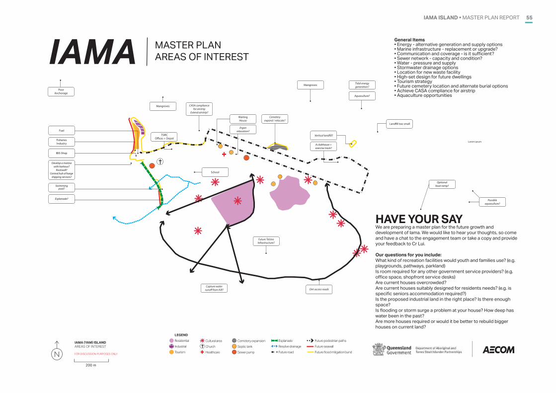
IAMA ISLAND • MASTER PLAN REPORT 55
General Items• Energy - alternative generation and supply options • Marine infrastructure - replacement or upgrade?• Communication and coverage - is it sufficient? • Sewer network - capacity and condition? • Water - pressure and supply• Stormwater drainage options• Location for new waste facility• High-set design for future dwellings• Tourism strategy• Future cemetery location and alternate burial options• Achieve CASA compliance for airstrip • Aquaculture opportunities
HAVE YOUR SAYWe are preparing a master plan for the future growth and development of Iama. We would like to hear your thoughts, so come and have a chat to the engagement team or take a copy and provide your feedback to Cr Lui. Our questions for you include:What kind of recreation facilities would youth and families use? (e.g. playgrounds, pathways, parkland)Is room required for any other government service providers? (e.g. office space, shopfront service desks)Are current houses overcrowded? Are current houses suitably designed for residents needs? (e.g. is specific seniors accommodation required?)Is the proposed industrial land in the right place? Is there enough space?Is flooding or storm surge a problem at your house? How deep has water been in the past?Are more houses required or would it be better to rebuild bigger houses on current land?
Lorem ipsum
IAMA MASTER PLAN AREAS OF INTEREST
A clubhouse +exercise track?
Poor Anchorage
TSIRCO�ces + Depot
Mangroves
IBIS Shop
Fuel
Fisheries Industry
Develop a marina with harbour?
Rockwall?Central hub of barge
shipping services?
Esplanade?
Waiting House
Ergon relocation?
Swimming pool?
Future TelstraInfrastructure?
Cemetery expand / relocate?
School
Aquaculture?
Tidal energy generation?
Capture water runo� from hill?
CASA compliance for airstrip
Extend airstrip?
Vertical land�ll?
Possible aquaculture?
Optional boat ramp?
Mangroves
Dirt access roads
Land�ll too small
IAMA �YAM� ISLANDAREAS OF INTEREST
FOR DISCUSSION PURPOSES ONLY
LEGEND Residential IndustrialTourism
Cultural areaChurchHealthcare
Cemetery expansionSeptic tankSewer pump
Esplanade Resolve drainageFuture road
Future pedestrian pathsFuture seawall Future flood mitigation bund
200 m
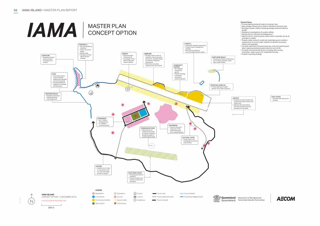
IAMA ISLAND • MASTER PLAN REPORT56
CULTURAL SITES\ Create tracks and
boardwalks to access cultural sites
ENERGY \ Relocate Ergon
infrastructure\ Investigate renew-
able energy gen-eration options
PENINSULA\ Day use facilities &
amenities \ Visitor accommo-
dation \ Market stalls \ Develop a central
island Tourism strategy
FUEL SUPPLY
- 24 hour fuel supply?- Fuel card? - Relocate Fuel?
SOUTHERN COAST\ Camping grounds for
residents\ Provide shelters and
access to water and amenities
COMMUNICATIONS\ Alternate site for
mobile phone tower to improve resilience (located outside of coastal hazard area)
CEMETERY\ Re-align road to north of
cemetery and incorporate with bund - detailed design to minimise mangrove disturbance
\ Determine remaining capacity and next location
General Items\ Provide lighting along all roads to housing / area \ New sewage infrastructure sized to ultimate community size \ Bunding of public utilities including sewage treatment plant &
landfill \ Resilience investigations for public utilities \ Identify site for new park and playground \ Identify site for multi-purpose centre which could also act as an
emergency shelter \ Prepare water network model and undertake asset condition
assessment of current water network to identify necessary repairs and upgrades
\ Consider alternative housing types (e.g. units and townhouses) when replacing existing houses where at end-of-life
\ Consider environmental factors including solar access, orientation, wells, louvres for residential housing
\ Prepare recycling strategy
IAMA MASTER PLAN CONCEPT OPTION
IAMA ISLANDCONCEPT OPTION � 2 DECEMBER 2019
FOR DISCUSSION PURPOSES ONLY
LEGEND
Residential
Commerical
Community facilities
Open space
Recreation
Tourism
Airport buffer
Cultural area
Church
Council
Healthcare
Future road
Future pedestrian path
Future rockwall
200 m
Future seawall
Future flood mitigation bund
COMMUNITY GARDEN\ Re-establish
community garden
\ Prepare strategy to promote household produce gardens
LANDFILL\ Undertake capacity assessment\ Prepare waste management
strategy \ Site may be suitable to
accommodate transfer station
NORTHERN BEACH\ Develop recreation facilities (e.g.
picnic tables, gazebos, water taps, public toilets)
SPORTING COMPLEX\ Provide lighting to enable
greater use of sports ground
AIRPORT\ Extension to east would avoid
conflict with power station and health clinic
\ Maintain 50m wide lateral transitional slope area from boundary for air safety
EAST COAST\ Provides safe harbour for
boating
ACCESS\ Establish access track
or road along south-ern coast from edge of town to airport
WESTERN BEACH\ Establish pedestrian
esplanade along main beachfront
PORT\ Undertake assess-
ment to identify additional breakwalls and mooring areas
\ Provide pedestrian pathway on rockwall linking to jetty
EXPANSION\ 28 X 1,000m²
residential lots \ 2 x 3,000m²
commercial lots EXPANSION\ Area for long-term
expansion of the community away from coastal hazards
COASTLINE\ Seawall and bund
walls to reduce inundation and erosion
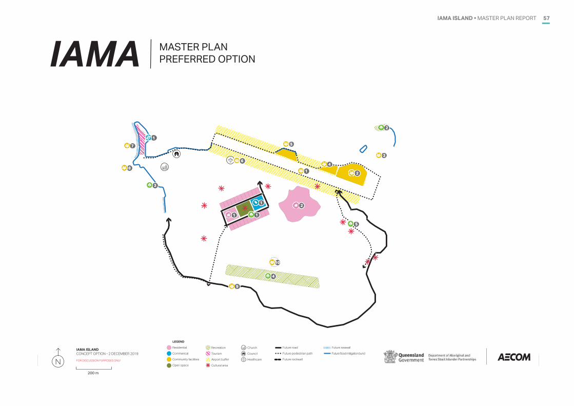
IAMA ISLAND • MASTER PLAN REPORT 57
IAMA MASTER PLAN PREFERRED OPTION
IAMA ISLANDCONCEPT OPTION � 2 DECEMBER 2019
FOR DISCUSSION PURPOSES ONLY
LEGEND
Residential
Commerical
Community facilities
Open space
Recreation
Tourism
Airport buffer
Cultural area
Church
Council
Healthcare
Future road
Future pedestrian path
Future rockwall
200 m
Future seawall
Future flood mitigation bund
1
21
3
1 2
3
4
1
2
5
1
4
5
6
8
7
9
10
58 IAMA ISLAND • MASTER PLAN REPORTIAMA ISLAND • MASTER PLAN REPORT58
APPENDIX B. INFRASTRUCTURE ASSESSMENTB.
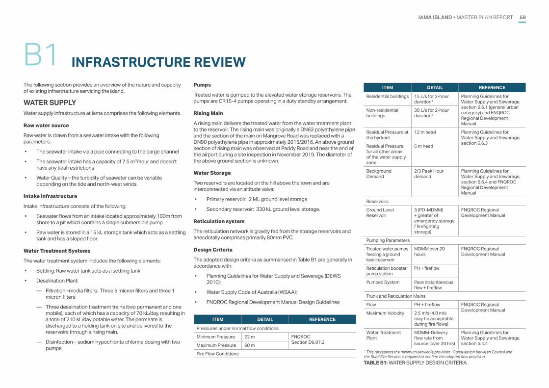
IAMA ISLAND • MASTER PLAN REPORT 59
INFRASTRUCTURE REVIEWB1
TABLE B1: WATER SUPPLY DESIGN CRITERIA
ITEM DETAIL REFERENCE
Pressures under normal flow conditions
Minimum Pressure 22 m FNQROCSection D6.07.2Maximum Pressure 60 m
Fire Flow Conditions1 This represents the minimum allowable provision. Consultation between Council and the Rural Fire Service is required to confirm the adopted flow provision.
The following section provides an overview of the nature and capacity of existing infrastructure servicing the island.
WATER SUPPLYWater supply infrastructure at Iama comprises the following elements.
Raw water source
Raw water is drawn from a seawater intake with the following parameters:
• The seawater intake via a pipe connecting to the barge channel
• The seawater intake has a capacity of 7.5 m3/hour and doesn’t have any tidal restrictions
• Water Quality – the turbidity of seawater can be variable depending on the tide and north-west winds.
Intake infrastructure
Intake infrastructure consists of the following:
• Seawater flows from an intake located approximately 100m from shore to a pit which contains a single submersible pump
• Raw water is stored in a 15 kL storage tank which acts as a settling tank and has a sloped floor.
Water Treatment Systems
The water treatment system includes the following elements:
• Settling: Raw water tank acts as a settling tank
• Desalination Plant:
— Filtration –media filters: Three 5 micron filters and three 1 micron filters
— Three desalination treatment trains (two permanent and one mobile), each of which has a capacity of 70 kL/day, resulting in a total of 210 kL/day potable water. The permeate is discharged to a holding tank on site and delivered to the reservoirs through a rising main.
— Disinfection – sodium hypochlorite chlorine dosing with two pumps
Pumps
Treated water is pumped to the elevated water storage reservoirs. The pumps are CR15-4 pumps operating in a duty standby arrangement.
Rising Main
A rising main delivers the treated water from the water treatment plant to the reservoir. The rising main was originally a DN63 polyethylene pipe and the section of the main on Mangrove Road was replaced with a DN90 polyethylene pipe in approximately 2015/2016. An above ground section of rising main was observed at Paddy Road and near the end of the airport during a site inspection in November 2019. The diameter of the above ground section is unknown.
Water Storage
Two reservoirs are located on the hill above the town and are interconnected via an altitude valve:
• Primary reservoir: 2 ML ground level storage
• Secondary reservoir: 330 kL ground level storage.
Reticulation system
The reticulation network is gravity fed from the storage reservoirs and anecdotally comprises primarily 80mm PVC.
Design Criteria
The adopted design criteria as summarised in Table B1 are generally in accordance with:
• Planning Guidelines for Water Supply and Sewerage (DEWS 2010);
• Water Supply Code of Australia (WSAA);
• FNQROC Regional Development Manual Design Guidelines
ITEM DETAIL REFERENCE
Residential buildings 15 L/s for 2-hour duration1
Planning Guidelines for Water Supply and Sewerage, section 6.6.1 (general urban category) and FNQROC Regional Development Manual
Non-residential buildings
30 L/s for 2-hour duration1
Residual Pressure at the hydrant
12 m head Planning Guidelines for Water Supply and Sewerage, section 6.6.3Residual Pressure
for all other areas of the water supply zone
6 m head
Background Demand
2/3 Peak Hour demand
Planning Guidelines for Water Supply and Sewerage, section 6.6.4 and FNQROC Regional Development Manual
Reservoirs
Ground Level Reservoir
3 (PD-MDMM) + greater of emergency storage / firefighting storage)
FNQROC Regional Development Manual
Pumping Parameters
Treated water pumps feeding a ground level reservoir
MDMM over 20 hours
FNQROC Regional Development Manual
Reticulation booster pump station
PH + fireflow
Pumped System Peak instantaneous flow + fireflow
Trunk and Reticulation Mains
Flow PH + fireflow FNQROC Regional Development ManualMaximum Velocity 2.5 m/s (4.0 m/s
may be acceptable during fire flows)
Water Treatment Plant
MDMM-Delivery flow rate from source (over 20 hrs)
Planning Guidelines for Water Supply and Sewerage, section 5.4.4
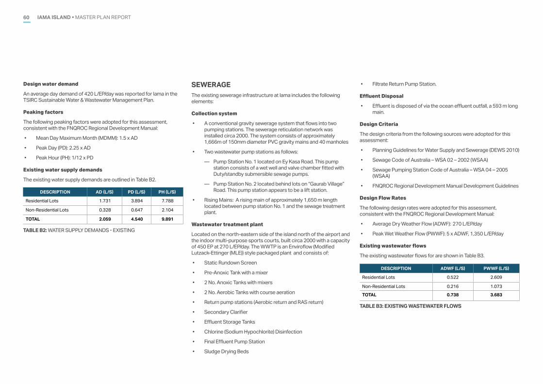
IAMA ISLAND • MASTER PLAN REPORT60
TABLE B2: WATER SUPPLY DEMANDS - EXISTING
DESCRIPTION AD (L/S) PD (L/S) PH (L/S)
Residential Lots 1.731 3.894 7.788
Non-Residential Lots 0.328 0.647 2.104
TOTAL 2.059 4.540 9.891
TABLE B3: EXISTING WASTEWATER FLOWS
DESCRIPTION ADWF (L/S) PWWF (L/S)
Residential Lots 0.522 2.609
Non-Residential Lots 0.216 1.073
TOTAL 0.738 3.683
Design water demand
An average day demand of 420 L/EP/day was reported for Iama in the TSIRC Sustainable Water & Wastewater Management Plan.
Peaking factors
The following peaking factors were adopted for this assessment, consistent with the FNQROC Regional Development Manual:
• Mean Day Maximum Month (MDMM): 1.5 x AD
• Peak Day (PD): 2.25 x AD
• Peak Hour (PH): 1/12 x PD
Existing water supply demands
The existing water supply demands are outlined in Table B2.
SEWERAGEThe existing sewerage infrastructure at Iama includes the following elements:
Collection system
• A conventional gravity sewerage system that flows into two pumping stations. The sewerage reticulation network was installed circa 2000. The system consists of approximately 1,666m of 150mm diameter PVC gravity mains and 40 manholes
• Two wastewater pump stations as follows:
— Pump Station No. 1 located on Ey Kasa Road. This pump station consists of a wet well and valve chamber fitted with Duty/standby submersible sewage pumps.
— Pump Station No. 2 located behind lots on “Gaurab Village” Road. This pump station appears to be a lift station.
• Rising Mains: A rising main of approximately 1,650 m length located between pump station No. 1 and the sewage treatment plant.
Wastewater treatment plant
Located on the north-eastern side of the island north of the airport and the indoor multi-purpose sports courts, built circa 2000 with a capacity of 450 EP at 270 L/EP/day. The WWTP is an Enviroflow (Modified Lutzack-Ettinger (MLE)) style packaged plant and consists of:
• Static Rundown Screen
• Pre-Anoxic Tank with a mixer
• 2 No. Anoxic Tanks with mixers
• 2 No. Aerobic Tanks with course aeration
• Return pump stations (Aerobic return and RAS return)
• Secondary Clarifier
• Effluent Storage Tanks
• Chlorine (Sodium Hypochlorite) Disinfection
• Final Effluent Pump Station
• Sludge Drying Beds
• Filtrate Return Pump Station.
Effluent Disposal
• Effluent is disposed of via the ocean effluent outfall, a 593 m long main.
Design Criteria
The design criteria from the following sources were adopted for this assessment:
• Planning Guidelines for Water Supply and Sewerage (DEWS 2010)
• Sewage Code of Australia – WSA 02 – 2002 (WSAA)
• Sewage Pumping Station Code of Australia – WSA 04 – 2005 (WSAA)
• FNQROC Regional Development Manual Development Guidelines
Design Flow Rates
The following design rates were adopted for this assessment, consistent with the FNQROC Regional Development Manual:
• Average Dry Weather Flow (ADWF): 270 L/EP/day
• Peak Wet Weather Flow (PWWF): 5 x ADWF, 1,350 L/EP/day
Existing wastewater flows
The existing wastewater flows for are shown in Table B3.
IAMA ISLAND • MASTER PLAN REPORT 61
STORMWATERIama is a vegetated granite island fringed with coral sand flats. The island contains vegetated, steep and hilly land, plateau areas at the top of the slope and flat areas around the coastline. The majority of the community is located within the flat areas.
A limited number of stormwater pits assist with the removal of stormwater from within the community and out to sea and kerbing is provided on some of the existing roads. The remainder of the community is serviced by overland flow, including a drainage channel located through the main community along Ey Kasa Road.
ELECTRICITY SUPPLY & COMMUNICATIONSIama receives power from three Ergon Energy diesel generators which are located near the airstrip. Electricity is supplied to the community by an overhead supply to the property boundary. Extension of existing supply to new properties will be required.
A communications tower is located near the landfill and the sewage treatment plant. Communications is provided to the community by underground cabling. Extension of conduiting to the frontage of new properties will be required.
TRANSPORTIama Island is part of the Torres Strait central group of islands and is located approximately 93 km north east of Horn Island. Access to Iama is by air or by barge. The airstrip and helicopter landing pad is located in the centre of the island to the east of the community and the barge ramp and finger pier is located on the western side of the island. A boat ramp is located of Mangrove Road, to the north of the community.
Iama contains a network of paved and sealed local roads, along with formed dirt roads. The paved and sealed roads are typically 4.5 to 5.5 m wide and are generally in good condition. Where new developments are proposed that require new roads to access the sites, paved roads with 200 mm wide concrete edge strips to match the existing roads will be required.
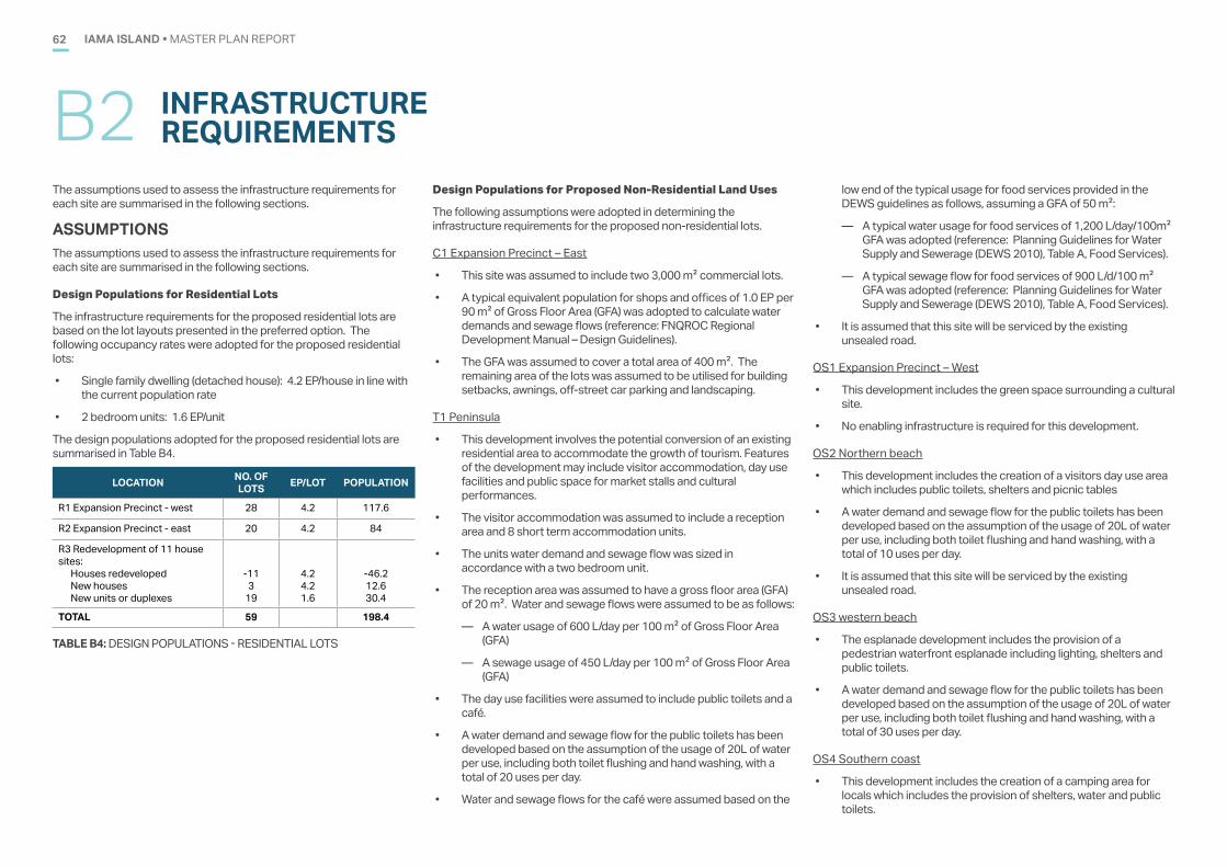
IAMA ISLAND • MASTER PLAN REPORT62
INFRASTRUCTURE REQUIREMENTSB2
TABLE B4: DESIGN POPULATIONS - RESIDENTIAL LOTS
LOCATION NO. OF LOTS EP/LOT POPULATION
R1 Expansion Precinct - west 28 4.2 117.6
R2 Expansion Precinct - east 20 4.2 84
R3 Redevelopment of 11 house sites:
Houses redevelopedNew housesNew units or duplexes
-113
19
4.24.21.6
-46.212.630.4
TOTAL 59 198.4
The assumptions used to assess the infrastructure requirements for each site are summarised in the following sections.
ASSUMPTIONSThe assumptions used to assess the infrastructure requirements for each site are summarised in the following sections.
Design Populations for Residential Lots
The infrastructure requirements for the proposed residential lots are based on the lot layouts presented in the preferred option. The following occupancy rates were adopted for the proposed residential lots:
• Single family dwelling (detached house): 4.2 EP/house in line with the current population rate
• 2 bedroom units: 1.6 EP/unit
The design populations adopted for the proposed residential lots are summarised in Table B4.
Design Populations for Proposed Non-Residential Land Uses
The following assumptions were adopted in determining the infrastructure requirements for the proposed non-residential lots.
C1 Expansion Precinct – East
• This site was assumed to include two 3,000 m2 commercial lots.
• A typical equivalent population for shops and offices of 1.0 EP per 90 m2 of Gross Floor Area (GFA) was adopted to calculate water demands and sewage flows (reference: FNQROC Regional Development Manual – Design Guidelines).
• The GFA was assumed to cover a total area of 400 m2. The remaining area of the lots was assumed to be utilised for building setbacks, awnings, off-street car parking and landscaping.
T1 Peninsula
• This development involves the potential conversion of an existing residential area to accommodate the growth of tourism. Features of the development may include visitor accommodation, day use facilities and public space for market stalls and cultural performances.
• The visitor accommodation was assumed to include a reception area and 8 short term accommodation units.
• The units water demand and sewage flow was sized in accordance with a two bedroom unit.
• The reception area was assumed to have a gross floor area (GFA) of 20 m2. Water and sewage flows were assumed to be as follows:
— A water usage of 600 L/day per 100 m2 of Gross Floor Area (GFA)
— A sewage usage of 450 L/day per 100 m2 of Gross Floor Area (GFA)
• The day use facilities were assumed to include public toilets and a café.
• A water demand and sewage flow for the public toilets has been developed based on the assumption of the usage of 20L of water per use, including both toilet flushing and hand washing, with a total of 20 uses per day.
• Water and sewage flows for the café were assumed based on the
low end of the typical usage for food services provided in the DEWS guidelines as follows, assuming a GFA of 50 m2:
— A typical water usage for food services of 1,200 L/day/100m2 GFA was adopted (reference: Planning Guidelines for Water Supply and Sewerage (DEWS 2010), Table A, Food Services).
— A typical sewage flow for food services of 900 L/d/100 m2 GFA was adopted (reference: Planning Guidelines for Water Supply and Sewerage (DEWS 2010), Table A, Food Services).
• It is assumed that this site will be serviced by the existing unsealed road.
OS1 Expansion Precinct – West
• This development includes the green space surrounding a cultural site.
• No enabling infrastructure is required for this development.
OS2 Northern beach
• This development includes the creation of a visitors day use area which includes public toilets, shelters and picnic tables
• A water demand and sewage flow for the public toilets has been developed based on the assumption of the usage of 20L of water per use, including both toilet flushing and hand washing, with a total of 10 uses per day.
• It is assumed that this site will be serviced by the existing unsealed road.
OS3 western beach
• The esplanade development includes the provision of a pedestrian waterfront esplanade including lighting, shelters and public toilets.
• A water demand and sewage flow for the public toilets has been developed based on the assumption of the usage of 20L of water per use, including both toilet flushing and hand washing, with a total of 30 uses per day.
OS4 Southern coast
• This development includes the creation of a camping area for locals which includes the provision of shelters, water and public toilets.
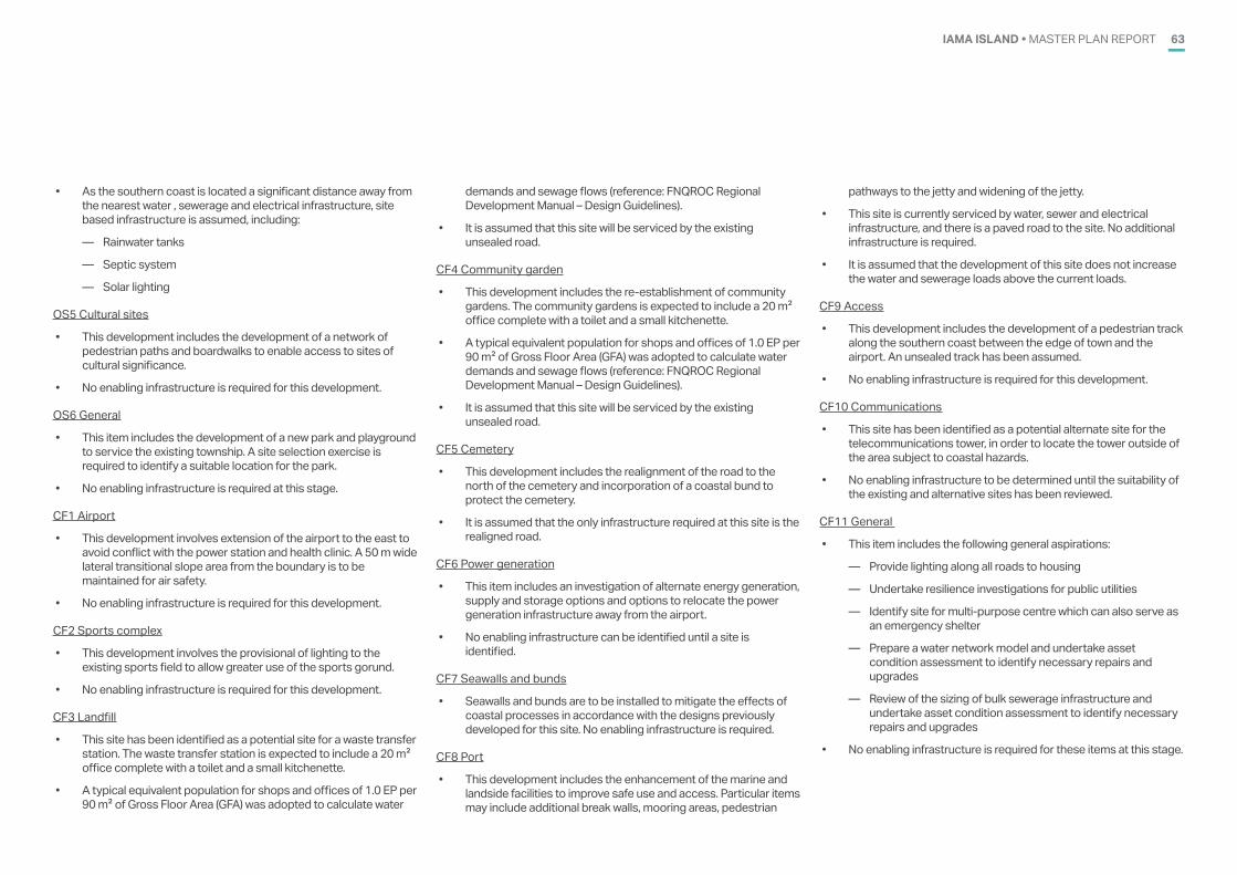
IAMA ISLAND • MASTER PLAN REPORT 63
TABLE A5: DESIGN WATER DEMAND - RESIDENTIAL LOTS
• As the southern coast is located a significant distance away from the nearest water , sewerage and electrical infrastructure, site based infrastructure is assumed, including:
— Rainwater tanks
— Septic system
— Solar lighting
OS5 Cultural sites
• This development includes the development of a network of pedestrian paths and boardwalks to enable access to sites of cultural significance.
• No enabling infrastructure is required for this development.
OS6 General
• This item includes the development of a new park and playground to service the existing township. A site selection exercise is required to identify a suitable location for the park.
• No enabling infrastructure is required at this stage.
CF1 Airport
• This development involves extension of the airport to the east to avoid conflict with the power station and health clinic. A 50 m wide lateral transitional slope area from the boundary is to be maintained for air safety.
• No enabling infrastructure is required for this development.
CF2 Sports complex
• This development involves the provisional of lighting to the existing sports field to allow greater use of the sports gorund.
• No enabling infrastructure is required for this development.
CF3 Landfill
• This site has been identified as a potential site for a waste transfer station. The waste transfer station is expected to include a 20 m2 office complete with a toilet and a small kitchenette.
• A typical equivalent population for shops and offices of 1.0 EP per 90 m2 of Gross Floor Area (GFA) was adopted to calculate water
demands and sewage flows (reference: FNQROC Regional Development Manual – Design Guidelines).
• It is assumed that this site will be serviced by the existing unsealed road.
CF4 Community garden
• This development includes the re-establishment of community gardens. The community gardens is expected to include a 20 m2 office complete with a toilet and a small kitchenette.
• A typical equivalent population for shops and offices of 1.0 EP per 90 m2 of Gross Floor Area (GFA) was adopted to calculate water demands and sewage flows (reference: FNQROC Regional Development Manual – Design Guidelines).
• It is assumed that this site will be serviced by the existing unsealed road.
CF5 Cemetery
• This development includes the realignment of the road to the north of the cemetery and incorporation of a coastal bund to protect the cemetery.
• It is assumed that the only infrastructure required at this site is the realigned road.
CF6 Power generation
• This item includes an investigation of alternate energy generation, supply and storage options and options to relocate the power generation infrastructure away from the airport.
• No enabling infrastructure can be identified until a site is identified.
CF7 Seawalls and bunds
• Seawalls and bunds are to be installed to mitigate the effects of coastal processes in accordance with the designs previously developed for this site. No enabling infrastructure is required.
CF8 Port
• This development includes the enhancement of the marine and landside facilities to improve safe use and access. Particular items may include additional break walls, mooring areas, pedestrian
pathways to the jetty and widening of the jetty.
• This site is currently serviced by water, sewer and electrical infrastructure, and there is a paved road to the site. No additional infrastructure is required.
• It is assumed that the development of this site does not increase the water and sewerage loads above the current loads.
CF9 Access
• This development includes the development of a pedestrian track along the southern coast between the edge of town and the airport. An unsealed track has been assumed.
• No enabling infrastructure is required for this development.
CF10 Communications
• This site has been identified as a potential alternate site for the telecommunications tower, in order to locate the tower outside of the area subject to coastal hazards.
• No enabling infrastructure to be determined until the suitability of the existing and alternative sites has been reviewed.
CF11 General
• This item includes the following general aspirations:
— Provide lighting along all roads to housing
— Undertake resilience investigations for public utilities
— Identify site for multi-purpose centre which can also serve as an emergency shelter
— Prepare a water network model and undertake asset condition assessment to identify necessary repairs and upgrades
— Review of the sizing of bulk sewerage infrastructure and undertake asset condition assessment to identify necessary repairs and upgrades
• No enabling infrastructure is required for these items at this stage.
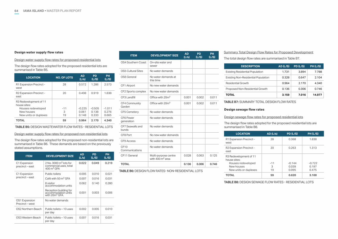
IAMA ISLAND • MASTER PLAN REPORT64
LOCATION NO. OF LOTS AD (L/s)
PD (L/S)
PH (L/S)
R1 Expansion Precinct - west
28 0.572 1.286 2.573
R2 Expansion Precinct - east
20 0.408 0.919 1.838
R3 Redevelopment of 11 house sites:
Houses redevelopedNew housesNew units or duplexes
-113
19
-0.2250.0610.148
-0.5050.1380.333
-1.0110.2760.665
TOTAL 59 0.964 2.170 4.340
TABLE B5: DESIGN WASTEWATER FLOW RATES - RESIDENTIAL LOTS
DESCRIPTION AD (L/S) PD (L/S) PH (L/S)
Existing Residential Population 1.731 3.894 7.788
Existing Non-Residential Population 0.328 0.647 2.104
Residential Growth 0.964 2.170 4.340
Proposed Non-Residential Growth 0.136 0.306 0.746
TOTAL 3.159 7.016 14.977
TABLE B7: SUMMARY TOTAL DESIGN FLOW RATES
Design water supply flow rates
Design water supply flow rates for proposed residential lots
The design flow rates adopted for the proposed residential lots are summarised in Table B5.
Design water supply flow rates for proposed non-residential lots
The design flow rates adopted for the proposed non-residential lots are summarised in Table B6. These demands are based on the previously stated assumptions.
ITEM DEVELOPMENT SIZE AD (L/s)
PD (L/S)
PH (L/S)
C1 Expansion precinct – east
2 No. 3000 m2 lots for commercial uses, total 400 m2 GFA
0.022 0.049 0.219
C1 Expansion precinct – east
Public toiletsCafé with 50 m2 GFA8 visitor accommodation units Reception building for accommodation units with 20m2 GFA.
0.005 0.007 0.062
0.001
0.010 0.016 0.140
0.003
0.021 0.031 0.280
0.006
OS1 Expansion Precinct – west
No water demands
OS2 Northern Beach Public toilets – 10 uses per day
0.002 0.005 0.010
OS3 Western Beach Public toilets – 10 uses per day
0.007 0.016 0.031
TABLE B6: DESIGN FLOW RATES- NON-RESIDENTIAL LOTS
ITEM DEVELOPMENT SIZE AD (L/s)
PD (L/S)
PH (L/S)
OS4 Southern Coast On-site water and sewer
OS5 Cultural Sites No water demands
OS6 General No water demands at this time
CF1 Airport No new water demands
CF2 Sports complex No new water demands
CF3 Landfill Office with 20m2 0.001 0.002 0.011
CF4 Community Garden
Office with 20m2 0.001 0.002 0.011
CF5 Cemetery No water demands
CF6 Power generation
No water demands
CF7 Seawalls and bunds
No water demands
CF8 Port No new water demands
CF9 Access No water demands
CF10 Communications
No water demands
CF11 General Multi-purpose centre with 400 m2 area
0.028 0.063 0.125
TOTAL 0.136 0.306 0.746
Summary Total Design Flow Rates for Proposed Development
The total design flow rates are summarised in Table B7.
Design sewage flow rates
Design sewage flow rates for proposed residential lots
The design flow rates adopted for the proposed residential lots are summarised in Table B8.
LOCATION AD (L/s) PD (L/S) PH (L/S)
R1 Expansion Precinct - west
28 0.368 1.838
R2 Expansion Precinct - east
20 0.263 1.313
R3 Redevelopment of 11 house sites:
Houses redevelopedNew housesNew units or duplexes
-113
19
-0.1440.0390.095
-0.7220.1970.475
TOTAL 59 0.620 3.100
TABLE B8: DESIGN SEWAGE FLOW RATES - RESIDENTIAL LOTS
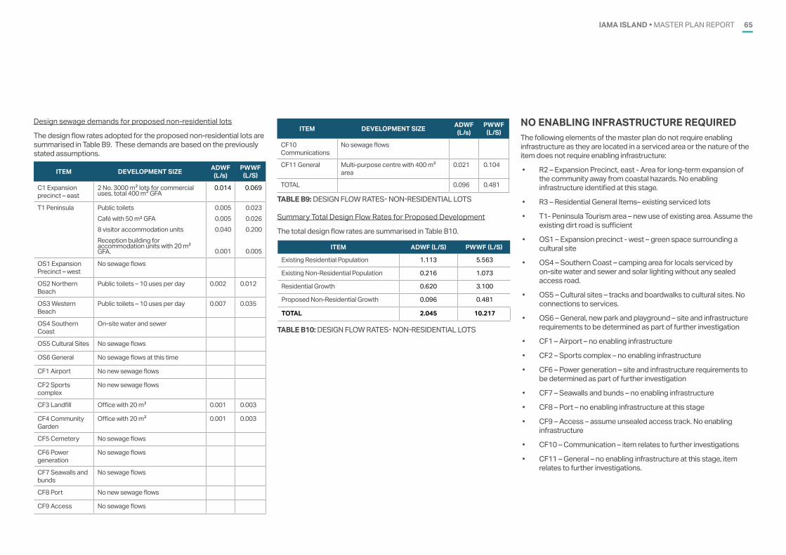
IAMA ISLAND • MASTER PLAN REPORT 65
Design sewage demands for proposed non-residential lots
The design flow rates adopted for the proposed non-residential lots are summarised in Table B9. These demands are based on the previously stated assumptions.
ITEM DEVELOPMENT SIZE ADWF (L/s)
PWWF (L/S)
C1 Expansion precinct – east
2 No. 3000 m2 lots for commercial uses, total 400 m2 GFA
0.014 0.069
T1 Peninsula Public toiletsCafé with 50 m² GFA8 visitor accommodation units Reception building for accommodation units with 20 m2 GFA.
0.0050.0050.040
0.001
0.023 0.026 0.200
0.005
OS1 Expansion Precinct – west
No sewage flows
OS2 Northern Beach
Public toilets – 10 uses per day 0.002 0.012
OS3 Western Beach
Public toilets – 10 uses per day 0.007 0.035
OS4 Southern Coast
On-site water and sewer
OS5 Cultural Sites No sewage flows
OS6 General No sewage flows at this time
CF1 Airport No new sewage flows
CF2 Sports complex
No new sewage flows
CF3 Landfill Office with 20 m2 0.001 0.003
CF4 Community Garden
Office with 20 m2 0.001 0.003
CF5 Cemetery No sewage flows
CF6 Power generation
No sewage flows
CF7 Seawalls and bunds
No sewage flows
CF8 Port No new sewage flows
CF9 Access No sewage flows
ITEM DEVELOPMENT SIZE ADWF (L/s)
PWWF (L/S)
CF10 Communications
No sewage flows
CF11 General Multi-purpose centre with 400 m2 area
0.021 0.104
TOTAL 0.096 0.481
TABLE B9: DESIGN FLOW RATES- NON-RESIDENTIAL LOTS
Summary Total Design Flow Rates for Proposed Development
The total design flow rates are summarised in Table B10.
ITEM ADWF (L/S) PWWF (L/S)
Existing Residential Population 1.113 5.563
Existing Non-Residential Population 0.216 1.073
Residential Growth 0.620 3.100
Proposed Non-Residential Growth 0.096 0.481
TOTAL 2.045 10.217
TABLE B10: DESIGN FLOW RATES- NON-RESIDENTIAL LOTS
NO ENABLING INFRASTRUCTURE REQUIREDThe following elements of the master plan do not require enabling infrastructure as they are located in a serviced area or the nature of the item does not require enabling infrastructure:
• R2 – Expansion Precinct, east - Area for long-term expansion of the community away from coastal hazards. No enabling infrastructure identified at this stage.
• R3 – Residential General Items– existing serviced lots
• T1- Peninsula Tourism area – new use of existing area. Assume the existing dirt road is sufficient
• OS1 – Expansion precinct - west – green space surrounding a cultural site
• OS4 – Southern Coast – camping area for locals serviced by on-site water and sewer and solar lighting without any sealed access road.
• OS5 – Cultural sites – tracks and boardwalks to cultural sites. No connections to services.
• OS6 – General, new park and playground – site and infrastructure requirements to be determined as part of further investigation
• CF1 – Airport – no enabling infrastructure
• CF2 – Sports complex – no enabling infrastructure
• CF6 – Power generation – site and infrastructure requirements to be determined as part of further investigation
• CF7 – Seawalls and bunds – no enabling infrastructure
• CF8 – Port – no enabling infrastructure at this stage
• CF9 – Access – assume unsealed access track. No enabling infrastructure
• CF10 – Communication – item relates to further investigations
• CF11 – General – no enabling infrastructure at this stage, item relates to further investigations.
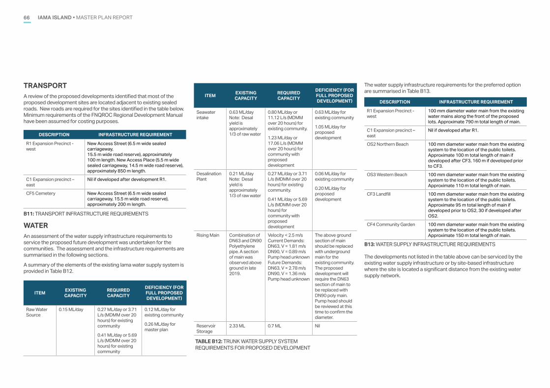
IAMA ISLAND • MASTER PLAN REPORT66
TRANSPORTA review of the proposed developments identified that most of the proposed development sites are located adjacent to existing sealed roads. New roads are required for the sites identified in the table below. Minimum requirements of the FNQROC Regional Development Manual have been assumed for costing purposes.
DESCRIPTION INFRASTRUCTURE REQUIREMENT
R1 Expansion Precinct - west
New Access Street (6.5 m wide sealed carriageway, 15.5 m wide road reserve), approximately 100 m length. New Access Place (5.5 m wide sealed carriageway, 14.5 m wide road reserve), approximately 850 m length.
C1 Expansion precinct – east
Nil if developed after development R1.
CF5 Cemetery New Access Street (6.5 m wide sealed carriageway, 15.5 m wide road reserve), approximately 200 m length.
B11: TRANSPORT INFRASTRUCTURE REQUIREMENTS
WATERAn assessment of the water supply infrastructure requirements to service the proposed future development was undertaken for the communities. The assessment and the infrastructure requirements are summarised in the following sections.
A summary of the elements of the existing Iama water supply system is provided in Table B12.
ITEM EXISTING CAPACITY
REQUIRED CAPACITY
DEFICIENCY (FOR FULL PROPOSED DEVELOPMENT)
Raw Water Source
0.15 ML/day 0.27 ML/day or 3.71 L/s (MDMM over 20 hours) for existing community
0.41 ML/day or 5.69 L/s (MDMM over 20 hours) for existing community
0.12 ML/day for existing community
0.26 ML/day for master plan
TABLE B12: TRUNK WATER SUPPLY SYSTEM REQUIREMENTS FOR PROPOSED DEVELOPMENT
The water supply infrastructure requirements for the preferred option are summarised in Table B13.
DESCRIPTION INFRASTRUCTURE REQUIREMENT
R1 Expansion Precinct - west
100 mm diameter water main from the existing water mains along the front of the proposed lots. Approximate 790 m total length of main.
C1 Expansion precinct – east
Nil if developed after R1.
OS2 Northern Beach 100 mm diameter water main from the existing system to the location of the public toilets. Approximate 100 m total length of main if developed after CF3, 160 m if developed prior to CF3.
OS3 Western Beach 100 mm diameter water main from the existing system to the location of the public toilets. Approximate 110 m total length of main.
CF3 Landfill 100 mm diameter water main from the existing system to the location of the public toilets. Approximate 95 m total length of main if developed prior to OS2, 30 if developed after OS2.
CF4 Community Garden 100 mm diameter water main from the existing system to the location of the public toilets. Approximate 150 m total length of main.
B13: WATER SUPPLY INFRASTRUCTURE REQUIREMENTS
The developments not listed in the table above can be serviced by the existing water supply infrastructure or by site-based infrastructure where the site is located a significant distance from the existing water supply network.
ITEM EXISTING CAPACITY
REQUIRED CAPACITY
DEFICIENCY (FOR FULL PROPOSED DEVELOPMENT)
Seawater intake
0.63 ML/day Note: Desal yield is approximately 1/3 of raw water
0.80 ML/day or 11.12 L/s (MDMM over 20 hours) for existing community.
1.23 ML/day or 17.06 L/s (MDMM over 20 hours) for community with proposed development
0.63 ML/day for existing community
1.05 ML/day for proposed development
Desalination Plant
0.21 ML/day Note: Desal yield is approximately 1/3 of raw water
0.27 ML/day or 3.71 L/s (MDMM over 20 hours) for existing community.
0.41 ML/day or 5.69 L/s (MDMM over 20 hours) for community with proposed development
0.06 ML/day for existing community
0.20 ML/day for proposed development
Rising Main Combination of DN63 and DN90 Polyethylene pipe. A section of main was observed above ground in late 2019.
Velocity < 2.5 m/s Current Demands: DN63, V = 1.81 m/s DN90, V = 0.89 m/s Pump head unknown Future Demands: DN63, V = 2.78 m/s DN90, V = 1.36 m/s Pump head unknown
The above ground section of main should be replaced with underground main for the existing community. The proposed development will require the DN63 section of main to be replaced with DN90 poly main. Pump head should be reviewed at this time to confirm the diameter.
Reservoir Storage
2.33 ML 0.7 ML Nil
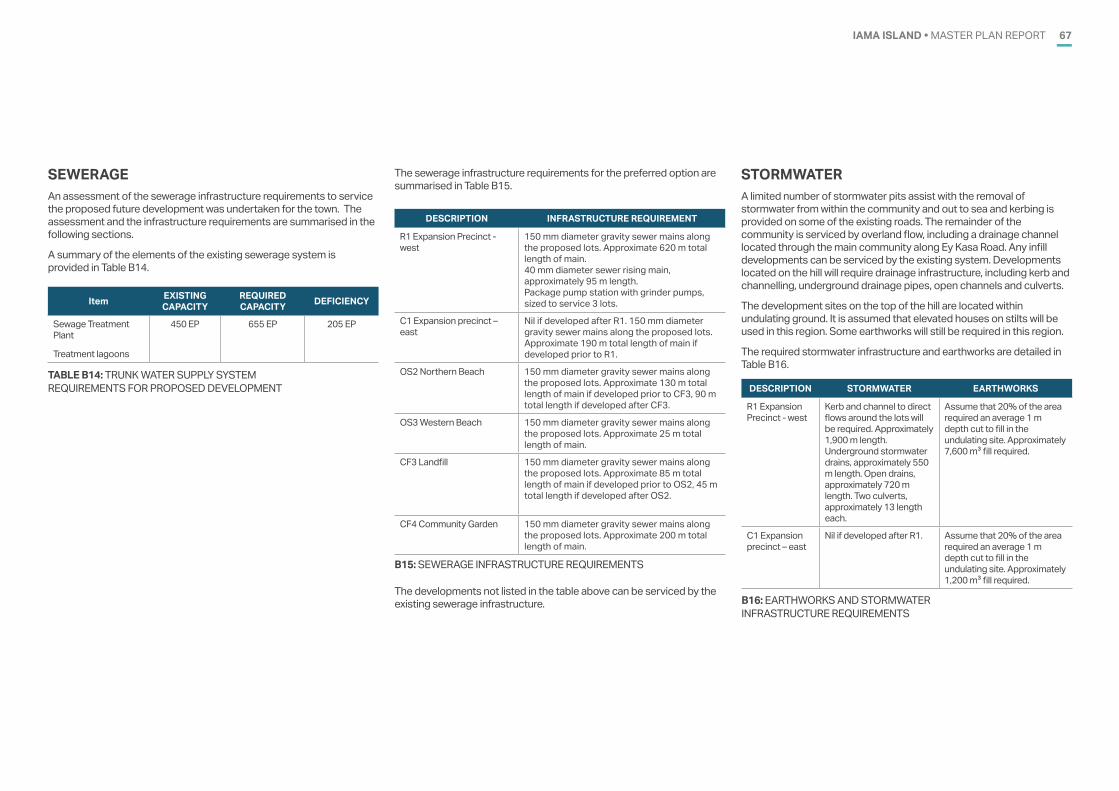
IAMA ISLAND • MASTER PLAN REPORT 67
SEWERAGEAn assessment of the sewerage infrastructure requirements to service the proposed future development was undertaken for the town. The assessment and the infrastructure requirements are summarised in the following sections.
A summary of the elements of the existing sewerage system is provided in Table B14.
Item EXISTING CAPACITY
REQUIRED CAPACITY DEFICIENCY
Sewage Treatment Plant
Treatment lagoons
450 EP 655 EP 205 EP
TABLE B14: TRUNK WATER SUPPLY SYSTEM REQUIREMENTS FOR PROPOSED DEVELOPMENT
The sewerage infrastructure requirements for the preferred option are summarised in Table B15.
DESCRIPTION INFRASTRUCTURE REQUIREMENT
R1 Expansion Precinct - west
150 mm diameter gravity sewer mains along the proposed lots. Approximate 620 m total length of main. 40 mm diameter sewer rising main, approximately 95 m length. Package pump station with grinder pumps, sized to service 3 lots.
C1 Expansion precinct – east
Nil if developed after R1. 150 mm diameter gravity sewer mains along the proposed lots. Approximate 190 m total length of main if developed prior to R1.
OS2 Northern Beach 150 mm diameter gravity sewer mains along the proposed lots. Approximate 130 m total length of main if developed prior to CF3, 90 m total length if developed after CF3.
OS3 Western Beach 150 mm diameter gravity sewer mains along the proposed lots. Approximate 25 m total length of main.
CF3 Landfill 150 mm diameter gravity sewer mains along the proposed lots. Approximate 85 m total length of main if developed prior to OS2, 45 m total length if developed after OS2.
CF4 Community Garden 150 mm diameter gravity sewer mains along the proposed lots. Approximate 200 m total length of main.
B15: SEWERAGE INFRASTRUCTURE REQUIREMENTS
The developments not listed in the table above can be serviced by the existing sewerage infrastructure.
STORMWATERA limited number of stormwater pits assist with the removal of stormwater from within the community and out to sea and kerbing is provided on some of the existing roads. The remainder of the community is serviced by overland flow, including a drainage channel located through the main community along Ey Kasa Road. Any infill developments can be serviced by the existing system. Developments located on the hill will require drainage infrastructure, including kerb and channelling, underground drainage pipes, open channels and culverts.
The development sites on the top of the hill are located within undulating ground. It is assumed that elevated houses on stilts will be used in this region. Some earthworks will still be required in this region.
The required stormwater infrastructure and earthworks are detailed in Table B16.
DESCRIPTION STORMWATER EARTHWORKS
R1 Expansion Precinct - west
Kerb and channel to direct flows around the lots will be required. Approximately 1,900 m length. Underground stormwater drains, approximately 550 m length. Open drains, approximately 720 m length. Two culverts, approximately 13 length each.
Assume that 20% of the area required an average 1 m depth cut to fill in the undulating site. Approximately 7,600 m3 fill required.
C1 Expansion precinct – east
Nil if developed after R1. Assume that 20% of the area required an average 1 m depth cut to fill in the undulating site. Approximately 1,200 m3 fill required.
B16: EARTHWORKS AND STORMWATER INFRASTRUCTURE REQUIREMENTS
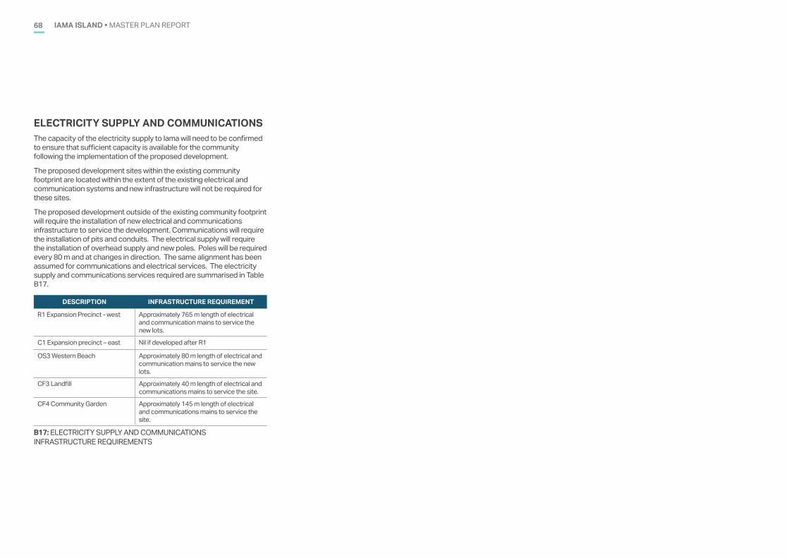
IAMA ISLAND • MASTER PLAN REPORT68
ELECTRICITY SUPPLY AND COMMUNICATIONS The capacity of the electricity supply to Iama will need to be confirmed to ensure that sufficient capacity is available for the community following the implementation of the proposed development.
The proposed development sites within the existing community footprint are located within the extent of the existing electrical and communication systems and new infrastructure will not be required for these sites.
The proposed development outside of the existing community footprint will require the installation of new electrical and communications infrastructure to service the development. Communications will require the installation of pits and conduits. The electrical supply will require the installation of overhead supply and new poles. Poles will be required every 80 m and at changes in direction. The same alignment has been assumed for communications and electrical services. The electricity supply and communications services required are summarised in Table B17.
DESCRIPTION INFRASTRUCTURE REQUIREMENT
R1 Expansion Precinct - west Approximately 765 m length of electrical and communication mains to service the new lots.
C1 Expansion precinct – east Nil if developed after R1
OS3 Western Beach Approximately 80 m length of electrical and communication mains to service the new lots.
CF3 Landfill Approximately 40 m length of electrical and communications mains to service the site.
CF4 Community Garden Approximately 145 m length of electrical and communications mains to service the site.
B17: ELECTRICITY SUPPLY AND COMMUNICATIONS INFRASTRUCTURE REQUIREMENTS
69IAMA ISLAND • MASTER PLAN REPORTIAMA ISLAND • MASTER PLAN REPORT69
APPENDIX C.NATIVE TITLE VISION MAPPINGC.
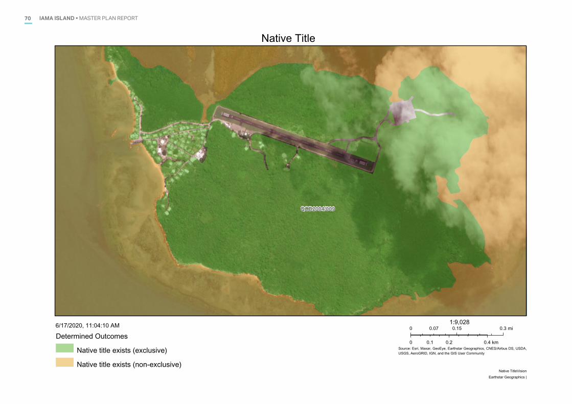
IAMA ISLAND • MASTER PLAN REPORT70
QCD2004/009
Native Title
Source: Esri, Maxar, GeoEye, Earthstar Geographics, CNES/Airbus DS, USDA,USGS, AeroGRID, IGN, and the GIS User Community
Determined Outcomes
Native title exists (exclusive)
Native title exists (non-exclusive)
6/17/2020, 11:04:10 AM 0 0.15 0.30.07 mi
0 0.2 0.40.1 km
1:9,028
Native TitleVisionEarthstar Geographics |
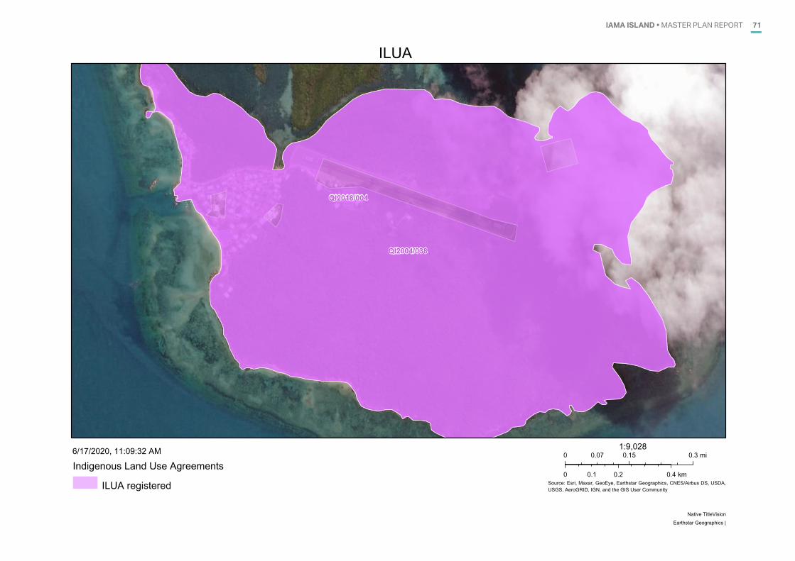
IAMA ISLAND • MASTER PLAN REPORT 71
QI2018/004
QI2004/038
ILUA
Source: Esri, Maxar, GeoEye, Earthstar Geographics, CNES/Airbus DS, USDA,USGS, AeroGRID, IGN, and the GIS User Community
Indigenous Land Use Agreements
ILUA registered
6/17/2020, 11:09:32 AM 0 0.15 0.30.07 mi
0 0.2 0.40.1 km
1:9,028
Native TitleVisionEarthstar Geographics |
72 IAMA ISLAND • MASTER PLAN REPORT
APPENDIX D.VEGETATION MAPPINGD.
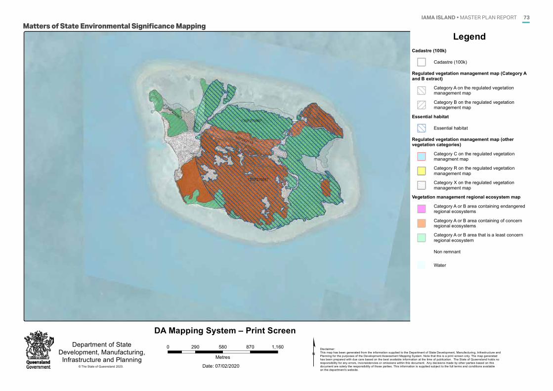
IAMA ISLAND • MASTER PLAN REPORT 73
Date: 07/02/2020
0 290 580 870 1,160
Metres
Department of StateDevelopment, Manufacturing,Infrastructure and Planning ¢ Disclaimer:
This map has been generated from the information supplied to the Department of State Development, Manufacturing, Infrastructure and Planning for the purposes of the Development Assessment Mapping System. Note that this is a print screen only. The map generated has been prepared with due care based on the best available information at the time of publication. The State of Queensland holds no responsibility for any errors, inconsistencies or omissions within this document. Any decisions made by other parties based on this document are solely the responsibility of those parties. This information is supplied subject to the full terms and conditions available on the department’s website.
DA Mapping System – Print Screen
© The State of Queensland 2020.
Date: 29/10/2019
Department of StateDevelopment, Manufacturing,Infrastructure and Planning
Disclaimer:This map has been generated from the information supplied to the Department of State Development, Manufacturing, Infrastructure and Planning for the purposes of the Development Assessment Mapping System. Note that this is a print screen only. The map generated has been prepared with due care based on the best available information at the time of publication. The State of Queensland holds no responsibility for any errors, inconsistencies or omissions within this document. Any decisions made by other parties based on this document are solely the responsibility of those parties. This information is supplied subject to the full terms and conditions available on the department’s website.
LegendCadastre (100k)
Cadastre (100k)
Regulated vegetation management map (Category Aand B extract)
Category A on the regulated vegetationmanagement map
Category B on the regulated vegetationmanagement map
Essential habitat
Essential habitat
Regulated vegetation management map (othervegetation categories)
Category C on the regulated vegetationmanagment map
Category R on the regulated vegetationmanagement map
Category X on the regulated vegetationmanagement map
Vegetation management regional ecosystem map
Category A or B area containing endangeredregional ecosystems
Category A or B area containing of concernregional ecosystems
Category A or B area that is a least concernregional ecosystem
Non remnant
Water
DA Mapping System – Print Screen
© The State of Queensland 2019.
Matters of State Environmental Significance Mapping
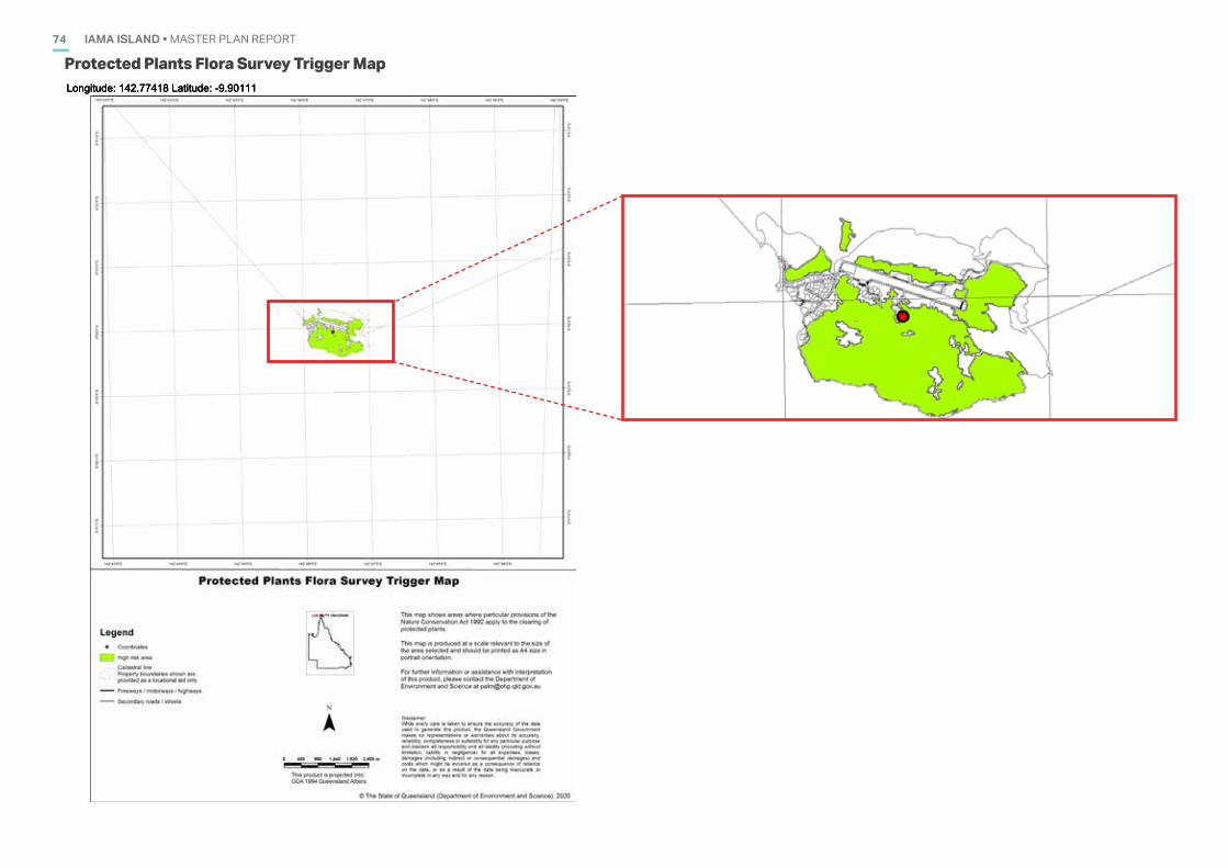
IAMA ISLAND • MASTER PLAN REPORT74
07/02/2020 08:28:00Longitude: 142.77418 Latitude: -9.90111
Protected Plants Flora Survey Trigger Map
07/02/2020 08:28:00Longitude: 142.77418 Latitude: -9.90111
07/02/2020 08:28:00Longitude: 142.77418 Latitude: -9.9011107/02/2020 08:28:00Longitude: 142.77418 Latitude: -9.90111
75IAMA ISLAND • MASTER PLAN REPORT
APPENDIX E.STATE POLICY DOCUMENTSE.
IAMA ISLAND • MASTER PLAN REPORT76
Department of Infrastructure, Local Government and Planning
State Planning Policy
July 2017
TORRES STRAIT & NORTHERN PENINSULA AREA
REGIONAL PLANPlanning for our future: 2009 to 2029
NPARC
SEISIA
NEW MAPOON
BAMAGA
UMAGICO
INJINOO
NORTHERN PENINSULA AREA REGIONAL COUNCIL
ACCESSIBLE VIA:HTTP://WWW.TSRA.GOV.AU/__DATA/ASSETS/PDF_FILE/0018/1773/TS-NPA-RP-09-29.PDF
ACCESSIBLE VIA: HTTPS://DILGPPRD.BLOB.CORE.WINDOWS.NET/GENERAL/SPP-JULY-2017.PDF
IAMA ISLAND • MASTER PLAN REPORT 77
ACCESSIBLE VIA:HTTP://WWW.TSRA.GOV.AU/__DATA/ASSETS/PDF_FILE/0018/1773/TS-NPA-RP-09-29.PDF
Resilient QueenslandDelivering the Queensland Strategy for Disaster Resilience
Pathways to a clean growth economyQueensland Climate Transition Strategy
Department of Environment and Heritage Protection
UNDERSTAND | ADAPT | TRANSITION
UNDERSTAND ADAPT | TRANSITIONUNDERSTAND ADAPT | TRANSITIONUNDERSTAND ADAPT | TRANSITION
ACCESSIBLE VIA:HTTPS://WWW.QRA.QLD.GOV.AU/RESILIENT-QUEENSLAND
ACCESSIBLE VIA:
HTTPS://WWW.QLD.GOV.AU/__DATA/ASSETS/PDF_FILE/0026/67283/QLD-CLIMATE-TRANSITION-STRATEGY.PDF
IAMA ISLAND • MASTER PLAN REPORT78
A
Coastal blue carbon:AN INTRODUCTION FOR POLICY MAKERS
ACCESSIBLE VIA: HTTPS://BLUECARBONPARTNERSHIP.ORG/RESOURCES/INTRODUCTION-POLICY-MAKERS/

79IAMA ISLAND • MASTER PLAN REPORT
APPENDIX F.LOCAL POLICY DOCUMENTSF.
IAMA ISLAND • MASTER PLAN REPORT80
www.tsirc .qld.gov.au 11 TSIRC - CORPORATE PLAN 2020 - 2025
2020 - 2025Bisnis Plan
Corporate Plan
2020-2025
1 TORRES STRAIT ISLAND REGIONAL COUNCIL - OPERATIONAL PLAN 2019/20
Torres Strait Island Regional CouncilOperational Plan2019/20
ACCESSIBLE VIA: HTTP://WWW.TSIRC.QLD.GOV.AU/SITES/DEFAULT/FILES/CORPORATE%20PLAN%202020-2025.PDF
ACCESSIBLE VIA: HTTP://TSIRC.QLD.GOV.AU/SITES/DEFAULT/FILES/OPERATIONAL%20PLAN%20FY20.PDF
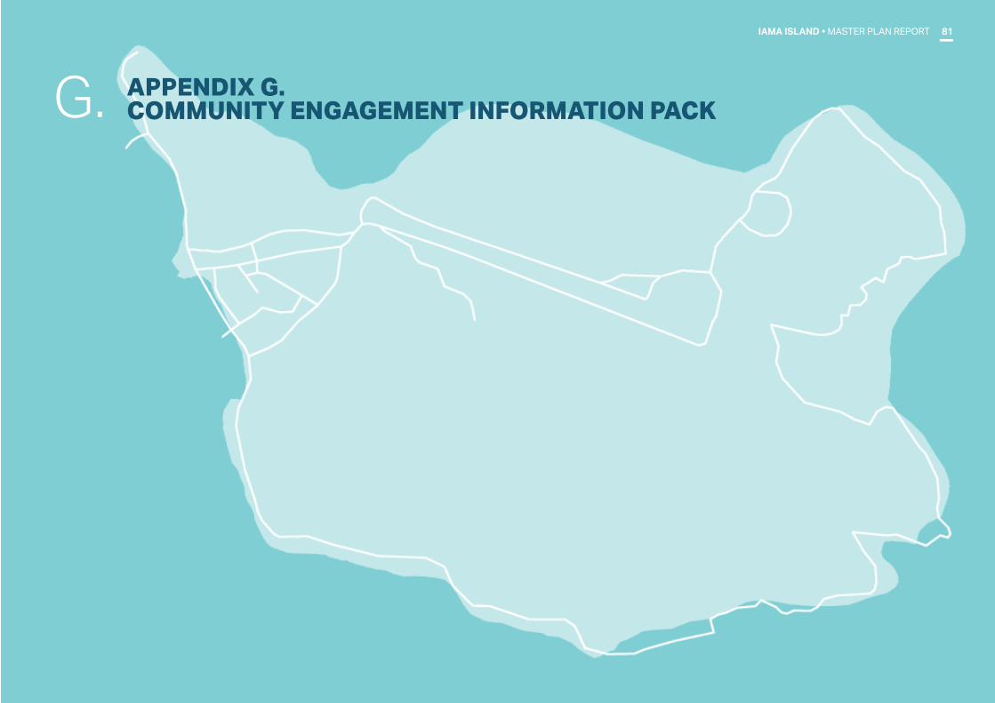
81IAMA ISLAND • MASTER PLAN REPORT
APPENDIX G. COMMUNITY ENGAGEMENT INFORMATION PACKG.
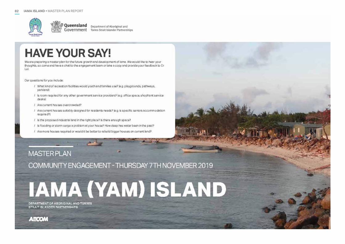
IAMA ISLAND • MASTER PLAN REPORT82
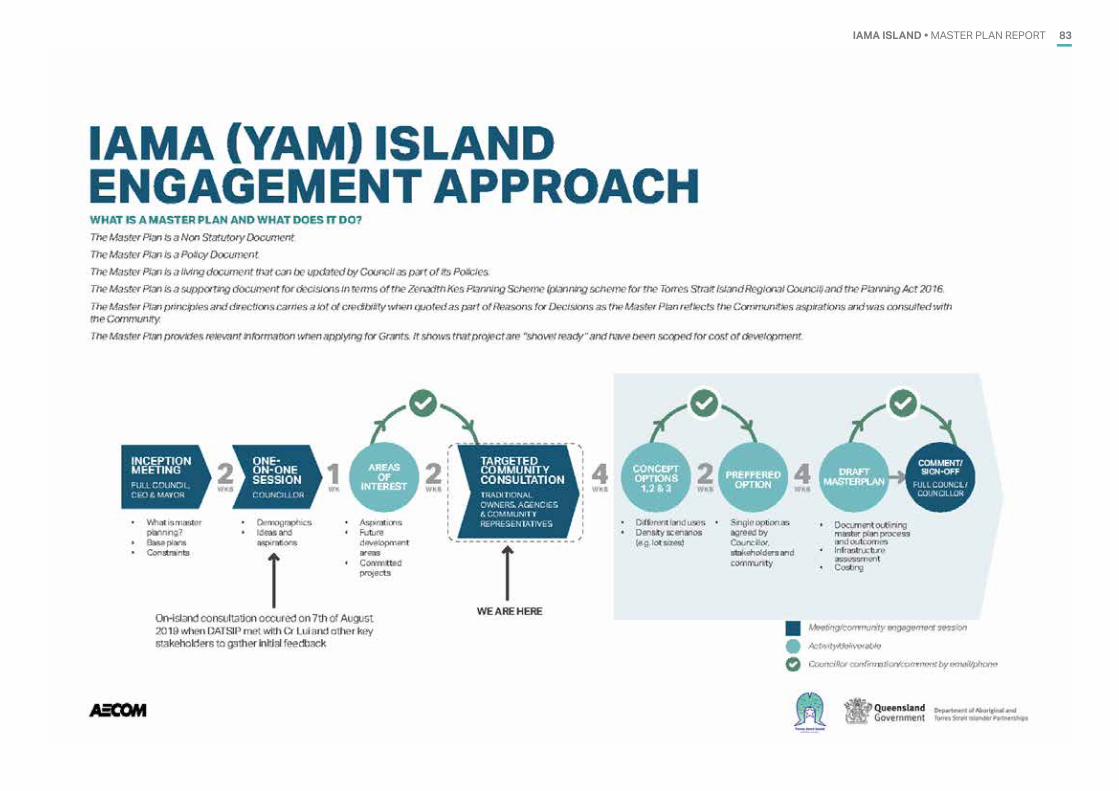
IAMA ISLAND • MASTER PLAN REPORT 83
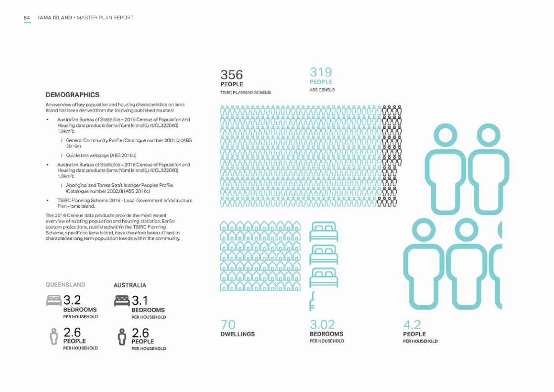
IAMA ISLAND • MASTER PLAN REPORT84
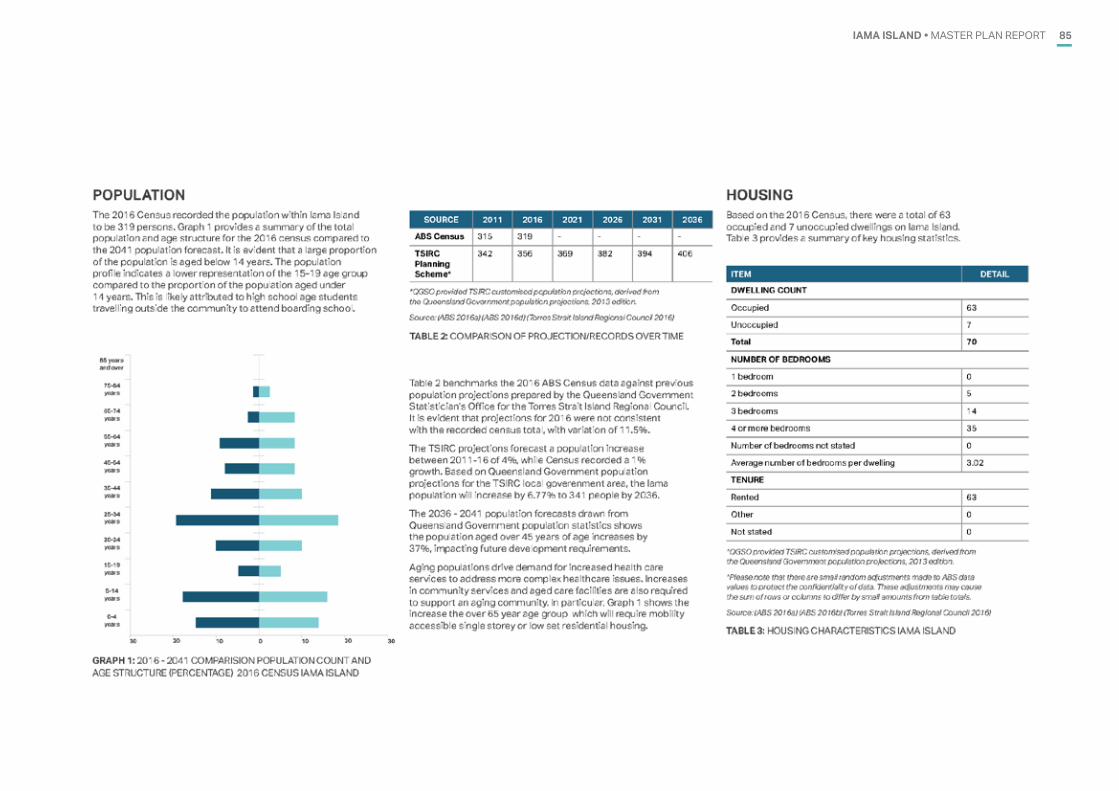
IAMA ISLAND • MASTER PLAN REPORT 85
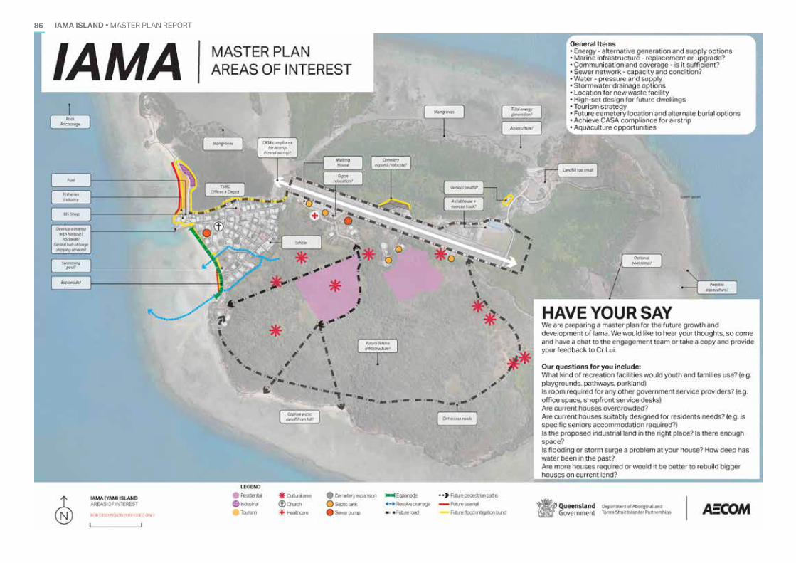
IAMA ISLAND • MASTER PLAN REPORT86
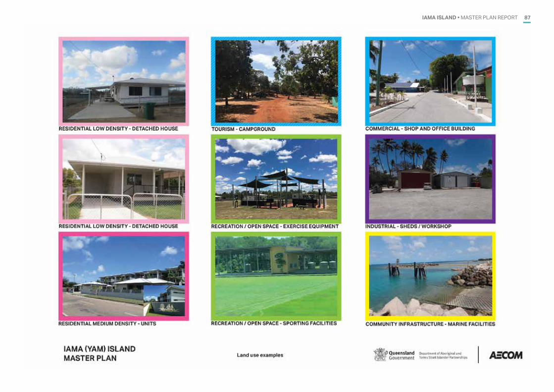
IAMA ISLAND • MASTER PLAN REPORT 87
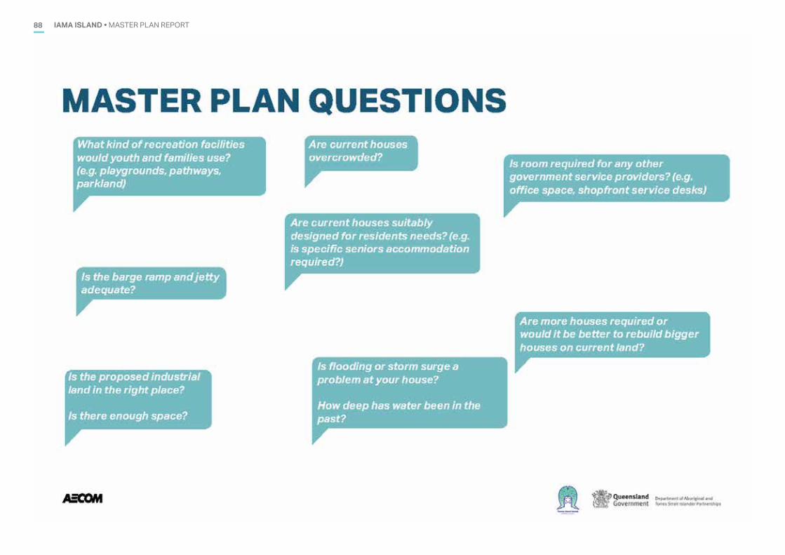
IAMA ISLAND • MASTER PLAN REPORT88
IAMA ISLAND • MASTER PLAN REPORT 89
IAMA ISLAND • MASTER PLAN REPORT90

AECOMAECOM AUSTRALIA PTY LTD
LEVEL 8, 540 WICKHAM STREETPO BOX 1307
FORTITUDE VALLEY QLD 4006T +61 7 3553 2000F +61 7 3553 2050
WWW.AECOM.COMABN 20 093 846 925


![[Table] IAmA Spontaneous Solo Traveller - _I'Ll Take Your Next Flight Out_. AMA. _ Tabled](https://img.pdfslide.us/doc/110x75/577ce0e21a28ab9e78b450e4/table-iama-spontaneous-solo-traveller-ill-take-your-next-flight-out.jpg)