Embed Size (px)
Citation preview
Marine Geological Cruise ReportNorth Sea/Fladen area
R/V G.O. SARSUoB Cruise No. GS-06-146IMR Cruise No. 2005117
26. November - 2. December 2006
Department of Earth Science,University of Bergen, Norway
December, 2006
REPORT: 100-04/06UNIVERSITY OF BERGEN
Department of Earth Science
Marine Geological Cruise Report
North Sea/Fladen area
R/V G.O. SARS UoB Cruise No. GS-06-146 IMR Cruise No. 2006117
26. November – 2. December 2006
A. Nygård1
B.O. Hjelstuen1
S. Monsen1
J. Brendryen1
I. Mardal1
C. Clark2
A. Hughes2
R. Levine2
1 University of Bergen, Department of Earth Science, Allegt. 41, N-5007 Bergen, Norway 2 University of Sheffield, Department of Geography, Winter Street, Sheffield, S10 2TN, United Kingdom
i
Cruise Report UoB Cruise No.GS-06-146/IMR Cruise No. 2006117 University of Bergen (UoB)
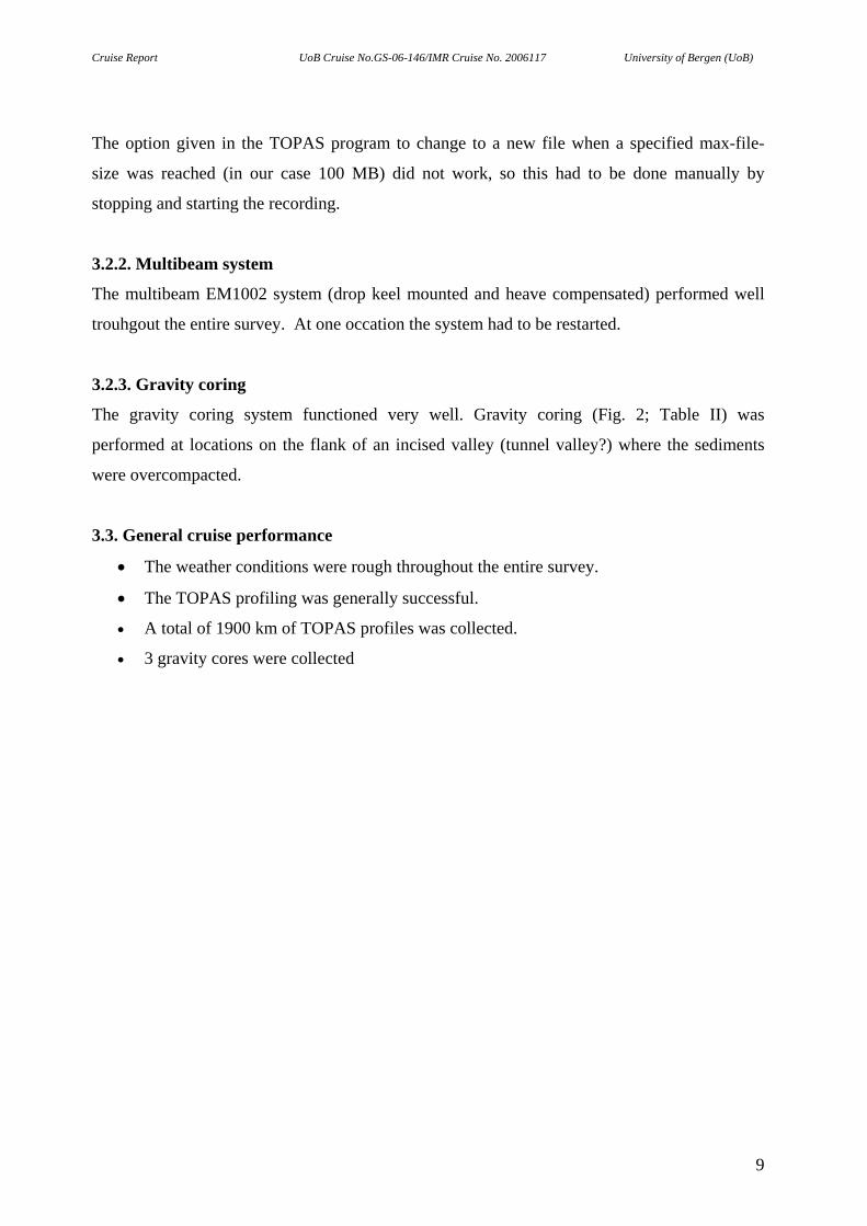
1. INTRODUCTION The marine geological survey to the North Sea (Figs. 1 and 2) is carried out by the Department
of Earth Science, University of Bergen. The cruise is a scientific contribution to the NFR-
funded research projects RAPID and GLACIPET (under the Petromaks programme); shortly
described below. This report will give an overview of the scientific objectives, a description of
the survey area and a general description of the cruise performance. Figure 1 shows the survey
area with ship track lines, whereas a general survey log is provided in Table 1.
1.1. Project description and objectives
The cruise is part of two projects: 1) “Punctuated disintegration of the NW European Ice Sheet
and rapid climate change” (RAPID) and 2) “Subsidence, uplift and tilting of traps – the
influence on petroleum systems” (GLACIPET).
1.1.1. RAPID
The project “Punctual disintegration of the NW European Ice Sheet and rapid climate change”
(RAPID) is a joint NFR/NERC scientific project. The marine geological objectives are to: a)
Constrain the timing of Norwegian Channel Ice Stream (NCIS) events during the last glacial
periods, b) Ascertain North Atlantic footprint of ice-rafted debris from the NCIS and assess
correlations between NCIS events and known ocean and climate excursions, c) Reconstruct
dimensions of the NCIS and estimate range of ice flux, d) Review evidence for major ice-
dammed lakes, and compute their water volume and likely drainage routes, e) Compile
geophysical and bathymetric data for the North Sea to develop the hypothesis of a grounded-ice
break-up event and constrain its timing, and f) Estimate the ice volume involved, and likely
melt water pathways to the North Atlantic.
The firm existence of glaciations over the North Sea (into the Fladen Ground Area), as well as
the existence of an ice stream issuing through the Norwegian Channel has only recently been
established. These two major parts of the Fennoscandian Ice Sheet, joining the continental ice
to that of the British Isles, provide a potentially important source for melt water and ice bergs to
have entered the North Atlantic in the past. In this project we aim to establish the area, volume
and history of the ice sheet over the North Sea and the NCIS during the last glacial maximum.
This will provide the basis for modeling experiments, employing a state-of-the-art ice berg
1
Cruise Report UoB Cruise No.GS-06-146/IMR Cruise No. 2006117 University of Bergen (UoB)
trajectory model, to examine the likely part of ice bergs from this region of Europe, and their
potential impact on North Atlantic convection processes, and hence the global thermohaline
circulation.
This research will benefit a number of scientific and policy areas. Reconstructing the evolution
of the European Ice Sheet near the North Sea during the last glaciation will assist organization
and policies that rely on recent geological history. A better reconstruction of past ice sheets also
provides revised surface boundary conditions for climate models of the period, which are
important verification tools for climate models of our global future. Understanding the past
contribution of European Ice Sheets to the freshwater balance of the North Atlantic allows us to
refine understanding of the ease with which the thermohaline circulation of the ocean can
change, and its climatic consequences for western Europe. While there are currently no ice
sheets in western Europe there is considerable debate about the sensitivity of the convection
processes in the NE Atlantic to potential thermohaline collapse in the near future. This work
will help define this debate.
1.1.2. GLACIPET The main objective of this national Petromaks-project is to model the isostatic response of
Cenozoic glaciations, sedimentation and erosion on the Norwegian continental shelf, and to
constrain consequences for petroleum systems. This objective will be met by the following sub-
goals, providing input to modelling: 1) More complete knowledge on timing and extent of
glaciations through the Plio-Pleistocene, 2) Improved understanding and quantification of
glacial depositional and erosional processes, 3) Expanded knowledge on the interaction
between the Fennoscandian, the Barents Sea, and the Kara Sea ice sheets, and their crustal
influence through the last glacial cycle. Two contrasting areas is to be studied: the Barents Sea
region, which is characterized by uplift through the late Cenozoic, and the northern North Sea,
a region of late Cenozoic subsidence.
Since the development of the ice age theory, there has been a more or less continuous debate on
the possible glaciations of the North Sea. Early interpretation of the extent of the
Fennoscandian and Hiberno-British ice sheets into the North Sea basin were mainly based on
inferences from sites bordering the North Sea, the general morphology (bathymetry) of the
North Sea, and surface sediment distribution from depth soundings and dredges. Some global
reconstructions (e.g. CLIMAP 1981) placed an ice mass between the Hiberno-British and
2
Cruise Report UoB Cruise No.GS-06-146/IMR Cruise No. 2006117 University of Bergen (UoB)
Fennoscandian ice sheets at the Last Glacial Maximum (LGM), while more recent ones have
not. Observations of deep incisions on the North Sea seafloor, and the interpretation as
subglacial/ice-proximal features have been taken as evidence for glaciations of the North Sea
and their distribution has been used in constructing maps of extent of grounded ice. From the
studies of core data and 2D seismic it has been suggested that the central North Sea has been
glaciated. Recent work using 3D seismic investigation of tunnel valleys in the central North Sea
concludes that they are subglacial meltwater channels, thus requiring an ice cover at their time
of formation. Also, new research carried out along the continental margins, including
recognition of end moraines and glacial fed debris flows strongly suggest that the NW
European margin from Ireland to Svalbard was covered by glacial ice to the shelf edge during
LGM. Detailed investigations of core and acoustic data suggests that the first occurrence of an
ice stream following the Norwegian Channel took place at ~1.1 Ma and from Marine Isotope
Stage (MIS) 12 (~0.460 Ma) the Norwegian Channel Ice Stream has apparently been active
during each glacial stage. For the central North Sea, the first evidence of glaciations have been
found within the Aberdeen Ground Bed and dated to ~0.900 Ma. The present project will
compile new and previously published data from the northern North Sea in order to quantify
erosion and deposition through the Pleistocene. An important element in this project will be to
utilize 3D industrial data in order to determine genesis and geometry of the Pleistocene units in
selected areas. This cruise, as the last years cruise GS140-05, will focus on collecting high
resolution acoustic data, Topas and multibeam, in order to better link new and previously
published core data with the seismic stratigraphy. From this work estimates of deposition (in
the major depocenters in the region) and erosion for two time intervals will be done: 1) From
first glaciation of the North Sea (~1.1 Ma) to MIS 12 (~0.5 Ma) and 2) the last 0.5 Ma.
3
Cruise Report UoB Cruise No.GS-06-146/IMR Cruise No. 2006117 University of Bergen (UoB)
1.2. Scientific Party
Atle Nygård UoB Research scientist/Cruise leader Berit O. Hjelstuen UoB Associate Professor Jo Brendryen UoB PhD student Ivar Mardal UoB Master student Stig Monsen UoB Technician Asgeir Steinsland IMR Survey Engineer Jarle Wangensten IMR Survey Engineer Chris Clark UoS Professor Anna Hughes UoS PhD student Richard Levine UoS Post. Doc UoB: University of Bergen, Dept. of Earth Science, Allegt. 41, 5007 Bergen, Norway IMR: Institute of Marine Research, Nordnesgt. 50, P.O. Box 1870 Bergen, Norway UoS: University of Sheffield, Department of Geography, Winter Street, Sheffield, S10 2TN,
UK
2. METHODS 2.1. Research vessel
R/V G.O. SARS has a length of 77.4 m, beam of 16.4 m and a displacement of 4067 tonnes,
and is owned by the Institute of Marine Research and the University of Bergen. R/V G.O.
SARS is outfitted with diesel-electric propulsion plant and 2 Teco Westinghouse DC motors
and has a top speed of 17.5 knots. Its engines are noise reduced; lowering the noise emission
under water by 99% compared to conventional research vessels. The main duties are research
operations within the areas of fishery, acoustic, environment and geology.
To accommodate these tasks the vessel is arranged with two sheltered hangars midships for
environmental and geological research operations. These hangars have 6 winches all with 6000
m cable length (either with electrical or optical cording) for lowering scientific equipment to
the deepest parts of the Norwegian Sea. The vessels heavy duty cranes and handling equipment
are located in the main mid-ship hangar and on the aft deck. These include 6 cranes for lifting
equipment from 2 tonnes up to 16 tonnes, and one CTD davit crane with a capacity of 2 tonnes.
One Z-frame crane, with a capacity of 8 tonnes, is located on the stern. The operation centre is
4
Cruise Report UoB Cruise No.GS-06-146/IMR Cruise No. 2006117 University of Bergen (UoB)
arranged on the 5th deck, controlling all acoustic and hydrographical equipment. Furthermore,
the vessel is arranged with 15 specialised laboratories. A number of sensitive transducers are
located in two independent drop keels.
R/V G.O. SARS has room for 45 persons in 19 single berth cabins and 13 double berth cabins
and it has a crew of 15.
2.2. Navigation
The shipboard navigation system is a Simrad Kongberg system. The GPS part is a dual antenna
system for heading and position determination. This system is able to create position accuracy
of 2m 2o (Differential GPS signal via satellite). No post-processing was carried out. The logged
navigation has datum WGS84. ASCII files including positional fixes for every 10 sec survey
time provided in a geographic co-ordinates (lat. and long.) format were made available for later
plotting purposes. In addition, UTM co-ordinates (Zone 31, Central Meridian, WGS 84) were
supplied.
2.3. Simrad Multibeam Echosounders
The Kongsberg Simrad Multibeam echo sounders EM300 and EM1002 are designed for seabed
mapping at variable depths, and therefore have variable resolution capacities. Only EM1002
was used during the cruise. The echo sounders consist of three units:
a) Transducer arrays
b) Transceiver unit
c) Operator station
Transducer arrays
The transducer arrays are different in form for the different models, but are used for both
transmitting and receiving pulses. Both arrays are positioned on the front of the drop keel hull.
Transceiver unit
The transceiver unit is a wall mounted cabinet with integrated shock and vibration absorbers. It
contains transmission and reception electronics, the processors for beam formation, bottom
detection and control of all parameters with respect to gain, ping rate and transmission angles.
5
Cruise Report UoB Cruise No.GS-06-146/IMR Cruise No. 2006117 University of Bergen (UoB)
Operator station
The operator station contains processors for beam-formation, bottom detection and parameter
control as well as the operator interface.
It detects:
• depth and sounding positions
• raw ranges and beam pointing angles
• seabed imaging
• vessel position and attitude
• sound speed data
• system installation and set-up parameters
The system does not require operator intervention during normal operation, but tracks the
bottom automatically while adjusting mode, gain and range dependant parameters as required.
To improve bottom detection, leading to an improved data quality, the system is interfaced with
the high frequency sonar.
Data Processing
There are three software packages that are commonly used during the processing process:
• The Neptun software, which is used for post-processing of bathymetric data (i.e.
cleaning and filtering of raw data etc.).
• The Triton software, which is used for seabed sediment classification. This software
extracts signal features from the seabed image data, and applies this data to a statistical
classification procedure in order to obtain the best estimate for seabed sediment type as
a function of position in the form of a map overlay.
• The Cfloor or the Fladermaus softwares are used for digital terrain modelling and plot
generation. These terrain models can easily produce contour maps, 3D plots, combined
bathymetry and acoustic imagery, depth profiles along specified routes, volume
calculations etc.
2.3.1. EM 1002
The Kongsberg Simrad EM 1002 multibeam echo sounder is used for high resolution seabed
mapping from water depths of 2 m to approximately 1002 m. The system has a maximum ping
rate of more than 10 Hz, with 111 beams per ping. The beamwidth is 2*2°, which gives swath
coverage of up to 7,5 times the distance from the transducer face to the bottom, or maximum
6
Cruise Report UoB Cruise No.GS-06-146/IMR Cruise No. 2006117 University of Bergen (UoB)
depth of about 1200 m. The EM 1002 system has a frequency of 95 kHz, which is robust for
pollution and particles in the water and therefore results in good accuracy and resolution.
Three different pulse lengths are used for different depths; 0,2 ms for depths less than 200 m,
0,7 ms for intermediate depths and 2,0 ms for depths larger than 600 m. These pulses give
depth resolutions of 2, 4 or 8 cm. On the cruise the normal procedure was however to switch to
EM300 when reaching ca. 600-700 m water depth for achieving highest quality on the
bathymetrical data.
The transducer is semicircular with a radius of 45 cm and 160° angular extent. The beam width
is 2*2°, and its height, width and length is 398 mm, 887 mm, and 473 mm, respectively. Eight
20 m long underwater cables connect the transducer to the transceiver unit. Because of the
curved shape, the accuracy is dependent upon variation in sound speed at the transducer depth.
On R/V G.O. SARS the transducer and the receiver are located in a drop keel.
2.4. TOPAS (Parametric Sub-bottom Profiler System)
The TOPAS PS18 system is a single, narrow beam sub-bottom profiler system with electronic
roll, pitch and heave stabilisator. The range resolution is normally less than 0.3 m, and
penetration capability is normally more than 150 m. The TOPAS is designed around a
parametric antenna utilizing the non-linear propagation characteristics of water to generate a
low frequency acoustic pulse from a short, high frequency burst or from the inter-modulation of
two high frequency signals. The received echoes are amplified, digitized, processed and
displayed on-line, and can be printed out during the process. Raw, unprocessed data may be
stored for later processing.
There are several types of pulses that can be used, depending on the different depth and
different use that is needed. Generally, high frequency gives high resolution but low penetration,
and for both the Ricker- and the Chirp pulse, maximum and minimum frequency is 6000 Hz
and 500 Hz respectively. The Ricker pulse was applied on the whole cruise due to shallow
water depth.
Ricker wavelet
The high resolution pulse is called the Ricker pulse, and gives detailed information about the
top 5-10 m sediments in water depths less than 2000-3000 m. This mode gives short, single
7
Cruise Report UoB Cruise No.GS-06-146/IMR Cruise No. 2006117 University of Bergen (UoB)
pulses with power spectrum centered around 3,5 kHz. Ricker pulse is a wide-band wavelet and
requires a high signal-to-noise ratio for optimal performance. Ping interval depends on wavelet
type, water depth and operation mode. It range from 200-15000 ms, but default ping/shot
interval for Ricker pulse is 300-500 ms in shallow areas.
3. FIELD OPERATIONS A summary of ship-board operations is provided in Table 1.
3.1. Weather and sea state conditions
North Sea Plateau to Aberdeen, 26. - 30. November 2006
The sea state was generally rough during the entire period with waves usually 3-5 m, reaching a
maximum of ca. 6-7 metres, and with wind speed maximum up to 55 kt (26 m/s). Calmer sea
state and lower wind speed (14-17 kt or 7m/s) occurred periodically, inbetween the rough states.
In spite of this the both TOPAS and multibeam were recorded during the entire survey.
During surveying of Line 22, towards Aberdeen, the wind speed exceeded 50 kt (25 m/s)
throughout the night (Force 9-10) giving frequently loss of signal along the entire surveyed
distance.
Aberdeen to Bergen, 1. - 2. December 2006
Calmer sea state, waves 1-2 metres, wind speed between 15 and 24 kt.
3.2. Equipment performance
3.2.1. TOPAS
The TOPAS parametric profiler was run with success during the entire survey. The TOPAS
data have in overall a reasonable quality with reasonable penetration and high resolution along
the survey lines. During periods of high sea state and strong wind loss in signal frequently
occurred when surveying upwind. However, when downwind, signal quality was generally
good.
Printing of TOPAS profiles to an analog printer functioned very well troughout the cruise.
8
Cruise Report UoB Cruise No.GS-06-146/IMR Cruise No. 2006117 University of Bergen (UoB)
The option given in the TOPAS program to change to a new file when a specified max-file-
size was reached (in our case 100 MB) did not work, so this had to be done manually by
stopping and starting the recording.
3.2.2. Multibeam system
The multibeam EM1002 system (drop keel mounted and heave compensated) performed well
trouhgout the entire survey. At one occation the system had to be restarted.
3.2.3. Gravity coring
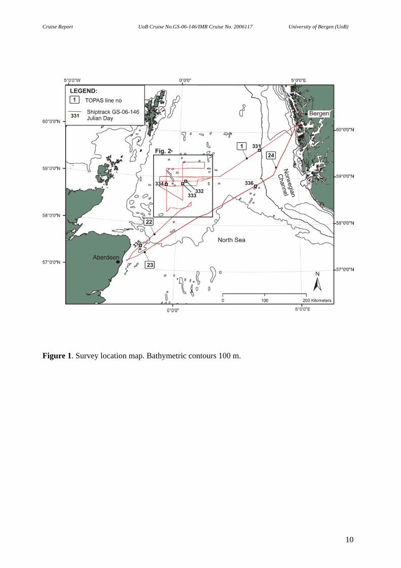
The gravity coring system functioned very well. Gravity coring (Fig. 2; Table II) was
performed at locations on the flank of an incised valley (tunnel valley?) where the sediments
were overcompacted.
3.3. General cruise performance
• The weather conditions were rough throughout the entire survey.
• The TOPAS profiling was generally successful.
• A total of 1900 km of TOPAS profiles was collected.
• 3 gravity cores were collected
9
Cruise Report UoB Cruise No.GS-06-146/IMR Cruise No. 2006117 University of Bergen (UoB)
Figure 1. Survey location map. Bathymetric contours 100 m.
10
Cruise Report UoB Cruise No.GS-06-146/IMR Cruise No. 2006117 University of Bergen (UoB)
Figure 2. Detailed survey map of the Fladen area. Figure location in Fig. 1.
11
Cruise Report UoB Cruise No.GS-06-146/IMR Cruise No. 2006117 University of Bergen (UoB)
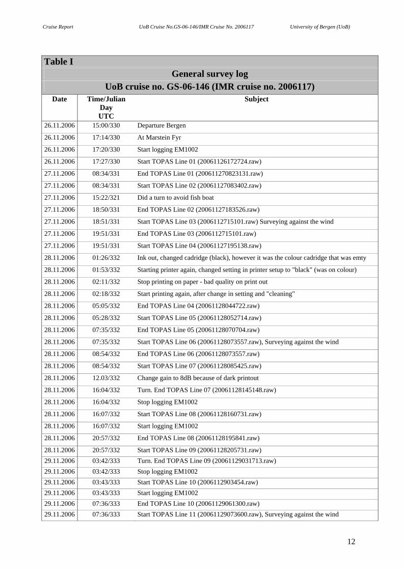
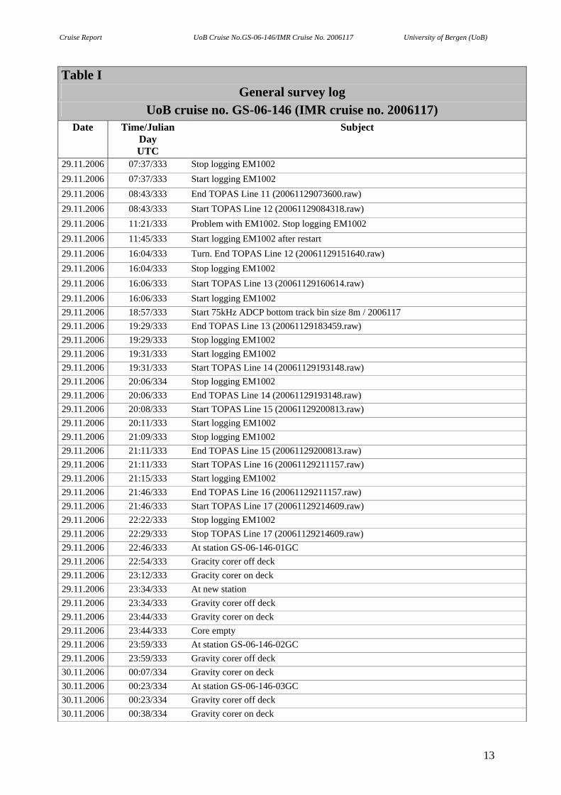
Table I
General survey log UoB cruise no. GS-06-146 (IMR cruise no. 2006117)
Date Time/Julian Day
Subject
UTC 26.11.2006 15:00/330 Departure Bergen
26.11.2006 17:14/330 At Marstein Fyr
26.11.2006 17:20/330 Start logging EM1002
26.11.2006 17:27/330 Start TOPAS Line 01 (20061126172724.raw)
27.11.2006 08:34/331 End TOPAS Line 01 (200611270823131.raw)
27.11.2006 08:34/331 Start TOPAS Line 02 (20061127083402.raw)
27.11.2006 15:22/321 Did a turn to avoid fish boat
27.11.2006 18:50/331 End TOPAS Line 02 (20061127183526.raw)
27.11.2006 18:51/331 Start TOPAS Line 03 (2006112715101.raw) Surveying against the wind
27.11.2006 19:51/331 End TOPAS Line 03 (2006112715101.raw)
27.11.2006 19:51/331 Start TOPAS Line 04 (20061127195138.raw)
28.11.2006 01:26/332 Ink out, changed cadridge (black), however it was the colour cadridge that was emty
28.11.2006 01:53/332 Starting printer again, changed setting in printer setup to "black" (was on colour)
28.11.2006 02:11/332 Stop printing on paper - bad quality on print out
28.11.2006 02:18/332 Start printing again, after change in setting and "cleaning"
28.11.2006 05:05/332 End TOPAS Line 04 (20061128044722.raw)
28.11.2006 05:28/332 Start TOPAS Line 05 (20061128052714.raw)
28.11.2006 07:35/332 End TOPAS Line 05 (20061128070704.raw)
28.11.2006 07:35/332 Start TOPAS Line 06 (20061128073557.raw), Surveying against the wind
28.11.2006 08:54/332 End TOPAS Line 06 (20061128073557.raw)
28.11.2006 08:54/332 Start TOPAS Line 07 (20061128085425.raw)
28.11.2006 12.03/332 Change gain to 8dB because of dark printout
28.11.2006 16:04/332 Turn. End TOPAS Line 07 (20061128145148.raw)
28.11.2006 16:04/332 Stop logging EM1002
28.11.2006 16:07/332 Start TOPAS Line 08 (20061128160731.raw)
28.11.2006 16:07/332 Start logging EM1002
28.11.2006 20:57/332 End TOPAS Line 08 (20061128195841.raw)
28.11.2006 20:57/332 Start TOPAS Line 09 (20061128205731.raw) 29.11.2006 03:42/333 Turn. End TOPAS Line 09 (20061129031713.raw) 29.11.2006 03:42/333 Stop logging EM1002 29.11.2006 03:43/333 Start TOPAS Line 10 (2006112903454.raw) 29.11.2006 03:43/333 Start logging EM1002 29.11.2006 07:36/333 End TOPAS Line 10 (20061129061300.raw) 29.11.2006 07:36/333 Start TOPAS Line 11 (20061129073600.raw), Surveying against the wind
12
Cruise Report UoB Cruise No.GS-06-146/IMR Cruise No. 2006117 University of Bergen (UoB)
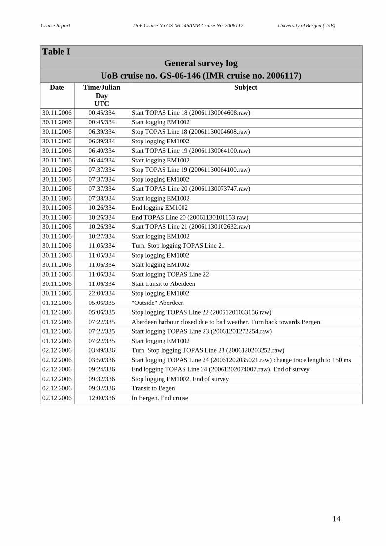
Table I General survey log
UoB cruise no. GS-06-146 (IMR cruise no. 2006117) Date Time/Julian
Day Subject
UTC 29.11.2006 07:37/333 Stop logging EM1002 29.11.2006 07:37/333 Start logging EM1002 29.11.2006 08:43/333 End TOPAS Line 11 (20061129073600.raw) 29.11.2006 08:43/333 Start TOPAS Line 12 (20061129084318.raw) 29.11.2006 11:21/333 Problem with EM1002. Stop logging EM1002 29.11.2006 11:45/333 Start logging EM1002 after restart 29.11.2006 16:04/333 Turn. End TOPAS Line 12 (20061129151640.raw) 29.11.2006 16:04/333 Stop logging EM1002 29.11.2006 16:06/333 Start TOPAS Line 13 (20061129160614.raw) 29.11.2006 16:06/333 Start logging EM1002 29.11.2006 18:57/333 Start 75kHz ADCP bottom track bin size 8m / 2006117 29.11.2006 19:29/333 End TOPAS Line 13 (20061129183459.raw) 29.11.2006 19:29/333 Stop logging EM1002 29.11.2006 19:31/333 Start logging EM1002 29.11.2006 19:31/333 Start TOPAS Line 14 (20061129193148.raw) 29.11.2006 20:06/334 Stop logging EM1002 29.11.2006 20:06/333 End TOPAS Line 14 (20061129193148.raw) 29.11.2006 20:08/333 Start TOPAS Line 15 (20061129200813.raw) 29.11.2006 20:11/333 Start logging EM1002 29.11.2006 21:09/333 Stop logging EM1002 29.11.2006 21:11/333 End TOPAS Line 15 (20061129200813.raw) 29.11.2006 21:11/333 Start TOPAS Line 16 (20061129211157.raw) 29.11.2006 21:15/333 Start logging EM1002 29.11.2006 21:46/333 End TOPAS Line 16 (20061129211157.raw) 29.11.2006 21:46/333 Start TOPAS Line 17 (20061129214609.raw) 29.11.2006 22:22/333 Stop logging EM1002 29.11.2006 22:29/333 Stop TOPAS Line 17 (20061129214609.raw) 29.11.2006 22:46/333 At station GS-06-146-01GC 29.11.2006 22:54/333 Gracity corer off deck 29.11.2006 23:12/333 Gracity corer on deck 29.11.2006 23:34/333 At new station 29.11.2006 23:34/333 Gravity corer off deck 29.11.2006 23:44/333 Gravity corer on deck 29.11.2006 23:44/333 Core empty 29.11.2006 23:59/333 At station GS-06-146-02GC 29.11.2006 23:59/333 Gravity corer off deck 30.11.2006 00:07/334 Gravity corer on deck 30.11.2006 00:23/334 At station GS-06-146-03GC 30.11.2006 00:23/334 Gravity corer off deck 30.11.2006 00:38/334 Gravity corer on deck
13
Cruise Report UoB Cruise No.GS-06-146/IMR Cruise No. 2006117 University of Bergen (UoB)
Table I General survey log
UoB cruise no. GS-06-146 (IMR cruise no. 2006117) Date Time/Julian
Day Subject
UTC 30.11.2006 00:45/334 Start TOPAS Line 18 (20061130004608.raw) 30.11.2006 00:45/334 Start logging EM1002 30.11.2006 06:39/334 Stop TOPAS Line 18 (20061130004608.raw) 30.11.2006 06:39/334 Stop logging EM1002 30.11.2006 06:40/334 Start TOPAS Line 19 (20061130064100.raw) 30.11.2006 06:44/334 Start logging EM1002 30.11.2006 07:37/334 Stop TOPAS Line 19 (20061130064100.raw) 30.11.2006 07:37/334 Stop logging EM1002 30.11.2006 07:37/334 Start TOPAS Line 20 (20061130073747.raw) 30.11.2006 07:38/334 Start logging EM1002 30.11.2006 10:26/334 End logging EM1002 30.11.2006 10:26/334 End TOPAS Line 20 (20061130101153.raw) 30.11.2006 10:26/334 Start TOPAS Line 21 (20061130102632.raw) 30.11.2006 10:27/334 Start logging EM1002 30.11.2006 11:05/334 Turn. Stop logging TOPAS Line 21 30.11.2006 11:05/334 Stop logging EM1002 30.11.2006 11:06/334 Start logging EM1002 30.11.2006 11:06/334 Start logging TOPAS Line 22 30.11.2006 11:06/334 Start transit to Aberdeen 30.11.2006 22:00/334 Stop logging EM1002 01.12.2006 05:06/335 "Outside" Aberdeen 01.12.2006 05:06/335 Stop logging TOPAS Line 22 (20061201033156.raw) 01.12.2006 07:22/335 Aberdeen harbour closed due to bad weather. Turn back towards Bergen. 01.12.2006 07:22/335 Start logging TOPAS Line 23 (20061201272254.raw) 01.12.2006 07:22/335 Start logging EM1002 02.12.2006 03:49/336 Turn. Stop logging TOPAS Line 23 (2006120203252.raw) 02.12.2006 03:50/336 Start logging TOPAS Line 24 (20061202035021.raw) change trace length to 150 ms 02.12.2006 09:24/336 End logging TOPAS Line 24 (20061202074007.raw), End of survey 02.12.2006 09:32/336 Stop logging EM1002, End of survey 02.12.2006 09:32/336 Transit to Begen 02.12.2006 12:00/336 In Bergen. End cruise
14
Cruise Report UoB Cruise No.GS-06-146/IMR Cruise No. 2006117 University of Bergen (UoB)
Table II Core stations log
UoB Cruise no. GS-06-146 (IMR cruise no. 206117)
(WGS 84; Zone 31) Geographical coordinates
UTM coordinates
(WGS 84; Zone 31)
Date
Julian Day
Time/
Subject
Water depth (m)
Longitude Deg.
Latitude Deg.
Easting Northing
29.11.2006 22:54/333 Gravity corer off deck at station 01 GC
29.11.2006 23:12/333 Gravity corer on deck at station 01 GC
145 58o 50.063' N 0o 28.707' E 6524353 354457
29.11.2006 23:34/333 Gravity corer off deck at
station 02 GC 29.11.2006 23:44/333 Gravity corer on deck at
station 02 GC
146 58o 50.144' N 0o 28.657' E 6524500 354415
30.11.2006 00:23/334 Gravity corer off deck at
station 03 GC 30.11.2006 00:38/334 Gravity corer on deck at
station 03 GC
143 58o 50.124' N 0o 28.677' E 6524466 354433
15
Cruise Report UoB Cruise No.GS-06-146/IMR Cruise No. 2006117 University of Bergen (UoB)
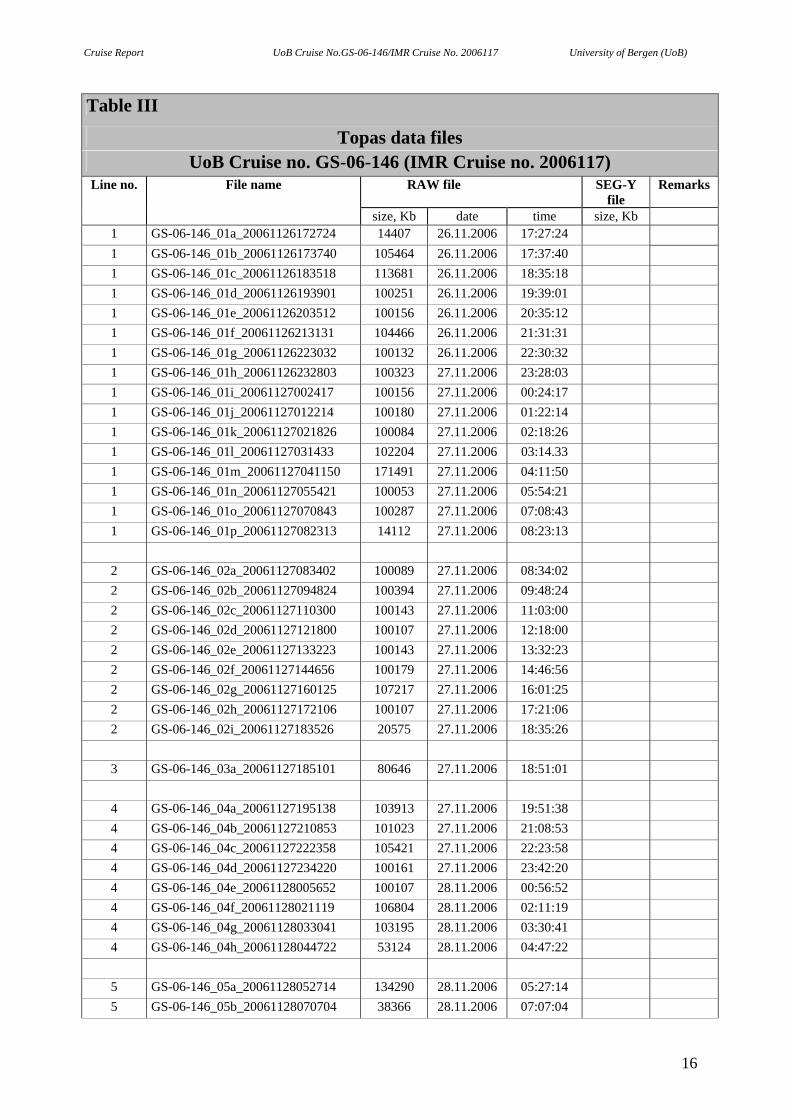
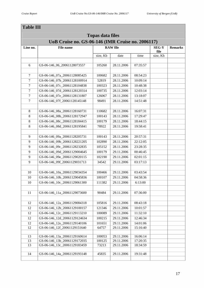
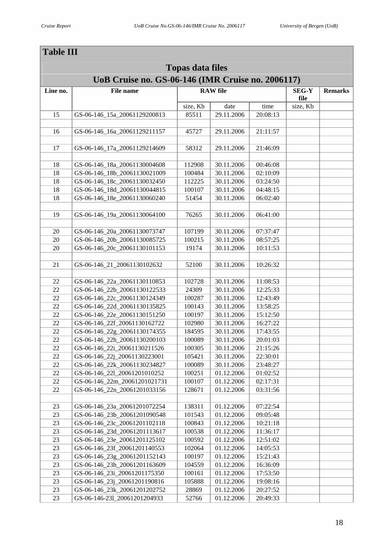
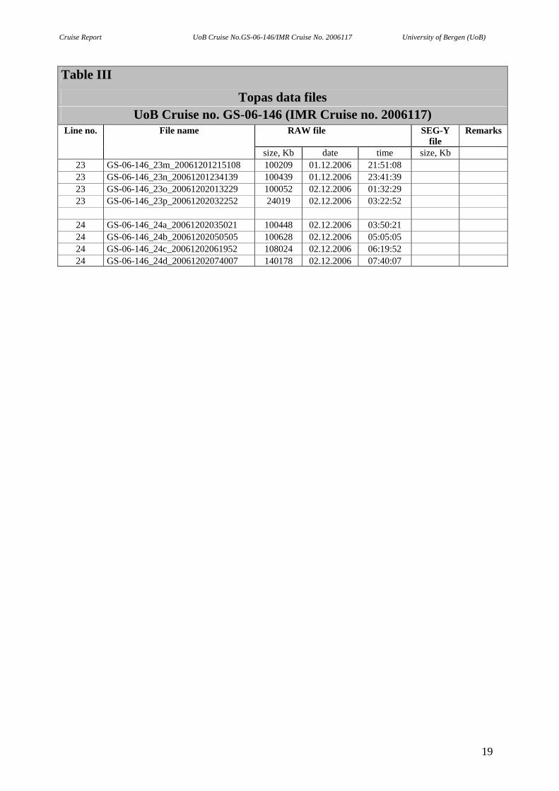
Table III
Topas data files UoB Cruise no. GS-06-146 (IMR Cruise no. 2006117)
Line no. File name RAW file SEG-Y file
Remarks
size, Kb date time size, Kb 1 GS-06-146_01a_20061126172724 14407 26.11.2006 17:27:24 1 GS-06-146_01b_20061126173740 105464 26.11.2006 17:37:40 1 GS-06-146_01c_20061126183518 113681 26.11.2006 18:35:18 1 GS-06-146_01d_20061126193901 100251 26.11.2006 19:39:01 1 GS-06-146_01e_20061126203512 100156 26.11.2006 20:35:12 1 GS-06-146_01f_20061126213131 104466 26.11.2006 21:31:31 1 GS-06-146_01g_20061126223032 100132 26.11.2006 22:30:32 1 GS-06-146_01h_20061126232803 100323 27.11.2006 23:28:03 1 GS-06-146_01i_20061127002417 100156 27.11.2006 00:24:17 1 GS-06-146_01j_20061127012214 100180 27.11.2006 01:22:14 1 GS-06-146_01k_20061127021826 100084 27.11.2006 02:18:26 1 GS-06-146_01l_20061127031433 102204 27.11.2006 03:14.33 1 GS-06-146_01m_20061127041150 171491 27.11.2006 04:11:50 1 GS-06-146_01n_20061127055421 100053 27.11.2006 05:54:21 1 GS-06-146_01o_20061127070843 100287 27.11.2006 07:08:43 1 GS-06-146_01p_20061127082313 14112 27.11.2006 08:23:13
2 GS-06-146_02a_20061127083402 100089 27.11.2006 08:34:02 2 GS-06-146_02b_20061127094824 100394 27.11.2006 09:48:24 2 GS-06-146_02c_20061127110300 100143 27.11.2006 11:03:00 2 GS-06-146_02d_20061127121800 100107 27.11.2006 12:18:00 2 GS-06-146_02e_20061127133223 100143 27.11.2006 13:32:23 2 GS-06-146_02f_20061127144656 100179 27.11.2006 14:46:56 2 GS-06-146_02g_20061127160125 107217 27.11.2006 16:01:25 2 GS-06-146_02h_20061127172106 100107 27.11.2006 17:21:06 2 GS-06-146_02i_20061127183526 20575 27.11.2006 18:35:26
3 GS-06-146_03a_20061127185101 80646 27.11.2006 18:51:01
4 GS-06-146_04a_20061127195138 103913 27.11.2006 19:51:38 4 GS-06-146_04b_20061127210853 101023 27.11.2006 21:08:53 4 GS-06-146_04c_20061127222358 105421 27.11.2006 22:23:58 4 GS-06-146_04d_20061127234220 100161 27.11.2006 23:42:20 4 GS-06-146_04e_20061128005652 100107 28.11.2006 00:56:52 4 GS-06-146_04f_20061128021119 106804 28.11.2006 02:11:19 4 GS-06-146_04g_20061128033041 103195 28.11.2006 03:30:41 4 GS-06-146_04h_20061128044722 53124 28.11.2006 04:47:22
5 GS-06-146_05a_20061128052714 134290 28.11.2006 05:27:14 5 GS-06-146_05b_20061128070704 38366 28.11.2006 07:07:04
16
Cruise Report UoB Cruise No.GS-06-146/IMR Cruise No. 2006117 University of Bergen (UoB)
Table III
Topas data files UoB Cruise no. GS-06-146 (IMR Cruise no. 2006117)
Line no. File name RAW file SEG-Y file
Remarks
size, Kb date time size, Kb
6 GS-06-146_06_20061128073557 105260 28.11.2006 07:35:57
7 GS-06-146_07a_20061128085425 100682 28.11.2006 08:54:23 7 GS-06-146_07b_20061128100914 52819 28.11.2006 10:09:14 7 GS-06-146_07c_20061128104838 100323 28.11.2006 10:48:38 7 GS-06-146_07d_20061128120314 100735 28.11.2006 12:03:14 7 GS-06-146_07e_20061128131807 126067 28.11.2006 13:18:07 7 GS-06-146_07f_20061128145148 98491 28.11.2006 14:51:48
8 GS-06-146_08a_20061128160731 110682 28.11.2006 16:07:31 8 GS-06-146_08b_20061128172947 100143 28.11.2006 17:29:47 8 GS-06-146_08c_20061128184415 100179 28.11.2006 18:44:15 8 GS-06-146_08d_20061128195841 78922 28.11.2006 19:58:41
9 GS-06-146_09a_20061128205731 100143 28.11.2006 20:57:31 9 GS-06-146_09b_20061128221205 102890 28.11.2006 22:12:05 9 GS-06-146_09c_20061128232835 105152 28.11.2006 23:28:35 9 GS-06-146_09d_20061129004645 100179 29.11.2006 00:46:45 9 GS-06-146_09e_20061129020115 102190 29.11.2006 02:01:15 9 GS-06-146_09f_20061129031713 34542 29.11.2006 03:17:13
10 GS-06-146_10a_20061129034354 100466 29.11.2006 03:43:54 10 GS-06-146_10b_20061129045836 100107 29.11.2006 04:58:36 10 GS-06-146_10c_20061129061300 111382 29.11.2006 6:13:00
11 GS-06-146_11a_20061129073600 90484 29.11.2006 07:36:00
12 GS-06-146_12a_20061129084318 105816 29.11.2006 08:43:18 12 GS-06-146_12b_20061129100157 121346 29.11.2006 10:01:57 12 GS-06-146_12c_20061129113210 100089 29.11.2006 11:32:10 12 GS-06-146_12d_20061129124634 100215 29.11.2006 12:46:34 12 GS-06-146_12e_20061129140106 101651 29.11.2006 14:01:06 12 GS-06-146_12f_20061129151640 64757 29.11.2006 15:16:40
13 GS-06-146_13a_20061129160614 100053 29.11.2006 16:06:14 13 GS-06-146_13b_20061129172035 100125 29.11.2006 17:20:35 13 GS-06-146_13c_20061129183459 73213 29.11.2006 18:34:59
14 GS-06-146_14a_20061129193148 45835 29.11.2006 19:31:48
17
Cruise Report UoB Cruise No.GS-06-146/IMR Cruise No. 2006117 University of Bergen (UoB)
Table III
Topas data files UoB Cruise no. GS-06-146 (IMR Cruise no. 2006117)
Line no. File name RAW file SEG-Y file
Remarks
size, Kb date time size, Kb 15 GS-06-146_15a_20061129200813 85511 29.11.2006 20:08:13
16 GS-06-146_16a_20061129211157 45727 29.11.2006 21:11:57
17 GS-06-146_17a_20061129214609 58312 29.11.2006 21:46:09
18 GS-06-146_18a_20061130004608 112908 30.11.2006 00:46:08 18 GS-06-146_18b_20061130021009 100484 30.11.2006 02:10:09 18 GS-06-146_18c_20061130032450 112225 30.11.2006 03:24:50 18 GS-06-146_18d_20061130044815 100107 30.11.2006 04:48:15 18 GS-06-146_18e_20061130060240 51454 30.11.2006 06:02:40
19 GS-06-146_19a_20061130064100 76265 30.11.2006 06:41:00
20 GS-06-146_20a_20061130073747 107199 30.11.2006 07:37:47 20 GS-06-146_20b_20061130085725 100215 30.11.2006 08:57:25 20 GS-06-146_20c_20061130101153 19174 30.11.2006 10:11:53
21 GS-06-146_21_20061130102632 52100 30.11.2006 10:26:32
22 GS-06-146_22a_20061130110853 102728 30.11.2006 11:08:53 22 GS-06-146_22b_20061130122533 24309 30.11.2006 12:25:33 22 GS-06-146_22c_20061130124349 100287 30.11.2006 12:43:49 22 GS-06-146_22d_20061130135825 100143 30.11.2006 13:58:25 22 GS-06-146_22e_20061130151250 100197 30.11.2006 15:12:50 22 GS-06-146_22f_20061130162722 102980 30.11.2006 16:27:22 22 GS-06-146_22g_20061130174355 184595 30.11.2006 17:43:55 22 GS-06-146_22h_20061130200103 100089 30.11.2006 20:01:03 22 GS-06-146_22i_20061130211526 100305 30.11.2006 21:15:26 22 GS-06-146_22j_20061130223001 105421 30.11.2006 22:30:01 22 GS-06-146_22k_20061130234827 100089 30.11.2006 23:48:27 22 GS-06-146_22l_20061201010252 100251 01.12.2006 01:02:52 22 GS-06-146_22m_20061201021731 100107 01.12.2006 02:17:31 22 GS-06-146_22n_20061201033156 128671 01.12.2006 03:31:56
23 GS-06-146_23a_20061201072254 138311 01.12.2006 07:22:54 23 GS-06-146_23b_20061201090548 101543 01.12.2006 09:05:48 23 GS-06-146_23c_20061201102118 100843 01.12.2006 10:21:18 23 GS-06-146_23d_20061201113617 100538 01.12.2006 11:36:17 23 GS-06-146_23e_20061201125102 100592 01.12.2006 12:51:02 23 GS-06-146_23f_20061201140553 102064 01.12.2006 14:05:53 23 GS-06-146_23g_20061201152143 100197 01.12.2006 15:21:43 23 GS-06-146_23h_20061201163609 104559 01.12.2006 16:36:09 23 GS-06-146_23i_20061201175350 100161 01.12.2006 17:53:50 23 GS-06-146_23j_20061201190816 105888 01.12.2006 19:08:16 23 GS-06-146_23k_20061201202752 28869 01.12.2006 20:27:52 23 GS-06-146-23l_20061201204933 52766 01.12.2006 20:49:33
18
Cruise Report UoB Cruise No.GS-06-146/IMR Cruise No. 2006117 University of Bergen (UoB)
Table III
Topas data files UoB Cruise no. GS-06-146 (IMR Cruise no. 2006117)
Line no. File name RAW file SEG-Y file
Remarks
size, Kb date time size, Kb 23 GS-06-146_23m_20061201215108 100209 01.12.2006 21:51:08 23 GS-06-146_23n_20061201234139 100439 01.12.2006 23:41:39 23 GS-06-146_23o_20061202013229 100052 02.12.2006 01:32:29 23 GS-06-146_23p_20061202032252 24019 02.12.2006 03:22:52
24 GS-06-146_24a_20061202035021 100448 02.12.2006 03:50:21 24 GS-06-146_24b_20061202050505 100628 02.12.2006 05:05:05 24 GS-06-146_24c_20061202061952 108024 02.12.2006 06:19:52 24 GS-06-146_24d_20061202074007 140178 02.12.2006 07:40:07
19
Cruise Report UoB Cruise No.GS-06-146/IMR Cruise No. 2006117 University of Bergen (UoB)
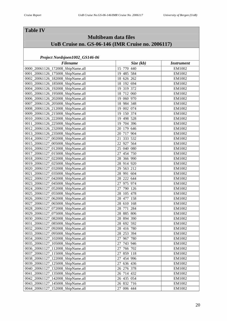
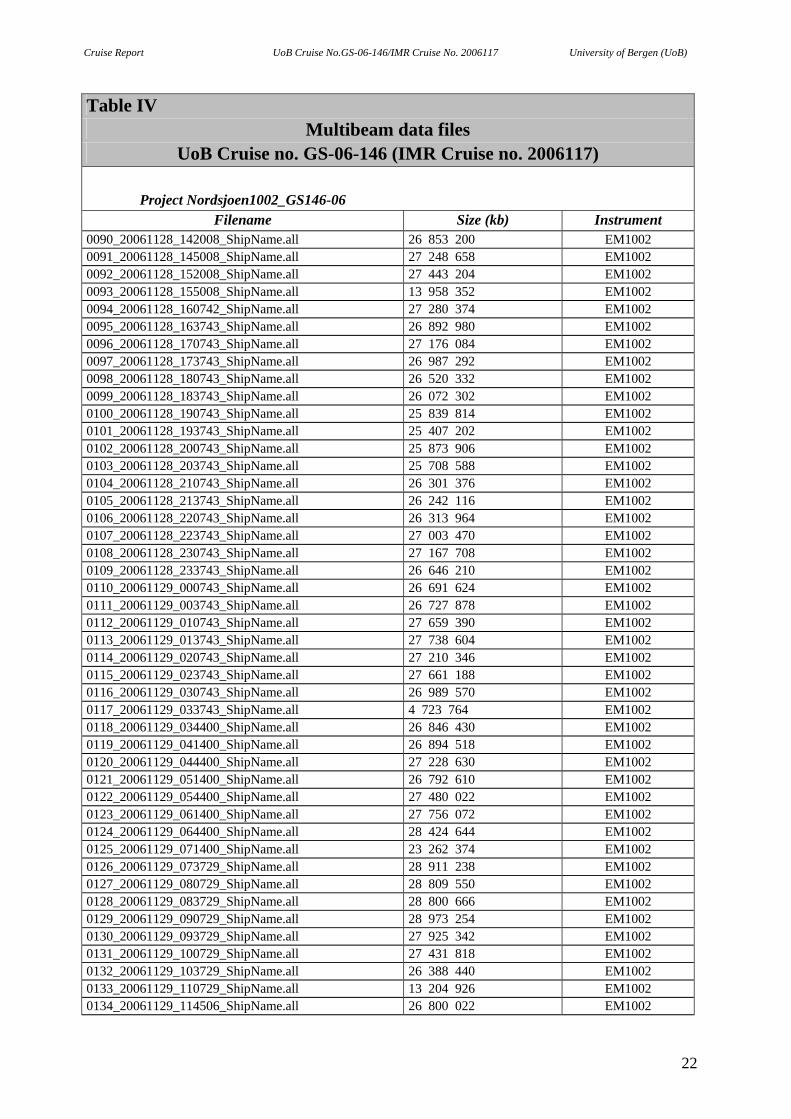
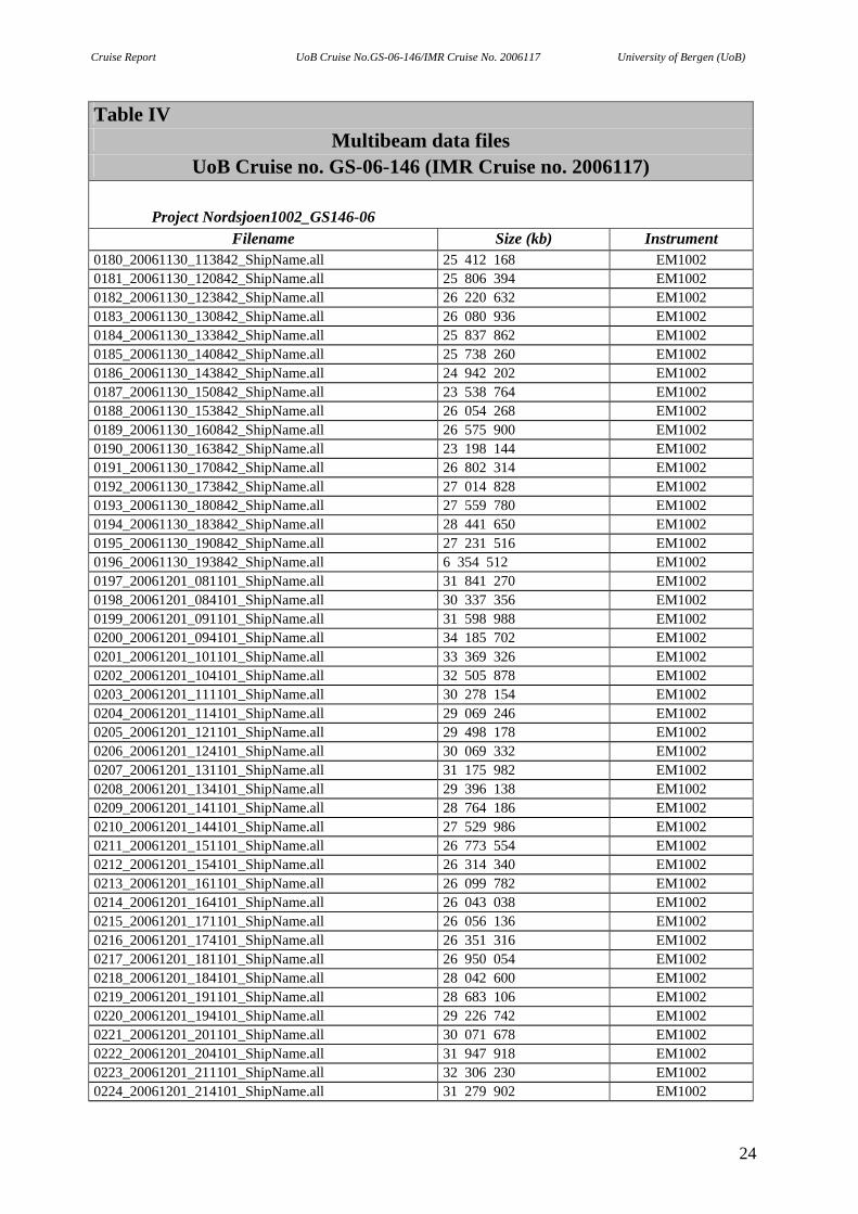
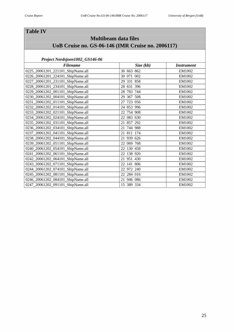
Table IV Multibeam data files
UoB Cruise no. GS-06-146 (IMR Cruise no. 2006117)
Project Nordsjoen1002_GS146-06 Filename Size (kb) Instrument
0000_20061126_172008_ShipName.all 15 770 440 EM1002 0001_20061126_175008_ShipName.all 19 485 584 EM1002 0002_20061126_182008_ShipName.all 18 626 262 EM1002 0003_20061126_185008_ShipName.all 18 192 694 EM1002 0004_20061126_192008_ShipName.all 19 319 372 EM1002 0005_20061126_195008_ShipName.all 18 712 060 EM1002 0006_20061126_202008_ShipName.all 19 060 970 EM1002 0007_20061126_205008_ShipName.all 18 984 348 EM1002 0008_20061126_212008_ShipName.all 19 002 074 EM1002 0009_20061126_215008_ShipName.all 19 150 374 EM1002 0010_20061126_222008_ShipName.all 19 498 528 EM1002 0011_20061126_225008_ShipName.all 19 704 396 EM1002 0012_20061126_232008_ShipName.all 20 179 646 EM1002 0013_20061126_235008_ShipName.all 20 717 904 EM1002 0014_20061127_002008_ShipName.all 21 333 532 EM1002 0015_20061127_005008_ShipName.all 22 927 564 EM1002 0016_20061127_012008_ShipName.all 25 040 080 EM1002 0017_20061127_015008_ShipName.all 27 454 750 EM1002 0018_20061127_022008_ShipName.all 28 366 990 EM1002 0019_20061127_025008_ShipName.all 28 914 920 EM1002 0020_20061127_032008_ShipName.all 29 563 212 EM1002 0021_20061127_035008_ShipName.all 28 991 604 EM1002 0022_20061127_042008_ShipName.all 28 222 644 EM1002 0023_20061127_045008_ShipName.all 27 975 974 EM1002 0024_20061127_052008_ShipName.all 27 790 126 EM1002 0025_20061127_055008_ShipName.all 28 105 478 EM1002 0026_20061127_062008_ShipName.all 28 477 158 EM1002 0027_20061127_065008_ShipName.all 28 610 168 EM1002 0028_20061127_072008_ShipName.all 28 771 284 EM1002 0029_20061127_075008_ShipName.all 28 885 806 EM1002 0030_20061127_082008_ShipName.all 28 894 390 EM1002 0031_20061127_085008_ShipName.all 28 692 592 EM1002 0032_20061127_092008_ShipName.all 28 416 780 EM1002 0033_20061127_095008_ShipName.all 28 253 394 EM1002 0034_20061127_102008_ShipName.all 27 967 780 EM1002 0035_20061127_105008_ShipName.all 27 743 946 EM1002 0036_20061127_112008_ShipName.all 27 766 702 EM1002 0037_20061127_115008_ShipName.all 27 859 118 EM1002 0038_20061127_122008_ShipName.all 27 454 996 EM1002 0039_20061127_125008_ShipName.all 27 636 436 EM1002 0040_20061127_132008_ShipName.all 26 276 378 EM1002 0041_20061127_135008_ShipName.all 26 714 432 EM1002 0042_20061127_142008_ShipName.all 26 435 054 EM1002 0043_20061127_145008_ShipName.all 26 832 716 EM1002 0044_20061127_152008_ShipName.all 27 006 444 EM1002
20

Cruise Report UoB Cruise No.GS-06-146/IMR Cruise No. 2006117 University of Bergen (UoB)
Table IV Multibeam data files
UoB Cruise no. GS-06-146 (IMR Cruise no. 2006117)
Project Nordsjoen1002_GS146-06 Filename Size (kb) Instrument
0045_20061127_155008_ShipName.all 27 351 342 EM1002 0046_20061127_162008_ShipName.all 27 630 874 EM1002 0047_20061127_165008_ShipName.all 25 285 738 EM1002 0048_20061127_172008_ShipName.all 27 100 048 EM1002 0049_20061127_175008_ShipName.all 26 670 644 EM1002 0050_20061127_182008_ShipName.all 27 137 944 EM1002 0051_20061127_185008_ShipName.all 22 827 814 EM1002 0052_20061127_192008_ShipName.all 21 712 042 EM1002 0053_20061127_195008_ShipName.all 24 491 564 EM1002 0054_20061127_202008_ShipName.all 26 748 976 EM1002 0055_20061127_205008_ShipName.all 26 248 552 EM1002 0056_20061127_212008_ShipName.all 26 574 666 EM1002 0057_20061127_215008_ShipName.all 27 188 424 EM1002 0058_20061127_222008_ShipName.all 29 061 766 EM1002 0059_20061127_225008_ShipName.all 28 104 366 EM1002 0060_20061127_232008_ShipName.all 27 079 200 EM1002 0061_20061127_235008_ShipName.all 26 585 732 EM1002 0062_20061128_002008_ShipName.all 26 331 630 EM1002 0063_20061128_005008_ShipName.all 26 014 294 EM1002 0064_20061128_012008_ShipName.all 26 230 328 EM1002 0065_20061128_015008_ShipName.all 26 575 074 EM1002 0066_20061128_022008_ShipName.all 27 321 618 EM1002 0067_20061128_025008_ShipName.all 27 424 154 EM1002 0068_20061128_032008_ShipName.all 27 389 114 EM1002 0069_20061128_035008_ShipName.all 27 540 962 EM1002 0070_20061128_042008_ShipName.all 27 823 636 EM1002 0071_20061128_045008_ShipName.all 27 630 782 EM1002 0072_20061128_052008_ShipName.all 27 775 152 EM1002 0073_20061128_055008_ShipName.all 27 564 154 EM1002 0074_20061128_062008_ShipName.all 27 384 384 EM1002 0075_20061128_065008_ShipName.all 27 729 754 EM1002 0076_20061128_072008_ShipName.all 27 157 094 EM1002 0077_20061128_075008_ShipName.all 26 073 570 EM1002 0078_20061128_082008_ShipName.all 25 378 086 EM1002 0079_20061128_085008_ShipName.all 26 521 612 EM1002 0080_20061128_092008_ShipName.all 26 241 508 EM1002 0081_20061128_095008_ShipName.all 26 370 224 EM1002 0082_20061128_102008_ShipName.all 26 974 026 EM1002 0083_20061128_105008_ShipName.all 26 897 214 EM1002 0084_20061128_112008_ShipName.all 27 263 786 EM1002 0085_20061128_115008_ShipName.all 27 440 474 EM1002 0086_20061128_122008_ShipName.all 26 963 350 EM1002 0087_20061128_125008_ShipName.all 27 333 298 EM1002 0088_20061128_132008_ShipName.all 28 722 600 EM1002 0089_20061128_135008_ShipName.all 26 893 606 EM1002
21
Cruise Report UoB Cruise No.GS-06-146/IMR Cruise No. 2006117 University of Bergen (UoB)
Table IV Multibeam data files
UoB Cruise no. GS-06-146 (IMR Cruise no. 2006117)
Project Nordsjoen1002_GS146-06 Filename Size (kb) Instrument
0090_20061128_142008_ShipName.all 26 853 200 EM1002 0091_20061128_145008_ShipName.all 27 248 658 EM1002 0092_20061128_152008_ShipName.all 27 443 204 EM1002 0093_20061128_155008_ShipName.all 13 958 352 EM1002 0094_20061128_160742_ShipName.all 27 280 374 EM1002 0095_20061128_163743_ShipName.all 26 892 980 EM1002 0096_20061128_170743_ShipName.all 27 176 084 EM1002 0097_20061128_173743_ShipName.all 26 987 292 EM1002 0098_20061128_180743_ShipName.all 26 520 332 EM1002 0099_20061128_183743_ShipName.all 26 072 302 EM1002 0100_20061128_190743_ShipName.all 25 839 814 EM1002 0101_20061128_193743_ShipName.all 25 407 202 EM1002 0102_20061128_200743_ShipName.all 25 873 906 EM1002 0103_20061128_203743_ShipName.all 25 708 588 EM1002 0104_20061128_210743_ShipName.all 26 301 376 EM1002 0105_20061128_213743_ShipName.all 26 242 116 EM1002 0106_20061128_220743_ShipName.all 26 313 964 EM1002 0107_20061128_223743_ShipName.all 27 003 470 EM1002 0108_20061128_230743_ShipName.all 27 167 708 EM1002 0109_20061128_233743_ShipName.all 26 646 210 EM1002 0110_20061129_000743_ShipName.all 26 691 624 EM1002 0111_20061129_003743_ShipName.all 26 727 878 EM1002 0112_20061129_010743_ShipName.all 27 659 390 EM1002 0113_20061129_013743_ShipName.all 27 738 604 EM1002 0114_20061129_020743_ShipName.all 27 210 346 EM1002 0115_20061129_023743_ShipName.all 27 661 188 EM1002 0116_20061129_030743_ShipName.all 26 989 570 EM1002 0117_20061129_033743_ShipName.all 4 723 764 EM1002 0118_20061129_034400_ShipName.all 26 846 430 EM1002 0119_20061129_041400_ShipName.all 26 894 518 EM1002 0120_20061129_044400_ShipName.all 27 228 630 EM1002 0121_20061129_051400_ShipName.all 26 792 610 EM1002 0122_20061129_054400_ShipName.all 27 480 022 EM1002 0123_20061129_061400_ShipName.all 27 756 072 EM1002 0124_20061129_064400_ShipName.all 28 424 644 EM1002 0125_20061129_071400_ShipName.all 23 262 374 EM1002 0126_20061129_073729_ShipName.all 28 911 238 EM1002 0127_20061129_080729_ShipName.all 28 809 550 EM1002 0128_20061129_083729_ShipName.all 28 800 666 EM1002 0129_20061129_090729_ShipName.all 28 973 254 EM1002 0130_20061129_093729_ShipName.all 27 925 342 EM1002 0131_20061129_100729_ShipName.all 27 431 818 EM1002 0132_20061129_103729_ShipName.all 26 388 440 EM1002 0133_20061129_110729_ShipName.all 13 204 926 EM1002 0134_20061129_114506_ShipName.all 26 800 022 EM1002
22

Cruise Report UoB Cruise No.GS-06-146/IMR Cruise No. 2006117 University of Bergen (UoB)
Table IV Multibeam data files
UoB Cruise no. GS-06-146 (IMR Cruise no. 2006117)
Project Nordsjoen1002_GS146-06 Filename Size (kb) Instrument
0135_20061129_121506_ShipName.all 26 610 416 EM1002 0136_20061129_124506_ShipName.all 27 501 812 EM1002 0137_20061129_131506_ShipName.all 26 278 192 EM1002 0138_20061129_134506_ShipName.all 26 692 626 EM1002 0139_20061129_141506_ShipName.all 26 693 694 EM1002 0140_20061129_144506_ShipName.all 26 406 386 EM1002 0141_20061129_151506_ShipName.all 26 482 794 EM1002 0142_20061129_154507_ShipName.all 17 352 128 EM1002 0143_20061129_160603_ShipName.all 24 026 998 EM1002 0144_20061129_163603_ShipName.all 24 445 610 EM1002 0145_20061129_170604_ShipName.all 25 416 210 EM1002 0146_20061129_173604_ShipName.all 26 070 396 EM1002 0147_20061129_180604_ShipName.all 25 270 614 EM1002 0148_20061129_183604_ShipName.all 23 092 118 EM1002 0149_20061129_190603_ShipName.all 19 394 212 EM1002 0150_20061129_193152_ShipName.all 24 621 758 EM1002 0151_20061129_200151_ShipName.all 2 992 582 EM1002 0152_20061129_201122_ShipName.all 24 108 646 EM1002 0153_20061129_204122_ShipName.all 23 355 110 EM1002 0154_20061129_211522_ShipName.all 24 957 792 EM1002 0155_20061129_214522_ShipName.all 23 945 634 EM1002 0156_20061129_221522_ShipName.all 5 078 378 EM1002 0157_20061130_004558_ShipName.all 25 139 158 EM1002 0158_20061130_011558_ShipName.all 24 694 170 EM1002 0159_20061130_014558_ShipName.all 26 360 702 EM1002 0160_20061130_021558_ShipName.all 18 226 944 EM1002 0161_20061130_024558_ShipName.all 24 873 378 EM1002 0162_20061130_031558_ShipName.all 24 116 384 EM1002 0163_20061130_034558_ShipName.all 16 625 704 EM1002 0164_20061130_041558_ShipName.all 23 577 098 EM1002 0165_20061130_044558_ShipName.all 25 575 606 EM1002 0166_20061130_051558_ShipName.all 23 892 562 EM1002 0167_20061130_054558_ShipName.all 24 856 184 EM1002 0168_20061130_061558_ShipName.all 20 169 564 EM1002 0169_20061130_064447_ShipName.all 27 678 862 EM1002 0170_20061130_071447_ShipName.all 20 800 364 EM1002 0171_20061130_073852_ShipName.all 27 502 236 EM1002 0172_20061130_080852_ShipName.all 26 841 242 EM1002 0173_20061130_083852_ShipName.all 26 582 984 EM1002 0174_20061130_090852_ShipName.all 26 265 694 EM1002 0175_20061130_093852_ShipName.all 26 273 468 EM1002 0176_20061130_100852_ShipName.all 14 859 886 EM1002 0177_20061130_102734_ShipName.all 26 084 422 EM1002 0178_20061130_105734_ShipName.all 7 502 944 EM1002 0179_20061130_110842_ShipName.all 25 070 860 EM1002
23
Cruise Report UoB Cruise No.GS-06-146/IMR Cruise No. 2006117 University of Bergen (UoB)
Table IV Multibeam data files
UoB Cruise no. GS-06-146 (IMR Cruise no. 2006117)
Project Nordsjoen1002_GS146-06 Filename Size (kb) Instrument
0180_20061130_113842_ShipName.all 25 412 168 EM1002 0181_20061130_120842_ShipName.all 25 806 394 EM1002 0182_20061130_123842_ShipName.all 26 220 632 EM1002 0183_20061130_130842_ShipName.all 26 080 936 EM1002 0184_20061130_133842_ShipName.all 25 837 862 EM1002 0185_20061130_140842_ShipName.all 25 738 260 EM1002 0186_20061130_143842_ShipName.all 24 942 202 EM1002 0187_20061130_150842_ShipName.all 23 538 764 EM1002 0188_20061130_153842_ShipName.all 26 054 268 EM1002 0189_20061130_160842_ShipName.all 26 575 900 EM1002 0190_20061130_163842_ShipName.all 23 198 144 EM1002 0191_20061130_170842_ShipName.all 26 802 314 EM1002 0192_20061130_173842_ShipName.all 27 014 828 EM1002 0193_20061130_180842_ShipName.all 27 559 780 EM1002 0194_20061130_183842_ShipName.all 28 441 650 EM1002 0195_20061130_190842_ShipName.all 27 231 516 EM1002 0196_20061130_193842_ShipName.all 6 354 512 EM1002 0197_20061201_081101_ShipName.all 31 841 270 EM1002 0198_20061201_084101_ShipName.all 30 337 356 EM1002 0199_20061201_091101_ShipName.all 31 598 988 EM1002 0200_20061201_094101_ShipName.all 34 185 702 EM1002 0201_20061201_101101_ShipName.all 33 369 326 EM1002 0202_20061201_104101_ShipName.all 32 505 878 EM1002 0203_20061201_111101_ShipName.all 30 278 154 EM1002 0204_20061201_114101_ShipName.all 29 069 246 EM1002 0205_20061201_121101_ShipName.all 29 498 178 EM1002 0206_20061201_124101_ShipName.all 30 069 332 EM1002 0207_20061201_131101_ShipName.all 31 175 982 EM1002 0208_20061201_134101_ShipName.all 29 396 138 EM1002 0209_20061201_141101_ShipName.all 28 764 186 EM1002 0210_20061201_144101_ShipName.all 27 529 986 EM1002 0211_20061201_151101_ShipName.all 26 773 554 EM1002 0212_20061201_154101_ShipName.all 26 314 340 EM1002 0213_20061201_161101_ShipName.all 26 099 782 EM1002 0214_20061201_164101_ShipName.all 26 043 038 EM1002 0215_20061201_171101_ShipName.all 26 056 136 EM1002 0216_20061201_174101_ShipName.all 26 351 316 EM1002 0217_20061201_181101_ShipName.all 26 950 054 EM1002 0218_20061201_184101_ShipName.all 28 042 600 EM1002 0219_20061201_191101_ShipName.all 28 683 106 EM1002 0220_20061201_194101_ShipName.all 29 226 742 EM1002 0221_20061201_201101_ShipName.all 30 071 678 EM1002 0222_20061201_204101_ShipName.all 31 947 918 EM1002 0223_20061201_211101_ShipName.all 32 306 230 EM1002 0224_20061201_214101_ShipName.all 31 279 902 EM1002
24
Cruise Report UoB Cruise No.GS-06-146/IMR Cruise No. 2006117 University of Bergen (UoB)
Table IV Multibeam data files
UoB Cruise no. GS-06-146 (IMR Cruise no. 2006117)
Project Nordsjoen1002_GS146-06 Filename Size (kb) Instrument
0225_20061201_221101_ShipName.all 30 663 862 EM1002 0226_20061201_224101_ShipName.all 30 071 002 EM1002 0227_20061201_231101_ShipName.all 29 331 858 EM1002 0228_20061201_234101_ShipName.all 28 631 396 EM1002 0229_20061202_001101_ShipName.all 28 783 744 EM1002 0230_20061202_004101_ShipName.all 29 367 508 EM1002 0231_20061202_011101_ShipName.all 27 723 056 EM1002 0232_20061202_014101_ShipName.all 24 853 996 EM1002 0233_20061202_021101_ShipName.all 22 754 908 EM1002 0234_20061202_024101_ShipName.all 22 083 630 EM1002 0235_20061202_031101_ShipName.all 21 857 292 EM1002 0236_20061202_034101_ShipName.all 21 744 988 EM1002 0237_20061202_041101_ShipName.all 21 811 174 EM1002 0238_20061202_044101_ShipName.all 21 939 626 EM1002 0239_20061202_051101_ShipName.all 22 069 768 EM1002 0240_20061202_054101_ShipName.all 22 130 458 EM1002 0241_20061202_061101_ShipName.all 22 138 920 EM1002 0242_20061202_064101_ShipName.all 21 951 430 EM1002 0243_20061202_071101_ShipName.all 22 141 806 EM1002 0244_20061202_074101_ShipName.all 22 972 240 EM1002 0245_20061202_081101_ShipName.all 22 284 016 EM1002 0246_20061202_084101_ShipName.all 21 946 086 EM1002 0247_20061202_091101_ShipName.all 15 389 334 EM1002
25
Cruise Report UoB Cruise No.GS-06-146/IMR Cruise No. 2006117 University of Bergen (UoB)
APPENDIX I
Cores Station Log Sheets
26
Cruise Report UoB Cruise No.GS-06-146/IMR Cruise No. 2006117 University of Bergen (UoB)
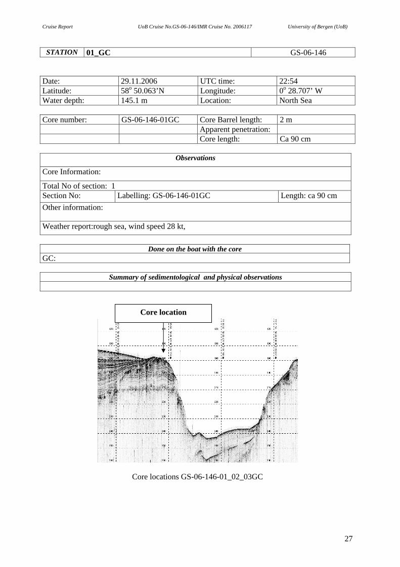
STATION 01_GC GS-06-146 Date: 29.11.2006 UTC time: 22:54 Latitude: 58o 50.063’N Longitude: 0o 28.707’ W Water depth: 145.1 m Location: North Sea Core number: GS-06-146-01GC Core Barrel length: 2 m Apparent penetration: Core length: Ca 90 cm
Observations
Core Information:
Total No of section: 1 Section No: Labelling: GS-06-146-01GC Length: ca 90 cm Other information: Weather report:rough sea, wind speed 28 kt,
Done on the boat with the core
GC:
Summary of sedimentological and physical observations
Core location
Core locations GS-06-146-01_02_03GC
27
Cruise Report UoB Cruise No.GS-06-146/IMR Cruise No. 2006117 University of Bergen (UoB)
STATION 02_GC GS-06-146 Date: 29.11.2006 UTC time: 23:59 Latitude: 58o 50.125’N Longitude: 0o 28.676’ W Water depth: 142,9 m Location: North Sea Core number: GS-06-146-02GC Core Barrel length: 2 m Apparent penetration: Core length: Ca 20 cm
Observations
Core Information:
Total No of section: 1 Section No: Labelling: GS-06-146-02GC Length: ca 20 cm Other information: Core catcher still on barrel. Weather report:rough sea, windspeed 28 kt,
Done on the boat with the core
GC:
Summary of sedimentological and physical observations
28
Cruise Report UoB Cruise No.GS-06-146/IMR Cruise No. 2006117 University of Bergen (UoB)
STATION 03_GC GS-06-146 Date: 29.11.2006 UTC time: 00:23 Latitude: 58o 50.124’N Longitude: 0o 28.677’ W Water depth: 142,9 m Location: North Sea Core number: GS-06-146-03GC Core Barel length: 1,5 m Apparent penetration: Core length: Ca 30 cm
Observations
Core Information:
Total No of section: 2 Section No: A B
Labelling: GS-06-146-03A-GC GS-06-146-03B-GC
Length: ca 20 cm Ca 10 cm
Other information: Section B is left in the core catcher. Packed in a zip-lock plastic bag. A shell was found in the section brake. The shell is divided between section A and B. Possibility of dating? Weather report:rough sea, windspeed 26 kt,
Done on the boat with the core
GC:
Summary of sedimentological and physical observations
29
Cruise Report UoB Cruise No. GS-06-146/IMR Cruise No. 2006117 University of Bergen (UoB)
Bibliographic reference: Nygård, A., Hjelstuen, B.O., Monsen, S., Brendryen, J., Mardal, I., Clark, C., Hughes, A., Levine, R., 2006. Marine Geological Cruise Report. North Sea/Fladen area. Report No. 100-04/06, Department of Earth Science, University of Bergen, Bergen, Norway, 29 pp. Copyright 2006 by: University of Bergen Department of Earth Science Allegt. 41, N-5007 Bergen, Norway First Published 2006 ISSN
ii
Cruise Report UoB Cruise No. GS-06-146/IMR Cruise No. 2006117 University of Bergen (UoB)
CONTENT
1. INTRODUCTION 1
1.1. Project description and objectives 1 1.1.1 RAPID 1 1.1.2 GLACIPET 2
1.2. Scientific party 4 2. METHODS 4
2.1. Research vessel 4 2.2. Navigation 5 2.3. Simrad Multibeam Echosounders 5
2.3.1. EM1002 6 2.4. TOPAS (Parametric Sub-bottom Profiler System) 7
3. FIELD OPERATIONS 8 3.1. Weather and sea state conditions 8 3.2. Equipment Performance 8 3.2.1. TOPAS 8 3.2.2. Multibeam system 9 3.2.3. Gravity coring 9 3.3. General cruise performance 9 Figure 1: Overview map with survey lines 10 Figure 2: Overview map with survey lines 11 Table I: General Survey Log 12 Table II: Core Station Log 15 Table III: Topas Data Files 16 Table IV: Multibeam Data Files 20 Appendix I: Core Station Log Sheets 26
iii