Embed Size (px)
Citation preview
Doug Finlayson Canberra, 2016
1
Geology of the Batemans Bay region
Geological
mapping
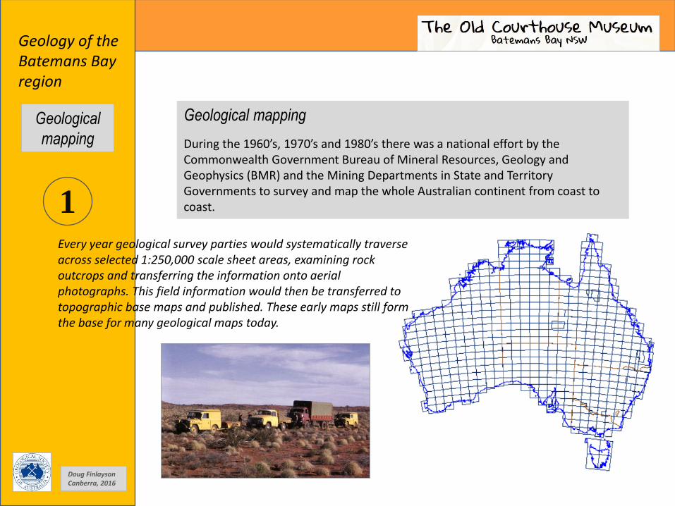
Geological mapping
During the 1960’s, 1970’s and 1980’s there was a national effort by the Commonwealth Government Bureau of Mineral Resources, Geology and Geophysics (BMR) and the Mining Departments in State and Territory Governments to survey and map the whole Australian continent from coast to coast.
Every year geological survey parties would systematically traverse across selected 1:250,000 scale sheet areas, examining rock outcrops and transferring the information onto aerial photographs. This field information would then be transferred to topographic base maps and published. These early maps still form the base for many geological maps today.

2
Geology of the Batemans Bay region
Geological map based on the 1:250,000 scale Canberra and Ulladulla geological map sheets.
Geological map resulting from 1960’s field work.
Doug Finlayson Canberra, 2016
Geological
mapping
Communities in the Batemans Bay region.

3
Geology of the Batemans Bay region
Braidwood Granodiorite 410-411 Ma
Moruya Tonalite 379 Ma
Comerong Volcanics 370-379 Ma
Merimbula Group 354-365 Ma
Adaminaby Group 460-490 Ma
Narooma – Batemans Bay mélange about 445-505 Ma
Wasp Head Formation 286-290 Ma
Best J.G., D'Addario G.W., Walpole B.P. and Rose G., 1964, Canberra 1:250 000 Geological Sheet SI/55-16, 2nd edition, Geological Survey of New South Wales, Sydney. Rose G., 1966, Ulladulla 1:250 000 Geological Sheet SI/56-13, 1st edition, Geological Survey of New South Wales, Sydney
Termeil (Bawley Point) Essexite 241 Ma
Doug Finlayson Canberra, 2016
Geological
mapping
Age of rock units given in millions of years (Ma).

4
Geology of the Batemans Bay region Map compiled from the 2008 Digital Geological Map of Australia
derived from earlier 1:250,000 scale geological mapping of the continent.
Extract from digital geological map - Surface Geology of Australia, 1:1million scale, 2008. Published by Geoscience Australia, Canberra.
Extract by David Haycraft and Doug Finlayson
Doug Finlayson Canberra, 2016
Geological
mapping

5
Geology of the Batemans Bay region
The first geological map William Smith (1769 – 1839) was the son of a blacksmith and born in Oxfordshire, England. Early in his life he worked in coal mines and noted the layers of rock and the fossils embedded in the various layers. Later in life he became a surveyor and engineer building canals across the country. He made notes of all the rock layers and fossils and eventually compiled the information into the first geological map of any country, first published in 1815. The map covered a large part of England and also parts of Scotland and Wales. https://en.wikipedia.org/wiki/William_Smith_(geologist)
William Smith
Doug Finlayson Canberra, 2016
Geological
mapping
6
Geology of the Batemans Bay region
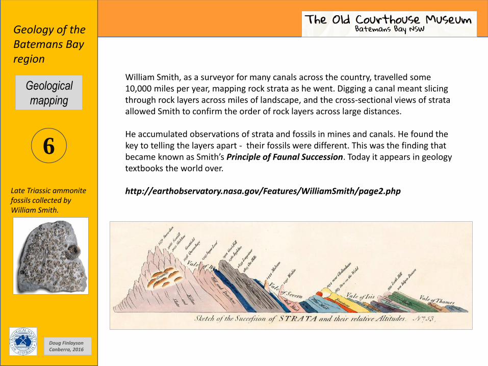
Late Triassic ammonite fossils collected by William Smith.
William Smith, as a surveyor for many canals across the country, travelled some 10,000 miles per year, mapping rock strata as he went. Digging a canal meant slicing through rock layers across miles of landscape, and the cross-sectional views of strata allowed Smith to confirm the order of rock layers across large distances. He accumulated observations of strata and fossils in mines and canals. He found the key to telling the layers apart - their fossils were different. This was the finding that became known as Smith’s Principle of Faunal Succession. Today it appears in geology textbooks the world over. http://earthobservatory.nasa.gov/Features/WilliamSmith/page2.php
Doug Finlayson Canberra, 2016
Geological
mapping

7
Geology of the Batemans Bay region
Folding in rock sequences at Surf Beach near Batehaven.
Who said you can’t bend rocks?
When mapping the geology of an area, structural geologists try to work out the sequence of the various faults and folds they find in rock outcrops. Tectonic events at the margins of the continent place a stress across the whole continent and result in earthquakes, faulting and folding both at a large scale and at a small scale over many millions of years. Mapping structures in 3D is quite a difficult job.
Small scale folding in mudstones near Batemans Bay.
Sydney University tutorial P.F. Rey.
Doug Finlayson Canberra, 2016
Geological
mapping
8
Geology of the Batemans Bay region
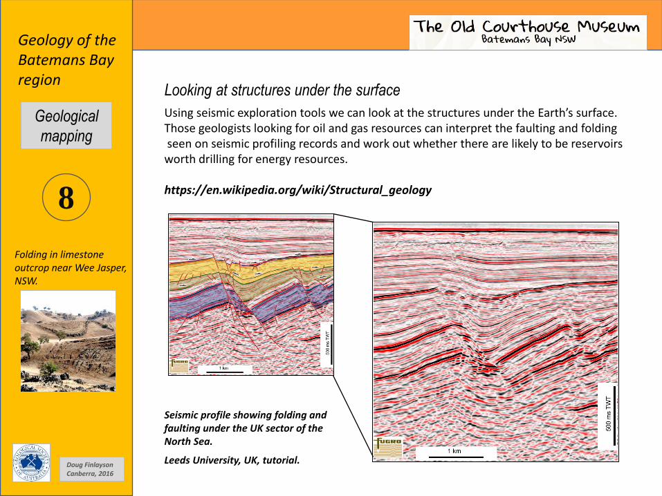
Seismic profile showing folding and faulting under the UK sector of the North Sea.
Leeds University, UK, tutorial.
Looking at structures under the surface
Using seismic exploration tools we can look at the structures under the Earth’s surface. Those geologists looking for oil and gas resources can interpret the faulting and folding seen on seismic profiling records and work out whether there are likely to be reservoirs worth drilling for energy resources. https://en.wikipedia.org/wiki/Structural_geology
Folding in limestone outcrop near Wee Jasper, NSW.
Doug Finlayson Canberra, 2016
Geological
mapping

9
Geology of the Batemans Bay region
There’s much more information on web sites and in books and journals. Some of these are listed below.
Books, maps and publications
• The Geology of Australia – D. Johnson, Cambridge University Press, 2004
• Best J.G., D'Addario G.W., Walpole B.P. and Rose G., 1964. Canberra 1:250 000 Geological Sheet SI/55-16, 2nd edition, Geological Survey of New South Wales, Sydney.
• Rose G., 1966, Ulladulla 1:250 000 Geological Sheet SI/56-13, 1st edition, Geological Survey of New South Wales, Sydney
Web sites
• Maps of Australia – Geoscience Australia, Canberra. http://www.ga.gov.au/data-pubs/maps
• Geological maps of New South Wales – Dept. of Industry, Resources and Energy http://www.resourcesandenergy.nsw.gov.au/
A massive 8.1 magnitude earthquake at Kunlun Pass in central Tibet on 14 November, 2001, changed the landscape forever in a few seconds. The length of the surface rupture was 426 km.
Doug Finlayson Canberra, 2016
Geological
mapping
WE LIVE ON A DYNAMIC PLANET