Embed Size (px)
Citation preview

5/5/2015
1
Geologic Data of the North Carolina Geological Survey –From Historic Data to Modern Detailed Geologic Mapping
Phil Bradley - North Carolina Geological Survey
1823 – State Legislature passed an act…. “to commence and carry on a geological and mineralogical survey of the various regions of the State;…..”
1825 ‐ America’s First State Geologic Map
North Carolina Geological Survey
MissionOur mission is to provide unbiased and technically accurate applied earth science scientific information to address societal needs.
Keepers of Geologic Data for North Carolina
- Maps, publications, core, rock samples, etc…
- 1985 State Map
- Detailed geologic maps

5/5/2015
2
Why do you Care?
• 99% (or more) of time detailed geology may not matter for a site or investigation.
• But occasionally detailed geology may have a big impact on success of site work/investigation
• Our goal is to provide resources to help identify that other 1% of out-of-ordinary geologic condition(s) that could have an impact on a project by utilizing existing geologic data from the NCGS
Detailed Geologic Maps
Partially Funded by:
“The number 1 fundamental resource for the geologist.”

5/5/2015
3
Detailed Geologic Maps“The number 1 fundamental resource for the geologist.”

5/5/2015
4
Mountains and Piedmont -Geologic Data Collection
-In general we collect geologic data the same way its been collected for almost 200 years
-Record observations (pen and paper and/or field computer)
-Collect structural measurements-Collect samples for later analysis
-Keep our observations separate from our interpretations
Generally the same process for landslide mapping and bedrock mapping
Tools in the Field
Hand lens
Rock hammer
Field camera
Scale bar and photograph identification board
Brunton Compass
Field book
Topographic map
Field computer
5/5/2015
5
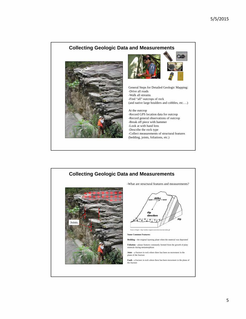
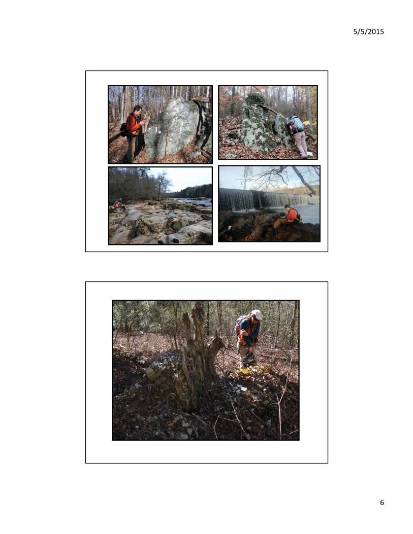
Collecting Geologic Data and Measurements
General Steps for Detailed Geologic Mapping:-Drive all roads-Walk all streams-Find “all” outcrops of rock (and native large boulders and cobbles, etc….)
At the outcrop-Record GPS location data for outcrop-Record general observations of outcrop-Break off piece with hammer-Look at with hand lens-Describe the rock type-Collect measurements of structural features(bedding, joints, foliations, etc.)
Collecting Geologic Data and Measurements
-What are structural features and measurements?
Bedding
Joints
Some Common Features:
Bedding – the original layering plane when the material was deposited
Foliation – planar features commonly formed from the growth of platy minerals during metamorphism
Joint – a fracture in rock where there has been no movement in the plane of the fracture
Fault - a fracture in rock where there has been movement in the plane of the fracture
Source of figure - http://earthsci.org/processes/struct/section/strike.gif
5/5/2015
6

5/5/2015
7
Making Geologic Maps Detailed Geologic Maps are based on observations and measurements collected in field
Step 1: Start with the base USGS 7.5-minute topographic map
Cedar Grove 7.5-Minute Topographic Map, Orange County, NC
N
APPROXIMATE SCALE:
0 2000
FEET
Making Geologic Maps Detailed Geologic Maps are based on observations and measurements collected in field
Step 2: Plot the station locations from field (i.e. outcrops)
Cedar Grove 7.5-Minute Topographic Map, Orange County, NC
N
APPROXIMATE SCALE:
0 2000
FEET

5/5/2015
8
Making Geologic Maps Detailed Geologic Maps are based on observations and measurements collected in field
Step 3: Color code symbols of each station based on rock type
Cedar Grove 7.5-Minute Topographic Map, Orange County, NC
N
APPROXIMATE SCALE:
0 2000
FEET
Making Geologic Maps Detailed Geologic Maps are based on observations and measurements collected in field
Step 4: Draw lines (geologic contacts) surrounding groups ofsimilar rock types
Cedar Grove 7.5-Minute Topographic Map, Orange County, NC
N
APPROXIMATE SCALE:
0 2000
FEET

5/5/2015
9
Making Geologic Maps Detailed Geologic Maps are based on observations and measurements collected in field
Step 5: Color in the areas of similar rock types
Cedar Grove 7.5-Minute Topographic Map, Orange County, NC
N
APPROXIMATE SCALE:
0 2000
FEET
Making Geologic Maps Detailed Geologic Maps are based on observations and measurements collected in field
Step 6: Cartographer makes everything pretty!
Cedar Grove 7.5-Minute Topographic Map, Orange County, NC
N
APPROXIMATE SCALE:
0 2000
FEET

5/5/2015
10
Making Geologic Maps Detailed Geologic Maps are based on observations and measurements collected in field
NW SE
Photograph of example of outcrop with bedding striking approximately 220 degrees and dipping 60 degrees to the northwest
Allen and Wilson (1968)
Work in Orange County
Bradley, Hanna, Gay, Stoddard, Bechtel, Phillips, Fuemmeler (2012)
Geology mapped from 2003 to 2011

5/5/2015
11
MINES AND PROSPECTS
Detailed geologic maps locate old mine workings more accurately than previous maps.
Deep River basin – Durham sub-basinRock Types
Conglomerates
Sandstones
Siltstones and Mudstones
Diabase

5/5/2015
12
Theoretical block diagram from: Hoffman, C.W. and Gallagher, P.E., 1989, Geology of the Southeast Durham and Southwest Durham 7.5-minute quadrangles, North Carolina, Bulletin 92, North Carolina Geological Survey, 34 p.
Main Rock Types:
ConglomeratesSandstonesSiltstoneMudstones
Diabase intrusions
Minor Rock Types:CoalLimestoneCarbonate rich sediments
Triassic Basins in North Carolina
ConglomeratesSiltstones and Mudstones Sandstones
Deep River basin – Durham sub-basinBasin-margin conglomerates
Triassic conglomerates from the eastern boundary of the Triassic basin on island in Falls Lake (photograph by Tim Davis).
Triassic conglomerates along shore of Falls Lake

5/5/2015
13
Triassic conglomerates along shore of Falls Lake
Deep River basin – Durham sub-basin
Sandstones and siltstones

5/5/2015
14
Diabase - Dikes
Diabase boulders from dike exposed off Briggs Ave, Durham, NC
Diabase sill with pendant of Triassic sediments exposed in the Butnerdiabase sill - Butner Quarry
Diabase - Sills

5/5/2015
15
Slope Stability Issues

5/5/2015
16
n=105
Map of Known and Potential Debris Flow Pathways in Buncombe County, North Carolina
Stability Index Map of Buncombe County, North Carolina
Slope Movements and Slope Movement Deposits Map of Buncombe County, North Carolina
Landslide Hazard Maps
A
C
D
I‐540 near U.S. 70: Rotational Slide – Cut Slope Failure1996‐1999
B

5/5/2015
17
Photographs of minor slope failure on HWY 55 immediately north of the Kit Creek Road and HWY 55 intersection. Approximately 3.6 miles south of I-40.
Photograph Explanations:
A –View of slope failure looking southwest. Yellow book for scale is approximately 7.5 inches x 4.5 inches.B - View looking in a southerly direction parallel to embankmentC – View looking down into top of slope failureD – close-up photograph of weathered Triassic siltstone
A
B
C
D
DURHAM COUNTY
Explanation
Thin mudstone/claystone layer dipping gently to the east
Extension of mudstone/claystone layer before road construction
Naturally occurring fracture/joint
Road Bed
East West

5/5/2015
18
Road Bed
East West
Possible Scenario
- Rainwater enters soil and percolates down to mudstone/claystone layer saturating and weaking layer producing a slip plane.
Explanation
Thin mudstone/claystone layer dipping gently to the east
Naturally occurring fracture/joint
Road Bed
East West
Possible Scenario
- weak and saturated mudstone/claystone layer slips and causes slump
Explanation
Thin mudstone/claystone layer dipping gently to the east
Naturally occurring fracture/joint

5/5/2015
19
Approximate location of slope movement outline for theDuke Gardens‐Flowers Drive rotational slide shown on 2010orthophotography
1984 Duke Gardens Slope Problems
2/5/1984
LateFeb.1984
2/12/1984
Resources
http://ngmdb.usgs.gov/ngmdb/ngmdb_home.html
National Geologic Map Database – Download digital versions of many maps from North Carolina
http://ngmdb.usgs.gov/ngmdb/ngmdb_home.html

5/5/2015
20
Resources
North Carolina Geological Survey Websitehttp://portal.ncdenr.org/web/lr/geological_home
Resources
North Carolina Geological Survey Websitehttp://portal.ncdenr.org/web/lr/nc-open-file-reports
iphone screenshot
GeoPDFs for iphone/ipadand Android

5/5/2015
21
Resources
North Carolina Geological Survey Yahoo Shophttp://nc-maps.stores.yahoo.net/