Embed Size (px)
Citation preview

Luis Bermudez Southeastern Universities
Research Association
Carlos RuedaMonterey Bay Aquarium
Research Institute
Moving Beyond the 10,000 Ways That
Don't Work
AGU Fall MeetingDec 14 2009
David ArcturOpen Geospatial Consortium

GEOSS

Complexity

Heterogeneity

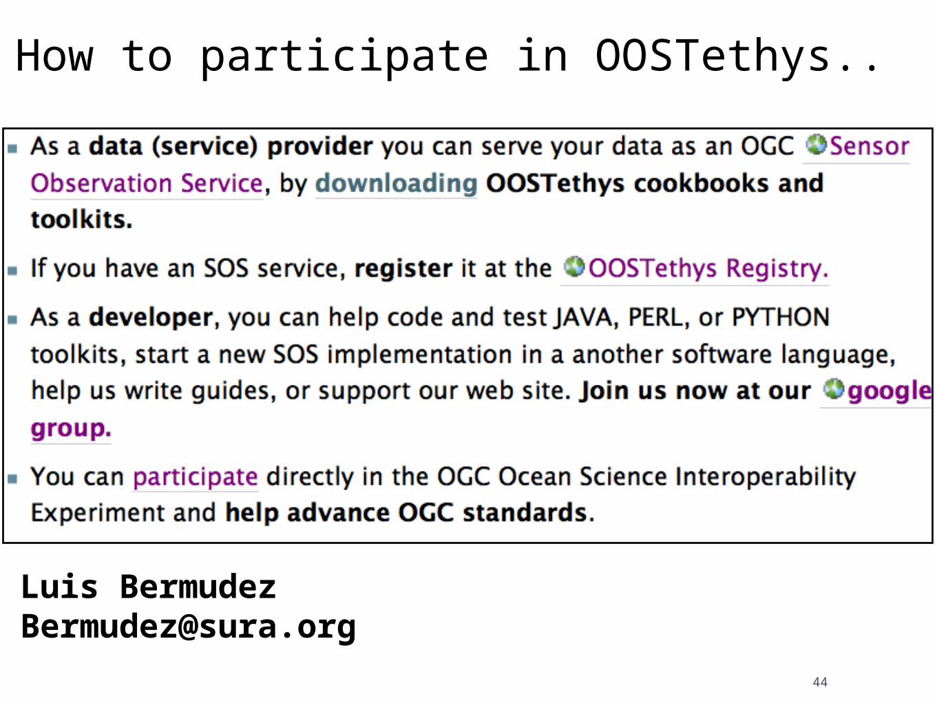
Identification of technologies .. and then what ?

And then ...
• create profiles• create tools
Minor PERL, PYTHON Minor PERL, PYTHON or JAVA or JAVA
programming ...programming ...
Simple Configuration File
OGC Sensor Observation
Service

How ?

8
I have not failed, I've just found 10,000 ways that won't work.
Thomas Edison
Try and try and try and try...

Try and try in an organized way
community + process

10
Engage with OGC

OGC’s Approach to Advancing Interoperability
© 2009 Open Geospatial Consortium, Inc. 11
• Interoperability Program (IP) - a global, innovative, hands-on rapid prototyping and testing program designed to accelerate interface development and validation, and bring interoperability to the market
• Specification Development Program – Consensus standards process similar to other Industry consortia (World Wide Web Consortium, OMA, etc.)
• Outreach and Community Adoption Program – education and training, encourage take up of OGC specifications, business development, communications programs
Demo & Reports

Types of Interoperability Projects
• Test beds are fast-paced, multi-vendor collaborative efforts to define, design, develop, and test candidate interface and encoding specifications. These draft specifications are then reviewed, revised, and, potentially, approved in the OGC Specification Program.
• Pilot Projects apply and test OpenGIS specifications in real world applications using standards based commercial off-the-shelf (SCOTS) products that implement OpenGIS Specifications. Pilot projects help users understand how to best implement interoperable geoprocessing that meets their requirements for application, spatial data, and geoprocessing service sharing. These projects also help identify gaps for further work.
• Interoperability Experiments are brief, low-overhead, formally structured and approved initiatives led and executed by OGC members to achieve specific technical objectives that further the OGC Technical Baseline.
12© 2009 Open Geospatial Consortium, Inc.

OGC Ocean ScienceInteroperability Experiment
OGC World initiativeto develop & improve
standards & best practices
for advancing interoperability of ocean
observing systems.

Some History...

Marine Metadata Interoperability
Building Community
Interoperability Experiments
Tethys
Education Agreements

SURA Coastal Ocean Observing & Prediction (SCOOP) program

OOSTethys =MMI interoperability
demonstration + SURA interoperability demonstration


Phase I
Phase II
Phase III ?

Phase I• Explore Web Feature Service (WFS) and Sensor Observation Service (SOS)
• Advance SOS in the ocean community
• Explore implementation about discovery of sensors and observations using semantic web technologies

Phase I Results
Report

Phase I Results
Request for
Changes
for SOS

Phase I Results
Best Practice
s

Semantics
Semantic Services led by Carlos Rueda (MBARI/MMI)Visualization Services led by Eric Bridger (GoMOOS)

Phase I ResultsOpen
Source Sofware
Easy to setup SOS
server toolkits
Minor PERL, PYTHON Minor PERL, PYTHON or JAVA or JAVA programmingprogramming
SOS
War files Perl Scripts
Simple Configuration File
http://code.google.com/
p/oostethys

Phase II
• More topics than in Phase I • Different interests • New participants• SWE Standards are more accepted, and more tools have been developed...

1. Automated metadata/software installation via PUCK protocol.2. SWE Common encoding for vertical and horizontal profiles (e.g. ADCP) and trajectories (AUV).3. Long time series services (e.g. 20 years of data).4. Offering of complex systems (e.g. observations systems containing other systems) such as collection of stations.5. Linking data from SOS to out-of-band offerings.6. Representation of vectors and scalars in SOS vs semantics.7. Semantic Registry and Services.8. Alert services for fast detection of coastal events. Offerings that are event based (e.g. all tsunami sensors within +/-12 hrs of an tsunami).9. XSLT and SOS responses.10. CSW Registry.
Phase II Topics
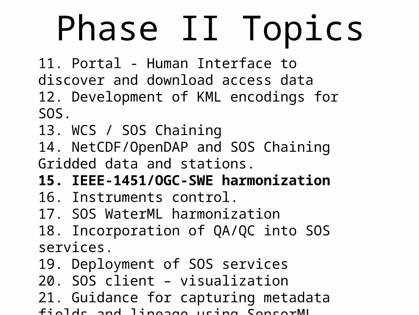
11. Portal - Human Interface to discover and download access data12. Development of KML encodings for SOS.13. WCS / SOS Chaining14. NetCDF/OpenDAP and SOS Chaining Gridded data and stations.15. IEEE-1451/OGC-SWE harmonization16. Instruments control.17. SOS WaterML harmonization18. Incorporation of QA/QC into SOS services. 19. Deployment of SOS services20. SOS client – visualization21. Guidance for capturing metadata fields and lineage using SensorML.
Phase II Topics

Phase II Results
Report

Led by Tom O’Reilly (MBARI)
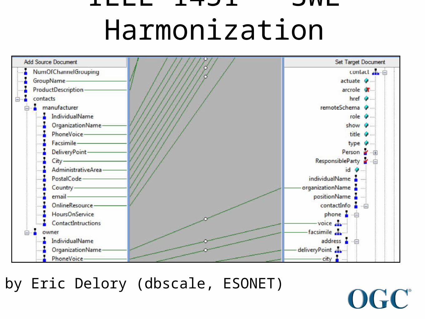
IEEE 1451 - SWE Harmonization
Led by Eric Delory (dbscale, ESONET)

Led by Manil Maskey (UAH)
Standard registry with testing capabilities

Led by Carlos Rueda (MBARI)
Simple SensorML Generator
Semantically enabled

Based on SensorML
Ocean Observing Systems Modeling
Led by Luis Bermudez (SURA)
SensorML

Example of affected
communities


39
Thomas Edison
Conclusions
try and try and try.. foster community consensus in aorganized standard process

40
How to start an IE

How to Start an IE: Reference Documents
• The OGC Interoperability Program
– 05-127r1, Mar 2006
• Interoperability Experiment Policies & Procedures (IE P&P)
– 05-130r3, April 2009
• The OGC Reference Model (ORM)
– Describes the OGC Standards Baseline and the relationship between baseline documents
– The OGC Standards Baseline consists of the approved OpenGIS® Abstract and Implementation Standards (Interface, Encoding, Profile, Application Schema) and Best Practice documents
– http://www.opengeospatial.org/standards/orm
– 08-062r4, Nov 2008
• OGC Intellectual Property Rights Policies and Procedures
– http://www.opengeospatial.org/about/ipr
– http://portal.opengeospatial.org/files/?artifact_id=32268

Interoperability Experiment Life Cycle
© 2009 Open Geospatial Consortium, Inc. 42

Architecture Board Approval Conditions
• The IE is focused on an interoperability issue related to the OGC Technical Baseline
• The IE completion timeframe is reasonable (4-6 months)
• The IE is “lightweight” – focuses on a single interoperability issue
• All materials, documents, lessons learned, and other findings developed as a result of the IE will be shared with the OGC membership
© 2009 Open Geospatial Consortium, Inc.43