Embed Size (px)
Citation preview

LSDS-1618 Version 4.0
Department of the Interior U.S. Geological Survey Landsat 4-7 Collection 2 (C2) Level 2 Science Product (L2SP) Guide Version 4.0 September 2021
- ii - LSDS-1618 Version 4.0
Landsat 4-7 Collection 2 (C2)
Level 2 Science Product (L2SP) Guide
September 2021
Document Owner: ______________________________ Kristi Sayler Date LSRD Project Manager U.S. Geological Survey Approved By: ______________________________ Karen Zanter Date LSDS CCB Chair U.S. Geological Survey
EROS Sioux Falls, South Dakota

- iii - LSDS-1618 Version 4.0
Executive Summary
This document describes relevant characteristics of the Landsat 4-5 and Landsat 7 Collection 2 (C2) Level 2 Science Products (L2SP) to facilitate their use in the land remote sensing community. Landsat 4-7 Level 2 Science Products contain:
• Surface Reflectance (SR) derived from Landsat 4-7 Collection 2 Level 1 data • Surface Temperature (ST) derived from Landsat 4-7 Collection 2 Level 1 data • Intermediate bands used in calculation of the ST products • Quality Assessment (QA) masks indicating the usefulness of the pixel data
All SR products are created with the Landsat Ecosystem Disturbance Adaptive Processing System (LEDAPS) code. All ST products are created with a single channel algorithm jointly developed by the Rochester Institute of Technology (RIT) and National Aeronautics and Space Administration (NASA) Jet Propulsion Laboratory (JPL). Information about Landsat 8 Collection 2 Level 2 products can be found in the Landsat 8 Collection 2 Level 2 Science Product Guide.

- iv - LSDS-1618 Version 4.0
Document History
Document Number
Document Version
Publication Date
Change Number
LSDS-1618 Version 1.0 May 2020 CR 15394
LSDS-1618 Version 2.0 September 2020 CR 20017
LSDS-1618 Version 3.0 October 2020 CR 20179
LSDS-1618 Version 4.0 September 2021 CR 20747

- v - LSDS-1618 Version 4.0
Contents
Executive Summary ..................................................................................................... iii Document History ........................................................................................................ iv Contents ......................................................................................................................... v List of Figures .............................................................................................................. vi List of Tables ................................................................................................................ vi Section 1 Introduction .............................................................................................. 1
1.1 Background ........................................................................................................ 1 1.1.1 Surface Reflectance .................................................................................. 1 1.1.2 Surface Temperature ................................................................................. 3
1.2 Document Organization ..................................................................................... 4 Section 2 Caveats and Constraints ......................................................................... 5
2.1 Surface Reflectance ........................................................................................... 5 2.2 Surface Temperature ......................................................................................... 6 2.3 Quality Assessment ........................................................................................... 8
Section 3 Product Access ........................................................................................ 9 Section 4 Product Packaging ................................................................................ 10 Section 5 Product Characteristics ........................................................................ 11
5.1 Band Specifications .......................................................................................... 11 5.1.1 Radiometric Saturation Band ................................................................... 16 5.1.2 Atmospheric Opacity Band ...................................................................... 16 5.1.3 Level 2 Metadata ..................................................................................... 17 5.1.4 Level 2 Special Notes .............................................................................. 17
5.2 Cloud and Cloud Shadow Specifications ......................................................... 17 5.2.1 Cloud Algorithm Known Issues ................................................................ 17
Section 6 Initial Characterization of Product Uncertainty ................................... 19 Section 7 Auxiliary Data ......................................................................................... 20
7.1 Surface Reflectance Auxiliary Data .................................................................. 20 7.1.1 ETOPO5 .................................................................................................. 20 7.1.2 NCEP/NCAR Reanalysis 1 ...................................................................... 20 7.1.3 TOMS ...................................................................................................... 20
7.2 Surface Temperature Auxiliary Data ................................................................ 21 7.2.1 ASTER Emissivity Data ........................................................................... 21 7.2.2 GOES-5 FP-IT Data ................................................................................. 21 7.2.3 MERRA-2 Data ........................................................................................ 21
Section 8 Citation Information ............................................................................... 22 Section 9 Acknowledgments ................................................................................. 23 Section 10 User Services ......................................................................................... 24 Appendix A Default File Characteristics .............................................................. 25 Appendix B Metadata Fields ................................................................................. 26 Appendix C Acronyms .......................................................................................... 34

- vi - LSDS-1618 Version 4.0
References ................................................................................................................... 37 List of Figures
Figure 1-1. Example of LEDAPS Atmospheric Correction: Left, Top of Atmosphere Reflectance Image; Right, Surface Reflectance Image ............................................ 2
Figure 2-1. ASTER GED Emissivity Coverage ................................................................ 7 List of Tables
Table 1-1. Differences Between Landsat 4–7 and Landsat 8 Surface Reflectance Algorithms ................................................................................................................ 3
Table 5-1. Collection 2 (C2) Landsat 4-7 Level 2 Science Product Band Specifications ............................................................................................................................... 12
Table 5-2. Landsat 4-7 Cloud Quality Assessment (SR_CLOUD_QA) Bit Index .......... 12 Table 5-3. Landsat 4-7 Cloud Quality Assessment (SR_CLOUD_QA) Values ............. 13 Table 5-4. Landsat 4-7 Cloud Quality Assessment (SR_CLOUD_QA) Value
Interpretations ........................................................................................................ 13 Table 5-5. Landsat 4-7 Pixel Quality Assessment (QA_PIXEL) Bit Index ..................... 14 Table 5-6. Landsat 4-7 Pixel Quality Assessment (QA_PIXEL) Value Interpretations* . 15 Table 5-7. Landsat 4-7 Radiometric Saturation Quality Assessment (QA_RADSAT) Bit
Index ...................................................................................................................... 16 Table A-1. Collection 2 Default File Characteristics ...................................................... 25

- 1 - LSDS-1618 Version 4.0
Section 1 Introduction
1.1 Background Landsat satellite data have been produced, archived, and distributed by the U.S. Geological Survey (USGS) since 1972. Users rely upon these data for conducting historical studies of land surface change but have shouldered the burden of post-production processing to create applications-ready datasets. To alleviate this burden on the user, and in compliance with guidelines established through the Global Climate Observing System, USGS has initiated an effort to produce a collection of Landsat Level 2 Science Products (L2SP) to support land surface change studies. Landsat Collection 2 (C2) marks the second major reprocessing effort on the Landsat archive by the USGS that results in several data product improvements that harness recent advancements in data processing, algorithm development, and data access and distribution capabilities.
1.1.1 Surface Reflectance Landsat 4-7 Surface Reflectance (SR) Science Products are generated from specialized software called Landsat Ecosystem Disturbance Adaptive Processing System (LEDAPS). LEDAPS was originally developed through a National Aeronautics and Space Administration (NASA) Making Earth System Data Records for Use in Research Environments (MEaSUREs) grant by NASA Goddard Space Flight Center (GSFC) and the University of Maryland (Masek et al., 2006). The Landsat 4-7 C2 SR is generated from LEDAPS version 3.4.0 (derived from the February 2011 version of NASA LEDAPS code). LEDAPS applies atmospheric correction routines to Landsat 4-5 Thematic Mapper (TM) or Landsat 7 Enhanced Thematic Mapper Plus (ETM+) Level 1 (L1) data, similar to routines derived from Moderate Resolution Imaging Spectroradiometer (MODIS). LEDAPS generates Top of Atmosphere (TOA) Reflectance and TOA Brightness Temperature (BT) using the calibration parameters from the metadata. Auxiliary data such as water vapor, ozone, geopotential height, Aerosol Optical Thickness (AOT), and digital elevation are then input with Landsat TOA Reflectance and TOA BT to Second Simulation of a Satellite Signal in the Solar Spectrum (6S) radiative transfer model to generate Surface Reflectance. The result is delivered as the Landsat Surface Reflectance data product.
- 2 - LSDS-1618 Version 4.0
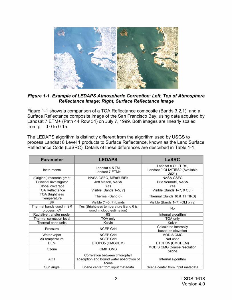
Figure 1-1. Example of LEDAPS Atmospheric Correction: Left, Top of Atmosphere Reflectance Image; Right, Surface Reflectance Image
Figure 1-1 shows a comparison of a TOA Reflectance composite (Bands 3,2,1), and a Surface Reflectance composite image of the San Francisco Bay, using data acquired by Landsat 7 ETM+ (Path 44 Row 34) on July 7, 1999. Both images are linearly scaled from ρ = 0.0 to 0.15. The LEDAPS algorithm is distinctly different from the algorithm used by USGS to process Landsat 8 Level 1 products to Surface Reflectance, known as the Land Surface Reflectance Code (LaSRC). Details of these differences are described in Table 1-1.
Parameter LEDAPS LaSRC
Instruments Landsat 4-5 TM, Landsat 7 ETM+
Landsat 8 OLI/TIRS, Landsat 9 OLI2/TIRS2 (Available
2021) (Original) research grant NASA GSFC, MEaSUREs NASA GSFC
Principal Investigator Jeff Masek, NASA Eric Vermote, NASA Global coverage Yes Yes TOA Reflectance Visible (Bands 1–5, 7) Visible (Bands 1–7, 9 OLI) TOA Brightness
Temperature Thermal (Band 6) Thermal (Bands 10 & 11 TIRS)
SR Visible (1–5, 7) bands Visible (Bands 1–7) (OLI only) Thermal bands used in SR
processing? Yes (Brightness temperature Band 6 is
used in cloud estimation) No
Radiative transfer model 6S Internal algorithm Thermal correction level TOA only TOA only
Thermal band units Kelvin Kelvin
Pressure NCEP Grid Calculated internally based on elevation
Water vapor NCEP Grid MODIS CMG Air temperature NCEP Grid Not used
DEM ETOPO5 (CMGDEM) ETOPO5 (CMGDEM)
Ozone OMI/TOMS MODIS CMG Coarse resolution ozone
AOT Correlation between chlorophyll
absorption and bound water absorption of scene
Internal algorithm
Sun angle Scene center from input metadata Scene center from input metadata

- 3 - LSDS-1618 Version 4.0
Parameter LEDAPS LaSRC View zenith angle From input metadata Hard-coded to “0”
Undesirable zenith angle correction
SR not processed when solar zenith angle > 76 degrees
SR not processed when solar zenith angle > 76 degrees
Pan band processed? No No XML metadata? Yes Yes
Brightness temperature calculated Yes (Band 6 TM/ETM+) Yes (Bands 10 & 11 TIRS)
Cloud mask CFMask (v3.3.1) CFMask (v3.3.1) Data format UINT16 UINT16 Fill values 0 0
QA bands
Cloud Adjacent cloud Cloud shadow
DDV Fill
Land water Snow
Atmospheric opacity
Cloud Adjacent cloud Cloud shadow
Aerosols Cirrus
Aerosol Interpolation Flag
6S = Second Simulation of a Satellite Signal in the Solar Spectrum, AOT = Aerosol Optical Thickness, CFMask = C Version of Function Of Mask, CMA = Climate Modeling Grid - Aerosol, CMG = Climate Modeling Grid, DDV = Dark Dense Vegetation, DEM = Digital Elevation Model, ETM+ = Enhanced Thematic Mapper Plus, GSFC = Goddard Space Flight Center, INT = Integer, LaSRC = Land Surface Reflectance Code, LEDAPS = Landsat Ecosystem Disturbance Adaptive Processing System, MEaSUREs = Making Earth Science Data Records for Use in Research Environments, MODIS = Moderate Resolution Imaging Spectroradiometer, NA = Not Applicable, NASA = National Aeronautics and Space Administration, NCEP = National Centers for Environmental Prediction, OLI = Operational Land Imager, OMI = Ozone Monitoring Instrument, QA = Quality Assessment, SR = Surface Reflectance, TIRS = Thermal Infrared Sensor, TM = Thematic Mapper, TOA = Top of Atmosphere Reflectance, TOMS = Total Ozone Mapping Spectrometer, XML = Extensible Markup Language
Table 1-1. Differences Between Landsat 4–7 and Landsat 8 Surface Reflectance Algorithms
1.1.2 Surface Temperature Landsat 4-7 Surface Temperature (ST) products are generated from the single channel algorithm version 1.3.0 (derived from June 2017 version of RIT ST code). The Collection 2 ST is derived from the Landsat Collection 2 Level 1 thermal infrared bands using Top of Atmosphere (TOA) Reflectance, TOA Brightness Temperature (BT), Advanced Spaceborne Thermal Emission and Reflection Radiometer (ASTER) Global Emissivity Dataset (GED) data, ASTER Normalized Difference Vegetation Index (NDVI) data, and atmospheric profiles of geopotential height, specific humidity, and air temperature extracted from reanalysis data. For Landsat 7 products, the Band 6 TOA BT product is generated from ETM+ Band 6 High gain (6H) and Band 6 Low gain (6L) merged together. The merged Band 6 is comprised of pixels that are not saturated in Band 6H. When Band 6H pixels are saturated with a brightness temperature outside of the 6H dynamic range (from 240K to 322K), they will be filled with pixels from the 6L band even if those pixels are saturated.

- 4 - LSDS-1618 Version 4.0
1.2 Document Organization This document contains the following sections:
• Section 1 provides an introduction • Section 2 provides an explanation of caveats and constraints • Section 3 provides details on product access • Section 4 provides details on product packaging • Section 5 provides an explanation of product characteristics • Section 6 provides details on detecting product uncertainty • Section 7 provides auxiliary data • Section 8 provides document citation information • Section 9 provides document acknowledgements • Section 10 provides User Services contact information • Appendix A provides a list of default file characteristics • Appendix B provides a list of metadata fields • Appendix C provides a list of acronyms • The References section contains a list of reference documents

- 5 - LSDS-1618 Version 4.0
Section 2 Caveats and Constraints
2.1 Surface Reflectance 1. Landsat 4-7 Collection 2 Surface Reflectance (SR) products are generated only
from scenes that have been processed to Tier 1 (T1) or Tier 2 (T2); Real-Time (RT) data cannot be used to create SR products. When acquired, scenes are processed and placed into the RT Tier. Follow-on processing to apply refined bumper mode parameters takes place 24-26 days later, and the scenes are then placed into T1 or T2. SR processing then is done within 24 hours. In summary, Landsat 4-7 Collection 2 SR data become available 25 to 27 days after data acquisition. Visit the Landsat Collection 2 Generation Timeline for a visual look at this timeframe.
2. The following date ranges apply to the availability of the Landsat archive for Surface Reflectance processing, with the exceptions noted in #3 below:
• Landsat 4 TM: July 1982 to December 1993 • Landsat 5 TM: March 1984 to May 2012 • Landsat 7 ETM+: April 1999 to present
3. Landsat 4-5 TM data cannot be processed to Surface Reflectance between specific dates because some auxiliary data required for Surface Reflectance processing are missing. See Section 7 for more information. The most up-to-date information regarding data gaps is in the “Caveats and Constraints” section of https://www.usgs.gov/core-science-systems/nli/landsat/landsat-collection-2-surface-reflectance.
4. TOA Reflectance data are derived using per-pixel solar illumination angles generated from the angle coefficient file. Previously, the scene center solar illumination angle from the Level 1 Metadata (MTL) file was used. This will impact the SR data products, as they are derived from TOA Reflectance.
• This should ideally improve the accuracy of the TOA Reflectance and subsequent SR corrections.
• Scene center solar illumination and sensor view angles (i.e., not per-pixel) are still used in the SR processing, as the Look-up Table (LUT) routines are called on a grid that is spatially coarser than the resolution of the Landsat data, therefore not necessitating per-pixel angle information.
5. Landsat 7 ETM+ inputs are not gap-filled in Surface Reflectance production, and gapped areas are not processed for Surface Reflectance. See https://www.usgs.gov/land-resources/nli/landsat/landsat-7 for information on Landsat 7 Scan Line Corrector (SLC)-off data products.
6. SR is not run on scenes with a solar zenith angle of greater than 76º. The primary physical issues with retrieving SR from high solar zenith angles (low sun angle) include:

- 6 - LSDS-1618 Version 4.0
• Solar elevation varies more near the poles [1], especially when relying upon sun-synchronous observations.
• Lower solar elevations at high latitudes results in longer atmospheric paths (i.e., more scattering) [1].
• The degree of uncertainty in SR retrieval greatly increases, from being negligible to highly inaccurate, at solar zenith angle > 76 degrees.
References: [1] Campbell, J.W., & Aarup, T. (1989). Photosynthetically available radiation at high latitudes. Limnology and Oceanography, 34(8), 1490-1499. http://dx.doi.org/10.4319/lo.1989.34.8.1490.
7. For reasons mentioned above, the Surface Reflectance data processed over high latitudes (> 65º) have larger uncertainty and should be analyzed carefully.
8. There are additional adverse conditions that can affect the efficacy of Landsat SR retrievals, such as:
• Hyper-arid or snow-covered regions • Low sun angle conditions • Coastal regions where land area is small relative to adjacent water • Areas with extensive cloud contamination
9. Landsat 7 Band 8 (panchromatic band) is not processed to Top of Atmosphere or Surface Reflectance.
2.2 Surface Temperature 1. For the reasons mentioned in Section 2.1, Landsat 4-7 Collection 2 Surface
Temperature (ST) products become available 25 to 27 days after data acquisition. 2. The Advanced Spaceborne Thermal Emission and Reflection Radiometer Global
Emissivity Dataset (ASTER GED) by Land Processes Distributed Active Archive Center (LP DAAC) is used in the ST algorithm for TM and ETM+ data. Where ASTER GED data is missing, there will be missing data in the Landsat ST product. Figure 2-1 shows a map of ASTER GED emissivity tiles coverage. Note: To investigate the availability of any given pixel, the “ASTER Global Emissivity Dataset 100 meter HDF5 V003” data can be attained from https://www.doi.org/10.5067/Community/ASTER_GED/AG100.003.

- 7 - LSDS-1618 Version 4.0
Figure 2-1. ASTER GED Emissivity Coverage
3. Goddard Earth Observing System, Version 5 (GEOS-5) Forward Processing for Instrument Teams (FP-IT) data are used in the Single Channel algorithm for atmospheric correction. If GEOS data are unavailable (for acquisitions before Jan. 1, 2000), then NASA’s Modern-Era Retrospective analysis for Research and Application (MERRA-2) reanalysis data are used in its place.
4. Atmospheric auxiliary data used for processing a Level 1 product into the ST are described in the Landsat Atmospheric Auxiliary Data Data Format Control Book (DFCB).
5. Data products must contain both sunlit optical and thermal data to be successfully processed to Surface Temperature, as Landsat NDVI and Normalized Difference Snow Index (NDSI) are required to temporally adjust the ASTER GED product to the target Landsat scene. Therefore, nighttime acquisitions cannot be processed to Surface Temperature.
6. A known error exists in the Landsat Surface Temperature retrievals relative to clouds and possibly cloud shadows. The characterization of these issues has been documented by Cook et al., 2014 (see the References section for more details).
- 8 - LSDS-1618 Version 4.0
2.3 Quality Assessment 1. Refer to the Quality Assessment (QA) bands for pixel-level condition and validity
flags. For cloud masking, users are advised to use the cloud bits populated in the Level 1 QA Band.
2. The cloud and cloud shadow indicators are known to report erroneous conditions in areas where temperature differentials are either too large or too small. For example, a warm cloud over extremely cold ground may not calculate enough difference in temperature to identify the cloud. Conversely, residual ice surrounded by unusually warm ground can potentially be identified as cloud.
3. The Landsat 4-7 “Clear” bit (bit 6) is erroneously set to OFF when it should be ON when the Cloud Shadow (bit 4), Snow/ice (bit 5), and Water (bit 7) are all ON. Additionally, the Clear bit is ON when it should be OFF when the Dilated Cloud (bit 1) is ON. Users are advised to engage the QA “Dilated Cloud” (bit 1) AND “Cloud” (bit 3) OFF condition to correctly identify clear pixels over water. For additional information please visit Landsat Collection 2 Known Issues webpage.

- 9 - LSDS-1618 Version 4.0
Section 3 Product Access
Landsat 4-7 Collection 2 SR and ST products can be downloaded from EarthExplorer (EE). The datasets for each sensor are located under the Landsat category, Landsat Collection 2 Level 2 subcategory: Landsat 4-5 TM C2 L2 and Landsat 7 ETM+ C2 L2. After reviewing the search results and selecting a scene, users can download all bands or select and download selected bands. Direct access to Landsat 4-7 Collection 2 SR and ST is also available via commercial cloud environment. For additional information, please visit Landsat Commercial Cloud Data Access. Visit the Landsat Data Access webpage for information about downloading Landsat products.

- 10 - LSDS-1618 Version 4.0
Section 4 Product Packaging
Landsat Collection 2 L2SP can be downloaded as individual bands as Cloud Optimized Georeferenced Tagged Image File Format (GeoTIFF) (COG) files. The Surface Reflectance filenames are structured as the Level 2 product identifier (ProductID) appended with the suffix “_SR_” followed by a band designation to denote the Surface Reflectance transformation. The Surface Temperature filenames use ProductID appended with the suffix “_ST_” followed by the band designation. Following are the components of a typical ProductID: LXSS_LLLL_PPPRRR_YYYYMMDD_yyyymmdd_CX_TX (e.g., LE07_L2SP_039037_20080728_20200319_02_T1_SR_B1) L Landsat X Sensor (“E” = ETM+; “T” = TM) SS Satellite (“07” = Landsat 7; “05” = Landsat 5; “04” = Landsat 4)
LLLL Processing correction level (“L2SP” if SR and ST are generated or “L2SR” if ST could not be generated)
PPP Path RRR Row YYYY Year of acquisition MM Month of acquisition DD Day of acquisition yyyy Year of Level 2 processing mm Month of Level 2 processing dd Day of Level 2 processing CX Collection number (“02”) TX Collection category (“RT” = Real Time; “T1” = Tier 1; “T2” = Tier 2)

- 11 - LSDS-1618 Version 4.0
Section 5 Product Characteristics
5.1 Band Specifications Landsat 4-7 Collection 2 L2SP are generated at 30-meter spatial resolution on a Universal Transverse Mercator (UTM) or Polar Stereographic (PS) mapping grid. Table 5-1 lists the specifications for Collection 2 L2SP bands. All packages include metadata provided in Object Description Language (ODL) metadata (MTL), Extensible Markup Language (XML)-based metadata. Collection 2 Landsat 4-7 L2SP are delivered in files named with the original ProductID and appended with “_SR_” or “_ST_” followed by a band designation. The default file format is GeoTIFF. The QA_PIXEL, QA_RADSAT, and SR_CLOUD_QA bands are delivered as bit-packed layers. The ST intermediate bands are delivered with the ST product. These layer bands are used in the creation of the ST band. The ST_TRAD band contains the Level-1 thermal band converted to thermal surface radiance. The ST_URAD and ST_DRAD bands respectively contain the upwelling and downwelling thermal radiance. The ST_ATRAN band contains the atmospheric transmittance. The ST_EMIS band and ST_EMSD band contain the calculated surface emissivity and its expected standard deviation. The ST_QA band contains the uncertainty of the ST band, in Kelvin. The CDIST band contains the distance of the pixel from the nearest cloud labeled in the QA_PIXEL band, in Kilometers. Landsat 4-7 Collection 2 L2SP have two separate QA bands for cloud and land cover classification. The SR_CLOUD_QA band is created during LEDAPS processing; its bit assignments are described in Table 5-2 and in greater detail in Table 5-3 and Table 5-4. The QA_PIXEL band is created by the CFMask version 3.3.1 (derived from Fmask version 3.3) algorithm; its bit assignments are described in Table 5-5 and Table 5-6. Cloud Shadow, Snow/Ice, and Cirrus Confidence flags in bits 10-15 each have a reserved value for future improvements. They match the respective flags in bits 2, 4, and 5 and may be used interchangeably.

- 12 - LSDS-1618
Version 4.0
Band Designation Band Name Data Type Units
Data Range Valid Range
Fill Value
Multiplicative Scale Factor
Additive Offset
ProductID_SR_B1 Band 1 SR UINT16 Reflectance 1 - 65535 7273 - 43636 0 0.0000275 -0.2 ProductID_SR_B2 Band 2 SR UINT16 Reflectance 1 – 65535 7273 - 43636 0 0.0000275 -0.2 ProductID_SR_B3 Band 3 SR UINT16 Reflectance 1 - 65535 7273 - 43636 0 0.0000275 -0.2 ProductID_SR_B4 Band 4 SR UINT16 Reflectance 1 - 65535 7273 - 43636 0 0.0000275 -0.2 ProductID_SR_B5 Band 5 SR UINT16 Reflectance 1 - 65535 7273 - 43636 0 0.0000275 -0.2 ProductID_ST_B6 Band 6 ST UINT16 Kelvin 1 - 65535 293 - 61440 0 0.00341802 149 ProductID_SR_B7 Band 7 SR UINT16 Reflectance 1 - 65535 7273 - 43636 0 0.0000275 -0.2
ProductID _SR_ATMOS_OPACITY Atmospheric Opacity INT16 Unitless 0 - 32767 0 - 1000 -9999 0.001 NA
ProductID_QA_PIXEL Level 2 Pixel Quality Band UINT16 Bit Index 1 - 65535 5440 – 16382 1 NA NA ProductID_QA_RADSAT Radiometric Saturation QA UINT16 Bit Index 0 - 65535 0 - 3829 NA NA NA
ProductID_SR_CLOUD_QA Surface Reflectance Cloud QA UINT8 Bit Index 0 - 255 1 - 63 0 NA NA
ProductID_ST_QA Surface Temperature Uncertainty INT16 Kelvin 0 - 32767 0 - 32767 -9999 0.01 NA
ProductID_ST_TRAD Thermal Radiance INT16 W/(m2 sr μm)/DN 0 - 22000 0 – 22000 -9999 0.001 NA ProductID_ST_URAD Upwelled Radiance INT16 W/(m2 sr μm)/DN 0 - 28000 0 – 28000 -9999 0.001 NA ProductID_ST_DRAD Downwelled Radiance INT16 W/(m2 sr μm)/DN 0 - 28000 0 - 28000 -9999 0.001 NA
ProductID_ST_ATRAN Atmospheric Transmittance INT16 Unitless 0 - 10000 0 - 10000 -9999 0.0001 NA
ProductID_ST_EMIS Emissivity estimated from ASTER GED INT16 Emissivity
coefficient 0 - 10000 0 - 10000 -9999 0.0001 NA
ProductID_ST_EMSD Emissivity standard deviation INT16 Emissivity coefficient 0 - 32767 0 – 10000 -9999 0.0001 NA
ProductID_ST_CDIST Pixel distance to cloud INT16 Kilometers 0 - 24000 0 – 24000 -9999 0.01 NA ProductID_MTL Level 2 Metadata file NA NA NA NA NA NA NA
Table 5-1. Collection 2 (C2) Landsat 4-7 Level 2 Science Product Band Specifications
Bit Attribute 0 Dark Dense Vegetation (DDV) 1 Cloud 2 Cloud shadow 3 Adjacent to cloud 4 Snow 5 Water 6 Unused 7 Unused
Table 5-2. Landsat 4-7 Cloud Quality Assessment (SR_CLOUD_QA) Bit Index

- 13 - LSDS-1618
Version 4.0
Attribute Pixel Value
DDV 1, 9 Cloud 2, 34
Cloud shadow 4, 12, 20, 36, 52 Adjacent to cloud 8, 12, 24, 40, 56
Snow 16, 20, 24, 48, 52, 56 Water 32, 34, 36, 40, 48, 52, 56
Table 5-3. Landsat 4-7 Cloud Quality Assessment (SR_CLOUD_QA) Values
Pixel Value DDV Cloud Cloud
shadow Adjacent to
cloud Snow Water Pixel Description 0 No No No No No No Fill 1 Yes No No No No No DDV 2 No Yes No No No No Cloud 4 No No Yes No No No Cloud shadow 8 No No No Yes No No Adjacent to cloud 9 Yes No No Yes No No DDV, adjacent to cloud
12 No No Yes Yes No No Adjacent to cloud, cloud shadow 16 No No No No Yes No Snow 20 No No Yes No Yes No Cloud shadow, snow 24 No No No Yes Yes No Adjacent to cloud, snow 32 No No No No No Yes Water 34 No Yes No No No Yes Cloud, water 36 No No Yes No No Yes Cloud shadow, water 40 No No No Yes No Yes Adjacent to cloud, water 48 No No No No Yes Yes Snow, water 52 No No Yes No Yes Yes Cloud shadow, snow, water 56 No No No Yes Yes Yes Adjacent to cloud, snow, water
Table 5-4. Landsat 4-7 Cloud Quality Assessment (SR_CLOUD_QA) Value Interpretations

- 14 - LSDS-1618
Version 4.0
Bit Flag Description Values 0 Fill 0 for image data
1 for fill data
1 Dilated Cloud 0 for cloud is not dilated or no cloud 1 for cloud dilation
2 Unused Unused
3 Cloud 0 for cloud confidence is not high 1 for high confidence cloud
4 Cloud Shadow 0 for Cloud Shadow Confidence is not high 1 for high confidence cloud shadow
5 Snow 0 for Snow/Ice Confidence is not high 1 for high confidence snow cover
6 Clear 0 if Cloud or Dilated Cloud bits are set 1 if Cloud and Dilated Cloud bits are not set
7 Water 0 for land or cloud 1 for water
8-9 Cloud Confidence
00 for no confidence level set 01 Low confidence 10 Medium confidence 11 High confidence
10-11 Cloud Shadow Confidence
00 for no confidence level set 01 Low confidence 10 Reserved 11 High confidence
12-13 Snow/Ice Confidence
00 for no confidence level set 01 Low confidence 10 Reserved 11 High confidence
14-15 Unused Unused
Table 5-5. Landsat 4-7 Pixel Quality Assessment (QA_PIXEL) Bit Index

- 15 - LSDS-1618
Version 4.0
Pixel Value Fill
Dilated Cloud Cirrus Cloud
Cloud Shadow Snow Clear Water
Cloud Conf.
Cloud Shadow
Conf. Snow/ Ice
Conf. Cirrus Conf. Pixel Description
1 Yes No N/A No No No No No None None None None Fill
5440 No No N/A No No No Yes No Low Low Low None Clear with lows set
5442 No Yes N/A No No No Yes No Low Low Low None Dilated cloud over land
5504 No No N/A No No No No Yes Low Low Low None Water with lows set
5506 No Yes N/A No No No No Yes Low Low Low None Dilated cloud over water
5696 No No N/A No No No Yes No Mid Low Low None Mid conf cloud
5760 No No N/A No No No No Yes Mid Low Low None Mid conf cloud over water
5896 No No N/A Yes No No No No High Low Low None High conf Cloud
7440 No No N/A No Yes No No No Low High Low None High conf cloud shadow
7568 No No N/A No Yes No No Yes Low High Low None Water with cloud shadow
7696 No No N/A No Yes No No No Mid High Low None Mid conf cloud with shadow
7824 No No N/A No Yes No No Yes Mid High Low None Mid conf cloud with shadow over water
7960 No No N/A Yes Yes No No No High High Low None High conf cloud with shadow
8088 No No N/A Yes Yes No No Yes High High Low None High conf cloud with shadow over water
13664 No No N/A No No Yes Yes No Low Low High None High conf snow/ice
Table 5-6. Landsat 4-7 Pixel Quality Assessment (QA_PIXEL) Value Interpretations*
*The QA band is validated against the confidence levels, not the clear/cloud bits; the confidence level bits are a truer measure of the cloud extent in the imagery. It is recommended to either use the clear/cloud bits OR the confidence levels, but not both.

- 16 - LSDS-1618 Version 4.0
5.1.1 Radiometric Saturation Band The Radiometric Saturation Quality (QA_RADSAT) band is a bit-packed representation of which sensor bands were saturated during data capture, yielding unusable data. Table 5-7 displays the interpretation of possible pixel values expected in the QA_RADSAT band after its bits are unpacked. For example, a pixel value of 8 indicates that Band 3 is saturated. Table 5-7 describes the bit assignments for the QA_RADSAT band.
Bit Flag Description Value Landsat 4-5 Landsat 7 0 Band 1 Data Saturation Band 1 Data Saturation 0 no saturation
1 saturated data
1 Band 2 Data Saturation Band 2 Data Saturation 0 no saturation 1 saturated data
2 Band 3 Data Saturation Band 3 Data Saturation 0 no saturation 1 saturated data
3 Band 4 Data Saturation Band 4 Data Saturation 0 no saturation 1 saturated data
4 Band 5 Data Saturation Band 5 Data Saturation 0 no saturation 1 saturated data
5 Band 6 Data Saturation Band 6L Data Saturation 0 no saturation 1 saturated data
6 Band 7 Data Saturation Band 7 Data Saturation 0 no saturation 1 saturated data
7 Unused Unused 0 not checked
8 Unused Band 6H Data Saturation 0 no saturation 1 saturated data
9 Dropped Pixel Dropped Pixel 0 Pixel present 1 detector doesn’t have a value – no data
10 Unused Unused 0 11 Unused Unused 0 12 Unused Unused 0 13 Unused Unused 0 14 Unused Unused 0 15 Unused Unused 0
Table 5-7. Landsat 4-7 Radiometric Saturation Quality Assessment (QA_RADSAT) Bit Index
5.1.2 Atmospheric Opacity Band The SR_ATMOS_OPACITY band is a general interpretation of atmospheric opacity generated by LEDAPS and based on the radiance viewed over Dark Dense Vegetation (DDV) within the scene. A general interpretation of atmospheric opacity is that values less than 0.1 are clear, 0.1-0.3 are average, and values greater than 0.3 indicate haze or other cloud situations. SR values from pixels with high atmospheric opacity will be less reliable, especially under high solar zenith angle conditions. The SR_ATMOS_OPACITY band is provided for advanced users and for product quality

- 17 - LSDS-1618 Version 4.0
assessment and has not been validated. Most users are advised to instead use the QA_PIXEL band information for cloud discrimination.
5.1.3 Level 2 Metadata Each Level 2 science product package includes an XML-based (_MTL.xml) and a text-based (_MTL.txt) metadata file. Examples of the metadata included in the XML are listed in Appendix A.
5.1.4 Level 2 Special Notes Metadata is included to help define the orientation of Polar Stereographic scenes acquired in ascending orbit over Antarctica. Whether on a descending or ascending orbit path, the first pixels acquired in a Landsat scene comprise the upper portion of an image. As Landsat crosses the southern polar region, it views the southern latitudes first and progresses north. This places pixels in southern latitudes in the upper part of the image so that it appears to the user that south is ‘up’ and north is ‘down.’ The <corner> field in the metadata xml clarifies the upper left and lower right corners of the scene.
5.2 Cloud and Cloud Shadow Specifications The Level 2 Pixel Quality Assessment band (QA_PIXEL; Table 5-5) is populated using information from the Level 1 Quality Assessment band. The Cloud Confidence, Cloud Shadow, and Snow/Ice flags derived from the CFMask algorithm. In order to support science data products using Level 2 as input, water values are re-calculated, and high-confidence cloud pixels are dilated, making QA_PIXEL comparable to the legacy CFMask bands. Specific details about Landsat Collection 2 Cloud Cover Assessment (CCA) algorithm can be found in Section 4.4.18 of the LSDS-1747 Landsat 8-9 OLI/TIRS Calibration / Validation Algorithm Description Document. The information with the QA_PIXEL band is likely to present more accurate results than the QA bands provided by the LEDAPS processing (SR_CLOUD_QA). The algorithm underlying the QA_PIXEL band is CFMask version 3.3.1 (derived from Fmask version 3.3), which was originally developed at Boston University in a Matrix Laboratory (MATLAB) environment to automate cloud, cloud shadow, and snow masking for Landsat TM and ETM+ images. The MATLAB Function of Mask (Fmask) was subsequently translated into open source C code at the USGS Earth Resources Observation and Science (EROS) Center, where it is implemented as the C version of Fmask (CFMask).
5.2.1 Cloud Algorithm Known Issues 1. The cloud indicators in the LEDAPS and CFMask algorithms are known to report
erroneous cloud conditions when temperature differentials are either too large or too small. For example, a warm cloud over extremely cold ground may not calculate enough difference in temperature to identify the cloud. Conversely, residual ice surrounded by unusually warm ground can potentially be identified as cloud.

- 18 - LSDS-1618 Version 4.0
2. Cloud algorithms may have issues over bright targets such as building tops, beaches, snow/ice, sand dunes and/or salt lakes.
3. Optically thin clouds will always be challenging to identify and have a chance of being omitted by all cloud algorithms.
4. The Landsat 4-7 “Clear” bit (bit 6) is erroneously set to OFF when it should be ON when the Cloud Shadow (bit 4), Snow/ice (bit 5), and Water (bit 7) are all ON. Additionally, the Clear bit is ON when it should be OFF when the Dilated Cloud (bit 1) is ON. Users are advised to engage the QA “Dilated Cloud” (bit 1) AND “Cloud” (bit 3) OFF condition to correctly identify clear pixels over water. For additional information please visit Landsat Collection 2 Known Issues webpage.

- 19 - LSDS-1618 Version 4.0
Section 6 Initial Characterization of Product Uncertainty
Several studies have been performed in regard to uncertainty of Collection 1 surface reflectance retrievals performed by the LEDAPS algorithm. Uncertainty is generally established through comparison of validated and reliable datasets that are independent of Landsat TM and ETM+ data. Maiersperger et al. (2013) compared LEDAPS’ Aerosol Optical Thickness (AOT) estimates with AERONET AOT, field spectrometer data, and the MODIS Surface Reflectance product over the conterminous United States. Claverie et al. (2015) used a similar methodology but added Bidirectional Reflectance Distribution Function (BRDF)-corrected MODIS Terra/Aqua data, Landsat 5 TM and Landsat 7 ETM+ data corrected with AERONET AOT (Ju et al., 2012), and LEDAPS-corrected Landsat 5 TM data to expand the spatial coverage to the entire world. Claverie et al. (2015) performed their comparisons with the AERONET-derived reflectance, LEDAPS-derived reflectance, and MODIS reflectance using the metrics of Accuracy, Precision, and Uncertainty (APU). APU was originally implemented by Vermote and Kotchenova (2008), where:
A = accuracy, as the mean bias of the satellite retrievals, versus the truth data P = precision, as the standard deviation of the satellite retrievals from the truth data and from the mean bias U = uncertainty, as the squared sum of the mean bias and standard deviation
For the resulting APU metrics, Claverie et al. (2015) established specification thresholds, or S, for the LEDAPS-AERONET comparisons and the LEDAPS-MODIS comparisons. The specifications are defined as:
SLEDAPSxAERONET = 0.05ρ + 0.005 SMODISxLEDAPS = 0.071ρ + 0.0071
where ρ is the reflectance. The LEDAPS-AERONET specification (~5% error threshold) is identical to that of the MODIS APU specification. The specifications for the LEDAPS-MODIS comparison (~7.1% error threshold) are defined differently to account for the BRDF and spectral corrections applied to the MODIS surface reflectance. The overall results showed that most LEDAPS retrievals fell within the defined specification, with the highest error being in the blue band. There is not a significant difference in performance between Landsat 5 TM and Landsat 7 ETM+. Compared with MODIS surface reflectance, Landsat 7 ETM+ had better performance over Landsat 5 TM due to ETM+ and MODIS having similar sun-view geometry characteristics. There was no significant inter-annual variation between Landsat sensors. Geographic uncertainty is greatest in high latitude areas and over tropical evergreen forests.

- 20 - LSDS-1618 Version 4.0
Section 7 Auxiliary Data
The atmosphere between the satellite and the Earth’s surface is composed of different gases that potentially absorb and/or scatter both incoming and reflected sunlight. These gases are primarily aerosols, water vapor, and ozone, all of which are partially modulated by the local air temperature. The Landsat instruments do not contain on-board sensors to measure these conditions, so this information is obtained through other observations, known as auxiliary data. For LEDAPS, auxiliary data are gathered either from other satellite-based observations or from an aggregation of ground and satellite data, known as reanalysis. Both spatial and temporal interpolations are performed to fit this auxiliary data within the ground area imaged and time of the Landsat image acquisition. NOTE: LEDAPS does not use auxiliary data for aerosols, but instead uses the Dark Dense Vegetation (DDV) method using Landsat’s multispectral information. Please see Masek et al., 2006 (see References) for more information pertaining to DDV’s use and relative performance in LEDAPS.
7.1 Surface Reflectance Auxiliary Data
7.1.1 ETOPO5 The Earth Topography Five Minute Grid (ETOPO5) (CMGDEM) is a gridded global elevation data model derived from several sources at a resolution of 5 minutes and is used in surface reflectance algorithms for Landsat 4-8 data. It is stored in Hierarchical Data Format Version 4 (HDF4) format. This file is static and is not updated.
7.1.2 NCEP/NCAR Reanalysis 1 The National Centers for Environmental Prediction (NCEP) / National Center for Atmospheric Research (NCAR) Reanalysis 1 products are annual Network Common Data Form (netCDF) files, provided by the National Oceanic and Atmospheric Association (NOAA), which contain daily values for surface pressure, precipitable water, and air temperature. NCEP data are used in LEDAPS for Landsat 4-7 data. The NCEP products are repackaged into daily Hierarchical Data Format (HDF) files that contain Scientific Datasets (SDS) for surface pressure, precipitable water, and air temperature, stored as floating-point values.
7.1.3 TOMS Ozone data products are available for the Total Ozone Mapping Spectrometer (TOMS) instruments and for the Ozone Monitoring Instrument (OMI), and are used in LEDAPS for Landsat 4-7 data. Different sources are used for different date ranges:
• Nimbus7 TOMS: October 24, 1978 to May 6, 1993 • Meteor3 TOMS: August 22, 1991 to Nov 24, 1994 • Earth Probe TOMS: July 6, 1996 to Dec 14, 2005 • Aura OMI: July 15, 2004 to present

- 21 - LSDS-1618 Version 4.0
The ozone products are repackaged into daily HDF files that contain ozone data stored as 16-bit integers.
7.2 Surface Temperature Auxiliary Data
7.2.1 ASTER Emissivity Data The Advanced Spaceborne Thermal Emission and Reflection Radiometer (ASTER) is an instrument on the Terra satellite. ASTER Global Emissivity Dataset (GED) is a global, 90-meter spatial resolution emissivity map of the Earth’s non-frozen land surfaces at different wavelengths in the thermal infrared spectrum. ASTER GED emissivity and emissivity standard deviations for Bands 13, 14, and Normalized Difference Vegetation Index (NDVI) are used in the surface temperature algorithm for Landsat 4-8 data.
7.2.2 GOES-5 FP-IT Data The Goddard Earth Observing System Model, Version 5, Forward Processing for Instrument Teams (GEOS-5 FP-IT) data is a system of models integrated using the Earth System Modeling Framework that began in 2000. GEOS-5 FP-IT data are used in the surface temperature algorithm for Landsat 4-7 data starting in Jan 1, 2000, to present. GEOS-5 FP-IT data are updated every three hours and are delivered in 8 files per day. New files that contain the subset of the GEOS-5 FP-IT data are created for Landsat Level 2 surface temperature processing.
7.2.3 MERRA-2 Data Modern Era Retrospective analysis for Research and Applications Version 2 (MERRA-2) is a NASA atmospheric reanalysis that provides atmospheric and land cover data beginning in 1980. MERRA-2 is the first long-term global reanalysis to assimilate space-based observations of aerosols and represent their interactions with other geophysical processes in the climate system.

- 22 - LSDS-1618 Version 4.0
Section 8 Citation Information
There are no restrictions on the use of these Landsat Science Products. It is not a requirement of data use, but the following citation may be used in publication or presentation materials to acknowledge the USGS as a data source, and to credit the original research. Landsat Collection 2 Level 2 Science Products courtesy of the U.S. Geological Survey Earth Resources Observation and Science Center. Masek, J.G., Vermote, E.F., Saleous N.E., Wolfe, R., Hall, F.G., Huemmrich, K.F., Gao, F., Kutler, J., and Lim, T-K. (2006). A Landsat surface reflectance dataset for North America, 1990–2000. IEEE Geoscience and Remote Sensing Letters 3(1):68-72. http://dx.doi.org/10.1109/LGRS.2005.857030. Reprints or citations of papers or oral presentations based on USGS data are welcome to help the USGS stay informed of how data are being used. These can be sent to the User Services address included in this guide.

- 23 - LSDS-1618 Version 4.0
Section 9 Acknowledgments
The original LEDAPS software was developed by Eric Vermote, Nazmi Saleous, Jonathan Kutler, and Robert Wolfe with support from the NASA Terrestrial Ecology program (Principal Investigator: Jeff Masek). Subsequent versions were adapted by Dr. Feng Gao (GSFC/ERT Corp.) with support from the NASA Advancing Collaborative Connections for Earth System Science (ACCESS) and the USGS Landsat Programs.
The original Landsat Single-Channel Surface Temperature code was developed by Monica Cook at Rochester Institute of Technology.
The original CFMask software, Fmask, was developed by Zhe Zhu and Curtis E. Woodcock at the Center for Remote Sensing in the Department of Earth and Environment at Boston University, and is available from https://github.com/gersl/fmask.

- 24 - LSDS-1618 Version 4.0
Section 10 User Services
Landsat Science Products and associated interfaces are supported by User Services staff at the USGS EROS. Any questions or comments regarding Landsat Science Products or interfaces can be directed to USGS EROS Customer Services: Email: [email protected] Phone: 1-605-594-6151 Phone (toll-free): 1-800-252-4547 User support is available Monday through Friday from 8:00 a.m. – 4:00 p.m. Central Time. Inquiries received outside of these hours will be addressed during the next business day.

- 25 - LSDS-1618 Version 4.0
Appendix A Default File Characteristics
NOTE: A Landsat 7 ETM+ product ID is used only as an example. Landsat 4 and 5 TM files have similar characteristics.
Description Example File Size (Kbytes)
Example File Name
Surface Reflectance Bands (6) 56,000 LE07_L2SP_042027_20050927_20190828_02_T1_SR_B*.TIF
Surface Temperature Band 65,000 LE07_L2SP_042027_20050927_20190828_02_T1_ST_B6.TIF
Level 2 Pixel QA 2,000 LE07_L2SP_042027_20050927_20190828_02_T1_QA_PIXEL.TIF
Surface Reflectance Atmospheric Opacity
Band 8,000 LE07_L2SP_042027_20050927_20190828_02_T1_SR_ATMOS_OPACITY.TIF
Surface Reflectance Cloud Quality
Assessment Band 6,000 LE07_L2SP_042027_20050927_20190828_02_T1_SR_CLOUD_QA.TIF
Radiometric Saturation Band 512 LE07_L2SP_042027_20050927_20190828_02_T1_QA_RADSAT.TIF
Surface Temperature Atmospheric
Transmittance Band 40,000 LE07_L2SP_042027_20050927_20190828_02_T1_ST_ATRAN.TIF
Pixel Distance to Cloud Band 22,000 LE07_L2SP_042027_20050927_20190828_02_T1_ST_CDIST.TIF
Thermal Downwelled Radiance Band 42,000 LE07_L2SP_042027_20050927_20190828_02_T1_ST_DRAD.TIF
Emissivity Band 40,000 LE07_L2SP_042027_20050927_20190828_02_T1_ST_EMIS.TIF
Emissivity Band Standard Deviation 27,000 LE07_L2SP_042027_20050927_20190828_02_T1_ST_EMSD.TIF
Surface Temperature Uncertainty Band 29,000 LE07_L2SP_042027_20050927_20190828_02_T1_ST_QA.TIF
Thermal Radiance Band 31,000 LE07_L2SP_042027_20050927_20190828_02_T1_ST_TRAD.TIF
Thermal Upwelled Radiance Band 36,000 LE07_L2SP_042027_20050927_20190828_02_T1_ST_URAD.TIF
Level 2 Metadata 16 LE07_L2SP_042027_20050927_20190828_02_T1_MTL.txt
Level 2 XML Metadata 23 LE07_L2SP_042027_20050927_20190828_02_T1_MTL.xml
Table A-1. Collection 2 Default File Characteristics

- 26 - LSDS-1618 Version 4.0
Appendix B Metadata Fields
Example of global XML metadata: <?xml version="1.0" encoding="UTF-8"?> <LANDSAT_METADATA_FILE> <PRODUCT_CONTENTS> <ORIGIN>Image courtesy of the U.S. Geological Survey</ORIGIN> <DIGITAL_OBJECT_IDENTIFIER>https://doi.org/10.5066/P9C7I13B</DIGITAL_OBJECT_IDENTIFIER> <LANDSAT_PRODUCT_ID>LE07_L2SP_042027_20050927_20200409_02_T1</LANDSAT_PRODUCT_ID> <PROCESSING_LEVEL>L2SP</PROCESSING_LEVEL> <COLLECTION_NUMBER>02</COLLECTION_NUMBER> <COLLECTION_CATEGORY>T1</COLLECTION_CATEGORY> <OUTPUT_FORMAT>GEOTIFF</OUTPUT_FORMAT> <FILE_NAME_BAND_1>LE07_L2SP_042027_20050927_20200409_02_T1_SR_B1.TIF</FILE_NAME_BAND_1> <FILE_NAME_BAND_2>LE07_L2SP_042027_20050927_20200409_02_T1_SR_B2.TIF</FILE_NAME_BAND_2> <FILE_NAME_BAND_3>LE07_L2SP_042027_20050927_20200409_02_T1_SR_B3.TIF</FILE_NAME_BAND_3> <FILE_NAME_BAND_4>LE07_L2SP_042027_20050927_20200409_02_T1_SR_B4.TIF</FILE_NAME_BAND_4> <FILE_NAME_BAND_5>LE07_L2SP_042027_20050927_20200409_02_T1_SR_B5.TIF</FILE_NAME_BAND_5> <FILE_NAME_BAND_ST_B6>LE07_L2SP_042027_20050927_20200409_02_T1_ST_B6.TIF</FILE_NAME_BAND_ST_B6> <FILE_NAME_BAND_7>LE07_L2SP_042027_20050927_20200409_02_T1_SR_B7.TIF</FILE_NAME_BAND_7> <FILE_NAME_THERMAL_RADIANCE>LE07_L2SP_042027_20050927_20200409_02_T1_ST_TRAD.TIF</FILE_NAME_THERMAL_RADIANCE> <FILE_NAME_UPWELL_RADIANCE>LE07_L2SP_042027_20050927_20200409_02_T1_ST_URAD.TIF</FILE_NAME_UPWELL_RADIANCE> <FILE_NAME_DOWNWELL_RADIANCE>LE07_L2SP_042027_20050927_20200409_02_T1_ST_DRAD.TIF</FILE_NAME_DOWNWELL_RADIANCE> <FILE_NAME_ATMOSPHERIC_TRANSMITTANCE>LE07_L2SP_042027_20050927_20200409_02_T1_ST_ATRAN.TIF</FILE_NAME_ATMOSPHERIC_TRANSMITTANCE> <FILE_NAME_EMISSIVITY>LE07_L2SP_042027_20050927_20200409_02_T1_ST_EMIS.TIF</FILE_NAME_EMISSIVITY> <FILE_NAME_EMISSIVITY_STDEV>LE07_L2SP_042027_20050927_20200409_02_T1_ST_EMSD.TIF</FILE_NAME_EMISSIVITY_STDEV> <FILE_NAME_CLOUD_DISTANCE>LE07_L2SP_042027_20050927_20200409_02_T1_ST_CDIST.TIF</FILE_NAME_CLOUD_DISTANCE>

- 27 - LSDS-1618 Version 4.0
<FILE_NAME_ATMOSPHERIC_OPACITY>LE07_L2SP_042027_20050927_20200409_02_T1_SR_ATMOS_OPACITY.TIF</FILE_NAME_ATMOSPHERIC_OPACITY> <FILE_NAME_QUALITY_L2_SURFACE_REFLECTANCE_CLOUD>LE07_L2SP_042027_20050927_20200409_02_T1_SR_CLOUD_QA.TIF</FILE_NAME_QUALITY_L2_SURFACE_REFLECTANCE_CLOUD> <FILE_NAME_QUALITY_L2_SURFACE_TEMPERATURE>LE07_L2SP_042027_20050927_20200409_02_T1_ST_QA.TIF</FILE_NAME_QUALITY_L2_SURFACE_TEMPERATURE> <FILE_NAME_QUALITY_L1_PIXEL>LE07_L2SP_042027_20050927_20200409_02_T1_QA_PIXEL.TIF</FILE_NAME_QUALITY_L1_PIXEL> <FILE_NAME_QUALITY_L1_RADIOMETRIC_SATURATION>LE07_L2SP_042027_20050927_20200409_02_T1_QA_RADSAT.TIF</FILE_NAME_QUALITY_L1_RADIOMETRIC_SATURATION> <FILE_NAME_ANGLE_COEFFICIENT>LE07_L2SP_042027_20050927_20200409_02_T1_ANG.txt</FILE_NAME_ANGLE_COEFFICIENT> <FILE_NAME_METADATA_ODL>LE07_L2SP_042027_20050927_20200409_02_T1_MTL.txt</FILE_NAME_METADATA_ODL> <FILE_NAME_METADATA_XML>LE07_L2SP_042027_20050927_20200409_02_T1_MTL.xml</FILE_NAME_METADATA_XML> <DATA_TYPE_BAND_1>UINT16</DATA_TYPE_BAND_1> <DATA_TYPE_BAND_2>UINT16</DATA_TYPE_BAND_2> <DATA_TYPE_BAND_3>UINT16</DATA_TYPE_BAND_3> <DATA_TYPE_BAND_4>UINT16</DATA_TYPE_BAND_4> <DATA_TYPE_BAND_5>UINT16</DATA_TYPE_BAND_5> <DATA_TYPE_BAND_ST_B6>UINT16</DATA_TYPE_BAND_ST_B6> <DATA_TYPE_BAND_7>UINT16</DATA_TYPE_BAND_7> <DATA_TYPE_THERMAL_RADIANCE>INT16</DATA_TYPE_THERMAL_RADIANCE> <DATA_TYPE_UPWELL_RADIANCE>INT16</DATA_TYPE_UPWELL_RADIANCE> <DATA_TYPE_DOWNWELL_RADIANCE>INT16</DATA_TYPE_DOWNWELL_RADIANCE> <DATA_TYPE_ATMOSPHERIC_TRANSMITTANCE>INT16</DATA_TYPE_ATMOSPHERIC_TRANSMITTANCE> <DATA_TYPE_EMISSIVITY>INT16</DATA_TYPE_EMISSIVITY> <DATA_TYPE_EMISSIVITY_STDEV>INT16</DATA_TYPE_EMISSIVITY_STDEV> <DATA_TYPE_CLOUD_DISTANCE>INT16</DATA_TYPE_CLOUD_DISTANCE> <DATA_TYPE_ATMOSPHERIC_OPACITY>INT16</DATA_TYPE_ATMOSPHERIC_OPACITY> <DATA_TYPE_QUALITY_L2_SURFACE_REFLECTANCE_CLOUD>UINT8</DATA_TYPE_QUALITY_L2_SURFACE_REFLECTANCE_CLOUD> <DATA_TYPE_QUALITY_L2_SURFACE_TEMPERATURE>INT16</DATA_TYPE_QUALITY_L2_SURFACE_TEMPERATURE> <DATA_TYPE_QUALITY_L1_PIXEL>UINT16</DATA_TYPE_QUALITY_L1_PIXEL> <DATA_TYPE_QUALITY_L1_RADIOMETRIC_SATURATION>UINT16</DATA_TYPE_QUALITY_L1_RADIOMETRIC_SATURATION> </PRODUCT_CONTENTS> <IMAGE_ATTRIBUTES> <SPACECRAFT_ID>LANDSAT_7</SPACECRAFT_ID> <SENSOR_ID>ETM</SENSOR_ID> <WRS_TYPE>2</WRS_TYPE> <WRS_PATH>042</WRS_PATH> <WRS_ROW>027</WRS_ROW> <DATE_ACQUIRED>2005-09-27</DATE_ACQUIRED> <SCENE_CENTER_TIME>18:20:00.1881414Z</SCENE_CENTER_TIME> <STATION_ID>EDC</STATION_ID> <CLOUD_COVER>5.00</CLOUD_COVER> <CLOUD_COVER_LAND>5.00</CLOUD_COVER_LAND> <IMAGE_QUALITY>9</IMAGE_QUALITY>

- 28 - LSDS-1618 Version 4.0
<SATURATION_BAND_1>Y</SATURATION_BAND_1> <SATURATION_BAND_2>Y</SATURATION_BAND_2> <SATURATION_BAND_3>Y</SATURATION_BAND_3> <SATURATION_BAND_4>Y</SATURATION_BAND_4> <SATURATION_BAND_5>Y</SATURATION_BAND_5> <SATURATION_BAND_6_VCID_1>Y</SATURATION_BAND_6_VCID_1> <SATURATION_BAND_6_VCID_2>Y</SATURATION_BAND_6_VCID_2> <SATURATION_BAND_7>Y</SATURATION_BAND_7> <SATURATION_BAND_8>N</SATURATION_BAND_8> <SUN_AZIMUTH>156.24786492</SUN_AZIMUTH> <SUN_ELEVATION>38.04866994</SUN_ELEVATION> <EARTH_SUN_DISTANCE>1.0021400</EARTH_SUN_DISTANCE> <SENSOR_MODE>SAM</SENSOR_MODE> <SENSOR_MODE_SLC>OFF</SENSOR_MODE_SLC> <SENSOR_ANOMALIES>NONE</SENSOR_ANOMALIES> </IMAGE_ATTRIBUTES> <PROJECTION_ATTRIBUTES> <MAP_PROJECTION>UTM</MAP_PROJECTION> <DATUM>WGS84</DATUM> <ELLIPSOID>WGS84</ELLIPSOID> <UTM_ZONE>11</UTM_ZONE> <GRID_CELL_SIZE_REFLECTIVE>30.00</GRID_CELL_SIZE_REFLECTIVE> <GRID_CELL_SIZE_THERMAL>30.00</GRID_CELL_SIZE_THERMAL> <REFLECTIVE_LINES>7291</REFLECTIVE_LINES> <REFLECTIVE_SAMPLES>7981</REFLECTIVE_SAMPLES> <THERMAL_LINES>7291</THERMAL_LINES> <THERMAL_SAMPLES>7981</THERMAL_SAMPLES> <ORIENTATION>NORTH_UP</ORIENTATION> <CORNER_UL_LAT_PRODUCT>48.44764</CORNER_UL_LAT_PRODUCT> <CORNER_UL_LON_PRODUCT>-117.30292</CORNER_UL_LON_PRODUCT> <CORNER_UR_LAT_PRODUCT>48.41066</CORNER_UR_LAT_PRODUCT> <CORNER_UR_LON_PRODUCT>-114.06748</CORNER_UR_LON_PRODUCT> <CORNER_LL_LAT_PRODUCT>46.47980</CORNER_LL_LAT_PRODUCT> <CORNER_LL_LON_PRODUCT>-117.29182</CORNER_LL_LON_PRODUCT> <CORNER_LR_LAT_PRODUCT>46.44526</CORNER_LR_LAT_PRODUCT> <CORNER_LR_LON_PRODUCT>-114.17475</CORNER_LR_LON_PRODUCT> <CORNER_UL_PROJECTION_X_PRODUCT>477600.000</CORNER_UL_PROJECTION_X_PRODUCT> <CORNER_UL_PROJECTION_Y_PRODUCT>5366100.000</CORNER_UL_PROJECTION_Y_PRODUCT> <CORNER_UR_PROJECTION_X_PRODUCT>717000.000</CORNER_UR_PROJECTION_X_PRODUCT> <CORNER_UR_PROJECTION_Y_PRODUCT>5366100.000</CORNER_UR_PROJECTION_Y_PRODUCT> <CORNER_LL_PROJECTION_X_PRODUCT>477600.000</CORNER_LL_PROJECTION_X_PRODUCT> <CORNER_LL_PROJECTION_Y_PRODUCT>5147400.000</CORNER_LL_PROJECTION_Y_PRODUCT> <CORNER_LR_PROJECTION_X_PRODUCT>717000.000</CORNER_LR_PROJECTION_X_PRODUCT> <CORNER_LR_PROJECTION_Y_PRODUCT>5147400.000</CORNER_LR_PROJECTION_Y_PRODUCT> </PROJECTION_ATTRIBUTES> <LEVEL2_PROCESSING_RECORD> <ORIGIN>Image courtesy of the U.S. Geological Survey</ORIGIN> <DIGITAL_OBJECT_IDENTIFIER>https://doi.org/10.5066/P9C7I13B</DIGITAL_OBJECT_IDENTIFIER> <REQUEST_ID>0522004096557_00002</REQUEST_ID> <LANDSAT_PRODUCT_ID>LE07_L2SP_042027_20050927_20200409_02_T1</LANDSAT_PRODUCT_ID> <PROCESSING_LEVEL>L2SP</PROCESSING_LEVEL> <OUTPUT_FORMAT>GEOTIFF</OUTPUT_FORMAT> <DATE_PRODUCT_GENERATED>2020-04-09T17:29:34Z</DATE_PRODUCT_GENERATED> <PROCESSING_SOFTWARE_VERSION>LPGS_15.3.0</PROCESSING_SOFTWARE_VERSION> <ALGORITHM_SOURCE_SURFACE_REFLECTANCE>LEDAPS_3.4.0</ALGORITHM_SOURCE_SURFACE_REFLECTANCE> <DATA_SOURCE_OZONE>TOMS</DATA_SOURCE_OZONE> <DATA_SOURCE_PRESSURE>NCEP</DATA_SOURCE_PRESSURE>

- 29 - LSDS-1618 Version 4.0
<DATA_SOURCE_WATER_VAPOR>NCEP</DATA_SOURCE_WATER_VAPOR> <DATA_SOURCE_AIR_TEMPERATURE>NCEP</DATA_SOURCE_AIR_TEMPERATURE> <ALGORITHM_SOURCE_SURFACE_TEMPERATURE>st_1.3.0</ALGORITHM_SOURCE_SURFACE_TEMPERATURE> <DATA_SOURCE_REANALYSIS>GEOS-5 FP-IT</DATA_SOURCE_REANALYSIS> </LEVEL2_PROCESSING_RECORD> <LEVEL2_SURFACE_REFLECTANCE_PARAMETERS> <REFLECTANCE_MAXIMUM_BAND_1>1.602213</REFLECTANCE_MAXIMUM_BAND_1> <REFLECTANCE_MINIMUM_BAND_1>-0.199972</REFLECTANCE_MINIMUM_BAND_1> <REFLECTANCE_MAXIMUM_BAND_2>1.602213</REFLECTANCE_MAXIMUM_BAND_2> <REFLECTANCE_MINIMUM_BAND_2>-0.199972</REFLECTANCE_MINIMUM_BAND_2> <REFLECTANCE_MAXIMUM_BAND_3>1.602213</REFLECTANCE_MAXIMUM_BAND_3> <REFLECTANCE_MINIMUM_BAND_3>-0.199972</REFLECTANCE_MINIMUM_BAND_3> <REFLECTANCE_MAXIMUM_BAND_4>1.602213</REFLECTANCE_MAXIMUM_BAND_4> <REFLECTANCE_MINIMUM_BAND_4>-0.199972</REFLECTANCE_MINIMUM_BAND_4> <REFLECTANCE_MAXIMUM_BAND_5>1.602213</REFLECTANCE_MAXIMUM_BAND_5> <REFLECTANCE_MINIMUM_BAND_5>-0.199972</REFLECTANCE_MINIMUM_BAND_5> <REFLECTANCE_MAXIMUM_BAND_7>1.602213</REFLECTANCE_MAXIMUM_BAND_7> <REFLECTANCE_MINIMUM_BAND_7>-0.199972</REFLECTANCE_MINIMUM_BAND_7> <QUANTIZE_CAL_MAX_BAND_1>65535</QUANTIZE_CAL_MAX_BAND_1> <QUANTIZE_CAL_MIN_BAND_1>1</QUANTIZE_CAL_MIN_BAND_1> <QUANTIZE_CAL_MAX_BAND_2>65535</QUANTIZE_CAL_MAX_BAND_2> <QUANTIZE_CAL_MIN_BAND_2>1</QUANTIZE_CAL_MIN_BAND_2> <QUANTIZE_CAL_MAX_BAND_3>65535</QUANTIZE_CAL_MAX_BAND_3> <QUANTIZE_CAL_MIN_BAND_3>1</QUANTIZE_CAL_MIN_BAND_3> <QUANTIZE_CAL_MAX_BAND_4>65535</QUANTIZE_CAL_MAX_BAND_4> <QUANTIZE_CAL_MIN_BAND_4>1</QUANTIZE_CAL_MIN_BAND_4> <QUANTIZE_CAL_MAX_BAND_5>65535</QUANTIZE_CAL_MAX_BAND_5> <QUANTIZE_CAL_MIN_BAND_5>1</QUANTIZE_CAL_MIN_BAND_5> <QUANTIZE_CAL_MAX_BAND_7>65535</QUANTIZE_CAL_MAX_BAND_7> <QUANTIZE_CAL_MIN_BAND_7>1</QUANTIZE_CAL_MIN_BAND_7> <REFLECTANCE_MULT_BAND_1>2.75e-05</REFLECTANCE_MULT_BAND_1> <REFLECTANCE_MULT_BAND_2>2.75e-05</REFLECTANCE_MULT_BAND_2> <REFLECTANCE_MULT_BAND_3>2.75e-05</REFLECTANCE_MULT_BAND_3> <REFLECTANCE_MULT_BAND_4>2.75e-05</REFLECTANCE_MULT_BAND_4> <REFLECTANCE_MULT_BAND_5>2.75e-05</REFLECTANCE_MULT_BAND_5> <REFLECTANCE_MULT_BAND_7>2.75e-05</REFLECTANCE_MULT_BAND_7> <REFLECTANCE_ADD_BAND_1>-0.2</REFLECTANCE_ADD_BAND_1> <REFLECTANCE_ADD_BAND_2>-0.2</REFLECTANCE_ADD_BAND_2> <REFLECTANCE_ADD_BAND_3>-0.2</REFLECTANCE_ADD_BAND_3> <REFLECTANCE_ADD_BAND_4>-0.2</REFLECTANCE_ADD_BAND_4> <REFLECTANCE_ADD_BAND_5>-0.2</REFLECTANCE_ADD_BAND_5> <REFLECTANCE_ADD_BAND_7>-0.2</REFLECTANCE_ADD_BAND_7> </LEVEL2_SURFACE_REFLECTANCE_PARAMETERS> <LEVEL2_SURFACE_TEMPERATURE_PARAMETERS> <TEMPERATURE_MAXIMUM_BAND_ST_B6>372.999941</TEMPERATURE_MAXIMUM_BAND_ST_B6> <TEMPERATURE_MINIMUM_BAND_ST_B6>149.003418</TEMPERATURE_MINIMUM_BAND_ST_B6> <QUANTIZE_CAL_MAXIMUM_BAND_ST_B6>65535</QUANTIZE_CAL_MAXIMUM_BAND_ST_B6> <QUANTIZE_CAL_MINIMUM_BAND_ST_B6>1</QUANTIZE_CAL_MINIMUM_BAND_ST_B6> <TEMPERATURE_MULT_BAND_ST_B6>0.00341802</TEMPERATURE_MULT_BAND_ST_B6> <TEMPERATURE_ADD_BAND_ST_B6>149.0</TEMPERATURE_ADD_BAND_ST_B6> </LEVEL2_SURFACE_TEMPERATURE_PARAMETERS> <LEVEL1_PROCESSING_RECORD> <ORIGIN>Image courtesy of the U.S. Geological Survey</ORIGIN> <DIGITAL_OBJECT_IDENTIFIER>https://doi.org/10.5066/P9TU80IG</DIGITAL_OBJECT_IDENTIFIER> <REQUEST_ID>0522004096557_00002</REQUEST_ID> <LANDSAT_SCENE_ID>LE70420272005270EDC00</LANDSAT_SCENE_ID> <LANDSAT_PRODUCT_ID>LE07_L1TP_042027_20050927_20200409_02_T1</LANDSAT_PRODUCT_ID> <PROCESSING_LEVEL>L1TP</PROCESSING_LEVEL>

- 30 - LSDS-1618 Version 4.0
<COLLECTION_CATEGORY>T1</COLLECTION_CATEGORY> <OUTPUT_FORMAT>GEOTIFF</OUTPUT_FORMAT> <DATE_PRODUCT_GENERATED>2020-04-09T17:20:44Z</DATE_PRODUCT_GENERATED> <PROCESSING_SOFTWARE_VERSION>LPGS_15.3.0</PROCESSING_SOFTWARE_VERSION> <FILE_NAME_BAND_1>LE07_L1TP_042027_20050927_20200409_02_T1_B1.TIF</FILE_NAME_BAND_1> <FILE_NAME_BAND_2>LE07_L1TP_042027_20050927_20200409_02_T1_B2.TIF</FILE_NAME_BAND_2> <FILE_NAME_BAND_3>LE07_L1TP_042027_20050927_20200409_02_T1_B3.TIF</FILE_NAME_BAND_3> <FILE_NAME_BAND_4>LE07_L1TP_042027_20050927_20200409_02_T1_B4.TIF</FILE_NAME_BAND_4> <FILE_NAME_BAND_5>LE07_L1TP_042027_20050927_20200409_02_T1_B5.TIF</FILE_NAME_BAND_5> <FILE_NAME_BAND_6_VCID_1>LE07_L1TP_042027_20050927_20200409_02_T1_B6_VCID_1.TIF</FILE_NAME_BAND_6_VCID_1> <FILE_NAME_BAND_6_VCID_2>LE07_L1TP_042027_20050927_20200409_02_T1_B6_VCID_2.TIF</FILE_NAME_BAND_6_VCID_2> <FILE_NAME_BAND_7>LE07_L1TP_042027_20050927_20200409_02_T1_B7.TIF</FILE_NAME_BAND_7> <FILE_NAME_BAND_8>LE07_L1TP_042027_20050927_20200409_02_T1_B8.TIF</FILE_NAME_BAND_8> <FILE_NAME_QUALITY_L1_PIXEL>LE07_L1TP_042027_20050927_20200409_02_T1_QA_PIXEL.TIF</FILE_NAME_QUALITY_L1_PIXEL> <FILE_NAME_QUALITY_L1_RADIOMETRIC_SATURATION>LE07_L1TP_042027_20050927_20200409_02_T1_QA_RADSAT.TIF</FILE_NAME_QUALITY_L1_RADIOMETRIC_SATURATION> <FILE_NAME_GROUND_CONTROL_POINT>LE07_L1TP_042027_20050927_20200409_02_T1_GCP.txt</FILE_NAME_GROUND_CONTROL_POINT> <FILE_NAME_ANGLE_COEFFICIENT>LE07_L1TP_042027_20050927_20200409_02_T1_ANG.txt</FILE_NAME_ANGLE_COEFFICIENT> <FILE_NAME_ANGLE_SENSOR_AZIMUTH_BAND_4>LE07_L1TP_042027_20050927_20200409_02_T1_VAA.TIF</FILE_NAME_ANGLE_SENSOR_AZIMUTH_BAND_4> <FILE_NAME_ANGLE_SENSOR_ZENITH_BAND_4>LE07_L1TP_042027_20050927_20200409_02_T1_VZA.TIF</FILE_NAME_ANGLE_SENSOR_ZENITH_BAND_4> <FILE_NAME_ANGLE_SOLAR_AZIMUTH_BAND_4>LE07_L1TP_042027_20050927_20200409_02_T1_SAA.TIF</FILE_NAME_ANGLE_SOLAR_AZIMUTH_BAND_4> <FILE_NAME_ANGLE_SOLAR_ZENITH_BAND_4>LE07_L1TP_042027_20050927_20200409_02_T1_SZA.TIF</FILE_NAME_ANGLE_SOLAR_ZENITH_BAND_4> <FILE_NAME_METADATA_ODL>LE07_L1TP_042027_20050927_20200409_02_T1_MTL.txt</FILE_NAME_METADATA_ODL> <FILE_NAME_METADATA_XML>LE07_L1TP_042027_20050927_20200409_02_T1_MTL.xml</FILE_NAME_METADATA_XML> <FILE_NAME_CPF>LE07CPF_20050701_20050930_02.01</FILE_NAME_CPF> <DATA_SOURCE_ELEVATION>GLS2000</DATA_SOURCE_ELEVATION> <GROUND_CONTROL_POINTS_VERSION>5</GROUND_CONTROL_POINTS_VERSION> <GROUND_CONTROL_POINTS_MODEL>1061</GROUND_CONTROL_POINTS_MODEL> <GEOMETRIC_RMSE_MODEL>4.406</GEOMETRIC_RMSE_MODEL> <GEOMETRIC_RMSE_MODEL_Y>3.378</GEOMETRIC_RMSE_MODEL_Y> <GEOMETRIC_RMSE_MODEL_X>2.829</GEOMETRIC_RMSE_MODEL_X> <EPHEMERIS_TYPE>DEFINITIVE</EPHEMERIS_TYPE> </LEVEL1_PROCESSING_RECORD>

- 31 - LSDS-1618 Version 4.0
<LEVEL1_MIN_MAX_RADIANCE> <RADIANCE_MAXIMUM_BAND_1>191.600</RADIANCE_MAXIMUM_BAND_1> <RADIANCE_MINIMUM_BAND_1>-6.200</RADIANCE_MINIMUM_BAND_1> <RADIANCE_MAXIMUM_BAND_2>196.500</RADIANCE_MAXIMUM_BAND_2> <RADIANCE_MINIMUM_BAND_2>-6.400</RADIANCE_MINIMUM_BAND_2> <RADIANCE_MAXIMUM_BAND_3>152.900</RADIANCE_MAXIMUM_BAND_3> <RADIANCE_MINIMUM_BAND_3>-5.000</RADIANCE_MINIMUM_BAND_3> <RADIANCE_MAXIMUM_BAND_4>241.100</RADIANCE_MAXIMUM_BAND_4> <RADIANCE_MINIMUM_BAND_4>-5.100</RADIANCE_MINIMUM_BAND_4> <RADIANCE_MAXIMUM_BAND_5>31.060</RADIANCE_MAXIMUM_BAND_5> <RADIANCE_MINIMUM_BAND_5>-1.000</RADIANCE_MINIMUM_BAND_5> <RADIANCE_MAXIMUM_BAND_6_VCID_1>17.040</RADIANCE_MAXIMUM_BAND_6_VCID_1> <RADIANCE_MINIMUM_BAND_6_VCID_1>0.000</RADIANCE_MINIMUM_BAND_6_VCID_1> <RADIANCE_MAXIMUM_BAND_6_VCID_2>12.650</RADIANCE_MAXIMUM_BAND_6_VCID_2> <RADIANCE_MINIMUM_BAND_6_VCID_2>3.200</RADIANCE_MINIMUM_BAND_6_VCID_2> <RADIANCE_MAXIMUM_BAND_7>10.800</RADIANCE_MAXIMUM_BAND_7> <RADIANCE_MINIMUM_BAND_7>-0.350</RADIANCE_MINIMUM_BAND_7> <RADIANCE_MAXIMUM_BAND_8>243.100</RADIANCE_MAXIMUM_BAND_8> <RADIANCE_MINIMUM_BAND_8>-4.700</RADIANCE_MINIMUM_BAND_8> </LEVEL1_MIN_MAX_RADIANCE> <LEVEL1_MIN_MAX_REFLECTANCE> <REFLECTANCE_MAXIMUM_BAND_1>0.296910</REFLECTANCE_MAXIMUM_BAND_1> <REFLECTANCE_MINIMUM_BAND_1>-0.009608</REFLECTANCE_MINIMUM_BAND_1> <REFLECTANCE_MAXIMUM_BAND_2>0.334034</REFLECTANCE_MAXIMUM_BAND_2> <REFLECTANCE_MINIMUM_BAND_2>-0.010879</REFLECTANCE_MINIMUM_BAND_2> <REFLECTANCE_MAXIMUM_BAND_3>0.316333</REFLECTANCE_MAXIMUM_BAND_3> <REFLECTANCE_MINIMUM_BAND_3>-0.010344</REFLECTANCE_MINIMUM_BAND_3> <REFLECTANCE_MAXIMUM_BAND_4>0.710255</REFLECTANCE_MAXIMUM_BAND_4> <REFLECTANCE_MINIMUM_BAND_4>-0.015024</REFLECTANCE_MINIMUM_BAND_4> <REFLECTANCE_MAXIMUM_BAND_5>0.442220</REFLECTANCE_MAXIMUM_BAND_5> <REFLECTANCE_MINIMUM_BAND_5>-0.014238</REFLECTANCE_MINIMUM_BAND_5> <REFLECTANCE_MAXIMUM_BAND_7>0.418812</REFLECTANCE_MAXIMUM_BAND_7> <REFLECTANCE_MINIMUM_BAND_7>-0.013573</REFLECTANCE_MINIMUM_BAND_7> <REFLECTANCE_MAXIMUM_BAND_8>0.581496</REFLECTANCE_MAXIMUM_BAND_8> <REFLECTANCE_MINIMUM_BAND_8>-0.011242</REFLECTANCE_MINIMUM_BAND_8> </LEVEL1_MIN_MAX_REFLECTANCE> <LEVEL1_MIN_MAX_PIXEL_VALUE> <QUANTIZE_CAL_MAX_BAND_1>255</QUANTIZE_CAL_MAX_BAND_1> <QUANTIZE_CAL_MIN_BAND_1>1</QUANTIZE_CAL_MIN_BAND_1> <QUANTIZE_CAL_MAX_BAND_2>255</QUANTIZE_CAL_MAX_BAND_2> <QUANTIZE_CAL_MIN_BAND_2>1</QUANTIZE_CAL_MIN_BAND_2> <QUANTIZE_CAL_MAX_BAND_3>255</QUANTIZE_CAL_MAX_BAND_3> <QUANTIZE_CAL_MIN_BAND_3>1</QUANTIZE_CAL_MIN_BAND_3> <QUANTIZE_CAL_MAX_BAND_4>255</QUANTIZE_CAL_MAX_BAND_4> <QUANTIZE_CAL_MIN_BAND_4>1</QUANTIZE_CAL_MIN_BAND_4> <QUANTIZE_CAL_MAX_BAND_5>255</QUANTIZE_CAL_MAX_BAND_5> <QUANTIZE_CAL_MIN_BAND_5>1</QUANTIZE_CAL_MIN_BAND_5> <QUANTIZE_CAL_MAX_BAND_6_VCID_1>255</QUANTIZE_CAL_MAX_BAND_6_VCID_1> <QUANTIZE_CAL_MIN_BAND_6_VCID_1>1</QUANTIZE_CAL_MIN_BAND_6_VCID_1> <QUANTIZE_CAL_MAX_BAND_6_VCID_2>255</QUANTIZE_CAL_MAX_BAND_6_VCID_2> <QUANTIZE_CAL_MIN_BAND_6_VCID_2>1</QUANTIZE_CAL_MIN_BAND_6_VCID_2> <QUANTIZE_CAL_MAX_BAND_7>255</QUANTIZE_CAL_MAX_BAND_7> <QUANTIZE_CAL_MIN_BAND_7>1</QUANTIZE_CAL_MIN_BAND_7> <QUANTIZE_CAL_MAX_BAND_8>255</QUANTIZE_CAL_MAX_BAND_8> <QUANTIZE_CAL_MIN_BAND_8>1</QUANTIZE_CAL_MIN_BAND_8> </LEVEL1_MIN_MAX_PIXEL_VALUE> <LEVEL1_RADIOMETRIC_RESCALING> <RADIANCE_MULT_BAND_1>7.7874E-01</RADIANCE_MULT_BAND_1> <RADIANCE_MULT_BAND_2>7.9882E-01</RADIANCE_MULT_BAND_2>

- 32 - LSDS-1618 Version 4.0
<RADIANCE_MULT_BAND_3>6.2165E-01</RADIANCE_MULT_BAND_3> <RADIANCE_MULT_BAND_4>9.6929E-01</RADIANCE_MULT_BAND_4> <RADIANCE_MULT_BAND_5>1.2622E-01</RADIANCE_MULT_BAND_5> <RADIANCE_MULT_BAND_6_VCID_1>6.7087E-02</RADIANCE_MULT_BAND_6_VCID_1> <RADIANCE_MULT_BAND_6_VCID_2>3.7205E-02</RADIANCE_MULT_BAND_6_VCID_2> <RADIANCE_MULT_BAND_7>4.3898E-02</RADIANCE_MULT_BAND_7> <RADIANCE_MULT_BAND_8>9.7559E-01</RADIANCE_MULT_BAND_8> <RADIANCE_ADD_BAND_1>-6.97874</RADIANCE_ADD_BAND_1> <RADIANCE_ADD_BAND_2>-7.19882</RADIANCE_ADD_BAND_2> <RADIANCE_ADD_BAND_3>-5.62165</RADIANCE_ADD_BAND_3> <RADIANCE_ADD_BAND_4>-6.06929</RADIANCE_ADD_BAND_4> <RADIANCE_ADD_BAND_5>-1.12622</RADIANCE_ADD_BAND_5> <RADIANCE_ADD_BAND_6_VCID_1>-0.06709</RADIANCE_ADD_BAND_6_VCID_1> <RADIANCE_ADD_BAND_6_VCID_2>3.16280</RADIANCE_ADD_BAND_6_VCID_2> <RADIANCE_ADD_BAND_7>-0.39390</RADIANCE_ADD_BAND_7> <RADIANCE_ADD_BAND_8>-5.67559</RADIANCE_ADD_BAND_8> <REFLECTANCE_MULT_BAND_1>1.2068E-03</REFLECTANCE_MULT_BAND_1> <REFLECTANCE_MULT_BAND_2>1.3579E-03</REFLECTANCE_MULT_BAND_2> <REFLECTANCE_MULT_BAND_3>1.2861E-03</REFLECTANCE_MULT_BAND_3> <REFLECTANCE_MULT_BAND_4>2.8554E-03</REFLECTANCE_MULT_BAND_4> <REFLECTANCE_MULT_BAND_5>1.7971E-03</REFLECTANCE_MULT_BAND_5> <REFLECTANCE_MULT_BAND_7>1.7023E-03</REFLECTANCE_MULT_BAND_7> <REFLECTANCE_MULT_BAND_8>2.3336E-03</REFLECTANCE_MULT_BAND_8> <REFLECTANCE_ADD_BAND_1>-0.010814</REFLECTANCE_ADD_BAND_1> <REFLECTANCE_ADD_BAND_2>-0.012237</REFLECTANCE_ADD_BAND_2> <REFLECTANCE_ADD_BAND_3>-0.011631</REFLECTANCE_ADD_BAND_3> <REFLECTANCE_ADD_BAND_4>-0.017879</REFLECTANCE_ADD_BAND_4> <REFLECTANCE_ADD_BAND_5>-0.016035</REFLECTANCE_ADD_BAND_5> <REFLECTANCE_ADD_BAND_7>-0.015275</REFLECTANCE_ADD_BAND_7> <REFLECTANCE_ADD_BAND_8>-0.013576</REFLECTANCE_ADD_BAND_8> </LEVEL1_RADIOMETRIC_RESCALING> <LEVEL1_THERMAL_CONSTANTS> <K1_CONSTANT_BAND_6_VCID_1>666.09</K1_CONSTANT_BAND_6_VCID_1> <K2_CONSTANT_BAND_6_VCID_1>1282.71</K2_CONSTANT_BAND_6_VCID_1> <K1_CONSTANT_BAND_6_VCID_2>666.09</K1_CONSTANT_BAND_6_VCID_2> <K2_CONSTANT_BAND_6_VCID_2>1282.71</K2_CONSTANT_BAND_6_VCID_2> </LEVEL1_THERMAL_CONSTANTS> <LEVEL1_PROJECTION_PARAMETERS> <MAP_PROJECTION>UTM</MAP_PROJECTION> <DATUM>WGS84</DATUM> <ELLIPSOID>WGS84</ELLIPSOID> <UTM_ZONE>11</UTM_ZONE> <GRID_CELL_SIZE_PANCHROMATIC>15.00</GRID_CELL_SIZE_PANCHROMATIC> <GRID_CELL_SIZE_REFLECTIVE>30.00</GRID_CELL_SIZE_REFLECTIVE> <GRID_CELL_SIZE_THERMAL>30.00</GRID_CELL_SIZE_THERMAL> <ORIENTATION>NORTH_UP</ORIENTATION> <RESAMPLING_OPTION>CUBIC_CONVOLUTION</RESAMPLING_OPTION> <SCAN_GAP_INTERPOLATION>2.0</SCAN_GAP_INTERPOLATION> </LEVEL1_PROJECTION_PARAMETERS> <PRODUCT_PARAMETERS> <CORRECTION_GAIN_BAND_1>CPF</CORRECTION_GAIN_BAND_1> <CORRECTION_GAIN_BAND_2>CPF</CORRECTION_GAIN_BAND_2> <CORRECTION_GAIN_BAND_3>CPF</CORRECTION_GAIN_BAND_3> <CORRECTION_GAIN_BAND_4>CPF</CORRECTION_GAIN_BAND_4> <CORRECTION_GAIN_BAND_5>CPF</CORRECTION_GAIN_BAND_5> <CORRECTION_GAIN_BAND_6_VCID_1>CPF</CORRECTION_GAIN_BAND_6_VCID_1> <CORRECTION_GAIN_BAND_6_VCID_2>CPF</CORRECTION_GAIN_BAND_6_VCID_2> <CORRECTION_GAIN_BAND_7>CPF</CORRECTION_GAIN_BAND_7> <CORRECTION_GAIN_BAND_8>CPF</CORRECTION_GAIN_BAND_8> <CORRECTION_BIAS_BAND_1>INTERNAL_CALIBRATION</CORRECTION_BIAS_BAND_1>

- 33 - LSDS-1618 Version 4.0
<CORRECTION_BIAS_BAND_2>INTERNAL_CALIBRATION</CORRECTION_BIAS_BAND_2> <CORRECTION_BIAS_BAND_3>INTERNAL_CALIBRATION</CORRECTION_BIAS_BAND_3> <CORRECTION_BIAS_BAND_4>INTERNAL_CALIBRATION</CORRECTION_BIAS_BAND_4> <CORRECTION_BIAS_BAND_5>INTERNAL_CALIBRATION</CORRECTION_BIAS_BAND_5> <CORRECTION_BIAS_BAND_6_VCID_1>INTERNAL_CALIBRATION</CORRECTION_BIAS_BAND_6_VCID_1> <CORRECTION_BIAS_BAND_6_VCID_2>INTERNAL_CALIBRATION</CORRECTION_BIAS_BAND_6_VCID_2> <CORRECTION_BIAS_BAND_7>INTERNAL_CALIBRATION</CORRECTION_BIAS_BAND_7> <CORRECTION_BIAS_BAND_8>INTERNAL_CALIBRATION</CORRECTION_BIAS_BAND_8> <GAIN_BAND_1>H</GAIN_BAND_1> <GAIN_BAND_2>H</GAIN_BAND_2> <GAIN_BAND_3>H</GAIN_BAND_3> <GAIN_BAND_4>L</GAIN_BAND_4> <GAIN_BAND_5>H</GAIN_BAND_5> <GAIN_BAND_6_VCID_1>L</GAIN_BAND_6_VCID_1> <GAIN_BAND_6_VCID_2>H</GAIN_BAND_6_VCID_2> <GAIN_BAND_7>H</GAIN_BAND_7> <GAIN_BAND_8>L</GAIN_BAND_8> <GAIN_CHANGE_BAND_1>HH</GAIN_CHANGE_BAND_1> <GAIN_CHANGE_BAND_2>HH</GAIN_CHANGE_BAND_2> <GAIN_CHANGE_BAND_3>HH</GAIN_CHANGE_BAND_3> <GAIN_CHANGE_BAND_4>LL</GAIN_CHANGE_BAND_4> <GAIN_CHANGE_BAND_5>HH</GAIN_CHANGE_BAND_5> <GAIN_CHANGE_BAND_6_VCID_1>LL</GAIN_CHANGE_BAND_6_VCID_1> <GAIN_CHANGE_BAND_6_VCID_2>HH</GAIN_CHANGE_BAND_6_VCID_2> <GAIN_CHANGE_BAND_7>HH</GAIN_CHANGE_BAND_7> <GAIN_CHANGE_BAND_8>LL</GAIN_CHANGE_BAND_8> <GAIN_CHANGE_SCAN_BAND_1>0</GAIN_CHANGE_SCAN_BAND_1> <GAIN_CHANGE_SCAN_BAND_2>0</GAIN_CHANGE_SCAN_BAND_2> <GAIN_CHANGE_SCAN_BAND_3>0</GAIN_CHANGE_SCAN_BAND_3> <GAIN_CHANGE_SCAN_BAND_4>0</GAIN_CHANGE_SCAN_BAND_4> <GAIN_CHANGE_SCAN_BAND_5>0</GAIN_CHANGE_SCAN_BAND_5> <GAIN_CHANGE_SCAN_BAND_6_VCID_1>0</GAIN_CHANGE_SCAN_BAND_6_VCID_1> <GAIN_CHANGE_SCAN_BAND_6_VCID_2>0</GAIN_CHANGE_SCAN_BAND_6_VCID_2> <GAIN_CHANGE_SCAN_BAND_7>0</GAIN_CHANGE_SCAN_BAND_7> <GAIN_CHANGE_SCAN_BAND_8>0</GAIN_CHANGE_SCAN_BAND_8> </PRODUCT_PARAMETERS> </LANDSAT_METADATA_FILE>

- 34 - LSDS-1618 Version 4.0
Appendix C Acronyms
6H Band 6 High 6L Band 6 Low 6S Second Simulation of a Satellite Signal in the Solar Spectrum ACCESS Advancing Collaborative Connections for Earth System Science ANG Angle Coefficients File AOT Aerosol Optical Thickness APU Accuracy, Precision, and Uncertainty
ASTER GED Advanced Spaceborne Thermal Emission and Reflection Radiometer Global Emissivity Dataset
BRDF Bidirectional Reflectance Distribution Function BT Brightness Temperature C1 Landsat Collection 1 C2 Landsat Collection 2 CCA Cloud Cover Assessment CDIST Distance to Cloud CFMask C version of Function of Mask (USGS EROS) CMA Climate Modeling Grid - Aerosol CMG Climate Modeling Grid COG Cloud Optimized GeoTIFF DDV Dark Dense Vegetation DEM Digital Elevation Model DFCB Data Format Control Book EE EarthExplorer EROS Earth Resources Observation and Science ESPA EROS Science Processing Architecture ETM+ Enhanced Thematic Mapper Plus ETOPO5 Earth Topography Five Minute Grid Fmask Function of Mask (Boston University) GEOS-5 FP-IT
Goddard Earth Observing System, Version 5 Forward Processing for Instrument Teams
GeoTIFF Georeferenced Tagged Image File Format GSFC Goddard Space Flight Center HDF Hierarchical Data Format INT Signed Integer INT16 16-bit Signed Integer JPL Jet Propulsion Laboratory L1 Level 1 L1GS Level 1 Systemic L1GT Level 1 Systematic Terrain L1TP Level 1 Terrain Precision L2 Level 2

- 35 - LSDS-1618 Version 4.0
L2SP Level 2 Science Product L2SR Level 2 Science Product, Reflectance only LaSRC Land Surface Reflectance Code LEDAPS Landsat Ecosystem Disturbance Adaptive Processing System LP DAAC Land Processes Distributed Active Archive Center LPGS Landsat Product Generation System LUT Look-up Table MATLAB Matrix Laboratory
MEaSUREs Making Earth System Data Records for Use in Research Environments
MERRA-2 Modern-Era Retrospective analysis for Research and Application MODIS Moderate Resolution Imaging Spectroradiometer MTL Level 1 Metadata NASA National Aeronautics and Space Administration NCAR National Center for Atmospheric Research NCEP National Centers for Environmental Prediction NDSI Normalized Difference Snow Index NDVI Normalized Difference Vegetation Index NetCDF Network Common Data Form NOAA National Oceanic and Atmospheric Administration ODL Object Description Language OLI Operational Land Imager OMI Ozone Monitoring Instrument PS Polar Stereographic QA Quality Assessment QA_PIXEL Pixel Quality Assessment QA_RADSAT Radiometric Saturation Quality RIT Rochester Institute of Technology RT Real-Time SDS Scientific Dataset SLC Scan Line Corrector SR Surface Reflectance ST Provisional Surface Temperature T1 Tier 1 T2 Tier 2 TIRS Thermal Infrared Sensor TM Thematic Mapper TOA Top of Atmosphere TOMS Total Ozone Mapping Spectrometer UINT Unsigned Integer UINT8 8-bit Unsigned Integer USGS U.S. Geological Survey UTM Universal Transverse Mercator

- 36 - LSDS-1618 Version 4.0
WRS-2 Worldwide Reference System-2 XML Extensible Markup Language

- 37 - LSDS-1618 Version 4.0
References
Chander, G., Markham, B.L., and Helder, D.L. (2009). Summary of current radiometric calibration coefficients for Landsat MSS, TM, ETM+, and EO-1 ALI sensors. Remote Sensing of Environment 113:893-903. http://dx.doi.org/10.1016/j.rse.2009.01.007. Claverie, M., Vermote, E.F., Franch, B., and Masek, J.G. (2015). Evaluation of the Landsat-5 TM and Landsat-7 ETM+ surface reflectance products. Remote Sensing of Environment 169:390-403. http://dx.doi.org/10.1016/j.rse.2015.08.030. Dwyer, J.L., Roy, D.P., Sauer, B., Jenkerson, C.B., Zhang, H.K., Lymburner, L. (2018). Analysis Ready Data: Enabling Analysis of the Landsat Archive. Remote Sensing of Environment 10(9):1363. https://www.mdpi.com/2072-4292/10/9/1363. Jones, J.W., Starbuck, M.J., and Jenkerson, C.B. (2013). Landsat surface reflectance quality Assessment extraction (version 1.7) (No. 11-C7). US Geological Survey. http://pubs.usgs.gov/tm/11/c07/pdf/tm11-c7.pdf. Ju, J., Roy, D.P., Vermote, E., Masek, J., and Kovalskyy, V. (2012). Continental-scale validation of MODIS-based and LEDAPS Landsat ETM+ atmospheric correction methods. Remote Sensing of Environment 122:175-184. http://dx.doi.org/10.1016/j.rse.2011.12.025. Maiersperger, T., Scaramuzza, P., Leigh, L., Shrestha, S., Gallo, K., Jenkerson, C., and Dwyer, J. (2013). Characterizing LEDAPS surface reflectance products by comparisons with AERONET, field spectrometer, and MODIS data. Remote Sensing of Environment 136:1-13. http://dx.doi.org/10.1016/j.rse.2013.04.007. Masek, J.G., Huang, C., Wolfe, R., Cohen, W., Hall, F., Kutler, J., and Nelson, P. (2008). North American forest disturbance mapped from a decadal Landsat record. Remote Sensing of Environment 112:2914-2926. http://dx.doi.org/10.1016/j.rse.2008.02.010. Masek, J.G., Vermote, E.F., Saleous N.E., Wolfe, R., Hall, F.G., Huemmrich, K.F., Gao, F., Kutler, J., and Lim, T-K. (2006). A Landsat surface reflectance dataset for North America, 1990–2000. IEEE Geoscience and Remote Sensing Letters 3(1):68-72. http://dx.doi.org/10.1109/LGRS.2005.857030. Schmidt, G.L., Jenkerson, C.B., Masek, J., Vermote, E., and Gao, F. (2013). Landsat ecosystem disturbance adaptive processing system (LEDAPS) algorithm description: U.S. Geological Survey Open-File Report 2013–1057, 17 p. Vermote, E.F., and Kotchenova, S. (2008). Atmospheric correction for the monitoring of land surfaces. Journal of Geophysical Research: Atmospheres (1984–2012) 113(D23). http://dx.doi.org/10.1029/2007JD009662.

- 38 - LSDS-1618 Version 4.0
Vermote, E.F., El Saleous, N., Justice, C.O., Kaufman, Y.J., Privette, J.L., Remer, L., Roger, J.C., and Tanre, D. (1997). Atmospheric correction of visible to middle-infrared EOS-MODIS data over land surfaces: Background, operational algorithm, and validation. Journal of Geophysical Research 102:17131-17141. Vermote, E.F., Tanre, D., Deuze, J.L., Herman, M., and Morcrette, J.J. (1997). Second simulation of the satellite signal in the solar spectrum, 6S: An overview. IEEE Transactions on Geoscience and Remote Sensing 35:675-686. http://dx.doi.org/10.1109/36.581987. Zhu, Z. and Woodcock, C.E. (2012). Object-based cloud and cloud shadow detection in Landsat imagery, Remote Sensing of Environment 118:83-94. http://dx.doi.org/10.1016/j.rse.2011.10.028.