Embed Size (px)
DESCRIPTION
Final Report, June 2013
Citation preview

Lexington-Fayette Urban County Government (LFUCG)
Lexington Distillery District Improvements ProgramFeasibility Study Lexington, Kentucky
Final Report
June 2013

Lexington Distillery District Improvements Program Feasibility Study, Lexington, KY
AcknowledgementsStrand Associates, Inc.®, MKSK, LandStory, Cultural Resource
Analysts, Inc., Third Rock Consultants, LLC, EHI Consultants, and
Public Art Consultants Todd Bressi and Stacy Levy would like
to convey our many thanks and appreciation to those individuals
who contributed their time, knowledge and support in helping
shape the development of this Distillery District Feasibility Study.
Mayor
Honorable Jim Gray
City Council
Linda Gorton, Vice Mayor
Chuck Ellinger, At-Large
Steve Kay, At-Large
Chris Ford, District 1
Shevawn Akers, District 2
Diane Lawless, District 3
Julian Beard, District 4
Bill Farmer, Jr., District 5
Kevin Stinnett, District 6
Jennifer Scutchfield, District 7
George Myers, District 8
Jennifer Mossotti, District 9
Harry Clarke, District 10
Peggy Henson, District 11
Ed Lane, District 12
Tom Blues (Former Councilman)
LFUCG Project Management
Bob Bayert, P.E., Project Manager
Technical Advisory Committee
Stakeholder Committee
Public Participants
Survey Respondents
Special thanks to all citizens, area property owners, and design workshop particpants.
Consultant Team
Strand Associates, Inc.®
MKSK
LandStory
Cultural Resource Analysts, Inc.
Third Rock Consultants, LLC
EHI Consultants
Todd Bressi/Stacy Levy -Public Art
James E. Pepper Dis t i l l e ry -1936

Lexington Distillery District Improvements Program Feasibility Study, Lexington, KY
INTRODUCTION
PHYSICAL CONDITIONS INVESTIGATION AND SITE ANALYSIS
DISTILLERY DISTRICT PUBLIC IMPROVEMENTS PROGRAM
RECOMMENDATIONS AND IMPLEMENTATION STRATEGIES
• Purpose and Intent
• Area of Study
• Process Summary
• Public Involvement Summary
• Goals and Objectives
• Existing Land Use
• Existing Physical Conditions
• Architectural Quality
• Summary of Environmental Process
• Neighborhoods
• Existing Corridor
• Analysis and Findings
• Defining Principles
• Alternatives Analysis
• Additional Improvement Considerations
• Stream Enhancements
• Public Space
• Public Art
• Recommended Plan
• Considerations for Implementation
• Funding
• Phasing and Implementation Strategy
Table of Contents
......................................................................................................................................................................................................................................6
......................................................................................................................................................................................................................................6
......................................................................................................................................................................................................................................6
......................................................................................................................................................................................................................................6
......................................................................................................................................................................................................................................6
......................................................................................................................................................................................................................................7
......................................................................................................................................................................................................................................7
......................................................................................................................................................................................................................................7
....................................................................................................................................................................................................................................12
....................................................................................................................................................................................................................................22
....................................................................................................................................................................................................................................22
....................................................................................................................................................................................................................................24
....................................................................................................................................................................................................................................33
....................................................................................................................................................................................................................................41
....................................................................................................................................................................................................................................46
....................................................................................................................................................................................................................................47
....................................................................................................................................................................................................................................48
....................................................................................................................................................................................................................................49
....................................................................................................................................................................................................................................55
....................................................................................................................................................................................................................................58
....................................................................................................................................................................................................................................59
....................................................................................................................................................................................................................................59
PageEXECUTIVE SUMMARY• Executive Summary ..................................................................................................................................................................................................................................4-5

Lexington Distillery District Improvements Program Feasibility Study, Lexington, KY4
Executive SummaryThe Distillery District Improvements Program offers a unique
opportunity for Lexington-Fayette Urban County Government
(LFUCG) to cost-effectively reinvest in an underutilized area of
the City that possesses many unique attributes and hidden
community assets. This often overlooked corridor supported
Lexington’s early industrial beginnings and is home to adjacent
neighborhoods, such as Irishtown and Melrose-Oak Park, that
bring relevant history that should not be lost or forgotten. The
Executive Summary provides a brief overview that highlights
the study findings while summarizing key recommendations for
LFUCG to consider in supporting both short-term and long-term
needs of the Distillery District Tax Increment Financing (TIF)
initiative.
Area of Study
The total length of the Manchester Street corridor through the
project area is just less than one mile and consists of two
distinct sections (East District and West District) created by
the Norfolk Southern (NS) rail line, which forms a very defining
physical divide. The study area includes properties located along
the corridor and considers adjacent neighborhoods in respecting
the relative sensitivities and concerns from the future corridor
redevelopment initiative.
Summary of Corridor AnalysisFrom its unheralded beginnings in the late 1700s to its industrial
growth in the 1800s and 1900s, the Manchester Street corridor
has experienced considerable change throughout its history.
Iconic structures such as the Old Tarr and Pepper Distilleries still
remain along with the first vestige of Town Branch Creek located
downstream of the Central Business District. However, through
this change, public investment in essential infrastructure has
not kept pace, which in-turn has taken its toll on the corridor
through a lack of tangible redevelopment and enhancement of
existing building stock. Once vibrant neighborhoods that flanked
the corridor have also deteriorated as other areas of the City
have seen growth and prosperity.
In assessing the causes and potential solutions, attention to
Quality of Place holds the key to revitalization of this once
contributing area of the City. As evidenced by the evaluations
and findings of this study, many infrastructure-related deficiencies
contribute directly to the current conditions that exist within
the District from drainage and sewerage facilities to walkable
pedestrian-friendly streets. The analysis of the existing corridor
provides clear evidence that investment in public infrastructure
is a fundamental need with or without the District Initiative.
Furthermore, the scale and complexity of the many challenges
identified herein support the public/private partnership approach
envisioned by the TIF District infrastructure modernization
strategy.
Defining Principles
The development of the proposed initial trail, roadway, and
streetscape improvements is an important inducement to private
sector developers, business interests, and investors alike. The
expectation that public investment can incentivize subsequent
private investment is supported by a multitude of local and
regional examples where basic services and amenities already
exist and other barriers, risks, and disincentives to private
investment can be overcome without further public participation.
The ultimate restoration and repair of the Manchester Street
Corridor, Town Branch Creek, and the neighborhoods that
define the Distillery District will occur through an evolving
series of public and private initiatives that shape the character
and quality of the District’s public realm and provide required
improvements, services, and amenities over many years.
The defining principles identified with this study are intended
to inform future decisions and guide public policy regarding
current and future investment. They were developed as a
result of public comments and advisory committee involvement.
These principles are reflected within a conceptual framework
plan that supports the TIF applicant’s desired program of land
uses while establishing guidelines for a future network of public
infrastructure, neighborhood parks, and open space that respond
to the aspirations of area residents and comments received
from local stakeholders and the general public. These guiding
principles were condensed into five defining goals and objectives
for the Distillery District Improvements Program as follows:
1. Adopt infrastructure strategies that are context and neighborhood-sensitive.
2. Leverage public investment for restorative potential.3. Enhance the local environment through sustainable planning
and design strategies.
4. Promote transit-oriented complete streets for a more compact and walkable corridor.
5. Use collaborative approach to build consensus for improvements to the public realm.
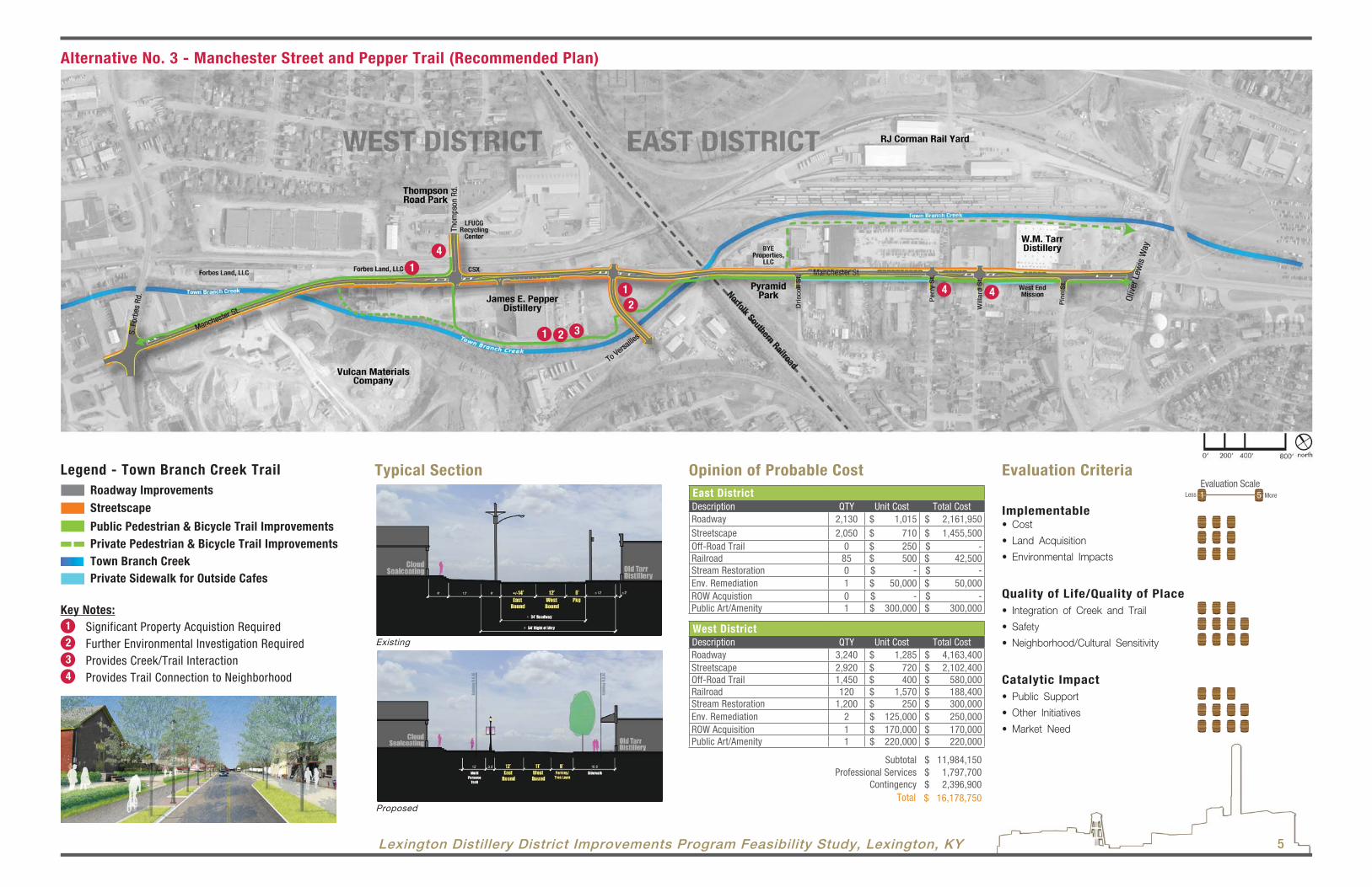
Recommended PlanThe Recommended Plan for implementation is Alternative No. 3
- Manchester Street and Pepper Trail as shown on the following
page. The benefits of this alternative include high visibility of
the trail in the commercial East District area, active engagement
with Town Branch Creek in the West District through Pepper
Distillery, and direct connectivity to both Irishtown and Melrose-
Oak Park neighborhoods. For a more detailed discussion of
the Recommended Plan and related implementation support
stategies, please turn to page 55.
Considerations for ImplementationThe Feasibility Study evaluation has outlined a variety of
infrastructure-related needs to support the intended
Distillery District Program. Through this evaluation, important
considerations were also identified that add complexity to the
approach for implementation of major capital roadway and trail
improvements. These include:
• Nonconforming interim redevelopment activity.
• Extreme floodplain encumbrance in the West District.
• Required rehabilitation and upgrades for public utility services.
• Limited availability of sewer service in West District.
• Pending consent decree trunk sewer remedial measures.
• Need for unified approach to stream revitalization.
• Corridor character negatively impacted by truck traffic.
• Lack of functional civic space.
• Advanced deterioration of historic Pepper Distillery Buildings.
• Outreach with neighborhoods and need for stabilization efforts.
• Requirements for easements and property acquisition.
The list of items noted above is not intended to be all-inclusive,
but instead a list that is representative of the unique challenges
the Distillery District faces. Experience suggests that many of
these issues extend well beyond the normal purview of the
private sector. As such, leadership in addressing these challenges
should be carefully considered by LFUCG in formulating its
strategy to adequately support the TIF District initiative.
Phasing and Implementation StrategyInitially, LFUCG’s role can be best served by providing solutions
to challenging questions that deter private sector investment
and entrepreneurship. The Priority Early Action Items outlined below represent needs that go beyond the normal scope of the
private sector due in large part to their complexity resulting from
interrelationships with the public realm. The Action Items have
been listed individually for ease of understanding; however, they
are collectively intertwined and should be considered together as
one moving forward. Their interrelationships and importance are
further illustrated as follows:
• Street/Trail Preliminary Plan – Supports identification of Phase 1 implementation – Aids utility companies in planning for future facilities. – Guides planning for interim redevelopment initiatives.
• FEMA Floodplain Update – Supports analysis of stream restoration alternatives. – Informs placement decisions for West District sewer system. – Determines adequacy of existing and proposed bridges.
• Utility Service (Partnering Initiative) – Outlines coordination required with public improvements. – Elevates understanding of cost and accountability for upgrades. – Supports seamless final design for roadway corridor.
• Sanitary Sewer Service (Implementation Plan) – Melds Remedial Measures plan with corridor improvements. – Unifies West District Sewer Solution with street/trail plan. – Resolves conflicts with stream revitalization planning.
• Stream Revitalization (Watershed-Based Plan) – Outlines potential strategies to reduce flooding. – Informs public improvement opportunities for Town Branch. – Provides basis for opening lower reach of culvert systems.
Recognizing investment in implementation is an important objective
for the District, the collective product of these tasks will bring
added confidence in direction with the private sector, while
serving as a checkpoint for LFUCG to assess how best to move
forward with subsequent involvement. While certain priority items
may take up to 24 months to fully complete, preliminary feedback
should be evident in all priority areas within 9 to 12 months to
help guide investment of remaining initial project funding.
Distillery District Conceptual Framework Plan “Birds Eye View”
Infrastructure Element Milestone 1 Milestone 2 Milestone 3 ObjectiveProjected Duration
Estimated Budget
Street/Trail Preliminary PlanInitiate 30% Design for Preferred Street/Trail Alternative
Establish MOA with Developer(s) for Targeted Public Investment
Request Construction Funding and Pursue Early Action Items to Improve Corridor Character
Align Developer(s) Initiatives with Phase I Improvements Program
6-9 mo. $200,000
FEMA Floodplain UpdateComplete Town Branch Watershed Hydrologic Study
Perform Updated Floodplain Analysis of Stream
Request FEMA Review and Concurrence
Floodplain Map Revision/Increase Redevelopment Potential in West District
18-24 mo. $400,000
Utility ServiceInitiate Utility Company Summit and Establish Partnering Relationship
Facilitate Needs Assessment and Define Upgrade Requirements
Formalize MOAs for Service Upgrades/Improvements
Utility Companies Commitment to Service Improvements
9-12 mo. $25,000
Sanitary Sewer ServiceAuthorize Study of Sewerability Alternatives
Adopt Implementation Cost Sharing Plan with Developer(s)
Integrate Recommendations with Remedial Measures Program
Implementation Plan for Sewer Service
6-9 mo. $25,000
Stream RevitalizationAuthorize Watershed Based Plan to Support Revitalization Initiative
Pursue Funding Opportunities for Targeted Stream Improvements
Outline Program of Improvements to Town Branch
Commission Design for Stream Restoration
18-24 mo. $175,000
Priority Early Action Item Recommendations
Lexington Distillery District Improvements Program Feasibility Study, Lexington, KY 5
Alternative No. 3 - Manchester Street and Pepper Trail (Recommended Plan)
Opinion of Probable Cost
East District
Description QTY Unit Cost Total CostRoadway 2,130 $ 1,015 $ 2,161,950 Streetscape 2,050 $ 710 $ 1,455,500 Off-Road Trail 0 $ 250 $ - Railroad 85 $ 500 $ 42,500 Stream Restoration 0 $ - $ - Env. Remediation 1 $ 50,000 $ 50,000 ROW Acquistion 0 $ - $ - Public Art/Amenity 1 $ 300,000 $ 300,000
West District
Description QTY Unit Cost Total CostRoadway 3,240 $ 1,285 $ 4,163,400 Streetscape 2,920 $ 720 $ 2,102,400 Off-Road Trail 1,450 $ 400 $ 580,000 Railroad 120 $ 1,570 $ 188,400 Stream Restoration 1,200 $ 250 $ 300,000 Env. Remediation 2 $ 125,000 $ 250,000 ROW Acquisition 1 $ 170,000 $ 170,000 Public Art/Amenity 1 $ 220,000 $ 220,000
Subtotal $ 11,984,150 Professional Services $ 1,797,700
Contingency $ 2,396,900 Total $ 16,178,750
Typical Section
1Evaluation Scale
5 MoreLess
Evaluation Criteria
Implementable• Cost
• Land Acquisition
• Environmental Impacts
Quality of Life/Quality of Place
• Integration of Creek and Trail
• Safety
• Neighborhood/Cultural Sensitivity
Catalytic Impact
• Public Support
• Other Initiatives
• Market Need
Legend - Town Branch Creek Trail
Roadway Improvements
Streetscape
Public Pedestrian & Bicycle Trail Improvements
Private Pedestrian & Bicycle Trail Improvements
Key Notes:
Significant Property Acquistion RequiredFurther Environmental Investigation RequiredProvides Creek/Trail InteractionProvides Trail Connection to Neighborhood
Private Sidewalk for Outside Cafes
1
2
3
4
Town Branch Creek
1
41
2
4
1 2 3
4
Existing
Proposed

Lexington Distillery District Improvements Program Feasibility Study, Lexington, KY6
IntroductionThe Lexington-Fayette Urban County Government (LFUCG)
comissioned the Strand Team to complete a feasibility study for
streetscape and trail improvements between Oliver Lewis Way
and Forbes Road along the Manchester Street Corridor. The
resulting program outlined through this study is intended to help
support revitalization efforts for the corridor as part of the larger
Lexington Distillery District (District) initiative. The study area is
located within downtown Lexington, Kentucky, near its early
beginnings at McConnell Springs and is steeped in history with
a number of historical landmarks located along Town Branch
Creek on which Lexington was originally settled. This area
also offers a rich history of the City’s industrial beginnings that
includes a currently active rail yard and the former James E.
Pepper Distillery, which is slated for redevelopment as part of
the Distillery District Revitalization initiative.
Purpose and Intent
The Lexington Distillery District project is a visionary initiative
proposed by developer Barry McNees to redevelop the once
burgeoning Manchester Street Corridor into a vibrant mixed-use
district. To help support this initiative, the developer and LFUCG
have jointly proposed a Tax Increment Financing (TIF) District
to help fund certain elements of required public infrastructure
improvements. The TIF district funding mechanism allows the
taxing jurisdiction to pay for public improvements from future
additional tax revenues the district generates as a result of the
improvements. In October 2009, the Commonwealth of Kentucky
approved the District TIF request, which led to initiation of this
study.
In support of the developer’s redevelopment initiative, LFUCG
also approved a $2.2 million bond issue in December 2009
for public infrastructure improvements within the District to help
serve as a stimulus. The purpose of this feasibility study is
to aid LFUCG in better understanding the scope of required
public improvements so that informed planning decisions can be
made regarding the City’s proposed investment in the corridor.
The recommendations of this feasibility study are guided by the
knowledge and opinions of LFUCG staff, outside agencies, and
a wide range of public and private stakeholders. This initiative
is intended to help guide LFUCG in making capital investment
decisions that are aligned with the City’s goal to maximize its
return on investment. In addition, the plan is intended to achieve
the following objectives:
• Implement a study approach that supports the potential for future federal funding.
• Enhance the District connectivity while remaining sensitive to neighborhood concerns.
• Evaluate alternative alignments and typical sections for roadway and trail improvements
• Provide an overall opinion of probable cost to help in evaluating alternatives.
• Coordinate study recommendations with the adjacent Rupp Arena and Arts and Entertainment District findings.
• Determine a recommended alternative with phasing and implementation strategy.
• Establish public infrastructure framework that supports private-sector investment along the corridor.
Area of Study
The total corridor length of the project area is just less than
one mile and consists of two distinct sections created by the
major north/south Norfolk Southern (NS) rail line, which forms a
very defining physical divide:
• East District: An area approximately 2,125 feet from the intersection of Oliver Lewis Way to the Norfolk Southern railroad overpass on Manchester Street.
• West District: An area approximately 2,950 feet from the Norfolk Southern railroad overpass on Manchester Street to beyond the Pepper Distillery property on Manchester Street to South Forbes Road.
The study area includes properties located along the corridor
and considers adjacent neighborhoods in respecting the relative
sensitivities and concerns from the future corridor redevelopment
initiative. The current width of the right-of-way for Manchester
Street varies along the corridor, with the majority of the
right-of-way being less than 50 feet.
Process Summary
The planning process for the Lexington Distillery District
Improvements Program (LDDIP) Feasibility Study involved a
comprehensive approach with input gathered from a number of
public meetings, stakeholders, and related research over a two-
year period. The project included four major phases:
• Planning Services
As part of the planning services, a tailored scope was
developed to meet the feasibility study goals and objectives.
Planning related services also included facilitation of project
information sessions with key permitting and potential funding
agencies.
• Site Inventory, Research, and Analysis
The Strand Team collected existing information relative to the
study area including current aerial photography, topography,
property ownership, utilities, proposed development plans,
and future trail improvement plans. Meetings with key
stakeholders including key developers, property owners, and
utility representatives were held to learn about future planned
improvements and to obtain input related to the planning,
design, and implementation of the LDDIP. Multiple site visits
allowed the planning team to gather information and research
the corridor to gain a greater understanding of the existing
physical conditions along with site constraints and opportunities.
• Alternatives Analysis
The site inventory, research, and analysis helped in the study
and development of various alternative alignments and typical
sections for Manchester Street and the Town Branch Trail.
These alternatives considered corridor opportunities while being
sensitive to other issues and concerns identified through the
structured outreach initiative. The alternatives were reviewed at
a public meeting and a decision-making matrix was developed
to evaluate the options and assist with selection of a preferred
plan for implementation.
• Recommendations and Implementation Strategies
A project of the scale and complexity as the Distillery District
Public Improvements Program includes many overlapping
considerations between both the public and private sectors.
To foster the cooperative dialogue needed to address these
common interests, recommendations and implementation
strategies are outlined to help move the public infrastructure
program forward in a logical fashion that compliments each
party’s respective objectives. Priority Early Action items
were outlined with various support strategies for both public
infrastructure and private development interests.
Public Involvement Summary
Effective communication between the project team, LFUCG staff,
and various stakeholder groups was essential for this feasibility
study to develop in an organized manner and meet the wide
range of concerns represented by various interests. Working
with the adjacent business owners and area residents was
deemed a critical and vital component to this planning initiative.
A comprehensive public involvement approach was planned to
gain feedback from the following traditional and nontraditional
stakeholders as design alternatives were explored, including:
• Neighborhood Group Meetings
Separate project information meetings were held in the Irishtown,
Melrose-Oak Park, and Speigle Heights neighborhoods. These
meetings were conducted to address the needs of those
residents most directly affected by the redevelopment
initiative. The neighborhood groups addressed
current concerns within their community and the
Manchester corridor in general, concerns about
the proposed development, and hopes for what
redevelopment could mean to the area.
• Other Corridor Stakeholder Meetings
In addition to the adjacent neighborhood groups,
there are several other key corridor stakeholders.
These stakeholders include groups such as the
developer, utility companies, RJ Corman Railroad
Company, and Vulcan Materials. The consultant
team met with these stakeholders to understand
their concerns and future plans.
• Public Workshops
Workshops were conducted that incorporated a visioning
component including activities based on audience involvement
to actively engage them in the process. Topics included
opportunities and constraints as well as sustainable design
strategies. Alternatives were presented at a public meeting with
opportunity for feedback. Surveys were also used to facilitate
input.
• Advisory/Technical Committee Meetings
Combined meetings with a stakeholder committee and city
advisory staff were held to help keep participants informed of
progress and to obtain feedback. The lines of communication
were kept open with both groups throughout the study duration.
These meetings included LFUCG staff and representatives of
organizations with an interest in the District, such as LexArts,
Rupp Arena, and Arts and Entertainment District Team, the
Downtown Development Authority, and others.
Goals and Objectives
In response to feedback generated through the public
involvement and community outreach initiative, a number of
guiding principles were identified to help focus the approach
to alternatives development, analysis, and recommendations
for implementation. These principles were condensed into five
defining goals and objectives for the Distillery District Public
Improvements Program as follows:
1. Adopt infrastructure strategies that are context and neighborhood-sensitive.
2. Leverage public investment for restorative potential.
3. Enhance the local environment through sustainable planning and design strategies.
4. Promote transit-oriented complete streets for a more compact and walkable corridor.
5. Use collaborative approach to build consensus for improvements to the public realm.
ose
Design Vernacular Helps Brand The District
Example Of Trail Integration With Outdoor Space and Roadway Elements
Creative Design Elements Promote Gathering In Public Spaces
Trail/Stream Integration Opportunities Enhance Water Resources
Vine Street Promenade Highlights Potential Off-Road Path
Distri
h
“Fill the Gap!” Vision Provides Opportunities To Link Downtown With The Distillery District
Manchester Street CorridorProposed Town Branch Trail Alternatives – Draft Town Branch Trail Master Plan 12-10-10Future Versail les Line Trail –Under EvaluationFloodway – 2008 FIRM Map
Gateway Opportunities
Legend
ExaOuOuEle
n Public Spaces
Relocation Alternatives for KU Transmission Line Critical to Project Cost
Screening or Eliminating Existing Aerial Sanitary Crossings Improve District Aesthetics
Creative Design Elements Promote Gathering I
esign Elements Promote n Public Spaces
Railroad Underpass Improvements Enhance Accessibility
ar Design VernaculaHelps Brand The

Lexington Distillery District Improvements Program Feasibility Study, Lexington, KY 7
Physical Conditions Investigation and Site AnalysisExisting Land Use
The Existing Land Use exhibit on the following page depicts
current use designations in and around the study area.
East Segment
The majority of parcels along the eastern segment of the
Manchester Street Corridor study area are currently classified
as Heavy Industrial and Light Industrial. The north side of
Manchester Street is dominated by an automotive impound
and storage lot and the former Old Tarr Distillery site, which is
currently occupied by Buster’s night club and artist studios. The
south side of the street is characterized by smaller industrial and
commercial parcels including a biological testing laboratory, pet
daycare facility, and small neighborhood convenience store. The
Irishtown Neighborhood is composed almost entirely of single-
and multifamily parcels extending south to the Versailles Road
right-of-way.
West Segment
The west segment of the corridor is dominated by Vulcan
Materials, the City’s Recycling Center, and the historic Pepper
Distillery. Bulk material processing, storage, and warehouse
facilities can be found along both sides of the street. Parcel
depths along the north side limit the commercial potential except
where depths become greater at the railway overpass and
Forbes Road intersection. The Melrose-Oak Park Neighborhood
is composed almost entirely of single-family residential parcels
extending north from the RJ Corman/CSX railroad right-of-way
to West Main Street. Speigle Heights subdivision is to the south,
but it is separated from the District by the RJ Corman Versailles
rail line.
Historic Land Use
From its meager beginning in the late 1700s to the bustling
factories of the 1800s and 1900s, the development along
Manchester Street is but a brief history of industrial growth in
Lexington as a whole.
The historic land uses along the East District began with
a woolen factory, a paper mill, and company housing for
workers on 40 acres of land. This area was named the Town
of Manchester by the founders of the factory, the Prentiss
Brothers. Over time, European Americans and European
immigrants settled in the area once known as Manchester and
people began referring to the area as Irishtown. The historic
land use remained industrial; however, the uses transitioned from
the factory, to a distillery, to a tobacco warehouse, to stock
yards/meat packing, and oil and lumber trades.
The historic land uses along the West District began as a
stockade. The area then transitioned to a gunpowder mill
before becoming a distillery. For more information on historic
land uses, see the Historic Context section.
Proposed Future Land Uses
Current development plans have proposed a variety of mixed-
use commercial and residential uses along both segments of the
corridor.
Distillery District Preliminary Development Plan
Existing Physical Conditions
The physical and ecological character of the Distillery District
has undergone constant and dramatic change from the time of
the City’s early establishment. These changes have resulted in
a variety of adverse conditions that impact the character and
condition of the study corridor.
Floodplain
The Town Branch tributary to Elkhorn Creek is a major drainage
course that has significantly influenced the development of
Lexington since its early beginning in the late 1700s. As the
City expanded as an early settlement, this important water
source served many purposes including supporting the various
industries that grew and thrived along its banks. Since those
early days, most of the historic Town Branch Creek has been
enclosed through a series of culvert systems extending upstream
from Rupp Arena to its headwaters beyond what is now
Midland Avenue.
The contributing watershed for Town Branch Creek located
upstream of the NS Railway crossing at Manchester Street
comprises some 5.3 square miles of almost entirely developed
urban area representing most of Lexington’s Downtown Urban
Core. This major watershed contributes significant urban runoff
that has, over time, severely degraded the character and quality
of this water resource.
The result of this collective impact is manifested in a significant
regulatory floodplain that requires careful attention with proposed
improvements that may be within or in close proximity to this
area. The effects of change may be most evident in the current
state of the Town Branch Creek where physical changes,
channelization, and the impacts of upland development have
modified what was once an ecologically diverse riparian corridor
into a highly urbanized drainage way and floodplain. Progressive
filling, site development, and the construction of roads and
railway lines have resulted in the loss of nearly all the natural
floodplains, native soils, and original surface and subsurface
drainage patterns.
Degraded Portion of Town Branch Creek
Slopes
Channelization and earthwork associated with streets and rail
lines have created physical barriers to vehicular and pedestrian
access to the extent that Thompson Road and De Roode
Street provide the only north-south linkages to Manchester
Street between Oliver Lewis Way and Forbes Road.
Vegetation
While a remnant woodland and substantial tree canopy can be
found along the south side of Town Branch Creek along the
Pepper Distillery site, the history of disturbance and empirical
evidence suggest that most if not all of the original woodland
and riparian vegetation has been lost.
Architectural Quality
The Old Tarr and Pepper Distilleries are proposed to become
the anchors for the adaptive reuse and revitalization of the
Manchester Corridor. The original remaining buildings of each
property are in various stages of repair. The Old Tarr Distillery
Warehouse is actively used today. Most of the Pepper Distillery
buildings appear to have good prospects for adaptive reuse
provided that structural deficiencies are correctable and that
stabilization measures are not deferred beyond reasonable time
frames. The distilling plant building appears to have significant
structural failures in the building shell and roof that could
threaten its viability for salvage and adaptive re-use.
The James McConnell House, the former Manchester
Community Center, and a 1920s-era brick building that housed
the West End Mission make up the balance of the corridor’s
historic building inventory immediately adjacent to the proposed
project. Although a few older homes are known to exist along
the corridor, modifications to their exteriors has diminished the
relevant architectural significance.
The resulting loss of most of the prior building inventory along
the south side of Manchester Street between the railroad
overpass and Oliver Lewis Way has resulted in a poorly defined
street edge and unappealing streetscape character.
Existing Residence - Typical of Manchester Street Corridor
Former Manchester Community Center (now Dog Town)

Lexington Distillery District Improvements Program Feasibility Study, Lexington, KY8
0’ 400’ 800’ north200’
Commercial
Recreation/Green Space
Heavy Industrial
Light Industrial
Single Family
Multifamily
Vacant
Office
Public/Institutional
Legend
James E. Pepper Distillery
W.M. Tarr Distillery
New
tow
n P
ike
ToooT wwn Brrraaannnccchhh
Versail les Rd.
Forbes Rd.
Maxwell Bro
adw
ay
Pat
ters
on S
t.
Jeff
erso
n S
t.
High St.High St.
De Roode St.
Manchester St.
Pin
e S
t.
Per
ry S
t.
Th
om
pso
n R
d.
Wil
lard
St.
Main St.
Oli
ver
Lew
is W
ay
Main St.
Drisc ol l St.
TTowwwwwnnnn BBBBBBBBrTooowwwn BrrrTooowwwoo nn BBr
2
2
1
1
Existing Land Use - Historic Distilleries

Lexington Distillery District Improvements Program Feasibility Study, Lexington, KY 9
0’ 200’ 400’ north100’
Retaining Walls
Existing Physical Features
LegendMature Woodland Scrub Understory
Scrub understory is indicative of the steep slopes along the rail corridor
Central rail overpass defines a wide section of the district
Treeline Hedge Mown Lawn
>20% slopes
10-20% slopesFloodway
100 yr. FEMA Floodplain
500 yr. FEMA Floodplain
Severely Sloped Stream Banks
Gently Sloped Stream Banks
S
GG
W.M. Tarr Distillery
Wil
lard
St.
Grade-separated roadway and rail corridors present physical barriers within the district and between surrounding neighborhoods. Central rail overpass defines east and west sides of the District.
East section of stream corridor is relocated from original route of Town Branch Creek, is heavily urbanized with steep embankments and narrow riparian zone.
West section of stream corridor follows original route of the Town Branch Creek and has a combination of wider embankments and intermittent retaining walls. Wider riparian zone contains more mature tree canopy.
Floodplain boundary encompasses the majority of the Manchester Street corridor in west district. Floodplain boundary is less restrictive in east district.
Vulcan Materials/ATS Construction. Active rock quarry and asphalt supply plant in close proximity.
Pyramid Park: Public green space park fronting on Manchester Street framed by elevated rail corridor with trail connection to Driscoll Street.
Thompson Park: Neighborhood park and playground.
RJ Corman Rail Yard
1
1
1
1
1
2
3
4
5
6
7
1
1
2
4
64
5
7
3
Jane St.
Anderson St.
Main St.
Manchester St.
James E. Pepper Distillery
Edmond St.
Valley Ave.
De Roode St.
Ferguson St.Robertson St.Speigle St.
Dri
sco
ll S
t.
Per
ry S
t.
Pin
e S
t.
Oli
ver
Lew
is W
ayManchester St.Th
om
pso
n R
d.
Hen
ton
Rd
.
Wi l
ton
Ave
.
Cly
de
St.
Texaco Rd.
Liggett St.
Vulcan MaterialsCompany
Warehouses
PyramidPark
Speigle Heights
Park
Thompson Rd. Park LFUCG
Recycling Center
Calvary Cemetery
Lexington Cemetery
Versail les Rd.

Lexington Distillery District Improvements Program Feasibility Study, Lexington, KY10
0’ 200’ 400’ north100’
Retaining Walls
Existing Floodplain
Legend
Scrub understory is indicative of the steep slopes along Town Branch
Channelized stream conditions where Town Branch crosses below Manchester St. and the railroad
Floodway
100 yr. FEMA Floodplain
500 yr. FEMA Floodplain
Severely Sloped Stream Banks
Gently Sloped Stream Banks
S
W.M. Tarr Distillery
East section of stream corridor is relocated from original route of Town Branch Creek and is heavily urbanized with steep embankments and a narrow riparian zone.
West section of stream corridor follows original route of Town Branch Creek and has a combination of wider embankments and intermittent retaining walls. Wider riparian zone contains more mature tree canopy.
Floodplain boundary encompasses the majority of the Manchester Street corridor in west district. Floodplain boundary is less restrictive in east district.
1
2
3
1
3
3
2
Jane St.
Anderson St.Edmond St.
Valley Ave.
De Roode St.
Ferguson St.Robertson St.Speigle St.
Versail les Rd.
Thompson Rd. Park
Main St.
Manchester St.
James E. Pepper Distillery
Dri
sco
ll S
t.
Wi l
lard
St.
Per
ry S
t.
Pin
e S
t.
Oli
ver
Lew
is W
ayManchester St.Th
om
pso
n R
d.
Hen
ton
Rd
.
Wi l
ton
Ave
.
Cly
de
St.
Texaco Rd.
Liggett St.
Vulcan MaterialsCompany
Warehouses
PyramidPark
Lexington Cemetery
Calvary Cemetery
LFUCG Recycling
Center
RJ Corman Rail Yard
Speigle Heights
Park

Lexington Distillery District Improvements Program Feasibility Study, Lexington, KY 11
Existing Vegetation
Town Branch Creek
Legend
Mature Woodland
Scrub Understory
Scrub understory is indicative of the steep slopes along the rail corridor
Scrub vegetation dominates the viewshed along Manchester St.
Treeline Hedge
Mown Lawn
East section of stream corridor is relocated from original route of Town Branch Creek and is heavily urbanized with steep embankments and a narrow riparian zone.
West section of stream corridor follows original route of Town Branch Creek and has a combination of wider embankments and intermittent retaining walls. Wider riparian zone contains more mature tree canopy.
Pyramid Park: Public green space park fronting on Manchester Street framed by elevated rail corridor with trail connection to Driscoll Street.
Thompson Park: Neighborhood park and playground.
1
2
3
4
1
3
4
2
Versail les Rd.
Jane St.
Anderson St.
Main St.
Manchester St.
James E. Pepper Distillery
W.M. Tarr Distillery
Edmond St.
Valley Ave.
Ferguson St.Robertson St.Speigle St.
Dri
sco
ll S
t.
Wi l
lard
St.
Per
ry S
t.
Pin
e S
t.
Oli
ver
Lew
is W
ayManchester St.Th
om
pso
n R
d.
Hen
ton
Rd
.
Wi l
ton
Ave
.
Cly
de
St.
Texaco Rd.
Liggett St.
Vulcan MaterialsCompany
Warehouses
PyramidPark
Speigle Heights
Park
Thompson Rd. Park
Lexington Cemetery
Calvary Cemetery
LFUCG Recycling
Center
RJ Corman Rail Yard
De Roode St.
0’ 200’ 400’ north100’

Lexington Distillery District Improvements Program Feasibility Study, Lexington, KY12
0’ 200’ 400’ north100’
Retaining Walls
Existing Slopes
Legend
Steep slopes and the rail corridor divide the District from surrounding neighborhoods
Central rail overpass defines a wide section of the District
>20% slopes
10-20% slopes
Town Branch Creek
Grade-separated roadway and rail corridors present physical barriers within the District and between surrounding neighborhoods. Central rail overpass defines east and west sides of the District.
The East section of the Town Branch Creek is relocated from original route and is heavily urbanized with steep embankments and narrow riparian zone.
West section of the Town Branch Creek follows the original route and has more shallow side slopes and intermittent retaining walls. Wider riparian zone contains more mature tree canopy.
Vulcan Materials/ATS Construction. Active rock quarry with existing surface and subsurface mining and asphalt and concrete supply plant in close proximity.
1
1
1
1
1
2
3
4
1
1
2
4
3
Versail les Rd.
Jane St.
Anderson St.
Main St.
Manchester St.
James E. Pepper Distillery
W.M. Tarr Distillery
Edmond St.
Valley Ave.
De Roode St.
Ferguson St.Robertson St.Speigle St.
Dri
sco
ll S
t.
Wi l
lard
St.
Per
ry S
t.
Pin
e S
t.
Oli
ver
Lew
is W
ay
Th
om
pso
n R
d.
Hen
ton
Rd
.
Wi l
ton
Ave
.
Cly
de
St.
Texaco Rd.
Liggett St.
Vulcan MaterialsCompany
Warehouses
PyramidPark
Speigle Heights
Thompson Rd. Park
Lexington Cemetery
Calvary Cemetery
LFUCG Recycling
Center
RJ Corman Rail Yard
Manchester St.
Irishtown

Lexington Distillery District Improvements Program Feasibility Study, Lexington, KY 13
Summary of Environmental Process
The environmental analysis to support the alternatives evaluation
was implemented as a two-phased process with an initial
overview followed by targeted baseline assessments. The
overview was completed to provide guidance to the project
team and LFUCG on where further efforts would be best
spent and to provide a good understanding of general corridor
environmental concerns. The second step was to complete
supplemental environmental evaluations, which included a
Cultural Historic and Archaeological Baseline Survey and Aquatic
and Terrestrial Baseline Assessment of Town Branch Creek.
Area of Potential Effect (Project Area)
For purposes of the environmental analysis, Areas of Potential
Effect were identified in accordance with the National
Environmental Policy Act (NEPA) process to guide relevant
field investigations and assessments. This Project Area limit
is referred to as Project Area hereinafter with regard to the
environmental analysis.
Initial Environmental Review
As a component of the feasibility study, an environmental review
was conducted in support of the LDDIP. The goal of the effort
is to understand potential environmental impacts of the project
and maintain compliance with NEPA procedures. Adherence
to the NEPA process will support future federal funding for
the project. The proposed project is comprised of two primary
parts: (1) streetscape improvements to Manchester Street
and (2) extension of the Town Branch Trail between Oliver
Lewis Way and South Forbes Road. In addition, environmental
resources were reviewed within the larger Project Area as noted
in the following exhibits: Aquatic and Terrestrial, Hazardous
Materials, and Socioeconomic sites. The larger project area is
associated with secondary and cumulative impacts related to the
development of the proposed Distillery District.
This initial environmental review presents an overview of the
ecological, hazardous materials, and socioeconomic conditions
and constraints within the project area and establishes a
foundation to support future analysis. It should be noted
that modeling for air quality and traffic noise has not been
conducted. A general discussion of air quality and traffic noise
is therefore included. Cultural resources are being examined
and are an equally important component of the NEPA process.
This component may require significant coordination with the
State Historic Preservation Office and other stakeholders to
maintain eligibility for federal funding. More detailed assessments
of each area of environmental consideration are planned as a
subsequent phase of the feasibility study.
Air Quality
Lexington/Fayette County, Kentucky, is part of the Bluegrass
Intrastate Air Quality Control Region. The county is currently
designated in attainment for all transportation-related air
pollutants. The proposed project is not anticipated to adversely
impact air quality.
The approximately 1-mile project corridor is located in a
predominantly urban/industrial area. Because future traffic
projections will not exceed 80,000 average daily traffic (ADT), a
full air quality analysis including carbon monoxide modeling is
not anticipated. An abbreviated air quality analysis would require
traffic data (ADT for each alternative scenario) to determine
anticipated impacts resulting from the proposed project.
Qualitative evaluation of mobile source pollutants would be
performed, including carbon monoxide, lead, nitrogen dioxide,
ozone, particulate matter, sulfur dioxide, and mobile source air
toxins. Fayette County is in attainment for ozone and particulate
matter, thus the air quality analysis would not require inclusion
of the PM-2.5 Checklist or the 8-hour ozone designation and
attainment status discussion.
Based on the current and anticipated traffic volumes of the
project area (less than 80,000 ADT), it is estimated that current
and future concentrations of transportation-related air pollutants
will not exceed the National Ambient Air Quality Standards
(NAAQS) established by the United States Environmental
Protection Agency (USEPA). The emissions of air pollutants
related to this project are not expected to have a negative
impact on the ambient air quality nor affect the attainment
status of Fayette County. Because the project is currently
locally funded, it is not listed in the Statewide Transportation
Improvement Program, Fiscal Years 2011-2014.
Traffic Noise
Traffic noise modeling was not conducted for this overview. The
project corridor contains sensitive noise receivers worth noting.
Three residential communities (Irishtown, Speigle Heights, and
Melrose-Oak Park) are located along the corridor. The Southend
Park neighborhood is adjacent to Irishtown and has experienced
“cut-through” traffic from South Broadway to Manchester
Street for many years. This neighborhood is currently being
redeveloped. Calvary Cemetery is located just north of the
corridor, although across the RJ Corman Railroad tracks from
Manchester Street. These sensitive receiver locations might
experience elevated noise levels because of increased traffic
from proposed projects within the Distillery District as compared
to existing conditions.
According to the Federal Highway Administration (FHWA)
Policy, Procedures for Abatement of Highway Traffic Noise and
Construction Noise, contained in 23 CFR 772, traffic noise
impacts occur when the predicted traffic noise levels approach
(are within 1 decibel on the A-weighted scale [dBA]) or exceed
the established Noise Abatement Criteria (NAC). The policy
states traffic noise impacts also occur when the predicted traffic
noise levels for the Build scenario substantially exceed existing
noise levels (increase beyond Existing levels by 10 dBA or
more). The FHWA exterior NAC for institutional and residential
facilities is 67.0 dBA. The Kentucky Transportation Cabinet’s
(KYTC) Noise Abatement Policy (February 2000) incorporates
FHWA procedures and NAC contained in 23 CFR 772. KYTC
policy also includes, among others, the following definitions and
criteria:
• A “noise increase” is defined as the difference in noise levels between the “Build and “No-build” alternatives in the design year.
• A project does not “appreciably alter” future noise levels if the noise increase is not greater than 3 dBA.
• Noise barrier construction will generally not be considered feasible along existing roadways where the proposed project does not appreciably alter future noise levels.
• KYTC will consider noise abatement measures as appropriate if the noise level predicted for the design year approaches (within 1 dBA) or exceeds the NAC for the land use category affected and/or the noise level increase predicted for the design year is 10 dBA or more greater than the measured existing noise level (a substantial exceedance).
With the implementation of this project, traffic noise levels are
not expected to increase substantially from Existing to Build
conditions. If federal funding is sought in the future, traffic noise
modeling may be required to determine noise increases.
Ecology
Diverse aquatic and terrestrial features are scarce in this
highly urbanized area and are shown on page 14. Aquatic
resources are restricted to Town Branch Creek and McConnell
Springs. The effects of the highly urbanized watershed on the
perennial Town Branch Creek are evident. The stream is a
303(d) listed stream for not supporting the designated warm
water uses of primary contact recreation (swimming) and warm
water aquatic habitat use (aquatic life). The upper reaches of
the stream flow through culverts beneath Lexington before
surfacing approximately 100 yards southeast of Oliver Lewis
Way. Northwest of Oliver Lewis Way, the stream meanders
through an industrial area, which in most sections has reduced
the riparian zone to 10 feet in width or less. Two primary
exceptions are a 700-yard section of Town Branch Creek from
the point at which it crosses west of Manchester Street at the
railroad bridge to the point at which it crosses back to the
north side of Manchester Street near Pine Mountain Lumber,
and a 500-yard section between Jimmie Campbell Drive and
Forbes Road. The riparian zone of the stream along this section
is wider (or has the potential to be made wider) and the canopy
is more mature. While the dominant canopy species along the
stream is bush honeysuckle (Lonicera mackii), the canopy along
this section is more diverse and includes mature slippery elm
(Ulmus rubra), sycamore (Platanus occidentalis), silver maple
(Acer saccharinum), and black locust (Robinia pseudoacacia).
McConnell Springs is located within the project area but outside
the Manchester Street streetscape improvements and Town
Branch Trail design project footprints. It is a 26-acre nature park
pocketed amongst a dense light industrial development area.
Aquatic resources within the park include a spring, a pond, a
stream, and wetland areas. The park’s large man-made wetland
pond is a valuable asset as it was designed to slow and filter
surface runoff. McConnell Springs also represents one of the
few terrestrial resource assets in the Project Area. The park, in
addition to Calvary Cemetery and Lexington Cemetery, contains
a diverse mix of mature trees that provide habitat for numerous
urban species of birds and mammals.
A more detailed assessment of Town Branch Creek within the
Project Area was conducted to develop a better understanding
of the existing physical conditions and water quality. This
assessment considered opportunities that might exist to improve
the condition of the creek and its tributaries in the district. This
in turn could also support ongoing watershed planning efforts
and how those considerations might influence the planning and
design components for the District.
Steep Stream Banks with Narrow Riparian Zone Dominated by Asian Bush Honeysuckle
Asian Bush Honeysuckle with Native Tree Saplings and Exotic Winter Creeper on the Bank of Town Branch

Lexington Distillery District Improvements Program Feasibility Study, Lexington, KY14
Underground Storage Tank/Hazardous Materials
The object of this assessment was to identify potential
conditions that could represent a liability to the project because
of the presence of hazardous waste, petroleum products, or
associated soil and groundwater contamination. A combination
of map review, database review, and pedestrian field survey was
used to assess potential hazardous materials sites within the
project area. They are shown on page 15.
• Database Review
Environmental Data Resources, Inc. (EDR) was contacted before
the field reconnaissance activities to produce an electronic
review of applicable environmental databases. Various state and
federal environmental agency databases were reviewed.
EDR’s database search resulted in the identification of numerous
facilities located in the vicinity of the project corridor. However,
only the facilities listed in Table 1 are believed to be of any
consequence to the proposed project.
Table 1 – Potential Sites of Concern, Hazardous Materials
Property AddressType of
BusinessDatabase (s) Contaminant
DT Ferrell Trust/
Ferrell’s Car
Care
1120
Manchester St
Automotive
repair (active)
SHWS, UST,
SB 193
Petroleum
products
ATS Construction
Plant # 16/
Central Kentucky
Asphalt
1256
Manchester St
Asphalt supply
plant (active)
SHWS,
NPDES,
FINDS, AIRS,
ICIS
Petroleum
products
Great Southern
Refinery
Texaco &
Clyde St
Historic refinery
(closed)SHWS
Petroleum
products
Bond
Management/
Environmental
Resources Inc.
811
Manchester St
Unknown
(no longer
present due to
improvements
to Oliver Lewis
Way)
UST, SB
193, RCRA-
NonGen,
FINDS
Petroleum
products
Fleetcard –
Lexman/Riley Oil
Company
943
Manchester St
Gas station
(active)UST
Petroleum
products
Vulcan
Construction
Materials
1280
Manchester StQuarry (active)
UST, AIRS,
FTTS/ HIST
FTTS, FINDS,
NPDES
Petroleum
products
Databases:AIRS - Permitted Airs facilitiesFINDS – Facility Index SystemFTTS/HIST FTTS – Federal Insecticide, Fungicide, and Rodenticide Act ICIS – Integrated Compliance Information SystemNPDES – Permitted Wastewater FacilitiesRCRA-NonGen – Resource Conservation and Recovery Act – Non GeneratorSB 193 – UST sites with known soil/groundwater contaminationSHWS–State Hazardous Waste SitesUST–Underground Storage Tank
• Mapping Review
Mapping resources were reviewed at the University of Kentucky
Science Library. Additional historic mapping was also reviewed
online via the Science Library website (http://libguides.uky.edu/
maps).
Historic aerial images were reviewed for the project corridor
including the following years: 1937, 1956, 1966, 1973, 1982,
and 1990. Additionally, historic topographic mapping for the
Lexington West 7.5 minute quadrangle was reviewed for 1950,
1955, 1959, and 1965.
As expected for a largely urban area such as Manchester
Street, the project corridor appeared developed on all images
reviewed. The 1937 image revealed many of the same
warehouse and distillery buildings along Manchester Street
that are still present today. Numerous residential dwellings
were evident along Manchester Street on the 1937 image.
The subsequent images reviewed revealed an increase in
development with the land use transitioning from residential
to more industrial. Most notably, the 1982 and 1990 images
showed what appeared to be automotive junk yards located
just east and west of the current Manchester Street railroad
crossing. The junk yards are not present today; however,
the presence of the historic junk yards represents potential
environmental conditions.
In addition to the aerial images and topographic mapping,
Sanborn Fire Insurance mapping was reviewed for 1886, 1890,
1896, 1901, 1907, and 1958. Limited Sanborn coverage is
available for the project area with the majority of the mapping
focusing on the area between Cox Street and the Manchester
Street railroad crossing. Various tobacco warehouses, distilleries,
and numerous residential dwellings were identified along
Manchester Street. One occupant of particular interest, the
Standard Oil Company, was identified just east of the former
Cox Street and Manchester Street intersection. Recent road
improvements to Oliver Lewis Way have dramatically altered the
former location of this parcel. However, the former land use on
this parcel does represent a potential environmental condition.
Additionally, the 1958 mapping identified a junk yard at the
intersection of Manchester and Perry Streets. This former junk
yard location also represents a potential environmental condition.
• Summary
Because of the long history of intense urban and industrial
development present throughout the project corridor,
the proposed projects can expect to encounter potential
environmental conditions. It should be assumed that a general
condition of surface soil contamination exists in the entire project
area.
Plans should not include the use of the existing surface soils
in the final grade. Most of the project corridor has also had fill
material use to bring the area to its existing grade. The quality
and nature of this fill material could also represent environmental
conditions. Town Branch Creek and its banks may have a
history for use with waste disposal. Once final alternatives are
developed, additional research is recommended.
Socioeconomic Review
• Land Use
Land use immediately adjacent to Town Branch and
Manchester Street between Forbes Road and Oliver Lewis
Way is almost exclusively industrial. Facilities such as the
Vulcan Materials Company, LFUCG Recycling Center, an RJ
Corman rail yard, and numerous small auto repair and other
businesses are present along Manchester Street. Pyramid Park,
a small neighborhood park, is located along the roadway as
well, as are the entertainment destinations Buster’s Billiards
and Backroom and The Barrel House. C&P Market, a
neighborhood convenience store/restaurant, is located near these
establishments.
Industrial and commercial facilities comprise much of the
land use in the project area as a whole; however, land use
is more diverse in the overall project area, which includes
several neighborhoods, parks, churches, day care facilities, retail
establishments, restaurants, and cemeteries.
• Communities/Community Features
The residential neighborhoods of Speigle Heights, Irishtown,
and Melrose-Oak Park are located near Manchester Street
in the project area. These neighborhoods are comprised of
modest one- or two-family frame or brick homes inhabited by
a mix of lower-middle to low-income individuals/families. Within
these communities, churches and parks are present. Several
community service and outreach centers are located within or
near the project area, such as the Salvation Army, Irishtown
Baptist Ministries, and the Carver Center. The main office for
Lexington’s Community Action Council, which has sites providing
social services throughout the county, is located just east of
Oliver Lewis Way on High Street. As no roadways will be
removed or significantly reconfigured as a result of the project,
access to/from these facilities will not change. Direct impacts to
these facilities are not anticipated. Improved pedestrian facilities
along the Manchester corridor will benefit those who patronize
these establishments, as many likely do so on foot.
One private educational facility is present in the project area:
Providence Montessori in Melrose-Oak Park (providing preschool
and elementary education).
Also present in the project area is Calvary Cemetery. Increased
noise could be of concern for visitors to the cemetery, as it
is close to the Town Branch Creek and Manchester Street
corridors. However, active rail lines, including the RJ Corman
rail yard, surround the property on two sides and separate the
cemetery from Town Branch Creek and Manchester Street; thus,
noise is already present in the area.
• Environmental Justice
Pursuant to Executive Order 12898, Federal Actions to Address
Environmental Justice in Minority Populations and Low-Income
Populations, the project area was examined for any minority or
low-income populations that may be impacted by the project.
Executive Order 12898 provides that minority and low-income
populations do not bear a disproportionate share of high and
adverse human health or environmental impacts by identifying
and addressing the impacts a project may have on these
populations.
Environmental Justice is a potential concern for the project.
Melrose-Oak Park, Speigle Heights, Irishtown, and Southend
Park neighborhoods contain a high percentage of minority
and/or low-income residents. Census data indicates that
just over half of Speigle Heights and Irishtown residents are
minorities, whereas approximately a quarter of Fayette County’s
population is comprised of minority residents. Although Melrose-
Oak Park and Southend Park contain a slightly smaller
percentage of minority residents than the county average, a
large percentage of residents in those neighborhoods rent their
homes, indicating incomes are likely lower in these areas. The
percentage of individuals who rent their homes is also higher
than the county average in Speigle Heights and Irishtown.
Table 2 – Neighborhood Data (2010 Census)
KentuckyFayette County
CT 9 BG 21 CT 10 BG 12 CT 10 BG 23
Minority (%) 12.2 24.3 23.4 51.1 16.4
Rent Home (%) 31.1 44.1 94.8 57.8 60.6
1Southend Park 2Speigel Heights, Irishtown3Melrose-Oak ParkSource: US Census, American FactFinder (http://factfinder2.census.gov)
Economic data down to the block group level is not yet
available from the 2010 census. The American Community
Survey (2007-2009) was examined to determine this information.
Median household and per capita income is also lower in these
areas than in the county as a whole.
Table 3 – Neighborhood Data (2007 to 2009 American Community Survey)
Kentucky Fayette County CT 91 CT 102
Hispanic or Latino 2.3 5.9 2.4 0.0
Median Household Income $41,197 $46,874 $16,449 $28,977
Per Capita Income $22,284 $27,878 $9,228 $12,006
HH Receiving Public
Assistance income (%)2.3 1.4 0.6 11.0
Median Gross Rent as % of
HH Income28.2 29.3 50.0 23.7
Median Year Structure Built 1976 1978 1978 1958
Median Value $113,100 $155,400 $92,600 $69,2001Southend Park 2Speigel Heights, Irishtown, Melrose-Oak ParkSource: US Census, American FactFinder (http://factfinder2.census.gov)

Lexington Distillery District Improvements Program Feasibility Study, Lexington, KY 15
Based on this information, the project has potential to affect
Environmental Justice communities. As the majority of the
property that is adjacent to Manchester Street and Town
Branch is commercial or industrial, few direct negative impacts
will be experienced by these communities; no households will
be relocated and no neighborhoods will be divided. Impacts
to these neighborhoods are more likely to be indirect, relating
to noise and traffic impacts as well as possible changes in
property values because of the induced growth effect. Such
an impact would benefit property owners but would negatively
impact residents who rent their homes.
Industrial properties separate these neighborhoods from major
thoroughfares likely to carry traffic to the proposed trail and
redeveloped Manchester corridor (Manchester Street, Forbes
Road), although residents of Irishtown along High Street and
Oliver Lewis Way lack these industrial buffers. The large
industrial properties between many residents and major
roadways will help alleviate some of the traffic noise visitors will
generate. However, residents may contend with more vehicles in
the area overall. Since the Manchester Street improvements are
part of a greater project to revitalize the roadway corridor as an
entertainment district, the area may experience more noise and
traffic in the evening hours than currently occurs.
The neighborhoods may experience positive impacts as a result
of the project, such as improved street lighting, sidewalks,
emergency vehicle access, and recreational opportunities.
So that the project meets the needs of these neighborhoods
as well as the wider community, care should be taken during
the project development process to identify and include these
residents during public involvement activities. This will allow the
project team to fully understand and consider Environmental
Justice community benefits and burdens. A full documentation of
the effort to engage the Environmental Justice community is a
requirement of the NEPA process.
• Section 4(f)
Section 4(f), as established by the United States Department
of Transportation (USDOT) Act of 1966 and amended in 1989
(49 USC. Section 303), states that all park and recreation
lands, wildlife and waterfowl refuges, and historic sites must be
considered in transportation project development. Section 4(f)
applies to all projects that receive federal funding or require
approval by any agencies of the USDOT. It requires that an
alternative that uses a Section 4(f) resource only be selected if
it can be proven that no other prudent and feasible alternatives
exist and that the selected alternative minimizes disturbance to
the resource. In 2005, Section 4(f) was amended to allow
de minimis ruling in the event any impacts would not
appreciably alter the attributes, features, or function of the
resource.
Pyramid Park is located on the south side of Manchester
Street, west of Driscoll Street. If the park is owned by LFUCG,
acquiring right-of-way from this facility may represent a Section
4(f) impact. Traffic may increase near the park, as it is located
along Manchester Street. However, as it is adjacent to railroad
tracks and currently experiences heavy truck traffic, noise is
already a factor at the park. Improved pedestrian facilities may
enhance neighborhood access to the park. The park is also
near Town Branch Creek and could benefit from proximity
to the trail as trail users visit the park and vice versa. Two
additional parks, Speigle Heights Park and Thompson Road
Park, are located in the larger project area. However, they will
not be directly impacted by the project. Indirect impacts to all
parks may be increased usage as the trail is developed. An
indirect impact, however, does not constitute a Section 4(f)
impact.
There are several historic structures and districts near the
project area. They are discussed in the historic context that
follows this section.
• Section 6(f)
Section 6(f) of the Land and Water Conservation Fund Act
(LWFCA) of 1965 (16 USC. 4601-4) established a funding
source for both federal acquisition of parks and recreation
lands and matching grants to state and local governments
for recreation planning, acquisition, and development. It set
requirements for state planning and provided a formula for
allocating annual LWCFA appropriations to the states. Section
6(f) concerns transportation projects that propose impacts to,
or the permanent conversion of, outdoor recreation property
that was acquired or developed with LWCFA grant assistance,
which is distributed by the Interagency Committee for Outdoor
Recreation of the Office of the Interagency Committee in
Washington, D.C. Any right-of-way taking from a public park
that has received LWCFA funding is considered a Section 6(f)
impact and requires coordination with, and approval from, the
National Park Service and the United States Department of the
Interior.
No facilities in the project area have received LWCFA funding,
and therefore the project will have no Section 6(f) impacts.
Summary of Initial Environmental Review
Based upon the preliminary environmental site review, there are
no ecological or socioeconomic constraints to the proposed
alignments of the Manchester Streetscape Improvements or
Town Branch Trail design projects. Coordination with residents
will be required during the environmental process to resolve
concerns about noise and traffic intrusions into neighborhoods.
Several sites adjacent to Manchester Street or the proposed trail
alignment may contain hazardous waste-related environmental
conditions requiring a Phase II Site Assessment prior to
construction. If federal funds are sought for the project, NEPA-
level environmental analysis will be required.
Summary of Aquatic and Terrestrial Baseline
Assessment
An assessment of Town Branch Creek was performed within
the limits of the Lexington Distillery District Improvement Trail
and Stream Restoration project area. Existing information from a
variety of sources regarding the stream and aquatic habitat was
reviewed and compiled for the analysis including the watershed
assessments, remedial measures plans, proposed TMDLs, and
other available data. Fieldwork was also conducted to document
aquatic habitat, bank stability, bank and substrate materials,
riparian zone vegetation, springs, seeps, outfalls, and crossings.
The aquatic macroinvertebrate community was also sampled.
The purpose of this supplemental evaluation is to more fully
characterize the condition of the aquatic and terrestrial setting
associated with Town Branch Creek within the Project Area.
This effort will support the potential for future federal funding of
the project by documenting the baseline ecological conditions. It
will also aid designers in their understanding of the opportunities
and limitations that may exist along the stream corridor.
Additional information regarding the opportunities and limitations
is presented in a separate document.
On August 30 and 31, 2012, and November 8, 2012, an
examination of the Town Branch Creek Project Area was
conducted to document observed features within or adjacent
to the stream channel that could be important for future
planning. Using the Center for Watershed Protection’s Urban
Subwatershed Restoration Manual 10 – Unified Stream
Assessments: A User’s Manual Version 1.0 (Kitchell and
Schueler 2005), biologists documented the condition of outfalls,
severe erosion, utility impacts, trash and debris, and stream
crossings. Photographs were taken of each feature, locations
were recorded with Global Positioning System (GPS), and field
data sheets were completed to describe each feature and
its interaction with the stream channel. Other observations
concerning the bank material and structure, tree species,
terrestrial and aquatic habitat, and other observations were
noted during the stream walks.
In addition to these visual assessments, eight reaches of the
stream were assessed using the Rapid Bioassessment Protocol
(RBP) Assessment, according to Kentucky Division of Water
(KDOW) and US Environmental Protection Agency (USEPA)
protocols (Barbour et al. 1999) (KDOW 2011). Their documented
scores reflect the condition of 10 habitat parameters and the
quality of habitat available for aquatic invertebrates, which is
an indicator of stream health. Water chemistry was sampled
within each of the eight assessment reaches including water
temperature, dissolved oxygen, pH, and specific conductance.
The benthic community of Town Branch Creek was sampled
at two locations within the project area. Aquatic insects were
collected from available habitats at these locations, following
procedures specified by KDOW (KDOW 2009a, 2009b). This
field data was then combined with other available data sources
to provide a comprehensive assessment of the project area.
The aquatic macroinvertebrates that live within Town Branch
Creek were primarily organisms tolerant of pollution, and the
overall community was of poor quality. All habitat assessments
over the reach were also poor. The riparian zone is narrow
and dominated by exotic invasive species, the channel has
been straightened, and the banks are often retaining walls or
limestone blocks. No habitat for state threatened, endangered,
or special concern species is present within the Town Branch
Creek Project Area.
Water chemistry readings reflect high conductivities (elevated
ions), which lead to impaired status of the stream. Historic data
indicate that the fecal coliform levels in the stream present a
public health risk. One known sanitary sewer overflow occurs
in the project area, the odor of sewage was observed, and
the total maximum daily load (TMDL) of Town Branch Creek
suspects several sanitary sewage contributions to the stream.
Nutrient levels in the stream have also historically
been high, contributing to the abundant algae
growth throughout the reach.
Emergence of Town Branch Creek - Behind Rupp Arena
Town Branch Substrate with Excessive Algal Growth from Nutrient Pollution

Lexington Distillery District Improvements Program Feasibility Study, Lexington, KY16
Town Branch Creek
McConnell Springs
Calvary Cemetery
Lexington Cemetery
Aquatic and Terrestrial Sites
LegendStreetscape Project Area
Aquatic Resources
Terrestrial Resources
Floodplain
Project Area
0’ 125’ 250’ north62.5’
OLI
VE
RLE
WIS
WAY
1
1
2
3
4
W MAIN ST
W HIGH ST
PINE ST
VERSAILLES RD
S BR
OADW
AY
S FOR
BES RD
MANCHESTER ST
S U
PPER
ST
S M
ILL
ST
S LI
MES
TON
E
W THIRD ST
W SHORT ST
JEFF
ERSO
N S
T
W SECOND ST
ANGLIANA AVE
RED
MILE R
D
W MAXWELL ST
LEESTOWN SRD
MER
INO
ST
DUNKIRK DR
OLD FRANKFORT PIKE
GARRETT AVE
W FOURTH ST
N B
RO
ADW
AY
NEW
TOW
N P
IKE
CLY
DE
ST
SCOTT ST
DELMO
NT DR
LEESTOWN RD PRIC
E R
D
W VINE ST
LON
DO
ND
ER
RY
DR
BRITTANY LN
THO
MP
SO
N R
D
CAHILL DR
JANE ST
PRALL ST
N M
ILL
ST
HALLS LN
PATT
ERSO
N S
TBENNETT AVE
DE ROODE ST
WIL
TON
AVE
LOU
IE P
L
SPR
ING
ST
CURRY AVE
LISLE
IND
US
TRIA
L AVE
GLOVER AVE
DR
WESTG
ATE DR
PAYN
E ST
HATTER LN
WOODFORD DRHAM
ILTON PARK
JER
SEY
ST
LEE S
T
ANTIQUE DR
PLU
NKE
TT S
T
SAV
OY
RD
LIGGETT ST
DRISCOLL ST
COMBS ST
CISC
O R
D
COLFAX ST
OX
DU
NAW
AY S
T
CEDAR ST
MARYLAND AVE
RO
SS A
VE
CHAIR AVE
HEN
RY
ST
SHARKEY WAY
TEXACO RD
WIL
LAR
D S
T
HEN
TON
RD
BOLIVAR ST
BRU
CE
ST
TRAFTON ST
POPL
AR S
T
MIL
LER
ST
PER
RY
ST
PHIL
LIP
S LN
TOW
NE
CEN
TER
DR
OLD
GE
OR
GE
TOW
N ST
N F
OR
BES
RD
VALLEY AVE
EMBRY AVE
MONTMULLIN ST
SAU
NIE
R S
T
PORTER ALY
MAC
KS A
LY
RED MILE PL
MALONEY ALY
PORTER PL
SMIT
H S
T
BUR
KE R
D
BALLARD ST
LAUDER
MAN
ALY
KLAIR ALY
CINDY ALY
LAW
REN
CE
ST
LEISURE LN
FERGUSO
N ST
SPEIGLE ST
BUCOT
BLAC
KBU
RN
AVE
RICH ALY
BOU
RBO
N A
VE
CAMPUS DR
FOREMAN AVE
HAMM ALY
ZEM
ALY
HAMMOND AVE
HAYMAN AVE
SPARTA C
T
HAM
PTO
N C
T
MCKINLEY ST
RUTH ST
PATTERSON DR
SELL
ER
S A
LY
ANDERSON ST
JOEL ST
LINWOOD DR
FELI
X ST
NEVILLE ST
SKIL
LMAN
ALY
TOWER PLZ
RS
ALY
CH
EAPS
IDE
EVANS S
T
DEVINE AVE
BUC
HAN
AN
ST
TUC
KER
ST
MO
RR
OW
PL
ALG
ON
QU
IN S
T
NANCY HANKS RD
WAYLAND CT
W HIGH ST
NEW
TOW
N P
IKE
VERSAILLES RD
DE ROODE ST
HILL RISE DR
Town Branch
Town Branch
1
2
3
4

Lexington Distillery District Improvements Program Feasibility Study, Lexington, KY 17
Auto Repair
ATS Construction/Vulcan Materials
Former Great Southern Refinery Location
Auto Repair
Former Junk Yard Location
Former Junk Yard Location
Ferrell’s Car Care
Auto Repair/Former Junk Yard Location
Riley Oil Company
Former UST Location (Bond Management)
Approximate Former Standard Oil Company Location
Hazardous Materials Sites
6
7
8 911
3
1
2
4
1156
7
8 9
10
W MAIN ST
W HIGH ST
PINE ST
VERSAILLES RD
S BR
OADW
AY
S FOR
BES RD
MANCHESTER ST
S U
PPER
ST
S M
ILL
ST
S LI
MES
TON
E
W THIRD ST
W SHORT ST
JEFF
ERSO
N S
T
W SECOND ST
LEESTOWN RD
ANGLIANA AVE
W MAXWELL ST
RED
MILE R
D
W FOURTH ST
LEESTOWN SRD
MER
INO
ST
DUNKIRK DR
N B
RO
ADW
AY
OLD FRANKFORT PIKE
NEW
TOW
N P
IKE
GARRETT AVE
PRIC
E R
D
CLY
DE
ST
SCOTT ST
DELMO
NT DR
W VINE ST
N M
ILL
ST
BRITTANY LN
THO
MP
SO
N R
D
CAHILL DR
JANE ST
ALL ST
HALLS LN
PATT
ERSO
N S
TBENNETT AVE
DE ROODE ST
WIL
TON
AVE
LOU
IE P
L
SPR
ING
ST
CURRY AVE
LISLE
IND
US
TRIA
L AVE
GLOVER AVE
WESTG
ATE DR
PAYN
E ST
WOODFORD DRHAM
ILTON PARK
JER
SEY
ST
ORPE AVE
LEE S
T
ANTIQUE DR
PLU
NKE
TT S
T
SAV
OY
RD
ITNEY AVE
LIGGETT ST
DRISCOLL ST
COMBS ST
HATTER LN
CISC
O R
D
COLFAX ST
ORBES RD
DU
NAW
AY S
T
SMIT
H S
T
CEDAR ST
MARYLAND AVE
RO
SS A
VE
HEN
RY
ST
CHAIR AVE
KE
RD
TEXACO RD
WIL
LAR
D S
T
HEN
TON
RD
BOLIVAR ST
BRU
CE
ST
TRAFTON ST
SHARKEY WAY
POPL
AR S
T
MIL
LER
ST
PER
RY
ST
PHIL
LIP
S LN
R
TOW
NE
CEN
TER
DR
OLD
GE
OR
GE
TOW
N ST
VALLEY AVE
EMBRY AVE
MONTMULLIN ST
SAU
NIE
R S
T
PORTER ALY
MAC
KS A
LY
RED MILE PL
MALONEY ALY
PORTER PL
BALLARD ST
LAUDER
MAN
ALY
KLAIR ALY
BOU
RBO
N A
VE
CAMPUS DR
CINDY A
LAW
REN
CE
ST
LEISURE LN
FERGUSO
N ST
SPEIGLE ST
BU
HIC
KOR
Y
BLAC
KBU
RN
AVE
RICH ALY
FOREMAN AVE
HAMM ALY
ZEM
ALY
PATTERSON DR
HAMMOND AVE
HAYMAN AVE
SPARTA C
TH
AMPT
ON
CT
MCKINLEY ST
RUTH ST
COLE ALY
ELL
ER
S A
LY
ANDERSON ST
JOEL ST
LINWOOD DR
W MAIN SRD
FELI
X ST
NEVILLE ST
SKIL
LMAN
ALY
TOWER PLZ
CH
EAPS
IDE
EVANS S
T
DEVINE AVE
BUC
HAN
AN
ST
TUC
KER
ST
ALG
ON
QU
IN S
T
NANCY HANKS RD
WAYLAND CT
MO
RR
OW
ALY
W HIGH ST
NEW
TOW
N P
IKE
VERSAILLES RD
DE ROODE ST
HILL RISE DR
Town Branch
Town Branch
0’ 125’ 250’ north62.5’0’ 125’ 250’ north62.5’
LegendStreetscape Project Area
Project Area
1
2
3
4
5
6
7
8
9
10
11

Lexington Distillery District Improvements Program Feasibility Study, Lexington, KY18
Providence Montessori
Catholic Center
Fire Station
Church of God
Thompson Road Park
Thompson Road Church
LFUCG Recycling Center
Lexington Cemetery
Calvary Cemetery
Pyramid Park
RJ Corman Rail Yard
C&D Market
Buster’s and Barrell House
Salvation Army
Sovereign Grace Chapel
Tiny Town Educare
St. Paul Catholic Church
St. Peter and Paul Catholic School
Main Street Baptist
First Baptist Church
Community Action Council
Historic Pleasant Green Missionary Baptist Church
Socioeconomic Sites
0’ 125’ 250’ north62.5’
1
2
3
4
5 67
8
9
10
11
12
13
14
1516
1718
1920
21
22
23
24
25
26
27
28
29
3031
32
33
34
35
37
36
38
Irish Town
Cardinal Valley
Melrose - Oak Park
Speigle Heights
Western Suburb
Meadowthorpe
Southend Park
HistoricWoodward Heights
HistoricSouth
Hill
NorthLimestone
Versailles Rd/Bennett Ave/Porter Pl
W MAIN ST
W HIGH ST
PINE ST
RSAILLES RD
S BR
OADW
AY
S FOR
BES RD
MANCHESTER ST
S U
PPER
ST
S M
ILL
ST
S LI
MES
TON
E
W THIRD STJEFF
ERSO
N S
T
W SHORT ST
W SECOND ST
ANGLIANA AVE
W MAXWELL ST
RED
MILE R
D
LEESTOWN SRD
DUNKIRK DR
MER
INO
ST
OLD FRANKFORT PIKE
W FOURTH ST
GARRETT AVE
NEW
TOW
N P
IKE
CLY
DE
ST
PRIC
E R
D
SCOTT ST
DELMO
NT DR
LEESTOWN RD
N B
RO
ADW
AY
LON
DO
ND
ER
RY
DR
BRITTANY LN
W VINE ST
CAHILL DR
JANE ST
HALLS LN
PATT
ERSO
N S
TBENNETT AVE
DE ROODE ST
WIL
TON
AVE
LOU
IE P
L
SPR
ING
ST
CURRY AVE
LISLE
IND
US
TRIA
L AVE
HATTER LN
GLOVER AVE
WESTG
ATE DR
PAYN
E ST
HAMILTO
N PARK
OLI
VER
LEW
IS W
AY
JER
SEY
ST
LEE S
T
ANTIQUE DR
PLU
NKE
TT S
T
SAV
OY
RD
LIGGETT ST
DRISCOLL ST
COMBS ST
CISC
O R
D
COLFAX ST
CO
X S
T
DU
NAW
AY S
T
CEDAR ST
MARYLAND AVE
RO
SS A
VE
SHARKEY WAY HEN
RY
ST
CHAIR AVE
TY CT
N FORBES RD
HEN
TON
RD
BOLIVAR ST
TRAFTON ST
SMIT
H S
T
WHITNEY AVE
MIL
LER
ST
PHIL
LIP
S LN
BUR
KE R
D
TOW
NE
CEN
TER
DR
OLD
GE
OR
GE
TOW
N ST
VALLEY AVE
EMBRY AVE
MONTMULLIN ST
SAU
NIE
R S
T
PORTER ALY
MAC
KS A
LY
RED MILE PL
MALONEY ALY
BALLARD ST
LAUDER
MAN
ALY
BOU
RBO
N A
VE
CIN
LAW
REN
CE
ST
LEISURE LN
BLAC
KBU
RN
AVEHIC
KOR
Y ST
FOREMAN AVE
ZEM
ALY
CHURCH ST
HAMMOND AVE
HAYMAN AVE
SPARTA C
T
HAM
PTO
N C
T
LEXI
NG
TON
CEN
TER
DR
LER
S A
LY
JOEL ST
LINWOOD DR
TOWER PLZ
TER
S AL
Y
EVANS S
T
DEVINE AVE
BYARS ST
MO
RR
OW
PL
ALG
ON
QU
IN S
T
NANCY HANKS RD
W HIGH ST
VERSAILLES RD
PINE ST
HILL RISE DR
Town Branch
Town Branch
LegendStreetscape Project Area
Parcel Area
Project Area
1
2
3
4
5
6
7
8
9
10
11
12
13
14
15
16
17
18
19
20
21
22
23
24
25
26
27
28
29
30
31
32
33
34
35
36
37
38
Carver Center
Fire Station
New Jerusalem Church of God
Irish Town Baptist Ministries
Hope Springs Church
Kingdom of God Antioch Missionary Baptist
Speigle Heights Park
Hillcrest Baptist
Little Wonders Daycare
Christian Towers
Covenant Baptist Church
New Beginnings Apostolic Church
Iglesia Adventista del Septimo Dia
Cahill Industrial Park
Fire Training Center
Vulcan Materials Company

Lexington Distillery District Improvements Program Feasibility Study, Lexington, KY 19
Historic Context
The history of the area along Manchester Street/Old Frankfort
Pike is closely tied to the founding and development of
Lexington itself. McConnell Springs, located along Old Frankfort
Pike to the west of the Distillery District, is the place where
William McConnell and his party of pioneers from Pennsylvania
first camped in the area, naming the settlement Lexington in
1775. During the Revolutionary War, the McConnell brothers
established a station fort on that land that would later become
the James E. Pepper Distillery. As the threat of Native American
attack subsided, they worked to improve their land claims
and further develop this area. In the 1780s James McConnell
constructed the stone residence that still stands on the north
side of Manchester Street at the west end of the Distillery
District. James also built an early grist mill on the property that
no longer exists. Thus began a history of industry in the area
that flourished in the nineteenth and early twentieth centuries.
Other early industries included the successful Trotter brothers
gunpowder mill which operated at the west end of the District
from 1812 to 1833, and the Prentiss brothers woolen factory
and paper mill at the east end of the District, which they
named Manchester, that operated during the first two decades
of the nineteenth century until James Prentiss’s financial
collapse.
These early manufacturers established the area as one of
Lexington’s industrial centers, and subsequent industries moved
in to take advantage of the area’s springs, proximity to Town
Branch Creek, and location on the railroad tracks. The most
famous of these are the James E. Pepper Distillery, established
at the west end of the District in 1879, and the William Tarr/
Ashland Distillery, established at the east end of the District in
1865. The Pepper Distillery established a respected name for
itself producing the “Henry Clay,” “Old Lexington,” “Old Oscar
Pepper”, “Pepper,” and “Old Pepper” brands until Prohibition
closed operations in 1920. However, unlike many of its
competitors, the Pepper Distillery was able to survive Prohibition
by receiving government permission to distill and market
medicinal whiskey to pharmacists.
With the passage of the Twenty-First Amendment ending
Prohibition in 1933, Schenley Products purchased the Pepper
Distillery property, constructing a modern distillery to produce the
“D.L. Moore,” “Henry Clay,” “James E. Pepper,” and “Indian Hill”
brands until closing the distillery in 1958. Nearby, the William
Tarr/Ashland Distillery produced the “Ashland,” “Old William
Tarr,” “Kentucky Belle,” “Old Barton,” “Old Pugh,” “Red Heart,”
and “Old Kentucky Home” brands of whiskey under several
different ownerships until Prohibition ceased production in 1920.
Although the warehouses continued to be used throughout the
following decade, distilling never again occurred at this site.
As the influence of the whiskey distilleries faded, the industries
continued to operate in this area, including the Manchester
Street Tobacco Warehouse Company, several oil companies,
and meat packers, including the Lexington Livestock Commission
Company, and the Munns Brothers Meat Warehouse. Today
several buildings associated with these industries remain in the
District.
Cultural Resources Overview Study
As a component of the feasibility study, a cultural resources
overview was completed for the Lexington Distillery District
Improvement Program. Since the identity of the District is
strongly tied to the founding and industrial development of
Lexington, this cultural resources overview study provides a
historic context for better understanding the history and identifies
historic resources representative of the District’s historical
themes that should be incorporated into the development
plans. Additionally, this study identifies known architectural
and archaeological historic properties that must be taken into
consideration if the proposed project utilizes federal funding or
requires federal permitting, necessitating compliance with Section
106 of the National Historic Preservation Act, and predicts the
likelihood of identifying other properties within the project area
that are eligible for listing in the National Register of Historic
Places (NRHP).
A search of records maintained by the Kentucky Heritage
Council was conducted to determine whether previously
documented architectural resources 50 years of age or older
were located in the project area. The records review indicated
that seven properties situated within the proposed Distillery
District Project Area had been previously surveyed, including
two properties, the Pepper Distillery and the James McConnell
House, that are listed in the NRHP. Several other NRHP
properties and Kentucky Heritage Council survey properties
were identified within a 304.8m (1,000.0 ft) buffer study area
surrounding the project area. A search of records maintained by
the Office of State Archaeology was conducted to:
1. Determine the locations of areas previously surveyed for
archaeological resources within the project area and within a
2.0 km (1.2 mi) buffer around the proposed District.
2. Identify any previously recorded archaeological sites that were
situated within the above-described area.
3. Provide information concerning what archaeological resources
could be expected within the project area.
4. Provide a context for any archaeological resources identified
within the project area and the 2 km buffer.
The review indicated that one archaeological investigation had
been conducted, but no sites had been documented within the
project area. There were 18 archaeological sites either eligible
for the NRHP or for which eligibility has not been assessed
within the 2 km overview area.
The study recommended that the proposed improvements
should encourage the preservation of, and avoid adverse
impacts to, known historic properties. Since marketing and
branding efforts for the District strongly emphasize the area’s
bourbon distilling heritage, the proposed improvements to the
District should take great care to preserve and emphasize
the physical features of the District related to the theme,
including the NNRHP-listed Pepper Distillery property, surviving
warehouses associated with the Ashland Distillery, and the two
lifelines of the District, Town Branch Creek and the railroad
lines.
Other aspects of the area’s history, such as its ties to
Lexington’s founding, its other industrial legacies, and its
relationship to the working class neighborhood of Irishtown
should also be considered in the planning process. The
following resources will help guide the design of the proposed
improvements to be compatible with the District’s historic
character:
• Resources such as Kentucky Streetscape Design Guidelines for Historic Commercial Districts.
• Creating Vibrant Public Spaces: Streetscape Design in Commercial and Historic Districts.
• The Secretary of the Interior’s Standards for the Treatment of Historic Properties.
Although these resources will provide valuable guidelines, the
designers should also consider the differences between the
mixed-use industrial Distillery District and a traditional commercial
District so that the proposed designs retain the industrial
character of the area that make it unique rather than transform
it into a typical commercial center. The designs must be
particularly sensitive to the existing and historical context of the
District when designing improvements directly adjacent to NRHP-
listed or eligible historic properties, such as the Pepper Distillery
and James McConnell house. A baseline cultural historic survey
of the District was recommended and completed to evaluate
previously unrecorded historic resources in the District, such as
the warehouses formerly associated with the Ashland Distillery,
to determine whether they are eligible for listing in the NRHP.
A baseline archaeological survey was also recommended and
completed to ascertain whether any buried historic and/or
prehistoric sites are present within the project area. Since any
aspects of the improvement project that utilize federal funding or
require a federal permit must consider impacts to NRHP-listed
or eligible historic properties, a complete baseline survey will
serve as a valuable planning tool for avoiding or minimizing any
potential adverse effects.
Cultural Historic Baseline Study
The cultural historic baseline field effort identified a total of
47 cultural historic sites within the area of potential effect.
Through the evaluation, it was determined that nine of the sites
retain sufficient integrity to be listed in the NRHP. Of the nine,
only the historic stone walls have the potential to be directly
impacted.
Archaeological Baseline Study
The archaeological baseline study surveyed the grassy and/or
vegetated portions of the project area. The investigations resulted
in the discovery of five previously unrecorded archaeological sites.
All of the sites documented were historic and dated from the
mid- to late nineteenth century through the mid- to late twentieth
century. No prehistoric material was found during the inventory.
Through the current investigations, the degree of site integrity
could not be determined for two of the sites. Therefore, it was
recommended that those properties be avoided or subjected to
further work to assess their NRHP status.
James E. Pepper Distillery - Bonded Warehouse
James McConnell House
Former Old Tarr Distillery

Lexington Distillery District Improvements Program Feasibility Study, Lexington, KY20
Existing Architectural and Cultural Resources West District
Distilling Plant [James E. Pepper Distillery]
Office/Service Building [James E. Pepper Distillery]
Barrel Storage, Recooperage, and Branding Warehouse [James E. Pepper Distillery]
Bonded Warehouse [James E. Pepper Distillery]
Outbuilding [James E. Pepper Distillery]
Water Tower [James E. Pepper Distillery]
Settling Tank [James E. Pepper Distillery]
Abandoned rail spur and bridge over Town Branch Creek
Concrete Block Building [James E. Pepper Distillery]
View of James E. Pepper Distillery from Manchester Street looking west
View of east elevation of James E. Pepper Distillery Bonded Warehouse
Overview of James E. Pepper Distilling Plant, Office/Service buildings, Barrel Storage, Recooperage, and Branding Warehouse looking west
James McConnell House
A
B
C
D
E
F
G
H
J
J
I
* Building information taken from the National Register of Historic Places for the James E. Pepper Distillery
B
MA
TC
H L
INE
EA
ST
DIS
TIL
LE
RY
DIS
TR
ICT
Dri
sco
ll S
t.Manchester St.
Wil l iam McConnell House
James E. PepperDisti l lery
Town Branch
South Forbes R
d.
No
rth F
orb
es Rd
.
Jane St.
Ferguson St.
Speigle St.
Anderson St.
Hen
ton
Rd
.
Wi l
ton
Ave
.
Cly
de
St.
Texaco Rd.
Liggett St.
Lexington Cemetery
Calvary Cemetery
Vulcan MaterialsCompany
Speigle Heights
Melrose-Oak Park
Th
om
pso
n R
d. LFUCG
Recycling Center
JamesMcConnell House
H
AB
C
I E F GD
0’ 200’ 400’ north100’
Legend
NRHP - Listed
NRHP - Listed[Threatened due to existing conditions]
Significant to District
Non-contributing Structure
Abandoned Railroad Connection
Original Town Branch Creek Path
Relocated Town Branch Creek Path
NRHP - Eligible
Bluegrass Stockyards
Town Branch Retaining Walls
Liggett and Myers Tobacco Warehouse

Lexington Distillery District Improvements Program Feasibility Study, Lexington, KY 21
RJ Corman Rail Yard
Wil
lard
St.
New
tow
n P
ike
High St.
Maxwell St.
Main St.
High St.
Pine St.
Pat
ters
on S
t.
Jeff
erso
n S
t.
Val ley Ave.
De Roode St.
Lexington Cemetery
Calvary Cemetery
Woodward Heights
Davistown/Southend
Park
Western Suburb
Pin
e S
t.
Oli
ver
Lew
is W
ay
W.M. Tarr Disti l lery
Edmond St.
Jane St.
Ferguson St.Robertson St.
Speigle St.
Anderson St.
Speigle Heights
IrishTown
Manchester St.
Dri
sco
ll S
t.
Per
ry S
t.
Town Branch
**CF DG E
*B
H
Town Branch Retaining Walls
Former Standard Oil Company
Wil
lard
St.
Val ley Ave.Edmond St.
IrishTown
Dri
sco
ll S
t.
Per
ry S
t.H
Jane St.
Ferguson St.Robertson St.
Speigle St.
Anderson St.
Speigle Heights
Existing Architectural and Cultural Resources East District
Town Branch ay
.t
Legend
NRHP - Listed
NRHP - Listed[Threatened due to existing conditions]
Significant to District
Non-contributing Structure
AbandonedRailroad Connection
Original Town Branch Path
Relocated Town Branch Path
Old Church Building located on the east corner of Pine St. and Manchester St. [916 Manchester St.]
Historic house located on the east corner of Perry St. and Manchester St. [964 Manchester St.]
Historical Society marker in front of Buster’s Billiards and Backroom.
Historic house located on the corner of Perry St. and Manchester St. [1000 Manchester St.]
A
B
C
D
E
F
G
ayay
.. DE
H
NRHP - Eligible
Bonded Warehouse [W.M. Tarr Distillery] Currently Buster’s Billiards and Backroom, The Barrel House, MS Renzy Studio Gallery.
Former House site [890 Manchester St.] Previously recorded historic site. Currently vacant parcel.
Old Church Building circa 1920 [916 Manchester St.] Currently Cloud Sealant and Striping Company.
Former House site [922 Manchester St.] Previously recorded historic site. Currently vacant parcel.
Former House site [922 Manchester St.] Previously recorded historic site. Currently vacant parcel.
Existing House [964 Manchester St.]
Existing Store/House [1000 Manchester St.] Currently C&P Market
Former Manchester Community Center [1026 Manchester St.] Currently Dogtown.
0’ 200’ 400’ north100’
A A

Lexington Distillery District Improvements Program Feasibility Study, Lexington, KY22
Neighborhoods
The Manchester Street corridor and the proposed redevelopment
area is bordered by three neighborhoods: Irishtown, Melrose-
Oak Park, and Speigle Heights. These adjoining neighborhoods
have been isolated over time by industrial development and
elevated highways and railroads that limit connectivity and
access to surrounding areas. Because of public impact to their
neighborhoods in the past, some of the residents expressed
concerns of uncertainty with the City’s plan to move forward
with the District. Through outreach efforts, members of the
consultant team were able to meet with these concerned
residents to provide information about the Distillery District
project and obtain their input on the plan and proposed public
improvments. The following is a discussion of each of the three
neighborhood public meetings.
Irishtown
Residents of the neighborhood feel that their concerns on
previous planning efforts for the area were unanswered and, as
a result, are fearfull of potential impacts from the project. Other
expressed concerns included the volume of truck traffic along
Manchester Street and crime within the neighborhood.
The meeting participants voiced fear that the proposed
development would take away the historic identity of the
Irishtown neighborhood. Plans for the proposed future
development have shown neighborhood homes being converted
into new development, which led to concerns for additional
loss of the existing housing stock. Other proposed development
concerns include concerns over more bars and vehicular traffic.
The neighborhood participants acknowledge that the project
has potential to provide benefits to the neighborhood
as well. Various enhancements the neighborhood would
encourage include improved pedestrian access, removal of
existing abandoned houses, neighborhood cleanup, increased
employment opportunities for the residents, development that
includes places the residents can patronize, park improvements,
and preservation of important historic elements and churches.
Melrose-Oak Park
The participating members of this neighborhood group expressed
serious concern with the rising crime in the neighborhood. Other
concerns included existing cut-through traffic, the volume of
truck traffic on Manchester Street, and dust from the nearby
quarry that plagues their neighborhood. The stakeholders
expressed anxiety about the development taking homes and
properties within the neighborhood.
The neighborhood would like to see the following improvements
as part of the project: improved pedestrian access, provide
bus shelters, incorporate green elements, reduce truck traffic,
clean up the distilleries, and include public improvements to the
neighborhood.
Speigle Heights
The participating neighborhood group expressed unanimous
concern that new development not be allowed to displace
residents from their homes. After development, fears also exist
that the increased property value in the District will result in
corresponding increases to their property taxes.
The neighborhood would like to see the project provide sewer
improvements within the neighborhood as well the Manchester
Corridor. They also expressed hope that the development will
include places for them to conveniently shop and dine.
Existing CorridorThe following findings and observations are based on field
investigation and photographic inventories of the planning area.
Planning and design principles and recommendations for future
improvements can be found in subsequent section(s) of the
study. General findings and observations are as follows.
Roadway
Manchester Street is an undivided urban arterial street with one
lane of travel in each direction. Doubling as KY 1681, Manchester
Street is a state-maintained roadway that eventually connects to
New Circle Road. The East District has sporadic on-street parking
with curb and gutter and sidewalks on each side of the street.
The West District has a more rural county road typical section
with no curb and gutter, sidewalks, or on-street parking. Street
lighting consists of overhead cobra lights that primarily light the
street. The two sections of the district are divided by railroad
crossings, one at-grade and the other by overpass. Both East
and West Districts have situations where existing buildings are in
close proximity to the edge of the traveled roadway. The close
buildings and railroad abutments create access concerns with
reduced sight distance and make it challenging to incorporate
desired roadway enhancements within the limited available
right-of-way.
Currently there are no dedicated bike lanes or trail facilities
through this area although plans call for the Town Branch Trail
to eventually extend through the corridor. Traffic control devices
along the corridor include a signal at Oliver Lewis Way, a signal
at Forbes Road, and a railroad signal for the at-grade rail
crossing in the middle of the corridor at the confluence area.
Right-of-Way
The existing Manchester Street corridor does not have archived
plans that document the right-of-way limits for the roadway. As
part of the feasibility study, a parcel map has been prepared
using available records including deeds and limited highway
plans from KYTC to generate a working right-of-way strip map.
The existing right-of-way is not consistent, as the plats of
record for the East District indicate right-of-way width varying
from 49 to 54 feet. In the West District, right-of-way varies from
40 to 80 feet with the majority being 40 feet in width. The side
streets along the corridor also do not have consistent widths
and vary from 33 to 45 feet. Review of NS and CSX Railroad
company property records indicate their respective ownership of
several parcels along the roadway corridor.
Railroad Overpass and Bridges (Confluence)
The confluence of the Manchester Street corridor, NS Railroad,
RJ Corman Railroad, and Town Branch Creek features three
bridge structures with layered conveyance facilities. Since the
confluence will be a major consideration in the alternatives
development, a site visit was conducted in September 2011
followed by a review of existing bridge inspection reports.
Constructed in the early 1900s, the top tier of the confluence
is a mainline NS railroad track and bridge. Manchester Street
crosses the middle tier of the confluence, which includes an
RJ Corman at-grade railroad crossing and private entrance
driveway. The bottom tier includes the Town Branch Creek
and its tributary which flows from the University of Kentucky.
In the early 2000s, RJ Corman Railroad added another tier,
which included burial of communication lines to meet overhead
clearance requirements for its rail facility.
The existing culvert structure, which conveys the Town Branch
Creek, exhibits several small to large concrete spalls with
exposed reinforcement in the inlet headwall. Several cracks and
spalls were also observed in the culvert side walls. According to
the KYTC bridge inspection dated June 6, 2011, the culvert has
experienced moderate to major deterioration or disintegration.
The culvert sufficiency rating currently classifies the culvert as
being eligible for federal bridge rehabilitation funding. Therefore,
the need for structure replacement should not influence
alternative decisions.
The NS overpass has limestone abutments with several cracks,
efflorescence, and spalling. The KYTC bridge inspection report
dated May 19, 2011, indicates this bridge is in fair condition
and the structural elements exhibit some minor deterioration. The
report also states the bearing devices are heavily deteriorated.
The roadway and railroad bridge crossing is a constraint on the
available roadway section width. Widening the crossing would
require major expense with two temporary railroad bridges and
close coordination with railroad officials. The major expense
associated with widening the overpass is a significant factor in
alternative alignment development.
The third structure at the confluence location is an additional
culvert that crosses under the NS Railroad overpass. This
culvert was constructed in the 1930s and is part of a lengthy
system that extends through the University of Kentucky campus
capturing drainage area that includes Chevy Chase. The existing
structure exhibits several spalls in the underside of the top slab
with exposed reinforcement. Spalls with exposed reinforcement
were also observed in the side walls. The bottom slab exhibits
section loss evidenced by exposed aggregate; however, no
exposed reinforcement was observed. Water flowing out of the
culvert was cloudy with an odor similar to a sanitary sewer.
The culvert was built adjacent to the southern bridge abutment
wall to the NS railroad overpass, as shown in the image on the
following page. Because of the proximity to the adjacent Town
Branch culvert structure and its current condition, replacement
should not influence alternative decisions.
NS Railroad Overpass - RJ Corman At-Grade Crossing
Narrow Roadway Corridor
Manchester Street Bridge/NS Railroad Overpass Abutment

Lexington Distillery District Improvements Program Feasibility Study, Lexington, KY 23
The remaining roadway bridge, located west of Pepper Distillery,
was constructed in 2000. The existing abutments exhibited
minor cracking propagating up from the weep holes with some
debris buildup at the pier. Debris was also observed on top
of the pier, between the box beams, and at the guardrail
connections, which suggests that the waterway opening is not
adequate to provide sufficient freeboard over the base flood
elevation and overtopping of the structure may be possible. The
existing structure was designed for a rural roadway section. If it
is desired to accommodate bicycle and pedestrian traffic across
the bridge, modifications should be considered, which will likely
require the bridge to be widened.
Traffic and Travel Characteristics
Manchester Street serves the various industrial uses along the
corridor and adjacent neighborhoods as an important connector
to other urban streets leading into and out of the area most
notably via Oliver Lewis Way, South Forbes Road, and New
Circle Road. With the current land uses that include small
businesses, warehouses, a rock quarry, and asphalt plant,
large truck traffic comprises a significant portion of trips that
regularly traverse the corridor. The existing corridor is attractive
to trucks because of its location relative to industry, lack of
impeding traffic infrastructure, wide lanes, and low overall traffic
volumes. The lack of traffic control and wide lanes also tends to
promote higher vehicular travel speeds. Dust along the roadway
is prevalent throughout the corridor, which appears to originate
from significant heavy construction vehicular traffic.
KYTC’s Division of Planning completed a traffic count in
2008, which determined an ADT volume of 6,770 trips per
day. The KYTC bridge inspection reports noted approximately
15 percent of the ADT as heavy trucks. It is expected the
proposed improvements will result in additional development and
consequential increasing traffic volume. With the recent addition
of Oliver Lewis Way, it is also expected there will be increased
traffic as a result of improved accessibility to the area. The
projected traffic volume and design vehicle will be important
considerations in the development of a proposed typical
section(s) throughout the corridor. Additionally, the suitability of
the typical section(s) ultimately proposed may be influenced by
future changes in land uses from those that presently exist.
The existing corridor provides limited on-street parking along
Manchester Street in the East District only. The parking is not
metered and is unmarked. LexTran has multiple bus stops
along the corridor although no current stops feature bus shelter
facilities.
Linkages (between Downtown and Adjacent Neighborhoods)
Physical barriers and significant modifications and development
of the area’s transportation network have resulted in a
highly restricted street network with poor north-south access
to existing neighborhoods and the major parallel thoroughfares
at West Main Street and Versailles Road. The RJ Corman
Rail Yard, NS Rail Line, and Vulcan Materials Quarry site have
limited the potential development of new cross-access linkages;
therefore, existing access should be carefully considered and
improved wherever possible for all modes of transportation.
Railroad Facilities
The District has deep roots in the rail industry with RJ Corman,
NS, and CSX all having rail infrastructure and property rights
along the roadway corridor. Railroads will greatly influence the
alignment alternative considerations, and the final configuration
will have multiple points of interaction with active rail facilities.
The original Town Branch Trail Feasibility Study showed potential
trail alignments utilizing rail infrastructure that is currently in
use. With major decision points in considering relationships and
potential opportunities to leverage existing railroad right-of-way,
an outreach effort with affected railroad interests was undertaken
to discuss:
• Relocating existing crossings to improve sight distance.
• Feasibility of decomissioning actively used rail infrastructure and required rail modifications.
• Realignment of existing crossings.
• Potential opportunities to celebrate the rail history within the District.
The coordination discussions ultimately helped to identify the
alternatives analysis and outlline an implementation strategy for
the recommended plan.
Storm and Sanitary Sewer Infrastructure
With the exception of the small segment between Oliver Lewis
Way and Pine Street, the infrastructure along the corridor
consists of some of the oldest in Lexington. Roadway drainage
facilities are extremely limited and located only in low points
or to allow off-site drainage to flow into the creek. The limited
storm sewer infrastructure results in localized ponding and
creates situations where channelized water flows in and along
the streets throughout the District.
The East District has four main sanitary trunk sewer systems,
two carrying flow from the downtown Central Business District
and two extending from the University of Kentucky portion of
the upstream sewershed. These trunks converge just east of
the existing railroad overpass and cross Town Branch Creek
through an aerial concrete pipe shown below. This convergence
represents a critical location in Lexington’s sanitary sewer
system where an infrastructure failure would present significant
problems for Town Branch Creek. From this point, the sanitary
sewer runs under both railroad lines following along the north
side of the RJ Corman/CSX railroad tracks through the West
District.
The remaining sanitary sewer line crosses Town Branch Creek
just upstream of the bonded warehouse with an aerial crossing
before crossing under the railroad tracks and connecting with
the previously mentioned trunk. Because of elevation constraints
with the major trunk sewer, this sanitary sewer is extremely
shallow providing little opportunity for connection to the system
by gravity. This ultimately impacts the sewerability of the West
District which in turn restricts the redevelopment potential.
LFUCG has planned improvements to the two trunks serving the
University of Kentucky area as part of the remedial measures
plan within the next 10 years. In addition, the 30-inch trunk
under Manchester Street serving the East District properties is
in poor condition and rehabilitation will be evaluated. The area
also has a recurring SSO near the railroad bridge overpass. The
exhibits on page 30 and 31 highlight the existing storm and
sanitary infrastructure along the corridor.
Utilities
Disposition of existing and proposed utilities will play a significant
role in making the District aesthetically pleasing and safe while
accommodating future growth. The existing corridor contains
numerous above- and belowground utilities running parallel
and perpendicular to the existing roadway. This includes a
significant overhead electric transmission facility that parallels the
existing right-of-way. With this area of Lexington being older
and underdeveloped by today’s standards, the existing utility
infrastructure will require significant upgrades and improvements to
adequately serve the anticipated needs of the District.
Manchester Street Culvert Plan - University of Kentucky Tributary
Bridge and Debris (West of Pepper Distillery)
Truck Traffic
Aerial Sewer Crossing (East District)
Town Branch Creek
RJ Corman Rail YardWEWEWEWEWEWEEESTSTSTSSTTS DDDDDDDISISISISISISSTRTRTRTRTRTRICICICICCII TTTTTTTT AAAASTSTSTTSTSTST DDDDDDISISISISSSTRTRTRTRT ICICICCICCICTTTTTST EAEAAEASTSTTAST
Manchester St.
Existing Railroads Along Project Corridor

Lexington Distillery District Improvements Program Feasibility Study, Lexington, KY24
Existing overhead utilities can detract from the visual quality
of urban streetscape and trail environments. Burying existing
utility lines is often expensive but a measurable improvement to
streetscape and trail aesthetics. Another option includes rerouting
overhead utilities to the perimeter or rear of the development and
backfeed service into the Manchester Street corridor. With only
limited space within the existing right-of-way, analyzing various
options will be essential in meeting the cumulative infrastructure
needs of the project.
Existing Overhead Utilities
In responding to this important design consideration, an
outreach effort was initiated with local utility companies that
included:
• AT&T
• Columbia Gas of Kentucky
• Insight Communications
• Kentucky American Water
• Kentucky Utilities - Distribution
• Kentucky Utilities - Transmission
• LFUCG Sanitary Sewers
• Sprint
• TW Telecom Inc.
• Windstream Communications
Through this study, coordination meetings between the design
team and the utilities have resulted in valuable input as to the
adequacy of existing facilities systems as well as providing
essential feedback on what would be involved with relocation
and upgrades to existing utilities in this area. These meetings
provided the forum for utility companies to:
• Review preliminary alternatives for upgrading their systems to meet future capacity.
• Analyze the necessity of upgrading aging infrastructure.
• Coordinate with other utilities in the corridor.
• Address the possible cost implications for future development scenarios.
Public Spaces
There is one dedicated public space located in each of the
neighborhoods immediately adjacent to the corridor: Speigle
Heights Park, Thompson Road Park, and Pyramind Park. Each
public space has an outdoor basketball court, a playground,
and a shelter while Speigle Heights Park also has an open
playing field. The combined area of these neighborhood parks is
approximately 5 acres with little difference in amenities.
Analysis and Findings
In evaluating the corridor, the planning team conducted multiple
site visits to obtain background and insights relative to potential
opportunities and constraints that could influence decision-
making. These activities included photo-documenting the entire
corridor and reconnaissance of the peripheral areas to gain a
full understanding of the existing physical conditions and current
on-site and adjacent land use. The previously discussed physical
conditions investigation and corridor analysis led to the following
opportunities and constraints.
Opportunities
• High and Main Street Connectivity. The Town Branch, Vine Street Promenade, and Legacy Trails could connect via a network of on- and off-road facilities along Newtown Pike, High, and Main Streets.
• Newtown Pike Linkage. Utilizing the Newtown Pike extension, strategically link Transylvania, Bluegrass Community and Technical College and the University of Kentucky campuses with downtown using a network of integrated trails.
• Fill the Gap. Integrate the design of the Manchester Street corridor with Rupp Arena, Arts and Entertainment Districts, and Town Branch Commons planned improvements.
• Jefferson Street. Transform the Jefferson Street viaduct from a “service street” to a “live-work-play street” that links neighborhoods to the north and south.
• Connect Manchester Street to High Street. Creation of a new gateway to the Rupp Arena, Arts and Entertainment Districts along a more pedestrian-friendly two-way thoroughfare.
• Complete Street. Roadway improvements along the east section of Manchester Street could feature more comprehensive streetscape amenities.
• Bikeway Trail. The proposed bikeway trail could be routed as a separated multiuse pathway along Manchester Street as a
means to heighten visibility, promote mixed-use development and create an enhanced sense of vibrancy along the corridor.
• Central Confluence Area. The confluence of the Town Branch, Roadway, Railroad, and Trail could become the signature public space at the midpoint of the Distillery District. Realigning the roadway provides additional width allowing for pedestrian and bicycle movements under the railroad.
• Neighborhood Anchor. Perry and Willard Streets could become the anchorpoints for the development of streetscape amenities and social gathering spaces which strengthen the identity and physical linkages of the Irishtown Neighborhood.
• Residential Neighborhood Context. Future residential development fronting along new neighborhood streets to maintain a scale, pattern, and intimacy appropriate to the existing neighborhood.
• Pine Street. Future improvements along Pine Street could create a stronger neighborhood gateway at Oliver Lewis Way and reestablish pedestrian access between Versailles Road, Oliver Lewis Way, and Valley Street.
• Incremental Trail Improvements. Off-road trail improvements incrementally phased to coincide with the redevelopment of sites abutting the Town Branch Creek while exposing the natural beauty of the stream.
• Trail Connections to Manchester Street. Opportunity to develop an urban, on-street trail along Manchester Street suggesting one or a series of lateral connections between the trail extending along the railroad bed south to Manchester Street.
• Utilization of Existing Railroad Bed. Connection with the terminus of the Town Branch Trail utilizing the grade of the existing railroad right-of-way.
• Thompson Street. Future improvements to the corridor in this vicinity to create increased pedestrian activity, improved safety, additional green space, and strong linkages to the proposed pathway along the Pepper Distillery and Town Branch Creek.
• Telling the Story. Transformation of a narrow parcel between the rail line and Manchester Street into a linear park and greenway to celebrate the founding of Lexington and recall the history of the area’s industrial past.
• Forbes Road Improvements. Intersection enhancements at Forbes Road to create a new gateway and more inviting and pedestrian-friendly linkage to the Melrose-Oak Park Neighborhood.
• The James McConnell House. A focal point along the greenway. Future property acquisition and development could extend the greenway and offer an enhanced experience along the trail.
• Versailles Rail Line. Potential future connection to the proposed rail-to-trail route along the Versailles rail line.
• Trail Loop. Direct connection to the historic Pepper Distillery along the naturalized bank of the Town Branch Creek and back to Manchester Street to complete the loop.
• Direct connection. Placing the trail along Manchester Street under the existing active railroad bridge and parallel with the Town Branch Creek as it extends west.
Contraints
• Trails near Railroads. Corridor surrounded by active railroads and active rail yard. Development of the trail in proximity to
the existing active railroad is a challenge from a physical and liability perspective. Safety and protecting the health and welfare of trail users is key. Provisions must be made to prove adequate vertical grade and horizontal separation from active railroad lines.
• Existing Floodplain. The entire West District is significantly impacted by the floodplain. Further floodplain investigation is required before development can occur on the Pepper Distillery property. Existing floodplain reduces development potential. Development must not increase flooding potential, but mitigate the negative impacts of surface stormwater through sustainable solutions; pervious materials, wetlands, bioswales, rain gardens and open green space.
• Right-of-Way Acquisition. In order to incorporate appropriate width for sidewalks, off-street trails and sidewalk cafes, acquisition of a few properties may be required. If the trail is adjacent to Town Branch in the East District, an active rail line is required to be relocated.
• Pedestrian Bridge. Needs for pedestrian bridge and possible tunneling under active Norfolk South railroad. Trail plans must limit the need for crossing vehicular roadways. To promote trails unimpeded by public road crossing, pedestrian bridges and potential of tunneling through the railroad, use of embankments will require investigation.
• Truck Traffic and Dust. The industrial corridor has a high percentage of truck traffic and dust caused by an adjacent quarry operation. Many of the resident complaints are a result of the significant truck traffic and dust along the corridor and in their neighborhood. A pedestrian-friendly corridor will compete with the truck route, so discussions with the sources of this traffic need to occur if this corridor is to be transformed as proposed.
• Implementation Cost. The overall costs of construction will require a significant public investment. Priorities for the corridor will need to be identified and established as part of a long-term phased implementation plan.
• Existing Neighborhood and Proposed Development. The proposed development must complement the existing neighborhoods and preserve the sanctity and rich heritage of the neighborhood while promoting the area as a destination and commercial hub. This includes public reinvestment in the neighborhoods public infrastructure and public space.
• Access to Neighborhoods.
• Manchester Street Realignment. Current right-of-way width of Manchester Street under the active Norfolk Southern railroad is narrow. In order to provide a separate pedestrian corridor, Manchester Street will require some realignment and subsequent modifications to the existing Town Branch Creek and University of Kentucky culvert.
• Town Branch Stream Bank Stabilization. The natural beauty of portions of the Town Branch Creek is currently unrealized. Recommendations need to be made for improvements to the naturalized section of the trail relative to its function as a drainage way and its potential as a trail/greenway corridor.
• Sanitary Sewer Service. The Pepper Distillery and other properties within the West District are currently unsewered. Provisions for providing sanitary sewer service to these properties will help increase property values and the marketability of the West District.
Thompson Road Park

Lexington Distillery District Improvements Program Feasibility Study, Lexington, KY 25
Linkages and Connections
Legend
Gateway Intersection
Significant Intersection Railroad
At-Grade Crossing
Grade-Separated Crossing
Roadway
Legacy Trail
RouteProposed Town Branch Trail Route
Parks
Potential two-way High Street extension.
Potential conversion of High Street from one-way west to two-way.
Potential conversion of Maxwell Street from one-way east to two-way.
3
2
1

Lexington Distillery District Improvements Program Feasibility Study, Lexington, KY26
Central Central Confluence Area. The confluence of the Town Branch Creek, Roadway, Railroad, and Trail could become the signature public space at the midpoint of the Distillery District.
Thompson Street. Future improvements to the corridor
in this vicinity to create increased pedestrian activity,
improved safety, additional green space and strong
linkages to the proposed pathway along the Pepper
Distillery and Town Branch Creek.
Telling the Story. Transformation of a narrow parcel
between the rail line and Manchester Street into a
linear park and greenway to celebrate the founding of
Lexington and recall the history of the area’s industrial
past.
Forbes Road Improvements. Intersection enhancements at
Forbes Road to create a new gateway and more inviting
and pedestrian-friendly linkage to the Melrose-Oak Park
Neighborhood.
Incremental Trail Improvements. Off-road trail
improvements incrementally phased to coincide with the
redevelopment of sites abutting the Town Branch Creek
while exposing the natural beauty of the stream.
The James McConnell House. A focal point along the
greenway.
Connectivity. Potential for long-term connectivity with Legacy Trail, University of Kentucky, downtown Lexington, future extensions of the Town Branch Trail to complete a full and connected network of pedestrian and bicycle trails in Lexington.
Versailles Rail Line. Potential future connection to the
proposed rail to trail route along the Versailles rail line.
Trail Loop. Direct connection to the historic Pepper
Distillery along the naturalized bank of the Town Branch
Creek and back to Manchester Street to complete the
loop.
Direct connection. Placing the trail along Manchester
Street under the existing active railroad bridge and
parallel with the Town Branch Creek as it extends west.
2
3
4
5
6
7
8
9
10
Opportunities - West District
0’ 125’ 250’ north62.5’
1

Lexington Distillery District Improvements Program Feasibility Study, Lexington, KY 27
High and Main Street Connectivity. The Town Branch, Vine Street Promenade, and Legacy Trails could connect via a network of on- and off-road facilities along Newtown Pike, High and Main Streets.
Newtown Pike Linkage. Utilizing the Newtown Pike extension, strategically link Transylvania, BCTC and U.K. campuses with downtown using a network of integrated trails.
Fill the Gap. Integrate the design of the Manchester Street corridor with Rupp Arena, Arts and Entertainment Districts, and Town Branch Commons planned improvements.
Jefferson Street. Transform the Jefferson Street Viaduct from a “service street” to a “live-work-play street” that links neighborhoods to the north and south.
Connect Manchester Street to High Street. Creation of a new gateway to the Rupp Arena, Arts and Entertainment Districts along a more pedestrian-friendly two-way thoroughfare.
Complete Street. Roadway improvements along the east section of Manchester Street could feature more comprehensive streetscape amenities.
Bikeway Trail. The proposed bikeway trail could be routed as a separated multiuse pathway along Manchester Street as a means to heighten visibility, promote mixed-use development, and create an enhanced sense of vibrancy along the corridor.
Central Confluence Area. The confluence of the Town Branch Creek, Roadway, Railroad, and Trail could become the signature public space at the midpoint of the Distillery District.
Neighborhood Anchor. Perry and Willard Streets could become the anchorpoints for the development of streetscape amenities and social gathering spaces which strengthen the identity and physical linkages of the Irishtown Neighborhood.
Residential Neighborhood Context. Future residential development fronting along new neighborhood streets to maintain a scale, pattern, and intimacy appropriate to the existing neighborhood.
Pine Street. Future improvements along Pine Street could create a stronger neighborhood gateway at Oliver Lewis Way and reestablish pedestrian access between Versailles Road, Oliver Lewis Way, and Valley Street.
Incremental Trail Improvements. Off-road trail improvements incrementally phased to coincide with the redevelopment of sites abutting the Town Branch Creek while exposing the natural beauty of the stream.
Trail Connections to Manchester Street.
Utilization of Existing Railroad Bed. Connection with the terminus of Town Branch Trail utilizing the grade of the existing railroad right-of-way.
1
2
3
4
5
6
7
8
9
10
11
12
13
14
Opportunities - East District
0’ 125’ 250’ north62.5’

Lexington Distillery District Improvements Program Feasibility Study, Lexington, KY28
Trails near Railroads. Corridor surrounded by active railroads and active rail yard. Development of the trail in proximity to the existing active railroad is a challenge from a physical and liability perspective.
Existing Floodplain. The entire West District is significantly impacted by the floodplain. Further floodplain investigation is required before development can occur on the Pepper Distillery property.
Right-of-Way Acquisition. In order to incorporate appropriate width for sidewalks, off-street trails, and sidewalk cafes, acquisition of a few properties may be required. If the trail is adjacent to Town Branch Creek in the East District, an active rail line is required to be relocated.
Pedestrian Bridge. Needs for pedestrian bridge and possible tunneling under active Norfolk South railroad.
Manchester Street Realignment. Current right-of-way width of Manchester Street under the active Norfolk Southern railroad is narrow.
Town Branch Stream Bank Stabilization. The natural beauty of portions of Town Branch Creek is currently unrealized.
Sanitary Sewer Service. The Pepper Distillery and other properties within the West District are currently unsewered.
Truck Traffic and Dust. The industrial corridor has a high percentage of truck traffic and dust caused by an adjacent quarry operation.
Implementation Cost. The overall costs of construction will require a significant public investment.
Existing Neighborhood and Proposed Development. The proposed development must complement the existing neighborhoods and preserve the sanctity and rich heritage of the neighborhood while promoting the area as a destination and commercial hub.
Access to Neighborhoods.
1
2
3
4
5
6
7
8
9
10
Constraints - West District
0’ 125’ 250’ north62.5’
11

Lexington Distillery District Improvements Program Feasibility Study, Lexington, KY 29
Trails near Railroads. Corridor surrounded by active railroads and active rail yard. Development of the trail in proximity to the existing active railroad is a challenge from a physical and liability perspective.
Existing Floodplain. The entire West District is significantly impacted by the floodplain. Further floodplain investigation is required before development can occur on the Pepper Distillery property.
Right-of-Way Acquisition. In order to incorporate appropriate width for sidewalks, off-street trails and sidewalk cafes, acquisition of a few properties may be required. If the trail is adjacent to Town Branch Creek in the East District, an active rail line is required to be relocated.
Pedestrian Bridge. Needs for pedestrian bridge and possible tunneling under active Norfolk South railroad.
Truck Traffic and Dust. The industrial corridor has a high percentage of truck traffic and dust caused by an adjacent quarry operation.
Implementation Cost. The overall costs of construction will require a significant public investment.
Existing Neighborhood and Proposed Development. The proposed development must complement the existing neighborhoods and preserve the sanctity and rich heritage of the neighborhood while promoting the area as a destination and commercial hub.
Access to Neighborhoods.
Constraints - East District
0’ 125’ 250’ north62.5’
1
2
3
4
5
6
7
8

Lexington Distillery District Improvements Program Feasibility Study, Lexington, KY30
Existing Sanitary Sewer Aerial Stream Crossing
Unsewered Area
Existing Sewer Location is Problematic for West District to Connect by Gravity
Shallow Gravity Sewer Inaccessible to Pepper Distillery by Gravity
Storm and Sanitary Sewer Line Locations West District
4
3
21
LegendSanitary Sewer Pipeline
Sanitary Sewer Force Main
Storm Sewer Pipeline
Storm Culvert
Town Branch Creek
0’ 125’ 250’ north62.5’

Lexington Distillery District Improvements Program Feasibility Study, Lexington, KY 31
Reoccurring Sanitary Sewer Overflow (SSO)
Existing Sanitary Sewer Aerial Stream Crossing
Remedial Measures Planned Improvements to Increase the Size of the Two Parallel Sanitary Trunk Sewers Receiving Flow from the University of Kentucky and Chevy Chase Areas
Sanitary Sewer Trunk Receiving Flow from the South Side of Downtown
Sanitary Sewer Trunk Receiving Flow from the North Side of Downtown
Remedial Measures Planned Evaluation of Sanitary Sewer Trunk Rehabilitation
Storm and Sanitary Sewer Line Locations East District
4
3
21
5
6
LegendSanitary Sewer Pipeline
Sanitary Sewer Force Main
Storm Sewer Pipeline
Storm Culvert
Town Branch Creek
0’ 125’ 250’ north62.5’

Lexington Distillery District Improvements Program Feasibility Study, Lexington, KY32
Lexington Greenway System and Park Trails PlanThe Distillery District has significant potential for long term connectivity with the Legacy Trail, University of Kentucky campus, nearby residential neighborhoods, downtown Lexington, and future extensions of Town Branch Trail to complete a comprehensive network of pedestrian and bicycle trails in Lexington. The Lexington Greenway System and Park Trails Plan illustrates potential city and county wide connectivity to the Distillery District.
STUDY AREA
Legacy Trail
Town Branch Trail
Distillery District
Downtown Lexington
Rupp Arena
University of Kentucky
Masterson Station Park
1
3
4
5
6
7
2
4
5
6
7
2
3
1 Legend

Lexington Distillery District Improvements Program Feasibility Study, Lexington, KY 33
Distillery District Public Improvement ProgramDefining Principles
The development of the proposed initial trail, roadway, and
streetscape improvements are an important inducement to
private sector developers, business interests, and investors. The
expectation that public investment can incentivize subsequent
private investment is supported by a multitude of local and
regional examples where basic services and amenities already
exist and other barriers, risks, and disincentives to private
investment can be overcome without further public participation.
The ultimate restoration and repair of the Manchester Corridor,
Town Branch Creek, and the neighborhoods that define the
District will occur through an evolving series of public and
private initiatives that shape the character and quality of the
District’s public realm and provide required improvements,
services, and amenities over many years.
The defining principles identified with this study are intended
to inform future decisions and guide public policy regarding
current and future investment. They were developed as a
result of public comments and advisory committee involvement.
These principles are reflected within a conceptual framework
plan that supports the TIF applicant’s desired program of
land uses while establishing guidelines for a future network of
public infrastructure, neighborhood parks, and open space that
responds to the aspirations of area residents and comments
received from local stakeholders and the general public.
Context-Sensitive/Neighborhood-Sensitive
Context-sensitive design principles establish guidelines for
redevelopment that protect the most desirable attributes
of the existing district or neighborhood while promoting a
complimentary form and pattern of redevelopment.
• Scale and Massing
The conceptual framework plan shows a pattern of development
where building placement follows the prevailing setbacks of the
District’s contributing building stock. Parking and service areas
are screened by building masses. New parallel streets establish
well-defined transitions between the smaller residential scale of
the adjoining neighborhoods and the larger building masses and
parking concentrations that reestablish a cohesive street wall
along Manchester Street.
• Circulation & Walkability
Narrow streets, double-fronted streetscapes, rear-loaded drive
access, and improved sidewalks and lighting emphasize the
walkability and pedestrian orientation of the District’s street
network.
Restorative
The overall quality of the westernmost portion of Town Branch
Creek bears witness to the resiliency of nature and the potential
for dramatic improvement in the ecological and environmental
quality of the District’s most precious natural resource. Future
investment should stress strategies and physical improvements
that reduce chemical, biological, and visual pollutants and
reestablish Town Branch Creek as a high quality stream corridor
and anchor of the proposed linear park and urban greenway,
which leads through the downtown.
Sustainable
• Healthier Ecosystems
Future investment in property acquisition and development
should consolidate and reconnect fragmented and degraded
stream buffers, daylight buried stream channels, and increase
the functional area, diversity, and quality of open spaces.
• Functional, Smart Infrastructure
Investments in roadway infrastructure should reduce future
energy demands, maximize the lifecycle of new facilities, and
respond to the needs of new businesses and residents.
• Cohesive Parks and Green Space
The confluence area and significant crossstreets of Melrose-Oak
Park and Irishtown should be developed to provide a balance
of higher quality open space and neighborhood-serving social
gathering and recreation nodes.
Transit-Oriented/Complete Streets
The recommended design of Manchester Street works within the
existing roadway section but proposes several improvements that
promote a compact and walkable streetscape character and multimodal capability. These recommendations include access
management techniques such as the consolidation of curb cuts
and development of new intersection geometries that improve
safety and reduce vehicular and pedestrian conflict points.
Collaborative
The priority improvements outlined within this study address the
most pressing public infrastructure needs of the corridor and
remove barriers to private investment that would otherwise go
unmet.
No single developer or project can be expected to undertake
the scale of planning, design, and capital improvements required
to implement the full range of recommendations.
The achievement of the vision and qualities contained within
the conceptual framework plan will require ongoing collaboration
among a wider range of affected stakeholders to establish the
prioritization, sequencing, and funding of future improvements.
Corridor stakeholders, neighborhood interests, and future
developers will need to work with city, state, and federal
agencies to build consensus for future improvements and
quality-of-life infrastructure.
Conceptual Framework Plan

Lexington Distillery District Improvements Program Feasibility Study, Lexington, KY34
Transit-Oriented/Complete Streets
Multimodal
Healthier Ecosystems/Cohesive Greenspace
Compact and Walkable
Context-Sensitive/Neighborhood-Sensitive
Conceptual Framework Plan

Lexington Distillery District Improvements Program Feasibility Study, Lexington, KY 35
Context-Sensitive/Neighborhood-Sensitive

Lexington Distillery District Improvements Program Feasibility Study, Lexington, KY36
Restorative

Lexington Distillery District Improvements Program Feasibility Study, Lexington, KY 37
Sustainable

Lexington Distillery District Improvements Program Feasibility Study, Lexington, KY38
Transit-Oriented/Complete Streets
BEFORE
AFTER

Lexington Distillery District Improvements Program Feasibility Study, Lexington, KY 39
Transit-Oriented/Complete Streets
BEFORE
AFTER

Lexington Distillery District Improvements Program Feasibility Study, Lexington, KY40
Collaborative
Kentucky Transportation Cabinet Utility Company Interests RJ Corman Railroad

Lexington Distillery District Improvements Program Feasibility Study, Lexington, KY 41
Alternatives Analysis
The alternatives development for streetscape and trail
improvements was influenced by many factors including the
defining principles, public involvement, and previous and
concurrent studies for the area. The Distillery District Master Plan
laid the framework for the proposed development within the
District shaping the program of required public improvements.
The Town Branch Trail Master Plan provided context for trail
connectivity and other desired considerations. The Rupp Arena,
Arts and Entertainment District Plan provided the perspective
for how the adjacent district will develop and provided the
momentum for a cohesive and continuous green space to
connect from the District to Downtown with Town Branch
Commons.
Alternatives Discussion
The base roadway improvements along the project corridor are
essentially the same for Alternatives 1 to 3. Manchester Street
is shown as a two-lane roadway with turn lanes and traffic
control enhancements at select intersections. Because of the
width restrictions at the confluence area combined with other
competing corridor interests, it was concluded that a three-lane
roadway section is not feasible. In order to proactively address
potential traffic concerns along the corridor that will result from
the redevelopment initiative, an access management approach
is recommended. This approach will require consideration for
existing driveways and access for future development to be
restricted to primary intersections. Turn lanes would be provided
at those intersections to support the turning movements.
A brief discussion and outline of features unique to each
alternative are described in the following text and subsequent
exhibits on the following pages.
No Action Alternative
The no action alternative or no-build scenario would leave the
Manchester corridor unimproved and without trail connectivity.
This alternative does not address the current infrastructure and
neighborhood needs along the corridor and does not support
the redevelopment initiative for the District.
Alternative No. 1 - Town Branch Creek Trail
The Town Branch Creek Trail Alternative separates the multi-
use trail from Manchester Street throughout the majority of the
corridor and maximizes the proximal placement of the trail with
the creek in the East and West Districts.
Features - Alternative No. 1
• Two-lane roadway with turn lanes at select intersections.
• Relocates existing driveway and access for future development to improve sight distance at the confluence area.
• Intermittent on-street parking.
• Amenity strip inlcuding elements such as street lighting, plantings, and rain gardens, etc.
• Improvements to the existing storm drainage system.
• Private loop trail for around the Pepper Distillery distilling plant building.
• Maximizes trail and creek interaction.
• Provides direct access to the trail from Melrose-Oak Park.
The following distinct components are required to facilitate the
construction of this alternative.
• Relocation of active RJ Corman rail line, a railroad bridge, and modifications to the existing rail line.
• Relocate/Enhance a segment of Town Branch Creek in the East District.
• Enhance a segment of Town Branch Creek in the West District.
• Relocate existing vehicular rail crossing to improve sight distance.
• Add a pedestrian/rail crossing.
• Add a tunnel for the trail under the Norfolk Southern railroad.
• Significant Land/Building Acquisition for four properties.
• Requires further environmental study for the relocated access road, off-road trail in the East District, and off-road trail in the West District.
Alternative No. 2 - Manchester Street Trail
The Manchester Street Trail Alternative combines bike lane
facilities in the East District and a multiuse trail adjacent to the
north side of Manchester Street in the West District.
Features - Alternative No. 2
• Two-lane roadway with turn lanes at select intersections.
• Bike lanes in East District.
• Multiuse trail in West District.
• Relocates existing driveway and access for future development to improve sight distance at the confluence area.
• Intermittent on-street parking.
• Amenity strip inlcuding elements such as street lighting, plantings, and rain gardens, etc.
• Improvements to the existing storm drainage system.
• Private loop trail for entire Pepper Distillery property.
• Maximizes trail visibility along the street corridor.
• Provides direct access to the trail from Melrose-Oak Park.
The following distinct components are required to facilitate the
construction of this alternative.
• Relocate existing vehicular rail crossing to improve sight distance.
• Significant Land/Building Acquisition for two properties.
• Requires further environmental study for the relocated access road.
Alternative No. 3 - Manchester Street and Pepper Trail
The Manchester Street and Pepper Trail Alternative features a
multiuse trail adjacent to the roadway throughout the majority of
the corridor. The trail for this alternative is located on the south
side of Manchester Street in the East District and on the north
side in the West District. The trail would follow Town Branch
Creek through a large portion of the Pepper Distillery Property
where the natural section of the stream currently exists.
Features - Alternative No. 3
• Two lane roadway with turn lanes at select intersections.
• Relocates existing driveway and access for future development to improve sight distance at the confluence area.
• Intermittent on-street parking.
• Amenity strip inlcuding elements such as street lighting, plantings, and rain gardens, etc.
• Improvements to the existing storm drainage system.
• Private loop trail around the Pepper Distillery distilling plant building.
• Maximizes trail interaction in the West District with natural stream segment.
• Maximizes trail visibility along the street corridor in the East District.
• Provides direct access to the trail from Melrose-Oak Park and Irishtown.
The following distinct components are required to facilitate the construction of this alternative.
• Enhance a segment of Town Branch Creek in the West District.
• Relocate existing vehicular rail crossing to improve sight distance.
• Significant Land/Building Acquisition for one property.
• Requires further environmental study for the relocated access road and off-road trail in the West District.

Lexington Distillery District Improvements Program Feasibility Study, Lexington, KY42
Alternative No. 1 - Town Branch Creek Trail
Opinion of Probable Cost
East District
Description QTY Unit Cost Total CostRoadway 2,130 $ 1,015 $ 2,161,950 Streetscape 2,050 $ 720 $ 1,476,000 Off-Road Trail 2,250 $ 840 $ 1,890,000 Railroad 885 $ 920 $ 814,200 Stream Restoration 2,100 $ 360 $ 756,000 Env. Remediation 2 $ 125,000 $ 250,000 ROW Acquisition 3 $ 530,000 $ 1,590,000 Public Art/Amenity 1 $ 300,000 $ 300,000
West District
Description QTY Unit Cost Total CostRoadway 3,240 $ 1,275 $ 4,131,000 Streetscape 2,920 $ 720 $ 2,102,400 Off-Road Trail 2,180 $ 400 $ 872,000 Railroad 120 $ 1,570 $ 188,400 Stream Restoration 900 $ 250 $ 225,000 Env. Remediation 2 $ 125,000 $ 250,000 ROW Acquisition 2 $ 240,000 $ 480,000 Public Art/Amenity 1 $ 220,000 $ 220,000
Subtotal $ 17,706,950 Professional Services $ 2,651,100
Contingency $ 3,534,700 Total $ 23,892,750
Typical Section Evaluation Criteria
Implementable• Cost
• Land Acquisition
• Environmental Impacts
Quality of Life/Quality of Place
• Integration of Creek and Trail
• Safety
• Neighborhood/Cultural Sensitivity
Catalytic Impact
• Public Support
• Other Initiatives
• Market Need
1Evaluation Scale
5 MoreLess
1
2
3
4
5
6
7
1
1
4
1 4
6
1
Legend - Town Branch Creek Trail
Roadway Improvements
Streetscape
Public Pedestrian and Bicycle Trail Improvements
Private Pedestrian and Bicycle Trail Improvements
Stream Relocation
Key Notes:
Significant Property Acquisition RequiredRail Yard and Rail Line ModificationsRailroad Tunnel RequiredFurther Environmental Investigation RequiredAt-Grade Rail/Trail Crossing-Safety ConsiderationProvides Creek/Trail InteractionProvides Trail Connection to Neighborhood
Town Branch Creek
Railroad Relocation
1
2
3
4
5
6
7
Existing
Proposed

Lexington Distillery District Improvements Program Feasibility Study, Lexington, KY 43
Evaluation Criteria
Implementable• Cost
• Land Acquisition
• Environmental Impacts
Quality of Life/Quality of Place
• Integration of Creek and Trail
• Safety
• Neighborhood/Cultural Sensitivity
Catalytic Impact
• Public Support
• Other Initiatives
• Market Need
Alternative No. 2 - Manchester Street Trail
Opinion of Probable Cost
East District
Description QTY Unit Cost Total CostRoadway 2,130 $ 1,035 $ 2,204,550 Streetscape 2,050 $ 720 $ 1,476,000 Off-Road Trail 0 $ 250 $ - Railroad 85 $ 500 $ 42,500 Stream Restoration 0 $ - $ - Env. Remediation 1 $ 50,000 $ 50,000 ROW Acquisition 0 $ - $ - Public Art/Amenity 1 $ 300,000 $ 300,000
West District
Description QTY Unit Cost Total CostRoadway 3,240 $ 1,295 $ 4,195,800 Streetscape 2,920 $ 720 $ 2,102,400 Off-Road Trail 0 $ 400 $ - Railroad 120 $ 1,570 $ 188,400 Stream Restoration 0 $ - $ - Env. Remediation 1 $ 50,000 $ 50,000 ROW Acquisition 1 $ 170,000 $ 170,000 Public Art/Amenity 1 $ 220,000 $ 220,000
Subtotal $ 10,999,650 Professional Services $ 1,650,000
Contingency $ 2,200,100 Total $14,849,750
Typical Section
1Evaluation Scale
5 MoreLess
1
23
1
3
4
4
Legend - Town Branch Creek Trail
Roadway Improvements
Streetscape
Public Pedestrian and Bicycle Trail Improvements
Private Pedestrian and Bicycle Trail Improvements
Town Branch Creek
Key Notes:
Significant Property Acquisition RequiredFurther Environmental Investigation RequiredProvides Trail Connection to NeighborhoodTrail Connects to Bike Lanes in East District
1
2
3
4
Existing
Proposed

Lexington Distillery District Improvements Program Feasibility Study, Lexington, KY44
Alternative No. 3 - Manchester Street and Pepper Trail
Opinion of Probable Cost
East District
Description QTY Unit Cost Total CostRoadway 2,130 $ 1,015 $ 2,161,950 Streetscape 2,050 $ 710 $ 1,455,500 Off-Road Trail 0 $ 250 $ - Railroad 85 $ 500 $ 42,500 Stream Restoration 0 $ - $ - Env. Remediation 1 $ 50,000 $ 50,000 ROW Acquisition 0 $ - $ - Public Art/Amenity 1 $ 300,000 $ 300,000
West District
Description QTY Unit Cost Total CostRoadway 3,240 $ 1,285 $ 4,163,400 Streetscape 2,920 $ 720 $ 2,102,400 Off-Road Trail 1,450 $ 400 $ 580,000 Railroad 120 $ 1,570 $ 188,400 Stream Restoration 1,200 $ 250 $ 300,000 Env. Remediation 2 $ 125,000 $ 250,000 ROW Acquisition 1 $ 170,000 $ 170,000 Public Art/Amenity 1 $ 220,000 $ 220,000
Subtotal $ 11,984,150 Professional Services $ 1,797,700
Contingency $ 2,396,900 Total $ 16,178,750
Typical Section
1Evaluation Scale
5 MoreLess
Evaluation Criteria
Implementable• Cost
• Land Acquisition
• Environmental Impacts
Quality of Life/Quality of Place
• Integration of Creek and Trail
• Safety
• Neighborhood/Cultural Sensitivity
Catalytic Impact
• Public Support
• Other Initiatives
• Market Need
Legend - Town Branch Creek Trail
Roadway Improvements
Streetscape
Public Pedestrian and Bicycle Trail Improvements
Private Pedestrian and Bicycle Trail Improvements
Key Notes:
Significant Property Acquisition RequiredFurther Environmental Investigation RequiredProvides Creek/Trail InteractionProvides Trail Connection to Neighborhood
Private Sidewalk for Outside Cafes
1
2
3
4
Town Branch Creek
1
41
2
4
1 2 3
4
Existing
Proposed

Lexington Distillery District Improvements Program Feasibility Study, Lexington, KY 45
Evaluation Matrix
The evaluation matrix shown to the right was developed from
feedback provided by the stakeholder committee and based on
the physical conditions investigation and corridor analysis. The
matrix contains three primary criterion that are used to rank the
project alternatives: Implementable, Quality of Life/Quality of
Place, and Catalytic Impact.
Implementable
The implementable criterion includes factors that influence
whether the alternative is more readily implementable in
supporting redevelopment interest in the District.
• Cost - Potential to lengthen project schedule while acquiring additional funding.
• Land Acquisition - Potential to lengthen project schedule, increase cost, delay or stop the project.
• Environmental Impacts - Potential to lengthen the project schedule, increase permitting, and increase project costs.
Quality of Life/Quality of Place
The quality of life and quality of place criterion includes factors
that influence whether the alternative has the ability to influence
the experience and quality of the environment for patrons and
residents of the District.
• Integration of Creek and Trail - Potential to increase interaction between people and the natural environment effects the experience and quality of place.
• Safety - Potential conflicts between pedestrian, cyclists, motor vehicles, and trains can impact the quality of life.
• Neighborhood/Cultural Sensitivity - Potential to influence the surrounding neighborhood and cultural resources effects the overall quality of the District.
Catalytic Impact
The catalytic impact criterion includes factors that influence
whether the project has the ability to positively influence not
only the district but surrounding areas and initiatives.
• Public Support - Public perception of the alternative will influence support for the District initiative as a whole.
• Other Initiatives - The extent to which the alternative compliments other parallel initiatives maximizes the level of overall project impact.
• Market Need - Implementation approach of the alternative reinforces the redevelopment potential and marketability of the District.
Implementable
• Cost
• Land Acquisition
• Environmental Impacts
Quality of Life/Quality of Place
• Integration of Creek and Trail
• Safety
• Neighborhood/Cultural Sensitivity
Catalytic Impact
• Public Support
• Other Initiatives
• Market Need
1Evaluation Scale
5 MoreLess
QTY Unit Cost Total Cost2,130 LF $ 1,015 $ 2,161,950 2,050 LF $ 710 $ 1,455,500
0 LF $ 250 $ - 85 LF $ 500 $ 42,500 0 LF $ - $ - 1 EA $ 50,000 $ 50,000 0 EA $ - $ - 1 LS $ 300,000 $ 300,000
QTY Unit Cost Total Cost3,240 LF $ 1,285 $ 4,163,400 2,920 LF $ 720 $ 2,102,400 1,450 LF $ 400 $ 580,000 120 LF $ 1,570 $ 188,400
1,200 LF $ 250 $ 300,000 2 EA $ 125,000 $ 250,000 1 EA $ 170,000 $ 170,000 1 LS $ 220,000 $ 220,000
$ 11,984,150 $ 1,797,700 $ 2,396,900 $ 16,178,750
Opinion of Probable Cost
East District
DescriptionRoadwayStreetscapeOff-Road TrailRailroadStream RestorationEnvironmental RemediationROW AcquisitionPublic Art/Amenity
West District
DescriptionRoadwayStreetscapeOff-Road TrailRailroadStream RestorationEnvironmental RemediationROW AcquisitionPublic Art/Amenity
Subtotal Professional Services
Contingency Total
QTY Unit Cost Total Cost2,130 LF $ 1,035 $ 2,204,550 2,050 LF $ 720 $ 1,476,000
0 LF $ 250 $ - 85 LF $ 500 $ 42,500 0 LF $ - $ - 1 EA $ 50,000 $ 50,000 0 EA $ - $ - 1 LS $ 300,000 $ 300,000
QTY Unit Cost Total Cost3,240 LF $ 1,295 $ 4,195,800 2,920 LF $ 720 $ 2,102,400
0 LF $ 400 $ - 120 LF $ 1,570 $ 188,400
0 LF $ - $ - 1 EA $ 50,000 $ 50,000 1 EA $ 170,000 $ 170,000 1 LS $ 220,000 $ 220,000
$ 10,999,650 $ 1,650,000 $ 2,200,100
$14,849,750
QTY Unit Cost Total Cost2,130 LF $ 1,015 $ 2,161,950 2,050 LF $ 720 $ 1,476,000 2,250 LF $ 840 $ 1,890,000 885 LF $ 920 $ 814,200
2,100 LF $ 360 $ 756,000 2 EA $ 125,000 $ 250,000 3 EA $ 530,000 $ 1,590,000 1 LS $ 300,000 $ 300,000
QTY Unit Cost Total Cost3,240 LF $ 1,275 $ 4,131,000 2,920 LF $ 720 $ 2,102,400 2,180 LF $ 400 $ 872,000 120 LF $ 1,570 $ 188,400 900 LF $ 250 $ 225,000 2 EA $ 125,000 $ 250,000 2 EA $ 240,000 $ 480,000 1 LS $ 220,000 $ 220,000
$ 17,706,950 $ 2,651,100 $ 3,534,700 $ 23,892,750
1Evaluation Scale
5 MoreLess1Evaluation Scale
5 MoreLess
Alternative No. 3Alternative No. 2Alternative No. 1
Evaluation Criteria 25 25 31

Lexington Distillery District Improvements Program Feasibility Study, Lexington, KY46
Additional Improvement Considerations
In addition to the basic infrastructure elements included with
the alternatives as previously described, there are additional
improvement considerations within the District. The following
describes additional improvement opportunities that have the
potential to significantly influence the viability of the District.
FEMA Floodplain and Town Branch Watershed
One of the most significant impediments to development in
the District is the FEMA floodplain. While the East District
has minimal constraints with the mapped floodplain, the West
District’s developable area is almost entirely encumbered by the
regulatory floodplain. As a result, the development of the Pepper
Distillery property is severely restricted. The historic designation
of this property does allow for some exemptions to the existing
structures; however, new construction would be prohibited
without special use permits and flood protection measures.
Floodplains are determined based on the hydrology of the
watershed and the hydraulics of the stream. The hydrology
establishes the flow in the stream while the hydraulics determine
how the stream conveys the flow. The hydrologic study for
Town Branch was completed in the mid-1970s using generalized
equations to develop the design flow for determination of
floodplain. The flow results in a floodplain with water depth
ranging from 5 to 7 feet above Manchester Street between the
confluence and the Pepper Distillery Bonded Warehouse.
To better understand the ramifications of the floodplain within
the West District, the Consultant Team completed a background
review of the FEMA floodplain. Multiple sources suggest the
existing FEMA flood study design flow rate is conservatively
high resulting in excessive floodplain impacts to the West
District. This information was based on discussions with other
engineers involved with flood studies in the watershed, an
analysis from the United States Army Corps of Engineers, and
anecdotal evidence from a representative of LFUCG’s Division of
Engineering for the May 1997 flood event.
In order for the West District to maximize its fullest potential,
there is a need to update the FEMA floodplain to better
reflect the actual existing conditions and reduce the floodplain
constraint where appropriate. Revising the floodplain map
requires a detailed approach that meets FEMA’s exacting
requirements. Because of the long lead time for FEMA approval,
this item requires immediate consideration.
Town Branch Watershed-Based Plan
The City and public have widely recognized the importance
of Town Branch Creek as a community asset. As a result,
there are on-going efforts with the Town Branch Commons
plan to resurrect or celebrate Town Branch Creek in the heart
of downtown. While this effort offers the potential to forever
transform downtown, it is important to recognize that a natural
experience with Town Branch Creek already exists within the
West District. This natural stream corridor has already been
successfully leveraged for completed segments of the Town
Branch Trail largely through the vision of Town Branch Trail, Inc.
Unfortunately, this natural segment of Town Branch Creek is in
distress and listed as a 303(d) list impaired stream. In addition
to flooding, the effects of urbanization within the watershed
result is water quality problems including loss of habitat,
increased water temperatures, and sedimentation among others.
One of the documented causes of the stream impairment is
attributed to fecal coliform. The presence of fecal coliform in
Town Branch Creek may indicate contamination with fecal
material from humans or animals, through the droppings of
birds and mammals, from storm runoff and/or human sewage.
Large quantities of fecal coliform bacteria in water may indicate
a higher risk of pathogens being present in the water. Since
the resulting trail and streetscape may draw the public to the
stream, signs indicating the health risks posed by swimming or
wading in the stream may be appropriate.
A watershed-based plan developed for Town Branch Creek
would include a holistic strategy to address identified issues
with revitalization initiatives aimed at improving the overall health
of the stream and the ecosystem it supports. The Watershed-
Based Plan and assorted improvements could not only benefit
the District area but also Town Branch Commons, which will be
faced with similar challenges for opening of the culvert system
and natural restoration of the stream.
Utility Infrastructure Upgrades
Coordination meetings with utility providers included discussion
on existing infrastructure and corresponding capacity, relocation
opportunities, feedback on cost and schedule implications, and
the required process for initialization of the determined utility
improvements. The following capacity concerns were identified
through the utility coordination effort:
• Columbia Gas of Kentucky - Must evaluate the capacity of existing low pressure gas main in the East District with proposed development improvements to determine future facility needs.
• Kentucky American Water - Will consolidate two old existing parallel water mains with proposed water main that is sized to serve the proposed District.
• Kentucky Utilities - Will likely upgrade two separate existing 4 kV systems after the required electrical load has been determined.
• Windstream Communication - Will consider upgrading the existing system with fiber-optic lines throughout the corridor.
A final determination of required utility upgrades is dependent on
developer(s) providing the specific capacity needs and planned
uses for the proposed development.
The Distillery District Master Plan shows illustrations that remove
overhead utilities form the Manchester Street corridor. To help
LFUCG understand the implications of a relocation plan, utility
providers were consulted to understand cost and schedule
implications of the various approaches to be considered. The
following relocation strategies where discussed: burial of the
overhead utilities, rerouting the overhead utilities to the rear
of the development properties, and phased relocations. The
subsequent information was derived from the utility company
discussions:
• Burial of the overhead electrical distribution and communications lines results in high cost, but improved aesthetics. Underground utilities will require abovegrade equipment similar to what is now visible along the South Limestone corridor. Because of right-of-way constraints, abovegrade infrastructure will likely have to be placed on private property in easements. The narrow right-of-way will also result in a highly congested underground utility corridor. Design exceptions for utility separation clearance will be required if the electrical transmission line is relocated underground. The following costs for burial of overhead utilities were developed collaboratively with the impacted utility providers:
– East District Electrical Distribution and Communication - $3,830,000
– West District Electrical Distribution and Communication - $3,585,000
– East District Electrical Transmission - $4,405,000
• Relocating the overhead utilities to the rear of the development properties can be problematic because of the significant number of required utility service drops. The adjacent neighborhood and proposed development limit the feasibility of an overhead relocation routing alignment because of required easement clearance and separation.
The scope of required utility improvements has the potential to
greatly influence the overall project schedule and will not be fully
understood until key project agreements are in place. The utility
providers routinely require that a Memorandum of Understanding
(MOU) be in place before initiating internal planning and
budgeting activities. To accommodate efforts to facilitate such
agreements, preliminary roadway designs will be required to help
support definition of the corridor for scoping purposes.
Sanitary Sewer Improvements
Within the District, the sanitary sewer system has both near-
and long-term improvement needs. The most pressing need
involves sewerability for the West District which includes the
significant proposed development on the Pepper Distillery
property (see storm and sanitary sewer exhibit on page 30
and 31). While an existing gravity sewer currently crosses
this property, it is very shallow and problematic in addressing
sewerability needs for future development. Because of elevation
constraints, wastewater from the Pepper Distillery property
will require pumping to the existing trunk system north of
Manchester Street and the RJ Corman Railroad.
The scale of the planned development will require a Class
“C” pump station (75 GPM to 999 GPM) to be constructed
as defined by LFUCG guidelines. The location of the pump
station will be influenced by the significant floodplain extents as
pump stations are required to be protected from the 100-year
base flood elevation. Given the constraints within the District, a
minimum allowance of $300,000 is recommended for the pump
station construction. The shallow sewer, which currently crosses
the site, is located within the footprint of a planned future
parking garage. As such, relocation should be considered in
conjunction with any planned sewer improvements in the West
District.
A reoccurring SSO is located adjacent to the Town Branch
Creek. With the goal of bringing people in closer proximity to
the natural stream environment, measures to improve water
quality by eliminating this SSO will need to be taken. Consent
Decree Remedial Measures projects are also planned for the
University of Kentucky trunk sewer system, which converges
near the confluence area. Additionally, both the East and
West Districts feature aerial sanitary sewer crossings. These
crossings impact the aesthetics of the corridor. Because of
the service area upstream of the East District aerial crossing,
an infrastructure failure at this location would result in a major
impact to the overall Town Branch sewershed. Given the
complexities of the sanitary infrastructure needs within the
District, a comprehensive evaluation should be considered to
address the overall sanitary sewer system needs throughout the
corridor.

Lexington Distillery District Improvements Program Feasibility Study, Lexington, KY 47
Stream EnhancementsThis section explores the stream enhancement opportunities
available within the Distillery District corridor. Generally, the
proposed District improvements will enhance the Town Branch
Creek corridor as an urban greenway with an attractive
streetscape that enhances livability and provides opportunities
to connect people with a historic water resource that is one of
the most important assets in the District. The stream itself can
serve as an “authentic amenity” or “signature feature”, providing
a sense of identity to the District.
Existing Conditions
This section of Town Branch Creek, a perennial stream, is
located in a highly developed area, primarily with industrial
and commercial land uses. The effects of the highly urbanized
watershed on Town Branch Creek are evident. The stream is
considered impaired and also suffers from physical impairment
because of channel modification, urban stormwater runoff, poor
in-stream substrate, and little riparian zone. Progressive filling,
site development and construction of roads and railway lines
have resulted in the loss of nearly all of the natural floodplains.
Because Town Branch Creek cannot access a floodplain, the
stream carries more energy, causing bank erosion and channel
downcutting. It also carries a higher pollutant load downstream
during storm events and may have reduced baseflow, which is
detrimental to aquatic life during drier conditions. The frequency
and magnitude of flooding is increased by the high percent of
impervious surface in the watershed, leading to frequent and/or
severe flooding events of higher magnitudes.
Stream Revitalization
Varying levels of opportunities exist for directly improving Town
Branch Creek. In general, the terms restoration, enhancement,
and stabilization are often used to describe stream
improvements.
• Restore - Restore a stream means to recreate meanders, stabilize soil, and install gently sloping stream banks. Stream restoration is not always possible due to constraints such as topography, property ownership, utility crossings, structures, or roadways.
• Enhance - Enhance a stream is to attempt meanders and gentle slopes where possible and to stabilize the stream banks. Restoration and enhancement can include the installation of in-stream structures to improve stability and aquatic habitat.
• Stabilize - Stabilize a stream is simply to secure the stream banks from further erosion because constraints limit other degrees of stream protection.
Elements considered for improvement specifically related to
stream restoration include the riparian zone, floodplain, channel
dimensions, channel pattern, channel longitudinal profile,
in-stream features, and substrate for aquatic habitat.
Riparian Zone
Riparian zones are significant because they provide many
water quality and habitat functions such as soil stabilization,
food and shelter for animals, and natural biofilters that protect
streams from excessive sedimentation, polluted surface runoff,
and erosion. Riparian trees provide shade to streams, regulating
stream water temperature, and therefore dissolved oxygen levels.
Additionally, the riparian zones improve the aesthetic value of
streams and provide green space. Improvements to the Town
Branch riparian area should include widening and diversifying
the riparian zone, connecting to green space, and water quality
features and public access points.
Floodplain
Currently, water does not access a floodplain during bankfull
(or greater) storm events. Where possible, a bankfull floodplain
or bench should be constructed on one or both sides of Town
Branch Creek. During storm events, water spreads over the
bench floodplain, slowing the water and reducing bank stress.
The floodplain bench has the capacity to store some water
in designed depressions and features such as vernal pools
or wetlands within the floodplain and provides biogeochemical
functions that improve water quality and stream ecology. These
features can enhance the overall stream ecology as well as
provide unique aesthetic opportunities. For example, opportunities
for passive recreation can be added to the bankfull floodplain,
such as including sections of trail or greenway within this
floodplain, bringing users closer to the water resource.
Ideally, any sections of Town Branch Creek flowing within
culverts should be “daylighted” or removed from the closed
culvert and returned to an open stream channel. Daylighting
streams is a recognized way to restore stream ecology, function,
and aesthetics through improving adjacent floodplain and riparian
zone.
Stream Dimensions/Pattern/Profile/Substrate
Creating a bankfull floodplain improves the dimensions of an
incised/entrenched channel. Additional improvements to channel
dimensions include design of an appropriate low flow or
baseflow channel that is stable, transports sediment, and holds
water to sustain aquatic life in low flow or drier conditions.
Steep banks should be graded to gentler, less erodible slope
and stabilized with erosion control blanket and vegetation.
Where feasible, appropriate meandering pattern can be designed
for sections of Town Branch Creek where land is available.
Meanders set up the natural riffle-pool habitat sequence
important to energy dissipation and the support of aquatic life.
Likewise, a diversity of streambed longitudinal profile is important
for dissipating energy and providing niche habitats needed for a
variety of aquatic organisms throughout their life cycles. Within
this project, installation of in-stream structures, described below,
is the main mechanism for improving streambed profile that is
proposed.
Currently, the banks along Town Branch Creek are steep and
include several outfall structures that are perched above the
stream. These banks should be graded and stabilized and outfall
structures should be modified to allow for a gentle entrance
into the stream. In addition, channels with step pools/other in-
stream structures or vegetated swales can be utilized to move
water into Town Branch Creek from any stormwater outfalls that
remain within the corridor after redevelopment.
Several springs and seeps are present along Town Branch
Creek. The stabilization of banks around these features is
needed, but opportunities exist to enhance these areas as
unique environmental and historical features.
In-Stream Features
There is currently lack of variable flow regime and longitudinal
streambed profile that supports aquatic life. In-stream structures
can be installed within the stream in locations where pattern
cannot be improved. These structures are used to repair or
enhance stream functions and habitat, provide the diversity
of bed features critical to stream health, and improve stream
stability. In-stream structures such as vanes, cross-vanes, j-hook
vanes, constructed riffles, boulder clusters, and wing deflectors
provide functions such aeration, energy dissipation that reduces
erosion, and creation of niche habitats for aquatic organisms.
In this setting, structures would likely be constructed with large
boulders. In-stream structures can also provide opportunities for
public access and enjoyment.
Analysis and Conclusion
Even with the adverse impacts of urbanization on Town Branch
Creek, there are numerous stream restoration opportunities
within the watershed and in the District area. These fully
implemented opportunities will help to restore the riparian zone
adjacent to the stream, rehabilitate the stream qualities along
with creating aquatic habitat within the corridor, and ultimately
educate the public on the significance of water quality and
quantity-related concerns. The Framework Plan detailed on
page 33 and the public space discussion on the following page
highlights how beneficial enhancement of the
Town Branch Stream Corridor can be cohesively
melded into redevelopment plans for the District.
Existing Stream Section
Stream with Wetland
West District Stream Enhancement Plan
West District Stream Enhancement Plan

Lexington Distillery District Improvements Program Feasibility Study, Lexington, KY48
Public Space
The Conceptual Framework Plan depicts a variety of public
spaces that are intended to enhance the aesthetic qualities and
livability of the District, mitigate the impacts of industrial uses
and the rail lines, and restore functional integrity of the Town
Branch Riparian Corridor.
Gunpowder Springs Depot
The former Trotter Brothers Gunpowder Mill (1812 to 1833)
stands out among a wide variety of late eighteenth and early
nineteenth century industries that located along the Town
Branch Creek because of the abundance of corridor’s spring
water. The framework plan borrows the Gunpowder Factory’s
legacy to identify the location for the potential development of
a village green and multimodal hub at the midpoint of the East
District and the crossroads of Irishtown’s Willard and Perry
Streets. The concept depicts a sloping plaza that would cut
down through more modern fills toward the original grade of the
creek. Mixed-use building would frame the view to an overlook
and possible dinner train boarding platform.
Melrose-Oak Park Recreation Area
The redevelopment of the current LFUCG Recycling Center
could feature a larger and more flexible outdoor recreation
area, playfield, and community pavilion or viewing area that
buffers the adjacent rail line and serves both the passive and
active needs of residents throughout the District. The proposed
greenway along the existing RJ Corman Rail Line could feature
a naturalized stream channel that reduces stormwater runoff,
promotes sound attenuation, and increases the ecological
diversity of the corridor.
The Confluence
The Confluence Area is both a physical and perceptual gateway
between the East and West District located at the intersection
of the Norfolk Southern Railway overpass, Town Branch Creek,
and Manchester Street. Significant filling and encroachment of
the stream corridor have diminished functional and aesthetic
qualities of the creek, channelized tributary streams, and
increased the flood potential in the area.
The framework plan shows the potential for a modest
realignment of Manchester Street and the integration of Pyramid
Park on the east side of the railway. The west side depicts
the potential for an expanded greenway network and the
development of a trailhead park and gathering space that could
feature an outdoor performance and viewing area along the
north bank of Town Branch Creek.
Confluence Area - Conceptual Framework Plan

Lexington Distillery District Improvements Program Feasibility Study, Lexington, KY 49
Public Art
Public art can play a unique and critical role in enhancing the
aesthetic quality and livability of the District
• Public art can reveal and express the essential character of
the District, especially the symbiotic relationship of natural
environment and industry. Public art can bring a contemporary
voice to the understanding of this place.
• A body of public art projects that are consistently focused on
environmental and industrial aspects of the District (what this
study calls the “Greenway” and the “Greyway”) can create
a sense of cohesiveness across the many improvements
(infrastructure, private development, public spaces,
environmental remediation) that will be made over time.
• Public art can lend an authenticity to the District that
is rooted in the character and history of the place, as
translated by the voices of artists.
• Public art can create public excitement about the
District, strengthening the overall impact of the project.
Public Art and the Essence of the District
Nature and Industry are intertwined throughout this the District,
there is no discernible separation between the natural world and
industry. The stream and the springs brought the town to this
site and supported the distillery industry. In turn, the distillery
industry left its mark on the surrounding nature with large
structures and stream bank stabilization. Now, as time passes,
nature is reclaiming many areas of the district. The public art
program should reflect not only the parallel worlds of nature and
industry but also the interactions between them.
• Greyway and Greenway
The interconnected quality of nature and industry suggests a
concept of two interconnected paths, the Greyway and the
Greenway, that will serve as literal and conceptual spines for
public art. The Greyway is connected to the existing man-made
infrastructure of the roadway corridor, following Manchester
Street. The Greenway is connected to the stream corridor and
includes the natural features of the site as it follows the Town
Branch Creek.
• Time
A public art strategy is also proposed that works on several
time scales. It works now, as many parts could be implemented
immediately and inexpensively to create an artistic presence
in the District before any new infrastructure is added, or
before any new development occurs. It will also grow also as
the plan advances; every time that infrastructure and private
development takes a step forward ideas in the art plan can
be brought forward. The strategy defines the ingredients of
each layer of the site and looks at the temporal possibilities for
implementation now and in the future.
Moving into Action
The public art recommendations in this plan are organized into
two parts.
The first part, “greenway” and “greyway,” demonstrates how the
essence of the District can be conveyed through two threads of
public art projects. Every project would be asked to respond to
one of two conditions; the streams and springs that attracted
development in the first place, or the remnants of the industrial
community that depended on the water. Artists could work in
a variety of visual media, from sculptural installations to projects
integrated into landscape and infrastructure, using light and color
to text and symbols.
The images on the “greenway” and “greyway” pages illustrate
how projects that are commissioned independently can add
up to a collection of artworks that are in conversation with
themselves and with visitors to the District. By focusing on
these threads, the public art initiative can contribute to the
District’s unique place character and create a set of experiences
that cannot be found anywhere else.
The second part, which includes sections on “immediate
projects,” “infrastructure”, and “public places,” indicates how
public art can be connected to the investment that is likely to
occur in the District. “Immediate projects” could be undertaken
starting now, while further planning and predevelopment activities
are underway, to send early messages about the changes that
are to come.
Projects for “Infrastructure” and “public places” would be related
to future improvements that are made to streets, trails, parks,
plazas, environmental management of Town Branch Creek,
utilities undergrounding and a potential parking garage proposed
on the Pepper Distillery site. Artists could be asked to lead
the design of public space and infrastructure improvements.
They can be asked to develop artworks that are integrated
into the design of public spaces or infrastructure. Artists
can also develop site-specific artworks that are developed
concurrently with the design and construction of public spaces
or infrastructure.
Funding and ManagementFunding for public art could come from many sources.
“Immediate action” projects, which would be of lower budgets,
could be funded by the entity that is set up to promote and
develop the District, and could draw on the public art/amenity
funds proposed in the preliminary budgets.
Artworks related to infrastructure and public places could be
funded from future expenditures from TIF public improvements
budget or by private investments made in the same area. An
annual budget of $75,000 would be ample to stage temporary
projects as well as small-scale, medium-term improvements.
These projects should be curated, as opposed to themed,
in order to sustain an ongoing effort of artistic exploration
and placemaking that grows from these two fundamental
characteristics of the District. This would require a level of
artistic direction, which could be provided by a curator in
residence, a curatorial consultant, and art planning consultant, or
an artist, with implementation managed on various levels by an
experienced organization such as LexArts. The artistic director’s
key role would be to help District developers, public agencies,
and design teams to identify key opportunities for public art
projects (short-term, long-term, public space, infrastructure) and
develop strategies for implementing them.
Photos:
Spencer Finch, The River that Runs Both Ways
Janet Zweig, Forms of Exchange
Stacy Levy
Buster Simpson

Lexington Distillery District Improvements Program Feasibility Study, Lexington, KY50
Public Art/GreenwayThe Greenway
The Greenway offers an immersive, sensory experience.
It follows Town Branch Creek and seeks out the more natural
aspects of the District. Projects about ecological processes and
natural phenomena will play a large role in how the design is
transmitted throughout this corridor.
The experience of the Greenway will be more subtle than the
experience of the Greyway. While Greyway projects might be bold
and vivid, experienced in a few moments across the dimensions
of speed and distance, the Greenway will be more about
patience, exploration and discovery, and about revealing hidden
processes and change over time.
The Greenway will reveal and celebrate the temporary and
temporal changes of nature. Circumstances such as weather,
water cycles, and the rhythmic registration of the seasons could
be part of the investigation into the nature of the site.
But nature is not alone in this corridor, and the projects will take
advantage of the overlay of nature with the industrial landscape.
The resulting art and design components will be more material
than those of the Greyway. Art projects could be free-standing
and temporary art projects could have a physicality and presence
that is in contrast to the Greyway’s more atmospheric site
treatments of highlighted and colored surfaces. The industrial
infrastructure will be located, preserved, and celebrated as artifacts
in the stream corridor.
Water features and upland landscapes can feature artworks that illuminate the movement/texture of water and landscape.
The stormwater management system includes not only drains, pipes, and outfalls but also gutters and spouts that collect water from buildings, which can be artistic elements.
The Town Branch Creek corridor can include places to view or engage with the water.
Artists can explore the interface/contrast between infrastructure and natural systems.
Artist designed sculptural scaffolds can guide topiary forms that take many years to grow.
Traditional artworks, like murals, can mimic natural process.
Artist-led marking projects can engage communities in rediscovering and revealing hidden natural systems.
Artworks can reveal or highlight natural phenomena that are not easily visible (air currents, water flows, topography).

Lexington Distillery District Improvements Program Feasibility Study, Lexington, KY 51
Public Art/GreywayThe Greyway
Perception of the site; The Greyway is about creating a place
identity, a collection of elements that signal to the visitors “you are
here.” The design of the Greyway creates a signature legibility that
defines the District for people who are passing through in cars
or on foot and for people who are hanging out at Gunpowder
Plaza, and other gathering places. The Greyway concentrates
more on nonmaterial ways of creating a place of interest and a
visual identity, such as lighting, painting, and enveloping. It has
intrinsically bolder, faster moves of color, light, and typography
overlaid on the existing infrastructure. It has embedded elements
that give a definite sense of place and passage through the
District.
The Greyway begins as a temporal introduction to the site, the
first immediate step to giving the District a sense of place and a
visual identity. It can be implemented early on in the development
process utilizing the existing situation and structures while the
overall public infrastructure and private development secures
funding. These interactions can be enjoyed until something more
lasting should take hold in the future of the site
The Greyway would be more focused on cultural artifacts that
show the industrial character of the site as well as its relationship
to the natural environment. Because of its relationship with the
existing industrial structures, the design of the Greyway has a
slower scale of change. It is not reacting to the ongoing variations
of nature, but rather works to unify the disparate industrial
elements, giving an overall connectedness to the site particularly
at night.
Lighting can give new life to the District’s industrial remnants.
Bollards can be used as visual and spatial structuring devices, as well as functional elements. Color can enliven the streetscape and also highlight the beauty of its simple forms.
The District’s industrial remnants can be given new life with paint and color.
Basic infrastructure, such as street lighting, parking lot lighting, and electrical infrastructure, can be reimagined in the language of color, graphics, and simple, functional forms described elsewhere.
Color, typography, and icons can be composed into a visual language that plays a dominant role in establishing the character of the District.
Seating can enhance the use of public spaces such as the proposed Gunpowder Plaza.
The windows of the former distillery buildings can feature artworks that make them places of discovery and surprise.
Traditional art approaches, such as muralism, can be expanded to include sites on industrial buildings.
Utility and storage buildings can be given decorative exterior treatments.

Lexington Distillery District Improvements Program Feasibility Study, Lexington, KY52
Public Art/Immediate OpportunitiesSmall Steps, Big Vision
The public art component of the District will have the most impact
if it is organized as a series of ongoing actions, starting with
small but smart and surprising interventions, and building towards
more substantive pieces integrated into design, development, and
infrastructure projects.
There are numerous ways that public art could have an impact
on the visual character of the District now, before any long-term
investments are made. Artists can infiltrate the existing urban
landscape with color, light, supergraphics, and simple rainwater
infrastructure – inexpensive projects that could be organized
quickly and which would signal change.
Icons
Bold gestures can create instant memories that become indelibly associated with the District’s overall profile and sense of place.
Incidental Infrastructure
Small scale urban elements and infrastructure, such as bollards and utility boxes, can be treated with artful interventions that give everything a new liveliness.
Gateways
Temporary artworks at key gateway locations along Manchester Street can announce the District and the signal the new development that is going to occur.
Industrial Facades
The industrial archaeology of historic distillery buildings can be highlighted as they are right now. Light and paint are two inexpensive media artists can use to explore these buildings.
Wayfinding
Special supergraphics can mark important places and help people find places within the District.
Events
Event-oriented art projects can attract significant crowds who might not otherwise visit a place.

Lexington Distillery District Improvements Program Feasibility Study, Lexington, KY 53
Public Art/Public Realm OpportunitiesKey Opportunities for Signature Projects
The public realm improvements proposed for the District offer
some of the most significant opportunities for incorporating public
art. In these places, public art can create both iconic images and
places that engage people in a very direct way.
The two key elements of the public realm are Manchester Street
itself and the Town Branch Trail, which provide connective tissue
for vehicles and pedestrians throughout the District. There are
also several specific public spaces proposed along the way: some
are new insertions that are proposed by this study; some already
exist and will be refurbished.
Artists could be engaged to be members of the design teams
creating new spaces, such as Confluence Park or Gunpowder
Plaza. Artists could also be commissioned to work on specific
features, such as community gathering spots or new places where
people can engage with Town Branch Creek. Artists could also
be commissioned to create independent, yet site specific, pieces
that are included in various parks and plazas.
11
1
22
3
4
566
3. Confluence Park
Here is where nature meets urban, where conditions–low and high water, seasons–are ever changing. Art can be dynamic and explore the interface of infrastructure and natural systems. It can also introduce the more invisible aspects of the site.
6. Manchester Street
This street will be the most visible, and most heavily used, public space in the District. The streetscape can be enlivened with artistic flair, using strategies like color to transform generic streetscape elements.
1. Town Branch Trail
The trail is a public space and an infrastructure project that leads people along the stream and through open spaces. Projects can reflect on both the trail itself as well as the views the trail gives of previously hidden landscapes.
5. Gunpowder Plaza
A place for gathering and people watching, where events like concerts can be programmed or spill out from the adjacent buildings. Art should help anchor this space, yet reflect the serendipity of urban life, and perhaps work with stormwater.
4. Pyramid Park
A place for neighborhood gathering and art possibilities include art-based fencing along Manchester Street, to define the space and make it feel safe, and a rain garden running through the park as part of the project to daylight the tributary.
2. Melrose–Oak Park Rec Area
A place for neighborhood recreation with a story circle gathering place and an artistic treatment of baseball field backstops are also shown below.

Lexington Distillery District Improvements Program Feasibility Study, Lexington, KY54
Public Art/Infrastructure OpportunitiesEmbedded Art in Infrastructure
Artists can also produce work that is integrated with the various
infrastructure and utility systems that weave through the District–
water, stormwater, transportation, power, and waste.
In the near-term, artists can produce work that highlights existing
infrastructure with small-scale projects. Over time, art planners
and artists should be involved with design teams working on
infrastructure improvements, to identify opportunities for artist
contributions early on, and to coordinate the artist’s work with the
work of the rest of the design team.
Stream
Improvements to the course of Town Branch Creek could include stream bank enhancements, aeration structures, and viewing areas.
Bridge
The bridge that will cross Town Branch Creek to connect a new residential area to Manchester Street can be enhanced with art.
Utilities
Working utility systems, such as electrical equipment, street lighting, and water and sewer pumps and pipes, can be enhanced with artworks, or be artworks themselves.
Garage
A parking garage may be included in the development plans. Public art can be incorporated into the facade of the structure, enhancing its appearance.
Underpass
The bridge that carries railroad tracks over Manchester Street marks the passage between the East and West Districts. The underpass can be a major artistic event.
Recycling Center
The recycling center next to the District could be celebrated with art that explores the waste cycle; perhaps whimsical, perhaps made out of reclaimed materials.

Lexington Distillery District Improvements Program Feasibility Study, Lexington, KY 55
Recommendations and Implementation StrategiesRecommended Plan
Based on the evaluation criteria outlined in the Alternatives Analysis section of this report and further detailed in the following, Alternative No. 3 - Manchester Street and Pepper
Trail is the recommended plan for implementation. With this
alternative, improvements to Manchester Street are complimented
with a multiuse trail inside the southerly right-of-way in the East
District, while following adjacent to the Town Branch Creek in
its relatively natural environment in the West District.
Project Highlights
• Manchester Street reverse curve allows roadway and trail to fit within clear width opening of existing railroad overpass at the confluence.
• Defined access points and access management strategy improve corridor character and mobility for future development.
• Street typical section promotes traffic calming to improve safety and support multimodal objectives.
• Relocated commercial entrance improves sight distance and safety at the confluence.
• Trail experience is enhanced by natural stream segment.
• Trail alignment provides connectivity and direct access from Melrose-Oak Park and Irishtown neighborhoods.
• Roadway and trail alignments minimize impact to both RJ Corman and Norfolk Southern railroads.
• Location of trail promotes visibility along the East District to support retail/commercial market needs.
• Opportunity areas are indentified for amenity elements throughout the corridor.
• Existing localized storm drainage issues are addressed.
• Cost of project goals and objectives is 50% lower than Alternative No. 1.
The following discussion describes how the Recommended Plan
achieves the optimal balance for the goals and objectives of the
project compared with the other considered alternatives.
Criterion No. 1 - Implementable
Given the unique complexity of the Manchester Street Corridor,
a more readily implementable alternative is essential in supporting
redevelopment interest in the District. Three factors comprise
this criterion including cost, land acquisition and potential for
environmental impacts. The basic public infrastructure cost for
the three alternatives considered ranged from $15,000,000 to
$24,000,000 with Alternative No. 2 - Manchester Street Trail
having the lowest opinion of probable cost. This alternative
included a trail alignment that generally followed Manchester
Street through the entirety of the corridor and scored highest for
this criterion.
Alternative No. 3 - Manchester Street and Pepper Trail scored
favorably in terms of cost and also incorporated a more
favorable trail alignment along Town Branch Creek in the West
District area. The alignment of the trail on the Pepper Distillery
property included some environmental consideration for the
historic designation of this property and its past uses. Alternative
No. 1 - Town Branch Creek Trail provided the most desirable
trail alignment in terms of relationship to Town Branch Creek;
however at $24,000,000, its estimated cost was 50% more than
Alternative No. 3, the Recommended Plan.
The primary cost variation between the three alternatives involved
location and placement of the trail in the East District area. For
Alternative No. 1, the trail was located along the channelized
section of Town Branch Creek in place of the existing RJ
Corman Railroad siding. This alignment adversely impacts
existing railroad operations and requires the following additional
improvements:
• Relocation of a segment of the RJ Corman Versailles rail line from the rail yard to Henkel-Denmark.
• Track and switching Improvements within the existing rail yard to accommodate loss of the siding.
• A new railroad bridge crossing Town Branch Creek.
• A tunnel for the trail under the Norfolk Southern railroad.
• Acquisition of a large commercial property and demolition of its existing structures.
• A small segment of Town Branch stream relocation.
• Necessary environmental investigations.
In addition to these significant infrastructure costs, the following
factors further affect the implementation feasibility of Alternative
No. 1.
• Railroad land acquisition from RJ Corman Railroad and agreement to relocate the existing rail facilities.
• Commercial property land acquisition and required demolition.
• Construction of a tunnel under a major mainline railroad facility.
• Additional permitting requirement for stream relocation and railroad bridge crossing Town Branch Creek.
• Potential environmental concerns along the future railway trail route.
The Recommended Plan achieves the best balance of user
experience, cost, and potential impediments to implementation.
Criterion No. 2 - Quality of Life/Quality of Place
Providing an experience that will help improve the quality
of place for the existing neighborhoods and corridor while
attracting visitors and private reinvestment is integral to the
overall success of the district. Through public involvement and
stakeholder feedback the quality of life/quality of place for the
district is directly related to three key factors that include the
extent of integration of the trail and stream, overall perception
of safety, and sensitivity to neighborhood and cultural concerns.
These factors were considered in relation to trail location and
experience and overall effectiveness in maximizing accessibility
with adjacent neighborhood areas.
The resulting analysis ranged from a fully integrated stream/trail
with Alternative No. 1 to a separated stream/trail with Alternative
No. 2 to partial stream/trail integration with Alternative No. 3, the
Recommended Plan. In considering all factors, it is apparent that
the natural stream experience the public desires is most visible
in the West District adjacent to Pepper Distillery. Alternative
No. 1 and the recommended plan both include extensive
interaction between the stream and trail from the confluence
area to Thompson Road. Neither alternative carries a public
trail beyond Thompson Road because of the close proximity of
the distilling plant building and stream and the unsafe midblock
roadway crossing location to the west at Manchester Street. The
alignments for both of these options reflect a private loop around
the distilling plant building that could add to the experience of
trail users and benefit the redevelopment potential for that portion
of the Pepper Distillery Project.
The Town Branch stream segment in the East District has been
channelized and includes unobstructed views of the RJ Corman
rail yard. In addition to the implementation challenges mentioned
earlier, concerns for safety with an additional pedestrian/rail
crossing currently outweigh the benefits of the trail alignment
along the channelized stream. Over time if the conditions in the
district change, the recommended plan does not preclude adding
a loop trail segment along this length of Town Branch Creek.
The recommended plan provides improved trail connectivity to
Irishtown as compared to the other alternatives, allowing more
direct access to trail amenities and recreational experience.
Criterion No. 3 - Catalytic Impact
The potential for catalytic impact was evaluated based on
public support for the project, market need, and how well
each alternative relates to other parallel initiatives. Alternative
No. 1 and the recommended plan both offer higher potential
for catalytic impact for the District. The noted public support
for creek/trail interaction helps rate Alternative No. 1 very
favorably for this factor. Conversely, activity along the street
frontage, “where people help make places,” has been credited
with improving the vitality of other successful districts and
development initiatives. By placing the trail for the recommended
plan within the streetscape of the East District, the window
traffic increases for potential businesses which in turn helps
meet the market need.
“Confluence Area” Norfolk Southern Railroad Overpass and at Grade RJ Corman Crossing.
Revitalized Town Branch will Bolster Distillery District Initiative.
Manchester Street - East District Recommended Plan.

Lexington Distillery District Improvements Program Feasibility Study, Lexington, KY56
Sp
Town Branch Creek
Sp
TTown BBranchh CCreek
Thompson Road Park
Forbes Land, LLCForbes Land, LLC
LFUCG Recycling Center
CSX
James E. Pepper Distillery
Vulcan Materials Company
Melrose-Oak Park
71
6
2
3
5
Recommended Plan - West District Manchester Street and Pepper Trail
1
2
3
4
Legend - Manchester Street-Pepper TrailRoadway Improvements
Streetscape
Public Pedestrian and Bicycle Trail Improvements
Private Pedestrian and Bicycle Trail Improvements
Town Branch Creek
Defined access points and access management strategy improves corridor character and mobility.
Street typical section promotes traffic calming to improve safety and support multimodal objectives.
Trail enhanced by interaction with natural stream segment.
New street eliminates unsafe commercial driveway at confluence and supports redevelopment potential.
Trail alignment provides connectivity and direct access from Melrose-Oak Park and Irishtown neighborhoods.
Roadway alignment minimizes impact to both RJ Corman and Norfolk Southern railroads.
Significant property acquisition required for trail and access management improvements.
Further environmental investigation required based on preliminary findings.
5
6
7
8
0’ 125’ 250’ north62.5’
4
8
Section AA (Existing) Section AA (Recommended Plan)
1
1
6
8
AJames McConnell House

Lexington Distillery District Improvements Program Feasibility Study, Lexington, KY 57
Speigle Heights
Irishtown
Town Branch Creek
Speigle Heights
Irishtown
RJ Corman Rail Yard
Pyramid Park
W.M. Tarr Distillery
Manchester St.
BYE Proper-ties, LLC
West End Mission
AST
1 1
Recommended Plan - East District Manchester Street and Pepper Trail
Manchester Street reverse curve allows roadway and trail to fit within clear width opening of existing railroad overpass at the confluence.
Defined access points and access management strategy improves corridor character and mobility.
Street typical section promotes traffic calming to improve safety and support multimodal objectives.
Trail alignment provides connectivity and direct access from Melrose-Oak Park and Irishtown neighborhoods.
Optional future private loop if property access becomes available.
Location of trail promotes visibility along the East District to support market needs.
Relocated commercial entrance improves safety at confluence.
New street eliminates unsafe commercial driveway at confluence and supports redevelopment potential.
1
Legend - Manchester Street-Pepper TrailRoadway Improvements
Streetscape
Public Pedestrian and Bicycle Trail Improvements
Private Pedestrian and Bicycle Trail Improvements
Private Sidewalk for Outside Cafes (optional)
Town Branch Creek
0’ 125’ 250’ north62.5’
2
3
4
5
6
44
6
5
222
3
2
6
1
7
7
Section BB (Existing) Section BB (Recommended Plan)
B
8
8

Lexington Distillery District Improvements Program Feasibility Study, Lexington, KY58
Considerations for Implementation
The Feasibility Study evaluation has outlined a variety
of infrastructure-related needs to support the intended
Distillery District Program. Through this evaluation, important
considerations were also identified that add complexity to the
approach for implementation of major capital roadway and trail
improvements. These include:
• Nonconforming interim redevelopment activity.
• Extreme floodplain encumbrance in the West District.
• Required rehabilitation and upgrades for public utility services.
• Limited availability of sewer service in West District.
• Pending consent decree trunk sewer remedial measures.
• Need for unified approach to stream revitalization.
• Corridor character negatively impacted by the truck traffic.
• Lack of functional civic space.
• Advanced deterioration of historic Pepper Distillery Buildings.
• Outreach with neighborhoods and need for stabilization efforts.
• Requirements for easements and property acquisition.
The list of items noted above are not intended to be all
inclusive, but instead the list is representative of the unique
challenges that the District faces. Experience suggests that
many of these issues extend well beyond the normal purview
of the private sector. Feedback through various meetings and
conversations with neighborhood representatives, concerned
citizens and private sector development interests affirmed this
assessment. As such, leadership in addressing these challenges
should be carefully considered by LFUCG in formulating its
strategy to support the TIF District initiative.
Priority Early Action Items
To assist LFUCG in formulating a strategy to support the
pending implementation phase for investment in public
infrastructure, the consultant team identified short-term priorities
where LFUCG could most effectively assist the District program.
The table on this page highlights five key target areas that will
be essential in catalyzing private sector investment in the district.
A more detailed discussion of the purpose and need for each
identified priority follows:
1. Street/Trail Preliminary Plan (Estimated Budget $200,000)Development of preliminary plans for the street and
trail system is deemed a critical priority to establish the
required structure for the future public realm for roadway,
streetscape, and trail sections. The 30% level drawings will
be used for a variety of purposes including the following:
• Identification of planned drainage and sewerage facilities.
• Location of firm placement opportunities for utility system rehabilitation and upgrade planning.
• Delineation of access management requirements to support trail system and multimodal objectives.
• Establishment of required infrastructure framework for interim redevelopment and adaptive reuse activity.
• Assistance in identifying potential Phase I implementation opportunities.
• Bringing confidence to private sector in establishing firm outline for infrastructure improvements.
Collectively, these and other resulting benefits will serve to
assist in aligning the Distillery District Developer(s) initiatives
with Phase I improvements and long-term objectives for
public infrastructure throughout the corridor.
2. FEMA Floodplain Update (Estimated Budget $400,000)Much of the District redevelopment area is encumbered
by floodplain of significant magnitude. This condition is
predominantly located in the West District area where
nearly all property within the TIF development boundary is
floodplain-challenged. Historical accounts and recent major
flood events of record suggest floodplain boundaries and
order of magnitude may be considerably overstated. As
a result, it is recommended that a phased evaluation be
conducted to reassess floodplain boundaries and base flood
elevations throughout the corridor.
The study should include a current evaluation of watershed
hydrology using modern analytical methods and tools. If
significant reductions in calibrated stream flows are validated,
subsequent steps leading to an approved FEMA Letter of
Map Revision could significantly enhance redevelopment
opportunities throughout the corridor. To be credibly
considered by FEMA, the study scale must extend far
beyond the District boundary. Additionally, the required
analysis and study scale far exceeds that which the private
sector routinely undertakes. Upon completion, the results will
potentially benefit other property owners both upstream and
downstream of the District with greater confidence levels in
floodplain mapping and flood elevations.
3. Utility Service (Estimated Budget $25,000)A vitally important consideration for the District is provision
of adequate and reliable utility service that meets future
demands. Discussions with the nine utility companies
that own and operate facilities along the corridor suggest
significant needs exist for rehabilitation and upgrade of
existing utilities to meet long-term demands for the District.
Additionally, desires to improve corridor aesthetics by burying
part or all existing overhead utilities requires careful planning
and consideration both in terms of cost and suitable
location(s) for duct bank systems.
To productively advance this conversation, it is
recommended that LFUCG lead a utility company partnering
initiative for the District that kicks off with a utility company
summit to discuss public/private commitment level and
interest in improving the corridor. The magnitudes of required
improvements to public utility infrastructure could take
several years to achieve as upgrade plans are developed
and refined in conjunction with planned roadway and
trail improvements. For a program of this magnitude, it
is important for utility companies to see leadership and
commitment in order to launch their internal process to plan
and budget for such a costly endeavor. The goal for this
initiative is to affirm utility company commitments to required
service improvements in support of the project.
4. Sanitary Sewer Service (Estimated Budget $25,000)Availability and adequacy of sanitary sewer service are early
checklist items for developers and financial interests seeking
real estate investment opportunities. Given the uncertainty
with this important development consideration for the West
District Area, it is vital that an implementation plan for
sewer service in this area be scripted so that private sector
interests understand requirements and potential costs for this
essential service. Historically, LFUCG has led previous efforts
to define the orderly expansion of its public sewer system
realm and plan for challenging unsewered properties within
the developed Urban Service Area.
Other factors contribute to the recommendation to undertake
the study effort. As an example, unsewered areas are
known to exist to the west of the District limits beyond
Forbes Road. A very shallow inaccessible gravity sewer line
crosses the easterly portion of the Pepper Distillery property.
Additionally, a gravity sewer from the Versailles Road area
parallels the westerly right-of-way of Norfolk Southern
Railroad where it crosses under the confluence and is
embedded in the structure and inaccessible for maintenance.
While the study may not integrate additional area or
incorporate modifications to these other facilities, it provides
a pivotal opportunity for LFUCG to holistically assess these
infrastructure issues moving forward before a window of
opportunity is closed.
5. Stream Revitalization (Estimated Budget $175,000)As a central feature throughout the District, revitalization of
Town Branch Creek is considered an important community
objective that is tied directly to the Town Branch Commons
initiative. With expressed potential for a new mixed-use
district validated by the TIF, a healthy stream ecosystem
must be a priority. To this end, it is important that a unified
approach to revitalization be established that not only serves
the needs of the District but also helps fulfill LFUCG’s
regulatory commitment as an Municipal Separate Sstorm
Sewer System (MS4). As a 303(d) listed stream, Town
Branch Creek is targeted for close scrutiny by the regulatory
community for action steps to reverse historic impairment
trends.
An important first step to stream revitalization is completion
of a watershed-based plan. LFUCG has completed or is in
progress of completing two similar planning efforts that are
intended to evaluate other watersheds and impairment trends
and outline comprehensive strategies for improvements. A
benefit of such a plan is eligibility for matching grant funds
that can be used for comprehensive stream restoration
initiatives. As an MS4, LFUCG’s leadership of this important
effort will ensure a unified approach to stream restoration
that is consistent with its permit obligation to improve water
quality.
Infrastructure Element Milestone 1 Milestone 2 Milestone 3 ObjectiveProjected Duration
Estimated Budget
Street/Trail Preliminary PlanInitiate 30% Design for Preferred Street/Trail Alternative
Establish MOA with Developer(s) for Targeted Public Investment
Request Construction Funding and Pursue Early Action Items to Improve Corridor Character
Align Developer(s) Initiatives with Phase I Improvements Program
6-9 mo. $200,000
FEMA Floodplain UpdateComplete Town Branch Watershed Hydrologic Study
Perform Updated Floodplain Analysis of Stream
Request FEMA Review and Concurrence
Floodplain Map Revision/Increase Redevelopment Potential in West District
18-24 mo. $400,000
Utility ServiceInitiate Utility Company Summit and Establish Partnering Relationship
Facilitate Needs Assessment and Define Upgrade Requirements
Formalize MOAs for Service Upgrades/Improvements
Utility Companies Commitment to Service Improvements
9-12 mo. $25,000
Sanitary Sewer ServiceAuthorize Study of Sewerability Alternatives
Adopt Implementation Cost Sharing Plan with Developer(s)
Integrate Recommendations with Remedial Measures Program
Implementation Plan for Sewer Service
6-9 mo. $25,000
Stream RevitalizationAuthorize Watershed Based Plan to Support Revitalization Initiative
Pursue Funding Opportunities for Targeted Stream Improvements
Outline Program of Improvements to Town Branch
Commission Design for Stream Restoration
18-24 mo. $175,000

Lexington Distillery District Improvements Program Feasibility Study, Lexington, KY 59
• Clean Water Act Section 319(h) - 319 grants are available for watershed-based plan development and implementation, protection of Special Use Waters with identified threats, as well as other nonpoint source pollution control projects to help mitigate or prevent runoff pollution. Priority consideration is given to applications for watershed-based plan development and implementation in 303(d) listed streams. The grant can be used to pay for up to 60% of the total cost for each project with a 40% nonfederal match.
• Recreational Trails Program (RTP) - RTP is funded by the FHWA. The program can be used to provide assistance for acquisition of easements, development and/or maintenance of recreational trails and trailhead facilities to benefit communities and enhance quality of life. The maximum grant request is $100,000.
• Neighborhood Stabilization Program (NSP) - NSP was established to stabilize communities that have suffered from foreclosure and abandonment. The program provides targeted assistance to state and local governments to acquire and redevelop foreclosed and abandoned homes and residential properties that might otherwise become sources of blight within their communities.
• Community Development Block Grant (CDBG) - LFUCG’s annual award of federal funds under the CDBG program is currently nearly $2,000,000. Section 108 is the loan guarantee provision of the program that provides communities with a source of financing for economic development, housing rehabilitation, public facilities, and large-scale physical development projects. It allows grant recipients to convert a small portion of their CDBG funds into federally guaranteed loans large enough to pursue physical and economic revitalization projects. This public reinvestment provides confidence in the development potential for the private sector.
• USEPA Brownfield Cleanup Grant - The program is designed to help public and private sector stakeholders work together to sustainably reuse brownfields. Eligible projects include environmental assessments and cleanup.
Phasing and Implementation Strategy
The Distillery District initiative presents a unique opportunity to
energize a long overlooked area of downtown Lexington and
transform it into a vibrant contributing mixed-use economic
center. Collateral benefits of the potential re-emergence include
new infrastructure and quality of life improvements that will
benefit adjacent neighborhood areas including Irishtown and
Melrose-Oak Park. There is also important historical relevance
to this area related to the City’s early industrial beginnings that
thrived along the banks of the Town Branch Creek, which still
exists today as an important community asset. In short, there
is sound rationale to help promote improvement of this area
through infrastructure investment.
These possibilities aside, LFUCG’s role in supporting this
effort can be best served initially by bringing solutions to
challenging questions that deter private sector investment
and entrepreneurship in potentially costly and uncertain
redevelopment initiatives. The Priority Early Action Items previously identified represent needs that go beyond the
normal scope of the private sector. This is due in large part
to their relevance with the broader community as a whole or
complexity resulting from their interrelationship with the public
realm. As more certainty is secured in these key areas of
concern subsequent steps can be more confidently planned and
implemented moving forward.
Although the recommended Priority Early Action Items have
been listed individually for ease of understanding on the
previous page, they are collectively intertwined and should be
considered together as one moving forward. To illustrate their
interrelationships and importance, consider the following:
• Street/Trail Preliminary Plan – Supports identification of Phase 1 implementation opportunities.
– Aids utility companies in planning for future facilities.
– Guides planning for interim redevelopment initiatives.
• FEMA Floodplain Update
– Supports analysis of stream restoration alternatives.
– Informs placement decisions for West District sewer infrastructure.
– Determines adequacy of existing and proposed bridge openings.
• Utility Service (Partnering Initiative) – Outlines coordination requirements with timing and construction of public improvements.
– Elevates understanding of cost and accountability for relocations and upgrades.
– Supports seamless final design for roadway corridor.
• Sanitary Sewer Service (Implementation Plan) – Melds Consent Decree Remedial Measures plan with corridor improvements.
– Unifies West District Sewer Solution with street/trail improvements plan.
– Resolves conflicts with stream revitalization planning.
• Stream Revitalization (Watershed-Based Plan) – Outlines potential strategies to reduce flooding and improve riparian corridor.
– Informs public improvement opportunities for Town Branch stream corridor.
– Provides basis for opening lower reach of culvert system for University of Kentucky tributary.
Recognizing investment in implementation is an important
objective for the District, completion of these Priority Early Action
Items represents a vitally important first step. The collective
product of this initial investment will bring short-term confidence
to the private sector, while serving as a checkpoint for
LFUCG to assess how best to move forward with subsequent
involvement. While certain priority items may take up to 24
months to fully complete, preliminary feedback should be
evident in all priority areas within 9 to 12 months to help guide
investment of remaining initial project funding. In looking beyond
this milestone, the public infrastructure and development support
strategies on the following pages highlight additional steps to
consider in bolstering the Distillery District TIF initiative.
Funding
The scope of public infrastructure improvements required to
support the District is substantial, both in terms of cost and
complexity. As a result, implementation will likely require multiple
phases relying of various sources of funding. Possible funding
sources include the following:
• Remaining Distillery District Bond Funds - Approximately $1.7 million remains in the original bond allocation that can be applied to portions of the project.
• Tax Increment Financing (TIF) - TIF is a financing and development tool that permits local governments to capture future increases in property and other tax revenues generated by a new development within a specified development area. The captured value of the increase in tax revenues is used to attract private development or to finance public improvements for economic development projects. The District has already received TIF designation. After $20 million is invested between the developer(s) and LFUCG, all previously approved public infrastructure costs may be reimbursed from incremental tax proceeds.
• Transportation Alternatives Program (TAP) - TAP is funded by the FHWA to support a variety of alternative transportation projects. Eligible projects include planning, design, and construction of on-road and off-road trail facilities and stormwater management controls. The grant can be used to pay for up to 80% of the total cost for each project with a 20% non-federal match.
• Federal and State Highway Funding - The Lexington Metropolitan Planning Organization (MPO) and the KYTC manage various funding programs that are available for highway and bridge improvements. As a state highway route, Manchester Street is eligible for these funding sources through the State Transportation Improvement Plan.
Funding Sources
Project Development Act iv i t ies
Add
itio
nal
Stu
dies
Req
uire
d fo
r Fu
ndin
g C
onsi
dera
tion
Roa
dway
Bri
dge
Trai
l
Nei
ghbo
rhoo
d Im
prov
emen
ts
Envi
ronm
enta
l A
sses
smen
ts
Envi
ronm
enta
l C
lean
up
Wat
ersh
ed-B
ased
Pla
n
Stre
am R
evita
lizat
ion
FEM
A Fl
oodp
lain
Upd
ate
Embe
dded
Pub
lic A
rt
Utili
ty R
eloc
atio
n
Distillery District Bond Funds N Tax Increment Financing N Transportation Alternatives Program N Federal and State Highway Funding N Clean Water Act Section 319(h) N Recreational Trails Program N Neighborhood Stabilization Program Y1 Community Development Block Grant Y1 EPA Brownfield Cleanup Grant N
1 - Study required to determine eligibility for grant.

Lexington Distillery District Improvements Program Feasibility Study, Lexington, KY60
James E. Pepper Distillery
Town Branch Creek
Public Infrastructure Strategy Priv
ate
Sect
or
Dev
elop
ers
&
Inve
stor
s
LFU
CG
S1 Prepare street and trail 30% preliminary design. PF/PA
S2 Complete FEMA Floodplain Update Study to establish reliable floodplain limits. SA PF/PASL
S3 Convene utility company summit with partnering efforts to outline program, budget, and schedule for various service upgrades required to support Distillery District revitalization. SA SF/PA
S4 Develop a comprehensive solution for provision of sewer service to West District SF PF/PASL
S5 Prepare watershed-based plan to provide avenue for future 319 grant funding in support of Town Branch stream rehabilitation initiative. SA PF/PA
S6 Work with developer(s) to outline Memorandum of Agreement for phased public improvements SA/SF PA/SL
S7 Work with MPO to procure state and federal funding to support construction of future trail and roadway improvements.
PA/SL SF
S8 Implement early stage corridor traffic calming measures to discourage heavy truck through travel patterns and begin enhancement phase for corridor character.
PF/PA SL
M1 Complete final design for Phase I public infrastructure improvements. PF/PA
M2 Acquire easements and begin implementation of Phase I utility upgrades. SF/SA PA/SL
M3 Upgrade existing substandard public sanitary sewer infrastructure to serve near term redevelopment opportunities. PF/PA
M4 Assess feasibility of daylighting lower reach of University of Kentucky box culvert system in Pyramid Park to help restore stream ecosystem and enhance public gathering space.
PF/PA SL
M5 Prepare unified design plan for Town Branch Creek revitalization initiative. SF/SA PF/PA
M6 Acquire easements, private properties and/or right-of-way to support implementation of trail improvements. PF/SA SF/PA
SL
M7 Initiate construction for Phase I public infrastructure improvements. PF/PA
M8 Complete final design for Phase 2 public infrastructure improvements. PF/PA
PA - Primary Administrative Responsibility S1 - Short-Term Strategy No.1PF - Primary Financial Interest M1 - Medium-Term Strategy No.1SF - Supporting Financial InterestSA - Supporting Administrative InterestSA - Supporting Marketing & Promotional InterestSL - Supporting Legislative Responsibility
Public Infrastructure Support Matrix
James McConnell House

Lexington Distillery District Improvements Program Feasibility Study, Lexington, KY 61
Development Strategy Priv
ate
Sect
or D
evel
oper
s &
In
vest
ors
Nei
ghbo
rhoo
d G
roup
s
LEX
Art
s
LFU
CG
CD
C /
LLC
Com
mun
ity-B
uild
ing
Org
s
Loca
l Sch
ools
(FC
S)
Chu
rche
s &
Civ
ic In
stitu
tions
Oth
er P
ublic
Age
ncie
s (H
ousi
ng A
utho
rity)
S1Establish a Not-for-Profit Community Development Corporation (CDC) or Private Limited Liability Corporation (LLC) to spearhead implementation of strategic planning goals and objectives.
SL PA/SF/SA SF SF
S2 Work with LexArts and local stakeholders to establish public art projects that build momentum and celebrate the historic and cultural legacy of the area. SF/SA PF/PA SF/SA SA SF/SA
S3 Promote reinvestment in existing housing stock and incentivize development of mixed-income housing alternatives throughout the adjoining neighborhoods PF SA/SL PA/SF
SL
S4Work with local stakeholders to gain site control of targeted properties and ensure that future development aligns with accepted community vision for redevelopment.
PF PA SF/SA SA SA/SF SF/SA
S5 Promote private reinvestment into neighborhood housing stock as a means to increase economic diversity within the primary trade area population. SL SF/SL PF/PA SF
S6Complete environmental assessments to determine physical, regulatory, and financial constraints on future development of targeted properties and pursue brownfield grant funds to support cleanup
PF/PA SF/SA SA
S7 Engage historic preservation interests to help support efforts to preserve historic corridor elements. SF/SA PA
M1Work with the LFUCG, private developers, and other partners to determine appropriate level of "gap" financing to support development of new market rate housing and commercial development on key district parcels.
SF/SA SF PA
M2 Partner with developers and property owners to recruit "first-in" tenants, retailers, and service providers to the district. SF SA/SL PA SA
M3 Develop initial marketing and promotional materials to support tenanting and recruitment activities. PF/PA SF/SA SA
M4 Implement wayfinding enhancements that reinforce the unique history and culture and create a more identifiable civic/business district. SA PF/PA SA
M5 Assemble property as required to gain control of key district sites. PF/PA SA/SL
L1 Implement an on-going district tenant recruitment and retention program SF/SA SF PF/PA SF/SA
L2Expand geographic boundaries of community improvement efforts to address substandard housing and promote investment in mixed-income, owner-occupied housing.
SL SA SF/SA SA
L3Work with Arena District stakeholders to develop a cooperative approach to community development and improve local competitive market position of associated business districts.
SA SA PA SA
L4 Continue to assess priorities and solicit development proposals for strategically important properties. SA PA SA
PA - Primary Administrative Responsibility S1 - Short-Term Strategy No.1PF - Primary Financial Interest M1 - Medium-Term Strategy No.1SF - Supporting Financial Interest L1 - Long-Term Strategy No.1SA - Supporting Administrative InterestSA - Supporting Marketing & Promotional InterestSL - Supporting Legislative Responsibility
Development Support Matrix