Embed Size (px)
Citation preview
Landslide Risk Assessment Report
Proposed Development, 16 Nunkeri Drive, North Mackay E130076
Prepared for Johannes & Janette Saleman
12 September 2013
Landslide Risk Assessment Report
Proposed Development, 16 Nunkeri Drive, North Mackay E130076
Landslide Risk Assessment Report Proposed Development, 16 Nunkeri Drive, North Mackay
12 September 2013 Cardno Bowler Pty Ltd ii
Contact Information
Cardno Bowler Pty Ltd
Trading as Cardno Bowler Pty Ltd
ABN 74128806735
2 Progress Drive
Paget Qld 4741
P.O. Box 6735 Mackay Mail Centre
Telephone: 07 4952 4750
Facsimile: 07 4952 4173
International: +61 7 4952 4750
www.cardno.com.au
Document Information
Prepared for Johannes & Janette Saleman
Project Name Proposed Development, 16 Nunkeri
Drive, North Mackay
File Reference E130076.docx
Job Reference E130076
Date 12 September 2013
Document Control
Ve
rsio
n Date Description of Revision
Pre
pa
red
By
Prepared
(Signature)
Rev
iew
ed
By
Reviewed (Signature)
12/09/2013 RM
Ve
rsio
n
Reason for Issue Approved for Release
By
Approved
(Signature)
Approved Release Date
© Cardno 2013. Copyright in the whole and every part of this document belongs to Cardno and may not be used, sold, transferred, copied or reproduced in whole or in part in any manner or form or in or on any media to any person other than by agreement with Cardno.
This document is produced by Cardno solely for the benefit and use by the client in accordance with the terms of the engagement. Cardno does not and shall not assume any responsibility or liability whatsoever to any third party arising out of any use or reliance by any third party on the content of this document.
Landslide Risk Assessment Report Proposed Development, 16 Nunkeri Drive, North Mackay
12 September 2013 Cardno Bowler Pty Ltd iii
Table of Contents
1 INTRODUCTION 4
2 SITE DESCRIPTION 5
3 INVESTIGATION WORK 6
3.1 Fieldwork 6
3.2 Laboratory Testing 6
4 SUBSURFACE CONDITIONS 7
4.1 Subsurface Strata 7
4.2 Laboratory Test Results 7
5 GEOTECHNICAL ASSESSMENT 8
5.1 Slope Stability Assessment 8
5.2 Building Footings 8
5.3 Batter Slopes 9
6 CONSTRUCTION INSPECTIONS 10
7 CONCLUSIONS AND RECOMMENDATIONS 11
Figures
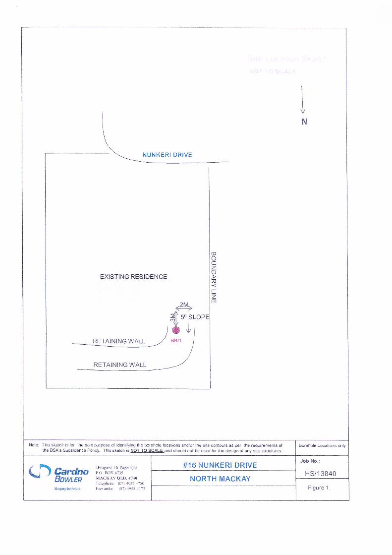
Figure 1 - Site Investigation Location Plan
Tables
Table 1: Summary of Subsurface Strata 7
Table 2: Classification Test Results 7
Table 3: Maximum Unprotected Batter Slopes 9
Appendices
Appendix A Fieldwork Results
Appendix B Landslide Hazard Analysis
Landslide Risk Assessment Report Proposed Development, 16 Nunkeri Drive, North Mackay
12 September 2013 Cardno Bowler Pty Ltd 4
1 INTRODUCTION
This report represents the results of a geotechnical site walkover and assessment carried out to assess the
potential risk of slope Instability and landslip hazard risk for the proposed development, both the existing site
conditions, as well as the post construction conditions, at 16 Nunkeri Drive, North of Mackay (Lot 5 on
SP121186).
It is understood that the proposed development consists of an extension to the rear of the existing dwelling
on site.
The proposed allotment was located on the lower slope of a crest, moderately sloping to the north. The
earthwork program including levelling the building area by cutting and filling has been undertaken for the
construction of the existing dwelling on the allotment.
This report must be read in conjunction with our attached ‘General Notes’.
Landslide Risk Assessment Report Proposed Development, 16 Nunkeri Drive, North Mackay
12 September 2013 Cardno Bowler Pty Ltd 5
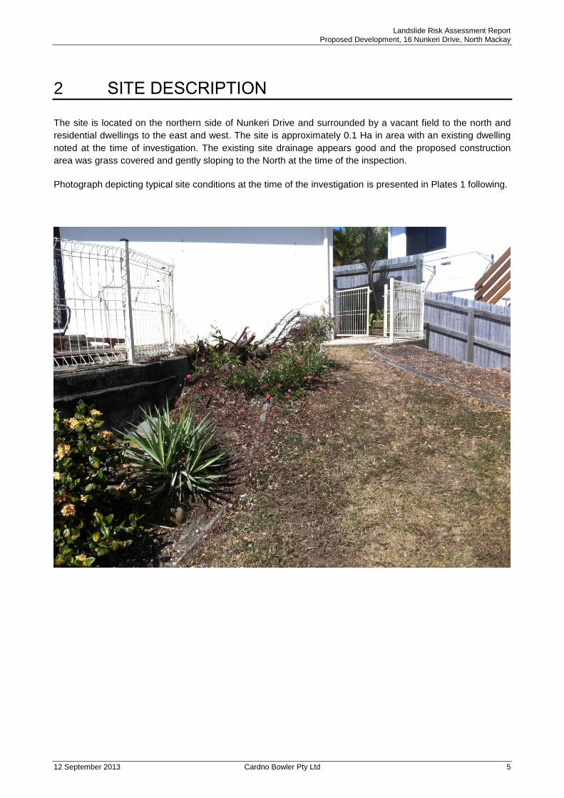
2 SITE DESCRIPTION
The site is located on the northern side of Nunkeri Drive and surrounded by a vacant field to the north and
residential dwellings to the east and west. The site is approximately 0.1 Ha in area with an existing dwelling
noted at the time of investigation. The existing site drainage appears good and the proposed construction
area was grass covered and gently sloping to the North at the time of the inspection.
Photograph depicting typical site conditions at the time of the investigation is presented in Plates 1 following.
Landslide Risk Assessment Report Proposed Development, 16 Nunkeri Drive, North Mackay
12 September 2013 Cardno Bowler Pty Ltd 6
3 INVESTIGATION WORK
3.1 Fieldwork
Fieldwork for the investigation was carried out on 19th April 2013 and 4
th September 2013, and included the
excavation of two (2) boreholes to a maximum depth of 2.0m at the locations shown on the attached site
sketch, Figure 1. The material encountered at each location is described on borehole log sheets included in
Appendix A.
Dynamic Cone Penetrometer (DCP) tests were carried out beside boreholes and the tabulated test results
are included on the borehole logs.
Fieldwork was carried out in accordance with Australian Standard, AS1726-1993 ‘Site Investigation Code’.
3.2 Laboratory Testing
Samples of representative strata were recovered and returned to our NATA accredited soils laboratory. The
following tests were carried out on selected samples;
Particle Size Distribution
Atterberg Limits
Linear Shrinkage
Laboratory testing was carried out in accordance with Australian Standard AS1289 ‘Laboratory Testing For
Engineering Purposes’.
Landslide Risk Assessment Report Proposed Development, 16 Nunkeri Drive, North Mackay
12 September 2013 Cardno Bowler Pty Ltd 7
4 SUBSURFACE CONDITIONS
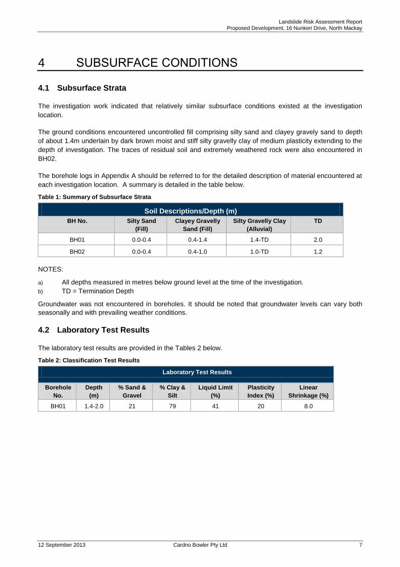
4.1 Subsurface Strata
The investigation work indicated that relatively similar subsurface conditions existed at the investigation
location.
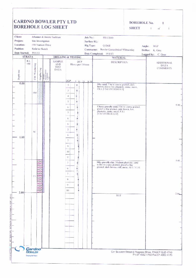
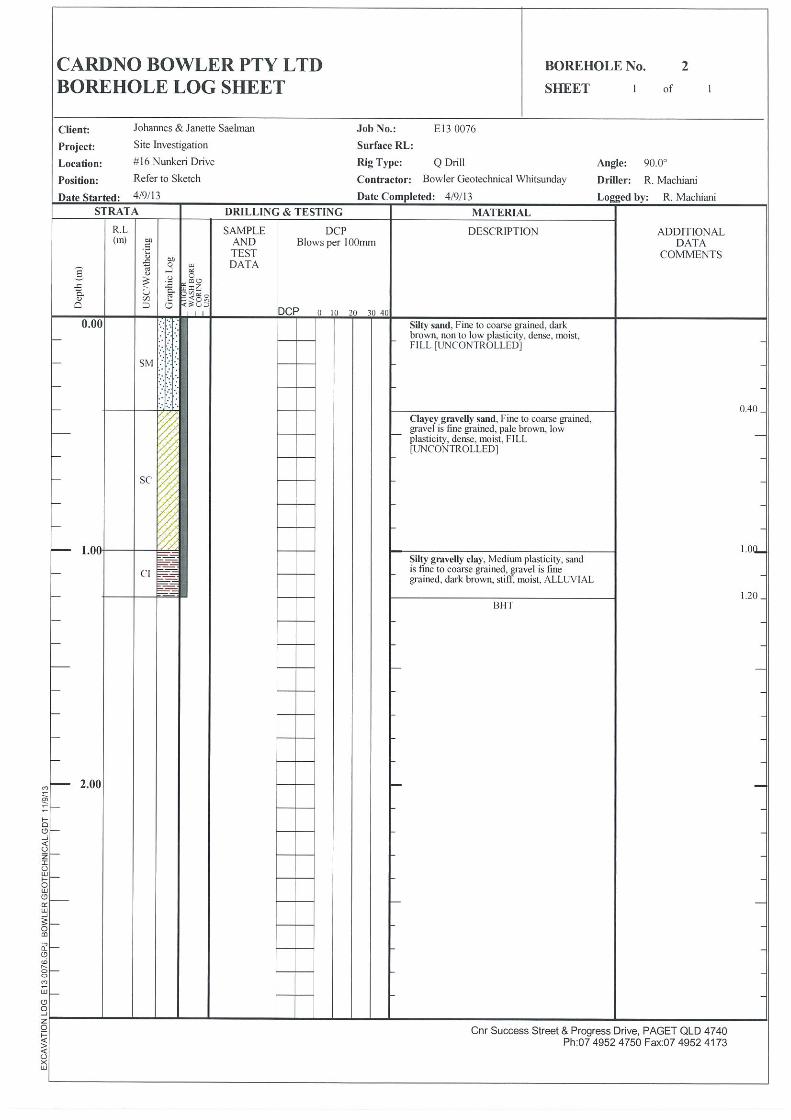
The ground conditions encountered uncontrolled fill comprising silty sand and clayey gravely sand to depth
of about 1.4m underlain by dark brown moist and stiff silty gravelly clay of medium plasticity extending to the
depth of investigation. The traces of residual soil and extremely weathered rock were also encountered in
BH02.
The borehole logs in Appendix A should be referred to for the detailed description of material encountered at
each investigation location. A summary is detailed in the table below.
Table 1: Summary of Subsurface Strata
Soil Descriptions/Depth (m)
BH No. Silty Sand
(Fill)
Clayey Gravelly
Sand (Fill)
Silty Gravelly Clay
(Alluvial)
TD
BH01 0.0-0.4 0.4-1.4 1.4-TD 2.0
BH02 0.0-0.4 0.4-1.0 1.0-TD 1.2
NOTES:
a) All depths measured in metres below ground level at the time of the investigation.
b) TD = Termination Depth
Groundwater was not encountered in boreholes. It should be noted that groundwater levels can vary both
seasonally and with prevailing weather conditions.
4.2 Laboratory Test Results
The laboratory test results are provided in the Tables 2 below.
Table 2: Classification Test Results
Laboratory Test Results
Borehole
No.
Depth
(m)
% Sand &
Gravel
% Clay &
Silt
Liquid Limit
(%)
Plasticity
Index (%)
Linear
Shrinkage (%)
BH01 1.4-2.0 21 79 41 20 8.0

Landslide Risk Assessment Report Proposed Development, 16 Nunkeri Drive, North Mackay
12 September 2013 Cardno Bowler Pty Ltd 8
5 GEOTECHNICAL ASSESSMENT
5.1 Slope Stability Assessment
A visual walkover inspection carried out by a Geotechnical Engineer for assessment of stability was
undertaken at 16 Nunkeri Drive, North Mackay. The fieldwork exercise included a broadscale inspection,
where possible, at specific locations across the site to assess the following;
Observe vegetation
Note any evidence of tension cracking
Note any evidence of seepage
Note any evidence of soil creep
Note any evidence of previous slips
Subsurface conditions
Drainage issues
Topographically, the site sloping to the north and is expected to drain surface run off to lower slopes. A
retaining wall was noted at the time of the investigation on the northern side of the site. Slope angles varied
from less than 6o (10%) to a maximum slope of approximately 17
o (30%) across the site and over proposed
building areas.
The stability of an area under construction will be a function of adequate drainage control. The above
assumes that appropriate stormwater management and subsurface drainage control measures will be
designed, installed and certified in accordance with recognised building practices/standards in order to
control groundwater and surface runoff.
No physical evidence of previous movement, soil creep etc. was observed during the mapping exercise
across the building area. During the above interpretation, no physical evidence was noted at these locations
to indicate that the site had undergone any previous instability.
Further to the above, a quantitative risk assessment has been assigned to the site based on the required
format provided by the (AGS) “Guidelines for Landslide Risk Management, 2007”. The results of this
assessment indicated that the proposed residential development on the allotment has a stability risk level
of Very Low to Low. For details of this analysis, refer to Annex B of this report.
Based on the above assessment, and if only minor works is proposed for the building platform, the minor
earthworks should not expect to adversely affect the current stability of adjoining properties provided the
recommendations of this report are adhered to and adequate civil/hydraulic and structural issues are
addressed. Given the results of our assessment (See Annex B), the proposed residential lot is considered
acceptable for its proposed usage with regards to stability.
5.2 Building Footings
The site preparation work should generally be carried out in accordance with AS3798-2007 ‘Guidelines on
Earthworks for Commercial and Residential Developments’.
Based on the predominant soil types encountered, and envisaged cut/fill operations, it is expected that the
site classifications, in accordance with AS2870-2011 ‘Residential Slabs and Footings’ over the site area
would be classified Class ’M’ (Moderately Reactive) with a modification to Class ‘P’ due to presence of
uncontrolled fill material. Any uncontrolled fill material shall be removed from site and replaced with
engineered fill, placed under controlled conditions in accordance with AS3798-2007.
Landslide Risk Assessment Report Proposed Development, 16 Nunkeri Drive, North Mackay
12 September 2013 Cardno Bowler Pty Ltd 9
As a general approach, we recommend that all load bearing footings for a residence be supported on similar
competent natural strata around the entire perimeter of the building. This may involve the deepening of
perimeter footings or the use of backhoe piers/short bored piles to support the perimeter footings and carry
the footing loads to similar competent natural strata. Allowable bearing capacity of 200kPa should be
available in silty gravelly clay material. This will have to be inspected and confirmed during construction by
the author of this report for validity.
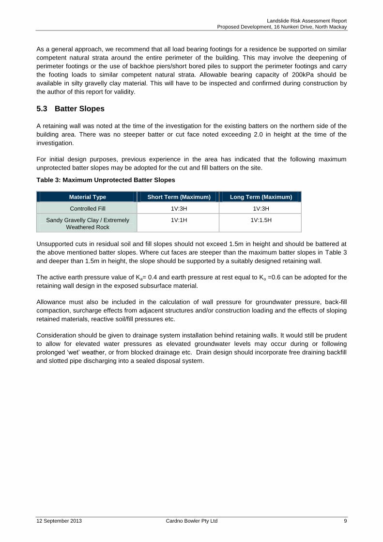
5.3 Batter Slopes
A retaining wall was noted at the time of the investigation for the existing batters on the northern side of the
building area. There was no steeper batter or cut face noted exceeding 2.0 in height at the time of the
investigation.
For initial design purposes, previous experience in the area has indicated that the following maximum
unprotected batter slopes may be adopted for the cut and fill batters on the site.
Table 3: Maximum Unprotected Batter Slopes
Material Type Short Term (Maximum) Long Term (Maximum)
Controlled Fill 1V:3H 1V:3H
Sandy Gravelly Clay / Extremely
Weathered Rock
1V:1H 1V:1.5H
Unsupported cuts in residual soil and fill slopes should not exceed 1.5m in height and should be battered at
the above mentioned batter slopes. Where cut faces are steeper than the maximum batter slopes in Table 3
and deeper than 1.5m in height, the slope should be supported by a suitably designed retaining wall.
The active earth pressure value of Ka= 0.4 and earth pressure at rest equal to Ko =0.6 can be adopted for the
retaining wall design in the exposed subsurface material.
Allowance must also be included in the calculation of wall pressure for groundwater pressure, back-fill
compaction, surcharge effects from adjacent structures and/or construction loading and the effects of sloping
retained materials, reactive soil/fill pressures etc.
Consideration should be given to drainage system installation behind retaining walls. It would still be prudent
to allow for elevated water pressures as elevated groundwater levels may occur during or following
prolonged ‘wet’ weather, or from blocked drainage etc. Drain design should incorporate free draining backfill
and slotted pipe discharging into a sealed disposal system.
Landslide Risk Assessment Report Proposed Development, 16 Nunkeri Drive, North Mackay
12 September 2013 Cardno Bowler Pty Ltd 10
6 CONSTRUCTION INSPECTIONS
It is recommended that placement of all structural fill and footing excavations be inspected, tested and
certified where necessary, by Cardno Bowler Pty Ltd to ensure recommendations made in this report have
been adhered to.
Should subsurface conditions other than those described in this report be encountered, Cardno Bowler Pty
Ltd should be consulted immediately and appropriate modifications developed and implemented if
necessary.
Landslide Risk Assessment Report Proposed Development, 16 Nunkeri Drive, North Mackay
12 September 2013 Cardno Bowler Pty Ltd 11
7 CONCLUSIONS AND RECOMMENDATIONS
The following is a summary of the conclusions and recommendations in regard to the landslide risk
assessment for the proposed extension to the residential development at 16 Nunkeri Drive, North Mackay.
However, the preceding sections of this report should be read for a full description of the conclusions and
recommendations.
1. Landslide risk assessment for the site in its current state is assessed to be acceptable. The risk to loss
of life is in an acceptable range of AGS (2007) requirements (For details refer to Annex B).
2. The ground conditions encountered uncontrolled fill comprising silty sand and clayey gravely sand to
depth of about 1.4m underlain by dark brown moist and stiff silty gravelly clay of medium plasticity
extending to the depth of investigation. The traces of residual soil and extremely weathered rock were
also encountered in BH02.
3. The site preparation work should generally be carried out in accordance with AS3798-2007 ‘Guidelines
on Earthworks for Commercial and Residential Developments’.
4. Based on the existing natural soil profile, the site may be classified Class ‘M’ with modification to
Class ‘P’ in accordance with AS2870-2011 ‘Residential Slabs and Footings’. Recommended bearing
capacity parameters to allow the proportioning of footings, depending on the applied load, are included
in Section 5.2.
5. Unsupported cuts in residual soil and fill slopes should not exceed 1.5m in height and should be
battered at the provided batter slopes in Table 3. Where cut faces are steeper than the maximum batter
slopes in Table 3 and deeper than 1.5m in height, the slope should be supported by a suitably
designed retaining wall.
6. The removal of existing vegetation and not installing proper drainage to the site will increase the
instability of any proposed site works.
If you require further information regarding this report please contact Rasoul on 07 4952 4750.
Yours faithfully
Rasoul Machiani
Geotechnical Engineer
For Cardno Bowler, Mackay
Landslide Risk Assessment Report Proposed Development, 16 Nunkeri Drive, North Mackay
12 September 2013 Cardno Bowler Pty Ltd 12
GENERAL
This report comprises the results of an investigation carried out for a specific purpose and client as defined in the introduction section(s) of the document. The report should not be used by other parties or for other purposes as it may not contain adequate or appropriate information. TEST HOLE LOGGING
The information on the Test Hole Logs (Boreholes, Backhoe Pits, Exposures etc.) has been based on a visual and tactile assessment except at the discrete locations where test information is available (field and/or laboratory results). Reference should be made to our standard sheets for the definition of our logging procedures (Soil and Rock Descriptions). GROUNDWATER
Unless otherwise indicated the water levels given on the test hole logs are the levels of free water or seepage in the test hole recorded at the given time of measuring. The actual groundwater level may differ from this recorded level depending on material permeabilities. Further variations of this level could occur with time due to such effects as seasonal and tidal fluctuations or construction activities. Final confirmation of levels can only be made by appropriate instrumentation techniques and programmes. INTERPRETATION OF RESULTS
The discussion and recommendations contained within this report are normally based on a site evaluation from discrete test hole data. Generalised or idealised subsurface conditions (including any cross-sections contained in the report) have been assumed or prepared by interpolation/extrapolation of these data. As such these conditions are an interpretation and must be considered as a guide only. CHANGE IN CONDITIONS
Local variations or anomalies in the generalised ground conditions used for this report can occur, particularly between discrete test hole locations. Furthermore, certain design or construction procedures may have been assumed in assessing the soil structure interaction behaviour of the site. Any change in design, in construction methods, or in ground conditions as noted during construction, from those assumed in this report should be referred to this firm for appropriate assessment and comment. FOUNDATION DEPTH
Where referred to in the report, the recommended depth of any foundation (piles, caissons, footings, etc.) is an engineering estimate of the depth to which they should be constructed. The estimate is influenced and perhaps limited by the fieldwork method and testing carried out in connection with the site investigation, and other pertinent information as has been made available. The depth remains, however, an estimate and therefore liable to variation. Footing drawings, designs and specifications based upon this report should provide for variations in the final depth depending upon the ground conditions at each point of support. REPRODUCTION OF REPORTS
Where it is desired to reproduce the information contained in this report for the inclusion in the contract documents or engineering specification of the subject development, such reproduction should include at least all the relevant test hole and test data, together with the appropriate standard description sheets and remarks made in the written report of a factual or descriptive nature.
This report is the subject of copyright and shall not be reproduced either totally or in part without the express permission of this firm.

Annex A
Fieldwork Results

Annex B
Landslide Risk Assessment
Landslide Risk Assessment for the Proposed Extension to the Existing Development,
16 Nunkeri Drive, North Mackay
Prepared for Johannes & Janette Saelman
Landslide Risk Assessment This report has used the landslide risk assessment methodology detailed in the Australian Geomechanics Society Landslide Risk Management Document (2007).
1. Defenitions
The terminology used in this assessment is the same as that used by AGS,2007.
- “Acceptable Risk – A risk which, for the purposes of life or work, society is prepared to
accept as it is with no regard to its management. Society does not generally consider
expenditure in further reducing such risks justifiable.
- Annual Exceedance Probability (AEP) – The estimated probability that an event of
specified magnitude will be exceeded in any year.
- Consequence – The outcomes or potential outcomes arising from the occurrence of a
landslide expressed qualitatively or quantitatively, in terms of loss, disadvantage or gain,
damage, injury or loss of life.
- Danger – The natural phenomenon that could lead to damage, described in terms of its
geometry, mechanical and other characteristics. The danger can be an existing one (such
as a creeping slope) or a potential one (such as a rock fall). The characterisation of a
danger does not include any forecasting.
- Elements at Risk – The population, buildings and engineering works, economic activities,
public services utilities, infrastructure and environmental features in the area potentially
affected by landslides.
- Frequency – A measure of likelihood expressed as the number of occurrences of an event
in a given time. See also Likelihood and Probability.
- Hazard – A condition with the potential for causing an undesirable consequence. The
description of landslide hazard should include the location, volume (or area), classification
and velocity of the potential landslides and any resultant detached material, and the
probability of their occurrence within a given period of time.
- Landslide. The movement of a mass of rock, debris, or earth (soil) down a slope.
- Individual Risk to Life – The risk of fatality or injury to any identifiable (named) individual
who lives within the zone impacted by the landslide or who follows a particular pattern of life
that might subject him or her to the consequences of the landslide.
- Landslide inventory – An inventory of the location, classification, volume, activity and date
of occurrence of landsliding.
- Landslide activity –The stage of development of a landslide; pre-failure when the slope is
strained throughout but is essentially intact; failure characterized by the formation of a
continuous surface of rupture; postfailure which includes movement from just after failure to
when it essentially stops and reactivation when the slope slides along one or several pre-
existing surfaces of rupture. Reactivation may be occasional (e.g. seasonal) or continuous
(in which case the slide is “active”).
Landslide Risk Assessment for the Proposed Extension to the Existing Development,
16 Nunkeri Drive, North Mackay
Prepared for Johannes & Janette Saelman
- Landslide Intensity – A set of spatially distributed parameters related to the destructive
power of a landslide. The parameters may be described quantitatively or qualitatively and
may include maximum movement velocity, total displacement, differential displacement,
depth of the moving mass, peak discharge per unit width, kinetic energy per unit area.
- Landslide Susceptibility – A quantitative or qualitative assessment of the classification,
volume (or area) and spatial distribution of landslides which exist or potentially may occur in
an area. Susceptibility may also include a description of the velocity and intensity of the
existing or potential landsliding.
- Likelihood – Used as a qualitative description of probability or frequency.
- Probability – A measure of the degree of certainty. This measure has a value between
zero (impossibility) and 1.0 (certainty). It is an estimate of the likelihood of the magnitude of
the uncertain quantity or the likelihood of the occurrence of the uncertain future event.
There are two main interpretations:
(i) Statistical – frequency or fraction – The outcome of a repetitive experiment of
some kind like flipping coins. It includes also the idea of population variability.
Such a number is called an “objective” or relative frequents probability because
it exists in the real world and is in principle measurable by doing the experiment.
(ii) Subjective probability (degree of belief) – Quantified measure of belief,
judgement, or confidence in the likelihood of an outcome, obtained by
considering all available information honestly, fairly and with a minimum of bias.
Subjective probability is affected by the state of understanding of a process,
judgement regarding an evaluation or the quality and quantity of information. It
may change over time as the state of knowledge changes.
- Qualitative Risk Analysis – An analysis which uses word form, descriptive or numeric
rating scales to describe the magnitude of potential consequences and the likelihood that
those consequences will occur.
- Quantitative Risk Analysis – an analysis based on numerical values of the probability,
vulnerability and consequences, and resulting in a numerical value of the risk.
- Risk – A measure of the probability and severity of an adverse effect to health, property or
the environment. Risk is often estimated by the product of probability and consequences.
However, a more general interpretation of risk involves a comparison of the probability and
consequences in a non-product form. For these guidelines risk is further defined as:
(a) For life loss, the annual probability that the person most at risk will lose his or her life taking account of the landslide hazard and the temporal spatial probability and vulnerability of the person. (b) For property loss, the annual probability of the consequence or the annualised loss taking account of the elements at risk, their temporal spatial probability and vulnerability.
- Risk Analysis – The use of available information to estimate the risk to individuals,
population, property or the environment from hazards. Risk analyses generally contain the
following steps: scope definition, hazard identification and risk estimation.
Landslide Risk Assessment for the Proposed Extension to the Existing Development,
16 Nunkeri Drive, North Mackay
Prepared for Johannes & Janette Saelman
- Risk Assessment – The process of risk analysis and risk evaluation.
- Risk Control or Risk Treatment – The process of decision making for managing risk and
the implementation or enforcement of risk mitigation measures and the re-evaluation of its
effectiveness from time to time, using the results of risk assessment as one input.
- Risk Estimation – The process used to produce a measure of the level of health, property
or environmental risks being analysed. Risk estimation contains the following steps:
frequency analysis, consequence analysis and their integration.
- Risk Evaluation – The stage at which values and judgments enter the decision process,
explicitly or implicitly, by including consideration of the importance of the estimated risks
and the associated social, environmental and economic consequences, in order to identify a
range of alternatives for managing the risks.
- Risk Management – The complete process of risk assessment and risk control (or risk
treatment).
- Tolerable Risk – A risk within a range that society can live with so as to secure certain net
benefits. It is a range of risk regarded as non-negligible and needing to be kept under
review and reduced further if possible.
- Vulnerability – The degree of loss to a given element or set of elements within the area
affected by the landslide hazard. It is expressed on a scale of 0 (no loss) to 1 (total loss).
For property, the loss will be the value of the damage relative to the value of the property;
for persons, it will be the probability that a particular life (the element at risk) will be lost,
given the person(s) is affected by the landslide.
2. Landslide Risk Management The processes followed for the risk analysis component of this site included:
- Assessment of landslide hazard,
- Assessment of landslide consequence, and
- Assessment of landslide risk for the identified study areas.
The methodology of these processes is described in more detail in the following sections.
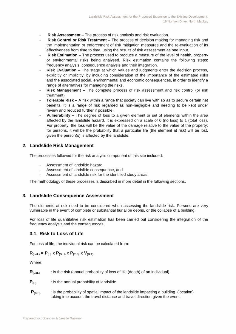
3. Landslide Consequence Assessment The elements at risk need to be considered when assessing the landslide risk. Persons are very vulnerable in the event of complete or substantial burial be debris, or the collapse of a building. For loss of life quantitative risk estimation has been carried out considering the integration of the frequency analysis and the consequences.
3.1. Risk to Loss of Life For loss of life, the individual risk can be calculated from:
R(LoL) = P(H) x P(S:H) x P(T:S) x V(D:T) Where:
R(LoL) : is the risk (annual probability of loss of life (death) of an individual).
P(H) : is the annual probability of landslide.
P(S:H) : is the probability of spatial impact of the landslide impacting a building (location)
taking into account the travel distance and travel direction given the event.

Landslide Risk Assessment for the Proposed Extension to the Existing Development,
16 Nunkeri Drive, North Mackay
Prepared for Johannes & Janette Saelman
P(T:S) : is the temporal spatial probability (e.g. of the building or location being occupied by
the individual) given the spatial impact and allowing for the possibility of evacuation given there is warning of landslide occurrence.
V(D:T) : is the vulnerability of the individual (probability of loss of life of the individual given
the impact).
3.1.1. Annual Probability of Landslide Formulation of a Landslide Inventory would include compiling evidence for previous landslides using:
- Aerial photograph interpretation,
- Historic records and discussions with local residents/ road maintenance personnel, and
- Field mapping.
Due to the limited historical records of landslide events in the subject area this assessment was qualitative only, based on AGS (2007, Appendix C, Page 91” Qualitative Measures of Likelihood”) as outlined in Table 2. The collated data during site inspection and desktop study was then used to make an assessment of landslide frequency in the study area. No physical evidence of previous movement, soil creep etc. was observed during the mapping exercise near each test pit location. During the above interpretation, no physical evidence was noted at these locations to indicate that the site had undergone any previous instability. Topographically, the site is located at the lower slope of a crest gently sloping to the north and is expected to drain surface run off to lower slopes. Slope angles varied from less than 6
o (10%) to a
maximum slope of approximately 17o (30%) across the site and over proposed building area.
AGS (2007) recommends some published relationship between verbal descriptor and probabilities (Commentary on Practice Note Guidelines for Landslide Risk Management, Page127). According to above information the estimation of Annual Probability of landslide for the subject site is as follows:
P(H) - Annual Probability of Landslide: 10-4
3.1.2. Probability of Spatial Impact of the Landslide (P(S:H)) For loss of life the Probability of spatial impact of the landslide impacting a building (location) taking into account the travel distance and travel direction given the event would be estimated as: - Landslide impact a building on the subject site 0.3 - Landslide to impact a vehicle or area downslope 0.2
3.1.3. Probability of Occupancy (P(T:S) ) For the temporal spatial probability of the building or location being occupied by the individual the estimation would be as follows: The probability for a person occupies the proposed extension area during a day is estimated less than 8 hours a day per year. The probability for the presence of a person within the area affected by landslide would be estimated conservatively 4 hours a day per year.
P(T:S) for person occupy the building : 0.33
P(T:S) for person attending the area or vehicle affected by landslide: 0.16
Landslide Risk Assessment for the Proposed Extension to the Existing Development,
16 Nunkeri Drive, North Mackay
Prepared for Johannes & Janette Saelman
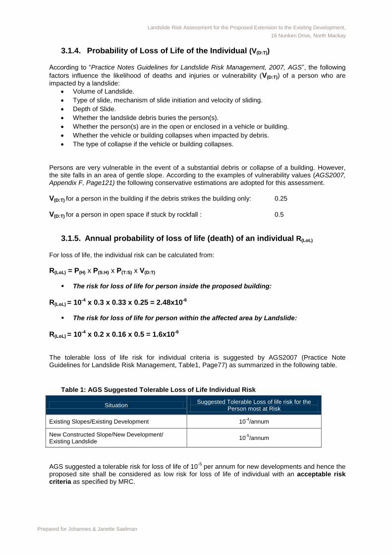
3.1.4. Probability of Loss of Life of the Individual (V(D:T))
According to “Practice Notes Guidelines for Landslide Risk Management, 2007, AGS”, the following
factors influence the likelihood of deaths and injuries or vulnerability (V(D:T)) of a person who are
impacted by a landslide:
Volume of Landslide.
Type of slide, mechanism of slide initiation and velocity of sliding.
Depth of Slide.
Whether the landslide debris buries the person(s).
Whether the person(s) are in the open or enclosed in a vehicle or building.
Whether the vehicle or building collapses when impacted by debris.
The type of collapse if the vehicle or building collapses.
Persons are very vulnerable in the event of a substantial debris or collapse of a building. However, the site falls in an area of gentle slope. According to the examples of vulnerability values (AGS2007, Appendix F, Page121) the following conservative estimations are adopted for this assessment.
V(D:T) for a person in the building if the debris strikes the building only: 0.25
V(D:T) for a person in open space if stuck by rockfall : 0.5
3.1.5. Annual probability of loss of life (death) of an individual R(LoL)
For loss of life, the individual risk can be calculated from:
R(LoL) = P(H) x P(S:H) x P(T:S) x V(D:T)
The risk for loss of life for person inside the proposed building:
R(LoL) = 10-4 x 0.3 x 0.33 x 0.25 = 2.48x10⁻⁶
The risk for loss of life for person within the affected area by Landslide:
R(LoL) = 10-4 x 0.2 x 0.16 x 0.5 = 1.6x10⁻⁶ The tolerable loss of life risk for individual criteria is suggested by AGS2007 (Practice Note Guidelines for Landslide Risk Management, Table1, Page77) as summarized in the following table.
Table 1: AGS Suggested Tolerable Loss of Life Individual Risk
Situation Suggested Tolerable Loss of life risk for the
Person most at Risk
Existing Slopes/Existing Development 10-4
/annum
New Constructed Slope/New Development/ Existing Landslide
10-5
/annum
AGS suggested a tolerable risk for loss of life of 10
-5 per annum for new developments and hence the
proposed site shall be considered as low risk for loss of life of individual with an acceptable risk criteria as specified by MRC.
Landslide Risk Assessment for the Proposed Extension to the Existing Development,
16 Nunkeri Drive, North Mackay
Prepared for Johannes & Janette Saelman
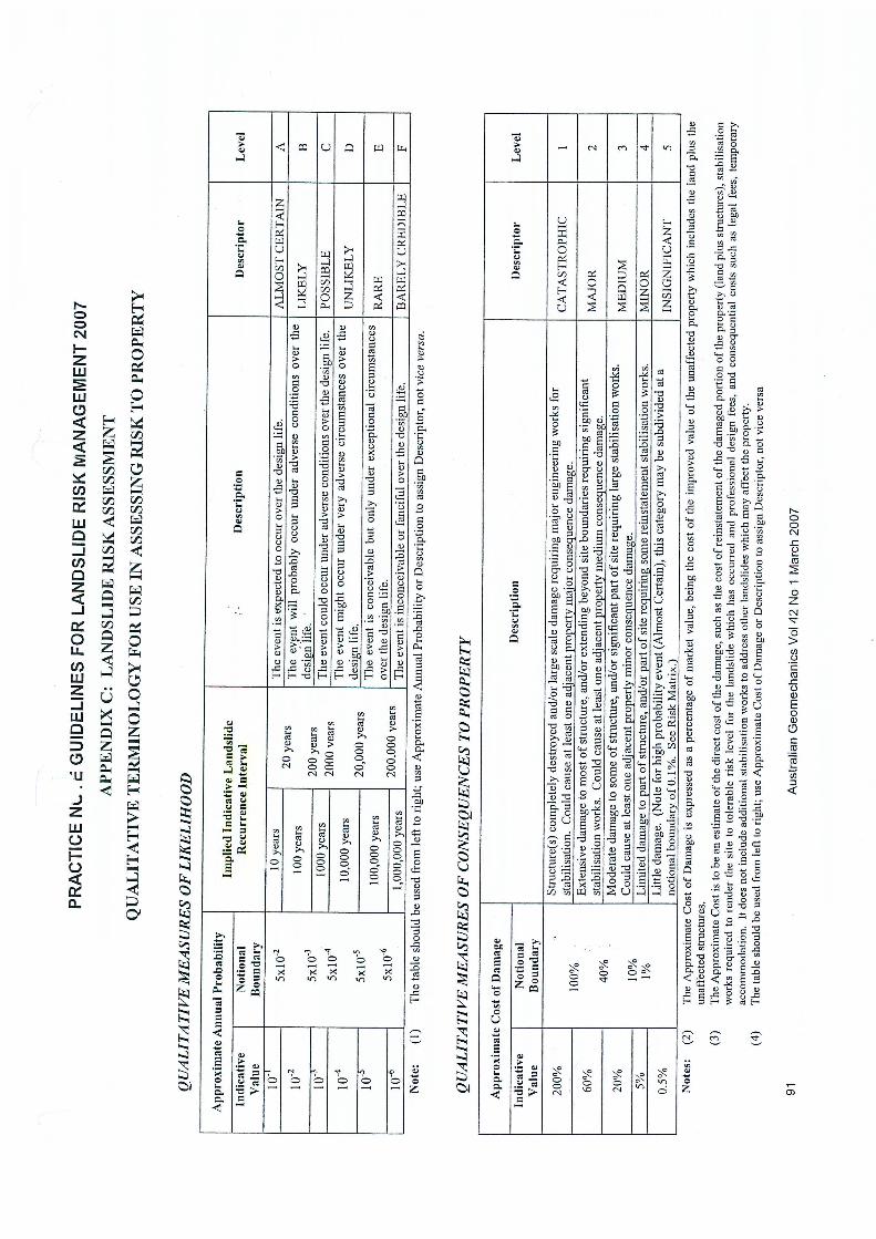
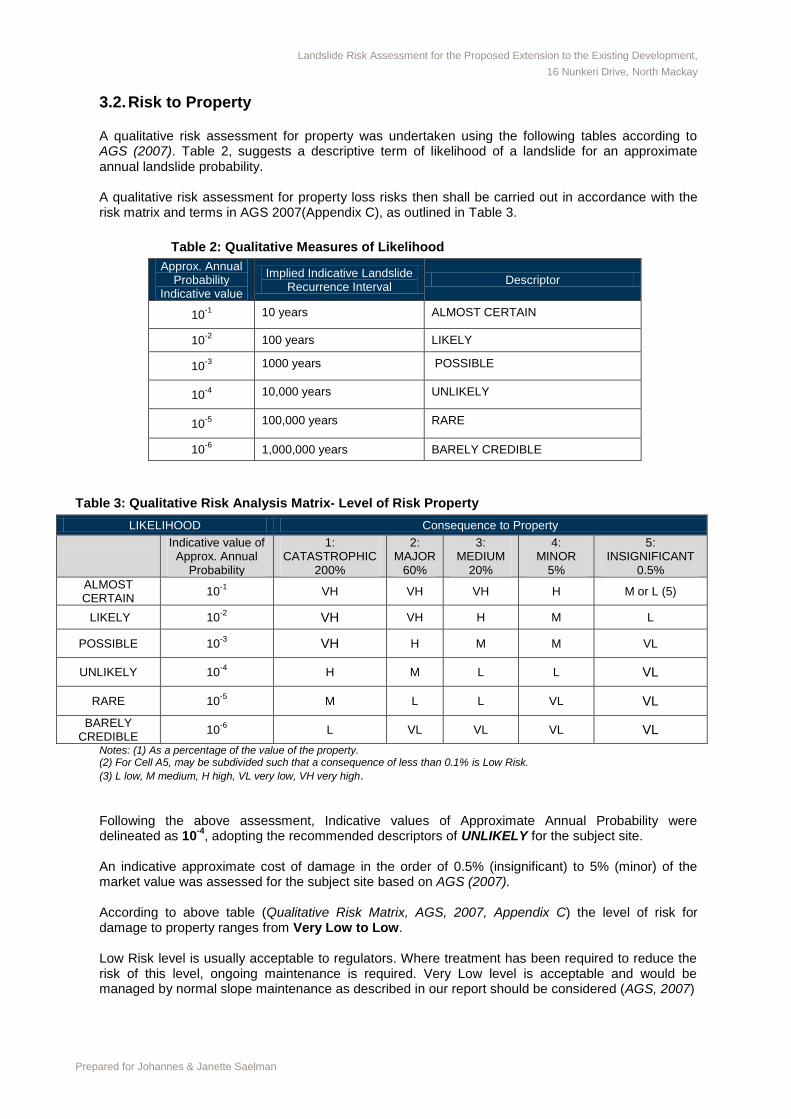
3.2. Risk to Property A qualitative risk assessment for property was undertaken using the following tables according to AGS (2007). Table 2, suggests a descriptive term of likelihood of a landslide for an approximate annual landslide probability. A qualitative risk assessment for property loss risks then shall be carried out in accordance with the risk matrix and terms in AGS 2007(Appendix C), as outlined in Table 3.
Table 2: Qualitative Measures of Likelihood
Approx. Annual Probability
Indicative value
Implied Indicative Landslide Recurrence Interval
Descriptor
10-1
10 years ALMOST CERTAIN
10-2 100 years LIKELY
10-3 1000 years POSSIBLE
10-4 10,000 years UNLIKELY
10-5 100,000 years RARE
10-6 1,000,000 years BARELY CREDIBLE
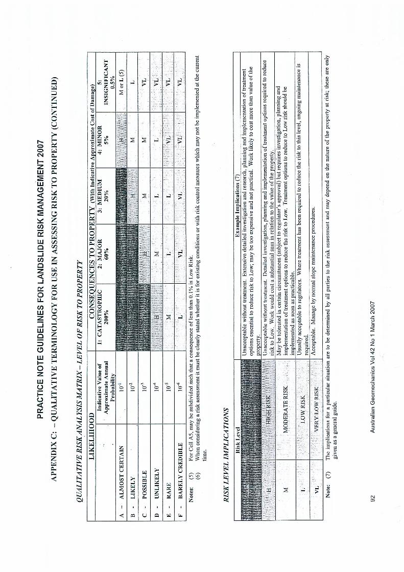
Table 3: Qualitative Risk Analysis Matrix- Level of Risk Property
LIKELIHOOD Consequence to Property
Indicative value of
Approx. Annual Probability
1: CATASTROPHIC
200%
2: MAJOR
60%
3: MEDIUM
20%
4: MINOR
5%
5: INSIGNIFICANT
0.5%
ALMOST CERTAIN
10-1
VH VH VH H M or L (5)
LIKELY 10-2 VH VH H M L
POSSIBLE 10-3 VH H M M VL
UNLIKELY 10-4 H M L L VL
RARE 10-5 M L L VL VL
BARELY CREDIBLE
10-6 L VL VL VL VL
Notes: (1) As a percentage of the value of the property. (2) For Cell A5, may be subdivided such that a consequence of less than 0.1% is Low Risk.
(3) L low, M medium, H high, VL very low, VH very high.
Following the above assessment, Indicative values of Approximate Annual Probability were delineated as 10
-4, adopting the recommended descriptors of UNLIKELY for the subject site.
An indicative approximate cost of damage in the order of 0.5% (insignificant) to 5% (minor) of the market value was assessed for the subject site based on AGS (2007). According to above table (Qualitative Risk Matrix, AGS, 2007, Appendix C) the level of risk for damage to property ranges from Very Low to Low. Low Risk level is usually acceptable to regulators. Where treatment has been required to reduce the risk of this level, ongoing maintenance is required. Very Low level is acceptable and would be managed by normal slope maintenance as described in our report should be considered (AGS, 2007)
Landslide Risk Assessment for the Proposed Extension to the Existing Development,
16 Nunkeri Drive, North Mackay
Prepared for Johannes & Janette Saelman
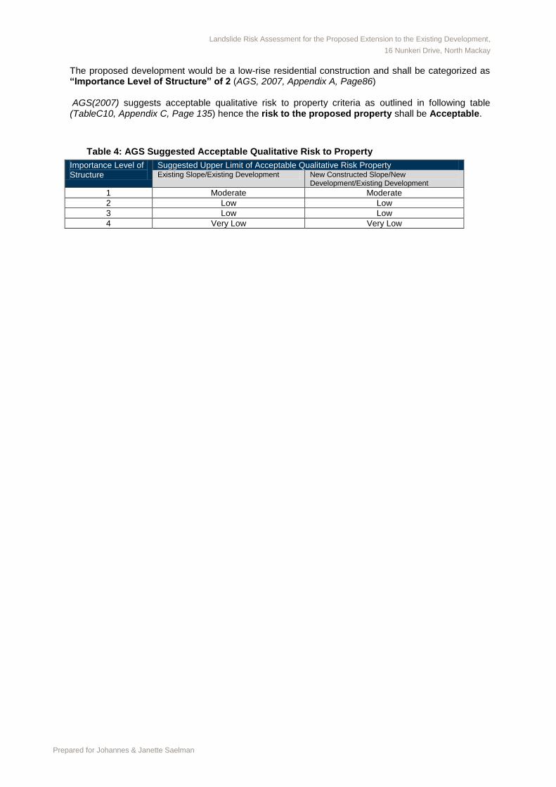
The proposed development would be a low-rise residential construction and shall be categorized as “Importance Level of Structure” of 2 (AGS, 2007, Appendix A, Page86)
AGS(2007) suggests acceptable qualitative risk to property criteria as outlined in following table (TableC10, Appendix C, Page 135) hence the risk to the proposed property shall be Acceptable.
Table 4: AGS Suggested Acceptable Qualitative Risk to Property
Importance Level of Structure
Suggested Upper Limit of Acceptable Qualitative Risk Property Existing Slope/Existing Development New Constructed Slope/New
Development/Existing Development
1 Moderate Moderate
2 Low Low
3 Low Low
4 Very Low Very Low