Embed Size (px)
Citation preview

Landslide Risk Assessment
Proposed Residential Development, Lot 27 Ian Reddacliff Drive, The Leap 5676/P/1912
Landslide Risk Assessment
Proposed Residential Development, Lot 27 Ian Reddacliff Drive, The Leap 5676/P/1912
Prepared for Jeffrey & Lesley Rowe 20 April 2015

Landslide Risk Assessment Proposed Residential Development, Lot 27 Ian Reddacliff Drive, The Leap
20 April 2015 Cardno Pty Ltd ii
Contact Information Construction Sciences Division Pty Ltd Trading as Cardno ABN 74128806735 2 Progress Drive Paget Qld 4741 P.O. Box 6735 Mackay Mail Centre Telephone: 07 4952 4750 Facsimile: 07 4952 4173 International: +61 7 4952 4750 [email protected] www.cardno.com.au
Document Information Prepared for Jeffrey & Lesley Rowe
Project Name Proposed Residential Development, Lot 27 Ian Reddacliff Drive, The Leap
File Reference Report(5676-P-1912) Job Reference 5676/P/1912 Date 20 April 2015
Document Control
Vers
ion
Date Description of Revision
Prep
ared
By Prepared
(Signature)
Revi
ewed
By Reviewed
(Signature)
1 20/04/2015 Final Report Rasoul Machiani
RM Grant Russell
GR
Vers
ion
Reason for Issue Approved for Release
By
Approved
(Signature)
Approved Release Date
1 Final Report Rasoul Machiani
20/04/2015
© Cardno 2014. Copyright in the whole and every part of this document belongs to Cardno and may not be used, sold, transferred, copied or reproduced in whole or in part in any manner or form or in or on any media to any person other than by agreement with Cardno.
This document is produced by Cardno solely for the benefit and use by the client in accordance with the terms of the engagement. Cardno does not and shall not assume any responsibility or liability whatsoever to any third party arising out of any use or reliance by any third party on the content of this document.

Landslide Risk Assessment Proposed Residential Development, Lot 27 Ian Reddacliff Drive, The Leap
20 April 2015 Cardno Pty Ltd iii
Table of Contents 1 INTRODUCTION 4
2 SITE DESCRIPTION 5
3 INVESTIGATION WORK 7 3.1 Fieldwork 7
4 SUBSURFACE CONDITIONS 8 4.1 Subsurface Strata 8
5 GEOTECHNICAL ASSESSMENT 9 5.1 Earthworks 9 5.1 Building Footings 9 5.2 Batter Slopes, Drainage and Surface Protection 9
6 SLOPE STABILITY ASSESSMENT 11
7 CONSTRUCTION INSPECTIONS 12
8 CONCLUSIONS AND RECOMMENDATIONS 13
Figures Figure 1 - Site Investigation Location Sketch
Tables Table 1: Summary of Subsurface Strata ........................................................................................................... 8 Table 2: Maximum Unprotected Batter Slopes ................................................................................................ 10
Appendices Appendix A Fieldwork Results Appendix B Quantitative Hazard Risk Assessment

Landslide Risk Assessment Proposed Residential Development, Lot 27 Ian Reddacliff Drive, The Leap
20 April 2015 Cardno Pty Ltd 4
1 INTRODUCTION
A geotechnical investigation and slope stability assessment was carried out for a proposed residential dwelling at Lot 27 Ian Reddacliff Drive, the Leap (Lot 27 on SP172242).
The objectives of the investigation were as follows:
� Determine the nature and certain engineering parameters of subsurface strata. � Determine the presence and depth of the groundwater table, if encountered. � Provide a house site classification for the proposed building area. � Determine whether the site is suitable and feasible for the proposed development in relation to long
term stability.
This report must be read in conjunction with our attached ‘General Notes’ and ‘Guidelines for Hillside, Constructions’ Australian Geomechanical Society Journal, Volume 37, No. 2, May 2002.

Landslide Risk Assessment Proposed Residential Development, Lot 27 Ian Reddacliff Drive, The Leap
20 April 2015 Cardno Pty Ltd 5
2 SITE DESCRIPTION
The proposed building envelope was located on the ridge line of a hill, moderately sloping to the north-west. Slope angles varies between 5o (8%) across the proposed construction area to a maximum slope of approximately 30o (60%) towards the western end. The allotment was bounded by Ian Reddacliff Drive to the east.
There was no existing structure on site at the time of investigation. However, sloping area noted on the northern side of the allotment with two existing tanks and an office. Rock outcrops were observed on the cut face as shown in Plate 3. The proposed construction area did not appear to be free draining. The site vegetation noted as native grass which was cleared prior to inspection.
Photographs depicting typical site conditions at the time of the investigation are presented in Plates 1 to 3 below.
Plate 1: General site view, looking towards the North-West

Landslide Risk Assessment Proposed Residential Development, Lot 27 Ian Reddacliff Drive, The Leap
20 April 2015 Cardno Pty Ltd 6
Plate 2: General site view, looking towards the South
Plate 3: General site view, looking towards the North

Landslide Risk Assessment Proposed Residential Development, Lot 27 Ian Reddacliff Drive, The Leap
20 April 2015 Cardno Pty Ltd 7
3 INVESTIGATION WORK
3.1 Fieldwork
A visual walkover inspection by a Geotechnical Engineer for assessment of stability was undertaken at the site on the 10th April 2015.
Fieldwork for the investigation was carried out on the 10th April 2015 and included the excavation of three (3) test pits at the locations shown on the attached site plan, Figure 1. The material encountered at each location is described on field log sheets included in Appendix A.
Fieldwork was carried out in accordance with Australian Standard, AS1726-1993 ‘Site Investigation Code’.

Landslide Risk Assessment Proposed Residential Development, Lot 27 Ian Reddacliff Drive, The Leap
20 April 2015 Cardno Pty Ltd 8
4 SUBSURFACE CONDITIONS
4.1 Subsurface Strata
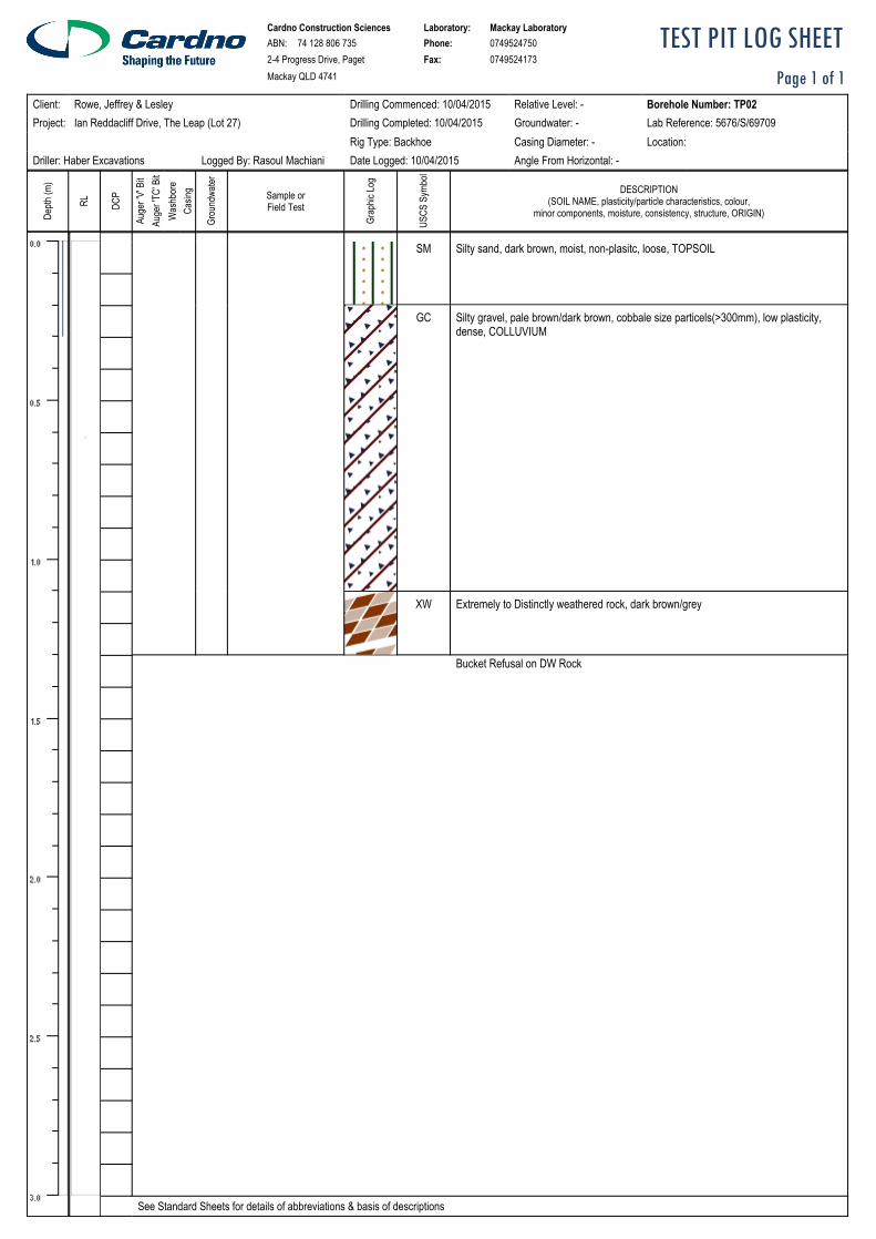
The ground conditions encountered generally topsoil and colluvium material to depth of about 0.3-1.7m overlaid extremely to distinctly weathered rock. All test pits were terminated on distinctly weathered rock encountered at depth of 0.3-1.9m.
The test pit logs in Appendix A should be referred to for the detailed description of material encountered at each investigation location. A summary is detailed in the table below.
Table 1: Summary of Subsurface Strata
Soil Descriptions/Depth (m) TP No. Topsoil Colluvium XW/DW Rock TD TP01 0.0-0.3 0.3-1.7 1.7-TD 1.9 (b)
TP02 0.0-0.2 0.2-1.1 1.1-TD 1.3 (b)
TP03 0.0-0.1 0.1-TD - 0.3 (b)
NOTES:
a) All depths measured in metres below ground level at the time of the investigation. b) TD = Termination on XW/DW Rock
No groundwater was encountered in any of the test pits at the time of the investigation. However, water seepage may occur along the granular/rock interface and through the strata during and after heavy rainfall events.

Landslide Risk Assessment Proposed Residential Development, Lot 27 Ian Reddacliff Drive, The Leap
20 April 2015 Cardno Pty Ltd 9
5 GEOTECHNICAL ASSESSMENT
5.1 Earthworks
All site preparation work should generally be carried out in accordance with AS3798-2007 ‘Guidelines on Earthworks for Commercial and Residential Developments’.
The site shall be stripped of any topsoil from the cut and fill areas. Prior to the placement of any structural fill (if required), the site should be proof rolled using a minimum 10 tonne (static weight) padfoot roller. Any encountered colluvium material shall be removed from site to reduce the potential for creep issues that may occur during and after construction.
The allotment is on a hill side slope and excessive site filling would increase the thickness of soil cover causing instability and creep. All filling shall only be undertaken after inspection and advice by the author of this report.
Depressions formed by the removal of vegetation, underground services, etc, should have all disturbed soil cleaned out and be backfilled with compacted select fill material.
5.1 Building Footings
All topsoil, uncontrolled fill and colluvium material, including cobbles and boulders should be removed from the footprints of the proposed building area. The site preparation work should generally be carried out in accordance with AS3798-2007 ‘Guidelines on Earthworks for Commercial and Residential Developments’.
Based on the predominant soil types encountered, the predicted surface movement of 20-30mm due to seasonal moisture variations is expected for this site in accordance with AS2870-2011 ‘Residential Slabs and Footings’. However, the site must be classified as a ‘Class P’ in accordance with AS2870-2011 ‘Residential Slabs and Footings’, due to the presence of colluvium within the proposed construction footprint.
All load bearing footings for a residence must be keyed into the good quality weathered rock to an adequate depth (min 300mm). This may involve the deepening of perimeter footings or the use of backhoe piers/ bored piles to support the perimeter footings and carry the footing loads to similar competent natural strata.
5.2 Batter Slopes, Drainage and Surface Protection
For initial design purposes, previous experience in the area has indicated that the following maximum unprotected batter slopes may be adopted for the cut and fill batters on the site.
Table 2: Maximum Unprotected Batter Slopes
Material Type Short Term (Maximum) Long Term (Maximum)
Controlled Fill/ Colluvium 1V:3H 1V:3H
Extremely to Distinctly Weathered Rock
1V:1H* 1V:1H*
Note: * Denotes requirement for detailed stability assessment of final batter by geotechnical engineer.
Unsupported cuts in controlled fill should not exceed 1.5m in height and should be battered at the above mentioned batter slopes. Where cut faces are steeper than the maximum batter slopes in Table 2 and deeper than 1.5m in height, the slope should be supported by a suitably designed retaining wall.

Landslide Risk Assessment Proposed Residential Development, Lot 27 Ian Reddacliff Drive, The Leap
20 April 2015 Cardno Pty Ltd 10
Consideration should be given to drainage system installation behind retaining walls. It would still be prudent to allow for elevated water pressures as elevated groundwater levels may occur during or following prolonged ‘wet’ weather, or from blocked drainage etc. Drain design should incorporate free draining backfill and slotted pipe discharging into a sealed disposal system.
Exposed soil should be protected from erosion, by means of directing surface water away from cuts and revegetating the surface with plants.

Landslide Risk Assessment Proposed Residential Development, Lot 27 Ian Reddacliff Drive, The Leap
20 April 2015 Cardno Pty Ltd 11
6 SLOPE STABILITY ASSESSMENT
Fieldwork for this component of the investigation was carried out by a Geotechnical Engineer on 10th April 2015.
The fieldwork exercise included a broadscale inspection, to assess the following;
� Determine slope angle � Observe vegetation � Note any evidence of tension cracking � Note any evidence of seepage � Note any evidence of soil creep � Note any evidence of previous slips � Geological features � Subsurface conditions � Drainage issues
Topographically, the site can be described as the ridge line of a hill, moderately sloping to the north-west. Slope angles varies between 5o (8%) across the proposed construction area to a maximum slope of approximately 35o (70%) towards the western end.
No physical evidence of previous movement, soil creep etc. was observed during the mapping exercise near each test pit location. During the above interpretation, no physical evidence was noted at these locations to indicate that the site had undergone any previous instability.
As indicated by the client, the proposed development is to consist of a residential dwelling at the allotment. Final bulk earthworks program including cut/fill levels and design loads were not known at the time of the preparation of this report.
All load bearing footings for a residence must be keyed into good quality weathered rock to an adequate depth (min 300mm). This may involve the deepening of perimeter footings and the use of backhoe piers/ bored piles to support the perimeter footings and carry the footing loads to similar competent natural strata.
Should the building be constructed over an area which is less than 15% slope and weathered rock is encountered, then a slab-on-ground may be considered. Where the slope exceeds 15% pole type or split level homes should be considered. A combination slab-on-ground, split level, pole type dwelling may be considered where slope percentages vary across a proposed building platform and appropriate soils allow for this type of construction. All cuts associated with split level constructions should be restricted to heights not exceeding 1.0m unless site specific advice is given. Where slopes exceed 25%, pole type homes should be considered only. A final decision on the most appropriate building type will need to be made at the design stage of the proposed building.
The stability of an area under construction will largely be a function of adequate drainage control. The above assumes that appropriate stormwater management and subsurface drainage control measures will be designed, installed and certified in accordance with recognised building practices/standards in order to control groundwater and surface runoff.
Further to the above, a quantitative risk assessment has been assigned to the site based on the required format provided by the (AGS) “Guidelines for Landslide Risk Management, 2007”. The results of this assessment indicated that the proposed residential development on the allotment has a long term stability risk level of ‘Low’ provided the recommendations of this report are adhered to, and adequate civil/hydraulic and structural issues are addressed. For details of this analysis, refer to Appendix B.

Landslide Risk Assessment Proposed Residential Development, Lot 27 Ian Reddacliff Drive, The Leap
20 April 2015 Cardno Pty Ltd 12
7 CONSTRUCTION INSPECTIONS
It is recommended that placement of all structural fill and footing excavations be inspected, tested and certified where necessary, by Cardno to ensure recommendations made in this report have been adhered to.
Should subsurface conditions other than those described in this report be encountered, Cardno should be consulted immediately and appropriate modifications developed and implemented if necessary.

Landslide Risk Assessment Proposed Residential Development, Lot 27 Ian Reddacliff Drive, The Leap
20 April 2015 Cardno Pty Ltd 13
8 CONCLUSIONS AND RECOMMENDATIONS
The following is a summary of the conclusions and recommendations in regard to the landslide risk assessment at Lot 27 Ian Reddacliff Drive, the Leap. However, the preceding sections of this report should be read for a full description of the conclusions and recommendations.
1. The ground conditions encountered generally topsoil, colluvium and fill material to depth of about 0.3-1.7m overlaid extremely to distinctly weathered rock. All test pits were terminated on distinctly weathered rock encountered at depth of 0.3-1.9m.
2. The site preparation work should generally be carried out in accordance with AS3798-2007 ‘Guidelines
on Earthworks for Commercial and Residential Developments’, any topsoil that is encountered shall be removed stockpiled for later use as landscaping material.
3. The site must be classified as a ‘Class P’ in accordance with AS2870-2011 ‘Residential Slabs and Footings’, due to the presence of colluvium and numerous trees within the proposed construction footprint.
4. Based on our quantitative hazard risk assessment, the proposed residential development on the
allotment has a long term stability risk level of ‘Low’ provided the recommendations of this report are adhered to, and adequate civil/hydraulic and structural issues are addressed. Refer to Appendix B for the results of the quantitative assessment.
5. During construction Cardno shall be engaged to carry out site inspections to certify that all cut/fill batters will achieve the theoretical FOS as required.
6. Effective subsurface and surface drainage will be critical in the maintenance of stability on the site. Yours faithfully
Rasoul Machiani (RPEQ 14057) Geotechnical Engineer for Cardno

Test Location Sketch
Cnr Success St & Progress Dr P.O. BOX 6735 MACKAY QLD. 4740 Telephone: (07) 4952 4750 Facsimile: (07) 4952 4173
Also at Gold Coast, Geebung, Sunshine Coast, Gladstone, Rockhampton, Browns Plains, Townsville, Cairns, Vietnam, PNG.
Job No.:
5676/P/1912 JEFFREY & LESLEY ROWE
LOT 27 IAN REDDACLIFF DRIVE
Test Locations Only Not To Scale
Test Pit 1
5683/T/17311
Reference No.:
Test Pit 2
Test Pit 3
Figure 1
Landslide Risk Assessment Proposed Residential Development, Lot 27 Ian Reddacliff Drive, The Leap
20 April 2015 Cardno Pty Ltd 14
Proposed Residential Development, Lot 27 Ian Reddacliff Drive, The Leap
APPENDIX A FIELDWORK RESULTS

TEST PIT LOG SHEETMackay QLD 4741
0749524173Fax:2-4 Progress Drive, Paget0749524750Phone:74 128 806 735ABN:Mackay LaboratoryLaboratory:Cardno Construction Sciences
DESCRIPTION(SOIL NAME, plasticity/particle characteristics, colour,
minor components, moisture, consistency, structure, ORIGIN)
USCS
Sym
bol
Grap
hic Lo
g
Sample orField Test
Grou
ndwa
ter
Casin
gW
ashb
ore
Auge
r 'TC'
Bit
Auge
r 'V' B
it
DCP
RL
Depth
(m)
Angle From Horizontal: -Date Logged: 20/04/2015Logged By: Rasoul MachianiDriller: Haber ExcavationsLocation:Casing Diameter: -Rig Type: BackhoeLab Reference: 5676/S/69708Groundwater: -Drilling Completed: 10/04/2015Ian Reddacliff Drive, The Leap (Lot 27)Project:Borehole Number: TP01Relative Level: -Drilling Commenced: 10/04/2015Rowe, Jeffrey & LesleyClient:
Page 1 of 1
Bucket Refusal on DW Rock
Extremely to Distinctly weathered rock, dark brown/greyXW
Silty gravel, pale brown/dark brown, cobbale size particels(>300mm), low plasticity,dense, COLLUVIUM
GC
Silty sand, dark brown, moist, non-plasitc, loose, TOPSOILSM
See Standard Sheets for details of abbreviations & basis of descriptions
TEST PIT LOG SHEETMackay QLD 4741
0749524173Fax:2-4 Progress Drive, Paget0749524750Phone:74 128 806 735ABN:Mackay LaboratoryLaboratory:Cardno Construction Sciences
DESCRIPTION(SOIL NAME, plasticity/particle characteristics, colour,
minor components, moisture, consistency, structure, ORIGIN)
USCS
Sym
bol
Grap
hic Lo
g
Sample orField Test
Grou
ndwa
ter
Casin
gW
ashb
ore
Auge
r 'TC'
Bit
Auge
r 'V' B
it
DCP
RL
Depth
(m)
Angle From Horizontal: -Date Logged: 10/04/2015Logged By: Rasoul MachianiDriller: Haber ExcavationsLocation:Casing Diameter: -Rig Type: BackhoeLab Reference: 5676/S/69709Groundwater: -Drilling Completed: 10/04/2015Ian Reddacliff Drive, The Leap (Lot 27)Project:Borehole Number: TP02Relative Level: -Drilling Commenced: 10/04/2015Rowe, Jeffrey & LesleyClient:
Page 1 of 1
Bucket Refusal on DW Rock
Extremely to Distinctly weathered rock, dark brown/greyXW
Silty gravel, pale brown/dark brown, cobbale size particels(>300mm), low plasticity,dense, COLLUVIUM
GC
Silty sand, dark brown, moist, non-plasitc, loose, TOPSOILSM
See Standard Sheets for details of abbreviations & basis of descriptions

TEST PIT LOG SHEETMackay QLD 4741
0749524173Fax:2-4 Progress Drive, Paget0749524750Phone:74 128 806 735ABN:Mackay LaboratoryLaboratory:Cardno Construction Sciences
DESCRIPTION(SOIL NAME, plasticity/particle characteristics, colour,
minor components, moisture, consistency, structure, ORIGIN)
USCS
Sym
bol
Grap
hic Lo
g
Sample orField Test
Grou
ndwa
ter
Casin
gW
ashb
ore
Auge
r 'TC'
Bit
Auge
r 'V' B
it
DCP
RL
Depth
(m)
Angle From Horizontal: -Date Logged: 20/04/2015Logged By: Rasoul MachianiDriller: Haber ExcavationsLocation:Casing Diameter: -Rig Type: BackhoeLab Reference: 5676/S/69710Groundwater: -Drilling Completed: 10/04/2015Ian Reddacliff Drive, The Leap (Lot 27)Project:Borehole Number: TP03Relative Level: -Drilling Commenced: 10/04/2015Rowe, Jeffrey & LesleyClient:
Page 1 of 1
Bucket Refusal on DW Rock
Silty gravel, pale brown/dark brown, cobbale size particels(>300mm), low plasticity,dense, COLLUVIUM
GC
Silty sand, dark brown, moist, non-plasitc, loose, TOPSOILSM
See Standard Sheets for details of abbreviations & basis of descriptions

Test Pit (TP01)
Test Pit (TP02)

Test Pit (TP03)

Landslide Risk Assessment Proposed Residential Development, Lot 27 Ian Reddacliff Drive, The Leap
20 April 2015 Cardno Pty Ltd 17
Proposed Residential Development, Lot 27 Ian Reddacliff Drive, The Leap
APPENDIX B QUANTITATIVE HAZARD RISK ASSESSMENT

Landslide Risk Assessment, Lot 27 Ian Reddacliff Drive, The Leap, QLD
Prepared for Jeffrey & Lesley Rowe
Landslide Risk Assessment This report has used the landslide risk assessment methodology detailed in the Australian Geomechanics Society Landslide Risk Management Document (2007).
1. Defenitions
The terminology used in this assessment is the same as that used by AGS,2007.
- “Acceptable Risk – A risk which, for the purposes of life or work, society is prepared to accept as it is with no regard to its management. Society does not generally consider expenditure in further reducing such risks justifiable.
- Annual Exceedance Probability (AEP) – The estimated probability that an event of
specified magnitude will be exceeded in any year. - Consequence – The outcomes or potential outcomes arising from the occurrence of a
landslide expressed qualitatively or quantitatively, in terms of loss, disadvantage or gain, damage, injury or loss of life.
- Danger – The natural phenomenon that could lead to damage, described in terms of its
geometry, mechanical and other characteristics. The danger can be an existing one (such as a creeping slope) or a potential one (such as a rock fall). The characterisation of a danger does not include any forecasting.
- Elements at Risk – The population, buildings and engineering works, economic activities,
public services utilities, infrastructure and environmental features in the area potentially affected by landslides.
- Frequency – A measure of likelihood expressed as the number of occurrences of an event
in a given time. See also Likelihood and Probability. - Hazard – A condition with the potential for causing an undesirable consequence. The
description of landslide hazard should include the location, volume (or area), classification and velocity of the potential landslides and any resultant detached material, and the probability of their occurrence within a given period of time.
- Landslide. The movement of a mass of rock, debris, or earth (soil) down a slope. - Individual Risk to Life – The risk of fatality or injury to any identifiable (named) individual
who lives within the zone impacted by the landslide or who follows a particular pattern of life that might subject him or her to the consequences of the landslide.
- Landslide inventory – An inventory of the location, classification, volume, activity and date of occurrence of landsliding.
- Landslide activity –The stage of development of a landslide; pre-failure when the slope is
strained throughout but is essentially intact; failure characterized by the formation of a continuous surface of rupture; postfailure which includes movement from just after failure to when it essentially stops and reactivation when the slope slides along one or several pre-existing surfaces of rupture. Reactivation may be occasional (e.g. seasonal) or continuous (in which case the slide is “active”).

Landslide Risk Assessment, Lot 27 Ian Reddacliff Drive, The Leap, QLD
Prepared for Jeffrey & Lesley Rowe
- Landslide Intensity – A set of spatially distributed parameters related to the destructive power of a landslide. The parameters may be described quantitatively or qualitatively and may include maximum movement velocity, total displacement, differential displacement, depth of the moving mass, peak discharge per unit width, kinetic energy per unit area.
- Landslide Susceptibility – A quantitative or qualitative assessment of the classification, volume (or area) and spatial distribution of landslides which exist or potentially may occur in an area. Susceptibility may also include a description of the velocity and intensity of the existing or potential landsliding.
- Landslide Susceptibility – A quantitative or qualitative assessment of the classification,
volume (or area) and spatial distribution of landslides which exist or potentially may occur in an area. Susceptibility may also include a description of the velocity and intensity of the existing or potential landsliding.
- Likelihood – Used as a qualitative description of probability or frequency.
- Probability – A measure of the degree of certainty. This measure has a value between
zero (impossibility) and 1.0 (certainty). It is an estimate of the likelihood of the magnitude of the uncertain quantity or the likelihood of the occurrence of the uncertain future event.
There are two main interpretations:
(i) Statistical – frequency or fraction – The outcome of a repetitive experiment of some kind like flipping coins. It includes also the idea of population variability. Such a number is called an “objective” or relative frequents probability because it exists in the real world and is in principle measurable by doing the experiment.
(ii) Subjective probability (degree of belief) – Quantified measure of belief, judgement, or confidence in the likelihood of an outcome, obtained by considering all available information honestly, fairly and with a minimum of bias. Subjective probability is affected by the state of understanding of a process, judgement regarding an evaluation or the quality and quantity of information. It may change over time as the state of knowledge changes.
- Qualitative Risk Analysis – An analysis which uses word form, descriptive or numeric
rating scales to describe the magnitude of potential consequences and the likelihood that those consequences will occur.
- Quantitative Risk Analysis – an analysis based on numerical values of the probability,
vulnerability and consequences, and resulting in a numerical value of the risk. - Risk – A measure of the probability and severity of an adverse effect to health, property or
the environment. Risk is often estimated by the product of probability and consequences. However, a more general interpretation of risk involves a comparison of the probability and consequences in a non-product form. For these guidelines risk is further defined as:
(a) For life loss, the annual probability that the person most at risk will lose his or her life taking account of the landslide hazard and the temporal spatial probability and vulnerability of the person. (b) For property loss, the annual probability of the consequence or the annualised loss taking account of the elements at risk, their temporal spatial probability and vulnerability.
- Risk Analysis – The use of available information to estimate the risk to individuals,
population, property or the environment from hazards. Risk analyses generally contain the following steps: scope definition, hazard identification and risk estimation.
- Risk Assessment – The process of risk analysis and risk evaluation.

Landslide Risk Assessment, Lot 27 Ian Reddacliff Drive, The Leap, QLD
Prepared for Jeffrey & Lesley Rowe
- Risk Control or Risk Treatment – The process of decision making for managing risk and the implementation or enforcement of risk mitigation measures and the re-evaluation of its effectiveness from time to time, using the results of risk assessment as one input.
- Risk Estimation – The process used to produce a measure of the level of health, property or environmental risks being analysed. Risk estimation contains the following steps: frequency analysis, consequence analysis and their integration.
- Risk Evaluation – The stage at which values and judgments enter the decision process, explicitly or implicitly, by including consideration of the importance of the estimated risks and the associated social, environmental and economic consequences, in order to identify a range of alternatives for managing the risks.
- Risk Management – The complete process of risk assessment and risk control (or risk treatment).
- Tolerable Risk – A risk within a range that society can live with so as to secure certain net
benefits. It is a range of risk regarded as non-negligible and needing to be kept under review and reduced further if possible.
- Vulnerability – The degree of loss to a given element or set of elements within the area affected by the landslide hazard. It is expressed on a scale of 0 (no loss) to 1 (total loss). For property, the loss will be the value of the damage relative to the value of the property; for persons, it will be the probability that a particular life (the element at risk) will be lost, given the person(s) is affected by the landslide.
2. Landslide Risk Management
The processes followed for the risk analysis component of this site included:
- Assessment of landslide hazard, - Assessment of landslide consequence, and - Assessment of landslide risk for the identified study areas.
The methodology of these processes is described in more detail in the following sections.
3. Landslide Consequence Assessment The elements at risk need to be considered when assessing the landslide risk. Persons are very vulnerable in the event of complete or substantial burial be debris, or the collapse of a building. For loss of life quantitative risk estimation has been carried out considering the integration of the frequency analysis and the consequences. 3.1. Risk to Loss of Life For loss of life, the individual risk can be calculated from: R(LoL) = P(H) x P(S:H) x P(T:S) x V(D:T) Where: R(LoL) : is the risk (annual probability of loss of life (death) of an individual). P(H) : is the annual probability of landslide. P(S:H) : is the probability of spatial impact of the landslide impacting a building (location)
taking into account the travel distance and travel direction given the event.

Landslide Risk Assessment, Lot 27 Ian Reddacliff Drive, The Leap, QLD
Prepared for Jeffrey & Lesley Rowe
P(T:S) : is the temporal spatial probability (e.g. of the building or location being occupied by the individual) given the spatial impact and allowing for the possibility of evacuation given there is warning of landslide occurrence.
V(D:T) : is the vulnerability of the individual (probability of loss of life of the individual given
the impact).
3.1.1. Annual Probability of Landslide Formulation of a Landslide Inventory would include compiling evidence for previous landslides using:
- Aerial photograph interpretation, - Historic records and discussions with local residents/ road maintenance personnel, and - Field mapping.
Due to the limited historical records of landslide events in the subject area this assessment was qualitative only, based on AGS (2007, Appendix C, Page 91” Qualitative Measures of Likelihood, Table 2”). The collated data during site inspection and desktop study was then used to make an assessment of landslide frequency in the study area.
No physical evidence of previous movement, soil creep etc. was observed during the mapping exercise near each test pit location. During the above interpretation, no physical evidence was noted at these locations to indicate that the site had undergone any previous instability.
The proposed building envelope was located on the ridge line of a hill, moderately sloping to the north-west. Slope angles varies between 5o (8%) across the proposed construction area to a maximum slope of approximately 30o (60%) towards the western end. The allotment was bounded by Ian Reddacliff Drive to the east and a residential property to the south.
AGS (2007) recommends some published relationship between verbal descriptor and probabilities (Commentary on Practice Note Guidelines for Landslide Risk Management, Page127). According to above information the estimation of Annual Probability of landslide for the subject site is as follows:
P(H) - Annual Probability of Landslide: 10-4
3.1.2. Probability of Spatial Impact of the Landslide (P(S:H))
Based on the information gathered during inspection, the site slopes approximately 25-35o down to the west. Rock outcrops were present at the surface of the batters.
For loss of life the Probability of spatial impact of the landslide impacting a building (location) taking into account the travel distance and travel direction given the event would be estimated as:
- Landslide impact a building on the subject site 0.5 - Landslide to impact a vehicle or area downslope 0.3

Landslide Risk Assessment, Lot 27 Ian Reddacliff Drive, The Leap, QLD
Prepared for Jeffrey & Lesley Rowe
3.1.3. Probability of Occupancy (P(T:S) ) For the temporal spatial probability of the building or location being occupied by the individual the estimation would be as follows: The probability for a person occupies the house during a day is estimated less than 8 hours a day per year. The probability for the presence of a person within the area affected by landslide would be estimated conservatively 6 hours a day per year. P(T:S) for person occupy the building : 0.33 P(T:S) for person attending the area or vehicle affected by landslide: 0.25
3.1.4. Probability of Loss of Life of the Individual (V(D:T)) According to “Practice Notes Guidelines for Landslide Risk Management, 2007, AGS”, the following factors influence the likelihood of deaths and injuries or vulnerability (V(D:T)) of a person who are impacted by a landslide:
x Volume of Landslide. x Type of slide, mechanism of slide initiation and velocity of sliding. x Depth of Slide. x Whether the landslide debris buries the person(s). x Whether the person(s) are in the open or enclosed in a vehicle or building. x Whether the vehicle or building collapses when impacted by debris. x The type of collapse if the vehicle or building collapses.
Persons are very vulnerable in the event of a substantial debris or collapse of a building. However, the site falls in an area of gentle slope. According to the examples of vulnerability values (AGS2007, Appendix F, Page121) the following conservative estimations are adopted for this assessment. V(D:T) for a person in the building if the debris strikes the building only: 0.5 V(D:T) for a person in open space if stuck by rockfall : 0.7
3.1.5. Annual probability of loss of life (death) of an individual R(LoL) For loss of life, the individual risk can be calculated from: R(LoL) = P(H) x P(S:H) x P(T:S) x V(D:T)
� The risk for loss of life for person inside the proposed building: R(LoL) = 10-4 x 0.5 x 0.33 x 0.5 = 8.25x10⁻⁶
� The risk for loss of life for person within the affected area by Landslide: R(LoL) = 10-4 x 0.3 x 0.25 x 0.7 = 5.25x10⁻⁶ The tolerable loss of life risk for individual criteria is suggested by AGS2007 (Practice Note Guidelines for Landslide Risk Management, Table1, Page77) as summarized in the following table.

Landslide Risk Assessment, Lot 27 Ian Reddacliff Drive, The Leap, QLD
Prepared for Jeffrey & Lesley Rowe
Table 1: AGS Suggested Tolerable Loss of Life Individual Risk
Situation Suggested Tolerable Loss of life risk for the Person most at Risk
Existing Slopes/Existing Development 10-4/annum
New Constructed Slope/New Development/ Existing Landslide 10-5/annum
AGS suggested a tolerable risk for loss of life of 10-5 per annum for new developments and hence the proposed site shall be considered as low risk for loss of life of individual with an acceptable risk criteria. 3.2. Risk to Property A qualitative risk assessment for property was undertaken using the following tables according to AGS (2007). Table 2, suggests a descriptive term of likelihood of a landslide for an approximate annual landslide probability. A qualitative risk assessment for property loss risks then shall be carried out in accordance with the risk matrix and terms in AGS 2007(Appendix C), as outlined in Table 3.
Table 2: Qualitative Measures of Likelihood Approx. Annual
Probability Indicative value
Implied Indicative Landslide Recurrence Interval Descriptor
10-1 10 years ALMOST CERTAIN
10-2 100 years LIKELY
10-3 1000 years POSSIBLE
10-4 10,000 years UNLIKELY
10-5 100,000 years RARE
10-6 1,000,000 years BARELY CREDIBLE
Table 3: Qualitative Risk Analysis Matrix- Level of Risk Property LIKELIHOOD Consequence to Property
Indicative value of
Approx. Annual Probability
1: CATASTROPHIC
200%
2: MAJOR
60%
3: MEDIUM
20%
4: MINOR
5%
5: INSIGNIFICANT
0.5% ALMOST CERTAIN 10-1 VH VH VH H M or L (5)
LIKELY 10-2 VH VH H M L
POSSIBLE 10-3 VH H M M VL
UNLIKELY 10-4 H M L L VL
RARE 10-5 M L L VL VL BARELY
CREDIBLE 10-6 L VL VL VL VL Notes: (1) As a percentage of the value of the property. (2) For Cell A5, may be subdivided such that a consequence of less than 0.1% is Low Risk. (3) L low, M medium, H high, VL very low, VH very high.
Landslide Risk Assessment, Lot 27 Ian Reddacliff Drive, The Leap, QLD
Prepared for Jeffrey & Lesley Rowe
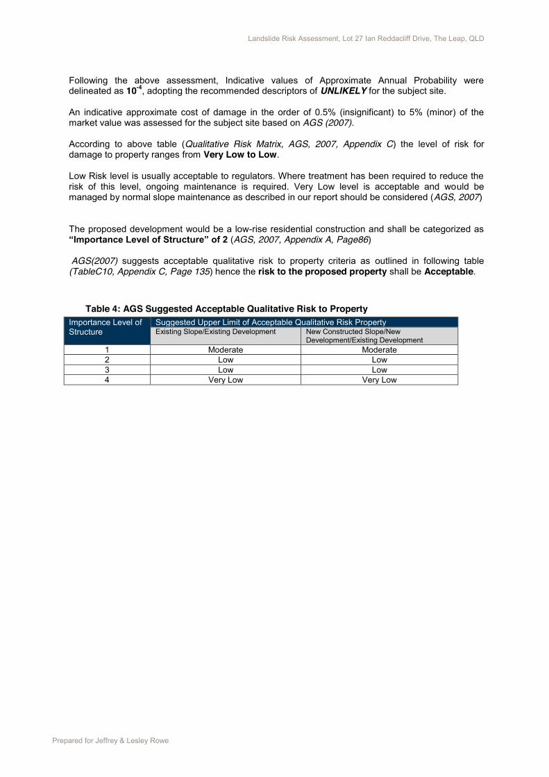
Following the above assessment, Indicative values of Approximate Annual Probability were delineated as 10-4, adopting the recommended descriptors of UNLIKELY for the subject site. An indicative approximate cost of damage in the order of 0.5% (insignificant) to 5% (minor) of the market value was assessed for the subject site based on AGS (2007). According to above table (Qualitative Risk Matrix, AGS, 2007, Appendix C) the level of risk for damage to property ranges from Very Low to Low. Low Risk level is usually acceptable to regulators. Where treatment has been required to reduce the risk of this level, ongoing maintenance is required. Very Low level is acceptable and would be managed by normal slope maintenance as described in our report should be considered (AGS, 2007)
The proposed development would be a low-rise residential construction and shall be categorized as “Importance Level of Structure” of 2 (AGS, 2007, Appendix A, Page86)
AGS(2007) suggests acceptable qualitative risk to property criteria as outlined in following table (TableC10, Appendix C, Page 135) hence the risk to the proposed property shall be Acceptable.
Table 4: AGS Suggested Acceptable Qualitative Risk to Property
Importance Level of Structure
Suggested Upper Limit of Acceptable Qualitative Risk Property Existing Slope/Existing Development New Constructed Slope/New
Development/Existing Development 1 Moderate Moderate 2 Low Low 3 Low Low 4 Very Low Very Low


27
ACN 113 769 994
PTY LTD
WE MEASURE UP
MACKAY SURVEYS
15023F01
B
Jeff Rowe
ResidentialDevelopment148 Ian Reddacliff DriveThe Leap
Contour & DetailSurvey of Part ofLot 27 on SP172242


This Property Report identifies Mackay City Planning Scheme zones and overlays that may affect the property. It is intended that this Report be used as a guide only, as part of the Development Application process.
The information contained in the Property Report is not a legal description of the property and should not be relied upon.
PLANNING SCHEME PROPERTY REPORT
Property Address: L 27 Ian Reddacliff DriveTHE LEAP QLD 4740
Real Property Description - Plan and Lot No.: SP172242/27 43200
Zone - Code: RR Description: Rural Residential
Area (SqM):
Planning - Locality: Precinct:Hinterland Reliance Creek
Affected by Development Codes
Tourist Areas
High Impact Areas
Key Resource Areas
Commercial and Residential Interface
Residential Character Areas
Development on Steep Land
Wetland Communities
Landscape Character
Character and Heritage Protection
Bushfire Management
Good Quality Agricultural Land
Airport Safety Zone
Aviation Facilities Buffer Area
Airport Noise Exposure
Airport Development Distances
Flood And Inundation
Affected by Overlay Codes
Image Corridors
Acid Sulfate Soils
Airport Obstacle Limitation Surface