Embed Size (px)
Citation preview
Landslide Dynamics: ISDR-ICL LandslideInteractive Teaching Tools (LITT)
Kyoji Sassa, Fausto Guzzetti, Hiromitsu Yamagishi, Željko Arbanas,Nicola Casagli, Binod Tiwari, Ko-Fei Liu, Alexander Strom,Mauri McSaveney, Eileen McSaveney, Khang Dang,and Hendy Setiawan
AbstractThe International Consortium on Landslides (ICL) and ICL supporting organizationsjointly established the ISDR-ICL Sendai Partnerships 2015–2025 which is the voluntarycommitment to the Sendai Framework for Disaster Risk Reduction 2015–2030. As the coreactivity of the Sendai Partnerships, ICL has created “Landslide Dynamics: ISDR-ICLLandslide Interactive Teaching Tools”, which are always updated and continuouslyimproved, based on responses from users and lessons during their application. This paperdescribes the aim, outline, the contents of Text tools, PPT tools for lectures and PDF toolsincluding already published reference papers/reports, guidelines, etc. Core parts of twofundamentals of the Teaching Tools, namely 1. Landslide types: description, illustrationand photos, and 2. Landslide Dynamics for Risk Assessment are introduced.
KeywordsInternational consortium on landslides (ICL) � International strategy for disaster riskreduction (ISDR) � Landslide dynamics � Landslide types � Capacity development
K. Sassa (&)International Consortium on Landslides (ICL), Kyoto, Japane-mail: [email protected]
F. GuzzettiIstituto di Ricerca per la Protezione Idrogeologica, ConsiglioNazionale delle Ricerche, via Madonna Alta 126, 06128 Perugia,Italye-mail: [email protected]
H. YamagishiAsian Institute of Spatial Information, Shiroishi-Ku, Hongodori2chome Kita 3-10, Sapporo, 003-0025, Japane-mail: [email protected]
Ž. ArbanasFaculty of Civil Engineering, University of Rijeka, RadmileMatejčić 3 Rijeka 51000, Rijeka, Croatiae-mail: [email protected]
N. CasagliDepartment of Earth Sciences, University of Firenze, Via La Pira4, 50212 Florence, Italye-mail: [email protected]
B. TiwariCivil & Environmental Engineering Department, California StateUniversity, Fullerton, 800 N State College Blvd., E-419,Fullerton, CA 92831, USAe-mail: [email protected]
K. LiuNational Taiwan University, No.1, Roosevelt Road, ChineseTaipei, 10617, Taiwan, Republic of Chinae-mail: [email protected]
M. McSaveney � E. McSaveneyGNS Science, PO Box 30368, Lower Hutt, 5040, New Zealande-mail: [email protected]
E. McSaveneye-mail: [email protected]
H. SetiawanDisaster Prevention Research Institute, Kyoto University, Uji,611-0011, Japane-mail: [email protected]
A. StromGeodynamics Research Centre—branch of JSC “HydroprojectInstitute”, Volokolamsk Highway 2, Moscow, 125993, Russiae-mail: [email protected]
K. DangInternational Consortium on Landslides, Kyoto, Japane-mail: [email protected]
K. DangVNU University of Science, Hanoi, Vietnam
© The Author(s) 2017K. Sassa et al. (eds.), Advancing Culture of Living with Landslides,DOI 10.1007/978-3-319-59469-9_17
193
Aim of Landslide Dynamics: ISDR-ICLLandslide Interactive Teaching Tools
The International Consortium on Landslides (ICL) pro-posed the ISDR-ICL Sendai Partnerships 2015–2025 forglobal promotion of understanding and reducing landslidedisaster risk at a session of “Underlying risk factors” of the3rd WCDRR on the morning of 16 March 2015. Thepartnership was proposed as a voluntary commitment to theWorld Conference on Disaster Risk Reduction, Sendai,Japan, 2015, and also as tools for implementing andmonitoring the Post-2015 Framework for Disaster RiskReduction and the Sustainable Development Goals. It wasapproved and signed by 16 global stakeholders in theafternoon of the same day in Sendai, Japan, and theSecretary-General Mr. Petteri Taalas of the World Meteo-rological Organization (WMO) signed it on 16 April 2016.The number of current ICL members (as of 30 November2016) that are a part of the Sendai Partnerships is 64. Thenumber will be updated every year. The signatory organi-zations may increase at the high-level panel discussion andthe round-table discussion during the Fourth World Land-slide Forum in Ljubljana, Slovenia in 2017. The SendaiPartnerships is being updated during the period.
The Sendai partnerships acknowledge that
• At a higher level, social and financial investment is vitalfor understanding and reducing landslide disaster risk, inparticular social and institutional vulnerability, throughcoordination of policies, planning, research, capacitydevelopment, and the production of publications andtools that are accessible, available free of charge and areeasy to use for everyone in both developing and devel-oped countries.
Landslide science and technologies have continuously beendeveloped to be more reliable, precise or cost-effective forlandslide disaster risk reduction over the world. However,this scientific and technological progress has not been sharedequally over the world. The gap between the available levelof science and technologies and the practical use of those inmany countries, regions and communities is very wide. Tofill this gap, ICL has created Landslide Interactive TeachingTools, which are always updated and continuouslyimproved, based on responses from users and lessons duringtheir application. All text books gradually become outdated.To avoid this problem, ICL plans to upload the latestteaching tools in the WEB of Teaching Tools and print texttools periodically.
Landslide Dynamics
A landslide is a downslope movement of rock, soil or both(Cruden 1991, 1996). Landslide disasters are caused byexposure to hazardous motions of soil and rock thatthreaten vulnerable human settlement in mountains, cities,coasts, and islands, as stated in the Sendai Partnerships.Understanding “Landslide dynamics” is the very basis oflandslide disaster risk reduction.
Organizations Contributing Teaching Tools
Each teaching tool will be submitted by the teaching toolcontributing organization as shown in the list of contributionorganizations. Each organization has its own Teaching ToolIdentifying Number consisting of telephone number of thecountry and the registered number within the country(Table 1). The involvement of organization as well as indi-vidual researcher is better to keep quality and updating ofeach tool.
Outline of the ISDR-ICL Landslide InteractiveTeaching Tools
The teaching tools are classified in five major parts. The partnumber is included in each teaching tool identifier.
0. Fundamentals(1) Landslide Types: Description, illustrations and photos(2) Landslide Dynamics for risk assessment
1. Mapping and Site Prediction(1) Basic Mapping(2) Site Prediction Using GIS(3) Field Guidelines
2. Monitoring and Early Warning(1) Remote SensingTechniques for LandslideMonitoring(2) Monitoring System Instrumentation(3) Rainfall Threshold for Landslide Prediction(4) Landslide Time Prediction from Pre-failure Move-
ment Monitoring(5) Guidelines for Landslide Monitoring and Early
Warning Systems3. Risk Assessment
(1) Numerical Modeling and Simulation(2) Physical and Mathematical Modeling(3) Laboratory Soil Testing for Landslide Analysis(4) Analysis and Assessment of Landslides
194 K. Sassa et al.

Table 1 List of contributing organizations with identifier number and email of leader
Identifier No. Organizations and email of leaders
001-1 Department of Civil and Environmental Engineering, California State University, Fullerton, 800 N. State College Blvd.,E-419, Fullerton, CA 92831Binod Tiwari: <[email protected]>
001-2 U.S. Geological Survey (Denver Federal Ctr., Denver, CO 80225 USA)Lynn Highland: <[email protected]>Geological Survey of Canada (601 Booth St., Ottawa, Ontario, Canada KIA 0E8)Peter Bobrowsky: <[email protected]>
007-1 Sergeev Institute of Environmental Geoscience RAS, Ulansky per., 13, PB 145, Moscow 101000, RussiaValentina Svalova <[email protected]>
020-1 Mining Department, Faculty of Engineering, Cairo University,Giza – 12613, EgyptYasser ELSHAYEB <[email protected].>
034-1 Department of Civil and Environmental Engineering, Universitat Politècnica de Catalunya BarcelonaTech. Jordi Girona l-3.08034 Barcelona, Spain.Jordi Corominas: <[email protected]>
034-2 Catalan Institute for Water Research (ICRA), Emili Grahit 101, 17003 Girona, Spain.Formerly at Sediment Transport Research Group (GITS), Department of Hydraulic, Marine, and Environmental Engineering,Universitat Politècnica de Catalunya—BarcelonaTech (UPC)Francesco Bregoli: <[email protected]>
039-1 Research Institute for Geo-Hydrological Protection, CNR, via Madonna Alta 126, 06128 Perugia, ItalyFausto Guzzetti <[email protected]>
039-2 ISPRA – Italian National Institute for Environmental Protection and Research, Geological Survey of ItalyClaudio Margottini: <[email protected]>
039-3 Department of Earth Sciences, University of Firenze, Via La Pira 4, Firenze, ItalyNicola Casagli: <[email protected]>
039-4 Department of Informatics, Modelling, Electronics and System Engineering, University of Calabria – Ponte Pietro Bucci, 41BBuilding, 5th Floor, 87036 Arcavacata di Rende (CS)—ItalyPasquale Versace: <[email protected]>
043-1 Institute of Mountain Risk Engineering, University of Natural Resources and Life Sciences, Peter-Jordan-Straße 82, Vienna,A-1190, AustriaJohannes Hübl: <[email protected]>
044-1 Department of Civil & Structural Engineering, University of Sheffield, Mappin St, Sheffield, United Kingdom.Elisabeth T. Bowman: <[email protected]>
052-1 Institute of Geography, National Autonomous University of Mexico (UNAM), Circuito Exterior, Ciudad Universitaria,04510, Coyoacán, Mexico City, MexicoIrasema Alcántara-Ayala: <[email protected]>
052-2 Instituto de Geografía, Universidad Nacional Autónoma de México, MéxicoGabriel Legorreta Paulíni: <[email protected]>
060-1 Slope Engineering Branch,Jabatan Kerja Raya MALAYSIA
062-1 Faculty of Engineering, Universitas Gadjah Mada, IndonesiaDwikorita Karnawati: <[email protected]>Teuku Faisal Fathani< [email protected]>
064-1 GNS Science, New ZealandMauri McSaveney <[email protected]>Chris Massey <[email protected]>
066-1 Asian Disaster Preparedness Center (ADPC),ThailandNMSI Arambepola <[email protected]>
081-1 ICL Headquarters, JapanKyoji Sassa <[email protected]>
081-2 Tohoku Gakuin University, JapanToyohiko Miyagi <[email protected]>
(continued)
Landslide Dynamics: ISDR-ICL Landslide Interactive … 195
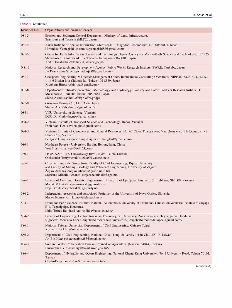
Table 1 (continued)
Identifier No. Organizations and email of leaders
081-3 Erosion and Sediment Control Department, Ministry of Land, Infrastructure,Transport and Tourism (MLIT), Japan
081-4 Asian Institute of Spatial Information, Shiroishi-ku, Hongodori 2chome kita 3-10 003-0025, JapanHiromitsu Yamagishi <[email protected]>
081-5 Center for Earth Information Science and Technology, Japan Agency for Marine-Earth Science and Technology, 3173-25Showamachi Kanazawa-ku, Yokohama Kanagawa 236-0001, JapanKeiko Takahashi <[email protected]>
0.81-6 National Research and Development Agency, Public Works Research Institute (PWRI), Tsukuba, JapanJie Dou <[email protected]/[email protected]>
081-7 Geosphere Engineering & Disaster Management Office, International Consulting Operations, NIPPON KOEI CO., LTD.,1-14-6 Kudan-kita Chiyoda-ku, Tokyo 102-8539, JapanKiyoharu Hirota <[email protected]>
081-8 Department of Disaster prevention, Meteorology and Hydrology, Forestry and Forest Products Research Institute, 1Matsunosato, Tsukuba, Ibaraki 305-8687, JapanShiho Asano <[email protected]>
081-9 Okuyama Boring Co., Ltd., Akita JapanShinro Abe <[email protected]>
084-1 VNU University of Science, VietnamDUC Do Minh<[email protected]>
084-2 Vietnam Institute of Transport Science and Technology, Hanoi, VietnamDinh Van Tien <[email protected]>
084-3 Vietnam Institute of Geosciences and Mineral Resources, No. 67 Chien Thang street, Van Quan ward, Ha Dong district,Hanoi City, VietnamLe Quoc Hung <[email protected]; [email protected]>
086-1 Northeast Forestry University, Harbin, Heilongjiang, ChinaWei Shan <[email protected]>
380-1 ITGIS NASU (13, Chokolivsky Blvd., Kyiv, 03186, Ukraine)Oleksander Trofymchuk <[email protected]>
385-1 Croatian Landslide Group from Faculty of Civil Engineering, Rijeka Universityand Faculty of Mining, Geology and Petroleum Engineering, University of ZagrebŽeljko Arbanas <[email protected]>Snježana Mihalić Arbanas <[email protected]>
386-1 Faculty of Civil and Geodetic Engineering, University of Ljubljana, Jamova c. 2, Ljubljana, SI-1000, SloveniaMatjaž Mikoš <[email protected]>Nejc Bezak <[email protected]>
386-2 Independent researcher and Associated Professor at the University of Nova Gorica, SloveniaMarko Komac < [email protected]>
504-1 Honduras Earth Science Institute. National Autonomous University of Honduras. Ciudad Universitaria, Boulevard SuyapaE-1. Tegucigalpa, Honduras.Lidia Torres Bernhard <[email protected]>
504-2 Faculty of Engineering, Central American Technological University, Zona Jacaleapa, Tegucigalpa, Honduras.Rigoberto Moncada López <[email protected]>, <[email protected]>
886-1 National Taiwan University, Department of Civil Engineering, Chinese TaipeiKo-Fei Liu <[email protected]>
886-2 Department of Civil Engineering, National Chiao Tong University (Hsin Chu, 30010, Taiwan)An-Bin Huang<[email protected]>
886-3 Soil and Water Conservation Bureau, Council of Agriculture (Nantou, 54044, Taiwan)Hsiao-Yuan Yin <[email protected]>
886-4 Department of Hydraulic and Ocean Engineering, National Cheng Kung University, No. 1 University Road, Tainan 70101,TaiwanChyan-Deng Jan <[email protected]>
(continued)
196 K. Sassa et al.
4. Risk Management and Country Practices(1) Landslide Risk Management(2) Community Risk Management(3) Country Practices.
The teaching tools consist of three types of tools.
1. The first type are text-tools consisting of original textswith figures. The first edition includes two volumes ofbooks.
2. The second type are PPT-tools consisting of PowerPointfiles and video tools made for visual lectures.
3. The third type are PDF-tools consisting of already pub-lished reference papers/reports, guidelines, laws andothers.The second and the third type of tools are supplementarytools of the text tools (text books).Each teaching tool has its own identifier. The identifier ofeach tool consists of three parts:
1. the number of the part of the tool box in which it appears(Parts 0–4);
2. the country telephone code and an assigned uniquenumber for each contributing organization (for example081-1 signifies Japan-ICL headquarters, and 081-3 sig-nifies Japan – Erosion and Sediment Control Department,Ministry of Land, Infrastructure, Transport and Tourism);
3. the last part of the identifier is a consecutive numberassigned to the teaching tool by its contributingorganization.
The following tables (Tables 1, 2, 3 and 4) present the list ofcontributing organizations and the list of contents of theteaching tools.
Fundamentals of the ISDR-ICL LandslideInteractive Teaching Tools (LITT)
All tools include visual explainations with many full colorillustrations and photos. The tools start from two funda-mental tools (TXT Tool 0.001-2.1 and TXT Tool 0.081-1.1).
To present examples and illustration and photos used inLITT and also present an overview of the content of twofundamental aspects, some selected illustrations and photosare presented below.
Landslide Types: Descriptions, Illustrationsand Photos
All figures and captions are copied from TXT Tool0.001-2.1. Fig. 1.
The definitions of landslides were not uniform around theworld before the United Nations International Decade forNatural Disaster Reduction (IDNDR) 1990–2000. Landslidedisasters are one of the major disasters to be tackled inIDNDR. The united definition of landslides forms the basisfor investigations and statistics of landslide disasters,through IDNDR as its base. The International GeotechnicalSocieties and UNESCO Working Group for World Land-slide Inventory (Chair: David Cruden) was established. Thelandslide was then defined to be “the movement of a mass ofrock, debris or earth down a slope”. The types wereexplained in detail in “Landslides-investigation and mitiga-tion”, edited by A Keith Turner and Robert L, Schuster,Special Report 247 of the National Research Council (U.S.)Transportation Research Board in 1996. In order to dis-seminate this definition of landslides, including debris flows,rock falls and others, Lynn Highland and Peter Bobrowskyimplemented the IPL 106 Best Practice handbook for land-slide hazard mitigation (2002–2007) to create a handbook onlandslides and published its result as “The LandslideHandbook—A guide to Understanding Landslides” (USGSCircular 1325) (Highland and Bobrowsky 2008). This bookwas well evaluated and translated into several languages.This project was awarded an “IPL Award for Success” at theSecond World Landslide Forum at FAO Headquarters,Rome, October 2011. This definition, which includes debrisflows, rock falls and other different types of landslides, is thebasis of landslide science and it is the base of the Interna-tional Journal “Landslides” founded in 2004. TXT Tool0.001-2.1 (Highland and Bobrowsky 2017) presents manyphotos and illustrations to explain this definition by IDNDR,
Table 1 (continued)
Identifier No. Organizations and email of leaders
886-5 Socio-Economic System Division, National Science & Technology Center for Disaster Reduction, Taiwan, R.O.C.Hsin-Chi Li <[email protected]>
886-6 Department of Soil and Water Conservation, National Chung Hsing University, (Taichung, 402, Taiwan, R.O.C.)Su-Chin Chen <[email protected]>
886-7 Water Environment Research Center, National Taipei University of Technology, 1, Sec. 3, Chung-Hsiao E. Rd., Taipei 106,TaiwanChia-Chun Ho <[email protected]>
Landslide Dynamics: ISDR-ICL Landslide Interactive … 197
Table 2 Contents of text tools
Landslide dynamics: ISDR-ICL landslide interactive teaching tools Vol. 1 fundamental, mapping and monitoring Kyoji Sassa, Fausto Guzzetti,Hiromitsu Yamagishi, Zeljko Arbanas, Nicola Casagli, Mauri McSaveney, Khang Dang Editors
No. Identifier Title Author
Fundamentals
1. TXT-Tool 0.001-2.1 Landslide types: descriptions, illustrations and photos Lynn Highland, PeterBobrowsky
2. TXT-Tool 0.081-1.1 Landslide dynamics for risk assessment Kyoji Sassa, Khang Dang
Part 1. Mapping and site prediction
I.1 Basic mapping
1. TXT-Tool 1.081-2.1 Landslide mapping through the interpretation of aerial photographs Toyohiko Miyagi
2. TXT-Tool 1.081-2.2 Landslide mapping through the interpretation of aerial photographs andtopographic maps
Eisaku Hamasaki et al.
3. TXT-Tool 1.081-3.1 Landslide recognition and mapping using aerial photographs and GoogleEarth
Hiromitsu Yamagishi,Rigoberto Moncada Lopez
4. TXT-Tool 1.039-1.1 Very-high resolution stereoscopic satellite images for landslide mapping Francesca Ardizzone et al.
5. TXT-Tool 1.504-1.1 Landslide Inventory educational methodology derived from experiencesin Latin America
Rigoberto Moncada Lopez,Hiromitsu Yamagishi
I.2 Site prediction using GIS
6. TXT-Tool 1.052-1.1 GIS using landslides Inventory mapping for Volcanoes Gabriel Legorreta Paulin
7. TXT-Tool 1.052-1.2 GIS using landslides susceptibility mapping model for Volcanoes Gabriel Legorreta Paulín,Michael Polenz, TrevorContreras
8. TXT-Tool 1.504-1.1 Landslide susceptibility assessment method Marko Komac, Jernej Jež
9. TXT-Tool 1.386-2.1 A comparative study of the binary logistic regression (BLR) and artificialneural network (ANN) models for GIS-based spatial predicting landslidesat a regional scale
Jie Dou et al.
10. TXT-Tool 1.386-2.2 Practical approach to assessing the factors influencing landslidesusceptibility modelling—a case of Slovenia
Marko Komac
11. TXT-Tool 1.084-3.1 Landslide susceptibility mapping at regional scale in Vietnam Le Quoc Hung et al.
12. TXT-Tool 1.039-1.2 Bedding attitude information through the interpretation of stereoscopicaerial photographs and GIS modeling
Ivan Marchesini et al.
13. TXT-Tool 1.086-1.1 Distribution of Isolated Patches Permafrost in the Lesser KhinganMountains of Northeast China using Landsat7 ETM + Imagery
Chunjiao Wang, Wei Shan
I.3 Field guidelines
14. TXT-Tool 1.081-7.1 Investigating landslides in the field Using Google Earth and PowerPoint: acase study of Altos de Loarque in Honduras
Kiyoharu Hirota
15. TXT-Tool 1.064-1.1 Field guide for the identification and assessment of landslide and erosionfeatures and related hazards affecting pipelines
Chris Massey et al.
Part 2. Monitoring and early warning
II.1 Remote sensing techniques for landslide monitoring
1. TXT-Tool 2.039-3.1 Satellite remote sensing techniques for landslides detection and mapping Nicola Casagli et al.
2. TXT-Tool 2.039-3.2 Ground-based remote sensing techniques for landslides detection,monitoring and early warning
Nicola Casagli, Stefano Morelliet al.
3. TXT-Tool 2.386-2.1 SAR interferometry as a tool for detection of landslides in early phases M. Komac, T. Peternel, M.Jemec
4. TXT-Tool 2.039-3.3 Ground-based radar interferometry for landslide monitoring Nicola Casagli et al.
II.2 Monitoring system instrumentation
5. TXT-Tool 2.062-1.1 A Landslide monitoring and early warning system Teuku Faisal Fathani,Dwikorita Karnawati
6. TXT-Tool 2.007-1.1 Monitoring alarm system of landslide and seismic safety for potentiallyhazardous objects
Alexander Ginzburg et al.
(continued)
198 K. Sassa et al.
Table 2 (continued)
Landslide dynamics: ISDR-ICL landslide interactive teaching tools Vol. 1 fundamental, mapping and monitoring Kyoji Sassa, Fausto Guzzetti,Hiromitsu Yamagishi, Zeljko Arbanas, Nicola Casagli, Mauri McSaveney, Khang Dang Editors
No. Identifier Title Author
7. TXT-Tool 2.007-1.2 Landslide and seismic monitoring system on the base of unified automaticequipment
Alexander Ginzburg et al.
II.3 Rainfall threshold for landslides prediction
8. TXT-Tool 2.039-1.1 Italian national landslide warning system Mauro Rossi et al.
9. TXT-Tool 2.084-3.1 Rainfall thresholds for triggering Geohazards in Bac Kan Province(Vietnam)
Nguyen Duc Ha et al.
10. TXT-Tool 2.039-1.2 Rainfall thresholds for the possible initiation of shallow landslides in theItalian Alps
Maria Teresa Brunetti et al.
11. TXT-Tool 2.039-1.3 Topographic and pedological rainfall thresholds for the prediction ofshallow landslides in central Italy
Silvia Peruccacci, Maria TeresaBrunetti et al.
12. TXT-Tool 2.039-4.1 FLaIR model (Forecasting of Landslides Induced by Rainfalls) Pasquale Versace et al.
13. TXT-Tool 2.386-2.1 A system to forecast rainfall induced landslides in Slovenia Mateja Jemec Auflič et al.
14. TXT-Tool 2.886-1.1 Early warning criteria for debris flows and their application in Taiwan Chyan-Deng Jan et al.
15. TXT-Tool 2.081-5.1 High-resolution rainfall prediction for early warning of landslides Ryo Onishi et al.
16. TXT-Tool 2.386-1.1 Intensity-Duration Curves for Rainfall-Induced Shallow Landslides andDebris Flows Using Copula Functions
Nejc Bezak et al.
17. TXT-Tool 2.039-1.5 An algorithm for the objective reconstruction of rainfall eventsresponsible for landslides
Massimo Melillo et al.
II.4 Landslide time prediction from pre-failure movement monitoring
18. TXT-Tool 2.385-1.1 A comprehensive landslide monitoring system: the Kostanjek landslide,Croatia
Snježana Mihalić Arbanas et al.
19. TXT-Tool 2.385-1.2 Landslide comprehensive monitoring system: the grohovo landslide casestudy, Croatia
Željko Arbanas et al.
20. TXT-Tool 2.062-1.2 A monitoring and early warning system for debris flows in rivers onVolcanoes
Teuku Faisal Fathani, DjokoLegono
21. TXT-Tool 2.380-1.1 Monitoring and early warning system of the building constructions of theLivadia Palace, Ukraine
O. Trofymchuk, I. Kaliukh, O.Klimenkov
22. TXT-Tool 2.039-4.2 LEWIS project: An Integrated System For Landslides Early Warning Pasquale Versace et al.
23. TXT-Tool 2.039-3.4 Methods to improve the reliability of time of slope failure predictions andto setup alarm levels based on the inverse velocity method
Tommaso Carlà et al.
II.5 Guidelines for landslides monitoring and early warning systems
24. TXT-Tool 2.886-1.2 Guidelines for landslide monitoring systems An-Bin Huang, Wen-JongChang
25. TXT-Tool 2.386-1.2 Practice guideline on monitoring and warning technology for debris flows Johannes Hübl, Matjaž Mikoš
26. TXT-Tool 2.886-1.3 Debris flow monitoring guidelines Hsiao-Yuan Yin, Yi-MinHuang
Back material
1. List of PDF-tools and PPT-tools
2. ICL structure
Landslide dynamics: ISDR-ICL landslide interactive teaching tools Vol. 2 testing, risk management and country practice Kyoji Sassa, BinodTiwari, Kofei Liu, Mauri McSaveney, Eileen McSaveney Alexander Strom, Hendy Setiawan editors
No. Identifier Title Author
Part 3. Risk assessment
III.1 Numerical modeling and simulation
1. TXT-Tool 3.081-1.1 An integrated model simulating the initiation and motion of earthquake andrain induced rapid landslides and its application to the 2006 Leyte landslide
Pham Van Tien, Kyoji Sassa,Khang Dang
2. TXT-Tool 3.385-1.1 Application of Integrated Landslide Simulation Model LS-Rapid to theKostanjek Landslide, Zagreb, Croatia
Karolina Gradiški et al.
(continued)
Landslide Dynamics: ISDR-ICL Landslide Interactive … 199
Table 2 (continued)
Landslide dynamics: ISDR-ICL landslide interactive teaching tools Vol. 2 testing, risk management and country practice Kyoji Sassa, BinodTiwari, Kofei Liu, Mauri McSaveney, Eileen McSaveney Alexander Strom, Hendy Setiawan editors
No. Identifier Title Author
3. TXT-Tool 3.081-1.2 Simulation of landslide induced tsunami (LS-Tsunami) based on thelandslide motion predicted by LS-RAPID
Khang Dang, Kyoji Sassa
4. TXT-Tool 3.081-1.3 A hypothesis of the Senoumi submarine megaslide in Suruga Bay in Japanbased on the undrained dynamic-loading ring shear tests and computersimulation
Hendy Setiawan, Kyoji Sassa,Bin He
5. TXT-Tool 3.081-1.4 Initiation Mechanism of Rapid and Long Runout Landslide and Simulationof Hiroshima Landslide Disasters using the Integrated Simulation Model(LS-RAPID)
Loi Doan Huy et al.
6. TXT-Tool 3.385-1.2 Deterministic landslide susceptibility analyses using LS-Rapid software Sanja Dugonjić Jovančevićet al.
7. TXT-Tool 3.886-1.1 Debris2D tutorial Ko-Fei LIU, Ying-Hsin WU
8. TXT-Tool 3.081-1.5 Manual for the LS-RAPID software Kyoji Sassa, Hendy Setiawanet al.
9. TXT-Tool 3.034-2.1 A debris flow regional fast hazard assessment tool F. Bregoli et al.
10. TXT-Tool 3.386-1.1 Two-dimensional debris-flow modelling and topographic data Jošt Sodnik, Matjaž Mikoš
11. TXT-Tool 3.886-1.2 Simulation for the debris flow and sediment transport in a large-scalewatershed
Ying-Hsin Wu et al.
12. TXT-Tool 3.385-1.3 Landslide occurrence prediction in the Rječina River Valley as a base foran early warning system
Martina Vivoda et al.
III.2 Physical and mathematical modeling
13. TXT-Tool 3.001-1.1 Physical modelling of rain-induced landslides Binod Tiwari, Beena Ajmera
14. TXT-Tool 3.001-1.2 Physical modeling of earthquake-induced landslides Beena Ajmera and BinodTiwari
15. TXT-Tool 3.044-1.1 The runout of chalk cliff collapses in England and France—case studiesand physical model experiments
E. T. Bowman, W. A. Take
16. TXT-Tool 3.007-1.1 Mechanical-mathematical modeling and monitoring for landslide processes Svalova Valentina
III.3 Laboratory soil testing for landslide analysis
17. TXT-Tool 3.081-1.6 Manual for undrained dynamic-loading ring shear apparatus Hendy Setiawan et al.
18. TXT-Tool 3.081-1.7 Undrained dynamic-loading ring shear apparatus and its application tolandslide dynamics
Hendy Setiawan et al.
19. TXT-Tool 3.081-1.8 A new high-stress undrained ring-shear apparatus and its application to the1792 Unzen–Mayuyama megaslide in Japan
Khang Dang et al.
20. TXT-Tool 3.001-1.3 Laboratory measurement of fully softened shear strength and its applicationfor landslide analysis
Binod Tiwari, Beena Ajmera
III.4 Analysis and assessment of landslides
21. TXT-Tool 3.081-1.9 Dynamic properties of earthquake induced large-scale rapid landslideswithin past landslide masses
Pham Van Tien, Kyoji Sassa
22. TXT-Tool 3.001-1.4 Using excel tools for slope stability analysis Beena Ajmera, Binod Tiwari
23. TXT-Tool 3.034-1.1 A textural classification of argillaceousRocks and their durability
J. Corominas,J. Martínez-Bofill, A. Soler
24. TXT-Tool 3.039-1.1 Landslide-related WPS Services Ivan Marchesini,Massimiliano Alvioli, MauroRossi
Part (4) Risk management and country practices
IV.1 Landslide risk management
1. TXT-Tool 4.084-1.1 Soil slope stability analysis Do Minh DUC
2. TXT-Tool 4.081-2.1 Risk Evaluation using the Analytic Hierarchy Process (AHP)—Introduction to the process concept
Eisaku HAMASAKI,Toyohiko MIYAGI
3. TXT-Tool 4.039-3.1 Terrestrial laser scanner and geomechanical surveys for the rapidevaluation of rock fall susceptibility scenarios
Gigli, G. et al.
(continued)
200 K. Sassa et al.
Table 2 (continued)
Landslide dynamics: ISDR-ICL landslide interactive teaching tools Vol. 2 testing, risk management and country practice Kyoji Sassa, BinodTiwari, Kofei Liu, Mauri McSaveney, Eileen McSaveney Alexander Strom, Hendy Setiawan editors
No. Identifier Title Author
4. TXT-Tool 4.039-3.2 How to assess landslide activity and intensity with Persistent ScattererInterferometry (PSI): the PSI-based matrix approach
Cigna, F., Bianchini, S.,Casagli, N.
5. TXT-Tool 4.034-1.1 Quantitative rockfall risk assessment for roadways and railways Olga Mavrouli, JordiCorominas
6. TXT-Tool 4.084-1.2 Landslide Vulnerability assessment: a case study of Backan Town,Northeast Vietnam
Do Minh Duc et al.
7. TXT-Tool 4.086-1.1 Landslide investigations in the northwest section of the Lesser KhinganRange in China using combined HDR and GPR methods
Zhaoguang Hu, Wei Shan,Hua Jiang
8. TXT-Tool 4.052-1.1 Landslide risk perception Irasema Alcántara Ayala
9. TXT-Tool 4.886-1.1 Taiwan Typhoon Loss Assessment System (TLAS Taiwan) Web Tool Hsin-Chi Li, Yi-Chen Chen,Mei-Chun Kuo
10. TXT-Tool 4.385-1.1 Method for prediction of landslide movements based on random forests Martin Krkač et al.
IV.2 Community risk management
11. TXT-Tool 4.062-1.1 Community hazard maps for landslide risk reduction Dwikorita Karnawati et al.
12. TXT-Tool 4.039-1.1 Definition and use of empirical rainfall thresholds for possible landslideoccurrence
Silvia Peruccacci, MariaTeresa Brunetti
13. TXT-Tool 4.062-1.2 A socio-technical approach for landslide mitigation and risk reduction Dwikorita Karnawati et al.
14. TXT-Tool 4.066-1.1 Community-based Landslide risk management approaches Asian Disaster PreparednessCentre (ADPC)
15. TXT-Tool 4.039-2.1 On the protection of cultural heritages from landslides Claudio Margottini
IV.3 Country practices
16. TXT-Tool 4.886-1.2 Procedures for constructing disaster evacuation maps: guidelines andstandards
Su-Chin Chen, Lien-KuangChen
17. TXT-Tool 4.886-1.3 Emergency post-landslide disaster documentation Lien-Kuang Chen
18. TXT-Tool 4.386-1.1 State-of-the-art overview on landslide disaster risk reduction in Slovenia Matjaž Mikoš et al.
19. TXT-Tool 4.086-1.2 Shallow landslides and plant protection in seasonal frozen regions Ying Guo et al.
20. TXT-Tool 4.886-1.4 Ecological countermeasure guidelines and case histories in Taiwan Chia-Chun HO et al.
21. TXT-Tool 4.086-1.3 The impact of climate change on landslides in Southeastern high-latitudepermafrost regions of China
Wei Shan, Zhaoguang Hu,Ying Guo
22. TXT-Tool 4.052-1.2 Landslide risk communication Irasema Alcántara Ayala
23. TXT-Tool 4.504-1.1 How to make a database of landslides in Tegucigalpa, Honduras Lidia Torres Bernhard et al.
24. TXT-Tool 4.039-3.3 Debris flows modeling for hazard mapping Massimiliano Nocentini et al.
25. TXT-Tool 4.039-4.1 Landslide investigations and risk mitigation. The Sarno, Italy, case study Giovanna Capparelli, LucianoPicarelli, Pasquale Versace
26. TXT-Tool 4.081-8.1 Landslide monitoring for early warning in the Hai van station landslide inVietnam
Shiho Asano, HirotakaOchiai, Huynh Dang Vinh
27. TXT-Tool 4.081-1.1 Mechanism of large-scale deep-seated landslides induced by rainfall ingravitationally deformed slopes: A case study of the Kuridaira landslide inKii Peninsula
Pham Van Tien et al.
28. TXT-Tool 4.081-9.1 Rotary sampling drilling technology to extract a core of high quality byusing sleeve-incorporating core barrel and polymer mud-From the cases ofdrilling in the landslide area of Japan and Vietnam
Shinro Abe et al.
29. TXT-Tool 4.081-1.2 Mechanism of the Aratozawa large-scale landslide induced by the 2008Iwate-Miyagi Earthquake
Hendy Setiawan et al.
Back material
1. List of PDF-tools and PPT-tools
2. ICL structure
Landslide Dynamics: ISDR-ICL Landslide Interactive … 201
as the major contribution from the global landslidecommunity.
The following four types of landslides: Falls (falls andtopples), Slides (rotational and translational), Spreads andFlows (debris flow and debris avalanches) are explainedusing illustrations and photo examples in Figs. 2, 3, 4 and 5.
Landslide Dynamics for Risk Assessment(TXT-Tool 0.081-1.1)
All figures and captions are copied from TXT-Tool0.081-1.1.
Table 3 Contents of PPT tools and video tools
List of PPT tools & video tools
No. Identifier Title Author
1. PPT-tool 1.039-1.1 Remote Sensing data and methodology for event landslide recognitionand mapping
Alessandro Mondini
2. PPT-tool 1.052-1.1 Logisnet Manual and Quick-start Tutorial Gabriel Legorreta Paulín,Marcus I. Bursik
3. PPT-tool 2.039-1.1 Italian National Landslide Warning System (29 pages) Mauro ROSSI et al.
4. PPT-tool 2.062-1.1 Landslide Monitoring and Early Warning System Teuku Faisal FATHANI,Dwikorita KARNAWATI
5. PPT-tool 2.062-1.2 Monitoring and Early Warning System for Debris Flows in Rivers onVolcanoes (37 pages)
Teuku Faisal FATHANI,Djoko LEGONO
6. PPT-tool 2.385-1.2 Landslide Comprehensive Monitoring System: The Grohovo LandslideCase Study, Croatia
Željko ARBANAS et al.
7. PPT-Tool 3.385-1.3 Landslide Occurrence Prediction in the Rječina River Valley as a Base foran Early Warning System
Martina VIVODA PRODANet al.
8. PPT-tool 2.886-1.2 Landslide Monitoring and Warning An-Bin HUANG, Wen-JongChang
9. PPT-tool 3.039-1.1 Landslide Hazards and Risk Assessment Fausto GUZZETTI
10. PPT-tool 3.039-1.2 Landslide-related WPS services Ivan MARCHESINI
11. PPT-tool 3.039-1.3 Probabilistic approach to physically based landslide modeling Massimiliano ALVIOLI et al.
12. PPT-tool 3.039-1.4 Advanced 2D Slope stability Analysis by LEM by SSAP software: a fullfreeware tool for teaching and scientific community
Lorenzo BORSELLI
13. PPT-tool 3.886-1.1 Debris-2D Tutorial Ko-Fei LIU, Ying-Hsin WU
14. PPT-tool 4.039-1.1 Definition and Use of Empirical Rainfall Thresholds for PossibleLandslide Occurrence
Maria Teresa BRUNETTI,Silvia PERUCCACCI
15. PPT-tool 4.039-1.2 Landslide Risk to the Population of Italy Paola SALVATI, CinziaBIANCHI
16. PPT-tool 4.062-1.1 Socio-Technical Approach for Landslide Mitigation and Risk Reduction Dwikorita KARNAWATIet al.
17. PPT-tool 4.062-1.2 Community Hazard Maps for Landslide Risk Reduction Dwikorita KARNAWATIet al.
18. PPT-tool 4.066-1.1 Course on Landslide Disaster Risk Reduction for Local GovernmentLevel Stakeholders
Asian Disaster PreparednessCentre
19. PPT-tool 4.886-1.1 Typhoon Loss Assessment System (TLAS) Taiwan Web Tool Hsin-Chi Li et al.
20. PPT-tool 4.886-1.2 Assessment Social Impact of debris flow disaster by Social VulnerabilityIndex
Ko-Fei Liu et al.
21. PPT-tool 4.886-1.3 Tutorial: Procedures for Constructing Disaster Evacuation Maps (56pages)
Su-Chin Chen, Lien-KuangChen
22. Video-tool 3.084-2.1 Manual for undrained dynamic-loading ring shear apparatus Lam Huu Quang
202 K. Sassa et al.
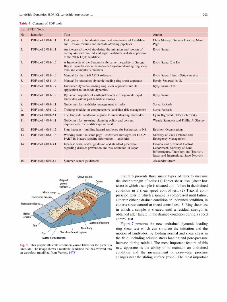
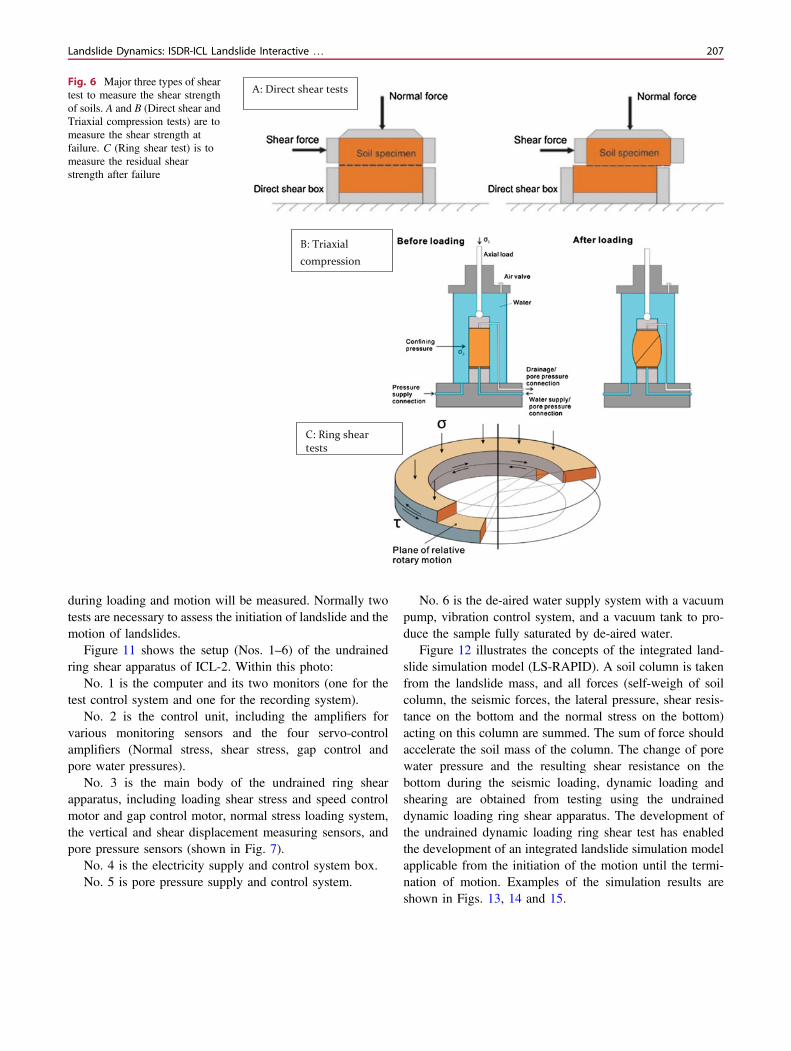
Figure 6 presents three major types of tests to measurethe shear strength of soils: (1) Direct shear tests (shear boxtests) in which a sample is sheared until failure in the drainedcondition in a shear speed control test, (2) Triaxial com-pression tests in which a sample is compressed until failure,either in either a drained condition or undrained condition, ineither a stress control or speed control test, 3. Ring shear testin which a sample is sheared until a residual strength isobtained after failure in the drained condition during a speedcontrol test.
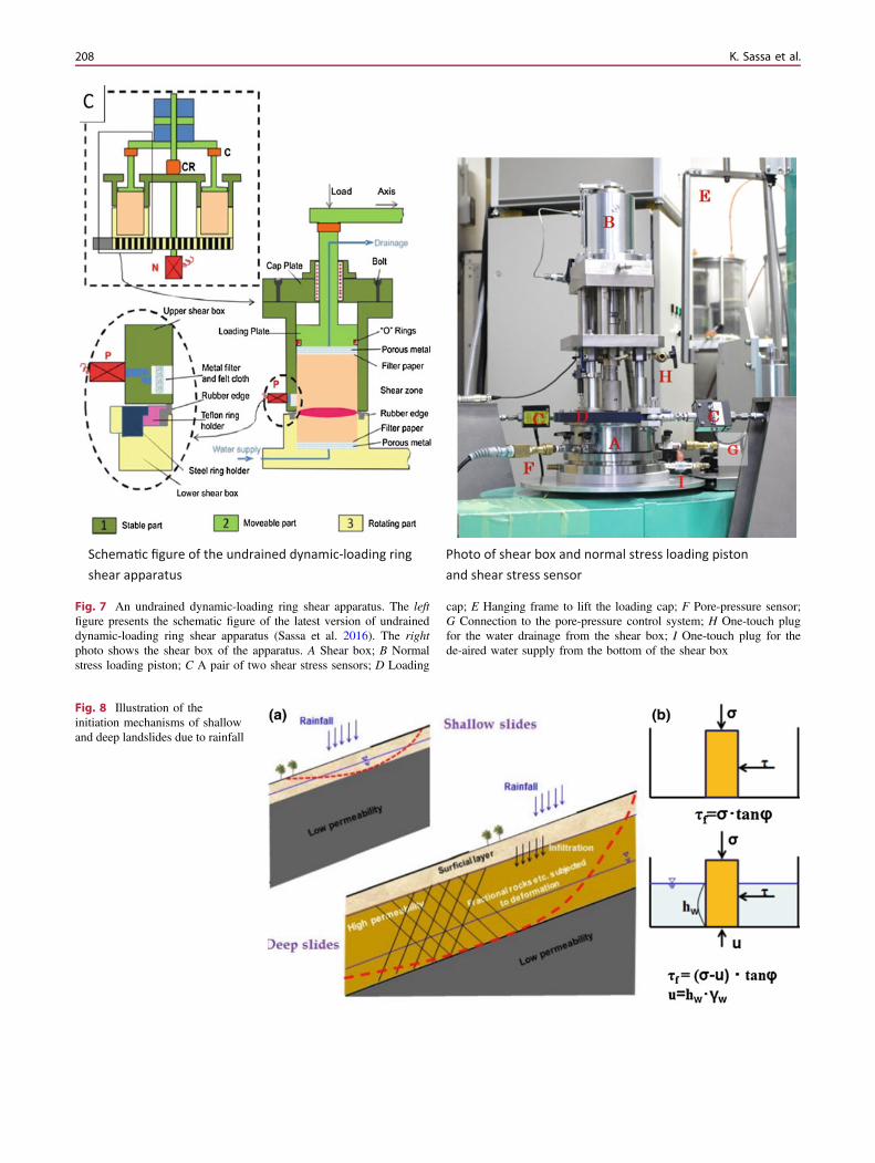
Figure 7 presents the new undrained dynamic loadingring shear test which can simulate the initiation and themotion of landslides, by loading normal and shear stress inthe field, including seismic stress loading and pore-pressureincrease during rainfall. The most important feature of thisnew apparatus is the ability of to maintain an undrainedcondition and the measurement of pore-water pressurechanges near the sliding surface (zone). The most important
Table 4 Contents of PDF tools
List of PDF Tools
No. Identifier Title Author
1. PDF-tool 1.064-1.1 Field guide for the identification and assessment of Landslideand Erosion features and hazards affecting pipelines
Chris Massey, Graham Hancox, MikePage
2. PDF-tool 3.081-1.1 An integrated model simulating the initiation and motion ofearthquake and rain induced rapid landslides and its applicationto the 2006 Leyte landslide
Kyoji Sassa
3. PDF-tool 3.081-1.3 A hypothesis of the Senoumi submarine megaslide in SurugaBay in Japan based on the undrained dynamic-loading ring sheartests and computer simulation
Kyoji Sassa, Bin He
4. PDF-tool 3.081-1.5 Manual for the LS-RAPID software Kyoji Sassa, Hendy Setiawan et al.
5. PDF-tool 3.081-1.6 Manual for undrained dynamic-loading ring shear apparatus Hendy Setiawan et al.
6. PDF-tool 3.081-1.7 Undrained dynamic-loading ring shear apparatus and itsapplication to landslide dynamics
Kyoji Sassa et al.
7. PDF-tool 3.081-1.9 Dynamic properties of earthquake-induced large-scale rapidlandslides within past landslide masses
Kyoji Sassa
8. PDF-tool 4.091-1.1 Guidelines for landslides management in India Surya Parkash
9. PDF-tool 4.091-1.2 Training module on comprehensive landslide risk management Surya Parkash
10. PDF-tool 0.001-2.1 The landslide handbook: a guide to understanding landslides Lynn Highland, Peter Bobrowsky
11. PDF-tool 4.064-1.1 Guidelines for assessing planning policy and consentrequirements for landslide-prone land
Wendy Saunders and Phillip J. Glassey
12. PDF-tool 4.064-1.2 Shut happens—building hazard resilience for businesses in NZ Resilient Organisations
13. PDF-tool 4.064-1.3 Working from the same page—consistent messages for CDEM:PART B: Hazard-specific information—landslides
Ministry of Civil Defence andEmergency Management
14. PDF-tool 4.081-3.1 Japanese laws, codes, guideline and standard procedureregarding disaster prevention and risk reduction in Japan
Erosion and Sediment ControlDepartment, Ministry of Land,Infrastructure, Transport and Tourism,Japan and International Sabo Network
15. PDF-tool 4.007-2-1 Summer school guidebook Alexander Strom
Fig. 1 This graphic illustrates commonly-used labels for the parts of alandslide. The image shows a rotational landslide that has evolved intoan earthflow (modified from Varnes, 1978)
Landslide Dynamics: ISDR-ICL Landslide Interactive … 203

factor for the landslide disaster risk assessment is the esti-mation of velocity and the travel distance, and the movingarea of landslides. The velocity and hazard area of a land-slide is controlled by shear resistance mobilized in thesliding surface of the landslide. The resistance is regulatedby the pore water pressure generated during initiation andmotion, as well as seismic shaking. The water leakage fromthe gap between the upper shear box and the lower shear boxis prevented by a rubber edge. The contact stress of therubber edge to the upper ring shear box is controlled to behigher than the generated pore water pressure in theservo-control system. Two sets of new apparatuses (ICL-1and ICL-2) were donated to Croatia and Vietnam from the
Government of Japan through the SATREPS project (Sci-ence and Technology Research Partnership for SustainableDevelopment). The system was developed to be practicaltoly maintain,ed even in developing countries.
Figure 8 illustrates the great effect of pore water pressure.During rainfalls, the ground water level is increased in a soillayer on the bed rock (stable) layer of the slope. Themobilized shear resistance on the sliding surface is affectedby the effective weight of the soil layer.
B illustrates a block inside a pool. A necessary horizontalforce to move this block is decreased when a the water tablewill increases and the effective weight of the block isdecreased by the buoyant force due to water. If the density of
Fig. 2 Illustrations and photos of an example of Falls. a Schematicillustration of rockfall. Note that rocks may roll and bounce atpotentially great distances depending on a number of factors. b A largerockfall due to the May, 2008 Wenchuan, China Earthquake. Photo by
Dave Wald, U.S. Geological Survey. c Schematic illustration of atopple. d A topple in the vicinity of Jasper National Park, BritishColumbia, Canada. Photo by G. Bianchi Fasani
204 K. Sassa et al.
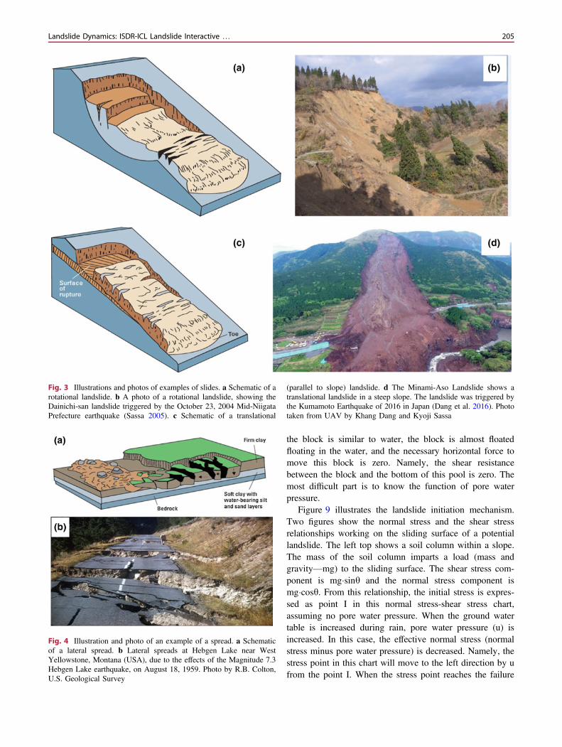
Fig. 3 Illustrations and photos of examples of slides. a Schematic of arotational landslide. b A photo of a rotational landslide, showing theDainichi-san landslide triggered by the October 23, 2004 Mid-NiigataPrefecture earthquake (Sassa 2005). c Schematic of a translational
(parallel to slope) landslide. d The Minami-Aso Landslide shows atranslational landslide in a steep slope. The landslide was triggered bythe Kumamoto Earthquake of 2016 in Japan (Dang et al. 2016). Phototaken from UAV by Khang Dang and Kyoji Sassa
Fig. 4 Illustration and photo of an example of a spread. a Schematicof a lateral spread. b Lateral spreads at Hebgen Lake near WestYellowstone, Montana (USA), due to the effects of the Magnitude 7.3Hebgen Lake earthquake, on August 18, 1959. Photo by R.B. Colton,U.S. Geological Survey
the block is similar to water, the block is almost floatedfloating in the water, and the necessary horizontal force tomove this block is zero. Namely, the shear resistancebetween the block and the bottom of this pool is zero. Themost difficult part is to know the function of pore waterpressure.
Figure 9 illustrates the landslide initiation mechanism.Two figures show the normal stress and the shear stressrelationships working on the sliding surface of a potentiallandslide. The left top shows a soil column within a slope.The mass of the soil column imparts a load (mass andgravity—mg) to the sliding surface. The shear stress com-ponent is mg�sinh and the normal stress component ismg�cosh. From this relationship, the initial stress is expres-sed as point I in this normal stress-shear stress chart,assuming no pore water pressure. When the ground watertable is increased during rain, pore water pressure (u) isincreased. In this case, the effective normal stress (normalstress minus pore water pressure) is decreased. Namely, thestress point in this chart will move to the left direction by ufrom the point I. When the stress point reaches the failure
Landslide Dynamics: ISDR-ICL Landslide Interactive … 205
line of this soil, the soil will fail. This is the initiation oflandslide by the mechanism of rainfall.
The right figure illustrates the initiation of landslide bypore water pressure plus earthquake loading. In the case ofslope layer that includes a certain height of ground watertable, as shown in Fig. 8, the initial stress before the earth-quake is located at A in Fig. 9. When an earthquake strikesthis area, seismic stress is loaded. The direction and thestress level will differ depending on the earthquake accel-eration and its direction, but the stress point moves from A tosomewhere. If the stress point reaches the failure line, thesoil layer will fail and a landslide is initiated. This is themechanism of an earthquake-induced landslide. Whether thelandslide will be initiated or not can be simulated using theundrained ring shear apparatus by loading the seismic stress(an example test result is shown in Fig. 17).
Figure 10 illustrates two cases of the undrained dynamicloading ring shear tests for the initiation of a landslide andthe movement of a the landslide. A sample will be takenfrom the potential shear zone or the soil layer or a layerwhich is estimated to have the same mechanical properties.The ring shear test will be conducted to determine whether alandslide will be initiated or not as shown in Fig. 9. Theinitiated landslide mass will move to the lower slope or ontothe alluvial deposit, as shown in the right figure of Fig. 10.The shear surface will be formed within the deposit.A sample will be taken from the deposit on which thelandslide mass now loadsrests on. A dynamic stress simu-lating the undrained loading by the moving landslide mass isgiven applied to the sample in the ring shear testing. Thestress necessary stress to shearing the deposit and the gen-erated pore water pressure and mobilized shear resistance
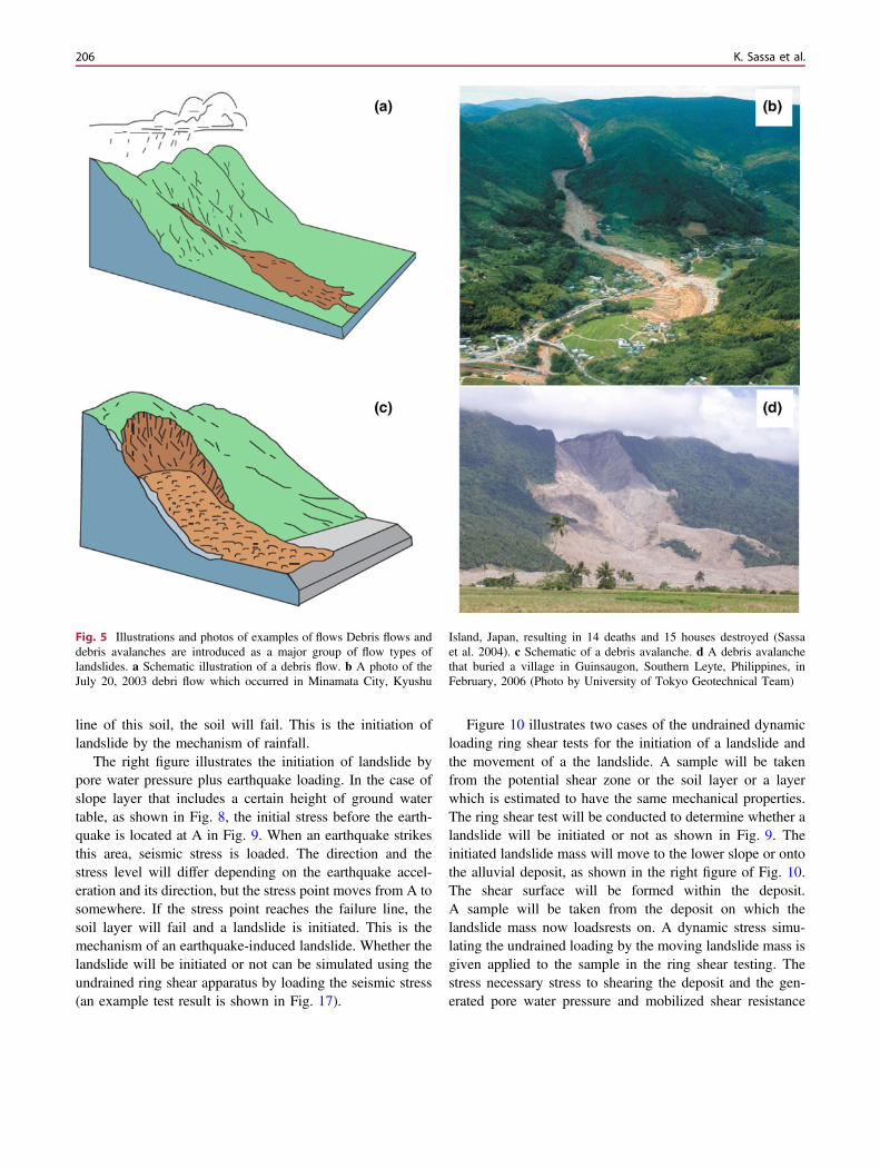
Fig. 5 Illustrations and photos of examples of flows Debris flows anddebris avalanches are introduced as a major group of flow types oflandslides. a Schematic illustration of a debris flow. b A photo of theJuly 20, 2003 debri flow which occurred in Minamata City, Kyushu
Island, Japan, resulting in 14 deaths and 15 houses destroyed (Sassaet al. 2004). c Schematic of a debris avalanche. d A debris avalanchethat buried a village in Guinsaugon, Southern Leyte, Philippines, inFebruary, 2006 (Photo by University of Tokyo Geotechnical Team)
206 K. Sassa et al.
during loading and motion will be measured. Normally twotests are necessary to assess the initiation of landslide and themotion of landslides.
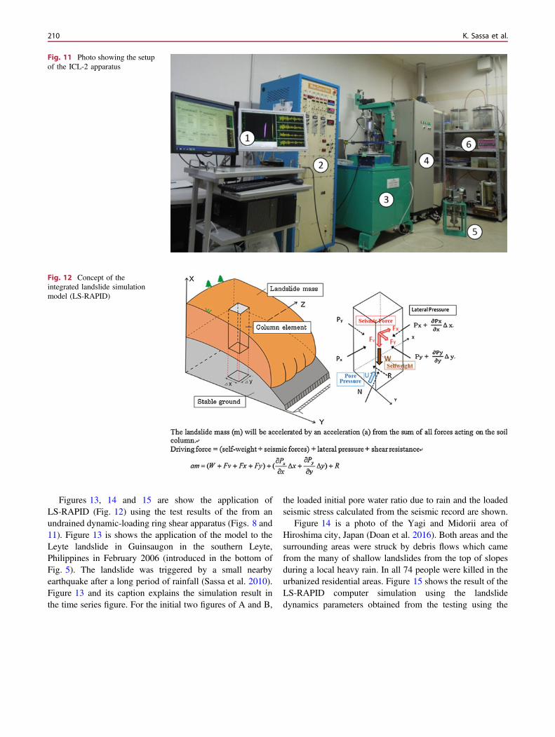
Figure 11 shows the setup (Nos. 1–6) of the undrainedring shear apparatus of ICL-2. Within this photo:
No. 1 is the computer and its two monitors (one for thetest control system and one for the recording system).
No. 2 is the control unit, including the amplifiers forvarious monitoring sensors and the four servo-controlamplifiers (Normal stress, shear stress, gap control andpore water pressures).
No. 3 is the main body of the undrained ring shearapparatus, including loading shear stress and speed controlmotor and gap control motor, normal stress loading system,the vertical and shear displacement measuring sensors, andpore pressure sensors (shown in Fig. 7).
No. 4 is the electricity supply and control system box.No. 5 is pore pressure supply and control system.
No. 6 is the de-aired water supply system with a vacuumpump, vibration control system, and a vacuum tank to pro-duce the sample fully saturated by de-aired water.
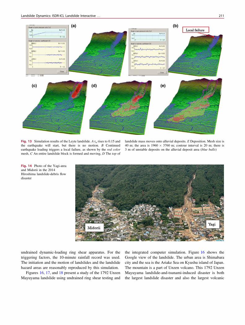
Figure 12 illustrates the concepts of the integrated land-slide simulation model (LS-RAPID). A soil column is takenfrom the landslide mass, and all forces (self-weigh of soilcolumn, the seismic forces, the lateral pressure, shear resis-tance on the bottom and the normal stress on the bottom)acting on this column are summed. The sum of force shouldaccelerate the soil mass of the column. The change of porewater pressure and the resulting shear resistance on thebottom during the seismic loading, dynamic loading andshearing are obtained from testing using the undraineddynamic loading ring shear apparatus. The development ofthe undrained dynamic loading ring shear test has enabledthe development of an integrated landslide simulation modelapplicable from the initiation of the motion until the termi-nation of motion. Examples of the simulation results areshown in Figs. 13, 14 and 15.
B: Triaxial compression
A: Direct shear tests
C: Ring shear tests
Fig. 6 Major three types of sheartest to measure the shear strengthof soils. A and B (Direct shear andTriaxial compression tests) are tomeasure the shear strength atfailure. C (Ring shear test) is tomeasure the residual shearstrength after failure
Landslide Dynamics: ISDR-ICL Landslide Interactive … 207
Schema c figure of the undrained dynamic-loading ring shear apparatus
Photo of shear box and normal stress loading piston and shear stress sensor
Fig. 7 An undrained dynamic-loading ring shear apparatus. The leftfigure presents the schematic figure of the latest version of undraineddynamic-loading ring shear apparatus (Sassa et al. 2016). The rightphoto shows the shear box of the apparatus. A Shear box; B Normalstress loading piston; C A pair of two shear stress sensors; D Loading
cap; E Hanging frame to lift the loading cap; F Pore-pressure sensor;G Connection to the pore-pressure control system; H One-touch plugfor the water drainage from the shear box; I One-touch plug for thede-aired water supply from the bottom of the shear box
Fig. 8 Illustration of theinitiation mechanisms of shallowand deep landslides due to rainfall
208 K. Sassa et al.
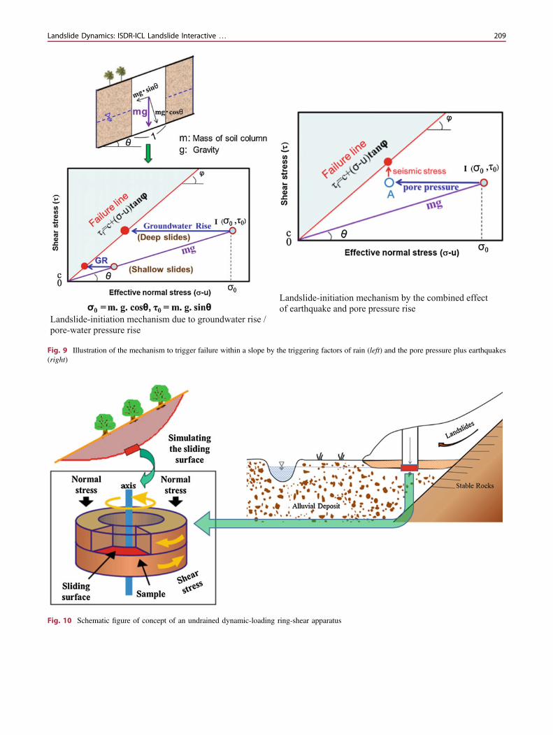
Landslide-initiation mechanism due to groundwater rise / pore-water pressure rise
Landslide-initiation mechanism by the combined effect of earthquake and pore pressure rise
Fig. 9 Illustration of the mechanism to trigger failure within a slope by the triggering factors of rain (left) and the pore pressure plus earthquakes(right)
Fig. 10 Schematic figure of concept of an undrained dynamic-loading ring-shear apparatus
Landslide Dynamics: ISDR-ICL Landslide Interactive … 209
Figures 13, 14 and 15 are show the application ofLS-RAPID (Fig. 12) using the test results of the from anundrained dynamic-loading ring shear apparatus (Figs. 8 and11). Figure 13 is shows the application of the model to theLeyte landslide in Guinsaugon in the southern Leyte,Philippines in February 2006 (introduced in the bottom ofFig. 5). The landslide was triggered by a small nearbyearthquake after a long period of rainfall (Sassa et al. 2010).Figure 13 and its caption explains the simulation result inthe time series figure. For the initial two figures of A and B,
the loaded initial pore water ratio due to rain and the loadedseismic stress calculated from the seismic record are shown.
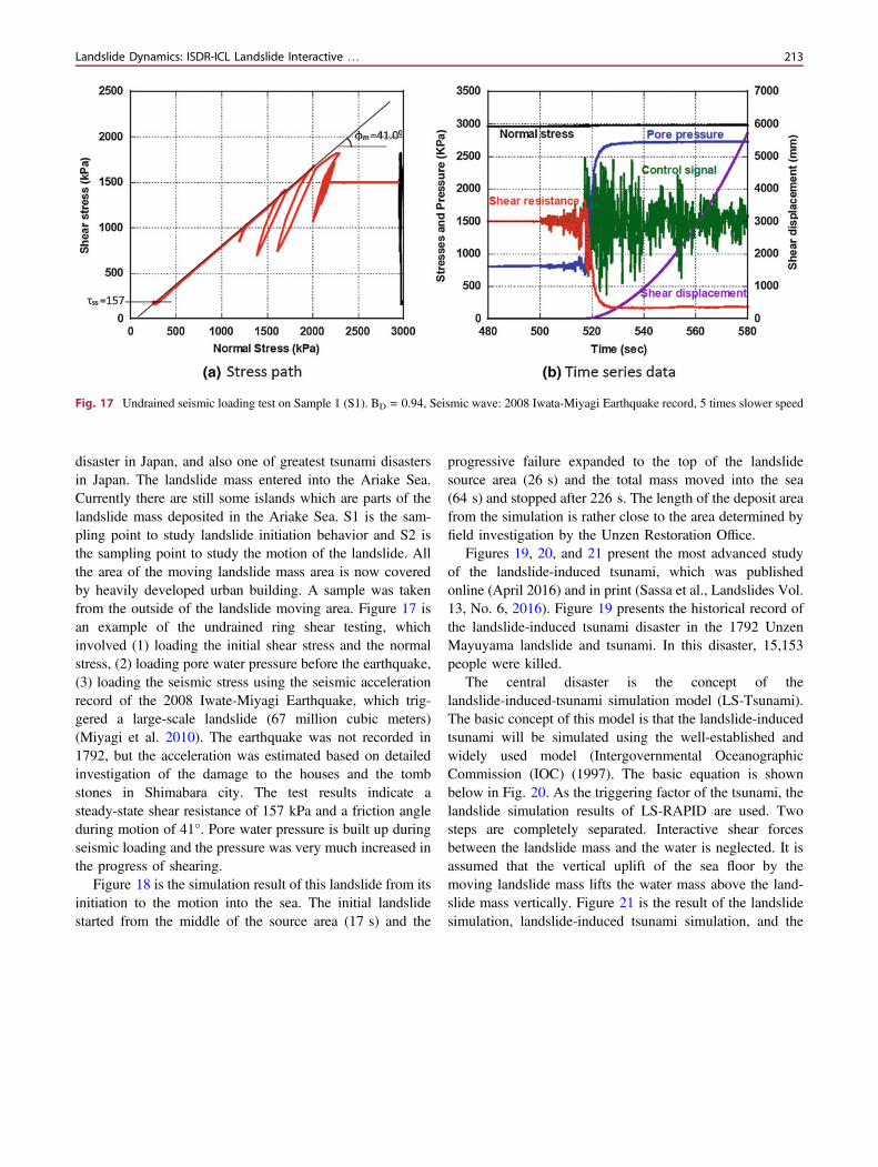
Figure 14 is a photo of the Yagi and Midorii area ofHiroshima city, Japan (Doan et al. 2016). Both areas and thesurrounding areas were struck by debris flows which camefrom the many of shallow landslides from the top of slopesduring a local heavy rain. In all 74 people were killed in theurbanized residential areas. Figure 15 shows the result of theLS-RAPID computer simulation using the landslidedynamics parameters obtained from the testing using the
Fig. 11 Photo showing the setupof the ICL-2 apparatus
Fig. 12 Concept of theintegrated landslide simulationmodel (LS-RAPID)
210 K. Sassa et al.
undrained dynamic-loading ring shear apparatus. For thetriggering factors, the 10-minute rainfall record was used.The initiation and the motion of landslides and the landslidehazard areas are reasonably reproduced by this simulation.
Figures 16, 17, and 18 present a study of the 1792 UnzenMayuyama landslide using undrained ring shear testing and
the integrated computer simulation. Figure 16 shows theGoogle view of the landslide. The urban area is Shimabaracity and the sea is the Ariake Sea on Kyushu island of Japan.The mountain is a part of Unzen volcano. This 1792 UnzenMayuyama landslide-and-tsunami-induced disaster is boththe largest landslide disaster and also the largest volcanic
Fig. 13 Simulation results of the Leyte landslide. A ru rises to 0.15 andthe earthquake will start, but there is no motion. B Continuedearthquake loading triggers a local failure, as shown by the red colormesh, C An entire landslide block is formed and moving, D The top of
landslide mass moves onto alluvial deposits. E Deposition. Mesh size is40 m; the area is 1960 � 3760 m; contour interval is 20 m; there is3 m of unstable deposits on the alluvial deposit area (blue balls)
Fig. 14 Photo of the Yagi-areaand Midorii in the 2014Hiroshima landslide-debris flowdisaster
Landslide Dynamics: ISDR-ICL Landslide Interactive … 211
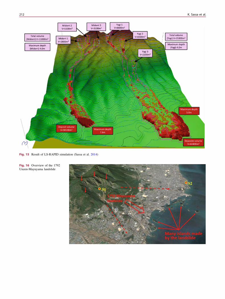
Fig. 15 Result of LS-RAPID simulation (Sassa et al. 2014)
Fig. 16 Overview of the 1792Unzen-Mayuyama landslide
212 K. Sassa et al.
disaster in Japan, and also one of greatest tsunami disastersin Japan. The landslide mass entered into the Ariake Sea.Currently there are still some islands which are parts of thelandslide mass deposited in the Ariake Sea. S1 is the sam-pling point to study landslide initiation behavior and S2 isthe sampling point to study the motion of the landslide. Allthe area of the moving landslide mass area is now coveredby heavily developed urban building. A sample was takenfrom the outside of the landslide moving area. Figure 17 isan example of the undrained ring shear testing, whichinvolved (1) loading the initial shear stress and the normalstress, (2) loading pore water pressure before the earthquake,(3) loading the seismic stress using the seismic accelerationrecord of the 2008 Iwate-Miyagi Earthquake, which trig-gered a large-scale landslide (67 million cubic meters)(Miyagi et al. 2010). The earthquake was not recorded in1792, but the acceleration was estimated based on detailedinvestigation of the damage to the houses and the tombstones in Shimabara city. The test results indicate asteady-state shear resistance of 157 kPa and a friction angleduring motion of 41°. Pore water pressure is built up duringseismic loading and the pressure was very much increased inthe progress of shearing.
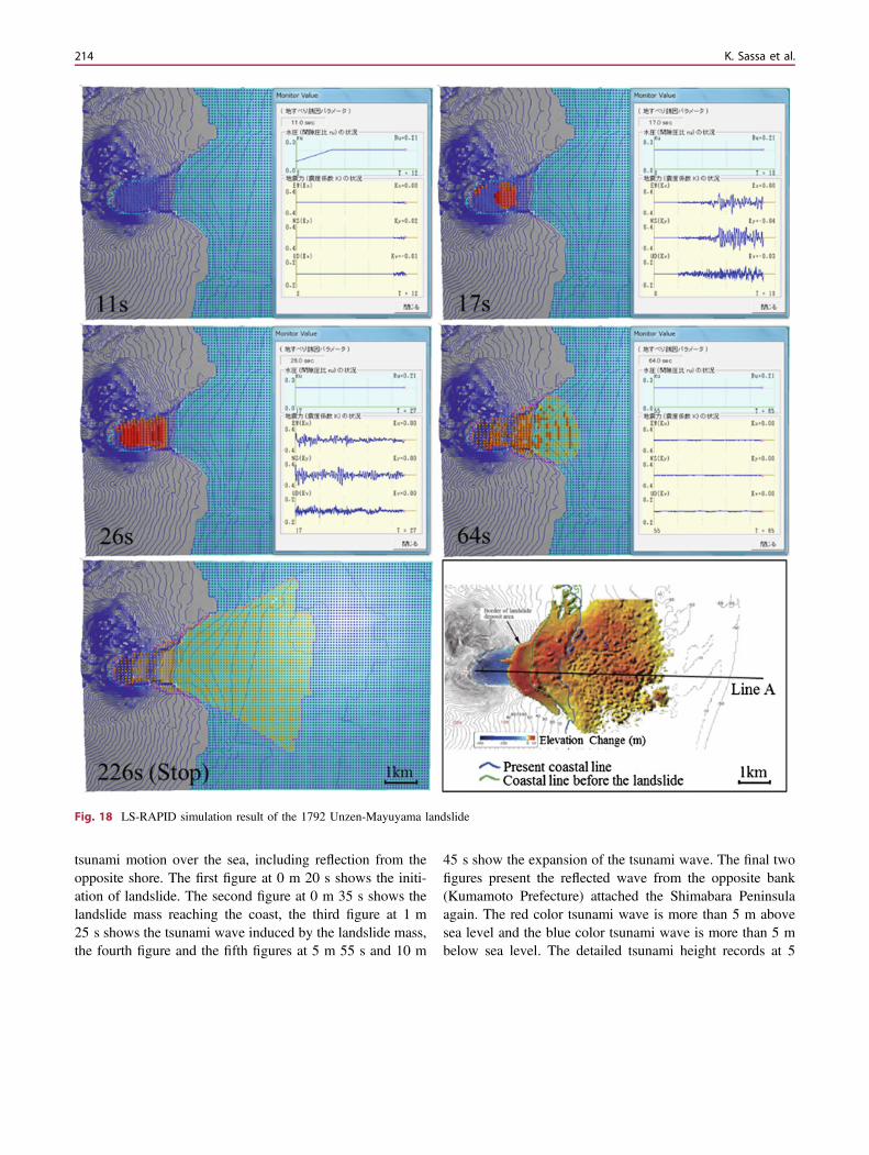
Figure 18 is the simulation result of this landslide from itsinitiation to the motion into the sea. The initial landslidestarted from the middle of the source area (17 s) and the
progressive failure expanded to the top of the landslidesource area (26 s) and the total mass moved into the sea(64 s) and stopped after 226 s. The length of the deposit areafrom the simulation is rather close to the area determined byfield investigation by the Unzen Restoration Office.
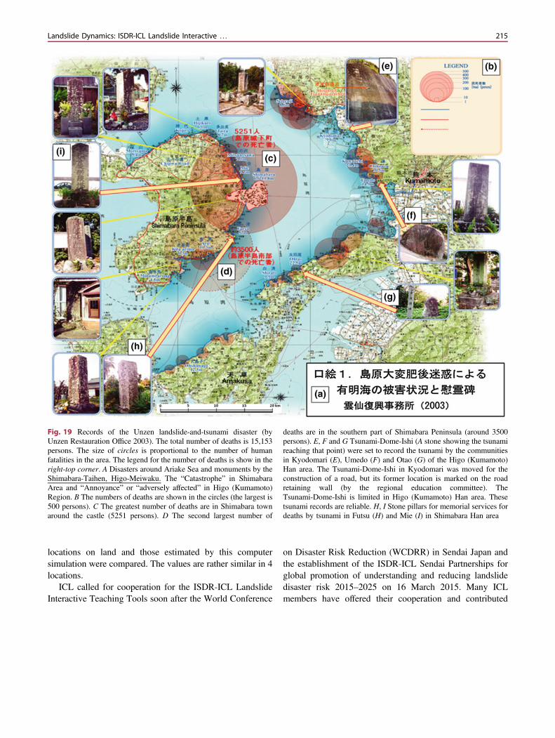
Figures 19, 20, and 21 present the most advanced studyof the landslide-induced tsunami, which was publishedonline (April 2016) and in print (Sassa et al., Landslides Vol.13, No. 6, 2016). Figure 19 presents the historical record ofthe landslide-induced tsunami disaster in the 1792 UnzenMayuyama landslide and tsunami. In this disaster, 15,153people were killed.
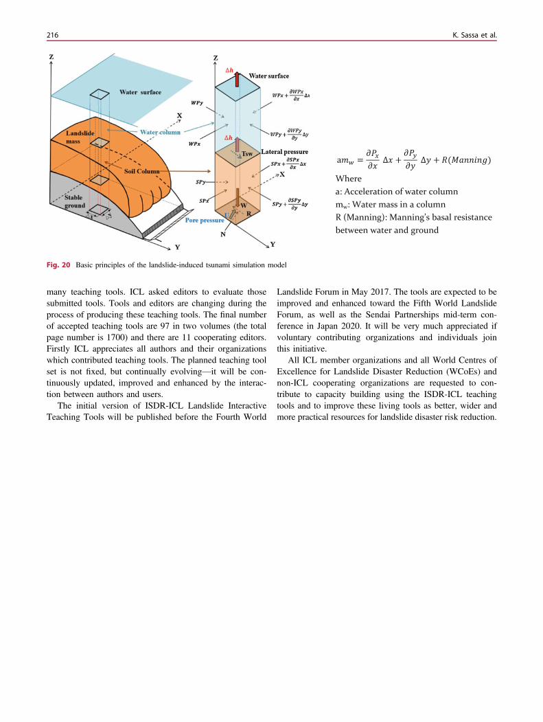
The central disaster is the concept of thelandslide-induced-tsunami simulation model (LS-Tsunami).The basic concept of this model is that the landslide-inducedtsunami will be simulated using the well-established andwidely used model (Intergovernmental OceanographicCommission (IOC) (1997). The basic equation is shownbelow in Fig. 20. As the triggering factor of the tsunami, thelandslide simulation results of LS-RAPID are used. Twosteps are completely separated. Interactive shear forcesbetween the landslide mass and the water is neglected. It isassumed that the vertical uplift of the sea floor by themoving landslide mass lifts the water mass above the land-slide mass vertically. Figure 21 is the result of the landslidesimulation, landslide-induced tsunami simulation, and the
Fig. 17 Undrained seismic loading test on Sample 1 (S1). BD = 0.94, Seismic wave: 2008 Iwata-Miyagi Earthquake record, 5 times slower speed
Landslide Dynamics: ISDR-ICL Landslide Interactive … 213
tsunami motion over the sea, including reflection from theopposite shore. The first figure at 0 m 20 s shows the initi-ation of landslide. The second figure at 0 m 35 s shows thelandslide mass reaching the coast, the third figure at 1 m25 s shows the tsunami wave induced by the landslide mass,the fourth figure and the fifth figures at 5 m 55 s and 10 m
45 s show the expansion of the tsunami wave. The final twofigures present the reflected wave from the opposite bank(Kumamoto Prefecture) attached the Shimabara Peninsulaagain. The red color tsunami wave is more than 5 m abovesea level and the blue color tsunami wave is more than 5 mbelow sea level. The detailed tsunami height records at 5
Fig. 18 LS-RAPID simulation result of the 1792 Unzen-Mayuyama landslide
214 K. Sassa et al.
locations on land and those estimated by this computersimulation were compared. The values are rather similar in 4locations.
ICL called for cooperation for the ISDR-ICL LandslideInteractive Teaching Tools soon after the World Conference
on Disaster Risk Reduction (WCDRR) in Sendai Japan andthe establishment of the ISDR-ICL Sendai Partnerships forglobal promotion of understanding and reducing landslidedisaster risk 2015–2025 on 16 March 2015. Many ICLmembers have offered their cooperation and contributed
Fig. 19 Records of the Unzen landslide-and-tsunami disaster (byUnzen Restauration Office 2003). The total number of deaths is 15,153persons. The size of circles is proportional to the number of humanfatalities in the area. The legend for the number of deaths is show in theright-top corner. A Disasters around Ariake Sea and monuments by theShimabara-Taihen, Higo-Meiwaku. The “Catastrophe” in ShimabaraArea and “Annoyance” or “adversely affected” in Higo (Kumamoto)Region. B The numbers of deaths are shown in the circles (the largest is500 persons). C The greatest number of deaths are in Shimabara townaround the castle (5251 persons). D The second largest number of
deaths are in the southern part of Shimabara Peninsula (around 3500persons). E, F and G Tsunami-Dome-Ishi (A stone showing the tsunamireaching that point) were set to record the tsunami by the communitiesin Kyodomari (E), Umedo (F) and Otao (G) of the Higo (Kumamoto)Han area. The Tsunami-Dome-Ishi in Kyodomari was moved for theconstruction of a road, but its former location is marked on the roadretaining wall (by the regional education committee). TheTsunami-Dome-Ishi is limited in Higo (Kumamoto) Han area. Thesetsunami records are reliable. H, I Stone pillars for memorial services fordeaths by tsunami in Futsu (H) and Mie (I) in Shimabara Han area
Landslide Dynamics: ISDR-ICL Landslide Interactive … 215
many teaching tools. ICL asked editors to evaluate thosesubmitted tools. Tools and editors are changing during theprocess of producing these teaching tools. The final numberof accepted teaching tools are 97 in two volumes (the totalpage number is 1700) and there are 11 cooperating editors.Firstly ICL appreciates all authors and their organizationswhich contributed teaching tools. The planned teaching toolset is not fixed, but continually evolving—it will be con-tinuously updated, improved and enhanced by the interac-tion between authors and users.
The initial version of ISDR-ICL Landslide InteractiveTeaching Tools will be published before the Fourth World
Landslide Forum in May 2017. The tools are expected to beimproved and enhanced toward the Fifth World LandslideForum, as well as the Sendai Partnerships mid-term con-ference in Japan 2020. It will be very much appreciated ifvoluntary contributing organizations and individuals jointhis initiative.
All ICL member organizations and all World Centres ofExcellence for Landslide Disaster Reduction (WCoEs) andnon-ICL cooperating organizations are requested to con-tribute to capacity building using the ISDR-ICL teachingtools and to improve these living tools as better, wider andmore practical resources for landslide disaster risk reduction.
a = ∆ + ∆ + ( )Wherea: Acceleration of water columnmw: Water mass in a columnR (Manning): Manning’s basal resistance between water and ground
Fig. 20 Basic principles of the landslide-induced tsunami simulation model
216 K. Sassa et al.
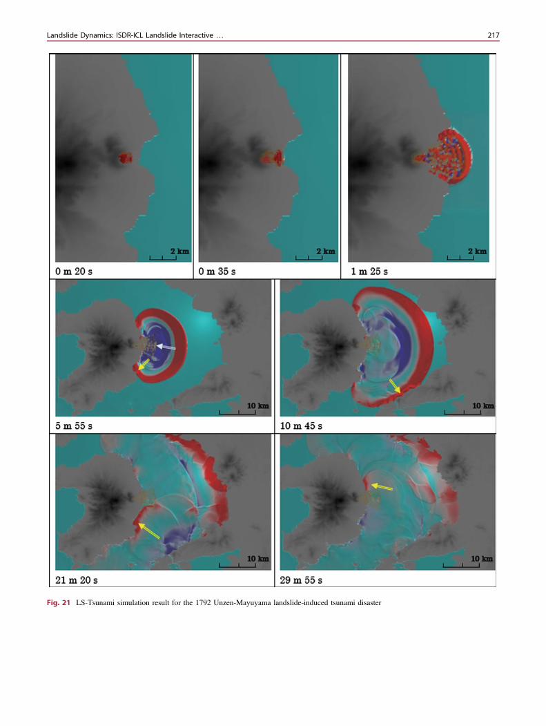
Fig. 21 LS-Tsunami simulation result for the 1792 Unzen-Mayuyama landslide-induced tsunami disaster
Landslide Dynamics: ISDR-ICL Landslide Interactive … 217
Acknowledgements Acknowledgement and call for cooperation forthe development of the ISDR-ICL Sendai Partnerships 2015–2025contributing to the Sendai Framework for Disaster Risk Reduction2015–2030.
References
Cruden DM (1991) A simple definition of a landslide. Bull Int AssocEng Geol 43:27–29
Cruden DM, Varnes DJ (1996) Landslide types and processes. In:Turner AK, Schuster RL (eds) Landslides investigation andmitigation. Transportation Research Board, US National ResearchCouncil. Special Report 247, Washington, DC, Chapter 3: 36–75
Dang K, Sassa K, Fukuoka H et al (2016) Mechanism of two rapid andlong-runout landslides in the 16 April 2016 Kumamoto earthquakeusing a ring-shear apparatus and computer simulation (LS-RAPID).Landslides 13(6):1525–1534
Doan HL, Sassa K, Fukuoka H et al. (2016) Initiation mechanism ofrapid and long runout landslides and simulation of hiroshimalandslide disasters using the Integrated Simulation Model(LS-RAPID). TXT-Tool 3.081-1.4. Landslide dynamics:ISDR-ICL landslide interactive teaching tools, vol 1 fundamental,mapping and monitoring. Accepted
Highland LM, Bobrowsky P (2008) The landslide handbook: a guide tounderstanding landslides. U.S. Geological Survey Circular 1325,129 p. http://pubs.usgs.gov/circ/1325/pdf/C1325_508.pdf
Highland LM, Bobrowsky P (2017) Landslide types: descriptions,illustrations and Photos. TXT-Tool 0.001-2.1. Landslide Dynamics:ISDR-ICL landslide interactive teaching tools, vol 1 fundamental,mapping and monitoring. Accepted
Miyagi T, Yamashina S, Esaka F, Abe S (2010) Massive landslidetriggered by 2008 Iwate-Miyagi inland earthquake in the AratozawaDam area, Tohoku, Japan. Landslides 8:99–108
Sassa K (2005) Landslide disasters triggered by the 2004 Mid-NiigataPrefecture earthquake in Japan. Landslides 2:135–142
Sassa K, Dang K (2016) Landslide dynamics for risk assessment.TXT-Tool 0.081-1.1. Landslide dynamics: ISDR-ICL landslideinteractive teaching tools, vol1 fundamental, mapping and moni-toring. Accepted
Sassa K, Nagai O, Solidum R et al (2010) An integrated modelsimulating the initiation and motion of earthquake and rain inducedrapid landslides and its application to the 2006 Leyte landslide.Landslides 7(3):219–236
Sassa K, Dang K, He B, Takara K, Inoue K, Nagai O (2014)Development of a new high-stress undrained ring shear apparatusand its application to the 1792 Unzen-Mayuyama megaslide inJapan. Landslides 11(5):827–842
Sassa K, Dang K, Yanagisawa H et al (2016) A new landslide-inducedtsunami simulation model and its application to the 1792Unzen-Mayuyama landslide-and-tsunami disaster. Landslides 13(6):1405–1419
Varnes DJ (1978) Slope movement types and processes. In: Schus-ter RL, Krizek RJ (eds) Landslides, analysis and control, specialreport 176: Transportation Research Board. National Academy ofSciences, Washington, DC., pp 11–33
Open Access This chapter is licensed under the terms of the CreativeCommons Attribution 4.0 International License (http://creativecommons.org/licenses/by/4.0/), which permits use, sharing,adaptation, distribution and reproduction in any medium or format, aslong as you give appropriate credit to the original author(s) and thesource, provide a link to the Creative Commons license and indicate ifchanges were made.
The images or other third party material in this chapter are included inthe chapter’s Creative Commons license, unless indicated otherwise ina credit line to the material. If material is not included in the chapter’sCreative Commons license and your intended use is not permitted bystatutory regulation or exceeds the permitted use, you will need toobtain permission directly from the copyright holder.
218 K. Sassa et al.