Embed Size (px)
Citation preview
1
Landscapes (geology and vegetation)
and colonial art of the Hamilton Region
SW Victoria
5th
Felix Museum Conversation
Hamilton Art Gallery
2 Dec. 2015
Rod Bird

2
3
Landscapes (geology and vegetation) and colonial art of the Hamilton Region
SW Victoria
Summary of presentation This is a brief introduction to the natural history of SW Victoria, within about 80 kms (an hour’s drive) from
Hamilton, as presented by the Hamilton Field Naturalists Club in Ref. 1. I will discuss the Hamilton region
in relation to local landscapes painted by 4 ‘colonial’ artists Buvelot, Chevalier, Clark and Von Guerard (at
least 50 landscape paintings or sketches were made here and 9 are in the Hamilton Gallery), or described by
the first explorers, settlers or government officials. One aim is to enable a comparison of the landscape we
had with what we have now, and to encourage the viewer to celebrate and care for our natural heritage.
There are 5 broad geological landscapes in our region.
1. Grampians Ranges & Plains – Silurian period (420 mya) marine sediments, compressed, folded &
faulted, throwing up the series of 4 ranges, capped with hard quartzose sandstone.
2. Volcanic Plains and Cones – 4.6 mya (Phase 1) & 2 mya (Phase 2) lava flows, with Phase 3 eruptions
to follow at 330,000 yrs BP and 30,000 years BP, producing cinder cones & flows.
3. Laterised Tablelands – e.g. Dundas Tableland, Laterised Tertiary period sediments (<65 mya) with
Devonian period (370-410 mya) outcrops of rhyolite or trachyte.
4. Casterton Rolling Hills – slopes & valley clays below Laterised Tableland, from soft Mesozoic era
sediments (70-240 mya) or Permian period glacial deposits (240-290 mya).
5. Sedimentary Rises & Plains – Ordovician period hills (440-520 mya) & Silurian period sandstone plains
(400-440 mya) e.g. Glenthompson-Wickliffe-Woorndoo.
Some vegetation was reported in written records of the early explorers, settlers, surveyors and officials.
Elements of that aspect will be presented here but for a detailed discourse see Ref. 3.
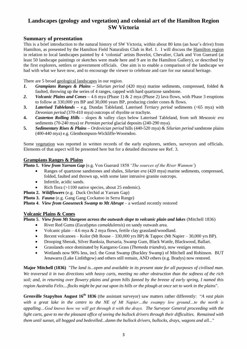
Grampians Ranges & Plains Photo 1. View from Yarram Gap (e.g. Von Guerard 1858 ‘The sources of the River Wannon’)
Ranges of quartzose sandstones and shales, Silurian era (420 mya) marine sediments, compressed,
folded, faulted and thrown up, with some later intrusive granite outcrops.
Infertile, acidic sands.
Rich flora (>1100 native species, about 25 endemic).
Photo 2. Wildflowers (e.g. Duck Orchid at Yarram Gap)
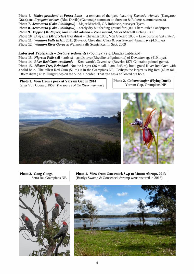
Photo 3. Fauna (e.g. Gang Gang Cockatoo in Serra Range)
Photo 4. View from Gooseneck Swamp to Mt Abrupt – a wetland recently restored
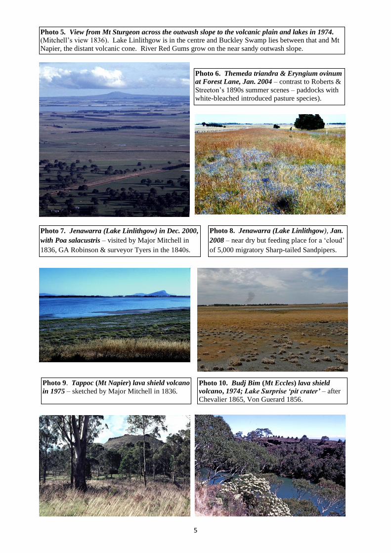
Volcanic Plains & Cones Photo 5. View from Mt Sturgeon across the outwash slope to volcanic plain and lakes (Mitchell 1836)
River Red Gums (Eucalyptus camaldulensis) on sandy outwash area.
Volcanic plain – 4.6 mya & 2 mya flows, fertile clay grassland/woodland.
Recent volcanoes – Kolor (Mt Rouse – 330,000 yrs BP) & Tappoc (Mt Napier – 30,000 yrs BP).
Drooping Sheoak, Silver Banksia, Bursaria, Swamp Gum, Black Wattle, Blackwood, Ballart.
Grasslands once dominated by Kangaroo Grass (Themeda triandra), now vestiges remain.
Wetlands now 90% less, incl. the Great Swamp (Buckley Swamp) of Mitchell and Robinson. BUT
Jenawarra (Lake Linlithgow) and others still remain, AND others (e.g. Bradys) now restored.
Major Mitchell (1836) "The land is...open and available in its present state for all purposes of civilised man.
We traversed it in two directions with heavy carts, meeting no other obstruction than the softness of the rich
soil; and, in returning over flowery plains and green hills fanned by the breeze of early spring, I named this
region Australia Felix....flocks might be put out upon its hills or the plough at once set to work in the plains".
Grenville Stapylton August 16th
1836 (the assistant surveyor) saw matters rather differently: “A vast plain
with a great lake in the centre to the NE of Mt Napier…the swampy low ground…to the north is
appalling…God knows how we will get through it with the drays. The Surveyor General proceeding with the
light carts, gave to me the pleasant office of seeing the bullock drivers through their difficulties. Remained with
them until sunset, all bogged and bedevilled...damn the bullock drivers, bullocks, drays, wagons and all..."
4
Photo 3. Gang Gangs
Serra Ra, Grampians NP. Photo 4. View from Gooseneck Swp to Mount Abrupt, 2013
(Bradys Swamp & Gooseneck Swamp were restored in 2013).
Photo 1. View from a peak at Yarram Gap in 2014
(after Von Guerard 1858 ‘The source of the River Wannon’)
Photo 2. Caleana major (Flying Duck)
Yarram Gap, Grampians NP
Photo 6. Native grassland at Forest Lane – a remnant of the past, featuring Themeda triandra (Kangaroo
Grass) and Eryngium ovinum (Blue Devils) (Gammage comment on Streeton & Roberts summer scenes).
Photo 7. Jenawarra (Lake Linlithgow) – Major Mitchell, GA Robinson, surveyor Tyers.
Photo 8. Jenawarra (Lake Linlithgow) – nearly dry but feeding ground for 5,000 Sharp-tailed Sandpipers.
Photo 9. Tappoc (Mt Napier) lava shield volcano – Von Guerard, Major Mitchell etching 1836.
Photo 10. Budj Bim (Mt Eccles) lava shield – Chevalier 1865, Von Guerard 1856 – Lake Surprise ‘pit crater’.
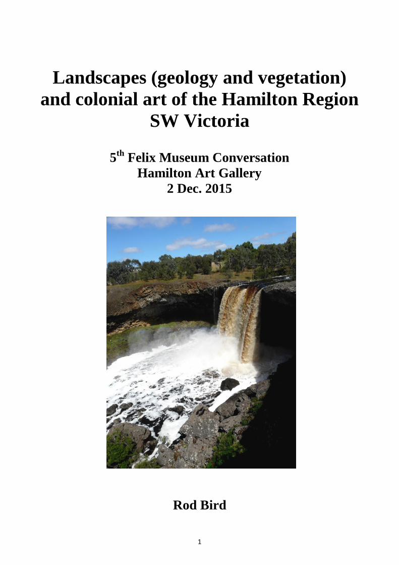
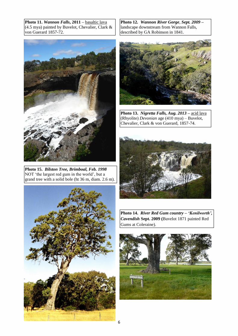
Photo 11. Wannon Falls in Jan. 2011 (Buvelot, Chevalier, Clark & von Guerard) basalt lava (4.6 mya).
Photo 12. Wannon River Gorge at Wannon Falls Scenic Res. in Sept. 2009
Laterised Tablelands – Tertiary sediments (<65 mya) (e.g. Dundas Tableland) Photo 13. Nigretta Falls (all 4 artists) – acidic lava (Rhyolite or Ignimbrite) of Devonian age (410 mya).
Photo 14. River Red Gum woodlands – ‘Kenilworth’, Cavendish (Buvelot 1871 Coleraine painted gums).
Photo 15. Bilston Tree, Brimboal. Not the largest (36 m tall, diam. 2.45 m), but a grand River Red Gum with
a solid bole. The tallest Red Gum (51 m) is in the Grampians NP. Perhaps the largest is Big Red (42 m tall,
3.86 m diam.) at Mullinger Swp on the Vic-SA border. That tree has a hollowed out bole.
5
Photo 5. View from Mt Sturgeon across the outwash slope to the volcanic plain and lakes in 1974. (Mitchell’s view 1836). Lake Linlithgow is in the centre and Buckley Swamp lies between that and Mt
Napier, the distant volcanic cone. River Red Gums grow on the near sandy outwash slope.
Photo 6. Themeda triandra & Eryngium ovinum
at Forest Lane, Jan. 2004 – contrast to Roberts &
Streeton’s 1890s summer scenes – paddocks with
white-bleached introduced pasture species).
Photo 7. Jenawarra (Lake Linlithgow) in Dec. 2000,
with Poa salacustris – visited by Major Mitchell in
1836, GA Robinson & surveyor Tyers in the 1840s.
Photo 8. Jenawarra (Lake Linlithgow), Jan.
2008 – near dry but feeding place for a ‘cloud’
of 5,000 migratory Sharp-tailed Sandpipers.
Photo 10. Budj Bim (Mt Eccles) lava shield
volcano, 1974; Lake Surprise ‘pit crater’ – after
Chevalier 1865, Von Guerard 1856.
Photo 9. Tappoc (Mt Napier) lava shield volcano
in 1975 – sketched by Major Mitchell in 1836.
6
Photo 12. Wannon River Gorge, Sept. 2009 –
landscape downstream from Wannon Falls,
described by GA Robinson in 1841.
Photo 15. Bilston Tree, Brimboal, Feb. 1998
NOT ‘the largest red gum in the world’, but a
grand tree with a solid bole (ht 36 m, diam. 2.6 m).
Photo 13. Nigretta Falls, Aug. 2013 – acid lava
(Rhyolite) Devonian age (410 mya) – Buvelot,
Chevalier, Clark & von Guerard, 1857-74.
Photo 14. River Red Gum country – ‘Kenilworth’,
Cavendish Sept. 2009 (Buvelot 1871 painted Red
Gums at Coleraine).
Photo 11. Wannon Falls, 2011 – basaltic lava
(4.5 mya) painted by Buvelot, Chevalier, Clark &
von Guerard 1857-72.
7
Introduction This is a brief synopsis of the natural history (geology and vegetation) of the Hamilton Region of Western
Victoria, within a ring of about 80 kms (an hour’s drive) from Hamilton, as presented by the Hamilton Field
Naturalists Club (Ref. 1).
I will mention only the broad features of the original vegetation and geology of the region, with particular
reference to early European visitors and colonial artists. Greater detail is available from Refs. 2-6.
The aim is to give a background to the various landscapes and vegetation that we encounter in our travels:
to explain a little of the geological history of our 5 major landscapes;
to show something of what we have now;
to draw attention to the scenes painted by the ‘colonial’ artists shortly after settlement, allowing a
comparison with the present, indicating how changed management has altered the environment;
to encourage the viewer to appreciate, celebrate and care for our natural heritage.
Our region has a great range of natural attributes that we should enjoy, conserve or restore.
Landscapes The landscapes of the region are broadly represented by 5 geological land-zones. The geological time scale for
the landscapes are indicated here by mya (million years ago) or BP (before present).
Grampians Ranges & Plains (Gariwerd, Dundas Ra., Western Black Ra. & Eastern Black Ra.)
Silurian era (420 mya) marine sediments compressed, folded and faulted;
Quartzose sandstone-capped mountains ranging 350 m above the plains
Granite outcrops intruded later (acid lava cooled below ground and exposed later by erosion of earth
above) near Mirranatwa, Zumsteins, Eastern Black Ra.;
Infertile, deep, acidic, sandy soils on outwash slopes;
Alluvial silty-loam flats along the creeks;
Infertile sandy-loam over dense clay on the outwash plains.
Rich flora (>1100 native species, about 25 endemic). Sub-alpine flora, including E, pauciflora (Snow
Gum) appear on Mt William and Major Mitchell Plateau.
E. camaldulensis (River Red Gum) on the plains between the ranges and on sandy outwash slopes.
E. baxteri (Brown Stringybark) and Callitris rhomboidea (Oyster Bay Pine) are dominant on the hills
and slopes, E. melliodora (Yellow Box) and E. leucoxylon (Yellow Gum) on lower slopes and flats.
E. obliqua (Messmate) and E. alaticaulis (Grampians Grey Gum) occupy the higher rainfall eastern-
facing slopes (e.g. near Strachans Hut). Banksia saxicola (Rock Banksia) is seen on upper slopes, B.
marginata (Silver Banksia) lower down and B. ornata (Desert Banksia) on deep sands.
Volcanic Plains, Scoria Cones & Wetlands Older basaltic plains, with a crust of basic lava from 4-40 m thick and hills (e.g. Al.low.ween, Mt
Pierrepoint) resulting from Phase 1 lava flows 4.6 mya, overlying Tertiary (<65 mya) sediments
(limestone, sandstone and shales). Laterised clayey soils developed on the weathered basalt.
Lakes formed by Phase 2 basalt 2 mya (e.g. Lake Repose volcanoes) flowing over Phase 1 basalt and
blocking streams (e.g. Jenawarra, Lake Linlithgow), or peat swamps formed from a Phase 3 flow
damming a valley (e.g. Mt Napier lava and Ko.nung.i.yoke, Buckley Swamp). The plains landscape was
dominated by Themeda triandra (Kangaroo Grass) and, in parts. Poa labillardiera (Common Tussock)
at settlement. Dwarf Banksia marginata (Silver Banksia) with E. ovata (Swamp Gum), A. mearnsii
(Black Wattle), Drooping Sheoak (Allocasuarina verticilata), Exocarpos cuppressiformis (Wild Cherry),
A. melanoxylon (Blackwood) and Bursaria spinosa (Sweet Bursaria) were the main tree species.
Young soils of the stony rises and scoria cones (e.g. Tappoc, Mt Napier), arising from eruptions from
~30,000 years BP (Mt Napier and Mt Eccles) to ~330,000 years BP (Mt Rouse). A flow of lava from
each of the above-named cones travelled many kilometres, two reaching the sea. The Byaduk Caves and
Wallacedale Tumuli lie along the Harmans Valley flow from Mt Napier. The vegetation is rather simple
with Pteridium esculentum (Austral Bracken) dominant. E. viminalis (Manna Gum) is the only species
of eucalypt present, along with A. melanoxylon as the dominant species. A. mearnsii has only a tiny
representation and Banksia marginata and Allocasuarina verticillata are invariably absent.
Erosion of Phase 1basalt by the Grange Burn and Muddy Creek revealing marine fossils (shells and
teeth) and plant fossils (e.g. Celery-top Pine) in limestone/mudstone sediments.
8
Laterised Tablelands (e.g. Dundas Tableland – the characteristic ‘Red Gum’ landscape)
Laterised Tertiary sediments (<65 mya) – acid, shallow sandy loam over clay (old duplex soils);
A plateau is dissected below the laterite by erosion, forming U & V-shaped, salt-prone valleys;
Devonian (370-410 mya rhyolite outcrops (acid lava cooled above ground) such as the 400 mya Mt
Cavendish and the Nigretta Falls. Trachyte outcrops also occur near Coleraine.
Casterton Rolling Hills (e.g. Coleraine and Wando Vale)
Steep grasslands dissected below the Dundas Tableland laterite cap;
Alkaline, brown, sandy clay loams or dark cracking clays in the valleys, arising from soft Mesozoic
sediments (70-240 mya) or Permian glacial deposits (240-290 mya).
River Red Gums scattered along watercourses and on hill tops.
Sedimentary Rises & Plains (sandy soils of Glenthompson-Wickliffe-Mortlake)
Ordovician sediments (440-520 mya) on hills (sandstone, shales, metamorphic rocks) & Silurian
sandstone plains (400-440 mya);
Old, laterised, infertile soils prone to erosion by wind and water, with saline gullies.
Grassland species and wildflowers abundant on undisturbed sites (e.g. Wickliffe roadsides)
Silver Banksia and Drooping Sheoak were once prominent trees but now mostly absent.
First Contacts – how the explorers and early settlers saw the land Major Thomas Mitchell
Mitchell, Stapylton and the party of convicts were travelling through a land from the Glenelg and Wannon
River to Portland that was filled with swamps. The land between the wetlands was also wet and boggy.
Today, some 50% of the wetlands in the Glenelg-Hopkins Catchment Management Area have been drained.
Some 90% of the wetlands on the volcanic plains have been drained. Some restoration has been achieved in
recent years, including Bradys Swamp, Gooseneck Swamp and Lake Condah (Ref. 4).
Mitchell’s party struggled across these landscapes in the wet spring of 1836 (Ref. 7):
"The land is...open and available in its present state for all purposes of civilised man. We met no other
obstruction than the softness of the rich soil; and, in returning over flowery plains and green hills fanned by the
breeze of early spring, I named this region Australia Felix....flocks might be put out upon its hills or the plough
at once set to work in the plains".
Mitchell described the plains as having trees spread in copses like an English pastoral woodland. An
indication of the open nature of the landscape near Coleraine can be seen in Thomas Clark’s 1860s paintings of
Bryans Creek and ‘Muntham’ Station.
Mitchell (1838) described a scene near Casterton as “A river winding among meadows which were fully a mile
broad, and green as an emerald. Above them rose swelling hills of fantastic shapes, but all smooth and thickly
covered with rich verdure. Behind these were higher hills, all having grass on their sides and trees on their
summits, and extending east and west, throughout the landscape as far as I could see”.
Near Pigeon Ponds, Mitchell described “hills of the finest forms all clothed with grass to their summits, and
many entirely clear of timber” (Ref. 7).
Granville Chetwynd Stapylton
The Assistant Surveyor in Mitchell’s party did not wax so eloquent – his task was to cope with this soft,
swampy country, extricating bogged wagons and boat carriages and managing unruly convicts (Ref. 8):
August 16th, 1836. “At 1 pm the Surveyor General proceeding with the light carts, gave over to me the
pleasant office of seeing the bullock drivers through their difficulties. Remained with them until sunset,
all bogged and bedevilled...damn the bullock drivers, bullocks, drays, wagons and all..."
September 5th, 1836. "We are cursedly hobbled with our drays....."
September 8th 1836. [Looking across the Great Swamp to Lake Linlithgow from the top of Mt Napier]
“A vast plain with a great lake in the centre to the north east of Mt Napier... the swampy low ground...to
the north is appalling...God knows how we will get through it with the drays...” [They skirted it on the
higher, drier west side).
9
Surveyor CJ Tyers
From Mt Rouse to the Grange on 7 Nov 1839: "... hopes of finding a passage between the Great Swamp…and
Mount Napier [Tappoc]...hemmed in on all sides by swamps and stony ranges …we skirted lake Linlithgow and
avoided the swamps..."
“...an open forest of stunted banksia extends 6 miles to the northward of Mt Rouse. Open downs, for 2 or 3
miles in width, divide this from an open forest (chiefly of eucalypti) extending some distance east and west of
Mount Sturgeon…”
David Alexander Beath
Beath settled at ‘Craigevar’ on the south side of the Grange [Digby Road] in 1849 and opened a store. The
Grange Burn and its vegetation was described in a letter from a visitor, Mary Broughton, in 1854 as “...a chain
of waterholes, some deep, plentiful gums along it [probably E. ovata] and kangaroo grass [Themeda triandra]
waving like a crop.
The Kangaroo Grass referred to covered much of the western plains and tablelands. Bill Gammage (Ref. 10)
has remarked that our view of the original Australian landscape has been greatly influenced by the paintings
of the Impressionists Tom Roberts and Arthur Streeton in the late 1890s. Their paintings showed the
introduced pasture grasses in summer, bleached white or cream. The tawny brown heads and stems of
Kangaroo Grasses in summer had long been exterminated by grazing stock and cultivation.
When burned, the regrowth of Kangaroo Grass in summer shows a deep green. The practice of burning
roadsides favours the persistence of this species; the failure to burn at regular intervals results in the loss of
other native species that cannot find space between the clumps.
George Augustus Robinson – Chief Protector of Aborigines from 1839-1849
The Great Swamp (Ko.nung.i.yoke) – May 1841
"I rode along the swamp and on the top of the highest ground the swamp extended further than I could see and
I observed many large arms or inlets branching off...I scarcely think Mitchell saw this swamp". [The Great
Swamp – Buckley Swamp – was drained after 1890 by making a cutting through a rise to Muddy Ck – Ref.6].
"In the swamp, several copses of tea-tree. Saw a fine large double hut, 10 feet in diameter with two entrances
and 4 ft high in centre...those like a cupola, when seen at a distance, have the appearance of mounds of earth.
They are built of large sticks closely packed together and covered with turf, grass side inwards”
"...The face of the whole country had been burnt and the rushes of the swamp and the young grass, anthistiria
[Kangaroo Grass]...a most verdant appearance....
Basalt plains east from Hamilton – June 1841
“Took a route through a beautiful undulating country covered with dwarf banksias, gums, cherry tree and well
grassed...the vast downs to the NW and NE, thinly studded with dwarf trees, was truly grand...a vast
champagne country…open downs, thinly studded with lightwood [Blackwood], banksia, cherry tree...saw a
great number of turkeys [Bustards] on our way...rich soil and well grassed".
Wannon – June 1841 – "The country around the Falls consists of open forest and dry, firm land well grassed.
A fine romantic view down the ravine...one of the finest natural curiosities I have seen and would be a fine
object for the pencil of Glover" [an English artist, then in Tasmania – Buvelot, Clark, Chevalier and von
Guerard painted the scene later]. "from this fall the Wannon is formed into a deep dell, the bank well grassed
and thinly studded with dwarf trees...native companions [Brolga] also frequent the plain...this morning a flock
of 23 turkeys [Bustards] flew across the Wannon".
John Robertson at ‘Wando Vale’ 1841
“…beautiful blackwood trees studded the hills in every sheltered nook – some of them really noble...all the
landscape looked like a park, with shade for sheep and cattle...The few sheep at first made little impression on
the face of the country for three or four years…many of our herbaceous plants began to disappear from the
pasture land… the long, deep-rooted grasses that held our strong clay hills together have died out…the ground
is exposed to the sun and it has cracked in all directions, and the clay hills are slipping…taking trees and all
with them…now that the soil is getting trodden hard with stock, springs of salt water are bursting out in every
hollow or watercourse…now mostly every little gully has a deep rut…ruts seven, eight and ten feet deep, and as
wide, are found for miles, where two years ago it was covered with tussocky grass like a land marsh….
10
Lloyd, a settler in SW Victoria 1862 – impact of hard-hoofed stock on the soil
“Great difficulty was experienced in riding at any pace exceeding…a jog-trot. The untrodden sward…was
literally comparable to a bed of sponge; our horses sank to the fetlocks at every step. No sooner had the rich
native pastures been well fed down and, as a consequence, every square inch of land continually impressed
with…little hoofs of sheep, then the whole of the occupied country began to assume a totally different aspect.
A two years occupation in most instances rendered a station so ‘firm’ that horse racing, kangaroo, emu and
dingo hunting…formed one of the principal sources of amusement to the light-hearted settlers”.
The great expanse of Kangaroo Grass is gone, although remnants may still be seen on roadsides, such as the
broad road reserve on Forest Lane NE from lake Linlithgow, where the verge has not been cultivated or
sprayed with herbicide. Kangaroo Grass and some other natives flourish when burned periodically for fire
control purposes – fire discourages the entry of pasture grasses and it reduces the mass of Themeda, allowing
other natives to grow in the spaces between tussocks.
GA Browne (Bruni 1903) – Tree clearance
By 1900 the country was "becoming so open that ere long the landholders will have to set about establishing
shelter plantations".
Munro (1886) – ‘Bassett’, an estate near Branxholme, traversed by the Crawford) River
"The change that has taken place...during the last 15 or 16 years could not possibly be imagined by any person
unacquainted with its original characteristics...The whole area was heavily timbered with gum and
honeysuckle [Silver Banksia], with a large proportion of splendidly grown wattle trees [Black Wattle] growing
on the river slopes. The forests have almost disappeared and, with the exception of the bleached trunks of the
larger gum trees, there is nothing to indicate that they ever existed...the honeysuckles have vanished...the native
grasses [Kangaroo Grass, Weeping Grass, Spear Grass and Wallaby Grass] are thick and flourish close to the
butts of the running timber, and a complete absence of tussocks [Poa labillardiera] which were so prevalent in
former days".
Colonial Artists and the Hamilton Region Landscape
Wannon Falls
Thomas Clark ~1860 – ‘Wannon Falls’ (oil on canvas), Hamilton AG (Ac. 2003.059)
Thomas Clark – ‘Wannon Falls’ (oil on canvas) [3 other versions of the above]
Thomas Clark – ‘Wannon Falls’ (oil on canvas) [view out from under the arch – 2 versions]
Louis Buvelot 1867 – ‘Wannon Falls’ (watercolour), Hamilton AG (Ac. 1295)
Louis Buvelot 1872 – ‘The Waterfall’ (oil), Ballarat AG
Nicholas Chevalier ~1865 – ‘The Wannon Falls’ (chromolithograph), Hamilton AG (Ac. 1986.030)
Emily Bowrang 1863 – ‘Wannon Falls’ (pencil and white chalk)
Eugene Von Guerard 1857 – ‘The Glenelg and Mt Gambier’ (drawings in pen, ink & wash)
o ‘Untere Vannon Fall’
o ‘View from behind Wannon Falls’
Eugene Von Guerard 1857 – ‘The Glenelg and Mt Gambier’ (drawings in pen, ink & wash), includes
a view from behind the arch of the Wannon Falls.
o ‘Der obere Fall des Vannon (moonet)’
Nigretta Falls
Nicholas Chevalier –‘Upper Falls on the Wannon’ (pencil)
Louis Buvelot 1874 – ‘Upper Falls on the Wannon’ (oil on canvas)
Thomas Clark –‘A view on the Wannon River’ (oil on canvas), [rocks above Nigretta Falls]
Thomas Clark – ‘The Upper Falls of the Wannon’ (oil on canvas), NG Vic [Nigretta Falls]
Eugene Von Guerard 1857 – ‘The Glenelg and Mount Gambier’ (pen, ink and wash)
o ‘Der obere Fall des Vannon (moonet)’
Grampians/Gariwerd
Eugene Von Guerard 1856 –‘Mt Sturgeon and Mount Abrupt’ (oil on canvas) [from NE of Mt
Rouse, ‘Blackwood Swamp?]
Eugene Von Guerard 1857 –‘Mt William from Mt Dryden’ (oil on canvas)
11
Eugene Von Guerard May-June 1856 – ‘Warrnambool to Mount Zero’ an album of 23 drawings in
pencil, ink & wash) and includes:
o ‘View of Mount Rouse’ May 1856
o ‘Mount Sturgeon and Mount Abrupt’ May 1856 – [a note on the sketch has ‘Lake 5 ½m...Mt
Rouse’; this is a sketch for his painting of the same name, minus sheep, man and dog].
Eugene Von Guerard 1858 –‘The sources of the River Wannon’
Eugene Von Guerard 1859-63 ‘– ‘Views Mainly of Victoria’ (ink and wash)
o ‘View of the Vannon Springs and Mount Abrupt’ [this sketch is similar to ‘The Source of the
River Wannon’]
Eugene Von Guerard 1865 –‘Mt William’
Eugene Von Guerard 1870 –‘View in the Grampians from the top of Serra Range’ (oil on canvas)
Eugene Von Guerard – ‘Mt William and part of the Grampians, Western Victoria’ (oil on card)
Eugene Von Guerard 1859-63 – Views, mainly from Victoria: Folio 15 ‘View of the Wannon
Springs and Mt Abrupt’ (ink and wash)
Nicholas Chevalier ~1864 –‘Mt Abrupt, the Grampians’ (oil on canvas), Hamilton AG (Ac.
2004.058) [Chevalier had 3 versions of this scene from the Wannon River valley to the SSE]
Nicholas Chevalier ~1864 –‘Mt Sturgeon, the Grampians’ (chromolithograph) Hamilton AG (Ac.
1986.029)
Nicholas Chevalier – ‘Mount Abrupt and the Grampians’ (coloured lithograph) [Kangaroo hunt to
the south of the mount and apparently near the bank of the Wannon River]
Nicholas Chevalier –‘Mt Sturgeon, Western District’ (chromolithograph)
Nicholas Chevalier – ‘Victoria Valley and Mt Caroline’ (engraving), Hamilton AG (Ac. 1980.27.03)
Emily Bowring ~1860s – ‘Mount Abrupt’ (pencil), Launceston AG
Emily Bowring ~1860s – ‘Mount Sturgeon , Dunkeld’ (pencil), Launceston AG
Mt Eccles
Eugene Von Guerard 1858 – ‘The crater of Mt Eccles’ (lithograph), Hamilton Gallery (Ac.
1985.003)
Eugene Von Guerard 1856 – (23 drawings in pen, ink & wash)
o ‘Crater of Mount Eeles’ June 1856 [Eels was the given name; it was corrupted later]
Eugene Von Guerard 1859-63 – ‘Views, mainly from Victoria: Folio 6’
o ‘Crater of Mt Ecles (sic) West of Victoria’ (ink and wash)
Nicholas Chevalier 1865 – ‘Mt Eccles’
Tappoc (Mt Napier)
Major Mitchell 1836 – etching of the crater on Mt Napier
Tower Hill
Eugene Von Guerard 1855 ‘Tower Hill’, Warrnambool AG
Eugene Von Guerard 1859-63 – ‘Views, mainly from Victoria: Folio 5’
o ‘Tower Hill' (ink and wash)
Coleraine area
Thomas Clark – ‘Early Coleraine’ ~ 1862 (oil on canvas), Hamilton AG (Ac. 1995.015)
Louis Buvelot 1871 – ‘Coleraine and a waterpool’ (oil on canvas) – [shows large Red Gums]
Thomas Clark – ‘Part of Murndal in the early days’ (oil on canvas)
Thomas Clark – ‘Koonongwootong Valley, Coleraine’ (oil on canvas)
Thomas Clark – ‘Muntham Station’ (oil on canvas), Hamilton AG (Ac. 0792) [Edward Henty’s
homestead nestled on the slope below the Dundas Tableland plateau – established in 1838]
Thomas Clark – ‘View of Muntham (Balochile area)’ (oil on canvas board)
William Tibbits 1876 – ‘Wando Dale’ (watercolour), Hamilton AG [buildings and paddocks]
This list comprises more than 50 past works from the colonial era for this region that relate to our notable
landmarks. The Hamilton Gallery has 9 of these works (indicated in the list above, see Ref. 9). Others that
feature Mt Arapiles (Chevalier and von Guerard) and The Hopkins River (Daniel Clark) are locations
considered outside the orbit of this article. Some sources where the art works (or illustrations thereof) may
be viewed are cited below.
12
References 1. Diane Luhrs (ed.) (2010) ‘Hamilton Region Nature Guide’ (publ. Hamilton Field Naturalists Club) 76
pp.
2. Rod Bird (2011) ‘River Red Gums at Bryans Swamp and other sites in SW Victoria and in South
Australia: photographs & measurements of significant ancient trees’ (publ. PR Bird) 54 pp.
3. Rod Bird (2011) ‘The Hamilton Region of south-western Victoria: an historical perspective of
landscape, settlement and impacts on Aborigine occupants, flora and fauna’ (publ. PR Bird) 37 pp.
4. Rod Bird (2014) ‘A short history of wetlands in SW Victoria: the landscape at settlement, impact of
agriculture, major wetlands near Hamilton, and wetland restoration’ (publ. PR Bird) 30 pp.
5. Rod Bird, Steve Clark, Murray Gunn (2008) ‘History, fauna and flora of Lake Linlithgow (Jenawarra)
and associated wetlands in south-west Victoria’ (publ. PR Bird) 56 pp.
6. Rod Bird ‘Restoration of the Buckley Swamp, formerly known as The Great Swamp (Ko.nung.i.yoke)
at Yatchaw, Hamilton, SW Victoria’ (publ. in www.hamilton-field naturalists-club-victoria.org.au) 11
pp.
7. Thomas Mitchell (1838) ‘Three expeditions into the interior of eastern Australia’ (Publ. T&W Boone,
London).
8. MH Douglas, L O’Brien (eds.)(1971) ‘The journal of Granville William Chetwynd from 10 Jul-6 Oct
1836’ in ‘The Natural History of Western Victoria’ (Publ. AIAS)
9. Hamilton Gallery Collection – locate this from www.hamiltongallery.org [then ‘collection’ and
‘search’ for required artist]
10. Bill Gammage (2011) ‘The Biggest Estate on Earth: how Aborigines made Australia’. (publ. Allen &
Unwin) 434 pp.
p. 34 – Arthur Streeton (1890) ‘Near Heidelberg’ [view of introduced pasture in summer]
p. 47 – Eugene von Guerard (1858) ‘Crater of Mt Eccles’ [impact of Aborigine burning]
p. 60-61 – Eugene von Guerard (1858) ‘Source of the Wannon’ [Grampians – view south from
a peak near Yarram Gap to Mt Abrupt showing the impact of controlled Aborigine burning].
11. Laura Murray (1989)’Great Australian Paintings’ (publ. National Book Distributors) 64 pp.
p. 20 – Arthur Streeton (1889) ‘Golden Summer, Eaglemont’ (private collection)
p. 25 – Tom Roberts (1891) ‘A Break Away!’ (South Aust AG)
12. John Currey (producer) (1971) ‘Great Australian Paintings’ (publ. Lansdowne Press) 72 pp.
Plate 3 – Louis Buvelot ‘(1872) ‘The Waterfall’(oil) (Ballarat AG)
Plate 10 – Arthur Streeton (1889) ‘Golden Summer’ (private collection) [a poor reproduction]
Plate 28 – Tom Roberts (1891) ‘The Breakaway!’ (South Aust AG)
13. William Splatt & Barbara Burton (1973) ‘100 Masterpieces of Australian Painting’(Publ. Rigby Ltd)
208 pp.
Arthur Streeton 1880 – ‘Near Heidelberg’ (oil on canvas)
Tom Roberts 1891 – ‘The Breakaway’ (oil on canvas)
14. A R Dodge (ed.) (1980) ‘Eugen von Guerard’ (Publ. Australian Gallery Directors Council) 139 pp.
‘Tower Hill’ 1855 (oil on canvas) [view from east rim]
‘Mount William from Mount Dryden’ 1857 (oil on canvas)
‘The Mitre Rock and Lake from Mount Arapiles’ 1874 (oil on canvas)
‘View in the Grampians from the top of Serra Range’ 1870 (oil on canvas)
15. D Thomas (ed.) (1988) ‘Creating Australia: 200 years of Art 1788-1988’, 248 pp.
Thomas Clark ~1860 – View on Muntham’ (oil on canvas)
Louis Buvelot ~1870 – ‘Upper Falls on the Wannon’ (oil on canvas)
Nicholas Chevalier 1863 – ‘Mount Arapiles and the Mitre Rock’ (oil on canvas)
Arthur Streeton 1889 – ‘Golden Summer, Eaglemont’ (oil on canvas)
Tom Roberts 1891 – ‘A breakaway!’ (oil on canvas)
16. Jane Clark & Bridget Whitelaw (1985) ‘Golden Summers: Heidelberg and Beyond’ (Publ.
International Cultural Corporation of Australia) 200 pp.
Arthur Streeton 1889 – ‘Golden Summer, Eaglemont’ (oil on canvas)
Arthur Streeton 1890 – ‘Near Heidelberg’ (oil on canvas)
Arthur Streeton `1888 – Impression for ‘Golden Summer’ (oil on canvas)
Tom Roberts 1891 – ‘A Break Away!’ (oil on canvas) [thirsty sheep rushing to a boggy
waterhole in January]
17. Julian Faigan (1984) ‘The Colonial Art of the Western District’ (Publ. City of Hamilton AG)
Louis Buvelot 1874 – ‘Upper Falls on the Wannon’ (coloured lithograph), NG Vic
Louis Buvelot 1867 – ‘Wannon Falls’ (watercolour), Hamilton AG [view from downstream]
Nicholas Chevalier – ‘Upper Falls on the Wannon’ (pencil) Ballarat AG
13
Nicholas Chevalier – ‘Mount Abrupt and the Grampians’ (coloured lithograph) [Kangaroo
hunt to the south of the mount and apparently near the bank of the Wannon River]
Nicholas Chevalier – ‘The Wannon Falls’ (chromolithograph)
Nicholas Chevalier – ‘Mount Sturgeon, Western District’ (chromolithograph)
Thomas Clark – ‘Wannon Falls’ (oil on canvas) [view out under the arch, behind the fall]
Thomas Clark – ‘Wannon Falls’ (oil on canvas), Warrnambool AG [view from downstream]
Thomas Clark – ‘A view on the Wannon River’ (oil on canvas) [rocks above Nigretta Falls]
Thomas Clark – ‘Part of Murndal in the Early Days’ (oil on canvas)
Thomas Clark – ‘Koonongwootong Valley, Coleraine’ (oil on canvas)
Thomas Clark – ‘Muntham’ (oil on canvas), Hamilton AG
Thomas Clark – ‘View on Muntham’ (oil on canvas on board), Glenelg Shire, Portland
Eugene von Guerard 1856 – ‘Mount Sturgeon and Mount Abrupt’ (oil on canvas) [view
across a swamp, perhaps the ‘Blackwood’ Swamp NE from Mt Rouse]
Eugene von Guerard – ‘Mount Sturgeon and part of the Grampians, Western Victoria’ (oil on
card), NG Vic [swamp in foreground]
Eugene Von Guerard May-June 1856 – ‘Warrnambool to Mount Zero’ an album of 23
drawings in pencil, ink & wash) and includes:
o ‘View of Mount Rouse’ May 1856
o ‘Mount Sturgeon and Mount Abrupt’ May 1856 – [a note has ‘Lake 5 ½m...Mt
Rouse’ this is a sketch for his painting of the same name, minus sheep, man and dog].
o ‘Crater of Mount Eeles’ June 1856 [Eels was the given name; it was corrupted later]
Eugene Von Guerard 1857 – ‘The Glenelg and Mount Gambier’ (pen, ink and wash)
o ‘Der obere Fall des Vannon (moonet)’
o ‘Untere Vannon Fall’
o ‘View from behind Wannon Falls’
Eugene Von Guerard 1859-63 ‘– ‘Views Mainly of Victoria’ (ink and wash)
o ‘Tower Hill’in Folio 5
o ‘Crater of Mount Ecles [sic], west of Victoria’ in Folio 6 [this sketch is similar to the
other Crater drawing]
o ‘View of the Vannon Springs and Mount Abrupt’ in Folio 15 [this sketch is similar to
the ‘Source of the Wannon]’
Emily Bowring ~1860s – ‘Mount Abrupt’ (pencil), Launceston AG
Emily Bowring ~1860s – ‘Mount Sturgeon , Dunkeld’ (pencil), Launceston AG
Emily Bowring 1863 – ‘Wannon Falls’ (pencil and white chalk), Launceston AG
William Tibbits 1876 – ‘Wando Dale’ (watercolour), Hamilton AG [buildings and paddocks]
18. Peter Dowling, Daniel McOwan (2013) ‘Exposing Thomas Clark: a colonial artist in Western
Victoria’ (Publ. City of Hamilton Art Gallery) 98 pp.
Thomas Clark – ‘Wannon Falls’ (oil on canvas) [view out from under the arch, behind the
waterfall]; NG Vic
Thomas Clark – ‘Wannon Falls’ (oil on canvas) [view out from under the arch, behind the
waterfall]; Private collection.
Thomas Clark – ‘Wannon Falls’ (oil on canvas), Hamilton AG (Ac. 2003.059) [front view]
Thomas Clark – ‘Wannon Falls’ (oil on canvas), NG Vic [a version of the above]
Thomas Clark – ‘Wannon Falls’ (oil on canvas), NG Aust [a version of the above]
Thomas Clark – ‘Wannon Falls’ (oil on canvas), Warrnambool AG [a version of the above]
Thomas Clark – ‘The Upper Falls of the Wannon’ (oil on canvas), NG Vic [Nigretta Falls]
Thomas Clark – ‘Koonongwootong Landscape’ (oil on canvas; view to Dundas Range and
Grampians); Private collection [alternative name ‘Koonongwootong Valley, Coleraine’]
Thomas Clark – ‘View of Muntham Station’ (oil on canvas), Hamilton AG (Ac. 0792);
[Edward Henty’s home was built after 1838 on the slope below the Dundas Tableland plateau]
Thomas Clark – ‘Muntham Homestead with garden’ (oil on canvas); Private collection
Thomas Clark – ‘View of Den Hills near Coleraine’ (oil on canvas on board), [alternative title
‘View on Muntham’]; Glenelg Shire Council, Portland
Thomas Clark – ‘Mr Winter’s Run on the Wannon’ (oil on canvas); [alternative title ‘Murndal
in the Early Days]; Private collection
Thomas Clark – ‘Early Coleraine’ ~ 1862 (oil on canvas); Hamilton AG (Ac. 1995.015)
Thomas Clark – ‘Early Coleraine’ (oil on canvas); Private collection [a version of the above]