Embed Size (px)
Citation preview

Non-Technical Summary Environmental Impact of Laúca Dam Construction Project
Kwanza Environmental Development Office Environmental Impact Assessment for the Laúca Dam Construction Project
NON-TECHNICAL SUMMARY
MAY 2013

Non-Technical Summary Environmental Impact of Laúca Dam Construction Project
Credits: Title: Environmental Impact Assessment for Laúca Dam Construction Project Client: Kwanza Environmental Development Office (Gabinete de Aproveitamento do Médio Kwanza – GAMEK). Rua do Massangano, s/n, Luanda. Telephone: +244-222-445072 / 222-675801; Fax: +244-222-447973 http://www.gamek.com Consultants: Holísticos, Lda. – Serviços, Estudos & Consultoria. Rua 60, Casa 559, Urbanização Harmonia, Benfica, Luanda. Telephone: 222 006938; Fax: 222 006435 Email: [email protected] www.holisticos.co.ao Intertechne Consultores, S.A. Av. João Gualberto, 1259, 16º andar – Alto da Glória. CEP 80030-001 Curitiba – Paraná – Brazil Telephone: +55(41)3219-7200; Fax: +55(41)3219-7848 Email: [email protected] Date: May 2013.

Non-Technical Summary Environmental Impact of Laúca Dam Construction Project 1. INTRODUCTION This document provides the Non-Technical Summary (Resumo Não Técnico – RNT) of the Environmental Impact Assessment (EIA) for the Laúca Dam Construction Project. The document was prepared pursuant to the applicable laws, specifically Decree No. 51/04, dated July 23, governing the requirements for development of Environmental Impact Assessments (EIA) for all projects capable of generating environmental impacts. Odebrecht contracted Holísticos – Serviços, Estudos e Consultoria, Lda. and Intertechne – Consultores S.A. for purposes of preparing the project study. From 2007-2009, the two firms developed a document on the Laúca Hydroelectric Unit based on an original study titled Caculo-Cabaca. As part of the project, in 2012 the partnership issued an EIA report on Diversion of the Kwanza River, which was submitted to the Ministry of the Environment on January 21, 2013. The dam construction EIA was founded on previous studies and included updated information and technical confirmation of the respective data. This updated report encompasses, in addition, a bibliographic survey and new field studies centered on social aspects of the project. The EIA was prepared for the Kwanza Environmental Development Office (Gabinete de Aproveitamento do Médio Kwanza – GAMEK) in its status as project sponsor. GAMEK is a component body of the Ministry of Energy and Water and has a separate legal personality and administrative and financial independence. The nature and purpose of GAMEK are specified in its Institutional Bylaws (Estatuto Orgânico), as approved by Joint Directive (Despacho Conjunto) No. 14/86, dated March 17, 1986. This document was prepared for the purposes of laying out the key issues relating to the Laúca Dam construction project in the Middle Kwanza Basin, specification of the objectives of the Environmental Impact Assessment, and justification of project. The document also examines the location of the project and the scope of the environmental impact assessment. 2. JUSTIFICATION Angola’s long conflict generated profound economic and social disruptions, severely destabilizing key public service sectors, including the energy sector. The Government of Angola has made rebuilding of the domestic infrastructure damaged during the conflict a priority. The growth of gross domestic product and the expansion of non-oil producing economic activities, including farming, civil construction, commerce, and manufacturing has led to a significant increase in energy demand in the country, in addition to a rise in demand by individual consumers, a product of the growth of urban centers, which continue to be subject continuous supply interruptions. According to the Ministry of Industry (2005), nearly 90% of all businesses in Angola have a generator to meet their in-house energy demands and counter the problem of unpredictable energy availability and inadequate supply.
Non-Technical Summary Environmental Impact of Laúca Dam Construction Project Hydroelectric power generation is considered sustainable and clean and is the most widely employed method in Angola. The Kwanza River Basin has the largest power generation capacity among Angola’s 48 river basins. Currently 700 MW are produced at the two hydroelectric plants that supply the North System, the Cambambe Hydroelectric Unit, with an installed capacity of 180 MW, and the Capanda Hydroelectric Unit, which generates 530 MW. The electric power and water sector investment Program sets out the 2016 targets established by the Ministry of Energy and Water:
• Per capita Increase in Consumption: The key target to be met by late 2016 involves the implementation of a production capacity of 7,000 MW, or 95,000 GWh, based primarily on renewable sources, with a view to ensuring per capita consumption of 4,000 kWh;
• Increase in the number of household connections and access points, estimated at 2 million;
• Interconnection of all isolated systems and establishment of the National Energy Transport Network (Rede Nacional de Transporte de Energia);
• Increase in the use of new and renewable energy sources (wind and solar) as a share of the Angolan energy grid, set at 1.5%.
Among the objectives of the Long-Term Development Strategy, Angola 2025 (Estratégia de Desenvolvimento a Longo Prazo, Angola 2025), is ensuring the efficient and integrated use of all energy sources in the Angolan energy grid to foster sustainable development and promoting the increased adoption of renewable natural energy sources and energy self-sufficiency throughout the country. In addition, the Angolan government has proposed a set of strategic recommendations for energy generation to promote sustainable development. Based on the information above and given the country’s energy needs, the government’s incentives to the production of clean energy through construction of the Láuca Dam is fully consistent with its strategic proposals, a project which is certain to provide the country with innumerable benefits in energy generation and distribution. 3. LOCATION The project site is located in the North System’s power generation and distribution area, part of Angola’s largest river basin with remaining available potential for the implementation of additional hydroelectric units. The dam will be built on the Malanje, Kwanza Norte, and Kwanza Sul provincial boundaries in the Middle Kwanza River Basin (Km 307.5), approximately 47 km downstream from the Capanda Hydroelectric Unit, near Nhangue Ya Pepe (Figure 1 – Non-Technical Summary). The project site is reached via the principal Access Road. The access road runs approximately 7 km from the main highway (Figure 2 – Non-Technical Summary).

Non-Technical Summary Environmental Impact of Laúca Dam Construction Project
Figure 1 – Non-Technical Summary: Geographic location of Laúca Dam. Legend Mapa de Localização = Location Map Legenda = Legend Capital Nacional = National Capital Cidades = Cities Limite de Província = Provincial Boundary Rios = Rivers AHE Laúca = Laúca Hydroelectric Unit Estradas = Highways Estradas Terraplenadas = Unpaved Roads
Non-Technical Summary Environmental Impact of Laúca Dam Construction Project
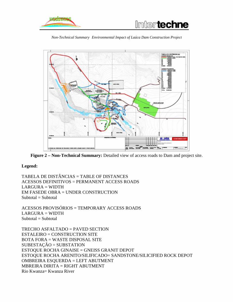
Figure 2 – Non-Technical Summary: Detailed view of access roads to Dam and project site.
Legend:
TABELA DE DISTÂNCIAS = TABLE OF DISTANCES ACESSOS DEFINITIVOS = PERMANENT ACCESS ROADS LARGURA = WIDTH EM FASEDE OBRA = UNDER CONSTRUCTION Subtotal = Subtotal ACESSOS PROVISÓRIOS = TEMPORARY ACCESS ROADS LARGURA = WIDTH Subtotal = Subtotal TRECHO ASFALTADO = PAVED SECTION ESTALEIRO = CONSTRUCTION SITE BOTA FORA = WASTE DISPOSAL SITE SUBESTAÇÃO = SUBSTATION ESTOQUE ROCHA GINAISE = GNEISS GRANIT DEPOT ESTOQUE ROCHA ARENITO/SILIFICADO= SANDSTONE/SILICIFIED ROCK DEPOT OMBREIRA ESQUERDA = LEFT ABUTMENT MBREIRA DIRITA = RIGHT ABUTMENT Rio Kwanza= Kwanza River

Non-Technical Summary Environmental Impact of Laúca Dam Construction Project NOTAS = NOTES OS ESTUDOS AQUIR APRESENTADOS SÃO PRELIMINARES E PODERÃO SOFRER ALTERAÇÕES DURANTE O PROJETO EXECUTIVO ↓ THE STUDIES PRESENTED HEREIN ARE PRELIMINARY AND MAY BE AMENDED DURING PREPARATION OF THE EXECUTIVE PROJECT Documentos de Referência = Reference Documents AH – LAÚCA = LAÚCA HYDROELECTRIC UNIT ESTUDO OBRA PRINCIPAL = PRINCIPAL PROJECT STUDY GERAL = GENERAL ACESSOS PROVISÓRIOS E DEFINITIVOS = TEMPORARY AND PERMANENT ACCESS ROADS ARRANJO GERAL = GENERAL LAYOUT [remaining text unreadable]
4. PROJECT OBJECTIVES AND DESCRIPTION The purpose of the project is the construction of a dam for the Laúca hydroelectric unit. To this end, open-air and underground construction work will be required. The hydroelectric unit will be implemented along a stretch of the Kwanza River Valley in which the river’s course is significantly embedded, forming a “Z” shape configuration marked by a natural slope of 100 m distributed along a two (2) km extension. Figure 3 – Non-Technical Summary lays out the general schematic of the construction work. The construction work provides for closing off the valley with a compacted concrete cylinder dam rising 132 m with a crest extension of approximately 1,100 m, built under cofferdams running across the river bed. Deviation and control of the river will be accomplished through construction of two (2) tunnels excavated on the right abutment. The tunnels will be equipped with concrete control structures and closing devices composed of three (3) gates each. As mentioned above, the tunnels are under construction and a corresponding EIA was performed and submitted to the Ministry of the Environment in January 2013. With respect to flooding control, the project design included construction of a flood discharger over the river bed, in conjunction with a control structure consisting of three (3) segment gates measuring 15.00 m wide and 20.95 m high, connected to a diversion pipe. The structure was designed to withstand a flow pressure of 10,020 m³/s.

Non-Technical Summary Environmental Impact of Laúca Dam Construction Project
Figure 3 – Non-Technical Summary: General layout of the Laúca Dam construction project
Legend: P/ CENTRAL ECOLÓGICA = TO ECOLOGIC CENTER P/ SUBESTAÇÃO = TO SUBSTATION CENTRAL ECOLÓGICA = ECOLOGICAL CENTER SUBESTAÇÃO = SUBSTATON BARRAGEM BCC = BCC DAM TÚNEL DE ACESSO = ACCESS TUNNEL DESCARREGADOR DE FUNDO = DEPTH DISCHARGER DESCARREGADOR DE CHEIAS = FLOOD DISCHARGER ACESSO = ACCESS ROAD TÚNEIS DE DESVIO = DIVERSION TUNNEL TOMADA D’ÁGUA = WATER INTAKE CENTRAL PRINCIPAL = MAIN STATION TÚNEL DE ACESSO = ACCESS TUNNEL PLANTA = BLUEPRINT

Non-Technical Summary Environmental Impact of Laúca Dam Construction Project
REVISÃO GERAL = GENERAL REVIEW descrição = description elaborado = prepared by verificado = verified by supervisor = supervisor aprovado = approved gerente de projecto = project manager data = date responsável = lead engineer Gabinete de Aproveitamento do Médio Kwanza = Middle Kwanza River Basin Development Office APROVEITAMENTO HIDROELÉTRICO DE LAÚCA = LAÚCA HYDROELECTRIC UNIT título = title PROJETO BÁSIC = BASIC PROJECT DESIGN ARRANJO GERAL = GENERAL SCHEMATIC PLANT = BLUEPRINT escola = school código Intertechne = Intertechne Code revisado = reviewed ????? código ????? = ???? Code revisado = reviewed Direitos Autorais Reservados = Copyrights Reserved PROÍBIDA QUALQUER REPRODUÇÃO SEM AUTORIZAÇÃO EXPRESSA ↓ ANY REPRODUCTION IS PROHIBITED EXCEPT WITH THE EXPRESS AUTHORIZATION OF THE AUTHOR ORIGINAL = ORIGINAL
The Power Generation Circuit is made up of the following hydraulic structures:
• The adduction channel, integrated to the reservoir, allowing for adequate flow to the intake, designed for a depletion of 50 meters (m);
• Six (6) gravity intakes. Access from the right bank will be accomplished through a landfill structure and a reinforced concrete bridge connecting to the nearest intake. The intake towers will be connected by reinforced concrete bridge sections extending 18 m, to ensure continued rolling of the gantry crane;
• Six (6) adduction tunnels to the underground power house equipped with six (6) turbine sets, having a vertical axis generator with unit power of 334 mega-watts (MW);

Non-Technical Summary Environmental Impact of Laúca Dam Construction Project
• Six evacuation tunnels;
• Gate structure for evacuation tunnel. The layout of the underground hydraulic construction circuit is supplemented by access tunnels to the main unit, auxiliary construction tunnels, and ventilation ducts and armored busways connected from the main unit to the exterior at the top right ledge, where the ventilation system and substation will be implemented. The Laúca Dam will have a total installed capacity of 2,070 MW and connect the Angolan interconnected system, at a voltage of 400 KV. The unit is scheduled to come online in 2017. Below, the key characteristics of the proposed project are provided.
Table 1 – Non-Technical Summary: Key Characteristics of Laúca Dam
Characteristics Installed Power 2.070 MW Turbines 6 Units Turbine Models Francis Maximum Normal Water Level 850 m Minimum Water Level 800 m Gross Head 219 m Net Head 200 m Total Volume 5,482 x 106m3
Useful Volume 4,120 x 106m3 Average Energy 987 MW Average Power Generation 8,643,229 MWh/year Energy Cost US$ 1,791/kW Implementation Cost US$ 3,701,600,000.00 Reservoir (flooded area) 188.10 km2
Total volume of the reservoir 5,482 x 106m3 Source: Intertechne Consultores S.A.
To obtain the required quantity of water for energy production, a reservoir area will be flooded. The reservoir will operate at varying water levels to regulate water flows and will include the characteristics below (see Figure 4 Non-Technical Summary):
• Total Area: 185 km²; • Maximum Water Level: Elevation 850 m; • Minimum Water Level: Elevation 800 m;
At its maximum extension, the Laúca Dam reservoir is 36 km long and 15 km wide, arranged in a rounded shape along most of its extension, elongating into a 9 km narrow canyon-shaped configuration

Non-Technical Summary Environmental Impact of Laúca Dam Construction Project at its final section. The systematic silting studies calculated the reservoir’s useful life at more than 300 years.
Figure 4 – Non-Technical Summary: Map of Laúca Dam reservoir
Legend: ENTRADA AH LAÚCA = LAÚCA HYDROELECTRIC UNIT ENTRANCE Projeção de Albufeira AH-LAÚCA = Projected Reservoir for LAÚCA HYDROELECTRIC UNIT a chave é a SEGURANÇA = the key is SAFETY USE EPFs (CAPACETE, BOTAS, LUVAS, etc.) = USE IPG (HARD HAT, BOOTS, GLOVES, etc.) TRABALHE COM FERRAMENTAS ADEQUADAS = WORK WITH PROPER TOOLS NOTE: 1. Dimensions are expressed in kilometers unless otherwise indicated illegible AH LAÚCA – DESVIO DO RIO – LAÚCA HYDROELECTRIC UNIT – DIVERSION OF RIVER TÍTULO = TITLE GERAL = GENERAL PROJEÇÃO DE ALBUFEIRA = RESERVOIR DESIGN PLANTA = BLUEPRINT illegible

Non-Technical Summary Environmental Impact of Laúca Dam Construction Project The number of workers during the “peak construction period” will be approximately 3,700, for a total of nearly 5,800 personnel, including direct and indirect service providers (support, administrative, laboratory, etc.). The peak period will run between the second and third year of construction work around the month of October 2015. 5. INSTITUTIONAL AND LEGAL FRAMEWORK The EIA references the functions of various relevant State agencies in matters relating to the project’s environmental and social impacts, as well as the provisions of the applicable domestic legislation and relevant international instruments for the Laúca Dam construction project environmental impact assessment. Emphasis is given to the institutional framework, including the administrative agencies with primary responsibility for environmental management and matters directly connected to the project scope, namely the energy and water, agriculture, and fishing sectors. In addition, the EIA addresses the applicable environmental and social legislation in connection with the project and the recommendations for the various project actions. Further, a description is offered of the multilateral environmental agreements to which Angola is a party and the specific directives and recommendations associated to the project scope. Primary responsibility for coordinating, executing, and enforcing the environmental policies of the Republic of Angola is exercised by the Ministry of Environment. The Ministry is also charged with executing Environmental Impact Assessments for projects with the potential to generate adverse environmental and social impacts. 6. REFERENCE SITUATION This chapter sets out information and data on the description of the current status of the project site, as well as the respective surrounding areas. Description of the reference situation in the project area of influence was accomplished through a bibliographic survey for each environmental component, in addition to field visits to the project site. PHYSICAL ENVIRONMENT For purposes of describing the physical environment in project areas of influence, a bibliographic survey stretching back 50 years was performed for each of the relevant components of the environmental impact assessment (climate, hydrography, geology, geomorphology, and pedology), in addition to a field data study.

Non-Technical Summary Environmental Impact of Laúca Dam Construction Project The climate in the Kwanza Basin is tropical with dry winters. Average monthly temperatures exceed 18o C, while average precipitation in at least one month of the year is less than 60 mm. Savannas are the typical biome for regions with this type of climate. With respect to the region’s geology, the area around the Kwanza Basin is located in a zone marked by the presence of extensive continental fault lines. The Horst Kwanza is located between fault lines. The Horst Kwanza separates two other key geologic structures, the Miombe Shield, located northwest of the Angola Shield, which lies to the southeast. A geomorphological analysis of the region reveals that erosion processes widely predominate in the area, generating the current forms of degradation identified, including bluffs, hills, and mountains carved out of proterozoic (granite, granodiorite, and quartzite. The primary landscape modeling process is fluvial erosion. The predominance of erosion processes in relation to weathering processes, in addition to significant declivities and the occurrence of other types of mass movements do not allow for the formation of thick mantles of altered sediment. The Kwanza River Basin is one of the four sub-basins into which the Kwanza River Hydrographic Basin is divided. The Kwanza River Hydrographic Basin encompasses an area covering approximately 25,000 km², stretching from the Condo Falls, South of Cidade de Malanje, through the base of the Cambambe Rapids. The basin varies from 160 to 1,000 m in altitude. BIOTIC ENVIRONMENT This section lays out the findings of the bibliographic survey and the field studies on the region’s plant life and wildlife in the direct area of incidence of the Kwanza River diversion project. Vegetation The survey revealed that the ground cover in the area presents natural features composed of various tree, brush, and plant species that thrive in the area, predominated by an abundance of tree, shrub, herbaceous, and water species. In the project’s direct area of influence, the following types of plant habitats and communities were identified:
• Dry savanna with fairly dispersed shrubs and trees, characterized by a variable floristic composition and marked by the occurrence of a diversity of meadow-grasses;
• Forest areas composed of dominant trees and some shrubs;
• Riparian forests along the river characterized by large trees, shrubs, and palms;
• Various vines extending over the canopy, with particular note to a number of edible varieties;
• Communities of aquatic plants, composed of plants directly dependent on the river’s water.

Non-Technical Summary Environmental Impact of Laúca Dam Construction Project
Photograph 1 – Non-Technical Summary:
Riparian vegetation on the Kwanza River. Photograph 2 – Non-Technical Summary:
Gallery forests (Buiza River).
Photograph 3 – Non-Technical Summary:
Mato de Panda, medium-height trees.
Photograph 4 – Non-Technical Summary: Open savanna in the aftermath of a fire during the
dry season.
Photograph 5 – Non-Technical Summary:
Steeped field in the rainy season.
Photograph 6 – Non-Technical Summary: Sparse savanna, typical landscape in the project
location.
Non-Technical Summary Environmental Impact of Laúca Dam Construction Project
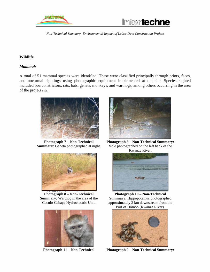
Wildlife Mammals A total of 51 mammal species were identified. These were classified principally through prints, feces, and nocturnal sightings using photographic equipment implemented at the site. Species sighted included boa constrictors, rats, bats, genets, monkeys, and warthogs, among others occurring in the area of the project site.
Photograph 7 – Non-Technical
Summary: Geneta photographed at night.
Photograph 8 – Non-Technical Summary: Vole photographed on the left bank of the
Kwanza River.
Photograph 8 – Non-Technical
Summary: Warthog in the area of the Caculo-Cabaça Hydroelectric Unit.
Photograph 10 – Non-Technical Summary: Hippopotamus photographed approximately 2 km downstream from the
Port of Dombo (Kwanza River).
Photograph 11 – Non-Technical Photograph 9 – Non-Technical Summary:

Non-Technical Summary Environmental Impact of Laúca Dam Construction Project Summary: Monkey captured in a savanna
area along the road connecting Kyangulungo to the Kwanza River.
Evidence of the presence of porcupines (feces).
Photograph 10 – Non-Technical
Summary: Animal print in the vicinity of the Project site.
Photograph 11 – Non-Technical Summary: Placement of nocturnal
photographic equipment. Birds The field studies performed for the EIA (2013) identified a total of 82 species. All the species are common to Angola and to the local biomes in the study area. One of the most important ornithological species for any environmental study involves birds of prey, to the extent these sit atop the food chain, thereby providing valuable evidence as to the general status of an ecosystem. In the case under study, eight (8) species were counted. By way of example, species identified in the location included the Cape turtle dove, Grey shrike thrush, Red-crested Turaco (endemic species), Peregrine falcon, Grey shrike thrush, Silver-beaked Tanager, and Bemba, among others (see Photograph 12 – Non-Technical Summary to Photograph 15 – Non-Technical Summary).
Photograph 12 – Non-Technical Summary: Cape Photograph 13 – Non-Technical Summary: Silver-

Non-Technical Summary Environmental Impact of Laúca Dam Construction Project turtle dove. beaked Tanager.
Photograph 14 – Non-Technical Summary:
Long-tailed Tyrant. Photograph 15 – Non-Technical Summary:
Grey shrike thrush. Amphibians A total of six (6) species of amphibians were identified in the field studies. Amphibians are a highly important wildlife group due to their significant sensitivity to changes in the environment. Specifically, their dependence on water and the fact that they breathe and absorb substances through the skin render amphibians extremely vulnerable to pollution. No endangered amphibians were registered in the area. Reptiles Reptiles constitute another key wildlife group, the proper description of which is important for the study of natural environments. However, herpotological studies are difficult, given the astute nature of the related species, which renders their capture a problematic issue, exacerbated by an absence of published studies on Angolan reptile species. This said, 11 species were identified in the area, specifically the green turtle, black-mouthed mamba, African python, tree agama lizard, Nile crocodile, and others. None of the recorded species is endangered. Fish Consideration was given to the existence of specific species that provide sustenance for others within given communities. Fish serve as a fundamental food source for other animals, in particular aquatic birds or species that connect environments. With respect to the economic significance of the ichthyofauna, the economic value of many species directly corresponds to their consumption value, as they are consumed locally.

Non-Technical Summary Environmental Impact of Laúca Dam Construction Project From a bio-ecological standpoint, this diversity reveals the presence of species that occupy distinct niches of the Kwanza system and are ecologically adapted, indicating a susceptibility to any changes in their status due to physical modification of local environmental conditions. Another aspect requiring consideration is the endemism of the fish species in the Kwanza River environment, an issue on which there is limited information. In regard to potential migratory species, the Kwanza River environment has been affected significantly by the Capanda Hydroelectric Unit and the Cambambe Hydroelectric Unit located upstream and downstream from the future project site, respectively.
Photograph 16 – Non-Technical Summary:
Synodontis sp. (A) and Chiloglanis cf. lukugae (B).and Schilbe cf. Bocagii (C)
Photograph 17 – Non-Technical Summary: Serranochromis cf. angusticeps (A),
Tilapia rendalli (B) and Pharyngochromis cfschwetzii.(C)
Photograph 18 – Non-Technical Summary: Labeo cf.
annectens (A, B) and Labeobarbus marequensis (C). Photograph 19 – Non-Technical Summary:
Hepsetus odoe
Non-Technical Summary Environmental Impact of Laúca Dam Construction Project
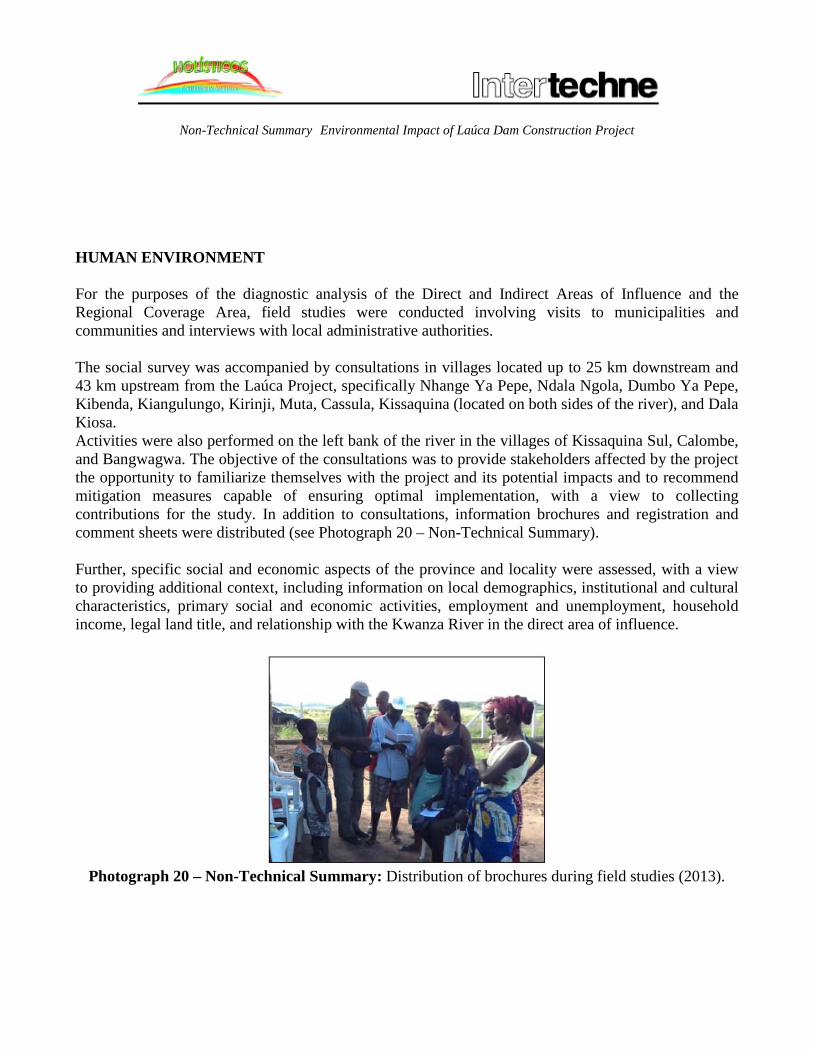
HUMAN ENVIRONMENT For the purposes of the diagnostic analysis of the Direct and Indirect Areas of Influence and the Regional Coverage Area, field studies were conducted involving visits to municipalities and communities and interviews with local administrative authorities. The social survey was accompanied by consultations in villages located up to 25 km downstream and 43 km upstream from the Laúca Project, specifically Nhange Ya Pepe, Ndala Ngola, Dumbo Ya Pepe, Kibenda, Kiangulungo, Kirinji, Muta, Cassula, Kissaquina (located on both sides of the river), and Dala Kiosa. Activities were also performed on the left bank of the river in the villages of Kissaquina Sul, Calombe, and Bangwagwa. The objective of the consultations was to provide stakeholders affected by the project the opportunity to familiarize themselves with the project and its potential impacts and to recommend mitigation measures capable of ensuring optimal implementation, with a view to collecting contributions for the study. In addition to consultations, information brochures and registration and comment sheets were distributed (see Photograph 20 – Non-Technical Summary). Further, specific social and economic aspects of the province and locality were assessed, with a view to providing additional context, including information on local demographics, institutional and cultural characteristics, primary social and economic activities, employment and unemployment, household income, legal land title, and relationship with the Kwanza River in the direct area of influence.
Photograph 20 – Non-Technical Summary: Distribution of brochures during field studies (2013).
Non-Technical Summary Environmental Impact of Laúca Dam Construction Project
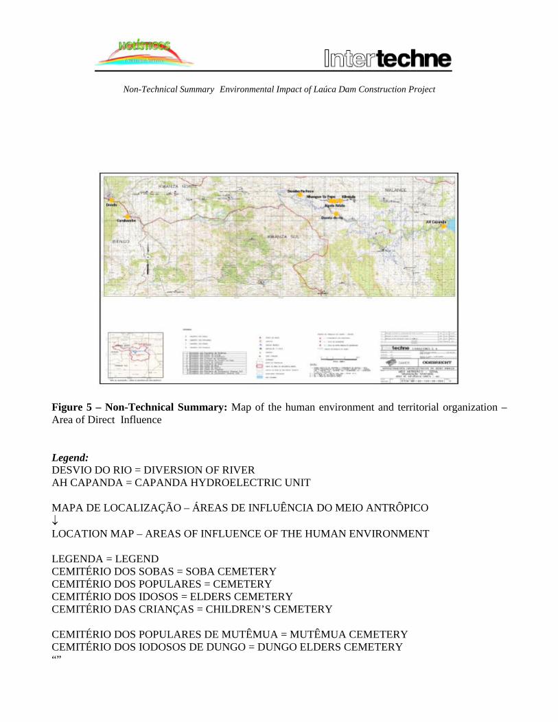
Figure 5 – Non-Technical Summary: Map of the human environment and territorial organization – Area of Direct Influence Legend: DESVIO DO RIO = DIVERSION OF RIVER AH CAPANDA = CAPANDA HYDROELECTRIC UNIT MAPA DE LOCALIZAÇÃO – ÁREAS DE INFLUÊNCIA DO MEIO ANTRÔPICO ↓ LOCATION MAP – AREAS OF INFLUENCE OF THE HUMAN ENVIRONMENT LEGENDA = LEGEND CEMITÉRIO DOS SOBAS = SOBA CEMETERY CEMITÉRIO DOS POPULARES = CEMETERY CEMITÉRIO DOS IDOSOS = ELDERS CEMETERY CEMITÉRIO DAS CRIANÇAS = CHILDREN’S CEMETERY CEMITÉRIO DOS POPULARES DE MUTÊMUA = MUTÊMUA CEMETERY CEMITÉRIO DOS IODOSOS DE DUNGO = DUNGO ELDERS CEMETERY “”

Non-Technical Summary Environmental Impact of Laúca Dam Construction Project “” POSTO DE SAÚDE = HEALTH CLINIC HOSPITAL = HOSPITAL ESCOLA TÉCNICA = VOCATIONAL TRAINING SCHOOL ESCOLA DE 1o CICLO = PRIMARY SCHOOL SANZALA = SANZALA SEDE COMUNA = COMMUNITY ADMINISTRATIVE OFFICE ESTRADAS = HIGHWAYS AND ROADS LIMITE DE PROVÍCIAS = PROVINCIAL BOUNDARIES LIMITE DE ÁREA DE INFLUÊNCIA DIRETA = DELIMITATION OF AREA OF DIRECT INFLUENCE LIMITE DE ÁREA DE INFLUÊNCIA INDIRETA = DELIMITATION OF AREA OF INDIRECT INFLUENCE ALBUFEIRAS PROPOSTAS = PROPOSED RESERVOIRS AH CAPANDA = CAPANDA HYDROELECTRIC UNIT PONTOS DO TRABALHO DE CAMPO ???? = FIELD STUDY POINTS ???? ACAMPAMENTOS DE PESCADORES = FISHING SETTLEMENT PONTO DE ???? = ???? LOCAL DA ANTIGA SANZALA DE ???? = SITE OF FORMER SANZALA OF ???? APROVEITAMENTOS HIDROELÉTRICOS NO MÉDIO KWANZA = HYDROELECTRIC UNITS IN THE MIDDLE KWANZA BASIN MEIO ANTRÓPICO GERAL = GENERAL HUMAN ENVIRONMENT ORGANIZAÇÃO TERRITORIAL = TERRITORIAL ORGANIZATION ÁREA DE INFLUÊNCIA DIRETA = AREA OF DIRECT INFLUENCE
Description of Village Populations The villages surveyed for the study are headed by traditional authorities organized pursuant to the applicable Angolan Government directives: Mayors, Deputy Mayors, sobas (chiefs), adjunct sobas, sekulo (sub-chief). In addition to the “official” traditional authorities, village hierarchies also include informal leaders, among these notable figures of the community, typically older people who are, in general, members of the Mbanza. The Cacuso and Cambambe Municipal Administrations provide citizens with only a small range of services, most notably, in addition to health and education, access to farm inputs, home deeds, certificates for the obtainment of land titles to farmland, vaccination certificates, notarial services (birth registrations, identity cards, certificates, authorizations to engage in informal commercial activities, and others). Currently available demographic information is largely unreliable and highly inconsistent. According to information collected from the study area, the estimated population is 793 inhabitants of the “Ambundu” ethno-linguistic group.

Non-Technical Summary Environmental Impact of Laúca Dam Construction Project The number of inhabitants per village is significantly lower than the average in other regions of Angola. Only three (3) villages have more than 100 inhabitants. Dala Kiosa (261 inhabitants), Nhangue Ya Pepe (123), and Ngola Ndala (108). The most sparsely populated villages are Kirinje, Cassula, Kibenda, and Dumbo Ya Pepe, with 8 inhabitants, respectively. The study villages suffer from extremely poor living conditions due to the absence of basic infrastructure, including water supply, basic sewage, and electric power, in addition to scarce and inadequate medical and education equipment, absence of a transportation system, and a lack of jobs and productive activities. Another important point to underscore is the absence of identification documents for a large portion of inhabitants, as this is a critical component for the incorporation of individuals in institutions and a requirement for obtaining employment. With respect to health services, the lack of medical care is a key challenge facing the local population, one exacerbated by the long distances separating inhabitants from the medical centers in Angola’s largest cities. The most common disease affecting inhabitants in the villages visited are malaria, diarrhea, respiratory illnesses, and worm infections. In addition to the diseases above, sleeping sickness and other maladies are of concern to local authorities, with recorded cases in the village of N’gola Ndala. The use of medicinal herbs to treat diseases in the villages visited is widespread. Typically, medicinal herbs and plants are picked in forest areas, collected in yard and garden areas, or grown by local residents. Childbirth services are provided by traditional midwives in the target villages. Education in the survey villages is deficient and the system does not have sufficient capacity to serve all school-aged children and young people. Of the 10 communities studied, only Nhangue Ya Pepe and Muta have schools, although the only establishment currently operating is located in the village of Nhangue Ya Pepe. The school in Muta does not have a teacher to administer classes. In the villages of Kissaquina and Dala Kiosa, students attend classes at the local church. In a majority of the villages, students attend school through the 4th grade. Those wishing to continue their studies move to nearby cities and towns, in particular Dondo and Cacuso. This has destabilized the local economy, as parents or those charged with educating children are forced to set aside large sums of money and food to cover the cost of living of children under their care. Dwellings in the four villages visited adhere to the same pattern as traditional dwellings throughout the country. They are built of adobe or wattle and daub and covered by grass or zinc mats and are generally divided into two rooms. Kitchens are located separately in a small room next to dwellings. Only a small number of households have latrines. The yards between dwellings are used by families as a social space. The materials employed in local constructions are obtained from the surrounding environment, including mud and kakondo grass, which are utilized to make bricks. Dwellings are covered with kapuia grass, while tetê grass is employed in the walls erected in wattle and daub dwellings. Piped water supplies is only available at the Cacuso and Cambamba local administration buildings. With regard to local villages, the communities in close proximity to the highway find themselves today

Non-Technical Summary Environmental Impact of Laúca Dam Construction Project even further displaced from water supplies for domestic consumption, bathing, or clothes and dish washing. Water supplies lie at a distance and are difficult to obtain. Often, they are of poor quality, primarily during the dry season. Water is collected from small rivers in the rainy season and from small impoundments along dry river beds, referred to as cacimbas, in the dry season. The Kwanza River is only used for fishing, as is the Teteje River, due to its considerable distance from local communities. None of the survey villages has a sewage or household waste system. Waste is disposed of in surrounding areas and, once accumulated, burned. In some cases, waste is buried in holes resulting from soil removed to produce adobe bricks for the construction of dwellings. The communities are not served by a regular transportation system. local inhabitants travel on foot, covering long distances, or, on occasion, employ private taxi or candonga services. Candongas are private unregistered vehicles circulating on the roads between the Capanda Hydroelectric Unit and Dondo. Candonga services are expensive relative to the purchasing power of local inhabitants, yet are the often the only means of transportation. The survey villages do not have electric power. Although located along the Capanda Hydroelectric Unit transmission line, there are no voltage reduction sub-stations in the area. Some families have generators. Village production systems are based exclusively on subsistence farming, rooted in the employment of rudimentary farming methods marked by low productivity, with the occasional sale of surplus produce and local fruits extracted from the surrounding area. Traditional crops are primarily harvested, including manioc (the staple food item in the region), corn, sweet potatoes, squash, cowpeas, and okra, and in some cases garlic and onions. Small subsistence plots are located at a distance from villages to avoid incursions by free-range goats raised in the local communities. Slash and burn techniques are widely used to prepare crop fields. With respect to livestock, some households engage in goat, pig, and some poultry production, notably chickens and ducks. No beef cattle or horses were observed. Village production systems are supplemented by hunting activities, notwithstanding the scarcity of available game, through the use trapping and burning techniques, given the absence of firearms, which were collected following conclusion of the country’s armed conflict. There are two farms owned by residents of the village of Kissaquina, both located approximately 12 km from the village and, more importantly, only a few meters from the banks of the Kwanza River. The farms, owned by siblings of the Boy family, are productive and provide jobs to young people in the area (see Photograph 21 – Non-Technical Summary and Photograph 22 – Non-Technical Summary).
Non-Technical Summary Environmental Impact of Laúca Dam Construction Project
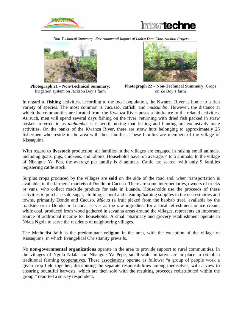
Photograph 21 – Non-Technical Summary:
Irrigation system on Jackson Boy’s farm Photograph 22 – Non-Technical Summary: Crops
on Ze Boy’s farm In regard to fishing activities, according to the local population, the Kwanza River is home to a rich variety of species. The most common is cacusso, catfish, and mussumbo. However, the distance at which the communities are located from the Kwanza River poses a hindrance to the related activities. As such, men will spend several days fishing on the river, returning with dried fish packed in straw baskets referred to as muhamba. It is worth noting that fishing and hunting are exclusively male activities. On the banks of the Kwanza River, there are straw huts belonging to approximately 25 fishermen who reside in the area with their families. These families are members of the village of Kissaquina. With regard to livestock production, all families in the villages are engaged in raising small animals, including goats, pigs, chickens, and rabbits. Households have, on average, 4 to 5 animals. In the village of Nhangue Ya Pep, the average per family is 8 animals. Cattle are scarce, with only 9 families registering cattle stock. Surplus crops produced by the villages are sold on the side of the road and, when transportation is available, in the farmers’ markets of Dondo or Cacuso. There are some intermediaries, owners of trucks or vans, who collect roadside produce for sale in Luanda. Households use the proceeds of these activities to purchase salt, sugar, clothing, school and cleaning/bathing supplies in the nearest cities and towns, primarily Dondo and Cacuso. Múcua (a fruit picked from the baobab tree), available by the roadside or in Dondo or Luanda, serves as the raw ingredient for a local refreshment or ice cream, while coal, produced from wood gathered in savanna areas around the villages, represents an important source of additional income for households. A small pharmacy and grocery establishment operate in Ndala Ngola to serve the residents of neighboring villages. The Methodist faith is the predominant religion in the area, with the exception of the village of Kissaquina, in which Evangelical Christianity prevails. No non-governmental organizations operate in the area to provide support to rural communities. In the villages of Ngola Ndala and Nhangue Ya Pepe, small-scale initiative are in place to establish traditional farming cooperatives. These associations operate as follows: “a group of people work a given crop field together, distributing the separate responsibilities among themselves, with a view to ensuring bountiful harvests, which are then sold with the resulting proceeds redistributed within the group,” reported a survey respondent.

Non-Technical Summary Environmental Impact of Laúca Dam Construction Project Village inhabitants have shared cultural practices, which includes a festival during annual cleaning of the sobas cemetery, popularly referred to as “Jindambo” and considered a sacred site. The village of Kissaquina has a cemetery located approximately 1,000 m from the fishing village, while the village of Kissaquina situated on the left bank of the Kwanza River also has a cemetery, which is scheduled to be flooded under the Laúca Hydroelectric Unit reservoir. Artisanal activities are not pursued in all of the villages due to an absence of clientele. The villages in which artisanal production is still found are Kibenda, where elderly community members engage in producing baskets, pestles, ironing boards, and mud pots, and Nhangue Ya Pepe and Ngola Ndala, which produce mud pots, luandos (traditional mats), and baskets. Not all villages provide recreational areas. The villages of Kiangululo, Muta, Nhangue Ya Pepe, Kassakina, and Ngola Ndala have football fields (1 per village). In Muta and Nhangue Ya Pepe, young people congregate on Sundays for friendly games with neighboring communities. The local authorities, including traditional authorities, have information regarding construction of the Laúca Dam, although that information is insufficient and lacks detail. The general population is also aware of the planned dam construction project. Chart 1 – Non-Technical Summary sets out the principal expectations, concerns, and complaints of residents in the villages consulted for the study.
Chart 1 – Non-Technical Summary: Expectations, concerns, and complaints of residents in survey villages.
Expectations
√ Job opportunities in dam construction and support structures; √ Possibility of access to social services such as medical care, education, potable water,
civil registration (identity cards for purposes of gaining employment), farm support, transportation, and commerce. A noteworthy service expectation is electric power, to the extent residents believe they are entitled to this benefit.
Concerns √ The job opportunities offered by the project constitute a value addition as it will occupy
the time of young people and cut down on robberies. However, the majority of working-age young people who might apply to Odebrecht do not have the necessary personal identification documents;
√ With respect to social responsibility and what the project will offer local populations in the surrounding area, residents expressed pessimism about Odebrecht’s fulfillment of the respective social commitments;
√ Resettlement of the affected populations, namely fishermen and farmers, as well as relocation of the sobas cemetery and flooding of some of the bridges used by the population to reach Kissaquina and Bangwagwa;
√ Damming of the river will modify the water course, leading to fluctuations in water levels and reduced fish stocks, principally in the rainy season following opening of the spillway gates.
Key Complaints
Non-Technical Summary Environmental Impact of Laúca Dam Construction Project √ Odebrecht does not hire workers in neighboring villages; √ Issue of the former coffee and banana plantations located 300 meters from the Laúca
rock (villages of Nhangue Ya Pepe and Kissaquina); √ Lack of identification card for residents.
7. ENVIROMENTAL PRESSURES The principal environmental pressures stemming from project activities in connection with the Kwanza River diversion tunnels, including construction of the respective access roads to the location and work sites and accommodations, are described below, specifically those arising from construction and operation of the tunnels. The planning stage will spur expectations among the local population, due to its direct contact with the technical teams conducting field studies for the engineering project and the related environmental assessments. Expectations will be particularly high in villages located in the Project Affected Area – ADA and Area of Direct Influence – AID. As unemployment is one of the region’s key economic challenges, the local population, in particular young people, have major expectations in regard to job creation. This was verified in consultations held with local communities, when young people asked about the project and how to go about securing employment. Development of environmental studies and engineering projects for the areas of influence in tunnel construction areas. The environmental studies on the project’s areas of influence, in addition to the respective engineering studies, will contribute to a more thorough technical and scientific understanding of the Middle Kwanza River Basin, offering valuable, and perhaps unprecedented, diagnostic analyses of the area. The implementation phase will include hiring of the project workforce. A total of 3,000 direct positions will be opened up for construction of the project, in addition to indirect jobs required in the region during dam construction work. The search for employment will draw local populations to the project area. Increased circulation of vehicles and persons will generate a demand for social equipment, namely health care and safety/security and, more specifically, access, communications, and environmental sanitation infrastructure. The quality of life of local village populations will be affected by these pressures. The increase in the circulation of vehicles and people could also have relatively significant social impacts, as the villages are based on family organizations governed by traditional authorities (sobas) and distinct rules and customs bound to community structures consisting of small groups. The flow of outsiders through the area will undoubtedly interfere in this organization, affecting the way of life and customs of local residents. The increase in heavy vehicle traffic on the road connecting the Capanda Hydroelectric Unit to Dondo, primary access road to the project work site, is a source of concern, given the presence of villages along

Non-Technical Summary Environmental Impact of Laúca Dam Construction Project the route. Most of these villages are located along the road and, in some cases, on both sides of the road, leading to continuous the continuous crossing of pedestrians and animals. Due to its size and complexity, the project implementation work will involve thousands of people and require a diversity of skill-sets. In this light, the risk of accidents inherent to the type of work required for the project are significant and encompass, in addition to occupational risks, the risk of accidents involving poisonous animals and others. It is important to underscore that given the significant number of workers involved, the consumption of alcohol and illicit drugs is a real possibility and a factor capable of increasing accident risks in work areas. Implementation of access roads, cleaning of sites, and other structures needed to support the project will have the effect of waterproofing the ground, due to compacting and re-covering with materials, for the purpose of building a smooth and resistant bottom, rendering it infeasible as a substrate for the development of plants and water absorption. The displacement of soil due to project activities will increase turbidity of the Kwanza River waters along downstream sections during the construction stage. In addition, erosion could occur by virtue of these activities. In regard to vegetation, the construction work in the project site area will trigger the loss of individual native plants, reducing the local plant gene pool and populations of rare species of special interest and value, in addition to eliminating habitats today used by local wildlife, which will have to move or be moved to adjacent areas. Removal of native vegetation will also lead to a reduction and loss in specific habitat areas for terrestrial wildlife in the region. The presence of a larger number of people in the project work area, deforestation, and noise pollution and the operation of machinery are factors that will drive local wildlife to move to surrounding areas. The displacement of terrestrial wildlife and the invasion of the local habitat by workers could cause accidents with poisonous animals at the project site. The formation of reservoirs, in general, causes impacts on water quality, the most important of which are associated to the flooding of local vegetation in the area of the reservoir and subsequent degradation of that vegetation. This phenomenon is related to a number of physical, chemical, and biological processes. The excessive presence of plant biomass in the aquatic environment results in the release of organic compost and nutrients as these decompose, potentially resulting in changes to the water in the reservoir in terms of color, turbidity, and eutrophication, that is, reduced oxygen in the water. In addition, filling of the reservoir will cause a change in the base level, modifying and redistributing hydraulic gradients and elevating water levels. Formation of the reservoir will also modify the local landscape through transformation of the river’s lotic environment into a lentic environment, with the loss of rapids and potential changes in vegetation, giving rise to a new situation in the ecosystem and thus transforming the landscape.

Non-Technical Summary Environmental Impact of Laúca Dam Construction Project The area around the Kissaquina village fishing settlement in Kwanza Sul province will be fully flooded by filling of the Laúca Hydroelectric Unit reservoir. There are straw dwellings near the banks of the Kwanza River belonging to approximately 25 fishermen who reside in the locality with their families. This population will have to be resettled. The village includes two farms owned by residents, located approximately 12 km from the village. The farms belong to two brothers, Jackson and Zé Boy, and lie just a few meters from the banks of the Kwanza River. The farms are productive and employ young people in the region. The proprietors are concerned with filling of the reservoir. The sacred cemetery of Kissaquina, where 11 village sobas are buried is located in the designated reservoir Laúca Hydroelectric Unit area. As it involves a site deemed sacred by the entire Ambundu ethnic group and encompasses still powerful rituals and symbolism for the local communities, resettlement of the site will be necessary in the light of the pre-established measures to prevent disruption of local traditions and customs. It is important to underscore that the soba of the village of Kissaquina is opposed to flooding of the area. The community suggests that elders in the affected villages and neighboring villages be contacted to find a solution to this question. The work will not affect other long-standing human settlements and sacred areas, as none are located in the project zone. Insofar as no ethnological studies or identification of potential archeological sites have been conducted to date, implementation of the project could directly impact areas with sites and artifacts of significant importance to Angolan history. Damming and diversion of the river (through the tunnels currently under construction), will affect annual reproductive cycles of fisheries and other wildlife species, as their ability to move or, additionally, to find news areas to spawning or mating areas will be restricted or cut off altogether. In the operational phase, modified water flows, temperatures, and chemical composition and retention of solids and nutrients will generate a number of limnological changes that could affect all aquatic wildlife along this stretch of the river. Formation of the reservoir, meanwhile, could lead to a substantial increase in nutrient levels in the water due to leeching of the flooded soil and decomposition of submerged terrestrial vegetation. Increases in disease vectors are possible by virtue of the formation of new humid and marshy areas following filling of the reservoir. Construction of the dam and filling of the reservoir will modify the topographical characteristics of the directly affected area and, consequently, active geomorphological processes. Construction of the dam will bring benefits to Angola by allowing for greater energy generation to meet the country’s growing demand, spurring expansion of the industrial sector while providing needed

Non-Technical Summary Environmental Impact of Laúca Dam Construction Project power to the general population, which remains dependent on biomass or generators as its principal source of energy. 8. ENVIRONMENTAL IMPACTS The impacts set out in this study were identified and assessed based on the relationship between the respective physical, biological, and anthropic characteristics analyzed in the various areas of influence, taking into account, to this end, the different project phases. In this light, the principal technical features were examined, in addition to the construction methods employed, through identification of the related project activities in the different phases, with a view to determining potential environmental changes. As such, based on the interaction of the project implementation measures and the environmental attributes examined, the impacts were identified and, subsequently, assessed qualitatively and/or quantitatively, for the purposes of proposing adequate measures to mitigate or correct potential adverse changes, while leveraging positive changes. The three environments in which pressures may generate impacts subject to analysis are:
• Physical Environment: pressures on the water, air, and soil; • Biotic Environment: plants and wildlife; • Human Environment: population, economy, territorial and property organization.
For each impact, the generating factors are indicated and the respective mitigation measures recommended, the adoption of which were deemed appropriate in time and space, in accordance with the importance, intensity, and duration of each factor. Similarly, the pertinent offset measures were indicated in the case of impacts not subject to mitigation.
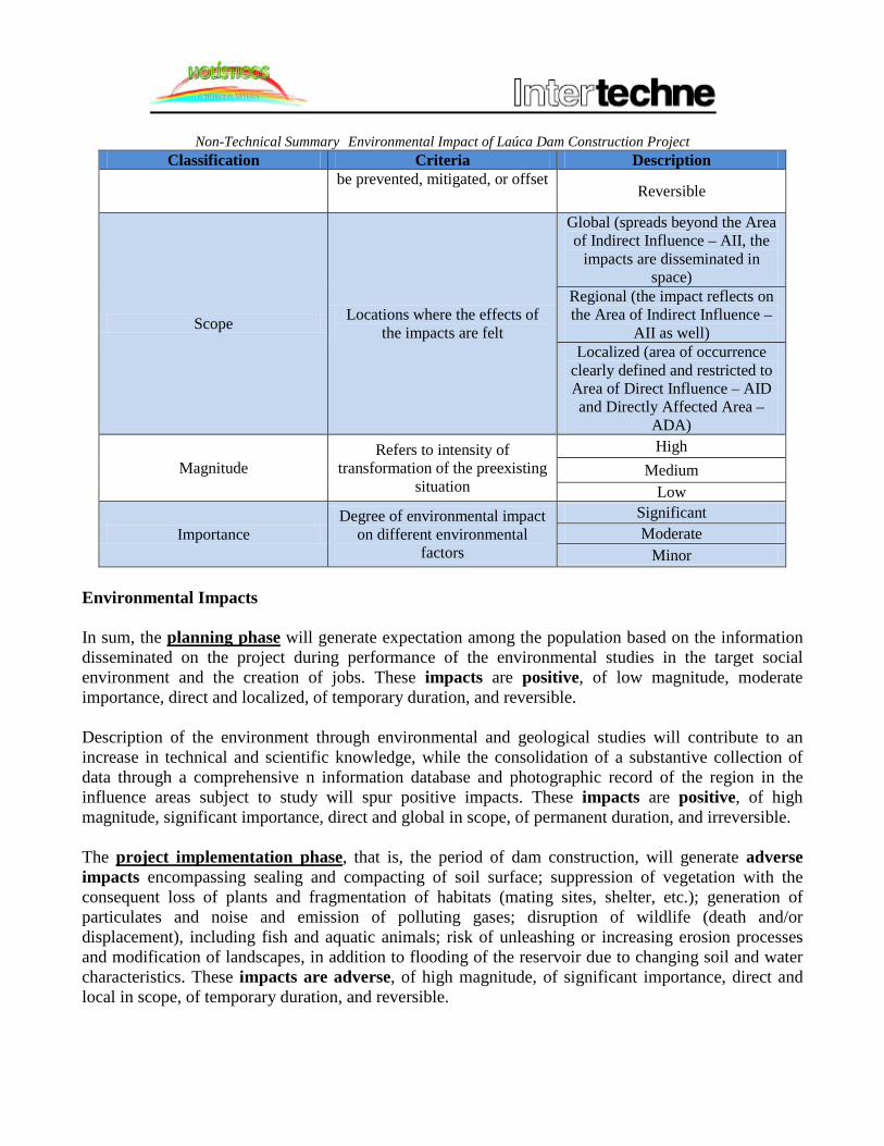
Table 2 – Non-Technical Summary: Criteria and Analysis of Impacts.
Classification Criteria Description
Phase Project implementation phase in which the impact occurs
Planning Implementation
Operation
Nature Effects of impacts Positive Adverse
Unspecified
Form How the impact manifests Direct Impact, arising from a
project action Indirect impact
Duration Time of impact Permanent Cyclical
Temporary Reversibility Determine whether impacts can Irreversible
Non-Technical Summary Environmental Impact of Laúca Dam Construction Project Classification Criteria Description
be prevented, mitigated, or offset Reversible
Scope Locations where the effects of the impacts are felt
Global (spreads beyond the Area of Indirect Influence – AII, the
impacts are disseminated in space)
Regional (the impact reflects on the Area of Indirect Influence –
AII as well) Localized (area of occurrence
clearly defined and restricted to Area of Direct Influence – AID and Directly Affected Area –
ADA)
Magnitude Refers to intensity of
transformation of the preexisting situation
High Medium
Low
Importance Degree of environmental impact
on different environmental factors
Significant Moderate
Minor Environmental Impacts In sum, the planning phase will generate expectation among the population based on the information disseminated on the project during performance of the environmental studies in the target social environment and the creation of jobs. These impacts are positive, of low magnitude, moderate importance, direct and localized, of temporary duration, and reversible. Description of the environment through environmental and geological studies will contribute to an increase in technical and scientific knowledge, while the consolidation of a substantive collection of data through a comprehensive n information database and photographic record of the region in the influence areas subject to study will spur positive impacts. These impacts are positive, of high magnitude, significant importance, direct and global in scope, of permanent duration, and irreversible. The project implementation phase, that is, the period of dam construction, will generate adverse impacts encompassing sealing and compacting of soil surface; suppression of vegetation with the consequent loss of plants and fragmentation of habitats (mating sites, shelter, etc.); generation of particulates and noise and emission of polluting gases; disruption of wildlife (death and/or displacement), including fish and aquatic animals; risk of unleashing or increasing erosion processes and modification of landscapes, in addition to flooding of the reservoir due to changing soil and water characteristics. These impacts are adverse, of high magnitude, of significant importance, direct and local in scope, of temporary duration, and reversible.

Non-Technical Summary Environmental Impact of Laúca Dam Construction Project Another risk involves potential effects on population dynamics; the risk of accidents involving the local population and workers. Further, the largest impact detected in the socioeconomic environment is the resettlement of populations affected by filling of the reservoir and transfer of the sobas cemetery from the village of Kissaquina. These impacts are adverse, direct, permanent, localized, and of high magnitude. Expected positive impacts in the implementation phase include improvements in commerce and the flow of goods and services and higher local incomes due to availability of timber; job creation and income generation for the local population. Operation of the project (energy generation) is not expected to cause major interference, as this phase will be followed by construction of the Laúca Dam, which, for its part will pose a risk of potential disruptions to wildlife downstream from the tunnels, while providing increased energy offerings, thereby stimulating the country’s social and economic development and boosting the quality of life of the Angolan population. With respect to the biotic environment, changes to the region’s water balance and climate will occur, in addition to increased sediment on the river bed, higher nutrient levels in the river’s water, and instability of hillsides in the reservoir area. These impacts are, in general, adverse, direct, permanent, irreversible, localized, of medium magnitude, and of moderate importance. 9. MITIGATION MEASURES AND MONITORING PLAN Description of the environmental impacts caused by implementation of the project is followed by determination of the corresponding mitigation measures required to attenuate the resulting adverse impacts and reinforce the positive impacts. Construction Phase For purposes of the impacts on the physical and biotic environments, monitoring of water quality and limnological follow-up of the river should be performed; and the recovery of degraded areas and environmental offsets aimed at recovering equivalent areas, executed. A wildlife inventory of the area should be executed to determine priority species for rescue, where necessary, and monitoring. Hillside areas should be preserved to the extent possible to prevent large-scale loss of nests and species displacement. Additionally, an inventory of the area’s vegetation should be performed to determine priority species for purposes of the collection and preservation of seeds, cuttings, and other propagation structures. Moreover, a nursery should be implemented and degraded areas replanted with native vegetation following flooding of the reservoir area. In regard to the human environment, media initiatives and worker training programs should be implemented to provide guidance on the issue of and raise awareness on accident risks. For the purposes of treating cases as these arise, agreements should be concluded with anti-ophidic serum

Non-Technical Summary Environmental Impact of Laúca Dam Construction Project producers, with a view to increasing available inventories at local health clinics, in addition to implementing adequate storage infrastructure for anti-ophidic serum inventories and ensuring sufficient trained personnel for administration of the respective treatments. Ongoing preventive and corrective worker training measures should be implemented in connection with occupational health and workplace safety, and include periodic retraining programs, with a view to reducing workplace accidents. In regard to health, campaigns to disseminate preventive measures should be organized, including presentations to provide guidance and information to local communities, within the framework of the public information plan on health and diseases, primarily STDs. With respect to the benefits provided to stimulate economic activity among the local population, training initiatives aimed at indirect jobs should encompass in connection with entrepreneurship and the production of goods and services, with a view to stimulating income generation and strengthening the social fabric and local economy. In terms of job creation, the project executor should develop and implement a professional placement program for the local population that includes vocational training. The program should be disseminated through the media and public relations plan and widely publicized, primarily for those populations in the Directly Affected Area – ADA and Area of Direct Influence – AID. The plan should contemplate future construction of the dam. For purposes of relocating the farms in question, measures should be adopted to determine the location and territorial layout of the new sites with the participation of the interested parties and include implementation of basic infrastructure (water, sewage, and waste disposal site, adequate preparation) to improve the quality of life of all affected parties. The farms should be located on fertile soil and near the river to ensure ready access to water supplies for irrigation. In the event this is not possible, adequate and sufficient irrigation and water supply systems should be installed at the selected sites. Relocation of the sacred cemetery should be accomplished through measures that encompass the participation of the community and the soba, as the respective site involves sacred ground duly designated by the local authorities as such, with a view to respecting the appropriate transfer rituals in order to mitigate potential conflicts with the local population. For purposes of the resettlement of the fishing community of the village of Kissaquina, measures should be implemented to determine the location and territorial layout of the settlement with the participation of the affected community, including complete implementation of infrastructure (water, sewage, waste disposal sites, adequate preparation, access roads) to promote improved quality of life for the respective residents. Operational Phase Integrated monitoring of water and aquatic animals should be performed. 10. ENVIRONMENTAL MANAGEMENT PROGRAM

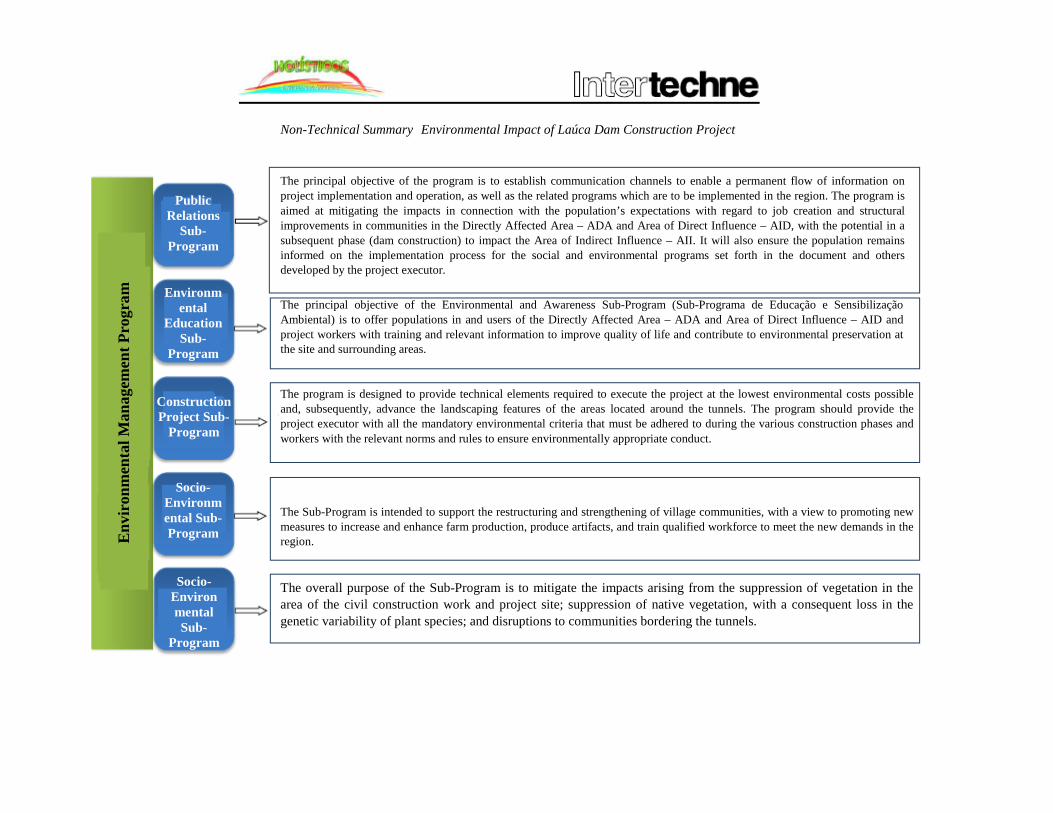
Non-Technical Summary Environmental Impact of Laúca Dam Construction Project Based on the environmental impact assessment conducted in the previous phase, through which the respective impacts/changes were identified and a series of mitigation and offset measure for these recommended, this chapter sets out the different environmental management plans and programs to prevent, minimize, or offset the impacts identified. The Environmental Management Program (Programa de Gestão Ambiental – PGA) proposed in this study is based on the applicable domestic laws, in addition to documents and similar studies in other parts of the world. The instructions and recommendations in the Odebrecht Integrated Safety, Environment, and Health Program were considered in this chapter as well.
Non-Technical Summary Environmental Impact of Laúca Dam Construction Project
The principal objective of the program is to establish communication channels to enable a permanent flow of information on project implementation and operation, as well as the related programs which are to be implemented in the region. The program is aimed at mitigating the impacts in connection with the population’s expectations with regard to job creation and structural improvements in communities in the Directly Affected Area – ADA and Area of Direct Influence – AID, with the potential in a subsequent phase (dam construction) to impact the Area of Indirect Influence – AII. It will also ensure the population remains informed on the implementation process for the social and environmental programs set forth in the document and others developed by the project executor.
The principal objective of the Environmental and Awareness Sub-Program (Sub-Programa de Educação e Sensibilização Ambiental) is to offer populations in and users of the Directly Affected Area – ADA and Area of Direct Influence – AID and project workers with training and relevant information to improve quality of life and contribute to environmental preservation at the site and surrounding areas.
The program is designed to provide technical elements required to execute the project at the lowest environmental costs possible and, subsequently, advance the landscaping features of the areas located around the tunnels. The program should provide the project executor with all the mandatory environmental criteria that must be adhered to during the various construction phases and workers with the relevant norms and rules to ensure environmentally appropriate conduct.
The Sub-Program is intended to support the restructuring and strengthening of village communities, with a view to promoting new measures to increase and enhance farm production, produce artifacts, and train qualified workforce to meet the new demands in the region.
The overall purpose of the Sub-Program is to mitigate the impacts arising from the suppression of vegetation in the area of the civil construction work and project site; suppression of native vegetation, with a consequent loss in the genetic variability of plant species; and disruptions to communities bordering the tunnels.
Env
iron
men
tal M
anag
emen
t Pro
gram
Public Relations
Sub-Program
Environmental
Education Sub-
Program
Construction Project Sub-
Program
Socio-Environmental Sub-Program
Socio-Environmental Sub-
Program

Non-Technical Summary Environmental Impact of Laúca Dam Construction Project 11. CONCLUSION The generation and distribution of electric power in Angola to spur the country’s industrial development and ensure the supply of energy to households remains a pressing need, as current systems do not have the capacity to satisfy existing demand. The maximum forecast demand in 2009 for the North System was approximately 520 MW, while peak demand in Luanda at 5:23 p.m. In April 2009 was 678 MW, of which only 520 MW was fully met and another 158 MW met only partially through a rotating system powered by thermoelectric sources. Of Angola’s 48 hydrographic regions, the Kwanza River basin has the largest energy generating capacity; currently, 700 MW are generated at the two hydroelectric plants that feed the North System, the Cambambe Hydroelectric Unit, with a capacity of 180 MW, and the Capanda Hydroelectric Unit, with a capacity of 520 MW. To increase energy production in the basin, dam elevation projects are underway at Cambambe, while additional hydroelectric projects are planned between Capanda and Cambambe, of which the Laúca Dam construction project is today at the most advanced stage of development. Data of the Ministry of Energy and Waters indicate that the total estimated capacity of the Kwanza River basin is 6,780 MW, with a guaranteed generation capacity of 26,200 GWh. In this context, studies have been prepared to enable the construction of an additional seven (7) hydroelectric units downstream from the Capanda Dam and upstream from Cambambe. The Laúca Dam is one of these projects, and will be located at kilometer 307.5 of the Kwanza River in a narrow valley with steep slopes rising more than 100 meters in a linear “S” shape, with the presence of rapids on the river bed and a natural fall of approximately 100 meters distributed along a 2 km section. The project’s installed power will be 2,070 MW, which will feed the North System. Over the coming ten years, the Angolan Government intends to interconnect its energy production systems, specifically the North, Central, and South Systems. Pursuant to the applicable Angolan environmental laws, the project proponent, the Kwanza Environmental Development Office (Gabinete de Aproveitamento do Médio Kwanza – GAMEK), contracted, through Odebrecht (the company tasked with executing the respective river diversion and dam construction projects) Holísticos and Intertechne to prepare the respective Environmental Impact Assessment. A vast body of bibliographic studies and technical field surveys were performed to prepare an Environmental Impact Assessment (EIA) consistent with the Láuca Hydroelectric unit implementation project located on the Malanje and Kwanza Sul province boundary lines. The results of the EIA reveal highly complex socio-environmental characteristics arising from the location, nature, and scope of the project.

Non-Technical Summary Environmental Impact of Laúca Dam Construction Project From a strictly environmental standpoint (physical and biotic environments), the directly affected areas (where the project will produce a direct impact) are areas on which there was scarce scientific information and studies, and, as such, insufficient data, thus rendering the technical work performed for the study of substantial significance. In this light, the report will serve as a reference for new projects planned and implemented in the region, in particular those designed for the middle portion of the Kwanza. The surveys of the physical and biotic environments revealed the existence of substantial environmental diversity in the region (with particular emphasis on the ichthyofauna, herptofauna, and avifauna) and that, despite the absence of any endangered species, the wildlife species in the are important for the region’s environmental equilibrium. The proposed environmental plans indicate research and monitoring plans for the region, which will serve to support the consolidation of a body of technical knowledge on the project implementation region and contribute to a more comprehensive description of the ecological systems located along the Kwanza River. The Environmental Impact Assessment also included and exhaustive process of consultations and interviews in the communities located within the Directly Affected Areas (Áreas Directamente Afectadas – ADA) and Areas of Direct Influence (Áreas de Influência Directa – AID), contributing to enhanced knowledge of local populations and their habits and customs, and a closer relationship between the project and surrounding communities. This process also enabled information to be collected on the expectations and demands of local populations with respect to the project, in particular those associated to the access to job opportunities and improved living conditions. The surveys did not indicate any relevant human pressures on the region’s natural resources, including water resources, as the Directly Affected Area (Área Directamente Afectada – ADA) and the Area of Direct Influence (Área de Influência Directa – AID) do not contain significant human populations. Potentially affected areas in the Directly Affected Area – ADA by virtue of filling of the reservoir include the Village of Kissaquina, a fishing settlement, and a cemetery. Natural resources are used for subsistence purposes by the population, including hunting and fishing activities for local consumption, as well as small-scale farming. In regard to the region’s social system, the bibliographical studies and surveys, in addition to an analysis of the current conditions of the local population conducted in the project’s area of influence (in particular the Directly Affected Area – ADA and Area of Direct Influence – AID) indicate the presence of rich and permanent cultural traits and habits and customs developed over the past 20 years. Further, a sensitive social landscape was identified with respect to the precarious conditions of local dwellings and direct dependence on natural resources as virtually the only source of income and sustenance. The environmental analysis presented in the study offers an outline of the socio-environmental reality of the project area currently and, above all, enables the development of effective control, monitoring, and, in addition, offset plans for the adverse impacts identified. The importance of developing an appropriate Resettlement Plan for communities directly affected by the project, specifically filling of the reservoir, is underscored. The Resettlement Plan must include procedures relating to the physical resettlement of persons and the transfer and loss of their dwellings and subsistence means. It is

Non-Technical Summary Environmental Impact of Laúca Dam Construction Project important to underline that studies on this issue must be performed, in addition to consultations with project affected persons, with a view to forging an agreement between stakeholders in connection with resettlement efforts. It is essential that projects of this nature provide the expected benefits with the lowest adverse impacts possible, both from an environmental and social standpoint. To this end, the proposed mitigation measures must be strictly fulfilled, with a view to ensuring the safety of workers and location communities and protecting the local and surrounding environment. In this light, an Environmental Management Program is set out for the dam construction and operational phases. The program offers a series of sub-programs relating to various aspects of the project, the most important of which are the construction support, community support, wildlife and plant, and degraded area recovery programs. The construction support program includes a Waste Management Plan prepared in accordance with the Regulation on Waste Management (Presidential Decree No. 190/12). As described in the previous sections, in general the adverse impacts highlighted in this document can be mitigated and/or prevented, provided the mitigation measures proposed in this document are followed and best practices of environmental management and the environmental management programs proposed in this EIA are applied. On the economic and social front, given the country’s energy needs it is important to underscore that this project has an important role in the effort to diversify the energy grid and strengthen the domestic economy and that it is consistent with the Angolan Energy Sector Program (Programa do Sector de Energia de Angola). In the construction and operational phases of the project, the most disseminated and advanced technology and equipment will be used. As such, the technology solution applied to the project is the most appropriate and suitable, and, similarly, the project will implement the best practices of construction for hydroelectric projects. Taking into account the outcomes of the pressure and impact matrixes, the projected adverse impacts of the enterprise, and the concrete measures to minimize and mitigate these, the plans developed should be followed by the project sponsor and project executor, as proposed in this document. The applicable domestic legislation, compliance with which is mandatory, must be implemented in the dam construction and operation phases. In the light of the environmental and social impacts identified in the Environmental Impact Assessment and based on the enforceability of the mitigation measures and respective monitoring plan, construction of the dam is deemed environmentally feasible and socially and economically relevant.

Kwanza Environmental Development Office Study of Environmental Impact of Laúca Dam Construction Project
FINAL REPORT
MAY 2013
Credits: Title: Study of Environmental Impact of Laúca Dam Construction Project Client: Kwanza Environmental Development Office (Gabinete de Aproveitamento do Médio Kwanza – GAMEK). Rua do Massangano, s/n, Luanda. Telephone: +244-222-445072 / 222-675801; Fax: +244-222-447973 http://www.gamek.com Consultants: Holísticos, Lda. – Serviços, Estudos & Consultoria. Rua 60, Casa 559, Urbanização Harmonia, Benfica, Luanda. Telephone: 222 006938; Fax: 222 006435 Email: [email protected] www.holisticos.co.ao Intertechne Consultores, S.A. Av. João Gualberto, 1259, 16º andar – Alto da Glória. CEP 80030-001 Curitiba – Paraná – Brazil Telephone: +55(41)3219-7200; Fax: +55(41)3219-7848 Email: [email protected] Date: May 2013.

CHAPTER 1
INTRODUCTION

Study of Environmental Impact of Laúca Dam Construction Project
CONTENTS
1. FOREWARD ................................................................................................................................................. 7
1.1. BACKGROUND ........................................................................................................................................ 7
1.2. INTRODUCTION ...................................................................................................................................... 8
1.3. JUSTIFICATION FOR THE EIA .............................................................................................................. 9
1.4. OBJECTIVES ........................................................................................................................................... 15
1.5. SCOPE OF THE STUDY......................................................................................................................... 16
1.6. METHODOLOGY ................................................................................................................................... 17
1.7. EIA TEAM ............................................................................................................................................... 21
1.8. LOCATION .............................................................................................................................................. 22
1.9. DETERMINATION OF AREA OF INFLUENCE .................................................................................. 28
1.9.1. DIRECT PROJECT AFFECTED AREA .............................................................................................. 28
1.9.2. AREA OF DIRECT INFLUENCE ........................................................................................................ 29
1.9.3. AREA OF INDIRECT INFLUENCE ................................................................................................... 29
1.9.4. REGIONAL COVERAGE AREA ........................................................................................................ 29
1.10. PUBLIC CONSULTATION PROCESS ................................................................................................ 31
1.10.1. PCDP Objectives ................................................................................................................................. 31
1.10.2. PCDP Scope ........................................................................................................................................ 32
Abbreviations
List of Figures FIGURE 1.1: GEOGRAPHIC LOCATION OF THE LAÚCA DAM (GENERAL) FIGURE 1.2: LOCATION AND ACCESS TO LAÚCA DAM FIGURE 1.3: SOCIAL SENSITIVITY MAP. LAÚCA DAM CONSTRUCTION PROJECT AREAS OF INFLUENCE List of Tables TABLE 1.1: MIDDLE KWANZA RIVER BASIN – COMPARISON OF HYDROELECTRIC POTENTIAL STUDIES TABLE 1.2: ELECTRIC POWER CONSUMPTION IN ANGOLA IN GWH BY SUPPLY SYSTEM (1990/2007) TABLE 1.3: INSTALLED AND FORECAST CAPACITY FOR ANGOLA’S NORTH, CENTRAL, AND SOUTH SYSTEMS (MW)

Study of Environmental Impact of Laúca Dam Construction Project
TABLE 1.4: HYDROELECTRIC ENERGY SYSTEM SUPPLY IN 2007 TABLE 1.5: HYDROELECTRIC POTENTIAL WITH THE DAMS GREATER THAN 50 MW TABLE 1.6: CONTACT INFORMATION FOR PROJECT ENTERPRISE (GAMEK TABLE 1.7: CONTACTINFORMATION FOR PROJECT CONSTRUCTION FIRM (ODEBRECHT) TABLE 1.8: CONTACT INFORMATION FOR ENVIRONMENTAL CONSULTING FIRM (HOLÍSTICOS) TABLE 1.9: CONTACT INFORMATION FOR CONSULTING FIRM (INTERTECHNE) TABLE 1.10: INFRASTRUCTURE WITHIN THE SCOPE OF THE EIA TABLE 1.11: AUTHORITIES INTERVIEWED FOR PRELIMINARY SURVEYS (2007-2009) TABLE 1.12: AUTHORITIES INTERVIEWED FOR THE RIVER DIVERSION EIA (2012) TABLE 1.13: VILLAGES INTERVIEWED IN 2013 FOR SOCIAL SURVEY TABLE 1.14: LISTOF GAMEK TECHNICAL EXPERTS TABLE 1.15: LIST OF EXPERTS INVOLVED IN THE EIA TABLE 1.16: PROJECT AREA OF DIRECT INFLUENCE Appendices Appendix I – Certificate of Registry of Holísticos at the Ministry of Environment
Appendix II – Community Meeting Attendance List
Appendix III – Project Information Brochure
Appendix IV – Comment Form
Appendix V – Odebrecht Waste Management Plan
Appendix VI – Avifauna Identified in Field Survey

Study of Environmental Impact of Laúca Dam Construction Project
Abbreviations
AAR Area of Regional Scope
ADA Project Affected Area
AICD Africa Infrastructures Country Diagnostic
AID Area of Direct Influence
AII Area of Indirect Influence
AH Hydroelectric Unit
BCC Compacted Cement Cylinders
EIA Environmental Impact Assessment
ENE Angolan National Energy Company
GAMEK Kwanza Environmental Development Office
GWh Giga Watts hour
IFC International Finance Corporation
KV Kilo Volts
KWh Kilo Watts hour
MW Mega Watts
PCDP Public Consultation and Dissemination Plan
SONEFE National Society for Ultramarine Enterprise Studies and Financing

Study of Environmental Impact of Laúca Dam Construction Project
1. FOREWARD
This chapter examines relevant aspects of the background to the Laúca Dam Construction Project. The objectives of the environmental impact assessment are set forth, in addition to the project justification, within the local and regional context. The pages below also indicate the technical experts engaged in preparing the Environmental Impact Assessment (EIA). Additionally, the precise location of the project is described, as are the scope of the Environmental Impact Assessment and the project areas of influence.
1.1. BACKGROUND In the colonial period, initial feasibility studies were conducted on hydroelectric power generation in the Middle Kwanza River Basin, at which time a potential annual generating capacity of 6,510 MW was identified through the implementation of nine (9) hydroelectric units. From 1950 through 1970, companies from different countries performed studies based on differing approaches and with varying levels of detail. The first studies were conducted by an American firm, Hydrotechnic Corporation, in 1955, with funds from the Marshal Plan. In the 1950s, the Angolan Government agency with primary responsibility for the energy sector, the Bengo and Lucala Kwanza Studies Brigade, supplemented the initial work. The parameters evaluated in the studies centered on the physical characteristics of the hydrographic basin in the Middle Kwanza River Basin, specifically: local hydrological characteristics, through assessment of the respective water fall ratios for purposes of the implementation of future hydroelectric plants, water flow, and local climate conditions. The studies were conducted on the basis of field studies in conjunction with photogrammetric over flights and aero-photogrammetric restitutions, referenced to the official first order network and to the average sea level as measured at the Luanda tide gauge. Another point taken into consideration in this stage was whether the units could be built independently from each other and whether implementation projects could make maximum use of the natural fall of the respective rivers, producing energy with sufficient power to meet local demand. In the 1960s, the National Society for Ultramarine Enterprise Studies and Financing (Sociedade Nacional de Estudo e Financiamento de Empreendimentos Ultramarinos – SONEFE) undertook a new series of studies, in an effort to collect additional data and update existing information. As a result of the preliminary studies, in 1962 the Cambambe Hydroelectric Unit (AH) entered into operation, located in the vicinity of the city of Dondo, through two implementation phases. The first, a facility completed in the early 1960s with a total installed power of 260 MW, divided into four (4) 65 MW units, operated under reduced flow conditions without regulation of upstream reservoir discharge flows (effective power of 180 MW). The dam was designed to add a total of 80 MW (20 MW X 4 turbines) through Plant 1 (denominated the Cambambe Elevation) and 700 MW (175 MW x 4 turbines) through Plant 2 (designated Cambambe 2) to the National Electric Power System. The Cambambe dam refurbishment and elevation work was initiated in 2011. The sequence of SONEFE studies, the General Middle Kwanza River Plan – Preliminary Study and Determination of the 2nd Echelon (Plano Geral do Médio Kwanza – Estudo Prévio e Definição do 2° Escalão) (1966) and the respective amendment (1972) set forth supplementary and more detailed

Study of Environmental Impact of Laúca Dam Construction Project
data on the Middle Kwanza River Basin with information corresponding to the preliminary inventory. In the early 1980s, the Angola Energy Resources Survey identified the energy potential of Angola’s hydrographic units, the most notable of which, in terms of hydroelectric generating potential, was the Kwanza River, a finding that served to confirm the SONEFE studies. Based on the results obtained, a decision was taken within the scope of Angola’s infrastructure restructuring process to invest in the hydroelectric potential of the Middle Kwanza River Basin through construction of the Capanda Dam, which entered into operation in 2004 with an installed capacity of 520 MW. The following year, EngeHidro reevaluated the alternatives put forward by SONEFE and Energoprojekt, the results of which are provided in Table 1.1.
Table 1.1: Middle Kwanza River Basin – Comparison of hydroelectric potential studies.
Studies Energoprojekt EngeHidro
GWh Mwave GWh Mwmed Capanda 1,000 114 1,937 221 Nhangue 1,300 148 2,241 256
Laúca 4,700 537 5,043 576 Caculo Cabaça 7,500 856 8,032 917
Cambambe 4,100 468 4,259 486 Source: Intertechne Consultores S.A., Review of Water Flow in the Middle Kwanza River Basin. Based on the studies above and Angola’s growing energy needs, steps were taken to boost the country’s existing energy potential, beginning with construction of a dam on the Kwanza River for the Laúca hydroelectric facility.
1.2. INTRODUCTION The Laúca Dam is located at kilometer 307.5 of the Kwanza River in a narrow U-shaped valley marked by a succession of concentrated rapids and falls stretching approximately 30 meters, with an incline of 4 m/km. Implementation of the Hydroelectric Unit will require a series of projects, including:
• Construction of basic infrastructure: temporary and permanent access points, administrative and industrial sites, technical energy supply, water, sewage, and other systems;
• Construction of two river diversion tunnels; • Construction of a spillway measuring 35 m high with 466.170 m3 of landfill volume. • Construction of a Compacted Cement Cylinder (CCC) dam measuring 132 m high and 625
m wide; • Construction of a water intake and ecological water intake system; • Construction of a landfill for solid waste generated at the project site; • Implementation of a main station with six 334 MW turbine units; • Filling of a reservoir through flooding of an area covering 185 km2.

Study of Environmental Impact of Laúca Dam Construction Project
1.3. JUSTIFICATION FOR THE EIA
Angola’s long conflict and the severe economic and social impact on the country stemming from the conflict generated acute imbalances in the delivery of various basic public services, including in the energy sector. The Angolan Government made reconstruction of infrastructure damaged during the conflict a priority. According to a 2011 diagnostic analysis of infrastructure in African countries (Africa Infrastructures Country Diagnostic – AICD), the end of Angola’s conflict coincided with a rise in oil prices, serving to generate revenues for the national reconstruction effort. Following a meeting to review the status of the domestic and global economy, the Angolan National Bank’s Committee on Monetary Policy (Comité de Política Monetária do Banco Nacional de Angola – CPM) concluded that the most recent estimate by the Angolan Executive is for real GDP growth on the order of 8.8%. The expansion in non-oil related economic activities has been driven by the farming, construction, commercial, and manufacturing sectors. All of these demand large quantities of energy, as does the country’s growing urban population, which today faces frequent supply interruptions. From 2002-2008, Angola expanded its energy production capacity from 830 MW to 1,200 MW. Data provided by the National Electric Energy Company (Empresa Nacional de Electricidade – ENE) indicates growth in electric power distribution in the province of Launda in the third quarter, reaching a daily average of 366 MW at the end of September 2012. However supply continues to lag behind demand. By way of example, the maximum initial forecast demand for 2009 in the North System was approximately 520 MW, while peak consumption in Luanda at 5:23 p.m. in April 2009 was 678 MW, of which only 520 MW was fully supplied, with another 158 MW met only partially through a rotating distribution system. Approximately 90% of the companies operating in Angola operate an in-house generators to meet their energy demand and address the frequent supply disruptions. According to a report by the Ministry of Industry (2005), expansion of the sector is contingent on boosting the supply of electric power, an objective tied to other strategic improvement and implementation plans. Data of the National Electric Energy Company (Empresa Nacional de Electricidade – ENE), set out in Table 1.2, indicates the growth in electric power consumption in Angola, which accelerated even further over the past decade.
Table 1.2: Electric power consumption in Angola in GWh by Supply System (1990/2007).
Electric Power Consumption (GWh)
Year North System
Central System
South System
Isolated Systems Total
1990 582.20 102.40 60.30 32.90 777.80 1991 696.20 111.50 67.10 29.90 904.70 1992 714.80 127.20 65.30 37.40 944.70 1993 677.80 97.10 62.60 36.30 873.80 1994 756.80 95.70 63.70 20.90 937.10

Study of Environmental Impact of Laúca Dam Construction Project
Electric Power Consumption (GWh)
Year North System
Central System
South System
Isolated Systems Total
1995 820,70 101,40 76,30 29,20 1.027,60 1996 808,80 96,50 80,70 60,50 1.046,50 1997 904,80 87,50 76,80 76,10 1.145,20 1998 1.054,30 87,30 97,30 69,30 1.308,20 1999 1.064,80 99,60 83,10 88,40 1.335,90 2000 1.145,80 93,00 89,70 97,50 1.426,00 2001 1.264,30 146,10 125,00 99,00 1.634,40 2002 1.400,80 156,00 120,40 105,10 1.782,30 2003 1.559,10 149,00 131,50 155,40 1.995,00 2004 1.814,17 117,76 131,68 179,81 2.243,42 2005 2.137,32 136,23 160,90 202,74 2.637,19 2006 2.414,35 166,72 159,75 241,99 2.982,81 2007* 3.137,43 481,22 162,18 500,17 4.281,00
*2007 data represent estimates. Source: National Electric Power Company (ENE). Energy Sector Development Program 2008-2013. Angola’s energy grid is centered primarily on hydroelectric generation, although thermoelectric generation has a strong presence as well, accounting for nearly 40% of the country’s electric power supply. With a total installed capacity of 1,010 MW in 2007, the system is not only costly but registers high pollution levels as well. An additional challenge lies in transporting generated energy, resulting in effective consumption of only 81% of the total, as only 55.3% of the country’s 2,231 km of transmission lines are currently available and operational. Table 1.3 offers a summary of the forecast installed capacity for the North, Central, and South Systems, based on thermoelectric and hydro generation for each survey year. Table 1.3: Installed and forecast capacity for Angola’s North, Central, and South Systems (MW)
Region/Year 2009 2010 2011 2018 North 187 389 389 1,229
Central 90 126 126 126 South 42 42 42 100 Total 319 557 557 1,455
Source: Catholic University of Angola, Angola Energy Report 2011 (Relatório Energia de Angola 2011). Configuration of Angola’s currently electric power supply system is organized around four (4) separate systems, classified according to the geographic location in which each is implemented, as shown in Table 1.4, indicating the provinces served by the respective systems and the installed and available capacity of each.
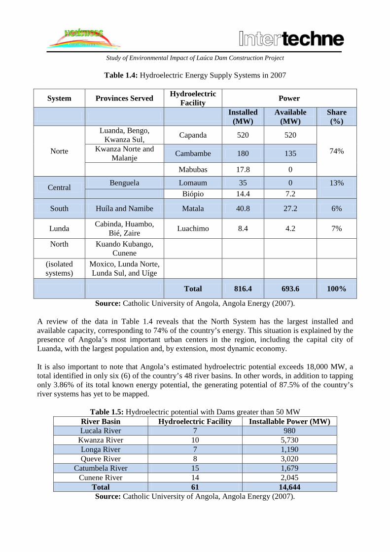
Study of Environmental Impact of Laúca Dam Construction Project
Table 1.4: Hydroelectric Energy Supply Systems in 2007
System Provinces Served Hydroelectric Facility Power
Installed (MW)
Available (MW)
Share (%)
Norte
Luanda, Bengo, Kwanza Sul, Capanda 520 520
74% Kwanza Norte and Malanje Cambambe 180 135
Mabubas 17.8 0
Central Benguela Lomaum 35 0 13% Biópio 14.4 7.2
South Huíla and Namibe Matala 40.8 27.2 6%
Lunda Cabinda, Huambo, Bié, Zaire Luachimo 8.4 4.2 7%
North
Kuando Kubango, Cunene
(isolated systems)
Moxico, Lunda Norte, Lunda Sul, and Uíge
Total 816.4 693.6 100%
Source: Catholic University of Angola, Angola Energy (2007). A review of the data in Table 1.4 reveals that the North System has the largest installed and available capacity, corresponding to 74% of the country’s energy. This situation is explained by the presence of Angola’s most important urban centers in the region, including the capital city of Luanda, with the largest population and, by extension, most dynamic economy. It is also important to note that Angola’s estimated hydroelectric potential exceeds 18,000 MW, a total identified in only six (6) of the country’s 48 river basins. In other words, in addition to tapping only 3.86% of its total known energy potential, the generating potential of 87.5% of the country’s river systems has yet to be mapped.
Table 1.5: Hydroelectric potential with Dams greater than 50 MW River Basin Hydroelectric Facility Installable Power (MW) Lucala River 7 980
Kwanza River 10 5,730 Longa River 7 1,190 Queve River 8 3,020
Catumbela River 15 1,679 Cunene River 14 2,045
Total 61 14,644 Source: Catholic University of Angola, Angola Energy (2007).

Study of Environmental Impact of Laúca Dam Construction Project
Of Angola’s 48 river basins, the Kwanza River Basin has the largest energy generating capacity; currently, 700 MW of energy are generated at the two hydroelectric plants that supply the North System, the Cambambe Hydroelectric Unit, with an installed capacity of 180 MW, and the Capanda Hydroelectric Unit, with 520 MW of installed capacity. However, the total estimated capacity of the river basin is 6,780 MW, with guaranteed energy generation of 26,200 GWh. In this context, feasibility studies have been performed for the construction of an additional seven (7) hydroelectric facilities downstream from the Capanda Dam. Roll-out of the Capanda Hydroelectric Unit paved the way for doubling the country’s energy capacity and the construction of new downstream plants, in addition to expanding steady energy supplies from the Cambambe Dam, due to the benefits, on the order of 350 m3/s every year, arising from the control of water flows on the Kwanza River by the Capanda Dam. The Government developed guidelines and programs for the Angolan energy and water sectors for the period 2009-2012, including plans for the implementation of measures to align energy balance in terms of supply and demand, with a view to preventing energy waste and future shortages from emerging as a drag on the national development efforts. One of the objectives of the Angola Long-Term Development Strategy 2025 (Estratégia de Desenvolvimento a Longo Prazo, Angola 2025)1
is to ensure that all energy sources encompassed in Angola’s energy grid provide an efficient and integrated contribution to the country’s development, promoting the increased use of renewable energy sources and energy self-sufficiency in Angola.
The electric power and water sector investment programs set out a series of goals to be met by the Ministry of Energy and Water through 2016:
• Increased per capita consumption: The primary target to be met by 2016 involves the implementation of 7,000 MW of production capacity, or 95,000 GWh, derived primarily from renewable resources, with a view to ensuring a per capita consumption level of 4,000 KWh;
• Increase in the number of household connections and accesses, estimated at 2 million; • Interconnection of all isolated systems and the creation of the National Energy Transport
Network (Rede Nacional de Transporte de Energia); • Increased contribution, up to 1.5% of the total, by new and renewable energy sources (wind
and solar) throughout the energy grid. The program also provides a schedule of ongoing and planned projects for energy production, transportation and distribution, for which the following outcomes are expected:
• Implementation of 7,000 MW of production capacity, representing a six-fold increase over existing capacity;
• Implementation of a 2,607 km energy transport network at 400 kV and a 2010 km transportation network at 220 kV;
• Construction of 46 small hydroelectric units with a total installed capacity of approximately 180 MW;
1 Electric power and water sector investment program 2016 (Ministry of Energy and Water – MINEA).

Study of Environmental Impact of Laúca Dam Construction Project
• Implementation of a 2,350 km distribution line and construction of 37 new substations, 1,300 converters, primarily in the area of Luanda.
The Angolan Government proposed a set of strategic recommendations for energy generation to promote sustainable development (Presidential Decree 256/11):
• Reduced biomass use in Angola’s energy grid; • Reduced “carbon footprint (CO2)” through the development of an electric energy production
park founded primarily on hydro infrastructure. Given the characteristics, location, and scope of the project, a number of potential environmental and social impacts are expected, both in the construction phase and operational phase of the Laúca Dam. Pursuant to the Law of Environmental Bases (Lei de Bases do Ambiente – No. 5/98, dated June 19) and other applicable statutes, implementation of a project of this scope must be preceded by an Environmental Impact Assessment (EIA) consisting of the following:
• The Environmental Impact Assessment, which must address, but not be limited to, the following:
o Description of the project; o All technology and location options for the project and an analysis of potential non-
execution of the project; o Systematic identification and assessment of the environmental impacts generated during
construction of the energy generation dam; o Determination of the geographic limits of all directly and indirectly project affected
areas by impacts, designated as the project area of direct influence and project area of indirect influence, for which purpose all human populations and other living beings and the river basin within which the project is located should be taken into account.
• Non-Technical Summary of the Study, for purposes of public consultation and
dissemination of information (including, at least, the objectives, scope, criteria, summary of the process, description of the environment, proposed mitigation measures, conclusions, and recommendations);
• Any other information deemed pertinent by virtue of the specific features and characteristics of the project, including its relevance to the economy and development of the Middle Kwanza River Basin region and surrounding areas.
The EIA was prepared pursuant to the applicable laws governing Environmental Impact Assessments and is based on the Terms of Reference approved by the Ministry of Environment, in accordance with Executive Decree No. 92/12, dated March 1. For purposes of preparing the Environmental Impact Assessment on the project in question, Odebrecht Angola, on behalf of and under the coordination of the Kwanza Environmental Development Office (Gabinete de Aproveitamento do Médio Kwanza – GAMEK), contracted Holísticos – Serviços, Estudos e Consultoria, Lda. – which prepared this document in partnership with Intertechne S.A., following field data collection surveys, meetings with stakeholders, and reviews of the project’s technical documentation and corresponding bibliography.

Study of Environmental Impact of Laúca Dam Construction Project
The Construtora Norberto Odebrecht S.A., the lead firm of the Odebrecht business group’s Engineering and Construction unit, was contracted, through its subsidiary, Odebrecht Angola – Projectos e Serviços Lda., a private sector construction company with over 28 years of experiences in the Angolan construction segment, to execute construction of the Laúca Dam. GAMEK is a component body of the Ministry of Energy and Water, with an independent legal and administrative and financial structure. Its primary objective is to undertake studies, preparatory analyses, and projects for rational water resource use in the Middle Kwanza River Basin. GAMEK’s scope of responsibility is the territorial space under the direct influence of the Middle Kwanza River Basing region.
Table 1.6: Contact Information for Project Enterprise (GAMEK)
Enterprise Name Gabinete de Aproveitamento do Médio Kwanza Address
Rua do Massangano S/N, Bairro Operário, Sambizanga – Luanda
Telephone (244) 222 445072 / 222675801 Legal Representative Name Eurico José Martins Mandslay Position General Director Taxpayer Registry No. 7403010230
Telephone 925141480 Email [email protected]
Table 1.7: Contact Information for Construction Company (Odebrecht)
Enterprise
Name
Consortium Constituted by Construtora Norberto Odebrecht S.A. - Sucursal Angola and Odebrecht
Angola Construção e Projectos de Energia Lda.
Commercial Registry No. 2008.731 and 1926-11, respectively Address
Av. Talatona s/n; Belas Business Park II, Torre Cabinda - 8° Andar, Luanda Sul – Luanda
Telephone 244 26 75000 Facsimile 244 26 75000
Legal Representative Name Marcus Fábio Souza Azevedo Position Contract Director Taxpayer Registry No. 270 878 898 18 Telephone 924744019 Email [email protected]
Holísticos is an Angolan environmental consulting firm based in Luanda and registered with the Ministry of Environment (see Registration Certificate in Appendix I), established in 2006. It is staffed by a team of dynamic multidisciplinary experts with extensive experience in the environmental field (see contact information in Table 1.8).

Study of Environmental Impact of Laúca Dam Construction Project
Table 1.8: Contact Information for Environmental Consulting Firm (Holísticos)
Enterprise
Name Holísticos, Lda. – Serviços, Estudos & Consultoria Commercial Registry No. 42639 Taxpayer Registry No. 5401156421
Environmental Consultant Registry No. - Ministry of Environment: 001
Address Urbanização Harmonia, Rua 60, Casa 559, Benfica, Luanda
Telephone +244 222 006938 Facsimile +244 222 006435
Legal Representative Name Miguel Morais, Managing Partner Address Rua 60, Casa 559, Urbanização Harmonia Telephone 923410186 Post Office Box 2426, Apartado IV Email [email protected]
Intertechne is a Brazilian consulting and engineering firm in the dam, hydroelectric, hydraulic, and infrastructure project segment with vast experience in the development of feasibility studies, basic project designs, executive projects, and construction management operations (see Table 1.9).
Table 1.9: Contact Information for Consulting Firm (Intertechne)
Enterprise Name INTERTECHNE CONSULTORES S.A.
Taxpayer Registry No. 80.378.052/0001-35 (Brazilian Corporate Tax Registry No.)
Address Av. João Gualberto, 1259, 16º andar - Alto da Glória CEP 80030-001 - Curitiba, PR – Brazil
Telephone +55(41)3219-7200 Facsimile +55(41)3219-7848
Legal Representative Name Lourenço Justiniano Naotake Babá
Address Avenida João Gualberto 1259, 18º andar – Alto da Glória – Curitiba – Paraná – Brazil – 80.030-001
Telephone 55 41 3219-7200 Email [email protected]
1.4. OBJECTIVES
The fundamental purpose of an Environmental Impact Assessment consists in analyzing how the proposed project will impact, whether adversely or positively, on the quality of the environment and its ecosystems, including the quality of life of individuals and communities in surrounding areas of the project site. In this light, a study of this nature is expected to play a lead role in minimizing, managing, and continuously monitoring the impacts identified in this document.

Study of Environmental Impact of Laúca Dam Construction Project
Preparation of this Environmental Impact Assessment serves to provide substance to the applicable Angolan environmental laws. The assessment had the following objectives:
• To describe the project, report on the Laúca Dam construction project work, and implement the respective equipment and to analyze the environmental and social benefits inherent to implementation of the project;
• To provide information on alternatives for preventing, mitigating, or reducing potential adverse environmental impacts in ecologically sensitive areas, comparing the benefits and disadvantages of each option and setting forth the reasons justifying selection of the recommended option;
• To prepare a socioeconomic description of the project area (with particular emphasis on resident communities located in close proximity to the dam construction site and the corresponding reservoir) and a description of the specific environment susceptible to impact by project activities;
• To hold consultations with populations potentially affected by dam construction work and operation, with a view to identifying the needs, expectations, and demands of the population and keeping the public updated on the status of the project. To this end, a Public Consultation and Dissemination Plan (Plano de Consulta e Divulgação Pública – PCDP) will be developed;
• To propose mitigation measures to reduce pollution, environmental disruptions, and other potential adverse impacts generated during the Laúca Dam construction and operational phases.
1.5. SCOPE OF THE STUDY
Given the existing deficiencies in meeting current energy demand, a proposal was developed to build a new dam downstream from Capanda. The Laúca Dam will add 2,070 MW to the national energy system, a total which does not meet current demand. The dam under study represents a more cost effective alternative for boosting energy supply, with greater assurance of regular energy provisions to meet Angola’s development needs. In the context of this study and based on the respective objectives, the items below were selected for purposes of constituting the project scope. The infrastructure for the project is provided in Table 1.10.
• Identify the significant environmental issues and effects caused by specific activities inherent to equipment installation, dam construction, support infrastructure and operation, in addition to construction of project access points;
• Identify significant effects on populations in the surrounding area and project workers caused by projected environmental impacts;

Study of Environmental Impact of Laúca Dam Construction Project
• Facilitate and consider the contacts with and information provided to project affected populations, understand their values as individuals and communities in regard to environmental quality;
• Evaluate the concerns expressed by the population in regard to the possible effects of the project and determine how to proceed;
• Define the limits and scope of a more detailed time and resource optimization analysis and assessment;
• Determine the scope of the assessment in connection with the respective analytical methods and consultation procedures, with a view to enhancing the efficiency of the environmental impact assessment process;
• Organize, focus, and communicate the potential impacts and concerns to support more detailed analysis and informed decision-making.
Table 1.10: Infrastructure within the scope of the EIA
Infrastructure within the Scope of the EIA Infrastructure outside the Scope
of the EIA Damming of River Diversion of River Filling of Reservoir Construction of coffer-dams
Deposits Principal Work Site Construction of Sewage Landfill at Work Site
Construction of Laúca Dam Construction of Power Station Construction of Water Intake
1.6. METHODOLOGY The Environmental Impact Study for the Laúca Dam construction project in the Middle Kwanza River Basin was based on a variety of methodologies applied to analysis of the pertinent environmental and social issues. The report is the product of preliminary surveys conduct in the period November 2007-August 2009 for the Study of the Laúca-Caculo Cabaça Dams. A technical update was performed from October to December 2012, limiting the study area to Laúca, i.e. the proposed area for construction of two river diversion tunnels, followed by the Environmental Impact Assessment2
on the project.
As part of the work on the future dam, the EIA included a research a methodological and bibliographic survey, contacts with authorities, and field studies, as set forth below:
2 EIA submitted January 21, 2013.
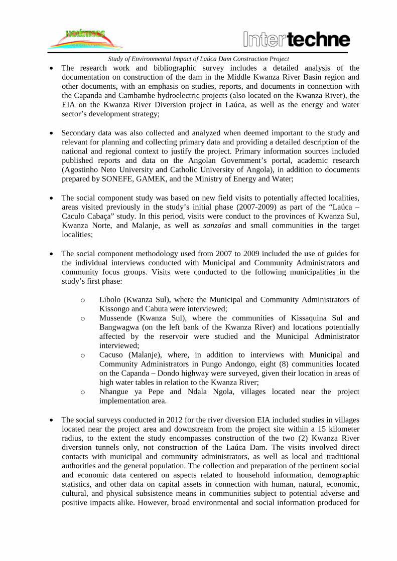
Study of Environmental Impact of Laúca Dam Construction Project
• The research work and bibliographic survey includes a detailed analysis of the documentation on construction of the dam in the Middle Kwanza River Basin region and other documents, with an emphasis on studies, reports, and documents in connection with the Capanda and Cambambe hydroelectric projects (also located on the Kwanza River), the EIA on the Kwanza River Diversion project in Laúca, as well as the energy and water sector’s development strategy;
• Secondary data was also collected and analyzed when deemed important to the study and relevant for planning and collecting primary data and providing a detailed description of the national and regional context to justify the project. Primary information sources included published reports and data on the Angolan Government’s portal, academic research (Agostinho Neto University and Catholic University of Angola), in addition to documents prepared by SONEFE, GAMEK, and the Ministry of Energy and Water;
• The social component study was based on new field visits to potentially affected localities, areas visited previously in the study’s initial phase (2007-2009) as part of the “Laúca – Caculo Cabaça” study. In this period, visits were conduct to the provinces of Kwanza Sul, Kwanza Norte, and Malanje, as well as sanzalas and small communities in the target localities;
• The social component methodology used from 2007 to 2009 included the use of guides for the individual interviews conducted with Municipal and Community Administrators and community focus groups. Visits were conducted to the following municipalities in the study’s first phase:
o Libolo (Kwanza Sul), where the Municipal and Community Administrators of Kissongo and Cabuta were interviewed;
o Mussende (Kwanza Sul), where the communities of Kissaquina Sul and Bangwagwa (on the left bank of the Kwanza River) and locations potentially affected by the reservoir were studied and the Municipal Administrator interviewed;
o Cacuso (Malanje), where, in addition to interviews with Municipal and Community Administrators in Pungo Andongo, eight (8) communities located on the Capanda – Dondo highway were surveyed, given their location in areas of high water tables in relation to the Kwanza River;
o Nhangue ya Pepe and Ndala Ngola, villages located near the project implementation area.
• The social surveys conducted in 2012 for the river diversion EIA included studies in villages
located near the project area and downstream from the project site within a 15 kilometer radius, to the extent the study encompasses construction of the two (2) Kwanza River diversion tunnels only, not construction of the Laúca Dam. The visits involved direct contacts with municipal and community administrators, as well as local and traditional authorities and the general population. The collection and preparation of the pertinent social and economic data centered on aspects related to household information, demographic statistics, and other data on capital assets in connection with human, natural, economic, cultural, and physical subsistence means in communities subject to potential adverse and positive impacts alike. However, broad environmental and social information produced for

Study of Environmental Impact of Laúca Dam Construction Project
previous studies was used where deemed necessary for understanding the region, identifying the respective impacts, and determining the appropriate mitigation measures;
• Additionally, the EIA for the Laúca River diversion project included consultations in the following villages: Nhangue ya Pepe, Ndala Ngola, Dumbo Ya Pepe, and Kibenda, given their location downstream from the project, while communities located upstream from the project are not expected to be affected by construction of the river diversion tunnels. However, since there will be demand for job opportunities, the Laúca EIA examined the villages of Muta, Kirinje, Cassula, Yang Ya Colo, Kiangulungo and Kissaquina, located on the main road connecting the project site to Capanda.
• Field studies were conducted for the environmental component in the proposed project area and surrounding areas, with an emphasis on the principal environmental features described for the project as set out in the respective reference situation. To this end, experts in various fields and specific methodologies for each selected descriptor were deployed. The primary descriptors were divided into the physical environment (data on soil, geomorphology, geology, hydrology, climate, and air quality) and biotic environment (description of the land and aquatic vegetation and wildlife and cartography). In the study’s second phase, visits were conducted to update the information and verify potential new species in the location. The studies provided the basis for the EIA field surveys of April and May 2013. More detailed data on the methodology employed to describe the reference situation is provided in Chapter 4. The data includes technical and scientific information on the social and environmental surveys of both the biotic and physical environment;
• The contacts with local and traditional authorities were accomplished during execution of the area data surveys. The list of interview subjects in the preliminary study (2007-2009) and river diversion (2012) phase of the social survey are shown in Table 1.11 and Table 1.12, respectively.
Table 1.11: Authorities interviewed during preliminary surveys (2007-2009).
Province Municipality Position Individual
Kwanza Sul
Libolo
Administrator of the Municipality of Libolo
Luis Mariano Lopes Carneiro
Deputy Administrator of the Municipality of
Libolo
Correia Victorino
Deputy Community Administrator of
Kissongo
Jeremias António
Community Administrator of
Cabuta Manuel Pedro
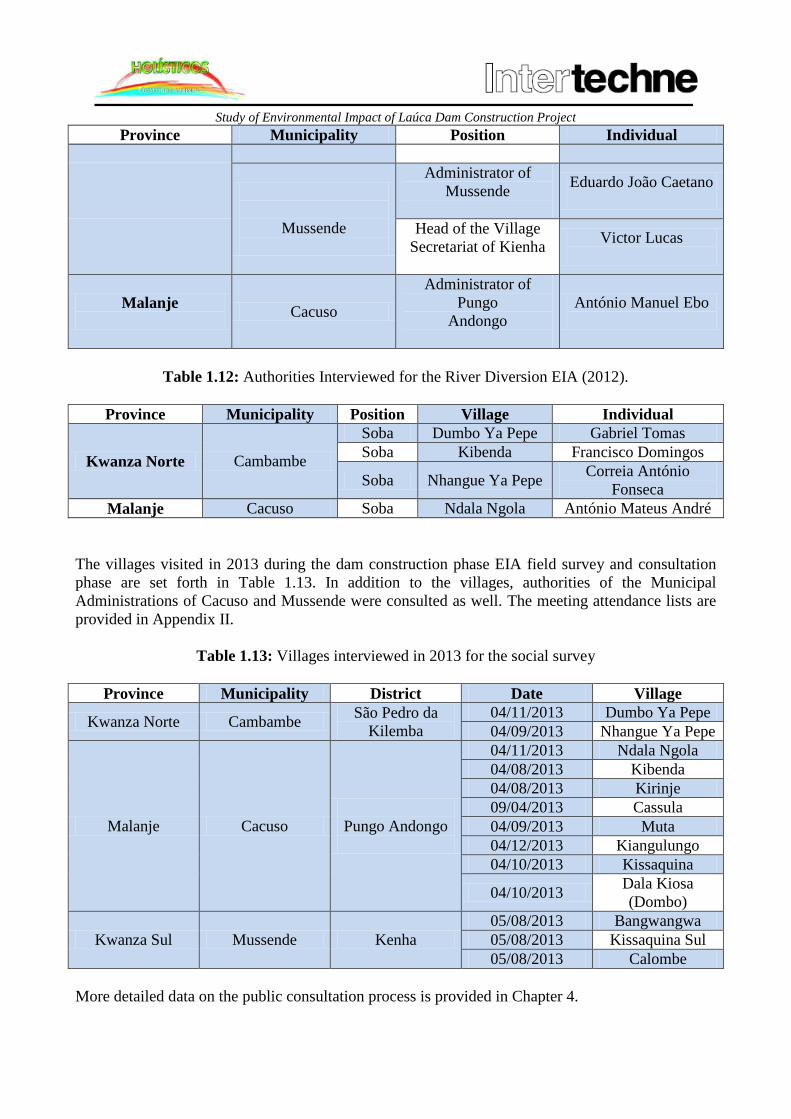
Study of Environmental Impact of Laúca Dam Construction Project
Province Municipality Position Individual
Mussende
Administrator of Mussende
Eduardo João Caetano
Head of the Village Secretariat of Kienha
Victor Lucas
Malanje Cacuso
Administrator of Pungo
Andongo
António Manuel Ebo
Table 1.12: Authorities Interviewed for the River Diversion EIA (2012).
Province Municipality Position Village Individual
Kwanza Norte Cambambe
Soba Dumbo Ya Pepe Gabriel Tomas Soba Kibenda Francisco Domingos
Soba Nhangue Ya Pepe Correia António Fonseca
Malanje Cacuso Soba Ndala Ngola António Mateus André The villages visited in 2013 during the dam construction phase EIA field survey and consultation phase are set forth in Table 1.13. In addition to the villages, authorities of the Municipal Administrations of Cacuso and Mussende were consulted as well. The meeting attendance lists are provided in Appendix II.
Table 1.13: Villages interviewed in 2013 for the social survey
Province Municipality District Date Village
Kwanza Norte Cambambe São Pedro da Kilemba
04/11/2013 Dumbo Ya Pepe 04/09/2013 Nhangue Ya Pepe
Malanje Cacuso
Pungo Andongo
04/11/2013 Ndala Ngola 04/08/2013 Kibenda 04/08/2013 Kirinje 09/04/2013 Cassula 04/09/2013 Muta 04/12/2013 Kiangulungo 04/10/2013 Kissaquina
04/10/2013 Dala Kiosa (Dombo)
Kwanza Sul Mussende Kenha 05/08/2013 Bangwangwa 05/08/2013 Kissaquina Sul 05/08/2013 Calombe
More detailed data on the public consultation process is provided in Chapter 4.

Study of Environmental Impact of Laúca Dam Construction Project
Preparation of this report also took into account the study on implementation of the hydroelectric unit in the Middle Kwanza River Basin conducted by Holísticos and Intertechne between November 2007 and August 2009. The study was of broader in scope, addressing aspects relating to the Laúca and Caculo-Cabaça Dams.
1.7. EIA TEAM For execution of the Environmental Impact Assessment, Holísticos organized a multidisciplinary team, which performed a series of activities in connection with the EIA, specifically in connection with the respective field studies, biotic sample analyses, and preparation and drafting of the report. The various experts and the corresponding areas of intervention are described in Table 1.15. In addition to the technicians indicated above, the teams were supported and accompanies by the GAMEK officials listed in Table 1.14.
Table 1.14: List of GAMEK Technicians
Name of Technician Field of Expertise Sónia Isaac Biologist
Maria Manuela Meireles Soares Human Resources Management Emanuel Adriano Cortez Gaspar Agronomy Engineer
Manuel Borges Major de Almeida Sociologist Jorge Elias de Carvalho Civil Engineer António João Ferreira Agricultural Technician
Francisco António Pereira Neto Geophysicist Rafael Miguel Neto Biochemical Technician
Table 1.15: List of experts involved in the EIA
Name Company Academic Training Function in THE EIA
Vladimir Russo Holísticos Master in
Environmental Education
Project Director: Legislation;
Project Description Analysis; Environmental Management Plan;
Social Base
Miguel Morais Holísticos
Biologist, Master in Ocean and
Coastal Sciences
Project Coordinator: Environmental Impacts;
Mitigation Measures; Environmental Base
Paula Roque Holísticos Economist Project Management
Roberta Macedo Holísticos
Environmental Sanitation Engineer,
Master in Environmental Technologies
Environmental Specialist: Project Description, Environmental Impacts, and Mitigation Measures
Analysis
Pedro Vaz Pinto Holísticos Forest Engineer Environmental Expert: Wildlife Description

Study of Environmental Impact of Laúca Dam Construction Project
Name Company Academic Training Function in THE EIA
Sendi Baptista Holísticos Biologist Environmental Expert:
Project Description; Environmental and Social Base
Santinho Figueira Consultoria Holísticos Sociologist Social Consultant
Eduardo Ferdinand Holísticos
Natural Resources and Environmental
Expert
Environmental and Social Expert; Analysis of Socioeconomic
Conditions
1.8. LOCATION The area subject to this study is located in the North System region, Angola’s largest river basin, with available potential for the implementation of new hydroelectric units. The dam will be built within the territorial limits of the Malanje, Kwanza Norte, and Kwanza Sul provinces in the Middle Kwanza River Basin (Km 307.5), approximately 47 km downstream from the Capanda Dam and near the locality of Nhangue Ya Pepe (Figure 1.2). Access to the project site is accomplished through National Highway 230, which runs from Luanda to Viana, and, ultimately, the city of Dondo, seat of the Cambambe municipal government, in the province of Kwanza Norte, 90 Km from Laúca. The access road stretches approximately 7 Km from the main highway. The Laúca Dam project is located 47 km from the Capanda Hydroelectric Unit, using as a reference, for this purpose, the Capanda-Dondo Highway, access to which is available via a paved road with appropriate signage, located near the locality of Nhangue Ya Pepe, situated approximately 57 km from the city of Dondo.

Study of Environmental Impact of Laúca Dam Construction Project
Figure 1.1: Geographic location of the Laúca Dam (general).

Study of Environmental Impact of Laúca Dam Construction Project
Legend: Mar Mediterrâneo = Mediterranean Sea Trópico de Câncer = Tropic of Cancer Oceáno Índico = Indian Ocean Equador = Equator Oceáno Atlântico = Atlantic Ocean Trópico de Capricórnio = Tropic of Capricorn MAPA DE LOCALIZAÇÃO – CONTINENTE AFRICANO = LOCATION MAP – AFRICAN CONTINENT Cabo Ledo = Cape Ledo Cabo de São Braz = Cape São Braz Porto Amboim = Port Amboim OCEÁNO ATLÂNTICO = ATLANTIC OCEAN MAPA DE LOCALIZAÇÃO – REGIONAL = LOCATION MAP - REGIONAL CAPITAL NACIONAL = NATIONAL CAPITAL CAPITAL PROVINCIAL = PROVINCIAL CAPITAL CIDADES – VILAS = CITIES – VILLAGES AEROPORTO = AIRPORT LIMITE PROVINCIAL = PROVINCIAL BOUNDARY ESTRADAS = HIGHWAY CAMINHOS = ROAD FERROVIAS = RAIL LINE BACIA HIDRGRÁFICA DO MÉDIO KWANZA = MIDDLE KWANZA RIVER BASIN BACIA HIDRGRÁFICA DO RIO KWANZA = KWANZA RIVER BASIN ÁREAS DOS ESTUDOS = STUDY AREAS ESCALA GRÁFICA – SCALE BAR descrição = description REVISÕES = REVISIONS prep. = prepared aprov. = approved data = date elaborado = prepared by verificado = verified by supervisor = supervisor aprovado = approved data = date gerente de projeto = project manager responsável técnico = lead engineer título = title APROVEITAMENTOS HIDROELÉTRICOS NO MÉDIO KWANZA ↓ HYDROELECTRIC UNITS IN THE MIDDLE KWANZA RIVER BASIN

Study of Environmental Impact of Laúca Dam Construction Project
GERAL = GENERAL MAPA DE LOCALIZAÇÃO E VIAS DE ACESSO = LOCATION MAPS AND ACCESS ROADS escala = scale folha = sheet Código do Documento = Document Code Revisão = Review

Study of Environmental Impact of Laúca Dam Construction Project
Figure 1.2: Location and access roads to the Laúca Dam

Study of Environmental Impact of Laúca Dam Construction Project
Legend:
AH LAÚCA = LAÚCA HYDROELECTRIC UNIT Entrada Km 35 = Entrance Km 35 Acesso AH Laúca = Access to Laúca Hydroelectric Unit Entrada Britador Km 19 = Entrance for Crusher Km 19 Linígrafo = Linigraph MAPA DE LOCALIZAÇÃO = LOCATION MAP MAPA DE LOCALIZAÇÃO – CONTINENTE AFRICANO = LOCATION MAP – AFRICAN CONTINENT AH LAÚCA = LAÚCA HYDROELECTRIC UNIT Porto Amboim = Port Amboim OCEÁNO ATLÂNTICO = ATLANTIC OCEAN MAPA DE LOCALIZAÇÃO – REGIONAL = LOCATION MAP - REGIONAL SEM ESCALA = NO SCALE NOTAS = NOTES
1- DISTÂNCIA APROXIMADA PRO ESTRADA DE DONDO A UHE LAÚCA ~90km ↓
1 – ESTIMATED DISTANCE ON DONDO – LAÚCA HYDROELECTRIC UNIT ROAD ~90km 2 – BASE CARTOGRÁFICA ELABORADA A PARTIR DE CARTAS TOPOGRÁFICAS EM ESCALA 1:500,000 do IGCA 9INSTITUTO DE GEODSIA E CARTOGRAFIA DE ANGOLA) ↓ 2 – CARTOGRAPHIC BASIS PREPARED FROM TOPOGRAPHIC MAPS WITH A SCALE 1:500,000 OF THE IGCA (ANGOLAN INSTITUTE OF GEODESY AND CARTOGRAPHY) ACESSOS LEVANTADOS EM CAMPO COM GPS, COMPLEMENTADOS COM CARTA TOPOGRÁFICA. O SISTEMA DE REFERÊNCIA UTILIZADO FOI O WGS84. ↓ 3 – ACCESS ROADS SURVEYED IN THE FIELD WITH GPS, SUPPLEMENT WITH TOPOGRAPHIC MAPS. REFERENCE SYSTEM: WGS84 LEGENDA = LEGEND CAPITAL NACIONAL = NATIONAL CAPITAL CAPITAL PROVINCIAL = PROVINCIAL CAPITAL CIDADES – VILAS = CITIES – VILLAGES AEROPORTO = AIRPORT LIMITE INTERNACIONAL = INTERNATIONAL BORDER LIMITE PROVINCIAL = PROVINCIAL BOUNDARY ESTRADAS = HIGHWAY CAMINHOS = ROAD FERROVIAS = RAIL LINE ÁREA DO EMPREENDIMENTO = PROJECT AREA

Study of Environmental Impact of Laúca Dam Construction Project
1.9. DETERMINATION OF AREA OF INFLUENCE3
The primary objective of any Environmental Impact Assessment is to determine the effects a proposed project will have on the locations and region in which it is executed. Based on a detailed analysis of the local environmental characteristics and potential impacts of the project, it is possible to ascertain whether the environment provides appropriate conditions for implementation of the project. Determination of the areas of influence of the proposed projects is one of the initial steps of an Environmental Impact Assessment (EIA) through which the geographic limits of the areas subject to both direct and indirect positive and adverse changes are established and guidelines for assessing the potential environmental impacts determined. For purposes of the hydroelectric unit dam construction project, the areas of influence subject to modification, encompassing the physical, biotic, and human environments, due to planning, construction, and operation of the project are delimited. To determine the areas of influence of the physical and biotic environments, physiographic aspects, including the river basin used to feed the reservoir, are considered. The human environment (socioeconomic studies) focuses on changes in the quality of life of the local populations in direct and indirect project affected areas, in addition to the respective administrative divisions, such as directly or indirectly affected provinces, municipalities, and districts. For this study, the information provided in the databases of official Angolan institutions was used, as well as other relevant impartial sources. It is worth noting that evaluation of the potential impacts is specific to each environment, with the respective study areas (Areas of Influence) determined on the basis of this specificity. In the case of the Laúca Dam environmental study area, the physical and biotic environments encompassed the following areas of influence (see Figure 1.3).4
• Direct Project Affected Area (Área Directamente Afectada – ADA); • Area of Direct Influence (Área de Influência Directa – AID); • Area of Indirect Influence (Área de Influência Indirecta – AII); • Regional Coverage Area (Área de Abrangência Regional – AAR).
1.9.1. DIRECT PROJECT AFFECTED AREA
The Direct Project Affected Area (ADA) of the biotic and physical environments corresponds to the surface area where the dam will be built and the reservoir filled, as well as those areas occupied by project infrastructure and other project structures. The human environment encompasses a portion of the village of Kissaquina, located in the district of Pungo Andongo. The local population will be affected by the Laúca reservoir and require removal and resettlement.
3 This section may be revised based on the survey conducted on the left bank of the River. 4 The areas of influence are in conformity with the recommendations in Executive Decree No. 92/12, governing the Terms of Reference for Environmental Impact Assessments.

Study of Environmental Impact of Laúca Dam Construction Project
1.9.2. AREA OF DIRECT INFLUENCE
The Area of Direct Influence (AID) corresponds to those areas subject to potential direct positive and adverse impacts. The physical and biotic environments encompass the dam implementation area, reservoir, area reserved for project infrastructure, plus a 5 km zone around the construction site. For purposes of the social environment, the areas set out in Table 1.16 were identified, all of which will be impacted by the Laúca Dam. These districts encompass small population centers (villages).
Table 1.16: Project Area of Direct Influence
Province Municipality District Village
Kwanza Norte Cambambe São Pedro da Kilemba
Dumbo Ya Pepe Nhangue Ya Pepe
Malanje Cacuso Pungo Andongo
Ndala Ngola Kibenda Kirinje Cassula Muta
Kiangulungo Kissaquina Dala Kiosa (Dombo)
1.9.3. AREA OF INDIRECT INFLUENCE
The Area of Indirect Influence (AII) considered for assessment of the physical and biotic environments consisted of the project affected area of the Kwanza River Drainage Basin, plus downstream and upstream segments, covering an area of 4,390 km². In regard to the human environment, the municipalities located in the provinces set forth in the AAR that will in some way be affected by implementation of the project, whether through the recruitment of workers or the socioeconomic stimulus fostered by the project, were included, specifically Cambambe, Kwanza Norte, Libolo and Mussende, Kwanza Sul, and Cacuso, Malanje.
1.9.4. REGIONAL COVERAGE AREA The Regional Coverage Area (AAR) corresponds to those areas potentially subject to indirect project impacts. For the physical and biotic environments, the Middle Kwanza River Drainage Basin was considered, encompassing a total area of 54,564.71 km². This cross-section provides an overview of the processes impacting ecological systems in the region, which can only be understood and analyzed through an assessment of a relatively broad area. Assessment of the human environment looked at the administrative unit of the provinces of Kwanza Norte, Kwanza Sul, and Malanje, taking into consideration factors characterizing the project’s potential scope with respect to its effects on regional economic development.

Study of Environmental Impact of Laúca Dam Construction Project
Figure 1.3: Social sensitivity map in the Laúca Dam construction project areas of influence

Study of Environmental Impact of Laúca Dam Construction Project
Legend:
Mapa de Sensibilidade Socialp Construção da Barragem de Laúca ↓ Laúca Dam Construction Social Sensitivity Map Fazenda Zé Boy = Zé Boy Farm Cemitério Kassaquina Sul = Kassaquina Sul Cemetery RIO KWANZA = KWANZA RIVER Kassaquina Sul Ponte = Kassaquina Sul Bridge Rio Luinga = Luinga River Aldeia (habitantes) = Village (inhabitants) Fazenda = Farm Cemitério = Cemetery AH Laúca = Laúca Hydroelectric Unit AH Capanda = Capanda Hydroelectric Unit Rio Kwanza = Kwanza River Sistema de Coordenadas = Coordinates DATA: MAIO – 2013 = DATE: MAY 2013
1.10. PUBLIC CONSULTATION PROCESS It is important to note that one of the objectives of the environmental impact assessment process is to hold consultations with and provide information to stakeholders, in particular those directly affected by potential project impacts on the quality of life of local populations. The process is intended to ensure transparent and continuous of information, in order to safeguard both the environment as well as the quality of life of local populations and, in this way, facilitate the participation of stakeholders throughout the development of the Environmental Impact Assessment. To this end, a Public Consultation and Dissemination Plan (Plano de Consulta e Divulgação Pública – PCDP) was prepared, pursuant to the guidelines of the International Financing Corporation (IFC) and the applicable Angolan laws. The Public Consultation and Dissemination Plan is a document prepared to determine the procedures for disseminating the project, particularly in the dam construction phase. The PCDP is an integral part of the project’s Environmental Impact Assessment development process. The principal objective of the document is to provide guidance to the organization of consultations and dissemination of the corresponding results and outcomes and those of the project. For purposes of this process, the local stakeholders subject to direct or indirect positive or adverse impacts arising from project actions and pressures will be engaged.
1.10.1. PCDP Objectives The principal objective of the PCDP is to ensure a consistent, solid, and coordinated public consultation process for the purpose of fostering effective participation of stakeholders and affected populations and achieving the following goals:

Study of Environmental Impact of Laúca Dam Construction Project
• To ensure that all stakeholders are included in the consultation and dissemination process;
• To guarantee that dissemination of the initial information on the project is adequate and understandable to stakeholders and other affected interested parties without technical expertise as well as local and surrounding populations;
• To assure that adequate information is provided to project affected populations and other stakeholders;
• To guarantee that all stakeholders have the opportunity to express their opinions and concerns regarding the project;
• To ensure that these opinions and concerns have an influence on project decisions;
• To guarantee regular “feedback” to stakeholders and other parties affected by the project;
• To ensure effective communication is maintained during the construction and operational phases of the proposed project.
1.10.2. PCDP Scope
Development and implementation of the PCDP is aimed at providing a reference document for the purpose of identifying the expectations of stakeholders and other parties affected by the project. The document is an integral component of the detailed plan illustrating the proposed phases and consultation periods. The PCDP identifies the appropriate level of public participation, as well as the discussion stages for the final report, and submission of the project’s Non-Technical Summary. The PCDP’s scope consists of the following three stages.
• Stage 1 – Field Survey: in this stage, stakeholders and direct and indirect project affected populations were consulted (communities in the surrounding area, fishermen, local authorities), in addition to local government institutions (municipal and district). This stage also included an exhaustive survey of the relevant socioeconomic data.
• Stage 2 – Community Information: based on the field survey, the focus of the project was reported to local stakeholders, who, for their part, offered their contributions. Emphasis was given to downstream communities and those affected by the reservoir, as encompassed in the direct project affected areas and project area ADA of direct influence. An information brochure was prepared for local communities (See Appendix III), which was distributed during the field visits. Comments and suggestions were collected through a suggestion form (Appendix IV).
• Stage 3 – Public Consultation: this stage will be organized by the Ministry of the Environment, pursuant to the applicable environmental laws, and serve for purposes of conducting a detailed assessment of the principal positive and adverse environmental impacts arising from the project. In this stage, the respective mitigation measures identified to address the most severe potential adverse impacts will be specified. The location and method of the public consultation will be determined by the Ministry of the Environment, following conclusion of the study’s preliminary assessment process by the pertinent project activity (energy and water) and environmental oversight entities.

Confidential
CHAPTER 02 PROJECT DESCRIPTION

Environmental Impact Study of the Laúca Dam Construction Project
Confidential
CONTENTS
2. PROJECT DESCRIPTION .................................................................................................................................. 6
2.1. ANALYSIS OF THE PROJECT ALTERNATIVES ................................................................................. 6
2.1.1. LOCALIZATION ALTERNATIVES ..................................................................................................... 6
2.1.2. TECHNOLOGIC ALTERNATIVES ........................................................ Error! Bookmark not defined.
2.2. JUSTIFICATION OF THE GENERATION TECHNOLOGY CHOICE ... Error! Bookmark not defined.
2.3. JUSTIFICATION FOR THE CHOICE OF THE LOCATION ................... Error! Bookmark not defined.
2.4. PRESENTATION OF THE PROJECT ........................................................ Error! Bookmark not defined.
2.4.1. GENERAL ARRANGEMENT ................................................................. Error! Bookmark not defined.
2.4.2. RESERVOIR ............................................................................................. Error! Bookmark not defined.
2.4.3. ACCESSES ............................................................................................... Error! Bookmark not defined.
2.4.4. AREAS FOR SOIL EXTRACTION AND WASTE DISPOSAL ............ Error! Bookmark not defined.
2.4.5. SUPPORT INFRASTRUCTURES AND LABOR ................................... Error! Bookmark not defined.
2.4.6. MINE HUNTING ...................................................................................... Error! Bookmark not defined.
2.4.7. DEFORESTING, UPROOTING AND CLEANING ................................ Error! Bookmark not defined.
2.5. SAFETY, OCCUPATIONAL HEALTH AND ENVIRONMENT ............. Error! Bookmark not defined.
2.5.1. INTEGRATED SUSTAINABILITY PROGRAM ................................... Error! Bookmark not defined.
2.5.2. HEALTH ................................................................................................... Error! Bookmark not defined.
2.5.3. OCCUPATIONAL SAFETY .................................................................... Error! Bookmark not defined.
2.5.4. ENVIRONMENT ...................................................................................... Error! Bookmark not defined.
2.6. COSTS AND CONSTRUCTION SCHEDULE .......................................... Error! Bookmark not defined.
Environmental Impact Study of the Laúca Dam Construction Project
Confidential
Abbreviations
List of Figures Figure 2.1: Schematic Longitudinal Profile of the Division of Falls – Alternative 1 Figure 2.2: Schematic Longitudinal Profile of the Division of Falls – Alternative 2 Figure 2.3: Schematic Longitudinal Profile of the Division of Falls – Alternative 3 Figure 2.4: Schematic Longitudinal Profile of the Division of Falls – Alternative 4 Figure 2.5: Schematic Longitudinal Profile of the Division of Falls – Alternative 5 Figure 2.6: Comparison of alternatives. Figure 2.7: Schematic profile of a hydroelectric power plant Figure 2.8: Schematic profile of the power production process using petroleum Figure 2.9: Schematic profile of a nuclear plant Figure 2.10: Schematic profile of the electric power production process from mineral coal. Figure 2.11: Overall layout of the Laúca dam construction works. Figure 2.12: General arrangement of Laúca AH. Figure 2.13: General arrangement of the BCC dam. Figure 2.14: General arrangement of the main generation circuit. Figure 2.15: General arrangement of the main plant. Figure 2.16: General arrangement of the ecologic plant generation circuit. Figure 2.17: Map of the Laúca dam reservoir Figure 2.18: Map of accesses to Laúca dam. Figure 2.19: Identification and localization of mines and disposal areas of Laúca AH. Figure 2.20: Disposal area and access zone to the mouth of the deviation tunnels. Figure 2.21: Localization of the waste disposal areas for the river deviation works. Figure 2.22: Disposal and storage areas (disposal and mines) Figure 2.23: Layout of the administrative quarters Figure 2.24: Fuel Station Figure 2.25: Lubrication and Tire Repair Station Figure 2.26: Vehicle Washing Station and Mechanical Workshop Figure 2.27: Decantation Tank Figure 2.28: Water/Oil Separation Tank Figure 2.29: Advanced/Industrial Work Quarters Figure 2.30: Sanitary Landfill (plan view and sections) Figure 2.31: Sanitary Landfill (details, plan view and sections) for the river deviation Figure 2.32: Explosives Warehouse Figure 2.33: Crushing center Figure 2.34: Concrete Center and Ice Center Figure 2.35: Areas to be mine-hunted for the Laúca dam Project Figure 2.36: Deforesting Figure 2.37: Water treatment station Figure 2.38: Drinking water tank Figure 2.39: Raw water tank Figure 2.40: Effluent treatment station Figure 2.41: Scheme of the ETE treatment system Figure 2.42: Detail of the ETE’s preliminary treatment5 Figure 2.43: Sections of the ETE’s preliminary treatment, equalization tank and pump well1 Figure 2.44: Plant beds Figure 2.45: Summarized schedule of the activities of the Laúca AH works

Environmental Impact Study of the Laúca Dam Construction Project
Confidential
List of Frame Frame 2.1: Summary of advantages and disadvantages of hydroelectric power generation in Angola. Frame 2.2: Summary of advantages and disadvantages of thermoelectric power generation in Angola. Frame 2.3: Summary of advantages and disadvantages of wind energy generation. Frame 2.4: Summary of advantages and disadvantages of solar energy. Frame 2.5: Summary of the advantages and disadvantages of energy generation by means of biogas. Frame 2.6: Summary of the advantages and disadvantages of generation by means of natural gas. Frame 2.7: Summary of advantages and disadvantages of nuclear energy generation. Frame 2.8: Summary of advantages and disadvantages of energy generation using mineral coal. List of Tables Table 2.1: Revision of the Fall Division in the Section’s Hydroelectric Power Plant. Table 2.2: Revision of the Fall Divisions in the Hydroelectric Power Plant of River Kwanza’s Medium Section – Alternative 1. Table 2.3: Revision of the Division of Falls for the Power Plant in the Medium Section of the Kwanza River – Alternative 2. Table 2.4: Revision in the Division of Falls for the Power Plants in the Medium Section of the Kwanza River – Alternative 3. Table 2.5: Revision in the Division of Falls for the Power Plants in the Medium Section of the Kwanza River – Alternative 4. Table 2.6: Revision in the Division of Falls for the Power Plants in the Medium Section of the Kwanza River – Alternative 5. Table 2.7: Revision in the Division of Falls for the Power Plants in the Medium Section of the Kwanza River – Comparison and Selection of Alternatives. Table 2.8: Summary of the study of Division of Falls for the plants in the Medium Section of the Kwanza River – Alternatives for the Division of Falls. Table 2.9: Main characteristics of the Laúca hydroelectric plant. Table 2.10: Types of solid residues produced by the works. Table 2.11: Important dates and events of the Laúca dam construction

Environmental Impact Study of the Laúca Dam Construction Project
Confidential
Abbreviations
BAS Submerged Aerated Biofilter BCC Concrete Compacted with Cylinder CCR Concrete Compacted with Roll CGR Waste Management Center EFB Concrete Surface EIA Environmental Impact Study EPI Personal Protection Equipment ENE National Power Company ETA Water Treatment Station ETE Effluent Treatment Station GAMEK Medium Kwanza Project Cabinet GNL Liquefied Natural Gas GNLA Angolan Liquefied Natural Gas IAN Negative Environmental Impact IAND Distributed Negative Environmental Impact PI Integrated Sustainability Plan PRAD Recovery Plan for Degraded Areas PN Nominal Pressure PVC Polyvinyl chloride PP Polypropylene UASB Upflow Anaerobic Sludge Blanket

Environmental Impact Study of the Laúca Dam Construction Project
Confidential
2. PROJECT DESCRIPTION
This section of the EIA Report presents a series of aspects related to the justification for
choosing the location for the implementation of the enterprise and the alternatives for electric
power production in Angola, as well as a general description of the proposed project and the
company’s environmental management programs.
2.1. ANALYSIS OF THE PROJECT ALTERNATIVES
2.1.1. LOCALIZATION ALTERNATIVES
For the definition of the best localization alternative for the hydroelectric power plant within the
medium section of the Kwanza basin, a study was developed in 2008 by Intertechne Consultores
S.A, seeking the division of falls. Such study has considered the alternatives selected during the
works carried out in the past decades, requested by the government from private companies.
The study has analyzed the technological advance that took place in hydroelectric power plants
along these years, and has assessed five (5) alternatives from a total of nine (9) different
enterprises, as shown in Table 2.1. The parameters established for this assessment stage were
the following:
• The proposal of upstream projects for each alternative, thus allowing the
implementation of discharge regularization reservoirs;
• The association of these with other projects, thus allowing the full use of the available
gross fall;
• The minimization of environmental impacts; and
• The lack of possibilities with multiple projects and the assessment of a solution
considering a single project.

Environmental Impact Study of the Laúca Dam Construction Project
Confidential
Table 2.1: Revision of the Fall Division in the Section’s Hydroelectric Power Plant.
Alternative Hydroelectric
Power Plant
Maximum normal
water level of the
reservoir (m)*
Downstream
water level Gross fall
1
Nhangue 850 760 90
Laúca 760 630 130
Caculo Cabaça 630 415 215
2 Dunga 850 630 220
3 Caculo Cabaça 630 415 215
Laúca Alto 850 630 330
4 Muta 850 415 435
5
Laúca 760 630 130
Caculo 1 630 555 75
Caculo 2 555 512 43
Caculo 3 512 415 97
* Maximum normal water level of the reservoir in meters.
2.1.1.1. Alternative 1
This alternative was present in the SONEFE (Angolan Society of Enterprises for the Supply of
Electric Power) study and mentioned in the Energoprojekt report, and considers three
enterprises: Nhangue, Laúca and Caculo-Cabaça, which characteristics are presented in Table
2.2.
Table 2.2: Revision of the Fall Divisions in the Hydroelectric Power Plant of River Kwanza’s
Medium Section – Alternative 1.
Hydroelectric Power
Plant
Basin (km2)
Reservoir Gross fall (m)
Normal flow (m3/s)
Available
power (MW)
Installed
power (MW)
Water level (m) Volume (hm3)
Upstream
Downstream
Total
Useful
Nhangue 109,000 850.00 760.00 5,48
2 4,120 90 449.9 295 780
Laúca 112,61 760.00 630.00 22 - 130 449.9 502 1,116

Environmental Impact Study of the Laúca Dam Construction Project
Confidential
7 Caculo Cabaça
112,663 630.00 415.00 41 - 215 449.9 822 1,826
Total 435 - 1,619 3,722

Environmental Impact Study of the Laúca Dam Construction Project
Confidential
Nhangue AH (Hydroelectric Power Plant)
The implementation place of the Nhangue AH is located approximately 40 km
downstream of Capanda AH, in a region with optimum conditions for the formation of a
reservoir for the regularization of the incoming flow.
The shape of the main valley and of the Buiza River, a left bank tributary, favor the
accumulation of water in the reservoir, reaching 5,400 hm³ in an area of approximately
190 km². In this section, the Kwanza River flows in a more flat pattern that alternates
with rapids and small water falls, ending up with an average gradient of 2.4 m/km.
The river valley has the shape of a closed Canyon with steep banks. Above the banks a
smooth pattern prevail, with small undulation and covered by layers of sandy soil and
altered rock. On the top of the banks there is a very hard and silicon-rich sandstone
(meta- sandstone) layer with reddish color.
In the base of the lower portion of the banks, an accumulation of “talus”-shaped blocks
can be observed, laid on their natural repose angle, which covers the contact between
the gneiss of the base and the meta-sandstone of the banks. The river bed presents
rapids and rock outcrops, and the major part of the surface is marked by fractures,
having gneiss and very hard and compact migmatites as foundation rock.
In this place, in a section of approximately 2 km, two alternative axes were identified
spaced 700 m between each other. The first upstream axis was selected in the studies of
SONEFE (1966) and the Hidroprojekt Institute, being the later used for the development
of an ante-project for the Nhangue AH, ordered by GAMEK in 1992.
The general arrangement of this study had considered an alternative with a concrete
dam compacted with roll (CCR), a river deviation through a tunnel built in the right
bank and the water intake structures, penstocks, power house and spillway in the river
bed, associated to the CCR dam structure. In the second axis, three alternate

Environmental Impact Study of the Laúca Dam Construction Project
Confidential
arrangements were studied and modeled in three dimensions (3D) for assessment as
shown below: • CCR dam and the structures of the deviation tunnels, water intakes, penstocks,
power house and spillway on the right bank;
• Dam built with rocks and concrete surface (EFB), deviation tunnels and spillway
implemented on the left bank and the hydraulic generation circuit on the right bank;
and
• Dam built with rocks and concrete surface (EFB), deviation tunnels and spillway
implemented on the right bank.
This later arrangement that considers all the structures on the right bank, proved to be
the most advantageous, both because of the access facility and because of the work
volume and construction costs. The project so defined is composed by the followings
structures:
• 1st phase cofferdams (transverse and longitudinal) on the river’s right bank;
• Three deviation tunnels on the right shoulder;
• Dam built with rocks and concrete surface (EFB) with a maximum height of 100
m;
• Transverse cofferdams, upstream and downstream, for the 2nd phase deviation;
• Hydraulic generation circuit composed by the water supply channel, 4 water
intake blocks, penstocks, power house equipped with 4 units of the vertical axis
Francis and outlet channel; and
• Sloped spillway with Creager profile discharging on the deviation tunnels
recovery channel.
Laúca AH

Environmental Impact Study of the Laúca Dam Construction Project
Confidential
The Laúca AH is located on km 307 of the Kwanza river, at approximately 8 km
downstream from the Nhangue AH, in a section where the river follows a narrow gorge
with “U” shape, presenting a succession of rapids and concentrated falls totaling
approximately 30 m and with a gradient of 4 m/km. Downstream from the place
foreseen for the dam axis, the Kwanza river presents a natural fall, with steps and
rapids, in the order of 100 m along a little bit more than 1,500 m of the river length.
In the place foreseen by SONEFE (1966) to be the dam location, the river bed has a
width in the order of 200 m and the water level is in the 730.00 m elevation. The valley
presents vertical banks reaching the elevation of 830.00 m with a distance between the
banks of 450 m. On the top, with smoother shoulders, the elevation of 850.00 m is
reached, with a distance between the banks in the order of 750 m.
The axis location is strongly embedded, with the rocky river-bed in gneiss and the
scarped side walls in sandstone. The river bed is irregular and eroded with foundation
on the firm remaining rock. The rock is highly fractured locally, in fracture zones.
Between the river bed and the side walls there is a layer of “talus” formed by blocks of
metric sizes with thicknesses up to tens of meters, covering the contact between the
gneiss in the base and the sandstone in the side walls.
In the side walls, the sandstone is partially fractured with sub-vertical and inclined
fractures forming locally unstable “wedges”.
Having in mind the geomorphologic and local geologic characteristics, with a natural
fall in the order of 100 m in a section of approximately 2 km, and with the river path
forming a sinuosity in the shape of “S”, the general arrangement studied has considered
a project solution of the derivation type. It is composed by a concrete dam compacted
with roll (CCR) in the beginning of the falls, on an attached valley, associated to the

Environmental Impact Study of the Laúca Dam Construction Project
Confidential
spillway structure equipped with gates for the 2nd phase river deviation, with the
underground hydraulic circuit excavated on the right shoulder.
The first phase deviation is carried out with transverse and longitudinal cofferdams
necessary for the partial restriction of the river bed, in order to allow the construction of
the water intake, spillway and mouths of the penstocks on the right shoulder.

Environmental Impact Study of the Laúca Dam Construction Project
Confidential
The second phase of the deviation is composed by the transverse cofferdams regarding
the river, upstream and downstream, with the river passing through the deviation gates,
thus allowing the dam construction on the river bed.
The dam is a small one, with maximum height in the order of 40 m, and the hydraulic
generation circuit is foreseen to be composed by 3 penstocks, underground power house
with three vertical-axis Francis-type turbines, intake chamber and two outlet tunnels 1.6
km long.
Caculo-Cabaça AH
The scheme of the Caculo-Cabaça project is characterized by the high natural fall
available on a long section of the Kwanza River. It is only possible to be explored by a
plant of the derivation type. The section under study develops in the shape of an
inverted “V”, counterclockwise, between the km 296 of the river, upstream (place of the
dam and spillway), and the km 276, downstream (recovery of the flows past the
turbines), representing a total of 20 km of extension and a natural fall of 183 m.
On the Caculo-Cabaça dam location, the valley is wide with smooth banks and the
predominance of gneiss as foundation. The cover of soil and altered rock on the wall is
in the order of 3 to 5 meters. On the bottom of the valley, the cover of soil and altered
rock is in the order of 2 to 3 meters. The river flows locally on a narrow gorge around
30 meters wide, where a high speed flow is observed. The estimated depth of the deeper
river bed is in the order of 10 a 15 meters. In the river banks there are continuous gneiss
outcrops with sub-vertical spreading, very fractured locally and covered by loose gneiss
blocks of several sizes including metric.
The general arrangement proposed for Caculo-Cabaça AH is composed by a concrete
dam compacted with roll (CCR) with maximum height in the order of 50 m on the
deepest river bed, complemented by the spillway located on the right bank and a section
of the closing dam on the right shoulder.

Environmental Impact Study of the Laúca Dam Construction Project
Confidential
The deviation of the river is foreseen to be carried out in 2 phases, being the first one composed
by transverse cofferdams, upstream and downstream, united by a cofferdam longitudinal to the
river path, built on the right bank to allow the excavation and pouring of concrete of the
spillway. The second phase of the deviation will be carried out through the spillway gaps along
the lowered crest, with the closing of the river gorge through transverse cofferdams, upstream
and downstream. The spillway, with Creager-type sill, is controlled by three sector gates.
The hydraulic generation circuit is foreseen to be built on the left shoulder and to be composed
by the open air water intake, penstocks, underground power house equipped with 4 vertical-axis
Francis-type units, intake chamber and two long outlet tunnels (9.7 km) that recover the flows
past the turbines on the (EL) 415.00 m elevation, downstream of the Caculo-Cabaça falls, end
of the section under study. Figure 2.1 represents the division of falls of Alternative 1.
Figure 2.1: Schematic Longitudinal Profile of the Division of Falls – Alternative 1

Environmental Impact Study of the Laúca Dam Construction Project
Confidential
Legend of Figure 2.1: Elevação = Elevation Derivação = Derivation Distância da Foz = Distance to the river mouth

Environmental Impact Study of the Laúca Dam Construction Project
Confidential
2.1.1.2. ALTERNATIVE 2
The initial scheme for the division of falls in this alternative is characterized by the
displacement to 3.5 km downstream of the Nhangue AH dam axis, on km 312 of the
river, intended for the implementation of a single project, associated to the upstream
regularization reservoir, resulting in the unification of the Nhangue and Laúca AHs,
complemented by the Caculo-Cabaça AH.
SONEFE mentions this study, regarding the upstream power plant, under the
denomination of Dunga AH in the change report, dismissing it because it means a
higher elevation dam with longer outlet tunnels (12 km), disadvantages in the
possibilities for planning partial investments and in the overpowering of the plant.
The revision of the division of falls in 2007, by Intertechne, generated new topographic
data of the region with the use of the aerial survey technique with laser profiling. The
higher level of detail made possible the development of new studies that confirmed the
possibility of considering this alternative with the characteristics shown in Table 2.3.
Table 2.3: Revision of the Division of Falls for the Power Plant in the Medium Section
of the Kwanza River – Alternative 2.
Hydroelectric Power
Plant
Basin (km2)
Reservoir Gross
Fall (m)
Reg. flow (m3/s
)
Available power (MW)
Installed
power (MW)
Water level (m) Volume (hm3)
Upstream
Downstream
Total
Useful
Dunga 112,536 850.00 630.00 5,48
2 4,120 220 449.9 786 1,869
Caculo Cabaça
112,663 630.00 415.00 41 - 215 449.
9 822 1,826
Total 435 1,608 3,695 Dunga AH
For the selection of the best axis and the proposal of an adequate general arrangement
for this project, a section of the Kwanza River with approximately 4 km of extension
was studied and some solutions assessed seeking a comparison between work volumes

Environmental Impact Study of the Laúca Dam Construction Project
Confidential
and construction facilities. From this comparison resulted the selection of an axis
located 4.5 km downstream of the Nhangue AH axis and with an arrangement of
deviation works, dam and spillway similar to the one adopted for that project, located
on the right shoulder. Therefore, a dam built with rocks and concrete surface (EFC),
will have e maximum height in the order of 109 m, nine meters more than the Nhangue
AH. The hydraulic generation circuit will be composed by a supply channel, open air water
intake, penstocks, underground power house equipped with four (4) units of the
vertical-axis “Francis”-type , intake chamber and two (2) outlet tunnels with an
extension of 5,370 m each, thus recovering the flows past the turbines at the same
position as the Laúca AH.
Caculo-Cabaça AH
The Caculo-Cabaça AH of the alternative 2 here presented is identical to the one
described in Alternative 1. Figure 2.2 represents the division of falls of Alternative 2.
Figure 2.2: Schematic Longitudinal Profile of the Division of Falls – Alternative 2 Legend of Figure 2.2: Elevação = Elevation
Environmental Impact Study of the Laúca Dam Construction Project
Confidential
Derivação = Derivation Distância da Foz = Distance to the river mouth
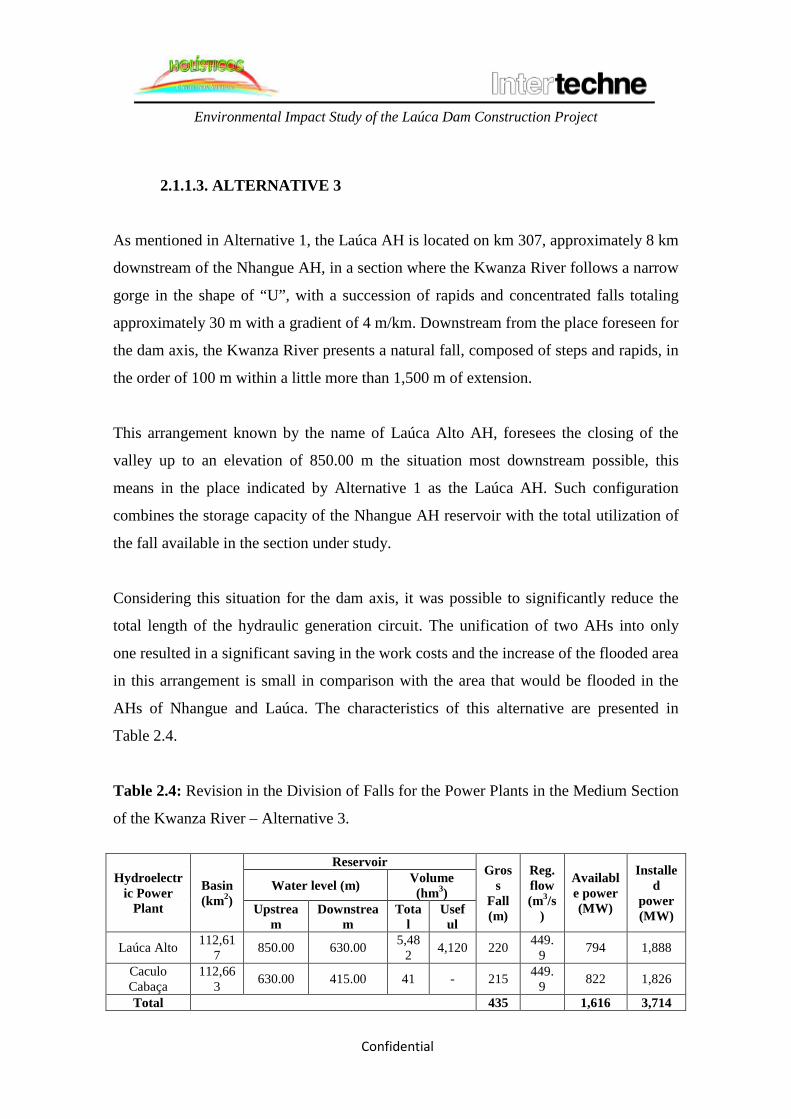
Environmental Impact Study of the Laúca Dam Construction Project
Confidential
2.1.1.3. ALTERNATIVE 3
As mentioned in Alternative 1, the Laúca AH is located on km 307, approximately 8 km
downstream of the Nhangue AH, in a section where the Kwanza River follows a narrow
gorge in the shape of “U”, with a succession of rapids and concentrated falls totaling
approximately 30 m with a gradient of 4 m/km. Downstream from the place foreseen for
the dam axis, the Kwanza River presents a natural fall, composed of steps and rapids, in
the order of 100 m within a little more than 1,500 m of extension.
This arrangement known by the name of Laúca Alto AH, foresees the closing of the
valley up to an elevation of 850.00 m the situation most downstream possible, this
means in the place indicated by Alternative 1 as the Laúca AH. Such configuration
combines the storage capacity of the Nhangue AH reservoir with the total utilization of
the fall available in the section under study.
Considering this situation for the dam axis, it was possible to significantly reduce the
total length of the hydraulic generation circuit. The unification of two AHs into only
one resulted in a significant saving in the work costs and the increase of the flooded area
in this arrangement is small in comparison with the area that would be flooded in the
AHs of Nhangue and Laúca. The characteristics of this alternative are presented in
Table 2.4.
Table 2.4: Revision in the Division of Falls for the Power Plants in the Medium Section
of the Kwanza River – Alternative 3.
Hydroelectric Power
Plant
Basin (km2)
Reservoir Gross
Fall (m)
Reg. flow (m3/s
)
Available power (MW)
Installed
power (MW)
Water level (m) Volume (hm3)
Upstream
Downstream
Total
Useful
Laúca Alto 112,617 850.00 630.00 5,48
2 4,120 220 449.9 794 1,888
Caculo Cabaça
112,663 630.00 415.00 41 - 215 449.
9 822 1,826
Total 435 1,616 3,714

Environmental Impact Study of the Laúca Dam Construction Project
Confidential

Environmental Impact Study of the Laúca Dam Construction Project
Confidential
Laúca Alto AH
The place of the Laúca Alto AH axis is strongly embedded, with the rocky river-bed in
gneiss and the scarped side walls in sandstone. The river bed is irregular due to the
effects of erosion in the foundation rock caused by the lines of failures and fractures
present. Between the river bed and the side walls there is a layer of “talus” formed by
blocks of metric sizes with thicknesses up to tens of meters, covering the contact
between the gneiss in the base and the sandstone in the walls. Medium fractured
sandstone can be found in the side walls with sub-vertical and inclined fractures
forming locally unstable “wedges”.
The general arrangement proposed foresee the closing of the valley, from the upper
level of the left shoulder until the right shoulder, with a dam built with concrete
compacted by roll (CCR) associated to the deviation structure by gates on the river bed
and to the spillway in the upper part of the dam, in the same alignment of the gates.
Following the later there is the water intake structure, the transition block and the rock
dam with vertical clay core.
The deviation of first phase is carried out with transverse and longitudinal cofferdams
necessary for the partial restriction of the river bed, in order to ensure the construction
of the deviation gates. The second phase of the deviation will make use of cofferdams
transverse to the river, upstream and downstream, with the river passing through the
deviation gates, thus allowing the construction of the dam on the river bed.
O hydraulic generation circuit is foreseen to the be composed by a supply channel,
water intake, four penstocks, underground power house with four vertical-axis Francis-
type turbines, intake chamber and two outlet tunnels with 1.6 km of extension.
Caculo-Cabaça AH
The Caculo-Cabaça AH that composes alternative 3 is the same already described for
alternative 1.

Environmental Impact Study of the Laúca Dam Construction Project
Confidential

Environmental Impact Study of the Laúca Dam Construction Project
Confidential
Figure 2.3 represents the division of falls for Alternative 3.
Figure 2.3: Schematic Longitudinal Profile of the Division of Falls – Alternative 3
Legend of Figure 2.3:
Elevação = Elevation
Derivação = Derivation
Distância da Foz = Distance to the river mouth
2.1.1.4. ALTERNATIVE 4
This alternative represents the project scheme associated to the total utilization of the
natural fall available in the section under study of the Kwanza River into a single
project.
This scheme called Muta AH considers the location of the dam in the place of
Laúca/Laúca Alto, with the maximum normal water level of the reservoir in the 850.00
m elevation (such as Laúca Alto AH) and the recovery of the flows past the turbines

Environmental Impact Study of the Laúca Dam Construction Project
Confidential
downstream of the Caculo-Cabaça falls, in the end of the section under study, at the
elevation of 410.00 m, according to the data presented in Table 2.5.

Environmental Impact Study of the Laúca Dam Construction Project
Confidential
Table 2.5: Revision in the Division of Falls for the Power Plants in the Medium Section
of the Kwanza River – Alternative 4.
Hydroelectric Power
Plant
Basin (km2)
Reservoir Gross
Fall (m)
Reg. flow (m3/s
)
Available power (MW)
Installed
power (MW)
Water level (m) Volume (hm3)
Upstream
Downstream
Total
Useful
Muta 112,610
850.00 415.00 5,482
4,120 435 449.9
1,598 3,672
Total 435 1,598 3,672
Muta AH
The general arrangement of the Muta AH works is identical to the one of Laúca Alto
AH. The fundamental difference is in the hydraulic generation circuit, for which the
sizing carried out has indicated a power unit count of 14 units, with vertical-axis
Francis-type turbines with characteristics that suit the limit of the worldwide
experience.
The scheme defined for the project has considered an intake feed with one penstock for
every two machines, a bifurcation tunnel close to the power house, one power house
with approximately 250 m of extension, intake chamber with large dimensions and two
outlet tunnels with extension in the order of 20 km.
The preliminary calculations for checking the hydraulic transients have conducted to a
steep lowering of the power house and the large dimension chambers, as well as high
pressure losses in the hydraulic circuit, in the magnitude of 9 to 10%.
Figure 2.4 below represents the division of falls of Alternative 4.
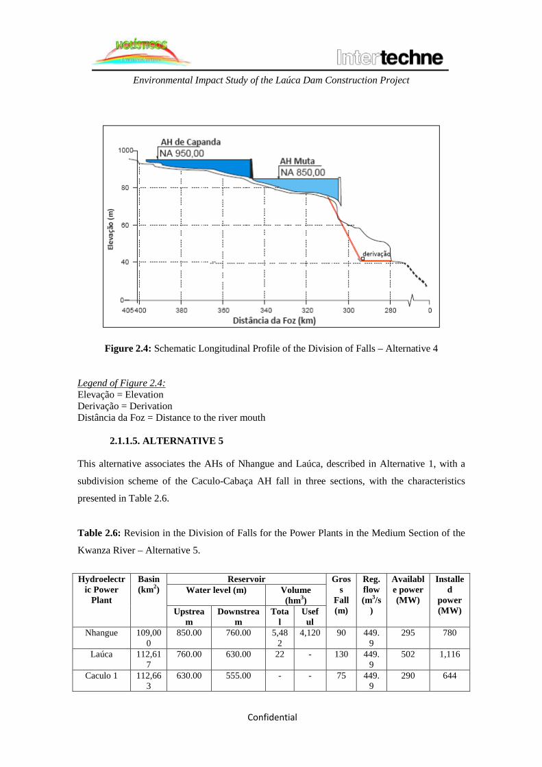
Environmental Impact Study of the Laúca Dam Construction Project
Confidential
Figure 2.4: Schematic Longitudinal Profile of the Division of Falls – Alternative 4 Legend of Figure 2.4: Elevação = Elevation Derivação = Derivation Distância da Foz = Distance to the river mouth
2.1.1.5. ALTERNATIVE 5 This alternative associates the AHs of Nhangue and Laúca, described in Alternative 1, with a
subdivision scheme of the Caculo-Cabaça AH fall in three sections, with the characteristics
presented in Table 2.6.
Table 2.6: Revision in the Division of Falls for the Power Plants in the Medium Section of the
Kwanza River – Alternative 5.
Hydroelectr
ic Power Plant
Basin (km2)
Reservoir Gross
Fall (m)
Reg. flow (m3/s
)
Available power (MW)
Installed
power (MW)
Water level (m) Volume (hm3)
Upstream
Downstream
Total
Useful
Nhangue 109,000
850.00 760.00 5,482
4,120 90 449.9
295 780
Laúca 112,617
760.00 630.00 22 - 130 449.9
502 1,116
Caculo 1 112,663
630.00 555.00 - - 75 449.9
290 644

Environmental Impact Study of the Laúca Dam Construction Project
Confidential
Caculo 2 112,663
555.00 512.00 - - 43 449.9
166 369
Caculo 3 112,663
512.00 415.00 - - 97 449.9
378 841
Total 435 1,616 3,714
Caculo 1 AH
The Caculo 1 AH is located in the same axis of the Caculo-Cabaça AH of Alternative 1,
and Takes advantage of a natural fall formed by rapids in the river, between km 296 and
292, through a hydraulic generation circuit implemented on the left shoulder, with 3.8
km of extension.
The gross fall of 75 m is formed by the dam with a reservoir in the 630.00 m elevation
and a recovery in the beginning of a much embedded straight section of the river, into
what seems to be a failure or fracture on the river bed, being the downstream water level
in the elevation of 555.00.
Caculo 2 AH
The Caculo 2 AH has its dam implemented on km 290 and a derivation is foreseen
through a tunnel and a channel between adjacent valleys in the section where the
Kwanza River has the shape of an inverted “V”. The tunnel, with approximately 2 km
of extension, carries the flows past the turbines (in an underground power house) up to a
channel with the connection to the reservoir downstream of Caculo 3 AH, located on the
elevation of 512.00, with an estimated length of 1.2 km.
Caculo 3 AH

Environmental Impact Study of the Laúca Dam Construction Project
Confidential
The Caculo 3 AH is formed by a dam associated to a spillway on km 279 of the Kwanza
River, creating a reservoir on the elevation of 512.00 m, with water intake and hydraulic
generation circuit located on the left shoulder and an underground power house on the
left bank, being the flows past the turbines recovered on the elevation of 415.00 m
downstream of the Caculo-Cabaça falls.
The small reservoir is located on a step between two sequences of rapids more
concentrated in the region and is complemented by a dam in a valley on the left bank.
Figure 2.5 represents the division of falls of Alternative 5.

Environmental Impact Study of the Laúca Dam Construction Project
Confidential
Figure 2.5: Schematic Longitudinal Profile of the Division of Falls – Alternative 5 Legend of Figure 2.5: Elevação = Elevation Derivação = Derivation Distância da Foz = Distance to the river mouth
2.1.1.6. CHOSEN ALTERNATIVE At the end of the assessment studies for the five alternatives, an option was made for the Laúca Alto power plants, hereinafter simply called Laúca, described in alternative 3 of this section (Reference drawing AHL-DE2-00B01-0010 of Intertechne). This alternative has shown the lowest cost/benefit index (Table 2.7) and the second lowest distributed negative environmental impact index – IAND, calculated based on the relevance of the flooded use typologies in the reproduction of the balance of the land, aquatic and social-economic ecosystems. For the obtainment of the IAND1, it was first carried out an assessment of the environmental impacts based on the methodology recommended in the Manual of Hydroelectric Inventory of Eleterbrás, of 1997. Such assessment for the medium Kwanza River basin has considered the direct impacts caused by the reservoirs and the environmental fragility of the several structuring elements of the natural and anthropic environment. Such elements, called synthesis components, represent the environmental system and make possible an integrated analysis among the several environmental and social elements. ______________________

Environmental Impact Study of the Laúca Dam Construction Project
Confidential
1 The methodology applied and the calculations for each alternative are presented in the document 0704-MK-RT-100- 00-010-RD(1) of Intertechne.
Environmental Impact Study of the Laúca Dam Construction Project
Confidential
Based on the social-environmental diagnosis carried out for the Kwanza basin, a
division of such basin in sub-units was carried out for analysis, per synthesis
component, called sub-areas. The identification of the sub-areas was based on the
premise that such units should have similar characteristics and particular relationships
and internal processes, which could be distinguished from the other basin spaces. To
make it possible to distinguish these subareas from each other, their hierarchical
classification was carried out based on their characteristics and importance, through the
attribution of values to each one of them within the range from 0 to 1.
Additionally, to express the relative importance among the impacting processes of each
synthesis component on the environmental system, different weights were attributed to
each one of them, in order to highlight the participation of each one of the elements
analyzed in the regional processes, serving as weighting element in the assessment of
impacts. The weighting of the synthesis components among each other also considered
scores in the range from 0 to 1, with the sum resulting in 1, representing the
environment of the contribution basin of the Kwanza River section under study.
Therefore, the environmental analysis of each sub-area was considered and the
obtainment of an index that could reflect its vulnerability regarding the implementation
of hydroelectric enterprises was carried out. Therefore, by weighting the scores
attributed to the sub-areas, herein called “fragility score” and its weights, an index
referred to the sub-area environmental assessment was obtained.
The fragility scores and the environmental assessment indexes were multiplied by the
respective quantities of surfaces suppressed by the implementation of each one of the
enterprise alternatives proposed, and these products were added among each other per
synthesis component and later divided by the total area affected, thus resulting on the
negative environmental impact index.

Confidential
In order to improve this indicator (IAN), the identification of the degree of impact of each one
of the reservoirs was sought for the same territorial unit, therefore, signaling the seriousness of
the interferences introduced in the environment of the medium Kwanza River basin. By means
of this analysis, a new indicator was obtained, called the Distributed Negative Environmental
Impact (IAND), which gave more emphasis to the results obtained per reservoir.
In order to choose the alternative, the parameters described below were also used:
Cost-Benefit Index for the Energy produced by the Power Plant (ICBi)
The energy benefit of each project in one alternative was measured based on the increase of
available energy in the reference system provided by the addition of the power plant,
considering all other Power Plants in the alternative as already built. The cost-benefit index for
the energy produced by each project was defined as the rate between its total cost, annualized by
means of a given discount rate, and its energy benefit.
Calculated by the following expression:
ICBi = CTi / (Efi x 8760)
where:
ICBi : Cost-benefit index of the dam energy, in US$/MWh
CTi : Total cost of the plant annualized by means of a given discount rate, expressed in
US$/year
ΔEfi : Increase in the available energy provided by the addition of the “i” plant in average MW,
considering all other Power Plants in the alternative as already built.
Cost-benefit index for the energy in the alternative (ICBa)
The cost-benefit index for the energy of each alternative, which will be the parameter with
which it will be assessed, is given by:

Confidential
ICBa = CTa / (8760 x ΔEfa)
where:
ICBa : Cost-benefit index of the energy of alternative a, in US$/MWh
ΔEfa : Gain of available energy provided by alternative a, in average MW
CTa : Total annual energy cost of alternative a, in US$ / year.
The economic parameters used in the calculation of the cost-benefit indexes the following:
• Service life: 50 years
• Discount rate: 10%
• Annual cost of operation and maintenance: given by the formula suggested in the Inventory
Manual, adapted to the Angolan conditions:
COM = a x (P)−b
where:
COM = operation and maintenance cost in US$/KW/year
P = Installed power in the plant, in MW
a = 153.17
b = 0.3716
The analysis carried out in the studies have yielded the data shown in Table 2.7 and in Figure
2.6, where, for each alternative, the cost-benefit index (ICBa, US$/MWh) is compared to the
corresponding distributed negative environmental impact index (IAND). In Figure 2.6, the
distributed negative environmental impact index (IAND) is plotted in the abscissa axis and the
cost-benefit index (ICBa, in US$/MWh) in the ordinate axis.

Confidential
Table 2.7: Revision in the Division of Falls for the Power Plants in the Medium Section of the Kwanza River – Comparison and Selection of Alternatives.
Alternative Cost-benefit index (US$/MWh)
Distributed negative environmental index - IAND
1 67.36 0.0038 2 60.55 0.0028 3 59.85 0.0027 4 71.18 0.0015 5 87.91 0.0066
Figure 2.6: Comparison of alternatives.
Legend of Figure 2.6: Cost-benefit index (US$/Mwh) Distributed negative environmental index (IAN/km2) Alternativa = Alternative For the selection of the chosen alternative, the pairs of Cost-Benefit Index for the
energy (ICB) and the Distributed Negative Environmental Index determined for each
combination of studied alternative was compared. According to the methodology used
in the studies, the alternatives represented by points close to the lower left region of the
chart shall be chosen, which corresponds to the simultaneous minimization of the two
indexes, as shown in Figure 2.6.

Confidential
For the selection of the recommended alternative, the followings aspects were
additionally considered:
• Reduction in the undergrounds works and the consequent reduction of the risk
associated to this kind of work;
• Design of the generation equipment within technologic conditions that suit the
current experience;
• Flexibility under the logistic point of view, given the proximity between the
power plants that compose the alternative.
• From the environmental point of view, the higher index regarding the one
presented by alternative 4 did not represent a restriction to the implementation of
the alternative 3 power plants, because the later is the one that presents the lower
Distributed Negative Environmental Impact after alternative 4.
Additionally, Alternative 3 represents an important advance of the Angolan energy
matrix, dominated by the use of fossil fuels. The energy offered will present better
quality, less pollution and will be cheaper than the present sources, thus favoring the
country’s social and economic development.
2.1.2. TECHNOLOGIC ALTERNATIVES
Considering the period of high economic growth that is now taking place in Angola, the
demand for energy is every time higher. Due to the possibility of using different
technologic modalities available for the production of energy, among them the
hydroelectric modality, we describe below, together with a brief discussion, the possible
electric power generation alternatives.

Confidential
2.1.2.1. RENEWABLE ENERGY SOURCES
Hydraulic Energy
The hydraulic energy is generated by directing the water flow into a power plant, for which the
civil works that involve both the construction of the dam and the deviation of the river and a
formation of the reservoir are carried out. The set of works and equipment for this kind of power
generation can be called a hydroelectric power plant.
The power plant structure is composed basically by the dam, the system for water collection and
delivery, the power house and the spillway, which work together in an integrated manner. The
dam interrupts the normal flow of the river to allow the formation of the reservoir. The reservoir
allows the formation of the necessary level difference that will define the hydraulic energy, the
collection of water in an adequate volume and the regularization of the river flow in periods of
rain or drought.
The collection and delivery systems are formed by tunnels, channels or ducts that have the
purpose of carrying the water up to the power house. This later installation houses the turbines,
formed by a series of blades attached to an axis connected to the generator. During the rotary
movement, the turbines convert the kinetic energy (from the water movement) into electric
energy by means of the generators that will produce electricity. After passing through the
turbine, the water is conducted back to the natural river bed by the outlet channel.
The spillway has the purpose of allowing the outflow of water whenever the reservoir levels
exceed the design limits. The spillway is opened when there is an excess of flow or rain, or also
when there is water in more quantity than it is necessary for storage or power generation. In
rainy periods, the process of opening the spillways is intended to avoid floods in the areas of
influence.

Confidential
Figure 2.7: Schematic profile of a hydroelectric power plant.
Source: ANEEL, 2008.
Legend of Figure 2.7: Reservatório = Reservoir Duto = Duct Casa de força = Power house Generator = Generator Turbina = Turbine Rio = River Fluxo de água = Water flow Linhas de transmissão de energia = Power transmission lines The generation of energy by means of hydroelectric power plants has the advantage of
the utilization of a renewable and low operation cost source when compared to
thermoelectric power plants.
On the other side, as hydroelectric enterprises are implemented in places where it is
possible to use the fall and flow of water courses, the turbines for such enterprises are
specifically designed for each location. Therefore, detailed technical studies are
necessary for the adequate implementation of this type of enterprise, thus requiring time
and financial resources.
A summary of advantages and disadvantages of energy generation by means of
hydroelectric power plants is given in Frame 2.1.

Confidential
Frame 2.1: Summary of advantages and disadvantages of hydroelectric power generation in
Angola.
Advantages
• Renewable energy;
• Lower generation costs considering the investment on the power plant implementation,
operation and maintenance;
• Lower operation and maintenance costs;
• Undetermined service life (above 50 years);
• Lower investment on the implementation of the generation plant;
• High economical impact in its implementation (generation of employments and
income);
• Possibility of using the reservoir for others purposes (irrigation and water supply);
• High flexibility in power generation, in accordance with the hourly demand of the
electric system. (The power demand varies around 50%);
Disadvantages
• Higher initial investment for the construction;
• May cause the displacement of the local population and the flooding of land (depending,
obviously, on the type of relief and the region where the enterprise is located);
• Its construction requires the formation of large water reservoirs that may bring
significant changes in the ecosystems;
• Need for investment in power transmission;
• Higher localized environmental impact.
Biomass
Biomass is one of the sources for energy production with the higher growth potential in its
utilization in the years to come, being considered as one of the best alternatives for the
diversification of the energy matrix in many countries.
Any organic matter that can be transformed into mechanical, thermal or electric energy is
classified as biomass. According to its origin, it can be classified as: forestry (mainly wood),
agricultural (soybean, rice and sugar cane, among others) and urban and industrial waste (solid
or liquid, as garbage). The byproducts obtained depend both on the raw-material used (where
the energy potential varies from type to type) and on the processing technology for the
obtainment of the energetic matter.

Confidential

Confidential
There are many techniques for the production of energy from biomass, each one produces a
certain byproduct and has a different level on the technological point of view. There is, for
example, the direct combustion that produces heat, the pyrolysis or carbonization, the
gasification, the anaerobic digestion and the trans-esterification, for example.
The processes for the production of this type of energy are characterized by having low
efficiency or the need for large volumes of raw-material for the production of small quantities.
An exception to this rule is the utilization of forestry biomass in industrial cogeneration
processes. For example, in the processing of wood in the process for the extraction of Cellulose,
it is possible to extract black lye (or black liquor) used as fuel in cogeneration units in the
cellulose industry itself.
According to a study from the International Energy Agency (2006), around 80% of the Angolan
population uses biomass for cooking and heating, whereas in the rural area and in the urban
perimeter zone, wood and charcoal are, respectively, the more used fuels.
The high number of biomass users, whether of wood or charcoal, causes the destruction of large
extensions of forests and damages to health. The search for new technological alternatives is
one of the most effective measures that will guarantee the sustainable use of biomass resources.
Even with the use of legal wood, exclusively planted for such use, the quantity of pollutants
launched to the atmosphere, as it happens with any thermoelectric technology, is high.
A summary of advantages and disadvantages of energy generation by means of thermoelectric
plants is indicated in Frame 2.2.

Confidential
Frame 2.2: Summary of advantages and disadvantages of thermoelectric power generation in
Angola.
Advantages
• Lower investment on the implementation of the generation plant;
• Reutilization of previously discarded waste for power generation and utilization in the
same place;
• Availability of natural gas;
Disadvantages
• Higher generation cost considering the investment on the implementation of the plant,
operation, maintenance and fuel;
• Need for the implementation of a complex infrastructure for the processing and
transport of the natural gas, a natural resource available in Angola;
• Viability conditioned to the availability of gas (gas ducts) and proximity to the energy
consumption center;
• Low economic impact in the implementation (generation of employment and income);
• Low flexibility for power generation in following the hourly demand of the electric
system (the power demand varies around 50%);
• Larger regional influence of the environmental impact related to the burning of fuel.
Wind Energy
Wind energy is, basically, the energy obtained from the kinetic energy (movement energy)
generated by the migration of air masses caused by the temperature differences that exist on the
planet’s surface.
Wind energy generation is a result of the contact of the wind on the propeller blades, elements
that belong to the plant. When the blades rotate they produce the mechanical energy that drives
the rotor of the aero-generator that produces the electricity. The quantity of mechanical energy
transferred – and, therefore, the potential of electric energy to be produced – is directly related
to the air density, the area covered by the rotation of the blades and the wind speed.

Confidential
As it happens with hydraulic energy, the generation based on wind energy also depends
on the existence of specific and favorable natural conditions. The assessment of such
conditions or of the wind potential of a certain region requires a systematic work of
collection and analysis of data about wind speed and regime.
The summary of the advantages and disadvantages of energy generation using the wind
is presented in Frame2.3.
Frame 2.3: Summary of advantages and disadvantages of wind energy generation.
Solar Energy
Solar energy reaches the Earth in the forms of thermal and luminous energy. This
radiation, however, does not reach the entire Earth’s surface in a uniform manner; it
depends on latitude, the season of the year and on atmospheric conditions. It is possible
to capture the light that passes through the Earth’s atmosphere and transform it into
another form of energy usable by men, as thermal and electric energy. The equipment
used in this capture will determine which type of energy will be obtained.
Advantages
• It’s an inexhaustible source of energy; • It does not emit polluting gases and does not generate waste; • It reduces the emission of greenhouse gases; • Wind parks are compatible with other land uses, as farming and cattle-raising.
Disadvantages • Intermittence, this means that the wind does not always blow when electricity is needed,
making difficult the integration of its production to the exploration program; • Strong visual impact; • Impact on the local birds: mainly through collision with the blades and unknown effects on
the modifications on the behavior of their of migration habits; • Sound impact: the sound of the wind hitting the blades produces a constant noise
(43dB(A)). • Neighboring houses must keep a minimum distance of 200m from the park.

Confidential
If a dark surface is used for capturing, the solar energy will be transformed into heat. If
photovoltaic cells are used (photovoltaic panels), the result will be electricity. The
equipment necessary for the production of heat is called collectors and concentrators,
because, besides collecting, sometimes it is necessary to concentrate the radiation on a
single point. This is the principle of many water solar heaters. Two systems can be used
in the production of electric energy: the heliothermic and the photovoltaic.
In the heliothermic system, the solar radiation is converted into heat that is used in
thermo-electric plants for the production of electricity. The complete process comprises
five phases: collection of the radiation, conversion into heat, transport and storage and,
finally, conversion into electricity. For a heliothermic power plant it is necessary a place
with high incidence of direct solar radiation, which means low cloud intensity and low
rainfall indexes.
In the photovoltaic system, the transformation of solar radiation into electricity is direct.
Therefore, it is necessary to adapt a semiconducting material (typically silicon) so, when
it is stimulated by the radiation, it allows the electronic flow (positive and negative
particles).
The solar energy plant is an alternative that can be considered for the supply of energy,
mainly in rural communities. Solar energy plants using photovoltaic units were already
implemented in some urban locations in an experimental manner, in social equipment as
schools, clinics and community centers around the world.
The use of solar energy in replacement of the use of biomass, for example, would be a
feasible alternative for a rural community, thus contributing for the reduction deforested
areas and the improvement of the quality of life of the affected population. However, for
the generation of energy for a larger population it would be necessary large areas for the
implementation of the solar panel park, which have high acquisition costs.

Confidential
The summary of the advantages and disadvantages of energy generation using the solar
energy is presented in Frame 2.4.
Frame 2.4: Summary of advantages and disadvantages of solar energy.
Advantages
• It’s an inexhaustible source of energy;
• It does not emit polluting gases and does not generate waste;
• It reduces the emission of greenhouse gases;
• The plants need only minimum maintenance;
• Solar energy is excellent in remote places or places with difficult access, because
its installation in low scale does not require large investments in transmission
lines.
Disadvantages
• There is variation in the quantities produced according to the climate situation
(rain, snow);
• As no production takes place at night, it is mandatory the existence of storage
means for the energy produced during the day in places where the solar panels
are not connected to the power transmission network;
• The forms of solar energy storage are less efficient when compared for example
to fossil fuels;
• Solar panels have little efficiency.
Biogas
Its application allows the reduction of the greenhouse effect gases and contributes with
the fight against the pollution of the soil and of water tables. Biogas is obtained from the
biomass contained in waste (urban, industrial and from farming) and in the sewage. This
biomass passes naturally from the solid state to the gaseous one through the action of
microorganisms that decompose organic matter in an anaerobic (without air)
environment.
In this case, the biogas is also launched to the atmosphere and, therefore, also
contributes to the global warming, since it is composed by methane (CH4), carbon
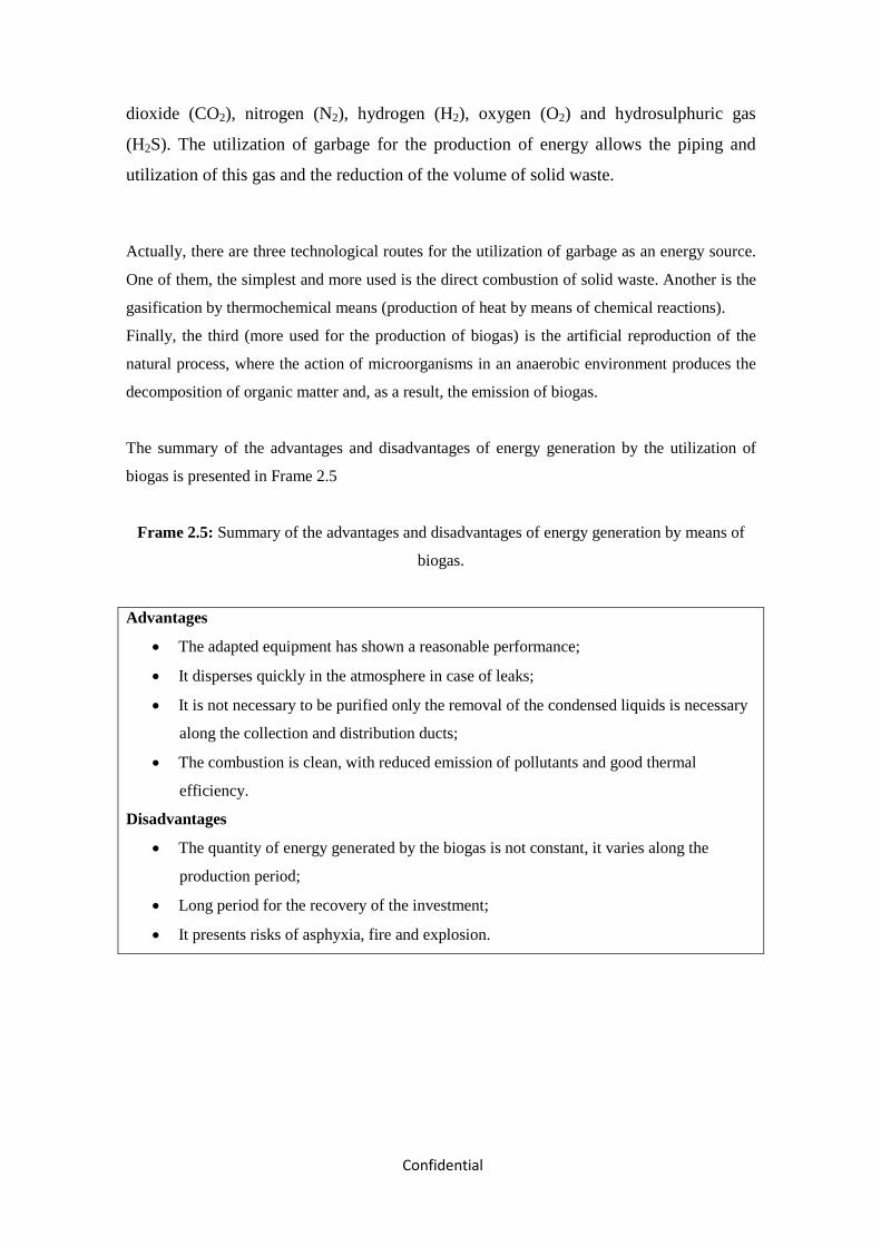
Confidential
dioxide (CO2), nitrogen (N2), hydrogen (H2), oxygen (O2) and hydrosulphuric gas
(H2S). The utilization of garbage for the production of energy allows the piping and
utilization of this gas and the reduction of the volume of solid waste.
Actually, there are three technological routes for the utilization of garbage as an energy source.
One of them, the simplest and more used is the direct combustion of solid waste. Another is the
gasification by thermochemical means (production of heat by means of chemical reactions).
Finally, the third (more used for the production of biogas) is the artificial reproduction of the
natural process, where the action of microorganisms in an anaerobic environment produces the
decomposition of organic matter and, as a result, the emission of biogas.
The summary of the advantages and disadvantages of energy generation by the utilization of
biogas is presented in Frame 2.5
Frame 2.5: Summary of the advantages and disadvantages of energy generation by means of
biogas.
Advantages
• The adapted equipment has shown a reasonable performance;
• It disperses quickly in the atmosphere in case of leaks;
• It is not necessary to be purified only the removal of the condensed liquids is necessary
along the collection and distribution ducts;
• The combustion is clean, with reduced emission of pollutants and good thermal
efficiency.
Disadvantages
• The quantity of energy generated by the biogas is not constant, it varies along the
production period;
• Long period for the recovery of the investment;
• It presents risks of asphyxia, fire and explosion.

Confidential
2.1.2.2. NON-RENEWABLE ENERGY SOURCES
Natural Gas
Natural gas is a hydrocarbon resulting from the decomposition of organic matter during millions
of years. It is found underground, in porous rocks isolated from the environment by an
impermeable layer. In its first decomposition stages, this organic matter of animal origin
produces petroleum and in its last degradation stages, natural gas.
That is why it is common the discovery of natural gas both associated to petroleum and in
isolated fields (not associated natural gas).
The application of natural gas in the production of electric energy can be divided into two
modalities. One of them is the exclusive generation of electricity, the other is cogeneration,
from which it is also extracted heat and steam used in industrial processes.
The use of natural gas as a supply source for power generation plants is only viable when the
thermoelectric plant is implemented where this resource is available. In Angola, the offer of gas
is limited only to the provinces of Cabinda and Zaire, therefore, the use of this type of power
plant becomes very limited and without conditions to compete with other sources.
The utilization foreseen for the natural gas was considered in the project for the exportation of
Liquefied Natural Gas of Angola (GNLA), a study disclosed at the end of the 90’s and approved
in 2001 by the Council of Ministers. In order to make viable the utilization of this resource, the
construction of a collection network was foreseen for the gas produced in some blocks (0, 2, 14,
15,17, 18, 32 and 33), including a gas pipeline to transport the gas to Soyo, a new gas
liquefaction center, installations for gas separation and piers. The production of LNG is initially
intended for exportation. However, the Government of Angola and Sonangol have requested a
market study with respect to the exploration of the domestic market. Therefore, the use of the
gas still depends on large investments, mainly on the implementation of infrastructure not
compatible with the urgency claimed by the country. The main investment in this area is that of
the Angola LNG Factory in the municipality of Soyo.

Confidential
The summary of the advantages and disadvantages of energy generation by the utilization of
natural gas is presented in Frame 2.6.
Frame 2.6: Summary of the advantages and disadvantages of generation by means of natural
gas.
Advantages
• Lower costs in the construction of the plant if compared to the hydroelectric plant;
• The plants can be built close to the gas sources, therefore, reducing losses;
• For being lighter than air, the gas dissipates quickly in the atmosphere in case of leak;
• Low requirements for treating the combustion gases;
• Does not require storage, thus eliminating the risks of fuel storage.
Disadvantages
• For being a fossil fuel, it is classified as non-renewable energy;
• Emission of greenhouse effect gases when burned (depending on the characteristics of
the natural gas burned and on the combustion reaction conditions).
Petroleum Byproducts
O petroleum is flammable oil, formed from the decomposition of organic matter as plants,
marine animals and the vegetation typical of temporarily flooded regions, and is found only in
sedimentary terrain. The base of its composition is hydrocarbon, a substance composed by
carbon and hydrogen, to which atoms of oxygen, nitrogen and sulfur can be attached, in
addition to metallic ions, mainly of nickel and vanadium.
Crude petroleum has no direct application. Its utilization requires a refining process from which
the byproducts are obtained and then distributed to a pulverized and diversified consumer
market. So, in addition to the extraction, the production chain comprises another three stages:
crude oil transport (normally in oil pipelines or ships), refining and distribution (delivery of
byproducts to the end consumer, usually in tank trucks).

Confidential
The electric power production process is similar in all plants using fossil fuels as raw-
material in either solid or liquid state, which includes the majority of the petroleum
byproducts (see Figure 2.8). In a very simplified description, this material is transported
up to the plant, stored, and later burned in a combustion chamber. The heat obtained in
this process is used to heat and increase the pressure of the water that will be
transformed into steam. This steam drives the turbines that transform the thermal energy
into mechanical energy. The generator then transforms the mechanical energy into
electric energy.
After moving the turbines, the steam is directed to the condenser where it will return to
the liquid state. The water that circulates inside the coils connected to the equipment is
the cooling fluid. This liquid, by its turn, is directed again to the boiler by a pump
system, where it will repeat the production process of the thermal energy that will be
transformed into mechanical energy that will drive the turbines.
The combustion and cooling stages (which also implies in the removal of non-
condensable gases from the steam) are those where the polluting gases are released to
the atmosphere. The volume and type of the emitted gas will vary according to the
composition of the fuel to be burned, the burning process or post-combustion removal
and also to the pollutant dispersion conditions (chimney height, land shape and
meteorology).

Confidential
Figure 2.8: Schematic profile of the power production process using petroleum
Legend of Figure 2.8: Chaminé = Chimney Pré-aquecedor de ar = Air pre-heater Aquecedor de água = Water heater Turbina = Turbine Gerador = Generator Transformadores = Transformers Caldeira = Boiler Ventilador de entrada = Intake fan Ventilador de saída = Outlet fan Bomba de água …. = Boiler water supply pump Bomba de condensado = Condensate pump Condensador = Condenser Bomba de circulação = Circulation pump Água de resfriamento = Cooling water Disjuntores = Circuit breakers A utilization of liquid fuels as diesel oil or fuel oil to supply the power generation plants
depends on the availability of these supplies. The Integrated Planning study of the Electric
Sector of the Ministry of Energy and Water has concluded that power generation by means of a
thermoelectric plant, with the use of oil fuel and steam generation plants is not viable because it
is a more expensive option than the natural gas. About this option, it must be considered that:
• This type of arrangement will be gradually replaced by natural gas generation which,
when available, will become a more economically attractive alternative;
• It is a very complex system that requires a higher installation time.
Nuclear Energy
The raw-material used in nuclear energy production is the uranium ore, a metal a little less hard
than steel, found in natural state in rocks in the earth’s crust. Uranium atoms are extracted from
this mineral to be used in nuclear generation.
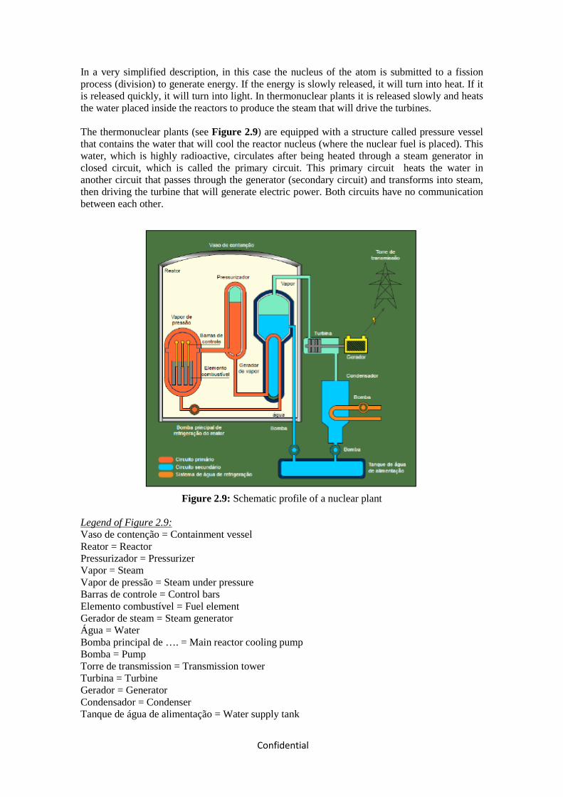
Confidential
In a very simplified description, in this case the nucleus of the atom is submitted to a fission process (division) to generate energy. If the energy is slowly released, it will turn into heat. If it is released quickly, it will turn into light. In thermonuclear plants it is released slowly and heats the water placed inside the reactors to produce the steam that will drive the turbines. The thermonuclear plants (see Figure 2.9) are equipped with a structure called pressure vessel that contains the water that will cool the reactor nucleus (where the nuclear fuel is placed). This water, which is highly radioactive, circulates after being heated through a steam generator in closed circuit, which is called the primary circuit. This primary circuit heats the water in another circuit that passes through the generator (secondary circuit) and transforms into steam, then driving the turbine that will generate electric power. Both circuits have no communication between each other.
Figure 2.9: Schematic profile of a nuclear plant
Legend of Figure 2.9: Vaso de contenção = Containment vessel Reator = Reactor Pressurizador = Pressurizer Vapor = Steam Vapor de pressão = Steam under pressure Barras de controle = Control bars Elemento combustível = Fuel element Gerador de steam = Steam generator Água = Water Bomba principal de …. = Main reactor cooling pump Bomba = Pump Torre de transmission = Transmission tower Turbina = Turbine Gerador = Generator Condensador = Condenser Tanque de água de alimentação = Water supply tank

Confidential
Circuito primário = Primary circuit Circuito secundário = Secondary circuit Sistema de água de refrigeração = Cooling water system In addition to the complex uranium preparation process, also called nuclear fuel cycle, there is also the problem of disposing the material used. There are two basic cycles: one open and one closed. The first one involves the final disposal of the fuel used. In the second, the remaining uranium and the plutonium produced are used again for power generation as a mixed oxide (MOx).
The summary of the advantages and disadvantages of nuclear energy generation is presented in
Frame 2.7.
Frame 2.7: Summary of advantages and disadvantages of nuclear energy generation.
Advantages
• Does not contribute to the greenhouse effect;
• Does not pollute the air with gases of sulfur, nitrogen, particulates, etc.;
• Does not use large land areas: the plant requires small installation spaces;
• Does not depend on climate seasons (neither rain nor wind);
• Little or almost no impact on the biosphere;
• Is a more concentrated source for power generation;
• The quantity of radioactive waste generated is extremely small and compact;
• The process technology is well known;
• The fuel transport risk is significantly lower when compared to the gas and oil of the
thermoelectric plants;
Disadvantages
• Need to store the nuclear waste in isolated and protected places;
• Need to isolate the plant after it is shut down;
• It has higher costs when compared to the other energy sources;
• The waste produced emit radioactivity during many years;
• Difficulties in storing the waste, consisting mainly of localization and safety problems;
• Can interfere with ecosystems;
• Risk of accidents in the nuclear plant.
Mineral Coal
In a brief description, the coal is extracted from the soil, fragmented and stored in silos, to be
later transported to the plant, where it will be stored again.

Confidential
After this, it is transformed into dust, which will allow a better thermal efficiency when placed
in boilers for burning.
The heat released by this burning is transformed in steam when it is transferred to the water that
circulates in the pipes placed around the burner. The thermal energy (or heat) contained in the
steam is transformed into mechanical (or kinetic) energy that will drive the turbine attached to
the electric power generator (see Figure 2.9). This movement will produce the electric energy.
In the case of cogeneration, the process is similar, but the steam, besides generating electric
energy, is also extracted to be used in industrial processes.
Figure 2.10: Schematic profile of the electric power production process from mineral coal.
Legend of Figure 2.10: Carvão mineral = Mineral coal Esteira = Conveyor Vapor = Steam Turbina = Turbine Gerador = Generator Transformador = Transformer Rio/Reservatório = River/Reservoir Água para resfrigeração = Cooling water Caldeira = Boiler Condensador = Condenser The main restriction to the use of coal is the strong social-environmental impact present in all
the production process stages and also in the consumption. The extraction, for example, causes
the degradation das mining areas. The combustion is responsible for carbon dioxide gas
emissions (CO2).
The summary of the advantages and disadvantages of energy generation using mineral coal is
presented in Frame 2.8.

Confidential
Frame 2.8: Summary of advantages and disadvantages of energy generation using mineral coal.
Advantages
• When compared to hydroelectric power plants, they are quicker to build, and can,
therefore, satisfy energy demands in a quicker way;
• They can be installed in places close to the consumption regions, thus reducing the cost
with towers and transmission lines;
Disadvantages
• The final cost of this type of energy is higher than the one generated in hydroelectric
plants, due to the price of fossil fuels;
• Finite source;
• Emission of greenhouse effect gases.
2.2. JUSTIFICATION OF THE GENERATION TECHNOLOGY CHOICE
Among the generation sources studied, the hydroelectric plants have the best cost/benefit index
in the economic point of view, and also in environment aspects, being considered one of the
cleanest generation sources with the best capacity to meet in large scale the increase in the
electricity offer.
Economically, the thermoelectric plants are less competitive than the hydroelectric plants, as the
later presents generation costs around US$ 55,00/MWh while the thermoelectric plants are
placed in the range between US$ 60,25/MWh for natural gas (provided the infrastructure is
already installed) and US$108,08 MWh for diesel (Sondotécnica/Odebrecht, 2003).
Regarding pollution, although there are efficient technologies for the reduction of the emission
of the pollutants generated by the process of burning such fuels (diesel and coal), high levels of
control imply in also high costs for the acquisition of equipment and the adequacy of processes,
which will reduce even more the competitiveness of the these fuels in the production of electric
energy.
As thermoelectric plants burning natural gas are considered the cleanest among the
thermoelectric sources using non-nuclear fuel, since its effects are less harmful than those of
other fuels (diesel and coal). However, that produces impacts that must be considered, as the use
of a non-renewable energy source and the emission of pollutants specially CO2 and NOx in
high proportions, which have effects on the population health, the vegetation and the associated

Confidential
fauna. The economic disadvantages regarding the hydroelectric sources are associated to the
higher generation cost. Among the higher investment costs there is the implementation of
infrastructure, as the construction of complex transport systems (gas pipelines).
Solar energy, although being one of the cleanest energy generation sources, still presents high
generation costs, having as main disadvantage the restricted technology and the implementation
costs. Among the advantages attributed to the photovoltaic systems there is the maintenance
facility; the possibility storing the generated electricity in batteries and the relatively low
environmental impacts, mainly in the operation phase.
Other disadvantages are due to:
• The low power of the generated energy, which limits the uses;
• Insufficient maintenance also leading to the abandonment of the systems;
• The need to find viable solutions for the acquisition and disposal of batteries.
Considering the data mentioned, the implementation of hydroelectric power plants turns out to
be the best alternative, because it is a cheap energy source for the development of the country
both in the medium and long terms, thus making possible the integration of the energy supply
systems, based on the high Angolan hydroelectric potential and on the low operation cost.
Regarding the environmental aspects, it must be emphasized that it is a renewable source and
that the generation of impacts can be mitigated and/or compensated, in addition to being in line
with the energy and economical aspects.
2.3. JUSTIFICATION FOR THE CHOICE OF THE LOCATION
In order to choose the implementation place of this project, the high energy potential of the
Medium Kwanza was taken in consideration, as well as the existence of two dams in the region,
the dams of Capanda (upstream of the project) and Cambambe (upstream of the project).
For the definition of the best alternative for the projects in the medium section of the Kwanza
basin, a study of the division of falls was developed in 2008 by Intertechne Consultores S.A.
This study has considered the alternatives highlighted by the works of previous decades and the
advance of the technology that took place in projects of hydroelectric plants along these years,
and has assessed five alternatives and a total of nine different enterprises. The alternatives
described in section 2.1.1 (Localization alternatives) are summarized in the Table. The
parameters established for this assessment stage were the following:

• The proposal of upstream projects, for each alternative, allowing the implementation of
discharge regularization reservoirs;
• The association of these with others projects, allowing the total use of the gross fall
available;
• The minimization of the environmental impacts;
• The exhaustion of possibilities with multiple plants and the assessment of a solution
with a single plant.
Table 2.8: Summary of the study of Division of Falls for the plants in the Medium Section of
the Kwanza River – Alternatives for the Division of Falls.
Alternative Plant Maximum
normal reservoir W.L.* (m)
Downstream W.L.* Gross fall (m)
1 Nhangue 850 760 90
Laúca 760 630 130 Caculo Cabaça 630 415 215
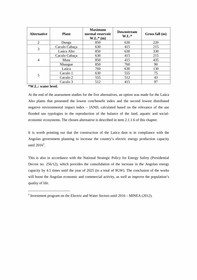
Alternative Plant Maximum
normal reservoir W.L.* (m)
Downstream W.L.* Gross fall (m)
2 Dunga 850 630 220
3 Caculo Cabaça 630 415 215 Laúca Alto 850 630 330
4 Caculo Cabaça 630 415 215
Muta 850 415 435 Nhangue 850 760 90
5
Laúca 760 630 130 Caculo 1 630 555 75 Caculo 2 555 512 43 Caculo 3 512 415 97
*W.L.: water level. At the end of the assessment studies for the five alternatives, an option was made for the Laúca
Alto plants that presented the lowest cost/benefit index and the second lowest distributed
negative environmental impact index – IAND, calculated based on the relevance of the use
flooded use typologies in the reproduction of the balance of the land, aquatic and social-
economic ecosystems. The chosen alternative is described in item 2.1.1.6 of this chapter.
It is worth pointing out that the construction of the Laúca dam is in compliance with the
Angolan government planning to increase the country’s electric energy production capacity
until 20162.
This is also in accordance with the National Strategic Policy for Energy Safety (Presidential
Decree no. 256/12), which provides the consolidation of the increase in the Angolan energy
capacity by 4.5 times until the year of 2025 (to a total of 9GW). The conclusion of the works
will boost the Angolan economic and commercial activity, as well as improve the population’s
quality of life.
_______________________ 2 Investment program on the Electric and Water Sectors until 2016 – MINEA (2012).

2.4. PRESENTATION OF THE PROJECT
Odebrecht Angola was contracted by GAMEK to carry out the civil works of the Laúca dam
construction. Therefore, the works were separated in two phases, the first one is already in
progress, and covers the construction of the river deviation by means of two tunnels. The second
phase covers the construction of the dam and the supporting infrastructure for the conclusion of
the power generation plant.
The Laúca hydroelectric plant will have a total installed power of 2,070 MW and shall be
connected to the interconnected Angolan system using the voltage of 400 kV. The plant
operation start-up is foreseen for 2017. Table 2.10 presents the main characteristics of the
proposed enterprise.
Table 2.9: Main characteristics of the Laúca hydroelectric plant.
Characteristics
Installed Power 2,070MW
Turbines 6 units
Turbine Type Francis
Max. Normal W.L. 850.00 m
Min. Normal W.L. 800.00 m
Gross Fall 219.00 m
Net Fall 200.00 m
Total Volume 5,482 x 106 m³
Useful Volume 4,120 x 106 m³
Average Power 987 MW
Average Generation 8,643,229 MWh/year
Cost of Energy US$ 1,791/ kW
Cost of Installation US$ 3,701,600,000.00
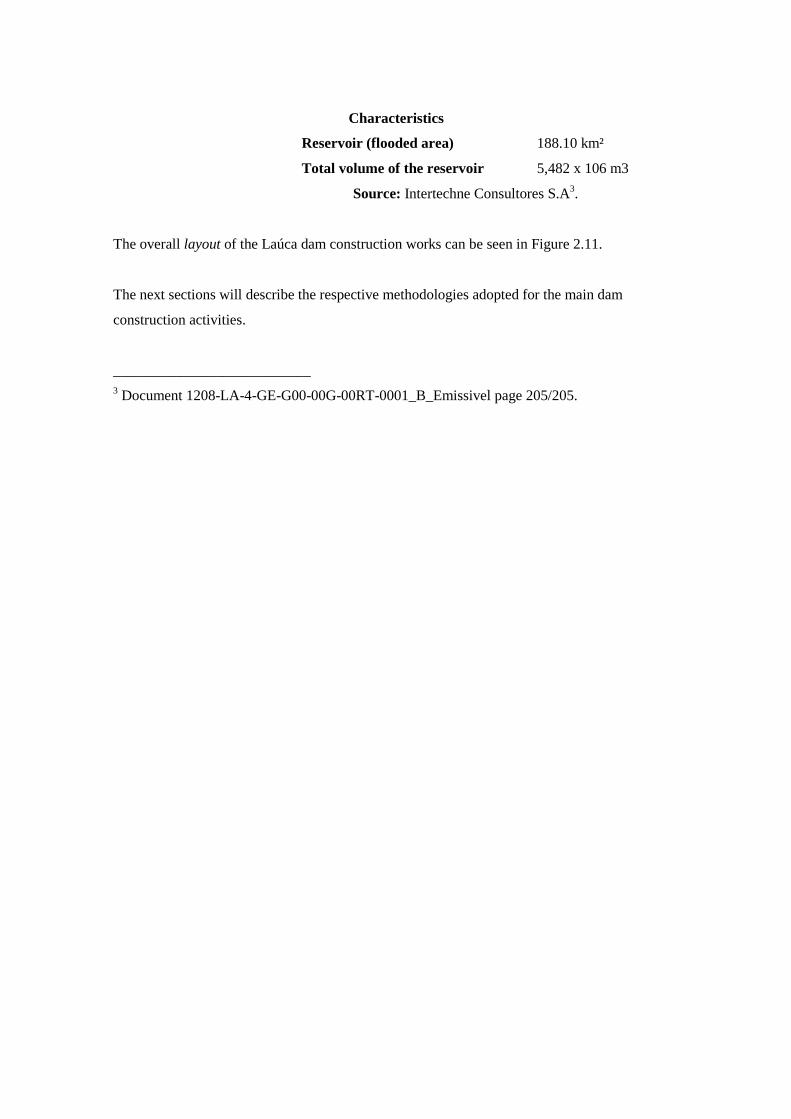
Characteristics
Reservoir (flooded area) 188.10 km²
Total volume of the reservoir 5,482 x 106 m3
Source: Intertechne Consultores S.A3.
The overall layout of the Laúca dam construction works can be seen in Figure 2.11.
The next sections will describe the respective methodologies adopted for the main dam
construction activities.
___________________________ 3 Document 1208-LA-4-GE-G00-00G-00RT-0001_B_Emissivel page 205/205.
Figure 2.11: Overall layout of the Laúca dam construction works. Legend of Figure 2.11: ESCRITÓRIO DE CAMPO = FIELD OFFICE REFEITÓRIO AVANÇADO = ADVANCED CANTEEN SANITÁRIO COLETIVO = COLLECTIVE TOILETS CENTRAL DE GERADORES = GENERATOR STATION CENTRAL DE BRITAGEM = CRUSHING STATION CENTRAL DE GELO = ICE STATION LABORATÓRIO DE CONCRETO = CONCRETE LABORATORY CENTRAL DE CONCRETO = CONCRETE STATION CENTRAL PREMOLDADOS = PRECAST STATION CENTRAL CARPINTARIA E ARMAÇÃO = FRAMEWORK BUILDING AND ERECTION STATION CENTRAL DE AR COMPRIMIDO = COMPRESSED AIR STATION CAIXA SEPARADORA DE ÁGUA E ÓLEO = WATER/OIL SEPARATION BOX TANQUE DE DECANTAÇÃO = SEDIMENTATION TANK PLATAFORMA DE LAVAGEM DE VEÍCULOS = VEHICLE WASHING PAD ESTALEIRO = WORKSHOP ATERRO SANITÁRIO = SANITARY LANDFILL PAIOL DE EXPLOSIVOS = EXPLOSIVE STORAGE LAYOUT GERAL = GENERAL LAYOUT ESTALEIRO AVANÇADO = ADVANCED WORK SITE PLANTA = PLAN VIEW
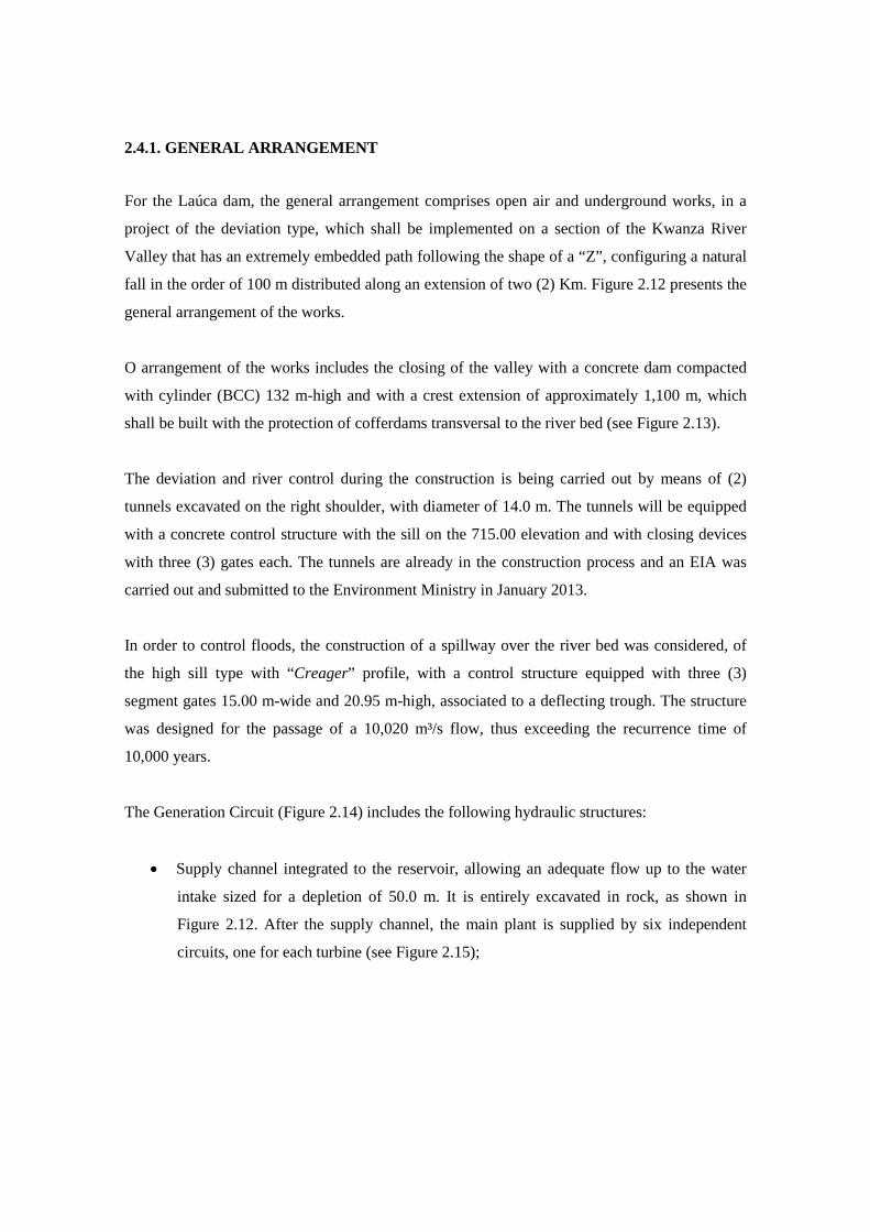
2.4.1. GENERAL ARRANGEMENT
For the Laúca dam, the general arrangement comprises open air and underground works, in a
project of the deviation type, which shall be implemented on a section of the Kwanza River
Valley that has an extremely embedded path following the shape of a “Z”, configuring a natural
fall in the order of 100 m distributed along an extension of two (2) Km. Figure 2.12 presents the
general arrangement of the works.
O arrangement of the works includes the closing of the valley with a concrete dam compacted
with cylinder (BCC) 132 m-high and with a crest extension of approximately 1,100 m, which
shall be built with the protection of cofferdams transversal to the river bed (see Figure 2.13).
The deviation and river control during the construction is being carried out by means of (2)
tunnels excavated on the right shoulder, with diameter of 14.0 m. The tunnels will be equipped
with a concrete control structure with the sill on the 715.00 elevation and with closing devices
with three (3) gates each. The tunnels are already in the construction process and an EIA was
carried out and submitted to the Environment Ministry in January 2013.
In order to control floods, the construction of a spillway over the river bed was considered, of
the high sill type with “Creager” profile, with a control structure equipped with three (3)
segment gates 15.00 m-wide and 20.95 m-high, associated to a deflecting trough. The structure
was designed for the passage of a 10,020 m³/s flow, thus exceeding the recurrence time of
10,000 years.
The Generation Circuit (Figure 2.14) includes the following hydraulic structures:
• Supply channel integrated to the reservoir, allowing an adequate flow up to the water
intake sized for a depletion of 50.0 m. It is entirely excavated in rock, as shown in
Figure 2.12. After the supply channel, the main plant is supplied by six independent
circuits, one for each turbine (see Figure 2.15);

• Six (6) water intakes of the gravity type, in island arrangement, with crest in the 855.00 m
elevation and 75.0m-high, built with 43.0m-long independent blocks in the stream direction
and 13.0 m-wide, away from the supply channel excavations for the connection to the supply
tunnels, in the well section, on the level of the supply channel floor. The access from the
right bank will be made by a landfill structure and a reinforced concrete bridge, connected to
the closest intake. The intake towers will be interconnected by bridge sections in reinforced
concrete 18.0 m-long, thus providing continuity to the portal crane rails;
• Six (6) penstocks to the power house with the followings characteristics:
o A first section in well arrangement with circular section, excavated in rock (sandstone),
around 80.0m-high in the average, coated with concrete with inside diameter of 7.0m,
associated to the inclined tunnel with rectangular arch section with 9.0 m by 12.2 m.
Average length of around 1,900,0m, having in the last 45m a transition to a rectangular
arch section coated with concrete with 9.0m, followed by a 25.0 m-long shielded
section with diameter of 5.2 m;
• Underground power house equipped with six (6) sets of Francis-type turbines, with vertical
axis generator, with unit power of 334 MW – 2.004 MW of installed power, and an
approximate length of 267m, including the service area;
• Six outlet tunnels with rectangular arch section with 11.0m by 14.0 m of diameter and
average length of 40m each;
• Structure of the outlet tunnel gates.
The general arrangement of the hydraulic circuit underground works is complemented by the
tunnels for access to the main plant, the auxiliary construction tunnels, the tunnels for
ventilation wells and exit of the shielded buses, that compose the connection from the main
plant up to the outside, on the top of the right shoulder, where the ventilation system and the
substation will be implemented.
Considering the need to meet the established downstream flows for the operation of the
Cambambe AH, under extreme conditions of the reservoir depletion and with the Laúca AH out
of operation, and also the maintenance of flows with ecologic purposes during the filling of the
reservoir, the project foresees the construction of um bottom discharge device for this purpose.
The works include a control structure equipped with a segment gate in a hydraulic circuit inside
the gallery on the dam body, with a total extension of approximately 118.0 m and a discharge
capacity in excess of 800 m³/s.

In order to meet the need of flows with ecologic purposes, under any operation conditions of the
enterprise in the derivation section with an extension of 2 km, a hydroelectric plant (Ecologic
Plant) was designed downstream of the dam for the use of such flows (Figure 2.16).
The Ecologic Plant, in open air, is located on the left shoulder downstream of the dam, with an
installed power of 65.5 MW (1 turbine-generator unit), and shall be supplied by a system
composed of:
• Water intake, built as a cantilever structure, supported on the face upstream of the dam’s left
bank, where a fixed grating and a wagon-type gate are installed to protect the turbines, in
addition of a servomotor for the assembly and maintenance of the gate. The intake operation
floor will be the dam crest itself located on the 855.00 m- elevation.
• A penstock with a 4.00 m-inside diameter circular section and length of 93.4 m;
• Plant with a unit block width of 36.00 m and total length of 41,00 m;
• Outlet channel;

Figure 2.12: General arrangement of Laúca AH.

Figure 2.13: General arrangement of the BCC dam.

Figure 2.14: General arrangement of the main generation circuit.
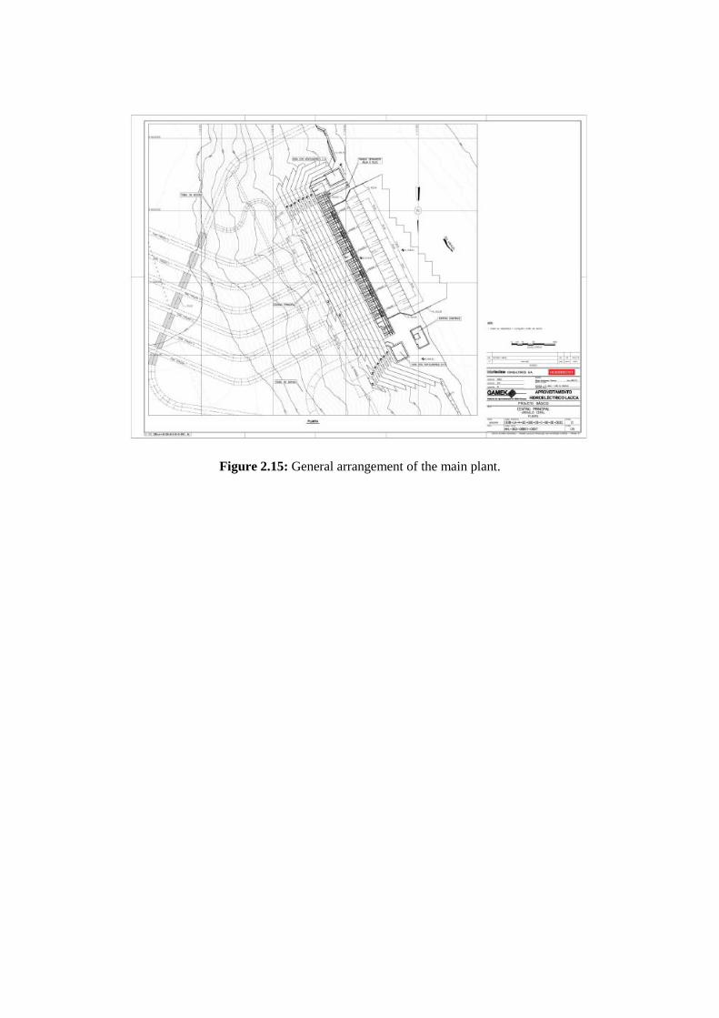
Figure 2.15: General arrangement of the main plant.

Figure 2.16: General arrangement of the ecologic plant generation circuit.

2.4.2. RESERVOIR The Laúca AH reservoir shall operate with depletion for flow regularization and shall have the
following main characteristics:
• Total area: 188 km²;
• Total volume: 5,482 Hm³;
• Maximum of maximums WL: EL. 852.00 m;
• Maximum WL: EL. 850.00 m;
• Minimum WL: EL. 800.00 m;
• Maximum depletion: 50.00 m;
• Useful volume: 4,120 Hm³;
• Average flow: 614 m³/s;
• Minimum ecologic flow: 60 m³/s.
The Laúca AH reservoir has a maximum extension in the order of 36 km and a maximum width
of 15 km, presenting a rounded shape in its larger portion and ending in a 9 km-long embedded
section in the form of “canyon”. The sedimentation studies have determined a reservoir service
life in excess of 300 years.
The Laúca AH shall operate with a maximum normal level in the 850 elevation, flooding an
area with around 188 km². The total stored volume at this elevation is of 5,651.2 Hm³. The
elevation x area and elevation x volume curves of the reservoir are presented in Figure 2.17.
According to the filling studies carried out, it is estimated that the reservoir water level will
reach the 830 elevation within a time of 124 days with 50% of probability for an average
incoming flow of 350 m3/s. The Laúca AH reservoir can be considered small when compared to
the design flows of the spillway. Therefore, the lamination of floods was not considered. The
design flow can be drained by the structure with 2.00 m over-elevation in the reservoir.
The spillway design was also checked for two exceptional conditions:
• The incoming flow of 14,000 m³/s, corresponding to the maximum probable flood of
Capanda AH, must be drained by the joint operation of the spillway, the bottom discharger,
the ecologic plant and four machines of the main plant with a water level less than or equal
to 856.2 m.

• For the condition where one gate is out of operation (n-1), the ten-millionth flood of 8,239
m³/s must be drained by the joint operation of the spillway and the bottom discharger with a
water level less than or equal to 855.00 m.

Figure 2.17: Map of the Laúca dam reservoir

2.4.3. ACCESSES
The access to the areas where the Laúca AH will be built is carried out through the right bank of
river Kwanza, following the local road that connects the city of Dondo to Capanda AH. The
Laúca AH enterprise will be implemented on km 307.5 of the Kwanza River, downstream of
Capanda AH. Starting in the road from Dondo to Capanda AH there are two alternatives to
reach the enterprise area. The first alternative is from the Nhangue Ya Pepe village, riding 10
km on a trail. The second alternative is from the Muta village, also riding for 10 km on a trail
until the dam axis area (see Figure 2.18).
Figure 2.18: Map of accesses to Laúca dam.

2.4.4. AREAS FOR SOIL EXTRACTION AND WASTE DISPOSAL
The soil extraction areas correspond to the places where the excavation of inert materials to be
used in the construction of the dam’s auxiliary structure will take place. The cuts will be carried
out with prevision for the adequate utilization or rejection of the extracted materials.
Therefore, only the materials that, following the classification and characterization carried out in
the soil laboratory and confirmed in the cuts, as being compatible with those specified for the
execution of the necessary services, will be transported for utilization.
For the river deviation works, three (3) clay mines and two (2) disposal areas (areas for disposal
of unwanted material) were foreseen4 (see Figure 2.19 and Figure 2.20). Disposal area 1 with an
area of 1,916.21 m2, installed in the access to the tunnel mouths, will be used as work platform
for the river deviation teams. It was built as a strategy for the enlargement of the access to the
mouths, in order to provide more safety to the workers. Disposal area 2, with an area of
4,014.81 m2, installed upstream of the future dam with material originated from the open air
excavations of the intake steps on elevation 800.00, will be incorporated to the main works
cofferdam. Therefore, both areas for the disposal of the excavated material, in this phase of the
works, will be incorporated to the plant’s permanent structures, thus avoiding changes on plots
of land external to the plant. The identification of the mentioned disposal areas and their
localization are given below.
________________________ 4 According to Reference Drawings LAU-DR-DE-420-91-002; LAU-DR-DE-360-36-001 and
LAU-DR-DE-420-91-004.

Figure 2.19: Identification and localization of mines and disposal areas of Laúca AH.

Figure 2.20: Disposal area and access zone to the mouth of the deviation tunnels.

Figure 2.21: Localization of the waste disposal areas for the river deviation works.
Legend Bota fora = Waste disposal area DESEMBOQUE PARTE SUPERIOR = UPPER DISCHARGE AREA DESEMBOQUE = DISCHARGE

For the dam construction, two (2) potential gneiss rock and sandstone mines, which will be used
in the crushing system, were identified (together with the respective quarries), and two (2)
disposal areas, being one on the left bank, where the material will be used in the cofferdam, and
the other on the right bank, which will be used as an extension in the crushing system.
The disposal areas correspond to the places where the discharge of inert, unwanted and waste
materials will take place. The implementation of these areas will take place in places where it is
possible the construction of uniform and regular slopes. The discarded material shall be placed
in continuous and thick layers, thus its compacting can be made with the help of machines used
for the transport and spreading. The minimum slope of such places shall be of 2% in order to
allow the adequate draining of the place. For the construction of the Laúca hydroelectric power
plant, areas upstream of the dam were identified.
The mines (areas for the extraction of rock and clay) as well as the disposal areas will not
exceed the projected elevations for the minimum reservoir level. Figure 2.2 presents the
localization of the inert material mines and disposal areas and their relationship with the Laúca
dam localization.

Figure 2.22: Disposal and storage areas (disposal and mines)

Legend CASA DE FORÇA = POWER HOUSE SUBESTAÇÃO = SUBSTATION ESTOQUE ROCHA ARENITO = SANDSTONE STORAGE ESTOQUE ROCHA GNAISSE = GNEISS ROCK STORAGE BOTA FORA = DISPOSAL AREA TOMADA D’ÁGUA = WATER INTAKE BALSA = FERRYBOAT ESTALEIRO = WORK QUARTERS TRECHO ASFALTADO = PAVED SECTION 2.4.4.1. IMPLEMENTATION OF THE STORAGE AND DISPOSAL AREAS
For the implementation of the excavated material disposal and storage areas, the preparation of
the area to be used was considered as follows:
• Marking of the area.
• Cleaning of vegetation.
• Scraping of the vegetation soil (between 20 cm and 30 cm), considering that this soil
will be left around the disposal and storage area.
•
After the usage time of the disposal and storage areas, these areas will be covered. Should there
exist disposal areas located in regions subject to flooding, they shall not receive the vegetation
soil recovering.
For the recovering of the areas used as storage and disposal areas, vegetation soil from other
regions can be used, including from outside the construction site.
2.4.4.2. UTILIZATION OF THE STORAGE AND DISPOSAL AREAS
The areas for the storage of excavated materials will be separated in sectors according to the
type of excavated material, regarding its utilization. The materials obtained from the
underground excavation of tunnels (gneiss) will be directed to storage places separated from
those excavated from rocks in open air (sandstone). The excavated volumes will be handled in
the following way:
The material obtained from the excavation of the right bank shoulder of the dam (open air
excavation), composed by meta-sedimentary rocks, with levels of silicon-rich sandstone in the
upper portion and siltite and sandstone penetrations in the lower portion inferior, will be

mapped, excavated and separated to be directed to the storage and disposal area on the river’s
right bank. According to its characterization, they will be allocated for future use.
The open air excavations on the dam’s left bank shoulder will generate materials with the same
properties of those in the right bank. They will be selected, so the silicon-rich sandstone and the
siltites will compose part of the cofferdam rock filling. The materials obtained from the
underground excavation of the pressure tunnel (gneiss) will be directed to the right bank
storage, for later crushing.
The underground excavation of the power house (gneiss) will generate materials for the right
bank storage until the implementation of the crusher. After this date, the materials will be
directly taken for crushing, preferably.
Regarding the material removed from the tunnel and the outlet channel, resulting from
underground excavation in gneiss, after the crusher installation, will be directed preferably to
the crusher, without passing through the storage.
The slope area of the Power House (external) will require treatment. The material removed from
the common excavation will be directed to the disposal area on the right bank. On the other side,
the material obtained from rock excavation in open air, will be directed to a storage specific for
this material, also located on the right bank.
Materials obtained from the common excavation of the right bank accesses will be directed to
the disposal area on the same bank, while those removed from the left bank accesses will be
taken to the left bank disposal area. If necessary and viable, in both cases they will be selected:
silicon-rich sandstone will be directed to the storage on the corresponding bank for later
utilization.
In all rock removal cases where there is a preference for direct transport to the crusher, and the
same is not able to absorb the conveyed quantities, they will be directed to the storage, because
the priority is the removal of the exploded materials the and cleaning of the work front.
2.4.5. SUPPORT INFRASTRUCTURES AND LABOR
Offices, worker lodging and support structures belonging to the construction site are being
implemented at approximately 6 km from the Dondo road to the Capanda AH, as well as the
industrial installations, on the flat areas on the river’s right bank. The approximate number of
workers during the so-called “peak work period” will be of approximately 3,700 people, totaling
around 5,800 workers, including direct and indirect services (support, administrative,
laboratory, etc.). The peak period shall take place between the second and third years of
construction, close to the month of October 2015.
The structures are being built and expanded with temporary buildings, being such execution in
progress, and the expansions will take place as established in the construction work schedule.
The dam construction work quarters is presented in Figure 2.23. In order to check the general
location of the workshop within the context of the works, please refer to Figure 2.18 that
presents the general site layout according to the accesses. The mentioned work quarters is
subdivided in:
• Administrative quarters, composed by the centralized structures of offices, lodging,
leisure areas, warehouses, mechanical workshops and others, close to the entrance gate;
• Advanced quarters, composed by field offices, laboratories and advanced canteens,
among others;
• Industrial workshop, composed by industrial concrete manufacturing centers, crushing,
framework, carpentry, among others.
2.4.5.1. ELECTRIC POWER SUPPLY
For the supply of electric power to the administrative structures of the work quarters, a diesel
generation center is being used, composed by 2 generators with 62 KVA each. Generators
located close to the work fronts supply the localized loads and are mobilized and allocated as to
fulfill the needs.
In order to provide power with higher reliability, safety and quality, due to the high power
demands, a 30 kV transmission network will be implemented, connecting the Capanda
substation up to the Laúca AH, in order to supply the power needs in replacement to the
utilization of diesel generators.
At the Laúca AH, a 30/ 15kV lowering substation will receive power and lower its voltage to
allow the distribution to the work fronts.

As a complement to the arrangement of the power supply to the work quarters and to the work
site, and to the strengthening of the system’s reliability premise, a diesel generation center will
be installed to meet emergency loads.
Therefore, if for some reason external to the substation and to the internal construction
networks, a loss of the 30 kV power should take place, the power arriving from the diesel
generator units will be automatically switched on, generating in 15 kV and feeding the work
quarters and the construction distribution networks.
2.4.5.2. ADMINISTRATIVE QUARTERS The administrative work quarters is distributed as shown in Figure 2.23, and is composed by the
mains structures described as follows:
Main Gate
To control the entrance and exit of people in the work area, a main gate will be built in the main
access entrance to the job site and to the work quarters. Such entrance is equipped with an
access control gate and watch house. Additionally, the installation of a truck scale is foreseen
for the weighting of trucks, close to the main gate.
At the side of the gate there will be a parking area, accessible before going through the gate, so
all trucks demanding the site and which had not yet checked in, may remain in waiting.

Figure 2.23: Layout of the administrative quarters

Offices of the Contractor and of the Plant Owner
The offices already built, will continue to assist the contractor’s administrative structures, which
are so distributed: office for transit and subcontracting; office for Human Resources structures;
office for the Acreditar Program and associated activities.
Additionally, another office will be designed and built, also to be used by the contractor to
house the contractor’s technical and administrative areas.
Similarly, an additional office will be designed and built for the plant owner, to house his
administrative and technical areas, as well as inspection structure, should this be the case.
Auditory
The auditory, with an area of 339,87m² and capacity for 300 seats, will be designed and built as
to compose the works administrative structure. It will be used for large events and presentations,
and may be used for large meetings, as well as a leisure area, for the projection of films to the
lodged personnel, should the plant administration so determine.
Operational Lodging
Each lodging house will have 72 rooms, each capable of lodging four people, with two single
double-level beds. The bathrooms are individual (shower and toilet), one per room. Therefore,
each lodging block will have capacity for 288 people.
Eight lodgings will be built with this format, with a unit area of 2.261.93m², totaling 576 rooms.
Therefore, the complete operational lodging will have capacity to lodge 2,304 workers.
Lodging for Supervisors
Each lodging house for supervisors will have 72 rooms, each of which will lodge two people in
individual single beds, with um an individual bathroom (shower and toilet) per room. Each
block will have capacity to lodge 144 people.
In seeking a better utilization of the structures already built for the river deviation, as well as the
optimization of the work quarter’s layout, lodging structures already built will be used.
Therefore, two finished blocks will be reallocated for utilization by workers at the supervision
level, being therefore necessary the building of another 6 blocks with this format, with a unit

area of 2,261.93m². The supervisor lodging area, with two workers per room, will have capacity
for lodging 1,152 people.
Lodging for Technicians
Each lodging block will have 64 rooms that will lodge one person in a single bed, with one
individual bathroom (shower and toilet).
In order to take more advantage of the areas already built, following the previously applied
criteria, the two lodging blocks with characteristics for the lodging of technicians and built to
suit the river deviation contract, will be used in this stage. Therefore, 2 additional lodging
blocks will be built, with a unit area of 1,602.37m². Finally, the four structures, each one with
64 rooms per block, will total 256 lodging rooms.
Residence for the Contractor and for the Plant Owner
Two residences will be built for the contractor, each one composed of 12 suites, kitchen, TV
room and dinning room and service area. The unit area is of 596.15m².
Similarly, two residences will be built for the plant owner, located close to the contractor residences, composed by 8 suites, kitchen, TV room and dinning room and a service area. The unit area is of 482.39m². Main Canteen The main canteen, built for the river deviation works will be expanded in order to suit the work
demands, totaling a built area of 1,508.94 m² with approximately 812 places. The canteen
expansion area is of 321.76 m². It is worth mentioning that, to complement the structures and
improve the worker’s nutrition, there will be also canteens in the advanced work quarters,
described in the respective item.
Health Care Facility
The Health Care Facility will count with a first-aid room, observation room, infirmary and
pharmacy, destined to basic and preventive assistance in the works. This facility was built
during the first contract, covering the river deviation works, and an area of 140 m² is foreseen
for the expansion, in the proximity of the already built structure.
It is destined to assistance in the case of diseases, endemic illnesses and accidents, and will
count with a waiting room, immunization room, examination room, dressing room, sterilization
and pharmacy, in addition to the pantry and bathroom.

Washing Room
Located close to the lodgings, the washing room is destined to provide cloth washing and drying
services to the lodged people, with a built area of 211.28m².
Leisure and Sports Areas
A leisure and entertainment area is foreseen for the lodged workers, being also used for carrying
out events. Additionally, areas for sports practice are foreseen.
Regarding the leisure area, the building of a covered structure is foreseen, with a total area of
507.30m². For holding corporate events and celebrations; the covered structure will be built with
total area of 2,410.00m².
Regarding sports, two soccer fields, three multi-sport courts, one tennis court and another soccer
field will be built. As a complement, an additional leisure area will be built close to the
residences of the contractor and the plant owner, to be used by them (built area: 339.87m²).
Warehouse
Warehouses will store, divided in sectors, the civil materials that will be used during the plant
construction. Two close individual units will be installed, each one with a built area of
339.87m².
Oil, Gas and Tire Storage
In order to separate the storage of lubricating oil in drums, gas and tires, separate structures will
be built for each one of these materials.
The structures will be individual, located within the general work quarters layout. Each structure
will be covered, and have a truck entrance area that will make loading and unloading easier.
Therefore, one exclusive structure for oil storage, one for gas, and finally, a third one exclusive
for tires will be built, each one with a unit covered area of 104.68 m².
Fuel Station
The fuel station is planned to carry out the fueling of the vehicles engaged in the works with oil
and gasoline, and is equipped with two oil fuel pumps and one gasoline fuel pump, as shown in
Figure 2.24.

Lubrication, Tire Repair and Washing Station
This covered structure will allow the execution of lubrication and tire repair works in heavy
equipment, and will include the extension of the existing structure as shown in Figure 2.25. It
will also count with a specific place for vehicle washing in the external area, presented in Figure
2.26, composed by a washing ramp and a washing area composed by another three washing
pads.
The used water will be directed to a decantation tank and later to a water/oil separation box,
built according to Figure 2.27 and Figure 2.28, respectively, which were expanded to suit the
expansion of the station structures.
Maintenance Halls in the Mechanic Workshop
Covered halls in metallic structure will be built to house the mechanical maintenance workshop,
which will be located in the area planned for this purpose as extensions of the existing
structures. Each structure will be adequate for the maintenance of light, medium and heavy
vehicles.
Figure 2.24: Fuel Station

Figure 2.25: Lubrication and Tire Repair Station

Figure 2.26: Vehicle Washing Station and Mechanical Workshop


Figure 2.27: Decantation Tank

Figure 2.28: Water/Oil Separation Tank

Water Treatment Station
The Water Treatment Station (ETA), built for the river deviation works, will be expanded to
allow the supply of drinking water to the work quarters and to the industrial installations that
will need drinking water during the execution of the main works. The treatment capacity will be
of 80 m³/h.
Next to the installation mentioned above, two drinking water reservoirs capable of storing
1,000,000 of liters of water will be built, and two raw water reservoirs capable of storing
2,000,000 liters of pumped water that will later be submitted to treatment.
Sewage Treatment Station (ETE)
The Sewage Treatment Station will collect all work quarter’s effluents and used waters, after
having passed through the separation process, being therefore stabilized and purified. It is
intended to serve a population of 4,000 people. The ETE will be better described in section
Error! The origin of the reference was not found. in this chapter.
Sanitary Landfill
A proper area for the storage of solid waste is defined, as shown in Figure 2.30 and Figure 2.31.
The sanitary landfill will be expanded to receive the debris generated during the plant
construction, under the monitoring of people qualified in environmental initiatives. The solid
waste management will be described in section Error! The origin of the reference was not
found. in this chapter, in the item Solid Waste Plan.
Explosives Warehouse
As shown in Figure 2.32, the already built explosive storage areas will be expanded for the river
deviation works. The location will follow the general construction layout.
Compressed Air Station
Two compressed air stations will be built, located close to the power house and the industrial
center work fronts.
Fire Contention Network
A network for fire contention and/or fighting is foreseen inside the administrative work
quarters, together to the main structures. It will be composed by hydrants, piping, passage boxes
and others accessories.

The network will start in the raw water reservoir located close to the ETA, and will feed the
underground network that will pass along the administrative work quarters until the hydrants
located in strategic positions within the structures.
2.4.5.3. ADVANCED WORK QUARTERS
The advanced work quarters is composed by support structures distributed around the site, out
of the limits of the administrative quarters. It is presented in Figure 2.29 and is composed by the
main structures described in the following sub-items. Such figure also presents the distribution
of the industrial work quarters structures inside the main construction site.
Field Office The field office will be designed and built to suit the field team (responsible for the work
fronts), as well as the inspection, on the main construction site’s central area. It will have
enough space for meeting and its own toilet, the built area is 532.47 m².

Figure 2.29: Advanced/Industrial Work Quarters

Figure 2.30: Sanitary Landfill (plan view and sections)

Figure 2.31: Sanitary Landfill (details, plan view and sections) for the river deviation

Figure 2.32: Explosives Warehouse Advanced Work Quarters Canteens
Advanced canteens will be built close to the work fronts. A canteen will be built in the
proximities of the power house, with an area of 340.48m², with approximate capacity of 150
places.
An advanced canteen is also foreseen to service the dam work fronts, and also a third one for the
water intake, with approximately 100 places each um and a unit area of 309.11m².
The above structures will have an area for washing dishes and kitchen instruments, an area to
store them and the incoming food as well, and a room for serving meals. There will be no
cooking area, because all the food will be prepared in the main site canteen.
Collective Field Bathrooms
The collective field bathrooms will be mounted in containers and will be placed according to the
general construction site layout, in the followings work fronts: power house, water intake, dam
and industrial centers.

Additionally, the use of chemical toilets is foreseen, due to their ease of installation, versatility
regarding the installation place in the work fronts and the maintenance during the use. They will
be placed together to the tunnels and in other fronts where the contractor will determine that
they are needed.
Concrete Mixer Washing Area
Located close to the concrete central, it is foreseen for the washing area of concrete mixers and
the respective vehicles, as well as other heavy vehicles engaged in the works, when necessary.
Two washing platforms will be built (platform for two vehicles), similar to the ones designed
for the lubrication and tire repair area, without ramp.
The used water will be directed to a decanting tank, for the removal of the solid materials and,
later, to a water/oil separator, built with characteristics similar to those of the mechanical
workshop area. As shown in Figure 2.27 and Figure 2.28.
Concrete and Soil Laboratory
Composed by an office area and material test rooms, the covered structure will have an area of
684.56m². This laboratory will have an area and equipment to carry out tests in concrete
specimens, as well as to carry out the required soil tests.
2.4.5.4. INDUSTRIAL WORK QUARTERS
Figure 2.29 shows the distribution of the structures mentioned below, that compose the
industrial work quarters. Additionally, it shows the location of the advanced work quarters
structures.
Crushing Center
The crushing center, designed as shown in Figure 2.33, is located close to the dam, being the
primary one facing the gneiss storage area. The primary feed will be carried out with trucks.
After passing through the crushing center screens and the storage, the aggregates with the
desired lump size will be transported by belt conveyors to the concrete center, downstream from
the production process.
Three crushing center units are foreseen, with a total nominal capacity of up to 1,600 ton/h.

Figure 2.33: Crushing center Concrete and Ice Center
The concrete and ice center is located close to the crushing center, with the characteristics
presented in Figure 2.34. The aggregates will be deposited on the scale by a belt conveyor when
arriving from the crushing center storage. The automatic center will dose the components used
in the production of conventional and BCC concrete.
The conventional concrete will be collected directly on the center, in dosing nozzles. The BCC
will be deposited automatically on the belt conveyor that covers the entire distance up to the
dam work fronts, where it is applied. Two centers with similar characteristics will be used.
There will be two centers with two mixers each, both with the same characteristics, capable of
producing both conventional concrete and BCC, with a total nominal capacity of up to 320 m³/h.
Cement storage silos and mineral additive storage silos, with approximate unit capacity of 1,000
tons each, will be located in the proximities, to store the mentioned products.

Carpentry Center
This installation will be covered, with an uncovered yard for storing the materials. The covered
area will be equipped with measuring, cutting and planning equipment and other necessary
equipment to carry out the carpentry works, as well as handheld tools. Will have an office
container used also for keeping tools. It will be located close to the framework center, being
serviced by the crane of the framework center.
Framework Center
This installation will be covered and equipped with automatic and manual iron cutting and
bending equipment. It will have equipment to make easier the handling of iron bars, tool storage
containers and can be used as office. It will have also an open air yard fro the storing of
materials. It is located close to the carpentry center and is serviced by a cargo handling crane.
Precast Center
The precast center belongs to the industrial centers area. This installation will have a covered
hall for fabrication and a storage area for manufactured pieces under the movable portal crane,
where they will wait for the end of the cure time. Additionally, there will be an external open air
storage area.

Figure 2.34: Concrete Center and Ice Center

2.4.6. MINE HUNTING
Mine hunting at the dam construction site is out of the scope of this study, however, this activity
has been in progress since before the first phase of the project (river deviation). The basic
guidelines for this activity are shown below.
• Subcontracting of a specialized entity for the issuing of the necessary reports from
specialized consultants for the preparation of the “Safety Plan for the Localization and
Safe Removal of Land Mines and Other Explosive Devices”, with the necessary mine-
hunting requirements for the river deviation works (in progress) and for the dam
construction;
• The “Safety Plan for the Localization and Safe Removal of Land Mines and Other
Explosive Devices” shall include all the necessary works for the detection, protection,
inspection, register, safety, removal and safe storage of land mines and other explosive
devices that may affect the works either temporarily or permanently;
• Execution of search, localization and final disposal of mines and explosive devices
belonging to the mine-hunting operations by the specialized subcontracted company;
• All the people involved in these works shall be appropriately trained and/or qualified;
• All the equipment used in the localization, marking of sites, safety, removal and storage
of land mines, explosive devices and explosive artifacts, intended for the individual and
collective protection of the people belonging to the mine-hunting teams, shall follow the
applicable international standards;
• The subcontracted entity engaged in mine-hunting shall have permanently available on
the operations site, a specific paramedic team and a vehicle for the evacuation of the
people injured in eventual accidents;
• After the end of the works in the assigned mine-hunting areas, within the construction
site, the plant owner will request from the subcontracted entity, a “Mine-Hunting
Certificate of the Site” issued by the entity that have carried out the activity and valid
for the areas where they were carried out, clearly identifying the mine-free zone and
stating that this zone is free of all mines and other explosive devices;
• All construction areas considered “clean” shall indicated as so and be subject to the
approval of the inspection. Odebrecht shall keep updated accurate registers of all the
mine-free and not mine-free areas within the construction site polygon.

Environmental Impact Study of the Laúca Dam Construction Project
Confidential
Mine-hunting will be necessary in a total area of approximately 3,400 km2 (three hundred thousand and four
hundred square kilometers) for the implementation of Laúca AH.
The stages composing the mine-hunting process are the following:
• Manual shrub removal or burning of the area to be searched for mines;
• Search over the area using metal or explosive detectors;
• Accurate inspection of the suspected area after the detector alarm and prospection of the object
found;
• Careful removal of the artifact found, followed by transport and final storage in an adequate place;
• In loco detonation, deflagration, should it not be possible to remove the artifact.
Mine-hunting in the construction site is being carried out by the Angolan army.

Environmental Impact Study of the Laúca Dam Construction Project
Confidential
Figure 2.35: Areas to be mine-hunted for the Laúca dam Project

Environmental Impact Study of the Laúca Dam Construction Project
Confidential
2.4.7. DEFORESTING, UPROOTING AND CLEANING The deforesting, uprooting and cleaning operations will be carried out in compliance with the Odebrecht
technical specifications. The areas to be deforested will be only those foreseen in the excavation project or
those to be used as access, material extraction and material storage. The services included in the deforesting,
uprooting and cleaning operations are:
• Tree cutting using manual or mechanical means;
• Manual or mechanical excavation for the removal of trunks with diameter above 0.20 m;
• Scraping of the vegetation layer over the soil;
• Material loading and unloading;
• Material transportation.
After the topographic marking of the perimeter to be deforested, based on the project drawings, this activity
will include the cutting and removal of the entire vegetation, of any dimension and density. The uprooting
and cleaning will consist of the operations for the removal of trunks or roots impossible of being removed by
the deforesting, with the use of adequate equipment.
The materials originated from the deforesting, uprooting and cleaning operations having diameter above 0.2
m or height above 3 m will be removed or stored in places adjacent to the deforested and uprooted areas.
The materials originated from the cleaning operation, which will consist of a small thickness excavation and
“scraping” of the vegetation layer, will be stored in a place defined by the work inspection, for the future
recovery of degraded areas. No earth movement can be started while the deforesting, uprooting and cleaning
services are not totally concluded. Figure 2.36 shows the localization of the deforesting areas.

Environmental Impact Study of the Laúca Dam Construction Project
Confidential
Figure 2.36: Deforesting

Environmental Impact Study of the Laúca Dam Construction Project
Confidential
2.5. SAFETY, OCCUPATIONAL HEALTH AND ENVIRONMENT
This item describes some prevention, correction and mitigation actions necessary for dealing with significant
environmental aspects and the dangers and risks affecting occupational health and safety, as well as the
fulfillment of the legal and other requirements applicable to the enterprise.
Operational controls and plans will be implemented for preparation, organization and dealing with
emergency situations, regarding the following safety, health and environment areas:
2.5.1. INTEGRATED SUSTAINABILITY PROGRAM
Odebrecht has developed an integrated sustainability plan (PI) for the construction works of the Laúca AH
dam that has established the following targets:
• Ensure competitive results and the operational continuity of the works through a good sustainability
performance;
• Support the process of consolidation and dissemination of the occupational safety culture;
• Encourage respect to the environmental and cultural characteristics in the implementation of the
works;
• Define an integrated sustainability standard in a didactic way and structured on the Pillar concept;
• Define the minimum components integrating this process through the standardization of tools and
technical procedures that will ensure the leveling of the best integrated sustainability practices;
• Ensure the generation of operational and managerial sustainability information, by means of
performance indicators;
• Fulfill the conditions specified in the installation license for the first phase of the project (river deviation) as well as the future license for the dam construction.
The PI is based on the integration of the requirements of the ISO 14001:2004 standards (Environment
Management Systems) and OHSAS 18001:2007 (Occupational Health and Safety Management Systems).
The later is applicable to all processes, activities, products and services belonging to the works, according to
the agreement with GAMEK.
The PI covers all the necessary actions of the entities involved in the works (company sectors) and presents
the necessary procedures to accomplish sustainability in the works.

Environmental Impact Study of the Laúca Dam Construction Project
Confidential
Based on the commitments expressed in the Integrated Sustainability Policy, the Director of the Laúca AH
Project Agreement – River Deviation, has established the following PI strategic guidelines:
• Legal compliance and compliance with other applicable requirements;
• Focus on the customer needs and expectations;
• Prevention, continuous improvement and measuring of the sustainability performance;
• Sustainability management, in a uniform manner;
• Installed capacity compatible with the PI demands;
• Management of knowledge and education at and for the work;
• Proactivity on sustainability;
• Priority to the collective protection measures to be taken before the use of the personal protection
equipment, in order to control hazards;
• Priority in the utilization of processes, products, equipment and services that minimize the aspects
and impacts of the activities;
• Interaction and synergy among the sustainability actions;
• Promotion of health protection, prevention and rehabilitation actions in the work activities;
• Negotiations with product, material, equipment and service suppliers
The development of the Integrated Sustainability Program and its respective strategic guidelines are in line
with the supporting pillars: Planning, Implementation, Verification and Critical Analysis, defined in the
Corporate Integrated Sustainability Program Manual of Construtora Norberto Odebrecht S.A.
The PI also covers the planning, implementation and operation of activities regarding Environment,
Resources, Functions, Responsibilities, Account Reporting and Authorities, Competence, Training and
Awareness among other items.
2.5.2. HEALTH
The operational controls associated to the health concentration area will be composed by a minimum set of
procedures associated to the main occupational health dangers and risks, seeking the collective and
individual protection of the workers.
The assessment of dangers and risks, as well as the preventive and mitigation measures, will be analyzed by
professionals in the areas of occupational health and safety, production and engineering.
The scope of such specific health prevention and control actions include: the health service (monitoring
equipment and instruments , installations, medicines, rescue equipment, emergency vehicles, etc); the

Environmental Impact Study of the Laúca Dam Construction Project
Confidential
audition protection program; the ergonomics program ; the breathing protection program; the program for the
insertion of handicapped and reduced mobility people; the rehabilitation for work program; operational
activities of the health service; waste management program for the health service residues; program for
assistance and collective health standards.
2.5.3. OCCUPATIONAL SAFETY
The operational controls associated to the occupational safety concentration area cover the prevention,
mitigation and continuous improvement actions regarding the main dangers and risks having as basic
reference:
• The hazard situations associated to the operational conditions in the work environment ;
o Excavations
o Blasting of rocks
o Services with rotating tools
o Load lifting and handling
o Services in electric circuits
o Work in high places
o Earthmoving – cutting and landfill
o Molds – fabrication, installation and dismantling
o Framework – cutting, bending, assembly and installation
o Concrete pouring
o Transport of cargo, materials and supplies
• Exposure to physical and chemical agents; and
• Danger situations associated to the loss of stability or landslides.
As a guarantee for the identification of such potential dangers and risks and the definition of the respective
preventive measures and recommendations, preventive analyses of the tasks will be carried out before
starting each one of the activities, services and production and maintenance works.
The personal protection equipment will be managed in order to be kept in adequate hygiene and safety
conditions.
Activities involving any of the abovementioned risks will require “permission for hazardous works”, before
starting, a procedure that will include a series of inspections based in standardized checklists, to ensure the
conformity level of the specific occupational safety operational controls.

Environmental Impact Study of the Laúca Dam Construction Project
Confidential
2.5.4. Environment The environment concentration area defines rules for prevention, mitigation and continuous improvement, associated to the main significant environmental aspects and impacts selected in the enterprise, taking in consideration the execution of processes including specific prevention, control and recovery actions. The main operational controls associated to potential environmental aspects and impacts of the enterprise are presented below: Water Supply This set of actions includes the design, installation and operation of the drinking water collection, treatment
and distribution systems in the facilities supporting the works.
The Water Treatment Station (ETA) built for the river deviation works will be expanded to allow the supply
of drinking water to the work quarters and to the industrial installations needing drinking water, during the
building of the dam (see Figure 2.37). The treatment capacity will be of 80 m³/h. Next to this installation,
two drinking water reservoirs will be built to allow the storage of 1,000,000 liters of water, and two raw
water reservoirs will be built for the storage of 2,000,000 liters of pumped water that will later be submitted
to treatment (see Figure 2.38: and Figure 2.39:).
Treatment and Control of Liquid Effluents
Two project options were identified for the implementation of a treatment system that will supply 6,000
people, of which 4,000 are lodged. The first consists of expanding the present system in operation according
to the River Deviation Agreement and the second proposes the implementation of an system of aerobic and
optional treatment lagoons.
For the two systems, the stages of design, installation and operation of the treatment systems, for the liquid
effluents arising from the sanitary sewage, are included.
In order to carry out the first option, the use of a Compact ETE is foreseen, which will receive all domestic
effluents and used waters from the work quarters, after having passed through the separation process that
ensure the stabilization and purification of such waters.
The treatment will be carried out by a compact UASB (Upflow Anaerobic Sludge Blanket) system, aerated
biofilter, Dortmund decanter, according to the design of the Brazilian company Bio G. The ETE is composed
by:
• A scraping system for the lumpy materials that promotes the retention of domestic residues, as for
example, cloth, plastics and materials inherently inert;

Environmental Impact Study of the Laúca Dam Construction Project
Confidential
• A desanding unit for the removal of sands and solid and inert particles;
• An equalization system to ensure the homogeneous entrance to the system, without neither flow
variations nor large physical variations in the effluent;
• An anaerobic treatment system of the UASB type, for the removal of organic material and solids in
suspension;
• An aerobic treatment system of the Aerated Submerged Biofilter (BAS) type that is used as a complement
to the UASB and have as main function the removal of organic compounds and nitrogen in the soluble
form;
• A tertiary treatment or finishing system of the Dortmund Decanter type, which has the main function of
removing solids in suspension and carrying out the polishing of the final effluent.
The compact ETE system was designed to service 1,400 people and will be expanded to meet the effective
peak of users during the works. Figure 2.40, Figure 2.41, Figure 2.42 and Figure 2.43 show the treatment
system.
A second option for the effluent treatment is a system composed by two lagoons in series, being the first
optional and the second aerobic. The sizing of these lagoons will be based on the following:
• Total population in the works = 6,000 people, being 4,000 lodged.
• Daily organic load of the people = 54 g/DBO5/day.
• Total daily organic load = 324 kgs DBO5/day.
The organic load is based on the effective peak of users in the month with the higher number of employees in
the work quarters. The water consumption per employee is estimated as follows:
• Lodged people = 150 l/day/person
• People not lodged = 75 l/day/person.
• Total volume of water consumed per day = 750 m3 /day.
• The total volume sewage was adopted as 90% of the water consumed = 675m3/day.
For the optional lagoon, the foreseen load is of 300 kgs DBO5/ha/day. The depth of this lagoon will be of 2.5
meters. The minimum total area of the lagoon will be of 324/300 = 10,800 m2 (180 m x 60 m).
For the aerobic lagoon, the estimated load foreseen will be of 150 kgs DBO / ha / day. Therefore, the aerobic
lagoon area will be of:

Environmental Impact Study of the Laúca Dam Construction Project
Confidential
• Area = 105 / 150 = 7000 m2 (116 m x 60 m).
• The depth of the aerobic lagoon will be of 1.5 meters.
• The foreseen retention times are:
o Optional lagoon = 10800 x 2.5 / 675 = 40 days. o Aerobic lagoon = 7000 x 1.5 / 675 = 16 days.
The treatment system using stabilization lagoons is carried out by an Optional Lagoon followed by an Aerobic Lagoon, being the calculated treatment efficiency in the first lagoon of approximately 65% of the DBO removal, remaining 35% to be treated in the Aerobic Lagoon. Management and Disposal of Solid Residues
The residue management will service the work quarters and all its installations, being in compliance with
Odebrecht’s Residue Management Plan (Attachment V).
The management guidelines and disposal of residues consist of a set of recommendations intended to reduce
to a minimum the generation of residues and to define the handling and disposal of residues and hazardous
materials, in order to minimize their environmental impacts and avoid damages to health. As mentioned in
item 2.4.52-65 sub-item “Sanitary Landfill”, a residue center with sanitary landfill, mixing station and
separation center will be installed for the construction phase.
The Residue Management Plan consists in the detailed planning of the direct or indirect actions involving the
stages of collection, transport, treatment and environmentally correct final destination of the solid residues
and waste. It is intended to minimize the generation of residues on the source, adequate the segregation in the
origin, control and reduce risks to the environment and ensure correct handling, following the legislation in
force.
All residues to be generated by the works will be identified and registered in a spreadsheet called “Solid
Residue Inventory” that will be updated once a year. Table 2.10 shows a list of the main solid residues
generated in the work quarters and their respective classification, in a generic and illustrative way, in the
Classes of Hazardous and Non-Hazardous.
Table 2.10: Types of solid residues produced by the works.
Type of Solid Residue Class Hazardous Non-Hazardous
Domestic residues of offices X Civil Construction Waste X
Used PPEs – Personal Protection Equipment X X Used lubricating oil and contaminated oil X
Empty paint cans X

Environmental Impact Study of the Laúca Dam Construction Project
Confidential
Type of Solid Residue Class Hazardous Non-Hazardous
Empty solvent cans X Mercury vapor bulbs X Incandescent bulbs X Sodium vapor bulbs X
Organic slurry of the Water Treatment Stations – ETA X Sweeping residues X
Slurry of the Sanitary Effluent Treatment Stations X Organic slurry of the water reservoir cleaning – ETA X
Electric lead batteries and their residues X Other batteries – depending on the composition X X
Thermal insulation oils X Used cutting and machining oil X
Food waste residues X Non-contaminated metallic scrap X
Paper, cardboard and plastic X Non-contaminated rubber X
Health service residues X Welding electrode stubs X
Wood scrap X Soil waste / unused rock /production of aggregates X
Residues of asphalt plants X Empty chemical products packing X
Vegetation waste (branches and leaves) X Printing cartridges and toner X X
Scraped straps, belts and steel ropes X Thermal insulation – silicate X
Glass wool X Asbestos tiles X
Fat from the ETE X The solid residues produced in the work quarters will be stored in a safe way and protected against handling
and transport risks, in alternative recipients such as: drums, buckets, dumpsters, in bulk, large bottles among
others, according to the specific need and as a mechanism to prevent leaks, spills or water infiltration.
The recipients used for such residue storing shall be made of a material compatible with the residues to be
stored and be in perfect conservation state. The reutilization of recipients from raw materials or chemical
products will be conditioned to their decontamination and identification.
The solid residues will be stored in a segregated way, being the mixture of residues of different classes
forbidden, as for example, mixing hazardous residues with others. In case such mixture takes place
involuntarily, the mixed residues shall be treated as hazardous.

Environmental Impact Study of the Laúca Dam Construction Project
Confidential
All residues collected from work quarters, work fronts and administrative areas will be sent to the defined
temporary storage areas, for later treatment or final destination. In this temporary solid residue storage stage,
the following requirements will be considered:
• Criteria for selection of the area(s) associated to layout, accessibility, quantities to be stored,
distances from the work fronts, etc;
• Segregation and compatibility among the residues to be stored, etc.
The selective collection process is under implementation according to the following stages:
• Storing of the residues by making the recipients available in the work fronts, in order to suit the
generation point needs;
• Awareness of the people involved toward the selective collection process;
• Definition of the places for recycling, reutilization or recovery;
The selective collection process uses recipients, containers and buckets, identified by specific colors for the
storing of each type of residue. The definition of the recipient colors will follow legal requirements and/or
the good practices applied in Angola.
Industrial Residues
The industrial residues that will be generated during the Laúca AH construction activities shall be subject to
mandatory management in terms of collection, disposal and adequate destination.
The hazardous residues (class I) shall be stored in an isolated place, covered and with impermeable floor, so,
in case of leaks, no infiltration with the possibility of contaminating the soil will occur. Additionally, a
concrete wall shall be built around the hall, to prevent any spill from reaching the external environment.
Oils and grease shall be stored in cylindrical drums or similar recipients, in PVC (Polyvinyl chloride) or PP
(Polypropylene), and kept hermetically closed. The recipients shall be provided with label, attached to a
visible place on the side, with a description of the contents.
The final destination of the residues will depend on the possibility of reuse, recovery or recycling carried out
by third parties, licensed or authorized by the official environmental control entities or a receptor licensed for
final disposal, whether by means of controlled industrial landfill, co-processing or thermal destruction.
Used oils may be made available to third parties to be re-refined for utilization in less demanding processes.
However, the permanent maintenance procedures of vehicles shall be continued, to prevent oil leaks and

Environmental Impact Study of the Laúca Dam Construction Project
Confidential
excessive consumption, as well as the hygiene measures in the workshop facilities, where in no case the
residues shall be disposed in the atmosphere, soil and water flows.
Plant bed A plant bed will be implemented in the construction site with the purpose of meeting the demand in the
recovery of degraded areas as mines, storage areas for unused material and temporary accesses. Native
species predominant in the regional ecosystem, fruit trees and ornamental plants to be integrated to the work
quarters landscape design, will be cultivated (Figure 2.44). For the recovery of degraded areas, species and
methodologies in accordance to the Degraded Areas Recovery Plan (PRAD) will be used.

Environmental Impact Study of the Laúca Dam Construction Project
Confidential
Figure 2.37: Water treatment station

Environmental Impact Study of the Laúca Dam Construction Project
Confidential
Figure 2.38: Drinking water tank

Environmental Impact Study of the Laúca Dam Construction Project
Confidential
Figure 2.39: Raw water tank

Environmental Impact Study of the Laúca Dam Construction Project
Confidential
Figure 2.40: Effluent treatment station

Environmental Impact Study of the Laúca Dam Construction Project
Confidential
Figure 2.41: Scheme of the ETE treatment system
Legend GRADEAMENTO = SCREENING DESARENADOR = DESANDER EQUALIZADOR = EQUALIZER

Environmental Impact Study of the Laúca Dam Construction Project
Confidential
Figure 2.42: Detail of the ETE’s preliminary treatment5
Legend TANQUE DE EQUALIZAÇÃO = EQUALIZATION TANK DEIXAR ESPERA NOS … = PREPARE PLACE IN BOTH CHANNELS FOR EMBEDDING PIPE DEIXAR ESPERA PARA CHUMBAGEM … = PREPARE PLACE FOR EMBEDDING THE PARSHALL TROUGH _____________________________ 5Designed by Bio G Engenharia e Sistemas de Saneamento, provided by Odebrecht, 2013

Environmental Impact Study of the Laúca Dam Construction Project
Confidential
Figure 2.43: Sections of the ETE’s preliminary treatment, equalization tank and pump well1
Legend DEIXAR ESPERA PARA … = PREPARE PLACE FOR EMBEDDING PIPE
Figure 2.44: Plant beds

Environmental Impact Study of the Laúca Dam Construction Project
Confidential
2.6. COSTS AND CONSTRUCTION SCHEDULE
The construction schedule foreseen for building the power plants resulted in five (5) years. The river deviation works started in July 2012. They are still in progress and their execution schedule will overlap the main works schedule (dam construction), scheduled to be started in July 2013. The end of the works, considering the complete execution of the civil works and the supply, erection and tests of the electromechanical equipment in the plants, counted as of the main contractor’s mobilization date until be beginning of the commercial generation of the first generation unit is foreseen for June 30, 2018, 6 months after the commercial generation. Considering that the work progress will follow the schedule, the start-up is foreseen for the second semester of 2017. The total estimated costs for the implementation of the enterprise, based on information available in July 2008, are the following:
• US$ 3,701,600,000, not considering the costs of the substation and transmission lines, with a cost index of US$ 1,791/KW;
The overall schedule foreseen for the power plant implementation is presented below (Figure 2.45). The main milestones for the implementation of this enterprise are foreseen as follows, as shown in Table 2.11.
Table 2.11: Important dates and events of the Laúca dam construction
Event Date Issuing of the Environmental License Beginning of July 2013
Start of concrete pouring in the Main Plant 2nd half of June 2014 Start of concrete pouring in the Dam 2nd half of June 2014
Start of the reservoir filling January 2017 Conclusion of the dam March 2017 Commercial generation of generation unit 1 07-31-2017 Conclusion of the Main Plant 01-30-2018

Environmental Impact Study of the Laúca Dam Construction Project
Confidential
Figure 2.45: Summarized schedule of the activities of the Laúca AH works
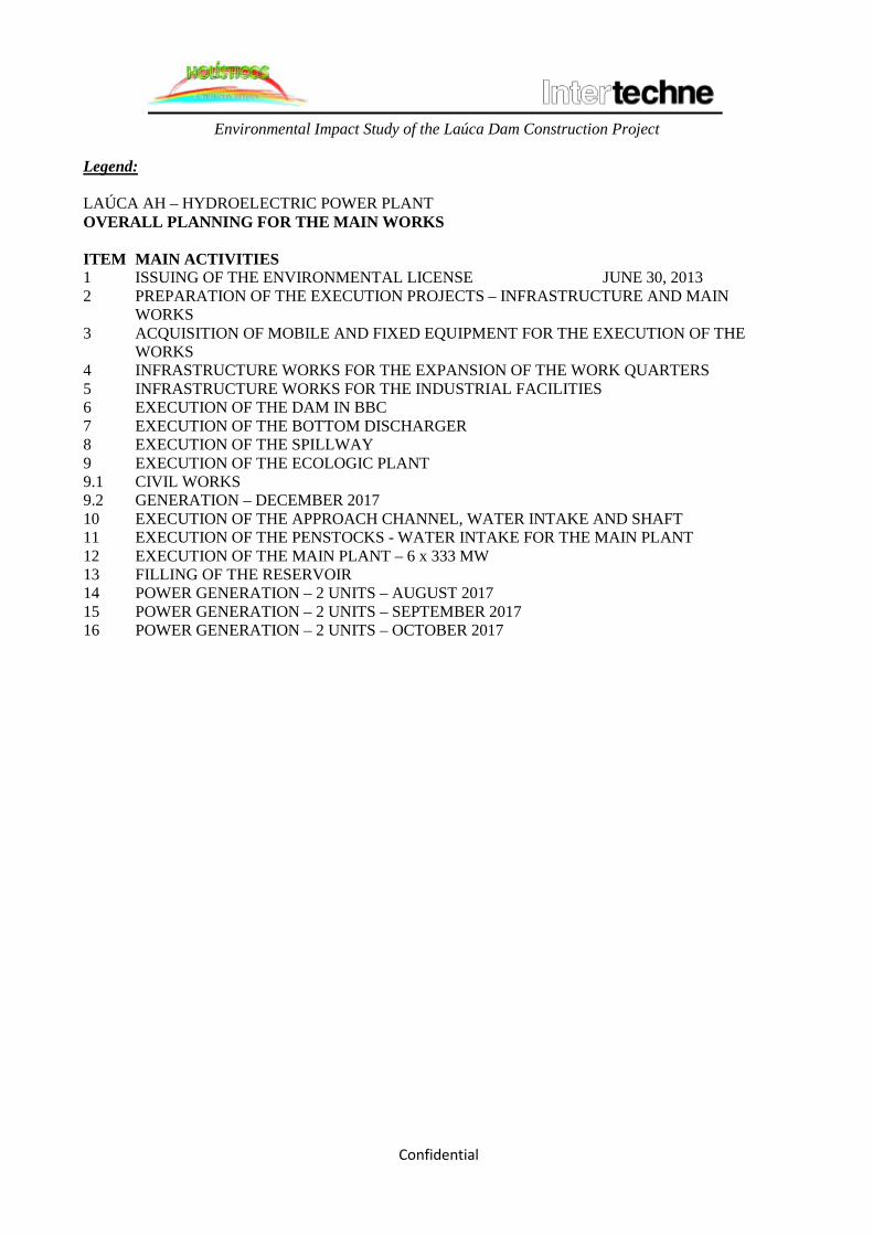
Environmental Impact Study of the Laúca Dam Construction Project
Confidential
Legend: LAÚCA AH – HYDROELECTRIC POWER PLANT OVERALL PLANNING FOR THE MAIN WORKS ITEM MAIN ACTIVITIES 1 ISSUING OF THE ENVIRONMENTAL LICENSE JUNE 30, 2013 2 PREPARATION OF THE EXECUTION PROJECTS – INFRASTRUCTURE AND MAIN
WORKS 3 ACQUISITION OF MOBILE AND FIXED EQUIPMENT FOR THE EXECUTION OF THE
WORKS 4 INFRASTRUCTURE WORKS FOR THE EXPANSION OF THE WORK QUARTERS 5 INFRASTRUCTURE WORKS FOR THE INDUSTRIAL FACILITIES 6 EXECUTION OF THE DAM IN BBC 7 EXECUTION OF THE BOTTOM DISCHARGER 8 EXECUTION OF THE SPILLWAY 9 EXECUTION OF THE ECOLOGIC PLANT 9.1 CIVIL WORKS 9.2 GENERATION – DECEMBER 2017 10 EXECUTION OF THE APPROACH CHANNEL, WATER INTAKE AND SHAFT 11 EXECUTION OF THE PENSTOCKS - WATER INTAKE FOR THE MAIN PLANT 12 EXECUTION OF THE MAIN PLANT – 6 x 333 MW 13 FILLING OF THE RESERVOIR 14 POWER GENERATION – 2 UNITS – AUGUST 2017 15 POWER GENERATION – 2 UNITS – SEPTEMBER 2017 16 POWER GENERATION – 2 UNITS – OCTOBER 2017

CHAPTER 3 INSTITUTIONAL AND LEGAL FRAMEWORK

Study of Environmental Impact of Laúca Dam Construction Project
CONTENTS
3. INSTITUTIONAL AND LEGAL FRAMEWORK ...................................................................................... 5
3.1. INSTITUTIONAL FRAMEWORK ........................................................................................................... 5
3.1.1. MINISTRY FOR THE ENVIRONMENT .............................................................................................. 6
3.1.2. MINISTRY OF ENERGY AND WATER RESOURCES ...................................................................... 8
3.1.3. MINISTRY OF AGRICULTURE ........................................................................................................... 8
3.1.4. MINISTRY OF FISHERIES ................................................................................................................... 9
3.1.5. LOCAL STATE AGENCIES ................................................................................................................ 10
3.1.6. TRADITIONAL AUTHORITIES ......................................................................................................... 10
3.1.7. ENVIRONMENTAL DEFENSE ASSOCIATIONS ............................................................................ 10
3.2. NATIONAL LEGAL FRAMEWORK .................................................................................................... 10
3.2.1. RIGHT TO LIVE IN A HEALTHY, UNPOLLUTED ENVIRONMENT AND TO THE BENEFITS OF THE RATIONAL USE OF NATURAL RESOURCES ........................................................................... 12
3.2.2. EVALUATION OF THE ENVIRONMENTAL IMPACT AND ENVIRONMENTAL LICENSING12
3.2.3. LIABILITY FOR ENVIRONMENTAL DAMAGES .......................................................................... 13
3.2.4. TERRITORIAL ORGANIZATION ...................................................................................................... 14
3.2.5. CULTURAL HERITAGE ..................................................................................................................... 14
3.2.6. LEGISLATION APPLICABLE TO THE PROJECT ........................................................................... 14
3.3. INTERNATIONAL LEGAL FRAMEWORK ......................................................................................... 20
3.3.1. UNITED NATIONS CONVENTION OF BIOLOGICAL DIVERSTIY ............................................. 20
3.3.2. BONN CONVENTION ......................................................................................................................... 20
3.3.3. INTERNATIONAL TREATY ON PHYTOGENETIC RESOURCES FOR FOOD AND AGRICULTURE (TIRFAA) ........................................................................................................................... 21
3.3.4. UNITED NATIONS CONVENTION TO COMBAT DESERTIFICATION IN COUNTRIES SERIOUSLY AFFECTED BY DROUGHT AND MITIGATION OF THE EFFECTS OF DROUGHT ..... 21
3.3.5. SADC PROTOCOL ON FISHERIES ................................................................................................... 21
3.3.6. SADC PROTOCOL ON ENERGY ...................................................................................................... 21
3.4. INTERNATIONAL GOOD PRACTICES ............................................................................................... 22
3.4.1. INTERNATIONAL FINANCIAL CORPORTION .............................................................................. 22
3.4.2. WORLD BANK ENVIRONMENT, HEALTH, AND SAFETY GUIDELINES ................................. 24
3.4.3. EQUATOR PRINCIPLES ..................................................................................................................... 25
3.4.4. WORLD BANK SAFEGUARDS POLICY .................................................................................... 27
3.5. CONCLUSIONS ...................................................................................................................................... 27

Study of Environmental Impact of Laúca Dam Construction Project
Abbreviations
List of Figures Figure 3.1: Diagram illustrating the Environmental Impact Evaluation process. List of Tables Chart 3.1: IFC Performance Standards Chart 3.2.: Equator Principles

Study of Environmental Impact of Laúca Dam Construction Project
Abbreviations
AIA Environmental Impact Assessment ASS Environment, Health, and Safety IFC International Financing Corporation EIA Environmental Impact Assessment EHS Environment, Health, and Safety EPI Individual Protection Equipment ENE National Energy Enterprise GAMEK Middle Kwanza Management Office GIIP Good International Industry Practice LBA Basic Environmental Law LRBA Basic Law on Water Biological Resources LGT Basic Labor Law IDF Forestry Development Institute IPA Artisanal Fishing and Aquiculture Development Institute INIP National Fisheries Research Institute ISO International Organization for Standardization IUCN International Union for Conservation of Nature LGT General Labor Labor Law LOTU Law on Territorial Organization and Urbanism MINAMB Ministry for the Environment MINEA Ministry of Energy And Water Resources MINPESCAS Fisheries Ministry OCDE Organization for Economic Cooperation and Development PO World Bank Operational Policy OIT International Labor Organization RNT Non –Technical Summary SADC Southern Africa Development Community TDR Terms of Reference
TIRFAA International Treaty on Plant Genetic Resources for Food and Agriculture
UNCCD United Nations Convention to Combat Desertification UNCDB United Nations Convention on Biological Diversity

Study of Environmental Impact of Laúca Dam Construction Project
3. INSTITUTIONAL AND LEGAL FRAMEWORK This chapter indicates the competences of several Government agencies responsible for issues related to possible environmental and social impacts of the project under consideration. It also addresses the provisions of the national legislation (of obligatory application) and a summary of the international instruments (which are not binding) pertaining to the Environmental Impact Study relative to the construction of the Laúca Dam, situated on the confluence of the provinces of Malanje, North Kwanza, and South Kwanza. The chapter further describes the environmental and social standards that must be met for the protection and preservation of the environment and of the quality of life of the people likely to be affected. The following aspects are addressed:
• Institutional framework, indicating the administrative agencies responsible for the
management of the environment and of issues directly connected with the implications of the Project for the areas of environment, energy, water, fishing, and agriculture;
• Environmental and social legislation applicable to the construction of the dam, and recommendations for the various actions under the Project; and provisions of the national legislation, which are compulsory;
• Description of the multilateral environmental agreements of which Angola is signatory, and whose guidelines and recommendations pertinent to the Project are binding;
• Summary of international good practices, with emphasis on the performance standards of the World Bank and the International Financial Cooperation (IFC), which will be implemented at the promoter’s discretion, as they are not binding instruments.
It should be noted that the national legislation and the international good practices here described are not presented in their entirety, but only examples of the main laws; it will be up to the undertaking’s promoter to define the mechanisms for identifying all the legislation applicable to the Project. 3.1. INSTITUTIONAL FRAMEWORK
The characteristics of the natural resources in Angola’s current social, economic, and industrial development context recommends the adoption of environmental protection measures to ensure compliance with the principles of sustainable development. The policies on use of the soil and territorial organization require regulatory measures to ensure the proper use of the Angolan territory. For the same reason, the implementation of projects whose activities may have an impact on the environment and on the sustainability of the natural resources is regulated by the State through various governmental institutions that form its organic structure. In light of the legislation in force, the Government approves the concession of the private use of water resources for the production of electric energy. As regards the Project under consideration, the institutions responsible for environmental issues are the Ministries for the Environment, Energy and Water, Agriculture, and Fisheries.

Study of Environmental Impact of Laúca Dam Construction Project
3.1.1. MINISTRY FOR THE ENVIRONMENT
A result of the development of the institutional framework and of the recognition of the importance of preserving the environment to ensure a better quality of life for the populations and sustainable development, as well as a result of the environmental challenges for the 21st century, the Ministry for the Environment (MINAMB) became responsible for drafting, implementing, and inspecting the management of the environment and of the natural resources for the protection, preservation, and conservation of environmental quality and for ensuring the rational use and preservation of the renewable natural resources. The MINAMB’s new organic statutes, approved by Presidential Decree No. 201/10 of 3 September 2010, purports to ensure the implementation of strategies and policies aimed at the preservation and management of the environment. As part of its environmental policy, the MINAMB, among other things, controls all actions likely to cause pollution, coordinates actions to recuperate areas considered critical, ensures the management of the continental or fluvial waters ecosystem in an integrated, sustained manner, as well as promoting actions aimed at the conservation of nature and landscape protection, in accordance with its current organic statutes. It is also incumbent on the MINAMB to undertake the evaluation of Environmental Impact Studies (EIA) pertaining to projects susceptible of causing negative environmental and social impacts. This evaluation calls for one or more than one public hearings in localities near a project’s intervention site, for presentation of the EIA report and the attendant Non-Technical Summary (RNT), and to elicit comments and contributions from the interested and affected parties. Should an EIA be approved, the MINAMB, upon specific application, issues the pertinent environmental permits in the name of the undertaking’s proponent, indicating which mitigation measures should be adopted. The issuing of an environmental permit for the undertaking is compulsory. An installation environmental permit is issued to approve, among other things, the process of preparation of the terrain and the construction of the dam and support infrastructure, including the filling of the reservoir; as well as an operation environmental permit, which approves the start of operations, after verification of compliance with the mitigation measures required during the construction phase. The aforementioned actions related to the AIA procedure are under the responsibility of the National Department for the Prevention and Evaluation of Environmental Impacts, which carries out the impact evaluations, issues the permits, and performs the environmental audits (as provided under Art. 19/1 of Presidential Decree No. 201/10). Figure 3.1 shows in diagram form the Environmental Impact Evaluation process (pursuant to the environmental legislation in force in Angola).

Study of Environmental Impact of Laúca Dam Construction Project
Figure 3.1: Diagram illustrating the Environmental Impact Evaluation process.

Study of Environmental Impact of Laúca Dam Construction Project
This study has been registered with the MINAMB as required under Executive Decree No. 92/12, accompanied by Annexes I and II to the Decree.1
The generic Terms of Reference (TDR) of the Ministry for the Environment (MINAMB, 2012) were applied, to the study after being properly adapted to fit the purposes of the EIA under consideration.
3.1.2. MINISTRY OF ENERGY AND WATER RESOURCES In addition to its attributions pertaining to energy and planning policy, the Ministry of Energy and Water Resources (MINEA) is responsible for proposing the formulation of, and for conducting, executing, and controlling the Executive’s policy on energy and water resources (Presidential Decree No. 246/12 of 11 December 2012, Art. 1). It is incumbent upon the MINEA to establish strategies, promote, and coordinate the rational use of energy and water resources, while ensuring their sustainable development; and to promote the national policy on electrification, general utilization of water resources, as well as ensuring their protection and conservation. The MINEA is also in charge of the water supply and sanitation policy and, among other attributions, it is responsible for licensing, monitoring, and inspecting the exploitation of services and facilities in the energy sector (Presidential Decree No. 246/12, Art. 2 (a), (d), and (i)). The National Electric Energy Department participates in the concession granting process, establishes norms, regulations, and appropriate technical specifications for energy production facilities; issues quality certificates pertaining to the materials to be used in the facilities, as well as performing technical audits of industrial electric facilities (Presidential Decree No. 246/12, Art. 15 2 (f) (i) and (k)). The National Water Resources Department coordinates the formulation of the national water resources policy and watches over its execution, follow-up, and systematic monitoring; promotes and coordinates the drafting and establishment of norms and regulations pertaining to the use of water resources, as well as promoting their publicity and enforcement; establishes, in the area of the commissions on basins and in coordination with other competent bodies, the actions aimed at optimizing the sharing of water resources of Hydrographic Basins in the common interest of the basin’s state; and promotes the development of actions aimed at the sustainable exploitation of water resources, especially to prevent waste, pollution, and contamination (Presidential Decree No. 246/12, Art. 18, 2 (b) (i) (p) and (r)). 3.1.3. MINISTRY OF AGRICULTURE The Ministry of Agriculture’s mission is to propose the formulation of, and to conduct, execute, and control the Executive’s policy on agriculture and food security, rural development, the welfare of rural communities, and forest resources, with a view to sustainable development. This Ministry has been restructured by Presidential Decree No. 228/12 of 3 December 2012, and to achieve its objectives, it has the following attributions, among others:
• To define strategies and programs for the national development in the areas of agriculture, cattle-raising, forestry, food security, rural development, fight against poverty, and
1 The documentation for registering the EIA was submitted to the Legal Office of the Ministry for the Environment and to the National Department for Environmental Impact Prevention and Evaluation (DNPAIA) on 8 April 2013.

Study of Environmental Impact of Laúca Dam Construction Project
community development, as well as promoting and coordinating the necessary actions to achieve these purposes;
• To ensure the management of land for the purposes of agriculture, cattle-raising, and forestry;
• To ensure the execution of policies and strategies for the sustainable management of forest and fauna resources; and
• To promote and execute policies and strategies aimed at the establishment and management of food reserve.
The Agrarian Lands Management Office, as the name indicates, is responsible for managing the lands for agriculture, cattle-raising, and forests in particular and participates in the issuing of titles to land for those purposes; issues opinions on agricultural, commercial, and industrial undertakings susceptible of influencing national development; and carries out a series of actions related to the structuring of land tenure. The Forestry Development Institute (IDF), in turn, is in charge of promoting, coordinating, and executing policies related to forestry, fauna, rural matters, and development of technological transfer. 3.1.4. MINISTRY OF FISHERIES The Fisheries Ministry (MINPESCAS) is responsible for formulating, executing, supervising, and controlling the policy on the management of aquatic biologic resources and activities related to fisheries, aquaculture, and salt in Angola. It was established by Presidential Decree No. 226/12 of 3 December 2012 and has the following attributions:
• To propose strategies and implement policies on the development of fisheries, aquaculture, and especially in respect of the exploitation and use of fishery resources;
• To promote the sustainable development of the sector and ensure, in cooperation with other competent agencies, the implementation of measures aimed at the preservation and sustainable management of aquatic biologic resources and the aquatic environment;
• To ensure, according to the overall policy on fisheries and industry, the harmonious development of the national fishing fleet and industry by means of instruments that regulate and control fishing and the transformation and processing of fishing and aquaculture products; and
• To coordinate the oversight of fishing in interior waters, on the territorial sea, and in the exclusive zone, cooperating as needed with other competent agencies, and ensuring the application of the pertinent sanctions.
To discharge its functions, the Fisheries Ministry has a series of central and provincial structures, among which the National Fisheries Research Institute and the Institute for the Development of Artisanal Fishing and Aquaculture deserve special mention. The National Fisheries Research Institute (INIP) is a public institution devoted to scientific research and technological development. It is a legal entity endowed with administrative, financial, and proprietary autonomy, as a special State service for data collection and studies on aquatic biologic resources and respective ecosystems. Some of INIP’s main roles are to contribute to the definition of the strategy and tactics of marine research on continental waters; to study the aquatic biologic resources and their environment; to
Study of Environmental Impact of Laúca Dam Construction Project
establish mechanisms for their rational conservation and exploitation, as well as for the exploration of species that are not fishing targets; to engage in the prospection of the reserves of aquatic biologic resources; and to propose measures aimed at the conservation and rational management of the aquatic biologic resources and their ecosystems. The Institute for the Development of Artisanal Fishing and Aquaculture (IPA) is a body under the Ministry of Fisheries in charge of actions aimed at promoting and supporting the development of artisanal fishing and of aquaculture in Angola. 3.1.5. LOCAL STATE AGENCIES
The provincial governments follow up the implementation of public investment programs and economic intervention projects in their respective provinces; establish provincial territorial plans; establish urbanism projects; administer the State’s public and private land tenure system; and promote measures aimed at water resources protection and at soil and water conservation (Decree-Law No. 17/10, Art. 12, 12/1/c, and 2(a-b)(i) and 6(c)). The municipal administrations establish the municipal territorial organization and the municipal development plans and ensure the preservation of sites classified as municipal cultural heritage (Decree-Law No. 17/10, Art. 45, 2(a) and 3(f). All administrations of municipalities and communes affected by the dam construction have been informed about the Project, and their opinions and comments are reflected in the Environmental Impact Study (See Chapter 4). 3.1.6. TRADITIONAL AUTHORITIES The traditional authorities participate in the municipal and communal councils for social consultation and coordination (Decree-law No. 17/10, Arts 52 (f) and 57 (e)). Traditional and community authorities were consulted and interviewed in connection with this Project, in relation to aspects of it that are relevant to communities that will be directly affected by it. 3.1.7. ENVIRONMENTAL DEFENSE ASSOCIATIONS The environmental defense associations are entitled to being consulted and informed about, among other things, environmental impact studies and forest and fauna resources organization; to participating in administrative processes that involve environmental issues; and to going to court in connection with actions that harm the environment (Law 3/06, Arts. 6-8).
3.2. NATIONAL LEGAL FRAMEWORK This section sums up the legal provisions in force in Angola, which must be taken into consideration in the Environmental Impact Evaluation, and must thus form part of the Environmental Impact Study (EIA). The summaries presented are not exhaustive; only the pertinent environmental legislation is addressed. Reference is also made to the international protocols that had an influence on the methodology used in the EIA’s preparation. The need to protect the environment and the requirements for achieving sustainable development are based on the citizens’ right to live in a healthy, unpolluted environment, a right guaranteed under the Constitution of the Republic of Angola.

Study of Environmental Impact of Laúca Dam Construction Project
Pursuant to Art. 13 of the new Angolan Constitution of 5 February 2010, international treaties and agreements duly approved or ratified are incorporated into the Angolan legal system after their official publication and international entry into force and as long as they are binding upon the State. The same law that guarantees to all the right to live in a healthy, unpolluted environment, imposes the duty to defend and preserve it. To this end, the State adopts the necessary measures for the protection of the environment and the flora and fauna on the national territory; for the maintenance of ecologic balance; for the proper localization of economic activities; and for the rational exploitation and use of all natural resources, in a context of sustainable development and respect for the rights of future generations and for the preservation of the different species. Angolan cities are entitled to living in a healthy, unpolluted environment (Constitutional Law, Art. 39 (1)) and to benefit from the rational use of the natural resources (Law No. 5/98, Basic Environmental Law, Art 3 (1)). The State must adopt the necessary measures to permit the citizens to exercise their rights effectively (Constitutional Law, Art 39/2), including their right to go to court in case of violation of their constitutional rights or rights guaranteed under other laws (Constitutional Law, Art. 74). The Basic Environmental Law (LBA) establishes the general duties regarding the defense of the environment and the sustainable use of the natural resources, as well as the contribution to the quality of life (Arts. 3 (1) and 25, the latter referring specifically to citizens and enterprises of both the public and private sectors). These provisions entail several legal consequences, such as the following:
(a) Individuals and legal entities must, in the course of their activities, abstain from degrading the environment or from in any way hindering the exercise of the fundamental right to live in a healthy, unpolluted environment, a right established under the Constitutional Law, Art. 39 (1 and guaranteed under Art. 74 of the same Law; and
(b) As these duties form part of generic obligations, these individuals and legal entities must chose the proper means for their fulfillment, in the lack of legislation specifying, even partially, the tenor of these obligations.
Anyone that causes damage to the environment has the obligation to indemnify the State in terms of objective responsibility (LBA, Art. 28); and any private citizen whose rights to live in a healthy, unpolluted environment and to enjoy the benefits of the rational use of natural resources are violated, are protected under the civil responsibility general regime, as provided under the Civil Code Arts. 483 ff (LBA , Art. 23). If the national legislation does not cover specific aspects or is incomplete, particularly as regards technical specifications, the Project promoters should resort to the international instruments2
in respect of good practices in the pertinent areas, or to appropriate norms in force in other countries. The undertaking’s promoter should thus resort to international instruments for orientation on some aspects of the generic duty to protect the environment and the quality of life, which that may not be reflected in the national legislation.
2 The most relevant international instruments for the Project are the Performance Standards of the International Financial Corporation and the World Bank’s Standard Operating Procedure.

Study of Environmental Impact of Laúca Dam Construction Project
3.2.1. RIGHT TO LIVE IN A HEALTHY, UNPOLLUTED ENVIRONMENT AND TO THE BENEFITS OF THE RATIONAL USE OF NATURAL RESOURCES
Angolan citizens have the right to live in a healthy, unpolluted environment, as well as the duty to defend and protect it (Constitution of the Republic of Angola, Art. 39(1)) and the right to benefit from the rational use of natural resources (Basic Environmental Law, Art. 3 (1)). The State must adopt the necessary measures to permit the citizens to exercise their rights effectively (Constitution of the Republic of Angola, Art. 39 (2)), including their right to go to court in cases, and in accordance with the law, of acts that are harmful to their health (…), the environment, and their quality of life ( Constitutional Law, Art. 74)).
3.2.2. EVALUATION OF THE ENVIRONMENTAL IMPACT AND ENVIRONMENTAL LICENSING
The Basic Environmental Law (Law No. 5/98 of 19 June 1998) provides for the obligatory environmental impact evaluation procedure in respect of actions that have implications for environmental and social balance and harmony (Art. 16 (1), including those that have a bearing on the communities’ interest (Art. 10). Decree No. 51/04 complements the Basic Environmental Law, establishing a series of procedures for the environmental impact studies prior to the approval, by the competent body, of projects that require an Environmental Impact Study; it further establishes norms on the preparation of this study and its later evaluation. Decree No. 51/04, Art. 4 (1) on the AIA requires that AIAs be done in the case of infrastructure projects that by their nature, dimension, and localization have implications for the environmental balance and harmony. Annex to Decree No. 51/04 expressly requires, in connection with Art. 4 (2), that an evaluation of environmental impact (AIA) be done in the case of hydroelectric dams, industrial facilities for the transmission of electric energy by aerial cables (Art. 3 (a)(k)), “Hydroelectric works for the exploration of hydric resources, such as dams for hydroelectric purposes (…)”, “industrial installations intended (…) to the transportation of electric energy by aerial cables” (Art. 3/a)” and electric energy transmission lines above 230 KV (Art. 3 (i)).3
Decree No. 51/04, Art. 6 (on AIAs) further establishes that the Environmental Impact Study (EIA) must be submitted by the undertaking’s owner (Art. 5). Art. 7 requires that for the study’s preparation a series of technical activities be carried out . Accordingly, this study must meet these requirements. The Minister for the Environment’s decision about the project (opinion) is preceded by public consultation (LBA, Art. 10 and Decree No. 51/04, Art. 10). Compliance with his decision by the undertaking’s owner is compulsory (Decree No. 51/04, Arts. 13 (1) and 16 (c)).
3 Lines of transmission of the energy to be generated by the future Laúca Dam to consumer centers are not addressed in this study.

Study of Environmental Impact of Laúca Dam Construction Project
The Basic Environmental Law further provides (Art. 17) that projects that by their nature, localization, or dimension are susceptible of causing significant environmental and social impact are subject to licensing; an environmental license is granted on the basis of the AIA (Art. 17 (2)). Licensing is obligatory in the case of projects that by law require an AIA. As the Project is for work connected with the construction of a future dam, an environmental installation and operating license shall be required (Decree No. 59/07, Arts. 3 and 4 (2) on environmental licensing). The environmental installation license applies to the implementation and modification of an undertaking in accordance with the specifications listed in the execution project (Decree No. 59/07, Art. 1 (c)). The environmental operating license applies to the start of the facilities’ operation, after verification of compliance with all requirements of the environmental impact study (same Decree, art. 1 (d). It should include the elements required under Art. 14 of the same Decree), particularly the following:
• The reference documents on the best methods and techniques applicable to the exercise of the licensed activity (Art. 14 (a));
• The limit values of pollutants emission (Art. (b)); and • Indication of the measures to ensure the proper protection of the soil and the subterranean
waters (Art. 14 (c)).
The license is valid for no less than three years and not more than eight years, and is renewable after environmental auditing (Decree No. 59/07, Arts. 14 (g) and 16). The fee to be paid for obtaining the license is regulated by Joint Executive Decree No. 130/09 of the Ministries for the Environment and of Finance. 3.2.3. LIABILITY FOR ENVIRONMENTAL DAMAGES
Decree No. 194/11 of 7 July 2011 establishes the liability for environmental risk and degradation, based on the “payer polluter” principle to prevent and exact reparation for any environmental damage. This applies to any environmental damage but does not apply to cases of armed conflicts, hostilities, civil war, insurrections, or natural phenomena of an exceptional character. It applies to environmental damages or imminent threat of such damage caused by pollution of a diffuse character, always under the assumption that there is a connection between the cause of the damage and the activity of the operator that caused the damage. One type of environmental damage is the pollution that threatens human health and the biodiversity owing to toxic elements introduced in the environment. In the lack of applicable norms on environmental quality, the decree mentions the ISO standards. The costs of prevention and compensation of environmental damage are shouldered by those responsible for the environmental pollution. The amount of the fine for violation of a legal norm or environmental license requirement varies from the Kwanza equivalent of US$1,000.00 to US$100,000,000.00 (one thousand to one hundred million U.S. dollars).

Study of Environmental Impact of Laúca Dam Construction Project
3.2.4. TERRITORIAL ORGANIZATION In general terms, according to Law 3/04, the Territorial Organization and Urbanism Law (LOTU), the use of land must conform to municipal or special territorial plans, which are binding on private citizens with the force of a regulation (LOTU, Art. 57 (2)). Private citizens have the right to access the information contained in these plans (Art. 53 (1), a subject regulated by Art. 11 of Decree No. 2/06 (General Regulation of Territorial, Urban, and Rural Plans). Decree 51/04, Art. 6 (f) determines that environmental impact studies take into consideration the content of government plans and programs that encompass the various territorial plans. 3.2.5. CULTURAL HERITAGE Law 14/05 (Cultural Heritage Law) defines cultural heritage as the material and immaterial assets that because of their recognized value should come under custody of the law (Art. 2 (1). These include paleontological, archeological, and architectonic assets that are valuable owing to their memory content, antiquity, authenticity, originality, rarity, exemplary quality, singularity, or other qualities (Art. 3 (1)). Immovable cultural assets include, among other things, the sites and spaces of historical, archeological, artistic, scientific, or social interest (Art. 6 (1c). Immovable cultural assets may be classified as being of local, regional, national , or international interest (Art. 7 (3)). Moveable cultural assets include, among others, those that express an evolution of nature or techniques, including those that are buried or submerged or are found in places of archeological, historical, or ethnological interest or in other places (Law 14/05, Art. 6 (2a)). The Law establishes the duty of all citizens to preserve, defend, and value their cultural heritage, as well as the duty of public and private entities to promote the safeguard and valorization of these assets (Art. 14 (1-2). Anyone who has found or may find on public or private land, or in a submerged location, any of such archeological testimonies must report the fact to the local authorities (Art. 35 (1). Infractions against cultural assets are subject to the sanctions provided under Art. 56 of Law 14/05. In the areas affected by the construction of dams, and of reservoirs and tunnels in particular, there may be cultural assets on the surface, which will be submerged; it is thus necessary to identify them and adopt measures for their preservation. As in this specific case the Project will require the building of tunnels for the deviation of the river course, including preparation work as well as digging, it would be convenient to alert the builder and his workers about the duty to report to the provincial cultural department or to the Cultural Heritage Institute any vestiges of a paleontological or archeological nature (artifacts or other items) that might have cultural value. It is also necessary to verify if there are in the area cultural or natural assets as defined under Law 14/05, Arts. 6 and 23. In the case such an asset exists, its demolition or destruction is subject to an opinion from the Ministry of Culture (Art. 13 (1) of the same law). 3.2.6. LEGISLATION APPLICABLE TO THE PROJECT 3.2.6.1. USE OF WATER RESOURCES

Study of Environmental Impact of Laúca Dam Construction Project
The construction of the facilities associated with the Laúca Dam and the future filling of the reservoir raise questions pertaining to the affected and environmental rights. The use of water resources is regulated by Law 6/02 (Water Resources Law), which expressly provides for the use of water resources for energy generation (Art. 25(1)). The General Law on Electricity determines that the activities aimed at energy generation, transmission, and distribution presuppose the conception and implementation of projects and the use of equipment ad methods that conform to the norms on the safety of people and assets and respect for property rights (Art. 3 (1/d). This law also determines that local communities in whose areas will be implemented projects for the generation, transmission, and distribution of electric energy are entitled to compensation for any damage as well as to deriving benefit for the region, on terms that may be regulated or on terms of the concessions or the licenses granted for that purpose (Art. 16 (3)). Such compensation should reflect the necessary sharing in the benefits resulting from the construction of the Laúca Dam. The General Law on Electricity further provides for public consultations in the case of the concession of rights to exercise activities aimed at the generation, transmission, and distribution of electric energy (Art. 5). 3.2.6.1. WATER QUALITY MANAGEMENT Presidential Decree No. 261/11 approved the Regulations on Water Quality, which sets water quality norms ad criteria to protect the water environment and improve water quality in light of its main uses. This decree applies to interior waters, both surface and subterranean, as well as water for aquaculture, cattle-raising, agricultural irrigation, and spas; it also regulates the norms for the control of residual water discharge into the national bodies of water and onto the soil, so as to preserve the quality of the aquatic environment and protect public health. Water used for human consumption at the dockyard and any infrastructure associated with the dam construction and the deviation of the river course must comply with the standards established under this decree. Undertakings that discharge residual waters onto the soil or into water resources must have a license issued by the Ministry for the Environment. This license will set the norms on discharge and on the prevention or mitigation of environmental damage. This decree is to be enforced together with the Law on Water Resources.
3.2.6.2. WATER RESOURCES USE RIGHTS AFFECTED BY THE CONSTRUCTION OF THE DAMS
The water use rights affected by the dam construction are as follows:
Study of Environmental Impact of Laúca Dam Construction Project
• The rights of local communities and families that use the river water pursuant to the shared
use regime (unimpeded, free of charge access for subsistence purposes), as provided under Arts. 21-23 of the Law on Water Resources;
• The rights of farmers that are holders of land rights who use water from the Kwanza River hydrological basin, pursuant to Art. 26 of the Law on Water Resources (unimpeded, free of charge access to certain bodies of water for agricultural, fishing, and forestry purposes); and
• The rights of privative use by individuals that use the water for the purposes established under Arts. 24 and 25 of the Law on Water Resources (access for commercial purposes is not provided under Art. 26).
Shared use prevails over private use; and, in principle, concessions may not be granted to the detriment of shared use (Law on Water Resources, Arts. 22 (2) and 33 (1)). It is thus necessary to identify the holders of water use rights, private and shared, whose rights will be expropriated for the sake of public interest. Fair compensation should be negotiated pursuant to the law, taking into consideration the provisions under the LOTU, Arts. 6 (1c), 10, and 20 (4) and the aforementioned provisions under the General Law on Electricity. The Law on Water Resources requires that public consultations be undertaken before the concession of private use of water resources for purposes that include the construction of dams (Art. 36). In particular, users associations, local authorities, social organizations, and other organizations directly interested in the use of the water resources of the geographical area where the undertaking will take place should be consulted (Art. 36 (1)). 3.2.6.3. FISHING RIGHTS AFFECTED BY THE DAMS’ CONSTRUCTION Persons that engage in commercial or subsistence fishing, pursuant to Arts. 35 and 42 of Law 6-A/04 (Law on Aquatic Biologic Resources (LRBA), are one of the social groups to be affected by the river changes called for under the Project. The general principles on the use and management of aquatic biologic resources are sustainable development principles on the defense of the fishing communities’ interests and on the participation of all the interested parties in the management of the resources (LRBA, Arts.6 (3a, h, and j)). Accordingly, the EIA should identify the people whose fishing rights will be affected by changes in the river, and foresee mechanisms for compensating them, including by granting them access to the reservoir to fish. This information is available in the chapter on the environmental and social characterization of the area (Chapter 4). 3.2.6.4. RIGHTS TO LANDS SUMBERGED BY THE RESERVOIRS The lands that will become submerged may be in the possession of rural communities, holders of land titles granted by the State, and holders of titles to private property. In the case of lands under concession, there must be expropriation based on public interest and payment of a fair indemnity, as provided under Art. 12 of Law 9/04 (Land Law). As regards

Study of Environmental Impact of Laúca Dam Construction Project
expropriations, Articles 217 and 237 of Decree No. 43894 (Regulation on Land Occupation and Concession), should be applied. In the case of community lands, those that are unoccupied will be released after consultation with the traditional authorities, pursuant to the customary land exploitation regime, and against payment of compensation as provided under Art. 37 of the Land Law. If these lands cannot be released they may be expropriated on the basis of public interest, against payment of a fair indemnity (Land Law, Art. 9 (2)). 3.2.6.5. ENVIRONMENTAL IMPACT OF THE USE OF WATER
FOR THE DAMS Water Pollution The pollution of waters by any means, including the discharge of any type of effluent, is forbidden, unless authorized by the basin managing body (Law on Water Resources, Art. 68). Art. 71 of the Law on Water Resources provides for the establishment of a protection area next to catchment zones, where any activities leading to water quality degradation are forbidden. Accordingly, the EIA must indicate possible sources of pollution of the waters. The environmental license will indicate the undertaking’s limits of emissions of pollutant substances (Presidential Decree 261/11, Art. 13 (1)). The EIA should also identify the new water catchment zones that will supply water for the dam workers, as well as the new points of shared use by the communities that might be relocated because of the Project, particularly owing to the filling of the reservoir. Aquatic Conservation Areas and Aquatic Ecosystems Protection There is no information on the establishment of aquatic conservation areas as called for under Arts. 78-81 of the LBRA. And yet, the LBRA requires the establishment of conservation areas such as humid and mangrove zones and the biologic resources spawning zones (Art. 86, (a)(d)). As it is expected that ecosystems and biologic resources will be affected, it might be necessary, depending on the AIA, to establish natural aquatic reservations, whole or in part, for the regeneration and sustainable renewal of species, particularly protected species, that will be affected by the Project (LBRA, Art. 82). Aquatic Biologic Resources and Ecosystems There is no information as to whether any fresh water species is listed as threatened, pursuant to the LRBA (Arts. 69 and 71). However, the EIA should identify the aquatic fauna and flora species that will be affected by the changes in the river, particularly rare, close to extinction, or threatened species, or species whose numbers will be reduced owing to the Project’s implementation. This description is found in the chapter on characterization of the area’s biodiversity. The EIA should also indicate appropriate measures for conservation of these species, taking into consideration not only the legislation on the AIAs, but also the principle of conservation and optimum use of aquatic biologic resources, as provided under Art. 6 (3)(c) of the LRBA. These measures are described in the management plans.

Study of Environmental Impact of Laúca Dam Construction Project
Terrestrial Biologic Resources As regards the terrestrial fauna, Joint Executive Decree No. 37/99 has updated the provisions of the Hunting Regulations (Legislative Diploma No. 2873 of 11 December 1957, amended by Legislative Diploma No. 86/72 of 20 September 1972, forbidding the hunting of some species and conditioning the hunting of others that may be captured only in quantities and in seasons to be announced by the competent authority, currently the Ministry for the Environment. In case these animals are submerged, there will be no hunting, except for capture of animals for their transfer to other previously determined habitats. As to the wild flora, Decree No. 44531 (Forestry Regulation) sets norms on the protection of these species. It forbids the cutting down of honey-producing species of greater regional interest and of producers of essences of recognized utility for rural communities, pursuant to lists to be adopted in each province (Art. 188). The Regulation further establishes norms on the felling of trees. The regime of areas of terrestrial species conservation in force since colonial times is considered obsolete. The flora and fauna protection zones recognized in Angola in the colonial period (Decree No. 40040, Arts. 31 and 53, the latter in reference to Art. 31) were classified as National Park, Integral National Reserve, Partial Reserve, and Especial Reserve, which also includes forest reserves. The Forestry Regulation calls for the creation of local conservation areas, the forest reservations referred under Art. 31 of Decree No. 40040. Under it, the hydrographic basins of water courses subject to torrential rains are obligatorily included in a total or partial reserve regime (Art. 62). The Land Law distinguishes only between total and partial reserves (Art. 27 (3)). Conservation areas are included in total reserves (Art. 27 (4) (5). The Law on Territorial Organization and Urbanism calls for especial plans for conservation areas (Art. 28, (3)(a). In partial reserves are included the strip of protection land around dams and reservoirs as well as land occupied by electricity facilities and transmission lines (Land Law, Art. 27 (7e) and (7g)). 3.2.6.6. SOLID WASTE MANAGEMENT Presidential Decree No. 190/12 sets the general rules regarding the production, treatment, collection, storage, and transportation of any solid waste, except for radioactive residues or those subject to specific regulations. The decree calls attention to the prevention or minimizing of the negative impacts of residues on human and environmental health. It applies to all individuals and legal entities, public or private, engaged in activities susceptible of producing waste or involved in waste management, as well as to all types of waste on the Angolan soil. It further regulates the classification of waste, the different waste categories, the management of hazardous and non-hazardous waste, and establishes the appropriate sanctions. The Decree classifies waste and establishes detailed screening, storage, and container requirements for all types of solid waste, so as to distinguish between hazardous and non-hazardous residues. These requirements regarding specific residues should be incorporated into the standard operating procedures that produce waste.

Study of Environmental Impact of Laúca Dam Construction Project
All enterprises, both public and private, must have a Solid Waste Management Plan before starting operations, with all the information in Annexes I and II to the Presidential Decree. This waste management plan must be submitted to the MINAMB for approval and renewed every four years thereafter. Still according to the Decree 190/12, waste must be transported by authorized services providers, in properly adapted vehicles to ensure safe transportation. Vehicles must be kept in proper functioning conditions and regularly maintained. Load limits must be respected, and the containers must have the appropriate or obligatory label and alert signs. In addition, the vehicles must carry the appropriate equipment for fighting fire and for solving leaking problems. The vehicles provider and drivers must have the proper license and authorization from the pertinent authorities. Drivers must have been trained for safe driving and for responding to basic emergencies, and must comply with the requirements relative to labeling and alert signs for any transportation means that carry hazardous waste. Vehicles must carry a filled out Waste Declaration Form with information on the transported material. Each driver is responsible for making sure that this form is properly filled out and placed in the vehicle before starting. The Decree further requires that copies of all hazardous waste declaration forms be submitted to the MINAMB. 3.2.6.7. WORK SAFETY AND HYGIENE From a labor legislation standpoint, the Project’s social impacts may be seen from two angles:
• Work safety and hygiene; and • Living conditions of workers engaged in the Project.
Work safety and hygiene The General Labor Legislation (Law 2/00, LGT) makes employers responsible for ensuring the quality of the work environment, including through the adoption of appropriate work safety and hygiene measures (Art. 43 (g)). Arts. 85-93 establish the employer’s duties in this regard. But the Angolan legislation fails to address technical norms on safety and hygiene in the different work environments, notwithstanding the determinations of the International Labor Organization (OIT) on this subject. Responsibility for the quality of the work environment falls on the employer, whether he is the contractor that executes the Projector or the enterprise that is going to exploit the undertaking, in relation to the workers involved. Decree No. 31/94 on safety, hygiene, and health in the workplace establishes the workers’ right to safety and hygiene conditions in the workplace; to be provided, free of charge, with the collective and individual protection equipment needed in their work post; to be regularly informed about work safety, hygiene, and health; and to elect a committee to treat these issues with the enterprise (Arts. 14 (a-c), 14 (d-e-f), and 17 (1)). The law also establishes the workers’ duties, including the duty to care for their own safety and health and for that of others that may be affected by their actions or omissions in the performance of their tasks (Art. 13 (1)).

Study of Environmental Impact of Laúca Dam Construction Project
In the lack of specific legislation on work safety and hygiene in the construction of dams for the generation of electric energy, it is recommended, as a good practice, that international standards be applied when appropriate. Workers’ living conditions at the work site The General Labor Law requires that conditions in the work environment safeguard the worker’s freedom and dignity, permitting them to satisfy normally their needs and those of their families, protecting their health, and ensuring that they may enjoy decent living conditions (Art. 3 (4)). As regards workers that have to relocate from where they habitually live to render services at the work site, Art. 191 (1b) establishes the employer’s obligation to ensure safe lodgings for the worker and his family, in appropriate condition, and in accordance with the requisite hygiene and health measures as well as with other measures required by the regulation, if these issues have not been discussed with the worker for his individual contract.
3.3. INTERNATIONAL LEGAL FRAMEWORK
Angola has not ratified any treaties related to water, in respect of regulation of the non-navigational uses of shared water, but it forms part of the Southern African Development Community (SADC) protocol on Energy and Fisheries. In addition to previously mentioned protocols, some provisions of agreements signed and ratified by Angola are relevant to the Project, such as the following:
• United Nations Convention on Biological Diversity (UNCDB); • United Nations Convention to Combat Desertification (UNCCD); • Bonn Convention: Convention of the Conservation of Migratory Species of Wild Animals
(CMS); and • International Treaty on Phytogenetic Resources for Food and Agriculture (TIRFAA)
There follows a summary of provisions of some international instruments that are relevant to the Project.
3.3.1. UNITED NATIONS CONVENTION OF BIOLOGICAL DIVERSTIY
The United Nations Convention on Biological Diversity (UNCBD) obligates the States Parties to identify and conserve their biological resources and their diversity (Art. 6), an obligation that has been incorporated into the Angolan legislation. The identification of biological resources that will be affected and the measures for their conservation are addressed in the chapter on environmental characterization. These measures are consistent with the National Biodiversity Strategy and Action Plan (2006-2012), currently being updated by the MINAMB.
3.3.2. BONN CONVENTION The Bonn Convention on Migratory Species of Wild Animals (CMS) obligates the States to identify these species and to prevent, eliminate, compensate, or minimize, if appropriate, the adverse effects of activities or obstacles that seriously obstruct or impede these species’ migration.
Study of Environmental Impact of Laúca Dam Construction Project
3.3.3. INTERNATIONAL TREATY ON PHYTOGENETIC RESOURCES FOR FOOD AND AGRICULTURE (TIRFAA)
The International Treaty on Phytogenetic Resources for Food and Agriculture (TIRFAA), in the section that incorporates the CBD provisions regarding these resources, obligates the States to ensure their diversity and sustainability, including the maintenance of agricultural systems that contribute to this end (Art. 6).
3.3.4. UNITED NATIONS CONVENTION TO COMBAT DESERTIFICATION IN COUNTRIES SERIOUSLY AFFECTED BY DROUGHT AND MITIGATION OF THE EFFECTS OF DROUGHT
The United Nations Convention to Combat Desertification in countries seriously affected by drought and to mitigate the effects of drought (UNCCD) obligates the States to adopt an integrated management of soils, water resources, and biological resources, as well as effective measures to prevent or mitigate desertification. It calls further for measures that permit the participation of local populations and communities in actions that affect these resources (Arts. 2-5). 3.3.5. SADC PROTOCOL ON FISHERIES
The Southern African Development Community (SADC) Protocol on Fisheries, applicable to water resources (Art. 2), determines that the States should take proper measures to regulate their use and protect them against over-exploitation, while creating an enabling environment and building capacity for the sustainable utilization of these resources; and ensuring the participation of all stakeholders in the promotion of the objectives of the protocol (Art. 4). These objectives include the promotion of food security, ensuring that future generations will benefit from these renewable resources, and alleviating poverty with the ultimate objective of its eradication (Art. 3). The State Parties are under the obligation to adopt measures to ensure that their nationals act in a responsible manner in the use of living aquatic resources (Art. 5/2). The States should also promote artisanal and subsistence fishing and facilitate the participation of artisanal and subsistence fishermen in the control and management of their fishing and related activities (Art. 12). Art. 14 obligates the States to conserve aquatic ecosystems, including their biodiversity and unique habitats, and to adopt measures to protect threatened species and to prevent pollution of their habitats.
3.3.6. SADC PROTOCOL ON ENERGY
The SADC Protocol on Energy calls on the States to use energy to support economic growth and development, alleviate poverty, and improve the standard and quality of life throughout the Region, as well as ensuring that the use of energy for development is environmentally sound (Art. 2). Annex 1 to the Protocol on Guidelines for Cooperation among member States establishes that cooperation in the area of electricity should aim at the development and use of energy in an

Study of Environmental Impact of Laúca Dam Construction Project
environmentally sound manner; and that electricity projects should be subject to the AIAs, and in conformity with mutually agreed basic environmental standards (Art. 1). 3.4. INTERNATIONAL GOOD PRACTICES In addition to the national legislation, some guidelines on environmentally good practices may be followed by projects of similar nature as the one under review. If followed, the undertakings will have a better environmental performance in the execution of their projects. Some of the main elements gleaned from international legislation, whose implementation is optional, at the discretion of an undertaking’s promoter, are shown a little further. 3.4.1. INTERNATIONAL FINANCIAL CORPORTION This section of the EIA presents a summary of the performance standards on environmental and social sustainability suggested by the International Financial Corporation (IFC), dated January 2012 (Chart 3.1).
Chart 3.1: IFC Performance Standards
Performance Standard Objectives Performance Standard 1 stresses the importance of performance in social and environmental management throughout a project’s life (any business activity subject to evaluation and management).
1. Impact identification and study. Identify and assess social and environmental impacts, both positive and negative, in the Project’s area of influence. 2. Mitigation. Prevent, and if this is not possible, minimize, mitigate, or compensate for negative impacts on workers, affected communities, and the environment. 3. Stakeholders’ participation. Ensure that the affected communities be duly involved with the issues susceptible of affecting their lives. 4. Efficient management. Promote better social and environmental performance of enterprises through the efficient use of management systems.
Performance Standard 2. Recognizes that the achievement of economic growth through the creation of jobs and income generation should be balanced with the workers’ basic rights.
5. Establish, maintain, and improve the workers’ administrative relations. 6. Promote fair treatment and non-discriminatory, equal opportunities for all workers; compliance with the labor laws and hiring of nationals. 7. Protect the work force, reporting child labor and forced labor. 8. Promote safe and sound working conditions; and protect and promote the workers’ health.

Study of Environmental Impact of Laúca Dam Construction Project
Performance Standard 3. Recognizes that the high levels of industrial activity and urbanization often produce high levels of water and land pollution that may threaten the community and the environment at the local, regional, and global level.
9. Prevent or minimize impacts that are adverse to human health and the environment, preventing or minimizing pollution caused by the Project’s activities. 10. Promote the reduction of emissions that contribute to climate change.
Performance Standard 4. Recognizes that a project’s activities, equipment, and infrastructure frequently bring benefits to the communities, including jobs, services, and economic development opportunities.
11. Prevent or minimize risks to and impacts on the health and safety of the local community throughout the life of a project, under both routine and special conditions. 12. Ensure the safeguard of functionaries and property in a legitimate manner that prevents or minimizes risks to the community’s safety.
Performance Standard 5. Addresses involuntary resettlement, which entails transfer (relocation or loss of home) and economic displacement (loss of goods or of access to goods leading to the loss of sources of income or way of life) as a result of the purchase of land in connection with a Project.
13. Prevent or minimize negative impacts o human health and the environment, preventing or minimizing pollution from a Project’s activities. 14. Promote the reduction of emissions that contribute to climate change.
Performance Standard 6 Recognizes that protecting and conserving biodiversity – the variety of life in all its forms, including the genetic diversity of species and ecosystems – and their capacity for changing and evolving is fundamental to sustainable development.
15. Protect and conserve biodiversity. 16. Promote the sustainable management and utilization of human resources through the adoption of practices that integrate conservation needs and development priorities.
Performance Standard 7. Recognizes that Indigenous peoples, as well as social groups whose identify differs
17. Ensure that the development process fosters respect for the Indigenous Peoples’ dignity, human rights, aspirations, cultures, and ways of life based on natural resources.
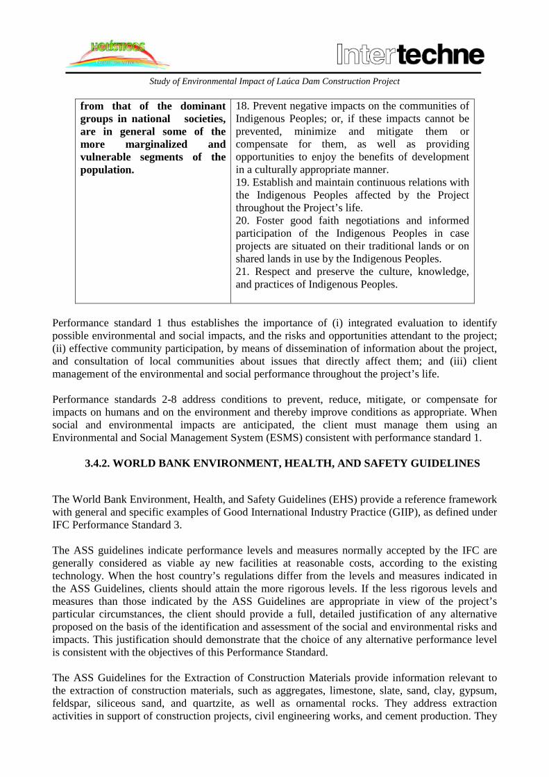
Study of Environmental Impact of Laúca Dam Construction Project
from that of the dominant groups in national societies, are in general some of the more marginalized and vulnerable segments of the population.
18. Prevent negative impacts on the communities of Indigenous Peoples; or, if these impacts cannot be prevented, minimize and mitigate them or compensate for them, as well as providing opportunities to enjoy the benefits of development in a culturally appropriate manner. 19. Establish and maintain continuous relations with the Indigenous Peoples affected by the Project throughout the Project’s life. 20. Foster good faith negotiations and informed participation of the Indigenous Peoples in case projects are situated on their traditional lands or on shared lands in use by the Indigenous Peoples. 21. Respect and preserve the culture, knowledge, and practices of Indigenous Peoples.
Performance standard 1 thus establishes the importance of (i) integrated evaluation to identify possible environmental and social impacts, and the risks and opportunities attendant to the project; (ii) effective community participation, by means of dissemination of information about the project, and consultation of local communities about issues that directly affect them; and (iii) client management of the environmental and social performance throughout the project’s life. Performance standards 2-8 address conditions to prevent, reduce, mitigate, or compensate for impacts on humans and on the environment and thereby improve conditions as appropriate. When social and environmental impacts are anticipated, the client must manage them using an Environmental and Social Management System (ESMS) consistent with performance standard 1. 3.4.2. WORLD BANK ENVIRONMENT, HEALTH, AND SAFETY GUIDELINES
The World Bank Environment, Health, and Safety Guidelines (EHS) provide a reference framework with general and specific examples of Good International Industry Practice (GIIP), as defined under IFC Performance Standard 3. The ASS guidelines indicate performance levels and measures normally accepted by the IFC are generally considered as viable ay new facilities at reasonable costs, according to the existing technology. When the host country’s regulations differ from the levels and measures indicated in the ASS Guidelines, clients should attain the more rigorous levels. If the less rigorous levels and measures than those indicated by the ASS Guidelines are appropriate in view of the project’s particular circumstances, the client should provide a full, detailed justification of any alternative proposed on the basis of the identification and assessment of the social and environmental risks and impacts. This justification should demonstrate that the choice of any alternative performance level is consistent with the objectives of this Performance Standard. The ASS Guidelines for the Extraction of Construction Materials provide information relevant to the extraction of construction materials, such as aggregates, limestone, slate, sand, clay, gypsum, feldspar, siliceous sand, and quartzite, as well as ornamental rocks. They address extraction activities in support of construction projects, civil engineering works, and cement production. They

Study of Environmental Impact of Laúca Dam Construction Project
also provide a summary of the issues associated with the extraction of construction materials during the construction, operation, and deactivation phases (e.g., atmospheric emissions, noise and vibration, water pollution, respiratory hazards, risks associated with uncontrolled access, and earth instability), together with recommendations on their management. 3.4.3. EQUATOR PRINCIPLES
The Equator Principles are a set of guidelines developed by the major financial institutions to deal with environmental and social issues for granting credit for project financing. These principles are adopted on a voluntary basis. They require compliance with the IFC performance standards and the ASS guidelines for the implementation of projects in low-income countries of the Organization of Economic Cooperation for Development (OCDE). The guidelines indicate an approach for determining, evaluating, and managing environmental and social risks in connection with project financing. Projects to be financed should be implemented in a manner that is socially responsible and that reflects good environmental management practice. The purpose is to ensure that projects are developed in a locally and socially responsible manner, so as to reflect the good practices of environmental management. Credit will be granted only to projects that abide by principles one to nine of the ten principles. These are shown in summary form in Chart 3.2. Projects are classified into categories A, B, and C, in accordance with the environmental and social criteria adopted by the IFC:
• Category A: Projects with possible, significant social or environmental impacts that are heterogeneous, irreversible, or unprecedented;
• Category B: Projects with potentially limited social or environmental impacts that are in reduced number, usually specific to a locality, amply reversible, and promptly addressed by mitigation measures; and
• Category C: Projects with no social or environmental impacts, or with minimal impacts.
Chart 3.2.: Equator Principles
Principle Description Principle 1: Review and Categorization
The project is categorized on the basis of the magnitude of is potential impacts and risks according to the IFC criteria.
Principle 2: Environmental and Social Assessment
Categories A and B projects require a social and environmental assessment for identifying the social and environmental risks relevant to the project.
Principle 3: Applicable Environmental and Social Standards
In the case of projects that are not OCDE members the assessment will be based on the IFC Performance Standards and the World Bank ASS Guidelines.
Principle 4: Environmental and Social Management System and Equator Principles Action Plan
In the case of categories A and B projects in countries that are not OCDE members, an Action Plan is required, reflecting the relevant aspects pointed out in the assessment report conclusions. It should describe and prioritize the actions

Study of Environmental Impact of Laúca Dam Construction Project
Principle Description
necessary for the management of mitigation measures, corrective measures, and measures for monitoring the impacts and risks identified in the assessment.
Principle 5: Stakeholder Engagement
For all category A projects and, if necessary, for category B projects in countries that are not OCDE members, the Government, the specialist, or the entrepreneur should have consulted, in a culturally adequate manner, the communities affected by the project. The documentation pertaining to the Assessment and the Action Plan or their non-technical summaries should be made available to the public.
Principle 6: Grievance Mechanism
In relation to all category A projects and, if necessary, to category B projects in countries that are not OCDE members, so as to ensure continuous consultation, public information, and community engagement throughout the project’s construction and operation, the entrepreneur should establish a grievance mechanism as part of the management system. The communities should be informed of the existence of such mechanism.
Principle 7: Independent Review For all category A projects and, if necessary, for category B projects, an independent social specialist or environmentalist without direct connection with the client will review the Assessment documentation, the Action Plan, and the Public Consultation process to verify compliance with the Equator Principles.
Principle 8: Covenants The following requirements should be incorporated into category A or B project contracts:
• Compliance with the host country’s social and environmental legislation, regulations, and authorizations;
• Compliance with the Action Plan during the project’s construction and operation;
• Availability of periodical reports prepared by enterprise functionaries, indicating compliance with the Action Plan; and
• Decommissioning of facilities, when applicable and appropriate, according to an agreed decommissioning plan.
Principle 9: Independent Monitoring and Reporting
For all category A projects and, if necessary, for category B projects, an independent environmental and/or social specialist should be nominated or the client should contract qualified external specialists to verify the information and follow-up, which should be shared with the EPFIs.
Principle 10: Reporting by and Transparency on the part of the
At least on a yearly basis information on the processes and experience related to the Principles’ implementation will be

Study of Environmental Impact of Laúca Dam Construction Project
Principle Description
Equator Principles Financial Institutions (EPFIs)
made public, while observing the proper confidentiality.
3.4.4. WORLD BANK SAFEGUARDS POLICY The World Bank operating policies (OP) were established to ensure that its operations would not impact on people or the environment. Of these policies, OP 4.37, revised in April 2013, is of particular importance here. OP 4.37 addresses the issue of dam safety and requires that experienced, competent professionals project and oversee the construction and that the entrepreneur adopts and implement dam safety measures throughout the project’s entire cycle. This policy applies also to existing dams or dams under construction, and is relevant to the project’s performance. In this case, an assessment of the dam’s safety must be done, and additional measures must be implemented, if needed. There are ten World Bank safeguards policies, and some of policies other than OP 4.37 may also be applied to dam projects, including OP 4.01 (Environmental Assessment), OP 4.04 (Natural Habitats), OP 4.10 (Indigenous Peoples), OP 4.11 (Material Cultural Assets), and OP 4.12 (Involuntary Resettlement). 3.5. CONCLUSIONS Environmental legislation governs mankind’s sustainable development and purports to safeguard environmental defense and peoples’ quality of life. Accordingly, natural resources are used in a sustainable manner, respecting ecosystems and the species that have their habitat in them. The norms and principles reviewed and explained in this chapter are important, as they permit the setting of boundaries and limits in respect of safeguarding the environment in the region where the future Laúca Dam is to be built. Aspects not covered or insufficiently covered by national legislation may be solved or supplemented by international good practices. Compliance with Angolan legislation is mandatory; noncompliance subjects the entrepreneur to sanctions. It is incumbent upon the entrepreneur and the owner of the project to carry out actions aimed at compliance and at the realization of international good practices and of sustainable development principles.