Embed Size (px)
Citation preview

KNKT.12.10.21.04
Aircraft Serious Incident Investigation Report
PT. Sriwijaya Air
Boeing 737-300; PK-CJT
Tabing Airfield, Padang, West Sumatra
Republic of Indonesia
13 October 2012
2016
KOMITE NASIONAL KESELAMATAN TRANSPORTASI REPUBLIC OF INDONESIA
FINAL

This Final report was produced by the Komite Nasional Keselamatan
Transportasi (KNKT), Transportation Building, 3rd
Floor, Jalan Medan
Merdeka Timur No. 5 Jakarta 10110, Indonesia.
The report is based upon the investigation carried out by the KNKT in
accordance with Annex 13 to the Convention on International Civil
Aviation Organization, the Indonesian Aviation Act (UU No. 1/2009) and
Government Regulation (PP No. 62/2013).
Readers are advised that the KNKT investigates for the sole purpose of
enhancing aviation safety. Consequently, the KNKT reports are confined to
matters of safety significance and may be misleading if used for any other
purpose.
As the KNKT believes that safety information is of greatest value if it is
passed on for the use of others, readers are encouraged to copy or reprint
for further distribution, acknowledging the KNKT as the source.
When the KNKT makes recommendations as a result of its
investigations or research, safety is its primary consideration.
However, the KNKT fully recognizes that the implementation of
recommendations arising from its investigations will in some cases
incur a cost to the industry.
Readers should note that the information in KNKT reports and
recommendations is provided to promote aviation safety. In no case is
it intended to imply blame or liability.

i
TABLE OF CONTENTS
TABLE OF CONTENTS ........................................................................................................ i
TABLE OF FIGURES ......................................................................................................... iii
ABBREVIATIONS AND DEFINITIONS .......................................................................... iv
INTRODUCTION ................................................................................................................. vi
1 FACTUAL INFORMATION ......................................................................................... 7
1.1 History of the Flight............................................................................................... 7
1.2 Injuries to Persons.................................................................................................. 8
1.3 Damage to Aircraft ................................................................................................ 8
1.4 Other Damage ........................................................................................................ 8
1.5 Personnel Information ........................................................................................... 9
1.5.1 Pilot in Command ..................................................................................... 9
1.5.2 Second in Command ................................................................................ 9
1.5.3 Aerodrome Control Tower ..................................................................... 10
1.6 Aircraft Information............................................................................................. 10
1.6.1 General ................................................................................................... 10
1.6.2 Engines ................................................................................................... 11
1.7 Meteorological Information ................................................................................. 11
1.8 Aids to Navigation ............................................................................................... 12
1.8.1 Instrument Landing System .................................................................... 12
1.8.2 Instrument Approach Chart Used by the Pilot ....................................... 13
1.9 Communications .................................................................................................. 14
1.10 Aerodrome Information ....................................................................................... 14
1.10.1 Minangkabau International Airport ........................................................ 14
1.10.2 Tabing Airfield ....................................................................................... 15
1.11 Flight Recorders................................................................................................... 16
1.11.1 Flight Data Recorder .............................................................................. 16
1.11.2 Cockpit Voice Recorder ......................................................................... 16
1.12 Wreckage and Impact Information ...................................................................... 16
1.13 Medical and Pathological Information ................................................................ 16
1.14 Fire ....................................................................................................................... 17
1.15 Survival Aspects .................................................................................................. 17
1.16 Tests and Research .............................................................................................. 17

ii
1.17 Organizational and Management Information ..................................................... 17
1.17.1 Approach Chart Policy ........................................................................... 17
1.17.2 Stabilized Approach (Boeing 737-300 FCTM page 5.4) ....................... 17
1.18 Additional Information ........................................................................................ 18
1.18.1 Civil Aviation Safety Regulation Part 69 ............................................... 18
1.18.2 Advisory Circular 170-02 ....................................................................... 20
1.19 Useful or Effective Investigation Techniques ..................................................... 20
2 ANALYSIS ..................................................................................................................... 21
2.1 Predicted Flight Profile ........................................................................................ 21
2.2 Runway Identification ......................................................................................... 22
2.3 Decision to Land .................................................................................................. 23
2.4 Attention of the Controller to the Landing Aircraft ............................................ 23
3 CONCLUSIONS ............................................................................................................ 25
3.1 Findings ............................................................................................................... 25
3.2 Contributing Factors ............................................................................................ 26
4 SAFETY ACTION ........................................................................................................ 27
4.1 PT. Sriwijaya Air ................................................................................................. 27
4.2 PT. Angkasa Pura II, branch office Minangkabau International Airport ............ 28
5 SAFETY RECOMMENDATIONS ............................................................................. 29
5.1 PT. Sriwijaya Air ................................................................................................. 29
5.2 AirNav Indonesia District Office Minangkabau Padang ..................................... 29
5.3 Directorate General of Civil Aviation ................................................................. 29
6 APPENDICES................................................................................................................ 30
6.1 National Transportation Safety Board Comment ................................................ 30

iii
TABLE OF FIGURES
Figure 1: ILS approach chart procedure runway 33 Minangkabau Airport ......................... 12
Figure 2: The photocopy of ILS approach chart procedure used by the pilot ...................... 13
Figure 3: The airports location ............................................................................................. 15
Figure 4: Predicted flight path .............................................................................................. 22

iv
ABBREVIATIONS AND DEFINITIONS
AC : Advisory Circular
AFE : Above Field Elevation
AOC : Aircraft Operator Certificate
ARQ : Airport Route Qualification
ATC : Air Traffic Control
ATIS : Automatic Terminal Information Service
ATPL : Airline Transport Pilot License
ATS : Air Traffic Services
CASR : Civil Aviation Safety Regulation
CDU : Control Display Unit
CPL : Commercial Pilot License
CVR : Cockpit Voice Recorder
DA : Decision Altitude
DGCA : Directorate General of Civil Aviation
DME : Distance Measuring Equipment
FCTM : Flight Crew Training Manual
FDR : Flight Data Recorder
fpm : Feet per minute
ft : Feet
IAP : Instrument Approach Procedure
ILS : Instrument Landing System
IMC : Instrument Meteorological Condition
in Hg : Inches of mercury
km : Kilometer
KNKT : Komite Nasional Keselamatan Transportasi /
National Transportation Safety Committee
mb : Millibars
nm : Nautical Miles
NOTAM : Notice to Airmen
PF : Pilot Flying
PIC : Pilot in Command
PM : Pilot Monitoring

v
SIC : Second in Command
SOP : Standard Operating Procedure
UTC : Universal Time Coordinated
VASIS : Visual Approach Slope Indicator System
VMC : Visual Meteorological Condition
VOR : Very High Frequency Omnidirectional Range

vi
INTRODUCTION
SYNOPSIS
On 13 October 2012, a Boeing 737-300 aircraft was being operated by Sriwijaya Air
conducted a scheduled passenger flight from Polonia International Airport, Medan (WIMM)
to Minangkabau International Airport (WIPT), Padang.
The aircraft departed Polonia International Airport with flight number SJY 021, on board the
aircraft were 102 persons consisted of two pilots, four flight attendants and 96 passengers.
The Pilot in Command (PIC) acted as Pilot Flying (PF) and the Second in Command (SIC)
acted as Pilot Monitoring (PM). The flight was the first flight on that day.
The flight from departure until commencing for approach was un-eventful and mostly was on
Instrument Meteorological Condition (IMC).
Considering to the cloud condition, the pilot requested runway 33 for the Instrument Landing
System (ILS) approach and it was approved by the Minang Approach. On descend the pilots
conducted approach briefing for ILS approach runway 33 according to the Instrument
Approach Procedure (IAP) chart. The pilots stated that the information contained in the
approach chart of “Tabbing (can be mistaken for Minangkabau Intl)” was absent during the
briefing.
When the flight had established to the localizer, the PIC saw a runway at approximately 10°
on the right, the pilot then reported to Minang Approach that the runway was in sight and was
instructed to contact Minangkabau Tower controller. The pilot intended to make a visual
approach and disconnected the autopilot then flew manually toward that runway. When
conducting the visual approach, the pilot assumed that the localizer was incorrect as the
runway was on the right side. The pilot continued the approach with landing gear down and
flap 40. The PIC also realized that the rate of descent was about 1,700 feet per minute.
After landing, the pilot reported to Minang tower that they had landed at Tabing Airfield. The
passengers were completely disembarked safely.
The investigation concluded the contributing factors to this accident are the unclear
significant information in the photocopy of the ILS approach chart might have missed by the
pilot and might reduce the pilot awareness to the adjacent airport with similar runway
direction and dimension; the previous experience of false VOR might have made the approach
was continued in an un-stabilized approach condition, and the information of incorrect
runway was not provided during the abnormal approach as it was not observed.
Following this accident the aircraft operator has issued six safety actions and the airport
operator has issued two safety actions which considered relevant to improve safety. In
addition, KNKT issued safety recommendations addressed to aircraft operator, air navigation
provider and the Directorate General of Civil Aviation.

7
1 FACTUAL INFORMATION
1.1 History of the Flight
On 13 October 2012, a Boeing 737-300 aircraft was being operated by Sriwijaya Air
as a scheduled passenger flight from Polonia International Airport, Medan (WIMM)
to Minangkabau International Airport (WIPT), Padang1.
At 0912 UTC2, the aircraft departed Polonia International Airport with flight number
SJY 021. The Pilot in Command (PIC) acted as Pilot Flying (PF) and the Second in
Command (SIC) acted as Pilot Monitoring (PM). The flight was the first flight on the
day for the crew. On board in this flight were 102 persons, consisted of two pilots,
four flight attendants and 96 passengers (93 adults, 1 child and 2 infants).
The flight from departure until commenced approach was un-eventful and mostly
was on Instrument Meteorological Condition (IMC).
The pilot received weather information from Automatic Terminal Information
Service (ATIS) which issued by Minangkabau before commenced descent. The ATIS
informed that the weather generally was fine and the cloud scattered at 2,000 feet
with ground visibility of 10 km.
At 0943 UTC, the pilot made first contact with Minangkabau Approach controller
(Minang Approach) and the flight was directed by Minang Approach to MKB3 VOR
for conducting VOR DME approach runway 15. Considering to the cloud condition,
the pilot requested for the Instrument Landing System (ILS4) approach runway 33
and was approved by the Minang Approach.
On descend the pilots conducted approach briefing according to the Instrument
Approach Procedure (IAP) chart. Based on interview, the pilots stated that the
information contained in the approach chart of “Tabbing (can be mistaken for
Minangkabau Intl)” was absent during the briefing.
The pilot requested several turns to the left for avoiding weather. While on radial 345
and 15 Nm from MKB VOR, the pilot was instructed to descend 6,000 feet.
As the result of several turns requested, the flight had deviated from the normal
route. Before reached over MKB VOR, the flight directed to the MKB used LNAV5
mode.
At 0958 UTC, the pilot reported over MKB VOR and Minang Approach instructed
to proceed to BAYUR6, descend to 5,000 feet and issued clearance for ILS approach
to runway 33. The pilot then selected the LNAV mode and flew the radial 195 MKB
VOR to BAYUR. Thereafter, the pilot selected the heading mode and on the Control
Display Unit (CDU), BAYUR was on top of the page but was not executed.
1 Minangkabau International Airport will be named as Minangkabau for the purpose of this report.
2 The 24-hours clock in Universal Time Coordinated (UTC) is used in this report to describe the local time as specific events occured.
Local time is UTC+7 hours.
3 MKB is the name of VOR which used in Minangkabau International Airport.
4 Instrument Landing System (ILS) is a ground-based instrument approach system that provides precision guidance to an aircraft
approaching and landing on a runway.
5 LNAV is autopilot feature to control lateral navigation.
6 BAYUR is a way point where located approximately 14 Nm from Minangkabau International airport on heading 198°

8
At 1001 UTC, the pilot reported over BAYUR and instructed by Minang Approach
to report when establishing localizer ILS runway 33.
The pilot executed the navigation setting on the CDU to follow the arc profile used
LNAV mode and selected the flap 5 then reduced the aircraft speed to 180 knots. The
flight was in and out through the clouds.
At 1004 UTC, the pilot reported that the flight had established to the localizer, on
that position the PIC saw a runway at approximately 10° on the right. The pilot then
reported to Minang Approach that the runway was in sight and was instructed to
contact Minangkabau Tower controller (Minang Tower). The pilot intended to make
a visual approach and disconnected the autopilot then flew manually toward that
runway. When conducting the visual approach, the pilot assumed that the localizer
was incorrect as the runway was on the right side. The pilot continued the approach
with landing gear down and flap 40. The PIC also realized that the rate of descent
was about 1,700 feet per minute.
At 1005 UTC, the pilot contacted Minang Tower which then saw the aircraft was on
long final and issued the landing clearance to runway 33. Minang Tower was also
observed an aircraft pushing back on the right side of the tower while the aircraft on
final was on the left side.
At 1006 UTC, the pilot reported to Minang tower that they had landed at Tabing
Airfield 7 . Referred to the information provided by the pilot, the Minang Tower
verified and realized that there was no aircraft on runway 33. The Minang Tower
then coordinated with the Tabing Airfield authority and the district manager of the
aircraft operator following this condition.
The pilot continued taxi to the apron and parked. The PIC called the flight attendant
clarified that they had landed at Tabing Airfield instead of Minangkabau. The flight
attendant contacted the company flight operations (Flops) officer in Jakarta, informed
the condition and requested further instruction.
The passengers were completely disembarked safely.
1.2 Injuries to Persons
There were no injuries to persons as a result of this occurrence.
1.3 Damage to Aircraft
The aircraft was undamaged.
1.4 Other Damage
There was no other damage to property and/or the environment.
7 Tabing Airfield will be named as Tabing for the purpose of this report.

9
1.5 Personnel Information
1.5.1 Pilot in Command
Gender : Male
Age : 58 years old
Nationality : Lithuanian
Marital status : Married
Date of joining company : 1 May 2012
License : ATPL
Validity of license : 31 January 2013
Aircraft type rating : B737-300/400/500
Medical certificate : First Class
Last of medical examination : 24 April 2012
Validity of medical certificate : 9 November 2012
Last proficiency check : 7 July 2012
Flying experience
Total hours : 15,500 hours
Last 90 days : 140 hours
Last 60 days : 140 hours
Last 24 hours : 5 hours
This flight : 1 hour
Medical limitation : The pilot shall use a corrective lens
during flight
A day before the occurrence, the PIC arrived at Medan at about midnight after
having 3 hours delay, it was caused by weather condition.
The PIC also mentioned having difficulty to take sleep and woke up at about 9
o’clock in the morning, and the PIC felt weary when departed from Medan.
The PIC had flown to Minangkabau three times where all of them landed on runway
15. The occurrence flight was the first approach on runway 33.
On 25 September 2012, the PIC experienced a false VOR on Pangkal Pinang while
conducting VOR approach and made go around.
1.5.2 Second in Command
Gender : Male
Age : 45 years old
Nationality : Indonesian, with permanent residence
permit in Japan

10
Marital status : Married
License : CPL
Validity of license : 30 April 2013
Aircraft type rating : B737-300/400/500
Medical certificate : First Class
Last of medical examination : 31 August 2012
Validity of medical certificate : 31 February 2012
Last proficiency check : 10 April 2012
Flying experience
Total hours : 800 hours
Last 90 days : 182 hours
Last 60 days : 173 hours
Last 24 hours : 5 hours
This flight : 1 hour
Medical limitation : None
The SIC had flown to Minangkabau two times used runway 15 and 33. The SIC had
finished the line training 1 month before the occurrence flight.
1.5.3 Aerodrome Control Tower
The Minangkabau Tower controller held a valid air traffic control license that was
issued on 11 June 2012 and joined PT. Angkasa Pura II. Prior to conduct as
aerodrome control tower in Minangkabau, the controller had one week
familiarization program as observer. At the time of the occurrence, the controller had
been 4 months performed duty as aerodrome control tower.
At the day of occurrence the controller worked for approximately 1 hour 30 minutes.
1.6 Aircraft Information
1.6.1 General
Registration Mark : PK-CJT
Manufacturer : Boeing Aircraft Company
Country of Manufacturer : United States of America
Type/ Model : B737-300
Serial Number : 24791
Year of manufacture : 1991
Certificate of Airworthiness
Issued : 29 July 2012
Validity : 28 July 2013
11
Category : Transport
Limitations : None
Certificate of Registration
Number : 24791
Issued : 13 April 2011
Validity : 12 April 2014
Time Since New : 39,010 hours
Cycles Since New : 34,217 cycles
Last Minor Check : A6 Check
(16 September 2012)
1.6.2 Engines
Manufacturer : Boeing Aircraft Company
Type/Model : CFM56-3CL rated at 22,100 lbs
Serial Number-1 engine : 858702
Time Since New : 25,468 hours
Cycles Since New : 19,357 cycles
Serial Number-2 engine : 858703
Time Since New : 24,153 hours
Cycles Since New : 20,100 cycles
1.7 Meteorological Information
Weather report from Tabing Meteorological Station, issued on 13 October 2012 were
as follows:
0930 UTC 1000 UTC
Wind 260 / 04 knots 240 / 04 knot
Visibility 10 km 10 km
Weather Haze Nil
Cloud SCT 020 SCT 022
TT/TD 29 / 24 28 / 23
QNH (mb / in Hg) 1,009 / 29.82 1,009 / 29.82

12
1.8 Aids to Navigation
1.8.1 Instrument Landing System
Minangkabau International Airport was equipped with Instrument Landing System
(ILS) Category I.
The existing approach procedure of the ILS runway 33 Minangkabau Airport showed
the localizer course was 335°, the Decision Altitude (DA) was 250 feet, the glide
slope of 3° and vertical speed for aircraft category C8 was 753 feet/minute. The chart
also contained information: Tabbing (can be mistaken for the Minangkabau Intl).
Figure 1: ILS approach chart procedure runway 33 Minangkabau Airport
8 Aircraft category C is an aircraft with approach speed between 120 – 140 knots.

13
The aircraft navigation equipment and the ground-based navigation aids including
the visual ground aids were serviceable and operated normally.
At 1208 UTC and 1216 UTC, there were two aircraft landed used ILS runway 33 and
there was no report of the ILS malfunction.
1.8.2 Instrument Approach Chart Used by the Pilot
During the flight, the pilots used a black and white photocopy of instrument
approach charts procedure. The information of: Tabbing (can be mistaken for the
Minangkabau Intl), as shown on dash box figure 2, was not clearly readable.
Figure 2: The photocopy of ILS approach chart procedure used by the pilot

14
1.9 Communications
Communications between ATS and the pilots were recorded by ground based
automatic voice recording equipment for the duration of the flight. The quality of the
aircraft’s recorded transmissions was good.
The significant excerpts of the communication are as follows:
0950 UTC, the pilot requested to turn 5 degrees to the left to avoid weather and
was approved by Minang Approach controller.
0952 UTC, the pilot reported to Minang Approach controller that the flight
directed to MKB VOR.
0953 UTC, the pilot requested to turn 5 degrees again to the left to avoid weather
and was approved by Minang Approach controller.
0955 UTC, the pilot reported that they had cleared of weather and the aircraft
position was on radial 345 and 15 Nm from MKB VOR, the Minang Approach
controller acknowledged and instructed to descend 6,000 feet.
0958 UTC, the pilot reported position was over MKB VOR, Minang Approach
controller instructed to proceed to BAYUR point descend to 5,000 feet and
cleared for ILS approach runway 33.
1001 UTC, the pilot reported over BAYUR and was instructed by Minang
Approach controller to report when established localizer.
1004 UTC, the pilot reported that they had the runway in sight and intended to
conduct a visual approach to runway 33, Minang Approach controller
acknowledged and instructed to contact Minangkabau Tower controller.
1005 UTC, the pilot contacted Minang Tower controller which then issued
landing clearance to runway 33.
1006 UTC, the pilot reported that they had landed on the runway 34 of Tabing
Airfield. The Minang Tower controller confirmed and acknowledged the
information.
1.10 Aerodrome Information
1.10.1 Minangkabau International Airport
Airport Name : Minangkabau International Airport
Airport Certificate : 009/SBU-DBU/VII/2010
Airport Identification : WIPT
Coordinate : 00°47’18”S 100°17’11”E
Airport Operator : PT. Angkasa Pura II (Persero)
Elevation : 18 feet
Runway Direction : 15 and 33 (155° and 335°)
Runway Length : 2,750 meter

15
Runway Width : 45 meter
Surface : Asphalt
1.10.2 Tabing Airfield
Airport Name : Tabing
Airport Certificate : Not Available
Airport Identification : Not Available
Coordinate : 00°52’32”S 100°21’02”E
Airport Operator : Indonesia Air Force
Elevation : 9 feet
Runway Direction : 16 and 34 (159° and 339°)
Runway Length : 2,150 meter
Runway Width : 45 meter
Surface : Asphalt
Tabing Airfield was a commercial airport until 22 July 2005, the commercial flight
operation moved to the Minangkabau International Airport and the Tabing Airfield
was used only for military operation.
On 9 October 2012, the Minangkabau Briefing Office issued NOTAMs which
informed that the runway approach light, runway edge light, runway centreline light
and VASIS of Tabing Airport were unserviceable. The NOTAMs valid until 9
December 2012, 2359 UTC.
The Tabing Airfield located 6 Nm southeast of Minangkabau airport at
approximately 2 Nm right side of the centerline extension of runway 33
Minangkabau.
Figure 3: The airports location

16
1.11 Flight Recorders
1.11.1 Flight Data Recorder
The aircraft was equipped with a universal Flight Data Recorder (FDR) and the
details of the FDR were as follows:
Manufacturer : Sundstrand
Type/Model : UFDR
Part Number : 980-4100-DXUN
Serial Number : 6500
The aircraft was equipped with a magnetic-tape digital flight data recorder designed
to record data in an ARINC 573/717 format.
The FDR was downloaded on 17 October 2012 using the Avionica RSUII in the
KNKT facility, the FDR contained 25.21 hours of reasonable quality data (some
tracks were excellent quality and some others were poor) comprising the occurrence
flight and 17 previous flights recorded since 11 October 2012.
Concerning to the data recorded on 11 October 2012 to the occurrence on 13 October
2012 which could not be read, the second downloaded using the KNKT HHMPI
equipment performed where the data then imported into the Flightscape Insight
Analysis software and the result the required data could not recovered.
To ensure that the FDR data downloaded was unreadable, the FDR data was sent to
ATSB facility for further analysis. The result of the FDR data read out in ATSB
facility was similar. It concluded that the FDR was not recorded properly prior the
occurrence.
1.11.2 Cockpit Voice Recorder
Manufacturer : Honeywell
Type/Model : AV557C
Part Number : 980-6005-076
Serial Number : 11547
The CVR data was downloaded at KNKT flight recorders laboratory. The CVR
contained 33 minutes of good quality recording. The communication which recorded
on the CVR during approach has overwritten with the communication after the
aircraft landed in Tabing.
1.12 Wreckage and Impact Information
Not relevant with this occurrence.
1.13 Medical and Pathological Information
No medical or pathological investigations were conducted as a result of this
occurrence, nor were they required.

17
1.14 Fire
There was no evidence of fire in-flight on this occurrence.
1.15 Survival Aspects
Not relevance in this occurrence.
1.16 Tests and Research
The tests or research were not required to be conducted as a result of this occurrence.
1.17 Organizational and Management Information
Aircraft Owner and Operator : PT. Sriwijaya Air
Address : Jalan Pangeran Jayakarta No.68 C15-16
Mangga Dua Selatan, Jakarta Pusat,
Republic of Indonesia
Operator Certificate Number : AOC/121-035
1.17.1 Approach Chart Policy
The aircraft operator used navigation chart published by Jeppesen since 2011 until
2012 and after 2012 changed the navigation chart provided by Naviga (an Indonesian
Navigation Chart provider that was approved by the DGCA).
1.17.2 Stabilized Approach (Boeing 737-300 FCTM page 5.4)
Stabilized Approach Recommendations
Maintaining a stable speed, descent rate, and vertical/lateral flight path in landing
configuration is commonly referred to as the stabilized approach concept. Any
significant deviation from planned flight path, airspeed, or descent rate should be
announced. The decision to execute a go-around is no indication of poor
performance.
Note: Do not attempt to land from an unstable approach.
Recommended Elements of a Stabilized Approach
The following recommendations are consistent with criteria developed by the Flight
Safety Foundation.
All approaches should be stabilized by 1,000 feet AFE in instrument meteorological
conditions (IMC) and by 500 feet AFE in visual meteorological conditions (VMC).
An approach is considered stabilized when all of the following criteria are met:
the aircraft is on the correct flight path
only small changes in heading and pitch are required to maintain the correct
flight path
the aircraft speed is not more than VREF + 20 knots indicated airspeed and
not less than VREF
the airplane is in the correct landing configuration
sink rate is no greater than 1,000 fpm; if an approach requires a sink rate
greater than 1,000 fpm, a special briefing should be conducted
18
power setting is appropriate for the aircraft configuration
all briefings and checklists have been conducted.
Specific types of approaches are stabilized if they also fulfill the following:
ILS approaches should be flown within one dot of the glide slope and localizer,
or within the expanded localizer scale (as installed)
During a circling approach, wings should be level on final when the aircraft
reaches 300 feet AFE.
Unique approach procedures or abnormal conditions requiring a deviation from the
above elements of a stabilized approach require a special briefing.
Note: An approach that becomes unstabilized below 1,000 feet AFE in IMC or below
500 feet AFE in VMC requires an immediate go-around.
These conditions should be maintained throughout the rest of the approach for it to
be considered a stabilized approach. If the above criteria cannot be established and
maintained at and below 500 feet AFE, initiate a go-around.
1.18 Additional Information
1.18.1 Civil Aviation Safety Regulation Part 69
Subpart 69.C Air Traffic Controller Ratings
69.032 Categories of air traffic controller ratings
Directorate General of Civil Aviation of Indonesia has established ratings for air
traffic controller with following categories:
1. Aerodrome control rating;
2. Approach control procedural rating;
3. Approach control surveillance rating;
4. Area control procedural rating;
5. Area control surveillance rating.
69.033 Requirements for air traffic controller ratings
1. Knowledge
The applicant shall have demonstrated a level of knowledge appropriate to the
privileges granted, in at least the following subjects in so far as they affect the
area of responsibility:
a. aerodrome control rating:
1) aerodrome layout; physical characteristics and visual aid;
2) airspace structure;
3) applicable rules, procedures and source of information;
4) air navigation facilities;
5) air traffic control equipment and its use;
6) terrain and prominent landmarks;
7) characteristic of air traffic;
8) weather phenomena;

19
9) emergency and search and rescue plans;
….
2. Experience
The applicant shall have:
a. satisfactorily completed an approved training course;
b. provided, satisfactorily, under the supervision of an appropriately rated air
traffic controller:
1) aerodrome control rating: an aerodrome control service, for a period of
not less than 90 hours or one month, whichever is greater, at the unit for
which the rating is sought:
2) approach control procedural, approach control surveillance, area
control procedural or area control surveillance rating: the control
service for which the rating is sought, for a period of not less than 180
hours or three months, whichever is greater, at the unit for which the
rating is sought.
c. the experience specified in b. shall have been completed within the 6-month
period immediately preceding application;
d. When the applicant already holds an air traffic controller rating in another
category, or the same rating for another unit, the Licensing Authority shall
determine whether the experience requirement of 2 can be reduced, and if so,
to what extent.
3. Skill.
The applicant shall have demonstrated, at a level appropriate to the privileges
being granted, the skill, judgment and performance required to provide a safe,
orderly and expeditious control service.
69.xA.4 Check / Assessment Guide
The following points should be considered when assessing the individual
performance of a controller:
a. aerodrome/approach/area procedures:
1) knowledge of separation standards and their application;
2) recognition of aircraft capabilities, i.e. differences in speed, climb, descent,
altitude requirements, take off/landing requirement, engine failure
performance, and other differences of performance;
3) awareness and analysis of traffic situations;
4) planning, sequencing and expedition of the traffic flow;
5) adjusting traffic to changing conditions in case of radar failure, radio aid
failure, changes in flight rules, aerodrome closures and diversions;
6) use of local procedures such as selection of runways, noise abatement
procedures, departure and instrument approach procedures;
7) co-ordination with other sectors/units, including methods of transfers and
updating of information;
8) utilization of radar;
20
9) composition of clearance in respect of contents, clarity, conciseness and
expedition.
1.18.2 Advisory Circular 170-02
7.1 FUNCTIONS OF AERODROME CONTROL TOWERS
7.1.1 General
7.1.1.2 Aerodrome controllers shall maintain a continuous watch on all flight
operations on and in the vicinity of an aerodrome as well as vehicles and personnel
on the manoeuvring area.
Watch shall be maintained by visual observation, augmented in low visibility
conditions by radar when available. Traffic shall be controlled in accordance with
the procedures set forth herein and all applicable traffic rules specified by the
appropriate ATS authority. If there are other aerodromes within a control zone,
traffic at all aerodromes within such a zone shall be coordinated so that traffic
circuits do not conflict.
1.19 Useful or Effective Investigation Techniques
The investigation was conducted in accordance with the KNKT approved policies
and procedures, and in accordance with the standards and recommended practices of
Annex 13 to the Chicago Convention.

21
2 ANALYSIS
The data from FDR and CVR of the occurrence flight were not available therefore
the investigation combined various sources such as aircraft approach procedure, ATC
communication transcript, pilot and ATC interview, and the published ILS approach
chart.
The investigation identified several safety issues led to the pilot continued landing
and the controller attention to the landing aircraft.
Therefore the analysis focused on:
Predicted flight profile;
Runway identification;
Decision to land;
Attention of the controller to the landing aircraft.
2.1 Predicted Flight Profile
To indicate the approach flight path from 0958 UTC until touchdown, the
investigation referred to various sources and might be predicted as follows:
1. 0958 UTC, the pilot reported over MKB VOR at altitude 6,000 feet and was
instructed to proceed to BAYUR, descended to 5,000 feet and cleared for ILS
approach runway 33.
While approaching BAYUR the pilot set flap 5 and set the airspeed to 180 knots.
The D 13.0 point as showed on the approach chart was not displayed on the
Control Display Unit (CDU) and the pilot defined D 13.0 point on the CDU but
did not execute.
2. 1001 UTC, the pilot reported over BAYUR, it can be assumed that the aircraft
altitude was 5,000 feet.
When leaving BAYUR the pilot selected autopilot to the LNAV mode and
followed ARC of 13 Nm from MKB VOR as programmed and set the altitude on
Main Control Panel (MCP) to 3300. When the aircraft turned on heading 010, the
pilot selected the VOR LOC mode.
3. 1004 UTC, the pilot reported to Minang approach that the runway was in sight.
The runway was approximately 10° to the right from the localizer and visually
above the glide. The PIC assumed that the ILS runway 33 was error, and decided
to continue visual approach. The pilot then selected the vertical speed to 1,700
feet/minutes, disengaged the autopilot and performed a side slip to align with the
runway.
4. At 1005 UTC, the controller issued landing clearance.
5. At 1006 UTC, aircraft touched down at Tabing Airfield.
Referring to the information above, the predicted flight path superimposed to the
available instrument chart showed in the following figure. The numbers (yellow
circles) indicated sequence of event as described above and the red dash lines
indicated the predicted flight path.
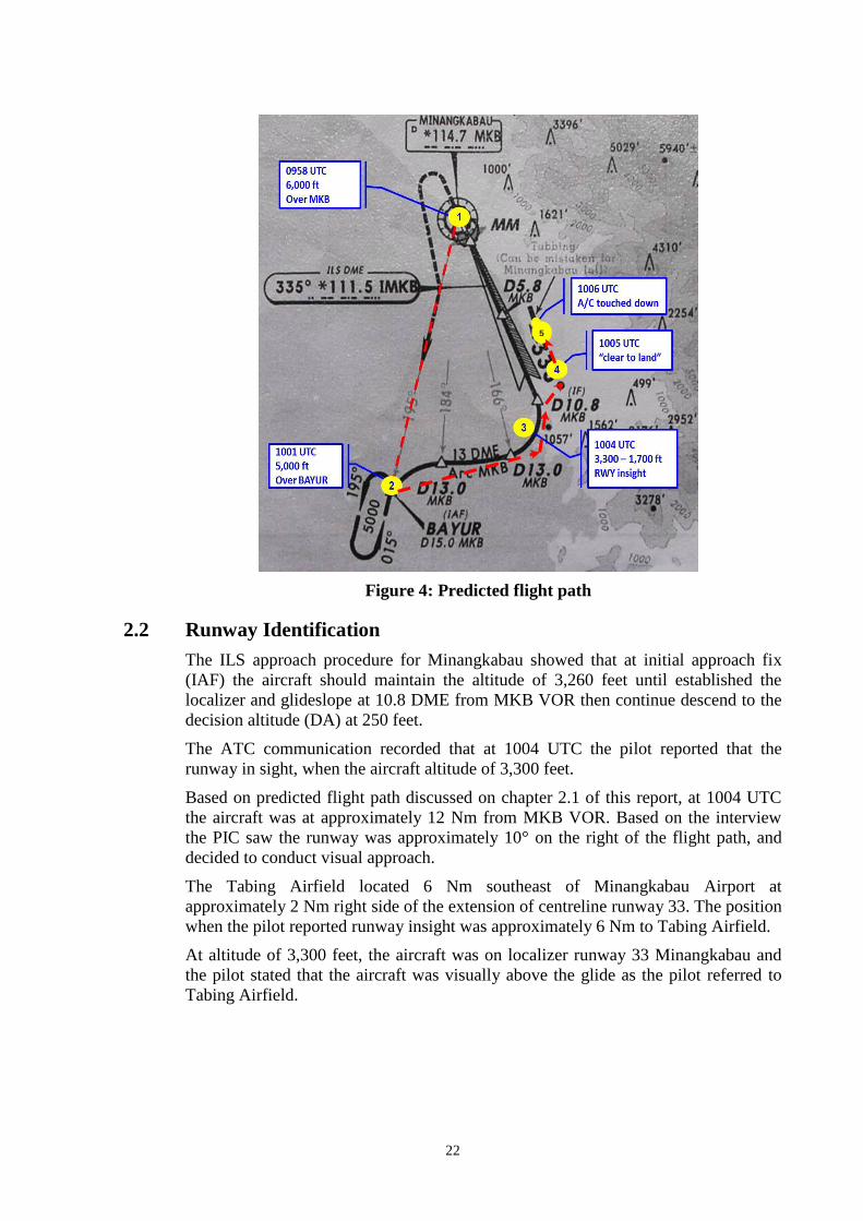
22
Figure 4: Predicted flight path
2.2 Runway Identification
The ILS approach procedure for Minangkabau showed that at initial approach fix
(IAF) the aircraft should maintain the altitude of 3,260 feet until established the
localizer and glideslope at 10.8 DME from MKB VOR then continue descend to the
decision altitude (DA) at 250 feet.
The ATC communication recorded that at 1004 UTC the pilot reported that the
runway in sight, when the aircraft altitude of 3,300 feet.
Based on predicted flight path discussed on chapter 2.1 of this report, at 1004 UTC
the aircraft was at approximately 12 Nm from MKB VOR. Based on the interview
the PIC saw the runway was approximately 10° on the right of the flight path, and
decided to conduct visual approach.
The Tabing Airfield located 6 Nm southeast of Minangkabau Airport at
approximately 2 Nm right side of the extension of centreline runway 33. The position
when the pilot reported runway insight was approximately 6 Nm to Tabing Airfield.
At altitude of 3,300 feet, the aircraft was on localizer runway 33 Minangkabau and
the pilot stated that the aircraft was visually above the glide as the pilot referred to
Tabing Airfield.
5

23
The PIC assumed that the ILS runway 33 was error which was based on his
experience of false indication during conducting VOR approach at Pangkal Pinang
Airport. This experience might have affected the judgment to the instrument
approach procedure. However according to the predicted flight profile, when the
aircraft established to the localizer runway 33 Minangkabau, indicated that the
aircraft was on proper flight profile. There was no report of ILS malfunction from the
pilots of two aircraft conducted ILS approach runway 33.
The available approach chart in the aircraft was a black and white photocopy. The
information available in the approach chart of “Tabbing (can be mistaken for
minangkabau intl)” was not clearly readable and was not mentioned during the crew
briefing.
The occurrence flight was the first flight for the PIC approach on runway 33
Minangkabau. These conditions might have made the pilot did not sufficiently
familiar with the approach environment of runway 33.
The absence of significant information “Tabbing (can be mistaken for Minangkabau
intl)”on approach briefing, previous experience VOR false indication and
insufficiently familiar with the approach environment might lead to the miss-
identification of the runway when the pilot saw a runway that was almost parallel
with the approach path.
2.3 Decision to Land
The pilot stated that when the aircraft established to the localizer at 3,300 feet and
saw the runway, the pilot set the rate of descend to 1,700 feet/minute (fpm) and
performed a side slip to continue the approach toward the runway in order to get the
correct approach profile. The aircraft landed 2 minutes later.
Refer to the Flight Crew Training Manual (FCTM) of the Boeing 737 page 5.4
stabilized approach stated that:
Sink rate is no greater than 1,000 fpm; if an approach requires a sink rate greater
than 1,000 fpm, a special briefing should be conducted.
The rate of descend 1,700 fpm and side slip to achieve the correct approach profile
was against the stabilized approach criteria otherwise, a special briefing should be
conducted.
The decision to land in such condition without special briefing could lead improper
cockpit coordination that might increase the risk of flight.
2.4 Attention of the Controller to the Landing Aircraft
The Minangkabau tower controller held a valid Air Traffic Control license that was
issued 4 months prior the occurrence. The controller had performed familiarization
program by conducting one week observation prior to conduct the duty as aerodrome
control tower in Minangkabau. The controller had 4 months experience as aerodrome
control tower. At the day of occurrence the controller worked for approximately 1
hour 30 minutes and had rest time before work.

24
During the occurrence, the Minangkabau Tower controller (Minang Tower) was
controlling one aircraft on approach and one on the ground. The approach aircraft
was on the left side of the controller while the pushing back aircraft was on the right.
Based on interview the Minang Tower stated that the attention was changed to the
pushing back aircraft on ground after issued the landing clearance.
According to AC 170-02 chapter 7.1.1.2 stated that aerodrome controllers shall
maintain a continuous watch on all flight operations on and in the vicinity of an
aerodrome. Controlling two aircraft can be considered as a less traffic movement
condition and can be assumed as a low workload. However, the controller missed to
watch the aircraft on final position.
The CASR 69.033 described the requirements and assessments for air traffic
controller ratings including the knowledge, while the applicant shall have
demonstrated a level of knowledge appropriate to the privileges granted, in at least
the characteristic of air traffic. While the assessment guide shall assess the controller
awareness and analysis of traffic situations and planning, sequencing and expedition
of the traffic flow.
The absence of aircraft observation might cause an abnormal approach of aircraft on
long final was unobserved, un-assessed and unadvised to avoid un-necessary
occurrence. This inappropriate implementation of regulations in aircraft observation
might possible an indication of insufficient assessment and/or time of under
supervision phase.

25
3 CONCLUSIONS
3.1 Findings9
1. The aircraft was certified, equipped and maintained in accordance with existing
regulations. There was no evidence of any defect or malfunction in the aircraft
that reported prior to the incident.
2. The Flight Data Recorder (FDR) data of the occurrence flight was could not be
recovered, and the Cockpit Voice Recorder (CVR) record during approach has
overwritten.
3. The flight crew held valid licenses and medical certificates.
4. The Pilot in Command (PIC) acted as Pilot Flying (PF) and the Second in
Command (SIC) acted as Pilot Monitoring (PM). The flight was the first flight
on that day for the crew.
5. The PIC had flown to Minangkabau for three times used runway 15. The
occurrence flight was the first time for the PIC, and the second flight for the
SIC approach runway 33.
6. The flight was on Instrument Meteorological Condition (IMC) and considering
the weather condition, the PIC requested runway 33 for landing.
7. The runway 33 of Minangkabau was equipped with Instrument Landing
System (ILS) which was serviceable and operated normally during the
occurrence flight.
8. While establishing the localizer, the PIC saw that the runway at approximately
10° on the right and the aircraft was above the normal glide. Based on previous
experience of false VOR at another airport, the PIC assumed that the localizer
was wrong, and continued approach to the runway.
9. The pilot flew manually with the rate of descend up to 1,700 feet/minute and
performed a side slip to continue the approach toward the runway in order to
get the correct approach profile.
10. The Tabing Airfield located 6 Nm southeast of Minangkabau Airport at
approximately 2 Nm right side of the extension of centreline runway 33. Since
2005, Tabing Airfield was closed for commercial flight operation and become
a military airfield. The runway direction and dimension of Minangkabau and
Tabing were similar.
11. The available approach chart in the aircraft was a black and white photocopy.
The information available in the approach chart of “Tabbing (can be mistaken
for minangkabau intl)” was not clearly readable and was not mentioned during
the crew briefing.
9 Findings are statements of all significant conditions, events or circumstances in the accident sequence. The findings are
significant steps in the accident sequence, but they are not always causal, or indicate deficiencies. Some findings point out
the conditions that pre-existed the accident sequence, but they are usually essential to the understanding of the
occurrence, usually in chronological order.

26
12. The Minang Tower saw the arriving aircraft on long final was on the left
meanwhile the pushing back aircraft was on the right. Based on interview the
Minang Tower stated that the Minang Tower attention was changed to the
pushing back aircraft on ground after issued the landing clearance for the
arriving aircraft.
13. During the occurrence, the Minangkabau Tower controller (Minang Tower)
was controlling one aircraft on approach and one on the ground. The Minang
Tower attention was changed to the pushing back aircraft on ground after
issued the landing clearance.
14. The AC 170-02 chapter 7.1.1.2 and chapter 7.7 stated that aerodrome
controllers shall maintain a continuous watch on all flight operations on and in
the vicinity of an aerodrome and an aircraft landing or in the final stages of an
approach to land shall normally have priority over an aircraft intending to
depart from the same or an intersecting runway.
15. The air traffic controller had been experienced for 4 months as aerodrome
control tower and had one week as observer prior to conduct as aerodrome
control tower in Minangkabau and had performed familiarization program by
conducting one week observation prior to conduct the duty as aerodrome
control tower.
3.2 Contributing Factors10
The unclear significant information in the copy (black and white) of the ILS
approach chart might have missed by the pilot and might reduce the pilot
awareness to the adjacent airport with similar runway direction and dimension.
The previous experience of false VOR might have made the approach was
continued in an un-stabilized approach condition.
The information of incorrect runway was not provided during the abnormal
approach as it was not observed.
10 Contributing factors is defined as events that might cause the occurrence. In the case that the event did not occur then the
accident might not happen or result in a less severe occurrence.

27
4 SAFETY ACTION
At the time of issuing this final investigation report, the Komite Nasional
Keselamatan Transportasi had been informed of safety actions resulting from this
occurrence.
4.1 PT. Sriwijaya Air
On 14 October 2012, the Quality, Safety and Security division issued
recommendation as initial safety action following this occurrence.
1. During instrument approach briefing (especially Minangkabau International
Airport), both pilots must conducts the complete briefing includes the detail of
remarks or caution stated in the approach chart template;
2. The flight execution must follow the procedure as brief before and increase
awareness and crew resource management, also the correct flight technique as
stated in the SOP (Flight Crew Operation Manual and Flight Crew Training
Manual);
3. Avoid scheduling foreign pilot and/or new pilot in command to be paired with
initial qualified pilots to fly in the same mission of flight;
4. Copy flight documents specially document which related to the information,
SOP and/or flight guidance etc. must be visible and clearly readable by pilots;
5. Re-evaluation of the pilot in command to the competency and knowledge of
airport environment area includes the specific weather phenomenon.
On 18 December 2013, the Operation Standard and Training Department issued the
bulletin No.05-DS Bulletin-2013 specified the airport category and the content were
as follows:
AIRPORT CATEGORY
Airport Category A
These are simple and straightforward airports that have no factors requiring special
procedure to enhance the safety aspect of operation. The safety level of operations
can be assured and determined by the crew through the study of relevant en-route
and approach charts. The PIC is responsible for acquiring the knowledge of that
aerodrome.
Category “A” airport satisfies all of the following requirements:
An approved instrument approach procedure;
At least one runway with no performance limited procedure for take-off and/or
landing;
Published circling minima not higher than 1000ft AFE;
Night operations capability;
The aerodrome is not closely surrounded by mountainous terrain or obstacle.

28
Airport Category B
These are airport that do not satisfy the conditions of the Category “A”. It requires a
written Airport Briefing disseminated to flight crew for proper study, understanding
and should certify that he has carried out these instructions to ensure safe level of
operations.
Category “B” airport requires extra considerations such as:
Non Standard Approach aids and/or approach patterns, or
Unusual local weather conditions or
Unusual characteristics or performance limitations, or
Any other relevant considerations including departure/enroute/arrival
obstructions, physical layout, lighting etc.
Airport Category C
Category “C” airport requires additional considerations to a Category “B” airport
and is considered to pose certain problems for the approach and/or landing and/or
take-off.
Category “C” airfield are subject to Airport Route Qualification (ARQ) procedures
for PIC whereby prior knowledge or experience is required. The PIC should be
briefed and visit the aerodrome under supervision by Route Instructor and/or
undertake instruction in a flight simulator approved by the Authority for that
purpose.
The special procedures must be detailed in the Airport Briefing such as:
Complicated ATC procedures with high density traffic or
Difficult or non-standard; departure, approach, and missed approach pattern or
Hazardous local weather condition or
Hazardous local terrain surrounding the area or
Other particular subject that affect normal performance on ground, departure or
arrival
4.2 PT. Angkasa Pura II, branch office Minangkabau International
Airport
On 23 October 2012, the Minangkabau International Airport informed the Komite
Nasional Keselamatan Transportasi the following safety action as follows:
Issued NOTAM as follows, “caution to all aircraft destination Minangkabau
Airport when established final course RWY 33 to avoid landing RWY 34 at
Tabing Airport position 6 NM south east of Minangkabau Airport”.
Amended the ATC Standard Operation Procedure (SOP) with additional
phraseology “report 7 NM” to be used by ATC on duty to warn the pilot which
approach using runway 33.

29
5 SAFETY RECOMMENDATIONS
The KNKT has recieved safety actions issued by the related operators concerning to
this occurence and considered that the safety actions were relevant for the
improvement.
In addition, KNKT issued recommendations to address the safety issues identified in
this investigation.
The Directorate General of Civil Aviation is responsible to monitor the
implementation of the recommendations by related parties.
5.1 PT. Sriwijaya Air
04.O-2016-61.1
To emphasize the implementation of stabilized approach procedure.
5.2 AirNav Indonesia District Office Minangkabau Padang
04.A-2016-53.2
To ensure the air traffic controller shall maintain continuous watch as required
by the Advisory Circular 170-02.
04.A-2016-61.1
To review the rating assessment process of air traffic controller to ensure the
applicant meets the appropriate level of knowledge and ability.
5.3 Directorate General of Civil Aviation
04.R-2016-62.1
To ensure additional information or caution of existing hazard is informed on
published Aeronautical Information Publication, including on Instrument
Approach Chart.

30
6 APPENDICES
6.1 National Transportation Safety Board Comment
NO PAGE COMMENTS KNKT RESPONSE
1. 18 1.17.2 Stabilized Approach (Boeing 737-300 FCTM page
5.4)
The Boeing Company suggests to cite the Flight Safety
Foundation publication rather than directly to cite from Boeing
manual and stated that the recommended elements of a
stabilized approach on the Flight Safety Foundation publication
was cited on Boeing 737-300 FCTM (page 5.4).
KNKT preferred to use the stabilized approach criteria as
stated on the Boeing 737-300 FCTM page 5.4 even though
the recommended elements were cited from the Flight Safety
Foundation. The reason is the pilot has obligation to comply
with the aircraft manual rather than the Flight Safety
Foundation recommendation.