Embed Size (px)
Citation preview

KOMITE NASIONAL KESELAMATAN TRANSPORTASI REPUBLIC OF INDONESIA 2014
FINAL KNKT.14.01.02.04
KOMITE NASIONAL KESELAMATAN TRANSPORTASI
PT. Sriwijaya AirBoeing 737-300; PK-CKL
Juanda International Airport SurabayaRepublic of Indonesia
27 January 2014
Runway Incursion Investigation Report

This final report was produced by the Komite Nasional Keselamatan Transportasi (KNKT) 3rd Floor Ministry of Transportation, Jalan Medan Merdeka Timur No. 5 Jakarta 10110, INDONESIA.
The report is based upon the investigation carried out by the KNKT in accordance with Annex 13 to the Convention on International Civil Aviation Organization, the Indonesian Aviation Act (UU No. 1/2009) and Government Regulation (PP No. 62/2013).
The final report consists of factual information collected until the final report published. This report includes analysis and conclusion.
Readers are advised that the KNKT investigates for the sole purpose of enhancing aviation safety. Consequently, the KNKT reports are confined to matters of safety significance and may be misleading if used for any other purpose.
As the KNKT believes that safety information is of greatest value if it is passed on for the use of others, readers are encouraged to copy or reprint for further distribution, acknowledging the KNKT as the source.
When the KNKT makes recommendations as a result of its investigations or research, safety is its primary consideration.
However, the KNKT fully recognizes that the implementation of recommendations arising from its investigations will in some cases incur a cost to the industry.
Readers should note that the information in KNKT reports and recommendations is provided to promote aviation safety. In no case is it intended to imply blame or liability.

i
TABLE OF CONTENTS TABLE OF CONTENTS ........................................................................................................ i
TABLE OF FIGURES ......................................................................................................... iii
ABREVIATION AND DEFINITION ................................................................................... v
INTRODUCTION ............................................................................................................... vii
1 FACTUAL INFORMATION ......................................................................................... 1 1.1 History of the Flight .............................................................................................. 1
1.2 Injuries to Persons ................................................................................................. 2
1.3 Damage to Aircraft ................................................................................................ 3
1.4 Other Damage ........................................................................................................ 3
1.5 Personnel Information ........................................................................................... 3
1.5.1 Pilot in Command ..................................................................................... 3
1.5.2 Second in Command ................................................................................ 4
1.6 Aircraft Information .............................................................................................. 4
1.7 Meteorological Information ................................................................................... 5
1.8 Aids to Navigation ................................................................................................. 6
1.9 Communications .................................................................................................... 7
1.9.1.1 Air Traffic Control Transcription ......................................................... 7
1.10 Aerodrome Information ......................................................................................... 8
1.10.1 Aerodrome layout ..................................................................................... 9
1.10.2 Taxiway Condition ................................................................................. 10
1.10.3 Runway Condition .................................................................................. 11
1.11 Flight Recorders .................................................................................................. 11
1.11.1 Flight Data Recorder .............................................................................. 11
1.11.2 Cockpit Voice Recorder ......................................................................... 16
1.12 Wreckage and Impact Information ...................................................................... 17
1.13 Medical and Pathological Information ................................................................ 17
1.14 Fire ....................................................................................................................... 17
1.15 Survival Aspects .................................................................................................. 17
1.16 Tests and Research .............................................................................................. 17
1.17 Organizational and Management Information ..................................................... 18
1.17.1 PT. Sriwijaya Air .................................................................................... 18
1.17.2 AirNav Indonesia Branch Office Surabaya ............................................ 19
1.17.3 Angkasa Pura I, Juanda International Airport ........................................ 21

ii
1.18 Additional Information ........................................................................................ 22
1.18.1 Interview with the Aircraft Operator ...................................................... 22
1.18.2 Interview with the Airport SMS, QM CS Manager ............................... 22
1.18.3 Hazard Occurrence Report ..................................................................... 22
1.18.4 Safety Management System (SMS) ....................................................... 23
1.18.5 CASR SMS sub part 7 Safety Risk Management .................................. 24
1.18.6 ICAO Annex 19 sub chapter 7. Surveillance obligations ...................... 25
1.18.7 Visual Illusion ........................................................................................ 25
1.18.8 Skills and Decision Making ................................................................... 25
1.19 Useful or Effective Investigation Techniques ..................................................... 26
2 ANALYSIS ..................................................................................................................... 27
2.1 Runway Identification by the Pilots on Final Approach ..................................... 27
2.2 Decision to Land .................................................................................................. 29
2.3 Handling of Hazard Report .................................................................................. 29
3 FINDINGS...................................................................................................................... 31 3.1 Findings ............................................................................................................... 31
3.2 Contributing Factors ............................................................................................ 32
4 SAFETY ACTION ........................................................................................................ 33 4.1 PT. Sriwijaya Air ................................................................................................. 33
4.2 Angkasa Pura I, Juanda International Airport ..................................................... 33
4.3 AirNav Indonesia Branch Office Surabaya ......................................................... 33
5 SAFETY RECOMMENDATIONS ............................................................................. 34
5.1 PT. Sriwijaya Air ................................................................................................. 34
5.2 AirNav Indonesia Branch Office Surabaya ......................................................... 34
5.3 Angkasa Pura I, Juanda International Airport ..................................................... 34
5.4 Directorate General of Civil Aviation (DGCA) .................................................. 35
6 APPENDICES................................................................................................................ 36 6.1 Hazard Occurrence Report of Singapore Airlines Pilot ...................................... 36
6.2 Juanda International Airport, PT. Angkasa Pura I ............................................... 37
6.3 AirNav Indonesia Branch Office Surabaya Comments ....................................... 38

iii
TABLE OF FIGURES Figure 1:The flight track as recorded on the FDR data and superimposed to Google Earth.. 2
Figure 2: The satellite weather image on Surabaya area at 0100 UTC .................................. 5
Figure 3: VOR/DME approach procedure runway 28 Juanda Airport ................................... 6
Figure 4: The picture from approximate 500 feet of final approach course VOR/DME runway 28.............................................................................................................................. 7
Figure 5: The aircraft flight and on SP2 taxiway trajectory revealed from the FDR plotted to Google earth ............................................................................................................. 8
Figure 6: Aerodrome chart ..................................................................................................... 9
Figure 7: The centre line marking on the runway 28 covered by rubber (yellow box) ........ 11
Figure 8: The FDR graph data on final approach ................................................................. 12
Figure 9: The FDR graph data on short final up to landing ................................................. 13
Figure 10: Shows the aircraft heading changed from 283° to 277° at approximate 500 feet16
Figure 11: Touchdown marks on taxiway SP2 ..................................................................... 17
Figure 12: The Dispatch Release form ................................................................................. 18
Figure 13: The organization chart of AirNav Indonesia Branch Office Surabaya ............... 19
Figure 14: SMS Organizational Chart of Juanda Airport ..................................................... 21

iv
v
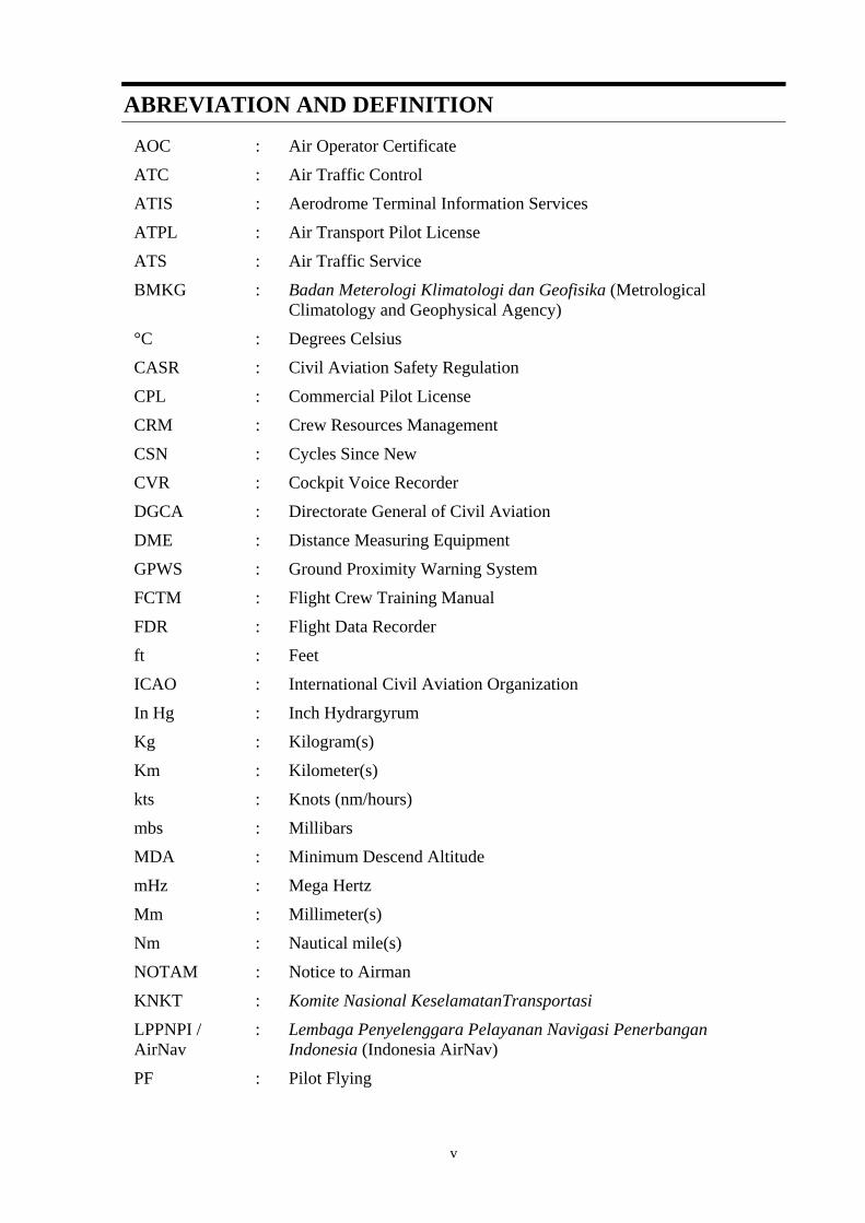
ABREVIATION AND DEFINITION
AOC : Air Operator Certificate
ATC : Air Traffic Control
ATIS : Aerodrome Terminal Information Services
ATPL : Air Transport Pilot License
ATS : Air Traffic Service
BMKG : Badan Meterologi Klimatologi dan Geofisika (Metrological Climatology and Geophysical Agency)
°C : Degrees Celsius
CASR : Civil Aviation Safety Regulation
CPL : Commercial Pilot License
CRM : Crew Resources Management
CSN : Cycles Since New
CVR : Cockpit Voice Recorder
DGCA : Directorate General of Civil Aviation
DME : Distance Measuring Equipment
GPWS : Ground Proximity Warning System
FCTM : Flight Crew Training Manual
FDR : Flight Data Recorder
ft : Feet
ICAO : International Civil Aviation Organization
In Hg : Inch Hydrargyrum
Kg : Kilogram(s)
Km : Kilometer(s)
kts : Knots (nm/hours)
mbs : Millibars
MDA : Minimum Descend Altitude
mHz : Mega Hertz
Mm : Millimeter(s)
Nm : Nautical mile(s)
NOTAM : Notice to Airman
KNKT : Komite Nasional KeselamatanTransportasi
LPPNPI / AirNav
: Lembaga Penyelenggara Pelayanan Navigasi Penerbangan Indonesia (Indonesia AirNav)
PF : Pilot Flying
vi
PIC : Pilot in Command
PM : Pilot Monitoring
QNH : Height above mean sea level based on local station pressure
S/N : Serial Number
SIC : Second in Command
SMS : Safety Management System
SOP : Standard Operating Procedure
TSN : Time since New
UTC : Universal Time Coordinate
VMC : Visual Meteorological Condition
VOR : Very High Frequency Omni Directional Range
VORLOC : Very High Frequency Omni Directional Range Localizer

vii
INTRODUCTION
SYNOPSIS On 27 January 2014, a Boeing 737-300 registration PK-CKL was being operated by PT. Sriwijaya Air on schedule passenger flight from Sepinggan Airport, Balikpapan (BPN / WALL) to Juanda International Airport, Surabaya (SUB / WARR). The aircraft departed from Balikpapan at 0109 UTC. The Pilot in Command (PIC) acted as Pilot Monitoring (PM) and the Second in Command (SIC) acted as Pilot Flying (PF).
Prior to the flight both pilots did not receive information of the current NOTAM (Notice to Airmen) for Juanda International Airport either from Balikpapan or Jakarta flight operation office. On the day of this serious incident, there was a NOTAM regarding to the status of taxiway SP2 that was closed due to work in progress of scrubbing, overlay and paving shoulder and was valid from 1 to 30 January 2014.
The pilot conducted the VOR/DME approach for runway 28. During the interview the PM stated that the weather was hazy and at 600 feet, both pilots saw the darker and shinier object on the surrounding area which they assumed as the runway. The pilots flew toward the object and raised some question to the controller regarding to the several objects on the runway.
The aircraft flew at low altitude below 50 feet over the taxiway SP2 up to touch down for approximately 29 seconds.
There was hazard report from a pilot reported the possibility of mistaking taxiway for runway during conducting a VOR/DME approach runway 28, which was received 30 days before this occurrence.
No one injured and no damage to the aircraft in this serious incident.
The investigation concluded that the contributing factors of this serious incident were as follow;
• The environment of the airport and the condition of the taxiway approach created an illusion that the SP2 taxiway appeared brighter than the active runway for pilot on the final approach.
• The absence of the operator SOP related to the requirement for go around on uncertain condition and the NOTAM information which might became the short term memory have made the pilot elected to continue landing following uncertain condition prior to land.
Prior to issue this final investigation report, the KNKT had been informed of safety actions resulting of the internal investigation by the operators concerning to operational safety related to this occurrence.
Included in this final report, the KNKT issued several safety recommendations to PT. Sriwijaya Air, PT. Angkasa Pura I, Airnav Indonesia of Surabaya and Directorate General of Civil Aviation to address the safety issues identified in this final report.

1
1 FACTUAL INFORMATION
1.1 History of the Flight On 27 January 2014, a Boeing 737-300 registration PK-CKL was being operated by PT. Sriwijaya Air on schedule passenger flight from Sepinggan Airport, Balikpapan (BPN / WALL) to Juanda International Airport, Surabaya (SUB / WARR). On board in this flight were 155 persons consist of 2 pilots, 4 Flight Attendants and 149 passengers.
This flight was on second day of three days flight schedule for the crew. On the first day the crew flew from CGK – JOG – BPN – TRK. On the second day the crew flew from TRK to BPN and the PIC acted as PF. In this flight the Pilot in Command (PIC) acted as Pilot Monitoring (PM) and the Second in Command (SIC) acted as Pilot Flying (PF).
Prior to departure, both pilots tried to get current NOTAM (Notice to Airmen) for Juanda International Airport either from Jakarta or Balikpapan flight operation offices and they did not get such current NOTAM and or related information. On the day of this occurrence, there was a NOTAM regarding to the status of taxiway SP2 that was closed due to work in progress of scrubbing, overlay and paving shoulder and valid from 1 to 30 January 2014.
The aircraft departed from Balikpapan at 0109 UTC1. The flight from departure until commence for approach was uneventful and there was no aircraft system abnormality reported or recorded prior to the occurrence.
During descend below 10,000 feet the flight was vectored by Surabaya Approach controller for VOR/DME approach runway 28 with several of weather avoidances as requested by the pilot.
At 1,000 feet, while the aircraft established the final approach course of the VOR/DME runway 28, the Surabaya Approach controller transferred the communication to Juanda Tower controller. Then the Juanda Tower controller had given a landing clearance to the pilot.
Based on the interview, the PM stated that the weather was hazy and while on final approach at 600 feet which was approaching the Minimum Descend Altitude (MDA) of 460 feet, both pilots saw the darker and shinier object on the surrounding area which they assumed as the runway. The aircraft was flown toward that object and furthermore both pilots were uncertain to what the objects they seen such as, chequer boards on the assumed runway.
The Flight Data Recorder (FDR) recorded that after passed 50 feet, the aircraft altitude was up and down over the object where the pilot believed as the runway for approximately 29 seconds.
The ATC ground base recorder recorded, when the aircraft at about on short final and prior to touch down, there were some discussions amongst the pilot and Juanda
1 The 24-hour clock used in this report to describe the time of day as specific events occurred is in Coordinated
Universal Time (UTC). Local time for Bali is Waktu Indonesia Tengah (WITA) is UTC + 8 hours.

2
Tower controller concerning to those above particular objects. The pilot raised some questions concerning to their confusions to the objects on the runway. Furthermore, the pilot asked whether there was a threshold displaced on the runway, and the Juanda Tower controller stated there was nothing and the runway was normal.
While having conversations with the pilots, Juanda Tower controller saw that the aircraft was about to land on the taxiway SP2 and instructed the pilot to go-around, the pilot replied that the aircraft already touched down.
At 0228 UTC the aircraft touched down on the taxiway SP2 at about the intersections of taxiway S3 and stopped prior to the taxiway S1. After evaluation and clarification performed the Juanda Tower controller instructed the pilot to taxi to apron.
The aircraft taxied to apron via taxiway S1, crosses the runway and park on stand number 13.
No one injured in this serious incident and no damage to the aircraft or other damage reported.
Figure 1:The flight track as recorded on the FDR data and superimposed to
Google Earth
1.2 Injuries to Persons
Injuries Flight crew Passengers Total in Aircraft Others
Fatal - - - - Serious - - - - Minor/None 6 149 155 -
TOTAL 6 149 155 -

3
1.3 Damage to Aircraft An observation found that there was no damage with the aircraft.
1.4 Other Damage An observation found also that there was no other damage to property and/or the environment.
1.5 Personnel Information 1.5.1 Pilot in Command
Gender : Male
Age : 60 years
Nationality : Indonesia
Marital status : Married
Date of joining company : 2010
License : ATPL
Date of issue : 06 April 1987
Aircraft type rating : B737-200/-300/-400/-500
Instrument rating : B737-200/-300/-400/-500
Medical certificate : First Class
Last of medical : 12 December 2013
Validity : 12 June 2014
Medical limitation : Holder shall wear lenses that correct for distant vision and possess glasses that correct for near vision
Last line check : 6 December 2013
Last proficiency check : 2 December 2013
Flying experience
Total hours : 23.247 hours
Total on type : 785 hours
Last 90 days : 67 hours 19 minutes
Last 60 days : 60 hours 35 minutes
Last 24 hours : 5 hours 9 minutes
This flight : 1 hours 19 minutes
4
1.5.2 Second in Command Gender : Male
Age : 40 years
Nationality : Indonesia
Marital status : Married
Date of joining company : 24 January 2011
License : CPL
Date of issue : 15 September 2008
Aircraft type rating : B737-200/-300/-400/-500
Instrument rating : B737-200/-300/-400/-500
Medical certificate : First Class
Last of medical : 16 January 2014
Validity : 16 July 2014
Medical limitation : Holder shall wear corrective lenses
Last line check : 5 December 2013
Last proficiency check : 14 October 2013
Flying experience
Total hours : 369 hours 52 minutes
Total on type : 369 hours 52 minutes
Last 90 days : 213 hours 42 minutes
Last 60 days : 156 hours 10 minutes
Last 24 hours : 5 hours 9 minutes
This flight : 1 hours 19 minutes
1.6 Aircraft Information
Registration Mark : PK-CKL Manufacturer : Boeing Company
Country of Manufacturer : United States of America
Type/ Model : B737-300
Serial Number : 26293
Year of manufacture : 22 October 1993
Certificate of Airworthiness
Issued : 25 October 2013
Validity : 24 October 2014
5
Category : Passenger
Limitations : None
Certificate of Registration
Issued : 20 September 2013
Validity : 19 September 2014
Time Since New : 55,151 hours 11 minutes
Cycles Since New : 33,605 cycle
Last Major Check : C03-Check at 28 June 2013
Last Minor Check : A03-Check at 21 October 2013
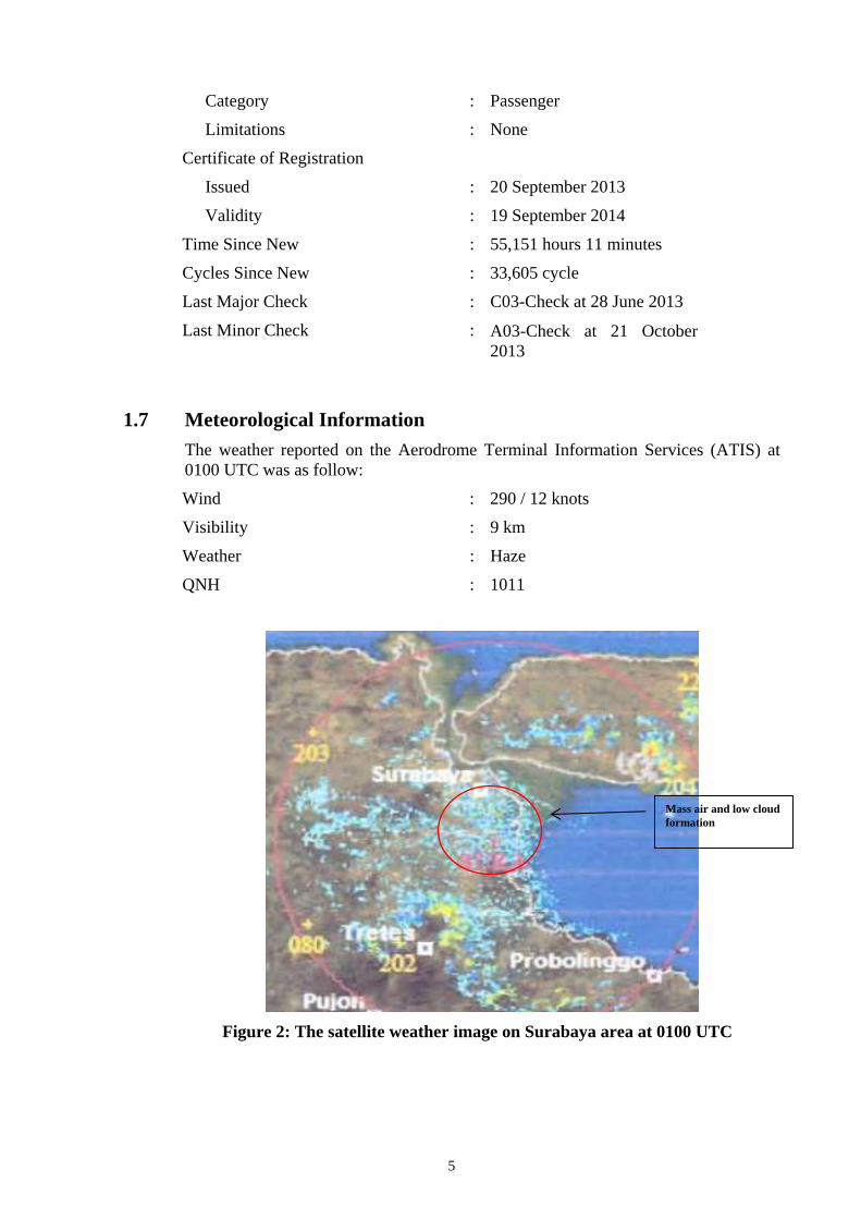
1.7 Meteorological Information The weather reported on the Aerodrome Terminal Information Services (ATIS) at 0100 UTC was as follow:
Wind : 290 / 12 knots
Visibility : 9 km
Weather : Haze
QNH : 1011
Figure 2: The satellite weather image on Surabaya area at 0100 UTC
Mass air and low cloud formation
6
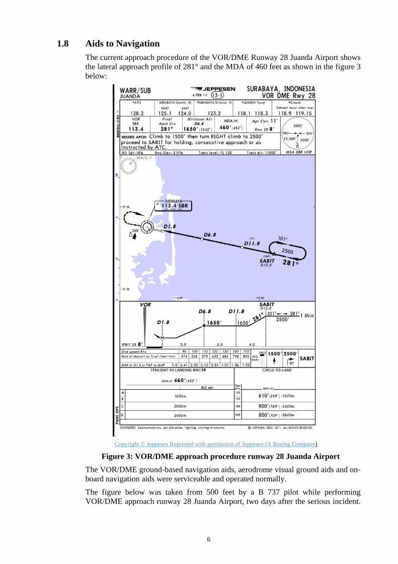
1.8 Aids to Navigation The current approach procedure of the VOR/DME Runway 28 Juanda Airport shows the lateral approach profile of 281° and the MDA of 460 feet as shown in the figure 3 below:
Copyright © Jeppesen Reprinted with permission of Jeppesen (A Boeing Company)
Figure 3: VOR/DME approach procedure runway 28 Juanda Airport The VOR/DME ground-based navigation aids, aerodrome visual ground aids and on-board navigation aids were serviceable and operated normally.
The figure below was taken from 500 feet by a B 737 pilot while performing VOR/DME approach runway 28 Juanda Airport, two days after the serious incident.

7
At the time of taking this picture, the visibility reported was greater than at the time of the serious incident and the picture showed that the SP2 taxi way was darkest and shiniest in surrounding area than the active runway 28.
Figure 4: The picture from approximate 500 feet of final approach course
VOR/DME runway 28
1.9 Communications The quality of communication between pilot and controller was good and performed normally as recorded by Air Traffic Control (ATC) ground base recorder at Juanda International Airport.
1.9.1.1 Air Traffic Control Transcription The pilots and Juanda Tower controller conversations as recorded on the ground base recorder of the Juanda International Airport were as follows:
02.27.41: The pilot raised question related to objects seen on the runway
02.27.47: The controller reconfirmed the question.
02.27.49: Aircraft GPWS “THIRTHY”
02.27.51: The controller asked whether the object as the pilot questioning was an animal.
02.27.55: The pilot reconfirmed whether any displace threshold.
02.27.59: The controller asked the pilot whether the pilot would make a go around
02.28.02: The pilot replied that they would continue approach.
02.28.07: The controller instructed the pilot to go around
02.28.12: The controller stated that the aircraft was on taxiway and instructed to go around.
02.28.13: The pilot replied that they had landed.
02.28 56: The controller instructed the pilot to hold position.
02.29.00: The pilot acknowledged holding position.
Final approach course of 281°

8
Based on the FDR data aircraft touch down at 02.28.08 UTC.
Figure 5: The aircraft flight and on SP2 taxiway trajectory revealed from the
FDR plotted to Google earth
1.10 Aerodrome Information
Airport Name : Juanda Airport
Airport Identification : WARR
Airport Operator : PT. AngkasaPura I
Coordinate : S 07 23.0 E 112. 4.8
Elevation : 10 feet
Runway Direction : 10-28
098° - 278°
Runway Length : 3000 meters
Runway Width : 45 Meters
Surface : Asphalt

9
1.10.1 Aerodrome layout The airport layout shows the runway 28-10, SP2, S3 taxiway and the area of the work in progress on SP2.
Copyright © Jeppesen Reprinted with permission of Jeppesen (A Boeing Company)
Figure 6: Aerodrome chart
S3 taxi way
The area that works was in progress
10
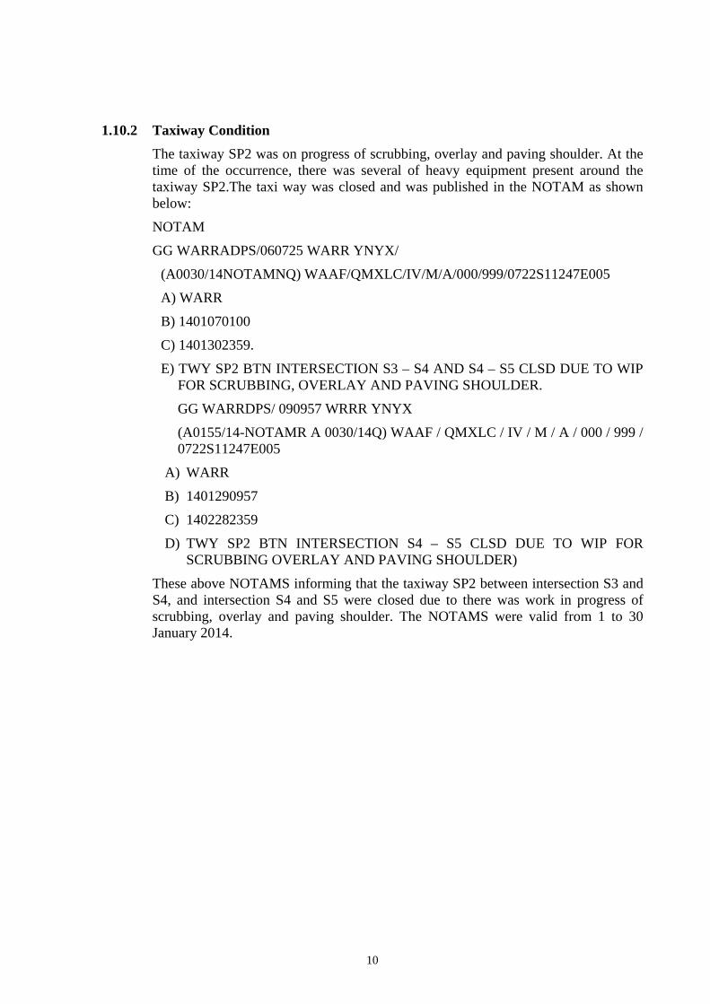
1.10.2 Taxiway Condition The taxiway SP2 was on progress of scrubbing, overlay and paving shoulder. At the time of the occurrence, there was several of heavy equipment present around the taxiway SP2.The taxi way was closed and was published in the NOTAM as shown below:
NOTAM
GG WARRADPS/060725 WARR YNYX/
(A0030/14NOTAMNQ) WAAF/QMXLC/IV/M/A/000/999/0722S11247E005
A) WARR
B) 1401070100
C) 1401302359.
E) TWY SP2 BTN INTERSECTION S3 – S4 AND S4 – S5 CLSD DUE TO WIP FOR SCRUBBING, OVERLAY AND PAVING SHOULDER.
GG WARRDPS/ 090957 WRRR YNYX
(A0155/14-NOTAMR A 0030/14Q) WAAF / QMXLC / IV / M / A / 000 / 999 / 0722S11247E005
A) WARR
B) 1401290957
C) 1402282359
D) TWY SP2 BTN INTERSECTION S4 – S5 CLSD DUE TO WIP FOR SCRUBBING OVERLAY AND PAVING SHOULDER)
These above NOTAMS informing that the taxiway SP2 between intersection S3 and S4, and intersection S4 and S5 were closed due to there was work in progress of scrubbing, overlay and paving shoulder. The NOTAMS were valid from 1 to 30 January 2014.
11
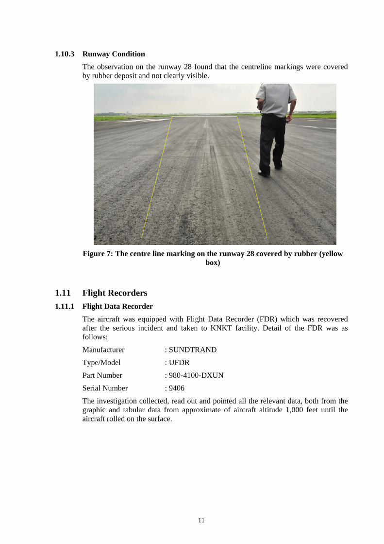
1.10.3 Runway Condition The observation on the runway 28 found that the centreline markings were covered by rubber deposit and not clearly visible.
Figure 7: The centre line marking on the runway 28 covered by rubber (yellow
box)
1.11 Flight Recorders 1.11.1 Flight Data Recorder
The aircraft was equipped with Flight Data Recorder (FDR) which was recovered after the serious incident and taken to KNKT facility. Detail of the FDR was as follows:
Manufacturer : SUNDTRAND
Type/Model : UFDR
Part Number : 980-4100-DXUN
Serial Number : 9406
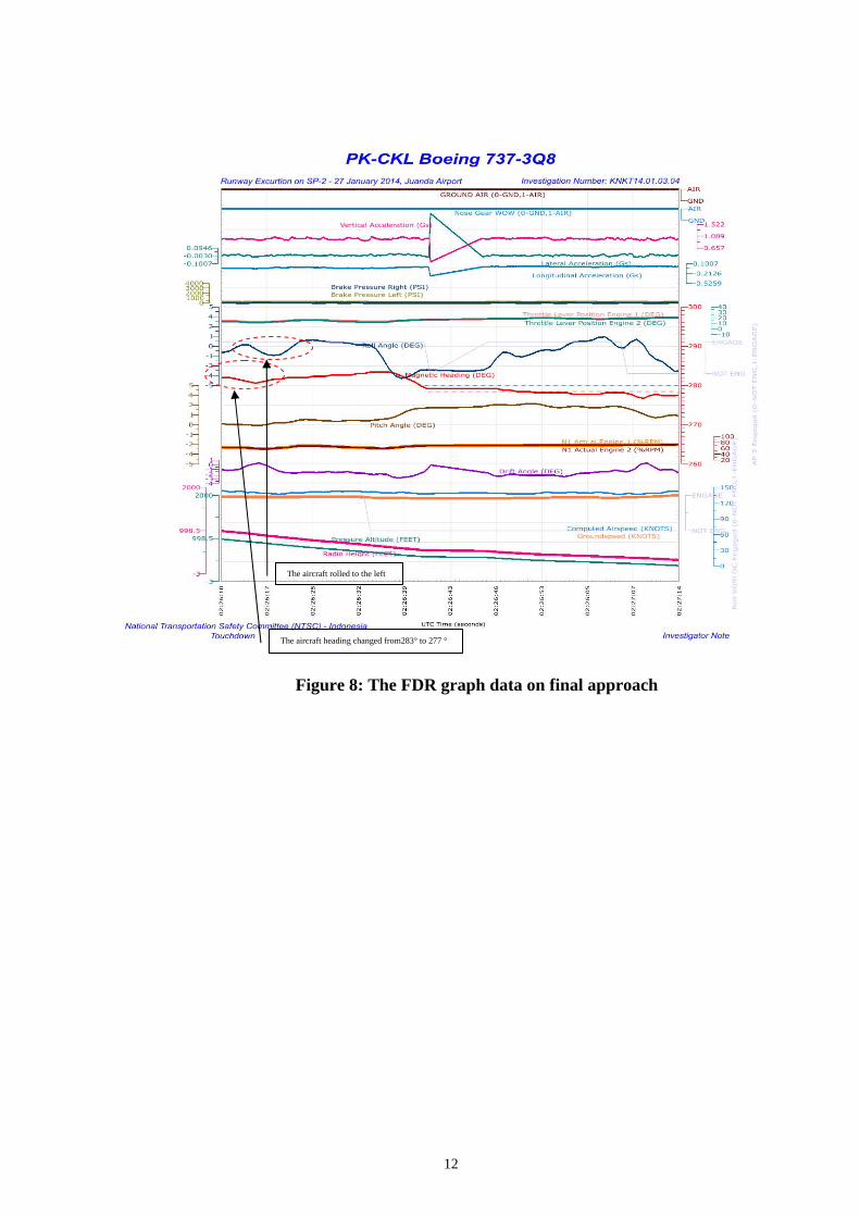
The investigation collected, read out and pointed all the relevant data, both from the graphic and tabular data from approximate of aircraft altitude 1,000 feet until the aircraft rolled on the surface.
12
Figure 8: The FDR graph data on final approach
The aircraft rolled to the left
The aircraft heading changed from283° to 277 °

13
Figure 9: The FDR graph data on short final up to landing
The aircraft pitch slightly up The aircraft slightly climb The N1s increased The aircraft touched down
14
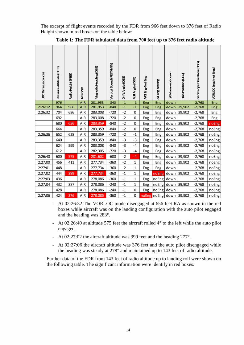
The excerpt of flight events recorded by the FDR from 966 feet down to 376 feet of Radio Height shown in red boxes on the table below:
Table 1: The FDR tabulated data from 700 feet up to 376 feet radio altitude UTC Time (seconds)
Pressure Altitude (FEET)
Radio Height (FEET)
AIR‐GND
Magnetic Heading (DEG)
Vertical Speed (FEET/MIN)
Drift Angle (DEG)
Roll Angle (DEG)
AP2 Eng‐Not Eng
AT Eng‐noteng
L/G dow
n‐not down
Flap Position (DEG)
Glideslope Deviation (Dots)
VORLOC Engd‐not Engd
976 AIR 281,953 ‐840 ‐1 ‐1 Eng Eng down ‐2,768 Eng2:26:12 964 966 AIR 281,953 ‐840 ‐1 ‐1 Eng Eng down 39,902 ‐2,768 Eng
2:26:32 704 686 AIR 283,008 ‐720 ‐2 0 Eng Eng down 39,902 ‐2,768 Eng692 AIR 283,008 ‐720 ‐2 0 Eng Eng down ‐2,768 Eng680 656 AIR 283,359 ‐840 ‐2 0 Eng Eng down 39,902 ‐2,768 noEng664 AIR 283,359 ‐840 ‐2 0 Eng Eng down ‐2,768 noEng
2:26:36 652 628 AIR 283,359 ‐720 ‐2 ‐1 Eng Eng down 39,902 ‐2,768 noEng640 AIR 283,359 ‐840 ‐3 ‐3 Eng Eng down ‐2,768 noEng624 599 AIR 283,008 ‐840 ‐3 ‐4 Eng Eng down 39,902 ‐2,768 noEng612 AIR 282,305 ‐720 ‐3 ‐4 Eng Eng down ‐2,768 noEng
2:26:40 600 575 AIR 281,602 ‐600 ‐2 ‐4 Eng Eng down 39,902 ‐2,768 noEng2:27:00 456 411 AIR 277,734 ‐360 ‐2 1 Eng Eng down 39,902 ‐2,768 noEng2:27:01 448 AIR 277,734 ‐360 ‐2 1 Eng Eng down ‐2,768 noEng2:27:02 444 399 AIR 277,734 ‐360 ‐1 1 Eng noEng down 39,902 ‐2,768 noEng2:27:03 436 AIR 278,086 ‐360 ‐1 1 Eng noEng down ‐2,768 noEng2:27:04 432 387 AIR 278,086 ‐240 ‐1 1 Eng noEng down 39,902 ‐2,768 noEng
428 AIR 278,086 ‐240 ‐1 0 Eng noEng down ‐2,768 noEng2:27:06 424 376 AIR 278,086 ‐360 ‐1 0 noEng noEng down 39,902 ‐2,768 noEng
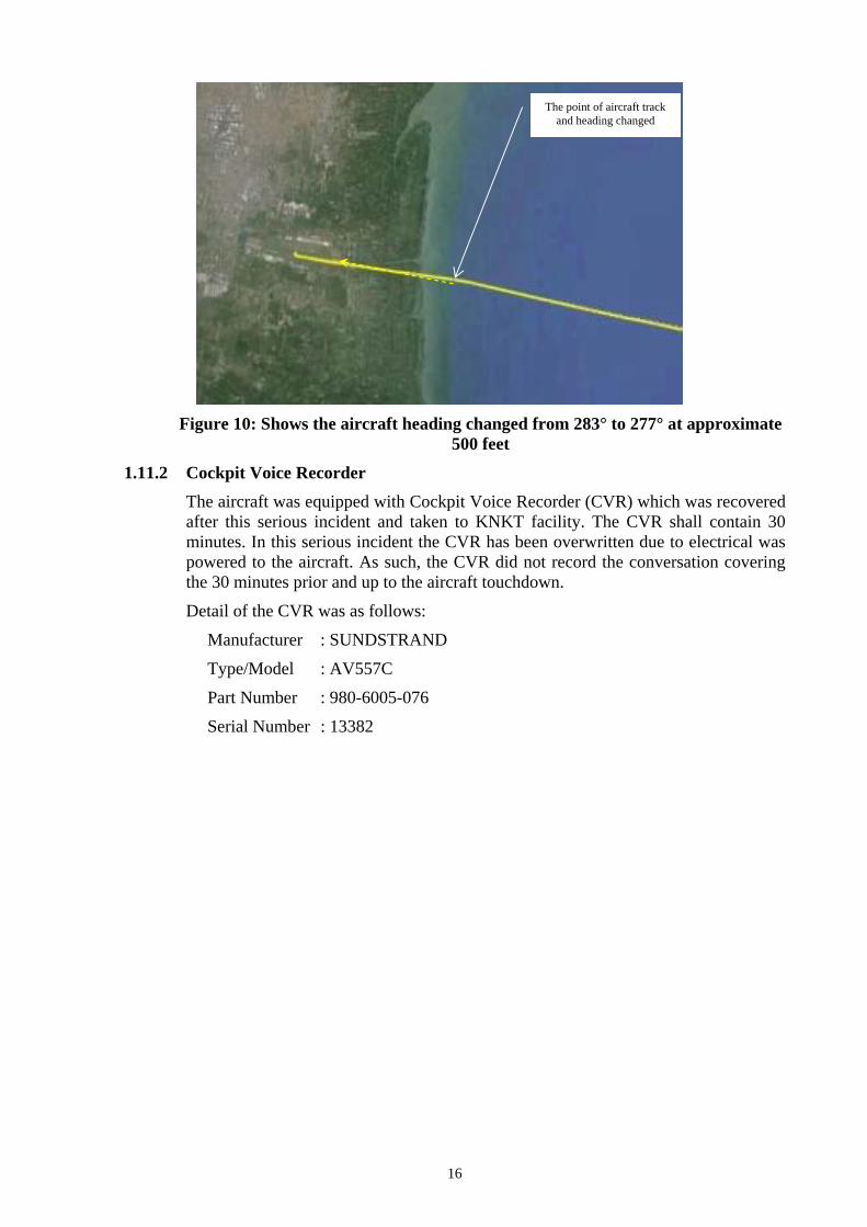
- At 02:26:32 The VORLOC mode disengaged at 656 feet RA as shown in the red boxes while aircraft was on the landing configuration with the auto pilot engaged and the heading was 283°.
- At 02:26:40 at altitude 575 feet the aircraft rolled 4° to the left while the auto pilot engaged.
- At 02:27:02 the aircraft altitude was 399 feet and the heading 277°.
- At 02:27:06 the aircraft altitude was 376 feet and the auto pilot disengaged while the heading was steady at 278° and maintained up to 143 feet of radio altitude.
Further data of the FDR from 143 feet of radio altitude up to landing roll were shown on the following table. The significant information were identify in red boxes.
15
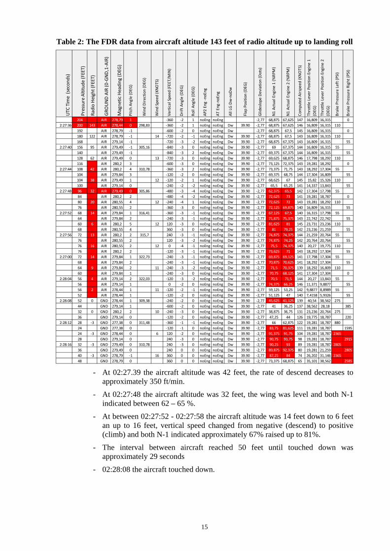
Table 2: The FDR data from aircraft altitude 143 feet of radio altitude up to landing roll
UTC
Time (secon
ds)
Pressure Altitude
(FEET)
Radio Height (FEET)
GRO
UND AIR (0
‐GND,1‐AIR)
Magnetic Heading
(DEG
)
Pitch An
gle (DEG
)
Wind Directio
n (DEG
)
Wind Speed (KNO
TS)
Vertical Speed
(FEET/MIN)
Drift An
gle (DEG
)
Roll An
gle (DEG
)
AP2 Eng ‐noEng
AT Eng
‐noEng
All LG Dw‐noD
w
Flap
Position
(DEG
)
Glideslope
Deviatio
n (Dots)
N1 Actual Engine 1 (%RP
M)
N1 Actual Engine 2 (%RP
M)
Computed Airspeed
(KNOTS)
Throttle Lever Position
Engine 1
(DEG
)
Throttle Lever Position
Engine 2
(DEG
)
Brake Pressure Left (PSI)
Brake Pressure Right (P
SI)
204 AIR 278,79 1 ‐360 ‐2 1 noEng noEng ‐2,77 68,875 67,625 147 16,809 16,315 02:27:36 200 143 AIR 278,44 0 298,83 ‐360 ‐2 1 noEng noEng Dw 39.90 ‐2,77 68,875 67,625 146 16,809 16,315 110
192 AIR 278,79 ‐1 ‐600 ‐2 0 noEng noEng Dw ‐2,77 68,875 67,5 145 16,809 16,315 0180 122 AIR 278,79 ‐1 14 ‐720 ‐2 ‐1 noEng noEng Dw 39.90 ‐2,77 68,875 67,5 143 16,809 16,315 110168 AIR 279,14 ‐1 ‐720 ‐3 ‐2 noEng noEng Dw 39.90 ‐2,77 68,875 67,375 143 16,809 16,315 55
2:27:40 156 95 AIR 279,49 ‐1 305,16 ‐840 ‐3 0 noEng noEng Dw 39.90 ‐2,77 69 67,375 144 16,809 16,315 55140 AIR 279,49 ‐1 ‐840 ‐3 2 noEng noEng Dw 39.90 ‐2,77 69,375 67,375 144 16,809 16,315 55128 62 AIR 279,49 0 13 ‐720 ‐3 0 noEng noEng Dw 39.90 ‐2,77 69,625 68,875 146 17,798 18,292 110116 AIR 280,2 3 ‐600 ‐3 0 noEng noEng Dw 39.90 ‐2,77 73,125 72,375 143 19,281 18,292 0
2:27:44 108 42 AIR 280,2 4 310,78 ‐360 ‐3 2 noEng noEng Dw 39.90 ‐2,77 73,375 71,75 143 18,292 17,304 55104 AIR 279,84 3 ‐120 ‐2 0 noEng noEng Dw 39.90 ‐2,77 69,375 68,75 144 17,304 16,809 55104 38 AIR 279,49 1 12 ‐120 ‐2 1 noEng noEng Dw 39.90 ‐2,77 68,625 67 145 15,82 15,326 110100 AIR 279,14 0 ‐240 ‐2 ‐2 noEng noEng Dw 39.90 ‐2,77 65,5 65,25 141 14,337 13,843 55
2:27:48 96 32 AIR 279,49 0 305,86 ‐480 ‐3 ‐4 noEng noEng Dw 39.90 ‐2,77 62,375 65,5 142 17,304 17,798 5584 AIR 280,2 2 ‐480 ‐4 ‐2 noEng noEng Dw 39.90 ‐2,77 72,625 73 141 19,281 18,787 080 20 AIR 280,55 4 12 ‐240 ‐4 1 noEng noEng Dw 39.90 ‐2,77 72,625 72 143 19,281 18,292 11076 AIR 280,55 2 ‐360 ‐3 0 noEng noEng Dw 39.90 ‐2,77 72,125 69,875 140 16,809 16,315 55
2:27:52 68 14 AIR 279,84 1 316,41 ‐360 ‐3 ‐1 noEng noEng Dw 39.90 ‐2,77 67,125 67,5 140 16,315 17,798 5564 AIR 279,84 2 ‐240 ‐3 ‐1 noEng noEng Dw 39.90 ‐2,77 71,875 75,375 143 22,742 22,742 5560 6 AIR 280,2 5 12 120 ‐3 0 noEng noEng Dw 39.90 ‐2,77 81,625 81 145 23,731 23,236 11068 AIR 280,55 4 360 ‐3 0 noEng noEng Dw 39.90 ‐2,77 81 79,25 142 23,236 21,259 55
2:27:56 72 13 AIR 280,2 2 315,7 240 ‐3 ‐1 noEng noEng Dw 39.90 ‐2,77 74,875 74,375 144 21,259 20,764 5576 AIR 280,55 2 120 ‐3 ‐2 noEng noEng Dw 39.90 ‐2,77 74,875 74,25 142 20,764 20,764 5576 16 AIR 280,55 2 12 0 ‐4 ‐1 noEng noEng Dw 39.90 ‐2,77 75,5 74,375 140 20,27 19,775 11076 AIR 280,2 2 ‐120 ‐3 ‐1 noEng noEng Dw 39.90 ‐2,77 73,625 71 143 18,292 17,304 55
2:27:00 72 14 AIR 279,84 1 322,73 ‐240 ‐3 ‐1 noEng noEng Dw 39.90 ‐2,77 69,875 69,125 141 17,798 17,304 5568 AIR 279,84 2 ‐240 ‐3 ‐1 noEng noEng Dw 39.90 ‐2,77 70,875 70,625 141 18,292 17,304 5564 9 AIR 279,84 2 11 ‐240 ‐3 ‐2 noEng noEng Dw 39.90 ‐2,77 71,5 70,375 139 18,292 16,809 11060 AIR 279,84 1 ‐240 ‐3 0 noEng noEng Dw 39.90 ‐2,77 70,75 68,125 141 17,304 17,304 0
2:28:04 56 4 AIR 279,14 2 322,03 ‐120 ‐3 ‐2 noEng noEng Dw 39.90 ‐2,77 70,5 71,5 144 20,27 13,843 5556 AIR 279,14 1 0 ‐2 0 noEng noEng Dw 39.90 ‐2,77 74,375 66,25 146 11,371 9,8877 5556 2 AIR 278,44 1 11 ‐120 ‐2 ‐1 noEng noEng Dw 39.90 ‐2,77 59,125 53,25 142 9,8877 8,8989 5552 AIR 278,44 1 ‐120 ‐2 0 noEng noEng Dw 39.90 ‐2,77 51,125 47 140 7,4158 5,9326 55
2:28:08 52 0 GND 278,44 1 309,38 ‐240 ‐2 0 noEng noEng Dw 39.90 ‐2,77 45,625 41,125 139 40,54 38,562 27544 GND 279,14 1 ‐600 ‐2 0 noEng noEng Dw 39.90 ‐2,77 41 36,25 137 38,562 28,18 38532 0 GND 280,2 2 10 ‐240 ‐3 0 noEng noEng Dw 39.90 ‐2,77 38,875 36,75 131 23,236 20,764 27536 GND 279,14 0 ‐120 ‐2 0 noEng noEng Dw 39.90 ‐2,77 47,25 44 126 19,775 18,787 220
2:28:12 28 ‐3 GND 277,38 0 311,48 ‐360 ‐1 ‐1 noEng noEng Dw 39.90 ‐2,77 66 62,875 122 19,281 18,787 88024 GND 277,38 0 ‐120 ‐1 0 noEng noEng Dw 39.90 ‐2,77 83,75 81,625 111 19,281 18,787 159524 ‐3 GND 278,44 0 6 120 ‐2 0 noEng noEng Dw 39.90 ‐2,77 91,375 91,75 104 19,281 18,787 236528 GND 279,14 0 240 ‐3 0 noEng noEng Dw 39.90 ‐2,77 90,75 93,75 98 19,281 18,787 2915
2:28:16 32 ‐3 GND 279,49 0 310,78 240 ‐3 0 noEng noEng Dw 39.90 ‐2,77 90,25 93 89 19,281 18,787 280536 GND 279,49 0 240 0 0 noEng noEng Dw 39.90 ‐2,77 89,875 92,375 80 19,281 21,259 280540 ‐3 GND 278,79 ‐1 16 360 0 0 noEng noEng Dw 39.90 ‐2,77 87,25 84 74 26,202 31,146 236548 GND 278,79 0 360 0 0 noEng noEng Dw 39.90 ‐2,77 73,375 68,875 65 35,101 38,562 2585
- At 02:27.39 the aircraft altitude was 42 feet, the rate of descend decreases to approximately 350 ft/min.
- At 02:27:48 the aircraft altitude was 32 feet, the wing was level and both N-1 indicated between 62 – 65 %.
- At between 02:27:52 - 02:27:58 the aircraft altitude was 14 feet down to 6 feet an up to 16 feet, vertical speed changed from negative (descend) to positive (climb) and both N-1 indicated approximately 67% raised up to 81%.
- The interval between aircraft reached 50 feet until touched down was approximately 29 seconds
- 02:28:08 the aircraft touched down.
16
Figure 10: Shows the aircraft heading changed from 283° to 277° at approximate
500 feet
1.11.2 Cockpit Voice Recorder The aircraft was equipped with Cockpit Voice Recorder (CVR) which was recovered after this serious incident and taken to KNKT facility. The CVR shall contain 30 minutes. In this serious incident the CVR has been overwritten due to electrical was powered to the aircraft. As such, the CVR did not record the conversation covering the 30 minutes prior and up to the aircraft touchdown.
Detail of the CVR was as follows:
Manufacturer : SUNDSTRAND
Type/Model : AV557C
Part Number : 980-6005-076
Serial Number : 13382
The point of aircraft track and heading changed
17
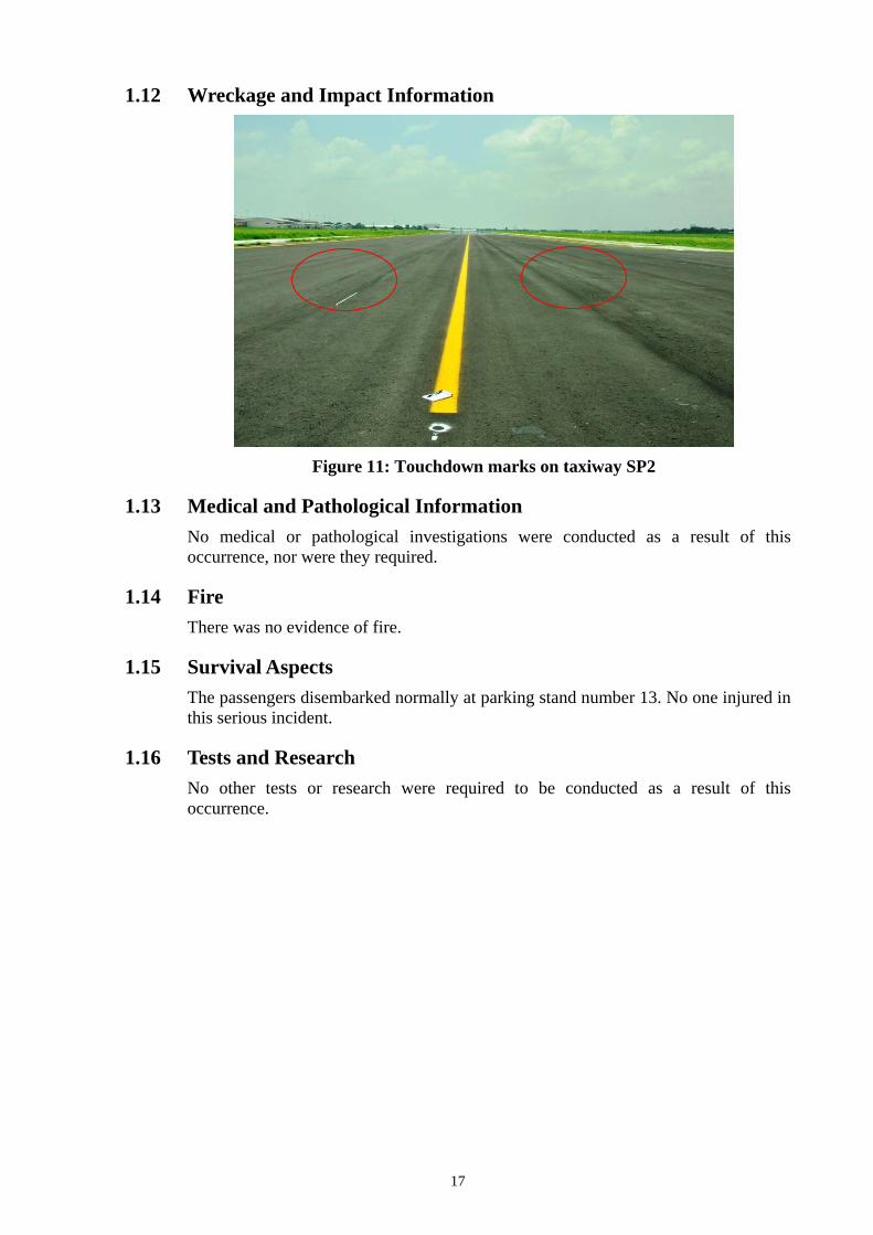
1.12 Wreckage and Impact Information
Figure 11: Touchdown marks on taxiway SP2
1.13 Medical and Pathological Information No medical or pathological investigations were conducted as a result of this occurrence, nor were they required.
1.14 Fire There was no evidence of fire.
1.15 Survival Aspects The passengers disembarked normally at parking stand number 13. No one injured in this serious incident.
1.16 Tests and Research No other tests or research were required to be conducted as a result of this occurrence.
18
1.17 Organizational and Management Information 1.17.1 PT. Sriwijaya Air
Aircraft Operator : PT. Sriwijaya Air
Address : Jl. Pangeran Jayakarta No. 68C Jakarta
Certificates Number : AOC /121-035
Operator Designator : SJY
The operator structure of organization is referred to CASR 121 and specified in the AOC/OPSPEC which valid to 10 November 2014.
The Crew Resources Management (CRM) is part of the operator’s Operation Training Manual whereas as from management explanation respects to the CRM, stated that the initial and recurrent trainings had been conducted by the third parties as well as the syllabus was also referred to the third party methods. The Company Policy stated that the recurrent of CRM performs for all flight crew annually and includes discussion of the practices of Perception and Situational Awareness.
The Situational Awareness contains several of Critical Elements such as, confusion, complacency etc. while the Perception includes discussion of how to eliminate the probably failures on object identification.
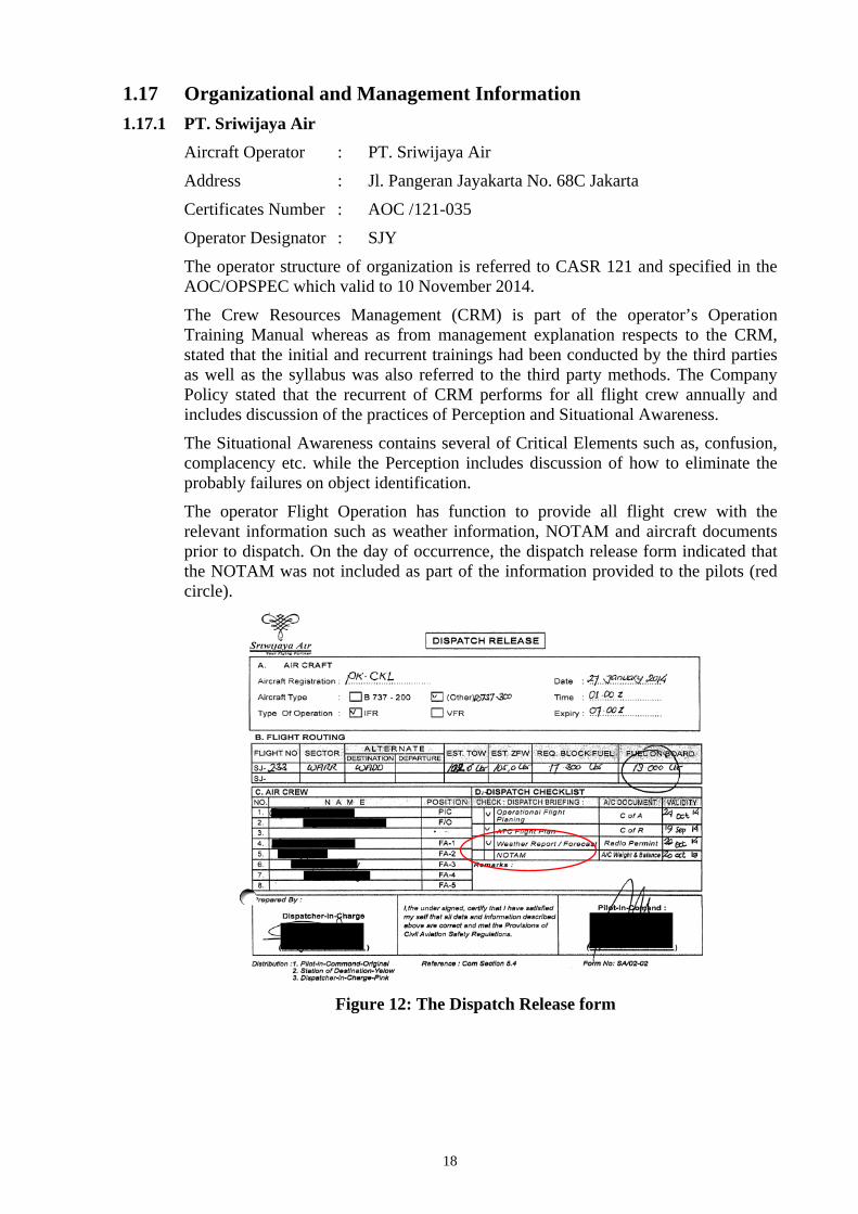
The operator Flight Operation has function to provide all flight crew with the relevant information such as weather information, NOTAM and aircraft documents prior to dispatch. On the day of occurrence, the dispatch release form indicated that the NOTAM was not included as part of the information provided to the pilots (red circle).
Figure 12: The Dispatch Release form

19
1.17.2 AirNav Indonesia Branch Office Surabaya The AirNav structure organization and the job description are stated in the letter of AirNav Indonesia number: PER.004/ LPPNPI/X/2013, subject Organisasi dan Tata Kerja Perum Lembaga Penyelenggara Pelayanan Navigasi Penerbangan Indonesia (LPPNPI) kantor Cabang Medan, Palembang, Surabaya, Denpasar, Balikpapan, dated 3 October 2013.
Figure 13: The organization chart of AirNav Indonesia Branch Office Surabaya
One of the organization departments is Safety Management System (SMS)2, led by a manager accountable to the General Manager, which has a function in performing the Safety Management System at AirNav Indonesia Branch Office Surabaya.
The general of responsibility and policies of the SMS unit are mentioned in the letter of structure organization section 6 article13, 14 and 15as follow;
Chapter 6 Safety Management System Manager
Article 8
Safety Management System Manager assisted by
a. Operation & facility quality assurance junior manager, and
b. System& procedure junior manager.
Article 13
General Manager, manager and junior manager in all Air Navigation Indonesia offices should understand and has to follow the guidance, and should responsible to serve the reports and improvement suggestions to their leaders in timely manner.
2. Safety management system (SMS) is a systematic approach to managing safety, including the necessary organizational
structures, accountabilities, policies and procedures.

20
Article 14
All the reports received by General Manager, Manager and Junior manager should be used as reference of development for further comprehensive report, as well as giving the right direction to the staffs.
Article 15
This particular report, should be sent to leader and copy the other related units within the organization.
On December 2013, AirNav Indonesia branch Surabaya and Angkasa Pura I Juanda Airport, received email related to a hazard report from Singapore Airlines pilot, with subject “Possibility of Lining up With Wrong Runway (SUB)”.
On 2 January 2014, the SMS manager of AirNav Indonesia Branch Office Surabaya replied through email to Singapore Airlines representatives and commented on the hazard that has been reported. The summary of the AirNav SMS manager were:
”it as very unlikely that a pilot would land on the taxiway as there were several conditiosn that may prevent for such occurrence. The conditions are:
(1) During an IFR flight, pilot should follow instrument approach procedure as stated in the AIP,
(2) During an VFR flight pilot should follow the VFR rules, which include visual references which different to the taxiway. The marking on the runway are:
a. Runway designated sign in significant size which not available on the taxiway;
b. Runway has touch down zone markers;
c. The color of the runway lights are different to the taxiway lights;
d. On the beginning of the runway, installed special runway lights;
e. The width of the runway was 45 meters, while the taxiway was 30 meters;
f. The centreline mark of the runway different with the taxiway.
Based on these conditions, the AirNav Branch Surabaya could not understand the reason of such hazard has been reported. However, if the reason of the possible of missalligned to the runway was due to blurred runway marking, that would be the responsibility of airport management.”

21
1.17.3 Angkasa Pura I, Juanda International Airport
Figure 14: SMS Organizational Chart of Juanda Airport
One of the organization dapartments is the Safety Management System (SMS, QM and CS Department) that led by the Head of Department and accountable to the General Manager.
Sub chapter 5.43 of the Aerodrome Manual hazard identification and risk assesment, generally described the function of SMS QM CS department were as follow:
a. The hazard report should align with the procedure described on chapter V SMS Manual.
b. Corporate inspection performs at least once a year or as required by the circumtances.
c. The audit performs at least once a year or as required by the circumtances.
The risk analysis is an assesment process of probability and consequence of the hazards which should be recognized and ranked of priority.

22
1.18 Additional Information 1.18.1 Interview with the Aircraft Operator
The investigation has conduct interview to the flight crew and the Quality Safety and Security policy maker and highlighted some statements as follow:
• The PM (Pilot Monitoring) stated that at 600 feet and approaching the Minimum Descend Altitude (MDA), he saw the taxiway SP2 and decided to continue the approach. Furthermore, he also saw the chequer board which he recognized as a board normally placed on a closed runway or taxiway.
• The PF (Pilot Flying) stated that when approaching the MDA at about 600 feet, he saw a darker and shiner object on the surrounding area then disengaged VOR/LOC mode and changed to HEADING mode and flew the aircraft toward the object as he assumed as the active runway.
• The PF explained on the day of the occurrence, he made phone call to the family and asked the condition for his child who was sick since one day before he left home for this flight schedule. He felt that he was mentally affected by this family condition furthermore he tried to improve his awareness more than the normal.
• An observation and discussion with the Quality Safety and Security department officers, noted that, there was no a specific statement in the operator manuals explaining, that whenever uncertain situation arises between the pilots or to any condition outside the flight deck takes place at a critical situation such as, approach to land, a go around should be executed.
1.18.2 Interview with the Airport SMS, QM CS Manager The SMS QM CS department has a function to encourages the people including the management personnel to be aware and prioritize the safety, policies and procedures in identifying and managing of hazards to be analysed for the issuance and activation of mitigations to minimize and/ or remove the hazard in the future.
1.18.3 Hazard Occurrence Report On 9 May 2014, the investigation received copy of hazard report issued by a Singapore Airlines pilot subject: Possibility of Mistaking Taxiway for Runway (SUB) which stated as follow:
HAZARD OCCURRENCE REPORT (Singapore Airlines Pilot) 12/2013
Title: Possibility of Mistaking Taxiway for Runway (SUB)
Summary of Hazards:
• When conducting a VOR approach into SUB on Rwy28, there is a real possibility of lining up on the southern taxiway (SP2) instead of runway 28.
• In hazy conditions, from far you can mistake the taxiway for the runway as it appears brighter than the runway.
• Also, the offset from the VOR to the runway is only 3 degrees and couple with the PAPI being unserviceable on Rwy 28 will even mislead the crew even more.
23
Suggested Corrective Action:
Do not disengage the autopilot too early during approach until you have positively identified the runway in use.
1.18.4 Safety Management System (SMS) The Safety Management System (SMS) is a management system which encourages the people to aware with safety, policies and procedures by identifying the hazard, assessing the risk and mitigate to acceptable level.
Indonesia PKPS on Safety Management System (CASR) Indonesia Peraturan Keselamatan Penerbangan Sipil (PKPS / CASR) on Safety Management System.
Sub-part 7: Manajemen resiko keselamatan
a. Umum
(1) Penyedia jasa harus membuat dan menyimpan Safety Data Collection And Processing Sistem (SDCPS) yang tersedia untuk identifikasi hazard dan analisis, penilaian dan mitigasi resiko keselamatan.
(2) SDCPS penyedia jasa harus mengikutsertakan metode reaktif, proaktif dan prediktif dari koleksi data keselamatan.
b. Identifikasi hazard
(1) Penyedia jasa harus membuat suatu cara formal untuk secara efektif mengumpulkan, mencatat, bertindak dan mengambil umpan balik dari hazard pada operasi, yang mengkombinasikan metode reaktif, proaktif dan prediktif dari pengumpulan data keselamatan. Cara formal dari pengumpulan data keselamatan harus mengikutsertakan sistem pelaporan wajib, sukarela dan rahasia.
(2) Proses identifikasi hazard harus mengikutsertakan langkah-langkah berikut:
(a) Pelaporan hazard, kejadian atau concern keselamatan;
(b) Pengumpulan dan penyimpanan data keselamatan;
(c) Analisis data keselamatan; dan
(d) Distribusi informasi keselamatan yang telah disaring dari data keselamatan.
c. Manajemen resiko
(1) Penyedia jasa harus membuat dan memelihara proses manajemen resiko formal yang menjamin analisis, penilaian dan mitigasi resiko dari konsekuensi hazard sampai pada tingkatan yang dapat diterima.
(2) Resiko dari konsekuensi setiap hazard yang diidentifikasi melalui proses identifikasi hazard seperti yang dijelaskan pada bagian 7.2 harus dianalisa berkenaan dengan kemungkinan dan kerumitan suatu kejadian, dan dinilai untuk mengetahui batasannya.
(3) Organisasi harus mendefinisikan tingkatan manajemen dengan kewenangan

24
untuk membuat keputusan batasan resiko keselamatan.
(4) Organisasi harus mendefinisikan kendali keselamatan untuk setiap resiko yang dinilai sebagai berada didalam batasan .
Sub-part 7: Safety Risk Management
a. General
(1) The services provider shall established and saved Safety Data Collection and Processing System (SDCPS) available to identify hazard and analysis, assess and mitigate safety risk.
(2) SDCPS of the service provider shall include method of reactive, proactive and predictive from the collected safety data.
b. Hazard identification
(1) service provider shall established effective formal method to collect, record, act and take feedback from operation hazard, combined with method of reactive, proactive and predictive of the safety data collection. The formal method of the data collection shall include mandatory, voluntary and confidential reporting.
(2) Hazard identification process shall include the following steps
(a) hazard reporting, occurrence or safety concern;
(b) collecting and preserving safety data;
(c) safety data analysis; and
(d) safety information distribution of selected safety data.
c. Risk Management
(1) Service provider shall established and maintain formal risk management process to ensure analysis, assessment and risk mitigation of hazard consequences to an acceptable level.
(2) The risk of any identified hazard through hazard collecting stated in 7.2 shall be analyzed in relation to the possibility and complexity of an occurrence, and assess its limit.
(3) Organization shall assigned management level authorized to take decision of certain level of risk assessment.
(4) Organization shall defined safety control to all risk which assessed within the limit
1.18.5 CASR SMS sub part 7 Safety Risk Management a. General
(1) The service provider shall develop and maintain a process that ensures that hazards associated with its aviation products or services are identified and mitigation of safety risk
(2) Hazard identification shall be based on a combination of reactive, proactive
25
and predictive methods of safety data collection
b. Hazard Identification
The service provider shall develop and maintain a process that ensures analysis, assessment and control of the safety risks associated with identified hazards, by combining of reactive, proactive and predictive methods of the safety data collected. The way of the collecting the safety data should include the mandatory and voluntary report.
1.18.6 ICAO Annex 19 sub chapter 7. Surveillance obligations
The State shall implement documented surveillance processes, by defining and planning inspections, audits, and monitoring activities on a continuous basis, to proactively assure that aviation licence, certificate, authorization and/or approval holders continue to meet the established requirements. This includes the surveillance of personnel designated by the Authority to perform safety oversight functions on its behalf.
1.18.7 Visual Illusion The references related to human perception and illusion taken from Human Factor in Flight by Frank H Hawkins, 1987 page 107-108 and 123 are as follows:
The Visual perception involves the eyes, the balancing mechanism of the ear (the vestibular apparatus) and brain. It is also influenced by past experience. …...The perception is greatly influenced by what we have come to believe about the properties of the object we are viewing and also what we expect the properties to be by the time we have to respond to them.
Some of the components involved in visual illusion are Eye, Brain, experience + memory store, pilot action and aircraft response.
The most general and effective protective measure against visual illusions is to supplements visual cues with information from other sources, particularly when experience and education indicate that illusion may be expected. Prior recognition of the situation should be reflected in inclusion of the item in routine crew briefing, initiated by the captain on the flight deck this is an area where input from other flight deck crew members can also be useful. Planning can then be made for the protective use of radio aids, radar attitude displays, radio altimeter, distance measuring equipment (DME), inertial and other navigation systems, visual glide slope aids (e.g. VASIS) and so on, to back up basic visual information.
Illusion, various other kinds of illusion has been identified. Brightness contrast sometimes creates an illusion. For example, a bright back ground or surround makes the centre area appear darker and vice versa.
1.18.8 Skills and Decision Making The skills are abilities that are learned, usually through training, toachieve a desired outcome.
Two basic classifications of skills are;
The perceptual-motor skill; which involve an interaction between perception and voluntary movement.
Perceptual motor skills are;
26
- Taught during initial and recurrent training - Required to fly aircraft in normal and emergency situation.
The cognitive skill; which involve mental processes such as comprehension, judgment, memory and reasoning.
Cognitive skills are; - More complex than perceptual-motor skills. - Related to learning and recall - Involved in gaining and maintaining situational awareness and in decision
making - Used when speaking, listening and understanding.
Decision making in safety critical and time constrained situations largely relies on flight crews following a predetermined course of action, typically encapsulated in Standard Operating Procedures. If a crew is uncertain about an aspect of flight operations, with the potential to compromise safety, then where possible the most prudent course of action is to operate in a way that allows time to adequately assess the situation and act accordingly. This aspect of decision making can be incorporated into Crew Resource Management (CRM) training. Conducting a go-around would have enabled them to ensure the immediate safety of the aircraft and then, with more time on hand, to resolve the uncertainty concerning the suitability of the runway.
1.19 Useful or Effective Investigation Techniques The investigation was conducted in accordance with the KNKT approved policies and procedures, and in accordance with the standards and recommended practices of Annex 13 to the Chicago Convention.

27
2 ANALYSIS The analysis part of this Final Report will discuss the relevant issues resulting in the landing on taxiway involving a Boeing 737-300 aircraft registered PK-CKL at Juanda International Airport of Surabaya on 27 January 2014.
The investigation determined that there were no issues with the aircraft and all systems related to this occurrence.
The analysis will therefore focus on the following issues:
• Runway identification by the pilots on final approach.
• Decision to land.
2.1 Runway Identification by the Pilots on Final Approach Based on the interview, both pilots had stated that when conducting the VOR/DME approach runway 28, the weather was hazy and when approaching the MDA, both pilots saw a darker and shinier object on the surrounding area which they assumed as the runway.
The hazy conditions on final approach degraded the visual cues available to the crew to identify the landing runway. In such a situation, the salience of the areas of white concrete on each side of the taxiway may have captured their attention, even though such a feature is not associated with standard runway markings. The runway marking on the runway 28 has blurred by the rubber deposit.
The investigation also examined on a photograph which was taken from approximate 500 feet by another Boeing 737 pilot of operator’s who was conducting VOR/DME approach runway 28, two days after the occurrence in a greater visibility. The photograph showed that the taxi way SP2 was more visible from that position as the taxiway shoulder were brighter and made the taxiway appeared darker and shinier compared to the active runway 28.
Frank H Hawkins, in the Human Factor in Flight stated that: brightness contrast sometimes creates an illusion. For example, a bright back ground or surround makes the centre area appear darker and vice versa. On the day of the occurrence the taxiway SP2 was on progress of paving shoulder while the shoulder was being concreted. The concreted shoulder created a bright surround of the taxiway and made the taxiway appeared darker.
Hawkins also stated: “some of the components involved in visual illusion are eye, brain, experience, memory store, pilot action and aircraft response.”
The investigation found that the pilots did not receive or read any NOTAM of Juanda Airport which contained the information of taxiway SP2 was closed as it was in the process of scrubbing, overlay and paving shoulder. If the flight crews have been informed and were aware of the condition of taxiway SP2, the information would have been stored in the pilot’s memory and could have been recalled as necessary. Hence, it might have helped the pilot’s accuracy in identifying the correct object in the low visibility and or marginal weather conditions.
28
The possibility of this occurrence has been reported by Singapore Airline pilot through an internal company hazard report that there was a real possibility of lining up on the southern taxiway (SP2) instead of runway 28 and the possibility may increase in hazy condition as the SP2 taxiway appears brighter than the runway. The hazard report had been officially submitted to AirNav Indonesia Branch Office Surabaya.
The most general and effective protective measure against visual illusions is to supplements visual cues with information from other sources. Planning can then be made for the protective use of radio aids, radar attitude displays, radio altimeter, distance measuring equipment (DME), inertial and other navigation systems, visual glide slope aids (e.g. VASIS) and so on, to back up basic visual information.
The Singapore Airline pilot also suggested that: pilots should not disengage the autopilot too early during approach until they had positively identified the runway in use.
The flight events recorded by the FDR from approximate 700 feet up to 376 feet revealed some significant information as follows;
- At 02:26:32 recorded that VORLOC mode that has captured of 281° was disengaged at 656 feet Radio Height and the aircraft flew on a the heading 283°.
- At 02:26:40 and aircraft altitude was 575 feet, the aircraft rolled to the left at 4° and flew on an average heading between 277° - 278° followed by disengagement of the auto pilot at 376 feet and continued the approach with the existing heading until 6 feet.
At the time PF flew towards the object which they believed as runway when approaching the MDA, this was most likely due to the absence of the information of the NOTAM relating to SP2 taxi way, and the absence of using relevant of other navigation aids as reference for those particular approach condition.
Refer to the conditions above it was most likely that the condition of the environment has created a visual illusion to the pilots that the SP2 taxiway appeared as the runway, even though such a feature was not associated with standard runway markings. The pilot flew toward the SP2 taxiway which they believed as the active runway.
The investigation concluded that the condition of the runway and its environment has made visual illusion to the pilots. Combination of the absence of the information of the NOTAM relating to SP2 taxi way, and the absence of using relevant of other navigation aids as another reference led the pilots selected the SP2 taxi way to land the aircraft.

29
2.2 Decision to Land The FDR recorded that after passed 50 feet, the rate of descend decreased, engine power increased, the aircraft altitude was up and down. The time interval between aircraft reached 50 feet until touched down was approximately 29 seconds. This can be concluded that the aircraft flew at low altitude over the area where the pilot believed as the runway.
The conversations between pilots and controller can be summarized that while on short final, the pilots saw objects on the area where they believed as the runway, however the controller has reinsured that the runway was normal.
The aforesaid conversations indicated that the crew was uncertain to the condition of the runway, and the conversation occurred while the aircraft flew over the area where the pilot believed as the runway. During this uncertainty the pilot delayed the touchdown for approximately 29 seconds.
This delay on touchdown was consistent with the indications of the marks of the main wheel touchdown as well as the FDR recorded at position near the intersection S3.
In such a situation, the safest course of action would have been for the crew to initiate a go-around, and then further analyse the situation when the flight was stabilised and there was time for a thorough appraisal.
The decision making at a critical phase of flight, and when time is limited, must rely on the crew following standard operating procedures. In this serious incident, the investigation could not found the operator’s manuals which described that if such un-certainty or confusions either between the pilots or with the condition outside the flight deck, a go around shall be initiated.
The PF decision to continue landing was most likely contributed by the absence of the spatial information related to the requirement for go around on uncertain condition and the NOTAM information which would became the short term memory to cope such unexpected condition.
2.3 Handling of Hazard Report The airport management and air traffic management offices received a hazard report contain information of possible line up to the wrong runway during the approach runway 28 in Juanda Airport Surabaya.
The report described that during performed VOR approach runway 28, the taxiway appeared brighter than the runway and possible for line up to the wrong runway.
This hazard report has clearly stated the reason of the possibility of line up to the wrong runway. However, the AirNav considered that the occurrence was very unlikely based on several parameter. The PKPS of Safety Management System required to process all hazard reported to be assess and mitigated to an acceptable level.
The difference between pilot report and the AirNav responses indicated that there was different perception of the pilot and controller vision to the hazard. The controller might not able to assess the hazard as the pilot. However, the controller did not assess the hazard thoroughly that might be conducted by consulting to the pilot or the operator who reported the hazard or to any pilot.
30
The investigation has not received information of the response of the airport management to the hazard reported.
This most likely that the SMS as stated in the PKPS, has not been fully implemented by AirNav branch office Surabaya and Angkasa Pura I Juanda Airport.

31
3 FINDINGS
3.1 Findings According to factual information during the investigation, the National Transportation Safety Committee founded any initial findings as follows:
1. The aircraft was airworthy prior to this occurrence.
2. All crew have valid licenses and medical certificates.
3. The aircraft was operated under a correct weight and balance envelope.
4. On board in this flight were 155 persons consist of 2 pilots, 4 Flight Attendants and 149 passengers. No one injured in this serious incident.
5. The aircraft departed from Balikpapan at 0109 UTC. The Pilot in Command (PIC) acted as Pilot Monitoring (PM) and the Second in Command (SIC) acted as Pilot Flying (PF). The flight from the departure until commence for approach was uneventful and there was no abnormality reported or recorded prior to the occurrence
6. The PF stated that he was mentally affected by the condition of family issue.
7. Prior to departure, both pilots did not provide with NOTAM for Juanda Airport either from Jakarta or Balikpapan operation offices.
8. There was a NOTAM regarding to the status of taxiway SP2 that was closed due to work in progress of scrubbing, overlay and paving shoulder and valid from 1 to 30 January 2014.
9. During the interview the PM stated that the weather was hazy, and at 600 feet approaching the MDA, the pilots saw darker and shinier object on the surrounding area which they assumed as the runway.
10. The photograph taken two days after the occurrence, by another pilot, from approximate 500 feet, in a greater visibility, showed that the taxi way SP2 appeared darker and shinier than the runway 28.
11. There was a hazard report from other operator pilot related to the hazard of the possibility of approach to the south taxiway.
12. The pilots changed the VORLOC mode into a HEADING mode of the autopilot and flew toward the object they assured as the active runway.
13. On short final until prior to touch down, the pilots were confused that they saw several objects on the runway and discussed with the controller.
14. The aircraft flew at low altitude over the taxiway SP2 for approximately 29 seconds prior to touch down.
15. The Juanda Tower controller saw the aircraft was about to land on the taxiway SP2 and instructed the pilot to go around, the pilot replied that the aircraft already touched down.
16. At 0228 UTC the aircraft touched down on the taxiway SP2 at about the intersections of taxiway S3.
17. The investigation could not found the operator’s manuals which described that if
32
un-certainty or confusions either between the pilots or condition outside the flight deck, a go around shall be initiated.
18. Observation on the runway, found that the runway centrelines marks were blurred by rubber deposit.
19. The SMS organization of the ATS and Airport Services provider were not in accordance to CASR SMS subpart 7.
3.2 Contributing Factors3 The environment of the airport and the condition of the taxiway approach created an illusion that the SP2 taxiway appeared brighter than the active runway for pilot on the final approach.
The pilots changed the lateral navigation mode from captured VORLOC mode to heading mode.
The decision to continue landing was most likely contributed by the absence of the spatial information related to the requirement for go-around on uncertain condition and the NOTAM information which would became the short term memory to cope such unexpected condition.
3 Contributing factors is defined as events that might cause the occurrence. In the case that the event did not occur then the
accident might not happen or result in a less severe occurrence
33
4 SAFETY ACTION At the time of issuing this final investigation report, the KNKT had been informed of safety actions resulting from the internal investigation of the operators concerning to operational safety related to this occurrence.
The following operator’s safety actions were as follow:
4.1 PT. Sriwijaya Air PT Sriwijaya Air (Quality Safety and Security department) recommends the operation department that:
• To review and improve crew resources management training (CRM Training);
• To review Standard Crew briefing including review NOTAM, approach and airport plate, giving special attention on Go Around/ Miss-Approach Procedure on the re-current training, proficiency check and Simulator Training;
• To improve pilot awareness of scanning between inside and outside condition after visual reference are established on final approach;
• To conduct and complete annual line check;
• To remind to all pilot to review the stabilized approach procedure on chapter 5 of Boeing 737-300/ 400/500 FCTM.
4.2 Angkasa Pura I, Juanda International Airport Juanda Airport Service Authority issued safety actions that reminding the aircraft operators to be aware of the possibility of miss-leading of runway identification in hazy weather, and also informing that there was a work in progress on the shoulder of taxi way SP2.
4.3 AirNav Indonesia Branch Office Surabaya AirNav Indonesia throughout the ATIS broadcasted additional information to the aircraft operators concerning to aware a possibility of miss-leading of runway identification in hazy weather,

34
5 SAFETY RECOMMENDATIONS Base on the examination of the factual data, analysis and the relevant findings that contributed to this serious incident were the pilot visual illusion as the result of the environment condition that have made the taxiway appeared brighter than the runway. The pilots continued the approach to the object which they believed as the active runway. The pilots were uncertain of the runway and flew at low level for 29 seconds prior to land, which might cause by the absence of the operator SOP related to the requirement for go around on uncertain condition and the NOTAM information.
These KNKT recommendations are based on the findings of this investigation. However the operator or the involved parties shall consider that the condition possibly extends to other pilot and or in certain cases to the other similar organization.
The KNKT considered that the safety actions issued by the related operators as result of this occurrence were relevant for the improvement, however KNKT considers to issue additional recommendations on specific area to;
5.1 PT. Sriwijaya Air a. To review the pilot CRM recurrent training on the subject of Visual Illusion in
combining with decision making process in a critical situation included examples and practices.
b. To review the modification of the current SOP, to include information for the pilot the requirement for go around whenever uncertain condition occurs at critical phase.
c. To ensure that the pilot familiar to the current NOTAM and shall be included in the dispatch briefing.
5.2 AirNav Indonesia Branch Office Surabaya There was a hazard report relating to the possibility of misalignment to the taxiway which was received 30 days before this serious incident.
The SMS Manual was not in accordance to CASR SMS subpart 7. As such, KNKT recommend that:
a. To ensure that the SMS manual and procedure should refer to the detail content of CASR SMS subpart 7.
b. The SMS implementation should refer to CASR SMS especially for the Safety Risk management.
5.3 Angkasa Pura I, Juanda International Airport 1. The investigation found that the runway centre lines marks blurred, covered by the
rubber deposit KNKT recommends reviewing the current of rubber deposit removal schedule to ensure that the centerline marks appear clearly.
2. The Aerodrome Manual Sub chapter 5.43 Hazard identification and risk assesment was not in accordance to CASR SMS subpart 7. As such, KNKT recommends that:

35
a. To ensure that Aerodrome Manual Sub chapter 5.43 should refer to the detail contain of CASR SMS subpart 7.
b. The SMS implementation should refer to CASR SMS especially for the Safety Risk management.
5.4 Directorate General of Civil Aviation (DGCA) Refer to the ICAO Annex 19 sub chapter 7, the DGCA shall implement documented surveillance processes, by defining and planning inspections, audits, and monitoring activities on a continuous basis. Therefore the KNKT recommends proactively assure the oversight and ensure that the recommendations issued in this final report were implemented correctly.

36
6 APPENDICES
6.1 Hazard Occurrence Report of Singapore Airlines Pilot The hazard occurrence reported by Singapore Airlines pilot on December 2013 and sent to Juanda International Airport authority.

37
6.2 Juanda International Airport, PT. Angkasa Pura I The Juanda International Airport issued a letter and categorized as their safety action.

38
6.3 AirNav Indonesia Branch Office Surabaya Comments
No Halaman Subyek Temuan Saran Perbaikan Penjelasan Tanggapan KNKT
1. i Table of Content Point
: 1.17.2
PT.AirNav Indonesia
•AirNav Indonesia
Branch Office
Surabaya
• Merujuk PER.013/LPPNPI/X1/2013 dan
PER.004/LPPNPI/X/2013 yang dimaksud
adalah AirNav Indonesia Kantor Cabang
Surabaya.
• AirNav Indonesia, merupakan Brand Image
dari Perusahaan Negara berbadan
hukumPerum (Perum Lembaga Penyelenggara
Pelayanan Navigasi PenerbanganIndonesia)
berkantor pusat di Jakarta.
• AirNav Indonesia Kantor Cabang Surabaya
merupakan salah satu dui 7 (tujuh) Kantor
Cabang Perum LPPNPI, dan membawahi 3
(tiga) Distrik yaitu Yogyakarta, Solo dan
Semarang.
Seluruh saran perbaikan dari PT. Airnav
Indonesia menjadi AirNav Indonesia
Branch Office Surabaya di terima dan
telah di revisi pada isi chapter final
report.
ii Point : 4.3
AirNav Indonesia, Juanda International Airport
AirNav Indonesia
Branch Office
Surabaya
• Jenis pelayanan AirNav Indonesia diatur dalam UU
No.1 Tahun 2009 tentang Penerbangan Bab XII, dan
AirNav Indonesia (Perurn LPPNPI) merupakan
amanah Pasal 271 UU No. 1 Tahun 2009.
Saran perbaikan dari PT. Airnav
Indonesia menjadi AirNav Indonesia
Branch Office Surabaya di terima dan
telah di revisi pada isi chapter final
39
No Halaman Subyek Temuan Saran Perbaikan Penjelasan Tanggapan KNKT
• Tugas dan Fungsi AirNav Indonesia Kantor Cabang
Surabaya dijabarkan dalam ER.004/LPPNPI/X/2013
Pasal 3 dan 4.
report.
iii Point : 5.2
AirNav Indonesia, Juanda International Airport
AirNav Indonesia
Branch Office
Surabaya
• Jenis pelayanan AirNav Indonesia diatur dalam UU
No.1 Tahun 2009 tentang Penerbangan Bab XII, dan
AirNav Indonesia (Per= LPPNPI) merupakan
amanah Pasal 271 UU No. 1 Tahun 2009.
• Tugas dan Fungsi AirNav Indonesia Kantor Cabang
Surabaya dijabarkan dalam ER.004/LPPNPI/X/2013
Pasal 3 dan 4.
Saran perbaikan dari PT. Airnav
Indonesia menjadi AirNav Indonesia
Branch Office Surabaya di terima dan
telah di revisi pada isi chapter final
report.
2. 6 Point: 1.8 Aids to
Navigation.
Figure3: VOR/DME
approach procedure
runway 28 Juanda
Airport.
(Menggunakan Chart
yang diterbitkan
Jeppesen).
•AirNav
Indonesia Branch
Office Surabaya
• Laporan KNKT merupakan produk negara
Indonesia, sebaiknya acuan referensinya juga
terbitan negara. (A1P Indonesia).
• SOP AirNav Indonesia Kantor Cabang Surabaya
saat ini sedang dalam prosesupdating.
Mempertimbangkan bahwa approach
chart yang digunakan operater (PT.
Sriwijaya. Air) adalah Jeppesen dan hal
ini sudah dituangkan di dalam Company
Operation Manual (COM), untuk itu
KNKT memutuskan tetap menggunakan
jeppessen pada final report ini.

40
No Halaman Subyek Temuan Saran Perbaikan Penjelasan Tanggapan KNKT
3. 10 Point: 1.10.1
Aerodrome layout.
Figure 6: Aerodrome
chart. (Menggunakan
Chart yang diterbitkan
Jeppesen)
AlP
INDONESIA
(VOL.II)
AERODRO
E CHART –
ICAO
WARR AD 2.24-1
SURABAYA/Jua
nda
• Laporan KNKT merupakan produk negara
Indonesia, sebaiknya acuanreferensinya juga
terbitan negara. .(AIP Indonesia).
• Aerodrome chart Surabaya/Juanda saat ini
dalam proses updating denganperubahan
/penambahan Taxiway N5S (Rapid Exit
Taxiway).
Mempertimbangkan bahwa approach
chart yang digunakan operater (PT.
Sriwijaya. Air) adalah Jeppesen dan hal
ini sudah dituangkan di dalam Company
Operation Manual (COM), untuk itu
KNKT memutuskan tetap menggunakan
jeppessen pada final report ini.
4. 19 Point : 1.17.2
PT. AirNav Indonesia
AirNav
Indonesia
Branch
Office
Surabaya
• Merujuk PER.013/LPPNPI/X1/2013 dan
PER.004/LPPNPI/X/2013 yang dimaksud adalah
AirNav Indonesia Kantor Cabang Surabaya.
• AirNav Indonesia, merupakan Branch Image dari
Perusahaan Negara berbadan hukum Perum (Perum
Lembaga Penyelenggara Pelayanan Navigasi
Penerbangan Indonesia) berkantor pusat di Jakarta.
• AirNav Indonesia Kantor Cabang Surabaya
merupakan salah satu dari 7 (tujob) Kantor Cabang
Penult LPPNPI, dan membawahi 3 (tiga) Distrik
yaitu Yogyakarta, Solo dan Semarang.
Saran perbaikan dari PT. Airnav
Indonesia menjadi AirNav Indonesia
Branch Office Surabaya di terima dan
telah di revisi pada isi chapter final
report.

41
No Halaman Subyek Temuan Saran Perbaikan Penjelasan Tanggapan KNKT
5. 20 Paragraf 1: ........... , which has a
function in performing
Safety
Management
System at AirNav
Indonesia Branch
Office Surabaya.
• Sesuai PP No.77 Tahun 2012 Tentang Perum
LPPNPI, telah terjadi pemisahan
kewenangan dan tanggung jawab pelayan navigasi
penerbangan dari PT. Angkasa Pura I (Persero)
kepada Perum LPPNPI.
• SMS AirNav Indonesia Kantor Cabang Surabaya
berwenang menjaga keandalan
fasilitas dan prosedur navigasi penerbangan bukan
pada fasilitas bandar udara.
Saran perbaikan dari PT. Airnav
Indonesia menjadi AirNav Indonesia
Branch Office Surabaya di terima dan
telah di revisi pada isi chapter final
report.
6. 23 The Safety
Management System
at Juanda
international
a i r p o
r t
Point: 1.18.5
CASR SMS sub part
• SMS AirNav Indonesia Kantor Cabang Surabaya
telah melakukan Safety Risk
Management setelah mendapatkan tembusan e-
mail perihal hazard yang dilaporkan oleh SIA
terkait "possibility of mistaking taxiway for
runway" diantaranya adalah :
a. Segera mengingatkan SMS, QM & CS
Department Head PT. Angkasa Pura I
(Persero) Bandara Juanda untuk menanggapi
laporan SIAdan mengarnbil langkah-langkah
pencegahan terkait hazard di fasilitas bandar
udara yang menjadi kewenangannya.
Hal ini di kategorikan sebagai tindakan
perbaikan (safety action) yang telah
menjadi bagian safety action yang
dilakukan operator bandara yang kami
masukkan ke dalam Chapter 4 dan 6 pada
final report ini.

42
No Halaman Subyek Temuan Saran Perbaikan Penjelasan Tanggapan KNKT
b. Untuk mengantisipasi kejadian salah mendarat
di Taxiway tersebut, SMS AirNav Indonesia
Kantor Cabang Surabaya telah memberlakukan
prosedur GNSS Aproach Rwy 28 yang lebih
presisi dalam intercepting final course Rwy 28.
c. SMS AirNav Indonesia Kantor Cabang
Surabaya telah rnenyelenggarakan sosialisasi
implementasi RNAV (GNSS) Approach
Procedure Rwy 28 pada tanggal 23-25 April
2014 dengan instruktur dari AirNav Indonesia
Kantor Pusat.

43
No Halaman Subyek Temuan Saran Perbaikan Penjelasan Tanggapan KNKT
7. 26 Point : 2.1
Paragraf :6
The investigation
found that the
pilots did not
receive or read
any NOTAM of
Juanda……….
• Penerbitan dan distribusi NOTAM telah dilakukan
oleh AirNav Indonesia Kantor Cabang Surabaya
sesuai prosedur.
SOP Rangtika : 3.2.5. Pendistribusian NOTAM
α. NOTAM yang diterirna dari NOF hams
disampaikan oleh petugas Aerodrome AIS
Unit Bandar Udara Juanda Surabaya kepada
unit-unit kerja terkait, antara llai
• Pendistribusian kepada unit Internal :
1. Unit TOWER/APP
2. Unit ATS terkait lainnya.
• Pendistribusian kepada unit Eksternal:l
1. Airlines
2. Bandara terkait.
b. Bila pendistribusian NOTAM tidak dapat
dilakukan dengan menggunakan
fasilitas jaringan komunikasi karena suatu
alasan, maka NOTAM tsb. harus segera
disampaikan oleh petugas Aerodrome MS
Hal ini di kategorikan sebagai tindakan
perbaikan (safety action) yang telah
menjadi bagian safety action yang
dilakukan operator bandara yang kami
masukkan ke dalam Chapter 4 dan 6 pada
final report ini.
44
No Halaman Subyek Temuan Saran Perbaikan Penjelasan Tanggapan KNKT
Unit Cabang Surabaya kepada unit-unit
terkait, tertulis;
c. Pada saat publikasi NOTAM harus ditunda
karena alasan teknis (NOF
malfunction), konsep NOTAM tsb. pada
kesempatan pertama di distribusikan ke unit
kerja terkait yang membututikan (Unit
ATS dan Penyelenggara Bandar Udara)
melalui telepon atau fax. atm .fasilitas
komunikasi lain yang dapat dlpertanggung
jawabkan.
• NOTAM: A0030/14 NOTAMNQ
Valid from 7 to 30 January 2014. (Draft Report hal.
11)
8. 27 Paragraf : 1
…………AirNav of
Juanda Internationa
Airport.
AirNav Indonesia Branch Office Surabaya.
• Jenis pelayanan. AirNav Indonesia diatur dalam
UU No.1 Tahun 2009 tentang Penerbangan Bab
XII, dan AirNav Indonesia (Perum LPPNPI)
merupakan amanah Pasal 271 UU No. 1 Tahun
2009.
• Tugas dan Fungsi AirNav Indonesia Kantor
Cabang Surabaya dijabarkan dalam
Saran perbaikan dari PT. Airnav
Indonesia menjadi AirNav Indonesia
Branch Office Surabaya di terima dan
telah di revisi pada isi chapter final
report.

45
No Halaman Subyek Temuan Saran Perbaikan Penjelasan Tanggapan KNKT
PER.004/LPPNPI/X/2013 Pasal 3 dan 4.
9. 30 19. The SMS
organization of the
ATS………………wer
e
not in accordance to
CASR SMS subpart 7
• SMS AirNav Indonesia Kantor Cabang Surabaya telah
melakukan Safety Risk Management setelah
mendapatkan ternbusan e-mail perihal hazard yang
dilaporkan oleh SIA terkait "possibility of mistaking
taxiway for runway" diantaranya adalah :
a. Segera mengingatkan SMS, QM & CS
Department Head PT. Angkasa Pura 1 (Persero)
Bandara Juanda untuk menanggapi laporan
SlAdan mengambil langkah-langkah pencegahan
terkait hazard di fasilitas bandar udara yang
menjadi kewenangannya.
b. Untuk mengantisipasi kejadian salah mendarat
di Taxiway tersebut, SMS
AirNav Indonesia Kantor Cabang Surabaya
telah memberlakukan prosedur GNSS Aproach
Rwy 28 yang lebih presisi dalam intercepting
final course Rwy 28.
c. SMS AirNav Indonesia Kantor Cabang Surabaya
telah menyelenggarakan
sosialisasi implementasi RNAV (GNSS)
•
46
No Halaman Subyek Temuan Saran Perbaikan Penjelasan Tanggapan KNKT
Approach Procedure Rwy 28 pada tanggal 23-25
April 2014 dengan instruktur dan AirNav
Indonesia Kantor Pusat.
• Hazard report SIA dikirimkan kepada SMS, QM &
CS Department PT. Angkasa Pura I (Persero)
Bandara Juanda, cq. Sdr. Panut dan Sdr. Tbnu
Wahyudi. (copy email terlampir)
47
No Halaman Subyek Temuan Saran Perbaikan Penjelasan Tanggapan KNKT
10. 31 Point 4.3 AirNav
Indonesia, Juanda
International
Airport
AirNav Indonesia
Branch Office
Surabaya.
• Ref. No. 1
Saran perbaikan dari PT. Airnav
Indonesia menjadi AirNav Indonesia
Branch Office Surabaya di terima dan
telah di revisi pada isi chapter final
report.
AirNav Indonesia
throughout the ATIS
broadcasted
additional
information to the e
aircraft operators
concerning to aware a
possibility of miss-
leading of runway
identification in hazy
weather,
• Informasi tersebut telah ditindaklanjuti dengan
penerbitan NOTAM dan di broadcast melalui
ATIS pada saat runway in used RWY28.

48
No Halaman Subyek Temuan Saran Perbaikan Penjelasan Tanggapan KNKT
11. 32 5.SAFETY
RECOMMENDATIO
NS
Point 5.2
AirNav
Indonesia,Juanda
International
Airport
AirNav Indonesia
Branch Office
Surabaya.
• Hazard report SIA dikirimkan kepada SMS, QM &
CS Department PT. Angkasa Pura I (Persero)
Bandara Juanda, cq. Sdr. Panut dan Sdr. lbnu
Wahyudi. (copy e-mail terlampir)
• SMS AirNav Indonesia Kantor Cabang Surabaya
telah melakukan Safety Risk Management terhadap
hazard yang dilaporkan oleh SIA terkait “possibility
of mistaking taxiway far runway" diantaranya
adalah :
Segera mengingatkan SMS, QM & CS
Department Head PT. Angkasa Pura I (Persero)
Bandara Juanda untuk menanggapi laporan SIA
dan mengambil langkah-langkah pencegahan
terkait hazard di fasilitas bandar udara yang
menjadi kewenangannya.
Saran perbaikan dari PT. Airnav
Indonesia menjadi AirNav Indonesia
Branch Office Surabaya di terima dan
telah di revisi pada isi chapter final
report.