Embed Size (px)
Citation preview

FINAL KNKT.14.01.01.04
Aircraft Accident Investigation Report
PT. Intan Angkasa Air Service
Piper Chieftain PA 31-350, PK-IWT
Tual, Maluku
Republic of Indonesia
19 January 2014
KOMITE NASIONAL KESELAMATAN TRANSPORTASI REPUBLIC OF INDONESIA
2018

This Final Report was produced by the Komite Nasional Keselamatan
Transportasi (KNKT), Transportation Building, 3rd Floor, Jalan Medan
Merdeka Timur No. 5 Jakarta 10110, Indonesia.
The report is based upon the investigation carried out by the KNKT in
accordance with Annex 13 to the Convention on International Civil
Aviation, the Indonesian Aviation Act (UU No. 1/2009) and Government
Regulation (PP No. 62/2013).
Readers are advised that the KNKT investigates for the sole purpose of
enhancing aviation safety. Consequently, the KNKT reports are confined to
matters of safety significance and may be misleading if used for any other
purpose.
As the KNKT believes that safety information is of greatest value if it is
passed on for the use of others, readers are encouraged to copy or reprint
for further distribution, acknowledging the KNKT as the source.
When the KNKT makes recommendations as a result of its
investigations or research, safety is its primary consideration.
However, the KNKT fully recognizes that the implementation of
recommendations arising from its investigations will in some cases
incur a cost to the industry.
Readers should note that the information in KNKT reports and
recommendations is provided to promote aviation safety. In no case is
it intended to imply blame or liability.
Jakarta, September 2018
KOMITE NASIONAL
KESELAMATAN TRANSPORTASI
CHAIRMAN
SOERJANTO TJAHJONO

i
TABLE OF CONTENTS
TABLE OF CONTENTS ........................................................................................................ i
TABLE OF FIGURES ......................................................................................................... iii
ABBREVIATIONS AND DEFINITIONS .......................................................................... iv
SYNOPSIS ............................................................................................................................... v
1. FACTUAL INFORMATION ......................................................................................... 1
1.1 History of the Flight............................................................................................... 1
1.2 Injuries to Persons.................................................................................................. 2
1.3 Damage to Aircraft ................................................................................................ 2
1.4 Other Damage ........................................................................................................ 2
1.5 Personnel Information ........................................................................................... 2
1.6 Aircraft Information............................................................................................... 3
1.6.1 General ..................................................................................................... 3
1.6.2 Engines ..................................................................................................... 3
1.6.3 Propellers .................................................................................................. 4
1.6.4 Aircraft Maintenance Information ............................................................ 4
1.7 Meteorological Information ................................................................................... 5
1.8 Aids to Navigation ................................................................................................. 6
1.9 Communications .................................................................................................... 7
1.10 Aerodrome Information ......................................................................................... 8
1.11 Flight Recorders................................................................................................... 10
1.12 Wreckage and Impact Information ...................................................................... 10
1.13 Medical and Pathological Information ................................................................ 14
1.14 Fire ....................................................................................................................... 14
1.15 Survival Aspects .................................................................................................. 15
1.16 Tests and Research .............................................................................................. 15
1.17 Organizational and Management Information ..................................................... 15
1.17.1 Aircraft Operator General Information .................................................. 15
1.17.2 Flight Following System ........................................................................ 15
1.17.3 Piper PA31-350 Chieftain Information Manual ..................................... 18
1.17.4 Pilot Operating Manual .......................................................................... 19
1.18 Other Information ................................................................................................ 19
1.18.1 Filed ATC Flight Plan ............................................................................ 19

ii
1.19 Useful or Effective Investigation Techniques ..................................................... 20
2. ANALYSIS ..................................................................................................................... 21
3. CONCLUSIONS ............................................................................................................ 24
3.1 Findings ............................................................................................................... 24
3.2 Contributing Factors ............................................................................................ 25
4. SAFETY ACTION ........................................................................................................ 26
5. SAFETY RECOMMENDATIONS ............................................................................. 27
5.1 PT. Intan Angkasa Air service ............................................................................. 27
5.2 Directorate General of Civil Aviation ................................................................. 27
6. APPENDICES................................................................................................................ 28
1.20 Sure Track Report ................................................................................................ 28

iii
TABLE OF FIGURES
Figure 1: The recovered page of the Aircraft Flight and Maintenance Logbook ................. 5
Figure 2: Weather report from Singapore Meteorological Service ...................................... 6
Figure 3: Langgur Airport NDB instrument approach chart runway 27 .............................. 7
Figure 4: Langgur airport layout........................................................................................... 9
Figure 5: The aircraft position relative to runway 27 marked on Google earth ................. 10
Figure 6: The general view of wreckage distribution ......................................................... 10
Figure 7: Nose landing gear and nose wheel tire ................................................................ 11
Figure 8: Left landing gear and left wheel tire ................................................................... 11
Figure 9: Right landing gear and right wheel tire ............................................................... 11
Figure 10: The deformation of the left wing leading edge ................................................. 12
Figure 11: Right view after crashed and after the fire was extinguised ............................. 12
Figure 12: Wing flap found not on up position .................................................................. 12
Figure 13: Left engine condition ........................................................................................ 13
Figure 14: Right engine ...................................................................................................... 13
Figure 15: Left propeller ..................................................................................................... 13
Figure 16: Right propeller .................................................................................................. 14
Figure 17: Tail section and the antenna of airborne mapping survey................................. 14
Figure 18: The exposure of fire after crash. The photo was taken by local witness .......... 15
Figure 19: Sure Track flight following system ................................................................... 16
Figure 20: Flight path from Sentani Airport up to end of the flight based on Sure Track
Global Positioning System ................................................................................... 17
Figure 21: Section 4 Normal Procedures ............................................................................ 18
Figure 22: Typical flap selector .......................................................................................... 19

iv
ABBREVIATIONS AND DEFINITIONS
AFIS : Aerodrome Flight Information Services
ARFF : Airport Rescue and Fire Fighting
ATC : Air Traffic Control
BASARNAS : Badan Search and Rescue Nasional (Indonesian Search and Rescue
Agency)
C : Celcius
C of A : Certificate of Airworthiness
C of R : Certificate of Registration
CB : Cumulonimbus
CPL : Civil Pilot License
DGCA : Directorate General of Civil Aviation
ETA : Estimated Time Arrival
GPS : Global Positioning System
in Hg : Inch Mercury (Hydrargyrum)
Km : Kilo meters
KNKT : Komite Nasional Keselamatan Transportasi (National
Transportation Safety Committee) is the Indonesia investigation
authority.
Kts : Knots
m : Meter(s)
mb : milibars
MHz : Mega Hertz
mph : Mile per hour
NDB : Non-Directional Beacon
Nm : Nautical mile
QFE : indicating the atmospheric pressure and when this value is set on an
aircraft's altimeter, will cause the altimeter to read altitude above the
airfield elevation.
QNH : indicating the atmospheric pressure adjusted to mean sea level and
when this value is set on an aircraft's altimeter, will cause the
altimeter to read altitude above mean sea level within a certain
defined region.
RPM : Rotation per Minute
TSN : Time Since New
UTC : Universal Time Coordinated
VHF : Very High Frequency
WIT : Waktu Indonesia bagian Timur (Eastern Indonesia Time)

v
SYNOPSIS
On 19 January 2014, a PA-31-350 Piper Chieftain, registered PK-IWT, was being operated by
PT. Intan Angkasa Air Service, on positioning flight from Sentani Airport, Jayapura with
intended destination of Juanda Airport, Surabaya for aircraft maintenance. The positioning
flight was planned to transit at Dumatubun Airport Langgur of Tual, Maluku and Haluoleo
Airport, Kendari at South East Sulawesi for refuelling.
On the first sector, the aircraft departed Sentani Airport at 2351 UTC (0851 WIT) and
estimated arrival at Langgur was 0320 UTC. On board on this flight was one pilot, two
company engineers and one ground staff.
At 0240 UTC the pilot contacted to the Langgur FISO, reported that the aircraft position was
85 Nm to Langgur Airport at altitude 10,000 feet and requested weather information. Langgur
FISO acknowledged and informed that the weather was rain and thunderstorm and the runway
in used was 09.
When the aircraft passing 5,000 feet, the pilot contacted the Langgur FISO and reported that
the aircraft position was 50 Nm from langgur and informed the estimated time of arrival was
0320 UTC. The Langgur FISO acknowledged and advised the pilot to contact when the
aircraft was at long final runway 09.
At 0318 UTC, the pilot contacted Langgur FISO, reported the position was 25 Nm to Langgur
at altitude of 2,500 feet and requested to use runway 27. The Langgur FISO advised the pilot
to contact on final runway 27.
At 0325 UTC, Langgur FISO contacted the pilot with no reply.
At 0340 UTC, Langgur FISO received information from local people that the aircraft had
crashed.
The aircraft was found at approximately 1.6 Nm north east of Langgur Airport at coordinate
5° 38’ 30.40” S; 132° 45’ 21.57” E. All occupants fatally injured and the aircraft destroyed by
impact force and post impact fire.
The aircraft was destroyed by impact forces and post impact fire, several parts of the
remaining wreckage such as cockpit could not be examined due to the level of damage. The
aircraft was not equipped with flight recorders and the communication between ATC and the
pilot was not recorded. No eye witness saw the aircraft prior to impact. Information available
for the investigation was limited. The analysis utilizes available information mainly on the
wreckage information including the information of the wings, engines and propellers.
Based on the available evidences, the investigation concluded that the left engine failed
during approach. The propeller did not set to feather resulted in significant asymmetric forces
on the left and right side of the aircraft. The asymmetric forces created yaw and roll tendency
and the aircraft became uncontrolled, subsequently led the aircraft to impact to the terrain.
Komite Nasional Keselamatan Transportasi (KNKT) had not been informed any safety action
taken by related parties. KNKT issue safety recommendations to address safety issues
identified on this investigation to aircraft operator and Directorate General of Civil Aviation
(DGCA).

1
1. FACTUAL INFORMATION
1.1 History of the Flight
On 19 January 2014, a PA-31-350 Piper Chieftain, Registered PK-IWT, was being
operated by PT. Intan Angkasa Air Service, on positioning flight from Sentani
Airport Jayapura, Papua with intended destination of Juanda Airport, Surabaya for
aircraft maintenance. The positioning flight was planned for refuel at Dumatubun
Airport of Tual, Maluku (Langgur)1 and Haluoleo Airport, Kendari at South East
Sulawesi.
On the first sector, the aircraft departed Sentani Airport at 2351 UTC 2 (0851 WIT)
and on board on this flight were four persons consisted of one pilot, two company
engineers and one ground staff.
At 0020 UTC, the pilot reported to company personnel at Jayapura via company
radio frequency informed that the aircraft was at 62 Nm from Sentani and estimated
to arrive at Langgur was 0310 UTC.
At 0240 UTC, the pilot made initial contact to the Langgur Flight Information
Services Officer (FISO). The pilot reported that the aircraft position was 85 Nm from
Langgur, cruised at altitude of 10,000 feet, the estimated time of arrival was 0310
UTC and requested weather information. Langgur FISO acknowledged the messages
and informed that the wind was calm, visibility 7 – 8 Km, the weather was rain and
thunderstorm and advised that the runway in use was runway 09.
A few minute later, the pilot contacted Langgur FISO requested for descend
clearance and was approved by the Langgur FISO and advised to report at position
five minutes out to Langgur.
When the aircraft position was 50 Nm from Langgur, the pilot contacted the Langgur
FISO reported that the aircraft was descending passed 5,000 feet and revised the
estimated time of arrival became 0320 UTC. The Langgur FISO acknowledged and
advised the pilot to report when the aircraft position at long final to runway 09.
At 0318 UTC, the pilot contacted Langgur FISO reported the aircraft position was 25
Nm from Langgur at altitude of 2,500 feet and requested to use runway 27. The
Langgur FISO acknowledged and advised the pilot to report when the aircraft
position on final runway 27.
At 0325 UTC, Langgur FISO contacted the PK-IWT pilot with no reply.
At 0340 UTC, Langgur FISO received information from local people that the aircraft
crashed.
The aircraft was found at approximately 1.6 Nm north east of Langgur Airport at
coordinate 5° 38’ 30.40” S; 132° 45’ 21.57” E.
All occupants fatally injured and the aircraft destroyed by impact force and post-
1 Dumatubun Airport of Tual, Maluku will be named as Langgur for the purpose of this report.
2 The 24-hour clock used in this report to describe the time of day as specific events occurred is in Coordinated Universal
Time (UTC). Local time that be used in this report is Waktu Indonesia Timur (WIT) or Western Indonesia Standard Time
which is UTC +9 hours.

2
impact fire.
1.2 Injuries to Persons
Injuries Flight crew Passengers Total in
Aircraft Others
Fatal 1 3 4 -
Serious - - - -
Minor/None - - - NA
TOTAL 1 3 4 -
1.3 Damage to Aircraft
The aircraft was destroyed by impact force and post-impact fire.
1.4 Other Damage
There was no other damage to property and/or the environment.
1.5 Personnel Information
Pilot
Gender : Male
Age : 39 years
Nationality : Indonesia
Marital status : Married
Date of joining company : October 2011
License : CPL
Date of issue : 31 July 1998
Aircraft type rating : PA-31-350
Instrument rating validity : 28 February 2014
Medical certificate : First Class
Last medical : 26 November 2013
Validity : 26 May 2014
Medical limitation : None
Last line check : 14 February 2013
Last proficiency check : 14 February 2013
Flying experience
Total hours : 2,860 hours

3
Total on type : 1,045 hours
Last 90 days : 20 hours
Last 60 days : 20 hours
Last 24 hours : 3 hours 30 minutes
This flight : 3 hours 30 minutes
1.6 Aircraft Information
1.6.1 General
Registration Mark : PK-IWT
Manufacturer : Piper
Country of Manufacturer : United States of America
Type/ Model : PA-31-350
Serial Number : 31-7752090
Year of manufacture : 1977
Certificate of Airworthiness
Issued : 21 December 2013
Validity : 21 January 2014
Category : Normal
Limitations : None
Certificate of Registration
Number : 3022
Issued : 21 December 2011
Validity : 21 December 2014
Time Since New : 5,859 hours
Last Major Check : 12 April 2013
Last Minor Check : 17 January 2014
1.6.2 Engines

4
Piper PA31-350 Navajo Chieftain was installed with twin opposite engines, the type
of the left engine and right engine was different.
Manufacturer : Lycoming
Left Engine
Type/Model : TIO-540-J2BD
Serial Number : L-11502-61A
Time Since New : 694 hours
Right engine
Type/Model : LTIO-540-J2BD
Serial Number-2 engine : L-1446-68A
Time Since New : 1655 hours
1.6.3 Propellers
Manufacturer : Hartzell
Type/Model : HC-C4YR-2
Serial Number left propeller : FH.381
Time Since New : 129.5 hours
Serial Number right propeller : FH.1032
Time Since New : 129.5 hours
1.6.4 Aircraft Maintenance Information
The operator informed that after the last major inspection on 12 April 2013, the
aircraft served in Papua which was outside of the operation base. The maintenance
record in the head office may not be updated.
The information of the last maintenance inspection was available only from the
Aircraft Flight and Maintenance Log book that was recovered in the accident site as
shown below.

5
Figure 1: The recovered page of the Aircraft Flight and Maintenance Logbook
The logbook contained following information:
On 19 January 2014, or two days before the accident, the aircraft time since new
(TSN) was 5859 hours, the left engine time was 694 hours and right engine time was
1655 hours, the left propeller time was 129.5 hours and the right propeller was 129.5
hours.
In the maintenance performance column, stated that the 100-hour inspection task had
been performed on 17 January 2014 and there was no significant finding on the
aircraft.
1.7 Meteorological Information
The weather information of Langgur Airport at 0300 UTC was reported:
Wind : 300 / 04 knots
Visibility : 7 Km
Weather : Thunderstorm/ Rain
Cloud3 : FEW 1800 CB, SCT 1500 feet
TT/TD : 26°/ 25°C
QNH4 (mb/in Hg) : 1,007 mbs
QFE5 (mb/in Hg) : 1,007 mbs
The satellite image of the weather condition provided by Meteorological Service
Singapore was as follow:
3 Cloud amount is assessed in total which is the estimated total apparent area of the sky covered with cloud. The
international unit for reporting cloud amount for FEW is when the clouds cover 1/8 up to 2/8 area of the sky and scattered
(SCT) is when the clouds cover 3/8 up to 4/8 area of the sky.
4 QNH indicating the atmospheric pressure adjusted to mean sea level and when this value is set on an aircraft's altimeter,
will cause the altimeter to read altitude above mean sea level within a certain defined region.
5 QFE indicating the atmospheric pressure and when this value is set on an aircraft's altimeter, will cause the altimeter to
read altitude above the airfield elevation.

6
Figure 2: Weather report from Singapore Meteorological Service
1.8 Aids to Navigation
At the time of occurrence, the Langgur airport is operated by Air Force Indonesia.
The Langgur Airport equipped with Non-Directional Beacon (NDB) station with
identification of TL and broadcasted on frequency 335 MHz. The instrument
approach chart of Langgur Airport issued by Air Force Indonesia was as follow:
Cloud
covered at
Dumatubun
area

7
Figure 3: Langgur Airport NDB instrument approach chart runway 27
1.9 Communications
The aircraft was equipped with Very High Frequency (VHF) radio communication
systems and the VHF radio was reported serviceable.
The communications between FISO and the pilot were not recorded. The
communication information used in this investigation was based on the FISO report
and the times were estimated.
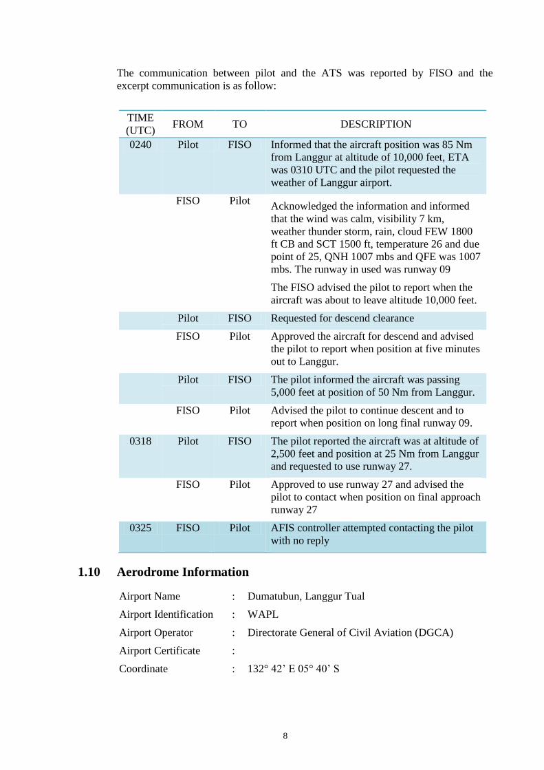
8
The communication between pilot and the ATS was reported by FISO and the
excerpt communication is as follow:
TIME
(UTC) FROM TO DESCRIPTION
0240 Pilot FISO Informed that the aircraft position was 85 Nm
from Langgur at altitude of 10,000 feet, ETA
was 0310 UTC and the pilot requested the
weather of Langgur airport.
FISO Pilot Acknowledged the information and informed
that the wind was calm, visibility 7 km,
weather thunder storm, rain, cloud FEW 1800
ft CB and SCT 1500 ft, temperature 26 and due
point of 25, QNH 1007 mbs and QFE was 1007
mbs. The runway in used was runway 09
The FISO advised the pilot to report when the
aircraft was about to leave altitude 10,000 feet.
Pilot FISO Requested for descend clearance
FISO Pilot Approved the aircraft for descend and advised
the pilot to report when position at five minutes
out to Langgur.
Pilot FISO The pilot informed the aircraft was passing
5,000 feet at position of 50 Nm from Langgur.
FISO Pilot Advised the pilot to continue descent and to
report when position on long final runway 09.
0318 Pilot FISO The pilot reported the aircraft was at altitude of
2,500 feet and position at 25 Nm from Langgur
and requested to use runway 27.
FISO Pilot Approved to use runway 27 and advised the
pilot to contact when position on final approach
runway 27
0325 FISO Pilot AFIS controller attempted contacting the pilot
with no reply
1.10 Aerodrome Information
Airport Name : Dumatubun, Langgur Tual
Airport Identification : WAPL
Airport Operator : Directorate General of Civil Aviation (DGCA)
Airport Certificate :
Coordinate : 132° 42’ E 05° 40’ S
9
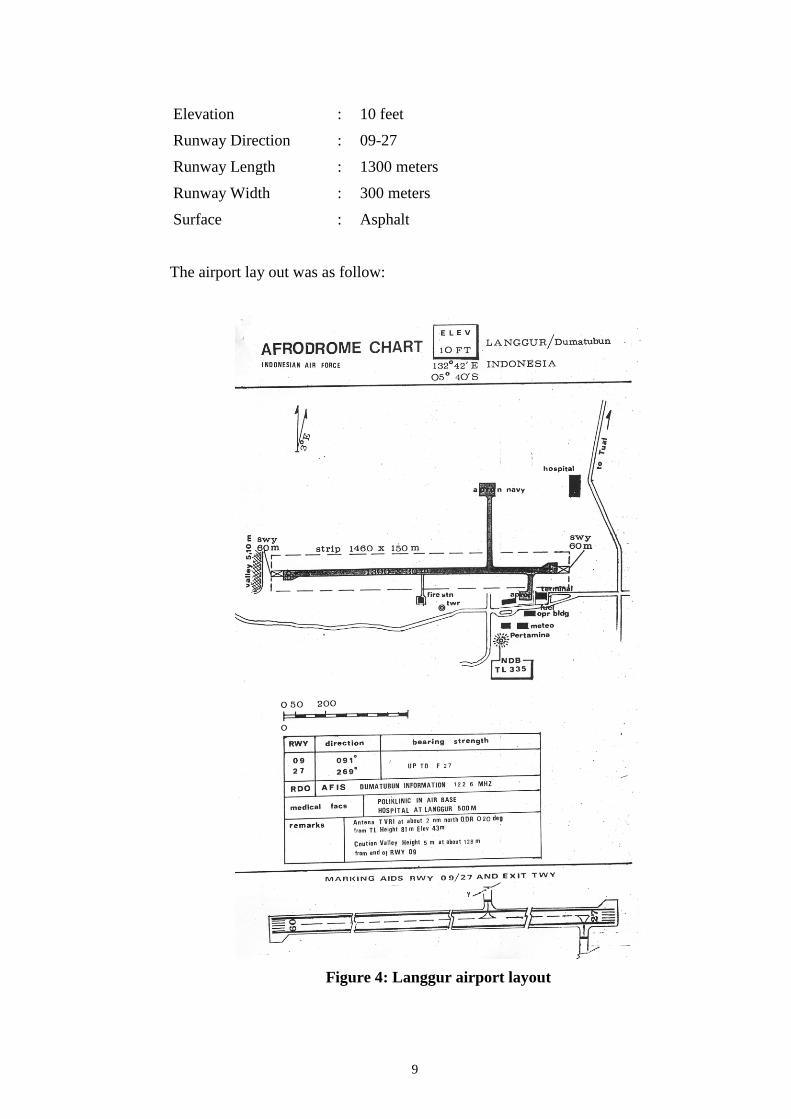
Elevation : 10 feet
Runway Direction : 09-27
Runway Length : 1300 meters
Runway Width : 300 meters
Surface : Asphalt
The airport lay out was as follow:
Figure 4: Langgur airport layout

10
1.11 Flight Recorders
The aircraft was not fitted with flight recorder. Neither recorder was required by
current Indonesian aviation regulations for this type of aircraft.
1.12 Wreckage and Impact Information
The aircraft was found at approximately 1.6 Nm North East of Langgur Airport at
coordinate 5° 38’ 30.40”; S 132° 45’ 21.57” E. at elevation approximately of 40 feet. The
location of the aircraft in relation to the runway marked on Google earth as follows:
Figure 5: The aircraft position relative to runway 27 marked on Google earth
The aircraft heading was approximately 300, the wreckage distributed on an area
with radius of approximately 50 meters and the fuselage destroyed by the post-
impact fire from the cockpit to the empennage.
Figure 6: The general view of wreckage distribution
The nose landing gear tire was still pressurized, and the gear was appeared to be
extended and locked which subsequently collapsed forward most likely at impact.
There was no sign of abnormality to the nose landing gear and tire.

11
Figure 7: Nose landing gear and nose wheel tire
Both main landing gears were still intact at the wing structure and appeared to be
extended and locked. There was no indication of abnormality and it was appeared
that landing gear had been extended.
Figure 8: Left landing gear and left wheel tire
Figure 9: Right landing gear and right wheel tire
The leading edge of the left wing bent upward at approximately 3 – 4 meters from
the wing tip which was a sign of impact force at the left wing. The left wing root was
destroyed by post-impact fire. The witnesses reported that the right wing was found
at an angle of approximately 45 with the wing tip at the top, prior to collapse due to
post impact fire.

12
Figure 10: The deformation of the left wing leading edge
Figure 11: Right view after crashed and after the fire was extinguised
There was no sign of fuel spill on the ground or remaining in the left wing tank most
likely the fuel tank was broken after impact, the fuel leaked and burnt.
All the wing flaps were not in the fully retracted position however, the angle of the
flap extension could not be determined.
Figure 12: Wing flap found not on up position
One of the flap
attachments

13
The left and right engines detached from its mountings and the propeller assemblies
detached from its engines. The left engine was found in upside down position and
faced about 60° to the left from its original position, compared to the position of the
left wing. There was no sign of fire on the left engine.
Figure 13: Left engine condition
Figure 14: Right engine condition
The left engine propeller detached and found at approximately 8 meters in front of
the left engine. The spinner submerged in the mud and damage. The propeller blades
were in the low pitch angle and several scratch marks on the propeller leading edges
and the blades. The propeller blades were not bent in any position.
Figure 15: Left propeller

14
The right engine propeller assembly detached from the engine and separated at
approximately 4 meters in front of the engine. Two blades were found bent backward
with scratch marks and two blades were relatively less damage. The propellers were
at low pitch angle. The spinner detached from the propeller unit.
Figure 16: Right propeller
Most part of the cockpit including the control column, engine control and flap
control were melted and unable to be examined due to impact and post impact fire.
The tail section was found not significantly damaged. The aircraft was equipped with
airborne magnetic mapping survey and the antenna boom was installed on the tail
section. The antenna of airborne magnetic mapping survey was detached and
separated approximately 6 meters behind the tail section.
Figure 17: Tail section and the antenna of airborne mapping survey
1.13 Medical and Pathological Information
No medical or pathological examinations were conducted as a result of this accident.
1.14 Fire
The witnesses state that the fire started after the impact. The cockpit through the
empennage was destroyed due to post-impact fire. The source of the fire was unable
to be determined.
Airborne mapping
survey antenna

15
Figure 18: The exposure of fire after crash. The photo was taken by local witness
1.15 Survival Aspects
After received the report of aircraft accident, the Airport Rescue and Fire Fighting
(ARFF) deployed to the accident site. The aircraft was found at approximately 1.6
Nm North East of Langgur Airport. When the ARFF team arrived at the accident site,
immediately extinguished the fire.
All the occupants were fatally injured. The evacuations of the deceased victims were
conducted by Indonesian search and rescue (BASARNAS) assisted by local people
after the fire had been extinguished.
1.16 Tests and Research
No test or research conducted in this investigation.
1.17 Organizational and Management Information
1.17.1 Aircraft Operator General Information
Aircraft owner and operator : PT. Intan Angkasa Air service
Komplek KIMU
Jalan Pintu Gerbang Tol Cibitung
Bekasi 17520
Air operator certificate : AOC 135-019
The operator had operation base in Balikpapan, East Kalimantan. The operator
operated total of nine aircraft including the accident aircraft and eight helicopters
consist of one Bell 212, one Bell 206 L, two SA315B Alouette III Lama, four MD
Helicopters MD.
1.17.2 Flight Following System
The operator established a flight-following system for the purpose of monitoring
aircraft using Sure Track Global Positioning System (GPS) tracking device. The
device transmitted data from aircraft to the Sure Track server every 5 minutes.
The total flight times as recorded in the flight following was approximately 3 hours

16
30 minutes. Detail of the Sure Track recorded data described in the Appendices of
this report and the data transmitted to the server are as follows:
Figure 19: Sure Track flight following system

17
Based on the movement report, the investigation reconstructed the movement into
the google map to enhance the flight path as shown below.
Figure 20: Flight path from Sentani Airport up to end of the flight
based on Sure Track Global Positioning System
Langgur Airport

18
1.17.3 Piper PA31-350 Chieftain Information Manual
The normal procedure for the landing in section 4, Normal Procedure was as follow:
Figure 21: Section 4 Normal Procedures
Refer to the description of this manual, the applicable flap selection for this aircraft
are 0, 15 and 25 which can be selected via motorized flap selector at the right

19
panel in the main instrument panel. Typical flap selector of this aircraft prior accident
is as follow:
Figure 22: Typical flap selector
1.17.4 Pilot Operating Manual
Emergency Procedure
8. SINGLE ENGINE LANDING
a. Complete feathering procedure.
b. Before landing check list.
(1) Do not drop gear until sure of making field. Maintain 125 mph (109 Kts).
(2) Do not lower flaps until sure of making runway. Maintain 110 mph (96
Kts).
9. SINGLE ENGINE GO-AROUND
a. Throttle - open
b. Flaps - retract
c. Landing gear - retract
d. Airspeed - "One Engine Inoperative Best Rate-of-Climb Speed" is 125 mph
(109 Kts), climb at 130 mph (113 Kts) for high ambient temperature.
e. Trim - set
f. Cowl flap - as required (operating engine)
NOTE
Aircraft will not climb with gear and flaps extended.
1.18 Other Information
1.18.1 Filed ATC Flight Plan

20
The filed (Air Traffic Control) ATC flight plan stated the aircraft was planned to
depart Sentani Airport at 2330 UTC with intended destination was Langgur Airport
(WAPL) via KUBIA waypoint and over Nabire Airport, with the alternate airport
was Benjina Airport (WAPK) which was approximately 95 Nm at radial 104 from
the Dumatubun. The cruising altitude was planes at 10,000 feet and the cruising
speed was 150 knots. The flight estimated would take 3 hours and 30 minutes. The
fuel endurance was six hours however the actual fuel onboard was unknown.
1.19 Useful or Effective Investigation Techniques
The investigation was conducted in accordance with the KNKT approved policies
and procedures, and in accordance with the standards and recommended practices of
Annex 13 to the Chicago Convention.

21
2. ANALYSIS
The aircraft was destroyed by impact forces and post impact fire, several parts of the
remaining wreckage such as cockpit could not be examined due to the level of
damage. The aircraft was not equipped with flight recorders and the communication
between Langgur FISO and the pilot was not recorded. No eyewitness saw the
aircraft prior to impact. Information available for the investigation was limited. The
analysis utilizes available information mainly on the wreckage information including
the information of the wings, engines and propellers.
The flight following system provides information that the accident site was close to
the airport. The filed flight plan stated that the elapse time of the flight was 3 hours
30 minutes and the total fuel endurance was 6 hours. The information indicated that
the fuel was sufficient to conduct the flight, even though the actual fuel uplift to each
wing tank could not be determined. This also supported by the evidence of post
impact fire intensity that indicated significant amount of fuel remain after the impact.
This information indicated that fuel shortage was unlikely to be occurred.
The aircraft was found at approximately 1.6 Nm North East of the airport while the
last communication stated that the pilot requested to land on runway 27 which
previously the runway in use was 09. The investigation could not determine the
reason of the pilot requested runway 27 however, considering the wind condition that
was from North West with velocity of 4 knots, and the aircraft was arriving from
North East, runway 27 was more appropriate for landing.
The wreckage provided evidence that all the landing gears appeared down and
locked, the wing flaps were not in the fully retracted position however, the angle of
the flap extension could not be determined. Referred to the Piper Navajo Information
Manual, the normal procedure checklist stated the landing gear down selected after
the flap selection to 15. Assumed that the procedure was performed and information
of the wreckage that the landing gear had been extended, it can be concluded that the
flap was minimum at 15 positions. This condition indicated that the aircraft was in
preparation for landing.
The left wing leading edge was found bending upward up to 4 meters, indicated that
the left wing was the first part impacted to the ground. This indicated that the aircraft
rolled to the left during impact. This supported by the evidence of the aircraft was
tilted to the left prior to rest on the final position after the fire extinguished. The
impact to the ground with position rolled to the left most likely resulted to the left
propeller impacted to the ground prior to detach from the engine.
Examination of the right propeller found that two blades bent backward and spinner
damage, these evidences showed that the engine completed about a half revolution
when contacted with the ground before propeller detached. The damage on the right
engine showed high rotational energy at impact. It was likely that the engine may
have been operating prior to impact.

22
In contrary with the right propeller, the evidence of left propeller showed less
damage without any bending blade. The left propeller most probably was also
rotating at impact indicated by the several scratch marks at the blade leading edges
and the blades, the unbending propeller indicated less rotational energy compared to
the right propeller.
In some circumstances, there is possibility of propeller rotates with the less energy
from the engine whenever the engine is at low power or completely ceases during
flight. During engine failure in flight, the propellers shall be feathered, which means
moved the propeller blades at approximately 90 degrees to the flight direction to
reduce the drag from the propellers. In the case of the engine ceases during flight and
the propellers are not set to feather, the propeller will automatically move to feather
however, it will take longer time. When the propeller has not reached the feather
position, the forward speed of the aircraft drives the propeller or consistence with
wind-milling situation.
The wind-milling situation of unfeather propellers creates drag (backward force). In
the case of two engines wing mounted aircraft, the ceased engine will create drag
while on to the other engine creates forward force. The drag on ceased engine and
forward force of the operating engine created significant asymmetric force followed
by yaw and roll tendency toward the fail engine. Significant asymmetric force might
have been made the aircraft difficult to control.
Differential rotation of both engines intentionally made by the pilot was unlikely
because normally during approach both engines should rotate with the same power
and rotation to ease the aircraft operation. It can be concluded that the low propeller
rotation was not intentionally done by the pilot.
The left wing leading edge bending upward indicated that the aircraft rolled to the
left prior to impact. The roll most likely was the results of the left engine had ceased
and result in asymmetric forces. The ceased on the left engine was indicated by the
less damage on the left propeller.
The evidence of the left engine found facing to the left relative to the wing position,
indicated the dominant impact forces were downward and to the left. This situation
was consistent with the possibility of wind-milling condition on the left engine while
the propeller was not set to feather subsequently created drag followed by yaw and
roll tendency to the left.
The engine failure which occurs on low power such as aircraft on descend might
have been difficult to be noticed as the asymmetric power was not significant. As the
engine ceasing, the power will reduce and followed by decreasing aircraft speed. The
pilot will tend to open both engines power to maintain the speed. The opening both
engines power will result in only one engine power increasing as the other engine
had failed. Increasing one engine power while the other engine ceasing, creates
significant asymmetric power including the yaw and roll tendency.
In the case of engine failure and followed by asymmetric power occurs during
approach at low altitude, it may be difficult to control by the pilot especially single
pilot aircraft. The pilot requires to perform emergency procedure for engine failure
which include procedure to feather the propeller that will reduce the asymmetric
power. Simultaneously, the pilot shall maintain the safe flight including maintain the

23
flight path.
The last maintenance record from the recovered aircraft flight and maintenance
logbook showed that there was no significant finding on the aircraft. The
investigation could not determine the reason of the left engine ceased.
The evidences of the left wing leading edge bending angle indicated that the aircraft
rolled to the left during impact. The propellers of left engine were found at low angle
and with no significant damage these evidences consistence with the propeller was
not set to feather and wind-milling situation (rotation at low speed). The wind-
milling propeller created drag and led to the aircraft uncontrolled. The aircraft was
found at 1.6 Nm from the airport and was on preparation for landing indicated that
the aircraft was close to the airport which most likely at low altitude.
Based on the available evidences, the investigation concluded that the left engine
failed during approach. The propeller did not set to feather resulted in significant
asymmetric forces on the left and right side of the aircraft. The asymmetric forces
created yaw and roll tendency and the aircraft became uncontrolled, subsequently led
the aircraft to impact to the terrain.

24
3. CONCLUSIONS
3.1 Findings6
1. The pilot in command held valid licenses and medical certificates.
2. The aircraft had a valid Certificate of Airworthiness (C of A) and Certificate of
Registration (C of R).
3. The recovered aircraft flight and maintenance log showed that there was no
significant finding on the aircraft during the last maintenance.
4. The filed flight plan stated that the endurance flight was 3 hours 30 minutes and
the total fuel endurance was 6 hours. The actual fuel onboard could not be
determined. The information indicated that the fuel was sufficient to conduct the
flight, which also supported by the evidence of post impact fire intensity that
indicated significant amount of fuel remain after the impact. The investigation
concluded that fuel shortage was unlikely to be occurred.
5. The weather at Langgur was raining and thunderstorm.
6. The aircraft was significantly damage due to impact force and post-impact fire.
Several parts of the remaining wreckage such as cockpit could not be examined
due to the level of damage.
7. The evidence showed that the flap was found not up which likely more than 15
degrees, all the landing gears appeared down and locks indicated that the aircraft
was configured for landing.
8. The aircraft was found approximately 1.6 Nm from the runway 27 indicated that
the aircraft was on approach and at most likely at low altitude.
9. The damage to the right engine propeller blades and spinner showed the engine
completed about a half revolution when impacted to the ground before propeller
separated it was most likely the right engine had high rotational energy which
indicated that the engine was operating at impact.
10. The evidence of left propeller showed minor damage without any bending of all
blades. The left propeller most probably was also rotating at impact indicated by
the several scratched at the blade surface but with less rotational energy compare
with the right propeller. It was most likely that the left engine had ceased during
impact.
11. The damage on the left wing and the engine was found facing left compare to the
position of the wing indicated the dominant impact forces were downward and to
the left.
12. Based on the available evidences, the investigation concluded that the left engine
failed during approach. The propeller did not set to feather resulted in significant
asymmetric forces on the left and right side of the aircraft.
6 Findings are statements of all significant conditions, events or circumstances in the accident sequence. The findings are
significant steps in the accident sequence, but they are not always causal, or indicate deficiencies. Some findings point
out the conditions that pre-existed the accident sequence, but they are usually essential to the understanding of the
occurrence, usually in chronological order.
25
The asymmetric forces created yaw and roll tendency and the aircraft became
uncontrol, subsequently led the aircraft to impact to the terrain.
3.2 Contributing Factors7
The investigation concluded that the left engine most likely failed during approach
and the propeller did not set to feather resulted in significant asymmetric forces. The
asymmetric forces created yaw and roll tendency and the aircraft became
uncontrolled, subsequently led the aircraft to impact to the terrain.
7 Contributing factors is defined as events that might cause the occurrence. In the case that the event did not occur then the
accident might not happen or result in a less severe occurrence.

26
4. SAFETY ACTION
At the time of issuing this Draft Final report, the Komite Nasional Keselamatan
Transportasi had not been informed of any safety actions resulting from this
occurrence. The aircraft operator stated that operation of fix wing aircraft was
terminated and continues the operation of helicopter only.

27
5. SAFETY RECOMMENDATIONS
As a result of this investigation, the Komite Nasional Keselamatan Transportasi
(KNKT) issue safety recommendations to address safety issue identify in this
investigation.
5.1 PT. Intan Angkasa Air Service
04.O-2018-01.1
The investigation concluded that the left engine failed during approach. The
propeller did not set to feather resulted in significant asymmetric forces on the left
and right side of the aircraft. KNKT recommend to review pilot training in handling
engine failure including during critical phase.
5.2 Directorate General of Civil Aviation
04.R-2018-01.2
The investigation concluded that the left engine most likely failed during approach.
The propeller did not set to feather resulted in significant asymmetric forces on the
left and right side of the aircraft. KNKT recommend to ensure the pilot training in
handling engine failure is adequate.

28
6. APPENDICES
1.20 Sure Track Report

29

30