Embed Size (px)
Citation preview
PRELIMINARYKNKT.16.10.37.04
Aircraft Accident Investigation Report
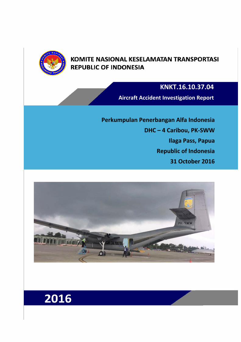
Perkumpulan Penerbangan Alfa Indonesia
DHC – 4 Caribou, PK‐SWW
Ilaga Pass, Papua
Republic of Indonesia
31 October 2016
This preliminary investigation report was produced by the Komite Nasional Keselamatan Transportasi (KNKT), Transportation Building, 3rd Floor, Jalan Medan Merdeka Timur No. 5 Jakarta 10110, Indonesia.
The report is based upon the initial investigation carried out by the KNKT in accordance with Annex 13 to the Convention on International Civil Aviation Organization, the Indonesian Aviation Act (UU No. 1/2009) and Government Regulation (PP No. 62/2013).
The preliminary report consists of factual information collected until the preliminary report published. This report will not include analysis and conclusion.
Readers are advised that the KNKT investigates for the sole purpose of enhancing aviation safety. Consequently, the KNKT reports are confined to matters of safety significance and may be misleading if used for any other purpose.
As the KNKT believes that safety information is of greatest value if it is passed on for the use of others, readers are encouraged to copy or reprint for further distribution, acknowledging the KNKT as the source.
When the KNKT makes recommendations as a result of its investigations or research, safety is its primary consideration.
However, the KNKT fully recognizes that the implementation of recommendations arising from its investigations will in some cases incur a cost to the industry.
Readers should note that the information in KNKT reports and recommendations is provided to promote aviation safety. In no case is it intended to imply blame or liability.
i
TABLE OF CONTENTS TABLE OF CONTENTS ........................................................................................................ i
TABLE OF FIGURES ......................................................................................................... iii
ABBREVIATIONS AND DEFINITIONS .......................................................................... iv
INTRODUCTION ................................................................................................................. vi
1 FACTUAL INFORMATION ......................................................................................... 7 1.1 History of the Flight .............................................................................................. 7
1.2 Injuries to Persons ................................................................................................. 8
1.3 Damage to Aircraft ................................................................................................ 8
1.4 Other Damage ........................................................................................................ 8
1.5 Personnel Information ........................................................................................... 8
1.5.1 Pilot in Command ..................................................................................... 8
1.5.2 Second in Command ................................................................................ 9
1.6 Aircraft Information ............................................................................................ 10
1.6.1 General ................................................................................................... 10
1.6.2 Engines ................................................................................................... 10
1.6.3 Propellers ................................................................................................ 11
1.6.4 Weight and Balance ................................................................................ 11
1.7 Meteorological Information ................................................................................. 11
1.8 Aids to Navigation ............................................................................................... 12
1.9 Communications .................................................................................................. 12
1.10 Aerodrome Information ....................................................................................... 13
1.11 Flight Recorders .................................................................................................. 13
1.11.1 Cockpit Voice Recorder ......................................................................... 13
1.12 Wreckage and Impact Information ...................................................................... 13
1.13 Medical and Pathological Information ................................................................ 15
1.14 Fire ....................................................................................................................... 15
1.15 Survival Aspects .................................................................................................. 16
1.16 Tests and Research .............................................................................................. 17
1.17 Organizational and Management Information ..................................................... 17
1.18 Additional Information ........................................................................................ 17
1.19 Useful or Effective Investigation Techniques ..................................................... 17
ii
2 FINDINGS...................................................................................................................... 18
3 SAFETY ACTION ........................................................................................................ 19 3.1 Directorate General of Civil Aviation ................................................................. 19
4 SAFETY RECOMMENDATIONS ............................................................................. 20

iii
TABLE OF FIGURES NO TABLE OF FIGURES ENTRIES FOUND.
iv
ABBREVIATIONS AND DEFINITIONS
AFIS Aerodrome Flight Information Services AGL Above Ground Level AIS Aeronautical Information Service ALERFA The code word used to designate an alert phase when:
• Attempts made during the uncertainty phase to establish contact with an aircraft or to gain any news from other sources have failed and the aircraft is now clearly overdue
• An aircraft, which has been cleared to land, has failed to land within 5 minutes of the estimated time of landing and communication with the aircraft has been lost;
• Information has been received which indicates that the operating efficiency of an aircraft for which the uncertainty phase was declared (or that of another aircraft) Has become impaired, but not to the extent that a forced landing is likely;
• There is reason to believe that the operation of an aircraft is subject to unlawful interference.
AOC Air Operator Certificate ATPL Air Transport Pilot License BASARNAS Badan Search and Rescue Nasional – The Indonesia Search and
Rescue Agency BMKG Badan Meterologi, Klimatoligi dan Geofisika – The Indonesia
Bureau of Meteorology, Climatology and Geophysics. °C Degrees Celsius CPL Commercial Pilot License CVR Cockpit Voice Recorder DETRESFA The code word used to designate a distress phase when:
• Attempts made during the alert phase to establish contact with an aircraft and to gain information through more widespread enquiries have failed - and the aircraft is clearly missing and probably in distress;
• The fuel on board is considered exhausted or insufficient for the aircraft to reach safety;
• Information is received which indicates that the operating efficiency of an aircraft has become impaired - to the extent that a forced landing is likely;
• Information is received, or it is reasonably certain that an aircraft is about to make or has made a forced landing or has crashed;
• A downed aircraft is located as the result of a sighting or of homing 0n to an aircraft Emergency Locator Beacon transmission.
v
DGCA Directorate General of Civil Aviation DVI Disaster Victim Identification ELT Emergency Locator Transmitter hPa Hectopascals ICAO International Civil Aviation Organization In Hg Inch hydrargyrum mb Millibars MTOW Maximum Take-off Weight NM Nautical mile(s) KNKT / NTSC Komite Nasional Keselamatan Transportasi / National Transportation
Safety Committee PIC Pilot in Command QFE Height above aerodrome elevation (or runway threshold elevation)
based on local station pressure QNH Altitude above mean sea level based on local station pressure RPM Revolution Per Minute SL RA Slight rain S/N Serial Number TSN Time Since New UTC Coordinated Universal Time VOR Very High Frequency Omni Range
vi
INTRODUCTION
SYNOPSIS A DHC-4 Caribou aircraft, registered PK-SWW was being operated by Perkumpulan Penerbangan Alfa Indonesia, on 31 October 2016 on an unscheduled cargo flight from Moses Kilangin Airport Timika, with intended destination to Kaminggaru Aerodrome, Ilaga Papua. On board on this flight was 4 persons consisted of two pilots, one company engineer and one flight operation officer.
At 2257 UTC, the aircraft departed Timika with intended cruising altitude of 12,500 feet and estimated time of arrival Ilaga at 2327 UTC.
At 2323 UTC, the pilot made initial contact with Ilaga Aerodrome Flight Information Services (AFIS) officer and reported that the aircraft position was at Ilaga Pass and informed the estimate time of arrival Ilaga would be on 2327 UTC. Ilaga Aerodrome Flight Information Services (AFIS) officer advised to continue descend to circuit altitude and to report when position on downwind.
At 2330 UTC, the AFIS officer called the pilot and was not replied. The AFIS officer asked pilot of another aircraft in the vicinity to contact the pilot of the DHC-4 Caribou aircraft and did not reply.
At 0020 UTC, Sentani Aeronautical Information Service (AIS) officer declared the aircraft status as ALERFA.
At 0022 UTC, Timika Tower controller received information from a pilot of an aircraft that Emergency Locator Transmitter (ELT) signal was detected approximately at 40 – 45 Nm with radial 060° from TMK VOR (Very High Frequency Omni Range) or approximately at coordinate 4°7’46” S; 137°38’11” E. This position was between Ilaga Pass and Jila Pass.
At 0053 UTC, the aircraft declared as DETRESFA.
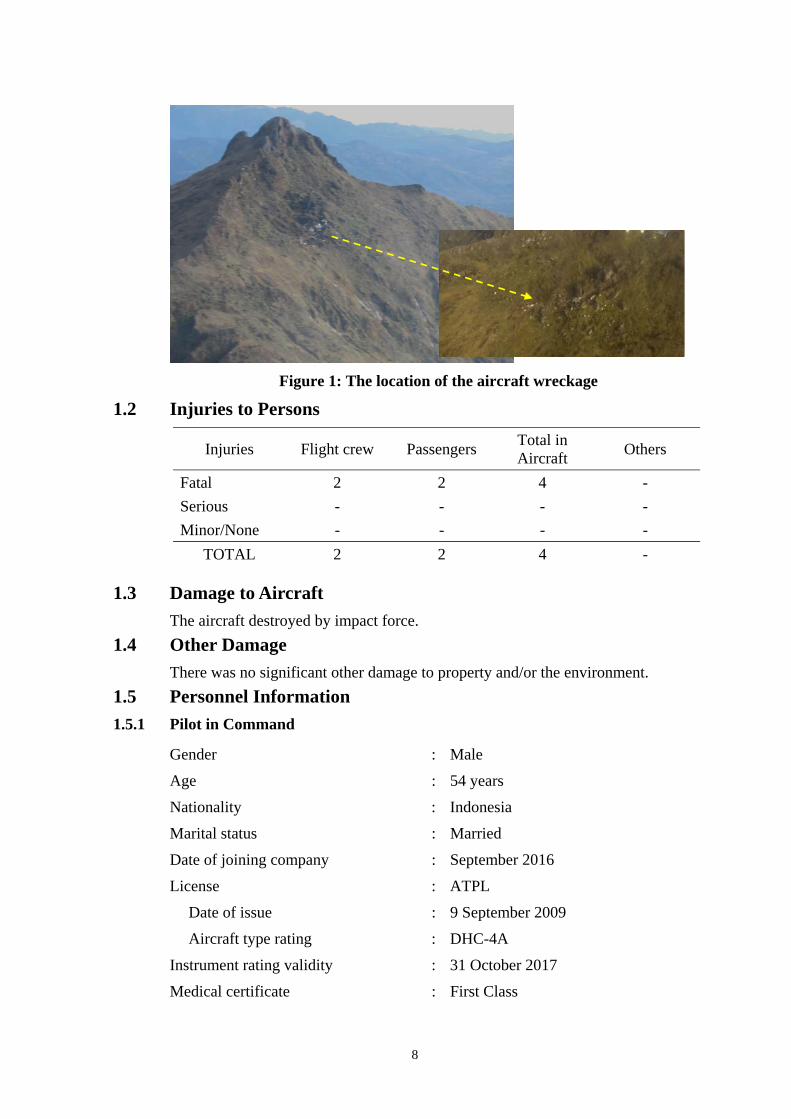
On 1 November 2016, the aircraft wreckage was found on a ridge of mountain between Ilaga Pass and Jila Pass at coordinate 4°5’55.10” S; 137°38’47.60” E with altitude approximately of 13,000 feet.
All occupants were fatally injured and the aircraft destroyed by impact force.
Prior to issue this preliminary report, KNKT had been received the safety actions taken by Indonesia Directorate General of Civil Aviation (DGCA) and KNKT issued safety recommendation to the Perkumpulan Penerbangan Alfa Indonesia.
The investigation is continuing and will include but not limited to the information of relevant aircraft operator manuals and procedures, crew training, voice recorded information, organization information and human factors.
7
1 FACTUAL INFORMATION
1.1 History of the Flight A DHC-4 Caribou aircraft registered PK-SWW was being operated by Perkumpulan Penerbangan Alfa Indonesia, on 31 October 2016 on an unscheduled cargo flight from Moses Kilangin Airport Timika1, with intended destination to Kaminggaru Aerodrome, Ilaga2 Papua. On board on this flight was 4 persons consisted of two pilots, one company engineer and one flight operation officer.
At 2257 UTC3, the aircraft departed Timika with intended cruising altitude of 12,500 feet and estimated time of arrival Ilaga at 2327 UTC.
At 2323 UTC, the pilot made initial contact with Ilaga Aerodrome Flight Information Services (AFIS) officer and reported that the aircraft position was at Ilaga Pass and informed the estimate time of arrival Ilaga would be on 2327 UTC. Ilaga AFIS officer advised to continue descend to circuit altitude and to report when position on downwind.
At 2330 UTC, the AFIS officer called the pilot and was not replied. The AFIS officer asked another pilot in the vicinity to contact the pilot of the DHC-4 Caribou aircraft and did not reply.
At 0020 UTC, Sentani aeronautical information service (AIS) officer declared the flight status as ALERFA4.
At 0022 UTC, Timika Tower controller received information from a pilot of an aircraft that Emergency Locator Transmitter (ELT) signal was detected approximately at 40 – 45 Nm with radial 060° from TMK VOR (Very High Frequency Omni Range) or approximately at coordinate 4°7’46” S; 137°38’11” E. This position was between Ilaga Pass and Jila Pass.
At 0053 UTC, the aircraft declared as DETRESFA5.
On 1 November 2016, the aircraft wreckage was found on a ridge of mountain between Ilaga Pass and Jila Pass at coordinate 4°5’55.10” S; 137°38’47.60” E with altitude approximately of 13,000 feet.
All occupants were fatally injured and the aircraft destroyed by impact force.
1 Moses Kilangin Airport Timika Papua will be named as Timika for the purpose of this report. 2 Ilaga Airport Papua will be named as Ilaga for the purpose of this report. 3 The 24-hour clock used in this report to describe the time of day as specific events occurred is in Universal Coordinated Time (UTC).
Local time for Timika is Eastern Indonesia Standard Time /Waktu Indonesia Timur (WIT) or UTC + 9. 4 ALERFA: The code word used to designate an alert phase. 5 DETRESFA: The code word used to designate a distress phase.
8
Figure 1: The location of the aircraft wreckage
1.2 Injuries to Persons
Injuries Flight crew Passengers Total in Aircraft Others
Fatal 2 2 4 - Serious - - - - Minor/None - - - -
TOTAL 2 2 4 -
1.3 Damage to Aircraft The aircraft destroyed by impact force.
1.4 Other Damage There was no significant other damage to property and/or the environment.
1.5 Personnel Information 1.5.1 Pilot in Command
Gender : Male
Age : 54 years
Nationality : Indonesia
Marital status : Married
Date of joining company : September 2016
License : ATPL
Date of issue : 9 September 2009
Aircraft type rating : DHC-4A
Instrument rating validity : 31 October 2017
Medical certificate : First Class
9
Last of medical : 15 August 2016
Validity : 15 February 2017
Medical limitation : Holder shall wear lenses that correct for distant vision and posses glasses that correct for near vision
Last line check : 5 October 2016
Last proficiency check : -
Flying experience
Total hours : 9336 hours 18 minutes
Total on type : 38 hours 21 minutes
Last 90 days : 194 hours 40 minutes
Last 60 days : 144 hours 19 minutes
Last 24 hours : Nil
This flight : Approximately 30 minutes
1.5.2 Second in Command
Gender : Male
Age : 39 years
Nationality : Indonesia
Marital status : Married
Date of joining company : September 2016
License : CPL
Date of issue : 19 August 2010
Aircraft type rating : DHC-4A
Instrument rating validity : 30 September 2017
Medical certificate : First Class
Last of medical : 27 June 2016
Validity : 27 December 2016
Medical limitation : None
Last line check : 15 September 2016
Last proficiency check : -
Flying experience
Total hours : 3636 hours 44 minutes
Total on type : 17 hours 59 minutes
10
Last 90 days : 61 hours 17 minutes
Last 60 days : 17 hours 59 minutes
Last 24 hours : Nil
This flight : Approximately 30 minutes
1.6 Aircraft Information 1.6.1 General
Registration Mark : PK-SWW
Manufacturer : Viking Air Limited (De Havilland)
Country of Manufacturer : Canada
Type/Model : DHC-4 Caribou Turbo
Serial Number : 303
Year of Manufacture : 1960
Certificate of Airworthiness
Issued : 25 August 2016
Validity : 24 August 2017
Category : Transport (cargo version)
Limitations : None
Certificate of Registration
Number : 3847
Issued : 25 August 2016
Validity : 24 August 2019
Time Since New : 2,748.1 hours
Cycles Since New : 5,953 cycles
Last Major Check : 1,200 hour inspection performed on 15 September 2014 (TSN 2627.6 hours)
1.6.2 Engines
Manufacturer : Pratt and Whitney
Type/Model : PT6A-67T
Serial Number-1 engine : PCE-PY0091
Time Since New : 114.43 hours
Cycles Since New : 80 cycles
Serial Number-2 engine : PCE-PY0090
Time Since New : 113.11 hours
11
Cycles Since New : 79 cycles
1.6.3 Propellers
Manufacturer : Hartzell Propeller Inc.
Type/Model : HC-B5MA-3M
Serial Number-1 propeller : HBA1921
Time Since New : N/A
Cycles Since New : N/A
Serial Number-2 propeller : HBA1902
Time Since New : N/A
Cycles Since New : N/A
1.6.4 Weight and Balance
Maximum allowable take-off weight : 27,500 lbs
Take-off weight : 26,862 lbs
Maximum allowable landing weight : 27,500 lbs
Estimated landing weight : 26,267 lbs
Fuel at take off : 2,500 lbs
Flight planned fuel burn : 585 lbs
Estimated fuel at landing : 1,915 lbs Take off Centre of Gravity : 36 % MAC
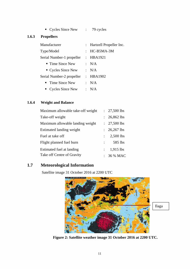
1.7 Meteorological Information Satellite image 31 October 2016 at 2200 UTC
Figure 2: Satellite weather image 31 October 2016 at 2200 UTC.
Ilaga
12
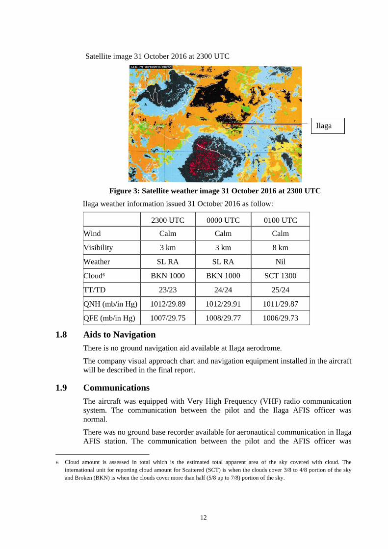
Satellite image 31 October 2016 at 2300 UTC
Figure 3: Satellite weather image 31 October 2016 at 2300 UTC
Ilaga weather information issued 31 October 2016 as follow:
2300 UTC 0000 UTC 0100 UTC
Wind Calm Calm Calm
Visibility 3 km 3 km 8 km
Weather SL RA SL RA Nil
Cloud6 BKN 1000 BKN 1000 SCT 1300
TT/TD 23/23 24/24 25/24
QNH (mb/in Hg) 1012/29.89 1012/29.91 1011/29.87
QFE (mb/in Hg) 1007/29.75 1008/29.77 1006/29.73
1.8 Aids to Navigation There is no ground navigation aid available at Ilaga aerodrome.
The company visual approach chart and navigation equipment installed in the aircraft will be described in the final report.
1.9 Communications The aircraft was equipped with Very High Frequency (VHF) radio communication system. The communication between the pilot and the Ilaga AFIS officer was normal.
There was no ground base recorder available for aeronautical communication in Ilaga AFIS station. The communication between the pilot and the AFIS officer was
6 Cloud amount is assessed in total which is the estimated total apparent area of the sky covered with cloud. The
international unit for reporting cloud amount for Scattered (SCT) is when the clouds cover 3/8 to 4/8 portion of the sky and Broken (BKN) is when the clouds cover more than half (5/8 up to 7/8) portion of the sky.
Ilaga
13
recorded in Cockpit Voice Recorder (CVR) installed in the aircraft.
1.10 Aerodrome Information
Airport Name : Ilaga – Aminggaru
Airport Identification : ILA/WABL
Airport Operator : DGCA
Airport Certificate : -
Coordinate : 04°03’00.00” S; 137°40’00.02” E
Elevation : 7975 feet (2316 m) mean sea level
Runway Direction : 07 – 25
Runway Length : 600 m
Runway Width : 18 m
Surface : Asphalt
1.11 Flight Recorders 1.11.1 Cockpit Voice Recorder
The aircraft was fitted with a Cockpit Voice Recorder (CVR).
Manufacturer : Universal
Type/Model : CVR-120A
Part Number : 1606-00-00
Serial Number : 1233
The CVR was recovered from the accident site on 6 November 2016 by KNKT investigator and transferred to KNKT recorder facility for data download process. The CVR contain 120 minutes of good quality data, including the accident flight. The information of the data recorded in the CVR will be described in the final report.
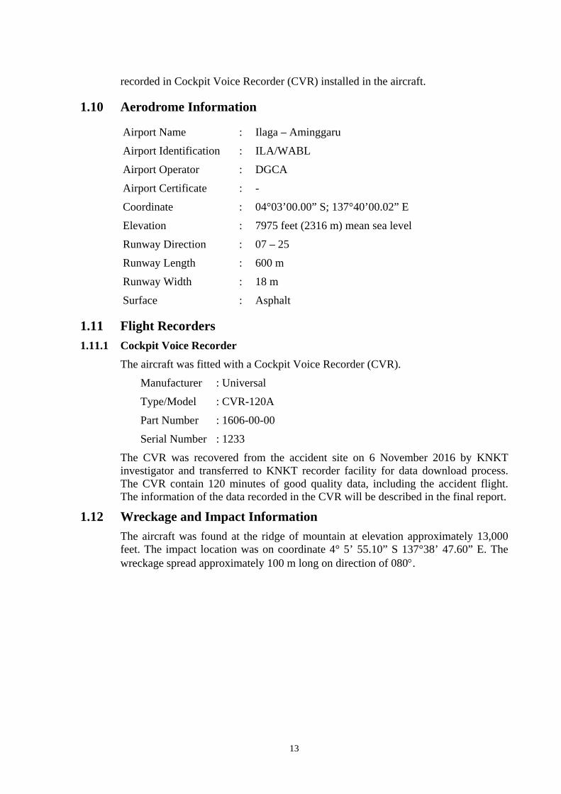
1.12 Wreckage and Impact Information The aircraft was found at the ridge of mountain at elevation approximately 13,000 feet. The impact location was on coordinate 4° 5’ 55.10” S 137°38’ 47.60” E. The wreckage spread approximately 100 m long on direction of 080°.
14
Figure 4: The wreckage distribution
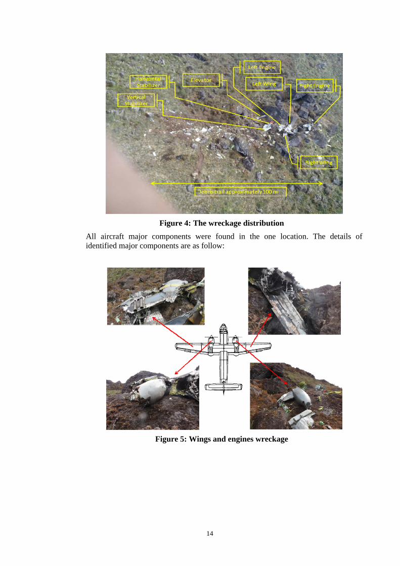
All aircraft major components were found in the one location. The details of identified major components are as follow:
Figure 5: Wings and engines wreckage
15
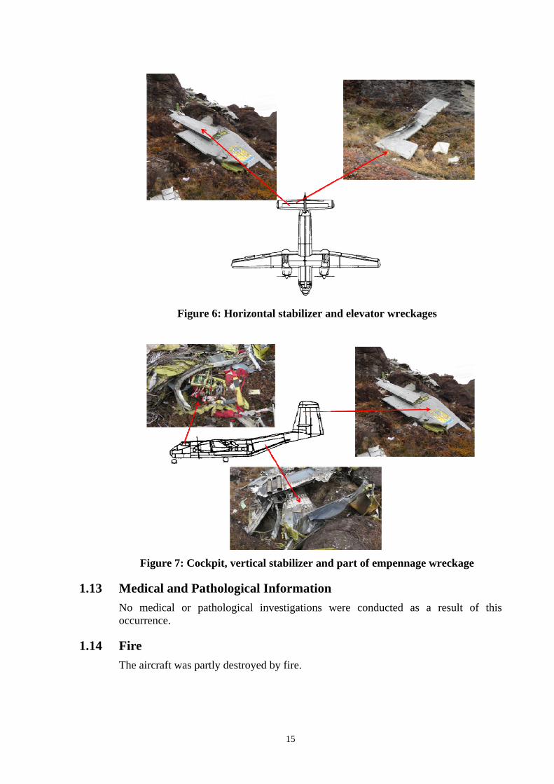
Figure 6: Horizontal stabilizer and elevator wreckages
Figure 7: Cockpit, vertical stabilizer and part of empennage wreckage
1.13 Medical and Pathological Information No medical or pathological investigations were conducted as a result of this occurrence.
1.14 Fire The aircraft was partly destroyed by fire.
16
1.15 Survival Aspects On 31 October 2016 at 0020 UTC, the aircraft declared as ALERFA and the message was conveyed to The Indonesian Search and Rescue Agency (Badan SAR Nasional – BASARNAS) office in Timika.
The declaration of aircraft emergency status was issued by Sentani because Ilaga AFIS was under Sentani AirNav branch and the communication in Ilaga was unreliable at the time of occurrence.
At 0022 UTC, Timika Tower controller received information from a pilot of an aircraft that Emergency Locator Transmitter (ELT) signal was detected approximately at 40 – 45 Nm with radial 060° from TMK VOR (Very High Frequency Omni Range) or approximately at coordinate 4°7’46” S; 137°38’11” E. This position was between Ilaga Pass and Jila Pass.
At 0053 UTC, the aircraft emergency status was declared as DETRESFA and a joint search and rescue team was assembled consisted of BASARNAS and Indonesia Air Force base in Timika and KNKT.
At 0440 UTC, the joint team departed to the nearest reported ELT signal area using MI171 helicopter. The team mission was to identify the aircraft position and to position search and rescue team at Jila village which was the nearest village from the predicted crash site. The accident site could not be identified as the predicted area was covered by low cloud. The helicopter continued to Jila village and dropped the team, fuel and logistic.
On 1 November 2016, a search operation was conducted using a DHC 6 Twin Otter aircraft which departed Timika at 2100 UTC. At 2133 UTC, the aircraft wreckage was found at the ridge of mountain between Ilaga Pass and Jila Pass at coordinate 4° 5’55.10” S; 137°38’47.60” E, at approximate elevation of 13,000 feet. The aircraft was destroyed by impact force.
Rescue team was deployed to the crash site used a Bell 212 helicopter departed Timika at 2300 UTC, to evacuate the occupants and returned to Timika at 0330 UTC with all deceased bodies. All occupants were fatally injured. The deceased bodies were transferred to Disaster Victim Identification (DVI) in Jakarta for identification.
On 5 November 2016, the DVI declared that the deceased bodies transferred to Jakarta were consisted only three personnel. After received the information, a rescue team was reassembled to rescue the remaining personnel and to search the CVR.
On 6 November 2016 at 2100 UTC, a joint team of KNKT, BASARNAS and special force of Indonesia Air Force based in Timika departed to the crash site using helicopter Kamov 32.
At 0035 UTC, the remaining occupant was discovered and subsequently the CVR.
At 0200 UTC, the remaining occupant was evacuated to Timika using Kamov 32. After evacuating the body to Timika the helicopter Kamov 32 could not reach the crash site due to weather and the team and the CVR stayed overnight, near the accident site.
On 7 November 2016 at 0200 UTC, the team and the CVR departed from the crash site to Timika used Kamov 32. The CVR subsequently transported to KNKT
17
recorder facility in Jakarta.
1.16 Tests and Research Test and research will include in the final report.
1.17 Organizational and Management Information Aircraft owner : District Puncak (Pemerintah Kabupaten Puncak)
Desa Kimak, Distrik Ilaga Kabupaten Puncak Papua – Indonesia
Aircraft operator : Perkumpulan Penerbangan Alfa Indonesia
Bulding B.20 A-B/SM
Halim Perdanakusumah International Airport
Jakarta Timur 13610 Indonesia
Air operator certificate : AOC/91-016
Further information of the aircraft operator will be described in the final report.
1.18 Additional Information The investigation is continuing and will include but not limited to the following information: − Relevant aircraft operator manuals and procedures, − Crew training, − Voice recorded information, − Organization information, − Human factors.
KNKT plans to complete the investigation within 12 months since the day of the occurrence. Should any further relevant safety issues emerge during the course of the investigation, KNKT will immediately bring the issues to the attention of the relevant parties and publish as required.
1.19 Useful or Effective Investigation Techniques The investigation was conducted in accordance with the KNKT approved policies and procedures, and in accordance with the standards and recommended practices of Annex 13 to the Chicago Convention.
18
2 FINDINGS7 According to factual information during the investigation, the Komite Nasional Keselamatan Transportasi identified initial findings as follows:
1. The aircraft had a valid Certificate of Airworthiness;
2. The pilots held valid licenses and medical certificates;
3. There was no pilot report of any aircraft system malfunction before the occurrence;
4. The wreckage was found at the ridge of mountain between Ilaga pass and Jila pass at coordinate 4° 5’ 55.10” S 137°38’ 47.60” E with altitude approximately of 13,000 feet
7 Findings are statements of all significant conditions, events or circumstances in the accident sequence. The findings are
significant steps in the accident sequence, but they are not always causal, or indicate deficiencies. Some findings point out the conditions that pre-existed the accident sequence, but they are usually essential to the understanding of the occurrence, usually in chronological order.
19
3 SAFETY ACTION At the time of issuing this preliminary report, the Komite Nasional Keselamatan Transportasi (KNKT) had been informed of safety actions resulting from this occurrence.
3.1 Directorate General of Civil Aviation On 9 November 2016, Directorate General of Civil Aviation (DGCA) issued Safety Circular (Edaran Keselamatan) number SE.24 tahun 2016, consist of the following recommendations:
1. Ensure the pilot to follow the Visual Flight Rules (VFR) and Instrument Flight Rules (IFR) principles. The pilot should not conduct VFR flight in instrument meteorological condition or uncertain Visual Meteorological Condition (VMC) refer to weather information issued by Badan Meteorologi, Klimatologi dan Geofisika (BMKG) or Meteorological, Climatology and Geophysical Bureau. The flight should be delayed or return to base (RTB) for VFR flight when the weather condition do not meet VFR minima.
2. Ensure the pilot to follow the route chart issued by DGCA or company approved route chart.
3. Ensure the pilot to conduct the stabilized approach in any IMC or VMC condition and execute go around if the criteria were not established.
4. Ensure the operator or pilot to follow the operation limitation according to the environment condition (elevation, temperature, air density, runway length, runway surface, wind speed, etc.)
5. Ensure all pilots flying in the mountainous area are qualified and trained properly.
6. Ensure the operator to conduct the Safety Management System (SMS) especially in hazard identification and assessment before conducting the operation in mountainous area.
7. Ensure that the aircraft complied with the airworthiness requirement.
8. The operators are not allowed to operate the aircraft in contrary with the Operations Specifications (Opsecs), Authorization, Condition and Limitation (ACL) and any other manual which approved by DGCA.
9. Ensure the operator to conduct the intensive monitoring and to placed the key personnel in the operation coverage.
20
4 SAFETY RECOMMENDATIONS According to factual information and initial findings, the Komite Nasional Keselamatan Transportasi (KNKT) recommend to Perkumpulan Penerbangan Alfa Indonesia to comply the DGCA Safety Circular number SE.24 of 2016.