Embed Size (px)
DESCRIPTION
Israeli settler agriculture as a means of land takeover in the West Bank.
Citation preview
Diakonia International Humanitarian Law ProgrammeLegal Analysis 1/2011
[COVER PICTURE – women running]
ISRAELI SETTLERS’ AGRICULTURE AS A MEANS OF LAND TAKEOVER IN THE WEST BANK
August 2013

NABOTH’S VINEYARD
1 Some time later there was an incident involving a vineyard belonging to Naboth the Jezreelite. The vineyard was in Jezreel, close to the palace of Ahab king of Samaria. 2 Ahab said to Naboth, “Let me have your vineyard to use for a vegetable garden, since it is close to my palace. In exchange I will give you a better vineyard or, if you prefer, I will pay you whatever it is worth.” 3 But Naboth replied, “The LORD forbid that I should give you the inheritance of my ancestors.” 4 So Ahab went home, sullen and angry because Naboth the Jezreelite had said, “I will not give you the inheritance of my ancestors.” He lay on his bed sulking and refused to eat. 5 His wife Jezebel came in and asked him, “Why are you so sullen? Why won’t you eat?” 6 He answered her, “Because I said to Naboth the Jezreelite, ‘Sell me your vineyard; or if you prefer, I will give you another vineyard in its place.’ But he said, ‘I will not give you my vineyard.’” 7 Jezebel his wife said, “Is this how you act as king over Israel? Get up and eat! Cheer up. I’ll get you the vineyard of Naboth the Jezreelite.” 8 So she wrote letters in Ahab’s name, placed his seal on them, and sent them to the elders and nobles who lived in Naboth’s city with him. 9 In those letters she wrote: “Proclaim a day of fasting and seat Naboth in a prominent place among the people. 10 But seat two scoundrels opposite him and have them bring charges that he has cursed both God and the king. Then take him out and stone him to death.” 11 So the elders and nobles who lived in Naboth’s city did as Jezebel directed in the letters she had written to them. 12 They proclaimed a fast and seated Naboth in a prominent place among the people. 13 Then two scoundrels came and sat opposite him and brought charges against Naboth before the people, saying, “Naboth has cursed both God and the king.” So they took him outside the city and stoned him to death. 14 Then they sent word to Jezebel: “Naboth has been stoned to death.” 15 As soon as Jezebel heard that Naboth had been stoned to death, she said to Ahab, “Get up and take possession of the vineyard of Naboth the Jezreelite that he refused to sell you. He is no longer alive, but dead.” 16 When Ahab heard that Naboth was dead, he got up and went down to take possession of Naboth’s vineyard.
(I Kings 21:1–16)
4
August 2013
Field research, GIS mapping, text, and photographs: Dror Etkes, Kerem NavotLegal consultancy and contribution of legal appendix: Quamar Mishirqi-Assad, Rabbis for Human Rights, IsraelHebrew editing: Lilach TchelnovEnglish translation and editing: Tamar CohenMaps & Graphs: Yair Shapira
Kerem Navot is a new Israeli civil society organization, established during 2012 and employing comprehensive land-use research to challenge the systems and policies that enable ongoing dispossession of Palestinians from their land in the West Bank. The methodologies employed at Kerem Navot have been developed over years of experience in the field.
We would like to thank Prof. Guy Stakalov for his help in processing the data collected in the survey on which this report is based, and Advocate Netta Amar-Shiff of the Diakonia International Humanitarian Law Resource Centre, for her advice in the writing of this report. We would like also to thank Mr. Idan Barir for his assistance with translation of Arabic legal documents.
This publication has been produced with the assistance of Diakonia.The content of this publication is the sole responsibility of the author and reflects the views of the author alone and not necessarily those of Diakonia.
Cover photo: Frush Beit Dajan and the settlement of Hamra by Alex Levac Designed by: Marwan Hamad, InterTech, Ramallah
5
TABLE OF CONTENTS
Executive Summary ........................................................................................................................................ 6
Introduction ................................................................................................................................................... 15 Structure of the Report ..................................................................................................................... 19
Part I: Thematic Background and Methodological Framework ............................................................. 22
Main Questions of the Report .......................................................................................................... 23 Survey, Database, and Methodology ................................................................................................ 24 Subjects for Future Research ........................................................................................................... 25
Part II: Official and Unofficial Methods of Land Takeovers for the Settlements in the West Bank, and the International Humanitarian and Human Rights Law Context ......................................................... 26
Official Israeli Land-Takeover Measures in the West Bank ............................................................ 26 Land Takeovers through Military Seizure Orders for “Security” Purposes ..................................... 28 Military Land Seizures for Agricultural Purposes .......................................................................... 30 Declaration of State Lands .............................................................................................................. 33 A Method to the Madness: Unofficial land takeovers by settlers and the deterioration of the rule of Law in the West Bank ........................................................................................................ 34
Part III: The Valley and the Hill – Two Typologies of Israeli Agriculture in the West Bank ................ 38
Israeli Agriculture in the West Bank Hill Country ........................................................................... 39 De Facto Appropriation of Areas around Settlements and Outposts ................................................ 40 Declaration of areas as “Special Security Areas” ............................................................................ 42 Agricultural Incursions by Settlers into Area B, Including the Nature Reserve Stipulated in the Accords .................................................................................................................................. 44 Takeovers of agricultural land for commemoration purposes .......................................................... 46 Israeli Agriculture in the Jordan Valley and Northern Dead Sea ..................................................... 50 Takeover of Waqf Lands .................................................................................................................. 55 Leasing land (daman) to Palestinians .............................................................................................. 56 Farming areas in the Border Region closed by Military Order 151 ................................................. 58 “Absentee” property and land-swap (tabdeel) contracts .................................................................. 60 Transfer of Agricultural Land to Israeli Settlements within the Green Line ................................... 62 Sewage Treatment for Irrigation of Israeli Agriculture in the Jordan Valley ................................... 65 Summary .......................................................................................................................................... 67
Part IV: Findings of the Survey ................................................................................................................... 68
Summary and Conclusions .......................................................................................................................... 87
Appendix I: Case Study – Agricultural Takeovers by Settlers around the Shilo Settlement and Outposts ......................................................................................................................................................... 89
Appendix II: Legal Recourse Based in Local Law for Palestinians in the West Bank against Settler Takeovers of Private Palestinian Land ..................................................................................................... 106
By Advocate Quamar Mishirqi-Assad, Head of the Legal Department of Rabbis for Human Rights, Israel
6
EXECUTIVE SUMMARY
The Zionist ideal of Jewish agriculture in the Land of Israel reached the occupied West Bank within months of the end of the 1967 War. Eventually, agriculture became a central means by which the settlement movement (with the overt or tacit approval and direct or indirect support of the state) staked a claim to and consolidated control over large areas of the West Bank. The first Israeli West-Bank settlers viewed agriculture as a means of solidifying Jewish settlement in the West Bank for three main reasons: Ideological/religious – Agricultural activity bolstered the claim that the Israeli settlement in so-called “Judea and Samaria” constituted a return to the “Land of the Fathers” and to the times when agriculture was a source of livelihood for the ancient Jewish communities in the region; Economic – Agriculture was considered an economic base on which the first settlements could subsist and develop, though with time, agriculture became less significant as a source of livelihood for the settler population; and Territorial – Agricultural activity was a key means with which to expand the territory of the nascent settlement enterprise.
In recent years, there has been a significant growth in the area cultivated by Israeli settlers throughout the West Bank. Today, over 93,000 dunam of Israeli agricultural activity takes place in between the military posts, civilian outposts, settlements, and bypass roads in the West Bank. This area is much larger area than the actual built-up area of the settlements and outposts (which constitute about 60,000 dunam, not including the Israeli neighborhoods in East Jerusalem). Moreover, the most rapid growth in agricultural areas is occurring around settlements that were originally established as suburban communities and where no substantial agricultural activity took place in the past.
This activity is part of a widespread and well-funded strategy, whose explicit goal is to expand the territory controlled by Israeli settlers throughout Area C. Behind the reality described in this report is a clear territorial rationale: the agricultural takeover of large swaths of land requires relatively few resources and time in comparison with actual construction in the settlements or the establishment of outposts or satellite settlements, and facilitates the quick establishment of facts on the ground.
The goal of this report is to add another layer to the debate about the expansion of Israeli settlements in the West Bank. This debate generally focuses on subjects such as construction in the settlements, establishment of outposts, demographic growth of the settler population, and the benefits that this population receives. The story of Israeli settler agriculture in the West Bank is not often mentioned or even understood as part of this debate, notwithstanding the far-reaching implications for the West Bank and the Palestinian population there.
This report surveys a number of aspects of Israeli agriculture in the West Bank, in particular the developments and changes that have taken place over the 15 years between 1997 and 2012. The report describes the official and unofficial means that have been used by the state of Israel and the settlers to take over land for agricultural use, and the role of such agricultural takeovers within the wider context of Israel’s land grabs for the settlements.
The report shows that the wholesale takeover of agricultural lands is not the result of the isolated efforts of individual settlers or even entire settlements, but part of a long-term and well-funded strategy that has been encouraged and supported by governmental and public agencies for many years, despite the blatant illegality of much of the activity, even in terms of Israeli law.
Part I: Thematic Background and Methodological Framework
This report is based on a survey of unprecedented scope, identifying and mapping over 93,000 dunam of land allocated or actually used for Israeli agricultural activity in the West Bank and the growth in this area from 1997 to 2012. The survey classifies the Israeli agricultural areas in the West Bank according to a number of parameters: year in which Israeli agricultural activity began; the measure by which the land was
7
expropriated (declaration of closed military zone, declaration as state land, land-swap of absentee property, “pirvate” takeover by settlers, etc.); land-ownership status (private Palestinian, public [state], Muslim Waqf, or pre-1948 Jewish-owned); region or regional council to which the land is affiliated; character of the settler population there (religious/secular); settlement jurisdiction (within/outside of a jurisdiction area of a settlement); and type of crop or branch of agriculture. In order to determine the status of each plot, in terms of land-ownership status and settlement jurisdiction, the data was cross-referenced with layers of official data from the Civil Administration, which we were transferred to us gradually between 2007 and 2012, following a series of requests and petitions submitted based on the Freedom of Information Law. The data presented in this report can therefore be regarded as reflecting official Israeli statistics.
Part II: Official and Unofficial Israeli Land Takeover Measures in the West Bank, and the International Humanitarian and Human Rights Law Context
Since 1967, the state of Israel has used a number of legal means to facilitate the takeover of lands in the West Bank. The two most widely used official means for taking over lands in the West Bank for the settlements, including for agriculture, are military seizure orders and declaration of “state lands.” Besides the official measures Israel has used to take over lands in the West Bank, the state has also, over the course of decades, encouraged settler takeovers of additional areas, both public (state) lands and private Palestinian lands. Hence, a large part of Israeli agriculture in the West Bank is a result of patently illegal activity, both according to international law and according to Israeli military and civil law. The dire reality described in this report could not exist without the state’s almost complete lack of law enforcement when it comes to Israeli settler land grabs or harassment and attacks on Palestinians in order to effectively prevent or deter them from entering their lands. To this day, there have been only a handful of cases in which Israel has actually uprooted fields unlawfully planted by settlers in the West Bank.
Part III: The Valley and the Hill – Two Typologies of Israeli Agriculture in the West Bank
• Israeli agriculture in the West Bank Hill CountryIsraeli agriculture in the West Bank Hill Country is based primarily on vineyards, olive groves, and deciduous fruit orchards, which are suitable to the relatively cold winter climate there. Although most of the Israeli settlements in the Hill Country were originally established as suburban communities and not as agricultural settlements, in recent years large amounts of land around these settlements have begun to be cultivated by settlers in the area. This is due largely to the religious-ideological character of the settler population in the West Bank Hill Country, which sees the settlement and cultivation of the Land of Israel not only as a political imperative but as a religious precept. During the last decade, tens of thousands of dunam of land (much of it is privately owned by Palestinians) around these settlements have been closed off to Palestinians, and settlers have begun to farm much of the area. In a few points along the ridge, settlers have even infiltrated parts of Area B (where Palestinians have full civil control and settlements are absolutely prohibited), in contravention of the Oslo Accords. Agricultural takeovers in this area are closely related to other means of takeover used by settlers, with the encouragement of the authorities, such as: putting up outposts, paving pirate access roads, and taking over scenic areas in order to convert them into local tourist initiatives.
• Israeli agriculture in the Jordan Valley and northern Dead SeaThe settlements in the Jordan Valley, the first of which were established in the first decade after 1967, were intended from the outset as agricultural settlements. Israeli agriculture in this region is based primarily on dates, field crops (falha), and greenhouse crops, all of which are suitable to the hot and dry climate. The settlements in the Jordan Valley, with a total population of only 9,500 settlers, are included in two Israeli regional councils—the Jordan Valley Regional Council and the Megilot (northern Dead Sea) Regional Council—that cover almost 1,500,000 dunam of land. About 80,000 Palestinians live in the Jordan Valley. Despite constituting 90% of the population in the region, the Palestinians in the Jordan Valley are not able to access the land there, since most of it was transferred to the settlements for agricultural use. Furthermore,
8
Israel Military Order 151 (1967) categorically closed off the entire border area between the West Bank and the Hashemite Kingdom of Jordan (an area of about 170,000 dunam, of which about 50,000 are private Palestinian land), thus prohibiting entry except by special permit from the military commander. With time, thousands of dunam of Palestinian land in this area has been transferred to Israeli settlers, and today in this strip alone about 8,600 dunam are cultivated. Another characteristic of Israeli agriculture in the Jordan Valley is that thousands of dunam around the settlements registered under the Muslim Waqf have been taken and transferred to the settlers, despite the fact that the status of this land is like that of private land and cannot be legally expropriated by the state. Three settlements are sitting entirely or partially on lands belonging to the Waqf: Netiv HaGdud, Na’aran, and Yitav.
One of the astounding findings of this report is that thousands of dunam of land in the Jordan Valley, which Israel took control of through various means and transferred to the settlements for agricultural purposes, are today leased out to Palestinian residents of the West Bank. These Palestinian farmers must pay rent to the settlers in order to farm lands that the settlers were given at no cost. In some cases, land is leased out to Palestinian citizens of Israel or even to Jewish-Israelis who live within the Green Line. The phenomenon, known in Arabic as daman (guarantorship, or contract), occurs primarily on lands used to grow vegetables, a sector that requires a great amount of human labor.
In order to give the agricultural areas allocated to the settlements in the Jordan Valley their bloc-like character, the Israeli authorities sometimes coerced Palestinian landowners into signing land-swap contracts (in Arabic, tabdeel)—i.e., to receive lands that Israel had defined as “absentee property” in exchange for their original land, which the state then transferred to the settlers. During the Oslo period, when some of the landowners, who had fled the Jordan Valley in the aftermath of the 1967 War, returned and demanded their lands back, those who had signed the land-swap contracts were left with nothing. There is no hard data today about the number of Palestinians who lost their lands in this way, however it is known that at least eight different settlements obtained part of their land through such tabdeel contracts.
Part IV: Findings of the Survey
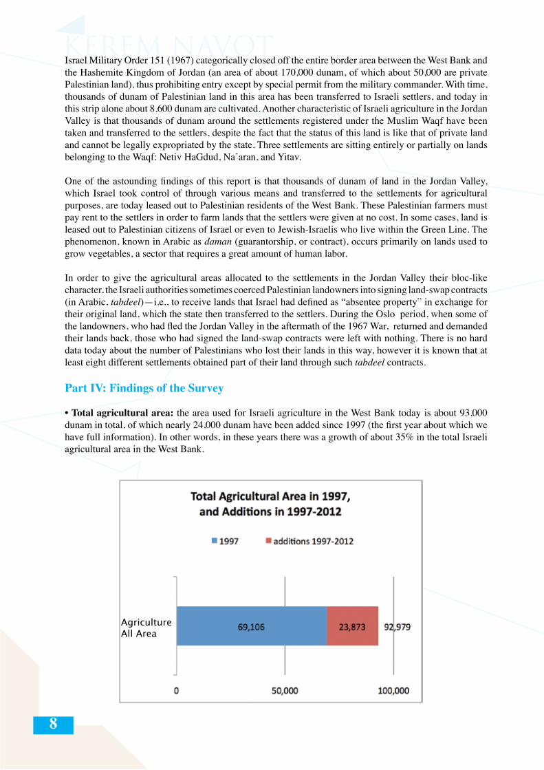
• Total agricultural area: the area used for Israeli agriculture in the West Bank today is about 93,000 dunam in total, of which nearly 24,000 dunam have been added since 1997 (the first year about which we have full information). In other words, in these years there was a growth of about 35% in the total Israeli agricultural area in the West Bank.
AgricultureAll Area
9
• Growth of agricultural area by year: The breakdown of the agricultural land takeovers in the West Bank by year shows that these takeovers were significant even before the outbreak of the second Intifada in October 2000. In effect, in 2000 itself, 2,700 dunam of land was taken over by settlers, second only to 2008, during which nearly 3,000 dunam were taken over. The obvious conclusion from this data is that the process of pushing Palestinians off their land—in particular, though not exclusively, around the Hill Country settlements—was not only a reaction to the security situation created by the second Intifada.
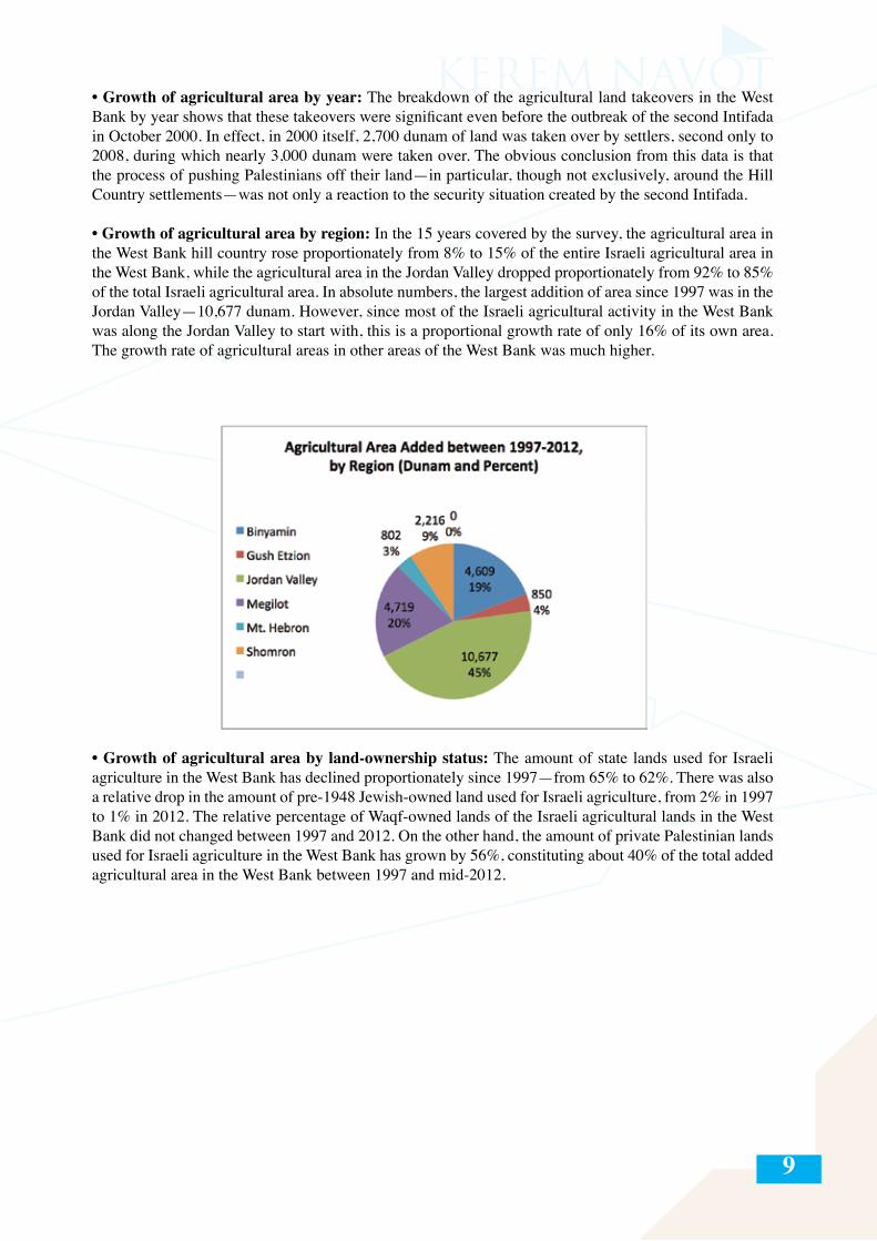
• Growth of agricultural area by region: In the 15 years covered by the survey, the agricultural area in the West Bank hill country rose proportionately from 8% to 15% of the entire Israeli agricultural area in the West Bank, while the agricultural area in the Jordan Valley dropped proportionately from 92% to 85% of the total Israeli agricultural area. In absolute numbers, the largest addition of area since 1997 was in the Jordan Valley—10,677 dunam. However, since most of the Israeli agricultural activity in the West Bank was along the Jordan Valley to start with, this is a proportional growth rate of only 16% of its own area. The growth rate of agricultural areas in other areas of the West Bank was much higher.
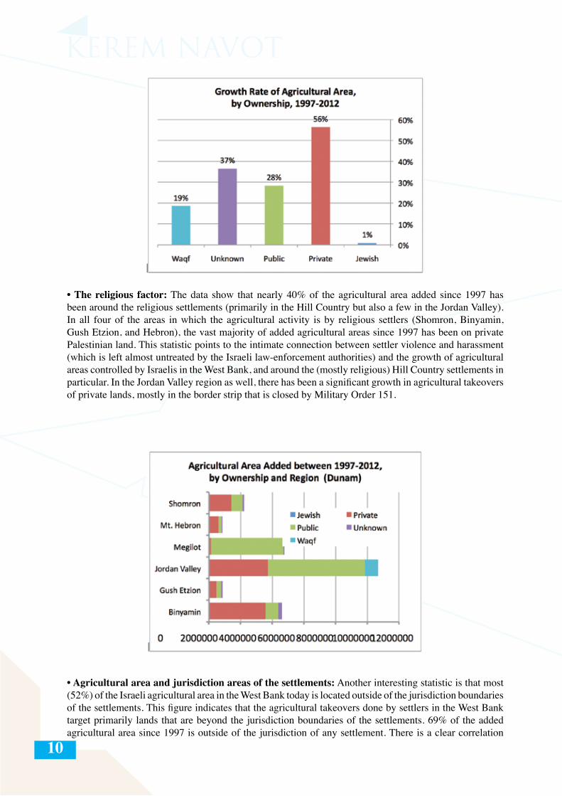
• Growth of agricultural area by land-ownership status: The amount of state lands used for Israeli agriculture in the West Bank has declined proportionately since 1997—from 65% to 62%. There was also a relative drop in the amount of pre-1948 Jewish-owned land used for Israeli agriculture, from 2% in 1997 to 1% in 2012. The relative percentage of Waqf-owned lands of the Israeli agricultural lands in the West Bank did not changed between 1997 and 2012. On the other hand, the amount of private Palestinian lands used for Israeli agriculture in the West Bank has grown by 56%, constituting about 40% of the total added agricultural area in the West Bank between 1997 and mid-2012.
10
• The religious factor: The data show that nearly 40% of the agricultural area added since 1997 has been around the religious settlements (primarily in the Hill Country but also a few in the Jordan Valley). In all four of the areas in which the agricultural activity is by religious settlers (Shomron, Binyamin, Gush Etzion, and Hebron), the vast majority of added agricultural areas since 1997 has been on private Palestinian land. This statistic points to the intimate connection between settler violence and harassment (which is left almost untreated by the Israeli law-enforcement authorities) and the growth of agricultural areas controlled by Israelis in the West Bank, and around the (mostly religious) Hill Country settlements in particular. In the Jordan Valley region as well, there has been a significant growth in agricultural takeovers of private lands, mostly in the border strip that is closed by Military Order 151.
• Agricultural area and jurisdiction areas of the settlements: Another interesting statistic is that most (52%) of the Israeli agricultural area in the West Bank today is located outside of the jurisdiction boundaries of the settlements. This figure indicates that the agricultural takeovers done by settlers in the West Bank target primarily lands that are beyond the jurisdiction boundaries of the settlements. 69% of the added agricultural area since 1997 is outside of the jurisdiction of any settlement. There is a clear correlation
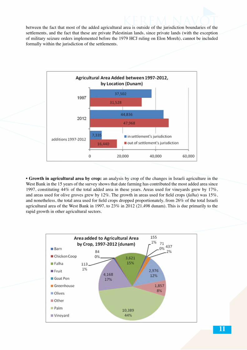
11
between the fact that most of the added agricultural area is outside of the jurisdiction boundaries of the settlements, and the fact that these are private Palestinian lands, since private lands (with the exception of military seizure orders implemented before the 1979 HCJ ruling on Elon Moreh), cannot be included formally within the jurisdiction of the settlements.
• Growth in agricultural area by crop: an analysis by crop of the changes in Israeli agriculture in the West Bank in the 15 years of the survey shows that date farming has contributed the most added area since 1997, constituting 44% of the total added area in these years. Areas used for vineyards grew by 17%, and areas used for olive groves grew by 12%. The growth in areas used for field crops (falha) was 15%, and nonetheless, the total area used for field crops dropped proportionately, from 26% of the total Israeli agricultural area of the West Bank in 1997, to 23% in 2012 (21,498 dunam). This is due primarily to the rapid growth in other agricultural sectors.
12
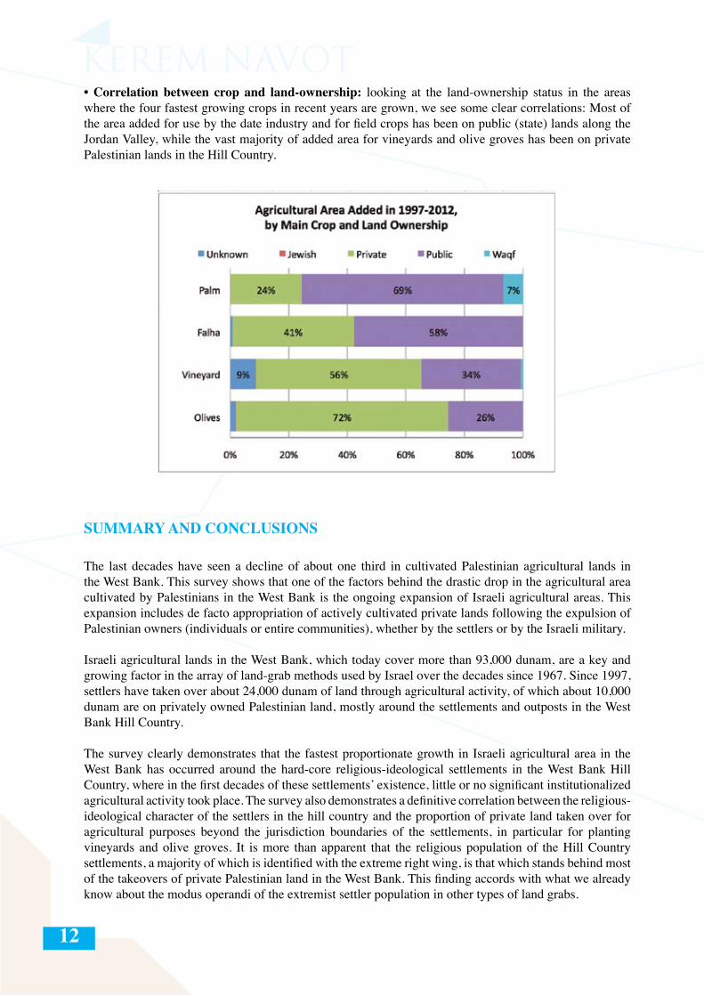
• Correlation between crop and land-ownership: looking at the land-ownership status in the areas where the four fastest growing crops in recent years are grown, we see some clear correlations: Most of the area added for use by the date industry and for field crops has been on public (state) lands along the Jordan Valley, while the vast majority of added area for vineyards and olive groves has been on private Palestinian lands in the Hill Country.
SUMMARY AND CONCLUSIONS
The last decades have seen a decline of about one third in cultivated Palestinian agricultural lands in the West Bank. This survey shows that one of the factors behind the drastic drop in the agricultural area cultivated by Palestinians in the West Bank is the ongoing expansion of Israeli agricultural areas. This expansion includes de facto appropriation of actively cultivated private lands following the expulsion of Palestinian owners (individuals or entire communities), whether by the settlers or by the Israeli military.
Israeli agricultural lands in the West Bank, which today cover more than 93,000 dunam, are a key and growing factor in the array of land-grab methods used by Israel over the decades since 1967. Since 1997, settlers have taken over about 24,000 dunam of land through agricultural activity, of which about 10,000 dunam are on privately owned Palestinian land, mostly around the settlements and outposts in the West Bank Hill Country.
The survey clearly demonstrates that the fastest proportionate growth in Israeli agricultural area in the West Bank has occurred around the hard-core religious-ideological settlements in the West Bank Hill Country, where in the first decades of these settlements’ existence, little or no significant institutionalized agricultural activity took place. The survey also demonstrates a definitive correlation between the religious-ideological character of the settlers in the hill country and the proportion of private land taken over for agricultural purposes beyond the jurisdiction boundaries of the settlements, in particular for planting vineyards and olive groves. It is more than apparent that the religious population of the Hill Country settlements, a majority of which is identified with the extreme right wing, is that which stands behind most of the takeovers of private Palestinian land in the West Bank. This finding accords with what we already know about the modus operandi of the extremist settler population in other types of land grabs.
13
This fact notwithstanding, there is another locus of takeovers of private Palestinian lands in the West Bank, namely, along the border area between the Jordan Valley and the Hashemite Kingdom of Jordan, which was closed off in 1967 by Military Order 151 and to which entry by Palestinian residents of the West Bank is blocked entirely. Israel has allowed settlers to take control of thousands of the approximately 170,000 dunam of public and private lands that are trapped in this zone, for the date industry. This phenomenon, which is accelerating every year, relies on a water infrastructure that Israel created in the Jordan Valley, which transports grey water (treated sewage, mostly from East Jerusalem), for the irrigation of Israeli agriculture in the Jordan Valley.
We should keep in mind that much of the expansion of the Israeli agricultural area that has happened on so-called “public” lands (lands that were declared “state lands” by Israel or which were registered as such before 1967), is also illegal, not only according to international law, but even according to the Israeli authorities, because these lands often have not actually been allocated to the settlements and the expansion is done without official permits.
This accelerated activity is part of a widespread, multi-pronged, and well-funded strategy that the settlers, with the full backing of the state, have advanced—since the mid-1990s and with greater intensity since the outbreak of the second intifada—with the stated goal of expanding the area under the control of the settlements in Area C and preventing the future transfer of land to the Palestinians. The other main methods used to advance these goals are: establishment of new outposts, paving of new roads around settlements and outposts, establishment of local tourist infrastructure around sites with religious, archeological, or scenic value, and designation of large “industrial zones.”
The responsibility of the state of Israel for the phenomena described in this report, which can only be described as the “wholesale takeover of West Bank land for the sake of Israeli agriculture,” is not limited to the funding and organization of deliberate actions aimed at expanding the agricultural area under the control of the settlers. The main responsibility of the state lies in the daily military cover and backing it provides for this activity and the almost complete lack of law enforcement against settlers who infiltrate and expropriate private Palestinian land and harass Palestinian farmers in blatant violation even of Israeli law.A clear conclusion emerges from this document, namely, that the story of the illegal takeover of land for Israeli agricultural purposes in the West Bank is yet another manifestation of the deterioration of law enforcement there. This deterioration is neither coincidental nor anecdotal. Behind it lies a consistent and clear rationale that runs throughout the West Bank: the sacrifice of the rule of law for the sake of the territorial interests of the settlement enterprise.
To this end, the state of Israel continues to act on two parallel channels: the official channel by which thousands of dunam of land in the West Bank are expropriated in a variety of ways from their Palestinian owners and transferred to the settlements by the Civil Administration; and the ostensibly unofficial channel by which the state directly and/or indirectly encourages, funds, and organizes the takeover by settlers of thousands of dunam of private Palestinian lands that they cannot obtain through official channels.
14
15
INTRODUCTION
The ideal of Jewish agriculture in the Land of Israel has been an integral part of Zionist thought and practice from the beginning of the Zionist Movement, largely shaping Zionist and subsequent Israeli territorial ideology and strategy from the late nineteenth century onwards. This intimate nexus of agriculture, ideology, and territorial expansionism continued after the establishment of the state of Israel in 1948 and reached the newly occupied West Bank within months of the end of the 1967 war. Agriculture eventually became a central means with which the settlement movement (with the active or tacit approval and support of the state) staked a claim to and consolidated control over large areas of the West Bank.
The first Israeli West-Bank settlers viewed agriculture as a means of solidifying Jewish settlement in the West Bank for three main reasons: Ideological/religious – Agricultural activity bolstered the claim that Israeli settlement in the West Bank (known in internal Israeli-Jewish discourse by the biblical name of “Judea and Samaria”) constituted a return to the “Land of the Fathers” and to the times when agriculture was a source of livelihood for the ancient Jewish communities in the area; Economic – Agriculture was considered an economic foundation on which the first settlements could subsist and develop1; and Territorial – Because agricultural activity enabled the settlers to hold large areas without necessitating massive construction there, it was a key means by which to create “facts on the ground” and expand the territory of the nascent settlement enterprise.
In the first decade after 1967 (until the hardline Likud Party’s rise to power in May 1977), successive Labor governments established some thirty settlements in the West Bank. Most of these were situated in the Jordan Valley—the easternmost strip of land in the West Bank, separating the rest of the West Bank from the Hashemite Kingdom of Jordan to the east. The choice to settle the Jordan Valley was determined by Labor-government policy, which in turn was guided by the logic of the Alon Plan2 and the traditional Zionist strategies of frontier settlement and securing borders. Most of these early settlements were planned from the outset by the government as agricultural settlements.3 By contrast, most of the settlements established from the 1980s onward, under Likud and Labor governments alike, were designated as suburban communities, with agriculture no longer constituting an anticipated source of livelihood for their residents. In the two decades since the Oslo Accords, however, and as this report will show, we have seen a constant expansion of the lands that Israeli settlers have claimed and begun to cultivate throughout the West Bank, including around settlements where no agricultural activity took place in the past.
Today the debate over the expansion of Israeli settlements in the West Bank focuses mostly on demographic statistics about the growth of the settler population, on the benefits that this population receives, on the number of new housing units being built in the settlements, or on the expansion or authorization of the illegal outposts. And yet, no one who has driven up and down the roads of the West Bank over the past decade can ignore another phenomenon, namely, the increasing areas around the settlements and outposts that have been appropriated officially or unofficially for agricultural activity or on which such activity
1 Agriculture eventually became less significant as a source of livelihood for the settler population, as the settlements took on a more distinctively suburban/bedroom-community character. According to Israel’s Central Burea of Statistics, at the end of 2011, only 1.5% of residents of the settlements worked in agriculture. See: CBS, Statistical Abstract of Israel, 2012, accessed at: http://www.cbs.gov.il/reader/shnaton/templ_shnaton.html?num_tab=st12_14x&CYear=20122 Drafted a short time after the Six-Day War, the Alon Plan (named after Yigal Alon, one of the Labor Party’s most prominent leaders in the 1960s and 70s), had the broad goal of ending the Israeli occupation of the West Bank, relinquishing the main Arab-populated areas of the West Bank while annexing most of the Jordan Valley, East Jerusalem, and Gush Etzion, as well as Hebron and Qiryat Arba’. The Alon Plan was never formally adopted by the Israeli governments but nonetheless guided Labor-Party settlement policy until 1977.3 Government decisions about the establishment of these settlements often mentioned the character of the settlement and the eventual sources of livelihood of its inhabitants. For example, the decision to establish the Alon Shvut settlement in 1968 was articulated as follows: “The decision has been made to establish an urban–rural center in Gush Etzion” (Government decision from 30.9.1968, cited in the Spiegel database. The database was compiled by Brigadier General Baruch Spiegel since 2004 to include up-to-date data about all statutory aspects of settlements and outposts in the West Bank. The full text of the database is accessible in Hebrew at: http://www.peacenow.org.il/sites/default/files/Spiegel_Report.pdf. An English translation of excerpts from the database was produced by Yesh Din and can be accessed at: http://yesh-din.org/sys/images/File/SpiegelDatabaseEng.pdf ).
16
is already taking place. This report will show that such agricultural activity is neither coincidental nor anecdotal, but part of a broad and well-planned and -funded strategy whose explicit goal is the expansion of the lands under the control of Israeli settlers throughout Area C.4
The central goal of this report is to contribute another layer to the public debate about the settlements, their implications, and their future. It seeks to broaden this discussion and to highlight the important role that agriculture plays in the Israeli policy of expansionism and land takeover in the West Bank. This phenomenon is not often mentioned or even understood, despite the fact that its implications for the West Bank and the Palestinian population there are already far-reaching and are only likely to grow with time. The “story” of Israeli agriculture in the West Bank has not yet been told, and the time has come to begin to tell it.
This report is based on a survey of unprecedented scope, identifying and mapping over 93,000 dunam of land allocated to or actually used for Israeli agricultural activity in the West Bank. For the sake of comparison, these 93,000 dunam of Israeli-controlled or-cultivated agricultural land dispersed between the many military posts, civilian outposts, settlements, and bypass roads in the West Bank, constitute a much larger area than the actual built-up area of the settlements and outposts (about 60,000 dunam, not including the Israeli neighborhoods in East Jerusalem); they are about three quarters the size of the municipal area of Jerusalem (about 125,000 dunam, including East Jerusalem); and almost twice the municipal area (about 52,000 dunam) of the city of Tel Aviv.
The survey classifies the Israeli agricultural areas in the West Bank according to a number of parameters: year in which the land was expropriated; measure by which the land was expropriated (declaration of closed military zone, declaration as state land, land-swap of absentee property, etc.); region or regional council to which the land is affiliated; character of the settler population there (religious/secular); land-ownership status (private Palestinian, public [state], Muslim Waqf, or pre-1948 Jewish-owned); settlement jurisdiction (within/without); and type of crop or branch of agriculture.
The compilation of the survey began in 2009 with the mapping of the vineyards around the settlements in the West Bank Hill Country (this area refers to the relatively high ridge of 700 to 1000 meters that runs down the middle of the West Bank, leading from the Hebron Hills region in the south to Nablus and Jenin in the north, along Highway 60). Thousands of dunam of grapevines have been planted by settlers in this region in recent years, mostly around the settlements affiliated with the religious-ideological stream of settlers, and in recent years many wineries were established there.5 Behind this scenic “Tuscany” (as the area is sometimes referred to) lies an ugly reality of violent dispossession and expulsion of individuals and entire villages by settlers, abetted by the Israeli law enforcement authorities in the West Bank.6
Grapes are not, of course, the only crop cultivated by settlers in the West Bank, and the survey eventually expanded to include all kinds of agricultural crops. The vast array of crops and products cultivated in settler agriculture in the West Bank includes olive groves, various deciduous orchards, dates, field crops (known in Israeli discourse by the Arabic term falha), greenhouse produce, chicken coops, dairy farms (cows, goats, sheep), and more.
4 Under the Oslo Accords, the West Bank was divided administratively into three areas: A, B, and C. Area C was defined in the Oslo Accords to include about 61% of the area of the West Bank, with Israel maintaining full military and civil control there. Area B includes about 21% of the West Bank, with the PA administering civilian affairs and Israel maintaining military control of the area. Area A comprises the about 18% of the West Bank (the main towns and cities) where the PA has both civilian and security authority.5 A report by the Coalition of Women for Peace on West Bank settler wineries lists 29 Israeli wineries in the West Bank. See: CWP, “Forbidden Fruit: The Israeli Wine Industry and the Occupation,” p. 10, accessed at: http://whoprofits.s483.sureserver.com/sites/default/files/WhoProfits-IsraeliWines.pdf6 The BBC already reported on the Israeli wine industry in the West Bank in 2009. For the broadcast report, see http://news.bbc.co.uk/2/hi/programmes/newsnight/8100445.stm. For the written article, see http://news.bbc.co.uk/2/hi/middle_east/8101110.stm. See also a report on the Israeli investigative program “Uvda” entitled “Wine Culture in the Settlements” [in Hebrew] (November 16, 2009), accessed at: http://www.mako.co.il/tv-ilana_dayan/2010-dcc4c8a272df4210/Article-4db3863563df421006.htm.
17
It is important to clarify from the outset that this phenomenon is not the result of isolated efforts of individual settlers or even entire settlements, but part of a long-term and well-funded strategy that has been encouraged and supported by Israeli governmental and public agencies for many years. Besides the Israel Ministry of Agriculture, which funnels large sums of money for Israeli agricultural activity in the West Bank,7 there are three apparent additional main channels for the transfer of money to support Israeli agriculture in the West Bank and its related infrastructures: the Ministry of Defense, which pays for the “security” components required to maintain Israeli civilian life in the West Bank (fences, Israeli military outposts, closure of military zones, etc.); the Settlement Division of the World Zionist Organization (WZO), which is entirely funded by the state budget and is responsible for the development of the civil infrastructures in most of the settlements and outposts (electricity, telecommunications, roads, street lighting); and the Jewish National Fund (JNF), which is involved in the funding of water purification facilities, reservoirs, and irrigation systems in the Jordan Valley. Although we do not have figures about how much the state of Israel has invested and continues to invest in Israeli agriculture in the West Bank, we are clearly talking about large sums, without which the lion’s share of this agricultural activity would not be possible and which no private individual could maintain. This activity, funded from the Israeli public coffers, should be understood as another aspect of Israeli settlement policy in the West Bank.
Besides the substantial government funding described here, West-Bank settler agriculture also benefits from the investments of private for-profit investors, although this is negligible in comparison with the immense investment made by the government. There is also a strong fundraising network that works to bring donations from Jewish as well as Christian-Zionist individuals and organizations, in particular from the United States, to support Israeli agriculture in the West Bank.8 Whatever these numbers are, it is increasingly clear that they are very small in comparison with the investment made by the state of Israel in agriculture and its related infrastructure in the West Bank.9
We recall that behind the widespread takeover of land throughout the West Bank for agricultural purposes stands a distinctive territorial rationale: in comparison with the construction of buildings in the West Bank settlements, staking a claim to agricultural areas requires few resources and little time.
The state of Israel’s responsibility for the creation and maintenance of the situation described in this document does not begin and end with the transfer of funds and allocation of land. Israel’s main official contribution was and remains the provision of the military auspices under which all of Israeli civilian life in the West Bank takes place. This military aegis does not cease to provide protection for Israeli settlers, even when their actions are patently illegal (see inset: “Under Military Cover,” on following page).
It is also important to realize that the dire reality described in this report could not exist without the state of Israel’s almost complete lack of law enforcement when it comes to Israeli settlers unlawfully taking Palestinian lands or harassing and attacking Palestinians in order to effectively expel them from their
7 According to the Coalition of Women for Peace, the Israeli Ministry of Agriculture, in response to a query by the CWP, responded that it had transferred some 22,000,000 NIS between 2008 and 2010 for the development of Israeli agriculture in the West Bank. See: CWP, “Forbidden Fruit,” p. 19.8 Aside from the financial support that comes from pro-settler Christian groups, there are groups of volunteers who come for periods of intensive work in the settlements. See: Chaim Levinson, “God and Grapes” [in Hebrew], Haaretz, October 8, 2010, accessed at: http://www.haaretz.com/weekend/week-s-end/god-and-grapes-1.31790. The website of the American organization, Hayovel, whose stated mission is “to strengthen and undergird the often overlooked small independent farmer in Israel through creative networking, education, tourism, and activism,” contains details about groups of volunteers who are planning on coming in 2013. See http://www.hayovel.com. The seasonal presence of Christian groups in the settlements has created an internal debate among the settlers regarding the degree of intimacy that should be encouraged with the members of these Christian groups and how much they can be trusted. Resonance of this debate can be found in a notice that was published on the extreme right-wing website “HaKol HaYehudi” (The Jewish Voice): “David HaIvri: ‘Christian Volunteers Commit to Keep from Missionizing” [in Hebrew] February 15 2012, http://www.hakolhayehudi.co.il/?P=25335.9 A New York Times article from July 2010 estimated that in the first decade of the 2000s, forty American organizations transferred more than 200,000,000 dollars to settlements in the West Bank and East Jerusalem. See: Jim Rutenberg, Mike McIntire, and Ethan Bronner, “Tax-Exempt Funds Aid Settlements in West Bank,” New York Times (July 5, 2010), accessed at: http://www.nytimes.com/2010/07/06/world/middleeast/06settle.html?pagewanted=all&_r=0. To date, we do not know the precise amounts of donations from these Jewish and Christian-Zionist organizations that go specifically to agriculture, and investigating the issue would require a large research effort that would likely encounter many obstacles. Observing the commemorative signs placed around several agricultural areas in the West Bank, however, it is clear that at least some of these funds have gone to support Israeli agriculture.
18
lands. There are only a handful of cases known to this day, in which Israel has actually uprooted fields planted by settlers in the West Bank.10
Under Military Cover
On Saturday, January 19, 2013, the Israeli military and police arrested some fifteen Palestinians and Israeli activists who had come to help Palestinian farmers cultivate a plot of 35 dunam, which settlers from the Mitzpe Yair outpost, near the settlement of Susya in the South Hebron Hills, had taken over. While the Palestinians had come to protest the theft of their own private land, which they had cultivated for generations, it was they, and not the trespassing settlers, who were arrested. The reason given for the arrest of the Palestinians and Israeli activists was that they were in violation of a military order declaring the land a “closed military zone.” As we will see throughout this report, this is a common means used by the Israeli military to distance Palestinians from areas that have been unlawfully seized by settlers.11
Agriculture is an important source of livelihoodfor the Palestinian population in the West Bank.A census taken by Israel in 1967 showed thatabout 34.2% of Palestinian men in the WestBank and the Gaza Strip at the time worked inagriculture.12 In 2011, the Palestinian Authority’s Central Bureau of Statistics reported that only 13.8 percent of residents of the West Bank were employed in agriculture.13 According to a survey done between 1982 and 1984, the total area cultivated by Palestinians in the West Bank was between 1,600,000 dunam and 1,700,000 dunam.14
According to PA CBS statistics from 2010, about 1,105,000 dunam were being actively cultivated by Palestinians in the West Bank.15 This area includes about 90,000 Palestinian farms.16
Here it is worth mentioning the findings of a 2012 study by MAS, the Palestinian Institute for the Study of Economic Policy, which estimated that an astounding one third (34%, to be precise) of Palestinian agriculture land in the West Bank is not accessible today to its owners. According to MAS’s estimates, the substantial drop in the lands cultivated by Palestinians in the West Bank (as we see in the statistics presented above) has four main causes. These are presented here in descending order, according to degree of influence on the Palestinians’ ability to access their own agricultural lands: settlements, the Separation Barrier, closed military zones, and various methods of enclosure that are not directly related to the settlements.17 Even the Staff Officer for Agricultural Affairs in the Civil Administration remarked, in his annual report for 2011, that there had been a drop of about one third in cultivated Palestinian agricultural lands. Though he, not surprisingly, attributed the steep decline in the scope of Palestinian farming to entirely different factors.18
10 The largest of these plots was a vineyard planted by Moshe Deutsch, a resident of the settlement of Susya, in mid-2007. The vineyard was uprooted by the Civil Administration on April 6, 2011, following a petition by the Palestinian owners of the land, who were represented by the legal department of Rabbis for Human Rights, Israel. For more on this, see the legal appendix to this report.11 Jacky Khoury, Chaim Levinson and Gili Cohen, “15-Year-Old Palestinian Critically Injured by IDF Fire in West Bank,” Haaretz (January 19, 2013), accessed at: http://www.haaretz.com/news/diplomacy-defense/15-year-old-palestinian-critically-injured-by-idf-fire-in-west-bank.premium-1.494959. 12 See: http://www.levyinstitute.org/pubs/1967_census/vol_4_intro_tab_e.pdf. In the years since 1967, this percentage has dropped, reaching 28% by 1984. See: Meron Benvenisti, Judea and Samaria Lexicon [in Hebrew] (Jerusalem, 1987), pp. 67–69..13 These statistics do not include Palestinians in the West Bank who are employed in agriculture within Israel or in the settlements. 6.8% of Palestinians employed in Israel and in the settlements are employed in the various branches of agriculture, http://www.pcbs.gov.ps/Portals/_PCBS/Downloads/book1878.pdf, p. 86, Table 22. 14 Ibid.15 See “Agricultural Census 2010 Final Results – West Bank” [in Arabic], p. 71, accessed at: http://www.pcbs.gov.ps/Portals/_PCBS/Downloads/book1874.pdf. 16 Ibid., p. 82.17 MAS, Food Security Bulletin, Issue 7 (summer 2012), p. 6.18 The causes cited by the Staff Officer for Agricultural Affairs are: (1) Use of agricultural land for massive construction to accommodate the natural population growth of the population in the West Bank; (2) Change of zoning of some of the land from agricultural to industrial; (3) Multiple owners of the same agricultural plot due to inheritance laws (parcelization of the agricultural plots), which leads to a decline in the profitability of using the land for agriculture; (4) Marketing targets: most of the agricultural produce of the West Bank is destined for the local market and for Israeli markets. The marketing to these targets brings a low profit, and therefore many farmers choose not to continue producing; (5) The ongoing rise in the prices of agricultural inputs, which leads to a significant detriment to the income and profits of the farmer; (6) Lack of water for irrigation: the lack of rain leads to a drop in the water levels in the artesian wells. The staff officer adds that the possibility of using pumped water is being examined. See: Agricultural Staff Sergeant Officer Unit, “Annual Summary for 2011” [in Hebrew], p. 2.
19
Even if the reasons for this drastic decline in Palestinian agriculture in the West Bank are varied and complex, and some even connected to internal changes within Palestinian society in the last two generations, the findings of the present survey and report demonstrate that one major and direct reason for this drop is the expansion of Israeli agriculture in the West Bank. As we will see, a large and growing part of this agricultural activity takes place on lands that were cultivated until recently by Palestinians and from which the Palestinian owners were evicted, whether by settlers or by the Israeli military.
Structure of the Report
The report is divided into four parts and two appendices.
Part I of the report presents the historical and thematic background of the report, describing the factors behind the unprecedented growth of the Israeli settlements during the 1990s and 2000s. This part presents the main questions that will be addressed in the report as well as the methodology and sources underlying the survey and data upon which the report is based. Part I also presents the methodological limitations of the survey and suggests subjects for further research on the subject of Israeli settler agriculture in the West Bank.
Part II provides an overview of the official measures used by Israel since 1967 to take over West Bank lands and transfer them to the settlements and settlers. These are presented in the context of International Humanitarian and Human Rights Law and include insets on subjects including the occupying power’s obligations towards the occupied population and the obligation to secure public order, citizen’s safety, and private property. In this chapter we will expand upon two central means that were used to establish and expand settlements over the years: land seizure for military purposes, and declaration of lands as state lands. Part II also presents the “unofficial” means by which settlers have taken over private Palestinian land in the past two decades, and the underlying lack of law enforcement by the Israeli authorities that makes this possible.
Part III analyzes the two main typologies of Israeli agriculture in the West Bank, comparing the agricultural activity that takes place around the settlements in the West Bank Hill Country (running north-south along Highway 60, the main artery connecting the southern West Bank with the northern West Bank), with the Israeli agricultural activity around the settlements in the Jordan Valley (along Highway 90, from the northern end of the Dead Sea in the south up to the Beit She’an Valley in the north).
Part IV presents the findings of the survey. It examines the growth in Israeli agricultural area in the West Bank from 1997 to 2012 according to a number of parameters: year of takeover, region, character of the settler population in the area, land-ownership status, settlement jurisdiction, and crops grown. The main findings of the survey are followed by a summary and conclusion.
Appendix I to this report is a case study analyzing the situation around the Shiloh settlement and its outposts, where the “pirate” takeover by settlers of private and public Palestinian lands has reached unprecedented proportions. The discussion gradually zooms in on the area around Adei Ad, one of the most violent outposts in the entire West Bank. (A very modest estimate tallies the violent incidents that have occurred around this outpost in recent years at several dozen.) This appendix examines the map of land takeovers for agricultural activity around the outpost, comparing it to the map of violent incidents that have happened around it over the course of more than a decade. Alongside the maps, this case study is based on a series of interviews conducted with a large sample of Palestinian residents of the villages whose lands abut Adei Ad. This case study was chosen, among other things, in order to examine the correlation between settler violence and land takeovers, to ask whether settler violence around the outpost is random and arbitrary, or whether it is a calculated tactic whose goal is to advance the mechanism of land grabs and territorial expansion.
20
Appendix II of the report, contributed by Advocate Quamar Mishirqi-Assad, head of the Legal Department of Rabbis for Human Rights, Israel, is a survey of the legal defenses existing in local law in the West Bank available to Palestinians against the takeover of their private lands by settlers. Mishirqi-Assad describes the legal background for the proprietary insecurity experienced of Palestinian landowners in Area C, presents the primary legal arguments used by the settlers to take over Palestinian lands, describes the legal defenses available for the Palestinian residents of the West Bank, and assesses the efficacy and implementation of these defenses.
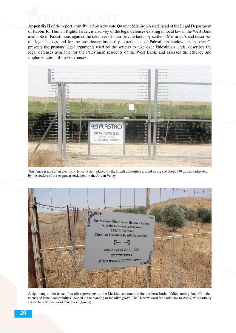
This fence is part of an electronic fence system placed by the Israeli authorities around an area of about 770 dunam cultivated by the settlers of the Argaman settlement in the Jordan Valley.
A sign hung on the fence of an olive grove next to the Maskiot settlement in the northern Jordan Valley, noting that “Christian friends of Israeli communities” helped in the planting of the olive grove. The Hebrew word for Christians (notzrim) was partially erased to make the word “enemies” (tzarim).
21
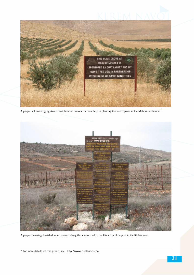
A plaque acknowledging American Christian donors for their help in planting this olive grove in the Mehora settlement19
A plaque thanking Jewish donors, located along the access road to the Givat Harel outpost in the Shiloh area.
19 For more details on this group, see: http://www.curtlandry.com.
22
PART I: THEMATIC BACKGROUND AND METHODOLOGICAL FRAMEWORK
The central challenge faced by the architects of the Israeli settlement enterprise in the West Bank since its inception has been the question of how to effectively take control of a maximum amount of territory and to counter-balance the much larger Palestinian population there.20 The answer to this challenge has been a calculated territorial strategy of creating so-called settlement blocs throughout the West Bank. This territorial strategy accelerated in the late 1970s and early 80s, the years in which the majority of the settlements were established (corresponding with the rise and consolidation of power of the right-wing Likud party after 1977), and has continued to guide the actions of Israeli governments to this day. It should be added that, in contrast to the first decade, during which the settlement enterprise and the notion of Greater Israel were far from the Israeli mainstream—after 1977 the settlements became openly and energetically promoted by successive Israeli governments, with the explicit goal of precluding the rise of an independent Palestinian state in the West Bank.
Following the signing of the Interim Agreement between Israel and the PLO, and the establishment of the Palestinian Authority in the early 1990s, the West Bank was divided into three administrative categories—Areas A, B, and C. Areas A and B, which cover about 39% of the West Bank (18% and 21% respectively) are under Palestinian civil administration, and Israeli settlements are prohibited there. Area C, which is under full Israeli military and civil control, and where all of the Israeli settlements are located, covers about 61% of the area of the West Bank. Supporters of the settlements in Israel viewed Israel’s retention of control over more than 60% of the West Bank as a window of opportunity in which to expand and entrench the settlements, including and primarily those deep in the heart of the West Bank. This unprecedented growth of the Israeli settlements during the 1990s and 2000s happened on a few parallel channels:
Unprecedented demographic growth – From 1993 to 2001, the settler population almost doubled itself,21
with an annual growth rate of between 7 and 10 percent—between three and five times (depending on the year) the average annual growth rate of the general Israeli population.22 This growth was due primarily to the massive migration of Israelis from within the Green Line to the settlements, but also to the relatively high birthrate in the West Bank settlements.
Formal expansion of jurisdiction boundaries of most of the settlements – In the period following the signing of the first Interim Agreement (September 1993), the Israeli military re-drew the maps of 92 out of the 117 West-Bank settlements which had defined jurisdictions at the time, effectively expanding their area.23
Paving of bypass roads – In the years after the signing of the Oslo Accords, hundreds of kilometers of new bypass roads were laid at the government’s initiative in order to enable convenient and quick access from within the Green Line to the settlements, and between the settlements themselves.
20 According to Israeli CBS statistics, at the end of 2011 there were about 325,000 settlers living in the West Bank (not including East Jerusalem), see: http://www.cbs.gov.il/reader/shnaton/templ_shnaton.html?num_tab=st02_04&CYear=2012. Based on the average growth rate of the settler population in the last decade (about 5% per year), it is reasonable to assume that by the beginning of 2013, there were about 340,000 settlers in the West Bank. In a CBS census of the Palestinian Authority in 2007, the number of Palestinian residents in the West Bank was about 2,350,000. See: http://www.pcbs.gov.ps?Portals/_PCBS/Downloads/book1487.pdf, p. 61, Table 1. This number includes the Palestinian population of East Jerusalem, which was about 260,000 at the time. See http://www.jiis.org.il/imageBank/File/shnaton_2007_8/shnaton%20C0106.pdf 21 According to CBS statistics, at the end of 1993, there were about 117,000 settlers living in the settlements (including in the Gaza Strip but not including East Jerusalem), and at the end of 2000 this number reached about 210,000.22 Population growth statistics from 1995 can be found on the website of the Israeli CBS, http://www.cbs.gov.il/reader/shnatonhnew_site.htm 23 At present, about 9.5% of the West Bank is included within the jurisdiction of the settlements. For a comprehensive survey of the subject of the jurisdiction limits of the settlements, see Dror Etkes and Hagit Ofran, “Construction and Development of Settlements Beyond the Official Limits of Jurisdiction” (July 2007), accessed at: http://peacenow.org.il/eng/content/construction-and-development-settlements-beyond-official-limits-jurisdiction. In 2012, jurisdiction boundaries were defined around a few settlements where no such boundaries existed previously.
23
Paving of “pirate” roads – Hundreds of roads have been carved around and between the settlements, outposts, farmland, and barren land in the West Bank, facilitating access to the surrounding areas in order to stake a claim over them.
Establishment of outposts and new “neighborhoods” – New outposts have been established near and even at some distance from the original cores of settlements, with the goal of eventually filling in the geographical gaps between the settlement points and including them, officially or de facto, within the jurisdiction limits of the “mother settlement.”
Allocation of areas for “industrial zones” – Over the years the Israeli authorities have allocated dozens of areas for “industrial zones.” The phenomenon reached its climax in the 1990s. With the exception of four sites on which any significant industrial activity takes place (Mishor Adumim, Barkan, West Ariel, and Shahak),24 the rest of the so-called “industrial zones” are mostly vacant, and primarily function as service and commercial centers (with shops, garages, and municipal bureaus) serving the settlers in the area.
Tourist initiatives – In the years since Oslo, lookout points have been built and walking paths and 4X4 trails carved, in order to attract tourists to the settlements. This has entailed the large-scale takeover of lands around the settlements, including the takeover of springs in the West Bank and their transformation into tourist spots for Israelis, while blocking Palestinians’ access to them.25
Agriculture – In this period, tens of thousands of dunam of West-Bank land were transferred to or taken over by settlers for agricultural purposes.
The measures listed here were and remain the primary means by which Israel, via a number of state and public authorities, expands areas that are subsequently controlled de facto by the settlers and settlements. The relentless drive toward territorial expansion is Israel’s primary tactic for compensating for its demographic disadvantage in the West Bank vis-à-vis the Palestinian majority.
Main Questions of the Report
The document tries to answer the following questions:
- What are the official and unofficial means26 that the state and/or the settlers use in order to take control of lands in the West Bank? - How do agricultural land takeovers combine with other means of land takeover in the West Bank?- What is the size of the area used for Israeli agriculture in the West Bank? By how much has this area grown in the years covered by the survey and the database (1997-2012)?- What are the main areas in the West Bank where this agricultural activity takes place?- When did the land takeover occur in each of the areas surveyed?- What are the proprietary and municipal statuses of the different areas used for Israeli agriculture in the West Bank?- What are the main agricultural sectors engaged in and crops grown by Israelis in the West Bank? - What is the correlation between the Israeli agricultural activity in different parts of the West Bank related to the character of the settler population in the different areas?
24 The Atarot industrial zone is not included in this list, since it is in the area that was included within the municipal boundary of Jerusalem after 1967, thereby placing it beyond the scope of this survey. 25 See this author’s comprehensive report for the UN Office for the Coordination of Humanitarian Affairs: “How Dispossession Happens: The Humanitarian Impact of the Takeover of Palestinian Water Springs by Israeli Settlers” (March 2012), accessed at: http://www.ochaopt.org/documents/ocha_opt_springs_report_march_2012_english.pdf.26 In the use of the term “official takeover” we refer to official and deliberate means taken by the Israeli authorities to take over Palestinian lands over the years. By “unofficial takeover” we refer to the means that are not explicitly initiated by the Israeli authorities, even if the state de facto supported and continues to support them.
24
Survey, Database, and Methodology
This document is based on a comprehensive survey and database compiled since 2009 and including data from 1997 to the beginning of 2013. The survey covers all of the areas that, to the best of our knowledge, are used today for Israeli agriculture in the West Bank, totaling about 93,000 dunam.27 The agricultural areas that settlers currently cultivate or cultivated in the past were identified and mapped with aerial photographs taken at least once a year and covering the entire area of the West Bank. Aerial photos were the main source in determining the year in which the cultivation of each plot began, the size of the plots, crops grown, land-ownership status, and municipal status.
In order to determine the status of each plot, in terms of both land-ownership status and settlement jurisdiction, we cross-referenced our data with layers of official data from the Civil Administration, which were transferred to us gradually between 2007 and 2012, following a series of requests and petitions submitted based on the Freedom of Information Law. These digital layers of data (updated to May 2012) distinguish between private lands, state lands, pre-1948 Jewish-owned lands, and lands registered under the Muslim Waqf. The data presented in this report can therefore be regarded as reflecting official Israeli government data.28
After identifying and mapping the borders of each plot, we tried to determine the following facts with regard to each:
- The year of actual takeover, i.e., the year in which the first explicit signs of farming or preparation of the land by Israeli settlers or their proxies were visible.- Type of crop grown on the plot (vineyards, olive groves, fruit orchards, date orchards, field crops [falha],and other 29 )- Area of the plot (in dunam)- The name of the settlement or outpost to which the plot was annexed, whether de jure or de facto.- Land-ownership status (private, state, Waqf, pre-1948 Jewish-owned)- Municipal status of the plot, i.e., within the jurisdiction area of a given settlement or outside of it.
After completing the database, we extracted the charts and graphs that constitute the findings of the survey presented in Part IV of this report.
During the course of the research, we encountered some methodological limitations and obstacles, which should be mentioned:
Dating: One of the main challenges in compiling the database was to determine the year in which settlers began to cultivate each plot. We had access to aerial photographs of the West Bank from 1997 to 2012.30
Thus, in most cases in which Israeli settler agricultural activity began before 1997, it was not possible to determine the precise year in which it began. Furthermore, because of the time gap between aerial photographs, it was not always possible to determine the exact beginning of agricultural activity on a given plot.31
27 This area does not include the territories annexed de facto by Israel in East Jerusalem (and where, as far as we know, there is no Israeli agricultural activity) nor does it include the strip of no man’s land in the Latrun region, which was also annexed to Israel after the 1967 (and where there are vast Israeli-cultivated agricultural lands). Moreover, it is important to note that the areas included in this survey are those in which ongoing agricultural activity has taken place for several years–as opposed to occasional incursions, which we have also seen over the years. This agricultural activity includes seasonal plowing and harvesting, planting of trees, or erection of agricultural facilities (such as dairy farms and chicken coops).28 Although the level of precision of the digital mapping is limited due to technical limitations, the general picture received from the synthesis of all of the statistics is sufficiently clear.29 We use the classification “other” primarily in places in which there are mixed crops and it was not possible to distinguish between kinds of crops. The classification also includes greenhouses, poultry, beef, and sheep.30 With the exception of 1998.31 We indicated the year which the first signs of cultivation of each plot had been seen. It is not impossible, however, that in some cases the actual cultivation began during the previous calendar year in the time gap between the two aerial photographs.
25
Municipal jurisdiction: It was not always possible to definitively attribute every agricultural plot to a specific settlement or outpost. In cases in which the land is in the jurisdiction of a given settlement, we went according to this. However, in cases in which the plot is not within the jurisdiction boundaries of any settlement, we had to determine its affiliation according to proximity to the nearest settlement or outpost, and/or according to the access roads around the plot. 32
Subjects for future research
This document does not pretend to cover all aspects of the issue of Israeli agriculture in the West Bank. Following are a number of key subjects that are beyond the scope of this report and whose continued investigation will add further layers to the knowledge we have about the impact of Israeli agriculture on the West Bank:
- The influence of Israeli agriculture on the Palestinian economy as a whole and on the ability of the tens of thousands of Palestinian residents of the West Bank to earn a dignified living;
- The influence of Israeli agriculture in the West Bank on the local water economy and the water-sharing policy in the West Bank;
- The degree of direct and indirect involvement of the Israeli government in the funding of agricultural takeovers; and
- The scope of export of produce from the settlements.33
32 In the Jordan Valley there are often rather large distances between the settlements and the agricultural lands allotted them. Since we cannot unequivocally determine in every case to which settlement each plot belongs, the data in these cases should be taken with some reservations.33 Recently, due to international pressure from a number of governments and organizations, it has become more difficult for Israel to export produce from the settlements. As a result, there is now clear evidence that some of the agricultural export from the West Bank settlements is done through Palestinian business interests that export produce from the settlements under their name, in exchange for some profit. See: http://www.aljazeera.com/programmes/aljazeeraworld/2012/08/2012822102524273640.html, minute 15:20.
26
Part II: Official and Unofficial Methods of Land Takeovers for the Settlements and the Internationl Humanitarian and Human Rights Law Context
Official Israeli Land-Takeover Measures in the West Bank
The State of Israel uses a number of official means to facilitate the takeover of lands in the West Bank. These are listed exhaustively in a B’Tselem report describing the methods of land requisition in the West Bank for illegal settlement construction.34 Most of these methods, as we will see, apply equally to land taken over for agricultural purposes:
- Military seizure orders for “security purposes.” - Expropriation of land for “public use” and transfer to settlements35
- Allocation of “state lands” to the settlements. This includes lands that were registered prior to 1967, under the Jordanians, as state land. It also includes hundreds of thousands of dunam that have been declared state land by Israel since 1967.- Transfer of “absentee” Palestinian property (property of landowners who fled during or following the 1967 War) to the settlements, whether directly or via land-swap (tabdeel) contracts with other Palestinian landowners.36
- Requisitioning of Muslim Waqf properties and transferring them to settlers- Transfer of pre-1948 Jewish-owned land to the settlements- Enabling and even encouraging Israeli corporations to purchase land in the West Bank,37 among other things by concealing purchases by Israeli entities and overlooking problematic and likely criminal land transactions.38
34 See: B’Tselem, “By Hook and by Crook: Israeli Settlement Policy in the West Bank” (July 2010), pp. 21–35, accessed at: http://www.btselem.org/sites/default/files2/201007_by_hook_and_by_crook_eng.pdf. 35 Land confiscation for public purposes is carried out under the Order Concerning Confiscation of Land for Public Purposes (Judea and Samaria) (no. 321) (1969), in which the land rights are transferred in perpetuity to the Custodian for Government Property, and lands confiscated in this way are meant to benefit the general public in the West Bank. The data in this survey show that in 1997, about 320 dunam of settler agricultural activity was taking place on areas confiscated by the Israeli military for public use. By mid-2012 this number had risen to 446 dunam (175 of these were later declared state lands). On the more general use of this confiscation order for the settlements, see: B’Tselem, “By Hook and by Crook: Israeli Settlement Policy in the West Bank” (July 2010), pp. 29-30, accessed at: http://www.btselem.org/sites/default/files2/201007_by_hook_and_by_crook_eng.pdf. The settlements of Ma’ale Adumim and Ofra were established in the 1970s on land acquired in confiscation orders for “public use.” In the case of the settlement of Susya in the South Hebron Hills, the area of the archeological site where the Palestinian village of Susya sat until the 1980s was annexed to the settlement and its Palestinian residents evicted under such an order. Route 443, connecting Jerusalem with the Tel Aviv metropolitan area through Modi’in, was also built on land confiscated using this order. 36 See pages 60-61 of this report.37 The Civil Administration refuses to date to reveal the map of land purchases by private Israeli entities carried out since 1967, but various sources indicate that the quantity of these lands is apparently negligible in comparison to all of the lands that were allotted by the Israeli authorities for the settlement enterprise. According to Israeli military law in the West Bank, every land transaction involving Israelis must first be approved by the Minister of Defense. The Order Concerning Land Transactions (Judea and Samaria) (no. 25) (1967) states that “no person shall make a land transaction, whether by himself or by proxy, whether directly or indirectly, except with the permission of the proper authorities” (Article 2). The order further states that a transaction done in contravention of Article 2 is not valid (Article 3), and that it is a criminal offense punishable by up to five years imprisonment, or a fine, or both (Article 4). Despite this order, settlers frequently make purchase claims in the West Bank, which even they admit were purchased without a permit of the Defense Minister. Despite this, as far as we know, to this day, not a single Israeli has been tried for purchasing land in the West Bank without a permit.38 An article of the Military Order Concerning State Property (no. 59) (1967), explicitly allows the Custodian for Government Property to declare a given land as “state land,” if it is “property whose owner asked the Custodian to manage it and the Custodian undertook its management.” This order enabled Israeli corporations to camouflage the purchase of land based on sales documents that are often suspected of being forged. This issue was discussed in Israeli HCJ 3988/06, Yassin et al v. the Military Commander, in which the petitioners demanded the cancellation of two declarations of state lands on the lands of the village of Bil’in in 1990–1991. The HCJ rejected the petition on November 9, 2006. See: http://elyon2.court.gov.il/files/06/980/039/P09/06039980.P09.htm [in Hebrew].
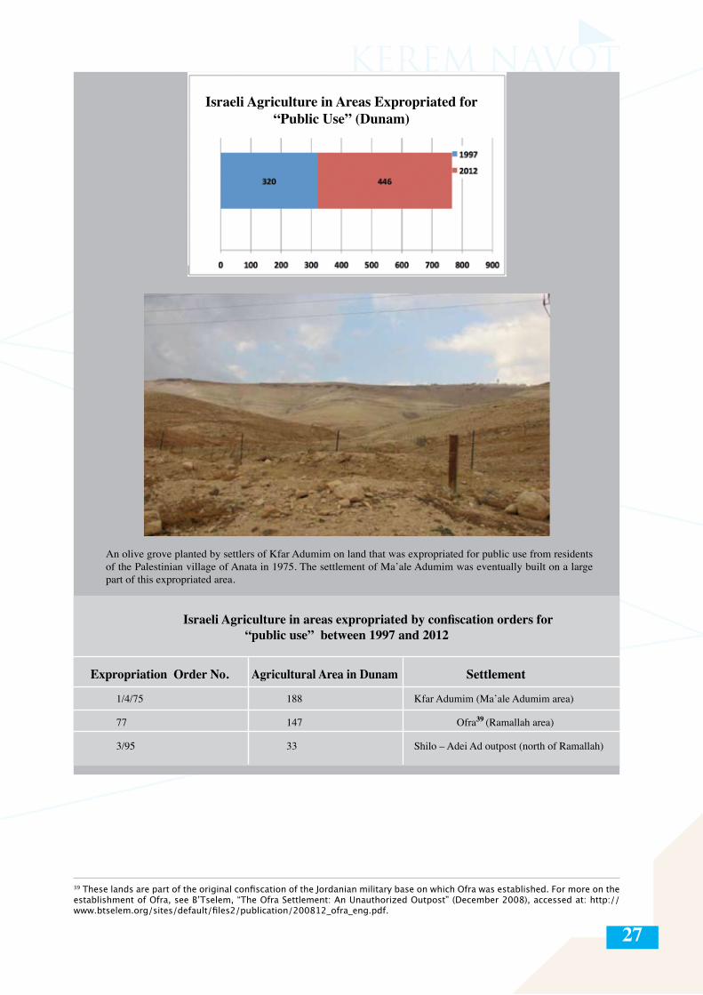
27
An olive grove planted by settlers of Kfar Adumim on land that was expropriated for public use from residents of the Palestinian village of Anata in 1975. The settlement of Ma’ale Adumim was eventually built on a large part of this expropriated area.
Israeli Agriculture in areas expropriated by confiscation orders for “public use” between 1997 and 2012
Expropriation Order No. Agricultural Area in Dunam Settlement
1/4/75 188 Kfar Adumim (Ma’ale Adumim area)
77 147 Ofra39 (Ramallah area)
3/95 33 Shilo – Adei Ad outpost (north of Ramallah)
Israeli Agriculture in Areas Expropriated for “Public Use” (Dunam)
39 These lands are part of the original confiscation of the Jordanian military base on which Ofra was established. For more on the establishment of Ofra, see B’Tselem, “The Ofra Settlement: An Unauthorized Outpost” (December 2008), accessed at: http://www.btselem.org/sites/default/files2/publication/200812_ofra_eng.pdf.
28
Land takeovers through military seizure orders for “security” purposes
In the first decade following the occupation of the West Bank, Israeli settlements were most often established on land requisitioned for ostensible “military-security purposes.” Some forty settlements were established over the years in this way.40 Since according to international law, such military orders can only be used for temporary expropriation (see inset on this page), much of the land requisitioned in this way was retroactively declared as state land. Other areas, which could not be declared state lands (whether because they were registered under private ownership, or because they were intensively cultivated by Palestinian farmers even if land registration was incomplete), to this day remain within the official jurisdiction areas of the settlements under military order.41
40 Different reports show varying statistics regarding the number of settlements that were established on lands seized for military-security purposes. The numbers that appear here are based on a GIS (Geographic Information System) layer provided by the Civil Administration in May 2012.41 Although the Elon Moreh ruling (HCJ 390/79, Dweiqat v. Government of Israel, P.D. 34 (1) (1979) officially impeded Israel’s ability to continue to administer military requisition orders on private lands for the establishment of settlements, in effect the state continued to do this into the early 1980s. Settlements such as Psagot, Ma’on, Dolev, Har Bracha, and Ma’ale Levona, were established in the 1980s on lands requisitioned in this way. Again, in most of the cases, lands seized in this way were retroactively declared as state lands.42 See: B’Tselem, “By Hook and by Crook: pp. 22, accessed at: http://www.btselem.org/sites/default/files2/201007_by_hook_and_by_crook_eng.pdf.
From among the many official land-appropriation methods listed here, we will expand on the two methods that have been most widely for taking over lands in the West Bank for the settlements: military seizure orders and declaration of state lands.
The Obligation to Protect Private Property under IHL and IHRL
The right to private property was recognized in the Universal Declaration of Human Rights of 1948: “Everyone has the right to own property alone as well as in association with others. No one shall be arbitrarily deprived of his property” (Art. 17). International law assumes that the belligerent occupation of territory is a temporary situation, and therefore it requires the protection and respect of the private property of the civilian population. It is a binding obligation on all states parties to the conflict that private property must be respected and cannot be confiscated (Art. 46, Hague Regulations). Additionally, pillaging of private property is absolutely prohibited (Art. 47, Hague Regulations; Art. 33(2), Fourth Geneva Convention) as are reprisals against property of protected persons (Art. 33(3), Fourth Geneva Convention). However, in limited instances, private movable and immovable property which is not of a military character may be temporarily requisitioned by the occupying power for “the needs of the army of occupation” (Art. 52, Hague Regulations). The occupying force is required to pay the landowners for the use of the land as compensation for the loss of their property for that period. The needs of the army of occupation do not include the taking of private land for the general security needs of the occupying power, nor for unlawful purposes, such as the establishment of settlements or the Separation Barrier.
To date, 21 settlements are sitting entirely or partially on private Palestinian lands seized by military order. Settlements in which the entire area was seized by military order include Beit El, Rimonim, and Kokhav HaShahar. In some settlements only part of the area is still officially held under military order, with other parts being allocated to the settlements via other official means, such as declaring the land state land (These include Qiryat Arba’, Ma’on, and Elqana.) After the October 1979 HCJ ruling on the Elon Moreh settlement (HCJ 390/79 Dweiqat v. Government of Israel), the state greatly reduced the use of military orders for establishing settlements, but kept building settlements on land which had been seized prior to this case.42
Und
er IH
L an
d IH
RL
29
The Illegality of the Settlements and the Corollary Infractions of International Humanitarian Law (IHL) and Human Rights Law (IHRL)
Settlements categorically violate IHL. A fundamental idea in the law of occupation is that occupation is only a temporary state and that the occupaying power therefore cannot make permanent changes in the occupied territory. This principle resonates in many of the concrete rules of both Hague and Geneva law. One example is the prohibition of population transfer set in Article 49 of the Fourth Geneva Convention.
The establishment of settlements results in ostensibly inevitable further violations of both IHL and IHRL law. By virtue of their permanent effect on the natural resources of the oPt and their negative effects on the environment, the settlements violate Article 55 of the Hague Regulations. The construction of settlements necessitates the destruction of private property, in violation of Article 53 of the Fourth Geneva Convention. The permanent nature of settlements and the confiscation of private Palestinian land for this purpose are in violation of Article 46 of the Hague Regulations. The construction of settlements and related infrastructure projects constitute a violation of Article 43 of the Hague Regulations, which requires the occupying power to take all measures within its power to ensure public order and safety, while respecting the laws in force in the territory unless absolutely prevented from doing so.
The illegality of settlements was again reaffirmed in the ICJ’s advisory opinion on the Separation Barrier from 2004. Following the Court’s rationale, since in practice the construction of settlements will lead to a fait accompli that could well become permanent, this would be tantamount to de facto annexation.
Und
er IH
L an
d IH
RL
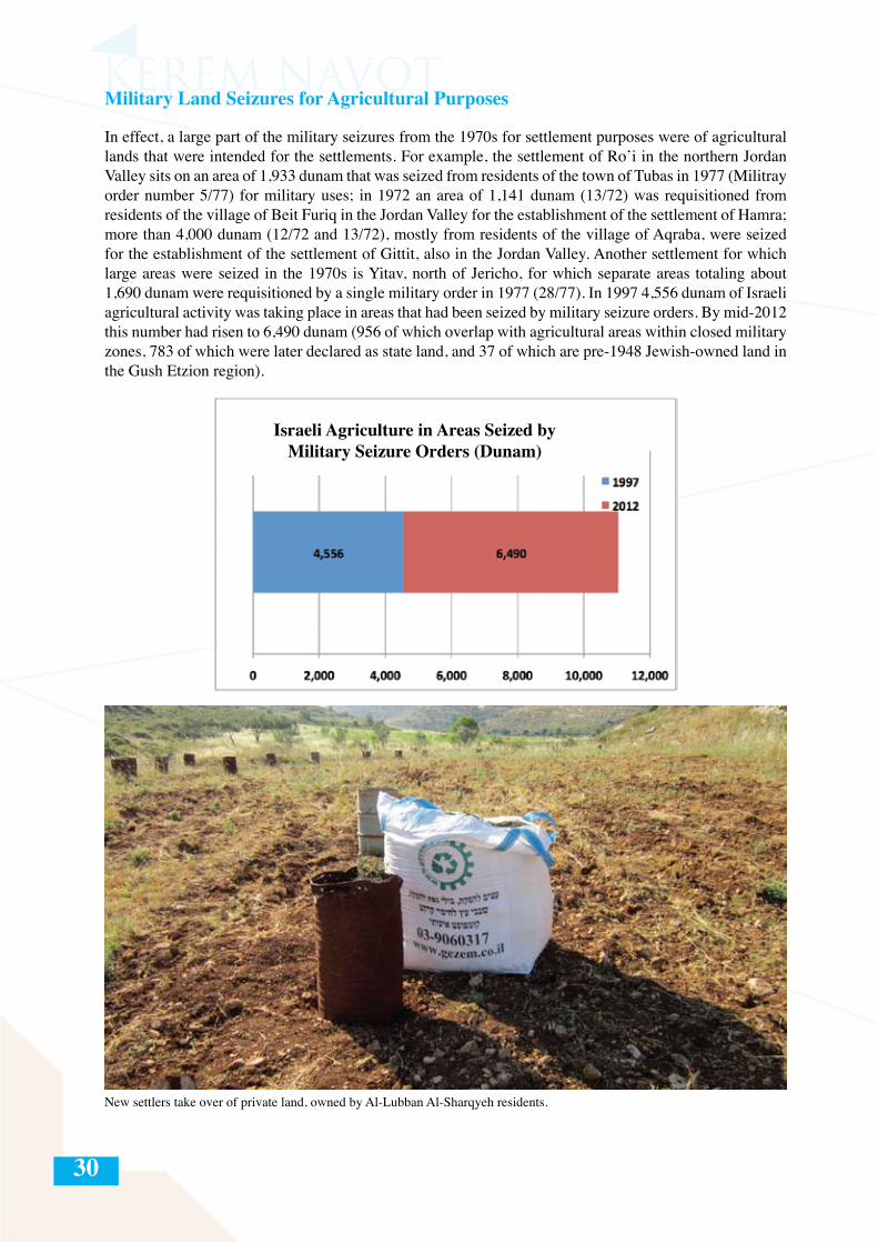
30
Military Land Seizures for Agricultural Purposes
In effect, a large part of the military seizures from the 1970s for settlement purposes were of agricultural lands that were intended for the settlements. For example, the settlement of Ro’i in the northern Jordan Valley sits on an area of 1,933 dunam that was seized from residents of the town of Tubas in 1977 (Militray order number 5/77) for military uses; in 1972 an area of 1,141 dunam (13/72) was requisitioned from residents of the village of Beit Furiq in the Jordan Valley for the establishment of the settlement of Hamra; more than 4,000 dunam (12/72 and 13/72), mostly from residents of the village of Aqraba, were seized for the establishment of the settlement of Gittit, also in the Jordan Valley. Another settlement for which large areas were seized in the 1970s is Yitav, north of Jericho, for which separate areas totaling about 1,690 dunam were requisitioned by a single military order in 1977 (28/77). In 1997 4,556 dunam of Israeli agricultural activity was taking place in areas that had been seized by military seizure orders. By mid-2012 this number had risen to 6,490 dunam (956 of which overlap with agricultural areas within closed military zones, 783 of which were later declared as state land, and 37 of which are pre-1948 Jewish-owned land in the Gush Etzion region).
Israeli Agriculture in Areas Seized by Military Seizure Orders (Dunam)
New settlers take over of private land, owned by Al-Lubban Al-Sharqyeh residents.
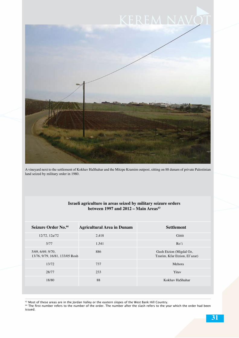
31
A vineyard next to the settlement of Kokhav HaShahar and the Mitzpe Kramim outpost, sitting on 88 dunam of private Palestinian land seized by military order in 1980.
43 Most of these areas are in the Jordan Valley or the eastern slopes of the West Bank Hill Country. 44 The first number refers to the number of the order. The number after the slash refers to the year which the order had been issued.
Israeli agriculture in areas seized by military seizure orders between 1997 and 2012 – Main Areas43
Seizure Order No.44 Agricultural Area in Dunam Settlement
12/72, 12a/72 2,418 Gittit
5/77 1,541 Ro’i
5/69, 6/69, 9/70, 886 Gush Etzion (Migdal Oz, 13/76, 9/79, 16/81, 133/05 Rosh Tzurim, Kfar Etzion, El’azar)
13/72 737 Mehora
28/77 233 Yitav
18/80 88 Kokhav HaShahar
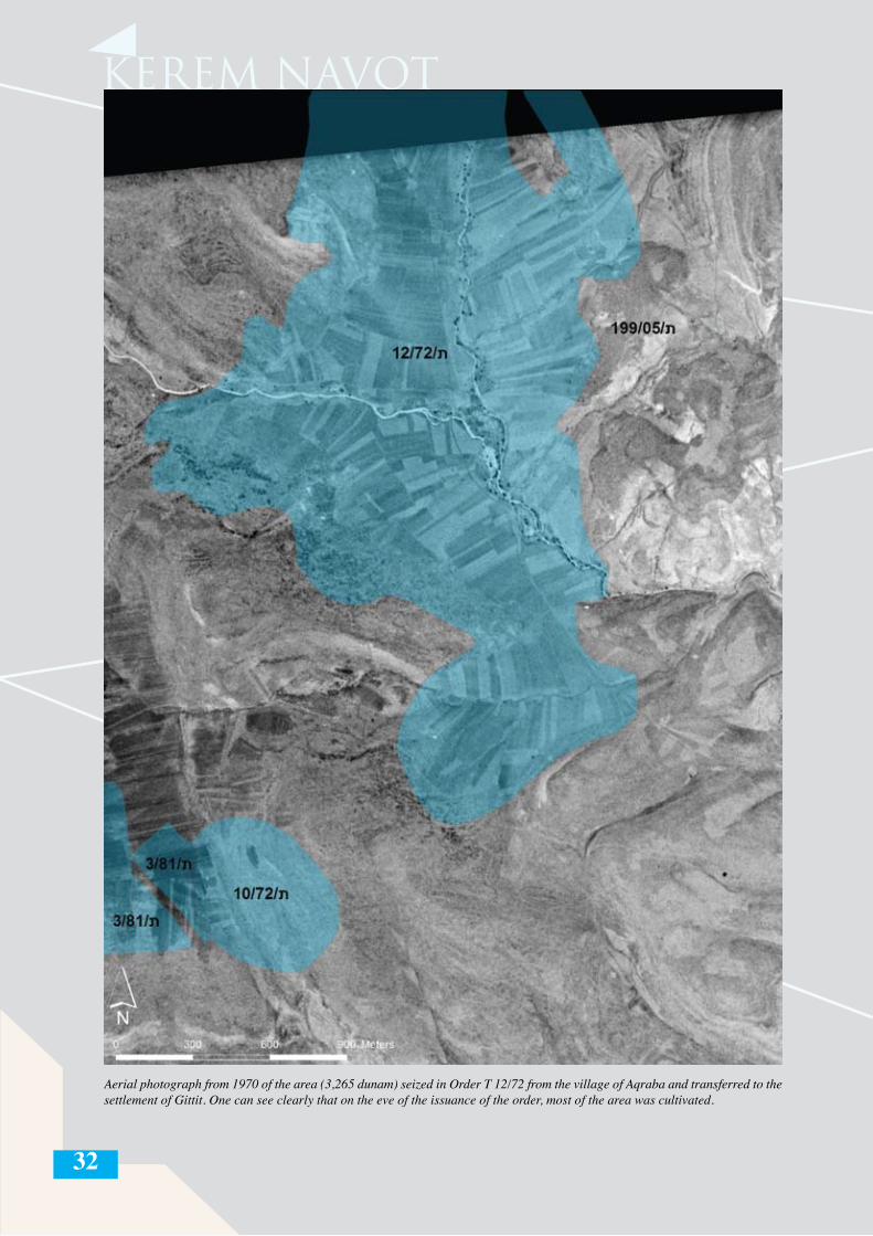
32
Aerial photograph from 1970 of the area (3,265 dunam) seized in Order T 12/72 from the village of Aqraba and transferred to the settlement of Gittit. One can see clearly that on the eve of the issuance of the order, most of the area was cultivated.
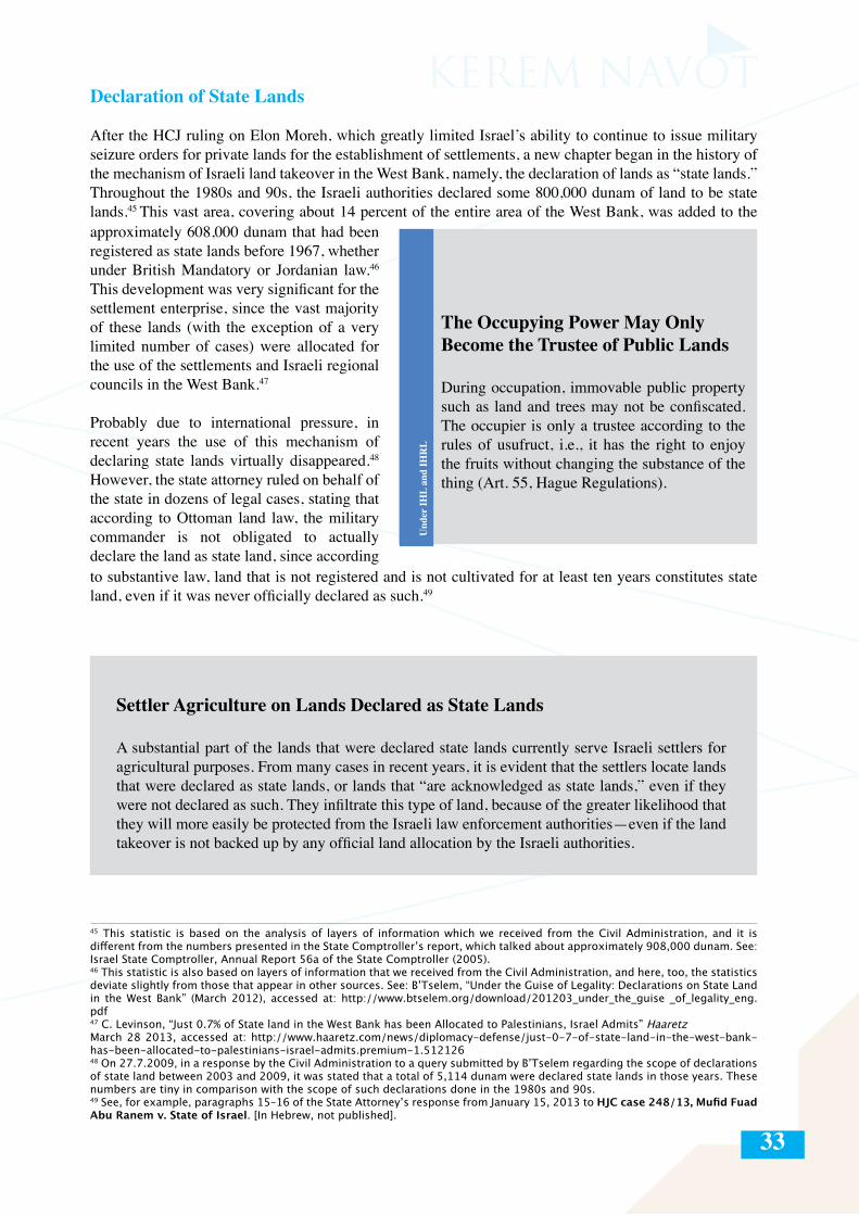
33
Declaration of State Lands
After the HCJ ruling on Elon Moreh, which greatly limited Israel’s ability to continue to issue military seizure orders for private lands for the establishment of settlements, a new chapter began in the history of the mechanism of Israeli land takeover in the West Bank, namely, the declaration of lands as “state lands.” Throughout the 1980s and 90s, the Israeli authorities declared some 800,000 dunam of land to be state lands.45 This vast area, covering about 14 percent of the entire area of the West Bank, was added to the approximately 608,000 dunam that had been registered as state lands before 1967, whether under British Mandatory or Jordanian law.46
This development was very significant for the settlement enterprise, since the vast majority of these lands (with the exception of a very limited number of cases) were allocated for the use of the settlements and Israeli regional councils in the West Bank.47
Probably due to international pressure, in recent years the use of this mechanism of declaring state lands virtually disappeared.48
However, the state attorney ruled on behalf of the state in dozens of legal cases, stating that according to Ottoman land law, the military commander is not obligated to actually declare the land as state land, since according
The Occupying Power May Only Become the Trustee of Public Lands
During occupation, immovable public property such as land and trees may not be confiscated. The occupier is only a trustee according to the rules of usufruct, i.e., it has the right to enjoy the fruits without changing the substance of the thing (Art. 55, Hague Regulations).
to substantive law, land that is not registered and is not cultivated for at least ten years constitutes state land, even if it was never officially declared as such.49
Settler Agriculture on Lands Declared as State Lands
A substantial part of the lands that were declared state lands currently serve Israeli settlers for agricultural purposes. From many cases in recent years, it is evident that the settlers locate lands that were declared as state lands, or lands that “are acknowledged as state lands,” even if they were not declared as such. They infiltrate this type of land, because of the greater likelihood that they will more easily be protected from the Israeli law enforcement authorities—even if the land takeover is not backed up by any official land allocation by the Israeli authorities.
45 This statistic is based on the analysis of layers of information which we received from the Civil Administration, and it is different from the numbers presented in the State Comptroller’s report, which talked about approximately 908,000 dunam. See: Israel State Comptroller, Annual Report 56a of the State Comptroller (2005). 46 This statistic is also based on layers of information that we received from the Civil Administration, and here, too, the statistics deviate slightly from those that appear in other sources. See: B’Tselem, “Under the Guise of Legality: Declarations on State Land in the West Bank” (March 2012), accessed at: http://www.btselem.org/download/201203_under_the_guise _of_legality_eng.pdf47 C. Levinson, “Just 0.7% of State land in the West Bank has been Allocated to Palestinians, Israel Admits” Haaretz March 28 2013, accessed at: http://www.haaretz.com/news/diplomacy-defense/just-0-7-of-state-land-in-the-west-bank-has-been-allocated-to-palestinians-israel-admits.premium-1.51212648 On 27.7.2009, in a response by the Civil Administration to a query submitted by B’Tselem regarding the scope of declarations of state land between 2003 and 2009, it was stated that a total of 5,114 dunam were declared state lands in those years. These numbers are tiny in comparison with the scope of such declarations done in the 1980s and 90s.49 See, for example, paragraphs 15–16 of the State Attorney’s response from January 15, 2013 to HJC case 248/13, Mufid Fuad Abu Ranem v. State of Israel. [In Hebrew, not published].
Und
er IH
L an
d IH
RL
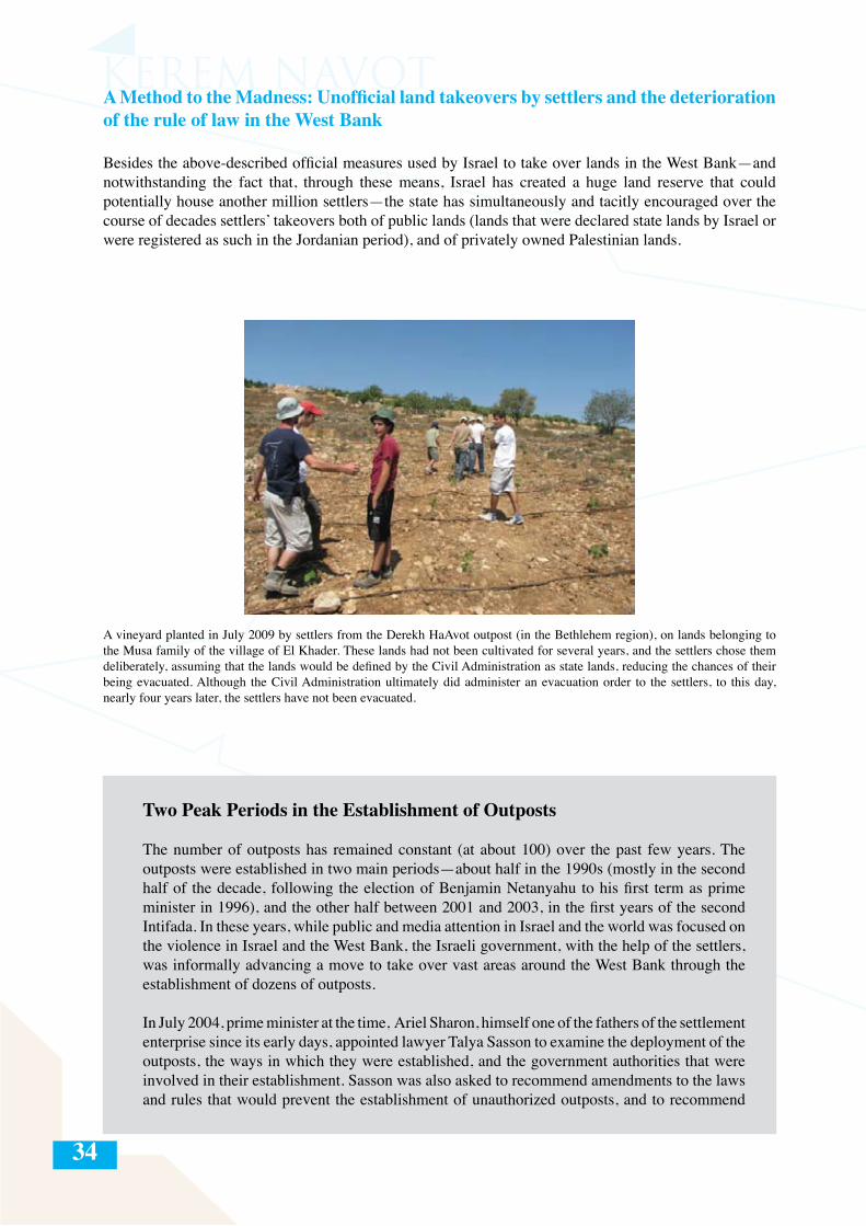
34
A vineyard planted in July 2009 by settlers from the Derekh HaAvot outpost (in the Bethlehem region), on lands belonging to the Musa family of the village of El Khader. These lands had not been cultivated for several years, and the settlers chose them deliberately, assuming that the lands would be defined by the Civil Administration as state lands, reducing the chances of their being evacuated. Although the Civil Administration ultimately did administer an evacuation order to the settlers, to this day, nearly four years later, the settlers have not been evacuated.
A Method to the Madness: Unofficial land takeovers by settlers and the deterioration of the rule of law in the West Bank
Besides the above-described official measures used by Israel to take over lands in the West Bank—and notwithstanding the fact that, through these means, Israel has created a huge land reserve that could potentially house another million settlers—the state has simultaneously and tacitly encouraged over the course of decades settlers’ takeovers both of public lands (lands that were declared state lands by Israel or were registered as such in the Jordanian period), and of privately owned Palestinian lands.
Two Peak Periods in the Establishment of Outposts
The number of outposts has remained constant (at about 100) over the past few years. The outposts were established in two main periods—about half in the 1990s (mostly in the second half of the decade, following the election of Benjamin Netanyahu to his first term as prime minister in 1996), and the other half between 2001 and 2003, in the first years of the second Intifada. In these years, while public and media attention in Israel and the world was focused on the violence in Israel and the West Bank, the Israeli government, with the help of the settlers, was informally advancing a move to take over vast areas around the West Bank through the establishment of dozens of outposts.
In July 2004, prime minister at the time, Ariel Sharon, himself one of the fathers of the settlement enterprise since its early days, appointed lawyer Talya Sasson to examine the deployment of the outposts, the ways in which they were established, and the government authorities that were involved in their establishment. Sasson was also asked to recommend amendments to the laws and rules that would prevent the establishment of unauthorized outposts, and to recommend
35
ways to tighten law enforcement and to take legal steps against those responsible for their establishment. At the time, Sharon was harshly criticized for appointing Sasson to investigate the issue of the outposts, since it was Sharon himself, as a minister in the Netanyahu government, who had called for the settlers, immediately following the signing of the Wye Accords (23.10.1998), to “run and grab the hilltops.”
In the introduction to her report, Sasson writes:
“In effect the illegal outposts are a continuation of the settlement enterprise in the territories. However, while in the more distant past the settlement enterprise sometimes enjoyed the formal recognition and encouragement of subsequent Israeli governments, in the second half of the 1990s this changed. Israeli governments were no longer formally involved in the establishment of outposts—apparently due to Israel’s international standing and the negative position of most of the countries of the world on the settlement enterprise. This has not been the case for other public authorities and state-sponsored bodies, who played a central role in the [outposts’] establishment, in some cases inspired by the political echelon, whether by turning a blind eye or by encouraging and supporting, though without any state-authorized decision.”50
In the 2005 Sasson Report (see inset, above), which detailed the deep involvement of Israeli government ministries in the establishment of illegal outposts in the West Bank, author Talya Sasson mentions the agricultural activity of Israeli settlers as one of the unlawful means used to establish the outposts. The Havat Aklum – Mevo’ot Yericho outpost, for example, was established on lands originally allocated to the settlement division of the WZO for agricultural purposes.51 In her recommendations for changes in government decision-making, Sasson remarks that the Settlement Division allocates agricultural lands without the oversight of the political echelon due to a loophole in the formulation of Article B of government decision 150 (1996), concerning “the allocation of state lands not for construction purposes.” Sasson recommends adding to this article that the allocation of state lands for agriculture be done only after the receipt of a permit from the minister of defense (as is done when land is allocated for construction).52 The present report suggests that the phenomenon of establishing outposts on lands originally allocated to the settlements for agricultural purposes is even more widespread than is described in the Sasson Report.
This phenomenon also emerges from the database compiled by the team of Brigadier General (res.) Baruch Spiegel, which worked parallel to Sasson.53 This database mentions that the Skhunat Kramim outpost (more commonly known as Mitzpe Kramim), erected in 1999 to the east of the Kokhav HaShahar settlement, was established with the approval of then minister of defense, Ehud Barak, on lands designated for agricultural use in Outline Plan 223/1.54 Spiegel notes that another structure, which serves as a boarding school and is located to the west of the Mevo Horon settlement, was also built on lands designated for agriculture.
50 Talya Sasson, “Interim Report on Unauthorized Outposts” [In Hebrew] (March 2005), p. 19, accessed at: http://www.pmo.gov.il/SiteCollectionDocuments/PMO/Communication/Spokesman/sason2.pdf. An English summary of the report is accessible at: http://www.mfa.gov.il/MFA/Government/Law/Legal+Issues+and+Rulings/Summary+of+Opinion+Concerning+Unauthorized+Outposts+-+Talya+Sason+Adv.htm51 Ibid., p. 109.52 Ibid., p. 326.53 The state refused to publish the database on the claim that it contained “sensitive security information.” The database was eventually exposed in Haaretz. See: Uri Blau, “Secret Israeli Database Reveals Full Extent of Illegal Settlement,” Haaretz Januray 1, 2009, accessed at: http://www.haaretz.com/secret-israeli-database-reveals-full-extent-of-illegal-settlement-1.266936.54 It should be noted that the very fact of the inclusion of these lands in Outline Plan 223/1 was already illegal, since these are private lands registered to residents of the village of Deir Jarir and Kafr Malik, over which neither the state nor the settlers have any rights.
36
Diakonia IHL Programme – “Within Range”
As this report shows, a large part of the Israeli agriculture in the West Bank constitutes illegal activity that contravenes not only international law, but also Israeli military law and civil law, which Israel is obligated to maintain and to enforce even by its own standards.55 The deterioration of the rule of law in the West Bank is by no means a new phenomenon, and much has been written about it in the last decades, including by Israeli government-appointed commissions. The report of the Karp Commission, from the early 1980s, appointed by the state attorney at the time Yitzhak Zamir, dealt with the failure of law enforcement on the settlers. The report discussed dozens of cases in which settlers were charged with harassing Palestinians as well as a number of instances of alleged trespassing and land incursions by settlers, which the Israeli authorities failed to deal with..56
Settler Violence Under IHL and IHRL
The construction of settlements and related infrastructure projects constitutes a violation of Article 1 common to all four Geneva Conventions, which obliges the occupying power to ensure respect for IHL by all actors in the occupied territory—state agents and other civilians. Article 43 of the Hague Regulations, which requires the occupying power to take all measures within its power to ensure public order and safety in light of the undeclared Israeli policy of leniency towards perpetrators in cases when Palestinians are attacked by settlers. “Protected persons are entitled, in all circumstances, to respect for their persons, their honour, their family rights…” (Art. 27, Fourth Geneva Convention).
According to General Comment no. 31 of the UN Committee on Human Rights from 2004: “There may be circumstances in which a failure to ensure [the rights stipulated in the International Covenant on Civil and Political Rights, henceforth: ICCPR] as required by article 2 would give rise to violations by States Parties of those rights, as a result of States Parties’ permitting or failing to take appropriate measures or to exercise due diligence to prevent, punish, investigate or redress the harm caused by such acts by private persons or entities. States are reminded of the interrelationship between the positive obligations imposed under article 2 and the need to provide effective remedies in the event of breach...”
According to Article 17 of ICCPR: “1. No one shall be subjected to arbitrary or unlawful interference with his privacy, family, home or correspondence, nor to unlawful attacks on his honour and reputation. 2. Everyone has the right to the protection of the law against such interference or attacks.”
One of the cases discussed in the Karp Report, which is particularly relevant for the subject of the present report, involves complaints by residents of the Palestinian village of Qaryut from 1981 about road-blocking and trespassing by settlers.57 At the time, settlers from Shilo blocked off the historical route connecting the villages of Qaryut, Turmus-ayya, and Sinjil to Ramallah. Although these were privately owned lands that were actively cultivated at the time, settlers blocked off the entire area of about 90 dunam from Palestinian entrance and annexed it to the de facto jurisdiction of Shilo, though the official boundaries of the settlement were never changed. The settlers of Shilo and its outposts use the land for agriculture to this day, and this area has become one of the areas most plagued by the phenomenon of agricultural incursions by settlers (see the case study appendix I to this report: “Agricultural Takeovers by Settlers around the Shilo Settlement and Outposts”).
55 Israeli criminal law applies to the settlers as Israeli citizens, as is defined in Article 15 of the Israel Penal Code from 1977.56 The (unpublished) report of the commission headed by Judith Karp, then deputy legal advisor to the government, was submitted to the government on 23.5.1982. Judith Karp resigned from her position once it became clear that the government did not intend to endorse her report’s conclusions regarding its law-enforcement policy in the West Bank. 57 Ibid., pp. 13–15.
Und
er IH
L an
d IH
RL
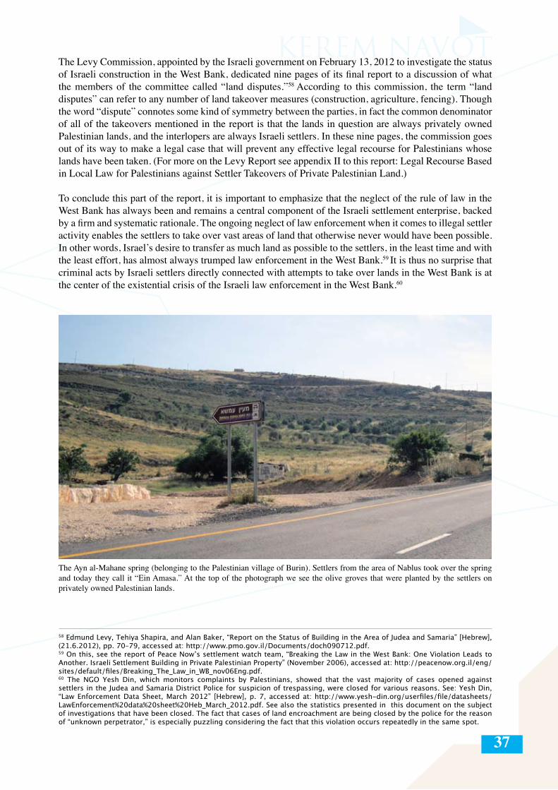
37
The Levy Commission, appointed by the Israeli government on February 13, 2012 to investigate the status of Israeli construction in the West Bank, dedicated nine pages of its final report to a discussion of what the members of the committee called “land disputes.”58 According to this commission, the term “land disputes” can refer to any number of land takeover measures (construction, agriculture, fencing). Though the word “dispute” connotes some kind of symmetry between the parties, in fact the common denominator of all of the takeovers mentioned in the report is that the lands in question are always privately owned Palestinian lands, and the interlopers are always Israeli settlers. In these nine pages, the commission goes out of its way to make a legal case that will prevent any effective legal recourse for Palestinians whose lands have been taken. (For more on the Levy Report see appendix II to this report: Legal Recourse Based in Local Law for Palestinians against Settler Takeovers of Private Palestinian Land.)
To conclude this part of the report, it is important to emphasize that the neglect of the rule of law in the West Bank has always been and remains a central component of the Israeli settlement enterprise, backed by a firm and systematic rationale. The ongoing neglect of law enforcement when it comes to illegal settler activity enables the settlers to take over vast areas of land that otherwise never would have been possible. In other words, Israel’s desire to transfer as much land as possible to the settlers, in the least time and with the least effort, has almost always trumped law enforcement in the West Bank.59 It is thus no surprise that criminal acts by Israeli settlers directly connected with attempts to take over lands in the West Bank is at the center of the existential crisis of the Israeli law enforcement in the West Bank.60
58 Edmund Levy, Tehiya Shapira, and Alan Baker, “Report on the Status of Building in the Area of Judea and Samaria” [Hebrew], (21.6.2012), pp. 70–79, accessed at: http://www.pmo.gov.il/Documents/doch090712.pdf.59 On this, see the report of Peace Now’s settlement watch team, “Breaking the Law in the West Bank: One Violation Leads to Another. Israeli Settlement Building in Private Palestinian Property” (November 2006), accessed at: http://peacenow.org.il/eng/sites/default/files/Breaking_The_Law_in_WB_nov06Eng.pdf. 60 The NGO Yesh Din, which monitors complaints by Palestinians, showed that the vast majority of cases opened against settlers in the Judea and Samaria District Police for suspicion of trespassing, were closed for various reasons. See: Yesh Din, “Law Enforcement Data Sheet, March 2012” [Hebrew], p. 7, accessed at: http://www.yesh-din.org/userfiles/file/datasheets/LawEnforcement%20data%20sheet%20Heb_March_2012.pdf. See also the statistics presented in this document on the subject of investigations that have been closed. The fact that cases of land encroachment are being closed by the police for the reason of “unknown perpetrator,” is especially puzzling considering the fact that this violation occurs repeatedly in the same spot.
The Ayn al-Mahane spring (belonging to the Palestinian village of Burin). Settlers from the area of Nablus took over the spring and today they call it “Ein Amasa.” At the top of the photograph we see the olive groves that were planted by the settlers on privately owned Palestinian lands.
38
PART III THE VALLEY AND THE HILL: TWO TYPOLOGIES OF ISRAELI AGRICULTURE IN THE WEST BANK
Israeli agriculture in the West Bank is as old as the settlement enterprise itself. Kfar Etzion, the first Israeli West Bank settlement, was established in late September 1967 as a religious agricultural kibbutz.61 In order to ensure the viability of its agricultural economy, from the end of the 1960s onward, the Israeli military issued a series of military seizure orders for the lands around Kfar Etzion, which were subsequently allocated for the agricultural use of the settlers.62 Two more such agricultural settlements were established in the same period: Mehola, in the northern Jordan Valley, at the end of 1968; and Mevo Horon, east of the area of the Latrun enclave, in 1969.63
Israeli agriculture in the West Bank subsequently developed, from 1967 onward, on two main channels: the first, in the West Bank Hill Country (the ridge running north-south along Highway 60, the main artery connecting the southern West Bank with the northern West Bank), and the second, in the Jordan Valley (along Highway 90, from the northern end of the Dead Sea in the south up to the Beit She’an valley in the north). The following pages entail an in-depth description of the two typologies of Israeli agriculture in the West Bank, and the official and unofficial means of land takeovers used in each.
61 Kfar Etzion was established on the site of the Jewish settlement that had been destroyed during the 1948 war. Four Jewish settlements existed in the area of Gush Etzion until 1948. Kfar Etzion, the oldest of them, was established, after two prior failed attempts, in 1943. In addition to the four Jewish settlements in Gush Etzion, a few other Jewish settlements existed throughout the West Bank until the eve of the 1948 war, all of whose economies were based on agriculture. These settlements were also destroyed during the 1948 war.62 This practice was widely employed by Israel from the late 1960s until the end of the 1970s. See discussion of the methods of land takeovers for the settlements in the previous chapter. See also: B’Tselem, “Land Grab: Israel’s Settlement Policy in the West Bank” (May 2002), pp. 47–64, accessed at: http://www.btselem.org/sites/default/files2/publication/200205_land_grab_eng.pdf.63 The Latrun enclave was considered no man’s land between 1949 and 1967. During the 1967 war, the inhabitants of three Palestinian West-Bank villages—Beit Nuba, Amwas, and Yalo—were expelled from the area east of the Latrun enclave, and an Israeli national park (Canada Park) was established on the ruins of these villages. While the settlement of Mevo Horon is closer to the Hill Country settlements in terms of its population (religious), it does not fit into either of the two typologies discussed in this report and functions today in a unique situation that no other settlement in the West Bank shares, namely, that because of the Separation Barrier, which was built between the settlement and the rest of the West Bank, Palestinians from the West Bank have no access whatsoever to the settlement.
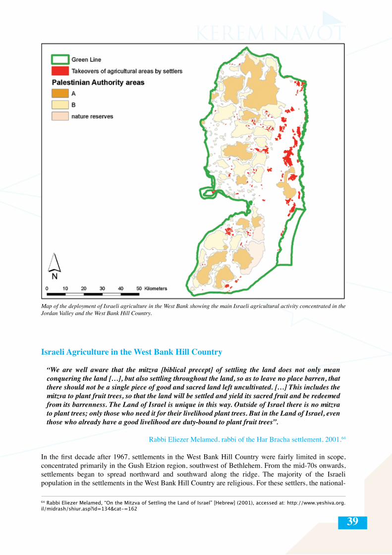
39
Map of the deployment of Israeli agriculture in the West Bank showing the main Israeli agricultural activity concentrated in the Jordan Valley and the West Bank Hill Country.
Israeli Agriculture in the West Bank Hill Country
“We are well aware that the mitzva [biblical precept] of settling the land does not only mean conquering the land […], but also settling throughout the land, so as to leave no place barren, that there should not be a single piece of good and sacred land left uncultivated. […] This includes the mitzva to plant fruit trees, so that the land will be settled and yield its sacred fruit and be redeemed from its barrenness. The Land of Israel is unique in this way. Outside of Israel there is no mitzva to plant trees; only those who need it for their livelihood plant trees. But in the Land of Israel, even those who already have a good livelihood are duty-bound to plant fruit trees”.
Rabbi Eliezer Melamed, rabbi of the Har Bracha settlement, 2001.64
In the first decade after 1967, settlements in the West Bank Hill Country were fairly limited in scope, concentrated primarily in the Gush Etzion region, southwest of Bethlehem. From the mid-70s onwards, settlements began to spread northward and southward along the ridge. The majority of the Israeli population in the settlements in the West Bank Hill Country are religious. For these settlers, the national-
64 Rabbi Eliezer Melamed, “On the Mitzva of Settling the Land of Israel” [Hebrew] (2001), accessed at: http://www.yeshiva.org.il/midrash/shiur.asp?id=134&cat-=162
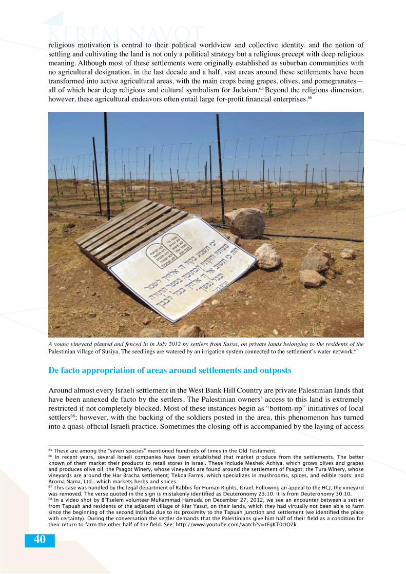
40
religious motivation is central to their political worldview and collective identity, and the notion of settling and cultivating the land is not only a political strategy but a religious precept with deep religious meaning. Although most of these settlements were originally established as suburban communities with no agricultural designation, in the last decade and a half, vast areas around these settlements have been transformed into active agricultural areas, with the main crops being grapes, olives, and pomegranates—all of which bear deep religious and cultural symbolism for Judaism.65 Beyond the religious dimension, however, these agricultural endeavors often entail large for-profit financial enterprises.66
65 These are among the “seven species” mentioned hundreds of times in the Old Testament.66 In recent years, several Israeli companies have been established that market produce from the settlements. The better known of them market their products to retail stores in Israel. These include Meshek Achiya, which grows olives and grapes and produces olive oil; the Psagot Winery, whose vineyards are found around the settlement of Psagot; the Tura Winery, whose vineyards are around the Har Bracha settlement; Tekoa Farms, which specializes in mushrooms, spices, and edible roots; and Aroma Nama, Ltd., which markets herbs and spices.67 This case was handled by the legal department of Rabbis for Human Rights, Israel. Following an appeal to the HCJ, the vineyard was removed. The verse quoted in the sign is mistakenly identified as Deuteronomy 23:10. It is from Deuteronomy 30:10.68 In a video shot by B’Tselem volunteer Muhammad Hamuda on December 27, 2012, we see an encounter between a settler from Tapuah and residents of the adjacent village of Kfar Yasuf, on their lands, which they had virtually not been able to farm since the beginning of the second Intifada due to its proximity to the Tapuah junction and settlement (we identified the place with certainty). During the conversation the settler demands that the Palestinians give him half of their field as a condition for their return to farm the other half of the field. See: http://www.youtube.com/watch?v=tEgKT0cIOZk
A young vineyard planted and fenced in in July 2012 by settlers from Susya, on private lands belonging to the residents of the Palestinian village of Susiya. The seedlings are watered by an irrigation system connected to the settlement’s water network.67
De facto appropriation of areas around settlements and outposts
Around almost every Israeli settlement in the West Bank Hill Country are private Palestinian lands that have been annexed de facto by the settlers. The Palestinian owners’ access to this land is extremely restricted if not completely blocked. Most of these instances begin as “bottom-up” initiatives of local settlers68; however, with the backing of the soldiers posted in the area, this phenomenon has turned into a quasi-official Israeli practice. Sometimes the closing-off is accompanied by the laying of access
41
roads and installation of street lighting, and sometimes the private lands are physically fenced off (without a permit, though with the full coordination and apparent funding of the Israeli authorities in most cases). 69
This expropriation and fencing-off of areas around the settlements provides an ample source of land for agricultural use by the settlers. According to conservative estimates, many thousands of dunam of private land has been closed off in this way, much of it during the second Intifada. The authorities only rarely intervene to stop the settlers’ incursion, and moreover, very often reinforce it by guarding and enforcing the prohibition on entry of Palestinians to the areas.
69 Examples of this can be found around the settlements of Beit El, Ofra, Ma’ale Michmash, Anatot, Psagot, Adam, and Kokhav Yaakov—all in the Ramallah region.
Muhammad Yusuf Jadi’a Nuwaj’a, born in 1956, a farmer from the village of Susiya
In 1966, Yaakov Talia put up his illegal outpost […] on part of our land. Since then, Yaakov Talia and his accomplices have regularly attacked and harassed us and other farmers in the area. […] We filed complaints with the representatives of the District Coordination Office [DCO] and the police, and we continued to hold on to our lands and farm them.
My family continued to live there and we held on to our lands until 2001. In July 2001, following the death of a settler from [the Israeli settlement] Susya [Yair Har Sinai], settlers from the area, especially Yaakov Talia, went on a rampage of attacks and harassment. The goal of the attacks was to […] strike fear and terror in the hearts of the people in the area, and make us leave. We submitted complaints to the DCO and to the police, but to no avail. The army itself also launched a wave of demolitions and expulsions from the area, helped the settlers, and protected them as they attacked us. We were then violently expelled from this land in 2001.
Because of the settlers’ violence, we could not continue to live on our land, and our access to the land was greatly limited. Until 2003 we made occasional attempts to enter our land, but every time we were met by the violent response of Yaakov Talia, who would even call in the army to kick us off the land. When we would go to work in Shalalat a-Da’is and Umm Likhwas, the army would come and declare the area a closed military zone, and say that it was prohibited to work on or even enter the area. The settler Yaakov Talia come onto our land with horses and cows and let them eat our harvest. He would also call upon other settlers, the security guards from the settlements, and even the soldiers. When the army would come they would prevent us from entering our land. After this, we filed many complaints against Yaakov Talia to the police for trespassing and destroying our harvest by deliberately plowing our lands and letting his sheep graze on our land.
We tried to coordinate the entrance to our land with the army so we could return to farm our land, but we were told that this was a closed military zone and that we can’t enter. Sometimes the people of the DCO told us that they would escort us to our land, but they wouldn’t show up. For five years we couldn’t reach our lands freely because of the violence of the settler Yaakov Talia. I myself tried to enter my lands and was arrested three times and taken to the Hebron police station, while Yaakov Talia and another settler filed complaints against me for entering a closed area. Having no access to our land, we could no longer harvest our fields, and since we could not graze our sheep on the land, we had to start buying food for our sheep. I used to have about thirty sheep, but I sold half of them, because where I live now in Yatta there is no suitable place for grazing them.
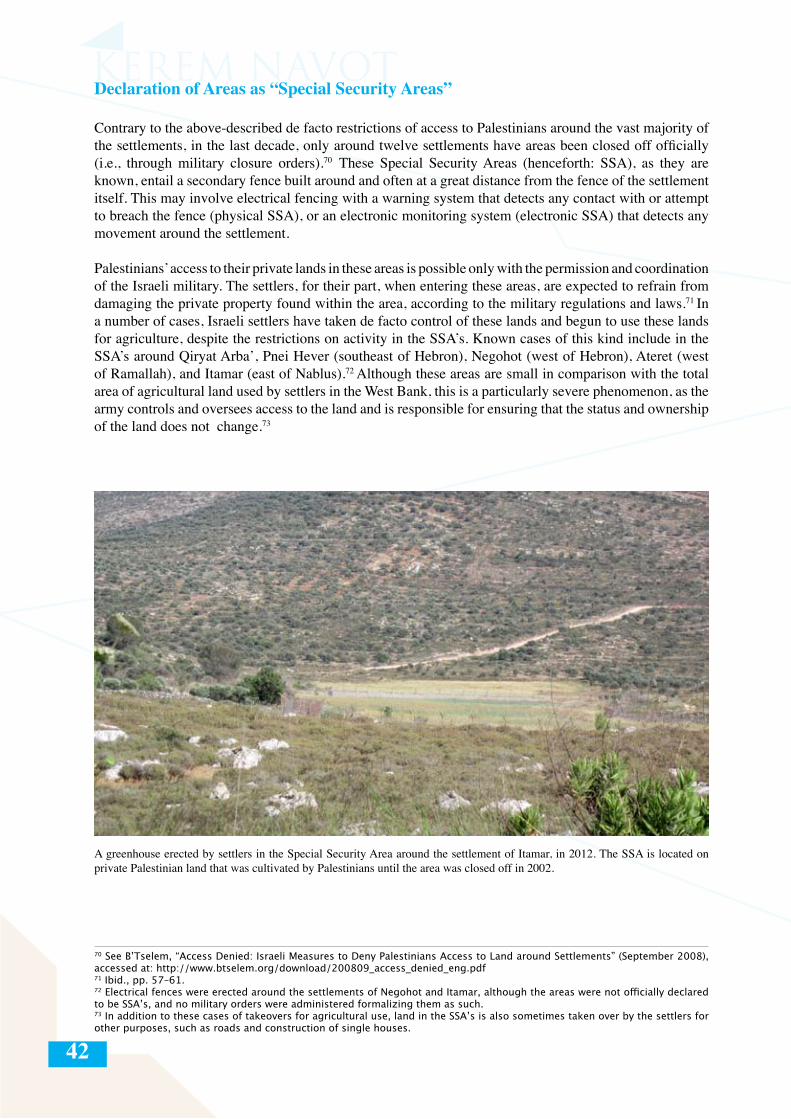
42
Declaration of Areas as “Special Security Areas”
Contrary to the above-described de facto restrictions of access to Palestinians around the vast majority of the settlements, in the last decade, only around twelve settlements have areas been closed off officially (i.e., through military closure orders).70 These Special Security Areas (henceforth: SSA), as they are known, entail a secondary fence built around and often at a great distance from the fence of the settlement itself. This may involve electrical fencing with a warning system that detects any contact with or attempt to breach the fence (physical SSA), or an electronic monitoring system (electronic SSA) that detects any movement around the settlement.
Palestinians’ access to their private lands in these areas is possible only with the permission and coordination of the Israeli military. The settlers, for their part, when entering these areas, are expected to refrain from damaging the private property found within the area, according to the military regulations and laws.71 In a number of cases, Israeli settlers have taken de facto control of these lands and begun to use these lands for agriculture, despite the restrictions on activity in the SSA’s. Known cases of this kind include in the SSA’s around Qiryat Arba’, Pnei Hever (southeast of Hebron), Negohot (west of Hebron), Ateret (west of Ramallah), and Itamar (east of Nablus).72 Although these areas are small in comparison with the total area of agricultural land used by settlers in the West Bank, this is a particularly severe phenomenon, as the army controls and oversees access to the land and is responsible for ensuring that the status and ownership of the land does not change.73
70 See B’Tselem, “Access Denied: Israeli Measures to Deny Palestinians Access to Land around Settlements” (September 2008), accessed at: http://www.btselem.org/download/200809_access_denied_eng.pdf 71 Ibid., pp. 57–61. 72 Electrical fences were erected around the settlements of Negohot and Itamar, although the areas were not officially declared to be SSA’s, and no military orders were administered formalizing them as such.73 In addition to these cases of takeovers for agricultural use, land in the SSA’s is also sometimes taken over by the settlers for other purposes, such as roads and construction of single houses.
A greenhouse erected by settlers in the Special Security Area around the settlement of Itamar, in 2012. The SSA is located on private Palestinian land that was cultivated by Palestinians until the area was closed off in 2002.
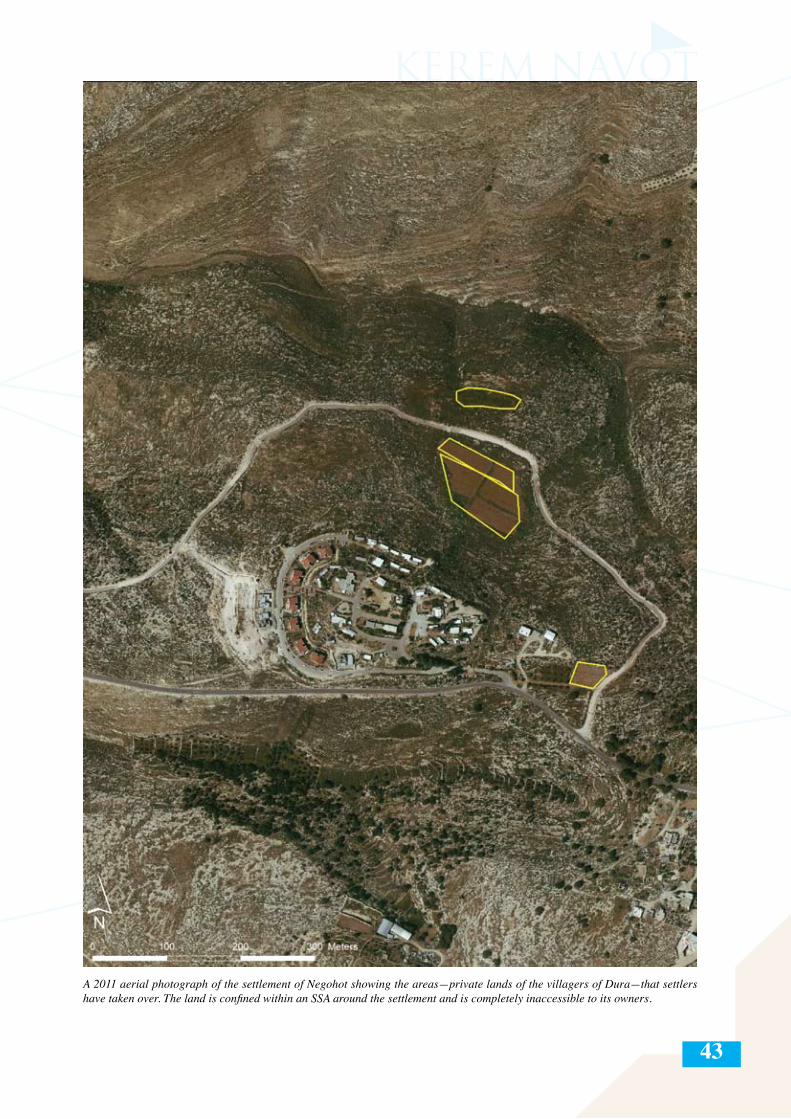
43
A 2011 aerial photograph of the settlement of Negohot showing the areas—private lands of the villagers of Dura—that settlers have taken over. The land is confined within an SSA around the settlement and is completely inaccessible to its owners.
44
Agricultural incursions by settlers into Area B, including the Nature Reserve stipulated in the Accords74
The reality of “might makes right” in the occupied West Bank enables the settlers to seize large swaths of land, virtually without interference on the part of the Israeli law enforcement authorities. In a few places across the West Bank—primarily, but not only, in the Hill Country—settlers have even managed to infiltrate parts of Area B. Although settlements or any permanent presence of settlers is prohibited in Area B according to the Interim Agreements between Israel and the Palestinian Authority, in our survey we identified a number of plots that have been expropriated by settlers through and for agricultural activity. Totaling about 190 dunam,75 these areas are as follows:
- Settlers from Shadmot Mehola are cultivating about 23 dunam of orchards around the village of Ayn al-Bayda in the northern Jordan Valley.- Settlers from the Amona outpost are cultivating about six dunam of vineyards to the south of the village of Salwad.- Setters from Yitzhar are cultivating a vineyard of about five dunam to the north of the village of Ayn Abus.- Settlers from one of the Itamar outposts are cultivating field crops on an area of about 90 dunam seized from the village of Yanun.- Settlers from the Esh Qodesh outpost (east of Shilo) are cultivating plots of about 62 dunam on the lands of the village of Jalud.76
- Settlers form the Ma’aleh Rehavam outpost are cultivating plots of about seven dunam on lands of Arab at-Ta’amra, east of Bethlehem. These plots are located in the area defined in the Wye River Memorandum as a nature reserve.
74 According to the Wye Accords, signed in Washington on October 23, 1998, Israel transferred 13% of Area C to the Palestinian Authority, with 1% being redefined as Area A and 12% as Area B. According to Article 1 of the agreement, one quarter of the land transferred to the Palestinians and defined as Area B was designated as a nature reserve on which Palestinian (and certainly Israeli) construction is forbidden. For the text of the Wye River Memorandum, see: http://www.knesset.gov.il/process/docs/wye_eng.htm.75 On this, see: Akiva Eldar, “West Bank outposts spreading into Area B, in violation of Oslo Accords,” Haaretz 18.2.2012, accessed at: http://www.haaretz.com/print-edition/news/west-bank-outposts-spreading-into-area-b-in-violation-of-oslo-accords-1.413390.76 There have been additional attempts by settlers from the outposts of Esh Qodesh and Achiya to take over more lands in the same area of Area B, by plowing the area.
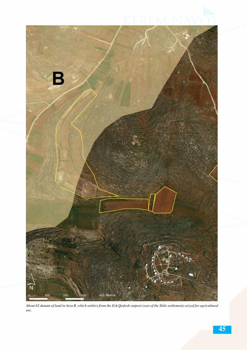
45
About 62 dunam of land in Area B, which settlers from the Esh Qodesh outpost (east of the Shilo settlement) seized for agricultural use.
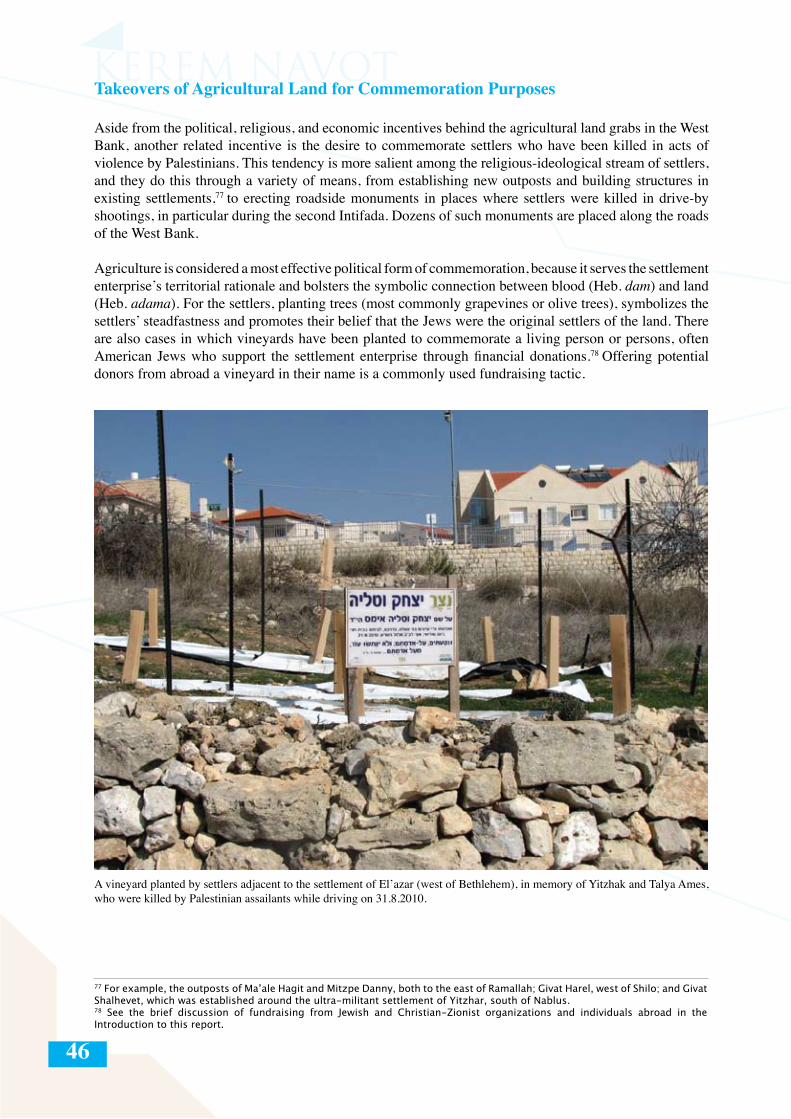
46
Takeovers of Agricultural Land for Commemoration Purposes
Aside from the political, religious, and economic incentives behind the agricultural land grabs in the West Bank, another related incentive is the desire to commemorate settlers who have been killed in acts of violence by Palestinians. This tendency is more salient among the religious-ideological stream of settlers, and they do this through a variety of means, from establishing new outposts and building structures in existing settlements,77 to erecting roadside monuments in places where settlers were killed in drive-by shootings, in particular during the second Intifada. Dozens of such monuments are placed along the roads of the West Bank.
Agriculture is considered a most effective political form of commemoration, because it serves the settlement enterprise’s territorial rationale and bolsters the symbolic connection between blood (Heb. dam) and land (Heb. adama). For the settlers, planting trees (most commonly grapevines or olive trees), symbolizes the settlers’ steadfastness and promotes their belief that the Jews were the original settlers of the land. There are also cases in which vineyards have been planted to commemorate a living person or persons, often American Jews who support the settlement enterprise through financial donations.78 Offering potential donors from abroad a vineyard in their name is a commonly used fundraising tactic.
A vineyard planted by settlers adjacent to the settlement of El’azar (west of Bethlehem), in memory of Yitzhak and Talya Ames, who were killed by Palestinian assailants while driving on 31.8.2010.
77 For example, the outposts of Ma’ale Hagit and Mitzpe Danny, both to the east of Ramallah; Givat Harel, west of Shilo; and Givat Shalhevet, which was established around the ultra-militant settlement of Yitzhar, south of Nablus.78 See the brief discussion of fundraising from Jewish and Christian-Zionist organizations and individuals abroad in the Introduction to this report.
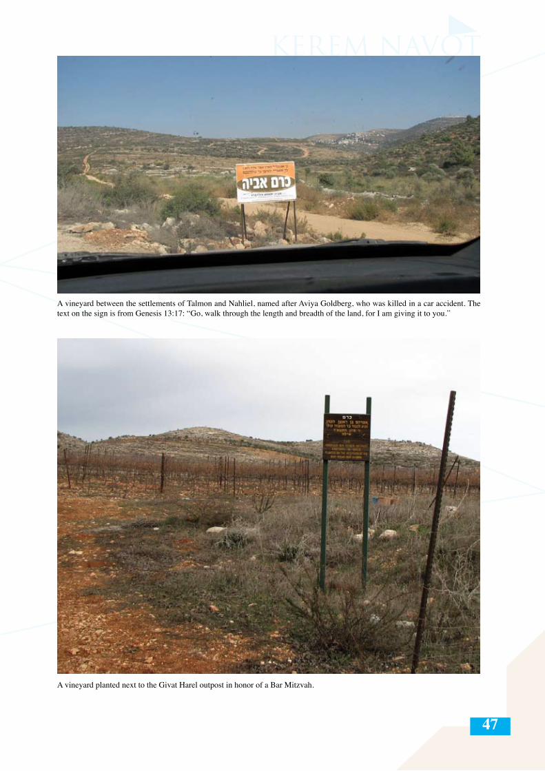
47
A vineyard between the settlements of Talmon and Nahliel, named after Aviya Goldberg, who was killed in a car accident. The text on the sign is from Genesis 13:17: “Go, walk through the length and breadth of the land, for I am giving it to you.”
A vineyard planted next to the Givat Harel outpost in honor of a Bar Mitzvah.
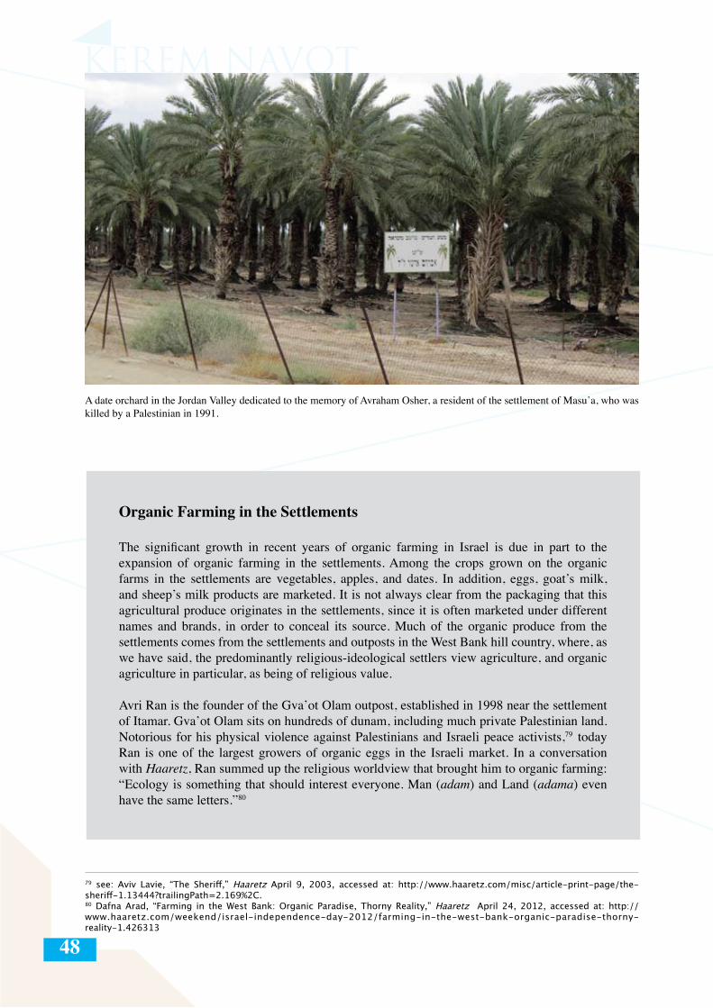
48
A date orchard in the Jordan Valley dedicated to the memory of Avraham Osher, a resident of the settlement of Masu’a, who was killed by a Palestinian in 1991.
79 see: Aviv Lavie, “The Sheriff,” Haaretz April 9, 2003, accessed at: http://www.haaretz.com/misc/article-print-page/the-sheriff-1.13444?trailingPath=2.169%2C.80 Dafna Arad, “Farming in the West Bank: Organic Paradise, Thorny Reality,” Haaretz April 24, 2012, accessed at: http://www.haaretz.com/weekend/israel-independence-day-2012/farming-in-the-west-bank-organic-paradise-thorny-reality-1.426313
Organic Farming in the Settlements
The significant growth in recent years of organic farming in Israel is due in part to the expansion of organic farming in the settlements. Among the crops grown on the organic farms in the settlements are vegetables, apples, and dates. In addition, eggs, goat’s milk, and sheep’s milk products are marketed. It is not always clear from the packaging that this agricultural produce originates in the settlements, since it is often marketed under different names and brands, in order to conceal its source. Much of the organic produce from the settlements comes from the settlements and outposts in the West Bank hill country, where, as we have said, the predominantly religious-ideological settlers view agriculture, and organic agriculture in particular, as being of religious value.
Avri Ran is the founder of the Gva’ot Olam outpost, established in 1998 near the settlement of Itamar. Gva’ot Olam sits on hundreds of dunam, including much private Palestinian land. Notorious for his physical violence against Palestinians and Israeli peace activists,79 today Ran is one of the largest growers of organic eggs in the Israeli market. In a conversation with Haaretz, Ran summed up the religious worldview that brought him to organic farming: “Ecology is something that should interest everyone. Man (adam) and Land (adama) even have the same letters.”80
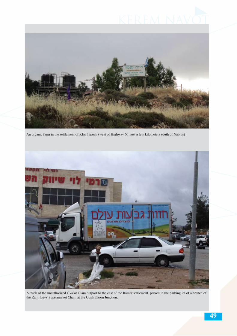
49
An organic farm in the settlement of Kfar Tapuah (west of Highway 60, just a few kilometers south of Nablus)
A truck of the unauthorized Gva’ot Olam outpost to the east of the Itamar settlement, parked in the parking lot of a branch of the Rami Levy Supermarket Chain at the Gush Etzion Junction.
50
Israeli Agriculture in the Jordan Valley and Northern Dead Sea
“The children’s voices are heard in the Moshav,their laughter rolling like the sound of a bell.The water is flowing, not a dry streambed.Once again the Jordan flows proudly.The horses gallop in the orchards, with the promise that everything will bloom…”
(From the song, “Somewhere in the Valley” Words: Noah Warshauer, melody: Ella Sheriff, performed by the IDF Central Command Ensemble, 1974)
The Jordan Valley is the easternmost strip of the West Bank. Its southernmost point connects the Green Line with the Dead Sea coast, slightly north of Ein Gedi, and it stretches north up to the Beit She’an Valley. The “strip” is about 15 kilometers in width, and most of it is a desert terrain (with the exception of a few places with natural water sources). To the east, the Jordan Valley delineates the border between the West Bank and the Hashemite Kingdom of Jordan. To the west it borders on the line of Palestinian villages along the Alon Road, parallel and to the east of the precipitation line (only to the west of which traditional mountain agriculture is possible). Agriculture in the settlements in the Jordan Valley is based on dates, field crops (falha), and greenhouse produce.
Throughout the late 1960s and 1970s, Israel established a series of settlements along the Jordan Valley. Many of these began as Nahal81 military outposts, and later received the status of civilian settlements, mostly becoming agricultural Kibbutzim and Moshavim. These were mostly secular settlements, some directly affiliated with the Labor Party and the Kibbutz Movement. Tens of thousands of dunam of land requisitioned in different ways by Israel in these years were allotted to the settlements in the Jordan Valley to help them establish their economies on agriculture.
Today there are some 40 settlements and outposts in the region, belonging to two regional councils—the Jordan Valley Regional Council and the Megilot Regional Council (in the northern Dead Sea region)—that cover an area of almost 1,500,000 dunam and have a population of only 9,500 settlers (out of around 350,000 settlers in the West Bank, not counting East Jerusalem). According to estimates, about 80,000 Palestinians live in the Jordan Valley today, constituting about 90 percent of the population of the area82 but denied denied access to most of the land in the strip. Israel prevents their access to the land through various land designations:
- State land – Tens of thousands of dunam, well beyond the amount of land registered as such in the Jordanian period, have been declared as state land since 1967, primarily in the 1980s. Most of this land was transferred to the settlements in the area.- Absentee property – Vast areas (the precise size is not known, though several sources estimate their area at thousands of dunam)83 were declared “absentee property,” mostly in the late 60s and 70s, and transferred to the use of the settlers, in contravention of the Military Order Concerning Absentees’ Property (private property) (Judea and Samaria) (no. 58) (1967).
81 In Hebrew, Nahal is an acronym for Fighting Pioneering Youth. The Nahal division was established in 1948 and served the Israeli governments as a main arm for the establishment of new agricultural communities, mainly in the Negev and the Galilee. The soldiers who chose to be recruited to the Nahal combined military training and practice periods with periods of agricultural work in the newly established communities. 82 These statistics are based on the B’Tselem report, “Dispossession and Exploitation: Israel’s policy in the Jordan Valley and Northern Dead Sea” (May 2011), accessed at: http://www.btselem.org/sites/default/files2/201105_dispossession_and_exploitation_eng.pdf 83 Israel State Comptroller, “Annual Report 56a for 2005” [Hebrew], accessed at: http://www.mevaker.gov.il/serve/contentTree.asp?bookid=433&id=1848&contentid=8021&parentcid=8017u&bctype=0&sw=1600&hw=830
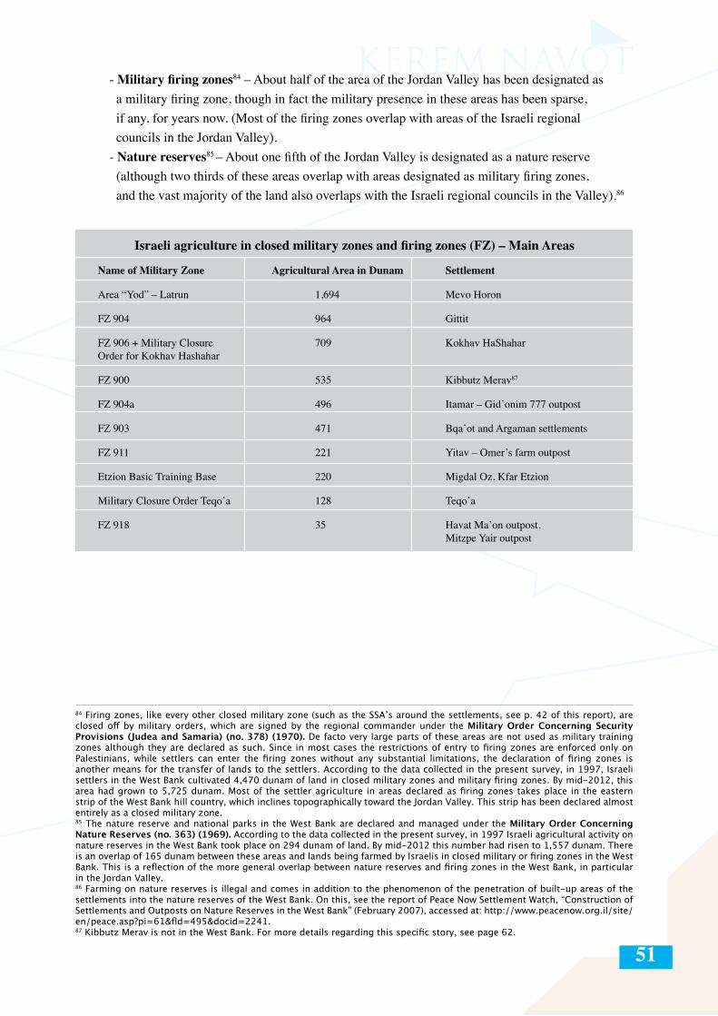
51
- Military firing zones84 – About half of the area of the Jordan Valley has been designated as a military firing zone, though in fact the military presence in these areas has been sparse, if any, for years now. (Most of the firing zones overlap with areas of the Israeli regional councils in the Jordan Valley). - Nature reserves85 – About one fifth of the Jordan Valley is designated as a nature reserve (although two thirds of these areas overlap with areas designated as military firing zones, and the vast majority of the land also overlaps with the Israeli regional councils in the Valley).86
84 Firing zones, like every other closed military zone (such as the SSA’s around the settlements, see p. 42 of this report), are closed off by military orders, which are signed by the regional commander under the Military Order Concerning Security Provisions (Judea and Samaria) (no. 378) (1970). De facto very large parts of these areas are not used as military training zones although they are declared as such. Since in most cases the restrictions of entry to firing zones are enforced only on Palestinians, while settlers can enter the firing zones without any substantial limitations, the declaration of firing zones is another means for the transfer of lands to the settlers. According to the data collected in the present survey, in 1997, Israeli settlers in the West Bank cultivated 4,470 dunam of land in closed military zones and military firing zones. By mid-2012, this area had grown to 5,725 dunam. Most of the settler agriculture in areas declared as firing zones takes place in the eastern strip of the West Bank hill country, which inclines topographically toward the Jordan Valley. This strip has been declared almost entirely as a closed military zone.85 The nature reserve and national parks in the West Bank are declared and managed under the Military Order Concerning Nature Reserves (no. 363) (1969). According to the data collected in the present survey, in 1997 Israeli agricultural activity on nature reserves in the West Bank took place on 294 dunam of land. By mid-2012 this number had risen to 1,557 dunam. There is an overlap of 165 dunam between these areas and lands being farmed by Israelis in closed military or firing zones in the West Bank. This is a reflection of the more general overlap between nature reserves and firing zones in the West Bank, in particular in the Jordan Valley.86 Farming on nature reserves is illegal and comes in addition to the phenomenon of the penetration of built-up areas of the settlements into the nature reserves of the West Bank. On this, see the report of Peace Now Settlement Watch, “Construction of Settlements and Outposts on Nature Reserves in the West Bank” (February 2007), accessed at: http://www.peacenow.org.il/site/en/peace.asp?pi=61&fld=495&docid=2241. 87 Kibbutz Merav is not in the West Bank. For more details regarding this specific story, see page 62.
Israeli agriculture in closed military zones and firing zones (FZ) – Main Areas
Name of Military Zone Agricultural Area in Dunam Settlement
Area “Yod” – Latrun 1,694 Mevo Horon
FZ 904 964 Gittit
FZ 906 + Military Closure 709 Kokhav HaShaharOrder for Kokhav Hashahar
FZ 900 535 Kibbutz Merav87
FZ 904a 496 Itamar – Gid’onim 777 outpost
FZ 903 471 Bqa’ot and Argaman settlements
FZ 911 221 Yitav – Omer’s farm outpost
Etzion Basic Training Base 220 Migdal Oz, Kfar Etzion
Military Closure Order Teqo’a 128 Teqo’a
FZ 918 35 Havat Ma’on outpost, Mitzpe Yair outpost
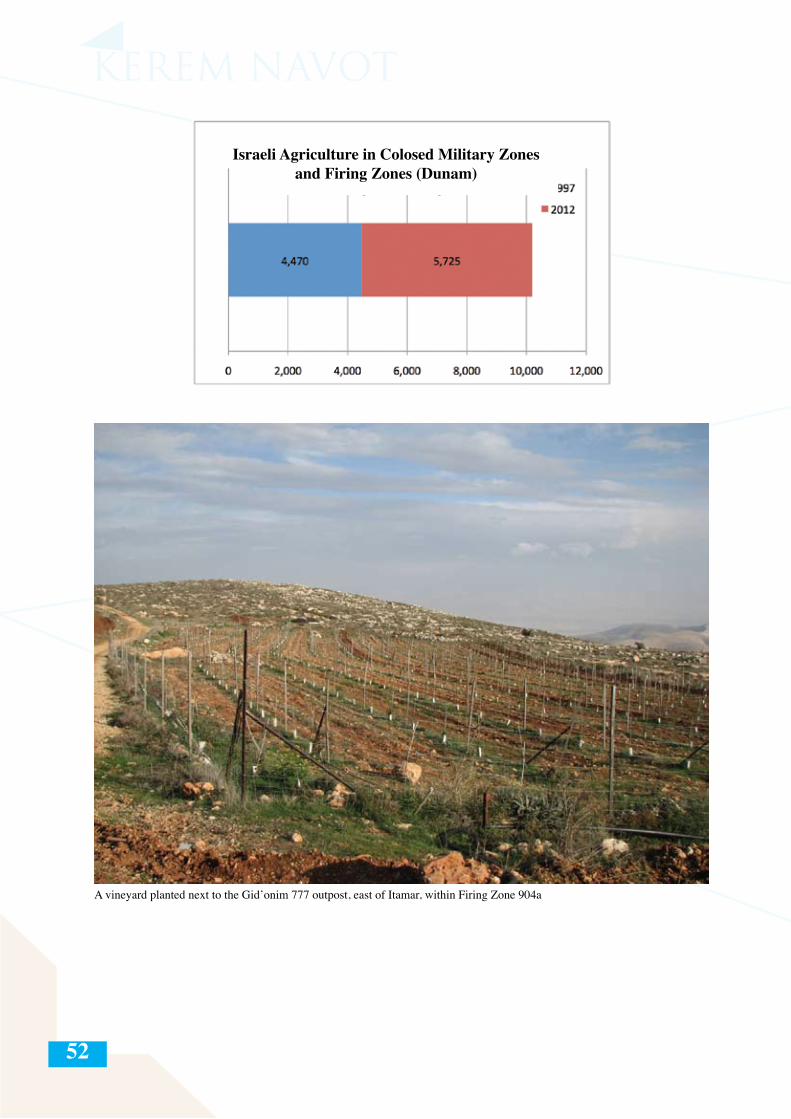
52
A vineyard planted next to the Gid’onim 777 outpost, east of Itamar, within Firing Zone 904a
Israeli Agriculture in Colosed Military Zones and Firing Zones (Dunam)
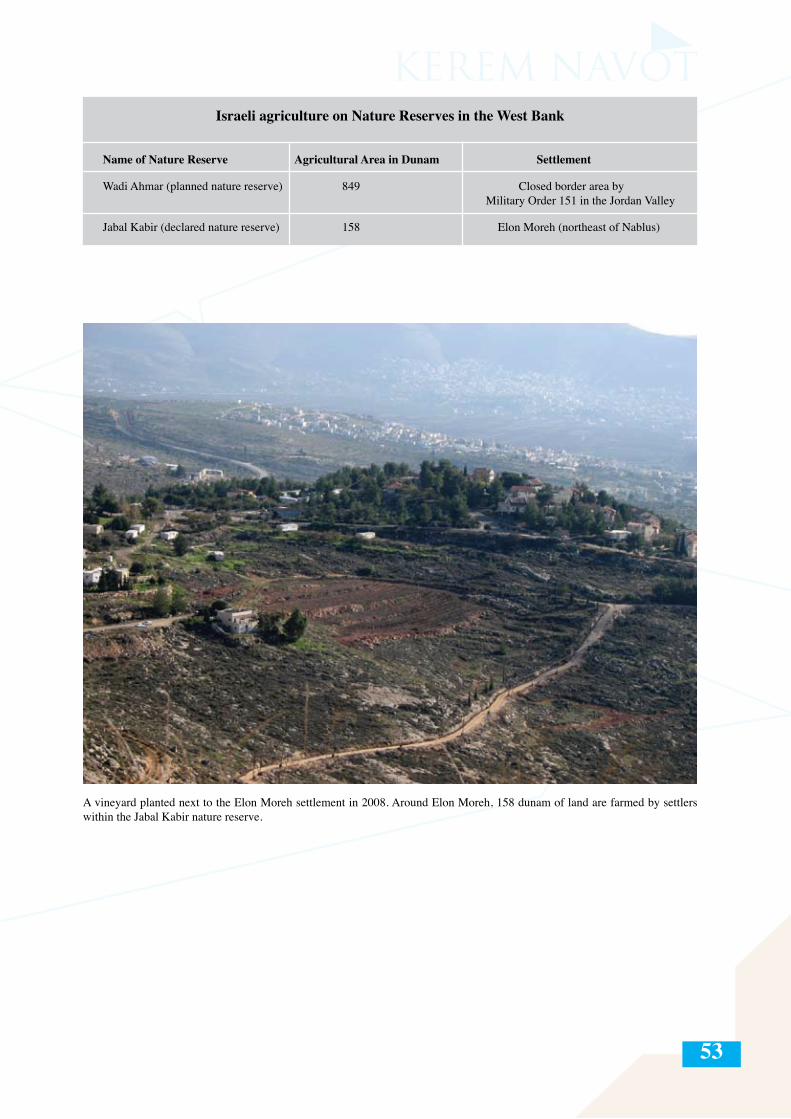
53
Israeli agriculture on Nature Reserves in the West Bank
Name of Nature Reserve Agricultural Area in Dunam Settlement
Wadi Ahmar (planned nature reserve) 849 Closed border area by Military Order 151 in the Jordan Valley
Jabal Kabir (declared nature reserve) 158 Elon Moreh (northeast of Nablus)
A vineyard planted next to the Elon Moreh settlement in 2008. Around Elon Moreh, 158 dunam of land are farmed by settlers within the Jabal Kabir nature reserve.
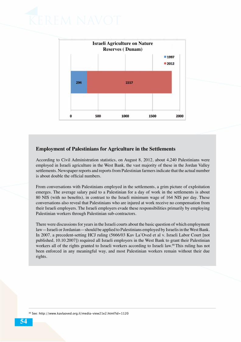
54
Employment of Palestinians for Agriculture in the Settlements
According to Civil Administration statistics, on August 8, 2012, about 4,240 Palestinians were employed in Israeli agriculture in the West Bank, the vast majority of these in the Jordan Valley settlements. Newspaper reports and reports from Palestinian farmers indicate that the actual number is about double the official numbers.
From conversations with Palestinians employed in the settlements, a grim picture of exploitation emerges. The average salary paid to a Palestinian for a day of work in the settlements is about 80 NIS (with no benefits), in contrast to the Israeli minimum wage of 164 NIS per day. These conversations also reveal that Palestinians who are injured at work receive no compensation from their Israeli employers. The Israeli employers evade these responsibilities primarily by employing Palestinian workers through Palestinian sub-contractors.
There were discussions for years in the Israeli courts about the basic question of which employment law—Israeli or Jordanian—should be applied to Palestinians employed by Israelis in the West Bank. In 2007, a precedent-setting HCJ ruling (5666/03 Kav La’Oved et al v. Israeli Labor Court [not published, 10.10.2007]) required all Israeli employers in the West Bank to grant their Palestinian workers all of the rights granted to Israeli workers according to Israeli law.88 This ruling has not been enforced in any meaningful way, and most Palestinian workers remain without their due rights.
88 See: http://www.kavlaoved.org.il/media-view21e2.html?id=1120
Israeli Agriculture on Nature Reserves ( Dunam)
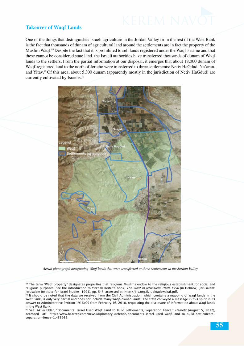
55
Takeover of Waqf Lands
One of the things that distinguishes Israeli agriculture in the Jordan Valley from the rest of the West Bank is the fact that thousands of dunam of agricultural land around the settlements are in fact the property of the Muslim Waqf.89 Despite the fact that it is prohibited to sell lands registered under the Waqf’s name and that these cannot be considered state land, the Israeli authorities have transferred thousands of dunam of Waqf lands to the settlers. From the partial information at our disposal, it emerges that about 18,000 dunam of Waqf-registered land to the north of Jericho were transferred to three settlements: Netiv HaGdud, Na’aran, and Yitav.90 Of this area, about 5,300 dunam (apparently mostly in the jurisdiction of Netiv HaGdud) are currently cultivated by Israelis.91
Aerial photograph designating Waqf lands that were transferred to three settlements in the Jordan Valley
89 The term “Waqf property” designates properties that religious Muslims endow to the religious establishment for social and religious purposes. See the introduction to Yitzhak Reiter’s book, The Waqf in Jerusalem 1948–1990 [in Hebrew] (Jerusalem: Jerusalem Institute for Israel Studies, 1991), pp. 5–7, accessed at: http://jiis.org.il/.upload/wakaf.pdf.90 It should be noted that the data we received from the Civil Administration, which contains a mapping of Waqf lands in the West Bank, is only very partial and does not include many Waqf-owned lands. The state conveyed a message in this spirit in its answer to Administrative Petition 1916/09 from February 16, 2010, requesting the disclosure of information about Waqf lands in the West Bank.91 See: Akiva Eldar, “Documents: Israel Used Waqf Land to Build Settlements, Separation Fence,” Haaretz (August 5, 2012), accessed at: http://www.haaretz.com/news/diplomacy-defense/documents-israel-used-waqf-land-to-build-settlements-separation-fence-1.455936.
56
Leasing land (daman) to Palestinians
Over the years, many Israeli farmers in the Jordan Valley have ceased farming the lands that had been allocated to them for agriculture use. There are a few reasons for this: the decline in numbers of settlers who make a direct living from agriculture; the decreasing profitability of maintaining small farms; the relatively large distances of the plots themselves from the settlements; and the dwindling of the population in the agricultural settlements in the Jordan Valley, in particular the departure of the younger generation. These areas amount to thousands of dunam.
One result of this is the development of a new phenomenon of which few besides those directly involved in it are aware: thousands of dunam92 of land, which Israel appropriated through various measures throughout the Jordan Valley, are currently leased to Palestinian residents of the West Bank, whose employment prospects in Israel were blocked or greatly diminished during and following the second Intifada; or to Palestinian citizens of Israel, who lease the lands and hire Palestinian workers from the West Bank.
Leasing these lands to Palestinian residents of the West Bank is in contravention of the settlers’ contracts with the Settlement Division of the World Zionist Organization (the organization entrusted with most of the lands of the West Bank that were eventually allotted to the settlements). For this reason, all of the sides involved prefer to keep a low profile. This phenomenon is known in Arabic as daman, meaning a guarantee, or simply, a lease. The accepted annual rate for leasing a single dunam ranges from three hundred shekels per season for lands on which there is an irrigation system (not including the cost of the water), to 40 NIS per dunam per season for fields on which only seasonal field crops can be cultivated. In most cases, the Palestinians who lease the land grow short-term seasonal crops, such as eggplants, peppers, cucumbers, and tomatoes, which demand large amounts of man power.
It should be noted that although the settlers in the Jordan Valley no longer actually cultivate thousands of the dunam of land that were allocated to them in the past, they recently managed to push through a plan with the Agriculture Ministry by which the land cultivated per household in the Jordan Valley would be increased from 35 to 80 dunam, and the water limit per household would grow from 42,000 cubes per year to 51,000 cubes per year.93
92 We identified about 6,200 dunam that are currently leased or that were leased in the not distant past to Palestinian residents of the West Bank or Israeli citizens. It is clear to us, however, that this is only a partial picture and that the real number is higher.93 Ministry of Agriculture, “Summary of meeting of the Program Committee no. 4/2011” (May 4, 2011).
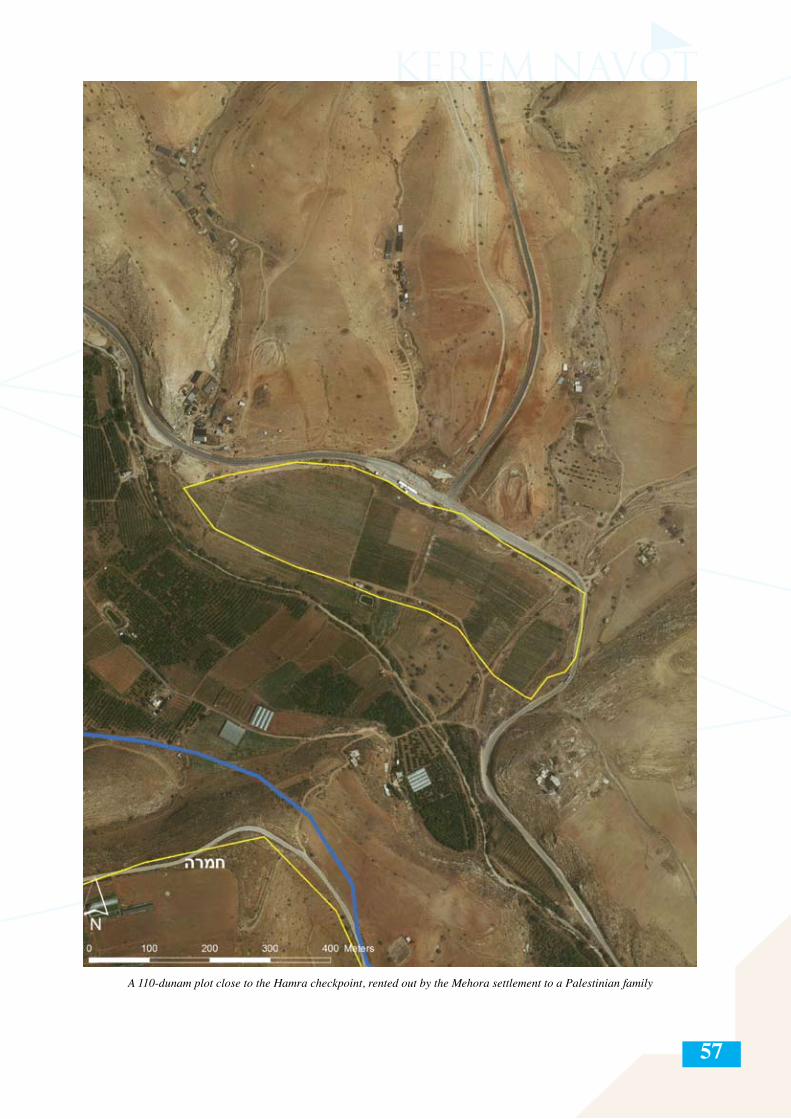
57
A 110-dunam plot close to the Hamra checkpoint, rented out by the Mehora settlement to a Palestinian family
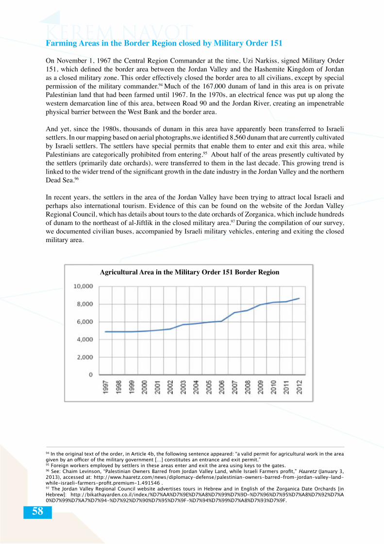
58
Farming Areas in the Border Region closed by Military Order 151
On November 1, 1967 the Central Region Commander at the time, Uzi Narkiss, signed Military Order 151, which defined the border area between the Jordan Valley and the Hashemite Kingdom of Jordan as a closed military zone. This order effectively closed the border area to all civilians, except by special permission of the military commander.94 Much of the 167,000 dunam of land in this area is on private Palestinian land that had been farmed until 1967. In the 1970s, an electrical fence was put up along the western demarcation line of this area, between Road 90 and the Jordan River, creating an impenetrable physical barrier between the West Bank and the border area.
And yet, since the 1980s, thousands of dunam in this area have apparently been transferred to Israeli settlers. In our mapping based on aerial photographs,we identified 8,560 dunam that are currently cultivated by Israeli settlers. The settlers have special permits that enable them to enter and exit this area, while Palestinians are categorically prohibited from entering.95 About half of the areas presently cultivated by the settlers (primarily date orchards), were transferred to them in the last decade. This growing trend is linked to the wider trend of the significant growth in the date industry in the Jordan Valley and the northern Dead Sea.96
In recent years, the settlers in the area of the Jordan Valley have been trying to attract local Israeli and perhaps also international tourism. Evidence of this can be found on the website of the Jordan Valley Regional Council, which has details about tours to the date orchards of Zorganica, which include hundreds of dunam to the northeast of al-Jiftlik in the closed military area.97 During the compilation of our survey, we documented civilian buses, accompanied by Israeli military vehicles, entering and exiting the closed military area.
94 In the original text of the order, in Article 4b, the following sentence appeared: “a valid permit for agricultural work in the area given by an officer of the military government […] constitutes an entrance and exit permit.”95 Foreign workers employed by settlers in these areas enter and exit the area using keys to the gates.96 See: Chaim Levinson, “Palestinian Owners Barred from Jordan Valley Land, while Israeli Farmers profit,” Haaretz (January 3, 2013), accessed at: http://www.haaretz.com/news/diplomacy-defense/palestinian-owners-barred-from-jordan-valley-land-while-israeli-farmers-profit.premium-1.491546 .97 The Jordan Valley Regional Council website advertises tours in Hebrew and in English of the Zorganica Date Orchards [in Hebrew]: http://bikathayarden.co.il/index/%D7%AA%D7%9E%D7%A8%D7%99%D7%9D-%D7%96%D7%95%D7%A8%D7%92%D7%A0%D7%99%D7%A7%D7%94-%D7%92%D7%90%D7%95%D7%9F-%D7%94%D7%99%D7%A8%D7%93%D7%9F.
Agricultural Area in the Military Order 151 Border Region
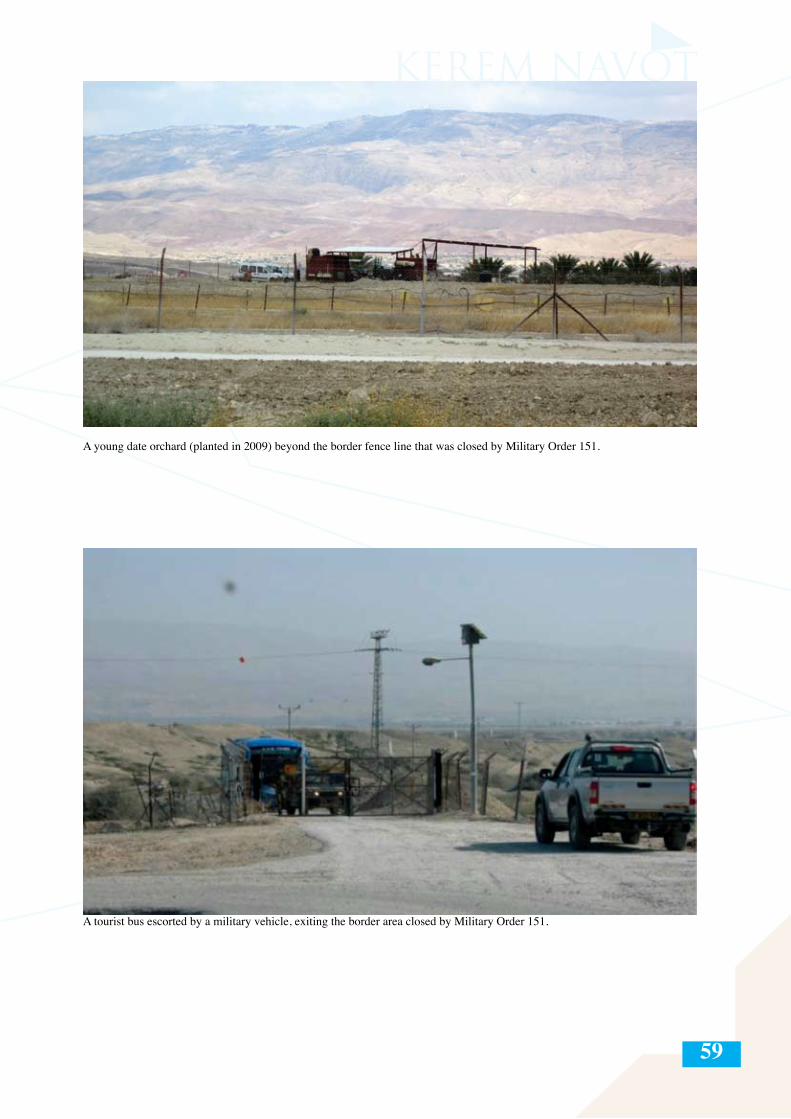
59
A young date orchard (planted in 2009) beyond the border fence line that was closed by Military Order 151.
A tourist bus escorted by a military vehicle, exiting the border area closed by Military Order 151.
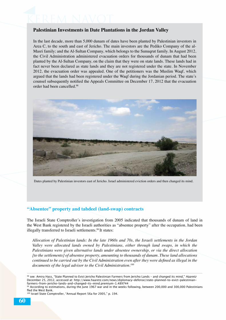
60
Palestinian Investments in Date Plantations in the Jordan Valley
In the last decade, more than 5,000 dunam of dates have been planted by Palestinian investors in Area C, to the south and east of Jericho. The main investors are the Pediko Company of the al-Masri family; and the Al-Sultan Company, which belongs to the Sunuqrut family. In August 2012, the Civil Administration administered evacuation orders for thousands of dunam that had been planted by the Al-Sultan Company, on the claim that they were on state lands. These lands had in fact never been declared as state lands and they are not registered under the state. In November 2012, the evacuation order was appealed. One of the petitioners was the Muslim Waqf, which argued that the lands had been registered under the Waqf during the Jordanian period. The state’s counsel subsequently notified the Appeals Committee on December 17, 2012 that the evacuation order had been cancelled.98
Dates planted by Palestinian investors east of Jericho. Israel administered eviction orders and then changed its mind.
“Absentee” property and tabdeel (land-swap) contracts
The Israeli State Comptroller’s investigation from 2005 indicated that thousands of dunam of land in the West Bank registered by the Israeli authorities as “absentee property” after the occupation, had been illegally transferred to Israeli settlements.99 It states:
Allocation of Palestinian lands: In the late 1960s and 70s, the Israeli settlements in the Jordan Valley were allocated lands owned by Palestinians, either through land swaps, in which the Palestinians were given alternative lands under absentee ownership, or via the direct allocation [to the settlements] of absentee property, amounting to thousands of dunam. These land allocations continued to be carried out by the Civil Administration even after they were defined as illegal in the documents of the legal advisor to the Civil Administration.100
98 see: Amira Hass, “State Planned to Evict Jericho Palestinian Farmers from Jericho Lands – and changed its mind,” Haaretz December 25, 2012, accessed at: http://www.haaretz.com/news/diplomacy-defense/state-planned-to-evict-palestinian-farmers-from-jericho-lands-and-changed-its-mind.premium-1.48974499 According to estimations, during the June 1967 war and in the weeks following, between 200,000 and 300,000 Palestinians fled the West Bank.100 Israel State Comptroller, “Annual Report 56a for 2005,” p. 194.
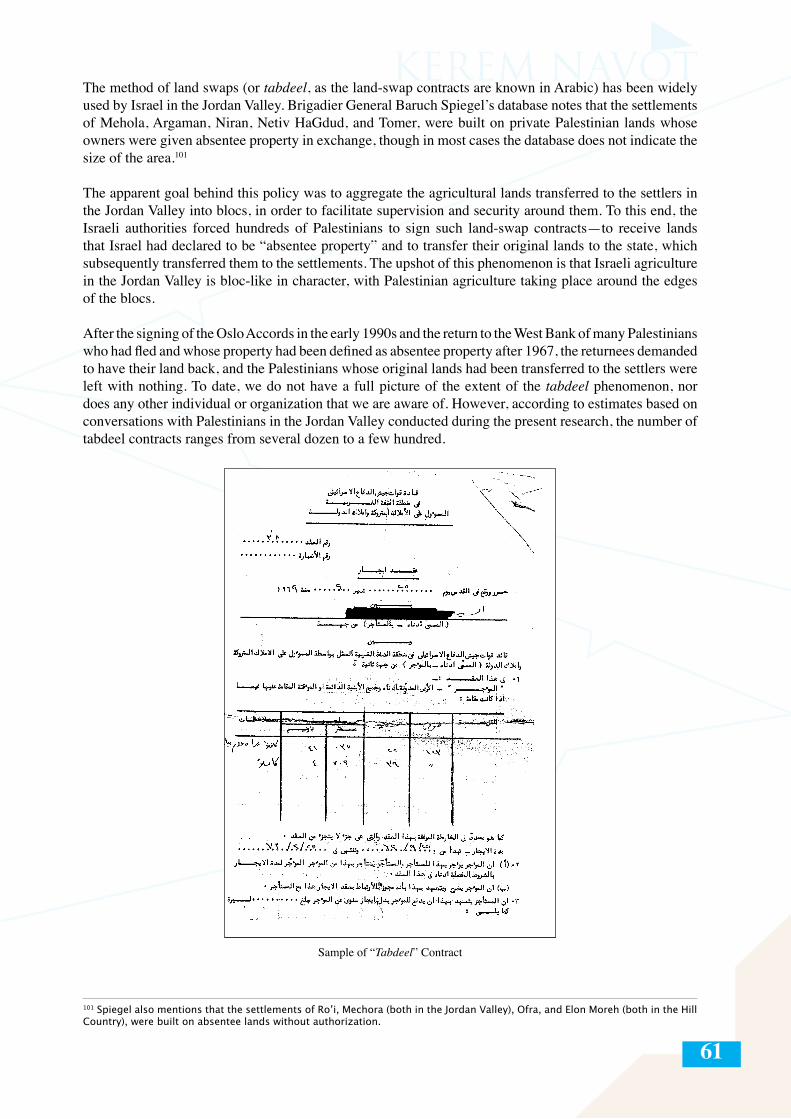
61
The method of land swaps (or tabdeel, as the land-swap contracts are known in Arabic) has been widely used by Israel in the Jordan Valley. Brigadier General Baruch Spiegel’s database notes that the settlements of Mehola, Argaman, Niran, Netiv HaGdud, and Tomer, were built on private Palestinian lands whose owners were given absentee property in exchange, though in most cases the database does not indicate the size of the area.101
The apparent goal behind this policy was to aggregate the agricultural lands transferred to the settlers in the Jordan Valley into blocs, in order to facilitate supervision and security around them. To this end, the Israeli authorities forced hundreds of Palestinians to sign such land-swap contracts—to receive lands that Israel had declared to be “absentee property” and to transfer their original lands to the state, which subsequently transferred them to the settlements. The upshot of this phenomenon is that Israeli agriculture in the Jordan Valley is bloc-like in character, with Palestinian agriculture taking place around the edges of the blocs.
After the signing of the Oslo Accords in the early 1990s and the return to the West Bank of many Palestinians who had fled and whose property had been defined as absentee property after 1967, the returnees demanded to have their land back, and the Palestinians whose original lands had been transferred to the settlers were left with nothing. To date, we do not have a full picture of the extent of the tabdeel phenomenon, nor does any other individual or organization that we are aware of. However, according to estimates based on conversations with Palestinians in the Jordan Valley conducted during the present research, the number of tabdeel contracts ranges from several dozen to a few hundred.
101 Spiegel also mentions that the settlements of Ro’i, Mechora (both in the Jordan Valley), Ofra, and Elon Moreh (both in the Hill Country), were built on absentee lands without authorization.
Sample of “Tabdeel” Contract
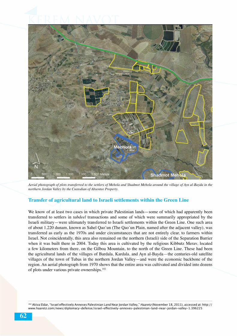
62
Aerial photograph of plots transferred to the settlers of Mehola and Shadmot Mehola around the village of Ayn al-Bayda in the northern Jordan Valley by the Custodian of Absentee Property.
Transfer of agricultural land to Israeli settlements within the Green Line
We know of at least two cases in which private Palestinian lands—some of which had apparently been transferred to settlers in tabdeel transactions and some of which were summarily appropriated by the Israeli military—were ultimately transferred to Israeli settlements within the Green Line. One such area of about 1,220 dunam, known as Sahel Qao’un (The Qao’un Plain, named after the adjacent valley), was transferred as early as the 1970s and under circumstances that are not entirely clear, to farmers within Israel. Not coincidentally, this area also remained on the northern (Israeli) side of the Separation Barrier when it was built there in 2004. Today this area is cultivated by the religious Kibbutz Merav, located a few kilometers from there, on the Gilboa Mountain, to the north of the Green Line. These had been the agricultural lands of the villages of Bardala, Kardala, and Ayn al-Bayda—the centuries-old satellite villages of the town of Tubas in the northern Jordan Valley—and were the economic backbone of the region. An aerial photograph from 1970 shows that the entire area was cultivated and divided into dozens of plots under various private ownerships.102
102 Akiva Eldar, “Israel effectively Annexes Palestinian Land Near Jordan Valley,” Haaretz (November 18, 2011), accessed at: http://www.haaretz.com/news/diplomacy-defense/israel-effectively-annexes-palestinian-land-near-jordan-valley-1.396225
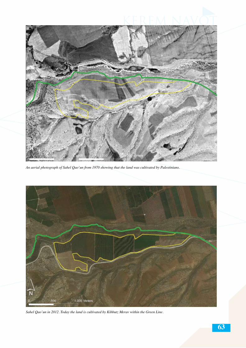
63
An aerial photograph of Sahel Qao’un from 1970 showing that the land was cultivated by Palestinians.
Sahel Qao’un in 2012. Today the land is cultivated by Kibbutz Merav within the Green Line.
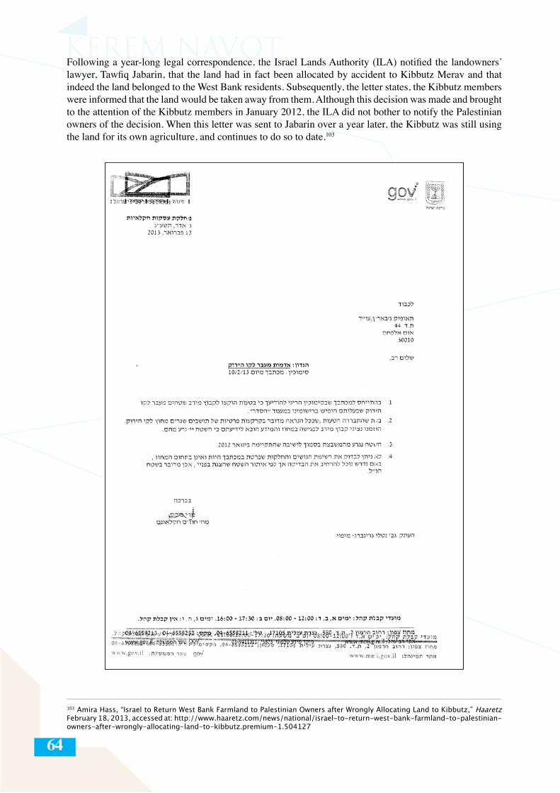
64
Following a year-long legal correspondence, the Israel Lands Authority (ILA) notified the landowners’ lawyer, Tawfiq Jabarin, that the land had in fact been allocated by accident to Kibbutz Merav and that indeed the land belonged to the West Bank residents. Subsequently, the letter states, the Kibbutz members were informed that the land would be taken away from them. Although this decision was made and brought to the attention of the Kibbutz members in January 2012, the ILA did not bother to notify the Palestinian owners of the decision. When this letter was sent to Jabarin over a year later, the Kibbutz was still using the land for its own agriculture, and continues to do so to date.103
103 Amira Hass, “Israel to Return West Bank Farmland to Palestinian Owners after Wrongly Allocating Land to Kibbutz,” Haaretz February 18, 2013, accessed at: http://www.haaretz.com/news/national/israel-to-return-west-bank-farmland-to-palestinian-owners-after-wrongly-allocating-land-to-kibbutz.premium-1.504127
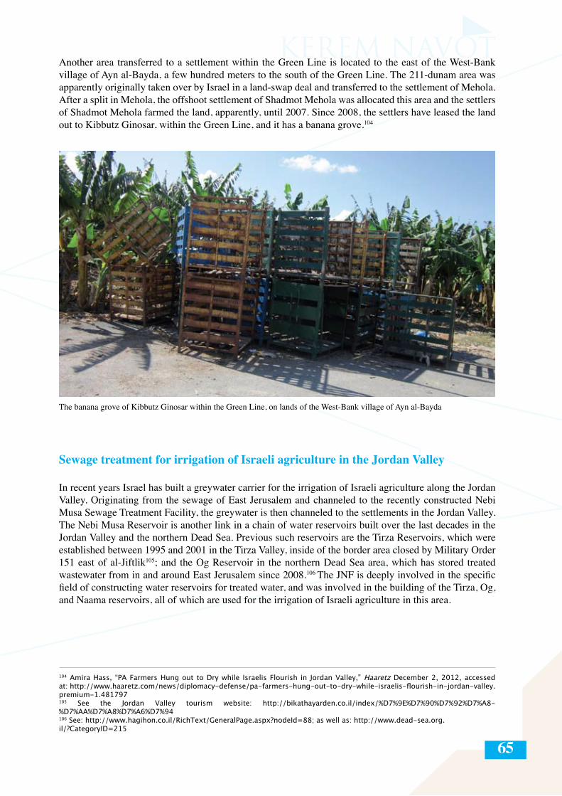
65
Another area transferred to a settlement within the Green Line is located to the east of the West-Bank village of Ayn al-Bayda, a few hundred meters to the south of the Green Line. The 211-dunam area was apparently originally taken over by Israel in a land-swap deal and transferred to the settlement of Mehola. After a split in Mehola, the offshoot settlement of Shadmot Mehola was allocated this area and the settlers of Shadmot Mehola farmed the land, apparently, until 2007. Since 2008, the settlers have leased the land out to Kibbutz Ginosar, within the Green Line, and it has a banana grove.104
The banana grove of Kibbutz Ginosar within the Green Line, on lands of the West-Bank village of Ayn al-Bayda
Sewage treatment for irrigation of Israeli agriculture in the Jordan Valley
In recent years Israel has built a greywater carrier for the irrigation of Israeli agriculture along the Jordan Valley. Originating from the sewage of East Jerusalem and channeled to the recently constructed Nebi Musa Sewage Treatment Facility, the greywater is then channeled to the settlements in the Jordan Valley. The Nebi Musa Reservoir is another link in a chain of water reservoirs built over the last decades in the Jordan Valley and the northern Dead Sea. Previous such reservoirs are the Tirza Reservoirs, which were established between 1995 and 2001 in the Tirza Valley, inside of the border area closed by Military Order 151 east of al-Jiftlik105; and the Og Reservoir in the northern Dead Sea area, which has stored treated wastewater from in and around East Jerusalem since 2008.106 The JNF is deeply involved in the specific field of constructing water reservoirs for treated water, and was involved in the building of the Tirza, Og, and Naama reservoirs, all of which are used for the irrigation of Israeli agriculture in this area.
104 Amira Hass, “PA Farmers Hung out to Dry while Israelis Flourish in Jordan Valley,” Haaretz December 2, 2012, accessed at: http://www.haaretz.com/news/diplomacy-defense/pa-farmers-hung-out-to-dry-while-israelis-flourish-in-jordan-valley.premium-1.481797 105 See the Jordan Valley tourism website: http://bikathayarden.co.il/index/%D7%9E%D7%90%D7%92%D7%A8-%D7%AA%D7%A8%D7%A6%D7%94106 See: http://www.hagihon.co.il/RichText/GeneralPage.aspx?nodeId=88; as well as: http://www.dead-sea.org.il/?CategoryID=215
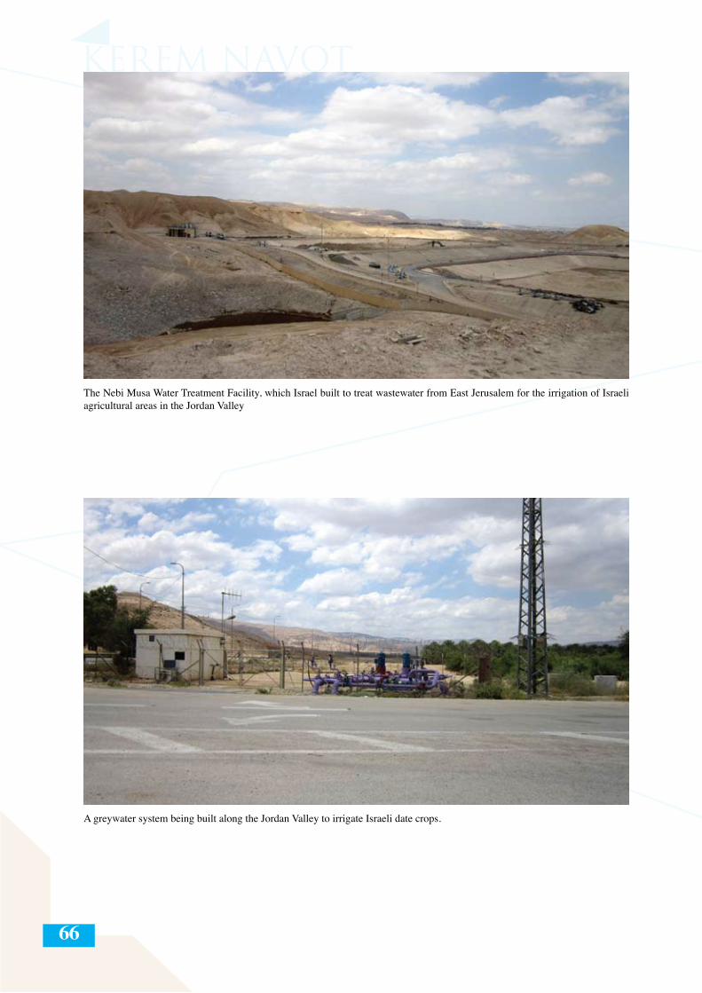
66
The Nebi Musa Water Treatment Facility, which Israel built to treat wastewater from East Jerusalem for the irrigation of Israeli agricultural areas in the Jordan Valley
A greywater system being built along the Jordan Valley to irrigate Israeli date crops.
67
Summary
Israeli agriculture in the West Bank developed since 1967 concurrently in two areas: along the ridge of the West Bank Hill Country, and in the Jordan Valley. In the Hill Country, Israeli agriculture began in the areas near the settlements around Bethlehem (Gush Etzion), and in the late 1970s began to spread north and south along the ridge. Agriculture in this area is based on vineyards, olive groves, and deciduous fruit trees. Since 2001 there has been a fast growth in the agricultural areas around the Hill Country settlements, a direct result of the prevention of Palestinian access to large areas around many of the settlements. In a relatively small number of cases the areas were closed off through official military orders, though around most of the settlement the closing off was done at the initiative of the settlers, albeit with the retroactive backing of the military. The closing off of large areas around the settlements to Palestinian entry, combined with the religious and ideological motivation of the settlers, created lucrative agricultural possibilities for the settlers. These factors are responsible for the sharp rise in agricultural area and activity around the Hill Country settlements, most of which entailed the takeover of private Palestinian land.
Starting in the late 60s, Israel established Nahal military outposts along the Jordan Valley. These were later authorized as civilian settlements and eventually many of them were formalized as Kibbutzim and Moshavim with a primarily secular population. Israeli agriculture in the Jordan Valley is based on dates, field crops, and greenhouse crops that are suited to the hot climate in the region. In contrast to the means of land takeovers around the hill-country settlements, most of the agricultural takeovers in the Jordan Valley occur on lands that were expropriated by Israel through various official means, after which they were transferred to the settlers. Moreover, Israel invests large sums of money in water treatment and irrigation infrastructure to serve the settler agriculture in the Jordan Valley and the northern Dead Sea, in particular the huge date industry that has developed there.
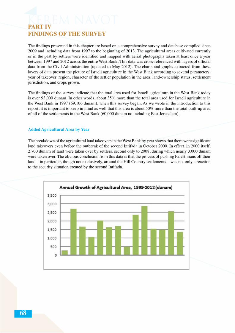
68
PART IVFINDINGS OF THE SURVEY
The findings presented in this chapter are based on a comprehensive survey and database compiled since 2009 and including data from 1997 to the beginning of 2013. The agricultural areas cultivated currently or in the past by settlers were identified and mapped with aerial photographs taken at least once a year between 1997 and 2012 across the entire West Bank. This data was cross-referenced with layers of official data from the Civil Administration (updated to May 2012). The charts and graphs extracted from these layers of data present the picture of Israeli agriculture in the West Bank according to several parameters: year of takeover, region, character of the settler population in the area, land-ownership status, settlement jurisdiction, and crops grown.
The findings of the survey indicate that the total area used for Israeli agriculture in the West Bank today is over 93,000 dunam. In other words, about 35% more than the total area used for Israeli agriculture in the West Bank in 1997 (69,106 dunam), when this survey began. As we wrote in the introduction to this report, it is important to keep in mind as well that this area is about 50% more than the total built-up area of all of the settlements in the West Bank (60,000 dunam no including East Jerusalem).
Added Agricultural Area by Year
The breakdown of the agricultural land takeovers in the West Bank by year shows that there were significant land takeovers even before the outbreak of the second Intifada in October 2000. In effect, in 2000 itself, 2,700 dunam of land were taken over by settlers, second only to 2008, during which nearly 3,000 dunam were taken over. The obvious conclusion from this data is that the process of pushing Palestinians off their land—in particular, though not exclusively, around the Hill Country settlements—was not only a reaction to the security situation created by the second Intifada.
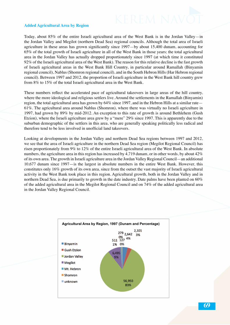
69
Added Agricultural Area by Region
Today, about 85% of the entire Israeli agricultural area of the West Bank is in the Jordan Valley—in the Jordan Valley and Megilot (northern Dead Sea) regional councils. Although the total area of Israeli agriculture in these areas has grown significantly since 1997—by about 15,400 dunam, accounting for 65% of the total growth of Israeli agriculture in all of the West Bank in those years; the total agricultural area in the Jordan Valley has actually dropped proportionately since 1997 (at which time it constituted 92% of the Israeli agricultural area of the West Bank). The reason for this relative decline is the fast growth of Israeli agricultural areas in the West Bank Hill Country, in particular around Ramallah (Binyamin regional council), Nablus (Shomron regional council), and in the South Hebron Hills (Har Hebron regional council). Between 1997 and 2012, the proportion of Israeli agriculture in the West Bank hill country grew from 8% to 15% of the total Israeli agricultural area in the West Bank.
These numbers reflect the accelerated pace of agricultural takeovers in large areas of the hill country, where the more ideological and religious settlers live. Around the settlements in the Ramallah (Binyamin) region, the total agricultural area has grown by 64% since 1997, and in the Hebron Hills at a similar rate—61%. The agricultural area around Nablus (Shomron), where there was virtually no Israeli agriculture in 1997, had grown by 89% by mid-2012. An exception to this rate of growth is around Bethlehem (Gush Etzion), where the Israeli agriculture area grew by a “mere” 29% since 1997. This is apparently due to the suburban demographic of the settlers in this area, who are generally speaking politically less radical and therefore tend to be less involved in unofficial land takeovers.
Looking at developments in the Jordan Valley and northern Dead Sea regions between 1997 and 2012, we see that the area of Israeli agriculture in the northern Dead Sea region (Megilot Regional Council) has risen proportionately from 9% to 12% of the entire Israeli agricultural area of the West Bank. In absolute numbers, the agriculture area in this region has increased by 4,719 dunam, or in other words, by about 42% of its own area. The growth in Israeli agriculture area in the Jordan Valley Regional Council—an additional 10,677 dunam since 1997—is the largest in absolute numbers in the entire West Bank. However, this constitutes only 16% growth of its own area, since from the outset the vast majority of Israeli agricultural activity in the West Bank took place in this region. Agricultural growth, both in the Jordan Valley and in northern Dead Sea, is due primarily to growth in the date industry. Date palms have been planted on 60% of the added agricultural area in the Megilot Regional Council and on 74% of the added agricultural area in the Jordan Valley Regional Council.
Agricultural Area by Region, 1997 (Dunam and Percentage)
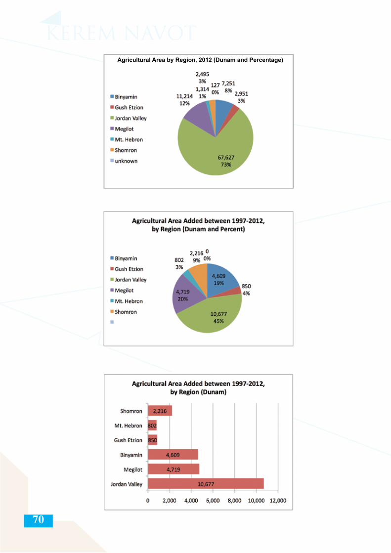
70
Agricultural Area by Region, 2012 (Dunam and Percentage)
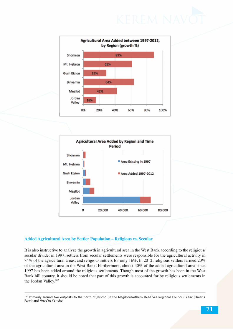
71
Added Agricultural Area by Settler Population – Religious vs. Secular
It is also instructive to analyze the growth in agricultural area in the West Bank according to the religious/secular divide: in 1997, settlers from secular settlements were responsible for the agricultural activity in 84% of the agricultural areas, and religious settlers for only 16%. In 2012, religious settlers farmed 20% of the agricultural area in the West Bank. Furthermore, almost 40% of the added agricultural area since 1997 has been added around the religious settlements. Though most of the growth has been in the West Bank hill country, it should be noted that part of this growth is accounted for by religious settlements in the Jordan Valley.107
107 Primarily around two outposts to the north of Jericho (in the Megilot/northern Dead Sea Regional Council): Yitav (Omer’s Farm) and Mevo’ot Yericho.
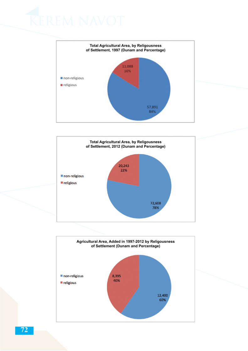
72
Total Agricultural Area, by Religousness of Settlement, 1997 (Dunam and Percentage)
Total Agricultural Area, by Religousness of Settlement, 2012 (Dunam and Percentage)
Agricultural Area, Added in 1997-2012 by Religousness of Settlement (Dunam and Percentage)
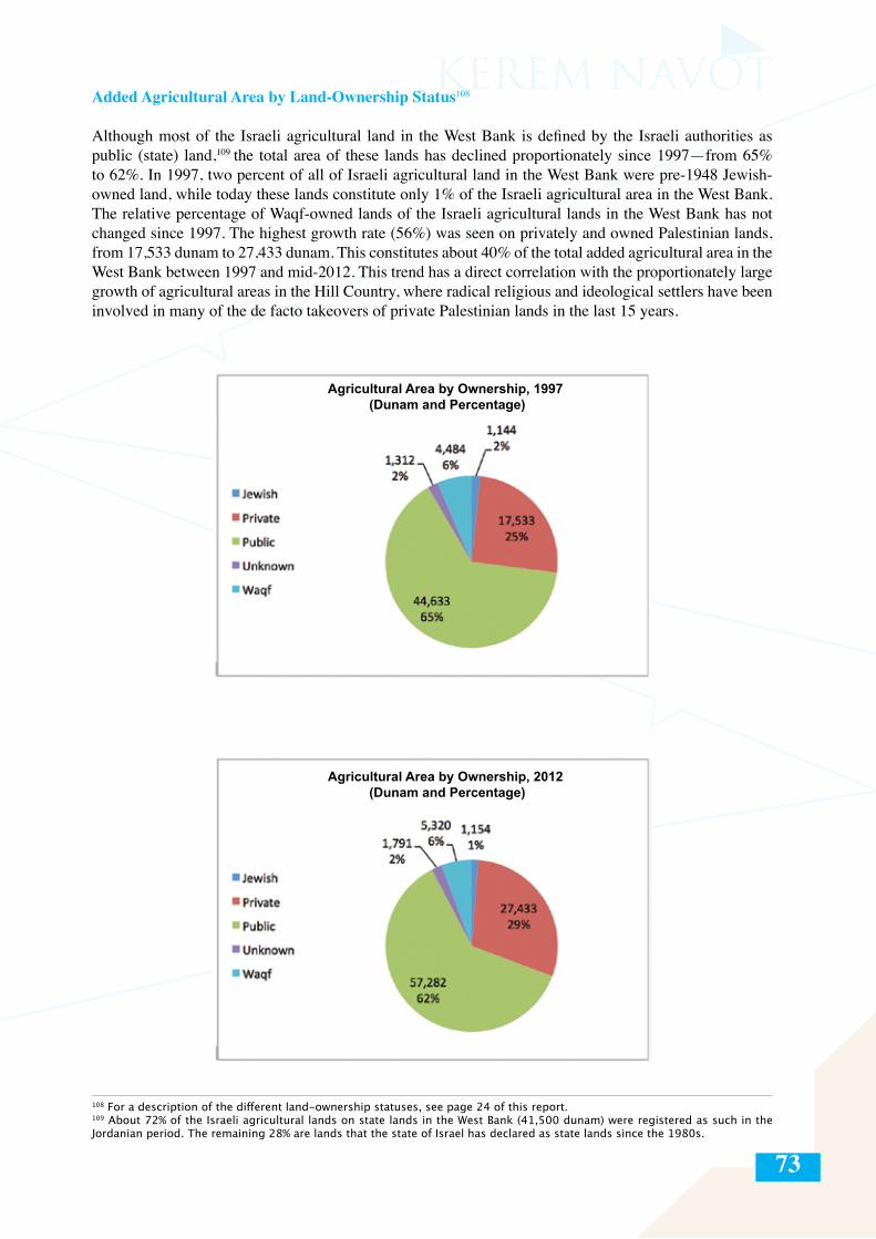
73
Added Agricultural Area by Land-Ownership Status108
Although most of the Israeli agricultural land in the West Bank is defined by the Israeli authorities as public (state) land,109 the total area of these lands has declined proportionately since 1997—from 65% to 62%. In 1997, two percent of all of Israeli agricultural land in the West Bank were pre-1948 Jewish-owned land, while today these lands constitute only 1% of the Israeli agricultural area in the West Bank. The relative percentage of Waqf-owned lands of the Israeli agricultural lands in the West Bank has not changed since 1997. The highest growth rate (56%) was seen on privately and owned Palestinian lands, from 17,533 dunam to 27,433 dunam. This constitutes about 40% of the total added agricultural area in the West Bank between 1997 and mid-2012. This trend has a direct correlation with the proportionately large growth of agricultural areas in the Hill Country, where radical religious and ideological settlers have been involved in many of the de facto takeovers of private Palestinian lands in the last 15 years.
108 For a description of the different land-ownership statuses, see page 24 of this report.109 About 72% of the Israeli agricultural lands on state lands in the West Bank (41,500 dunam) were registered as such in the Jordanian period. The remaining 28% are lands that the state of Israel has declared as state lands since the 1980s.
Agricultural Area by Ownership, 1997 (Dunam and Percentage)
Agricultural Area by Ownership, 2012 (Dunam and Percentage)
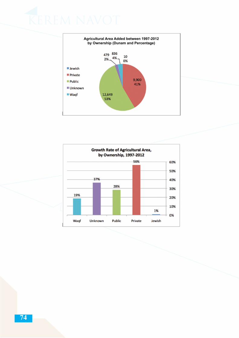
74
Agricultural Area Added between 1997-2012by Ownership (Dunam and Percentage)
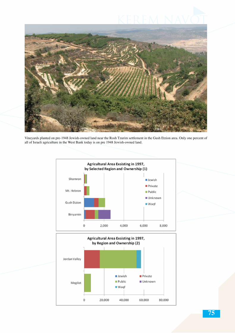
75
Vineyards planted on pre-1948 Jewish-owned land near the Rosh Tzurim settlement in the Gush Etzion area. Only one percent of all of Israeli agriculture in the West Bank today is on pre 1948 Jewish-owned land.
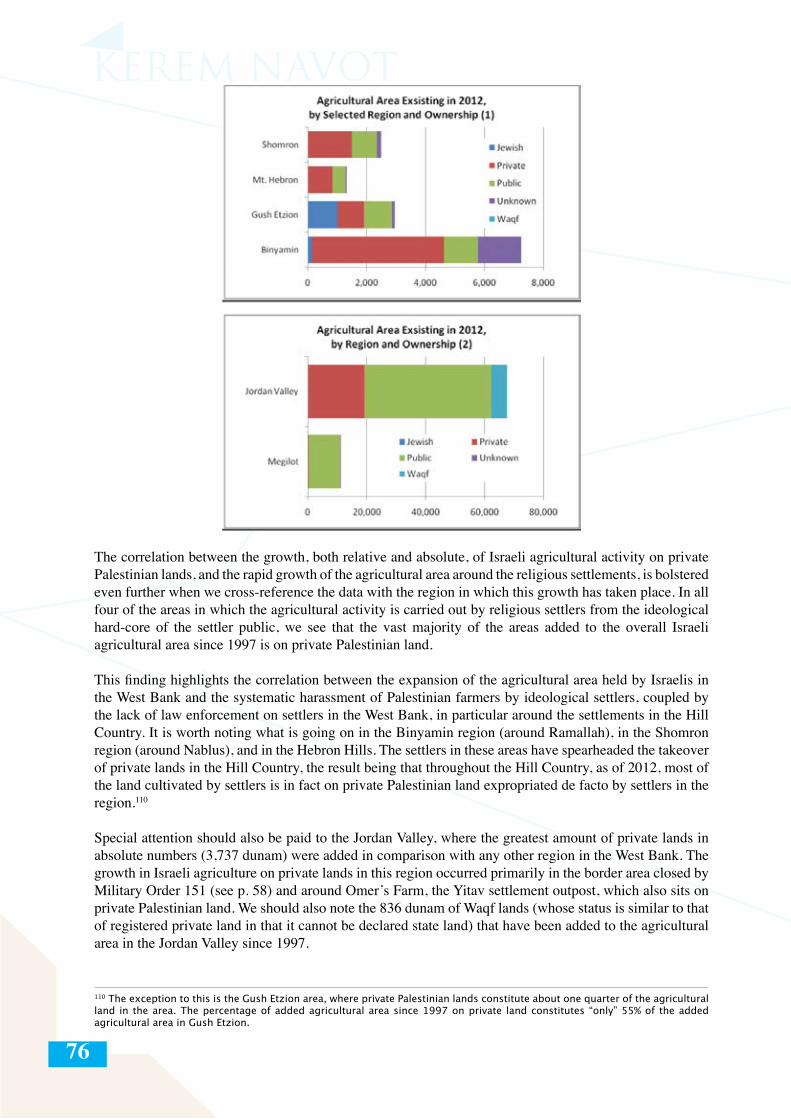
76
The correlation between the growth, both relative and absolute, of Israeli agricultural activity on private Palestinian lands, and the rapid growth of the agricultural area around the religious settlements, is bolstered even further when we cross-reference the data with the region in which this growth has taken place. In all four of the areas in which the agricultural activity is carried out by religious settlers from the ideological hard-core of the settler public, we see that the vast majority of the areas added to the overall Israeli agricultural area since 1997 is on private Palestinian land.
This finding highlights the correlation between the expansion of the agricultural area held by Israelis in the West Bank and the systematic harassment of Palestinian farmers by ideological settlers, coupled by the lack of law enforcement on settlers in the West Bank, in particular around the settlements in the Hill Country. It is worth noting what is going on in the Binyamin region (around Ramallah), in the Shomron region (around Nablus), and in the Hebron Hills. The settlers in these areas have spearheaded the takeover of private lands in the Hill Country, the result being that throughout the Hill Country, as of 2012, most of the land cultivated by settlers is in fact on private Palestinian land expropriated de facto by settlers in the region.110
Special attention should also be paid to the Jordan Valley, where the greatest amount of private lands in absolute numbers (3,737 dunam) were added in comparison with any other region in the West Bank. The growth in Israeli agriculture on private lands in this region occurred primarily in the border area closed by Military Order 151 (see p. 58) and around Omer’s Farm, the Yitav settlement outpost, which also sits on private Palestinian land. We should also note the 836 dunam of Waqf lands (whose status is similar to that of registered private land in that it cannot be declared state land) that have been added to the agricultural area in the Jordan Valley since 1997.
110 The exception to this is the Gush Etzion area, where private Palestinian lands constitute about one quarter of the agricultural land in the area. The percentage of added agricultural area since 1997 on private land constitutes “only” 55% of the added agricultural area in Gush Etzion.
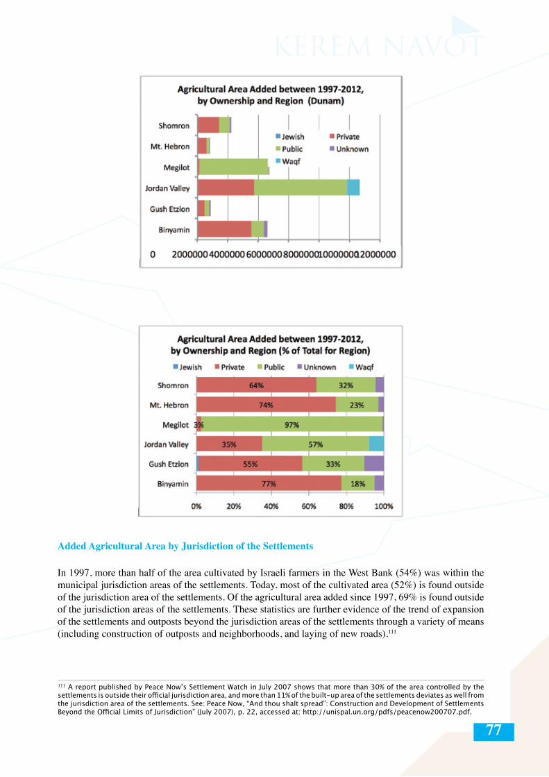
77
Added Agricultural Area by Jurisdiction of the Settlements
In 1997, more than half of the area cultivated by Israeli farmers in the West Bank (54%) was within the municipal jurisdiction areas of the settlements. Today, most of the cultivated area (52%) is found outside of the jurisdiction area of the settlements. Of the agricultural area added since 1997, 69% is found outside of the jurisdiction areas of the settlements. These statistics are further evidence of the trend of expansion of the settlements and outposts beyond the jurisdiction areas of the settlements through a variety of means (including construction of outposts and neighborhoods, and laying of new roads).111
111 A report published by Peace Now’s Settlement Watch in July 2007 shows that more than 30% of the area controlled by the settlements is outside their official jurisdiction area, and more than 11% of the built-up area of the settlements deviates as well from the jurisdiction area of the settlements. See: Peace Now, “And thou shalt spread”: Construction and Development of Settlements Beyond the Official Limits of Jurisdiction” (July 2007), p. 22, accessed at: http://unispal.un.org/pdfs/peacenow200707.pdf.
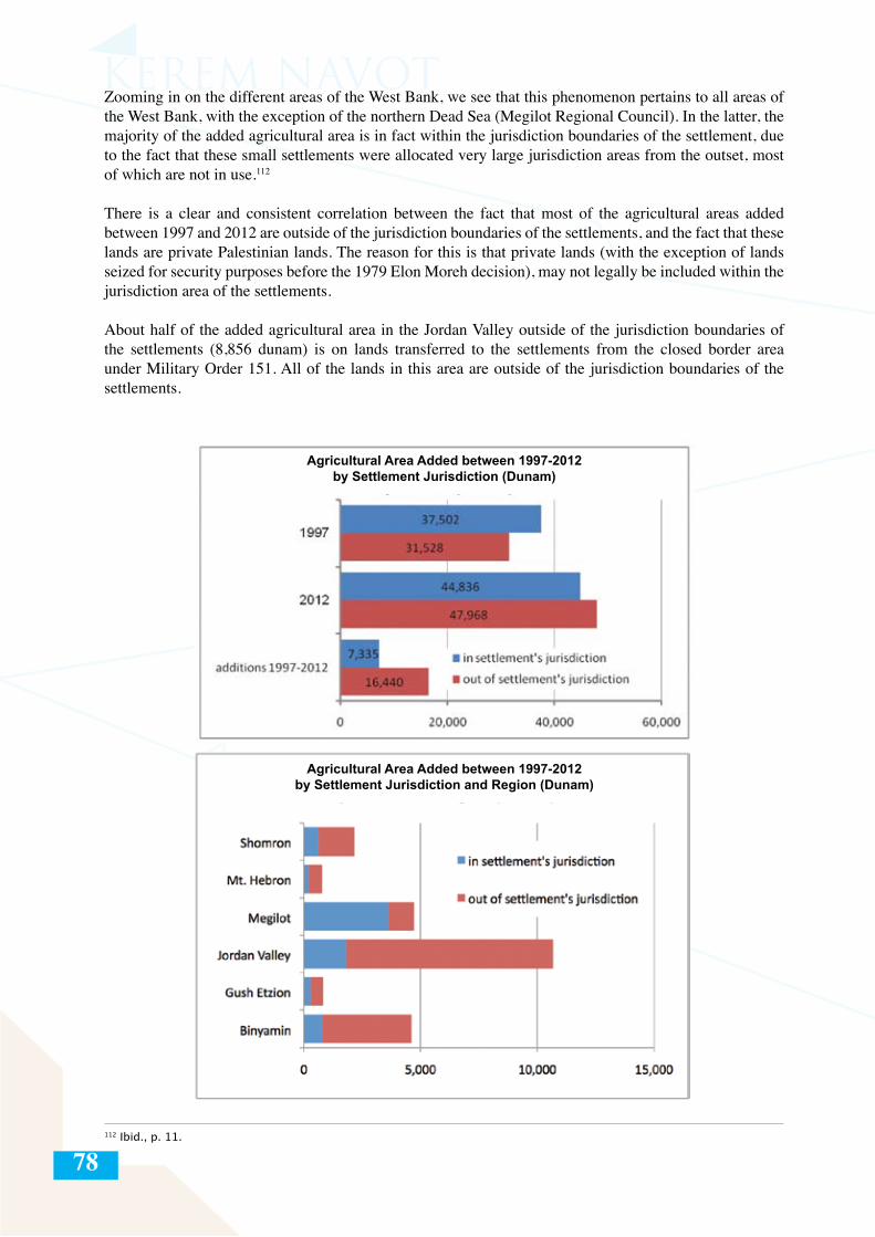
78
Zooming in on the different areas of the West Bank, we see that this phenomenon pertains to all areas of the West Bank, with the exception of the northern Dead Sea (Megilot Regional Council). In the latter, the majority of the added agricultural area is in fact within the jurisdiction boundaries of the settlement, due to the fact that these small settlements were allocated very large jurisdiction areas from the outset, most of which are not in use.112
There is a clear and consistent correlation between the fact that most of the agricultural areas added between 1997 and 2012 are outside of the jurisdiction boundaries of the settlements, and the fact that these lands are private Palestinian lands. The reason for this is that private lands (with the exception of lands seized for security purposes before the 1979 Elon Moreh decision), may not legally be included within the jurisdiction area of the settlements.
About half of the added agricultural area in the Jordan Valley outside of the jurisdiction boundaries of the settlements (8,856 dunam) is on lands transferred to the settlements from the closed border area under Military Order 151. All of the lands in this area are outside of the jurisdiction boundaries of the settlements.
112 Ibid., p. 11.
Agricultural Area Added between 1997-2012by Settlement Jurisdiction (Dunam)
Agricultural Area Added between 1997-2012by Settlement Jurisdiction and Region (Dunam)
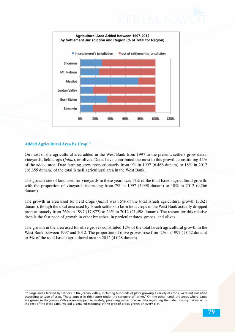
79
Added Agricultural Area by Crop113
On most of the agricultural area added in the West Bank from 1997 to the present, settlers grow dates, vineyards, field crops (falha), or olives. Dates have contributed the most to this growth, constituting 44% of the added area. Date farming grew proportionately from 9% in 1997 (6,466 dunam) to 18% in 2012 (16,855 dunam) of the total Israeli agricultural area in the West Bank.
The growth rate of land used for vineyards in these years was 17% of the total Israeli agricultural growth, with the proportion of vineyards increasing from 7% in 1997 (5,098 dunam) to 10% in 2012 (9,266 dunam).
The growth in area used for field crops (falha) was 15% of the total Israeli agricultural growth (3,621 dunam), though the total area used by Israeli settlers to farm field crops in the West Bank actually dropped proportionately from 26% in 1997 (17,877) to 23% in 2012 (21,498 dunam). The reason for this relative drop is the fast pace of growth in other branches, in particular dates, grapes, and olives.
The growth in the area used for olive groves constituted 12% of the total Israeli agricultural growth in the West Bank between 1997 and 2012. The proportion of olive groves rose from 2% in 1997 (1,052 dunam) to 5% of the total Israeli agricultural area in 2012 (4,028 dunam).
113 Large areas farmed by settlers in the Jordan Valley, including hundreds of plots growing a variety of crops, were not classified according to type of crop. These appear in this report under the category of “other.” On the other hand, the areas where dates are grown in the Jordan Valley were mapped separately, providing rather precise data regarding the date industry. Likewise, in the rest of the West Bank, we did a detailed mapping of the type of crops grown on every plot.
Agricultural Area Added between 1997-2012by Settlement Jurisdiction and Region (% of Total for Region)
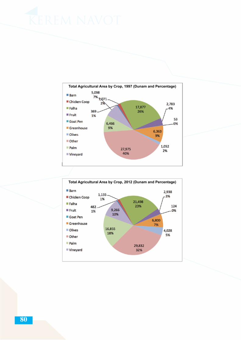
80
Total Agricultural Area by Crop, 1997 (Dunam and Percentage)
Total Agricultural Area by Crop, 2012 (Dunam and Percentage)
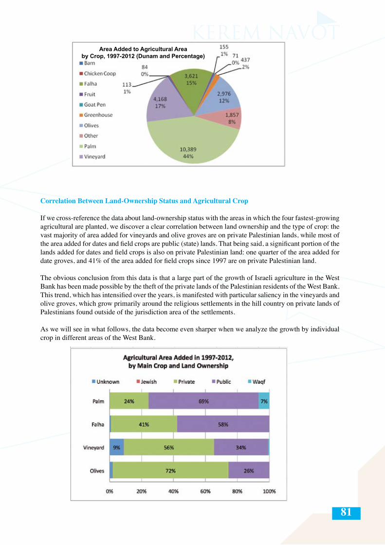
81
Correlation Between Land-Ownership Status and Agricultural Crop
If we cross-reference the data about land-ownership status with the areas in which the four fastest-growing agricultural are planted, we discover a clear correlation between land ownership and the type of crop: the vast majority of area added for vineyards and olive groves are on private Palestinian lands, while most of the area added for dates and field crops are public (state) lands. That being said, a significant portion of the lands added for dates and field crops is also on private Palestinian land: one quarter of the area added for date groves, and 41% of the area added for field crops since 1997 are on private Palestinian land.
The obvious conclusion from this data is that a large part of the growth of Israeli agriculture in the West Bank has been made possible by the theft of the private lands of the Palestinian residents of the West Bank. This trend, which has intensified over the years, is manifested with particular saliency in the vineyards and olive groves, which grow primarily around the religious settlements in the hill country on private lands of Palestinians found outside of the jurisdiction area of the settlements.
As we will see in what follows, the data become even sharper when we analyze the growth by individual crop in different areas of the West Bank.
Area Added to Agricultural Area by Crop, 1997-2012 (Dunam and Percentage)
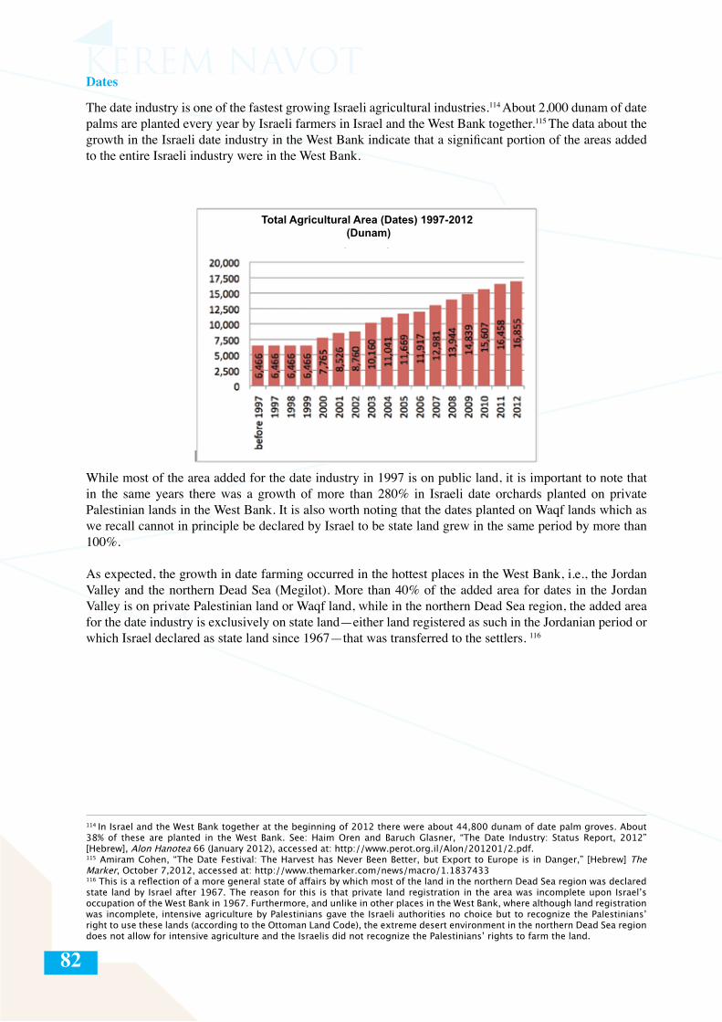
82
Dates
The date industry is one of the fastest growing Israeli agricultural industries.114 About 2,000 dunam of date palms are planted every year by Israeli farmers in Israel and the West Bank together.115 The data about the growth in the Israeli date industry in the West Bank indicate that a significant portion of the areas added to the entire Israeli industry were in the West Bank.
While most of the area added for the date industry in 1997 is on public land, it is important to note that in the same years there was a growth of more than 280% in Israeli date orchards planted on private Palestinian lands in the West Bank. It is also worth noting that the dates planted on Waqf lands which as we recall cannot in principle be declared by Israel to be state land grew in the same period by more than 100%.
As expected, the growth in date farming occurred in the hottest places in the West Bank, i.e., the Jordan Valley and the northern Dead Sea (Megilot). More than 40% of the added area for dates in the Jordan Valley is on private Palestinian land or Waqf land, while in the northern Dead Sea region, the added area for the date industry is exclusively on state land—either land registered as such in the Jordanian period or which Israel declared as state land since 1967—that was transferred to the settlers. 116
114 In Israel and the West Bank together at the beginning of 2012 there were about 44,800 dunam of date palm groves. About 38% of these are planted in the West Bank. See: Haim Oren and Baruch Glasner, “The Date Industry: Status Report, 2012” [Hebrew], Alon Hanotea 66 (January 2012), accessed at: http://www.perot.org.il/Alon/201201/2.pdf. 115 Amiram Cohen, “The Date Festival: The Harvest has Never Been Better, but Export to Europe is in Danger,” [Hebrew] The Marker, October 7,2012, accessed at: http://www.themarker.com/news/macro/1.1837433116 This is a reflection of a more general state of affairs by which most of the land in the northern Dead Sea region was declared state land by Israel after 1967. The reason for this is that private land registration in the area was incomplete upon Israel’s occupation of the West Bank in 1967. Furthermore, and unlike in other places in the West Bank, where although land registration was incomplete, intensive agriculture by Palestinians gave the Israeli authorities no choice but to recognize the Palestinians’ right to use these lands (according to the Ottoman Land Code), the extreme desert environment in the northern Dead Sea region does not allow for intensive agriculture and the Israelis did not recognize the Palestinians’ rights to farm the land.
Total Agricultural Area (Dates) 1997-2012 (Dunam)
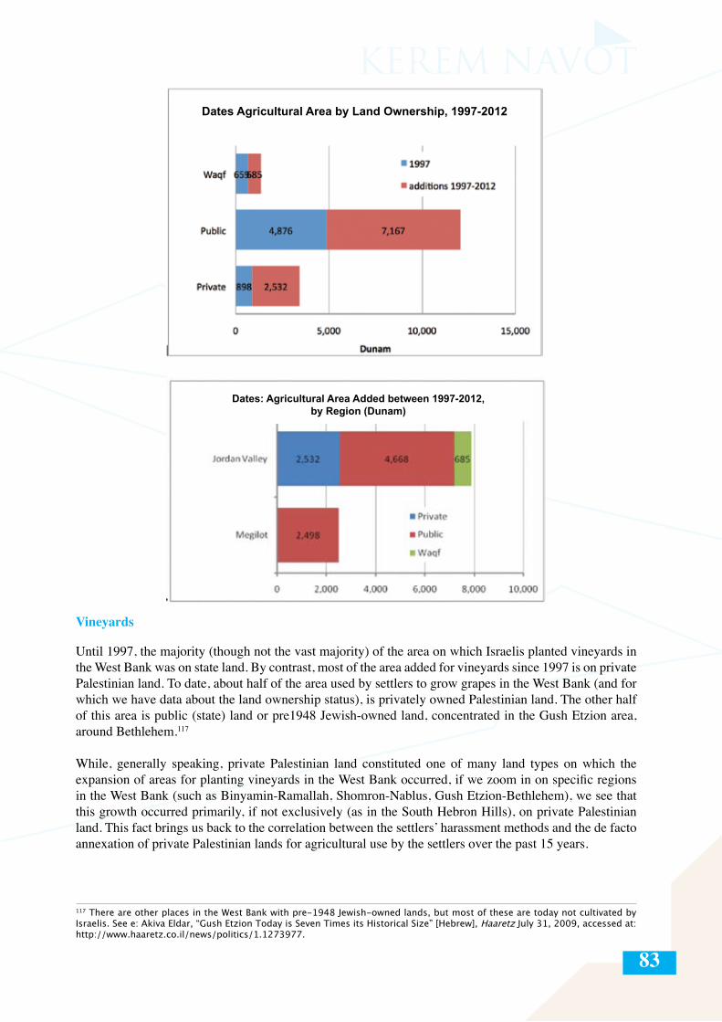
83
Vineyards
Until 1997, the majority (though not the vast majority) of the area on which Israelis planted vineyards in the West Bank was on state land. By contrast, most of the area added for vineyards since 1997 is on private Palestinian land. To date, about half of the area used by settlers to grow grapes in the West Bank (and for which we have data about the land ownership status), is privately owned Palestinian land. The other half of this area is public (state) land or pre1948 Jewish-owned land, concentrated in the Gush Etzion area, around Bethlehem.117
While, generally speaking, private Palestinian land constituted one of many land types on which the expansion of areas for planting vineyards in the West Bank occurred, if we zoom in on specific regions in the West Bank (such as Binyamin-Ramallah, Shomron-Nablus, Gush Etzion-Bethlehem), we see that this growth occurred primarily, if not exclusively (as in the South Hebron Hills), on private Palestinian land. This fact brings us back to the correlation between the settlers’ harassment methods and the de facto annexation of private Palestinian lands for agricultural use by the settlers over the past 15 years.
117 There are other places in the West Bank with pre-1948 Jewish-owned lands, but most of these are today not cultivated by Israelis. See e: Akiva Eldar, “Gush Etzion Today is Seven Times its Historical Size” [Hebrew], Haaretz July 31, 2009, accessed at: http://www.haaretz.co.il/news/politics/1.1273977.
Dates Agricultural Area by Land Ownership, 1997-2012
Dates: Agricultural Area Added between 1997-2012, by Region (Dunam)
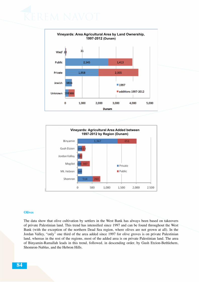
84
Olives
The data show that olive cultivation by settlers in the West Bank has always been based on takeovers of private Palestinian land. This trend has intensified since 1997 and can be found throughout the West Bank (with the exception of the northern Dead Sea region, where olives are not grown at all). In the Jordan Valley, “only” one third of the area added since 1997 for olive groves is on private Palestinian land, whereas in the rest of the regions, most of the added area is on private Palestinian land. The area of Binyamin-Ramallah leads in this trend, followed, in descending order, by Gush Etzion-Bethlehem, Shomron-Nablus, and the Hebron Hills.
Vineyards: Area Agricultural Area by Land Ownership, 1997-2012 (Dunam)
Vineyards: Agricultural Area Added between 1997-2012 by Region (Dunam)
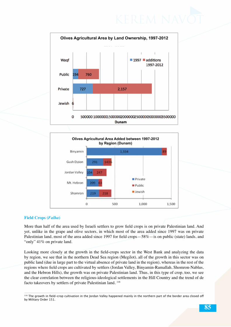
85
Field Crops (Falha)
More than half of the area used by Israeli settlers to grow field crops is on private Palestinian land. And yet, unlike in the grape and olive sectors, in which most of the area added since 1997 was on private Palestinian land, most of the area added since 1997 for field crops—58%—is on public (state) lands, and “only” 41% on private land.
Looking more closely at the growth in the field-crops sector in the West Bank and analyzing the data by region, we see that in the northern Dead Sea region (Megilot), all of the growth in this sector was on public land (due in large part to the virtual absence of private land in the region), whereas in the rest of the regions where field crops are cultivated by settlers (Jordan Valley, Binyamin-Ramallah, Shomron-Nablus, and the Hebron Hills), the growth was on private Palestinian land. Thus, in this type of crop, too, we see the clear correlation between the religious-ideological settlements in the Hill Country and the trend of de facto takeovers by settlers of private Palestinian land. 118
118 The growth in field-crop cultivation in the Jordan Valley happened mainly in the northern part of the border area closed off by Military Order 151.
Olives Agricultural Area by Land Ownership, 1997-2012
Olives Agricultural Area Added between 1997-2012by Region (Dunam)
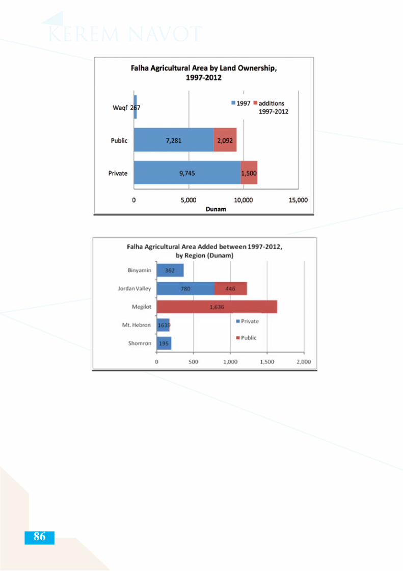
86
87
SUMMARY AND CONCLUSIONS
The goal of this report has been to add another layer to the discussion about the Israeli settlements in the West Bank. This debate about the settlements tends to focus on construction of new neighborhoods, establishment of outposts, demographic growth among the settlers, the benefits they receive, and settler violence. Israeli agriculture in the West Bank is usually discussed in connection with the monitoring and labeling of agricultural exports from the West Bank settlements, which is an important tool for advocacy work on the economic implications of settler agriculture. Little is known or discussed, however, about the far-reaching territorial implications of the phenomenon, its humanitarian repercussions, and the risk this poses for Palestinian state building and for Palestinian civil society.
The last decades have seen a decline of about one third in cultivated Palestinian agricultural lands in the West Bank. This survey shows that one of the factors behind the drastic drop in the agricultural area cultivated by Palestinians in the West Bank is the ongoing expansion of Israeli agricultural areas. This expansion includes de facto appropriation of actively cultivated private lands whose Palestinian owners (individuals or entire communities) have been expelled, whether by the settlers or by the Israeli military.
Israeli agricultural lands in the West Bank, which today cover about 93,000 dunam (about one and a half times the total built-up area of the settlements, not including East Jerusalem), are a central and growing factor in the array of land-grab methods in the civilian reality that Israel has created over the decades in the West Bank. Since 1997, settlers have taken over about 24,000 dunam of land through agricultural activity, of which about 10,000 dunam are on privately owned Palestinian land, mostly around the settlements and outposts in the West Bank hill country.
The survey clearly demonstrates that the fastest proportionate growth in Israeli agricultural area in the West Bank has occurred around the hard-core religious ideological settlements in the West Bank Hill Country, where in the first decades of these settlements’ existence, little or no significant institutionalized agricultural activity took place—as opposed to the Jordan Valley, which until 1997 was responsible for 92% of all of the Israeli agriculture in the West Bank.
The survey also demonstrates a definitive correlation between the religious-ideological character of the settlers in the Hill Country and the proportion of private land taken over for agricultural purposes beyond the jurisdiction boundaries of the settlements, in particular for planting vineyards and olive groves (for which the mountainous climate is ideal). It is more than apparent that the religious population of the Hill Country settlements, a majority of which is identified with the extreme right wing, is that which stands behind most of the takeovers of private Palestinian land in the West Bank. This finding accords with what we already know about the modus operandi of the extremist settler population in other types of land takeover as well.
This fact notwithstanding, we have identified another locus of takeovers of private Palestinian lands in the West Bank, namely, along the border area between the Jordan Valley and the Hashemite Kingdom of Jordan, which was closed off in 1967 by Military Order 151 and which is blocked off entirely to entry by Palestinian residents of the West Bank. Israel has allowed settlers to take control of thousands of the approximately 170,000 dunam of public and private lands that are trapped in this zone, for use by the date industry. This phenomenon, which is accelerating every year, relies on a water infrastructure that Israel created in the Jordan Valley, which transports greywater (treated sewage, mostly from East Jerusalem), for the irrigation of Israeli agriculture in the Jordan Valley.
We should recall at this point that much of the expansion of the Israeli agricultural area that has happened on so-called “public” lands (lands that were declared “state lands” by Israel or which were registered as such before 1967), is also illegal, not only according to international law, but also according to the Israeli authorities, because it takes place on lands that have not been allocated to the settlements and without attaining official permits.
88
This accelerated activity is part of a widespread, multi-pronged, and well-funded strategy that the settlers, with the full backing of the state, have advanced—since the mid-1990s and with greater intensity since the outbreak of the second intifada—with the stated goal of expanding the area under the control of the settlements in Area C and preventing the future transfer of land to the Palestinians. The other main methods used to advance these goals are: establishment of new outposts, paving of new roads around settlements and outposts, establishment of local tourist infrastructure around sites with religious, archeological, or scenic value,119 and designation of large “industrial zones.”
The responsibility of the state of Israel for the phenomena described in this report, which can only be described as the “wholesale takeover of West Bank land for the sake of Israeli agriculture,” is not limited to the funding and organization of deliberate actions aimed at expanding the agricultural area under the control of the settlers, but also and primarily entails the daily military cover and backing it provides for this activity and the complete lack of law enforcement against settlers who infiltrate private Palestinian land and harass Palestinian farmers in blatant violation even of Israeli law.
A clear conclusion emerges from this document, namely, that the story of the illegal takeover of land for Israeli agricultural purposes in the West Bank is yet another manifestation of the deterioration of law enforcement there. This deterioration is neither coincidental nor anecdotal. Behind it lies a consistent and clear rationale that runs throughout the West Bank: the sacrifice of the rule of law for the sake of the territorial interests of the settlement enterprise.
To this end, the state of Israel continues to act on two parallel channels: the official channel by which thousands of dunam of land in the West Bank are expropriated in a variety of ways from their Palestinian owners and transferred to the settlements by the Civil Administration; and the ostensibly unofficial takeover by settlers of thousands of dunam of private Palestinian lands, with the direct and/or indirect encouragement, funding, and organization of the state.
119 This does not include large national parks and nature reserves, which are another means of blocking Palestinian access to land in Area C on a broader (not per-settlement) basis.
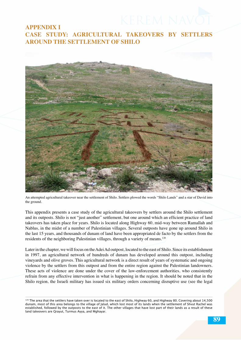
89
APPENDIX ICASE STUDY: AGRICULTURAL TAKEOVERS BY SETTLERS AROUND THE SETTLEMENT OF SHILO
An attempted agricultural takeover near the settlement of Shilo. Settlers plowed the words “Shilo Lands” and a star of David into the ground.
This appendix presents a case study of the agricultural takeovers by settlers around the Shilo settlement and its outposts. Shilo is not “just another” settlement, but one around which an efficient practice of land takeovers has taken place for years. Shilo is located along Highway 60, mid-way between Ramallah and Nablus, in the midst of a number of Palestinian villages. Several outposts have gone up around Shilo in the last 15 years, and thousands of dunam of land have been appropriated de facto by the settlers from the residents of the neighboring Palestinian villages, through a variety of means.120
Later in the chapter, we will focus on the Adei Ad outpost, located to the east of Shilo. Since its establishment in 1997, an agricultural network of hundreds of dunam has developed around this outpost, including vineyards and olive groves. This agricultural network is a direct result of years of systematic and ongoing violence by the settlers from this outpost and from the entire region against the Palestinian landowners. These acts of violence are done under the cover of the law-enforcement authorities, who consistently refrain from any effective intervention in what is happening in the region. It should be noted that in the Shilo region, the Israeli military has issued six military orders concerning disruptive use (see the legal
120 The area that the settlers have taken over is located to the east of Shilo, Highway 60, and Highway 80. Covering about 14,500 dunam, most of this area belongs to the village of Jalud, which lost most of its lands when the settlement of Shvut Rachel was established, followed by the outposts to the east of it. The other villages that have lost part of their lands as a result of these land takeovers are Qrayut, Turmus Ayya, and Mghayar.
90
appendix to this report for a detailed description of this military order and its implementation) against settlers, and five declarations about the closing off of areas to Israelis.121 Subsequently, in early January 2013, for the first time in years, a Palestinian landowner was allowed to plow his lands in the two valleys adjacent to the outposts Achiya and Esh Qodesh (Khallet al-Wusta and Abu Shabirqa). This was made possible only thanks to an appeal submitted by the landowner to the HCJ, following which the state was obligated to ensure the appellant’s entrance to his land.122 The farmer’s return to plowing his land provoked an outburst of settler violence in the area, lasting for several days.123
It is doubtful whether there is another area in the West Bank where one can see so clearly the Israeli territorial “bloc method” in action. Although the Shilo area is not usually mentioned among the so-called Israeli “settlement blocs” in the West Bank (all of which are located to the west of the actual or planned route of the Separation Barrier), it in effect, constitutes a bloc with a significant civilian and military Israeli presence to the east of the Separation Barrier. The core of the bloc is a cluster of three settlements—Shilo, Eli, and Ma’ale Levona—which were established in the late 1970s and first half of the 80s. In the decades since then, more than ten unauthorized outposts have been added to these settlements. Today this bloc stretches over tens of thousands of dunam, some on open barren land, where a number of “pirate” roads were paved, and some on agricultural lands that had previously been farmed by the Palestinians in the area and which today are blocked off to their owners. It is especially instructive to analyze the array of land takeover methods in this area, since it contains a particularly wide variety of measures: paving roads, erecting outposts, taking over sites with potential touristic value, (including two natural springs),124 and, of course, the expansive use of agricultural takeovers.
The Shilo Settlement
The settlement of Shilo was established in 1978 and was authorized by the first Begin government about a year later. The name of the settlement is taken from the name of the ancient settlement of Shilo, which is identified with the archeological site of Tel Shilo. The archeological site is included today within the settlement’s official jurisdiction boundaries and is marketed as a tourist site, to which the settlers, with the support of the government, are trying to bring groups from Israel and abroad.125 Shilo is located next to a few Palestinian villages, on whose lands it was established: Turmus Ayya and Sinjil to the southwest and west of the settlement, and Qaryut and Jalud to the north and northeast of the settlement.
The Shilo settlement was first established on an area of about 760 dunam that had been seized by a military seizure order “for military-security purposes.”126 Like all the other military seizure orders administered in those days, no expiration date was set for this order. And, as in many other cases, throughout the 1980s lands that had been seized militarily for the establishment of Shilo (along with many other lands in the area) were declared “state lands.” Eventually the outpost of Shvut Rachel, among others, was established on these lands, to the east of Shilo. This will be expanded upon on below. The two neighboring settlements, Eli and Ma’ale Levona, were established about six years later, in 1984, just a few kilometers to the north and northwest of Shilo, thus laying the foundations for the three main anchors of the settlement bloc in the area.
121 The settlers have appealed all of these military orders, which are now frozen in various appeals committees. The orders were signed following the efforts of the legal department of Rabbis for Human Rights, Israel, which represents the Palestinian landowners.122 HCJ 1593/12 Fawzi Ibrahim Abd Hajj and others v. Minister of Defense. The appeal was submitted by the legal department of Rabbis for Human Rights, Israel.123 Itamar Fleishman, “Confrontations around the Esh Qodesh Outpost: Settlers Evacuated” [in Hebrew], Ynet Jaurary 1, 2013, accessed at: http://www.ynet.co.il/articles/0,7340,L-4327598,00.html. 124 These two sprints are Ayn al-Ariq, located on Qaryut lands, which settlers took over and changed the name “Heroism Spring,” and Ayn al-Muhaybar, on the lands of Luban as-Sharqiya, which settlers took over and now call “Oz Spring.”125 In December 2011 Israeli Minister of Education Gideon Saar decided to include Tel Shilo on the list of educational tours in the school system. See: Talila Nesher, “Israeli Students to Visit West Bank City of Shiloh on School Trips Education Minister Says,” Haaretz December 13, 2011, accessed at: http://www.haaretz.com/news/national/israeli-students-to-visit-west-bank-city-of-shiloh-on-school-trips-education-minister-says-1.401197 .126 Military Seizure order no. 15/79 from June 16, 1979.
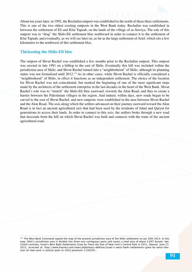
91
About ten years later, in 1992, the Rechalim outpost was established to the north of these three settlements. This is one of the two oldest existing outposts in the West Bank today. Rechalim was established in between the settlement of Eli and Kfar Tapuah, on the lands of the village of as-Sawiya. The role of this outpost was to “drag” the Shilo-Eli settlement bloc northward in order to connect it to the settlement of Kfar Tapuah, and eventually, as we will see later on, as far as the large settlement of Ariel, which sits a few kilometers to the northwest of this settlement bloc.
Thickening the Shilo-Eli bloc
The outpost of Shvut Rachel was established a few months prior to the Rechalim outpost. This outpost was erected in late 1991 on a hilltop to the east of Shilo. Eventually this hill was included within the jurisdiction area of Shilo, and Shvut Rachel turned into a “neighborhood” of Shilo, although its planning status was not formalized until 2012.127 As in other cases, while Shvut Rachel is officially considered a “neighborhood” of Shilo, in effect it functions as an independent settlement. The choice of the location for Shvut Rachel was not coincidental, but marked the beginning of one of the most significant steps made by the architects of the settlement enterprise in the last decades in the heart of the West Bank. Shvut Rachel’s role was to “stretch” the Shilo-Eli bloc eastward, towards the Alon Road, and thus to create a barrier between the Palestinian villages in the region. And indeed, within days, new roads began to be carved to the east of Shvut Rachel, and new outposts were established in the area between Shvut Rachel and the Alon Road. The axis along which the settlers advanced on their journey eastward toward the Alon Road is in fact an ancient agricultural axis that had been used by the residents of Jalud and Qaryut for generations to access their lands. In order to connect to this axis, the settlers broke through a new road that descends from the hill on which Shvut Rachel was built and connects with the route of the ancient agricultural road.
127 The West Bank Command signed the map of the present jurisdiction area of the Shilo settlement on Jan 20th 2013. In this map, Shilo’s jurisdiction area is divided into three non-contiguous parts and covers a total area of about 3,697 dunam. See: Chaim Levinson, Israel’s West Bank Settlements Grew by Twice the Size of New York’s Central Park in 2012, Haaretz June 27, 2013, accessed at: http://www.haaretz.com/news/diplomacy-defense/israel-s-west-bank-settlements-grew-by-twice-the-size-of-new-york-s-central-park-in-2012.premium-1.526101 .
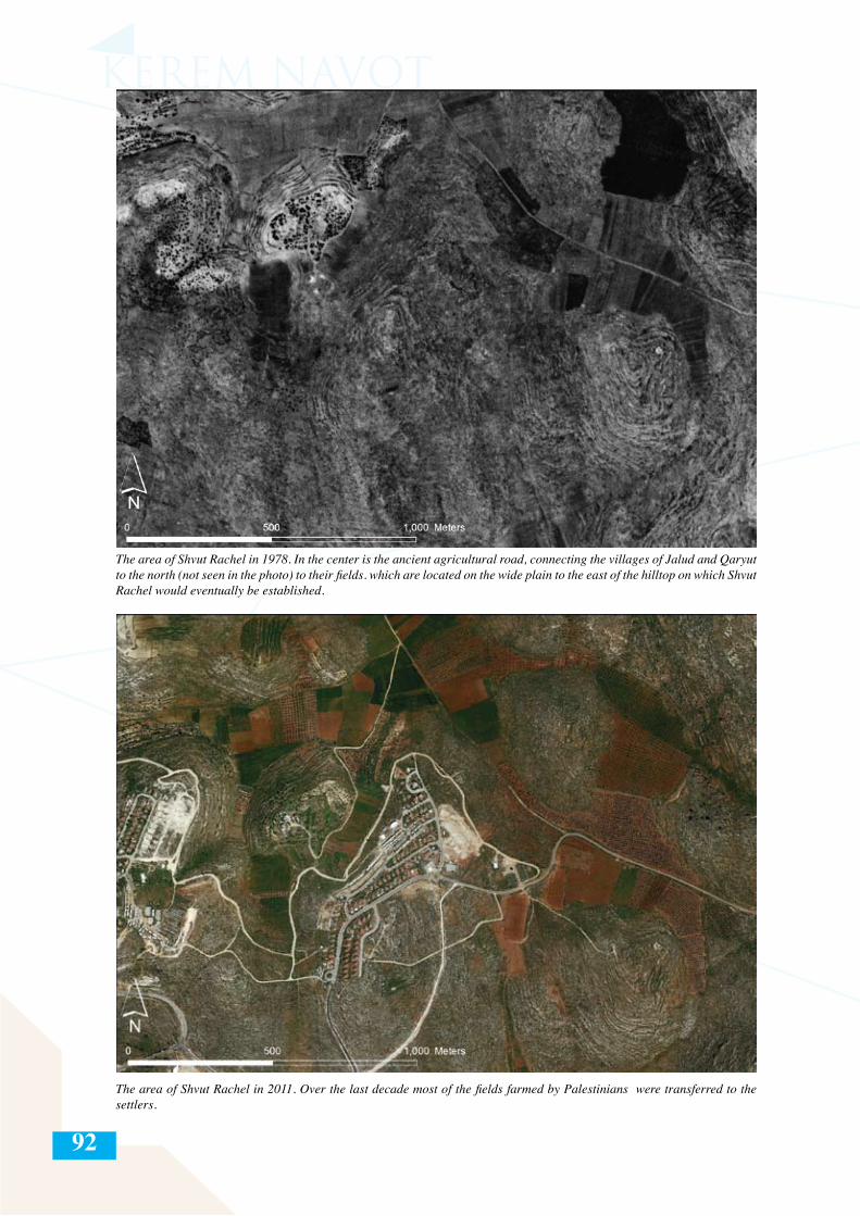
92
The area of Shvut Rachel in 1978. In the center is the ancient agricultural road, connecting the villages of Jalud and Qaryut to the north (not seen in the photo) to their fields. which are located on the wide plain to the east of the hilltop on which Shvut Rachel would eventually be established.
The area of Shvut Rachel in 2011. Over the last decade most of the fields farmed by Palestinians were transferred to the settlers.
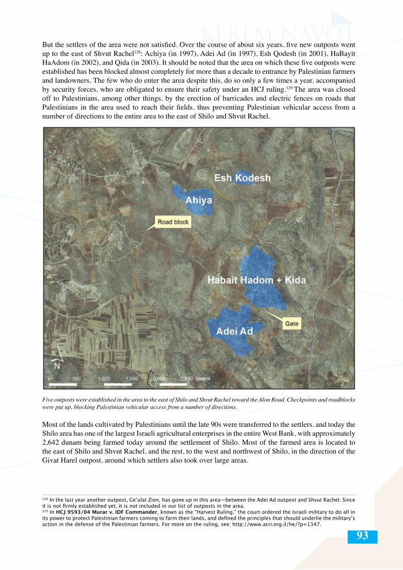
93
But the settlers of the area were not satisfied. Over the course of about six years, five new outposts went up to the east of Shvut Rachel128: Achiya (in 1997), Adei Ad (in 1997), Esh Qodesh (in 2001), HaBayit HaAdom (in 2002), and Qida (in 2003). It should be noted that the area on which these five outposts were established has been blocked almost completely for more than a decade to entrance by Palestinian farmers and landowners. The few who do enter the area despite this, do so only a few times a year, accompanied by security forces, who are obligated to ensure their safety under an HCJ ruling.129 The area was closed off to Palestinians, among other things, by the erection of barricades and electric fences on roads that Palestinians in the area used to reach their fields, thus preventing Palestinian vehicular access from a number of directions to the entire area to the east of Shilo and Shvut Rachel.
128 In the last year another outpost, Ge’ulat Zion, has gone up in this area—between the Adei Ad outpost and Shvut Rachel. Since it is not firmly established yet, it is not included in our list of outposts in the area.129 In HCJ 9593/04 Murar v. IDF Commander, known as the “Harvest Ruling,” the court ordered the Israeli military to do all in its power to protect Palestinian farmers coming to farm their lands, and defined the principles that should underlie the military’s action in the defense of the Palestinian farmers. For more on the ruling, see: http://www.acri.org.il/he/?p=1347.
Five outposts were established in the area to the east of Shilo and Shvut Rachel toward the Alon Road. Checkpoints and roadblocks were put up, blocking Palestinian vehicular access from a number of directions.
Most of the lands cultivated by Palestinians until the late 90s were transferred to the settlers, and today the Shilo area has one of the largest Israeli agricultural enterprises in the entire West Bank, with approximately 2,642 dunam being farmed today around the settlement of Shilo. Most of the farmed area is located to the east of Shilo and Shvut Rachel, and the rest, to the west and northwest of Shilo, in the direction of the Givat Harel outpost, around which settlers also took over large areas.
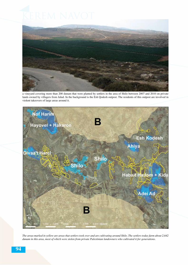
94
The areas marked in yellow are areas that settlers took over and are cultivating around Shilo. The settlers today farm about 2,642 dunam in this area, most of which were stolen from private Palestinian landowners who cultivated it for generations.
a vineyard covering more than 200 dunam that were planted by settlers in the area of Shilo between 2007 and 2010 on private lands owned by villagers from Jalud. In the background is the Esh Qodesh outpost. The residents of this outpost are involved in violent takeovers of large areas around it.
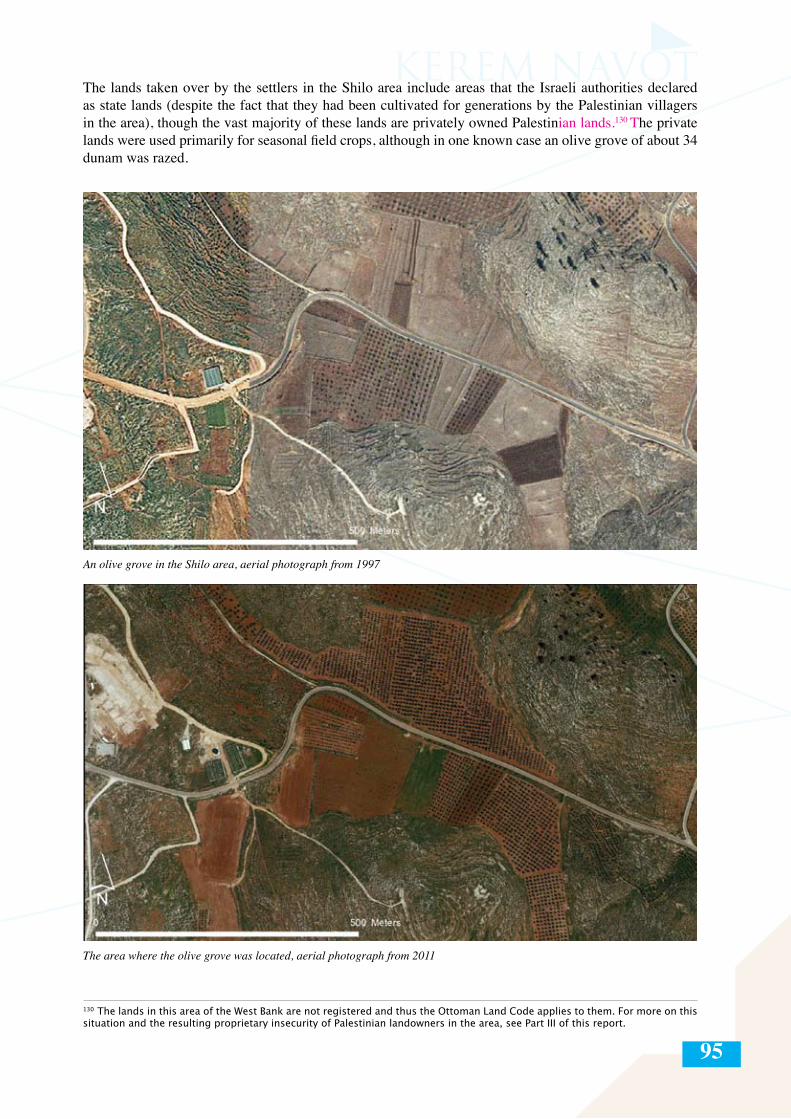
95
The lands taken over by the settlers in the Shilo area include areas that the Israeli authorities declared as state lands (despite the fact that they had been cultivated for generations by the Palestinian villagers in the area), though the vast majority of these lands are privately owned Palestinian lands.130 The private lands were used primarily for seasonal field crops, although in one known case an olive grove of about 34 dunam was razed.
An olive grove in the Shilo area, aerial photograph from 1997
The area where the olive grove was located, aerial photograph from 2011
130 The lands in this area of the West Bank are not registered and thus the Ottoman Land Code applies to them. For more on this situation and the resulting proprietary insecurity of Palestinian landowners in the area, see Part III of this report.
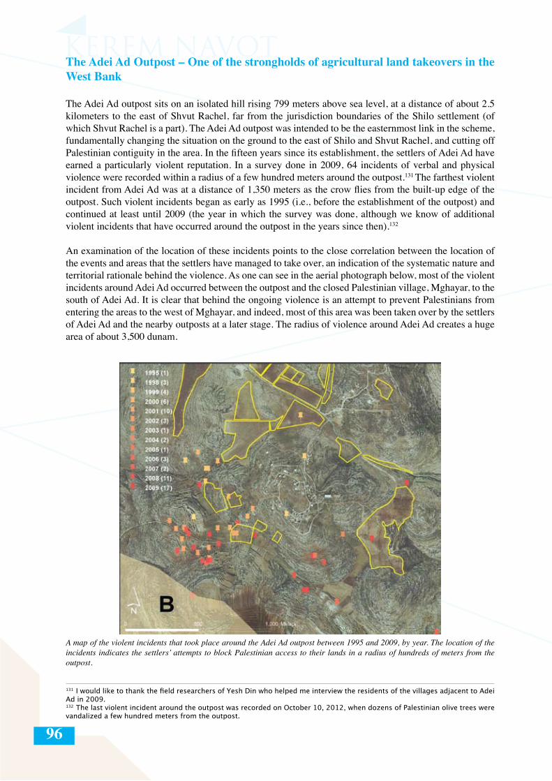
96
The Adei Ad Outpost – One of the strongholds of agricultural land takeovers in the West Bank
The Adei Ad outpost sits on an isolated hill rising 799 meters above sea level, at a distance of about 2.5 kilometers to the east of Shvut Rachel, far from the jurisdiction boundaries of the Shilo settlement (of which Shvut Rachel is a part). The Adei Ad outpost was intended to be the easternmost link in the scheme, fundamentally changing the situation on the ground to the east of Shilo and Shvut Rachel, and cutting off Palestinian contiguity in the area. In the fifteen years since its establishment, the settlers of Adei Ad have earned a particularly violent reputation. In a survey done in 2009, 64 incidents of verbal and physical violence were recorded within a radius of a few hundred meters around the outpost.131 The farthest violent incident from Adei Ad was at a distance of 1,350 meters as the crow flies from the built-up edge of the outpost. Such violent incidents began as early as 1995 (i.e., before the establishment of the outpost) and continued at least until 2009 (the year in which the survey was done, although we know of additional violent incidents that have occurred around the outpost in the years since then).132
An examination of the location of these incidents points to the close correlation between the location of the events and areas that the settlers have managed to take over, an indication of the systematic nature and territorial rationale behind the violence. As one can see in the aerial photograph below, most of the violent incidents around Adei Ad occurred between the outpost and the closed Palestinian village, Mghayar, to the south of Adei Ad. It is clear that behind the ongoing violence is an attempt to prevent Palestinians from entering the areas to the west of Mghayar, and indeed, most of this area was been taken over by the settlers of Adei Ad and the nearby outposts at a later stage. The radius of violence around Adei Ad creates a huge area of about 3,500 dunam.
131 I would like to thank the field researchers of Yesh Din who helped me interview the residents of the villages adjacent to Adei Ad in 2009.132 The last violent incident around the outpost was recorded on October 10, 2012, when dozens of Palestinian olive trees were vandalized a few hundred meters from the outpost.
A map of the violent incidents that took place around the Adei Ad outpost between 1995 and 2009, by year. The location of the incidents indicates the settlers’ attempts to block Palestinian access to their lands in a radius of hundreds of meters from the outpost.
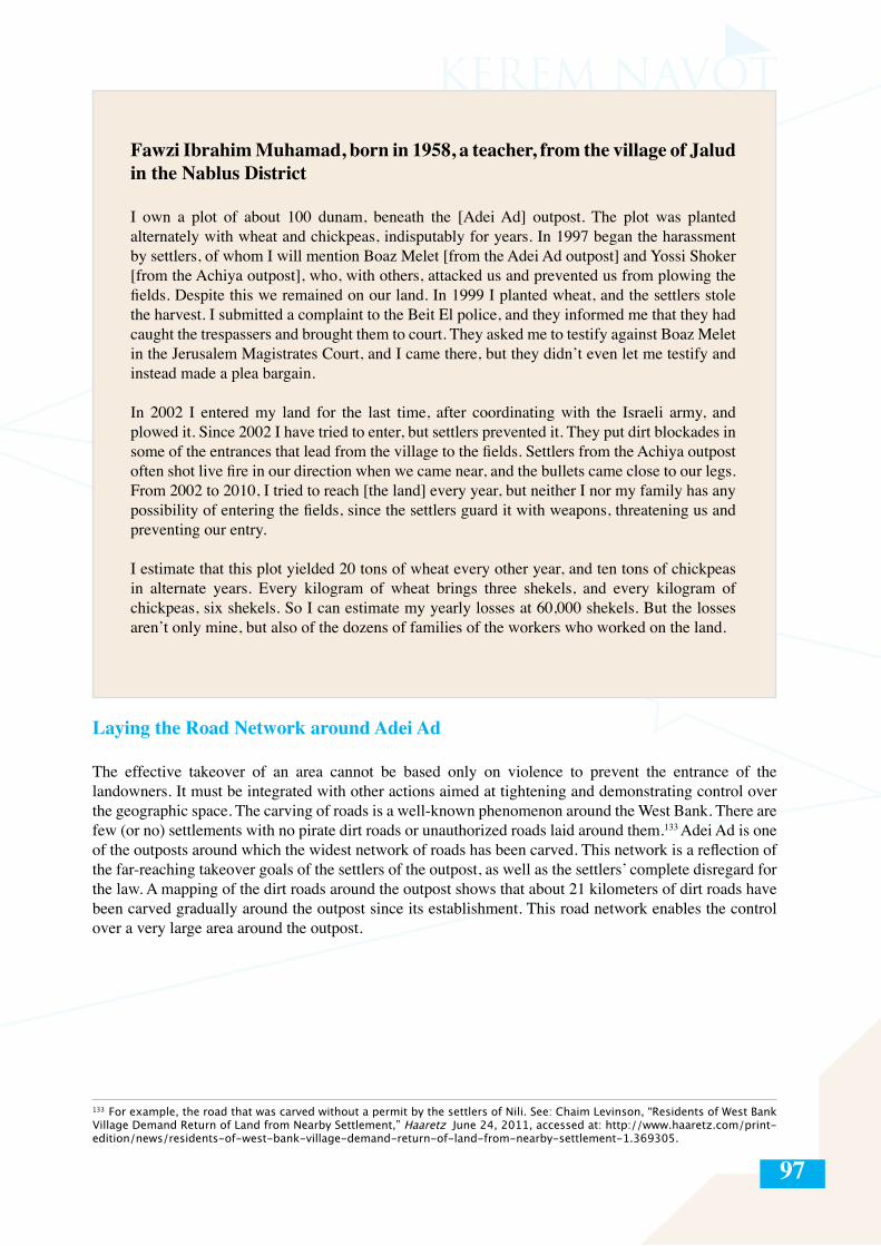
97
Fawzi Ibrahim Muhamad, born in 1958, a teacher, from the village of Jalud in the Nablus District
I own a plot of about 100 dunam, beneath the [Adei Ad] outpost. The plot was planted alternately with wheat and chickpeas, indisputably for years. In 1997 began the harassment by settlers, of whom I will mention Boaz Melet [from the Adei Ad outpost] and Yossi Shoker [from the Achiya outpost], who, with others, attacked us and prevented us from plowing the fields. Despite this we remained on our land. In 1999 I planted wheat, and the settlers stole the harvest. I submitted a complaint to the Beit El police, and they informed me that they had caught the trespassers and brought them to court. They asked me to testify against Boaz Melet in the Jerusalem Magistrates Court, and I came there, but they didn’t even let me testify and instead made a plea bargain.
In 2002 I entered my land for the last time, after coordinating with the Israeli army, and plowed it. Since 2002 I have tried to enter, but settlers prevented it. They put dirt blockades in some of the entrances that lead from the village to the fields. Settlers from the Achiya outpost often shot live fire in our direction when we came near, and the bullets came close to our legs. From 2002 to 2010, I tried to reach [the land] every year, but neither I nor my family has any possibility of entering the fields, since the settlers guard it with weapons, threatening us and preventing our entry.
I estimate that this plot yielded 20 tons of wheat every other year, and ten tons of chickpeas in alternate years. Every kilogram of wheat brings three shekels, and every kilogram of chickpeas, six shekels. So I can estimate my yearly losses at 60,000 shekels. But the losses aren’t only mine, but also of the dozens of families of the workers who worked on the land.
Laying the Road Network around Adei Ad
The effective takeover of an area cannot be based only on violence to prevent the entrance of the landowners. It must be integrated with other actions aimed at tightening and demonstrating control over the geographic space. The carving of roads is a well-known phenomenon around the West Bank. There are few (or no) settlements with no pirate dirt roads or unauthorized roads laid around them.133 Adei Ad is one of the outposts around which the widest network of roads has been carved. This network is a reflection of the far-reaching takeover goals of the settlers of the outpost, as well as the settlers’ complete disregard for the law. A mapping of the dirt roads around the outpost shows that about 21 kilometers of dirt roads have been carved gradually around the outpost since its establishment. This road network enables the control over a very large area around the outpost.
133 For example, the road that was carved without a permit by the settlers of Nili. See: Chaim Levinson, “Residents of West Bank Village Demand Return of Land from Nearby Settlement,” Haaretz June 24, 2011, accessed at: http://www.haaretz.com/print-edition/news/residents-of-west-bank-village-demand-return-of-land-from-nearby-settlement-1.369305.
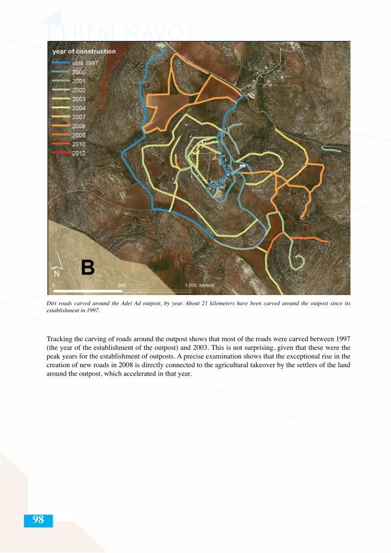
98
Dirt roads carved around the Adei Ad outpost, by year. About 21 kilometers have been carved around the outpost since its establishment in 1997.
Tracking the carving of roads around the outpost shows that most of the roads were carved between 1997 (the year of the establishment of the outpost) and 2003. This is not surprising, given that these were the peak years for the establishment of outposts. A precise examination shows that the exceptional rise in the creation of new roads in 2008 is directly connected to the agricultural takeover by the settlers of the land around the outpost, which accelerated in that year.
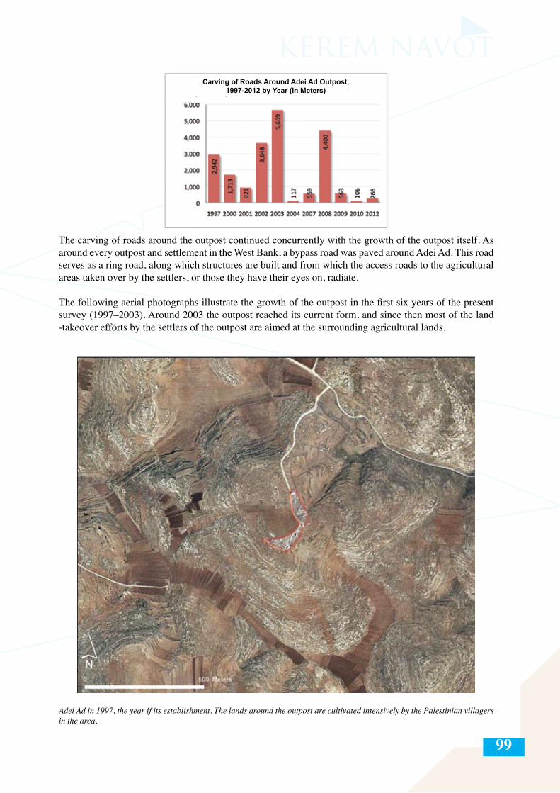
99
The carving of roads around the outpost continued concurrently with the growth of the outpost itself. As around every outpost and settlement in the West Bank, a bypass road was paved around Adei Ad. This road serves as a ring road, along which structures are built and from which the access roads to the agricultural areas taken over by the settlers, or those they have their eyes on, radiate.
The following aerial photographs illustrate the growth of the outpost in the first six years of the present survey (1997–2003). Around 2003 the outpost reached its current form, and since then most of the land -takeover efforts by the settlers of the outpost are aimed at the surrounding agricultural lands.
Adei Ad in 1997, the year if its establishment. The lands around the outpost are cultivated intensively by the Palestinian villagers in the area.
Carving of Roads Around Adei Ad Outpost,1997-2012 by Year (In Meters)
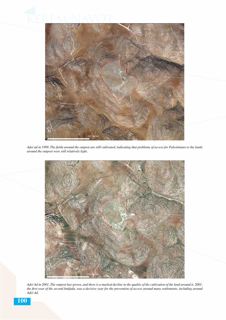
100
Adei ad in 1999. The fields around the outpost are still cultivated, indicating that problems of access for Palestinians to the lands around the outpost were still relatively light.
Adei Ad in 2001. The outpost has grown, and there is a marked decline in the quality of the cultivation of the land around it. 2001, the first year of the second Intifada, was a decisive year for the prevention of access around many settlements, including around Adei Ad.
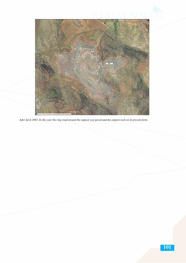
101
Adei Ad in 2003. In this year the ring road around the outpost was paved and the outpost took on its present form.
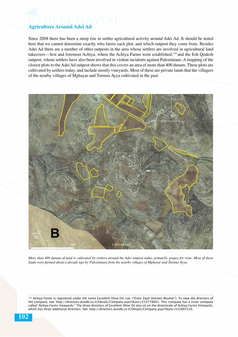
102
Agriculture Around Adei Ad
Since 2008 there has been a steep rise in settler agricultural activity around Adei Ad. It should be noted here that we cannot determine exactly who farms each plot, and which outpost they come from. Besides Adei Ad there are a number of other outposts in the area whose settlers are involved in agricultural land takeovers—first and foremost Achiya, where the Achiya Farms were established,134 and the Esh Qodesh outpost, whose settlers have also been involved in violent incidents against Palestinians. A mapping of the closest plots to the Adei Ad outpost shows that this covers an area of more than 400 dunam. These plots are cultivated by settlers today, and include mostly vineyards. Most of these are private lands that the villagers of the nearby villages of Mghayar and Turmus Ayya cultivated in the past.
More than 400 dunam of land is cultivated by settlers around the Adei outpost today, primarily grapes for wine. Most of these lands were farmed about a decade ago by Palestinians from the nearby villages of Mghayar and Turmus Ayya.
134 Achiya Farms is registered under the name Excellent Olive Oil, Ltd. (“Eretz Zayit Shemen Muvhar”). To view the directors of the company, see: http://directors.dundb.co.il/Details/Company.aspx?duns=533778841. This company has a sister company called “Achiya Farms Vineyards.” The three directors of Excellent Olive Oil also sit on the directorate of Achiya Farms Vineyards, which has three additional directors. See: http://directors.dundb.co.il/Details/Company.aspx?duns=532807216.
103
Azat Jaber Abdelghani Khatib, born in 1927, farmer, from the village of Qaryut in the Nablus district
Throughout the years, I and my family, who owned the land, grew our crops on these lands. We plowed and harvested the crops according to the agricultural seasons continuously over the course of the years. We have a water reservoir there. We would plant the seeds—wheat, barley, lentils, chickpeas, and more, with no problem.
Since the establishment of the new settlements [meaning the string of outposts to the east of Shilo] around our lands, we began to suffer from violence and harassment by the settlers. I and the rest of the farmers objected to these attacks and we would complain to the DCL [District Coordination Liaison Offices] and the police, and we continued to hold on to our lands and farm there. A number of settlers, some of them masked, attacked me, and one of them hit me with the butt of his gun and I was injured in my hand, and they also took my plow from me. I went to a government hospital in Ramallah where I got four stitches in my hand. I submitted a complaint to the police and wasn’t given a copy.
From time to time the settlers would invade these plots and other plots of ours in order to damage them and steal crops. My late brother submitted complaints to the Binyamin police for vandalism, stealing crops, and trespassing. Despite the continued attacks by the settlers, we continued to hold on to our land. In 2004 the settlers burned our yield of wheat, barley, lentils, and chickpeas. My late brother Sliman submitted a complaint and was not given a copy by the police. Many times we submitted complaints to the law enforcement authorities (police, militray, and DCL), but they did not address our complaints. Since 2004, every time we went to our land, the army would prevent us from entering or kick us out. My late brother was informed that in 2007 the settlers planted a vineyard on our land. Today neither I nor my family can enter our land, since the settlers control it and threaten us with weapons, and the army doesn’t’ help us. I estimate the financial damage resulting from our inability to use our land at about 10,000 Jordanian dinar [about 52,000 shekels] per year.

104
Development of the Adei Ad outpost, 1997–2012
Year Area included within Number of structures the ring road (m2)
1997 13,326 6
1999 131,683 12
2001 No change 18
2002 141,870 25
2003 452,187 36
2004 No change 41
2005 No change 47
2006 No change 48
2007 No change 43
2008 No change 34
2009 No change 34
2010 No change 37
2011 No change 40
2012 No change 37
105
The case law of the Israeli High Court of Justice, referred to in detail in the appendix hereafter, should be read in light of the fact that the Court has expanded the powers of the occupier beyond the limitations provided for by international law, to the point that the distinction between sovereign and occupier has been blurred and fundamental notions and protections are ignored or overridden. This is particularly notable in relation to spatial planning and related policies and practices.
106
LEGAL RECOURSE BASED IN LOCAL LAW FOR PALESTINIANS IN THE WEST BANK AGAINST SETTLER TAKEOVERS OF PRIVATE PALESTINIAN LANDQuamar Mishirqi-Assad, Advocate Head of the Legal Department of Rabbis for Human Rights, Israel
The goal of this chapter is to assess the scope of the defenses in local law in the West Bank to which Palestinians in Area C have recourse for protection against settler takeovers of their land. The chapter begins by laying out the legal background for the general lack of proprietary security experienced by Palestinian residents of Area C under Israeli law. Subsequently, it presents the main legal arguments used by settlers in order to keep possession of land they have taken over. And finally, the chapter presents a survey of the legal defenses available to Palestinians and assesses the degree of their efficacy and enforcement on the criminal, civil, and administrative levels.
I. Legal BackgroundSince the end of the June 1967 war, the West Bank has been under Israeli military occupation, or in legal terms, “belligerent occupation.” It follows that, in accordance with International Humanitarian Law,1 the Israeli military, as the temporary administrator of the West Bank, is responsible for the welfare of the “protected” Palestinian population living there. The State of Israel is obliged to maintain public order and civilian life in the West Bank and to respect the local laws of the land that were in place before the occupation.2 The obligation to maintain all aspects of life, including the physical, social, and proprietary security of the occupied population3 was recognized in a 1983 ruling of Israel’s High Court of Justice4. Israel’s obligations are also couched in Human Rights Law, which obligates the occupying power to protect private property.5
The Lack of Proprietary Security of the Palestinian Residents of Area C under the Law Applied by Israel in the West Bank
The law applied by Israel in the West Bank today is based upon the law that was in place before the Israeli occupation, including amendments implemented by respective past regimes (Ottoman, British, and Jordanian). The definitive law with regard to immovable property rights is the Ottoman Land Code of 1858, as revised and amended by British Mandatory and Jordanian law, as well as Israeli security legislation (in the form of military orders), all of which are subordinate to the rules of international law. Simultaneously, Israel applied Israeli administrative law to the Israeli government officials operating in the occupied territories.6
1 Israel professes to apply International Humanitarian Law in the West Bank, despite its official position (as presented by the former Attorney General of Israel, Meir Shamgar) that the West Bank is not held under “belligerent occupation.” This official legal stance has been presented by the state in response to the many petitions submitted against it to date and was furthered in a report by a government-appointed committee headed by retired justice Edmund Levy. See: Eyal Zamir, State Lands in Judea and Samaria – a Legal Survey [Hebrew] (Jerusalem, 1985), p. 10 (hereafter: Zamir, State Lands). See: Edmund Levy, Tehiya Shapira, and Alan Baker, “Report on the Status of Building in the Area of Judea and Samaria” [Hebrew], (21.6.2012), pp. 2–13, accessed at: http://www.pmo.gov.il/Documents/doch090712.pdf (hereafter: Levy Report).2 This is according to the Hague Convention and its annex, Hague Regulation 43, concerning the Laws and Customs of War on Land from 1907 (hereafter: Hague Regulations), accessible at: http://www.icrc.org/applic/ihl/ihl.nsf/INTRO/1953 For example, see Articles 46, 52, and 53 of the Hague Regulations (see fn. 2, above) and Articles 27 and 53 of the Fourth Geneva Convention of 1949 Concerning the Protection of Civilian Persons in Time of War, accessible at http://www.icrc.org/ihl.nsf/385ec082b509e76c41256739003e636d/6756482d86146898c125641e004aa3c5.4 In an extensive ruling of the HCJ, it was determined that it is Israel’s obligation to maintain public order and security in the West Bank. See, for example, HCJ 69/81 Abu Ayta v. IDF Commander in Judea and Samaria, 84 37 (2) 197, 309; HCJ 202/81 Tabib v. Minister of Defense 84 36(2) 622, 629; HCJ 393/82 Jama’iyat Askan al-Mualimun v. IDF Commander in Judea and Samaria, 84 37 (4) 785, 797; HCJ 548/04 Amana – the Settlement Movement of Gush Emunim v. IDF Commander in Judea and Samaria (forthcoming). HCJ 10302/07 Tal Construction and Investments Karnei Shomron v. Minister of Defense (published in NEVO, 16.11.2008), HCJ 9593/04 Murad v. Minister of Defense (published in NEVO 19.01.2006), par. 30, in HCJ 5439/09 Ahmad Abd al-Qader v. Military Appeals Commission (given on 20.3.2012) (henceforth: Abd al-Qader case).5 See, for example, Article 11 of the International Covenant on Economic, Social, and Cultural Rights, 1966. 6 For an expansion of this, see: Zamir, State Lands (above, fn. 1), p. 2; Ariel Yosefi, “Unregistered Land in Judea and Samaria – the NAOT Forum” (Seminar paper, Hebrew University of Jerusalem, 2009), pp. 5–6 (hereafter: Yosefi, “Unregistered Land”); and HCJ 69/81 Abu Ayta v. Commander of Judea and Samaria, 84 37 (2) 199, 231, on the application of administrative law to Israeli government officials operating in the West Bank..
APPENDIX II
107
Following are three main factors behind the proprietary insecurity experienced by Palestinians in Area C:
Firstly, most of the land in the West Bank serves as miri land, as defined by the Ottoman Land Code. This means that it belongs to the ruling power, unless a legitimate private claim to the land arises.7 The statute of limitations enshrined in articles 20 and 78 of the Ottoman Land Code (concerning unregistered land), as will be explained in the next part of this chapter, states that uninterrupted cultivation for ten years, without objections from any party, grants the farmer rights to the land. In the absence of such right, possession reverts to the government.
Secondly, in 1967, the military commander suspended the process of land registration in the West Bank.8 This process had begun in the Mandatory period9 and continued under Jordanian rule,10 and if completed, would have determined the boundaries and ownership of every plot. Presently, approximately two thirds of the area of the West Bank remains unregistered, mostly in Area C (covering about 60% of the area of the West Bank). The law that applies to these lands is determined by the above-described substantive (Ottoman) law.11
The suspension of land registration, coupled by Israel’s interpretation of the miri statute, facilitated the Israeli policy of recognizing large areas in the West Bank as “state lands,” by means of official declaration or otherwise. Under this policy, these lands were transferred to Israeli settlements, in contravention of Israel’s international obligations towards the protected population, which should supersede local law. In the absence of land registration, Palestinians have difficulty proving their claims to restore possession of their land and/or to appeal state land declarations, since they cannot provide conclusive evidence of their rights over the land.12
It should be noted that these unregistered lands are generally listed in the pre-1967 tax registers. While these can be useful for Palestinian landowners, the disadvantage of these registries is that they do not contain precise identification of the location or size of the plot or the nature of the rights to it. In the absence of another alternative, these listings have become more important, and in certain proceedings they are the only physical evidence of possession of the land.13
Thirdly, ever since the Interim Agreement between Israel and the Palestinian Authority in 1995, Palestinian courts in the West Bank are not authorized to rule on land claims against Israelis in Area C without their consent.14 Needless to say, such consent is never given. Thus, the courts in Israel serve as the forum for
7 Miri lands are lands belonging to the Turkish Emir, which were designated for agricultural cultivation. Such lands are defined as being located at a distance of up to 2.5 kilometers from the houses of the village, and to which the individual earns private rights by the continuous and undisputed cultivation for ten years. (Article 78 of the Ottoman Land Code), or alternately by a permit that is given to the individual a priori by the regime, according to article 3 of the Code, in the form of a land title deed. Most of the land in the West Bank was already considered miri land under the British Mandate. See: B’Tselem, “Under the Guise of Legality: Declarations on State Land in the West Bank” (March 2012), accessed at: http://www.btselem.org/download/201203_under_the_guise _of_legality_eng.pdf, p. 26 (hereafter: B’Tselem “Under the Guise of Legality”). For an expansion on the land categorizations, see: A. Ben Shemesh, Land Laws in the State of Israel [in Hebrew] (Tel Aviv, 1953), pp. 27–175. Moshe Dukhan, Land Law in the State of Israel [Hebrew] (2nd ed.) (Jerusalem, 1953). For another analysis see B’Tselem, “Under the Guise of Legality” (above, fn. 7), pp. 15–18; as well as Zamir, State Lands (above, fn. 1), pp. 14–23.8 Military Order Concerning Land and Water Settlement (no. 291) (Judea and Samaria) (1968), (Proclamations, Orders and Appointments) 16, p. 591. For an expansion on the justifications given for the suspension of the land registration process, see: Levin Shnor, “Land Disputes in the West Bank—Between Private and Public” [Hebrew, unpublished], p. 19 (hereafter: Levin-Shnor, “Land Disputes”); as well as Geremy Forman, “A Tale of Two Regions: Diffusion of the Israeli ‘50 Percent Rule’ from the Galilee to the Occupied West Bank,” Law & Soc. Inquiry 34 (2009), pp. 671, 689.9 According to the British Mandatory Land Settlement Ordinance of 1928.10 According to the 1952 Jordanian Law on the Settlement of Land and Water Rights, no. 40. 11 See: Zamir, State Lands (above, fn. 1), p. 27. For the map of land registration, see: Ian Lustick, “Israel and the West Bank after Elon Moreh: The Mechanics of De Facto Annexation,” Middle East Journal 35 (1981), pp. 557, 570.12 Levin-Shnor, “Land Disputes” (above, fn. 8), p. 37. See also: Talya Sasson, “An (Interim) Opinion Concerning Unauthorized Outposts” [in Hebrew] (March 2005) (hereafter: Sasson Report), accessed at: http://www.pmo.gov.il/SiteCollectionDocuments/PMO/Communication/Spokesman/sason2.pdf. An English summary of the report is accessible at: http://www.mfa.gov.il/MFA/Government/Law/Legal+Issues+and+Rulings/Summary+of+Opinion+Concerning+Unauthorized+Outposts+-+Talya+Sason+Adv.htm. See also: B’Tselem, “Under the Guise of Legality” (above, fn. 7), p 26. 13 Yosefi, “Unregistered Land” (above, fn. 6), p. 6; See also: Plia Albeck, “Land Use in Judea and Samaria for Jewish Settlement: Legal Aspects and the Test of Reality” [Hebrew], in Avraham Shvut (ed.), Ascent to the Mountain: Renewal of Jewish Settlement in Judea and Samaria (Jerusalem, 2002), pp. 221, 225. 14 The Israeli-Palestinian Interim Agreement on the West Bank and Gaza Strip was signed in Washington between the State of Israel and the Palestinian Liberation Organization on 28 September 1995. See Annex IV: Protocol Concerning Legal Affairs, Article III, sub-articles 1 and 2, accessible at http://www.knesset.gov.il/process/docs/heskemb5_eng.htm.
108
these land claims. As a general rule, Palestinians avoid turning to the civil courts in Israel, for a variety of reasons: lack of faith in the Israeli legal system, bureaucracy and red tape, high legal fees, difficulty of access, and a high threshold of physical evidence required to prove their claims.
To summarize, the complexity of land law in the West Bank, the lack of land registration, and the absence of courts to deal with land issues, serve to perpetuate the proprietary insecurity of Palestinians in Area C while providing ample opportunity for settlers to carry out unauthorized agricultural land incursions with the goal of eventually registering these lands under their name. The legal reality in the West Bank, as will be explained in the next part of this chapter, thus facilitates the takeover by settlers of Palestinian lands under the guise of legality.
II. Unauthorized incursions by settlers onto private Palestinian lands and the legal arguments used by settlers to maintain possession of unlawfully seized land
Since 2000, the number of unauthorized incursions by settlers onto private Palestinian lands has grown considerably, in exploitation of the above-described proprietary insecurity of the Palestinians in Area C. Hence, as previously noted, the following discussion focuses primarily on unregistered lands in the West Bank to which the Ottoman Statute of Limitation applies. Unofficial land takeovers and attempted takeovers by the settlers generally begin by taking possession of an area and using if to grow field crops, plant trees, or graze sheep, while preventing Palestinian access to the land through physical violence or the threat of violence, paving of roads, erecting of structures, etc.
Moreover, in cases when an administrative decision is made in favor of a Palestinian claimant (i.e., to evacuate the trespassing settlers), settlers often appeal the decision by turning to Israeli military or civilian courts. The opening of such legal proceedings is tantamount to the nullification or, at the very least, the deferral of the implementation of the administrative decision to evacuate trespassers and restore the land to its owners. This effectively enables the continued occupation of the land in question for years, causing the emotional and financial attrition of the landowners.
In most of the cases, the trespassing settlers claim the right to continue to possess the land based on their interpretation of articles 20 and 78 of the Ottoman Land Code, i.e., by virtue of having allegedly cultivated and possessed the land for more than ten years. While both articles stipulate a 10-year statute of limitations on possession, there is a significant difference between them with regard to title. Article 78 entitles the person meeting its requirements to a statute of limitations on purchase, meaning if a person possesses the land for ten years without objection, he may purchase the ownership rights and register it under his name. Article 20, on the other hand, entitles the person meeting the statute of limitations to a procedural statute of limitations alone, meaning the possessor cannot be evicted so long as he possesses it, but neither can he register the land under his name. In other words, Article 20 is used by the settlers in defense against eviction from land they have allegedly possessed and cultivated for ten years, while Article 78 serves as an offensive argument to enable the settler cultivating the land to register it under his name.15
In 2011, the Israeli High Court of Justice ruled that claims to land rights by virtue of statute of limitations are not valid without furnishing proof of a legitimate source for the initial possession of the land; in other words, these rights are not valid if possession was taken not in good faith.16 This ruling is based, among other things, on the state’s interpretation of articles 78 and 20, by which the presentation of a legal source
15 Article 78 states: “Every one who has possessed and cultivated State or mevqufé land for ten years without dispute acquires a right by prescription, and whether he has a valid title-deed or not the land cannot be regarded as vacant, and he shall be given a new title-deed gratuitously. Nevertheless if such person admits and confesses that he took possession of the land without any right when it was vacant, the land shall be offered to him on payment of the tapou value, without taking into account the lapse of time; if he does not accept, it shall be put up to auction and adjudged to the highest bidder.” Article 20 states: “In the absence of a valid excuse according to the Sacred Law, duly proved, such as minority, unsoundness of mind, duress or absence on a journey, actions concerning land of the Kind that is possessed by title deed, the occupation of which has continued without dispute for a period of ten years, shall not be maintainable. The period of ten years begins to run from the time when the excuses above-mentioned have ceased to exist. Provided that if the Defendant admits and confesses that he has arbitrarily taken possession of and cultivated the land, no account is taken of the lapse of time and possession, and the land is given back to its proper possessor.”16 HCJ 9296/08 IDF Commander v. Military Appeals Commission (ruling on 2.6.2011). See also: Abd al-Qader case (above, fn. 4).
109
for the possession (such as a contract of sale, inheritance, or a document regarding payment of land tax) is required in addition to proof of possession and cultivation. Absent such proof, it is impossible to register the land or to purchase rights to possession and use of the land.
III. Survey of Legal Defenses Available to Palestinians – Scope and Enforcement Over the years, the Civil Administration and the Military Commander have presented the Palestinians with a number of avenues for defense of their private land, in the areas of criminal, civil and administrative law. However, when we look closely at the scope of these defenses and, a fortiori, at their enforcement, the vulnerability and lack of effective legal resources for Palestinians in revealed.
Criminal Defenses: Criminal Trespassing
Criminal law enforcement in the West Bank is based, inter alia, on the Military Commander’s obligation to maintain public order and the civil life of the protected population. The responsibility for the enforcement of criminal law falls primarily upon the Israeli police forces in the West Bank.17 Criminal trespassing—the most relevant infraction in cases of land takeovers (aside from crimes related to personal physical safety)—is one of the crimes in the Israeli criminal penal code that applies to Israeli citizens in the West Bank.18 However, this law is not properly enforced by the Israeli police in the West Bank. From a recent summary of criminal complaints collected by Israeli organizations, it emerges that between 72% and 86% of settler trespassing cases were closed without indictments and the rest are still under investigation.19 The Sasson Report made a similar observation:
“Criminal law enforcement in the territories does not provide effective protection of land-ownership and -possession rights for Palestinians.” 20
Private/Civil Defenses: Initial Registration or Civil Suit
After Israel’s suspension of land registration in the West Bank in 1967, the only method of land registration available for Palestinians was to register a specific piece of land by private initiative, known as an “initial registration” proceeding.21 This process is similar in essence to the land-registration procedure, but differs from it in that it happens at the initiative and expense of the individual, and registers only the area over which the individual demands recognition of his ownership.22 In addition to the initial registration procedure, the civil courts in Israel are authorized to rule on civil suits regarding land disputes (such as eviction and ownership claims).23 These are ostensibly the two main channels for protecting private property.
That being said, these two channels are not effective for most Palestinians seeking legal recourse to reclaim rights to their land, for a number of reasons, which have already been mentioned: lack of faith in the Israeli legal system24; red tape and high legal fees, including the requirement to deposit tens of thousands of shekels in order to open a civil suit; difficulties of access and limitations of movement and exit from the West Bank; inability in many cases to personally identify the trespasser, which makes it impossible to file a complaint; and the high threshold of physical evidence needed to prove land ownership rights to unregistered land..
17 According to Military Order Regarding Security Provisions (Consolidated Version) (Judea and Samaria) (no. 1651) (2009).18 The crime of trespassing is defined in article 447 (a) of the penal code (1977). The penal code states that it applies to crimes committed exterritorialy by citizens or residents of Israel. Israelis are tried in Israeli courts according to the penal code. By contrast, Palestinians are subject to the criminal law that applies to the West Bank and are tried in military courts.19 From the statistics of the legal department of Rabbis for Human Rights, Israel, it emerges that between 2005 and 2012, 134 complaints were filed for trespassing, of which 96 were closed. Statistics collected by Yesh Din show that between 2005 and 2011, more than 86% of settler trespassing cases were closed without an indictment, see: http://www.yeshdin.org/userfiles/file/datasheets/LawEnforcement%20data%20sheet%20Heb_March_2012.pdf. 20 Sasson Report (above, fn. 11), p. 315.21 Law Concerning the Registration of Previously Unregistered Immovable Property (no. 6) (1964), as was amended by the Military Order Concerning Amendment of the Registration of Previously Unregistered Immovable Property Law (Judea and Samaria) (no. 1621) (2008).22 Levin-Shnor, “Land Disputes” (above, fn. 8), p. 18.23 According to articles 40, 51 of the Court Code [Consolidated Version], 1984.24 See: Sasson Report (above, fn. 11), p. 314.
110
Moreover, it is important to mention that such proceedings contain a risk of irreversible damage for landowners, in the case in which the claim is rejected. If, for example, a request for initial registration is rejected, the land can then be registered under the General Custodian of Government and Absentee Property (i.e., under the state), notwithstanding the ostensibly temporary state of the occupation.
This difficulty is exacerbated by the fact that some of the right-holders to the land became absentees after they fled the West Bank in 1967. Property whose owners are defined as absentees is administered by the Custodian of Absentee Property.25 As a result, many Palestinians holding rights to land refrain from initiating land-registration proceedings or turning to law-enforcement authorities, for fear that there will be counter-claim that the family members are absentees, thus transferring the property to the administration of the Custodian of Absentee Property.26
The preceding discussion demonstrates that the abovementioned civil options are not relevant for most Palestinians in the West Bank.27 The proliferation of acts of trespassing, coupled by the inefficacy of civil procedures, necessitates an effective and concerted involvement on the administrative and not necessarily the legal level. Given this reality, emphasis must be placed on the legal obligation of administrative and public authorities to prevent acts of trespassing of Israelis onto Palestinian lands.
Defenses on the Public Administrative Level1. The Classic Defense: Order for the Evacuation of Trespassers (in cases of a fresh incursion) This order has been in existence since 1999. It is effective in cases in which the landowner detects a trespasser on his land and turns to the police within 30 days of the beginning of the incursion. The goal of this order is to restore possession to the landowner immediately, before damage is caused or before there is a change in the balance of rights. The Palestinian landholder may have the trespasser evacuated only after receiving an authorization from the police commander and military commander.28
This defense is not generally employed by Palestinians, for a number of reasons: (1) the security forces refuse to authorize the order or drag their feet in doing so; (2) the Palestinian landowners do not catch the incursion in real time due to the restrictions on freedom of movement and access that are imposed on them around the settlements29; and (3) the difficulty in proving legal possession due to the lack of land registration.30
In 2004, in the HCJ ruling on Amana, Justice Procaccia noted that the order is not implementable and does not provide sufficient recourse land takeovers in the Territories:
“…a direct and general legislative regulation is therefore necessary, which will authorize the Military Commander to act to prevent unauthorized takeovers of lands in the area.”31
2. A New Defense: Order Concerning Disruptive Use of Private Lands Following the Amana ruling and the Sasson Report’s reference to the lack of suitable administrative recourse against incursions on unregistered private lands in the West Bank, in 2007 a new Order Concerning Disruptive Use of Private Lands was enacted,32 authorizing the military commander to evacuate incursions into private lands up to five years33 after their inception. The implementation of the order does not hinge on the filing of a complaint by the landowner. “Disruptive use,” as defined in the order, is “the use of private lands without legal right,” in other words, without a legal source indicating a right of possession or use. The order, which initially protected landowners from incursions of up to three years, was expanded in 2010 to include
25 Order Concerning Absentee Property (Private Property) (Judea and Samaria) (no. 58), 1967.26 State Comptroller Annual Summary 56a for 2005, 222 (2005); Report of the World Bank, “The Economic Effects of Restricted Access to Land in the West Bank,” (2008), p. 10. See: http://siteresources.worldbank.org/INTWESTBANKGAZA/Resources/EconomicEffectsofRestrictedAccesstoLandintheWestBankOct.21.08.pdf.27 For an in-depth analysis, see Levin-Shnor, “Land Disputes” (above, fn. 8).28 Under article 4 of the Order Concerning Land (Eviction of Trespassers) (Judea and Samaria) (no. 1472) (1999).29 Sasson Report (above, fn. 11), p. 316.30 Ibid.31 Justice Procaccia’s ruling in HCJ 548/04 Amana – the Gush Emunim Settlement Movement v. IDF Commander in Judea and Samaria (unpublished), Article 3.32 Order Concerning Land (Disruptive Use of Private Lands) (Judea and Samaria) (no. 1586) (2007).
111
incursions of up to five years. In the amendment it was stated that the count-down on the five years will be restarted if there is a “significant change” in the nature of the use of the land. That being said, the scope of the protection granted by this order is limited a priori since it does not include many incursions that began before 2004 (i.e., three years before the order was legislated).
From the time of the issuance of the Order Concerning Disruptive Use of Private Lands in 2007 and up to August 2011, the order has been used in more than twenty different cases,34 though this is far from being a full and adequate response to the number and scope of existing takeovers. In a few of the cases, the military commander initiated the signing of the order, without first receiving a request from the landowner to evacuate the invaders; in several cases, the landowners requested that the order be put into effect but were not answered. In hindsight, we can see that the verifications that the authorities conduct before releasing the order can last for years, during which time the attrition of the landowners’ rights continue. In addition to this, and perhaps worse, there are cases in which an evacuation order is signed but not implemented for many years. In effect, according to data held by the legal department of Rabbis for Human Rights, Israel, to date there have been merely two cases in which an actual evacuation was implemented based on this order.35
The 2012 Levy Report claimed that the Order Concerning Disruptive Use of Private Lands is not legitimate because it entails the involvement of the administrative authority in the private sphere, whereas such issues should be decided by the appropriate judicial forum.36 The Levy Commission recommended annulling the order, while offering no alternative for dealing with incursions onto private land. The annulment of the order would be tantamount to restoring the previous situation and would eliminate the only effective tool that exists today, even if its scope and efficacy is far from sufficient.
The current head of the Civil Administration, Brigadier General Moti Almoz, who is authorized with enforcing the Order Concerning Disruptive Use of Private Lands, is reluctant to do so37 and has advanced very few evacuation proceedings against trespassers using the order. It should be noted that Almoz’s approach is opposed to the HCJ ruling regarding the obligation to enact and to implement the order.38As a result of the refusal of the head of the Civil Administration to implement the order, the Palestinian landowners have to appeal to the High Court of Justice in order to demand to have him obligated to fulfill his duties.39
To sum up, the present efficacy of the Order Concerning Disruptive Use of Private Lands and the question of its continued use are doubtful.
3. A New Defense: Procedure for Handling Disputes over Private Lands and the Issuing of Orders Concerning the Closure of Areas to Israelis. In 2007, the legal advisor in the West Bank formulated a procedure for dealing with land disputes over private lands. This procedure authorizes the state legal advisor to rule regarding the right to possession of a “disputed” area after the submission of a complaint by a party affected by said dispute.
33 Order Concerning Land (Disruptive Use of Private land) (amendment no. 2) (no. 1657) (2010).34 Levin-Shnor, “Land Disputes” (above, fn. 8), p. 47. According to statistics of the legal department of Rabbis for Human Rights, Israel, and since the writing of Levin-Shnor’s article (August 2011), another seven such orders have been signed.35 The first of these cases is HCJ 656/11 Ahmad Muhammad Awad v. Military Commander (unpublished 01.05.2011), which was withdrawn by agreement in 2011. The evacuation resulting from this case happened only after an appeal was brought before the HCJ, and four years passed from the beginning of the incursion until the actual evacuation. The second case occurred following appeal 15/08 Shulav v. Head of the Civil Administration (unpublished 23.03.2009).36 Levy Report (above, fn. 1), p. 72.37 Ibid., p. 71.38 Abd al-Qader case (above, fn. 4), Par. 11 of the ruling by then Supreme Court President Dorit Beinisch.39 As in the appeals submitted by the legal department of Rabbis for Human Rights regarding the Jalud lands in the area of Susiya.
112
According to this procedure, whose goal was to facilitate decision-making in land-dispute cases, the legal advisor can rule quickly on the question of who possesses the land de facto and who holds it de jure, weighing administrative evidence such as the history of the use and possession of the land, documents, and the arguments of the parties. The results of this verification serve to guide the authorities in dealing with the dispute—for example, in order to close off Palestinian areas to Israelis by military order or to take necessary steps to maintain public security and order.40
The Levy Commission Report also recommended annulling this procedure by steering the dispute to the civil courts. Should this recommendation be adopted, there is a risk that the use of the procedure will be canceled as will the Order for Closing Areas for Israelis. This defense, despite its imperfection and difficulty to enforce, would be canceled entirely.
SummaryA combination of factors contributes to the state of proprietary insecurity of many Palestinians who own unregistered or partially registered lands in the West Bank. This situation makes it very convenient for the continued infringement of the property rights of many Palestinians in Area C, both by the state and by the settlers.
The legal defenses—in the criminal, private, and administrative spheres—available to Palestinians whose lands have been taken over by settlers are for the most part ineffective, due to their lack of suitability to the unique conditions in the West Bank as an occupied territory, in particular because of the proprietary and statutory vulnerability of the Palestinians, coupled by the shared land interests of the state and the settlers in Area C.
Since 2007, the Israeli authorities have adopted two new administrative defenses: the Order Concerning Disruptive Use of Private Lands, and a procedure for dealing with land disputes. These defenses obligate the authorities to intervene in cases of incursions onto private lands, and are thus another layer enforcing the HCJ ruling that places the burden of proof on the trespasser to furnish a valid source for his rights to the land and prohibits him from registering the land under his name, even if he has cultivated it for more than ten years.
One might have hoped that the adoption and implementation of these defenses would put a stop to the wave of aggressive takeovers and constitute a disincentive to committing them. This is not the case, however, and the situation on the ground has not changed, as settlers continue to invade private Palestinian lands. The reasons for this are manifold: foot-dragging by the authorities when verifying a complaint before the defenses are enacted; reluctance on the part of the authorities to implement military orders for the evacuation of the settlers in the absence of a complaint from the land owner; legal action by the settlers in response to the use of the above defenses in order to buy time and wear out the Palestinian landowners; and political pressures and the ideology of the decision-makers, which have been bolstered by the Levy Commission Report.
The conclusions of the Levy Report seek to undermine the existing legal defenses for Palestinians against takeovers of their land. The Levy Commission findings aim to reduce the recourse that Palestinians have today and to weaken even further their control over land in the West Bank. The report is premised on the ostensible existence of land disputes between neighbors, whose solution must be sought in the private-civilian realm.
This legal-technical approach has no connection with the legal or political reality in the West Bank, as we can see by the immense scope of takeovers of private Palestinian lands by settlers. What the Levy Commission seeks to present as private land disputes are in fact part of an ideological and political campaign whose goal is to change the demographic make-up and fabric of the socio-cultural-economic life of the protected Palestinian population, which has been woven over many generations. Beyond safeguarding the existing defenses, the State of Israel is obligated to enact a comprehensive reform regarding the failure of law enforcement against settlers invading Palestinian lands, both on the legislative-judicial level and on the administrative level.
40 Order 1651 Concerning Security Provisions (Integrated Version) (Judea and Samaria) (2009), art. 318.