Embed Size (px)
Citation preview

.---------------------~TI~M:'!O~T~HY~&~s~·r':"AC~Y~R~O"."AR~K~-----------------------r-------------------------------·"·· .... ·---co-/""O) _______________________ __ 01''.l<'ICIAL RECORD 227, ROY & JESSIE FEE
PAGE 122 DEED VOLUME 194,
RAYMOND & ELIZABETH VINING OFFICIAL RECORD 79,
PAGE 314
(5.001 ACRE TRACT)
TlMOTHY & STACY ROARK OFnCIAL RECORD 227,
PAGE 122
' / \{
/ /
/
N 86° 47' 52" 2850.91'
EXISTING 25 WIDE WATER EASEMENT AS
RECORDED IN OFFICIAL RECORD 221 PAGE I#
5.001 ACRE TRACT
Beginning for reference on a found 5/8" iron pin located on the northeast corner of Section 17;
Thence along the north line of Section 17, North 86° 47' 52" West a distance of 2650.91 feet to a 6/8" X 30" iron pin with a 1 1/4" plastic identification cap set on the northeast corner of Raymond and Elizabeth Vining, (Official Record 79, Page 314);
Thence leaving the north line of Section 17 and along the property line of Raymond and Elizabeth Vining the following two (2) courses: 1. South 35° 50' 30" East, passing a 5/6" iron pin with a 1" plastic identification cap found at 163.61 feet, going a total distance of 245.61 feet to a 5/6" X 30" iron pin with a 1 1/4" plastic identification cap set, and; 2. South 41° 45' 54" East a distance of 161.37 feet to a 5/8" X 30" iron pin with a 1 1/4" plastic identification cap set being the principal place of beginning of the tract herein described;
Thence leaving the property line of Raymond and Elizabeth Vining and with a line through the grantor's property the following four (4) courses: 1. North 69° 50' 42" East a distance ot 486.39 feet to a 5/8" X 30" iron pin with a 1 1/4" plastic identification cap set, 2. South 00° 39' 37" East a distance of 106.03 feet to a 5/8" X 30" iron pin with a 1 1/4" plastic identification cap set, 3. South 46° 36' 46" East a distance of 184.80 feet to a 5/8" X 30" iron pin with a 1 1/ 4" plastic identification cap set, and; 4. South 32° 27' 11" East, passing a 5/8" X 30" iron pin with a 1 1/4" plastic identification cap set at 373.52 feet, going a total distance of 423.52 feet to a 5/8" X 12" iron pin set in the center of Butler Road (Township Road 196A):
Thence along the center of Butler Road the following three (3) courses: 1. North 73° 07' 56" West a distance of 278.04 feet to a point, 2. North 11• Hi' 04" West a distance oC 255.02 feet to a point, and; 3. North 80° 21' 03" West a distance of 75.46 feet to a 5/8" X 12" iron pin set on the northerly line of Roger and Betty Weir, (Otficial Record 14, Page 240):
Thence leaving the center of Butler Road and along the property line of Roger and Betty Weir, North 45" 49' 27" West, passing a 5/8" iron pin with a 1" plastic identification cap found stamped "R.M.S.-5167" at 50.00 feet, going a total distance of 197.13 feet to a 5/8" iron pin with a 1" plastic identification cap found stamped "R.M.S.-5167" on the property line of the above mentioned Raymond and Blh:abeth Vining;
Thence along the property line of Raymond and Elizabeth Vining the following two (2) courses: 1. North 30° 52' 22" West a distance of 128.08 feet to a 5/8" iron pin with a 1" pla3tic identification cap found stamped "R.M.S.-5167", and; 2. North 41° 45' 54" West a distance of 34.64 feet to the principal place of beginning, containing 5.001 acres more or less and being subject to the right of way of Butler Road (Township Road 196A) and all other legal easement of record.
-----
7 I "7; PAGE 657-660 ,....... ~.
SECTION B
SECTION 17
FOUND 5/8" IRON PIN LOCATED ON THE NORTHEAST CORNER
OF SECTION 17
8/8 ~ ~ u u J'.:;i;:l I~
U) I U)
·--o _ ~-E~!'.I_?~-~ I SECTION 16- -
I
I:"- I ~ ....; ,_.
z,z 8j8 E--i E--i u u
12 i f;j
TIMOTHY & STACY ROARK OFFICIAL RECORD 227,
PAGE 122
--
I
---
REFERENCES:
DEEDS AS NOTED
COUNTY MAPS
PREVIOUS SUln'EYS
EXISTING MONUM.ENTS
L1':GEND:
100
II 0
Iii II Scale: l" =
C FOUND 5/8" IRON PIN
100
I 100'
------------- I . · · · · Eo]>'l_b __ _
7--- ...... l:J'/? h----FOUND 5/8" IRON PH ~: t 1/,~" l.D.
.A CAP STAMPED "R.M.S.··MH('
0 POINT 1 -------- 'I'fr . · · ~.OAD ___ _
I ---?__._ l 96 ..... I ----A
/ GARY & MARY DEARTH ---/ OFFICIAL RECORD 17,
PAGE 779
® SET IRON SPIKE (5/6" Y 12" JJRON PIN)
8 SET 5/8" X 30" IRON f'IN Wl'fH A 1 1/4" I.D. CAP STAMPED "SllARHE'l''f-8019"
I I
/
NOTES:
BEING A TRACT OF LAND THAT IS NOW OR FORMERLY IN THE NAME OF TIMOTHY AND STACY ROARK AS RECORDED IN OFFICIAL RECORD 227, PAGE 122 OF THE HOCKING COUNTY RECORDER'S 01''FICE.
BEING A PART OF TAX PARCEL 150002450200.
ALL SET 5/8" IRON PINS WITH 1 1/4" PLASTIC lDENTII<'ICA'flON CAPS ARE STAMPED "SHARRE'i'T-8019".
ALL BEARINGS BASED ON THE NORTH LINE OP SECTION 17 BEING NOR'fH 86° 47' 52" WEST AND ARE 'fO BE USED TO DENOTE ANGLES ONLY.
ALL IRON PINS SET BEING 5/6" BY 30".
ALL OFFSET IRON PINS BEING SET AT A DISTANCE OF 50.00 FEET UNLESS OTHERWISE INDICATED.
Af!.PMY.JillJ.'1!111.<JiblATJCAUX Hod<lng County Engineer's Offic~
By:_alQ.Date: M.{Zi]).O~.Y._~~
I HEREBY CERTIFY TIIAT AN ACTUAL SURVEY WAS MADE UNDER MY DIRECT SUPERVISION O•' THE PREMlSES SHOWN HEREON ON 'fHE 31st DAY 01'' AUGUST, 2009 AND THAT THE PLAT IS A CORRECT REPRESENTATION OF 'fllE PREMISES AS DETERMINED BY SAID SURVEY. I FUR'fHER CERTIFY T. l~AN~IERE ARE NO ENCROACHMENTS EITHER
WAY~···c~-' "1~~.v;T ·.s SHOWN.
, / /Lh/Y u1t-PAU -SHA.. ---PROF1':SSIONAL SURVEYOR NO. 8019 0 -.._..._....,_._. .......... ,_.__,...,.....,...__. ..... __ _. .............. ..,_ .... .._,_,...,,_,,._.._.._ .... _., .......................... ._ __ _..,._,_.,._,...._. __ .... ____ ~M--------------................. .._ ..... ._,_.......,_.,.,._..,_ .... ._,..__. ________________ _.._,.._._._,, .......... _. .... _..~-----..4------------~------......----------_.,.·~--q,_..._..._ __ .._ .......... .-.;;;;;. ... .,_.,_.,,

EXHIBIT "A" (5.001 ACRE TRACT)
Being a part of a tract of land that is now or formerly in the name of Timothy and Stacy Roark as recorded in Official Record 227, Page ·122 of the Hocking County Recorder's Office, said tract being situated in the northeast quarter of Section 17, T-11-N, R-19-W, Salt Creek Township, Hocking County, State of Ohio and being more particularly described as follows:
Beginning for reference on a found 5/8" iron pin located on the northeast corner of Section 17;
Thence along the north line of Section 17, North 86° 47' 52" West a distance of 2850.91 feet to a 5/8" X 30,, iron pin with a 1 X" plastic identification cap set on the northeast corner of Raymond and Elizabeth Vining, (Official Record 79, Page 314);
Thence leaving the north line of Section 17 and along the property line of Raymond and Elizabeth Vining the following two (2) courses:
1. South 35° 50' 30" East, passing a 5/8" iron pin with a 1" plastic identification cap found at 163.81 feet, going a total distance of 245.81 feet to a 5/8" X 30" iron pin with a 1 Y..'' plastic identification cap set, and;
2. South 41° 45' 54" East a distance of 161. 37 feet to a 5/8" X 30" iron pin with a 1 %" plastic identification cap set being the principal place of beginning of the tract herein described;
Thence leaving the property line of Raymond and Elizabeth Vining and with a line through the grantor's property the following four (4) courses:
1. North 69° 50' 42" East a distance of 486.39 feet to a 5/8" X 30" iron pin with a 1 Y,." plastic identification cap set,
2. South 00° 39' 37" East a distance of 106.03 feet to a 5/8" X 30" iron pin with a 1 %" plastic identification cap set,
3. South 46° 36' 46" East a distance of 184.80 feet to a 5/8" X 30" iron pin with a 1 X" plastic identification cap set, and;
4. South 32° 27' 11" East, passing a 5/8" X 30" iron pin with a 1 Y.." plastic identification cap set at 373.52 feet, going a total distance of 423.52 feet to a 5/8" X 12" iron pin set in the center of Butler Road (Township Road 196A);
Thence along the center of Butler Road the following three (3) courses: 1. North 73° 07' 56" West a distance of 278.04 feet to a point, 2. North 77° 15' 04!1 West a distance of 255.02 feet to a point, and; 3. North 80° 21' 03 11 West a distance of 75.46 feet to a 5/8" X 12" iron pin
set on the northerly line of Roger and Betty Weir, (Official Record 14, Page 240);
Thence leaving the center of Butler Road and along the property line of Roger and Betty Weir, North 45° 49' 27" West, passing a 5/8" iron pin with a 1" plastic identification cap found stamped "R.M.S.-5167" at 50.00 feet, going a total distance of 197. ·13 feet to a 5/8" iron pin with a 1" plastic identification cap found stamped 11 R.M.S.-516T" on the property line of the above mentioned Raymond and Elizabeth Vining;
[continued on page 2]
Page 1 of 2

EXHIBIT "A"
Thence along the property line of Raymond and Elizabeth Vining the following two (2) courses:
1. North 30° 52' 22" West a distance of 128.08 feet to a 5/8" iron pin with a 1" plastic identification cap found stamped "R.M.S.-5167", and;
2. North 41° 45' 54" West a distance of 34.64 feet to the principal place of beginning, containing 5.001 acres more or less and being subject to the right of way of Butler Road (Township Road 196A) and all other legal easement of record.
Being a part of Tax Parcel 150002450200.
The above described tract being subject to a 25 foot wide waterline easement as found in Official Record 227, Page 122 of the Hocking County Recorder's Office.
The above described tract being subject to a 60.00 foot wide ingress and egress easement as found in Official Record 221, Page 122 of the Hocking County Recorder's Office.
All 5/8" iron pins with 1 X" plastic identification caps set are stamped "SHARREIT-8019".
All iron pins set being 5/8" by 30".
All bearings based on the north line of Section 17 being, North 86° 4 7' 52" West and are to be used to denote angles only.
The above described tract was surveyed by Paul R. Sharrett, Ohio Professional Surveyor No. 8019, August 31, 2009.
,···-==,===·==c~-·-·-----=····-------------- ---- --- ------ -----6A~T--Cfi!~El't-_J.7, 2." I~./~ d;~ ... ~
BEING S/TUA TED IN THE ... <~.>;;~·~~·i"·~.~>. NORTHEAST QUARTER OF { ... / m 111.'ou1 \ :\ SECTION 17. T-11-N. R-19-W. \ .. \"~ 1•1ou .. ~/ .. /
SALTCREEK TOWNSHIP \<"·r' .. !.~ .... \ ... ~./ • "·... v l .... "
HOCKING COUNTY. · · · ·· ST A TE OF OHIO. DATE
912911995
BY P.R.S. PROJ. NO.:
TIMOTHY & ST ACY ROARK SURVEY J I H095002 Ci\006 I H095002.GCD
44.65 AC TR. GRACE J. DELONG
DEED VOLUME 206. PAGE 90.
DEED VOLi.ME /04.
-------------~--·------
SAM'S CREEK ROAD TOWN l~P ROAD NO. 178
~GE4N I _ $_EQ!QN_8 _ - _ - SECTION 8
SECTION 1r- - - - -- -~ s 86' 47· s . I SECTION 9
16300' 2JS0ffr1<f-~ INM.:_,1~
6,;, • • 0 . .
1-l ri 9. / FOUND IRON PIN ' • .2L5Lf.. sooo·
JJ206 AC. TR.
2.2128 TAKEN TO BE AT I THE NORTHEAST
ACRE TRACT ; q. ~~/ ~~~~N~~ TMOTHY & STACY I Dr(> I
ROARK 1,1 PA°rl ~46 I r..,":J
I I
I SECTION 16
I I
I I
I I
I TIMOTHY & STACY ROARK • O.R. 6.
PAGE 446
~-d!L..s·/ I ~·OA0 / 4'*•(/
I
I I
I ,, I . ., (.,~'?!SJ \P/ ~\~~°/ \01?
\~ I
0 100 22--so SCALE I r • /00'
LEGEND:
r) FQUIK) PK NAL
0 FOlND IRON PN
<D SET PK NAl
A ~O<JIK) 518: IRON PN & l.D. CAP STAWED R.MS.-5167
6 SET 518" ~ON PIN & ID. CAP STAM'ED "SEYMOl..R & ASSOC/A TE:S-
REFERENCES:
DEEDS AS NOTED
COUNTY MAPS
PREVIOUS SURVEYS
EXISTNG MOMJMENTS
A .i:.Jt , ... ~-·rh\J
LOGAN-HOCKING_ COUNff 'J{}df. H£Alf H ocvr .S--
Oate ~(}f;:_ LC/;-.L!l.<l---~
NOTES;
BENG A PART OF A TRACT OF LAND THAT IS NOW OR FORMERLY IN THE NAME OF TMOTHY AND STACY ROAR'< AS RECORDED N OFFICAL RECORD 6. PAGE 446 OF THE HOCKNG COUNTY RECORDERS OFFICE.
All 518' IRON PIN WITH PLASTIC DENTFICATION CAP STAMPED "SEYMOUR & ASSOC/A TES"
ALL BEARNGS BASED ON Tl-€ NORTH LNE OF SECTION 17 BEING. NORTH 86' BE47' 52" WEST AND ARE TO BE USED TO DENOTE ANGLES ONLY
All IRON PNS SET BENG 518" BY J6".
ApPffl'I'"" ., ........ ,., •. •H• Hocl·ri- (.n1-•"1- eNill>'~ "'1(f
111 fh-FN ""'~ 10-t.."fS-
SUBDIVISION REGULATIONS WAIVED PENDIN<1 HEALTH l)l'i'T i\r.>?P,Ql/AL
[JY Hoc.. co-:P'ti::..~~ tJ- t.-6·., 5:..
I HEREBY CERTFY THAT AN ACTUAL SURVEY WAS MADE l.NOER MY DIRECT SUPERVISION OF THE PREMISES SHOWN fF.REON ON Tl-£ 29 TH OF SEPTEMBER. 1995 AND THAT THE PLAT IS A CORRECT REPRESENTATION OF 1h'E PREMISES AS DETERMINED BY SAO SURVEY I FURMR CF.RTFY THAT TfJfRE ARE NO ENCROACJ-9vlENTS EITHER WAY ACROSS ANY BOUt-OARY EXCEPT AS SHOWN HEREON.
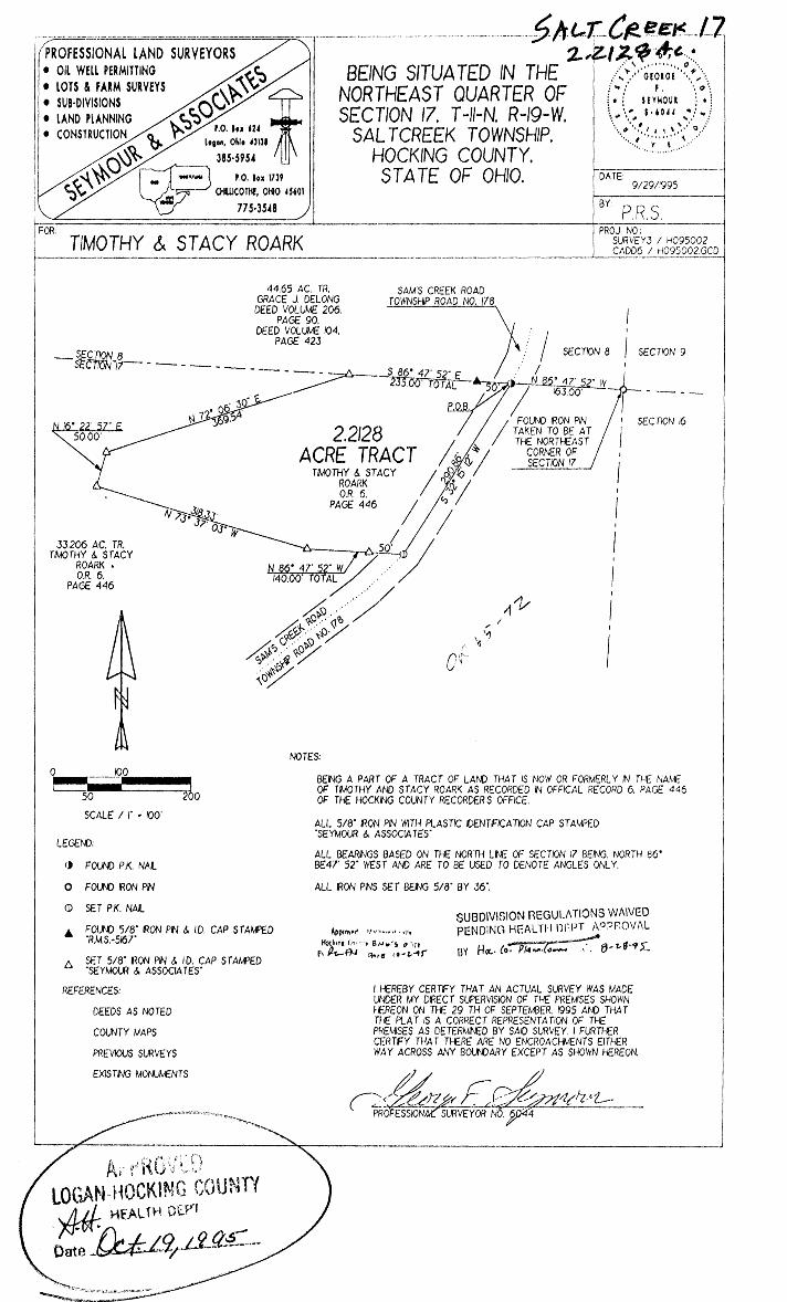
EXHIBIT "A" (2.2128 ACRE TRACT)
Being a part of a tract of land that is now or formerly in the name of Timothy and Stacy Roark as recorded in Official Record 6, Page 446 of the Hocking County Recorder's Office, said tract being situated in the northeast quarter of Section 17, T-11-N, R-19-W, Saltcreek Township, Hocking County, State of Ohio and being more particularly described as follows:
Beginning for reference on a found iron pin, taken to be at the northeast ~Iter of Section 17;
CoR "'e-~
Thence along the north line of Section .17, North 86. 47' 52" West a distance of 163.00 feet to a P.K. nail found in the center of Sam's Creek Road (Township Road No. 178) and the principal place of beginning of the tract herein described;
Thence leaving the north line of Section 17 and along the center of Sam's Creek Road, South 32• 15' 12" West a distance of 290.86 feet to a P.K. nail set;
Thence leaving the center of Sam's Creek Road and with a line through the grantor's p~operty the following four (4) courses: (1] North 86. 47' 52" West, passing a 5/8" iron pin with a
plastic identification cap set at 50.00 feet, going a total distance of 140.00 feet to a 5/8" iron pin with a plastic identification cap set,
[2] North 73• 37' 03" West a distance of 318.33 ·feet to a 5/8" iron pin with a plastic identification cap set,
[3] North 16• 22' 57" East a distance of 50.00 feet to a 5/8" iron pin with a plastic identification cap set, and;
[4] North 12· 06 1 30" East a distance of 369.54 feet to a 5/8" iron pin with a plastic identification cap set, being on the north line of Section 17;
1rhence along the north 1 ine of Sect ion 1 7, Sou th 8 6 • 4 7 ' 5 2" East, passing a 5/8" iron pin with a plastic identification cap found (stamped R.M.S.-5167) at 185.00 feet, going a total distance of 235.00 feet to the principal place of beginning containing 2.2128 acres more or less and being subject to the right of way of Sam's Creek Road (Township Road No. 178) and all other easements of record.
All 5/8" iron pins with plastic identification caps set are stamped "Sey.mour & Associates".
The bearings used in the above described tract were based on the north line of Section 17 being, North 86. 47' 52" West and are fo~ the determination of angles only.
The above described tract was surveyed by George F. Seymour, Ohio Professional Surveyor No. 6044, September 29, 1995.
~ • Mat~ematically Hoc~ng Cou1'ty Engineer's office
By ~ 'FN Da~r- I0~.~-4f SUBD\VlSlON REGULATlONS WA\\/ED PEND\NG HEALTH DEPT. APPROVAL
BY H«.· fO, '"-' (.,....... _OATE 8- ~-9,)
-~'-~-~~ O"'X. SS, Qc.-,.A<..J.,.
0 10.:::::»
~:~(_~N--S~ l "-::S.:::i-')
Q __ =---~~-~·-:~--G>~)-v_.;/~' ~-- • ~ '•@' ,. ,-
5='~~=~.::-~~ ,, -·_ :·_> ·: ,;:_:~-· .-· ,, •. '. )
- ·-~~-;'.5:>~~-::S:~ - --
... -- -- ·- "'"/.::i';)L-~. ·:·.~-»~(~ .. · .. ~~. ~. . ·1 ~-~/r:S?~'i-l;C_-~C*-~
/\.,··~ ·'' .· ... " . •. ·--~.)::!\ ~5.~~ . .

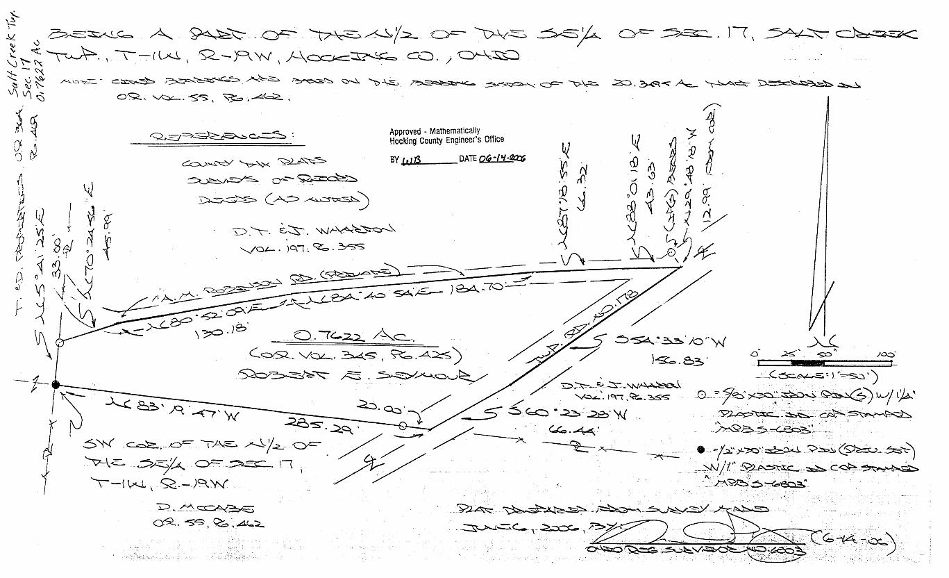
DESCRIPTION OF 0. 7622 ACRE TRACT
Being the tract of land transferred to Robert E. Seymour in Vol. 345, Pg. 425, Hocking Co. Official Records, situated in the N Y2 of the SE 1/4 of Sec. 17, Salt Creek Twp., T-1 IN, R-19W, Hocking Co., Ohio, and being more particularly described as follows:
Beginning at an iron pin previously set on the SW corner of the N Yi of the SE 114 of Sec. 17;
Thence, with the west line of said N Yi, N 5 degrees 41' 25" Ea distance of 33.00 ft. to an iron pin set;
Thence N 70 degrees 24' 56" Ea distance of 45.99 ft. to a point in the center of a private roadway known as the "A.M. Robinson Road";
Thence with the centerline of said roadway the following four (4) courses: 1) N 80 degrees 52' 09" Ea distance of 130.18 ft. to a point; 2) N 84 degrees 40' 54" E a distance of 184. 70 ft. to a point; 3) N 87 degrees 18' 55" Ea distance of 66.32 ft. to a point; 4) N 88 degrees 01' 18" Ea distance of 43.63 ft. to a point in the center of
Twp. Rd. 178, said point being referenced by an iron pin set which bears N 29 degrees 48' 18" W a distance of 12.99 ft,;
Thence with the centerline of said Twp. road the following two (2) courses: 1) S 54 degrees 33' 10" W a distance of 156.83 ft. to a point; 2) S 60 degrees 23' 28" W a distance of 66.44 ft. to a point on the south line
of the N Yi of the SE 114; Thence, with said south line, N 83 degrees 19' 47" W, passing an iron pin set at 20.00
ft., going a total distance of285.29 ft. to the place of beginning, containing 0.7622 acre, more or less, and being subject to the right-of-way of Twp. Rd. 178 and all valid easements.
Cited bearings are based on the bearing system of the 20.3495 Ac. tract described in O.R. Vol. 55, Pg. 462.
All iron pins described as being set are 5/8" X 30" with a 1 W' plastic l.D. cap stamped "M.P.B. S-6803".
All iron pins described as being previously set are W' X 30" with a I" plastic I.D. cap stamped "M.P.B. S-6803''.
The above description is the result of an actual survey made by Michael P. Berry, Ohio Registered Surveyor No. 6803, on June 6, 2006.
Approved . Mathematically Hocking county Engineer's Office
SY t.Ufl DATe <;A-l'i.-~

Q" 71_76AC TR_ Q CX)j(J)
ROY & JESSIE FEE ~f!! z•z l.,t...:.._ ~1~ DEED VOLUME 1 94. I~ • t- I-
@-- SECJ_}_2_~~ -~2'.:~~P~AG;E~8r5-7-u8~6~0'ir,.....~~§::__o~~~~-'~~~~'7'83"~~~_2.:~~~.2.::.~~~~~~~~~l-DL~~/·'~~~~/·~ , 1244 93· ii~ N W ,1,.. 1-..7 \ SECTION 17 Y
257-~3 • 165.71' \ 1347_55· TOTAL TO P_o_s. ,lf'; P 0 B 783.95' ~J
· · · \ ' .' . SE CT I ON g \ 235.oo· ~ z 0 N ~ •O
N _. N
- '-1 (J1 _.
--..J -
0
(/)
0 VJ N Ol • ID N - N 0 -~(.)1
- '-1
5.031 ACRE TRACT
-z_ ~ _> cP ~---.l
°' ())_ ~
\ I -SECTION-15---\ , \ / \ 2. 21 AC. TR. / \ l!J-- DAV I D M I LL I GAN FOUND IRON \ t OFFICIAL RECORD 192, \ ~- PAGE 773
LOCATED ON THE NORTHEAST CORNER
SECTION 17 z'z \ \ \ \ \ \ \ I \ \
7.83 AC. TR. DAV I D M I LL I GAN
OFFICIAL RECORD 192, PAGE 775
'--.-,~~.~~~~~~~~1~
---~----7l- ,/ 0 0 ,/ ,/ w w
/ / (/) (/) ,,,,,,. .... "' ///
,,,,,."'-' ,//
,,," ,,.,,,,,,,.'
LEGEND: ,/ _/ 0 FOUND 5/8" IRON PIN
~ FOUND IRON SPIKE (RAILROAD SPIKE)
0 ~-~ ~ FOUND 5/8" IRON PIN & 1 1/4" I .D. CAP STAMPED ,.SEYMOUR & ASSOCIATES"
su1L£ < ©--\ .l ____ _ ------ rw/ RoAD ____ £ 1 _ ~-----/
GAR~. r• ;; ~~;:;~~~~~~~~~~~~------1 !_+-----~- __ J~3-q(-1--;~~~~~~~~~~~--~/--/ . 7 - -. -,/',,,,.,-'/>
FOUND 5/8" IRON PIN & 1 1/4" I .D. CAP STAMPED "R.M.S.-5167"
FOUND 5/8" IRON PIN & 1 1/4" I .D. CAP STAMPED "SHARRETT-8019"
OFFICIAL RECORD 17. ----"""-'--~ -• .1 a t ~p.-PAGE 779 / ---- ---------------------- // -' POINT
f.> / NUMBER DIRECTION DISTANCE ~ / S 02" 38' 58" E 127. 90. * ~· ~~- // 7 · 15 AC· TR·
~ A< '\; T I M & B I LL I E ROARK S 71 "38'52" W 19.94' c,·.._;>~ / OFFICIAL RECORD 46, S 74"42'31" W 45.67' ~~<:,,c_,OC?>v, / "'"'<v' ~ ~ / PAGE 802 s 84"33'13" w 45.06' ~~~~~
2 3 4 5 N 88"47'00" W 121.99' ~'?[,_<..' 6 N 83" 38' 33" W 66 . 51 ' ~~~ 0
-7~~--N~7-7-·-29~·2-o~ .. -w---t-2-o-.-1-2~·--j
* DENOTES TOTAL DISTANCE
NOTES: BEING A TRACT OF LAND THAT IS NOW OR FORMERLY IN THE NAME OF TIMOTHY ANO STACY ROARK AS RECORDED IN OFFICIAL RECORD 227, PAGE 122 OF THE HOCKING COUNTY RECORDER'S OFFICE.
BEING A PART OF TAX PARCEL 150002450200_
ALL SET 5/8" IRON PINS WITH 1 1/4" PLASTIC IDENTIFICATION CAPS ARE STAMPED "SHARRETT-8019".
ALL BEARINGS BASED ON THE NORTH LINE OF SECTION 17 BEING NORTH 86" 47' 52" WEST AND ARE TO BE USED TO DENOTE ANGLES ONLY.
ALL IRON PINS SET BEING 5/8" BY 32".
ALL OFFSET IRON PINS BEING SET AT A DISTANCE OF 50.00 FEET UNLESS OTHERWISE INDICATED.
SET IRON SPIKE (5/8" X 12" IRON PIN)
A SET 5/8" IRON PIN WITH A 1 1/4" I .D. CAP STAMPED "SHARRETT-8019"
REFERENCES:
DEEDS AS NOTED
COUNTY MAPS
PREVIOUS SURVEYS
EXISTING MONUMENTS
Approved - Mathematically . Hocking County Engineer's Office
BY C vJ DATE 11-~l·aS-
200 0 200 • II II I Scale: 1" 200'
I HEREBY CERTIFY THAT AN ACTUAL SURVEY WAS MADE UNDER MY DIRECT SUPERVISION OF THE PREMISES SHOWN HEREON ON THE 15th DAY OF NOVEMBER. 2005 AND THAT THE PLAT IS A CORRECT REPRESENTATION OF THE PREMISES AS DETERMINED BY SAID SURVEY_ I FURTHER CERTIFY TH TH RE ARE NO ENCROACHMENTS EITHER WAY ACRO A Y our9A EXCEPT ,f\S SHOWN.
I ~ Yi
PAUL SHARRETT PROFESSIONAL SURVEYOR NO. 8019
,,= 0 I :::0 ()1
I 0
--1 ()1
~ -0 0 --1 :;u
I (/)
-< :;:o 0 )> :::0 7'
/p 9 -·+

EXHIBIT "A" (5.031 ACRE TRACT)
Being a part of a tract of land that is now or formerly.in the name of Timothy and Stacy Roark as recorded in Official Record 227, Page 122 of the Hocking County Recorder's Office, said tract being situated in the northeast quarter of Section 17, T-11-N, R-19-W, Saltcreek Township, Hocking County, State of Ohio and being more particularly described as follows: ·
Beginning for reference on a found 5/8" iron pin located on the northeast corner of Section 17;
Thence along the north line of Section 17, North 86° 47' 52" West, passing a iron spike found (railroad spike) in the center of Sam's Creek Road (Township Road 178) at 163.00 feet, passing a 5/8" iron pin with a 1 Y." plastic identification cap found stamped "SEYMOUR & ASSOCIATES" at 398.00 feet, passing a 5/8" iron pin with a 1 Y." plastic identification cap found stamped "SHARRETT-8019" at 1181.95 feet, going a total distance of 1347.66 feet to a 5/8" iron pin with a 1 Y." plastic identification cap set being the principal place of beginning of the tract herein described;
Thence leaving the north line of Section 17 and with a line through the grantor's property the following three (3) courses:
1. South 02° 22' 57" East a distance of 369.04 feet to a 5/8" iron pin with a 1 Y." plastic identification cap set,
· 2. South 36° 16' 39" East a distance of 298.45 feet to a 5/8" iron pin with a 1 Y." plastic identification cap set, and;
· 3. South 02° 38' 58" East, passing a 5/8" iron pin with a 1 Y." plastic identification cap set at 77.90 feet, going a total distance of 127.90 feet to a iron spike set (5/8" X12" iron pin) in Butler Road (Township Road 196A);
Thence along the roadway of Butler Road the following six (6) courses: 1. South 71° 38' 52" West a distance of 19.94 feet to a point, 2. South 74" 42' 31" West a distance of 45.67 feet to a point, 3. South 84 ° 33' 13" West a distance of 45.06 feet to a point, 4. North 88° 47' 00" West a distance of 121.99 feet to a point, 5. North 83° 38' 33" West a distance of 66.51 feet to a point, and; 6. North 77° 29' 20" West a distance of 20.12 feet to a iron sr:>ike set;
Thence leaving the roadway of Butler Road and with a line through the grantor's property the following two (2) courses:
1. North 18° 52' 47" West, passing a 5/8" iron pin with a 1 W' plastic · identification cap set at 50.00 feet, going a total distance of 378.76 feet to a 518" iron pin with a 1 Y." plastic identification cap set, and;
2. North 02° 22' 57" West a distance of 401.71 feet to~ 5/8" iron pin with a 1 %" plastic identification cap set on the north line of Section 17;
Thence along the north line of Section 17, South 86° 47' 52" East a distance of 257.35 feet to the principal place of beginning, containing 5.031 acres more or less and being subject to the right of way of Butler Road (Township Road 196A) and all other legal easement of record.
Being a part of Tax Parcel 150002450200.
All 5/8" iron pins with 1 %" plastic ide·ntification caps set are stamped "SHARRETT-801911. '
All iron pins set being 5/8" by 32".
All bearings based on the no'rth line of Section 17 being, North 86° 47.~~~~/'<4~ are to be used to denote angles only, ~fl\~~ 00oOOO•o 0?1t/, ~,.,,,,,,..
~ ~ 000 GO• 0 ~ . s 000 ••• ~ The above described tract was surveyed by Paul R. Sharre , OhiC PrbfeS~rowan \ ~
,., --- QI • -
Surveyor No. 8019, November 15, 2005. · : ~ i s-sorn : er::: .. ~°' ·O-
Approved - Mathematically Hocking County Engineer's Office
BY (0) DATE !!:~~-_r.}S
~(t / ... ): 2 ~ •• ~ :0 •• <q .....
,, & ··~G/STEI'~"(':;'\ $ ".;: &1i ~ ••••••• ·c~< v /1,,,, ONAL. v ,,,,-r '''111111111111

52.00 re. 1R. J llE) & C»JE.VA IEIT.IllEl 215-6~
S 79° 1•1' 35" E J/6 f.Q' 1UfAL
UNIEfilJNE CF BU'Q( lU'\D ('lWP mm 00. 1~)
N 10° 39' 12" E 1 l59.al' -
N 00° 55' 17" E 200.43'
131.6'• re. m. N 78° (15' /~II E '{3.fh' AllH{f & ocrumrr KAiflml
112-515
N 85° (15' 59" E 153.86'
l N 61° 24' 30" E
93.65'
i'rN 51° C15' 35" E
,.,
r
Wt.81'
N 54° 21 ' ce11 E 13't.li2'
N 57° 58' 11" E pf 1(5.78'
N 59° IS' 15" E 113.60'
S 79° .47'. 35" E -.1097 .29 1
N 5"1° '5' 51" E 116.62'
50.626 ACHE TRACT
11.289 ACRES 39.337 ACRES
120'
150.00'
32.36 re. m . .l\UElT & [.CUJHUY KAfS.tfll
~-: 112-515
s 10° 01' 59" w 18'{6.33' 'IOfAL
110.2(/j re. 'IR. DAVID & lXHlIE Kl\IG.INER lJ(-151
s-E <XJml CF 'llIE N-W ClJARl'ER
P.O.B.
~·:"
i: ~ SLT!adllli N 79° 55' 19" W Vlt?h.85' oo.oo re. m.
Jlll'fil Ml\II.IJE,Y 107-451
PROPERTY PLAT
PLAT DRAWING OF A 50.626 ACRE TRACT, SITUATED IN THE NORTHWEST QUARTER OF SECTION 17, T-11-N, R-19-W, SALTCREEK TOWNSHIP, HOCKING COUNTY, STATE OF OHIO.
WlE
IE.llU A rmm.N CF A 131 .6't fCRE TR/Cf' fIDffiUY CF AIHm E. AID IXJUmIY L. KAiflffR, /IS .IE . .INE/HID lN VOCLffi 112, Ptra 515 CF TIIE l.(Q(JOO Cll.NlY REX:XIllffi a<Fim. ML :um PINS mr ffillU }"BY 36" wrm 3JRVEY<R3 I.D. CAP. ML f£AllilG3 ~ CN M/\GJEI'IC OCffiH .l\ID ME ID. IE lilD ID OOUlE AfllES rnLY. 'llIE AWJE LISlID DEED IffEmUS AID f«UID PL/\T ~ LGD flS A Bt\5IS Fm CJIBRYOO OJf 'llIE \-0«.
BASED ON A ACTUAL SURVEY OF THE PREMISES IN MAY 1992, UNDER THE DIRECT SUPERVISION OF RONAW M. SHARRETT P.S. 5167.
LEGEND
C FOUND STONE MONUMENT O SET IRON PIN WITH
I.D. CAP '.\ SET IRON SPIKE IN
£. ROADWAY • POINT IN ROADWAY
Approved· Mathematically H~..,County Engineer's office
By F-N Date-5_~-4(Z...--

5/21/1992
R. M. SHARRETT & ASSOCIATES
LEGAL DESbRIPTION
50.626 ACRE TRACT Being situated in the northwest quarter of Section 17, T-11-N, R-19-W,
Saltcreek Township, Hocking County, State of Ohio and being more particularly described as follows;
PLl\CE OF BEGINNING of this survey, being at a found stone, located at the southeast corner of the northwest quarter of Section 17;
Thence, with the southline of the northwest quarter, North 79° 55' 19" West, a distance of 1486.65 feet to a set iron pin, being at the southeast corner of a 52.00 acre tract, property of James and Geneva Hettinger, Volume 215, Page 690;
thence, leaving the southline of the northwest quarter and with the eastline of the 52.00 acre tract, North 10° 39' 12" East, a distance of 1159.20 feet to a set iron pin; '
thence, leaving the eastline of the 52.00 acre tract and with a line through the property, which this survey is a part of, South 79° 47' 35" East, a distance of 376.82 feet to a set iron spike, being in the centerline of Black Road (Township Road No. 196), passing a set iron pin at 276.82 feet;
thence, with the centerline of Black Road, the following twelve (12) courses and distances, North 54° 25' 51" East, a distance of 116.62 feet to a point;
thence, North 59° 48' 15" East, a distance of 113.60 feet to a point; thence, North 57° 58' 11" East, a distance of 125.78 feet to a point; thence, North 54° 21' 02" East, a distance of 134.42 feet to a point; thence, North 51° 05' 35" East, a distance of 84.81 feet to a point; thence, North 65° 05' 59" East, a distance of 153.86 feet to a point; thence, North 61° 24' 30" East, a distance of 98.65 feet to a point; thence, North 67° 56' 11'' East, a distance'of 72.57 feet to a point; thence, North 78° 05' 48" East, a distance of 73.66 feet to a point; thence, North 80° 55' 17" East, a distance of 200.43 feet to a point; thence, North 88° 49' 09" East, a distance of 120.13 feet to a point; thence, North 86° 06' 52" East, a distance of '+7 .12 feet to a set iron
spike, being on the eastline of the northwest quarter of Section 17; thence, leaving the centerline of Black Road and with the eastline of the
northwest quarter, South 10° 01' 59" West, a distance of 1876.33 feet to the PLACE OF BEGINNING, containing 50.626 acres more or less, passing set iron pins at 30.00 feet, 150.00 feet, 570.50 feet and 720.50 feet, being subject to all legal easements and right-of-ways.
Being a portion of a 131.64 acre tract, property of Albert E. and Dorathy L. Karshner, as delineated in Volume 112. Page 515 of the Hocking County Recorders Office.
All Jron pins ~-E2t bein.g_J_~:·_py._39~' ,tiJth_surv~_yq_r~ I_.p. c~p. All bearings based on Magnetic North and are to be used to denote angles
only.
Based on a actual survey of the premises in May 1992, under the direct supervision of Ronald M. Sharrett p.s. 5167.
Approved • Mathematically Htg County Engineer's office
By ftY Data £'-"Yf-9Z-

7 40-385-4349
PLAT OF SURVEY ,,.0•11~
'Be:1r-JG F\- PAR.I cir s~cr10") ;7, r- 11- 1-J / P- -1 er- '"-1, 0 i:H .. -r c..12.c12:~ To<-VAJ -~41P, t-ID~k'.JrJ£~ C!ovNIY1 .Sn11c oC.
61, .. uo.
PROJ. No.: ~ I 1q1 \ BY: c.T.J. DATE: 1-18-'iC;
SC.A L.6 J •: l..60 I
~ C>TE.. ·, ~t:: Ae.uJ6 ~ L>J~'Q.IC cc12.1 ,, ct:. F~o M (Y\(' >-) \) M. 'T•, ;=·our-JO oµ rt/G
61'\;':,T Ll>J6 C>~ '5~C.TIC0 If ,A~ .S J/ 0 1-7 1 0"?:/',;..J f1.,..;0 Arl.E fuf:'. Z.00
t 2.o. '3 B '
·;. ___ N 11" 51' 31 '' C II..~ .60' •t
" I ~~ I/} I \j 1' rl
I> f.. "' ' I <> • C> .. • ' ;:; i .~ 1 . i··-"' 1 D z..1,, ~o c, 1Jt,,. 10 (j .., ""
~ ~
\to.oz\-\
;! I -L---~14"o"'4T'E. c.1.44'
6 - :S/5··~~0" £'(2.ou Pi~ 1..v/LO c..AP •'..se-YMovR.,l-A~.soc..''~c;T
• - e'/...I !:>TIA.JC. .:r:l<.o,J Pll'..l
©1998 SEYMOUR & ASSOCIATES
Approved · Mathematically Hocking County Engineer's Office
BY f ,#-!/u _DATE__? --Z-:'f '(
l/() (.,,6</<i
7

EXHIBIT "A"
Being part of the tract of land that is now or formerly in the name of Robert Smith and James Meadows as recorded in Official Record 22 at page 455, Hocking County Recorder's Office, said tract being part of Section 17, Tl1N, R19W, Salt Creek Township, Hocking County, State of Ohio, and being more particularly described as follows:
Beginning at a 5/8" X 30" iron pin with a plastic identification cap set on the southeast corner of Section 17 and the grantor's southeast corner;
Thence along the south line of Section 17 and the grantor's south line, North 79 degrees 11 minutes 00 seconds West, passing through a 5/811 X 30" iron pin with a plastic identification cap set at 1344.75 feet, going a total distance of 1374.75 feet to a point in the center of Township Road 179 and the grantor's corner;
Thence along the center of said road the following five courses: 1. North 14 degrees 09 minutes 47 seconds East a distance of 61.44 feet to a point; 2. North 10 degrees 26 minutes 38 seconds East a distance of 66.10 feet to a point; 3. NorthJ 1 degrees 51 minutes 37 seconds East a distance of 163.00 feet to a point; 4. North 20 degrees 48 minutes 23 seconds East a distance of 120.38 feet to a point, and; 5. North 26 degrees 17 minutes 32 seconds East a distance of 99.38 feet to a point being the
grantor's north line;
Thence leaving the center of said road and along the grantor's north line, South 79 degrees 53 minutes 02 seconds East, passing through a 5/8" X 30" iron pin with a plastic identification cap set at 30.00 feet, going a total distance of 1325.57 feet to an iron pin found on the grantor's northeast corner and the east line of Section 17;
Thence along the grantor's east line and the east line of Section 17, South 11 degrees 17 minutes 03 seconds West a distance of 520.96 feet to the point of beginning, containing 16.041 acres, more or less, and subject to the right-of-way of Township Road 179 and all easements of record.
All 5/8" X 30" iron pins with plastic identification caps set are stamped "Seymour & Associates".
The bearings used in the above described tract were based on the east line of Section l 7 as bearing South 11 degrees 17 minutes 03 seconds West and are for the determination of angles
only.
The above described tract was surveyed by George F. Seymour, Ohio Professional Surveyor No. 6044, January 28, 1999.
Approved - Matliernatically Hocking County Engineer's Ottice
BY~ DATE 2-..Z-o'f. f

.DATE
DATE
f,,
v
SUBJECT. ....................... .
····································································· ··········································
JUL 3 0 1973 C\ /' l<i "l
OF.
JOB NO ............................................... .
··································································)']·
/'':,/ol>I
1·2 \:; ·73

BY..: ...................... DATE .... . SUBJECT ............................................................................. .
C~KD. BY ......... DATE ......... .
........................................................................ . .......................................................................................... , .. , ....... . f
C~,-6..1--\ f·-t"' ._ <.::76/lcJlr/ )J&rcY
Oflfl~oueof lffi~~ !4fu <;,®_ '411 Y.,
f:l!t[tltl#tRSs Qf!~~E LOGAN, OHIO 1~\3Jt<
JllL301973-
{fi. G-,
SHEET NO .. .. .... OF ..
JOB NO .............................. .

i P.S.PS i SURVEYING
(7 40) 775-.3548
SITUATED IN THE NORTHEAST QUARTER OF SECTION 17. T-1 1-N. R-19-W. SALTCREEK TOWNSHIP.
HOCKIHNG COUNTY. P.O. BOX 1739 CHILLICOTHE. OHIO 45601 ST A TE OF OHIO. DRAWN DATE
PR.S. 2-24-01 FILENAME: SURVEY3 I H00/03 CADD6 I H00/03.GCD
FOR: TIMOTHY W. AND ST ACY L. ROARK
0
76.65 AC. TR. ROY 6. ..!':SSE FEE DEED VOLUME 194. PAGE 857 • 860
SECTION 8 - SECTlON 17- - - - -L.
n£ RED BARN FOl..NJA TION OFFJCJAL RECORD 182.
PAGE I 19
200
SCALE I r - 200'
400
7.829 ACRE TRACT
REFERENCES:
DEEDS AS NOTED
COUNTY MAPS
PREVIOUS SURVEYS
EXISTING MONUMENTS
A B c D E
NOTES:
BEING A PART OF A TRACT OF LAND THAT IS NOW OR FORMERLY IN THE NAME OF THE RED BARN FOUNDATION AS RECORDED IN OFFICIAL RECORED 182. PAGE I 19 OF THE HOCKING COUNTY RECORDERS OFFICE.
ALL SET 5/8" IRON PINS WITH PLASTIC /DENT/FICA TION CAPS ARE ST AMPED "SHARRETT-8019".
ALL BEARINGS BASED ON THE NORTH LINE OF SECTION 17 BEING. SOUTH 86' 47' 52" EAST AND ARE TO BE USED TO DENOTE ANGLES ONLY.
ALL IRON PINS SET BEiNG 5/8" BY 32".
ALL OFFSET IRON PINS BEING SET AT A DISTANCE OF 50.00 FEET UNLESS OTHERWISE IND/CA TED.
BEING A PART OF AUDITORS TAX PARCEL ___ _
44.65 AC. TR GRA C£ DEl..ONG
DEED 'IOU...!£ 206.
N N s s s
PAGE 90
BEARING DISTANCE 56' 74' 85' 7 3. 7 I '
38' 36" w 49.72' 26' 54· w 47.83' 07' 45· w 48. 77. 29' 38" w 50.04' 38' 52" w 78.37'
LEGEND:
A FOUND 5/8" IRON PIN & l.D. CAP ST AMPED "SEYMOUR & ASSOC/A TES"
0 FOUND 5/8" IRON PIN
~ FOUND RAILROAD SPIKE
• POINT
0 SET IRON SPIKE (60 PENNY NAIL!
<D SET PK. NAIL
L. SET 5/8" IRON PIN & ID. CAP ST AMPED "SHARRETT-8019"
I HEREBY CERTIFY THAT AN ACTUAL SURVEY WAS MADE UNDER MY DIRECT SUPERVISION OF THE PREMISES SHOWN HEREON ON THE 24th DAY OF FEBRUARY. 2001 AND THAT THE PLAT IS A CORRECT REPRESENTATION OF THE PREMISES AS DETERNIMED BY SAID SURVEY. I FURTHER CERTIFY THAT THERE ARE NO ENCROACHMENTS EITHER WAY ACROSS ANY BOUNDARY EXCEPT AS SHOWN
,,,&,k

-~
\
EXHIBIT 11N (7 .829 ACRE TRACT)
Being a part of a tract of land that is now or formerly in the name of The Red Barn Foundation as recorded in Official Record 182, Page 119 of the Hocking County Recorder's Office, said tract being situated in the northeast quarter of Section l 7, T-11-N, R-19-W, Saltcreek Township, Hocking County, State of Ohio and being more particularly described as follows:
Beginning for reference on a found 5/8 11 iron pin located on what is taken to be the northeast corner of Section l 7;
Thence along the north line Section 17, North 86° 47' 52 11 West a distance of 163.00 feet to a railroad spike found in the center of Sam's Creek Road (Township Road l 78);
Thence leaving the north line of Section l 7 and along the center of Sam's Creek Road, South 35° 151 12 11 West a distance of 290.86 feet to a P.K. nail set being the principal place of beginning of the tract herein described;
Thence continuing along the center of Sam's Creek Road the following four (4) courses: l. South 46° 001 45 11 West a distance of 78.01 feet to a point, 2. South 54 ° 40' 09 11 West a distance of l 00.39 feet to a point, 3. South 50° 39 1 36 11 West a distance of 97.90 feet to a point, and; 4. South 46° 20' 14" West a distance of 286.83 feet to a P.K. nail set at the
intersection of the center line of Butler Road (Township Road l 96A) and Sam's Creek Road (Township Road l 78);
Thence along the center of Butler Road the following five (5) courses: l. North 56 ° 38' 36" West a distance of 49 .72 feet to a point, 2. North 74° 26' 54" West a distance of 47.83 feet to a point, 3. South 85° 07' 45" West a distance of 48.77 feet to a point,
4. South 73° 29' 38 11 West a distance of 50.04 feet to a point, and; 5. South 71 ° 38' 52" West a distance of 78.37 feet to a iron spike set (60 penny
nail);
Thence leaving the center of Butler Road and with a line through the grantor's property the following three (3) courses:
l. North 02° 40' 35 11 West, passing a 5/8" iron pin with a plastic identification cap set at 50.00 feet, going a total distance of 142 .21 feet to a 5/8 11 iron pin with a plastic identification cap set,
2. North 4 1 ° 201 1 9 11 West a distance of 13 7 .82 feet to a 5/8" iron pin with a plastic identification cap set, and;
3. North l l 0 04' 23" West a distance of 440.77 feet to a 5/8 11 iron pin with a plastic identification cap set on the north line of Section 1 7;
Thence along the north line of Section 17, South 86° 47' 52" East a distance of 783.95 feet to a 5/8" iron pin with a plastic identification cap found stamped "SEYMOUR & ASSOCIATES", said iron pin being on the northerly line of a 2.2128 acre tract, Official Record 65, Page 72;
Thence leaving the north line of Section l 7 and along the property line of the 2 .2128 acre tract the following four (4) courses:
l . South 72 ° 06' 30 11 West a distance of 369 .54 feet to a 5/8" iron pin with a plastic identification cap found stamped "SEYMOUR & ASSOCIATES",
[continued on page 2]
Page 1 of 2

EXHIBIT "A"
2. South 16° 22 1 57" West a distance of 50.00 feet to a 5/8 11 iron pin with a plastic identification cap found stamped "SEYMOUR & ASSOCIATES",
3. South 73° 37' 03 11 East a distance of 318.33 feet to a 5/8 11 iron pin with a plastic identification cap found stamped "SEYMOUR & ASSOCIATES", and;
4. South 86 ° 4 T 52 11 East, passing a 5/8 11 iron pin with a plastic identification cap found stamped "SEYMOUR & ASSOCIATES 1
' at 90.00 feet, going a total distance of 140.00 feet to the principal place of beginning, containing 7.829 acres more or less and being subject to the right of way of Sam's Creek Road (Township Road l 78) and Butler Road (Township Road l 96A) and all other easements of record.
Being a part of Auditors Tax Parcel ________ _
All 5/8 11 iron pins with plastic identification caps set are stamped 11SHARRETT-8019 11•
All iron pins set being 5/8 11 by 32 11•
The bearings based on the north line of Section l 7 being, South 86 ° 4 7' 52 11 East and are to be used to denote angles only.
The above described tract was surveyed by Paul R. Sharrett, Ohio Professional Surveyor No. 8019, February 24, 2001 .
....I '~ ·~ ~·, 1, j :..: I I.,:.~• '
Page 2 of 2

.~.~~~
o-Q.. -SS, Qc,, .A<-~
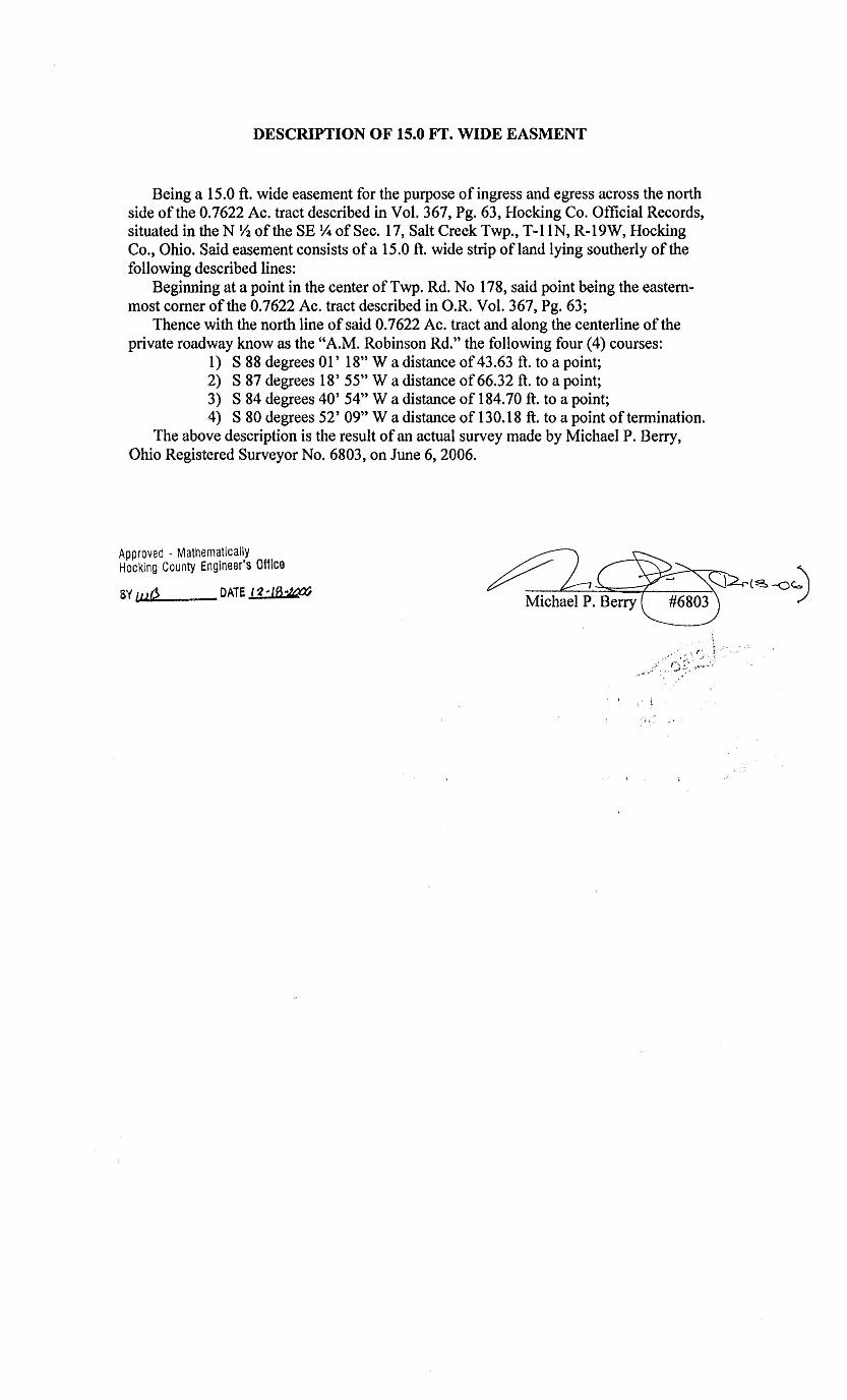
DESCRIPTION OF 15.0 Ff. WIDE EASMENT
Being a 15.0 ft. wide easement for the purpose of ingress and egress across the north side of the 0.7622 Ac. tract described in Vol. 367, Pg. 63, Hocking Co. Official Records, situated in the N Y2 of the SE Y4 of Sec. 17, Salt Creek Twp., T-1 IN, R-19W, Hocking Co., Ohio. Said easement consists of a 15.0 ft. wide strip ofland lying southerly of the following described lines:
Beginning at a point in the center of Twp. Rd. No 178, said point being the easternmost comer of the 0.7622 Ac. tract described in O.R. Vol. 367, Pg. 63;
Thence with the north line of said 0.7622 Ac. tract and along the centerline of the private roadway know as the "A.M. Robinson Rd." the following four (4) courses:
1) S 88 degrees 01' 18" W a distance of 43.63 ft. to a point; 2) S 87 degrees 18' 55" W a distance of 66.32 ft. to a point; 3) S 84 degrees 40' 54'' W a distance of 184.70 ft. to a point; 4) S 80 degrees 52' 09" W a distance of 130.18 ft. to a point of termination.
The above description is the result of an actual survey made by Michael P. Berry, Ohio Registered Surveyor No. 6803, on June 6, 2006.
Approved - Mathematically Hocking County Engineer's Office
6Y tut'? DATE l~-18~
. I
\ 1':

~-1· I I
lr;JJ-lJTl t S 86° 47' 52" E 2687 .91 • -t .,.._.,_ < I y
I I
I
~!~/ ---52.00'
N 81° 00' 00" W 75. 76' '1Ul"AL
33.206 ACRE TRACT
P R 0 P E R T Y P L A T N 74° 33' 42" W 101.72'
PLAT DRAWING OF A 33.206 ACRE TRACT, A 60.00 FOOT INGRESS & EGRESS N Tl0 29' 19" W EASoo:NT FOR GRANTOR AND A 25.00 FOOT WATER EASEliENT FOR GRANTOR, 84.19' ALL BEING SITUATED IN THE NORTH-HALF OF NORTH-HALF Ol" SECTION 17, N 83<' 38' 33" W T-11-N, R-19-W, SALTCREEK TOWNSHIP, HOCKING COUNTY, STATE OF OHIO. 66.51'
N 0 T E BEING A PORTION OF A 81 .01 ACRE TRACT, PROPERTY OF ALBERT E. AND DOROTHY KARSHNER, AS DELINEATED IN VOLUME 112, PAGE 515 OF THE HOCKING COUNTY RECORDERS OFFICE. ALL IRON PINS SET BEING !" BY 36". WITH SURVEYORS I.D. CAP. ALL BEARINGS BASED ON MAGNETIC NORTH AND ARE TO BE USED TO DENOTE ANGLES ONLY. THE ABOVE LISTED DEED REFERENCES AND RECORD PLAT WERE USED AS A BASIS l"OR CARRYING OUT THE WORK.
BASED ON A ACTUAL SURVEY OF THE PREl-iISES IN AUGUST 1992, UNDER THE DIRECT SUPERVISION OF RONAU) M. SHARRETT P.S. 5167.
t I.
N % 0 38' ?h" W l/3.72'
N 74° 26' 54" W 47.83'
S ff.)0 CJl' '6" W 48.77'
s 71° 38' 52" w 256.<£' I
s 74° 42' 31" w . "6.67'
s84" 33' 13" w '6.0l'
I I
,,50_04•
/ N 83" 47' OJ" W
121.99• ~S CREEK ROAD 32.36 AC. KAfGffR 112-514
NJ. -1
2 3 4 5 6 7 8
TR.
ffiARilm DISTNllS S %0 53' 'Cl' E 116.21' S 410 %' 16" E a:;.95• S 3l" 50' 18" E 126.67' s '6° 47' 'Cl' E 236.a)• N 27° 23' 52" W 193~83· N 16° <5' 11" E 93.73• N 83" 55 I OJ" E 178.64' N 63° <5' 00" E 79.48•
Approved • Mathematically ~unty Engineer's office
By llate 6--'JI "'h-
N 85° 47' 52" W 163.00' I
.:/...
s 32" 15' 12" w
'S "iJO 00' 115n w 78.0l'
s 54° I,()' CJ1" w J 100.39•
s SO° 39' ?k>" w 97.<JJ'
S "iJO 2()I 14" W 285.83'
L E G E N D
s 3:AlE
:-1""::21'.n' /(.:: .J.,,e8dcry
\S FOUND IRON PINS
I
8 :;EC •
.2 ,.
/SEC. 16
t
I I
I I
I I
I
l o SET IRON PINS WITH I .D. CAPS j e POINTS
~ SET IRON SPIKES OR P.K.
•

8/11 /1992
33.206 ACRE TRACT
R. M. SHARRETT & ASSOCIATES LEGAL DESCRIPTION
PH.614-775-3548
Being situated in the north-half of the north-half of Section 17, T-11-N, R-19-W, Saltcreek Township, Hocking County, State of Ohio and being more particularly described as follows;
PLACE OF BEGINNING of this survey being at a set P.K. nail, located on the northline of Section 17, P.K. nail being in the centerline of of Sam's Creek Road (Township Road No. 178), P.K. nail bears with the northline of Section 17, North 86° 47' 52" West, a distance of 163.00 feet from a found iron pin, located at the northeast corner of Section 17, P.K. nail also being at the northwest corner of a 1.065 acre tract, property of Rickey and Carl Hart, Volume 222, Page 451;
Thence, leaving the northline of Section 17 and with the centerline of Sam's Creek Road, the following five (5) courses and distances, South 32° 15' 12" West, a distance of 290.86 feet to a point;
thence, South 46° 00' 45" West, a distance of 78.01 feet to a point; thence, South 54° 40' 09" West, a distance of 100.39 feet to a point; thence, South 50° 39' 36 11 West, a distance of 97.90 feet to a point; thence, South 46° 20' 14" West, a distance of 286.83 feet to a set P.K.
nail, being at the intersection of Sam's Creek Road and Butler Road {Township Road No. 196A);
thence, leaving the centerline of Sam's Creek Road and with the centerline of Butler Road the following fourteen (14) courses and distances, North 56° 38" 36" West, a distances of 49.72 feet to a point;
thence, North 74° 26' 54" West, a distance of 47.83 feet to a point; thence, South 85° 07' 45" West, a distance of 48.77 feet to a point; thence, South 73° 29' 38" West, a distance of 50.04 feet to a point; thence, South 71° 38' 52" West, a distance of 256.28 feet to a point; thence, South 74° 42' 31" West, a distance of 45.67 feet to a point; thence, South 84° 33' 13" West, a distance of 45.06 feet to a point; thence, North 88° 47' 00" West, a distance of 121 .99 feet to a point; thence, North 83° 38' 33" West, a distance of 66.51 feet to a point; thence, North 77° 29' 19" West, a distance of 84.19 feet to a point; thence, North 74° 33' 42" West, a distance of 101.72 feet to a point; thence, North 73° 07' 56" West, a distance of 436.69 feet to a point; thence, North 77° 15' 04" West, a distance of 255.02 feet to a point; thence, North 81° 08' 00" West, a distance of 75.76 feet to a set iron
spike; passing a set iron spike at 23.76 feet; thence, leaving the c~nterline of Butler Road and with the following four
(4) courses and distances, through the property, which this survey is a part of, North 45° 47' 41" West, a distance of 197.52 feet to a set iron pin, passing a set iron pin at 50.00 feet;
thence, North 30° 50' 18" West, a distance of 128.02 feet to a set iron , pin ;
thence, North 41° 56' 16" West, a distance of 196.26 feet to a set iron pin, passing a set iron pin at 80.00 feet, being on the southwestline of a 60.00 foot easement;
thence, North 35° 30' 10" West, a distance of 245.81 feet to a set iron pin, being on the northline of Section 17, passing a set iron pin at 82.23 feet, being on the northeast line of a 60.00 foot easement;
thence, with the northline of Section 17~ South 86° 47' 52" East, a distance of 2687.91 feet to the PLACE OF BEGINNING, containing 33.206 acres more or less, passing a set iron pin at 2637.91 feet, being subject to all easements and right-of-ways.
THE ABOVE DESCRIBED 33.206 ACRE TRACT, BEING SUBJECT TO A 60.00 FOOT INGRESS AND EGRESS EASEMENT FOR THE GRANTOR.
LEGAL DESCRIPTION OF THE CENTERLINE OF THE 60.00 FOOT INGRESS AND EGRESS EASEMENT, BEING MORE PARTICULARLY DESCRIBED AS FOLLOWSi
Beginning at a set iron pin, located at the northwest corner of the 33.206 acre tract;
thence, with the westline of the 33.206 acre tract, South 35° 30' 10" East, a distance of 245.81 feet to a set iron pin, being the POINT OF BEGINNING of the centerline of the 60.00 foot ingress and egress easement, passing a set iron pin at 163.57 feet, being on the northeast line of the 60.00 foot ingress and egress easement;
( 1 )

8/11/1992
R. M. SHARRETT & ASSOCIATES LEGAL DESCRIPTION
PH. 614-775-35'•8
thence, leaving the westline of the 33.206 acre tract and with the following four (4) courses and distances through the 33.206 acre tract, South 56° 53' 40" East, a distance of. 116.21 feet to a point;
thence, South 41° 56' 16" East, a distance of 86.95 feet to a point; thence, South 30° 50' 1811 East, a distance of 126.67 feet to a point; thence, South 45° 47' 40" East, a distance of 236.26 feet to a set iron spike
, being in the centerline of Butler Road also being on the southline of the 33.206 acre tract and being the END of the centerline of the 60.00 foot ingress and egress easement;
LEGAL DESCRIPTION OF A CENTERLINE OF A 25.00 FOOT WATERLINE EASEMENT TO A NATURAL SPRING FOR THE GRANTOR.
Beginning at a set iron pin, located at the southwest corner of the 33.206 acre tract, set iron pin being in the centerline of Butler Road;
Thence, leaving the centerline of Butler Road and with the westline of the 33.206 acre tract, North 45° 47' 41" West, a distance of 127.52 feet to a point, being the POINT OF BEGINNING of the centerline of the 25.00 foot waterline easement;
thence, leaving the westline of the 33.206 acre tract and with the following four (4) courses and distances, North 27° 23' 52" West, a distance of 198.88 feet to a point, being in the centerline of a 60.00 foot ingress and egress easement;
thence, North 45° 25' 11'' East, a distance of 93.73 feet to a point; thence, North 88° 55' 00" East, a distance of 178.64 feet to a point; thence, North 63° 25' 00" East, a distance of 79.48 feet to a point of
END of the centerline of the 25.00 foot waterline easement;
Being a portion of a 81 .01 acre tract, property of Albert E. and Dorothy L. Karshner, as delineated in Volume 112, Page 515 of the Hocking County Recorders Office.
All bearings based on Magnetic North and are to be used to denote angles only.
All iron pins set being ~" by 36" with surveyors I.D. cap.
Based on a actual survey of the premises in August 1992, under the direct supervision of Ronald M. Sharrett p.s. 5167.
Approved • Mathematically "tg County Engineer's office r. 6· V-..ft-ByM .. Date~--~
DATE lJ ... //--9.Z
(2)

r:;:;e,; I i7 VISTA SURVEYING SERVICES, INC.
Professional Land surveyors
20525 Buena Vista Road Rockbridge, Ohio 43149 Tele. (614) 969-4101
PLAT OF SURVEY
SITUATED IN THE STATE OF OHIO, COUNTY OF HOCKING, TOWNSHIP OF SALT CREEK AND BEING A PART OF A 47.93 ACRE PARCEL OF LAND LOCATED IN THE SOUTH HALF OF THE SOUTHEASrr QUARTER OF SECTION 17, TOWNSHIP 11, RANGE 19 AS CONVEYED TO WALTER Mee ABE IN DEED VOLUME 142, PAGE 55, ALL RECORDS OF THE RECORDER'S OFFICE, HOCKING COUNTY, OHIO.
£/-l~-:._<¥ ~AM 1:3 CR~~k l- - -- ---- ~ L}AY/.0 <If A4.4/2~§A.I~
.:J~#L/L TZ Ce~O YOL.. /C-~ ;?J'1?. 2'28
~ .. ----- o..<;Jo - - - -I ~ f ~ "" ---- ____ ~~- --- - -- --- <r. .e ~ \. ---f-- --- --- -._:_ ::? ~)
'ti~ ~~ ~~ \j " 'JI ~ ~~
~ ~' ~~
" ~~ H ~~ IJ (/) .,..-;;_ r-r1 c·
I '.7 -
I •'··- co
r ~~ ~ (") ·-w (/)
J: (5 : c~ z I i·:- )J 1 --l rr1 I :::c 'i~ I '··· c::.1 r·--
r· ri );> "Tl -·f --f ~:; .. •
~-? . S:>, :~·~~ :·:;:;. -~-rn ··u (,/) !o ~~~ -::; ~ ;..~~ .,; I~ ~~ ~~ \<:ij '> lil ! i···- CJ
~ ~ -----~:.. \,. (
~ \(\ ~ t\)
\~
\
~ ~
~ 0 l{\
~
~ ~ ?Vif
:J Q° I
,..., :.: :':I~
~~ l ~ ,, ~~ ~
~ ~r ~ if .:;'
~' ~ I
~~ \ ' --
~in ~~ ~ ~" ' \) ~ M ........... ,.-·-t--· " ~t\) ~ ~ () '\) ~ LEGEMO
\
~ '<)
o. ?<:'J a Ad R~S
~ ~
Cl .£ROA./ ;£//A/ 5§ T 6 R'A/LR0.4.0 .:?~)k:'§ r'OL/A/O
~ ~
~ \)
'
~ 0
~ ~
.84/RL/A/ 6LAC~ LJGE/J J/OL. 20?:) .JO~. <!5?
;00/NT Or '3~ t$ /A/ A./ I A/ <fJ
~\V q~t '1 J ./ I 0 I
• I F \i · " ., a. ti i• V" f\·P· ~'-' ~ JV ~'I
1 • I I.I . ~"' , ' q I · 0 i • . !J I 0 ·~~·
~ 10 ~O/NT ~J~. OJ y!J f RE,&'.f"4?ENG'~
~, W, c C/R. 0,$' ..::), t9, Y¢ 0/ ~EcJ. /7., 7-//, £-I~
~o ../ , \ ~/ 531, E <?oo.oo')
\
;;:---.___ ~2 sc-c, ~;(A/~
( ) /A/.OIC4/~5 O~SC/2/,0//0A/ .O/S T/hVC:~
The bearing system for this plat is based on a Plat of Survey by Robert K. Hinton for David D. and Marlene M. Schultz dated August 3, 1977 on file at the Hocking County Engineer's Office, Logan, Ohio.
All iron pins set are 3/4 inch diameter iron pipe with plastic identification caps unless otherwise stated.
0 25 50 /OQ
3310 ~C//LE.: /'~::: ~O'
I hereby certify that this plat was prepared from an actual field survey of the pre mises in September of 1988 and from existing public records and that said plat correctly shows the liJU~&lh. the parcel to be conveyed.
"·-~·o "'®~ ,go_· .,.;.~~:o~. · ~ation was rnad,,e by me on this A/ J ... "fJ. 1.Yd . y of o~ 1 . I 1988.
--~! L \o , : . : i itfi ~ CA· [ : " :
• ·!> i!Jl q: : •, ~ ·u ~"' •
~ .. tf'··.C' * "'.,,.,;, (/ .... ·. . . . () ~,·
'1 I? I
'•.,,,, J ~-· assell, Reg. Surveyor No. 6378 ,,, Ifft -·

DESCRIPTION OF A 0.783 ACRE PARCEL OF LAND
Situated in the State of Ohio, County of Hocking, Township of Salt Creek, and being a
part of a 47.93 acre parcel of land located in the south half of the southeast quarter
of Section 17, Township 11, Range 19 as conveyed to Walter McCabe (hereinafter re
fered to as ."Grantor") in Deed Volume 142, Page 55, all records of the Recorder's Of
fice, Hocking County, Ohio and being more particularly descdbed as follows:
Com menc.ing for reference at the southwest corner of the southeast quarter of Section
17, Township 11, Range 19, said corner being the southwesterly property corner of a
30.00 acre parcel of land as conveyed to Burlin Black in Deed Volume 205, Page 85;
Thence N 6° 41' 53" E along the half section line of Section 17 and the westerly prop
erty line of the afforementioned Black parcel a distance of 500.00 feet (description
distance) to a fence corner post found, said corner post being the northwesterly prop
erty corner of the afforementioned Black parcel and the Grantor's southwesterly prop
erty corner;
Thence s 83° 18' 09" E along the Grantor's southerly property line and the northerly
property line of the afforementioned Black parcel a distance of 1091.35 feet to '1(1k,'1 A1~1t.
set, said iron pin being the true POINT OF BEGINNING for the parcel herein de
scribed;
Thence N 34° 02' 16" w through the Grantor's lands a distance of 109.04 feet to an
iron pin set, said iron pin being the northwesterly property corner of the parcel herein
descrilied;
Thence N 85° 11' 45" E continuing through the Grantor's lands a distance of 325.93
feet (paming an iron pin set at 318.57 feet) to a point, said point being in the center
of East Sam's Creek Road (Township Road 179) and on the westerly property line of a
0.569 acre parcel of land as conveyed to David D. and Marlene M. Schultz in Deed Vol
ume 164, Page 223;
Thence s 1° 53' 46" W along the center of East Sam's Creek Road, the westerly prop
erty line of the afforementioned Schultz parcel and a property line of the Grantor a
distance of 65.24 feet to a point;
Thence s 12° 44' 42" w continuing along the center of East Sam's Creek Road, the
westerly property line of the afforementioned Schultz parcel and a property line of the
Grantor a distance of 83.07 feet to a railroad spike found, said railroad spike being on
the Grantor's southerly property line, the northerly property line of the afforemention
ed Black parcel and the southwesterly property corner of the afforementioned Schultz
parcel;
Thence N 83° 18' 09" w along the Grantor's southerly property line and the northerly
property line of the afforementioned Black parcel a distance of 244.94 feet (passing an
iron pin set at 20.00 feet) to the point of beginning, containing O. 783 acres, more or
less, and subject to all legal easements and rights of way of record.
The bearing system for this description is based on a Plat of survey by Robert K. Hin
ton for David D. and Marlene M. Schultz dated Aug. 3, 1977 on file at the Hocking
County Engineer's Office, Logan, Ohio.
All iron pins set are 3/4 inch diameter pipe with plastic identification caps unless stat
ed otherwise.
This description was prepared on Oct. 6, 1988 by Jerry L. Cassell, Registered surveyor
No. 6378 for Vista Surveying Services, Inc. and is based on an actual field survey and
existing public records.
Approved - MathematicJlly H0cking County Er.gine~r·s of;:cc
By g_.:.FN DJte 10-r~·f,'I{,
SUBDIVISION REGULA HONS W1\iVED PENDING HE!\LTH DUJT. i\f"Jf.)f{()'./J\L
BY \D Dr\TE ro-f(-f:Vo -·~---.---- ...... ~--,--·--- -------

100 0 100 ••• I Scale: 1" = 100'
LEGEND:
0 5/8" I RON PIN FOUND
® FOUND I RON SP I KE
/). FOUND RAILROAD SPIKE
.6. f.OUND 518" I RON PIN & I . D. CAP STAMPED '5167"
• POI NT
<D SET P.K. NAIL
8. SET 5/8" IRON P,IN & I .D. CAP STAMPED SHARRETT-8019
REFERENCES: DEEDS AS NOTED
COUNTY MAPS
PREVIOUS SURVEYS
NOTES: BEING A TRACT OF LAND THAT IS NOW OR FORMERLY IN THE NAME OF TIM & BILLIE ROARK AS RECORDED IN OFFICIAL RECORD 46, PAGE 802 OF THE HOCKING COUNTY RECORDER'S OFFICE.
BEING A PART OF TAX PARCEL 150002450400,
ALL SET 5/8" IRON PINS WITH PLASTIC IDENTIFICATION CAPS ARE STAMPED "SHARRETT-8019".
ALL BEARINGS BASED ON THE NORTH LINE OF SECTION 17 BEING, NORTH 86' 47' 52" WEST AND ARE TO BE USED TO DENOTE ANGLES ONLY.
ALL IRON PINS SET BEING 5/8" BY 32".
ALL OFFSET IRON PINS BEING SET AT A DISTANCE OF 50.00 FEET UNLESS OTHERWISE INDICATED.
23. 160 AC. TR. TIMOTHY & STACY ROARK OFFICIAL RECORD 227,
PAGE 122 150002450200
1(()
I (/) J: I I 'f'-/~ (/)/ z '~···~, 10 1001 /;:: I .t-/ U ; . 'w
__ SECTION 8 I ·~·· / 1 /(/)
SEC --- / . I T I ON 1 7 - - - ;-11. / o-1 I I
I 1<0
I I 't'-
1 z I 10
/ FOUND I RON PI 1 _
TAKEN TO BE 1--/ / THE NORTHEAS U
CORNER OF / SECTION 17 1W
/// ((/) / I
/ /// I /
/
~ __ Cf-1 /// /// --s-c -:!:_/ ,/ rowNs BurLEr{----- l' --- ---- -~-~------, ® ,,
EXISTING MONUMENTS I NUMBER DIRECTION DISTANCE 1 N 86'47'52" W 163.00' 2 s 32'15'12" w 290.86' 3 s 46'00'45" w 78.01' 4 s 54'40'09" w 100.39'
H I p Ro!} bRo 1f[J ~ --- -- --1~ t 14 ±5 ~ ---- --- --- --- --- --- --- --- --- --- 11 ----1__9§A.. ® --- --- ~-J_. ~--------- I I
____ / • t:!.---- I I z------------ P.O.B. I I
2.740 AC. TR. GARY & MARY DEARTH OFFICIAL RECORD 17,
PAGE 779 150002450401
20.030 AC. TR. ROBER & BETTY WEIR
OFFICIAL RECORD 14, PAGE 240
150002450300
SHEET REVISIONS
;----- I II
I II I I
~/ // /I 2.769
ACRE TRACT 2.102 ACRE TRACT
-2. 062 ACRE TRACT - f I I
I --!-.· I /{\ .
I "-1 .. . C/:) I
/ L
/ /
> /
--- ---
I I
IOZl\1 ;Q:-. t-.....;
9. 917 AC. TR. I ()I
1i};:'Z1 TIM & BILLIE ROARK
OFFICIAL RECORD 46, PAGE 802
150002450400
11. ~if>! ;;y. "<../
/,(j"'. I .QI
I I
I
I I
IV].··""'- I ;~ . i-1:'1 ·~. ':".J/
1.z.~1 10 01 I ·;._;_ ...___; .·· I
- I I . I I
I I I I
I I I I
I I I I
I I I I
I I I I
I I I I
I I -1~ I
I I
I
I I
I
I I
I
I I
I
I I
I
FOR· TIMOTHY ROARK
SITUATED IN THE NORTHEAST QUARTER OF SECTION T-11-N, R-19-W, SALTCREEK TOWNSHIP,
HOCKING COUNTY, STATE OF OHIO 1 7'
JOB DRAWN DATE
P.R.S. 11-20-02 FILENAME: EGPT H00207.DWG
FOUND IRON SPIKE LOCATED AT THE INTERSECTION OF
THE CENTERLINE OF SAM'S CREEK ROAD (TOWNSHIP ROAD
178) AND BUTLER ROAD (TOWNSHIP ROAD 196A)
5 6 7 8 9 10 1 1 1 2 13 1 4 15 16 17
s 50'.39'.36" w s 46'20'14" w N 56'38'37" W N 74'26'54" W s 85'07'45" w s 73'29'38" w s 71 '38'52" w S 77'29'19" E S 83'38'33" E S 88'47'00" E N 84'33'13" E N 74'42'31" E N71'38'52"E
Approved - Mathematically Hocking County Engineer's Office
97.90' 286.83' 49.72' 47.83' 48.77' 50.04' 196 .16' 41 .50' 66. 51 ' 121 . 99' 45.06' 45.67' 60.12'
I HEREBY CERTIFY THAT AN ACTUAL SURVEY WAS MADE UNDER MY DIRECT SUPERVISION OF THE PREMISES SHOWN HEREON ON THE 20th DAY OF NOVEMBER, 2002 AND THAT THE PLAT IS A CORRECT REPRESENTATION OF THE PREMISES AS DETERMINED BY SAID SURVEY. I FURTHER CERTIFY THAT THERE ARE NO ENCROACHMENTS EITHER WAY ACROSS ~BO ND Y XCEPT AS SHOWN.
8019
P.S. P SURVEYING 740-775-3548 800-848-3548
•LOTS • FARMS
PAUL SHARRETT PROfESSIOIW. S\IRVrfOR
,. s. PAINT ST. [SUIT[ 2•> • SUBDIVISIONS ClllWCOTHE, OHIO 45601
' •CONSTRUCTION
.II
II

EXHIBIT "A" (2.769 ACRE TRACT)
Being a part of a tract of land that is now or formerly in the name of Tim and Billie Roark as recorded in Official Record 46, Page 802 of the Hocking County Recorder's Office, said tract being situated in the northeast quarter of Section 17, T-11-N, R-19-W, Saltcreek Township, Hocking County, State of Ohio and being more particularly described as follows:
Beginning for reference on a found 5/8" iron pin taken to be on the northeast corner of Section 17;
Thence along the north line of Section 17, North 86° 47' 52" West a distance of 163.00 feet to a railroad spike found in the center of Sam's Creek Road (Township Road 178);
Thence leaving the north line of Section 17 and along the center of Sam's Creek Road the following five (5) courses:
1. South 32° 15' 12" West a distance of 290.86 feet to a point, 2. South 46° 00' 45" West a distance of 78.01 feet to a point, 3. South 54° 40' 09" West a distance of 100.39 feet to a point, 4. South 50° 39' 36" West a distance of 97.90 feet to a point, and; 5. South 46° 20' 14" West a distance of 286.83 feet to a iron spike found at the
intersection of the center line of Butler Road (Township Road 196A) and Sam's Creek Road;
Thence leaving the center of Sam's Creek Road and along the center of Butler Road the following five (5) courses:
1. North 56° 38' 37" West a distance of 49.72 feet to a point, 2. North 7 4 ° 26' 54" West a distance of 47 .83 feet to a point, 3. South 85° 07' 45" West a distance of 48. 77 feet to a point, 4. South 73° 29' 38" West a distance of 50.04 feet to a point, and; 5. South 71° 38' 52" West a distance of 196.16 feet to a P. K. nail set being the
principal place of beginning of the tract herein described;
Thence leaving the center of Butler Road and with a line through the grantor's property, South 45° 25' 09" West, passing a 5/8" iron pin with a plastic identification cap set at 50.00 feet, going a total distance of 664.99 feet to a 5/8'' iron pin with a plastic identification cap set on the property line of a 20.030 acre tract (Official Record 14, Page 240);
Thence along the property line of the 20.030 acre tract, North 55° 48' 16" West a distance of 205.59 feet to a 5/8" iron pin with a plastic identification cap found stamped u5167" on the southeast corner of a 2.740 acre tract (Official Record 17, Page 779);
Thence along the property line of the 2.740 acre tract, North 38° 47' 10" East, passing a 5/8" iron pin with a plastic identification cap set at 379.66 feet, going a totat distance of 429.66 feet to a iron spike found in the center of Butler Road;
Thence along the center of Butler Road the following six (6) courses: 1. South 77° 29' 19'' East a distance of 41.50 feet to a point, 2. South 83° 38' 33" East a distance of 66.51 feet to a point, 3. South 88° 47' 00" East a distance of 121.99 feet to a point, 4. North 84 ° 33' 13" East a distance of 45.06 feet to a point,
[continued on page 2]
Page 1 of 2

EXHIBIT "A"
5. North 74° 42' 31" East a distance of 45.67 feet to a point, and; 6. North 71° 38' 52" East a distance of 60.12 feet to the principal place of
beginning, containing 2.769 acres more or less and being subject to the right of way of Butler Road (Township Road 196A) and all other legal easements of record.
Being all of a 1.598 acre tract and a portion of a 1.628 acre tract and a 2.102 acre tract as found in Official Record 46, Page 46 of the Hocking County Recorder's Office.
Being a part of Tax Parcel 150002450400.
All 5/8" iron pins with plastic identification caps set are stamped "SHARRETT-8019".
All iron pins set being 5/8" by 32".
All bearings based on the north line of Section 17 being, North 86° 4 7' 52" West and are to be used to denote angles only.
The above described tract was surveyed by Paul R. Sharrett, Ohio Professional Surveyor No. 8019, November 20, 2002.
Approved - Mathematically Hocking County Engineer's Of11ce
BY f /f/ WI) DME 11 ~U.-t?~ ......._ -·--· ··~·~·...-.1<<.:il>~~ ~;~;.~:;.-;;=.;;;;,;;.;.;:._
Page 2 of 2

i i
00.00 IC. 'IR. KARHJER '2<J5-Zr7
28.00 IC. 'IR. KAifllNER 1~
r---,
52.00 AC. 'IR. HEITilUR 215-®
I
N 4° 21 I 11" E 137'•-72' TOrAL
s e6° 47' 52" E 1379.05' 1UfAL
37.143 ACRE TRACT
s /f4° '•7' 41" w 84.81'
s 55° C6' 37" w <}3.65'
1
'~~S'CTIOOJNE I 1 N ffi• 4·1· 52'' w I P.O.B.
· =-<xi· I S'I:. 8 • m:. 9
~~~------L-1,____---~ I $~;-----·-
S ~o 31 1
120.13'
' s 74° 37' 24" w 200.43'
s 71 O 1+7 I 5411 W 73.fh'
s 61° 38' 18" w 72.57'
33.2C6 N:,. TR. IDARK
~- 17 ,
I I
O.R. RXK 6, PAffi446 I j
I
1.;·pr,w2t.1 · Ma1!Je1rat,~~i:J
hcch1ng County Engineer's oll1c1~
s 58° 48' 05" w 32.36 AC. 'IR. KJ\JflMR 112-514
81 -fflAW..JJatL.f-~ "l:_'t-:1::, ft/ (J J? c,U. I(/ PTI" IJ -
('4""-i r7e V"4P dN r>e*O
ur/o A(PPfPIS-0 PeSG.
s XAIB
BLACK IDAD 153.e6'
TCWflIIP IDAD 00. 1 % s 48° m• 0011 w
s 53° 30' 22" w 113.60'
N e6 I 05" 28" w 376.~· TOrAL
134.42'
s 51° 40' 17" w 125.78'
S fl80 [Jf I 5711 W 116.62'
P R 0 P E R T Y P L A T
PLAT DRAWING OF A 37.143 ACRE TRACT AND A 60.00 FOOT INGRESS AND EGRESS EASEMENT FOR THE GRANTOR, ALL BEING SITUATED IN THE EASTHALF OF THE NORTHWEST QUARTER, PART OF THE NORTHWEST QUARTER OF THE NORTHEAST QUARTER OF SECTION 17 ALSO THE SOUTHWEST QUARTER OF SECTION 8, T-11-N, R-19-W, SALTCREEK TOWNSHIP, HOCKING COUNTY, STATE OF OHIO.
N 0 T E
LEGEND
e FUID :nm PIN 0 ::Er m:N P-JN & I.D. CAP e EDINIS
1 11:::2CX) I
1--1
6. ::Er nm SP"lKES AID P .K. NAI1S
oo. -1
I£.ARIN1)
I N-S }; $ITCN LINE
BEING A PORTION OF A 81.01 ACRE TRACT, PROPERTY OF ALBERT E AND DOROTHY KARSHNER, AS D:~LINEATED IN VOLUME 112, PAGE 515 OF THE HOCKING COUNTY RECORDE'.{S OFFICE.
2 3 4 5 6 7 8 9
S 32° 23' 38" E S 72° 47' 59" E N 78° 00' 00" E N 76° C6' 51" E N 85° 45' 29" E S 83° 50' 00" E S 87° 41 ' 40" E S 57° 52' 20'' E S 68° 43' 00" E S 56° 53' 40'' E S 41° 56' 16" E S 30° 50' 18" E S 45° 47' '+0" E
DISI'fill;ES
77.78' 19).55' Z38.16' 161.37' 201.74' 223.l+O'
I I
I I
I
J3AS<D CN A ACIUAL SJRVEY CF 'IHE PREMI$ IN AlllLST 1992 UIDffi 'IHE ALL IRON PINS SET BEING ~" BY 36" WITH SURVEYORS I. D. CAP. DIRECI' SJPERVISICN CF R.NAID M. ::HARREIT P.S. 5167. ' ''''''"o""''''' ALL BEARINGS BASED ON MAGNETIC NORTH AND ARE TO BE USED TO DENOTE
,,,,'':\to F o'',,, ANGLES ONLY. ''""" ~ o••••., IX ,, ,$-',.-...,-... ,.••• "••. /'.'.0,~ THE ABOVE LISTED DEED HEFERENCES AND RECORD PLAT WERE USED AS A
' ..,,..,,, • 0 ..
~ l R. M. 0• ";,BASIS FOR CARRYING OUT THE WORK. g *i SHARRETT i * ~ ;: .. . -- . . -
~ ~ ;~~ 5167 :o::~ eJ*-:1):1 •c;:::,~
DA'IE -:;. o.., •.">'t:- "<S>o•" -\. ~ S-l /-92. -:;,;~s·>~.~~~f-0 \0~-.\<v,, ...... "•· .. "''ON· AL .:1,; .. '' . .,~~"r.;• ..; ,~,,,
''t.•11u111•l
10 11 12 13
<}3.C2' 100.21' lo+.,l
184.~' 243.35' T2lt ... \ e6.95'
126.67' 236.26'

~ ~ J • ..,
....
oo. ffiARThU) DISI'.AOCES I
1 S 73° CJl'. r:h" E 2(1).(()' 2 S 74° 33' LJ2" E 101. 72'
~-.~, I 3 · S 77° 29' 19" E &'t.19' 4 s 83° 38' ~II E 66.51'
::w-1' s Cm1( OOAD I 'ICWflilP IDAD 00. 178 / /J $.I
5 S 00° '16' 59" E 121.99' /~.,
6 N 84° 33' 14" E 't5.rh' I ·r N 7'+0 42' 31" E 't5.67'
8 N 71° 38' 52" E 256.281 33.21 tc. IB. llJAl«
N 86° 47' 52" W 163.00'
s 42° 59' 41" w S'l;. 17 l
9 N 73° 29' 38" E 50.0lt' 10 N 95° CJ(' 45" E 1'8.Tf' 11 S 74° 26' 54" E l(( .83' 12 s 56° 38' ~'E 49.72' k~
._;_ - 5.Y !/'
N 39° 13' 10'' E Ja>.2'•' 1UfAL
N 51° 10' 39" W 165.21 I
~.36 tc. IB. I<Alfl!NIB 112-514 & 515
501-._,,. ·-... r•r ~, :£.'
4-yj.00'
1<]5.78'
----------
OR. 6 - Ltli6
12.656 ACRE TRACT
N m0 ro • 11111 w 91.53•
:JI
845.JT'
Pf P.IV
S yjO 53o /f5I W 63.ffi'
s 31° ''°' 00'' w ~.48'
s 30° 41' 41" w 718.ffi'
110.2(1) PC. IB. KARSfEl 137-151
110.2U5 tc. IB. KAiflRll 13'(-151
N ffi0 (J(' 28" w 401 .00' 'IOfAL I SfM' s Cm1( roJ\D
f... 'IDmIIP RW) oo. 178
I
P L A T-D R A W I N G
PLAT DRAWING OF A 12.656 ACRE TRACT, SITUATED IN THE NORTHEAST QUARTER OF SECTION 17, T-11-N, R-19-W, SALTCREEK TOWNSHIP, HOCKING COUNTY, STATE OF OHIO.
N 0 T E
BEING A PORTION OF A 131 .64 ACRE TRACT AND A 32.360 ACRE TRACT, PROPERTY OF ALBERT E. AND DORATHY L. KARSHNER AS DELINEATED IN VOLUME 112, PAGE 514 & 515 OF THE HOCKING COUNTY RECORDERS OFFICE. ALL IRON PINS SET BEING i 11 BY 36" WITH SURVEYORS I.D. CAP. ALL BEARINGS BASED ON MAGNETIC NORTH AND ARE TO BE USED TO DENOTE ANGLES ONLY. THE ABOVE LISTED DEED REFERENCES AND RECORD PLAT WERE USED AS A BASIS FOR CARRYING OUT THE WORK.
BASED ON A ACTUAL SURVEY OF THE PREMISES IN DECEMBER 1992, UNDER THE DIRECT SUPERVISION OF RONALD M. SHARRETT P.S. 5167.
XA1E 1" = 2(X)'
100
LEGEND
© FUID IIm PIN
m FUID RAIIIDAD SPIKE
.&. RlID P .K. NAIL
A OOINfS IN 10\L'WAY
e SIT IIm PIN & I.D. CAP
.A ~ SPIKE IN IDAIMAY
Approved· Matheniat'c:'ilY
B~o~J~~~!i"'~:~t'.£~:>
I
I , I I
I
1

1/08/1993 PH.614-775-3548
R. M. SHARRETT & ASSOCIATES L E G A L D E S C R I P T I 0 N
12.656 ACRE TRACT
Being situated in the northeast quarter of Section 17, T-11-N, R-19-W, Saltcreek Township, Hocking County, State of Ohio and being more partucularly described as follows;
Beginning at a found iron pin, located at the northeast corner of Section 17;
Thence, with the northline of Section 17, North 86° 47' 52" West, a distance of 163.00 feet to a found railroad spike, located in the centerline of Sam's Creek Road (Township Road No. 178);
thence, leaving the northline of Section 17, South 42° 59' 41" West, a distance of 845.37 feet to a found P.K. nail, located at the centerline of the intersection of Sam's Creek Road and Butler Road (Township Road No. 196AJ, found P.K. nail, being the PLACE OF BEGINNING of this survey;
thence, continuing with the centerline of Sam's Creek Road, the following three (3) courses and distances, South 35° 53' 45" West, a distance of 63.86 feet to a point;
thence, South 31° 40' 00" West, a distance of 82.48 feet to a point; thence, South 30° 41' 41" West, a distance of 718.85 feet to a found
P.K. nail, being on the northline of a 110.205 acre tract, property of David L. and Bonnie S. Karshner, Volume 137, Page 151;
thence, leaving the centerline of Sam's Creek Road and with the northline of the 110.205 acre tract, North 86° 07' 28" West, a distance of 401 .00 feet to a set iron pin, passing a found iron pin at 20.00 feet;
thence, leaving the aforementioned northline and with the following five (5) courses and distances through the property, which this survey is a part of, North 47° 53' 54" East, a distnace of 195.78 feet to a set iron pin;
thence, North 67° 03' 47" West, a distance of 91 .53 feet to a set iron pin;
thence, North 55° 44' 02" West, a distance of 435.00 feet to a set iron pin;
thence, North 51 ° 10' 39" West, a distnace of 165. 21 feet to a set iron pin;
thence, North 39° 13' 10" East, a distance of 306.24 feet to a set 60 penny spike, being in the centerline of Butler Road, passing a set iron pin at 256.24 feet;
thence, with the centerline of Butler Road, the following twelve (12) courses and distances, South 73° 07' 55" East, a distance of 205.60 feet to a point;
thence, South 74° 33' 42" East, a distance of 101 .72 feet to a point; thence, South 77° 29' 19" East, a distance of 84.19 feet to a point; thence, South 83° 38' 32" East, a distance of 66.51 feet to a point; thence, South 88° 46' 59" East, a distance of 121.99 feet to a point; thence, North 84° 33' 14" East, a distance of 45.06 feet to a point; thence, North 74° 42' 31" East, a distance of 45.67 feet to a point; thence, North 71° 38' 52" East, a distance of 256.28 feet to a point; thence, North 73° 29' 38" East, a distance of 50.04 feet to a point; thence, North 85° 07' 45" East, a distance of 48.77 feet to a point; thence, South 74° 26' 54" East, a distance of 47.83 feet to a pointr thence, South 56° 38' 36" East, a distance of 49.72 feet to the
PLACE OF BEGINNING, containing 12.656 acres more or less, being 10.600 acres in the 32.360 acre tract and 2.056 acres in the 131 .64 acre tract and being subject to all legal easements and right-of-ways.
Being a portion of a 131 .64 acre tract and a 32.360 acre tract, property of Albert E. and-Dorathy L. Karshner, as delineated in Volume 112, page 514 and 515 of the Hocking County R~corders Office.
All bearings based on Magnetic North and are to be used to denote angles only ..
All iron pins set being ~" by 36" with surveyors I.D. cap.
Based on a actual survey of the premises in December 1992, under the direct supervision of Ronald M. Sharrett p.s. 5167.

5().63 oc. 'IB. HElTilllR 003-li8
P.O.B ..
---I I
I
N fJJ0 25' 39" E 3(4.12' 'IOIAL
S 39° 28' 47" E 1 gr. 52' 'IOIAL
S 74° 50' C6" E 75.76'
FOAD (1WP IO"ID ID. 1 %A)
S 70° '37' 10" E 255.(Q•
11
S 71° 11' 25" E --s4.19•
-........:: ..........;;::
IDI1..ffi IDAD . (TWP FOAD 00. 1%1\)
S 89° 00' 53" E 45.C6'
;>? S 68° 15' 4fJ' E ~ N
101.72' S 770 20, 3<J1 E '• ............._-.--....i.._..r-9~
32.690 ACRE TRACT
N 79° 47' 35" W 1673.46' 'IOIAL
110.205 oc. 'IB. DAVID L. & romE S.
ID. -1
2 3 4 5 6
I:F..AJ{IlG)
N 79° 47' 32" E s 83° 34' 22" E S 68° 00' 59" E S 50° 20' 42" E s 42° 13' 39' w s 28° 00' 00" w
KAfflffR 13(-151
DISTAOCES 50.0l•' 48.77' 47.ffi' 49.72' 63.eb' 82.I~'
BASED ON A ACTUAL SURVEY OF THE PREMISES IN MAY 1992, UNDER THE DIRECT SUPERVISION OF RONALD M. SHARRETT P.S. 5167.
DATE ~ ~ f'j<jZ
-£:6.51' S 82° 29' C6" E 121.99'
N 81° 00' 25" E 45.67'
s 3(0 01 ' 35" w
.I
r rr ;$'/J
718.84'
. G · ;e 1 S,,f.:. ..
20' '/ ---/
I (I :::iAl-1' S CREE( ID.AD 1y (TWP FOAD ID. 178)
I ~
/'
:::iAl-1' S CREEK FOAD (1WP FOAD ID. 178)
SCALE 1"=200'
0 SET IRON PIN & I.D.CAP c SE'I SP.IKE IN ROADWAY CJ FOUND STONE •POINTS IN ROADWAY
110.205 AC.TR. DAVID L.& BONNIE S •
KARSHNER 137-151
PROPERTY PLAT
Pl.AT DRJ\W1ID CF A 32.6~ Mm Tru\Cl', SITUATED IN 'IEE ~ CF 'IEE N:RIHFASr CIJARIER CF SECTICN 17, T-11-N, R-19-W, SAI..:ICREEK '1.umIIP, IUXOO CXlJNlY, SIA1E CF rnro.
I ruJE
ffiIN3 A R:RITCN CF A 131.64 1'CRE 'IRl\CT AID A 32.JlD fLRE 'ffiJ\CI', PR)ffl{fY CF AIHlIT E. AfD 1XfilillIY L. I<AR'.:llliIB, AS DE1.JNEA1ID IN 'V<XlM.: 112, PACE 514 AID 515 CF 'IHE OC'(](OO
CXXNIY RElXlllIB CWICE. .AIL IJ(N POO IBl' IEm:J ~" BY 36" WTIH SJRIJEYCllS I.D. CAP. .AIL IF.ARiln3 PA.<:E) CN Ml'iNETIC :tnmI AfD m<.: 10 ~ lGD 'IO IDUIE AlG.ES CNIX. '.IHE .AIUJE LISlID Im) REFEl@nS AID IaXID PI.AT WEl1E lflD AS A BASIS FOO CJ\RRYIID aJT 1HE \.a«.
Arpro~ect - Mathemat;c<i!~/ "n'~in~ County Engineer's c\he <•e-,""" 'I . 1-·I"· ·or, BY--~~J_H _J)ate __ .~_z_

5/21/1992 PH.614-775-3548
R. M. SHARRETT & ASSOCIATES L E G A L D E S C R I P T I 0 N
32.690 ACRE TRACT
Being situated in the north-half of the northeast quarter of Section 17, T-11-N, R-19-W, Saltcreek Township, Hocking County, State of Ohio and being more particularly described as follows;
Beginning at a found stone, located at the southwest corner of the northeast quarter of Section 17;
Thence, with the westline of the northeast quarter, North 10° 01' 59" East, a distance of 1155.83 feet to a set iron pin, by an existing fence corner post, being at the northwest corner of a 110.205 acre tract, property of David L. and Bonnie s. Karshner, Volume 137, Page 151, set iron pin being the PLACE OF BEGINNING of this survey;
thence, continuing with the westline of the northeast quarter, North 10° 01' 59" East, a distance of 720.50 feet to a set iron spike, being in the centerline of Black Road (Township Road No. 196), passing set iron pins at 150.00 feet and 570.50 feet and 690.50 feet;
thence, leaving the westline of the northeast quarter, also leaving the centerline of Black Road and with the following two (2) courses and distances, North 60° 25' 39" East, a distance of 374.12 feet to a set iron pin, passing a set iron pin at 100.00 feet;
thence, South 39° 28' 47" East, a distance of 197,52 feet to a set iron spike, being in the centerline of Butler Road (Township Road No. 196A), passing a set iron pin at 147.52 feet;
thence, with the centerline of Butler Road, the following fourteen (14) courses and distances, South 74° 50' 06" East, a distance of 75.76 feet to a point;
thence, South 70° 57' 10" East, a distance of 255.02 feet to a point; thence, South 66° 50' 02" East, a distance of 436.69 feet to a point; thence, South 68° 15' 48" East, a distance of 101.72 feet to a point; thence, South 71° 11' 25" East, a distance of 84.19 feet to a point; thence, South 77° 20' 39" East, a distance of 66.51 feet to a point; thence, South 82° 29' 06" East, a distance of 121 ,99 feet to a point; thence, South 89° 08' 53" East, a distance of 45.06 feet to a point; thence, North 81° 00' 25" East, a distance of 45.67 feet to a point; thence, North 77° 56' 46" East, a distance of 256.28 feet to a point; thence, North 79° 47' 32" East, a distance of 50.04 feet to a point; thence, South 88° 34' 22" East, a distance of 48.77 feet to a point; thence, South 68° 08' 59" East, a distance of 47.83 feet to a point; thence, South 50° 20' 42" East, a distance of 49.72 feet to a set iron
spike, being in the centerline of Sam's Creek Road {Township Road No. 178); thence, with the centerline of Sam's Creek Road, the following three (3)
courses and distances, South 42° 13' 39" West, a distance of 63.86 feet to a point;
thence, South 38° 00' 00" West, a distance of 82.48 feet to a point; thence, South 37° 01' 35" West, a distance of 718.84 feet to a set iron
spike, being on the northline and westline of a 110.205 acre tract, property of David L. and Bonnie s. Karshner, Volume 137, Page 151;
thence, leaving the centerline of Sam's Creek Road and with the northline of the 110.205 acre tract, North 79° 47' 35" West, a distance of 1673.46 feet fo the PLACE OF BEGINNING, containing 32.690 acres more or less, passing a set iron pin at 20.00 feet, being 30.443 acres in the 32.360 acre tract and 2.247 acres in the 131 .64 acre tract and being subject to all legal easements and right-of-ways.
Being a portion of a 131 .64 acre tract and a 32.360 acre tract, property of Albert E. and Dorathy L. Karshner , as delineated in Volume 112, Page 514 and 515 of the Hocking County Recorders Office.
only.
All iron pins set being ~" by 36" with surveyors I.D. cap. All bearing are based on Magnetic North and are to be used to denote angles
App~ld • Mathematical!y H~ing County Engineer's otfre By.~..} 1-L_ J)ate ~.-11. ·17
Based on a a~tual survey of the premises in May 1992, under the direct supervision of Ronald M. Sharrett p.s. 5167.
'·

BUTLER ROAD TWP. ROAD NO. 196A
W-+--E
s SCALE/ 1''~ 100 I
200
LEGEND •SET IRON PINf l.D. CAP e FOUND IRON PIN _.SET IRON SPIKE ~POINT £ FOUND IRON SPIKE
P L A T D R A W I N G
PLAT DRAWING OF SEVEN SURVEYS CONTAINING 12.656 ACRES TOTAL,
.)· BEING SITUATED IN THE NORTHEAST QUARTER OF SECTION 17, T-11-N,
. R-19-W, SALTCREEK TOWNSHIP, HOCKING COUNTY, STATE OF OHIO.
N 0 T E
EACH SURVEY BEING A PORTION OF A 32.36~ACRE TRACT, PROPERTY OF ALBERT E. AND DOR THY L. KARSHNER, AS DELINEATED IN VOLUME 112, PAGE 514 AND 515 OF THE HOCKING COUNTY RECORDERS OFFICE.
ALL BEARINGS BASED ON MAGNETIC NORTH AND ARE TO BE USED TO DENOTE ANGLES ONLY.
ALL IRON PINS SET BEING J" BY 36 11 WITH SURVEYORS I.D. CAP. THE ABOVE LISTED DEED REFERENCES AND RECORD PLAT WERE USED AS A BASIS FOR CARRYING OUT THE WORK.
'
BASED ON A ACTUAL SURVEY OF THE PREMISES IN DECF.MBER 1992, UNDER THE DIRECT SUPERVISION OF RONALD M. SHARRETl' P.S. 5167.
DATE(~/.3-73
32.36 PC. TR. KAlflfEl 112-514
oo. 1 3 5 7 9
11 13 15
IFAR.IOCS DIST NUS
N >;/:JO ::?8' J6tt w 49.72' S ffiO (J(I 45n W 48.TI' s 71° ::?8' 53" w 212.00' s 74° 42' 31" w '6.67' N 83° 47' 00'' w 53.01' N ff3° ::?8' 32" W (i>.51' N TI0 29' 18'' w 42.ffi' N 73° (ff' 55" W 30.ffi•
N 67° 03' 91.53'
11 Q.2(1j re. TR. DAVID & ffHIIE KAlfltEl 13'[-151
oo. 2 4 6 8
10 12 14 16
N 86° 07' 401.00•
IFAR.IOCS
N 74° 261 54n W S TJO 291 ::?811 w s 71° ::?8' 53" w s &'1° 33' 14" w N 83° 4'/ 1 00'' w N '(( 0 29' 18" W N 74° 33' '12" W N '(3° (Jf I 55" w
33.2C6 re. w. ln\KH(
O.R. 6, Pta: 4'16
DISfm::ES 4'f .ff3' 5().04' 44.28' 45.C6' ffi.93' 41.51 '
101.72' 1'/5.00'
383. 1' TOTAL I I ;: SURVEY TWO / / ,./ .. 2. 062 ACRE TRACT 1.. ,./
.. 1, I I~ ,·
/ /~ ( I 0y , . /.~
1' v /', / - •• :__ ', I , I ,....,; ""' .
SURVEY ONE I /.. -,, . 2.52'/ ACRE TRACT ;·~~ 1,.
2811 w •· TOT~
I . .
I
I I
/~;> <_' . . '
I <t)G '"" : ;' ,, ,•
I I
.. s 30° 41 1 41"~
288.40'
SAM'S CREEK ROAD TWP. ROAD NO. 178
,.,,Ill () ()
CJ) CJ) Ill fTl 01 ()
s 42· 59' 41" w ~/en
I 84 :37'
s 35° 53' 45" w 63.86'
31° '10' 00" w 82.48'
t>J ' ~
ta () ....
tJ • -~
I I
I
~ > .................... ~
' ' ' ('
.~\fl -~ t-1 'i "'""°"~ "' ti I" ~ ()Q "' ~~ ib 41 11 w
~ '~ ~~f~ ffi
r;!.095 re. TR. DAVID & B'.mIE KAlfiNll 13/-151
~ . (' . . . • "It
CONDITIONAL APPROVAUTRANSFER·Nct ta ·J: ~ ~e used as separate tuildin3 s1'.2 er !Jansferre1 as an independent parcel i.1 tile future without Planning Commission enJ I or health Dept approval.
SUBDIVISION REGULATIONS WAIVED PENDING HEALTH DEPT. APPROVAL
,, (. ,.,._ C DATE tf..w:!L_ BY ~« .o. f"'°""· ~
........
"

1/08/1993 PH.614-775-35118
R. M. SHARRETT & ASSOCIATES L E G A L D E S C R I P T I 0 N
SURVEY ONE 2.527 ACRE TRACT
Being situated in the northeast quarter of Section 17, T-11-N, R-19-W, Saltcreek Township, Hocking County, State of Ohio and being more particularly described as follows;
Beginning at a found iron pin, located at the northeast corner of Section 17;
Thence, with the northline of Section 17, North 86° 47' 52" West, a distance of 163.00 feet to a found railroad spike, located in· the centerline of Sam's Creek Road (Township Road no. ~78);
thence, leaving the northline of Section 17, South 42° 59' 41" West, a distance of 845.37 feet to a found P.K. nail, located at the centerline of the intersection of Sam's Creek Road and Butler Road (Township Road No. 196A};
thence, with Sam's Creek Road, the following three (3) courses and distances, South 35° 53' 45" West, a distance of 63.86 feet to a point;
thence, South 31° 40' 00" West, a distance of 82.48 feet to a po:.nt; thence, South 30° 41' 41" West, a distance of 430.45 feet to a SE~t
railroad spike, being the PLACE OF BEGINNING of this survey, passing a set railroad spike at 142.05 feet;
thence, continuing with the centerline of Sam's Creek Road, South 30° 41' 41" West, a distance of 288.40 feet to a found P.K. nail, being at a corner to a 110.205 acre tract, property of David L. and Bonnie Karshner, Volume 137, Page 1 51 ;
thence, leaving the centerline of Sam's Creek Road and with the propertyline of the 110.205 acre tract, North 86° 07' 28" West, a distance of 401.00 feet to a set iron pin, passing a found iron pin at 20.00 feet;
thence, leaving the aforementioned 11 O .205 acre tract propertyli~1e and with the following four (4) courses and distances, through the property, which this survey is a part of, North 47° 53' 54" East, a distance of 195.78 feet to set iron pin;
thence, North 67° 03' 47" West, a distance of 91 .53 feet to a se~ iron pin;
thence, North 38° 41' 53" East, a distance of 160.00 feet to a s-:~t iron pin;
thence, South 79° 35' 53" East, a distance of 392.76 feet to the PLACE OF BEGINNING, qontaining 2.527 acres more or less, passing a set iron pin at 342.76 feet, being subject to all legal easement and right-of-ways.
Being a portion of a 32.36 acre tract, property of Albert E. and Dorothy L. Karshner, as delineated in Volume 112, Page 514 of the Hocking County Recorders Office.
All bearings based on Magnetic North and are to be used to denot.; angles only. ·
All iron pins set being ~" by 36" with surveyors I.D. cap.
Based on a actual survey of the premises in December 1992, under the direct supervision of Ronald M. ~harrett p.s. 5167.
~¥~DATE AppramJ • Mati1emalica1!1 1:
H~ki~ Co.untJ Engineer's oHici~ B1 ~1-!. ....... _Uate .4-:~~1) ..
·pa..,(),,.,«,., ~t. .... H~
P'111H. (o""''"'· if ·pefl. Aff~ $
,,,,,, ""''''''' ,,''-< ~ 0 F o'''' ,, hi._\~ ',l,,6 ,, .... ,, "'l . • • • • • • • • • 'T ~ ,, .:'e, ••• ••• 0 ~ ~ • ·~ M ... ! ~ • h. • • ~ ' . . ~ :: * : SH A R RE TT : * : : . . : .. • t ..
; ~ ~- !i167 • ~: ~ "J) •• • r-.. ~ ~"'.~ o•,-v~ -:.v- ·~o <;;.• """"~ . ",,. :.<'-"• •• ISTE~.• ~\'<,. ..,, ,, <..,& • ,, • • • • • ~~ ....
~~.. ,,,,, Sto IJA L ~~ ,,, .. ~ ....... ,,,, ,, .. . ~. ·~· • IJ11111uaa\\\ ~1."* :.

1/08/1993 PH. 61 '•-775-351•8
R. M. SHARRETT & ASSOCIATES L E G A L D E S C R I P T I 0 N
SURVEY TWO 2.062 ACRE TRACT
Being situated in the northeast quarter of Section 17, T-11-N, R-19-W, Saltcreek Township, Hocking County, State of Ohio and being more.particularly described as follows;
Beginning at a found iron pin, located at the northeast corner of Section 17;
Thence, with the northline of Section 17, North 86° 47' 52" West, a distance of 163.00 feet to a found railroad spike, located in the centerline of Sam's Creek Road (Township Road no. 178};
thence, leaving the northline of Section 17, South 42° 59' 41" West, a distance of 845.37 feet to a found P.K. nail, located at the centerline of ~the intersection of Sam's Creek Road and Butler Road (Township Road No. 196A);
thence, with Sam's Creek Road, the following three (3) courses and distances, ·south 35° 53' 45" West, a distance of 63.86 feet to a point;
thence, South 31° 40' 00" West, a distance of 82.48 feet to a point; thence, South 30° 41' 41 11 west, a distance of 142.05 feet to a set
railroad spike, being the PLACE OF BEGINNING of this survey; thence, continuing with the centerline of Sam's Creek Road, South 30°
41' 41" West, a distance of 288.40 feet to a set railroad spike; thence, leaving the centerline of Sam's Creek Road and with the following
three (3) courses and distances, through the property, which this survey is a part of, North 79° 35' 53" West, a distance of 392.76 feet to a set iron pin, passing a set iron pin at 50.00 feet;
thence, North 38 ° tf 1 ' 53" East, a distance of 240. 00 feet to a set iron pin;
thence, South 88° 28' 21" East, a distance of 383.61 feet to the PLACE OF BEGINNING, containing 2.062 acres more or less, passing a set iron pin at 333.61 feet, being subject to all legal easements and right-of-ways.
Being a portion of a 32.36 acre tract, property of Albert E. and Dorothy L. Karshner, as delineated in Volume 112, Page 514 of the .Hocking County Recorders Office.
All bearings.based on Magnetic North and are to be used to denote angles only.
All iron pins set being ~" by 36 11 with surveyors I.D. cap.
Based on a actual survey of the premises in December 1992, under the direct supervision of Ronald M. Sharrett p.s. 5167.
~g--..-,4-+---1---~~~___..::_~,.___-DA_TE __.__)-µ;__~ \''''~" "o"F1111111
'
fhdl~ ff4""', (a~I'. . f «~H~ D~. /tff~v,/Jt
,,, ~ t- 0 ,,, ,,\,,{~ ······· '..{.~'; ..... '-, • • r7/-, . .:- ~ •• •• Fo 0:,
~ .• ·. ~ ~ : R. M. •• ~ ... * • SHA • .. g : RRETT : * § - . . ~ - . ~ . ; ~ •• 5167 : ~ ~ ~-='3 ....... .·<::>~ -:.. OA •'~~ ,,._() • \ - .: ,, .,... • "/S e"~ • ,:;-. "' . -:. ~ •• r~ ..... ~" .,. .. ._. ,,,, 1.r.s,o· •••••• , \ ~ , ..... ~ .... ~
,,,, NA L ~v \,~~- · ,,,,,,,, .... ,,~

1 /08/1993 PH.614-'115-35'18
R. M. SHARRETT & ASSOCIATES L E G A L D E S C R I P T I 0 N
SURVEY THREE 2.102 ACRE TRACT
Being situated in the northeast quarter of Section 17, T-11-N, R-19-W, Saltcreek Township, Hocking County, State of Ohio and being more particularly described as follows;
Beginning at a found iron pin, located at the northeast corner of Section 17;
Thence, with the northline of Section 17, North 86° 47' 52" West, a distance of 163.00 feet to a found railroad spike, located in the centerline of Sam's Creek Road (Township Road no. 178);
thence, leaving the northline of Section 17, South 42° 59' 41" West, a distance of 845.37 feet to a found P.K. nail, located at the centerline of the intersection of Sam's Creek Road and Butler Road (Township Road No. 196A), found P.K. nail, being the PLACE OF BEGINNING of this survey;
thence, continuing with the centerline of Sam's Creek Road, the following three (3) courses and distances, South 35° 53' 45" West, a distance of 63.86 feet to a point;
thence, South 31° 40 1 00 11 West, a distance of 82.Li8 feet to a point; thence, South 30° 41' L11 11 West, a distance of 142.05 feet to a set
railroad spike; thence, leaving the centerline of Sam's Creek Road and with the
following two (2) courses and distances through the property, which this survey is a part of, North 88° 28' 21" West, a distance of 383.61 feet to a set iron pin, passing a set iron pin at 50.00 feet;
thence, North 38° L11' 53" East, a distance of 242.0'i feet to a set 60 penny spike, being in the centerline of Butler Road, passing a set iron pin at 192.0'1 feet;
thence, with the centerline of Butler Road, the following five (5) courses and distances, North 71° 38' 53" East, a distance of 212.00 feet to a point;
thence, North 73° 29' 38 11 East, a distance of 50.04 feet to a point; thence, North 85° 07' 45" East, a distance of 48.77 feet to a point; thence, South 74° 26' 54" East, a distance of 47.83 feet to a point; thence, South 56° 38' 36 11 East, a distance of 49.72 feet to the PLACE
OF BEGINNING, containing 2.102 acres more or less, being subject to all legal easements and right-of-ways.
Being a portion of a 32.36 acre tract and a 131 .64 acre tract, porperty of Albert E. and Dorothy L. Ka~shner, as delineated in Volume 112, Page 514 of the Hocking County Recorders Office.
All bearings based on Magnetic North and are to be used to denote angles only.
All iron pins set being ~ 11 by 36" with surveyors I.D. cap.
Based on a actual survey of the premises in December 1992, under the direct supervision of Ronald M. Sharrett p.s. 5167.
DATE } -/.:J ,-J3
fTu.cl,j Pf'IM. {o--,. 'I H°' H~ ~· ~IFDJ~ s

1 /08/1993 PH.61 '~-775-3548
R. M. SHARRETT & ASSOCIATES L E G A L D E S C R I P T I 0 N
SURVEY FOUR 1.628 ACRE TRACT
Being situated in the northeast quarter of Section 17, T-11-N, R-19-W, Saltcreek Township, Hocking County, State of Ohio and being more particularly described as follows;
Beginning at a found iron pin, located at the northeast corner of Section 17;
Thence, with the northline of Section 17, North 86° 47' 52" West, a distance of 163.00 feet to a found railroad spike, located in the centerline of Sam's Creek Road (Township Road No. 178);
thence, leaving the northline of Section 17, South 42° 59' 41" West, a distance of 845.37 feet to a found P.K. nail, located at the centerline of the intersection of Sam's Creek Road and Butler Road (Township Road No. 196A);
thence, with the centerline of Butler Road, the following courses and distances, North 56° 38' 36" West, a distance of 49.72 feet to a point;
thence, North 74° 26' 54" West, a distance of 47.83 feet to a point; thence, South 85° 07' 45" West, a distance of 48.77 feet to a point; thence, South 73° 29' 38" West, a distance of 50.04 feet to a point; thence, South 71° 38' 53" West, a distance of 212.00 feet to a set
60 penny spike, being the PLACE OF BEGINNING of this survey; thence, leaving the centerline of Butler Road and with the following
three (3) courses and distances through the property, which this survey is a part of, South 38° 41' 53" West, a distance of 642.04 feet to a set iron pin, passing set iron pins at 50.00 , 242.04 and 482.04 feet;
thence, North 55° 'f4' 02" West, a distance of 125. 00 feet to a set iron pin;
thence, North 38° 37' 09" East, a distance of 513.96 feet to a set 60 penny spike, located in the centerline of Butler Road, passing a set iron pin at 463.96 feet;
thence, with the centerline of Butler Road, the following four (4} courses and distances, South 88° 47' 00'' East, a distance of 53.01 feet to a point;
thence, North 811° 33' 14" East, a distance of 45.06 feet to a point; thence, North 74° 42' 31" East, a distance of 45.67 feet to a point; thence, North 71° 38' 53" East, a distance of 44.28 feet to the PLACE
OF BEGINNING containing 1 .628 acres more or less, being subject to all legal easements and right-of-ways.
Being a portion of a 32.36 acre tract and a 131.64 acre tract, property of Albert E. and Dorothy L. Karshner, as delineated in Volume 112, Page 514 & 515 of the Hocking County Recorders Office.
All bearings based on Magnetic North and are to be used to denote angles only.
All iron pins set being ~" by 36" with surveyors I. D. cap.
Based on a actual survey of the premises in December 1992, under the direct supervision of Ronald M. Sharrett p.s. 5167.
Apµrnv~d .. Mallrn:1~2' '· ·f Hocking County EngineJr':i ·- · · _.
By ~F.f.L __ Uate tk: '!-1""17
f~9}~ Pl41f1~· ("""'~I 4 t-\~1.t-i... t:>'rf't', ~/1r:JAI j
.·,,.
~· . - ~
. "'. ..

1/08/1993
R. M. SHARRETT & ASSOCIATES L E G A L D E S C R I P T I 0 N
SURVEY FIVE 1.598 ACRE TRACT
PH.614-775-3548
Being situated in the northeast quarter of Section 17, T-11-N, R-19-W, Saltcreek Township, Hocking County, State of Ohio and being more particularly described as follows;
Beginning at a found iron pin, located at the northeast corner of Section 17;
Thence, with the northline of Section 17, North 86° 47' 52" West, a distance of 163.00 feet to a found railroad spike, located in the centerline of Sam's Creek Road (Township Road No. 178);
thence, leaving the northline of Section 17, South 42° 59' 41" West, a distance of 845.37 feet to a found P.K. nail, located at the centerline of the intersection of Sam's Creek Road and Butler Road (Township Road No. 196A);
thence, with the centerline of Butler Road, the following 9 courses and distances, North 56° 38' 36" West, a distance of 49.72 feet to a point;
thence, North 74° 26' 54" West, a distance of 47.83 feet to a point; thence, South 85° 07' 45" West, a distance of 48.77 feet to a point; thence, South 73° 29' 38" West, a distance of 50.04 feet to a point; thence, South 71° 38' 53" West, a distance of 212.00 feet to a set
60 penny spike, thence, continuing, South 71° 38' 53" West, a distance of 44.28 feet to
a point; thence, South 74° 42' 31" West, a distance of 45.67 feet to a point; thence, Sou th 8'+ 0 33' 1 4" West, a distance of 45. 06 feet to a point; thence, North 88°47' 00" West, a distance of 53.01 feet to a set 60
penny spike, being the PLACE OF BEGINNING of this survey; thence, leaving the centerline of Butler Road and with the following
three (3) courses and distances through the property, which this survey is a part of, South 38° 37' 09'' West, a distance of 513.96 feet to a set iron pin, passing a set iron pin at 50.00 feet;
thence, North 55° 44' 02" West, a distance of 150.00 feet to a set iron pin;
thence, North 38° 47' 10" East, a distance of 429.68 feet to a set 60 penny spike, located in the centerline of Butler Road, passing a set iron pin at 379.68 feet;
thence, with the centerline of Butler Road the following three (3) courses and distances, South 77° 29' 18" East, a distance of 41.51 feet to a point;
thence, South 83° 38' 32" East, a distance of 66.51 feet to a point; thence, South 88° 47' 00" East, a distance of 68.98 feet to the PLACE
OF BEGINNING, containing 1 .598 acres more or less, being subject to all legal easements and right-of-ways.
Being a portion of a 32.36 acre tract and a 131 .64 acre tract, property of Albert E. and Dorothy L. Karshner, as delineated in Volume 112, Page 514 & 515 of the Hocking County Recorders Office.
All bearings based on Magnetic North and are to be used to denote angles only.
All iron pins set being ~" by 36" with surveyors I.D. cap.
Based on a actual survey of the premises in December 1992, under the direct supervision of Ronald M. Sharrett p.s. 5167.
_(2~N ~....__ __ ~ ______ D_AT_E_/_--'--f.J>_-~_J_''''"""'''''''' -p ,,•·"~'(.. OF o '1,,,
Apprnva~ ~ Malhematicc.Uy ·'1-H0.clii_ng Co.unty Engineer's r~tfici;
By J~ft.l __ JJata .~:11 'f~ ..
1\t11~. Co,,,...•.. 'I
t>~f'T. fyf1"v4 I>
..... ,;{ 1t' •••• •. • •• IY/ ,,, .... ""._ ..... • •. 'O ,
$ -J··· .. ~ :: • R. M. •• -=. g •f SHARAETI : * ~ - . . .. - . . . ·~~\ 5167 :~j ·}:.~o··~ ..... .-,(;:)~ - .- ir~ ~v • ""' ~ .... ~,, ~L'-·._G1s1e.\\.··~,<v ~ · . .,, ~er ••••••• ~~ ... .. ._,~~ °S/ONAL ~~ ,,, .. ...
·'I~ ''' 1111111111 &1l\

1/08/1993 PH.614-775-3548
R. M. SHARRETT & ASSOCIATES L E G A L D E S C R I P T I 0 N
SURVEY SIX 1 • '•65 ACRE TRACT
Being situated in the northeast quarter of Section 17, T-11-N, R-19-W, Saltcreek Township, Hocking County, State of Ohio and being more particularly described as follows;
Beginning at a found iron pin, located at the northeast corner of Section 17;
Thence, with the northline of Section 17, North 86° 47' 52" West, a distance of 163.00 feet to a found railroad spike, located in the centerline of Sam's Creek Road (Township Road No. 178);
thence, leaving the northline of Section 17, South 42° 59' 41" West, a distance of 845.37 feet to a found P.K. nail, located at the centerline of the intersection of Sam's Creek Road and Butler Road (Township Road No. 196A);
thence, with the centerline of Butler Road, the following 11 courses and distances, North 56° 38' 36" West, a distance of 49.72 feet to a point;
thence, North 74° 26' 54" West, a distance of 47.83 feet to a point; thence, South 85° 07' 45" West, a distance of 48.77 feet to a point; thence, South 73° 29' 38" _West, a distance of 50.04 feet to a point; thence, South 71° 38' 53" West, a distance of 212.00 feet to a set
60 penny spike, thence, continuing, South 71° 38' 53" West, a distance of 44.28 feet to
a point; thence, South 71+ 0 42' 31" West, a distance of 45.67 feet to a point; thence, South 84° 33' 14" West, a distance of 45.06 feet to a point; thence, North 88° 47' 00" West, a distance of 121 .99 feet to a point,
passing a set 60.00 penny spike at 53.01 feet; thence, North 83° 38' 32" West, a distance of 66.51 feet to a point; thence, North 77° 29' 18" East, a distance of 41.51 feet to a set 60
penny spike, being the PLACE OF BEGINNING of this survey; thence, leaving the centerline of Butler Road and with the following
three (3) c6urs~s and distances through the property, which this survey is a part of, South 38° 47' 10" West, a distance of 429.68 feet to a set iron pin, passing a set iron pin at 50.00 feet;
thence, North 55° 1+4' 02" West, a distance of 160.00 feet to a set iron pin;
thence, North 38° 42' 07" East, a distance of 371.66 feet to a set 60 penny spike, located in the centerline of Butler Road, passing a set iron pin at 321 .66 feet;
thence, with the centerline of Butler Road, the following three (3) courses and distances, South 73° 07' 55" East, a distance of 30.60 feet to a point;
thence, South 71+ 0 33' 42" East, a distance of 101.72 feet to a point; thence, South 77° 29' 18" East, a distance of 42.68 feet to the PLACE
OF BEGINNING, containing 1 .465 acres more or less, being subject to all legal easements and right-of-ways.
Being a portion of a 32.36 acre tract and a 131 .64 acre tract, property of Albert E. and Dorothy L. Karshner, as delineated in Volume 112, Page 514 & 515 of the Hocking County Recorders Office.
All bearings based on Magnetic North and are to be used to denote angles only.
All iron pins set being ~" by 36 11 with surveyor I.D. oap.
Based on a actual survey of the premsies in December 1992, under the direct supervision of Ronald M. Sharrett p.s. 5167.
IP 11' ~f I ;1.:1-t /tt:.. P"''f.U'/ 61/t;O 'I 'J.
" . '" -}- ~CONDITIONAL APPROVAUTRANSFER-f\ct to Apprnved • Math~mavc, ! be used as separate building s1ta er
H. ~\hlng County E··.r.2···,ir.ser's · • ' transferred as an ind~pendent pa:cel in the :' 12.fN L'/.: "\'-2.14} future without Planning Comm1ss1on and/or
i-:f. SUBDIVISION REGULATl'a~~PWJ{1~ED PENDING HEALTH DEPT. APPROVAL
BY tkt..(o. rteiJ.\I'\· (t,u+-,_OATE t-zt,-43

1/08/1993
R. M. SHARRETT & ASSOCIATES L E G A L D E S C R I P T I 0 N
SURVEY SEVEN 1.274 ACRE TRACT
PH. 61 '•-775-3548
Being situated in the northeast quarter of Section 17, T-11-N, R-19-W, Saltcreek Township, Hocking County, State of Ohio and being more particularly described as follows;
Beginning at a found iron p'in, located at the northeast corner of Section 17;
Thence, with the northline of Section 17, North 86° 47' 52" West, a distance of 163.00 feet to a fountl railroad spike, located in the centerline of Sam's Creek Road (Township Road No. 178);
thenc~, leaving the northline of Section 17, South 42° 59' 41" West, a distance of 845.37 feet to a found P.K. nail, located at the centerline of the intersection of Sam's Creek Road and Butler Road (Township Road No. 196A);
thence, with the centerline of Butler Road, the following 13 courses and distances, North 56° 38 1 36 11 West, a distance of 49.72 feet to a point;
thence, North 74° 26' 54" West, a distance of 47.83 feet to a point; thence, South 85° 07' 45" West, a distance of 48.77 feet to a point; thence, South 73° 29' 38 11 West, a distance of 50.04 feet to a point; thence, South 71° 38' 53" West, a distance of 212.00 feet to a set
60 penny spike, thence, continuing, South 71° 38' 53" West, a distance of 44.28 feet to
a point; thence, South 74° 42' 31 11 West, a distance of 45.67 feet to a point; thence; South 84° 33' 14 11 West, a distance of "45.06 feet to a point; thence, North 88° 47' 00" West, a distance of 121.99 feet to a point,
passing a set iron pin at 53.01 feet; thence, North 83° 38' 32" West, a distance of 66.51 feet to a point; thence, North 77° 29' 1811 West, a distance of 84.19 feet to a point,
passing a set 60 penny spike at 41 .51· feet; thence, North ·rt+ 0 33' 42 11 West, a distance of 101 . 72 feet to a point; thenc(~, North 73° 07' 55" West, a distance of 30.60 feet to a set 60
penny spike, being the PLACE OF BEGINNING of this survey; thenc1~, leaving the centerline of Butler Road and with the following
three (3) courses and distances, through the property, which this survey is a part of, ~:outh 38° 42' 07" West, a distance of 371.66 feet to a set iron pin, passing a set iron pin at 50.00 feet;
thenc1~, North 51 ° 1 O' 39 11 West, a distance of 165. 21 feet to a set iron pin;
thenc1~, North 39° 13' 10 11 East, a distance of 306. 24 feet to a set spike, located in the centerline of Butler Road, passing a set iron pin at 256, 24 feE t j
thenc(}, with the centerline of Butler Road, South 73° 07' 55" East, a distance cf 175.00 feet to the PLACE OF BEGINNING, containing 1 .274 acres more or less, being subject to all legal easements and right-of-ways~--
Being a portion of a 32.36 acre tract and a 131 .64 acre tract, property of Albert E. and Dorothy L. Karshner, as delineated in Volume 112, Page 514 & 515 of the Hocking County Recorders Office.
All bearings based on Magnetic North and are to be used to denote angles only.
All iron pins set being ~" by 3611 with surveyors I.D. cap. I
Based on a actual survey of the premises in December 1992, under the direct supervision of Ronald M. Sharrett p.s. 5167.
~4.?i/~ DATE(--/f!4J 7 ~1<•( qf~<J'ic-~
Approved • Mat imatically...... ~ CONDITIONAL APPROVAUTRANSFER-Not la be used as separate building si!e or
Hol\h,ing County En i11eer's olf1cB transferred as an independent parcel in the By ... ~Yi'J __ JJat k:i-1'.11 . .. future without Pfanning Commission and/or
health Dept approval •
.)(-'J-- SUBDIVISION REGULATIONS WAIVED PENDING HEALTH DEPT. APPROVAL
BY fhc., (o. pt.q~ .... &~ DATE tf: .. 14:13

l
A ?A
-<-
;:::2.0. ~AC\ •;:;: A._~
s ...!..2 • ...2A. ;;:.o ..;:::
Bl. "SA.
-
D.""\. L ~. w~Vt>..ta.~o~
-.../<.) ,_ . ) q ( ' )t_ . ~..,.o:;-
( <;>--. ~ C" -...JOt- . .2oe> ~. A <-2-) I ~ l "II ,
\ .::s ,3. ':>.., ) <- «.:;: .G '-
c.....:> .__,_ "'<:"-/ ...,.. A..'<.. -:'.::> .t..-""""6 ~ ....... ~;....1~ o.c:· 5:20 >?-.!:>
) ~~ -,.LA.""' Q. .;::i" ~~
t>..::~ .,f_. (.A::. ~ ._ . .,, )
..; ~\.\~
\ ;;' ~ ;.:b :5~ ~6 E.. \ -.· ,, ·9A.
'> .'50. $( ""l ~ \ 1 .!,.. ":.I • '"""'-:1:: ..: I _A...,L 6:.,, A I co \N. .:2A -s . A.C\
Q . !:;>v ~ £.. 3" . r \,C "\bo v!::>
0 ,., . V QJ.- . 22. , q;_ . A ..:::c;-
~ 5..-.. . Al ~ 'N Q . II
,::"f!,v.r -~ ~ • )
_,
0 •
~ o::c~. oc- "'"T"'1~ o '/.:i. ac- ...,..... \::::. s..c:: r o ,.,- ?....C... .
) l
I
N 0 /00 :za::>_ - ~
r- ---t:_.:-·--=:::i c~ 1 "" ..l..:lo)
0 = 1~ ~~ q -:A<.fa) 'W('U:> ~ • "' ~ ~.....,._ (':-~ (Jr"> .) @) ~ ~ ~_,,_~,c (J""T:..)
0 " ~/"< "~ Lr't.:>.) • ~ !:> ...... ..../£.. --"' >...l.. er~.)
~ :,.Yc.---..:Jt,C. ..... ~~ + ~ ~"'~ """.:;.,.._
'?~ ~.-'?A..,.,,~ r-<c?=.y. • ~e..., .::.. y /'-' "' :::..:;-
~A_...:. • \( •Oc,.c::;. 1 ~?1 "
'
·~~::-;;; r0; .. --._...
" .

DESCRIPI'ION OF SURVEY FOR MR. & MRS. DAVID SCHULTZ
Being a part of a tract of land last transferred in Vol. 208. Pg. 462, Hocking Co. Deed Records, situated in the s 1/2 of the SE 1/4 of Sec. 17, Salt Creek Twp., T-llN,
R-19W, Hocking Co., Ohio, and being more particularly described as follows:
Beginning at an iron pin found on the NE corner of said S 1/2 of the SE 1/4; .. Thence, with the east line of Sec. 17, S 8 01 1 45 11 W a distance of 771.93 ft. to
an iron pin found;
Thence, with the north line of a 30.0 Ac. tract described in O.R. Vol. 22, Pg. 455, " N 83 08 1 20" W a distance of 1246.64 ft. to a point, said point being referenced by an
iron pipe found which bears s 54°47 1 39 11 W a distance of 0.77 ft.;
Thence, with the east and north lines of the 0.569 Ac. tract described in Vol. Pg. 223, the following two (2) courses:
c>
1) N 54 47 1 39" E a distance of 231.82 ft. to a railroad spike found;
2) N 80° 47 1 00 11 W a distance of 245.29 ft. to a railroad spike found in the center of Twp. Rd. No. 179;
Thence, with the center of said Twp. Rd. the following eight (8) courses:
1) N 8° 51 1 51 11 W a distance of 63.46 ft. to a point;
2) N 20° 53 I 58" W a distance of 78.94 ft. to a point; 3) N 33~16 1 50" W a distance of 59.13 ft. to a point;
4) N 36° 49 1 04" W a distance of 139.97 ft. to a point;
5) 0
distance a point; N 31 41 1 30" Wa of 97.77 ft. to
6) N 22°24 1 20 11 W a distance of 81.54 ft. to a point;
7) " N 12 01 1 36" W a distance of 57.96 ft. to a point; 8) N 3°39 1 49" W a distance of 123.09 ft. to a point on the north line of said -
s 1/2 of the SE 1/4, said point being referenced by an iron pin set which bears S 0
72
33 1 37 11 E a distance of 25.61 ft.; Thence, with said north line, S 83°19 1 47" Ea distance of 1666.17 ft. to the
place of beginning, containing 25.4208 acres, more or less, and being subject to the
right-of-way of Twp. Rd. No. 179 and all valid easements.
Cited bearings are based on the bearing system of the 0.783 Ac. tract described
in Vol. 208, Pg. 460.
All iron pins described as being set are 1/2 11 X 30" with an attached plastic
identification cap.
164,
The above description is the result of an actual survey made by Michael P. Berry,
Ohio Registereed Surveyor No. 6803, on January 17, 1995.
Appoved . Matp.ma.t.~al~,..,;
Hoj72Ali~6 ''" _ By ate /-2 b-1:;,
Michael P. Berry
DESCRIPI'IOO" OF SURVEY FOR HR. DAVID lt:CABE
Being a part of a tract of land last transferred in Vol. 208, Pg. 462, Hocking
Co. Deed Records, situated in the S 1/2 of the SE 1/4 of Sec. 17, Salt Creek Twp., T=ll"· N, R-19 W, Hocking Co., Ohio, and being more particularly described as follows:
Beginning at an iron pin set on the NW corner of said S 1/2 of the SE 1/4;
Thence, with the north line of said S 1/2, S 83° 19 1 47 11 E a distance of 1023.01
ft. to a point in the center of Twp. Rd. No. 179, said point being referenced by an iron
pin set which bears S 70.,.40 1 45 11 W a distance of 13.90 ft.;
Thence, with the center of said Twp. Rd. No. 179 the following nine (9) courses:
1) S 3~39 1 49 11 E a distance of 123.09 ft. to a point;
2) S 12~01 1 36 11 Ea distance of 57.96 ft. to a point;
3) S 22 24 1 20 11 E a distance of 81.54 ft. to a point;
4) S 31° 41 1 30 11 E a distance of 97. 77 ft. to a point; 5) S 36°49 1 04 11 Ea distance of 139.97 ft. to a point;
6) S 33°16 1 50 11 Ea distance of 59.13 ft. to a point;
7) s 20°53 1 58 11 Ea distance of 78.94 ft. to a point;
8) S 8°51 1 51 11 Ea distance of 63.46 ft. to a railroad spike found;
9) S ( 53 1 51 11 W a distance of 17.83 ft. to a point, said point being referenced
by an iron pin found which bears N 7!°34 1 14 11 W a distance of 7.46 ft.;
Thence, leaving said Twp. Rd. and with the north and west lines of the 0.783
Ac. tract described in Vol. 208, Pg. 460, the following two (2) courses: 1) s 85°11 1 45" W a distance of 325.93 ft. to a point, said point being referenced
by an iron pin found which bears N 29°22 1 48 11 W a distance of 5.07 ft.; 0
2) S 34 02' 16 11 Ea distance of 108.81 ft. to a point, said point being referenced
by a spike nail found driven in a sycamor~ tree which bears N 12°36 1 33 11 Ea distance of
3.07 ft.;
Thence, with the north line of a 30.0 Ac. tract described in O.R. Vol. 22, Pg. 455, 0
N 83 15' 32 11 W a distance of 1091. 74 ft. to an iron pin set on the west line of the S 1/2
of the SE 1/4; 0
Thence, with said west line, N 5 41' 25 11 Ea distance of 765.78 ft. to the place
of beginning, containing 20.3495 acres, more or less, and being subject to the riglrr-of-way
of Twp. Rd. No. 178, Twp. Rd. No. 179, and all valid easements.
Cited bearings are based on the bearing system of the 0.783 Ac. tract described
in Vol. 208, Pg. 460.
All iron pins described as being set are 1/2 11 X 30 11 with an attached plastic identification cap.
The above description is the result of an actual survey made by Michael P. Berry,
Ohio Registered Surveyor No. 6803, on January 17, 1995.
Appoved • M~~c{~~~ Hocking County - .. h , ·~ · _
Bv Jr l/4-._ " · I - t. (,, -:_'1 '7 ~_Q_Q_~~ Michael P. Berry ~3

88-00 AC. KARSllNER 205-277
TR.
'
I ' I '
I I 5 "
30.0'
----S 32° 23' 38" E 77.78'
63.26'
28 .00 f\C. TR. Kf\RSHNER 1 50 ~577
,. ,, '
__J
< lo I-
&5. '.iO fC. Til. 10'\1~
N-W CORNER OF THE N·[ 1/4 OF THE S 86 ° 47' 52' E O. !L JUJ( 6, P!G: 1,.1,6
N-W I 4
300.00'
\
\
SURVEY TWELV~:
6.3 33 f\CRE T!1AC1'
1379.05' TO-I AL 60. 00 FOOT I NGRE:SS EGRF.SS Ef\S~F.NT FOR GRf\NTOH
P.o.n. 10
SUF~VEY ELE V~:N
6.3'{8 ACRE TRf\CT
3
107. 11
SURVf; y TEN
\ I
6 .1·1~ f\CR E TRACT
55 ---- 6 ----- P.O.B. 8
·-""-L2L• • ~l --- ---.;r;; 2').8!• ' -........
SURVEY NlNE 6 .1 30 l\ CRE TRl\ c ·r
~35 .oo •
9
SURVEY EIGHT 6.054 ACRE TRACT
I •
I I ' I
I SECTION 8 SECTION 17
. ! '•1° 56 ' 16" E I 196. 26 ·
'"
S 3C1° 50 ' 17" E 1'018. 02 .
N 86" 47' 52' W 2850, 91'
I ' I ' I '
I I
,--'- ---__:S:._cE:._:C:...__!:8 l SEC 9 SEC 17-T SEC~- -
I '
I 60.00 FOOT I NGRESS EGRESS E'~Sf'J<'iENT FOR GRANTOA I
JJ.2C6 re. m. IO\fO(
O. R. BXJ< 6, PN:E 1#;
32 . 36 AC . TR. - -KARSHNER_ - -
--) " , •. ~ _u~fli""
15 ----+-f --
'" ~,
~ · 20 , ~ 18
·,~ / 19
~:::::1=~;. ::;;--~~-===-:':'' ~14~i-1'~A~ ~----t~ 17 --·--- <' , ' -------~ 16
I ' I
'"
I I \
22 // / BLACK ROAD \ TWP. ROAD NO. 196 \ -
zg \ 52 . 00 AC. TH. HETTJNGER 2 1'::>-690
SU RV~: Y TH I HTE EN 6.073 f\ CRI~ TRACT
\
/ .. / 27
28
/
/ 26
' N 86° os· 28 " w 376.8? ' TOTf\L 29
I ,
I ' I
BASED ON A ACTUAL. SURVEY OF THE PRD1TSE:S JN AUGUST 199?, UNDER TllE DlRECT SUPERVISION OF RONALD M. SHARRETT P.S. 5 167 .
';i0 . 63 f\C. TR. l!ITTlNGER O.R. BOOK 3 , Pl\GE 1,g
....... ... ...
\
/ ,.1 /
24 /
23
'M=>t1'1'd ~/#_j
S.NQt.J.dt'lf>f34 335
. .,{;I (L<J·4J _,-/I ..:. {_ { -.,
-'?-/1' 8 t. <,_ "'/
~ "" .;. l/ ' 1 _,-f:I 0~1 · ?
-..,.y Mo·?
NO.
• J 5 'I 9 .. " . ' ' I •9
" 23 2')
27 29·
BF.ARINGS
s '/ 2" '"'' 59" ~: N 76° 06' 5 1" E s 83° 50 ' 00" F. S )·1° 5? ' ?0" I~
s 68 ° 1, 3 . 00" 1-: S 1i1" r16 ' 16" I< s I") " 1.-1 • loO" E : ; I\?~ 1 1' 1'i " w s ,, Ji'' w s 6 1° 38 ' 18" w s '.:>8 ° 1,9 ' 05 " w s 1,1, 0 ,, ., . '•l " w s 1,9° 03 ' 08" w s 53° 30 ' 22 " w s 1,9• 07" ')' / " w
DISTANCES
190.'.:>5 ' TOTAL 161 - 37 ' ??3 .'•0 '
33. 31,' 191,,9? ·
86 . 9'J' 236 . 26' 120.1] ' 1 '.:>2 . 68 ' '{2. 57 ' '.:>3 . 10 ' 91, . 81 ' 91, . 66 '
1• . 89 ' 116 . 62 '
P L A T
NO.
2
" 6 8
•o
" 1 " •• <8 20 22 2" 26 ?8
llEARJNGS
N 78° 08' 00" E N 85° 1•5' 29" E s s·r 0 1,1• '•O" E S 57° 52' 20" E S '.:>6° 53 ' 11 0 " E S 30° 50 ' 18 " E s ·19° '•8' 58" w s 71,o 3?' 2'•" w s ·1 1° '•7' 5'•" w s 55° 06' 37 " w s 58° 1,9• 05" w s 1,9o 03' 08" w s 51° '•0' 17" w s 53° 30' 22 " w
D R A W 1 N G
DISTANCE:$
238- 16' TOTAL 201. 'I'• '
98.02' 11•6-87' TOTAL 2'• 3 .J5 ' TOTAi. 126.67'
1.-1 . 12 • 1, ·,_75• 73.66' 98.65'
100.76' 39. 76 '
125 .78 ' 108. 71 '
PLf\T DRl\WlNG OF STX SUR VEY S, CONTAJ.NlNG 37.1~2 ACRES TOTAL,
9 1::1 NG SlTU ATED IN TllE NOR THW EST OU/IHTf.R OF THE NORTHE/IST
OUl\11TER /IN D TllE f.AST-Hl\Lf OF Tll E NORTHWE ST OUARTEH Of SECTION
1·1 , T-11-N, R-19-W, Sl\LTCREE K TOWNSHIP, HOCKING COU NTY,
ST f\T I': OF OHI O.
N 0 T E
B~;JNG A PORTION OF A 81.01 ACRE TRACT, PROPERTY OF ALBERT E. AND DOAOTl!Y L - KAR S l!NF;R , AS DELINEATED IN VOLUME 112, PAGE 5 1 5 OF Ttl!l HOCKI NG COIJNTY RECORDERS OFFJCE.
Al.L BEARINGS Bf\SED ON MAGNETJ_C NOR Tll AND ARE TO BE USED TO DENOTE ANGl_.ES ONl. Y.
ALL. l!ION PINS SET BEJNG i" BY 36 " WITll SURVEYORS J.O . CAP.
TllE /\BOVE 1 .. ISTED DEED REFl':RENCES AND RECORD PLAT WERE USED AS A BASIS FOR CARRYING OUT 1'11E WORK.
W E s
SCALE/ I', 100'
0 100
50 200 LEGEND
• 0 " ..
FOUND IRON PIN SET IRON PIN* l.D. CAP POINTS SET IRON SPIKE FOUND IRON SPIKE
AJ)provail ·Mathematically Hocking County Engineer's u!llca B~~ate_z.~z_ 'f-17

.--·--
~· ...
·----·:::i:· 4.11_7 ----·
fer GOf1Pte?-e"
f't.A-r THI~ fdt..P~~
\

1/08/1993 PH. 61'•-Tf5-3548
R. M. SHARRETT & ASSOCIATES L E G A L D E S G R I P T I 0 N
LEGAL DESCRIPTION OF THE CENTERLINE OF THE 60.00 FOOT INGRESS AND EGRESS EASEMENT, BEING MORE PARTICULARLY DESCRIBED AS FbLLOWS.
Beginning at a found iron pin, located at the northeast corner of Section 17;
thence, with the northline of Section 17, North 86° 47' 52'' West, a distance of 4276.L+5 feet to a found iron pin, being the POINT OF BEGINNING of the 60.00 foot ingress and egress easement, passing a found iron pin at 4246.45 feet, being at the southeast corner of a 88.00 acre tract, which this 60.00 foot ingress and egress easement is for;
thence, leaving the northline of Section 17 and with the following :; thirteen (13) courses and distances through the property of the grantor, South 32° 23' 38'' East, a distance of 77.78 feet to a found iron pin, being on the westline of the 37.143 acre tract;
thence, South 72° 47' 59" East, a distance of 190.55 feet to a point; thence, North 78° 08' 00" East, a distance of 238.16 feet to a point; thence, North 76° 06' 51'' East, a distance of 161 .37 feet to a found iron
pin, being on the southline of Section 8; thence, North 85° 45' 29" East, a distance of 201 .74 feet to a point; thence, South 83° 50' 00" East, a distance of 223.40 feet to a point; thence, South 87° 41' 40" East, a distance of 98.02 feet to a point; thence, South 57° 52' 20" East, a distance of 180.21 feet to a point,
passing a found iron pin at 33.34 feet, being on the northline of Section 17; thence, South 68° 43' 00'' East, a distance of 184.92 feet to a point; thence, South 56° 53' 40" East, a distance of 243.35 feet to a point,
passing a found iron pin, being on the westline of a 33.206 acre tract, property of Timothy and Stacy Roark, O.R. Book 6, Page 446;
thence, South 41° 56' 16" East, a distance of 86.95 feet to a point; thence, South 30° 50' 18" East, a distance of 126.67 feet to a point; thence, South 45° 47' 40'' East, a distance of 236.26 feet to a found iron
spike, being in the centerline of Black Road (Township Road No. 196) and being the END of the 60.00 foot ingress and egress easement for the grantor.
Being a portion of a 81 .01 acre tract, property of Albert E. and Dorothy L. Karshner, as delineated in Volume 112, Page 515 of the Hocking County Recorders Office.
All bearings based on Magnetic North and are to be used to denote angles only.
All iron pins set being ~" by 36" with surveyors I. D. cap.
Based on a actual survey of the premises in August 1992, under the direct supervision of Ronald M. Sharrett p.s. 5167.
DATE /- /J- y_J 111 11111111,,,
''' OF 1' ,,,, :'\ t. 0 '•,,,
...... "~ ••••• •••• 1$-,, •, .. ~ ~- ,• •. 'O ~ ~ -.1 • • " .. • R ., • .. .: : .n. •. -;, : *.: SHARRETT ~ ,, : - . ~ - . . .. ~;?.. \ 5167 .: "- i . -,.,.. . . -... .. ~ 0 •,-9~ 0 •• .J,.r:) .. ~ -:;. ;.('~ •.p1sre\\~ .. ~ .,.' ,, ,.J's ....... ~~ •'
,,,,, 10N AL ~\) ,,»' ,,,,,,,,, 111 • • ••''
1 /08/1993
R. M. SHARRETT & ASSOCIATES L E G A L D E S C R I P T I 0 N
SURVEY EIGHT 6. 0511 ACRE TRACT
Being situated in the northwest quarter of the northeast quarter and the east-half of the northwest quarter of Section 17, T-11-N, R-19-W, Saltcreek Township, Hocking County, State of Ohio and being more particularly described as follows;
Beginning at a found iron pin, located at the northwest corner of the northeast quarter of the northwest quarter of Section 17;
Thence, with the northline of Section 17, South 86° 47' 52'' East, a distance of 1144.05 feet to a set iron pin, being the PLACE OF BEGINNING of this survey;
thence, continuing with the northline of Section 17, South 86° 47' 52" East, a distance of 235.00 feet to a found iron pin, being at the northwest corner of a 33.206 acre tract, property of Timothy and Stacy Roark , O.R. Book 6, Page 446;
thence, leaving the northline of Section 17 and with the westline of the 33.206 acre tract, the following three (3) courses and distances, South 35° 30' 10" East, a distance of"2L+5.81 feet to a found iron pin;
thence, South t+ 1 ° 56' 16" East, a distance of 196. 26 feet to a found iron pin;
thence, South 30° 50' 17" East, a distance of 128.02 feet to a found iron pin;
thence, leaving the westline of the 33.206 acre tract and with a line through the property, which this survey is a part of, South 54° 07' 45" West, a distance of 371+ .12 feet to a found ircn spike, being in the centerline of Black Road (Township Road No. 196), passing a set iron pin at 274.12 feet;
thence, with the centerline of Black Road the following three (3) courses and distances, South 79° 48' 58'' West, a distance of 47.12 feet to a point;
thence, South 82° 31' 15" West, a distance of 120.13 feet to a point; thence, South 74° 37' 24" West, a distance of 47.75 feet to a set
60 penny spike; thence, leaving the centerline of Black Road and with a line through the
property, which this survey is a part of, North 4° 41' 25" West, a distance of 727. t+L+ feet to the PLACE OF BEGINNING, containing 6. 054 acres more or less, passing a set iron pin at 70.00 feet, being subject to all legal easements and right-of-ways.
THE ABOVE DESCRIBED 6.054 ACRE TRACT, BEING SUBJECT TO A 60.00 FOOT INGRESS AND EGRESS EASEMENT FOR THE GRANTOR AS DESCRIBED ON PAGE TWO.
( 1)
1/08/1993
R. M. SHARRETT & ASSOCIATES L E G A L D E S C R I P T I 0 N
SURVEY THIRTEEN 6.073 ACRE TRACT
Being situated in the east-half of the northwest quarter of Section 17, T-11-N, R-19-W, Saltcreek Township, Hocking County, State of Ohio and being more particularly described as follows;
Beginning at a found iron pin, located at the northwest corner of the northeast quarter of the northwest quarter of Section 17;
Thence, with the westline of the east-half of the northwest quarter, South Lt 0 21' 11 11 West, a distance of 499.72 feet to a set iron pin, being the PLACE OF BEGINNING of this survey;
thence, leaving the aforementioned westline and with a line through the property, which this survey is a part of, South 32° 37' 35" East, a distance of 897.26 feet to a set 60 penny spike, located in the centerline of Black Road (Township Road No. 196), passing a set iron pin at 827.26 feet;
thence, with the centerline of Black Hoad, the following two (2) courses, South 53° 30' 22" West, a distance of 108.71 feet to a point;
thence, South 48° 07' 57" West, a distance of 116.62 feet to a found 60 penny spike, being on the northline of a 50.626 acre tract, property of James and Geneva Hettinger, O.R. Book 3, Page 48;
thence, leaving the centerline of Black Road and with the northline of the 50.626 acre tract, North 86° 05' 28" West, a distance of 376.82 feet to a found iron pin, being on the westline of the east-half of the northwest quarter of Section 17, passing a found iron pin at 100.00 feet;
thence, with the westline of the east-half of the northwest quarter, North It 0 21 ' 11" East, a distance of 875. 00 feet to the PLACE OF BEGINNING, containing 6.073 acres more or less and being subject to all legal easements and right-of-wsys.
Being a portion of a 81 .01 acre tract, property of Albert E. and Dorothy L. Karshner, as delineated in Volume 112, Page 515 of the Hocking County Recorders Office.
All bearings based on Magnetic North and are to be used to denote angles only.
All iron pins set being ~" by 36" with surveyors I.D. cap.
Based on a actual survey of the premises in December 1992, under the direct supervision of Ronald M. Sharrett p.s. 5167.
~Jd4x_~- DATE /-/3-93

1/08/1993
R. M. SHARRETT & ASSOCIATES L E G A L D E S C R I P T I 0 N
SURVEY TWELVE 6.333 ACRE TRACT
Being situated in the east-half of the northwest quarter of Section 17, T-11-N, R-19-W, Saltcreek Township, Hocking County, State of Ohio and being more particularly described as follows;
PLACE OF BEGINNING, of this survey, being at a found iron pin, located at the northwest corner of the northeast quarter of the northwest quarter of Section 17;
Thence, leaving the northwest corner of the northeast quarter of the northwest quarter of Section 17 and with a line through the property, which this survey is a part of, South 29° 08' 44'' East, a distance of 1270.65 feet to a set 60 penny spike, located in the centerline of Black Road (Township Road No. 196), passing a set iron pin at 1200.65 feet;
thence, with the centerline of Black Road, the following three (3) courses and distances, South L~8° 03' 08" West, a distance of 94.66 feet to a point;
thence, South 51° 40' 17" West, a distance of 125.78 feet to a point; thence, South 53° 30' 22'' West, a distance of 4.89 feet to a set 60
penny spike; thence, leaving the centerline of Black Road and with a line through the
property, which this survey is a part of, North 32° 37' 35" West, a distance of 897.26 feet to a set iron pin, being on the westline of the east-half of the northwest quarter, passing a set iron pin at 70.00 feet;
thence, with the aforementioned westline of the east-half, North 4° 21' 11" East, a distance of 499.72 feet to the PLACE OF BEGINNING, containing 6.333 acres more or less, passing a found iron pin at 436.36 feet, being subject to all legal easements and right-of-ways.
THE ABOVE DESCRIBED 6.333 ACRE TRACT, BEING SUBJECT TO A 60.00 FOOT INGRESS AND EGRESS EASEMENT FOR THE GRANTOR AS DESCRIBED ON PAGE TWO.
t;;vaJetJ .. MathamaUcaH:1 H~<h!ng C1Junl1 [ngimm·s offlc::J
i ~-JJ,JfLk.-:?_1/:!/ J
( 1)

1/08/1993
SURVEY ELEVEN 6.378 ACRE TRACT
PH . 61 4 - Tl 5 - 3 5 t• 8
R. M. SHARRETT & ASSOCIATES L E G A L D E S R I P T I 0 N
Being situated in the east-half of the northwest quarter of Section 17, T-11-N, R-19-W, Saltcreek Township, Hocking County, State of Ohio and being more particularly described as follows;
PLACE OF BEGINNING, of this survey, being at a found iron pin, located at the northwest corner of the northeast quarter of the northwest quarter of Section 17;
Thence, with the northline of Section 17, South 86° 47' 52'' East, a distance of 300.00 feet to a set iron pin;
thence, leaving the northline of Section 17 and with a line through the property, which this survey is a part of, South 27° 24' 50'' East, a distance of 1074.74 feet to a set 60 penny spike, located in the centerline of Black Road (Township Road No. 196),passing a set iron pin at 1004.74 feet;
thence, with the centerline of Black Road, the following three (3) courses and distances, South 58° 48' 05'' West, a distance of 100.76 feet to a point;
thence, South 44° 47' 41'' West, a distance of 84.81 feet to a point; thence, South 48° 03' 08" West, a distance of 39.76 feet to a set 60
penny spike; thence, leaving the centerline of Black Road and with a line through the
property, which this survey is a part of, N~rth 29° 08' 44'' West, a distance of 1270.65 feet to the PLACE OF BEGINNING, containing 6.378 acres more or less, passing a set iron pin at 70.00 feet, being subject to all legal easements and right-of-ways.
THE ABOVE DESCRIBED 6.378 ACRE TRACT, BEING SUBJECT TO A 60.00 FOOT INGRESS AND EGRESS EASEMENT FOR THE GRANTOR AS DESCRIBED ON PAGE TWO.
A;Tovea ~ Mamamafaalf:1 f: _:k:ng Couni1 E:nglnaer':> o!fic1J · /i 1W--J)at•J.~-:.~ 't:1]
( 1 )
1/08/1993
R. M. SHARRETT & ASSOCIATES L E G A L D E S C R I P T I 0 N
SURVEY TEN 6.174 ACRE TRACT
Being situated in the east-half of the northwest quarter of Section 17, T-11-N, R-19-W, Saltcreek Township, Hocking County, State of Ohio and being more particularly described as follows;
Beginning at a found iron pin, located at the northwest corner of the northeast quarter of the northwest quarter of Section 17;
Thence, with the northline of Section 17, South 86° 47' 52'' East, a distance of 300.00 feet to a set iron pin, being the PLACE OF BEGINNING of this survey;
thence, continuing with the northline of Section 17, South 86° 47' 52'' East, a distance of 375.00 feet to a set iron pin, passing a found iron pin at 267.89 feet;
thence, leaving the northline of Section 17 and with a line through the property, which this survey is a part of, South 20° 52' 11'' East, a distance of 871 .90 feet to a set 60 penny spike, located in the centerline of Black Road (Township Road No. 196), passing a set iron pin at 801 .90 feet;
thence, with the centerline of Black Road, the following three (3) courses and distances, South 61° 38' 1811 West, a distance of 72.57 feet to a point;
thence, South 55° 06' 37" West, a distance of 98.65 feet to a point; thence, South 58° 48' 05" West, a distance of 53.10 feet to a set 60
penny spike; thence, leaving the centerline of Black Road and with a line through the
property, which this survey is a part of, North 27° 24' 50'' West, a distance of 1 07 ti. 7 4 feet to the PLACE OF BEGINNING, containing 6. 1"(4 acres more or less, passing a set iron pin at 70.00 feet, being subject to all legal easements and right-of-ways.
THE ABOVE DESCRIBED 6.174 ACRE TRACT, BEING SUBJECT TO A 60.00 FOOT INGRESS AND EGRESS EASEMENT FOR THE GRANTOR AS DESCRIBED ON PAGE TWO.
( 1 )

1 /08/1993 PH . 6 1 It -17 5 - 3 5 t• 8
R. M. SHARRETT & ASSOCIATES L E G A L D E S C R I P T I 0 N
SURVEY NINE 6.130 ACRE TRACT
Being situated in the east-half of the northwest quarter of Section 17, T-11-N, R-19-W, Saltcreek Township, Hocking County, State of Ohio and being more particularly described as follows;
Beginning at a found iron pin, located at the northwest corner of the northeast quarter of the northwest quarter of Section 17;
Thence, with the northline of Section 17°South 86° 47' 52'' East, a distance of 675. 00 feet to a set iron pin, being the PLACE Qlo' BEGINNING of this survey;
thence, continuing with the northline of Section 17, South 86° 47' 52'' East, a distance of 469.05 feet to a set iron pin, passing a found iron pin at 4'+3.21 feet;
thence, leaving the northline of Section 17 and with a line through the property, which this survey is a part of, South 4° 41 1 25 11 East, a distance of 727.44 feet to a set 60 penny spike, located in the centerline of Bla~k Road (Township Road No. 196), passing a set iron pin at 657.44 feet;
thence, with the centerline of Black Road, the following two (2) courses and distances, South 74° 37' 24" West, a distance of 152.68 feet to a point;
thence, South 71° 47' 54'' West, a distance of 73.66 feet to a 60 penny spike;
thence, leaving the centerline of Black Road and with a line through the propery, which this survey is a part of, North 20° 52' 11" West, a distance of 871 .90 feet to the PLACE OF BEGINNING containing 6.130 acres more or less, passing a set iron pin at 70.00 feet, being subject to all legal easements and right-of-ways.
THE ABOVE DESCRIBED 6.130 ACRE TRACT, BEING SUBJECT TO A 60.00 FOOT INGRESS AND EGRESS EASEMENT FOR THE GRANTOR AS DESCRIBED ON PAGE TWO.
( 1 )

I '
. "" '
y
J :11 •• • .. ~'f.;-, .r •
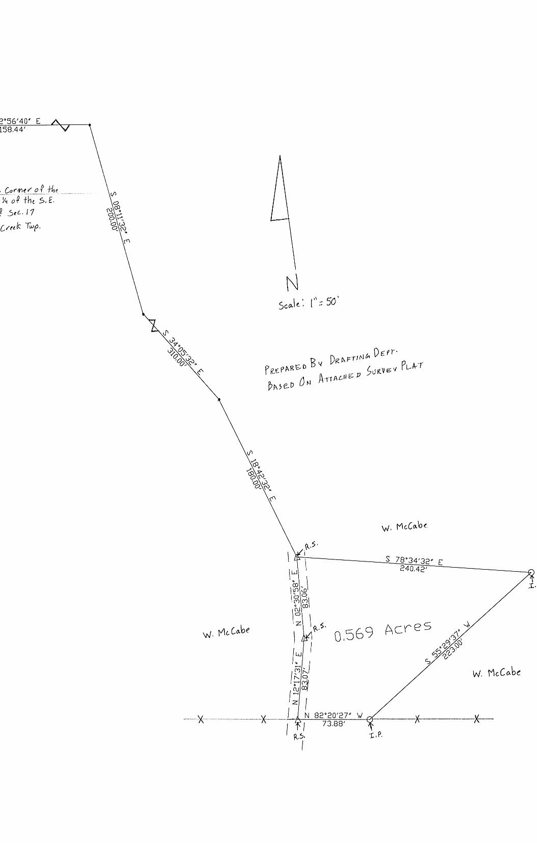
S 82°56' 40u E 158.44'
-~-~-~ · _(,_o r-~-~ l/'°_ef. fh_e ___ _ 5, lU, Y'i o~ +he S, E. 1;~ of Sec.11
So.I+ [red:: Twp.
N
240.42'
w. Mc.Co.be

0.569 Acres
DESCRIPTION: Situated in the State of Ohio, County of Hocking, Township of Salt creek being
apart of the southeast quarter of section No. 17, T-11-N, R-19-Wand bounded as follows:
Beginning at a railroad spike in the center line of Deihl Road No. 181, said spike bears S 82°-56'-40" E 758.44' (feet), S 08°-11'-32" E 200.00' (feet), S 34°-05'-32" E 310.00' (Feet) and S 18°-42'-32" E 180.00' (Feet) from the northwest corner of the southwest quarter of the southeast quarter of the said section No. 17 in said township,
Thence S 78° -34'-32" E 240.42' (feet) to an iron pin, Thence S 55°-29'-37" W 223.00' (feet) to and iron pin, Thence N 82° -20' -27" W 73.88' (feet) to a railroad spike in the center of Deihl road, Thence with the center of said road N 12° -17'-31" E 83.07' (feet) to a railroad spike, Thence N 02° -30'-58" E 83.06' (feet) to the beginning.
Containing 0.569 Acres of a acre more of less Grantee: Walter McCabe 49.25 Ac. Tract
(Tax Map)
P Rt:. Pf\ i<&'o BY Pr< A-PTJN c,p D£. f'I. B 1t..oe: .::> 0 M J\ rr Aat ~D ~ u fl v e. v PLAT .

150001500000 6,1.19 AC. TR.
HOY & JESSIE FE~; OFPICIAL RECORD 194,
PAGE 1357 AND 1360
I
I 150001510000 44.65 AC. TR.
I DALTON DELONG
I OFFICIAL RECORD 331, kt:: PAGE 534 / f:j ~
I I~ I
I co 'CJ:,
>7,•7 tC-t f.'"-t
00 >-1 ' 1--i
~,~ (.) (.)
I ~-y·' 86° 4.7' 52" ·w
\ 1502.28' 11 I · .. 81. 95' \~ECTION 17 7133•95, TOTAL TO P.0.B. /()f· /
N k1 k1 cnj~
DEED REFERENCE
150002450200 -TIMOTHY & STACY ROARK
OFFICIAL RECORD 227, PAGE 122
----
3.010 1\CRE TRACT
8--r---8 13 @
SPRING 14--
12
WELL
---------------/--/ .. · · · ......... ll~.T~E~~R(}A.n--
; -----·----- TWP. 196A --------~----~-
/
---? -- ----- /
150002450402 2.7'/ AC. TR.
WAYNE'S BUILDING SUPPLY, LTD. OFFICIAL RECORD 399,
PAGE 6
/
/ /
/
/ /
/ /
LEGEND:
/ /
/ _p---
150002450400 '/.15 AC. TH.
TIM & DILLIE ROARK OFl"ICCAL RECORD •16,
PAGE 002
0 FOUND 5/8" IRON PIN
~ FOUND IRON SPIKE (RAILROAD SPIKE)
150002450202 7.029 AC. TR.
DAVID MILLIGAN 0~'1''ICIAL RECORD 192,
PAGE 775
NUMBER DIRECTION 1 S 0~38'56" E 2 s 71"38'52" w 3 N 02°33'56" Yf
-------------
_@- / ." I
...-- ...-- 235.oo' ~ ' I
I I
I I I
I
163.oo' ...
-- . I I
I
__... __... __... -----
__... __... --~---I
JJ_ ---....
DISTANCE 142.58'• 157.93'• 127.!H '•
--... --.... ....... -....__ --... ---
150002450201 2,2128 AC. TR. DAVID MILLIGAN
O~'FICIAL RECORD 192, PAGf~ 773
I I
I I
I I
I I
I
I
I I
I I
I
I I
I I
I I
...... I
-._ ..._ I I
I
I I
I
--.. / -@- - - - - --,/-- -
/ / ,
/
// /
/'/ /
/ /'
/
/
/ /
/
/
/' /
,-" / ,...
/
/ /
/
/ /
/ /
/
/
I I
I I
I I
I I
I I
I
I I
I I
I
I I
I
FOUND IRON Pl LOCATED ON THE
NORTHEAST CORNER O~' SECTION 1'/
t
I __ _E_ECTION 9
I sEcTiONw-, I
• DENOTES TO'fAL DIS'fA!'f CE
/ /
/ /
/ /
/
/
/ /
/
/ /
/
WATER EASEMEN'f NUMBER DIREt.'TION DISTANCE 4 s 7 !0 38'52" w 6.21' ,___.__...
s 71°38'52" w 20.56' 5 6 N 31°45'49" lf 123.90' ., N 51"46'23" If 106.92' ........
N 23°34'24" Yf 113.38' 8 9 s 66°25'36" w 25.00' 10 N 23°34'24" \f 27.27'
J!__ N 413°28'30" W ·13.57' 12 N 00"11'37" E 149.73' ,..___..__.
S 69°48'23" E 70.00' 13 14 s 00·11·3r w 118.08'
1--· S 43°28'30" E 27.37' 15
16 S 23"34'24" E 42.73' 17 s 66°25'36" w 25.00' 10 s 23°34'24" E 103.35' 19 s 51°46'23" E 107.'l3' 20 s 31°45'49" E 132.19'
(3.010 ACRE TRACT) Beginning for reference on a found o/3" iron pin located on the northeast corner of Section 17;
Thence along the north line of Section 17, North 86° 17' 52" West, passing a il'On spike found (railroad spike) in the center of Sam's Creek Road (Township Road 173) at 163.00 feet, passing a 5/0" iron pin with a 1 1/4" plastic identification cap found stamped "SEYMOUH &: ASSOCIATES" at 393.00 feet, going a total distance of 1161.95 feet. to a 5/6" iron pin with a 1 1/4" plastic identification cap set being the principal place of beginning of the tract herein described, said iron pin being on the northwest corner of a 7.829 aere tract (Official Record 192, Page '175 / A.P.N. 150002450202);
Thence leaving the north line of Section 17 and along the property line of the 7.829 acre tract the following three (3) courses: 1. South 11° 05' 18" East a distance of 440.10 feet to a o/8" iron pin with a. t 1/4" plastic identification eap set, 2. South 41° 19' 32" East a distance of 13'/.31 feet to a 5/0" iron pin with a. 1 l/4" plastic identification eap set, and; 3. South 02° 38' 50" East, passing a 92.00 feet, going a total distance of Road (Township Road 196A);
5/8" iron pin with a .I 1/4" plastic identification cap set at 142.08 feet to a iron spike set (5/6" X12" iron pin) in Butler
Thence along the roadway of Butler Road, South '11° 30' 52" West a distance of 157.93 feet to a iron spike set (5/8» X 12" iron pin);
Thence leaving the roadway of Butler Road and with a line through the grantl)r's property the following three (3) courses: 1. North 02° 36' 58" \feat, passing a 5/6" iron pin with a 1 l/,i" plastic identification cap set at 50.00 feet, going a total distance of 12"/.91 feet to a 5/0" iron pin with a 1 1/4" plastic identilication cap set, 2. North 36° 16' 39" West a distance of 293.15 feet to a 5/6" iron pin with a 1 l/•i" plastic identification cap set, and; 3. North 02° 22' 57" West a distance of 369.04 feet to a 5/6" iron pin with a 1 1/,1" plastic identification cap set on the north line of Section 17;
Thence along the north line of Section 1'/, South 66° 4'7' 52" East a distance of 165.71 feet to the principal place of beginning, containing 3.010 acres morn or less and being subject to the right of way of Butler Road (Township Road 196A) and all other legal easement of record.
r11>. FOUND 5/6" IRON PIN & I.D. CAP S'fAMPED "" "SEYMOUR & ASSOCIATES"
NOTES: FOUND 5/3" IRON PIN & 1 1/4" 1.0 .
.t. CAP STAMPED "R.M.S.--516'1"
• POINT
® SET MAGNETIC NAIL
® SET IRON SPIKE (5/6" X 12" IRON PIN)
BEING A 'l'RACT OF LAND 'fHA'f IS NOW OR FORMERLY IN THE NAME OP TIMOTHY AND STACY ROARK AS RECORDED IN OFFICIAL RECORD 227, PAGE 122 OF THE HOCKING COUNTY RECORDER'S OFF!CE.
BEING A PART OF TAX PARCEL 150002450200.
ALL SET 5/8" IRON PINS WITH 1 1/·i" PJ..ASTIC IDENTIFICATION CAPS ARE S'rAMPED "SHAHRE'l'T-0019".
I JIEREBY CER'flPY 'flIAT AN ACTUAL SURVEY WAS MADE
100
SET 5/0" x 30" moN PIN WITH A 1 1/ 4" PLASTIC I.D. ,i. CAP STAMPED "SllARRE'rl'-0019"
ALL BEARINGS BASED ON THE NORTH LINE 01" SEC'l'lON 17 BEING NORTH 66° 47' 52" WEST AND ARE TO BE USED TO DENOTE ANGLES ONLY.
ALL IRON PINS SET BEING 5/8" DY 30".
~ Q~
UNDER MY DIRECT SUPERVISION OF THE PREMISES SHOWN l>l HEREON ON THE 20th DAY Of JULY, 2012 AND THAT p; THE PLAT IS A CORRECT HEl?HESENTATION OF THE
0 • =· Scale: 1" = 100' REFERENCES:
DEEDS AS NOTED
COUNTY MAPS
PREVIOUS SURVEYS
EXISTING MONUMimTs
ALL OFFSE'r IRON PINS BEING SE'f A.'r A DISTANCE OF 50.00 FEE'r UNLESS OTHERWISE INDICATED.
PREMISES AS DETERMINED BY SAID SURVEY. l 1''UR1'11ER CERTIFY TUA' THERE ARE NO ENCROACHMENTS EITHER
WAY AC'".: TJLCf SHOWN
PAUL SHAR~r ~ PROFESSIONAL SURVEYOR NO. 8019
•
V> z 0 V>
> 0 co :::::> V>
•
~ A
§ A
~
0 ~ A u:i 0
"' -t 0 ::t:
E-< 0.. 0 Cil
~
~ z ~ ......
"'"' "1 ..... I
t;:> "1 I
['.
ui ~ ii:

EXHIBIT "A" (3.010 ACRE TRACT)
Being a part of a tract of land that is now or formerly in the name of Timothy and Stacy Roark as recorded in Official Record 227, Page 122 of the Hocking County Recorder's Office, said tract being situated in the northeast quarter of Section 17, T-11-N, R-19-W, Saltcreek Township, Hocking County, State of Ohio and being more particularly described as follows:
Beginning for reference on a found 5/8" iron pin located on the northeast corner of Section 17;
Thence along the north line of Section 17, North 86° 4 7' 52" West, passing a iron spike found (railroad spike) in the center of Sam's Creek Road (Township Road 178) at 163.00 feet, passing a 518" iron pin with a 1 X" plastic identification cap found stamped "SEYMOUR & ASSOCIATES" at 398.00 feet, going a total distance of 1181.95 feet to a 5/8" iron pin with a 1 X" plastic identification cap set being the principal place of beginning of the tract herein described, said iron pin being on the northwest corner of a 7.829 acre tract (Official Record 192, Page 775 / A.P.N. 150002450202);
Thence leaving the north line of Section 17 and along the property line of the 7 .829 acre tract the following three (3) courses:
1. South 11° 05' 18" East a distance of 440.40 feet to a 5/8" iron pin with a 1 X" plastic identification cap set,
2. South 41° 19' 32" East a distance of 137.81 feet to a 5/8" iron pin with a 1 X" plastic identification cap set, and;
3. South 02° 38' 58" East, passing a 5/8" iron pin with a 1 X" plastic identification cap set at 92.00 feet, going a total distance of 142.58 feet to a iron spike set (5/8" X12" iron pin) in Butler Road (Township Road 196A);
Thence along the roadway of Butler Road, South 71° 38' 52" West a distance of 157.93 feet to a iron spike set (5/8" X 12" iron pin);
Thence leaving the roadway of Butler Road and with a line through the grantor's property the following three (3) courses:
1. North 02° 38' 58" West, passing a 5/8" iron pin with a 1 %" plastic identification cap set at 50.00 feet, going a total distance of 127.91 feet to a 5/8" iron pin with a 1 %" plastic identification cap set,
2. North 36° 16' 39" West a distance of 298.45 feet to a 5/8" iron pin with a 1 %" plastic identification cap set, and;
3. North 02° 22' 57" West a distance of 369.04 feet to a 5/8" iron pin with a 1 X" plastic identification cap set on the north line of Section 17;
Thence along the north line of Section 17, South 86° 47' 52" East a distance of 165.71 feet to the principal place of beginning, containing 3.010 acres more or less and being subject to the right of way of Butler Road (Township Road 196A) and all other legal easement of record.
Being a part of Tax Parcel 150002450200.
The above described tract being subject to a water easement being more particularly described as follows:
Beginning for reference on a set iron spike (5/8" X 12" iron pin) located on the southeast corner of the above described tract, said iron spike being in the center of Butler Road (Township Road 196A);
[continued on page 2]
Page 1of2
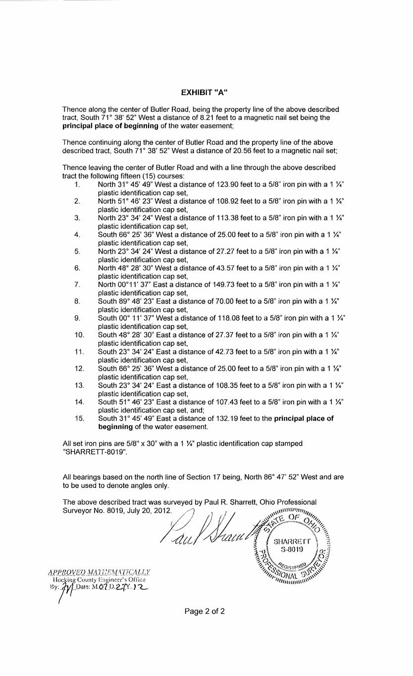
EXHIBIT "A"
Thence along the center of Butler Road, being the property line of the above described tract, South 71° 38' 52" West a distance of 8.21 feet to a magnetic nail set being the principal place of beginning of the water easement;
Thence continuing along the center of Butler Road and the property line of the above described tract, South 71° 38' 52" West a distance of 20.56 feet to a magnetic nail set;
Thence leaving the center of Butler Road and with a line through the above described tract the following fifteen (15) courses:
1. North 31° 45' 49" West a distance of 123.90 feet to a 5/8" iron pin with a 1 %" plastic identification cap set,
2. North 51° 46' 23" West a distance of 108.92 feet to a 5/8" iron pin with a 1 %" plastic identification cap set,
3. North 23° 34' 24" West a distance of 113.38 feet to a 5/8" iron pin with a 1 %" plastic identification cap set,
4. South 66° 25' 36" West a distance of 25.00 feet to a 5/8" iron pin with a 1 %" plastic identification cap set,
5. North 23° 34' 24" West a distance of 27.27 feet to a 5/8" iron pin with a 1 %" plastic identification cap set,
6. North 48° 28' 30" West a distance of 43.57 feet to a 518" iron pin with a 1 %" plastic identification cap set,
7. North 00°11' 37" East a distance of 149. 73 feet to a 5/8" iron pin with a 1 %" plastic identification cap set,
8. South 89° 48' 23" East a distance of 70.00 feet to a 5/8" iron pin with a 1 %" plastic identification cap set,
9. South 00° 11' 37" West a distance of 118.08 feet to a 5/8" iron pin with a 1 %" plastic identification cap set,
10. South 48° 28' 30" East a distance of 27.37 feet to a 518" iron pin with a 1 %" plastic identification cap set,
11. South 23° 34' 24" East a distance of 42. 73 feet to a 5/8" iron pin with a 1 %" plastic identification cap set,
12. South 66° 25' 36" West a distance of 25.00 feet to a 5/8" iron pin with a 1 %" plastic identification cap set,
13. South 23° 34' 24" East a distance of 108.35 feet to a 5/8" iron pin with a 1 %" plastic identification cap set,
14. South 51° 46' 23" East a distance of 107.43 feet to a 5/8" iron pin with a 1 %" plastic identification cap set, and;
15. South 31° 45' 49" East a distance of 132.19 feet to the principal place of beginning of the water easement.
All set iron pins are 5/8" x 30" with a 1 %" plastic identification cap stamped "SHARRETI-8019".
All bearings based on the north line of Section 17 being, North 86° 47' 52" West and are to be used to denote angles only.
The above described tract was surveyed by Paul R. Sharrett, Ohio Professional
Surveyor No. 8019, July 20, 20~2·.. . . ) diu. 1 . . .. · ,,,,,tMlll'U!11111 /) ~· '"'''. G ()p '"1.1,. ( ·~ ~-'..t..12S ~ .............. ()(.. "..;.
'~ - ~''····'' #''··~~ ~ · :,:: 0.·· ·· .. o~ ,,,1 /i'.J tdl/IA (,.. •·l 1h(HlFr·r· \~ \ 'v/[,(,,(,/t..,,/ ,, vr- ;'\f'\r'\....... • ,(·~
Page 2 of 2
:;, .. d..0
1. ~ C' 8<)·1 (l ' ~: '."•vt~ <>" ij ll'--'•• if. •.J • • ·'· '• .,.-0' ho:: ~; ·~ ,x ~,. ~O~··. ~ v . t; ::: ~-~··· •• /~G1sri:~~~ ..... -.,\/,$' 'l si~" ...... ; ..... ··":~s~ ,,
".1.1_,,,\ 'IONJ\L b ,,, ... '' 11111111111111 \\ ,,

EXHIBIT "A II (File #3-4333)
5 $.J ·f {,-. ~ 1l- /,,,~ I (
I . 0 i ~ ;J~ /f! fa
Situated in the Township of Salt Creek, County ofl-locking and State of Ohio: Being a part of the Northeast quarter of Section 17, Township 11, Range 19, and bounded and described as follows: Beginning at an iron pin marking the Northeast corner of Section 17; thence South 00 degrees 00' 161.70 feet to a beech tree; thence South 66 degrees 36' West 321.67 fl(et to a spike in the center line of Sams Creek Road No. 178; thence with the center of said road North 24 degrees 08' East 292.60 feet to a spike; thence North 82 degrees 30' East 179.40 feet to the place of beginning, containing 1.065 acres, more or less. Surveyed by Robert K. ~. Registered Surveyor Number 5179, State of Ohio, May 9,
1970. L I-}; nt'o It
£1,ei"-~ A 11 cs r Parcel~: 15-000247.0000 \ I."'-'} A11-rre.~
Prior Deed Reference: OR Book 478, Page 361 of the Hocking County, Ohio records
TRACT f!/ ~<!'t1 __ f'~_r:J.,._ .. _f!~--~?_I _ 10 ... -b'l~_rl ___ .
NAME: ~---- -DESCRIPTION: DISTANCE UNITS: Feet POINT OF BEGINNING: N=-82. 95056 I I E=169. 28587 I
TYPE DIRECTION DISTANCE NORTHING EASTING DESCRIPTION ------
LINE LINE LINE LINE
-------------N 24°08 1 00 11 E N 82°30'00 11 E s 00°00 1 00 11 E s 66°36 1 00 11 w
292.60' 179.40' 161. 70 I
321.67'
184.07516' 207.49156'
45.79156' -81.95900'
Area: 46,399 Sq. Feet, 1.065 Acres (Un-balanced) Perimeter: 955.37' Closing line: S 66°31'56 11 W, 2.49' Error in closure: 1:384
SPIKE
SPIKE
1.065Ac.
SURVEY BY ROBERT K. HINTON SURVEYOR NUMBER 5179 MAY 9 1970
288.91873' 466.78394' 466.78394' 171.56981'
IRON PIN
BEECH TREE

-----------...,--------------------------------------~--------------------------~;...'-r-•l!'•·--"'~""'J'.~1~'----------------------------------------------------------------..... -----------~ I
I I
I I
I I
I I
DONALD N. FRIEND FAMILY TRUST OFFICIAL RECORD 512,
PAGE 138
1 SECTION 7 I ·/----;----- ___ _£ECTION 8 ~ SECfION 18 K- SECTIONn--------·-~--~_?_o
I \SET IRON PIN BEING OK THE NORTHWEST CORNER
OF SECTION 17
' II> -.... 0
0 1-.. ~ NO
°' ~ 0
ROGER AND BETTY WEIR OFFICIAL RECORD 14,
PAGE 238
11' 15"
' ' • :: . '
I I
I I
I <;<;01 J-'· 1··1·" 1' i -- - •... _-:._. '. -" U -HL ----<Ii ---
r~\~ ---- --,\___ ---_:_,\_-::-::-_--:=--_-_:-:_-:_- 1 _::-::-: __ ,,-=~=~=c=c+-----SECTJON_~1 SE~TION g
w
1"" \ \ ', 11 ', SEC1ION 17 /SECTION--16 i--1i-t \ \ O'°"' t'( \ ' \ I '-, oi"l"N \ \ \ I \ °'/ N \ \ \ ..,. ' \ I ri \ \ \ \ ', /[I) \ \ \ I ' I \\ \ \ I '\ I \ \ \ I \
I I
I
I HEREBY CERTIFY THAT AN ACTUAL SURVEY WAS MADE UNDER MY DIRECT SUPERVISION OF THE PREMISES SHOWN HEREON ON THE 17th DAY OF NOVEMBER, 2014 AND THAT THE PLAT IS A CORRECT REPRESENTATION OF THE PREMISES AS DETERMINED BY SAID SURVEY. I FURTHER CERTIFY THAT THERE ARE NO ENCROACHMENTS EITHER WAY ACROSS ANY BOUNDARY EXCEPT AS SHOWN. B' /! , , ' I / ,i
\ ~ // \ - - - _.,.. ______ _ Jffl ~Lfl(r -PAUL SHARRETT ' ~, PROFESSIONAL SURVEYOR NO. 8019
200
~--'"""--'~~-~-___J = 200'
I \ \ \ I \
~\ \ \ \ I ) I \ \\ \ \ I / 1"' \ \ \ \ I // I. \ \ I /
• N \ \ \ ---i€ /."' \ \ \ \ I / / ---------J? i~ \ \ \ \ I __ ,,,.::'-------- --------· "'I""' \ \ \ \ I --------.-/ --------1-96
8\[~]--~=====S~8~6°ilf1 'i:16~':_' J;lE ___________ r; \\ \ \ \ -------1- --~---------F,oAD 1P.o.B.I 1334.83' , \ \\ \ /\---- ~--------10-w~sn1P
x x--x x x x--x x x x---x· x -X-x--X- 8 \ \ \ ,,""'_,., ,.,....---
50.960 ACRE TRACT
(DEED VOLUME 215, PAGE 690)
SET IRON PIN BEING ON THE SOUTHWEST CORNER
OF THE NORTHWEST ~ l/QUARTER OF SECTION 17
oy\ ( fi;f " JC ,( "
z/~~ I \ I \\ I I
I \ I
!/ I; I I
I f FENCE CORNER
I \
I I
I Scale: 1"=50' I
I I
1287.01'
N 86'45'07" w
T&D PROPERTIES, LTD. OFFICIAL RECORD 364,
PAGE 469
\ I
I
\ \ \ ,,,,,,"' ,,_,.,,,,-"' \ \ \ ,,,,,,,. ,,,"' - / \ _,,-"'\.· ,,-"'
\ \ ,,,,-"' ''' ,,,,,"' "' JAMES & GENEVA \ \ / · ,/
. • HETTINGER \ \ / · / i2 g OFFICIAL RECORD 14, \ )(/ // .,-; o PAGE 701 \ ' , - r \ /,,,, ,,,," .. ~ ID ~ \ /,,/ _,.,,-0_<;) ~
\ ,,,"' . /:1 "' .. [/) ;< - '~:V
/,~,..., / /
/'. /a; / / v // .· // "" / / . - - - ·- -- - - _,,/ //
"' ' "' (Q
oi ·"' l'- "" .... II> .... M
0
[/)
--r~ / / . /
/ / / /
/ / / /
_,,/ ,,,,,," ,,," . //
/ / / /
/ /
/ / /
/
JAMES & GENEVA HETTINGER OFFICIAL RECORD 3,
PAGE 48
FOUND STONE MONUMENT LOCATED ON THE
SOUTHEAST CORNER OF THE NORTHWEST QUARTER
OF SECTION 17
I I
I I
I I
•------------!~1· I N 86°45'07" ____ _
IV ------IBJ-~::!.J<'.2 SECTION LINE
[/) I z
I -----
LEGEND:
IZl FOUND STONE MONUMENT
0 FOUND 3" IRON PIPE
~FOUND 5/8" IRON PIN
FOUND 5/8" IRON PIN & PLASTIC I.D. CAP A STAMPED "RS-5167"
NOTES: •POINT BEING A TRACT OF LAND THAT IS NOW OR FORMERLY IN THE NAME OF JAMES AND GENEVA HETTINGER AS RECORDED IN DEED VOLUME 215, PAGE 690 OF THE HOCKING COUNTY RECORDER'S OFFICE. 6 ~~IM%~' "~H~~·R~~~~a~i~" & PLASTIC I.D. CAP
BEING A SURVEY OF AUDITOR'S PARCEL 15002440100.
ALL SET 5(8" X 30" IRON PINS WITH PLASTIC IDENTIFICATION CAPS ARE STAMPED 'SHARRETT-!3019".
ALL BEARINGS BASED ON THE WEST LINE o~· SECTION 17 BEING, NORTH 02• 27' 45" EAST AND ARE TO BE USED TO DENOTE ANGLES ONLY.
(50.960 ACRE TRACT)
Beginning for reference on a set 5/8" iron pin with a plastic identification cap located on the northwest corner of Section 17, said iron pin being the northwest corner of a parcel of land as conveyed to Roger and Betty Weir (Official Record 14, Page 238);
Thence along the west line of Section 17 being the property line of the aforementioned Weir property, South 02• 27' 45" West a distance of 904.00 feet to a 5/8" X 30" iron pin with a plastic identification cap set on the southwest corner of the Weir property, said iron pin being the principal place of beginning of the tract herein described;
Thence leaving the west line of Section 17 and continuing along the property line of the Weir property, South 86° 11' 16" East a distance of 1334.83 feet to a 5/8" X 30" iron pin with a plastic identification cap set on the west line of a parcel of land as conveyed to James and Geneva Hettinger (Official Record 14, Page 701);
Thence along the property line of the aforementioned Hettinger property, South 04° 20' 32" West a distance of 515.59 feet to a 5/8" iron pin found on the northwest corner of another parcel of land as conveyed to James and Geneva Hettinger (Official Record 3, Page 48);
Thence along the property line of the aforementioned Hettinger property, South 03• 57' 36" West a distance of 1172.93 feet to a 5/8" iron pin found on the south line of the northwest quarter of Section 17 and the north line of a parcel of land as conveyed to T & D Properties, Ltd. (Official Record 364, Page 469);
Thence along the south line of the northwest quarter of Section 17 and the aforementioned T & D Properties, Ltd., North 86° 45' 07" West a distance of 1287.01 feet to a 5/8" X 30" iron pin with a plastic identification cap set on the west line of Section 17 and the east line of a parcel of land as conveyed to Sierrra Properties, LLC. and Elfie Properties, LLC. (Official Record 268, Page 264);
Thence along the west line of Section 17 and the aforementioned Sierra Properties, LLC. and Elfie Properties, LLC., North 02° 27' 45" East a distance of 1701.64 feet to the principal place of beginning, containing 50.960 acres more or less and being subject to all legal easements of record.
REFERENCES:
DEEDS AS NOTED
COUNTY MAPS
PREVIOUS SURVEYS
EXISTING MONUMENTS

EXHIBIT "A" (50.960 ACRE TRACT)
Being a tract of land that is now or formerly in the name of James and Geneva Hettinger as recorded in Deed Volume 215, Page 690 of the Hocking County Recorder's Office, said tract being situated in the west-half of the northwest quarter of Section 17, T-11-N, R-19-W, Salt Creek Township, Hocking County, State of Ohio and being more particularly described as follows:
Beginning for reference on a set 518" iron pin with a plastic identification cap located on the northwest corner of Section 17, said iron pin being the northwest corner of a parcel of land as conveyed to Roger and Betty Weir (Official Record 14, Page 238);
Thence along the west line of Section 17 being the property line of the aforementioned Weir property, South 02° 27' 45 West a distance of 904.00 feet to a 5/8" X 30" iron pin with a plastic identification cap set on the southwest corner of the Weir property, said iron pin being the principal place of beginning of the tract herein described;
Thence leaving the west line of Section 17 and continuing along the property line of the Weir property, South 86° 11' 16" East a distance of 1334.83 feet to a 518" X 30" iron pin with a plastic identification cap set on the west line of a parcel of land as conveyed to James and Geneva Hettinger (Official Record 14, Page 701 );
Thence along the property line of the aforementioned Hettinger property, South 04 ° 20' 32" West a distance of 515.59 feet to a 518" iron pin found on the northwest corner of another parcel of land as conveyed to James and Geneva Hettinger (Official Record 3, Page 48);
Thence along the property line of the aforementioned Hettinger property, South 03° 57' 36" West a distance of 1172.93 feet to a 5/8" iron pin found on the south line of the northwest quarter of Section 17 and the north line of a parcel of land as conveyed to T & D Properties, Ltd. (Official Record 364, Page 469);
Thence along the south line of the northwest quarter of Section 17 and the aforementioned T & D Properties, Ltd., North 86° 45' 07" West a distance of 1287.01 feet to a 5/8" X 30" iron pin with a plastic identification cap set on the west line of Section 17 and the east line of a parcel of land as conveyed to Sierrra Properties, LLC. and Elfie Properties, LLC. (Official Record 268, Page 264);
Thence along the west line of Section 17 and the aforementioned Sierra Properties, LLC. and Elfie Properties, LLC., North 02° 27' 45" East a distance of 1701.64 feet to the principal place of beginning, containing 50.960 acres more or less and being subject to all legal easements of record.
Being a survey of Auditor's Parcel 150002440100.
All iron pins set being 5/8" X 30" with a plastic identification cap stamped "SHARRETT-8019".
All bearings based on the west line of Section 17 being, North 02° 27' 45" East and are to be used to denote angles only.
The above described tract was surveyed by Paul R. Sharrett, Ohio Professional Surveyor No. 8019, November 17, 2014 [H01405].
",'
/>::~~': . " ..
\ (: r~

5Ecr;0 N 7
5EcT10N 18
FOUND AT N8'25'09'E 15.78
---
SITUATED IN FRACTIONAL LOT 4 OF THE WEST PART OF THE NORTHWEST QUARTER OF SECTION 17, SALT CREEK TOWNSHIP, T-llN, R-19W, HOCKING COUNTY, OHIO BEING THE TRACT OF LAND TRANSFERRED TO ROGER D. AND BETTY J. WEIR IN OR14-238 OF HOCKING COUNTY RECORDS CITED BEARINGS ARE BASED ON MAGNETIC NORTH ON DECEMBER 26, 2014
---
SOUTHEAST CORNER OP THE fYEST HALP OP THE SOUTNfYEST QUARTER OP SECTION 8
I I
-- I I ---.r-:::: NE CORNER OP' I---, ---;_~ NB9022 '29 ,,
PRACTIONAL \ ~ LOT45ECTION/7 1 ~429Q ,
SB0'22'29'E~ 66. 18'
\ ~·25 \' 5ECTIONL;, ~~T05c ' >--- EXISTING NE PER R.H . Alt) ----
',,· -, ,,-DRIVE . 5 fi4RRETT To ---------- . -------·.!':._ THE NF --._ ___ ', -- L.- CORNE, -· --------- -·
-- R OF 5Ec Tio;;;-;--- -/----___~ NE CORNER OP SECTION 17
28.1282 AC ES
PLAT PREPARED ABOVE IS THE RESULT OF AN ACTUAL SURVEY MADE BY MICHAEL P. BERRY, DECEMBER 26, 2014 TO UANUARY 16, 2015.
~;-)_Cl OHIO _REGISTE~ SURVE OR P. S. 6803
CA-1- r-:;) ·- .. __
100 00 100 h±rffl 1 I 1 I I SCALE: 1"=100'
0
LEGEND 5/8 'x30 IRON PIN WITH 1-1/4'' PLASTIC ID CAP STAMPED ''MPB S-6803' SET
5/B' IRON PIN WITH 1-1/4' @ PLASTIC ID CAP STAMPED
SHARRETT -8019' FOUND
e 5/8'' IRON PIN FOUND
• UN-MONUMENTED POINT -€-- ROAD CENTERLINE
><c---x FENCE LINE
REFERENCES: COUNTY TAX MAPS SURVEYS OF RECORD 1880 PLAT RECORDS DEEDS (AS NOTED)
------ ---

DESCRIPTION OF SURVEY FOR MR. & MRS. ROGER WEIR
Being the tract of land transferred to Roger D, and Betty J. Weir, in OR14-238 of Hocking County Records, situated in Fractional Lot 4 of the west part of the northwest quarter of Section 17, Salt Creek Township, T-llN, R-19W, Hocking County, Ohio, and being more particularly described as follows:
Beginning at an iron pin set on the northwest corner of Section 17, said pin being referenced by a Sharrett pin found which bears North 08°25'09" East, a distance of 15.78 feet;
Thence, with the north line of Section 17, South 80°22'29" East, a distance of 130 l. 77 feet to an iron pin set on the northeast corner of said Fractional Lot 4, said pin being referenced by the southeast corner of the west half of the southwest quarter of Section 8, T-1 lN, R-19W, which bears South 80°22'29" East, a distance of 66.18 feet, and further referenced by the northeast corner of section 17, which bears, by previous survey South 80°22'29" East, a distance of 4290.25 feet;
Thence, with the east line of Fractional Lot 4 and along an existing fence line, South 07°53'46" West, a distance of913.38 feet to an iron pin set;
Thence, with an old, well defined fence line and along the historic north line of occupation of the tracts of land described in DV215-690, North 82°34'40" West, a distance of 1310.02 feet to an iron pin set on the west line of Section 17;
Thence, with said west section line North 08°25'09" East, passing a Sharrett pin found at 75.36 feet, going a total distance of 963.54 feet to the place of beginning, containing 28.1282 acres, more or less, and being subject to all valid easements.
Cited bearings are based on magnetic north, as observed December 26, 2014.
All iron pins described as being set are 5/8 inch X 30 inches with a 1-114 inch plastic ID cap stamped "MPB S-6803".
All Sharrett pins described as being found are 5/8 inch with a 1-114 inch plastic ID cap stamped "SHARRETT-8019".
The above description is the result of an actual survey made by Michael P. Berry, Ohio Registered Surveyor P.S. 6803, from December 26, 2014 to January 16, 2015.
£-) ___ ot~ Michael P. Berry Ohio Registered S'4rveyor P.S. 6 03
c-__/>. - l __ , r.::; \ '


EXHIBIT "A" (49. 792 ACRE TRACT)
Being part of a tract of land that is now or formerly in the name of James and Geneva Hettinger as recorded in Official Record 547, Page 651 of the Hocking County Recorder's Office, said tract being situated in the west-half of the northwest quarter of Section 17, T-11-N, R-19-W, Salt Creek Township, Hocking County, State of Ohio and being more particularly described as follows:
Beginning for reference on a set 5/8" iron pin with a plastic identification cap located on the northwest corner of Section 17;
Thence along the west line of Section 17, South 02° 27' 45" West, passing a 5/8" X 30" iron pin with a plastic identification cap set at 904.00 feet, going a total distance of 979.32 feet to a 5/8" iron pin with a plastic identification cap found stamped "MPS S-6803" on the southwest corner of a parcel of land as conveyed to Roger and Betty Weir (Official Record 551, Page 201 ), said iron pin being the principal place of beginning of the tract herein described;
Thence leaving the west line of Section 17 and continuing along the property line of the Weir property the following two (2) courses:
1. South 88° 32' 04" East a distance of 1310.02 feet to a 5/8" iron pin with a plastic identification cap found stamped "MPS S-6803", and;
2. North 01° 56' 22" East a distance of 434.60 feet to a 5/8" X 30" iron pin with a plastic identification cap set;
Thence with a new line, South 32° 38' 41" East a distance of 70.07 feet to a 5/8" iron pin with a plastic identification cap found with a plastic identification cap stamped "RS-5167" on the northerly corner of a parcel of land as conveyed to James and Geneva Hettinger (Official Record 14, Page 701);
Thence along the property line of the aforementioned Hettinger property, South 04 ° 20' 32" West, passing a 5/8" X 30" iron pin with a plastic identification cap set at 356.36 feet, going a total distance of 871.95 feet to a 5/8" iron pin found on the northwest corner of another parcel of land as conveyed to James and Geneva Hettinger (Official Record 3, Page 48);
Thence along the property line of the aforementioned Hettinger property, South 03° 57' 36" West a distance of 1172.93 feet to a 5/8" iron pin found on the south line of the northwest quarter of Section 17 and the north line of a parcel of land as conveyed to T & D Properties, Ltd. (Official Record 364, Page 469);
Thence along the south line of the northwest quarter of Section 17 and the aforementioned T & D Properties, Ltd., North 86° 45' 07" West a distance of 1287.01 feet to a 5/8" X 30" iron pin with a plastic identification cap set on the west line of Section 17 and the east line of a parcel of land as conveyed to Sierra Properties, LLC. and Elfie Properties, LLC. (Official Record 268, Page 264);
[continued on page 2]
Page 1 of 2

EXHIBIT "A"
Thence along the west line of Section 17 and the aforementioned Sierra Properties, LLC. and Elfie Properties, LLC., North 02° 27' 45" East a distance of 1626.32 feet to the principal place of beginning, containing 49. 792 acres more or less and being subject to all legal easements of record.
All iron pins set being 5/8" X 30" with a plastic identification cap stamped "SHARRETT-8019".
All bearings based on the west line of Section 17 being, North 02° 27' 45" East and are to be used to denote angles only.
The above described tract was surveyed by Paul R. Sharrett, Ohio Professional Surveyor No. 8019, November 17, 2014, (REVISED ON October 1, 2015) [H01405].
Page 2 of 2

BEING PART OF THE TRACT OF LAND DESCRIBED IN DVl 12-515 OF HOCKING COUNTY RECORDS OF DEEDS SITUATED IN THE EAST HALF OF THE NORTHWEST QUARTER OF
SECTION 17, SALT CREEK TOWNSHIP, T-llN, R-19W, HOCKING COUNTY, OHIO CITED BEARINGS ARE BASED ON THE BEARING SYSTEM OF THE 28.1282 ACRES TRACT DESCRIBED IN OR551-201
/AF<F<ETT /RON PIN r;ttJ 1~J4 11 PLASTIECTTl~/?f;; STAMPED "SHARR FOUND
---- ------~--·------
/
r<PfTT /R0~& 1~AP RON s~14 11 PLAS1lf/v1" )AJ/TH pl-r:::o 11p.rvf.S.-srAM L-
pouND
0
0
• •
--x--499.93'M
499. 72'R
i
'I
~ 50 00 50 ~E::lt=FJ----~
1"=50' 5/8"x30" IRON PIN W/ 1-1/4" PLASTIC ID CAP STAMPED "MPB S-6803" PREVIOUSLY SET 5/8"x30" IRON PIN W/ 1-1/4" PLASTIC ID CAP STAMPED "MPB S-6803" SET
5/8" IRON PIN FOUND AS NOTED UN-MONUMENTED POINTS
CENTERLINE EDGE OF ROADWAY FENCE LINE MEASURED BY MICHAEL P. BERRY MEASURED BY RON SHARRETT AS SHOWN ON A SURVEY MADE 01 /13/1993
REFERENCES: COUNTY TAX PLATS SURVEYS OF RECORD 1880 PLAT RECORDS DEEDS( AS NOTED)

DESCRIPTION OF SURVEY FOR MR. ROGER WEIR
Being part of the tract of land described in DV 112-515, Hocking County records of deeds, situated in the east half of the northwest quarter of Section 17, Salt Creek Township, T-llN, R-19W, Hocking County, Ohio, and more particularly described as follows:
Beginning at an iron pin previously set on the northwest corner of said east half of the northwest quarter, and being the northeast corner of a 28.1282 acres tract described in OR.551-201;
Thence with the north line of Section 17, South 80°22'29" East, a distance of 62. 71 feet to an iron pin set;
Thence with an extension of the west line of the 6.333 acres tract described in OR.513-284, South l 0°21' 11" West, passing a 5/8 inch iron pin found on the northwest corner of said tract at 35.09, and continuing along the west line of said 6.333 acres tract, a distance of 535.02 feet to a Ron Sharrett pin found on the southwesterly corner of said 6.333 acres tract;
Thence with part of the northerly boundary of a 49. 792 acres tract described in OR.567-151, North 26°39'53" West, a distance of 70.07 feet to a Paul Sharrett iron pin found on the west line of said east half of the northwest quarter;
Thence with said west line and along the east line of 28 .1282 acres tract described in 0 R.5 51-201, North 07°53'46" East, a distance of 478.72 feet to the place of beginning, containing 0.6035 acres, more or less, and being subject to all valid easements.
Cited bearings are based on the bearing system of the 28.1282 acres tract described in OR55 l-20 l.
All iron pins described as being set or previously set are 5/8 inch by 30 inches, with a 1-1/4 inch plastic ID cap stamped "M.P.B. S-6803"
All Paul Sharrett pins described as being found, are 5/8 inch with a 1-114 inch plastic ID cap stamped "Sharrett-8019".
All Ron Sharrett pins described as being found, are 5/8 inch with a 1-1 /4 inch plastic ID cap stamped "R.M.S.-5167".
The above description is the result of an actual survey made by Michael P. Berry, Ohio Registered Surveyor, P.S. 6803, on January 16, 2015 and March 11, 2016.
file:HOC-SLr-017-WEIR JUN 27 2016
'.\~Of o •.. '~~Y·· .·.~·
·c, . MICHAEL P. .0
* BERl<Y * S-6803
~<-'GI ST\: \l.Y,'>
suRvf:.'J.O~


![Agenda Item 7 - Shorelinecosweb.ci.shoreline.wa.us/uploads/attachments/pds/... · From: JM [jj206@drizzle.com] Sent: Monday, May 07, 2007 2:05 AM To: Steve Szafran Subject: Public](https://img.pdfslide.us/doc/110x75/5a8ead2b7f8b9adb648d6a83/agenda-item-7-jm-jj206drizzlecom-sent-monday-may-07-2007-205-am-to-steve.jpg)