Embed Size (px)
Citation preview
Japan – IndonesiaJOINT STUDY
The joint Study on Evaluation of Coal Resources and Reserves in Indonesia
CONCEPT
JCOALNEDO
Japan – IndonesiaJOINT STUDY
JCOAL
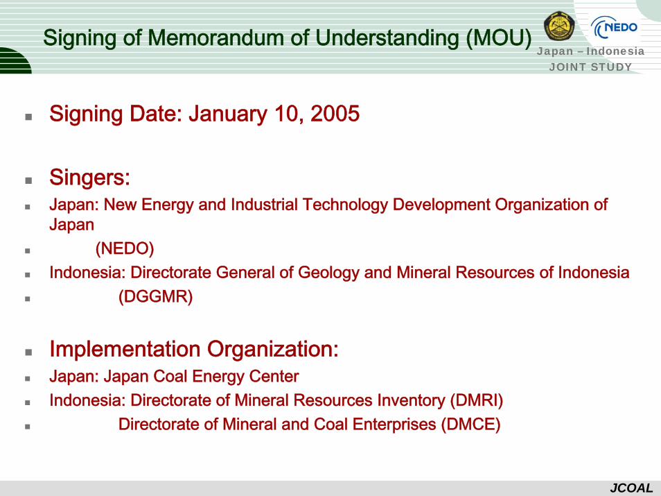
Signing of Memorandum of Understanding (MOU)
Signing Date: January 10, 2005
Singers:Japan: New Energy and Industrial Technology Development Organization of Japan
(NEDO)Indonesia: Directorate General of Geology and Mineral Resources of Indonesia
(DGGMR)
Implementation Organization:Japan: Japan Coal Energy CenterIndonesia: Directorate of Mineral Resources Inventory (DMRI)
Directorate of Mineral and Coal Enterprises (DMCE)
Japan – IndonesiaJOINT STUDY
JCOAL
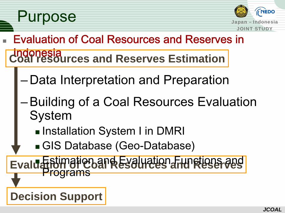
PurposeEvaluation of Coal Resources and Reserves in IndonesiaCoal resources and Reserves Estimation
Evaluation of Coal Resources and Reserves
– Data Interpretation and Preparation– Building of a Coal Resources Evaluation
SystemInstallation System I in DMRI GIS Database (Geo-Database)Estimation and Evaluation Functions and Programs
Decision Support
Japan – IndonesiaJOINT STUDY
JCOAL
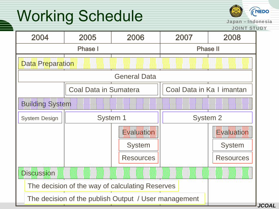
2004 2005 2006 2007 2008Phase Ⅰ Phase Ⅱ
Working Schedule
Data Preparation
System 1
Coal Data in Sumatera Coal Data in Kalimantan
Evaluation
System
Resources
System Design System 2
General Data
Building System
Evaluation
System
Resources
The decision of the way of calculating Reserves
Discussion
The decision of the publish Output / User management
Japan – IndonesiaJOINT STUDY
JCOAL
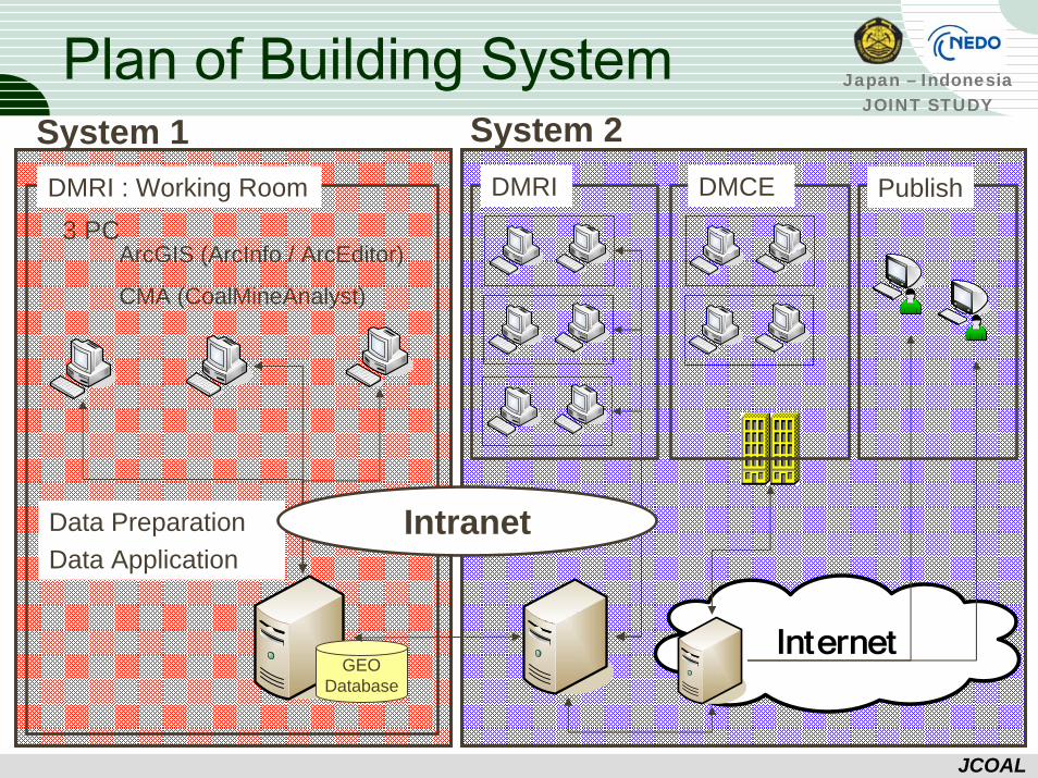
Plan of Building System
DMRI : Working Room3 PC
ArcGIS (ArcInfo / ArcEditor)
CMA (CoalMineAnalyst)
System 1
Data PreparationData Application
GEODatabase
DMRI DMCE Publish
Intranet
System 2
Japan – IndonesiaJOINT STUDY
JCOAL
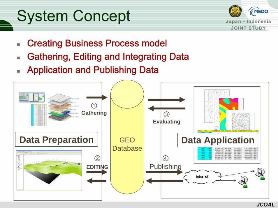
System ConceptCreating Business Process modelGathering, Editing and Integrating DataApplication and Publishing Data
GEODatabase
②EDITING
③Evaluating
①Gathering
④Publishing
Data Preparation Data Application
Japan – IndonesiaJOINT STUDY
JCOAL
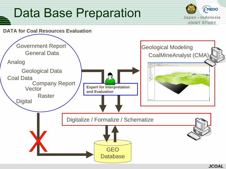
Data Base PreparationDATA for Coal Resources Evaluation
Government Report
Company Report
General Data
Coal DataGeological Data
VectorRaster
Digital
Analog
GEODatabase
Digitalize / Formalize / Schematize
Geological ModelingCoalMineAnalyst (CMA)
X
Expert for Interpretation and Evaluation
Japan – IndonesiaJOINT STUDY
JCOAL
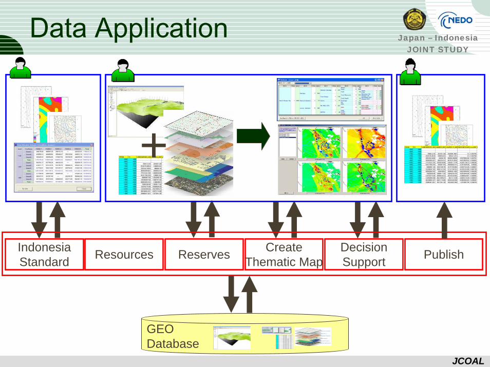
Data Application
GEODatabase
ReservesIndonesiaStandard Resources Create
Thematic MapDecisionSupport Publish
+
Japan – IndonesiaJOINT STUDY
JCOAL
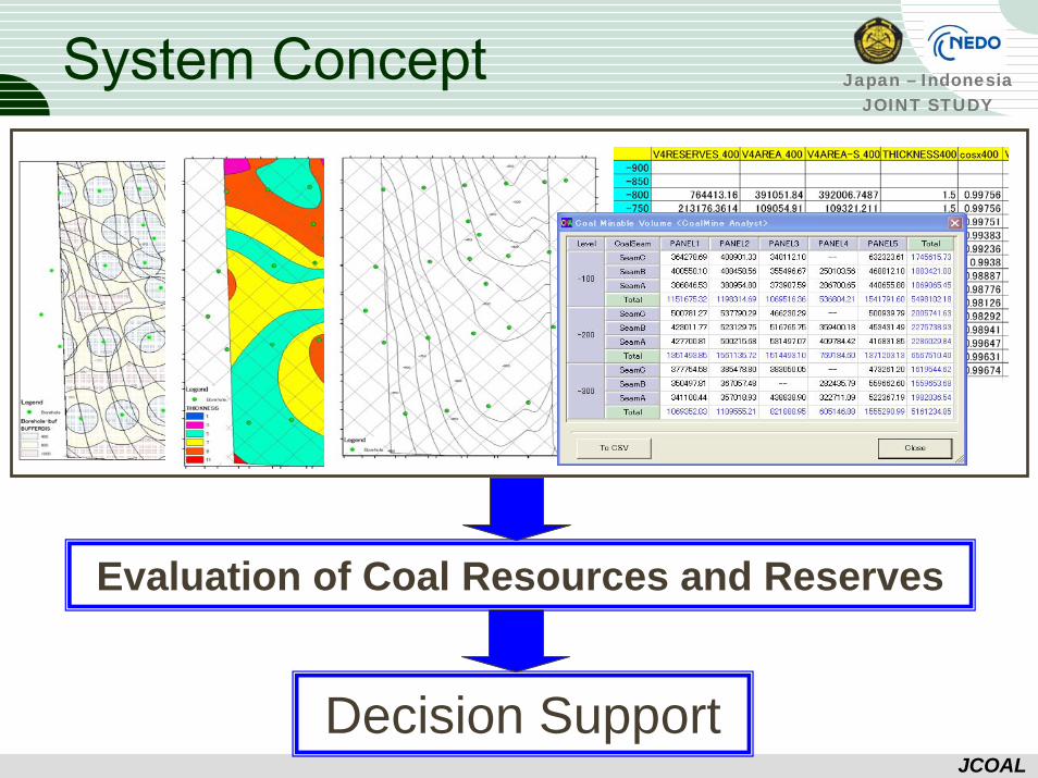
System Concept
Decision Support
Evaluation of Coal Resources and Reserves
Japan – IndonesiaJOINT STUDY
JCOAL
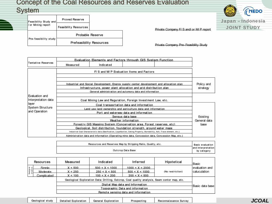
Concept of the Coal Resources and Reserves Evaluation System
Private Company F/ S and/ or M/ P report
Private Company Pre- Feasibility Study
Measured Indicat ed
Simple X < 500 500 < X < 1000 1000 < X < 2000Moderate X < 250 250 < X < 500 500 < X < 1000 (No rest r ic t ion)
Complicated X < 100 100 < X < 200 200 < X < 500
Detai led Explorat ion General Explorat ion Prospect ing Reconnaissance Survey
ExistingGeneral data
base
Indus t r i al Coal Char ac t er i s t i c dat a (Gas i f i cat i on, Li quefac t i on, Cok i ng Pr oper t y , Bur nabi l i t y , Ash, T r ace el ement , et c .)
Resources Indicated Inferred Hipotet ical
Weat her informat ion
Por t and wat erway dat a and informat ionSensus dat a base
Proved Reserve
Feasibi l i t y Resources
Probable Reserve
Feasibi l i t y St udy and/ or Mining report
Pre- f easibi l i t y st udyPrefeasibilit y Resources
Infrast ruct ure, power plant allocat ion and gr id dist r ibut ion plan
Basic data base
Basicevaluation andcaluculation
Out c rop Dat a Base
Land use land ownership and agricul t ure data and inf ormat ion
Forest ry GIS Mapping Syst em (Concervat ion area, Forest reserves, et c )
Basic evaluat ionand int erpret at ion
by cat egory
Resources and Reserves Map by St r ipping Rat io, Qualit y, et c .
Measured
Policy andstrategy
Coal t ranspor t at ion dat a and informat ion
Tent at ive Reserves
F/ S and M/ P Evaluat ion It ems and Fact ors
General administ rat ion and aut omony dat a and informat ion
Evaluat ion Elements and Factors through GIS System Funct ion
Evaluation andInterpretation datalayerSystem Structureand Operation
Coal Mining Law and Regurat ion, Foreign Invest ment Law, et c .
Administ rat ion dat a and informat ion (Operat ing mine dat a, Concession dat a, Concession Map, et c .)
Indust rial and Social Development , Energy supply center development and al locat ion plan
Geological, Soil dist r ibut ion, foundat ion st rengt h, ground wat er maps
Geol
ogic
alst
ruct
ure
Geological st udy
Topographic Dat a and informat ionRemot e sensing dat a and informat ion
Digit al Map dat a and Informat ionGeological Explorat ion Data: Dri l l ing, Out crop, Coal qual i t y analysis, Seam contor map, et c.
Japan – IndonesiaJOINT STUDY
JCOAL
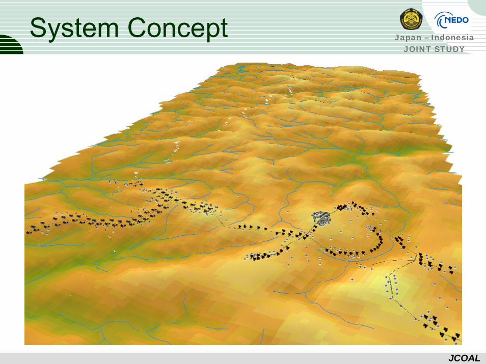
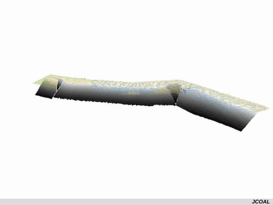
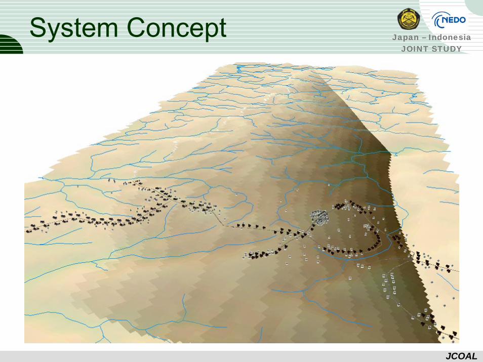
System Concept
Japan – IndonesiaJOINT STUDY
JCOAL
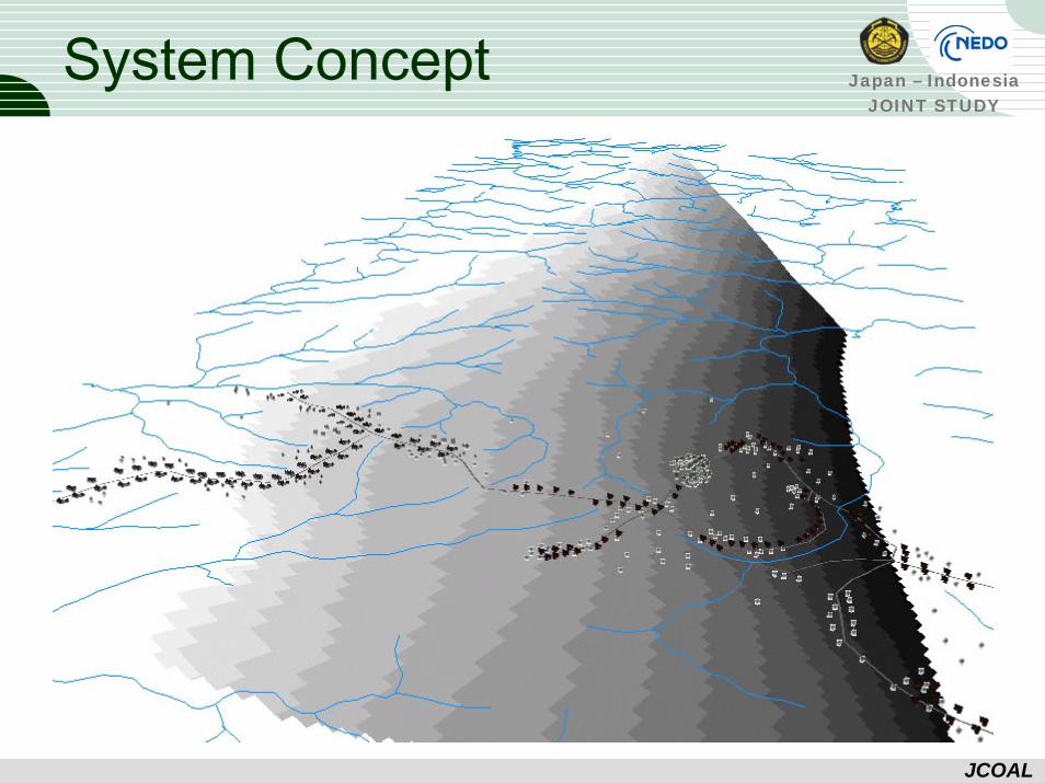
System Concept
Japan – IndonesiaJOINT STUDY
JCOAL
System Concept
Japan – IndonesiaJOINT STUDY
JCOAL
System Concept
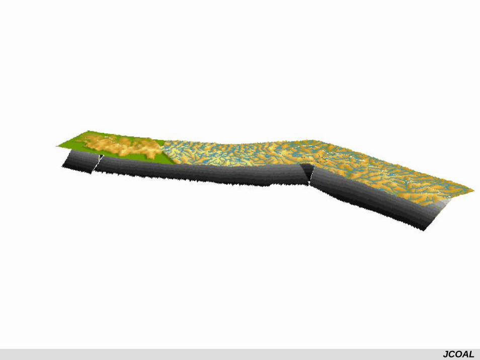
Japan – IndonesiaJOINT STUDY
JCOAL
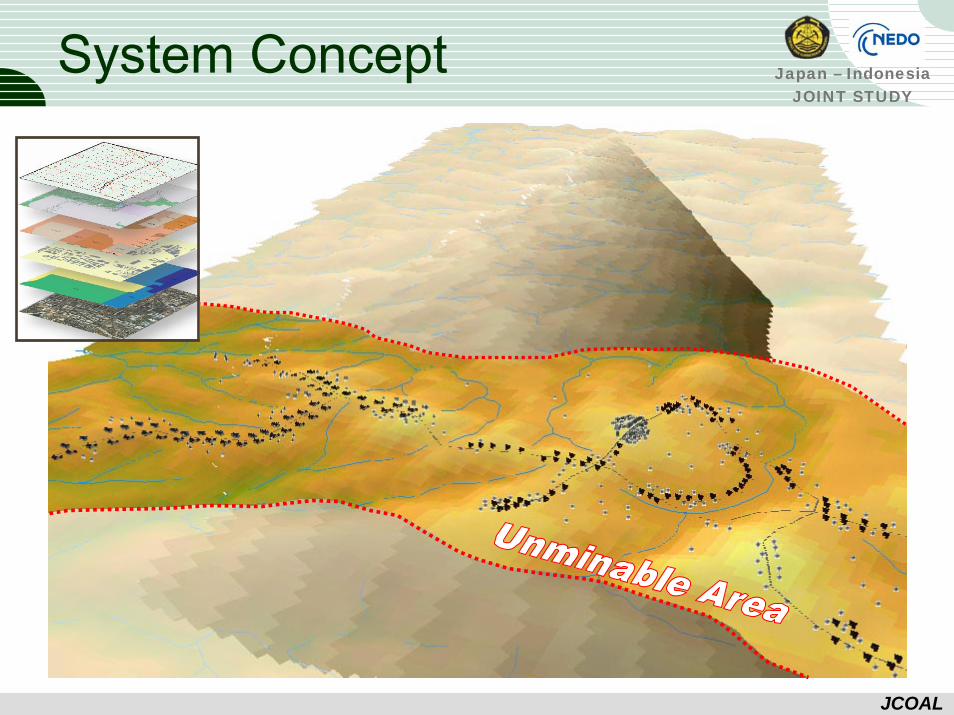
Resources
River
Public House
Rail
Main Load
Reserved Area
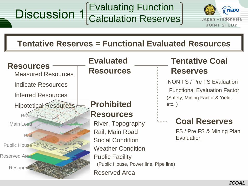
Discussion 1
Tentative Reserves = Functional Evaluated Resources
ResourcesMeasured Resources
Inferred Resources
Hipotetical Resources Prohibited Resources
Indicate Resources
Evaluated Resources
Coal Reserves
Tentative Coal Reserves
River, TopographyRail, Main RoadSocial ConditionWeather ConditionPublic Facility
Reserved Area(Public House, Power line, Pipe line)
FS / Pre FS & Mining Plan Evaluation
Functional Evaluation Factor (Safety, Mining Factor & Yield, etc. )
NON FS / Pre FS Evaluation
Evaluating Function Calculation Reserves
Japan – IndonesiaJOINT STUDY
JCOAL
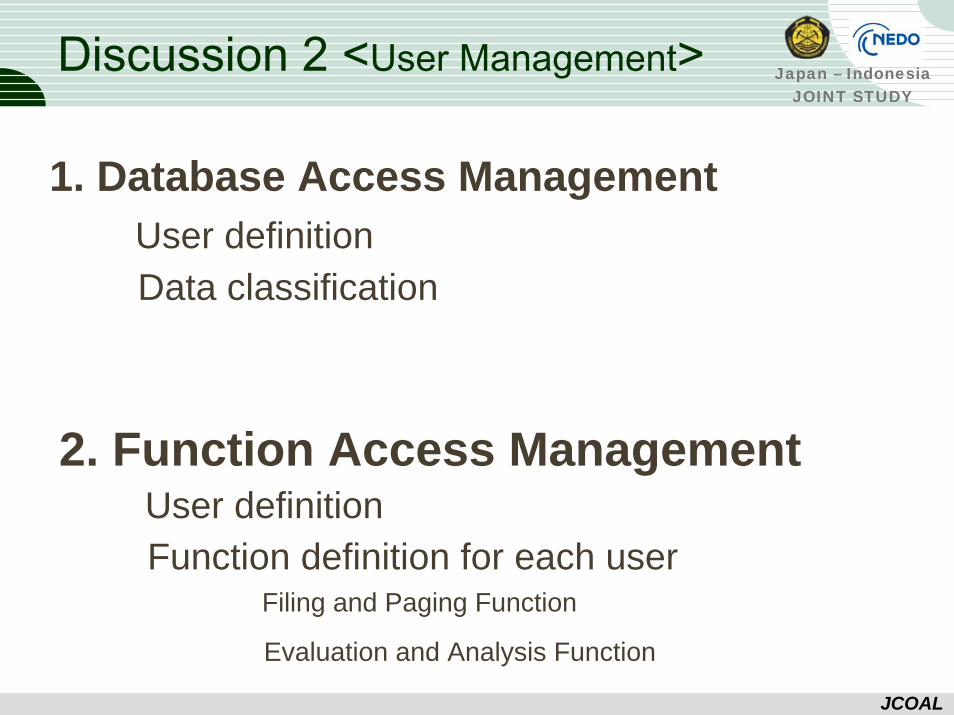
Discussion 2 <User Management>
1. Database Access Management
2. Function Access Management
User definition Data classification
User definition Function definition for each user
Filing and Paging Function
Evaluation and Analysis Function
Japan – IndonesiaJOINT STUDY
JCOAL
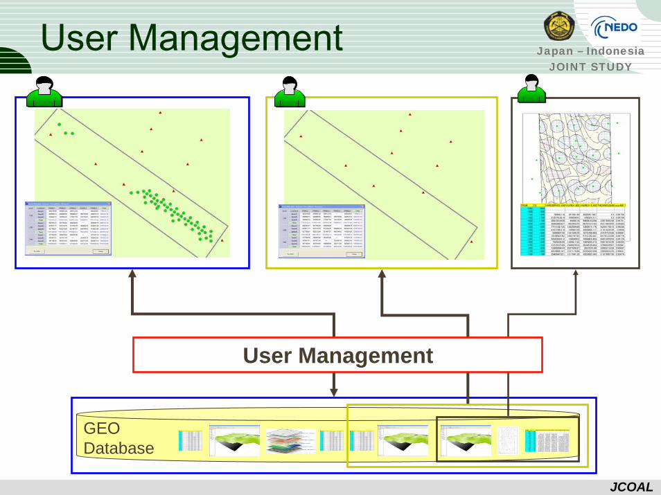
User Management
GEODatabase
User Management

Japan – IndonesiaJOINT STUDY
JCOAL
Progress of the Study (Digital Database)
Japan – IndonesiaJOINT STUDY
JCOAL
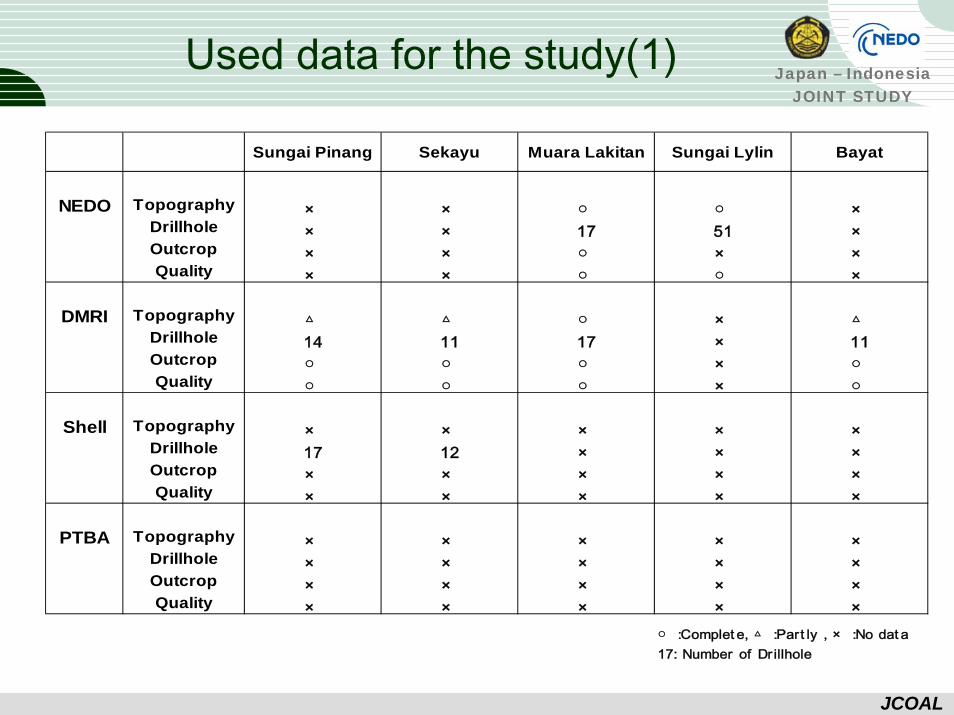
Used data for the study(1)
Sungai Pinang Sekayu Muara Lakitan Sungai Lylin Bayat
NEDO Topography × × ○ ○ ×Drillhole × × 17 51 ×Outcrop × × ○ × ×Quality × × ○ ○ ×
DMRI Topography △ △ ○ × △Drillhole 14 11 17 × 11Outcrop ○ ○ ○ × ○Quality ○ ○ ○ × ○
Shell Topography × × × × ×Drillhole 17 12 × × ×Outcrop × × × × ×Quality × × × × ×
PTBA Topography × × × × ×Drillhole × × × × ×Outcrop × × × × ×Quality × × × × ×
○ :Complet e, △ :Part ly , × :No dat a17: Number of Dr illhole
Japan – IndonesiaJOINT STUDY
JCOAL
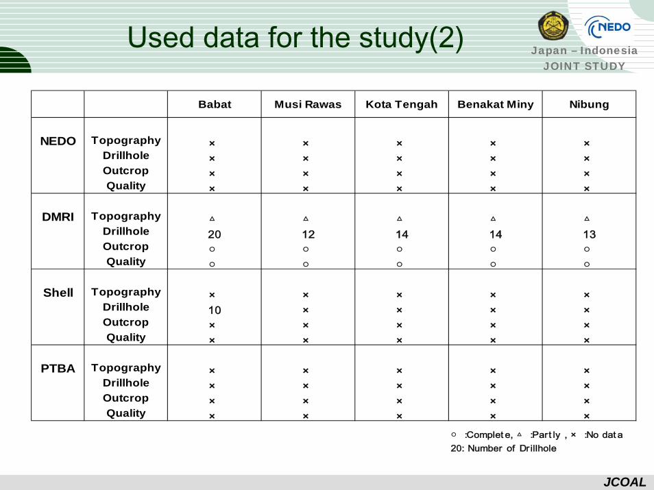
Used data for the study(2)
Babat Musi Rawas Kota Tengah Benakat Miny Nibung
NEDO Topography × × × × ×Drillhole × × × × ×Outcrop × × × × ×Quality × × × × ×
DMRI Topography △ △ △ △ △Drillhole 20 12 14 14 13Outcrop ○ ○ ○ ○ ○Quality ○ ○ ○ ○ ○
Shell Topography × × × × ×Drillhole 10 × × × ×Outcrop × × × × ×Quality × × × × ×
PTBA Topography × × × × ×Drillhole × × × × ×Outcrop × × × × ×Quality × × × × ×
○ :Complet e, △ :Part ly , × :No dat a20: Number of Dr illhole
Japan – IndonesiaJOINT STUDY
JCOAL
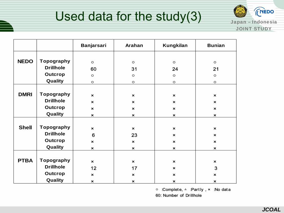
Used data for the study(3)
Banjarsari Arahan Kungkilan Bunian
NEDO Topography ○ ○ ○ ○Drillhole 60 31 24 21Outcrop ○ ○ ○ ○Quality ○ ○ ○ ○
DMRI Topography × × × ×Drillhole × × × ×Outcrop × × × ×Quality × × × ×
Shell Topography × × × ×Drillhole 6 23 × ×Outcrop × × × ×Quality × × × ×
PTBA Topography × × × ×Drillhole 12 17 × 3Outcrop × × × ×Quality × × × ×
○ :Complet e, △ :Part ly , × :No dat a60: Number of Dr illhole
Japan – IndonesiaJOINT STUDY
JCOAL
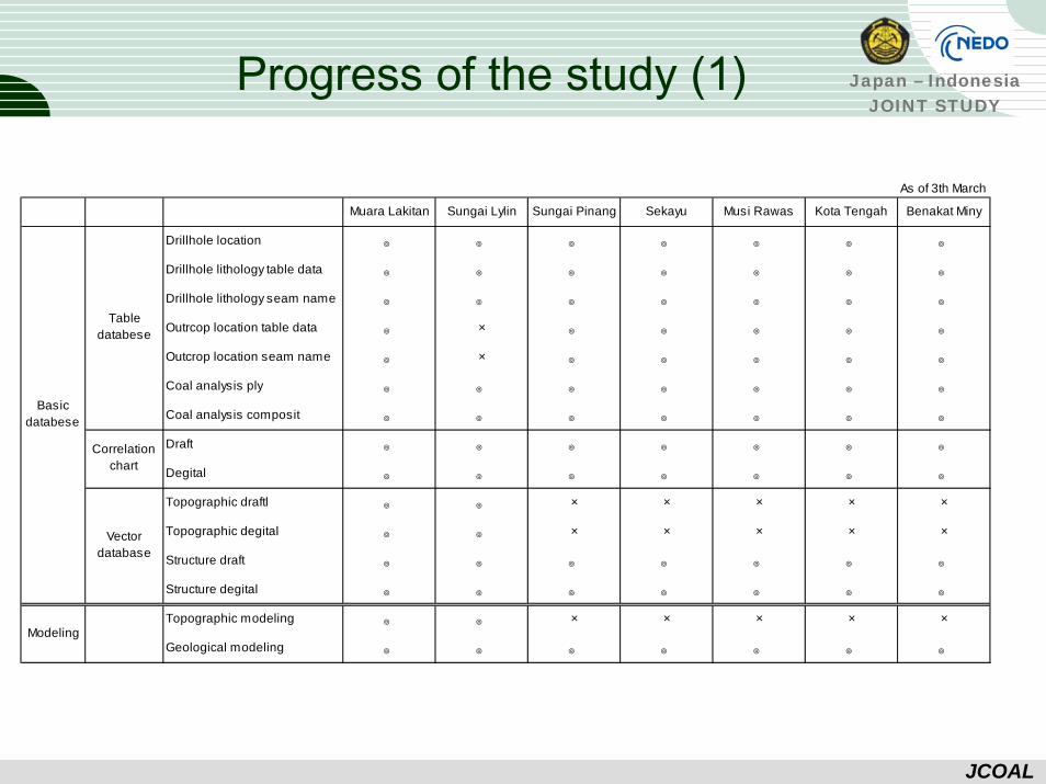
Progress of the study (1)
As of 3th March
Muara Lakitan Sungai Lylin Sungai Pinang Sekayu Musi Rawas Kota Tengah Benakat Miny
Drillhole location ◎ ◎ ◎ ◎ ◎ ◎ ◎
Drillhole lithology table data ◎ ◎ ◎ ◎ ◎ ◎ ◎
Drillhole lithology seam name ◎ ◎ ◎ ◎ ◎ ◎ ◎
Outrcop location table data ◎ × ◎ ◎ ◎ ◎ ◎
Outcrop location seam name ◎ × ◎ ◎ ◎ ◎ ◎
Coal analysis ply ◎ ◎ ◎ ◎ ◎ ◎ ◎
Coal analysis composit ◎ ◎ ◎ ◎ ◎ ◎ ◎
Draft ◎ ◎ ◎ ◎ ◎ ◎ ◎
Degital ◎ ◎ ◎ ◎ ◎ ◎ ◎
Topographic draftl ◎ ◎ × × × × ×
Topographic degital ◎ ◎ × × × × ×
Structure draft ◎ ◎ ◎ ◎ ◎ ◎ ◎
Structure degital ◎ ◎ ◎ ◎ ◎ ◎ ◎
Topographic modeling ◎ ◎ × × × × ×
Geological modeling ◎ ◎ ◎ ◎ ◎ ◎ ◎
Basicdatabese
Modeling
Tabledatabese
Correlationchart
Vectordatabase
Japan – IndonesiaJOINT STUDY
JCOAL
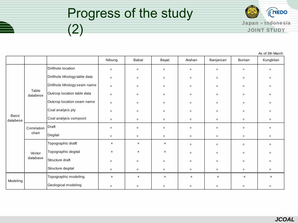
Progress of the study (2)
As of 3th March
Nibung Babat Bayat Arahan Banjarsari Bunian Kungkilan
Drillhole location ◎ ◎ ◎ ◎ ◎ ◎ ◎
Drillhole lithology table data ◎ ◎ ◎ ◎ ◎ ◎ ◎
Drillhole lithology seam name ◎ ◎ ◎ ◎ ◎ ◎ ◎
Outrcop location table data ◎ ◎ ◎ ◎ ◎ ◎ ◎
Outcrop location seam name ◎ ◎ ◎ ◎ ◎ ◎ ◎
Coal analysis ply ◎ ◎ ◎ ◎ ◎ ◎ ◎
Coal analysis composit ◎ ◎ ◎ ◎ ◎ ◎ ◎
Draft ◎ ◎ ◎ ◎ ◎ ◎ ◎
Degital ◎ ◎ ◎ ◎ ◎ ◎ ◎
Topographic draftl × × × ◎ ◎ ◎ ◎
Topographic degital × × × ◎ ◎ ◎ ◎
Structure draft ◎ ◎ ◎ ◎ ◎ ◎ ◎
Structure degital ◎ ◎ ◎ ◎ ◎ ◎ ◎
Topographic modeling × × × × × × ×
Geological modeling ◎ ◎ ◎ ◎ ◎ ◎ ◎
Basicdatabese
Modeling
Tabledatabese
Correlationchart
Vectordatabase

Japan – IndonesiaJOINT STUDY
JCOAL
Thank You Very Much

Japan – IndonesiaJOINT STUDY
JCOAL

Japan – IndonesiaJOINT STUDY
JCOAL
Japan – IndonesiaJOINT STUDY
JCOAL
System Concept
Japan – IndonesiaJOINT STUDY
JCOAL
System Concept