Embed Size (px)
Citation preview
www.nasa.gov
National Aeronautics and
Space Administration
ARSETApplied Remote Sensing Traininghttp://arset.gsfc.nasa.gov
@NASAARSET
Introduction to Satellite Remote
Sensing for Air Quality Applications
Webinar Session 1 – July 6, 2016
Training Overview and Introduction to
Satellite Remote Sensing
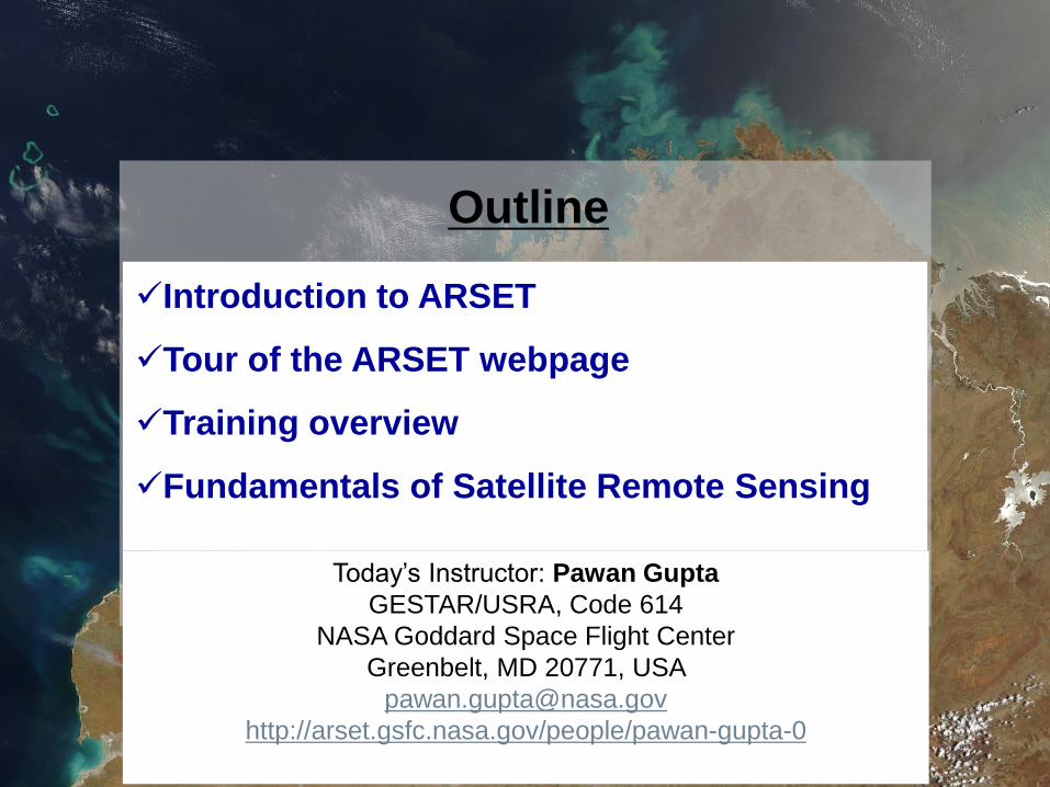
Outline
Introduction to ARSET
Tour of the ARSET webpage
Training overview
Fundamentals of Satellite Remote Sensing
Today’s Instructor: Pawan Gupta
GESTAR/USRA, Code 614
NASA Goddard Space Flight Center
Greenbelt, MD 20771, USA
http://arset.gsfc.nasa.gov/people/pawan-gupta-0
National Aeronautics and Space Administration 3Applied Remote Sensing Training Program
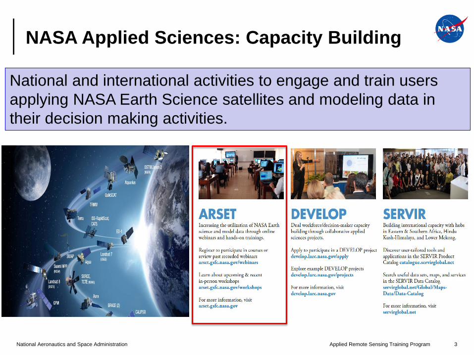
NASA Applied Sciences: Capacity Building
National and international activities to engage and train users
applying NASA Earth Science satellites and modeling data in
their decision making activities.
National Aeronautics and Space Administration 4Applied Remote Sensing Training Program
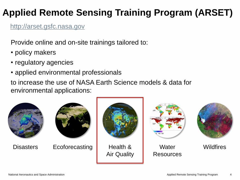
Applied Remote Sensing Training Program (ARSET)
Provide online and on-site trainings tailored to:
• policy makers
• regulatory agencies
• applied environmental professionals
to increase the use of NASA Earth Science models & data for
environmental applications:
http://arset.gsfc.nasa.gov
Health &
Air Quality
Disasters Water
Resources
WildfiresEcoforecasting
National Aeronautics and Space Administration 5Applied Remote Sensing Training Program
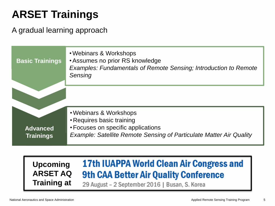
ARSET Trainings
A gradual learning approach
• Webinars & Workshops
• Assumes no prior RS knowledge
Examples: Fundamentals of Remote Sensing; Introduction to Remote
Sensing
Basic Trainings
• Webinars & Workshops
• Requires basic training
• Focuses on specific applications
Example: Satellite Remote Sensing of Particulate Matter Air QualityAdvanced
Trainings
Upcoming
ARSET AQ
Training at
National Aeronautics and Space Administration 6Applied Remote Sensing Training Program
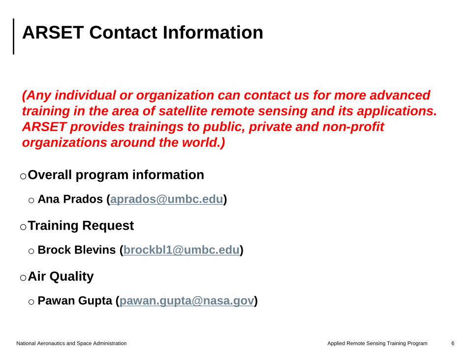
ARSET Contact Information
(Any individual or organization can contact us for more advanced
training in the area of satellite remote sensing and its applications.
ARSET provides trainings to public, private and non-profit
organizations around the world.)
oOverall program information
o Ana Prados ([email protected])
oTraining Request
o Brock Blevins ([email protected])
oAir Quality
o Pawan Gupta ([email protected])
www.nasa.gov
National Aeronautics and
Space Administration
ARSETApplied Remote Sensing Traininghttp://arset.gsfc.nasa.gov
@NASAARSET
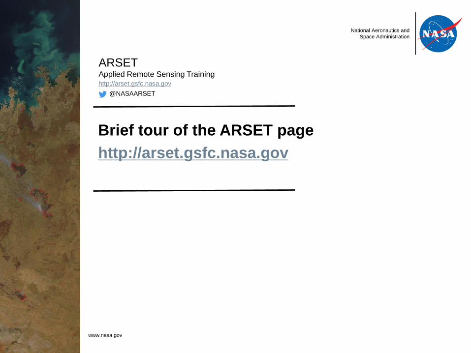
Brief tour of the ARSET page
http://arset.gsfc.nasa.gov
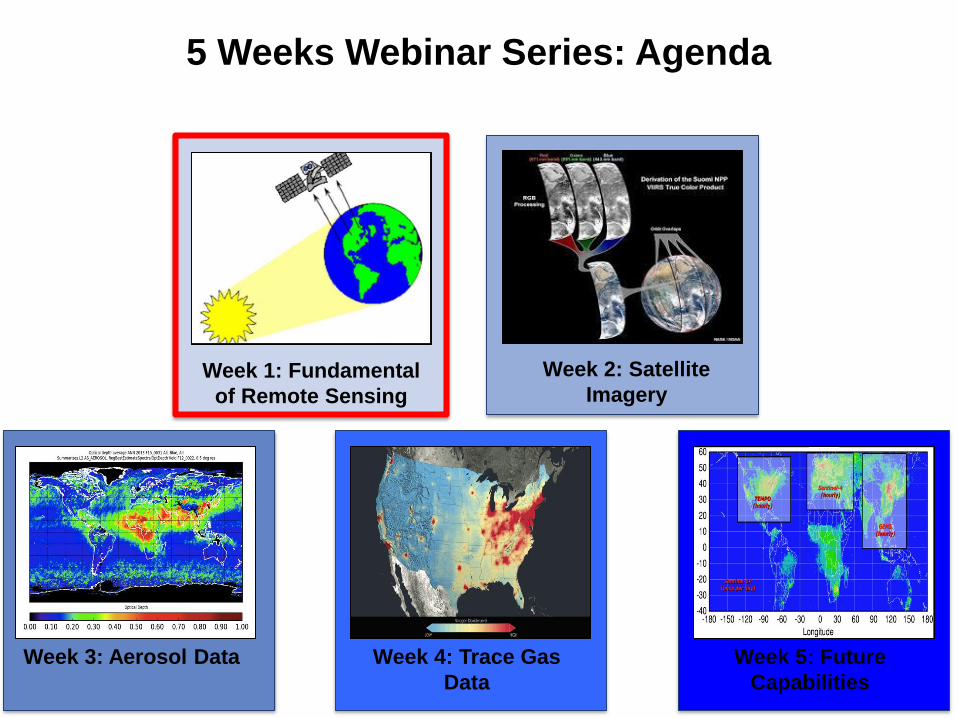
5 Weeks Webinar Series: Agenda
Week 1: Fundamental
of Remote Sensing
Week 2: Satellite
Imagery
Week 3: Aerosol Data Week 4: Trace Gas
Data
Week 5: Future
Capabilities
www.nasa.gov
National Aeronautics and
Space Administration
ARSETApplied Remote Sensing Traininghttp://arset.gsfc.nasa.gov
@NASAARSET
Fundamentals of Satellite Remote
Sensing
National Aeronautics and Space Administration 10Applied Remote Sensing Training Program
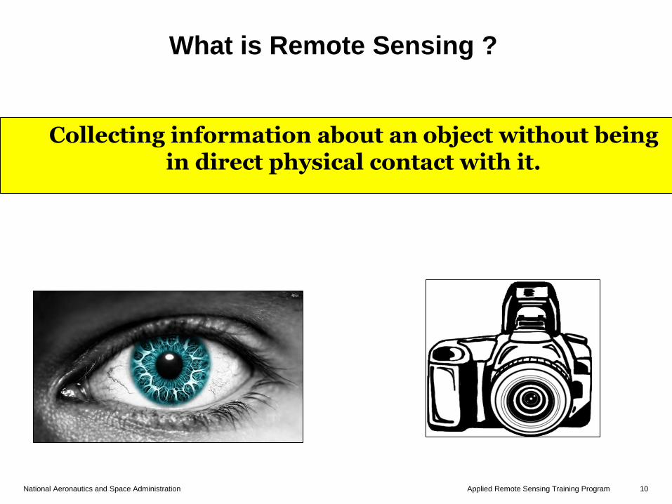
What is Remote Sensing ?
Collecting information about an object without being in direct physical contact with it.
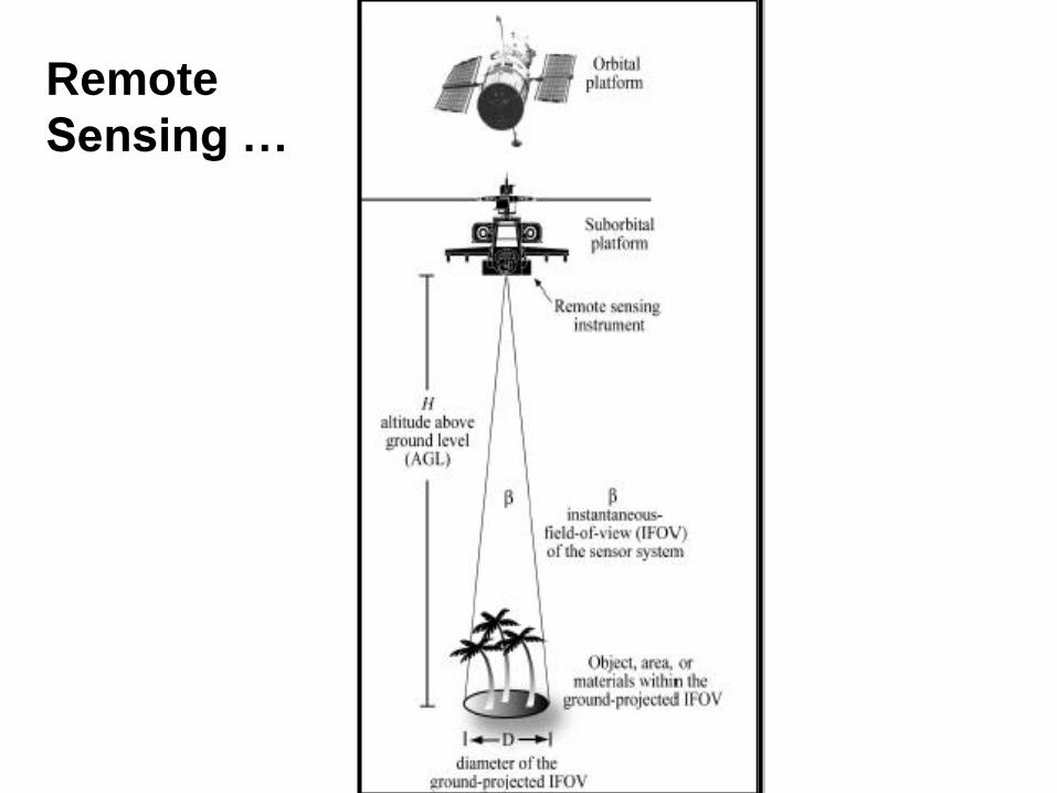
Remote
Sensing …

National Aeronautics and Space Administration 12Applied Remote Sensing Training Program
Remote Sensing: Platforms
• The platform depends on the end application
• What information do you want?
• How much detail do you need?
• What type of detail?
• How frequently do you need the data?
National Aeronautics and Space Administration 13Applied Remote Sensing Training Program
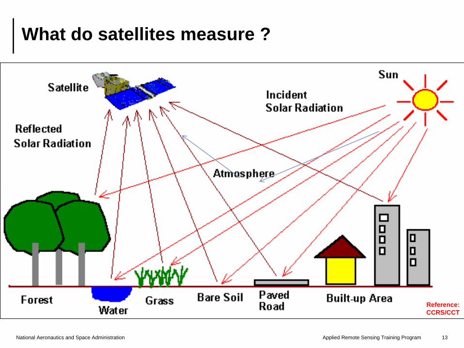
What do satellites measure ?
Reference:
CCRS/CCT
National Aeronautics and Space Administration 14Applied Remote Sensing Training Program
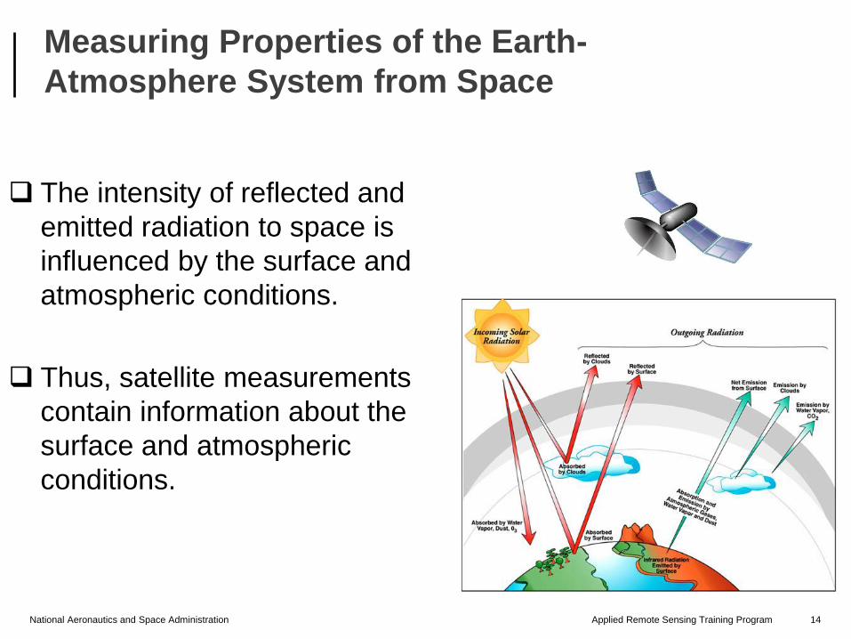
The intensity of reflected and
emitted radiation to space is
influenced by the surface and
atmospheric conditions.
Thus, satellite measurements
contain information about the
surface and atmospheric
conditions.
Measuring Properties of the Earth-
Atmosphere System from Space
National Aeronautics and Space Administration 15Applied Remote Sensing Training Program
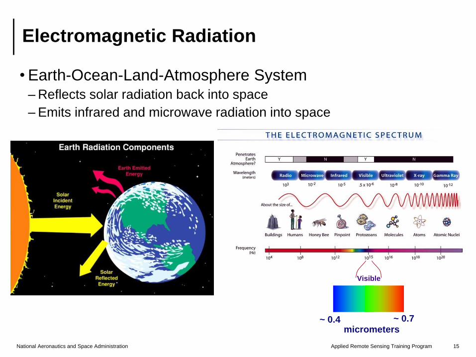
• Earth-Ocean-Land-Atmosphere System– Reflects solar radiation back into space
– Emits infrared and microwave radiation into space
Electromagnetic Radiation
Visible
~ 0.4micrometers
~ 0.7
National Aeronautics and Space Administration 16Applied Remote Sensing Training Program
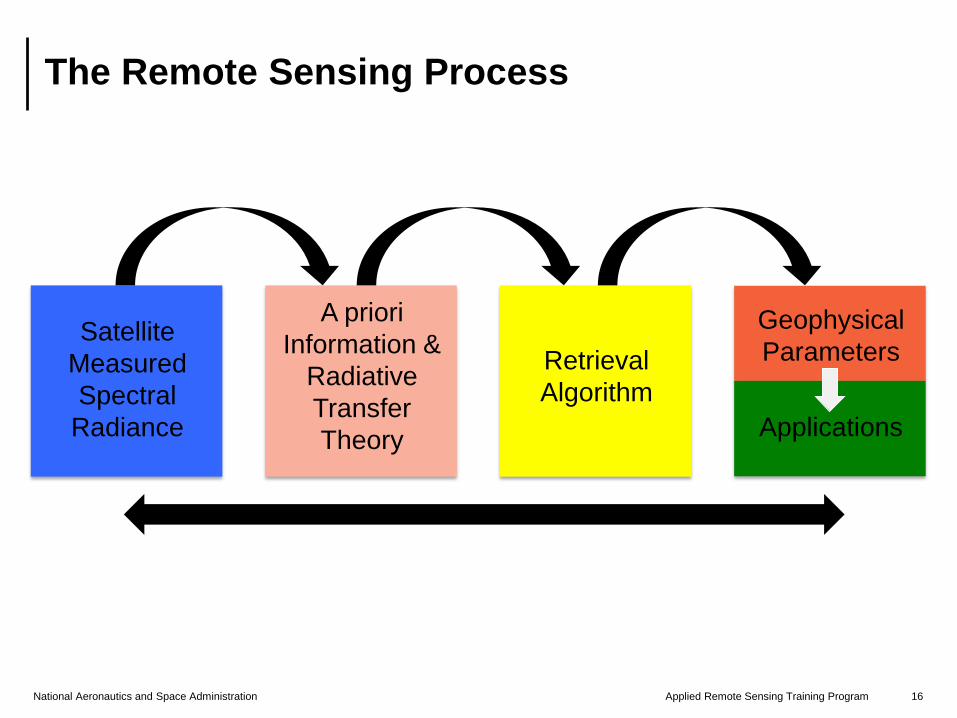
The Remote Sensing Process
A priori
Information &
Radiative
Transfer
Theory
Retrieval
Algorithm
Geophysical
Parameters
Applications
Satellite
Measured
Spectral
Radiance

www.nasa.gov
National Aeronautics and
Space Administration
ARSETApplied Remote Sensing Traininghttp://arset.gsfc.nasa.gov
@NASAARSET
Satellites, Sensors, and Orbits
National Aeronautics and Space Administration 18Applied Remote Sensing Training Program
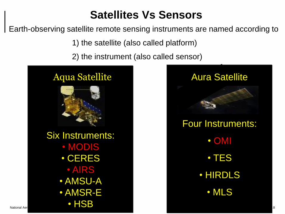
Earth-observing satellite remote sensing instruments are named according to
1) the satellite (also called platform)
2) the instrument (also called sensor)
Six Instruments:
• MODIS
• CERES
• AIRS
• AMSU-A
• AMSR-E
• HSB
Four Instruments:
• OMI
• TES
• HIRDLS
• MLS
Aura SatelliteAqua Satellite
Satellites Vs Sensors
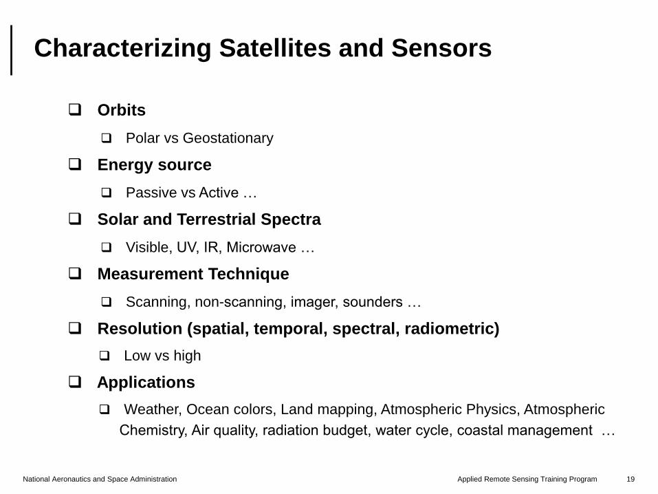
National Aeronautics and Space Administration 19Applied Remote Sensing Training Program
Satellite/Sensor Classifications
Orbits
Polar vs Geostationary
Energy source
Passive vs Active …
Solar and Terrestrial Spectra
Visible, UV, IR, Microwave …
Measurement Technique
Scanning, non-scanning, imager, sounders …
Resolution (spatial, temporal, spectral, radiometric)
Low vs high
Applications
Weather, Ocean colors, Land mapping, Atmospheric Physics, Atmospheric
Chemistry, Air quality, radiation budget, water cycle, coastal management …
Characterizing Satellites and Sensors
National Aeronautics and Space Administration 20Applied Remote Sensing Training Program
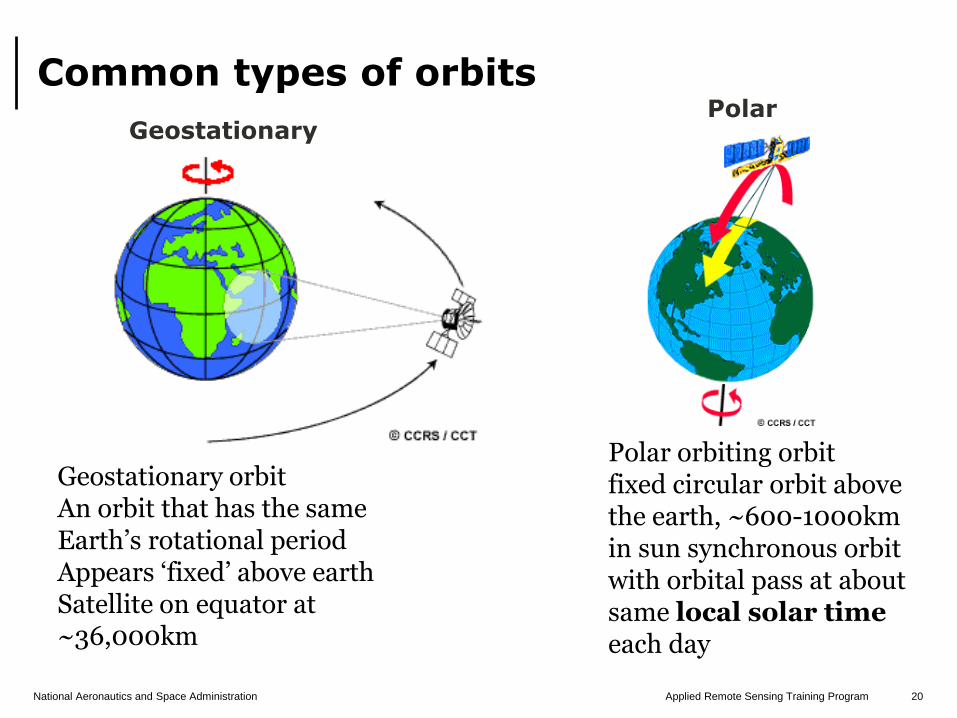
Common types of orbits
Geostationary orbitAn orbit that has the same Earth’s rotational periodAppears ‘fixed’ above earth Satellite on equator at ~36,000km
Polar orbiting orbitfixed circular orbit above the earth, ~600-1000km in sun synchronous orbit with orbital pass at about same local solar timeeach day
GeostationaryPolar
National Aeronautics and Space Administration 21Applied Remote Sensing Training Program
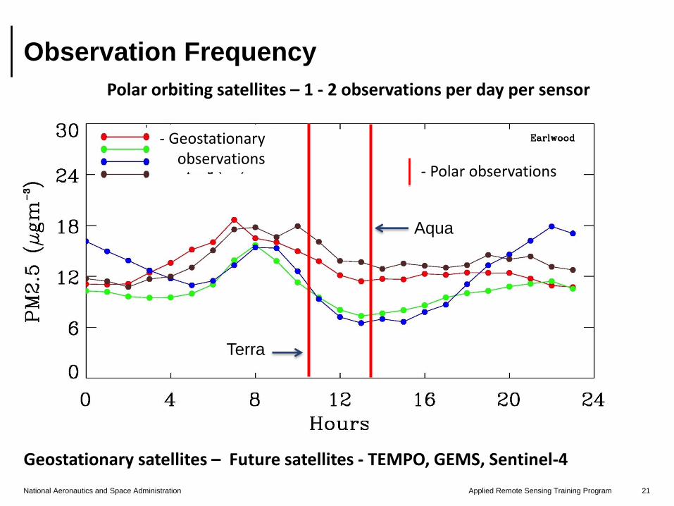
Observation Frequency
Polar orbiting satellites – 1 - 2 observations per day per sensor
Geostationary satellites – Future satellites - TEMPO, GEMS, Sentinel-4
- Polar observations
- Geostationaryobservations
Terra
Aqua
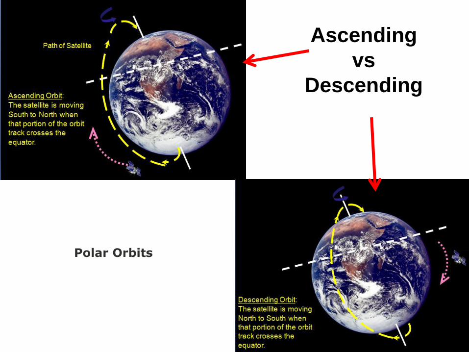
Ascending
vs
Descending
Polar Orbits
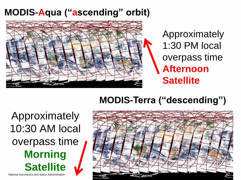
National Aeronautics and Space Administration 23Applied Remote Sensing Training Program
MODIS-Aqua (“ascending” orbit)
MODIS-Terra (“descending”)
Approximately
1:30 PM local
overpass time
Afternoon
Satellite
Approximately
10:30 AM local
overpass time
Morning
Satellite
National Aeronautics and Space Administration 24Applied Remote Sensing Training Program
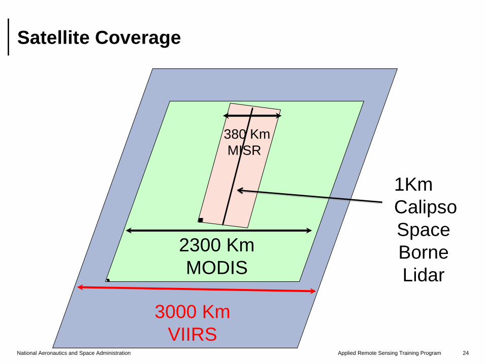
Satellite Coverage
2300 Km
MODIS
3000 Km
VIIRS
1Km
Calipso
Space
Borne
Lidar
380 Km
MISR
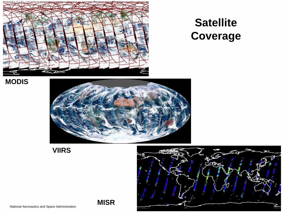
National Aeronautics and Space Administration 25Applied Remote Sensing Training Program
Satellite
Coverage
MODIS
VIIRS
MISR
National Aeronautics and Space Administration 26Applied Remote Sensing Training Program
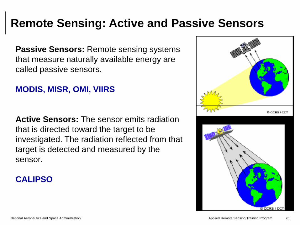
Remote Sensing: Active and Passive Sensors
Passive Sensors: Remote sensing systems
that measure naturally available energy are
called passive sensors.
MODIS, MISR, OMI, VIIRS
Active Sensors: The sensor emits radiation
that is directed toward the target to be
investigated. The radiation reflected from that
target is detected and measured by the
sensor.
CALIPSO
Resolution
National Aeronautics and Space Administration 28Applied Remote Sensing Training Program
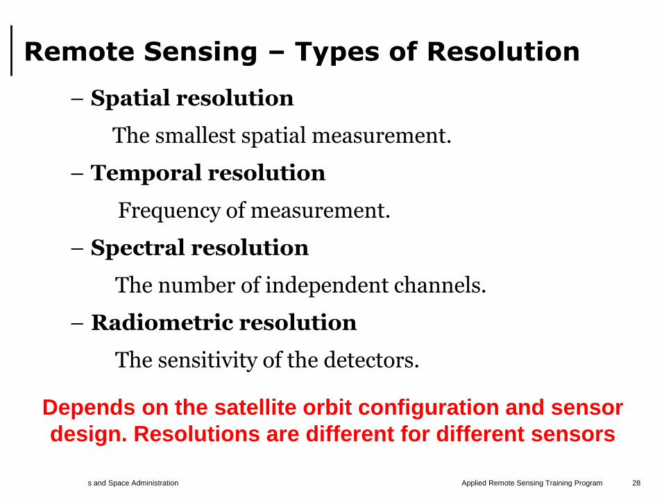
Remote Sensing – Types of Resolution
– Spatial resolution
The smallest spatial measurement.
– Temporal resolution
Frequency of measurement.
– Spectral resolution
The number of independent channels.
– Radiometric resolution
The sensitivity of the detectors.
Depends on the satellite orbit configuration and sensor
design. Resolutions are different for different sensors
National Aeronautics and Space Administration 29Applied Remote Sensing Training Program
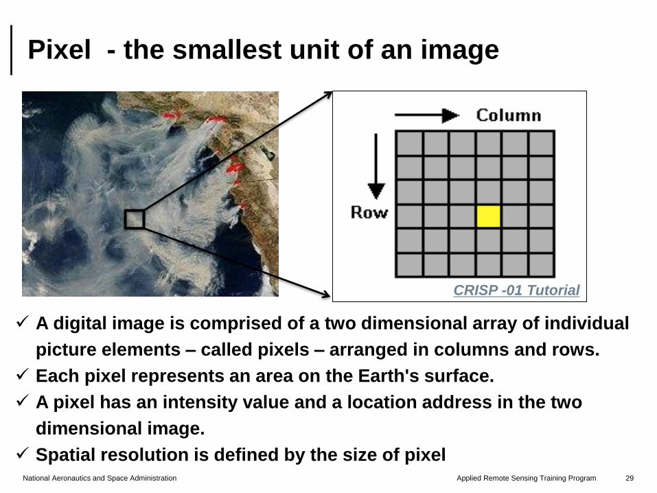
Pixel - the smallest unit of an image
A digital image is comprised of a two dimensional array of individual
picture elements – called pixels – arranged in columns and rows.
Each pixel represents an area on the Earth's surface.
A pixel has an intensity value and a location address in the two
dimensional image.
Spatial resolution is defined by the size of pixel
CRISP -01 Tutorial
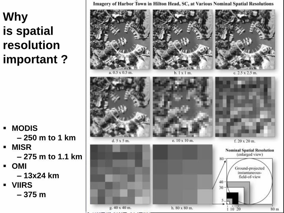
Why
is spatial
resolution
important ?
MODIS
– 250 m to 1 km
MISR
– 275 m to 1.1 km
OMI
– 13x24 km
VIIRS
– 375 m
National Aeronautics and Space Administration 31Applied Remote Sensing Training Program
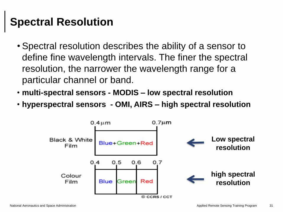
Spectral Resolution
• Spectral resolution describes the ability of a sensor to
define fine wavelength intervals. The finer the spectral
resolution, the narrower the wavelength range for a
particular channel or band.
• multi-spectral sensors - MODIS – low spectral resolution
• hyperspectral sensors - OMI, AIRS – high spectral resolution
Low spectral
resolution
high spectral
resolution
National Aeronautics and Space Administration 32Applied Remote Sensing Training Program
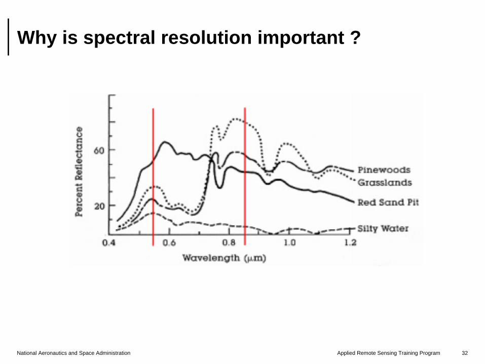
Why is spectral resolution important ?
National Aeronautics and Space Administration 33Applied Remote Sensing Training Program
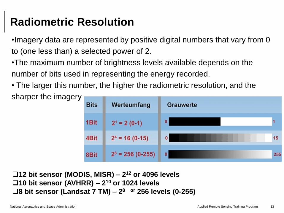
Radiometric Resolution
•Imagery data are represented by positive digital numbers that vary from 0
to (one less than) a selected power of 2.
•The maximum number of brightness levels available depends on the
number of bits used in representing the energy recorded.
• The larger this number, the higher the radiometric resolution, and the
sharper the imagery
12 bit sensor (MODIS, MISR) – 212 or 4096 levels
10 bit sensor (AVHRR) – 210 or 1024 levels
8 bit sensor (Landsat 7 TM) – 28 or 256 levels (0-255)
National Aeronautics and Space Administration 34Applied Remote Sensing Training Program
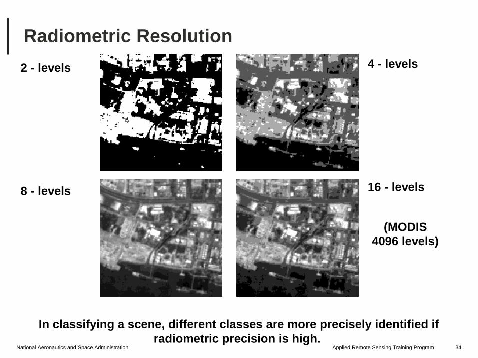
Radiometric Resolution
2 - levels 4 - levels
8 - levels 16 - levels
In classifying a scene, different classes are more precisely identified if
radiometric precision is high.
(MODIS
4096 levels)
National Aeronautics and Space Administration 35Applied Remote Sensing Training Program
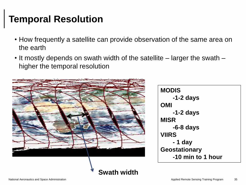
Temporal Resolution
• How frequently a satellite can provide observation of the same area on
the earth
• It mostly depends on swath width of the satellite – larger the swath –
higher the temporal resolution
MODIS
-1-2 days
OMI
-1-2 days
MISR
-6-8 days
VIIRS
- 1 day
Geostationary
-10 min to 1 hour
Swath width
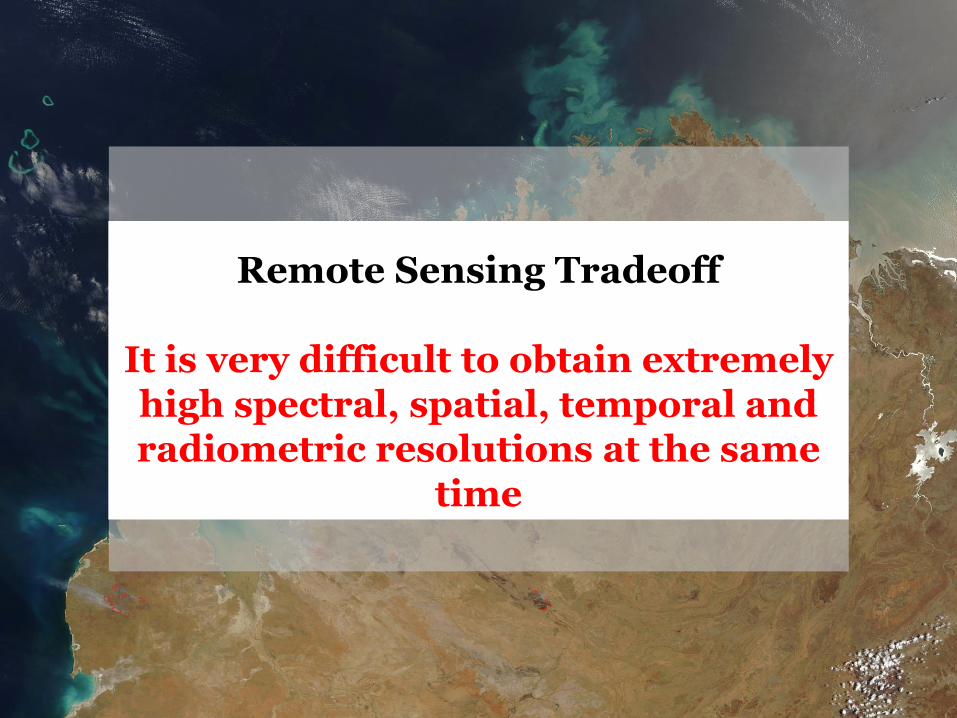
Remote Sensing Tradeoff
It is very difficult to obtain extremely high spectral, spatial, temporal and radiometric resolutions at the same
time
National Aeronautics and Space Administration 37Applied Remote Sensing Training Program
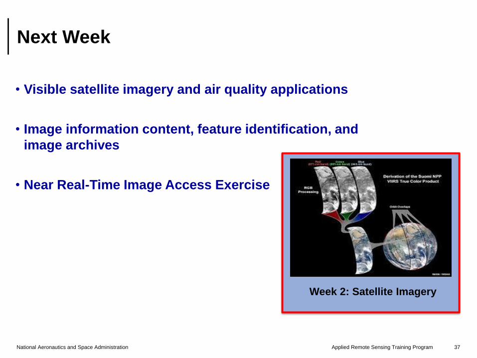
Next Week
• Visible satellite imagery and air quality applications
• Image information content, feature identification, and
image archives
• Near Real-Time Image Access Exercise
Week 2: Satellite Imagery
National Aeronautics and Space Administration 38Applied Remote Sensing Training Program
Natural Resources Canada
http://www.nrcan.gc.ca/earth-sciences/geomatics/satellite-imagery-air-
photos/satellite-imagery-products/educational-resources/9309
Center for Remote Imaging, Sensing and Processing
http://www.crisp.nus.edu.sg/~research/tutorial/image.htm
Earth Observatory
http://earthobservatory.nasa.gov/Features/RemoteSensing/remote_06.p
hp
EOS-Goddard
http://fas.org/irp/imint/docs/rst/Front/tofc.html
Spectral Resolution
http://web.pdx.edu/~jduh/courses/Archive/geog481w07/Students/Cody_Spectral
Resolution.pdf
References and Further Reading
NO ASSIGNMENTS
Attending all sessions (live or
recording) required for the
certificate
All the materials and recordings
will be available at
http://arset.gsfc.nasa.gov/airquality/webin
ars/introduction-satellite-remote-sensing-
air-quality-applications
Contact Pawan Gupta ([email protected]) for the technical questions
Brock Blevins ([email protected]) for material access, future trainings, and other logistic