Embed Size (px)
Citation preview
INDONESIA
NATIONAL PROFILE
DISASTER RISK PROFILE
INSTITUTIONAL SETUP
INITIATIVES
1. NATIONAL PROFILE
1.1 General1
Indonesia is the world's largest archipelago, with more than 17,500 islands that
scattered between 6 degrees north latitude to 11 degrees south latitude and from 9
degrees to 141 degrees east longitude. Indonesia bridges two continents, Asia and
Australia/Oceania. This strategic position profoundly influences the country's
culture, social and political life, and the economy.
Spanning the length of 3,977 miles from the Indian Ocean to the Pacific Ocean, if
its territorial waters were included, the total area of Indonesia would cover 1.9
million square miles.
The five major islands of Indonesia are: Sumatra with an area of 473,606 square
km, Java with an area of 132,107 square km, Kalimantan with 539,460 square km,
Sulawesi with 189,216 square km, and Papua covering an area of 421,981 square
km.
1.2 Physiography1
Indonesia is a land of vivid contrasts. Gleaming urban skyscraper tower above tiny
roadside kiosks selling ancient herbal remedies thatch-roofed village houses sport a
television in the family room and a team of oxen tethered in the yard.
To understand the forces shaping the personality of Indonesia, past and present,
many of the nation's most fundamental characteristics can be discerned from the
contours of a map.
The map reveals a sprawling nation, tracing the path of the Equator over several
thousand miles. Comprising 13,700 islands a bridge between the landmass of
Southeast Asia and the continent of Australia, the vast archipelago of Indonesia
spans three time zones over a width greater than the distance from Dublin to
Moscow, or from Florida to Alaska. Indonesia's historical evolution has been
strongly influenced by the sheer forces of its own geography - with the interplay
between climate, rainfall and volcanic activity shaping agricultural and population
patterns in different ways throughout the country's enormous diversity of islands.
Islands such as Java and Bali are endowed with some of the most fertile soil of the
Earth.
For this reason, they are most heavily populated and enjoy the most ancient of
cultures. Other regions -- such as Kalimantan, with its heavy forest canopy, or
Nusa Tenggara (Lesser Sunda) islands, with their more arid climate -- are home to
smaller numbers of people.
The distance separating islands both from one another and from neighboring
countries also played a critical role in determining Indonesia's early patterns of
settlement and population movement. Whether for trade or cultural reasons, certain
regions of Indonesia shared histories that were closely intertwined. Other regions
remained largely untouched by outside contact and developed their traditions in
relative isolation. Java, for example was strongly influenced by the early Hindu
and Buddhist traders from India, as long ago as the 7th century, coastal
Kalimantan, on the other hand, was touched more directly by influences from
Northeast Asian nations; Aceh, in northernmost Sumatra, was more strongly
affected by Islamic traders from the Middle East. All have joined together to create
the Indonesian mosaic today.
Geography has also played role in the remarkable diversity of Indonesia's abundant
plant and animal life. The 19th-century British botanist Alfred Russell Wallace,
who is credited, together with Darwin, with the theory of evolution, determined a
precise line of demarcation between the Indonesian islands of Bali and Lombok --
the "Wallace Line" -- which separates the flora and fauna found throughout Asia
from those unique to Australasia.
Sometimes called the "Ring of Fire" (referring to the chain of active volcanoes
that form its spine) Indonesia also is the sole habitat for several of the world's most
unusual living species -- ranging from the menacing Komodo Drageon, a 10-foot
carnivorous lizard, to a bizarre flower known as Rafflesia, with damp and tropical
petals opening more than a meter in diameter. Just as the forces of geography and
climate strongly influenced these islands in the past, they continue to play a critical
role in shaping the evolving nature of Indonesia today.
Beginning as a loosely structured amalgam of autonomous regions and races,
Indonesia has worked diligently to develop a common national language and a
shared political ideology Together these have played a crucial role in forging
former fiefdoms into today's proud unified nation. It was with good reason that the
new country adopted as its motto the slogan Bhinneka Tunggal Ika. Taken from the
ancient Sanskrit means "Unity in Diversity" - aptly expressing the rich complexity
of the people of Indonesia and their nation.
1.3 Climate1
The climate and weather of Indonesia is characterized by two tropical seasons,
which vary with the equatorial air circulation (The Walker Circulation) and the
meridian air circulation (The Hardley Circulation). The displacement of the latter
follows the north-south movement of the sun and its relative position form the
earth, in particular from the continents of Asia and Australia, at certain periods of
the year.
These factors contribute to the displacement and intensity of the Inter-Tropical
Convergence Zone (ITCZ) which is an equatorial trough of low pressure that
produces rain. Thus, the west and east monsoons, or the rainy and dry seasons, are
a prevalent feature of the tropical climate.
I. The Main Seasons
The climate changes every six months. The dry season (June to September) is
influenced by the Australian continental air masses; while the rainy season
(December to March) is the result of the Asian and Pacific Ocean air masses. The
air contains vapor which precipitates and produces rain in the country. Tropical
areas have rains almost the whole year through. However, the climate of Central
Maluku is an exception. The rainy season is from June to September and the dry
season from December to March. The transitional periods between the two seasons
are April to May and October to November.
II. Temperature and Humidity
Due to the large number of islands and mountains in the country, average
temperatures may be classified as follows: coastal plains: 28°C inland and
mountain areas: 26°C higher mountain areas: 23°C, varying with the altitude.
Being in a tropical zone, Indonesia has an average relative humidity between 70%
and 90%, with a minimum of 73% and a maximum of 87%.
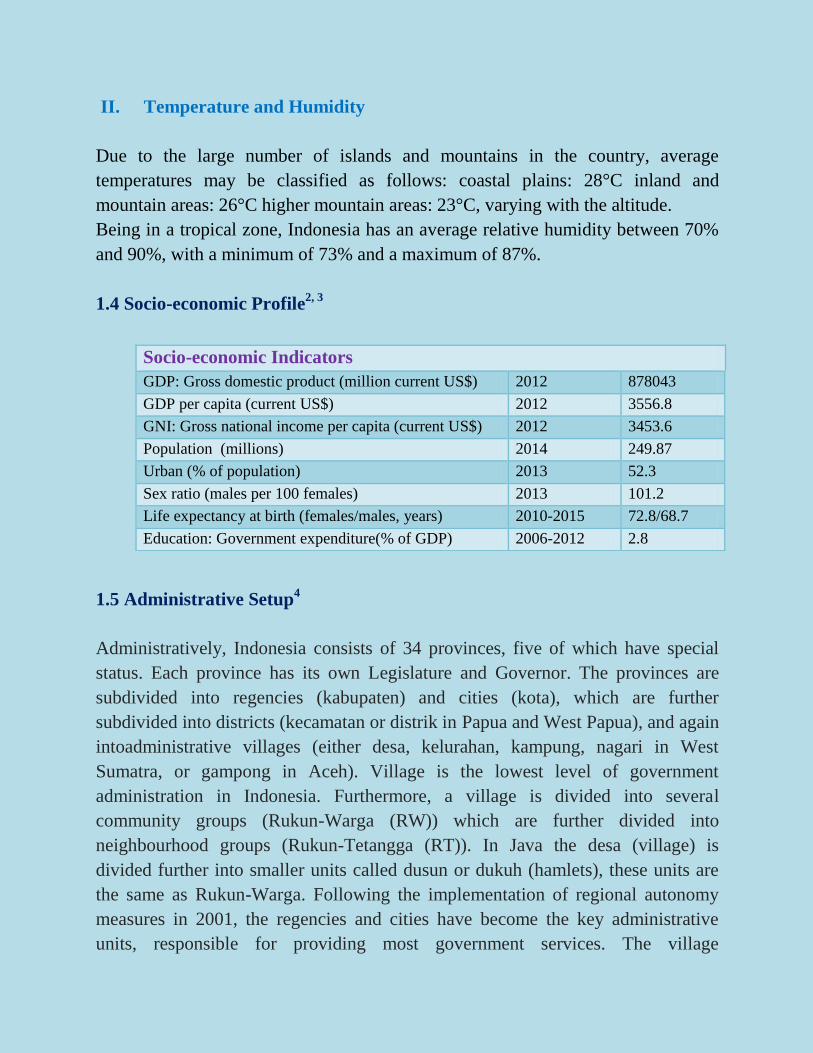
1.4 Socio-economic Profile2, 3
1.5 Administrative Setup4
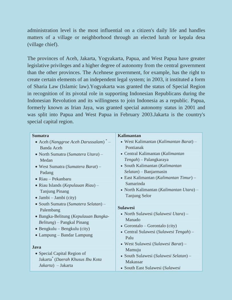
Administratively, Indonesia consists of 34 provinces, five of which have special
status. Each province has its own Legislature and Governor. The provinces are
subdivided into regencies (kabupaten) and cities (kota), which are further
subdivided into districts (kecamatan or distrik in Papua and West Papua), and again
intoadministrative villages (either desa, kelurahan, kampung, nagari in West
Sumatra, or gampong in Aceh). Village is the lowest level of government
administration in Indonesia. Furthermore, a village is divided into several
community groups (Rukun-Warga (RW)) which are further divided into
neighbourhood groups (Rukun-Tetangga (RT)). In Java the desa (village) is
divided further into smaller units called dusun or dukuh (hamlets), these units are
the same as Rukun-Warga. Following the implementation of regional autonomy
measures in 2001, the regencies and cities have become the key administrative
units, responsible for providing most government services. The village
Socio-economic Indicators
GDP: Gross domestic product (million current US$) 2012 878043
GDP per capita (current US$) 2012 3556.8
GNI: Gross national income per capita (current US$) 2012 3453.6
Population (millions) 2014 249.87
Urban (% of population) 2013 52.3
Sex ratio (males per 100 females) 2013 101.2
Life expectancy at birth (females/males, years) 2010-2015 72.8/68.7
Education: Government expenditure(% of GDP) 2006-2012 2.8
administration level is the most influential on a citizen's daily life and handles
matters of a village or neighborhood through an elected lurah or kepala desa
(village chief).
The provinces of Aceh, Jakarta, Yogyakarta, Papua, and West Papua have greater
legislative privileges and a higher degree of autonomy from the central government
than the other provinces. The Acehnese government, for example, has the right to
create certain elements of an independent legal system; in 2003, it instituted a form
of Sharia Law (Islamic law).Yogyakarta was granted the status of Special Region
in recognition of its pivotal role in supporting Indonesian Republicans during the
Indonesian Revolution and its willingness to join Indonesia as a republic. Papua,
formerly known as Irian Jaya, was granted special autonomy status in 2001 and
was split into Papua and West Papua in February 2003.Jakarta is the country's
special capital region.
Sumatra
Aceh (Nanggroe Aceh Darussalam) * –
Banda Aceh
North Sumatra (Sumatera Utara) –
Medan
West Sumatra (Sumatera Barat) –
Padang
Riau – Pekanbaru
Riau Islands (Kepulauan Riau) –
Tanjung Pinang
Jambi – Jambi (city)
South Sumatra (Sumatera Selatan) –
Palembang
Bangka-Belitung (Kepulauan Bangka-
Belitung) – Pangkal Pinang
Bengkulu – Bengkulu (city)
Lampung – Bandar Lampung
Java
Special Capital Region of
Jakarta* (Daerah Khusus Ibu Kota
Jakarta) – Jakarta
Kalimantan
West Kalimantan (Kalimantan Barat) –
Pontianak
Central Kalimantan (Kalimantan
Tengah) – Palangkaraya
South Kalimantan (Kalimantan
Selatan) – Banjarmasin
East Kalimantan (Kalimantan Timur) –
Samarinda
North Kalimantan (Kalimantan Utara) –
Tanjung Selor
Sulawesi
North Sulawesi (Sulawesi Utara) –
Manado
Gorontalo – Gorontalo (city)
Central Sulawesi (Sulawesi Tengah) –
Palu
West Sulawesi (Sulawesi Barat) –
Mamuju
South Sulawesi (Sulawesi Selatan) –
Makassar
South East Sulawesi (Sulawesi
Banten – Serang
West Java (Jawa Barat) – Bandung
Central Java (Jawa Tengah) – Semarang
Yogyakarta Special Region* (Daerah
Istimewa Yogyakarta) – Yogyakarta
(city)
East Java (Jawa Timur) – Surabaya
Lesser Sunda Islands
Bali – Denpasar
West Nusa Tenggara (Nusa Tenggara
Barat) – Mataram
East Nusa Tenggara (Nusa Tenggara
Timur) – Kupang
Tenggara) – Kendari
Maluku Islands
Maluku – Ambon
North Maluku (Maluku Utara) – Sofifi
Western New Guinea
West Papua* (Papua Barat) –
Manokwari
Papua* – Jayapura
* indicates provinces with Special Status
2. DISASTER RISK PROFILE5
Indonesia ranks 12th among countries having relatively high mortality risks from
multiple hazards. Indonesia is situated in one of the most active disaster hot spots
where several types of disasters such as earthquake, tsunami, volcanic eruption,
flood, landslide, and drought and forest fires frequently occur. According to a
global risk analysis by the World Bank, Indonesia is among the top 35 countries
that have high mortality risks from multiple hazards with about 40 percent
population living in areas at risk. For a country that has more than 230 million
population, this percentage gives a very large nominal number of more than 90
million population potentially at risk creating a major humanitarian catastrophe
incase large disasters occur.
Increasing frequency of disaster impacting public expenditures. According to the
Government’s disaster data, between 2001 and 2007 alone there have been more
than 4,000 occurrences of disasters including floods (37%), droughts (24%),
landslides (11%), and windstorm (9%). As the disasters damage public
infrastructure and people’s homes, mostly uninsured, they created an enormous
burden on public expenditure to restore those facilities.
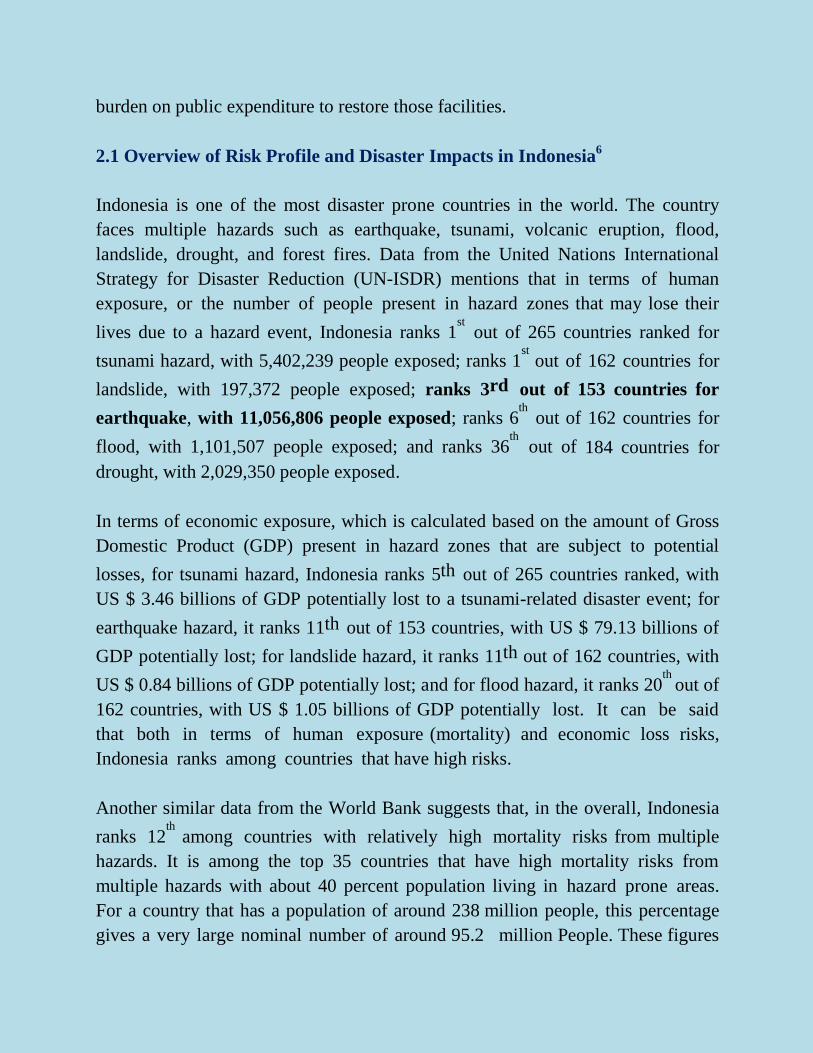
2.1 Overview of Risk Profile and Disaster Impacts in Indonesia6
Indonesia is one of the most disaster prone countries in the world. The country
faces multiple hazards such as earthquake, tsunami, volcanic eruption, flood,
landslide, drought, and forest fires. Data from the United Nations International
Strategy for Disaster Reduction (UN-ISDR) mentions that in terms of human
exposure, or the number of people present in hazard zones that may lose their
lives due to a hazard event, Indonesia ranks 1st out of 265 countries ranked for
tsunami hazard, with 5,402,239 people exposed; ranks 1st out of 162 countries for
landslide, with 197,372 people exposed; ranks 3rd out of 153 countries for
earthquake, with 11,056,806 people exposed; ranks 6th out of 162 countries for
flood, with 1,101,507 people exposed; and ranks 36th out of 184 countries for
drought, with 2,029,350 people exposed.
In terms of economic exposure, which is calculated based on the amount of Gross
Domestic Product (GDP) present in hazard zones that are subject to potential
losses, for tsunami hazard, Indonesia ranks 5th out of 265 countries ranked, with
US $ 3.46 billions of GDP potentially lost to a tsunami-related disaster event; for
earthquake hazard, it ranks 11th out of 153 countries, with US $ 79.13 billions of
GDP potentially lost; for landslide hazard, it ranks 11th out of 162 countries, with
US $ 0.84 billions of GDP potentially lost; and for flood hazard, it ranks 20th
out of
162 countries, with US $ 1.05 billions of GDP potentially lost. It can be said
that both in terms of human exposure (mortality) and economic loss risks,
Indonesia ranks among countries that have high risks.
Another similar data from the World Bank suggests that, in the overall, Indonesia
ranks 12th among countries with relatively high mortality risks from multiple
hazards. It is among the top 35 countries that have high mortality risks from
multiple hazards with about 40 percent population living in hazard prone areas.
For a country that has a population of around 238 million people, this percentage
gives a very large nominal number of around 95.2 million People. These figures
imply that a major humanitarian catastrophe might happen should large disasters
occur.
Disaster historical data have shown that Indonesia has experienced a substantial
number of disasters, with significant number of people killed. In the period of
1980-2008, according to the UN-ISDR, Indonesia has experienced 293 disaster
events that have killed 189,615 people, with an average number of people killed
per year of 6,538. The number of people affected by those disasters is even
bigger, i.e. 18,195,948 people, with an average number of people affected per
year of 627,446. Besides human losses, economic damage effect by disasters
during the period is also huge. The country suffers an annual economic damage
of US $ 731,705,000 caused by disaster, with a total of US $ 21,219,450,000 for
the period of 1980-2008.3
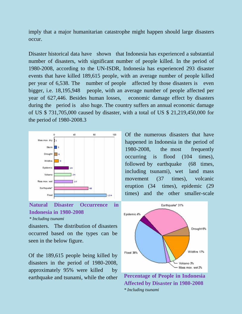
Of the numerous disasters that have
happened in Indonesia in the period of
1980-2008, the most frequently
occurring is flood (104 times),
followed by earthquake (68 times,
including tsunami), wet land mass
movement (37 times), volcanic
eruption (34 times), epidemic (29
times) and the other smaller-scale
disasters. The distribution of disasters
occurred based on the types can be
seen in the below figure.
Of the 189,615 people being killed by
disasters in the period of 1980-2008,
approximately 95% were killed by
earthquake and tsunami, while the other
Natural Disaster Occurrence in
Indonesia in 1980-2008
* Including tsunami
Percentage of People in Indonesia
Affected by Disaster in 1980-2008
* Including tsunami
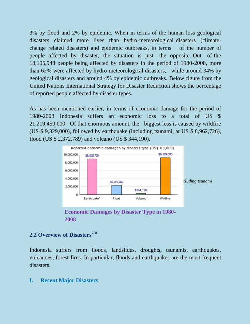
3% by flood and 2% by epidemic. When in terms of the human loss geological
disasters claimed more lives than hydro-meteorological disasters (climate-
change related disasters) and epidemic outbreaks, in terms of the number of
people affected by disaster, the situation is just the opposite. Out of the
18,195,948 people being affected by disasters in the period of 1980-2008, more
than 62% were affected by hydro-meteorological disasters, while around 34% by
geological disasters and around 4% by epidemic outbreaks. Below figure from the
United Nations International Strategy for Disaster Reduction shows the percentage
of reported people affected by disaster types.
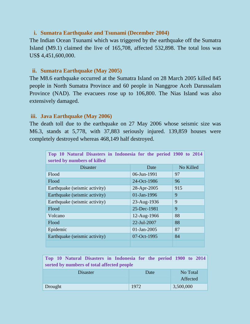
As has been mentioned earlier, in terms of economic damage for the period of
1980-2008 Indonesia suffers an economic loss to a total of US $
21,219,450,000. Of that enormous amount, the biggest loss is caused by wildfire
(US $ 9,329,000), followed by earthquake (including tsunami, at US $ 8,962,726),
flood (US $ 2,372,789) and volcano (US $ 344,190).
2.2 Overview of Disasters7, 8
Indonesia suffers from floods, landslides, droughts, tsunamis, earthquakes,
volcanoes, forest fires. In particular, floods and earthquakes are the most frequent
disasters.
I. Recent Major Disasters
* Including tsunami
Economic Damages by Disaster Type in 1980-
2008
i. Sumatra Earthquake and Tsunami (December 2004)
The Indian Ocean Tsunami which was triggered by the earthquake off the Sumatra
Island (M9.1) claimed the live of 165,708, affected 532,898. The total loss was
US$ 4,451,600,000.
ii. Sumatra Earthquake (May 2005)
The M8.6 earthquake occurred at the Sumatra Island on 28 March 2005 killed 845
people in North Sumatra Province and 60 people in Nanggroe Aceh Darussalam
Province (NAD). The evacuees rose up to 106,800. The Nias Island was also
extensively damaged.
iii. Java Earthquake (May 2006)
The death toll due to the earthquake on 27 May 2006 whose seismic size was
M6.3, stands at 5,778, with 37,883 seriously injured. 139,859 houses were
completely destroyed whereas 468,149 half destroyed.
Top 10 Natural Disasters in Indonesia for the period 1900 to 2014
sorted by numbers of killed
Disaster Date No Killed
Flood 06-Jun-1991 97
Flood 24-Oct-1986 96
Earthquake (seismic activity) 28-Apr-2005 915
Earthquake (seismic activity) 01-Jan-1996 9
Earthquake (seismic activity) 23-Aug-1936 9
Flood 25-Dec-1981 9
Volcano 12-Aug-1966 88
Flood 22-Jul-2007 88
Epidemic 01-Jan-2005 87
Earthquake (seismic activity) 07-Oct-1995 84
Top 10 Natural Disasters in Indonesia for the period 1900 to 2014
sorted by numbers of total affected people
Disaster Date No Total
Affected
Drought 1972 3,500,000
Earthquake (seismic activity) 27-May-2006 3,177,923
Wildfire Oct-1994 3,000,000
Earthquake (seismic activity) 30-Sep-2009 2,501,798
Drought Sep-1997 1,065,000
Flood 23-Dec-2006 618,486
Flood 9-Feb-1996 556,000
Earthquake (seismic activity) 26-Dec-2004 532,898
Flood 14-Mar-1966 524,100
Flood 27-Jan-2002 500,750
3. INSTITUTIONAL SETUP5
A comprehensive legislative framework has been put in place, but
implementation remains a major challenge.
Top 10 Natural Disasters in Indonesia for the period 1900 to 2014
sorted by economic damage costs
Disaster Date Damage (000
US$)
Flood 31-Jan-2007 971,000
Earthquake (seismic activity) 11-Feb-2009 9,000
Drought Sep-1997 88,000
Wildfire Sep-1997 8,000,000
Volcano 10-Feb-1990 8,000
Flood 16-May-2000 79,000
Flood Apr-1968 7,831
Flood 2-Oct-2010 78,000
Flood Dec-1983 7,007
Drought 1972 70,000
After the 2004 Indian Ocean Tsunami, Indonesia enacted a new Law on Disaster
Management (Law 24/2007) that outlines the principles, division of labor,
organization and implementation of the national disaster management system,
including the role of international organizations. The Law has been further
elaborated by the issuance of three key Government Regulations, one Presidential
Regulation and numerous implementing guidelines. While the issuance of the legal
framework is an important first step, more work needs to be carried out to ensure
that the regulations are disseminated and implemented by the respective
institutions and observed by the public.
3.1 Legal System
Disaster Management Law No. 24 was enacted in April 2007.
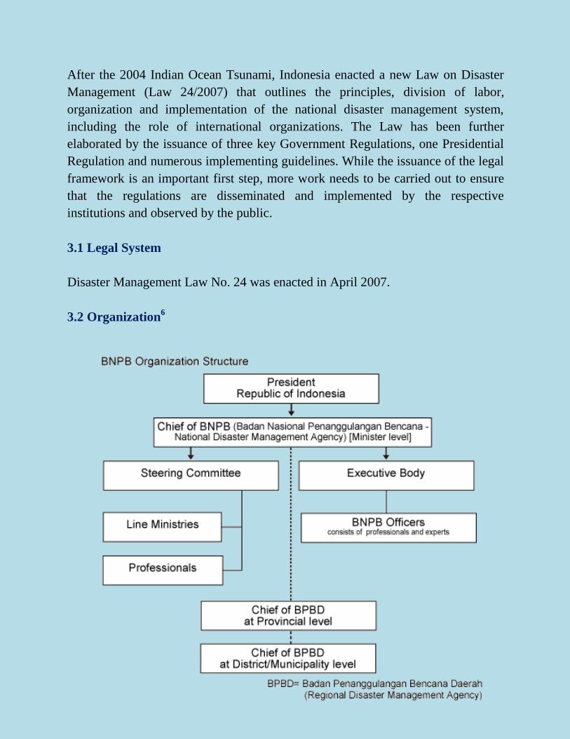
3.2 Organization6
Badan Nasional Penanggulangan Bencana (National Disaster Management
Agency, BNPB) was established in 2008. BNPB consists of the president of the
BNPB, the Management and Operational Committee, and the Policy
Implementation Agency. Being composed of ten ministries (Ministry of Interior,
Ministry of Social Affairs, Ministry of Public Works, Ministry of Health, Ministry
of Finance, Ministry of Transportation, Ministry of Energy and Mineral Resources,
Police and Armed Forces) and other nine experts, the Management and Operational
Committee is in charge of advisory and consultation with the BNPB's president.
The Policy Implementation Agency is in charge of increasing preparedness,
emergency response, and relief and reconstruction. Also, the Indonesian
Government is planning to establish the Regional Disaster Management Agency
(BPBD). In November 2008, National Platform was established to expand the
cooperation among sectors.
4. INITIATIVES9
4.1 National Policy & Plans
Indonesia: Decision of the President of the Republic of Indonesia on the
National Coordinating Board for Disaster Management (Decision no. 43 of
19 September 1990)1990, Indonesia
Indonesia: Government regulation of the Republic of Indonesia concerning
participation of international institutions and foreign non-governmental
organizations in disaster management (Regulation no. 23 of 2008)2008,
BNPB, Indonesia
References
1 http://www.undp.or.id/general/about_indonesia.asp
2 http://data.un.org/CountryProfile.aspx?crName=indonesia
3 http://hdr.undp.org/en/countries/profiles/IDN
4 http://en.wikipedia.org/wiki/Indonesia
5 http://gfdrr.org/ctrydrmnotes/Indonesia.pdf

6 http://www.aipasecretariat.org/wp-content/uploads/2011/07/Indonesia_Disaster-
Response-Management.pdf 7http://www.adrc.asia/nationinformation.php?NationCode=360&Lang=en&Nation
Num=03 8 http://www.emdat.be/result-country-profile
9 http://www.preventionweb.net/english/countries/asia/idn/