Embed Size (px)
Citation preview

ICT & Aerospace Technologies
GMSPAZIO S.r.l. –Tel.: +39 335 5702 339 – Tel. +39 06 4555 2502 - Fax.: +39 06 4555 2501 e-mail: [email protected] – website: www.gmspazio.com - P.IVA 08473031006 Sede Operativa: via Stefano Longanesi, 14 - 00146 Roma (Italia) - Sede Legale: via Giuseppe Veronese, 90 – 00146 Roma (Italia)
Company Profile
GMSPAZIO started in 2005 to answer the strong demand coming from ICT and Aerospace
Markets, for solutions dedicated to 4Ds (Space plus Time) synthetic scenarios management.
Company operations are dedicated to help customers in complex simulation scenarios
management, and Satellite Remote Sensing sectors, offering Products, Services, Training and
know-how to develop customized Geographic Information Systems and customers’ tailored
applications and services.
Looking at Products, GMSPAZIO is the:
o Unique Italian Distributor of AGI (Analythical Graphic Inc) solutions:
• STK (Satellite ToolKit)
• NavTK (Navigation Toolkit)
• ODTK (Orbit Determination ToolKit)
• 4DX, RT3 and DSim (Real Time Applications’ Development Kits)
o Unique Italian Distributor of Orbit Logic Inc. solutions:
• CPS (Collection Planning Systems)
• UAV Planner
o Distributor of Very High Resolution Satellite Remote Sensing Images
Looking at Services, GMSPAZIO offers:
o Support to Design, Develop, Test and Deploy customized ICT Applications for land, sea, air
and space resources management
o Satellite Remote Sensing images high quality level processing, including: Georeferencing,
Orthorectification and DTM/DEM extraction from VHR Remote Sensing Satellite Images.
o Value Added Services for Change Detection worldwide using VHR Remote Sensing Satellite
Images. (More than 50.000 km2 processed, delivered and published on the web in 2007-
2008)
o Training on ICT and Remote Sensing and Synthetic Simulation subjects
GMSPAZIO’s main customers are (in alphabetical order):
� Agenzia Spaziale Italiana (Italian Space Agency)
� Carlo Gavazzi Space S.p.a.
� European Satellite Navigation Industries (formerly Galileo Industries S.p.a.) � ImageSat International NV
� MARSec S.p.a.
� Ministero della Difesa (Italian Ministery of Defense)
� NAMSA (Nato Maintenance and Supply Agency)
� Provincia di Benevento
� Regione Liguria
� Rheinmetall Italia S.p.a.
� Space Engineering S.p.a.
� SpaceToEarth
� Telespazio S.p.a.
� Thales Alenia Space Italia S.p.a.
GMSPAZIO S.r.l. holds, since 2006 August 4th, the EN ISO 9001:2000 Certification for:
“Trade, training and technical service of software for management of information related to the
territory. Provision of services of data elaboration of territory and remote sensing. Design and
provision of consultancy services in the information field.” (Sectors EA 29a, 33 e 35)
(Dasa-Rägister, SINCERT, # IQ-0806-07)
ICT & Aerospace Technologies
GMSPAZIO S.r.l. –Tel.: +39 335 5702 339 – Tel. +39 06 4555 2502 - Fax.: +39 06 4555 2501 e-mail: [email protected] – website: www.gmspazio.com - P.IVA 08473031006 Sede Operativa: via Stefano Longanesi, 14 - 00146 Roma (Italia) - Sede Legale: via Giuseppe Veronese, 90 – 00146 Roma (Italia)
AGI Analytical Graphics Inc. – GMSPAZIO Distribution activity
GMSPAZIO is the Italian distributor for AGI, Analytical Graphics Inc.
(USA). AGI offers, since 1989, a wide set of products dedicated to solve
customer needs in the following main areas:
� Space Superiority
� Communications & Electronic Warfare
� Geospatial Intelligence
� Mission Design Operations
� Space Exploration
� Range Safety
� Aircraft & UAV Systems
� C4ISR
� Navigation
� Missile Defense
AGI Products are packaged in the following solutions’ sets:
• STK
Satellite ToolKit
• NavTK
Navigation ToolKit
• ODTK
Orbit Determination ToolKit
• STK Engine
The Developers’ Platform (formerly 4DX)
• RT3 & DSim
Real Time Tracking Tool & Distributed Simulation
• Viewer
The AGI Viewer
These software are leader of 4Ds synthetic scenarios management, with more than 40.000
installations worldwide for the major players in the Aerospace, Defense and Intelligence
markets. The allow customers to run in several areas like:
• Radar analysis • Monte Carlo studies
• Optimization methods
• Attitude modeling
• RF Communications
• Coverage analysis
• Proximity Operations
• Orbit determination
• Maneuver planning
• Collision avoidance
• Missile Modeling
• Airborne/UAV modeling
• Real Time Operations
• GPS Navigation
• Sea/under-sea
• Mission Scheduling
• Weather Effects
• GIS analysis
• HLA/DIS Support
ICT & Aerospace Technologies
GMSPAZIO S.r.l. –Tel.: +39 335 5702 339 – Tel. +39 06 4555 2502 - Fax.: +39 06 4555 2501 e-mail: [email protected] – website: www.gmspazio.com - P.IVA 08473031006 Sede Operativa: via Stefano Longanesi, 14 - 00146 Roma (Italia) - Sede Legale: via Giuseppe Veronese, 90 – 00146 Roma (Italia)
Orbit Logic Inc. – GMSPAZIO Distribution activity
GMSPAZIO is the Italian distributor for Orbit Logic Inc.
(USA). Orbit Logic offers collection planning and scheduling
optimization solutions for imaging, remote sensing, aerospace
and geo-intelligence customers since 2000.
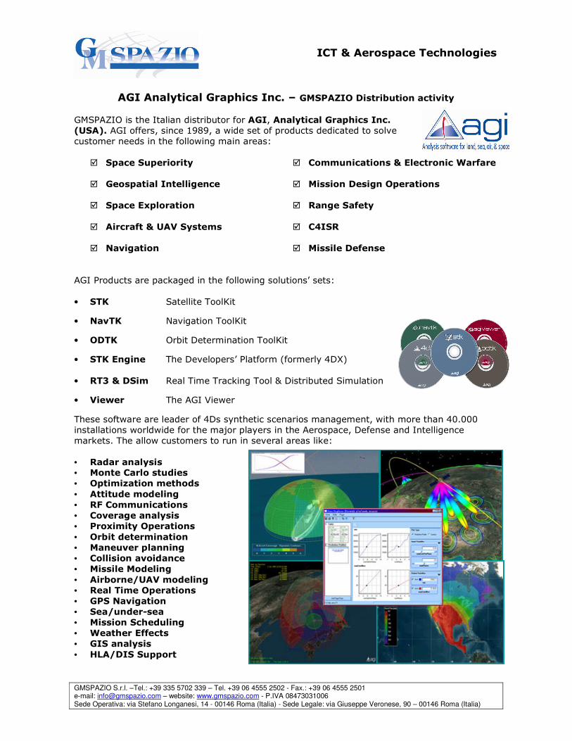
Foremost of these solutions are STK/Scheduler™ and the Collection Planning System (CPS).
Introduced by Orbit Logic in 2002,
STK/Scheduler™ is a flexible scheduling
system utilized in spacecraft and aerospace
operations worldwide as part of AGI's Satellite
Tool Kit suite of tools.
The software allows aerospace professionals
to model their systems and perform optimized
operational scheduling and analysis - right out
of the box.
CPS is a customizable and scalable
operational architecture for imaging and
remote sensing satellites.
It utilizes a high fidelity user-specific
spacecraft simulator and sophisticated
optimization algorithms to produce a
collection plan that maximizes the quality and
priority of the desired imagery and data.
Available in a stand-alone workstation or
server environment for automated planning,
CPS can be integrated with any type of
spacecraft ground system.
Orbit Logic newest product, UAV Planner, offers
the means to automate flight planning and re-
tasking of UAVs as well as other reconnaissance
aircraft, plus many more unique capabilities.
Based on Orbit Logic's years of experience in
spacecraft operations and planning systems
development, Orbit Logic offers systems and
software development and engineering services
for collection planning and scheduling applications as well as for command and control
and flight dynamics systems
ICT & Aerospace Technologies
GMSPAZIO S.r.l. –Tel.: +39 335 5702 339 – Tel. +39 06 4555 2502 - Fax.: +39 06 4555 2501 e-mail: [email protected] – website: www.gmspazio.com - P.IVA 08473031006 Sede Operativa: via Stefano Longanesi, 14 - 00146 Roma (Italia) - Sede Legale: via Giuseppe Veronese, 90 – 00146 Roma (Italia)
GMSPAZIO Solutions for Real time monitoring and Control
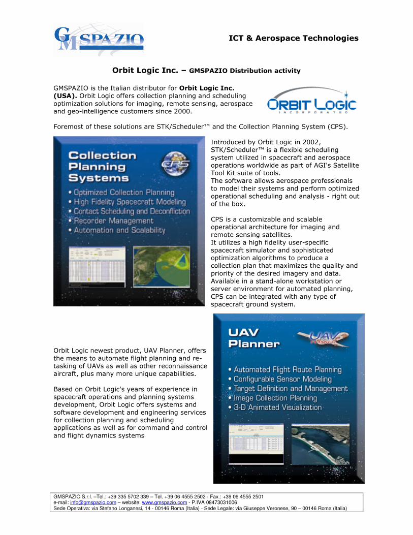
GCPA – GMSPAZIO’s COSMO-SkyMed™ Performance Analyzer The ultimate solution from GMSPAZIO to discover
COSMO-SkyMed™ Constellation performances.
GCPA is a powerful easy to use tool, offering precise
determination of the COSMO-SkyMed™ constellation
coverage characteristics. It relies on the AGI™ analytical
and graphical engine to guarantee both high precision
and intuitive simulation results display to the user,
allowing him to configure available satellites, looking
modes, operative modes and minimum ground stations
access elevation to fully customize his/her analysis. Copyright ASI/Ministero della Difesa
GCPA comes with different modules to satisfy any need
regarding the constellation’s performances determination:
� Single point analysis tool, that makes possible the analysis of
the constellation’s access epoch to any point in the world,
together with the response time determination based on the
assets currently available
� Area analysis tool to determine the constellation’s wide area
coverage performances, giving information about total
access, revisit time and time to next passage
� Ground station access tool, that lists the constellation’s
access to the ground segment, giving information about
azimuth, elevation and range of each planned passage
� Database manager, to easily handle the target and area
target collection available for analysis
GCPA offers a powerful workbench to analyze COSMO-SkyMed™
performances, its main features are:
� Orbital determination made through AGI propagators
� Dual propagation mode: real time and X real time
� 2D and 3D windows interface
� Response time determination
� Customizable sensor swath
� AGI and Celestrak databases available
� Quick database update with NORAD Two-Line Element sets � Powerful textual report output section
Either you need a powerful planning acquisition tool or a
mean to easily show COSMO-SkyMed™ constellation
works, GCPA is the right answer.
GCPA is available in two versions: Basic and Full.
ICT & Aerospace Technologies
GMSPAZIO S.r.l. –Tel.: +39 335 5702 339 – Tel. +39 06 4555 2502 - Fax.: +39 06 4555 2501 e-mail: [email protected] – website: www.gmspazio.com - P.IVA 08473031006 Sede Operativa: via Stefano Longanesi, 14 - 00146 Roma (Italia) - Sede Legale: via Giuseppe Veronese, 90 – 00146 Roma (Italia)
GSC2 – Real Time Monitoring and Control System
GSC2 is an integrated solution for real time monitoring and
control of cooperative and non cooperative objects inside an
Area of Interest (A.O.I).
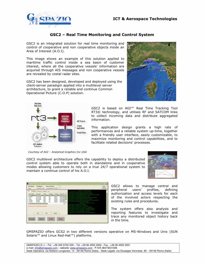
This image shows an example of this solution applied to maritime traffic control inside a sea basin of customer
interest, where all the cooperative vessels’ information are
acquired through AIS messages and non cooperative vessels
are revealed by costal radar sites.
GSC2 has been designed, developed and deployed using the
client-server paradigm applied into a multilevel server
architecture, to grant a reliable and continue Common
Operational Picture (C.O.P) solution.
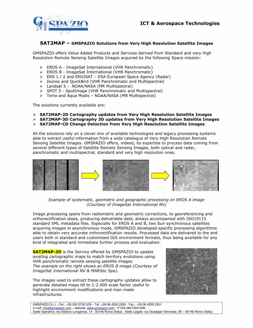
GSC2 is based on AGI™ Real Time Tracking Tool
RT3© technology, and utilises RF and SATCOM links
to collect incoming data and distribute aggregated
information.
This application design grants a high rate of
performances and a reliable system up-time, together
with a friendly user interface, easily customizable, to
maximize monitoring and control capabilities, and to
facilitate related decisions’ processes.
Courtesy of AGI – Analytical Graphics Inc USA
GSC2 multilevel architecture offers the capability to deploy a distributed
control system able to operate both in standalone and in cooperative
modes allowing customers to rely on a true 24/7 operational system to
maintain a continue control of his A.O.I.
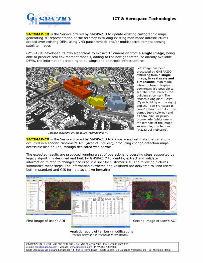
GSC2 allows to manage central and peripheral users’ profiles, defining
authorization and access levels for each
of the involved actors respecting the
existing rules and procedures.
The system offers also analysis and
reporting features to investigate and
trace any monitored object history back
in the time.
GMSPAZIO offers GCS2 in two different versions operative on MS-Windows and Unix (SUN
Solaris™ and Linux Red-Hat™) platforms.
ICT & Aerospace Technologies
GMSPAZIO S.r.l. –Tel.: +39 335 5702 339 – Tel. +39 06 4555 2502 - Fax.: +39 06 4555 2501 e-mail: [email protected] – website: www.gmspazio.com - P.IVA 08473031006 Sede Operativa: via Stefano Longanesi, 14 - 00146 Roma (Italia) - Sede Legale: via Giuseppe Veronese, 90 – 00146 Roma (Italia)
SAT2MAP – GMSPAZIO Solutions from Very High Resolution Satellite Images
GMSPAZIO offers Value Added Products and Services derived from Standard and very High
Resolution Remote Sensing Satellite Images acquired by the following Space mission:
� EROS A - ImageSat International (VHR Panchromatic)
� EROS B - ImageSat International (VHR Panchromatic)
� ERS 1 / 2 and ENVISAT – ESA European Space Agency (Radar)
� Ikonos and QuickBird (VHR Panchromatic and Multispectral)
� Landsat 5 - NOAA/NASA (MR Multispectral)
� SPOT 5 - SpotImage (VHR Panchromatic and Multispectral)
� Terra and Aqua Modis – NOAA/NASA (MR Multispectral)
The solutions currently available are:
� SAT2MAP-2D Cartography updates from Very High Resolution Satellite Images
� SAT2MAP-3D Cartography 3D updates from Very High Resolution Satellite Images
� SAT2MAP-CD Change Detection from Very High Resolution Satellite Images
All the solutions rely on a clever mix of available technologies and legacy processing systems
able to extract useful information from a wide catalogue of Very High Resolution Remote
Sensing Satellite Images. GMSPAZIO offers, indeed, its expertise to process data coming from
several different types of Satellite Remote Sensing Images, both optical and radar,
panchromatic and multispectral, standard and very high resolution ones.
Example of systematic, geometric and geographic processing on EROS A image
(Courtesy of ImageSat International NV)
Image processing spans from radiometric and geometric corrections, to georeferencing and
orthorectification steps, producing deliverable data, always accompanied with ISO19115
standard XML metadata files. Especially for EROS A and B, two Sun synchronous satellites
acquiring images in asynchronous mode, GMSPAZIO developed specific processing algorithms
able to obtain very accurate orthorectification results. Processed data are delivered to the end
users both in standard and customized GIS environment formats, thus being available for any
kind of integrated and immediate further process and evaluation.
SAT2MAP-2D is the Service offered by GMSPAZIO to update
existing cartographic maps to match territory evolutions using
VHR panchromatic remote sensing satellite images
The example on the right shows an EROS B image (Courtesy of
ImageSat International NV & MARSec Spa).
The images used to extract these cartography updates allow to
generate detailed maps till to 1:2.000 scale factor useful to
highlight environment modifications and man made
infrastructures.
ICT & Aerospace Technologies
GMSPAZIO S.r.l. –Tel.: +39 335 5702 339 – Tel. +39 06 4555 2502 - Fax.: +39 06 4555 2501 e-mail: [email protected] – website: www.gmspazio.com - P.IVA 08473031006 Sede Operativa: via Stefano Longanesi, 14 - 00146 Roma (Italia) - Sede Legale: via Giuseppe Veronese, 90 – 00146 Roma (Italia)
SAT2MAP-3D is the Service offered by GMSPAZIO to update existing cartographic maps
generating 3D representation of the territory extruding existing man made infrastructures
draped over existing DEM, using VHR panchromatic and/or multispectral remote sensing
satellite images
GMSPAZIO developed its own algorithms to extract 3rd dimension from a single image, being
able to produce real environment models, adding to the new generated or already available
DEMs, the information pertaining to buildings and anthropic infrastructures.
Left image has been
processed by GMSPAZIO extruding from a single
image, in real scale and dimensions, man made
infrastructure in Naples downtown; it’s possible to
see The Royal Palace (red building at center), The
“Maschio Angioino” Castel (Cyan building on the right)
and the “San Francesco di
Paola” Church with its three domes (gold colored) and
its semi-circular pillars promenade (white one in
the left part of the image) surrounding the famous
“Piazza del Plebiscito”. Images copyright of ImageSat International NV
SAT2MAP-CD is the Service offered by GMSPAZIO to compare and estimate the variations
occurred in a specific customer’s AOI (Area of Interest), producing change detection maps
accessible also on-line, through dedicated web portals.
The expected results are produced running a set of operational processing steps supported by
legacy algorithms designed and built by GMSPAZIO to identify, extract and validate
information related to changes occurred in a specific customer AOI. The following pictures
summarize these steps. The information extracted and validated are delivered to “end users”
both in standard and GIS formats as shown hereafter:
First image of user’s AOI Second image of user’s AOI
Analytic report of territory modifications (Images copyright of ImageSat International)