Embed Size (px)
Citation preview
11/1/2011
1
Hurricanes and Nor’Easters
Severe Thunderstorms and Tornadoes
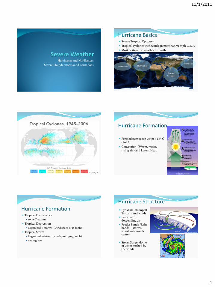
Hurricane Basics Severe Tropical Cyclones
Tropical cyclones with winds greater than 74 mph (120 km/h)
Most destructive weather on earth
Typhoons
Tropical Cyclones
Hurricanes Hurricanes
From Wikipedia
Hurricane Formation
Formed over ocean water > 26o C (80o F)
Convection (Warm, moist, rising air.) and Latent Heat
From NWS Jetstream
Hurricane Formation Tropical Disturbance
some T-storms
Tropical Depression
Organized T-storms (wind speed 0-38 mph)
Tropical Storm
Organized rotation (wind speed 39-73 mph)
name given
Hurricane Structure
Eye Wall –strongest T-storm and winds
Eye – calm descending air
Feeder Bands /Rain bands - storms spiral in towards center
Storm Surge- dome of water pushed by the winds
From NWS Jetstream
11/1/2011
2
Hurricane Damage Storm Surge – may exceed 20 feet
Winds – may exceed 150 mph
Waves – may exceed 50 feet
Flooding – Rain intensity and speed of the storm may cause flooding
Tornadoes – occasional weak tornadoes may occur
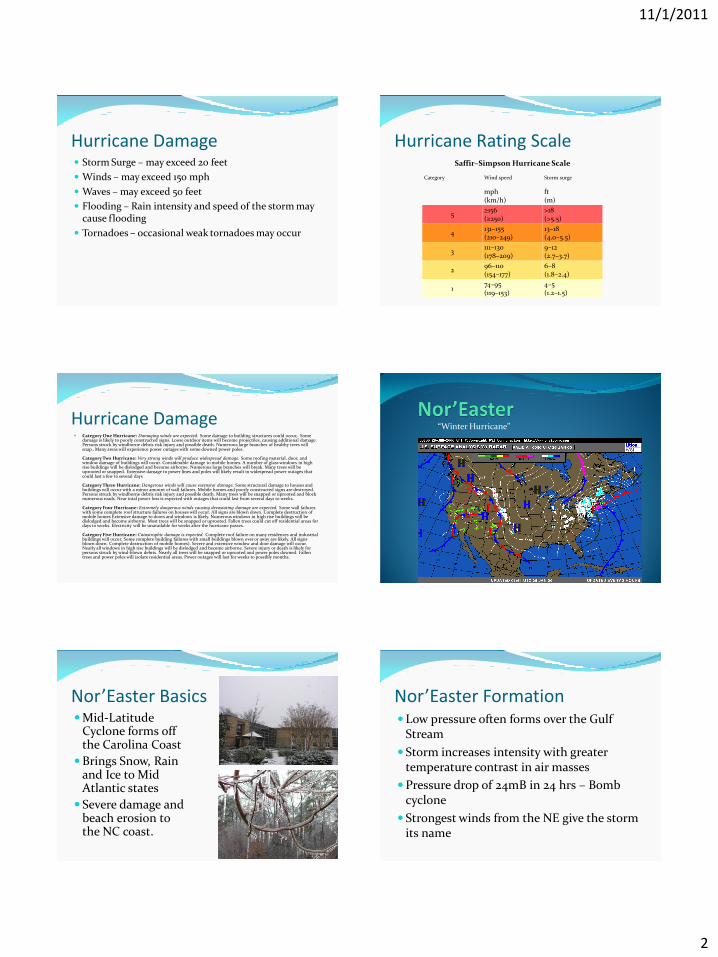
Saffir–Simpson Hurricane Scale
Category Wind speed Storm surge
mph (km/h)
ft (m)
5 ≥156 (≥250)
>18 (>5.5)
4 131–155 (210–249)
13–18 (4.0–5.5)
3 111–130 (178–209)
9–12 (2.7–3.7)
2 96–110 (154–177)
6–8 (1.8–2.4)
1 74–95 (119–153)
4–5 (1.2–1.5)
Hurricane Rating Scale
Hurricane Damage Category One Hurricane: Damaging winds are expected. Some damage to building structures could occur,. Some
damage is likely to poorly constructed signs. Loose outdoor items will become projectiles, causing additional damage. Persons struck by windborne debris risk injury and possible death. Numerous large branches of healthy trees will snap.. Many areas will experience power outages with some downed power poles. Category Two Hurricane: Very strong winds will produce widespread damage. Some roofing material, door, and window damage of buildings will occur. Considerable damage to mobile homes. A number of glass windows in high rise buildings will be dislodged and become airborne. Numerous large branches will break. Many trees will be uprooted or snapped. Extensive damage to power lines and poles will likely result in widespread power outages that could last a few to several days Category Three Hurricane: Dangerous winds will cause extensive damage. Some structural damage to houses and buildings will occur with a minor amount of wall failures. Mobile homes and poorly constructed signs are destroyed. Persons struck by windborne debris risk injury and possible death. Many trees will be snapped or uprooted and block numerous roads. Near total power loss is expected with outages that could last from several days to weeks. Category Four Hurricane: Extremely dangerous winds causing devastating damage are expected. Some wall failures with some complete roof structure failures on houses will occur. All signs are blown down. Complete destruction of mobile homes Extensive damage to doors and windows is likely. Numerous windows in high rise buildings will be dislodged and become airborne. Most trees will be snapped or uprooted. Fallen trees could cut off residential areas for days to weeks. Electricity will be unavailable for weeks after the hurricane passes. Category Five Hurricane: Catastrophic damage is expected. Complete roof failure on many residences and industrial buildings will occur. Some complete building failures with small buildings blown over or away are likely. All signs blown down. Complete destruction of mobile homes). Severe and extensive window and door damage will occur. Nearly all windows in high rise buildings will be dislodged and become airborne. Severe injury or death is likely for persons struck by wind-blown debris. Nearly all trees will be snapped or uprooted and power poles downed. Fallen trees and power poles will isolate residential areas. Power outages will last for weeks to possibly months.
“Winter Hurricane”
Nor’Easter Basics Mid-Latitude
Cyclone forms off the Carolina Coast
Brings Snow, Rain and Ice to Mid Atlantic states
Severe damage and beach erosion to the NC coast.
Nor’Easter Formation Low pressure often forms over the Gulf
Stream
Storm increases intensity with greater temperature contrast in air masses
Pressure drop of 24mB in 24 hrs – Bomb cyclone
Strongest winds from the NE give the storm its name
11/1/2011
3
Storm with lightning, thunder, and strong winds T-Storm Formation Ingredients:
Moisture
Unstable air
Cold air over warm allows more rapid convection
Development of T-Storm
Cumulus stage Warm moist air
forms a large cumulus cloud
T-Storm Development Mature stage Violently rising air
forms cumulonimbus cloud Heavy rain, wind, hail, and
lightening possible
11/1/2011
4
T-Storm Development
Dissipating Stage Down drafts cool
and slow convection
Types of T-storms Single cell
Multi-cell
Multi-cell line (Squall line)
Super cell
A thunderstorm will be called SEVERE if: Hail > ¾”
Winds in excess of 57 mph
Tornado
Single Cell Storm Multi Cell Storm
Squall Line Super Cell Storm
11/1/2011
5
Smallest and most violent short lived cyclones associated with thunderstorms
Tornado Formation Middle and high altitude wind shear
causes rotation (roll)
Directional Shear
Speed Shear
Convection (Updrafts) causes roll to become vertical
Wind speeds may reach over 300 mph.
Tornado on Doppler RADAR
Tornado Formation
Tornado Alley
From Wikipedia
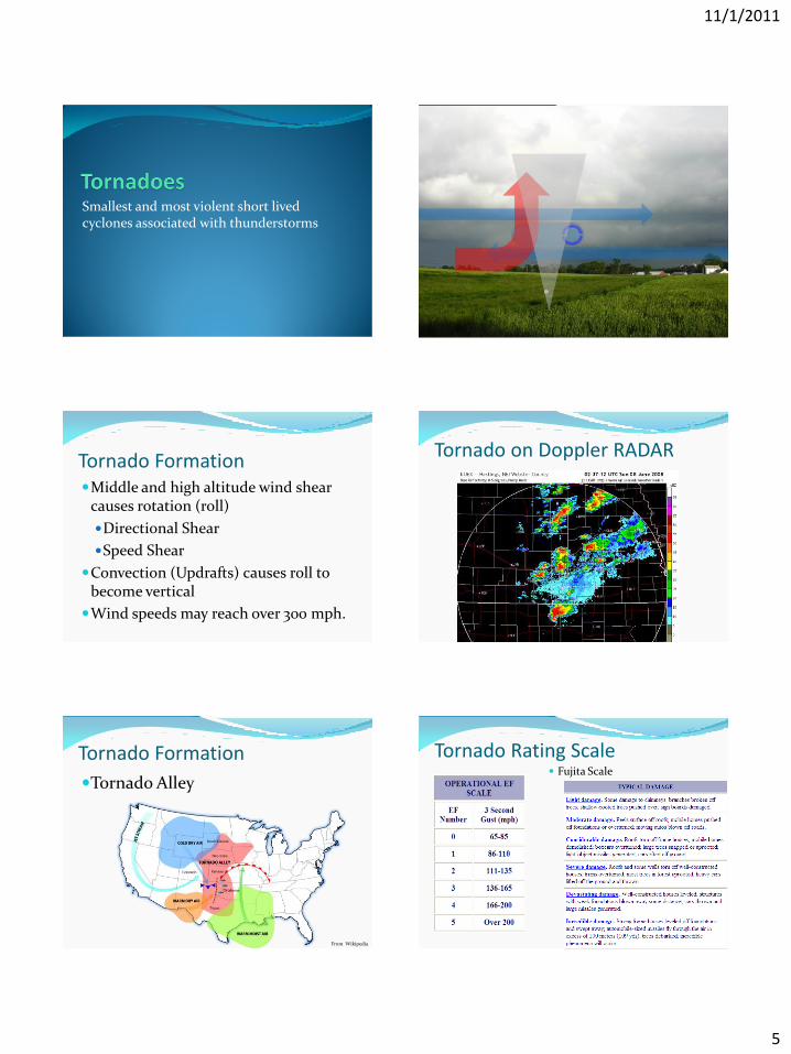
Tornado Rating Scale Fujita Scale