Embed Size (px)
Citation preview
Historical background to Central Asia
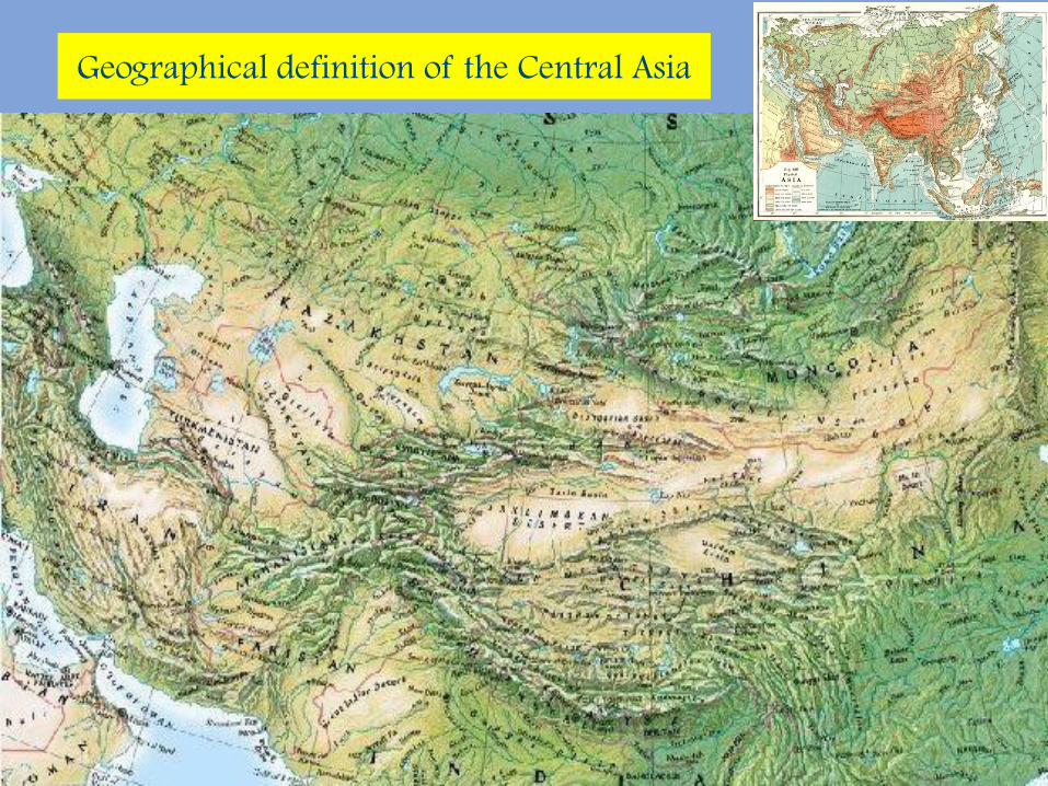
Geographical definition of the Central Asia
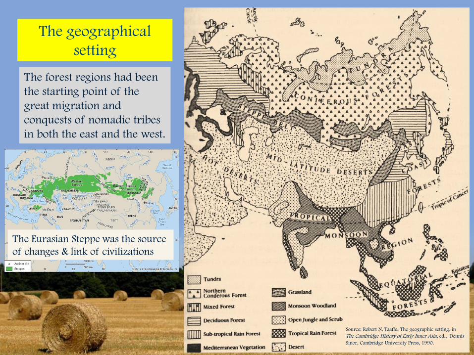
The geographical
setting
The forest regions had been
the starting point of the
great migration and
conquests of nomadic tribes
in both the east and the west.
Source: Robert N. Taaffe, The geographic setting, in
The Cambridge History of Early Inner Asia, ed., Dennis
Sinor, Cambridge University Press, 1990.
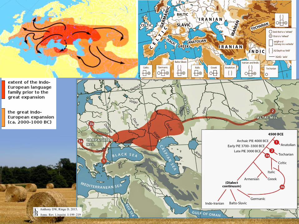
The Eurasian Steppe was the source
of changes & link of civilizations
Definition of the Central Asia as against 西域
For the British English, the East was defined in the context of ocean travel in the
1800’s. Thus, the “Far East” versus the “Middle East,” all in relation to the sea
ports of Britain located to the west of these areas. In the late 1800’s, the term High
Asia or Central Asia referred to the landlocked high-altitude region that included
Tibet, parts of India, Afghanistan, Mongolia, and China. For the British, who
traveled mostly by sea, the region of Central Asia/High Asia was grouped as one
unit despite cultural differences between the people living there. It was more a
reflection of their relationship to the region of Asia, in which the lands of
Mongolia did not figure prominently at the time.
The Russians divided the region into two areas: Middle Asia and Central Asia.
Middle Asia included “Turkmenistan, Uzbekistan, Tajikistan, and parts of
Kyrgyzstan & Central Asia included Tuva, Inner and Outer Mongolia (the
Mongolian Banners), Tibet, and the modern Chinese of Xinjiang and Qinghai.
These terms were translated directly into German, retaining their distinctions, but
later translated into French and Chinese as simply “Central Asia,” losing the
Russian and German distinctions. Scholars like Owen Lattimore used the term
“Inner Asia” to refer to the Russian “Central Asia.”(Source: What is Inner Asia? April 3, 2013, by
ariell, https://ariellahearn.wordpress.com/2013/04/03/what-is-inner-asia/)
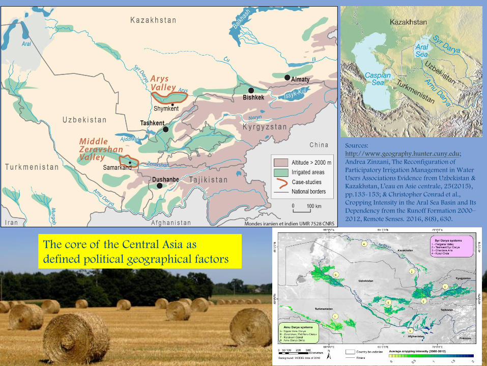
The core of the Central Asia as
defined political geographical factors
Sources:
http://www.geography.hunter.cuny.edu;
Andrea Zinzani, The Reconfiguration of
Participatory Irrigation Management in Water
Users Associations Evidence from Uzbekistan &
Kazakhstan, L’eau en Asie centrale, 25(2015),
pp.133-153; & Christopher Conrad et al.,
Cropping Intensity in the Aral Sea Basin and Its
Dependency from the Runoff Formation 2000–
2012, Remote Senses. 2016, 8(8), 630.
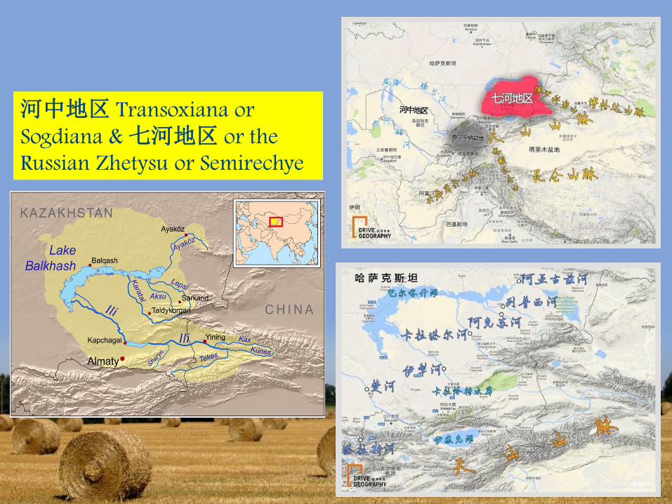
河中地区 Transoxiana or
Sogdiana & 七河地区 or the
Russian Zhetysu or Semirechye
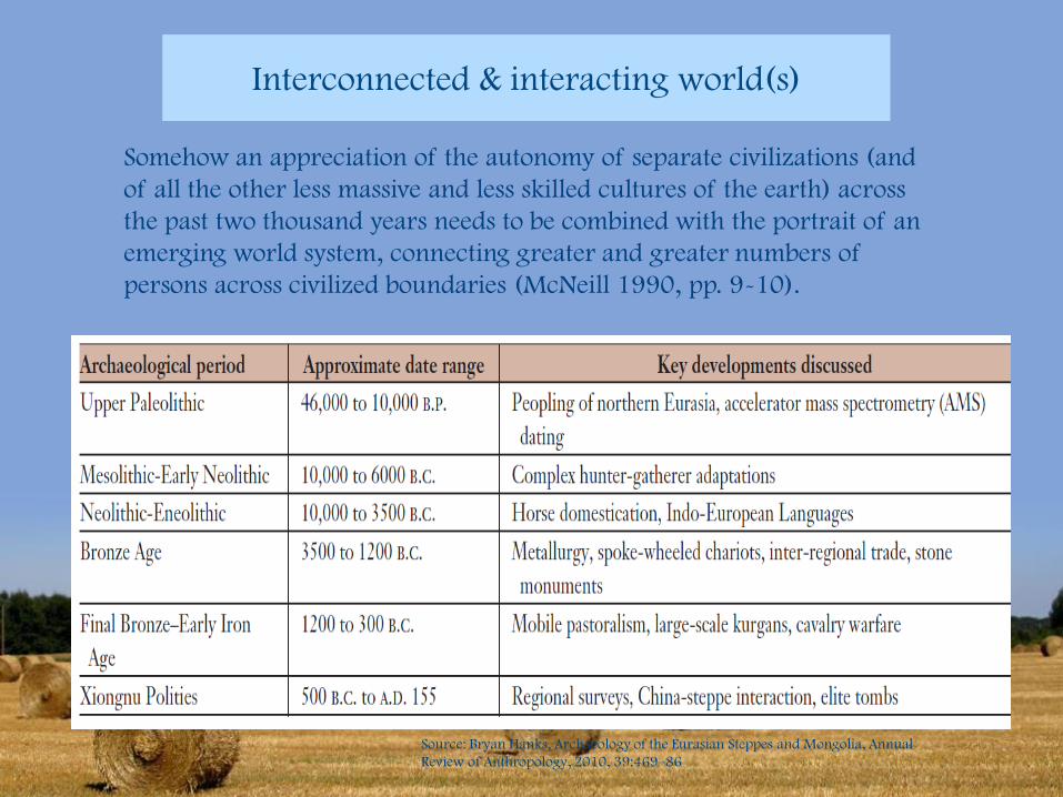
Interconnected & interacting world(s)
Source: Bryan Hanks, Archaeology of the Eurasian Steppes and Mongolia, Annual
Review of Anthropology, 2010, 39:469–86
Somehow an appreciation of the autonomy of separate civilizations (and
of all the other less massive and less skilled cultures of the earth) across
the past two thousand years needs to be combined with the portrait of an
emerging world system, connecting greater and greater numbers of
persons across civilized boundaries (McNeill 1990, pp. 9-10).
Source: History of the Steppe
http://www.essential-
humanities.net/world-
history/steppe /
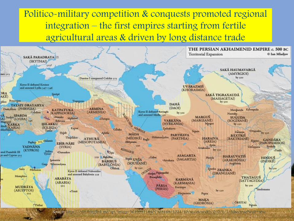
Politico-military competition & conquests promoted regional
integration – the first empires starting from fertile
agricultural areas & driven by long distance trade
Source: https://cdn.thinglink.me/api/image/561999118407303169/1024/10/scaletowidth/0/0/1/1/false/true?wait=true
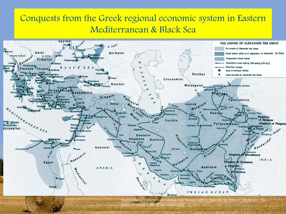
Conquests from the Greek regional economic system in Eastern
Mediterranean & Black Sea
Source: http://whereismacedonia.org/images/about_macedonia/history/alexander-the-
great/alexander-the-great-empire.jpg
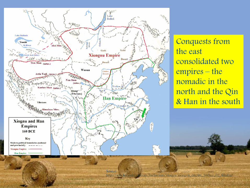
Source:
http://spooksrus.tripod.com/barbarians/images/xiongnu_empire_160bce_02_filled.gif
Conquests from
the east
consolidated two
empires – the
nomadic in the
north and the Qin
& Han in the south
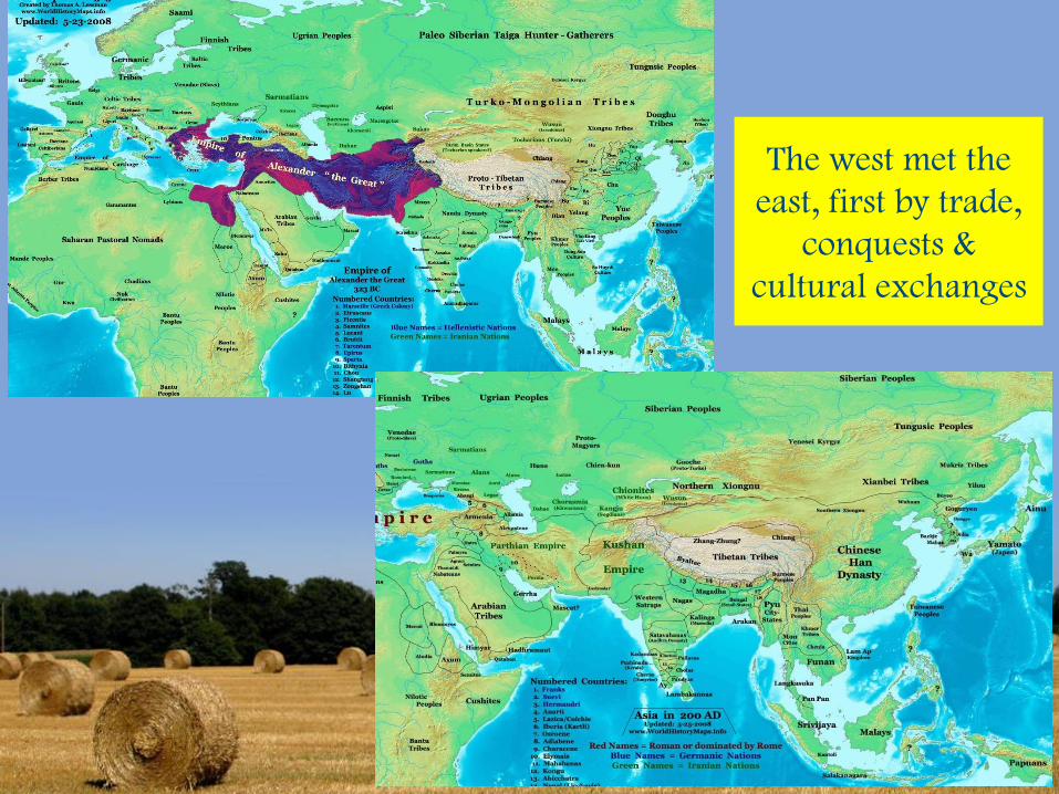
The west met the
east, first by trade,
conquests &
cultural exchanges
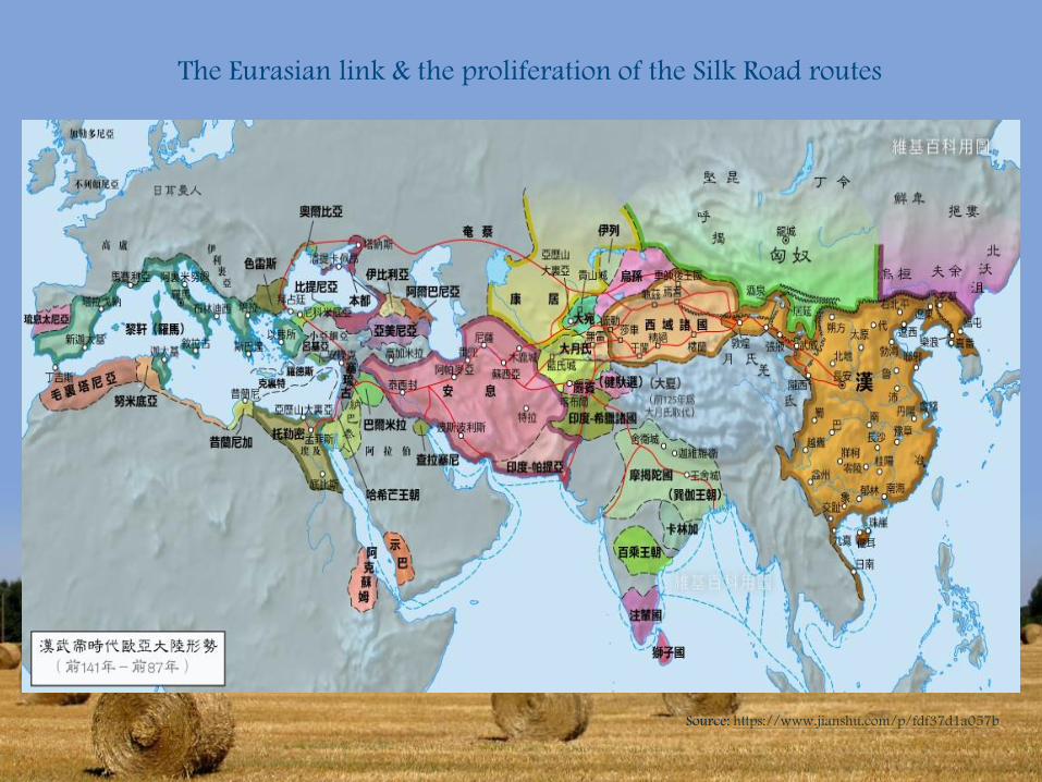
The Eurasian link & the proliferation of the Silk Road routes
Source: https://www.jianshu.com/p/fdf37d1a057b
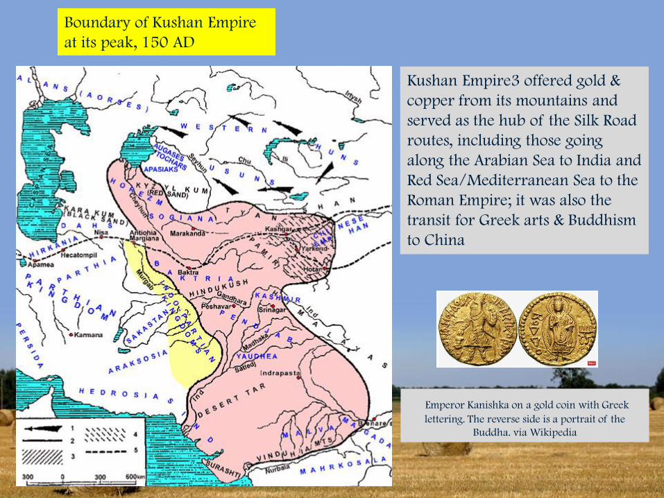
Boundary of Kushan Empire
at its peak, 150 AD
Kushan Empire3 offered gold &
copper from its mountains and
served as the hub of the Silk Road
routes, including those going
along the Arabian Sea to India and
Red Sea/Mediterranean Sea to the
Roman Empire; it was also the
transit for Greek arts & Buddhism
to China
Emperor Kanishka on a gold coin with Greek
lettering. The reverse side is a portrait of the
Buddha. via Wikipedia
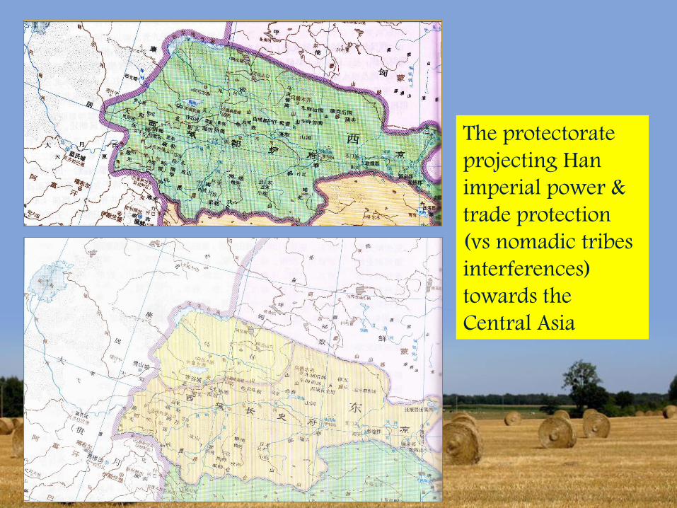
The protectorate
projecting Han
imperial power &
trade protection
(vs nomadic tribes
interferences)
towards the
Central Asia
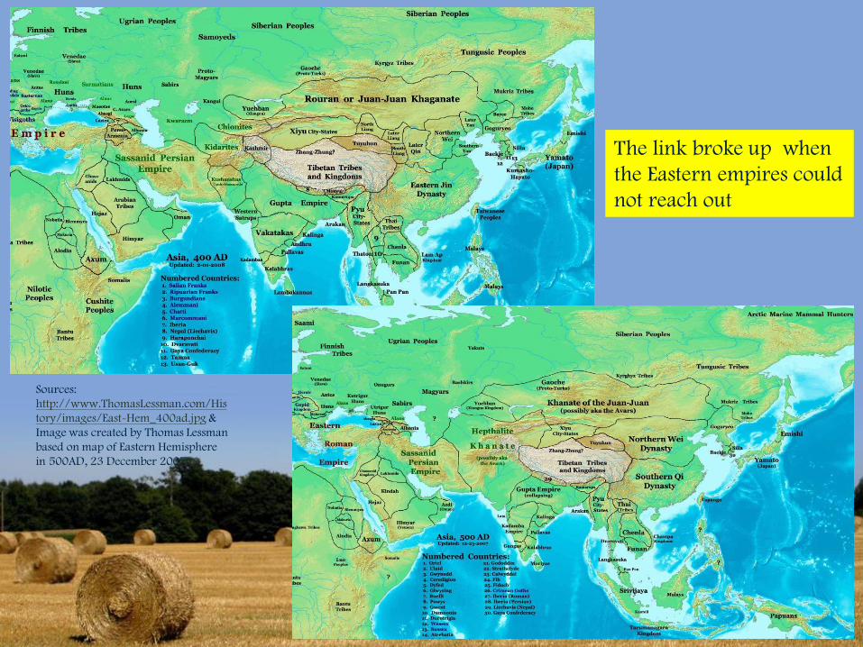
The link broke up when
the Eastern empires could
not reach out
Sources:
http://www.ThomasLessman.com/His
tory/images/East-Hem_400ad.jpg &
Image was created by Thomas Lessman
based on map of Eastern Hemisphere
in 500AD, 23 December 2007.
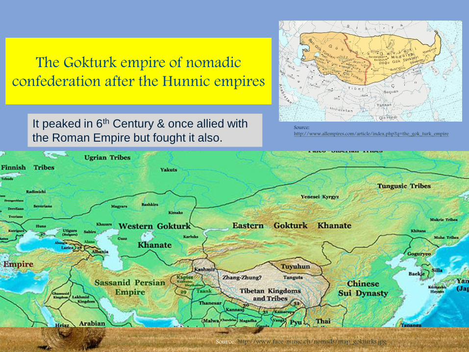
The Gokturk empire of nomadic
confederation after the Hunnic empires
Source: http://www.face-music.ch/nomads/map_gokturks.jpg
Source:
http://www.allempires.com/article/index.php?q=the_gok_turk_empire
It peaked in 6th Century & once allied with
the Roman Empire but fought it also.
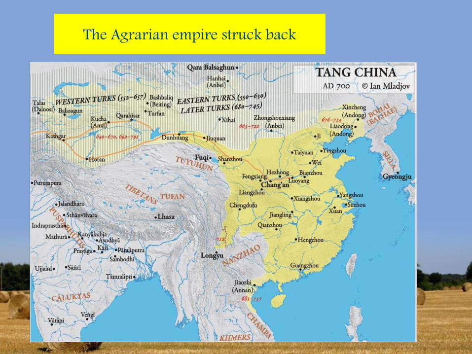
The Agrarian empire struck back
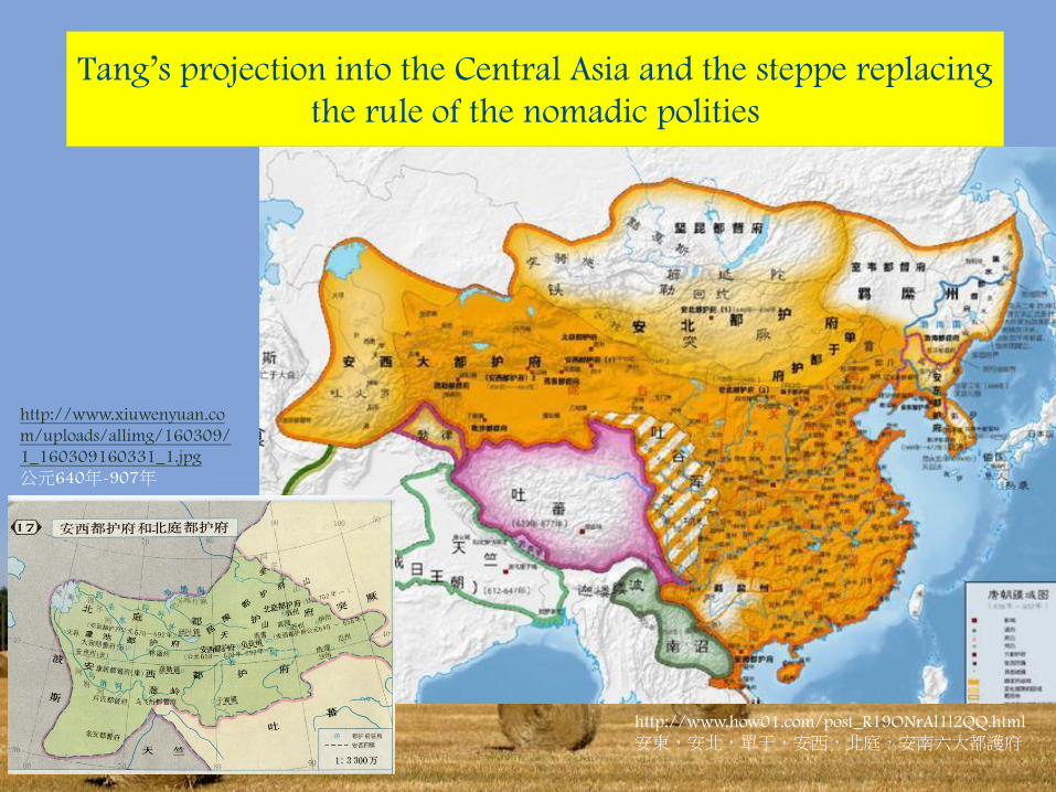
Tang’s projection into the Central Asia and the steppe replacing
the rule of the nomadic polities
http://www.how01.com/post_R19ONrAl1l2QQ.html
安東,安北,單于,安西,北庭,安南六大都護府
http://www.xiuwenyuan.co
m/uploads/allimg/160309/
1_160309160331_1.jpg
公元640年-907年
Source:
https://read01.com/geMye5.html#.Wtl
XuYhuaUk
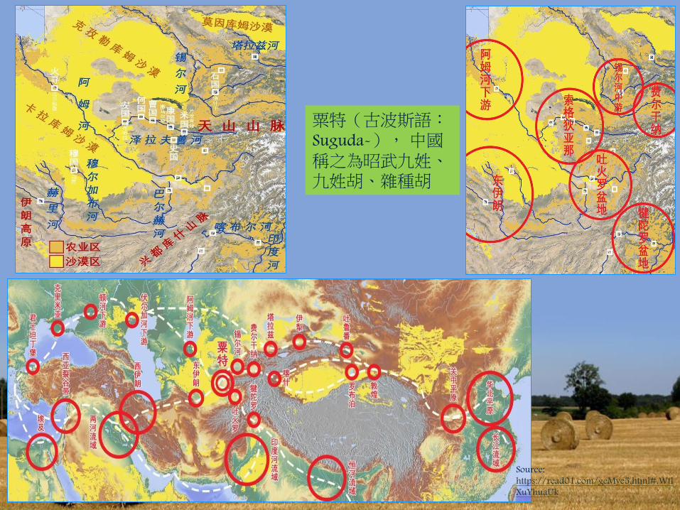
粟特(古波斯語:Suguda-),中國稱之為昭武九姓、九姓胡、雜種胡
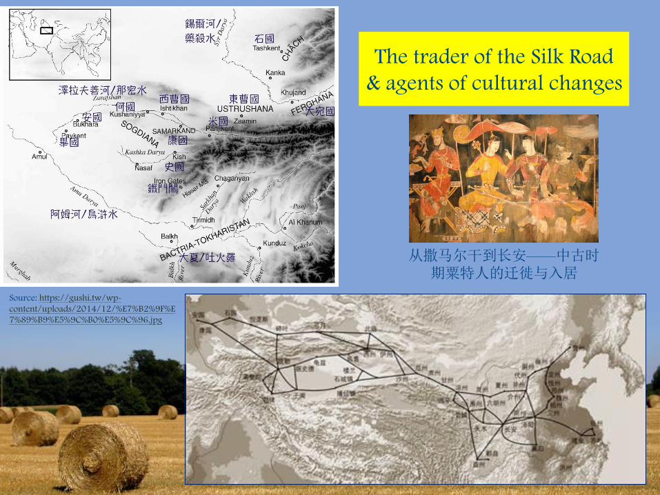
The trader of the Silk Road
& agents of cultural changes
从撒马尔干到长安——中古时期粟特人的迁徙与入居
Source: https://gushi.tw/wp-
content/uploads/2014/12/%E7%B2%9F%E
7%89%B9%E5%9C%B0%E5%9C%96.jpg
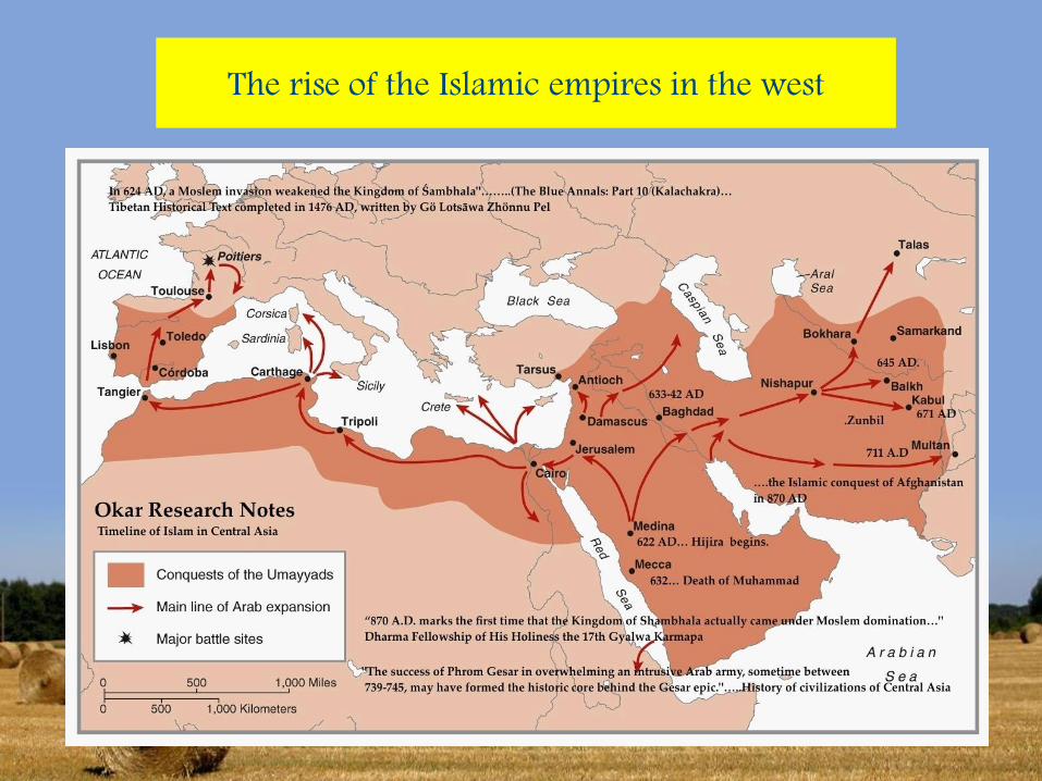
The rise of the Islamic empires in the west
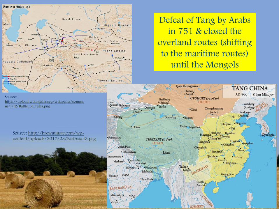
Defeat of Tang by Arabs
in 751 & closed the
overland routes (shifting
to the maritime routes)
until the Mongols
Source:
https://upload.wikimedia.org/wikipedia/commo
ns/f/f2/Battle_of_Talas.png
Source: http://brewminate.com/wp-
content/uploads/2017/03/EastAsia43.png
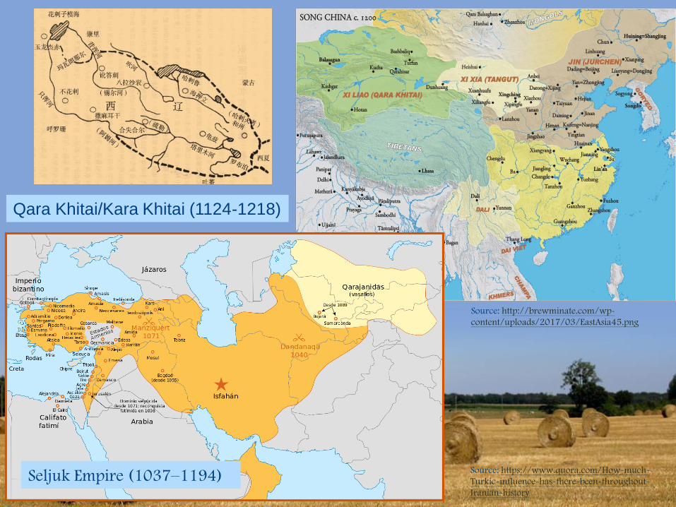
Seljuk Empire (1037–1194)Source: https://www.quora.com/How-much-
Turkic-influence-has-there-been-throughout-
Iranian-history
Source: http://brewminate.com/wp-
content/uploads/2017/03/EastAsia45.png
Qara Khitai/Kara Khitai (1124-1218)

The Mongol Empire, the first Eurasian empire
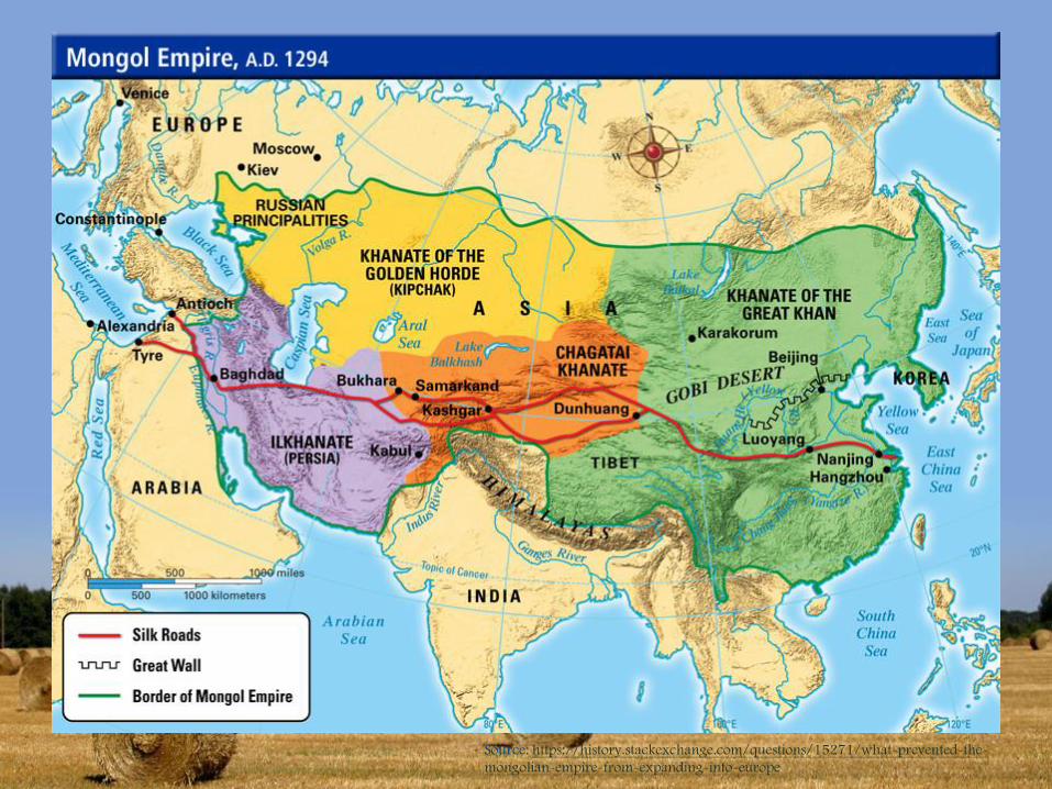
Source: https://history.stackexchange.com/questions/15271/what-prevented-the-
mongolian-empire-from-expanding-into-europe
Sources:
https://hist106spring2011.files.w
ordpress.com/2011/03/picture5.
jpg & http://1.bp.blogspot.com/-
MnuOi6USuIo/VHuJYXXonzI/AA
AAAAAAZJM/PI1TjlFAMtI/s1600
/Campaign%2Bmap.jpg
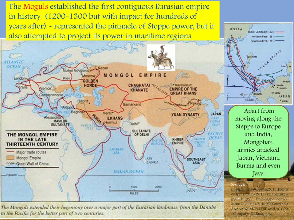
Apart from
moving along the
Steppe to Europe
and India,
Mongolian
armies attacked
Japan, Vietnam,
Burma and even
Java
The Moguls established the first contiguous Eurasian empire
in history (1200-1300 but with impact for hundreds of
years after) - represented the pinnacle of Steppe power, but it
also attempted to project its power in maritime regions
Historical significance of the Mongol empire
1. Representing both the continuation of the steppe nomadic empires from
Xiongnu (with all their institutional innovations & political dynastic cycle of
centralization and decentralization) onward, and the breakthrough towards a
global empire beyond the structural conflicts between nomadic and agrarian
modes of production (the tradition of the Persian, Arabic & Turkic empires &
leading down to Russian and Ottoman Empires of the recent past);
2. It brought the economic and cultural integration and exchanges between the
west (Middle East and Europe) and the east (China) – cannon and gun powder,
tea and porcelain, etc. The expansion of the silk road continued to grow
maritime trade and provided the basis for the subsequent Indian Ocean trade by
Ottoman Empire followed by the Europeans
3. Chinggisid dynastic legacy only reached exhaustion by the 18th Century, but it
had shaped the regional and local politics throughout centuries, esp. in the
Timurid-Moghul dynasty
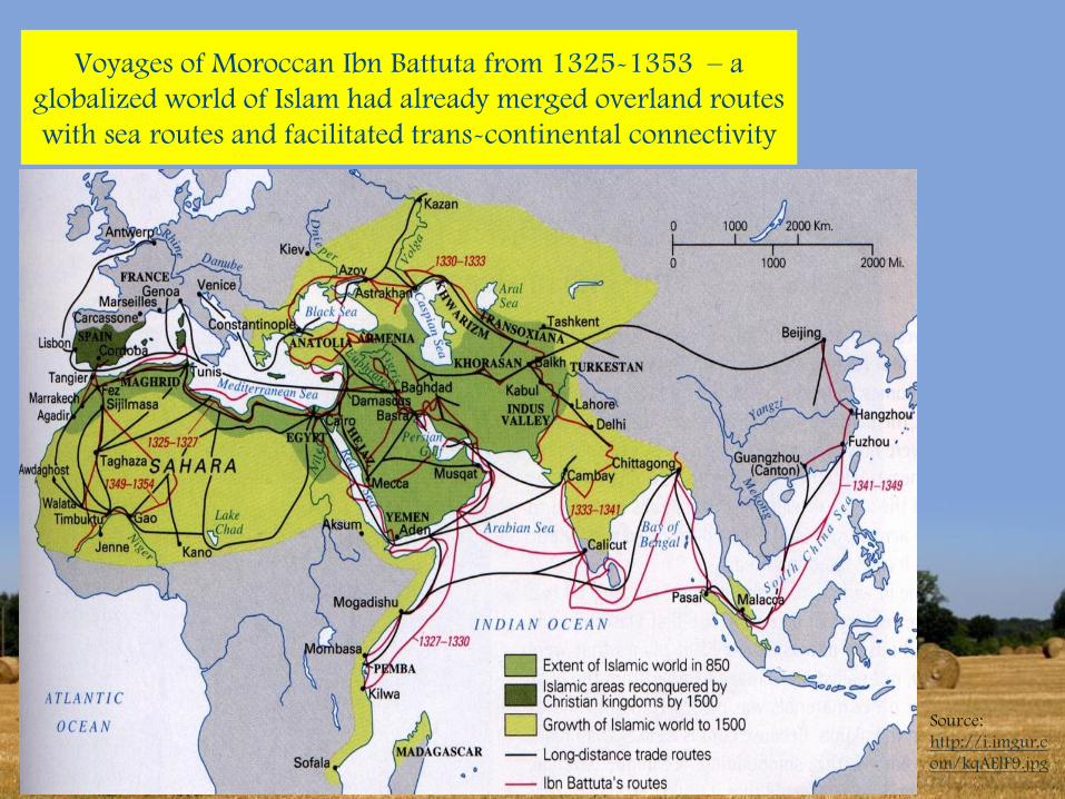
Voyages of Moroccan Ibn Battuta from 1325-1353 – a
globalized world of Islam had already merged overland routes
with sea routes and facilitated trans-continental connectivity
Source:
http://i.imgur.c
om/kqAElF9.jpg
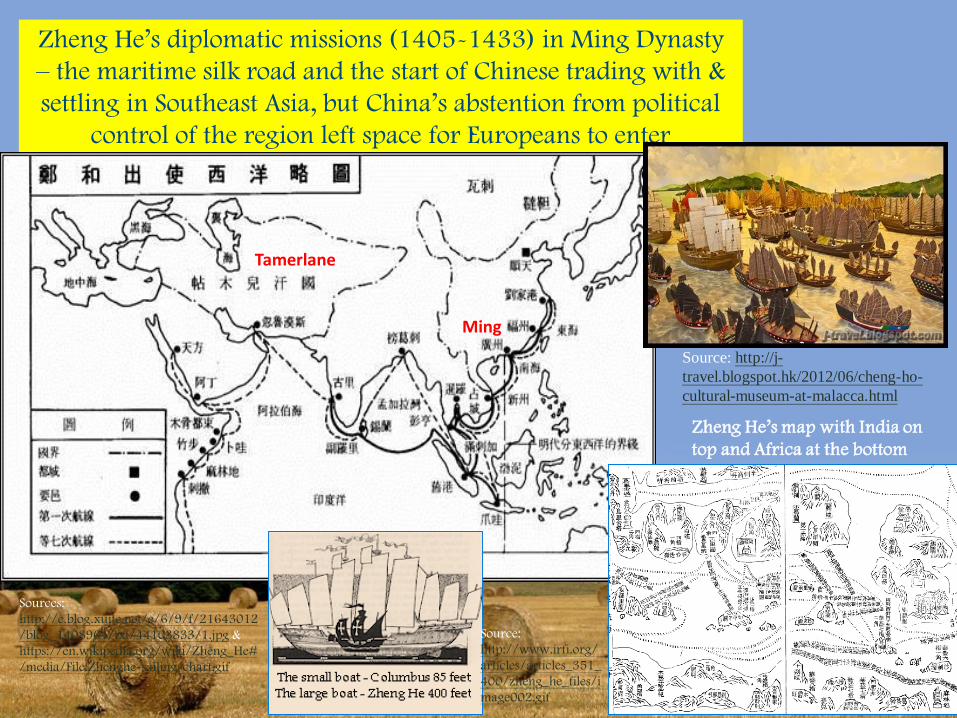
Zheng He’s diplomatic missions (1405-1433) in Ming Dynasty
– the maritime silk road and the start of Chinese trading with &
settling in Southeast Asia, but China’s abstention from political
control of the region left space for Europeans to enter
Sources:
http://e.blog.xuite.net/e/6/9/f/21643012
/blog_1408964/txt/44103833/1.jpg &
https://en.wikipedia.org/wiki/Zheng_He#
/media/File:Zhenghe-sailing-chart.gif
Source: http://j-
travel.blogspot.hk/2012/06/cheng-ho-
cultural-museum-at-malacca.html
Tamerlane
Ming
Zheng He’s map with India on
top and Africa at the bottom
Source:
http://www.irfi.org/
articles/articles_351_
400/zheng_he_files/i
mage002.gif
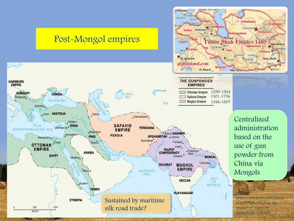
Post-Mongol empires
Source:
https://www.tes.com/lesson
s/qtd7rtgHnWnAvg/the-
impact-of-islam-on-
gunpowder-empires
1299-19241501-1736
1526-1857
Centralized
administration
based on the
use of gun
powder from
China via
Mongols
Sustained by maritime
silk road trade?
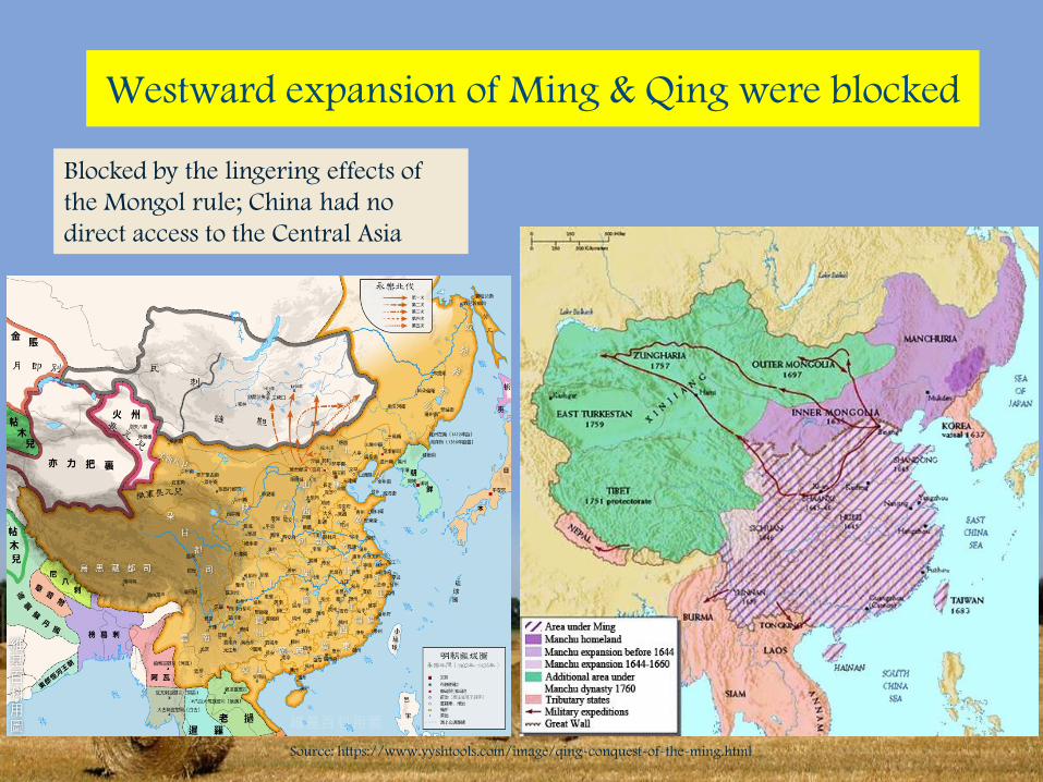
Westward expansion of Ming & Qing were blocked
Source: https://www.yyshtools.com/image/qing-conquest-of-the-ming.html
Blocked by the lingering effects of
the Mongol rule; China had no
direct access to the Central Asia
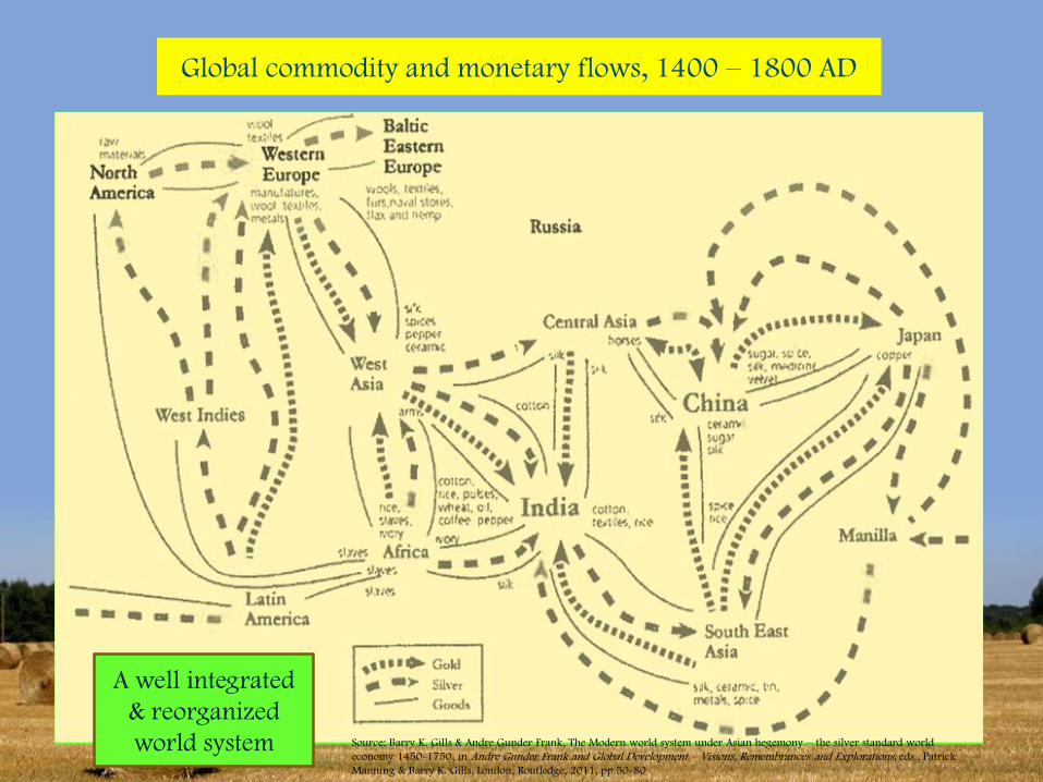
Global commodity and monetary flows, 1400 – 1800 AD
A well integrated
& reorganized
world system Source: Barry K. Gills & Andre Gunder Frank, The Modern world system under Asian hegemony – the silver standard world
economy 1450-1750, in Andre Gunder Frank and Global Development – Visions, Remembrances and Explorations, eds., Patrick
Manning & Barry K. Gills, London, Routledge, 2011, pp.50-80
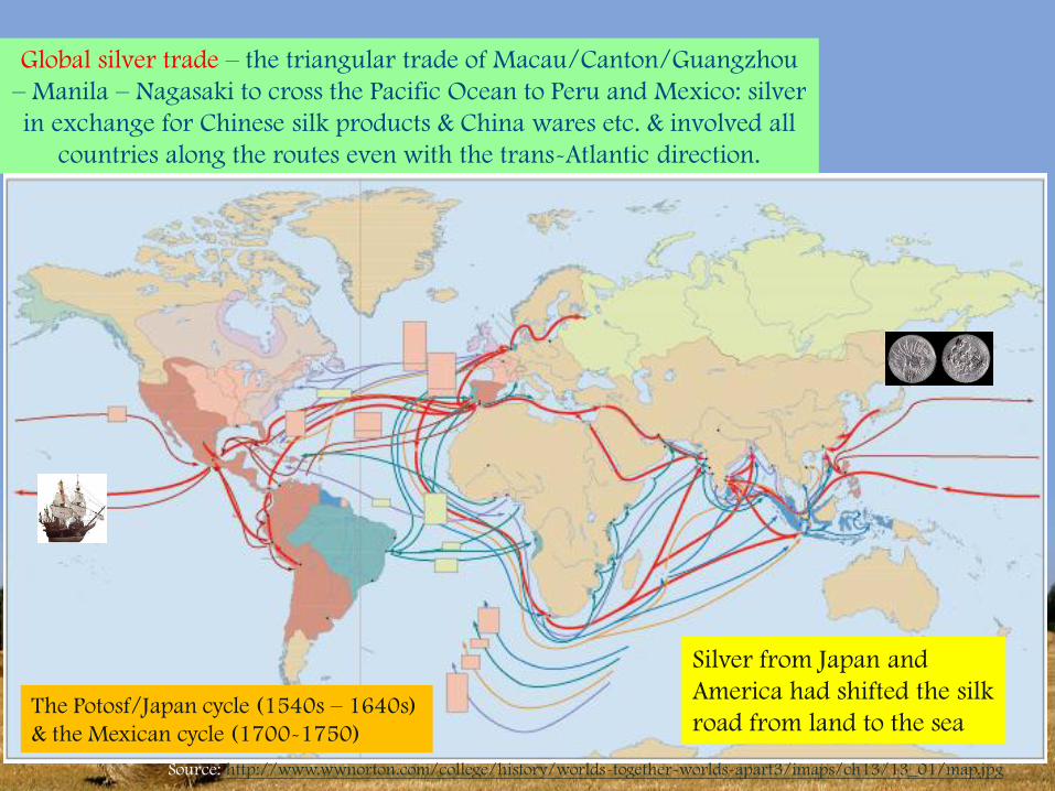
Global silver trade – the triangular trade of Macau/Canton/Guangzhou
– Manila – Nagasaki to cross the Pacific Ocean to Peru and Mexico: silver
in exchange for Chinese silk products & China wares etc. & involved all
countries along the routes even with the trans-Atlantic direction.
Source: http://www.wwnorton.com/college/history/worlds-together-worlds-apart3/imaps/ch13/13_01/map.jpg
The Potosf/Japan cycle (1540s – 1640s)
& the Mexican cycle (1700-1750)
Silver from Japan and
America had shifted the silk
road from land to the sea
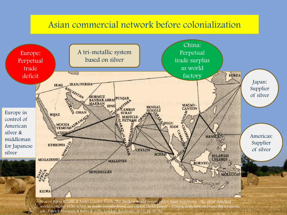
Asian commercial network before colonialization
China:
Perpetual
trade surplus
as world
factoryJapan:
Supplier
of silver
Americas:
Supplier
of silver
Europe:
Perpetual
trade
deficit
Source: Barry K. Gills & Andre Gunder Frank, The Modern world system under Asian hegemony – the silver standard
world economy 1450-1750, in Andre Gunder Frank and Global Development – Visions, Remembrances and Explorations, eds., Patrick Manning & Barry K. Gills, London, Routledge, 2011, pp.50-80
A tri-metallic system
based on silver
Europe in
control of
American
silver &
middleman
for Japanese
silver
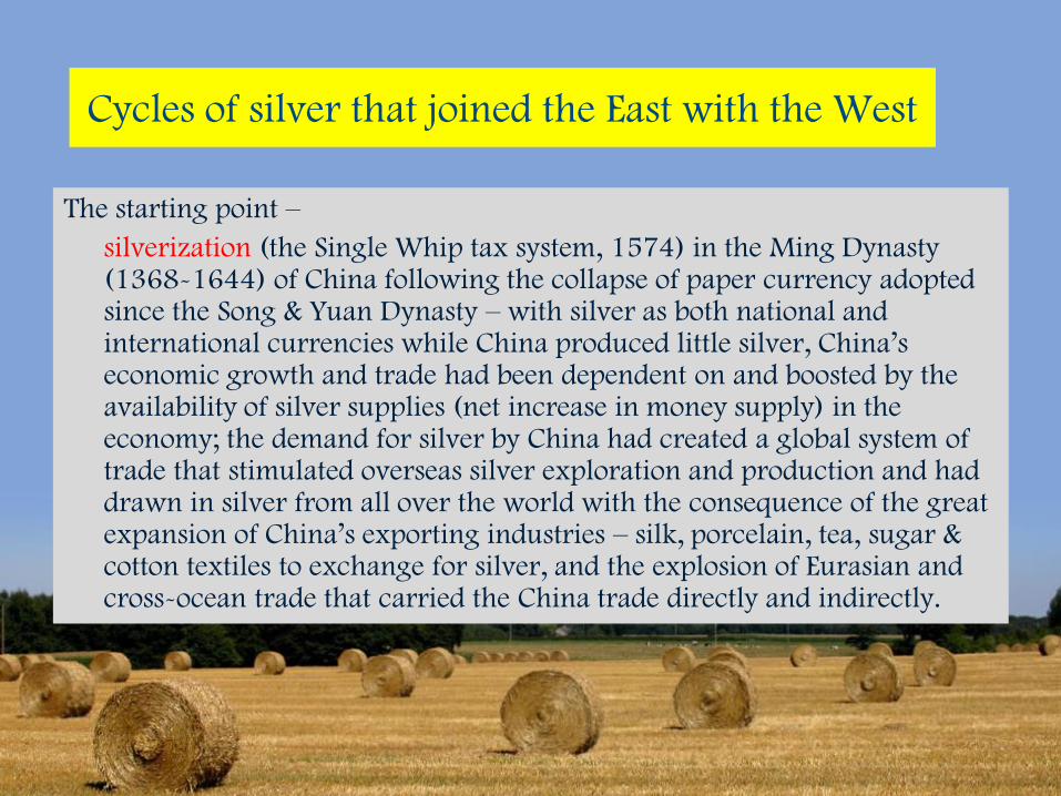
Cycles of silver that joined the East with the West
The starting point –
silverization (the Single Whip tax system, 1574) in the Ming Dynasty (1368-1644) of China following the collapse of paper currency adopted since the Song & Yuan Dynasty – with silver as both national and international currencies while China produced little silver, China’s economic growth and trade had been dependent on and boosted by the availability of silver supplies (net increase in money supply) in the economy; the demand for silver by China had created a global system of trade that stimulated overseas silver exploration and production and had drawn in silver from all over the world with the consequence of the great expansion of China’s exporting industries – silk, porcelain, tea, sugar & cotton textiles to exchange for silver, and the explosion of Eurasian and cross-ocean trade that carried the China trade directly and indirectly.
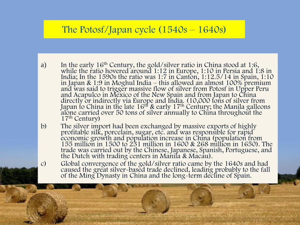
The Potosf/Japan cycle (1540s – 1640s)
a) In the early 16th Century, the gold/silver ratio in China stood at 1:6, while the ratio hovered around 1:12 in Europe, 1:10 in Persia and 1:8 in India; In the 1590s the ratio was 1:7 in Canton, 1:12.5/14 in Spain, 1:10 in Japan & 1:9 in Moghul India – this allowed an almost 100% premium and was said to trigger massive flow of silver from Potosf in Upper Peru and Acapulco in Mexico of the New Spain and from Japan to China directly or indirectly via Europe and India. (10,000 tons of silver from Japan to China in the late 16th & early 17th Century; the Manila galleons alone carried over 50 tons of silver annually to China throughout the 17th Century)
b) The silver import had been exchanged by massive exports of highly profitable silk, porcelain, sugar, etc. and was responsible for rapid economic growth and population increase in China (population from 155 million in 1500 to 231 million in 1600 & 268 million in 1650). The trade was carried out by the Chinese, Japanese, Spanish, Portuguese, and the Dutch with trading centers in Manila & Macau).
c) Global convergence of the gold/silver ratio came by the 1640s and had caused the great silver-based trade declined, leading probably to the fall of the Ming Dynasty in China and the long-term decline of Spain.
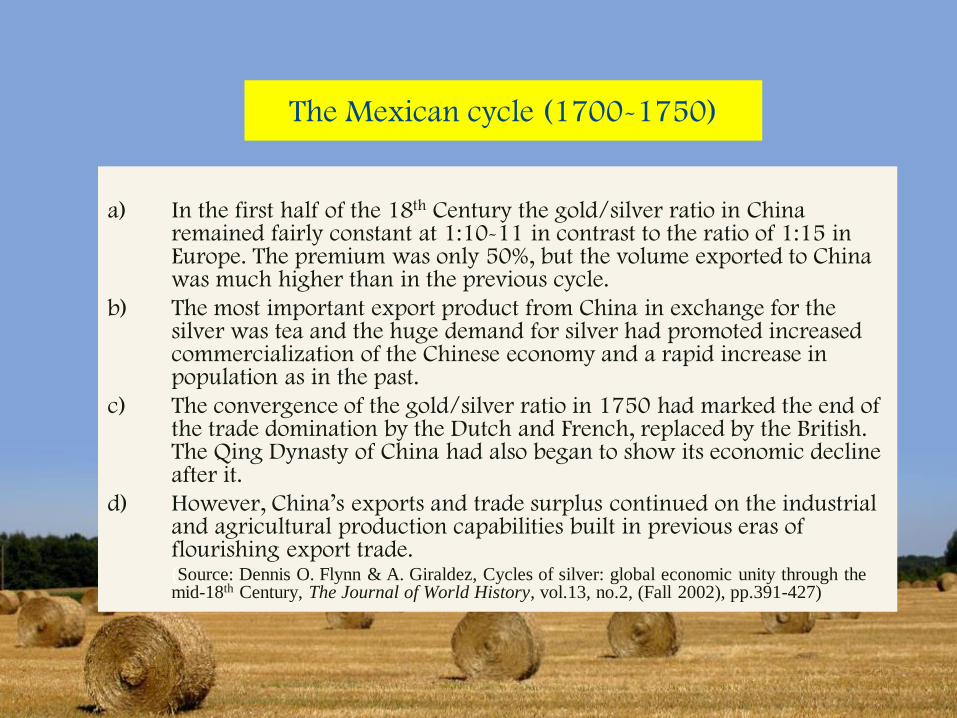
The Mexican cycle (1700-1750)
a) In the first half of the 18th Century the gold/silver ratio in China remained fairly constant at 1:10-11 in contrast to the ratio of 1:15 in Europe. The premium was only 50%, but the volume exported to China was much higher than in the previous cycle.
b) The most important export product from China in exchange for the silver was tea and the huge demand for silver had promoted increased commercialization of the Chinese economy and a rapid increase in population as in the past.
c) The convergence of the gold/silver ratio in 1750 had marked the end of the trade domination by the Dutch and French, replaced by the British. The Qing Dynasty of China had also began to show its economic decline after it.
d) However, China’s exports and trade surplus continued on the industrial and agricultural production capabilities built in previous eras of flourishing export trade.(Source: Dennis O. Flynn & A. Giraldez, Cycles of silver: global economic unity through the mid-18th Century, The Journal of World History, vol.13, no.2, (Fall 2002), pp.391-427)
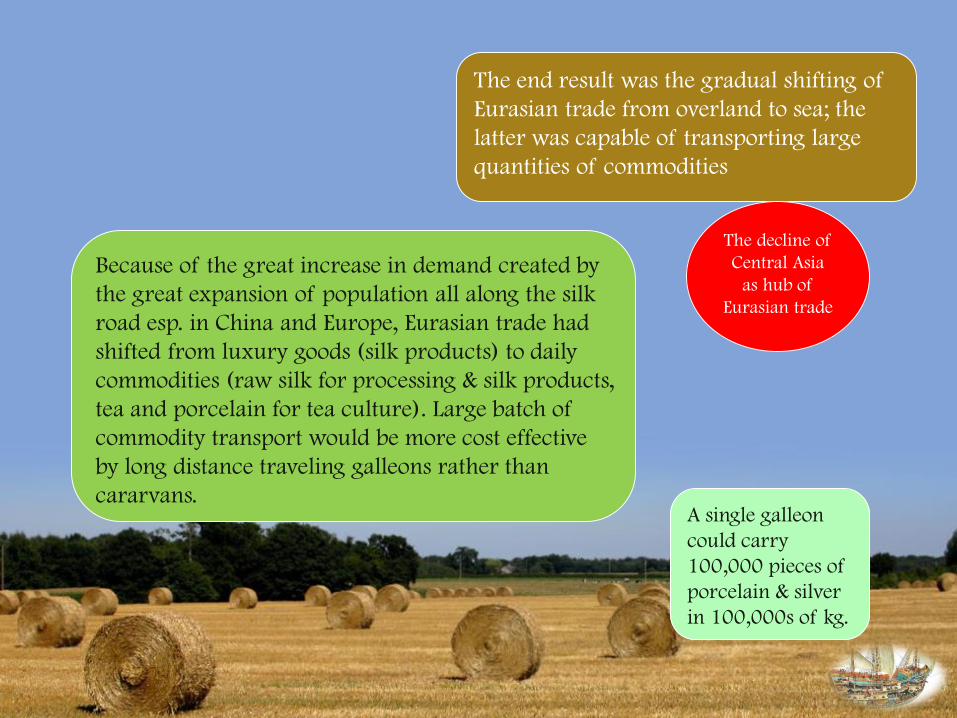
The end result was the gradual shifting of
Eurasian trade from overland to sea; the
latter was capable of transporting large
quantities of commodities
Because of the great increase in demand created by
the great expansion of population all along the silk
road esp. in China and Europe, Eurasian trade had
shifted from luxury goods (silk products) to daily
commodities (raw silk for processing & silk products,
tea and porcelain for tea culture). Large batch of
commodity transport would be more cost effective
by long distance traveling galleons rather than
cararvans.A single galleon
could carry
100,000 pieces of
porcelain & silver
in 100,000s of kg.
The decline of
Central Asia
as hub of
Eurasian trade
Sources:
https://upload.wikimedia.org/wikipedia/commons/thumb/1/14/Map_Siberian_route.svg/2000px-
Map_Siberian_route.svg.png & http://chinaexpat.com/wp-content/uploads/u1/route_map.jpg
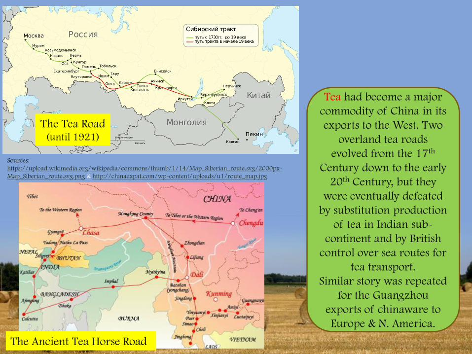
The Tea Road(until 1921)
The Ancient Tea Horse Road
Tea had become a major
commodity of China in its
exports to the West. Two
overland tea roads
evolved from the 17th
Century down to the early
20th Century, but they
were eventually defeated
by substitution production
of tea in Indian sub-
continent and by British
control over sea routes for
tea transport.
Similar story was repeated
for the Guangzhou
exports of chinaware to
Europe & N. America.
The Great Transformations in the modern World(s)
probably after 17th Century instead of 16th Century
• Overland silk roads were disrupted because of the weakening of the
great empires of China, Ottoman and Austrian-Hungarian, with the
expansion of the Russian empire provided only the northern route to
China (Mongolia & Harbin), but its competition with other continental
European powers and the control of Britain over major production and
trade centers in Asia had limited its trade functions;
• The Maritime silk road became the battleground for scramble for
concessions and colonialization by West European powers. British by
the 19th Century dominated and controlled the trade of chinaware, tea,
silk with China and spices with Indonesia.
• The trans-Atlantic trade overtook the Eurasian silk roads (both
overland and maritime) through colonialization, development of
plantation economies, slave trade and massive migration, with the
subsequent rise of the USA over Europe by the end of the 19th Century
– in an effort to substitute imports from China and Asia
Rethinking the Silk Road
• The Silk Road and its variants over the past millennium was basically
commercial ventures – taking advantage of the great economic production
capabilities of quality products of China and the consumption demand from
the rest of the world – it required innovative and ever upgrading production
capabilities in China and the expansion in consumption demand in the rest of
the world – from Roman Empire to the rise of the Muslim empires in the
Middle East and West Asia to the rise of the West (Western Europe & North
America).
• Long distance commercial ventures needed political protection to offer safety
and stability as well as internationally acceptable payment currency for cross-
border economic calculation & planning. In particular the use of silver had
expanded both production in China and overseas consumption and promoted
technology development (product technologies & transport technologies)
from the long 16th Century to early 20th Century. Politics (international
relations) and finance (cross border exchange rates) will be crucial factors to
determine the ups and downs of the Silk Road.
• Technology has also been a crucial factor in determining long-distance trade
& exchanges – first the harnessing of horses and camels provided the basis
for overland silk road expansion, later improvements in navigation
technologies allowed sea faring and ocean going to move bulkier goods and
larger number of travelers across great distance, and railways and airplanes
are yet to revolutionize the silk road connectivity.
• The silk road is about connectivity - starting from physical connectivity to
economic, political, social, cultural connectivity that could & will be
culminated in information connectivity and cultural empathy. It is not just
about investment and trade. However, given the disruptions of the silk road
connectivity by the decline of China and West Asia polities in the 20th
Century, the Cold War and the global economic shifts to cross Atlantic
regions, it needs to restore physical connectivity in terms of infrastructure
investments to build up again the momentum for trade and exchanges for it
to resurge.
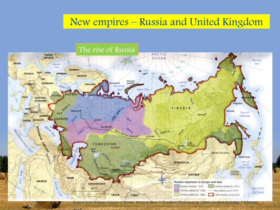
New empires – Russia and United Kingdom
The rise of Russia
, Source: Josh Wilson, Origins of Russia: Moscow Rises to Tsardom (Prehistory to 1584), Geohistory.today, 7 February
2017.
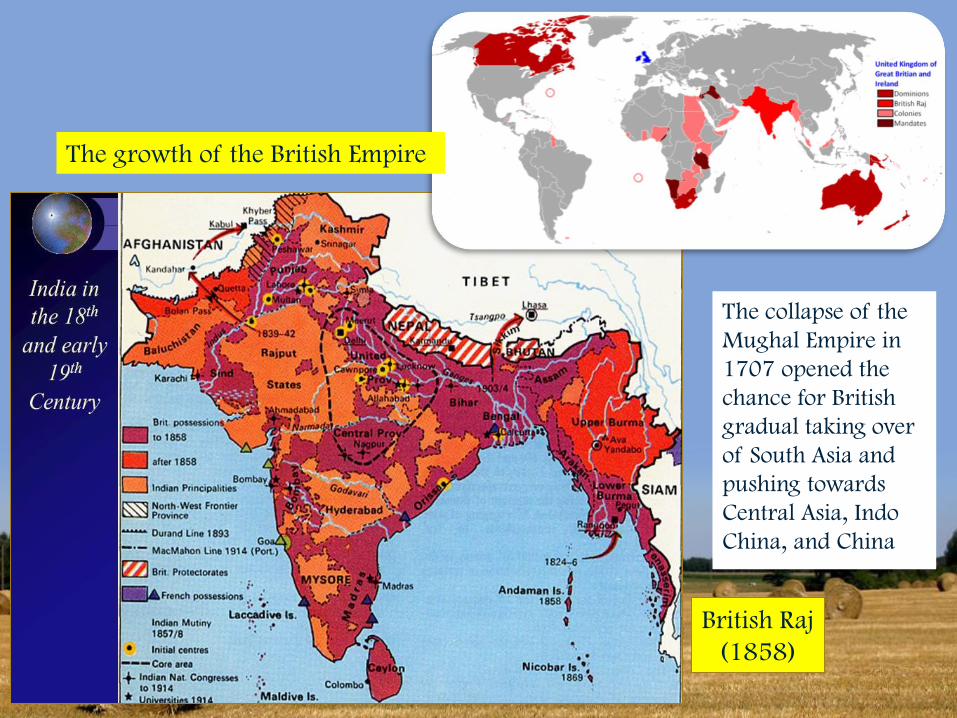
British Raj
(1858)
The growth of the British Empire
The collapse of the
Mughal Empire in
1707 opened the
chance for British
gradual taking over
of South Asia and
pushing towards
Central Asia, Indo
China, and China
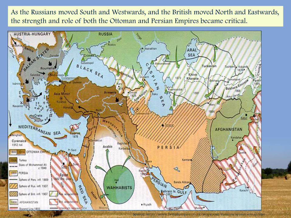
As the Russians moved South and Westwards, and the British moved North and Eastwards,
the strength and role of both the Ottoman and Persian Empires became critical.
Source: http://www.britishempire.co.uk/maproom/russianexpansionmap.htm
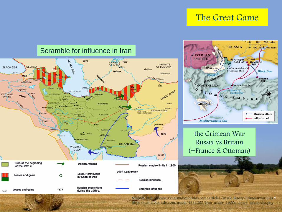
The Great Game
the Crimean War
Russia vs Britain
(+France & Ottoman)
Scramble for influence in Iran
Sources: http://www.socialstudiesforkids.com/articles /worldhistory/crimeanwar.htm &
https://cdn2.vox-cdn.com/assets/4232263/Iran_under_1900s_qajars_wikimedia.png
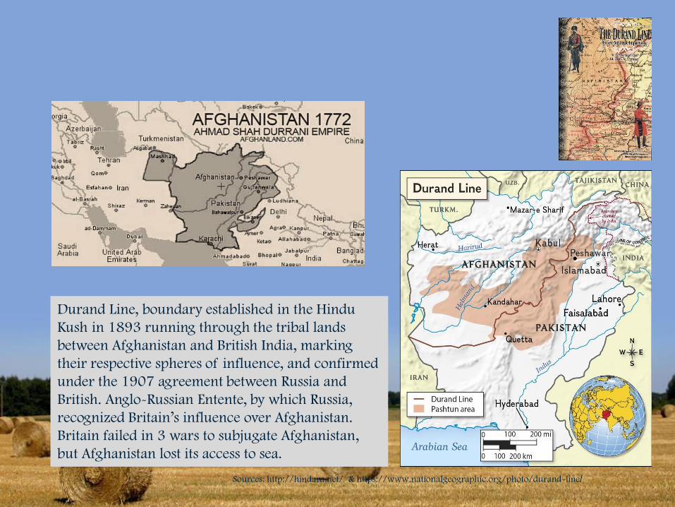
Durand Line, boundary established in the Hindu
Kush in 1893 running through the tribal lands
between Afghanistan and British India, marking
their respective spheres of influence, and confirmed
under the 1907 agreement between Russia and
British. Anglo-Russian Entente, by which Russia,
recognized Britain’s influence over Afghanistan.
Britain failed in 3 wars to subjugate Afghanistan,
but Afghanistan lost its access to sea.
Sources: http://hindara.net/ & https://www.nationalgeographic.org/photo/durand-line/
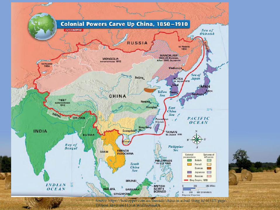
Source: https://hotcopper.com.au/threads/china-is-a-bad-thing.4046125/page-
73?post_id=31661131#.WuLErohuaUk
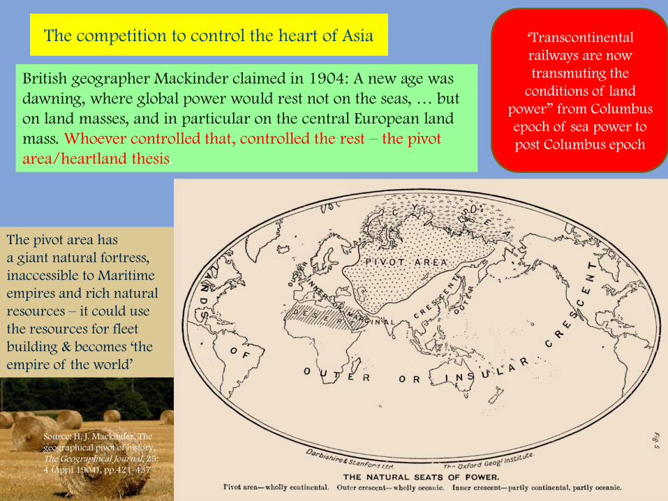
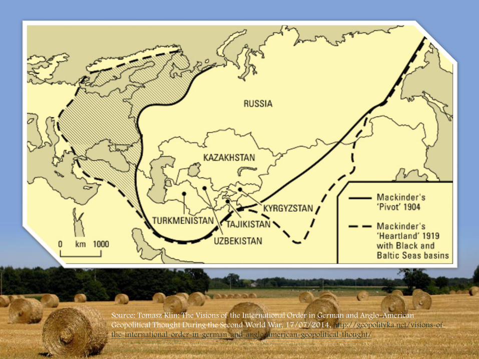
The competition to control the heart of Asia
Source: H. J. Mackinder, The
geographical pivot of history,
The Geographical Journal, 25:
4 (April 1904), pp.421-437
British geographer Mackinder claimed in 1904: A new age was
dawning, where global power would rest not on the seas, … but
on land masses, and in particular on the central European land
mass. Whoever controlled that, controlled the rest – the pivot
area/heartland thesis.
‘Transcontinental
railways are now
transmuting the
conditions of land
power” from Columbus
epoch of sea power to
post Columbus epoch
The pivot area has
a giant natural fortress,
inaccessible to Maritime
empires and rich natural
resources – it could use
the resources for fleet
building & becomes ‘the
empire of the world’
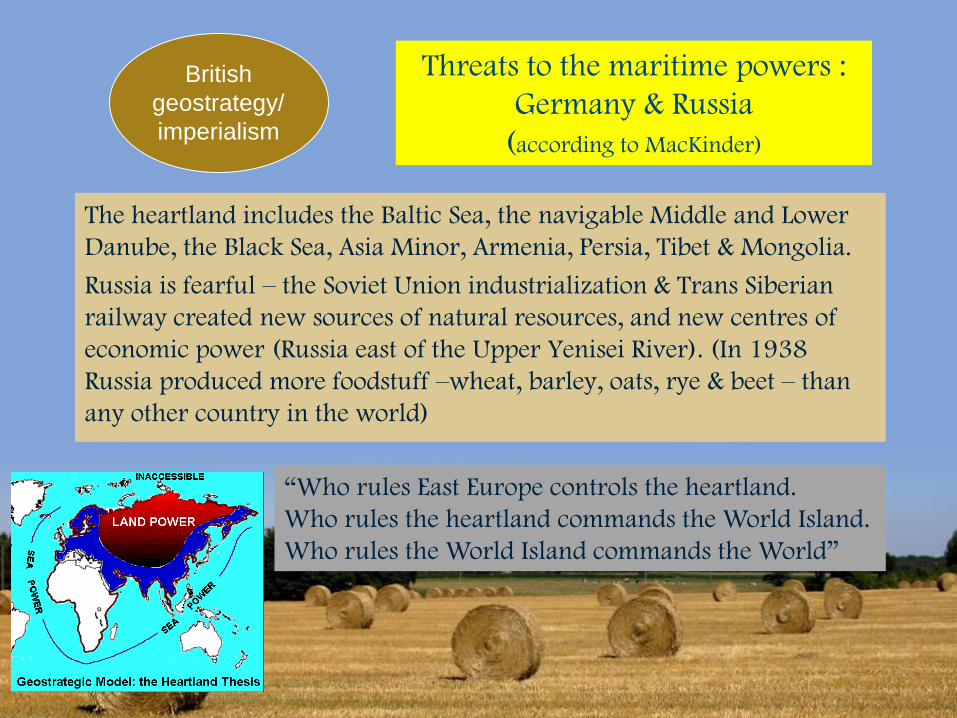
Threats to the maritime powers :
Germany & Russia
(according to MacKinder)
The heartland includes the Baltic Sea, the navigable Middle and Lower
Danube, the Black Sea, Asia Minor, Armenia, Persia, Tibet & Mongolia.
Russia is fearful – the Soviet Union industrialization & Trans Siberian
railway created new sources of natural resources, and new centres of
economic power (Russia east of the Upper Yenisei River). (In 1938
Russia produced more foodstuff –wheat, barley, oats, rye & beet – than
any other country in the world)
“Who rules East Europe controls the heartland.
Who rules the heartland commands the World Island.
Who rules the World Island commands the World”
British
geostrategy/
imperialism
Source: Tomasz Klin: The Visions of the International Order in German and Anglo-American
Geopolitical Thought During the Second World War, 17/07/2014, http://geopolityka.net/visions-of-
the-international-order-in-german-and-anglo-american-geopolitical-thought/
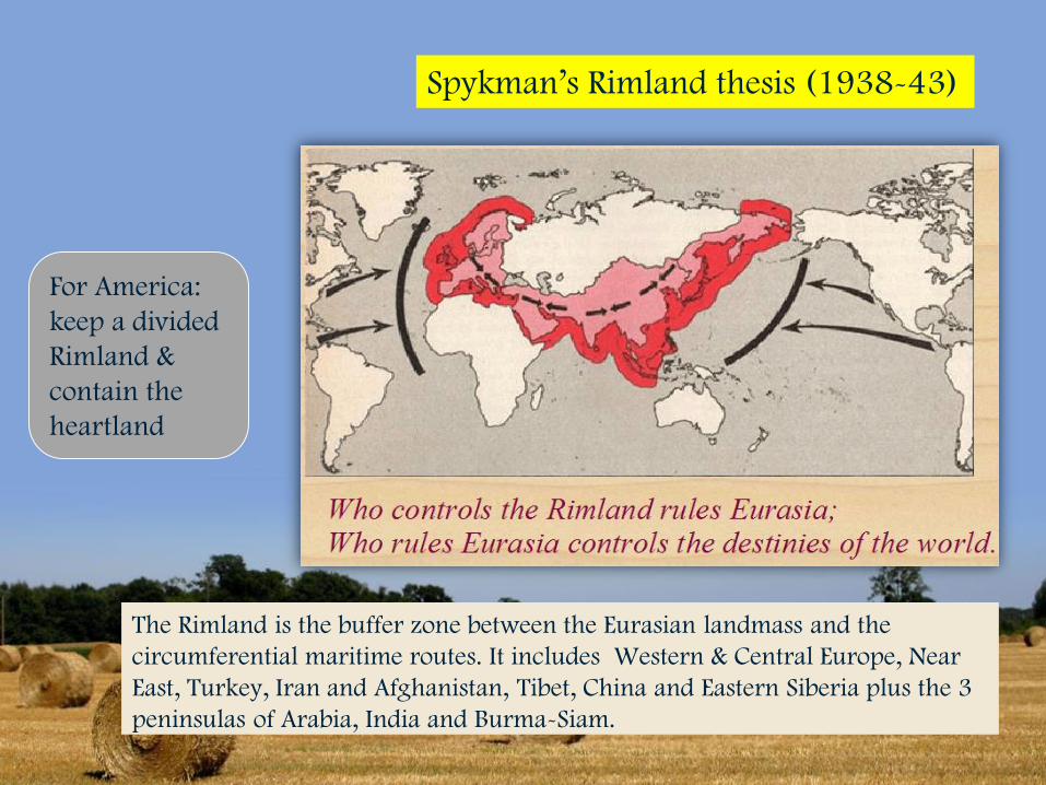
The Rimland is the buffer zone between the Eurasian landmass and the
circumferential maritime routes. It includes Western & Central Europe, Near
East, Turkey, Iran and Afghanistan, Tibet, China and Eastern Siberia plus the 3
peninsulas of Arabia, India and Burma-Siam.
Spykman’s Rimland thesis (1938-43)
For America:
keep a divided
Rimland &
contain the
heartland
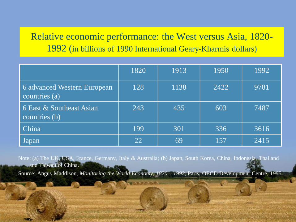
Relative economic performance: the West versus Asia, 1820-
1992 (in billions of 1990 International Geary-Kharmis dollars)
Note: (a) The UK, USA, France, Germany, Italy & Australia; (b) Japan, South Korea, China, Indonesia, Thailand
and Taiwan of China.
Source: Angus Maddison, Monitoring the World Economy, 1820 – 1992, Paris, OECD Development Centre, 1995.
1820 1913 1950 1992
6 advanced Western European
countries (a)
128 1138 2422 9781
6 East & Southeast Asian
countries (b)
243 435 603 7487
China 199 301 336 3616
Japan 22 69 157 2415