Embed Size (px)
Citation preview

Greater Rio Grande Watershed Alliance Project Proposal Template
All proposals are due to the GRGWA Technical Committee by June 30, 2012. Only proposals turned in by this date will be considered for 2012 funding.
GRGWA Technical Committee members (Mike Matush, Susan Rich, Terrell Treat, Jim
Wanstall, Jill Wick, and Joe Zebrowski) are available to assist with proposal development.
Project name: Romero Fire Mastication and Restoration Project type(s) (Initial treatment, re-treatment, re-vegetation):
• Initial treatment – mastication and chemical treatment of mostly Russian Olive trees with some tamarix (salt cedar)
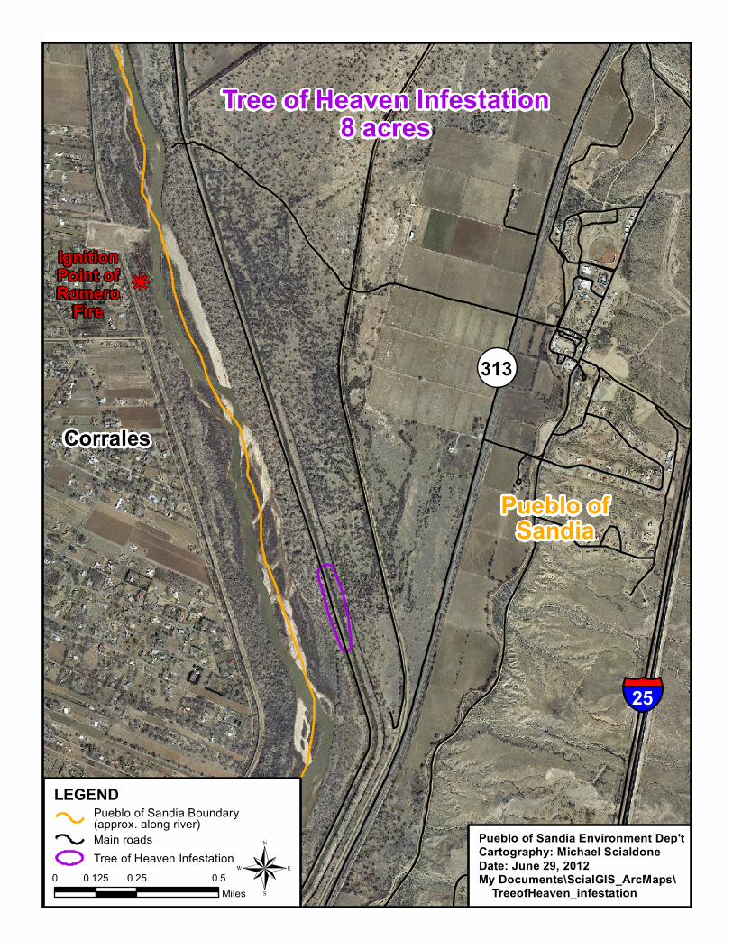
• Initial treatment – chemical treatment of Tree of Heaven infestation • Re-vegetation – planting and seeding of burned area
Project proponent (SWCD): Project location (city, county, nearest intersection, etc.): → A map of the project area with the treatment(s) delineated must be attached to this proposal. The project site is entirely located on Pueblo of Sandia Indian Reservation. The Pueblo of Sandia is between Albuquerque and Bernalillo, and across the Rio Grande from Corrales and Rio Rancho. The Bernalillo/Sandoval county line runs through the southern portion of the Reservation, but the project site is entirely within Sandoval County. It is adjacent to the Riverside Drain and about ¼ mile from the Rio Grande on its west side. See attached maps. Landowner(s):
N/A
For private land: Has the landowner(s) submitted an application form (for example, State Forestry’s Landowner Request for Assistance Form) for this project?
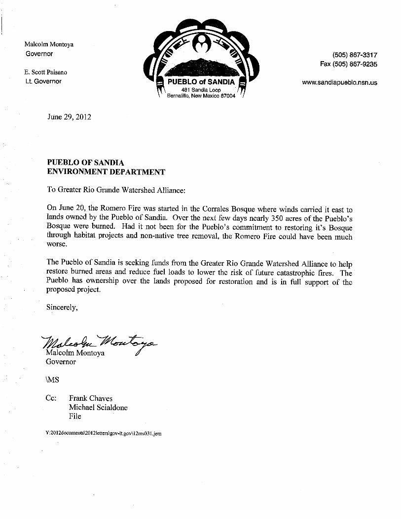
For public/tribal land: Does the landowner or land management agency support this project? Has the landowner or land management agency formally requested assistance for this project?The Pueblo of Sandia Tribal Administration supports this project. See attached letter from Governor Malcolm Montoya.
How is this site accessed? Is access controlled? (Is there a locked gate or will we need to make arrangements with the landowner for access?The Pueblo of Sandia controls access to all its lands. Access Permits are issued when needed through the department handling a particular project. In this case, the Environment Department would work
)

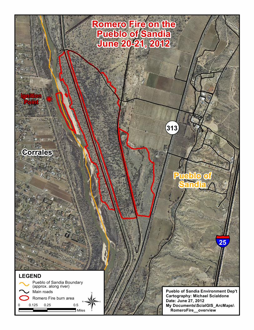
with GRGWA to ensure timely access for site review and for the contractor doing the work. It is generally easy to access the site from a maintained dirt road off of Hwy 313. Project objective(s) (This is something that is specific and measurable; i.e., remove and control all salt cedar and Russian olive from within project boundary): Reduce fire risk through removal of all Russian olive and salt cedar within project boundary. Chemically treat all Tree of Heaven within project boundary. See all burned areas within boundary with appropriate native upland/grassland seed mix. Size of project (If this project includes multiple project types, indicate the size of each type. For example, the project may have 23 acres of initial treatment and 10 acres of re-treatment. The treatments must also be delineated on an attached map.): 279 acres of mostly Russian olive will be masticated and chemically treated. 279 acres of burned area will be reseeded.
NOTE: this is the total burned area, but not acreage still has trees to be masticated or was burned at level needing planting and reseeding.
8 acres of Tree of Heaven will be chemically treated. Current site description: Include the following
The project site is located between the Riverside Drain and Hwy 313 with the Albuquerque Main Irrigation Canal running through it. Another drainage channel parallels the Riverside Drain. These ditches/canals and their adjacent roads are the primary infrastructure in the area. It has a grassland understory with an overstory of fairly large cottonwood trees and Russian olives. There is a large patch of Tree of Heaven that is spreading and needs to be controlled.
: ecosystem type (riparian, upland, wetland), dominant vegetation, soils, hydrology, wildlife (if known), current land use, infrastructure within the project area (including fences and jetty jacks), and current problem areas or areas of concern (erosion issues, noxious weeds, etc.).
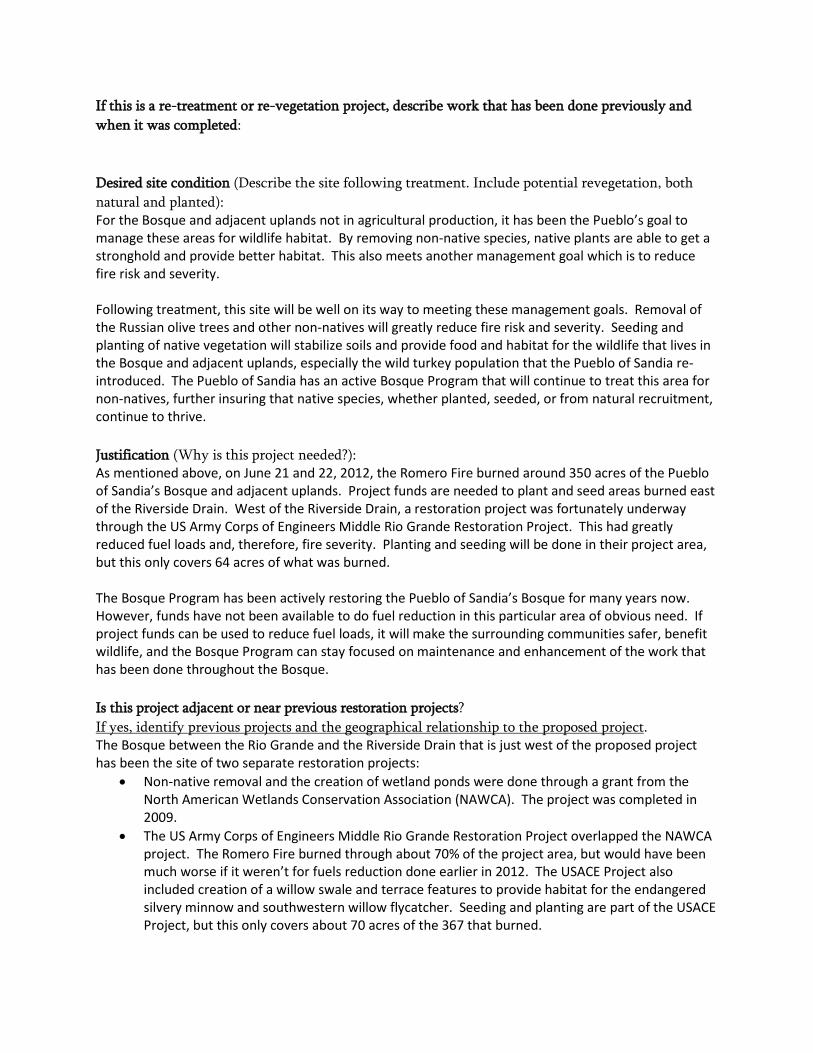
The main use of the area currently is habitat for wildlife, particularly for turkeys that the Pueblo of Sandia re-introduced in the past few years. Other wildlife includes coyote, bobcat, mountain lion, skunks, raccoons, porcupines, and a large assortment of birds and raptors including ducks, geese, hawks (Coopers, red-tailed, and sharp-shinned), eagles, and osprey. Some cattle grazing occurs in and around the project area. Farm lands are adjacent to the east and the Bosque along the Rio Grande is to the west. On June 20, 2012, around 3:00pm, a fire started on the west side of the Rio Grande in the Corrales Bosque. The fire was human caused, but the exact cause is still being investigated as of this writing. Due to prevailing strong winds, the fire quickly jumped the river into the Pueblo of Sandia’s Bosque. It wasn’t until the days later that the fire was considered contained. Around 350 acres burned on the east side of the Rio Grande. The drought-dried grass and large Russian olive trees made for a potent fuel combination. The Pueblo of Sandia would like to remove the remaining Russian olive trees in the area to reduce fuel loads and prevent another large fire. Fortunately, for the most part, the fire did not scorch the soil (testing will be conducted in certain areas). The Pueblo of Sandia would like to get plants and native seed planted on these areas before invasive weeds are able to take over.
If this is a re-treatment or re-vegetation project, describe work that has been done previously and when it was completed: Desired site condition (Describe the site following treatment. Include potential revegetation, both natural and planted): For the Bosque and adjacent uplands not in agricultural production, it has been the Pueblo’s goal to manage these areas for wildlife habitat. By removing non-native species, native plants are able to get a stronghold and provide better habitat. This also meets another management goal which is to reduce fire risk and severity. Following treatment, this site will be well on its way to meeting these management goals. Removal of the Russian olive trees and other non-natives will greatly reduce fire risk and severity. Seeding and planting of native vegetation will stabilize soils and provide food and habitat for the wildlife that lives in the Bosque and adjacent uplands, especially the wild turkey population that the Pueblo of Sandia re-introduced. The Pueblo of Sandia has an active Bosque Program that will continue to treat this area for non-natives, further insuring that native species, whether planted, seeded, or from natural recruitment, continue to thrive. Justification (Why is this project needed?): As mentioned above, on June 21 and 22, 2012, the Romero Fire burned around 350 acres of the Pueblo of Sandia’s Bosque and adjacent uplands. Project funds are needed to plant and seed areas burned east of the Riverside Drain. West of the Riverside Drain, a restoration project was fortunately underway through the US Army Corps of Engineers Middle Rio Grande Restoration Project. This had greatly reduced fuel loads and, therefore, fire severity. Planting and seeding will be done in their project area, but this only covers 64 acres of what was burned. The Bosque Program has been actively restoring the Pueblo of Sandia’s Bosque for many years now. However, funds have not been available to do fuel reduction in this particular area of obvious need. If project funds can be used to reduce fuel loads, it will make the surrounding communities safer, benefit wildlife, and the Bosque Program can stay focused on maintenance and enhancement of the work that has been done throughout the Bosque. Is this project adjacent or near previous restoration projects? If yes, identify previous projects and the geographical relationship to the proposed projectThe Bosque between the Rio Grande and the Riverside Drain that is just west of the proposed project has been the site of two separate restoration projects:
.
• Non-native removal and the creation of wetland ponds were done through a grant from the North American Wetlands Conservation Association (NAWCA). The project was completed in 2009.
• The US Army Corps of Engineers Middle Rio Grande Restoration Project overlapped the NAWCA project. The Romero Fire burned through about 70% of the project area, but would have been much worse if it weren’t for fuels reduction done earlier in 2012. The USACE Project also included creation of a willow swale and terrace features to provide habitat for the endangered silvery minnow and southwestern willow flycatcher. Seeding and planting are part of the USACE Project, but this only covers about 70 acres of the 367 that burned.

Adjacent to the above-mentioned projects on their north end is an area that was cleared of non-native vegetation in 2007 through the USACE. To the south of the proposed project, fuels reduction was done in 2006 through a Wildland / Urban Interface grant from the Bureau of Indian Affairs. Further south and west, the Bureau of Reclamation completed 2 projects that involved fuels reduction / non-native removal and the creation of a flow-through channel to benefit the endangered silvery minnow. (((year completed))) Is there any baseline data (vegetation, ground water monitoring, etc.) available for this site? If yes, describe what is available and how the information can be accessed
.
How and by whom will the project be maintained? The Environment Department of the Pueblo of Sandia has a Bosque Program that is active in maintaining the habitat of the Bosque. Once the large-scale work of mastication is done, the Bosque Program has the capacity to maintain the proposed project area by cutting non-native resprouts with brushsaws or chainsaws and/or treating them with chemicals. SWCD board member/representative signature date
Corrales
LEGEND
Main roadsRomero Fire burn area ®0 0.25 0.50.125
Miles
§̈¦
Pueblo ofSandia
Pueblo of Sandia Boundary(approx. along river)
Pueblo of Sandia Environment Dep'tCartography: Michael ScialdoneDate: June 27, 2012My Documents\ScialGIS_ArcMaps\ RomeroFire__overview
Romero Fire on thePueblo of SandiaJune 20-21, 2012
kj
!(
25
313
IgnitionPoint

Corrales
LEGEND
Main roadsRomero Fire burn area restoration -mastication, planting, & seeding
®0 0.25 0.50.125Miles
§̈¦
Pueblo ofSandia
Pueblo of Sandia Boundary(approx. along river)
Pueblo of Sandia Environment Dep'tCartography: Michael ScialdoneDate: June 27, 2012My Documents\ScialGIS_ArcMaps\ GRGWA_mastication_planting_seeding
Area Proposed for Mastication,Planting, and Seeding
kj
!(
25
313
IgnitionPoint ofRomero
Fire
Corrales
LEGEND
Main roadsTree of Heaven Infestation®0 0.25 0.50.125
Miles
§̈¦
Pueblo ofSandia
Pueblo of Sandia Boundary(approx. along river)
Pueblo of Sandia Environment Dep'tCartography: Michael ScialdoneDate: June 29, 2012My Documents\ScialGIS_ArcMaps\ TreeofHeaven_infestation
Tree of Heaven Infestation8 acres
kj
!(
25
313
IgnitionPoint ofRomero
Fire