Embed Size (px)
Citation preview
Gorgon and Jansz Feed Gas Pipeline and Wells Operations
Environment Plan Summary: Commonwealth Waters
Document ID: GOR-COP-02027 Revision ID: 2.0
Revision Date: 12 September 2016 Next Revision Due:
Information Sensitivity: Public
Gorgon and Jansz Feed Gas Pipeline and Wells Operations Environment Plan Summary: Commonwealth Waters
Document ID: GOR-COP-02027 Revision ID:2.0 Revision Date: 12 September 2016 Page ii Information Sensitivity: Public Uncontrolled when Printed
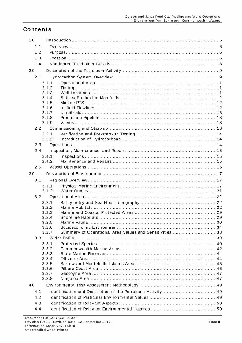
Contents
1.0 Introduction .................................................................................................... 6 1.1 Overview ...................................................................................................... 6 1.2 Purpose ........................................................................................................ 6 1.3 Location ....................................................................................................... 6 1.4 Nominated Titleholder Details ......................................................................... 8
2.0 Description of the Petroleum Activity .................................................................. 9 2.1 Hydrocarbon System Overview ....................................................................... 9
2.1.1 Operational Area ................................................................................... 11 2.1.2 Timing ................................................................................................. 11 2.1.3 Well Locations ...................................................................................... 11 2.1.4 Subsea Production Manifolds .................................................................. 12 2.1.5 Midline PTS .......................................................................................... 12 2.1.6 In-field Flowlines .................................................................................. 12 2.1.7 Umbilicals ............................................................................................ 13 2.1.8 Production Pipeline ................................................................................ 13 2.1.9 Valves ................................................................................................. 13
2.2 Commissioning and Start-up .......................................................................... 13 2.2.1 Verification and Pre-start-up Testing ....................................................... 14 2.2.2 Introduction of Hydrocarbons ................................................................. 14
2.3 Operations................................................................................................... 14 2.4 Inspection, Maintenance, and Repairs ............................................................. 15
2.4.1 Inspections .......................................................................................... 15 2.4.2 Maintenance and Repairs ....................................................................... 15
2.5 Vessel Operations ......................................................................................... 16 3.0 Description of Environment .............................................................................. 17
3.1 Regional Overview ........................................................................................ 17 3.1.1 Physical Marine Environment .................................................................. 17 3.1.2 Water Quality ....................................................................................... 21
3.2 Operational Area .......................................................................................... 22 3.2.1 Bathymetry and Sea Floor Topography .................................................... 22 3.2.2 Marine Habitats .................................................................................... 22 3.2.3 Marine and Coastal Protected Areas ........................................................ 29 3.2.4 Shoreline Habitats................................................................................. 29 3.2.5 Marine Fauna ....................................................................................... 30 3.2.6 Socioeconomic Environment ................................................................... 34 3.2.7 Summary of Operational Area Values and Sensitivities .............................. 38
3.3 Wider EMBA ................................................................................................. 39 3.3.1 Protected Species ................................................................................. 40 3.3.2 Commonwealth Marine Areas ................................................................. 42 3.3.3 State Marine Reserves ........................................................................... 44 3.3.4 Offshore Area ....................................................................................... 44 3.3.5 Barrow and Montebello Islands Area ........................................................ 45 3.3.6 Pilbara Coast Area................................................................................. 46 3.3.7 Gascoyne Area ..................................................................................... 47 3.3.8 Ningaloo Area ....................................................................................... 47
4.0 Environmental Risk Assessment Methodology ..................................................... 49 4.1 Identification and Description of the Petroleum Activity ..................................... 49 4.2 Identification of Particular Environmental Values .............................................. 49 4.3 Identification of Relevant Aspects ................................................................... 50 4.4 Identification of Relevant Environmental Hazards ............................................. 50
Gorgon and Jansz Feed Gas Pipeline and Wells Operations Environment Plan Summary: Commonwealth Waters
Document ID: GOR-COP-02027 Revision ID:2.0 Revision Date: 12 September 2016 Page iii Information Sensitivity: Public Uncontrolled when Printed
4.5 Evaluation of Impacts and Risk ...................................................................... 50 4.5.1 Consequence ........................................................................................ 50 4.5.2 Control Measures and ALARP .................................................................. 53 4.5.3 Likelihood ............................................................................................ 53 4.5.4 Quantification of the Level of Risk ........................................................... 53
4.6 Risk Acceptance Criteria ................................................................................ 53 4.7 Environmental Performance Outcomes, Standards, and Measurement Criteria ...... 54
5.0 Environmental Risk Assessment and Management Strategy – Petroleum Activity .... 55 5.1 Commissioning and Start-up .......................................................................... 55 5.2 Operations................................................................................................... 55
5.2.1 Planned Discharges – Risk Assessment .................................................... 55 5.2.2 Leaks and Spills – Risk Assessment ......................................................... 58
5.3 Inspection, Maintenance, and Repairs ............................................................. 62 5.3.1 Seabed Disturbance .............................................................................. 62 5.3.2 Planned Discharges ............................................................................... 63 5.3.3 Noise Emissions .................................................................................... 64
5.4 Vessel Operations ......................................................................................... 65 5.4.1 Physical Interaction ............................................................................... 65 5.4.2 Seabed Disturbance – Risk Assessment ................................................... 67 5.4.3 Introduction of Invasive Marine Pests – Risk Assessment ........................... 68 5.4.4 Planned Discharges – Risk Assessment .................................................... 71 5.4.5 Leaks and Spills – Risk Assessment ......................................................... 73
6.0 Environmental Risk Assessment and Management Strategy – Emergency Conditions and Emergency Response Activities .............................................................................. 79
6.1 Loss of Well Control – Emergency Condition..................................................... 79 6.2 Major Defect – Emergency Condition Overview................................................. 82
6.2.1 Emergency Condition – Risk Assessment ................................................. 82 6.3 Emergency Response Overview ...................................................................... 88
6.3.1 Ground Disturbance – Risk Assessment ................................................... 92 6.3.2 Physical Interaction – Risk Assessment .................................................... 94 6.3.3 Physical Presence – Risk Assessment ....................................................... 96 6.3.4 Noise and Vibrations – Risk Assessment .................................................. 99 6.3.5 Secondary Contamination– Risk Assessment .......................................... 101
7.0 Implementation Strategy ............................................................................... 104 7.1 Operational Excellence Management System .................................................. 104
7.1.1 Safe Operations (OE-03) ...................................................................... 105 7.1.2 Management of Change (OE-04) ........................................................... 106 7.1.3 Environmental Stewardship (OE-07) ...................................................... 106 7.1.4 Incident Investigation (OE-09) ............................................................. 108 7.1.5 Community and Stakeholder Engagement (OE-10) .................................. 108 7.1.6 Emergency Management (OE-11.01) ..................................................... 108 7.1.7 Compliance Assurance (OE-12.01) ........................................................ 116
7.2 Petroleum Activity Implementation ............................................................... 117 7.2.1 Chain of Command ............................................................................. 117 7.2.2 Environmental Awareness .................................................................... 117
7.3 Oil Pollution Emergency Plan (OPEP) ............................................................. 117 7.4 Monitoring and Reporting ............................................................................ 119
7.4.1 Monitoring ......................................................................................... 119 7.4.2 Incident Reporting .............................................................................. 120 7.4.3 Routine Reporting ............................................................................... 122
7.5 Environment Plan Review ............................................................................ 122 8.0 Stakeholder Consultation Plan ........................................................................ 123
Gorgon and Jansz Feed Gas Pipeline and Wells Operations Environment Plan Summary: Commonwealth Waters
Document ID: GOR-COP-02027 Revision ID:2.0 Revision Date: 12 September 2016 Page iv Information Sensitivity: Public Uncontrolled when Printed
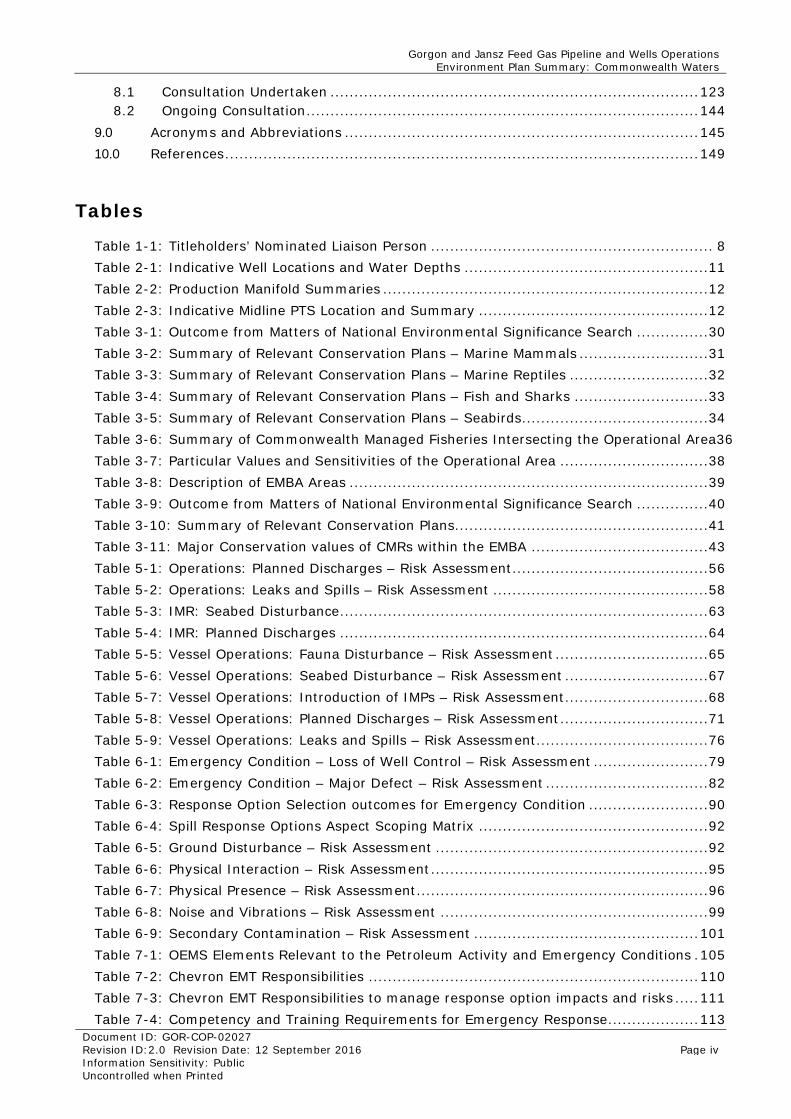
8.1 Consultation Undertaken ............................................................................. 123 8.2 Ongoing Consultation .................................................................................. 144
9.0 Acronyms and Abbreviations .......................................................................... 145 10.0 References ................................................................................................... 149
Tables
Table 1-1: Titleholders’ Nominated Liaison Person ........................................................... 8 Table 2-1: Indicative Well Locations and Water Depths ................................................... 11 Table 2-2: Production Manifold Summaries .................................................................... 12 Table 2-3: Indicative Midline PTS Location and Summary ................................................ 12 Table 3-1: Outcome from Matters of National Environmental Significance Search ............... 30 Table 3-2: Summary of Relevant Conservation Plans – Marine Mammals ........................... 31 Table 3-3: Summary of Relevant Conservation Plans – Marine Reptiles ............................. 32 Table 3-4: Summary of Relevant Conservation Plans – Fish and Sharks ............................ 33 Table 3-5: Summary of Relevant Conservation Plans – Seabirds ....................................... 34 Table 3-6: Summary of Commonwealth Managed Fisheries Intersecting the Operational Area36 Table 3-7: Particular Values and Sensitivities of the Operational Area ............................... 38 Table 3-8: Description of EMBA Areas ........................................................................... 39 Table 3-9: Outcome from Matters of National Environmental Significance Search ............... 40 Table 3-10: Summary of Relevant Conservation Plans ..................................................... 41 Table 3-11: Major Conservation values of CMRs within the EMBA ..................................... 43 Table 5-1: Operations: Planned Discharges – Risk Assessment ......................................... 56 Table 5-2: Operations: Leaks and Spills – Risk Assessment ............................................. 58 Table 5-3: IMR: Seabed Disturbance ............................................................................. 63 Table 5-4: IMR: Planned Discharges ............................................................................. 64 Table 5-5: Vessel Operations: Fauna Disturbance – Risk Assessment ................................ 65 Table 5-6: Vessel Operations: Seabed Disturbance – Risk Assessment .............................. 67 Table 5-7: Vessel Operations: Introduction of IMPs – Risk Assessment .............................. 68 Table 5-8: Vessel Operations: Planned Discharges – Risk Assessment ............................... 71 Table 5-9: Vessel Operations: Leaks and Spills – Risk Assessment.................................... 76 Table 6-1: Emergency Condition – Loss of Well Control – Risk Assessment ........................ 79 Table 6-2: Emergency Condition – Major Defect – Risk Assessment .................................. 82 Table 6-3: Response Option Selection outcomes for Emergency Condition ......................... 90 Table 6-4: Spill Response Options Aspect Scoping Matrix ................................................ 92 Table 6-5: Ground Disturbance – Risk Assessment ......................................................... 92 Table 6-6: Physical Interaction – Risk Assessment .......................................................... 95 Table 6-7: Physical Presence – Risk Assessment ............................................................. 96 Table 6-8: Noise and Vibrations – Risk Assessment ........................................................ 99 Table 6-9: Secondary Contamination – Risk Assessment ............................................... 101 Table 7-1: OEMS Elements Relevant to the Petroleum Activity and Emergency Conditions . 105 Table 7-2: Chevron EMT Responsibilities ..................................................................... 110 Table 7-3: Chevron EMT Responsibilities to manage response option impacts and risks ..... 111 Table 7-4: Competency and Training Requirements for Emergency Response ................... 113
Gorgon and Jansz Feed Gas Pipeline and Wells Operations Environment Plan Summary: Commonwealth Waters
Document ID: GOR-COP-02027 Revision ID:2.0 Revision Date: 12 September 2016 Page v Information Sensitivity: Public Uncontrolled when Printed
Table 7-5: Components of the Monitoring Program ....................................................... 114 Table 7-6: Exercise Types.......................................................................................... 115 Table 7-7: Exercise Levels ......................................................................................... 115 Table 7-8: Oil Spill response Agency Support Services .................................................. 118 Table 7-9: Incident Investigation: Routine External Reporting ........................................ 120 Table 7-10: Routine External Reporting ....................................................................... 122 Table 8-1: Stakeholders Engaged for Gorgon and Jansz Feed Gas Pipeline and Wells Operations activities (in Commonwealth Waters) .......................................................... 124 Table 8.2 Stakeholder Engagement Summary .............................................................. 126 Table 8.3 Stakeholder Engagement Log ....................................................................... 132 Table 9-1: Acronyms and Abbreviations ...................................................................... 145
Figures
Figure 1-1: Overview of Petroleum Activity Location and Operational Area .......................... 7 Figure 2-1: Schematic of Gorgon and Jansz Feed Gas Pipelines and Wells Infrastructure ..... 10 Figure 3-1: Seasonally Averaged Winds in the North-west Marine Region .......................... 19 Figure 3-2: Surface and Subsurface Currents in the Region ............................................. 20 Figure 3-3: Dominant Marine Habitats Within the Operational Area ................................... 24 Figure 3-4: Benthic Habitat at the Gully Region .............................................................. 25 Figure 3-5: Benthic Habitat at the Scarp Region ............................................................. 26 Figure 3-6: Key Ecological Features of the North-west Marine Region ................................ 29 Figure 3-7: Shipping Lanes in the Region ...................................................................... 35 Figure 3-8: Impact Assessment Areas (IAA) .................................................................. 39 Figure 4-1: Chevron Corporation’s Integrated Risk Prioritization Matrix ............................. 52 Figure 5-1: Summary of Modelling Results 335 m3 of MDO .............................................. 75 Figure 6-1: Bowtie Diagram: Maps the Interface and Coverage between the Gorgon and Jansz–Io Drilling, Completion and Well Maintenance Environment Plan and the EP .............. 79 Figure 7-1: Chevron Management System Process Overview .......................................... 104 Figure 7-2: Chevron EMT Basic Hierarchy .................................................................... 109 Figure 7-3: Basic EMT Organisation Chart – Emergency Response Chain of Command ....... 110 Figure 7-4: Chain of Command .................................................................................. 117
Appendices
Appendix A Chevron OE Policy 530 ............................................................................. 153
Gorgon and Jansz Feed Gas Pipeline and Wells Operations Environment Plan Summary: Commonwealth Waters
Document ID: GOR-COP-02027 Revision ID:2.0 Revision Date: 12 September 2016 Page 6 Information Sensitivity: Public Uncontrolled when Printed
1.0 Introduction
1.1 Overview Chevron Australia Pty Ltd (Chevron) has developed the Gorgon and Jansz gas fields which include offshore production wells and feed gas pipeline infrastructure. During operations, the pipelines will gather and transport gas to the Gorgon Gas Treatment Plant (GTP) on Barrow Island.
1.2 Purpose The Gorgon and Jansz Feed Gas Pipeline and Wells Operations (Commonwealth Waters) – Environment Plan Summary (this Summary) summarises the Gorgon and Jansz Feed Gas Pipeline and Wells Operations Environment Plan (the Plan) accepted by the National Offshore Petroleum Safety Environment Management Authority (NOPSEMA) on 15th August 2015.
This Environment Plan Summary (this Summary) documents how the operation of Gorgon and Jansz Feed Gas Pipeline and wells will be carried out in a manner consistent with the principles of ecologically sustainable development; how potential environmental impacts and risks will be managed to an ALARP level through implementation of control measures; and communicate to relevant persons how their objections and claims have been taken into account, as detailed within the Gorgon and Jansz Feed Gas Pipeline and Wells Operations Environment Plan (the EP).
This Summary has been prepared in accordance with the requirements of the Offshore Petroleum and Greenhouse Gas Storage (Environment) Regulations 2009 (OPGGS(E)R), specifically Subregulation 11(4), as administered by the National Offshore Petroleum Safety and Environment Management Authority (NOPSEMA).
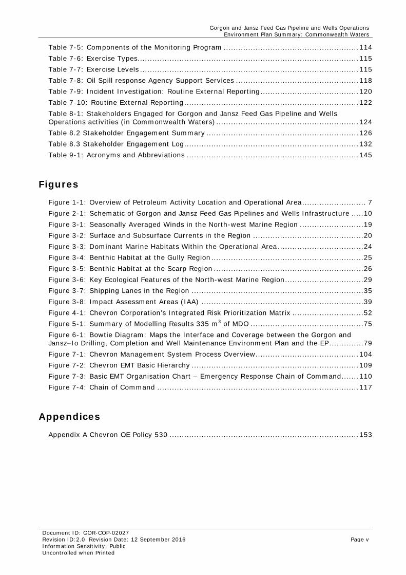
1.3 Location The Gorgon gas field is located within production Licences WA-37-L and WA-38-L, approximately 130 km off the north-west coast of Western Australia, and approximately 65 km north-west of Barrow Island (Figure 1-1). The Gorgon Feed-gas Pipeline and associated flowlines are located within pipeline licence WA-20-PL.
The Jansz–Io gas fields are located within production licenses WA-36-L, WA-39-L and WA-40-L approximately 200 km off the north-west coast of Western Australia in water depths of approximately 1350 m (Figure 1-1). The Jansz-Io Feed-gas Pipeline and associated flowlines are located within pipeline licence WA-19-PL.
Gorgon and Jansz Feed Gas Pipeline and Wells Operations Environment Plan Summary: Commonwealth Waters
Document ID: GOR-COP-02027 Revision ID:2.0 Revision Date: 12 September 2016 Page 7 Information Sensitivity: Public Uncontrolled when Printed
Figure 1-1: Overview of Petroleum Activity Location and Operational Area
Gorgon and Jansz Feed Gas Pipeline and Wells Operations Environment Plan Summary: Commonwealth Waters
Document ID: GOR-COP-02027 Revision ID:2.0 Revision Date: 12 September 2016 Page 8 Information Sensitivity: Public Uncontrolled when Printed
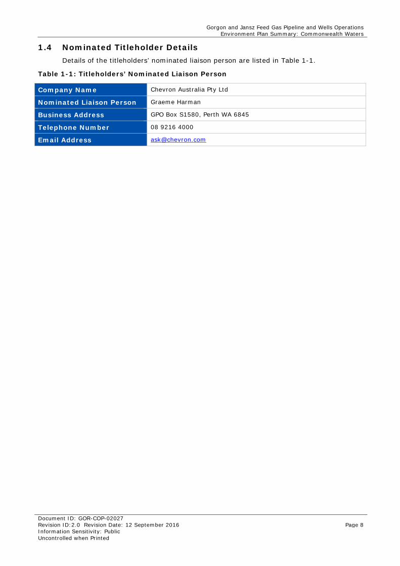
1.4 Nominated Titleholder Details Details of the titleholders’ nominated liaison person are listed in Table 1-1.
Table 1-1: Titleholders’ Nominated Liaison Person
Company Name Chevron Australia Pty Ltd
Nominated Liaison Person Graeme Harman
Business Address GPO Box S1580, Perth WA 6845
Telephone Number 08 9216 4000
Email Address [email protected]
Gorgon and Jansz Feed Gas Pipeline and Wells Operations Environment Plan Summary: Commonwealth Waters
Document ID: GOR-COP-02027 Revision ID:2.0 Revision Date: 12 September 2016 Page 9 Information Sensitivity: Public Uncontrolled when Printed
2.0 Description of the Petroleum Activity This Section describes the petroleum activities associated with the operation of the Gorgon and Jansz hydrocarbon systems in Commonwealth Waters, specifically:
• Commissioning and Start-up (Section 2.2)
• Operations (Section 2.3)
• Inspection Maintenance and Repair (IMR) (Section 2.4).
Section 2.1 provides an overview of the hydrocarbon system in Commonwealth Waters, and includes general details on the location and layout of the infrastructure. As support vessel operations are common to each activity, a separate description of vessel operations is presented in Section 2.5.
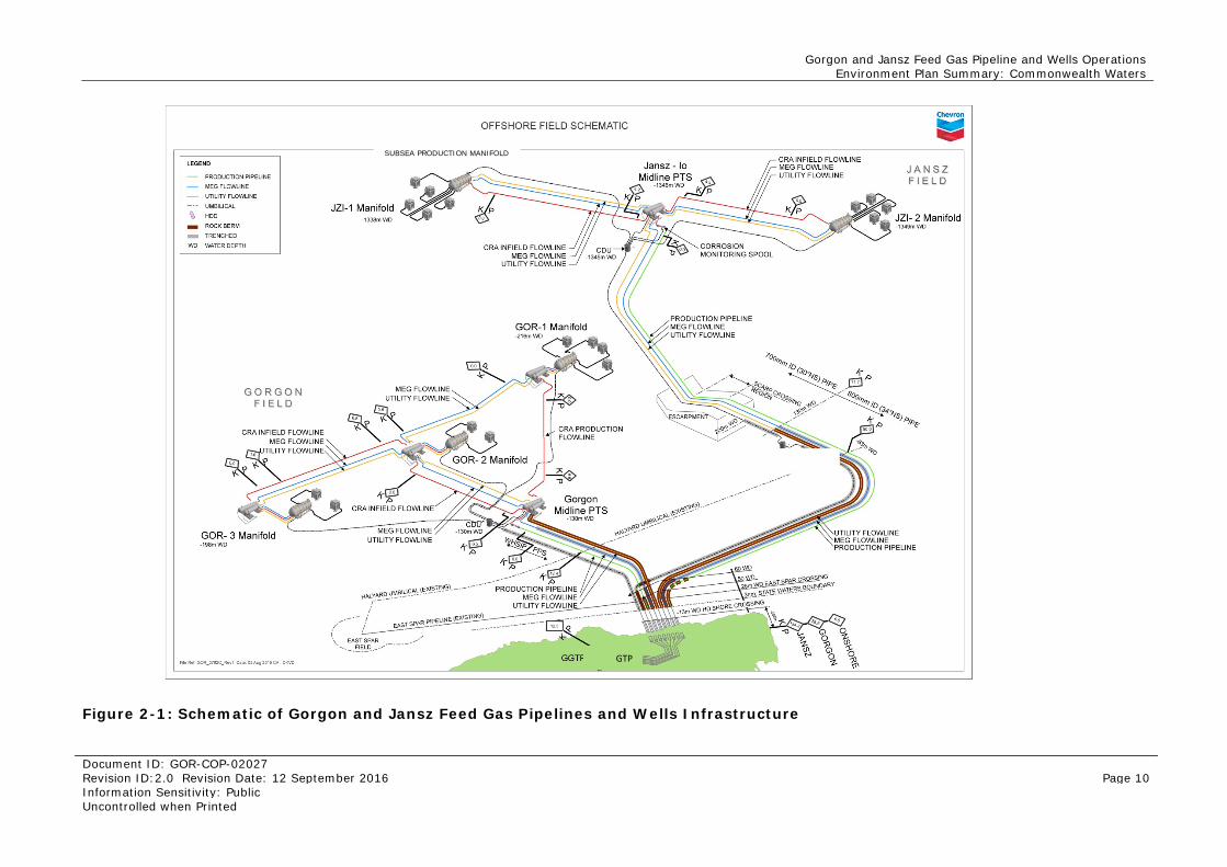
2.1 Hydrocarbon System Overview The pipeline and umbilical route from the Jansz–Io gas field traverse the scarp between the Chrysaor Canyons and the Gorgon gas field, on to the continental shelf. The pipeline and umbilical then cross the Halyard Electrohydraulic Umbilical (EHU) at a water depth of approximately 75 m, and continue south-east to Barrow Island. Flowlines run from the midline pipeline termination structure (PTS) to each drill centre (JZI-1 and JZI-2).
The pipeline and umbilical route from the Gorgon field heads south-east toward Barrow Island. The Gorgon pipeline and umbilical route will then cross the EHU at water depth approximately 95 m and converge with the Jansz pipeline and umbilical at approximately 70 m water depth. Flowlines run from the midline PTS to each drill centre (GOR-1, GOR-2 and GOR-3).
A schematic diagram showing the layout of infrastructure is presented in Figure 2-1.
Gorgon and Jansz Feed Gas Pipeline and Wells Operations Environment Plan Summary: Commonwealth Waters
Document ID: GOR-COP-02027 Revision ID:2.0 Revision Date: 12 September 2016 Page 10 Information Sensitivity: Public Uncontrolled when Printed
Figure 2-1: Schematic of Gorgon and Jansz Feed Gas Pipelines and Wells Infrastructure
SUBSEA PRODUCTION MANIFOLD
GTP
Gorgon and Jansz Feed Gas Pipeline and Wells Operations Environment Plan Summary: Commonwealth Waters
Document ID: GOR-COP-02027 Revision ID:2.0 Revision Date: 12 September 2016 Page 11 Information Sensitivity: Public Uncontrolled when Printed
2.1.1 Operational Area The operational area for the petroleum activity is defined as a 200 m wide corridor centred over the Gorgon and Jansz subsea infrastructure within Commonwealth Waters (Figure 1-1). It is within this area that the petroleum activity defined within Sections 2.2 to 2.4 will be undertaken. The values and sensitivities of this area are described in more detail in Section 3.2.
2.1.2 Timing Initial commissioning and start-up activities (for Jansz–Io) were undertaken in fourth quarter of 2015. These activities have been staged to coincide with other commissioning and start-up activities being undertaken onshore at the GTP and will occur over a 12- to 18-month period.
Following start-up, operations are expected to continue for the nominal operational design life of 50 years. IMR activities may occur at any time during commissioning, start-up and operation.
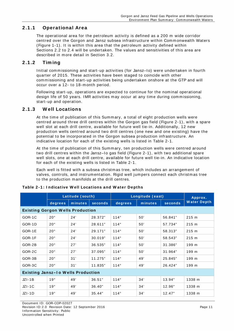
2.1.3 Well Locations At the time of publication of this Summary, a total of eight production wells were centred around three drill centres within the Gorgon gas field (Figure 2-1), with a spare well slot at each drill centre, available for future well tie-in. Additionally, 12 new production wells centred around two drill centres (one new and one existing) have the potential to be incorporated in the Gorgon subsea production infrastructure. An indicative location for each of the existing wells is listed in Table 2-1.
At the time of publication of this Summary, ten production wells were centred around two drill centres within the Jansz–Io gas field (Figure 2-1), with two additional spare well slots, one at each drill centre, available for future well tie-in. An indicative location for each of the existing wells is listed in Table 2-1.
Each well is fitted with a subsea christmas tree, which includes an arrangement of valves, controls, and instrumentation. Rigid well jumpers connect each christmas tree to the production manifolds at the drill centres.
Table 2-1: Indicative Well Locations and Water Depths
Latitude (south) Longitude (east) Approx.
Water Depth degrees minutes seconds degrees minutes seconds
Existing Gorgon Wells Production
GOR-1C 20° 24’ 28.372” 114° 50’ 56.841” 215 m
GOR-1D 20° 24’ 28.611” 114° 50’ 57.734” 215 m
GOR-1E 20° 24’ 29.171” 114° 50’ 58.313” 215 m
GOR-1F 20° 24’ 30.019” 114° 50’ 58.543” 215 m
GOR-2B 20° 27’ 36.535” 114° 50’ 31.386” 199 m
GOR-2C 20° 27’ 37.095” 114° 50’ 31.964” 199 m
GOR-3B 20° 31’ 11.275” 114° 49’ 25.845” 199 m
GOR-3C 20° 31’ 11.835” 114° 49’ 26.424” 199 m
Existing Jansz–Io Wells Production
JZI-1B 19° 49’ 36.51" 114° 34’ 13.94" 1338 m
JZI-1C 19° 49’ 36.40" 114° 34’ 12.96" 1338 m
JZI-1D 19° 49’ 35.44" 114° 34’ 12.47" 1338 m
Gorgon and Jansz Feed Gas Pipeline and Wells Operations Environment Plan Summary: Commonwealth Waters
Document ID: GOR-COP-02027 Revision ID:2.0 Revision Date: 12 September 2016 Page 12 Information Sensitivity: Public Uncontrolled when Printed
Latitude (south) Longitude (east) Approx.
Water Depth degrees minutes seconds degrees minutes seconds
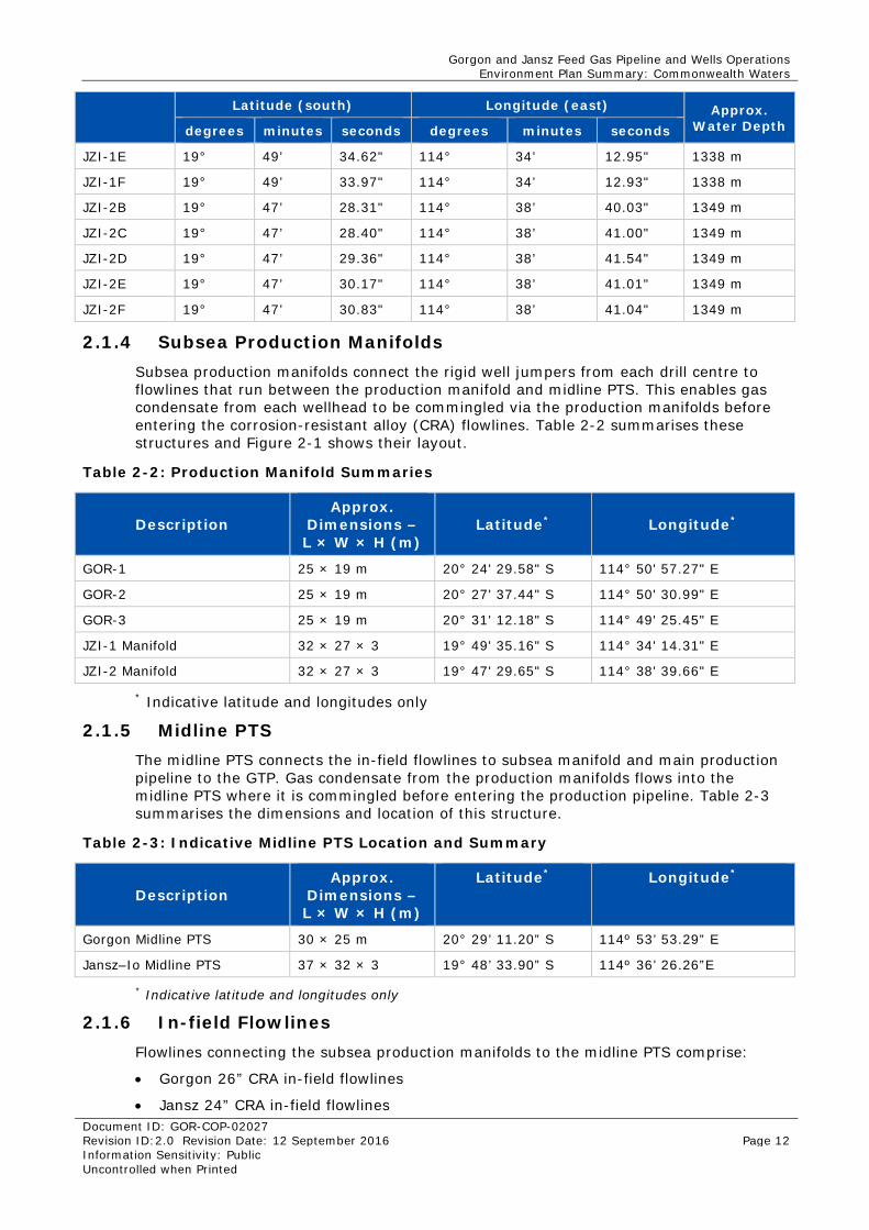
JZI-1E 19° 49’ 34.62" 114° 34’ 12.95" 1338 m
JZI-1F 19° 49’ 33.97" 114° 34’ 12.93" 1338 m
JZI-2B 19° 47’ 28.31" 114° 38’ 40.03" 1349 m
JZI-2C 19° 47’ 28.40" 114° 38’ 41.00" 1349 m
JZI-2D 19° 47’ 29.36" 114° 38’ 41.54" 1349 m
JZI-2E 19° 47’ 30.17" 114° 38’ 41.01" 1349 m
JZI-2F 19° 47’ 30.83" 114° 38’ 41.04" 1349 m
2.1.4 Subsea Production Manifolds Subsea production manifolds connect the rigid well jumpers from each drill centre to flowlines that run between the production manifold and midline PTS. This enables gas condensate from each wellhead to be commingled via the production manifolds before entering the corrosion-resistant alloy (CRA) flowlines. Table 2-2 summarises these structures and Figure 2-1 shows their layout.
Table 2-2: Production Manifold Summaries
Description Approx.
Dimensions – L × W × H (m)
Latitude* Longitude*
GOR-1 25 × 19 m 20° 24' 29.58" S 114° 50' 57.27" E
GOR-2 25 × 19 m 20° 27' 37.44" S 114° 50' 30.99" E
GOR-3 25 × 19 m 20° 31' 12.18" S 114° 49' 25.45" E
JZI-1 Manifold 32 × 27 × 3 19° 49' 35.16" S 114° 34' 14.31" E
JZI-2 Manifold 32 × 27 × 3 19° 47' 29.65" S 114° 38' 39.66" E
* Indicative latitude and longitudes only
2.1.5 Midline PTS The midline PTS connects the in-field flowlines to subsea manifold and main production pipeline to the GTP. Gas condensate from the production manifolds flows into the midline PTS where it is commingled before entering the production pipeline. Table 2-3 summarises the dimensions and location of this structure.
Table 2-3: Indicative Midline PTS Location and Summary
Description Approx.
Dimensions – L × W × H (m)
Latitude* Longitude*
Gorgon Midline PTS 30 × 25 m 20° 29’ 11.20” S 114º 53’ 53.29” E
Jansz–Io Midline PTS 37 × 32 × 3 19° 48’ 33.90” S 114º 36’ 26.26”E
* Indicative latitude and longitudes only
2.1.6 In-field Flowlines Flowlines connecting the subsea production manifolds to the midline PTS comprise:
• Gorgon 26” CRA in-field flowlines
• Jansz 24” CRA in-field flowlines
Gorgon and Jansz Feed Gas Pipeline and Wells Operations Environment Plan Summary: Commonwealth Waters
Document ID: GOR-COP-02027 Revision ID:2.0 Revision Date: 12 September 2016 Page 13 Information Sensitivity: Public Uncontrolled when Printed
• Gorgon 8” monoethylene glycol (MEG) flowlines
• Jansz 6” monoethylene glycol (MEG) flowlines
• Gorgon and Jansz 6” utility flowlines.
Flowlines connecting the midline PTS to the GTP are located adjacent to the production pipeline, include:
• Gorgon and Jansz 8” MEG flowline
• Gorgon and Jansz 6” utility flowline.
The CRA in-field flowlines collect and transfer gas condensate from the production manifolds to the midline PTS.
MEG flowlines provide continuous injection of MEG into the production system for hydrate management. In addition, MEG flowlines deliver production chemicals (for corrosion and scale management) to the field. MEG and production chemicals are then returned via the production pipelines to the GTP, where MEG will be regenerated for re-use.
Utility flowlines support a subsea maintenance depressurisation capability, annulus depressurisation, and double-sided depressurisation of the production system in the unlikely event of a hydrate blockage. The utility flowlines are filled with preservation fluid (e.g. MEG) when not in use to reduce susceptibility to corrosion and hydrate formation if gas bubbles are trapped in the pipeline.
All flowlines are connected to the production manifolds and midline PTS by jumpers and spool pieces.
2.1.7 Umbilicals The fibre-optic and electrohydraulic control umbilicals provide hydraulic power, electric power, and a fibre-optic control link from the GTP to subsea infrastructure within the Gorgon and Jansz–Io gas field. A Central Distribution Unit (CDU), is a termination point for the main control umbilical from the GTP, and is where the umbilical splits to provide links between the midline PTS, christmas trees, production manifolds, and other components (Figure 2-1).
2.1.8 Production Pipeline The Gorgon production pipeline runs for approximately 65 km between the midline PTS to the shore crossing at North Whites Beach on Barrow Island. The Gorgon pipeline route crosses the Halyard EHU at water depth approximately 95 m and converges with the Jansz pipeline at approximately 70 m water depth.
The Jansz production pipeline runs for approximately 134 km between the midline PTS to the shore crossing at North Whites Beach on Barrow Island. The pipeline transitions from 30” to 34” diameter at the top of the escarpment where it then crosses the Halyard EHU in approximately 83 m water depth. . The pipeline from the escarpment to the shore is a 34” pipeline.
2.1.9 Valves The valves associated with the Gorgon electrohydraulic control system are located on christmas trees and production manifolds in waters deeper than 199 m (Figure 2-1).
2.2 Commissioning and Start-up The purpose of commissioning activities are to ensure that all components of the system are installed, tested, and function as per the project design documentation and specifications. Once commissioning is complete, start-up activities introduce hydrocarbons to the system. Commissioning and start-up activities involve:
Gorgon and Jansz Feed Gas Pipeline and Wells Operations Environment Plan Summary: Commonwealth Waters
Document ID: GOR-COP-02027 Revision ID:2.0 Revision Date: 12 September 2016 Page 14 Information Sensitivity: Public Uncontrolled when Printed
• verification and pre-start-up testing
• introduction of hydrocarbons.
Commissioning post maintenance or repair is also provided for within the EP.
IMR activities may be required during commissioning and start-up. Information regarding these activities are captured within Section 2.4.
2.2.1 Verification and Pre-start-up Testing The verification and pre-start-up testing activities covered by the EP include the testing of the subsea electrohydraulic control and monitoring systems. This involves testing subsea valves and the emergency shutdown of infrastructure such as the subsea trees and choke module. Verification and pre-start-up activities occur before initial start-up as well as after a field shut-in. Shut-ins, which are expected to occur infrequently, may be required to allow maintenance or repair activities to be undertaken.
These tests are likely to result in small discharges (up to tens of litres) of control fluids and MEG from individual valves. In total, approximately 3 m3 of fluid is expected to be discharged from each of the Gorgon and Jansz systems during verification and testing activities.
These activities will be supported by a vessel and ROVs equipped with video cameras Refer to Section 2.5 for vessel operations.
2.2.2 Introduction of Hydrocarbons Start-up activities commence with the controlled introduction of condensate into the in-field flowlines and production pipeline. The subsea infrastructure including MEG and utility flowlines, and umbilicals are then subject to function testing. During the introduction of hydrocarbons, residual drilling fluids (within the wells) and other residual fluids (which may include nitrogen preservation gas and dehydrated gas), within the CRA in-field flowlines and production pipeline will be displaced.
These fluids are expected to be displaced via the introduction of dehydrated gas. This activity may result in the release of preservation fluids and dehydrated gas to the environment.
Pigs may be used to push residual fluids through the production pipelines from the midline PTS during start-up. The connection, testing, and retrieval of the pig launcher will result in a small (approximately 8 m3) discharge to the marine environment of MEG which may also contain minor residual condensate.
2.3 Operations The principal activity during operations will be the flow and transportation of condensate and other produced fluids from the wells to the GTP, via the in-field flowlines and production pipelines. The subsea infrastructure in Commonwealth waters is predominantly a closed system; however, there are discharge points (valves) located at the subsea electrohydraulic control and monitoring system and at the midline PTS. Operation of this system will result in discharges of hydraulic control fluid to the marine environment from valves, with each valve actuation estimated to result in a loss of a few litres to the marine environment. As an estimate, approximately 30 m3/year of hydraulic control fluid is expected to be discharged from both the Gorgon and Jansz subsea infrastructure during operations.
If an alternative pathway is required to supply production chemicals to the field, the chemical cores within the umbilicals may be used as a contingency measure. If these lines are required for this purpose, the hydraulic spacer fluid (approximately 20 m3) within the cores will be displaced at the respective drill centre and replaced with the required chemicals.
Gorgon and Jansz Feed Gas Pipeline and Wells Operations Environment Plan Summary: Commonwealth Waters
Document ID: GOR-COP-02027 Revision ID:2.0 Revision Date: 12 September 2016 Page 15 Information Sensitivity: Public Uncontrolled when Printed
2.4 Inspection, Maintenance, and Repairs IMR of subsea infrastructure will be undertaken to ensure that the integrity of the hydrocarbon system is maintained at or above acceptable standards. IMR activities may occur at any time during operations, including during commissioning and start-up. IMR requires the use of an IMR vessel (described in Section 2.5).
2.4.1 Inspections Inspections provide assurance that assets are being maintained and operated according to design, as well as proactively identify maintenance or repair activities that may be required. Inspection generally involves the use of a surface vessel travelling along the route of the subsea system with an associated subsea ROV. All inspection activities are provided for within the EP. An appropriate level of conservatism has been incorporated (including activity frequency) to enable risk evaluations to be undertaken.
Generally, inspections will occur once a year; however, the precise frequency and timing will be informed by monitoring and previous inspection results. Typically vessels will be on site for 55 to 155 days per year depending on the type of inspection and complexity. Events such as cyclones or seismic activity that could affect the subsea infrastructure may also trigger inspections. Inspection techniques may include:
• visual inspections (indicative frequency: two yearly) – may involve aerial surveys, ROVs or autonomous underwater vehicles (AUVs) deployed from a vessel; may also involve divers and a dive support vessel
• marine acoustic surveys (indicative frequency: two yearly) – may include the use of side-scan sonar and multibeam echo sounders, and are typically done from a vessel using towed acoustic instruments, ROVs, or AUVs
• non-destructive testing (indicative frequency: two yearly) –may include ultrasonic testing and electrical resistance testing, which are typically undertaken using an ROV deployed from a vessel
• cathodic protection measurements (indicative frequency: two yearly) – are completed using ROVs and conductivity probes or by taking visual readings of anode wastage gauge readings
• escarpment fatigue monitoring /inspection (indicative frequency: bi-annual) – fatigue monitoring equipment will be installed and retrieved by a ROV deployed from a vessel
• pigging (indicative frequency: two yearly) – temporary pig launchers are deployed from a vessel and tied in to the midline PTS; they may use a combination of inhibiters, water, gel, MEG, and/or nitrogen slugs to complete pigging activities including internal inspection of the pipeline. Fluids used to drive the pig train are directed to the GTP, and pigs may be equipped with tracking transmitters.
2.4.2 Maintenance and Repairs Maintenance and repair activities may need to be conducted during the operational life of the project to:
• prevent deterioration and/or failure of infrastructure
• maintain reliability and performance of infrastructure.
Maintenance and repair activities are expected to be rare and infrequent, with activities anticipated to occur on a five yearly frequency; however, the exact frequency of maintenance activities will depend on the results of inspections. If a repair is required, a vessel may remain on site for approximately 20 to 60 days at a time, depending on the repair required.
Maintenance and minor repairs may include, but are not limited to:
Gorgon and Jansz Feed Gas Pipeline and Wells Operations Environment Plan Summary: Commonwealth Waters
Document ID: GOR-COP-02027 Revision ID:2.0 Revision Date: 12 September 2016 Page 16 Information Sensitivity: Public Uncontrolled when Printed
• module/component change-out (including back testing of seals) – may include, but is not limited to, the replacement of subsea equipment modules such as flow meters or choke modules
• stabilisation/span correction – may involve activities such as installation of grout bags or concrete mattresses
• subsea excavation – excavation alongside infrastructure may be required to gain access to, or enable minor repairs of, infrastructure
• maintenance of cathodic protection systems / additional anodes – cathodic protection equipment may be added to, or placed adjacent to, production pipelines using a vessel and ROV spread
• removal of marine biological growth and calcareous deposits – may be undertaken using mechanical techniques and/or chemical treatments using a vessel and ROV spread
• pipeline defects – repairs of pipeline defects that threaten structural integrity may involve the use of structural clamps or high-pressure repair clamps. These activities are generally undertaken by ROVs from a single vessel, but may require support from an additional vessel.
2.5 Vessel Operations Vessel operations for all activities associated with the EP are expected to be of low intensity. Typically, one vessel would be required to implement the activities within scope of the EP; however, there may be occasions where more than one vessel is required in the field. At times, activities will require 24-hour vessel operations and take days or months, depending on the scale and complexity of the work scope. Typically for normal operations, vessels may be used for inspection based activities as described in Section 2.4.1.
In the event of maintenance and repairs to the infrastructure, additional days on site may be required, but such activities are expected to be infrequent. As such, the number of vessel days on site to complete the regular inspections, and contingent maintenance and repair activities has been estimated in the order of 55 to 155 days.
The type of vessel that may be used is currently unknown, and vessel type and specifications will depend on vessel availability and activity requirements. Vessels will operate using dynamic positioning (DP); however, under some circumstances vessels may need to be anchored depending on the activity being undertaken and the associated vessel requirements. Vessels will only use marine diesel oil (MDO) and will not need reprovisioning (including bunkering) on site.
Gorgon and Jansz Feed Gas Pipeline and Wells Operations Environment Plan Summary: Commonwealth Waters
Document ID: GOR-COP-02027 Revision ID:2.0 Revision Date: 12 September 2016 Page 17 Information Sensitivity: Public Uncontrolled when Printed
3.0 Description of Environment This Section describes the environment that may be affected (EMBA) relevant to the EP for the petroleum activity and potential emergency conditions for the Gorgon and Jansz wells and Feed Gas Pipeline in Commonwealth Waters.
The EMBA was identified using low hydrocarbon exposures from spill modelling undertaken for an emergency condition.
To enable a systematic description of the environment and allow further consideration of consequence and sensitivity to impacts and risks arising from the petroleum activity and emergency conditions, the operational area and wider EMBA were overlaid on to geographic areas (labelled Impact Assessment Areas [IAA]), as shown in Figure 3-8. Delineation of the IAAs is based on government management plans, the ecological and social values of each area, and the presence of receptors, including the extent of marine protected areas. These areas include the:
• Offshore area
• Barrow and Montebello Islands area
• Pilbara Coast area
• Gascoyne area
• Ningaloo area.
Nature and scale has been used to inform the level of detail required to describe the existing environment in accordance with NOPSEMA’s Environment Plan Content Guidelines (N04750-GN1344). Given that the operational area has the highest potential to be affected by the petroleum activity, this has been described in detail (Section 3.2).
3.1 Regional Overview The Integrated Marine and Coastal Regionalisation of Australia (IMCRA) is an ecosystem-based classification of Australia’s marine and coastal environments that has been developed by the Commonwealth Government as a regional framework for planning resources development and biodiversity protection (DEH 2006). The IMCRA divides Australia’s oceans into five marine regions with 41 provincial bioregions, which are biogeographical areas defined by similar ecological characteristics.
The operational area crosses the North-west Marine Region, which encompasses the Commonwealth Waters from the WA/Northern Territory border to Kalbarri, south of Shark Bay (SEWPaC 2012). A Marine Bioregional Plan for the North-west Marine Region has been released which aims to strengthen the operation of the EPBC Act in the region by improving the way the marine environment is managed and protected. The EP outlines the conservation values of the region, the associated pressures affecting those values, the priorities and strategies to address the pressures, and useful advice for industry planners looking to undertake activities in the region (SEWPaC 2012). This information has been referenced throughout the EP where relevant.
3.1.1 Physical Marine Environment 3.1.1.1 Meteorology
The southern portion of the North West Shelf, including Barrow Island, is characterised by an arid, subtropical climate. The summer season occurs from October to March, with mean daily maximum temperatures reaching 34 °C, and mean daily minimum temperatures averaging 20 °C. During winter (June–August), mean daily maximum temperatures reach 26 °C, with mean daily minimum temperatures of 17 °C. The months of April, May, and September are considered a transition season during which either the summer or winter weather regime may predominate or conditions may vary between the two (Chevron Australia 2005).
Gorgon and Jansz Feed Gas Pipeline and Wells Operations Environment Plan Summary: Commonwealth Waters
Document ID: GOR-COP-02027 Revision ID:2.0 Revision Date: 12 September 2016 Page 18 Information Sensitivity: Public Uncontrolled when Printed
The region experiences high relative humidity that remains fairly constant throughout the year. The early period of the day experiences an annual average of about 65% relative humidity, with afternoon periods experiencing between 47% and 59% (Chevron Australia 2005).
Rainfall in the region is highly seasonal. Lower rainfall and humidity are typically associated with the Southeast Monsoon, in contrast to the high levels of rainfall and humidity associated with the Northwest Monsoon (SEWPaC 2012). The historic annual average rainfall for Barrow Island is 320 mm. However, rainfall varies significantly from year to year and is dependent on rain-bearing low-pressure systems, thunderstorm activity, and the passage of tropical cyclones (Chevron Australia 2005).
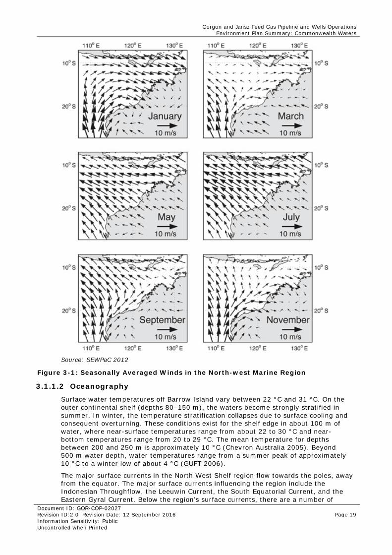
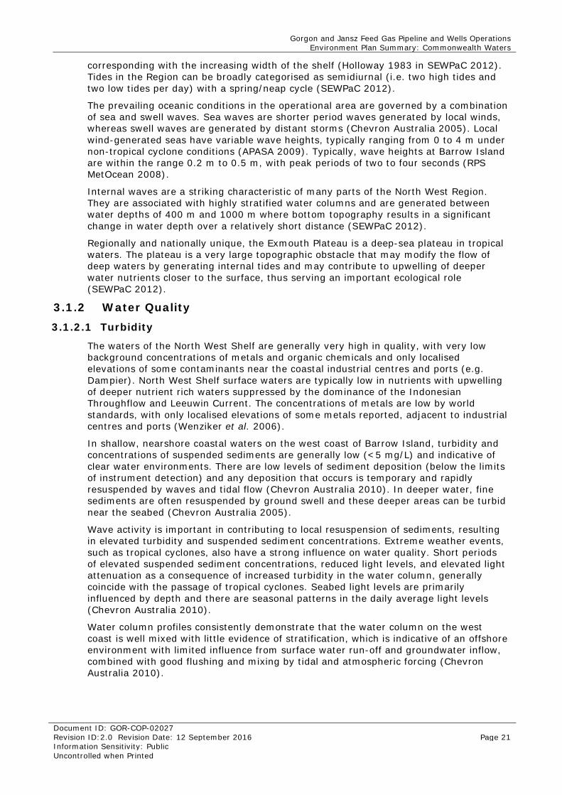
Seasonal movement of atmospheric pressure systems dictates wind patterns on the North West Shelf. From October to March, the prevailing non-storm winds are from the south-west, west, and north-west at an average speed of less than 10 knots. From June to August, winds are generally lighter and more variable in direction (SEWPaC 2012). The seasonally averaged wind condition in the North West Shelf is shown in Figure 3-1.
The mean ambient wind speed around Barrow Island during the summer period is 6.6 m/s, and the maximum summer wind speed is 16.2 m/s (Kellogg Joint Venture Gorgon [KJVG] 2008). The dominant wind directions during summer are from the south-west and west. During winter, winds approach from the east, south, and south-west and have a mean speed of 5.8 m/s and a maximum speed of 19.4 m/s. The wind prevails from the south-west for more than 50% of the time (APASA 2009). In general, wind speeds are <10 m/s for more than 90% of the time, but rarely fall below 1 m/s (2.2% of the time). Peak winds on Barrow Island occur in the range of 32 to 44 m/s and are associated either with very strong breezes or storms (APASA 2009).
Cyclones are episodic events in the North-west Marine Region, usually occurring from November to April. Cyclones typically form in the Timor and Arafura Seas. Initially, they generally travel in a south-westerly direction, but their tracks become more variable as they travel further south (MetOcean Engineers 2006). Under extreme cyclone conditions, winds can reach more than 250 km/h (APASA 2009). On average, four cyclones pass within 400 nm of Barrow Island each year (MetOcean Engineers 2006).
Gorgon and Jansz Feed Gas Pipeline and Wells Operations Environment Plan Summary: Commonwealth Waters
Document ID: GOR-COP-02027 Revision ID:2.0 Revision Date: 12 September 2016 Page 19 Information Sensitivity: Public Uncontrolled when Printed
Source: SEWPaC 2012
Figure 3-1: Seasonally Averaged Winds in the North-west Marine Region
3.1.1.2 Oceanography
Surface water temperatures off Barrow Island vary between 22 °C and 31 °C. On the outer continental shelf (depths 80–150 m), the waters become strongly stratified in summer. In winter, the temperature stratification collapses due to surface cooling and consequent overturning. These conditions exist for the shelf edge in about 100 m of water, where near-surface temperatures range from about 22 to 30 °C and near-bottom temperatures range from 20 to 29 °C. The mean temperature for depths between 200 and 250 m is approximately 10 °C (Chevron Australia 2005). Beyond 500 m water depth, water temperatures range from a summer peak of approximately 10 °C to a winter low of about 4 °C (GUFT 2006).
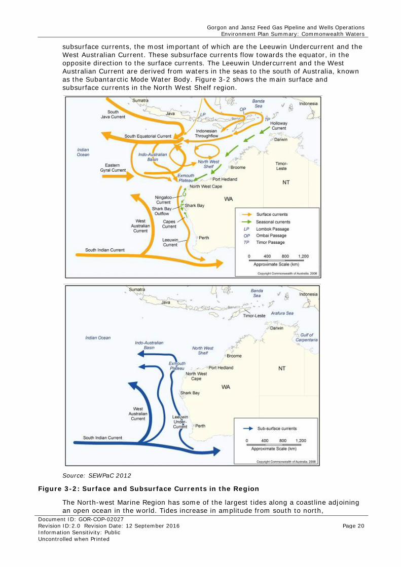
The major surface currents in the North West Shelf region flow towards the poles, away from the equator. The major surface currents influencing the region include the Indonesian Throughflow, the Leeuwin Current, the South Equatorial Current, and the Eastern Gyral Current. Below the region’s surface currents, there are a number of
Gorgon and Jansz Feed Gas Pipeline and Wells Operations Environment Plan Summary: Commonwealth Waters
Document ID: GOR-COP-02027 Revision ID:2.0 Revision Date: 12 September 2016 Page 20 Information Sensitivity: Public Uncontrolled when Printed
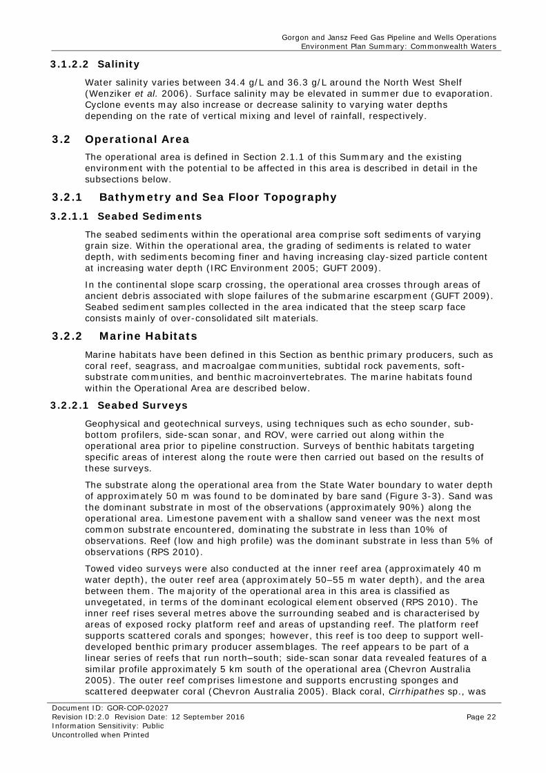
subsurface currents, the most important of which are the Leeuwin Undercurrent and the West Australian Current. These subsurface currents flow towards the equator, in the opposite direction to the surface currents. The Leeuwin Undercurrent and the West Australian Current are derived from waters in the seas to the south of Australia, known as the Subantarctic Mode Water Body. Figure 3-2 shows the main surface and subsurface currents in the North West Shelf region.
Source: SEWPaC 2012
Figure 3-2: Surface and Subsurface Currents in the Region
The North-west Marine Region has some of the largest tides along a coastline adjoining an open ocean in the world. Tides increase in amplitude from south to north,
Gorgon and Jansz Feed Gas Pipeline and Wells Operations Environment Plan Summary: Commonwealth Waters
Document ID: GOR-COP-02027 Revision ID:2.0 Revision Date: 12 September 2016 Page 21 Information Sensitivity: Public Uncontrolled when Printed
corresponding with the increasing width of the shelf (Holloway 1983 in SEWPaC 2012). Tides in the Region can be broadly categorised as semidiurnal (i.e. two high tides and two low tides per day) with a spring/neap cycle (SEWPaC 2012).
The prevailing oceanic conditions in the operational area are governed by a combination of sea and swell waves. Sea waves are shorter period waves generated by local winds, whereas swell waves are generated by distant storms (Chevron Australia 2005). Local wind-generated seas have variable wave heights, typically ranging from 0 to 4 m under non-tropical cyclone conditions (APASA 2009). Typically, wave heights at Barrow Island are within the range 0.2 m to 0.5 m, with peak periods of two to four seconds (RPS MetOcean 2008).
Internal waves are a striking characteristic of many parts of the North West Region. They are associated with highly stratified water columns and are generated between water depths of 400 m and 1000 m where bottom topography results in a significant change in water depth over a relatively short distance (SEWPaC 2012).
Regionally and nationally unique, the Exmouth Plateau is a deep-sea plateau in tropical waters. The plateau is a very large topographic obstacle that may modify the flow of deep waters by generating internal tides and may contribute to upwelling of deeper water nutrients closer to the surface, thus serving an important ecological role (SEWPaC 2012).
3.1.2 Water Quality 3.1.2.1 Turbidity
The waters of the North West Shelf are generally very high in quality, with very low background concentrations of metals and organic chemicals and only localised elevations of some contaminants near the coastal industrial centres and ports (e.g. Dampier). North West Shelf surface waters are typically low in nutrients with upwelling of deeper nutrient rich waters suppressed by the dominance of the Indonesian Throughflow and Leeuwin Current. The concentrations of metals are low by world standards, with only localised elevations of some metals reported, adjacent to industrial centres and ports (Wenziker et al. 2006).
In shallow, nearshore coastal waters on the west coast of Barrow Island, turbidity and concentrations of suspended sediments are generally low (<5 mg/L) and indicative of clear water environments. There are low levels of sediment deposition (below the limits of instrument detection) and any deposition that occurs is temporary and rapidly resuspended by waves and tidal flow (Chevron Australia 2010). In deeper water, fine sediments are often resuspended by ground swell and these deeper areas can be turbid near the seabed (Chevron Australia 2005).
Wave activity is important in contributing to local resuspension of sediments, resulting in elevated turbidity and suspended sediment concentrations. Extreme weather events, such as tropical cyclones, also have a strong influence on water quality. Short periods of elevated suspended sediment concentrations, reduced light levels, and elevated light attenuation as a consequence of increased turbidity in the water column, generally coincide with the passage of tropical cyclones. Seabed light levels are primarily influenced by depth and there are seasonal patterns in the daily average light levels (Chevron Australia 2010).
Water column profiles consistently demonstrate that the water column on the west coast is well mixed with little evidence of stratification, which is indicative of an offshore environment with limited influence from surface water run-off and groundwater inflow, combined with good flushing and mixing by tidal and atmospheric forcing (Chevron Australia 2010).
Gorgon and Jansz Feed Gas Pipeline and Wells Operations Environment Plan Summary: Commonwealth Waters
Document ID: GOR-COP-02027 Revision ID:2.0 Revision Date: 12 September 2016 Page 22 Information Sensitivity: Public Uncontrolled when Printed
3.1.2.2 Salinity
Water salinity varies between 34.4 g/L and 36.3 g/L around the North West Shelf (Wenziker et al. 2006). Surface salinity may be elevated in summer due to evaporation. Cyclone events may also increase or decrease salinity to varying water depths depending on the rate of vertical mixing and level of rainfall, respectively.
3.2 Operational Area The operational area is defined in Section 2.1.1 of this Summary and the existing environment with the potential to be affected in this area is described in detail in the subsections below.
3.2.1 Bathymetry and Sea Floor Topography 3.2.1.1 Seabed Sediments
The seabed sediments within the operational area comprise soft sediments of varying grain size. Within the operational area, the grading of sediments is related to water depth, with sediments becoming finer and having increasing clay-sized particle content at increasing water depth (IRC Environment 2005; GUFT 2009).
In the continental slope scarp crossing, the operational area crosses through areas of ancient debris associated with slope failures of the submarine escarpment (GUFT 2009). Seabed sediment samples collected in the area indicated that the steep scarp face consists mainly of over-consolidated silt materials.
3.2.2 Marine Habitats Marine habitats have been defined in this Section as benthic primary producers, such as coral reef, seagrass, and macroalgae communities, subtidal rock pavements, soft-substrate communities, and benthic macroinvertebrates. The marine habitats found within the Operational Area are described below.
3.2.2.1 Seabed Surveys
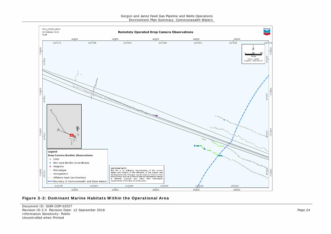
Geophysical and geotechnical surveys, using techniques such as echo sounder, sub-bottom profilers, side-scan sonar, and ROV, were carried out along within the operational area prior to pipeline construction. Surveys of benthic habitats targeting specific areas of interest along the route were then carried out based on the results of these surveys.
The substrate along the operational area from the State Water boundary to water depth of approximately 50 m was found to be dominated by bare sand (Figure 3-3). Sand was the dominant substrate in most of the observations (approximately 90%) along the operational area. Limestone pavement with a shallow sand veneer was the next most common substrate encountered, dominating the substrate in less than 10% of observations. Reef (low and high profile) was the dominant substrate in less than 5% of observations (RPS 2010).
Towed video surveys were also conducted at the inner reef area (approximately 40 m water depth), the outer reef area (approximately 50–55 m water depth), and the area between them. The majority of the operational area in this area is classified as unvegetated, in terms of the dominant ecological element observed (RPS 2010). The inner reef rises several metres above the surrounding seabed and is characterised by areas of exposed rocky platform reef and areas of upstanding reef. The platform reef supports scattered corals and sponges; however, this reef is too deep to support well-developed benthic primary producer assemblages. The reef appears to be part of a linear series of reefs that run north–south; side-scan sonar data revealed features of a similar profile approximately 5 km south of the operational area (Chevron Australia 2005). The outer reef comprises limestone and supports encrusting sponges and scattered deepwater coral (Chevron Australia 2005). Black coral, Cirrhipathes sp., was
Gorgon and Jansz Feed Gas Pipeline and Wells Operations Environment Plan Summary: Commonwealth Waters
Document ID: GOR-COP-02027 Revision ID:2.0 Revision Date: 12 September 2016 Page 23 Information Sensitivity: Public Uncontrolled when Printed
observed at nine locations along the outer reef. In locations where black coral was observed, it was present as a subdominant taxa in areas dominated by sponges and other benthic macroinvertebrates (RPS 2010).
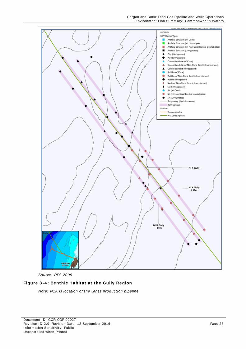
Further offshore in the Gorgon gas field, at approximately 200 m water depth, the seabed comprises soft bioturbated sediments. The benthos in this area is well below the photic zone so there are no marine macrophytes (Chevron Australia 2005). Similarly, during an ROV survey in the Gully Region along the Jansz pipeline route in approximately 250 m water depth, the seabed was found to be dominated by silty mud with little evidence of life (Figure 3-4) (RPS 2009).
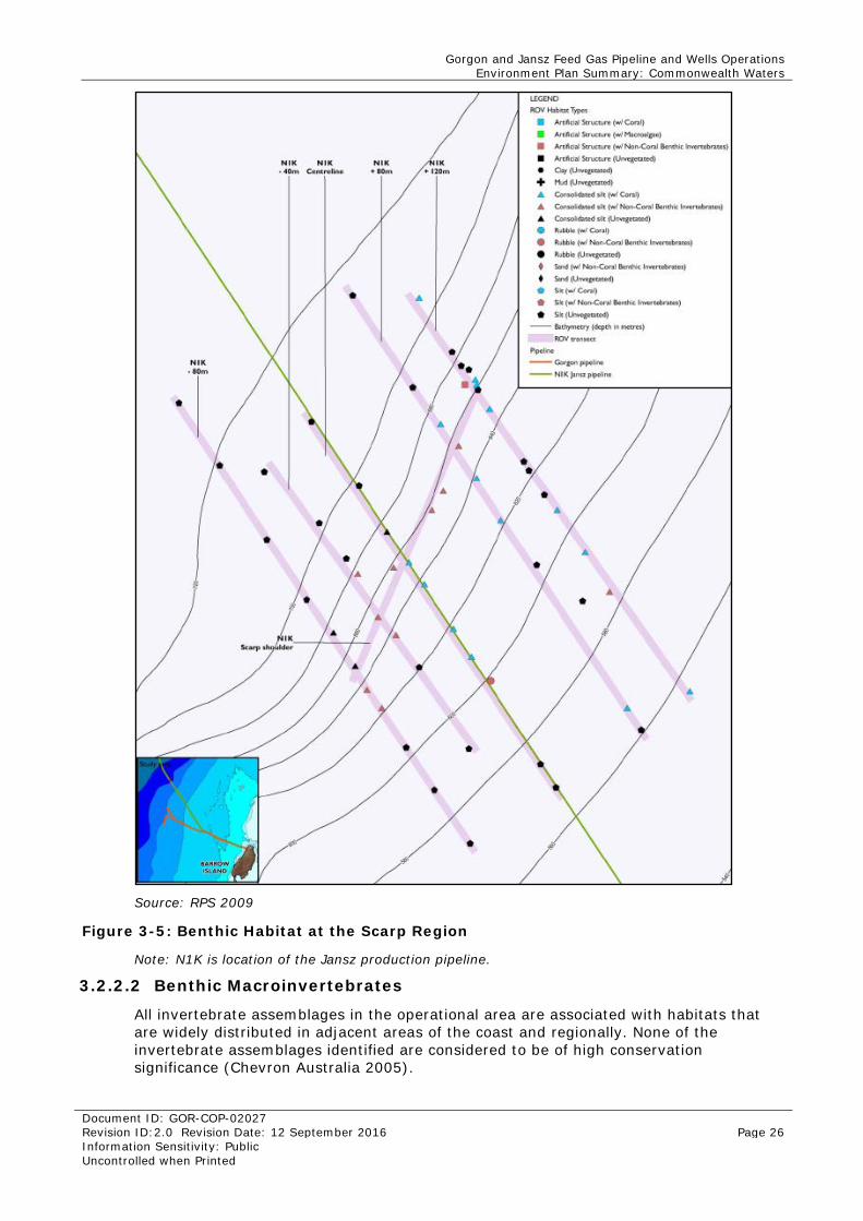
To determine the type of benthic habitat present in the deeper area, five transects, which ranged from 558 to 714 m water depth, were filmed along the operational area. An additional transect was also run along a narrow depth band between 643 m and 656 m water depth, following a hard outcropping area of the scarp (Figure 3-5). The substrate most commonly found in this deeper water comprised soft sediments—sand, silt, and mud. However, these habitat types are widespread in the region and are not considered to be of regional significance due to their ubiquity and the sparseness of biota supported (RPS 2009). The steep scarp face was found to comprise mainly over-consolidated silt materials, mostly devoid of marine growth, with occasional sparse communities of benthic invertebrates including soft corals, bryozoans, and colonial ascidians (Figure 3-5). These over-consolidated silt sediments provide structural diversity to an otherwise flat benthos. They are of higher conservation significance than the soft sediment habitats found in the area as they are less widespread and support more abundant biota. However, based on the high resolution bathymetry data from the area, these hard scarp features probably stretch at least 10 km to the north and 5 km to the south of the operational area (RPS 2009).
Gorgon and Jansz Feed Gas Pipeline and Wells Operations Environment Plan Summary: Commonwealth Waters
Document ID: GOR-COP-02027 Revision ID:2.0 Revision Date: 12 September 2016 Page 24 Information Sensitivity: Public Uncontrolled when Printed
Figure 3-3: Dominant Marine Habitats Within the Operational Area
Gorgon and Jansz Feed Gas Pipeline and Wells Operations Environment Plan Summary: Commonwealth Waters
Document ID: GOR-COP-02027 Revision ID:2.0 Revision Date: 12 September 2016 Page 25 Information Sensitivity: Public Uncontrolled when Printed
Source: RPS 2009
Figure 3-4: Benthic Habitat at the Gully Region
Note: N1K is location of the Jansz production pipeline.
Gorgon and Jansz Feed Gas Pipeline and Wells Operations Environment Plan Summary: Commonwealth Waters
Document ID: GOR-COP-02027 Revision ID:2.0 Revision Date: 12 September 2016 Page 26 Information Sensitivity: Public Uncontrolled when Printed
Source: RPS 2009
Figure 3-5: Benthic Habitat at the Scarp Region
Note: N1K is location of the Jansz production pipeline.
3.2.2.2 Benthic Macroinvertebrates
All invertebrate assemblages in the operational area are associated with habitats that are widely distributed in adjacent areas of the coast and regionally. None of the invertebrate assemblages identified are considered to be of high conservation significance (Chevron Australia 2005).
Gorgon and Jansz Feed Gas Pipeline and Wells Operations Environment Plan Summary: Commonwealth Waters
Document ID: GOR-COP-02027 Revision ID:2.0 Revision Date: 12 September 2016 Page 27 Information Sensitivity: Public Uncontrolled when Printed
The operational area crosses large expanses of bare sediments and localised high profile reef in 40–50 m water depth. The reefs support filter-feeding invertebrates including sponges, gorgonians, black corals, sea whips, ascidians, and bryozoans. However, benthic macroinvertebrate cover was sparse at most of the surveyed sites (RPS 2010).
An ROV survey was conducted in the vicinity of where the operational area intersects the East Spar Pipeline, at approximately 25 m water depth. The seabed in the area was found to be dominated by coarse to medium sand. Rock berms covered the East Spar pipeline at approximately 30 m intervals. The rocks berms support sparse filter-feeding assemblages, dominated by sea whips, gorgonians, and sponges. The operational area was commonly colonised by benthic communities very similar in appearance to those observed on the rock berms. These benthic communities are very widespread in the region and are not considered to be of regional significance (RPS 2009).
The soft sediments on the seabed near the Gorgon gas fields at approximately 200 m water depth are heavily bioturbated, indicating an active infauna assemblage. This assemblage type is typically dominated by polychaete worms and crustaceans that burrow into the sediment, together with larger demersal fish and crustaceans. This assemblage is probably very widely distributed in similar depths along the edge of the continental shelf. For example, the infaunal assemblages at the East Spar facilities off the west coast of Barrow Island, in 80–90 m water depth, are similarly dominated by polychaete worms and crustaceans (Kinhill 1999 cited in Chevron Australia 2005). This is similar to most infaunal assemblages of northern Australia (Long and Poiner 1994 cited in Chevron Australia 2005).
An ROV survey in the Gully Region along the operational area in approximately 250 m water depth found that there were some areas of scattered rubble with associated sparse benthic invertebrates, including sponges and gorgonians (Figure 3-4). Where harder consolidated sediment was present, sparse patches of crinoids (feather stars) and occasional sparse communities of other benthic invertebrates, including sponges and gorgonians, were found (RPS 2009).
Surveys conducted in the Scarp Region found that the soft sediment in close proximity to the operational area was often marked by burrow holes made by unidentified organisms (thought to be small fish or crustaceans) and supported some benthic life, including solitary sea pens, holothurians, and hydroids (RPS 2009). Soft corals were found to be most abundant at depths between approximately 550 m and 700 m, with Alcyonian soft corals being the most common taxa identified. At these sites, the soft corals were found in mixed communities with bryozoans, sponges and hydroids (Figure 3-5) (RPS 2009).
Benthic surveys conducted at 18 sites in depths ranging from 212 m to more than 1300 m, showed that no epifauna were recorded from the majority of samples (63%), and infauna, where present, were in low abundance, with low richness and diversity. A total of 148 individuals from 36 infaunal taxa were recorded. Less than 14% of taxa had an abundance of ten or more individuals. Most taxa (58%) were in low abundance, with three individuals or fewer over the entire survey. Approximately 19% of samples contained no infauna (IRC Environment 2005).
Infaunal composition was very similar at most sites. The few differences between samples were driven by the presence of single individuals of taxa unique to one sample. No two sites could be statistically separated on a pairwise basis based on their infaunal communities. However, significant relationships were evident between water depth and infaunal abundance, richness, and diversity, and there was a correlation between sediment properties and community similarity between sites. In general, abundance, richness, and diversity decreased with increasing water depth. Grain size parameters, particularly larger grain sizes, also appeared to influence the distribution of infaunal communities; a more diverse community was found at the shallowest site, which also had coarser sediments. In contrast to the general trend, highest diversity was recorded
Gorgon and Jansz Feed Gas Pipeline and Wells Operations Environment Plan Summary: Commonwealth Waters
Document ID: GOR-COP-02027 Revision ID:2.0 Revision Date: 12 September 2016 Page 28 Information Sensitivity: Public Uncontrolled when Printed
at one of the deepest sites where infauna should have been most depauperate. High diversity at this site is explained in terms of heterogeneous sediment size, recognised as an important factor maintaining diversity in the deep sea (IRC Environment 2005).
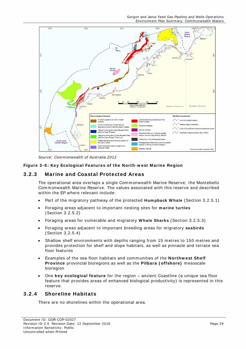
3.2.2.3 Key Ecological Features
Within the North-west Marine Region, a number of key ecological features have been identified (Figure 3-6). Key ecological features are elements of the Commonwealth marine environment that are considered to be of regional importance for either a region’s biodiversity or its ecosystem function and integrity (Commonwealth of Australia 2012). As can be seen from Figure 3-6, the operational area overlies two key ecological features that are described below:
• Ancient Coastline
• Continental Slope Demersal Communities.
Ancient Coastline
The shelf of the North-west Marine Region contains several terraces and steps, which reflect changes in sea level that occurred over the last 100 000 years. The most prominent of these features occurs as an escarpment along the North West Shelf and Sahul Shelf at a depth of 125 m. Parts of the ancient coastline, particularly where it exists as a rocky escarpment, are thought to provide biologically important habitats in areas otherwise dominated by soft sediments (Commonwealth of Australia 2012).
Continental Slope Demersal Fish Communities
The Northwest Province, between North West Cape and Montebello Trough, has more than 500 fish species, 76 of which are endemic. The slopes of the Timor Province and the Northwest Transition also contain more than 500 species of demersal fish, of which 64 are considered endemic. The demersal fish species occupy two distinct demersal community types (biomes) associated with the upper slope (water depth of 225 to 500 m) and the mid-slope (750–1000 m) (Commonwealth of Australia 2012).
The level of endemism (i.e. unique species) of demersal fish species in this community is the highest among Australian continental slope environments. Bacteria and fauna present on the continental slope are the basis of the food web for demersal fish and higher-order consumers in this system.
Gorgon and Jansz Feed Gas Pipeline and Wells Operations Environment Plan Summary: Commonwealth Waters
Document ID: GOR-COP-02027 Revision ID:2.0 Revision Date: 12 September 2016 Page 29 Information Sensitivity: Public Uncontrolled when Printed
Source: Commonwealth of Australia 2012
Figure 3-6: Key Ecological Features of the North-west Marine Region
3.2.3 Marine and Coastal Protected Areas The operational area overlaps a single Commonwealth Marine Reserve; the Montebello Commonwealth Marine Reserve. The values associated with this reserve and described within the EP where relevant include:
• Part of the migratory pathway of the protected Humpback Whale (Section 3.2.5.1)
• Foraging areas adjacent to important nesting sites for marine turtles (Section 3.2.5.2)
• Foraging areas for vulnerable and migratory Whale Sharks (Section 3.2.5.3)
• Foraging areas adjacent to important breeding areas for migratory seabirds (Section 3.2.5.4)
• Shallow shelf environments with depths ranging from 15 metres to 150 metres and provides protection for shelf and slope habitats, as well as pinnacle and terrace sea floor features
• Examples of the sea floor habitats and communities of the Northwest Shelf Province provincial bioregions as well as the Pilbara (offshore) mesoscale bioregion
• One key ecological feature for the region – ancient Coastline (a unique sea floor feature that provides areas of enhanced biological productivity) is represented in this reserve.
3.2.4 Shoreline Habitats There are no shorelines within the operational area.
Gorgon and Jansz Feed Gas Pipeline and Wells Operations Environment Plan Summary: Commonwealth Waters
Document ID: GOR-COP-02027 Revision ID:2.0 Revision Date: 12 September 2016 Page 30 Information Sensitivity: Public Uncontrolled when Printed
3.2.5 Marine Fauna A Matter of National Environmental Significance search, was conducted for the operational area, under the EPBC Act. The results of this search is included as Appendix C in the EP. Given the large number of marine fauna with the potential to occur in these areas, a summary of the number and types of marine fauna is provided within Table 3-1.
Table 3-1: Outcome from Matters of National Environmental Significance Search
Marine Fauna Type
Operational area Summary
Listed Threatened Listed Migratory
Marine Mammals
Two species: • Blue Whale (Balaenoptera musculus) • Humpback Whale (Megaptera novaeangliae).
17 species of: • Whale • Dolphin.
Marine Reptiles
Six species: • Short-nosed Seasnake (Aipysurus apraefrontalis) • Loggerhead Turtle (Caretta caretta) • Green Turtle (Chelonia mydas) • Leatherback Turtle (Dermochelys coriacea) • Hawksbill Turtle (Eretmochelys imbricate) • Flatback Turtle (Natator depressus).
5 Marine Turtle species
Fish and Sharks
Five species: • Grey Nurse Shark (Carcharias taurus) • Great White Shark (Carcharodon carcharias) • Dwarf Sawfish (Pristis clavata) • Green Sawfish (Pristis zijsron) • Whale Shark (Rhincodon typus).
8 species of: • Sharks • Rays • Sawfish.
Seabirds Two species: • Southern Giant Petrel (Macronectes giganteus) • Australian Fairy Tern (Sternula nereis nereis).
One species: • Southern Giant
Petrel.
The following subsections describe the biologically important areas (BIAs) associated with these species where they overlap the operational area. These areas are considered as the value or sensitivity, given that they are spatially defined areas where aggregations of individuals of a regionally significant species are known to display biologically important behaviours such as breeding, foraging, resting or migration.
3.2.5.1 Marine Mammals
Although no feeding or breeding areas for marine mammals are known to occur within the operational area, this area intersects the Blue and Humpback Whale migration route. Humpback Whales migrate annually between their feeding grounds in Antarctic waters and their calving grounds in Pilbara/Kimberley waters from June to October (Chevron Australia 2005). Northbound Humpback Whales tend to remain in, or within, 200 m water depth, while southbound whales tend to come closer to Barrow Island and generally occur between 50 m and 200 m water depth (Jenner et al. 2001). Blue whales undertake northerly migration from April to August and southerly migration from September to November.
Summary of Relevant Conservation Plans
A summary of management actions associated with Humpback Whale developed under the EPBC Act has been identified and provided in Table 3-2.
Gorgon and Jansz Feed Gas Pipeline and Wells Operations Environment Plan Summary: Commonwealth Waters
Document ID: GOR-COP-02027 Revision ID:2.0 Revision Date: 12 September 2016 Page 31 Information Sensitivity: Public Uncontrolled when Printed
Table 3-2: Summary of Relevant Conservation Plans – Marine Mammals
Species Relevant plan / advice
Relevant management advice Section in plan
addressed
Humpback Whale
Conservation Advice for the Humpback Whale 2015–2020
Assess and address anthropogenic noise Section 5.3.3
Minimising vessel collisions Maximise the likelihood that all vessel strike incidents are reported in the National Ship Strike Database. All cetaceans are protected in Commonwealth waters and, the EPBC Act requires that all collisions with whales in Commonwealth waters are reported. Vessel collisions can be submitted to the National Ship Strike Database at: https://data.marinemammals.gov.au/report/shipstrike
Sections 5.4.1 and 7.4.2
Blue Whale Conservation Management Plan for the Blue Whale
Minimising vessel collisions Ensure the risk of vessel strike on Humpback Whales is considered when assessing actions that increase vessel traffic in areas where Humpback Whales occur and, if required appropriate mitigation measures are implemented to reduce the risk of vessel strike.
Section 5.4.1
Minimising vessel collisions Enhance education programs to inform vessel operators of best practice behaviours and regulations for interacting with Humpback Whales.
Section 5.4.1
3.2.5.2 Marine Reptiles
The operational area intersects several BIAs named as internesting habitat for different marine turtle species including:
• Flatback Turtle
• Green Turtle
• Hawksbill Turtle.
Internesting habitat is defined as those areas used by marine turtles to rest between laying eggs. These areas generally surround important turtle nesting areas.
Barrow Island is a regionally important nesting area for Green Turtles and Flatback Turtles, whilst Hawksbill Turtles nest at low densities around the Island (Chevron Australia 2005). Green Turtles are the most abundant marine turtle species on the west coast of Barrow Island, with the Island listed as a major nesting site for the species (Bowman Bishaw Gorham 2005).
Turtle surveys have shown that Green Turtle nesting and track activity on North Whites Beach (the offshore feed gas pipeline landfall site) is significantly lower than other beaches because the shallow sand and limestone reef, including a large limestone shelf along the waterline, make the beach unsuitable for nesting (Pendoley 2005; Pendoley Environmental 2008). Whites Beach, approximately 500 m south of North Whites Beach, is commonly used as a nesting site and is deemed significant because the Green Turtle nesting densities are higher than other beaches on the west coast, including Perched Beach and North Whites Beach. The nesting period for Green Turtles on the west coast of Barrow Island is between November and February (Pendoley 2005), with numbers peaking during December and January (Bowman Bishaw Gorham 2005). Green Turtle hatchlings emerge from the nests from summer to early autumn.
Green Turtles nesting at Barrow Island migrate to foraging grounds that extend from Legendre Island in the Dampier Archipelago to waters in the southern Kimberley
Gorgon and Jansz Feed Gas Pipeline and Wells Operations Environment Plan Summary: Commonwealth Waters
Document ID: GOR-COP-02027 Revision ID:2.0 Revision Date: 12 September 2016 Page 32 Information Sensitivity: Public Uncontrolled when Printed
(Pendoley 2005). Migration data from tag recovery have found that Green Turtles tagged at Barrow Island have been reported as far south as Kalbarri and as far north as eastern Indonesia, suggesting a wide distribution off the Western Australian coastline (DPaW Turtle Tagging Database). These data also show Green Turtles foraging in shallow water <25 m deep, with more than 25% of time spent in waters <10 m deep (Chevron Australia 2009).
Barrow Island is not considered a regionally important nesting site for Hawksbill Turtles. The estimated size of the Hawksbill Turtle reproductive population at Barrow Island is 100 per year, which is smaller than the reproductive populations at the Lowendal Islands and the Montebello Islands (1000 and 1300 respectively; Pendoley 2005). Hawksbill Turtle nesting on Barrow Island typically occurs in low numbers on beaches that are small, shallow and characterised by coarse-grained sand or coral grit interspersed with rocks and beach wrack (Pendoley 2005). Although their peak nesting period is between October and November, Hawksbill Turtles have a seasonally diffuse nesting cycle and individuals may nest at any time throughout the year (Pendoley Environmental 2008). Surveys from 1999 to 2008 did not record any Hawksbill Turtle nests at North Whites Beach (although one set of tracks was recorded in that period) (Pendoley Environmental 2008).
Summary of Relevant Conservation Plans
A summary of management actions associated with Marine Turtles developed under the EPBC Act has been identified and provided in Table 3-3.
Table 3-3: Summary of Relevant Conservation Plans – Marine Reptiles
Species Relevant plan / advice
Relevant management
advice
Section in plan
addressed
Caretta caretta (Loggerhead Turtle) Chelonia mydas (Green Turtle) Dermochelys coriacea (Leatherback Turtle, Leathery Turtle, Luth) Eretmochelys imbricata (Hawksbill Turtle) Natator depressus (Flatback Turtle)
Recovery Plan for Marine Turtles in Australia
Boat strike None identified
Section 5.4.1
Dermochelys coriacea (Leatherback Turtle, Leathery Turtle, Luth)
Approved Conservation Advice for Dermochelys coriacea (Leatherback Turtle
Boat strike None identified
Section 5.4.1
3.2.5.3 Fish and Sharks
The operational area intersects two BIAs associated with fish and sharks.
• Whale Shark foraging area
• Continental slope demersal fish communities (see Section 3.2.2.3).
Ningaloo Reef is important for Whale Shark (listed as vulnerable) aggregation, which occurs annually between March and August in the waters of the Ningaloo Marine Park, frequently close to the Ningaloo Reef front, both in the lagoon and outside it. This aggregation behaviour is only known to occur in a few places in the world. The Whale Shark is also listed as vulnerable and occurs in most areas assessed. The 200 m isobath along the northern part of the Western Australian coast is an important migration route, with migration occurring mainly between July and November.
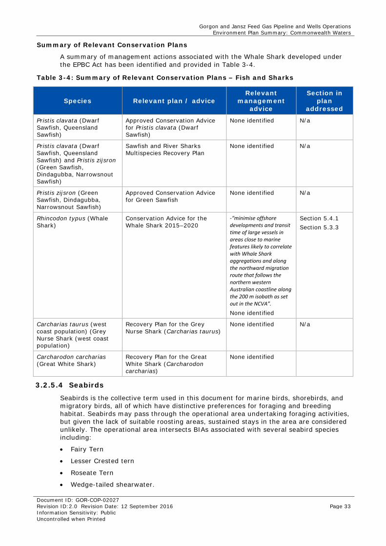
Gorgon and Jansz Feed Gas Pipeline and Wells Operations Environment Plan Summary: Commonwealth Waters
Document ID: GOR-COP-02027 Revision ID:2.0 Revision Date: 12 September 2016 Page 33 Information Sensitivity: Public Uncontrolled when Printed
Summary of Relevant Conservation Plans
A summary of management actions associated with the Whale Shark developed under the EPBC Act has been identified and provided in Table 3-4.
Table 3-4: Summary of Relevant Conservation Plans – Fish and Sharks
Species Relevant plan / advice Relevant
management advice
Section in plan
addressed
Pristis clavata (Dwarf Sawfish, Queensland Sawfish)
Approved Conservation Advice for Pristis clavata (Dwarf Sawfish)
None identified N/a
Pristis clavata (Dwarf Sawfish, Queensland Sawfish) and Pristis zijsron (Green Sawfish, Dindagubba, Narrowsnout Sawfish)
Sawfish and River Sharks Multispecies Recovery Plan
None identified N/a
Pristis zijsron (Green Sawfish, Dindagubba, Narrowsnout Sawfish)
Approved Conservation Advice for Green Sawfish
None identified N/a
Rhincodon typus (Whale Shark)
Conservation Advice for the Whale Shark 2015–2020
-“minimise offshore developments and transit time of large vessels in areas close to marine features likely to correlate with Whale Shark aggregations and along the northward migration route that follows the northern western Australian coastline along the 200 m isobath as set out in the NCVA”.
None identified
Section 5.4.1 Section 5.3.3
Carcharias taurus (west coast population) (Grey Nurse Shark (west coast population)
Recovery Plan for the Grey Nurse Shark (Carcharias taurus)
None identified N/a
Carcharodon carcharias (Great White Shark)
Recovery Plan for the Great White Shark (Carcharodon carcharias)
None identified
3.2.5.4 Seabirds
Seabirds is the collective term used in this document for marine birds, shorebirds, and migratory birds, all of which have distinctive preferences for foraging and breeding habitat. Seabirds may pass through the operational area undertaking foraging activities, but given the lack of suitable roosting areas, sustained stays in the area are considered unlikely. The operational area intersects BIAs associated with several seabird species including:
• Fairy Tern
• Lesser Crested tern
• Roseate Tern
• Wedge-tailed shearwater.
Gorgon and Jansz Feed Gas Pipeline and Wells Operations Environment Plan Summary: Commonwealth Waters
Document ID: GOR-COP-02027 Revision ID:2.0 Revision Date: 12 September 2016 Page 34 Information Sensitivity: Public Uncontrolled when Printed
Although these BIAs are labelled breeding habitat, the habitat overlapping the operational area is considered to provide foraging habitat to these species given there are no nesting areas for these species within the operational area.
Summary of Relevant Conservation Plans
A summary of management actions associated with the Fairy Tern developed under the EPBC Act has been identified and provided in Table 3-5.
Table 3-5: Summary of Relevant Conservation Plans – Seabirds
Species Relevant plan / advice
Relevant management
advice
Section in plan
addressed
Thalassarche melanophris (Black-browed Albatross)
National Recovery Plan for Threatened Albatrosses and Giant Petrels 2011–2016
None identified N/a
Macronectes giganteus (Southern Giant Petrel)
None identified N/a
Pterodroma Mollis (Soft-plumaged Petrel)
None identified N/a
Pterodroma Mollis (Soft-plumaged Petrel)
Conservation Advice Pterodroma Mollis Soft-plumaged Petrel
None identified N/a
Sternula nereis nereis (Australian Fairy Tern)
Conservation Advice for Sternula nereis nereis (Fairy Tern)
None identified N/a
3.2.6 Socioeconomic Environment 3.2.6.1 Infrastructure
Infrastructure includes other petroleum development, ports, and harbours. There are a number of oil and gas facilities in the vicinity of the operational area. These include:
• The East Spar Pipeline, which runs from the East Spar field to Varanus Island and is used to transport gas from the Halyard and Spar development. Production from the Halyard-1 well commenced in mid-2011. The Spar-2 well is currently being developed and is about 16 km from the East Spar manifold. If the well is successful, Spar-2 will be tied back to East Spar. First production is expected from Spar-2 in late 2012
• Halyard EHU, which provides well control of the Halyard and Spar development from the existing John Brookes Platform. The John Brookes, an unmanned platform operated by Apache, is located approximately 10 km east of the proposed Jansz pipelines and umbilical
As the operational area is entirely offshore, there is no infrastructure such as ports or harbours within this area.
3.2.6.2 Commercial Shipping
A review of Australian Ship Reporting (ATSB 2013), a ship reporting system operated by the Australian Maritime Safety Authority (AMSA), estimated that 1200 ships a year (equating to fewer than four per day) travelled through the vicinity of the operational area in 2008.
Although the operational area intersects the shipping route between the WA coast and Asia, the main shipping routes to and from Port Hedland and the Port of Dampier are located to the east (Figure 3-7).
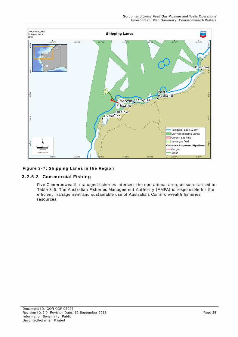
Gorgon and Jansz Feed Gas Pipeline and Wells Operations Environment Plan Summary: Commonwealth Waters
Document ID: GOR-COP-02027 Revision ID:2.0 Revision Date: 12 September 2016 Page 35 Information Sensitivity: Public Uncontrolled when Printed
Figure 3-7: Shipping Lanes in the Region
3.2.6.3 Commercial Fishing
Five Commonwealth managed fisheries intersect the operational area, as summarised in Table 3-6. The Australian Fisheries Management Authority (AMFA) is responsible for the efficient management and sustainable use of Australia’s Commonwealth fisheries resources.
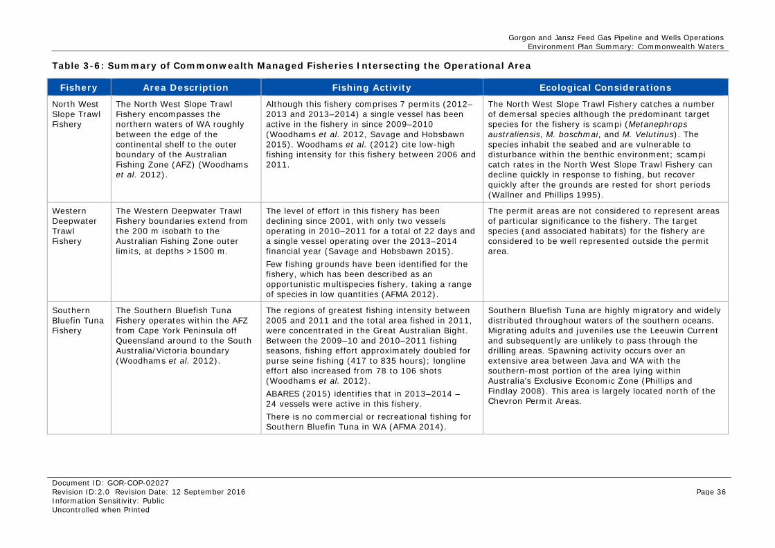
Gorgon and Jansz Feed Gas Pipeline and Wells Operations Environment Plan Summary: Commonwealth Waters
Document ID: GOR-COP-02027 Revision ID:2.0 Revision Date: 12 September 2016 Page 36 Information Sensitivity: Public Uncontrolled when Printed
Table 3-6: Summary of Commonwealth Managed Fisheries Intersecting the Operational Area
Fishery Area Description Fishing Activity Ecological Considerations
North West Slope Trawl Fishery
The North West Slope Trawl Fishery encompasses the northern waters of WA roughly between the edge of the continental shelf to the outer boundary of the Australian Fishing Zone (AFZ) (Woodhams et al. 2012).
Although this fishery comprises 7 permits (2012–2013 and 2013–2014) a single vessel has been active in the fishery in since 2009–2010 (Woodhams et al. 2012, Savage and Hobsbawn 2015). Woodhams et al. (2012) cite low-high fishing intensity for this fishery between 2006 and 2011.
The North West Slope Trawl Fishery catches a number of demersal species although the predominant target species for the fishery is scampi (Metanephrops australiensis, M. boschmai, and M. Velutinus). The species inhabit the seabed and are vulnerable to disturbance within the benthic environment; scampi catch rates in the North West Slope Trawl Fishery can decline quickly in response to fishing, but recover quickly after the grounds are rested for short periods (Wallner and Phillips 1995).
Western Deepwater Trawl Fishery
The Western Deepwater Trawl Fishery boundaries extend from the 200 m isobath to the Australian Fishing Zone outer limits, at depths >1500 m.
The level of effort in this fishery has been declining since 2001, with only two vessels operating in 2010–2011 for a total of 22 days and a single vessel operating over the 2013–2014 financial year (Savage and Hobsbawn 2015). Few fishing grounds have been identified for the fishery, which has been described as an opportunistic multispecies fishery, taking a range of species in low quantities (AFMA 2012).
The permit areas are not considered to represent areas of particular significance to the fishery. The target species (and associated habitats) for the fishery are considered to be well represented outside the permit area.
Southern Bluefin Tuna Fishery
The Southern Bluefish Tuna Fishery operates within the AFZ from Cape York Peninsula off Queensland around to the South Australia/Victoria boundary (Woodhams et al. 2012).
The regions of greatest fishing intensity between 2005 and 2011 and the total area fished in 2011, were concentrated in the Great Australian Bight. Between the 2009–10 and 2010–2011 fishing seasons, fishing effort approximately doubled for purse seine fishing (417 to 835 hours); longline effort also increased from 78 to 106 shots (Woodhams et al. 2012). ABARES (2015) identifies that in 2013–2014 – 24 vessels were active in this fishery. There is no commercial or recreational fishing for Southern Bluefin Tuna in WA (AFMA 2014).
Southern Bluefish Tuna are highly migratory and widely distributed throughout waters of the southern oceans. Migrating adults and juveniles use the Leeuwin Current and subsequently are unlikely to pass through the drilling areas. Spawning activity occurs over an extensive area between Java and WA with the southern-most portion of the area lying within Australia’s Exclusive Economic Zone (Phillips and Findlay 2008). This area is largely located north of the Chevron Permit Areas.
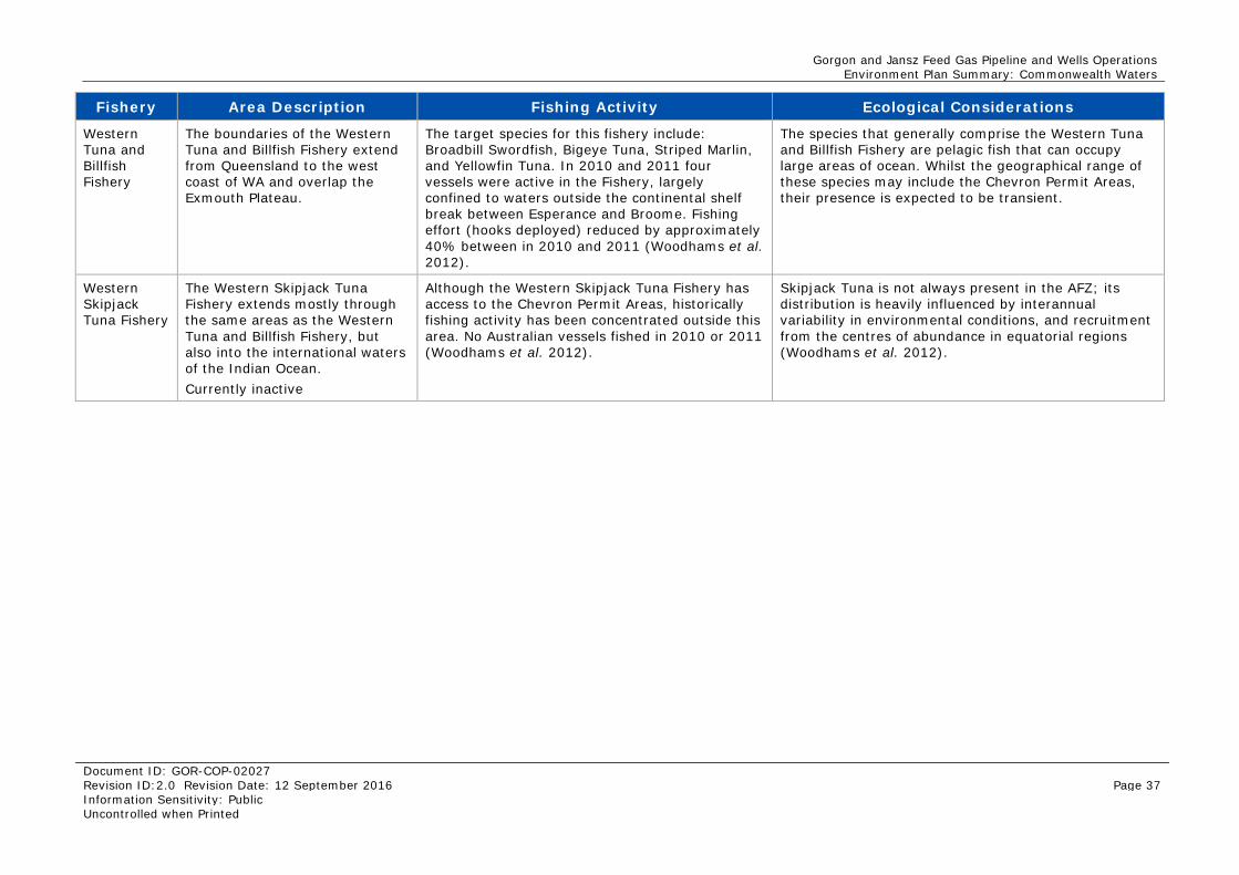
Gorgon and Jansz Feed Gas Pipeline and Wells Operations Environment Plan Summary: Commonwealth Waters
Document ID: GOR-COP-02027 Revision ID:2.0 Revision Date: 12 September 2016 Page 37 Information Sensitivity: Public Uncontrolled when Printed
Fishery Area Description Fishing Activity Ecological Considerations
Western Tuna and Billfish Fishery
The boundaries of the Western Tuna and Billfish Fishery extend from Queensland to the west coast of WA and overlap the Exmouth Plateau.
The target species for this fishery include: Broadbill Swordfish, Bigeye Tuna, Striped Marlin, and Yellowfin Tuna. In 2010 and 2011 four vessels were active in the Fishery, largely confined to waters outside the continental shelf break between Esperance and Broome. Fishing effort (hooks deployed) reduced by approximately 40% between in 2010 and 2011 (Woodhams et al. 2012).
The species that generally comprise the Western Tuna and Billfish Fishery are pelagic fish that can occupy large areas of ocean. Whilst the geographical range of these species may include the Chevron Permit Areas, their presence is expected to be transient.
Western Skipjack Tuna Fishery
The Western Skipjack Tuna Fishery extends mostly through the same areas as the Western Tuna and Billfish Fishery, but also into the international waters of the Indian Ocean. Currently inactive
Although the Western Skipjack Tuna Fishery has access to the Chevron Permit Areas, historically fishing activity has been concentrated outside this area. No Australian vessels fished in 2010 or 2011 (Woodhams et al. 2012).
Skipjack Tuna is not always present in the AFZ; its distribution is heavily influenced by interannual variability in environmental conditions, and recruitment from the centres of abundance in equatorial regions (Woodhams et al. 2012).
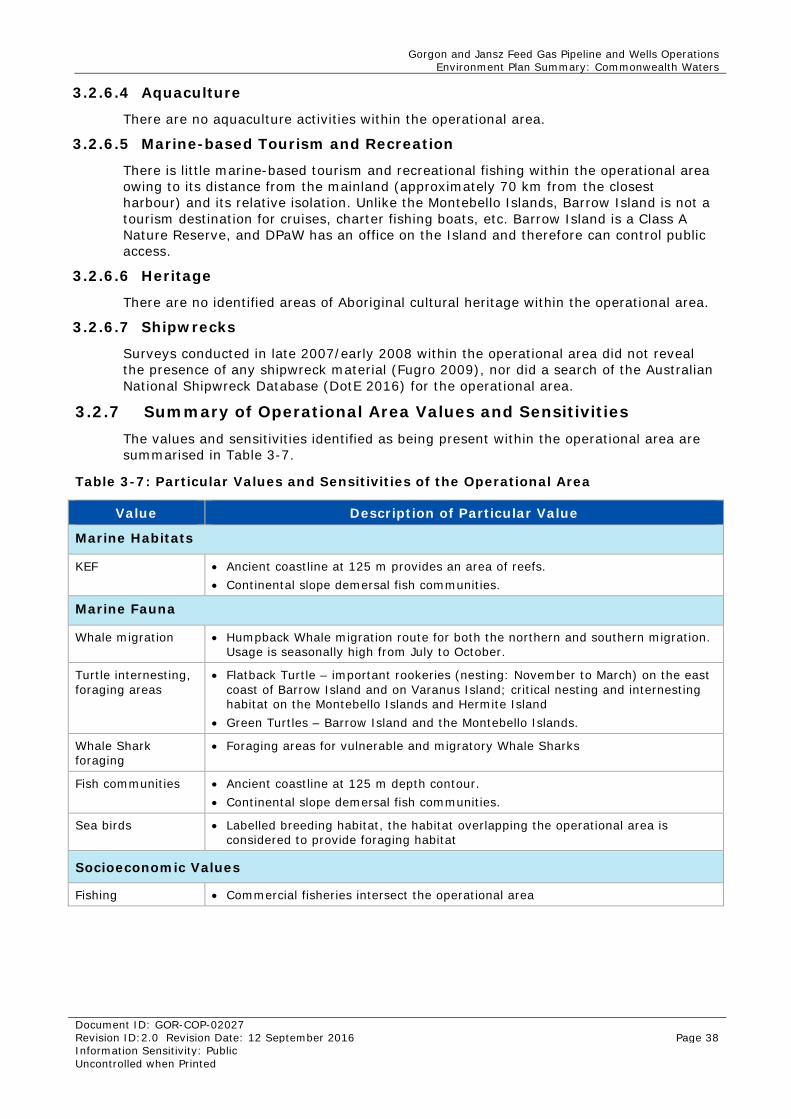
Gorgon and Jansz Feed Gas Pipeline and Wells Operations Environment Plan Summary: Commonwealth Waters
Document ID: GOR-COP-02027 Revision ID:2.0 Revision Date: 12 September 2016 Page 38 Information Sensitivity: Public Uncontrolled when Printed
3.2.6.4 Aquaculture
There are no aquaculture activities within the operational area.
3.2.6.5 Marine-based Tourism and Recreation
There is little marine-based tourism and recreational fishing within the operational area owing to its distance from the mainland (approximately 70 km from the closest harbour) and its relative isolation. Unlike the Montebello Islands, Barrow Island is not a tourism destination for cruises, charter fishing boats, etc. Barrow Island is a Class A Nature Reserve, and DPaW has an office on the Island and therefore can control public access.
3.2.6.6 Heritage
There are no identified areas of Aboriginal cultural heritage within the operational area.
3.2.6.7 Shipwrecks
Surveys conducted in late 2007/early 2008 within the operational area did not reveal the presence of any shipwreck material (Fugro 2009), nor did a search of the Australian National Shipwreck Database (DotE 2016) for the operational area.
3.2.7 Summary of Operational Area Values and Sensitivities The values and sensitivities identified as being present within the operational area are summarised in Table 3-7.
Table 3-7: Particular Values and Sensitivities of the Operational Area
Value Description of Particular Value
Marine Habitats
KEF • Ancient coastline at 125 m provides an area of reefs. • Continental slope demersal fish communities.
Marine Fauna
Whale migration • Humpback Whale migration route for both the northern and southern migration. Usage is seasonally high from July to October.
Turtle internesting, foraging areas
• Flatback Turtle – important rookeries (nesting: November to March) on the east coast of Barrow Island and on Varanus Island; critical nesting and internesting habitat on the Montebello Islands and Hermite Island
• Green Turtles – Barrow Island and the Montebello Islands.
Whale Shark foraging
• Foraging areas for vulnerable and migratory Whale Sharks
Fish communities • Ancient coastline at 125 m depth contour. • Continental slope demersal fish communities.
Sea birds • Labelled breeding habitat, the habitat overlapping the operational area is considered to provide foraging habitat
Socioeconomic Values
Fishing • Commercial fisheries intersect the operational area
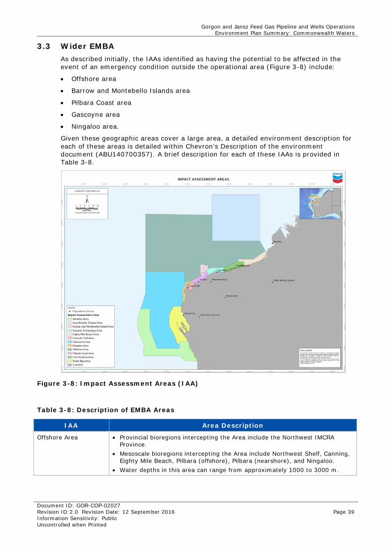
Gorgon and Jansz Feed Gas Pipeline and Wells Operations Environment Plan Summary: Commonwealth Waters
Document ID: GOR-COP-02027 Revision ID:2.0 Revision Date: 12 September 2016 Page 39 Information Sensitivity: Public Uncontrolled when Printed
3.3 Wider EMBA As described initially, the IAAs identified as having the potential to be affected in the event of an emergency condition outside the operational area (Figure 3-8) include:
• Offshore area
• Barrow and Montebello Islands area
• Pilbara Coast area
• Gascoyne area
• Ningaloo area.
Given these geographic areas cover a large area, a detailed environment description for each of these areas is detailed within Chevron’s Description of the environment document (ABU140700357). A brief description for each of these IAAs is provided in Table 3-8.
Figure 3-8: Impact Assessment Areas (IAA)
Table 3-8: Description of EMBA Areas
IAA Area Description
Offshore Area • Provincial bioregions intercepting the Area include the Northwest IMCRA Province.
• Mesoscale bioregions intercepting the Area include Northwest Shelf, Canning, Eighty Mile Beach, Pilbara (offshore), Pilbara (nearshore), and Ningaloo.
• Water depths in this area can range from approximately 1000 to 3000 m.
Gorgon and Jansz Feed Gas Pipeline and Wells Operations Environment Plan Summary: Commonwealth Waters
Document ID: GOR-COP-02027 Revision ID:2.0 Revision Date: 12 September 2016 Page 40 Information Sensitivity: Public Uncontrolled when Printed
IAA Area Description
Barrow and Montebello Islands Area
• Provincial bioregions intercepting the Area include Northwest IMCRA Province and Northwest Province.
• Mesoscale bioregions intercepting the Area include Pilbara (offshore) and Pilbara (nearshore).
• Water depths in this area can reach approximately 150 m.
Pilbara Coast Area • Provincial bioregions intercepting the Area include Northwest IMCRA Province and Northwest Province.
• Mesoscale bioregions intercepting the Area include Pilbara (offshore) and Pilbara (nearshore).
• Water depths in this area can reach approximately 10 m.
Gascoyne Area • Provincial bioregions intercepting the Area include Central Western Province, Central Western IMCRA Province, Central Western IMCRA Transition, Central Western Transition, and Northwest Province.
• Mesoscale bioregions intercepting the Area include Ningaloo and Central West Coast.
• This area is exclusive of any coastal habitats. • Water depths in this area can reach approximately 6000 m.
Ningaloo Area • Provincial bioregions intercepting the Area include Central Western IMCRA Province, Central Western IMCRA Transition, Central Western Transition, Northwest Province, and Northwest IMCRA Province.
• Mesoscale bioregions intercepting the Area include Pilbara (offshore), Pilbara (nearshore), and Ningaloo.
• Water depths in this area can exceed 500 m.
3.3.1 Protected Species A Matters of NES search, was conducted for the wider EMBA. Given the large number of marine fauna with the potential to occur in these areas, a summary of the number and types of marine fauna is provided within Table 3-9.
Table 3-9: Outcome from Matters of National Environmental Significance Search
Marine Fauna Type
Operational area Summary
Listed Migratory
Marine Mammals 32 species of: • Dolphin • Dugong • Whales.
12 species of: • Whale • Dugong.
Marine Reptiles 22 species of: • Seasnake • Marine turtles
Five species of: • Marine turtle.
Fish and Sharks 36 species of: • Sharks • Rays • Sawfish • Pipefish • Seahorse.
Nine species of: • Sharks • Rays • Sawfish.
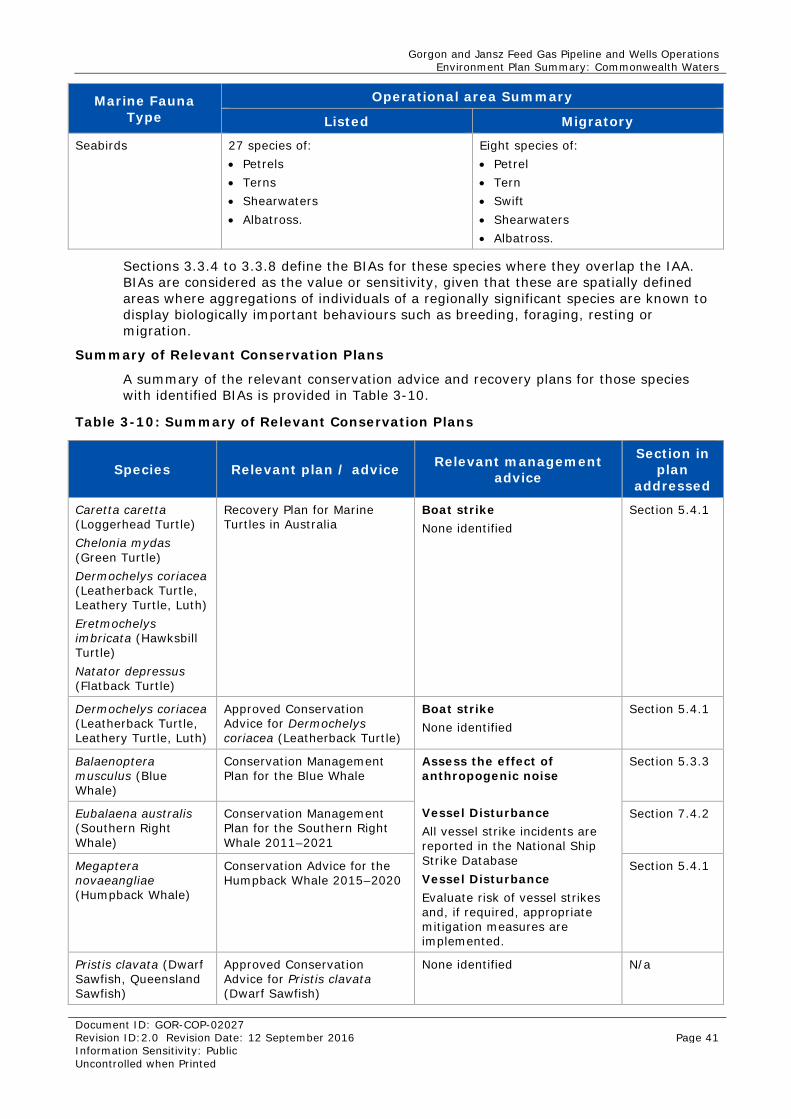
Gorgon and Jansz Feed Gas Pipeline and Wells Operations Environment Plan Summary: Commonwealth Waters
Document ID: GOR-COP-02027 Revision ID:2.0 Revision Date: 12 September 2016 Page 41 Information Sensitivity: Public Uncontrolled when Printed
Marine Fauna Type
Operational area Summary
Listed Migratory
Seabirds 27 species of: • Petrels • Terns • Shearwaters • Albatross.
Eight species of: • Petrel • Tern • Swift • Shearwaters • Albatross.
Sections 3.3.4 to 3.3.8 define the BIAs for these species where they overlap the IAA. BIAs are considered as the value or sensitivity, given that these are spatially defined areas where aggregations of individuals of a regionally significant species are known to display biologically important behaviours such as breeding, foraging, resting or migration.
Summary of Relevant Conservation Plans
A summary of the relevant conservation advice and recovery plans for those species with identified BIAs is provided in Table 3-10.
Table 3-10: Summary of Relevant Conservation Plans
Species Relevant plan / advice Relevant management advice
Section in plan
addressed
Caretta caretta (Loggerhead Turtle) Chelonia mydas (Green Turtle) Dermochelys coriacea (Leatherback Turtle, Leathery Turtle, Luth) Eretmochelys imbricata (Hawksbill Turtle) Natator depressus (Flatback Turtle)
Recovery Plan for Marine Turtles in Australia
Boat strike None identified
Section 5.4.1
Dermochelys coriacea (Leatherback Turtle, Leathery Turtle, Luth)
Approved Conservation Advice for Dermochelys coriacea (Leatherback Turtle)
Boat strike None identified
Section 5.4.1
Balaenoptera musculus (Blue Whale)
Conservation Management Plan for the Blue Whale
Assess the effect of anthropogenic noise Vessel Disturbance All vessel strike incidents are reported in the National Ship Strike Database Vessel Disturbance Evaluate risk of vessel strikes and, if required, appropriate mitigation measures are implemented.
Section 5.3.3
Eubalaena australis (Southern Right Whale)
Conservation Management Plan for the Southern Right Whale 2011–2021
Section 7.4.2
Megaptera novaeangliae (Humpback Whale)
Conservation Advice for the Humpback Whale 2015–2020
Section 5.4.1
Pristis clavata (Dwarf Sawfish, Queensland Sawfish)
Approved Conservation Advice for Pristis clavata (Dwarf Sawfish)
None identified N/a
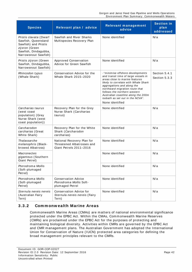
Gorgon and Jansz Feed Gas Pipeline and Wells Operations Environment Plan Summary: Commonwealth Waters
Document ID: GOR-COP-02027 Revision ID:2.0 Revision Date: 12 September 2016 Page 42 Information Sensitivity: Public Uncontrolled when Printed
Species Relevant plan / advice Relevant management advice
Section in plan
addressed
Pristis clavata (Dwarf Sawfish, Queensland Sawfish) and Pristis zijsron (Green Sawfish, Dindagubba, Narrowsnout Sawfish)
Sawfish and River Sharks Multispecies Recovery Plan
None identified N/a
Pristis zijsron (Green Sawfish, Dindagubba, Narrowsnout Sawfish)
Approved Conservation Advice for Green Sawfish
None identified N/a
Rhincodon typus (Whale Shark)
Conservation Advice for the Whale Shark 2015–2020
-“minimise offshore developments and transit time of large vessels in areas close to marine features likely to correlate with Whale Shark aggregations and along the northward migration route that follows the northern western Australian coastline along the 200m isobath as set out in the NCVA”.
None identified
Section 5.4.1 Section 5.3.3
Carcharias taurus (west coast population) (Grey Nurse Shark (west coast population))
Recovery Plan for the Grey Nurse Shark (Carcharias taurus)
None identified N/a
Carcharodon carcharias (Great White Shark)
Recovery Plan for the White Shark (Carcharodon carcharias)
None identified N/a
Thalassarche melanophris (Black-browed Albatross)
National Recovery Plan for Threatened Albatrosses and Giant Petrels 2011–2016
None identified N/a
Macronectes giganteus (Southern Giant Petrel)
None identified N/a
Pterodroma Mollis (Soft-plumaged Petrel)
None identified N/a
Pterodroma Mollis (Soft-plumaged Petrel)
Conservation Advice Pterodroma Mollis Soft-plumaged Petrel
None identified N/a
Sternula nereis nereis (Australian Fairy Tern)
Conservation Advice for Sternula nereis nereis (Fairy Tern)
None identified N/a
3.3.2 Commonwealth Marine Areas Commonwealth Marine Areas (CMAs) are matters of national environmental significance protected under the EPBC Act. Within the CMAs, Commonwealth Marine Reserves (CMRs) are proclaimed under the EPBC Act for the purposes of protecting and maintaining biological diversity. Activities within CMRs are governed by the EPBC Act and CMR management plans. The Australian Government has adopted the International Union for Conservation of Nature (IUCN) protected area categories for defining the broad management principles relevant to the CMRs.
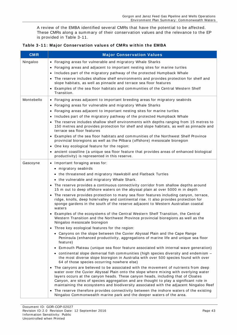
Gorgon and Jansz Feed Gas Pipeline and Wells Operations Environment Plan Summary: Commonwealth Waters
Document ID: GOR-COP-02027 Revision ID:2.0 Revision Date: 12 September 2016 Page 43 Information Sensitivity: Public Uncontrolled when Printed
A review of the EMBA identified several CMRs that have the potential to be affected. These CMRs along a summary of their conservation values and the relevance to the EP is provided in Table 3-11.
Table 3-11: Major Conservation values of CMRs within the EMBA
CMR Major Conservation Values
Ningaloo • Foraging areas for vulnerable and migratory Whale Sharks • Foraging areas and adjacent to important nesting sites for marine turtles • Includes part of the migratory pathway of the protected Humpback Whale • The reserve includes shallow shelf environments and provides protection for shelf and
slope habitats, as well as pinnacle and terrace sea floor features • Examples of the sea floor habitats and communities of the Central Western Shelf
Transition.
Montebello • Foraging areas adjacent to important breeding areas for migratory seabirds • Foraging areas for vulnerable and migratory Whale Sharks • Foraging areas adjacent to important nesting sites for marine turtles • Includes part of the migratory pathway of the protected Humpback Whale • The reserve includes shallow shelf environments with depths ranging from 15 metres to
150 metres and provides protection for shelf and slope habitats, as well as pinnacle and terrace sea floor features
• Examples of the sea floor habitats and communities of the Northwest Shelf Province provincial bioregions as well as the Pilbara (offshore) mesoscale bioregion
• One key ecological feature for the region: • ancient coastline (a unique sea floor feature that provides areas of enhanced biological
productivity) is represented in this reserve.
Gascoyne • Important foraging areas for: • migratory seabirds • the threatened and migratory Hawksbill and Flatback Turtles • the vulnerable and migratory Whale Shark.
• The reserve provides a continuous connectivity corridor from shallow depths around 15 m out to deep offshore waters on the abyssal plain at over 5000 m in depth
• The reserve provides protection to many sea floor features including canyon, terrace, ridge, knolls, deep hole/valley and continental rise. It also provides protection for sponge gardens in the south of the reserve adjacent to Western Australian coastal waters
• Examples of the ecosystems of the Central Western Shelf Transition, the Central Western Transition and the Northwest Province provincial bioregions as well as the Ningaloo mesoscale bioregion
• Three key ecological features for the region: • Canyons on the slope between the Cuvier Abyssal Plain and the Cape Range
Peninsula (enhanced productivity, aggregations of marine life and unique sea floor feature)
• Exmouth Plateau (unique sea floor feature associated with internal wave generation) • continental slope demersal fish communities (high species diversity and endemism –
the most diverse slope bioregion in Australia with over 500 species found with over 64 of those species occurring nowhere else)
• The canyons are believed to be associated with the movement of nutrients from deep water over the Cuvier Abyssal Plain onto the slope where mixing with overlying water layers occurs at the canyon heads. These canyon heads, including that of Cloates Canyon, are sites of species aggregation and are thought to play a significant role in maintaining the ecosystems and biodiversity associated with the adjacent Ningaloo Reef
• The reserve therefore provides connectivity between the inshore waters of the existing Ningaloo Commonwealth marine park and the deeper waters of the area.
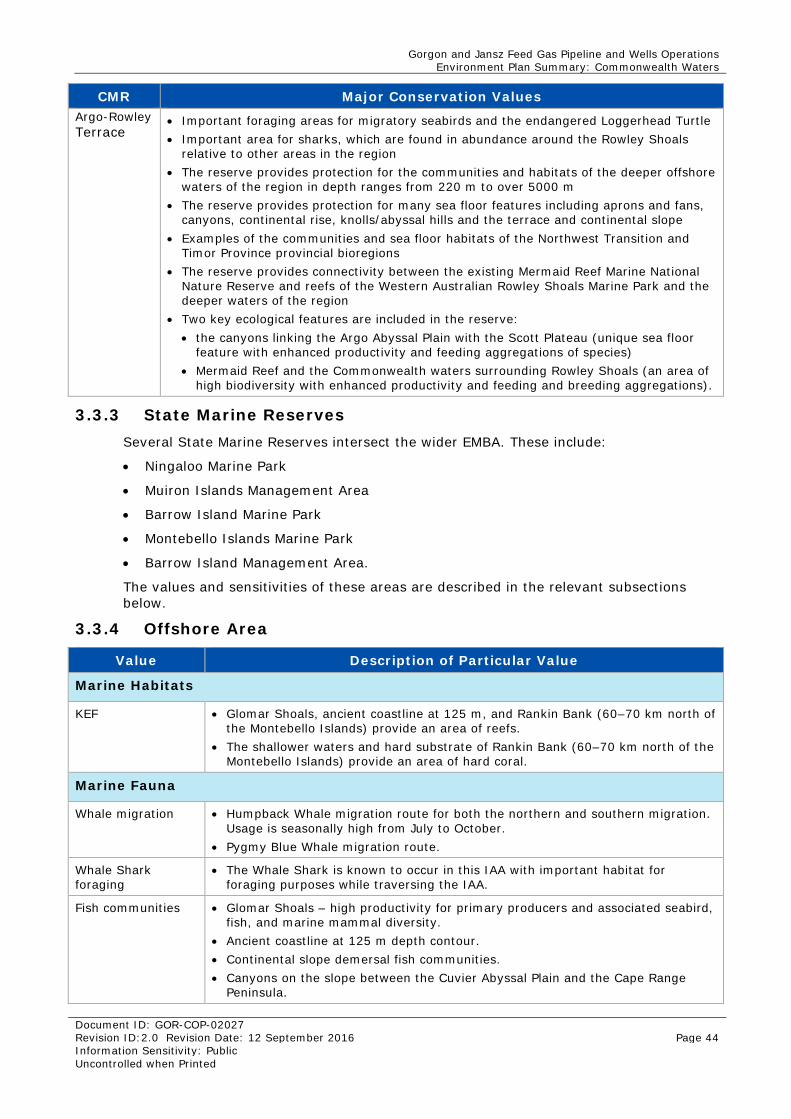
Gorgon and Jansz Feed Gas Pipeline and Wells Operations Environment Plan Summary: Commonwealth Waters
Document ID: GOR-COP-02027 Revision ID:2.0 Revision Date: 12 September 2016 Page 44 Information Sensitivity: Public Uncontrolled when Printed
CMR Major Conservation Values Argo-Rowley Terrace
• Important foraging areas for migratory seabirds and the endangered Loggerhead Turtle • Important area for sharks, which are found in abundance around the Rowley Shoals
relative to other areas in the region • The reserve provides protection for the communities and habitats of the deeper offshore
waters of the region in depth ranges from 220 m to over 5000 m • The reserve provides protection for many sea floor features including aprons and fans,
canyons, continental rise, knolls/abyssal hills and the terrace and continental slope • Examples of the communities and sea floor habitats of the Northwest Transition and
Timor Province provincial bioregions • The reserve provides connectivity between the existing Mermaid Reef Marine National
Nature Reserve and reefs of the Western Australian Rowley Shoals Marine Park and the deeper waters of the region
• Two key ecological features are included in the reserve: • the canyons linking the Argo Abyssal Plain with the Scott Plateau (unique sea floor
feature with enhanced productivity and feeding aggregations of species) • Mermaid Reef and the Commonwealth waters surrounding Rowley Shoals (an area of
high biodiversity with enhanced productivity and feeding and breeding aggregations).
3.3.3 State Marine Reserves Several State Marine Reserves intersect the wider EMBA. These include:
• Ningaloo Marine Park
• Muiron Islands Management Area
• Barrow Island Marine Park
• Montebello Islands Marine Park
• Barrow Island Management Area.
The values and sensitivities of these areas are described in the relevant subsections below.
3.3.4 Offshore Area
Value Description of Particular Value
Marine Habitats
KEF • Glomar Shoals, ancient coastline at 125 m, and Rankin Bank (60–70 km north of the Montebello Islands) provide an area of reefs.
• The shallower waters and hard substrate of Rankin Bank (60–70 km north of the Montebello Islands) provide an area of hard coral.
Marine Fauna
Whale migration • Humpback Whale migration route for both the northern and southern migration. Usage is seasonally high from July to October.
• Pygmy Blue Whale migration route.
Whale Shark foraging
• The Whale Shark is known to occur in this IAA with important habitat for foraging purposes while traversing the IAA.
Fish communities • Glomar Shoals – high productivity for primary producers and associated seabird, fish, and marine mammal diversity.
• Ancient coastline at 125 m depth contour. • Continental slope demersal fish communities. • Canyons on the slope between the Cuvier Abyssal Plain and the Cape Range
Peninsula.
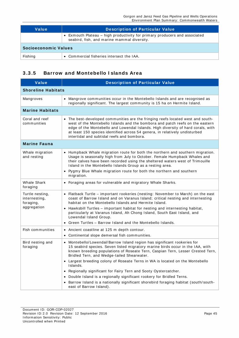
Gorgon and Jansz Feed Gas Pipeline and Wells Operations Environment Plan Summary: Commonwealth Waters
Document ID: GOR-COP-02027 Revision ID:2.0 Revision Date: 12 September 2016 Page 45 Information Sensitivity: Public Uncontrolled when Printed
Value Description of Particular Value • Exmouth Plateau – high productivity for primary producers and associated
seabird, fish, and marine mammal diversity.
Socioeconomic Values
Fishing • Commercial fisheries intersect the IAA.
3.3.5 Barrow and Montebello Islands Area
Value Description of Particular Value
Shoreline Habitats
Mangroves • Mangrove communities occur in the Montebello Islands and are recognised as regionally significant. The largest community is 15 ha on Hermite Island.
Marine Habitats
Coral and reef communities
• The best-developed communities are the fringing reefs located west and south-west of the Montebello Islands and the bombora and patch reefs on the eastern edge of the Montebello and Lowendal Islands. High diversity of hard corals, with at least 150 species identified across 54 genera, in relatively undisturbed intertidal and subtidal reefs and bombora.
Marine Fauna
Whale migration and resting
• Humpback Whale migration route for both the northern and southern migration. Usage is seasonally high from July to October. Female Humpback Whales and their calves have been recorded using the sheltered waters west of Trimouille Island in the Montebello Islands Group as a resting area.
• Pygmy Blue Whale migration route for both the northern and southern migration.
Whale Shark foraging
• Foraging areas for vulnerable and migratory Whale Sharks.
Turtle nesting, internesting, foraging, aggregation
• Flatback Turtle – important rookeries (nesting: November to March) on the east coast of Barrow Island and on Varanus Island; critical nesting and internesting habitat on the Montebello Islands and Hermite Island.
• Hawksbill Turtles – important habitat for nesting and internesting habitat, particularly at Varanus Island, Ah Chong Island, South East Island, and Lowendal Island Group.
• Green Turtles – Barrow Island and the Montebello Islands.
Fish communities • Ancient coastline at 125 m depth contour. • Continental slope demersal fish communities.
Bird nesting and foraging
• Montebello/Lowendal/Barrow Island region has significant rookeries for 15 seabird species. Seven listed migratory marine birds occur in the IAA, with known breeding populations of Roseate Tern, Caspian Tern, Lesser Crested Tern, Bridled Tern, and Wedge-tailed Shearwater.
• Largest breeding colony of Roseate Terns in WA is located on the Montebello Islands.
• Regionally significant for Fairy Tern and Sooty Oystercatcher. • Double Island is a regionally significant rookery for Bridled Terns. • Barrow Island is a nationally significant shorebird foraging habitat (south/south-
east of Barrow Island).
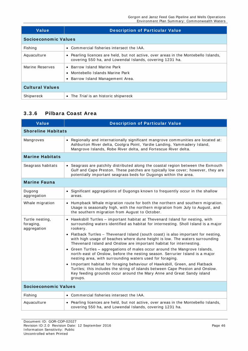
Gorgon and Jansz Feed Gas Pipeline and Wells Operations Environment Plan Summary: Commonwealth Waters
Document ID: GOR-COP-02027 Revision ID:2.0 Revision Date: 12 September 2016 Page 46 Information Sensitivity: Public Uncontrolled when Printed
Value Description of Particular Value
Socioeconomic Values
Fishing • Commercial fisheries intersect the IAA.
Aquaculture • Pearling licences are held, but not active, over areas in the Montebello Islands, covering 550 ha, and Lowendal Islands, covering 1231 ha.
Marine Reserves • Barrow Island Marine Park • Montebello Islands Marine Park • Barrow Island Management Area.
Cultural Values
Shipwreck • The Trial is an historic shipwreck
3.3.6 Pilbara Coast Area
Value Description of Particular Value
Shoreline Habitats
Mangroves • Regionally and internationally significant mangrove communities are located at: Ashburton River delta, Coolgra Point, Yardie Landing, Yammadery Island, Mangrove Islands, Robe River delta, and Fortescue River delta.
Marine Habitats
Seagrass habitats • Seagrass are patchily distributed along the coastal region between the Exmouth Gulf and Cape Preston. These patches are typically low cover; however, they are potentially important seagrass beds for Dugongs within the area.
Marine Fauna
Dugong aggregation
• Significant aggregations of Dugongs known to frequently occur in the shallow areas.
Whale migration • Humpback Whale migration route for both the northern and southern migration. Usage is seasonally high, with the northern migration from July to August, and the southern migration from August to October.
Turtle nesting, foraging, aggregation
• Hawksbill Turtles – important habitat at Thevenard Island for nesting, with surrounding waters identified as habitat for internesting. Sholl Island is a major rookery.
• Flatback Turtles – Thevenard Island (south coast) is also important for nesting, with high usage of beaches where dune height is low. The waters surrounding Thevenard Island and Onslow are important habitat for internesting.
• Green Turtles – aggregations of males occur around the Mangrove Islands, north-east of Onslow, before the nesting season. Serrurier Island is a major nesting area, with surrounding waters used for foraging.
• Important habitat for foraging behaviour of Hawksbill, Green, and Flatback Turtles; this includes the string of islands between Cape Preston and Onslow. Key feeding grounds occur around the Mary Anne and Great Sandy island groups.
Socioeconomic Values
Fishing • Commercial fisheries intersect the IAA.
Aquaculture • Pearling licences are held, but not active, over areas in the Montebello Islands, covering 550 ha, and Lowendal Islands, covering 1231 ha.
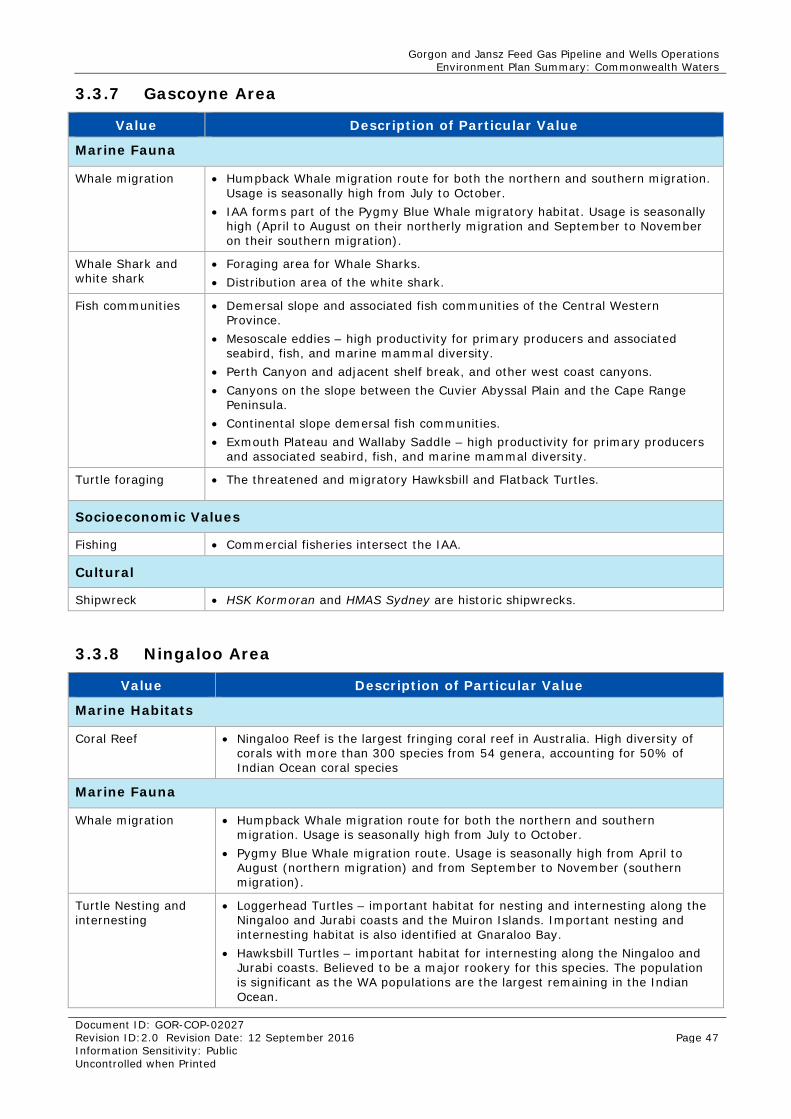
Gorgon and Jansz Feed Gas Pipeline and Wells Operations Environment Plan Summary: Commonwealth Waters
Document ID: GOR-COP-02027 Revision ID:2.0 Revision Date: 12 September 2016 Page 47 Information Sensitivity: Public Uncontrolled when Printed
3.3.7 Gascoyne Area
Value Description of Particular Value
Marine Fauna
Whale migration • Humpback Whale migration route for both the northern and southern migration. Usage is seasonally high from July to October.
• IAA forms part of the Pygmy Blue Whale migratory habitat. Usage is seasonally high (April to August on their northerly migration and September to November on their southern migration).
Whale Shark and white shark
• Foraging area for Whale Sharks. • Distribution area of the white shark.
Fish communities • Demersal slope and associated fish communities of the Central Western Province.
• Mesoscale eddies – high productivity for primary producers and associated seabird, fish, and marine mammal diversity.
• Perth Canyon and adjacent shelf break, and other west coast canyons. • Canyons on the slope between the Cuvier Abyssal Plain and the Cape Range
Peninsula. • Continental slope demersal fish communities. • Exmouth Plateau and Wallaby Saddle – high productivity for primary producers
and associated seabird, fish, and marine mammal diversity.
Turtle foraging • The threatened and migratory Hawksbill and Flatback Turtles.
Socioeconomic Values
Fishing • Commercial fisheries intersect the IAA.
Cultural
Shipwreck • HSK Kormoran and HMAS Sydney are historic shipwrecks.
3.3.8 Ningaloo Area
Value Description of Particular Value
Marine Habitats
Coral Reef • Ningaloo Reef is the largest fringing coral reef in Australia. High diversity of corals with more than 300 species from 54 genera, accounting for 50% of Indian Ocean coral species
Marine Fauna
Whale migration • Humpback Whale migration route for both the northern and southern migration. Usage is seasonally high from July to October.
• Pygmy Blue Whale migration route. Usage is seasonally high from April to August (northern migration) and from September to November (southern migration).
Turtle Nesting and internesting
• Loggerhead Turtles – important habitat for nesting and internesting along the Ningaloo and Jurabi coasts and the Muiron Islands. Important nesting and internesting habitat is also identified at Gnaraloo Bay.
• Hawksbill Turtles – important habitat for internesting along the Ningaloo and Jurabi coasts. Believed to be a major rookery for this species. The population is significant as the WA populations are the largest remaining in the Indian Ocean.
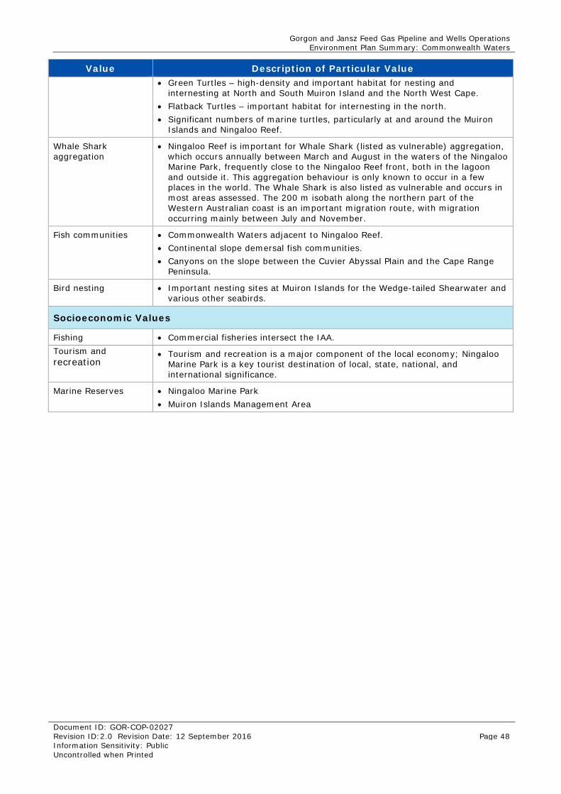
Gorgon and Jansz Feed Gas Pipeline and Wells Operations Environment Plan Summary: Commonwealth Waters
Document ID: GOR-COP-02027 Revision ID:2.0 Revision Date: 12 September 2016 Page 48 Information Sensitivity: Public Uncontrolled when Printed
Value Description of Particular Value • Green Turtles – high-density and important habitat for nesting and
internesting at North and South Muiron Island and the North West Cape. • Flatback Turtles – important habitat for internesting in the north. • Significant numbers of marine turtles, particularly at and around the Muiron
Islands and Ningaloo Reef.
Whale Shark aggregation
• Ningaloo Reef is important for Whale Shark (listed as vulnerable) aggregation, which occurs annually between March and August in the waters of the Ningaloo Marine Park, frequently close to the Ningaloo Reef front, both in the lagoon and outside it. This aggregation behaviour is only known to occur in a few places in the world. The Whale Shark is also listed as vulnerable and occurs in most areas assessed. The 200 m isobath along the northern part of the Western Australian coast is an important migration route, with migration occurring mainly between July and November.
Fish communities • Commonwealth Waters adjacent to Ningaloo Reef. • Continental slope demersal fish communities. • Canyons on the slope between the Cuvier Abyssal Plain and the Cape Range
Peninsula.
Bird nesting • Important nesting sites at Muiron Islands for the Wedge-tailed Shearwater and various other seabirds.
Socioeconomic Values
Fishing • Commercial fisheries intersect the IAA. Tourism and recreation
• Tourism and recreation is a major component of the local economy; Ningaloo Marine Park is a key tourist destination of local, state, national, and international significance.
Marine Reserves • Ningaloo Marine Park • Muiron Islands Management Area
Gorgon and Jansz Feed Gas Pipeline and Wells Operations Environment Plan Summary: Commonwealth Waters
Document ID: GOR-COP-02027 Revision ID:2.0 Revision Date: 12 September 2016 Page 49 Information Sensitivity: Public Uncontrolled when Printed
4.0 Environmental Risk Assessment Methodology In accordance with Division 2.3, Regulation 13(5) of the OPGGS(E)R, an environmental risk assessment was undertaken to evaluate impacts and risks arising from the activities described in Section 2.0.
The risk assessment for the EP was undertaken in accordance with the Chevron Australia Health, Environment, and Safety (HES) Risk Management Process (OE-03.01.01) using the Chevron Integrated Risk Prioritization Matrix (Figure 4-1). The approach generally aligns with the processes outlined in ISO 31000:2009 Risk Management – Principles and Guidelines (Standards Australia/Standards New Zealand 2009) and Handbook 203:2012 Managing Environment-related Risk (Standards Australia/Standards New Zealand 2012).
The risk assessment process and evaluation involved numerous consultations and workshops with environmental, health, safety, project, and emergency response personnel, pipeline integrity engineers, subsea engineers, and a marine supervisor. Risks considered and covered in the EP were identified and informed by:
• experience gained during previous stages of the project
• experience of Chevron Australia personnel involved in operations
• stakeholder engagement (Section 8.0).
• RISK: The HES Risk Management Process (OE-03.01.01) defines risk as the combination of the potential consequences arising from a specified hazard together with the likelihood of the hazard actually resulting in an unwanted event.
4.1 Identification and Description of the Petroleum Activity All components of the Petroleum Activity and potential emergency conditions relevant to the scope of the EP are described in detail in Sections 2.0 and 6.1 respectively.
An emergency condition (Section 6.1) is defined as:
• an event that has the potential to result in an environmental consequence level of 3 or below (Major to Catastrophic), or
• an event that has the potential to result in an environmental consequence level of 4 and above (Moderate to Incidental), but requires a coordinated response to implement response options as described in Table 6-3 to manage any potential resulting impacts and risks.
Emergency response activities are control measures that are planned to be implemented in an emergency condition. These control measures have been evaluated by emergency response personnel and environmental specialists to identify their suitability in responding to the emergency conditions associated with the petroleum activity.
4.2 Identification of Particular Environmental Values As both a loss of well control and a major defect were defined as the emergency conditions for the petroleum activity, spill modelling was undertaken (as described in detail in Section 6.1 and 6.2) to identify the worst-case EMBA associated with the petroleum activity. Within the EMBA, the environment was described (Section 3.0) and the particular environmental values and sensitivities of specific locations were identified. In accordance with Regulation 13(3) of the OPGGS(E)R, the particular values and sensitivities were identified as:
(a) the world heritage values of a declared World Heritage property within the meaning of the EPBC Act
Gorgon and Jansz Feed Gas Pipeline and Wells Operations Environment Plan Summary: Commonwealth Waters
Document ID: GOR-COP-02027 Revision ID:2.0 Revision Date: 12 September 2016 Page 50 Information Sensitivity: Public Uncontrolled when Printed
(b) the national heritage values of a National Heritage place within the meaning of that Act
(c) the ecological character of a declared Ramsar wetland within the meaning of that Act
(d) the presence of a listed threatened species or listed threatened ecological community within the meaning of that Act
(e) the presence of a listed migratory species within the meaning of that Act
(f) any values and sensitivities that exist in, or in relation to, part or all of:
(i) a Commonwealth marine area within the meaning of that Act, or
(ii) Commonwealth land within the meaning of that Act.
Because a large number of species have the potential to be present within the EMBA, the identification of values and sensitivities, based upon (d) and (e) above, focuses on BIAs for these species where there is the potential for aggregation of listed species not just transient individuals.
4.3 Identification of Relevant Aspects
ASPECT: The Chevron Australian Business Unit (ABU) Environmental Stewardship Standardised OE Process (OE-07.01.02) defines an aspect as an element of Chevron’s activities, products, or services related to an operation that has the potential to interact with the environment at present or later (e.g. wastewater discharge, greenhouse gas emission, legacy environmental obligations).
Following the description of the Petroleum Activity and associated emergency conditions and emergency response activities, an assessment was undertaken to identify potential interactions between the petroleum activity and the receiving environment. The outcomes of stakeholder consultation also contributed to this scoping process.
Note: Potential interactions with safety, health, and assets is outside the scope of the EP.
These potential interactions, or aspects, were categorised for use in the risk assessment of this Petroleum Activity:
• seabed disturbance
• invasive marine pests (IMPs)
• planned discharges
• leaks and spills.
4.4 Identification of Relevant Environmental Hazards HAZARD: The Chevron HES Risk Management Process (OE-03.01.01) defines a hazard as a chemical or physical condition that has the potential for causing damage or injury to people, property, or the environment.
The aspects identified were used in the scoping process to determine environmental hazards associated with the Petroleum Activity that had the potential to cause environment damage. This information was then used to undertake an environmental risk assessment.
4.5 Evaluation of Impacts and Risk 4.5.1 Consequence
After identification of the potential hazards, the potential consequences were assessed and evaluated. Consequence is defined using Chevron Corporation’s Integrated Risk
Gorgon and Jansz Feed Gas Pipeline and Wells Operations Environment Plan Summary: Commonwealth Waters
Document ID: GOR-COP-02027 Revision ID:2.0 Revision Date: 12 September 2016 Page 51 Information Sensitivity: Public Uncontrolled when Printed
Prioritization Matrix (Figure 4-1). The level of consequence is determined by the potential level of impact based on:
• the spatial scale or extent of potential hazards of the environmental aspect within the receiving environment
• the nature of the receiving environment (from Section 3.0) (within the spatial extent), including proximity to sensitive receptors, relative importance, and sensitivity or resilience to change
• the impact mechanisms (cause and effect) of the environmental hazard within the receiving environment (e.g. persistence, toxicity, mobility, bioaccumulation potential)
• the duration and frequency of potential effects and time for recovery
• the potential degree of change relative to the existing environment or to criteria of acceptability (cross referenced with Chevron Corporation’s Integrated Risk Prioritization Matrix Figure 4-1).
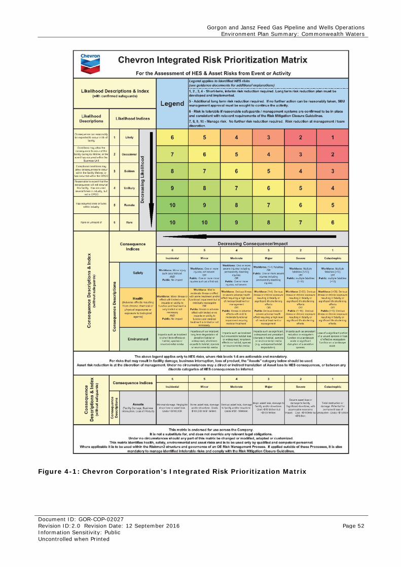
Gorgon and Jansz Feed Gas Pipeline and Wells Operations Environment Plan Summary: Commonwealth Waters
Document ID: GOR-COP-02027 Revision ID:2.0 Revision Date: 12 September 2016 Page 52 Information Sensitivity: Public Uncontrolled when Printed
Figure 4-1: Chevron Corporation’s Integrated Risk Prioritization Matrix
Gorgon and Jansz Feed Gas Pipeline and Wells Operations Environment Plan Summary: Commonwealth Waters
Document ID: GOR-COP-02027 Revision ID:2.0 Revision Date: 12 September 2016 Page 53 Information Sensitivity: Public Uncontrolled when Printed
4.5.2 Control Measures and ALARP Control measures were identified for each hazard with the aim of eliminating the hazard, or minimising the risk to as low as reasonably practicable (ALARP). The ALARP principle recognises that no industrial activity is entirely risk-free. However, to ensure that all risks and impacts associated with the Petroleum Activity are reduced to ALARP, Chevron’s hierarchy of control was used to determine the control measures that could be practicably implemented and those that could not.
The hierarchy of control is:
• eliminate the hazard
• substitute the hazard
• engineer to change design, install a physical barrier, or isolate
• administrative – establish a procedure, training, or instruction
Where it is demonstrated that the ‘cost’ of implementing further control measures is disproportionate to the benefit gained, the control measure will not be implemented, and the risk is considered ALARP. ‘Cost’ includes financial cost, time or duration, effort, occupational health and safety risks, or environmental impacts associated with implementing the control.
Although the control measures considered to not be reasonably practicable are not included for implementation, they are described throughout the evaluations to demonstrate why they cannot be practicably implemented and to demonstrate that all impacts and risks are ALARP.
4.5.3 Likelihood The likelihood (probability) of a defined consequence occurring was determined, taking into account the control measures in place. The likelihood of a particular consequence occurring was identified using one of the six likelihood categories shown in Figure 4-1.
4.5.4 Quantification of the Level of Risk The Chevron Corporation Integrated Risk Prioritization Matrix (Figure 4-1) was applied during an Environmental Risk Assessment Workshop for the Petroleum Activity. This matrix uses consequence and likelihood rankings of 1 to 6, which when combined, result in a risk level between 1 (highest risk) and 10 (lowest risk). Risk assessment outcomes are based solely on assessment of risk to the environment (as defined under the OPGGS(E)R. Risk to company reputation, regulatory compliance, stakeholder expectations, or community relationships were considered but not risk assessed.
4.6 Risk Acceptance Criteria Impacts and risks are only deemed acceptable once all reasonably practicable alternatives and additional measures have been taken to reduce the potential consequence and likelihood to ALARP.
Chevron has determined that risk rankings of 4 or fewer are too significant to proceed without the implementation of additional control measures to reduce the likelihood of the consequence occurring, and thus reduce the risk ranking. A risk level of 5 is acceptable only if it can be demonstrated that the risk has been reduced to ALARP and Chevron management approval has been granted.
The environmental impacts and risks associated with implementing the Petroleum Activity described in the EP were determined to be acceptable if:
• the level of environmental risk is assessed to be between 6 and 10 on the risk matrix, or
• the level of environmental risk is assessed to be ALARP
Gorgon and Jansz Feed Gas Pipeline and Wells Operations Environment Plan Summary: Commonwealth Waters
Document ID: GOR-COP-02027 Revision ID:2.0 Revision Date: 12 September 2016 Page 54 Information Sensitivity: Public Uncontrolled when Printed
• the activity (and associated potential impacts and risks) complies with relevant legislation, industry standards/guidelines, and corporate policies, standards, and procedures specific to the operational environment.
4.7 Environmental Performance Outcomes, Standards, and Measurement Criteria In accordance with Regulation 4 of the OPGGS(E)R, environmental performance outcomes, performance standards, and measurement criteria were defined to address the potential environmental impacts and risks identified during the risk assessment.
Chevron defines environmental performance outcomes, standards, and measurement criteria that relate to the management of the identified environmental risks as:
• Environmental Performance Outcomes are the level of performance in managing the potential environmental impacts and environmental risks from each Petroleum Activity, emergency condition, and emergency response activity.
• Environmental Performance Standards are measureable statements of performance of a system, item of equipment, person, or procedure that are used to manage environmental impacts and risks for the duration of the Petroleum Activity.
• Measurement Criteria are compliance and assurance statements that detail how performance standards are implemented and are used to determine whether the outcomes and standards have been met and whether the implementation strategy has been complied with. Where no practicable quantitative target exists, a qualitative target is set and used to measure whether an outcome and standard has been met.
If an emergency condition occurs where human safety is at risk, the performance outcomes, standards, and measurement criteria described in the EP may not be implemented. In the event of an offshore emergency condition, the International Convention for the Safety of Life at Sea (SOLAS) 1974 may take precedence.
Gorgon and Jansz Feed Gas Pipeline and Wells Operations Environment Plan Summary: Commonwealth Waters
Document ID: GOR-COP-02027 Revision ID:2.0 Revision Date: 12 September 2016 Page 55 Information Sensitivity: Public Uncontrolled when Printed
5.0 Environmental Risk Assessment and Management Strategy – Petroleum Activity To meet the requirements of the OPGGS(E)R, Division 2.3, Regulation 13(5) and (6), Evaluation of environmental impacts and risks and Regulation 13(7) Environmental performance outcomes and standards, this Section evaluates the impacts and risks associated with the petroleum activity appropriate to the nature and scale of each impact and risk, and details the control measures that will be used to reduce the potential impacts and risks to ALARP and an acceptable level.
The assessment covers these petroleum activity groups:
• Commissioning and Start-up (Section 5.1)
• Operations (Section 5.2)
• IMR (Section 5.3).
Vessel operations are associated with each of these activity groups and are evaluated separately in Section 5.3.3.
5.1 Commissioning and Start-up An evaluation of the activities associated with commissioning and start-up determined that there are no environmental aspects with the potential to cause environmental damage to particular values and sensitivities as identified in Section 3.0. This determination is based upon the nature and scale of the activities, the location in which they are being undertaken and the lack of sensitive receptors as listed in Section 3.0 with the potential to be exposed to the activity.
5.2 Operations In accordance with Section 4.0, the environmental aspects identified during operations with the potential to cause environmental damage are:
• planned discharges
• leaks and spills.
5.2.1 Planned Discharges – Risk Assessment Planned discharges during operations are associated with the operation of subsea electrohydraulic control and monitoring systems (valve actuations) and through the additional supply of production chemicals into the field, if required. These discharges are expected to include:
• hydraulic control fluid from valve actuations (a few litres per actuation, estimated at 30 m3 per system annually )
• hydraulic spacer fluid (use of chemical cores in umbilical’s for additional supply of production chemicals), estimated at approximately 20 m3 per discharge.
An evaluation of the potential impacts and risks associated with discharges from valve actuations identified that changes to water quality did not present a hazard to marine fauna. These discharges are distributed across the production manifolds and christmas trees in water depths greater than 199 m in the Gorgon field and 1300 m in the Jansz–Io field (Figure 2-1). These discharges are not continuous (but frequent) and are small in volume, and thus are expected to rapidly disperse and dilute upon discharge. Therefore, they are not expected to have a net environmental effect on identified values and sensitivities. However, this discharge has been further evaluated to consider potential accumulative affects to ensure an appropriate level of conservatism is built into the evaluation.
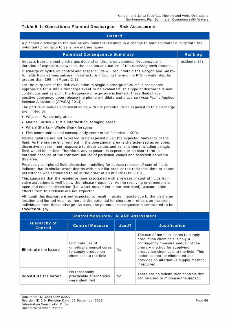
Gorgon and Jansz Feed Gas Pipeline and Wells Operations Environment Plan Summary: Commonwealth Waters
Document ID: GOR-COP-02027 Revision ID:2.0 Revision Date: 12 September 2016 Page 56 Information Sensitivity: Public Uncontrolled when Printed
Table 5-1: Operations: Planned Discharges – Risk Assessment
Hazard
A planned discharge to the marine environment resulting in a change to ambient water quality with the potential for impacts to sensitive marine fauna.
Potential Consequence Summary Ranking
Impacts from planned discharges depend on discharge volumes, frequency, and duration of exposure, as well as the location and nature of the receiving environment. Discharge of hydraulic control and spacer fluids will occur within the Gorgon and Jansz–Io fields from various subsea infrastructure including the midline PTS in water depths greater than 199 m (Figure 2-1). For the purposes of the risk evaluation, a single discharge of 20 m3 is considered appropriate for a single discharge event to be evaluated. This type of discharge is non-continuous and as such, the frequency of exposure is limited. These fluids have positive buoyancy, upon release the plume will dilute and disperse (Asia-Pacific Applied Science Associates [APASA] 2014). The particular values and sensitivities with the potential to be exposed to this discharge are limited to: • Whales – Whale migration • Marine Turtles – Turtle internesting, foraging areas • Whale Sharks – Whale Shark foraging • Fish communities and consequently commercial fisheries – KEFs. Marine habitats are not expected to be exposed given the expected buoyancy of the fluid. As the marine environment in the operational area is characterised as an open, dispersive environment, exposure to these values and sensitivities (including pelagic fish) would be limited. Therefore, any exposure is expected to be short term in duration because of the transient nature of particular values and sensitivities within this area. Previously completed fluid dispersion modelling for subsea releases of control fluids indicate that in similar water depths with a similar product the residence time or plume persistence was estimated to be in the order of 18 minutes (BP 2013). This suggests that the residence time associated with a release of control fluids from valve actuations is well below the release frequency. As the receiving environment is open and enables dispersion (i.e. water movement is not restricted), accumulation effects from this release are not expected. Although this discharge is not expected to result in acute impacts due to the discharge location and limited volume, there is the potential for short-term effects on transient individuals from this discharge. As such, the potential consequence is considered to be Incidental (6).
Incidental (6)
Control Measures / ALARP Assessment
Hierarchy of Control Control Measure Used? Justification
Eliminate the hazard
Eliminate use of umbilical chemical cores to supply production chemicals to the field
No
The use of umbilical cores to supply production chemicals is only a contingency measure and is not the primary method for supplying production chemicals to the field. This option cannot be eliminated as it provides an alternative supply method, if required.
Substitute the hazard No reasonably practicable alternatives were identified
No There are no substitution controls that can be used to minimise the impact.
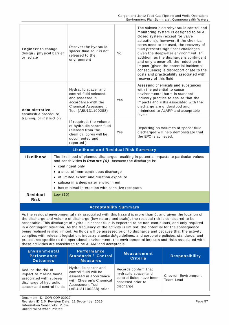
Gorgon and Jansz Feed Gas Pipeline and Wells Operations Environment Plan Summary: Commonwealth Waters
Document ID: GOR-COP-02027 Revision ID:2.0 Revision Date: 12 September 2016 Page 57 Information Sensitivity: Public Uncontrolled when Printed
Engineer to change design / physical barrier or isolate
Recover the hydraulic spacer fluid so it is not released to the environment
No
The subsea electrohydraulic control and monitoring system is designed to be a closed system (except for valve actuations); however, if the chemical cores need to be used, the recovery of fluid presents significant challenges given the deepwater environment. In addition, as the discharge is contingent and only a once-off, the reduction in impact (given the potential incidental consequence) is disproportionate to the costs and practicability associated with recovery of this fluid.
Administrative – establish a procedure, training, or instruction
Hydraulic spacer and control fluid selected and assessed in accordance with the Chemical Assessment Tool (ABU131100288)
Yes
Assessing chemicals and substances with the potential to cause environmental harm is standard industry practice to ensure that the impacts and risks associated with the discharge are understood and minimised to ALARP and acceptable levels.
If required, the volume of hydraulic spacer fluid released from the chemical cores will be documented and reported )
Yes Reporting on volumes of spacer fluid discharged will help demonstrate that the EPO is achieved.
Likelihood and Residual Risk Summary
Likelihood The likelihood of planned discharges resulting in potential impacts to particular values and sensitivities is Remote (5), because the discharge is: • contingent only • a once-off non-continuous discharge • of limited extent and duration exposure • subsea in a deepwater environment • has minimal interaction with sensitive receptors
Residual Risk
Low (10)
Acceptability Summary
As the residual environmental risk associated with this hazard is more than 6, and given the location of the discharge and volume of discharge (low nature and scale), the residual risk is considered to be acceptable. This discharge of hydraulic spacer fluid is expected to be non-continuous, and only required in a contingent situation. As the frequency of the activity is limited, the potential for the consequence being realised is also limited. As fluids will be assessed prior to discharge and because that the activity complies with relevant legislation, industry standards/guidelines, and corporate policies, standards, and procedures specific to the operational environment, the environmental impacts and risks associated with these activities are considered to be ALARP and acceptable.
Environmental Performance
Outcomes
Performance Standards / Control
Measures
Measurement Criteria Responsibility
Reduce the risk of impact to marine fauna associated with subsea discharge of hydraulic spacer and control fluids
Hydraulic spacer and control fluid will be assessed in accordance with Chevron’s Chemical Assessment Tool (ABU131100288) prior
Records confirm that hydraulic spacer and control fluids have been assessed prior to discharge
Chevron Environment Team Lead
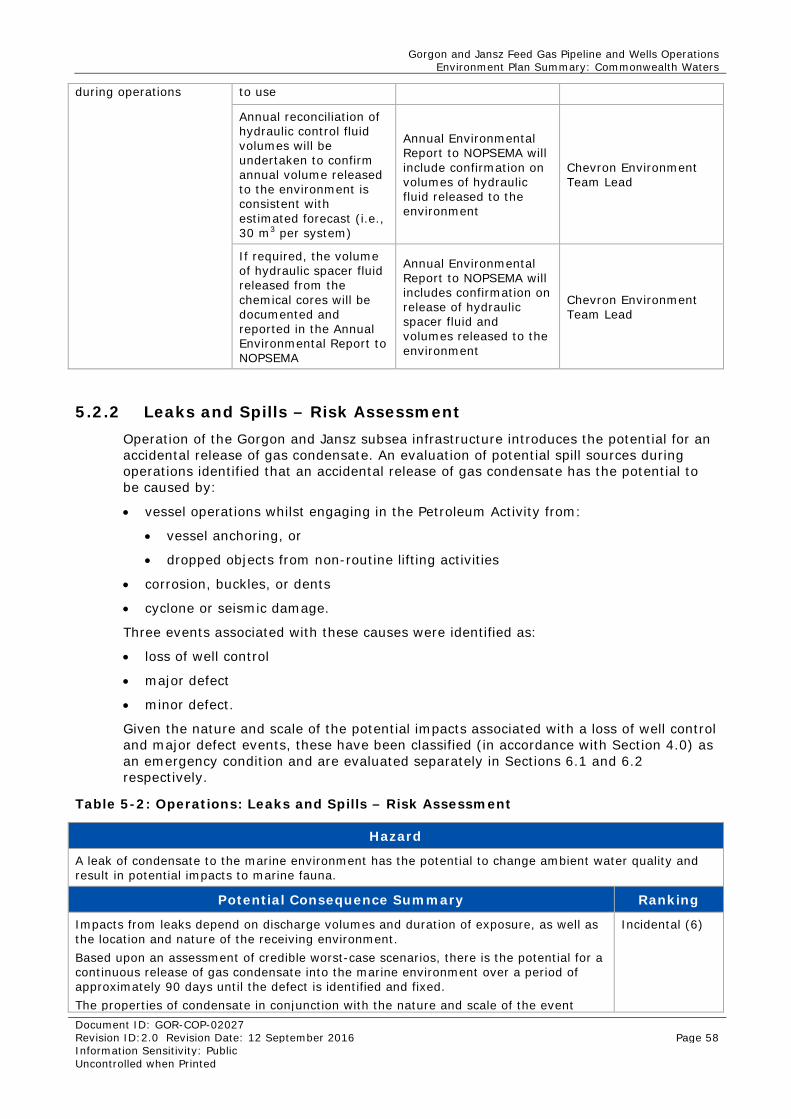
Gorgon and Jansz Feed Gas Pipeline and Wells Operations Environment Plan Summary: Commonwealth Waters
Document ID: GOR-COP-02027 Revision ID:2.0 Revision Date: 12 September 2016 Page 58 Information Sensitivity: Public Uncontrolled when Printed
during operations to use
Annual reconciliation of hydraulic control fluid volumes will be undertaken to confirm annual volume released to the environment is consistent with estimated forecast (i.e., 30 m3 per system)
Annual Environmental Report to NOPSEMA will include confirmation on volumes of hydraulic fluid released to the environment
Chevron Environment Team Lead
If required, the volume of hydraulic spacer fluid released from the chemical cores will be documented and reported in the Annual Environmental Report to NOPSEMA
Annual Environmental Report to NOPSEMA will includes confirmation on release of hydraulic spacer fluid and volumes released to the environment
Chevron Environment Team Lead
5.2.2 Leaks and Spills – Risk Assessment Operation of the Gorgon and Jansz subsea infrastructure introduces the potential for an accidental release of gas condensate. An evaluation of potential spill sources during operations identified that an accidental release of gas condensate has the potential to be caused by:
• vessel operations whilst engaging in the Petroleum Activity from:
• vessel anchoring, or
• dropped objects from non-routine lifting activities
• corrosion, buckles, or dents
• cyclone or seismic damage.
Three events associated with these causes were identified as:
• loss of well control
• major defect
• minor defect.
Given the nature and scale of the potential impacts associated with a loss of well control and major defect events, these have been classified (in accordance with Section 4.0) as an emergency condition and are evaluated separately in Sections 6.1 and 6.2 respectively.
Table 5-2: Operations: Leaks and Spills – Risk Assessment
Hazard
A leak of condensate to the marine environment has the potential to change ambient water quality and result in potential impacts to marine fauna.
Potential Consequence Summary Ranking
Impacts from leaks depend on discharge volumes and duration of exposure, as well as the location and nature of the receiving environment. Based upon an assessment of credible worst-case scenarios, there is the potential for a continuous release of gas condensate into the marine environment over a period of approximately 90 days until the defect is identified and fixed. The properties of condensate in conjunction with the nature and scale of the event
Incidental (6)
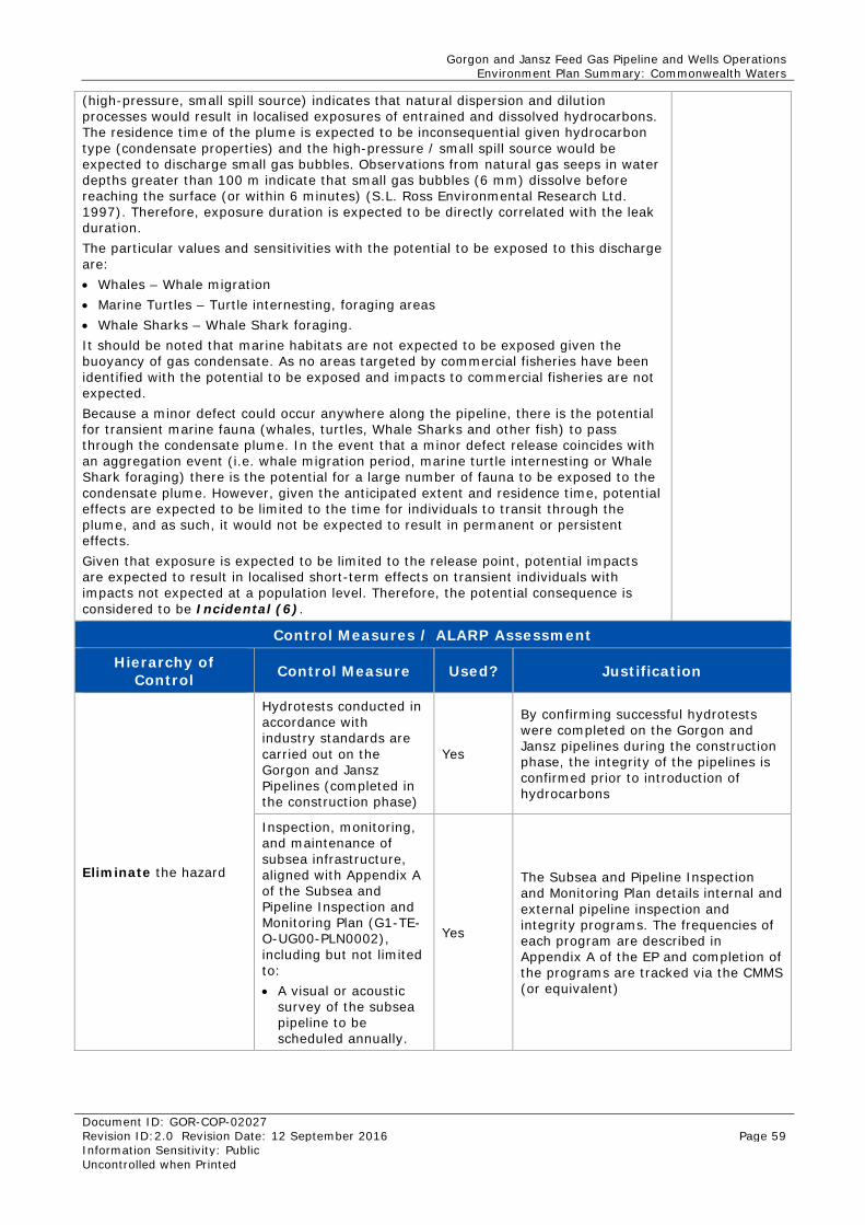
Gorgon and Jansz Feed Gas Pipeline and Wells Operations Environment Plan Summary: Commonwealth Waters
Document ID: GOR-COP-02027 Revision ID:2.0 Revision Date: 12 September 2016 Page 59 Information Sensitivity: Public Uncontrolled when Printed
(high-pressure, small spill source) indicates that natural dispersion and dilution processes would result in localised exposures of entrained and dissolved hydrocarbons. The residence time of the plume is expected to be inconsequential given hydrocarbon type (condensate properties) and the high-pressure / small spill source would be expected to discharge small gas bubbles. Observations from natural gas seeps in water depths greater than 100 m indicate that small gas bubbles (6 mm) dissolve before reaching the surface (or within 6 minutes) (S.L. Ross Environmental Research Ltd. 1997). Therefore, exposure duration is expected to be directly correlated with the leak duration. The particular values and sensitivities with the potential to be exposed to this discharge are: • Whales – Whale migration • Marine Turtles – Turtle internesting, foraging areas • Whale Sharks – Whale Shark foraging. It should be noted that marine habitats are not expected to be exposed given the buoyancy of gas condensate. As no areas targeted by commercial fisheries have been identified with the potential to be exposed and impacts to commercial fisheries are not expected. Because a minor defect could occur anywhere along the pipeline, there is the potential for transient marine fauna (whales, turtles, Whale Sharks and other fish) to pass through the condensate plume. In the event that a minor defect release coincides with an aggregation event (i.e. whale migration period, marine turtle internesting or Whale Shark foraging) there is the potential for a large number of fauna to be exposed to the condensate plume. However, given the anticipated extent and residence time, potential effects are expected to be limited to the time for individuals to transit through the plume, and as such, it would not be expected to result in permanent or persistent effects. Given that exposure is expected to be limited to the release point, potential impacts are expected to result in localised short-term effects on transient individuals with impacts not expected at a population level. Therefore, the potential consequence is considered to be Incidental (6).
Control Measures / ALARP Assessment
Hierarchy of Control Control Measure Used? Justification
Eliminate the hazard
Hydrotests conducted in accordance with industry standards are carried out on the Gorgon and Jansz Pipelines (completed in the construction phase)
Yes
By confirming successful hydrotests were completed on the Gorgon and Jansz pipelines during the construction phase, the integrity of the pipelines is confirmed prior to introduction of hydrocarbons
Inspection, monitoring, and maintenance of subsea infrastructure, aligned with Appendix A of the Subsea and Pipeline Inspection and Monitoring Plan (G1-TE-O-UG00-PLN0002), including but not limited to: • A visual or acoustic
survey of the subsea pipeline to be scheduled annually.
Yes
The Subsea and Pipeline Inspection and Monitoring Plan details internal and external pipeline inspection and integrity programs. The frequencies of each program are described in Appendix A of the EP and completion of the programs are tracked via the CMMS (or equivalent)

Gorgon and Jansz Feed Gas Pipeline and Wells Operations Environment Plan Summary: Commonwealth Waters
Document ID: GOR-COP-02027 Revision ID:2.0 Revision Date: 12 September 2016 Page 60 Information Sensitivity: Public Uncontrolled when Printed
Substitute the hazard No reasonably practicable alternatives were identified
No There are no substitution controls that can be used to minimise the impact.
Engineer to change design / physical barrier or isolate
A Flow Management Tool (FMT) is in place during operations to detect if the pipeline is leaking
Yes
The FMT detects changes in pressure. A reduction in flow and pressure would typically be detected by the FMT in less than a day; however, a small flow reduction trend (i.e. <5% reduction) may take up to two weeks to detect
Administrative – establish a procedure, training, or instruction
Contract will be in place for the procurement of pipe clamps for minor defects prior to commencement of operations
Yes Demonstration that prior to operations contracts to support the procurement of pipe clamps are in progress.
Ensure pipelines are identified on marine charts to minimise potential for anchoring within their proximity
Yes
By ensuring that pipelines are identified on the marine charts, there is less chance that vessels will anchor close to them, thus reducing the potential for anchor damage
Any anchoring will be undertaken in accordance with Section 9 of the ABU SCM Marine Operating Guideline(ABU-SSU-00340)
Yes
Chevron’s ABU SCM Marine Operating Guideline describes the minimum requirements for anchoring near subsea infrastructure
Risks of dropped objects will be managed by a Vessel Safety Case that will be submitted to, and accepted by, NOPSEMA before any activities under the EP involving marine vessels commence
Yes
Given that the vessel is not yet contracted, the vessel safety case, to be accepted by NOPSEMA will manage the risk of dropped objects.
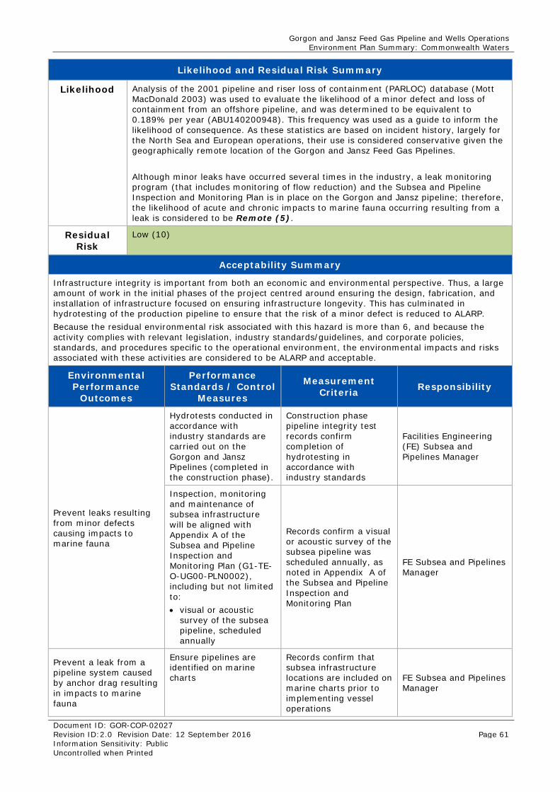
Gorgon and Jansz Feed Gas Pipeline and Wells Operations Environment Plan Summary: Commonwealth Waters
Document ID: GOR-COP-02027 Revision ID:2.0 Revision Date: 12 September 2016 Page 61 Information Sensitivity: Public Uncontrolled when Printed
Likelihood and Residual Risk Summary
Likelihood Analysis of the 2001 pipeline and riser loss of containment (PARLOC) database (Mott MacDonald 2003) was used to evaluate the likelihood of a minor defect and loss of containment from an offshore pipeline, and was determined to be equivalent to 0.189% per year (ABU140200948). This frequency was used as a guide to inform the likelihood of consequence. As these statistics are based on incident history, largely for the North Sea and European operations, their use is considered conservative given the geographically remote location of the Gorgon and Jansz Feed Gas Pipelines. Although minor leaks have occurred several times in the industry, a leak monitoring program (that includes monitoring of flow reduction) and the Subsea and Pipeline Inspection and Monitoring Plan is in place on the Gorgon and Jansz pipeline; therefore, the likelihood of acute and chronic impacts to marine fauna occurring resulting from a leak is considered to be Remote (5).
Residual Risk
Low (10)
Acceptability Summary
Infrastructure integrity is important from both an economic and environmental perspective. Thus, a large amount of work in the initial phases of the project centred around ensuring the design, fabrication, and installation of infrastructure focused on ensuring infrastructure longevity. This has culminated in hydrotesting of the production pipeline to ensure that the risk of a minor defect is reduced to ALARP. Because the residual environmental risk associated with this hazard is more than 6, and because the activity complies with relevant legislation, industry standards/guidelines, and corporate policies, standards, and procedures specific to the operational environment, the environmental impacts and risks associated with these activities are considered to be ALARP and acceptable.
Environmental Performance
Outcomes
Performance Standards / Control
Measures
Measurement Criteria Responsibility
Prevent leaks resulting from minor defects causing impacts to marine fauna
Hydrotests conducted in accordance with industry standards are carried out on the Gorgon and Jansz Pipelines (completed in the construction phase).
Construction phase pipeline integrity test records confirm completion of hydrotesting in accordance with industry standards
Facilities Engineering (FE) Subsea and Pipelines Manager
Inspection, monitoring and maintenance of subsea infrastructure will be aligned with Appendix A of the Subsea and Pipeline Inspection and Monitoring Plan (G1-TE-O-UG00-PLN0002), including but not limited to: • visual or acoustic
survey of the subsea pipeline, scheduled annually
Records confirm a visual or acoustic survey of the subsea pipeline was scheduled annually, as noted in Appendix A of the Subsea and Pipeline Inspection and Monitoring Plan
FE Subsea and Pipelines Manager
Prevent a leak from a pipeline system caused by anchor drag resulting in impacts to marine fauna
Ensure pipelines are identified on marine charts
Records confirm that subsea infrastructure locations are included on marine charts prior to implementing vessel operations
FE Subsea and Pipelines Manager
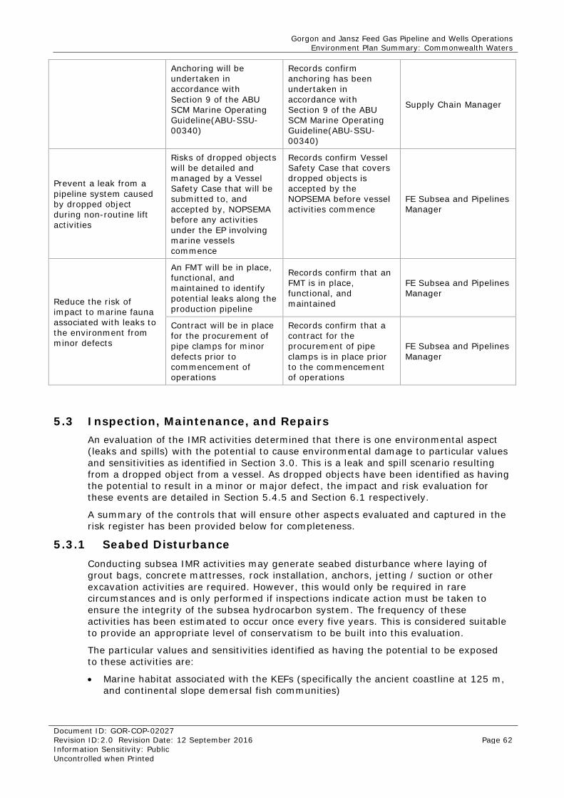
Gorgon and Jansz Feed Gas Pipeline and Wells Operations Environment Plan Summary: Commonwealth Waters
Document ID: GOR-COP-02027 Revision ID:2.0 Revision Date: 12 September 2016 Page 62 Information Sensitivity: Public Uncontrolled when Printed
Anchoring will be undertaken in accordance with Section 9 of the ABU SCM Marine Operating Guideline(ABU-SSU-00340)
Records confirm anchoring has been undertaken in accordance with Section 9 of the ABU SCM Marine Operating Guideline(ABU-SSU-00340)
Supply Chain Manager
Prevent a leak from a pipeline system caused by dropped object during non-routine lift activities
Risks of dropped objects will be detailed and managed by a Vessel Safety Case that will be submitted to, and accepted by, NOPSEMA before any activities under the EP involving marine vessels commence
Records confirm Vessel Safety Case that covers dropped objects is accepted by the NOPSEMA before vessel activities commence
FE Subsea and Pipelines Manager
Reduce the risk of impact to marine fauna associated with leaks to the environment from minor defects
An FMT will be in place, functional, and maintained to identify potential leaks along the production pipeline
Records confirm that an FMT is in place, functional, and maintained
FE Subsea and Pipelines Manager
Contract will be in place for the procurement of pipe clamps for minor defects prior to commencement of operations
Records confirm that a contract for the procurement of pipe clamps is in place prior to the commencement of operations
FE Subsea and Pipelines Manager
5.3 Inspection, Maintenance, and Repairs An evaluation of the IMR activities determined that there is one environmental aspect (leaks and spills) with the potential to cause environmental damage to particular values and sensitivities as identified in Section 3.0. This is a leak and spill scenario resulting from a dropped object from a vessel. As dropped objects have been identified as having the potential to result in a minor or major defect, the impact and risk evaluation for these events are detailed in Section 5.4.5 and Section 6.1 respectively.
A summary of the controls that will ensure other aspects evaluated and captured in the risk register has been provided below for completeness.
5.3.1 Seabed Disturbance Conducting subsea IMR activities may generate seabed disturbance where laying of grout bags, concrete mattresses, rock installation, anchors, jetting / suction or other excavation activities are required. However, this would only be required in rare circumstances and is only performed if inspections indicate action must be taken to ensure the integrity of the subsea hydrocarbon system. The frequency of these activities has been estimated to occur once every five years. This is considered suitable to provide an appropriate level of conservatism to be built into this evaluation.
The particular values and sensitivities identified as having the potential to be exposed to these activities are:
• Marine habitat associated with the KEFs (specifically the ancient coastline at 125 m, and continental slope demersal fish communities)
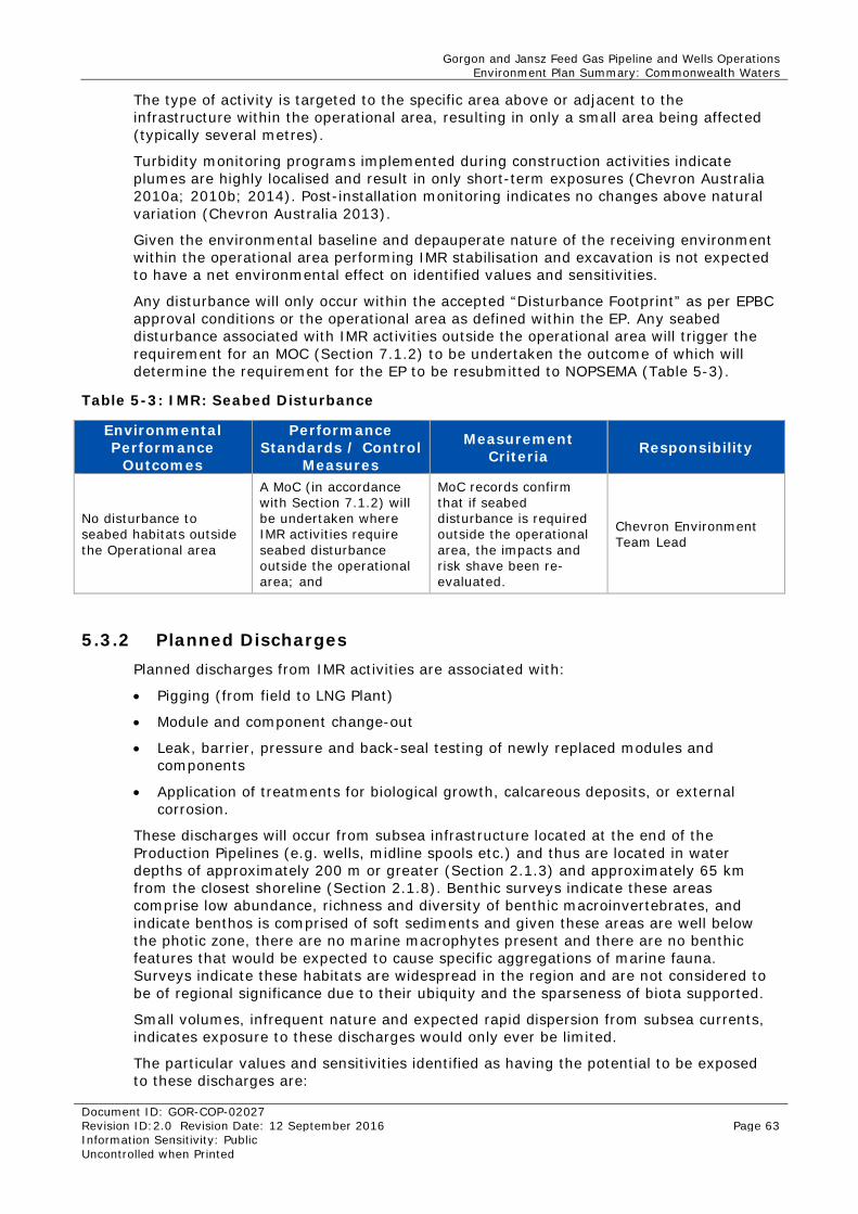
Gorgon and Jansz Feed Gas Pipeline and Wells Operations Environment Plan Summary: Commonwealth Waters
Document ID: GOR-COP-02027 Revision ID:2.0 Revision Date: 12 September 2016 Page 63 Information Sensitivity: Public Uncontrolled when Printed
The type of activity is targeted to the specific area above or adjacent to the infrastructure within the operational area, resulting in only a small area being affected (typically several metres).
Turbidity monitoring programs implemented during construction activities indicate plumes are highly localised and result in only short-term exposures (Chevron Australia 2010a; 2010b; 2014). Post-installation monitoring indicates no changes above natural variation (Chevron Australia 2013).
Given the environmental baseline and depauperate nature of the receiving environment within the operational area performing IMR stabilisation and excavation is not expected to have a net environmental effect on identified values and sensitivities.
Any disturbance will only occur within the accepted “Disturbance Footprint” as per EPBC approval conditions or the operational area as defined within the EP. Any seabed disturbance associated with IMR activities outside the operational area will trigger the requirement for an MOC (Section 7.1.2) to be undertaken the outcome of which will determine the requirement for the EP to be resubmitted to NOPSEMA (Table 5-3).
Table 5-3: IMR: Seabed Disturbance
Environmental Performance
Outcomes
Performance Standards / Control
Measures
Measurement Criteria Responsibility
No disturbance to seabed habitats outside the Operational area
A MoC (in accordance with Section 7.1.2) will be undertaken where IMR activities require seabed disturbance outside the operational area; and
MoC records confirm that if seabed disturbance is required outside the operational area, the impacts and risk shave been re-evaluated.
Chevron Environment Team Lead
5.3.2 Planned Discharges Planned discharges from IMR activities are associated with:
• Pigging (from field to LNG Plant)
• Module and component change-out
• Leak, barrier, pressure and back-seal testing of newly replaced modules and components
• Application of treatments for biological growth, calcareous deposits, or external corrosion.
These discharges will occur from subsea infrastructure located at the end of the Production Pipelines (e.g. wells, midline spools etc.) and thus are located in water depths of approximately 200 m or greater (Section 2.1.3) and approximately 65 km from the closest shoreline (Section 2.1.8). Benthic surveys indicate these areas comprise low abundance, richness and diversity of benthic macroinvertebrates, and indicate benthos is comprised of soft sediments and given these areas are well below the photic zone, there are no marine macrophytes present and there are no benthic features that would be expected to cause specific aggregations of marine fauna. Surveys indicate these habitats are widespread in the region and are not considered to be of regional significance due to their ubiquity and the sparseness of biota supported.
Small volumes, infrequent nature and expected rapid dispersion from subsea currents, indicates exposure to these discharges would only ever be limited.
The particular values and sensitivities identified as having the potential to be exposed to these discharges are:
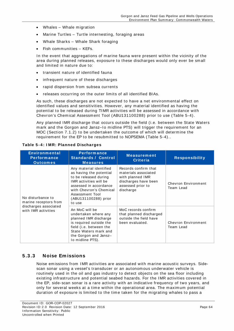
Gorgon and Jansz Feed Gas Pipeline and Wells Operations Environment Plan Summary: Commonwealth Waters
Document ID: GOR-COP-02027 Revision ID:2.0 Revision Date: 12 September 2016 Page 64 Information Sensitivity: Public Uncontrolled when Printed
• Whales – Whale migration
• Marine Turtles – Turtle internesting, foraging areas
• Whale Sharks – Whale Shark foraging
• Fish communities – KEFs.
In the event that aggregations of marine fauna were present within the vicinity of the area during planned releases, exposure to these discharges would only ever be small and limited in nature due to:
• transient nature of identified fauna
• infrequent nature of these discharges
• rapid dispersion from subsea currents
• releases occurring on the outer limits of all identified BIAs.
As such, these discharges are not expected to have a net environmental effect on identified values and sensitivities. However, any material identified as having the potential to be released during TIMR activities will be assessed in accordance with Chevron’s Chemical Assessment Tool (ABU131100288) prior to use (Table 5-4).
Any planned IMR discharge that occurs outside the field (i.e. between the State Waters mark and the Gorgon and Jansz–Io midline PTS) will trigger the requirement for an MOC (Section 7.1.2) to be undertaken the outcome of which will determine the requirement for the EP to be resubmitted to NOPSEMA (Table 5-4)..
Table 5-4: IMR: Planned Discharges
Environmental Performance
Outcomes
Performance Standards / Control
Measures
Measurement Criteria Responsibility
No disturbance to marine receptors from discharges associated with IMR activities
Any material identified as having the potential to be released during IMR activities will be assessed in accordance with Chevron’s Chemical Assessment Tool (ABU131100288) prior to use
Records confirm that materials associated with planned IMR discharges have been assessed prior to discharge
Chevron Environment Team Lead
An MoC will be undertaken where any planned IMR discharge is required outside the field (i.e. between the State Waters mark and the Gorgon and Jansz–Io midline PTS).
MoC records confirm that planned discharged outside the field have been evaluated. Chevron Environment
Team Lead
5.3.3 Noise Emissions Noise emissions from IMR activities are associated with marine acoustic surveys. Side-scan sonar using a vessel’s transducer or an autonomous underwater vehicle is routinely used in the oil and gas industry to detect objects on the sea floor including existing infrastructure and potential seabed hazards. For the IMR activities covered in the EP, side-scan sonar is a rare activity with an indicative frequency of two years, and only for several weeks at a time within the operational area. The maximum potential duration of exposure is limited to the time taken for the migrating whales to pass a
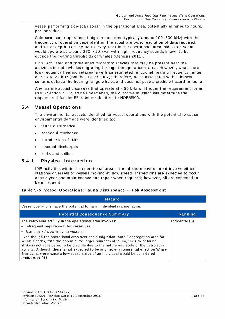
Gorgon and Jansz Feed Gas Pipeline and Wells Operations Environment Plan Summary: Commonwealth Waters
Document ID: GOR-COP-02027 Revision ID:2.0 Revision Date: 12 September 2016 Page 65 Information Sensitivity: Public Uncontrolled when Printed
vessel performing side-scan sonar in the operational area, potentially minutes to hours, per individual.
Side-scan sonar operates at high frequencies (typically around 100–500 kHz) with the frequency of operation dependent on the substrate type, resolution of data required, and water depth. For any IMR survey work in the operational area, side-scan sonar would operate at around 270–410 kHz, with high-frequency sounds known to be outside the hearing thresholds of whales (Genesis 2011).
EPBC Act listed and threatened migratory species that may be present near the activities include whales migrating through the operational area. However, whales are low-frequency hearing cetaceans with an estimated functional hearing frequency range of 7 Hz to 22 kHz (Southall et. al.2007); therefore, noise associated with side-scan sonar is outside the hearing range whales and does not pose a credible hazard to fauna.
Any marine acoustic surveys that operate at <50 kHz will trigger the requirement for an MOC (Section 7.1.2) to be undertaken, the outcome of which will determine the requirement for the EP to be resubmitted to NOPSEMA.
5.4 Vessel Operations The environmental aspects identified for vessel operations with the potential to cause environmental damage were identified as:
• fauna disturbance
• seabed disturbance
• introduction of IMPs
• planned discharges
• leaks and spills.
5.4.1 Physical Interaction IMR activities within the operational area in the offshore environment involve either stationary vessels or vessels moving at slow speed. Inspections are expected to occur once a year and maintenance and repair when required; however, all are expected to be infrequent.
Table 5-5: Vessel Operations: Fauna Disturbance – Risk Assessment
Hazard
Vessel operations have the potential to harm individual marine fauna.
Potential Consequence Summary Ranking
The Petroleum activity in the operational area involves: • Infrequent requirement for vessel use • Stationary / slow-moving vessels. Even though the operational area overlaps a migration route / aggregation area for Whale Sharks, with the potential for larger numbers of fauna, the risk of fauna strike is not considered to be credible due to the nature and scale of the petroleum activity. Although there is not expected to be any net environmental effect on Whale Sharks, at worst-case a low-speed strike of an individual would be considered incidental (6)
Incidental (6)
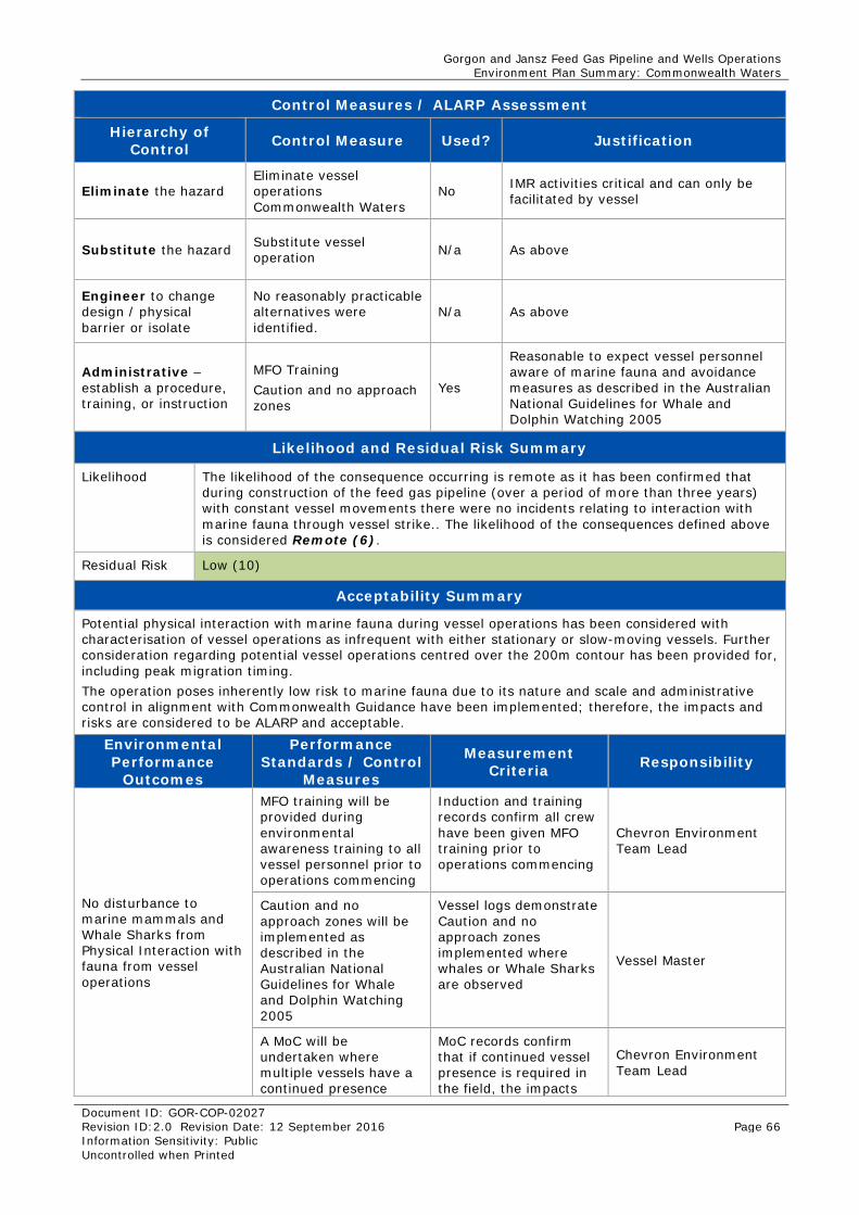
Gorgon and Jansz Feed Gas Pipeline and Wells Operations Environment Plan Summary: Commonwealth Waters
Document ID: GOR-COP-02027 Revision ID:2.0 Revision Date: 12 September 2016 Page 66 Information Sensitivity: Public Uncontrolled when Printed
Control Measures / ALARP Assessment
Hierarchy of Control Control Measure Used? Justification
Eliminate the hazard Eliminate vessel operations Commonwealth Waters
No IMR activities critical and can only be facilitated by vessel
Substitute the hazard Substitute vessel operation N/a As above
Engineer to change design / physical barrier or isolate
No reasonably practicable alternatives were identified.
N/a As above
Administrative – establish a procedure, training, or instruction
MFO Training Caution and no approach zones
Yes
Reasonable to expect vessel personnel aware of marine fauna and avoidance measures as described in the Australian National Guidelines for Whale and Dolphin Watching 2005
Likelihood and Residual Risk Summary
Likelihood The likelihood of the consequence occurring is remote as it has been confirmed that during construction of the feed gas pipeline (over a period of more than three years) with constant vessel movements there were no incidents relating to interaction with marine fauna through vessel strike.. The likelihood of the consequences defined above is considered Remote (6).
Residual Risk Low (10)
Acceptability Summary
Potential physical interaction with marine fauna during vessel operations has been considered with characterisation of vessel operations as infrequent with either stationary or slow-moving vessels. Further consideration regarding potential vessel operations centred over the 200m contour has been provided for, including peak migration timing. The operation poses inherently low risk to marine fauna due to its nature and scale and administrative control in alignment with Commonwealth Guidance have been implemented; therefore, the impacts and risks are considered to be ALARP and acceptable.
Environmental Performance
Outcomes
Performance Standards / Control
Measures
Measurement Criteria Responsibility
No disturbance to marine mammals and Whale Sharks from Physical Interaction with fauna from vessel operations
MFO training will be provided during environmental awareness training to all vessel personnel prior to operations commencing
Induction and training records confirm all crew have been given MFO training prior to operations commencing
Chevron Environment Team Lead
Caution and no approach zones will be implemented as described in the Australian National Guidelines for Whale and Dolphin Watching 2005
Vessel logs demonstrate Caution and no approach zones implemented where whales or Whale Sharks are observed
Vessel Master
A MoC will be undertaken where multiple vessels have a continued presence
MoC records confirm that if continued vessel presence is required in the field, the impacts
Chevron Environment Team Lead
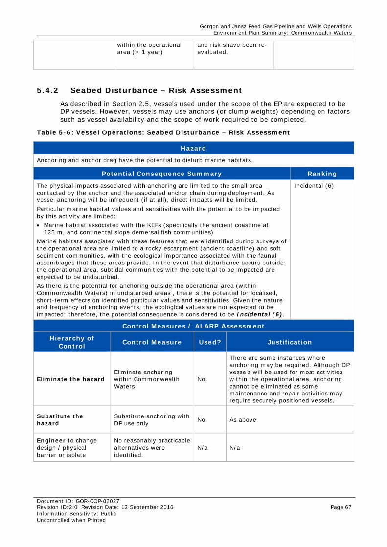
Gorgon and Jansz Feed Gas Pipeline and Wells Operations Environment Plan Summary: Commonwealth Waters
Document ID: GOR-COP-02027 Revision ID:2.0 Revision Date: 12 September 2016 Page 67 Information Sensitivity: Public Uncontrolled when Printed
within the operational area (> 1 year)
and risk shave been re-evaluated.
5.4.2 Seabed Disturbance – Risk Assessment As described in Section 2.5, vessels used under the scope of the EP are expected to be DP vessels. However, vessels may use anchors (or clump weights) depending on factors such as vessel availability and the scope of work required to be completed.
Table 5-6: Vessel Operations: Seabed Disturbance – Risk Assessment
Hazard
Anchoring and anchor drag have the potential to disturb marine habitats.
Potential Consequence Summary Ranking
The physical impacts associated with anchoring are limited to the small area contacted by the anchor and the associated anchor chain during deployment. As vessel anchoring will be infrequent (if at all), direct impacts will be limited. Particular marine habitat values and sensitivities with the potential to be impacted by this activity are limited: • Marine habitat associated with the KEFs (specifically the ancient coastline at
125 m, and continental slope demersal fish communities) Marine habitats associated with these features that were identified during surveys of the operational area are limited to a rocky escarpment (ancient coastline) and soft sediment communities, with the ecological importance associated with the faunal assemblages that these areas provide. In the event that disturbance occurs outside the operational area, subtidal communities with the potential to be impacted are expected to be undisturbed. As there is the potential for anchoring outside the operational area (within Commonwealth Waters) in undisturbed areas , there is the potential for localised, short-term effects on identified particular values and sensitivities. Given the nature and frequency of anchoring events, the ecological values are not expected to be impacted; therefore, the potential consequence is considered to be Incidental (6).
Incidental (6)
Control Measures / ALARP Assessment
Hierarchy of Control Control Measure Used? Justification
Eliminate the hazard Eliminate anchoring within Commonwealth Waters
No
There are some instances where anchoring may be required. Although DP vessels will be used for most activities within the operational area, anchoring cannot be eliminated as some maintenance and repair activities may require securely positioned vessels.
Substitute the hazard
Substitute anchoring with DP use only No As above
Engineer to change design / physical barrier or isolate
No reasonably practicable alternatives were identified.
N/a N/a
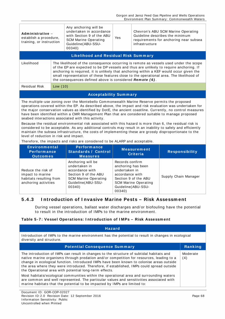
Gorgon and Jansz Feed Gas Pipeline and Wells Operations Environment Plan Summary: Commonwealth Waters
Document ID: GOR-COP-02027 Revision ID:2.0 Revision Date: 12 September 2016 Page 68 Information Sensitivity: Public Uncontrolled when Printed
Administrative – establish a procedure, training, or instruction
Any anchoring will be undertaken in accordance with Section 9 of the ABU SCM Marine Operating Guideline(ABU-SSU-00340)
Yes
Chevron’s ABU SCM Marine Operating Guideline describes the minimum requirements for anchoring near subsea infrastructure
Likelihood and Residual Risk Summary
Likelihood The likelihood of the consequence occurring is remote as vessels used under the scope of the EP are expected to be DP vessels and thus are unlikely to require anchoring. If anchoring is required, it is unlikely that anchoring within a KEF would occur given the small representation of these features close to the operational area. The likelihood of the consequences defined above is considered Remote (6).
Residual Risk Low (10)
Acceptability Summary
The multiple-use zoning over the Montebello Commonwealth Marine Reserve permits the proposed operations covered within the EP. As described above, the impact and risk evaluation was undertaken for the major conservation values as identified by DotE, the ancient coastline. Currently, no control measures have been identified within a CMR Management Plan that are considered suitable to manage proposed seabed interactions associated with this activity. Because the residual environmental risk associated with this hazard is more than 6, the residual risk is considered to be acceptable. As any additional controls may result in an inability to safely and efficiently maintain the subsea infrastructure, the costs of implementing these are grossly disproportionate to the level of reduction in risk and impact. Therefore, the impacts and risks are considered to be ALARP and acceptable.
Environmental Performance
Outcomes
Performance Standards / Control
Measures
Measurement Criteria Responsibility
Reduce the risk of impact to marine habitats resulting from anchoring activities
Anchoring will be undertaken in accordance with Section 9 of the ABU SCM Marine Operating Guideline(ABU-SSU-00340)
Records confirm anchoring has been undertaken in accordance with Section 9 of the ABU SCM Marine Operating Guideline(ABU-SSU-00340)
Supply Chain Manager
5.4.3 Introduction of Invasive Marine Pests – Risk Assessment During vessel operations, ballast water discharges and/or biofouling have the potential to result in the introduction of IMPs to the marine environment.
Table 5-7: Vessel Operations: Introduction of IMPs – Risk Assessment
Hazard
Introduction of IMPs to the marine environment has the potential to result in changes in ecological diversity and structure.
Potential Consequence Summary Ranking
The introduction of IMPs can result in changes to the structure of subtidal habitats and native marine organisms through predation and/or competition for resources, leading to a change in ecological function. Introduced IMPs have been known to colonise areas outside the area where they were introduced. Therefore, if established, IMPs could spread outside the Operational area with potential long-term effects. Most habitats/ecological communities within the operational area and surrounding waters are common and well represented. The particular values and sensitivities associated with marine habitats that the potential to be impacted by IMPs are limited to:
Moderate (4)
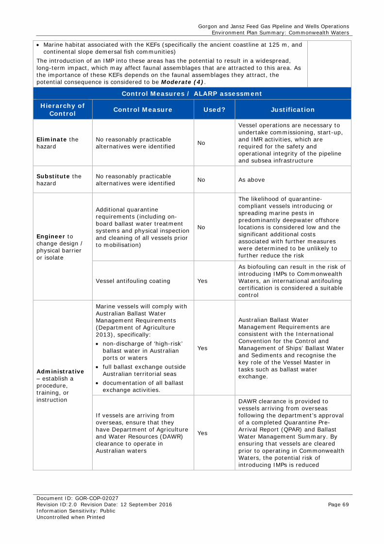
Gorgon and Jansz Feed Gas Pipeline and Wells Operations Environment Plan Summary: Commonwealth Waters
Document ID: GOR-COP-02027 Revision ID:2.0 Revision Date: 12 September 2016 Page 69 Information Sensitivity: Public Uncontrolled when Printed
• Marine habitat associated with the KEFs (specifically the ancient coastline at 125 m, and continental slope demersal fish communities)
The introduction of an IMP into these areas has the potential to result in a widespread, long-term impact, which may affect faunal assemblages that are attracted to this area. As the importance of these KEFs depends on the faunal assemblages they attract, the potential consequence is considered to be Moderate (4).
Control Measures / ALARP assessment
Hierarchy of Control Control Measure Used? Justification
Eliminate the hazard
No reasonably practicable alternatives were identified No
Vessel operations are necessary to undertake commissioning, start-up, and IMR activities, which are required for the safety and operational integrity of the pipeline and subsea infrastructure
Substitute the hazard
No reasonably practicable alternatives were identified No As above
Engineer to change design / physical barrier or isolate
Additional quarantine requirements (including on-board ballast water treatment systems and physical inspection and cleaning of all vessels prior to mobilisation)
No
The likelihood of quarantine-compliant vessels introducing or spreading marine pests in predominantly deepwater offshore locations is considered low and the significant additional costs associated with further measures were determined to be unlikely to further reduce the risk
Vessel antifouling coating Yes
As biofouling can result in the risk of introducing IMPs to Commonwealth Waters, an international antifouling certification is considered a suitable control
Administrative – establish a procedure, training, or instruction
Marine vessels will comply with Australian Ballast Water Management Requirements (Department of Agriculture 2013), specifically: • non-discharge of ‘high-risk’
ballast water in Australian ports or waters
• full ballast exchange outside Australian territorial seas
• documentation of all ballast exchange activities.
Yes
Australian Ballast Water Management Requirements are consistent with the International Convention for the Control and Management of Ships’ Ballast Water and Sediments and recognise the key role of the Vessel Master in tasks such as ballast water exchange.
If vessels are arriving from overseas, ensure that they have Department of Agriculture and Water Resources (DAWR) clearance to operate in Australian waters
Yes
DAWR clearance is provided to vessels arriving from overseas following the department’s approval of a completed Quarantine Pre-Arrival Report (QPAR) and Ballast Water Management Summary. By ensuring that vessels are cleared prior to operating in Commonwealth Waters, the potential risk of introducing IMPs is reduced
Gorgon and Jansz Feed Gas Pipeline and Wells Operations Environment Plan Summary: Commonwealth Waters
Document ID: GOR-COP-02027 Revision ID:2.0 Revision Date: 12 September 2016 Page 70 Information Sensitivity: Public Uncontrolled when Printed
Likelihood and Residual Risk Summary
Likelihood The pathways for IMP introduction are well known, and thus standard preventive measures are known. The ability for IMPs to colonise a habitat depends on a number of environmental conditions. It has been found that highly disturbed environments (such as marinas) are more susceptible to colonisation than open water environments where the number of dilutions and the degree of dispersal are high (Paulay et al. 2002). Ballast water is responsible for 20% to 30% of all IMP incursions into Commonwealth Waters; however, research indicates that biofouling (the accumulation of aquatic microorganisms, algae, plants, and animals on vessel hulls and submerged surfaces) has been responsible for more foreign marine introductions than ballast water (Department of Agriculture 2014). Given the activities that vessels will be undertaking, discharge of ballast water is only expected to occur infrequently in the Operational area. In addition to this, vessels will maintain antifouling Therefore, the likelihood of the consequences described above occurring as a result of vessel activities is considered to be Rare (6).
Residual Risk
Low (9)
Acceptability Summary
The multiple-use zoning over the Montebello Commonwealth Marine Reserve permits the proposed operations covered within the EP. As described above, the impact and risk evaluation was undertaken for the major conservation values as identified by DotE, the ancient coastline. Currently, no control measures have been identified within a CMR Management Plan that are considered suitable to manage proposed seabed interactions associated with this activity. The activities that may introduce or spread IMPs are typical of similar activities undertaken in the North West Shelf region and elsewhere. Associated potential impacts and risks are well known and understood. As the residual environmental risk associated with this hazard is more than 6, and because vessel operations will comply with relevant legislation, industry standards/guidelines, and corporate policies, standards, and procedures specific to the operational environment, the environmental impacts and risks associated with vessel operations are considered to be ALARP and acceptable.
Environmental Performance
Outcomes
Performance Standards / Control Measures Measurement Criteria Responsibilit
y
Prevent the introduction and establishment of marine pests in the marine environment
Marine vessels will maintain an up-to-date international antifouling coating certification
Offshore Vessel Inspection Database (OVID) report confirms that international antifouling coating certification is up-to-date
Supply Chain Manager
International vessels will have DAWR clearance to operate in Australian waters, if applicable
Records confirm that DAWR clearance has been granted to international vessels, where applicable
Supply Chain Manager
International marine vessels will be required to comply with Australian Ballast Water Management Requirements (Department of Agriculture 2013), of which the key requirements are: • non-discharge of ‘high-risk’
ballast water in Australian ports or waters
• full ballast exchange outside Australian territorial seas
• documentation of all ballast exchange activities.
For international marine vessels, records show compliance with the Australian Ballast Water Management Requirements: • non-discharge of ‘high-risk’
ballast water in Australian ports or waters
• full ballast exchange outside Australian territorial seas
• documentation of all ballast exchange activities.
Vessel Master
Gorgon and Jansz Feed Gas Pipeline and Wells Operations Environment Plan Summary: Commonwealth Waters
Document ID: GOR-COP-02027 Revision ID:2.0 Revision Date: 12 September 2016 Page 71 Information Sensitivity: Public Uncontrolled when Printed
5.4.4 Planned Discharges – Risk Assessment Vessels used for activities covered within the EP will generate a number of liquid wastes that are likely to be discharged to the marine environment. Planned discharges of liquid wastes may include:
• bilge water
• domestic wastes (sewage, greywater, and putrescibles).
Table 5-8: Vessel Operations: Planned Discharges – Risk Assessment
Hazard
Discharge of liquid wastes to the marine environment has the potential to cause a decline in water quality leading to potential effects on marine fauna.
Potential Consequence Summary Ranking
Modelling of domestic waste (10 m3/day) indicates that discharges were rapidly diluted in the upper (less than 10 m) water layer with no elevations in water quality monitoring parameters (e.g. total nitrogen, total phosphorous, and selected metals) above background levels at monitoring stations 50 m away (Woodside 2014). This modelling was based on volumes that far exceed volumes expected during support vessel operations. Therefore, the extent of impacts are expected to be localised to the discharge location. Bilge water may contain trace quantities of contaminants such as oil, grease, and detergents that were on the deck prior to draining. The volumes of bilge water and residues that accumulate on board the vessel are difficult to determine accurately as they depend on a number of factors. However, the concentration of residues that are typically discharged from vessels is low and the potential for impacts to water quality are expected to be short-term and localised. Bilge discharge is not a continuous discharge, and would only occur if required. The particular values and sensitivities with the potential to be impacted by planned discharges are: • Whales – Whale migration • Marine Turtles – Turtle internesting, foraging areas • Whale Sharks – Whale Shark foraging • Fish communities – KEFs. Because the marine environment in the Operational area is characterised as an open, dispersive environment, exposure to these values and sensitivities is expected to be limited as these liquid wastes will rapidly dilute and disperse. As such particular values and sensitivities with the potential to be exposed are only expected to be impacted an individual level, not a population level. Given the localised and short-term effects, the potential consequence is considered to be Incidental (6).
Incidental (6)
Control Measures / ALARP assessment
Hierarchy of Control Control Measure Used? Justification
Eliminate the hazard No reasonably practicable alternatives were identified
No
Vessel operations are necessary to undertake commissioning, start-up, and IMR activities, which are required for the safety and operational integrity of the pipeline and subsea infrastructure
Substitute the hazard As above No As above
Gorgon and Jansz Feed Gas Pipeline and Wells Operations Environment Plan Summary: Commonwealth Waters
Document ID: GOR-COP-02027 Revision ID:2.0 Revision Date: 12 September 2016 Page 72 Information Sensitivity: Public Uncontrolled when Printed
Engineer to change design / physical barrier or isolate
Store liquid wastes on board the vessel and transport to shore for handling and disposal
No
This control measure was not considered reasonably practicable, as vessels would be required to demobilise and depart the Operational area each time liquid waste tanks became full. Significant time and cost implications would arise from this alternative because of the distances that would be required for the vessel to make a return trip from the Operational area to port where wastes would then be transported to an appropriate waste management facility. This option would also introduce secondary environmental impacts as a consequence of the additional travel required.
Sewage treatment plant and oil-water separator will be maintained to ensure it is operational.
Yes
By ensuring that equipment is maintained and functional, relevant performance objectives can be demonstrated.
Administrative – establish a procedure, training, or instruction
Pre- mobilisation vessel inspection will be conducted confirming MARPOL-compliant sewage treatment plant is present on vessels >400 T.
Yes
This is a standard measure implemented across the industry to ensure impacts and risks are minimised to ALARP and acceptable levels
Pre-mobilisation vessel inspection confirming MARPOL-compliant oil-water separator is present on vessels.
Yes
This is a standard measure implemented across the industry to ensure impacts and risks are minimised to ALARP and Acceptable levels
Likelihood and Residual Risk Summary
Likelihood The impacts from vessel discharges are well known and are regulated internationally and nationally. Given that bilge is treated to ensure oil in water concentrations do not exceed 15 ppm, the likelihood of potential effects on marine fauna are rare given the nature, scale and frequency of the discharges and the limited sensitive receptors identified within the operational area. The likelihood of the consequences defined above is considered Rare (6).
Residual Risk
Low (10)
Acceptability Summary
Bilge and domestic waste streams discharged from vessels are a regulated practice in Commonwealth Waters. The proposed management measures meet the requirements of the Commonwealth Navigation Act 2012 and Protection of the Sea (Prevention of Pollution from Ships) Act 1983. The multiple-use zoning over the Montebello Commonwealth Marine Reserve permits the proposed operations covered within the EP. As described above, the impact and risk evaluation was undertaken for the major conservation values as identified by DotE, the ancient coastline. Currently, no control measures have been identified within a CMR Management Plan that are considered suitable to manage proposed interactions associated with this activity. The residual environmental risk associated with this hazard is more than 6, and vessel operations will comply with relevant legislation, industry standards/guidelines, and corporate policies, standards, and procedures specific to the operational environment. As such the environmental impacts and risks associated with vessel operations are considered to be ALARP and acceptable.
Gorgon and Jansz Feed Gas Pipeline and Wells Operations Environment Plan Summary: Commonwealth Waters
Document ID: GOR-COP-02027 Revision ID:2.0 Revision Date: 12 September 2016 Page 73 Information Sensitivity: Public Uncontrolled when Printed
Environmental Performance
Outcomes
Performance Standards / Control Measures
Measurement Criteria Responsibility
Reduce the risk of impact to marine fauna from the discharge of liquid wastes
Sewage treatment plant and oil water separators will be maintained ensure equipment meets MARPOL requirements.
Maintenance Records confirm the sewage treatment plant and oil water separator is maintained and operational as per MARPOL requirements.
Supply Chain Manager
Pre-mobilisation vessel inspection confirming MARPOL-compliant sewage treatment plant is present on vessels >400 T
OVID report confirms that International Sewage Pollution Prevention Certificate (Annex IV) is available
Supply Chain Manager
Pre-mobilisation vessel inspection confirming MARPOL-compliant oil-water separator is present on vessels if bilge water is to be discharged, and that oily bilge is discharged where oil in water concentrations of <15 ppm can be achieved.
OVID report confirms that International Oil Pollution Prevention Certificate (Annex I) is available
Supply Chain Manager
Oil Record book (or similar) and maintenance records confirm discharges are <15 ppm.
Supply Chain Manager
5.4.5 Leaks and Spills – Risk Assessment The leak and spill scenarios associated with vessel operations are:
• major defect in subsea pipeline resulting from anchor drag associated with the Petroleum Activity
• single point failure
• vessel collision (from simultaneous operations).
Given the nature and scale of a major defect and its potential impacts, this scenario has been deemed (in accordance with Section 4.0) to be an emergency condition and is described in Section 6.1.
Hydrocarbons, utility and hydraulic oils, and other chemicals are generally stored in containers holding less than 1000 L (1 m3). Single point failures could occur due to poor handling or storage of materials, or mechanical breakdown of equipment.
Vessel collision within Commonwealth Waters is considered a credible hazard (although extremely unlikely) given the potential for more than one vessel to undertake maintenance/minor repairs. Modelling was undertaken to provide an indication of the potential impacts and risks associated with this event.
Location
It is not practicable for modelling to be undertaken at every possible location within Operational Area. In addition to this, modelling can only provide a prediction of the hydrocarbon’s fate. Subsequently, identification of the release location was based upon:
• the location with the greatest potential environmental consequence (closest to sensitive receptors)
• areas considered most at risk of resulting in the event transpiring.
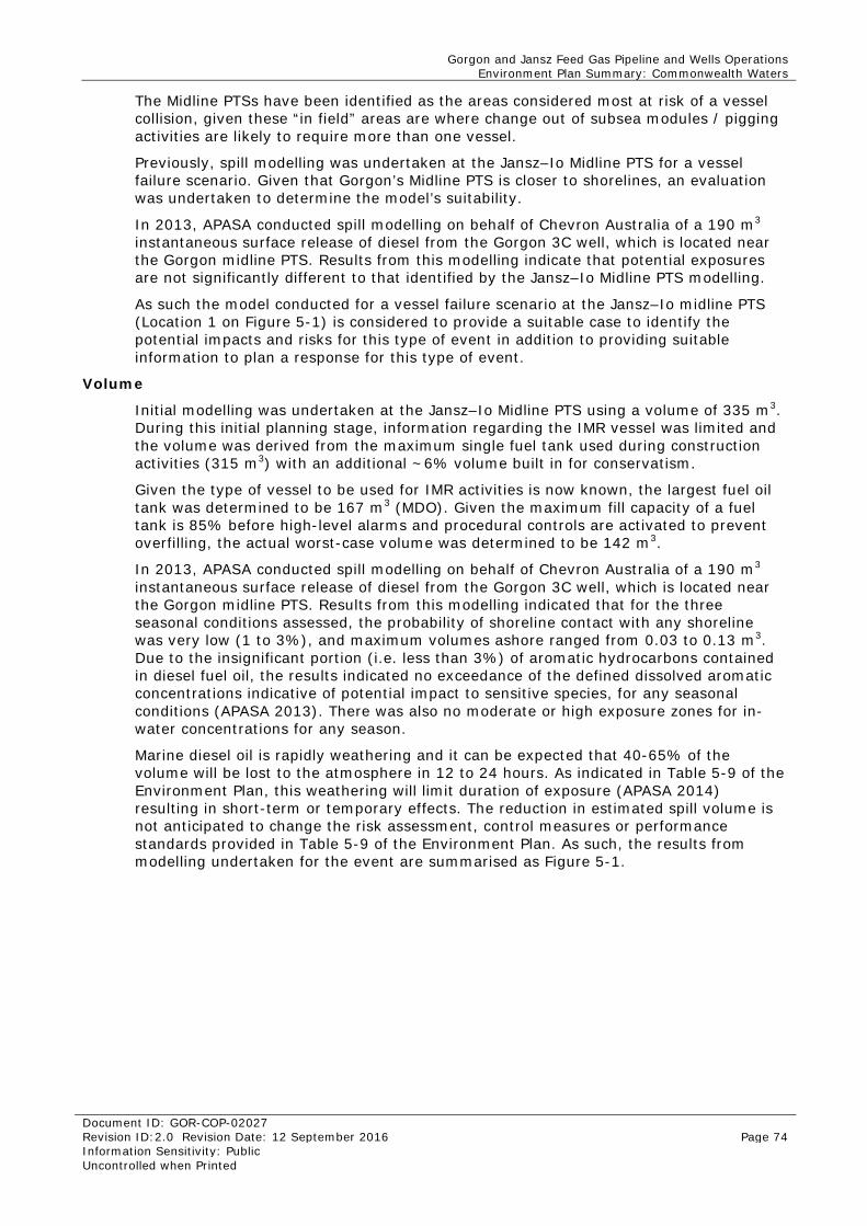
Gorgon and Jansz Feed Gas Pipeline and Wells Operations Environment Plan Summary: Commonwealth Waters
Document ID: GOR-COP-02027 Revision ID:2.0 Revision Date: 12 September 2016 Page 74 Information Sensitivity: Public Uncontrolled when Printed
The Midline PTSs have been identified as the areas considered most at risk of a vessel collision, given these “in field” areas are where change out of subsea modules / pigging activities are likely to require more than one vessel.
Previously, spill modelling was undertaken at the Jansz–Io Midline PTS for a vessel failure scenario. Given that Gorgon’s Midline PTS is closer to shorelines, an evaluation was undertaken to determine the model’s suitability.
In 2013, APASA conducted spill modelling on behalf of Chevron Australia of a 190 m3 instantaneous surface release of diesel from the Gorgon 3C well, which is located near the Gorgon midline PTS. Results from this modelling indicate that potential exposures are not significantly different to that identified by the Jansz–Io Midline PTS modelling.
As such the model conducted for a vessel failure scenario at the Jansz–Io midline PTS (Location 1 on Figure 5-1) is considered to provide a suitable case to identify the potential impacts and risks for this type of event in addition to providing suitable information to plan a response for this type of event.
Volume
Initial modelling was undertaken at the Jansz–Io Midline PTS using a volume of 335 m3. During this initial planning stage, information regarding the IMR vessel was limited and the volume was derived from the maximum single fuel tank used during construction activities (315 m3) with an additional ~6% volume built in for conservatism.
Given the type of vessel to be used for IMR activities is now known, the largest fuel oil tank was determined to be 167 m3 (MDO). Given the maximum fill capacity of a fuel tank is 85% before high-level alarms and procedural controls are activated to prevent overfilling, the actual worst-case volume was determined to be 142 m3.
In 2013, APASA conducted spill modelling on behalf of Chevron Australia of a 190 m3 instantaneous surface release of diesel from the Gorgon 3C well, which is located near the Gorgon midline PTS. Results from this modelling indicated that for the three seasonal conditions assessed, the probability of shoreline contact with any shoreline was very low (1 to 3%), and maximum volumes ashore ranged from 0.03 to 0.13 m3. Due to the insignificant portion (i.e. less than 3%) of aromatic hydrocarbons contained in diesel fuel oil, the results indicated no exceedance of the defined dissolved aromatic concentrations indicative of potential impact to sensitive species, for any seasonal conditions (APASA 2013). There was also no moderate or high exposure zones for in-water concentrations for any season.
Marine diesel oil is rapidly weathering and it can be expected that 40-65% of the volume will be lost to the atmosphere in 12 to 24 hours. As indicated in Table 5-9 of the Environment Plan, this weathering will limit duration of exposure (APASA 2014) resulting in short-term or temporary effects. The reduction in estimated spill volume is not anticipated to change the risk assessment, control measures or performance standards provided in Table 5-9 of the Environment Plan. As such, the results from modelling undertaken for the event are summarised as Figure 5-1.
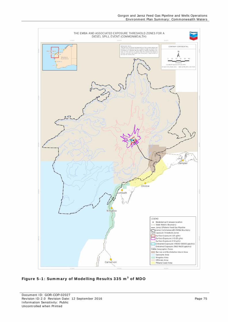
Gorgon and Jansz Feed Gas Pipeline and Wells Operations Environment Plan Summary: Commonwealth Waters
Document ID: GOR-COP-02027 Revision ID:2.0 Revision Date: 12 September 2016 Page 75 Information Sensitivity: Public Uncontrolled when Printed
Figure 5-1: Summary of Modelling Results 335 m3 of MDO
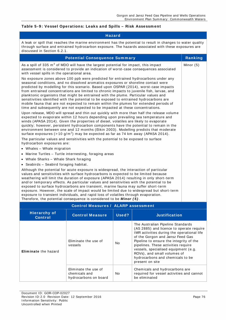
Gorgon and Jansz Feed Gas Pipeline and Wells Operations Environment Plan Summary: Commonwealth Waters
Document ID: GOR-COP-02027 Revision ID:2.0 Revision Date: 12 September 2016 Page 76 Information Sensitivity: Public Uncontrolled when Printed
Table 5-9: Vessel Operations: Leaks and Spills – Risk Assessment
Hazard
A leak or spill that reaches the marine environment has the potential to result in changes to water quality through surface and entrained hydrocarbon exposure. The hazards associated with these exposures are discussed in Section 6.2.1.
Potential Consequence Summary Ranking
As a spill of 335 m3 of MDO will have the largest potential for impact, this impact assessment is considered to provide an indication of worst-case consequences associated with vessel spills in the operational area. No exposure zones above 100 ppb were predicted for entrained hydrocarbons under any seasonal conditions, and no dissolved aromatics exposures or shoreline contact were predicted by modelling for this scenario. Based upon OSPAR (2014), worst-case impacts from entrained concentrations are limited to chronic impacts to juvenile fish, larvae, and planktonic organisms that might be entrained with the plume. Particular values and sensitivities identified with the potential to be exposed to entrained hydrocarbons are mobile fauna that are not expected to remain within the plumes for extended periods of time and subsequently are not expected to be impacted at these concentrations. Upon release, MDO will spread and thin out quickly with more than half the release volume expected to evaporate within 12 hours depending upon prevailing sea temperature and winds (APASA 2014). Given the properties of diesel, volatiles are likely to evaporate quickly; however, persistent hydrocarbon components have the potential to remain in the environment between one and 12 months (Etkin 2003). Modelling predicts that moderate surface exposures (>10 g/m2) may be expected as far as 74 km away (APASA 2014). The particular values and sensitivities with the potential to be exposed to surface hydrocarbon exposures are: • Whales – Whale migration • Marine Turtles – Turtle internesting, foraging areas • Whale Sharks – Whale Shark foraging • Seabirds – Seabird foraging habitat. Although the potential for acute exposure is widespread, the interaction of particular values and sensitivities with surface hydrocarbons is expected to be limited because weathering will limit the duration of exposure (APASA 2014) resulting in only short-term and/or temporary effects. As particular values and sensitivities with the potential to be exposed to surface hydrocarbons are transient, marine fauna may suffer short-term exposure. However, the scale of impact would be limited due to widespread but short-term exposure to transient individuals, and rapid loss of volatiles through evaporation. Therefore, the potential consequence is considered to be Minor (5).
Minor (5)
Control Measures / ALARP assessment
Hierarchy of Control Control Measure Used? Justification
Eliminate the hazard
Eliminate the use of vessels No
The Australian Pipeline Standards (AS 2885) and licence to operate require IMR activities during the operational life of the Gorgon and Jansz Feed Gas Pipeline to ensure the integrity of the pipelines. These activities require vessels, specialised equipment (e.g. ROVs), and small volumes of hydrocarbons and chemicals to be present on site
Eliminate the use of chemicals and hydrocarbons on board
No Chemicals and hydrocarbons are required for vessel activities and cannot be eliminated
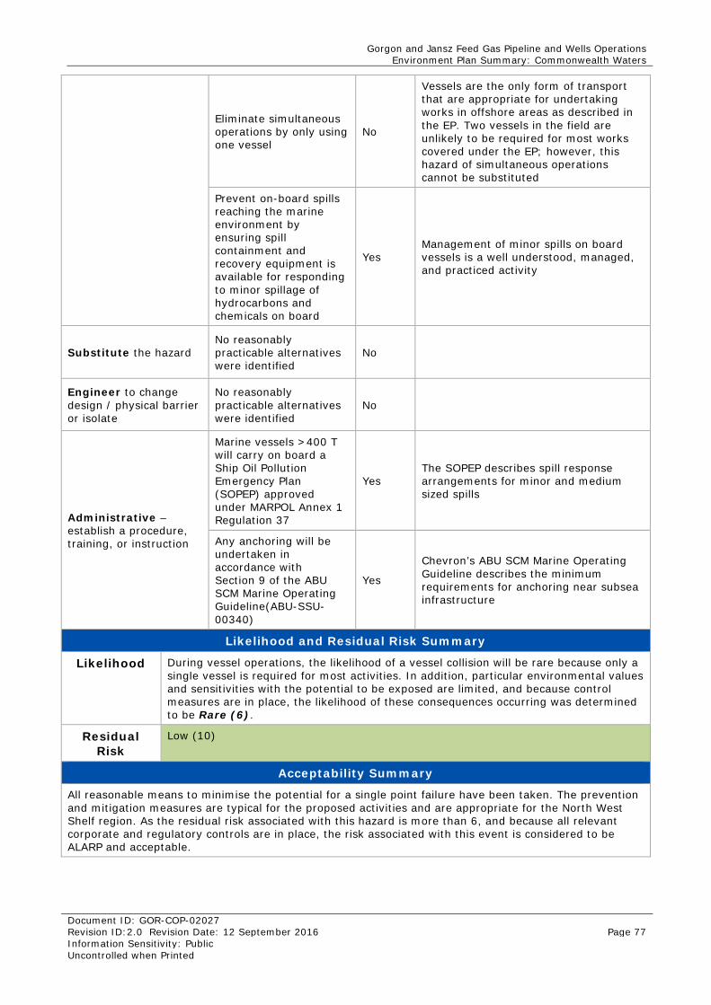
Gorgon and Jansz Feed Gas Pipeline and Wells Operations Environment Plan Summary: Commonwealth Waters
Document ID: GOR-COP-02027 Revision ID:2.0 Revision Date: 12 September 2016 Page 77 Information Sensitivity: Public Uncontrolled when Printed
Eliminate simultaneous operations by only using one vessel
No
Vessels are the only form of transport that are appropriate for undertaking works in offshore areas as described in the EP. Two vessels in the field are unlikely to be required for most works covered under the EP; however, this hazard of simultaneous operations cannot be substituted
Prevent on-board spills reaching the marine environment by ensuring spill containment and recovery equipment is available for responding to minor spillage of hydrocarbons and chemicals on board
Yes Management of minor spills on board vessels is a well understood, managed, and practiced activity
Substitute the hazard No reasonably practicable alternatives were identified
No
Engineer to change design / physical barrier or isolate
No reasonably practicable alternatives were identified
No
Administrative – establish a procedure, training, or instruction
Marine vessels >400 T will carry on board a Ship Oil Pollution Emergency Plan (SOPEP) approved under MARPOL Annex 1 Regulation 37
Yes The SOPEP describes spill response arrangements for minor and medium sized spills
Any anchoring will be undertaken in accordance with Section 9 of the ABU SCM Marine Operating Guideline(ABU-SSU-00340)
Yes
Chevron’s ABU SCM Marine Operating Guideline describes the minimum requirements for anchoring near subsea infrastructure
Likelihood and Residual Risk Summary
Likelihood During vessel operations, the likelihood of a vessel collision will be rare because only a single vessel is required for most activities. In addition, particular environmental values and sensitivities with the potential to be exposed are limited, and because control measures are in place, the likelihood of these consequences occurring was determined to be Rare (6).
Residual Risk
Low (10)
Acceptability Summary
All reasonable means to minimise the potential for a single point failure have been taken. The prevention and mitigation measures are typical for the proposed activities and are appropriate for the North West Shelf region. As the residual risk associated with this hazard is more than 6, and because all relevant corporate and regulatory controls are in place, the risk associated with this event is considered to be ALARP and acceptable.
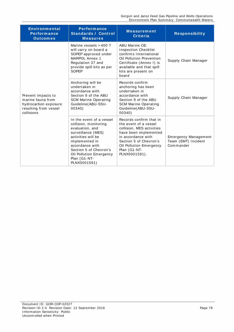
Gorgon and Jansz Feed Gas Pipeline and Wells Operations Environment Plan Summary: Commonwealth Waters
Document ID: GOR-COP-02027 Revision ID:2.0 Revision Date: 12 September 2016 Page 78 Information Sensitivity: Public Uncontrolled when Printed
Environmental Performance
Outcomes
Performance Standards / Control
Measures
Measurement Criteria Responsibility
Prevent impacts to marine fauna from hydrocarbon exposure resulting from vessel collisions
Marine vessels >400 T will carry on board a SOPEP approved under MARPOL Annex 1 Regulation 37 and provide spill kits as per SOPEP
ABU Marine OE Inspection Checklist confirms International Oil Pollution Prevention Certificate (Annex I) is available and that spill kits are present on board
Supply Chain Manager
Anchoring will be undertaken in accordance with Section 9 of the ABU SCM Marine Operating Guideline(ABU-SSU-00340)
Records confirm anchoring has been undertaken in accordance with Section 9 of the ABU SCM Marine Operating Guideline(ABU-SSU-00340)
Supply Chain Manager
In the event of a vessel collision, monitoring evaluation, and surveillance (MES) activities will be implemented in accordance with Section 5 of Chevron’s Oil Pollution Emergency Plan (G1-NT-PLNX0001591)
Records confirm that in the event of a vessel collision, MES activities have been implemented in accordance with Section 5 of Chevron’s Oil Pollution Emergency Plan (G1-NT-PLNX0001591).
Emergency Management Team (EMT) Incident Commander
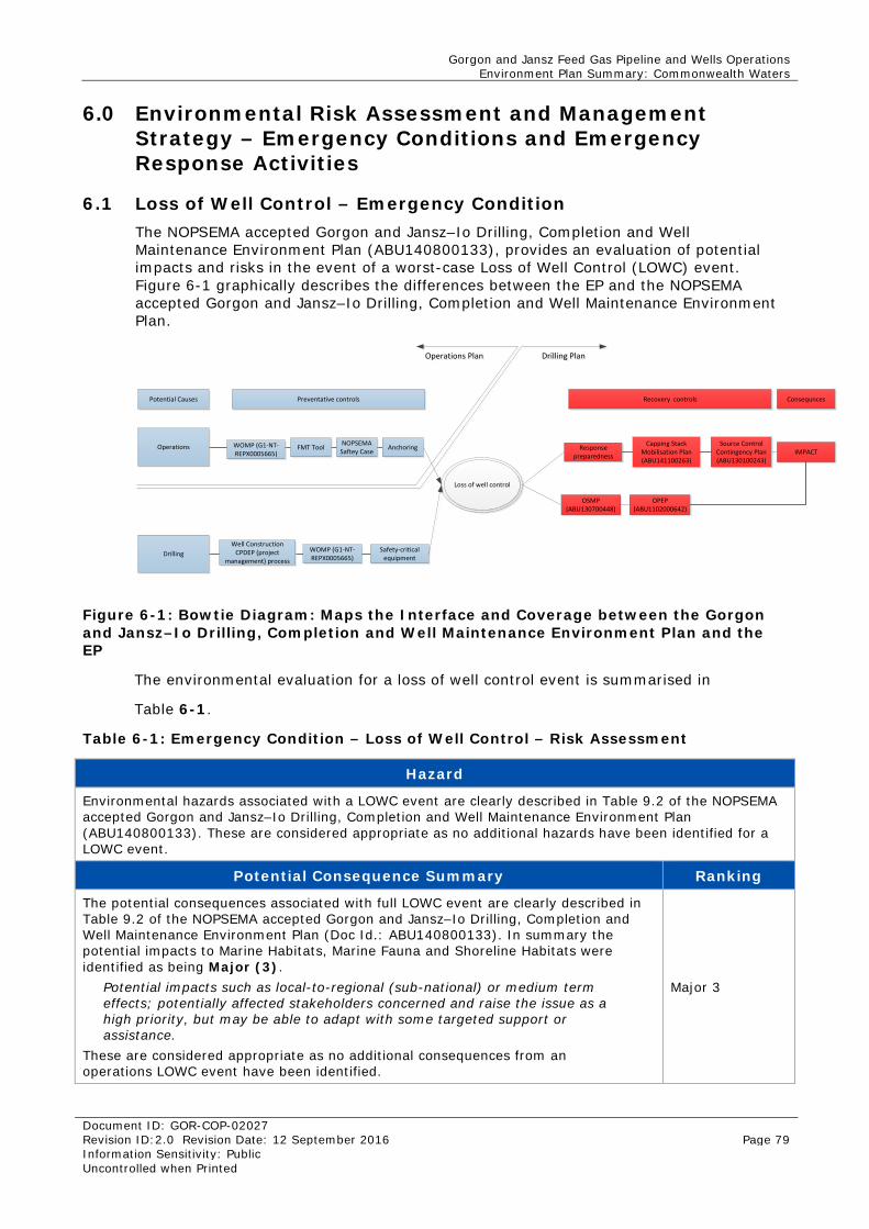
Gorgon and Jansz Feed Gas Pipeline and Wells Operations Environment Plan Summary: Commonwealth Waters
Document ID: GOR-COP-02027 Revision ID:2.0 Revision Date: 12 September 2016 Page 79 Information Sensitivity: Public Uncontrolled when Printed
6.0 Environmental Risk Assessment and Management Strategy – Emergency Conditions and Emergency Response Activities
6.1 Loss of Well Control – Emergency Condition The NOPSEMA accepted Gorgon and Jansz–Io Drilling, Completion and Well Maintenance Environment Plan (ABU140800133), provides an evaluation of potential impacts and risks in the event of a worst-case Loss of Well Control (LOWC) event. Figure 6-1 graphically describes the differences between the EP and the NOPSEMA accepted Gorgon and Jansz–Io Drilling, Completion and Well Maintenance Environment Plan.
Potential Causes Preventative controls
Operations
Drilling
WOMP (G1-NT-REPX0005665)
Recovery controls Consequnces
FMT Tool NOPSEMA Saftey Case Anchoring
Loss of well control
Well Construction CPDEP (project
management) process
Safety-critical equipment
WOMP (G1-NT-REPX0005665)
Source Control Contingency Plan (ABU130100243)
Capping Stack Mobilisation Plan (ABU141100263)
OPEP (ABU1102000642)
OSMP (ABU130700448)
Response preparedness IMPACT
Operations PlanOperations Plan Drilling PlanDrilling Plan
Figure 6-1: Bowtie Diagram: Maps the Interface and Coverage between the Gorgon and Jansz–Io Drilling, Completion and Well Maintenance Environment Plan and the EP
The environmental evaluation for a loss of well control event is summarised in
Table 6-1.
Table 6-1: Emergency Condition – Loss of Well Control – Risk Assessment
Hazard
Environmental hazards associated with a LOWC event are clearly described in Table 9.2 of the NOPSEMA accepted Gorgon and Jansz–Io Drilling, Completion and Well Maintenance Environment Plan (ABU140800133). These are considered appropriate as no additional hazards have been identified for a LOWC event.
Potential Consequence Summary Ranking
The potential consequences associated with full LOWC event are clearly described in Table 9.2 of the NOPSEMA accepted Gorgon and Jansz–Io Drilling, Completion and Well Maintenance Environment Plan (Doc Id.: ABU140800133). In summary the potential impacts to Marine Habitats, Marine Fauna and Shoreline Habitats were identified as being Major (3).
Potential impacts such as local-to-regional (sub-national) or medium term effects; potentially affected stakeholders concerned and raise the issue as a high priority, but may be able to adapt with some targeted support or assistance.
These are considered appropriate as no additional consequences from an operations LOWC event have been identified.
Major 3
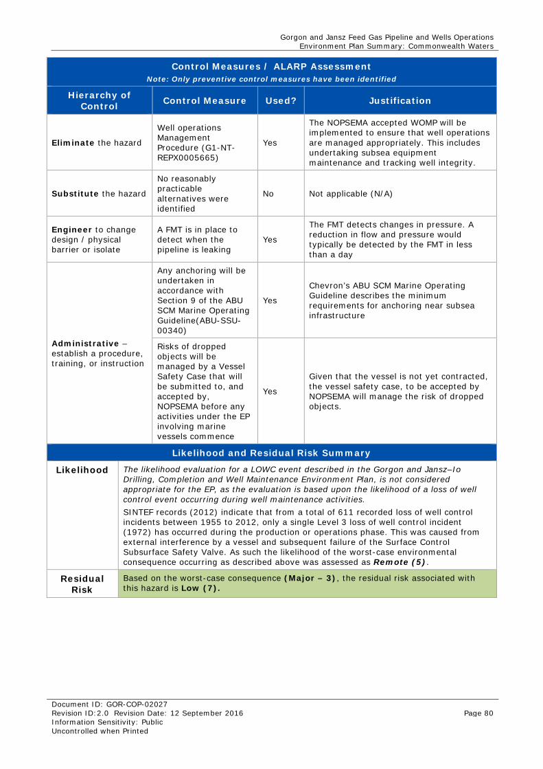
Gorgon and Jansz Feed Gas Pipeline and Wells Operations Environment Plan Summary: Commonwealth Waters
Document ID: GOR-COP-02027 Revision ID:2.0 Revision Date: 12 September 2016 Page 80 Information Sensitivity: Public Uncontrolled when Printed
Control Measures / ALARP Assessment Note: Only preventive control measures have been identified
Hierarchy of Control Control Measure Used? Justification
Eliminate the hazard
Well operations Management Procedure (G1-NT-REPX0005665)
Yes
The NOPSEMA accepted WOMP will be implemented to ensure that well operations are managed appropriately. This includes undertaking subsea equipment maintenance and tracking well integrity.
Substitute the hazard
No reasonably practicable alternatives were identified
No Not applicable (N/A)
Engineer to change design / physical barrier or isolate
A FMT is in place to detect when the pipeline is leaking
Yes
The FMT detects changes in pressure. A reduction in flow and pressure would typically be detected by the FMT in less than a day
Administrative – establish a procedure, training, or instruction
Any anchoring will be undertaken in accordance with Section 9 of the ABU SCM Marine Operating Guideline(ABU-SSU-00340)
Yes
Chevron’s ABU SCM Marine Operating Guideline describes the minimum requirements for anchoring near subsea infrastructure
Risks of dropped objects will be managed by a Vessel Safety Case that will be submitted to, and accepted by, NOPSEMA before any activities under the EP involving marine vessels commence
Yes
Given that the vessel is not yet contracted, the vessel safety case, to be accepted by NOPSEMA will manage the risk of dropped objects.
Likelihood and Residual Risk Summary
Likelihood The likelihood evaluation for a LOWC event described in the Gorgon and Jansz–Io Drilling, Completion and Well Maintenance Environment Plan, is not considered appropriate for the EP, as the evaluation is based upon the likelihood of a loss of well control event occurring during well maintenance activities. SINTEF records (2012) indicate that from a total of 611 recorded loss of well control incidents between 1955 to 2012, only a single Level 3 loss of well control incident (1972) has occurred during the production or operations phase. This was caused from external interference by a vessel and subsequent failure of the Surface Control Subsurface Safety Valve. As such the likelihood of the worst-case environmental consequence occurring as described above was assessed as Remote (5).
Residual Risk
Based on the worst-case consequence (Major – 3), the residual risk associated with this hazard is Low (7).
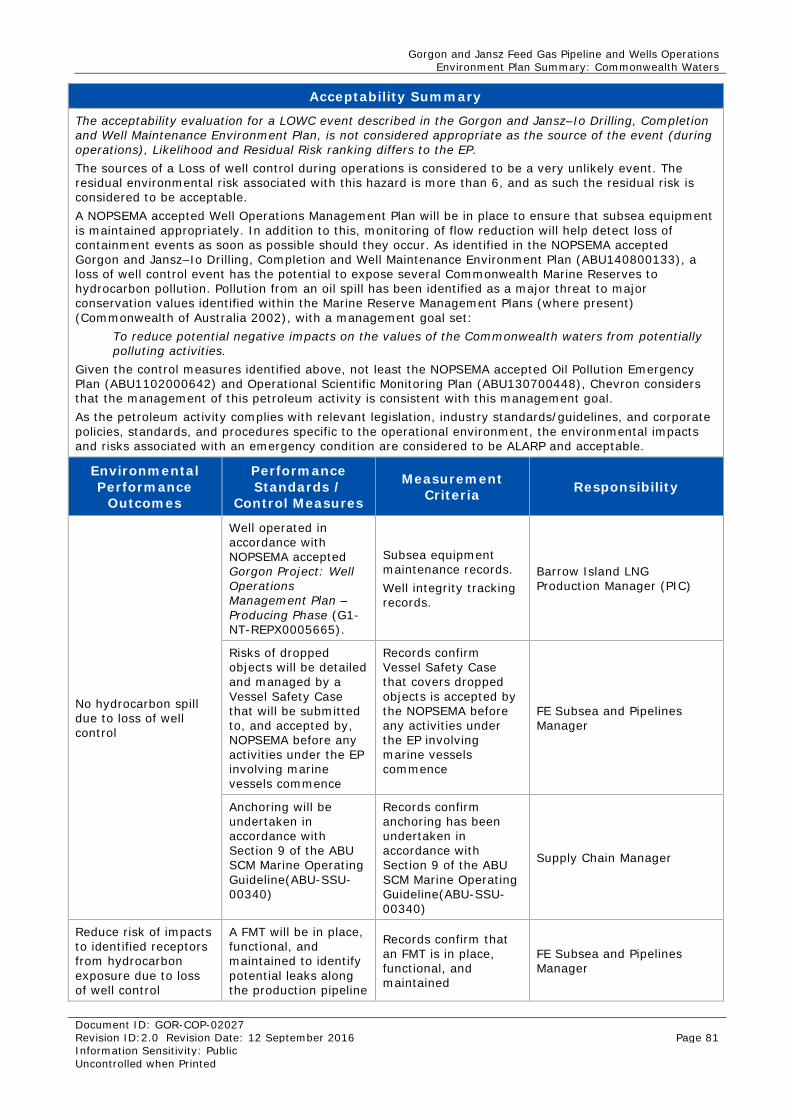
Gorgon and Jansz Feed Gas Pipeline and Wells Operations Environment Plan Summary: Commonwealth Waters
Document ID: GOR-COP-02027 Revision ID:2.0 Revision Date: 12 September 2016 Page 81 Information Sensitivity: Public Uncontrolled when Printed
Acceptability Summary
The acceptability evaluation for a LOWC event described in the Gorgon and Jansz–Io Drilling, Completion and Well Maintenance Environment Plan, is not considered appropriate as the source of the event (during operations), Likelihood and Residual Risk ranking differs to the EP. The sources of a Loss of well control during operations is considered to be a very unlikely event. The residual environmental risk associated with this hazard is more than 6, and as such the residual risk is considered to be acceptable. A NOPSEMA accepted Well Operations Management Plan will be in place to ensure that subsea equipment is maintained appropriately. In addition to this, monitoring of flow reduction will help detect loss of containment events as soon as possible should they occur. As identified in the NOPSEMA accepted Gorgon and Jansz–Io Drilling, Completion and Well Maintenance Environment Plan (ABU140800133), a loss of well control event has the potential to expose several Commonwealth Marine Reserves to hydrocarbon pollution. Pollution from an oil spill has been identified as a major threat to major conservation values identified within the Marine Reserve Management Plans (where present) (Commonwealth of Australia 2002), with a management goal set:
To reduce potential negative impacts on the values of the Commonwealth waters from potentially polluting activities.
Given the control measures identified above, not least the NOPSEMA accepted Oil Pollution Emergency Plan (ABU1102000642) and Operational Scientific Monitoring Plan (ABU130700448), Chevron considers that the management of this petroleum activity is consistent with this management goal. As the petroleum activity complies with relevant legislation, industry standards/guidelines, and corporate policies, standards, and procedures specific to the operational environment, the environmental impacts and risks associated with an emergency condition are considered to be ALARP and acceptable.
Environmental Performance
Outcomes
Performance Standards /
Control Measures
Measurement Criteria Responsibility
No hydrocarbon spill due to loss of well control
Well operated in accordance with NOPSEMA accepted Gorgon Project: Well Operations Management Plan – Producing Phase (G1-NT-REPX0005665).
Subsea equipment maintenance records. Well integrity tracking records.
Barrow Island LNG Production Manager (PIC)
Risks of dropped objects will be detailed and managed by a Vessel Safety Case that will be submitted to, and accepted by, NOPSEMA before any activities under the EP involving marine vessels commence
Records confirm Vessel Safety Case that covers dropped objects is accepted by the NOPSEMA before any activities under the EP involving marine vessels commence
FE Subsea and Pipelines Manager
Anchoring will be undertaken in accordance with Section 9 of the ABU SCM Marine Operating Guideline(ABU-SSU-00340)
Records confirm anchoring has been undertaken in accordance with Section 9 of the ABU SCM Marine Operating Guideline(ABU-SSU-00340)
Supply Chain Manager
Reduce risk of impacts to identified receptors from hydrocarbon exposure due to loss of well control
A FMT will be in place, functional, and maintained to identify potential leaks along the production pipeline
Records confirm that an FMT is in place, functional, and maintained
FE Subsea and Pipelines Manager
Gorgon and Jansz Feed Gas Pipeline and Wells Operations Environment Plan Summary: Commonwealth Waters
Document ID: GOR-COP-02027 Revision ID:2.0 Revision Date: 12 September 2016 Page 82 Information Sensitivity: Public Uncontrolled when Printed
6.2 Major Defect – Emergency Condition Overview Upon evaluating the risks associated with activities covered under the EP, a major defect in a flowline or production pipeline is considered to be a credible (but unlikely) event. The major causes of this event are considered to be:
• vessel operations whilst engaging in the Petroleum Activity from:
• vessel anchoring, or
• dropped objects from non-routine lifting activities
• cyclone or seismic damage.
A major defect would predominantly result in the release of gas but also a mixture of fluids (including condensate). Condensate is a low-density, high American Petroleum Institute (API) gravity liquid hydrocarbon phase that generally occurs in association with natural gas. Condensate is rapidly lost from the sea surface by evaporation, but can be dispersed into the water column when released from a subsea structure. The speed and extent of weathering is influenced by the composition of the condensate as well as the oceanographic conditions at the time of the defect.
6.2.1 Emergency Condition – Risk Assessment Hydrocarbon exposure has the potential to result in both acute and chronic impacts to marine fauna depending on the sensitivity of organism exposed and the concentration of exposure. Therefore, a consequence assessment has been undertaken for all exposures, specifically:
• surface
• entrained
• dissolved
• shoreline.
The only socioeconomic receptors identified as having particular value and sensitivity with the potential to be affected are commercial and recreational fisheries. Potential impacts to these fisheries are directly related to targeted fish stocks, and assessment of these is based upon impacts to marine fauna.
Table 6-2 summarises the potential hazards associated with each exposure type.
Table 6-2: Emergency Condition – Major Defect – Risk Assessment
Hazard (Surface Exposure)
Scholten et al. (1996) indicates that a hydrocarbon layer 25 g/m2 thick (defined here as high exposure) would be harmful for seabirds that contact a surface hydrocarbon slick. Engelhardt (1983), Clark (1984), Geraci and St. Aubin (1988), and Jenssen (1994) indicate that a hydrocarbon layer of greater than 10 g/m2 (defined as moderate exposure) would impart a lethal dose to an intersecting wildlife individual (i.e. marine reptiles / marine mammals). Peakall et al. (1997) stated that oil concentration less than 1 g/m2 (~1 µm) was not harmful to seabirds and therefore a leak of condensate resulting from a major defect has the potential to result in acute exposures to marine fauna where concentrations are greater than 10 g/m2.
Potential Consequence Summary Ranking
Modelling indicates that surface exposures greater than 10 g/m2 may extend up to 7.8 km from the release site and overlap the offshore area as well as the Barrow and Montebello Island area. Modelling indicates that for all seasons approximately 65% of the total spill volume is expected to evaporate within the first 24 hours, with only a negligible portion of
Minor (5)
Gorgon and Jansz Feed Gas Pipeline and Wells Operations Environment Plan Summary: Commonwealth Waters
Document ID: GOR-COP-02027 Revision ID:2.0 Revision Date: 12 September 2016 Page 83 Information Sensitivity: Public Uncontrolled when Printed
visible condensate remaining on the surface within seven days (APASA 2014). Modelling indicates a minimum time to shore of 21 hours indicating that most of the volatiles would evaporate by the time surface exposures reach nearshore locations. Air-breathing fauna and seabirds are most at risk from surface exposures due to the high volatile components. Therefore, the particular values and sensitivities with the potential to be affected by surface hydrocarbon exposures are: • Whales – Whale migration • Marine Turtles – Turtle internesting, foraging areas • Whale Sharks – Whale Shark foraging • Seabirds – Seabird foraging. Because of the potential extent of moderate surface exposures, there is the potential for widespread exposure to marine fauna (Whales, turtles, Whale Sharks and seabirds). Therefore, there is the potential for acute exposures to result in marine fauna casualties. However, weathering indicates that the duration associated with a surface slick (of moderate concentration) is limited, and therefore exposure to marine fauna above concentrations that may result in acute impacts is also limited. Therefore, if this event was to result in marine fauna casualties, it is expected that impacts would only occur at an individual level (given the limited duration) and would be unlikely to impact local populations. In accordance with Chevron’s Integrated Risk Prioritization Matrix (Figure 4-1), this event is expected to result in widespread, short-term impacts to species. Therefore, the potential consequence is considered to be Minor (5).
Hazard (Entrained Exposure)
OSPAR (2014) describes the predicted no effect concentration for dispersed oil as being 70.5 ppb based upon exposure times exceeding seven days. As the Predicted No Effect Concentration (PNEC) is based upon prolonged exposures (>7 days), concentrations >70.5 ppb are considered as having potential for chronic impacts to juvenile fish, larvae, and planktonic organisms that might be entrained (or otherwise moving) within the plumes. In accordance with ANZECC/ARMCANZ (2000), an acute to chronic factor of ten was applied to indicate concentrations of instantaneous mortality for marine fauna. Subsequently entrained hydrocarbons with the potential for acute impacts is >700 ppb.
Potential Consequence Summary Ranking
Modelling of this scenario indicates that there are no entrained exposures greater than 500 ppb associated with this discharge. Marine fauna with gill-based respiratory systems are expected to have higher sensitivity to exposures of entrained contaminants. Therefore, the receptors most susceptible to dissolved hydrocarbons are fish. Fish are an integral component of several particular values and sensitivities with the potential to be affected by a major defect: • Fish communities (associated with KEFs) and consequently commercial fisheries • Foraging Whale Sharks • Areas of high fish diversity (Barrow and Montebello Island area). The particular values and sensitivities with the potential to be exposed to entrained concentrations (<700 ppb) are mobile transient fauna that are not expected to remain within entrained hydrocarbon plumes for extended periods of time. As such, no acute impacts or risks associated with entrained exposures from a major defect are expected. Any impacts from this exposure are expected to result in localised short-term effects to limited small numbers of juvenile fish, larvae, and planktonic organisms, which is not expected to affect population viability and recruitment of fish. Consequently, diverse fish assemblages, and commercial and recreational fisheries are not expected to be significantly impacted. Therefore, the potential consequence is considered to be Incidental (6).
Incidental (6)
Gorgon and Jansz Feed Gas Pipeline and Wells Operations Environment Plan Summary: Commonwealth Waters
Document ID: GOR-COP-02027 Revision ID:2.0 Revision Date: 12 September 2016 Page 84 Information Sensitivity: Public Uncontrolled when Printed
Hazard (Dissolved Exposure)
Potential effects from exposure to dissolved aromatic hydrocarbons included damage to the lining of the stomach and intestine, as well as effects to motility and digestion. French-McCay (2002) indicate that an average 96-hour LC50 of 50 ppb (or 4800 ppb.hr) has the potential to result in an acute lethal threshold to 5% of biota. A review of scientific literature indicates that a minimum threshold of six ppb over 96 hours (or 576 ppb.hr) has the potential to result in an acute lethal threshold to 1% of biota (Engelhardt 1983; Clark 1984; Geraci and St. Aubin 1988; Jenssen 1994; Tsvetnenko 1998) Therefore, there is the potential for acute impacts to 1% of species where dissolved exposures of less than 6 ppb (or 576 ppb.hr) are encountered.
Potential Consequence Summary Ranking
Modelling of this scenario indicates that dissolved exposures of 6 ppb and more have the potential to occur within the offshore area and the Barrow and Montebello Islands area. Marine fauna with gill-based respiratory systems are expected to have higher sensitivity to exposures of dissolved contaminants. Therefore, the receptors most susceptible to dissolved hydrocarbons are fish. Fish are an integral component of several particular values and sensitivities with the potential to be affected by a major defect: • Fish communities (associated with KEFs) and consequently commercial fisheries • Areas of high fish diversity (Barrow and Montebello Island area). Fish are mobile and are not expected to remain within dissolved hydrocarbon plumes for extended time periods. Due to the requirement for relatively long exposure times for exposure concentrations of 6 ppb to result in acute impacts to marine fauna, these exposure concentrations are considered most likely to impact juvenile fish or larvae that might be entrained (or otherwise moving) within the plumes. Although there are diverse marine fish assemblages and commercial and recreational fisheries with the potential to be exposed to low concentrations of dissolved hydrocarbons, no known important spawning areas have been identified with the potential to be impacted. Thus, any impacts are expected to result in localised short-term effects to limited small numbers of juvenile fish, larvae, and planktonic organisms, which is not expected to affect population viability and recruitment of fish. Consequently, diverse fish assemblages, and commercial and recreational fisheries are not expected to be significantly impacted. Therefore, the potential consequence is considered to be Incidental (6).
Incidental (6)
Hazard (Shoreline Exposure)
Lin and Mendelssohn (1996) indicate that hydrocarbon volumes greater than 1000 g/m2 that come ashore during the growing season have the potential to significantly impact on salt marsh or mangrove plants. Owens and Sergy (1994) indicate that volumes ashore greater than 100–1000 g/m2, have the potential to coat shoreline habitats. For benthic epifaunal invertebrates living in intertidal habitats on hard substrates, a threshold of 100 g/m2 oil thickness would be enough to coat the animal and likely impact its survival and reproductive capacity (French 2009). Thus, a leak of condensate has the potential to result in acute exposures to marine fauna where concentrations ashore are greater than 100 g/m2. In addition, concentrations ashore greater than 1000 g/m2 are considered to have negative impacts on sensitive mangal communities.
Potential Consequence Summary Ranking
Modelling of this scenario indicates that shoreline exposures would only occur within the Barrow and Montebello Island area, with a minimum time to come ashore of 21 hours and with peak volumes ashore expected to be 778.6 g/m2. These volumes have the potential coat marine benthic epifauna. Therefore, marine fauna that use shorelines for nesting and breeding, along with intertidal vegetation (specifically mangrove communities), have a higher risk from exposure to shoreline hydrocarbon accumulation. Thus, the particular values and sensitivities with the
Moderate (4)
Gorgon and Jansz Feed Gas Pipeline and Wells Operations Environment Plan Summary: Commonwealth Waters
Document ID: GOR-COP-02027 Revision ID:2.0 Revision Date: 12 September 2016 Page 85 Information Sensitivity: Public Uncontrolled when Printed
potential to be affected by shoreline hydrocarbon exposures are: • Turtle nesting • Bird nesting and foraging. Although the volumes ashore are not expected to be significant, coating of fauna could occur across a number of shorelines (limited to Barrow Island and Montebello Islands). As there are several significant nesting areas for seabirds and turtles across Barrow and Montebello Islands, there is the potential to impact on nesting populations, which has the potential to affect species recruitment at a local population level. Therefore, there is the potential for long-term effects on species while local populations recover from interrupted recruitment. Thus, impacts have potential widespread long-term impacts to species. Therefore, the potential consequence associated with shoreline hydrocarbon exposure is considered to be Moderate (4).
Control Measures / ALARP Assessment
Hierarchy of Control Control Measure Used? Justification
Eliminate the hazard
Inspection, monitoring, and maintenance of subsea infrastructure, aligned with Appendix A of the Subsea and Pipeline Inspection and Monitoring Plan (G1-TE-O-UG00-PLN0002), including but not limited to: • A visual or acoustic
survey of the subsea pipeline to be scheduled annually.
Yes
The Subsea and Pipeline Inspection and Monitoring Plan details internal and external pipeline inspection and integrity programs. The frequencies of each program are described in Appendix A of the EP and are tracked via the CMMS (or equivalent)
Substitute the hazard No reasonably practicable alternatives were identified
No Not applicable (N/A)
Engineer to change design / physical barrier or isolate
A FMT is in place to detect when the pipeline is leaking
Yes
The FMT detects changes in pressure. A reduction in flow and pressure would typically be detected by the FMT in less than a day
In the event of a major defect, pipeline pressure will be maintained in accordance with Section 7.3 of the Gorgon and Jansz Pipelines Isolation Plan (G1-TE-H-UG00-PLN0035) to minimise the volume of hydrocarbons entering the environment
Yes
By managing the pressure and ensuring pipeline pressure is just above ambient seabed pressure (at the release location), the integrity of the asset is maintained while minimising the volume of hydrocarbons lost to the environment
Administrative – establish a procedure, training, or instruction
Ensure pipelines are identified on marine charts to minimise potential for anchoring within their proximity
Yes
By ensuring that pipelines are identified on the marine charts, there is less chance that vessels will anchor close to them, thus reducing the potential for anchor damage
Gorgon and Jansz Feed Gas Pipeline and Wells Operations Environment Plan Summary: Commonwealth Waters
Document ID: GOR-COP-02027 Revision ID:2.0 Revision Date: 12 September 2016 Page 86 Information Sensitivity: Public Uncontrolled when Printed
Any anchoring will be undertaken in accordance with Section 9 of the ABU SCM Marine Operating Guideline(ABU-SSU-00340)
Yes
Chevron’s ABU SCM Marine Operating Guideline describes the minimum requirements for anchoring near subsea infrastructure
Risks of dropped objects will be managed by a Vessel Safety Case that will be submitted to, and accepted by, NOPSEMA before any activities under the EP involving marine vessels commence
Yes
Given that the vessel is not yet contracted, the vessel safety case, to be accepted by NOPSEMA will manage the risk of dropped objects.
Source control response is undertaken in accordance with the Emergency Operating Procedure – Loss of Containment (Hazardous or Environmental Release) Operating Procedure – Gorgon Operations (GOR-0000-PRO-0088)
Yes As above
The Oil Pollution Emergency Plan (OPEP) (GOR-COP-0900) will be implemented in the event of a major defect
Yes
The OPEP details all the response options and arrangements that are effective and suitable for a major defect event
Chevron will ensure emergency response activities are effective by implementing Sections 5 and 6.1 of the OPEP (GOR-COP-0900)
Yes
To ensure that response options are effective, Chevron will implement Sections 5 and 6.1 of the OPEP that describes the processes required to continually assess response efficacy
Chevron will ensure emergency response activities are effective by ensuring response preparedness (in accordance with Section 7.1.6 of the EP)
Yes
To ensure that Chevron is prepared to respond to a major defect event, response preparedness will be tested in accordance with Section 7.1.6 of the EP
Gorgon and Jansz Feed Gas Pipeline and Wells Operations Environment Plan Summary: Commonwealth Waters
Document ID: GOR-COP-02027 Revision ID:2.0 Revision Date: 12 September 2016 Page 87 Information Sensitivity: Public Uncontrolled when Printed
Likelihood and Residual Risk Summary
Likelihood The PARLOC database (MacDonald 2003) was used as a guide to evaluate the likely frequency of the loss of containment from an individual pipeline. The annual probability of a loss of containment failure event was calculated for the Gorgon and Jansz Feed Gas production pipelines as having a 0.189% chance of occurring (annually) for the offshore production pipelines (MacDonald 2003). Given the low probability of a major defect event, the likelihood of the event coinciding with the breeding or migration period of particular values, and the control measures in place, the likelihood of the worst-case environmental consequence occurring as described above was assessed as Remote (5).
Residual Risk
Based on the worst-case consequence (Moderate – 4), the residual risk associated with this hazard is Low (8).
Acceptability Summary
The sources of a major defect event were considered and addressed during the design, route selection, and construction of the Gorgon and Jansz Feed Gas Pipeline System. As the residual environmental risk associated with this hazard is more than 6, the residual risk is considered to be acceptable. In addition, a significant monitoring program (that includes monitoring of flow reduction), the Subsea and Pipeline Inspection and Monitoring Plan is in place to prevent major defects where possible, and to detected them as soon as possible should they occur. As the petroleum activity complies with relevant legislation, industry standards/guidelines, and corporate policies, standards, and procedures specific to the operational environment, the environmental impacts and risks associated with an emergency condition are considered to be ALARP and acceptable.
Environmental Performance
Outcomes
Performance Standards / Control
Measures
Measurement Criteria Responsibility
Prevent a leak from a pipeline system failure causing impacts to marine fauna
Inspection, monitoring and maintenance of subsea infrastructure will be aligned with Appendix A of the Subsea and Pipeline Inspection and Monitoring Plan (G1-TE-O-UG00-PLN0002), including but not limited to: • visual or acoustic
survey of the subsea pipeline scheduled annually
Records confirm a visual or acoustic survey of the subsea pipeline was scheduled, as noted in Appendix A of the Subsea and Pipeline Inspection and Monitoring Plan (G1-TE-O-UG00-PLN0002)
FE Subsea and Pipelines Manager
Prevent a leak from a pipeline system caused by anchor drag resulting in impacts to marine fauna
Ensure pipelines are identified on marine charts
Records confirm that subsea infrastructure locations are included on marine charts prior to implementing vessel operations
FE Subsea and Pipelines Manager
Anchoring will be undertaken in accordance with Section 9 of the ABU SCM Marine Operating Guideline(ABU-SSU-00340)
Records confirm anchoring has been undertaken in accordance with Section 9 of the ABU SCM Marine Operating Guideline(ABU-SSU-00340)
Supply Chain Manager
Prevent a leak from a pipeline system caused by dropped object
Risks of dropped objects will be detailed and managed by a Vessel
Records confirm Vessel Safety Case that covers dropped objects is
FE Subsea and Pipelines Manager
Gorgon and Jansz Feed Gas Pipeline and Wells Operations Environment Plan Summary: Commonwealth Waters
Document ID: GOR-COP-02027 Revision ID:2.0 Revision Date: 12 September 2016 Page 88 Information Sensitivity: Public Uncontrolled when Printed
during non-routine lift activities
Safety Case that will be submitted to, and accepted by, NOPSEMA before any activities under the EP involving marine vessels commence
accepted by the NOPSEMA before vessel activities commence
Reduce risk of impacts to identified receptors from hydrocarbon exposure
A FMT will be in place, functional, and maintained to identify potential leaks along the production pipeline
Records confirm that an FMT is in place, functional, and maintained
FE Subsea and Pipelines Manager
Source control response is undertaken in accordance with the Emergency OP – Loss of Containment (Hazardous or Environmental Release) Operating Procedure – Gorgon Operations (GOR-0000-PRO-0088)
Records confirm source control response is undertaken in accordance with the Emergency OP – Loss of Containment (Hazardous or Environmental Release) Operating Procedure – Gorgon Operations (GOR-0000-PRO-0088)
Barrow Island LNG Production Manager (PIC)
Emergency response activities will be implemented in accordance with the OPEP (GOR-COP-0900) in the event of a major defect
Records confirm that emergency response activities have been implemented in accordance with the OPEP (GOR-COP-0900)
Emergency Management Team (EMT) Incident Commander
Chevron will ensure emergency response activities are effective by implementing Section 5 (Monitoring, Evaluation, and Surveillance) and Section 6.1 (Operational Net Environmental Benefit Analysis [NEBA]) of the OPEP (GOR-COP-0900)
Records confirm that emergency response activities have been implemented in accordance with Sections 5 and 6.1 of the OPEP (GOR-COP-0900)
Emergency Management Team (EMT) Incident Commander
Chevron will ensure emergency response activities are effective by ensuring response preparedness (in accordance with Section 7.1.6 of the EP)
Records confirm that spill response preparedness is in accordance with Section 7.1.6 of the EP)
ABU Emergency Management and Security Manager
6.3 Emergency Response Overview Not all techniques are appropriate for every hydrocarbon spill. Different types of spilt hydrocarbon, spill locations, and spill volumes require different techniques or a combination of techniques to implement an effective response strategy. The continuation of an ineffective technique without considering alternative techniques can result in an environmental impact that is not ALARP.
Options to respond to a Loss of Well Control emergency condition inclusive of specific Source Control strategies (described in Section 6.1) are evaluated in Section 11 of the NOPSEMA accepted Gorgon and Jansz–Io Drilling, Completion and Well Maintenance
Gorgon and Jansz Feed Gas Pipeline and Wells Operations Environment Plan Summary: Commonwealth Waters
Document ID: GOR-COP-02027 Revision ID:2.0 Revision Date: 12 September 2016 Page 89 Information Sensitivity: Public Uncontrolled when Printed
Environment Plan (ABU140800133). This information is considered appropriate as a response to any Gorgon / Jansz–Io Loss of Well Control event would be undertaken in accordance with the NOPSEMA accepted documents:
• Gorgon and Jansz–Io Drilling, Completion and Well Maintenance Environment Plan (ABU140800133)
• Gorgon and Jansz Feed Gas Pipelines and Wells Operations – Oil Pollution Emergency Plan (ABU1102000642)
• Operation and Scientific Monitoring Program – Environmental Monitoring in the Event of an Oil Spill to Marine or Coastal Waters (ABU130700448)
Consequently the emergency response overview below provides an evaluation of the response arrangements considered appropriate for responding to a Major Defect emergency condition.
A screening exercise was undertaken to identify response options recommended for this event. The screening process evaluated the options to identify:
• effectiveness
• feasibility
• trade-off considerations.
Table 6-3 lists the outcomes of the assessment and subsequent response options recommended for emergency conditions associated with the EP.
A scoping exercise of the recommended response options was then undertaken to identify the environmental aspects with the potential to cause environmental damage to particular values and sensitivities as identified in Section 3.0. The results of this exercise is included as Table 6-4.
Monitoring evaluation and surveillance (MES) activities would be enacted in the event of any spill event (the degree of which is dictated by the nature and scale of the event) and subsequently are considered response activities (not response options). MES activities provides information on spill location, extent and movement to inform spill response decision making.
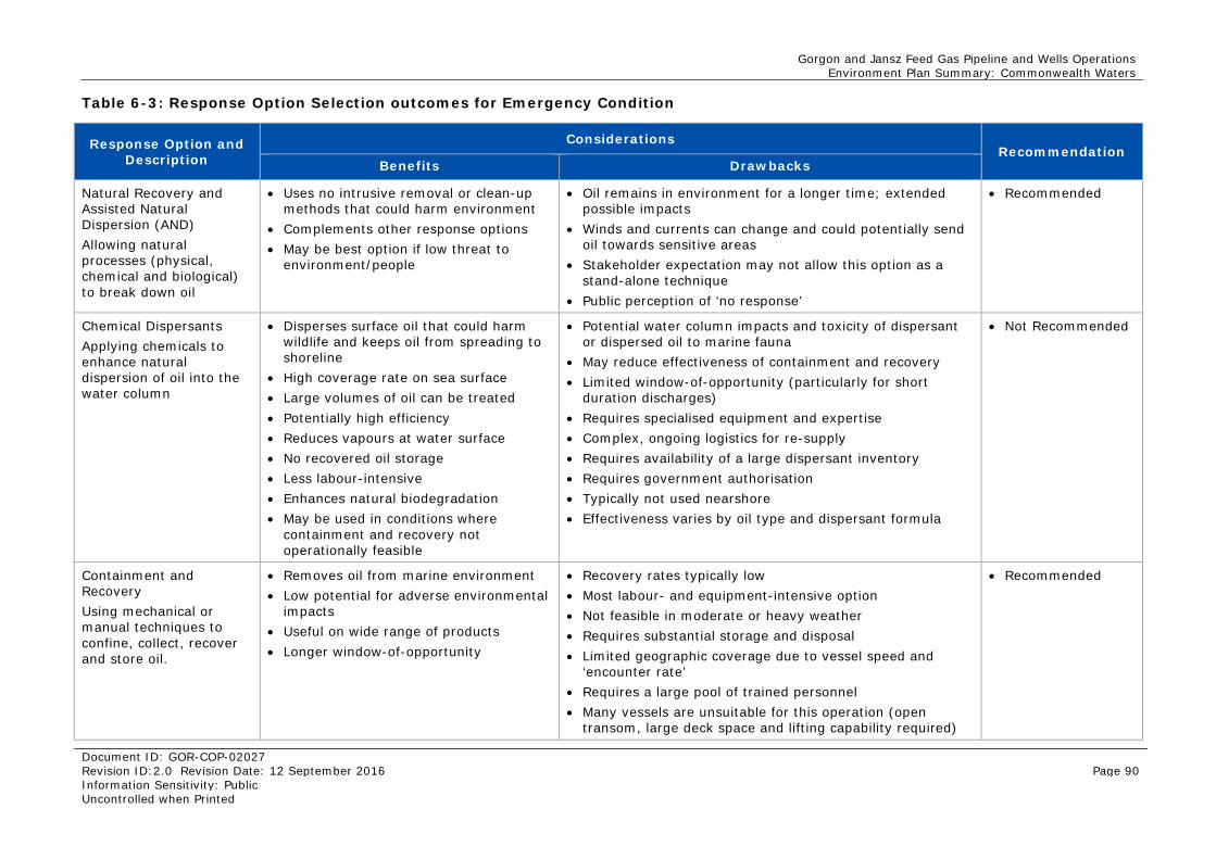
Gorgon and Jansz Feed Gas Pipeline and Wells Operations Environment Plan Summary: Commonwealth Waters
Document ID: GOR-COP-02027 Revision ID:2.0 Revision Date: 12 September 2016 Page 90 Information Sensitivity: Public Uncontrolled when Printed
Table 6-3: Response Option Selection outcomes for Emergency Condition
Response Option and Description
Considerations Recommendation
Benefits Drawbacks
Natural Recovery and Assisted Natural Dispersion (AND) Allowing natural processes (physical, chemical and biological) to break down oil
• Uses no intrusive removal or clean-up methods that could harm environment
• Complements other response options • May be best option if low threat to
environment/people
• Oil remains in environment for a longer time; extended possible impacts
• Winds and currents can change and could potentially send oil towards sensitive areas
• Stakeholder expectation may not allow this option as a stand-alone technique
• Public perception of ‘no response’
• Recommended
Chemical Dispersants Applying chemicals to enhance natural dispersion of oil into the water column
• Disperses surface oil that could harm wildlife and keeps oil from spreading to shoreline
• High coverage rate on sea surface • Large volumes of oil can be treated • Potentially high efficiency • Reduces vapours at water surface • No recovered oil storage • Less labour-intensive • Enhances natural biodegradation • May be used in conditions where
containment and recovery not operationally feasible
• Potential water column impacts and toxicity of dispersant or dispersed oil to marine fauna
• May reduce effectiveness of containment and recovery • Limited window-of-opportunity (particularly for short
duration discharges) • Requires specialised equipment and expertise • Complex, ongoing logistics for re-supply • Requires availability of a large dispersant inventory • Requires government authorisation • Typically not used nearshore • Effectiveness varies by oil type and dispersant formula
• Not Recommended
Containment and Recovery Using mechanical or manual techniques to confine, collect, recover and store oil.
• Removes oil from marine environment • Low potential for adverse environmental
impacts • Useful on wide range of products • Longer window-of-opportunity
• Recovery rates typically low • Most labour- and equipment-intensive option • Not feasible in moderate or heavy weather • Requires substantial storage and disposal • Limited geographic coverage due to vessel speed and
‘encounter rate’ • Requires a large pool of trained personnel • Many vessels are unsuitable for this operation (open
transom, large deck space and lifting capability required)
• Recommended
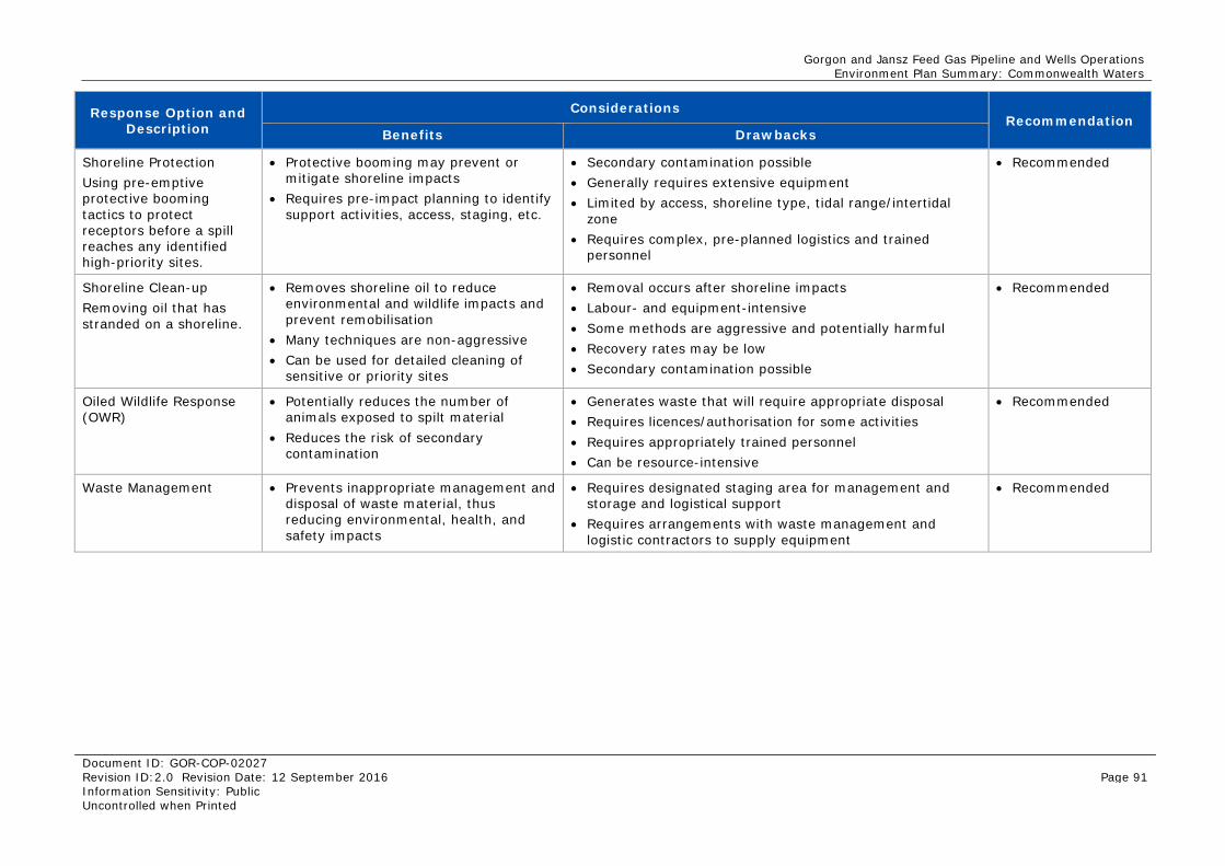
Gorgon and Jansz Feed Gas Pipeline and Wells Operations Environment Plan Summary: Commonwealth Waters
Document ID: GOR-COP-02027 Revision ID:2.0 Revision Date: 12 September 2016 Page 91 Information Sensitivity: Public Uncontrolled when Printed
Response Option and Description
Considerations Recommendation
Benefits Drawbacks
Shoreline Protection Using pre-emptive protective booming tactics to protect receptors before a spill reaches any identified high-priority sites.
• Protective booming may prevent or mitigate shoreline impacts
• Requires pre-impact planning to identify support activities, access, staging, etc.
• Secondary contamination possible • Generally requires extensive equipment • Limited by access, shoreline type, tidal range/intertidal
zone • Requires complex, pre-planned logistics and trained
personnel
• Recommended
Shoreline Clean-up Removing oil that has stranded on a shoreline.
• Removes shoreline oil to reduce environmental and wildlife impacts and prevent remobilisation
• Many techniques are non-aggressive • Can be used for detailed cleaning of
sensitive or priority sites
• Removal occurs after shoreline impacts • Labour- and equipment-intensive • Some methods are aggressive and potentially harmful • Recovery rates may be low • Secondary contamination possible
• Recommended
Oiled Wildlife Response (OWR)
• Potentially reduces the number of animals exposed to spilt material
• Reduces the risk of secondary contamination
• Generates waste that will require appropriate disposal • Requires licences/authorisation for some activities • Requires appropriately trained personnel • Can be resource-intensive
• Recommended
Waste Management • Prevents inappropriate management and disposal of waste material, thus reducing environmental, health, and safety impacts
• Requires designated staging area for management and storage and logistical support
• Requires arrangements with waste management and logistic contractors to supply equipment
• Recommended
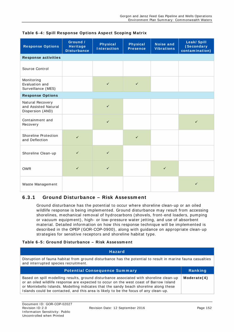
Gorgon and Jansz Feed Gas Pipeline and Wells Operations Environment Plan Summary: Commonwealth Waters
Document ID: GOR-COP-02027 Revision ID:2.0 Revision Date: 12 September 2016 Page 152 Information Sensitivity: Public Uncontrolled when Printed
Table 6-4: Spill Response Options Aspect Scoping Matrix
Response Options Ground / Heritage
Disturbance
Physical Interaction
Physical Presence
Noise and Vibrations
Leak/Spill (Secondary
contamination)
Response activities
Source Control
Monitoring Evaluation and Surveillance (MES)
Response Options
Natural Recovery and Assisted Natural Dispersion (AND)
Containment and Recovery
Shoreline Protection and Deflection
Shoreline Clean-up
OWR
Waste Management
6.3.1 Ground Disturbance – Risk Assessment Ground disturbance has the potential to occur where shoreline clean-up or an oiled wildlife response is being implemented. Ground disturbance may result from accessing shorelines, mechanical removal of hydrocarbons (shovels, front-end loaders, pumping or vacuum equipment), high- or low-pressure water jetting, and use of absorbent material. Detailed information on how this response technique will be implemented is described in the OPEP (GOR-COP-0900), along with guidance on appropriate clean-up strategies for sensitive receptors and shoreline habitat type.
Table 6-5: Ground Disturbance – Risk Assessment
Hazard
Disruption of fauna habitat from ground disturbance has the potential to result in marine fauna casualties and interrupted species recruitment.
Potential Consequence Summary Ranking
Based on spill modelling results, ground disturbance associated with shoreline clean-up or an oiled wildlife response are expected to occur on the west coast of Barrow Island or Montebello Islands. Modelling indicates that the sandy beach shoreline along these Islands could be contacted, and this area is likely to be the focus of any clean-up.
Moderate(4)
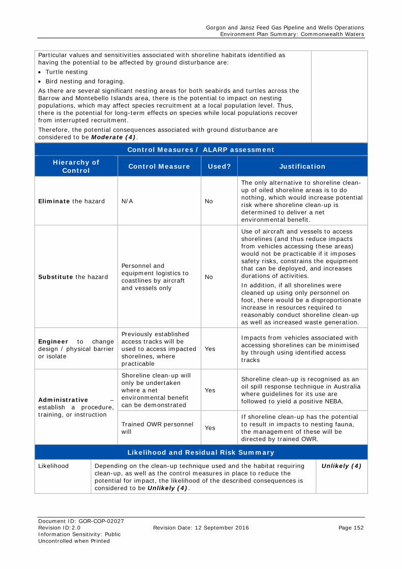
Gorgon and Jansz Feed Gas Pipeline and Wells Operations Environment Plan Summary: Commonwealth Waters
Document ID: GOR-COP-02027 Revision ID:2.0 Revision Date: 12 September 2016 Page 152 Information Sensitivity: Public Uncontrolled when Printed
Particular values and sensitivities associated with shoreline habitats identified as having the potential to be affected by ground disturbance are: • Turtle nesting • Bird nesting and foraging. As there are several significant nesting areas for both seabirds and turtles across the Barrow and Montebello Islands area, there is the potential to impact on nesting populations, which may affect species recruitment at a local population level. Thus, there is the potential for long-term effects on species while local populations recover from interrupted recruitment. Therefore, the potential consequences associated with ground disturbance are considered to be Moderate (4).
Control Measures / ALARP assessment
Hierarchy of Control Control Measure Used? Justification
Eliminate the hazard N/A No
The only alternative to shoreline clean-up of oiled shoreline areas is to do nothing, which would increase potential risk where shoreline clean-up is determined to deliver a net environmental benefit.
Substitute the hazard
Personnel and equipment logistics to coastlines by aircraft and vessels only
No
Use of aircraft and vessels to access shorelines (and thus reduce impacts from vehicles accessing these areas) would not be practicable if it imposes safety risks, constrains the equipment that can be deployed, and increases durations of activities. In addition, if all shorelines were cleaned up using only personnel on foot, there would be a disproportionate increase in resources required to reasonably conduct shoreline clean-up as well as increased waste generation.
Engineer to change design / physical barrier or isolate
Previously established access tracks will be used to access impacted shorelines, where practicable
Yes
Impacts from vehicles associated with accessing shorelines can be minimised by through using identified access tracks
Administrative – establish a procedure, training, or instruction
Shoreline clean-up will only be undertaken where a net environmental benefit can be demonstrated
Yes
Shoreline clean-up is recognised as an oil spill response technique in Australia where guidelines for its use are followed to yield a positive NEBA.
Trained OWR personnel will Yes
If shoreline clean-up has the potential to result in impacts to nesting fauna, the management of these will be directed by trained OWR.
Likelihood and Residual Risk Summary
Likelihood Depending on the clean-up technique used and the habitat requiring clean-up, as well as the control measures in place to reduce the potential for impact, the likelihood of the described consequences is considered to be Unlikely (4).
Unlikely (4)
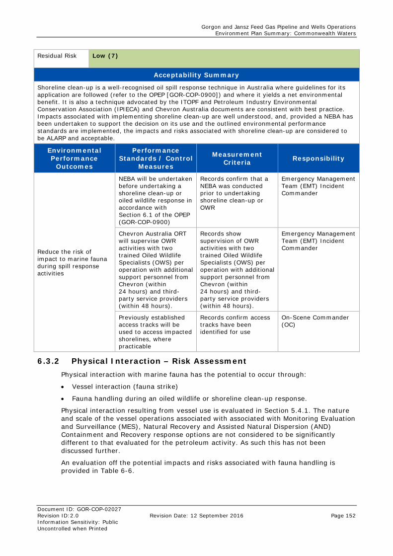
Gorgon and Jansz Feed Gas Pipeline and Wells Operations Environment Plan Summary: Commonwealth Waters
Document ID: GOR-COP-02027 Revision ID:2.0 Revision Date: 12 September 2016 Page 152 Information Sensitivity: Public Uncontrolled when Printed
Residual Risk Low (7)
Acceptability Summary
Shoreline clean-up is a well-recognised oil spill response technique in Australia where guidelines for its application are followed (refer to the OPEP [GOR-COP-0900]) and where it yields a net environmental benefit. It is also a technique advocated by the ITOPF and Petroleum Industry Environmental Conservation Association (IPIECA) and Chevron Australia documents are consistent with best practice. Impacts associated with implementing shoreline clean-up are well understood, and, provided a NEBA has been undertaken to support the decision on its use and the outlined environmental performance standards are implemented, the impacts and risks associated with shoreline clean-up are considered to be ALARP and acceptable.
Environmental Performance
Outcomes
Performance Standards / Control
Measures
Measurement Criteria Responsibility
Reduce the risk of impact to marine fauna during spill response activities
NEBA will be undertaken before undertaking a shoreline clean-up or oiled wildlife response in accordance with Section 6.1 of the OPEP (GOR-COP-0900)
Records confirm that a NEBA was conducted prior to undertaking shoreline clean-up or OWR
Emergency Management Team (EMT) Incident Commander
Chevron Australia ORT will supervise OWR activities with two trained Oiled Wildlife Specialists (OWS) per operation with additional support personnel from Chevron (within 24 hours) and third-party service providers (within 48 hours).
Records show supervision of OWR activities with two trained Oiled Wildlife Specialists (OWS) per operation with additional support personnel from Chevron (within 24 hours) and third-party service providers (within 48 hours).
Emergency Management Team (EMT) Incident Commander
Previously established access tracks will be used to access impacted shorelines, where practicable
Records confirm access tracks have been identified for use
On-Scene Commander (OC)
6.3.2 Physical Interaction – Risk Assessment Physical interaction with marine fauna has the potential to occur through:
• Vessel interaction (fauna strike)
• Fauna handling during an oiled wildlife or shoreline clean-up response.
Physical interaction resulting from vessel use is evaluated in Section 5.4.1. The nature and scale of the vessel operations associated with associated with Monitoring Evaluation and Surveillance (MES), Natural Recovery and Assisted Natural Dispersion (AND) Containment and Recovery response options are not considered to be significantly different to that evaluated for the petroleum activity. As such this has not been discussed further.
An evaluation off the potential impacts and risks associated with fauna handling is provided in Table 6-6.
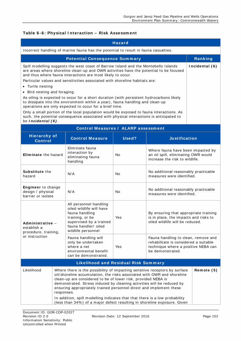
Gorgon and Jansz Feed Gas Pipeline and Wells Operations Environment Plan Summary: Commonwealth Waters
Document ID: GOR-COP-02027 Revision ID:2.0 Revision Date: 12 September 2016 Page 152 Information Sensitivity: Public Uncontrolled when Printed
Table 6-6: Physical Interaction – Risk Assessment
Hazard
Incorrect handling of marine fauna has the potential to result in fauna casualties.
Potential Consequence Summary Ranking
Spill modelling suggests the west coast of Barrow Island and the Montebello Islands are areas where shoreline clean-up and OWR activities have the potential to be focused and thus where fauna interactions are most likely to occur. Particular values and sensitivities associated with shoreline habitats are: • Turtle nesting • Bird nesting and foraging. As oiling is expected to occur for a short duration (with persistent hydrocarbons likely to dissipate into the environment within a year), fauna handling and clean-up operations are only expected to occur for a brief time. Only a small portion of the local population would be exposed to fauna interactions. As such, the potential consequence associated with physical interactions is anticipated to be Incidental (6).
Incidental (6)
Control Measures / ALARP assessment
Hierarchy of Control Control Measure Used? Justification
Eliminate the hazard
Eliminate fauna interaction by eliminating fauna handling
No Where fauna have been impacted by an oil spill, eliminating OWR would increase the risk to wildlife.
Substitute the hazard N/A No No additional reasonably practicable
measures were identified.
Engineer to change design / physical barrier or isolate
N/A No No additional reasonably practicable measures were identified.
Administrative – establish a procedure, training, or instruction
All personnel handling oiled wildlife will have fauna handling training, or be supervised by a trained fauna handler/ oiled wildlife personnel
Yes By ensuring that appropriate training is in place, the impacts and risks to oiled wildlife will be reduced.
Fauna handling will only be undertaken where a net environmental benefit can be demonstrated.
Yes
Fauna handling to clean, remove and rehabilitate is considered a suitable technique where a positive NEBA can be demonstrated.
Likelihood and Residual Risk Summary
Likelihood Where there is the possibility of impacting sensitive receptors by surface oil/shoreline accumulation, the risks associated with OWR and shoreline clean-up are considered to be of lower risk, provided NEBA is demonstrated. Stress induced by cleaning activities will be reduced by ensuring appropriately trained personnel direct and implement these responses. In addition, spill modelling indicates that that there is a low probability (less than 34%) of a major defect resulting in shoreline exposure. Given
Remote (5)
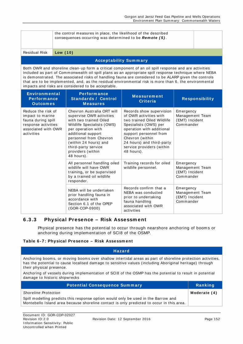
Gorgon and Jansz Feed Gas Pipeline and Wells Operations Environment Plan Summary: Commonwealth Waters
Document ID: GOR-COP-02027 Revision ID:2.0 Revision Date: 12 September 2016 Page 152 Information Sensitivity: Public Uncontrolled when Printed
the control measures in place, the likelihood of the described consequences occurring was determined to be Remote (5).
Residual Risk Low (10)
Acceptability Summary
Both OWR and shoreline clean-up form a critical component of an oil spill response and are activities included as part of Commonwealth oil spill plans as an appropriate spill response technique where NEBA is demonstrated. The associated risks of handling fauna are considered to be ALARP given the controls that are to be implemented, and, as the residual environmental risk is more than 6, the environmental impacts and risks are considered to be acceptable.
Environmental Performance
Outcomes
Performance Standards / Control
Measures
Measurement Criteria Responsibility
Reduce the risk of impact to marine fauna during spill response activities associated with OWR activities
Chevron Australia ORT will supervise OWR activities with two trained Oiled Wildlife Specialists (OWS) per operation with additional support personnel from Chevron (within 24 hours) and third-party service providers (within 48 hours).
Records show supervision of OWR activities with two trained Oiled Wildlife Specialists (OWS) per operation with additional support personnel from Chevron (within 24 hours) and third-party service providers (within 48 hours).
Emergency Management Team (EMT) Incident Commander
All personnel handling oiled wildlife will have OWR training, or be supervised by a trained oil wildlife responder.
Training records for oiled wildlife personnel.
Emergency Management Team (EMT) Incident Commander
NEBA will be undertaken prior handling fauna in accordance with Section 6.1 of the OPEP (GOR-COP-0900)
Records confirm that a NEBA was conducted prior to undertaking fauna handling associated with OWR activities
Emergency Management Team (EMT) Incident Commander
6.3.3 Physical Presence – Risk Assessment Physical presence has the potential to occur through nearshore anchoring of booms or anchoring during implementation of SCI8 of the OSMP.
Table 6-7: Physical Presence – Risk Assessment
Hazard
Anchoring booms, or moving booms over shallow intertidal areas as part of shoreline protection activities, has the potential to cause localised damage to sensitive values (including Aboriginal heritage) through their physical presence. Anchoring of vessels during implementation of SCI8 of the OSMP has the potential to result in potential damage to historic shipwrecks
Potential Consequence Summary Ranking
Shoreline Protection Spill modelling predicts this response option would only be used in the Barrow and Montebello Island area because shoreline contact is only predicted to occur in this area.
Moderate (4)
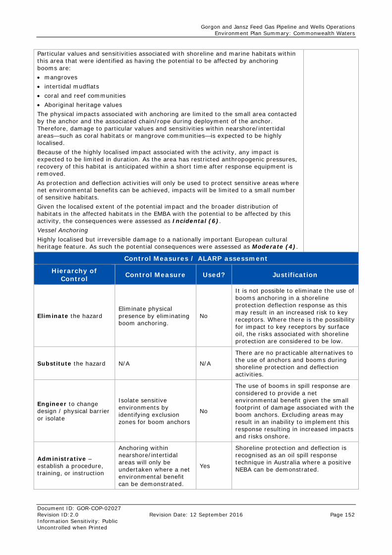
Gorgon and Jansz Feed Gas Pipeline and Wells Operations Environment Plan Summary: Commonwealth Waters
Document ID: GOR-COP-02027 Revision ID:2.0 Revision Date: 12 September 2016 Page 152 Information Sensitivity: Public Uncontrolled when Printed
Particular values and sensitivities associated with shoreline and marine habitats within this area that were identified as having the potential to be affected by anchoring booms are: • mangroves • intertidal mudflats • coral and reef communities • Aboriginal heritage values The physical impacts associated with anchoring are limited to the small area contacted by the anchor and the associated chain/rope during deployment of the anchor. Therefore, damage to particular values and sensitivities within nearshore/intertidal areas—such as coral habitats or mangrove communities—is expected to be highly localised. Because of the highly localised impact associated with the activity, any impact is expected to be limited in duration. As the area has restricted anthropogenic pressures, recovery of this habitat is anticipated within a short time after response equipment is removed. As protection and deflection activities will only be used to protect sensitive areas where net environmental benefits can be achieved, impacts will be limited to a small number of sensitive habitats. Given the localised extent of the potential impact and the broader distribution of habitats in the affected habitats in the EMBA with the potential to be affected by this activity, the consequences were assessed as Incidental (6). Vessel Anchoring Highly localised but irreversible damage to a nationally important European cultural heritage feature. As such the potential consequences were assessed as Moderate (4).
Control Measures / ALARP assessment
Hierarchy of Control Control Measure Used? Justification
Eliminate the hazard Eliminate physical presence by eliminating boom anchoring.
No
It is not possible to eliminate the use of booms anchoring in a shoreline protection deflection response as this may result in an increased risk to key receptors. Where there is the possibility for impact to key receptors by surface oil, the risks associated with shoreline protection are considered to be low.
Substitute the hazard N/A N/A
There are no practicable alternatives to the use of anchors and booms during shoreline protection and deflection activities.
Engineer to change design / physical barrier or isolate
Isolate sensitive environments by identifying exclusion zones for boom anchors
No
The use of booms in spill response are considered to provide a net environmental benefit given the small footprint of damage associated with the boom anchors. Excluding areas may result in an inability to implement this response resulting in increased impacts and risks onshore.
Administrative – establish a procedure, training, or instruction
Anchoring within nearshore/intertidal areas will only be undertaken where a net environmental benefit can be demonstrated.
Yes
Shoreline protection and deflection is recognised as an oil spill response technique in Australia where a positive NEBA can be demonstrated.
Gorgon and Jansz Feed Gas Pipeline and Wells Operations Environment Plan Summary: Commonwealth Waters
Document ID: GOR-COP-02027 Revision ID:2.0 Revision Date: 12 September 2016 Page 152 Information Sensitivity: Public Uncontrolled when Printed
Chevron GIS database will store all registered historic shipwreck locations in the N.W. shelf region and be accessible to EMT in the event of an oil spill emergency condition
Yes
By ensuring that historic shipwreck locations are captured inn internal systems response activities will ensure impacts to these are prevented where possible.
Chevron GIS database and external mapping application including DoT OSRA will be reviewed for registered historic shipwreck locations in the event of an oil spill emergency condition
Yes
No access to shipwreck protection zones in the event of a spill, unless authorisation is granted by the Department of the Environment
Yes
No anchoring to be undertaken within the shipwreck protection zones.
Yes
Likelihood and Residual Risk Summary
Likelihood Based on spill modelling outputs, the likelihood of shoreline protection affecting sensitive receptors such as mangroves and coral reef systems is low. Impacts to marine habitats are more likely to occur in waters off the west coast of Barrow Island, where the predominant marine assemblage is a macroalgal community on a limestone pavement. The location of sensitive marine habitats at Barrow Island is well documented and the use of preferred coastal locations for staging, deployment, and booming operations will limit the potential for damage to any identified sensitivities. With control measures in place, the potential for the consequences described above were determined to be Unlikely (4).
Unlikely (4)
Residual Risk Low (7)
Acceptability Summary
Shoreline protection and deflection is recognised as an oil spill response technique in Australia where guidelines for its application are followed (refer to the OPEP [GOR-COP-0900]) and it yields a net environmental benefit. Because the residual environmental risk associated with this hazard is more than 6, and because the activity is a technique advocated by the ITOPF, the environmental impacts and risks associated with these activities is considered to be ALARP and acceptable.
Gorgon and Jansz Feed Gas Pipeline and Wells Operations Environment Plan Summary: Commonwealth Waters
Document ID: GOR-COP-02027 Revision ID:2.0 Revision Date: 12 September 2016 Page 152 Information Sensitivity: Public Uncontrolled when Printed
Environmental Performance
Outcomes
Performance Standards / Control
Measures
Measurement Criteria Responsibility
Reduce the risk of impact to shoreline and marine habitats associated with protection and deflection activities
NEBA will be undertaken prior to anchoring booms in nearshore/intertidal areas in accordance with Section 6.1 of the OPEP (GOR-COP-0900)
Records confirm that a NEBA was conducted prior to undertaking shoreline protection and deflection activities
Emergency Management Team (EMT) Incident Commander
No physical disturbance to historic shipwrecks.
Chevron GIS database will store all registered historic shipwreck locations in the N.W. shelf region and be accessible to EMT in the event of an oil spill emergency condition
GIS database query able to display registered historic shipwreck locations
ABU GIS Analyst
Chevron GIS database and external mapping application including DoT OSRA will be reviewed for registered historic shipwreck locations in the event of an oil spill emergency condition
Incident records confirm database searches for registered historic shipwreck locations
Emergency Management Team (EMT) Incident Commander
No access to shipwreck protection zones in the event of a spill, unless authorisation is granted by the Department of the Environment
Records confirm approval has been given by Department of the Environment to access shipwreck protection zones in the event of a spill
No anchoring to be undertaken within the shipwreck protection zones.
IMT Logs confirm that no anchoring has been undertaken within shipwreck protection zones.
6.3.4 Noise and Vibrations – Risk Assessment Noise has the potential to be generated through hazing activities during an oiled wildlife response.
Table 6-8: Noise and Vibrations – Risk Assessment
Hazard
Noise generation from spill response activities has the potential to result in auditory fatigue to marine fauna or behaviour changes resulting in environmental harm.
Potential Consequence Summary Ranking
Potential noise impacts associated with hazing activities are mainly associated with the disruption of fauna behaviour; noise levels associated with these activities are not expected to result in fauna casualties. However, there is the potential that changes in behaviour may result in casualties through fatigue or disruption during a sensitive life
Incidental (6)
Gorgon and Jansz Feed Gas Pipeline and Wells Operations Environment Plan Summary: Commonwealth Waters
Document ID: GOR-COP-02027 Revision ID:2.0 Revision Date: 12 September 2016 Page 152 Information Sensitivity: Public Uncontrolled when Printed
stage. The particular values and sensitivities associated with the potential to be impacted by noise are: • Bird nesting and foraging Within the Barrow and Montebello Islands area are important nesting areas for seabirds. If these receptors are impacted, there is the potential for localised short-term effects on local populations. As such, hazing activities are considered as having the potential for environmental damage and subsequently the potential consequence associated with these impacts and risks is considered to be Incidental (6).
Control Measures / ALARP assessment
Hierarchy of Control Control Measure Used? Justification
Eliminate the hazard Eliminate noise impacts by eliminating hazing activities.
No
It is not possible to eliminate the use of hazing during an OWR as this may result in an increased risk and mortality to key receptors. Where there is the possibility for shorelines to be exposed to oil, hazing is considered to be a suitable option for minimising hydrocarbon exposure to seabirds.
Substitute the hazard N/A N/A There are no practicable alternatives to the use of hazing activities.
Engineer to change design / physical barrier or isolate
Isolate areas of sensitive receptors where hazing will not be implemented
No
Given the hydrocarbon type and nature and scale of the event (limited volumes ashore), no areas have been identified where hazing would not be considered suitable. This is as hazing activities would only be used for a short period of time to enable clean-up efforts.
Administrative – establish a procedure, training, or instruction
Hazing activities will be inspected to ensure that there is no direct impact to fauna associated with this response technique
Yes Inspection of hazing or deterrent activities will be conducted to ensure no direct injury to fauna.
Likelihood and Residual Risk Summary
Likelihood Based on spill modelling outputs, the likelihood of noise from hazing activities affecting sensitive receptors—such as nesting seabirds and Humpback Whales—is low. Given the hydrocarbon type (gas condensate), it is expected that most hydrocarbons would evaporate and thus impacts are expected to be localised to specific coastal locations. With control measures in place, the potential for the consequences described above were determined to be Remote (5).
Remote (5)
Residual Risk Low (10)
Acceptability Summary
Oiled wildlife (hazing) is recognised as an oil spill response technique in Australia where it yields a net environmental benefit. As the residual environmental risk associated with this hazard is more than 6, and because the activity is a technique advocated by the ITOPF, the environmental impacts and risks associated with these activities is considered ALARP and acceptable.
Gorgon and Jansz Feed Gas Pipeline and Wells Operations Environment Plan Summary: Commonwealth Waters
Document ID: GOR-COP-02027 Revision ID:2.0 Revision Date: 12 September 2016 Page 152 Information Sensitivity: Public Uncontrolled when Printed
Environmental Performance
Outcomes
Performance Standards / Control
Measures
Measurement Criteria Responsibility
Reduce the risk of causing impacts to seabirds from noise emissions during hazing
Hazing activities will be inspected to ensure that there is no direct impact to seabirds from hazing
Response records confirm inspections of hazing and deterrent activities undertaken during response activities
On-Scene Commander (OC)
6.3.5 Secondary Contamination– Risk Assessment Secondary contamination has the potential to occur where inadequate management of waste occurs. If wastes are inappropriately stored or if there is inadequate capacity to handle the types or volumes of waste generated by the spill response, contamination of the holding areas could occur.
Table 6-9: Secondary Contamination – Risk Assessment
Hazard
Inappropriate waste management may pose a hazard to marine or terrestrial receptors via secondary contamination (e.g. toxicity or ingestion of waste material, or damage to habitats as a result of staging area establishment).
Potential Consequence Summary Ranking
Hazardous oily wastes accidentally released to the environment can cause localised water and sediment contamination, with either direct or indirect effects on marine organisms and habitats. The extent of exposure is expected to be highly localised to the area in which wastes are being collected and managed. Because the potential localised extent, the duration of impact is expected to be temporary and limited to the duration of containment and recovery, shoreline clean-up and Oiled Wildlife Response activities. Due to the localised temporary nature of the impact, fauna species (e.g. turtles or seabirds) are most at risk; however, given the extent of the hazard, only isolated individuals and/or incidental areas of habitat have the potential to be affected. Thus, potential impacts to any particular values or sensitivities would be short-term and localised in nature. Therefore, the consequences from waste management are assessed to be Incidental (6).
Incidental (6)
Control Measures / ALARP assessment
Hierarchy of Control Control Measure Used? Justification
Eliminate the hazard
Eliminate secondary contamination by eliminating waste management activities
No
Waste management is a critical component for oil spill response and there is no alternative other than ‘do nothing’, which delivers greater risk to the environment and hence provides no net environmental benefit.
Substitute the hazard N/A No There are no practicable alternatives to the management of waste during spill response.
Engineer to change design / physical barrier or isolate
N/A N/A There are no practicable alternatives to the management of waste during spill response.
Gorgon and Jansz Feed Gas Pipeline and Wells Operations Environment Plan Summary: Commonwealth Waters
Document ID: GOR-COP-02027 Revision ID:2.0 Revision Date: 12 September 2016 Page 152 Information Sensitivity: Public Uncontrolled when Printed
Administrative – establish a procedure, training, or instruction
• All waste material collected during spill response activities will be appropriately segregated, stored, handled, transported, and disposed of at a licenced facility, if disposed of in Australia
Yes
By ensuring appropriate waste management practices are in place, the risk of secondary contamination from improper waste management can be managed
• Documented Procedures for waste management – Oil Spill Response Guidance Note: Waste Management
Yes
Response activities such as containment and recovery may result in the generation of a range of response-related wastes. Processes and procedures such as the Oil Spill Response Guidance Note: Waste Management (ABU140200023) for have been developed and implemented to coordinate handling, managing, storing, and disposing of waste to minimise volumes and ensure correct disposal.
• Documented Procedures for waste management – Third-Party Contract.
Yes
Chevron has identified and contracted specialist waste providers to ensure proper disposal of response-generated wastes. Chevron has a contract with Toxfree. .
Likelihood and Residual Risk Summary
Likelihood With the identified controls in place, the likelihood of localised impacts to habitats/ecological communities and marine fauna from inappropriate disposal of waste generated during the response was determined to be Rare (6).
Rare (6)
Residual Risk Low (10)
Acceptability Summary
Waste management is a critical on-scene management support function for oil spill response and will be managed consistent with relevant Commonwealth, State, and local government regulations, and in consultation with relevant authorities. All associated risks are considered to be ALARP and because the residual environmental risk is more than 6, the environmental impacts and risks are acceptable with the specified procedural controls in place.
Environmental Performance
Outcomes
Performance Standards / Control
Measures
Measurement Criteria Responsibility
Reduce the risk of causing impacts to marine fauna associated with waste management activities during spill response activities
All waste material collected during spill response activities will be appropriately segregated, stored, handled, transported, and disposed of at a licenced facility, if disposed of in Australia
Waste records confirm waste disposed of to a licenced facility, if disposed of in Australia
EMT Incident Commander
Waste management activities conducted in accordance with Oil Spill Response Guidance Note:
Records confirm waste management is undertaken in accordance with Oil Spill Response Guidance
EMT Incident Commander
Gorgon and Jansz Feed Gas Pipeline and Wells Operations Environment Plan Summary: Commonwealth Waters
Document ID: GOR-COP-02027 Revision ID:2.0 Revision Date: 12 September 2016 Page 152 Information Sensitivity: Public Uncontrolled when Printed
Waste Management. Note: Waste Management
Contract is in place with third-party waste provider.
Records show third-party waste contract is in place.
HES Specialist – Waste
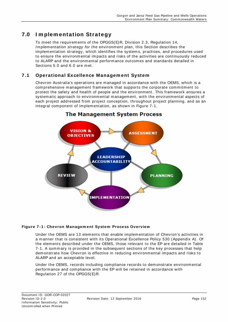
Gorgon and Jansz Feed Gas Pipeline and Wells Operations Environment Plan Summary: Commonwealth Waters
Document ID: GOR-COP-02027 Revision ID:2.0 Revision Date: 12 September 2016 Page 152 Information Sensitivity: Public Uncontrolled when Printed
7.0 Implementation Strategy To meet the requirements of the OPGGS(E)R, Division 2.3, Regulation 14, Implementation strategy for the environment plan, this Section describes the implementation strategy, which identifies the systems, practices, and procedures used to ensure the environmental impacts and risks of the activities are continuously reduced to ALARP and the environmental performance outcomes and standards detailed in Sections 5.0 and 6.0 are met.
7.1 Operational Excellence Management System Chevron Australia’s operations are managed in accordance with the OEMS, which is a comprehensive management framework that supports the corporate commitment to protect the safety and health of people and the environment. This framework ensures a systematic approach to environmental management, with the environmental aspects of each project addressed from project conception, throughout project planning, and as an integral component of implementation, as shown in Figure 7-1.
Figure 7-1: Chevron Management System Process Overview
Under the OEMS are 13 elements that enable implementation of Chevron’s activities in a manner that is consistent with its Operational Excellence Policy 530 (Appendix A). Of the elements described under the OEMS, those relevant to the EP are detailed in Table 7-1. A summary is provided in the subsequent sections of the key processes that help demonstrate how Chevron is effective in reducing environmental impacts and risks to ALARP and an acceptable level.
Under the OEMS, records including compliance records to demonstrate environmental performance and compliance with the EP will be retained in accordance with Regulation 27 of the OPGGS(E)R.
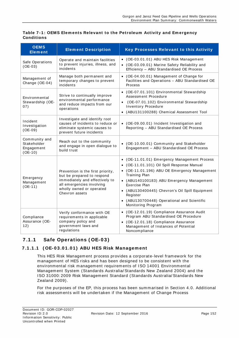
Gorgon and Jansz Feed Gas Pipeline and Wells Operations Environment Plan Summary: Commonwealth Waters
Document ID: GOR-COP-02027 Revision ID:2.0 Revision Date: 12 September 2016 Page 152 Information Sensitivity: Public Uncontrolled when Printed
Table 7-1: OEMS Elements Relevant to the Petroleum Activity and Emergency Conditions
OEMS Element Element Description Key Processes Relevant to this Activity
Safe Operations (OE-03)
Operate and maintain facilities to prevent injuries, illness, and incidents
• (OE-03.01.01) ABU HES Risk Management • (OE-03.09.01) Marine Safety Reliability and
Efficiency – ABU Standardised OE Process
Management of Change (OE-04)
Manage both permanent and temporary changes to prevent incidents
• (OE-04.00.01) Management of Change for Facilities and Operations – ABU Standardised OE Process
Environmental Stewardship (OE-07)
Strive to continually improve environmental performance and reduce impacts from our operations
• (OE-07.01.101) Environmental Stewardship Assessment Procedure
• (OE-07.01.102) Environmental Stewardship Inventory Procedure
• (ABU131100288) Chemical Assessment Tool
Incident Investigation (OE-09)
Investigate and identify root causes of incidents to reduce or eliminate systemic causes to prevent future incidents
• (OE-09.00.01) Incident Investigation and Reporting – ABU Standardised OE Process
Community and Stakeholder Engagement (OE-10)
Reach out to the community and engage in open dialogue to build trust
• (OE-10.00.01) Community and Stakeholder Engagement – ABU Standardised OE Process
Emergency Management (OE-11)
Prevention is the first priority, but be prepared to respond immediately and effectively to all emergencies involving wholly owned or operated Chevron assets
• (OE-11.01.01) Emergency Management Process • (OE-11.01.101) Oil Spill Response Manual • (OE-11.01.196) ABU OE Emergency Management
Training Plan • (ABU140100183) ABU Emergency Management
Exercise Plan • (ABU130400445) Chevron’s Oil Spill Equipment
Register • (ABU130700448) Operational and Scientific
Monitoring Program
Compliance Assurance (OE-12)
Verify conformance with OE requirements in applicable company policy and government laws and regulations
• (OE-12.01.19) Compliance Assurance Audit Program ABU Standardised OE Procedure
• (OE-12.01.18) Compliance Assurance Management of Instances of Potential Noncompliance
7.1.1 Safe Operations (OE-03) 7.1.1.1 (OE-03.01.01) ABU HES Risk Management
This HES Risk Management process provides a corporate-level framework for the management of HES risks and has been designed to be consistent with the environmental risk management requirements of ISO 14001 Environmental Management System (Standards Australia/Standards New Zealand 2004) and the ISO 31000:2009 Risk Management Standard (Standards Australia/Standards New Zealand 2009).
For the purposes of the EP, this process has been summarised in Section 4.0. Additional risk assessments will be undertaken if the Management of Change Process
Gorgon and Jansz Feed Gas Pipeline and Wells Operations Environment Plan Summary: Commonwealth Waters
Document ID: GOR-COP-02027 Revision ID:2.0 Revision Date: 12 September 2016 Page 152 Information Sensitivity: Public Uncontrolled when Printed
(Section 7.1.2) is triggered. The risk assessment will be undertaken in accordance with this process.
This process in conjunction with OE-04.00.01 (Section 7.1.2) are the management system measures that will be used to demonstrate the requirements of Regulation 14(3)(a), that impacts and risks of the petroleum activity continue to be identified and reduced to ALARP.
7.1.1.2 (OE-03.09.01) Marine Safety Reliability and Efficiency – ABU Standardised OE Process
Section 2.1.2 of the Marine Safety, Reliability and Efficiency process references the Upstream Marine Standard which identifies the requirements and activities necessary to deliver safe, reliable and efficient marine services. Specifically, Section 4.1 of the Upstream Marine Standard (Vessel Assurance) explains the requirements for vessels to be inspected annually.
The results of Vessel Inspection Questionnaires are recorded in an Offshore Vessel Inspection Database (OVID) and can be used to ensure environmental performance outcomes are achieved.
7.1.2 Management of Change (OE-04) 7.1.2.1 (OE-04.00.01) Management of Change for Facilities and Operations
The purpose of Chevron’s Management of Change for Facilities and Operations – ABU Standardised OE Process (OE-04.00.01) is to manage changes to facilities, operations, products, and the organisation so as to prevent incidents, support reliable and efficient operations, and to keep unacceptable risks from being introduced into Chevron’s business.
This process will be followed to document and assess the impact of changes to activities described in Section 2.0 in conjunction with OE-03.01.01. These changes will be assessed to determine if there is potential for new or increased environmental impact or risk not already provided for in the EP. If these changes do not trigger OPGGS(E) Regulation 17, as detailed below, the Plan shall be revised and changes recorded within the Plan without resubmission. In accordance with OPGGS(E) Regulation 17, an Environment Plan must be resubmitted to NOPSEMA for approval prior to:
• the commencement of any new activity, or any significant modification to, change, or new stage of an existing activity, not provided for in the Plan
• a change in instrument holder for, or operator of, the activity
• the occurrence of a significant new environmental impact or risk, or significant increase in an existing environmental impact or risk, not provided for in the Plan
• the occurrence of a series of new environmental impacts or risks, or a series of increases in existing environmental impacts or risks, which, taken together, amount to the occurrence of a significant new environmental impact or risk, or a significant increase in an existing environmental impact or risk, not provided for in the Plan.
7.1.3 Environmental Stewardship (OE-07) 7.1.3.1 (OE-07.01.101) Environmental Stewardship Assessment Procedure
The purpose of the Environmental Stewardship Assessment Procedure is to:
• annually assess significant environmental aspects for potential environmental management improvement opportunities to meet applicable requirements, achieve environmental objectives and targets and address potential environmental impacts
• prioritize environmental aspects with potential improvement opportunities.
Gorgon and Jansz Feed Gas Pipeline and Wells Operations Environment Plan Summary: Commonwealth Waters
Document ID: GOR-COP-02027 Revision ID:2.0 Revision Date: 12 September 2016 Page 152 Information Sensitivity: Public Uncontrolled when Printed
This process drives Chevron to ensure that improvement opportunities for significant impacts and risks (as identified in the aspects impacts register Section 7.1.3.2) are continually identified and that the impacts and risks are continually reduced to ALARP in accordance with Regulation 14(3)(a) of the OPGGS(E)R.
7.1.3.2 (OE-07.01.102) Environmental Stewardship Inventory Procedure
The purpose of the Environmental Stewardship Inventory Procedure is to develop an inventory of an operation’s environmental aspects, their potential adverse or beneficial impacts, and the environmental controls currently in use.
This aspects impacts register is used to manage all environmental risk management controls across the business. This includes the control measures as identified within the EP.
7.1.3.3 (ABU131100288) Chemical Assessment Tool
Under the Environmental Stewardship Element, a chemical assessment tool (ABU131100288) has been developed to enable consistent environmental assessments of drilling fluids, chemicals, and other materials that may result in a discharge to the marine environment. This process has been previously described in the NOPSEMA-accepted Wheatstone Development Drilling and Completion Program – Environment Plan (ABU130500319).
For clarity, Chevron has incorporated and amalgamated a number of chemical assessment tools applied across both onshore and offshore applications into a single centralised process called the Hazardous Materials Environmental Assessment Tool (HMEAT).
The document number of the D&C Chemical Assessment Tool (previously accepted) and the new Hazardous Materials Environmental Assessment Tool is ABU131100288. The Hazardous Materials Environmental Assessment Tool is considered to have superseded the D&C Tool. The Offshore Chemical Environmental Work Instruction (ABU130400521) was developed specifically to guide the assessment process for Drilling and Completion chemical evaluations. The components of the Work Instruction remain within the updated HMEAT.
The acceptability of each chemical application is evaluated through a semi‐quantitative assessment which considers three components that influence the potential risk associated with the use/discharge of a chemical to the marine environment. These components are:
• inherent chemical properties
• environmental sensitivities within the receiving environment
• chemical application.
The chemical environmental risk assessment generates a chemical application risk profile. Chemicals with an unacceptable chemical risk profile are rejected.
Chevron’s Chemical Selection Tool reduces risks to ALARP by:
• allowing for the non-acceptance (elimination) of chemicals based upon their chemical characteristics including persistent, bioaccumulation and toxicity in relation to the sensitivities associated with the receiving environment
• incorporating a process for identifying chemicals that may by subject to substitution warnings as applied by the U.K. Offshore Chemical Notification Scheme (OCNS)
• providing for alternatives analysis, prompting the chemical requester to seek technically equivalent, but potentially less ecologically harmful, chemicals where practicable
Gorgon and Jansz Feed Gas Pipeline and Wells Operations Environment Plan Summary: Commonwealth Waters
Document ID: GOR-COP-02027 Revision ID:2.0 Revision Date: 12 September 2016 Page 152 Information Sensitivity: Public Uncontrolled when Printed
• providing suitable administrative controls to enable to evaluation of chemicals prior to use and enables the record keeping of assessment outcomes
• providing for the evaluation to be undertaken by HES professionals embedded within the organisation.
With the application of the above ALARP criteria, including the consideration of site-specific environmental sensitivities, the tool actively demonstrates the selection of most acceptable chemical alternatives (where technically practicable).
In accordance with Section 5.2 of the EP, the chemical assessment tool plan will be used to ensure environmental performance outcomes are achieved.
7.1.4 Incident Investigation (OE-09) 7.1.4.1 (OE-09.00.01) Incident Investigation and Reporting – ABU
Standardised OE Process
The Incident Investigation and Reporting Process – ABU Standardised OE Process (OE-09.00.01) describes the process in which Chevron reports and investigates incidents. Specifically, and in accordance with this process, all environmental incidents within the scope of the EP will be reported by Chevron as per Table 7-9.
7.1.5 Community and Stakeholder Engagement (OE-10) 7.1.5.1 (OE-10.00.01) Community and Stakeholder Engagement – ABU
Standardised OE Process
The Chevron’s Community and Stakeholder Engagement ABU Standardised OE Process (OE-10.00.01) systematically identifies stakeholders and plans and executes engagement to foster mutual understanding, dialogue, and trust.
In accordance with OPGGS(E) Regulation 14(9), the Stakeholder Consultation Plan describes the process undertaken for appropriate consultation with relevant authorities and relevant interested persons or organisations. Chevron will continue to engage with relevant stakeholders as described in the Stakeholder Consultation Plan which has been developed under this process.
7.1.6 Emergency Management (OE-11.01) 7.1.6.1 (OE-11.01.01) Emergency Management Process
The Emergency Management Process provides organisational structures, management processes, and the tools necessary to respond to emergencies and to prevent or mitigate emergency and/or crisis situations; respond to incidents in a safe, rapid, and effective manner; and, restore or resume affected operations of strategic importance to Global Upstream.
The system used to organise Chevron oil spill incident management teams is based on the Incident Command System (ICS) and is compatible with the Australasian Inter-service Incident Management System (AIIMS) and the Oil Spill Incident Control System. This system is also compatible with the National Marine Oil Spill Contingency Plan, whose incident management system is consistent with the AIIMS (Australian Maritime Safety Authority [AMSA] 2014).
The ICS provides a standardised incident command response structure for any emergency and comprises:
• On-site Response Team (ORT)
• Emergency Management Team (EMT):
• Level 2 EMT
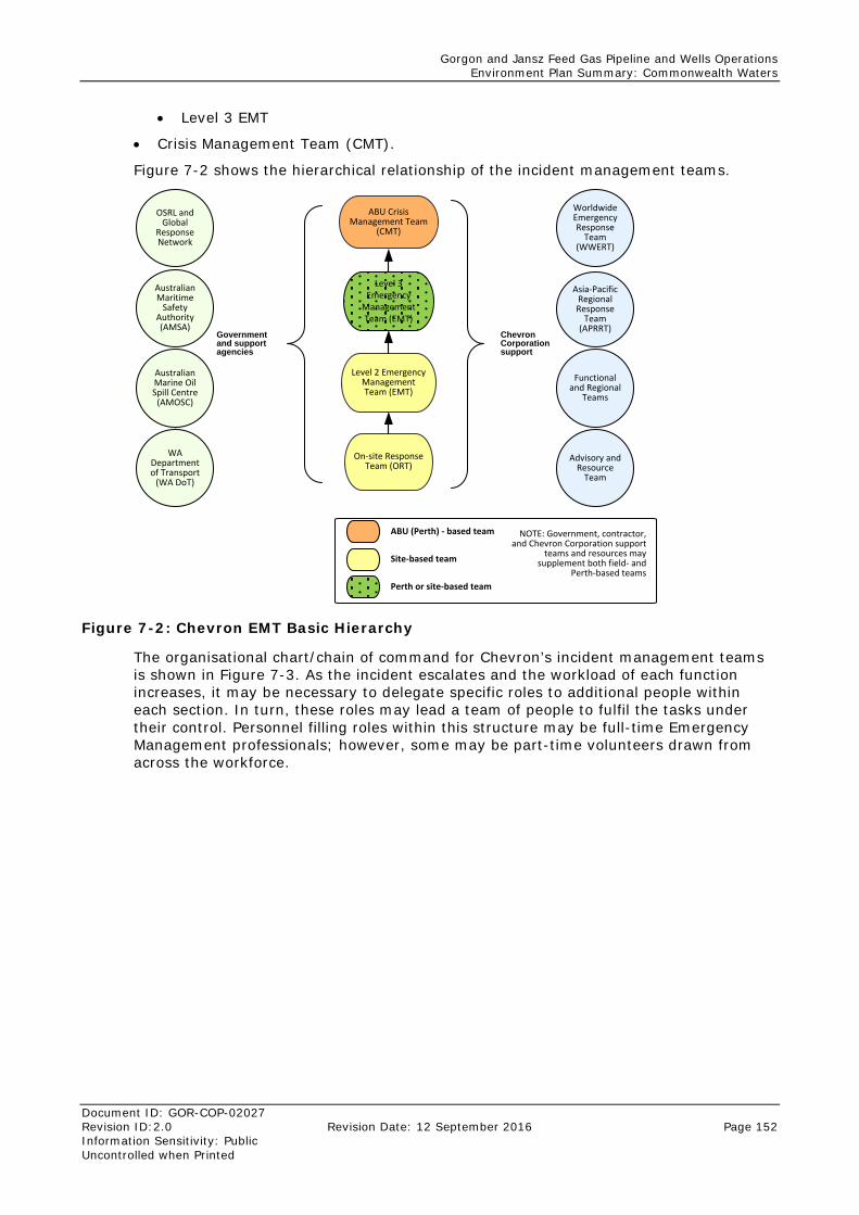
Gorgon and Jansz Feed Gas Pipeline and Wells Operations Environment Plan Summary: Commonwealth Waters
Document ID: GOR-COP-02027 Revision ID:2.0 Revision Date: 12 September 2016 Page 152 Information Sensitivity: Public Uncontrolled when Printed
• Level 3 EMT
• Crisis Management Team (CMT).
Figure 7-2 shows the hierarchical relationship of the incident management teams.
ABU Crisis Management Team
(CMT)
On-site Response Team (ORT)
Level 3 Emergency
Management Team (EMT)
Level 2 Emergency Management Team (EMT)
Australian Marine Oil Spill Centre
(AMOSC)
WA Department of Transport
(WA DoT)
Australian Maritime
Safety Authority (AMSA)
Advisory and Resource
Team
Asia-Pacific Regional Response
Team (APRRT)
Worldwide Emergency Response
Team (WWERT)
Functional and Regional
Teams
OSRL and Global
Response Network
Chevron Corporation support
ABU (Perth) - based team
Site-based team
NOTE: Government, contractor, and Chevron Corporation support
teams and resources may supplement both field- and
Perth-based teams
Government and support agencies
Perth or site-based team
Figure 7-2: Chevron EMT Basic Hierarchy
The organisational chart/chain of command for Chevron’s incident management teams is shown in Figure 7-3. As the incident escalates and the workload of each function increases, it may be necessary to delegate specific roles to additional people within each section. In turn, these roles may lead a team of people to fulfil the tasks under their control. Personnel filling roles within this structure may be full-time Emergency Management professionals; however, some may be part-time volunteers drawn from across the workforce.
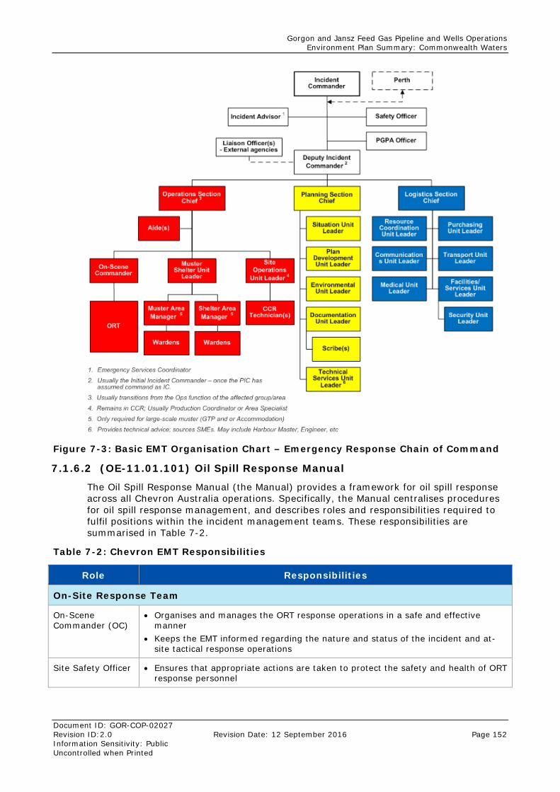
Gorgon and Jansz Feed Gas Pipeline and Wells Operations Environment Plan Summary: Commonwealth Waters
Document ID: GOR-COP-02027 Revision ID:2.0 Revision Date: 12 September 2016 Page 152 Information Sensitivity: Public Uncontrolled when Printed
Figure 7-3: Basic EMT Organisation Chart – Emergency Response Chain of Command
7.1.6.2 (OE-11.01.101) Oil Spill Response Manual
The Oil Spill Response Manual (the Manual) provides a framework for oil spill response across all Chevron Australia operations. Specifically, the Manual centralises procedures for oil spill response management, and describes roles and responsibilities required to fulfil positions within the incident management teams. These responsibilities are summarised in Table 7-2.
Table 7-2: Chevron EMT Responsibilities
Role Responsibilities
On-Site Response Team
On-Scene Commander (OC)
• Organises and manages the ORT response operations in a safe and effective manner
• Keeps the EMT informed regarding the nature and status of the incident and at-site tactical response operations
Site Safety Officer • Ensures that appropriate actions are taken to protect the safety and health of ORT response personnel
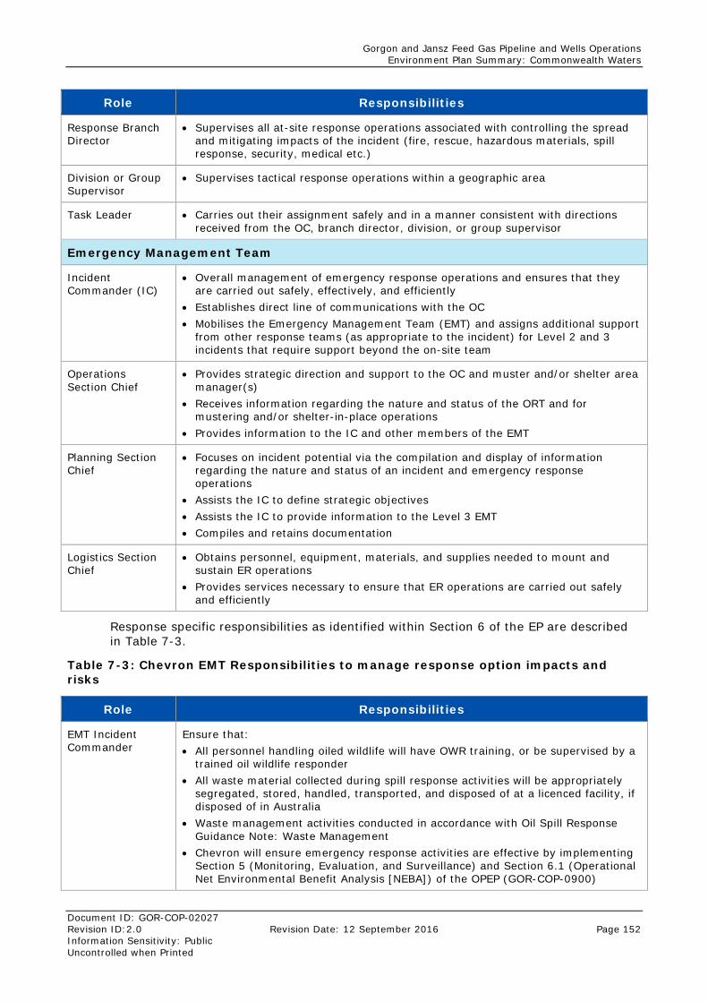
Gorgon and Jansz Feed Gas Pipeline and Wells Operations Environment Plan Summary: Commonwealth Waters
Document ID: GOR-COP-02027 Revision ID:2.0 Revision Date: 12 September 2016 Page 152 Information Sensitivity: Public Uncontrolled when Printed
Role Responsibilities
Response Branch Director
• Supervises all at-site response operations associated with controlling the spread and mitigating impacts of the incident (fire, rescue, hazardous materials, spill response, security, medical etc.)
Division or Group Supervisor
• Supervises tactical response operations within a geographic area
Task Leader • Carries out their assignment safely and in a manner consistent with directions received from the OC, branch director, division, or group supervisor
Emergency Management Team
Incident Commander (IC)
• Overall management of emergency response operations and ensures that they are carried out safely, effectively, and efficiently
• Establishes direct line of communications with the OC • Mobilises the Emergency Management Team (EMT) and assigns additional support
from other response teams (as appropriate to the incident) for Level 2 and 3 incidents that require support beyond the on-site team
Operations Section Chief
• Provides strategic direction and support to the OC and muster and/or shelter area manager(s)
• Receives information regarding the nature and status of the ORT and for mustering and/or shelter-in-place operations
• Provides information to the IC and other members of the EMT
Planning Section Chief
• Focuses on incident potential via the compilation and display of information regarding the nature and status of an incident and emergency response operations
• Assists the IC to define strategic objectives • Assists the IC to provide information to the Level 3 EMT • Compiles and retains documentation
Logistics Section Chief
• Obtains personnel, equipment, materials, and supplies needed to mount and sustain ER operations
• Provides services necessary to ensure that ER operations are carried out safely and efficiently
Response specific responsibilities as identified within Section 6 of the EP are described in Table 7-3.
Table 7-3: Chevron EMT Responsibilities to manage response option impacts and risks
Role Responsibilities
EMT Incident Commander
Ensure that: • All personnel handling oiled wildlife will have OWR training, or be supervised by a
trained oil wildlife responder • All waste material collected during spill response activities will be appropriately
segregated, stored, handled, transported, and disposed of at a licenced facility, if disposed of in Australia
• Waste management activities conducted in accordance with Oil Spill Response Guidance Note: Waste Management
• Chevron will ensure emergency response activities are effective by implementing Section 5 (Monitoring, Evaluation, and Surveillance) and Section 6.1 (Operational Net Environmental Benefit Analysis [NEBA]) of the OPEP (GOR-COP-0900)
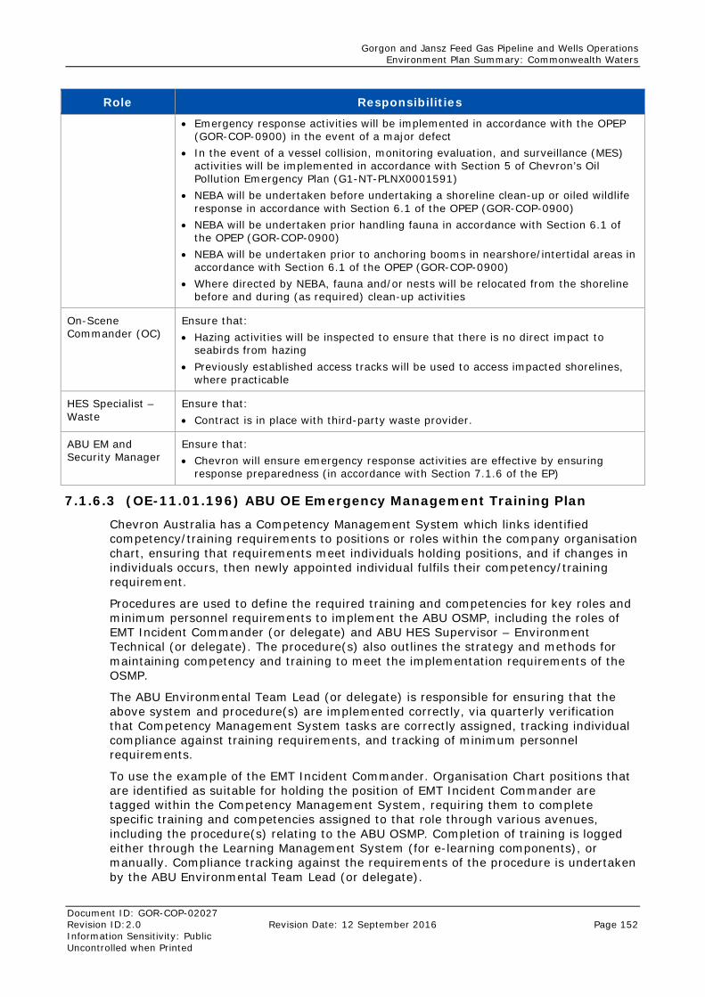
Gorgon and Jansz Feed Gas Pipeline and Wells Operations Environment Plan Summary: Commonwealth Waters
Document ID: GOR-COP-02027 Revision ID:2.0 Revision Date: 12 September 2016 Page 152 Information Sensitivity: Public Uncontrolled when Printed
Role Responsibilities
• Emergency response activities will be implemented in accordance with the OPEP (GOR-COP-0900) in the event of a major defect
• In the event of a vessel collision, monitoring evaluation, and surveillance (MES) activities will be implemented in accordance with Section 5 of Chevron’s Oil Pollution Emergency Plan (G1-NT-PLNX0001591)
• NEBA will be undertaken before undertaking a shoreline clean-up or oiled wildlife response in accordance with Section 6.1 of the OPEP (GOR-COP-0900)
• NEBA will be undertaken prior handling fauna in accordance with Section 6.1 of the OPEP (GOR-COP-0900)
• NEBA will be undertaken prior to anchoring booms in nearshore/intertidal areas in accordance with Section 6.1 of the OPEP (GOR-COP-0900)
• Where directed by NEBA, fauna and/or nests will be relocated from the shoreline before and during (as required) clean-up activities
On-Scene Commander (OC)
Ensure that: • Hazing activities will be inspected to ensure that there is no direct impact to
seabirds from hazing • Previously established access tracks will be used to access impacted shorelines,
where practicable
HES Specialist – Waste
Ensure that: • Contract is in place with third-party waste provider.
ABU EM and Security Manager
Ensure that: • Chevron will ensure emergency response activities are effective by ensuring
response preparedness (in accordance with Section 7.1.6 of the EP)
7.1.6.3 (OE-11.01.196) ABU OE Emergency Management Training Plan
Chevron Australia has a Competency Management System which links identified competency/training requirements to positions or roles within the company organisation chart, ensuring that requirements meet individuals holding positions, and if changes in individuals occurs, then newly appointed individual fulfils their competency/training requirement.
Procedures are used to define the required training and competencies for key roles and minimum personnel requirements to implement the ABU OSMP, including the roles of EMT Incident Commander (or delegate) and ABU HES Supervisor – Environment Technical (or delegate). The procedure(s) also outlines the strategy and methods for maintaining competency and training to meet the implementation requirements of the OSMP.
The ABU Environmental Team Lead (or delegate) is responsible for ensuring that the above system and procedure(s) are implemented correctly, via quarterly verification that Competency Management System tasks are correctly assigned, tracking individual compliance against training requirements, and tracking of minimum personnel requirements.
To use the example of the EMT Incident Commander. Organisation Chart positions that are identified as suitable for holding the position of EMT Incident Commander are tagged within the Competency Management System, requiring them to complete specific training and competencies assigned to that role through various avenues, including the procedure(s) relating to the ABU OSMP. Completion of training is logged either through the Learning Management System (for e-learning components), or manually. Compliance tracking against the requirements of the procedure is undertaken by the ABU Environmental Team Lead (or delegate).
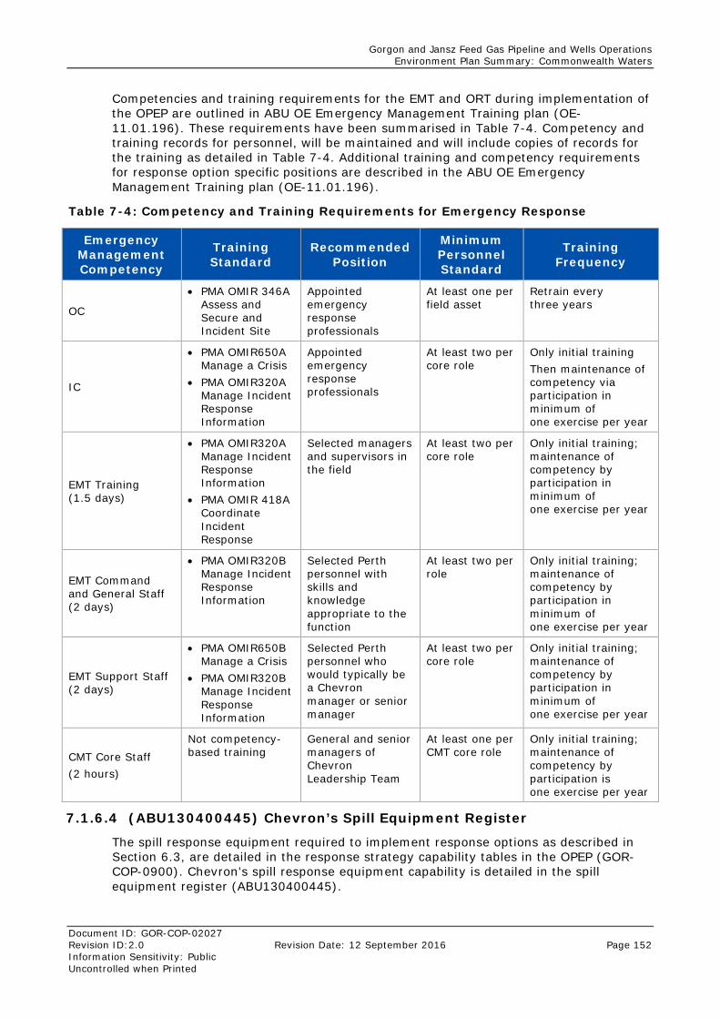
Gorgon and Jansz Feed Gas Pipeline and Wells Operations Environment Plan Summary: Commonwealth Waters
Document ID: GOR-COP-02027 Revision ID:2.0 Revision Date: 12 September 2016 Page 152 Information Sensitivity: Public Uncontrolled when Printed
Competencies and training requirements for the EMT and ORT during implementation of the OPEP are outlined in ABU OE Emergency Management Training plan (OE-11.01.196). These requirements have been summarised in Table 7-4. Competency and training records for personnel, will be maintained and will include copies of records for the training as detailed in Table 7-4. Additional training and competency requirements for response option specific positions are described in the ABU OE Emergency Management Training plan (OE-11.01.196).
Table 7-4: Competency and Training Requirements for Emergency Response
Emergency Management Competency
Training Standard
Recommended Position
Minimum Personnel Standard
Training Frequency
OC
• PMA OMIR 346A Assess and Secure and Incident Site
Appointed emergency response professionals
At least one per field asset
Retrain every three years
IC
• PMA OMIR650A Manage a Crisis
• PMA OMIR320A Manage Incident Response Information
Appointed emergency response professionals
At least two per core role
Only initial training Then maintenance of competency via participation in minimum of one exercise per year
EMT Training (1.5 days)
• PMA OMIR320A Manage Incident Response Information
• PMA OMIR 418A Coordinate Incident Response
Selected managers and supervisors in the field
At least two per core role
Only initial training; maintenance of competency by participation in minimum of one exercise per year
EMT Command and General Staff (2 days)
• PMA OMIR320B Manage Incident Response Information
Selected Perth personnel with skills and knowledge appropriate to the function
At least two per role
Only initial training; maintenance of competency by participation in minimum of one exercise per year
EMT Support Staff (2 days)
• PMA OMIR650B Manage a Crisis
• PMA OMIR320B Manage Incident Response Information
Selected Perth personnel who would typically be a Chevron manager or senior manager
At least two per core role
Only initial training; maintenance of competency by participation in minimum of one exercise per year
CMT Core Staff (2 hours)
Not competency-based training
General and senior managers of Chevron Leadership Team
At least one per CMT core role
Only initial training; maintenance of competency by participation is one exercise per year
7.1.6.4 (ABU130400445) Chevron’s Spill Equipment Register
The spill response equipment required to implement response options as described in Section 6.3, are detailed in the response strategy capability tables in the OPEP (GOR-COP-0900). Chevron’s spill response equipment capability is detailed in the spill equipment register (ABU130400445).
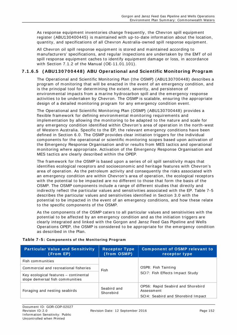
Gorgon and Jansz Feed Gas Pipeline and Wells Operations Environment Plan Summary: Commonwealth Waters
Document ID: GOR-COP-02027 Revision ID:2.0 Revision Date: 12 September 2016 Page 152 Information Sensitivity: Public Uncontrolled when Printed
As response equipment inventories change frequently, the Chevron spill equipment register (ABU130400445) is maintained with up-to-date information about the location, quantity, and specifications of all Chevron Australia-owned spill response equipment.
All Chevron oil spill response equipment is stored and maintained according to manufacturers’ specifications, and regular inspections are undertaken by the EMT of oil spill response equipment caches to identify equipment damage or loss, in accordance with Section 7.1.2 of the Manual (OE-11.01.101).
7.1.6.5 (ABU130700448) ABU Operational and Scientific Monitoring Program
The Operational and Scientific Monitoring Plan (the OSMP) (ABU130700448) describes a program of monitoring that will be enacted in the event of an emergency condition, and is the principal tool for determining the extent, severity, and persistence of environmental impacts from a marine hydrocarbon spill and the emergency response activities to be undertaken by Chevron. The OSMP is scalable, ensuring the appropriate design of a detailed monitoring program for any emergency condition event.
The Operational and Scientific Monitoring Plan (OSMP) (ABU130700448) provides a flexible framework for defining environmental monitoring requirements and implementation by allowing the monitoring to be adapted to the nature and scale for any emergency condition identified within Chevron’s area of operation in the north-west of Western Australia. Specific to the EP, the relevant emergency conditions have been defined in Section 6.0. The OSMP provides clear initiation triggers for the individual components for the operational or scientific monitoring scopes based upon activation of the Emergency Response Organisation and/or results from MES tactics and operational monitoring where appropriate. Activation of the Emergency Response Organisation and MES tactics are clearly described within the OPEP.
The framework for the OSMP is based upon a series of oil spill sensitivity maps that identifies ecological receptors and socioeconomic and heritage features with Chevron’s area of operation. As the petroleum activity and consequently the risks associated with an emergency condition are within Chevron’s area of operation, the ecological receptors with the potential to be impacted are no different to those that form the basis of the OSMP. The OSMP components include a range of different studies that directly and indirectly reflect the particular values and sensitivities associated with the EP. Table 7-5 describes the particular values and sensitivities identified in Section 3.0 with the potential to be impacted in the event of an emergency conditions, and how these relate to the specific components of the OSMP.
As the components of the OSMP caters to all particular values and sensitivities with the potential to be affected by an emergency condition and as the initiation triggers are clearly integrated and linked with the Gorgon and Jansz Feed Gas Pipeline and Wells Operations OPEP, the OSMP is considered to be appropriate for the emergency condition as described in the Plan.
Table 7-5: Components of the Monitoring Program
Particular Value and Sensitivity (From EP)
Receptor Type (from OSMP)
Component of OSMP relevant to receptor type
Fish communities
Fish OSP8: Fish Tainting SCI7: Fish Effects Impact Study
Commercial and recreational fisheries
Key ecological features – continental slope demersal fish communities
Foraging and nesting seabirds Seabird and Shorebird
OPS6: Rapid Seabird and Shorebird Assessment SCI4: Seabird and Shorebird Impact
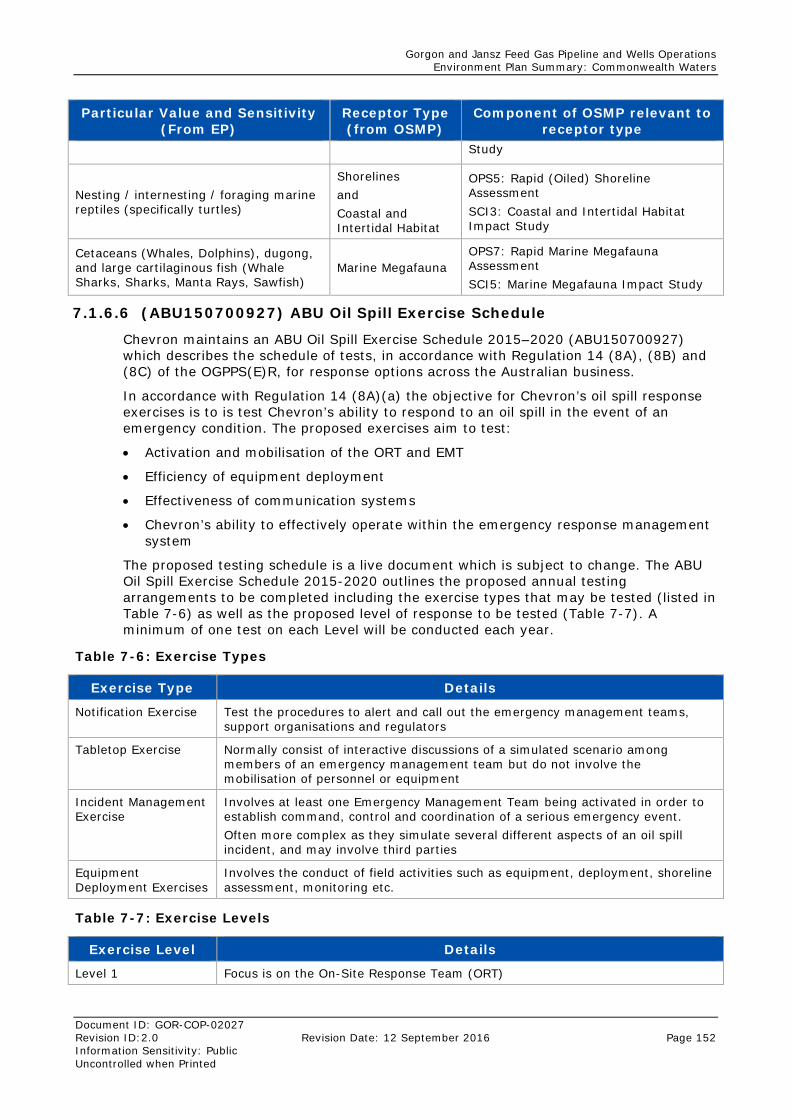
Gorgon and Jansz Feed Gas Pipeline and Wells Operations Environment Plan Summary: Commonwealth Waters
Document ID: GOR-COP-02027 Revision ID:2.0 Revision Date: 12 September 2016 Page 152 Information Sensitivity: Public Uncontrolled when Printed
Particular Value and Sensitivity (From EP)
Receptor Type (from OSMP)
Component of OSMP relevant to receptor type
Study
Nesting / internesting / foraging marine reptiles (specifically turtles)
Shorelines and Coastal and Intertidal Habitat
OPS5: Rapid (Oiled) Shoreline Assessment SCI3: Coastal and Intertidal Habitat Impact Study
Cetaceans (Whales, Dolphins), dugong, and large cartilaginous fish (Whale Sharks, Sharks, Manta Rays, Sawfish)
Marine Megafauna OPS7: Rapid Marine Megafauna Assessment SCI5: Marine Megafauna Impact Study
7.1.6.6 (ABU150700927) ABU Oil Spill Exercise Schedule
Chevron maintains an ABU Oil Spill Exercise Schedule 2015–2020 (ABU150700927) which describes the schedule of tests, in accordance with Regulation 14 (8A), (8B) and (8C) of the OGPPS(E)R, for response options across the Australian business.
In accordance with Regulation 14 (8A)(a) the objective for Chevron’s oil spill response exercises is to is test Chevron’s ability to respond to an oil spill in the event of an emergency condition. The proposed exercises aim to test:
• Activation and mobilisation of the ORT and EMT
• Efficiency of equipment deployment
• Effectiveness of communication systems
• Chevron’s ability to effectively operate within the emergency response management system
The proposed testing schedule is a live document which is subject to change. The ABU Oil Spill Exercise Schedule 2015-2020 outlines the proposed annual testing arrangements to be completed including the exercise types that may be tested (listed in Table 7-6) as well as the proposed level of response to be tested (Table 7-7). A minimum of one test on each Level will be conducted each year.
Table 7-6: Exercise Types
Exercise Type Details
Notification Exercise Test the procedures to alert and call out the emergency management teams, support organisations and regulators
Tabletop Exercise Normally consist of interactive discussions of a simulated scenario among members of an emergency management team but do not involve the mobilisation of personnel or equipment
Incident Management Exercise
Involves at least one Emergency Management Team being activated in order to establish command, control and coordination of a serious emergency event. Often more complex as they simulate several different aspects of an oil spill incident, and may involve third parties
Equipment Deployment Exercises
Involves the conduct of field activities such as equipment, deployment, shoreline assessment, monitoring etc.
Table 7-7: Exercise Levels
Exercise Level Details
Level 1 Focus is on the On-Site Response Team (ORT)
Gorgon and Jansz Feed Gas Pipeline and Wells Operations Environment Plan Summary: Commonwealth Waters
Document ID: GOR-COP-02027 Revision ID:2.0 Revision Date: 12 September 2016 Page 152 Information Sensitivity: Public Uncontrolled when Printed
Exercise Level Details
Level 2 These include the ORT and/or the Installation Emergency Management (Level 2) Team (Installation EMT)
Level 3 Can include the ORT, the Installation (Level 2) EMT, and the (Level 3) EMT. They may also include the Crisis Management Team (CRT) and third parties.
In accordance with OPGGS(E) Regulation 14 (8B)(c) and (d), the ABU Oil Spill Exercise Schedule 2015–2020 explains the mechanisms for identifying and incorporating lessons learned. The Chevron Oil Spill Exercise Report is attached as an appendix to the ABU Oil Spill Exercise Schedule 2015–2020 and is used during spill exercises to assess the effectiveness of the exercise against its objectives and record recommendations.
Recommendations will then be recorded in the Oil Spill Exercise Schedule and relevant actions tracked to completion. Exercise planners refer to the recommendations in the Oil Spill Exercise Schedule when planning future exercises.
The EP ensures that the response arrangements as detailed in the EP and the OPEP (GOR-COP-0900) shall be tested:
• when they are introduced
• when they are significantly amended
• not later than 12 months after the most recent test
• if a new location for the activity is added to the environment plan after the response arrangements have been tested, and before the next test is conducted: testing the response arrangements in relation to the new location as soon as practicable after it is added to the plan
• if a facility becomes operational after the response arrangements have been tested and before the next test is conducted: testing the response arrangements in relation to the facility when it becomes operational.
7.1.7 Compliance Assurance (OE-12.01) 7.1.7.1 (OE-12.01.19) Compliance Assurance Audit Program ABU
Standardised OE Procedure
This procedure addresses the establishment of audit programs to verify the effectiveness of controls and the extent to which requirements are met by Chevron. Audits may focus on in-field activities or administrative processes depending on the activities being undertaken around the time of audit. A record of audits and the audit outcomes is maintained, and actions arising from internal audits will be tracked until closure in accordance with Section 7.1.7.2.
7.1.7.2 (OE12.01.18) Compliance Assurance Management of Instances of Potential Noncompliance
This procedure addresses instances where the requirements may not have been fully met. For the EP, this process is used if audit findings identify that activities within the scope of the EP are not being implemented in accordance with the risk control measures stated in in Sections 5.0 and 6.0.
If findings are identified during Level 4 audits, corrective actions will be identified, assigned, and recorded in Essential Suite, which is a Chevron-wide database that sends notifications and follow-up emails to the responsible person for timely closure of audit actions.
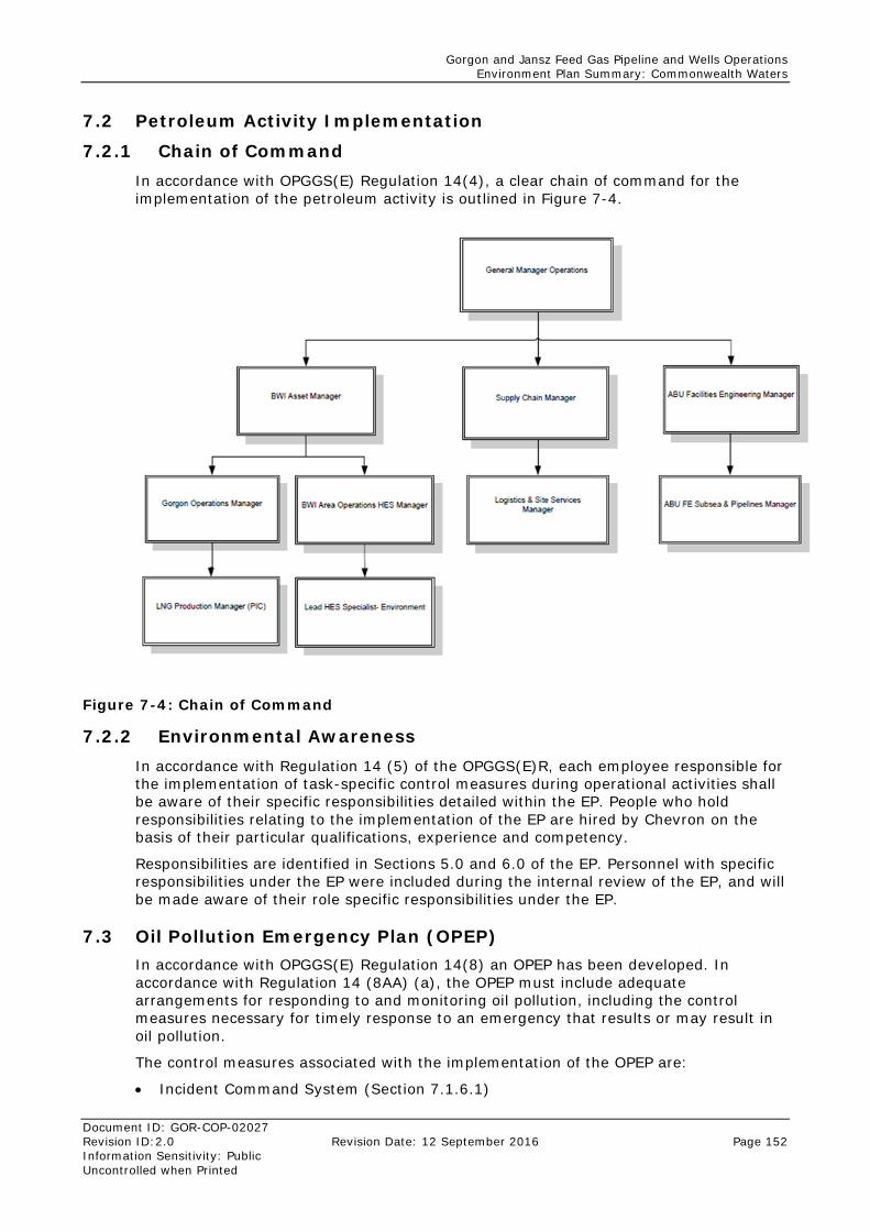
Gorgon and Jansz Feed Gas Pipeline and Wells Operations Environment Plan Summary: Commonwealth Waters
Document ID: GOR-COP-02027 Revision ID:2.0 Revision Date: 12 September 2016 Page 152 Information Sensitivity: Public Uncontrolled when Printed
7.2 Petroleum Activity Implementation
7.2.1 Chain of Command In accordance with OPGGS(E) Regulation 14(4), a clear chain of command for the implementation of the petroleum activity is outlined in Figure 7-4.
Figure 7-4: Chain of Command
7.2.2 Environmental Awareness In accordance with Regulation 14 (5) of the OPGGS(E)R, each employee responsible for the implementation of task-specific control measures during operational activities shall be aware of their specific responsibilities detailed within the EP. People who hold responsibilities relating to the implementation of the EP are hired by Chevron on the basis of their particular qualifications, experience and competency.
Responsibilities are identified in Sections 5.0 and 6.0 of the EP. Personnel with specific responsibilities under the EP were included during the internal review of the EP, and will be made aware of their role specific responsibilities under the EP.
7.3 Oil Pollution Emergency Plan (OPEP) In accordance with OPGGS(E) Regulation 14(8) an OPEP has been developed. In accordance with Regulation 14 (8AA) (a), the OPEP must include adequate arrangements for responding to and monitoring oil pollution, including the control measures necessary for timely response to an emergency that results or may result in oil pollution.
The control measures associated with the implementation of the OPEP are:
• Incident Command System (Section 7.1.6.1)
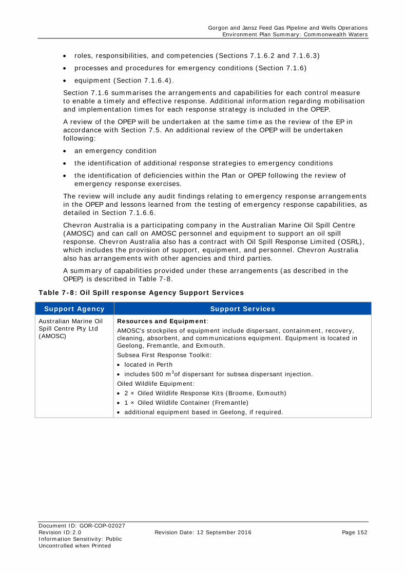
Gorgon and Jansz Feed Gas Pipeline and Wells Operations Environment Plan Summary: Commonwealth Waters
Document ID: GOR-COP-02027 Revision ID:2.0 Revision Date: 12 September 2016 Page 152 Information Sensitivity: Public Uncontrolled when Printed
• roles, responsibilities, and competencies (Sections 7.1.6.2 and 7.1.6.3)
• processes and procedures for emergency conditions (Section 7.1.6)
• equipment (Section 7.1.6.4).
Section 7.1.6 summarises the arrangements and capabilities for each control measure to enable a timely and effective response. Additional information regarding mobilisation and implementation times for each response strategy is included in the OPEP.
A review of the OPEP will be undertaken at the same time as the review of the EP in accordance with Section 7.5. An additional review of the OPEP will be undertaken following:
• an emergency condition
• the identification of additional response strategies to emergency conditions
• the identification of deficiencies within the Plan or OPEP following the review of emergency response exercises.
The review will include any audit findings relating to emergency response arrangements in the OPEP and lessons learned from the testing of emergency response capabilities, as detailed in Section 7.1.6.6.
Chevron Australia is a participating company in the Australian Marine Oil Spill Centre (AMOSC) and can call on AMOSC personnel and equipment to support an oil spill response. Chevron Australia also has a contract with Oil Spill Response Limited (OSRL), which includes the provision of support, equipment, and personnel. Chevron Australia also has arrangements with other agencies and third parties.
A summary of capabilities provided under these arrangements (as described in the OPEP) is described in Table 7-8.
Table 7-8: Oil Spill response Agency Support Services
Support Agency Support Services
Australian Marine Oil Spill Centre Pty Ltd (AMOSC)
Resources and Equipment: AMOSC’s stockpiles of equipment include dispersant, containment, recovery, cleaning, absorbent, and communications equipment. Equipment is located in Geelong, Fremantle, and Exmouth. Subsea First Response Toolkit: • located in Perth • includes 500 m3of dispersant for subsea dispersant injection. Oiled Wildlife Equipment: • 2 × Oiled Wildlife Response Kits (Broome, Exmouth) • 1 × Oiled Wildlife Container (Fremantle) • additional equipment based in Geelong, if required.
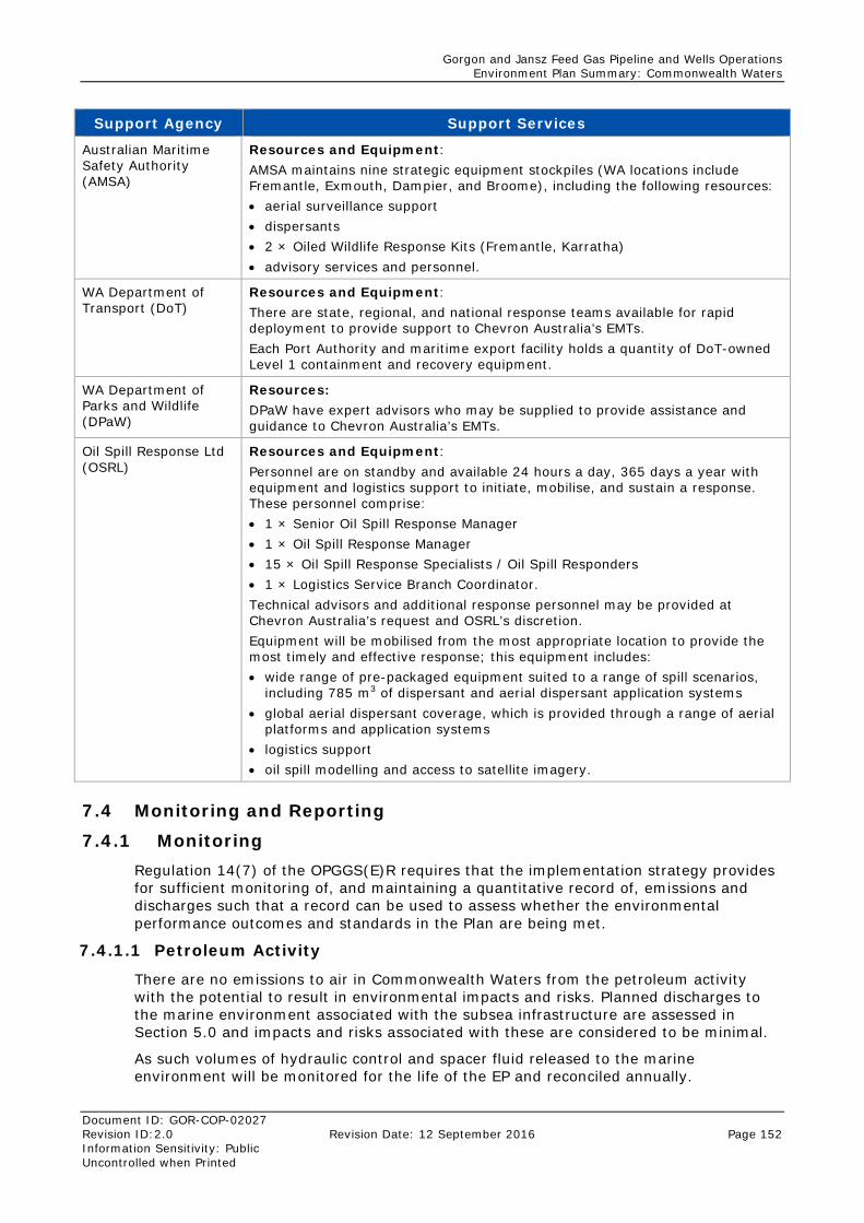
Gorgon and Jansz Feed Gas Pipeline and Wells Operations Environment Plan Summary: Commonwealth Waters
Document ID: GOR-COP-02027 Revision ID:2.0 Revision Date: 12 September 2016 Page 152 Information Sensitivity: Public Uncontrolled when Printed
Support Agency Support Services
Australian Maritime Safety Authority (AMSA)
Resources and Equipment: AMSA maintains nine strategic equipment stockpiles (WA locations include Fremantle, Exmouth, Dampier, and Broome), including the following resources: • aerial surveillance support • dispersants • 2 × Oiled Wildlife Response Kits (Fremantle, Karratha) • advisory services and personnel.
WA Department of Transport (DoT)
Resources and Equipment: There are state, regional, and national response teams available for rapid deployment to provide support to Chevron Australia’s EMTs. Each Port Authority and maritime export facility holds a quantity of DoT-owned Level 1 containment and recovery equipment.
WA Department of Parks and Wildlife (DPaW)
Resources: DPaW have expert advisors who may be supplied to provide assistance and guidance to Chevron Australia’s EMTs.
Oil Spill Response Ltd (OSRL)
Resources and Equipment: Personnel are on standby and available 24 hours a day, 365 days a year with equipment and logistics support to initiate, mobilise, and sustain a response. These personnel comprise: • 1 × Senior Oil Spill Response Manager • 1 × Oil Spill Response Manager • 15 × Oil Spill Response Specialists / Oil Spill Responders • 1 × Logistics Service Branch Coordinator. Technical advisors and additional response personnel may be provided at Chevron Australia’s request and OSRL’s discretion. Equipment will be mobilised from the most appropriate location to provide the most timely and effective response; this equipment includes: • wide range of pre-packaged equipment suited to a range of spill scenarios,
including 785 m3 of dispersant and aerial dispersant application systems • global aerial dispersant coverage, which is provided through a range of aerial
platforms and application systems • logistics support • oil spill modelling and access to satellite imagery.
7.4 Monitoring and Reporting
7.4.1 Monitoring Regulation 14(7) of the OPGGS(E)R requires that the implementation strategy provides for sufficient monitoring of, and maintaining a quantitative record of, emissions and discharges such that a record can be used to assess whether the environmental performance outcomes and standards in the Plan are being met.
7.4.1.1 Petroleum Activity
There are no emissions to air in Commonwealth Waters from the petroleum activity with the potential to result in environmental impacts and risks. Planned discharges to the marine environment associated with the subsea infrastructure are assessed in Section 5.0 and impacts and risks associated with these are considered to be minimal.
As such volumes of hydraulic control and spacer fluid released to the marine environment will be monitored for the life of the EP and reconciled annually.
Gorgon and Jansz Feed Gas Pipeline and Wells Operations Environment Plan Summary: Commonwealth Waters
Document ID: GOR-COP-02027 Revision ID:2.0 Revision Date: 12 September 2016 Page 152 Information Sensitivity: Public Uncontrolled when Printed
Given the nature and scale of this activity, along with the impacts and risks associated with discharges and emissions, additional monitoring is not required to demonstrate that the environmental performance outcomes and standards in the Plan are being met.
For unplanned spill events not considered to be an emergency, Chevron has set environmental performance standards in Section 5.0 where monitoring is required to demonstrate that the environmental performance outcomes are being met. These will be implemented in accordance with the relevant process control measure.
Leak and spill events considered to be recordable incidents will be reported to NOSPEMA in accordance with Section 7.4.2 of the Plan. These reports will include quantitative information in accordance with Regulation 26B.
7.4.1.2 Major Defect – Emergency Condition
In the event of a major defect event, Chevron will implement the ABU OSMP (ABU130700448) which is described in Section 7.1.6.5 of the EP. The OSMP describes a program of monitoring, and is the principal tool for determining the extent, severity, and persistence of environmental impacts from an emergency condition and the emergency response activities to be undertaken by Chevron.
7.4.1.3 Loss of Well Control – Emergency Condition
In addition to the ABU OSMP (ABU130700448), in the event of a Loss of well control event, Chevron will implement the NOPSEMA accepted documents:
• Gorgon and Jansz–Io Drilling, Completion and Well Maintenance Environment Plan (ABU140800133)
• Oil Pollution Emergency Plan (ABU1102000642).
7.4.2 Incident Reporting In accordance with Chevron’s Incident, Investigation, and Reporting process, all environmental incidents will be reported by Chevron in accordance with Table 7-9.
Table 7-9: Incident Investigation: Routine External Reporting
Recordable Incident Reporting – OPGGS(E) Regulation 26B
Legislative definition of “recordable incident”: “Recordable incident, for an activity, means a breach of an environmental performance outcome or environmental performance standard, in the environment plan that applies to the activity, that is not a reportable incident” Recordable incidents are breaches of environmental performance outcomes and standards described in Sections 5.0 and 6.0.
Reporting Requirements Report to / Timing
Written notification As a minimum, the written incident report must include a description of: • the incidents and all material facts and
circumstances concerning the incidents • any actions taken to avoid or mitigate any
adverse environmental impacts • any corrective actions that have been taken,
or may be taken, to prevent repetition of similar incidents.
Submit written report to NOPSEMA by the 15th of each month
Gorgon and Jansz Feed Gas Pipeline and Wells Operations Environment Plan Summary: Commonwealth Waters
Document ID: GOR-COP-02027 Revision ID:2.0 Revision Date: 12 September 2016 Page 152 Information Sensitivity: Public Uncontrolled when Printed
Reportable Incident Reporting – OPGGS(E) Regulations 26 and 26A
Legislative definition of “reportable incident”: “Reportable incident, for an activity means an incident relating to an activity that has caused, or has the potential to cause, moderate to significant environmental damage.” Therefore, reportable incidents are considered to be emergency conditions as defined in Section 4.1 of the EP. In accordance with this definition, the reportable incidents identified under the EP are: • a loss of well control (Section 6.1) • a major defect (Section 6.2).
Reporting Requirements Report to / Timing
Verbal notification Verbal notification must be undertaken within two hours of the incident or as soon as practicable information: • the incident and all material facts and
circumstances known at the time • any actions taken to avoid or mitigate any
adverse environmental impacts • any corrective actions that have been taken,
or may be taken, to prevent repetition of similar incidents.
Report verbally to NOPSEMA within two hours or as soon as practicable and provide written record of notification by email. Phone: (08) 6461 7090 Email: [email protected]
Written notification Verbal notifications must be followed by a written report (of information provided in verbal notification) as soon as practicable, to NOPSEMA, the National Offshore Petroleum Titles Authority, and the Western Australian Department of Mines and Petroleum (DMP)
As soon as practicable following the incident. Email: [email protected] Email: [email protected] Email: petroleum.environment@ dmp.wa.gov.au
Written incident report A written incident report must be provided as soon as practicable and not later than 3 days after the first occurrence of the reportable incident. At a minimum, the written incident report will include: • the incident and all material facts and
circumstances • actions taken to avoid or mitigate any adverse
environmental impacts • any corrective actions that have been taken,
or may be taken, to prevent a recurrence • a completion date. The written incident report must also be provided to NOPSEMA, the National Offshore Petroleum Titles Authority, and the Western Australian Department of Mines and Petroleum (DMP). If the initial notification of the reportable incident was verbal, this information must be included in the written report.
As soon as practicable, and not later than 3 days following the incident. Email: [email protected] Email: [email protected] Email: petroleum.environment@ dmp.wa.gov.au
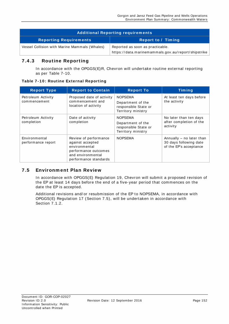
Gorgon and Jansz Feed Gas Pipeline and Wells Operations Environment Plan Summary: Commonwealth Waters
Document ID: GOR-COP-02027 Revision ID:2.0 Revision Date: 12 September 2016 Page 152 Information Sensitivity: Public Uncontrolled when Printed
Additional Reporting requirements
Reporting Requirements Report to / Timing
Vessel Collision with Marine Mammals (Whales) Reported as soon as practicable. https://data.marinemammals.gov.au/report/shipstrike
7.4.3 Routine Reporting In accordance with the OPGGS(E)R, Chevron will undertake routine external reporting as per Table 7-10.
Table 7-10: Routine External Reporting
Report Type Report to Contain Report To Timing
Petroleum Activity commencement
Proposed date of activity commencement and location of activity
NOPSEMA Department of the responsible State or Territory ministry
At least ten days before the activity
Petroleum Activity completion
Date of activity completion
NOPSEMA Department of the responsible State or Territory ministry
No later than ten days after completion of the activity
Environmental performance report
Review of performance against accepted environmental performance outcomes and environmental performance standards
NOPSEMA Annually – no later than 30 days following date of the EP’s acceptance
7.5 Environment Plan Review In accordance with OPGGS(E) Regulation 19, Chevron will submit a proposed revision of the EP at least 14 days before the end of a five-year period that commences on the date the EP is accepted.
Additional revisions and/or resubmission of the EP to NOPSEMA, in accordance with OPGGS(E) Regulation 17 (Section 7.5), will be undertaken in accordance with Section 7.1.2.
Gorgon and Jansz Feed Gas Pipeline and Wells Operations Environment Plan Summary: Commonwealth Waters
Document ID: GOR-COP-02027 Revision ID:2.0 Revision Date: 12 September 2016 Page 152 Information Sensitivity: Public Uncontrolled when Printed
8.0 Stakeholder Consultation Plan Chevron Australia prepared a Stakeholder Consultation Plan specific for this petroleum activity. The Stakeholder Consultation Plan describes:
• stakeholder identification and analysis
• stakeholder engagement log, including information provided to stakeholders and Chevron Australia responses as well as ongoing consultation requirements
• full text of consultation.
8.1 Consultation Undertaken As part of Chevron’s ongoing stakeholder engagement strategy, relevant stakeholders were engaged during the preparation of the EP. Stakeholder consultation included, but was not limited to, engagement with members of the community, government departments, industry operators, commercial and recreational fishing groups (Table 8-1).
No objections or claims about adverse impacts relating directly to the petroleum activity (Gorgon and Jansz Feed Gas Pipeline and Wells Operations in Commonwealth Waters) were raised by stakeholders. Some feedback and clarifications were received and these are summarised in
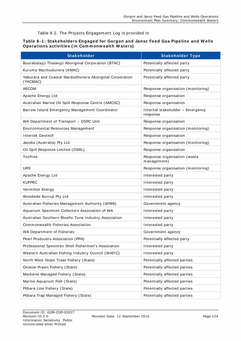
Gorgon and Jansz Feed Gas Pipeline and Wells Operations Environment Plan Summary: Commonwealth Waters
Document ID: GOR-COP-02027 Revision ID:2.0 Revision Date: 12 September 2016 Page 124 Information Sensitivity: Public Uncontrolled when Printed
Table 8.2. The Projects Engagement Log is provided in
Table 8-1: Stakeholders Engaged for Gorgon and Jansz Feed Gas Pipeline and Wells Operations activities (in Commonwealth Waters)
Stakeholder Stakeholder Type
Buurabalayji Thalanyji Aboriginal Corporation (BTAC) Potentially affected party
Kuruma Marthudunera (KMAC) Potentially affected party
Yaburara and Coastal Mardudhunera Aboriginal Corporation (YACMAC)
Potentially affected party
AECOM Response organisation (monitoring)
Apache Energy Ltd Response organisation
Australian Marine Oil Spill Response Centre (AMOSC) Response organisation
Barrow Island Emergency Management Coordinator Internal stakeholder – Emergency response
WA Department of Transport – OSRC Unit Response organisation
Environmental Resources Management Response organisation (monitoring)
Intertek Geotech Response organisation
Jacobs (Australia) Pty Ltd Response organisation (monitoring)
Oil Spill Response Limited (OSRL) Response organisation
ToxFree Response organisation (waste management)
URS Response organisation (monitoring)
Apache Energy Ltd Interested party
KUFPEC Interested party
Vermilion Energy Interested party
Woodside Burrup Pty Ltd Interested party
Australian Fisheries Management Authority (AFMA) Government agency
Aquarium Specimen Collectors Association of WA Interested party
Australian Southern Bluefin Tuna Industry Association Interested party
Commonwealth Fisheries Association Interested party
WA Department of Fisheries Government agency
Pearl Producers Association (PPA) Potentially affected party
Professional Specimen Shell Fishermen's Association Interested party
Western Australian Fishing Industry Council (WAFIC) Interested party
North West Slope Trawl Fishery (State) Potentially affected parties
Onslow Prawn Fishery (State) Potentially affected parties
Mackerel Managed Fishery (State) Potentially affected parties
Marine Aquarium Fish (State) Potentially affected parties
Pilbara Line Fishery (State) Potentially affected parties
Pilbara Trap Managed Fishery (State) Potentially affected parties
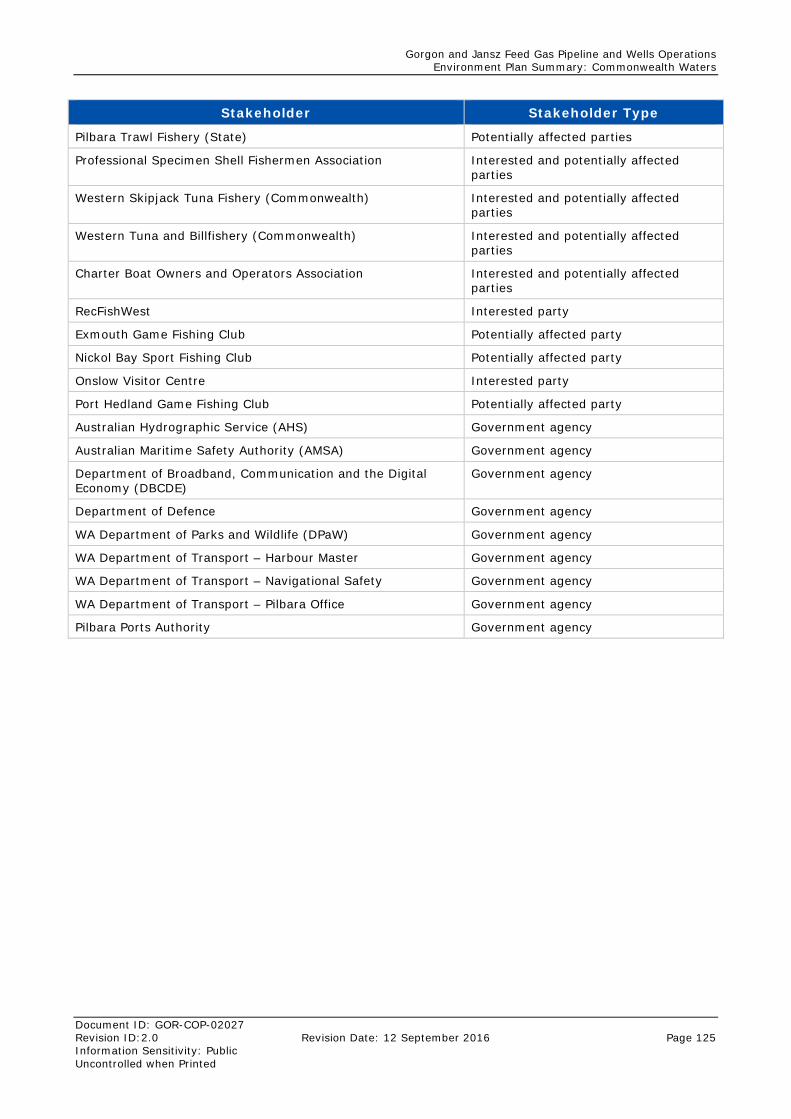
Gorgon and Jansz Feed Gas Pipeline and Wells Operations Environment Plan Summary: Commonwealth Waters
Document ID: GOR-COP-02027 Revision ID:2.0 Revision Date: 12 September 2016 Page 125 Information Sensitivity: Public Uncontrolled when Printed
Stakeholder Stakeholder Type
Pilbara Trawl Fishery (State) Potentially affected parties
Professional Specimen Shell Fishermen Association Interested and potentially affected parties
Western Skipjack Tuna Fishery (Commonwealth) Interested and potentially affected parties
Western Tuna and Billfishery (Commonwealth) Interested and potentially affected parties
Charter Boat Owners and Operators Association Interested and potentially affected parties
RecFishWest Interested party
Exmouth Game Fishing Club Potentially affected party
Nickol Bay Sport Fishing Club Potentially affected party
Onslow Visitor Centre Interested party
Port Hedland Game Fishing Club Potentially affected party
Australian Hydrographic Service (AHS) Government agency
Australian Maritime Safety Authority (AMSA) Government agency
Department of Broadband, Communication and the Digital Economy (DBCDE)
Government agency
Department of Defence Government agency
WA Department of Parks and Wildlife (DPaW) Government agency
WA Department of Transport – Harbour Master Government agency
WA Department of Transport – Navigational Safety Government agency
WA Department of Transport – Pilbara Office Government agency
Pilbara Ports Authority Government agency
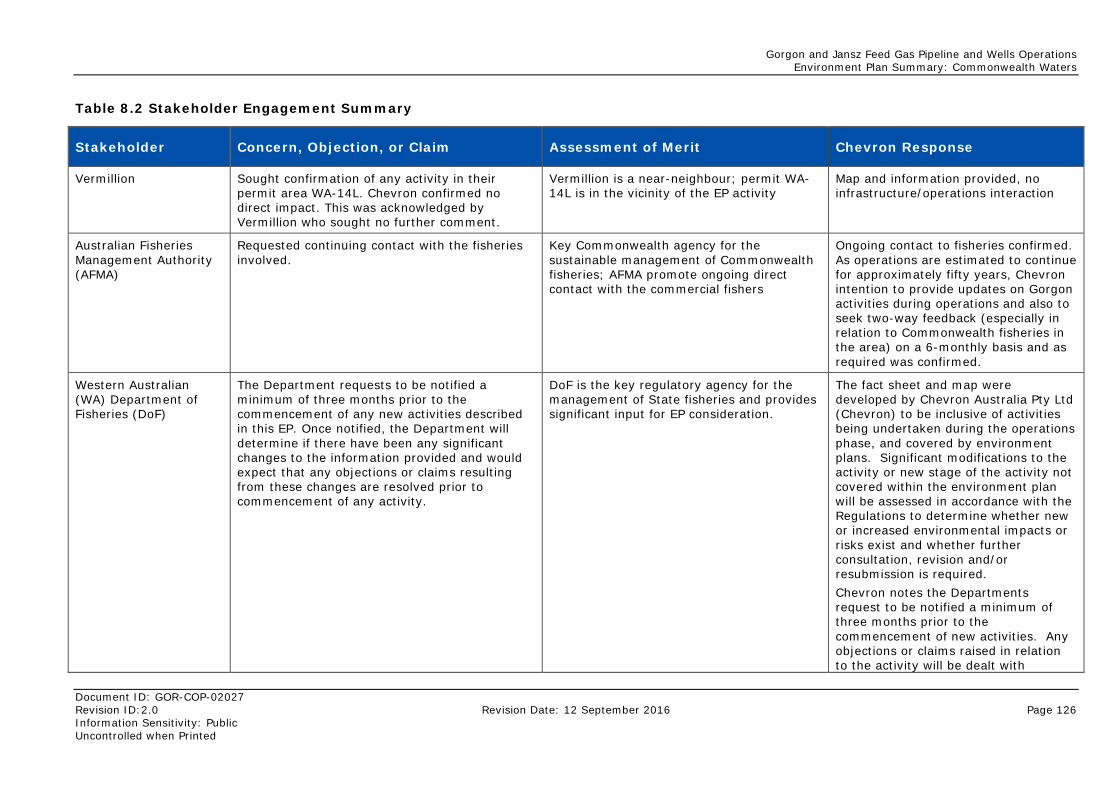
Gorgon and Jansz Feed Gas Pipeline and Wells Operations Environment Plan Summary: Commonwealth Waters
Document ID: GOR-COP-02027 Revision ID:2.0 Revision Date: 12 September 2016 Page 126 Information Sensitivity: Public Uncontrolled when Printed
Table 8.2 Stakeholder Engagement Summary
Stakeholder Concern, Objection, or Claim Assessment of Merit Chevron Response
Vermillion Sought confirmation of any activity in their permit area WA-14L. Chevron confirmed no direct impact. This was acknowledged by Vermillion who sought no further comment.
Vermillion is a near-neighbour; permit WA-14L is in the vicinity of the EP activity
Map and information provided, no infrastructure/operations interaction
Australian Fisheries Management Authority (AFMA)
Requested continuing contact with the fisheries involved.
Key Commonwealth agency for the sustainable management of Commonwealth fisheries; AFMA promote ongoing direct contact with the commercial fishers
Ongoing contact to fisheries confirmed. As operations are estimated to continue for approximately fifty years, Chevron intention to provide updates on Gorgon activities during operations and also to seek two-way feedback (especially in relation to Commonwealth fisheries in the area) on a 6-monthly basis and as required was confirmed.
Western Australian (WA) Department of Fisheries (DoF)
The Department requests to be notified a minimum of three months prior to the commencement of any new activities described in this EP. Once notified, the Department will determine if there have been any significant changes to the information provided and would expect that any objections or claims resulting from these changes are resolved prior to commencement of any activity.
DoF is the key regulatory agency for the management of State fisheries and provides significant input for EP consideration.
The fact sheet and map were developed by Chevron Australia Pty Ltd (Chevron) to be inclusive of activities being undertaken during the operations phase, and covered by environment plans. Significant modifications to the activity or new stage of the activity not covered within the environment plan will be assessed in accordance with the Regulations to determine whether new or increased environmental impacts or risks exist and whether further consultation, revision and/or resubmission is required. Chevron notes the Departments request to be notified a minimum of three months prior to the commencement of new activities. Any objections or claims raised in relation to the activity will be dealt with
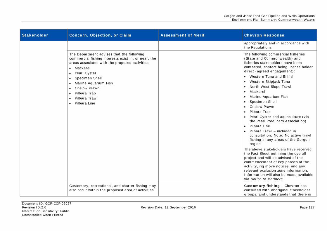
Gorgon and Jansz Feed Gas Pipeline and Wells Operations Environment Plan Summary: Commonwealth Waters
Document ID: GOR-COP-02027 Revision ID:2.0 Revision Date: 12 September 2016 Page 127 Information Sensitivity: Public Uncontrolled when Printed
Stakeholder Concern, Objection, or Claim Assessment of Merit Chevron Response
appropriately and in accordance with the Regulations.
The Department advises that the following commercial fishing interests exist in, or near, the areas associated with the proposed activities: • Mackerel • Pearl Oyster • Specimen Shell • Marine Aquarium Fish • Onslow Prawn • Pilbara Trap • Pilbara Trawl • Pilbara Line
The following commercial fisheries (State and Commonwealth) and fisheries stakeholders have been contacted, contact being license holder direct (agreed engagement): • Western Tuna and Billfish • Western Skipjack Tuna • North West Slope Trawl • Mackerel • Marine Aquarium Fish • Specimen Shell • Onslow Prawn • Pilbara Trap • Pearl Oyster and aquaculture (via
the Pearl Producers Association) • Pilbara Line • Pilbara Trawl – included in
consultation; Note: No active trawl fishing in any areas of the Gorgon region
The above stakeholders have received the Fact Sheet outlining the overall project and will be advised of the commencement of key phases of the activity, rig move notices, and any relevant exclusion zone information. Information will also be made available via Notice to Mariners.
Customary, recreational, and charter fishing may also occur within the proposed area of activities.
Customary fishing – Chevron has consulted with Aboriginal stakeholder groups, and understands that there is
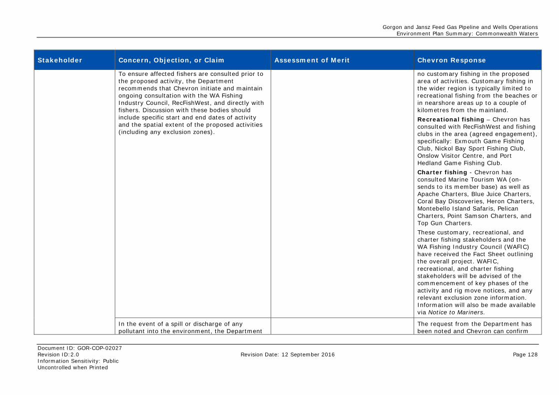
Gorgon and Jansz Feed Gas Pipeline and Wells Operations Environment Plan Summary: Commonwealth Waters
Document ID: GOR-COP-02027 Revision ID:2.0 Revision Date: 12 September 2016 Page 128 Information Sensitivity: Public Uncontrolled when Printed
Stakeholder Concern, Objection, or Claim Assessment of Merit Chevron Response
To ensure affected fishers are consulted prior to the proposed activity, the Department recommends that Chevron initiate and maintain ongoing consultation with the WA Fishing Industry Council, RecFishWest, and directly with fishers. Discussion with these bodies should include specific start and end dates of activity and the spatial extent of the proposed activities (including any exclusion zones).
no customary fishing in the proposed area of activities. Customary fishing in the wider region is typically limited to recreational fishing from the beaches or in nearshore areas up to a couple of kilometres from the mainland. Recreational fishing – Chevron has consulted with RecFishWest and fishing clubs in the area (agreed engagement), specifically: Exmouth Game Fishing Club, Nickol Bay Sport Fishing Club, Onslow Visitor Centre, and Port Hedland Game Fishing Club. Charter fishing - Chevron has consulted Marine Tourism WA (on-sends to its member base) as well as Apache Charters, Blue Juice Charters, Coral Bay Discoveries, Heron Charters, Montebello Island Safaris, Pelican Charters, Point Samson Charters, and Top Gun Charters. These customary, recreational, and charter fishing stakeholders and the WA Fishing Industry Council (WAFIC) have received the Fact Sheet outlining the overall project. WAFIC, recreational, and charter fishing stakeholders will be advised of the commencement of key phases of the activity and rig move notices, and any relevant exclusion zone information. Information will also be made available via Notice to Mariners.
In the event of a spill or discharge of any pollutant into the environment, the Department
The request from the Department has been noted and Chevron can confirm
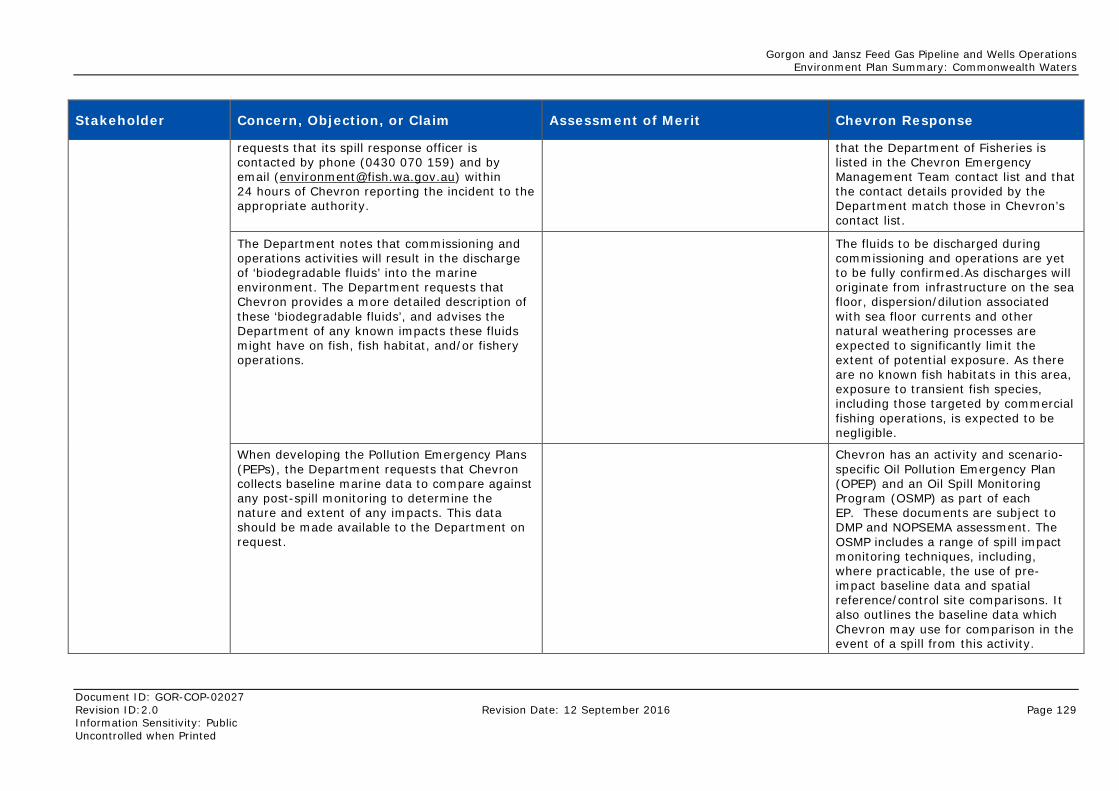
Gorgon and Jansz Feed Gas Pipeline and Wells Operations Environment Plan Summary: Commonwealth Waters
Document ID: GOR-COP-02027 Revision ID:2.0 Revision Date: 12 September 2016 Page 129 Information Sensitivity: Public Uncontrolled when Printed
Stakeholder Concern, Objection, or Claim Assessment of Merit Chevron Response
requests that its spill response officer is contacted by phone (0430 070 159) and by email ([email protected]) within 24 hours of Chevron reporting the incident to the appropriate authority.
that the Department of Fisheries is listed in the Chevron Emergency Management Team contact list and that the contact details provided by the Department match those in Chevron’s contact list.
The Department notes that commissioning and operations activities will result in the discharge of ‘biodegradable fluids’ into the marine environment. The Department requests that Chevron provides a more detailed description of these ‘biodegradable fluids’, and advises the Department of any known impacts these fluids might have on fish, fish habitat, and/or fishery operations.
The fluids to be discharged during commissioning and operations are yet to be fully confirmed.As discharges will originate from infrastructure on the sea floor, dispersion/dilution associated with sea floor currents and other natural weathering processes are expected to significantly limit the extent of potential exposure. As there are no known fish habitats in this area, exposure to transient fish species, including those targeted by commercial fishing operations, is expected to be negligible.
When developing the Pollution Emergency Plans (PEPs), the Department requests that Chevron collects baseline marine data to compare against any post-spill monitoring to determine the nature and extent of any impacts. This data should be made available to the Department on request.
Chevron has an activity and scenario-specific Oil Pollution Emergency Plan (OPEP) and an Oil Spill Monitoring Program (OSMP) as part of each EP. These documents are subject to DMP and NOPSEMA assessment. The OSMP includes a range of spill impact monitoring techniques, including, where practicable, the use of pre-impact baseline data and spatial reference/control site comparisons. It also outlines the baseline data which Chevron may use for comparison in the event of a spill from this activity.
Gorgon and Jansz Feed Gas Pipeline and Wells Operations Environment Plan Summary: Commonwealth Waters
Document ID: GOR-COP-02027 Revision ID:2.0 Revision Date: 12 September 2016 Page 130 Information Sensitivity: Public Uncontrolled when Printed
Stakeholder Concern, Objection, or Claim Assessment of Merit Chevron Response
Spawning grounds and nursery areas for key fish species are particularly vulnerable to the impact of spills. The Department requests that specific strategies are developed in the EP and/or PEPs to mitigate these risks.
Chevron has prepared the EPs in order to; describe the activity; describe the environment to identify the environmental values and sensitivities in the area that may potentially be affected and; identify mitigation measures to reduce risks to as low as reasonably practicable (ALARP). This includes the assessment of potential receptors, including fish species and spawning grounds. The EP and OPEP outline strategies to mitigate impacts and reduce identified risks to ALARP.
Biosecurity – Fish Resources Management Regulations 1995 (reg. 176(1): The Department requires that all vessel managers and operators of immersible equipment minimise the risk of translocating pests and diseases into or within WA waters. Vessel hulls, sea chests, and niche areas must be ‘clean’ before each voyage. The Department’s policy requires that the suspected or confirmed presence of any marine pest or disease be reported within 24 hours by email ([email protected]) or telephone (FishWatch: 1800 815 507) – including any organism listed in the Western Australian Prevention List for Introduced Marine Pests. The above information to be forwarded directly to all vessel operators associated with the project.
The EP specifies controls to minimise the risk of translocating pests and diseases into or within WA waters for vessels associated with the petroleum activity and within the operational area. Examples of controls include the requirement for vessels associated with the petroleum activity to be AQIS compliant; and that vessels entering the Marine Quarantine Zone surrounding Barrow Island are compliant with the approved Gorgon Quarantine Management System (QMS), which was developed in consultation with an independent Quarantine Expert Panel, of which the Department is a member. The confirmed introduction or spread of marine pests is identified as a reportable incident to be notified verbally and in writing to NOPSEMA and DMP.
Gorgon and Jansz Feed Gas Pipeline and Wells Operations Environment Plan Summary: Commonwealth Waters
Document ID: GOR-COP-02027 Revision ID:2.0 Revision Date: 12 September 2016 Page 131 Information Sensitivity: Public Uncontrolled when Printed
Stakeholder Concern, Objection, or Claim Assessment of Merit Chevron Response
Vessel operators associated with the activities described in the EPs will be required to comply with the quarantine requirements of the EPs.
The Department requests that all potential impacts to fisheries, fish, and fish habitat described in this letter are acknowledged in the final EP and the PEPs, and strategies undertaken by Chevron to mitigate or minimise these impacts are defined.
Chevron confirms that potential impacts and risks resulting from the activities described in the EPs, including to fisheries, fish, and fish habitat, have been evaluated and mitigation measures developed as necessary to reduce these risks to ALARP.
Note: The information provided is valid for six months. Chevron to re-consult with the Department for any new activities commencing after this period, and re-consult a minimum of three months prior to initiating any on-ground work. Given the duration of the project the Department requests Chevron to provide regular updates on activities that have the potential to impact the aquatic environment.
Significant modification to the activity or a new stage of the activity not covered within the EPs will be assessed in accordance with the Regulations to determine whether new or increased environmental impacts or risks exist and whether further consultation, revision, and/or resubmission is required. Chevron will consult with the Department as required through this process. EPs will be reviewed and/or updated in accordance with the frequency stipulated in the Regulations (every five years) or where new or increased environmental impact or risk is identified.
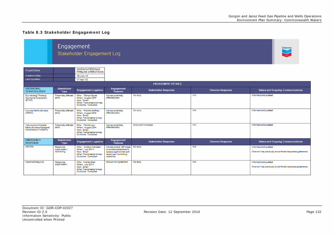
Gorgon and Jansz Feed Gas Pipeline and Wells Operations Environment Plan Summary: Commonwealth Waters
Document ID: GOR-COP-02027 Revision ID:2.0 Revision Date: 12 September 2016 Page 132 Information Sensitivity: Public Uncontrolled when Printed
Table 8.3 Stakeholder Engagement Log
Gorgon and Jansz Feed Gas Pipeline and Wells Operations Environment Plan Summary: Commonwealth Waters
Document ID: GOR-COP-02027 Revision ID:2.0 Revision Date: 12 September 2016 Page 133 Information Sensitivity: Public Uncontrolled when Printed
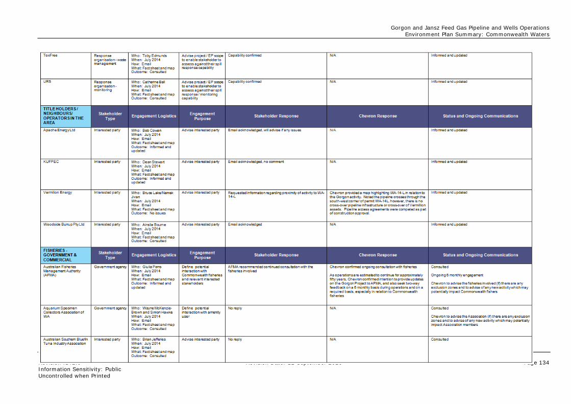
Gorgon and Jansz Feed Gas Pipeline and Wells Operations Environment Plan Summary: Commonwealth Waters
Document ID: GOR-COP-02027 Revision ID:2.0 Revision Date: 12 September 2016 Page 134 Information Sensitivity: Public Uncontrolled when Printed
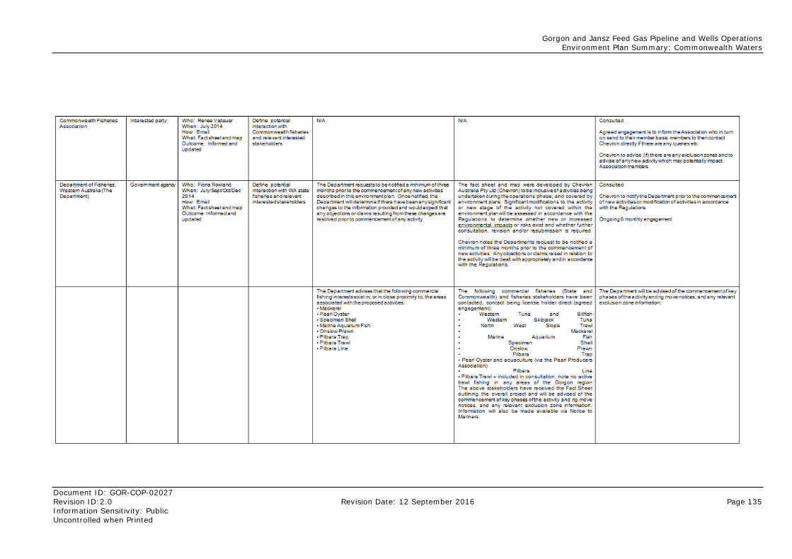
Gorgon and Jansz Feed Gas Pipeline and Wells Operations Environment Plan Summary: Commonwealth Waters
Document ID: GOR-COP-02027 Revision ID:2.0 Revision Date: 12 September 2016 Page 135 Information Sensitivity: Public Uncontrolled when Printed
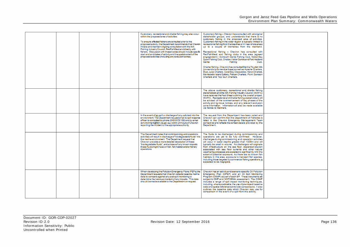
Gorgon and Jansz Feed Gas Pipeline and Wells Operations Environment Plan Summary: Commonwealth Waters
Document ID: GOR-COP-02027 Revision ID:2.0 Revision Date: 12 September 2016 Page 136 Information Sensitivity: Public Uncontrolled when Printed
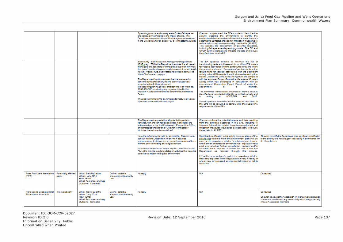
Gorgon and Jansz Feed Gas Pipeline and Wells Operations Environment Plan Summary: Commonwealth Waters
Document ID: GOR-COP-02027 Revision ID:2.0 Revision Date: 12 September 2016 Page 137 Information Sensitivity: Public Uncontrolled when Printed
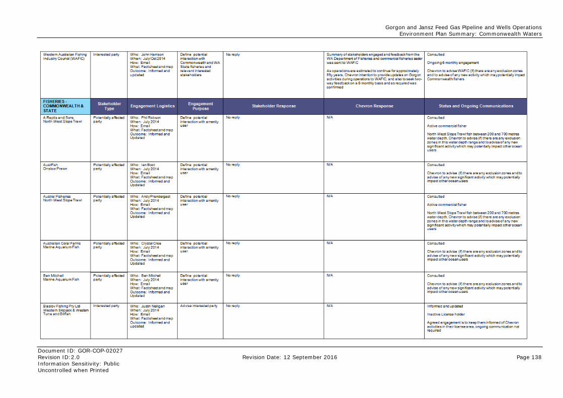
Gorgon and Jansz Feed Gas Pipeline and Wells Operations Environment Plan Summary: Commonwealth Waters
Document ID: GOR-COP-02027 Revision ID:2.0 Revision Date: 12 September 2016 Page 138 Information Sensitivity: Public Uncontrolled when Printed
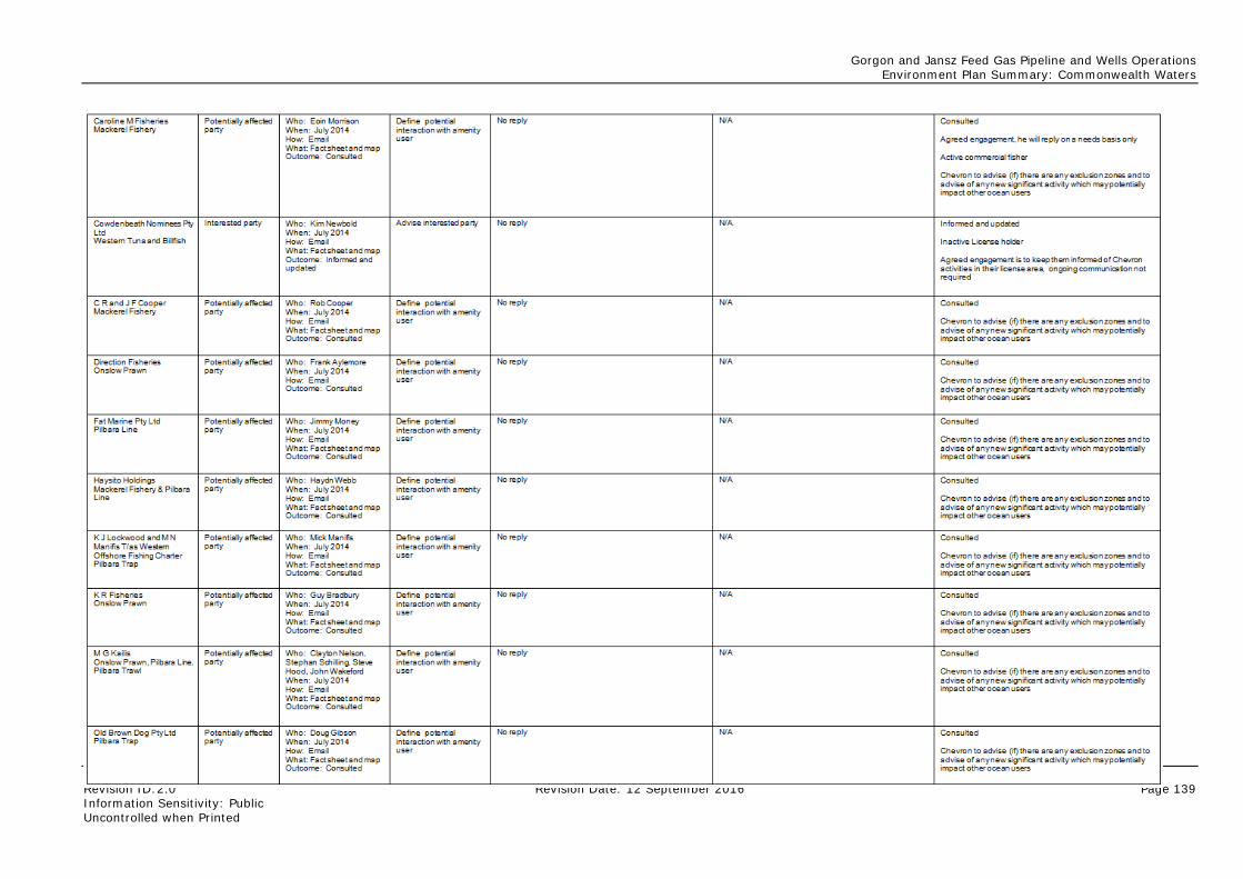
Gorgon and Jansz Feed Gas Pipeline and Wells Operations Environment Plan Summary: Commonwealth Waters
Document ID: GOR-COP-02027 Revision ID:2.0 Revision Date: 12 September 2016 Page 139 Information Sensitivity: Public Uncontrolled when Printed
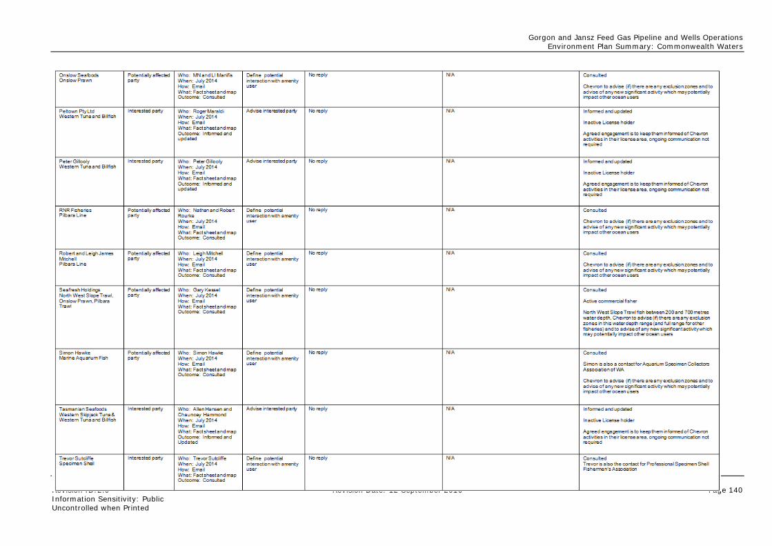
Gorgon and Jansz Feed Gas Pipeline and Wells Operations Environment Plan Summary: Commonwealth Waters
Document ID: GOR-COP-02027 Revision ID:2.0 Revision Date: 12 September 2016 Page 140 Information Sensitivity: Public Uncontrolled when Printed
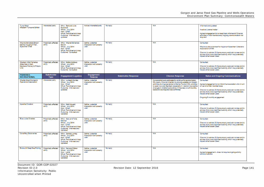
Gorgon and Jansz Feed Gas Pipeline and Wells Operations Environment Plan Summary: Commonwealth Waters
Document ID: GOR-COP-02027 Revision ID:2.0 Revision Date: 12 September 2016 Page 141 Information Sensitivity: Public Uncontrolled when Printed
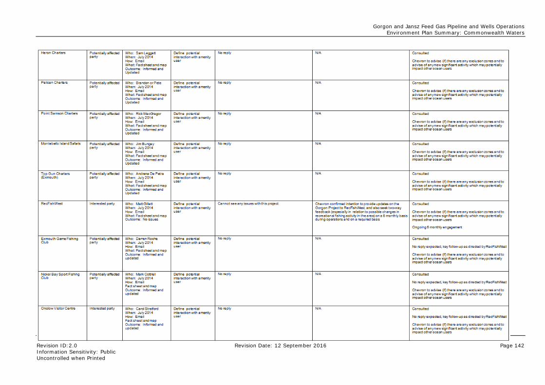
Gorgon and Jansz Feed Gas Pipeline and Wells Operations Environment Plan Summary: Commonwealth Waters
Document ID: GOR-COP-02027 Revision ID:2.0 Revision Date: 12 September 2016 Page 142 Information Sensitivity: Public Uncontrolled when Printed
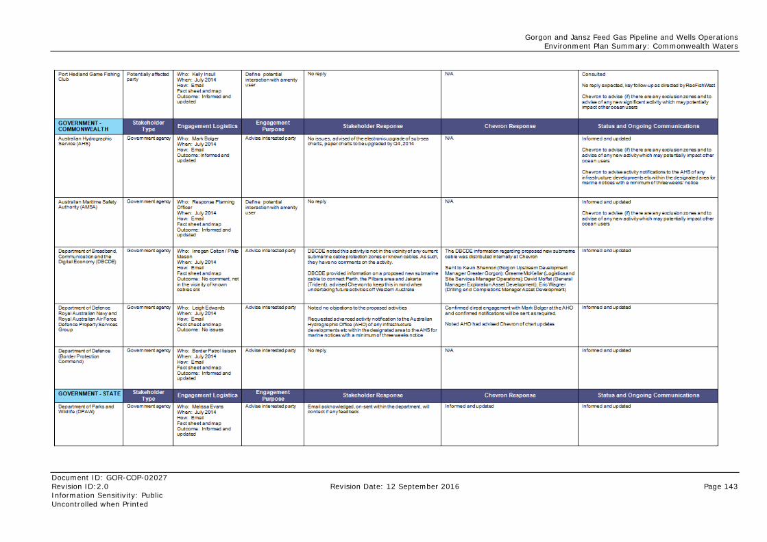
Gorgon and Jansz Feed Gas Pipeline and Wells Operations Environment Plan Summary: Commonwealth Waters
Document ID: GOR-COP-02027 Revision ID:2.0 Revision Date: 12 September 2016 Page 143 Information Sensitivity: Public Uncontrolled when Printed
Gorgon and Jansz Feed Gas Pipeline and Wells Operations Environment Plan Summary: Commonwealth Waters
Document ID: GOR-COP-02027 Revision ID:2.0 Revision Date: 12 September 2016 Page 144 Information Sensitivity: Public Uncontrolled when Printed
8.2 Ongoing Consultation In accordance with the Stakeholder Consultation Plan, Chevron Australia will maintain communications with identified stakeholders as required ensuring they are informed of any aspects associated with the operation of the Gorgon and Jansz Feed Gas Pipeline and Wells that may potentially affect their respective interests within the area. Specifically, Chevron Australia will:
• provide response organisations with a copy of the OPEP
• notify the Australian Hydrographic Service of activities and infrastructure for inclusion in Marine Notices
• engage with the WA Department of Fisheries, AFMA, WAFIC, RecFishWest, and the Charter Boat Owners and Operators Association on a regular basis.
Additionally, Chevron Australia can continue to be contacted about the petroleum activities described in this Summary via the contact details provided in Section 1.4.
Gorgon and Jansz Feed Gas Pipeline and Wells Operations Environment Plan Summary: Commonwealth Waters
Document ID: GOR-COP-02027 Revision ID:2.0 Revision Date: 12 September 2016 Page 145 Information Sensitivity: Public Uncontrolled when Printed
9.0 Acronyms and Abbreviations Table 9-1 defines the acronyms and abbreviations used in this document.
Table 9-1: Acronyms and Abbreviations
Acronym/ Abbreviation/ Defined Terms
Definition
ABU Chevron’s Australian Business Unit
Acute Rapid effect due to short-term exposure; usually of short duration.
AEMT Asset Emergency Management Team
AIIMS Australasian Inter-service Incident Management System
ALARP As Low As Reasonably Practicable; a level of risk that is not intolerable, and cannot be reduced further without the expenditure of costs that are grossly disproportionate to the benefit gained.
AMSA Australian Maritime Safety Authority
AND Assisted Natural Dispersion
ANZECC Australian and New Zealand Environment and Conservation Council
APASA Asia-Pacific Applied Science Associates
API American Petroleum Index which is used to group oils based on specific gravity properties.
ARMCANZ Agriculture and Resource Management Council of Australia and New Zealand
Aromatic Hydrocarbon A hydrocarbon that contains one or more benzene rings with alternating double and single bonds between carbon atoms. Aromatic hydrocarbons can be monocyclic or polycyclic.
AS Australian Standard
As far as practicable, where practicable, practicable
All mean reasonably practicable have regard to, among other things, local conditions and circumstances (including costs) and to the current state of technical knowledge.
Aspect The Chevron Australian Business Unit (ABU) Environmental Stewardship Standardised OE Process (OE-07.01.02) defines an aspect as an element of Chevron’s activities, products, or services related to an operation that has the potential to interact with the environment at present or later (e.g. wastewater discharge, greenhouse gas emission, legacy environmental obligations).
AUV Autonomous Underwater Vehicle
Ballast Water Water held within tanks or cargo holds on a marine vessel; used to regulate the vessel’s draft and its stability.
bar Metric unit of atmospheric pressure
BIAs Biologically Important Areas; ‘spatially and temporally defined areas where protected species display biologically important behaviours (including breeding, foraging, resting, or migration), based on the best available scientific information. Parts of a marine region particularly important for the conservation of protected species’ (as defined by the Department of Environment)
CDU Central Distribution Unit
CEFAS Centre for Environment, Fisheries and Aquaculture Science
Gorgon and Jansz Feed Gas Pipeline and Wells Operations Environment Plan Summary: Commonwealth Waters
Document ID: GOR-COP-02027 Revision ID:2.0 Revision Date: 12 September 2016 Page 146 Information Sensitivity: Public Uncontrolled when Printed
Acronym/ Abbreviation/ Defined Terms
Definition
Chevron Chevron Australia Pty Ltd
CMT Crisis Management Team
Commonwealth Marine Area
The Commonwealth Marine Area is a matter of national environmental significance under the EPBC Act that includes any part of the sea, including the waters, seabed, and airspace, within Australia's Exclusive Economic Zone and/or over the continental shelf of Australia, that is not State or Northern Territory waters.
Commonwealth Waters Commonwealth Waters are Australian waters seaward of the three nautical mile limit of State Waters out to the limit of the Australian Exclusive Economic Zone (up to 200 nautical miles seaward of the territorial sea baseline). Jurisdiction over the water column above the seabed is vested in the Australian Commonwealth Government.
Construction EP Refers to the Gorgon Gas Development and Jansz Feed Gas Pipeline Offshore Feed Gas Pipeline Installation Management Plan (G1-NT-PLNX0000298).
CRA Corrosion-resistant Alloy
DAFF Department of Agriculture, Fisheries and Forestry
DC (DC1 and DC2) Drill Centre
DMP Western Australian Department of Mines and Petroleum
DP Dynamic Positioning
EHU Halyard Electrohydraulic Umbilical
EM Emergency Management
EMBA Environment that May Be Affected
EMT Emergency Management Team
EP Environment Plan
EPBC Act Commonwealth Environment Protection and Biodiversity Conservation Act 1999
EPBC Reference: 2005/2184
Commonwealth Ministerial Approval (for the Jansz Feed Gas Pipeline) as amended or replaced from time to time.
FE Facilities Engineering
Feed Gas Pipeline System
Pipeline from the offshore gas wells to the Gorgon Gas Treatment Plant including associated power umbilicals.
FMT Flow Management Tool
g/m2 Grams per square metre
Ground Disturbance Physical disturbance of soil, sediment or habitats (terrestrial vegetation or marine habitats) from activities such as excavation, jetting or trenching; or associated with vehicles/vessels or equipment movement.
GTP Gorgon Gas Treatment Plant
Hazard The Chevron HES Risk Management Process (OE-03.01.01) defines a hazard as a chemical or physical condition that has the potential for causing damage or injury to people, property, or the environment.
Hazardous Material Any substance (liquid or solid) that has the potential to cause harm to the environment or living organisms; examples include concentrated reverse osmosis brine, cement dust, paint, fuels, and solvents.
Gorgon and Jansz Feed Gas Pipeline and Wells Operations Environment Plan Summary: Commonwealth Waters
Document ID: GOR-COP-02027 Revision ID:2.0 Revision Date: 12 September 2016 Page 147 Information Sensitivity: Public Uncontrolled when Printed
Acronym/ Abbreviation/ Defined Terms
Definition
HES Health, Environment, and Safety
HMEAT Hazardous Materials Environmental Assessment Tool
IAA Impact Assessment Area
IC Incident Commander
ICS Incident Command System
IMP Invasive Marine Pests
IMR Inspection, Maintenance, and Repair
IPIECA Petroleum Industry Environmental Conservation Association
ISO International Organization for Standardization
ITOPF International Tanker Owners Pollution Federation Limited
KEF Key Ecological Feature
LC50 Lethal Concentration with the potential to result in a 50% mortality of a sample population
LNG Liquefied Natural Gas
LOWC Loss of Well Control
MAOP Maximum Allowable Operating Pressure
MARPOL The International Convention for the Prevention of Pollution From Ships, 1973 as modified by the Protocol of 1978. Also known as MARPOL 73/78.
MDO Marine Diesel Oil
MEG Monoethylene glycol
MES Monitoring, Evaluation, and Surveillance
N/A Not Applicable
NEBA Net Environmental Benefit Analysis
NES National Environmental Significance
NOPSEMA National Offshore Petroleum Safety and Environment Management Authority
OC On-Scene Commander
OE Operational Excellence
OEMS Operational Excellence Management System; the standardised approach to consistently deliver and continuously improve OE that applies to all Chevron Corporation’s capital projects and operational activities.
OPEP Oil Pollution Emergency Plan
OPGGS Act Commonwealth Offshore Petroleum and Greenhouse Gas Storage Act 2006
OPGGS(E)R Commonwealth Offshore Petroleum and Greenhouse Gas Storage (Environment) Regulations 2009
ORT On-site Response Team
OSMP Operational and Scientific Monitoring Plan
OVID Offshore Vessel Inspection Database
Gorgon and Jansz Feed Gas Pipeline and Wells Operations Environment Plan Summary: Commonwealth Waters
Document ID: GOR-COP-02027 Revision ID:2.0 Revision Date: 12 September 2016 Page 148 Information Sensitivity: Public Uncontrolled when Printed
Acronym/ Abbreviation/ Defined Terms
Definition
OWR Oiled Wildlife Response
PARLOC Database Pipeline and Riser Loss of Containment Database
PBT Persistence, Bioaccumulation, Toxicity
Physical Interaction Interaction between equipment, transportation or personnel and fauna (e.g. fauna strike; feeding or handling fauna).
Physical Presence Presence of artificial infrastructure or people in the natural environment which has the potential to change natural processes, (e.g. creation of a barrier; creation of differing habitat) or disturb/modify fauna behaviour.
PIC Person in Charge
Pipeline Jansz production pipeline
PNEC Predicted No Effect Concentration
ppb Parts per billion
ppb.hrs Parts per billion per hour
ppm Parts per million
PTS Pipeline Termination Structure
Ramsar Convention The Convention on Wetlands of International Importance
Risk The HES Risk Management Process (OE-03.01.01) defines risk as the combination of the potential consequences arising from a specified hazard together with the likelihood of the hazard actually resulting in an unwanted event.
ROV Remotely Operated Vehicle
RPS APASA RPS Asia-Pacific Applied Science Associates
SIMAP Spill Impact Mapping and Analysis Program
SOLAS International Convention for the Safety of Life at Sea 1974
SOPEP Ship Oil Pollution Emergency Plan
TAPL Texaco Australia Pty Ltd
UK United Kingdom
WA Western Australia
Gorgon and Jansz Feed Gas Pipeline and Wells Operations Environment Plan Summary: Commonwealth Waters
Document ID: GOR-COP-02027 Revision ID:2.0 Revision Date: 12 September 2016 Page 149 Information Sensitivity: Public Uncontrolled when Printed
10.0 References Asia Pacific Applied Science Associates (APASA). 2009. Gorgon Upstream JV – Horizontal Directional Drilling Simulation Study. Unpublished report prepared for Chevron Australia. Perth, Western Australia. (G1-TE-Z-UG00-REP0089
Asia-Pacific Applied Science Associates. 2014. Quantitative Oil Spill Modelling – Jansz. Q0331. Unpublished report prepared for Chevron Australia, Perth, Western Australia.
Australian and New Zealand Environment and Conservation Council and Agriculture and Resource Management Council of Australia and New Zealand. 2000. Australian and New Zealand Guidelines for Fresh and Marine Water Quality. National Water Quality Management Strategy Paper No. 4. Environment Australia, Canberra, Australian Capital Territory.
Australian Fisheries Management Authority (AFMA). 2012. 2011 Harvest Strategy Review for the Western Deepwater and North West Slope Trawl Fishery. Available from: http://www.afma.gov.au/wp-content/uploads/2010/07/WDTF-and-NWSTF-harvest-strategy-review-2011.pdf.
Australian Fisheries Management Authority (AFMA). 2014. AFMA Annual Report. http://www.afma.gov.au/wp-content/uploads/2014/04/2013-14-AFMA-Annual-Report.pdf.
Australian Maritime Safety Authority. 2013. Technical Guideline for the Preparation of Marine Pollution Contingency Plans for Marine and Coastal Facilities. Australian Maritime Safety Authority, Canberra, Australian Capital Territory.
Australian Maritime Safety Authority. 2014. The National Plan for Maritime Environmental Emergencies (National Plan). Australian Maritime Safety Authority, Canberra, Australian Capital Territory.
Boudreau, P. and Ayling, A.M. 1994. Drilling activities. In: Environmental Implications for Offshore Oil and Gas Development in Australia. Edited by Swan, J.M., Neff, J.M., and Young, P.C. 123–207. Sydney, NSW: Australian Petroleum Exploration pp 123–207.
Bowman Bishaw Gorham (BBG). 2005. Gorgon Development on Barrow Island Technical Report: Sea Turtles. Prepared for ChevronTexaco Australia, Perth, Western Australia.
BP. 2013. Shah Deniz 2 Project. Environmental & Socio-Economic Impact Assessment. Chapter 4. Viewed online at<http://www.bp.com/content/dam/bp-country/en_az/pdf/ESIAs/SD2_Chapter_4_Options_Assessed.pdf>
Chevron Australia. 2005. Draft Environmental Impact Statement/Environmental Review and Management Programme for the Proposed Gorgon Gas Development. Chevron Australia, Perth, Western Australia.
Chevron Australia. 2009. Gorgon Gas Development and Jansz Feed Gas Pipeline: Long-term Marine Turtle Management Plan. Chevron Australia, Perth, Western Australia. (G1-NT-PLNX0000296)
Chevron Australia. 2010. Gorgon Gas Development and Jansz Feed Gas Pipeline: Coastal and Marine Baseline State and Environmental Impact Report: Offshore Feed Gas Pipeline System and Marine Component of the Shore Crossing. Chevron Australia, Perth, Western Australia. (G1-NT-REPX0002749)
Chevron Australia. 2010a. Chevron Wheatstone RT-1 Trials: Trench 2 & 4 – RT-1 Turbidity Measurements Field Report. Chevron Australia, Perth, Western Australia. (SSS-1005-OP-RPT-035)
Chevron Australia. 2010b. Chevron Wheatstone RT-1 Trials: Trench 3 – RT-1 Turbidity Measurements Field Report. Chevron Australia, Perth, Western Australia. (SSS-1005-OP-RPT-031)
Chevron Australia. 2013. Gorgon Gas Development and Jansz Feed Gas Pipeline: Post-Development Coastal and Marine State and Environment Impact Report: Offshore Feed Gas Pipeline System and Marine Component of the Shore Crossing, Year 1: 2013. Chevron Australia, Perth, Western Australia. (G1-NT-REPX0006072)
Chevron Australia. 2014. Gorgon Gas Development and Jansz Feed Gas Pipeline: Offshore Feed
Gorgon and Jansz Feed Gas Pipeline and Wells Operations Environment Plan Summary: Commonwealth Waters
Document ID: GOR-COP-02027 Revision ID:2.0 Revision Date: 12 September 2016 Page 150 Information Sensitivity: Public Uncontrolled when Printed
Gas Pipeline Installation Management Plan. Chevron Australia, Perth, Western Australia. (G1-NT-PLNX0000298).
Clark, R.B. 1984. Impact of Oil Pollution on Seabirds. Environmental Pollution, (Series A) 33.
Commonwealth of Australia 2002. Ningaloo Marine Park (Commonwealth Waters) Management Plan Environment Australia, Canberra.
Commonwealth of Australia. 2012. Commonwealth Marine Environment Report Card – North West Marine Region. Report supporting the marine bioregional plan for the North-west Marine Region prepared under the Environment Protection and Biodiversity Conservation Act 1999. Canberra, Australian Capital Territory.
Department of Agriculture. 2013. Australian Ballast Water Management Requirements – Version 5. Available from: http://www.agriculture.gov.au/SiteCollectionDocuments/aqis/airvesselmilitary/vessels/ballast/ballast-water-mgmt-requirements-v5.pdf [Accessed 01 Jan 2015]
Department of Agriculture. 2014. Quarantine Concerns. Available from: http://www.agriculture.gov.au/biosecurity/avm/vessels/quarantine-concerns/ballast/australian-ballast-water-management-requirements [Accessed 01 Jan 2015]
Department of Conservation and Land Management (CALM). 2007. Management Plan for the Montebello / Barrow Islands Marine Conservation Reserves 2007-2017 Management Plan No. 55. CALM, Perth, Western Australia
Department of Sustainability, Environment, Water, Population and Communities (SEWPaC). 2012. Marine bioregional plan for the North-west Marine Region prepared under the Environment Protection and Biodiversity Conservation Act 1999. Department of Sustainability, Environment, Water, Population and Communities. Available from: http://www.environment.gov.au/system/files/pages/1670366b-988b-4201-94a1-1f29175a4d65/files/north-west-marine-plan.pdf.
Department of the Environment (DotE). 2016. Australia's National Shipwrecks database. Available from: https://dmzapp17p.ris.environment.gov.au/shipwreck/public/maps/shipwreck-map-search-load.do [Accessed 02 May 2016].
Department of the Environment and Heritage (DEH). 2006. A Guide to the Integrated Marine and Coastal Regionalisation of Australia Version 4.0. Department of the Environment and Heritage, Canberra, Australian Capital Territory
Dolphin, W.F. 1987. Ventilation and dive patterns of humpback whales, Megaptera novaeangliae, on their Alaskan feeding grounds. Canadian Journal of Zoology, 1987, 65(1): 83–90.
Engelhardt, F.R. 1983. Petroleum Effects on Marine Mammals. Aquatic Toxicology, 4: 199–217.
Etkins, D.S. 1997. The Impact of Oil Spills on Marine Mammals. OSIR Report – Special Report, OSIR
Etkins, D.S. 2003. Determination of Persistence in Petroleum-based oils. Report prepared on behalf of US Environmental Protection Agency Oil Program. Shell Development (Australia) Proprietary Limited. (Section 2.5.3)
French, D.P. 2009. State-of-the-art and research needs for oil spill impact assessment modelling. In: Proceedings of 32nd Arctic and Marine Oil Spill Program (AMOP) Technical Seminar. Ottawa, Ontario, Canada. (pp. 601–653)
French-McKay, D.P. 2002. Development and Application of an Oil Toxicity and Exposure model. Environmental Toxicology and Chemistry, 21.
Fugro. 2009. Gorgon Project: 2008 Geophysical Survey. Unpublished report for Chevron Australia. Perth, Western Australia. (G1-TE-V-U0000-REPX054)
Genesis Oil and Gas Consultants report for the Department of Energy and Climate Change. 2011. Review and Assessment of Underwater Sound Produced from Oil and Gas Sound Activities and Potential Reporting Requirements under the Marine Strategy Framework Directive. Aberdeen, Scotland.
Geraci, J.R. and St. Aubin, D.J. 1988. Synthesis of Effects of Oil on Marine Mammals. Report to US Department of the Interior, Minerals Management Service, Atlantic OCS Region, OCS Study.
Gorgon and Jansz Feed Gas Pipeline and Wells Operations Environment Plan Summary: Commonwealth Waters
Document ID: GOR-COP-02027 Revision ID:2.0 Revision Date: 12 September 2016 Page 151 Information Sensitivity: Public Uncontrolled when Printed
Ventura, California.
Gorgon Upstream Facilities Team (GUFT). 2006. Jansz Scarp Crossing Evaluation. Gorgon Upstream Facilities Team, Perth, Western Australia. (G1-TE-V-UPJ0-TCN0004)
Gorgon Upstream Facilities Team (GUFT). 2009. Soil Data Summary at N1K Scarp Crossing. Gorgon Upstream Facilities Team, Perth, Western Australia. (G1-TE-Z-UGJ0-REP0003)
Hinwood, J.B. Potts, A.E., Dennis, L.R., Carey, J.M., Houridis, H., Bell, R.J., Thomson, J.R., Boudreau, P. & Ayling, A.M. (1994) Drilling activities. In: Environmental Implications of Offshore Oil and Gas Development in Australia – the Findings of an Independent Scientific Review. Swan, J.M., Neff, J.M. & Young, P.C. (Eds). Australian Petroleum Exploration Association, Sydney. pp 123-207.
IRC Environment. 2005. Jansz Pipeline Benthic Fauna Survey. Unpublished report prepared for Mobil Exploration and Producing Australia Pty Ltd by IRC Environment, ENV-REP-04-228-003 Rev B, Perth, Western Australia.
Jenner, K. C. S., Jenner, M. N. and McCabe, K. A. 2001. Geographical and Temporal Movements of Humpback Whales in Western Australian Waters. APPEA Journal. pp749–765.
Jenssen, B.M. 1994. Effects of Oil Pollution, Chemically Treated Oil, and Cleaning on the Thermal Balance of Birds. Environmental Pollution, 86.
Kellogg Joint Venture Gorgon (KJVG). 2008. Materials Offloading Facility – Coastal Process Impact Study for the Gorgon Project Barrow Island LNG Plant. Kellogg Joint Venture Gorgon, Perth Western Australia. (G1-TE-T-7400-REP0501)
Kirwan, M. and Short, J. 2003. Guanabara Bay oil spill 2000, Brazil – cetacean response. International Oil Spill Conference (IOSC) Conference Proceedings, 2003: 1035–1037.
Lin, Q. and Mendelssohn, I. 1996. A comparative investigation of the effects of south Louisiana crude oil on the vegetation of fresh, brackish and salt marshes. Marine Pollution Bulletin, 32:2, February 1996, p202–209.
MacDonald, M. 2003. PARLOC 2001: The Update of Loss of Containment Data for Offshore Pipelines. July 2003, 5th Edition. Energy Institute, London
MetOcean Engineers Pty Ltd. 2006. Final MetOcean Design Criteria Gorgon MOF and Revised Export Jetty. Unpublished report (R1279) prepared for Chevron Australia, September 2006. Perth, Western Australia
Northcote, W. and Macbeth, J. 2008. Socio-Economic Impacts of Sanctuary Zone Changes in Ningaloo Marine Park: A Preliminary Investigation of Effects on Visitation Patters and Human Usage. CRC for Sustainable Tourism. Gold Coast, Queensland, Australia
O’Sullivan, A.J. and Jacques, T.G. 2001. Impact Reference System: Effects Of Oil in the Marine Environment: Impact of Hydrocarbons on Fauna and Flora. European Commission, Belgium.
OSPAR. 2014. Establishment of a list of Predicted No Effect Concentrations (PNECs) for naturally occurring substances in produced water. OSPAR Commission. OSPAR Agreement: 2014–05
Owens, E. and Sergy, G. 1994. Field Guide to the Documentation and Description of Oiled Shorelines. Government of Canada Publications, Edmonton, Alberta.
Paulay, G., Kirkendale, L., Lambert, G. and Meyer, C. 2002, Anthropogenic biotic interchange in a coral reef ecosystem: A case study from Guam. Pacific Science, 56(4): 403–422.
Peakall, D.B., Wells, P.G. and Mackay, D. 1987. A Hazard Assessment of Chemically Dispersed Oil Spills and Seabirds. Marine Environmental Research, 22(2): 91–106.
Pendoley Environmental. 2008. Gorgon Gas Development: Sea Turtle Track Census and Hatchling Fan Monitoring Program November 2007 to April 2008 and Five Year Review and Analysis. Unpublished report for Chevron Australia, Perth, Western Australia.
Pendoley, K. 2005. Sea Turtles and Industrial Activity on the North West Shelf, Western Australia. PhD thesis, Murdoch University, Perth, Western Australia.
Phillips, K. and Findlay, J. 2008. Southern Bluefin Tuna Fishery. In: Larcombe, J. and Begg, G. (eds) 2008, Fishery status reports 2007: status of fish stocks managed by the Australian
Gorgon and Jansz Feed Gas Pipeline and Wells Operations Environment Plan Summary: Commonwealth Waters
Document ID: GOR-COP-02027 Revision ID:2.0 Revision Date: 12 September 2016 Page 152 Information Sensitivity: Public Uncontrolled when Printed
Government, Bureau of Rural Sciences, Canberra.
RPS APASA 2014. Gorgon and Jansz – Quantitative Oil Spill Modelling. RPS APASA, Brisbane, Queensland, Australia.
RPS MetOcean. 2008. Coastal Modelling Barrow Island. Perth, Western Australia. Unpublished report (R1385V2) prepared for Chevron Australia, Perth, Western Australia.
RPS. 2009. ROV Survey of Proposed Feed Gas Pipeline. Report prepared for Chevron Australia, Perth, Western Australia.
RPS. 2010. Benthic Habitat Survey for Proposed Gorgon and Jansz Feed Gas Pipeline Routes and HDD Exit Points. Report prepared for Chevron Australia, Perth, Western Australia
S.L. Ross Environmental Research Ltd. 1997. Fate and Behaviour of Deepwater Subsea Oil Well Blowouts in the Gulf of Mexico. Available from: http://www.bsee.gov/Technology-and-Research/Oil-Spill-Response-Research/Reports/200-299/287AA/ [Accessed 2 Jan 2014]
Savage, J. and Hobsbawn, P. 2015, Australian fisheries and aquaculture statistics 2014, Fisheries Research and Development Corporation project 2014/245. ABARES, Canberra, December. CC BY 3.0.
Scholten, M.C., Kaag, T., Dokkum, N.H.B.M., Jak, H.P., Jak, R.G., Schobben, H.P.M. and Slob, W. 1996. Toxic Effects of Oil in the Aquatic Environment. TNO-MEP– R96/230. Den Helder, The Netherlands.
SINTEF. 2013. Offshore Blowout Database 2013, Proprietary, www.sintef.no March 2013
Southall, B.L., Bowles, A.E., Ellison, W.T., Finneran, J.J., Gentry, R.L., Greene Jr, C.R., Kastak, D., Ketten, D.R., Miller, J.H., Nachtigall, P.E., Richardson, W.J., Thomas, J.A. and Tyack, P.L. 2007. Marine Mammal Noise Exposure Criteria: Initial Scientific Recommendations. Aquatic Mammals, 33(4): 411–414.
Standards Australia/Standards New Zealand. 2004. ISO 14001:2004 Environmental Management Systems – Requirements with Guidance for Use. Sydney, Australia/Wellington, New Zealand.
Standards Australia/Standards New Zealand. 2009. ISO 31000:2009 Risk Management – Principles and Guidelines. Sydney, Australia/Wellington, New Zealand.
Standards Australia/Standards New Zealand. 2012. Handbook 203:2012 Managing Environment-related Risk. Sydney, Australia/Wellington, New Zealand.
Tsvetnenko, Y. 1998. Derivation of Australian Tropical Marine Water Quality Criteria for Protection of Aquatic Life from Adverse Effects of Petroleum Hydrocarbons. Environmental Toxicology and Water Quality, 13.
Wallner, B. G. and Phillips, B. F. 1995. Development of a Trawl Fishery for Deepwater Metanephropid Lobsters Off the Northwest Continental Slope of Australia: Designing a Management Strategy Compatible with Species Life History. ICES mar. Sci. Symp., 199:379–390.
Wenziker, K., McAlpine, K., Apte, S. and Masini, R. 2006. Background Quality for Coastal Marine Waters of the North West Shelf, Western Australia. North West Shelf Joint Environmental Management Study Technical Report 18. CSIRO.
Woodhams, J., Vieira, S. and Stobutzki, I. (eds). 2012. Fishery Status Reports 2011. Australian Bureau of Agricultural and Resource Economics and Sciences, Canberra, Australian Capital Territory.
Woodside Energy Ltd. 2014. Browse FLNG Development, Draft Environmental Impact Statement. EPBC 2013/7079. November 2014. Woodside Energy, Perth WA.
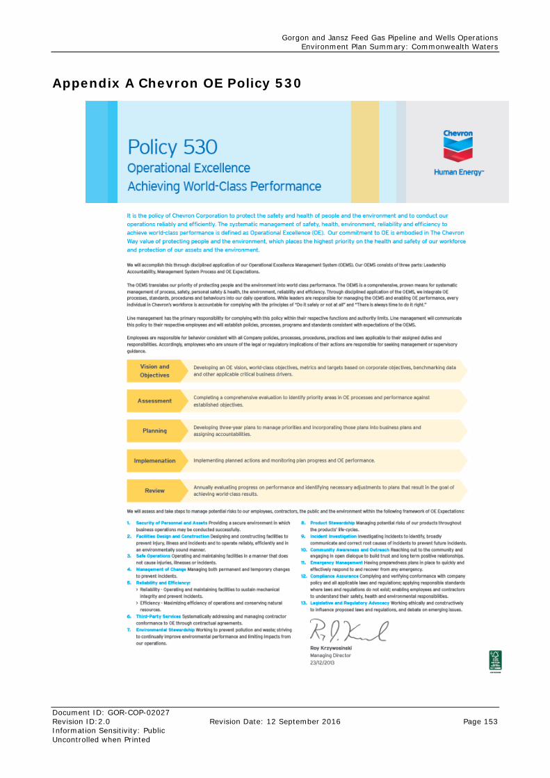
Gorgon and Jansz Feed Gas Pipeline and Wells Operations Environment Plan Summary: Commonwealth Waters
Document ID: GOR-COP-02027 Revision ID:2.0 Revision Date: 12 September 2016 Page 153 Information Sensitivity: Public Uncontrolled when Printed
Appendix A Chevron OE Policy 530