Embed Size (px)
Citation preview

HANMER-ooIl-A I
SE",19ft
S 290412, S 290413, S 290414 and S 290415.
1..Q.Cation
The above four claims c:.re located two miles north and four miles west of the village of Hanmer in Hanmer Township.
More specifically the area covered incI .des the 9, Concession S.
Reference: O.D.M. Map !lo. lQ56-1. T0cation map this report 2"=1 ~ile.
::->revious work
of Lot
Geological mapping and ation work was done Jas. Thompson from 1953 to 1955 inclusive. No surface work, such as drilling or trenching is shown on Thompson's map in or near the surveyed area.
The purpose of the ground sur-Jey was tc ~ ocate and outline, basic and ultrabasic rock types and suI i i~s.
containing magnetic minerals such as magnetite rrhotite in overburden areas.
The electromagnetic survey was done to outline conductors Which might heavily minerali zones, either magnetic or non-magnetic.
•
•
- 2 -
M&qnetometer Surv~y (Procedure) - continued
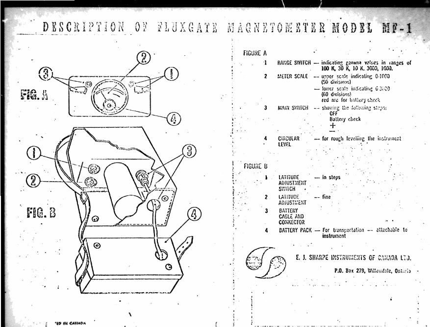
This hand held magnetometer requires no orientation and after coarse levelling, the magnetic re is recorded from a meter mounted on the top of the-instrument.
During this particular survey all of the magnetic were taken in the 3,000 gamma range.
Electromagnetic survey (Procedure)
The instrument used is an I.N.C.O. ~ark IV g~ound E.M. unit. The transmitter is a small. circular, hand held, battery powered vertical coil, that operates on a frequency of 1000 cycles per second. The receiver measures tl1e dip, of the total electromagnetic field through a process of null detection.
The survey method used is known as the "Broadside" technique. The transmitter and receiver are moved simultaneously along parallel traverse lines usually 400 feet apart. Readings are taken with the receiver positioned along strike from the transmitter. l\ny conductor, within range of the transmitter, produces a secondary electromagnetic field distorting the primary field. This distortion is measured in terms of dip angles, in degrees, on a clinometer ~ttached to the receiving coil. These angle readings indicate the L~rection to the source of the secondary field and a zero reading. at the crossover, represents the axis of the conductor.
Base line and grid lines were cut and chained by Reginald Charron, line cutting contractor, whose address is Wahnapitae. ontario. This work was done from June 23 to ,July 5. 1971.
The magnetic and electromagnetic surveys were carried out by two employees of canadian Nickel company Limited, travelling to and from work truck from Canico·s field office in copper Cliff, ontario. ~ield survey work was done on July 12. 13, 14, 1971.
arid lines are spaced at 400 feet and station intervals are chained to 100 feet. Magnetic data waa recorded at 50 foot atationa while S.M. readings were taken every 100 feet. A
atation wa~ .atablished on the grid at to co~r.et for diurnal, and other variationa, 1ft the

•
- 3 -
Survey Data - continued
Total base li.ne cut, survey~d and chained Total cross line cut and chained Total number of magnetic stations read Total number of electromagnetic readings
Magnetic Survey Results
1,200 feet 20 .. 800 feet
398 206
An accompanying map shows tA } results of the magnetic survey on a scale of one inch equals 200 feet. MC!!gnetic readings are plotted relative to an arbitrary base station of 1250 gammas .. located at co-ordinates 00/00, on the common border of claims S 290413 and S 290414.
A broad magnetic high anomaly of +300 to +400 gammas,3.bcve background intensity, strikes E-W through the center of the surveyed area along the 00 baseline. No ground conductor is associated with thi~ magnetic zone.
on the common border of S 290414 and S 290415 a linear magnetic anomaly was outlined. This anomely has the same general E-W strike as the zone above but its' intensity ranges from +400 to +800 gammas above magnetic background. No ground conductor is directly associated with this anomaly.
Because of t-.he presence of the vermilion River several magnetic readings could not be taken at the southeast corner of claim S 290414.
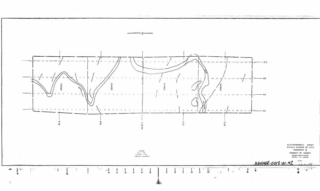
Electromagnetic Survey Results
E.M. results are also shown on an accompanying map on a scale of one inch equals 200 feet Readings are plotted as left or right (L or R) and the number fol denotes the size of the in
A number of weak crossovers and several very doubtful weak conductors were interpreted from the E.M. readings. Only on~ medium strength conductor is of any possible interedt. conductors aDd cre •• overa are shown as heavy dashed lines on the E.M .. and
•
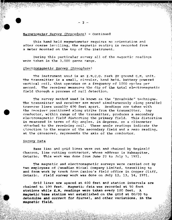
rlaim S 290412
claim S 290413
claim S 290414
Claim S 290415
Recommendation
- 4 -
- continued
contains only weak ossovers.
Has a weak E-W trending conductor near its' north border.
Has two possible E-W trending weak conductors~ one is centrally l~cated in the claim and the other is along the south border.
Has two isolated weak crossovers and a definite weak to medium strength conductor striking NWSEa The west part of this conductor strikes into the linear reagnetic anomaly described earlier.
A low priority drill hole is recommended to test the weak to medium strength conductor at its' strongest point, and near its' point of intersection with the linear magnetic anomaly.
Drill - 50° NORTH from 4+00E - 17+505.
Drilling could be done with a Winkle Drill and the depth of the hole suggested should be a minimum of 200 feet.
GJG: ss 21, 1971

•
HANMER TWP.
CON V
CON IV
LOT 10 LOT 9 LOT 8 CON III
N.E. a S,E. QUARTER OF LOT 9
CONCESSION Y-TOWNSHIP OF HANMER
SUDIUAY MINING DIVISION
01 suoaUAV
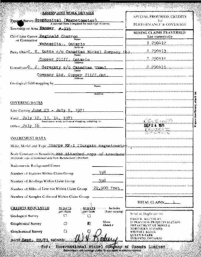
AIft~P~lQfilfO" .. :raIL$ . 1'i ..• ~ .. '. ttrvey GeOahYCl1e.'1 (Magnetometer) .. A ~me fmftll8 ~ fOf each type of ~urvey
Township or Ar,ea~.IDIUt~, 'f"I~"""¥~~------------
Chid Line
SPECiAL PROVI.SION CREDITS for
MINING CLAIMS TRAVERSED
Party ChiefJ:....:... -=:..:....-=::::,:.::~t..-.:'t..L..x-..::.u.~~~"""-....£.1....ro...:loI; ............... -W.~~i.&..I..,J.-.....,...v ••••••••••••••••• :? .. g 9.9.~.~3 .......................... .
Geologic'll field m.tpping by __________ "..,..-_____ _ Name
Addrcss
COVERING DATES
Line
t~idd ........J1I£.lC.~---A .. _~_ ......... __ .........,._ .................. ______ • _____ _
OI1it.:c July 16
INSTRCMENT DATA
.................... :? .. ~29.~!.1~L ........................ .
....... ........ .... S ... 29.Q!+~5 ......................... .
................................................................. 'i 'Iil
................................................................. , .................. &:.t;;.<;~.~ .. ~.y ............................ .
SEP 2. 1971 ................... j~!.~.<~,."J .. ~.:::·.~T~: ..................... .
~~~~ 'T r C, to
.1 1 =
Selle Constant or SenSili\ity See attached cap¥ of brocb:llve ................................................................. . 0, pr<}~·,d(' ,O{H' of imtru,-,u'nt <kilO frO",1 11l.,rlu!tilctUfl!' '1 brochuFf!.
Ril(hllU'lI:trit: B.u.:kgrouncl Count
Number (,f Stations \\'ithin Claim Group
Number of \\'ithin Claim
Nillmlu"r of Miles of Lint, cut Within Chlim Group
Number :')almplcs Colle(~t.ed Within Chtim Group
398
"" locludell (Line ('utting)
Show Cbe(;a<l

Chief Une 0.£ Contractor
Wahnap1tae, QntariQ
MINING CLAIMS TRAVERSED List numericall
.................. S ... 2,SlQ!1.12 ........................... .
Chief J. E. Lubta g/o Canadian Nickel enmpap)' .................. § ... ?9.9.HJ.3 ........................... . Name
....................... ~5!.9.!·:.~.~~ .......................... .
Consultant .=....:--.;:::...:..-::::.::::.:.~CI.!.!!~~~ti.....'lIf~~L.A.!iiilM.ailr.JillW.L.....L!..oI...l.o..i:it.loO..."--:.....I.ot.....~d .............. ~ ••• s5).9.~+J.5. ........................... .
Copper eLi rr, Gntar10
Geological field m<lpping by __________ --::--:--_____ _ Name
Xddra,
COVERING DATES
Line Cutting June 23 - .Iu] Y 5, '971
Office ___ .JOJ;.;.:u;...,1 ..... yL.--.olillo.l6~. _19 .......... 7 .... 1 _____________ _
INSTRC\1E:\T DATA
Make. Model <md Inco MK, IV E,M. un:tt
S.'calc COl1st.am or Sensithit)( see geopbjlsj ea.J report fO)' Or provul.: COPl' oj dalll 1rt»f,1lfIlFlU!tlctUff"'. bnx·"UN'. exp lana t '1 on
RadiomC'tric Count
Number of St.ttiom Within Chum Group 206
Number of Within Claim Group 206
Number of Miles of Line cut Within Claim Group ....2.2...000 fee t
Z)dllDp'lCS CoUecH~d Within Cl'lim Group
Includes (l.ine ell tt ina)
." ................... ................... ~ .......................... :!
................................................................. 1 OIl
... , .............. ~1.s..~;.s~.,1 .. v.~ ... j;~................ .... .1 S£P2' an is
······· .. · .. · .... ·t·~·J:·e"·.~~~-i;.··;·;~···· .... · .. ······· .. ··.. .~
............................. :~.~.~.~.......................... I --

s p n r.,
.' IIE.'OABllIlY.
FLUXGATE ill A G :\1 T,' 1, JJ TOMETER .,
,
c I
A first order fluxCJtc type vertical com-
ponent magnetoineter. Advanced tf ansis
torizcd circuitry and ex!ensive temperature
compensation is the core of its accuracy
comparable to prcci~ion tripod mounted
Schmidt lytle ma.;nctometers.
It is a hand held instrument and need~
only coarse levelling and no orientation.
Fea!ures such as direct rCJding of gamma
values and the possibility of accurate lero
setting at base s!?tions ensure simplicity
of operation and higher field economy.
I } ; . , r:' >. <.
t I .. ' r; ~"'" 1:., ••.•
r'· r:o.: : r: ' t .. :'.,
. ;.;'
f', .
.. ".: ~ ... ~~ .. "
.'
. , ~'- .
.. ". '- . ,,'
: .,. ." i . ~",
", .. , .~ .. ..
. , ,.
.; ~ ...
, . .. :". ,;.. . '.'" • _:.0 ••
'. -:.~ .... ' : .. .. . ~. ,"
. • • .' t : >~ ..
. ~
L_~ .. ~ __ ~_ .. __ .. ;., ... : . , .......... :.~ .... -."'_~ """ ~n_ .. .,. ~_. __ ......... ";."' .. ,;.,' •• ~_11. •• '.: ...... ;4'~
The r,~odcl rt.F·} Flux;;.ate Magnetometer is dcsigr.ed for accur.ate ground surveys in the mining industry as well as a basic
component for air sur.cybg by sma:! aircraft. Technical data and comparison charts avaiJable 011 request
I c A T I o N
20 C.1mmas (per ~catc -:ivhi~li) on lOCO &l!Him~
rhnCI!·
5 &"mmas I~" scala ~ivi~lun on l(jJ() eamma 'lIn~e.
I,COO c.1m:nas 3,OCO .c,'':1 :mas
10,1)00 c~m"''lS 3O,OO() e·""'" lS
lOO,v11l ~:,itjI1JS ,
s :
W,XIMUM R.':lGE:
LATITUDE .'OJUS1:.:tiH RM.GES,
:!: 100,000 c~mr.las
10,000 Iq .75,000 C;;;r.nIJS, I;crlh~rn h~n:j~;'1Cl't con-wHOIo 101
10,000 to l\OM &":"'n,'~, ~ObU,trn h;'I>i!, :',~ or :': 30,OrO t:.i'ttmVS (ii·q~l)rht.
OI:'~:::i'i!ONS. il;;C'_UOW; ::,'., rc:.{ C.\~D r x 4". 16~
1'1(1(;"(, n:;CLUilHiQ Gf.HLii c'on 9lbs,
Mm.RI[S: 12 Fil!hliC1.t [l~Hcrks \,'C" u!'!,
\
fiGURE A
i' : -,
'. I
'.-
" , , .
- .
~ '. ..
"1 RM:GE SWITCII - inilic,llinZ can1tll-. v~h;~:; in 1at'IZtlS or 100 K. 30 X. 1 il K, 300G, 1000.
2 METER SCALE - U;lj1i:f sc~:r. indir.~lin!! O· HK'.()
3
4
2
MI\IN SWITCH
CIi\CUtAR LEVF.l
(50 ~ivi:;If);IS)
- 100':a ~CJ!~ illckalili/! Ii 3(::;0 (60 dl\'isions) rcd aii: for u~llcrJ ~!i,'~~,
- ShO'w'::f:g t:le ro~:{r;;ii1~ S:''';'3: Off Ballery check +
- for rou\:h (e'Ieliinl: the ir.~'(U:'1Ci;t - .
LATHUO£: - in steps AOJUmmn S\':nCH IJ\ mUDE -- fine ADJUSr:,:r);T
3 BflTImy CAGL~ AND CO~i'iECTOa
4 BATIERY PACK - For trJns[;ortation - Jt!;Jch"u:c to instrument
P.O. Box 279. \'/illuwd;;lc, Or.;.;rl~
"

o o o
a.: 3: I-
z w o (f)
::E ::::> ....J
135476 1135475 ----4----
S IS , I ; 1
~3~~7~ J ~3:4?~ S,S IS
I 117393 ' : I _~) ; ®: I , 1 '-. 1135422 <'3
MRO ' MRO i 135478 :'35480 :'35440 1'~3~54JQ , L~ - - - + - - - -!- - - - r - -- - 1"': - -- ----tt--:= - - --i S :S :S :s is IS
135 14 : 13571l :'3,57'5 : 135716 i 13544'1 :135442 ;
~----iS---7+S - - -Ts---t---)-~S--~ 135717 137766 : 129917 ; '37765
, ,
'354lR
I ,
'J4~ ... '~i454 , 3~72:1
,$
'3545,
135456 ~J (~ <
.p'
m' , ~t~
/P) ~) 'P):~:-}:Pi
, ;35124
~--'<,
tpl
"
,
,'P' 'p"" j
!
!3~,!51 ]13"'730 -- ---f -
733 IS i I 35732
-";'-+,--:~~~n,~
131) 735] -~ :-.....:...~.
::-r~,;;~
I
1::,738 ~
;'
13~:' .".£'
$ u ('>
~ "3 5 '. ,
"' ~
13 5 ~~
(P; (0) ® (£I I;',) ® (Pi! ® ®
135509 ' 135502 . -1-~ -
S ,S VI 135508 ' 135501 I'iii;
® V
;.,.-.;,-, ... '::;.
;- m m <.0
;:P'j p', p z.!:' ,'':J CD , 00 ~~) :';' .~/~ -', ® 1'7) '~'" P '" IV ::E
a..: ~ ~
....J 0
r") r~ I .) III w a:: a.. <r u
"
I z o
il
I !
/ I
~ . . -1-'----' , aJ
o o
,-EGENe;
~OI'ODUn"R U'S-O-
.
.o '" N
/ '(
\ \
U)
o
--I U)
o N
ELECTROMAGNETIC SURVEY
N.E. a S.E. QUARTER OF LOT 9
CONCESSION Y TOWNSHIP OF HANMER
SUDBURY MINING DIVISION DISTAICT 01' SUOBURY
1
L-~~~~ ________________________________________ ~~~_-.~.-~-~-~~~~~~~' ,~ I 'T,' ·----~··-·-T--··-----------7~-"---'-"-.... t y •
. ~ I I .. 0 J. • c:.
I I 2- 3 .,. S
I y
I , " 13.. ., co- • I ' 10

z z 0 ~ '"
-" CD
0 0
.UG~ET'C ~T4"O~ ~ " ..... "
to"'OUR 1~'{qUC200G""U'
iii i~----"--------------------~------------------~
o ! i I
.J. .) + 5 'I ~
.~-- -"
1
if)
~
i I I I ., • 1 10
en
8
1 ,
"
MAGNETOMETER ,URVEY N.E.SSL QUARTER OF LOT9
CONCESSION Y. TOW~SHIP OF HANMER
SUDBURY MINING DIVI5!ON
DISTRICT OF S .. )BURY


![GEOPH RPT EM & MAG SUR SHOAL L PROJ GRIDS 5A/5B/6E & 7C · 2017. 1. 17. · Ivy] Natural VyJ Resources Work Credits Ontario ^^ mCnt . J"f 2.5474 [Date Mining Recorder's Report of](https://img.pdfslide.us/doc/110x75/6123208d25efc33a115b9085/geoph-rpt-em-mag-sur-shoal-l-proj-grids-5a5b6e-7c-2017-1-17-ivy.jpg)