Embed Size (px)
Citation preview
Garmony Hydro Scheme
Environmental Statement
December 2011
Mull and Iona Community Trust

282515 TGD TGC 1 B
http://pims01/pims/llisapi.dll?func=ll&objaction=overview&objid=1473533573
December 2011
Garmony Hydro Scheme
Environmental Statement
December 2011
Mull and Iona Community Trust
Mott MacDonald, 1 Atlantic Quay, Broomielaw, Glasgow G2 8JB, United Kingdom
T +44(0) 141 222 4500 F +44(0) 141 221 2048, W www.mottmac.com
An Roth Community Enterprise Centre, Craignure, Isle of Mull, PA65 6AY


Garmony Hydro Scheme
Mott MacDonald, 1 Atlantic Quay, Broomielaw, Glasgow G2 8JB, United Kingdom
T +44(0) 141 222 4500 F +44(0) 141 221 2048, W www.mottmac.com
Revision Date Originator Checker Approver Description
A May 2011 G Weir D Noble C McPake
N Green G McGill Issue for client comment
B December 2011 K Rae D Noble R Forrester
N Green D Macdonald Updated with new powerhouse and pipe location
Issue and revision record
This document is issued for the party which commissioned it
and for specific purposes connected with the above-captioned
project only. It should not be relied upon by any other party or
used for any other purpose.
We accept no responsibility for the consequences of this
document being relied upon by any other party, or being used
for any other purpose, or containing any error or omission which
is due to an error or omission in data supplied to us by other
parties
This document contains confidential information and proprietary
intellectual property. It should not be shown to other parties
without consent from us and from the party which
commissioned it.

282515/TGD/TGC/1/B December 2011 http://pims01/pims/llisapi.dll?func=ll&objaction=overview&objid=1473533573
Garmony Hydro Scheme
Chapter Title Page
Executive Summary i
1. Introduction 1
1.1 Overview __________________________________________________________________________ 1
1.2 Context ____________________________________________________________________________ 1
1.3 The Site ___________________________________________________________________________ 2
1.4 The Planning Application ______________________________________________________________ 3
1.5 Policy and Planning Context ___________________________________________________________ 3
1.6 Required Consents___________________________________________________________________ 3
1.7 Structure and Content of the Environmental Statement_______________________________________ 4
2. Scheme Alternatives 5
2.1 Introduction_________________________________________________________________________ 5
2.2 Need for the Proposed Development _____________________________________________________ 5
2.3 Do Nothing _________________________________________________________________________ 5
2.4 Alternatives Considered During Preliminary Design _________________________________________ 5
3. The Proposed Scheme 7
3.1 Summary __________________________________________________________________________ 7
3.2 Intake weirs ________________________________________________________________________ 8
3.3 Pipeline____________________________________________________________________________ 8
3.4 Powerhouse ________________________________________________________________________ 9
3.5 Access Tracks ______________________________________________________________________ 9
3.6 Electricity Grid Connection____________________________________________________________ 10
3.7 Construction Phase _________________________________________________________________ 10
3.8 Operation and Maintenance___________________________________________________________ 11
3.9 Decommissioning ___________________________________________________________________ 12
4. The EIA Process 13
4.1 Regulatory Context__________________________________________________________________ 13
4.2 Screening _________________________________________________________________________ 13
4.3 Scoping & Consultation ______________________________________________________________ 13
4.4 Topics Scoped Out__________________________________________________________________ 14
4.5 Environmental Statement Preparation ___________________________________________________ 16
5. Ecology and Nature Conservation 18
5.1 Assessment Methodology ____________________________________________________________ 18
5.2 Baseline Assessment ________________________________________________________________ 22
5.3 Assessment of Impacts ______________________________________________________________ 28
5.4 Mitigation _________________________________________________________________________ 31
5.5 Residual Effects after Mitigation________________________________________________________ 33
5.6 Summary of Effects _________________________________________________________________ 33
6. Hydrology 36
Content
282515/TGD/TGC/1/B December 2011 http://pims01/pims/llisapi.dll?func=ll&objaction=overview&objid=1473533573
Garmony Hydro Scheme
6.1 Introduction________________________________________________________________________ 36
6.2 Consultation _______________________________________________________________________ 36
6.3 Legislative Background ______________________________________________________________ 37
6.4 Methodology_______________________________________________________________________ 39
6.5 Water Supplies_____________________________________________________________________ 40
6.6 Derivation of the Natural Flow Duration Curve_____________________________________________ 41
6.7 Scheme Operation-Effect of Scheme on Natural Flows______________________________________ 43
6.8 Mitigation Measures _________________________________________________________________ 45
6.9 Residual Effects ____________________________________________________________________ 47
6.10 Cumulative Effects __________________________________________________________________ 47
6.11 Statement of Significance_____________________________________________________________ 48
7. Summary and Residual Impacts 49
8. References 50
Appendices 52
Appendix A. Scheme Layout ____________________________________________________________________ 53
Appendix B. Construction Method Statement________________________________________________________ 54
Appendix C. Pre-application (Screening) Response___________________________________________________ 55
Appendix D. Pre-application (Scoping) Response ____________________________________________________ 56
Appendix E. Ecology___________________________________________________________________________ 57
Glossary & Abbreviations 58
Tables
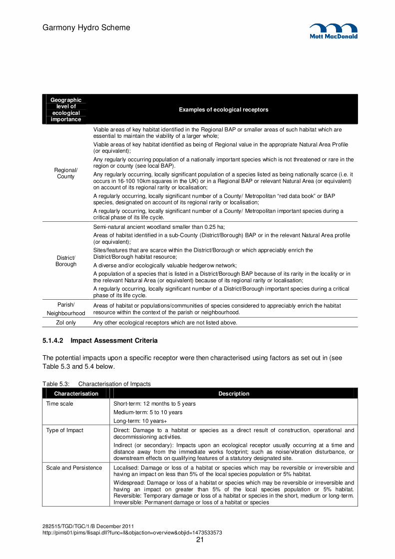
Table 5.1: Summary of Relevant Scoping Responses _______________________________________________ 19
Table 5.2: Assessment of the Geographical Scale element of Conservation Value.(IEEM 2006) ______________ 20
Table 5.3: Characterisation of Impacts ___________________________________________________________ 21
Table 5.4: Criteria for Determining the Magnitude of Impact (Adapted from SNH 2002) _____________________ 22
Table 5.5: Assessment of Impact Significance _____________________________________________________ 22
Table 5.6: Summary of Effects on Ecological Receptors _____________________________________________ 34
Table 6.1: Summary of Scoping Responses and Comments __________________________________________ 36
Table 6.2: Estimated Long Term FDC at Intake (NM 669 389)_________________________________________ 42
Table 6.3: Intake Catchment Details _____________________________________________________________ 43
Table 6.4: Minimum flows required for power generation _____________________________________________ 45
Table 6.5: Scheme Parameters_________________________________________________________________ 46
Table 6.6: Proposed Mitigation Measures_________________________________________________________ 46
Figures
Figure 1.1 Site Location________________________________________________________________________ 1
Figure 3.1: Scheme Layout _____________________________________________________________________ 7
Figure 5.1: Habitat Map ________________________________________________ Error! Bookmark not defined.
Figure 6.1: LFE FDC at Intake (NM 669 389)_______________________________________________________ 42
Figure 6.2: Natural and Operational Residual Flow Duration Curve at intake location _______________________ 44
Figure 6.3: Natural and Operational Residual Flow Duration Curve at impassable barrier upstream of powerhouse 44

282515/TGD/TGC/1/B December 2011 http://pims01/pims/llisapi.dll?func=ll&objaction=overview&objid=1473533573
Garmony Hydro Scheme

282515/TGD/TGC/1/B December 2011 http://pims01/pims/llisapi.dll?func=ll&objaction=overview&objid=1473533573
i
Garmony Hydro Scheme
The Mull and Iona Community Trust (M&ICT) is proposing to construct a small hydroelectric scheme on the
Allt Achadh na Moine watercourse near Garmony, on the eastern side of the Isle of Mull. Mott MacDonald
has prepared this informal and non-statutory Environmental Statement on behalf of M&ICT to support a
request for planning permission for the proposed scheme.
The proposed scheme will be run-of-river and will be designed with an approximate installed capacity of
260-400kW. It will feature the following infrastructure:
� A primary intake structure on the Allt Achadh na Moine.
� A minor diversion intake structure on the tributary, Allt Beinn nam Meann
� A powerhouse containing the turbine, generator and associated equipment.
� A buried pipeline, and associated culverting of un-named tributary, connecting the intakes to the
powerhouse.
� A pipe bridge across the Allt Achadh na Moine.
� An open tailrace channel or buried pipeline and screened discharge structure.
� Access tracks to the powerhouse and along the pipeline to the intake locations
� Overhead or buried power line linking the powerhouse to the local electricity distribution network
The proposed development lies within the jurisdiction of Argyll and Bute Council. The proposed scheme is
in keeping with the relevant national, regional and local plans and policies to meet sustainable development
objectives and to increase the amount of renewable energy that is generated.
A scoping study was undertaken to identify key issues associated with the proposed hydro scheme to
define the scope of this informal Environmental Statement (ES) and the parameters that would require
further investigation. A scoping report was produced and sent to various consultees. The scoping exercise
identified Ecology and Nature Conservation and Hydrology as those topics requiring further investigation
and inclusion in the ES. Several topics were ‘scoped out’ of further assessment and the rationale for this is
provided in Chapter 4 of this document.
In this document the potential effects of the proposed hydro scheme on the environment have been
considered and assessed under the following headings:
Ecology and Nature Conservation
An ecological impact assessment of the proposed scheme was carried out through desk studies and site
surveys. Baseline surveys undertaken to inform the assessment included the following:
� Phase 1 Habitat/National vegetation Classification (NVC) surveys;
� Bryophyte and aquatic macrophyte survey
� Otter survey
� Fish habitat survey
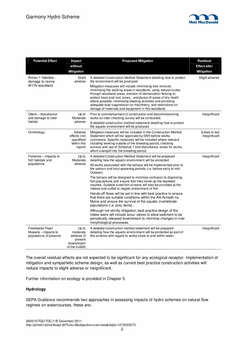
The following table summarises the potential impacts the development may have on receptors and the
overall effect once mitigation has been applied.
Executive Summary
282515/TGD/TGC/1/B December 2011 http://pims01/pims/llisapi.dll?func=ll&objaction=overview&objid=1473533573
ii
Garmony Hydro Scheme
Potential Effect Impact
without
Mitigation
Proposed Mitigation Residual
Effect after
Mitigation
Annex 1 habitats - damage to ravine W17b woodland
Slight adverse
A detailed Construction Method Statement detailing how to protect the environment will be produced.
Mitigation measures will include minimising tree removal, minimising the working areas in woodland, using natural routes through woodland areas, erection of demarcation fencing to protect trees and root zones, avoidance of areas of dry heath where possible, minimising blasting activities and providing adequate dust suppression on machinery, and restrictions on storage of materials and equipment in this woodland.
Slight adverse
Otters – disturbance and damage to otter habitat
Up to Moderate
adverse
Prior to commencement of construction and decommissioning works an otter checking survey will be conducted.
A detailed construction method statement detailing how to protect the aquatic environment will be produced
Insignificant
Ornithology Adverse effects (not
quantified within this
report)
Mitigation measures will be included in the Construction Method Statement which will be approved by SNH before works commence. Specific measures will be included where relevant including working outside of the breeding period, checking surveys and use of Schedule 1 bird disturbance zones for works which overspill into the breeding period.
[Likely to be] Insignificant
Fisheries – impacts to fish habitats and populations
Up to Moderate
adverse
A detailed Construction Method Statement will be prepared detailing how the aquatic environment will be protected.
All works associated with the tailrace will be implemented prior to the salmon and trout spawning periods (i.e. before early to mid October).
The tailrace will be designed to minimise confusion to dispersing fish populations and ensure that they travel up the depleted reaches. Suitable sized fish screens will also be provided at the intakes and outfall to negate entrainment of fish.
Hands-off flows will be set in line with best practice to ensure that there are suitable conditions within the Allt Achadh na Moine and ensure the survival of the aquatic invertebrate populations (i.e. prey items).
Although not strictly mitigation, best practice design of the intake weirs will include scour valves to allow sediment to be periodically released downstream to minimise changes in river morphological processes.
Insignificant
Freshwater Pearl Mussels – impacts to populations (if present)
Up to moderate
adverse (if present
downstream of the outfall)
A detailed construction method statement wi ll be prepared detailing how the aquatic environment will be protected as part of this scheme with regard to works close to and within water.
Insignificant
The overall residual effects are not expected to be significant for any ecological receptor. Implementation of
mitigation and sympathetic scheme design, as well as current best practice construction activities will
reduce impacts to slight adverse or insignificant.
Further information on ecology is provided in Chapter 5.
Hydrology
SEPA Guidance recommends two approaches in assessing impacts of hydro schemes on natural flow
regimes on watercourses, these are;

282515/TGD/TGC/1/B December 2011 http://pims01/pims/llisapi.dll?func=ll&objaction=overview&objid=1473533573
iii
Garmony Hydro Scheme
� Theoretical/ desk based approach,
� Use of measured data.
Given the size of the proposed scheme options and the lack of suitable analogues on Mull for spot
gaugings to be linked to, it has been agreed with SEPA that a theoretical approach was appropriate for
assessing the impacts of the hydro scheme on Allt Achadh na Moine.
The FDC for the intake location was derived using Low Flow Enterprise (LFE) software. LFE is SEPA’s
preferred theoretical approach for estimating the FDC of an ungauged location or catchment with
insufficient monitoring data. The method used by LFE is based on the regionalisation of flow duration
statistics in estimating flows and builds on the strong influence physical and climatic characteristics of a
catchment have on the resulting flow regime. The FDC derived from LFE was used in the assessment of
potential impacts of the hydro scheme.
The operation of the proposed scheme would directly depend on the water level and flow within Allt Achadh
na Moine. The turbine would operate only when sufficient water is available at the intake to allow for both
turbine flow and the provision of hands-off flow. Under such conditions, water would be abstracted through
the intake from where it would be transferred down the pipeline to the turbine in the powerhouse.
In addition to the proposed intake location on Allt Achadh na Moine, water will be diverted from the
adjacent tributary Allt Beinn nam Meann. The diversion is proposed a short distance upstream of the
confluence with Allt Achadh na Moine leaving a very short impacted stretch (up to 20m). A hands-off flow
equivalent to Q90 (0.002m3/s) will be provided at the diversionary intake.
The operational FDC at the intakes shows that for approximately 34% of the year the natural flows in the
watercourses would be too low to accommodate both minimum abstraction and hands-off flow, so no
power generation would take place at the intake. At these times the turbine would not operate and no water
would be abstracted from the Allt Achadh na Moine. For periods when abstraction is occurring, residual
flows passing the intake of the proposed scheme will increase gradually from Qn90 and in accordance with
SEPA’s recommended mitigation for flow variability, downstream flow will increase in proportion to
upstream flows rising to Qn80 when the upstream flow is Qn30.
SEPA guidance specifies that the maximum abstraction should not exceed 1.3 to 1.5 times the average
daily flow to ensure protection of high flows. The proposed maximum abstraction at each intake is within
this limit set to 1.5 times the average daily flow.
The impact on river flows as a specific receptor, considered in isolation from its dependant ecology, is low
or very low and consequently needs no mitigation in its own right. However, the true impact of the scheme
on hydrology is intrinsically linked to the consequent impact on the ecology which depends on the river
flows.
The ecological survey has identified spawning grounds downstream of the intake. The location of the
tailrace will be at the upstream limit of these spawning grounds and flows will be protected through
compliance with SEPA’s mitigation measures. The lack of spawning grounds upstream of the intake
removes the need for any additional flow regimes.
The overall residual effects are not significant for the Allt Achadh na Moine.

282515/TGD/TGC/1/B December 2011 http://pims01/pims/llisapi.dll?func=ll&objaction=overview&objid=1473533573
iv
Garmony Hydro Scheme
Conclusion
No significant potential adverse impacts have been identified as a result of the development of the
proposed hydro scheme. Residual impacts for hydrology and ecology are deemed to be negligible overall
due to the mitigation measures that are proposed, the temporary and short-term nature of the construction
phase, and the fact that this is a relatively small hydro scheme with an output of less than 500kW.
282515/TGD/TGC/1/B December 2011 http://pims01/pims/llisapi.dll?func=ll&objaction=overview&objid=1473533573
1
Garmony Hydro Scheme
1.1 Overview
Small hydroelectric power schemes are commonplace in the uplands of Scotland given the wet climate and
mountainous terrain. These factors make the country well placed to take advantage of this renewable
technology on a large scale. Currently around 10% of Scotland’s electricity is produced from hydro power
but this proportion is set to grow with the Scottish Government’s ambitious target for 80% of all electricity
consumption to be derived from renewable sources by 2020. The proposed Garmony hydropower scheme
can contribute towards achieving this goal.
1.2 Context
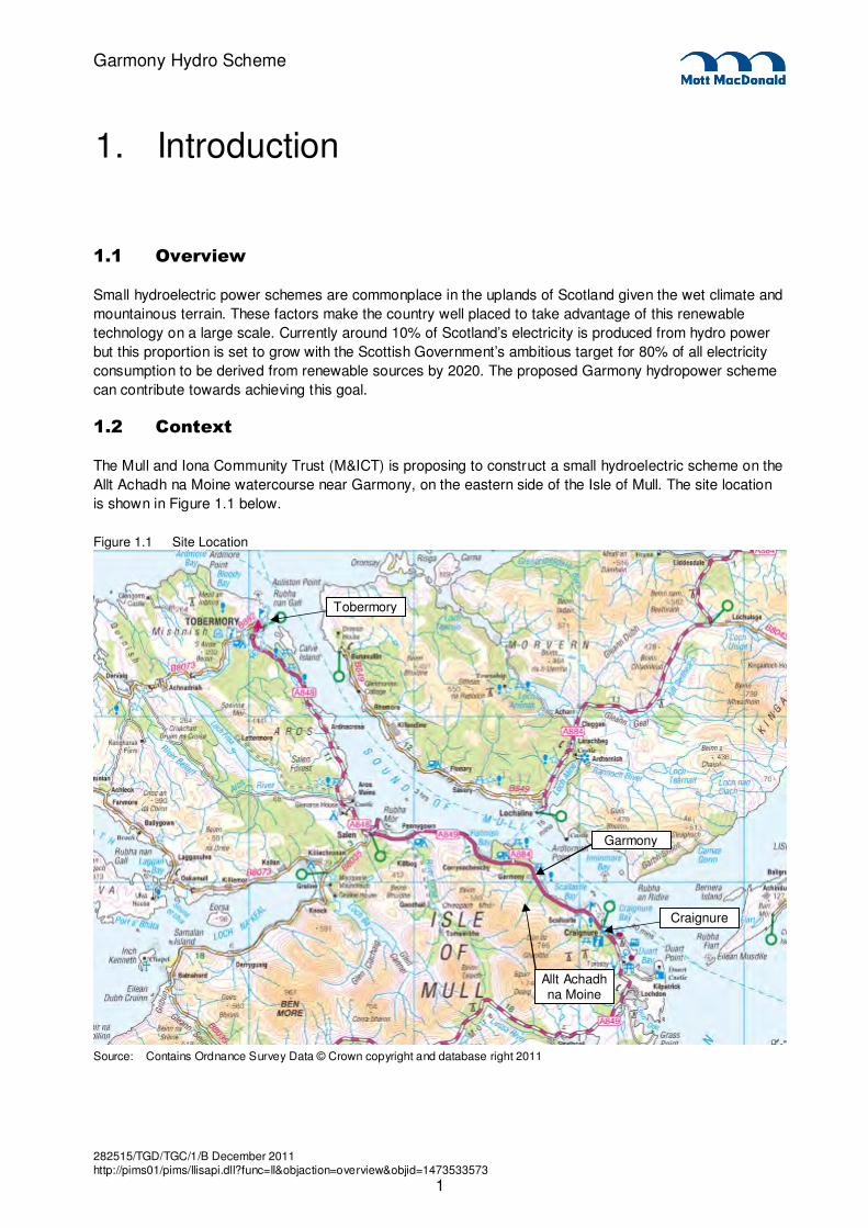
The Mull and Iona Community Trust (M&ICT) is proposing to construct a small hydroelectric scheme on the
Allt Achadh na Moine watercourse near Garmony, on the eastern side of the Isle of Mull. The site location
is shown in Figure 1.1 below.
Figure 1.1 Site Location
Source: Contains Ordnance Survey Data © Crown copyright and database right 2011
1. Introduction
Allt Achadh na Moine
Tobermory
Craignure
Garmony

282515/TGD/TGC/1/B December 2011 http://pims01/pims/llisapi.dll?func=ll&objaction=overview&objid=1473533573
2
Garmony Hydro Scheme
The proposed scheme will be run-of-river and will be designed with an approximate installed capacity of
260-400kW. It will feature the following infrastructure:
� A primary intake structure on the Allt Achadh na Moine.
� A minor diversion intake structure on the tributary, Allt Beinn nam Meann
� A powerhouse containing the turbine, generator and associated equipment.
� A buried pipeline, and associated culverting of un-named tributary, connecting the intakes to the
powerhouse.
� A pipe bridge across the Allt Achadh na Moine.
� An open tailrace channel or buried pipeline and screened discharge structure.
� Access tracks to the powerhouse and along the pipeline to the intake locations
� Overhead or buried power line linking the powerhouse to the local electricity distribution network
1.2.1 The Applicant
The applicant is the Mull and Iona Community Trust. Comments, queries or requests for further information
regarding the Garmony hydro scheme can be made via the contact details below:
Garmony Hydro Scheme Development Enquiries
Mull and Iona Community Trust
An Roth Community Enterprise Centre
Craignure
Isle of Mull
PA65 6AY
1.2.2 Land Ownership
All of the land on which the proposed development is sited is in the ownership of the Forestry Commission.
The Forestry Commission has granted permission for M&ICT to use the land on which the proposed
scheme will be situated. The applicant will take all reasonable steps to identify those who enjoy rights over
the land affected to ensure they are informed about the proposed development.
1.3 The Site
The Allt Achadh na Moine is an upland oligotrophic watercourse, with its source in the hills to the South of
Garmony. Draining the Coire Clachach on the northern flank of Beinn Thunacaraidh, it quickly descends in
a series of cascades and waterfalls before entering a large area of Sitka Spruce plantation. The burn
continues to descend a number of other cascades and small water falls before entering a large area of
recent deforestation, where it levels out before entering the sea at Garmony Point.
Habitats above the Forestry boundary consist mainly of a mosaic of wet heath and acid grassland,
dominated by wavy hair grass and heather species e.g Cross-leaved heath (Erica tetralix). Lower reaches
of the burn descend through a break in the forestry (approximately 20m wide), which is dominated by acid
grassland species, bracken and birch scrub.
Land use is predominantly forestry plantation.

282515/TGD/TGC/1/B December 2011 http://pims01/pims/llisapi.dll?func=ll&objaction=overview&objid=1473533573
3
Garmony Hydro Scheme
1.4 The Planning Application
The Garmony hydro scheme includes plant installations, pipelines, grid connection, access tracks and
temporary construction works. The construction works will include temporary site cabins, plant and
machinery that will be required for the duration of the building operations. These facilities will be located
adjacent to the proposed development site and as such they will benefit from permitted development rights.
The planning application to which this ES relates is submitted to Argyll and Bute Council (as planning
authority), who are the relevant Local Planning Authority (LPA). The planning application includes:
� Application for Planning Permission
� Land Ownership Certificate
� Notice to Tenants
� Planning Application Supporting Drawings
1.5 Policy and Planning Context
There is a relationship between the proposed scheme and national energy policy, national planning policy,
regional planning policy and local planning policy. This document will not summarise all of the relevant
policy, as is the practice in formal environmental statements, but will give a brief overview of the applicable
regional and local policy as it pertains to the scheme.
The current development plans in force include the Argyll and Bute Structure Plan (approved 2002) and the
Local Plan – Argyll and Bute (adopted 2009). It is expected that the proposed development would be
assessed mainly against Policy LP REN 3 of the Local Plan which states the following:
‘Non-wind renewable energy related development, including solar, hydro, biomass, energy from waste, and
onshore development consequent on wave and tidal resource use, will be supported in forms, scales and
locations where it will promote the aim of sustainable development, where servicing, electricity distribution
and access impacts are acceptable, and all other material considerations including the council’s
international and national obligations are satisfactorily addressed’
1.6 Required Consents
1.6.1 Section 37 of the Electricity Act 1989
Section 37 of the Electricity Act 1989 requires permission from the Scottish Government for projects which
involve the installation of overhead power lines. As outlined in section 1.2 above, electricity power lines will
be installed above ground to link the scheme powerhouse to the national grid network. An application for
section 37 consent will be made to the Scottish Ministers (via Scottish and Southern Energy) as part of the
scheme approval and planning process.
1.6.2 Water Environment (Controlled Activities) (Scotland) Regulations 2006 (CAR)
Consent is required to impound, abstract and return water to a river and to conduct engineering works
within and alongside watercourses. An application will be made to the licensing authority SEPA for the
appropriate CAR consents for the scheme. Further information relating to CAR consenting is provided in
the Hydrology chapter.

282515/TGD/TGC/1/B December 2011 http://pims01/pims/llisapi.dll?func=ll&objaction=overview&objid=1473533573
4
Garmony Hydro Scheme
1.7 Structure and Content of the Environmental Statement
The environmental statement (ES) is a comprehensive and concise document drawing together all the
relevant information about the proposed scheme and its potential significant environmental effects. The ES
includes an executive summary and appendices.
The structure of the ES is as follows:
Chapter 1: Introduction This section provides an introduction to the scheme, including a brief outline of the details and location of the proposed scheme; the EIA processes and methodologies; the outcome of the screening and scoping stages; and details of the assessment team.
Chapter 2: Scheme Alternatives A description of the alternative options which were assessed and provides a comprehensive reasoning as to why these options were discounted as viable schemes.
Chapter 3: The Proposed Scheme Detailed chapter outlining the proposed scheme components. Provides the overall scheme layout including access arrangements and site welfare compounds/services, construction programme and activities, and waste disposal arrangements.
Chapter 4: The EIA Process This chapter provides an outline of the requirements of the EIA Regulations and how these have been adapted for this non-statutory ES.
Chapter 5: Ecology & Nature Conservation
Following a brief outline of the chapter content, a description of the applicable legislation is given and an outline of the scoping responses and subsequent comments to these is provided. A description of the methodology adopted for the assessment is then given. This is followed by an analysis of the predicted impacts in relation to ecology and nature conservation. Mitigation measures are proposed and residual impacts are assessed.
Chapter 6: Hydrology Structure as per Chapter 5.
Chapter 7: Summary and Residual Impacts
This chapter provides a brief summary of the findings from the assessment chapters

282515/TGD/TGC/1/B December 2011 http://pims01/pims/llisapi.dll?func=ll&objaction=overview&objid=1473533573
5
Garmony Hydro Scheme
2.1 Introduction
This chapter sets out the background to the need for the proposed scheme and describes how alternatives
to meeting the need were identified and evaluated. The chapter also describes how the conclusion was
reached that the proposed scheme for which planning permission is being sought is the preferred option.
2.2 Need for the Proposed Development
Small hydroelectric power schemes are commonplace in the uplands of Scotland given the wet climate and
mountainous terrain. These factors make the country well placed to take advantage of this renewable
technology on a widespread scale. Currently around 10% of Scotland’s electricity is produced from hydro
power but this number is set to grow with the Scottish Government’s ambitious target of 80% of all
electricity consumption to be derived from renewable sources by 2020. The proposed Garmony
hydropower scheme can contribute towards achieving this goal.
A variety of potential options were examined as part of the feasibility and design process. These were:
� Do nothing;
� Alternative hydropower schemes in the surrounding area; and
� Alternative design of the proposed scheme;
Key issues identified and used in the selection of the above were:
� Technical – providing a technically feasible scheme;
� Economic – providing an economically feasible and beneficial scheme, where the cost of damage
avoided is greater than the capital, operation and maintenance costs of the proposed scheme;
� Environmental – minimising the environmental impact of the scheme as well as preserving the local
biodiversity and habitat throughout all phases of the scheme;
Further details of the alternatives considered are provided in this chapter.
2.3 Do Nothing
The do nothing option was not considered to be acceptable. A successful hydro power scheme will provide
an income to the Mull and Iona Community Trust which will be retained for investment in community
projects in the area. It will also benefit by providing an estimated 980-1250MWh/yr of electricity to the
national grid, helping the UK to satisfy its energy requirements and meet its renewables targets.
2.4 Alternatives Considered During Preliminary Design
The design of the Garmony hydro scheme was an iterative process, with various alternative scheme
layouts considered as part of the design and optimisation process.
A high level screening for hydro power potential was prepared by Babyhydro1 that reviewed eight possible
watercourses for hydropower schemes. The four schemes with greatest hydro potential were selected for
further assessment.
_________________________
1 Community Power Generation Sites for the Isle of Mull, Appendix 1, Abridge Initial Hydro Study. 22 Feb 2010. MICT-Evaluation-001
2. Scheme Alternatives

282515/TGD/TGC/1/B December 2011 http://pims01/pims/llisapi.dll?func=ll&objaction=overview&objid=1473533573
6
Garmony Hydro Scheme
The four schemes were assessed by Mott MacDonald. Following this assessment and optimisation, two of
the schemes were disregarded and two were progressed. One of these is the Garmony scheme.
Other schemes that have not been developed are likely to have higher cost, lower power output, and/or
greater potential environmental impact than the Garmony scheme currently being developed.
During outline design of the Garmony hydro scheme, consideration was given to alternative locations and
alignments for the key components:
� Alternative intake locations were considered, in order to maximise energy yield and constructability.
Sites deemed technically unsuitable or difficult to construct were excluded from the assessment.
� Powerhouse location was selected to maximise energy yield, as well as avoiding areas at risk of
flooding and other environmental constraints identified as part of the EIA process.
� The pipeline alignment was developed in an iterative process, to obtain the most direct route whilst
avoiding areas with difficult ground conditions and other environmental constraints identified as part of
the EIA process.
Alternative alignments for access tracks were considered, but it was decided to use the existing estate
tracks and to follow the pipeline alignment, to minimise cost and environmental impact. Where new tracks
are required, these have been aligned to avoid areas of difficult ground and other identified environmental
constraints.
282515/TGD/TGC/1/B December 2011 http://pims01/pims/llisapi.dll?func=ll&objaction=overview&objid=1473533573
7
Garmony Hydro Scheme
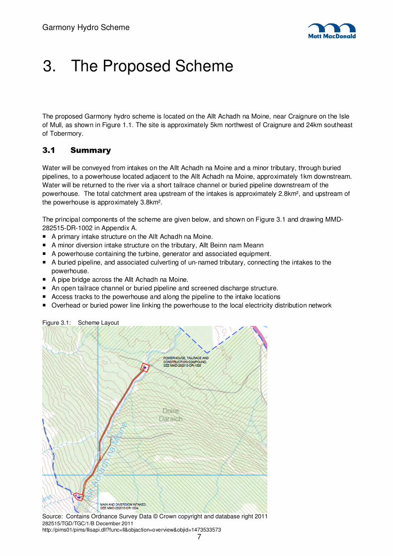
The proposed Garmony hydro scheme is located on the Allt Achadh na Moine, near Craignure on the Isle
of Mull, as shown in Figure 1.1. The site is approximately 5km northwest of Craignure and 24km southeast
of Tobermory.
3.1 Summary
Water will be conveyed from intakes on the Allt Achadh na Moine and a minor tributary, through buried
pipelines, to a powerhouse located adjacent to the Allt Achadh na Moine, approximately 1km downstream.
Water will be returned to the river via a short tailrace channel or buried pipeline downstream of the
powerhouse. The total catchment area upstream of the intakes is approximately 2.8km², and upstream of
the powerhouse is approximately 3.8km².
The principal components of the scheme are given below, and shown on Figure 3.1 and drawing MMD-
282515-DR-1002 in Appendix A.
� A primary intake structure on the Allt Achadh na Moine.
� A minor diversion intake structure on the tributary, Allt Beinn nam Meann
� A powerhouse containing the turbine, generator and associated equipment.
� A buried pipeline, and associated culverting of un-named tributary, connecting the intakes to the
powerhouse.
� A pipe bridge across the Allt Achadh na Moine.
� An open tailrace channel or buried pipeline and screened discharge structure.
� Access tracks to the powerhouse and along the pipeline to the intake locations
� Overhead or buried power line linking the powerhouse to the local electricity distribution network
Figure 3.1: Scheme Layout
Source: Contains Ordnance Survey Data © Crown copyright and database right 2011
3. The Proposed Scheme
282515/TGD/TGC/1/B December 2011 http://pims01/pims/llisapi.dll?func=ll&objaction=overview&objid=1473533573
8
Garmony Hydro Scheme
3.2 Intake weirs
A primary intake structure plus a minor diversion intake structure will be constructed on the Allt Achadh na
Moine and its tributary, the Allt Beinn nam Meann, to abstract water for hydroelectric power generation.
The intakes will be located on the upstream (southwestern) edge of the existing forestry plantation, within
the Forestry Commission land boundary. The primary intake weir will be formed across the Allt Achadh na
Moine on a rocky outcrop, upstream of a waterfall, at an elevation of approximately 140mAOD at OSGR
NM66893887. A minor intake weir will be formed across the Allt Beinn nam Meann (at OSGR
NM66873888), with water diverted approximately 25m into the Allt Achadh na Moine upstream of the
primary intake.
The intake weirs will be of reinforced concrete construction, designed to use the minimum quantity of
imported materials and minimise the visual impact as far as practicable.
They will include provision for a preferential hands-off flow to pass the structure irrespective of whether
abstraction is taking place or not:
� No abstraction for power generation will occur in low flow conditions. All of the natural river flow will
pass the structure at times of low flow.
� During periods of operation, a hands-off flow will pass through the compensation plate, and will flow
downstream. Abstraction for power generation will utilise the residual flow in the river. The hands-off
flow will increase with the natural river flow upstream of the intake.
� When the natural river flow exceeds the agreed scheme capacity, any excess water will flow unimpeded
over the weir, in addition to the hands-off flow.
The design of the intake structures will incorporate the following features:
� The intakes will be fitted with screens, to prevent debris or animals becoming trapped or entering the
pipeline.
� The intakes will be designed safely to pass flood flows of up to the 1% AEP (1 in 100 year) event.
� Valves will be incorporated within or close to the intake chambers in order to isolate the pipeline as
required. Drain/scour valves will also be fitted for maintenance purposes.
3.3 Pipeline
Water will be transferred from the intakes to the powerhouse via 0.5m diameter pipelines approximately
1km long. The pipeline will follow the route shown on Figure 3.1, initially down the south-eastern bank of
the Allt Achadh na Moine before it crosses the Allt Achadh na Moine by way of a pipe bridge at OSGR
NM67013912 and continues on the north-western bank towards the powerhouse, requiring the un-named
tributary at OSGR NM67063929 to be culverted. The route may deviate locally to allow an optimal
alignment to suit topographical and ground conditions.
The following technical and environmental constraints were considered during the development of the
pipeline alignment:
� Intake and powerhouse locations
� Local topography of the site
� Minimising the length of the pipeline route and number of river crossings
� Avoiding sensitive environmental and archaeological areas wherever possible
The need for a continuous fall along the pipeline may require local landscaping works in order to give
sufficient depth of cover to the pipeline.
282515/TGD/TGC/1/B December 2011 http://pims01/pims/llisapi.dll?func=ll&objaction=overview&objid=1473533573
9
Garmony Hydro Scheme
Once a detailed alignment has been fixed, the construction corridor will be limited to a width of 30m,
although this could be reduced if required at certain points to avoid particular environmental constraints.
Tree felling at the edge of the forestry plantation, along the pipeline route, will be required prior to
construction of the scheme, however it is understood that it is already proposed to fell this area within the
next year. The extent of the felling (both for the project and as part of normal forestry operations) is shown
on drawing MMD-282515-DR-1002 in Appendix A. The majority will consist of conifer plantation, with a
small percentage of birch and oak.
3.4 Powerhouse
A powerhouse building containing the turbine, generator, and associated equipment will be located
adjacent to the existing forestry track bridge across the Allt Achadh na Moine at OSGR NM672396. The
powerhouse has been located to maximise power output of the scheme and avoid any environmentally
sensitive areas.
The powerhouse compound will cover an area approximately 20m by 20m, with a building structure of
approximately 10m by 7m. An electrical transformer compound approximately 4m by 4m will be located
adjacent to the powerhouse.
The powerhouse building will be constructed in keeping with the local environment and will be finished in
the local vernacular style, either neutral coloured corrugated sheet walls and roof, or blockwork walls with a
grey harled finish and a corrugated sheet roof. The powerhouse will be located to minimise the visual
impact of the structure as far as practicable given other constraints, and will be designed to minimise noise
and vibration disturbance to nearby receptors.
A tailrace will transfer water back to the Allt Achadh na Moine after passing through the turbine located
within the powerhouse. A fish screen will be fitted across the tailrace outfall.
The tailrace outfall will be designed to dissipate energy, thus minimising erosion of the main riverbed and
banks, as well as minimising the impact on fish.
The client’s name, logo and an emergency contact number will be displayed on an external sign at the
powerhouse building. Internal and external lighting will be provided at the powerhouse for use during
maintenance visits.
The powerhouse building will be located and designed to protect its contents from the 0.5%AEP (1 in 200
year) fluvial flood from Allt Achadh na Moine, the site is not at risk from coastal flooding. The exact location
and level will be determined during detailed design.
3.5 Access Tracks
The existing forestry access track between the A849 and the powerhouse location will be utilised for the
construction and operation of the proposed scheme. Minor works may be required to upgrade this track.
Construction access will follow the pipeline route between the powerhouse and intakes. A new forestry
track provides access to the location of the proposed pipe bridge from the east. This avoids the need for
any crossing of the Allt Achadh na Moine by construction vehicles.

282515/TGD/TGC/1/B December 2011 http://pims01/pims/llisapi.dll?func=ll&objaction=overview&objid=1473533573
10
Garmony Hydro Scheme
During the operational phase of the scheme, this will be retained as a track suitable for light vehicular (e.g.
Argocat or quad bike) access, to permit inspection and cleaning of intake screens.
Stepping stones will be incorporated in the downstream apron of the intake weir to permit access across
the river at low and medium flows while the scheme is running.
3.6 Electricity Grid Connection
The connection to the electricity distribution network will be located on the existing 33kV overhead
powerline, adjacent to the A849 road approximately 600m northeast of the powerhouse.
A low voltage powerline will be established between the powerhouse and the connection point. This is
proposed as an overhead line with three conductors, supported on wooden poles typically 8m high and
0.3m diameter. Alternatively, a buried cable may be used, located adjacent the access track.
3.7 Construction Phase
The construction will be undertaken over a period of approximately one year. A generic construction
method statement has been provided in Appendix B.
It is proposed to establish a temporary compound and lay-down area adjacent to the proposed powerhouse
location, alongside the existing forestry track.
For the period of construction, temporary welfare facilities will be set up by the contractor at the main
compound and temporary satellite compounds close to work areas as required.
Deliveries to the site will generally be made to the temporary construction compound area, and then
transported via tracks to the works site.
For the construction of a small hydro scheme such as this the volumes of material required for temporary
track works and pipe laying are likely to be small. Locally won material from the construction will be
processed as required on site to be used for track construction and pipeline bedding material where
practicable. Where additional material is required, this will be sourced from local borrow pits established
within the defined working areas where practicable.
There are no significant deposits of peat within the working areas. The detailed scheme alignment will
avoid where practicable areas of deep or extensive peat. Other soil excavated during the scheme
construction will be used to refill trenches, for reinstatement, and landscaping.
Construction waste will be minimised wherever possible, with the remainder recycled or disposed of
accordingly off site by the contractor.
Pollution prevention measures, in accordance with SEPA’s Pollution Prevention Guidelines, will be put in
place to minimise silt runoff into watercourses.

282515/TGD/TGC/1/B December 2011 http://pims01/pims/llisapi.dll?func=ll&objaction=overview&objid=1473533573
11
Garmony Hydro Scheme
3.7.1 Indicative Traffic Volumes
Traffic movements have been forecast for the construction and operational phases of the scheme
development. These are indicative and will be dependent on how the contractor chooses to undertake the
works.
� Delivery of construction plant at start and end of works – 2 deliveries and 2 pick-up’s (HGV)
� Concrete and aggregate deliveries during works programme – 5-10 deliveries (HGV)
� Pipeline delivery – 6 to 10 deliveries (HGV)
� Turbine generator and associated electrical equipment – 2 deliveries (HGV)
� Personnel to and from site – 1-4 journeys per day (LGV)2
Temporary effects relating to an increase in general construction traffic will be regulated through
consultation between the contractor, the Local Authority and the Police. The following should be
considered:
� arrangements for the management of timing and frequency of vehicles; in order to minimise local
disruption and ensure that vehicles travelling in opposing directions do not get stuck on narrow route
sections;
� which public roads are, and are not to be used by construction traffic;
� which local towns and villages are to avoided and when;
� which community gala and local event days on which construction deliveries will not be carried out;
� proposed arrangements for ongoing liaison with stakeholders including the local community; and
� procedures to ensure pedestrian/cyclist easement and safety adjacent to worksites and construction
routes. Notably this must include warning signage on the on sections of core paths, coincident with the
site access route. Every effort will be made to retain general right of way
The contractor will be required to monitor and ensure that damage to walkways, driveways, accesses,
bridges, walls, verges and private property does not occur. Where accidental damage occurs, the
contractor will promptly make good any damage. Pre- and post-construction road surveys will be completed
to accurately assess damage attributable to development.
3.8 Operation and Maintenance
The operation of the proposed scheme will be automatically controlled, based on available water in the Allt
Achadh na Moine, through the use of water level sensors within the head pond and intake chamber.
� During periods of operation, a hands-off flow will be passed through the compensation plate, and will
flow downstream. Abstraction for power generation will utilise the residual flow in the river.
� When the natural river flow exceeds the pipeline capacity, any excess water will flow unimpeded over
the weir, in addition to the hands-off flow.
� In low flow conditions, no abstraction for power generation will occur. All of the natural river flow will
pass the structure.
Routine visits to the key operational elements of the scheme (the powerhouse and the intakes) will be
undertaken on a typically monthly basis for general maintenance and screen cleaning.
_________________________
2 Typical maximum 7-8 persons on site at one time

282515/TGD/TGC/1/B December 2011 http://pims01/pims/llisapi.dll?func=ll&objaction=overview&objid=1473533573
12
Garmony Hydro Scheme
3.9 Decommissioning
Hydroelectric schemes can operate for many decades with few problems, and therefore a long lifespan can
be expected from a scheme such as this. Refurbishment of mechanical and electrical equipment can
further extend the operational lifetime of hydro schemes.
In the event that the proposed scheme is decommissioned, the powerhouse could be removed or reused
as a shelter and the intakes removed with minimal impact. Buried assets would be made secure and
where appropriate left in-situ undisturbed.
282515/TGD/TGC/1/B December 2011 http://pims01/pims/llisapi.dll?func=ll&objaction=overview&objid=1473533573
13
Garmony Hydro Scheme
4.1 Regulatory Context
The Environmental Impact Assessment (Scotland) Regulations 1999 (hereafter referred to as the ‘EIA
Regulations’) apply to projects which require planning permission in response to an application under Part
III of the Town and Country Planning (Scotland) Act 1997. The EIA Regulations prohibit the granting of
planning permission for developments likely to have significant effects on the environment defined in the
EIA Regulations as 'EIA Developments', unless information on those effects is considered by the
determining authority in reaching its decision on the application. That information includes both the
environmental statement (ES), which represents the applicant's own assessment, and any other
information provided by consultees and the public about the proposal's environmental effects
4.2 Screening
Screening is the term in the EIA Regulations used to describe the process on which the need for a
proposed scheme to be subject to EIA is determined. Under the EIA Regulations, a screening opinion may
be requested from the relevant planning authority in advance of the planning application to determine
whether the scheme constitutes an EIA development. If deemed to be so, an ES is required to be
submitted in support of any planning application.
A hydropower scheme is considered to be a relevant project if it falls under Schedule 2 of the
Environmental Impact Assessment (Scotland) Regulations 1999, 3(h):
“Installations for hydroelectric energy production…designed to produce more than 0.5 megawatts.”
A screening opinion was sought from Argyll and Bute Council (ABC) in January 2011. ABC confirmed that
since the power output of the scheme is below the 0.5MW threshold, a formal environmental impact
assessment (EIA) is not required in support of the planning application (see Appendix C for ABC’s
written response). Subsequently, any correspondence with ABC prior to submission of the planning
application would thereby be treated as pre-application consultation.
4.3 Scoping & Consultation
While a statutory EIA is not required, it is the intention to proactively submit an informal environmental
statement to support the Planning Application. As a precursor to the preparation of the environmental
statement, preparatory work was carried out, including a desk study, site walkover and consultation with
relevant consultees. The consultation was conducted to establish issues that may be required to be
investigated to inform the planning process and to determine the scope of survey work.
The nature and outcome of such consultation is noted in the relevant chapter of this ES. Organisations that
have been consulted include:
� Argyll and Bute Council
− Environmental Health
− Area Roads Department
� Scottish Environmental Protection Agency (SEPA)
� Scottish Natural Heritage (SNH)
� Historic Scotland
4. The EIA Process
282515/TGD/TGC/1/B December 2011 http://pims01/pims/llisapi.dll?func=ll&objaction=overview&objid=1473533573
14
Garmony Hydro Scheme
� Royal Society for the Protection of Birds (RSPB)
� West of Scotland Archaeology Service (WOSAS)
� Argyll Fisheries Trust
� Argyll District Salmon Fishery Board
Freedom of Information (FOI) requests were also requested from the following organisations:
� Argyll and Bute Council (ABC)
� Scottish Environmental Protection Agency (SEPA)
� Scottish Natural Heritage (SNH)
� Scottish Water
Consultee responses have been taken into consideration where deemed appropriate.
At the scoping stage, further advice was provided by Argyll and Bute Council and this can be seen in
Appendix D.
4.4 Topics Scoped Out
As a result of the scoping exercise, the following topics were scoped out of any further assessment on the
grounds that any impacts were deemed to be manageable and not significant.
Landscape and Visual
The proposed scheme does not lie in an area designated for landscape or visual amenity. The site does lie
within land that has been classed as ‘Sensitive Countryside’ and ‘Very Sensitive Countryside’ in the Argyll
and Bute Local Plan. However, it is argued that the area surrounding the scheme is made up primarily of
commercial forestry and can not be considered a pristine landscape.
The intake will be located high up in the watercourse and is unlikely to be visible from the public road or
other frequently visited vantage points. It is unlikely to be a visual intrusion to walkers or climbers on the
Beinn Mheadhan or Beinn Thunacaraidh given its small scale and the fact that much of the surrounding
landscape has already been altered by human influence (i.e. forestry plantation). Much of the area is
difficult to access and members of the public have little opportunity to experience the landscape where
most of the infrastructure would be situated.
The powerhouse may be visible from the main road, however, there are existing buildings situated
relatively close to where the powerhouse is proposed. Mitigation measures will be included in the scheme
design to help minimise any perceived visual impact, such as cladding the powerhouse in materials in
keeping with buildings in the surrounding area.
A grid connection will be required to link the powerhouse to existing overhead powerlines approximately
0.6km away. This may be an overhead power line, using relatively unassuming wooden poles around 8m
high and 0.3m in diameter, or alternatively a buried cable may be used.
Access and Traffic
It is envisioned that site access will be taken from the A849 on to an existing forestry access track which
passes the location of the proposed powerhouse. From here, access to intakes is likely to be along a new
282515/TGD/TGC/1/B December 2011 http://pims01/pims/llisapi.dll?func=ll&objaction=overview&objid=1473533573
15
Garmony Hydro Scheme
access track which will follow the proposed pipeline route through the existing forestry ride. Some
additional felling of the plantation edge (approx.10-20m) may be required.
It is expected that road traffic will increase during the construction phase, with heavy goods vehicles
(HGVs) and 4×4s being used to transport materials and personnel to and from site. The traffic generated
by the scheme construction is considered insignificant in relation to the normal flows along the adjacent
A849. No abnormal loads will be required for the scheme construction or operation.
During operation there is likely to be negligible impact on traffic and access as site access will only be
required for routine maintenance on a monthly basis.
No formal assessment of traffic flows is proposed however consultation will be sought with the Local
Authority roads department on appropriate traffic management (see section 3.7.1 for more information).
Archaeology and Cultural Heritage
From a search of Historic Scotland’s PastMap website it was determined that there are no designated sites
or features of archaeological interest listed within the vicinity of the Garmony scheme or the surrounding
areas. This was confirmed through consultation with the West of Scotland Archaeology Service (WOSAS)
who advised that no sites have been recorded close to the proposed scheme (pers. comm., Martin O’Hare,
25/01/11) and that much of the area traversed by the scheme has been under tree cover since at least the
mid 18th century. It is arguably less likely that undisturbed archaeological features will exist there. No
features of archaeological interest were noted during environmental field visits to the site.
It is proposed that a cautionary approach is adopted throughout the construction phase whereby any
archaeological assets found will be fenced off and an archaeologist contacted for assessment.
Geology and Soils
There are no known geological features of specific interest in the vicinity.
A geotechnical/soils investigation will be required to further inform the engineering scheme development.
However, this investigation is planned to take place after lodging of a planning application.
Socio-Economics
It is expected that the construction phase will provide a moderate amount of employment to the area. This
provides opportunity for the workforce to be contracted locally and for neighbouring businesses and
services to be utilised. During the operational phase local contractors could be sought for maintenance and
upkeep of the schemes. It is likely that these factors will provide a positive economic impact to the
surrounding settlements.
A successful hydro power scheme will provide an income to the Mull & Iona Community Trust which will be
retained for investment in community projects in the area. It will also benefit by providing an estimated 980-
1250MWh of electricity to the national grid, helping the UK to satisfy its energy requirements and meet its
renewables targets.
The overall impact of the construction and operation of the scheme on the socio-economic status of the
area is envisaged as beneficial.
282515/TGD/TGC/1/B December 2011 http://pims01/pims/llisapi.dll?func=ll&objaction=overview&objid=1473533573
16
Garmony Hydro Scheme
Air Quality
There are not likely to be any significant effects on air quality during the construction phase as the potential
nuisance of dust from materials transport and handling will be mitigated through appropriate construction
management practices. The closest residential property is 0.6km away from the scheme at its closest point
and the intervening land profile is such that it is unlikely that dust will have any significant impact on the
receptor.
Noise
The nearest residential property is a farm house which lies approximately 0.6km away from the proposed
hydro scheme at its closest point (the powerhouse). Noise from the turbine is not normally an issue unless
the receptor is within 0.2 - 0.3km of the powerhouse site. Any operational noise generated will be kept to a
minimum by implementing mitigation within the design of the powerhouse. Any residual operational noise
from the powerhouse will most likely be below ambient conditions at the nearest residential property
following incorporation of these measures.
Further information regarding the design of the powerhouse and the attenuation this will afford is not
available at this stage. As standard practice, turbine manufacturers do not state the dBA of the turbines
during operation as the noise levels outwith the turbine house will ultimately be determined by the design of
the encasing structure. Requirements for noise attenuation will be discussed with the Local Authority
environmental health department at the detailed design stage.
It is envisioned that there may be a slight increase in road traffic noise levels during the construction period;
however, this is considered to be negligible based on the close proximity of one of the main roads on Mull
(the A849) to the scheme and to the nearest property.
4.5 Environmental Statement Preparation
A team of specialist consultants has been involved in the production of this document. Overall management
of the EIA process and production of the ES was performed by Mott MacDonald Ltd. Mott MacDonald also
provided technical input as follows:
� Ecology
� Landscape and Visual Amenity
� Access and Traffic
� Hydrology
� Geology and Soils
� Socio-economics
� Construction
The Mott MacDonald team was supported by external ecological consultant Ross Preston of Rowan
Ecology and Education Support who carried out the following surveys:
� Phase 1 habitat survey/National Vegetation Classification (NVC);
� Bryophyte and Aquatic Macrophyte survey;
� Otters; and
� Fish Habitat Survey

282515/TGD/TGC/1/B December 2011 http://pims01/pims/llisapi.dll?func=ll&objaction=overview&objid=1473533573
17
Garmony Hydro Scheme
Information on local ornithology was provided by Dr Paul Haworth of Haworth Conservation.
Throughout the process, input has also been sought from SEPA, SNH and Argyll and Bute Council as well
as other organisations and individuals as appropriate.
282515/TGD/TGC/1/B December 2011 http://pims01/pims/llisapi.dll?func=ll&objaction=overview&objid=1473533573
18
Garmony Hydro Scheme
This chapter provides an Ecological Impact Assessment (EcIA) of the proposed Garmony hydropower
scheme, prepared by Mott MacDonald. This chapter summarises the relevant legislative and policy context
applicable to the scheme, presents the methodology that has been used in undertaking the assessment,
provides a basis for baseline conditions, and highlights the likely impacts and requirements for mitigation.
5.1 Assessment Methodology
5.1.1 Legislative Background
The main legislative framework for the assessment is set by the following Acts of Parliament and
Regulations:
� Wildlife and Countryside Act 1981 (as amended);
� Conservation (Habitats) Regulations 1994 (as amended);
� Nature Conservation (Scotland) Act 2004;
� The salmon (Fish Passes and Screens) (Scotland) Regulations 1994;
� Water Environment (Controlled Activities) (Scotland) Regulations 2005 (CAR) (as amended).
The following EC Directives and International Conventions are also relevant, as applied in the above UK
Acts and Regulations:
� Convention on Biological Diversity (1992);
� EC Directive on the Conservation of Natural Habitats and of Wild Fauna and Flora (Habitat Directive
1992) as amended (92/43/EEC);
� EC Directive on the Conservation of Wild Birds
� Water Framework Directive 2000 (2000/60/EC)
� Bern Convention on the Conservation of European Wildlife and Natural Habitats (1979) as amended;
� Bonn Convention on the Conservation of Migratory Species of Wild Animals (1979) (as amended).
The following guidance has been used in the compilation of this assessment:
� A Handbook on Environmental Impact Assessment (SNH 2002);
� Guidelines for Ecological Impact Assessment in the United Kingdom (IEEM 2006);
� Guidelines on the Environmental Impacts of Wind Farms and Small Scale Hydroelectric Schemes (SNH
2002);
� Guidance for Applicants Supporting Information Requirements for Hydropower Applications (SEPA);
� Renewable Energy Service Level Statement (SNH 2010);
� Planning Advice Note (PAN) 58, Environmental Impact Assessment (Scottish Government, 1999);
� National Planning Policy Guideline 14: Natural Heritage 1999; and;
� Scottish Executive Advice Note EJ K1-3.
5.1.2 Zone of Influence (ZoI)
Current guidance on ecological assessments recommends that all ecological features that occur within a
zone of influence (ZoI) around the proposed development are investigated (IEEM, 2006). Given the nature
of the development the type of potential impacts upon ecological receptors are varied. The potential ZoI
includes:
� Areas directly within the land take for the proposed development and access;
� Areas which will be temporarily affected during construction;
� Downstream aquatic habitats and statutory designated sites;
5. Ecology and Nature Conservation
282515/TGD/TGC/1/B December 2011 http://pims01/pims/llisapi.dll?func=ll&objaction=overview&objid=1473533573
19
Garmony Hydro Scheme
� Areas likely to be impacted by hydrological disruption and abstraction; and
� Areas where there is a risk of noise/vibration disturbance during construction and/or operation.
In respect of protected and notable animal species, a 500 m radius ZoI from the proposed hydro-scheme
infrastructure has been used. For habitats and flora the ZoI has been extended to 100 m of proposed
infrastructure. The ZoI for statutory designated sites was significantly larger, taken to 10 km from the hydro-
scheme infrastructure. This allowed for an assessment of the potential pollution/sedimentation impacts
associated with the construction and decommissioning phases of the scheme.
5.1.3 Consultation
A scoping document was issued to consultees in February 2011 with specific details of the proposed
Garmony hydropower scheme development. Table 5.1 below summarises the responses received from
consultees of relevance to ecological issues.
Table 5.1: Summary of Relevant Scoping Responses
Name of Organisation Key Concerns Comment
Scottish Natural Heritage (SNH) SNH has highlighted the importance of consideration for fisheries, freshwater pearl mussels and riparian habitats.
Concerns of the affects on European Protected Species were also raised and the importance of the landscape and visual impacts of the development.
They also highlighted that habitats are suitable for breeding schedule 1 raptors, in particular hen harrier and white-tailed eagle.
Fisheries, freshwater pearl mussels, riparian habitats and protected species have all been addressed in this document.
Impact on landscape and visual was deemed to be manageable and not significant during the Scoping stage and was therefore not considered further in this document.
Scottish Environmental Protection Agency (SEPA)
SEPA has highlighted Aquatic ecosystems must be considered in relation to water dependant habitats and aquatic species including migratory fish.
Aquatic habitats and species have been considered in chapters 5 and 6 of this document.
Royal Society For the Protection of Birds (RSPB)
RSPB have highlighted that the habitats are suitable for breeding schedule 1 raptors, in particular hen harrier.
They have highlighted the potential impact upon ground nesting birds during the construction phase.
For reasons outlined in this chapter, a full ornithological impact assessment has not been conducted as part of this report.
However, standard mitigation has been proposed to reduce the risk of impact upon ground nesting birds during the construction phase.
Argyll Fisheries Trust The trust has highlighted the potential of the Allt Achadh na Moine to support both resident brown trout and migratory sea trout.
Baseline studies have confirmed this potential and appropriate mitigation has been proposed where necessary
Argyll District Salmon Fisheries Board Scoping reports issued. No response received.
As a result of the scoping exercise a sufficient level of baseline studies was determined through consultation with SNH and SEPA. The following surveys and assessments were conducted in relation to the proposed scheme:
� Desk study for designated sites of nature conservation interest;
� Phase 1 habitat survey/National Vegetation Classification (NVC) survey;
� Bryophyte survey;
282515/TGD/TGC/1/B December 2011 http://pims01/pims/llisapi.dll?func=ll&objaction=overview&objid=1473533573
20
Garmony Hydro Scheme
� Fish habitat survey;
� Avian desk study to determine nesting Schedule 1 raptors (Outwith the remit of this report. See Section
1.3.2.3);
� Otter (Lutra lutra) survey; and,
� Assessment of habitats for freshwater pearl mussels (Margaritifera margaritifera).
5.1.4 Assessment of Significance
5.1.4.1 Evaluation of Conservation Value
The criteria used to determine the conservation value and sensitivity of each ecological receptor is based
on an adaptation of the guidance published by the Institute of Ecology and Environmental Management
(IEEM, 2006).
Using criteria set out in Table 5.2, the conservation value of each ecological feature was determined based
on an assessment of its relative importance in a spatial context (IEEM 2006). Features of international and
national importance tend to be described as having high conservation value. For those of regional and
district importance tends to be assigned medium conservation value, and those features of local ecological
interest assigned low conservation value. Negligible nature conservation value has been assigned to
features with limited or no ecological importance, considered very common throughout the UK or whose
loss would be unlikely to adversely affect the local ecology. An assessment of conservation value also
involves an element of professional judgement taking into consideration factors such as size and condition,
and distribution of the habitat or species within the wider area.
Table 5.2: Assessment of the Geographical Scale element of Conservation Value.(IEEM 2006)
Geographic level of
ecological importance
Examples of ecological receptors
International
An internationally designated site (SPA, SPA, SAC, Ramsar site, Biogenetic Reserve).
A viable area of a habitat type listed in Annex I of the Habitats Directive, or smaller areas of such habitat which are essential to maintain the viability of a larger whole.
A regularly occurring, nationally significant population of any internationally important species during a critical phase of its life cycle.
National
A nationally designated site (SSSI, ASSI, NNR, Marine Nature Reserve) or a discrete area which meets the published selection criteria for national designation (e.g. SSSI selection guidelines).
Any regularly occurring population of an nationally important species, which is threatened or rare in the UK (i.e. it is a UK Red Data Book species or listed as occurring in 15 or fewer 10km squares in the UK) or of uncertain conservation status or of global conservation concern in the UK BAP.
A viable area of a priority habitat identified in the UK BAP, or of smaller areas of such habitat which are essential to maintain the viability of a larger whole.
A regularly occurring, regionally or county significant number of a nationally important species during a critical phase of its life cycle.
282515/TGD/TGC/1/B December 2011 http://pims01/pims/llisapi.dll?func=ll&objaction=overview&objid=1473533573
21
Garmony Hydro Scheme
Geographic level of
ecological importance
Examples of ecological receptors
Regional/ County
Viable areas of key habitat identified in the Regional BAP or smaller areas of such habitat which are essential to maintain the viability of a larger whole;
Viable areas of key habitat identified as being of Regional value in the appropriate Natural Area Profile (or equivalent);
Any regularly occurring population of a nationally important species which is not threatened or rare in the region or county (see local BAP).
Any regularly occurring, locally significant population of a species listed as being nationally scarce (i.e. it occurs in 16-100 10km squares in the UK) or in a Regional BAP or relevant Natural Area (or equivalent) on account of its regional rarity or localisation;
A regularly occurring, locally significant number of a County/ Metropolitan “red data book” or BAP species, designated on account of its regional rarity or localisation;
A regularly occurring, locally significant number of a County/ Metropolitan important species during a critical phase of its life cycle.
District/ Borough
Semi-natural ancient woodland smaller than 0.25 ha;
Areas of habitat identified in a sub-County (District/Borough) BAP or in the relevant Natural Area profile (or equivalent);
Sites/features that are scarce within the District/Borough or which appreciably enrich the District/Borough habitat resource;
A diverse and/or ecologically valuable hedgerow network;
A population of a species that is listed in a District/Borough BAP because of its rarity in the locality or in the relevant Natural Area (or equivalent) because of its regional rarity or localisation;
A regularly occurring, locally significant number of a District/Borough important species during a critical phase of its life cycle.
Parish/
Neighbourhood
Areas of habitat or populations/communities of species considered to appreciably enrich the habitat resource within the context of the parish or neighbourhood.
ZoI only Any other ecological receptors which are not listed above.
5.1.4.2 Impact Assessment Criteria
The potential impacts upon a specific receptor were then characterised using factors as set out in (see
Table 5.3 and 5.4 below.
Table 5.3: Characterisation of Impacts
Characterisation Description
Time scale Short-term: 12 months to 5 years
Medium-term: 5 to 10 years
Long-term: 10 years+
Type of Impact Direct: Damage to a habitat or species as a direct result of construction, operational and decommissioning activities.
Indirect (or secondary): Impacts upon an ecological receptor usually occurring at a time and distance away from the immediate works footprint; such as noise/vibration disturbance, or downstream effects on qualifying features of a statutory designated site.
Scale and Persistence Localised: Damage or loss of a habitat or species which may be reversible or irreversible and having an impact on less than 5% of the local species population or 5% habitat.
Widespread: Damage or loss of a habitat or species which may be reversible or irreversible and having an impact on greater than 5% of the local species population or 5% habitat. Reversible: Temporary damage or loss of a habitat or species in the short, medium or long-term. Irreversible: Permanent damage or loss of a habitat or species
282515/TGD/TGC/1/B December 2011 http://pims01/pims/llisapi.dll?func=ll&objaction=overview&objid=1473533573
22
Garmony Hydro Scheme
Characterisation Description
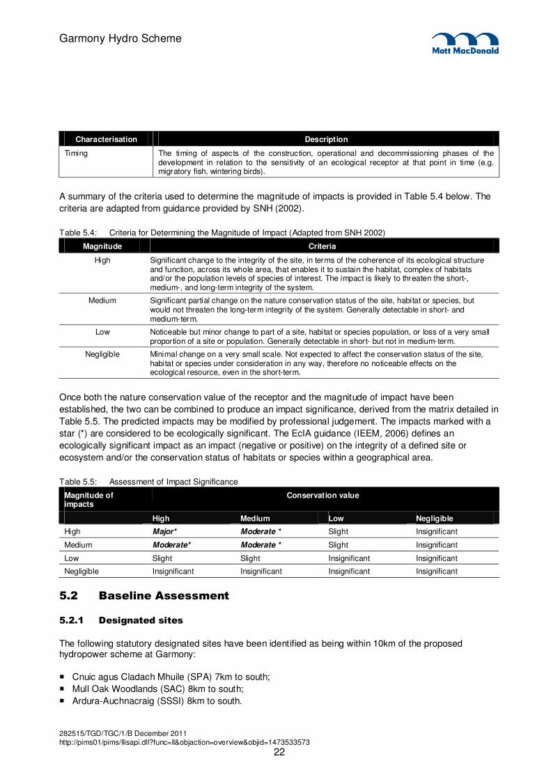
Timing The timing of aspects of the construction, operational and decommissioning phases of the development in relation to the sensitivity of an ecological receptor at that point in time (e.g. migratory fish, wintering birds).
A summary of the criteria used to determine the magnitude of impacts is provided in Table 5.4 below. The
criteria are adapted from guidance provided by SNH (2002).
Table 5.4: Criteria for Determining the Magnitude of Impact (Adapted from SNH 2002)
Magnitude Criteria
High Significant change to the integrity of the site, in terms of the coherence of its ecological structure and function, across its whole area, that enables it to sustain the habitat, complex of habitats and/or the population levels of species of interest. The impact is likely to threaten the short-, medium-, and long-term integrity of the system.
Medium Significant partial change on the nature conservation status of the site, habitat or species, but would not threaten the long-term integrity of the system. Generally detectable in short- and medium-term.
Low Noticeable but minor change to part of a site, habitat or species population, or loss of a very small proportion of a site or population. Generally detectable in short- but not in medium-term.
Negligible Minimal change on a very small scale. Not expected to affect the conservation status of the site, habitat or species under consideration in any way, therefore no noticeable effects on the ecological resource, even in the short-term.
Once both the nature conservation value of the receptor and the magnitude of impact have been
established, the two can be combined to produce an impact significance, derived from the matrix detailed in
Table 5.5. The predicted impacts may be modified by professional judgement. The impacts marked with a
star (*) are considered to be ecologically significant. The EcIA guidance (IEEM, 2006) defines an
ecologically significant impact as an impact (negative or positive) on the integrity of a defined site or
ecosystem and/or the conservation status of habitats or species within a geographical area.
Table 5.5: Assessment of Impact Significance
Magnitude of impacts
Conservation value
High Medium Low Negligible
High Major* Moderate * Slight Insignificant
Medium Moderate* Moderate * Slight Insignificant
Low Slight Slight Insignificant Insignificant
Negligible Insignificant Insignificant Insignificant Insignificant
5.2 Baseline Assessment
5.2.1 Designated sites
The following statutory designated sites have been identified as being within 10km of the proposed hydropower scheme at Garmony:
� Cnuic agus Cladach Mhuile (SPA) 7km to south;
� Mull Oak Woodlands (SAC) 8km to south;
� Ardura-Auchnacraig (SSSI) 8km to south.

282515/TGD/TGC/1/B December 2011 http://pims01/pims/llisapi.dll?func=ll&objaction=overview&objid=1473533573
23
Garmony Hydro Scheme
The proximity of these sites is not considered to be relevant to the proposed hydro scheme at Garmony. The proposed development will be discrete to that location and any potential impacts will be localised to that catchment, and will have no direct, indirect or cumulative impact upon these sites.
5.2.2 Terrestrial Ecology
5.2.2.1 Habitats and Flora
A Phase 1/NVC survey was conducted by Rowan Ecology and Educational Support. Details of the survey
are provided within Appendix E. The proposed scheme passes through or close to four broad habitat
types. This includes conifer plantation, broadleaved woodland, acid grassland and scattered scrub. These
habitats are shown along with the scheme layout (overleaf) in:
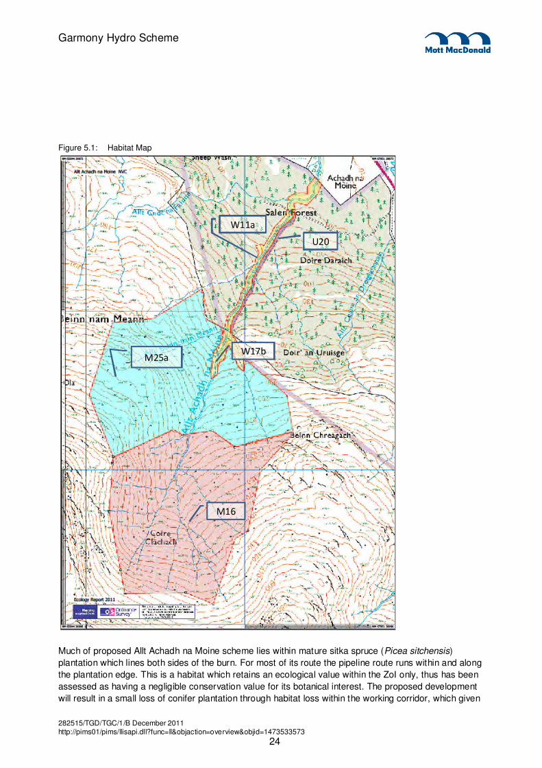
282515/TGD/TGC/1/B December 2011 http://pims01/pims/llisapi.dll?func=ll&objaction=overview&objid=1473533573
24
Garmony Hydro Scheme
Figure 5.1: Habitat Map
W11a
M25a
U20
W17b
M16
Much of proposed Allt Achadh na Moine scheme lies within mature sitka spruce (Picea sitchensis)
plantation which lines both sides of the burn. For most of its route the pipeline route runs within and along
the plantation edge. This is a habitat which retains an ecological value within the ZoI only, thus has been
assessed as having a negligible conservation value for its botanical interest. The proposed development
will result in a small loss of conifer plantation through habitat loss within the working corridor, which given
282515/TGD/TGC/1/B December 2011 http://pims01/pims/llisapi.dll?func=ll&objaction=overview&objid=1473533573
25
Garmony Hydro Scheme
its low conservation importance will not result in an ecologically significant impact. Ecological impacts upon
this habitat type will not be considered further in this assessment.
Allt Achadh na Moine flows through a glade within the plantation. Here scattered scrub habitats, acid
grassland and bracken (U20c Pteridium aquilinum-Galium saxatile community, species-poor sub-
communities) are present in small quantities within these open areas. Scattered scrub, acid grassland and
bracken habitats are common throughout this area of Mull and Scotland in general. They provide habitat
diversity within the site and retain an ecological value within the local Parish context, and thus have been
assessed as having a low conservation value. The proposed development will result in a small loss of
scattered scrub and acid grassland habitats, which given their low conservation importance will not result in
ecologically significant impact. Therefore impacts to scattered scrub, acid grassland and bracken habitats
will not be considered further in this assessment.
The lower and mid-reaches of the open glade are lined by a thin strip of riparian oak and birch broadleaved
woodland (W11a Quercus petraea – Betula pubescens – Oxalis acetosella NVC community). In reality this
exists as a tree line either side of the burn. The proposed intake lies within the most southerly part of the
plantation and broadleaved woodland. In this location conifer plantation gives way to a more extensive area
of oak woodland within a shallow gulley and nearby narrow gorge. This is represented by W17b Quercus
petraea – Betula pubescens – Dicranum majus NVC woodland community. Upland oak woodlands
commonly referred to ‘Western Oakwoods’ are listed as Annex 1 habitats of the EU Habitats Directive 92,
91A0 Old sessile oak woods with Ilex and Blechnum in the British Isles. They are also priority habitats
listed in the UKBAP and Argyll and Bute LBAP. Both woodland NVC communities retain an international
ecological importance. However they are both small in size (particularly the W11a trees lining the burn),
have limited associated bryophyte interest (See Section 5.2.2.2 below) and more extensive areas of these
habitat types exist elsewhere on Mull (i.e. Mull Oak Woodlands SAC). Areas of W11a W17b woodland
have therefore been assessed to retain a Regional ecological importance and therefore retain a Medium
conservation value.
To the south of the proposed intake and therefore outwith the scheme layout lie more typical open upland
habitats. Wet dwarf-shrub heath based over shallow peat (M16 Erica tetralix – Sphagnum compactum wet
heath NVC community) and modified heathy mire/acid flush (M25a Erica tetralix sub-community Molinia
caerulea – Potentilla erecta mire) are extensively found. M16 wet dwarf shrub heath habitat is protected
under Annex I of the EU Habitats Directive 92, 4010 Northern Atlantic wet heaths with Erica tetralix. It is
also listed as UKBAP priority habitat. As a result this habitat retains an international ecological importance
and therefore assessed to retain a high conservation value. M25a mire is a much modified and
impoverished habitat as a result of overgrazing and/or as a result of previous forestry land uses. As a result
it is not listed as an Annex 1 habitat, and while it is very widespread it retains a regional ecological
importance due to its potential to regenerate (to wet heath). It therefore retains a medium conservation
value. Both habitats will remain unaffected by the proposed development and therefore will not be
considered further in this assessment.
5.2.2.2 Bryophytes
A bryophyte survey was conducted by Rowan Ecology and Educational Support. Details of the survey are
provided within Appendix E.
The oak woodlands on Mull, particularly the W17b NVC community within the incised/gulley sections of the
burn would be expected to provide suitably humid conditions able to support a number of ecologically
important oceanic bryophytes and lichens. However, the survey findings noted that Allt Achadh na Moine
282515/TGD/TGC/1/B December 2011 http://pims01/pims/llisapi.dll?func=ll&objaction=overview&objid=1473533573
26
Garmony Hydro Scheme
has a poor representation of oceanic bryophyte communities. Only common bryophytes were noted with no
Rare or Nationally Scarce species identified.
The terrestrial component of the bryophyte surveys along the pipeline and access route also noted to retain
a low diversity of bryophytes species due to the bracken dominated habitat and dense conifer plantation.
Likewise no rare, nationally scarce or UKBAP species were noted.
The bryophyte interest within the study area (both in terms of aquatic zones and terrestrial components)
has been assessed to retain an ecological importance within a Parish context only, and therefore retains a
low conservation value. As a result of the low conservation importance of the mosses and liverworts
interest within and adjacent to Allt Achadh na Moine, impacts to bryophytes will not be considered further in
this assessment.
5.2.2.3 Ornithology
Ornithological assessments do not form part of the remit of this report. Avian issues are covered separately
based on discussions between the Applicant’s representative Haworth Conservation and SNH. A desk
study was conducted to determine the presence of avian nest records within the vicinity of the scheme,
specifically raptors, particularly hen harrier (Circus cyaneus), white-tailed eagle (Haliaeetus albicilla) and
golden eagle (Aquila chrysaetos) and other Schedule 1 bird species. A number of raptor nesting records
exist at various distances from the proposed scheme infrastructure. An assessment of impacts and
subsequent mitigation recommendations has been conducted by Haworth Conservation and agreed with
SNH. Due to confidentiality issues, Mott MacDonald has not been provided with relevant avian records and
can therefore not corroborate the assessments conducted. As a result, avian issues do not form part of this
assessment.
5.2.2.4 Otters
Otters are protected under the Conservation of Habitats and Species Regulations 2010 and Schedule 5 of
the Wildlife and Countryside Act 1981. It is listed as a UKBAP, as well as being listed on the Scottish
Biodiversity List.
An otter survey was conducted on 15th March 2011 by Rowan Ecology and Educational Support. Details of
the survey are provided within Appendix E. An occasionally used rest-up site was identified at NM 67369
39698, 97m downstream (and around a meander) from the proposed powerhouse and tailrace). This is
shown in Figure 5.1. Otters are a species of international importance within a European context. They are
however common in Mull and the west coast of Scotland. They have been assessed to retain a regional
ecological importance and hence of medium conservation value.
5.2.3 Aquatic Ecology
5.2.3.1 Fisheries
A fish habitat survey was conducted by Rowan Ecology and Educational Support. Details of the survey are
provided within Appendix E. The survey concentrated on identifying suitable habitat for a number of fish
species including Atlantic salmon (Salmo salar), sea trout (Salmo trutta trutta), brown trout (Salmo truta
fario), European eel (Anguilla anguilla) and lampreys.
282515/TGD/TGC/1/B December 2011 http://pims01/pims/llisapi.dll?func=ll&objaction=overview&objid=1473533573
27
Garmony Hydro Scheme
The lower and mid-reaches of the Allt Achadh na Moine Burn are accessible for migratory sea trout and
Atlantic salmon up to an impassable waterfall at NM 6719 3950 (see Figure 5.1), approximately 150 m
upstream from the proposed power house and tailrace. This includes numerous suitable spawning and
adult holding grounds downstream of the proposed powerhouse and tailrace, with a number of potential
adult holding grounds (but no potential spawning habitat) upstream of the proposed power house/tailrace. It
is assessed that migratory salmonid species are able to reach spawning maturity in the estuarine
environment and make opportunistic use of the spawning opportunities afforded by high flows. The
dominance of bedrock, the fragmentation of the habitat by impassable obstacles, and the average channel
slope make it highly unlikely that there are any ancestral brown trout populations present from within the
abstracted reaches above the waterfall at NM6719 3950. However there is the potential for their presence
within the lower reaches between the power house/tailrace and the waterfall (consisting of a proportion of
trout which remain resident as opposed to migrating to the sea). Atlantic salmon, brown trout and sea trout
are UKBAP listed species of national importance. There are a number of important salmonid rivers within
Mull and the west coast of Scotland in general. The morphology of Allt Achadh na Moine means this it is
not one of the foremost salmonid rivers in the region. However, populations can be seriously affected by
changes to their breeding habitat. Atlantic salmon, brown trout and sea trout have been assessed to retain
a medium conservation value.
The fine sediment aggradation required for the juvenile lamprey stages is entirely absent from throughout
the entire surveyed reaches. It is considered highly unlikely that there are lamprey species using the Allt
Achadh na Moine. Lampreys will therefore not be considered further in this assessment.
It is assessed that European eel are likely to be present throughout the watercourse as they are not
restricted by spawning habitat requirements and are able to negotiate obstacles such as waterfalls which
would form barriers to salmonids, for example. European eel are a UKBAP listed species of national
importance, though they are commonly found within many watercourses on both Mull and Western
Scotland. While ubiquitous in most watercourses in this part of Scotland, they have been assessed to retain
a medium conservation value.
5.2.3.2 Aquatic Macrophytes
An assessment for aquatic macrophytes was conducted by Rowan Ecology and Educational Support at the
same time as the bryophyte survey. Aquatic broadleaved macrophytes are absent from the surveyed
stretch of Allt Achadh na Moine Burn. The lack of suitable substrate and susceptibility to high flow periods
is likely to restrict the ability of aquatic broadleaved macrophytic plants to colonise. As a result of the low
conservation importance of the aquatic macrophytic interest, the impacts to aquatic macrophytes will not be
considered further in this assessment.
5.2.3.3 Fresh Water Pearl Mussels
Fresh water pearl mussels are protected by its inclusion in Annexes II and IV of the EC Habitats Directive
and under the Wildlife and Countryside Act 1981 (as amended). The species is listed as a UKBAP and
Argyll and Bute LBAP priority species and also appears on the Scottish Biodiversity List. Fresh water pearl
mussels retain an international ecological importance and remain rare in Scotland and the UK, and
therefore retain a high conservation value.
The habitat characteristics within the proposed depleted section of Allt Achadh na Moine are unsuitable for
fresh water pearl mussels, due to bedrock dominance, gradient, and generally large substrates. Likewise
282515/TGD/TGC/1/B December 2011 http://pims01/pims/llisapi.dll?func=ll&objaction=overview&objid=1473533573
28
Garmony Hydro Scheme
given the obstructions to salmonid passage further up the burn, they have been assessed to be absent
from the proposed depleted reach as well as above the proposed intake. The lower reaches of the burn
below the powerhouse down to the head of tide retain small areas of potentially suitable pearl mussel
habitat. While potential impacts are not anticipated likely for this species, a precautionary approach has
been adopted to consider downstream effects to the species (if present).
5.3 Assessment of Impacts Impacts which potentially could occur during the Construction, Operational and De-commissioning phases are:
� Damage to sensitive Annex 1 habitats;
� Damage to fish habitats and fish populations;
� Disturbance/harm to protected species, and:
� Disturbance to Schedule 1, and other breeding birds (though not assessed within this report).
The following information relates to impacts to the identified ecological receptors:
5.3.1 Terrestrial Ecology
5.3.1.1 Annex 1 Habitats
As previously alluded to in Section 1.3.2.1, the proposed construction works will result in the small loss of a
number of common habitats (based on a pipeline/access footprint width of 10 m) including conifer
plantation (0.4 ha), acid grassland (0.07 ha) and scattered scrub (0.3 ha). These are common habitats with
limited conservation importance and the impacts of the development will be insignificant from an Ecological
Impact Assessment (EcIA) perspective.
The construction of the intake weir, access track and pipeline are proposed within an area of W17b
woodland at the southern end of the scheme. Most areas of the woodland will remain untouched by the
proposed development. However there will be a small loss of woodland trees within the working corridor at
the bottom of the gulley/ravine close to the burn which will be cleared to allow access to zones of
infrastructure. This equates to approximately 0.13 ha within the pipeline/access corridor. The two
impoundment weirs (one on Allt Achadh na Moine and one on an adjacent tributary) will also result in the
creation of a dam pool and subsequent flooding of a small area of riparian woodland (approximately 0.008
ha). Further short-term potential impacts could arise from vehicle movements and compaction; storage of
materials and equipment in the root zone of trees, spillage of materials, contaminated run-off, oil and other
pollutants, blasted rock debris and dust drift. Without mitigation the magnitude of this impact of damage
and land take is assessed as having a minor negative impact within the context of this scheme, with the
overall impact assessed up to be slight adverse on W17b woodland.
The proposed working corridor along the plantation edge will avoid all areas of riparian W11a woodland
adjacent to Allt Achadh na Moine. The proposed development will not affect this type of upland oak
woodland.
More typical upland wet heath habitats located to the south of the proposed pipeline will not be affected by
the proposed development. Previous design iterations had considered an intake location further to the
south on Allt Achadh na Moine within areas of these sensitive habitats (Annex 1 in the case of wet dwarf-
shrub heath) which are sensitive to changes in soil drainage and compaction and take longer to recover
282515/TGD/TGC/1/B December 2011 http://pims01/pims/llisapi.dll?func=ll&objaction=overview&objid=1473533573
29
Garmony Hydro Scheme
compared to non-peat based habitats. As a result of embedded mitigation, the proposed intake was
removed from this location and moved further downstream on the Allt Achadh na Moine.
5.3.1.2 Ornithology
The potential impacts upon avian receptors are not within the remit of this report and have been assessed
separately. However, in summary the development of the hydro scheme has the potential to result in the
following impacts upon Schedule 1 Raptors and Breeding Birds:
� Death or harm to ground nesting bird/eggs/chicks and damage or destruction of active nests;
� Loss of potentially suitable nesting sites;
� Disturbance to nesting schedule 1 raptors and other breeding birds potentially leading to breeding
failure during the period the hydro-scheme work are conducted; and,
� Localised loss of foraging habitat.
5.3.1.3 Otters
Construction and decommissioning activities have the potential to result in damage or destruction to otter
rest-up sites or holts if present within or near to the proposed development works at the time of works.
While the identified rest-up site is considered too far away and out of view of the proposed works at the
power house and tailrace, there is potential for otters to utilise shelters within adjacent woodland (i.e. close
to the working corridor) between the time of initial survey and works commencing. Depending on the use of
such structures i.e. occasional rest up site or breeding holt with young, the magnitude of destruction to otter
sheltering locations has the potential to be up to medium negative if used for breeding at the time, resulting
in an overall impact of up to moderate adverse on local (breeding) populations.
There is potential for individual otters to become entrained (leading to harm) within excavations such as
pipeline trenches, burrow pits and building foundations during the construction and decommissioning
phases. There is also potential for otters to enter uncapped pipes during night time hours to take refuge,
and become trapped inside the pipes (potentially leading to harm). The impact to otters will be up to slight
adverse on local otter populations.
Construction and decommissioning activities are likely to result in disturbance to otters from the point of the
proposed power house upstream to the intake location. Vehicular/machinery movements, human
movements as well as noise and blast/vibration impacts are likely to lead to the temporary abandonment of
any use of Allt Achadh na Moine Burn and surrounding areas by otters in that period. Given the fact that
the catchment may be used occasionally by foraging and/or dispersing otters, the magnitude of this effect
is considered to be low negative. The overall impact of has the potential to be slight adverse.
Without proper management of works activities near water, such as works on the intake and pipeline,
power house and tail race, there is potential to cause damage to the aquatic environment through sediment
wash and leaching of pollutants and construction materials. This has the potential to result in negative
affects downstream, including otter foraging resources in Allt Achadh na Moine Burn. Given that best
practice construction methods will be implemented, this effect is considered unlikely. However should it
occur, it could lead to temporary reversible damage to otter habitats of a low negative magnitude. The
overall impacts to otter (foraging) habitat are potentially up to slight adverse.
282515/TGD/TGC/1/B December 2011 http://pims01/pims/llisapi.dll?func=ll&objaction=overview&objid=1473533573
30
Garmony Hydro Scheme
5.3.2 Aquatic Ecology
5.3.2.1 Fisheries
Without proper management of works activities near water, fish populations (eels, migratory and resident
salmonids) present within lower reaches of the scheme and downstream of the outfall could be affected
due to sedimentation and pollution incidents associated with works on the power house, intake/outfall,
access track and pipeline during the construction and decommissioning phases. Such incidents also have
the potential to result in direct injury or harm to fish populations within Allt Achadh na Moine including
immature salmonids, resident brown trout as well as European eels. Impacts will be greatest should adult
migratory salmonids be present within the burn at the time of these works, in which a pollution incident
could result in the loss of an adult breeding population. Given that best practice construction methods will
be implemented, this effect is considered unlikely. However, without best practice working methods this
could lead to temporary effects on suitable fish habitats (including salmonid spawning grounds), and
permanent impacts upon fish populations of up to a medium negative magnitude. The overall impact to fish
populations within Allt Achadh na Moine could be up to moderate adverse.
During the operational phase there will be a change over time in the natural river characteristics of the
burn, particularly between the intake and outfall. The construction of the intake weirs will result in potential
additional barriers to fish dispersal, subsequent reduction in water volume and flows within the depleted
reach, as well as changes to the natural hydro-morphological processes within Allt Achadh na Moine and
Allt Beinn nam Heam. Salmonid species are absent from the upper reaches so the presence of weirs in
those locations will not create additional barriers to movement. European eels are anticipated to be present
both above and below the proposed scheme. The species is able to climb up some natural obstacles such
as waterfalls and intake weirs or travel overland around barriers. It is considered unlikely that the proposed
intake impoundment will represent a significant barrier to eel dispersal up and down Allt Achadh na Moine.
It is anticipated that occasional spate conditions as well as (standard best practice) scour valves built into
the intake weir will allow for the transportation of sediment and maintain near natural siltation processes
downstream from the intakes and ensure that there remains some dynamic morphology within the burn.
Given the fact that the depleted reach is punctuated by natural barriers for salmonid colonisation and
dispersal and important spawning grounds are located downstream of the outfall, it is unlikely that a
reduction in water volume and flows will result in a significant effect upon natural dispersal and spawning
behaviour of migratory and resident trout and Atlantic salmon. Flows over spawning gravel beds will
therefore be akin to a natural flow regime and will not inhibit migration to breeding sites, while alternative
adult holding pools are located downstream of the tailrace (adjacent to suitable spawning grounds).
Furthermore winter spate conditions will result in spill over the weirs which will add to the Q90 hands-off
flow regime and will allow for movement to and between adult holding pools within the depleted reach and
spawning grounds downstream. The magnitude of the potential effects of reduced flows and weir
construction on fish dispersal as well as changes to the natural hydro-morphological processes within Allt
Achadh na Moine (and Allt Beinn nam Heam) is considered to be negligible. Therefore the impact upon fish
populations and fish habitats is assessed to be insignificant.
Without sympathetic design of the tailrace, as well as the intake and outfall screens there is potential for
fish to become entrained within the tailrace and pipeline with resultant mortality due to pressure changes or
contact with turbine blades. In addition water returning from the proposed tailrace has the potential to
confuse dispersing fish populations which could try to swim up the tailrace as opposed to the natural
depleted reach of the watercourse. The magnitude of these effects is assessed to be up to medium
negative. The overall impact of has the potential to be up to moderate adverse.
282515/TGD/TGC/1/B December 2011 http://pims01/pims/llisapi.dll?func=ll&objaction=overview&objid=1473533573
31
Garmony Hydro Scheme
5.3.2.2 Freshwater Pearl Mussels
Without proper management of construction activities in and around water, freshwater pearl mussel
populations (if present) and suitable habitat within lower reaches of Allt Achadh na Moine Burn downstream
of the outfall could be affected due to sedimentation and pollution incidents associated with power house,
intake/outfall and pipeline during the construction and decommissioning phases. Given that best practice
construction methods will be implemented and the small amount of potentially suitable habitat, this effect is
considered unlikely. However, without such measures this could lead to temporary effects on suitable pearl
mussel habitats and permanent affects upon individuals from the population in the burn of up to a medium
negative magnitude. The overall impact to freshwater pearl mussels within Allt Achadh na Moine Burn
could be up moderate adverse on freshwater pearl mussel populations.
5.4 Mitigation
5.4.1 Construction Method Statement
A detailed Construction Method Statement will be prepared and approved by SNH and SEPA prior to the
start of the construction phase. It will provide full details of the activities and construction methods required
for the various aspects of the proposed works, design specifications of all proposed infrastructure,
specification of size and locations of working zones, as well as a timetable of construction activities. This
document will also provide the basis of for the implementation of mitigation measures designed to minimise
impacts upon terrestrial receptors (i.e. Annex 1 habitats, breeding birds and otters) as well as aquatic
receptors (i.e. fisheries, freshwater pearl mussels).
5.4.2 Annex 1 Habitats
The Construction Method Statement will provide details regarding the required ecological mitigation
measures to be implemented for the Allt Achadh na Moine scheme with regard to sensitive habitats.
Mitigation measures will be implemented to minimise the impact of the impacts of the construction works
including:
� All personnel and machinery keeping within the working corridor and agreed access route(s);
� Minimisation of working zones, particularly through areas of W17b and W11a woodland any other
Annex 1 habitats. Removal of trees should be avoided and the pipeline route follow natural gaps within
the W17b woodland where possible;
� Erection of temporary fencing to demarcate the working zones and thus deter damage and disturbance
to adjacent sensitive habitats;
� Erection of temporary fencing around protection zones including Annex 1 habitats and other sensitive
habitats to avoid vehicular encroachment;
� Excavated vegetation with its root layer will be retained for re-instatement;
� Any stripped peat will be stored on site for subsequent re-instatement works following completion of
construction works to facilitate recovery;
� Excavation of temporary drainage channels will be minimised where possible and designed with
consideration to sensitive habitats;
� Where excavation to the base level of rock and substrate in which tracks and pipeline trenches will be
built within is significant, the use of floating roads to minimise impacts to the hydrological regime within
wet heath/blanket bog habitats will be considered;
� All stored excavated material, works compounds and construction materials will be stored away from
Annex 1 habitats and bases of trees; and,
� Minimising the risk of rock debris from blasting; and providing adequate dust suppression on machinery.
282515/TGD/TGC/1/B December 2011 http://pims01/pims/llisapi.dll?func=ll&objaction=overview&objid=1473533573
32
Garmony Hydro Scheme
The primary measure of reducing impacts upon Annex 1 wet heath and blanket bog blanket bog habitats
implemented for this scheme is embedded mitigation. The proposed intake has been moved downstream
to avoid areas of M16 wet heath and M25 mire communities to avoid impacts to peat soils and their
hydrological processes. Furthermore the working corridor for the pipeline and access track works has been
located away from the W11a woodland lining the Allt Achadh na Moine towards the conifer plantation edge.
5.4.3 Ornithology
While assessments for not part of the remit of this Report, proposed mitigation for avian receptors relates to
conducting works in the vicinity of known Schedule 1 bird nests outside of the breeding period.
Mitigation measures for avian receptors will be detailed within the Construction Method Statement, which
will be approved by SNH before works commence. Specific measures will be included where relevant and
based on the following principles:
� Works, if possible should avoid the bird nesting period between early March and early August;
� Where works overspill into the breeding season, checking surveys for breeding birds especially
Schedule 1 raptors will be conducted;
� Where nesting birds (including Schedule 1 birds) are identified suitably sized disturbance zone will be
implemented where works cannot be conducted in that area until breeding has been completed.
5.4.4 Otters
Prior to commencement of construction and decommissioning works, an otter checking survey will be
conducted. While no otter holts were noted during the survey, erosion of the banks during high flows
ensure a dynamic bank morphology and the presence of conifer plantation on both sides of the burn
provides suitable shelter for the species. Otter checking surveys will aim to assess the status of the species
on the site and relevant mitigation can be implemented prior to works commencing. This would include
protected species licensing to disturb or close an otter holt/rest-up site, and provision of artificial holt sites
where appropriate.
The Construction Method Statement will provide details regarding the required ecological mitigation
measures to be implemented for the Allt Achadh na Moine scheme with regard to otters. Mitigation for
otters will include restricting rock blasting operations to periods of time well after and before darkness,
insertion of mammal ladders within excavated pits, capping of pipes each evening and speed restrictions
and signage along access tracks.
5.4.5 Fisheries
5.4.5.1 Construction Impacts Mitigation
A detailed Construction Method Statement will be prepared and approved by SNH and SEPA prior to the
start of the construction phase. The document will provide details regarding the required ecological
mitigation measures to be implemented for the Allt Achadh na Moine scheme with regard to protection of
the aquatic environment and fish populations both within and downstream of the proposed scheme.
Mitigation measures and best practice methods will be conducted in adherence to SEPA and CoSHH
guidelines. Measures would include a pollution prevention plan; use of sediment traps/filters on all run-off
channels during construction including straw, geotextiles and sandbags; regular monitoring and
replacement of all sediment traps.

282515/TGD/TGC/1/B December 2011 http://pims01/pims/llisapi.dll?func=ll&objaction=overview&objid=1473533573
33
Garmony Hydro Scheme
All in-channel infrastructure works will be implemented prior to the salmonid spawning periods (i.e. before
early to mid October). This will mean that the hydro scheme is built and fully operational at a time outside of
the most vulnerable period for these species within Allt Achadh na Moine. The timetable of the proposed
works will be finalised in consultation with SEPA and SNH to ensure that fish stocks and fry are protected.
The tailrace and associated infrastructure will be designed based on current best practice methods to
include suitably sized fish screens at the outfall and intake to prevent entrainment. Where further
consultation with statutory consultees highlights a requirement for further mitigation to dissuade fish from
trying to swim up the tailrace, the construction method statement will include a design of the outfall/tailrace
under water with an increased size to reduce flow velocities to minimise confusion to migrating fish species.
5.4.5.2 Operation Impacts Mitigation
SEPA has published guidelines for protection of river flows, and dependent ecology including fish, for small
hydroschemes. These are discussed further in Section 6.8.
Hands-off flows have been set in line with best practice to ensure that there are suitable conditions within
Achadh na Moine to ensure the survival of the aquatic invertebrate populations and therefore retaining an
important food source for fish species.
5.4.6 Freshwater Pearl Mussels
A detailed Construction Method Statement will be prepared and approved by SNH and SEPA prior to the
start of the construction phase. The document will provide details regarding the required ecological
mitigation measures to be implemented for the Allt Achadh na Moine scheme with regard to protection of
the aquatic environment both within and downstream of the proposed scheme. Mitigation measures and
best practice methods will be conducted in adherence to SEPA and CoSHH guidelines. Measures would
include a pollution prevention plan; use of sediment traps/filters on all run-off channels during construction
including straw, geotextiles and sandbags; regular monitoring and replacement of all sediment traps.
5.5 Residual Effects after Mitigation
Following the implementation of embedded mitigation and sympathetic scheme design, as well as current
best practice construction activities will reduce all moderate adverse impacts to insignificant or slight
adverse (which are not ecologically significant). Table 5.6 below provides a summary of the anticipated
residual effects on ecological receptors in relation to the Allt Achadh na Moine scheme following
implementation of relevant mitigation.
5.6 Summary of Effects
Table 5.6 provides a summary of effects pre-mitigation and resulting residual effect (following mitigation).
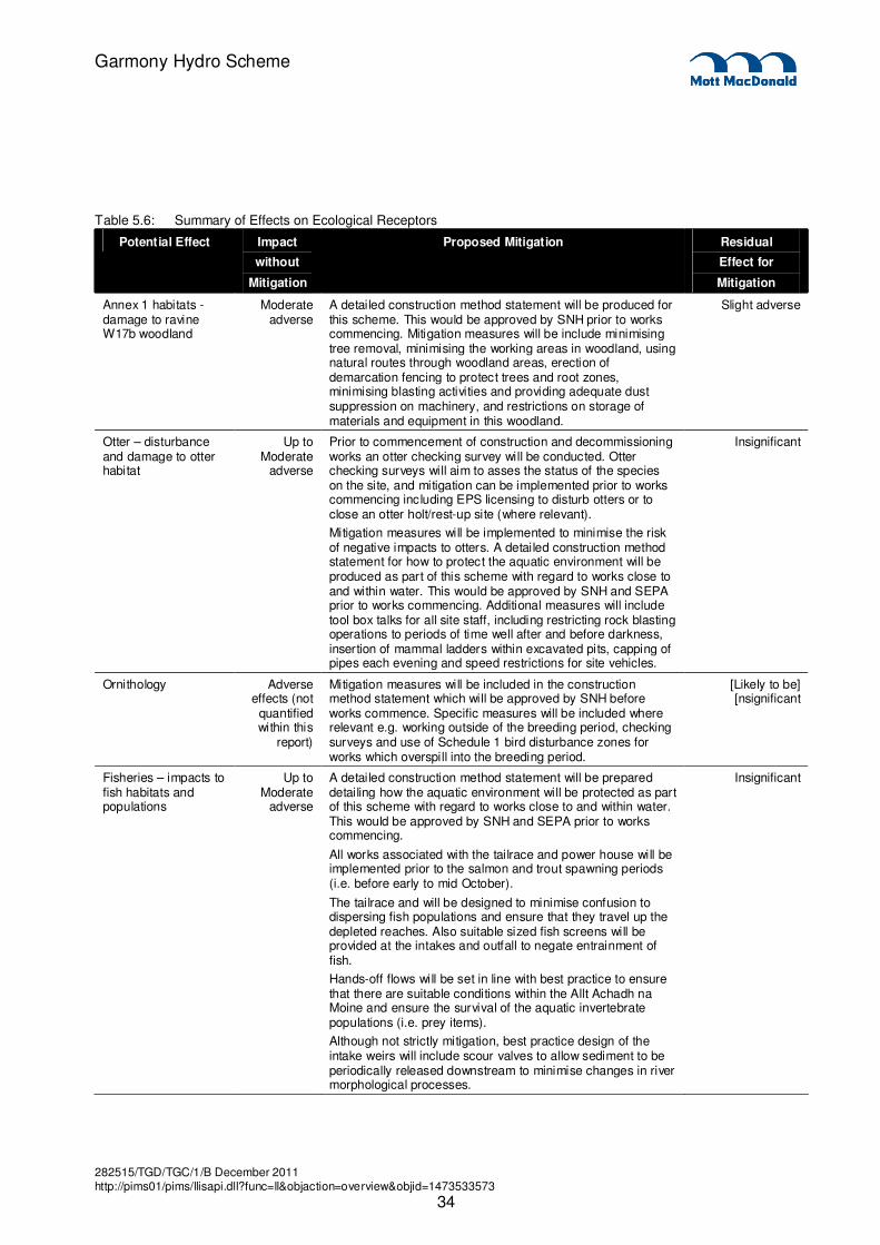
282515/TGD/TGC/1/B December 2011 http://pims01/pims/llisapi.dll?func=ll&objaction=overview&objid=1473533573
34
Garmony Hydro Scheme
Table 5.6: Summary of Effects on Ecological Receptors
Potential Effect Impact
without
Mitigation
Proposed Mitigation Residual
Effect for
Mitigation
Annex 1 habitats - damage to ravine W17b woodland
Moderate adverse
A detailed construction method statement will be produced for this scheme. This would be approved by SNH prior to works commencing. Mitigation measures will be include minimising tree removal, minimising the working areas in woodland, using natural routes through woodland areas, erection of demarcation fencing to protect trees and root zones, minimising blasting activities and providing adequate dust suppression on machinery, and restrictions on storage of materials and equipment in this woodland.
Slight adverse
Otter – disturbance and damage to otter habitat
Up to Moderate
adverse
Prior to commencement of construction and decommissioning works an otter checking survey will be conducted. Otter checking surveys will aim to asses the status of the species on the site, and mitigation can be implemented prior to works commencing including EPS licensing to disturb otters or to close an otter holt/rest-up site (where relevant).
Mitigation measures will be implemented to minimise the risk of negative impacts to otters. A detailed construction method statement for how to protect the aquatic environment will be produced as part of this scheme with regard to works close to and within water. This would be approved by SNH and SEPA prior to works commencing. Additional measures will include tool box talks for all site staff, including restricting rock blasting operations to periods of time well after and before darkness, insertion of mammal ladders within excavated pits, capping of pipes each evening and speed restrictions for site vehicles.
Insignificant
Ornithology Adverse effects (not
quantified within this
report)
Mitigation measures will be included in the construction method statement which will be approved by SNH before works commence. Specific measures will be included where relevant e.g. working outside of the breeding period, checking surveys and use of Schedule 1 bird disturbance zones for works which overspill into the breeding period.
[Likely to be] [nsignificant
Fisheries – impacts to fish habitats and populations
Up to Moderate
adverse
A detailed construction method statement will be prepared detailing how the aquatic environment will be protected as part of this scheme with regard to works close to and within water. This would be approved by SNH and SEPA prior to works commencing.
All works associated with the tailrace and power house will be implemented prior to the salmon and trout spawning periods (i.e. before early to mid October).
The tailrace and will be designed to minimise confusion to dispersing fish populations and ensure that they travel up the depleted reaches. Also suitable sized fish screens will be provided at the intakes and outfall to negate entrainment of fish.
Hands-off flows will be set in line with best practice to ensure that there are suitable conditions within the Allt Achadh na Moine and ensure the survival of the aquatic invertebrate populations (i.e. prey items).
Although not strictly mitigation, best practice design of the intake weirs will include scour valves to allow sediment to be periodically released downstream to minimise changes in river morphological processes.
Insignificant

282515/TGD/TGC/1/B December 2011 http://pims01/pims/llisapi.dll?func=ll&objaction=overview&objid=1473533573
35
Garmony Hydro Scheme
Potential Effect Impact
without
Mitigation
Proposed Mitigation Residual
Effect for
Mitigation
Freshwater Pearl Mussels – impact on population (if present)
Up to moderate
adverse (if present
downstream of the
outfall)
A detailed construction method statement will be prepared detailing how the aquatic environment will be protected with regard to works close to and within water. This would be approved by SNH and SEPA prior to works commencing.
Insignificant
282515/TGD/TGC/1/B December 2011 http://pims01/pims/llisapi.dll?func=ll&objaction=overview&objid=1473533573
36
Garmony Hydro Scheme
6.1 Introduction
This chapter addresses the potential hydrological effects of the Garmony hydro scheme and assesses the
need for mitigation measures as described in the Controlled Activities Regulations (CAR) guidance for
hydropower.
This chapter presents an assessment of baseline hydrological conditions at the intake location on Allt
Achadh na Moine (NM 669 389) and considers the potential effects on natural flow regimes arising from the
proposed hydro scheme. Specifically this section presents;
� Legislation, policy and guidance pertaining to hydropower schemes,
� Available information for this assessment,
� The derivation of long term natural flow duration curves (FDC) at intake locations,
� The effect of the hydro scheme operation on natural flows,
� The mitigation measures proposed for the scheme,
� The residual effects, and
� An assessment of the cumulative effects of this scheme along with other proposed developments.
6.2 Consultation
As a precursor to this environmental statement, preparatory work has been carried out including
consultation with relevant organisations.
The consultation process identifies any potential issues that should be assessed in the planning
application. Table 6.1 below summarises the feedback we have received from consultees.
Table 6.1: Summary of Scoping Responses and Comments
Name of Organisation Response Comment
Scottish Natural Heritage (SNH) Reference to the SNHi interactive site to identify any designations within close proximity of the proposed
scheme.
Recommendation to read the Hydro page of the Renewable Energy section of the SNH website.
Any designations will be assessed within the Ecology
Chapter.
SNH Hydro guidance will be taken into account in this
assessment.
No further aspects to address.
Argyll and Bute Council The council have not identified any private water supplies.
Confirmation that there are no existing or planned hydro schemes within the area.
No other information has been provided.
N/A
Scottish Environment Protection Agency (SEPA)
Recommend that the tailrace should be located at or immediately downstream of upstream limit for
migratory salmonids. Should a further downstream tailrace location be approved SEPA may identify
additional mitigation such as a higher baseline, increased HOF or turbine shut down during
spawning, fish passage at intake weir (if migratory fish can access that far). Whether this will be
required or not will depend on local conditions such as habitat quality
Tailrace will be located at the upstream limit of the spawning
grounds for migratory salmonids.
6. Hydrology
282515/TGD/TGC/1/B December 2011 http://pims01/pims/llisapi.dll?func=ll&objaction=overview&objid=1473533573
37
Garmony Hydro Scheme
Name of Organisation Response Comment
Scottish Water (SW) SW has identified an abstraction from Scallastle River for Craignure WTW. The abstraction is from a
separate watercourse to the south east, therefore SW state the proposal should not impact on the
water quality or quantity of this abstraction.
The Water Supply Catchment and DWPA for Scallastle River abstraction is not connected to the
proposed catchment. There is a hatched area to the south west of the proposed site which is recorded as a proposed catchment, however SW do not abstract
from this catchment and there are no proposals to abstract for it in the future.
There are no SW discharges within or upstream of
the proposed catchment.
SW are not undertaking any studies within the hydrological area
There are no other SW infrastructure and non-
infrastructure within the proposed catchment.
No information on past flood events within the study area.
Site specific guidance would be discussed for each
site upon application
Noted. Whilst this is not a concern to SW, any potential
risks to the groundwater will be addressed through compliance
with Pollution Prevention Guidelines.
Noted.
6.3 Legislative Background
6.3.1 The Water Environment and Water Services (Scotland) Act 2003
The Water Environment and Water Services (Scotland) Act 2003 (WEWS) is the enabling act for the
European Water Framework Directive, which introduced a new integrated approach to the protection,
improvement and sustainable use of the water environment. This legislation provides the framework for
River Basin Management Planning (RBMP) and introduces the concept of ecological status as means of
classifying water bodies and for setting environmental objectives.
With respect to hydropower schemes WEWS facilitated the introduction of controlled activities regulations
and has allowed the objective development of programmes of measures for those schemes where actions
are required to enable a water body to achieve its ecological potential within an agreed timescale.
6.3.2 The Water Environment (Controlled Activities) (Scotland) Regulations 2005
(CAR)
The Water Environment CAR was introduced as secondary legislation following the passing of the WEWS
Act. CAR established the licensing framework for abstractions, impoundments, discharges and engineering
works and gives SEPA the means to manage the pressures on the water environment and to monitor the
impacts.
With respect to hydropower schemes CAR has introduced powers for SEPA to license abstractions,
impoundments and engineering works. Achieving a CAR license is essential for any scheme and a key
condition to a planning consent.

282515/TGD/TGC/1/B December 2011 http://pims01/pims/llisapi.dll?func=ll&objaction=overview&objid=1473533573
38
Garmony Hydro Scheme
6.3.3 Implementing the Water Environment and Water Services (Scotland) Act 2003:
Development of environmental standards and conditions - Policy Statement
(March 2007)
Environmental standards and conditions are essential to allow SEPA to assess the risks to the ecological
status of a water body and to identify the scale of improvements which would be needed to bring a water
body not in good condition back to good health. The development of environmental standards and
conditions was therefore a key part of the implementation of the WEWS Act.
The main work of developing environmental standards is carried out by the UK Technical Advisory Group
for the WFD (UKTAG). This is a partnership of technical experts from the UK environmental protection and
conservation agencies, as well as some partners from the Republic of Ireland. Given its technical expertise,
UKTAG is responsible for developing recommendations for standards and presenting these to the UK
administrations for consideration.
This policy sets out guiding principles for the application of the environmental standards in Scotland. These
bring together many of the existing requirements of regulators but relate them explicitly to the use of the
new standards. SEPA and other regulators are directed by Scottish Ministers to have regard to these
principles in their implementation of the environmental standards set out in the Directions.
With respect to abstractions the policy established the guiding principle that the environmental standards
would be based upon the percentage change from natural flow for rivers and percentage change from
natural inflows for freshwater lochs.
6.3.4 Implementing the Water Environment and Water Services (Scotland) Act 2003:
Assessing Scotland’s water environment – use of environmental standards,
condition limits and classification schemes - Policy Statement (February 2010)
This policy statement directs SEPA to use specific standards based on the guiding principles stated in the
2007 policy statement. With respect to water resources the policy statement defines the environmental
standards as a permitted abstraction per day as a proportion of the natural flow. The permitted abstraction
expressed as a percentage of the natural flow increases with natural flow. In addition, the policy provides
direction to SEPA on the condition limits that should be applied to assess a proposed change in flow
regime. These limits are expressed as ranges within which defined indicators of flow regime can lie.
It is this policy and the standards defined therein that are relevant to this assessment.
6.3.5 Guidance for applicants on supporting information requirements for
hydropower applications
This document is promoted by a number of agencies (Marine Scotland, SNH and SEPA) as well as the
Scottish Government to assist developers of hydropower schemes in making a successful application for a
CAR licence. The guidance will be referred to as the “SEPA Guidance” in this assessment.
The document is designed to help developers with their application, by explaining the process of applying
for a water use licence and, in particular, on the minimum information a hydropower developer will need to
provide SEPA in support of their application. The document also highlights where other consents are
necessary for a development and how these may interact with the SEPA determination.
282515/TGD/TGC/1/B December 2011 http://pims01/pims/llisapi.dll?func=ll&objaction=overview&objid=1473533573
39
Garmony Hydro Scheme
The guidance is focussed on the needs of developers for small hydropower schemes in that it is aimed at
run-of-river schemes (less than 24 hours worth of storage) and high head schemes.
The guidance sets out for developers the application process and guides them as to what specific
information SEPA will require in order to make a determination.
This chapter aims to meet the specific requirements set out in section 3.1 of this guidance.
6.3.6 Guidance for developers of run-of river hydropower schemes-
SEPA issued guidance relating to the development of run-of-river hydro schemes in November 2010. This
will be referred to as the “[SEPA] Guidance” in this chapter.
Developers of hydropower schemes require a water use licence from SEPA. Before granting such a
licence, SEPA has to take account of a scheme's likely adverse impacts on the water environment, as well
as its potential benefits to renewable energy generation. Scottish Ministers set out their objectives for this
guidance in a policy statement issued in January 2010 with respect to striking the right balance between
the protection of the water environment and renewable energy generation..
Part A of the Guidance:
� outlines how, in determining applications relating to hydropower schemes, SEPA intends to achieve
Scottish Ministers' policy objectives;
� provides guidance to developers on identifying sub-100 kilowatt hydropower schemes that are likely to
be acceptable in the context of the Ministers' policy statement.
Part B of the Guidance sets out the proposed mitigation SEPA expects to be incorporated into any run-of-
river hydropower schemes.
One of SEPA's proposed prior-authorisation requirements for all hydropower schemes likely to have
adverse impacts on the water environment is that all practicable mitigation is taken to minimise those
impacts.
SEPA stipulate that all schemes identified as potentially acceptable using the guidance in Part A will be
expected to incorporate the mitigation set out in Part B.
This Guidance been taken into account in this assessment and in particular in the consideration of
mitigation measures.
Where the adverse impacts of a scheme would be sufficient to affect the status of a water body, SEPA also
has to be able to demonstrate that the scheme’s benefits cannot be provided using significantly better
environmental option i.e. adverse impacts caused by schemes of 100 kilowatts or more are justifiable in
terms of costs and benefits.
6.4 Methodology
The SEPA Guidance recommends two approaches in assessing impacts of hydro schemes on natural flow
regimes on watercourses, these are;
� Theoretical/ desk based approach,
� Use of measured data.
282515/TGD/TGC/1/B December 2011 http://pims01/pims/llisapi.dll?func=ll&objaction=overview&objid=1473533573
40
Garmony Hydro Scheme
Given the size of the proposed scheme options and the lack of suitable analogues on Mull the requirement
for measured flow data was not deemed appropriate for this scheme. It has been agreed with SEPA3 that a
theoretical approach will be taken when assessing the impacts of Garmony hydro scheme on Allt Achadh
na Moine so long as a Q90 hands-off flow is applied.
The Flow Duration Curve (FDC) for the intake location was derived using Low Flow Enterprise (LFE)
software. LFE is SEPA’s preferred theoretical approach for estimating the FDC of an ungauged location or
catchment with insufficient monitoring data. The method used by LFE is based on the regionalisation of
flow duration statistics in estimating flows and builds on the strong influence physical and climatic
characteristics of a catchment have on the resulting flow regime.
FDC are used by SEPA when regulating water resources and point source authorisations. Further
information on the FDC for the site and uncertainties surrounding the data are included in Section 6.6.
6.5 Water Supplies
6.5.1 Public Water Supply
SW identified in their consultation response that there is an existing abstraction from Scallastle River for
Craignure WTW (CAR/L/1011382). However as Scallastle River is within a separate catchment to the south
east of Allt Achadh na Moine the proposal should not impact on the water quality or quantity of this
abstraction. SW confirmed in their response that they do not anticipate any potential risks to the Scallastle
River abstraction.
6.5.2 Private Water Supply
Information on the location and type of any private water supplies within the hydrological catchment was
requested from SEPA and Argyll and Bute Council. There did not have any registered private water
supplies.
Further information on potential private water supplies was provided by both MICT and the Forestry
Commission.
The private water supply provided by MICT is located downstream of the tailrace of proposed scheme
(NM 675 399). As all abstracted water will have been returned to the watercourse there will be no impact
on the yield of the private water supply. The Forestry Commission have identified a further potential private
water supply. The map provided by the Forestry Commission indicates that a supply is located along the
impacted stretch. Site walkovers have been undertaken in this area but no sign of a private water supply
has been identified.
However, as there are potentially two supplies located on the same watercourse at the proposed scheme,
adherence to SEPA’s Pollution Prevention Guidelines and the local authority guidelines relating to PWS will
be required to ensure there is no deterioration of the water quality of the supplies, in particular during
scheme construction. Before any construction begins it is recommended that every effort is made to
determine the owners of the supplies to discuss preventative measures. A contingency plan should be
_________________________
3 Memorandum from Jodi Old to Stephen MacIntyre, 3
rd February 2011.
282515/TGD/TGC/1/B December 2011 http://pims01/pims/llisapi.dll?func=ll&objaction=overview&objid=1473533573
41
Garmony Hydro Scheme
prepared by the contractor which should be followed in the event of a contamination event and include
provisions for an alternative supply of good quality water at short notice.
If the PWS are confirmed to be in use then discussion will take place with the local authority as to the need
for water quality sampling.
6.5.3 Groundwater Drinking Protection Areas
SW identified in their consultation response that the Water Supply Catchment and Drinking Water
Protection Area (DWPA) is located to the south west of the proposed catchment.
The DWPA is associated with the Island of Mull groundwater body which covers the extent of the island.
Data requests were sent to SEPA and Argyll and Bute Council for information on any groundwater
abstractions within the proximity of the proposed scheme. No groundwater abstractions have been
identified.
Adherence with Pollution Prevention Guidelines removes the potential for any pollution impacts on the
groundwater body.
There will be no further assessment of the impact on groundwater or public and private water supplies in
this assessment.
6.6 Derivation of the Natural Flow Duration Curve
A flow duration curve is a graphical summary of the flows existing in a river over a certain period of time.
Instead of showing the flow at a specific time, as a hydrograph would, it shows the percentage of time in
which flow is at least a certain value. These percentages are known as Q values. As an example, the Q95
is the flow exceeded 95% of the time (i.e. flows are expected to fall below this value on 18 days in an
average year).
A FDC can represent either natural or impacted flows and therefore a differentiation between these is
presented by referring to natural flows with the Qn prefix rather than simply using Q. The ‘n’ represents the
word natural.
The resulting long term FDC estimated at the intake location is stated in Table 6.2.
282515/TGD/TGC/1/B December 2011 http://pims01/pims/llisapi.dll?func=ll&objaction=overview&objid=1473533573
42
Garmony Hydro Scheme
Table 6.2: Estimated Long Term FDC at Intake (NM 669 389)
Percentile Flow (m3/s)
Qn5 0.95
Qn10 0.65
Qn20 0.39
Qn30 0.25
Qn40 0.17
Qn50 0.11
Qn60 0.08
Qn70 0.05
Qn80 0.03
Qn90 0.02
Qn95 0.02
Qn99 0.01
Qmean 0.25
Figure 6.1: LFE FDC at Intake (NM 669 389)
0.001
0.01
0.1
1
0 10 20 30 40 50 60 70 80 90 100
% Time Flow is Exceeded
Flo
w (
m3
/s)
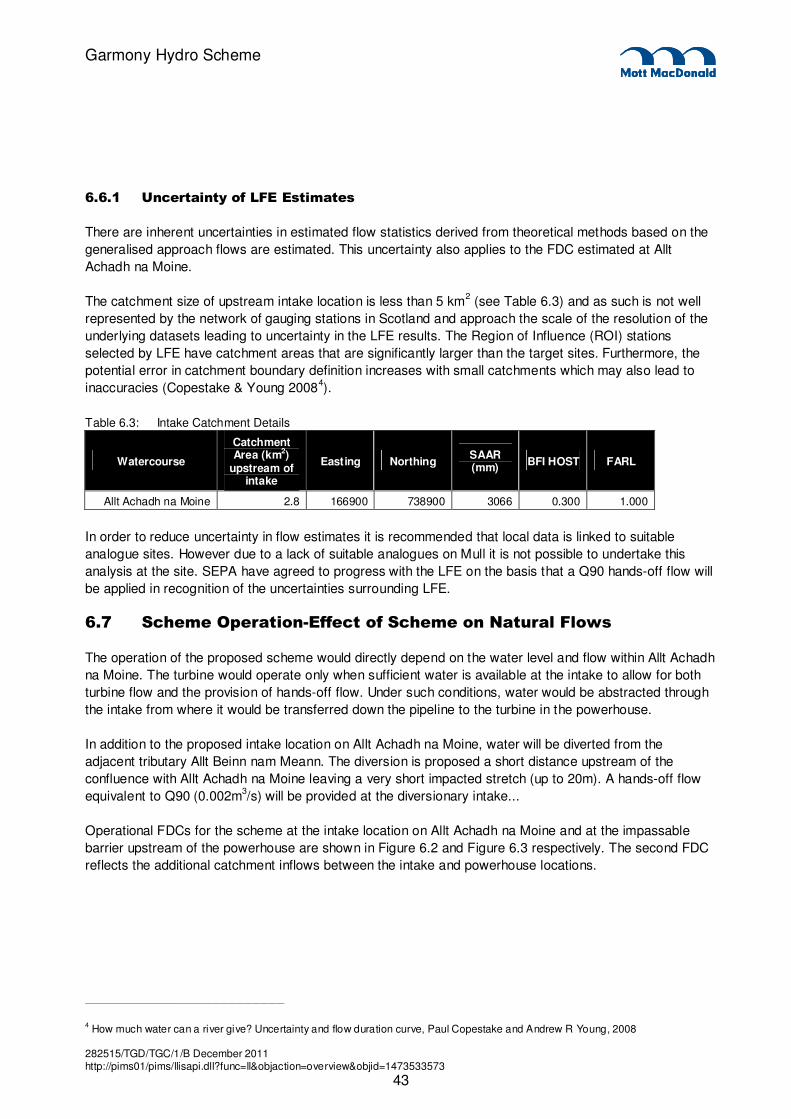
282515/TGD/TGC/1/B December 2011 http://pims01/pims/llisapi.dll?func=ll&objaction=overview&objid=1473533573
43
Garmony Hydro Scheme
6.6.1 Uncertainty of LFE Estimates
There are inherent uncertainties in estimated flow statistics derived from theoretical methods based on the
generalised approach flows are estimated. This uncertainty also applies to the FDC estimated at Allt
Achadh na Moine.
The catchment size of upstream intake location is less than 5 km2 (see Table 6.3) and as such is not well
represented by the network of gauging stations in Scotland and approach the scale of the resolution of the
underlying datasets leading to uncertainty in the LFE results. The Region of Influence (ROI) stations
selected by LFE have catchment areas that are significantly larger than the target sites. Furthermore, the
potential error in catchment boundary definition increases with small catchments which may also lead to
inaccuracies (Copestake & Young 20084).
Table 6.3: Intake Catchment Details
Watercourse
Catchment Area (km2)
upstream of intake
Easting Northing SAAR (mm)
BFI HOST FARL
Allt Achadh na Moine 2.8 166900 738900 3066 0.300 1.000
In order to reduce uncertainty in flow estimates it is recommended that local data is linked to suitable
analogue sites. However due to a lack of suitable analogues on Mull it is not possible to undertake this
analysis at the site. SEPA have agreed to progress with the LFE on the basis that a Q90 hands-off flow will
be applied in recognition of the uncertainties surrounding LFE.
6.7 Scheme Operation-Effect of Scheme on Natural Flows
The operation of the proposed scheme would directly depend on the water level and flow within Allt Achadh
na Moine. The turbine would operate only when sufficient water is available at the intake to allow for both
turbine flow and the provision of hands-off flow. Under such conditions, water would be abstracted through
the intake from where it would be transferred down the pipeline to the turbine in the powerhouse.
In addition to the proposed intake location on Allt Achadh na Moine, water will be diverted from the
adjacent tributary Allt Beinn nam Meann. The diversion is proposed a short distance upstream of the
confluence with Allt Achadh na Moine leaving a very short impacted stretch (up to 20m). A hands-off flow
equivalent to Q90 (0.002m3/s) will be provided at the diversionary intake...
Operational FDCs for the scheme at the intake location on Allt Achadh na Moine and at the impassable
barrier upstream of the powerhouse are shown in Figure 6.2 and Figure 6.3 respectively. The second FDC
reflects the additional catchment inflows between the intake and powerhouse locations.
_________________________
4 How much water can a river give? Uncertainty and flow duration curve, Paul Copestake and Andrew R Young, 2008
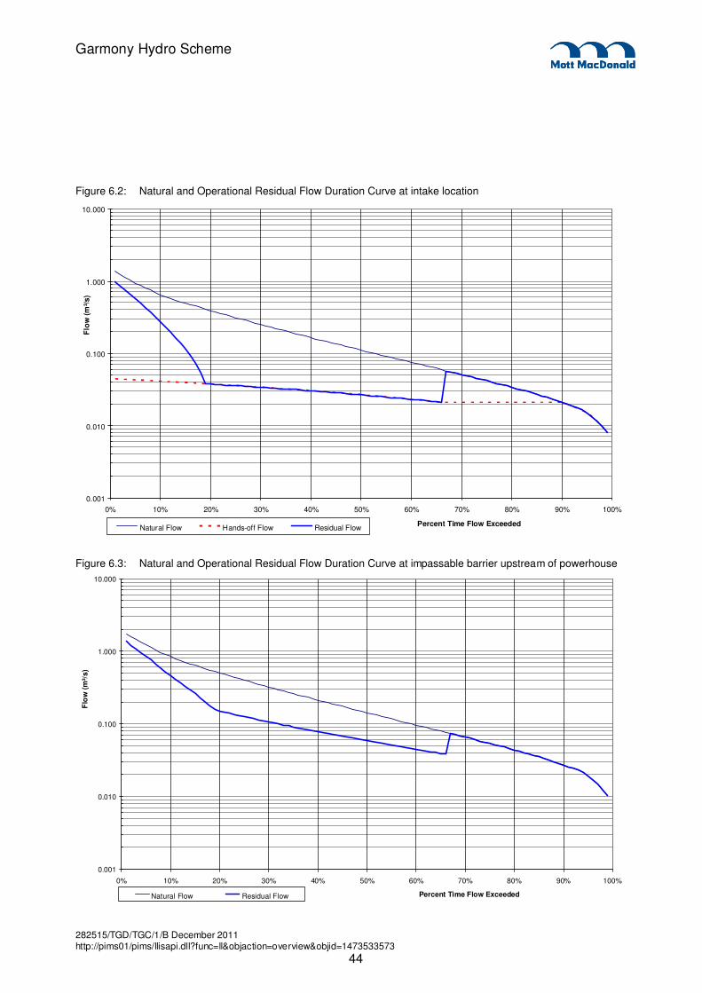
282515/TGD/TGC/1/B December 2011 http://pims01/pims/llisapi.dll?func=ll&objaction=overview&objid=1473533573
44
Garmony Hydro Scheme
Figure 6.2: Natural and Operational Residual Flow Duration Curve at intake location
0.001
0.010
0.100
1.000
10.000
0% 10% 20% 30% 40% 50% 60% 70% 80% 90% 100%
Percent Time Flow Exceeded
Flo
w (
m³/s)
Natural Flow Hands-off Flow Residual Flow
Figure 6.3: Natural and Operational Residual Flow Duration Curve at impassable barrier upstream of powerhouse
0.001
0.010
0.100
1.000
10.000
0% 10% 20% 30% 40% 50% 60% 70% 80% 90% 100%
Percent Time Flow Exceeded
Flo
w (
m³/
s)
Natural Flow Residual Flow
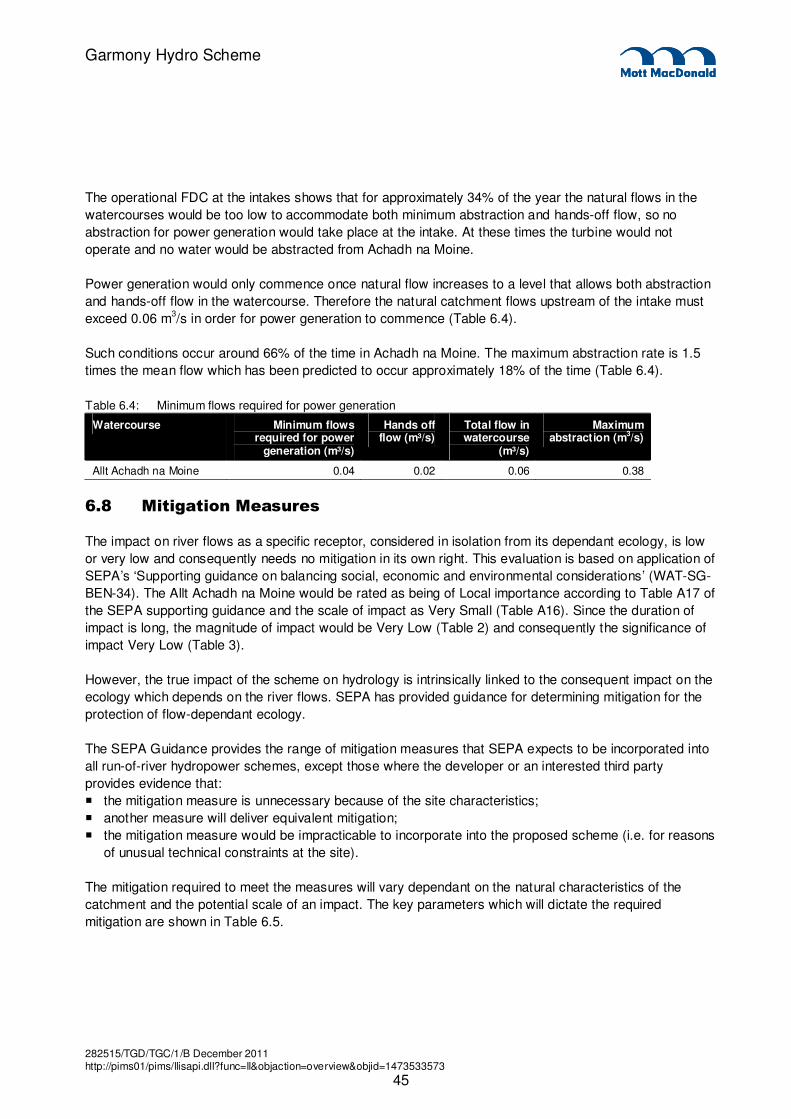
282515/TGD/TGC/1/B December 2011 http://pims01/pims/llisapi.dll?func=ll&objaction=overview&objid=1473533573
45
Garmony Hydro Scheme
The operational FDC at the intakes shows that for approximately 34% of the year the natural flows in the
watercourses would be too low to accommodate both minimum abstraction and hands-off flow, so no
abstraction for power generation would take place at the intake. At these times the turbine would not
operate and no water would be abstracted from Achadh na Moine.
Power generation would only commence once natural flow increases to a level that allows both abstraction
and hands-off flow in the watercourse. Therefore the natural catchment flows upstream of the intake must
exceed 0.06 m3/s in order for power generation to commence (Table 6.4).
Such conditions occur around 66% of the time in Achadh na Moine. The maximum abstraction rate is 1.5
times the mean flow which has been predicted to occur approximately 18% of the time (Table 6.4).
Table 6.4: Minimum flows required for power generation
Watercourse Minimum flows required for power
generation (m³/s)
Hands off flow (m³/s)
Total flow in watercourse
(m³/s)
Maximum abstraction (m3/s)
Allt Achadh na Moine 0.04 0.02 0.06 0.38
6.8 Mitigation Measures
The impact on river flows as a specific receptor, considered in isolation from its dependant ecology, is low
or very low and consequently needs no mitigation in its own right. This evaluation is based on application of
SEPA’s ‘Supporting guidance on balancing social, economic and environmental considerations’ (WAT-SG-
BEN-34). The Allt Achadh na Moine would be rated as being of Local importance according to Table A17 of
the SEPA supporting guidance and the scale of impact as Very Small (Table A16). Since the duration of
impact is long, the magnitude of impact would be Very Low (Table 2) and consequently the significance of
impact Very Low (Table 3).
However, the true impact of the scheme on hydrology is intrinsically linked to the consequent impact on the
ecology which depends on the river flows. SEPA has provided guidance for determining mitigation for the
protection of flow-dependant ecology.
The SEPA Guidance provides the range of mitigation measures that SEPA expects to be incorporated into
all run-of-river hydropower schemes, except those where the developer or an interested third party
provides evidence that:
� the mitigation measure is unnecessary because of the site characteristics;
� another measure will deliver equivalent mitigation;
� the mitigation measure would be impracticable to incorporate into the proposed scheme (i.e. for reasons
of unusual technical constraints at the site).
The mitigation required to meet the measures will vary dependant on the natural characteristics of the
catchment and the potential scale of an impact. The key parameters which will dictate the required
mitigation are shown in Table 6.5.
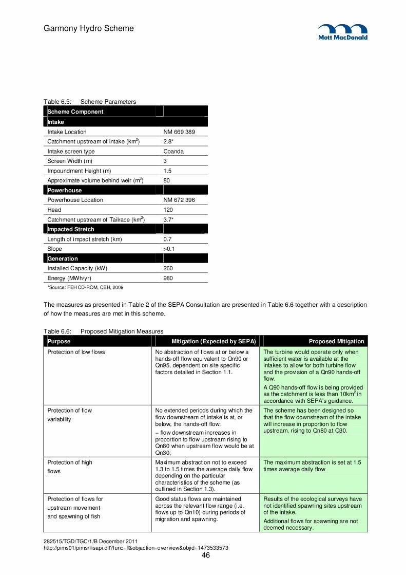
282515/TGD/TGC/1/B December 2011 http://pims01/pims/llisapi.dll?func=ll&objaction=overview&objid=1473533573
46
Garmony Hydro Scheme
Table 6.5: Scheme Parameters
Scheme Component
Intake
Intake Location NM 669 389
Catchment upstream of intake (km2) 2.8*
Intake screen type Coanda
Screen Width (m) 3
Impoundment Height (m) 1.5
Approximate volume behind weir (m3) 80
Powerhouse
Powerhouse Location NM 672 396
Head 120
Catchment upstream of Tailrace (km2) 3.7*
Impacted Stretch
Length of impact stretch (km) 0.7
Slope >0.1
Generation
Installed Capacity (kW) 260
Energy (MWh/yr) 980
*Source: FEH CD-ROM, CEH, 2009
The measures as presented in Table 2 of the SEPA Consultation are presented in Table 6.6 together with a description
of how the measures are met in this scheme.
Table 6.6: Proposed Mitigation Measures
Purpose Mitigation (Expected by SEPA) Proposed Mitigation
Protection of low flows No abstraction of flows at or below a hands-off flow equivalent to Qn90 or Qn95, dependent on site specific factors detailed in Section 1.1.
The turbine would operate only when sufficient water is available at the intakes to allow for both turbine flow and the provision of a Qn90 hands-off flow.
A Q90 hands-off flow is being provided as the catchment is less than 10km2 in accordance with SEPA’s guidance.
Protection of flow
variability
No extended periods during which the flow downstream of intake is at, or below, the hands-off flow:
− flow downstream increases in proportion to flow upstream rising to Qn80 when upstream flow would be at Qn30;
The scheme has been designed so that the flow downstream of the intake will increase in proportion to flow upstream, rising to Qn80 at Q30.
Protection of high
flows
Maximum abstraction not to exceed 1.3 to 1.5 times the average daily flow depending on the particular characteristics of the scheme (as outlined in Section 1.3).
The maximum abstraction is set at 1.5 times average daily flow
Protection of flows for
upstream movement
and spawning of fish
Good status flows are maintained across the relevant flow range (i.e. flows up to Qn10) during periods of migration and spawning.
Results of the ecological surveys have not identified spawning sites upstream of the intake.
Additional flows for spawning are not deemed necessary.
282515/TGD/TGC/1/B December 2011 http://pims01/pims/llisapi.dll?func=ll&objaction=overview&objid=1473533573
47
Garmony Hydro Scheme
Protection of low flows will be mitigated through the implementation of a hands-off flow. A hands-off flow is
the flow below which no abstraction of water for power supply purposes will take place. Hands-off flow is
the amount of water allowed to bypass the intake weir and therefore continue onwards downstream
unaffected by the operation of the hydro scheme. This flow is essential for the integrity of aquatic life in the
reaches below the intake weir.
For the proposed scheme the hands-off flow would be set at the Qn90 value at the main intake location.
That is, whenever the scheme is operational a minimum flow of 0.02 m³/s would not be abstracted and
allowed to continue onwards downstream. A hands-off flow equivalent to Q90 (0.002m3/s) will be provided
at the diversionary intake.
SEPA would anticipate the mitigation of flow variability through ensuring there are no extended periods
during which the flow downstream of the intake is at, or naturally below, the hands-off flow.
For roughly one third of the time there will be no abstraction from the intake and the flows downstream of
the intake structures will vary naturally between the Qn100 and Qn67flows.
For periods when abstraction is occurring, residual flows passing the intake of the proposed scheme will
increase gradually from Qn90 and in accordance with SEPA’s recommended mitigation for flow variability,
downstream flow will increase in proportion to upstream flows rising to Qn80 when the upstream flow is
Qn30.
SEPA guidance specifies that the maximum abstraction should not exceed 1.3 to 1.5 times the average
daily flow to ensure protection of high flows. The proposed maximum abstraction at each intake is within
this limit set to 1.5 times the average daily flow. The results of the ecological surveys have not identified a
requirement for more stringent mitigation.
The ecological survey has identified spawning grounds downstream of the intake. The location of the
tailrace will be at the upstream limit of these spawning grounds. The lack of spawning grounds upstream of
the intake removes the need for any additional flow regimes.
6.9 Residual Effects
Appropriate mitigation measures have been applied for the protection of low flows, high flows and flow
variability. As such whilst it is acknowledged that there will be a minor impact upon the depleted stretch the
impact will not be significant. There will be no residual impact downstream of the depleted reach.
6.10 Cumulative Effects
Cumulative impacts are those effects that may result from the combination of past, present or future actions
of planned activities which are within the hydrological study area. While a single activity may in itself result I
an insignificant impact, it may, when combined with other impacts (significant or insignificant) in the same
geographical area, occurring at the same time, result in a cumulative impact that is significant.
Following consultation with Argyll and Bute Council it has been confirmed that there are no existing or
planned schemes within the same hydrological catchment as the proposed Garmony scheme.

282515/TGD/TGC/1/B December 2011 http://pims01/pims/llisapi.dll?func=ll&objaction=overview&objid=1473533573
48
Garmony Hydro Scheme
6.11 Statement of Significance
This Chapter has assessed the potential effects of the proposed scheme on the hydrology of the
downstream water body. As the scheme complies with all the mitigation measures identified in the SEPA
Guidance document it is considered that there is no significant residual effect from the proposed scheme
and no potential cumulative effects to be considered.
As ecological surveys have identified that there are no spawning grounds upstream of the intake, there is
no requirement for additional flows for migration of fish.

282515/TGD/TGC/1/B December 2011 http://pims01/pims/llisapi.dll?func=ll&objaction=overview&objid=1473533573
49
Garmony Hydro Scheme
This document has considered the potential impacts the proposed Garmony hydro scheme will have on the
environment.
During the environmental scoping process it was determined that certain topics would be scoped out of
further assessment, namely archaeology and cultural heritage, noise, air quality, landscape and visual
impact, access and traffic, geology and soils and socio-economics (see section 4.4).
It was determined that ecology and hydrology would be considered further in this Environmental Statement
and the full assessment can be found in Chapters 5 and 6 respectively.
Residual impacts are those remaining after mitigation measures have been applied. The residual impacts
pertaining to the proposed scheme were assessed in both assessment chapters.
In the Ecology chapter, it was deemed that following the implementation of embedded mitigation,
sympathetic scheme design and best-practice construction methods, this will reduce all moderate adverse
impacts to insignificant or slight adverse (which are not ecologically significant).
In the Hydrology chapter it was deemed that appropriate mitigation measures have been applied for the
protection of low flows, high flows and flow variability. The scheme complies with all the mitigation
measures identified in the SEPA Guidance document. While there will be a minor impact upon the depleted
stretch of the watercourse, the impact will not be significant. There will be no residual impact downstream
of the depleted reach.
Overall, the negative residual impact of the proposed scheme is deemed to be negligible due to the
mitigation measures that are proposed, the temporary and short-term nature of the construction phase, and
the fact that this is a small scheme with an output of less than 500kW.
The scheme has the potential to benefit the community as it is likely that there will be the opportunity for the
workforce to be contracted locally and neighbouring businesses and services utilised. Successful execution
of the hydro scheme will provide an income to the Mull and Iona Community Trust which will be retained for
investment in community projects in the area. It will also benefit by providing a source of renewable
electricity to the national grid, helping the UK to satisfy its energy requirements and meet its renewable
targets.
7. Summary and Residual Impacts
282515/TGD/TGC/1/B December 2011 http://pims01/pims/llisapi.dll?func=ll&objaction=overview&objid=1473533573
50
Garmony Hydro Scheme
Argyll and Bute Local Plan (adopted 2009)
Argyll and Bute Structure Plan (approved 2002)
Copestake, P. and Young, A.R. (2008) How much water can a river give? Uncertainty and the Flow
Duration Curve. BHS 10th National Hydrology Symposium, Exeter.
Eaton MA, Brown AF, Noble DG, Musgrove AJ, Hearn R, Aebischer NJ, Gibbons DW, Evans A and
Gregory RD (2009) Birds of Conservation Concern 3: the population status of birds in the United Kingdom,
Channel Islands and the Isle of Man. British Birds 102, pp296–341
Environment Agency/Scottish Environment Protection Agency (2003) River Habitat Survey in Britain and
Ireland – Field Survey Guidance Manual
Guidance for applicants on supporting information requirements for Hydropower applications, Marine
Scotland , Natural Scotland, SEPA, Scottish Natural Heritage
Holdich, D. 2003. Ecology of the White-clawed Crayfish. Conserving Natura 2000 Rivers Ecology Series
No. 1. English Nature, Peterborough
Institute of Ecology and Environmental Management. (2006) Guidelines for Ecological Impact Assessment in the United Kingdom (version 7 July 2006).
Mott MacDonald (2011) Garmony Hydro Scheme Scoping Report
Regulatory Method (WAT-RM-34) Derogation Determination - Adverse Impacts on the Water Environment,
SEPA, 2009
Rodwell, J. S. (1998) British Plant Communities Volume 2 – Mires and Heaths. Cambridge University Press.
Ruddock, M. & Whitfield, D. P. (2007) A Review of Disturbance on Selected Bird Species. A report from
Natural Research (Projects) Ltd to Scottish Natural Heritage. Inverness
Scotland River Basin District (Surface Water Typology, Environmental Standards, Conditions Limits and
Groundwater Threshold Values) Direction, Scottish Executive 2007
Skinner, A., Young, M. & Hastie, L. (2003) Ecology of the Freshwater Pearl Mussel. Conserving Natura
2000 Rivers Ecology Series No. 2 English Nature, Peterborough.
SNH (2002) A Handbook on Environmental Impact Assessment
SNH (2002) Guidelines on the Environmental Impacts of Wind Farms and Small Scale Hydroelectric
Schemes.
SNH (2010) Renewable Energy Service Level Statement.
8. References

282515/TGD/TGC/1/B December 2011 http://pims01/pims/llisapi.dll?func=ll&objaction=overview&objid=1473533573
51
Garmony Hydro Scheme
SEPA (2009) Technical Guide to Flow Measurement (WAT-SG-54)
SEPA (2007) Water Environment (Controlled Activities) (Scotland) Regulations 2005 (CAR) Guidance for
applicants on supporting information requirements for hydropower applications.
Websites:
National Biodiversity Network (NBN) Gateway http://data.nbn.org.uk/
Scottish Government (2010). Scottish Biodiversity List. Information found at
http://www.snh.gov.uk/protecting-scotlands-nature/biodiversity-scotland/scottish-biodiversity-list
SNH’s Information Service (SNHi) http://www.snh.org.uk/snhi/
United Kingdom Biodiversity Action Plan http://www.ukbap.org.uk/

282515/TGD/TGC/1/B December 2011 http://pims01/pims/llisapi.dll?func=ll&objaction=overview&objid=1473533573
52
Garmony Hydro Scheme
Appendix A. Scheme Layout ____________________________________________________________________ 53
Appendix B. Construction Method Statement________________________________________________________ 54
Appendix C. Pre-application (Screening) Response___________________________________________________ 55
Appendix D. Pre-application (Scoping) Response ____________________________________________________ 56
Appendix E. Ecology___________________________________________________________________________ 57
Appendices

282515/TGD/TGC/1/B December 2011 http://pims01/pims/llisapi.dll?func=ll&objaction=overview&objid=1473533573
58
Garmony Hydro Scheme
ABC Argyll and Bute Council
AEP Annual exceedence probability
BFI HOST Base flow index hydrology of soils type
BMWP Biological Monitoring Working Party
BoCC Birds of Conservation Concern
BTO British Trust for Ornithology
CAR Water Environment (Controlled Activities) (Scotland) Regulations 2005
CBD Convention on Biological Diversity 1992
cm Centimeters
CoSHH Control of Substances Hazardous to Health Regulations 2002
DWPA Drinking Water Protected Areas
EcIA Ecological impact assessment
EIA Environmental impact assessment
ES Environmental statement
EU European Union
FALAKE Proportion of catchment covered by a lake or reservoir
FARL Flood attenuation attributable to reservoirs and lakes
FDC Flow duration curve
GCR Geological Conservation Review
GIS Geographic Information Systems
ha Hectares
HER Historic Environment Record
HGV Heavy Goods Vehicle
IEEM Institute of Ecology and Environment Management
IEMA Institute of Environmental Management and Assessment
km kilometres
km2 square kilometres
kV kilovolts
kW kilowatts
LBAP Local Biodiversity Action Plan
LFE Low Flow Enterprise
LGV Light Goods Vehicle
LPA Local Planning Authority
l/s litres per second
m metres
mAOD metres above ordnance datum
MICT (M&ICT) Mull and Iona Community Trust
Glossary & Abbreviations

282515/TGD/TGC/1/B December 2011 http://pims01/pims/llisapi.dll?func=ll&objaction=overview&objid=1473533573
59
Garmony Hydro Scheme
Ml/d megalitres per day
mm millimetres
mm/year millimetres per year
m3/s cubic metres per second
MW Megawatt (1,000kW)
MWh Megawatt hours
NBN National Biodiversity Network
NGR National Grid Reference
NMRS National Monuments Record of Scotland
NNR National Nature Reserve
NPPG National Planning Policy Guideline
NPS National Policy Statement
NSA National Scenic Area
NVC National Vegetation Classification
OS Ordnance Survey
OSGR Ordnance Survey Grid Reference
PAN Planning Advisory Note
SEP Sustainable Economy Policy
ERP Environment and Resources Policy
PROW Public Right of Way
Q90 90th percentile flow
Q95 95th percentile flow
RBMP River Basin Management Planning
RCAHMS Royal Commission on the Ancient and Historical Monuments of
Scotland
RHS River Habitat Survey
RSPB Royal Society for the Protection of Birds
SAAR standard annual average rainfall
SAC Special Area of Conservation
SAMs Scheduled Ancient Monuments
SBL Scottish Biodiversity List
SEPA Scottish Environmental Protection Agency
SNH Scottish National Heritage
SNHi Scottish National Heritage’s Information Service
SPA Special Protected Area
SSSI Site of Special Scientific Interest
UKBAP United Kingdom Biodiversity Action Plan

282515/TGD/TGC/1/B December 2011 http://pims01/pims/llisapi.dll?func=ll&objaction=overview&objid=1473533573
60
Garmony Hydro Scheme
W&C 1981 Wildlife and Countryside Act 1981
WEWS Water Environment and Water Services (Scotland) Act 2003
WOSAS West of Scotland Archaeology Service
ZoI Zone of Influence
‘ feet
“ inches