Upload
others
View
5
Download
0
Embed Size (px)
Citation preview

From Colin PhillipsTo Thomas WattSubject FW State Significant Project - Airly Mine Extension (SSD 12_ 5581)Date Friday 31 October 2014 22703 PMAttachments CVEG Submission Airly Mine Extension 2014pdf
Airly Mine Extension Project EISColocomSubFin(2)pdfSubmission Pells 2014 Nr2pdf
From Sanday ltsandayskymeshcomaugtSent Friday 31 October 2014 1418To Colin PhillipsSubject State Significant Project - Airly Mine Extension (SSD 12_ 5581) Dear Mr Phillips
State Significant Project - Airly Mine Extension (SSD 12_5581) As discussed on the telephone attached please find Capertee Valley Environmental Group IncsSubmission in objection to the abovementioned mine extension Yours faithfully Veronica Sanday Please note additional Expert Reports emailed as annexures Hon SecretaryCapertee Valley Environmental Group IncLot 2 Coorain StreetGlen Davis NSW 2846Tel 02 63797200
Capertee Valley Environmental Group IncABN 31 096 498 385
Email sandayskymeshcomauTelephone 02 63797200
Postal AddressLot 2 Coorain Street
GLEN DAVIS NSW 2846
31st October 2014
Mining and Industry ProjectsNSW Department of Planning amp InfrastructureGPO Box 39Sydney NSW 2001
Dear Sir
State Significant Project - Airly Mine Extension (SSD 12_5581)
Capertee Valley Environmental Group Inc (CVEG Inc) objects to the approval of the above mentioned mine extension and jointly with Capertee Valley Alliance (CVA) engaged the Environmental Defenders Office who in turn engaged Experts to review Airly Mine Extensions EIS
CVEG Inc supports the submissions of CVA and relies upon the expert opinion evidence contained in such submission with the knowledge an consent of CVA and the authors of such expert reports
In the interest of brevity and to avoid repetition CVEG Incrsquos submission does not refer expressly to the entirety of the expert opinion evidence presented by CVA
Below are some of the reasons for this objection and attached are the Expert Review Documents---
World Heritage Properties
The Application for Exploration will impact a huge portion of the Blue Mountains National Park Gardens of Stone National Park Wollemi National Park within which is Wollemi Wilderness a declared Wilderness Area All of these National Parks are a part of The Greater Blue Mountains declared World Heritage Area and as such should be protected by the Precautionary Principle Relevant to its World Heritage listing UNESCO notes that The Greater Blue Mountains World Heritage Area contains primitive species of outstanding significance to the evolution of the earthrsquos plant life It is our understanding that it is against International Best Practice Guidelines to mine within or adjacent to a World Heritage Area This is stipulated by the International Union for Conservation of Nature Gardens of Stone Proposal Stage 2 covers an area with a range of environmental and heritage values either poorly represented or not represented in the World Heritage Area
Threatened Species and Threatened Ecological Communities
The following are some of the threatened fauna in Capertee Valley National Parks and World Heritage Areas which would be adversely impacted should this Mine Expansion be approved --
Large-eared Pied Bat (Chalinolobus dwyeriV)Swift Parrot (Lathamus discolour E)Regent Honeyeater (Xanthomyza phrygia E)Booroolong Frog (Litoria booroolongensrs E)Brush -tailed Rock-wallaby (Petrogale penicilIata V)New Holland Mouse (Pseudomys novaehollandiae V)Pink-tailed Wormlizard (Aprasia parapulchella V)Spotted-tail Quoll (Dasyurus maculatus maculatus E)Bathurst Copper Butterfly (Paralucia spinifera V)(CE-Critically Endangered E-Endangered V-Vulnerable)
The following are some of the threatened flora which would be adversely impacted should this Mine Expansion be approved in Capertee Valley---
Pultenaea sp Genowlan Point Pea (CE)Mount Vincent Mintbush (Prostanthera stricta V )Grey Grevillea (Grevillea obustiflora E)Clandulla Geebung (Persoonia marginata V)Prasophyllum spWybong (C Phelps ORG 5269 CE)Wollemi Mint Bush (Prostanthera cryptandroides subsp cryptandroides V)Wollemi Pine ( Wollemi nobilis CE)Austral Toadflax (Thesium austral V)Philotheca ericifolia (V)Flockton Wattle (Acacia flocktoniae V)Evans Grevillea (Grevillea evansiana V)Rufous Pomaderris (Pomaderris brunnea V)(CE - Critically Endangered E - Endangered V - Vulnerable)
The following are some of the threatened ecological communities of flora in Capertee Valley which would be adversely impacted should this Mine Expansion be approved---
White Box (CE)Yellow Box (CE)Blakelys Red Gum (CE)Grassy Woodland and Derived Native Grassland (CE)(CE - Critically Endangered)
Significant Landscapes
Capertee Valley is World-renowned as a birdwatchers paradise with 245 different species of bird using the valley throughout the year Its scenic beauty geoheritage on the World level and its biodiversity of National Significance are highly valued by residents and visitors to this magnificent part of Australia Pearsonrsquos Lookout just off Castlereagh Highway near Capertee is a recently upgraded well visited site for many tourists and the visual impact of the mine both from the Lookout and from the road into the Capertee Valley would totally ruin the majestic views which draw people from the four corners of the World
Water Resources
The continued --- and expansion --- of mining risks contamination of water supply The area covered by this proposed expansion plays a vital part in water catchment for river systemsThe expansion area covers headwaters of creeks and rivers which ultimately flow into The Greater Blue
Mountains World Heritage Area and on by way of Capertee River into Colo River a declared wild river Many of these rivers and creeks are vitally important to Wollemi Wilderness and to the scenic beauty of The Greater Blue Mountains World Heritage Area The Greater Blue Mountains is a designated World Heritage Area of Global Significance for the Conservation of Biodiversity Its ecosystems depend on a reliable supply of surface water and upon groundwater from aquifers These water resources would be placed in jeopardy should this Mine Expansion be approved Farmers in Capertee Valley would have their livelihood threatened due to adverse impacts upon their water resources
Social and Economic Impacts
In consideration of this proposed mine expansion quality of life issues should also be prioritised particularly as they will greatly affect residents of Capertee Valley Economic impacts due to loss of World Heritage status could result if indeed Creeks and Rivers are poisoned as a result of the mine expansion being approved The flow-on consequences of this and the actual despoliation of an area known Nationally and Internationally for its scenic and pristine beauty would be enormous The tourism industry a mainstay of this part of the Greater Blue Mountains World Heritage Areas economy would suffer greatly An extensive range of structured and unstructured recreational activities take place in the Capertee Valley eg bushwalking canyoning bird watching camping and photography as well as nature education programmes for schools and nature conservation programmes for adults This proposed mine expansion is not compatible with such activities
Airly Mine Extension ndash Expert Review Documents
Acquatic Ecology Review Dr Alison Hunt
Overall comments
bull Overall methodology are adequate although the sample design is spatially and temporally limited in relation to stygofauna (part 22)
bull Airly creek and Torbane Creek sites are the most biologically impacted due to existing factors such as deforestation agriculture and mining (part 23)
bull The ldquoscientific robustnessrdquo could be added to by providing additional assessment especially for stygofauna and hyporheic fauna (part 30)
Stygofauna (part 24)
bull Stygofauna sampling did not reveal stygofauna potentially due to the severely limited sampling effort and location of bores + no attempt made to sample hyporheic fauna
Potential impacts and Mitigation measures (Part 25)
bull Mitigation measures proposed will probably mitigate against potential risks
bull Report acknowledges sensitive receptorspotential for disruption of ecosystems including Genowlan Creek Gap Creek Village Spring and Grotto Creek
bull Mitigation measures are considered appropriate and manageable
Impacts on Threatened Species (part 26)
bull No assessment of impacts using the Significant Impact Criteria detailed in Matters
of National Environmental ndash Significant Impact Guidelines 11 However Alison Hunt notes that the conclusions would not have been altered
Submission on Airly Mine Extension Dr Haydn Washington
bull Comparison of mine layouts for the various extraction zones show that extraction rates will be as much as 66 under the majority of the mesas rather than 50 as was verbally announced by the Colo Committee (page 2)
bull EIS deliberately avoids stating anywhere the percentage coal extraction under the various mining zones because it is too high for the safety of the SCA (see page 3-4 for analysis of zones) (Page 3)
bull Disputes what is stated on page 37 of the EIS regarding pagodas in the SCA Says there are both smooth and platy pagodas present with good examples of both types Mugii Murum-ban SCA is an excellent showcase of pagoda geodiversity Pagodas are also regularly greater than 20 metres in height (the EIS states they only reach this height) (Page 8)
bull Says that the assertion on pages 345 and 354 of the EIS that the proposal poses no long-term risk of a decrease in the EPBC listed Pultenaea sp Genowlan Point is a direct and blatant untruth as the only known population runs serious risk of being sent extinct via cliff collapse (Page 9)
bull Says the EIS failed to identify an aboriginal art site on the creek that runs up to Airly turret from the stone cottage (Page 12)
Review of Noise Management John Bassett
Overall comments
bull Report states that compliance measurements have been conducted on an annual basis however there is no data presented from these measurements Therefore claims that the noise environment is the same as five years ago is contestable
bull Quiet recreation sites at Airly Gap camp ground and Nissen Hut on Glenowlan Mountain are not indicated in any of the modelling
bull Assessment criteria for sites for ldquocontemplative activities that generate little noise and where benefits are comprised by external noise intrusion for example reading meditationrdquo is set at a higher standard than a school classroom (35dB(A)) or a place of worship (40dB(A)) (NSW INP Table 21)
Operational noise
bull SoundPlan 3D is the software that has been used ndash it was released in 2011 and is an old version
bull Noise indicators show that residence 2 will experience levels of 35-40dBA with REA1 2
bull No noise contour maps presented for temperature inversions although they are recognised in NSW Industrial Noise Policy as a significant factor in noise propagation
bull Recommend current assessment of existing noise environment be conducted modelling be conducted for all receiver sites including recreational sites and modelling include meteorological conditions
Sleep disturbance
bull No indication of modelling procedure or proof that analysis complies with NSW Industrial Noise Policy
bull Recommend modelling must include an indication of potential sleep disturbance and effects of construction noise at all receiver sites
Review of Surface Water Assessment Andrew Marr
Overall commentsSummary (Page 1 and 2)
bull Overall Review of GHD document demonstrates that information on surface water and salt balances for the proposed mine extension in that report do not adequately address the DGs requirements as they do not adequately present the volume and frequency of discharges for a range of different rainfall sequences stages of mine development and the range of possible groundwater inflows into the mine
bull Summary for presented of water and salt balance modelling is very limited and doesnrsquot provide adequate information regarding the model outputs This means the assessment doesnrsquot cover the full range of rainfall sequences and possible groundwater inflows
bull Findings on water and salt balances for year 2030 presented in the hydrogeological model In both Scenario 1 and 2 salt discharge from LDP001 can be
expected to be much higher than represented in the report
bull The terrain in the region (steep escarpments plateaus) would mean variation in annual rainfall and intensity-frequency-duration rainfall over short distances This is not recognised in the report
bull This could impact long-term rainfall averages and shorter duration rainfall intensities for the mine site
bull The results in the report are not adequate to present the performance of the surface water facility over the full range of rainfall sequences and stages of mine development
bull Water and salt balance assessment only used Scenario 2 from hydrogeological modelling for all the water and salt balance modelling ndash Scenario 1 case should also have been modelled to account for full range of rainfall sequencesmine development stages
bull Changes to catchment hydrology and hydraulics the studies should estimate base-flow at these locations so that base-flow can also be presented as percentage change
bull Stream geomorphology geomorphology assessment should also consider changes in baseflow as these also have the potential to impact on stream morphology
Approach
bull Approach to water and salt balance modelling was to use GOLDSIM model to stimulate the operation of surface water facility ndash this is considered adequate However itrsquos rigorousness depends onrdquo
bull Input data
bull Operating rules in the model
bull Adequacy of representation of various processes including conversion of rainfall to runoff generation of salt loads from rainfall-run off etc
bull Issues with input data
bull Was mostly provided by Airly Mining and the report assumes this was accurate (canrsquot really comment on this data as we donrsquot have it)
bull The Report should have investigated variation in rainfall patterns in the region and demonstrated that data sequences adopted from Ilford
adequately represent both the long-term rainfall averages and shorter duration rainfall intensities
bull Simulation Model
bull Goldsim model used ndash essentially accounting model
bull Simulation uses as input 112 realisations of daily rainfall from the Ilford (Warragunyah) Station ndash this is a reasonable approach
bull Catchment runoff is modelled using AWDM model Widely used model but the Report adjusts model parameters (which are based on work from Boughton and Chiew) without a discussion of how that would impact streamflow characteristics
bull Sensitivity analysis sensitivity testing shows the mean discharge is relatively insensitive to the value adopted but the model was tested on data from a gauging site on the Turon River at Sofala a much larger catchment than that in the study area Nonetheless the model under-estimated runoff at this site by 60 showing the inaccuracy of the model
bull Modelling of salt transfers assume that salt concentrations from catchments are constant over time and do not vary ndash this assumption is not substantiated
bull Output has been summarised but some information has been lost which is evident from the small amount of output from a very large quantity of input
bull For the proposed mine extension the report presents only simulation results for the year 2030 (see dot points on page 4 for examples)
bull Presentation of simulation results
bull The results presented are not adequate to present the performance of the surface water facility over a range of rainfall sequences
bull Statistical information presented in Figure 6-4 does not allow the water balance to be verified
bull The report should provide schematics similar to Figure 6-4 showing water and salt transfers within the entire facility
bull Figure 6-4 should also be presented so as to demonstrate what happens at
various stages of mine development
DGs requirements
bull Information provided on surface water and salt balances for proposed mine extension in GHD report do not adequately address DGs requirements as the report does not adequately present volume and frequency of discharges for a range of different rainfall sequences and stages of mine development
Review of ldquosurface water impact assessmentrdquo
bull Additional information on hydrogeological modelling used to estimate groundwater in the mine is in here
bull Water and salt balance assessment here used Scenario 2 from the hydrogeological modelling for all water and salt balance modelling Scenario 1 should also have been used
bull Sub-section 641 provides estimate of changes to baseflow at various locations downstream of the mine changes in baseflow should be recorded in MLy and percentages
bull Geomorphological assessment should also consider changes in baseflow and the potential impacts
Subsidence Pells Consulting
Executive summarygeneral comments
bull There is an inconsistency between the Clarence Colliery and Airly Mine Extension modelling as the Clarence Collieryrsquos 2014 paper records that the predicted subsidence range is 20mm to 30 mm prior to flooding
bull Suggestion that there is a Zone 6 for proposed mining zones ndash where there would be no mining beneath Gap Creek and Genowlan Creek where cover is less than 40m Failure to incorporate zone 6 in the mine planning presented in the EIS is a fundamental issue that warrants re-submission of EIS
bull Hydrogeology and groundwater significant omissions in respect to factual data relevant to assessing likely impacts on groundwater system and associated impacts on springs and baseflows to the creek system
bull There may be errors in the application of the MODFLOW 2005 software in this particular mining situation ndash but Pells have been unable to resolve the conflict
bull Heritage whole assessment of impacts on Aboriginal and European heritage is premised on the statement that subsidence will be limited to 0-10 mm The statement is not given anywhere else in the EIS and appears to be incorrect ndash therefore calling into question conclusions on impacts on Aboriginal and European heritage
Subsidence and mine plan
bull The Environmental Protection Zone is not given the level of protection proposed for the lsquocliff zonersquo (part 13)
bull Figure 1-21 provided by Pells demonstrates that there might be geometric confusion where the boundary between Zone 2 and 3 is defined both by a distance of 30m from the toe of a cliff line and an angle of gt8 degrees especially where cliff bases are not shown on contour maps (part 13)
bull There should be a zone 6 which constitutes areas where no mining will take place on Figure 1021A (part 13)
Groundwater Impacts
bull Access to the processed field test data was requested so that the results could be tested but the information was not provided (part 142)
bull The report does not present adopted compressibility and volumetric water content parameters in the hydrauclic conductivity values for the predictive analyses in Table 2 (part 143)
bull Figure 1-27 the term ldquoaverage fracturingrdquo is misleading
Assessment and opinions in respect to subsidence and hydrogeology
bull EIS documentation does not set out in detail how the predictions of subsidence are made ndash but Pells has relied on information given in Section 62 of Appendix D of the EIS
bull Estimates of subsidence above the panel (50m wide) and pillar workings in Zone 5 are empirical estimates based on a very limited NSW database + numerical model from USA There is substantial uncertainty in respect to subsidence magnitudes
bull There is significant probability that these magnitudes could be greater than the predicted ranges
bull Conclusions that there will be no impacts on pagoda structures and smaller cliff lines is based entirely on assumptions that behaviour will mimic that at Clarence colliery
bull However paper published by Clarence Colliery shows subsidence range is higher
bull Recommendation Airly mine panel and pillar design should target the same surface subsidence as at Clarence ndash 20 ndash 30mm
bull The estimation of subsidence for first workings beneath the cliff lines
bull Based on elastic theory for stable pillars - this is appropriate
bull Concerned with the conclusion that where the workings may fill with water long term settlements could reach about 65mm with tilts between 06 ndash 1mmm This will likely cause joint opening and instability This is a major problem ndash if this happens then the intent of the mine plan cannot be achieved
bull Recommend that mining beneath the old oil shale mine should be limited to first workings to reduce subsidence movements and additional cracking + cliff line instability
bull Recommend incorporation of a new Zone 6 ndash failure to do so in a fundamental issue and warrants resubmission of EIS
Conclusion
CVEG Inc requests that the same evaluation should apply to this proposal as did the Coalpac Consolidation Project which the Department of Planning determined should be refused because impacts on the areas conservation values would be unacceptable
Yours faithfully
Veronica SandayVeronica SandayHon SecretaryFor the Management Committee
Attached please also find Economic Impact Assessment Rod Campbell Australian Institute
1
Submission on the Airly Mine Extension Project EIS
(State Significant Development 5581)
By Dr Haydn Washington on behalf of the Colo Committee October 2014
(Contact Hon Sec Colo Committee Dr Haydn Washington
haydnwashingtonbigpondcom)
Introduction
The Colo Committee has been involved is assessing the biodiversity and geodiversity
significance of the Airly and Genowlan mesas since 1980 We attended and made
submissions to the original Mining Wardenrsquos Court and the 1993 Airly Coal Project
Commission of Inquiry (Simpson 1993) (the proponent was then Novacoal) We have since
given extensive submissions on all development proposals in the area We lobbied since the
early 1980s for reservation of this area of great biodiversity and geodiversity significance
which has now been recognised through the creation of Mugii Murum-ban SCA The author
of this submission nominated both the lsquoGenowlan Point Heathlandrsquo Endangered Ecological
Community under the TSC Act and was involved in the discovery and then nomination of the
critically endangered Pultenaea sp lsquoGenowlan Pointrsquo The author is also the lead author of
Washington HG and Wray RAL (2011) The geoheritage and geomorphology of
the sandstone pagodas of the north-western Blue Mountains region (NSW)
Proceedings of the Linnean Society of New South Wales 132 131-143
This is the only peer-reviewed paper of the geodiversity significance of the lsquopagodarsquo rock
formations and identifies the Airly and Genowlan mesas as the northern part of the pagoda
heartland This area thus has significant internationally geodiversity value The Colo
Committee (via the author) has been a member of the Subsidence Management Committee
for Airly (now to be changed to a Consultative Committee) The Colo Committee has thus
been involved intimately since 1980 with the research and discovery of the biodiversity and
geodiversity significance of the proposal area It can quite rightly be seen as a lsquojewel in the
crownrsquo of the whole area
The lease proposal is immediately north of the World Heritage Area The Greater Blue
Mountains World Heritage Advisory Committee has also indicated that it would seek at a
future time to add the Mugii Murum-ban SCA to the Greater Blue Mountains World Heritage
Area once mining has completed ndash assuming its outstanding natural heritage values have not
been damaged by mining The author can confirm this as till recently he was a member of the
Greater Blue Mountains World Heritage Advisory Committee This area will most likely go
on the National Heritage List when this is revised certainly the World Heritage Advisory
Committee recommends this This SCA is not just of state significance but of national
significance Accordingly the precautionary principle should be applied to ensure the
protection of the area and to minimise possible disturbance to the State Conservation Area
2
Given the growing recognition of significance of the pagoda rock formation and the other
geodiversity and biodiversity of these mesas the original Novacoal proposal for total
extraction over most of the area (and 70 under cliffs) has been abandoned The Colo
Committee also acknowledges that Centennial Coal supported the creation of the SCA and
has committed itself to a maximum of 125 mm subsidence rather than the 18 metre
subsidence of past approvals That is a major step forward to protect this area
However the Colo Committeersquos key concern remains the percentage of coal to be extracted
under highly important pagoda and slot canyon areas and also under very high cliffs and
associated very steep talus slopes that act as lsquoflying buttressesrsquo to support these cliffs
Pagodas Genowlan Mountain
Concern regarding quality of information in the EIS
The author of this submission has been an environmental scientist for 40 years and has
analysed many EISrsquos This current EIS is light years ahead of the original appalling Novacoal
EIS We acknowledge the significant research undertaken to improve the knowledge of the
area However given that Centennial in the past verbally assured the Colo Committee and
the Colong Foundation for Wilderness that only 50 of coal would be mined under the
mesas to ensure their protection the EIS is woefully deficient in actually owning up to the
percentage extraction under this area of great conservation significance We have had to
ourselves determine this percentage from comparing mine layouts for the various extraction
zones We are thus dismayed that extraction rates will be as much as 66 under the majority
of the mesas (panel and pillar zone) Such critical information should not have been hidden
inside the EIS and breaches clarity and transparency requirements The public has a right to
know what is being proposed for this highly significant natural area We had hoped that
3
Centennial would be forthcoming about percentage extraction given concerns we (and other
groups) have expressed in the past on this matter most recently in Airly Mod 3 only a few
weeks ago
A sorry history of impact on the Western coalfields
We also note the long and sorry history of lies about subsidence and collapse and other
impacts (such as water pollution) on the Western Coalfields Mining companies initially
refused to acknowledge that longwall mining caused massive subsidence until it was proven
to be the case by the Department of Mineral Resources Mining companies (Centennial
included) have sought to deny that full subsidence under upland swamps damages these areas
(a recent report by the Independent Expert Scientific Committee on Coal Seam Gas and
Large Coal Mining Development IESC 2014 confirms such damage) Mining companies
regularly downplay the impact of their activities on water quality and quantity (even though
Centennial was fined over $1 million for this on Newnes Plateau) Mining companies
regularly somehow lsquofail to findrsquo threatened species that amateur biologists trip over in quite
obvious locations
Regularly environment groups are essentially called on to lsquotrust usrsquo by mining companies
However history has shown again and again that statements such as lsquonot predictedrsquo or lsquono
impactrsquo have proven to be false At that point the mining company essentially says lsquooops -
sorryrsquo and seeks to blame it on natural erosion or unknown factors In the interests of
maximising their profits mining companies fail to employ the precautionary principle at a
level that properly protects high conservation areas such as this SCA We believe the same
process still continues in this EIS It looks very comprehensive and professional (especially if
one doesnrsquot know the area and its history well) It seeks to use the strategy of most recent
EISs which is to drown the reader with masses of information in the hope that they give up
and accept the proponent knows what they are talking about However the EIS seeks to hide
the fact that too much coal is being extracted to ensure that significant damage does not
occur to an area of national and international significance
Key points
1) Subsidence
The key failing of this proposal is its attempt to mislead the reader as to the percentage of
coal to be extracted under this lsquojewel in the crownrsquo of the Capertee valley The EIS
deliberately avoids stating anywhere the percentage coal extraction under the various mining
zones ndash because it is too high for the safety of the SCA One can spend time and infer what
percentage extraction will take place by consulting the mine plan layouts and looking at void
and pillar widths (as we have done) This tells us
Panel and pillar area ndash most of mesas including pagodas the Grotto and slot
canyons such as Valley of the Kings and heathland Endangered Ecological
Community ndash 61 metre void and 295 metre chain pillars so essentially 66 of coal is
being extracted
4
Cliff zone ndash first workings only so around 30 extraction but this is planned to
happen even under the very high cliffs (over 100 metres) of Genowlan Pt and Pt
Hatteras
Partial Pillar extraction zones ndash depends on the depth as to how much they take off
the pillar but looks like it will range from 50-60 extraction From the diagrams in
the EIS this is the hardest to estimate percentage extraction This is set to happen
under the steep talus slopes that act as flying buttresses to hold up the cliffs
Shallow zone ndash first workings so around 30 extraction
New Hartley mine zone - panel and pillar mining so 66 coal extraction under an
area that already has had subsidence
There are key issues involved here being
1) The largest area of mining is Panel and Pillar mining zone where two thirds of coal
is proposed to be mined and voids are proposed to be 61 metres This is wider than
three cricket pitches end to end The commitment of only mining half the coal - given
verbally by Centennial to the Colo Committee and the Colong Foundation for
Wilderness when Mugii Murum-ban SCA was created has been abandoned The price
of coal has dropped and Centennial is now seeking to maximise coal extraction under
slot canyons and superb pagodas and many overhangs (eg Valley of the Kings on
Genowlan Mountain) Centennial considered in the EIS reducing this to 50 metres
wide ndash which had less subsidence but settled on 61 metre wide voids purely to
maximise coal extraction It describes this as lsquooptimumrsquo but in fact the table on p 228
clearly shows that a 50 metre void is more optimum in having less subsidence and
substantially less tilt 66 extraction would not be considered acceptable under a
water storage or under a cathedral These mesas are lsquonatural cathedrals so 66
extraction is not acceptable here either The EIS goes to great effort to seek to
downplay subsidence impacts from these 61 metre voids However the geodiversity
of Mugii Murum-ban needs to be protected for thousands of years not just the life of
this mine With two thirds extraction a major earth tremor or mini-quake in the future
could well cause major subsidence and cliff collapse By seeking to maximise coal
extraction Centennial has abandoned the precautionary principle and is increasing
the risk of damage to the SCA Void widths should be only 40 metres wide with 40
metre pillars P 228 of the EIS does not consider the reduced subsidence for a 40
metre wide void but does show that a 50 metre void has less subsidence (and a lot less
tilt) than the 61 metre void proposed
2) Cliff line zone ndash where it seems 30 of coal will be extracted (p 224) in first
workings However the EIS notes that cliffs on the mesas can be up to 120-150
metres high Genowlan Point and Point Hatteras are key examples of such superb
cliffs The EIS notes (eg p 245) that up to 5 of cliff lines could be damaged by
subsidence It seeks to suggest that this would just be lsquoisolated rock fallsrsquo but this is
just wishful thinking 5 damage to these high superb cliffs is unacceptable in a SCA
It is simply not acceptable to mine any coal under cliffs over 50 metres in height If
this occurs under the tip of Genowlan Point (where there is faulting and jointing) then
there is a very good chance that the only known population of Pultenaea sp
Genowlan Point a critically endangered species rarer than the Wollemi Pine will be
destroyed as this area collapses
3) Partial pillar extraction zone ndash which is under the very steep talus slopes that
effectively act as flying buttresses to hold up the high cliffs The EIS is even harder to
comprehend in terms of percentage extraction (going on the mine layouts) and there
5
are two variants ndash lsquosingle sided liftsrsquo and lsquodouble sided liftsrsquo However it seems
extraction here will be around 50 for the former and 60 for the latter Under steep
talus slopes supporting high cliffs we feel these areas should be first workings only
ndash with 30 extraction The precautionary principle tells us that this is appropriate to
ensure the long term integrity of talus slopes and the cliffs they support The maps
provided in the EIS are inaccurate but the key historic ruins seem to lie above this
zone (possibly the shallow zone) These ruins are of such significance that there
should only be first workings (30 extraction) under all the ruins in whatever zone
they are located
High cliffs Genowlan Point
6
4) New Hartley shale mine zone ndash this proposes to extract two thirds of coal under an
area that has already had subsidence due to past oil shale mining As a result it
predicts half a metre subsidence The EIS states there has been prior subsidence
(estimated around 300 mm) and argues there will not be further damage (other than
additional surface cracking p iii) caused by 500 mm subsidence This is irrational
and no proof is provided The cliffs in this zone are directly upslope of the historic oil
shale mining ruins The EIS points out that there are cracks caused by the earlier
subsidence and that a major rock fall occurred in 1911 (from that estimated 300 mm
subsidence) With half a metre subsidence planned this is likely to be more severe
with possible further cliff collapse that damages these nationally significant ruins
66 extraction is clearly inappropriate under this area which should be limited to
first workings (30 coal extraction)
In considering the above the statement on p 250 that lsquosensitive featuresrsquo will not be
impacted on cannot be seen as the truth Significant risk remains of major damage to a superb
natural area Centennial staff drew the attention of a colleague of mine to pillars in the
Clarence Colliery bord-and-pillar extraction area where the fretting of pillars too place until
a stable slope was reached such that the top of the pillar (that supporting the roof) is
narrower than the base This process was happening during the life of the mine This
indicates the need for wider pillars (such as the 40 metres proposed here) This is reinforced
by the report of Dr Pells (2014) on the Airly EIS that referred to the destabilising influence of
flooded voids on pillar strength He noted this was especially relevant to first workings under
high cliff-lines Dr Pells has also pointed out that Clarence mine was sited extensively as a
model for what is proposed at Airly He points (Pells 2014) out that
a paper published in 20147 on Clarence Colliery records that the predicted
subsidence range is 20mm to 30mm prior to flooding with the average maximum
above 31 different panels since 2003 being 24mm Given that the experience at
Clarence Colliery is the basis for the Airly Extension mine design it is my opinion
that the panel and pillar design should target the same surface subsidence as at
Clarence namely 20mm to 30mm and therefore warrants redesign
However the EIS indicates that subsidence could be up to 65 mm more than twice that at
Clarence colliery Hence why the void widths need to be decreased and the pillar widths
widened (where only 50 of coal is mined) to reduce subsidence to a similar level as at
Clarence While Centennial regularly points to their record in minimal subsidence at
Clarence given its desire to maximise coal extraction it seems to be pushing coal extraction
beyond the level at Clarence and hence creating greater subsidence and much greater risk
This is unacceptable under an area of such high conservation significance
However by reducing the amount of coal extracted by some 10-15 by the changes
suggested above the precautionary principle would be brought into play and the risk of major
damage strongly reduced
2) Historic ruins
The oil shale ruins on the side of Mt Airly are not just of state significance (on the State
Heritage list) but actually of national significance though the EIS attempts to downplay their
7
significance and to downplay any likely impact on them despite the fact that pp 366-373
show many good photos of this fascinating heritage P 374 shows that 9 sites have lsquohigh
contributionrsquo The conclusion of this section that the heritage of the oil shale ruins is only of
local significance is a travesty They are already on the state heritage list so clearly the claim
they are of only local significance is incorrect The National Trust Register lists these ruins
and notes
The Airly township is a rare example of an abandoned mining town uncompromised
by later development and the remains of the minersrsquo houses are both technically
interesting and evocative of the hardships endured by miners in these locations The
Torbane refinery was significant for its role in the development of retorting
technologies in the early twentieth century and for its prototyping of retorts later used
at Newnes
The EIS makes the claim that subsidence under historic sites will only be between 0 and 10
mm however this does not conform with any of the subsidence figures for the mining zones
and is clearly an error It sounds good but is not supported elsewhere in the document
Extraction should be limited to first workings (30 extraction) only under this important
heritage (though 50-60 extraction seems to be proposed on p 375)
3) Flora
I am a plant ecologist by training and have done many flora surveys throughout the Greater
Blue Mountains and carried out the original flora survey for Gardens of Stone NP Both
myself and Jan Allen of Mt Tomah Botanic Gardens (an accomplished field botanist) have
made many trips to Genowlan mountain We co-discovered Pultenaea sp lsquoGenowlan Pointrsquo
and investigated the She-oak Grasstree heathland I later nominated both the Pultenaea under
both the TSC Act and EPBC Act and the heathland under the TSC Act as an EEC I am thus
German bake-house
Mt Airly historic ruins
8
intimately familiar with the flora of the plateau-top The EIS in regard to its flora and flora
study is a major step up from EAs such as that for Coalpac (which missed 100 plants)
However the flora list in Appendix H misses 13 plants being
Astrotricha obovata (uncommon plant found on tip of Gen Pt)
Billardieara procumbens (heathland)
Callitris rhomboidea (Gen Pt)
Cryptandra amara (heathland)
Dampiera purpurea
Gonocarpus longifolius (ROTAP 3RC)
Grevillea arenaria subsp arenaria (on basalt near Gen Pt)
Isopogon prostratus (uncommon plant but common in heathland)
Micromyrtus sessilis (limit of range heathland)
Persoonia myrtilloides (heathland)
Pseudanthus divaricatissimus (ROTAP 3RC heathland and Gen Pt)
Pultenaea sp lsquoGenowlan Pointrsquo (critically endangered)
Xanthorrhoea johnsonii (limit of range heathland)
It thus fails to record two ROTAP species found in the SCA ndash Pseudanthus divaricatissimus
and Gonocarpus longifolius It does record the presence of the Pagoda Daisy Leucochrysum
graminifolium but fails to acknowledge that this is ROTAP listed 2R There are thus three
other ROTAP listed rare plants in the SCA that are not acknowledged Indeed the species
list actually fails to list the critically endangered Pultenaea sp lsquoGenowlan Pointrsquo plus fails to
list the presence of Xanthorrhoea johnsonii and Micromyrtus sessilis (heathland) both at the
limit of their range Xanthorrhoea johnsonii was identified for us by David Bedford of the
Tasmanian Botanic Gardens (the expert on this genus) The EIS also failed to note the
presence of the uncommon Astrotricha obovata (IDed by RBG) found on the tip of Genowlan
Point This uncommon plant should probably be listed as vulnerable it is just that nobody has
got around to nominating it On the road to Genowlan Point on the small basalt section one
walks through a grove of Grevillea arenaria subsp arenaria (identified by Bob Makinson of
the RBG for me) yet this obvious large patch of the 2-3 metre shrub is not listed It is of
interest that previously the mint bush found at Airly Turret and near Genowlan Point in some
abundance was IDed by Barry Conn of the RBG as Prostanthera howelliae It has been now
been correctly identified in the EIS as Prostanthera stricta (vulnerable) though both the
drawings in the Flora of NSW and the PlantNet website do not resemble the reality which is
why we originally sent a collection in to the RBG This adds yet another unusual plant to the
list found in this area that is a hotspot for both biodiversity and geodiversity
9
Genowlan Mountain and Point are actually hot spots of botanic biodiversity (as well as
geodiversity) The failure to find 13 plants 3 of which are ROTAP listed and two of which
are very uncommon raises concern as to the thoroughness of the botanical survey The
failure to find an obvious species ndash Grevillea arenaria subsp arenaria adds to this concern
4) Pagoda description inaccuracies
As the co-author of the only real paper on pagoda geomorphology (Washington and Wray
2011) I would dispute what is stated on p 37 of the EIS regarding pagodas in the SCA
There are both smooth and platy pagodas present with good examples of both types Mugii
Murum-ban SCA is an excellent showcase of pagoda geodiversity Pagodas are also regularly
greater than 20 metres in height (the EIS states they only reach this height)
Genowlan Point heathland EEC
10
The suggestion on p 38 that pagodas will typically crack but that total collapse does not
happen is not a rule In fact pagodas undercut by caves or that are tilted have collapsed from
subsidence in other parts of the Western coalfields As p 38 notes pagodas are lsquosensitive
surface featuresrsquo for this reason one does not remove two thirds of the coal in voids 61
metres wide underneath them The plan to remove 50-60 of coal under talus slopes
(depending on depth of cover in partial pillar extraction areas) is reprehensible One can liken
it to removing half the flying buttresses that hold up tall cathedral walls The claim on p 38
that 66 coal extraction will have no effect on talus slope vegetation is also questionable as
major cliff collapse will have major effects on this community
lsquoCity in the Skyrsquo north of
Genowlan Mountain trig
shows both excellent
smooth pagodas as well as
platy pagodas
Well-developed platy
pagodas (centre of
picture) on Genowlan
Mountain looking
towards start of
Genowlan Point
11
5) Hydrology water flow and water quality
The EIS is quite dismissive of the impact that mining will have on the permanent water
supplies on the mesas It suggests that all creeks are ephemeral While this is mostly true the
Grotto always has water in our experience in the pool below the slot canyon There are also
seeps and springs on other parts of the mesas P iv states there will be no draw down on the
Grotto or Genowlan creek (other than a 100 metre section) Again while this sounds
comforting this is a hopeful prediction not an absolute fact The absolute fact is that
hydrology will not change if they do not mine It may be true that if they extract only 50 of
coal it may not affect hydrology but if 66 of coal is mined under these areas as proposed
the likelihood of irreversible impact on permanent water sources in the SCA is much
increased The precautionary principle tells us to minimise risk and this is highly appropriate
in such a high conservation area The EIS admits that the Airly village spring is likely to stop
flowing (used by an adjacent owner via poly-pipe) but blithely asserts that there will
otherwise be no impact This claim has been made in the past however for many other mining
proposals where major change occurred to aquifers and water flow It is quite likely that
the water flow to the Grotto will be decreased and ceases to be permanent Other permanent
water seeps (eg in cave at start of Genowlan Point) and pools in Genowlan Creek may also
dry up This will make it even harder for walkers to source water in the SCA It is also likely
to affect springs used by adjacent landowners P 42 states that there is a lsquolack of waterrsquo on
Genowlan Point Having camped there many times there is in fact seeps and drips for
bushwalkers to use just as Aboriginal people would have used them in the past (indeed one is
near the boomerang art site)
p iv states that there will be no measurable change in water quantity or quality in streams
flowing to the world heritage area It also notes however that flow to Airly creek in the WHA
will increase by 145 We are concerned that water quality into Airly creek will also
decline However we remain unconvinced as to assurances of zero impact given they have
been made for every other mining proposal in the Western Coalfields yet major changes in
water quality and water pollution have resulted For example Centennial was fined over a
million dollars by the Commonwealth for pollution of streams on Newnes plateau flowing to
the World Heritage Area
The current water management system is unsatisfactory as it mixes clean surface water with
site runoff water and also combines these with mine effluent from the underground workings
This is a most unsatisfactory arrangement and contrary to any standard practice for water
management for the last thirty five years The arrangements are clearly illustrated on pages
100 and 101 of the EIS Even the production bore water goes into the large dirty water dam
along with the water from the CPP Centennial Coal does not explain its water management
in section 3 Why are clean and dirty waters mixed with mine effluent in the largest storage
on the site Surely it is better to minimise the dirty water and the mine effluent so that these
waste waters can be first used as operational process water as is proposed for runoff from the
reject emplacement area The REA water is proposed to go to the 109ML large storage dam
12
The water management plan needs to be rethought so that the dirty water is sorted
SEPARATELY and used in preference for mine process water Any overflows from these
separate storages should then be diverted to the large storage dam This would be a far better
arrangement to minimise discharge of toxic water from the site rather than risk maximising
it albeit in diluted form
6) Failure to adequately discuss the risk of extinction to the critically endangered
Pultenaea sp lsquoGenowlan Pointrsquo
I was the co-discoverer of Pultenaea sp Genowlan Point (NSW 417813) and nominated it as
endangered under the TSC Act and then as critically endangered under the EPBC Act Only
around 20 plants remain right on the very tip of Genowlan Point Despite this (and the fact
that the cliff below is over 120 m high) Centennial plans to extract 30 of coal under such
cliffs with some associated subsidence Genowlan point has a fault and extensive jointing
The risk of the very end of the point collapsing is very real Despite this on p 345 and 354 of
the EIS it states that the proposal poses no long term risk of a decrease in the population of
this EPBC listed species This is a direct and blatant untruth as the only known population
runs serious risk of being sent extinct via cliff collapse This deception is both unprofessional
and unacceptable
7) Slot canyon misrepresentation
P 39 states that narrow deeply incised gorges are lsquoquite commonrsquo throughout the Blue
Mountains This is true of gorges but quite untrue of slot canyons such as the Grotto and
Valley of the kings Slot canyons are mainly limited to the north-west edge of Wollemi NP
and Gardens of Stone The extent of slot canyons in this area is arguably of international
significance (Washington and Wray 2014) The Grotto is thus not just another boring old
gorge it is a slot canyon a significant landform on the national and international stage
13
8) Misleading greenhouse gas information
This EIS shares (with other coal EISs) a generic blindness in regard to overall greenhouse
gases produced by coal mining projects ndash it ignores the actual burning of the coal itself This
is because it is not burnt on site However this in effect is lsquosmoke and mirrorsrsquo the
atmosphere and global warming does not consider such paltry distinctions This project will
produce 18 million tonnes of coal a year At a carbon content of 66 this means one tonne
of coal produces 22 tonnes of CO2 hence the mine will produce 4 million tonnes of CO2 a
year while in production Australiarsquos annual emissions of CO2 (from the March Quarterly
update for 2014) are 542 million tonnes of CO2 The Airly mine CO2 production is thus
073 of total Australian emissions ndash a considerable addition to global warming and
climate change This is the realistic comparison of the climate impact of the proposed mine
not the 0002 stated on p 432 produced by using the smoke and mirrors of the scope 1-3
methodology that ignores the burning of the coal if it is off site The fact remains that this
proposal is a significant greenhouse gas producer that will accelerate climate change while
Australia is a country that is very much at risk from climate change To avoid runaway
climate change most of our remaining fossil fuels need to be kept in the ground as noted by
over 98 of climate scientists and most Academies of Sciences around the world
The Grotto ndash a distinctive slot canyon (significant
on international level) not a lsquocommonrsquo gorge
14
Other points
Fauna
The Colo Committee has seen a breeding pair of the threatened Peregrine Falcon on
Genowlan Point but these are not listed in the EIS
World Heritage Area
p 349 of the EIS downplays the impact of the proposal on the Greater Blue Mountains World
Heritage Area It fails to note however that the GBMWH Advisory Committee has identified
Mugii Murum-ban SCA as an area that should be added to the WHA once mining ceases ndash
provided that mining has not damaged the biodiversity and geodiversity of the SCA
Missed Aboriginal art site
We question the thoroughness of the archaeological study since if failed to identify an art site
on the creek that runs up to Airly Turret from the stone cottage This has charcoal animal
drawings which (while faint) are still visible See below for charcoal outline of a tortoise
there
Inaccuracy re diamond mining
This was carried out on Airly Turret not Genowlan mountain While Airly Turret is in fact on
the Genowlan mesa and not the Airly mesa nevertheless the headwaters of Genowlan Ck
separate it from the rest of Genowlan mountain and it has a different name
15
Conclusion and recommendations
This proposal is for mining under one of the most significant spots of natural heritage in
NSW an area of high biodiversity and geodiversity significance That is why it is a State
Conservation Area that is why the Greater Blue Mountains World Heritage Area Advisory
Committee would like to add the area the World Heritage Area in the future (if this mining
proposal does not damage it) Let us be sure of what is at stake here ndash the lsquojewel in the
crownrsquo of the Capertee Valley is at risk of significant degradation
The key issue to be considered in this EIS should have been stated honestly up front ndash the
percentage of coal to be extracted in the different mining zones Instead Centennial has
sought to hide this percentage Why Because if it was up front it would have to admit that it
was breaking the commitment made to community groups such as the Colo Committee and
the Colong Foundation for Wilderness in the past ndash that only 50 of coal would be mined
Instead any reader of the EIS has to look at the mining layouts to discover that under most of
this superb area 66 of coal is to be mined leaving 61 metre voids (three times the length of
a cricket pitch) below this superb area We are expected to believe that this is safe for all
time not just for the 20 year life of the mine We are asked to believe that with two thirds of
the coal removed and huge voids under this special place that a future earth tremor or small
earthquake will not then bring down cliffs and pagodas and slot canyons and significantly
damage the surface of the SCA Many of us in the Colo Committee are scientists we do not
accept such assurances given the failure of similar assurances over more than three decades
on the Western coalfields This EIS proposes too great an extraction of coal in the interests of
Centennial making a greater profit The price of coal has dropped since the original promise
of taking only half the coal Accordingly the EIS now ignores the precautionary principle
and puts at risk both a critically endangered species (Pultenaea sp lsquoGenowlan Pointrsquo) and
Endangered Ecological Community areas of internationally significant pagodas and slot
canyons and high cliffs that are a major tourist attraction for those that visit the area It puts
the SCA itself of risk of major degradation
Yet it doesnrsquot have to Centennial could return to its earlier promise to only mine half the
coal under the SCA The precautionary principle could be applied and less coal would be
extracted under the area The Colo Committee does not oppose all coal mining under the
SCA just the current escalation of coal extraction that has substantially increased the risk of
subsidence and cliff collapse Hence our recommendations are
Cliffs over 50 metres in height should have no coal extraction under them even
lsquofirst workingsrsquo that remove 30 of coal This would protect the high cliffs of
Genowlan Point and the critically endangered Pultenaea and the heathland EEC plus
protect the high cliffs of Point Hatteras and Mt Airly
Reduce coal extraction to 50 in the pillar and panel zone so that voids are 40
metres wide with 40 metre pillars to ensure long term protection of the surface of
Mugii Murum-ban SCA (and its high conservation biodiversity and geodiversity)
Reduce coal extraction on the steep talus slopes to first workings only ndash 30
extraction not the extraction of 50-60 proposed in the EIS for the partial pillar
extraction zone
16
Reduce coal extraction to first workings (30) in the New Hartley mine zone to
minimise further subsidence that could cause cliff collapses to damage the significant
historic oil shale ruins
These recommendations may well reduce coal extraction by 10-15 overall However they
would allow a much safer coal project that would not run the risk of significantly damaging
this superb State Conservation Area The Colo Committee believes that if coal mining cannot
be done in a lsquosafe wayrsquo that ensures the long term protection of the SCA then it should not
proceed We urge the State government to ensure that if the mine is approved it is only
approved with the above safeguards to protect this lsquojewel in the crownrsquo of NSWrsquos natural
heritage Public opinion local opinion and the regard of future generations of Australians
requires we get it right to protect Mugii Murum-ban SCA The current proposal fails in this
by abandoning the precautionary principle in the interests of maximising coal extraction
However it is the responsibility of the Department of Planning to ensure under the objects of
the EPampA Act that the precautionary principle is upheld The recommendations above
ensure that this is the case and we urge the Department to amend the proposal accordingly
References
IESC (2014) IESC 2014-053 Angus Place Mine Extension Project see
httpwwwiescenvironmentgovausystemfilesresources21a738ac-fb5a-4ab1-8d62-
1b3f78a686acfilesiesc-advice-angus-place-2014-053pdf
Pells P (2014) Report on the Airly Mine Extension EIS report to Environment Defenders
Office for Capertee Valley Environment Group
Simpson W (1993) lsquoUnderground coal mine proposed by Novacoal Australia Pty Ltd
Mounts Airly and Genowlan Area Capertee Valley City of Greater Lithgowrsquo Report to the
Hon R Webster Minister for Planning by William Simpson Acting Chairman Commission
of Inquiry
Washington H and Wray R (2011) lsquoThe geoheritage and geomorphology of the sandstone
pagodas of the north-western Blue Mountains region (NSW)rsquo Proc Linn Soc NSW
132131-143
Washington H and Wray R (2014) lsquoThe Geodiversity and Geoheritage values at the
International and National Level of the Greater Blue Mountains World Heritage Area (and
areas recommended to be added to it by the Greater Blue Mountain World Heritage Advisory
Committee)rsquo report written for the Greater Blue Mountains World Heritage Advisory
Committee in support of National Heritage Listing for geodiversity of the World Heritage
Area
ABN 74 978 620 434Phone 02 4381 2125Fax 02 4381 2126The Old Post Office49 Lakeside DriveMacMasters Beach NSW 2251wwwpellsconsultingcomau
Our Ref M2R1
23 October 2014
EDO NSWLevel 5 263 Clarence StreetSYDNEY NSW 2000
Attention Megan Kessler
Dear Ms Kessler
AIRLY MINE EXTENSION - EIS
Enclosed herewith is an expert report by the undersigned in respect to subsidenceand groundwater impacts set out in the EIS for the Airly Mine extension
Yours faithfully
PHILIP PELLSFTSE BSc(Eng) MSc(Eng) DSc DIC FIEAust MASCE
CONTENTS
EXECUTIVE SUMMARY OF FINDINGS 1
INTRODUCTION 4
PART 1 ndash SUMMARY OF RELEVANT PARTS OF THE EIS GERMANE TO SUBSIDENCE AND HYDROGEOLOGY 5
11 LOCATION AND LAYOUT 5
12 GEOLOGY 13
13 Subsidence and Mine Plan 16
14 Groundwater Impacts 26
141 Existing Groundwater Regime 26
142 Factual Information 28
143 Predictive Groundwater Modelling 28
144 Groundwater System Impacts Predicted in the EIS 31
PART 2 ndash ASSESSMENT AND OPINIONS IN RESPECT TO SUBSIDENCE AND HYDROGEOLOGY 33
21 Subsidence and Mine Plan 33
22 Hydrogeology 34
23 Heritage 37
APPENDIX A - CURRICULUM VITAE OF DR PHILIP PELLS 38
APPENDIX B - DOCUMENTATION 42
M2R1ii 23 October 2014
EXECUTIVE SUMMARY OF FINDINGS
General
The intent of mine planning as set out in the EIS is to limit surface subsidence movements to quantities that will not cause instability of the cliff lines and pagoda structures damage to Aboriginal and European heritage and impacts to the groundwater system that would lead to reduction in baseflows to the creeks above the mining area In this regard mine planning is built on the experience by Centennial Coal at the Clarence Colliery In principle this approach is appropriate but as set out in this report lsquothe devil is in the detailrsquo
A paper published in 2014 on Clarence Colliery records that the predicted subsidence range is 20mm to 30mm prior to flooding with the average maximum above 31 different panels since 2003 being 24mm These subsidence movements are significantly less than proposed for the Airly Mine in all areas other than first workings Therefore there appears to be an inconsistency between the Clarence Colliery model and the application at Airly
Subsidence and Mine Planning
Centennial have planned future mining around 5 defined zones namely
Zone 1Termed the ldquoShallow Zonerdquo where there is low cover and only first workings using bord and pillar methods are proposedPredicted maximum subsidence = 26mm
Zone 2Termed ldquoPartial Pillar Extraction Zonerdquo located between the ldquoShallow Zonerdquo and a postulated line where cliffs could be affectedPredicted maximum subsidence = 65mm
Zone 3A zonal footprint beneath cliff lines where only first workings would be employedPredicted maximum subsidence = 65mm
Zone 4The footprint of the old oil shale mine workings where extraction of coal beneath the level of the oil shale workings would interact with those workingsPredicted maximum subsidence = 200 to 500mm
Zone 5Beneath the plateau areas involving panel and pillar extractionPredicted maximum subsidence = 106mm
However in the Executive Summary of Appendix E (Groundwater) there is a statement that ldquothere is no mining beneath Gap Creek and Genowlan Creek (and to a distance of 20m from the creeks) where the depth of cover is less than 40mrdquo
M2R11 23 October 2014
In effect this constitutes Zone 6 to the mine plan which is not dealt with elsewhere in the EIS According to the writerrsquos interpretation this constraint of no mining beneath Gap and Genowlan Creeks where the cover is less than 40m effectively breaks the mining area into a western and eastern part with a major constraint on the connection of these two parts In addition this constraint means that the mine plan proposed by Centennial Coal in June 2004 (ldquoExtension of Timerdquo) is physically impossible
In respect to the proposed mining zones which are defined according subsidence movements the writer concludes as follows
Zone 1 Acceptable as is
Zone 2 This mining zone constitutes a relatively small proportion of the mine area Therefore given the uncertainty in respect to the subsidence movements and the very adverse consequences of cliff line instability it would appear to be wise and appropriate to eliminate this mining zone In this case first workings would be adopted from the low cover area through to the plateau area
Zone 3 The design is considered appropriate provided it is not possible that the workings in this zone can become flooded in the long term If flooding can occur the expected subsidence and surface tilts are greater than are acceptable for safe guarding the cliff line and pagoda structures
Zone 4 It is predicted that new surface subsidence will be in the range 200mm to 500mm with tilts up to 17mm per metre It is certain that such subsidence movements will cause substantial additional cracking in the surface area above the old workings and will cause cliff line instability in the escarpments around the perimeter of the old workings In my opinion this level of surface damage should be unacceptable to Government authorities It is my opinion that mining beneath the old oil shale mine should be limited to first workings
Zone 5 Given that the experience at Clarence Colliery is the basis for the Airly Extension mine design it is my opinion that the panel and pillar design should target the same surface subsidence as at Clarence namely 20mm to 30mm
Zone 6 I have drawn attention to the fact that Appendix E of the EIS states there would be no mining beneath Gap Creek and Genowlan Creek where cover is less than 40m In my opinion failure to incorporate Zone 6 in the mine planning presented in the EIS is a fundamental issue that warrants re-submission of the EIS
Hydrogeology and Groundwater
As set out in Section 22 of this report there are significant omissions in respect to factual data relevant to assessing likely impacts on the groundwater system and associated impacts on springs and baseflows to the creek system above the mining area These relate particularly to details of existing piezometer monitoring and details of permeability measurements which are the key part of the predictive groundwater modelling
M2R12 23 October 2014
A greater concern is that the results of the groundwater modelling using the software MODFLOW 2005 are counterintuitive in terms of groundwater physics In an attempt to check the predictions made by the groundwater model using alternative software we have concluded that there may be errors in the application of the MODFLOW 2005 software in this particular mining situation Given that we cannot access the fulldetails of the 3D model described in Appendix E We have been unable to resolve the conflict However it is a conflict of such significance that the likely impacts of the mine on the groundwater system cannot properly be assessed on the available information
Heritage
The whole assessment of impacts on Aboriginal and European heritage is premised on the statement that subsidence will be limited to between 0 and 10 millimetres This statement is given nowhere else in the EIS and appears not to be true This must call into question the conclusions in regard to impacts on Aboriginal and European heritage
M2R13 23 October 2014
INTRODUCTION
In accordance with a letter from the EDO NSW of 8 October 2014 this report by Dr Philip Pells presents an assessment of subsidence and hydrogeological impacts presented in the Environmental Impact Statement (the EIS) for the Airly Mine Extension Project
I have read the documentation termed Division 2 of Part 31 of the Uniform Civil Procedure Rules 2005 (NSW) have prepared this report in accordance with those rules and agree to be bound by those rules in this matter My curriculum vitae is given in Appendix A
The documentation I have relied upon in preparing this report is listed in Appendix B
I note that the mine operates under DA 16291 granted on 14 April 1993 That DA allowed for a mine layout and associated subsidence different to that proposed in the EIS I note that in many places in the EIS reference is made to the lsquoApproved Conditionsrsquo as opposed to the lsquoProposed Conditionsrsquo (see for example the Executive Summary in Appendix E of the EIS) I make no comment in this report on the so-called lsquoApproved Conditionsrsquo I only provide comment on the lsquoProposed Conditionsrsquo
This report is in two parts Part 1 is a summary of the main facts calculations and designs within the EIS germane to subsidence and hydrogeology Part 2 presents my assessment and opinions in relation to those matters
M2R14 23 October 2014
PART 1 ndash SUMMARY OF RELEVANT PARTS OF THE EIS GERMANE TO SUBSIDENCE AND HYDROGEOLOGY
11 LOCATION AND LAYOUT
The area of the mine is succinctly described by Joseph Carne (1903) in Memoir 3 of the Geology Survey of NSW viz
ldquoAirly and Genowlan or Morindurey Mountains consist of an isolated mass of productive Permo-Carboniferous strata surmounted by exceedingly bold and fantastic sandstone escarpments of the Hawkesbury Series1 The main branch of Genowlan Creek divides the latter into the irregular summits known collectively as Airly and Genowlan Mountainsrdquo
Figure 1-1 gives an overview of the topography and shows the major creek systems and existing mine workings Figure 1-2 gives contours of depth to the coal seam which is to be worked in the Airly Mine Extension Project2
Figure 1-1 Aerial photograph showing topography and existing mines
1 We now know that the sandstone escarpments are Burra-Moko Sandstone that forms the cliffs at Govetts Leap near Blackheath2 According to the EIS this is the Lithgow Seam However work by Bayly (38th Symposium on Advances in the Study of the Sydney Basin 2012) indicates the seam is more properly described as the Lidsdale Seam
M2R15 23 October 2014
Figure 1-2 Contours of depth to the Lithgow Seam which is the seam worked in Airly Colliery
The ldquofantastic sandstone escarpmentsrsquo of Joseph Carne are shown in more detail in Figures 1-3 to 1-5
Figure 1-3 Southern area of plateau showing well developed jointing in sandstone and two important environmental locations
M2R16 23 October 2014
Figure 1-4 Area above the old Torbane workings The Torbane Colliery was in the Lithgow Seam The oil shale mine was higher in the stratigraphic sequence
Figure 1-5 Airly Turret view NE Note overhanging cliffs and numerous pagoda structures (photo Brian Fox)
M2R17 23 October 2014
Figure 1-6 is Carnersquos map of the torbanite mines as of 1903 The mine plan of the old Torbane and Genowlan oil shale (torbanite) workings is given in Figure 1-7
Figu
re 1
-6M
ap b
y Jo
seph
Car
ne 1
903
M2R18 23 October 2014
Figure 1-7 Detail of Torbane oil shale workings ndash 1893 to 1913
Figure 1-8 is a detail from Carnersquos map of 1903 It shows the entries into what were then two separate shale mines New Hartley and Genowlan It also shows the tramway and tunnel through Airly Mountain at coal seam level that was used to transport the torbanite to the retorts at Torbane Village
M2R19 23 October 2014
Figure 1-8 Detail from Carnersquos map of 1903 showing tunnels and tramways servicing the New Hartley and Genowlan oil shale mines
M2R110 23 October 2014
Figure 1-9 shows Carnersquos map overlain on the Google Earth photograph of 24 October 2013 The agreement is remarkably good given that Carne produced his map by compass survey Figure 1-9 shows that in 1903 there was an Airly Village on Gap Creek between Airly Mountain and Genowlan Mountain The location is shown in more detail in Figure 1-10 superimposed in the Google Earth photograph of 23 May 2006 The village is discussed in Appendix J to the EIS which dismisses all heritage associated with the quite extraordinary Torbane-Airly-Genowlan engineering works and the Airly society as being only of ldquolocal interestrdquo
Figure 1-9 Carnersquos map overlain on Google Earth
M2R111 23 October 2014
Figure 1-10 Location of Airly Village according to Carne (1903)
A submission by Centennial Coal of June 2014 indicated that the initial extensions to the present mine layout would be as per Figure 1-11 Details of this initial mining given by Golder Associates (June 2014) show that the mining would be beneath Airly Village (see Figure 1-12) This is discussed further in Section 13 below
Figure 1-11 Proposed initial extensions to Airly Mine (Centennial Coal June 2014)
M2R112 23 October 2014
Figure 1-12 Details of proposed initial extensions
12 GEOLOGY
Figure 1-13 is a geological plan of the relevant area Figure 1-14 is a west-east cross section at an exaggerated vertical scale
Figure 1-13 Geological map
M2R113 23 October 2014
Figure 1-14 Geology section
An important point is that the coal seam which is to be mined (the Lithgow Seam) outcrops around the perimeter of the Airly-Genowlan Mountain complex This has particular implications in respect to the groundwater systems in the area as is discussed in Section 14
Figure 1-15 is a cartoon showing the major stratigraphic layers which are tabulatedin Table 1
Figure 1-15 Stratigraphy
M2R114 23 October 2014
Table 1Stratigraphic Sequence ndash Airly Mine
As mentioned earlier the cliff lines around Airly and Genowlan Mountains are formed in the Burra Moko Sandstone named after Burra Moko Head near Blackheath where the well-known lsquoHanging Rockrsquo is composed of this sandstone (see Figure 1-16)
M2R115 23 October 2014
Figure 1-16 Hanging Rock near Blackheath ndash Burra Moko Sandstone
13 Subsidence and Mine Plan
Centennial have planned future mining so as to limit subsidence and associated ground strains according to zones defined by surface features being primarily the sensitive cliff lines There are five zones namely
Zone 1Termed the ldquoShallow Zonerdquo where there is low cover and only first workings using bord and pillar methods are proposedPredicted maximum subsidence = 26mm
Zone 2Termed ldquoPartial Pillar Extraction Zonerdquo located between the ldquoShallow Zonerdquo and a postulated line where cliffs could be affectedPredicted maximum subsidence = 65mm
M2R116 23 October 2014
Zone 3A zonal footprint beneath cliff lines where only first workings would be employedPredicted maximum subsidence = 65mm
Zone 4The footprint of the old oil shale mine workings where extraction of coal beneath the level of the oil shale workings would interact with those workingsPredicted maximum subsidence = 200 to 500mm
Zone 5Beneath the plateau areas involving panel and pillar extractionPredicted maximum subsidence = 106mm
The zones are shown in plan in Figures 1-17 taken from Appendix E of the EIS and Figure 1-18 taken from Golder Associates (Appendix D of EIS)
Figure 1-17 Proposed Mining Zones above the Lithgow Seam Note that the pink zones are beneath the plateau areas where panel and pillar mining is proposed
M2R117 23 October 2014
Figure 1-18 Proposed Mining Zones showing Golderrsquos cliff line numbering
It should be noted that the zones in Figure 1-17 and 1-18 partly overlap with the Environmental Protection Zone shown in Centennial Coal Drg No 5 of 28 May 2014 (reproduced in Figure 1-19) This is shown in Figure 1-20 where the outline from Figure 1-19 is superimposed on the Mining Zones as given in Figure 1-18 The important point to note is that the Environmental Protection Zone extends well beyond the cliff line zone (Zone 3) described above which is the zone given particular consideration in the mine plan designed to limit subsidence so as not to cause cliff line collapses That is to say that the whole Environmental Protection Zone is not given the level of protection proposed for the lsquocliff zonersquo
M2R118 23 October 2014
Figure 1-19 Environmental Protection Zone from Centennial Coal June 2014
Figure 1-20 Environmental Protection Zone superimposed on Mining Zones
M2R119 23 October 2014
Figure 1-21 is a cartoon from Chapter 8 of the EIS that shows how the Mining Zones are related to topography There could be geometric confusion as per Figure 1-21where the boundary between Zones 2 and 3 is defined both by a distance of 30m from the toe of a cliff line and an angle of gt8deg particularly as the cliff line bases are not shown on contour maps and are difficult to determine What this means is that the 30m distance and the 8deg angle may be in conflict If as I recommend in Part 2 of this report mining in Zone 2 is restricted to first workings as per Zone 1 then this issue of conflict is irrelevant however with the proposal as set out in the EIS it would be appropriate that the following sentence is included
The upslope boundary of Zone 2 shall be no closer than 30m from the intersection of the scree slope with the base of the cliff line or no closer than defined by an 8deg vertical angle from the intersection of the scree slope with the base of the cliff line whichever is the greater
Figure 1-21 Cartoon showing Mining Zones
There is a key statement in the Executive Summary of Appendix E (Groundwater) that appears not have been incorporated in planning of the mine The statement is as follows
ldquoWhere groundwater impacts have been predicted for proposed conditions a mitigation measure incorporated into the proposed mining system is the restriction of mining in the Shallow Zone so that there is no mining beneath Gap Creek and Genowlan Creek (and to a distance of 20m from the creeks) where the depth of cover is less than 40mrdquo
Appendix E does not show the extent of the area covered by the above statement Therefore I have used the contour information given in Figure 1-2 to designate these areas as is shown in Figure 1-21A
M2R120 23 October 2014
Figure 1-21A Areas with cover less than 40m in Gap Creek and Genowlan Creek Note there is a similar area in Airly Creek
The statement that there will be no mining in the areas shown in Figure 1-21A should constitute a sixth zone to the mine plan The significance of this is apparent when one considers the mine plan proposed by Centennial Coal in their report of June 2014 (Reference 8) In Figure 1-21B I have superimposed the ldquono mining zonerdquo beneath Gap Creek over the mine plan proposed in June 2014 It can be seen that the mine plan of June 2014 is in conflict with the statement quoted above from Appendix E
M2R121 23 October 2014
Figu
re 1
-21B
Zon
e of
ldquono
min
ingrdquo
as
per A
ppen
dix
E of
the
EIS
supe
rimpo
sed
on m
ine
plan
sub
mitt
ed b
y C
ente
nnia
l Coa
l in
June
201
4 (R
efer
ence
8)
M2R122 23 October 2014
The following information in respect to subsidence is taken from Chapter 8 and Appendix D of the EIS
ZONE 1 ndash LOW COVER
SHALLOW ZONE
Mining Method
To avoid any surface cracking or sinkhole formation due to caving of the overburden to the surface it is proposed that only first workings be practiced in the shallow zone
Subsidence Predictions and Impact
Subsidence effects in the Shallow Zone are
subsidence 35 to 255mmtilt 06 to 11mmmtensile Strain 01 to 04mmmcompressive strain 02 to 06mmmfractured zone height lt10m above the seamsurface cracking not expected
ZONE 2 ndash BETWEEN LOW COVER AND CLIFFS
PARTIAL PILLAR EXTRACTION ZONE
Mining Method
Mining in the Partial Pillar Extraction Zone will consist of the initial formation of a layout of large pillars followed by the systematic removal of lsquoliftingrdquo of the edges of some of the pillars in the system during retreat This lifting process would either be on one side of a roadway (single sided lifting) for areas where depth ranges between 80 and 120m or on both sides of the roadway (double sided lifting) for areas where depth ranges from 120 to a maximum of 160m Typical single and double sided lifting layouts are shown in Figure 810
Single sided lifting will generate voids up to 155m wide whilst double sided lift would generate voids up to 255m wide with long term stable pillars between
Subsidence Predictions and Impacts
Predicted subsidence effects in the Partial Pillar Extraction Zone are
subsidence 25 to 65mmtilt 05 to 26mmmtensile strain 02 to 11mmmcompressive strain 02 to 19mmmfractured zone height 20 to 35m above the seamsurface cracking not expected
M2R123 23 October 2014
ZONE 3 ndash CLIFFSCLIFF LINE ZONE AND ZONE OF FIRST WORKINGS
Mining Method
This would consist of first workings only with pillars designed to be long term stable The pillars used in this area would be typically large with an appropriately high FOS equivalent to that used for protection of key surface features (typically FOSgt211) Apart from the major cliff lines this zone also covers other key areas where subsidence impact would be significant such as the talus slope below the cliffs adjacent to the New Hartley Oil Shale Mine or where depth of cover is too shallow for panel and pillar mining but also too great for partial pillar extraction such as around The Grotto as shown on Figure 82 A typical pillar layout for the cliff zone is shown in Figure 86
Subsidence Prediction
Predicted subsidence effects in the cliff line zone and zone of first workings are
subsidence 10 to 65mmtilt 06 to 11mmmtensile strain 02 to 03mmmcompressive strain 02 to 05mmmfractured zone height lt10m above the seamsurface cracking not expected
ZONE 4 ndash OLD OIL SHALE MINING AREA
NEW HARTLEY SHALE MINE POTENTIAL INTERACTION ZONE
The New Hartley Shale Mine Potential Interaction Zone represents the part of the deposit overlain by the abandoned New Hartley Shale Mine The shale mine interaction zone represents a total recoverable coal resource of approximately 1 million tonnes which is around 3 of the total recoverable resource in the most productive part of the deposit namely the Panel and Pillar Zone
In summary the following mining constraints will apply to the New Hartley Shale Mine Potential Interaction Zone
panel and pillar mining in the majority of the areacliff zone first workings only under the cliffs and extending to limit of the oil shale mine workings down slope of the cliffsincreased set back from the cliffs to half the mining depth
In the case of sub-critical old voids the subsidence predictions are3
new subsidence 500mmtilt 62 to 167mmmtensile strain 24 to 5mmmcompressive strain 18 to 83mmmnew surface cracking expected
Where the old workings had super-critical voids the new subsidence predictions are less essentially because much of the cumulative subsidence has already occurred
new subsidence 200mmtilt 25 to 67mmm
3 Note that the predicted subsidences are substantially greater than for the remainder of the plateau area as per Zone 5
M2R124 23 October 2014
tensile strain 10 to 2mmmcompressive strain 07 to 33mmmnew surface cracking expected
ZONE 5 ndash PLATEAU
PANEL AND PILLAR MINING ZONE
It was decided that provided the upper bound of subsidence at 160m (the typical depth at the top of the cliffs) remained lt125mm (the value not to be exceeded) the design was worth pursuing The results of the analysis are summarised below
Void Width Sensitivity Analysis
Width (W) of Void (m) 505 555 605 655 705
Depth (H) of cover (m) 160 160 160 160 160
Final maximum subsidence (mm) Expected 45 48 51 81 84
Upper Bound 99 106 113 145 151
An important feature of the panel and pillar style of mining is the limitation of the height of fracturing above the Lithgow seam Golder Associates (2014) indicates that the likely height of fracturing above the Lithgow seam in the panel and pillar zone to be 60-70mm Given the average thickness of the Permian strata above the Lithgow seam is 105m the fractured zonewould remain well within that stratum This coupled with the lack of surface fracturing predicted due to the low levels of subsidence means that the overlying Triassic sandstone unit is left intact It is this Triassic unit and associated alluvium and colluvium that provide much of the groundwater baseflows to the creek systems such as Genowlan Creek The only exception to this scenario is in the limited area of the oil shale interaction zone
Key features of this type of mining include
mining height lt30mmaximum roadway width 55mmaximum void width 61m
Subsidence Predictions
The predicted subsidence effects for the Panel and Pillar Mining Zone are
subsidence typically less than 100mm but ranging from 40 to 106mmtilt typically 1 to 2mmm (lower bound 0mmm and upper bound 3mmm)tensile strain 0 to 1mmmcompressive strain 0 to 2mmmfractured zone height 60 to 70m above the seamsurface cracking not expected
No impact is predicted4 on the following features within the Panel and Pillar Mining Zone
pagodasaquifers in alluvium and colluvium materialaquifers in the Triassic sandstoneaquifers in the Devonian strata underlying the Shoalhaven formation
4 I do not agree with these findings as is discussed in Part 2
M2R125 23 October 2014
14 Groundwater Impacts
141 Existing Groundwater Regime
Appendix E of the EIS summarises the existing groundwater regime as follows
ldquoThe local groundwater sources within the Project Application Area are those within strata that outcrop around Airly and Genowlan Mountains namely within the Quaternary alluvium weathered andor fractured sandstone and coal seams Yields are typically less than 5Ls and the local groundwater sources are part of the Sydney Basin North groundwater source The porous and fractured rock groundwater sources include the Narrabeen Sandstone and coal seams of the Illawarra Coal Measures The Narrabeen Sandstone is an unconfined aquifer that outcrops across the plateaus of Mount Airly and Genowlan Mountain The outcrop areas are recharged by net rainfall and catchment runoff Groundwater discharges to the ground surface as seepage along the slopes Genowlan Creek is assumed to receive seepage from the Narrabeen Sandstone in the upper catchment These sources are recharged by rainfall via fractures within overlaying strata and seep out of the side of the mountains or directly into watercourses With the majority of discharge from these sources being to seepage areas there is minimal inter-aquifer flow to underlying regional groundwater sources(see Figure 1-22) There is a downward vertical hydraulic gradient across the strata from the Narrabeen Sandstone to the Illawarra Coal Measures The regionalgroundwater sources occur within the Shoalhaven Group below the Lithgow seam as well as within the underlying metamorphic rocks
Genowlan Creek and Gap Creek (see Figure 1-23) are fed consistently by flows which emerge from the Quaternary colluvium and alluvium Flows in the Grotto and Gap Creek vary with rainfall seasonality whereas the flows through the Oasis are persistent varying from approximately 22Ls in average conditions to 1Ls during drought
A search of the NSW Groundwater Bore Database identified 35 private bores and one test bore within 5km of the Project Application Area (see Figure 1-24)rdquo
Figure 1-22 Cartoon from EIS indicating existing groundwater regime
M2R126 23 October 2014
Figure 1-23 Creek systems
Figure 1-24 Existing bores within 5km of Project Application Area according to EIS
M2R127 23 October 2014
142 Factual Information
The report includes important information from piezometers that have been installed in the vicinity of the existing Airly Mine Workings In particular piezometer numbers
ARP01ARP02AARP03AARP04ARP06ARP07ARP08
Unfortunately the report does not give the reduced levels for the collars (tops) of these piezometers meaning that it is impossible for me to properly analysis the data A request was made for this information but it had not been furnished by 21 October 2014
Page 27 of the Groundwater Impact Assessment refers to ldquoPacker testingrdquo as follows
ldquoPacker testing reported by GHD (2014b) indicates the following hydraulic conductivities-Narrabeen Sandstone 000015 mday (ARP06)-Lithgow Seam 007 mday (ARP06)-Marrangaroo Formation 000016 mday (ARP06)rdquo
The report states that GHD (2014b) is the Surface Water Assessment (viz GHD (2014b) Airly Mine Extension Project ndash Surface Water Impact Assessment) There does not appear to be a reference to the Packer testing in this report I have searched all the documentation and cannot find details of the field tests I need access to the processed field test data in order to evaluate the validity of the testing and the generalisations made by GHD as summarised above Again this information was requested but had not been furnished by 21 October 2014
143 Predictive Groundwater Modelling
Assessment of probable impacts of mining beneath the whole area defined by the Mining Zones is presented in the EIS using the 3D software MODFLOW 2005 The particular version used was MODFLOW-NWT The following is extracted form Appendix E of the EIS
ldquoThe model domain covers approximately 75km2 as shown in Figure 1-25
The area has been divided into a grid consisting of 200 columns and 150 rows generating equally sized cells with dimensions 50m x 50m It was considered that this degree of discretisation of the model domain would provide adequate refinement throughout the main areas of interest without leading to excessive model run times
The horizontal domain of the hydrogeological model includes the outcrop boundary of the Illawarra Coal Measures and extends into the Shoalhaven Group outcrop area as shown by the boundary in Figure 1-25 The vertical domain of the local scale hydrogeological model extends from the ground surface to a depth of 450m AHD
The model has been divided into ten layers and seven different hydrogeological units as follows
M2R128 23 October 2014
Layer 1 Alluvium and Shallow ZoneLayer 2 Narrabeen SandstoneLayer 3 Permian Siltstone interburdenLayer 4 Coal seam (Irondale)Layer 5 Permian Siltstone interburdenLayer 6 Coal seam (Lidsdale)Layer 7 Permian Siltstone interburdenLayer 8 Coal seam (Lithgow)Layer 9 Marrangaroo FormationLayer 10 Basement rock (Shoalhaven Group)
Calibration of the hydrogeological model was undertaken under steady state conditions followed by some transient validation over the period 2012 to 2014 comparing modelled groundwater levels to observed levels at ARP05
Horizontal and vertical hydraulic conductivities and the net recharge coefficient were adjusted during steady state calibration in order to minimise the residual errors between modelled and observed steady state head (groundwater levels) and to achieve the other calibration targets (see Figure 1-26) The calibrated steady state heads (levels) were used to define initial head conditions for the transient predictive simulations
The steady state model was converted into a transient model and was initially run from 2009 to 2014 using annual stress periodsrdquo
Figure 1-25 Boundary of MODFLOW groundwater model
M2R129 23 October 2014
Figure 1-26 Comparison of measured and computed pre-mining groundwater contours in Burra Moko Sandstone
The adopted hydraulic conductivity values for the predictive analyses are given in Table 2 The report does not present adopted compressibility and volumetric water content parameters
Table 2Hydrogeological Properties after Steady State Calibration
M2R130 23 October 2014
144 Groundwater System Impacts Predicted in the EIS
The following is extracted from Appendices E and F of the EIS
ldquoThe peak groundwater inflow into the mining void is predicted to range from 24MLyear to 184MLyear under proposed conditions Approximately 80 of this groundwater is expected to come from the overlying Permian strata and the remaining 20 from the underlying Marrangaroo Formation
One of the largest sources of water into the Airly Mine water management system under proposed and approved conditions is expected to be the inflow of groundwater into the underground workings Under existing conditions there is negligible groundwater make The greatest change to the system is the predicted increase in groundwater make into the proposed mining areas which is estimated to peak under proposed conditions at approximately 180MLyear in 2030 The predicted quantities are very sensitive to the assumed extent of fracturing above the workings as shown in Figure 1-27
Scenario 1 assumes that there will be no change in hydraulic conductivity in the caving and fracturing zones above the panel and pillar mining zone This scenario was modelled to provide a lower bound estimate for groundwater inflows and drawdownScenario 2 assumes that the vertical and horizontal hydraulic conductivity will increase up to a height of 75m above the panel and pillar mining zone which is the maximum height of the fracture zone predicted by Golder Associates (2013)rdquo
Figure 1-27 Predicted groundwater inflows into underground workings under proposed conditions
The comment on Figure 1-27 made by myself should be noted This is to effect that the wording ldquoaverage fracturingrdquo which is one the figure in the EIS is somewhat misleading According to the text of the EIS the assumption is
M2R131 23 October 2014
ldquono change to hydraulic conductivity in caving and fracturing zonesrdquo
In other words the computed flows for average fracturing take no account of the fracturing that is stated to be expected for each of the mining zones within the EIS
Predicted impacts5 on the groundwater regime are taken from the EIS as follows
ldquoDepressurisation of the Narrabeen Sandstone is expected to be negligible (not measurable) under proposed conditions throughout most of the strata although there may be some localised drawdown at the interface with the underlying Permian strata
Depressurisation of the Permian strata of the Illawarra Coal Measures overlying the Lithgow Seam is expected to range from 46m to 75m and depressurisation of up to 6m within the underlying Marrangaroo Formation
As a result of depressurisation of the Permian strata within the New Hartley Shale Mine potential interaction zone there is potential for the flow at Village Spring to reduce or ceaserdquo
The modelled changes to groundwater sources are said to be summarised in Table 7-1 from which Table 3 is extracted)
Table 3Summary of Hydrogeological Model Predictions
Impact Type Proposed Conditions
Groundwater Flow to Mining Void 24-184MLyear (peaks for Scenario 1 and Scenario 2 (average fracturing))
Groundwater Drawdown Gap Creek alluvium drawdown 25-35m
Genowlan Creek alluvium drawdown up to 11m No impact at the Grotto or Oasis areas
Narrabeen Sandstone minor drawdown anticipated at interface with Permian strata
Permian Siltstone drawdown 46-75m
Marrangaroo Formation drawdown up to 6m
Shoalhaven Group drawdown up to 01m
Drawdown Recovery lt5-60 years
Baseflow Reduction 13-271MLyear at confluence of Gap and Genowlan Creeks
5 My assessments of these findings are given in Part 2 of this report
M2R132 23 October 2014
PART 2 ndash ASSESSMENT AND OPINIONS IN RESPECT TO SUBSIDENCE AND HYDROGEOLOGY
21 Subsidence and Mine Plan
The proposed mine plan is linked directly to calculations of probable subsidence
In principle I agree with the intent of limiting surface impacts by limiting subsidence movement using appropriate extraction methods all based on the experience at Clarence Colliery
The EIS documentation (see Appendix D of EIS) does not set out in detail how the predictions of subsidence are made the reader being referred to Strata Engineering (2011a) and (2012a) which documents are not given on the NSW Planning and Environment website for the Airly Mine Extension Project Therefore I have relied on information given in Section 62 of Appendix D of the EIS From this Section I draw the following conclusions
The estimates of subsidence above the panel (50m wide) and pillar workings (Zone 5 in Figure 1-21) are empirical estimates based on a very limited NSW database6 and a numerical model from the USA and there is substantial uncertainty in respect to subsidence magnitudes (settlement strain and tilt) There is a significant probability that thesemagnitudes could be greater than the predicted ranges (settlement 40 to 106mm tensile strain 0 to 1mmm) The conclusion documented in Section 13 above that there would be no impacts on the pagoda structures and smaller cliff lines above the panel and pillar mining is based entirely on the assumptions that behaviour will mimic that at Clarence Colliery However a paper published in 20147 on Clarence Colliery records that the predicted subsidence range is 20mm to 30mm prior to flooding with the average maximum above 31 different panels since 2003 being 24mm Given that the experience at Clarence Colliery is the basis for the Airly Extension mine design it is my opinion that the panel and pillar design should target the same surface subsidence as atClarence namely 20mm to 30mm and therefore warrants redesign
The estimation of subsidence for first workings beneath the cliff lines (Zone 3 in Figure 1-21) are based on elastic theory for stable pillars I consider this to be appropriate and accept that maximum settlement should be less than about 20mm However I am concerned with the conclusion given in Section 622 of Appendix D that where the workings may fill with water in the long term settlements could reach about 65mm with tilts in the range 06 to 1mmm These tilts mean that a 150m high cliff line could tilt up to 150mm which is likely to cause joint opening and possible instability Therefore in my opinion the reality is that some cliff line instability must be expected if the areas of first workings fill with water Therefore if the intent of the mine plan is to be achieved namely no mine-induced cliff line instability it will be necessary to ensure that the first
6 Figure 10 of Appendix C shows that the proposed Airly design covers a mining geometry for which there is no data in the Holla (1991) guidelines for the Western Coalfields7 White E Clarence Colliery ndash Partial Extraction to Protect Surface Features 9th Triennial Conference Mine Subsidence Technological Society Institution of Engineers Australia 2014
M2R133 23 October 2014
workings can never fill with water If this is not possible then it is my opinion that the intent of the mine plan may not be achieved
The estimates for the partial pillar extraction areas (Zone 2 in Figure 121) have been made using the same methodology as adopted for Zone 5 as discussed in Part 1 above As shown by Pells (1991)8 subsidence in the vicinity of the toe-lines of cliffs is critical to cliff line stability
It can be seen from Figure 1-18 that this mining zone constitutes a relatively small proportion of the mine area Therefore given the uncertainty in respect to the subsidence movements and the very adverse consequences of cliff line instability it would appear to be wise and appropriate to eliminate this mining zone In this case first workings would be adopted from the low cover area through to the plateau area
Panel and pillar mining is proposed beneath the old oil shale mine workings and it is predicted that new surface subsidence will be in the range 200mm to 500mm with tilts up to 17mm per metre It is certain that such subsidence movements will cause substantial additional cracking in the surface area above the old workings and will cause cliff line instability in the escarpments around the perimeter of the old workings In my opinion this level of surface damage should be unacceptable to Government authorities It is my opinion that mining beneath the old oil shale mine should be limited to first workings
In Section 13 above I have drawn attention to the fact that Appendix E of the EIS states there would be no mining beneath Gap Creek and Genowlan Creek where cover is less than 40m This in effect constitutes Zone 6 for mine planning purposes I have shown by Figures 1-21A and 1-21B that this statement has a significant impact on mine planning which is not addressed in Chapters 8 and 10 of the EIS In my opinion failure to incorporate Zone 6 in the mine planning presented in the EIS is a fundamental issue that warrants re-submission of the EIS
22 Hydrogeology
I accept as reasonable the interpretation of the existing groundwater regime in the EIS as summarised in Section 141 above I also accept as reasonable the conceptual groundwater model for assessing groundwater impact as summarised in Section 142
The predicted impacts are based entirely on the computer calculations made using the software MODFLOW-2005 It is acknowledged that this is established software but it is also noted that the software is known in some cases to incorrectly computerthe impacts of downward seepage9 The situation in the plateau area at Airly involve substantial components of vertical downwards flow to the mine workings
8 Pells PJ N A note on escarpment instability associated with mining subsidence 2nd
Triennial Conference Mine Subsidence Technological Society 19919 MODFLOW was developed by the USGR for large 3D problems involving dominantly horizontal flow Pells and Pells (2013) have demonstrated some of the issues with vertical flow
M2R134 23 October 2014
I was surprised that the MODFLOW analyses showed that ldquodepressurisation of the Narrabeen Sandstone is expected to be negligible (not measurable) under proposed conditions throughout most of the stratardquo Because the details of the complex modelling are not given in the EIS it was not possible to check the full 3D analyses However a check was made for the central part of the model beneath the plateau area where downward seepage gradients should be significant Hydraulic conductivity values were adopted as per the EIS as summarised in Table 3 Specific storage parameters were estimated
Two dimensional analyses were undertaken using the geometry and parameters as per Table 3 using four different versions of MODFLOW10 and a finite element program SEEPW11
The results of these analyses are given in Figure 2-1 and 2-2
Figure 2-1 Results from SEEPW analyses
10 MODFLOW 2000 MODFLOW 2005 MODFLOW-NWT MODFLOW SURFACT11 SEEPW is very well established software from Canada with more than two decades of international testing
Thickness From To kh kv Specific storagem msec msec 1m
1 Soil 5 0 5 580E-07 580E-08 569E-062 Burra-Moko Head Sandstone 150 5 155 580E-07 580E-08 569E-06
3Siltstone and Middle River
Seam40 155 195 220E-09 220E-10 216E-08
4 Irondale 4 195 199 580E-07 580E-08 569E-065 Siltstone 15 199 214 220E-09 220E-10 216E-086 Lidsdale 4 214 218 580E-07 580E-08 569E-067 Siltstone 3 218 221 220E-09 220E-10 216E-088 Lithgow seam 6 221 227 580E-07 580E-08 569E-069 Marangaroo 13 227 240 120E-08 120E-09 118E-07
10 Shoalhaven 100 240 340 350E-08 350E-09 343E-07
Layer Descriptionm
M2R135 23 October 2014
Figure 2-2 Results from MODFLOW-NWT analyses
Figure 2-1 shows how the vertical groundwater pressure profile changes with time in association with dewatering at mine level using the SEEPW software It can be seen that the SEEPW software shows that depressurisation within the Narrabeen Sandstone (Burra Moko Sandstone) continues with the passage of time This is the behaviour I expect from first principal of physics
Figure 2-2 shows the same plot but from the MODFLOW-NWT software The results are similar to the SEEPW for the initial few months but after about 1 year computed depressurisation ceases within the Narrabeen Sandstone This behaviour is inconsistent with fundamental principles and appears to relate to the software I have not determined the cause of this unexpected behaviour but it leads me to question a fundamental conclusion of the EIS namely that there will be no depressurisation in the Burra Moko Sandstone and therefore no impact on springs and seeps that constitute baseflows to the creeks It is my opinion that this matter warrants resolution by the consultants to Centennial Coal
M2R136 23 October 2014
23 Heritage
While matters pertaining to Aboriginal heritage are outside my expertise I do have substantial knowledge related to the history of oil shale mining in New South Wales as documented in a book by Pells and Hammon (2009)12
I note that Appendix J (Cultural Heritage) contains the following statement
ldquoThe Airly shale mining complex sits between Mount Airly and Genowlan Mountain in a dramatic and highly scenic landscape characterised by sweeping topography dense vegetation and large sandstone mesas rising from the Capertee Valley floor As such the Airly site and its visual setting have high aesthetic value Some of the more intact dwelling remains such as the so called Managerrsquos House and the Bakery are considered to be picturesque ruins with visually impressive backdrops (refer to Plates in Section 4) In many cases therefore it is the combination of the site components and their setting that creates attractive viewsvistas The introduction of access generally including a transport system in the form of the haulage skipwaytramway the mine workings themselves and the associated dwellings to thisremote location was undoubtedly a feat of technical ingenuity It is understood that the introduction of tramways in particular initially a narrow gauge tramway on a self-activating inclined way followed by a double line cable tramway which passed throughthe mountain were considerable technical achievementsrdquo
It then states
ldquoThe principle element ensuring negligible impact to the Airly shale mining complex is the Centennial Airly Mine Plan Whilst the Airly shale mining complex will be undermined using partial extraction mining methods the mining occurs at depth resulting in a predicted level of between 0 and 10 millimetres of subsidence As such there will be no impact on the remnant structuresrdquo
The statement that subsidence will be limited to between 0 and 10 millimetres is given nowhere else in the EIS and is not true This must call into question the conclusions in regard to impacts on Aboriginal and European heritage
Yours faithfully
PHILIP PELLS
12 Pells PJ and Hammon PJ (2009) ldquoThe Burning Mists of Time A Technological and Social History of Mining at Katoombardquo Philsquare Publishing
M2R137 23 October 2014
APPENDIX A
CURRICULUM VITAE OF DR PHILIP PELLS
M2R138 23 October 2014
PHFTS
Edu
Pro
Awa
FIEL
EMP
200Prin
199PrinAdju
198DireMan
197Sen
197SenSen
196DesDam
HILIP J SE BSc(En
ucational Qu
fessional A
ards
LDS OF SPE
PLOYMENT
9ncipal Pells C
3 - 2009 ncipal Pells Sunct Profess
1 - 1993ector Coffey nager New S
5 - 1980nior Lecturer
1 - 1974nior Researchnior Research
7 - 1970ign Engineer
m
N PELng) MSc D
ualifications
ssociations
ECIALISATI
tunnels and earth and rohydrogeologfoundationshaul road an
T
Consulting
Sullivan Meyor of Civil En
Partners PtySouth Wales
in Rock Mec
h Officer Roh Officer Na
r Ninham Sh
LLSSc(Eng) D
s BMDD
s FFEM
11
2
2
ON
mining rock ockfill dams agy slope stabilnd heavy dut
ynink Pty Ltdngineering U
y Ltd Sydne
chanics Univ
ock Mechanicational Institu
hand amp Partn
DIC CPEng
BSc (Eng) CMSc (Eng) LDIC (Soil MecDSc(Eng) Ca
Fellow EnginFellow AustraEngineeringMember ASC
972 SA Ins993 EH D
Geom2003 Austra
Engin2008 Allen
mechanicsand tailings d
ity and desigty pavements
University of
y
versity of Syd
cs Division Cute for Road
ners Cape T
g MASCE F
ape Town 1ondon 1968chanics) Lonape Town 19
neers Australalian Academ
CE
st of Civil Enavies Memo
mechanics Soalian Centenneering Neyland Awa
dams
gn of stabilisas
NSW
dney
CSIRResearch C
Town - Assist
FIEAust
966 8ndon 1968 993
iamy of Techno
gs ndash Best Parial Lecture ociety ary Medal fo
ard AusIMM
ation works
CSIR
tant Residen
Ju
ological Scien
aper in TransAustralian
or Services to
M
nt Engineer X
Pellsune 2013
nces and
sactions
o Civil
Xonxa
MAJ
Dr Pdocuwww
The
SyTu
Be
Ea
MKCh
Ga
Se
YaAre
RioSe
DeDia
BeProKa
Th
JOR PROJE
Pellsrsquo contribuument titled wpellsconsu
following pro
ydney Harbouunnel
ennelong Car
astern Distrib
K1 Transfer Shuquicamata
ateway Bridg
elangor Turf c
andicoogina Bea C Pilbara
o Tinto Techervices
e Beers Openamond Mine
engalon Coalospect East
alimantan
hredbo
ECTS
utions to projProject Sumltingcomau
ojects are hig
ur S
r Park S
butor S
Station C
ge B
club K
Bridgea
W
hnical I
n Pit KN
lt
I
N
jects he has maries and P
ghlighted to
Sydney
Sydney
Sydney
Chile
Brisbane
Kuala Lumpu
WA
International
KimberleyNSW
Indonesia
NSW
2
worked on sPublications
give an idea
GeotedesignHarbo
Site incavernpermainstalla
Develoincludiconcrerock projecconstr
Indepeto the productogeth
Investconstrsocket
ur Site seSungeearthwaband
Speciatopplingorgereinfor
Prepardesignwithin
Analyspit dia
Terraindesigncatchmacid ge
MembNSW Cat Threanalys
since 1970 agiven on the
of the range
chnical invesn studies for ur
vestigation fn rock mechanent supporation and mo
opment of coing upper caete planks suDesign of pe
ct Provision ruction
endent invescollapse of tction from th
her with SRK
igation desigruction adviceted foundatio
election for pei Besi evaluworks requiredoned tin min
alist advice inng and sliding including rercement
ration of pavn and constrRio Tintorsquos in
sis of movemmond pipe
n evaluation ns for out-of-ment diversioeneration
er of PSM teCoroner on tedbo Resposes
re summarise website
e of work und
stigations anthe tunnel be
or 175m spaanics analyst design inst
onitoring con
oncept of pigrriageway ca
upported by nermanent supof technical
stigation and he MK1 Cave in-pit crushChile
gn recommee and inspecons for Pier 7
proposed newuation of settements for cone site
n regard to sg of pier foun
ecommendati
vement desigruction guidenternational o
ments in side
and preparapits waste duon requireme
eam acting ashe causes oonsible for al
Ju
sed in a sepa
dertaken
nd geotechniceneath Sydn
an undergroses primary trumentationnstruction co
ggyback tunnarried on prenarrow ledgepport for tunadvice durin
reporting in vern that stophers Work d
endations andctions for roc7
w race courstlements andonstruction o
stability againndation on edions for rock
gn part of Relines for haoperations
slopes of old
ation of detaiumps includients and con
s advisors toof the 1997 lall testing and
Pellsune 2013
arate
calney
und and
nntrol
nelestressed es of nels in
ng
regard ppeddone
dck
e at
on an
nst dge of
k mass
io Tintorsquos aul roads
d open
ledngtrol of
o the andslide d stability
MeSaInd
Xo
KeKa
Ba
PUB
Dr Pgive
elawan Openatui Open Pitdonesia
onxa Dam
elian Gold Mialimantan
allarat Goldfie
BLICATIONS
Pells has puben in the sepa
n Pit and t Thiess
K
S
ine East I
eld NL V
S
blished four barate docum
Kalimantan
South Africa
Indonesia
Victoria
books 54 refent cited abo
3
InvestfailureSeptem
DesignreinforAssista
Site infor a 1complethree score t
Formuprimar8 declweathestreng
fereed paperove
igation analyof in-pit dum
mber 2011
n of 60m higrcement layoant Resident
vestigation20m high sloeted in Octosaddle damsthe other two
ulation of geory and permaine in squeezered siltstoneth ranging fr
rs and 38 co
ysis and repomps of Decem
h rockfill damout for downst Engineer du
design and coping clay cober 1996 Th
s one 70m ho 12m and 20
otechnical moanent supporzing ground e of unconfinom 05 MPa
nference pap
Ju
orting on caumber 2010 a
m including stream face uring constru
construction ore rock fill dhis project inigh with a ve0m high
odel and desrt for 250m dcomprising e
ned compres to 25 MPa
pers Details
Pellsune 2013
uses of nd
uction
adviceam
ncludes ertical
sign of deep 1 in extremely ssive
s are
APPENDIX B
DOCUMENTATION
M2R142 23 October 2014
APPENDIX B DOCUMENTATION
1 Golder Associates (September 2014) EIS Airly Mine Extension Chapter 8 Mine Design and Subsidence
2 Golder Associates (September 2014) EIS Airly Mine Extension Chapter 10 Assessment and Management of Key Environmental Issues
3 Golder Associates (undated) Report No 127621105-003-R Rev 2 Subsidence Predictions and Impact Assessment for Airly Mine being Appendix D of EIS
4 GHD and Centennial Coal (July 2014) Groundwater Impact Assessment Airly Mine Extension Project being Appendix E of the EIS
5 GHD and Centennial Coal (July 2014) Surface Water Impact Assessment being Appendix F of the EIS
6 Centennial Coal (September 2014) Environmental Impact Statement Volume 1 Report which is actually only an Executive Summary and Table of Contents
7 Golder Associates (June 2014) Pillar Stability and Subsidence Assessments for the 205 Panel Extension 100 Cross Panel 420 Panel 121 Panel and 122 Panel Report No 127621105-109-Rev 1
8 Centennial Coal Airly (June 2014) Airly Mine Extension of Time Section 75W Modification to Development Consent DA 16291
9 Carne J E (1903) The Kerosene Shale Deposits of New South Wales Geological Survey of NSW Memoir No 3
10 RPS Australia East Pty Ltd (August 2014) Airly Mine Extension Project Cultural Heritage Impact Assessment
M2R143 23 October 2014
Capertee Valley Environmental Group IncABN 31 096 498 385
Email sandayskymeshcomauTelephone 02 63797200
Postal AddressLot 2 Coorain Street
GLEN DAVIS NSW 2846
31st October 2014
Mining and Industry ProjectsNSW Department of Planning amp InfrastructureGPO Box 39Sydney NSW 2001
Dear Sir
State Significant Project - Airly Mine Extension (SSD 12_5581)
Capertee Valley Environmental Group Inc (CVEG Inc) objects to the approval of the above mentioned mine extension and jointly with Capertee Valley Alliance (CVA) engaged the Environmental Defenders Office who in turn engaged Experts to review Airly Mine Extensions EIS
CVEG Inc supports the submissions of CVA and relies upon the expert opinion evidence contained in such submission with the knowledge an consent of CVA and the authors of such expert reports
In the interest of brevity and to avoid repetition CVEG Incrsquos submission does not refer expressly to the entirety of the expert opinion evidence presented by CVA
Below are some of the reasons for this objection and attached are the Expert Review Documents---
World Heritage Properties
The Application for Exploration will impact a huge portion of the Blue Mountains National Park Gardens of Stone National Park Wollemi National Park within which is Wollemi Wilderness a declared Wilderness Area All of these National Parks are a part of The Greater Blue Mountains declared World Heritage Area and as such should be protected by the Precautionary Principle Relevant to its World Heritage listing UNESCO notes that The Greater Blue Mountains World Heritage Area contains primitive species of outstanding significance to the evolution of the earthrsquos plant life It is our understanding that it is against International Best Practice Guidelines to mine within or adjacent to a World Heritage Area This is stipulated by the International Union for Conservation of Nature Gardens of Stone Proposal Stage 2 covers an area with a range of environmental and heritage values either poorly represented or not represented in the World Heritage Area
Threatened Species and Threatened Ecological Communities
The following are some of the threatened fauna in Capertee Valley National Parks and World Heritage Areas which would be adversely impacted should this Mine Expansion be approved --
Large-eared Pied Bat (Chalinolobus dwyeriV)Swift Parrot (Lathamus discolour E)Regent Honeyeater (Xanthomyza phrygia E)Booroolong Frog (Litoria booroolongensrs E)Brush -tailed Rock-wallaby (Petrogale penicilIata V)New Holland Mouse (Pseudomys novaehollandiae V)Pink-tailed Wormlizard (Aprasia parapulchella V)Spotted-tail Quoll (Dasyurus maculatus maculatus E)Bathurst Copper Butterfly (Paralucia spinifera V)(CE-Critically Endangered E-Endangered V-Vulnerable)
The following are some of the threatened flora which would be adversely impacted should this Mine Expansion be approved in Capertee Valley---
Pultenaea sp Genowlan Point Pea (CE)Mount Vincent Mintbush (Prostanthera stricta V )Grey Grevillea (Grevillea obustiflora E)Clandulla Geebung (Persoonia marginata V)Prasophyllum spWybong (C Phelps ORG 5269 CE)Wollemi Mint Bush (Prostanthera cryptandroides subsp cryptandroides V)Wollemi Pine ( Wollemi nobilis CE)Austral Toadflax (Thesium austral V)Philotheca ericifolia (V)Flockton Wattle (Acacia flocktoniae V)Evans Grevillea (Grevillea evansiana V)Rufous Pomaderris (Pomaderris brunnea V)(CE - Critically Endangered E - Endangered V - Vulnerable)
The following are some of the threatened ecological communities of flora in Capertee Valley which would be adversely impacted should this Mine Expansion be approved---
White Box (CE)Yellow Box (CE)Blakelys Red Gum (CE)Grassy Woodland and Derived Native Grassland (CE)(CE - Critically Endangered)
Significant Landscapes
Capertee Valley is World-renowned as a birdwatchers paradise with 245 different species of bird using the valley throughout the year Its scenic beauty geoheritage on the World level and its biodiversity of National Significance are highly valued by residents and visitors to this magnificent part of Australia Pearsonrsquos Lookout just off Castlereagh Highway near Capertee is a recently upgraded well visited site for many tourists and the visual impact of the mine both from the Lookout and from the road into the Capertee Valley would totally ruin the majestic views which draw people from the four corners of the World
Water Resources
The continued --- and expansion --- of mining risks contamination of water supply The area covered by this proposed expansion plays a vital part in water catchment for river systemsThe expansion area covers headwaters of creeks and rivers which ultimately flow into The Greater Blue
Mountains World Heritage Area and on by way of Capertee River into Colo River a declared wild river Many of these rivers and creeks are vitally important to Wollemi Wilderness and to the scenic beauty of The Greater Blue Mountains World Heritage Area The Greater Blue Mountains is a designated World Heritage Area of Global Significance for the Conservation of Biodiversity Its ecosystems depend on a reliable supply of surface water and upon groundwater from aquifers These water resources would be placed in jeopardy should this Mine Expansion be approved Farmers in Capertee Valley would have their livelihood threatened due to adverse impacts upon their water resources
Social and Economic Impacts
In consideration of this proposed mine expansion quality of life issues should also be prioritised particularly as they will greatly affect residents of Capertee Valley Economic impacts due to loss of World Heritage status could result if indeed Creeks and Rivers are poisoned as a result of the mine expansion being approved The flow-on consequences of this and the actual despoliation of an area known Nationally and Internationally for its scenic and pristine beauty would be enormous The tourism industry a mainstay of this part of the Greater Blue Mountains World Heritage Areas economy would suffer greatly An extensive range of structured and unstructured recreational activities take place in the Capertee Valley eg bushwalking canyoning bird watching camping and photography as well as nature education programmes for schools and nature conservation programmes for adults This proposed mine expansion is not compatible with such activities
Airly Mine Extension ndash Expert Review Documents
Acquatic Ecology Review Dr Alison Hunt
Overall comments
bull Overall methodology are adequate although the sample design is spatially and temporally limited in relation to stygofauna (part 22)
bull Airly creek and Torbane Creek sites are the most biologically impacted due to existing factors such as deforestation agriculture and mining (part 23)
bull The ldquoscientific robustnessrdquo could be added to by providing additional assessment especially for stygofauna and hyporheic fauna (part 30)
Stygofauna (part 24)
bull Stygofauna sampling did not reveal stygofauna potentially due to the severely limited sampling effort and location of bores + no attempt made to sample hyporheic fauna
Potential impacts and Mitigation measures (Part 25)
bull Mitigation measures proposed will probably mitigate against potential risks
bull Report acknowledges sensitive receptorspotential for disruption of ecosystems including Genowlan Creek Gap Creek Village Spring and Grotto Creek
bull Mitigation measures are considered appropriate and manageable
Impacts on Threatened Species (part 26)
bull No assessment of impacts using the Significant Impact Criteria detailed in Matters
of National Environmental ndash Significant Impact Guidelines 11 However Alison Hunt notes that the conclusions would not have been altered
Submission on Airly Mine Extension Dr Haydn Washington
bull Comparison of mine layouts for the various extraction zones show that extraction rates will be as much as 66 under the majority of the mesas rather than 50 as was verbally announced by the Colo Committee (page 2)
bull EIS deliberately avoids stating anywhere the percentage coal extraction under the various mining zones because it is too high for the safety of the SCA (see page 3-4 for analysis of zones) (Page 3)
bull Disputes what is stated on page 37 of the EIS regarding pagodas in the SCA Says there are both smooth and platy pagodas present with good examples of both types Mugii Murum-ban SCA is an excellent showcase of pagoda geodiversity Pagodas are also regularly greater than 20 metres in height (the EIS states they only reach this height) (Page 8)
bull Says that the assertion on pages 345 and 354 of the EIS that the proposal poses no long-term risk of a decrease in the EPBC listed Pultenaea sp Genowlan Point is a direct and blatant untruth as the only known population runs serious risk of being sent extinct via cliff collapse (Page 9)
bull Says the EIS failed to identify an aboriginal art site on the creek that runs up to Airly turret from the stone cottage (Page 12)
Review of Noise Management John Bassett
Overall comments
bull Report states that compliance measurements have been conducted on an annual basis however there is no data presented from these measurements Therefore claims that the noise environment is the same as five years ago is contestable
bull Quiet recreation sites at Airly Gap camp ground and Nissen Hut on Glenowlan Mountain are not indicated in any of the modelling
bull Assessment criteria for sites for ldquocontemplative activities that generate little noise and where benefits are comprised by external noise intrusion for example reading meditationrdquo is set at a higher standard than a school classroom (35dB(A)) or a place of worship (40dB(A)) (NSW INP Table 21)
Operational noise
bull SoundPlan 3D is the software that has been used ndash it was released in 2011 and is an old version
bull Noise indicators show that residence 2 will experience levels of 35-40dBA with REA1 2
bull No noise contour maps presented for temperature inversions although they are recognised in NSW Industrial Noise Policy as a significant factor in noise propagation
bull Recommend current assessment of existing noise environment be conducted modelling be conducted for all receiver sites including recreational sites and modelling include meteorological conditions
Sleep disturbance
bull No indication of modelling procedure or proof that analysis complies with NSW Industrial Noise Policy
bull Recommend modelling must include an indication of potential sleep disturbance and effects of construction noise at all receiver sites
Review of Surface Water Assessment Andrew Marr
Overall commentsSummary (Page 1 and 2)
bull Overall Review of GHD document demonstrates that information on surface water and salt balances for the proposed mine extension in that report do not adequately address the DGs requirements as they do not adequately present the volume and frequency of discharges for a range of different rainfall sequences stages of mine development and the range of possible groundwater inflows into the mine
bull Summary for presented of water and salt balance modelling is very limited and doesnrsquot provide adequate information regarding the model outputs This means the assessment doesnrsquot cover the full range of rainfall sequences and possible groundwater inflows
bull Findings on water and salt balances for year 2030 presented in the hydrogeological model In both Scenario 1 and 2 salt discharge from LDP001 can be
expected to be much higher than represented in the report
bull The terrain in the region (steep escarpments plateaus) would mean variation in annual rainfall and intensity-frequency-duration rainfall over short distances This is not recognised in the report
bull This could impact long-term rainfall averages and shorter duration rainfall intensities for the mine site
bull The results in the report are not adequate to present the performance of the surface water facility over the full range of rainfall sequences and stages of mine development
bull Water and salt balance assessment only used Scenario 2 from hydrogeological modelling for all the water and salt balance modelling ndash Scenario 1 case should also have been modelled to account for full range of rainfall sequencesmine development stages
bull Changes to catchment hydrology and hydraulics the studies should estimate base-flow at these locations so that base-flow can also be presented as percentage change
bull Stream geomorphology geomorphology assessment should also consider changes in baseflow as these also have the potential to impact on stream morphology
Approach
bull Approach to water and salt balance modelling was to use GOLDSIM model to stimulate the operation of surface water facility ndash this is considered adequate However itrsquos rigorousness depends onrdquo
bull Input data
bull Operating rules in the model
bull Adequacy of representation of various processes including conversion of rainfall to runoff generation of salt loads from rainfall-run off etc
bull Issues with input data
bull Was mostly provided by Airly Mining and the report assumes this was accurate (canrsquot really comment on this data as we donrsquot have it)
bull The Report should have investigated variation in rainfall patterns in the region and demonstrated that data sequences adopted from Ilford
adequately represent both the long-term rainfall averages and shorter duration rainfall intensities
bull Simulation Model
bull Goldsim model used ndash essentially accounting model
bull Simulation uses as input 112 realisations of daily rainfall from the Ilford (Warragunyah) Station ndash this is a reasonable approach
bull Catchment runoff is modelled using AWDM model Widely used model but the Report adjusts model parameters (which are based on work from Boughton and Chiew) without a discussion of how that would impact streamflow characteristics
bull Sensitivity analysis sensitivity testing shows the mean discharge is relatively insensitive to the value adopted but the model was tested on data from a gauging site on the Turon River at Sofala a much larger catchment than that in the study area Nonetheless the model under-estimated runoff at this site by 60 showing the inaccuracy of the model
bull Modelling of salt transfers assume that salt concentrations from catchments are constant over time and do not vary ndash this assumption is not substantiated
bull Output has been summarised but some information has been lost which is evident from the small amount of output from a very large quantity of input
bull For the proposed mine extension the report presents only simulation results for the year 2030 (see dot points on page 4 for examples)
bull Presentation of simulation results
bull The results presented are not adequate to present the performance of the surface water facility over a range of rainfall sequences
bull Statistical information presented in Figure 6-4 does not allow the water balance to be verified
bull The report should provide schematics similar to Figure 6-4 showing water and salt transfers within the entire facility
bull Figure 6-4 should also be presented so as to demonstrate what happens at
various stages of mine development
DGs requirements
bull Information provided on surface water and salt balances for proposed mine extension in GHD report do not adequately address DGs requirements as the report does not adequately present volume and frequency of discharges for a range of different rainfall sequences and stages of mine development
Review of ldquosurface water impact assessmentrdquo
bull Additional information on hydrogeological modelling used to estimate groundwater in the mine is in here
bull Water and salt balance assessment here used Scenario 2 from the hydrogeological modelling for all water and salt balance modelling Scenario 1 should also have been used
bull Sub-section 641 provides estimate of changes to baseflow at various locations downstream of the mine changes in baseflow should be recorded in MLy and percentages
bull Geomorphological assessment should also consider changes in baseflow and the potential impacts
Subsidence Pells Consulting
Executive summarygeneral comments
bull There is an inconsistency between the Clarence Colliery and Airly Mine Extension modelling as the Clarence Collieryrsquos 2014 paper records that the predicted subsidence range is 20mm to 30 mm prior to flooding
bull Suggestion that there is a Zone 6 for proposed mining zones ndash where there would be no mining beneath Gap Creek and Genowlan Creek where cover is less than 40m Failure to incorporate zone 6 in the mine planning presented in the EIS is a fundamental issue that warrants re-submission of EIS
bull Hydrogeology and groundwater significant omissions in respect to factual data relevant to assessing likely impacts on groundwater system and associated impacts on springs and baseflows to the creek system
bull There may be errors in the application of the MODFLOW 2005 software in this particular mining situation ndash but Pells have been unable to resolve the conflict
bull Heritage whole assessment of impacts on Aboriginal and European heritage is premised on the statement that subsidence will be limited to 0-10 mm The statement is not given anywhere else in the EIS and appears to be incorrect ndash therefore calling into question conclusions on impacts on Aboriginal and European heritage
Subsidence and mine plan
bull The Environmental Protection Zone is not given the level of protection proposed for the lsquocliff zonersquo (part 13)
bull Figure 1-21 provided by Pells demonstrates that there might be geometric confusion where the boundary between Zone 2 and 3 is defined both by a distance of 30m from the toe of a cliff line and an angle of gt8 degrees especially where cliff bases are not shown on contour maps (part 13)
bull There should be a zone 6 which constitutes areas where no mining will take place on Figure 1021A (part 13)
Groundwater Impacts
bull Access to the processed field test data was requested so that the results could be tested but the information was not provided (part 142)
bull The report does not present adopted compressibility and volumetric water content parameters in the hydrauclic conductivity values for the predictive analyses in Table 2 (part 143)
bull Figure 1-27 the term ldquoaverage fracturingrdquo is misleading
Assessment and opinions in respect to subsidence and hydrogeology
bull EIS documentation does not set out in detail how the predictions of subsidence are made ndash but Pells has relied on information given in Section 62 of Appendix D of the EIS
bull Estimates of subsidence above the panel (50m wide) and pillar workings in Zone 5 are empirical estimates based on a very limited NSW database + numerical model from USA There is substantial uncertainty in respect to subsidence magnitudes
bull There is significant probability that these magnitudes could be greater than the predicted ranges
bull Conclusions that there will be no impacts on pagoda structures and smaller cliff lines is based entirely on assumptions that behaviour will mimic that at Clarence colliery
bull However paper published by Clarence Colliery shows subsidence range is higher
bull Recommendation Airly mine panel and pillar design should target the same surface subsidence as at Clarence ndash 20 ndash 30mm
bull The estimation of subsidence for first workings beneath the cliff lines
bull Based on elastic theory for stable pillars - this is appropriate
bull Concerned with the conclusion that where the workings may fill with water long term settlements could reach about 65mm with tilts between 06 ndash 1mmm This will likely cause joint opening and instability This is a major problem ndash if this happens then the intent of the mine plan cannot be achieved
bull Recommend that mining beneath the old oil shale mine should be limited to first workings to reduce subsidence movements and additional cracking + cliff line instability
bull Recommend incorporation of a new Zone 6 ndash failure to do so in a fundamental issue and warrants resubmission of EIS
Conclusion
CVEG Inc requests that the same evaluation should apply to this proposal as did the Coalpac Consolidation Project which the Department of Planning determined should be refused because impacts on the areas conservation values would be unacceptable
Yours faithfully
Veronica SandayVeronica SandayHon SecretaryFor the Management Committee
Attached please also find Economic Impact Assessment Rod Campbell Australian Institute
1
Submission on the Airly Mine Extension Project EIS
(State Significant Development 5581)
By Dr Haydn Washington on behalf of the Colo Committee October 2014
(Contact Hon Sec Colo Committee Dr Haydn Washington
haydnwashingtonbigpondcom)
Introduction
The Colo Committee has been involved is assessing the biodiversity and geodiversity
significance of the Airly and Genowlan mesas since 1980 We attended and made
submissions to the original Mining Wardenrsquos Court and the 1993 Airly Coal Project
Commission of Inquiry (Simpson 1993) (the proponent was then Novacoal) We have since
given extensive submissions on all development proposals in the area We lobbied since the
early 1980s for reservation of this area of great biodiversity and geodiversity significance
which has now been recognised through the creation of Mugii Murum-ban SCA The author
of this submission nominated both the lsquoGenowlan Point Heathlandrsquo Endangered Ecological
Community under the TSC Act and was involved in the discovery and then nomination of the
critically endangered Pultenaea sp lsquoGenowlan Pointrsquo The author is also the lead author of
Washington HG and Wray RAL (2011) The geoheritage and geomorphology of
the sandstone pagodas of the north-western Blue Mountains region (NSW)
Proceedings of the Linnean Society of New South Wales 132 131-143
This is the only peer-reviewed paper of the geodiversity significance of the lsquopagodarsquo rock
formations and identifies the Airly and Genowlan mesas as the northern part of the pagoda
heartland This area thus has significant internationally geodiversity value The Colo
Committee (via the author) has been a member of the Subsidence Management Committee
for Airly (now to be changed to a Consultative Committee) The Colo Committee has thus
been involved intimately since 1980 with the research and discovery of the biodiversity and
geodiversity significance of the proposal area It can quite rightly be seen as a lsquojewel in the
crownrsquo of the whole area
The lease proposal is immediately north of the World Heritage Area The Greater Blue
Mountains World Heritage Advisory Committee has also indicated that it would seek at a
future time to add the Mugii Murum-ban SCA to the Greater Blue Mountains World Heritage
Area once mining has completed ndash assuming its outstanding natural heritage values have not
been damaged by mining The author can confirm this as till recently he was a member of the
Greater Blue Mountains World Heritage Advisory Committee This area will most likely go
on the National Heritage List when this is revised certainly the World Heritage Advisory
Committee recommends this This SCA is not just of state significance but of national
significance Accordingly the precautionary principle should be applied to ensure the
protection of the area and to minimise possible disturbance to the State Conservation Area
2
Given the growing recognition of significance of the pagoda rock formation and the other
geodiversity and biodiversity of these mesas the original Novacoal proposal for total
extraction over most of the area (and 70 under cliffs) has been abandoned The Colo
Committee also acknowledges that Centennial Coal supported the creation of the SCA and
has committed itself to a maximum of 125 mm subsidence rather than the 18 metre
subsidence of past approvals That is a major step forward to protect this area
However the Colo Committeersquos key concern remains the percentage of coal to be extracted
under highly important pagoda and slot canyon areas and also under very high cliffs and
associated very steep talus slopes that act as lsquoflying buttressesrsquo to support these cliffs
Pagodas Genowlan Mountain
Concern regarding quality of information in the EIS
The author of this submission has been an environmental scientist for 40 years and has
analysed many EISrsquos This current EIS is light years ahead of the original appalling Novacoal
EIS We acknowledge the significant research undertaken to improve the knowledge of the
area However given that Centennial in the past verbally assured the Colo Committee and
the Colong Foundation for Wilderness that only 50 of coal would be mined under the
mesas to ensure their protection the EIS is woefully deficient in actually owning up to the
percentage extraction under this area of great conservation significance We have had to
ourselves determine this percentage from comparing mine layouts for the various extraction
zones We are thus dismayed that extraction rates will be as much as 66 under the majority
of the mesas (panel and pillar zone) Such critical information should not have been hidden
inside the EIS and breaches clarity and transparency requirements The public has a right to
know what is being proposed for this highly significant natural area We had hoped that
3
Centennial would be forthcoming about percentage extraction given concerns we (and other
groups) have expressed in the past on this matter most recently in Airly Mod 3 only a few
weeks ago
A sorry history of impact on the Western coalfields
We also note the long and sorry history of lies about subsidence and collapse and other
impacts (such as water pollution) on the Western Coalfields Mining companies initially
refused to acknowledge that longwall mining caused massive subsidence until it was proven
to be the case by the Department of Mineral Resources Mining companies (Centennial
included) have sought to deny that full subsidence under upland swamps damages these areas
(a recent report by the Independent Expert Scientific Committee on Coal Seam Gas and
Large Coal Mining Development IESC 2014 confirms such damage) Mining companies
regularly downplay the impact of their activities on water quality and quantity (even though
Centennial was fined over $1 million for this on Newnes Plateau) Mining companies
regularly somehow lsquofail to findrsquo threatened species that amateur biologists trip over in quite
obvious locations
Regularly environment groups are essentially called on to lsquotrust usrsquo by mining companies
However history has shown again and again that statements such as lsquonot predictedrsquo or lsquono
impactrsquo have proven to be false At that point the mining company essentially says lsquooops -
sorryrsquo and seeks to blame it on natural erosion or unknown factors In the interests of
maximising their profits mining companies fail to employ the precautionary principle at a
level that properly protects high conservation areas such as this SCA We believe the same
process still continues in this EIS It looks very comprehensive and professional (especially if
one doesnrsquot know the area and its history well) It seeks to use the strategy of most recent
EISs which is to drown the reader with masses of information in the hope that they give up
and accept the proponent knows what they are talking about However the EIS seeks to hide
the fact that too much coal is being extracted to ensure that significant damage does not
occur to an area of national and international significance
Key points
1) Subsidence
The key failing of this proposal is its attempt to mislead the reader as to the percentage of
coal to be extracted under this lsquojewel in the crownrsquo of the Capertee valley The EIS
deliberately avoids stating anywhere the percentage coal extraction under the various mining
zones ndash because it is too high for the safety of the SCA One can spend time and infer what
percentage extraction will take place by consulting the mine plan layouts and looking at void
and pillar widths (as we have done) This tells us
Panel and pillar area ndash most of mesas including pagodas the Grotto and slot
canyons such as Valley of the Kings and heathland Endangered Ecological
Community ndash 61 metre void and 295 metre chain pillars so essentially 66 of coal is
being extracted
4
Cliff zone ndash first workings only so around 30 extraction but this is planned to
happen even under the very high cliffs (over 100 metres) of Genowlan Pt and Pt
Hatteras
Partial Pillar extraction zones ndash depends on the depth as to how much they take off
the pillar but looks like it will range from 50-60 extraction From the diagrams in
the EIS this is the hardest to estimate percentage extraction This is set to happen
under the steep talus slopes that act as flying buttresses to hold up the cliffs
Shallow zone ndash first workings so around 30 extraction
New Hartley mine zone - panel and pillar mining so 66 coal extraction under an
area that already has had subsidence
There are key issues involved here being
1) The largest area of mining is Panel and Pillar mining zone where two thirds of coal
is proposed to be mined and voids are proposed to be 61 metres This is wider than
three cricket pitches end to end The commitment of only mining half the coal - given
verbally by Centennial to the Colo Committee and the Colong Foundation for
Wilderness when Mugii Murum-ban SCA was created has been abandoned The price
of coal has dropped and Centennial is now seeking to maximise coal extraction under
slot canyons and superb pagodas and many overhangs (eg Valley of the Kings on
Genowlan Mountain) Centennial considered in the EIS reducing this to 50 metres
wide ndash which had less subsidence but settled on 61 metre wide voids purely to
maximise coal extraction It describes this as lsquooptimumrsquo but in fact the table on p 228
clearly shows that a 50 metre void is more optimum in having less subsidence and
substantially less tilt 66 extraction would not be considered acceptable under a
water storage or under a cathedral These mesas are lsquonatural cathedrals so 66
extraction is not acceptable here either The EIS goes to great effort to seek to
downplay subsidence impacts from these 61 metre voids However the geodiversity
of Mugii Murum-ban needs to be protected for thousands of years not just the life of
this mine With two thirds extraction a major earth tremor or mini-quake in the future
could well cause major subsidence and cliff collapse By seeking to maximise coal
extraction Centennial has abandoned the precautionary principle and is increasing
the risk of damage to the SCA Void widths should be only 40 metres wide with 40
metre pillars P 228 of the EIS does not consider the reduced subsidence for a 40
metre wide void but does show that a 50 metre void has less subsidence (and a lot less
tilt) than the 61 metre void proposed
2) Cliff line zone ndash where it seems 30 of coal will be extracted (p 224) in first
workings However the EIS notes that cliffs on the mesas can be up to 120-150
metres high Genowlan Point and Point Hatteras are key examples of such superb
cliffs The EIS notes (eg p 245) that up to 5 of cliff lines could be damaged by
subsidence It seeks to suggest that this would just be lsquoisolated rock fallsrsquo but this is
just wishful thinking 5 damage to these high superb cliffs is unacceptable in a SCA
It is simply not acceptable to mine any coal under cliffs over 50 metres in height If
this occurs under the tip of Genowlan Point (where there is faulting and jointing) then
there is a very good chance that the only known population of Pultenaea sp
Genowlan Point a critically endangered species rarer than the Wollemi Pine will be
destroyed as this area collapses
3) Partial pillar extraction zone ndash which is under the very steep talus slopes that
effectively act as flying buttresses to hold up the high cliffs The EIS is even harder to
comprehend in terms of percentage extraction (going on the mine layouts) and there
5
are two variants ndash lsquosingle sided liftsrsquo and lsquodouble sided liftsrsquo However it seems
extraction here will be around 50 for the former and 60 for the latter Under steep
talus slopes supporting high cliffs we feel these areas should be first workings only
ndash with 30 extraction The precautionary principle tells us that this is appropriate to
ensure the long term integrity of talus slopes and the cliffs they support The maps
provided in the EIS are inaccurate but the key historic ruins seem to lie above this
zone (possibly the shallow zone) These ruins are of such significance that there
should only be first workings (30 extraction) under all the ruins in whatever zone
they are located
High cliffs Genowlan Point
6
4) New Hartley shale mine zone ndash this proposes to extract two thirds of coal under an
area that has already had subsidence due to past oil shale mining As a result it
predicts half a metre subsidence The EIS states there has been prior subsidence
(estimated around 300 mm) and argues there will not be further damage (other than
additional surface cracking p iii) caused by 500 mm subsidence This is irrational
and no proof is provided The cliffs in this zone are directly upslope of the historic oil
shale mining ruins The EIS points out that there are cracks caused by the earlier
subsidence and that a major rock fall occurred in 1911 (from that estimated 300 mm
subsidence) With half a metre subsidence planned this is likely to be more severe
with possible further cliff collapse that damages these nationally significant ruins
66 extraction is clearly inappropriate under this area which should be limited to
first workings (30 coal extraction)
In considering the above the statement on p 250 that lsquosensitive featuresrsquo will not be
impacted on cannot be seen as the truth Significant risk remains of major damage to a superb
natural area Centennial staff drew the attention of a colleague of mine to pillars in the
Clarence Colliery bord-and-pillar extraction area where the fretting of pillars too place until
a stable slope was reached such that the top of the pillar (that supporting the roof) is
narrower than the base This process was happening during the life of the mine This
indicates the need for wider pillars (such as the 40 metres proposed here) This is reinforced
by the report of Dr Pells (2014) on the Airly EIS that referred to the destabilising influence of
flooded voids on pillar strength He noted this was especially relevant to first workings under
high cliff-lines Dr Pells has also pointed out that Clarence mine was sited extensively as a
model for what is proposed at Airly He points (Pells 2014) out that
a paper published in 20147 on Clarence Colliery records that the predicted
subsidence range is 20mm to 30mm prior to flooding with the average maximum
above 31 different panels since 2003 being 24mm Given that the experience at
Clarence Colliery is the basis for the Airly Extension mine design it is my opinion
that the panel and pillar design should target the same surface subsidence as at
Clarence namely 20mm to 30mm and therefore warrants redesign
However the EIS indicates that subsidence could be up to 65 mm more than twice that at
Clarence colliery Hence why the void widths need to be decreased and the pillar widths
widened (where only 50 of coal is mined) to reduce subsidence to a similar level as at
Clarence While Centennial regularly points to their record in minimal subsidence at
Clarence given its desire to maximise coal extraction it seems to be pushing coal extraction
beyond the level at Clarence and hence creating greater subsidence and much greater risk
This is unacceptable under an area of such high conservation significance
However by reducing the amount of coal extracted by some 10-15 by the changes
suggested above the precautionary principle would be brought into play and the risk of major
damage strongly reduced
2) Historic ruins
The oil shale ruins on the side of Mt Airly are not just of state significance (on the State
Heritage list) but actually of national significance though the EIS attempts to downplay their
7
significance and to downplay any likely impact on them despite the fact that pp 366-373
show many good photos of this fascinating heritage P 374 shows that 9 sites have lsquohigh
contributionrsquo The conclusion of this section that the heritage of the oil shale ruins is only of
local significance is a travesty They are already on the state heritage list so clearly the claim
they are of only local significance is incorrect The National Trust Register lists these ruins
and notes
The Airly township is a rare example of an abandoned mining town uncompromised
by later development and the remains of the minersrsquo houses are both technically
interesting and evocative of the hardships endured by miners in these locations The
Torbane refinery was significant for its role in the development of retorting
technologies in the early twentieth century and for its prototyping of retorts later used
at Newnes
The EIS makes the claim that subsidence under historic sites will only be between 0 and 10
mm however this does not conform with any of the subsidence figures for the mining zones
and is clearly an error It sounds good but is not supported elsewhere in the document
Extraction should be limited to first workings (30 extraction) only under this important
heritage (though 50-60 extraction seems to be proposed on p 375)
3) Flora
I am a plant ecologist by training and have done many flora surveys throughout the Greater
Blue Mountains and carried out the original flora survey for Gardens of Stone NP Both
myself and Jan Allen of Mt Tomah Botanic Gardens (an accomplished field botanist) have
made many trips to Genowlan mountain We co-discovered Pultenaea sp lsquoGenowlan Pointrsquo
and investigated the She-oak Grasstree heathland I later nominated both the Pultenaea under
both the TSC Act and EPBC Act and the heathland under the TSC Act as an EEC I am thus
German bake-house
Mt Airly historic ruins
8
intimately familiar with the flora of the plateau-top The EIS in regard to its flora and flora
study is a major step up from EAs such as that for Coalpac (which missed 100 plants)
However the flora list in Appendix H misses 13 plants being
Astrotricha obovata (uncommon plant found on tip of Gen Pt)
Billardieara procumbens (heathland)
Callitris rhomboidea (Gen Pt)
Cryptandra amara (heathland)
Dampiera purpurea
Gonocarpus longifolius (ROTAP 3RC)
Grevillea arenaria subsp arenaria (on basalt near Gen Pt)
Isopogon prostratus (uncommon plant but common in heathland)
Micromyrtus sessilis (limit of range heathland)
Persoonia myrtilloides (heathland)
Pseudanthus divaricatissimus (ROTAP 3RC heathland and Gen Pt)
Pultenaea sp lsquoGenowlan Pointrsquo (critically endangered)
Xanthorrhoea johnsonii (limit of range heathland)
It thus fails to record two ROTAP species found in the SCA ndash Pseudanthus divaricatissimus
and Gonocarpus longifolius It does record the presence of the Pagoda Daisy Leucochrysum
graminifolium but fails to acknowledge that this is ROTAP listed 2R There are thus three
other ROTAP listed rare plants in the SCA that are not acknowledged Indeed the species
list actually fails to list the critically endangered Pultenaea sp lsquoGenowlan Pointrsquo plus fails to
list the presence of Xanthorrhoea johnsonii and Micromyrtus sessilis (heathland) both at the
limit of their range Xanthorrhoea johnsonii was identified for us by David Bedford of the
Tasmanian Botanic Gardens (the expert on this genus) The EIS also failed to note the
presence of the uncommon Astrotricha obovata (IDed by RBG) found on the tip of Genowlan
Point This uncommon plant should probably be listed as vulnerable it is just that nobody has
got around to nominating it On the road to Genowlan Point on the small basalt section one
walks through a grove of Grevillea arenaria subsp arenaria (identified by Bob Makinson of
the RBG for me) yet this obvious large patch of the 2-3 metre shrub is not listed It is of
interest that previously the mint bush found at Airly Turret and near Genowlan Point in some
abundance was IDed by Barry Conn of the RBG as Prostanthera howelliae It has been now
been correctly identified in the EIS as Prostanthera stricta (vulnerable) though both the
drawings in the Flora of NSW and the PlantNet website do not resemble the reality which is
why we originally sent a collection in to the RBG This adds yet another unusual plant to the
list found in this area that is a hotspot for both biodiversity and geodiversity
9
Genowlan Mountain and Point are actually hot spots of botanic biodiversity (as well as
geodiversity) The failure to find 13 plants 3 of which are ROTAP listed and two of which
are very uncommon raises concern as to the thoroughness of the botanical survey The
failure to find an obvious species ndash Grevillea arenaria subsp arenaria adds to this concern
4) Pagoda description inaccuracies
As the co-author of the only real paper on pagoda geomorphology (Washington and Wray
2011) I would dispute what is stated on p 37 of the EIS regarding pagodas in the SCA
There are both smooth and platy pagodas present with good examples of both types Mugii
Murum-ban SCA is an excellent showcase of pagoda geodiversity Pagodas are also regularly
greater than 20 metres in height (the EIS states they only reach this height)
Genowlan Point heathland EEC
10
The suggestion on p 38 that pagodas will typically crack but that total collapse does not
happen is not a rule In fact pagodas undercut by caves or that are tilted have collapsed from
subsidence in other parts of the Western coalfields As p 38 notes pagodas are lsquosensitive
surface featuresrsquo for this reason one does not remove two thirds of the coal in voids 61
metres wide underneath them The plan to remove 50-60 of coal under talus slopes
(depending on depth of cover in partial pillar extraction areas) is reprehensible One can liken
it to removing half the flying buttresses that hold up tall cathedral walls The claim on p 38
that 66 coal extraction will have no effect on talus slope vegetation is also questionable as
major cliff collapse will have major effects on this community
lsquoCity in the Skyrsquo north of
Genowlan Mountain trig
shows both excellent
smooth pagodas as well as
platy pagodas
Well-developed platy
pagodas (centre of
picture) on Genowlan
Mountain looking
towards start of
Genowlan Point
11
5) Hydrology water flow and water quality
The EIS is quite dismissive of the impact that mining will have on the permanent water
supplies on the mesas It suggests that all creeks are ephemeral While this is mostly true the
Grotto always has water in our experience in the pool below the slot canyon There are also
seeps and springs on other parts of the mesas P iv states there will be no draw down on the
Grotto or Genowlan creek (other than a 100 metre section) Again while this sounds
comforting this is a hopeful prediction not an absolute fact The absolute fact is that
hydrology will not change if they do not mine It may be true that if they extract only 50 of
coal it may not affect hydrology but if 66 of coal is mined under these areas as proposed
the likelihood of irreversible impact on permanent water sources in the SCA is much
increased The precautionary principle tells us to minimise risk and this is highly appropriate
in such a high conservation area The EIS admits that the Airly village spring is likely to stop
flowing (used by an adjacent owner via poly-pipe) but blithely asserts that there will
otherwise be no impact This claim has been made in the past however for many other mining
proposals where major change occurred to aquifers and water flow It is quite likely that
the water flow to the Grotto will be decreased and ceases to be permanent Other permanent
water seeps (eg in cave at start of Genowlan Point) and pools in Genowlan Creek may also
dry up This will make it even harder for walkers to source water in the SCA It is also likely
to affect springs used by adjacent landowners P 42 states that there is a lsquolack of waterrsquo on
Genowlan Point Having camped there many times there is in fact seeps and drips for
bushwalkers to use just as Aboriginal people would have used them in the past (indeed one is
near the boomerang art site)
p iv states that there will be no measurable change in water quantity or quality in streams
flowing to the world heritage area It also notes however that flow to Airly creek in the WHA
will increase by 145 We are concerned that water quality into Airly creek will also
decline However we remain unconvinced as to assurances of zero impact given they have
been made for every other mining proposal in the Western Coalfields yet major changes in
water quality and water pollution have resulted For example Centennial was fined over a
million dollars by the Commonwealth for pollution of streams on Newnes plateau flowing to
the World Heritage Area
The current water management system is unsatisfactory as it mixes clean surface water with
site runoff water and also combines these with mine effluent from the underground workings
This is a most unsatisfactory arrangement and contrary to any standard practice for water
management for the last thirty five years The arrangements are clearly illustrated on pages
100 and 101 of the EIS Even the production bore water goes into the large dirty water dam
along with the water from the CPP Centennial Coal does not explain its water management
in section 3 Why are clean and dirty waters mixed with mine effluent in the largest storage
on the site Surely it is better to minimise the dirty water and the mine effluent so that these
waste waters can be first used as operational process water as is proposed for runoff from the
reject emplacement area The REA water is proposed to go to the 109ML large storage dam
12
The water management plan needs to be rethought so that the dirty water is sorted
SEPARATELY and used in preference for mine process water Any overflows from these
separate storages should then be diverted to the large storage dam This would be a far better
arrangement to minimise discharge of toxic water from the site rather than risk maximising
it albeit in diluted form
6) Failure to adequately discuss the risk of extinction to the critically endangered
Pultenaea sp lsquoGenowlan Pointrsquo
I was the co-discoverer of Pultenaea sp Genowlan Point (NSW 417813) and nominated it as
endangered under the TSC Act and then as critically endangered under the EPBC Act Only
around 20 plants remain right on the very tip of Genowlan Point Despite this (and the fact
that the cliff below is over 120 m high) Centennial plans to extract 30 of coal under such
cliffs with some associated subsidence Genowlan point has a fault and extensive jointing
The risk of the very end of the point collapsing is very real Despite this on p 345 and 354 of
the EIS it states that the proposal poses no long term risk of a decrease in the population of
this EPBC listed species This is a direct and blatant untruth as the only known population
runs serious risk of being sent extinct via cliff collapse This deception is both unprofessional
and unacceptable
7) Slot canyon misrepresentation
P 39 states that narrow deeply incised gorges are lsquoquite commonrsquo throughout the Blue
Mountains This is true of gorges but quite untrue of slot canyons such as the Grotto and
Valley of the kings Slot canyons are mainly limited to the north-west edge of Wollemi NP
and Gardens of Stone The extent of slot canyons in this area is arguably of international
significance (Washington and Wray 2014) The Grotto is thus not just another boring old
gorge it is a slot canyon a significant landform on the national and international stage
13
8) Misleading greenhouse gas information
This EIS shares (with other coal EISs) a generic blindness in regard to overall greenhouse
gases produced by coal mining projects ndash it ignores the actual burning of the coal itself This
is because it is not burnt on site However this in effect is lsquosmoke and mirrorsrsquo the
atmosphere and global warming does not consider such paltry distinctions This project will
produce 18 million tonnes of coal a year At a carbon content of 66 this means one tonne
of coal produces 22 tonnes of CO2 hence the mine will produce 4 million tonnes of CO2 a
year while in production Australiarsquos annual emissions of CO2 (from the March Quarterly
update for 2014) are 542 million tonnes of CO2 The Airly mine CO2 production is thus
073 of total Australian emissions ndash a considerable addition to global warming and
climate change This is the realistic comparison of the climate impact of the proposed mine
not the 0002 stated on p 432 produced by using the smoke and mirrors of the scope 1-3
methodology that ignores the burning of the coal if it is off site The fact remains that this
proposal is a significant greenhouse gas producer that will accelerate climate change while
Australia is a country that is very much at risk from climate change To avoid runaway
climate change most of our remaining fossil fuels need to be kept in the ground as noted by
over 98 of climate scientists and most Academies of Sciences around the world
The Grotto ndash a distinctive slot canyon (significant
on international level) not a lsquocommonrsquo gorge
14
Other points
Fauna
The Colo Committee has seen a breeding pair of the threatened Peregrine Falcon on
Genowlan Point but these are not listed in the EIS
World Heritage Area
p 349 of the EIS downplays the impact of the proposal on the Greater Blue Mountains World
Heritage Area It fails to note however that the GBMWH Advisory Committee has identified
Mugii Murum-ban SCA as an area that should be added to the WHA once mining ceases ndash
provided that mining has not damaged the biodiversity and geodiversity of the SCA
Missed Aboriginal art site
We question the thoroughness of the archaeological study since if failed to identify an art site
on the creek that runs up to Airly Turret from the stone cottage This has charcoal animal
drawings which (while faint) are still visible See below for charcoal outline of a tortoise
there
Inaccuracy re diamond mining
This was carried out on Airly Turret not Genowlan mountain While Airly Turret is in fact on
the Genowlan mesa and not the Airly mesa nevertheless the headwaters of Genowlan Ck
separate it from the rest of Genowlan mountain and it has a different name
15
Conclusion and recommendations
This proposal is for mining under one of the most significant spots of natural heritage in
NSW an area of high biodiversity and geodiversity significance That is why it is a State
Conservation Area that is why the Greater Blue Mountains World Heritage Area Advisory
Committee would like to add the area the World Heritage Area in the future (if this mining
proposal does not damage it) Let us be sure of what is at stake here ndash the lsquojewel in the
crownrsquo of the Capertee Valley is at risk of significant degradation
The key issue to be considered in this EIS should have been stated honestly up front ndash the
percentage of coal to be extracted in the different mining zones Instead Centennial has
sought to hide this percentage Why Because if it was up front it would have to admit that it
was breaking the commitment made to community groups such as the Colo Committee and
the Colong Foundation for Wilderness in the past ndash that only 50 of coal would be mined
Instead any reader of the EIS has to look at the mining layouts to discover that under most of
this superb area 66 of coal is to be mined leaving 61 metre voids (three times the length of
a cricket pitch) below this superb area We are expected to believe that this is safe for all
time not just for the 20 year life of the mine We are asked to believe that with two thirds of
the coal removed and huge voids under this special place that a future earth tremor or small
earthquake will not then bring down cliffs and pagodas and slot canyons and significantly
damage the surface of the SCA Many of us in the Colo Committee are scientists we do not
accept such assurances given the failure of similar assurances over more than three decades
on the Western coalfields This EIS proposes too great an extraction of coal in the interests of
Centennial making a greater profit The price of coal has dropped since the original promise
of taking only half the coal Accordingly the EIS now ignores the precautionary principle
and puts at risk both a critically endangered species (Pultenaea sp lsquoGenowlan Pointrsquo) and
Endangered Ecological Community areas of internationally significant pagodas and slot
canyons and high cliffs that are a major tourist attraction for those that visit the area It puts
the SCA itself of risk of major degradation
Yet it doesnrsquot have to Centennial could return to its earlier promise to only mine half the
coal under the SCA The precautionary principle could be applied and less coal would be
extracted under the area The Colo Committee does not oppose all coal mining under the
SCA just the current escalation of coal extraction that has substantially increased the risk of
subsidence and cliff collapse Hence our recommendations are
Cliffs over 50 metres in height should have no coal extraction under them even
lsquofirst workingsrsquo that remove 30 of coal This would protect the high cliffs of
Genowlan Point and the critically endangered Pultenaea and the heathland EEC plus
protect the high cliffs of Point Hatteras and Mt Airly
Reduce coal extraction to 50 in the pillar and panel zone so that voids are 40
metres wide with 40 metre pillars to ensure long term protection of the surface of
Mugii Murum-ban SCA (and its high conservation biodiversity and geodiversity)
Reduce coal extraction on the steep talus slopes to first workings only ndash 30
extraction not the extraction of 50-60 proposed in the EIS for the partial pillar
extraction zone
16
Reduce coal extraction to first workings (30) in the New Hartley mine zone to
minimise further subsidence that could cause cliff collapses to damage the significant
historic oil shale ruins
These recommendations may well reduce coal extraction by 10-15 overall However they
would allow a much safer coal project that would not run the risk of significantly damaging
this superb State Conservation Area The Colo Committee believes that if coal mining cannot
be done in a lsquosafe wayrsquo that ensures the long term protection of the SCA then it should not
proceed We urge the State government to ensure that if the mine is approved it is only
approved with the above safeguards to protect this lsquojewel in the crownrsquo of NSWrsquos natural
heritage Public opinion local opinion and the regard of future generations of Australians
requires we get it right to protect Mugii Murum-ban SCA The current proposal fails in this
by abandoning the precautionary principle in the interests of maximising coal extraction
However it is the responsibility of the Department of Planning to ensure under the objects of
the EPampA Act that the precautionary principle is upheld The recommendations above
ensure that this is the case and we urge the Department to amend the proposal accordingly
References
IESC (2014) IESC 2014-053 Angus Place Mine Extension Project see
httpwwwiescenvironmentgovausystemfilesresources21a738ac-fb5a-4ab1-8d62-
1b3f78a686acfilesiesc-advice-angus-place-2014-053pdf
Pells P (2014) Report on the Airly Mine Extension EIS report to Environment Defenders
Office for Capertee Valley Environment Group
Simpson W (1993) lsquoUnderground coal mine proposed by Novacoal Australia Pty Ltd
Mounts Airly and Genowlan Area Capertee Valley City of Greater Lithgowrsquo Report to the
Hon R Webster Minister for Planning by William Simpson Acting Chairman Commission
of Inquiry
Washington H and Wray R (2011) lsquoThe geoheritage and geomorphology of the sandstone
pagodas of the north-western Blue Mountains region (NSW)rsquo Proc Linn Soc NSW
132131-143
Washington H and Wray R (2014) lsquoThe Geodiversity and Geoheritage values at the
International and National Level of the Greater Blue Mountains World Heritage Area (and
areas recommended to be added to it by the Greater Blue Mountain World Heritage Advisory
Committee)rsquo report written for the Greater Blue Mountains World Heritage Advisory
Committee in support of National Heritage Listing for geodiversity of the World Heritage
Area
Review of Noise Management Section 105 of Airly Mine Extension EIS This report reviews the SLR Noise and Vibration Impact report that is found in Appendix K of the Airly Mine Extension Project ndash EIS Chapter 10 The Noise and Vibration report assesses the following Operational Noise Potential Sleep Disturbance General Comment The NSW Industrial Noise Policy mandates long term measurement of the existing background noise for industrial developments or extractive industries (NSW INP Table 31) Several of the noise assessment criteria are levels expressed relative to the Rating Background Level SLR base their assessment of the existing noise environment on long-term measurements taken in 2009 They state that there have been subsequent compliance measurements conducted on an annual basis (Appendix K Sect 61) but there is no data presented from these measurements As such SLRrsquos assertion that the existing noise environment may be assumed to be the same as it was five years ago is rather contestable It is difficult to properly respond to the SLR report where all assessment is being conducted against old data Nonetheless the following comments are made in light of that It should also be noted that the quiet recreation sites at the Airly Gap camp ground and the Nissen Hut on Glenowlan Mountain are not indicated in any of the noise modeling provided by SLR It is astounding that the assessment criteria for such sites of ldquocontemplative activities that generate little noise and where benefits are compromised by external noise intrusion for example reading meditationrdquo is set significantly higher than a school classroom (35dB(A)) or a place of worship (40dB(A)) (NSW INP Table 21) Nonetheless the recommended maximum level established by the NSW INP (p16) is 55dB(A) SLR report the maximum level as 60dB(A) This appears to be an error
Operational Noise SoundPlan 3D modeling software has been used to predict the noise emanating from the proposed mine The version used is 71 which was released in 2011 It is unclear whether SLR are using an old version of Soundplan or the modeling like the background noise measurements were conducted in the past The modeling is conducted on three scenarios existing mine operations without reject emplacement activity approved mine operations with REA1 operating approved mine operations with REA2 operating The SLR report states that the noise levels predicted in the models indicate that all residential locations will experience noise levels below the noise intrusion criteria (Appendix K p43) yet reference to Figures 7 and 8 show the residence 2 will experience levels of 35 ndash 40dBA with REA1 or 2 operating Reference to Table 24 shows that this is above the Project Specific Noise Criteria Further to that there are no noise contour maps presented for temperature inversions Temperature inversions are recognised in the NSW Industrial Noise Policy as a
significant factor in noise propagation causing an increase in noise of up to 20dB (NSW INP Sect 51) Modeling of meteorological conditions such as inversion layers is available in SoundPlan and should be included in the Acoustic Report Recommendation A current assessment of the existing noise environment be conducted modeling be conducted for all receiver sites including the recreational sites and the modeling include meteorological conditions Potential Sleep Disturbance and Construction Noise The analysis provided in section 104 and 122 of the SLR report states that the development complies with the requirements of the NSW Industrial Noise Policy yet there is little evidence to confirm that Where modeling has been used there should be some indication of the modeling procedure In this case it appears that SoundPlan has been used to model the noise effects This package is capable of calculating and mapping sleep disturbance yet this information has not been provided Recommendation In addition to the modeling outlined above the modeling must include an indication of potential sleep disturbanceand effects of construction noise at all receiver sites John Bassett PhD (Sydney) MAAS MASA
Airly Mine Extension Project - Review of Surface Water Impact Assessment 1 | P a g e
AIRLY MINE EXTENSION PROJECT
REVIEW OF SURFACE WATER ASSESSMENT
prepared by Andrew Marr October 2014
EXECUTIVE SUMMARY
The approach is considered adequate to allow assessment of the performance of the facility for a
range of mine operating conditions over the proposed life of the mine and for a range of rainfall
sequences however the summary presented of the water and salt balance modelling is very limited
and does not provide adequate information regarding the model outputs to allow assessment of
surface water impacts over the full range of rainfall sequences and possible groundwater inflows to
the mine
The report presents in detail the water and salt balances for year 2030 assuming groundwater make
into the mine based on Scenario 2 (average fracturing) in the hydrogeological model While this
represents the maximum groundwater make considered likely and therefore the maximum discharge
from LDP001 it also represents the minimum usage of the production bore and the minimum salt
input into the system The production bore will be used much more at the start of mine operation
when groundwater make will be negligible It will also be used more under Scenario 1 hydro-
geological modelling In both these cases salt discharge from LDP001 can be expected to be much
higher than presented in the report
Other concerns with the assessment are
As the terrain in the region is quite variable with high plateaus steep escarpments and broad
valleys it is likely that there are significant differences in annual rainfalls and intensity-frequency-
duration rainfall characteristics over quite short distances depending on altitude and exposure The
report should have investigated the rainfall patterns in the region and demonstrated that the data
sequences adopted from Ilford (Warragunyah) adequately represent both the long term rainfall
averages and the shorter-duration rainfall intensities for the mine site
The Simulation Model adapts key parameters to local conditions but there is no discussion of the
effect of the changes in parameters on the stream flow characteristics so it is not possible to assess if
the changes made to the parameters are appropriate Testing of the model against data from the
Turon River at Sofala demonstrates the relative inaccuracy of the model in this situation
The statistical information presented in Figure 6-4 does not allow the water balance to be verified for
the 10 and 90 excedence cases In summary the results presented in the report are not adequate
to present the performance of the surface water facility over the full range of rainfall sequences and
stages of mine development
The water and salt balance assessment used Scenario 2 from the hydrogeological modelling for all
the water and salt balance modelling Scenario 1 case should also be modelled in Goldsim to assess
the impact on salt and water balances of this reduction in groundwater make for the full range of
rainfall sequences and mine development stages
Airly Mine Extension Project - Review of Surface Water Impact Assessment 2 | P a g e
In assessing changes to the catchment hydrology and hydraulics (sub-section 641) the report
provides an estimate of changes to baseflow at various locations downstream of the mine site The
studies should attempt to estimate baseflow at these locations so that changes in baseflow can also
be presented as percentage change
When commenting on impacts on stream geomorphology (sub-Section 77) the report states that
there will be negligible impact due to the minimal subsidence from mining The geormophological
assessment should also consider changes in baseflow as these also have the potential to impact on
stream morphology
Based on the review of the GHD document it is considered that the information on surface water and
salt balances for the proposed mine extension provided in the GHD report do not adequately address
the Director Generalrsquos requirements in that the report does not adequately present the volume and
frequency of discharges for a range of different rainfall sequences stages of mine development and
the range of possible groundwater inflows into the mine
INTRODUCTION
The review of the documents relating to surface water issues for the proposed Airly Mine Extension
is reported in this document The review aimed to assess and comment on the following
bull The approach adopted
bull The data used
bull Modelling and analysis
bull Presentation of results
bull Validity of any conclusions included in the report
bull Adequacy of the studies to address the terms of reference provided by DG
The review did not examine all the details of the studies associated with surface water issues and
did not access the data used as inputs or seek out any other data that may be relevant
The surface water issues are discussed at numerous locations in the various EIS documents The key
study however is covered by the document titled ldquoAirly Mine Extension Project ndash Water and Salt
Balance Assessmentrdquo (GHD July 2014) which presents a detailed assessment that is subsequently
referenced elsewhere This review does not comment on the sections of the reports that describe
Existing and Approved conditions It is considered that these sections are not directly relevant to the
proposed mine extension
The GHD 2014 document describes in detail the inputs outputs and internal water and salt transfer
rules that have been incorporated into the Goldsim model to simulate the water and salt balances of
the proposed project and summarises the outputs of the Goldsim modelling
APPROACH
The approach adopted to the assessment of the water and salt balance is to use the GOLDSIM model
to simulate the operation of the surface water facility at a daily time step over a period equal to the
design life of the proposed mine extension for a range of rainfall sequences based on historical daily
rainfall records This is considered adequate to allow assessment of the performance of the facility
Airly Mine Extension Project - Review of Surface Water Impact Assessment 3 | P a g e
for a range of mine operating conditions over the proposed life of the mine and for a range of
rainfall sequences
The reliability of the output of the simulation depends on
bull the reliability and appropriateness of the input data
bull whether the operating rules incorporated into the model realistically represent the future
operating procedures that will be adopted and
bull the adequacy of the representation of various processes including the conversion of rainfall
to runoff the generation of salt loads from the rainfall-runoff and mining processes and the
entrainment of water and salt in the mine products including the coal products and rejects
INPUT DATA
Most of the input data required for the Goldsim model was provided by Airly Mining This included
physical characteristics of the components of the system as well as operating rules to be adopted
The report assumes these inputs are reliable although it mentions that the area-capacity tables for
some storages could improve in accuracy as additional terrestrial survey becomes available It is not
possible to comment on the data supplied by Airly Mining
The key inputs that were not supplied by Airly Mining were the rainfall sequences to be used in the
rainfall-runoff simulations and the model and associated parameters to be adopted to convert daily
rainfall to runoff for the various catchments
According to the report ldquoDaily rainfall data was obtained as SILO Patched Point Data from the
Queensland Climate Change Centre of Excellence SILO Patched Point Data is based on historical
data from a particular Bureau of Meteorology (BOM) station with missing data lsquopatched inrsquo by
interpolating with data from nearby stations For this assessment SILO data was obtained for BOM
Ilford (Warrangunyah) Station (station number 62031) which is located approximately 29 km north-
west of Airly Mine This station was chosen based on the length and quality of the data record and
proximity to the siterdquo
GHD used a daily rainfall sequence from January 1901 to December 2012 for simulations GHD
performed some comparisons with data closer to the site and concluded that the record was
appropriate for the simulation As the terrain in the region is quite variable with high plateaus
steep escarpments and broad valleys it is likely that there are significant differences in annual
rainfalls and intensity-frequency-duration rainfall characteristics over quite short distances
depending on altitude and exposure The report should have investigated the rainfall patterns in the
region and demonstrated that the data sequences adopted from Ilford (Warragunyah) adequately
represent both the long term rainfall averages and the shorter-duration rainfall intensities for the
mine site
SIMULATION MODEL
The Goldsim model used in the study is essentially an accounting model that simulates the operation
of the water management facilities at a daily time step over the life of the mine (25 years) In order
to represent variations in rainfall over time the simulation uses as input 112 realisations of daily
rainfall from the Ilford (Warragunyah) sequence From the report it appears that the first realisation
Airly Mine Extension Project - Review of Surface Water Impact Assessment 4 | P a g e
simulated is from 01 January 1901 to 31 December 1925 the second realisation is from 01 January
1902 to 31 December 1926 etc The record from 01 January 1901 to 31 December 1924 is added
after 31 December 2012 so that 112 realisations each of 25 years duration can be obtained from the
112 years of record This is a reasonable approach that allows any exceptionally wet or dry periods
in the last 24 years of record to be included in the modelling
Runoff from the catchments is modelled using the AWBM model This is a widely used model for
this type of application although the model parameters need to be selected based on calibration
against historical records or on the basis of the physical features of the catchments The report
provides a basis for the selection of model parameters based on work by Boughton and Chiew
(2003) but then adjusts the parameters to better reproduce the ldquoephemeralrdquo characteristics of the
streams at the mine site There is no discussion of the effect of the changes in parameters on the
streamflow characteristics so it is not possible to assess if the changes made to the parameters are
appropriate Annexure B presents the results of sensitivity analysis of the average surface storage
capacity parameter in the AWBM model the only parameter that is normally adjusted in model
calibration (other parameters are estimated from catchment characteristics) The sensitivity testing
shows that the mean discharge is relatively insensitive to the value adopted However the model
was tested on data from a gauging site on the Turon River at Sofala a much larger catchment than
those in the study Even so the model under-estimated runoff at this site by 60 This illustrates
the relative inaccuracy of the model in this situation
Modelling of the salt transfers assumes that salt concentrations from catchments are constant over
time and do not vary with discharge No basis is given for this assumption Also it is assumed that
the concentration of salt in all storages is uniform across the storage While this a reasonable
simplification for relatively small storages there is no attempt to assess the possible impact of this
assumption on system performance
The output files from the multiple simulations must be very large and contain a huge amount of
detail It is obviously necessary to summarise the output to provide a basis for assessment of the
project however information is lost in the process of summarising the output It is important that
the information provided in the summary is adequate for the purpose of assessing the project and
provides an unbiased view of the simulation outputs The report has presented a small amount of
output from the very large quantity of simulation outputs For the proposed mine extension the
report presents only simulation results for the year 2030 (expected to be the year with the
maximum gain of groundwater from the mine)
bull In Figure 6-4 the report presents for all locations only the annual average discharge and salt
transfer and the annual discharge and salt transfer that are exceeded in 10 of the
realisations and in 90 of the realisations
bull In Figure 6-5 the report presents daily discharges at LDP001 plotted as percentile of time
exceeded
bull In the text overflow discharges from the REA facility at the Proposed LDP presented show
that the mean is only 05 MLy that the discharge is zero for at least 90 of realisations and
that there was one discharge of 31 ML as a result of a 5-day rainfall event that explains
028 MLy of the 05 MLy average discharge
Airly Mine Extension Project - Review of Surface Water Impact Assessment 5 | P a g e
bull Discharges from LDP002 and LDP003 are presented as zero on the basis that pumps will be
upgraded although the capacity upgrade required has not been specified
PRESENTATION OF SIMULATION RESULTS
The statistical information presented in Figure 6-4 does not allow the water balance to be verified
The discharges and salt transfers for the 10 and 90 exceedence realisations may results from
different realisations for each of the locations For example the 10 exceedence discharge from the
7 ML dam to the 109 ML Dirty Water Dam may be for realisation number 25 while the 10
exceedence discharge from the 109 ML Dirty Water Dam to the 35 ML Discharge Dam may be for
realisation number 99 Therefore there will not generally be a balance for each node or for the
entire system so it is not possible to check the overall water balance for the 10 and 90
exceedence cases
The report should provide schematics similar to Figure 6-4 showing water and salt transfers within
the entire facility for specific realisations such as the realisations that give the 10 and 90
exceedence discharges at LDP001 Similar schematics should be presented showing daily water and
salt transfers for the 1 10 50 90 and 99 exceedence daily discharges at LDP001
The report should also present schematics similar to Figure 6-4 that show what happens at various
stages of mine development In the early years for example groundwater gain from the mine is
small so there may be greater use of bore water with resulting increases in salt transfers and
discharges
In summary the results presented in the report are not adequate to present the performance of the
surface water facility over a range of rainfall sequences and stages of mine development The
information is generated by the simulation model but there is inadequate detail provided in the
summaries presented
DIRECTOR GENERALrsquoS REQUIREMENTS
The Director Generalrsquos requirements relating to the water and salt balance assessment are
presented in the GHD report as follows
ldquoA detailed site water balance including a description of site water demands water disposal
methods (inclusive of volume and frequency of any discharges) water supply infrastructure
and water storage structuresrdquo
Based on the review of the GHD document it is considered that the information on surface water
and salt balances for the proposed mine extension provided in the GHD report do not adequately
address the Director Generalrsquos requirements in that the report does not adequately present the
volume and frequency of discharges for a range of different rainfall sequences and stages of mine
development
REVIEW OF ldquoWESTERN COALFIELD WATER AND SALT BALANCErdquo (GHD February 2014)
This document presents water and salt balance studies for numerous mines in the western coalfield
(which includes the proposed Airly Mine Extension) as well as for the Wallerawang and Mount Piper
Power Stations There is no additional information in this document relating to the Proposed Airly
Airly Mine Extension Project - Review of Surface Water Impact Assessment 6 | P a g e
Mine Extension compared to the more detailed study described in ldquoAirly Mine Extension Project ndash
Water and Salt Balance Assessmentrdquo (GHD July 2014) which states in the Executive Summary that
ldquothere are no other developments which need to be considered contributing to the cumulative
impact of the Project in relation to surface waterrdquo
REVIEW OF ldquoSURFACE WATER IMPACT ASSESSMENTrdquo (GHD July 2014)
This report repeats the main elements of the report ldquoAirly Mine Extension Project ndash Water and Salt
Balance Assessmentrdquo (GHD July 2014) then provides additional information and analysis
Comments are provided here on the additional information and analysis only
It is noted that this report provides additional information on the hydro-geological modelling used to
estimate groundwater make in the mine The water and salt balance assessment used Scenario 2
from the hydrogeological modelling for all the water and salt balance modelling The ldquoSurface Water
Impact Assessment Reportrdquo states in sub-section 631 (p89) that Scenario 2 (average fracturing) is
considered ldquothe most likely based on the mine designrdquo However it notes that considerably less
inflow is predicted under Scenario 1 peaking at 23 MLy rather than 180 MLy for Scenario 2 This
Scenario 1 case should also be modelled in Goldsim to assess the impact on salt and water balances
of this reduction in groundwater make for the full range of rainfall sequences and mine development
stages A significant increase in salt inputs to the water facilities can be expected under this scenario
due to increased use of the production bore which has a salinity of 4630 microSiemenscm
compared to only 900 microSiemenscm for the groundwater make This is likely to increase salt
discharges from the mine site
In assessing changes to the catchment hydrology and hydraulics (sub-section 641) the report
provides an estimate of changes to baseflow at various locations downstream of the mine site The
table provides estimates for three cases ndash Existing Scenario 1 and Scenario 2 (where Scenario 1 and
Scenario 2 apparently refer to the hydrogeological modelling) Changes in baseflow for these three
cases are expressed in terms of MLy The last column in this table shows estimated changes in
ldquototal annual flowrdquo at the locations expressed as percentage of flow The table should also show the
estimated percentage change in baseflow at each location The studies should attempt to estimate
baseflow at these locations as a basis for assessing the impacts of changes in baseflow It is possible
that much of the baseflow at locations further down the catchments originates in the steeper upper
reaches of the stream systems rather than further down the systems and that any change in
baseflow from these upper reaches will significantly impact baseflow further downstream
When commenting on impacts on stream geomorphology (sub-Section 77) the report states that
there will be negligible impact due to the minimal subsidence from mining The geormophological
assessment should also consider changes in baseflow as these also have the potential to impact on
stream morphology
ABN 74 978 620 434Phone 02 4381 2125Fax 02 4381 2126The Old Post Office49 Lakeside DriveMacMasters Beach NSW 2251wwwpellsconsultingcomau
Our Ref M2R1
23 October 2014
EDO NSWLevel 5 263 Clarence StreetSYDNEY NSW 2000
Attention Megan Kessler
Dear Ms Kessler
AIRLY MINE EXTENSION - EIS
Enclosed herewith is an expert report by the undersigned in respect to subsidenceand groundwater impacts set out in the EIS for the Airly Mine extension
Yours faithfully
PHILIP PELLSFTSE BSc(Eng) MSc(Eng) DSc DIC FIEAust MASCE
CONTENTS
EXECUTIVE SUMMARY OF FINDINGS 1
INTRODUCTION 4
PART 1 ndash SUMMARY OF RELEVANT PARTS OF THE EIS GERMANE TO SUBSIDENCE AND HYDROGEOLOGY 5
11 LOCATION AND LAYOUT 5
12 GEOLOGY 13
13 Subsidence and Mine Plan 16
14 Groundwater Impacts 26
141 Existing Groundwater Regime 26
142 Factual Information 28
143 Predictive Groundwater Modelling 28
144 Groundwater System Impacts Predicted in the EIS 31
PART 2 ndash ASSESSMENT AND OPINIONS IN RESPECT TO SUBSIDENCE AND HYDROGEOLOGY 33
21 Subsidence and Mine Plan 33
22 Hydrogeology 34
23 Heritage 37
APPENDIX A - CURRICULUM VITAE OF DR PHILIP PELLS 38
APPENDIX B - DOCUMENTATION 42
M2R1ii 23 October 2014
EXECUTIVE SUMMARY OF FINDINGS
General
The intent of mine planning as set out in the EIS is to limit surface subsidence movements to quantities that will not cause instability of the cliff lines and pagoda structures damage to Aboriginal and European heritage and impacts to the groundwater system that would lead to reduction in baseflows to the creeks above the mining area In this regard mine planning is built on the experience by Centennial Coal at the Clarence Colliery In principle this approach is appropriate but as set out in this report lsquothe devil is in the detailrsquo
A paper published in 2014 on Clarence Colliery records that the predicted subsidence range is 20mm to 30mm prior to flooding with the average maximum above 31 different panels since 2003 being 24mm These subsidence movements are significantly less than proposed for the Airly Mine in all areas other than first workings Therefore there appears to be an inconsistency between the Clarence Colliery model and the application at Airly
Subsidence and Mine Planning
Centennial have planned future mining around 5 defined zones namely
Zone 1Termed the ldquoShallow Zonerdquo where there is low cover and only first workings using bord and pillar methods are proposedPredicted maximum subsidence = 26mm
Zone 2Termed ldquoPartial Pillar Extraction Zonerdquo located between the ldquoShallow Zonerdquo and a postulated line where cliffs could be affectedPredicted maximum subsidence = 65mm
Zone 3A zonal footprint beneath cliff lines where only first workings would be employedPredicted maximum subsidence = 65mm
Zone 4The footprint of the old oil shale mine workings where extraction of coal beneath the level of the oil shale workings would interact with those workingsPredicted maximum subsidence = 200 to 500mm
Zone 5Beneath the plateau areas involving panel and pillar extractionPredicted maximum subsidence = 106mm
However in the Executive Summary of Appendix E (Groundwater) there is a statement that ldquothere is no mining beneath Gap Creek and Genowlan Creek (and to a distance of 20m from the creeks) where the depth of cover is less than 40mrdquo
M2R11 23 October 2014
In effect this constitutes Zone 6 to the mine plan which is not dealt with elsewhere in the EIS According to the writerrsquos interpretation this constraint of no mining beneath Gap and Genowlan Creeks where the cover is less than 40m effectively breaks the mining area into a western and eastern part with a major constraint on the connection of these two parts In addition this constraint means that the mine plan proposed by Centennial Coal in June 2004 (ldquoExtension of Timerdquo) is physically impossible
In respect to the proposed mining zones which are defined according subsidence movements the writer concludes as follows
Zone 1 Acceptable as is
Zone 2 This mining zone constitutes a relatively small proportion of the mine area Therefore given the uncertainty in respect to the subsidence movements and the very adverse consequences of cliff line instability it would appear to be wise and appropriate to eliminate this mining zone In this case first workings would be adopted from the low cover area through to the plateau area
Zone 3 The design is considered appropriate provided it is not possible that the workings in this zone can become flooded in the long term If flooding can occur the expected subsidence and surface tilts are greater than are acceptable for safe guarding the cliff line and pagoda structures
Zone 4 It is predicted that new surface subsidence will be in the range 200mm to 500mm with tilts up to 17mm per metre It is certain that such subsidence movements will cause substantial additional cracking in the surface area above the old workings and will cause cliff line instability in the escarpments around the perimeter of the old workings In my opinion this level of surface damage should be unacceptable to Government authorities It is my opinion that mining beneath the old oil shale mine should be limited to first workings
Zone 5 Given that the experience at Clarence Colliery is the basis for the Airly Extension mine design it is my opinion that the panel and pillar design should target the same surface subsidence as at Clarence namely 20mm to 30mm
Zone 6 I have drawn attention to the fact that Appendix E of the EIS states there would be no mining beneath Gap Creek and Genowlan Creek where cover is less than 40m In my opinion failure to incorporate Zone 6 in the mine planning presented in the EIS is a fundamental issue that warrants re-submission of the EIS
Hydrogeology and Groundwater
As set out in Section 22 of this report there are significant omissions in respect to factual data relevant to assessing likely impacts on the groundwater system and associated impacts on springs and baseflows to the creek system above the mining area These relate particularly to details of existing piezometer monitoring and details of permeability measurements which are the key part of the predictive groundwater modelling
M2R12 23 October 2014
A greater concern is that the results of the groundwater modelling using the software MODFLOW 2005 are counterintuitive in terms of groundwater physics In an attempt to check the predictions made by the groundwater model using alternative software we have concluded that there may be errors in the application of the MODFLOW 2005 software in this particular mining situation Given that we cannot access the fulldetails of the 3D model described in Appendix E We have been unable to resolve the conflict However it is a conflict of such significance that the likely impacts of the mine on the groundwater system cannot properly be assessed on the available information
Heritage
The whole assessment of impacts on Aboriginal and European heritage is premised on the statement that subsidence will be limited to between 0 and 10 millimetres This statement is given nowhere else in the EIS and appears not to be true This must call into question the conclusions in regard to impacts on Aboriginal and European heritage
M2R13 23 October 2014
INTRODUCTION
In accordance with a letter from the EDO NSW of 8 October 2014 this report by Dr Philip Pells presents an assessment of subsidence and hydrogeological impacts presented in the Environmental Impact Statement (the EIS) for the Airly Mine Extension Project
I have read the documentation termed Division 2 of Part 31 of the Uniform Civil Procedure Rules 2005 (NSW) have prepared this report in accordance with those rules and agree to be bound by those rules in this matter My curriculum vitae is given in Appendix A
The documentation I have relied upon in preparing this report is listed in Appendix B
I note that the mine operates under DA 16291 granted on 14 April 1993 That DA allowed for a mine layout and associated subsidence different to that proposed in the EIS I note that in many places in the EIS reference is made to the lsquoApproved Conditionsrsquo as opposed to the lsquoProposed Conditionsrsquo (see for example the Executive Summary in Appendix E of the EIS) I make no comment in this report on the so-called lsquoApproved Conditionsrsquo I only provide comment on the lsquoProposed Conditionsrsquo
This report is in two parts Part 1 is a summary of the main facts calculations and designs within the EIS germane to subsidence and hydrogeology Part 2 presents my assessment and opinions in relation to those matters
M2R14 23 October 2014
PART 1 ndash SUMMARY OF RELEVANT PARTS OF THE EIS GERMANE TO SUBSIDENCE AND HYDROGEOLOGY
11 LOCATION AND LAYOUT
The area of the mine is succinctly described by Joseph Carne (1903) in Memoir 3 of the Geology Survey of NSW viz
ldquoAirly and Genowlan or Morindurey Mountains consist of an isolated mass of productive Permo-Carboniferous strata surmounted by exceedingly bold and fantastic sandstone escarpments of the Hawkesbury Series1 The main branch of Genowlan Creek divides the latter into the irregular summits known collectively as Airly and Genowlan Mountainsrdquo
Figure 1-1 gives an overview of the topography and shows the major creek systems and existing mine workings Figure 1-2 gives contours of depth to the coal seam which is to be worked in the Airly Mine Extension Project2
Figure 1-1 Aerial photograph showing topography and existing mines
1 We now know that the sandstone escarpments are Burra-Moko Sandstone that forms the cliffs at Govetts Leap near Blackheath2 According to the EIS this is the Lithgow Seam However work by Bayly (38th Symposium on Advances in the Study of the Sydney Basin 2012) indicates the seam is more properly described as the Lidsdale Seam
M2R15 23 October 2014
Figure 1-2 Contours of depth to the Lithgow Seam which is the seam worked in Airly Colliery
The ldquofantastic sandstone escarpmentsrsquo of Joseph Carne are shown in more detail in Figures 1-3 to 1-5
Figure 1-3 Southern area of plateau showing well developed jointing in sandstone and two important environmental locations
M2R16 23 October 2014
Figure 1-4 Area above the old Torbane workings The Torbane Colliery was in the Lithgow Seam The oil shale mine was higher in the stratigraphic sequence
Figure 1-5 Airly Turret view NE Note overhanging cliffs and numerous pagoda structures (photo Brian Fox)
M2R17 23 October 2014
Figure 1-6 is Carnersquos map of the torbanite mines as of 1903 The mine plan of the old Torbane and Genowlan oil shale (torbanite) workings is given in Figure 1-7
Figu
re 1
-6M
ap b
y Jo
seph
Car
ne 1
903
M2R18 23 October 2014
Figure 1-7 Detail of Torbane oil shale workings ndash 1893 to 1913
Figure 1-8 is a detail from Carnersquos map of 1903 It shows the entries into what were then two separate shale mines New Hartley and Genowlan It also shows the tramway and tunnel through Airly Mountain at coal seam level that was used to transport the torbanite to the retorts at Torbane Village
M2R19 23 October 2014
Figure 1-8 Detail from Carnersquos map of 1903 showing tunnels and tramways servicing the New Hartley and Genowlan oil shale mines
M2R110 23 October 2014
Figure 1-9 shows Carnersquos map overlain on the Google Earth photograph of 24 October 2013 The agreement is remarkably good given that Carne produced his map by compass survey Figure 1-9 shows that in 1903 there was an Airly Village on Gap Creek between Airly Mountain and Genowlan Mountain The location is shown in more detail in Figure 1-10 superimposed in the Google Earth photograph of 23 May 2006 The village is discussed in Appendix J to the EIS which dismisses all heritage associated with the quite extraordinary Torbane-Airly-Genowlan engineering works and the Airly society as being only of ldquolocal interestrdquo
Figure 1-9 Carnersquos map overlain on Google Earth
M2R111 23 October 2014
Figure 1-10 Location of Airly Village according to Carne (1903)
A submission by Centennial Coal of June 2014 indicated that the initial extensions to the present mine layout would be as per Figure 1-11 Details of this initial mining given by Golder Associates (June 2014) show that the mining would be beneath Airly Village (see Figure 1-12) This is discussed further in Section 13 below
Figure 1-11 Proposed initial extensions to Airly Mine (Centennial Coal June 2014)
M2R112 23 October 2014
Figure 1-12 Details of proposed initial extensions
12 GEOLOGY
Figure 1-13 is a geological plan of the relevant area Figure 1-14 is a west-east cross section at an exaggerated vertical scale
Figure 1-13 Geological map
M2R113 23 October 2014
Figure 1-14 Geology section
An important point is that the coal seam which is to be mined (the Lithgow Seam) outcrops around the perimeter of the Airly-Genowlan Mountain complex This has particular implications in respect to the groundwater systems in the area as is discussed in Section 14
Figure 1-15 is a cartoon showing the major stratigraphic layers which are tabulatedin Table 1
Figure 1-15 Stratigraphy
M2R114 23 October 2014
Table 1Stratigraphic Sequence ndash Airly Mine
As mentioned earlier the cliff lines around Airly and Genowlan Mountains are formed in the Burra Moko Sandstone named after Burra Moko Head near Blackheath where the well-known lsquoHanging Rockrsquo is composed of this sandstone (see Figure 1-16)
M2R115 23 October 2014
Figure 1-16 Hanging Rock near Blackheath ndash Burra Moko Sandstone
13 Subsidence and Mine Plan
Centennial have planned future mining so as to limit subsidence and associated ground strains according to zones defined by surface features being primarily the sensitive cliff lines There are five zones namely
Zone 1Termed the ldquoShallow Zonerdquo where there is low cover and only first workings using bord and pillar methods are proposedPredicted maximum subsidence = 26mm
Zone 2Termed ldquoPartial Pillar Extraction Zonerdquo located between the ldquoShallow Zonerdquo and a postulated line where cliffs could be affectedPredicted maximum subsidence = 65mm
M2R116 23 October 2014
Zone 3A zonal footprint beneath cliff lines where only first workings would be employedPredicted maximum subsidence = 65mm
Zone 4The footprint of the old oil shale mine workings where extraction of coal beneath the level of the oil shale workings would interact with those workingsPredicted maximum subsidence = 200 to 500mm
Zone 5Beneath the plateau areas involving panel and pillar extractionPredicted maximum subsidence = 106mm
The zones are shown in plan in Figures 1-17 taken from Appendix E of the EIS and Figure 1-18 taken from Golder Associates (Appendix D of EIS)
Figure 1-17 Proposed Mining Zones above the Lithgow Seam Note that the pink zones are beneath the plateau areas where panel and pillar mining is proposed
M2R117 23 October 2014
Figure 1-18 Proposed Mining Zones showing Golderrsquos cliff line numbering
It should be noted that the zones in Figure 1-17 and 1-18 partly overlap with the Environmental Protection Zone shown in Centennial Coal Drg No 5 of 28 May 2014 (reproduced in Figure 1-19) This is shown in Figure 1-20 where the outline from Figure 1-19 is superimposed on the Mining Zones as given in Figure 1-18 The important point to note is that the Environmental Protection Zone extends well beyond the cliff line zone (Zone 3) described above which is the zone given particular consideration in the mine plan designed to limit subsidence so as not to cause cliff line collapses That is to say that the whole Environmental Protection Zone is not given the level of protection proposed for the lsquocliff zonersquo
M2R118 23 October 2014
Figure 1-19 Environmental Protection Zone from Centennial Coal June 2014
Figure 1-20 Environmental Protection Zone superimposed on Mining Zones
M2R119 23 October 2014
Figure 1-21 is a cartoon from Chapter 8 of the EIS that shows how the Mining Zones are related to topography There could be geometric confusion as per Figure 1-21where the boundary between Zones 2 and 3 is defined both by a distance of 30m from the toe of a cliff line and an angle of gt8deg particularly as the cliff line bases are not shown on contour maps and are difficult to determine What this means is that the 30m distance and the 8deg angle may be in conflict If as I recommend in Part 2 of this report mining in Zone 2 is restricted to first workings as per Zone 1 then this issue of conflict is irrelevant however with the proposal as set out in the EIS it would be appropriate that the following sentence is included
The upslope boundary of Zone 2 shall be no closer than 30m from the intersection of the scree slope with the base of the cliff line or no closer than defined by an 8deg vertical angle from the intersection of the scree slope with the base of the cliff line whichever is the greater
Figure 1-21 Cartoon showing Mining Zones
There is a key statement in the Executive Summary of Appendix E (Groundwater) that appears not have been incorporated in planning of the mine The statement is as follows
ldquoWhere groundwater impacts have been predicted for proposed conditions a mitigation measure incorporated into the proposed mining system is the restriction of mining in the Shallow Zone so that there is no mining beneath Gap Creek and Genowlan Creek (and to a distance of 20m from the creeks) where the depth of cover is less than 40mrdquo
Appendix E does not show the extent of the area covered by the above statement Therefore I have used the contour information given in Figure 1-2 to designate these areas as is shown in Figure 1-21A
M2R120 23 October 2014
Figure 1-21A Areas with cover less than 40m in Gap Creek and Genowlan Creek Note there is a similar area in Airly Creek
The statement that there will be no mining in the areas shown in Figure 1-21A should constitute a sixth zone to the mine plan The significance of this is apparent when one considers the mine plan proposed by Centennial Coal in their report of June 2014 (Reference 8) In Figure 1-21B I have superimposed the ldquono mining zonerdquo beneath Gap Creek over the mine plan proposed in June 2014 It can be seen that the mine plan of June 2014 is in conflict with the statement quoted above from Appendix E
M2R121 23 October 2014
Figu
re 1
-21B
Zon
e of
ldquono
min
ingrdquo
as
per A
ppen
dix
E of
the
EIS
supe
rimpo
sed
on m
ine
plan
sub
mitt
ed b
y C
ente
nnia
l Coa
l in
June
201
4 (R
efer
ence
8)
M2R122 23 October 2014
The following information in respect to subsidence is taken from Chapter 8 and Appendix D of the EIS
ZONE 1 ndash LOW COVER
SHALLOW ZONE
Mining Method
To avoid any surface cracking or sinkhole formation due to caving of the overburden to the surface it is proposed that only first workings be practiced in the shallow zone
Subsidence Predictions and Impact
Subsidence effects in the Shallow Zone are
subsidence 35 to 255mmtilt 06 to 11mmmtensile Strain 01 to 04mmmcompressive strain 02 to 06mmmfractured zone height lt10m above the seamsurface cracking not expected
ZONE 2 ndash BETWEEN LOW COVER AND CLIFFS
PARTIAL PILLAR EXTRACTION ZONE
Mining Method
Mining in the Partial Pillar Extraction Zone will consist of the initial formation of a layout of large pillars followed by the systematic removal of lsquoliftingrdquo of the edges of some of the pillars in the system during retreat This lifting process would either be on one side of a roadway (single sided lifting) for areas where depth ranges between 80 and 120m or on both sides of the roadway (double sided lifting) for areas where depth ranges from 120 to a maximum of 160m Typical single and double sided lifting layouts are shown in Figure 810
Single sided lifting will generate voids up to 155m wide whilst double sided lift would generate voids up to 255m wide with long term stable pillars between
Subsidence Predictions and Impacts
Predicted subsidence effects in the Partial Pillar Extraction Zone are
subsidence 25 to 65mmtilt 05 to 26mmmtensile strain 02 to 11mmmcompressive strain 02 to 19mmmfractured zone height 20 to 35m above the seamsurface cracking not expected
M2R123 23 October 2014
ZONE 3 ndash CLIFFSCLIFF LINE ZONE AND ZONE OF FIRST WORKINGS
Mining Method
This would consist of first workings only with pillars designed to be long term stable The pillars used in this area would be typically large with an appropriately high FOS equivalent to that used for protection of key surface features (typically FOSgt211) Apart from the major cliff lines this zone also covers other key areas where subsidence impact would be significant such as the talus slope below the cliffs adjacent to the New Hartley Oil Shale Mine or where depth of cover is too shallow for panel and pillar mining but also too great for partial pillar extraction such as around The Grotto as shown on Figure 82 A typical pillar layout for the cliff zone is shown in Figure 86
Subsidence Prediction
Predicted subsidence effects in the cliff line zone and zone of first workings are
subsidence 10 to 65mmtilt 06 to 11mmmtensile strain 02 to 03mmmcompressive strain 02 to 05mmmfractured zone height lt10m above the seamsurface cracking not expected
ZONE 4 ndash OLD OIL SHALE MINING AREA
NEW HARTLEY SHALE MINE POTENTIAL INTERACTION ZONE
The New Hartley Shale Mine Potential Interaction Zone represents the part of the deposit overlain by the abandoned New Hartley Shale Mine The shale mine interaction zone represents a total recoverable coal resource of approximately 1 million tonnes which is around 3 of the total recoverable resource in the most productive part of the deposit namely the Panel and Pillar Zone
In summary the following mining constraints will apply to the New Hartley Shale Mine Potential Interaction Zone
panel and pillar mining in the majority of the areacliff zone first workings only under the cliffs and extending to limit of the oil shale mine workings down slope of the cliffsincreased set back from the cliffs to half the mining depth
In the case of sub-critical old voids the subsidence predictions are3
new subsidence 500mmtilt 62 to 167mmmtensile strain 24 to 5mmmcompressive strain 18 to 83mmmnew surface cracking expected
Where the old workings had super-critical voids the new subsidence predictions are less essentially because much of the cumulative subsidence has already occurred
new subsidence 200mmtilt 25 to 67mmm
3 Note that the predicted subsidences are substantially greater than for the remainder of the plateau area as per Zone 5
M2R124 23 October 2014
tensile strain 10 to 2mmmcompressive strain 07 to 33mmmnew surface cracking expected
ZONE 5 ndash PLATEAU
PANEL AND PILLAR MINING ZONE
It was decided that provided the upper bound of subsidence at 160m (the typical depth at the top of the cliffs) remained lt125mm (the value not to be exceeded) the design was worth pursuing The results of the analysis are summarised below
Void Width Sensitivity Analysis
Width (W) of Void (m) 505 555 605 655 705
Depth (H) of cover (m) 160 160 160 160 160
Final maximum subsidence (mm) Expected 45 48 51 81 84
Upper Bound 99 106 113 145 151
An important feature of the panel and pillar style of mining is the limitation of the height of fracturing above the Lithgow seam Golder Associates (2014) indicates that the likely height of fracturing above the Lithgow seam in the panel and pillar zone to be 60-70mm Given the average thickness of the Permian strata above the Lithgow seam is 105m the fractured zonewould remain well within that stratum This coupled with the lack of surface fracturing predicted due to the low levels of subsidence means that the overlying Triassic sandstone unit is left intact It is this Triassic unit and associated alluvium and colluvium that provide much of the groundwater baseflows to the creek systems such as Genowlan Creek The only exception to this scenario is in the limited area of the oil shale interaction zone
Key features of this type of mining include
mining height lt30mmaximum roadway width 55mmaximum void width 61m
Subsidence Predictions
The predicted subsidence effects for the Panel and Pillar Mining Zone are
subsidence typically less than 100mm but ranging from 40 to 106mmtilt typically 1 to 2mmm (lower bound 0mmm and upper bound 3mmm)tensile strain 0 to 1mmmcompressive strain 0 to 2mmmfractured zone height 60 to 70m above the seamsurface cracking not expected
No impact is predicted4 on the following features within the Panel and Pillar Mining Zone
pagodasaquifers in alluvium and colluvium materialaquifers in the Triassic sandstoneaquifers in the Devonian strata underlying the Shoalhaven formation
4 I do not agree with these findings as is discussed in Part 2
M2R125 23 October 2014
14 Groundwater Impacts
141 Existing Groundwater Regime
Appendix E of the EIS summarises the existing groundwater regime as follows
ldquoThe local groundwater sources within the Project Application Area are those within strata that outcrop around Airly and Genowlan Mountains namely within the Quaternary alluvium weathered andor fractured sandstone and coal seams Yields are typically less than 5Ls and the local groundwater sources are part of the Sydney Basin North groundwater source The porous and fractured rock groundwater sources include the Narrabeen Sandstone and coal seams of the Illawarra Coal Measures The Narrabeen Sandstone is an unconfined aquifer that outcrops across the plateaus of Mount Airly and Genowlan Mountain The outcrop areas are recharged by net rainfall and catchment runoff Groundwater discharges to the ground surface as seepage along the slopes Genowlan Creek is assumed to receive seepage from the Narrabeen Sandstone in the upper catchment These sources are recharged by rainfall via fractures within overlaying strata and seep out of the side of the mountains or directly into watercourses With the majority of discharge from these sources being to seepage areas there is minimal inter-aquifer flow to underlying regional groundwater sources(see Figure 1-22) There is a downward vertical hydraulic gradient across the strata from the Narrabeen Sandstone to the Illawarra Coal Measures The regionalgroundwater sources occur within the Shoalhaven Group below the Lithgow seam as well as within the underlying metamorphic rocks
Genowlan Creek and Gap Creek (see Figure 1-23) are fed consistently by flows which emerge from the Quaternary colluvium and alluvium Flows in the Grotto and Gap Creek vary with rainfall seasonality whereas the flows through the Oasis are persistent varying from approximately 22Ls in average conditions to 1Ls during drought
A search of the NSW Groundwater Bore Database identified 35 private bores and one test bore within 5km of the Project Application Area (see Figure 1-24)rdquo
Figure 1-22 Cartoon from EIS indicating existing groundwater regime
M2R126 23 October 2014
Figure 1-23 Creek systems
Figure 1-24 Existing bores within 5km of Project Application Area according to EIS
M2R127 23 October 2014
142 Factual Information
The report includes important information from piezometers that have been installed in the vicinity of the existing Airly Mine Workings In particular piezometer numbers
ARP01ARP02AARP03AARP04ARP06ARP07ARP08
Unfortunately the report does not give the reduced levels for the collars (tops) of these piezometers meaning that it is impossible for me to properly analysis the data A request was made for this information but it had not been furnished by 21 October 2014
Page 27 of the Groundwater Impact Assessment refers to ldquoPacker testingrdquo as follows
ldquoPacker testing reported by GHD (2014b) indicates the following hydraulic conductivities-Narrabeen Sandstone 000015 mday (ARP06)-Lithgow Seam 007 mday (ARP06)-Marrangaroo Formation 000016 mday (ARP06)rdquo
The report states that GHD (2014b) is the Surface Water Assessment (viz GHD (2014b) Airly Mine Extension Project ndash Surface Water Impact Assessment) There does not appear to be a reference to the Packer testing in this report I have searched all the documentation and cannot find details of the field tests I need access to the processed field test data in order to evaluate the validity of the testing and the generalisations made by GHD as summarised above Again this information was requested but had not been furnished by 21 October 2014
143 Predictive Groundwater Modelling
Assessment of probable impacts of mining beneath the whole area defined by the Mining Zones is presented in the EIS using the 3D software MODFLOW 2005 The particular version used was MODFLOW-NWT The following is extracted form Appendix E of the EIS
ldquoThe model domain covers approximately 75km2 as shown in Figure 1-25
The area has been divided into a grid consisting of 200 columns and 150 rows generating equally sized cells with dimensions 50m x 50m It was considered that this degree of discretisation of the model domain would provide adequate refinement throughout the main areas of interest without leading to excessive model run times
The horizontal domain of the hydrogeological model includes the outcrop boundary of the Illawarra Coal Measures and extends into the Shoalhaven Group outcrop area as shown by the boundary in Figure 1-25 The vertical domain of the local scale hydrogeological model extends from the ground surface to a depth of 450m AHD
The model has been divided into ten layers and seven different hydrogeological units as follows
M2R128 23 October 2014
Layer 1 Alluvium and Shallow ZoneLayer 2 Narrabeen SandstoneLayer 3 Permian Siltstone interburdenLayer 4 Coal seam (Irondale)Layer 5 Permian Siltstone interburdenLayer 6 Coal seam (Lidsdale)Layer 7 Permian Siltstone interburdenLayer 8 Coal seam (Lithgow)Layer 9 Marrangaroo FormationLayer 10 Basement rock (Shoalhaven Group)
Calibration of the hydrogeological model was undertaken under steady state conditions followed by some transient validation over the period 2012 to 2014 comparing modelled groundwater levels to observed levels at ARP05
Horizontal and vertical hydraulic conductivities and the net recharge coefficient were adjusted during steady state calibration in order to minimise the residual errors between modelled and observed steady state head (groundwater levels) and to achieve the other calibration targets (see Figure 1-26) The calibrated steady state heads (levels) were used to define initial head conditions for the transient predictive simulations
The steady state model was converted into a transient model and was initially run from 2009 to 2014 using annual stress periodsrdquo
Figure 1-25 Boundary of MODFLOW groundwater model
M2R129 23 October 2014
Figure 1-26 Comparison of measured and computed pre-mining groundwater contours in Burra Moko Sandstone
The adopted hydraulic conductivity values for the predictive analyses are given in Table 2 The report does not present adopted compressibility and volumetric water content parameters
Table 2Hydrogeological Properties after Steady State Calibration
M2R130 23 October 2014
144 Groundwater System Impacts Predicted in the EIS
The following is extracted from Appendices E and F of the EIS
ldquoThe peak groundwater inflow into the mining void is predicted to range from 24MLyear to 184MLyear under proposed conditions Approximately 80 of this groundwater is expected to come from the overlying Permian strata and the remaining 20 from the underlying Marrangaroo Formation
One of the largest sources of water into the Airly Mine water management system under proposed and approved conditions is expected to be the inflow of groundwater into the underground workings Under existing conditions there is negligible groundwater make The greatest change to the system is the predicted increase in groundwater make into the proposed mining areas which is estimated to peak under proposed conditions at approximately 180MLyear in 2030 The predicted quantities are very sensitive to the assumed extent of fracturing above the workings as shown in Figure 1-27
Scenario 1 assumes that there will be no change in hydraulic conductivity in the caving and fracturing zones above the panel and pillar mining zone This scenario was modelled to provide a lower bound estimate for groundwater inflows and drawdownScenario 2 assumes that the vertical and horizontal hydraulic conductivity will increase up to a height of 75m above the panel and pillar mining zone which is the maximum height of the fracture zone predicted by Golder Associates (2013)rdquo
Figure 1-27 Predicted groundwater inflows into underground workings under proposed conditions
The comment on Figure 1-27 made by myself should be noted This is to effect that the wording ldquoaverage fracturingrdquo which is one the figure in the EIS is somewhat misleading According to the text of the EIS the assumption is
M2R131 23 October 2014
ldquono change to hydraulic conductivity in caving and fracturing zonesrdquo
In other words the computed flows for average fracturing take no account of the fracturing that is stated to be expected for each of the mining zones within the EIS
Predicted impacts5 on the groundwater regime are taken from the EIS as follows
ldquoDepressurisation of the Narrabeen Sandstone is expected to be negligible (not measurable) under proposed conditions throughout most of the strata although there may be some localised drawdown at the interface with the underlying Permian strata
Depressurisation of the Permian strata of the Illawarra Coal Measures overlying the Lithgow Seam is expected to range from 46m to 75m and depressurisation of up to 6m within the underlying Marrangaroo Formation
As a result of depressurisation of the Permian strata within the New Hartley Shale Mine potential interaction zone there is potential for the flow at Village Spring to reduce or ceaserdquo
The modelled changes to groundwater sources are said to be summarised in Table 7-1 from which Table 3 is extracted)
Table 3Summary of Hydrogeological Model Predictions
Impact Type Proposed Conditions
Groundwater Flow to Mining Void 24-184MLyear (peaks for Scenario 1 and Scenario 2 (average fracturing))
Groundwater Drawdown Gap Creek alluvium drawdown 25-35m
Genowlan Creek alluvium drawdown up to 11m No impact at the Grotto or Oasis areas
Narrabeen Sandstone minor drawdown anticipated at interface with Permian strata
Permian Siltstone drawdown 46-75m
Marrangaroo Formation drawdown up to 6m
Shoalhaven Group drawdown up to 01m
Drawdown Recovery lt5-60 years
Baseflow Reduction 13-271MLyear at confluence of Gap and Genowlan Creeks
5 My assessments of these findings are given in Part 2 of this report
M2R132 23 October 2014
PART 2 ndash ASSESSMENT AND OPINIONS IN RESPECT TO SUBSIDENCE AND HYDROGEOLOGY
21 Subsidence and Mine Plan
The proposed mine plan is linked directly to calculations of probable subsidence
In principle I agree with the intent of limiting surface impacts by limiting subsidence movement using appropriate extraction methods all based on the experience at Clarence Colliery
The EIS documentation (see Appendix D of EIS) does not set out in detail how the predictions of subsidence are made the reader being referred to Strata Engineering (2011a) and (2012a) which documents are not given on the NSW Planning and Environment website for the Airly Mine Extension Project Therefore I have relied on information given in Section 62 of Appendix D of the EIS From this Section I draw the following conclusions
The estimates of subsidence above the panel (50m wide) and pillar workings (Zone 5 in Figure 1-21) are empirical estimates based on a very limited NSW database6 and a numerical model from the USA and there is substantial uncertainty in respect to subsidence magnitudes (settlement strain and tilt) There is a significant probability that thesemagnitudes could be greater than the predicted ranges (settlement 40 to 106mm tensile strain 0 to 1mmm) The conclusion documented in Section 13 above that there would be no impacts on the pagoda structures and smaller cliff lines above the panel and pillar mining is based entirely on the assumptions that behaviour will mimic that at Clarence Colliery However a paper published in 20147 on Clarence Colliery records that the predicted subsidence range is 20mm to 30mm prior to flooding with the average maximum above 31 different panels since 2003 being 24mm Given that the experience at Clarence Colliery is the basis for the Airly Extension mine design it is my opinion that the panel and pillar design should target the same surface subsidence as atClarence namely 20mm to 30mm and therefore warrants redesign
The estimation of subsidence for first workings beneath the cliff lines (Zone 3 in Figure 1-21) are based on elastic theory for stable pillars I consider this to be appropriate and accept that maximum settlement should be less than about 20mm However I am concerned with the conclusion given in Section 622 of Appendix D that where the workings may fill with water in the long term settlements could reach about 65mm with tilts in the range 06 to 1mmm These tilts mean that a 150m high cliff line could tilt up to 150mm which is likely to cause joint opening and possible instability Therefore in my opinion the reality is that some cliff line instability must be expected if the areas of first workings fill with water Therefore if the intent of the mine plan is to be achieved namely no mine-induced cliff line instability it will be necessary to ensure that the first
6 Figure 10 of Appendix C shows that the proposed Airly design covers a mining geometry for which there is no data in the Holla (1991) guidelines for the Western Coalfields7 White E Clarence Colliery ndash Partial Extraction to Protect Surface Features 9th Triennial Conference Mine Subsidence Technological Society Institution of Engineers Australia 2014
M2R133 23 October 2014
workings can never fill with water If this is not possible then it is my opinion that the intent of the mine plan may not be achieved
The estimates for the partial pillar extraction areas (Zone 2 in Figure 121) have been made using the same methodology as adopted for Zone 5 as discussed in Part 1 above As shown by Pells (1991)8 subsidence in the vicinity of the toe-lines of cliffs is critical to cliff line stability
It can be seen from Figure 1-18 that this mining zone constitutes a relatively small proportion of the mine area Therefore given the uncertainty in respect to the subsidence movements and the very adverse consequences of cliff line instability it would appear to be wise and appropriate to eliminate this mining zone In this case first workings would be adopted from the low cover area through to the plateau area
Panel and pillar mining is proposed beneath the old oil shale mine workings and it is predicted that new surface subsidence will be in the range 200mm to 500mm with tilts up to 17mm per metre It is certain that such subsidence movements will cause substantial additional cracking in the surface area above the old workings and will cause cliff line instability in the escarpments around the perimeter of the old workings In my opinion this level of surface damage should be unacceptable to Government authorities It is my opinion that mining beneath the old oil shale mine should be limited to first workings
In Section 13 above I have drawn attention to the fact that Appendix E of the EIS states there would be no mining beneath Gap Creek and Genowlan Creek where cover is less than 40m This in effect constitutes Zone 6 for mine planning purposes I have shown by Figures 1-21A and 1-21B that this statement has a significant impact on mine planning which is not addressed in Chapters 8 and 10 of the EIS In my opinion failure to incorporate Zone 6 in the mine planning presented in the EIS is a fundamental issue that warrants re-submission of the EIS
22 Hydrogeology
I accept as reasonable the interpretation of the existing groundwater regime in the EIS as summarised in Section 141 above I also accept as reasonable the conceptual groundwater model for assessing groundwater impact as summarised in Section 142
The predicted impacts are based entirely on the computer calculations made using the software MODFLOW-2005 It is acknowledged that this is established software but it is also noted that the software is known in some cases to incorrectly computerthe impacts of downward seepage9 The situation in the plateau area at Airly involve substantial components of vertical downwards flow to the mine workings
8 Pells PJ N A note on escarpment instability associated with mining subsidence 2nd
Triennial Conference Mine Subsidence Technological Society 19919 MODFLOW was developed by the USGR for large 3D problems involving dominantly horizontal flow Pells and Pells (2013) have demonstrated some of the issues with vertical flow
M2R134 23 October 2014
I was surprised that the MODFLOW analyses showed that ldquodepressurisation of the Narrabeen Sandstone is expected to be negligible (not measurable) under proposed conditions throughout most of the stratardquo Because the details of the complex modelling are not given in the EIS it was not possible to check the full 3D analyses However a check was made for the central part of the model beneath the plateau area where downward seepage gradients should be significant Hydraulic conductivity values were adopted as per the EIS as summarised in Table 3 Specific storage parameters were estimated
Two dimensional analyses were undertaken using the geometry and parameters as per Table 3 using four different versions of MODFLOW10 and a finite element program SEEPW11
The results of these analyses are given in Figure 2-1 and 2-2
Figure 2-1 Results from SEEPW analyses
10 MODFLOW 2000 MODFLOW 2005 MODFLOW-NWT MODFLOW SURFACT11 SEEPW is very well established software from Canada with more than two decades of international testing
Thickness From To kh kv Specific storagem msec msec 1m
1 Soil 5 0 5 580E-07 580E-08 569E-062 Burra-Moko Head Sandstone 150 5 155 580E-07 580E-08 569E-06
3Siltstone and Middle River
Seam40 155 195 220E-09 220E-10 216E-08
4 Irondale 4 195 199 580E-07 580E-08 569E-065 Siltstone 15 199 214 220E-09 220E-10 216E-086 Lidsdale 4 214 218 580E-07 580E-08 569E-067 Siltstone 3 218 221 220E-09 220E-10 216E-088 Lithgow seam 6 221 227 580E-07 580E-08 569E-069 Marangaroo 13 227 240 120E-08 120E-09 118E-07
10 Shoalhaven 100 240 340 350E-08 350E-09 343E-07
Layer Descriptionm
M2R135 23 October 2014
Figure 2-2 Results from MODFLOW-NWT analyses
Figure 2-1 shows how the vertical groundwater pressure profile changes with time in association with dewatering at mine level using the SEEPW software It can be seen that the SEEPW software shows that depressurisation within the Narrabeen Sandstone (Burra Moko Sandstone) continues with the passage of time This is the behaviour I expect from first principal of physics
Figure 2-2 shows the same plot but from the MODFLOW-NWT software The results are similar to the SEEPW for the initial few months but after about 1 year computed depressurisation ceases within the Narrabeen Sandstone This behaviour is inconsistent with fundamental principles and appears to relate to the software I have not determined the cause of this unexpected behaviour but it leads me to question a fundamental conclusion of the EIS namely that there will be no depressurisation in the Burra Moko Sandstone and therefore no impact on springs and seeps that constitute baseflows to the creeks It is my opinion that this matter warrants resolution by the consultants to Centennial Coal
M2R136 23 October 2014
23 Heritage
While matters pertaining to Aboriginal heritage are outside my expertise I do have substantial knowledge related to the history of oil shale mining in New South Wales as documented in a book by Pells and Hammon (2009)12
I note that Appendix J (Cultural Heritage) contains the following statement
ldquoThe Airly shale mining complex sits between Mount Airly and Genowlan Mountain in a dramatic and highly scenic landscape characterised by sweeping topography dense vegetation and large sandstone mesas rising from the Capertee Valley floor As such the Airly site and its visual setting have high aesthetic value Some of the more intact dwelling remains such as the so called Managerrsquos House and the Bakery are considered to be picturesque ruins with visually impressive backdrops (refer to Plates in Section 4) In many cases therefore it is the combination of the site components and their setting that creates attractive viewsvistas The introduction of access generally including a transport system in the form of the haulage skipwaytramway the mine workings themselves and the associated dwellings to thisremote location was undoubtedly a feat of technical ingenuity It is understood that the introduction of tramways in particular initially a narrow gauge tramway on a self-activating inclined way followed by a double line cable tramway which passed throughthe mountain were considerable technical achievementsrdquo
It then states
ldquoThe principle element ensuring negligible impact to the Airly shale mining complex is the Centennial Airly Mine Plan Whilst the Airly shale mining complex will be undermined using partial extraction mining methods the mining occurs at depth resulting in a predicted level of between 0 and 10 millimetres of subsidence As such there will be no impact on the remnant structuresrdquo
The statement that subsidence will be limited to between 0 and 10 millimetres is given nowhere else in the EIS and is not true This must call into question the conclusions in regard to impacts on Aboriginal and European heritage
Yours faithfully
PHILIP PELLS
12 Pells PJ and Hammon PJ (2009) ldquoThe Burning Mists of Time A Technological and Social History of Mining at Katoombardquo Philsquare Publishing
M2R137 23 October 2014
APPENDIX A
CURRICULUM VITAE OF DR PHILIP PELLS
M2R138 23 October 2014
PHFTS
Edu
Pro
Awa
FIEL
EMP
200Prin
199PrinAdju
198DireMan
197Sen
197SenSen
196DesDam
HILIP J SE BSc(En
ucational Qu
fessional A
ards
LDS OF SPE
PLOYMENT
9ncipal Pells C
3 - 2009 ncipal Pells Sunct Profess
1 - 1993ector Coffey nager New S
5 - 1980nior Lecturer
1 - 1974nior Researchnior Research
7 - 1970ign Engineer
m
N PELng) MSc D
ualifications
ssociations
ECIALISATI
tunnels and earth and rohydrogeologfoundationshaul road an
T
Consulting
Sullivan Meyor of Civil En
Partners PtySouth Wales
in Rock Mec
h Officer Roh Officer Na
r Ninham Sh
LLSSc(Eng) D
s BMDD
s FFEM
11
2
2
ON
mining rock ockfill dams agy slope stabilnd heavy dut
ynink Pty Ltdngineering U
y Ltd Sydne
chanics Univ
ock Mechanicational Institu
hand amp Partn
DIC CPEng
BSc (Eng) CMSc (Eng) LDIC (Soil MecDSc(Eng) Ca
Fellow EnginFellow AustraEngineeringMember ASC
972 SA Ins993 EH D
Geom2003 Austra
Engin2008 Allen
mechanicsand tailings d
ity and desigty pavements
University of
y
versity of Syd
cs Division Cute for Road
ners Cape T
g MASCE F
ape Town 1ondon 1968chanics) Lonape Town 19
neers Australalian Academ
CE
st of Civil Enavies Memo
mechanics Soalian Centenneering Neyland Awa
dams
gn of stabilisas
NSW
dney
CSIRResearch C
Town - Assist
FIEAust
966 8ndon 1968 993
iamy of Techno
gs ndash Best Parial Lecture ociety ary Medal fo
ard AusIMM
ation works
CSIR
tant Residen
Ju
ological Scien
aper in TransAustralian
or Services to
M
nt Engineer X
Pellsune 2013
nces and
sactions
o Civil
Xonxa
MAJ
Dr Pdocuwww
The
SyTu
Be
Ea
MKCh
Ga
Se
YaAre
RioSe
DeDia
BeProKa
Th
JOR PROJE
Pellsrsquo contribuument titled wpellsconsu
following pro
ydney Harbouunnel
ennelong Car
astern Distrib
K1 Transfer Shuquicamata
ateway Bridg
elangor Turf c
andicoogina Bea C Pilbara
o Tinto Techervices
e Beers Openamond Mine
engalon Coalospect East
alimantan
hredbo
ECTS
utions to projProject Sumltingcomau
ojects are hig
ur S
r Park S
butor S
Station C
ge B
club K
Bridgea
W
hnical I
n Pit KN
lt
I
N
jects he has maries and P
ghlighted to
Sydney
Sydney
Sydney
Chile
Brisbane
Kuala Lumpu
WA
International
KimberleyNSW
Indonesia
NSW
2
worked on sPublications
give an idea
GeotedesignHarbo
Site incavernpermainstalla
Develoincludiconcrerock projecconstr
Indepeto the productogeth
Investconstrsocket
ur Site seSungeearthwaband
Speciatopplingorgereinfor
Prepardesignwithin
Analyspit dia
Terraindesigncatchmacid ge
MembNSW Cat Threanalys
since 1970 agiven on the
of the range
chnical invesn studies for ur
vestigation fn rock mechanent supporation and mo
opment of coing upper caete planks suDesign of pe
ct Provision ruction
endent invescollapse of tction from th
her with SRK
igation desigruction adviceted foundatio
election for pei Besi evaluworks requiredoned tin min
alist advice inng and sliding including rercement
ration of pavn and constrRio Tintorsquos in
sis of movemmond pipe
n evaluation ns for out-of-ment diversioeneration
er of PSM teCoroner on tedbo Resposes
re summarise website
e of work und
stigations anthe tunnel be
or 175m spaanics analyst design inst
onitoring con
oncept of pigrriageway ca
upported by nermanent supof technical
stigation and he MK1 Cave in-pit crushChile
gn recommee and inspecons for Pier 7
proposed newuation of settements for cone site
n regard to sg of pier foun
ecommendati
vement desigruction guidenternational o
ments in side
and preparapits waste duon requireme
eam acting ashe causes oonsible for al
Ju
sed in a sepa
dertaken
nd geotechniceneath Sydn
an undergroses primary trumentationnstruction co
ggyback tunnarried on prenarrow ledgepport for tunadvice durin
reporting in vern that stophers Work d
endations andctions for roc7
w race courstlements andonstruction o
stability againndation on edions for rock
gn part of Relines for haoperations
slopes of old
ation of detaiumps includients and con
s advisors toof the 1997 lall testing and
Pellsune 2013
arate
calney
und and
nntrol
nelestressed es of nels in
ng
regard ppeddone
dck
e at
on an
nst dge of
k mass
io Tintorsquos aul roads
d open
ledngtrol of
o the andslide d stability
MeSaInd
Xo
KeKa
Ba
PUB
Dr Pgive
elawan Openatui Open Pitdonesia
onxa Dam
elian Gold Mialimantan
allarat Goldfie
BLICATIONS
Pells has puben in the sepa
n Pit and t Thiess
K
S
ine East I
eld NL V
S
blished four barate docum
Kalimantan
South Africa
Indonesia
Victoria
books 54 refent cited abo
3
InvestfailureSeptem
DesignreinforAssista
Site infor a 1complethree score t
Formuprimar8 declweathestreng
fereed paperove
igation analyof in-pit dum
mber 2011
n of 60m higrcement layoant Resident
vestigation20m high sloeted in Octosaddle damsthe other two
ulation of geory and permaine in squeezered siltstoneth ranging fr
rs and 38 co
ysis and repomps of Decem
h rockfill damout for downst Engineer du
design and coping clay cober 1996 Th
s one 70m ho 12m and 20
otechnical moanent supporzing ground e of unconfinom 05 MPa
nference pap
Ju
orting on caumber 2010 a
m including stream face uring constru
construction ore rock fill dhis project inigh with a ve0m high
odel and desrt for 250m dcomprising e
ned compres to 25 MPa
pers Details
Pellsune 2013
uses of nd
uction
adviceam
ncludes ertical
sign of deep 1 in extremely ssive
s are
APPENDIX B
DOCUMENTATION
M2R142 23 October 2014
APPENDIX B DOCUMENTATION
1 Golder Associates (September 2014) EIS Airly Mine Extension Chapter 8 Mine Design and Subsidence
2 Golder Associates (September 2014) EIS Airly Mine Extension Chapter 10 Assessment and Management of Key Environmental Issues
3 Golder Associates (undated) Report No 127621105-003-R Rev 2 Subsidence Predictions and Impact Assessment for Airly Mine being Appendix D of EIS
4 GHD and Centennial Coal (July 2014) Groundwater Impact Assessment Airly Mine Extension Project being Appendix E of the EIS
5 GHD and Centennial Coal (July 2014) Surface Water Impact Assessment being Appendix F of the EIS
6 Centennial Coal (September 2014) Environmental Impact Statement Volume 1 Report which is actually only an Executive Summary and Table of Contents
7 Golder Associates (June 2014) Pillar Stability and Subsidence Assessments for the 205 Panel Extension 100 Cross Panel 420 Panel 121 Panel and 122 Panel Report No 127621105-109-Rev 1
8 Centennial Coal Airly (June 2014) Airly Mine Extension of Time Section 75W Modification to Development Consent DA 16291
9 Carne J E (1903) The Kerosene Shale Deposits of New South Wales Geological Survey of NSW Memoir No 3
10 RPS Australia East Pty Ltd (August 2014) Airly Mine Extension Project Cultural Heritage Impact Assessment
M2R143 23 October 2014
Submission
Airly Mine Extension Proposal Submission October 2014
Rod Campbell
About The Australia Institute
The Australia Institute is an independent public policy think tank based in Canberra It is funded by donations from philanthropic trusts and individuals and commissioned research Since its launch in 1994 the Institute has carried out highly influential research on a broad range of economic social and environmental issues
Our philosophy
As we begin the 21st century new dilemmas confront our society and our planet Unprecedented levels of consumption co-exist with extreme poverty Through new technology we are more connected than we have ever been yet civic engagement is declining Environmental neglect continues despite heightened ecological awareness A better balance is urgently needed
The Australia Institutersquos directors staff and supporters represent a broad range of views and priorities What unites us is a belief that through a combination of research and creativity we can promote new solutions and ways of thinking
Our purposemdashlsquoResearch that mattersrsquo
The Institute aims to foster informed debate about our culture our economy and our environment and bring greater accountability to the democratic process Our goal is to gather interpret and communicate evidence in order to both diagnose the problems we face and propose new solutions to tackle them
The Institute is wholly independent and not affiliated with any other organisation As an Approved Research Institute donations to our Research Fund are tax deductible for the donor Donations can be made via our website at httpswwwtaiorgau or by calling the Institute on 02 6130 0530 Our secure and user-friendly website allows donors to make either one-off or regular monthly donations and we encourage everyone who can to donate in this way as it assists our research in the most significant manner
Level 5 City Walk Centre 131 City Walk Canberra City ACT 2601 Tel +61 2 6130 0530 Email mailtaiorgau Website wwwtaiorgau
1
The Australia Institute - Airly Submission
Introduction
The Australia Institute welcomes the opportunity to make a submission on the Airly Mine Extension Proposal Our submission relates to the Economic Impact Assessment of the proposal by consultants AIGIS Group included as Appendix N to the Environmental Impact Statement (EIS) The results of this appendix are the basis for economic claims in EIS Chapter 6 ndash Socio-economic analysis Chapter 12 ndash Justification and Conclusion and the Executive Summary
The Economic Impact Assessment of the Airly project does not comply with Australian and NSW government guidelines for economic assessment and makes basic technical errors in its application of cost benefit analysis and environmental economic techniques
The assessment fails to discuss the major costs and benefits of the project giving decision makers no insight into the financial strength or otherwise of the project and the reliability of the estimates of economic benefit
One major technical error is the inclusion of wages in the benefit calculations of the project This assumes that all employees would otherwise be unemployed for the duration of the project an assumption that is not realistic at any time other than during a deep economic depression which is clearly not the case in NSW
Attempts have been made to evaluate the environmental impacts of the project While these attempts are welcome and some of the references used are important studies the application of environmental economic techniques does not meet standards expected in the economics profession
Approach to economic assessment
The economic assessment written by AIGIS Group is not based on standard economic assessment techniques and does not comply with NSW Treasury or Federal Government guidelines This is acknowledged by AIGIS group
The approach taken in this report may be considered as being unorthodox in the context of the use of cost-benefit analysis techniques However the intent is to produce material which facilitates lsquolayrsquo stakeholders to better comprehend the analysis presented as it relates to project impacts likely to be of greater significance to such stakeholder groups1
It is surprising that research submitted to a formal planning process would be based on lsquolayrsquo economics rather than standard approaches supported by government departments This approach has not been adopted in other parts of the EIS ndash sections relating mine design are not based on lsquolayrsquo engineering and seem to employ very lsquoorthodoxrsquo approaches to geology While we support any attempt to make economics more accessible to the public this should not be at the expense of the quality of the analysis as is the case here It is convenient for the proponents that AIGIS Grouprsquos approach to lsquolayrsquo economics happens to overstate the value of their project to NSW by at least $100 million as will be discussed below
Furthermore the main audience for EIS technical appendices is not the general public but NSW decision makers government departments and members of the public with a strong interest in planning All of these groups have members and staff with training in lsquoorthodoxrsquo economics and are not assisted by distortions ostensibly aimed at making results more
1 (AIGIS Group 2014a) p9
2
accessible Centennial Coal can and does promote its economic claims on its website and other public relations material2 The EIS process is not the place for such promotion
Employment and wages in cost benefit analysis
Wages and opportunity cost of labour
The most significant technical error in the Economic Assessment is the treatment of employment Decision makers should certainly consider the jobs of the 135 people who would work on the project However the value of employment is fundamentally overstated in the Economic Assessment
The Economic Assessment treats wages earned by workers as a benefit of the project While wages are beneficial to workers they are a cost to the mine so the treatment of wages in cost benefit analysis needs to be carefully considered
The standard assumption for cost benefit analysis is that workers would work in other jobs if this project did not go ahead as is made clear in the federal guidelines for cost benefit analysis
As a general rule it is recommended that analysts assume that labour as with other resources is fully employed Moreover unless the project is specifically targeted towards the goal of reducing unemployment it can be expected that many of the jobs will be filled by individuals who are currently employed but who are attracted either by the pay or by other attributes of the new positions3
Cost benefit analysis only includes wages as a benefit if it can be shown clearly that workers on the project would not otherwise have a job or be engaged in any productive activity In times of very high unemployment this may be a possibility but with NSW unemployment at around 58 per cent this is not an appropriate assumption To include wages as a partial benefit it has to be shown that some degree of the labour on the project would otherwise be unused as is emphasised by NSW Treasury
It can be argued that in times of unemployment the opportunity cost of labour employed on a project is less than the wage costs and project costs and benefits should be adjusted accordingly However in practice such adjustments are not generally made and are not recommended4
AIGIS Group make no attempt to estimate what portion of workers on the project might otherwise be unemployed and therefore assume that all workers would be otherwise unemployed for the duration of the project In a highly skilled industry like mining this is clearly incorrect as these skills would be used in other mining construction and engineering projects This is stressed in discussion of cost benefit analysis commissioned by the proponents of the Maules Creek Coal Project
BCA involves the comparison of the lsquowith and withoutrsquo project circumstances The use of resources with and without the mine must therefore be considered Without the mine the resources to be allocated to the mining operation would be engaged in other uses in the economy These are the opportunity costs of the proposed mine Given that markets for these resources (land machinery labour etc) in the Australian
2 See for example httpwwwcentennialcoalcomauOperationsProjectsAirly-Extensionaspx 3 (Department of Finance and Administration 2006) p40 4 (NSW Treasury 2007) p48
3
The Australia Institute - Airly Submission
economy are relatively competitive and not highly distorted by subsidies and regulations market prices reflect these resources opportunity costs5
The correct treatment of the wages related to the project is to treat them as a cost to the proponents one that will be covered by revenue from sales If it can be shown that some portion of this employment would otherwise not exist some small amount can be included in the cost benefit analysis however this is not standard practice in NSW or more widely
The result of including wages as a benefit is that the AIGIS Group cost benefit analysis overstates benefits by present value $1026 million6 Under standard assumptions none of this amount would be included in a cost benefit analysis
Main costs and benefits
Proper cost benefit analysis gives readers some idea of the financial strength of the project By presenting estimates of likely revenues and costs readers can assess the degree to which the project will be able to operate through market fluctuations and other difficulties Readers gain some understanding of the likelihood of benefits such as royalties and employment being maintained at the claimed levels
Given the importance of this information to stakeholders it is surprising that this EIS says
This material is unsuitable for presentation in a document which is intended for public exhibition and is excluded from this Economic Assessment on that basis7
Proposals by Centennial assessed by the AIGIS Group are the only projects to make this claim Every other recent coal project in NSW has included broad estimates of capital and operating costs as well as likely revenues Companies such as Rio Tinto BHP Billiton Whitehaven Coal Glencore Yancoal Shenhua and many others do not consider such estimates to be unsuitable for the public and provide it in their economic assessments
Centennial and AIGIS Group adopted the same approach in their assessment of the Angus Place extension proposal Showing no cost or revenue estimates they claimed the project would operate for 25 years bringing 225 jobs and $770 million in benefits including $203 million in royalties
None of these benefits are likely to occur however as Centennial recently announced the suspension of operations at Angus Place and probable cancellation of the extension
In this current market that additional investment that wed need to get [for the Angus Place Extension] is extremely difficult to justify on the back of both the domestic and international market8
No indication is provided in the AIGIS Group assessment of the Angus Place project that such an outcome was possible
The economic strength of the Airly project is also impossible to gauge from the EIS submitted based on non-transparency and lsquolayrsquo economics Airlyrsquos viability should be questioned as since beginning operation in 2009-10 the project has already been closed and put in care 5 (Bennett 2011) p2 6 See (AIGIS Group 2014b) p19 the sum of construction and mine operation employment benefits 7 (AIGIS Group 2014b) p14-15 8 Centennials Managing Director David Moult quoted on ABC website httpwwwabcnetaunews2014-10-29another-coal-mining-blow-for-lithgow3a-angus-place-mothballed5850380
4
and maintenance for over a year between 2012 and 2014 a fact not mentioned in AIGIS Grouprsquos otherwise comprehensive history of the mine on page12
This shows that the Airly mine is a marginal operation and that future interruptions should be expected This is confirmed by company statements While AIGIS Group considers that discussion of Airlyrsquos costs and revenues is too sensitive for the NSW public Centennialrsquos parent company Thailandrsquos Banpu shows no such reservations
Centennialrsquos run-of-mine output in 2013 decreased hellip The decrease was due to the higher cost Airly and Mannering operations being placed under lsquocare and maintenancersquo throughout the year9
Airly is a high cost operation and a decision has been made recently to put it onto care and maintenance and to transfer equipment to Clarence10
In 4Q12 the operations of Airly and Mannering both regarded as small and high-cost mines were put in Care and Maintenance phase in order to improve efficiency for the group11
Discussion of project economics including costs and benefits is important for decision makers This is emphasised in the NSW Treasury Guidelines for use of Cost Benefit Analysis in mining and coal seam gas proposals
Benefits and costs should be estimated where possible as those that accrue for New South Wales In the first instance it will generally be most practical to assess all major costs and benefits to whoever they accrue and then adjust to estimate the proportion of these attributable to residents of the State
Clearly the financial strength of the project is important to the NSW community The community and decision makers should have an understanding of the projectrsquos economics to ensure that the claimed benefits ndash such as jobs and royalty revenues ndash actually do materialise Where projects are financially weak they fail to provide these benefits but still impose costs on the community From publically available information the Airly project appears financially marginal
Environmental impacts
Environmental costs associated with the project have been estimated through ldquobenefits transferrdquo Benefits transfer involves taking the results of environmental valuation studies in one area and applying them to the area in question Benefits transfer is not ideal ndash ideally detailed studies would be done relating to the project area However this is not always practical or possible so using benefits transfer can be an acceptable way of estimating environmental impacts in monetary terms
Great care must be taken however to ensure that appropriate studies have been used and that their results have been carefully adapted to the relevant impacts Analysts must outline why they have chosen particular studies and what they have done to ldquotransferrdquo these results Unfortunately no such analysis is provided in the Angus Place economic assessment Studies used in the assessment and some comments are provided in Table 1 below
9 (Banpu 2014) p11 10 (Banpu 2013) p11 11 (Banpu 2013) p106
5
The Australia Institute - Airly Submission
Table 1 Environmental valuation in the Airly EIS
Impact Study used Comment
Noise Day B Bateman I amp Lake I (2010) ldquoEstimating the Demand for Peace and Quiet Using Property Market Datardquo - Hedonic pricing (impact on dwelling values)
This study is based on property sales data from 1997 in Birmingham in the UK It is unclear why this study has been used when similar studies have been conducted in Australia
Subsidence soil and water
Streever WJ Callaghan-Perry M Searles A Stevens T amp Svoboda P (1998) ldquoPublic Attitudes and Values for Wetland Conservation in New South Wales Australiardquo
There have been many environmental valuation studies done in NSW since 1998 including in relation to coal projects and subsidence Why this one is used and how its values have been applied is unclear
Of greater significance however a willingness to pay value has been calculated only for households in Lithgow As the projectrsquos subsidence impacts will affect significant areas the willingness to pay of households in the rest of NSW or Australia may be relevant This is emphasised in evaluation of similar impacts in the Warkworth case in the Hunter Valley see (Preston 2013) The approach taken is therefore likely to heavily undervalue the potential impacts of the project Why this same study has been applied to estimate impacts on soil surface water groundwater and natural heritage impacts is unclear and seems inappropriate
Air DEC NSW (2005) ldquoHealth Costs of Air Pollution in the Greater Sydney Metropolitan Regionrdquo
This is a well-known study and an obvious choice to assist in evaluating this impact More detail needs to be provided on how values calculated for the entire greater Sydney area have been applied to 17 individuals and whether this is the appropriate approach to take in valuing this impact
Heritage Allen Consulting Group (2005) ldquoValuing the Priceless The Value of Heritage Protection in Australiardquo
This study relates to a nation-wide survey of attitudes towards heritage protection Why this study was chosen when studies relating specifically to aboriginal heritage sites exist is unclear Minimal detail is provided on how the results of this study have been adapted to the Airly situation
Biodiversity Land amp Water Australia (2005) ldquoMaking Economic Valuation Work for Diversity Conservationrdquo
This reference is not an economic evaluation of biodiversity impacts but a basic review of environmental economic techniques The economic assessment seems to base its evaluation from a text box in this report relating to a separate study Jakobsson K amp
6
Dragun A (2001) The worth of a possum valuing species with the contingent valuation method Environmental and Resource Economics 19 211-227
AIGIS Group make no comment as to whether this studyrsquos context in Victoria is applicable to the Capertee area or how its results were adapted
Visual Curtis IA (2004) ldquoValuing Ecosystem Goods and Services A New Approach Using a Surrogate Market and the Combination of Multiple Criteria Analysis and a Delphi Panel to Assign Weights to Attributesrdquo
Curtisrsquos ecosystems valuation approach is an interesting and important development in ecological economics However this study is based on ratable land values and evaluation of all aspects of ecosystems services in the Queensland Wet Tropics World Heritage Area It is completely unsuitable for evaluation of visual impacts of the Airly project This is the opinion not just of The Australia Institute but of the author of the study who we contacted for comment AIGIS Group have either not read or not understood Curtisrsquo study
Decision makers should give little weight to the evaluation of environmental costs in the Economic Assessment An identical approach was adopted in AIGIS Grouprsquos assessment of the Angus Place project In their response to submissions their main defence of their choice of benefits transfer studies is that they appear in the Environment and Heritage Departmentrsquos Environmental Valuation Reference Inventory Their appearance in this inventory does not justify their use and shows AIGIS Grouprsquos limited knowledge of wider environmental valuation literature While some of the studies used to evaluate these impacts are important pieces of research the level of rigour applied to adapting these results to the Airly project falls far short of standards expected within the economics profession
Conclusion
The economic assessment of the Airly coal project makes fundamental errors in economic theory and fails to comply with state and federal guidelines The authors justify their departure from standard economic practice by claiming to write for a lsquolayrsquo audience This not only serves to overstate the value of the project by over $100 million but insults their primary audience ndash NSW planning officials
Wages are incorrectly counted as a benefit of the project This is inappropriate as it assumes workers would otherwise be unemployed for the duration of the project ndash a situation highly unlikely in NSW
By not including any discussion of the major costs and benefits of the project such as capital costs operating costs and coal sales revenue the Economic Assessment provides decision makers with no understanding of the projectrsquos economics It is impossible to assess whether and under what circumstances the project will be able to provide the jobs and royalties claimed by the proponents This is especially surprising for a project which has been in and out of care-and-maintenance in its short life and is openly acknowledged as high-cost by its owners
7
The Australia Institute - Airly Submission
References
AIGIS Group (2014a) Airly Mine Extension Project Economic Impact Assessment
AIGIS Group (2014b) ANGUS PLACE COLLIERY EXTENSION PROJECT Economic Impact Assessment Prepared for Centenial Coal appendix O of Angus Place Proposalrsquos Environmental Impact Statement
Banpu (2013) Annual Report 2012 Retrieved from httpwwwbanpucombackofficeuploadAR2012-EN-Final_170602pdf
Banpu (2014) Banpu annual report 2013 Retrieved from httpwwwbanpucombackofficeuploadBanpu2013eng r_171424pdf
Bennett J (2011) Maules Creek Coal Project Economic Impact Assessment A review Research Evaluation A review commissioned by Aston Resources proponents of the Maules Creek Coal Project Proposal Retrieved from httpsmajorprojectsaffinitylivecompublicd70ab9717ed8449eafa6b1e7d8e4cea5Appendix G Bennet Peer Review_lowrespdf
Department of Finance and Administration (2006) Handbook of Cost-Benefit Analysis Financial Management Financial Management Reference Material No6 Financial Mangement Group Department of Finance and Administration Commonwealth of Australia
NSW Treasury (2007) NSW Government Guidelines for Economic Appraisal Office of Financial Management Policy amp Guidelines Paper
Preston B (2013) Judgement on Bulga Milbrodale Progress Association Inc v Minister for Planning and Infrastructure and Warkworth Mining Limited Judgement in the Land and Environment Court New South Wales Retrieved from httpwwwedoorgauedonswsitepdfcasesumWarkworth_judgmentpdf

Capertee Valley Environmental Group IncABN 31 096 498 385
Email sandayskymeshcomauTelephone 02 63797200
Postal AddressLot 2 Coorain Street
GLEN DAVIS NSW 2846
31st October 2014
Mining and Industry ProjectsNSW Department of Planning amp InfrastructureGPO Box 39Sydney NSW 2001
Dear Sir
State Significant Project - Airly Mine Extension (SSD 12_5581)
Capertee Valley Environmental Group Inc (CVEG Inc) objects to the approval of the above mentioned mine extension and jointly with Capertee Valley Alliance (CVA) engaged the Environmental Defenders Office who in turn engaged Experts to review Airly Mine Extensions EIS
CVEG Inc supports the submissions of CVA and relies upon the expert opinion evidence contained in such submission with the knowledge an consent of CVA and the authors of such expert reports
In the interest of brevity and to avoid repetition CVEG Incrsquos submission does not refer expressly to the entirety of the expert opinion evidence presented by CVA
Below are some of the reasons for this objection and attached are the Expert Review Documents---
World Heritage Properties
The Application for Exploration will impact a huge portion of the Blue Mountains National Park Gardens of Stone National Park Wollemi National Park within which is Wollemi Wilderness a declared Wilderness Area All of these National Parks are a part of The Greater Blue Mountains declared World Heritage Area and as such should be protected by the Precautionary Principle Relevant to its World Heritage listing UNESCO notes that The Greater Blue Mountains World Heritage Area contains primitive species of outstanding significance to the evolution of the earthrsquos plant life It is our understanding that it is against International Best Practice Guidelines to mine within or adjacent to a World Heritage Area This is stipulated by the International Union for Conservation of Nature Gardens of Stone Proposal Stage 2 covers an area with a range of environmental and heritage values either poorly represented or not represented in the World Heritage Area
Threatened Species and Threatened Ecological Communities
The following are some of the threatened fauna in Capertee Valley National Parks and World Heritage Areas which would be adversely impacted should this Mine Expansion be approved --
Large-eared Pied Bat (Chalinolobus dwyeriV)Swift Parrot (Lathamus discolour E)Regent Honeyeater (Xanthomyza phrygia E)Booroolong Frog (Litoria booroolongensrs E)Brush -tailed Rock-wallaby (Petrogale penicilIata V)New Holland Mouse (Pseudomys novaehollandiae V)Pink-tailed Wormlizard (Aprasia parapulchella V)Spotted-tail Quoll (Dasyurus maculatus maculatus E)Bathurst Copper Butterfly (Paralucia spinifera V)(CE-Critically Endangered E-Endangered V-Vulnerable)
The following are some of the threatened flora which would be adversely impacted should this Mine Expansion be approved in Capertee Valley---
Pultenaea sp Genowlan Point Pea (CE)Mount Vincent Mintbush (Prostanthera stricta V )Grey Grevillea (Grevillea obustiflora E)Clandulla Geebung (Persoonia marginata V)Prasophyllum spWybong (C Phelps ORG 5269 CE)Wollemi Mint Bush (Prostanthera cryptandroides subsp cryptandroides V)Wollemi Pine ( Wollemi nobilis CE)Austral Toadflax (Thesium austral V)Philotheca ericifolia (V)Flockton Wattle (Acacia flocktoniae V)Evans Grevillea (Grevillea evansiana V)Rufous Pomaderris (Pomaderris brunnea V)(CE - Critically Endangered E - Endangered V - Vulnerable)
The following are some of the threatened ecological communities of flora in Capertee Valley which would be adversely impacted should this Mine Expansion be approved---
White Box (CE)Yellow Box (CE)Blakelys Red Gum (CE)Grassy Woodland and Derived Native Grassland (CE)(CE - Critically Endangered)
Significant Landscapes
Capertee Valley is World-renowned as a birdwatchers paradise with 245 different species of bird using the valley throughout the year Its scenic beauty geoheritage on the World level and its biodiversity of National Significance are highly valued by residents and visitors to this magnificent part of Australia Pearsonrsquos Lookout just off Castlereagh Highway near Capertee is a recently upgraded well visited site for many tourists and the visual impact of the mine both from the Lookout and from the road into the Capertee Valley would totally ruin the majestic views which draw people from the four corners of the World
Water Resources
The continued --- and expansion --- of mining risks contamination of water supply The area covered by this proposed expansion plays a vital part in water catchment for river systemsThe expansion area covers headwaters of creeks and rivers which ultimately flow into The Greater Blue
Mountains World Heritage Area and on by way of Capertee River into Colo River a declared wild river Many of these rivers and creeks are vitally important to Wollemi Wilderness and to the scenic beauty of The Greater Blue Mountains World Heritage Area The Greater Blue Mountains is a designated World Heritage Area of Global Significance for the Conservation of Biodiversity Its ecosystems depend on a reliable supply of surface water and upon groundwater from aquifers These water resources would be placed in jeopardy should this Mine Expansion be approved Farmers in Capertee Valley would have their livelihood threatened due to adverse impacts upon their water resources
Social and Economic Impacts
In consideration of this proposed mine expansion quality of life issues should also be prioritised particularly as they will greatly affect residents of Capertee Valley Economic impacts due to loss of World Heritage status could result if indeed Creeks and Rivers are poisoned as a result of the mine expansion being approved The flow-on consequences of this and the actual despoliation of an area known Nationally and Internationally for its scenic and pristine beauty would be enormous The tourism industry a mainstay of this part of the Greater Blue Mountains World Heritage Areas economy would suffer greatly An extensive range of structured and unstructured recreational activities take place in the Capertee Valley eg bushwalking canyoning bird watching camping and photography as well as nature education programmes for schools and nature conservation programmes for adults This proposed mine expansion is not compatible with such activities
Airly Mine Extension ndash Expert Review Documents
Acquatic Ecology Review Dr Alison Hunt
Overall comments
bull Overall methodology are adequate although the sample design is spatially and temporally limited in relation to stygofauna (part 22)
bull Airly creek and Torbane Creek sites are the most biologically impacted due to existing factors such as deforestation agriculture and mining (part 23)
bull The ldquoscientific robustnessrdquo could be added to by providing additional assessment especially for stygofauna and hyporheic fauna (part 30)
Stygofauna (part 24)
bull Stygofauna sampling did not reveal stygofauna potentially due to the severely limited sampling effort and location of bores + no attempt made to sample hyporheic fauna
Potential impacts and Mitigation measures (Part 25)
bull Mitigation measures proposed will probably mitigate against potential risks
bull Report acknowledges sensitive receptorspotential for disruption of ecosystems including Genowlan Creek Gap Creek Village Spring and Grotto Creek
bull Mitigation measures are considered appropriate and manageable
Impacts on Threatened Species (part 26)
bull No assessment of impacts using the Significant Impact Criteria detailed in Matters
of National Environmental ndash Significant Impact Guidelines 11 However Alison Hunt notes that the conclusions would not have been altered
Submission on Airly Mine Extension Dr Haydn Washington
bull Comparison of mine layouts for the various extraction zones show that extraction rates will be as much as 66 under the majority of the mesas rather than 50 as was verbally announced by the Colo Committee (page 2)
bull EIS deliberately avoids stating anywhere the percentage coal extraction under the various mining zones because it is too high for the safety of the SCA (see page 3-4 for analysis of zones) (Page 3)
bull Disputes what is stated on page 37 of the EIS regarding pagodas in the SCA Says there are both smooth and platy pagodas present with good examples of both types Mugii Murum-ban SCA is an excellent showcase of pagoda geodiversity Pagodas are also regularly greater than 20 metres in height (the EIS states they only reach this height) (Page 8)
bull Says that the assertion on pages 345 and 354 of the EIS that the proposal poses no long-term risk of a decrease in the EPBC listed Pultenaea sp Genowlan Point is a direct and blatant untruth as the only known population runs serious risk of being sent extinct via cliff collapse (Page 9)
bull Says the EIS failed to identify an aboriginal art site on the creek that runs up to Airly turret from the stone cottage (Page 12)
Review of Noise Management John Bassett
Overall comments
bull Report states that compliance measurements have been conducted on an annual basis however there is no data presented from these measurements Therefore claims that the noise environment is the same as five years ago is contestable
bull Quiet recreation sites at Airly Gap camp ground and Nissen Hut on Glenowlan Mountain are not indicated in any of the modelling
bull Assessment criteria for sites for ldquocontemplative activities that generate little noise and where benefits are comprised by external noise intrusion for example reading meditationrdquo is set at a higher standard than a school classroom (35dB(A)) or a place of worship (40dB(A)) (NSW INP Table 21)
Operational noise
bull SoundPlan 3D is the software that has been used ndash it was released in 2011 and is an old version
bull Noise indicators show that residence 2 will experience levels of 35-40dBA with REA1 2
bull No noise contour maps presented for temperature inversions although they are recognised in NSW Industrial Noise Policy as a significant factor in noise propagation
bull Recommend current assessment of existing noise environment be conducted modelling be conducted for all receiver sites including recreational sites and modelling include meteorological conditions
Sleep disturbance
bull No indication of modelling procedure or proof that analysis complies with NSW Industrial Noise Policy
bull Recommend modelling must include an indication of potential sleep disturbance and effects of construction noise at all receiver sites
Review of Surface Water Assessment Andrew Marr
Overall commentsSummary (Page 1 and 2)
bull Overall Review of GHD document demonstrates that information on surface water and salt balances for the proposed mine extension in that report do not adequately address the DGs requirements as they do not adequately present the volume and frequency of discharges for a range of different rainfall sequences stages of mine development and the range of possible groundwater inflows into the mine
bull Summary for presented of water and salt balance modelling is very limited and doesnrsquot provide adequate information regarding the model outputs This means the assessment doesnrsquot cover the full range of rainfall sequences and possible groundwater inflows
bull Findings on water and salt balances for year 2030 presented in the hydrogeological model In both Scenario 1 and 2 salt discharge from LDP001 can be
expected to be much higher than represented in the report
bull The terrain in the region (steep escarpments plateaus) would mean variation in annual rainfall and intensity-frequency-duration rainfall over short distances This is not recognised in the report
bull This could impact long-term rainfall averages and shorter duration rainfall intensities for the mine site
bull The results in the report are not adequate to present the performance of the surface water facility over the full range of rainfall sequences and stages of mine development
bull Water and salt balance assessment only used Scenario 2 from hydrogeological modelling for all the water and salt balance modelling ndash Scenario 1 case should also have been modelled to account for full range of rainfall sequencesmine development stages
bull Changes to catchment hydrology and hydraulics the studies should estimate base-flow at these locations so that base-flow can also be presented as percentage change
bull Stream geomorphology geomorphology assessment should also consider changes in baseflow as these also have the potential to impact on stream morphology
Approach
bull Approach to water and salt balance modelling was to use GOLDSIM model to stimulate the operation of surface water facility ndash this is considered adequate However itrsquos rigorousness depends onrdquo
bull Input data
bull Operating rules in the model
bull Adequacy of representation of various processes including conversion of rainfall to runoff generation of salt loads from rainfall-run off etc
bull Issues with input data
bull Was mostly provided by Airly Mining and the report assumes this was accurate (canrsquot really comment on this data as we donrsquot have it)
bull The Report should have investigated variation in rainfall patterns in the region and demonstrated that data sequences adopted from Ilford
adequately represent both the long-term rainfall averages and shorter duration rainfall intensities
bull Simulation Model
bull Goldsim model used ndash essentially accounting model
bull Simulation uses as input 112 realisations of daily rainfall from the Ilford (Warragunyah) Station ndash this is a reasonable approach
bull Catchment runoff is modelled using AWDM model Widely used model but the Report adjusts model parameters (which are based on work from Boughton and Chiew) without a discussion of how that would impact streamflow characteristics
bull Sensitivity analysis sensitivity testing shows the mean discharge is relatively insensitive to the value adopted but the model was tested on data from a gauging site on the Turon River at Sofala a much larger catchment than that in the study area Nonetheless the model under-estimated runoff at this site by 60 showing the inaccuracy of the model
bull Modelling of salt transfers assume that salt concentrations from catchments are constant over time and do not vary ndash this assumption is not substantiated
bull Output has been summarised but some information has been lost which is evident from the small amount of output from a very large quantity of input
bull For the proposed mine extension the report presents only simulation results for the year 2030 (see dot points on page 4 for examples)
bull Presentation of simulation results
bull The results presented are not adequate to present the performance of the surface water facility over a range of rainfall sequences
bull Statistical information presented in Figure 6-4 does not allow the water balance to be verified
bull The report should provide schematics similar to Figure 6-4 showing water and salt transfers within the entire facility
bull Figure 6-4 should also be presented so as to demonstrate what happens at
various stages of mine development
DGs requirements
bull Information provided on surface water and salt balances for proposed mine extension in GHD report do not adequately address DGs requirements as the report does not adequately present volume and frequency of discharges for a range of different rainfall sequences and stages of mine development
Review of ldquosurface water impact assessmentrdquo
bull Additional information on hydrogeological modelling used to estimate groundwater in the mine is in here
bull Water and salt balance assessment here used Scenario 2 from the hydrogeological modelling for all water and salt balance modelling Scenario 1 should also have been used
bull Sub-section 641 provides estimate of changes to baseflow at various locations downstream of the mine changes in baseflow should be recorded in MLy and percentages
bull Geomorphological assessment should also consider changes in baseflow and the potential impacts
Subsidence Pells Consulting
Executive summarygeneral comments
bull There is an inconsistency between the Clarence Colliery and Airly Mine Extension modelling as the Clarence Collieryrsquos 2014 paper records that the predicted subsidence range is 20mm to 30 mm prior to flooding
bull Suggestion that there is a Zone 6 for proposed mining zones ndash where there would be no mining beneath Gap Creek and Genowlan Creek where cover is less than 40m Failure to incorporate zone 6 in the mine planning presented in the EIS is a fundamental issue that warrants re-submission of EIS
bull Hydrogeology and groundwater significant omissions in respect to factual data relevant to assessing likely impacts on groundwater system and associated impacts on springs and baseflows to the creek system
bull There may be errors in the application of the MODFLOW 2005 software in this particular mining situation ndash but Pells have been unable to resolve the conflict
bull Heritage whole assessment of impacts on Aboriginal and European heritage is premised on the statement that subsidence will be limited to 0-10 mm The statement is not given anywhere else in the EIS and appears to be incorrect ndash therefore calling into question conclusions on impacts on Aboriginal and European heritage
Subsidence and mine plan
bull The Environmental Protection Zone is not given the level of protection proposed for the lsquocliff zonersquo (part 13)
bull Figure 1-21 provided by Pells demonstrates that there might be geometric confusion where the boundary between Zone 2 and 3 is defined both by a distance of 30m from the toe of a cliff line and an angle of gt8 degrees especially where cliff bases are not shown on contour maps (part 13)
bull There should be a zone 6 which constitutes areas where no mining will take place on Figure 1021A (part 13)
Groundwater Impacts
bull Access to the processed field test data was requested so that the results could be tested but the information was not provided (part 142)
bull The report does not present adopted compressibility and volumetric water content parameters in the hydrauclic conductivity values for the predictive analyses in Table 2 (part 143)
bull Figure 1-27 the term ldquoaverage fracturingrdquo is misleading
Assessment and opinions in respect to subsidence and hydrogeology
bull EIS documentation does not set out in detail how the predictions of subsidence are made ndash but Pells has relied on information given in Section 62 of Appendix D of the EIS
bull Estimates of subsidence above the panel (50m wide) and pillar workings in Zone 5 are empirical estimates based on a very limited NSW database + numerical model from USA There is substantial uncertainty in respect to subsidence magnitudes
bull There is significant probability that these magnitudes could be greater than the predicted ranges
bull Conclusions that there will be no impacts on pagoda structures and smaller cliff lines is based entirely on assumptions that behaviour will mimic that at Clarence colliery
bull However paper published by Clarence Colliery shows subsidence range is higher
bull Recommendation Airly mine panel and pillar design should target the same surface subsidence as at Clarence ndash 20 ndash 30mm
bull The estimation of subsidence for first workings beneath the cliff lines
bull Based on elastic theory for stable pillars - this is appropriate
bull Concerned with the conclusion that where the workings may fill with water long term settlements could reach about 65mm with tilts between 06 ndash 1mmm This will likely cause joint opening and instability This is a major problem ndash if this happens then the intent of the mine plan cannot be achieved
bull Recommend that mining beneath the old oil shale mine should be limited to first workings to reduce subsidence movements and additional cracking + cliff line instability
bull Recommend incorporation of a new Zone 6 ndash failure to do so in a fundamental issue and warrants resubmission of EIS
Conclusion
CVEG Inc requests that the same evaluation should apply to this proposal as did the Coalpac Consolidation Project which the Department of Planning determined should be refused because impacts on the areas conservation values would be unacceptable
Yours faithfully
Veronica SandayVeronica SandayHon SecretaryFor the Management Committee
Attached please also find Economic Impact Assessment Rod Campbell Australian Institute
1
Submission on the Airly Mine Extension Project EIS
(State Significant Development 5581)
By Dr Haydn Washington on behalf of the Colo Committee October 2014
(Contact Hon Sec Colo Committee Dr Haydn Washington
haydnwashingtonbigpondcom)
Introduction
The Colo Committee has been involved is assessing the biodiversity and geodiversity
significance of the Airly and Genowlan mesas since 1980 We attended and made
submissions to the original Mining Wardenrsquos Court and the 1993 Airly Coal Project
Commission of Inquiry (Simpson 1993) (the proponent was then Novacoal) We have since
given extensive submissions on all development proposals in the area We lobbied since the
early 1980s for reservation of this area of great biodiversity and geodiversity significance
which has now been recognised through the creation of Mugii Murum-ban SCA The author
of this submission nominated both the lsquoGenowlan Point Heathlandrsquo Endangered Ecological
Community under the TSC Act and was involved in the discovery and then nomination of the
critically endangered Pultenaea sp lsquoGenowlan Pointrsquo The author is also the lead author of
Washington HG and Wray RAL (2011) The geoheritage and geomorphology of
the sandstone pagodas of the north-western Blue Mountains region (NSW)
Proceedings of the Linnean Society of New South Wales 132 131-143
This is the only peer-reviewed paper of the geodiversity significance of the lsquopagodarsquo rock
formations and identifies the Airly and Genowlan mesas as the northern part of the pagoda
heartland This area thus has significant internationally geodiversity value The Colo
Committee (via the author) has been a member of the Subsidence Management Committee
for Airly (now to be changed to a Consultative Committee) The Colo Committee has thus
been involved intimately since 1980 with the research and discovery of the biodiversity and
geodiversity significance of the proposal area It can quite rightly be seen as a lsquojewel in the
crownrsquo of the whole area
The lease proposal is immediately north of the World Heritage Area The Greater Blue
Mountains World Heritage Advisory Committee has also indicated that it would seek at a
future time to add the Mugii Murum-ban SCA to the Greater Blue Mountains World Heritage
Area once mining has completed ndash assuming its outstanding natural heritage values have not
been damaged by mining The author can confirm this as till recently he was a member of the
Greater Blue Mountains World Heritage Advisory Committee This area will most likely go
on the National Heritage List when this is revised certainly the World Heritage Advisory
Committee recommends this This SCA is not just of state significance but of national
significance Accordingly the precautionary principle should be applied to ensure the
protection of the area and to minimise possible disturbance to the State Conservation Area
2
Given the growing recognition of significance of the pagoda rock formation and the other
geodiversity and biodiversity of these mesas the original Novacoal proposal for total
extraction over most of the area (and 70 under cliffs) has been abandoned The Colo
Committee also acknowledges that Centennial Coal supported the creation of the SCA and
has committed itself to a maximum of 125 mm subsidence rather than the 18 metre
subsidence of past approvals That is a major step forward to protect this area
However the Colo Committeersquos key concern remains the percentage of coal to be extracted
under highly important pagoda and slot canyon areas and also under very high cliffs and
associated very steep talus slopes that act as lsquoflying buttressesrsquo to support these cliffs
Pagodas Genowlan Mountain
Concern regarding quality of information in the EIS
The author of this submission has been an environmental scientist for 40 years and has
analysed many EISrsquos This current EIS is light years ahead of the original appalling Novacoal
EIS We acknowledge the significant research undertaken to improve the knowledge of the
area However given that Centennial in the past verbally assured the Colo Committee and
the Colong Foundation for Wilderness that only 50 of coal would be mined under the
mesas to ensure their protection the EIS is woefully deficient in actually owning up to the
percentage extraction under this area of great conservation significance We have had to
ourselves determine this percentage from comparing mine layouts for the various extraction
zones We are thus dismayed that extraction rates will be as much as 66 under the majority
of the mesas (panel and pillar zone) Such critical information should not have been hidden
inside the EIS and breaches clarity and transparency requirements The public has a right to
know what is being proposed for this highly significant natural area We had hoped that
3
Centennial would be forthcoming about percentage extraction given concerns we (and other
groups) have expressed in the past on this matter most recently in Airly Mod 3 only a few
weeks ago
A sorry history of impact on the Western coalfields
We also note the long and sorry history of lies about subsidence and collapse and other
impacts (such as water pollution) on the Western Coalfields Mining companies initially
refused to acknowledge that longwall mining caused massive subsidence until it was proven
to be the case by the Department of Mineral Resources Mining companies (Centennial
included) have sought to deny that full subsidence under upland swamps damages these areas
(a recent report by the Independent Expert Scientific Committee on Coal Seam Gas and
Large Coal Mining Development IESC 2014 confirms such damage) Mining companies
regularly downplay the impact of their activities on water quality and quantity (even though
Centennial was fined over $1 million for this on Newnes Plateau) Mining companies
regularly somehow lsquofail to findrsquo threatened species that amateur biologists trip over in quite
obvious locations
Regularly environment groups are essentially called on to lsquotrust usrsquo by mining companies
However history has shown again and again that statements such as lsquonot predictedrsquo or lsquono
impactrsquo have proven to be false At that point the mining company essentially says lsquooops -
sorryrsquo and seeks to blame it on natural erosion or unknown factors In the interests of
maximising their profits mining companies fail to employ the precautionary principle at a
level that properly protects high conservation areas such as this SCA We believe the same
process still continues in this EIS It looks very comprehensive and professional (especially if
one doesnrsquot know the area and its history well) It seeks to use the strategy of most recent
EISs which is to drown the reader with masses of information in the hope that they give up
and accept the proponent knows what they are talking about However the EIS seeks to hide
the fact that too much coal is being extracted to ensure that significant damage does not
occur to an area of national and international significance
Key points
1) Subsidence
The key failing of this proposal is its attempt to mislead the reader as to the percentage of
coal to be extracted under this lsquojewel in the crownrsquo of the Capertee valley The EIS
deliberately avoids stating anywhere the percentage coal extraction under the various mining
zones ndash because it is too high for the safety of the SCA One can spend time and infer what
percentage extraction will take place by consulting the mine plan layouts and looking at void
and pillar widths (as we have done) This tells us
Panel and pillar area ndash most of mesas including pagodas the Grotto and slot
canyons such as Valley of the Kings and heathland Endangered Ecological
Community ndash 61 metre void and 295 metre chain pillars so essentially 66 of coal is
being extracted
4
Cliff zone ndash first workings only so around 30 extraction but this is planned to
happen even under the very high cliffs (over 100 metres) of Genowlan Pt and Pt
Hatteras
Partial Pillar extraction zones ndash depends on the depth as to how much they take off
the pillar but looks like it will range from 50-60 extraction From the diagrams in
the EIS this is the hardest to estimate percentage extraction This is set to happen
under the steep talus slopes that act as flying buttresses to hold up the cliffs
Shallow zone ndash first workings so around 30 extraction
New Hartley mine zone - panel and pillar mining so 66 coal extraction under an
area that already has had subsidence
There are key issues involved here being
1) The largest area of mining is Panel and Pillar mining zone where two thirds of coal
is proposed to be mined and voids are proposed to be 61 metres This is wider than
three cricket pitches end to end The commitment of only mining half the coal - given
verbally by Centennial to the Colo Committee and the Colong Foundation for
Wilderness when Mugii Murum-ban SCA was created has been abandoned The price
of coal has dropped and Centennial is now seeking to maximise coal extraction under
slot canyons and superb pagodas and many overhangs (eg Valley of the Kings on
Genowlan Mountain) Centennial considered in the EIS reducing this to 50 metres
wide ndash which had less subsidence but settled on 61 metre wide voids purely to
maximise coal extraction It describes this as lsquooptimumrsquo but in fact the table on p 228
clearly shows that a 50 metre void is more optimum in having less subsidence and
substantially less tilt 66 extraction would not be considered acceptable under a
water storage or under a cathedral These mesas are lsquonatural cathedrals so 66
extraction is not acceptable here either The EIS goes to great effort to seek to
downplay subsidence impacts from these 61 metre voids However the geodiversity
of Mugii Murum-ban needs to be protected for thousands of years not just the life of
this mine With two thirds extraction a major earth tremor or mini-quake in the future
could well cause major subsidence and cliff collapse By seeking to maximise coal
extraction Centennial has abandoned the precautionary principle and is increasing
the risk of damage to the SCA Void widths should be only 40 metres wide with 40
metre pillars P 228 of the EIS does not consider the reduced subsidence for a 40
metre wide void but does show that a 50 metre void has less subsidence (and a lot less
tilt) than the 61 metre void proposed
2) Cliff line zone ndash where it seems 30 of coal will be extracted (p 224) in first
workings However the EIS notes that cliffs on the mesas can be up to 120-150
metres high Genowlan Point and Point Hatteras are key examples of such superb
cliffs The EIS notes (eg p 245) that up to 5 of cliff lines could be damaged by
subsidence It seeks to suggest that this would just be lsquoisolated rock fallsrsquo but this is
just wishful thinking 5 damage to these high superb cliffs is unacceptable in a SCA
It is simply not acceptable to mine any coal under cliffs over 50 metres in height If
this occurs under the tip of Genowlan Point (where there is faulting and jointing) then
there is a very good chance that the only known population of Pultenaea sp
Genowlan Point a critically endangered species rarer than the Wollemi Pine will be
destroyed as this area collapses
3) Partial pillar extraction zone ndash which is under the very steep talus slopes that
effectively act as flying buttresses to hold up the high cliffs The EIS is even harder to
comprehend in terms of percentage extraction (going on the mine layouts) and there
5
are two variants ndash lsquosingle sided liftsrsquo and lsquodouble sided liftsrsquo However it seems
extraction here will be around 50 for the former and 60 for the latter Under steep
talus slopes supporting high cliffs we feel these areas should be first workings only
ndash with 30 extraction The precautionary principle tells us that this is appropriate to
ensure the long term integrity of talus slopes and the cliffs they support The maps
provided in the EIS are inaccurate but the key historic ruins seem to lie above this
zone (possibly the shallow zone) These ruins are of such significance that there
should only be first workings (30 extraction) under all the ruins in whatever zone
they are located
High cliffs Genowlan Point
6
4) New Hartley shale mine zone ndash this proposes to extract two thirds of coal under an
area that has already had subsidence due to past oil shale mining As a result it
predicts half a metre subsidence The EIS states there has been prior subsidence
(estimated around 300 mm) and argues there will not be further damage (other than
additional surface cracking p iii) caused by 500 mm subsidence This is irrational
and no proof is provided The cliffs in this zone are directly upslope of the historic oil
shale mining ruins The EIS points out that there are cracks caused by the earlier
subsidence and that a major rock fall occurred in 1911 (from that estimated 300 mm
subsidence) With half a metre subsidence planned this is likely to be more severe
with possible further cliff collapse that damages these nationally significant ruins
66 extraction is clearly inappropriate under this area which should be limited to
first workings (30 coal extraction)
In considering the above the statement on p 250 that lsquosensitive featuresrsquo will not be
impacted on cannot be seen as the truth Significant risk remains of major damage to a superb
natural area Centennial staff drew the attention of a colleague of mine to pillars in the
Clarence Colliery bord-and-pillar extraction area where the fretting of pillars too place until
a stable slope was reached such that the top of the pillar (that supporting the roof) is
narrower than the base This process was happening during the life of the mine This
indicates the need for wider pillars (such as the 40 metres proposed here) This is reinforced
by the report of Dr Pells (2014) on the Airly EIS that referred to the destabilising influence of
flooded voids on pillar strength He noted this was especially relevant to first workings under
high cliff-lines Dr Pells has also pointed out that Clarence mine was sited extensively as a
model for what is proposed at Airly He points (Pells 2014) out that
a paper published in 20147 on Clarence Colliery records that the predicted
subsidence range is 20mm to 30mm prior to flooding with the average maximum
above 31 different panels since 2003 being 24mm Given that the experience at
Clarence Colliery is the basis for the Airly Extension mine design it is my opinion
that the panel and pillar design should target the same surface subsidence as at
Clarence namely 20mm to 30mm and therefore warrants redesign
However the EIS indicates that subsidence could be up to 65 mm more than twice that at
Clarence colliery Hence why the void widths need to be decreased and the pillar widths
widened (where only 50 of coal is mined) to reduce subsidence to a similar level as at
Clarence While Centennial regularly points to their record in minimal subsidence at
Clarence given its desire to maximise coal extraction it seems to be pushing coal extraction
beyond the level at Clarence and hence creating greater subsidence and much greater risk
This is unacceptable under an area of such high conservation significance
However by reducing the amount of coal extracted by some 10-15 by the changes
suggested above the precautionary principle would be brought into play and the risk of major
damage strongly reduced
2) Historic ruins
The oil shale ruins on the side of Mt Airly are not just of state significance (on the State
Heritage list) but actually of national significance though the EIS attempts to downplay their
7
significance and to downplay any likely impact on them despite the fact that pp 366-373
show many good photos of this fascinating heritage P 374 shows that 9 sites have lsquohigh
contributionrsquo The conclusion of this section that the heritage of the oil shale ruins is only of
local significance is a travesty They are already on the state heritage list so clearly the claim
they are of only local significance is incorrect The National Trust Register lists these ruins
and notes
The Airly township is a rare example of an abandoned mining town uncompromised
by later development and the remains of the minersrsquo houses are both technically
interesting and evocative of the hardships endured by miners in these locations The
Torbane refinery was significant for its role in the development of retorting
technologies in the early twentieth century and for its prototyping of retorts later used
at Newnes
The EIS makes the claim that subsidence under historic sites will only be between 0 and 10
mm however this does not conform with any of the subsidence figures for the mining zones
and is clearly an error It sounds good but is not supported elsewhere in the document
Extraction should be limited to first workings (30 extraction) only under this important
heritage (though 50-60 extraction seems to be proposed on p 375)
3) Flora
I am a plant ecologist by training and have done many flora surveys throughout the Greater
Blue Mountains and carried out the original flora survey for Gardens of Stone NP Both
myself and Jan Allen of Mt Tomah Botanic Gardens (an accomplished field botanist) have
made many trips to Genowlan mountain We co-discovered Pultenaea sp lsquoGenowlan Pointrsquo
and investigated the She-oak Grasstree heathland I later nominated both the Pultenaea under
both the TSC Act and EPBC Act and the heathland under the TSC Act as an EEC I am thus
German bake-house
Mt Airly historic ruins
8
intimately familiar with the flora of the plateau-top The EIS in regard to its flora and flora
study is a major step up from EAs such as that for Coalpac (which missed 100 plants)
However the flora list in Appendix H misses 13 plants being
Astrotricha obovata (uncommon plant found on tip of Gen Pt)
Billardieara procumbens (heathland)
Callitris rhomboidea (Gen Pt)
Cryptandra amara (heathland)
Dampiera purpurea
Gonocarpus longifolius (ROTAP 3RC)
Grevillea arenaria subsp arenaria (on basalt near Gen Pt)
Isopogon prostratus (uncommon plant but common in heathland)
Micromyrtus sessilis (limit of range heathland)
Persoonia myrtilloides (heathland)
Pseudanthus divaricatissimus (ROTAP 3RC heathland and Gen Pt)
Pultenaea sp lsquoGenowlan Pointrsquo (critically endangered)
Xanthorrhoea johnsonii (limit of range heathland)
It thus fails to record two ROTAP species found in the SCA ndash Pseudanthus divaricatissimus
and Gonocarpus longifolius It does record the presence of the Pagoda Daisy Leucochrysum
graminifolium but fails to acknowledge that this is ROTAP listed 2R There are thus three
other ROTAP listed rare plants in the SCA that are not acknowledged Indeed the species
list actually fails to list the critically endangered Pultenaea sp lsquoGenowlan Pointrsquo plus fails to
list the presence of Xanthorrhoea johnsonii and Micromyrtus sessilis (heathland) both at the
limit of their range Xanthorrhoea johnsonii was identified for us by David Bedford of the
Tasmanian Botanic Gardens (the expert on this genus) The EIS also failed to note the
presence of the uncommon Astrotricha obovata (IDed by RBG) found on the tip of Genowlan
Point This uncommon plant should probably be listed as vulnerable it is just that nobody has
got around to nominating it On the road to Genowlan Point on the small basalt section one
walks through a grove of Grevillea arenaria subsp arenaria (identified by Bob Makinson of
the RBG for me) yet this obvious large patch of the 2-3 metre shrub is not listed It is of
interest that previously the mint bush found at Airly Turret and near Genowlan Point in some
abundance was IDed by Barry Conn of the RBG as Prostanthera howelliae It has been now
been correctly identified in the EIS as Prostanthera stricta (vulnerable) though both the
drawings in the Flora of NSW and the PlantNet website do not resemble the reality which is
why we originally sent a collection in to the RBG This adds yet another unusual plant to the
list found in this area that is a hotspot for both biodiversity and geodiversity
9
Genowlan Mountain and Point are actually hot spots of botanic biodiversity (as well as
geodiversity) The failure to find 13 plants 3 of which are ROTAP listed and two of which
are very uncommon raises concern as to the thoroughness of the botanical survey The
failure to find an obvious species ndash Grevillea arenaria subsp arenaria adds to this concern
4) Pagoda description inaccuracies
As the co-author of the only real paper on pagoda geomorphology (Washington and Wray
2011) I would dispute what is stated on p 37 of the EIS regarding pagodas in the SCA
There are both smooth and platy pagodas present with good examples of both types Mugii
Murum-ban SCA is an excellent showcase of pagoda geodiversity Pagodas are also regularly
greater than 20 metres in height (the EIS states they only reach this height)
Genowlan Point heathland EEC
10
The suggestion on p 38 that pagodas will typically crack but that total collapse does not
happen is not a rule In fact pagodas undercut by caves or that are tilted have collapsed from
subsidence in other parts of the Western coalfields As p 38 notes pagodas are lsquosensitive
surface featuresrsquo for this reason one does not remove two thirds of the coal in voids 61
metres wide underneath them The plan to remove 50-60 of coal under talus slopes
(depending on depth of cover in partial pillar extraction areas) is reprehensible One can liken
it to removing half the flying buttresses that hold up tall cathedral walls The claim on p 38
that 66 coal extraction will have no effect on talus slope vegetation is also questionable as
major cliff collapse will have major effects on this community
lsquoCity in the Skyrsquo north of
Genowlan Mountain trig
shows both excellent
smooth pagodas as well as
platy pagodas
Well-developed platy
pagodas (centre of
picture) on Genowlan
Mountain looking
towards start of
Genowlan Point
11
5) Hydrology water flow and water quality
The EIS is quite dismissive of the impact that mining will have on the permanent water
supplies on the mesas It suggests that all creeks are ephemeral While this is mostly true the
Grotto always has water in our experience in the pool below the slot canyon There are also
seeps and springs on other parts of the mesas P iv states there will be no draw down on the
Grotto or Genowlan creek (other than a 100 metre section) Again while this sounds
comforting this is a hopeful prediction not an absolute fact The absolute fact is that
hydrology will not change if they do not mine It may be true that if they extract only 50 of
coal it may not affect hydrology but if 66 of coal is mined under these areas as proposed
the likelihood of irreversible impact on permanent water sources in the SCA is much
increased The precautionary principle tells us to minimise risk and this is highly appropriate
in such a high conservation area The EIS admits that the Airly village spring is likely to stop
flowing (used by an adjacent owner via poly-pipe) but blithely asserts that there will
otherwise be no impact This claim has been made in the past however for many other mining
proposals where major change occurred to aquifers and water flow It is quite likely that
the water flow to the Grotto will be decreased and ceases to be permanent Other permanent
water seeps (eg in cave at start of Genowlan Point) and pools in Genowlan Creek may also
dry up This will make it even harder for walkers to source water in the SCA It is also likely
to affect springs used by adjacent landowners P 42 states that there is a lsquolack of waterrsquo on
Genowlan Point Having camped there many times there is in fact seeps and drips for
bushwalkers to use just as Aboriginal people would have used them in the past (indeed one is
near the boomerang art site)
p iv states that there will be no measurable change in water quantity or quality in streams
flowing to the world heritage area It also notes however that flow to Airly creek in the WHA
will increase by 145 We are concerned that water quality into Airly creek will also
decline However we remain unconvinced as to assurances of zero impact given they have
been made for every other mining proposal in the Western Coalfields yet major changes in
water quality and water pollution have resulted For example Centennial was fined over a
million dollars by the Commonwealth for pollution of streams on Newnes plateau flowing to
the World Heritage Area
The current water management system is unsatisfactory as it mixes clean surface water with
site runoff water and also combines these with mine effluent from the underground workings
This is a most unsatisfactory arrangement and contrary to any standard practice for water
management for the last thirty five years The arrangements are clearly illustrated on pages
100 and 101 of the EIS Even the production bore water goes into the large dirty water dam
along with the water from the CPP Centennial Coal does not explain its water management
in section 3 Why are clean and dirty waters mixed with mine effluent in the largest storage
on the site Surely it is better to minimise the dirty water and the mine effluent so that these
waste waters can be first used as operational process water as is proposed for runoff from the
reject emplacement area The REA water is proposed to go to the 109ML large storage dam
12
The water management plan needs to be rethought so that the dirty water is sorted
SEPARATELY and used in preference for mine process water Any overflows from these
separate storages should then be diverted to the large storage dam This would be a far better
arrangement to minimise discharge of toxic water from the site rather than risk maximising
it albeit in diluted form
6) Failure to adequately discuss the risk of extinction to the critically endangered
Pultenaea sp lsquoGenowlan Pointrsquo
I was the co-discoverer of Pultenaea sp Genowlan Point (NSW 417813) and nominated it as
endangered under the TSC Act and then as critically endangered under the EPBC Act Only
around 20 plants remain right on the very tip of Genowlan Point Despite this (and the fact
that the cliff below is over 120 m high) Centennial plans to extract 30 of coal under such
cliffs with some associated subsidence Genowlan point has a fault and extensive jointing
The risk of the very end of the point collapsing is very real Despite this on p 345 and 354 of
the EIS it states that the proposal poses no long term risk of a decrease in the population of
this EPBC listed species This is a direct and blatant untruth as the only known population
runs serious risk of being sent extinct via cliff collapse This deception is both unprofessional
and unacceptable
7) Slot canyon misrepresentation
P 39 states that narrow deeply incised gorges are lsquoquite commonrsquo throughout the Blue
Mountains This is true of gorges but quite untrue of slot canyons such as the Grotto and
Valley of the kings Slot canyons are mainly limited to the north-west edge of Wollemi NP
and Gardens of Stone The extent of slot canyons in this area is arguably of international
significance (Washington and Wray 2014) The Grotto is thus not just another boring old
gorge it is a slot canyon a significant landform on the national and international stage
13
8) Misleading greenhouse gas information
This EIS shares (with other coal EISs) a generic blindness in regard to overall greenhouse
gases produced by coal mining projects ndash it ignores the actual burning of the coal itself This
is because it is not burnt on site However this in effect is lsquosmoke and mirrorsrsquo the
atmosphere and global warming does not consider such paltry distinctions This project will
produce 18 million tonnes of coal a year At a carbon content of 66 this means one tonne
of coal produces 22 tonnes of CO2 hence the mine will produce 4 million tonnes of CO2 a
year while in production Australiarsquos annual emissions of CO2 (from the March Quarterly
update for 2014) are 542 million tonnes of CO2 The Airly mine CO2 production is thus
073 of total Australian emissions ndash a considerable addition to global warming and
climate change This is the realistic comparison of the climate impact of the proposed mine
not the 0002 stated on p 432 produced by using the smoke and mirrors of the scope 1-3
methodology that ignores the burning of the coal if it is off site The fact remains that this
proposal is a significant greenhouse gas producer that will accelerate climate change while
Australia is a country that is very much at risk from climate change To avoid runaway
climate change most of our remaining fossil fuels need to be kept in the ground as noted by
over 98 of climate scientists and most Academies of Sciences around the world
The Grotto ndash a distinctive slot canyon (significant
on international level) not a lsquocommonrsquo gorge
14
Other points
Fauna
The Colo Committee has seen a breeding pair of the threatened Peregrine Falcon on
Genowlan Point but these are not listed in the EIS
World Heritage Area
p 349 of the EIS downplays the impact of the proposal on the Greater Blue Mountains World
Heritage Area It fails to note however that the GBMWH Advisory Committee has identified
Mugii Murum-ban SCA as an area that should be added to the WHA once mining ceases ndash
provided that mining has not damaged the biodiversity and geodiversity of the SCA
Missed Aboriginal art site
We question the thoroughness of the archaeological study since if failed to identify an art site
on the creek that runs up to Airly Turret from the stone cottage This has charcoal animal
drawings which (while faint) are still visible See below for charcoal outline of a tortoise
there
Inaccuracy re diamond mining
This was carried out on Airly Turret not Genowlan mountain While Airly Turret is in fact on
the Genowlan mesa and not the Airly mesa nevertheless the headwaters of Genowlan Ck
separate it from the rest of Genowlan mountain and it has a different name
15
Conclusion and recommendations
This proposal is for mining under one of the most significant spots of natural heritage in
NSW an area of high biodiversity and geodiversity significance That is why it is a State
Conservation Area that is why the Greater Blue Mountains World Heritage Area Advisory
Committee would like to add the area the World Heritage Area in the future (if this mining
proposal does not damage it) Let us be sure of what is at stake here ndash the lsquojewel in the
crownrsquo of the Capertee Valley is at risk of significant degradation
The key issue to be considered in this EIS should have been stated honestly up front ndash the
percentage of coal to be extracted in the different mining zones Instead Centennial has
sought to hide this percentage Why Because if it was up front it would have to admit that it
was breaking the commitment made to community groups such as the Colo Committee and
the Colong Foundation for Wilderness in the past ndash that only 50 of coal would be mined
Instead any reader of the EIS has to look at the mining layouts to discover that under most of
this superb area 66 of coal is to be mined leaving 61 metre voids (three times the length of
a cricket pitch) below this superb area We are expected to believe that this is safe for all
time not just for the 20 year life of the mine We are asked to believe that with two thirds of
the coal removed and huge voids under this special place that a future earth tremor or small
earthquake will not then bring down cliffs and pagodas and slot canyons and significantly
damage the surface of the SCA Many of us in the Colo Committee are scientists we do not
accept such assurances given the failure of similar assurances over more than three decades
on the Western coalfields This EIS proposes too great an extraction of coal in the interests of
Centennial making a greater profit The price of coal has dropped since the original promise
of taking only half the coal Accordingly the EIS now ignores the precautionary principle
and puts at risk both a critically endangered species (Pultenaea sp lsquoGenowlan Pointrsquo) and
Endangered Ecological Community areas of internationally significant pagodas and slot
canyons and high cliffs that are a major tourist attraction for those that visit the area It puts
the SCA itself of risk of major degradation
Yet it doesnrsquot have to Centennial could return to its earlier promise to only mine half the
coal under the SCA The precautionary principle could be applied and less coal would be
extracted under the area The Colo Committee does not oppose all coal mining under the
SCA just the current escalation of coal extraction that has substantially increased the risk of
subsidence and cliff collapse Hence our recommendations are
Cliffs over 50 metres in height should have no coal extraction under them even
lsquofirst workingsrsquo that remove 30 of coal This would protect the high cliffs of
Genowlan Point and the critically endangered Pultenaea and the heathland EEC plus
protect the high cliffs of Point Hatteras and Mt Airly
Reduce coal extraction to 50 in the pillar and panel zone so that voids are 40
metres wide with 40 metre pillars to ensure long term protection of the surface of
Mugii Murum-ban SCA (and its high conservation biodiversity and geodiversity)
Reduce coal extraction on the steep talus slopes to first workings only ndash 30
extraction not the extraction of 50-60 proposed in the EIS for the partial pillar
extraction zone
16
Reduce coal extraction to first workings (30) in the New Hartley mine zone to
minimise further subsidence that could cause cliff collapses to damage the significant
historic oil shale ruins
These recommendations may well reduce coal extraction by 10-15 overall However they
would allow a much safer coal project that would not run the risk of significantly damaging
this superb State Conservation Area The Colo Committee believes that if coal mining cannot
be done in a lsquosafe wayrsquo that ensures the long term protection of the SCA then it should not
proceed We urge the State government to ensure that if the mine is approved it is only
approved with the above safeguards to protect this lsquojewel in the crownrsquo of NSWrsquos natural
heritage Public opinion local opinion and the regard of future generations of Australians
requires we get it right to protect Mugii Murum-ban SCA The current proposal fails in this
by abandoning the precautionary principle in the interests of maximising coal extraction
However it is the responsibility of the Department of Planning to ensure under the objects of
the EPampA Act that the precautionary principle is upheld The recommendations above
ensure that this is the case and we urge the Department to amend the proposal accordingly
References
IESC (2014) IESC 2014-053 Angus Place Mine Extension Project see
httpwwwiescenvironmentgovausystemfilesresources21a738ac-fb5a-4ab1-8d62-
1b3f78a686acfilesiesc-advice-angus-place-2014-053pdf
Pells P (2014) Report on the Airly Mine Extension EIS report to Environment Defenders
Office for Capertee Valley Environment Group
Simpson W (1993) lsquoUnderground coal mine proposed by Novacoal Australia Pty Ltd
Mounts Airly and Genowlan Area Capertee Valley City of Greater Lithgowrsquo Report to the
Hon R Webster Minister for Planning by William Simpson Acting Chairman Commission
of Inquiry
Washington H and Wray R (2011) lsquoThe geoheritage and geomorphology of the sandstone
pagodas of the north-western Blue Mountains region (NSW)rsquo Proc Linn Soc NSW
132131-143
Washington H and Wray R (2014) lsquoThe Geodiversity and Geoheritage values at the
International and National Level of the Greater Blue Mountains World Heritage Area (and
areas recommended to be added to it by the Greater Blue Mountain World Heritage Advisory
Committee)rsquo report written for the Greater Blue Mountains World Heritage Advisory
Committee in support of National Heritage Listing for geodiversity of the World Heritage
Area
ABN 74 978 620 434Phone 02 4381 2125Fax 02 4381 2126The Old Post Office49 Lakeside DriveMacMasters Beach NSW 2251wwwpellsconsultingcomau
Our Ref M2R1
23 October 2014
EDO NSWLevel 5 263 Clarence StreetSYDNEY NSW 2000
Attention Megan Kessler
Dear Ms Kessler
AIRLY MINE EXTENSION - EIS
Enclosed herewith is an expert report by the undersigned in respect to subsidenceand groundwater impacts set out in the EIS for the Airly Mine extension
Yours faithfully
PHILIP PELLSFTSE BSc(Eng) MSc(Eng) DSc DIC FIEAust MASCE
CONTENTS
EXECUTIVE SUMMARY OF FINDINGS 1
INTRODUCTION 4
PART 1 ndash SUMMARY OF RELEVANT PARTS OF THE EIS GERMANE TO SUBSIDENCE AND HYDROGEOLOGY 5
11 LOCATION AND LAYOUT 5
12 GEOLOGY 13
13 Subsidence and Mine Plan 16
14 Groundwater Impacts 26
141 Existing Groundwater Regime 26
142 Factual Information 28
143 Predictive Groundwater Modelling 28
144 Groundwater System Impacts Predicted in the EIS 31
PART 2 ndash ASSESSMENT AND OPINIONS IN RESPECT TO SUBSIDENCE AND HYDROGEOLOGY 33
21 Subsidence and Mine Plan 33
22 Hydrogeology 34
23 Heritage 37
APPENDIX A - CURRICULUM VITAE OF DR PHILIP PELLS 38
APPENDIX B - DOCUMENTATION 42
M2R1ii 23 October 2014
EXECUTIVE SUMMARY OF FINDINGS
General
The intent of mine planning as set out in the EIS is to limit surface subsidence movements to quantities that will not cause instability of the cliff lines and pagoda structures damage to Aboriginal and European heritage and impacts to the groundwater system that would lead to reduction in baseflows to the creeks above the mining area In this regard mine planning is built on the experience by Centennial Coal at the Clarence Colliery In principle this approach is appropriate but as set out in this report lsquothe devil is in the detailrsquo
A paper published in 2014 on Clarence Colliery records that the predicted subsidence range is 20mm to 30mm prior to flooding with the average maximum above 31 different panels since 2003 being 24mm These subsidence movements are significantly less than proposed for the Airly Mine in all areas other than first workings Therefore there appears to be an inconsistency between the Clarence Colliery model and the application at Airly
Subsidence and Mine Planning
Centennial have planned future mining around 5 defined zones namely
Zone 1Termed the ldquoShallow Zonerdquo where there is low cover and only first workings using bord and pillar methods are proposedPredicted maximum subsidence = 26mm
Zone 2Termed ldquoPartial Pillar Extraction Zonerdquo located between the ldquoShallow Zonerdquo and a postulated line where cliffs could be affectedPredicted maximum subsidence = 65mm
Zone 3A zonal footprint beneath cliff lines where only first workings would be employedPredicted maximum subsidence = 65mm
Zone 4The footprint of the old oil shale mine workings where extraction of coal beneath the level of the oil shale workings would interact with those workingsPredicted maximum subsidence = 200 to 500mm
Zone 5Beneath the plateau areas involving panel and pillar extractionPredicted maximum subsidence = 106mm
However in the Executive Summary of Appendix E (Groundwater) there is a statement that ldquothere is no mining beneath Gap Creek and Genowlan Creek (and to a distance of 20m from the creeks) where the depth of cover is less than 40mrdquo
M2R11 23 October 2014
In effect this constitutes Zone 6 to the mine plan which is not dealt with elsewhere in the EIS According to the writerrsquos interpretation this constraint of no mining beneath Gap and Genowlan Creeks where the cover is less than 40m effectively breaks the mining area into a western and eastern part with a major constraint on the connection of these two parts In addition this constraint means that the mine plan proposed by Centennial Coal in June 2004 (ldquoExtension of Timerdquo) is physically impossible
In respect to the proposed mining zones which are defined according subsidence movements the writer concludes as follows
Zone 1 Acceptable as is
Zone 2 This mining zone constitutes a relatively small proportion of the mine area Therefore given the uncertainty in respect to the subsidence movements and the very adverse consequences of cliff line instability it would appear to be wise and appropriate to eliminate this mining zone In this case first workings would be adopted from the low cover area through to the plateau area
Zone 3 The design is considered appropriate provided it is not possible that the workings in this zone can become flooded in the long term If flooding can occur the expected subsidence and surface tilts are greater than are acceptable for safe guarding the cliff line and pagoda structures
Zone 4 It is predicted that new surface subsidence will be in the range 200mm to 500mm with tilts up to 17mm per metre It is certain that such subsidence movements will cause substantial additional cracking in the surface area above the old workings and will cause cliff line instability in the escarpments around the perimeter of the old workings In my opinion this level of surface damage should be unacceptable to Government authorities It is my opinion that mining beneath the old oil shale mine should be limited to first workings
Zone 5 Given that the experience at Clarence Colliery is the basis for the Airly Extension mine design it is my opinion that the panel and pillar design should target the same surface subsidence as at Clarence namely 20mm to 30mm
Zone 6 I have drawn attention to the fact that Appendix E of the EIS states there would be no mining beneath Gap Creek and Genowlan Creek where cover is less than 40m In my opinion failure to incorporate Zone 6 in the mine planning presented in the EIS is a fundamental issue that warrants re-submission of the EIS
Hydrogeology and Groundwater
As set out in Section 22 of this report there are significant omissions in respect to factual data relevant to assessing likely impacts on the groundwater system and associated impacts on springs and baseflows to the creek system above the mining area These relate particularly to details of existing piezometer monitoring and details of permeability measurements which are the key part of the predictive groundwater modelling
M2R12 23 October 2014
A greater concern is that the results of the groundwater modelling using the software MODFLOW 2005 are counterintuitive in terms of groundwater physics In an attempt to check the predictions made by the groundwater model using alternative software we have concluded that there may be errors in the application of the MODFLOW 2005 software in this particular mining situation Given that we cannot access the fulldetails of the 3D model described in Appendix E We have been unable to resolve the conflict However it is a conflict of such significance that the likely impacts of the mine on the groundwater system cannot properly be assessed on the available information
Heritage
The whole assessment of impacts on Aboriginal and European heritage is premised on the statement that subsidence will be limited to between 0 and 10 millimetres This statement is given nowhere else in the EIS and appears not to be true This must call into question the conclusions in regard to impacts on Aboriginal and European heritage
M2R13 23 October 2014
INTRODUCTION
In accordance with a letter from the EDO NSW of 8 October 2014 this report by Dr Philip Pells presents an assessment of subsidence and hydrogeological impacts presented in the Environmental Impact Statement (the EIS) for the Airly Mine Extension Project
I have read the documentation termed Division 2 of Part 31 of the Uniform Civil Procedure Rules 2005 (NSW) have prepared this report in accordance with those rules and agree to be bound by those rules in this matter My curriculum vitae is given in Appendix A
The documentation I have relied upon in preparing this report is listed in Appendix B
I note that the mine operates under DA 16291 granted on 14 April 1993 That DA allowed for a mine layout and associated subsidence different to that proposed in the EIS I note that in many places in the EIS reference is made to the lsquoApproved Conditionsrsquo as opposed to the lsquoProposed Conditionsrsquo (see for example the Executive Summary in Appendix E of the EIS) I make no comment in this report on the so-called lsquoApproved Conditionsrsquo I only provide comment on the lsquoProposed Conditionsrsquo
This report is in two parts Part 1 is a summary of the main facts calculations and designs within the EIS germane to subsidence and hydrogeology Part 2 presents my assessment and opinions in relation to those matters
M2R14 23 October 2014
PART 1 ndash SUMMARY OF RELEVANT PARTS OF THE EIS GERMANE TO SUBSIDENCE AND HYDROGEOLOGY
11 LOCATION AND LAYOUT
The area of the mine is succinctly described by Joseph Carne (1903) in Memoir 3 of the Geology Survey of NSW viz
ldquoAirly and Genowlan or Morindurey Mountains consist of an isolated mass of productive Permo-Carboniferous strata surmounted by exceedingly bold and fantastic sandstone escarpments of the Hawkesbury Series1 The main branch of Genowlan Creek divides the latter into the irregular summits known collectively as Airly and Genowlan Mountainsrdquo
Figure 1-1 gives an overview of the topography and shows the major creek systems and existing mine workings Figure 1-2 gives contours of depth to the coal seam which is to be worked in the Airly Mine Extension Project2
Figure 1-1 Aerial photograph showing topography and existing mines
1 We now know that the sandstone escarpments are Burra-Moko Sandstone that forms the cliffs at Govetts Leap near Blackheath2 According to the EIS this is the Lithgow Seam However work by Bayly (38th Symposium on Advances in the Study of the Sydney Basin 2012) indicates the seam is more properly described as the Lidsdale Seam
M2R15 23 October 2014
Figure 1-2 Contours of depth to the Lithgow Seam which is the seam worked in Airly Colliery
The ldquofantastic sandstone escarpmentsrsquo of Joseph Carne are shown in more detail in Figures 1-3 to 1-5
Figure 1-3 Southern area of plateau showing well developed jointing in sandstone and two important environmental locations
M2R16 23 October 2014
Figure 1-4 Area above the old Torbane workings The Torbane Colliery was in the Lithgow Seam The oil shale mine was higher in the stratigraphic sequence
Figure 1-5 Airly Turret view NE Note overhanging cliffs and numerous pagoda structures (photo Brian Fox)
M2R17 23 October 2014
Figure 1-6 is Carnersquos map of the torbanite mines as of 1903 The mine plan of the old Torbane and Genowlan oil shale (torbanite) workings is given in Figure 1-7
Figu
re 1
-6M
ap b
y Jo
seph
Car
ne 1
903
M2R18 23 October 2014
Figure 1-7 Detail of Torbane oil shale workings ndash 1893 to 1913
Figure 1-8 is a detail from Carnersquos map of 1903 It shows the entries into what were then two separate shale mines New Hartley and Genowlan It also shows the tramway and tunnel through Airly Mountain at coal seam level that was used to transport the torbanite to the retorts at Torbane Village
M2R19 23 October 2014
Figure 1-8 Detail from Carnersquos map of 1903 showing tunnels and tramways servicing the New Hartley and Genowlan oil shale mines
M2R110 23 October 2014
Figure 1-9 shows Carnersquos map overlain on the Google Earth photograph of 24 October 2013 The agreement is remarkably good given that Carne produced his map by compass survey Figure 1-9 shows that in 1903 there was an Airly Village on Gap Creek between Airly Mountain and Genowlan Mountain The location is shown in more detail in Figure 1-10 superimposed in the Google Earth photograph of 23 May 2006 The village is discussed in Appendix J to the EIS which dismisses all heritage associated with the quite extraordinary Torbane-Airly-Genowlan engineering works and the Airly society as being only of ldquolocal interestrdquo
Figure 1-9 Carnersquos map overlain on Google Earth
M2R111 23 October 2014
Figure 1-10 Location of Airly Village according to Carne (1903)
A submission by Centennial Coal of June 2014 indicated that the initial extensions to the present mine layout would be as per Figure 1-11 Details of this initial mining given by Golder Associates (June 2014) show that the mining would be beneath Airly Village (see Figure 1-12) This is discussed further in Section 13 below
Figure 1-11 Proposed initial extensions to Airly Mine (Centennial Coal June 2014)
M2R112 23 October 2014
Figure 1-12 Details of proposed initial extensions
12 GEOLOGY
Figure 1-13 is a geological plan of the relevant area Figure 1-14 is a west-east cross section at an exaggerated vertical scale
Figure 1-13 Geological map
M2R113 23 October 2014
Figure 1-14 Geology section
An important point is that the coal seam which is to be mined (the Lithgow Seam) outcrops around the perimeter of the Airly-Genowlan Mountain complex This has particular implications in respect to the groundwater systems in the area as is discussed in Section 14
Figure 1-15 is a cartoon showing the major stratigraphic layers which are tabulatedin Table 1
Figure 1-15 Stratigraphy
M2R114 23 October 2014
Table 1Stratigraphic Sequence ndash Airly Mine
As mentioned earlier the cliff lines around Airly and Genowlan Mountains are formed in the Burra Moko Sandstone named after Burra Moko Head near Blackheath where the well-known lsquoHanging Rockrsquo is composed of this sandstone (see Figure 1-16)
M2R115 23 October 2014
Figure 1-16 Hanging Rock near Blackheath ndash Burra Moko Sandstone
13 Subsidence and Mine Plan
Centennial have planned future mining so as to limit subsidence and associated ground strains according to zones defined by surface features being primarily the sensitive cliff lines There are five zones namely
Zone 1Termed the ldquoShallow Zonerdquo where there is low cover and only first workings using bord and pillar methods are proposedPredicted maximum subsidence = 26mm
Zone 2Termed ldquoPartial Pillar Extraction Zonerdquo located between the ldquoShallow Zonerdquo and a postulated line where cliffs could be affectedPredicted maximum subsidence = 65mm
M2R116 23 October 2014
Zone 3A zonal footprint beneath cliff lines where only first workings would be employedPredicted maximum subsidence = 65mm
Zone 4The footprint of the old oil shale mine workings where extraction of coal beneath the level of the oil shale workings would interact with those workingsPredicted maximum subsidence = 200 to 500mm
Zone 5Beneath the plateau areas involving panel and pillar extractionPredicted maximum subsidence = 106mm
The zones are shown in plan in Figures 1-17 taken from Appendix E of the EIS and Figure 1-18 taken from Golder Associates (Appendix D of EIS)
Figure 1-17 Proposed Mining Zones above the Lithgow Seam Note that the pink zones are beneath the plateau areas where panel and pillar mining is proposed
M2R117 23 October 2014
Figure 1-18 Proposed Mining Zones showing Golderrsquos cliff line numbering
It should be noted that the zones in Figure 1-17 and 1-18 partly overlap with the Environmental Protection Zone shown in Centennial Coal Drg No 5 of 28 May 2014 (reproduced in Figure 1-19) This is shown in Figure 1-20 where the outline from Figure 1-19 is superimposed on the Mining Zones as given in Figure 1-18 The important point to note is that the Environmental Protection Zone extends well beyond the cliff line zone (Zone 3) described above which is the zone given particular consideration in the mine plan designed to limit subsidence so as not to cause cliff line collapses That is to say that the whole Environmental Protection Zone is not given the level of protection proposed for the lsquocliff zonersquo
M2R118 23 October 2014
Figure 1-19 Environmental Protection Zone from Centennial Coal June 2014
Figure 1-20 Environmental Protection Zone superimposed on Mining Zones
M2R119 23 October 2014
Figure 1-21 is a cartoon from Chapter 8 of the EIS that shows how the Mining Zones are related to topography There could be geometric confusion as per Figure 1-21where the boundary between Zones 2 and 3 is defined both by a distance of 30m from the toe of a cliff line and an angle of gt8deg particularly as the cliff line bases are not shown on contour maps and are difficult to determine What this means is that the 30m distance and the 8deg angle may be in conflict If as I recommend in Part 2 of this report mining in Zone 2 is restricted to first workings as per Zone 1 then this issue of conflict is irrelevant however with the proposal as set out in the EIS it would be appropriate that the following sentence is included
The upslope boundary of Zone 2 shall be no closer than 30m from the intersection of the scree slope with the base of the cliff line or no closer than defined by an 8deg vertical angle from the intersection of the scree slope with the base of the cliff line whichever is the greater
Figure 1-21 Cartoon showing Mining Zones
There is a key statement in the Executive Summary of Appendix E (Groundwater) that appears not have been incorporated in planning of the mine The statement is as follows
ldquoWhere groundwater impacts have been predicted for proposed conditions a mitigation measure incorporated into the proposed mining system is the restriction of mining in the Shallow Zone so that there is no mining beneath Gap Creek and Genowlan Creek (and to a distance of 20m from the creeks) where the depth of cover is less than 40mrdquo
Appendix E does not show the extent of the area covered by the above statement Therefore I have used the contour information given in Figure 1-2 to designate these areas as is shown in Figure 1-21A
M2R120 23 October 2014
Figure 1-21A Areas with cover less than 40m in Gap Creek and Genowlan Creek Note there is a similar area in Airly Creek
The statement that there will be no mining in the areas shown in Figure 1-21A should constitute a sixth zone to the mine plan The significance of this is apparent when one considers the mine plan proposed by Centennial Coal in their report of June 2014 (Reference 8) In Figure 1-21B I have superimposed the ldquono mining zonerdquo beneath Gap Creek over the mine plan proposed in June 2014 It can be seen that the mine plan of June 2014 is in conflict with the statement quoted above from Appendix E
M2R121 23 October 2014
Figu
re 1
-21B
Zon
e of
ldquono
min
ingrdquo
as
per A
ppen
dix
E of
the
EIS
supe
rimpo
sed
on m
ine
plan
sub
mitt
ed b
y C
ente
nnia
l Coa
l in
June
201
4 (R
efer
ence
8)
M2R122 23 October 2014
The following information in respect to subsidence is taken from Chapter 8 and Appendix D of the EIS
ZONE 1 ndash LOW COVER
SHALLOW ZONE
Mining Method
To avoid any surface cracking or sinkhole formation due to caving of the overburden to the surface it is proposed that only first workings be practiced in the shallow zone
Subsidence Predictions and Impact
Subsidence effects in the Shallow Zone are
subsidence 35 to 255mmtilt 06 to 11mmmtensile Strain 01 to 04mmmcompressive strain 02 to 06mmmfractured zone height lt10m above the seamsurface cracking not expected
ZONE 2 ndash BETWEEN LOW COVER AND CLIFFS
PARTIAL PILLAR EXTRACTION ZONE
Mining Method
Mining in the Partial Pillar Extraction Zone will consist of the initial formation of a layout of large pillars followed by the systematic removal of lsquoliftingrdquo of the edges of some of the pillars in the system during retreat This lifting process would either be on one side of a roadway (single sided lifting) for areas where depth ranges between 80 and 120m or on both sides of the roadway (double sided lifting) for areas where depth ranges from 120 to a maximum of 160m Typical single and double sided lifting layouts are shown in Figure 810
Single sided lifting will generate voids up to 155m wide whilst double sided lift would generate voids up to 255m wide with long term stable pillars between
Subsidence Predictions and Impacts
Predicted subsidence effects in the Partial Pillar Extraction Zone are
subsidence 25 to 65mmtilt 05 to 26mmmtensile strain 02 to 11mmmcompressive strain 02 to 19mmmfractured zone height 20 to 35m above the seamsurface cracking not expected
M2R123 23 October 2014
ZONE 3 ndash CLIFFSCLIFF LINE ZONE AND ZONE OF FIRST WORKINGS
Mining Method
This would consist of first workings only with pillars designed to be long term stable The pillars used in this area would be typically large with an appropriately high FOS equivalent to that used for protection of key surface features (typically FOSgt211) Apart from the major cliff lines this zone also covers other key areas where subsidence impact would be significant such as the talus slope below the cliffs adjacent to the New Hartley Oil Shale Mine or where depth of cover is too shallow for panel and pillar mining but also too great for partial pillar extraction such as around The Grotto as shown on Figure 82 A typical pillar layout for the cliff zone is shown in Figure 86
Subsidence Prediction
Predicted subsidence effects in the cliff line zone and zone of first workings are
subsidence 10 to 65mmtilt 06 to 11mmmtensile strain 02 to 03mmmcompressive strain 02 to 05mmmfractured zone height lt10m above the seamsurface cracking not expected
ZONE 4 ndash OLD OIL SHALE MINING AREA
NEW HARTLEY SHALE MINE POTENTIAL INTERACTION ZONE
The New Hartley Shale Mine Potential Interaction Zone represents the part of the deposit overlain by the abandoned New Hartley Shale Mine The shale mine interaction zone represents a total recoverable coal resource of approximately 1 million tonnes which is around 3 of the total recoverable resource in the most productive part of the deposit namely the Panel and Pillar Zone
In summary the following mining constraints will apply to the New Hartley Shale Mine Potential Interaction Zone
panel and pillar mining in the majority of the areacliff zone first workings only under the cliffs and extending to limit of the oil shale mine workings down slope of the cliffsincreased set back from the cliffs to half the mining depth
In the case of sub-critical old voids the subsidence predictions are3
new subsidence 500mmtilt 62 to 167mmmtensile strain 24 to 5mmmcompressive strain 18 to 83mmmnew surface cracking expected
Where the old workings had super-critical voids the new subsidence predictions are less essentially because much of the cumulative subsidence has already occurred
new subsidence 200mmtilt 25 to 67mmm
3 Note that the predicted subsidences are substantially greater than for the remainder of the plateau area as per Zone 5
M2R124 23 October 2014
tensile strain 10 to 2mmmcompressive strain 07 to 33mmmnew surface cracking expected
ZONE 5 ndash PLATEAU
PANEL AND PILLAR MINING ZONE
It was decided that provided the upper bound of subsidence at 160m (the typical depth at the top of the cliffs) remained lt125mm (the value not to be exceeded) the design was worth pursuing The results of the analysis are summarised below
Void Width Sensitivity Analysis
Width (W) of Void (m) 505 555 605 655 705
Depth (H) of cover (m) 160 160 160 160 160
Final maximum subsidence (mm) Expected 45 48 51 81 84
Upper Bound 99 106 113 145 151
An important feature of the panel and pillar style of mining is the limitation of the height of fracturing above the Lithgow seam Golder Associates (2014) indicates that the likely height of fracturing above the Lithgow seam in the panel and pillar zone to be 60-70mm Given the average thickness of the Permian strata above the Lithgow seam is 105m the fractured zonewould remain well within that stratum This coupled with the lack of surface fracturing predicted due to the low levels of subsidence means that the overlying Triassic sandstone unit is left intact It is this Triassic unit and associated alluvium and colluvium that provide much of the groundwater baseflows to the creek systems such as Genowlan Creek The only exception to this scenario is in the limited area of the oil shale interaction zone
Key features of this type of mining include
mining height lt30mmaximum roadway width 55mmaximum void width 61m
Subsidence Predictions
The predicted subsidence effects for the Panel and Pillar Mining Zone are
subsidence typically less than 100mm but ranging from 40 to 106mmtilt typically 1 to 2mmm (lower bound 0mmm and upper bound 3mmm)tensile strain 0 to 1mmmcompressive strain 0 to 2mmmfractured zone height 60 to 70m above the seamsurface cracking not expected
No impact is predicted4 on the following features within the Panel and Pillar Mining Zone
pagodasaquifers in alluvium and colluvium materialaquifers in the Triassic sandstoneaquifers in the Devonian strata underlying the Shoalhaven formation
4 I do not agree with these findings as is discussed in Part 2
M2R125 23 October 2014
14 Groundwater Impacts
141 Existing Groundwater Regime
Appendix E of the EIS summarises the existing groundwater regime as follows
ldquoThe local groundwater sources within the Project Application Area are those within strata that outcrop around Airly and Genowlan Mountains namely within the Quaternary alluvium weathered andor fractured sandstone and coal seams Yields are typically less than 5Ls and the local groundwater sources are part of the Sydney Basin North groundwater source The porous and fractured rock groundwater sources include the Narrabeen Sandstone and coal seams of the Illawarra Coal Measures The Narrabeen Sandstone is an unconfined aquifer that outcrops across the plateaus of Mount Airly and Genowlan Mountain The outcrop areas are recharged by net rainfall and catchment runoff Groundwater discharges to the ground surface as seepage along the slopes Genowlan Creek is assumed to receive seepage from the Narrabeen Sandstone in the upper catchment These sources are recharged by rainfall via fractures within overlaying strata and seep out of the side of the mountains or directly into watercourses With the majority of discharge from these sources being to seepage areas there is minimal inter-aquifer flow to underlying regional groundwater sources(see Figure 1-22) There is a downward vertical hydraulic gradient across the strata from the Narrabeen Sandstone to the Illawarra Coal Measures The regionalgroundwater sources occur within the Shoalhaven Group below the Lithgow seam as well as within the underlying metamorphic rocks
Genowlan Creek and Gap Creek (see Figure 1-23) are fed consistently by flows which emerge from the Quaternary colluvium and alluvium Flows in the Grotto and Gap Creek vary with rainfall seasonality whereas the flows through the Oasis are persistent varying from approximately 22Ls in average conditions to 1Ls during drought
A search of the NSW Groundwater Bore Database identified 35 private bores and one test bore within 5km of the Project Application Area (see Figure 1-24)rdquo
Figure 1-22 Cartoon from EIS indicating existing groundwater regime
M2R126 23 October 2014
Figure 1-23 Creek systems
Figure 1-24 Existing bores within 5km of Project Application Area according to EIS
M2R127 23 October 2014
142 Factual Information
The report includes important information from piezometers that have been installed in the vicinity of the existing Airly Mine Workings In particular piezometer numbers
ARP01ARP02AARP03AARP04ARP06ARP07ARP08
Unfortunately the report does not give the reduced levels for the collars (tops) of these piezometers meaning that it is impossible for me to properly analysis the data A request was made for this information but it had not been furnished by 21 October 2014
Page 27 of the Groundwater Impact Assessment refers to ldquoPacker testingrdquo as follows
ldquoPacker testing reported by GHD (2014b) indicates the following hydraulic conductivities-Narrabeen Sandstone 000015 mday (ARP06)-Lithgow Seam 007 mday (ARP06)-Marrangaroo Formation 000016 mday (ARP06)rdquo
The report states that GHD (2014b) is the Surface Water Assessment (viz GHD (2014b) Airly Mine Extension Project ndash Surface Water Impact Assessment) There does not appear to be a reference to the Packer testing in this report I have searched all the documentation and cannot find details of the field tests I need access to the processed field test data in order to evaluate the validity of the testing and the generalisations made by GHD as summarised above Again this information was requested but had not been furnished by 21 October 2014
143 Predictive Groundwater Modelling
Assessment of probable impacts of mining beneath the whole area defined by the Mining Zones is presented in the EIS using the 3D software MODFLOW 2005 The particular version used was MODFLOW-NWT The following is extracted form Appendix E of the EIS
ldquoThe model domain covers approximately 75km2 as shown in Figure 1-25
The area has been divided into a grid consisting of 200 columns and 150 rows generating equally sized cells with dimensions 50m x 50m It was considered that this degree of discretisation of the model domain would provide adequate refinement throughout the main areas of interest without leading to excessive model run times
The horizontal domain of the hydrogeological model includes the outcrop boundary of the Illawarra Coal Measures and extends into the Shoalhaven Group outcrop area as shown by the boundary in Figure 1-25 The vertical domain of the local scale hydrogeological model extends from the ground surface to a depth of 450m AHD
The model has been divided into ten layers and seven different hydrogeological units as follows
M2R128 23 October 2014
Layer 1 Alluvium and Shallow ZoneLayer 2 Narrabeen SandstoneLayer 3 Permian Siltstone interburdenLayer 4 Coal seam (Irondale)Layer 5 Permian Siltstone interburdenLayer 6 Coal seam (Lidsdale)Layer 7 Permian Siltstone interburdenLayer 8 Coal seam (Lithgow)Layer 9 Marrangaroo FormationLayer 10 Basement rock (Shoalhaven Group)
Calibration of the hydrogeological model was undertaken under steady state conditions followed by some transient validation over the period 2012 to 2014 comparing modelled groundwater levels to observed levels at ARP05
Horizontal and vertical hydraulic conductivities and the net recharge coefficient were adjusted during steady state calibration in order to minimise the residual errors between modelled and observed steady state head (groundwater levels) and to achieve the other calibration targets (see Figure 1-26) The calibrated steady state heads (levels) were used to define initial head conditions for the transient predictive simulations
The steady state model was converted into a transient model and was initially run from 2009 to 2014 using annual stress periodsrdquo
Figure 1-25 Boundary of MODFLOW groundwater model
M2R129 23 October 2014
Figure 1-26 Comparison of measured and computed pre-mining groundwater contours in Burra Moko Sandstone
The adopted hydraulic conductivity values for the predictive analyses are given in Table 2 The report does not present adopted compressibility and volumetric water content parameters
Table 2Hydrogeological Properties after Steady State Calibration
M2R130 23 October 2014
144 Groundwater System Impacts Predicted in the EIS
The following is extracted from Appendices E and F of the EIS
ldquoThe peak groundwater inflow into the mining void is predicted to range from 24MLyear to 184MLyear under proposed conditions Approximately 80 of this groundwater is expected to come from the overlying Permian strata and the remaining 20 from the underlying Marrangaroo Formation
One of the largest sources of water into the Airly Mine water management system under proposed and approved conditions is expected to be the inflow of groundwater into the underground workings Under existing conditions there is negligible groundwater make The greatest change to the system is the predicted increase in groundwater make into the proposed mining areas which is estimated to peak under proposed conditions at approximately 180MLyear in 2030 The predicted quantities are very sensitive to the assumed extent of fracturing above the workings as shown in Figure 1-27
Scenario 1 assumes that there will be no change in hydraulic conductivity in the caving and fracturing zones above the panel and pillar mining zone This scenario was modelled to provide a lower bound estimate for groundwater inflows and drawdownScenario 2 assumes that the vertical and horizontal hydraulic conductivity will increase up to a height of 75m above the panel and pillar mining zone which is the maximum height of the fracture zone predicted by Golder Associates (2013)rdquo
Figure 1-27 Predicted groundwater inflows into underground workings under proposed conditions
The comment on Figure 1-27 made by myself should be noted This is to effect that the wording ldquoaverage fracturingrdquo which is one the figure in the EIS is somewhat misleading According to the text of the EIS the assumption is
M2R131 23 October 2014
ldquono change to hydraulic conductivity in caving and fracturing zonesrdquo
In other words the computed flows for average fracturing take no account of the fracturing that is stated to be expected for each of the mining zones within the EIS
Predicted impacts5 on the groundwater regime are taken from the EIS as follows
ldquoDepressurisation of the Narrabeen Sandstone is expected to be negligible (not measurable) under proposed conditions throughout most of the strata although there may be some localised drawdown at the interface with the underlying Permian strata
Depressurisation of the Permian strata of the Illawarra Coal Measures overlying the Lithgow Seam is expected to range from 46m to 75m and depressurisation of up to 6m within the underlying Marrangaroo Formation
As a result of depressurisation of the Permian strata within the New Hartley Shale Mine potential interaction zone there is potential for the flow at Village Spring to reduce or ceaserdquo
The modelled changes to groundwater sources are said to be summarised in Table 7-1 from which Table 3 is extracted)
Table 3Summary of Hydrogeological Model Predictions
Impact Type Proposed Conditions
Groundwater Flow to Mining Void 24-184MLyear (peaks for Scenario 1 and Scenario 2 (average fracturing))
Groundwater Drawdown Gap Creek alluvium drawdown 25-35m
Genowlan Creek alluvium drawdown up to 11m No impact at the Grotto or Oasis areas
Narrabeen Sandstone minor drawdown anticipated at interface with Permian strata
Permian Siltstone drawdown 46-75m
Marrangaroo Formation drawdown up to 6m
Shoalhaven Group drawdown up to 01m
Drawdown Recovery lt5-60 years
Baseflow Reduction 13-271MLyear at confluence of Gap and Genowlan Creeks
5 My assessments of these findings are given in Part 2 of this report
M2R132 23 October 2014
PART 2 ndash ASSESSMENT AND OPINIONS IN RESPECT TO SUBSIDENCE AND HYDROGEOLOGY
21 Subsidence and Mine Plan
The proposed mine plan is linked directly to calculations of probable subsidence
In principle I agree with the intent of limiting surface impacts by limiting subsidence movement using appropriate extraction methods all based on the experience at Clarence Colliery
The EIS documentation (see Appendix D of EIS) does not set out in detail how the predictions of subsidence are made the reader being referred to Strata Engineering (2011a) and (2012a) which documents are not given on the NSW Planning and Environment website for the Airly Mine Extension Project Therefore I have relied on information given in Section 62 of Appendix D of the EIS From this Section I draw the following conclusions
The estimates of subsidence above the panel (50m wide) and pillar workings (Zone 5 in Figure 1-21) are empirical estimates based on a very limited NSW database6 and a numerical model from the USA and there is substantial uncertainty in respect to subsidence magnitudes (settlement strain and tilt) There is a significant probability that thesemagnitudes could be greater than the predicted ranges (settlement 40 to 106mm tensile strain 0 to 1mmm) The conclusion documented in Section 13 above that there would be no impacts on the pagoda structures and smaller cliff lines above the panel and pillar mining is based entirely on the assumptions that behaviour will mimic that at Clarence Colliery However a paper published in 20147 on Clarence Colliery records that the predicted subsidence range is 20mm to 30mm prior to flooding with the average maximum above 31 different panels since 2003 being 24mm Given that the experience at Clarence Colliery is the basis for the Airly Extension mine design it is my opinion that the panel and pillar design should target the same surface subsidence as atClarence namely 20mm to 30mm and therefore warrants redesign
The estimation of subsidence for first workings beneath the cliff lines (Zone 3 in Figure 1-21) are based on elastic theory for stable pillars I consider this to be appropriate and accept that maximum settlement should be less than about 20mm However I am concerned with the conclusion given in Section 622 of Appendix D that where the workings may fill with water in the long term settlements could reach about 65mm with tilts in the range 06 to 1mmm These tilts mean that a 150m high cliff line could tilt up to 150mm which is likely to cause joint opening and possible instability Therefore in my opinion the reality is that some cliff line instability must be expected if the areas of first workings fill with water Therefore if the intent of the mine plan is to be achieved namely no mine-induced cliff line instability it will be necessary to ensure that the first
6 Figure 10 of Appendix C shows that the proposed Airly design covers a mining geometry for which there is no data in the Holla (1991) guidelines for the Western Coalfields7 White E Clarence Colliery ndash Partial Extraction to Protect Surface Features 9th Triennial Conference Mine Subsidence Technological Society Institution of Engineers Australia 2014
M2R133 23 October 2014
workings can never fill with water If this is not possible then it is my opinion that the intent of the mine plan may not be achieved
The estimates for the partial pillar extraction areas (Zone 2 in Figure 121) have been made using the same methodology as adopted for Zone 5 as discussed in Part 1 above As shown by Pells (1991)8 subsidence in the vicinity of the toe-lines of cliffs is critical to cliff line stability
It can be seen from Figure 1-18 that this mining zone constitutes a relatively small proportion of the mine area Therefore given the uncertainty in respect to the subsidence movements and the very adverse consequences of cliff line instability it would appear to be wise and appropriate to eliminate this mining zone In this case first workings would be adopted from the low cover area through to the plateau area
Panel and pillar mining is proposed beneath the old oil shale mine workings and it is predicted that new surface subsidence will be in the range 200mm to 500mm with tilts up to 17mm per metre It is certain that such subsidence movements will cause substantial additional cracking in the surface area above the old workings and will cause cliff line instability in the escarpments around the perimeter of the old workings In my opinion this level of surface damage should be unacceptable to Government authorities It is my opinion that mining beneath the old oil shale mine should be limited to first workings
In Section 13 above I have drawn attention to the fact that Appendix E of the EIS states there would be no mining beneath Gap Creek and Genowlan Creek where cover is less than 40m This in effect constitutes Zone 6 for mine planning purposes I have shown by Figures 1-21A and 1-21B that this statement has a significant impact on mine planning which is not addressed in Chapters 8 and 10 of the EIS In my opinion failure to incorporate Zone 6 in the mine planning presented in the EIS is a fundamental issue that warrants re-submission of the EIS
22 Hydrogeology
I accept as reasonable the interpretation of the existing groundwater regime in the EIS as summarised in Section 141 above I also accept as reasonable the conceptual groundwater model for assessing groundwater impact as summarised in Section 142
The predicted impacts are based entirely on the computer calculations made using the software MODFLOW-2005 It is acknowledged that this is established software but it is also noted that the software is known in some cases to incorrectly computerthe impacts of downward seepage9 The situation in the plateau area at Airly involve substantial components of vertical downwards flow to the mine workings
8 Pells PJ N A note on escarpment instability associated with mining subsidence 2nd
Triennial Conference Mine Subsidence Technological Society 19919 MODFLOW was developed by the USGR for large 3D problems involving dominantly horizontal flow Pells and Pells (2013) have demonstrated some of the issues with vertical flow
M2R134 23 October 2014
I was surprised that the MODFLOW analyses showed that ldquodepressurisation of the Narrabeen Sandstone is expected to be negligible (not measurable) under proposed conditions throughout most of the stratardquo Because the details of the complex modelling are not given in the EIS it was not possible to check the full 3D analyses However a check was made for the central part of the model beneath the plateau area where downward seepage gradients should be significant Hydraulic conductivity values were adopted as per the EIS as summarised in Table 3 Specific storage parameters were estimated
Two dimensional analyses were undertaken using the geometry and parameters as per Table 3 using four different versions of MODFLOW10 and a finite element program SEEPW11
The results of these analyses are given in Figure 2-1 and 2-2
Figure 2-1 Results from SEEPW analyses
10 MODFLOW 2000 MODFLOW 2005 MODFLOW-NWT MODFLOW SURFACT11 SEEPW is very well established software from Canada with more than two decades of international testing
Thickness From To kh kv Specific storagem msec msec 1m
1 Soil 5 0 5 580E-07 580E-08 569E-062 Burra-Moko Head Sandstone 150 5 155 580E-07 580E-08 569E-06
3Siltstone and Middle River
Seam40 155 195 220E-09 220E-10 216E-08
4 Irondale 4 195 199 580E-07 580E-08 569E-065 Siltstone 15 199 214 220E-09 220E-10 216E-086 Lidsdale 4 214 218 580E-07 580E-08 569E-067 Siltstone 3 218 221 220E-09 220E-10 216E-088 Lithgow seam 6 221 227 580E-07 580E-08 569E-069 Marangaroo 13 227 240 120E-08 120E-09 118E-07
10 Shoalhaven 100 240 340 350E-08 350E-09 343E-07
Layer Descriptionm
M2R135 23 October 2014
Figure 2-2 Results from MODFLOW-NWT analyses
Figure 2-1 shows how the vertical groundwater pressure profile changes with time in association with dewatering at mine level using the SEEPW software It can be seen that the SEEPW software shows that depressurisation within the Narrabeen Sandstone (Burra Moko Sandstone) continues with the passage of time This is the behaviour I expect from first principal of physics
Figure 2-2 shows the same plot but from the MODFLOW-NWT software The results are similar to the SEEPW for the initial few months but after about 1 year computed depressurisation ceases within the Narrabeen Sandstone This behaviour is inconsistent with fundamental principles and appears to relate to the software I have not determined the cause of this unexpected behaviour but it leads me to question a fundamental conclusion of the EIS namely that there will be no depressurisation in the Burra Moko Sandstone and therefore no impact on springs and seeps that constitute baseflows to the creeks It is my opinion that this matter warrants resolution by the consultants to Centennial Coal
M2R136 23 October 2014
23 Heritage
While matters pertaining to Aboriginal heritage are outside my expertise I do have substantial knowledge related to the history of oil shale mining in New South Wales as documented in a book by Pells and Hammon (2009)12
I note that Appendix J (Cultural Heritage) contains the following statement
ldquoThe Airly shale mining complex sits between Mount Airly and Genowlan Mountain in a dramatic and highly scenic landscape characterised by sweeping topography dense vegetation and large sandstone mesas rising from the Capertee Valley floor As such the Airly site and its visual setting have high aesthetic value Some of the more intact dwelling remains such as the so called Managerrsquos House and the Bakery are considered to be picturesque ruins with visually impressive backdrops (refer to Plates in Section 4) In many cases therefore it is the combination of the site components and their setting that creates attractive viewsvistas The introduction of access generally including a transport system in the form of the haulage skipwaytramway the mine workings themselves and the associated dwellings to thisremote location was undoubtedly a feat of technical ingenuity It is understood that the introduction of tramways in particular initially a narrow gauge tramway on a self-activating inclined way followed by a double line cable tramway which passed throughthe mountain were considerable technical achievementsrdquo
It then states
ldquoThe principle element ensuring negligible impact to the Airly shale mining complex is the Centennial Airly Mine Plan Whilst the Airly shale mining complex will be undermined using partial extraction mining methods the mining occurs at depth resulting in a predicted level of between 0 and 10 millimetres of subsidence As such there will be no impact on the remnant structuresrdquo
The statement that subsidence will be limited to between 0 and 10 millimetres is given nowhere else in the EIS and is not true This must call into question the conclusions in regard to impacts on Aboriginal and European heritage
Yours faithfully
PHILIP PELLS
12 Pells PJ and Hammon PJ (2009) ldquoThe Burning Mists of Time A Technological and Social History of Mining at Katoombardquo Philsquare Publishing
M2R137 23 October 2014
APPENDIX A
CURRICULUM VITAE OF DR PHILIP PELLS
M2R138 23 October 2014
PHFTS
Edu
Pro
Awa
FIEL
EMP
200Prin
199PrinAdju
198DireMan
197Sen
197SenSen
196DesDam
HILIP J SE BSc(En
ucational Qu
fessional A
ards
LDS OF SPE
PLOYMENT
9ncipal Pells C
3 - 2009 ncipal Pells Sunct Profess
1 - 1993ector Coffey nager New S
5 - 1980nior Lecturer
1 - 1974nior Researchnior Research
7 - 1970ign Engineer
m
N PELng) MSc D
ualifications
ssociations
ECIALISATI
tunnels and earth and rohydrogeologfoundationshaul road an
T
Consulting
Sullivan Meyor of Civil En
Partners PtySouth Wales
in Rock Mec
h Officer Roh Officer Na
r Ninham Sh
LLSSc(Eng) D
s BMDD
s FFEM
11
2
2
ON
mining rock ockfill dams agy slope stabilnd heavy dut
ynink Pty Ltdngineering U
y Ltd Sydne
chanics Univ
ock Mechanicational Institu
hand amp Partn
DIC CPEng
BSc (Eng) CMSc (Eng) LDIC (Soil MecDSc(Eng) Ca
Fellow EnginFellow AustraEngineeringMember ASC
972 SA Ins993 EH D
Geom2003 Austra
Engin2008 Allen
mechanicsand tailings d
ity and desigty pavements
University of
y
versity of Syd
cs Division Cute for Road
ners Cape T
g MASCE F
ape Town 1ondon 1968chanics) Lonape Town 19
neers Australalian Academ
CE
st of Civil Enavies Memo
mechanics Soalian Centenneering Neyland Awa
dams
gn of stabilisas
NSW
dney
CSIRResearch C
Town - Assist
FIEAust
966 8ndon 1968 993
iamy of Techno
gs ndash Best Parial Lecture ociety ary Medal fo
ard AusIMM
ation works
CSIR
tant Residen
Ju
ological Scien
aper in TransAustralian
or Services to
M
nt Engineer X
Pellsune 2013
nces and
sactions
o Civil
Xonxa
MAJ
Dr Pdocuwww
The
SyTu
Be
Ea
MKCh
Ga
Se
YaAre
RioSe
DeDia
BeProKa
Th
JOR PROJE
Pellsrsquo contribuument titled wpellsconsu
following pro
ydney Harbouunnel
ennelong Car
astern Distrib
K1 Transfer Shuquicamata
ateway Bridg
elangor Turf c
andicoogina Bea C Pilbara
o Tinto Techervices
e Beers Openamond Mine
engalon Coalospect East
alimantan
hredbo
ECTS
utions to projProject Sumltingcomau
ojects are hig
ur S
r Park S
butor S
Station C
ge B
club K
Bridgea
W
hnical I
n Pit KN
lt
I
N
jects he has maries and P
ghlighted to
Sydney
Sydney
Sydney
Chile
Brisbane
Kuala Lumpu
WA
International
KimberleyNSW
Indonesia
NSW
2
worked on sPublications
give an idea
GeotedesignHarbo
Site incavernpermainstalla
Develoincludiconcrerock projecconstr
Indepeto the productogeth
Investconstrsocket
ur Site seSungeearthwaband
Speciatopplingorgereinfor
Prepardesignwithin
Analyspit dia
Terraindesigncatchmacid ge
MembNSW Cat Threanalys
since 1970 agiven on the
of the range
chnical invesn studies for ur
vestigation fn rock mechanent supporation and mo
opment of coing upper caete planks suDesign of pe
ct Provision ruction
endent invescollapse of tction from th
her with SRK
igation desigruction adviceted foundatio
election for pei Besi evaluworks requiredoned tin min
alist advice inng and sliding including rercement
ration of pavn and constrRio Tintorsquos in
sis of movemmond pipe
n evaluation ns for out-of-ment diversioeneration
er of PSM teCoroner on tedbo Resposes
re summarise website
e of work und
stigations anthe tunnel be
or 175m spaanics analyst design inst
onitoring con
oncept of pigrriageway ca
upported by nermanent supof technical
stigation and he MK1 Cave in-pit crushChile
gn recommee and inspecons for Pier 7
proposed newuation of settements for cone site
n regard to sg of pier foun
ecommendati
vement desigruction guidenternational o
ments in side
and preparapits waste duon requireme
eam acting ashe causes oonsible for al
Ju
sed in a sepa
dertaken
nd geotechniceneath Sydn
an undergroses primary trumentationnstruction co
ggyback tunnarried on prenarrow ledgepport for tunadvice durin
reporting in vern that stophers Work d
endations andctions for roc7
w race courstlements andonstruction o
stability againndation on edions for rock
gn part of Relines for haoperations
slopes of old
ation of detaiumps includients and con
s advisors toof the 1997 lall testing and
Pellsune 2013
arate
calney
und and
nntrol
nelestressed es of nels in
ng
regard ppeddone
dck
e at
on an
nst dge of
k mass
io Tintorsquos aul roads
d open
ledngtrol of
o the andslide d stability
MeSaInd
Xo
KeKa
Ba
PUB
Dr Pgive
elawan Openatui Open Pitdonesia
onxa Dam
elian Gold Mialimantan
allarat Goldfie
BLICATIONS
Pells has puben in the sepa
n Pit and t Thiess
K
S
ine East I
eld NL V
S
blished four barate docum
Kalimantan
South Africa
Indonesia
Victoria
books 54 refent cited abo
3
InvestfailureSeptem
DesignreinforAssista
Site infor a 1complethree score t
Formuprimar8 declweathestreng
fereed paperove
igation analyof in-pit dum
mber 2011
n of 60m higrcement layoant Resident
vestigation20m high sloeted in Octosaddle damsthe other two
ulation of geory and permaine in squeezered siltstoneth ranging fr
rs and 38 co
ysis and repomps of Decem
h rockfill damout for downst Engineer du
design and coping clay cober 1996 Th
s one 70m ho 12m and 20
otechnical moanent supporzing ground e of unconfinom 05 MPa
nference pap
Ju
orting on caumber 2010 a
m including stream face uring constru
construction ore rock fill dhis project inigh with a ve0m high
odel and desrt for 250m dcomprising e
ned compres to 25 MPa
pers Details
Pellsune 2013
uses of nd
uction
adviceam
ncludes ertical
sign of deep 1 in extremely ssive
s are
APPENDIX B
DOCUMENTATION
M2R142 23 October 2014
APPENDIX B DOCUMENTATION
1 Golder Associates (September 2014) EIS Airly Mine Extension Chapter 8 Mine Design and Subsidence
2 Golder Associates (September 2014) EIS Airly Mine Extension Chapter 10 Assessment and Management of Key Environmental Issues
3 Golder Associates (undated) Report No 127621105-003-R Rev 2 Subsidence Predictions and Impact Assessment for Airly Mine being Appendix D of EIS
4 GHD and Centennial Coal (July 2014) Groundwater Impact Assessment Airly Mine Extension Project being Appendix E of the EIS
5 GHD and Centennial Coal (July 2014) Surface Water Impact Assessment being Appendix F of the EIS
6 Centennial Coal (September 2014) Environmental Impact Statement Volume 1 Report which is actually only an Executive Summary and Table of Contents
7 Golder Associates (June 2014) Pillar Stability and Subsidence Assessments for the 205 Panel Extension 100 Cross Panel 420 Panel 121 Panel and 122 Panel Report No 127621105-109-Rev 1
8 Centennial Coal Airly (June 2014) Airly Mine Extension of Time Section 75W Modification to Development Consent DA 16291
9 Carne J E (1903) The Kerosene Shale Deposits of New South Wales Geological Survey of NSW Memoir No 3
10 RPS Australia East Pty Ltd (August 2014) Airly Mine Extension Project Cultural Heritage Impact Assessment
M2R143 23 October 2014
Capertee Valley Environmental Group IncABN 31 096 498 385
Email sandayskymeshcomauTelephone 02 63797200
Postal AddressLot 2 Coorain Street
GLEN DAVIS NSW 2846
31st October 2014
Mining and Industry ProjectsNSW Department of Planning amp InfrastructureGPO Box 39Sydney NSW 2001
Dear Sir
State Significant Project - Airly Mine Extension (SSD 12_5581)
Capertee Valley Environmental Group Inc (CVEG Inc) objects to the approval of the above mentioned mine extension and jointly with Capertee Valley Alliance (CVA) engaged the Environmental Defenders Office who in turn engaged Experts to review Airly Mine Extensions EIS
CVEG Inc supports the submissions of CVA and relies upon the expert opinion evidence contained in such submission with the knowledge an consent of CVA and the authors of such expert reports
In the interest of brevity and to avoid repetition CVEG Incrsquos submission does not refer expressly to the entirety of the expert opinion evidence presented by CVA
Below are some of the reasons for this objection and attached are the Expert Review Documents---
World Heritage Properties
The Application for Exploration will impact a huge portion of the Blue Mountains National Park Gardens of Stone National Park Wollemi National Park within which is Wollemi Wilderness a declared Wilderness Area All of these National Parks are a part of The Greater Blue Mountains declared World Heritage Area and as such should be protected by the Precautionary Principle Relevant to its World Heritage listing UNESCO notes that The Greater Blue Mountains World Heritage Area contains primitive species of outstanding significance to the evolution of the earthrsquos plant life It is our understanding that it is against International Best Practice Guidelines to mine within or adjacent to a World Heritage Area This is stipulated by the International Union for Conservation of Nature Gardens of Stone Proposal Stage 2 covers an area with a range of environmental and heritage values either poorly represented or not represented in the World Heritage Area
Threatened Species and Threatened Ecological Communities
The following are some of the threatened fauna in Capertee Valley National Parks and World Heritage Areas which would be adversely impacted should this Mine Expansion be approved --
Large-eared Pied Bat (Chalinolobus dwyeriV)Swift Parrot (Lathamus discolour E)Regent Honeyeater (Xanthomyza phrygia E)Booroolong Frog (Litoria booroolongensrs E)Brush -tailed Rock-wallaby (Petrogale penicilIata V)New Holland Mouse (Pseudomys novaehollandiae V)Pink-tailed Wormlizard (Aprasia parapulchella V)Spotted-tail Quoll (Dasyurus maculatus maculatus E)Bathurst Copper Butterfly (Paralucia spinifera V)(CE-Critically Endangered E-Endangered V-Vulnerable)
The following are some of the threatened flora which would be adversely impacted should this Mine Expansion be approved in Capertee Valley---
Pultenaea sp Genowlan Point Pea (CE)Mount Vincent Mintbush (Prostanthera stricta V )Grey Grevillea (Grevillea obustiflora E)Clandulla Geebung (Persoonia marginata V)Prasophyllum spWybong (C Phelps ORG 5269 CE)Wollemi Mint Bush (Prostanthera cryptandroides subsp cryptandroides V)Wollemi Pine ( Wollemi nobilis CE)Austral Toadflax (Thesium austral V)Philotheca ericifolia (V)Flockton Wattle (Acacia flocktoniae V)Evans Grevillea (Grevillea evansiana V)Rufous Pomaderris (Pomaderris brunnea V)(CE - Critically Endangered E - Endangered V - Vulnerable)
The following are some of the threatened ecological communities of flora in Capertee Valley which would be adversely impacted should this Mine Expansion be approved---
White Box (CE)Yellow Box (CE)Blakelys Red Gum (CE)Grassy Woodland and Derived Native Grassland (CE)(CE - Critically Endangered)
Significant Landscapes
Capertee Valley is World-renowned as a birdwatchers paradise with 245 different species of bird using the valley throughout the year Its scenic beauty geoheritage on the World level and its biodiversity of National Significance are highly valued by residents and visitors to this magnificent part of Australia Pearsonrsquos Lookout just off Castlereagh Highway near Capertee is a recently upgraded well visited site for many tourists and the visual impact of the mine both from the Lookout and from the road into the Capertee Valley would totally ruin the majestic views which draw people from the four corners of the World
Water Resources
The continued --- and expansion --- of mining risks contamination of water supply The area covered by this proposed expansion plays a vital part in water catchment for river systemsThe expansion area covers headwaters of creeks and rivers which ultimately flow into The Greater Blue
Mountains World Heritage Area and on by way of Capertee River into Colo River a declared wild river Many of these rivers and creeks are vitally important to Wollemi Wilderness and to the scenic beauty of The Greater Blue Mountains World Heritage Area The Greater Blue Mountains is a designated World Heritage Area of Global Significance for the Conservation of Biodiversity Its ecosystems depend on a reliable supply of surface water and upon groundwater from aquifers These water resources would be placed in jeopardy should this Mine Expansion be approved Farmers in Capertee Valley would have their livelihood threatened due to adverse impacts upon their water resources
Social and Economic Impacts
In consideration of this proposed mine expansion quality of life issues should also be prioritised particularly as they will greatly affect residents of Capertee Valley Economic impacts due to loss of World Heritage status could result if indeed Creeks and Rivers are poisoned as a result of the mine expansion being approved The flow-on consequences of this and the actual despoliation of an area known Nationally and Internationally for its scenic and pristine beauty would be enormous The tourism industry a mainstay of this part of the Greater Blue Mountains World Heritage Areas economy would suffer greatly An extensive range of structured and unstructured recreational activities take place in the Capertee Valley eg bushwalking canyoning bird watching camping and photography as well as nature education programmes for schools and nature conservation programmes for adults This proposed mine expansion is not compatible with such activities
Airly Mine Extension ndash Expert Review Documents
Acquatic Ecology Review Dr Alison Hunt
Overall comments
bull Overall methodology are adequate although the sample design is spatially and temporally limited in relation to stygofauna (part 22)
bull Airly creek and Torbane Creek sites are the most biologically impacted due to existing factors such as deforestation agriculture and mining (part 23)
bull The ldquoscientific robustnessrdquo could be added to by providing additional assessment especially for stygofauna and hyporheic fauna (part 30)
Stygofauna (part 24)
bull Stygofauna sampling did not reveal stygofauna potentially due to the severely limited sampling effort and location of bores + no attempt made to sample hyporheic fauna
Potential impacts and Mitigation measures (Part 25)
bull Mitigation measures proposed will probably mitigate against potential risks
bull Report acknowledges sensitive receptorspotential for disruption of ecosystems including Genowlan Creek Gap Creek Village Spring and Grotto Creek
bull Mitigation measures are considered appropriate and manageable
Impacts on Threatened Species (part 26)
bull No assessment of impacts using the Significant Impact Criteria detailed in Matters
of National Environmental ndash Significant Impact Guidelines 11 However Alison Hunt notes that the conclusions would not have been altered
Submission on Airly Mine Extension Dr Haydn Washington
bull Comparison of mine layouts for the various extraction zones show that extraction rates will be as much as 66 under the majority of the mesas rather than 50 as was verbally announced by the Colo Committee (page 2)
bull EIS deliberately avoids stating anywhere the percentage coal extraction under the various mining zones because it is too high for the safety of the SCA (see page 3-4 for analysis of zones) (Page 3)
bull Disputes what is stated on page 37 of the EIS regarding pagodas in the SCA Says there are both smooth and platy pagodas present with good examples of both types Mugii Murum-ban SCA is an excellent showcase of pagoda geodiversity Pagodas are also regularly greater than 20 metres in height (the EIS states they only reach this height) (Page 8)
bull Says that the assertion on pages 345 and 354 of the EIS that the proposal poses no long-term risk of a decrease in the EPBC listed Pultenaea sp Genowlan Point is a direct and blatant untruth as the only known population runs serious risk of being sent extinct via cliff collapse (Page 9)
bull Says the EIS failed to identify an aboriginal art site on the creek that runs up to Airly turret from the stone cottage (Page 12)
Review of Noise Management John Bassett
Overall comments
bull Report states that compliance measurements have been conducted on an annual basis however there is no data presented from these measurements Therefore claims that the noise environment is the same as five years ago is contestable
bull Quiet recreation sites at Airly Gap camp ground and Nissen Hut on Glenowlan Mountain are not indicated in any of the modelling
bull Assessment criteria for sites for ldquocontemplative activities that generate little noise and where benefits are comprised by external noise intrusion for example reading meditationrdquo is set at a higher standard than a school classroom (35dB(A)) or a place of worship (40dB(A)) (NSW INP Table 21)
Operational noise
bull SoundPlan 3D is the software that has been used ndash it was released in 2011 and is an old version
bull Noise indicators show that residence 2 will experience levels of 35-40dBA with REA1 2
bull No noise contour maps presented for temperature inversions although they are recognised in NSW Industrial Noise Policy as a significant factor in noise propagation
bull Recommend current assessment of existing noise environment be conducted modelling be conducted for all receiver sites including recreational sites and modelling include meteorological conditions
Sleep disturbance
bull No indication of modelling procedure or proof that analysis complies with NSW Industrial Noise Policy
bull Recommend modelling must include an indication of potential sleep disturbance and effects of construction noise at all receiver sites
Review of Surface Water Assessment Andrew Marr
Overall commentsSummary (Page 1 and 2)
bull Overall Review of GHD document demonstrates that information on surface water and salt balances for the proposed mine extension in that report do not adequately address the DGs requirements as they do not adequately present the volume and frequency of discharges for a range of different rainfall sequences stages of mine development and the range of possible groundwater inflows into the mine
bull Summary for presented of water and salt balance modelling is very limited and doesnrsquot provide adequate information regarding the model outputs This means the assessment doesnrsquot cover the full range of rainfall sequences and possible groundwater inflows
bull Findings on water and salt balances for year 2030 presented in the hydrogeological model In both Scenario 1 and 2 salt discharge from LDP001 can be
expected to be much higher than represented in the report
bull The terrain in the region (steep escarpments plateaus) would mean variation in annual rainfall and intensity-frequency-duration rainfall over short distances This is not recognised in the report
bull This could impact long-term rainfall averages and shorter duration rainfall intensities for the mine site
bull The results in the report are not adequate to present the performance of the surface water facility over the full range of rainfall sequences and stages of mine development
bull Water and salt balance assessment only used Scenario 2 from hydrogeological modelling for all the water and salt balance modelling ndash Scenario 1 case should also have been modelled to account for full range of rainfall sequencesmine development stages
bull Changes to catchment hydrology and hydraulics the studies should estimate base-flow at these locations so that base-flow can also be presented as percentage change
bull Stream geomorphology geomorphology assessment should also consider changes in baseflow as these also have the potential to impact on stream morphology
Approach
bull Approach to water and salt balance modelling was to use GOLDSIM model to stimulate the operation of surface water facility ndash this is considered adequate However itrsquos rigorousness depends onrdquo
bull Input data
bull Operating rules in the model
bull Adequacy of representation of various processes including conversion of rainfall to runoff generation of salt loads from rainfall-run off etc
bull Issues with input data
bull Was mostly provided by Airly Mining and the report assumes this was accurate (canrsquot really comment on this data as we donrsquot have it)
bull The Report should have investigated variation in rainfall patterns in the region and demonstrated that data sequences adopted from Ilford
adequately represent both the long-term rainfall averages and shorter duration rainfall intensities
bull Simulation Model
bull Goldsim model used ndash essentially accounting model
bull Simulation uses as input 112 realisations of daily rainfall from the Ilford (Warragunyah) Station ndash this is a reasonable approach
bull Catchment runoff is modelled using AWDM model Widely used model but the Report adjusts model parameters (which are based on work from Boughton and Chiew) without a discussion of how that would impact streamflow characteristics
bull Sensitivity analysis sensitivity testing shows the mean discharge is relatively insensitive to the value adopted but the model was tested on data from a gauging site on the Turon River at Sofala a much larger catchment than that in the study area Nonetheless the model under-estimated runoff at this site by 60 showing the inaccuracy of the model
bull Modelling of salt transfers assume that salt concentrations from catchments are constant over time and do not vary ndash this assumption is not substantiated
bull Output has been summarised but some information has been lost which is evident from the small amount of output from a very large quantity of input
bull For the proposed mine extension the report presents only simulation results for the year 2030 (see dot points on page 4 for examples)
bull Presentation of simulation results
bull The results presented are not adequate to present the performance of the surface water facility over a range of rainfall sequences
bull Statistical information presented in Figure 6-4 does not allow the water balance to be verified
bull The report should provide schematics similar to Figure 6-4 showing water and salt transfers within the entire facility
bull Figure 6-4 should also be presented so as to demonstrate what happens at
various stages of mine development
DGs requirements
bull Information provided on surface water and salt balances for proposed mine extension in GHD report do not adequately address DGs requirements as the report does not adequately present volume and frequency of discharges for a range of different rainfall sequences and stages of mine development
Review of ldquosurface water impact assessmentrdquo
bull Additional information on hydrogeological modelling used to estimate groundwater in the mine is in here
bull Water and salt balance assessment here used Scenario 2 from the hydrogeological modelling for all water and salt balance modelling Scenario 1 should also have been used
bull Sub-section 641 provides estimate of changes to baseflow at various locations downstream of the mine changes in baseflow should be recorded in MLy and percentages
bull Geomorphological assessment should also consider changes in baseflow and the potential impacts
Subsidence Pells Consulting
Executive summarygeneral comments
bull There is an inconsistency between the Clarence Colliery and Airly Mine Extension modelling as the Clarence Collieryrsquos 2014 paper records that the predicted subsidence range is 20mm to 30 mm prior to flooding
bull Suggestion that there is a Zone 6 for proposed mining zones ndash where there would be no mining beneath Gap Creek and Genowlan Creek where cover is less than 40m Failure to incorporate zone 6 in the mine planning presented in the EIS is a fundamental issue that warrants re-submission of EIS
bull Hydrogeology and groundwater significant omissions in respect to factual data relevant to assessing likely impacts on groundwater system and associated impacts on springs and baseflows to the creek system
bull There may be errors in the application of the MODFLOW 2005 software in this particular mining situation ndash but Pells have been unable to resolve the conflict
bull Heritage whole assessment of impacts on Aboriginal and European heritage is premised on the statement that subsidence will be limited to 0-10 mm The statement is not given anywhere else in the EIS and appears to be incorrect ndash therefore calling into question conclusions on impacts on Aboriginal and European heritage
Subsidence and mine plan
bull The Environmental Protection Zone is not given the level of protection proposed for the lsquocliff zonersquo (part 13)
bull Figure 1-21 provided by Pells demonstrates that there might be geometric confusion where the boundary between Zone 2 and 3 is defined both by a distance of 30m from the toe of a cliff line and an angle of gt8 degrees especially where cliff bases are not shown on contour maps (part 13)
bull There should be a zone 6 which constitutes areas where no mining will take place on Figure 1021A (part 13)
Groundwater Impacts
bull Access to the processed field test data was requested so that the results could be tested but the information was not provided (part 142)
bull The report does not present adopted compressibility and volumetric water content parameters in the hydrauclic conductivity values for the predictive analyses in Table 2 (part 143)
bull Figure 1-27 the term ldquoaverage fracturingrdquo is misleading
Assessment and opinions in respect to subsidence and hydrogeology
bull EIS documentation does not set out in detail how the predictions of subsidence are made ndash but Pells has relied on information given in Section 62 of Appendix D of the EIS
bull Estimates of subsidence above the panel (50m wide) and pillar workings in Zone 5 are empirical estimates based on a very limited NSW database + numerical model from USA There is substantial uncertainty in respect to subsidence magnitudes
bull There is significant probability that these magnitudes could be greater than the predicted ranges
bull Conclusions that there will be no impacts on pagoda structures and smaller cliff lines is based entirely on assumptions that behaviour will mimic that at Clarence colliery
bull However paper published by Clarence Colliery shows subsidence range is higher
bull Recommendation Airly mine panel and pillar design should target the same surface subsidence as at Clarence ndash 20 ndash 30mm
bull The estimation of subsidence for first workings beneath the cliff lines
bull Based on elastic theory for stable pillars - this is appropriate
bull Concerned with the conclusion that where the workings may fill with water long term settlements could reach about 65mm with tilts between 06 ndash 1mmm This will likely cause joint opening and instability This is a major problem ndash if this happens then the intent of the mine plan cannot be achieved
bull Recommend that mining beneath the old oil shale mine should be limited to first workings to reduce subsidence movements and additional cracking + cliff line instability
bull Recommend incorporation of a new Zone 6 ndash failure to do so in a fundamental issue and warrants resubmission of EIS
Conclusion
CVEG Inc requests that the same evaluation should apply to this proposal as did the Coalpac Consolidation Project which the Department of Planning determined should be refused because impacts on the areas conservation values would be unacceptable
Yours faithfully
Veronica SandayVeronica SandayHon SecretaryFor the Management Committee
Attached please also find Economic Impact Assessment Rod Campbell Australian Institute
1
Submission on the Airly Mine Extension Project EIS
(State Significant Development 5581)
By Dr Haydn Washington on behalf of the Colo Committee October 2014
(Contact Hon Sec Colo Committee Dr Haydn Washington
haydnwashingtonbigpondcom)
Introduction
The Colo Committee has been involved is assessing the biodiversity and geodiversity
significance of the Airly and Genowlan mesas since 1980 We attended and made
submissions to the original Mining Wardenrsquos Court and the 1993 Airly Coal Project
Commission of Inquiry (Simpson 1993) (the proponent was then Novacoal) We have since
given extensive submissions on all development proposals in the area We lobbied since the
early 1980s for reservation of this area of great biodiversity and geodiversity significance
which has now been recognised through the creation of Mugii Murum-ban SCA The author
of this submission nominated both the lsquoGenowlan Point Heathlandrsquo Endangered Ecological
Community under the TSC Act and was involved in the discovery and then nomination of the
critically endangered Pultenaea sp lsquoGenowlan Pointrsquo The author is also the lead author of
Washington HG and Wray RAL (2011) The geoheritage and geomorphology of
the sandstone pagodas of the north-western Blue Mountains region (NSW)
Proceedings of the Linnean Society of New South Wales 132 131-143
This is the only peer-reviewed paper of the geodiversity significance of the lsquopagodarsquo rock
formations and identifies the Airly and Genowlan mesas as the northern part of the pagoda
heartland This area thus has significant internationally geodiversity value The Colo
Committee (via the author) has been a member of the Subsidence Management Committee
for Airly (now to be changed to a Consultative Committee) The Colo Committee has thus
been involved intimately since 1980 with the research and discovery of the biodiversity and
geodiversity significance of the proposal area It can quite rightly be seen as a lsquojewel in the
crownrsquo of the whole area
The lease proposal is immediately north of the World Heritage Area The Greater Blue
Mountains World Heritage Advisory Committee has also indicated that it would seek at a
future time to add the Mugii Murum-ban SCA to the Greater Blue Mountains World Heritage
Area once mining has completed ndash assuming its outstanding natural heritage values have not
been damaged by mining The author can confirm this as till recently he was a member of the
Greater Blue Mountains World Heritage Advisory Committee This area will most likely go
on the National Heritage List when this is revised certainly the World Heritage Advisory
Committee recommends this This SCA is not just of state significance but of national
significance Accordingly the precautionary principle should be applied to ensure the
protection of the area and to minimise possible disturbance to the State Conservation Area
2
Given the growing recognition of significance of the pagoda rock formation and the other
geodiversity and biodiversity of these mesas the original Novacoal proposal for total
extraction over most of the area (and 70 under cliffs) has been abandoned The Colo
Committee also acknowledges that Centennial Coal supported the creation of the SCA and
has committed itself to a maximum of 125 mm subsidence rather than the 18 metre
subsidence of past approvals That is a major step forward to protect this area
However the Colo Committeersquos key concern remains the percentage of coal to be extracted
under highly important pagoda and slot canyon areas and also under very high cliffs and
associated very steep talus slopes that act as lsquoflying buttressesrsquo to support these cliffs
Pagodas Genowlan Mountain
Concern regarding quality of information in the EIS
The author of this submission has been an environmental scientist for 40 years and has
analysed many EISrsquos This current EIS is light years ahead of the original appalling Novacoal
EIS We acknowledge the significant research undertaken to improve the knowledge of the
area However given that Centennial in the past verbally assured the Colo Committee and
the Colong Foundation for Wilderness that only 50 of coal would be mined under the
mesas to ensure their protection the EIS is woefully deficient in actually owning up to the
percentage extraction under this area of great conservation significance We have had to
ourselves determine this percentage from comparing mine layouts for the various extraction
zones We are thus dismayed that extraction rates will be as much as 66 under the majority
of the mesas (panel and pillar zone) Such critical information should not have been hidden
inside the EIS and breaches clarity and transparency requirements The public has a right to
know what is being proposed for this highly significant natural area We had hoped that
3
Centennial would be forthcoming about percentage extraction given concerns we (and other
groups) have expressed in the past on this matter most recently in Airly Mod 3 only a few
weeks ago
A sorry history of impact on the Western coalfields
We also note the long and sorry history of lies about subsidence and collapse and other
impacts (such as water pollution) on the Western Coalfields Mining companies initially
refused to acknowledge that longwall mining caused massive subsidence until it was proven
to be the case by the Department of Mineral Resources Mining companies (Centennial
included) have sought to deny that full subsidence under upland swamps damages these areas
(a recent report by the Independent Expert Scientific Committee on Coal Seam Gas and
Large Coal Mining Development IESC 2014 confirms such damage) Mining companies
regularly downplay the impact of their activities on water quality and quantity (even though
Centennial was fined over $1 million for this on Newnes Plateau) Mining companies
regularly somehow lsquofail to findrsquo threatened species that amateur biologists trip over in quite
obvious locations
Regularly environment groups are essentially called on to lsquotrust usrsquo by mining companies
However history has shown again and again that statements such as lsquonot predictedrsquo or lsquono
impactrsquo have proven to be false At that point the mining company essentially says lsquooops -
sorryrsquo and seeks to blame it on natural erosion or unknown factors In the interests of
maximising their profits mining companies fail to employ the precautionary principle at a
level that properly protects high conservation areas such as this SCA We believe the same
process still continues in this EIS It looks very comprehensive and professional (especially if
one doesnrsquot know the area and its history well) It seeks to use the strategy of most recent
EISs which is to drown the reader with masses of information in the hope that they give up
and accept the proponent knows what they are talking about However the EIS seeks to hide
the fact that too much coal is being extracted to ensure that significant damage does not
occur to an area of national and international significance
Key points
1) Subsidence
The key failing of this proposal is its attempt to mislead the reader as to the percentage of
coal to be extracted under this lsquojewel in the crownrsquo of the Capertee valley The EIS
deliberately avoids stating anywhere the percentage coal extraction under the various mining
zones ndash because it is too high for the safety of the SCA One can spend time and infer what
percentage extraction will take place by consulting the mine plan layouts and looking at void
and pillar widths (as we have done) This tells us
Panel and pillar area ndash most of mesas including pagodas the Grotto and slot
canyons such as Valley of the Kings and heathland Endangered Ecological
Community ndash 61 metre void and 295 metre chain pillars so essentially 66 of coal is
being extracted
4
Cliff zone ndash first workings only so around 30 extraction but this is planned to
happen even under the very high cliffs (over 100 metres) of Genowlan Pt and Pt
Hatteras
Partial Pillar extraction zones ndash depends on the depth as to how much they take off
the pillar but looks like it will range from 50-60 extraction From the diagrams in
the EIS this is the hardest to estimate percentage extraction This is set to happen
under the steep talus slopes that act as flying buttresses to hold up the cliffs
Shallow zone ndash first workings so around 30 extraction
New Hartley mine zone - panel and pillar mining so 66 coal extraction under an
area that already has had subsidence
There are key issues involved here being
1) The largest area of mining is Panel and Pillar mining zone where two thirds of coal
is proposed to be mined and voids are proposed to be 61 metres This is wider than
three cricket pitches end to end The commitment of only mining half the coal - given
verbally by Centennial to the Colo Committee and the Colong Foundation for
Wilderness when Mugii Murum-ban SCA was created has been abandoned The price
of coal has dropped and Centennial is now seeking to maximise coal extraction under
slot canyons and superb pagodas and many overhangs (eg Valley of the Kings on
Genowlan Mountain) Centennial considered in the EIS reducing this to 50 metres
wide ndash which had less subsidence but settled on 61 metre wide voids purely to
maximise coal extraction It describes this as lsquooptimumrsquo but in fact the table on p 228
clearly shows that a 50 metre void is more optimum in having less subsidence and
substantially less tilt 66 extraction would not be considered acceptable under a
water storage or under a cathedral These mesas are lsquonatural cathedrals so 66
extraction is not acceptable here either The EIS goes to great effort to seek to
downplay subsidence impacts from these 61 metre voids However the geodiversity
of Mugii Murum-ban needs to be protected for thousands of years not just the life of
this mine With two thirds extraction a major earth tremor or mini-quake in the future
could well cause major subsidence and cliff collapse By seeking to maximise coal
extraction Centennial has abandoned the precautionary principle and is increasing
the risk of damage to the SCA Void widths should be only 40 metres wide with 40
metre pillars P 228 of the EIS does not consider the reduced subsidence for a 40
metre wide void but does show that a 50 metre void has less subsidence (and a lot less
tilt) than the 61 metre void proposed
2) Cliff line zone ndash where it seems 30 of coal will be extracted (p 224) in first
workings However the EIS notes that cliffs on the mesas can be up to 120-150
metres high Genowlan Point and Point Hatteras are key examples of such superb
cliffs The EIS notes (eg p 245) that up to 5 of cliff lines could be damaged by
subsidence It seeks to suggest that this would just be lsquoisolated rock fallsrsquo but this is
just wishful thinking 5 damage to these high superb cliffs is unacceptable in a SCA
It is simply not acceptable to mine any coal under cliffs over 50 metres in height If
this occurs under the tip of Genowlan Point (where there is faulting and jointing) then
there is a very good chance that the only known population of Pultenaea sp
Genowlan Point a critically endangered species rarer than the Wollemi Pine will be
destroyed as this area collapses
3) Partial pillar extraction zone ndash which is under the very steep talus slopes that
effectively act as flying buttresses to hold up the high cliffs The EIS is even harder to
comprehend in terms of percentage extraction (going on the mine layouts) and there
5
are two variants ndash lsquosingle sided liftsrsquo and lsquodouble sided liftsrsquo However it seems
extraction here will be around 50 for the former and 60 for the latter Under steep
talus slopes supporting high cliffs we feel these areas should be first workings only
ndash with 30 extraction The precautionary principle tells us that this is appropriate to
ensure the long term integrity of talus slopes and the cliffs they support The maps
provided in the EIS are inaccurate but the key historic ruins seem to lie above this
zone (possibly the shallow zone) These ruins are of such significance that there
should only be first workings (30 extraction) under all the ruins in whatever zone
they are located
High cliffs Genowlan Point
6
4) New Hartley shale mine zone ndash this proposes to extract two thirds of coal under an
area that has already had subsidence due to past oil shale mining As a result it
predicts half a metre subsidence The EIS states there has been prior subsidence
(estimated around 300 mm) and argues there will not be further damage (other than
additional surface cracking p iii) caused by 500 mm subsidence This is irrational
and no proof is provided The cliffs in this zone are directly upslope of the historic oil
shale mining ruins The EIS points out that there are cracks caused by the earlier
subsidence and that a major rock fall occurred in 1911 (from that estimated 300 mm
subsidence) With half a metre subsidence planned this is likely to be more severe
with possible further cliff collapse that damages these nationally significant ruins
66 extraction is clearly inappropriate under this area which should be limited to
first workings (30 coal extraction)
In considering the above the statement on p 250 that lsquosensitive featuresrsquo will not be
impacted on cannot be seen as the truth Significant risk remains of major damage to a superb
natural area Centennial staff drew the attention of a colleague of mine to pillars in the
Clarence Colliery bord-and-pillar extraction area where the fretting of pillars too place until
a stable slope was reached such that the top of the pillar (that supporting the roof) is
narrower than the base This process was happening during the life of the mine This
indicates the need for wider pillars (such as the 40 metres proposed here) This is reinforced
by the report of Dr Pells (2014) on the Airly EIS that referred to the destabilising influence of
flooded voids on pillar strength He noted this was especially relevant to first workings under
high cliff-lines Dr Pells has also pointed out that Clarence mine was sited extensively as a
model for what is proposed at Airly He points (Pells 2014) out that
a paper published in 20147 on Clarence Colliery records that the predicted
subsidence range is 20mm to 30mm prior to flooding with the average maximum
above 31 different panels since 2003 being 24mm Given that the experience at
Clarence Colliery is the basis for the Airly Extension mine design it is my opinion
that the panel and pillar design should target the same surface subsidence as at
Clarence namely 20mm to 30mm and therefore warrants redesign
However the EIS indicates that subsidence could be up to 65 mm more than twice that at
Clarence colliery Hence why the void widths need to be decreased and the pillar widths
widened (where only 50 of coal is mined) to reduce subsidence to a similar level as at
Clarence While Centennial regularly points to their record in minimal subsidence at
Clarence given its desire to maximise coal extraction it seems to be pushing coal extraction
beyond the level at Clarence and hence creating greater subsidence and much greater risk
This is unacceptable under an area of such high conservation significance
However by reducing the amount of coal extracted by some 10-15 by the changes
suggested above the precautionary principle would be brought into play and the risk of major
damage strongly reduced
2) Historic ruins
The oil shale ruins on the side of Mt Airly are not just of state significance (on the State
Heritage list) but actually of national significance though the EIS attempts to downplay their
7
significance and to downplay any likely impact on them despite the fact that pp 366-373
show many good photos of this fascinating heritage P 374 shows that 9 sites have lsquohigh
contributionrsquo The conclusion of this section that the heritage of the oil shale ruins is only of
local significance is a travesty They are already on the state heritage list so clearly the claim
they are of only local significance is incorrect The National Trust Register lists these ruins
and notes
The Airly township is a rare example of an abandoned mining town uncompromised
by later development and the remains of the minersrsquo houses are both technically
interesting and evocative of the hardships endured by miners in these locations The
Torbane refinery was significant for its role in the development of retorting
technologies in the early twentieth century and for its prototyping of retorts later used
at Newnes
The EIS makes the claim that subsidence under historic sites will only be between 0 and 10
mm however this does not conform with any of the subsidence figures for the mining zones
and is clearly an error It sounds good but is not supported elsewhere in the document
Extraction should be limited to first workings (30 extraction) only under this important
heritage (though 50-60 extraction seems to be proposed on p 375)
3) Flora
I am a plant ecologist by training and have done many flora surveys throughout the Greater
Blue Mountains and carried out the original flora survey for Gardens of Stone NP Both
myself and Jan Allen of Mt Tomah Botanic Gardens (an accomplished field botanist) have
made many trips to Genowlan mountain We co-discovered Pultenaea sp lsquoGenowlan Pointrsquo
and investigated the She-oak Grasstree heathland I later nominated both the Pultenaea under
both the TSC Act and EPBC Act and the heathland under the TSC Act as an EEC I am thus
German bake-house
Mt Airly historic ruins
8
intimately familiar with the flora of the plateau-top The EIS in regard to its flora and flora
study is a major step up from EAs such as that for Coalpac (which missed 100 plants)
However the flora list in Appendix H misses 13 plants being
Astrotricha obovata (uncommon plant found on tip of Gen Pt)
Billardieara procumbens (heathland)
Callitris rhomboidea (Gen Pt)
Cryptandra amara (heathland)
Dampiera purpurea
Gonocarpus longifolius (ROTAP 3RC)
Grevillea arenaria subsp arenaria (on basalt near Gen Pt)
Isopogon prostratus (uncommon plant but common in heathland)
Micromyrtus sessilis (limit of range heathland)
Persoonia myrtilloides (heathland)
Pseudanthus divaricatissimus (ROTAP 3RC heathland and Gen Pt)
Pultenaea sp lsquoGenowlan Pointrsquo (critically endangered)
Xanthorrhoea johnsonii (limit of range heathland)
It thus fails to record two ROTAP species found in the SCA ndash Pseudanthus divaricatissimus
and Gonocarpus longifolius It does record the presence of the Pagoda Daisy Leucochrysum
graminifolium but fails to acknowledge that this is ROTAP listed 2R There are thus three
other ROTAP listed rare plants in the SCA that are not acknowledged Indeed the species
list actually fails to list the critically endangered Pultenaea sp lsquoGenowlan Pointrsquo plus fails to
list the presence of Xanthorrhoea johnsonii and Micromyrtus sessilis (heathland) both at the
limit of their range Xanthorrhoea johnsonii was identified for us by David Bedford of the
Tasmanian Botanic Gardens (the expert on this genus) The EIS also failed to note the
presence of the uncommon Astrotricha obovata (IDed by RBG) found on the tip of Genowlan
Point This uncommon plant should probably be listed as vulnerable it is just that nobody has
got around to nominating it On the road to Genowlan Point on the small basalt section one
walks through a grove of Grevillea arenaria subsp arenaria (identified by Bob Makinson of
the RBG for me) yet this obvious large patch of the 2-3 metre shrub is not listed It is of
interest that previously the mint bush found at Airly Turret and near Genowlan Point in some
abundance was IDed by Barry Conn of the RBG as Prostanthera howelliae It has been now
been correctly identified in the EIS as Prostanthera stricta (vulnerable) though both the
drawings in the Flora of NSW and the PlantNet website do not resemble the reality which is
why we originally sent a collection in to the RBG This adds yet another unusual plant to the
list found in this area that is a hotspot for both biodiversity and geodiversity
9
Genowlan Mountain and Point are actually hot spots of botanic biodiversity (as well as
geodiversity) The failure to find 13 plants 3 of which are ROTAP listed and two of which
are very uncommon raises concern as to the thoroughness of the botanical survey The
failure to find an obvious species ndash Grevillea arenaria subsp arenaria adds to this concern
4) Pagoda description inaccuracies
As the co-author of the only real paper on pagoda geomorphology (Washington and Wray
2011) I would dispute what is stated on p 37 of the EIS regarding pagodas in the SCA
There are both smooth and platy pagodas present with good examples of both types Mugii
Murum-ban SCA is an excellent showcase of pagoda geodiversity Pagodas are also regularly
greater than 20 metres in height (the EIS states they only reach this height)
Genowlan Point heathland EEC
10
The suggestion on p 38 that pagodas will typically crack but that total collapse does not
happen is not a rule In fact pagodas undercut by caves or that are tilted have collapsed from
subsidence in other parts of the Western coalfields As p 38 notes pagodas are lsquosensitive
surface featuresrsquo for this reason one does not remove two thirds of the coal in voids 61
metres wide underneath them The plan to remove 50-60 of coal under talus slopes
(depending on depth of cover in partial pillar extraction areas) is reprehensible One can liken
it to removing half the flying buttresses that hold up tall cathedral walls The claim on p 38
that 66 coal extraction will have no effect on talus slope vegetation is also questionable as
major cliff collapse will have major effects on this community
lsquoCity in the Skyrsquo north of
Genowlan Mountain trig
shows both excellent
smooth pagodas as well as
platy pagodas
Well-developed platy
pagodas (centre of
picture) on Genowlan
Mountain looking
towards start of
Genowlan Point
11
5) Hydrology water flow and water quality
The EIS is quite dismissive of the impact that mining will have on the permanent water
supplies on the mesas It suggests that all creeks are ephemeral While this is mostly true the
Grotto always has water in our experience in the pool below the slot canyon There are also
seeps and springs on other parts of the mesas P iv states there will be no draw down on the
Grotto or Genowlan creek (other than a 100 metre section) Again while this sounds
comforting this is a hopeful prediction not an absolute fact The absolute fact is that
hydrology will not change if they do not mine It may be true that if they extract only 50 of
coal it may not affect hydrology but if 66 of coal is mined under these areas as proposed
the likelihood of irreversible impact on permanent water sources in the SCA is much
increased The precautionary principle tells us to minimise risk and this is highly appropriate
in such a high conservation area The EIS admits that the Airly village spring is likely to stop
flowing (used by an adjacent owner via poly-pipe) but blithely asserts that there will
otherwise be no impact This claim has been made in the past however for many other mining
proposals where major change occurred to aquifers and water flow It is quite likely that
the water flow to the Grotto will be decreased and ceases to be permanent Other permanent
water seeps (eg in cave at start of Genowlan Point) and pools in Genowlan Creek may also
dry up This will make it even harder for walkers to source water in the SCA It is also likely
to affect springs used by adjacent landowners P 42 states that there is a lsquolack of waterrsquo on
Genowlan Point Having camped there many times there is in fact seeps and drips for
bushwalkers to use just as Aboriginal people would have used them in the past (indeed one is
near the boomerang art site)
p iv states that there will be no measurable change in water quantity or quality in streams
flowing to the world heritage area It also notes however that flow to Airly creek in the WHA
will increase by 145 We are concerned that water quality into Airly creek will also
decline However we remain unconvinced as to assurances of zero impact given they have
been made for every other mining proposal in the Western Coalfields yet major changes in
water quality and water pollution have resulted For example Centennial was fined over a
million dollars by the Commonwealth for pollution of streams on Newnes plateau flowing to
the World Heritage Area
The current water management system is unsatisfactory as it mixes clean surface water with
site runoff water and also combines these with mine effluent from the underground workings
This is a most unsatisfactory arrangement and contrary to any standard practice for water
management for the last thirty five years The arrangements are clearly illustrated on pages
100 and 101 of the EIS Even the production bore water goes into the large dirty water dam
along with the water from the CPP Centennial Coal does not explain its water management
in section 3 Why are clean and dirty waters mixed with mine effluent in the largest storage
on the site Surely it is better to minimise the dirty water and the mine effluent so that these
waste waters can be first used as operational process water as is proposed for runoff from the
reject emplacement area The REA water is proposed to go to the 109ML large storage dam
12
The water management plan needs to be rethought so that the dirty water is sorted
SEPARATELY and used in preference for mine process water Any overflows from these
separate storages should then be diverted to the large storage dam This would be a far better
arrangement to minimise discharge of toxic water from the site rather than risk maximising
it albeit in diluted form
6) Failure to adequately discuss the risk of extinction to the critically endangered
Pultenaea sp lsquoGenowlan Pointrsquo
I was the co-discoverer of Pultenaea sp Genowlan Point (NSW 417813) and nominated it as
endangered under the TSC Act and then as critically endangered under the EPBC Act Only
around 20 plants remain right on the very tip of Genowlan Point Despite this (and the fact
that the cliff below is over 120 m high) Centennial plans to extract 30 of coal under such
cliffs with some associated subsidence Genowlan point has a fault and extensive jointing
The risk of the very end of the point collapsing is very real Despite this on p 345 and 354 of
the EIS it states that the proposal poses no long term risk of a decrease in the population of
this EPBC listed species This is a direct and blatant untruth as the only known population
runs serious risk of being sent extinct via cliff collapse This deception is both unprofessional
and unacceptable
7) Slot canyon misrepresentation
P 39 states that narrow deeply incised gorges are lsquoquite commonrsquo throughout the Blue
Mountains This is true of gorges but quite untrue of slot canyons such as the Grotto and
Valley of the kings Slot canyons are mainly limited to the north-west edge of Wollemi NP
and Gardens of Stone The extent of slot canyons in this area is arguably of international
significance (Washington and Wray 2014) The Grotto is thus not just another boring old
gorge it is a slot canyon a significant landform on the national and international stage
13
8) Misleading greenhouse gas information
This EIS shares (with other coal EISs) a generic blindness in regard to overall greenhouse
gases produced by coal mining projects ndash it ignores the actual burning of the coal itself This
is because it is not burnt on site However this in effect is lsquosmoke and mirrorsrsquo the
atmosphere and global warming does not consider such paltry distinctions This project will
produce 18 million tonnes of coal a year At a carbon content of 66 this means one tonne
of coal produces 22 tonnes of CO2 hence the mine will produce 4 million tonnes of CO2 a
year while in production Australiarsquos annual emissions of CO2 (from the March Quarterly
update for 2014) are 542 million tonnes of CO2 The Airly mine CO2 production is thus
073 of total Australian emissions ndash a considerable addition to global warming and
climate change This is the realistic comparison of the climate impact of the proposed mine
not the 0002 stated on p 432 produced by using the smoke and mirrors of the scope 1-3
methodology that ignores the burning of the coal if it is off site The fact remains that this
proposal is a significant greenhouse gas producer that will accelerate climate change while
Australia is a country that is very much at risk from climate change To avoid runaway
climate change most of our remaining fossil fuels need to be kept in the ground as noted by
over 98 of climate scientists and most Academies of Sciences around the world
The Grotto ndash a distinctive slot canyon (significant
on international level) not a lsquocommonrsquo gorge
14
Other points
Fauna
The Colo Committee has seen a breeding pair of the threatened Peregrine Falcon on
Genowlan Point but these are not listed in the EIS
World Heritage Area
p 349 of the EIS downplays the impact of the proposal on the Greater Blue Mountains World
Heritage Area It fails to note however that the GBMWH Advisory Committee has identified
Mugii Murum-ban SCA as an area that should be added to the WHA once mining ceases ndash
provided that mining has not damaged the biodiversity and geodiversity of the SCA
Missed Aboriginal art site
We question the thoroughness of the archaeological study since if failed to identify an art site
on the creek that runs up to Airly Turret from the stone cottage This has charcoal animal
drawings which (while faint) are still visible See below for charcoal outline of a tortoise
there
Inaccuracy re diamond mining
This was carried out on Airly Turret not Genowlan mountain While Airly Turret is in fact on
the Genowlan mesa and not the Airly mesa nevertheless the headwaters of Genowlan Ck
separate it from the rest of Genowlan mountain and it has a different name
15
Conclusion and recommendations
This proposal is for mining under one of the most significant spots of natural heritage in
NSW an area of high biodiversity and geodiversity significance That is why it is a State
Conservation Area that is why the Greater Blue Mountains World Heritage Area Advisory
Committee would like to add the area the World Heritage Area in the future (if this mining
proposal does not damage it) Let us be sure of what is at stake here ndash the lsquojewel in the
crownrsquo of the Capertee Valley is at risk of significant degradation
The key issue to be considered in this EIS should have been stated honestly up front ndash the
percentage of coal to be extracted in the different mining zones Instead Centennial has
sought to hide this percentage Why Because if it was up front it would have to admit that it
was breaking the commitment made to community groups such as the Colo Committee and
the Colong Foundation for Wilderness in the past ndash that only 50 of coal would be mined
Instead any reader of the EIS has to look at the mining layouts to discover that under most of
this superb area 66 of coal is to be mined leaving 61 metre voids (three times the length of
a cricket pitch) below this superb area We are expected to believe that this is safe for all
time not just for the 20 year life of the mine We are asked to believe that with two thirds of
the coal removed and huge voids under this special place that a future earth tremor or small
earthquake will not then bring down cliffs and pagodas and slot canyons and significantly
damage the surface of the SCA Many of us in the Colo Committee are scientists we do not
accept such assurances given the failure of similar assurances over more than three decades
on the Western coalfields This EIS proposes too great an extraction of coal in the interests of
Centennial making a greater profit The price of coal has dropped since the original promise
of taking only half the coal Accordingly the EIS now ignores the precautionary principle
and puts at risk both a critically endangered species (Pultenaea sp lsquoGenowlan Pointrsquo) and
Endangered Ecological Community areas of internationally significant pagodas and slot
canyons and high cliffs that are a major tourist attraction for those that visit the area It puts
the SCA itself of risk of major degradation
Yet it doesnrsquot have to Centennial could return to its earlier promise to only mine half the
coal under the SCA The precautionary principle could be applied and less coal would be
extracted under the area The Colo Committee does not oppose all coal mining under the
SCA just the current escalation of coal extraction that has substantially increased the risk of
subsidence and cliff collapse Hence our recommendations are
Cliffs over 50 metres in height should have no coal extraction under them even
lsquofirst workingsrsquo that remove 30 of coal This would protect the high cliffs of
Genowlan Point and the critically endangered Pultenaea and the heathland EEC plus
protect the high cliffs of Point Hatteras and Mt Airly
Reduce coal extraction to 50 in the pillar and panel zone so that voids are 40
metres wide with 40 metre pillars to ensure long term protection of the surface of
Mugii Murum-ban SCA (and its high conservation biodiversity and geodiversity)
Reduce coal extraction on the steep talus slopes to first workings only ndash 30
extraction not the extraction of 50-60 proposed in the EIS for the partial pillar
extraction zone
16
Reduce coal extraction to first workings (30) in the New Hartley mine zone to
minimise further subsidence that could cause cliff collapses to damage the significant
historic oil shale ruins
These recommendations may well reduce coal extraction by 10-15 overall However they
would allow a much safer coal project that would not run the risk of significantly damaging
this superb State Conservation Area The Colo Committee believes that if coal mining cannot
be done in a lsquosafe wayrsquo that ensures the long term protection of the SCA then it should not
proceed We urge the State government to ensure that if the mine is approved it is only
approved with the above safeguards to protect this lsquojewel in the crownrsquo of NSWrsquos natural
heritage Public opinion local opinion and the regard of future generations of Australians
requires we get it right to protect Mugii Murum-ban SCA The current proposal fails in this
by abandoning the precautionary principle in the interests of maximising coal extraction
However it is the responsibility of the Department of Planning to ensure under the objects of
the EPampA Act that the precautionary principle is upheld The recommendations above
ensure that this is the case and we urge the Department to amend the proposal accordingly
References
IESC (2014) IESC 2014-053 Angus Place Mine Extension Project see
httpwwwiescenvironmentgovausystemfilesresources21a738ac-fb5a-4ab1-8d62-
1b3f78a686acfilesiesc-advice-angus-place-2014-053pdf
Pells P (2014) Report on the Airly Mine Extension EIS report to Environment Defenders
Office for Capertee Valley Environment Group
Simpson W (1993) lsquoUnderground coal mine proposed by Novacoal Australia Pty Ltd
Mounts Airly and Genowlan Area Capertee Valley City of Greater Lithgowrsquo Report to the
Hon R Webster Minister for Planning by William Simpson Acting Chairman Commission
of Inquiry
Washington H and Wray R (2011) lsquoThe geoheritage and geomorphology of the sandstone
pagodas of the north-western Blue Mountains region (NSW)rsquo Proc Linn Soc NSW
132131-143
Washington H and Wray R (2014) lsquoThe Geodiversity and Geoheritage values at the
International and National Level of the Greater Blue Mountains World Heritage Area (and
areas recommended to be added to it by the Greater Blue Mountain World Heritage Advisory
Committee)rsquo report written for the Greater Blue Mountains World Heritage Advisory
Committee in support of National Heritage Listing for geodiversity of the World Heritage
Area
Review of Noise Management Section 105 of Airly Mine Extension EIS This report reviews the SLR Noise and Vibration Impact report that is found in Appendix K of the Airly Mine Extension Project ndash EIS Chapter 10 The Noise and Vibration report assesses the following Operational Noise Potential Sleep Disturbance General Comment The NSW Industrial Noise Policy mandates long term measurement of the existing background noise for industrial developments or extractive industries (NSW INP Table 31) Several of the noise assessment criteria are levels expressed relative to the Rating Background Level SLR base their assessment of the existing noise environment on long-term measurements taken in 2009 They state that there have been subsequent compliance measurements conducted on an annual basis (Appendix K Sect 61) but there is no data presented from these measurements As such SLRrsquos assertion that the existing noise environment may be assumed to be the same as it was five years ago is rather contestable It is difficult to properly respond to the SLR report where all assessment is being conducted against old data Nonetheless the following comments are made in light of that It should also be noted that the quiet recreation sites at the Airly Gap camp ground and the Nissen Hut on Glenowlan Mountain are not indicated in any of the noise modeling provided by SLR It is astounding that the assessment criteria for such sites of ldquocontemplative activities that generate little noise and where benefits are compromised by external noise intrusion for example reading meditationrdquo is set significantly higher than a school classroom (35dB(A)) or a place of worship (40dB(A)) (NSW INP Table 21) Nonetheless the recommended maximum level established by the NSW INP (p16) is 55dB(A) SLR report the maximum level as 60dB(A) This appears to be an error
Operational Noise SoundPlan 3D modeling software has been used to predict the noise emanating from the proposed mine The version used is 71 which was released in 2011 It is unclear whether SLR are using an old version of Soundplan or the modeling like the background noise measurements were conducted in the past The modeling is conducted on three scenarios existing mine operations without reject emplacement activity approved mine operations with REA1 operating approved mine operations with REA2 operating The SLR report states that the noise levels predicted in the models indicate that all residential locations will experience noise levels below the noise intrusion criteria (Appendix K p43) yet reference to Figures 7 and 8 show the residence 2 will experience levels of 35 ndash 40dBA with REA1 or 2 operating Reference to Table 24 shows that this is above the Project Specific Noise Criteria Further to that there are no noise contour maps presented for temperature inversions Temperature inversions are recognised in the NSW Industrial Noise Policy as a
significant factor in noise propagation causing an increase in noise of up to 20dB (NSW INP Sect 51) Modeling of meteorological conditions such as inversion layers is available in SoundPlan and should be included in the Acoustic Report Recommendation A current assessment of the existing noise environment be conducted modeling be conducted for all receiver sites including the recreational sites and the modeling include meteorological conditions Potential Sleep Disturbance and Construction Noise The analysis provided in section 104 and 122 of the SLR report states that the development complies with the requirements of the NSW Industrial Noise Policy yet there is little evidence to confirm that Where modeling has been used there should be some indication of the modeling procedure In this case it appears that SoundPlan has been used to model the noise effects This package is capable of calculating and mapping sleep disturbance yet this information has not been provided Recommendation In addition to the modeling outlined above the modeling must include an indication of potential sleep disturbanceand effects of construction noise at all receiver sites John Bassett PhD (Sydney) MAAS MASA
Airly Mine Extension Project - Review of Surface Water Impact Assessment 1 | P a g e
AIRLY MINE EXTENSION PROJECT
REVIEW OF SURFACE WATER ASSESSMENT
prepared by Andrew Marr October 2014
EXECUTIVE SUMMARY
The approach is considered adequate to allow assessment of the performance of the facility for a
range of mine operating conditions over the proposed life of the mine and for a range of rainfall
sequences however the summary presented of the water and salt balance modelling is very limited
and does not provide adequate information regarding the model outputs to allow assessment of
surface water impacts over the full range of rainfall sequences and possible groundwater inflows to
the mine
The report presents in detail the water and salt balances for year 2030 assuming groundwater make
into the mine based on Scenario 2 (average fracturing) in the hydrogeological model While this
represents the maximum groundwater make considered likely and therefore the maximum discharge
from LDP001 it also represents the minimum usage of the production bore and the minimum salt
input into the system The production bore will be used much more at the start of mine operation
when groundwater make will be negligible It will also be used more under Scenario 1 hydro-
geological modelling In both these cases salt discharge from LDP001 can be expected to be much
higher than presented in the report
Other concerns with the assessment are
As the terrain in the region is quite variable with high plateaus steep escarpments and broad
valleys it is likely that there are significant differences in annual rainfalls and intensity-frequency-
duration rainfall characteristics over quite short distances depending on altitude and exposure The
report should have investigated the rainfall patterns in the region and demonstrated that the data
sequences adopted from Ilford (Warragunyah) adequately represent both the long term rainfall
averages and the shorter-duration rainfall intensities for the mine site
The Simulation Model adapts key parameters to local conditions but there is no discussion of the
effect of the changes in parameters on the stream flow characteristics so it is not possible to assess if
the changes made to the parameters are appropriate Testing of the model against data from the
Turon River at Sofala demonstrates the relative inaccuracy of the model in this situation
The statistical information presented in Figure 6-4 does not allow the water balance to be verified for
the 10 and 90 excedence cases In summary the results presented in the report are not adequate
to present the performance of the surface water facility over the full range of rainfall sequences and
stages of mine development
The water and salt balance assessment used Scenario 2 from the hydrogeological modelling for all
the water and salt balance modelling Scenario 1 case should also be modelled in Goldsim to assess
the impact on salt and water balances of this reduction in groundwater make for the full range of
rainfall sequences and mine development stages
Airly Mine Extension Project - Review of Surface Water Impact Assessment 2 | P a g e
In assessing changes to the catchment hydrology and hydraulics (sub-section 641) the report
provides an estimate of changes to baseflow at various locations downstream of the mine site The
studies should attempt to estimate baseflow at these locations so that changes in baseflow can also
be presented as percentage change
When commenting on impacts on stream geomorphology (sub-Section 77) the report states that
there will be negligible impact due to the minimal subsidence from mining The geormophological
assessment should also consider changes in baseflow as these also have the potential to impact on
stream morphology
Based on the review of the GHD document it is considered that the information on surface water and
salt balances for the proposed mine extension provided in the GHD report do not adequately address
the Director Generalrsquos requirements in that the report does not adequately present the volume and
frequency of discharges for a range of different rainfall sequences stages of mine development and
the range of possible groundwater inflows into the mine
INTRODUCTION
The review of the documents relating to surface water issues for the proposed Airly Mine Extension
is reported in this document The review aimed to assess and comment on the following
bull The approach adopted
bull The data used
bull Modelling and analysis
bull Presentation of results
bull Validity of any conclusions included in the report
bull Adequacy of the studies to address the terms of reference provided by DG
The review did not examine all the details of the studies associated with surface water issues and
did not access the data used as inputs or seek out any other data that may be relevant
The surface water issues are discussed at numerous locations in the various EIS documents The key
study however is covered by the document titled ldquoAirly Mine Extension Project ndash Water and Salt
Balance Assessmentrdquo (GHD July 2014) which presents a detailed assessment that is subsequently
referenced elsewhere This review does not comment on the sections of the reports that describe
Existing and Approved conditions It is considered that these sections are not directly relevant to the
proposed mine extension
The GHD 2014 document describes in detail the inputs outputs and internal water and salt transfer
rules that have been incorporated into the Goldsim model to simulate the water and salt balances of
the proposed project and summarises the outputs of the Goldsim modelling
APPROACH
The approach adopted to the assessment of the water and salt balance is to use the GOLDSIM model
to simulate the operation of the surface water facility at a daily time step over a period equal to the
design life of the proposed mine extension for a range of rainfall sequences based on historical daily
rainfall records This is considered adequate to allow assessment of the performance of the facility
Airly Mine Extension Project - Review of Surface Water Impact Assessment 3 | P a g e
for a range of mine operating conditions over the proposed life of the mine and for a range of
rainfall sequences
The reliability of the output of the simulation depends on
bull the reliability and appropriateness of the input data
bull whether the operating rules incorporated into the model realistically represent the future
operating procedures that will be adopted and
bull the adequacy of the representation of various processes including the conversion of rainfall
to runoff the generation of salt loads from the rainfall-runoff and mining processes and the
entrainment of water and salt in the mine products including the coal products and rejects
INPUT DATA
Most of the input data required for the Goldsim model was provided by Airly Mining This included
physical characteristics of the components of the system as well as operating rules to be adopted
The report assumes these inputs are reliable although it mentions that the area-capacity tables for
some storages could improve in accuracy as additional terrestrial survey becomes available It is not
possible to comment on the data supplied by Airly Mining
The key inputs that were not supplied by Airly Mining were the rainfall sequences to be used in the
rainfall-runoff simulations and the model and associated parameters to be adopted to convert daily
rainfall to runoff for the various catchments
According to the report ldquoDaily rainfall data was obtained as SILO Patched Point Data from the
Queensland Climate Change Centre of Excellence SILO Patched Point Data is based on historical
data from a particular Bureau of Meteorology (BOM) station with missing data lsquopatched inrsquo by
interpolating with data from nearby stations For this assessment SILO data was obtained for BOM
Ilford (Warrangunyah) Station (station number 62031) which is located approximately 29 km north-
west of Airly Mine This station was chosen based on the length and quality of the data record and
proximity to the siterdquo
GHD used a daily rainfall sequence from January 1901 to December 2012 for simulations GHD
performed some comparisons with data closer to the site and concluded that the record was
appropriate for the simulation As the terrain in the region is quite variable with high plateaus
steep escarpments and broad valleys it is likely that there are significant differences in annual
rainfalls and intensity-frequency-duration rainfall characteristics over quite short distances
depending on altitude and exposure The report should have investigated the rainfall patterns in the
region and demonstrated that the data sequences adopted from Ilford (Warragunyah) adequately
represent both the long term rainfall averages and the shorter-duration rainfall intensities for the
mine site
SIMULATION MODEL
The Goldsim model used in the study is essentially an accounting model that simulates the operation
of the water management facilities at a daily time step over the life of the mine (25 years) In order
to represent variations in rainfall over time the simulation uses as input 112 realisations of daily
rainfall from the Ilford (Warragunyah) sequence From the report it appears that the first realisation
Airly Mine Extension Project - Review of Surface Water Impact Assessment 4 | P a g e
simulated is from 01 January 1901 to 31 December 1925 the second realisation is from 01 January
1902 to 31 December 1926 etc The record from 01 January 1901 to 31 December 1924 is added
after 31 December 2012 so that 112 realisations each of 25 years duration can be obtained from the
112 years of record This is a reasonable approach that allows any exceptionally wet or dry periods
in the last 24 years of record to be included in the modelling
Runoff from the catchments is modelled using the AWBM model This is a widely used model for
this type of application although the model parameters need to be selected based on calibration
against historical records or on the basis of the physical features of the catchments The report
provides a basis for the selection of model parameters based on work by Boughton and Chiew
(2003) but then adjusts the parameters to better reproduce the ldquoephemeralrdquo characteristics of the
streams at the mine site There is no discussion of the effect of the changes in parameters on the
streamflow characteristics so it is not possible to assess if the changes made to the parameters are
appropriate Annexure B presents the results of sensitivity analysis of the average surface storage
capacity parameter in the AWBM model the only parameter that is normally adjusted in model
calibration (other parameters are estimated from catchment characteristics) The sensitivity testing
shows that the mean discharge is relatively insensitive to the value adopted However the model
was tested on data from a gauging site on the Turon River at Sofala a much larger catchment than
those in the study Even so the model under-estimated runoff at this site by 60 This illustrates
the relative inaccuracy of the model in this situation
Modelling of the salt transfers assumes that salt concentrations from catchments are constant over
time and do not vary with discharge No basis is given for this assumption Also it is assumed that
the concentration of salt in all storages is uniform across the storage While this a reasonable
simplification for relatively small storages there is no attempt to assess the possible impact of this
assumption on system performance
The output files from the multiple simulations must be very large and contain a huge amount of
detail It is obviously necessary to summarise the output to provide a basis for assessment of the
project however information is lost in the process of summarising the output It is important that
the information provided in the summary is adequate for the purpose of assessing the project and
provides an unbiased view of the simulation outputs The report has presented a small amount of
output from the very large quantity of simulation outputs For the proposed mine extension the
report presents only simulation results for the year 2030 (expected to be the year with the
maximum gain of groundwater from the mine)
bull In Figure 6-4 the report presents for all locations only the annual average discharge and salt
transfer and the annual discharge and salt transfer that are exceeded in 10 of the
realisations and in 90 of the realisations
bull In Figure 6-5 the report presents daily discharges at LDP001 plotted as percentile of time
exceeded
bull In the text overflow discharges from the REA facility at the Proposed LDP presented show
that the mean is only 05 MLy that the discharge is zero for at least 90 of realisations and
that there was one discharge of 31 ML as a result of a 5-day rainfall event that explains
028 MLy of the 05 MLy average discharge
Airly Mine Extension Project - Review of Surface Water Impact Assessment 5 | P a g e
bull Discharges from LDP002 and LDP003 are presented as zero on the basis that pumps will be
upgraded although the capacity upgrade required has not been specified
PRESENTATION OF SIMULATION RESULTS
The statistical information presented in Figure 6-4 does not allow the water balance to be verified
The discharges and salt transfers for the 10 and 90 exceedence realisations may results from
different realisations for each of the locations For example the 10 exceedence discharge from the
7 ML dam to the 109 ML Dirty Water Dam may be for realisation number 25 while the 10
exceedence discharge from the 109 ML Dirty Water Dam to the 35 ML Discharge Dam may be for
realisation number 99 Therefore there will not generally be a balance for each node or for the
entire system so it is not possible to check the overall water balance for the 10 and 90
exceedence cases
The report should provide schematics similar to Figure 6-4 showing water and salt transfers within
the entire facility for specific realisations such as the realisations that give the 10 and 90
exceedence discharges at LDP001 Similar schematics should be presented showing daily water and
salt transfers for the 1 10 50 90 and 99 exceedence daily discharges at LDP001
The report should also present schematics similar to Figure 6-4 that show what happens at various
stages of mine development In the early years for example groundwater gain from the mine is
small so there may be greater use of bore water with resulting increases in salt transfers and
discharges
In summary the results presented in the report are not adequate to present the performance of the
surface water facility over a range of rainfall sequences and stages of mine development The
information is generated by the simulation model but there is inadequate detail provided in the
summaries presented
DIRECTOR GENERALrsquoS REQUIREMENTS
The Director Generalrsquos requirements relating to the water and salt balance assessment are
presented in the GHD report as follows
ldquoA detailed site water balance including a description of site water demands water disposal
methods (inclusive of volume and frequency of any discharges) water supply infrastructure
and water storage structuresrdquo
Based on the review of the GHD document it is considered that the information on surface water
and salt balances for the proposed mine extension provided in the GHD report do not adequately
address the Director Generalrsquos requirements in that the report does not adequately present the
volume and frequency of discharges for a range of different rainfall sequences and stages of mine
development
REVIEW OF ldquoWESTERN COALFIELD WATER AND SALT BALANCErdquo (GHD February 2014)
This document presents water and salt balance studies for numerous mines in the western coalfield
(which includes the proposed Airly Mine Extension) as well as for the Wallerawang and Mount Piper
Power Stations There is no additional information in this document relating to the Proposed Airly
Airly Mine Extension Project - Review of Surface Water Impact Assessment 6 | P a g e
Mine Extension compared to the more detailed study described in ldquoAirly Mine Extension Project ndash
Water and Salt Balance Assessmentrdquo (GHD July 2014) which states in the Executive Summary that
ldquothere are no other developments which need to be considered contributing to the cumulative
impact of the Project in relation to surface waterrdquo
REVIEW OF ldquoSURFACE WATER IMPACT ASSESSMENTrdquo (GHD July 2014)
This report repeats the main elements of the report ldquoAirly Mine Extension Project ndash Water and Salt
Balance Assessmentrdquo (GHD July 2014) then provides additional information and analysis
Comments are provided here on the additional information and analysis only
It is noted that this report provides additional information on the hydro-geological modelling used to
estimate groundwater make in the mine The water and salt balance assessment used Scenario 2
from the hydrogeological modelling for all the water and salt balance modelling The ldquoSurface Water
Impact Assessment Reportrdquo states in sub-section 631 (p89) that Scenario 2 (average fracturing) is
considered ldquothe most likely based on the mine designrdquo However it notes that considerably less
inflow is predicted under Scenario 1 peaking at 23 MLy rather than 180 MLy for Scenario 2 This
Scenario 1 case should also be modelled in Goldsim to assess the impact on salt and water balances
of this reduction in groundwater make for the full range of rainfall sequences and mine development
stages A significant increase in salt inputs to the water facilities can be expected under this scenario
due to increased use of the production bore which has a salinity of 4630 microSiemenscm
compared to only 900 microSiemenscm for the groundwater make This is likely to increase salt
discharges from the mine site
In assessing changes to the catchment hydrology and hydraulics (sub-section 641) the report
provides an estimate of changes to baseflow at various locations downstream of the mine site The
table provides estimates for three cases ndash Existing Scenario 1 and Scenario 2 (where Scenario 1 and
Scenario 2 apparently refer to the hydrogeological modelling) Changes in baseflow for these three
cases are expressed in terms of MLy The last column in this table shows estimated changes in
ldquototal annual flowrdquo at the locations expressed as percentage of flow The table should also show the
estimated percentage change in baseflow at each location The studies should attempt to estimate
baseflow at these locations as a basis for assessing the impacts of changes in baseflow It is possible
that much of the baseflow at locations further down the catchments originates in the steeper upper
reaches of the stream systems rather than further down the systems and that any change in
baseflow from these upper reaches will significantly impact baseflow further downstream
When commenting on impacts on stream geomorphology (sub-Section 77) the report states that
there will be negligible impact due to the minimal subsidence from mining The geormophological
assessment should also consider changes in baseflow as these also have the potential to impact on
stream morphology
ABN 74 978 620 434Phone 02 4381 2125Fax 02 4381 2126The Old Post Office49 Lakeside DriveMacMasters Beach NSW 2251wwwpellsconsultingcomau
Our Ref M2R1
23 October 2014
EDO NSWLevel 5 263 Clarence StreetSYDNEY NSW 2000
Attention Megan Kessler
Dear Ms Kessler
AIRLY MINE EXTENSION - EIS
Enclosed herewith is an expert report by the undersigned in respect to subsidenceand groundwater impacts set out in the EIS for the Airly Mine extension
Yours faithfully
PHILIP PELLSFTSE BSc(Eng) MSc(Eng) DSc DIC FIEAust MASCE
CONTENTS
EXECUTIVE SUMMARY OF FINDINGS 1
INTRODUCTION 4
PART 1 ndash SUMMARY OF RELEVANT PARTS OF THE EIS GERMANE TO SUBSIDENCE AND HYDROGEOLOGY 5
11 LOCATION AND LAYOUT 5
12 GEOLOGY 13
13 Subsidence and Mine Plan 16
14 Groundwater Impacts 26
141 Existing Groundwater Regime 26
142 Factual Information 28
143 Predictive Groundwater Modelling 28
144 Groundwater System Impacts Predicted in the EIS 31
PART 2 ndash ASSESSMENT AND OPINIONS IN RESPECT TO SUBSIDENCE AND HYDROGEOLOGY 33
21 Subsidence and Mine Plan 33
22 Hydrogeology 34
23 Heritage 37
APPENDIX A - CURRICULUM VITAE OF DR PHILIP PELLS 38
APPENDIX B - DOCUMENTATION 42
M2R1ii 23 October 2014
EXECUTIVE SUMMARY OF FINDINGS
General
The intent of mine planning as set out in the EIS is to limit surface subsidence movements to quantities that will not cause instability of the cliff lines and pagoda structures damage to Aboriginal and European heritage and impacts to the groundwater system that would lead to reduction in baseflows to the creeks above the mining area In this regard mine planning is built on the experience by Centennial Coal at the Clarence Colliery In principle this approach is appropriate but as set out in this report lsquothe devil is in the detailrsquo
A paper published in 2014 on Clarence Colliery records that the predicted subsidence range is 20mm to 30mm prior to flooding with the average maximum above 31 different panels since 2003 being 24mm These subsidence movements are significantly less than proposed for the Airly Mine in all areas other than first workings Therefore there appears to be an inconsistency between the Clarence Colliery model and the application at Airly
Subsidence and Mine Planning
Centennial have planned future mining around 5 defined zones namely
Zone 1Termed the ldquoShallow Zonerdquo where there is low cover and only first workings using bord and pillar methods are proposedPredicted maximum subsidence = 26mm
Zone 2Termed ldquoPartial Pillar Extraction Zonerdquo located between the ldquoShallow Zonerdquo and a postulated line where cliffs could be affectedPredicted maximum subsidence = 65mm
Zone 3A zonal footprint beneath cliff lines where only first workings would be employedPredicted maximum subsidence = 65mm
Zone 4The footprint of the old oil shale mine workings where extraction of coal beneath the level of the oil shale workings would interact with those workingsPredicted maximum subsidence = 200 to 500mm
Zone 5Beneath the plateau areas involving panel and pillar extractionPredicted maximum subsidence = 106mm
However in the Executive Summary of Appendix E (Groundwater) there is a statement that ldquothere is no mining beneath Gap Creek and Genowlan Creek (and to a distance of 20m from the creeks) where the depth of cover is less than 40mrdquo
M2R11 23 October 2014
In effect this constitutes Zone 6 to the mine plan which is not dealt with elsewhere in the EIS According to the writerrsquos interpretation this constraint of no mining beneath Gap and Genowlan Creeks where the cover is less than 40m effectively breaks the mining area into a western and eastern part with a major constraint on the connection of these two parts In addition this constraint means that the mine plan proposed by Centennial Coal in June 2004 (ldquoExtension of Timerdquo) is physically impossible
In respect to the proposed mining zones which are defined according subsidence movements the writer concludes as follows
Zone 1 Acceptable as is
Zone 2 This mining zone constitutes a relatively small proportion of the mine area Therefore given the uncertainty in respect to the subsidence movements and the very adverse consequences of cliff line instability it would appear to be wise and appropriate to eliminate this mining zone In this case first workings would be adopted from the low cover area through to the plateau area
Zone 3 The design is considered appropriate provided it is not possible that the workings in this zone can become flooded in the long term If flooding can occur the expected subsidence and surface tilts are greater than are acceptable for safe guarding the cliff line and pagoda structures
Zone 4 It is predicted that new surface subsidence will be in the range 200mm to 500mm with tilts up to 17mm per metre It is certain that such subsidence movements will cause substantial additional cracking in the surface area above the old workings and will cause cliff line instability in the escarpments around the perimeter of the old workings In my opinion this level of surface damage should be unacceptable to Government authorities It is my opinion that mining beneath the old oil shale mine should be limited to first workings
Zone 5 Given that the experience at Clarence Colliery is the basis for the Airly Extension mine design it is my opinion that the panel and pillar design should target the same surface subsidence as at Clarence namely 20mm to 30mm
Zone 6 I have drawn attention to the fact that Appendix E of the EIS states there would be no mining beneath Gap Creek and Genowlan Creek where cover is less than 40m In my opinion failure to incorporate Zone 6 in the mine planning presented in the EIS is a fundamental issue that warrants re-submission of the EIS
Hydrogeology and Groundwater
As set out in Section 22 of this report there are significant omissions in respect to factual data relevant to assessing likely impacts on the groundwater system and associated impacts on springs and baseflows to the creek system above the mining area These relate particularly to details of existing piezometer monitoring and details of permeability measurements which are the key part of the predictive groundwater modelling
M2R12 23 October 2014
A greater concern is that the results of the groundwater modelling using the software MODFLOW 2005 are counterintuitive in terms of groundwater physics In an attempt to check the predictions made by the groundwater model using alternative software we have concluded that there may be errors in the application of the MODFLOW 2005 software in this particular mining situation Given that we cannot access the fulldetails of the 3D model described in Appendix E We have been unable to resolve the conflict However it is a conflict of such significance that the likely impacts of the mine on the groundwater system cannot properly be assessed on the available information
Heritage
The whole assessment of impacts on Aboriginal and European heritage is premised on the statement that subsidence will be limited to between 0 and 10 millimetres This statement is given nowhere else in the EIS and appears not to be true This must call into question the conclusions in regard to impacts on Aboriginal and European heritage
M2R13 23 October 2014
INTRODUCTION
In accordance with a letter from the EDO NSW of 8 October 2014 this report by Dr Philip Pells presents an assessment of subsidence and hydrogeological impacts presented in the Environmental Impact Statement (the EIS) for the Airly Mine Extension Project
I have read the documentation termed Division 2 of Part 31 of the Uniform Civil Procedure Rules 2005 (NSW) have prepared this report in accordance with those rules and agree to be bound by those rules in this matter My curriculum vitae is given in Appendix A
The documentation I have relied upon in preparing this report is listed in Appendix B
I note that the mine operates under DA 16291 granted on 14 April 1993 That DA allowed for a mine layout and associated subsidence different to that proposed in the EIS I note that in many places in the EIS reference is made to the lsquoApproved Conditionsrsquo as opposed to the lsquoProposed Conditionsrsquo (see for example the Executive Summary in Appendix E of the EIS) I make no comment in this report on the so-called lsquoApproved Conditionsrsquo I only provide comment on the lsquoProposed Conditionsrsquo
This report is in two parts Part 1 is a summary of the main facts calculations and designs within the EIS germane to subsidence and hydrogeology Part 2 presents my assessment and opinions in relation to those matters
M2R14 23 October 2014
PART 1 ndash SUMMARY OF RELEVANT PARTS OF THE EIS GERMANE TO SUBSIDENCE AND HYDROGEOLOGY
11 LOCATION AND LAYOUT
The area of the mine is succinctly described by Joseph Carne (1903) in Memoir 3 of the Geology Survey of NSW viz
ldquoAirly and Genowlan or Morindurey Mountains consist of an isolated mass of productive Permo-Carboniferous strata surmounted by exceedingly bold and fantastic sandstone escarpments of the Hawkesbury Series1 The main branch of Genowlan Creek divides the latter into the irregular summits known collectively as Airly and Genowlan Mountainsrdquo
Figure 1-1 gives an overview of the topography and shows the major creek systems and existing mine workings Figure 1-2 gives contours of depth to the coal seam which is to be worked in the Airly Mine Extension Project2
Figure 1-1 Aerial photograph showing topography and existing mines
1 We now know that the sandstone escarpments are Burra-Moko Sandstone that forms the cliffs at Govetts Leap near Blackheath2 According to the EIS this is the Lithgow Seam However work by Bayly (38th Symposium on Advances in the Study of the Sydney Basin 2012) indicates the seam is more properly described as the Lidsdale Seam
M2R15 23 October 2014
Figure 1-2 Contours of depth to the Lithgow Seam which is the seam worked in Airly Colliery
The ldquofantastic sandstone escarpmentsrsquo of Joseph Carne are shown in more detail in Figures 1-3 to 1-5
Figure 1-3 Southern area of plateau showing well developed jointing in sandstone and two important environmental locations
M2R16 23 October 2014
Figure 1-4 Area above the old Torbane workings The Torbane Colliery was in the Lithgow Seam The oil shale mine was higher in the stratigraphic sequence
Figure 1-5 Airly Turret view NE Note overhanging cliffs and numerous pagoda structures (photo Brian Fox)
M2R17 23 October 2014
Figure 1-6 is Carnersquos map of the torbanite mines as of 1903 The mine plan of the old Torbane and Genowlan oil shale (torbanite) workings is given in Figure 1-7
Figu
re 1
-6M
ap b
y Jo
seph
Car
ne 1
903
M2R18 23 October 2014
Figure 1-7 Detail of Torbane oil shale workings ndash 1893 to 1913
Figure 1-8 is a detail from Carnersquos map of 1903 It shows the entries into what were then two separate shale mines New Hartley and Genowlan It also shows the tramway and tunnel through Airly Mountain at coal seam level that was used to transport the torbanite to the retorts at Torbane Village
M2R19 23 October 2014
Figure 1-8 Detail from Carnersquos map of 1903 showing tunnels and tramways servicing the New Hartley and Genowlan oil shale mines
M2R110 23 October 2014
Figure 1-9 shows Carnersquos map overlain on the Google Earth photograph of 24 October 2013 The agreement is remarkably good given that Carne produced his map by compass survey Figure 1-9 shows that in 1903 there was an Airly Village on Gap Creek between Airly Mountain and Genowlan Mountain The location is shown in more detail in Figure 1-10 superimposed in the Google Earth photograph of 23 May 2006 The village is discussed in Appendix J to the EIS which dismisses all heritage associated with the quite extraordinary Torbane-Airly-Genowlan engineering works and the Airly society as being only of ldquolocal interestrdquo
Figure 1-9 Carnersquos map overlain on Google Earth
M2R111 23 October 2014
Figure 1-10 Location of Airly Village according to Carne (1903)
A submission by Centennial Coal of June 2014 indicated that the initial extensions to the present mine layout would be as per Figure 1-11 Details of this initial mining given by Golder Associates (June 2014) show that the mining would be beneath Airly Village (see Figure 1-12) This is discussed further in Section 13 below
Figure 1-11 Proposed initial extensions to Airly Mine (Centennial Coal June 2014)
M2R112 23 October 2014
Figure 1-12 Details of proposed initial extensions
12 GEOLOGY
Figure 1-13 is a geological plan of the relevant area Figure 1-14 is a west-east cross section at an exaggerated vertical scale
Figure 1-13 Geological map
M2R113 23 October 2014
Figure 1-14 Geology section
An important point is that the coal seam which is to be mined (the Lithgow Seam) outcrops around the perimeter of the Airly-Genowlan Mountain complex This has particular implications in respect to the groundwater systems in the area as is discussed in Section 14
Figure 1-15 is a cartoon showing the major stratigraphic layers which are tabulatedin Table 1
Figure 1-15 Stratigraphy
M2R114 23 October 2014
Table 1Stratigraphic Sequence ndash Airly Mine
As mentioned earlier the cliff lines around Airly and Genowlan Mountains are formed in the Burra Moko Sandstone named after Burra Moko Head near Blackheath where the well-known lsquoHanging Rockrsquo is composed of this sandstone (see Figure 1-16)
M2R115 23 October 2014
Figure 1-16 Hanging Rock near Blackheath ndash Burra Moko Sandstone
13 Subsidence and Mine Plan
Centennial have planned future mining so as to limit subsidence and associated ground strains according to zones defined by surface features being primarily the sensitive cliff lines There are five zones namely
Zone 1Termed the ldquoShallow Zonerdquo where there is low cover and only first workings using bord and pillar methods are proposedPredicted maximum subsidence = 26mm
Zone 2Termed ldquoPartial Pillar Extraction Zonerdquo located between the ldquoShallow Zonerdquo and a postulated line where cliffs could be affectedPredicted maximum subsidence = 65mm
M2R116 23 October 2014
Zone 3A zonal footprint beneath cliff lines where only first workings would be employedPredicted maximum subsidence = 65mm
Zone 4The footprint of the old oil shale mine workings where extraction of coal beneath the level of the oil shale workings would interact with those workingsPredicted maximum subsidence = 200 to 500mm
Zone 5Beneath the plateau areas involving panel and pillar extractionPredicted maximum subsidence = 106mm
The zones are shown in plan in Figures 1-17 taken from Appendix E of the EIS and Figure 1-18 taken from Golder Associates (Appendix D of EIS)
Figure 1-17 Proposed Mining Zones above the Lithgow Seam Note that the pink zones are beneath the plateau areas where panel and pillar mining is proposed
M2R117 23 October 2014
Figure 1-18 Proposed Mining Zones showing Golderrsquos cliff line numbering
It should be noted that the zones in Figure 1-17 and 1-18 partly overlap with the Environmental Protection Zone shown in Centennial Coal Drg No 5 of 28 May 2014 (reproduced in Figure 1-19) This is shown in Figure 1-20 where the outline from Figure 1-19 is superimposed on the Mining Zones as given in Figure 1-18 The important point to note is that the Environmental Protection Zone extends well beyond the cliff line zone (Zone 3) described above which is the zone given particular consideration in the mine plan designed to limit subsidence so as not to cause cliff line collapses That is to say that the whole Environmental Protection Zone is not given the level of protection proposed for the lsquocliff zonersquo
M2R118 23 October 2014
Figure 1-19 Environmental Protection Zone from Centennial Coal June 2014
Figure 1-20 Environmental Protection Zone superimposed on Mining Zones
M2R119 23 October 2014
Figure 1-21 is a cartoon from Chapter 8 of the EIS that shows how the Mining Zones are related to topography There could be geometric confusion as per Figure 1-21where the boundary between Zones 2 and 3 is defined both by a distance of 30m from the toe of a cliff line and an angle of gt8deg particularly as the cliff line bases are not shown on contour maps and are difficult to determine What this means is that the 30m distance and the 8deg angle may be in conflict If as I recommend in Part 2 of this report mining in Zone 2 is restricted to first workings as per Zone 1 then this issue of conflict is irrelevant however with the proposal as set out in the EIS it would be appropriate that the following sentence is included
The upslope boundary of Zone 2 shall be no closer than 30m from the intersection of the scree slope with the base of the cliff line or no closer than defined by an 8deg vertical angle from the intersection of the scree slope with the base of the cliff line whichever is the greater
Figure 1-21 Cartoon showing Mining Zones
There is a key statement in the Executive Summary of Appendix E (Groundwater) that appears not have been incorporated in planning of the mine The statement is as follows
ldquoWhere groundwater impacts have been predicted for proposed conditions a mitigation measure incorporated into the proposed mining system is the restriction of mining in the Shallow Zone so that there is no mining beneath Gap Creek and Genowlan Creek (and to a distance of 20m from the creeks) where the depth of cover is less than 40mrdquo
Appendix E does not show the extent of the area covered by the above statement Therefore I have used the contour information given in Figure 1-2 to designate these areas as is shown in Figure 1-21A
M2R120 23 October 2014
Figure 1-21A Areas with cover less than 40m in Gap Creek and Genowlan Creek Note there is a similar area in Airly Creek
The statement that there will be no mining in the areas shown in Figure 1-21A should constitute a sixth zone to the mine plan The significance of this is apparent when one considers the mine plan proposed by Centennial Coal in their report of June 2014 (Reference 8) In Figure 1-21B I have superimposed the ldquono mining zonerdquo beneath Gap Creek over the mine plan proposed in June 2014 It can be seen that the mine plan of June 2014 is in conflict with the statement quoted above from Appendix E
M2R121 23 October 2014
Figu
re 1
-21B
Zon
e of
ldquono
min
ingrdquo
as
per A
ppen
dix
E of
the
EIS
supe
rimpo
sed
on m
ine
plan
sub
mitt
ed b
y C
ente
nnia
l Coa
l in
June
201
4 (R
efer
ence
8)
M2R122 23 October 2014
The following information in respect to subsidence is taken from Chapter 8 and Appendix D of the EIS
ZONE 1 ndash LOW COVER
SHALLOW ZONE
Mining Method
To avoid any surface cracking or sinkhole formation due to caving of the overburden to the surface it is proposed that only first workings be practiced in the shallow zone
Subsidence Predictions and Impact
Subsidence effects in the Shallow Zone are
subsidence 35 to 255mmtilt 06 to 11mmmtensile Strain 01 to 04mmmcompressive strain 02 to 06mmmfractured zone height lt10m above the seamsurface cracking not expected
ZONE 2 ndash BETWEEN LOW COVER AND CLIFFS
PARTIAL PILLAR EXTRACTION ZONE
Mining Method
Mining in the Partial Pillar Extraction Zone will consist of the initial formation of a layout of large pillars followed by the systematic removal of lsquoliftingrdquo of the edges of some of the pillars in the system during retreat This lifting process would either be on one side of a roadway (single sided lifting) for areas where depth ranges between 80 and 120m or on both sides of the roadway (double sided lifting) for areas where depth ranges from 120 to a maximum of 160m Typical single and double sided lifting layouts are shown in Figure 810
Single sided lifting will generate voids up to 155m wide whilst double sided lift would generate voids up to 255m wide with long term stable pillars between
Subsidence Predictions and Impacts
Predicted subsidence effects in the Partial Pillar Extraction Zone are
subsidence 25 to 65mmtilt 05 to 26mmmtensile strain 02 to 11mmmcompressive strain 02 to 19mmmfractured zone height 20 to 35m above the seamsurface cracking not expected
M2R123 23 October 2014
ZONE 3 ndash CLIFFSCLIFF LINE ZONE AND ZONE OF FIRST WORKINGS
Mining Method
This would consist of first workings only with pillars designed to be long term stable The pillars used in this area would be typically large with an appropriately high FOS equivalent to that used for protection of key surface features (typically FOSgt211) Apart from the major cliff lines this zone also covers other key areas where subsidence impact would be significant such as the talus slope below the cliffs adjacent to the New Hartley Oil Shale Mine or where depth of cover is too shallow for panel and pillar mining but also too great for partial pillar extraction such as around The Grotto as shown on Figure 82 A typical pillar layout for the cliff zone is shown in Figure 86
Subsidence Prediction
Predicted subsidence effects in the cliff line zone and zone of first workings are
subsidence 10 to 65mmtilt 06 to 11mmmtensile strain 02 to 03mmmcompressive strain 02 to 05mmmfractured zone height lt10m above the seamsurface cracking not expected
ZONE 4 ndash OLD OIL SHALE MINING AREA
NEW HARTLEY SHALE MINE POTENTIAL INTERACTION ZONE
The New Hartley Shale Mine Potential Interaction Zone represents the part of the deposit overlain by the abandoned New Hartley Shale Mine The shale mine interaction zone represents a total recoverable coal resource of approximately 1 million tonnes which is around 3 of the total recoverable resource in the most productive part of the deposit namely the Panel and Pillar Zone
In summary the following mining constraints will apply to the New Hartley Shale Mine Potential Interaction Zone
panel and pillar mining in the majority of the areacliff zone first workings only under the cliffs and extending to limit of the oil shale mine workings down slope of the cliffsincreased set back from the cliffs to half the mining depth
In the case of sub-critical old voids the subsidence predictions are3
new subsidence 500mmtilt 62 to 167mmmtensile strain 24 to 5mmmcompressive strain 18 to 83mmmnew surface cracking expected
Where the old workings had super-critical voids the new subsidence predictions are less essentially because much of the cumulative subsidence has already occurred
new subsidence 200mmtilt 25 to 67mmm
3 Note that the predicted subsidences are substantially greater than for the remainder of the plateau area as per Zone 5
M2R124 23 October 2014
tensile strain 10 to 2mmmcompressive strain 07 to 33mmmnew surface cracking expected
ZONE 5 ndash PLATEAU
PANEL AND PILLAR MINING ZONE
It was decided that provided the upper bound of subsidence at 160m (the typical depth at the top of the cliffs) remained lt125mm (the value not to be exceeded) the design was worth pursuing The results of the analysis are summarised below
Void Width Sensitivity Analysis
Width (W) of Void (m) 505 555 605 655 705
Depth (H) of cover (m) 160 160 160 160 160
Final maximum subsidence (mm) Expected 45 48 51 81 84
Upper Bound 99 106 113 145 151
An important feature of the panel and pillar style of mining is the limitation of the height of fracturing above the Lithgow seam Golder Associates (2014) indicates that the likely height of fracturing above the Lithgow seam in the panel and pillar zone to be 60-70mm Given the average thickness of the Permian strata above the Lithgow seam is 105m the fractured zonewould remain well within that stratum This coupled with the lack of surface fracturing predicted due to the low levels of subsidence means that the overlying Triassic sandstone unit is left intact It is this Triassic unit and associated alluvium and colluvium that provide much of the groundwater baseflows to the creek systems such as Genowlan Creek The only exception to this scenario is in the limited area of the oil shale interaction zone
Key features of this type of mining include
mining height lt30mmaximum roadway width 55mmaximum void width 61m
Subsidence Predictions
The predicted subsidence effects for the Panel and Pillar Mining Zone are
subsidence typically less than 100mm but ranging from 40 to 106mmtilt typically 1 to 2mmm (lower bound 0mmm and upper bound 3mmm)tensile strain 0 to 1mmmcompressive strain 0 to 2mmmfractured zone height 60 to 70m above the seamsurface cracking not expected
No impact is predicted4 on the following features within the Panel and Pillar Mining Zone
pagodasaquifers in alluvium and colluvium materialaquifers in the Triassic sandstoneaquifers in the Devonian strata underlying the Shoalhaven formation
4 I do not agree with these findings as is discussed in Part 2
M2R125 23 October 2014
14 Groundwater Impacts
141 Existing Groundwater Regime
Appendix E of the EIS summarises the existing groundwater regime as follows
ldquoThe local groundwater sources within the Project Application Area are those within strata that outcrop around Airly and Genowlan Mountains namely within the Quaternary alluvium weathered andor fractured sandstone and coal seams Yields are typically less than 5Ls and the local groundwater sources are part of the Sydney Basin North groundwater source The porous and fractured rock groundwater sources include the Narrabeen Sandstone and coal seams of the Illawarra Coal Measures The Narrabeen Sandstone is an unconfined aquifer that outcrops across the plateaus of Mount Airly and Genowlan Mountain The outcrop areas are recharged by net rainfall and catchment runoff Groundwater discharges to the ground surface as seepage along the slopes Genowlan Creek is assumed to receive seepage from the Narrabeen Sandstone in the upper catchment These sources are recharged by rainfall via fractures within overlaying strata and seep out of the side of the mountains or directly into watercourses With the majority of discharge from these sources being to seepage areas there is minimal inter-aquifer flow to underlying regional groundwater sources(see Figure 1-22) There is a downward vertical hydraulic gradient across the strata from the Narrabeen Sandstone to the Illawarra Coal Measures The regionalgroundwater sources occur within the Shoalhaven Group below the Lithgow seam as well as within the underlying metamorphic rocks
Genowlan Creek and Gap Creek (see Figure 1-23) are fed consistently by flows which emerge from the Quaternary colluvium and alluvium Flows in the Grotto and Gap Creek vary with rainfall seasonality whereas the flows through the Oasis are persistent varying from approximately 22Ls in average conditions to 1Ls during drought
A search of the NSW Groundwater Bore Database identified 35 private bores and one test bore within 5km of the Project Application Area (see Figure 1-24)rdquo
Figure 1-22 Cartoon from EIS indicating existing groundwater regime
M2R126 23 October 2014
Figure 1-23 Creek systems
Figure 1-24 Existing bores within 5km of Project Application Area according to EIS
M2R127 23 October 2014
142 Factual Information
The report includes important information from piezometers that have been installed in the vicinity of the existing Airly Mine Workings In particular piezometer numbers
ARP01ARP02AARP03AARP04ARP06ARP07ARP08
Unfortunately the report does not give the reduced levels for the collars (tops) of these piezometers meaning that it is impossible for me to properly analysis the data A request was made for this information but it had not been furnished by 21 October 2014
Page 27 of the Groundwater Impact Assessment refers to ldquoPacker testingrdquo as follows
ldquoPacker testing reported by GHD (2014b) indicates the following hydraulic conductivities-Narrabeen Sandstone 000015 mday (ARP06)-Lithgow Seam 007 mday (ARP06)-Marrangaroo Formation 000016 mday (ARP06)rdquo
The report states that GHD (2014b) is the Surface Water Assessment (viz GHD (2014b) Airly Mine Extension Project ndash Surface Water Impact Assessment) There does not appear to be a reference to the Packer testing in this report I have searched all the documentation and cannot find details of the field tests I need access to the processed field test data in order to evaluate the validity of the testing and the generalisations made by GHD as summarised above Again this information was requested but had not been furnished by 21 October 2014
143 Predictive Groundwater Modelling
Assessment of probable impacts of mining beneath the whole area defined by the Mining Zones is presented in the EIS using the 3D software MODFLOW 2005 The particular version used was MODFLOW-NWT The following is extracted form Appendix E of the EIS
ldquoThe model domain covers approximately 75km2 as shown in Figure 1-25
The area has been divided into a grid consisting of 200 columns and 150 rows generating equally sized cells with dimensions 50m x 50m It was considered that this degree of discretisation of the model domain would provide adequate refinement throughout the main areas of interest without leading to excessive model run times
The horizontal domain of the hydrogeological model includes the outcrop boundary of the Illawarra Coal Measures and extends into the Shoalhaven Group outcrop area as shown by the boundary in Figure 1-25 The vertical domain of the local scale hydrogeological model extends from the ground surface to a depth of 450m AHD
The model has been divided into ten layers and seven different hydrogeological units as follows
M2R128 23 October 2014
Layer 1 Alluvium and Shallow ZoneLayer 2 Narrabeen SandstoneLayer 3 Permian Siltstone interburdenLayer 4 Coal seam (Irondale)Layer 5 Permian Siltstone interburdenLayer 6 Coal seam (Lidsdale)Layer 7 Permian Siltstone interburdenLayer 8 Coal seam (Lithgow)Layer 9 Marrangaroo FormationLayer 10 Basement rock (Shoalhaven Group)
Calibration of the hydrogeological model was undertaken under steady state conditions followed by some transient validation over the period 2012 to 2014 comparing modelled groundwater levels to observed levels at ARP05
Horizontal and vertical hydraulic conductivities and the net recharge coefficient were adjusted during steady state calibration in order to minimise the residual errors between modelled and observed steady state head (groundwater levels) and to achieve the other calibration targets (see Figure 1-26) The calibrated steady state heads (levels) were used to define initial head conditions for the transient predictive simulations
The steady state model was converted into a transient model and was initially run from 2009 to 2014 using annual stress periodsrdquo
Figure 1-25 Boundary of MODFLOW groundwater model
M2R129 23 October 2014
Figure 1-26 Comparison of measured and computed pre-mining groundwater contours in Burra Moko Sandstone
The adopted hydraulic conductivity values for the predictive analyses are given in Table 2 The report does not present adopted compressibility and volumetric water content parameters
Table 2Hydrogeological Properties after Steady State Calibration
M2R130 23 October 2014
144 Groundwater System Impacts Predicted in the EIS
The following is extracted from Appendices E and F of the EIS
ldquoThe peak groundwater inflow into the mining void is predicted to range from 24MLyear to 184MLyear under proposed conditions Approximately 80 of this groundwater is expected to come from the overlying Permian strata and the remaining 20 from the underlying Marrangaroo Formation
One of the largest sources of water into the Airly Mine water management system under proposed and approved conditions is expected to be the inflow of groundwater into the underground workings Under existing conditions there is negligible groundwater make The greatest change to the system is the predicted increase in groundwater make into the proposed mining areas which is estimated to peak under proposed conditions at approximately 180MLyear in 2030 The predicted quantities are very sensitive to the assumed extent of fracturing above the workings as shown in Figure 1-27
Scenario 1 assumes that there will be no change in hydraulic conductivity in the caving and fracturing zones above the panel and pillar mining zone This scenario was modelled to provide a lower bound estimate for groundwater inflows and drawdownScenario 2 assumes that the vertical and horizontal hydraulic conductivity will increase up to a height of 75m above the panel and pillar mining zone which is the maximum height of the fracture zone predicted by Golder Associates (2013)rdquo
Figure 1-27 Predicted groundwater inflows into underground workings under proposed conditions
The comment on Figure 1-27 made by myself should be noted This is to effect that the wording ldquoaverage fracturingrdquo which is one the figure in the EIS is somewhat misleading According to the text of the EIS the assumption is
M2R131 23 October 2014
ldquono change to hydraulic conductivity in caving and fracturing zonesrdquo
In other words the computed flows for average fracturing take no account of the fracturing that is stated to be expected for each of the mining zones within the EIS
Predicted impacts5 on the groundwater regime are taken from the EIS as follows
ldquoDepressurisation of the Narrabeen Sandstone is expected to be negligible (not measurable) under proposed conditions throughout most of the strata although there may be some localised drawdown at the interface with the underlying Permian strata
Depressurisation of the Permian strata of the Illawarra Coal Measures overlying the Lithgow Seam is expected to range from 46m to 75m and depressurisation of up to 6m within the underlying Marrangaroo Formation
As a result of depressurisation of the Permian strata within the New Hartley Shale Mine potential interaction zone there is potential for the flow at Village Spring to reduce or ceaserdquo
The modelled changes to groundwater sources are said to be summarised in Table 7-1 from which Table 3 is extracted)
Table 3Summary of Hydrogeological Model Predictions
Impact Type Proposed Conditions
Groundwater Flow to Mining Void 24-184MLyear (peaks for Scenario 1 and Scenario 2 (average fracturing))
Groundwater Drawdown Gap Creek alluvium drawdown 25-35m
Genowlan Creek alluvium drawdown up to 11m No impact at the Grotto or Oasis areas
Narrabeen Sandstone minor drawdown anticipated at interface with Permian strata
Permian Siltstone drawdown 46-75m
Marrangaroo Formation drawdown up to 6m
Shoalhaven Group drawdown up to 01m
Drawdown Recovery lt5-60 years
Baseflow Reduction 13-271MLyear at confluence of Gap and Genowlan Creeks
5 My assessments of these findings are given in Part 2 of this report
M2R132 23 October 2014
PART 2 ndash ASSESSMENT AND OPINIONS IN RESPECT TO SUBSIDENCE AND HYDROGEOLOGY
21 Subsidence and Mine Plan
The proposed mine plan is linked directly to calculations of probable subsidence
In principle I agree with the intent of limiting surface impacts by limiting subsidence movement using appropriate extraction methods all based on the experience at Clarence Colliery
The EIS documentation (see Appendix D of EIS) does not set out in detail how the predictions of subsidence are made the reader being referred to Strata Engineering (2011a) and (2012a) which documents are not given on the NSW Planning and Environment website for the Airly Mine Extension Project Therefore I have relied on information given in Section 62 of Appendix D of the EIS From this Section I draw the following conclusions
The estimates of subsidence above the panel (50m wide) and pillar workings (Zone 5 in Figure 1-21) are empirical estimates based on a very limited NSW database6 and a numerical model from the USA and there is substantial uncertainty in respect to subsidence magnitudes (settlement strain and tilt) There is a significant probability that thesemagnitudes could be greater than the predicted ranges (settlement 40 to 106mm tensile strain 0 to 1mmm) The conclusion documented in Section 13 above that there would be no impacts on the pagoda structures and smaller cliff lines above the panel and pillar mining is based entirely on the assumptions that behaviour will mimic that at Clarence Colliery However a paper published in 20147 on Clarence Colliery records that the predicted subsidence range is 20mm to 30mm prior to flooding with the average maximum above 31 different panels since 2003 being 24mm Given that the experience at Clarence Colliery is the basis for the Airly Extension mine design it is my opinion that the panel and pillar design should target the same surface subsidence as atClarence namely 20mm to 30mm and therefore warrants redesign
The estimation of subsidence for first workings beneath the cliff lines (Zone 3 in Figure 1-21) are based on elastic theory for stable pillars I consider this to be appropriate and accept that maximum settlement should be less than about 20mm However I am concerned with the conclusion given in Section 622 of Appendix D that where the workings may fill with water in the long term settlements could reach about 65mm with tilts in the range 06 to 1mmm These tilts mean that a 150m high cliff line could tilt up to 150mm which is likely to cause joint opening and possible instability Therefore in my opinion the reality is that some cliff line instability must be expected if the areas of first workings fill with water Therefore if the intent of the mine plan is to be achieved namely no mine-induced cliff line instability it will be necessary to ensure that the first
6 Figure 10 of Appendix C shows that the proposed Airly design covers a mining geometry for which there is no data in the Holla (1991) guidelines for the Western Coalfields7 White E Clarence Colliery ndash Partial Extraction to Protect Surface Features 9th Triennial Conference Mine Subsidence Technological Society Institution of Engineers Australia 2014
M2R133 23 October 2014
workings can never fill with water If this is not possible then it is my opinion that the intent of the mine plan may not be achieved
The estimates for the partial pillar extraction areas (Zone 2 in Figure 121) have been made using the same methodology as adopted for Zone 5 as discussed in Part 1 above As shown by Pells (1991)8 subsidence in the vicinity of the toe-lines of cliffs is critical to cliff line stability
It can be seen from Figure 1-18 that this mining zone constitutes a relatively small proportion of the mine area Therefore given the uncertainty in respect to the subsidence movements and the very adverse consequences of cliff line instability it would appear to be wise and appropriate to eliminate this mining zone In this case first workings would be adopted from the low cover area through to the plateau area
Panel and pillar mining is proposed beneath the old oil shale mine workings and it is predicted that new surface subsidence will be in the range 200mm to 500mm with tilts up to 17mm per metre It is certain that such subsidence movements will cause substantial additional cracking in the surface area above the old workings and will cause cliff line instability in the escarpments around the perimeter of the old workings In my opinion this level of surface damage should be unacceptable to Government authorities It is my opinion that mining beneath the old oil shale mine should be limited to first workings
In Section 13 above I have drawn attention to the fact that Appendix E of the EIS states there would be no mining beneath Gap Creek and Genowlan Creek where cover is less than 40m This in effect constitutes Zone 6 for mine planning purposes I have shown by Figures 1-21A and 1-21B that this statement has a significant impact on mine planning which is not addressed in Chapters 8 and 10 of the EIS In my opinion failure to incorporate Zone 6 in the mine planning presented in the EIS is a fundamental issue that warrants re-submission of the EIS
22 Hydrogeology
I accept as reasonable the interpretation of the existing groundwater regime in the EIS as summarised in Section 141 above I also accept as reasonable the conceptual groundwater model for assessing groundwater impact as summarised in Section 142
The predicted impacts are based entirely on the computer calculations made using the software MODFLOW-2005 It is acknowledged that this is established software but it is also noted that the software is known in some cases to incorrectly computerthe impacts of downward seepage9 The situation in the plateau area at Airly involve substantial components of vertical downwards flow to the mine workings
8 Pells PJ N A note on escarpment instability associated with mining subsidence 2nd
Triennial Conference Mine Subsidence Technological Society 19919 MODFLOW was developed by the USGR for large 3D problems involving dominantly horizontal flow Pells and Pells (2013) have demonstrated some of the issues with vertical flow
M2R134 23 October 2014
I was surprised that the MODFLOW analyses showed that ldquodepressurisation of the Narrabeen Sandstone is expected to be negligible (not measurable) under proposed conditions throughout most of the stratardquo Because the details of the complex modelling are not given in the EIS it was not possible to check the full 3D analyses However a check was made for the central part of the model beneath the plateau area where downward seepage gradients should be significant Hydraulic conductivity values were adopted as per the EIS as summarised in Table 3 Specific storage parameters were estimated
Two dimensional analyses were undertaken using the geometry and parameters as per Table 3 using four different versions of MODFLOW10 and a finite element program SEEPW11
The results of these analyses are given in Figure 2-1 and 2-2
Figure 2-1 Results from SEEPW analyses
10 MODFLOW 2000 MODFLOW 2005 MODFLOW-NWT MODFLOW SURFACT11 SEEPW is very well established software from Canada with more than two decades of international testing
Thickness From To kh kv Specific storagem msec msec 1m
1 Soil 5 0 5 580E-07 580E-08 569E-062 Burra-Moko Head Sandstone 150 5 155 580E-07 580E-08 569E-06
3Siltstone and Middle River
Seam40 155 195 220E-09 220E-10 216E-08
4 Irondale 4 195 199 580E-07 580E-08 569E-065 Siltstone 15 199 214 220E-09 220E-10 216E-086 Lidsdale 4 214 218 580E-07 580E-08 569E-067 Siltstone 3 218 221 220E-09 220E-10 216E-088 Lithgow seam 6 221 227 580E-07 580E-08 569E-069 Marangaroo 13 227 240 120E-08 120E-09 118E-07
10 Shoalhaven 100 240 340 350E-08 350E-09 343E-07
Layer Descriptionm
M2R135 23 October 2014
Figure 2-2 Results from MODFLOW-NWT analyses
Figure 2-1 shows how the vertical groundwater pressure profile changes with time in association with dewatering at mine level using the SEEPW software It can be seen that the SEEPW software shows that depressurisation within the Narrabeen Sandstone (Burra Moko Sandstone) continues with the passage of time This is the behaviour I expect from first principal of physics
Figure 2-2 shows the same plot but from the MODFLOW-NWT software The results are similar to the SEEPW for the initial few months but after about 1 year computed depressurisation ceases within the Narrabeen Sandstone This behaviour is inconsistent with fundamental principles and appears to relate to the software I have not determined the cause of this unexpected behaviour but it leads me to question a fundamental conclusion of the EIS namely that there will be no depressurisation in the Burra Moko Sandstone and therefore no impact on springs and seeps that constitute baseflows to the creeks It is my opinion that this matter warrants resolution by the consultants to Centennial Coal
M2R136 23 October 2014
23 Heritage
While matters pertaining to Aboriginal heritage are outside my expertise I do have substantial knowledge related to the history of oil shale mining in New South Wales as documented in a book by Pells and Hammon (2009)12
I note that Appendix J (Cultural Heritage) contains the following statement
ldquoThe Airly shale mining complex sits between Mount Airly and Genowlan Mountain in a dramatic and highly scenic landscape characterised by sweeping topography dense vegetation and large sandstone mesas rising from the Capertee Valley floor As such the Airly site and its visual setting have high aesthetic value Some of the more intact dwelling remains such as the so called Managerrsquos House and the Bakery are considered to be picturesque ruins with visually impressive backdrops (refer to Plates in Section 4) In many cases therefore it is the combination of the site components and their setting that creates attractive viewsvistas The introduction of access generally including a transport system in the form of the haulage skipwaytramway the mine workings themselves and the associated dwellings to thisremote location was undoubtedly a feat of technical ingenuity It is understood that the introduction of tramways in particular initially a narrow gauge tramway on a self-activating inclined way followed by a double line cable tramway which passed throughthe mountain were considerable technical achievementsrdquo
It then states
ldquoThe principle element ensuring negligible impact to the Airly shale mining complex is the Centennial Airly Mine Plan Whilst the Airly shale mining complex will be undermined using partial extraction mining methods the mining occurs at depth resulting in a predicted level of between 0 and 10 millimetres of subsidence As such there will be no impact on the remnant structuresrdquo
The statement that subsidence will be limited to between 0 and 10 millimetres is given nowhere else in the EIS and is not true This must call into question the conclusions in regard to impacts on Aboriginal and European heritage
Yours faithfully
PHILIP PELLS
12 Pells PJ and Hammon PJ (2009) ldquoThe Burning Mists of Time A Technological and Social History of Mining at Katoombardquo Philsquare Publishing
M2R137 23 October 2014
APPENDIX A
CURRICULUM VITAE OF DR PHILIP PELLS
M2R138 23 October 2014
PHFTS
Edu
Pro
Awa
FIEL
EMP
200Prin
199PrinAdju
198DireMan
197Sen
197SenSen
196DesDam
HILIP J SE BSc(En
ucational Qu
fessional A
ards
LDS OF SPE
PLOYMENT
9ncipal Pells C
3 - 2009 ncipal Pells Sunct Profess
1 - 1993ector Coffey nager New S
5 - 1980nior Lecturer
1 - 1974nior Researchnior Research
7 - 1970ign Engineer
m
N PELng) MSc D
ualifications
ssociations
ECIALISATI
tunnels and earth and rohydrogeologfoundationshaul road an
T
Consulting
Sullivan Meyor of Civil En
Partners PtySouth Wales
in Rock Mec
h Officer Roh Officer Na
r Ninham Sh
LLSSc(Eng) D
s BMDD
s FFEM
11
2
2
ON
mining rock ockfill dams agy slope stabilnd heavy dut
ynink Pty Ltdngineering U
y Ltd Sydne
chanics Univ
ock Mechanicational Institu
hand amp Partn
DIC CPEng
BSc (Eng) CMSc (Eng) LDIC (Soil MecDSc(Eng) Ca
Fellow EnginFellow AustraEngineeringMember ASC
972 SA Ins993 EH D
Geom2003 Austra
Engin2008 Allen
mechanicsand tailings d
ity and desigty pavements
University of
y
versity of Syd
cs Division Cute for Road
ners Cape T
g MASCE F
ape Town 1ondon 1968chanics) Lonape Town 19
neers Australalian Academ
CE
st of Civil Enavies Memo
mechanics Soalian Centenneering Neyland Awa
dams
gn of stabilisas
NSW
dney
CSIRResearch C
Town - Assist
FIEAust
966 8ndon 1968 993
iamy of Techno
gs ndash Best Parial Lecture ociety ary Medal fo
ard AusIMM
ation works
CSIR
tant Residen
Ju
ological Scien
aper in TransAustralian
or Services to
M
nt Engineer X
Pellsune 2013
nces and
sactions
o Civil
Xonxa
MAJ
Dr Pdocuwww
The
SyTu
Be
Ea
MKCh
Ga
Se
YaAre
RioSe
DeDia
BeProKa
Th
JOR PROJE
Pellsrsquo contribuument titled wpellsconsu
following pro
ydney Harbouunnel
ennelong Car
astern Distrib
K1 Transfer Shuquicamata
ateway Bridg
elangor Turf c
andicoogina Bea C Pilbara
o Tinto Techervices
e Beers Openamond Mine
engalon Coalospect East
alimantan
hredbo
ECTS
utions to projProject Sumltingcomau
ojects are hig
ur S
r Park S
butor S
Station C
ge B
club K
Bridgea
W
hnical I
n Pit KN
lt
I
N
jects he has maries and P
ghlighted to
Sydney
Sydney
Sydney
Chile
Brisbane
Kuala Lumpu
WA
International
KimberleyNSW
Indonesia
NSW
2
worked on sPublications
give an idea
GeotedesignHarbo
Site incavernpermainstalla
Develoincludiconcrerock projecconstr
Indepeto the productogeth
Investconstrsocket
ur Site seSungeearthwaband
Speciatopplingorgereinfor
Prepardesignwithin
Analyspit dia
Terraindesigncatchmacid ge
MembNSW Cat Threanalys
since 1970 agiven on the
of the range
chnical invesn studies for ur
vestigation fn rock mechanent supporation and mo
opment of coing upper caete planks suDesign of pe
ct Provision ruction
endent invescollapse of tction from th
her with SRK
igation desigruction adviceted foundatio
election for pei Besi evaluworks requiredoned tin min
alist advice inng and sliding including rercement
ration of pavn and constrRio Tintorsquos in
sis of movemmond pipe
n evaluation ns for out-of-ment diversioeneration
er of PSM teCoroner on tedbo Resposes
re summarise website
e of work und
stigations anthe tunnel be
or 175m spaanics analyst design inst
onitoring con
oncept of pigrriageway ca
upported by nermanent supof technical
stigation and he MK1 Cave in-pit crushChile
gn recommee and inspecons for Pier 7
proposed newuation of settements for cone site
n regard to sg of pier foun
ecommendati
vement desigruction guidenternational o
ments in side
and preparapits waste duon requireme
eam acting ashe causes oonsible for al
Ju
sed in a sepa
dertaken
nd geotechniceneath Sydn
an undergroses primary trumentationnstruction co
ggyback tunnarried on prenarrow ledgepport for tunadvice durin
reporting in vern that stophers Work d
endations andctions for roc7
w race courstlements andonstruction o
stability againndation on edions for rock
gn part of Relines for haoperations
slopes of old
ation of detaiumps includients and con
s advisors toof the 1997 lall testing and
Pellsune 2013
arate
calney
und and
nntrol
nelestressed es of nels in
ng
regard ppeddone
dck
e at
on an
nst dge of
k mass
io Tintorsquos aul roads
d open
ledngtrol of
o the andslide d stability
MeSaInd
Xo
KeKa
Ba
PUB
Dr Pgive
elawan Openatui Open Pitdonesia
onxa Dam
elian Gold Mialimantan
allarat Goldfie
BLICATIONS
Pells has puben in the sepa
n Pit and t Thiess
K
S
ine East I
eld NL V
S
blished four barate docum
Kalimantan
South Africa
Indonesia
Victoria
books 54 refent cited abo
3
InvestfailureSeptem
DesignreinforAssista
Site infor a 1complethree score t
Formuprimar8 declweathestreng
fereed paperove
igation analyof in-pit dum
mber 2011
n of 60m higrcement layoant Resident
vestigation20m high sloeted in Octosaddle damsthe other two
ulation of geory and permaine in squeezered siltstoneth ranging fr
rs and 38 co
ysis and repomps of Decem
h rockfill damout for downst Engineer du
design and coping clay cober 1996 Th
s one 70m ho 12m and 20
otechnical moanent supporzing ground e of unconfinom 05 MPa
nference pap
Ju
orting on caumber 2010 a
m including stream face uring constru
construction ore rock fill dhis project inigh with a ve0m high
odel and desrt for 250m dcomprising e
ned compres to 25 MPa
pers Details
Pellsune 2013
uses of nd
uction
adviceam
ncludes ertical
sign of deep 1 in extremely ssive
s are
APPENDIX B
DOCUMENTATION
M2R142 23 October 2014
APPENDIX B DOCUMENTATION
1 Golder Associates (September 2014) EIS Airly Mine Extension Chapter 8 Mine Design and Subsidence
2 Golder Associates (September 2014) EIS Airly Mine Extension Chapter 10 Assessment and Management of Key Environmental Issues
3 Golder Associates (undated) Report No 127621105-003-R Rev 2 Subsidence Predictions and Impact Assessment for Airly Mine being Appendix D of EIS
4 GHD and Centennial Coal (July 2014) Groundwater Impact Assessment Airly Mine Extension Project being Appendix E of the EIS
5 GHD and Centennial Coal (July 2014) Surface Water Impact Assessment being Appendix F of the EIS
6 Centennial Coal (September 2014) Environmental Impact Statement Volume 1 Report which is actually only an Executive Summary and Table of Contents
7 Golder Associates (June 2014) Pillar Stability and Subsidence Assessments for the 205 Panel Extension 100 Cross Panel 420 Panel 121 Panel and 122 Panel Report No 127621105-109-Rev 1
8 Centennial Coal Airly (June 2014) Airly Mine Extension of Time Section 75W Modification to Development Consent DA 16291
9 Carne J E (1903) The Kerosene Shale Deposits of New South Wales Geological Survey of NSW Memoir No 3
10 RPS Australia East Pty Ltd (August 2014) Airly Mine Extension Project Cultural Heritage Impact Assessment
M2R143 23 October 2014
Submission
Airly Mine Extension Proposal Submission October 2014
Rod Campbell
About The Australia Institute
The Australia Institute is an independent public policy think tank based in Canberra It is funded by donations from philanthropic trusts and individuals and commissioned research Since its launch in 1994 the Institute has carried out highly influential research on a broad range of economic social and environmental issues
Our philosophy
As we begin the 21st century new dilemmas confront our society and our planet Unprecedented levels of consumption co-exist with extreme poverty Through new technology we are more connected than we have ever been yet civic engagement is declining Environmental neglect continues despite heightened ecological awareness A better balance is urgently needed
The Australia Institutersquos directors staff and supporters represent a broad range of views and priorities What unites us is a belief that through a combination of research and creativity we can promote new solutions and ways of thinking
Our purposemdashlsquoResearch that mattersrsquo
The Institute aims to foster informed debate about our culture our economy and our environment and bring greater accountability to the democratic process Our goal is to gather interpret and communicate evidence in order to both diagnose the problems we face and propose new solutions to tackle them
The Institute is wholly independent and not affiliated with any other organisation As an Approved Research Institute donations to our Research Fund are tax deductible for the donor Donations can be made via our website at httpswwwtaiorgau or by calling the Institute on 02 6130 0530 Our secure and user-friendly website allows donors to make either one-off or regular monthly donations and we encourage everyone who can to donate in this way as it assists our research in the most significant manner
Level 5 City Walk Centre 131 City Walk Canberra City ACT 2601 Tel +61 2 6130 0530 Email mailtaiorgau Website wwwtaiorgau
1
The Australia Institute - Airly Submission
Introduction
The Australia Institute welcomes the opportunity to make a submission on the Airly Mine Extension Proposal Our submission relates to the Economic Impact Assessment of the proposal by consultants AIGIS Group included as Appendix N to the Environmental Impact Statement (EIS) The results of this appendix are the basis for economic claims in EIS Chapter 6 ndash Socio-economic analysis Chapter 12 ndash Justification and Conclusion and the Executive Summary
The Economic Impact Assessment of the Airly project does not comply with Australian and NSW government guidelines for economic assessment and makes basic technical errors in its application of cost benefit analysis and environmental economic techniques
The assessment fails to discuss the major costs and benefits of the project giving decision makers no insight into the financial strength or otherwise of the project and the reliability of the estimates of economic benefit
One major technical error is the inclusion of wages in the benefit calculations of the project This assumes that all employees would otherwise be unemployed for the duration of the project an assumption that is not realistic at any time other than during a deep economic depression which is clearly not the case in NSW
Attempts have been made to evaluate the environmental impacts of the project While these attempts are welcome and some of the references used are important studies the application of environmental economic techniques does not meet standards expected in the economics profession
Approach to economic assessment
The economic assessment written by AIGIS Group is not based on standard economic assessment techniques and does not comply with NSW Treasury or Federal Government guidelines This is acknowledged by AIGIS group
The approach taken in this report may be considered as being unorthodox in the context of the use of cost-benefit analysis techniques However the intent is to produce material which facilitates lsquolayrsquo stakeholders to better comprehend the analysis presented as it relates to project impacts likely to be of greater significance to such stakeholder groups1
It is surprising that research submitted to a formal planning process would be based on lsquolayrsquo economics rather than standard approaches supported by government departments This approach has not been adopted in other parts of the EIS ndash sections relating mine design are not based on lsquolayrsquo engineering and seem to employ very lsquoorthodoxrsquo approaches to geology While we support any attempt to make economics more accessible to the public this should not be at the expense of the quality of the analysis as is the case here It is convenient for the proponents that AIGIS Grouprsquos approach to lsquolayrsquo economics happens to overstate the value of their project to NSW by at least $100 million as will be discussed below
Furthermore the main audience for EIS technical appendices is not the general public but NSW decision makers government departments and members of the public with a strong interest in planning All of these groups have members and staff with training in lsquoorthodoxrsquo economics and are not assisted by distortions ostensibly aimed at making results more
1 (AIGIS Group 2014a) p9
2
accessible Centennial Coal can and does promote its economic claims on its website and other public relations material2 The EIS process is not the place for such promotion
Employment and wages in cost benefit analysis
Wages and opportunity cost of labour
The most significant technical error in the Economic Assessment is the treatment of employment Decision makers should certainly consider the jobs of the 135 people who would work on the project However the value of employment is fundamentally overstated in the Economic Assessment
The Economic Assessment treats wages earned by workers as a benefit of the project While wages are beneficial to workers they are a cost to the mine so the treatment of wages in cost benefit analysis needs to be carefully considered
The standard assumption for cost benefit analysis is that workers would work in other jobs if this project did not go ahead as is made clear in the federal guidelines for cost benefit analysis
As a general rule it is recommended that analysts assume that labour as with other resources is fully employed Moreover unless the project is specifically targeted towards the goal of reducing unemployment it can be expected that many of the jobs will be filled by individuals who are currently employed but who are attracted either by the pay or by other attributes of the new positions3
Cost benefit analysis only includes wages as a benefit if it can be shown clearly that workers on the project would not otherwise have a job or be engaged in any productive activity In times of very high unemployment this may be a possibility but with NSW unemployment at around 58 per cent this is not an appropriate assumption To include wages as a partial benefit it has to be shown that some degree of the labour on the project would otherwise be unused as is emphasised by NSW Treasury
It can be argued that in times of unemployment the opportunity cost of labour employed on a project is less than the wage costs and project costs and benefits should be adjusted accordingly However in practice such adjustments are not generally made and are not recommended4
AIGIS Group make no attempt to estimate what portion of workers on the project might otherwise be unemployed and therefore assume that all workers would be otherwise unemployed for the duration of the project In a highly skilled industry like mining this is clearly incorrect as these skills would be used in other mining construction and engineering projects This is stressed in discussion of cost benefit analysis commissioned by the proponents of the Maules Creek Coal Project
BCA involves the comparison of the lsquowith and withoutrsquo project circumstances The use of resources with and without the mine must therefore be considered Without the mine the resources to be allocated to the mining operation would be engaged in other uses in the economy These are the opportunity costs of the proposed mine Given that markets for these resources (land machinery labour etc) in the Australian
2 See for example httpwwwcentennialcoalcomauOperationsProjectsAirly-Extensionaspx 3 (Department of Finance and Administration 2006) p40 4 (NSW Treasury 2007) p48
3
The Australia Institute - Airly Submission
economy are relatively competitive and not highly distorted by subsidies and regulations market prices reflect these resources opportunity costs5
The correct treatment of the wages related to the project is to treat them as a cost to the proponents one that will be covered by revenue from sales If it can be shown that some portion of this employment would otherwise not exist some small amount can be included in the cost benefit analysis however this is not standard practice in NSW or more widely
The result of including wages as a benefit is that the AIGIS Group cost benefit analysis overstates benefits by present value $1026 million6 Under standard assumptions none of this amount would be included in a cost benefit analysis
Main costs and benefits
Proper cost benefit analysis gives readers some idea of the financial strength of the project By presenting estimates of likely revenues and costs readers can assess the degree to which the project will be able to operate through market fluctuations and other difficulties Readers gain some understanding of the likelihood of benefits such as royalties and employment being maintained at the claimed levels
Given the importance of this information to stakeholders it is surprising that this EIS says
This material is unsuitable for presentation in a document which is intended for public exhibition and is excluded from this Economic Assessment on that basis7
Proposals by Centennial assessed by the AIGIS Group are the only projects to make this claim Every other recent coal project in NSW has included broad estimates of capital and operating costs as well as likely revenues Companies such as Rio Tinto BHP Billiton Whitehaven Coal Glencore Yancoal Shenhua and many others do not consider such estimates to be unsuitable for the public and provide it in their economic assessments
Centennial and AIGIS Group adopted the same approach in their assessment of the Angus Place extension proposal Showing no cost or revenue estimates they claimed the project would operate for 25 years bringing 225 jobs and $770 million in benefits including $203 million in royalties
None of these benefits are likely to occur however as Centennial recently announced the suspension of operations at Angus Place and probable cancellation of the extension
In this current market that additional investment that wed need to get [for the Angus Place Extension] is extremely difficult to justify on the back of both the domestic and international market8
No indication is provided in the AIGIS Group assessment of the Angus Place project that such an outcome was possible
The economic strength of the Airly project is also impossible to gauge from the EIS submitted based on non-transparency and lsquolayrsquo economics Airlyrsquos viability should be questioned as since beginning operation in 2009-10 the project has already been closed and put in care 5 (Bennett 2011) p2 6 See (AIGIS Group 2014b) p19 the sum of construction and mine operation employment benefits 7 (AIGIS Group 2014b) p14-15 8 Centennials Managing Director David Moult quoted on ABC website httpwwwabcnetaunews2014-10-29another-coal-mining-blow-for-lithgow3a-angus-place-mothballed5850380
4
and maintenance for over a year between 2012 and 2014 a fact not mentioned in AIGIS Grouprsquos otherwise comprehensive history of the mine on page12
This shows that the Airly mine is a marginal operation and that future interruptions should be expected This is confirmed by company statements While AIGIS Group considers that discussion of Airlyrsquos costs and revenues is too sensitive for the NSW public Centennialrsquos parent company Thailandrsquos Banpu shows no such reservations
Centennialrsquos run-of-mine output in 2013 decreased hellip The decrease was due to the higher cost Airly and Mannering operations being placed under lsquocare and maintenancersquo throughout the year9
Airly is a high cost operation and a decision has been made recently to put it onto care and maintenance and to transfer equipment to Clarence10
In 4Q12 the operations of Airly and Mannering both regarded as small and high-cost mines were put in Care and Maintenance phase in order to improve efficiency for the group11
Discussion of project economics including costs and benefits is important for decision makers This is emphasised in the NSW Treasury Guidelines for use of Cost Benefit Analysis in mining and coal seam gas proposals
Benefits and costs should be estimated where possible as those that accrue for New South Wales In the first instance it will generally be most practical to assess all major costs and benefits to whoever they accrue and then adjust to estimate the proportion of these attributable to residents of the State
Clearly the financial strength of the project is important to the NSW community The community and decision makers should have an understanding of the projectrsquos economics to ensure that the claimed benefits ndash such as jobs and royalty revenues ndash actually do materialise Where projects are financially weak they fail to provide these benefits but still impose costs on the community From publically available information the Airly project appears financially marginal
Environmental impacts
Environmental costs associated with the project have been estimated through ldquobenefits transferrdquo Benefits transfer involves taking the results of environmental valuation studies in one area and applying them to the area in question Benefits transfer is not ideal ndash ideally detailed studies would be done relating to the project area However this is not always practical or possible so using benefits transfer can be an acceptable way of estimating environmental impacts in monetary terms
Great care must be taken however to ensure that appropriate studies have been used and that their results have been carefully adapted to the relevant impacts Analysts must outline why they have chosen particular studies and what they have done to ldquotransferrdquo these results Unfortunately no such analysis is provided in the Angus Place economic assessment Studies used in the assessment and some comments are provided in Table 1 below
9 (Banpu 2014) p11 10 (Banpu 2013) p11 11 (Banpu 2013) p106
5
The Australia Institute - Airly Submission
Table 1 Environmental valuation in the Airly EIS
Impact Study used Comment
Noise Day B Bateman I amp Lake I (2010) ldquoEstimating the Demand for Peace and Quiet Using Property Market Datardquo - Hedonic pricing (impact on dwelling values)
This study is based on property sales data from 1997 in Birmingham in the UK It is unclear why this study has been used when similar studies have been conducted in Australia
Subsidence soil and water
Streever WJ Callaghan-Perry M Searles A Stevens T amp Svoboda P (1998) ldquoPublic Attitudes and Values for Wetland Conservation in New South Wales Australiardquo
There have been many environmental valuation studies done in NSW since 1998 including in relation to coal projects and subsidence Why this one is used and how its values have been applied is unclear
Of greater significance however a willingness to pay value has been calculated only for households in Lithgow As the projectrsquos subsidence impacts will affect significant areas the willingness to pay of households in the rest of NSW or Australia may be relevant This is emphasised in evaluation of similar impacts in the Warkworth case in the Hunter Valley see (Preston 2013) The approach taken is therefore likely to heavily undervalue the potential impacts of the project Why this same study has been applied to estimate impacts on soil surface water groundwater and natural heritage impacts is unclear and seems inappropriate
Air DEC NSW (2005) ldquoHealth Costs of Air Pollution in the Greater Sydney Metropolitan Regionrdquo
This is a well-known study and an obvious choice to assist in evaluating this impact More detail needs to be provided on how values calculated for the entire greater Sydney area have been applied to 17 individuals and whether this is the appropriate approach to take in valuing this impact
Heritage Allen Consulting Group (2005) ldquoValuing the Priceless The Value of Heritage Protection in Australiardquo
This study relates to a nation-wide survey of attitudes towards heritage protection Why this study was chosen when studies relating specifically to aboriginal heritage sites exist is unclear Minimal detail is provided on how the results of this study have been adapted to the Airly situation
Biodiversity Land amp Water Australia (2005) ldquoMaking Economic Valuation Work for Diversity Conservationrdquo
This reference is not an economic evaluation of biodiversity impacts but a basic review of environmental economic techniques The economic assessment seems to base its evaluation from a text box in this report relating to a separate study Jakobsson K amp
6
Dragun A (2001) The worth of a possum valuing species with the contingent valuation method Environmental and Resource Economics 19 211-227
AIGIS Group make no comment as to whether this studyrsquos context in Victoria is applicable to the Capertee area or how its results were adapted
Visual Curtis IA (2004) ldquoValuing Ecosystem Goods and Services A New Approach Using a Surrogate Market and the Combination of Multiple Criteria Analysis and a Delphi Panel to Assign Weights to Attributesrdquo
Curtisrsquos ecosystems valuation approach is an interesting and important development in ecological economics However this study is based on ratable land values and evaluation of all aspects of ecosystems services in the Queensland Wet Tropics World Heritage Area It is completely unsuitable for evaluation of visual impacts of the Airly project This is the opinion not just of The Australia Institute but of the author of the study who we contacted for comment AIGIS Group have either not read or not understood Curtisrsquo study
Decision makers should give little weight to the evaluation of environmental costs in the Economic Assessment An identical approach was adopted in AIGIS Grouprsquos assessment of the Angus Place project In their response to submissions their main defence of their choice of benefits transfer studies is that they appear in the Environment and Heritage Departmentrsquos Environmental Valuation Reference Inventory Their appearance in this inventory does not justify their use and shows AIGIS Grouprsquos limited knowledge of wider environmental valuation literature While some of the studies used to evaluate these impacts are important pieces of research the level of rigour applied to adapting these results to the Airly project falls far short of standards expected within the economics profession
Conclusion
The economic assessment of the Airly coal project makes fundamental errors in economic theory and fails to comply with state and federal guidelines The authors justify their departure from standard economic practice by claiming to write for a lsquolayrsquo audience This not only serves to overstate the value of the project by over $100 million but insults their primary audience ndash NSW planning officials
Wages are incorrectly counted as a benefit of the project This is inappropriate as it assumes workers would otherwise be unemployed for the duration of the project ndash a situation highly unlikely in NSW
By not including any discussion of the major costs and benefits of the project such as capital costs operating costs and coal sales revenue the Economic Assessment provides decision makers with no understanding of the projectrsquos economics It is impossible to assess whether and under what circumstances the project will be able to provide the jobs and royalties claimed by the proponents This is especially surprising for a project which has been in and out of care-and-maintenance in its short life and is openly acknowledged as high-cost by its owners
7
The Australia Institute - Airly Submission
References
AIGIS Group (2014a) Airly Mine Extension Project Economic Impact Assessment
AIGIS Group (2014b) ANGUS PLACE COLLIERY EXTENSION PROJECT Economic Impact Assessment Prepared for Centenial Coal appendix O of Angus Place Proposalrsquos Environmental Impact Statement
Banpu (2013) Annual Report 2012 Retrieved from httpwwwbanpucombackofficeuploadAR2012-EN-Final_170602pdf
Banpu (2014) Banpu annual report 2013 Retrieved from httpwwwbanpucombackofficeuploadBanpu2013eng r_171424pdf
Bennett J (2011) Maules Creek Coal Project Economic Impact Assessment A review Research Evaluation A review commissioned by Aston Resources proponents of the Maules Creek Coal Project Proposal Retrieved from httpsmajorprojectsaffinitylivecompublicd70ab9717ed8449eafa6b1e7d8e4cea5Appendix G Bennet Peer Review_lowrespdf
Department of Finance and Administration (2006) Handbook of Cost-Benefit Analysis Financial Management Financial Management Reference Material No6 Financial Mangement Group Department of Finance and Administration Commonwealth of Australia
NSW Treasury (2007) NSW Government Guidelines for Economic Appraisal Office of Financial Management Policy amp Guidelines Paper
Preston B (2013) Judgement on Bulga Milbrodale Progress Association Inc v Minister for Planning and Infrastructure and Warkworth Mining Limited Judgement in the Land and Environment Court New South Wales Retrieved from httpwwwedoorgauedonswsitepdfcasesumWarkworth_judgmentpdf

Threatened Species and Threatened Ecological Communities
The following are some of the threatened fauna in Capertee Valley National Parks and World Heritage Areas which would be adversely impacted should this Mine Expansion be approved --
Large-eared Pied Bat (Chalinolobus dwyeriV)Swift Parrot (Lathamus discolour E)Regent Honeyeater (Xanthomyza phrygia E)Booroolong Frog (Litoria booroolongensrs E)Brush -tailed Rock-wallaby (Petrogale penicilIata V)New Holland Mouse (Pseudomys novaehollandiae V)Pink-tailed Wormlizard (Aprasia parapulchella V)Spotted-tail Quoll (Dasyurus maculatus maculatus E)Bathurst Copper Butterfly (Paralucia spinifera V)(CE-Critically Endangered E-Endangered V-Vulnerable)
The following are some of the threatened flora which would be adversely impacted should this Mine Expansion be approved in Capertee Valley---
Pultenaea sp Genowlan Point Pea (CE)Mount Vincent Mintbush (Prostanthera stricta V )Grey Grevillea (Grevillea obustiflora E)Clandulla Geebung (Persoonia marginata V)Prasophyllum spWybong (C Phelps ORG 5269 CE)Wollemi Mint Bush (Prostanthera cryptandroides subsp cryptandroides V)Wollemi Pine ( Wollemi nobilis CE)Austral Toadflax (Thesium austral V)Philotheca ericifolia (V)Flockton Wattle (Acacia flocktoniae V)Evans Grevillea (Grevillea evansiana V)Rufous Pomaderris (Pomaderris brunnea V)(CE - Critically Endangered E - Endangered V - Vulnerable)
The following are some of the threatened ecological communities of flora in Capertee Valley which would be adversely impacted should this Mine Expansion be approved---
White Box (CE)Yellow Box (CE)Blakelys Red Gum (CE)Grassy Woodland and Derived Native Grassland (CE)(CE - Critically Endangered)
Significant Landscapes
Capertee Valley is World-renowned as a birdwatchers paradise with 245 different species of bird using the valley throughout the year Its scenic beauty geoheritage on the World level and its biodiversity of National Significance are highly valued by residents and visitors to this magnificent part of Australia Pearsonrsquos Lookout just off Castlereagh Highway near Capertee is a recently upgraded well visited site for many tourists and the visual impact of the mine both from the Lookout and from the road into the Capertee Valley would totally ruin the majestic views which draw people from the four corners of the World
Water Resources
The continued --- and expansion --- of mining risks contamination of water supply The area covered by this proposed expansion plays a vital part in water catchment for river systemsThe expansion area covers headwaters of creeks and rivers which ultimately flow into The Greater Blue
Mountains World Heritage Area and on by way of Capertee River into Colo River a declared wild river Many of these rivers and creeks are vitally important to Wollemi Wilderness and to the scenic beauty of The Greater Blue Mountains World Heritage Area The Greater Blue Mountains is a designated World Heritage Area of Global Significance for the Conservation of Biodiversity Its ecosystems depend on a reliable supply of surface water and upon groundwater from aquifers These water resources would be placed in jeopardy should this Mine Expansion be approved Farmers in Capertee Valley would have their livelihood threatened due to adverse impacts upon their water resources
Social and Economic Impacts
In consideration of this proposed mine expansion quality of life issues should also be prioritised particularly as they will greatly affect residents of Capertee Valley Economic impacts due to loss of World Heritage status could result if indeed Creeks and Rivers are poisoned as a result of the mine expansion being approved The flow-on consequences of this and the actual despoliation of an area known Nationally and Internationally for its scenic and pristine beauty would be enormous The tourism industry a mainstay of this part of the Greater Blue Mountains World Heritage Areas economy would suffer greatly An extensive range of structured and unstructured recreational activities take place in the Capertee Valley eg bushwalking canyoning bird watching camping and photography as well as nature education programmes for schools and nature conservation programmes for adults This proposed mine expansion is not compatible with such activities
Airly Mine Extension ndash Expert Review Documents
Acquatic Ecology Review Dr Alison Hunt
Overall comments
bull Overall methodology are adequate although the sample design is spatially and temporally limited in relation to stygofauna (part 22)
bull Airly creek and Torbane Creek sites are the most biologically impacted due to existing factors such as deforestation agriculture and mining (part 23)
bull The ldquoscientific robustnessrdquo could be added to by providing additional assessment especially for stygofauna and hyporheic fauna (part 30)
Stygofauna (part 24)
bull Stygofauna sampling did not reveal stygofauna potentially due to the severely limited sampling effort and location of bores + no attempt made to sample hyporheic fauna
Potential impacts and Mitigation measures (Part 25)
bull Mitigation measures proposed will probably mitigate against potential risks
bull Report acknowledges sensitive receptorspotential for disruption of ecosystems including Genowlan Creek Gap Creek Village Spring and Grotto Creek
bull Mitigation measures are considered appropriate and manageable
Impacts on Threatened Species (part 26)
bull No assessment of impacts using the Significant Impact Criteria detailed in Matters
of National Environmental ndash Significant Impact Guidelines 11 However Alison Hunt notes that the conclusions would not have been altered
Submission on Airly Mine Extension Dr Haydn Washington
bull Comparison of mine layouts for the various extraction zones show that extraction rates will be as much as 66 under the majority of the mesas rather than 50 as was verbally announced by the Colo Committee (page 2)
bull EIS deliberately avoids stating anywhere the percentage coal extraction under the various mining zones because it is too high for the safety of the SCA (see page 3-4 for analysis of zones) (Page 3)
bull Disputes what is stated on page 37 of the EIS regarding pagodas in the SCA Says there are both smooth and platy pagodas present with good examples of both types Mugii Murum-ban SCA is an excellent showcase of pagoda geodiversity Pagodas are also regularly greater than 20 metres in height (the EIS states they only reach this height) (Page 8)
bull Says that the assertion on pages 345 and 354 of the EIS that the proposal poses no long-term risk of a decrease in the EPBC listed Pultenaea sp Genowlan Point is a direct and blatant untruth as the only known population runs serious risk of being sent extinct via cliff collapse (Page 9)
bull Says the EIS failed to identify an aboriginal art site on the creek that runs up to Airly turret from the stone cottage (Page 12)
Review of Noise Management John Bassett
Overall comments
bull Report states that compliance measurements have been conducted on an annual basis however there is no data presented from these measurements Therefore claims that the noise environment is the same as five years ago is contestable
bull Quiet recreation sites at Airly Gap camp ground and Nissen Hut on Glenowlan Mountain are not indicated in any of the modelling
bull Assessment criteria for sites for ldquocontemplative activities that generate little noise and where benefits are comprised by external noise intrusion for example reading meditationrdquo is set at a higher standard than a school classroom (35dB(A)) or a place of worship (40dB(A)) (NSW INP Table 21)
Operational noise
bull SoundPlan 3D is the software that has been used ndash it was released in 2011 and is an old version
bull Noise indicators show that residence 2 will experience levels of 35-40dBA with REA1 2
bull No noise contour maps presented for temperature inversions although they are recognised in NSW Industrial Noise Policy as a significant factor in noise propagation
bull Recommend current assessment of existing noise environment be conducted modelling be conducted for all receiver sites including recreational sites and modelling include meteorological conditions
Sleep disturbance
bull No indication of modelling procedure or proof that analysis complies with NSW Industrial Noise Policy
bull Recommend modelling must include an indication of potential sleep disturbance and effects of construction noise at all receiver sites
Review of Surface Water Assessment Andrew Marr
Overall commentsSummary (Page 1 and 2)
bull Overall Review of GHD document demonstrates that information on surface water and salt balances for the proposed mine extension in that report do not adequately address the DGs requirements as they do not adequately present the volume and frequency of discharges for a range of different rainfall sequences stages of mine development and the range of possible groundwater inflows into the mine
bull Summary for presented of water and salt balance modelling is very limited and doesnrsquot provide adequate information regarding the model outputs This means the assessment doesnrsquot cover the full range of rainfall sequences and possible groundwater inflows
bull Findings on water and salt balances for year 2030 presented in the hydrogeological model In both Scenario 1 and 2 salt discharge from LDP001 can be
expected to be much higher than represented in the report
bull The terrain in the region (steep escarpments plateaus) would mean variation in annual rainfall and intensity-frequency-duration rainfall over short distances This is not recognised in the report
bull This could impact long-term rainfall averages and shorter duration rainfall intensities for the mine site
bull The results in the report are not adequate to present the performance of the surface water facility over the full range of rainfall sequences and stages of mine development
bull Water and salt balance assessment only used Scenario 2 from hydrogeological modelling for all the water and salt balance modelling ndash Scenario 1 case should also have been modelled to account for full range of rainfall sequencesmine development stages
bull Changes to catchment hydrology and hydraulics the studies should estimate base-flow at these locations so that base-flow can also be presented as percentage change
bull Stream geomorphology geomorphology assessment should also consider changes in baseflow as these also have the potential to impact on stream morphology
Approach
bull Approach to water and salt balance modelling was to use GOLDSIM model to stimulate the operation of surface water facility ndash this is considered adequate However itrsquos rigorousness depends onrdquo
bull Input data
bull Operating rules in the model
bull Adequacy of representation of various processes including conversion of rainfall to runoff generation of salt loads from rainfall-run off etc
bull Issues with input data
bull Was mostly provided by Airly Mining and the report assumes this was accurate (canrsquot really comment on this data as we donrsquot have it)
bull The Report should have investigated variation in rainfall patterns in the region and demonstrated that data sequences adopted from Ilford
adequately represent both the long-term rainfall averages and shorter duration rainfall intensities
bull Simulation Model
bull Goldsim model used ndash essentially accounting model
bull Simulation uses as input 112 realisations of daily rainfall from the Ilford (Warragunyah) Station ndash this is a reasonable approach
bull Catchment runoff is modelled using AWDM model Widely used model but the Report adjusts model parameters (which are based on work from Boughton and Chiew) without a discussion of how that would impact streamflow characteristics
bull Sensitivity analysis sensitivity testing shows the mean discharge is relatively insensitive to the value adopted but the model was tested on data from a gauging site on the Turon River at Sofala a much larger catchment than that in the study area Nonetheless the model under-estimated runoff at this site by 60 showing the inaccuracy of the model
bull Modelling of salt transfers assume that salt concentrations from catchments are constant over time and do not vary ndash this assumption is not substantiated
bull Output has been summarised but some information has been lost which is evident from the small amount of output from a very large quantity of input
bull For the proposed mine extension the report presents only simulation results for the year 2030 (see dot points on page 4 for examples)
bull Presentation of simulation results
bull The results presented are not adequate to present the performance of the surface water facility over a range of rainfall sequences
bull Statistical information presented in Figure 6-4 does not allow the water balance to be verified
bull The report should provide schematics similar to Figure 6-4 showing water and salt transfers within the entire facility
bull Figure 6-4 should also be presented so as to demonstrate what happens at
various stages of mine development
DGs requirements
bull Information provided on surface water and salt balances for proposed mine extension in GHD report do not adequately address DGs requirements as the report does not adequately present volume and frequency of discharges for a range of different rainfall sequences and stages of mine development
Review of ldquosurface water impact assessmentrdquo
bull Additional information on hydrogeological modelling used to estimate groundwater in the mine is in here
bull Water and salt balance assessment here used Scenario 2 from the hydrogeological modelling for all water and salt balance modelling Scenario 1 should also have been used
bull Sub-section 641 provides estimate of changes to baseflow at various locations downstream of the mine changes in baseflow should be recorded in MLy and percentages
bull Geomorphological assessment should also consider changes in baseflow and the potential impacts
Subsidence Pells Consulting
Executive summarygeneral comments
bull There is an inconsistency between the Clarence Colliery and Airly Mine Extension modelling as the Clarence Collieryrsquos 2014 paper records that the predicted subsidence range is 20mm to 30 mm prior to flooding
bull Suggestion that there is a Zone 6 for proposed mining zones ndash where there would be no mining beneath Gap Creek and Genowlan Creek where cover is less than 40m Failure to incorporate zone 6 in the mine planning presented in the EIS is a fundamental issue that warrants re-submission of EIS
bull Hydrogeology and groundwater significant omissions in respect to factual data relevant to assessing likely impacts on groundwater system and associated impacts on springs and baseflows to the creek system
bull There may be errors in the application of the MODFLOW 2005 software in this particular mining situation ndash but Pells have been unable to resolve the conflict
bull Heritage whole assessment of impacts on Aboriginal and European heritage is premised on the statement that subsidence will be limited to 0-10 mm The statement is not given anywhere else in the EIS and appears to be incorrect ndash therefore calling into question conclusions on impacts on Aboriginal and European heritage
Subsidence and mine plan
bull The Environmental Protection Zone is not given the level of protection proposed for the lsquocliff zonersquo (part 13)
bull Figure 1-21 provided by Pells demonstrates that there might be geometric confusion where the boundary between Zone 2 and 3 is defined both by a distance of 30m from the toe of a cliff line and an angle of gt8 degrees especially where cliff bases are not shown on contour maps (part 13)
bull There should be a zone 6 which constitutes areas where no mining will take place on Figure 1021A (part 13)
Groundwater Impacts
bull Access to the processed field test data was requested so that the results could be tested but the information was not provided (part 142)
bull The report does not present adopted compressibility and volumetric water content parameters in the hydrauclic conductivity values for the predictive analyses in Table 2 (part 143)
bull Figure 1-27 the term ldquoaverage fracturingrdquo is misleading
Assessment and opinions in respect to subsidence and hydrogeology
bull EIS documentation does not set out in detail how the predictions of subsidence are made ndash but Pells has relied on information given in Section 62 of Appendix D of the EIS
bull Estimates of subsidence above the panel (50m wide) and pillar workings in Zone 5 are empirical estimates based on a very limited NSW database + numerical model from USA There is substantial uncertainty in respect to subsidence magnitudes
bull There is significant probability that these magnitudes could be greater than the predicted ranges
bull Conclusions that there will be no impacts on pagoda structures and smaller cliff lines is based entirely on assumptions that behaviour will mimic that at Clarence colliery
bull However paper published by Clarence Colliery shows subsidence range is higher
bull Recommendation Airly mine panel and pillar design should target the same surface subsidence as at Clarence ndash 20 ndash 30mm
bull The estimation of subsidence for first workings beneath the cliff lines
bull Based on elastic theory for stable pillars - this is appropriate
bull Concerned with the conclusion that where the workings may fill with water long term settlements could reach about 65mm with tilts between 06 ndash 1mmm This will likely cause joint opening and instability This is a major problem ndash if this happens then the intent of the mine plan cannot be achieved
bull Recommend that mining beneath the old oil shale mine should be limited to first workings to reduce subsidence movements and additional cracking + cliff line instability
bull Recommend incorporation of a new Zone 6 ndash failure to do so in a fundamental issue and warrants resubmission of EIS
Conclusion
CVEG Inc requests that the same evaluation should apply to this proposal as did the Coalpac Consolidation Project which the Department of Planning determined should be refused because impacts on the areas conservation values would be unacceptable
Yours faithfully
Veronica SandayVeronica SandayHon SecretaryFor the Management Committee
Attached please also find Economic Impact Assessment Rod Campbell Australian Institute
1
Submission on the Airly Mine Extension Project EIS
(State Significant Development 5581)
By Dr Haydn Washington on behalf of the Colo Committee October 2014
(Contact Hon Sec Colo Committee Dr Haydn Washington
haydnwashingtonbigpondcom)
Introduction
The Colo Committee has been involved is assessing the biodiversity and geodiversity
significance of the Airly and Genowlan mesas since 1980 We attended and made
submissions to the original Mining Wardenrsquos Court and the 1993 Airly Coal Project
Commission of Inquiry (Simpson 1993) (the proponent was then Novacoal) We have since
given extensive submissions on all development proposals in the area We lobbied since the
early 1980s for reservation of this area of great biodiversity and geodiversity significance
which has now been recognised through the creation of Mugii Murum-ban SCA The author
of this submission nominated both the lsquoGenowlan Point Heathlandrsquo Endangered Ecological
Community under the TSC Act and was involved in the discovery and then nomination of the
critically endangered Pultenaea sp lsquoGenowlan Pointrsquo The author is also the lead author of
Washington HG and Wray RAL (2011) The geoheritage and geomorphology of
the sandstone pagodas of the north-western Blue Mountains region (NSW)
Proceedings of the Linnean Society of New South Wales 132 131-143
This is the only peer-reviewed paper of the geodiversity significance of the lsquopagodarsquo rock
formations and identifies the Airly and Genowlan mesas as the northern part of the pagoda
heartland This area thus has significant internationally geodiversity value The Colo
Committee (via the author) has been a member of the Subsidence Management Committee
for Airly (now to be changed to a Consultative Committee) The Colo Committee has thus
been involved intimately since 1980 with the research and discovery of the biodiversity and
geodiversity significance of the proposal area It can quite rightly be seen as a lsquojewel in the
crownrsquo of the whole area
The lease proposal is immediately north of the World Heritage Area The Greater Blue
Mountains World Heritage Advisory Committee has also indicated that it would seek at a
future time to add the Mugii Murum-ban SCA to the Greater Blue Mountains World Heritage
Area once mining has completed ndash assuming its outstanding natural heritage values have not
been damaged by mining The author can confirm this as till recently he was a member of the
Greater Blue Mountains World Heritage Advisory Committee This area will most likely go
on the National Heritage List when this is revised certainly the World Heritage Advisory
Committee recommends this This SCA is not just of state significance but of national
significance Accordingly the precautionary principle should be applied to ensure the
protection of the area and to minimise possible disturbance to the State Conservation Area
2
Given the growing recognition of significance of the pagoda rock formation and the other
geodiversity and biodiversity of these mesas the original Novacoal proposal for total
extraction over most of the area (and 70 under cliffs) has been abandoned The Colo
Committee also acknowledges that Centennial Coal supported the creation of the SCA and
has committed itself to a maximum of 125 mm subsidence rather than the 18 metre
subsidence of past approvals That is a major step forward to protect this area
However the Colo Committeersquos key concern remains the percentage of coal to be extracted
under highly important pagoda and slot canyon areas and also under very high cliffs and
associated very steep talus slopes that act as lsquoflying buttressesrsquo to support these cliffs
Pagodas Genowlan Mountain
Concern regarding quality of information in the EIS
The author of this submission has been an environmental scientist for 40 years and has
analysed many EISrsquos This current EIS is light years ahead of the original appalling Novacoal
EIS We acknowledge the significant research undertaken to improve the knowledge of the
area However given that Centennial in the past verbally assured the Colo Committee and
the Colong Foundation for Wilderness that only 50 of coal would be mined under the
mesas to ensure their protection the EIS is woefully deficient in actually owning up to the
percentage extraction under this area of great conservation significance We have had to
ourselves determine this percentage from comparing mine layouts for the various extraction
zones We are thus dismayed that extraction rates will be as much as 66 under the majority
of the mesas (panel and pillar zone) Such critical information should not have been hidden
inside the EIS and breaches clarity and transparency requirements The public has a right to
know what is being proposed for this highly significant natural area We had hoped that
3
Centennial would be forthcoming about percentage extraction given concerns we (and other
groups) have expressed in the past on this matter most recently in Airly Mod 3 only a few
weeks ago
A sorry history of impact on the Western coalfields
We also note the long and sorry history of lies about subsidence and collapse and other
impacts (such as water pollution) on the Western Coalfields Mining companies initially
refused to acknowledge that longwall mining caused massive subsidence until it was proven
to be the case by the Department of Mineral Resources Mining companies (Centennial
included) have sought to deny that full subsidence under upland swamps damages these areas
(a recent report by the Independent Expert Scientific Committee on Coal Seam Gas and
Large Coal Mining Development IESC 2014 confirms such damage) Mining companies
regularly downplay the impact of their activities on water quality and quantity (even though
Centennial was fined over $1 million for this on Newnes Plateau) Mining companies
regularly somehow lsquofail to findrsquo threatened species that amateur biologists trip over in quite
obvious locations
Regularly environment groups are essentially called on to lsquotrust usrsquo by mining companies
However history has shown again and again that statements such as lsquonot predictedrsquo or lsquono
impactrsquo have proven to be false At that point the mining company essentially says lsquooops -
sorryrsquo and seeks to blame it on natural erosion or unknown factors In the interests of
maximising their profits mining companies fail to employ the precautionary principle at a
level that properly protects high conservation areas such as this SCA We believe the same
process still continues in this EIS It looks very comprehensive and professional (especially if
one doesnrsquot know the area and its history well) It seeks to use the strategy of most recent
EISs which is to drown the reader with masses of information in the hope that they give up
and accept the proponent knows what they are talking about However the EIS seeks to hide
the fact that too much coal is being extracted to ensure that significant damage does not
occur to an area of national and international significance
Key points
1) Subsidence
The key failing of this proposal is its attempt to mislead the reader as to the percentage of
coal to be extracted under this lsquojewel in the crownrsquo of the Capertee valley The EIS
deliberately avoids stating anywhere the percentage coal extraction under the various mining
zones ndash because it is too high for the safety of the SCA One can spend time and infer what
percentage extraction will take place by consulting the mine plan layouts and looking at void
and pillar widths (as we have done) This tells us
Panel and pillar area ndash most of mesas including pagodas the Grotto and slot
canyons such as Valley of the Kings and heathland Endangered Ecological
Community ndash 61 metre void and 295 metre chain pillars so essentially 66 of coal is
being extracted
4
Cliff zone ndash first workings only so around 30 extraction but this is planned to
happen even under the very high cliffs (over 100 metres) of Genowlan Pt and Pt
Hatteras
Partial Pillar extraction zones ndash depends on the depth as to how much they take off
the pillar but looks like it will range from 50-60 extraction From the diagrams in
the EIS this is the hardest to estimate percentage extraction This is set to happen
under the steep talus slopes that act as flying buttresses to hold up the cliffs
Shallow zone ndash first workings so around 30 extraction
New Hartley mine zone - panel and pillar mining so 66 coal extraction under an
area that already has had subsidence
There are key issues involved here being
1) The largest area of mining is Panel and Pillar mining zone where two thirds of coal
is proposed to be mined and voids are proposed to be 61 metres This is wider than
three cricket pitches end to end The commitment of only mining half the coal - given
verbally by Centennial to the Colo Committee and the Colong Foundation for
Wilderness when Mugii Murum-ban SCA was created has been abandoned The price
of coal has dropped and Centennial is now seeking to maximise coal extraction under
slot canyons and superb pagodas and many overhangs (eg Valley of the Kings on
Genowlan Mountain) Centennial considered in the EIS reducing this to 50 metres
wide ndash which had less subsidence but settled on 61 metre wide voids purely to
maximise coal extraction It describes this as lsquooptimumrsquo but in fact the table on p 228
clearly shows that a 50 metre void is more optimum in having less subsidence and
substantially less tilt 66 extraction would not be considered acceptable under a
water storage or under a cathedral These mesas are lsquonatural cathedrals so 66
extraction is not acceptable here either The EIS goes to great effort to seek to
downplay subsidence impacts from these 61 metre voids However the geodiversity
of Mugii Murum-ban needs to be protected for thousands of years not just the life of
this mine With two thirds extraction a major earth tremor or mini-quake in the future
could well cause major subsidence and cliff collapse By seeking to maximise coal
extraction Centennial has abandoned the precautionary principle and is increasing
the risk of damage to the SCA Void widths should be only 40 metres wide with 40
metre pillars P 228 of the EIS does not consider the reduced subsidence for a 40
metre wide void but does show that a 50 metre void has less subsidence (and a lot less
tilt) than the 61 metre void proposed
2) Cliff line zone ndash where it seems 30 of coal will be extracted (p 224) in first
workings However the EIS notes that cliffs on the mesas can be up to 120-150
metres high Genowlan Point and Point Hatteras are key examples of such superb
cliffs The EIS notes (eg p 245) that up to 5 of cliff lines could be damaged by
subsidence It seeks to suggest that this would just be lsquoisolated rock fallsrsquo but this is
just wishful thinking 5 damage to these high superb cliffs is unacceptable in a SCA
It is simply not acceptable to mine any coal under cliffs over 50 metres in height If
this occurs under the tip of Genowlan Point (where there is faulting and jointing) then
there is a very good chance that the only known population of Pultenaea sp
Genowlan Point a critically endangered species rarer than the Wollemi Pine will be
destroyed as this area collapses
3) Partial pillar extraction zone ndash which is under the very steep talus slopes that
effectively act as flying buttresses to hold up the high cliffs The EIS is even harder to
comprehend in terms of percentage extraction (going on the mine layouts) and there
5
are two variants ndash lsquosingle sided liftsrsquo and lsquodouble sided liftsrsquo However it seems
extraction here will be around 50 for the former and 60 for the latter Under steep
talus slopes supporting high cliffs we feel these areas should be first workings only
ndash with 30 extraction The precautionary principle tells us that this is appropriate to
ensure the long term integrity of talus slopes and the cliffs they support The maps
provided in the EIS are inaccurate but the key historic ruins seem to lie above this
zone (possibly the shallow zone) These ruins are of such significance that there
should only be first workings (30 extraction) under all the ruins in whatever zone
they are located
High cliffs Genowlan Point
6
4) New Hartley shale mine zone ndash this proposes to extract two thirds of coal under an
area that has already had subsidence due to past oil shale mining As a result it
predicts half a metre subsidence The EIS states there has been prior subsidence
(estimated around 300 mm) and argues there will not be further damage (other than
additional surface cracking p iii) caused by 500 mm subsidence This is irrational
and no proof is provided The cliffs in this zone are directly upslope of the historic oil
shale mining ruins The EIS points out that there are cracks caused by the earlier
subsidence and that a major rock fall occurred in 1911 (from that estimated 300 mm
subsidence) With half a metre subsidence planned this is likely to be more severe
with possible further cliff collapse that damages these nationally significant ruins
66 extraction is clearly inappropriate under this area which should be limited to
first workings (30 coal extraction)
In considering the above the statement on p 250 that lsquosensitive featuresrsquo will not be
impacted on cannot be seen as the truth Significant risk remains of major damage to a superb
natural area Centennial staff drew the attention of a colleague of mine to pillars in the
Clarence Colliery bord-and-pillar extraction area where the fretting of pillars too place until
a stable slope was reached such that the top of the pillar (that supporting the roof) is
narrower than the base This process was happening during the life of the mine This
indicates the need for wider pillars (such as the 40 metres proposed here) This is reinforced
by the report of Dr Pells (2014) on the Airly EIS that referred to the destabilising influence of
flooded voids on pillar strength He noted this was especially relevant to first workings under
high cliff-lines Dr Pells has also pointed out that Clarence mine was sited extensively as a
model for what is proposed at Airly He points (Pells 2014) out that
a paper published in 20147 on Clarence Colliery records that the predicted
subsidence range is 20mm to 30mm prior to flooding with the average maximum
above 31 different panels since 2003 being 24mm Given that the experience at
Clarence Colliery is the basis for the Airly Extension mine design it is my opinion
that the panel and pillar design should target the same surface subsidence as at
Clarence namely 20mm to 30mm and therefore warrants redesign
However the EIS indicates that subsidence could be up to 65 mm more than twice that at
Clarence colliery Hence why the void widths need to be decreased and the pillar widths
widened (where only 50 of coal is mined) to reduce subsidence to a similar level as at
Clarence While Centennial regularly points to their record in minimal subsidence at
Clarence given its desire to maximise coal extraction it seems to be pushing coal extraction
beyond the level at Clarence and hence creating greater subsidence and much greater risk
This is unacceptable under an area of such high conservation significance
However by reducing the amount of coal extracted by some 10-15 by the changes
suggested above the precautionary principle would be brought into play and the risk of major
damage strongly reduced
2) Historic ruins
The oil shale ruins on the side of Mt Airly are not just of state significance (on the State
Heritage list) but actually of national significance though the EIS attempts to downplay their
7
significance and to downplay any likely impact on them despite the fact that pp 366-373
show many good photos of this fascinating heritage P 374 shows that 9 sites have lsquohigh
contributionrsquo The conclusion of this section that the heritage of the oil shale ruins is only of
local significance is a travesty They are already on the state heritage list so clearly the claim
they are of only local significance is incorrect The National Trust Register lists these ruins
and notes
The Airly township is a rare example of an abandoned mining town uncompromised
by later development and the remains of the minersrsquo houses are both technically
interesting and evocative of the hardships endured by miners in these locations The
Torbane refinery was significant for its role in the development of retorting
technologies in the early twentieth century and for its prototyping of retorts later used
at Newnes
The EIS makes the claim that subsidence under historic sites will only be between 0 and 10
mm however this does not conform with any of the subsidence figures for the mining zones
and is clearly an error It sounds good but is not supported elsewhere in the document
Extraction should be limited to first workings (30 extraction) only under this important
heritage (though 50-60 extraction seems to be proposed on p 375)
3) Flora
I am a plant ecologist by training and have done many flora surveys throughout the Greater
Blue Mountains and carried out the original flora survey for Gardens of Stone NP Both
myself and Jan Allen of Mt Tomah Botanic Gardens (an accomplished field botanist) have
made many trips to Genowlan mountain We co-discovered Pultenaea sp lsquoGenowlan Pointrsquo
and investigated the She-oak Grasstree heathland I later nominated both the Pultenaea under
both the TSC Act and EPBC Act and the heathland under the TSC Act as an EEC I am thus
German bake-house
Mt Airly historic ruins
8
intimately familiar with the flora of the plateau-top The EIS in regard to its flora and flora
study is a major step up from EAs such as that for Coalpac (which missed 100 plants)
However the flora list in Appendix H misses 13 plants being
Astrotricha obovata (uncommon plant found on tip of Gen Pt)
Billardieara procumbens (heathland)
Callitris rhomboidea (Gen Pt)
Cryptandra amara (heathland)
Dampiera purpurea
Gonocarpus longifolius (ROTAP 3RC)
Grevillea arenaria subsp arenaria (on basalt near Gen Pt)
Isopogon prostratus (uncommon plant but common in heathland)
Micromyrtus sessilis (limit of range heathland)
Persoonia myrtilloides (heathland)
Pseudanthus divaricatissimus (ROTAP 3RC heathland and Gen Pt)
Pultenaea sp lsquoGenowlan Pointrsquo (critically endangered)
Xanthorrhoea johnsonii (limit of range heathland)
It thus fails to record two ROTAP species found in the SCA ndash Pseudanthus divaricatissimus
and Gonocarpus longifolius It does record the presence of the Pagoda Daisy Leucochrysum
graminifolium but fails to acknowledge that this is ROTAP listed 2R There are thus three
other ROTAP listed rare plants in the SCA that are not acknowledged Indeed the species
list actually fails to list the critically endangered Pultenaea sp lsquoGenowlan Pointrsquo plus fails to
list the presence of Xanthorrhoea johnsonii and Micromyrtus sessilis (heathland) both at the
limit of their range Xanthorrhoea johnsonii was identified for us by David Bedford of the
Tasmanian Botanic Gardens (the expert on this genus) The EIS also failed to note the
presence of the uncommon Astrotricha obovata (IDed by RBG) found on the tip of Genowlan
Point This uncommon plant should probably be listed as vulnerable it is just that nobody has
got around to nominating it On the road to Genowlan Point on the small basalt section one
walks through a grove of Grevillea arenaria subsp arenaria (identified by Bob Makinson of
the RBG for me) yet this obvious large patch of the 2-3 metre shrub is not listed It is of
interest that previously the mint bush found at Airly Turret and near Genowlan Point in some
abundance was IDed by Barry Conn of the RBG as Prostanthera howelliae It has been now
been correctly identified in the EIS as Prostanthera stricta (vulnerable) though both the
drawings in the Flora of NSW and the PlantNet website do not resemble the reality which is
why we originally sent a collection in to the RBG This adds yet another unusual plant to the
list found in this area that is a hotspot for both biodiversity and geodiversity
9
Genowlan Mountain and Point are actually hot spots of botanic biodiversity (as well as
geodiversity) The failure to find 13 plants 3 of which are ROTAP listed and two of which
are very uncommon raises concern as to the thoroughness of the botanical survey The
failure to find an obvious species ndash Grevillea arenaria subsp arenaria adds to this concern
4) Pagoda description inaccuracies
As the co-author of the only real paper on pagoda geomorphology (Washington and Wray
2011) I would dispute what is stated on p 37 of the EIS regarding pagodas in the SCA
There are both smooth and platy pagodas present with good examples of both types Mugii
Murum-ban SCA is an excellent showcase of pagoda geodiversity Pagodas are also regularly
greater than 20 metres in height (the EIS states they only reach this height)
Genowlan Point heathland EEC
10
The suggestion on p 38 that pagodas will typically crack but that total collapse does not
happen is not a rule In fact pagodas undercut by caves or that are tilted have collapsed from
subsidence in other parts of the Western coalfields As p 38 notes pagodas are lsquosensitive
surface featuresrsquo for this reason one does not remove two thirds of the coal in voids 61
metres wide underneath them The plan to remove 50-60 of coal under talus slopes
(depending on depth of cover in partial pillar extraction areas) is reprehensible One can liken
it to removing half the flying buttresses that hold up tall cathedral walls The claim on p 38
that 66 coal extraction will have no effect on talus slope vegetation is also questionable as
major cliff collapse will have major effects on this community
lsquoCity in the Skyrsquo north of
Genowlan Mountain trig
shows both excellent
smooth pagodas as well as
platy pagodas
Well-developed platy
pagodas (centre of
picture) on Genowlan
Mountain looking
towards start of
Genowlan Point
11
5) Hydrology water flow and water quality
The EIS is quite dismissive of the impact that mining will have on the permanent water
supplies on the mesas It suggests that all creeks are ephemeral While this is mostly true the
Grotto always has water in our experience in the pool below the slot canyon There are also
seeps and springs on other parts of the mesas P iv states there will be no draw down on the
Grotto or Genowlan creek (other than a 100 metre section) Again while this sounds
comforting this is a hopeful prediction not an absolute fact The absolute fact is that
hydrology will not change if they do not mine It may be true that if they extract only 50 of
coal it may not affect hydrology but if 66 of coal is mined under these areas as proposed
the likelihood of irreversible impact on permanent water sources in the SCA is much
increased The precautionary principle tells us to minimise risk and this is highly appropriate
in such a high conservation area The EIS admits that the Airly village spring is likely to stop
flowing (used by an adjacent owner via poly-pipe) but blithely asserts that there will
otherwise be no impact This claim has been made in the past however for many other mining
proposals where major change occurred to aquifers and water flow It is quite likely that
the water flow to the Grotto will be decreased and ceases to be permanent Other permanent
water seeps (eg in cave at start of Genowlan Point) and pools in Genowlan Creek may also
dry up This will make it even harder for walkers to source water in the SCA It is also likely
to affect springs used by adjacent landowners P 42 states that there is a lsquolack of waterrsquo on
Genowlan Point Having camped there many times there is in fact seeps and drips for
bushwalkers to use just as Aboriginal people would have used them in the past (indeed one is
near the boomerang art site)
p iv states that there will be no measurable change in water quantity or quality in streams
flowing to the world heritage area It also notes however that flow to Airly creek in the WHA
will increase by 145 We are concerned that water quality into Airly creek will also
decline However we remain unconvinced as to assurances of zero impact given they have
been made for every other mining proposal in the Western Coalfields yet major changes in
water quality and water pollution have resulted For example Centennial was fined over a
million dollars by the Commonwealth for pollution of streams on Newnes plateau flowing to
the World Heritage Area
The current water management system is unsatisfactory as it mixes clean surface water with
site runoff water and also combines these with mine effluent from the underground workings
This is a most unsatisfactory arrangement and contrary to any standard practice for water
management for the last thirty five years The arrangements are clearly illustrated on pages
100 and 101 of the EIS Even the production bore water goes into the large dirty water dam
along with the water from the CPP Centennial Coal does not explain its water management
in section 3 Why are clean and dirty waters mixed with mine effluent in the largest storage
on the site Surely it is better to minimise the dirty water and the mine effluent so that these
waste waters can be first used as operational process water as is proposed for runoff from the
reject emplacement area The REA water is proposed to go to the 109ML large storage dam
12
The water management plan needs to be rethought so that the dirty water is sorted
SEPARATELY and used in preference for mine process water Any overflows from these
separate storages should then be diverted to the large storage dam This would be a far better
arrangement to minimise discharge of toxic water from the site rather than risk maximising
it albeit in diluted form
6) Failure to adequately discuss the risk of extinction to the critically endangered
Pultenaea sp lsquoGenowlan Pointrsquo
I was the co-discoverer of Pultenaea sp Genowlan Point (NSW 417813) and nominated it as
endangered under the TSC Act and then as critically endangered under the EPBC Act Only
around 20 plants remain right on the very tip of Genowlan Point Despite this (and the fact
that the cliff below is over 120 m high) Centennial plans to extract 30 of coal under such
cliffs with some associated subsidence Genowlan point has a fault and extensive jointing
The risk of the very end of the point collapsing is very real Despite this on p 345 and 354 of
the EIS it states that the proposal poses no long term risk of a decrease in the population of
this EPBC listed species This is a direct and blatant untruth as the only known population
runs serious risk of being sent extinct via cliff collapse This deception is both unprofessional
and unacceptable
7) Slot canyon misrepresentation
P 39 states that narrow deeply incised gorges are lsquoquite commonrsquo throughout the Blue
Mountains This is true of gorges but quite untrue of slot canyons such as the Grotto and
Valley of the kings Slot canyons are mainly limited to the north-west edge of Wollemi NP
and Gardens of Stone The extent of slot canyons in this area is arguably of international
significance (Washington and Wray 2014) The Grotto is thus not just another boring old
gorge it is a slot canyon a significant landform on the national and international stage
13
8) Misleading greenhouse gas information
This EIS shares (with other coal EISs) a generic blindness in regard to overall greenhouse
gases produced by coal mining projects ndash it ignores the actual burning of the coal itself This
is because it is not burnt on site However this in effect is lsquosmoke and mirrorsrsquo the
atmosphere and global warming does not consider such paltry distinctions This project will
produce 18 million tonnes of coal a year At a carbon content of 66 this means one tonne
of coal produces 22 tonnes of CO2 hence the mine will produce 4 million tonnes of CO2 a
year while in production Australiarsquos annual emissions of CO2 (from the March Quarterly
update for 2014) are 542 million tonnes of CO2 The Airly mine CO2 production is thus
073 of total Australian emissions ndash a considerable addition to global warming and
climate change This is the realistic comparison of the climate impact of the proposed mine
not the 0002 stated on p 432 produced by using the smoke and mirrors of the scope 1-3
methodology that ignores the burning of the coal if it is off site The fact remains that this
proposal is a significant greenhouse gas producer that will accelerate climate change while
Australia is a country that is very much at risk from climate change To avoid runaway
climate change most of our remaining fossil fuels need to be kept in the ground as noted by
over 98 of climate scientists and most Academies of Sciences around the world
The Grotto ndash a distinctive slot canyon (significant
on international level) not a lsquocommonrsquo gorge
14
Other points
Fauna
The Colo Committee has seen a breeding pair of the threatened Peregrine Falcon on
Genowlan Point but these are not listed in the EIS
World Heritage Area
p 349 of the EIS downplays the impact of the proposal on the Greater Blue Mountains World
Heritage Area It fails to note however that the GBMWH Advisory Committee has identified
Mugii Murum-ban SCA as an area that should be added to the WHA once mining ceases ndash
provided that mining has not damaged the biodiversity and geodiversity of the SCA
Missed Aboriginal art site
We question the thoroughness of the archaeological study since if failed to identify an art site
on the creek that runs up to Airly Turret from the stone cottage This has charcoal animal
drawings which (while faint) are still visible See below for charcoal outline of a tortoise
there
Inaccuracy re diamond mining
This was carried out on Airly Turret not Genowlan mountain While Airly Turret is in fact on
the Genowlan mesa and not the Airly mesa nevertheless the headwaters of Genowlan Ck
separate it from the rest of Genowlan mountain and it has a different name
15
Conclusion and recommendations
This proposal is for mining under one of the most significant spots of natural heritage in
NSW an area of high biodiversity and geodiversity significance That is why it is a State
Conservation Area that is why the Greater Blue Mountains World Heritage Area Advisory
Committee would like to add the area the World Heritage Area in the future (if this mining
proposal does not damage it) Let us be sure of what is at stake here ndash the lsquojewel in the
crownrsquo of the Capertee Valley is at risk of significant degradation
The key issue to be considered in this EIS should have been stated honestly up front ndash the
percentage of coal to be extracted in the different mining zones Instead Centennial has
sought to hide this percentage Why Because if it was up front it would have to admit that it
was breaking the commitment made to community groups such as the Colo Committee and
the Colong Foundation for Wilderness in the past ndash that only 50 of coal would be mined
Instead any reader of the EIS has to look at the mining layouts to discover that under most of
this superb area 66 of coal is to be mined leaving 61 metre voids (three times the length of
a cricket pitch) below this superb area We are expected to believe that this is safe for all
time not just for the 20 year life of the mine We are asked to believe that with two thirds of
the coal removed and huge voids under this special place that a future earth tremor or small
earthquake will not then bring down cliffs and pagodas and slot canyons and significantly
damage the surface of the SCA Many of us in the Colo Committee are scientists we do not
accept such assurances given the failure of similar assurances over more than three decades
on the Western coalfields This EIS proposes too great an extraction of coal in the interests of
Centennial making a greater profit The price of coal has dropped since the original promise
of taking only half the coal Accordingly the EIS now ignores the precautionary principle
and puts at risk both a critically endangered species (Pultenaea sp lsquoGenowlan Pointrsquo) and
Endangered Ecological Community areas of internationally significant pagodas and slot
canyons and high cliffs that are a major tourist attraction for those that visit the area It puts
the SCA itself of risk of major degradation
Yet it doesnrsquot have to Centennial could return to its earlier promise to only mine half the
coal under the SCA The precautionary principle could be applied and less coal would be
extracted under the area The Colo Committee does not oppose all coal mining under the
SCA just the current escalation of coal extraction that has substantially increased the risk of
subsidence and cliff collapse Hence our recommendations are
Cliffs over 50 metres in height should have no coal extraction under them even
lsquofirst workingsrsquo that remove 30 of coal This would protect the high cliffs of
Genowlan Point and the critically endangered Pultenaea and the heathland EEC plus
protect the high cliffs of Point Hatteras and Mt Airly
Reduce coal extraction to 50 in the pillar and panel zone so that voids are 40
metres wide with 40 metre pillars to ensure long term protection of the surface of
Mugii Murum-ban SCA (and its high conservation biodiversity and geodiversity)
Reduce coal extraction on the steep talus slopes to first workings only ndash 30
extraction not the extraction of 50-60 proposed in the EIS for the partial pillar
extraction zone
16
Reduce coal extraction to first workings (30) in the New Hartley mine zone to
minimise further subsidence that could cause cliff collapses to damage the significant
historic oil shale ruins
These recommendations may well reduce coal extraction by 10-15 overall However they
would allow a much safer coal project that would not run the risk of significantly damaging
this superb State Conservation Area The Colo Committee believes that if coal mining cannot
be done in a lsquosafe wayrsquo that ensures the long term protection of the SCA then it should not
proceed We urge the State government to ensure that if the mine is approved it is only
approved with the above safeguards to protect this lsquojewel in the crownrsquo of NSWrsquos natural
heritage Public opinion local opinion and the regard of future generations of Australians
requires we get it right to protect Mugii Murum-ban SCA The current proposal fails in this
by abandoning the precautionary principle in the interests of maximising coal extraction
However it is the responsibility of the Department of Planning to ensure under the objects of
the EPampA Act that the precautionary principle is upheld The recommendations above
ensure that this is the case and we urge the Department to amend the proposal accordingly
References
IESC (2014) IESC 2014-053 Angus Place Mine Extension Project see
httpwwwiescenvironmentgovausystemfilesresources21a738ac-fb5a-4ab1-8d62-
1b3f78a686acfilesiesc-advice-angus-place-2014-053pdf
Pells P (2014) Report on the Airly Mine Extension EIS report to Environment Defenders
Office for Capertee Valley Environment Group
Simpson W (1993) lsquoUnderground coal mine proposed by Novacoal Australia Pty Ltd
Mounts Airly and Genowlan Area Capertee Valley City of Greater Lithgowrsquo Report to the
Hon R Webster Minister for Planning by William Simpson Acting Chairman Commission
of Inquiry
Washington H and Wray R (2011) lsquoThe geoheritage and geomorphology of the sandstone
pagodas of the north-western Blue Mountains region (NSW)rsquo Proc Linn Soc NSW
132131-143
Washington H and Wray R (2014) lsquoThe Geodiversity and Geoheritage values at the
International and National Level of the Greater Blue Mountains World Heritage Area (and
areas recommended to be added to it by the Greater Blue Mountain World Heritage Advisory
Committee)rsquo report written for the Greater Blue Mountains World Heritage Advisory
Committee in support of National Heritage Listing for geodiversity of the World Heritage
Area
ABN 74 978 620 434Phone 02 4381 2125Fax 02 4381 2126The Old Post Office49 Lakeside DriveMacMasters Beach NSW 2251wwwpellsconsultingcomau
Our Ref M2R1
23 October 2014
EDO NSWLevel 5 263 Clarence StreetSYDNEY NSW 2000
Attention Megan Kessler
Dear Ms Kessler
AIRLY MINE EXTENSION - EIS
Enclosed herewith is an expert report by the undersigned in respect to subsidenceand groundwater impacts set out in the EIS for the Airly Mine extension
Yours faithfully
PHILIP PELLSFTSE BSc(Eng) MSc(Eng) DSc DIC FIEAust MASCE
CONTENTS
EXECUTIVE SUMMARY OF FINDINGS 1
INTRODUCTION 4
PART 1 ndash SUMMARY OF RELEVANT PARTS OF THE EIS GERMANE TO SUBSIDENCE AND HYDROGEOLOGY 5
11 LOCATION AND LAYOUT 5
12 GEOLOGY 13
13 Subsidence and Mine Plan 16
14 Groundwater Impacts 26
141 Existing Groundwater Regime 26
142 Factual Information 28
143 Predictive Groundwater Modelling 28
144 Groundwater System Impacts Predicted in the EIS 31
PART 2 ndash ASSESSMENT AND OPINIONS IN RESPECT TO SUBSIDENCE AND HYDROGEOLOGY 33
21 Subsidence and Mine Plan 33
22 Hydrogeology 34
23 Heritage 37
APPENDIX A - CURRICULUM VITAE OF DR PHILIP PELLS 38
APPENDIX B - DOCUMENTATION 42
M2R1ii 23 October 2014
EXECUTIVE SUMMARY OF FINDINGS
General
The intent of mine planning as set out in the EIS is to limit surface subsidence movements to quantities that will not cause instability of the cliff lines and pagoda structures damage to Aboriginal and European heritage and impacts to the groundwater system that would lead to reduction in baseflows to the creeks above the mining area In this regard mine planning is built on the experience by Centennial Coal at the Clarence Colliery In principle this approach is appropriate but as set out in this report lsquothe devil is in the detailrsquo
A paper published in 2014 on Clarence Colliery records that the predicted subsidence range is 20mm to 30mm prior to flooding with the average maximum above 31 different panels since 2003 being 24mm These subsidence movements are significantly less than proposed for the Airly Mine in all areas other than first workings Therefore there appears to be an inconsistency between the Clarence Colliery model and the application at Airly
Subsidence and Mine Planning
Centennial have planned future mining around 5 defined zones namely
Zone 1Termed the ldquoShallow Zonerdquo where there is low cover and only first workings using bord and pillar methods are proposedPredicted maximum subsidence = 26mm
Zone 2Termed ldquoPartial Pillar Extraction Zonerdquo located between the ldquoShallow Zonerdquo and a postulated line where cliffs could be affectedPredicted maximum subsidence = 65mm
Zone 3A zonal footprint beneath cliff lines where only first workings would be employedPredicted maximum subsidence = 65mm
Zone 4The footprint of the old oil shale mine workings where extraction of coal beneath the level of the oil shale workings would interact with those workingsPredicted maximum subsidence = 200 to 500mm
Zone 5Beneath the plateau areas involving panel and pillar extractionPredicted maximum subsidence = 106mm
However in the Executive Summary of Appendix E (Groundwater) there is a statement that ldquothere is no mining beneath Gap Creek and Genowlan Creek (and to a distance of 20m from the creeks) where the depth of cover is less than 40mrdquo
M2R11 23 October 2014
In effect this constitutes Zone 6 to the mine plan which is not dealt with elsewhere in the EIS According to the writerrsquos interpretation this constraint of no mining beneath Gap and Genowlan Creeks where the cover is less than 40m effectively breaks the mining area into a western and eastern part with a major constraint on the connection of these two parts In addition this constraint means that the mine plan proposed by Centennial Coal in June 2004 (ldquoExtension of Timerdquo) is physically impossible
In respect to the proposed mining zones which are defined according subsidence movements the writer concludes as follows
Zone 1 Acceptable as is
Zone 2 This mining zone constitutes a relatively small proportion of the mine area Therefore given the uncertainty in respect to the subsidence movements and the very adverse consequences of cliff line instability it would appear to be wise and appropriate to eliminate this mining zone In this case first workings would be adopted from the low cover area through to the plateau area
Zone 3 The design is considered appropriate provided it is not possible that the workings in this zone can become flooded in the long term If flooding can occur the expected subsidence and surface tilts are greater than are acceptable for safe guarding the cliff line and pagoda structures
Zone 4 It is predicted that new surface subsidence will be in the range 200mm to 500mm with tilts up to 17mm per metre It is certain that such subsidence movements will cause substantial additional cracking in the surface area above the old workings and will cause cliff line instability in the escarpments around the perimeter of the old workings In my opinion this level of surface damage should be unacceptable to Government authorities It is my opinion that mining beneath the old oil shale mine should be limited to first workings
Zone 5 Given that the experience at Clarence Colliery is the basis for the Airly Extension mine design it is my opinion that the panel and pillar design should target the same surface subsidence as at Clarence namely 20mm to 30mm
Zone 6 I have drawn attention to the fact that Appendix E of the EIS states there would be no mining beneath Gap Creek and Genowlan Creek where cover is less than 40m In my opinion failure to incorporate Zone 6 in the mine planning presented in the EIS is a fundamental issue that warrants re-submission of the EIS
Hydrogeology and Groundwater
As set out in Section 22 of this report there are significant omissions in respect to factual data relevant to assessing likely impacts on the groundwater system and associated impacts on springs and baseflows to the creek system above the mining area These relate particularly to details of existing piezometer monitoring and details of permeability measurements which are the key part of the predictive groundwater modelling
M2R12 23 October 2014
A greater concern is that the results of the groundwater modelling using the software MODFLOW 2005 are counterintuitive in terms of groundwater physics In an attempt to check the predictions made by the groundwater model using alternative software we have concluded that there may be errors in the application of the MODFLOW 2005 software in this particular mining situation Given that we cannot access the fulldetails of the 3D model described in Appendix E We have been unable to resolve the conflict However it is a conflict of such significance that the likely impacts of the mine on the groundwater system cannot properly be assessed on the available information
Heritage
The whole assessment of impacts on Aboriginal and European heritage is premised on the statement that subsidence will be limited to between 0 and 10 millimetres This statement is given nowhere else in the EIS and appears not to be true This must call into question the conclusions in regard to impacts on Aboriginal and European heritage
M2R13 23 October 2014
INTRODUCTION
In accordance with a letter from the EDO NSW of 8 October 2014 this report by Dr Philip Pells presents an assessment of subsidence and hydrogeological impacts presented in the Environmental Impact Statement (the EIS) for the Airly Mine Extension Project
I have read the documentation termed Division 2 of Part 31 of the Uniform Civil Procedure Rules 2005 (NSW) have prepared this report in accordance with those rules and agree to be bound by those rules in this matter My curriculum vitae is given in Appendix A
The documentation I have relied upon in preparing this report is listed in Appendix B
I note that the mine operates under DA 16291 granted on 14 April 1993 That DA allowed for a mine layout and associated subsidence different to that proposed in the EIS I note that in many places in the EIS reference is made to the lsquoApproved Conditionsrsquo as opposed to the lsquoProposed Conditionsrsquo (see for example the Executive Summary in Appendix E of the EIS) I make no comment in this report on the so-called lsquoApproved Conditionsrsquo I only provide comment on the lsquoProposed Conditionsrsquo
This report is in two parts Part 1 is a summary of the main facts calculations and designs within the EIS germane to subsidence and hydrogeology Part 2 presents my assessment and opinions in relation to those matters
M2R14 23 October 2014
PART 1 ndash SUMMARY OF RELEVANT PARTS OF THE EIS GERMANE TO SUBSIDENCE AND HYDROGEOLOGY
11 LOCATION AND LAYOUT
The area of the mine is succinctly described by Joseph Carne (1903) in Memoir 3 of the Geology Survey of NSW viz
ldquoAirly and Genowlan or Morindurey Mountains consist of an isolated mass of productive Permo-Carboniferous strata surmounted by exceedingly bold and fantastic sandstone escarpments of the Hawkesbury Series1 The main branch of Genowlan Creek divides the latter into the irregular summits known collectively as Airly and Genowlan Mountainsrdquo
Figure 1-1 gives an overview of the topography and shows the major creek systems and existing mine workings Figure 1-2 gives contours of depth to the coal seam which is to be worked in the Airly Mine Extension Project2
Figure 1-1 Aerial photograph showing topography and existing mines
1 We now know that the sandstone escarpments are Burra-Moko Sandstone that forms the cliffs at Govetts Leap near Blackheath2 According to the EIS this is the Lithgow Seam However work by Bayly (38th Symposium on Advances in the Study of the Sydney Basin 2012) indicates the seam is more properly described as the Lidsdale Seam
M2R15 23 October 2014
Figure 1-2 Contours of depth to the Lithgow Seam which is the seam worked in Airly Colliery
The ldquofantastic sandstone escarpmentsrsquo of Joseph Carne are shown in more detail in Figures 1-3 to 1-5
Figure 1-3 Southern area of plateau showing well developed jointing in sandstone and two important environmental locations
M2R16 23 October 2014
Figure 1-4 Area above the old Torbane workings The Torbane Colliery was in the Lithgow Seam The oil shale mine was higher in the stratigraphic sequence
Figure 1-5 Airly Turret view NE Note overhanging cliffs and numerous pagoda structures (photo Brian Fox)
M2R17 23 October 2014
Figure 1-6 is Carnersquos map of the torbanite mines as of 1903 The mine plan of the old Torbane and Genowlan oil shale (torbanite) workings is given in Figure 1-7
Figu
re 1
-6M
ap b
y Jo
seph
Car
ne 1
903
M2R18 23 October 2014
Figure 1-7 Detail of Torbane oil shale workings ndash 1893 to 1913
Figure 1-8 is a detail from Carnersquos map of 1903 It shows the entries into what were then two separate shale mines New Hartley and Genowlan It also shows the tramway and tunnel through Airly Mountain at coal seam level that was used to transport the torbanite to the retorts at Torbane Village
M2R19 23 October 2014
Figure 1-8 Detail from Carnersquos map of 1903 showing tunnels and tramways servicing the New Hartley and Genowlan oil shale mines
M2R110 23 October 2014
Figure 1-9 shows Carnersquos map overlain on the Google Earth photograph of 24 October 2013 The agreement is remarkably good given that Carne produced his map by compass survey Figure 1-9 shows that in 1903 there was an Airly Village on Gap Creek between Airly Mountain and Genowlan Mountain The location is shown in more detail in Figure 1-10 superimposed in the Google Earth photograph of 23 May 2006 The village is discussed in Appendix J to the EIS which dismisses all heritage associated with the quite extraordinary Torbane-Airly-Genowlan engineering works and the Airly society as being only of ldquolocal interestrdquo
Figure 1-9 Carnersquos map overlain on Google Earth
M2R111 23 October 2014
Figure 1-10 Location of Airly Village according to Carne (1903)
A submission by Centennial Coal of June 2014 indicated that the initial extensions to the present mine layout would be as per Figure 1-11 Details of this initial mining given by Golder Associates (June 2014) show that the mining would be beneath Airly Village (see Figure 1-12) This is discussed further in Section 13 below
Figure 1-11 Proposed initial extensions to Airly Mine (Centennial Coal June 2014)
M2R112 23 October 2014
Figure 1-12 Details of proposed initial extensions
12 GEOLOGY
Figure 1-13 is a geological plan of the relevant area Figure 1-14 is a west-east cross section at an exaggerated vertical scale
Figure 1-13 Geological map
M2R113 23 October 2014
Figure 1-14 Geology section
An important point is that the coal seam which is to be mined (the Lithgow Seam) outcrops around the perimeter of the Airly-Genowlan Mountain complex This has particular implications in respect to the groundwater systems in the area as is discussed in Section 14
Figure 1-15 is a cartoon showing the major stratigraphic layers which are tabulatedin Table 1
Figure 1-15 Stratigraphy
M2R114 23 October 2014
Table 1Stratigraphic Sequence ndash Airly Mine
As mentioned earlier the cliff lines around Airly and Genowlan Mountains are formed in the Burra Moko Sandstone named after Burra Moko Head near Blackheath where the well-known lsquoHanging Rockrsquo is composed of this sandstone (see Figure 1-16)
M2R115 23 October 2014
Figure 1-16 Hanging Rock near Blackheath ndash Burra Moko Sandstone
13 Subsidence and Mine Plan
Centennial have planned future mining so as to limit subsidence and associated ground strains according to zones defined by surface features being primarily the sensitive cliff lines There are five zones namely
Zone 1Termed the ldquoShallow Zonerdquo where there is low cover and only first workings using bord and pillar methods are proposedPredicted maximum subsidence = 26mm
Zone 2Termed ldquoPartial Pillar Extraction Zonerdquo located between the ldquoShallow Zonerdquo and a postulated line where cliffs could be affectedPredicted maximum subsidence = 65mm
M2R116 23 October 2014
Zone 3A zonal footprint beneath cliff lines where only first workings would be employedPredicted maximum subsidence = 65mm
Zone 4The footprint of the old oil shale mine workings where extraction of coal beneath the level of the oil shale workings would interact with those workingsPredicted maximum subsidence = 200 to 500mm
Zone 5Beneath the plateau areas involving panel and pillar extractionPredicted maximum subsidence = 106mm
The zones are shown in plan in Figures 1-17 taken from Appendix E of the EIS and Figure 1-18 taken from Golder Associates (Appendix D of EIS)
Figure 1-17 Proposed Mining Zones above the Lithgow Seam Note that the pink zones are beneath the plateau areas where panel and pillar mining is proposed
M2R117 23 October 2014
Figure 1-18 Proposed Mining Zones showing Golderrsquos cliff line numbering
It should be noted that the zones in Figure 1-17 and 1-18 partly overlap with the Environmental Protection Zone shown in Centennial Coal Drg No 5 of 28 May 2014 (reproduced in Figure 1-19) This is shown in Figure 1-20 where the outline from Figure 1-19 is superimposed on the Mining Zones as given in Figure 1-18 The important point to note is that the Environmental Protection Zone extends well beyond the cliff line zone (Zone 3) described above which is the zone given particular consideration in the mine plan designed to limit subsidence so as not to cause cliff line collapses That is to say that the whole Environmental Protection Zone is not given the level of protection proposed for the lsquocliff zonersquo
M2R118 23 October 2014
Figure 1-19 Environmental Protection Zone from Centennial Coal June 2014
Figure 1-20 Environmental Protection Zone superimposed on Mining Zones
M2R119 23 October 2014
Figure 1-21 is a cartoon from Chapter 8 of the EIS that shows how the Mining Zones are related to topography There could be geometric confusion as per Figure 1-21where the boundary between Zones 2 and 3 is defined both by a distance of 30m from the toe of a cliff line and an angle of gt8deg particularly as the cliff line bases are not shown on contour maps and are difficult to determine What this means is that the 30m distance and the 8deg angle may be in conflict If as I recommend in Part 2 of this report mining in Zone 2 is restricted to first workings as per Zone 1 then this issue of conflict is irrelevant however with the proposal as set out in the EIS it would be appropriate that the following sentence is included
The upslope boundary of Zone 2 shall be no closer than 30m from the intersection of the scree slope with the base of the cliff line or no closer than defined by an 8deg vertical angle from the intersection of the scree slope with the base of the cliff line whichever is the greater
Figure 1-21 Cartoon showing Mining Zones
There is a key statement in the Executive Summary of Appendix E (Groundwater) that appears not have been incorporated in planning of the mine The statement is as follows
ldquoWhere groundwater impacts have been predicted for proposed conditions a mitigation measure incorporated into the proposed mining system is the restriction of mining in the Shallow Zone so that there is no mining beneath Gap Creek and Genowlan Creek (and to a distance of 20m from the creeks) where the depth of cover is less than 40mrdquo
Appendix E does not show the extent of the area covered by the above statement Therefore I have used the contour information given in Figure 1-2 to designate these areas as is shown in Figure 1-21A
M2R120 23 October 2014
Figure 1-21A Areas with cover less than 40m in Gap Creek and Genowlan Creek Note there is a similar area in Airly Creek
The statement that there will be no mining in the areas shown in Figure 1-21A should constitute a sixth zone to the mine plan The significance of this is apparent when one considers the mine plan proposed by Centennial Coal in their report of June 2014 (Reference 8) In Figure 1-21B I have superimposed the ldquono mining zonerdquo beneath Gap Creek over the mine plan proposed in June 2014 It can be seen that the mine plan of June 2014 is in conflict with the statement quoted above from Appendix E
M2R121 23 October 2014
Figu
re 1
-21B
Zon
e of
ldquono
min
ingrdquo
as
per A
ppen
dix
E of
the
EIS
supe
rimpo
sed
on m
ine
plan
sub
mitt
ed b
y C
ente
nnia
l Coa
l in
June
201
4 (R
efer
ence
8)
M2R122 23 October 2014
The following information in respect to subsidence is taken from Chapter 8 and Appendix D of the EIS
ZONE 1 ndash LOW COVER
SHALLOW ZONE
Mining Method
To avoid any surface cracking or sinkhole formation due to caving of the overburden to the surface it is proposed that only first workings be practiced in the shallow zone
Subsidence Predictions and Impact
Subsidence effects in the Shallow Zone are
subsidence 35 to 255mmtilt 06 to 11mmmtensile Strain 01 to 04mmmcompressive strain 02 to 06mmmfractured zone height lt10m above the seamsurface cracking not expected
ZONE 2 ndash BETWEEN LOW COVER AND CLIFFS
PARTIAL PILLAR EXTRACTION ZONE
Mining Method
Mining in the Partial Pillar Extraction Zone will consist of the initial formation of a layout of large pillars followed by the systematic removal of lsquoliftingrdquo of the edges of some of the pillars in the system during retreat This lifting process would either be on one side of a roadway (single sided lifting) for areas where depth ranges between 80 and 120m or on both sides of the roadway (double sided lifting) for areas where depth ranges from 120 to a maximum of 160m Typical single and double sided lifting layouts are shown in Figure 810
Single sided lifting will generate voids up to 155m wide whilst double sided lift would generate voids up to 255m wide with long term stable pillars between
Subsidence Predictions and Impacts
Predicted subsidence effects in the Partial Pillar Extraction Zone are
subsidence 25 to 65mmtilt 05 to 26mmmtensile strain 02 to 11mmmcompressive strain 02 to 19mmmfractured zone height 20 to 35m above the seamsurface cracking not expected
M2R123 23 October 2014
ZONE 3 ndash CLIFFSCLIFF LINE ZONE AND ZONE OF FIRST WORKINGS
Mining Method
This would consist of first workings only with pillars designed to be long term stable The pillars used in this area would be typically large with an appropriately high FOS equivalent to that used for protection of key surface features (typically FOSgt211) Apart from the major cliff lines this zone also covers other key areas where subsidence impact would be significant such as the talus slope below the cliffs adjacent to the New Hartley Oil Shale Mine or where depth of cover is too shallow for panel and pillar mining but also too great for partial pillar extraction such as around The Grotto as shown on Figure 82 A typical pillar layout for the cliff zone is shown in Figure 86
Subsidence Prediction
Predicted subsidence effects in the cliff line zone and zone of first workings are
subsidence 10 to 65mmtilt 06 to 11mmmtensile strain 02 to 03mmmcompressive strain 02 to 05mmmfractured zone height lt10m above the seamsurface cracking not expected
ZONE 4 ndash OLD OIL SHALE MINING AREA
NEW HARTLEY SHALE MINE POTENTIAL INTERACTION ZONE
The New Hartley Shale Mine Potential Interaction Zone represents the part of the deposit overlain by the abandoned New Hartley Shale Mine The shale mine interaction zone represents a total recoverable coal resource of approximately 1 million tonnes which is around 3 of the total recoverable resource in the most productive part of the deposit namely the Panel and Pillar Zone
In summary the following mining constraints will apply to the New Hartley Shale Mine Potential Interaction Zone
panel and pillar mining in the majority of the areacliff zone first workings only under the cliffs and extending to limit of the oil shale mine workings down slope of the cliffsincreased set back from the cliffs to half the mining depth
In the case of sub-critical old voids the subsidence predictions are3
new subsidence 500mmtilt 62 to 167mmmtensile strain 24 to 5mmmcompressive strain 18 to 83mmmnew surface cracking expected
Where the old workings had super-critical voids the new subsidence predictions are less essentially because much of the cumulative subsidence has already occurred
new subsidence 200mmtilt 25 to 67mmm
3 Note that the predicted subsidences are substantially greater than for the remainder of the plateau area as per Zone 5
M2R124 23 October 2014
tensile strain 10 to 2mmmcompressive strain 07 to 33mmmnew surface cracking expected
ZONE 5 ndash PLATEAU
PANEL AND PILLAR MINING ZONE
It was decided that provided the upper bound of subsidence at 160m (the typical depth at the top of the cliffs) remained lt125mm (the value not to be exceeded) the design was worth pursuing The results of the analysis are summarised below
Void Width Sensitivity Analysis
Width (W) of Void (m) 505 555 605 655 705
Depth (H) of cover (m) 160 160 160 160 160
Final maximum subsidence (mm) Expected 45 48 51 81 84
Upper Bound 99 106 113 145 151
An important feature of the panel and pillar style of mining is the limitation of the height of fracturing above the Lithgow seam Golder Associates (2014) indicates that the likely height of fracturing above the Lithgow seam in the panel and pillar zone to be 60-70mm Given the average thickness of the Permian strata above the Lithgow seam is 105m the fractured zonewould remain well within that stratum This coupled with the lack of surface fracturing predicted due to the low levels of subsidence means that the overlying Triassic sandstone unit is left intact It is this Triassic unit and associated alluvium and colluvium that provide much of the groundwater baseflows to the creek systems such as Genowlan Creek The only exception to this scenario is in the limited area of the oil shale interaction zone
Key features of this type of mining include
mining height lt30mmaximum roadway width 55mmaximum void width 61m
Subsidence Predictions
The predicted subsidence effects for the Panel and Pillar Mining Zone are
subsidence typically less than 100mm but ranging from 40 to 106mmtilt typically 1 to 2mmm (lower bound 0mmm and upper bound 3mmm)tensile strain 0 to 1mmmcompressive strain 0 to 2mmmfractured zone height 60 to 70m above the seamsurface cracking not expected
No impact is predicted4 on the following features within the Panel and Pillar Mining Zone
pagodasaquifers in alluvium and colluvium materialaquifers in the Triassic sandstoneaquifers in the Devonian strata underlying the Shoalhaven formation
4 I do not agree with these findings as is discussed in Part 2
M2R125 23 October 2014
14 Groundwater Impacts
141 Existing Groundwater Regime
Appendix E of the EIS summarises the existing groundwater regime as follows
ldquoThe local groundwater sources within the Project Application Area are those within strata that outcrop around Airly and Genowlan Mountains namely within the Quaternary alluvium weathered andor fractured sandstone and coal seams Yields are typically less than 5Ls and the local groundwater sources are part of the Sydney Basin North groundwater source The porous and fractured rock groundwater sources include the Narrabeen Sandstone and coal seams of the Illawarra Coal Measures The Narrabeen Sandstone is an unconfined aquifer that outcrops across the plateaus of Mount Airly and Genowlan Mountain The outcrop areas are recharged by net rainfall and catchment runoff Groundwater discharges to the ground surface as seepage along the slopes Genowlan Creek is assumed to receive seepage from the Narrabeen Sandstone in the upper catchment These sources are recharged by rainfall via fractures within overlaying strata and seep out of the side of the mountains or directly into watercourses With the majority of discharge from these sources being to seepage areas there is minimal inter-aquifer flow to underlying regional groundwater sources(see Figure 1-22) There is a downward vertical hydraulic gradient across the strata from the Narrabeen Sandstone to the Illawarra Coal Measures The regionalgroundwater sources occur within the Shoalhaven Group below the Lithgow seam as well as within the underlying metamorphic rocks
Genowlan Creek and Gap Creek (see Figure 1-23) are fed consistently by flows which emerge from the Quaternary colluvium and alluvium Flows in the Grotto and Gap Creek vary with rainfall seasonality whereas the flows through the Oasis are persistent varying from approximately 22Ls in average conditions to 1Ls during drought
A search of the NSW Groundwater Bore Database identified 35 private bores and one test bore within 5km of the Project Application Area (see Figure 1-24)rdquo
Figure 1-22 Cartoon from EIS indicating existing groundwater regime
M2R126 23 October 2014
Figure 1-23 Creek systems
Figure 1-24 Existing bores within 5km of Project Application Area according to EIS
M2R127 23 October 2014
142 Factual Information
The report includes important information from piezometers that have been installed in the vicinity of the existing Airly Mine Workings In particular piezometer numbers
ARP01ARP02AARP03AARP04ARP06ARP07ARP08
Unfortunately the report does not give the reduced levels for the collars (tops) of these piezometers meaning that it is impossible for me to properly analysis the data A request was made for this information but it had not been furnished by 21 October 2014
Page 27 of the Groundwater Impact Assessment refers to ldquoPacker testingrdquo as follows
ldquoPacker testing reported by GHD (2014b) indicates the following hydraulic conductivities-Narrabeen Sandstone 000015 mday (ARP06)-Lithgow Seam 007 mday (ARP06)-Marrangaroo Formation 000016 mday (ARP06)rdquo
The report states that GHD (2014b) is the Surface Water Assessment (viz GHD (2014b) Airly Mine Extension Project ndash Surface Water Impact Assessment) There does not appear to be a reference to the Packer testing in this report I have searched all the documentation and cannot find details of the field tests I need access to the processed field test data in order to evaluate the validity of the testing and the generalisations made by GHD as summarised above Again this information was requested but had not been furnished by 21 October 2014
143 Predictive Groundwater Modelling
Assessment of probable impacts of mining beneath the whole area defined by the Mining Zones is presented in the EIS using the 3D software MODFLOW 2005 The particular version used was MODFLOW-NWT The following is extracted form Appendix E of the EIS
ldquoThe model domain covers approximately 75km2 as shown in Figure 1-25
The area has been divided into a grid consisting of 200 columns and 150 rows generating equally sized cells with dimensions 50m x 50m It was considered that this degree of discretisation of the model domain would provide adequate refinement throughout the main areas of interest without leading to excessive model run times
The horizontal domain of the hydrogeological model includes the outcrop boundary of the Illawarra Coal Measures and extends into the Shoalhaven Group outcrop area as shown by the boundary in Figure 1-25 The vertical domain of the local scale hydrogeological model extends from the ground surface to a depth of 450m AHD
The model has been divided into ten layers and seven different hydrogeological units as follows
M2R128 23 October 2014
Layer 1 Alluvium and Shallow ZoneLayer 2 Narrabeen SandstoneLayer 3 Permian Siltstone interburdenLayer 4 Coal seam (Irondale)Layer 5 Permian Siltstone interburdenLayer 6 Coal seam (Lidsdale)Layer 7 Permian Siltstone interburdenLayer 8 Coal seam (Lithgow)Layer 9 Marrangaroo FormationLayer 10 Basement rock (Shoalhaven Group)
Calibration of the hydrogeological model was undertaken under steady state conditions followed by some transient validation over the period 2012 to 2014 comparing modelled groundwater levels to observed levels at ARP05
Horizontal and vertical hydraulic conductivities and the net recharge coefficient were adjusted during steady state calibration in order to minimise the residual errors between modelled and observed steady state head (groundwater levels) and to achieve the other calibration targets (see Figure 1-26) The calibrated steady state heads (levels) were used to define initial head conditions for the transient predictive simulations
The steady state model was converted into a transient model and was initially run from 2009 to 2014 using annual stress periodsrdquo
Figure 1-25 Boundary of MODFLOW groundwater model
M2R129 23 October 2014
Figure 1-26 Comparison of measured and computed pre-mining groundwater contours in Burra Moko Sandstone
The adopted hydraulic conductivity values for the predictive analyses are given in Table 2 The report does not present adopted compressibility and volumetric water content parameters
Table 2Hydrogeological Properties after Steady State Calibration
M2R130 23 October 2014
144 Groundwater System Impacts Predicted in the EIS
The following is extracted from Appendices E and F of the EIS
ldquoThe peak groundwater inflow into the mining void is predicted to range from 24MLyear to 184MLyear under proposed conditions Approximately 80 of this groundwater is expected to come from the overlying Permian strata and the remaining 20 from the underlying Marrangaroo Formation
One of the largest sources of water into the Airly Mine water management system under proposed and approved conditions is expected to be the inflow of groundwater into the underground workings Under existing conditions there is negligible groundwater make The greatest change to the system is the predicted increase in groundwater make into the proposed mining areas which is estimated to peak under proposed conditions at approximately 180MLyear in 2030 The predicted quantities are very sensitive to the assumed extent of fracturing above the workings as shown in Figure 1-27
Scenario 1 assumes that there will be no change in hydraulic conductivity in the caving and fracturing zones above the panel and pillar mining zone This scenario was modelled to provide a lower bound estimate for groundwater inflows and drawdownScenario 2 assumes that the vertical and horizontal hydraulic conductivity will increase up to a height of 75m above the panel and pillar mining zone which is the maximum height of the fracture zone predicted by Golder Associates (2013)rdquo
Figure 1-27 Predicted groundwater inflows into underground workings under proposed conditions
The comment on Figure 1-27 made by myself should be noted This is to effect that the wording ldquoaverage fracturingrdquo which is one the figure in the EIS is somewhat misleading According to the text of the EIS the assumption is
M2R131 23 October 2014
ldquono change to hydraulic conductivity in caving and fracturing zonesrdquo
In other words the computed flows for average fracturing take no account of the fracturing that is stated to be expected for each of the mining zones within the EIS
Predicted impacts5 on the groundwater regime are taken from the EIS as follows
ldquoDepressurisation of the Narrabeen Sandstone is expected to be negligible (not measurable) under proposed conditions throughout most of the strata although there may be some localised drawdown at the interface with the underlying Permian strata
Depressurisation of the Permian strata of the Illawarra Coal Measures overlying the Lithgow Seam is expected to range from 46m to 75m and depressurisation of up to 6m within the underlying Marrangaroo Formation
As a result of depressurisation of the Permian strata within the New Hartley Shale Mine potential interaction zone there is potential for the flow at Village Spring to reduce or ceaserdquo
The modelled changes to groundwater sources are said to be summarised in Table 7-1 from which Table 3 is extracted)
Table 3Summary of Hydrogeological Model Predictions
Impact Type Proposed Conditions
Groundwater Flow to Mining Void 24-184MLyear (peaks for Scenario 1 and Scenario 2 (average fracturing))
Groundwater Drawdown Gap Creek alluvium drawdown 25-35m
Genowlan Creek alluvium drawdown up to 11m No impact at the Grotto or Oasis areas
Narrabeen Sandstone minor drawdown anticipated at interface with Permian strata
Permian Siltstone drawdown 46-75m
Marrangaroo Formation drawdown up to 6m
Shoalhaven Group drawdown up to 01m
Drawdown Recovery lt5-60 years
Baseflow Reduction 13-271MLyear at confluence of Gap and Genowlan Creeks
5 My assessments of these findings are given in Part 2 of this report
M2R132 23 October 2014
PART 2 ndash ASSESSMENT AND OPINIONS IN RESPECT TO SUBSIDENCE AND HYDROGEOLOGY
21 Subsidence and Mine Plan
The proposed mine plan is linked directly to calculations of probable subsidence
In principle I agree with the intent of limiting surface impacts by limiting subsidence movement using appropriate extraction methods all based on the experience at Clarence Colliery
The EIS documentation (see Appendix D of EIS) does not set out in detail how the predictions of subsidence are made the reader being referred to Strata Engineering (2011a) and (2012a) which documents are not given on the NSW Planning and Environment website for the Airly Mine Extension Project Therefore I have relied on information given in Section 62 of Appendix D of the EIS From this Section I draw the following conclusions
The estimates of subsidence above the panel (50m wide) and pillar workings (Zone 5 in Figure 1-21) are empirical estimates based on a very limited NSW database6 and a numerical model from the USA and there is substantial uncertainty in respect to subsidence magnitudes (settlement strain and tilt) There is a significant probability that thesemagnitudes could be greater than the predicted ranges (settlement 40 to 106mm tensile strain 0 to 1mmm) The conclusion documented in Section 13 above that there would be no impacts on the pagoda structures and smaller cliff lines above the panel and pillar mining is based entirely on the assumptions that behaviour will mimic that at Clarence Colliery However a paper published in 20147 on Clarence Colliery records that the predicted subsidence range is 20mm to 30mm prior to flooding with the average maximum above 31 different panels since 2003 being 24mm Given that the experience at Clarence Colliery is the basis for the Airly Extension mine design it is my opinion that the panel and pillar design should target the same surface subsidence as atClarence namely 20mm to 30mm and therefore warrants redesign
The estimation of subsidence for first workings beneath the cliff lines (Zone 3 in Figure 1-21) are based on elastic theory for stable pillars I consider this to be appropriate and accept that maximum settlement should be less than about 20mm However I am concerned with the conclusion given in Section 622 of Appendix D that where the workings may fill with water in the long term settlements could reach about 65mm with tilts in the range 06 to 1mmm These tilts mean that a 150m high cliff line could tilt up to 150mm which is likely to cause joint opening and possible instability Therefore in my opinion the reality is that some cliff line instability must be expected if the areas of first workings fill with water Therefore if the intent of the mine plan is to be achieved namely no mine-induced cliff line instability it will be necessary to ensure that the first
6 Figure 10 of Appendix C shows that the proposed Airly design covers a mining geometry for which there is no data in the Holla (1991) guidelines for the Western Coalfields7 White E Clarence Colliery ndash Partial Extraction to Protect Surface Features 9th Triennial Conference Mine Subsidence Technological Society Institution of Engineers Australia 2014
M2R133 23 October 2014
workings can never fill with water If this is not possible then it is my opinion that the intent of the mine plan may not be achieved
The estimates for the partial pillar extraction areas (Zone 2 in Figure 121) have been made using the same methodology as adopted for Zone 5 as discussed in Part 1 above As shown by Pells (1991)8 subsidence in the vicinity of the toe-lines of cliffs is critical to cliff line stability
It can be seen from Figure 1-18 that this mining zone constitutes a relatively small proportion of the mine area Therefore given the uncertainty in respect to the subsidence movements and the very adverse consequences of cliff line instability it would appear to be wise and appropriate to eliminate this mining zone In this case first workings would be adopted from the low cover area through to the plateau area
Panel and pillar mining is proposed beneath the old oil shale mine workings and it is predicted that new surface subsidence will be in the range 200mm to 500mm with tilts up to 17mm per metre It is certain that such subsidence movements will cause substantial additional cracking in the surface area above the old workings and will cause cliff line instability in the escarpments around the perimeter of the old workings In my opinion this level of surface damage should be unacceptable to Government authorities It is my opinion that mining beneath the old oil shale mine should be limited to first workings
In Section 13 above I have drawn attention to the fact that Appendix E of the EIS states there would be no mining beneath Gap Creek and Genowlan Creek where cover is less than 40m This in effect constitutes Zone 6 for mine planning purposes I have shown by Figures 1-21A and 1-21B that this statement has a significant impact on mine planning which is not addressed in Chapters 8 and 10 of the EIS In my opinion failure to incorporate Zone 6 in the mine planning presented in the EIS is a fundamental issue that warrants re-submission of the EIS
22 Hydrogeology
I accept as reasonable the interpretation of the existing groundwater regime in the EIS as summarised in Section 141 above I also accept as reasonable the conceptual groundwater model for assessing groundwater impact as summarised in Section 142
The predicted impacts are based entirely on the computer calculations made using the software MODFLOW-2005 It is acknowledged that this is established software but it is also noted that the software is known in some cases to incorrectly computerthe impacts of downward seepage9 The situation in the plateau area at Airly involve substantial components of vertical downwards flow to the mine workings
8 Pells PJ N A note on escarpment instability associated with mining subsidence 2nd
Triennial Conference Mine Subsidence Technological Society 19919 MODFLOW was developed by the USGR for large 3D problems involving dominantly horizontal flow Pells and Pells (2013) have demonstrated some of the issues with vertical flow
M2R134 23 October 2014
I was surprised that the MODFLOW analyses showed that ldquodepressurisation of the Narrabeen Sandstone is expected to be negligible (not measurable) under proposed conditions throughout most of the stratardquo Because the details of the complex modelling are not given in the EIS it was not possible to check the full 3D analyses However a check was made for the central part of the model beneath the plateau area where downward seepage gradients should be significant Hydraulic conductivity values were adopted as per the EIS as summarised in Table 3 Specific storage parameters were estimated
Two dimensional analyses were undertaken using the geometry and parameters as per Table 3 using four different versions of MODFLOW10 and a finite element program SEEPW11
The results of these analyses are given in Figure 2-1 and 2-2
Figure 2-1 Results from SEEPW analyses
10 MODFLOW 2000 MODFLOW 2005 MODFLOW-NWT MODFLOW SURFACT11 SEEPW is very well established software from Canada with more than two decades of international testing
Thickness From To kh kv Specific storagem msec msec 1m
1 Soil 5 0 5 580E-07 580E-08 569E-062 Burra-Moko Head Sandstone 150 5 155 580E-07 580E-08 569E-06
3Siltstone and Middle River
Seam40 155 195 220E-09 220E-10 216E-08
4 Irondale 4 195 199 580E-07 580E-08 569E-065 Siltstone 15 199 214 220E-09 220E-10 216E-086 Lidsdale 4 214 218 580E-07 580E-08 569E-067 Siltstone 3 218 221 220E-09 220E-10 216E-088 Lithgow seam 6 221 227 580E-07 580E-08 569E-069 Marangaroo 13 227 240 120E-08 120E-09 118E-07
10 Shoalhaven 100 240 340 350E-08 350E-09 343E-07
Layer Descriptionm
M2R135 23 October 2014
Figure 2-2 Results from MODFLOW-NWT analyses
Figure 2-1 shows how the vertical groundwater pressure profile changes with time in association with dewatering at mine level using the SEEPW software It can be seen that the SEEPW software shows that depressurisation within the Narrabeen Sandstone (Burra Moko Sandstone) continues with the passage of time This is the behaviour I expect from first principal of physics
Figure 2-2 shows the same plot but from the MODFLOW-NWT software The results are similar to the SEEPW for the initial few months but after about 1 year computed depressurisation ceases within the Narrabeen Sandstone This behaviour is inconsistent with fundamental principles and appears to relate to the software I have not determined the cause of this unexpected behaviour but it leads me to question a fundamental conclusion of the EIS namely that there will be no depressurisation in the Burra Moko Sandstone and therefore no impact on springs and seeps that constitute baseflows to the creeks It is my opinion that this matter warrants resolution by the consultants to Centennial Coal
M2R136 23 October 2014
23 Heritage
While matters pertaining to Aboriginal heritage are outside my expertise I do have substantial knowledge related to the history of oil shale mining in New South Wales as documented in a book by Pells and Hammon (2009)12
I note that Appendix J (Cultural Heritage) contains the following statement
ldquoThe Airly shale mining complex sits between Mount Airly and Genowlan Mountain in a dramatic and highly scenic landscape characterised by sweeping topography dense vegetation and large sandstone mesas rising from the Capertee Valley floor As such the Airly site and its visual setting have high aesthetic value Some of the more intact dwelling remains such as the so called Managerrsquos House and the Bakery are considered to be picturesque ruins with visually impressive backdrops (refer to Plates in Section 4) In many cases therefore it is the combination of the site components and their setting that creates attractive viewsvistas The introduction of access generally including a transport system in the form of the haulage skipwaytramway the mine workings themselves and the associated dwellings to thisremote location was undoubtedly a feat of technical ingenuity It is understood that the introduction of tramways in particular initially a narrow gauge tramway on a self-activating inclined way followed by a double line cable tramway which passed throughthe mountain were considerable technical achievementsrdquo
It then states
ldquoThe principle element ensuring negligible impact to the Airly shale mining complex is the Centennial Airly Mine Plan Whilst the Airly shale mining complex will be undermined using partial extraction mining methods the mining occurs at depth resulting in a predicted level of between 0 and 10 millimetres of subsidence As such there will be no impact on the remnant structuresrdquo
The statement that subsidence will be limited to between 0 and 10 millimetres is given nowhere else in the EIS and is not true This must call into question the conclusions in regard to impacts on Aboriginal and European heritage
Yours faithfully
PHILIP PELLS
12 Pells PJ and Hammon PJ (2009) ldquoThe Burning Mists of Time A Technological and Social History of Mining at Katoombardquo Philsquare Publishing
M2R137 23 October 2014
APPENDIX A
CURRICULUM VITAE OF DR PHILIP PELLS
M2R138 23 October 2014
PHFTS
Edu
Pro
Awa
FIEL
EMP
200Prin
199PrinAdju
198DireMan
197Sen
197SenSen
196DesDam
HILIP J SE BSc(En
ucational Qu
fessional A
ards
LDS OF SPE
PLOYMENT
9ncipal Pells C
3 - 2009 ncipal Pells Sunct Profess
1 - 1993ector Coffey nager New S
5 - 1980nior Lecturer
1 - 1974nior Researchnior Research
7 - 1970ign Engineer
m
N PELng) MSc D
ualifications
ssociations
ECIALISATI
tunnels and earth and rohydrogeologfoundationshaul road an
T
Consulting
Sullivan Meyor of Civil En
Partners PtySouth Wales
in Rock Mec
h Officer Roh Officer Na
r Ninham Sh
LLSSc(Eng) D
s BMDD
s FFEM
11
2
2
ON
mining rock ockfill dams agy slope stabilnd heavy dut
ynink Pty Ltdngineering U
y Ltd Sydne
chanics Univ
ock Mechanicational Institu
hand amp Partn
DIC CPEng
BSc (Eng) CMSc (Eng) LDIC (Soil MecDSc(Eng) Ca
Fellow EnginFellow AustraEngineeringMember ASC
972 SA Ins993 EH D
Geom2003 Austra
Engin2008 Allen
mechanicsand tailings d
ity and desigty pavements
University of
y
versity of Syd
cs Division Cute for Road
ners Cape T
g MASCE F
ape Town 1ondon 1968chanics) Lonape Town 19
neers Australalian Academ
CE
st of Civil Enavies Memo
mechanics Soalian Centenneering Neyland Awa
dams
gn of stabilisas
NSW
dney
CSIRResearch C
Town - Assist
FIEAust
966 8ndon 1968 993
iamy of Techno
gs ndash Best Parial Lecture ociety ary Medal fo
ard AusIMM
ation works
CSIR
tant Residen
Ju
ological Scien
aper in TransAustralian
or Services to
M
nt Engineer X
Pellsune 2013
nces and
sactions
o Civil
Xonxa
MAJ
Dr Pdocuwww
The
SyTu
Be
Ea
MKCh
Ga
Se
YaAre
RioSe
DeDia
BeProKa
Th
JOR PROJE
Pellsrsquo contribuument titled wpellsconsu
following pro
ydney Harbouunnel
ennelong Car
astern Distrib
K1 Transfer Shuquicamata
ateway Bridg
elangor Turf c
andicoogina Bea C Pilbara
o Tinto Techervices
e Beers Openamond Mine
engalon Coalospect East
alimantan
hredbo
ECTS
utions to projProject Sumltingcomau
ojects are hig
ur S
r Park S
butor S
Station C
ge B
club K
Bridgea
W
hnical I
n Pit KN
lt
I
N
jects he has maries and P
ghlighted to
Sydney
Sydney
Sydney
Chile
Brisbane
Kuala Lumpu
WA
International
KimberleyNSW
Indonesia
NSW
2
worked on sPublications
give an idea
GeotedesignHarbo
Site incavernpermainstalla
Develoincludiconcrerock projecconstr
Indepeto the productogeth
Investconstrsocket
ur Site seSungeearthwaband
Speciatopplingorgereinfor
Prepardesignwithin
Analyspit dia
Terraindesigncatchmacid ge
MembNSW Cat Threanalys
since 1970 agiven on the
of the range
chnical invesn studies for ur
vestigation fn rock mechanent supporation and mo
opment of coing upper caete planks suDesign of pe
ct Provision ruction
endent invescollapse of tction from th
her with SRK
igation desigruction adviceted foundatio
election for pei Besi evaluworks requiredoned tin min
alist advice inng and sliding including rercement
ration of pavn and constrRio Tintorsquos in
sis of movemmond pipe
n evaluation ns for out-of-ment diversioeneration
er of PSM teCoroner on tedbo Resposes
re summarise website
e of work und
stigations anthe tunnel be
or 175m spaanics analyst design inst
onitoring con
oncept of pigrriageway ca
upported by nermanent supof technical
stigation and he MK1 Cave in-pit crushChile
gn recommee and inspecons for Pier 7
proposed newuation of settements for cone site
n regard to sg of pier foun
ecommendati
vement desigruction guidenternational o
ments in side
and preparapits waste duon requireme
eam acting ashe causes oonsible for al
Ju
sed in a sepa
dertaken
nd geotechniceneath Sydn
an undergroses primary trumentationnstruction co
ggyback tunnarried on prenarrow ledgepport for tunadvice durin
reporting in vern that stophers Work d
endations andctions for roc7
w race courstlements andonstruction o
stability againndation on edions for rock
gn part of Relines for haoperations
slopes of old
ation of detaiumps includients and con
s advisors toof the 1997 lall testing and
Pellsune 2013
arate
calney
und and
nntrol
nelestressed es of nels in
ng
regard ppeddone
dck
e at
on an
nst dge of
k mass
io Tintorsquos aul roads
d open
ledngtrol of
o the andslide d stability
MeSaInd
Xo
KeKa
Ba
PUB
Dr Pgive
elawan Openatui Open Pitdonesia
onxa Dam
elian Gold Mialimantan
allarat Goldfie
BLICATIONS
Pells has puben in the sepa
n Pit and t Thiess
K
S
ine East I
eld NL V
S
blished four barate docum
Kalimantan
South Africa
Indonesia
Victoria
books 54 refent cited abo
3
InvestfailureSeptem
DesignreinforAssista
Site infor a 1complethree score t
Formuprimar8 declweathestreng
fereed paperove
igation analyof in-pit dum
mber 2011
n of 60m higrcement layoant Resident
vestigation20m high sloeted in Octosaddle damsthe other two
ulation of geory and permaine in squeezered siltstoneth ranging fr
rs and 38 co
ysis and repomps of Decem
h rockfill damout for downst Engineer du
design and coping clay cober 1996 Th
s one 70m ho 12m and 20
otechnical moanent supporzing ground e of unconfinom 05 MPa
nference pap
Ju
orting on caumber 2010 a
m including stream face uring constru
construction ore rock fill dhis project inigh with a ve0m high
odel and desrt for 250m dcomprising e
ned compres to 25 MPa
pers Details
Pellsune 2013
uses of nd
uction
adviceam
ncludes ertical
sign of deep 1 in extremely ssive
s are
APPENDIX B
DOCUMENTATION
M2R142 23 October 2014
APPENDIX B DOCUMENTATION
1 Golder Associates (September 2014) EIS Airly Mine Extension Chapter 8 Mine Design and Subsidence
2 Golder Associates (September 2014) EIS Airly Mine Extension Chapter 10 Assessment and Management of Key Environmental Issues
3 Golder Associates (undated) Report No 127621105-003-R Rev 2 Subsidence Predictions and Impact Assessment for Airly Mine being Appendix D of EIS
4 GHD and Centennial Coal (July 2014) Groundwater Impact Assessment Airly Mine Extension Project being Appendix E of the EIS
5 GHD and Centennial Coal (July 2014) Surface Water Impact Assessment being Appendix F of the EIS
6 Centennial Coal (September 2014) Environmental Impact Statement Volume 1 Report which is actually only an Executive Summary and Table of Contents
7 Golder Associates (June 2014) Pillar Stability and Subsidence Assessments for the 205 Panel Extension 100 Cross Panel 420 Panel 121 Panel and 122 Panel Report No 127621105-109-Rev 1
8 Centennial Coal Airly (June 2014) Airly Mine Extension of Time Section 75W Modification to Development Consent DA 16291
9 Carne J E (1903) The Kerosene Shale Deposits of New South Wales Geological Survey of NSW Memoir No 3
10 RPS Australia East Pty Ltd (August 2014) Airly Mine Extension Project Cultural Heritage Impact Assessment
M2R143 23 October 2014
Capertee Valley Environmental Group IncABN 31 096 498 385
Email sandayskymeshcomauTelephone 02 63797200
Postal AddressLot 2 Coorain Street
GLEN DAVIS NSW 2846
31st October 2014
Mining and Industry ProjectsNSW Department of Planning amp InfrastructureGPO Box 39Sydney NSW 2001
Dear Sir
State Significant Project - Airly Mine Extension (SSD 12_5581)
Capertee Valley Environmental Group Inc (CVEG Inc) objects to the approval of the above mentioned mine extension and jointly with Capertee Valley Alliance (CVA) engaged the Environmental Defenders Office who in turn engaged Experts to review Airly Mine Extensions EIS
CVEG Inc supports the submissions of CVA and relies upon the expert opinion evidence contained in such submission with the knowledge an consent of CVA and the authors of such expert reports
In the interest of brevity and to avoid repetition CVEG Incrsquos submission does not refer expressly to the entirety of the expert opinion evidence presented by CVA
Below are some of the reasons for this objection and attached are the Expert Review Documents---
World Heritage Properties
The Application for Exploration will impact a huge portion of the Blue Mountains National Park Gardens of Stone National Park Wollemi National Park within which is Wollemi Wilderness a declared Wilderness Area All of these National Parks are a part of The Greater Blue Mountains declared World Heritage Area and as such should be protected by the Precautionary Principle Relevant to its World Heritage listing UNESCO notes that The Greater Blue Mountains World Heritage Area contains primitive species of outstanding significance to the evolution of the earthrsquos plant life It is our understanding that it is against International Best Practice Guidelines to mine within or adjacent to a World Heritage Area This is stipulated by the International Union for Conservation of Nature Gardens of Stone Proposal Stage 2 covers an area with a range of environmental and heritage values either poorly represented or not represented in the World Heritage Area
Threatened Species and Threatened Ecological Communities
The following are some of the threatened fauna in Capertee Valley National Parks and World Heritage Areas which would be adversely impacted should this Mine Expansion be approved --
Large-eared Pied Bat (Chalinolobus dwyeriV)Swift Parrot (Lathamus discolour E)Regent Honeyeater (Xanthomyza phrygia E)Booroolong Frog (Litoria booroolongensrs E)Brush -tailed Rock-wallaby (Petrogale penicilIata V)New Holland Mouse (Pseudomys novaehollandiae V)Pink-tailed Wormlizard (Aprasia parapulchella V)Spotted-tail Quoll (Dasyurus maculatus maculatus E)Bathurst Copper Butterfly (Paralucia spinifera V)(CE-Critically Endangered E-Endangered V-Vulnerable)
The following are some of the threatened flora which would be adversely impacted should this Mine Expansion be approved in Capertee Valley---
Pultenaea sp Genowlan Point Pea (CE)Mount Vincent Mintbush (Prostanthera stricta V )Grey Grevillea (Grevillea obustiflora E)Clandulla Geebung (Persoonia marginata V)Prasophyllum spWybong (C Phelps ORG 5269 CE)Wollemi Mint Bush (Prostanthera cryptandroides subsp cryptandroides V)Wollemi Pine ( Wollemi nobilis CE)Austral Toadflax (Thesium austral V)Philotheca ericifolia (V)Flockton Wattle (Acacia flocktoniae V)Evans Grevillea (Grevillea evansiana V)Rufous Pomaderris (Pomaderris brunnea V)(CE - Critically Endangered E - Endangered V - Vulnerable)
The following are some of the threatened ecological communities of flora in Capertee Valley which would be adversely impacted should this Mine Expansion be approved---
White Box (CE)Yellow Box (CE)Blakelys Red Gum (CE)Grassy Woodland and Derived Native Grassland (CE)(CE - Critically Endangered)
Significant Landscapes
Capertee Valley is World-renowned as a birdwatchers paradise with 245 different species of bird using the valley throughout the year Its scenic beauty geoheritage on the World level and its biodiversity of National Significance are highly valued by residents and visitors to this magnificent part of Australia Pearsonrsquos Lookout just off Castlereagh Highway near Capertee is a recently upgraded well visited site for many tourists and the visual impact of the mine both from the Lookout and from the road into the Capertee Valley would totally ruin the majestic views which draw people from the four corners of the World
Water Resources
The continued --- and expansion --- of mining risks contamination of water supply The area covered by this proposed expansion plays a vital part in water catchment for river systemsThe expansion area covers headwaters of creeks and rivers which ultimately flow into The Greater Blue
Mountains World Heritage Area and on by way of Capertee River into Colo River a declared wild river Many of these rivers and creeks are vitally important to Wollemi Wilderness and to the scenic beauty of The Greater Blue Mountains World Heritage Area The Greater Blue Mountains is a designated World Heritage Area of Global Significance for the Conservation of Biodiversity Its ecosystems depend on a reliable supply of surface water and upon groundwater from aquifers These water resources would be placed in jeopardy should this Mine Expansion be approved Farmers in Capertee Valley would have their livelihood threatened due to adverse impacts upon their water resources
Social and Economic Impacts
In consideration of this proposed mine expansion quality of life issues should also be prioritised particularly as they will greatly affect residents of Capertee Valley Economic impacts due to loss of World Heritage status could result if indeed Creeks and Rivers are poisoned as a result of the mine expansion being approved The flow-on consequences of this and the actual despoliation of an area known Nationally and Internationally for its scenic and pristine beauty would be enormous The tourism industry a mainstay of this part of the Greater Blue Mountains World Heritage Areas economy would suffer greatly An extensive range of structured and unstructured recreational activities take place in the Capertee Valley eg bushwalking canyoning bird watching camping and photography as well as nature education programmes for schools and nature conservation programmes for adults This proposed mine expansion is not compatible with such activities
Airly Mine Extension ndash Expert Review Documents
Acquatic Ecology Review Dr Alison Hunt
Overall comments
bull Overall methodology are adequate although the sample design is spatially and temporally limited in relation to stygofauna (part 22)
bull Airly creek and Torbane Creek sites are the most biologically impacted due to existing factors such as deforestation agriculture and mining (part 23)
bull The ldquoscientific robustnessrdquo could be added to by providing additional assessment especially for stygofauna and hyporheic fauna (part 30)
Stygofauna (part 24)
bull Stygofauna sampling did not reveal stygofauna potentially due to the severely limited sampling effort and location of bores + no attempt made to sample hyporheic fauna
Potential impacts and Mitigation measures (Part 25)
bull Mitigation measures proposed will probably mitigate against potential risks
bull Report acknowledges sensitive receptorspotential for disruption of ecosystems including Genowlan Creek Gap Creek Village Spring and Grotto Creek
bull Mitigation measures are considered appropriate and manageable
Impacts on Threatened Species (part 26)
bull No assessment of impacts using the Significant Impact Criteria detailed in Matters
of National Environmental ndash Significant Impact Guidelines 11 However Alison Hunt notes that the conclusions would not have been altered
Submission on Airly Mine Extension Dr Haydn Washington
bull Comparison of mine layouts for the various extraction zones show that extraction rates will be as much as 66 under the majority of the mesas rather than 50 as was verbally announced by the Colo Committee (page 2)
bull EIS deliberately avoids stating anywhere the percentage coal extraction under the various mining zones because it is too high for the safety of the SCA (see page 3-4 for analysis of zones) (Page 3)
bull Disputes what is stated on page 37 of the EIS regarding pagodas in the SCA Says there are both smooth and platy pagodas present with good examples of both types Mugii Murum-ban SCA is an excellent showcase of pagoda geodiversity Pagodas are also regularly greater than 20 metres in height (the EIS states they only reach this height) (Page 8)
bull Says that the assertion on pages 345 and 354 of the EIS that the proposal poses no long-term risk of a decrease in the EPBC listed Pultenaea sp Genowlan Point is a direct and blatant untruth as the only known population runs serious risk of being sent extinct via cliff collapse (Page 9)
bull Says the EIS failed to identify an aboriginal art site on the creek that runs up to Airly turret from the stone cottage (Page 12)
Review of Noise Management John Bassett
Overall comments
bull Report states that compliance measurements have been conducted on an annual basis however there is no data presented from these measurements Therefore claims that the noise environment is the same as five years ago is contestable
bull Quiet recreation sites at Airly Gap camp ground and Nissen Hut on Glenowlan Mountain are not indicated in any of the modelling
bull Assessment criteria for sites for ldquocontemplative activities that generate little noise and where benefits are comprised by external noise intrusion for example reading meditationrdquo is set at a higher standard than a school classroom (35dB(A)) or a place of worship (40dB(A)) (NSW INP Table 21)
Operational noise
bull SoundPlan 3D is the software that has been used ndash it was released in 2011 and is an old version
bull Noise indicators show that residence 2 will experience levels of 35-40dBA with REA1 2
bull No noise contour maps presented for temperature inversions although they are recognised in NSW Industrial Noise Policy as a significant factor in noise propagation
bull Recommend current assessment of existing noise environment be conducted modelling be conducted for all receiver sites including recreational sites and modelling include meteorological conditions
Sleep disturbance
bull No indication of modelling procedure or proof that analysis complies with NSW Industrial Noise Policy
bull Recommend modelling must include an indication of potential sleep disturbance and effects of construction noise at all receiver sites
Review of Surface Water Assessment Andrew Marr
Overall commentsSummary (Page 1 and 2)
bull Overall Review of GHD document demonstrates that information on surface water and salt balances for the proposed mine extension in that report do not adequately address the DGs requirements as they do not adequately present the volume and frequency of discharges for a range of different rainfall sequences stages of mine development and the range of possible groundwater inflows into the mine
bull Summary for presented of water and salt balance modelling is very limited and doesnrsquot provide adequate information regarding the model outputs This means the assessment doesnrsquot cover the full range of rainfall sequences and possible groundwater inflows
bull Findings on water and salt balances for year 2030 presented in the hydrogeological model In both Scenario 1 and 2 salt discharge from LDP001 can be
expected to be much higher than represented in the report
bull The terrain in the region (steep escarpments plateaus) would mean variation in annual rainfall and intensity-frequency-duration rainfall over short distances This is not recognised in the report
bull This could impact long-term rainfall averages and shorter duration rainfall intensities for the mine site
bull The results in the report are not adequate to present the performance of the surface water facility over the full range of rainfall sequences and stages of mine development
bull Water and salt balance assessment only used Scenario 2 from hydrogeological modelling for all the water and salt balance modelling ndash Scenario 1 case should also have been modelled to account for full range of rainfall sequencesmine development stages
bull Changes to catchment hydrology and hydraulics the studies should estimate base-flow at these locations so that base-flow can also be presented as percentage change
bull Stream geomorphology geomorphology assessment should also consider changes in baseflow as these also have the potential to impact on stream morphology
Approach
bull Approach to water and salt balance modelling was to use GOLDSIM model to stimulate the operation of surface water facility ndash this is considered adequate However itrsquos rigorousness depends onrdquo
bull Input data
bull Operating rules in the model
bull Adequacy of representation of various processes including conversion of rainfall to runoff generation of salt loads from rainfall-run off etc
bull Issues with input data
bull Was mostly provided by Airly Mining and the report assumes this was accurate (canrsquot really comment on this data as we donrsquot have it)
bull The Report should have investigated variation in rainfall patterns in the region and demonstrated that data sequences adopted from Ilford
adequately represent both the long-term rainfall averages and shorter duration rainfall intensities
bull Simulation Model
bull Goldsim model used ndash essentially accounting model
bull Simulation uses as input 112 realisations of daily rainfall from the Ilford (Warragunyah) Station ndash this is a reasonable approach
bull Catchment runoff is modelled using AWDM model Widely used model but the Report adjusts model parameters (which are based on work from Boughton and Chiew) without a discussion of how that would impact streamflow characteristics
bull Sensitivity analysis sensitivity testing shows the mean discharge is relatively insensitive to the value adopted but the model was tested on data from a gauging site on the Turon River at Sofala a much larger catchment than that in the study area Nonetheless the model under-estimated runoff at this site by 60 showing the inaccuracy of the model
bull Modelling of salt transfers assume that salt concentrations from catchments are constant over time and do not vary ndash this assumption is not substantiated
bull Output has been summarised but some information has been lost which is evident from the small amount of output from a very large quantity of input
bull For the proposed mine extension the report presents only simulation results for the year 2030 (see dot points on page 4 for examples)
bull Presentation of simulation results
bull The results presented are not adequate to present the performance of the surface water facility over a range of rainfall sequences
bull Statistical information presented in Figure 6-4 does not allow the water balance to be verified
bull The report should provide schematics similar to Figure 6-4 showing water and salt transfers within the entire facility
bull Figure 6-4 should also be presented so as to demonstrate what happens at
various stages of mine development
DGs requirements
bull Information provided on surface water and salt balances for proposed mine extension in GHD report do not adequately address DGs requirements as the report does not adequately present volume and frequency of discharges for a range of different rainfall sequences and stages of mine development
Review of ldquosurface water impact assessmentrdquo
bull Additional information on hydrogeological modelling used to estimate groundwater in the mine is in here
bull Water and salt balance assessment here used Scenario 2 from the hydrogeological modelling for all water and salt balance modelling Scenario 1 should also have been used
bull Sub-section 641 provides estimate of changes to baseflow at various locations downstream of the mine changes in baseflow should be recorded in MLy and percentages
bull Geomorphological assessment should also consider changes in baseflow and the potential impacts
Subsidence Pells Consulting
Executive summarygeneral comments
bull There is an inconsistency between the Clarence Colliery and Airly Mine Extension modelling as the Clarence Collieryrsquos 2014 paper records that the predicted subsidence range is 20mm to 30 mm prior to flooding
bull Suggestion that there is a Zone 6 for proposed mining zones ndash where there would be no mining beneath Gap Creek and Genowlan Creek where cover is less than 40m Failure to incorporate zone 6 in the mine planning presented in the EIS is a fundamental issue that warrants re-submission of EIS
bull Hydrogeology and groundwater significant omissions in respect to factual data relevant to assessing likely impacts on groundwater system and associated impacts on springs and baseflows to the creek system
bull There may be errors in the application of the MODFLOW 2005 software in this particular mining situation ndash but Pells have been unable to resolve the conflict
bull Heritage whole assessment of impacts on Aboriginal and European heritage is premised on the statement that subsidence will be limited to 0-10 mm The statement is not given anywhere else in the EIS and appears to be incorrect ndash therefore calling into question conclusions on impacts on Aboriginal and European heritage
Subsidence and mine plan
bull The Environmental Protection Zone is not given the level of protection proposed for the lsquocliff zonersquo (part 13)
bull Figure 1-21 provided by Pells demonstrates that there might be geometric confusion where the boundary between Zone 2 and 3 is defined both by a distance of 30m from the toe of a cliff line and an angle of gt8 degrees especially where cliff bases are not shown on contour maps (part 13)
bull There should be a zone 6 which constitutes areas where no mining will take place on Figure 1021A (part 13)
Groundwater Impacts
bull Access to the processed field test data was requested so that the results could be tested but the information was not provided (part 142)
bull The report does not present adopted compressibility and volumetric water content parameters in the hydrauclic conductivity values for the predictive analyses in Table 2 (part 143)
bull Figure 1-27 the term ldquoaverage fracturingrdquo is misleading
Assessment and opinions in respect to subsidence and hydrogeology
bull EIS documentation does not set out in detail how the predictions of subsidence are made ndash but Pells has relied on information given in Section 62 of Appendix D of the EIS
bull Estimates of subsidence above the panel (50m wide) and pillar workings in Zone 5 are empirical estimates based on a very limited NSW database + numerical model from USA There is substantial uncertainty in respect to subsidence magnitudes
bull There is significant probability that these magnitudes could be greater than the predicted ranges
bull Conclusions that there will be no impacts on pagoda structures and smaller cliff lines is based entirely on assumptions that behaviour will mimic that at Clarence colliery
bull However paper published by Clarence Colliery shows subsidence range is higher
bull Recommendation Airly mine panel and pillar design should target the same surface subsidence as at Clarence ndash 20 ndash 30mm
bull The estimation of subsidence for first workings beneath the cliff lines
bull Based on elastic theory for stable pillars - this is appropriate
bull Concerned with the conclusion that where the workings may fill with water long term settlements could reach about 65mm with tilts between 06 ndash 1mmm This will likely cause joint opening and instability This is a major problem ndash if this happens then the intent of the mine plan cannot be achieved
bull Recommend that mining beneath the old oil shale mine should be limited to first workings to reduce subsidence movements and additional cracking + cliff line instability
bull Recommend incorporation of a new Zone 6 ndash failure to do so in a fundamental issue and warrants resubmission of EIS
Conclusion
CVEG Inc requests that the same evaluation should apply to this proposal as did the Coalpac Consolidation Project which the Department of Planning determined should be refused because impacts on the areas conservation values would be unacceptable
Yours faithfully
Veronica SandayVeronica SandayHon SecretaryFor the Management Committee
Attached please also find Economic Impact Assessment Rod Campbell Australian Institute
1
Submission on the Airly Mine Extension Project EIS
(State Significant Development 5581)
By Dr Haydn Washington on behalf of the Colo Committee October 2014
(Contact Hon Sec Colo Committee Dr Haydn Washington
haydnwashingtonbigpondcom)
Introduction
The Colo Committee has been involved is assessing the biodiversity and geodiversity
significance of the Airly and Genowlan mesas since 1980 We attended and made
submissions to the original Mining Wardenrsquos Court and the 1993 Airly Coal Project
Commission of Inquiry (Simpson 1993) (the proponent was then Novacoal) We have since
given extensive submissions on all development proposals in the area We lobbied since the
early 1980s for reservation of this area of great biodiversity and geodiversity significance
which has now been recognised through the creation of Mugii Murum-ban SCA The author
of this submission nominated both the lsquoGenowlan Point Heathlandrsquo Endangered Ecological
Community under the TSC Act and was involved in the discovery and then nomination of the
critically endangered Pultenaea sp lsquoGenowlan Pointrsquo The author is also the lead author of
Washington HG and Wray RAL (2011) The geoheritage and geomorphology of
the sandstone pagodas of the north-western Blue Mountains region (NSW)
Proceedings of the Linnean Society of New South Wales 132 131-143
This is the only peer-reviewed paper of the geodiversity significance of the lsquopagodarsquo rock
formations and identifies the Airly and Genowlan mesas as the northern part of the pagoda
heartland This area thus has significant internationally geodiversity value The Colo
Committee (via the author) has been a member of the Subsidence Management Committee
for Airly (now to be changed to a Consultative Committee) The Colo Committee has thus
been involved intimately since 1980 with the research and discovery of the biodiversity and
geodiversity significance of the proposal area It can quite rightly be seen as a lsquojewel in the
crownrsquo of the whole area
The lease proposal is immediately north of the World Heritage Area The Greater Blue
Mountains World Heritage Advisory Committee has also indicated that it would seek at a
future time to add the Mugii Murum-ban SCA to the Greater Blue Mountains World Heritage
Area once mining has completed ndash assuming its outstanding natural heritage values have not
been damaged by mining The author can confirm this as till recently he was a member of the
Greater Blue Mountains World Heritage Advisory Committee This area will most likely go
on the National Heritage List when this is revised certainly the World Heritage Advisory
Committee recommends this This SCA is not just of state significance but of national
significance Accordingly the precautionary principle should be applied to ensure the
protection of the area and to minimise possible disturbance to the State Conservation Area
2
Given the growing recognition of significance of the pagoda rock formation and the other
geodiversity and biodiversity of these mesas the original Novacoal proposal for total
extraction over most of the area (and 70 under cliffs) has been abandoned The Colo
Committee also acknowledges that Centennial Coal supported the creation of the SCA and
has committed itself to a maximum of 125 mm subsidence rather than the 18 metre
subsidence of past approvals That is a major step forward to protect this area
However the Colo Committeersquos key concern remains the percentage of coal to be extracted
under highly important pagoda and slot canyon areas and also under very high cliffs and
associated very steep talus slopes that act as lsquoflying buttressesrsquo to support these cliffs
Pagodas Genowlan Mountain
Concern regarding quality of information in the EIS
The author of this submission has been an environmental scientist for 40 years and has
analysed many EISrsquos This current EIS is light years ahead of the original appalling Novacoal
EIS We acknowledge the significant research undertaken to improve the knowledge of the
area However given that Centennial in the past verbally assured the Colo Committee and
the Colong Foundation for Wilderness that only 50 of coal would be mined under the
mesas to ensure their protection the EIS is woefully deficient in actually owning up to the
percentage extraction under this area of great conservation significance We have had to
ourselves determine this percentage from comparing mine layouts for the various extraction
zones We are thus dismayed that extraction rates will be as much as 66 under the majority
of the mesas (panel and pillar zone) Such critical information should not have been hidden
inside the EIS and breaches clarity and transparency requirements The public has a right to
know what is being proposed for this highly significant natural area We had hoped that
3
Centennial would be forthcoming about percentage extraction given concerns we (and other
groups) have expressed in the past on this matter most recently in Airly Mod 3 only a few
weeks ago
A sorry history of impact on the Western coalfields
We also note the long and sorry history of lies about subsidence and collapse and other
impacts (such as water pollution) on the Western Coalfields Mining companies initially
refused to acknowledge that longwall mining caused massive subsidence until it was proven
to be the case by the Department of Mineral Resources Mining companies (Centennial
included) have sought to deny that full subsidence under upland swamps damages these areas
(a recent report by the Independent Expert Scientific Committee on Coal Seam Gas and
Large Coal Mining Development IESC 2014 confirms such damage) Mining companies
regularly downplay the impact of their activities on water quality and quantity (even though
Centennial was fined over $1 million for this on Newnes Plateau) Mining companies
regularly somehow lsquofail to findrsquo threatened species that amateur biologists trip over in quite
obvious locations
Regularly environment groups are essentially called on to lsquotrust usrsquo by mining companies
However history has shown again and again that statements such as lsquonot predictedrsquo or lsquono
impactrsquo have proven to be false At that point the mining company essentially says lsquooops -
sorryrsquo and seeks to blame it on natural erosion or unknown factors In the interests of
maximising their profits mining companies fail to employ the precautionary principle at a
level that properly protects high conservation areas such as this SCA We believe the same
process still continues in this EIS It looks very comprehensive and professional (especially if
one doesnrsquot know the area and its history well) It seeks to use the strategy of most recent
EISs which is to drown the reader with masses of information in the hope that they give up
and accept the proponent knows what they are talking about However the EIS seeks to hide
the fact that too much coal is being extracted to ensure that significant damage does not
occur to an area of national and international significance
Key points
1) Subsidence
The key failing of this proposal is its attempt to mislead the reader as to the percentage of
coal to be extracted under this lsquojewel in the crownrsquo of the Capertee valley The EIS
deliberately avoids stating anywhere the percentage coal extraction under the various mining
zones ndash because it is too high for the safety of the SCA One can spend time and infer what
percentage extraction will take place by consulting the mine plan layouts and looking at void
and pillar widths (as we have done) This tells us
Panel and pillar area ndash most of mesas including pagodas the Grotto and slot
canyons such as Valley of the Kings and heathland Endangered Ecological
Community ndash 61 metre void and 295 metre chain pillars so essentially 66 of coal is
being extracted
4
Cliff zone ndash first workings only so around 30 extraction but this is planned to
happen even under the very high cliffs (over 100 metres) of Genowlan Pt and Pt
Hatteras
Partial Pillar extraction zones ndash depends on the depth as to how much they take off
the pillar but looks like it will range from 50-60 extraction From the diagrams in
the EIS this is the hardest to estimate percentage extraction This is set to happen
under the steep talus slopes that act as flying buttresses to hold up the cliffs
Shallow zone ndash first workings so around 30 extraction
New Hartley mine zone - panel and pillar mining so 66 coal extraction under an
area that already has had subsidence
There are key issues involved here being
1) The largest area of mining is Panel and Pillar mining zone where two thirds of coal
is proposed to be mined and voids are proposed to be 61 metres This is wider than
three cricket pitches end to end The commitment of only mining half the coal - given
verbally by Centennial to the Colo Committee and the Colong Foundation for
Wilderness when Mugii Murum-ban SCA was created has been abandoned The price
of coal has dropped and Centennial is now seeking to maximise coal extraction under
slot canyons and superb pagodas and many overhangs (eg Valley of the Kings on
Genowlan Mountain) Centennial considered in the EIS reducing this to 50 metres
wide ndash which had less subsidence but settled on 61 metre wide voids purely to
maximise coal extraction It describes this as lsquooptimumrsquo but in fact the table on p 228
clearly shows that a 50 metre void is more optimum in having less subsidence and
substantially less tilt 66 extraction would not be considered acceptable under a
water storage or under a cathedral These mesas are lsquonatural cathedrals so 66
extraction is not acceptable here either The EIS goes to great effort to seek to
downplay subsidence impacts from these 61 metre voids However the geodiversity
of Mugii Murum-ban needs to be protected for thousands of years not just the life of
this mine With two thirds extraction a major earth tremor or mini-quake in the future
could well cause major subsidence and cliff collapse By seeking to maximise coal
extraction Centennial has abandoned the precautionary principle and is increasing
the risk of damage to the SCA Void widths should be only 40 metres wide with 40
metre pillars P 228 of the EIS does not consider the reduced subsidence for a 40
metre wide void but does show that a 50 metre void has less subsidence (and a lot less
tilt) than the 61 metre void proposed
2) Cliff line zone ndash where it seems 30 of coal will be extracted (p 224) in first
workings However the EIS notes that cliffs on the mesas can be up to 120-150
metres high Genowlan Point and Point Hatteras are key examples of such superb
cliffs The EIS notes (eg p 245) that up to 5 of cliff lines could be damaged by
subsidence It seeks to suggest that this would just be lsquoisolated rock fallsrsquo but this is
just wishful thinking 5 damage to these high superb cliffs is unacceptable in a SCA
It is simply not acceptable to mine any coal under cliffs over 50 metres in height If
this occurs under the tip of Genowlan Point (where there is faulting and jointing) then
there is a very good chance that the only known population of Pultenaea sp
Genowlan Point a critically endangered species rarer than the Wollemi Pine will be
destroyed as this area collapses
3) Partial pillar extraction zone ndash which is under the very steep talus slopes that
effectively act as flying buttresses to hold up the high cliffs The EIS is even harder to
comprehend in terms of percentage extraction (going on the mine layouts) and there
5
are two variants ndash lsquosingle sided liftsrsquo and lsquodouble sided liftsrsquo However it seems
extraction here will be around 50 for the former and 60 for the latter Under steep
talus slopes supporting high cliffs we feel these areas should be first workings only
ndash with 30 extraction The precautionary principle tells us that this is appropriate to
ensure the long term integrity of talus slopes and the cliffs they support The maps
provided in the EIS are inaccurate but the key historic ruins seem to lie above this
zone (possibly the shallow zone) These ruins are of such significance that there
should only be first workings (30 extraction) under all the ruins in whatever zone
they are located
High cliffs Genowlan Point
6
4) New Hartley shale mine zone ndash this proposes to extract two thirds of coal under an
area that has already had subsidence due to past oil shale mining As a result it
predicts half a metre subsidence The EIS states there has been prior subsidence
(estimated around 300 mm) and argues there will not be further damage (other than
additional surface cracking p iii) caused by 500 mm subsidence This is irrational
and no proof is provided The cliffs in this zone are directly upslope of the historic oil
shale mining ruins The EIS points out that there are cracks caused by the earlier
subsidence and that a major rock fall occurred in 1911 (from that estimated 300 mm
subsidence) With half a metre subsidence planned this is likely to be more severe
with possible further cliff collapse that damages these nationally significant ruins
66 extraction is clearly inappropriate under this area which should be limited to
first workings (30 coal extraction)
In considering the above the statement on p 250 that lsquosensitive featuresrsquo will not be
impacted on cannot be seen as the truth Significant risk remains of major damage to a superb
natural area Centennial staff drew the attention of a colleague of mine to pillars in the
Clarence Colliery bord-and-pillar extraction area where the fretting of pillars too place until
a stable slope was reached such that the top of the pillar (that supporting the roof) is
narrower than the base This process was happening during the life of the mine This
indicates the need for wider pillars (such as the 40 metres proposed here) This is reinforced
by the report of Dr Pells (2014) on the Airly EIS that referred to the destabilising influence of
flooded voids on pillar strength He noted this was especially relevant to first workings under
high cliff-lines Dr Pells has also pointed out that Clarence mine was sited extensively as a
model for what is proposed at Airly He points (Pells 2014) out that
a paper published in 20147 on Clarence Colliery records that the predicted
subsidence range is 20mm to 30mm prior to flooding with the average maximum
above 31 different panels since 2003 being 24mm Given that the experience at
Clarence Colliery is the basis for the Airly Extension mine design it is my opinion
that the panel and pillar design should target the same surface subsidence as at
Clarence namely 20mm to 30mm and therefore warrants redesign
However the EIS indicates that subsidence could be up to 65 mm more than twice that at
Clarence colliery Hence why the void widths need to be decreased and the pillar widths
widened (where only 50 of coal is mined) to reduce subsidence to a similar level as at
Clarence While Centennial regularly points to their record in minimal subsidence at
Clarence given its desire to maximise coal extraction it seems to be pushing coal extraction
beyond the level at Clarence and hence creating greater subsidence and much greater risk
This is unacceptable under an area of such high conservation significance
However by reducing the amount of coal extracted by some 10-15 by the changes
suggested above the precautionary principle would be brought into play and the risk of major
damage strongly reduced
2) Historic ruins
The oil shale ruins on the side of Mt Airly are not just of state significance (on the State
Heritage list) but actually of national significance though the EIS attempts to downplay their
7
significance and to downplay any likely impact on them despite the fact that pp 366-373
show many good photos of this fascinating heritage P 374 shows that 9 sites have lsquohigh
contributionrsquo The conclusion of this section that the heritage of the oil shale ruins is only of
local significance is a travesty They are already on the state heritage list so clearly the claim
they are of only local significance is incorrect The National Trust Register lists these ruins
and notes
The Airly township is a rare example of an abandoned mining town uncompromised
by later development and the remains of the minersrsquo houses are both technically
interesting and evocative of the hardships endured by miners in these locations The
Torbane refinery was significant for its role in the development of retorting
technologies in the early twentieth century and for its prototyping of retorts later used
at Newnes
The EIS makes the claim that subsidence under historic sites will only be between 0 and 10
mm however this does not conform with any of the subsidence figures for the mining zones
and is clearly an error It sounds good but is not supported elsewhere in the document
Extraction should be limited to first workings (30 extraction) only under this important
heritage (though 50-60 extraction seems to be proposed on p 375)
3) Flora
I am a plant ecologist by training and have done many flora surveys throughout the Greater
Blue Mountains and carried out the original flora survey for Gardens of Stone NP Both
myself and Jan Allen of Mt Tomah Botanic Gardens (an accomplished field botanist) have
made many trips to Genowlan mountain We co-discovered Pultenaea sp lsquoGenowlan Pointrsquo
and investigated the She-oak Grasstree heathland I later nominated both the Pultenaea under
both the TSC Act and EPBC Act and the heathland under the TSC Act as an EEC I am thus
German bake-house
Mt Airly historic ruins
8
intimately familiar with the flora of the plateau-top The EIS in regard to its flora and flora
study is a major step up from EAs such as that for Coalpac (which missed 100 plants)
However the flora list in Appendix H misses 13 plants being
Astrotricha obovata (uncommon plant found on tip of Gen Pt)
Billardieara procumbens (heathland)
Callitris rhomboidea (Gen Pt)
Cryptandra amara (heathland)
Dampiera purpurea
Gonocarpus longifolius (ROTAP 3RC)
Grevillea arenaria subsp arenaria (on basalt near Gen Pt)
Isopogon prostratus (uncommon plant but common in heathland)
Micromyrtus sessilis (limit of range heathland)
Persoonia myrtilloides (heathland)
Pseudanthus divaricatissimus (ROTAP 3RC heathland and Gen Pt)
Pultenaea sp lsquoGenowlan Pointrsquo (critically endangered)
Xanthorrhoea johnsonii (limit of range heathland)
It thus fails to record two ROTAP species found in the SCA ndash Pseudanthus divaricatissimus
and Gonocarpus longifolius It does record the presence of the Pagoda Daisy Leucochrysum
graminifolium but fails to acknowledge that this is ROTAP listed 2R There are thus three
other ROTAP listed rare plants in the SCA that are not acknowledged Indeed the species
list actually fails to list the critically endangered Pultenaea sp lsquoGenowlan Pointrsquo plus fails to
list the presence of Xanthorrhoea johnsonii and Micromyrtus sessilis (heathland) both at the
limit of their range Xanthorrhoea johnsonii was identified for us by David Bedford of the
Tasmanian Botanic Gardens (the expert on this genus) The EIS also failed to note the
presence of the uncommon Astrotricha obovata (IDed by RBG) found on the tip of Genowlan
Point This uncommon plant should probably be listed as vulnerable it is just that nobody has
got around to nominating it On the road to Genowlan Point on the small basalt section one
walks through a grove of Grevillea arenaria subsp arenaria (identified by Bob Makinson of
the RBG for me) yet this obvious large patch of the 2-3 metre shrub is not listed It is of
interest that previously the mint bush found at Airly Turret and near Genowlan Point in some
abundance was IDed by Barry Conn of the RBG as Prostanthera howelliae It has been now
been correctly identified in the EIS as Prostanthera stricta (vulnerable) though both the
drawings in the Flora of NSW and the PlantNet website do not resemble the reality which is
why we originally sent a collection in to the RBG This adds yet another unusual plant to the
list found in this area that is a hotspot for both biodiversity and geodiversity
9
Genowlan Mountain and Point are actually hot spots of botanic biodiversity (as well as
geodiversity) The failure to find 13 plants 3 of which are ROTAP listed and two of which
are very uncommon raises concern as to the thoroughness of the botanical survey The
failure to find an obvious species ndash Grevillea arenaria subsp arenaria adds to this concern
4) Pagoda description inaccuracies
As the co-author of the only real paper on pagoda geomorphology (Washington and Wray
2011) I would dispute what is stated on p 37 of the EIS regarding pagodas in the SCA
There are both smooth and platy pagodas present with good examples of both types Mugii
Murum-ban SCA is an excellent showcase of pagoda geodiversity Pagodas are also regularly
greater than 20 metres in height (the EIS states they only reach this height)
Genowlan Point heathland EEC
10
The suggestion on p 38 that pagodas will typically crack but that total collapse does not
happen is not a rule In fact pagodas undercut by caves or that are tilted have collapsed from
subsidence in other parts of the Western coalfields As p 38 notes pagodas are lsquosensitive
surface featuresrsquo for this reason one does not remove two thirds of the coal in voids 61
metres wide underneath them The plan to remove 50-60 of coal under talus slopes
(depending on depth of cover in partial pillar extraction areas) is reprehensible One can liken
it to removing half the flying buttresses that hold up tall cathedral walls The claim on p 38
that 66 coal extraction will have no effect on talus slope vegetation is also questionable as
major cliff collapse will have major effects on this community
lsquoCity in the Skyrsquo north of
Genowlan Mountain trig
shows both excellent
smooth pagodas as well as
platy pagodas
Well-developed platy
pagodas (centre of
picture) on Genowlan
Mountain looking
towards start of
Genowlan Point
11
5) Hydrology water flow and water quality
The EIS is quite dismissive of the impact that mining will have on the permanent water
supplies on the mesas It suggests that all creeks are ephemeral While this is mostly true the
Grotto always has water in our experience in the pool below the slot canyon There are also
seeps and springs on other parts of the mesas P iv states there will be no draw down on the
Grotto or Genowlan creek (other than a 100 metre section) Again while this sounds
comforting this is a hopeful prediction not an absolute fact The absolute fact is that
hydrology will not change if they do not mine It may be true that if they extract only 50 of
coal it may not affect hydrology but if 66 of coal is mined under these areas as proposed
the likelihood of irreversible impact on permanent water sources in the SCA is much
increased The precautionary principle tells us to minimise risk and this is highly appropriate
in such a high conservation area The EIS admits that the Airly village spring is likely to stop
flowing (used by an adjacent owner via poly-pipe) but blithely asserts that there will
otherwise be no impact This claim has been made in the past however for many other mining
proposals where major change occurred to aquifers and water flow It is quite likely that
the water flow to the Grotto will be decreased and ceases to be permanent Other permanent
water seeps (eg in cave at start of Genowlan Point) and pools in Genowlan Creek may also
dry up This will make it even harder for walkers to source water in the SCA It is also likely
to affect springs used by adjacent landowners P 42 states that there is a lsquolack of waterrsquo on
Genowlan Point Having camped there many times there is in fact seeps and drips for
bushwalkers to use just as Aboriginal people would have used them in the past (indeed one is
near the boomerang art site)
p iv states that there will be no measurable change in water quantity or quality in streams
flowing to the world heritage area It also notes however that flow to Airly creek in the WHA
will increase by 145 We are concerned that water quality into Airly creek will also
decline However we remain unconvinced as to assurances of zero impact given they have
been made for every other mining proposal in the Western Coalfields yet major changes in
water quality and water pollution have resulted For example Centennial was fined over a
million dollars by the Commonwealth for pollution of streams on Newnes plateau flowing to
the World Heritage Area
The current water management system is unsatisfactory as it mixes clean surface water with
site runoff water and also combines these with mine effluent from the underground workings
This is a most unsatisfactory arrangement and contrary to any standard practice for water
management for the last thirty five years The arrangements are clearly illustrated on pages
100 and 101 of the EIS Even the production bore water goes into the large dirty water dam
along with the water from the CPP Centennial Coal does not explain its water management
in section 3 Why are clean and dirty waters mixed with mine effluent in the largest storage
on the site Surely it is better to minimise the dirty water and the mine effluent so that these
waste waters can be first used as operational process water as is proposed for runoff from the
reject emplacement area The REA water is proposed to go to the 109ML large storage dam
12
The water management plan needs to be rethought so that the dirty water is sorted
SEPARATELY and used in preference for mine process water Any overflows from these
separate storages should then be diverted to the large storage dam This would be a far better
arrangement to minimise discharge of toxic water from the site rather than risk maximising
it albeit in diluted form
6) Failure to adequately discuss the risk of extinction to the critically endangered
Pultenaea sp lsquoGenowlan Pointrsquo
I was the co-discoverer of Pultenaea sp Genowlan Point (NSW 417813) and nominated it as
endangered under the TSC Act and then as critically endangered under the EPBC Act Only
around 20 plants remain right on the very tip of Genowlan Point Despite this (and the fact
that the cliff below is over 120 m high) Centennial plans to extract 30 of coal under such
cliffs with some associated subsidence Genowlan point has a fault and extensive jointing
The risk of the very end of the point collapsing is very real Despite this on p 345 and 354 of
the EIS it states that the proposal poses no long term risk of a decrease in the population of
this EPBC listed species This is a direct and blatant untruth as the only known population
runs serious risk of being sent extinct via cliff collapse This deception is both unprofessional
and unacceptable
7) Slot canyon misrepresentation
P 39 states that narrow deeply incised gorges are lsquoquite commonrsquo throughout the Blue
Mountains This is true of gorges but quite untrue of slot canyons such as the Grotto and
Valley of the kings Slot canyons are mainly limited to the north-west edge of Wollemi NP
and Gardens of Stone The extent of slot canyons in this area is arguably of international
significance (Washington and Wray 2014) The Grotto is thus not just another boring old
gorge it is a slot canyon a significant landform on the national and international stage
13
8) Misleading greenhouse gas information
This EIS shares (with other coal EISs) a generic blindness in regard to overall greenhouse
gases produced by coal mining projects ndash it ignores the actual burning of the coal itself This
is because it is not burnt on site However this in effect is lsquosmoke and mirrorsrsquo the
atmosphere and global warming does not consider such paltry distinctions This project will
produce 18 million tonnes of coal a year At a carbon content of 66 this means one tonne
of coal produces 22 tonnes of CO2 hence the mine will produce 4 million tonnes of CO2 a
year while in production Australiarsquos annual emissions of CO2 (from the March Quarterly
update for 2014) are 542 million tonnes of CO2 The Airly mine CO2 production is thus
073 of total Australian emissions ndash a considerable addition to global warming and
climate change This is the realistic comparison of the climate impact of the proposed mine
not the 0002 stated on p 432 produced by using the smoke and mirrors of the scope 1-3
methodology that ignores the burning of the coal if it is off site The fact remains that this
proposal is a significant greenhouse gas producer that will accelerate climate change while
Australia is a country that is very much at risk from climate change To avoid runaway
climate change most of our remaining fossil fuels need to be kept in the ground as noted by
over 98 of climate scientists and most Academies of Sciences around the world
The Grotto ndash a distinctive slot canyon (significant
on international level) not a lsquocommonrsquo gorge
14
Other points
Fauna
The Colo Committee has seen a breeding pair of the threatened Peregrine Falcon on
Genowlan Point but these are not listed in the EIS
World Heritage Area
p 349 of the EIS downplays the impact of the proposal on the Greater Blue Mountains World
Heritage Area It fails to note however that the GBMWH Advisory Committee has identified
Mugii Murum-ban SCA as an area that should be added to the WHA once mining ceases ndash
provided that mining has not damaged the biodiversity and geodiversity of the SCA
Missed Aboriginal art site
We question the thoroughness of the archaeological study since if failed to identify an art site
on the creek that runs up to Airly Turret from the stone cottage This has charcoal animal
drawings which (while faint) are still visible See below for charcoal outline of a tortoise
there
Inaccuracy re diamond mining
This was carried out on Airly Turret not Genowlan mountain While Airly Turret is in fact on
the Genowlan mesa and not the Airly mesa nevertheless the headwaters of Genowlan Ck
separate it from the rest of Genowlan mountain and it has a different name
15
Conclusion and recommendations
This proposal is for mining under one of the most significant spots of natural heritage in
NSW an area of high biodiversity and geodiversity significance That is why it is a State
Conservation Area that is why the Greater Blue Mountains World Heritage Area Advisory
Committee would like to add the area the World Heritage Area in the future (if this mining
proposal does not damage it) Let us be sure of what is at stake here ndash the lsquojewel in the
crownrsquo of the Capertee Valley is at risk of significant degradation
The key issue to be considered in this EIS should have been stated honestly up front ndash the
percentage of coal to be extracted in the different mining zones Instead Centennial has
sought to hide this percentage Why Because if it was up front it would have to admit that it
was breaking the commitment made to community groups such as the Colo Committee and
the Colong Foundation for Wilderness in the past ndash that only 50 of coal would be mined
Instead any reader of the EIS has to look at the mining layouts to discover that under most of
this superb area 66 of coal is to be mined leaving 61 metre voids (three times the length of
a cricket pitch) below this superb area We are expected to believe that this is safe for all
time not just for the 20 year life of the mine We are asked to believe that with two thirds of
the coal removed and huge voids under this special place that a future earth tremor or small
earthquake will not then bring down cliffs and pagodas and slot canyons and significantly
damage the surface of the SCA Many of us in the Colo Committee are scientists we do not
accept such assurances given the failure of similar assurances over more than three decades
on the Western coalfields This EIS proposes too great an extraction of coal in the interests of
Centennial making a greater profit The price of coal has dropped since the original promise
of taking only half the coal Accordingly the EIS now ignores the precautionary principle
and puts at risk both a critically endangered species (Pultenaea sp lsquoGenowlan Pointrsquo) and
Endangered Ecological Community areas of internationally significant pagodas and slot
canyons and high cliffs that are a major tourist attraction for those that visit the area It puts
the SCA itself of risk of major degradation
Yet it doesnrsquot have to Centennial could return to its earlier promise to only mine half the
coal under the SCA The precautionary principle could be applied and less coal would be
extracted under the area The Colo Committee does not oppose all coal mining under the
SCA just the current escalation of coal extraction that has substantially increased the risk of
subsidence and cliff collapse Hence our recommendations are
Cliffs over 50 metres in height should have no coal extraction under them even
lsquofirst workingsrsquo that remove 30 of coal This would protect the high cliffs of
Genowlan Point and the critically endangered Pultenaea and the heathland EEC plus
protect the high cliffs of Point Hatteras and Mt Airly
Reduce coal extraction to 50 in the pillar and panel zone so that voids are 40
metres wide with 40 metre pillars to ensure long term protection of the surface of
Mugii Murum-ban SCA (and its high conservation biodiversity and geodiversity)
Reduce coal extraction on the steep talus slopes to first workings only ndash 30
extraction not the extraction of 50-60 proposed in the EIS for the partial pillar
extraction zone
16
Reduce coal extraction to first workings (30) in the New Hartley mine zone to
minimise further subsidence that could cause cliff collapses to damage the significant
historic oil shale ruins
These recommendations may well reduce coal extraction by 10-15 overall However they
would allow a much safer coal project that would not run the risk of significantly damaging
this superb State Conservation Area The Colo Committee believes that if coal mining cannot
be done in a lsquosafe wayrsquo that ensures the long term protection of the SCA then it should not
proceed We urge the State government to ensure that if the mine is approved it is only
approved with the above safeguards to protect this lsquojewel in the crownrsquo of NSWrsquos natural
heritage Public opinion local opinion and the regard of future generations of Australians
requires we get it right to protect Mugii Murum-ban SCA The current proposal fails in this
by abandoning the precautionary principle in the interests of maximising coal extraction
However it is the responsibility of the Department of Planning to ensure under the objects of
the EPampA Act that the precautionary principle is upheld The recommendations above
ensure that this is the case and we urge the Department to amend the proposal accordingly
References
IESC (2014) IESC 2014-053 Angus Place Mine Extension Project see
httpwwwiescenvironmentgovausystemfilesresources21a738ac-fb5a-4ab1-8d62-
1b3f78a686acfilesiesc-advice-angus-place-2014-053pdf
Pells P (2014) Report on the Airly Mine Extension EIS report to Environment Defenders
Office for Capertee Valley Environment Group
Simpson W (1993) lsquoUnderground coal mine proposed by Novacoal Australia Pty Ltd
Mounts Airly and Genowlan Area Capertee Valley City of Greater Lithgowrsquo Report to the
Hon R Webster Minister for Planning by William Simpson Acting Chairman Commission
of Inquiry
Washington H and Wray R (2011) lsquoThe geoheritage and geomorphology of the sandstone
pagodas of the north-western Blue Mountains region (NSW)rsquo Proc Linn Soc NSW
132131-143
Washington H and Wray R (2014) lsquoThe Geodiversity and Geoheritage values at the
International and National Level of the Greater Blue Mountains World Heritage Area (and
areas recommended to be added to it by the Greater Blue Mountain World Heritage Advisory
Committee)rsquo report written for the Greater Blue Mountains World Heritage Advisory
Committee in support of National Heritage Listing for geodiversity of the World Heritage
Area
Review of Noise Management Section 105 of Airly Mine Extension EIS This report reviews the SLR Noise and Vibration Impact report that is found in Appendix K of the Airly Mine Extension Project ndash EIS Chapter 10 The Noise and Vibration report assesses the following Operational Noise Potential Sleep Disturbance General Comment The NSW Industrial Noise Policy mandates long term measurement of the existing background noise for industrial developments or extractive industries (NSW INP Table 31) Several of the noise assessment criteria are levels expressed relative to the Rating Background Level SLR base their assessment of the existing noise environment on long-term measurements taken in 2009 They state that there have been subsequent compliance measurements conducted on an annual basis (Appendix K Sect 61) but there is no data presented from these measurements As such SLRrsquos assertion that the existing noise environment may be assumed to be the same as it was five years ago is rather contestable It is difficult to properly respond to the SLR report where all assessment is being conducted against old data Nonetheless the following comments are made in light of that It should also be noted that the quiet recreation sites at the Airly Gap camp ground and the Nissen Hut on Glenowlan Mountain are not indicated in any of the noise modeling provided by SLR It is astounding that the assessment criteria for such sites of ldquocontemplative activities that generate little noise and where benefits are compromised by external noise intrusion for example reading meditationrdquo is set significantly higher than a school classroom (35dB(A)) or a place of worship (40dB(A)) (NSW INP Table 21) Nonetheless the recommended maximum level established by the NSW INP (p16) is 55dB(A) SLR report the maximum level as 60dB(A) This appears to be an error
Operational Noise SoundPlan 3D modeling software has been used to predict the noise emanating from the proposed mine The version used is 71 which was released in 2011 It is unclear whether SLR are using an old version of Soundplan or the modeling like the background noise measurements were conducted in the past The modeling is conducted on three scenarios existing mine operations without reject emplacement activity approved mine operations with REA1 operating approved mine operations with REA2 operating The SLR report states that the noise levels predicted in the models indicate that all residential locations will experience noise levels below the noise intrusion criteria (Appendix K p43) yet reference to Figures 7 and 8 show the residence 2 will experience levels of 35 ndash 40dBA with REA1 or 2 operating Reference to Table 24 shows that this is above the Project Specific Noise Criteria Further to that there are no noise contour maps presented for temperature inversions Temperature inversions are recognised in the NSW Industrial Noise Policy as a
significant factor in noise propagation causing an increase in noise of up to 20dB (NSW INP Sect 51) Modeling of meteorological conditions such as inversion layers is available in SoundPlan and should be included in the Acoustic Report Recommendation A current assessment of the existing noise environment be conducted modeling be conducted for all receiver sites including the recreational sites and the modeling include meteorological conditions Potential Sleep Disturbance and Construction Noise The analysis provided in section 104 and 122 of the SLR report states that the development complies with the requirements of the NSW Industrial Noise Policy yet there is little evidence to confirm that Where modeling has been used there should be some indication of the modeling procedure In this case it appears that SoundPlan has been used to model the noise effects This package is capable of calculating and mapping sleep disturbance yet this information has not been provided Recommendation In addition to the modeling outlined above the modeling must include an indication of potential sleep disturbanceand effects of construction noise at all receiver sites John Bassett PhD (Sydney) MAAS MASA
Airly Mine Extension Project - Review of Surface Water Impact Assessment 1 | P a g e
AIRLY MINE EXTENSION PROJECT
REVIEW OF SURFACE WATER ASSESSMENT
prepared by Andrew Marr October 2014
EXECUTIVE SUMMARY
The approach is considered adequate to allow assessment of the performance of the facility for a
range of mine operating conditions over the proposed life of the mine and for a range of rainfall
sequences however the summary presented of the water and salt balance modelling is very limited
and does not provide adequate information regarding the model outputs to allow assessment of
surface water impacts over the full range of rainfall sequences and possible groundwater inflows to
the mine
The report presents in detail the water and salt balances for year 2030 assuming groundwater make
into the mine based on Scenario 2 (average fracturing) in the hydrogeological model While this
represents the maximum groundwater make considered likely and therefore the maximum discharge
from LDP001 it also represents the minimum usage of the production bore and the minimum salt
input into the system The production bore will be used much more at the start of mine operation
when groundwater make will be negligible It will also be used more under Scenario 1 hydro-
geological modelling In both these cases salt discharge from LDP001 can be expected to be much
higher than presented in the report
Other concerns with the assessment are
As the terrain in the region is quite variable with high plateaus steep escarpments and broad
valleys it is likely that there are significant differences in annual rainfalls and intensity-frequency-
duration rainfall characteristics over quite short distances depending on altitude and exposure The
report should have investigated the rainfall patterns in the region and demonstrated that the data
sequences adopted from Ilford (Warragunyah) adequately represent both the long term rainfall
averages and the shorter-duration rainfall intensities for the mine site
The Simulation Model adapts key parameters to local conditions but there is no discussion of the
effect of the changes in parameters on the stream flow characteristics so it is not possible to assess if
the changes made to the parameters are appropriate Testing of the model against data from the
Turon River at Sofala demonstrates the relative inaccuracy of the model in this situation
The statistical information presented in Figure 6-4 does not allow the water balance to be verified for
the 10 and 90 excedence cases In summary the results presented in the report are not adequate
to present the performance of the surface water facility over the full range of rainfall sequences and
stages of mine development
The water and salt balance assessment used Scenario 2 from the hydrogeological modelling for all
the water and salt balance modelling Scenario 1 case should also be modelled in Goldsim to assess
the impact on salt and water balances of this reduction in groundwater make for the full range of
rainfall sequences and mine development stages
Airly Mine Extension Project - Review of Surface Water Impact Assessment 2 | P a g e
In assessing changes to the catchment hydrology and hydraulics (sub-section 641) the report
provides an estimate of changes to baseflow at various locations downstream of the mine site The
studies should attempt to estimate baseflow at these locations so that changes in baseflow can also
be presented as percentage change
When commenting on impacts on stream geomorphology (sub-Section 77) the report states that
there will be negligible impact due to the minimal subsidence from mining The geormophological
assessment should also consider changes in baseflow as these also have the potential to impact on
stream morphology
Based on the review of the GHD document it is considered that the information on surface water and
salt balances for the proposed mine extension provided in the GHD report do not adequately address
the Director Generalrsquos requirements in that the report does not adequately present the volume and
frequency of discharges for a range of different rainfall sequences stages of mine development and
the range of possible groundwater inflows into the mine
INTRODUCTION
The review of the documents relating to surface water issues for the proposed Airly Mine Extension
is reported in this document The review aimed to assess and comment on the following
bull The approach adopted
bull The data used
bull Modelling and analysis
bull Presentation of results
bull Validity of any conclusions included in the report
bull Adequacy of the studies to address the terms of reference provided by DG
The review did not examine all the details of the studies associated with surface water issues and
did not access the data used as inputs or seek out any other data that may be relevant
The surface water issues are discussed at numerous locations in the various EIS documents The key
study however is covered by the document titled ldquoAirly Mine Extension Project ndash Water and Salt
Balance Assessmentrdquo (GHD July 2014) which presents a detailed assessment that is subsequently
referenced elsewhere This review does not comment on the sections of the reports that describe
Existing and Approved conditions It is considered that these sections are not directly relevant to the
proposed mine extension
The GHD 2014 document describes in detail the inputs outputs and internal water and salt transfer
rules that have been incorporated into the Goldsim model to simulate the water and salt balances of
the proposed project and summarises the outputs of the Goldsim modelling
APPROACH
The approach adopted to the assessment of the water and salt balance is to use the GOLDSIM model
to simulate the operation of the surface water facility at a daily time step over a period equal to the
design life of the proposed mine extension for a range of rainfall sequences based on historical daily
rainfall records This is considered adequate to allow assessment of the performance of the facility
Airly Mine Extension Project - Review of Surface Water Impact Assessment 3 | P a g e
for a range of mine operating conditions over the proposed life of the mine and for a range of
rainfall sequences
The reliability of the output of the simulation depends on
bull the reliability and appropriateness of the input data
bull whether the operating rules incorporated into the model realistically represent the future
operating procedures that will be adopted and
bull the adequacy of the representation of various processes including the conversion of rainfall
to runoff the generation of salt loads from the rainfall-runoff and mining processes and the
entrainment of water and salt in the mine products including the coal products and rejects
INPUT DATA
Most of the input data required for the Goldsim model was provided by Airly Mining This included
physical characteristics of the components of the system as well as operating rules to be adopted
The report assumes these inputs are reliable although it mentions that the area-capacity tables for
some storages could improve in accuracy as additional terrestrial survey becomes available It is not
possible to comment on the data supplied by Airly Mining
The key inputs that were not supplied by Airly Mining were the rainfall sequences to be used in the
rainfall-runoff simulations and the model and associated parameters to be adopted to convert daily
rainfall to runoff for the various catchments
According to the report ldquoDaily rainfall data was obtained as SILO Patched Point Data from the
Queensland Climate Change Centre of Excellence SILO Patched Point Data is based on historical
data from a particular Bureau of Meteorology (BOM) station with missing data lsquopatched inrsquo by
interpolating with data from nearby stations For this assessment SILO data was obtained for BOM
Ilford (Warrangunyah) Station (station number 62031) which is located approximately 29 km north-
west of Airly Mine This station was chosen based on the length and quality of the data record and
proximity to the siterdquo
GHD used a daily rainfall sequence from January 1901 to December 2012 for simulations GHD
performed some comparisons with data closer to the site and concluded that the record was
appropriate for the simulation As the terrain in the region is quite variable with high plateaus
steep escarpments and broad valleys it is likely that there are significant differences in annual
rainfalls and intensity-frequency-duration rainfall characteristics over quite short distances
depending on altitude and exposure The report should have investigated the rainfall patterns in the
region and demonstrated that the data sequences adopted from Ilford (Warragunyah) adequately
represent both the long term rainfall averages and the shorter-duration rainfall intensities for the
mine site
SIMULATION MODEL
The Goldsim model used in the study is essentially an accounting model that simulates the operation
of the water management facilities at a daily time step over the life of the mine (25 years) In order
to represent variations in rainfall over time the simulation uses as input 112 realisations of daily
rainfall from the Ilford (Warragunyah) sequence From the report it appears that the first realisation
Airly Mine Extension Project - Review of Surface Water Impact Assessment 4 | P a g e
simulated is from 01 January 1901 to 31 December 1925 the second realisation is from 01 January
1902 to 31 December 1926 etc The record from 01 January 1901 to 31 December 1924 is added
after 31 December 2012 so that 112 realisations each of 25 years duration can be obtained from the
112 years of record This is a reasonable approach that allows any exceptionally wet or dry periods
in the last 24 years of record to be included in the modelling
Runoff from the catchments is modelled using the AWBM model This is a widely used model for
this type of application although the model parameters need to be selected based on calibration
against historical records or on the basis of the physical features of the catchments The report
provides a basis for the selection of model parameters based on work by Boughton and Chiew
(2003) but then adjusts the parameters to better reproduce the ldquoephemeralrdquo characteristics of the
streams at the mine site There is no discussion of the effect of the changes in parameters on the
streamflow characteristics so it is not possible to assess if the changes made to the parameters are
appropriate Annexure B presents the results of sensitivity analysis of the average surface storage
capacity parameter in the AWBM model the only parameter that is normally adjusted in model
calibration (other parameters are estimated from catchment characteristics) The sensitivity testing
shows that the mean discharge is relatively insensitive to the value adopted However the model
was tested on data from a gauging site on the Turon River at Sofala a much larger catchment than
those in the study Even so the model under-estimated runoff at this site by 60 This illustrates
the relative inaccuracy of the model in this situation
Modelling of the salt transfers assumes that salt concentrations from catchments are constant over
time and do not vary with discharge No basis is given for this assumption Also it is assumed that
the concentration of salt in all storages is uniform across the storage While this a reasonable
simplification for relatively small storages there is no attempt to assess the possible impact of this
assumption on system performance
The output files from the multiple simulations must be very large and contain a huge amount of
detail It is obviously necessary to summarise the output to provide a basis for assessment of the
project however information is lost in the process of summarising the output It is important that
the information provided in the summary is adequate for the purpose of assessing the project and
provides an unbiased view of the simulation outputs The report has presented a small amount of
output from the very large quantity of simulation outputs For the proposed mine extension the
report presents only simulation results for the year 2030 (expected to be the year with the
maximum gain of groundwater from the mine)
bull In Figure 6-4 the report presents for all locations only the annual average discharge and salt
transfer and the annual discharge and salt transfer that are exceeded in 10 of the
realisations and in 90 of the realisations
bull In Figure 6-5 the report presents daily discharges at LDP001 plotted as percentile of time
exceeded
bull In the text overflow discharges from the REA facility at the Proposed LDP presented show
that the mean is only 05 MLy that the discharge is zero for at least 90 of realisations and
that there was one discharge of 31 ML as a result of a 5-day rainfall event that explains
028 MLy of the 05 MLy average discharge
Airly Mine Extension Project - Review of Surface Water Impact Assessment 5 | P a g e
bull Discharges from LDP002 and LDP003 are presented as zero on the basis that pumps will be
upgraded although the capacity upgrade required has not been specified
PRESENTATION OF SIMULATION RESULTS
The statistical information presented in Figure 6-4 does not allow the water balance to be verified
The discharges and salt transfers for the 10 and 90 exceedence realisations may results from
different realisations for each of the locations For example the 10 exceedence discharge from the
7 ML dam to the 109 ML Dirty Water Dam may be for realisation number 25 while the 10
exceedence discharge from the 109 ML Dirty Water Dam to the 35 ML Discharge Dam may be for
realisation number 99 Therefore there will not generally be a balance for each node or for the
entire system so it is not possible to check the overall water balance for the 10 and 90
exceedence cases
The report should provide schematics similar to Figure 6-4 showing water and salt transfers within
the entire facility for specific realisations such as the realisations that give the 10 and 90
exceedence discharges at LDP001 Similar schematics should be presented showing daily water and
salt transfers for the 1 10 50 90 and 99 exceedence daily discharges at LDP001
The report should also present schematics similar to Figure 6-4 that show what happens at various
stages of mine development In the early years for example groundwater gain from the mine is
small so there may be greater use of bore water with resulting increases in salt transfers and
discharges
In summary the results presented in the report are not adequate to present the performance of the
surface water facility over a range of rainfall sequences and stages of mine development The
information is generated by the simulation model but there is inadequate detail provided in the
summaries presented
DIRECTOR GENERALrsquoS REQUIREMENTS
The Director Generalrsquos requirements relating to the water and salt balance assessment are
presented in the GHD report as follows
ldquoA detailed site water balance including a description of site water demands water disposal
methods (inclusive of volume and frequency of any discharges) water supply infrastructure
and water storage structuresrdquo
Based on the review of the GHD document it is considered that the information on surface water
and salt balances for the proposed mine extension provided in the GHD report do not adequately
address the Director Generalrsquos requirements in that the report does not adequately present the
volume and frequency of discharges for a range of different rainfall sequences and stages of mine
development
REVIEW OF ldquoWESTERN COALFIELD WATER AND SALT BALANCErdquo (GHD February 2014)
This document presents water and salt balance studies for numerous mines in the western coalfield
(which includes the proposed Airly Mine Extension) as well as for the Wallerawang and Mount Piper
Power Stations There is no additional information in this document relating to the Proposed Airly
Airly Mine Extension Project - Review of Surface Water Impact Assessment 6 | P a g e
Mine Extension compared to the more detailed study described in ldquoAirly Mine Extension Project ndash
Water and Salt Balance Assessmentrdquo (GHD July 2014) which states in the Executive Summary that
ldquothere are no other developments which need to be considered contributing to the cumulative
impact of the Project in relation to surface waterrdquo
REVIEW OF ldquoSURFACE WATER IMPACT ASSESSMENTrdquo (GHD July 2014)
This report repeats the main elements of the report ldquoAirly Mine Extension Project ndash Water and Salt
Balance Assessmentrdquo (GHD July 2014) then provides additional information and analysis
Comments are provided here on the additional information and analysis only
It is noted that this report provides additional information on the hydro-geological modelling used to
estimate groundwater make in the mine The water and salt balance assessment used Scenario 2
from the hydrogeological modelling for all the water and salt balance modelling The ldquoSurface Water
Impact Assessment Reportrdquo states in sub-section 631 (p89) that Scenario 2 (average fracturing) is
considered ldquothe most likely based on the mine designrdquo However it notes that considerably less
inflow is predicted under Scenario 1 peaking at 23 MLy rather than 180 MLy for Scenario 2 This
Scenario 1 case should also be modelled in Goldsim to assess the impact on salt and water balances
of this reduction in groundwater make for the full range of rainfall sequences and mine development
stages A significant increase in salt inputs to the water facilities can be expected under this scenario
due to increased use of the production bore which has a salinity of 4630 microSiemenscm
compared to only 900 microSiemenscm for the groundwater make This is likely to increase salt
discharges from the mine site
In assessing changes to the catchment hydrology and hydraulics (sub-section 641) the report
provides an estimate of changes to baseflow at various locations downstream of the mine site The
table provides estimates for three cases ndash Existing Scenario 1 and Scenario 2 (where Scenario 1 and
Scenario 2 apparently refer to the hydrogeological modelling) Changes in baseflow for these three
cases are expressed in terms of MLy The last column in this table shows estimated changes in
ldquototal annual flowrdquo at the locations expressed as percentage of flow The table should also show the
estimated percentage change in baseflow at each location The studies should attempt to estimate
baseflow at these locations as a basis for assessing the impacts of changes in baseflow It is possible
that much of the baseflow at locations further down the catchments originates in the steeper upper
reaches of the stream systems rather than further down the systems and that any change in
baseflow from these upper reaches will significantly impact baseflow further downstream
When commenting on impacts on stream geomorphology (sub-Section 77) the report states that
there will be negligible impact due to the minimal subsidence from mining The geormophological
assessment should also consider changes in baseflow as these also have the potential to impact on
stream morphology
ABN 74 978 620 434Phone 02 4381 2125Fax 02 4381 2126The Old Post Office49 Lakeside DriveMacMasters Beach NSW 2251wwwpellsconsultingcomau
Our Ref M2R1
23 October 2014
EDO NSWLevel 5 263 Clarence StreetSYDNEY NSW 2000
Attention Megan Kessler
Dear Ms Kessler
AIRLY MINE EXTENSION - EIS
Enclosed herewith is an expert report by the undersigned in respect to subsidenceand groundwater impacts set out in the EIS for the Airly Mine extension
Yours faithfully
PHILIP PELLSFTSE BSc(Eng) MSc(Eng) DSc DIC FIEAust MASCE
CONTENTS
EXECUTIVE SUMMARY OF FINDINGS 1
INTRODUCTION 4
PART 1 ndash SUMMARY OF RELEVANT PARTS OF THE EIS GERMANE TO SUBSIDENCE AND HYDROGEOLOGY 5
11 LOCATION AND LAYOUT 5
12 GEOLOGY 13
13 Subsidence and Mine Plan 16
14 Groundwater Impacts 26
141 Existing Groundwater Regime 26
142 Factual Information 28
143 Predictive Groundwater Modelling 28
144 Groundwater System Impacts Predicted in the EIS 31
PART 2 ndash ASSESSMENT AND OPINIONS IN RESPECT TO SUBSIDENCE AND HYDROGEOLOGY 33
21 Subsidence and Mine Plan 33
22 Hydrogeology 34
23 Heritage 37
APPENDIX A - CURRICULUM VITAE OF DR PHILIP PELLS 38
APPENDIX B - DOCUMENTATION 42
M2R1ii 23 October 2014
EXECUTIVE SUMMARY OF FINDINGS
General
The intent of mine planning as set out in the EIS is to limit surface subsidence movements to quantities that will not cause instability of the cliff lines and pagoda structures damage to Aboriginal and European heritage and impacts to the groundwater system that would lead to reduction in baseflows to the creeks above the mining area In this regard mine planning is built on the experience by Centennial Coal at the Clarence Colliery In principle this approach is appropriate but as set out in this report lsquothe devil is in the detailrsquo
A paper published in 2014 on Clarence Colliery records that the predicted subsidence range is 20mm to 30mm prior to flooding with the average maximum above 31 different panels since 2003 being 24mm These subsidence movements are significantly less than proposed for the Airly Mine in all areas other than first workings Therefore there appears to be an inconsistency between the Clarence Colliery model and the application at Airly
Subsidence and Mine Planning
Centennial have planned future mining around 5 defined zones namely
Zone 1Termed the ldquoShallow Zonerdquo where there is low cover and only first workings using bord and pillar methods are proposedPredicted maximum subsidence = 26mm
Zone 2Termed ldquoPartial Pillar Extraction Zonerdquo located between the ldquoShallow Zonerdquo and a postulated line where cliffs could be affectedPredicted maximum subsidence = 65mm
Zone 3A zonal footprint beneath cliff lines where only first workings would be employedPredicted maximum subsidence = 65mm
Zone 4The footprint of the old oil shale mine workings where extraction of coal beneath the level of the oil shale workings would interact with those workingsPredicted maximum subsidence = 200 to 500mm
Zone 5Beneath the plateau areas involving panel and pillar extractionPredicted maximum subsidence = 106mm
However in the Executive Summary of Appendix E (Groundwater) there is a statement that ldquothere is no mining beneath Gap Creek and Genowlan Creek (and to a distance of 20m from the creeks) where the depth of cover is less than 40mrdquo
M2R11 23 October 2014
In effect this constitutes Zone 6 to the mine plan which is not dealt with elsewhere in the EIS According to the writerrsquos interpretation this constraint of no mining beneath Gap and Genowlan Creeks where the cover is less than 40m effectively breaks the mining area into a western and eastern part with a major constraint on the connection of these two parts In addition this constraint means that the mine plan proposed by Centennial Coal in June 2004 (ldquoExtension of Timerdquo) is physically impossible
In respect to the proposed mining zones which are defined according subsidence movements the writer concludes as follows
Zone 1 Acceptable as is
Zone 2 This mining zone constitutes a relatively small proportion of the mine area Therefore given the uncertainty in respect to the subsidence movements and the very adverse consequences of cliff line instability it would appear to be wise and appropriate to eliminate this mining zone In this case first workings would be adopted from the low cover area through to the plateau area
Zone 3 The design is considered appropriate provided it is not possible that the workings in this zone can become flooded in the long term If flooding can occur the expected subsidence and surface tilts are greater than are acceptable for safe guarding the cliff line and pagoda structures
Zone 4 It is predicted that new surface subsidence will be in the range 200mm to 500mm with tilts up to 17mm per metre It is certain that such subsidence movements will cause substantial additional cracking in the surface area above the old workings and will cause cliff line instability in the escarpments around the perimeter of the old workings In my opinion this level of surface damage should be unacceptable to Government authorities It is my opinion that mining beneath the old oil shale mine should be limited to first workings
Zone 5 Given that the experience at Clarence Colliery is the basis for the Airly Extension mine design it is my opinion that the panel and pillar design should target the same surface subsidence as at Clarence namely 20mm to 30mm
Zone 6 I have drawn attention to the fact that Appendix E of the EIS states there would be no mining beneath Gap Creek and Genowlan Creek where cover is less than 40m In my opinion failure to incorporate Zone 6 in the mine planning presented in the EIS is a fundamental issue that warrants re-submission of the EIS
Hydrogeology and Groundwater
As set out in Section 22 of this report there are significant omissions in respect to factual data relevant to assessing likely impacts on the groundwater system and associated impacts on springs and baseflows to the creek system above the mining area These relate particularly to details of existing piezometer monitoring and details of permeability measurements which are the key part of the predictive groundwater modelling
M2R12 23 October 2014
A greater concern is that the results of the groundwater modelling using the software MODFLOW 2005 are counterintuitive in terms of groundwater physics In an attempt to check the predictions made by the groundwater model using alternative software we have concluded that there may be errors in the application of the MODFLOW 2005 software in this particular mining situation Given that we cannot access the fulldetails of the 3D model described in Appendix E We have been unable to resolve the conflict However it is a conflict of such significance that the likely impacts of the mine on the groundwater system cannot properly be assessed on the available information
Heritage
The whole assessment of impacts on Aboriginal and European heritage is premised on the statement that subsidence will be limited to between 0 and 10 millimetres This statement is given nowhere else in the EIS and appears not to be true This must call into question the conclusions in regard to impacts on Aboriginal and European heritage
M2R13 23 October 2014
INTRODUCTION
In accordance with a letter from the EDO NSW of 8 October 2014 this report by Dr Philip Pells presents an assessment of subsidence and hydrogeological impacts presented in the Environmental Impact Statement (the EIS) for the Airly Mine Extension Project
I have read the documentation termed Division 2 of Part 31 of the Uniform Civil Procedure Rules 2005 (NSW) have prepared this report in accordance with those rules and agree to be bound by those rules in this matter My curriculum vitae is given in Appendix A
The documentation I have relied upon in preparing this report is listed in Appendix B
I note that the mine operates under DA 16291 granted on 14 April 1993 That DA allowed for a mine layout and associated subsidence different to that proposed in the EIS I note that in many places in the EIS reference is made to the lsquoApproved Conditionsrsquo as opposed to the lsquoProposed Conditionsrsquo (see for example the Executive Summary in Appendix E of the EIS) I make no comment in this report on the so-called lsquoApproved Conditionsrsquo I only provide comment on the lsquoProposed Conditionsrsquo
This report is in two parts Part 1 is a summary of the main facts calculations and designs within the EIS germane to subsidence and hydrogeology Part 2 presents my assessment and opinions in relation to those matters
M2R14 23 October 2014
PART 1 ndash SUMMARY OF RELEVANT PARTS OF THE EIS GERMANE TO SUBSIDENCE AND HYDROGEOLOGY
11 LOCATION AND LAYOUT
The area of the mine is succinctly described by Joseph Carne (1903) in Memoir 3 of the Geology Survey of NSW viz
ldquoAirly and Genowlan or Morindurey Mountains consist of an isolated mass of productive Permo-Carboniferous strata surmounted by exceedingly bold and fantastic sandstone escarpments of the Hawkesbury Series1 The main branch of Genowlan Creek divides the latter into the irregular summits known collectively as Airly and Genowlan Mountainsrdquo
Figure 1-1 gives an overview of the topography and shows the major creek systems and existing mine workings Figure 1-2 gives contours of depth to the coal seam which is to be worked in the Airly Mine Extension Project2
Figure 1-1 Aerial photograph showing topography and existing mines
1 We now know that the sandstone escarpments are Burra-Moko Sandstone that forms the cliffs at Govetts Leap near Blackheath2 According to the EIS this is the Lithgow Seam However work by Bayly (38th Symposium on Advances in the Study of the Sydney Basin 2012) indicates the seam is more properly described as the Lidsdale Seam
M2R15 23 October 2014
Figure 1-2 Contours of depth to the Lithgow Seam which is the seam worked in Airly Colliery
The ldquofantastic sandstone escarpmentsrsquo of Joseph Carne are shown in more detail in Figures 1-3 to 1-5
Figure 1-3 Southern area of plateau showing well developed jointing in sandstone and two important environmental locations
M2R16 23 October 2014
Figure 1-4 Area above the old Torbane workings The Torbane Colliery was in the Lithgow Seam The oil shale mine was higher in the stratigraphic sequence
Figure 1-5 Airly Turret view NE Note overhanging cliffs and numerous pagoda structures (photo Brian Fox)
M2R17 23 October 2014
Figure 1-6 is Carnersquos map of the torbanite mines as of 1903 The mine plan of the old Torbane and Genowlan oil shale (torbanite) workings is given in Figure 1-7
Figu
re 1
-6M
ap b
y Jo
seph
Car
ne 1
903
M2R18 23 October 2014
Figure 1-7 Detail of Torbane oil shale workings ndash 1893 to 1913
Figure 1-8 is a detail from Carnersquos map of 1903 It shows the entries into what were then two separate shale mines New Hartley and Genowlan It also shows the tramway and tunnel through Airly Mountain at coal seam level that was used to transport the torbanite to the retorts at Torbane Village
M2R19 23 October 2014
Figure 1-8 Detail from Carnersquos map of 1903 showing tunnels and tramways servicing the New Hartley and Genowlan oil shale mines
M2R110 23 October 2014
Figure 1-9 shows Carnersquos map overlain on the Google Earth photograph of 24 October 2013 The agreement is remarkably good given that Carne produced his map by compass survey Figure 1-9 shows that in 1903 there was an Airly Village on Gap Creek between Airly Mountain and Genowlan Mountain The location is shown in more detail in Figure 1-10 superimposed in the Google Earth photograph of 23 May 2006 The village is discussed in Appendix J to the EIS which dismisses all heritage associated with the quite extraordinary Torbane-Airly-Genowlan engineering works and the Airly society as being only of ldquolocal interestrdquo
Figure 1-9 Carnersquos map overlain on Google Earth
M2R111 23 October 2014
Figure 1-10 Location of Airly Village according to Carne (1903)
A submission by Centennial Coal of June 2014 indicated that the initial extensions to the present mine layout would be as per Figure 1-11 Details of this initial mining given by Golder Associates (June 2014) show that the mining would be beneath Airly Village (see Figure 1-12) This is discussed further in Section 13 below
Figure 1-11 Proposed initial extensions to Airly Mine (Centennial Coal June 2014)
M2R112 23 October 2014
Figure 1-12 Details of proposed initial extensions
12 GEOLOGY
Figure 1-13 is a geological plan of the relevant area Figure 1-14 is a west-east cross section at an exaggerated vertical scale
Figure 1-13 Geological map
M2R113 23 October 2014
Figure 1-14 Geology section
An important point is that the coal seam which is to be mined (the Lithgow Seam) outcrops around the perimeter of the Airly-Genowlan Mountain complex This has particular implications in respect to the groundwater systems in the area as is discussed in Section 14
Figure 1-15 is a cartoon showing the major stratigraphic layers which are tabulatedin Table 1
Figure 1-15 Stratigraphy
M2R114 23 October 2014
Table 1Stratigraphic Sequence ndash Airly Mine
As mentioned earlier the cliff lines around Airly and Genowlan Mountains are formed in the Burra Moko Sandstone named after Burra Moko Head near Blackheath where the well-known lsquoHanging Rockrsquo is composed of this sandstone (see Figure 1-16)
M2R115 23 October 2014
Figure 1-16 Hanging Rock near Blackheath ndash Burra Moko Sandstone
13 Subsidence and Mine Plan
Centennial have planned future mining so as to limit subsidence and associated ground strains according to zones defined by surface features being primarily the sensitive cliff lines There are five zones namely
Zone 1Termed the ldquoShallow Zonerdquo where there is low cover and only first workings using bord and pillar methods are proposedPredicted maximum subsidence = 26mm
Zone 2Termed ldquoPartial Pillar Extraction Zonerdquo located between the ldquoShallow Zonerdquo and a postulated line where cliffs could be affectedPredicted maximum subsidence = 65mm
M2R116 23 October 2014
Zone 3A zonal footprint beneath cliff lines where only first workings would be employedPredicted maximum subsidence = 65mm
Zone 4The footprint of the old oil shale mine workings where extraction of coal beneath the level of the oil shale workings would interact with those workingsPredicted maximum subsidence = 200 to 500mm
Zone 5Beneath the plateau areas involving panel and pillar extractionPredicted maximum subsidence = 106mm
The zones are shown in plan in Figures 1-17 taken from Appendix E of the EIS and Figure 1-18 taken from Golder Associates (Appendix D of EIS)
Figure 1-17 Proposed Mining Zones above the Lithgow Seam Note that the pink zones are beneath the plateau areas where panel and pillar mining is proposed
M2R117 23 October 2014
Figure 1-18 Proposed Mining Zones showing Golderrsquos cliff line numbering
It should be noted that the zones in Figure 1-17 and 1-18 partly overlap with the Environmental Protection Zone shown in Centennial Coal Drg No 5 of 28 May 2014 (reproduced in Figure 1-19) This is shown in Figure 1-20 where the outline from Figure 1-19 is superimposed on the Mining Zones as given in Figure 1-18 The important point to note is that the Environmental Protection Zone extends well beyond the cliff line zone (Zone 3) described above which is the zone given particular consideration in the mine plan designed to limit subsidence so as not to cause cliff line collapses That is to say that the whole Environmental Protection Zone is not given the level of protection proposed for the lsquocliff zonersquo
M2R118 23 October 2014
Figure 1-19 Environmental Protection Zone from Centennial Coal June 2014
Figure 1-20 Environmental Protection Zone superimposed on Mining Zones
M2R119 23 October 2014
Figure 1-21 is a cartoon from Chapter 8 of the EIS that shows how the Mining Zones are related to topography There could be geometric confusion as per Figure 1-21where the boundary between Zones 2 and 3 is defined both by a distance of 30m from the toe of a cliff line and an angle of gt8deg particularly as the cliff line bases are not shown on contour maps and are difficult to determine What this means is that the 30m distance and the 8deg angle may be in conflict If as I recommend in Part 2 of this report mining in Zone 2 is restricted to first workings as per Zone 1 then this issue of conflict is irrelevant however with the proposal as set out in the EIS it would be appropriate that the following sentence is included
The upslope boundary of Zone 2 shall be no closer than 30m from the intersection of the scree slope with the base of the cliff line or no closer than defined by an 8deg vertical angle from the intersection of the scree slope with the base of the cliff line whichever is the greater
Figure 1-21 Cartoon showing Mining Zones
There is a key statement in the Executive Summary of Appendix E (Groundwater) that appears not have been incorporated in planning of the mine The statement is as follows
ldquoWhere groundwater impacts have been predicted for proposed conditions a mitigation measure incorporated into the proposed mining system is the restriction of mining in the Shallow Zone so that there is no mining beneath Gap Creek and Genowlan Creek (and to a distance of 20m from the creeks) where the depth of cover is less than 40mrdquo
Appendix E does not show the extent of the area covered by the above statement Therefore I have used the contour information given in Figure 1-2 to designate these areas as is shown in Figure 1-21A
M2R120 23 October 2014
Figure 1-21A Areas with cover less than 40m in Gap Creek and Genowlan Creek Note there is a similar area in Airly Creek
The statement that there will be no mining in the areas shown in Figure 1-21A should constitute a sixth zone to the mine plan The significance of this is apparent when one considers the mine plan proposed by Centennial Coal in their report of June 2014 (Reference 8) In Figure 1-21B I have superimposed the ldquono mining zonerdquo beneath Gap Creek over the mine plan proposed in June 2014 It can be seen that the mine plan of June 2014 is in conflict with the statement quoted above from Appendix E
M2R121 23 October 2014
Figu
re 1
-21B
Zon
e of
ldquono
min
ingrdquo
as
per A
ppen
dix
E of
the
EIS
supe
rimpo
sed
on m
ine
plan
sub
mitt
ed b
y C
ente
nnia
l Coa
l in
June
201
4 (R
efer
ence
8)
M2R122 23 October 2014
The following information in respect to subsidence is taken from Chapter 8 and Appendix D of the EIS
ZONE 1 ndash LOW COVER
SHALLOW ZONE
Mining Method
To avoid any surface cracking or sinkhole formation due to caving of the overburden to the surface it is proposed that only first workings be practiced in the shallow zone
Subsidence Predictions and Impact
Subsidence effects in the Shallow Zone are
subsidence 35 to 255mmtilt 06 to 11mmmtensile Strain 01 to 04mmmcompressive strain 02 to 06mmmfractured zone height lt10m above the seamsurface cracking not expected
ZONE 2 ndash BETWEEN LOW COVER AND CLIFFS
PARTIAL PILLAR EXTRACTION ZONE
Mining Method
Mining in the Partial Pillar Extraction Zone will consist of the initial formation of a layout of large pillars followed by the systematic removal of lsquoliftingrdquo of the edges of some of the pillars in the system during retreat This lifting process would either be on one side of a roadway (single sided lifting) for areas where depth ranges between 80 and 120m or on both sides of the roadway (double sided lifting) for areas where depth ranges from 120 to a maximum of 160m Typical single and double sided lifting layouts are shown in Figure 810
Single sided lifting will generate voids up to 155m wide whilst double sided lift would generate voids up to 255m wide with long term stable pillars between
Subsidence Predictions and Impacts
Predicted subsidence effects in the Partial Pillar Extraction Zone are
subsidence 25 to 65mmtilt 05 to 26mmmtensile strain 02 to 11mmmcompressive strain 02 to 19mmmfractured zone height 20 to 35m above the seamsurface cracking not expected
M2R123 23 October 2014
ZONE 3 ndash CLIFFSCLIFF LINE ZONE AND ZONE OF FIRST WORKINGS
Mining Method
This would consist of first workings only with pillars designed to be long term stable The pillars used in this area would be typically large with an appropriately high FOS equivalent to that used for protection of key surface features (typically FOSgt211) Apart from the major cliff lines this zone also covers other key areas where subsidence impact would be significant such as the talus slope below the cliffs adjacent to the New Hartley Oil Shale Mine or where depth of cover is too shallow for panel and pillar mining but also too great for partial pillar extraction such as around The Grotto as shown on Figure 82 A typical pillar layout for the cliff zone is shown in Figure 86
Subsidence Prediction
Predicted subsidence effects in the cliff line zone and zone of first workings are
subsidence 10 to 65mmtilt 06 to 11mmmtensile strain 02 to 03mmmcompressive strain 02 to 05mmmfractured zone height lt10m above the seamsurface cracking not expected
ZONE 4 ndash OLD OIL SHALE MINING AREA
NEW HARTLEY SHALE MINE POTENTIAL INTERACTION ZONE
The New Hartley Shale Mine Potential Interaction Zone represents the part of the deposit overlain by the abandoned New Hartley Shale Mine The shale mine interaction zone represents a total recoverable coal resource of approximately 1 million tonnes which is around 3 of the total recoverable resource in the most productive part of the deposit namely the Panel and Pillar Zone
In summary the following mining constraints will apply to the New Hartley Shale Mine Potential Interaction Zone
panel and pillar mining in the majority of the areacliff zone first workings only under the cliffs and extending to limit of the oil shale mine workings down slope of the cliffsincreased set back from the cliffs to half the mining depth
In the case of sub-critical old voids the subsidence predictions are3
new subsidence 500mmtilt 62 to 167mmmtensile strain 24 to 5mmmcompressive strain 18 to 83mmmnew surface cracking expected
Where the old workings had super-critical voids the new subsidence predictions are less essentially because much of the cumulative subsidence has already occurred
new subsidence 200mmtilt 25 to 67mmm
3 Note that the predicted subsidences are substantially greater than for the remainder of the plateau area as per Zone 5
M2R124 23 October 2014
tensile strain 10 to 2mmmcompressive strain 07 to 33mmmnew surface cracking expected
ZONE 5 ndash PLATEAU
PANEL AND PILLAR MINING ZONE
It was decided that provided the upper bound of subsidence at 160m (the typical depth at the top of the cliffs) remained lt125mm (the value not to be exceeded) the design was worth pursuing The results of the analysis are summarised below
Void Width Sensitivity Analysis
Width (W) of Void (m) 505 555 605 655 705
Depth (H) of cover (m) 160 160 160 160 160
Final maximum subsidence (mm) Expected 45 48 51 81 84
Upper Bound 99 106 113 145 151
An important feature of the panel and pillar style of mining is the limitation of the height of fracturing above the Lithgow seam Golder Associates (2014) indicates that the likely height of fracturing above the Lithgow seam in the panel and pillar zone to be 60-70mm Given the average thickness of the Permian strata above the Lithgow seam is 105m the fractured zonewould remain well within that stratum This coupled with the lack of surface fracturing predicted due to the low levels of subsidence means that the overlying Triassic sandstone unit is left intact It is this Triassic unit and associated alluvium and colluvium that provide much of the groundwater baseflows to the creek systems such as Genowlan Creek The only exception to this scenario is in the limited area of the oil shale interaction zone
Key features of this type of mining include
mining height lt30mmaximum roadway width 55mmaximum void width 61m
Subsidence Predictions
The predicted subsidence effects for the Panel and Pillar Mining Zone are
subsidence typically less than 100mm but ranging from 40 to 106mmtilt typically 1 to 2mmm (lower bound 0mmm and upper bound 3mmm)tensile strain 0 to 1mmmcompressive strain 0 to 2mmmfractured zone height 60 to 70m above the seamsurface cracking not expected
No impact is predicted4 on the following features within the Panel and Pillar Mining Zone
pagodasaquifers in alluvium and colluvium materialaquifers in the Triassic sandstoneaquifers in the Devonian strata underlying the Shoalhaven formation
4 I do not agree with these findings as is discussed in Part 2
M2R125 23 October 2014
14 Groundwater Impacts
141 Existing Groundwater Regime
Appendix E of the EIS summarises the existing groundwater regime as follows
ldquoThe local groundwater sources within the Project Application Area are those within strata that outcrop around Airly and Genowlan Mountains namely within the Quaternary alluvium weathered andor fractured sandstone and coal seams Yields are typically less than 5Ls and the local groundwater sources are part of the Sydney Basin North groundwater source The porous and fractured rock groundwater sources include the Narrabeen Sandstone and coal seams of the Illawarra Coal Measures The Narrabeen Sandstone is an unconfined aquifer that outcrops across the plateaus of Mount Airly and Genowlan Mountain The outcrop areas are recharged by net rainfall and catchment runoff Groundwater discharges to the ground surface as seepage along the slopes Genowlan Creek is assumed to receive seepage from the Narrabeen Sandstone in the upper catchment These sources are recharged by rainfall via fractures within overlaying strata and seep out of the side of the mountains or directly into watercourses With the majority of discharge from these sources being to seepage areas there is minimal inter-aquifer flow to underlying regional groundwater sources(see Figure 1-22) There is a downward vertical hydraulic gradient across the strata from the Narrabeen Sandstone to the Illawarra Coal Measures The regionalgroundwater sources occur within the Shoalhaven Group below the Lithgow seam as well as within the underlying metamorphic rocks
Genowlan Creek and Gap Creek (see Figure 1-23) are fed consistently by flows which emerge from the Quaternary colluvium and alluvium Flows in the Grotto and Gap Creek vary with rainfall seasonality whereas the flows through the Oasis are persistent varying from approximately 22Ls in average conditions to 1Ls during drought
A search of the NSW Groundwater Bore Database identified 35 private bores and one test bore within 5km of the Project Application Area (see Figure 1-24)rdquo
Figure 1-22 Cartoon from EIS indicating existing groundwater regime
M2R126 23 October 2014
Figure 1-23 Creek systems
Figure 1-24 Existing bores within 5km of Project Application Area according to EIS
M2R127 23 October 2014
142 Factual Information
The report includes important information from piezometers that have been installed in the vicinity of the existing Airly Mine Workings In particular piezometer numbers
ARP01ARP02AARP03AARP04ARP06ARP07ARP08
Unfortunately the report does not give the reduced levels for the collars (tops) of these piezometers meaning that it is impossible for me to properly analysis the data A request was made for this information but it had not been furnished by 21 October 2014
Page 27 of the Groundwater Impact Assessment refers to ldquoPacker testingrdquo as follows
ldquoPacker testing reported by GHD (2014b) indicates the following hydraulic conductivities-Narrabeen Sandstone 000015 mday (ARP06)-Lithgow Seam 007 mday (ARP06)-Marrangaroo Formation 000016 mday (ARP06)rdquo
The report states that GHD (2014b) is the Surface Water Assessment (viz GHD (2014b) Airly Mine Extension Project ndash Surface Water Impact Assessment) There does not appear to be a reference to the Packer testing in this report I have searched all the documentation and cannot find details of the field tests I need access to the processed field test data in order to evaluate the validity of the testing and the generalisations made by GHD as summarised above Again this information was requested but had not been furnished by 21 October 2014
143 Predictive Groundwater Modelling
Assessment of probable impacts of mining beneath the whole area defined by the Mining Zones is presented in the EIS using the 3D software MODFLOW 2005 The particular version used was MODFLOW-NWT The following is extracted form Appendix E of the EIS
ldquoThe model domain covers approximately 75km2 as shown in Figure 1-25
The area has been divided into a grid consisting of 200 columns and 150 rows generating equally sized cells with dimensions 50m x 50m It was considered that this degree of discretisation of the model domain would provide adequate refinement throughout the main areas of interest without leading to excessive model run times
The horizontal domain of the hydrogeological model includes the outcrop boundary of the Illawarra Coal Measures and extends into the Shoalhaven Group outcrop area as shown by the boundary in Figure 1-25 The vertical domain of the local scale hydrogeological model extends from the ground surface to a depth of 450m AHD
The model has been divided into ten layers and seven different hydrogeological units as follows
M2R128 23 October 2014
Layer 1 Alluvium and Shallow ZoneLayer 2 Narrabeen SandstoneLayer 3 Permian Siltstone interburdenLayer 4 Coal seam (Irondale)Layer 5 Permian Siltstone interburdenLayer 6 Coal seam (Lidsdale)Layer 7 Permian Siltstone interburdenLayer 8 Coal seam (Lithgow)Layer 9 Marrangaroo FormationLayer 10 Basement rock (Shoalhaven Group)
Calibration of the hydrogeological model was undertaken under steady state conditions followed by some transient validation over the period 2012 to 2014 comparing modelled groundwater levels to observed levels at ARP05
Horizontal and vertical hydraulic conductivities and the net recharge coefficient were adjusted during steady state calibration in order to minimise the residual errors between modelled and observed steady state head (groundwater levels) and to achieve the other calibration targets (see Figure 1-26) The calibrated steady state heads (levels) were used to define initial head conditions for the transient predictive simulations
The steady state model was converted into a transient model and was initially run from 2009 to 2014 using annual stress periodsrdquo
Figure 1-25 Boundary of MODFLOW groundwater model
M2R129 23 October 2014
Figure 1-26 Comparison of measured and computed pre-mining groundwater contours in Burra Moko Sandstone
The adopted hydraulic conductivity values for the predictive analyses are given in Table 2 The report does not present adopted compressibility and volumetric water content parameters
Table 2Hydrogeological Properties after Steady State Calibration
M2R130 23 October 2014
144 Groundwater System Impacts Predicted in the EIS
The following is extracted from Appendices E and F of the EIS
ldquoThe peak groundwater inflow into the mining void is predicted to range from 24MLyear to 184MLyear under proposed conditions Approximately 80 of this groundwater is expected to come from the overlying Permian strata and the remaining 20 from the underlying Marrangaroo Formation
One of the largest sources of water into the Airly Mine water management system under proposed and approved conditions is expected to be the inflow of groundwater into the underground workings Under existing conditions there is negligible groundwater make The greatest change to the system is the predicted increase in groundwater make into the proposed mining areas which is estimated to peak under proposed conditions at approximately 180MLyear in 2030 The predicted quantities are very sensitive to the assumed extent of fracturing above the workings as shown in Figure 1-27
Scenario 1 assumes that there will be no change in hydraulic conductivity in the caving and fracturing zones above the panel and pillar mining zone This scenario was modelled to provide a lower bound estimate for groundwater inflows and drawdownScenario 2 assumes that the vertical and horizontal hydraulic conductivity will increase up to a height of 75m above the panel and pillar mining zone which is the maximum height of the fracture zone predicted by Golder Associates (2013)rdquo
Figure 1-27 Predicted groundwater inflows into underground workings under proposed conditions
The comment on Figure 1-27 made by myself should be noted This is to effect that the wording ldquoaverage fracturingrdquo which is one the figure in the EIS is somewhat misleading According to the text of the EIS the assumption is
M2R131 23 October 2014
ldquono change to hydraulic conductivity in caving and fracturing zonesrdquo
In other words the computed flows for average fracturing take no account of the fracturing that is stated to be expected for each of the mining zones within the EIS
Predicted impacts5 on the groundwater regime are taken from the EIS as follows
ldquoDepressurisation of the Narrabeen Sandstone is expected to be negligible (not measurable) under proposed conditions throughout most of the strata although there may be some localised drawdown at the interface with the underlying Permian strata
Depressurisation of the Permian strata of the Illawarra Coal Measures overlying the Lithgow Seam is expected to range from 46m to 75m and depressurisation of up to 6m within the underlying Marrangaroo Formation
As a result of depressurisation of the Permian strata within the New Hartley Shale Mine potential interaction zone there is potential for the flow at Village Spring to reduce or ceaserdquo
The modelled changes to groundwater sources are said to be summarised in Table 7-1 from which Table 3 is extracted)
Table 3Summary of Hydrogeological Model Predictions
Impact Type Proposed Conditions
Groundwater Flow to Mining Void 24-184MLyear (peaks for Scenario 1 and Scenario 2 (average fracturing))
Groundwater Drawdown Gap Creek alluvium drawdown 25-35m
Genowlan Creek alluvium drawdown up to 11m No impact at the Grotto or Oasis areas
Narrabeen Sandstone minor drawdown anticipated at interface with Permian strata
Permian Siltstone drawdown 46-75m
Marrangaroo Formation drawdown up to 6m
Shoalhaven Group drawdown up to 01m
Drawdown Recovery lt5-60 years
Baseflow Reduction 13-271MLyear at confluence of Gap and Genowlan Creeks
5 My assessments of these findings are given in Part 2 of this report
M2R132 23 October 2014
PART 2 ndash ASSESSMENT AND OPINIONS IN RESPECT TO SUBSIDENCE AND HYDROGEOLOGY
21 Subsidence and Mine Plan
The proposed mine plan is linked directly to calculations of probable subsidence
In principle I agree with the intent of limiting surface impacts by limiting subsidence movement using appropriate extraction methods all based on the experience at Clarence Colliery
The EIS documentation (see Appendix D of EIS) does not set out in detail how the predictions of subsidence are made the reader being referred to Strata Engineering (2011a) and (2012a) which documents are not given on the NSW Planning and Environment website for the Airly Mine Extension Project Therefore I have relied on information given in Section 62 of Appendix D of the EIS From this Section I draw the following conclusions
The estimates of subsidence above the panel (50m wide) and pillar workings (Zone 5 in Figure 1-21) are empirical estimates based on a very limited NSW database6 and a numerical model from the USA and there is substantial uncertainty in respect to subsidence magnitudes (settlement strain and tilt) There is a significant probability that thesemagnitudes could be greater than the predicted ranges (settlement 40 to 106mm tensile strain 0 to 1mmm) The conclusion documented in Section 13 above that there would be no impacts on the pagoda structures and smaller cliff lines above the panel and pillar mining is based entirely on the assumptions that behaviour will mimic that at Clarence Colliery However a paper published in 20147 on Clarence Colliery records that the predicted subsidence range is 20mm to 30mm prior to flooding with the average maximum above 31 different panels since 2003 being 24mm Given that the experience at Clarence Colliery is the basis for the Airly Extension mine design it is my opinion that the panel and pillar design should target the same surface subsidence as atClarence namely 20mm to 30mm and therefore warrants redesign
The estimation of subsidence for first workings beneath the cliff lines (Zone 3 in Figure 1-21) are based on elastic theory for stable pillars I consider this to be appropriate and accept that maximum settlement should be less than about 20mm However I am concerned with the conclusion given in Section 622 of Appendix D that where the workings may fill with water in the long term settlements could reach about 65mm with tilts in the range 06 to 1mmm These tilts mean that a 150m high cliff line could tilt up to 150mm which is likely to cause joint opening and possible instability Therefore in my opinion the reality is that some cliff line instability must be expected if the areas of first workings fill with water Therefore if the intent of the mine plan is to be achieved namely no mine-induced cliff line instability it will be necessary to ensure that the first
6 Figure 10 of Appendix C shows that the proposed Airly design covers a mining geometry for which there is no data in the Holla (1991) guidelines for the Western Coalfields7 White E Clarence Colliery ndash Partial Extraction to Protect Surface Features 9th Triennial Conference Mine Subsidence Technological Society Institution of Engineers Australia 2014
M2R133 23 October 2014
workings can never fill with water If this is not possible then it is my opinion that the intent of the mine plan may not be achieved
The estimates for the partial pillar extraction areas (Zone 2 in Figure 121) have been made using the same methodology as adopted for Zone 5 as discussed in Part 1 above As shown by Pells (1991)8 subsidence in the vicinity of the toe-lines of cliffs is critical to cliff line stability
It can be seen from Figure 1-18 that this mining zone constitutes a relatively small proportion of the mine area Therefore given the uncertainty in respect to the subsidence movements and the very adverse consequences of cliff line instability it would appear to be wise and appropriate to eliminate this mining zone In this case first workings would be adopted from the low cover area through to the plateau area
Panel and pillar mining is proposed beneath the old oil shale mine workings and it is predicted that new surface subsidence will be in the range 200mm to 500mm with tilts up to 17mm per metre It is certain that such subsidence movements will cause substantial additional cracking in the surface area above the old workings and will cause cliff line instability in the escarpments around the perimeter of the old workings In my opinion this level of surface damage should be unacceptable to Government authorities It is my opinion that mining beneath the old oil shale mine should be limited to first workings
In Section 13 above I have drawn attention to the fact that Appendix E of the EIS states there would be no mining beneath Gap Creek and Genowlan Creek where cover is less than 40m This in effect constitutes Zone 6 for mine planning purposes I have shown by Figures 1-21A and 1-21B that this statement has a significant impact on mine planning which is not addressed in Chapters 8 and 10 of the EIS In my opinion failure to incorporate Zone 6 in the mine planning presented in the EIS is a fundamental issue that warrants re-submission of the EIS
22 Hydrogeology
I accept as reasonable the interpretation of the existing groundwater regime in the EIS as summarised in Section 141 above I also accept as reasonable the conceptual groundwater model for assessing groundwater impact as summarised in Section 142
The predicted impacts are based entirely on the computer calculations made using the software MODFLOW-2005 It is acknowledged that this is established software but it is also noted that the software is known in some cases to incorrectly computerthe impacts of downward seepage9 The situation in the plateau area at Airly involve substantial components of vertical downwards flow to the mine workings
8 Pells PJ N A note on escarpment instability associated with mining subsidence 2nd
Triennial Conference Mine Subsidence Technological Society 19919 MODFLOW was developed by the USGR for large 3D problems involving dominantly horizontal flow Pells and Pells (2013) have demonstrated some of the issues with vertical flow
M2R134 23 October 2014
I was surprised that the MODFLOW analyses showed that ldquodepressurisation of the Narrabeen Sandstone is expected to be negligible (not measurable) under proposed conditions throughout most of the stratardquo Because the details of the complex modelling are not given in the EIS it was not possible to check the full 3D analyses However a check was made for the central part of the model beneath the plateau area where downward seepage gradients should be significant Hydraulic conductivity values were adopted as per the EIS as summarised in Table 3 Specific storage parameters were estimated
Two dimensional analyses were undertaken using the geometry and parameters as per Table 3 using four different versions of MODFLOW10 and a finite element program SEEPW11
The results of these analyses are given in Figure 2-1 and 2-2
Figure 2-1 Results from SEEPW analyses
10 MODFLOW 2000 MODFLOW 2005 MODFLOW-NWT MODFLOW SURFACT11 SEEPW is very well established software from Canada with more than two decades of international testing
Thickness From To kh kv Specific storagem msec msec 1m
1 Soil 5 0 5 580E-07 580E-08 569E-062 Burra-Moko Head Sandstone 150 5 155 580E-07 580E-08 569E-06
3Siltstone and Middle River
Seam40 155 195 220E-09 220E-10 216E-08
4 Irondale 4 195 199 580E-07 580E-08 569E-065 Siltstone 15 199 214 220E-09 220E-10 216E-086 Lidsdale 4 214 218 580E-07 580E-08 569E-067 Siltstone 3 218 221 220E-09 220E-10 216E-088 Lithgow seam 6 221 227 580E-07 580E-08 569E-069 Marangaroo 13 227 240 120E-08 120E-09 118E-07
10 Shoalhaven 100 240 340 350E-08 350E-09 343E-07
Layer Descriptionm
M2R135 23 October 2014
Figure 2-2 Results from MODFLOW-NWT analyses
Figure 2-1 shows how the vertical groundwater pressure profile changes with time in association with dewatering at mine level using the SEEPW software It can be seen that the SEEPW software shows that depressurisation within the Narrabeen Sandstone (Burra Moko Sandstone) continues with the passage of time This is the behaviour I expect from first principal of physics
Figure 2-2 shows the same plot but from the MODFLOW-NWT software The results are similar to the SEEPW for the initial few months but after about 1 year computed depressurisation ceases within the Narrabeen Sandstone This behaviour is inconsistent with fundamental principles and appears to relate to the software I have not determined the cause of this unexpected behaviour but it leads me to question a fundamental conclusion of the EIS namely that there will be no depressurisation in the Burra Moko Sandstone and therefore no impact on springs and seeps that constitute baseflows to the creeks It is my opinion that this matter warrants resolution by the consultants to Centennial Coal
M2R136 23 October 2014
23 Heritage
While matters pertaining to Aboriginal heritage are outside my expertise I do have substantial knowledge related to the history of oil shale mining in New South Wales as documented in a book by Pells and Hammon (2009)12
I note that Appendix J (Cultural Heritage) contains the following statement
ldquoThe Airly shale mining complex sits between Mount Airly and Genowlan Mountain in a dramatic and highly scenic landscape characterised by sweeping topography dense vegetation and large sandstone mesas rising from the Capertee Valley floor As such the Airly site and its visual setting have high aesthetic value Some of the more intact dwelling remains such as the so called Managerrsquos House and the Bakery are considered to be picturesque ruins with visually impressive backdrops (refer to Plates in Section 4) In many cases therefore it is the combination of the site components and their setting that creates attractive viewsvistas The introduction of access generally including a transport system in the form of the haulage skipwaytramway the mine workings themselves and the associated dwellings to thisremote location was undoubtedly a feat of technical ingenuity It is understood that the introduction of tramways in particular initially a narrow gauge tramway on a self-activating inclined way followed by a double line cable tramway which passed throughthe mountain were considerable technical achievementsrdquo
It then states
ldquoThe principle element ensuring negligible impact to the Airly shale mining complex is the Centennial Airly Mine Plan Whilst the Airly shale mining complex will be undermined using partial extraction mining methods the mining occurs at depth resulting in a predicted level of between 0 and 10 millimetres of subsidence As such there will be no impact on the remnant structuresrdquo
The statement that subsidence will be limited to between 0 and 10 millimetres is given nowhere else in the EIS and is not true This must call into question the conclusions in regard to impacts on Aboriginal and European heritage
Yours faithfully
PHILIP PELLS
12 Pells PJ and Hammon PJ (2009) ldquoThe Burning Mists of Time A Technological and Social History of Mining at Katoombardquo Philsquare Publishing
M2R137 23 October 2014
APPENDIX A
CURRICULUM VITAE OF DR PHILIP PELLS
M2R138 23 October 2014
PHFTS
Edu
Pro
Awa
FIEL
EMP
200Prin
199PrinAdju
198DireMan
197Sen
197SenSen
196DesDam
HILIP J SE BSc(En
ucational Qu
fessional A
ards
LDS OF SPE
PLOYMENT
9ncipal Pells C
3 - 2009 ncipal Pells Sunct Profess
1 - 1993ector Coffey nager New S
5 - 1980nior Lecturer
1 - 1974nior Researchnior Research
7 - 1970ign Engineer
m
N PELng) MSc D
ualifications
ssociations
ECIALISATI
tunnels and earth and rohydrogeologfoundationshaul road an
T
Consulting
Sullivan Meyor of Civil En
Partners PtySouth Wales
in Rock Mec
h Officer Roh Officer Na
r Ninham Sh
LLSSc(Eng) D
s BMDD
s FFEM
11
2
2
ON
mining rock ockfill dams agy slope stabilnd heavy dut
ynink Pty Ltdngineering U
y Ltd Sydne
chanics Univ
ock Mechanicational Institu
hand amp Partn
DIC CPEng
BSc (Eng) CMSc (Eng) LDIC (Soil MecDSc(Eng) Ca
Fellow EnginFellow AustraEngineeringMember ASC
972 SA Ins993 EH D
Geom2003 Austra
Engin2008 Allen
mechanicsand tailings d
ity and desigty pavements
University of
y
versity of Syd
cs Division Cute for Road
ners Cape T
g MASCE F
ape Town 1ondon 1968chanics) Lonape Town 19
neers Australalian Academ
CE
st of Civil Enavies Memo
mechanics Soalian Centenneering Neyland Awa
dams
gn of stabilisas
NSW
dney
CSIRResearch C
Town - Assist
FIEAust
966 8ndon 1968 993
iamy of Techno
gs ndash Best Parial Lecture ociety ary Medal fo
ard AusIMM
ation works
CSIR
tant Residen
Ju
ological Scien
aper in TransAustralian
or Services to
M
nt Engineer X
Pellsune 2013
nces and
sactions
o Civil
Xonxa
MAJ
Dr Pdocuwww
The
SyTu
Be
Ea
MKCh
Ga
Se
YaAre
RioSe
DeDia
BeProKa
Th
JOR PROJE
Pellsrsquo contribuument titled wpellsconsu
following pro
ydney Harbouunnel
ennelong Car
astern Distrib
K1 Transfer Shuquicamata
ateway Bridg
elangor Turf c
andicoogina Bea C Pilbara
o Tinto Techervices
e Beers Openamond Mine
engalon Coalospect East
alimantan
hredbo
ECTS
utions to projProject Sumltingcomau
ojects are hig
ur S
r Park S
butor S
Station C
ge B
club K
Bridgea
W
hnical I
n Pit KN
lt
I
N
jects he has maries and P
ghlighted to
Sydney
Sydney
Sydney
Chile
Brisbane
Kuala Lumpu
WA
International
KimberleyNSW
Indonesia
NSW
2
worked on sPublications
give an idea
GeotedesignHarbo
Site incavernpermainstalla
Develoincludiconcrerock projecconstr
Indepeto the productogeth
Investconstrsocket
ur Site seSungeearthwaband
Speciatopplingorgereinfor
Prepardesignwithin
Analyspit dia
Terraindesigncatchmacid ge
MembNSW Cat Threanalys
since 1970 agiven on the
of the range
chnical invesn studies for ur
vestigation fn rock mechanent supporation and mo
opment of coing upper caete planks suDesign of pe
ct Provision ruction
endent invescollapse of tction from th
her with SRK
igation desigruction adviceted foundatio
election for pei Besi evaluworks requiredoned tin min
alist advice inng and sliding including rercement
ration of pavn and constrRio Tintorsquos in
sis of movemmond pipe
n evaluation ns for out-of-ment diversioeneration
er of PSM teCoroner on tedbo Resposes
re summarise website
e of work und
stigations anthe tunnel be
or 175m spaanics analyst design inst
onitoring con
oncept of pigrriageway ca
upported by nermanent supof technical
stigation and he MK1 Cave in-pit crushChile
gn recommee and inspecons for Pier 7
proposed newuation of settements for cone site
n regard to sg of pier foun
ecommendati
vement desigruction guidenternational o
ments in side
and preparapits waste duon requireme
eam acting ashe causes oonsible for al
Ju
sed in a sepa
dertaken
nd geotechniceneath Sydn
an undergroses primary trumentationnstruction co
ggyback tunnarried on prenarrow ledgepport for tunadvice durin
reporting in vern that stophers Work d
endations andctions for roc7
w race courstlements andonstruction o
stability againndation on edions for rock
gn part of Relines for haoperations
slopes of old
ation of detaiumps includients and con
s advisors toof the 1997 lall testing and
Pellsune 2013
arate
calney
und and
nntrol
nelestressed es of nels in
ng
regard ppeddone
dck
e at
on an
nst dge of
k mass
io Tintorsquos aul roads
d open
ledngtrol of
o the andslide d stability
MeSaInd
Xo
KeKa
Ba
PUB
Dr Pgive
elawan Openatui Open Pitdonesia
onxa Dam
elian Gold Mialimantan
allarat Goldfie
BLICATIONS
Pells has puben in the sepa
n Pit and t Thiess
K
S
ine East I
eld NL V
S
blished four barate docum
Kalimantan
South Africa
Indonesia
Victoria
books 54 refent cited abo
3
InvestfailureSeptem
DesignreinforAssista
Site infor a 1complethree score t
Formuprimar8 declweathestreng
fereed paperove
igation analyof in-pit dum
mber 2011
n of 60m higrcement layoant Resident
vestigation20m high sloeted in Octosaddle damsthe other two
ulation of geory and permaine in squeezered siltstoneth ranging fr
rs and 38 co
ysis and repomps of Decem
h rockfill damout for downst Engineer du
design and coping clay cober 1996 Th
s one 70m ho 12m and 20
otechnical moanent supporzing ground e of unconfinom 05 MPa
nference pap
Ju
orting on caumber 2010 a
m including stream face uring constru
construction ore rock fill dhis project inigh with a ve0m high
odel and desrt for 250m dcomprising e
ned compres to 25 MPa
pers Details
Pellsune 2013
uses of nd
uction
adviceam
ncludes ertical
sign of deep 1 in extremely ssive
s are
APPENDIX B
DOCUMENTATION
M2R142 23 October 2014
APPENDIX B DOCUMENTATION
1 Golder Associates (September 2014) EIS Airly Mine Extension Chapter 8 Mine Design and Subsidence
2 Golder Associates (September 2014) EIS Airly Mine Extension Chapter 10 Assessment and Management of Key Environmental Issues
3 Golder Associates (undated) Report No 127621105-003-R Rev 2 Subsidence Predictions and Impact Assessment for Airly Mine being Appendix D of EIS
4 GHD and Centennial Coal (July 2014) Groundwater Impact Assessment Airly Mine Extension Project being Appendix E of the EIS
5 GHD and Centennial Coal (July 2014) Surface Water Impact Assessment being Appendix F of the EIS
6 Centennial Coal (September 2014) Environmental Impact Statement Volume 1 Report which is actually only an Executive Summary and Table of Contents
7 Golder Associates (June 2014) Pillar Stability and Subsidence Assessments for the 205 Panel Extension 100 Cross Panel 420 Panel 121 Panel and 122 Panel Report No 127621105-109-Rev 1
8 Centennial Coal Airly (June 2014) Airly Mine Extension of Time Section 75W Modification to Development Consent DA 16291
9 Carne J E (1903) The Kerosene Shale Deposits of New South Wales Geological Survey of NSW Memoir No 3
10 RPS Australia East Pty Ltd (August 2014) Airly Mine Extension Project Cultural Heritage Impact Assessment
M2R143 23 October 2014
Submission
Airly Mine Extension Proposal Submission October 2014
Rod Campbell
About The Australia Institute
The Australia Institute is an independent public policy think tank based in Canberra It is funded by donations from philanthropic trusts and individuals and commissioned research Since its launch in 1994 the Institute has carried out highly influential research on a broad range of economic social and environmental issues
Our philosophy
As we begin the 21st century new dilemmas confront our society and our planet Unprecedented levels of consumption co-exist with extreme poverty Through new technology we are more connected than we have ever been yet civic engagement is declining Environmental neglect continues despite heightened ecological awareness A better balance is urgently needed
The Australia Institutersquos directors staff and supporters represent a broad range of views and priorities What unites us is a belief that through a combination of research and creativity we can promote new solutions and ways of thinking
Our purposemdashlsquoResearch that mattersrsquo
The Institute aims to foster informed debate about our culture our economy and our environment and bring greater accountability to the democratic process Our goal is to gather interpret and communicate evidence in order to both diagnose the problems we face and propose new solutions to tackle them
The Institute is wholly independent and not affiliated with any other organisation As an Approved Research Institute donations to our Research Fund are tax deductible for the donor Donations can be made via our website at httpswwwtaiorgau or by calling the Institute on 02 6130 0530 Our secure and user-friendly website allows donors to make either one-off or regular monthly donations and we encourage everyone who can to donate in this way as it assists our research in the most significant manner
Level 5 City Walk Centre 131 City Walk Canberra City ACT 2601 Tel +61 2 6130 0530 Email mailtaiorgau Website wwwtaiorgau
1
The Australia Institute - Airly Submission
Introduction
The Australia Institute welcomes the opportunity to make a submission on the Airly Mine Extension Proposal Our submission relates to the Economic Impact Assessment of the proposal by consultants AIGIS Group included as Appendix N to the Environmental Impact Statement (EIS) The results of this appendix are the basis for economic claims in EIS Chapter 6 ndash Socio-economic analysis Chapter 12 ndash Justification and Conclusion and the Executive Summary
The Economic Impact Assessment of the Airly project does not comply with Australian and NSW government guidelines for economic assessment and makes basic technical errors in its application of cost benefit analysis and environmental economic techniques
The assessment fails to discuss the major costs and benefits of the project giving decision makers no insight into the financial strength or otherwise of the project and the reliability of the estimates of economic benefit
One major technical error is the inclusion of wages in the benefit calculations of the project This assumes that all employees would otherwise be unemployed for the duration of the project an assumption that is not realistic at any time other than during a deep economic depression which is clearly not the case in NSW
Attempts have been made to evaluate the environmental impacts of the project While these attempts are welcome and some of the references used are important studies the application of environmental economic techniques does not meet standards expected in the economics profession
Approach to economic assessment
The economic assessment written by AIGIS Group is not based on standard economic assessment techniques and does not comply with NSW Treasury or Federal Government guidelines This is acknowledged by AIGIS group
The approach taken in this report may be considered as being unorthodox in the context of the use of cost-benefit analysis techniques However the intent is to produce material which facilitates lsquolayrsquo stakeholders to better comprehend the analysis presented as it relates to project impacts likely to be of greater significance to such stakeholder groups1
It is surprising that research submitted to a formal planning process would be based on lsquolayrsquo economics rather than standard approaches supported by government departments This approach has not been adopted in other parts of the EIS ndash sections relating mine design are not based on lsquolayrsquo engineering and seem to employ very lsquoorthodoxrsquo approaches to geology While we support any attempt to make economics more accessible to the public this should not be at the expense of the quality of the analysis as is the case here It is convenient for the proponents that AIGIS Grouprsquos approach to lsquolayrsquo economics happens to overstate the value of their project to NSW by at least $100 million as will be discussed below
Furthermore the main audience for EIS technical appendices is not the general public but NSW decision makers government departments and members of the public with a strong interest in planning All of these groups have members and staff with training in lsquoorthodoxrsquo economics and are not assisted by distortions ostensibly aimed at making results more
1 (AIGIS Group 2014a) p9
2
accessible Centennial Coal can and does promote its economic claims on its website and other public relations material2 The EIS process is not the place for such promotion
Employment and wages in cost benefit analysis
Wages and opportunity cost of labour
The most significant technical error in the Economic Assessment is the treatment of employment Decision makers should certainly consider the jobs of the 135 people who would work on the project However the value of employment is fundamentally overstated in the Economic Assessment
The Economic Assessment treats wages earned by workers as a benefit of the project While wages are beneficial to workers they are a cost to the mine so the treatment of wages in cost benefit analysis needs to be carefully considered
The standard assumption for cost benefit analysis is that workers would work in other jobs if this project did not go ahead as is made clear in the federal guidelines for cost benefit analysis
As a general rule it is recommended that analysts assume that labour as with other resources is fully employed Moreover unless the project is specifically targeted towards the goal of reducing unemployment it can be expected that many of the jobs will be filled by individuals who are currently employed but who are attracted either by the pay or by other attributes of the new positions3
Cost benefit analysis only includes wages as a benefit if it can be shown clearly that workers on the project would not otherwise have a job or be engaged in any productive activity In times of very high unemployment this may be a possibility but with NSW unemployment at around 58 per cent this is not an appropriate assumption To include wages as a partial benefit it has to be shown that some degree of the labour on the project would otherwise be unused as is emphasised by NSW Treasury
It can be argued that in times of unemployment the opportunity cost of labour employed on a project is less than the wage costs and project costs and benefits should be adjusted accordingly However in practice such adjustments are not generally made and are not recommended4
AIGIS Group make no attempt to estimate what portion of workers on the project might otherwise be unemployed and therefore assume that all workers would be otherwise unemployed for the duration of the project In a highly skilled industry like mining this is clearly incorrect as these skills would be used in other mining construction and engineering projects This is stressed in discussion of cost benefit analysis commissioned by the proponents of the Maules Creek Coal Project
BCA involves the comparison of the lsquowith and withoutrsquo project circumstances The use of resources with and without the mine must therefore be considered Without the mine the resources to be allocated to the mining operation would be engaged in other uses in the economy These are the opportunity costs of the proposed mine Given that markets for these resources (land machinery labour etc) in the Australian
2 See for example httpwwwcentennialcoalcomauOperationsProjectsAirly-Extensionaspx 3 (Department of Finance and Administration 2006) p40 4 (NSW Treasury 2007) p48
3
The Australia Institute - Airly Submission
economy are relatively competitive and not highly distorted by subsidies and regulations market prices reflect these resources opportunity costs5
The correct treatment of the wages related to the project is to treat them as a cost to the proponents one that will be covered by revenue from sales If it can be shown that some portion of this employment would otherwise not exist some small amount can be included in the cost benefit analysis however this is not standard practice in NSW or more widely
The result of including wages as a benefit is that the AIGIS Group cost benefit analysis overstates benefits by present value $1026 million6 Under standard assumptions none of this amount would be included in a cost benefit analysis
Main costs and benefits
Proper cost benefit analysis gives readers some idea of the financial strength of the project By presenting estimates of likely revenues and costs readers can assess the degree to which the project will be able to operate through market fluctuations and other difficulties Readers gain some understanding of the likelihood of benefits such as royalties and employment being maintained at the claimed levels
Given the importance of this information to stakeholders it is surprising that this EIS says
This material is unsuitable for presentation in a document which is intended for public exhibition and is excluded from this Economic Assessment on that basis7
Proposals by Centennial assessed by the AIGIS Group are the only projects to make this claim Every other recent coal project in NSW has included broad estimates of capital and operating costs as well as likely revenues Companies such as Rio Tinto BHP Billiton Whitehaven Coal Glencore Yancoal Shenhua and many others do not consider such estimates to be unsuitable for the public and provide it in their economic assessments
Centennial and AIGIS Group adopted the same approach in their assessment of the Angus Place extension proposal Showing no cost or revenue estimates they claimed the project would operate for 25 years bringing 225 jobs and $770 million in benefits including $203 million in royalties
None of these benefits are likely to occur however as Centennial recently announced the suspension of operations at Angus Place and probable cancellation of the extension
In this current market that additional investment that wed need to get [for the Angus Place Extension] is extremely difficult to justify on the back of both the domestic and international market8
No indication is provided in the AIGIS Group assessment of the Angus Place project that such an outcome was possible
The economic strength of the Airly project is also impossible to gauge from the EIS submitted based on non-transparency and lsquolayrsquo economics Airlyrsquos viability should be questioned as since beginning operation in 2009-10 the project has already been closed and put in care 5 (Bennett 2011) p2 6 See (AIGIS Group 2014b) p19 the sum of construction and mine operation employment benefits 7 (AIGIS Group 2014b) p14-15 8 Centennials Managing Director David Moult quoted on ABC website httpwwwabcnetaunews2014-10-29another-coal-mining-blow-for-lithgow3a-angus-place-mothballed5850380
4
and maintenance for over a year between 2012 and 2014 a fact not mentioned in AIGIS Grouprsquos otherwise comprehensive history of the mine on page12
This shows that the Airly mine is a marginal operation and that future interruptions should be expected This is confirmed by company statements While AIGIS Group considers that discussion of Airlyrsquos costs and revenues is too sensitive for the NSW public Centennialrsquos parent company Thailandrsquos Banpu shows no such reservations
Centennialrsquos run-of-mine output in 2013 decreased hellip The decrease was due to the higher cost Airly and Mannering operations being placed under lsquocare and maintenancersquo throughout the year9
Airly is a high cost operation and a decision has been made recently to put it onto care and maintenance and to transfer equipment to Clarence10
In 4Q12 the operations of Airly and Mannering both regarded as small and high-cost mines were put in Care and Maintenance phase in order to improve efficiency for the group11
Discussion of project economics including costs and benefits is important for decision makers This is emphasised in the NSW Treasury Guidelines for use of Cost Benefit Analysis in mining and coal seam gas proposals
Benefits and costs should be estimated where possible as those that accrue for New South Wales In the first instance it will generally be most practical to assess all major costs and benefits to whoever they accrue and then adjust to estimate the proportion of these attributable to residents of the State
Clearly the financial strength of the project is important to the NSW community The community and decision makers should have an understanding of the projectrsquos economics to ensure that the claimed benefits ndash such as jobs and royalty revenues ndash actually do materialise Where projects are financially weak they fail to provide these benefits but still impose costs on the community From publically available information the Airly project appears financially marginal
Environmental impacts
Environmental costs associated with the project have been estimated through ldquobenefits transferrdquo Benefits transfer involves taking the results of environmental valuation studies in one area and applying them to the area in question Benefits transfer is not ideal ndash ideally detailed studies would be done relating to the project area However this is not always practical or possible so using benefits transfer can be an acceptable way of estimating environmental impacts in monetary terms
Great care must be taken however to ensure that appropriate studies have been used and that their results have been carefully adapted to the relevant impacts Analysts must outline why they have chosen particular studies and what they have done to ldquotransferrdquo these results Unfortunately no such analysis is provided in the Angus Place economic assessment Studies used in the assessment and some comments are provided in Table 1 below
9 (Banpu 2014) p11 10 (Banpu 2013) p11 11 (Banpu 2013) p106
5
The Australia Institute - Airly Submission
Table 1 Environmental valuation in the Airly EIS
Impact Study used Comment
Noise Day B Bateman I amp Lake I (2010) ldquoEstimating the Demand for Peace and Quiet Using Property Market Datardquo - Hedonic pricing (impact on dwelling values)
This study is based on property sales data from 1997 in Birmingham in the UK It is unclear why this study has been used when similar studies have been conducted in Australia
Subsidence soil and water
Streever WJ Callaghan-Perry M Searles A Stevens T amp Svoboda P (1998) ldquoPublic Attitudes and Values for Wetland Conservation in New South Wales Australiardquo
There have been many environmental valuation studies done in NSW since 1998 including in relation to coal projects and subsidence Why this one is used and how its values have been applied is unclear
Of greater significance however a willingness to pay value has been calculated only for households in Lithgow As the projectrsquos subsidence impacts will affect significant areas the willingness to pay of households in the rest of NSW or Australia may be relevant This is emphasised in evaluation of similar impacts in the Warkworth case in the Hunter Valley see (Preston 2013) The approach taken is therefore likely to heavily undervalue the potential impacts of the project Why this same study has been applied to estimate impacts on soil surface water groundwater and natural heritage impacts is unclear and seems inappropriate
Air DEC NSW (2005) ldquoHealth Costs of Air Pollution in the Greater Sydney Metropolitan Regionrdquo
This is a well-known study and an obvious choice to assist in evaluating this impact More detail needs to be provided on how values calculated for the entire greater Sydney area have been applied to 17 individuals and whether this is the appropriate approach to take in valuing this impact
Heritage Allen Consulting Group (2005) ldquoValuing the Priceless The Value of Heritage Protection in Australiardquo
This study relates to a nation-wide survey of attitudes towards heritage protection Why this study was chosen when studies relating specifically to aboriginal heritage sites exist is unclear Minimal detail is provided on how the results of this study have been adapted to the Airly situation
Biodiversity Land amp Water Australia (2005) ldquoMaking Economic Valuation Work for Diversity Conservationrdquo
This reference is not an economic evaluation of biodiversity impacts but a basic review of environmental economic techniques The economic assessment seems to base its evaluation from a text box in this report relating to a separate study Jakobsson K amp
6
Dragun A (2001) The worth of a possum valuing species with the contingent valuation method Environmental and Resource Economics 19 211-227
AIGIS Group make no comment as to whether this studyrsquos context in Victoria is applicable to the Capertee area or how its results were adapted
Visual Curtis IA (2004) ldquoValuing Ecosystem Goods and Services A New Approach Using a Surrogate Market and the Combination of Multiple Criteria Analysis and a Delphi Panel to Assign Weights to Attributesrdquo
Curtisrsquos ecosystems valuation approach is an interesting and important development in ecological economics However this study is based on ratable land values and evaluation of all aspects of ecosystems services in the Queensland Wet Tropics World Heritage Area It is completely unsuitable for evaluation of visual impacts of the Airly project This is the opinion not just of The Australia Institute but of the author of the study who we contacted for comment AIGIS Group have either not read or not understood Curtisrsquo study
Decision makers should give little weight to the evaluation of environmental costs in the Economic Assessment An identical approach was adopted in AIGIS Grouprsquos assessment of the Angus Place project In their response to submissions their main defence of their choice of benefits transfer studies is that they appear in the Environment and Heritage Departmentrsquos Environmental Valuation Reference Inventory Their appearance in this inventory does not justify their use and shows AIGIS Grouprsquos limited knowledge of wider environmental valuation literature While some of the studies used to evaluate these impacts are important pieces of research the level of rigour applied to adapting these results to the Airly project falls far short of standards expected within the economics profession
Conclusion
The economic assessment of the Airly coal project makes fundamental errors in economic theory and fails to comply with state and federal guidelines The authors justify their departure from standard economic practice by claiming to write for a lsquolayrsquo audience This not only serves to overstate the value of the project by over $100 million but insults their primary audience ndash NSW planning officials
Wages are incorrectly counted as a benefit of the project This is inappropriate as it assumes workers would otherwise be unemployed for the duration of the project ndash a situation highly unlikely in NSW
By not including any discussion of the major costs and benefits of the project such as capital costs operating costs and coal sales revenue the Economic Assessment provides decision makers with no understanding of the projectrsquos economics It is impossible to assess whether and under what circumstances the project will be able to provide the jobs and royalties claimed by the proponents This is especially surprising for a project which has been in and out of care-and-maintenance in its short life and is openly acknowledged as high-cost by its owners
7
The Australia Institute - Airly Submission
References
AIGIS Group (2014a) Airly Mine Extension Project Economic Impact Assessment
AIGIS Group (2014b) ANGUS PLACE COLLIERY EXTENSION PROJECT Economic Impact Assessment Prepared for Centenial Coal appendix O of Angus Place Proposalrsquos Environmental Impact Statement
Banpu (2013) Annual Report 2012 Retrieved from httpwwwbanpucombackofficeuploadAR2012-EN-Final_170602pdf
Banpu (2014) Banpu annual report 2013 Retrieved from httpwwwbanpucombackofficeuploadBanpu2013eng r_171424pdf
Bennett J (2011) Maules Creek Coal Project Economic Impact Assessment A review Research Evaluation A review commissioned by Aston Resources proponents of the Maules Creek Coal Project Proposal Retrieved from httpsmajorprojectsaffinitylivecompublicd70ab9717ed8449eafa6b1e7d8e4cea5Appendix G Bennet Peer Review_lowrespdf
Department of Finance and Administration (2006) Handbook of Cost-Benefit Analysis Financial Management Financial Management Reference Material No6 Financial Mangement Group Department of Finance and Administration Commonwealth of Australia
NSW Treasury (2007) NSW Government Guidelines for Economic Appraisal Office of Financial Management Policy amp Guidelines Paper
Preston B (2013) Judgement on Bulga Milbrodale Progress Association Inc v Minister for Planning and Infrastructure and Warkworth Mining Limited Judgement in the Land and Environment Court New South Wales Retrieved from httpwwwedoorgauedonswsitepdfcasesumWarkworth_judgmentpdf

Mountains World Heritage Area and on by way of Capertee River into Colo River a declared wild river Many of these rivers and creeks are vitally important to Wollemi Wilderness and to the scenic beauty of The Greater Blue Mountains World Heritage Area The Greater Blue Mountains is a designated World Heritage Area of Global Significance for the Conservation of Biodiversity Its ecosystems depend on a reliable supply of surface water and upon groundwater from aquifers These water resources would be placed in jeopardy should this Mine Expansion be approved Farmers in Capertee Valley would have their livelihood threatened due to adverse impacts upon their water resources
Social and Economic Impacts
In consideration of this proposed mine expansion quality of life issues should also be prioritised particularly as they will greatly affect residents of Capertee Valley Economic impacts due to loss of World Heritage status could result if indeed Creeks and Rivers are poisoned as a result of the mine expansion being approved The flow-on consequences of this and the actual despoliation of an area known Nationally and Internationally for its scenic and pristine beauty would be enormous The tourism industry a mainstay of this part of the Greater Blue Mountains World Heritage Areas economy would suffer greatly An extensive range of structured and unstructured recreational activities take place in the Capertee Valley eg bushwalking canyoning bird watching camping and photography as well as nature education programmes for schools and nature conservation programmes for adults This proposed mine expansion is not compatible with such activities
Airly Mine Extension ndash Expert Review Documents
Acquatic Ecology Review Dr Alison Hunt
Overall comments
bull Overall methodology are adequate although the sample design is spatially and temporally limited in relation to stygofauna (part 22)
bull Airly creek and Torbane Creek sites are the most biologically impacted due to existing factors such as deforestation agriculture and mining (part 23)
bull The ldquoscientific robustnessrdquo could be added to by providing additional assessment especially for stygofauna and hyporheic fauna (part 30)
Stygofauna (part 24)
bull Stygofauna sampling did not reveal stygofauna potentially due to the severely limited sampling effort and location of bores + no attempt made to sample hyporheic fauna
Potential impacts and Mitigation measures (Part 25)
bull Mitigation measures proposed will probably mitigate against potential risks
bull Report acknowledges sensitive receptorspotential for disruption of ecosystems including Genowlan Creek Gap Creek Village Spring and Grotto Creek
bull Mitigation measures are considered appropriate and manageable
Impacts on Threatened Species (part 26)
bull No assessment of impacts using the Significant Impact Criteria detailed in Matters
of National Environmental ndash Significant Impact Guidelines 11 However Alison Hunt notes that the conclusions would not have been altered
Submission on Airly Mine Extension Dr Haydn Washington
bull Comparison of mine layouts for the various extraction zones show that extraction rates will be as much as 66 under the majority of the mesas rather than 50 as was verbally announced by the Colo Committee (page 2)
bull EIS deliberately avoids stating anywhere the percentage coal extraction under the various mining zones because it is too high for the safety of the SCA (see page 3-4 for analysis of zones) (Page 3)
bull Disputes what is stated on page 37 of the EIS regarding pagodas in the SCA Says there are both smooth and platy pagodas present with good examples of both types Mugii Murum-ban SCA is an excellent showcase of pagoda geodiversity Pagodas are also regularly greater than 20 metres in height (the EIS states they only reach this height) (Page 8)
bull Says that the assertion on pages 345 and 354 of the EIS that the proposal poses no long-term risk of a decrease in the EPBC listed Pultenaea sp Genowlan Point is a direct and blatant untruth as the only known population runs serious risk of being sent extinct via cliff collapse (Page 9)
bull Says the EIS failed to identify an aboriginal art site on the creek that runs up to Airly turret from the stone cottage (Page 12)
Review of Noise Management John Bassett
Overall comments
bull Report states that compliance measurements have been conducted on an annual basis however there is no data presented from these measurements Therefore claims that the noise environment is the same as five years ago is contestable
bull Quiet recreation sites at Airly Gap camp ground and Nissen Hut on Glenowlan Mountain are not indicated in any of the modelling
bull Assessment criteria for sites for ldquocontemplative activities that generate little noise and where benefits are comprised by external noise intrusion for example reading meditationrdquo is set at a higher standard than a school classroom (35dB(A)) or a place of worship (40dB(A)) (NSW INP Table 21)
Operational noise
bull SoundPlan 3D is the software that has been used ndash it was released in 2011 and is an old version
bull Noise indicators show that residence 2 will experience levels of 35-40dBA with REA1 2
bull No noise contour maps presented for temperature inversions although they are recognised in NSW Industrial Noise Policy as a significant factor in noise propagation
bull Recommend current assessment of existing noise environment be conducted modelling be conducted for all receiver sites including recreational sites and modelling include meteorological conditions
Sleep disturbance
bull No indication of modelling procedure or proof that analysis complies with NSW Industrial Noise Policy
bull Recommend modelling must include an indication of potential sleep disturbance and effects of construction noise at all receiver sites
Review of Surface Water Assessment Andrew Marr
Overall commentsSummary (Page 1 and 2)
bull Overall Review of GHD document demonstrates that information on surface water and salt balances for the proposed mine extension in that report do not adequately address the DGs requirements as they do not adequately present the volume and frequency of discharges for a range of different rainfall sequences stages of mine development and the range of possible groundwater inflows into the mine
bull Summary for presented of water and salt balance modelling is very limited and doesnrsquot provide adequate information regarding the model outputs This means the assessment doesnrsquot cover the full range of rainfall sequences and possible groundwater inflows
bull Findings on water and salt balances for year 2030 presented in the hydrogeological model In both Scenario 1 and 2 salt discharge from LDP001 can be
expected to be much higher than represented in the report
bull The terrain in the region (steep escarpments plateaus) would mean variation in annual rainfall and intensity-frequency-duration rainfall over short distances This is not recognised in the report
bull This could impact long-term rainfall averages and shorter duration rainfall intensities for the mine site
bull The results in the report are not adequate to present the performance of the surface water facility over the full range of rainfall sequences and stages of mine development
bull Water and salt balance assessment only used Scenario 2 from hydrogeological modelling for all the water and salt balance modelling ndash Scenario 1 case should also have been modelled to account for full range of rainfall sequencesmine development stages
bull Changes to catchment hydrology and hydraulics the studies should estimate base-flow at these locations so that base-flow can also be presented as percentage change
bull Stream geomorphology geomorphology assessment should also consider changes in baseflow as these also have the potential to impact on stream morphology
Approach
bull Approach to water and salt balance modelling was to use GOLDSIM model to stimulate the operation of surface water facility ndash this is considered adequate However itrsquos rigorousness depends onrdquo
bull Input data
bull Operating rules in the model
bull Adequacy of representation of various processes including conversion of rainfall to runoff generation of salt loads from rainfall-run off etc
bull Issues with input data
bull Was mostly provided by Airly Mining and the report assumes this was accurate (canrsquot really comment on this data as we donrsquot have it)
bull The Report should have investigated variation in rainfall patterns in the region and demonstrated that data sequences adopted from Ilford
adequately represent both the long-term rainfall averages and shorter duration rainfall intensities
bull Simulation Model
bull Goldsim model used ndash essentially accounting model
bull Simulation uses as input 112 realisations of daily rainfall from the Ilford (Warragunyah) Station ndash this is a reasonable approach
bull Catchment runoff is modelled using AWDM model Widely used model but the Report adjusts model parameters (which are based on work from Boughton and Chiew) without a discussion of how that would impact streamflow characteristics
bull Sensitivity analysis sensitivity testing shows the mean discharge is relatively insensitive to the value adopted but the model was tested on data from a gauging site on the Turon River at Sofala a much larger catchment than that in the study area Nonetheless the model under-estimated runoff at this site by 60 showing the inaccuracy of the model
bull Modelling of salt transfers assume that salt concentrations from catchments are constant over time and do not vary ndash this assumption is not substantiated
bull Output has been summarised but some information has been lost which is evident from the small amount of output from a very large quantity of input
bull For the proposed mine extension the report presents only simulation results for the year 2030 (see dot points on page 4 for examples)
bull Presentation of simulation results
bull The results presented are not adequate to present the performance of the surface water facility over a range of rainfall sequences
bull Statistical information presented in Figure 6-4 does not allow the water balance to be verified
bull The report should provide schematics similar to Figure 6-4 showing water and salt transfers within the entire facility
bull Figure 6-4 should also be presented so as to demonstrate what happens at
various stages of mine development
DGs requirements
bull Information provided on surface water and salt balances for proposed mine extension in GHD report do not adequately address DGs requirements as the report does not adequately present volume and frequency of discharges for a range of different rainfall sequences and stages of mine development
Review of ldquosurface water impact assessmentrdquo
bull Additional information on hydrogeological modelling used to estimate groundwater in the mine is in here
bull Water and salt balance assessment here used Scenario 2 from the hydrogeological modelling for all water and salt balance modelling Scenario 1 should also have been used
bull Sub-section 641 provides estimate of changes to baseflow at various locations downstream of the mine changes in baseflow should be recorded in MLy and percentages
bull Geomorphological assessment should also consider changes in baseflow and the potential impacts
Subsidence Pells Consulting
Executive summarygeneral comments
bull There is an inconsistency between the Clarence Colliery and Airly Mine Extension modelling as the Clarence Collieryrsquos 2014 paper records that the predicted subsidence range is 20mm to 30 mm prior to flooding
bull Suggestion that there is a Zone 6 for proposed mining zones ndash where there would be no mining beneath Gap Creek and Genowlan Creek where cover is less than 40m Failure to incorporate zone 6 in the mine planning presented in the EIS is a fundamental issue that warrants re-submission of EIS
bull Hydrogeology and groundwater significant omissions in respect to factual data relevant to assessing likely impacts on groundwater system and associated impacts on springs and baseflows to the creek system
bull There may be errors in the application of the MODFLOW 2005 software in this particular mining situation ndash but Pells have been unable to resolve the conflict
bull Heritage whole assessment of impacts on Aboriginal and European heritage is premised on the statement that subsidence will be limited to 0-10 mm The statement is not given anywhere else in the EIS and appears to be incorrect ndash therefore calling into question conclusions on impacts on Aboriginal and European heritage
Subsidence and mine plan
bull The Environmental Protection Zone is not given the level of protection proposed for the lsquocliff zonersquo (part 13)
bull Figure 1-21 provided by Pells demonstrates that there might be geometric confusion where the boundary between Zone 2 and 3 is defined both by a distance of 30m from the toe of a cliff line and an angle of gt8 degrees especially where cliff bases are not shown on contour maps (part 13)
bull There should be a zone 6 which constitutes areas where no mining will take place on Figure 1021A (part 13)
Groundwater Impacts
bull Access to the processed field test data was requested so that the results could be tested but the information was not provided (part 142)
bull The report does not present adopted compressibility and volumetric water content parameters in the hydrauclic conductivity values for the predictive analyses in Table 2 (part 143)
bull Figure 1-27 the term ldquoaverage fracturingrdquo is misleading
Assessment and opinions in respect to subsidence and hydrogeology
bull EIS documentation does not set out in detail how the predictions of subsidence are made ndash but Pells has relied on information given in Section 62 of Appendix D of the EIS
bull Estimates of subsidence above the panel (50m wide) and pillar workings in Zone 5 are empirical estimates based on a very limited NSW database + numerical model from USA There is substantial uncertainty in respect to subsidence magnitudes
bull There is significant probability that these magnitudes could be greater than the predicted ranges
bull Conclusions that there will be no impacts on pagoda structures and smaller cliff lines is based entirely on assumptions that behaviour will mimic that at Clarence colliery
bull However paper published by Clarence Colliery shows subsidence range is higher
bull Recommendation Airly mine panel and pillar design should target the same surface subsidence as at Clarence ndash 20 ndash 30mm
bull The estimation of subsidence for first workings beneath the cliff lines
bull Based on elastic theory for stable pillars - this is appropriate
bull Concerned with the conclusion that where the workings may fill with water long term settlements could reach about 65mm with tilts between 06 ndash 1mmm This will likely cause joint opening and instability This is a major problem ndash if this happens then the intent of the mine plan cannot be achieved
bull Recommend that mining beneath the old oil shale mine should be limited to first workings to reduce subsidence movements and additional cracking + cliff line instability
bull Recommend incorporation of a new Zone 6 ndash failure to do so in a fundamental issue and warrants resubmission of EIS
Conclusion
CVEG Inc requests that the same evaluation should apply to this proposal as did the Coalpac Consolidation Project which the Department of Planning determined should be refused because impacts on the areas conservation values would be unacceptable
Yours faithfully
Veronica SandayVeronica SandayHon SecretaryFor the Management Committee
Attached please also find Economic Impact Assessment Rod Campbell Australian Institute
1
Submission on the Airly Mine Extension Project EIS
(State Significant Development 5581)
By Dr Haydn Washington on behalf of the Colo Committee October 2014
(Contact Hon Sec Colo Committee Dr Haydn Washington
haydnwashingtonbigpondcom)
Introduction
The Colo Committee has been involved is assessing the biodiversity and geodiversity
significance of the Airly and Genowlan mesas since 1980 We attended and made
submissions to the original Mining Wardenrsquos Court and the 1993 Airly Coal Project
Commission of Inquiry (Simpson 1993) (the proponent was then Novacoal) We have since
given extensive submissions on all development proposals in the area We lobbied since the
early 1980s for reservation of this area of great biodiversity and geodiversity significance
which has now been recognised through the creation of Mugii Murum-ban SCA The author
of this submission nominated both the lsquoGenowlan Point Heathlandrsquo Endangered Ecological
Community under the TSC Act and was involved in the discovery and then nomination of the
critically endangered Pultenaea sp lsquoGenowlan Pointrsquo The author is also the lead author of
Washington HG and Wray RAL (2011) The geoheritage and geomorphology of
the sandstone pagodas of the north-western Blue Mountains region (NSW)
Proceedings of the Linnean Society of New South Wales 132 131-143
This is the only peer-reviewed paper of the geodiversity significance of the lsquopagodarsquo rock
formations and identifies the Airly and Genowlan mesas as the northern part of the pagoda
heartland This area thus has significant internationally geodiversity value The Colo
Committee (via the author) has been a member of the Subsidence Management Committee
for Airly (now to be changed to a Consultative Committee) The Colo Committee has thus
been involved intimately since 1980 with the research and discovery of the biodiversity and
geodiversity significance of the proposal area It can quite rightly be seen as a lsquojewel in the
crownrsquo of the whole area
The lease proposal is immediately north of the World Heritage Area The Greater Blue
Mountains World Heritage Advisory Committee has also indicated that it would seek at a
future time to add the Mugii Murum-ban SCA to the Greater Blue Mountains World Heritage
Area once mining has completed ndash assuming its outstanding natural heritage values have not
been damaged by mining The author can confirm this as till recently he was a member of the
Greater Blue Mountains World Heritage Advisory Committee This area will most likely go
on the National Heritage List when this is revised certainly the World Heritage Advisory
Committee recommends this This SCA is not just of state significance but of national
significance Accordingly the precautionary principle should be applied to ensure the
protection of the area and to minimise possible disturbance to the State Conservation Area
2
Given the growing recognition of significance of the pagoda rock formation and the other
geodiversity and biodiversity of these mesas the original Novacoal proposal for total
extraction over most of the area (and 70 under cliffs) has been abandoned The Colo
Committee also acknowledges that Centennial Coal supported the creation of the SCA and
has committed itself to a maximum of 125 mm subsidence rather than the 18 metre
subsidence of past approvals That is a major step forward to protect this area
However the Colo Committeersquos key concern remains the percentage of coal to be extracted
under highly important pagoda and slot canyon areas and also under very high cliffs and
associated very steep talus slopes that act as lsquoflying buttressesrsquo to support these cliffs
Pagodas Genowlan Mountain
Concern regarding quality of information in the EIS
The author of this submission has been an environmental scientist for 40 years and has
analysed many EISrsquos This current EIS is light years ahead of the original appalling Novacoal
EIS We acknowledge the significant research undertaken to improve the knowledge of the
area However given that Centennial in the past verbally assured the Colo Committee and
the Colong Foundation for Wilderness that only 50 of coal would be mined under the
mesas to ensure their protection the EIS is woefully deficient in actually owning up to the
percentage extraction under this area of great conservation significance We have had to
ourselves determine this percentage from comparing mine layouts for the various extraction
zones We are thus dismayed that extraction rates will be as much as 66 under the majority
of the mesas (panel and pillar zone) Such critical information should not have been hidden
inside the EIS and breaches clarity and transparency requirements The public has a right to
know what is being proposed for this highly significant natural area We had hoped that
3
Centennial would be forthcoming about percentage extraction given concerns we (and other
groups) have expressed in the past on this matter most recently in Airly Mod 3 only a few
weeks ago
A sorry history of impact on the Western coalfields
We also note the long and sorry history of lies about subsidence and collapse and other
impacts (such as water pollution) on the Western Coalfields Mining companies initially
refused to acknowledge that longwall mining caused massive subsidence until it was proven
to be the case by the Department of Mineral Resources Mining companies (Centennial
included) have sought to deny that full subsidence under upland swamps damages these areas
(a recent report by the Independent Expert Scientific Committee on Coal Seam Gas and
Large Coal Mining Development IESC 2014 confirms such damage) Mining companies
regularly downplay the impact of their activities on water quality and quantity (even though
Centennial was fined over $1 million for this on Newnes Plateau) Mining companies
regularly somehow lsquofail to findrsquo threatened species that amateur biologists trip over in quite
obvious locations
Regularly environment groups are essentially called on to lsquotrust usrsquo by mining companies
However history has shown again and again that statements such as lsquonot predictedrsquo or lsquono
impactrsquo have proven to be false At that point the mining company essentially says lsquooops -
sorryrsquo and seeks to blame it on natural erosion or unknown factors In the interests of
maximising their profits mining companies fail to employ the precautionary principle at a
level that properly protects high conservation areas such as this SCA We believe the same
process still continues in this EIS It looks very comprehensive and professional (especially if
one doesnrsquot know the area and its history well) It seeks to use the strategy of most recent
EISs which is to drown the reader with masses of information in the hope that they give up
and accept the proponent knows what they are talking about However the EIS seeks to hide
the fact that too much coal is being extracted to ensure that significant damage does not
occur to an area of national and international significance
Key points
1) Subsidence
The key failing of this proposal is its attempt to mislead the reader as to the percentage of
coal to be extracted under this lsquojewel in the crownrsquo of the Capertee valley The EIS
deliberately avoids stating anywhere the percentage coal extraction under the various mining
zones ndash because it is too high for the safety of the SCA One can spend time and infer what
percentage extraction will take place by consulting the mine plan layouts and looking at void
and pillar widths (as we have done) This tells us
Panel and pillar area ndash most of mesas including pagodas the Grotto and slot
canyons such as Valley of the Kings and heathland Endangered Ecological
Community ndash 61 metre void and 295 metre chain pillars so essentially 66 of coal is
being extracted
4
Cliff zone ndash first workings only so around 30 extraction but this is planned to
happen even under the very high cliffs (over 100 metres) of Genowlan Pt and Pt
Hatteras
Partial Pillar extraction zones ndash depends on the depth as to how much they take off
the pillar but looks like it will range from 50-60 extraction From the diagrams in
the EIS this is the hardest to estimate percentage extraction This is set to happen
under the steep talus slopes that act as flying buttresses to hold up the cliffs
Shallow zone ndash first workings so around 30 extraction
New Hartley mine zone - panel and pillar mining so 66 coal extraction under an
area that already has had subsidence
There are key issues involved here being
1) The largest area of mining is Panel and Pillar mining zone where two thirds of coal
is proposed to be mined and voids are proposed to be 61 metres This is wider than
three cricket pitches end to end The commitment of only mining half the coal - given
verbally by Centennial to the Colo Committee and the Colong Foundation for
Wilderness when Mugii Murum-ban SCA was created has been abandoned The price
of coal has dropped and Centennial is now seeking to maximise coal extraction under
slot canyons and superb pagodas and many overhangs (eg Valley of the Kings on
Genowlan Mountain) Centennial considered in the EIS reducing this to 50 metres
wide ndash which had less subsidence but settled on 61 metre wide voids purely to
maximise coal extraction It describes this as lsquooptimumrsquo but in fact the table on p 228
clearly shows that a 50 metre void is more optimum in having less subsidence and
substantially less tilt 66 extraction would not be considered acceptable under a
water storage or under a cathedral These mesas are lsquonatural cathedrals so 66
extraction is not acceptable here either The EIS goes to great effort to seek to
downplay subsidence impacts from these 61 metre voids However the geodiversity
of Mugii Murum-ban needs to be protected for thousands of years not just the life of
this mine With two thirds extraction a major earth tremor or mini-quake in the future
could well cause major subsidence and cliff collapse By seeking to maximise coal
extraction Centennial has abandoned the precautionary principle and is increasing
the risk of damage to the SCA Void widths should be only 40 metres wide with 40
metre pillars P 228 of the EIS does not consider the reduced subsidence for a 40
metre wide void but does show that a 50 metre void has less subsidence (and a lot less
tilt) than the 61 metre void proposed
2) Cliff line zone ndash where it seems 30 of coal will be extracted (p 224) in first
workings However the EIS notes that cliffs on the mesas can be up to 120-150
metres high Genowlan Point and Point Hatteras are key examples of such superb
cliffs The EIS notes (eg p 245) that up to 5 of cliff lines could be damaged by
subsidence It seeks to suggest that this would just be lsquoisolated rock fallsrsquo but this is
just wishful thinking 5 damage to these high superb cliffs is unacceptable in a SCA
It is simply not acceptable to mine any coal under cliffs over 50 metres in height If
this occurs under the tip of Genowlan Point (where there is faulting and jointing) then
there is a very good chance that the only known population of Pultenaea sp
Genowlan Point a critically endangered species rarer than the Wollemi Pine will be
destroyed as this area collapses
3) Partial pillar extraction zone ndash which is under the very steep talus slopes that
effectively act as flying buttresses to hold up the high cliffs The EIS is even harder to
comprehend in terms of percentage extraction (going on the mine layouts) and there
5
are two variants ndash lsquosingle sided liftsrsquo and lsquodouble sided liftsrsquo However it seems
extraction here will be around 50 for the former and 60 for the latter Under steep
talus slopes supporting high cliffs we feel these areas should be first workings only
ndash with 30 extraction The precautionary principle tells us that this is appropriate to
ensure the long term integrity of talus slopes and the cliffs they support The maps
provided in the EIS are inaccurate but the key historic ruins seem to lie above this
zone (possibly the shallow zone) These ruins are of such significance that there
should only be first workings (30 extraction) under all the ruins in whatever zone
they are located
High cliffs Genowlan Point
6
4) New Hartley shale mine zone ndash this proposes to extract two thirds of coal under an
area that has already had subsidence due to past oil shale mining As a result it
predicts half a metre subsidence The EIS states there has been prior subsidence
(estimated around 300 mm) and argues there will not be further damage (other than
additional surface cracking p iii) caused by 500 mm subsidence This is irrational
and no proof is provided The cliffs in this zone are directly upslope of the historic oil
shale mining ruins The EIS points out that there are cracks caused by the earlier
subsidence and that a major rock fall occurred in 1911 (from that estimated 300 mm
subsidence) With half a metre subsidence planned this is likely to be more severe
with possible further cliff collapse that damages these nationally significant ruins
66 extraction is clearly inappropriate under this area which should be limited to
first workings (30 coal extraction)
In considering the above the statement on p 250 that lsquosensitive featuresrsquo will not be
impacted on cannot be seen as the truth Significant risk remains of major damage to a superb
natural area Centennial staff drew the attention of a colleague of mine to pillars in the
Clarence Colliery bord-and-pillar extraction area where the fretting of pillars too place until
a stable slope was reached such that the top of the pillar (that supporting the roof) is
narrower than the base This process was happening during the life of the mine This
indicates the need for wider pillars (such as the 40 metres proposed here) This is reinforced
by the report of Dr Pells (2014) on the Airly EIS that referred to the destabilising influence of
flooded voids on pillar strength He noted this was especially relevant to first workings under
high cliff-lines Dr Pells has also pointed out that Clarence mine was sited extensively as a
model for what is proposed at Airly He points (Pells 2014) out that
a paper published in 20147 on Clarence Colliery records that the predicted
subsidence range is 20mm to 30mm prior to flooding with the average maximum
above 31 different panels since 2003 being 24mm Given that the experience at
Clarence Colliery is the basis for the Airly Extension mine design it is my opinion
that the panel and pillar design should target the same surface subsidence as at
Clarence namely 20mm to 30mm and therefore warrants redesign
However the EIS indicates that subsidence could be up to 65 mm more than twice that at
Clarence colliery Hence why the void widths need to be decreased and the pillar widths
widened (where only 50 of coal is mined) to reduce subsidence to a similar level as at
Clarence While Centennial regularly points to their record in minimal subsidence at
Clarence given its desire to maximise coal extraction it seems to be pushing coal extraction
beyond the level at Clarence and hence creating greater subsidence and much greater risk
This is unacceptable under an area of such high conservation significance
However by reducing the amount of coal extracted by some 10-15 by the changes
suggested above the precautionary principle would be brought into play and the risk of major
damage strongly reduced
2) Historic ruins
The oil shale ruins on the side of Mt Airly are not just of state significance (on the State
Heritage list) but actually of national significance though the EIS attempts to downplay their
7
significance and to downplay any likely impact on them despite the fact that pp 366-373
show many good photos of this fascinating heritage P 374 shows that 9 sites have lsquohigh
contributionrsquo The conclusion of this section that the heritage of the oil shale ruins is only of
local significance is a travesty They are already on the state heritage list so clearly the claim
they are of only local significance is incorrect The National Trust Register lists these ruins
and notes
The Airly township is a rare example of an abandoned mining town uncompromised
by later development and the remains of the minersrsquo houses are both technically
interesting and evocative of the hardships endured by miners in these locations The
Torbane refinery was significant for its role in the development of retorting
technologies in the early twentieth century and for its prototyping of retorts later used
at Newnes
The EIS makes the claim that subsidence under historic sites will only be between 0 and 10
mm however this does not conform with any of the subsidence figures for the mining zones
and is clearly an error It sounds good but is not supported elsewhere in the document
Extraction should be limited to first workings (30 extraction) only under this important
heritage (though 50-60 extraction seems to be proposed on p 375)
3) Flora
I am a plant ecologist by training and have done many flora surveys throughout the Greater
Blue Mountains and carried out the original flora survey for Gardens of Stone NP Both
myself and Jan Allen of Mt Tomah Botanic Gardens (an accomplished field botanist) have
made many trips to Genowlan mountain We co-discovered Pultenaea sp lsquoGenowlan Pointrsquo
and investigated the She-oak Grasstree heathland I later nominated both the Pultenaea under
both the TSC Act and EPBC Act and the heathland under the TSC Act as an EEC I am thus
German bake-house
Mt Airly historic ruins
8
intimately familiar with the flora of the plateau-top The EIS in regard to its flora and flora
study is a major step up from EAs such as that for Coalpac (which missed 100 plants)
However the flora list in Appendix H misses 13 plants being
Astrotricha obovata (uncommon plant found on tip of Gen Pt)
Billardieara procumbens (heathland)
Callitris rhomboidea (Gen Pt)
Cryptandra amara (heathland)
Dampiera purpurea
Gonocarpus longifolius (ROTAP 3RC)
Grevillea arenaria subsp arenaria (on basalt near Gen Pt)
Isopogon prostratus (uncommon plant but common in heathland)
Micromyrtus sessilis (limit of range heathland)
Persoonia myrtilloides (heathland)
Pseudanthus divaricatissimus (ROTAP 3RC heathland and Gen Pt)
Pultenaea sp lsquoGenowlan Pointrsquo (critically endangered)
Xanthorrhoea johnsonii (limit of range heathland)
It thus fails to record two ROTAP species found in the SCA ndash Pseudanthus divaricatissimus
and Gonocarpus longifolius It does record the presence of the Pagoda Daisy Leucochrysum
graminifolium but fails to acknowledge that this is ROTAP listed 2R There are thus three
other ROTAP listed rare plants in the SCA that are not acknowledged Indeed the species
list actually fails to list the critically endangered Pultenaea sp lsquoGenowlan Pointrsquo plus fails to
list the presence of Xanthorrhoea johnsonii and Micromyrtus sessilis (heathland) both at the
limit of their range Xanthorrhoea johnsonii was identified for us by David Bedford of the
Tasmanian Botanic Gardens (the expert on this genus) The EIS also failed to note the
presence of the uncommon Astrotricha obovata (IDed by RBG) found on the tip of Genowlan
Point This uncommon plant should probably be listed as vulnerable it is just that nobody has
got around to nominating it On the road to Genowlan Point on the small basalt section one
walks through a grove of Grevillea arenaria subsp arenaria (identified by Bob Makinson of
the RBG for me) yet this obvious large patch of the 2-3 metre shrub is not listed It is of
interest that previously the mint bush found at Airly Turret and near Genowlan Point in some
abundance was IDed by Barry Conn of the RBG as Prostanthera howelliae It has been now
been correctly identified in the EIS as Prostanthera stricta (vulnerable) though both the
drawings in the Flora of NSW and the PlantNet website do not resemble the reality which is
why we originally sent a collection in to the RBG This adds yet another unusual plant to the
list found in this area that is a hotspot for both biodiversity and geodiversity
9
Genowlan Mountain and Point are actually hot spots of botanic biodiversity (as well as
geodiversity) The failure to find 13 plants 3 of which are ROTAP listed and two of which
are very uncommon raises concern as to the thoroughness of the botanical survey The
failure to find an obvious species ndash Grevillea arenaria subsp arenaria adds to this concern
4) Pagoda description inaccuracies
As the co-author of the only real paper on pagoda geomorphology (Washington and Wray
2011) I would dispute what is stated on p 37 of the EIS regarding pagodas in the SCA
There are both smooth and platy pagodas present with good examples of both types Mugii
Murum-ban SCA is an excellent showcase of pagoda geodiversity Pagodas are also regularly
greater than 20 metres in height (the EIS states they only reach this height)
Genowlan Point heathland EEC
10
The suggestion on p 38 that pagodas will typically crack but that total collapse does not
happen is not a rule In fact pagodas undercut by caves or that are tilted have collapsed from
subsidence in other parts of the Western coalfields As p 38 notes pagodas are lsquosensitive
surface featuresrsquo for this reason one does not remove two thirds of the coal in voids 61
metres wide underneath them The plan to remove 50-60 of coal under talus slopes
(depending on depth of cover in partial pillar extraction areas) is reprehensible One can liken
it to removing half the flying buttresses that hold up tall cathedral walls The claim on p 38
that 66 coal extraction will have no effect on talus slope vegetation is also questionable as
major cliff collapse will have major effects on this community
lsquoCity in the Skyrsquo north of
Genowlan Mountain trig
shows both excellent
smooth pagodas as well as
platy pagodas
Well-developed platy
pagodas (centre of
picture) on Genowlan
Mountain looking
towards start of
Genowlan Point
11
5) Hydrology water flow and water quality
The EIS is quite dismissive of the impact that mining will have on the permanent water
supplies on the mesas It suggests that all creeks are ephemeral While this is mostly true the
Grotto always has water in our experience in the pool below the slot canyon There are also
seeps and springs on other parts of the mesas P iv states there will be no draw down on the
Grotto or Genowlan creek (other than a 100 metre section) Again while this sounds
comforting this is a hopeful prediction not an absolute fact The absolute fact is that
hydrology will not change if they do not mine It may be true that if they extract only 50 of
coal it may not affect hydrology but if 66 of coal is mined under these areas as proposed
the likelihood of irreversible impact on permanent water sources in the SCA is much
increased The precautionary principle tells us to minimise risk and this is highly appropriate
in such a high conservation area The EIS admits that the Airly village spring is likely to stop
flowing (used by an adjacent owner via poly-pipe) but blithely asserts that there will
otherwise be no impact This claim has been made in the past however for many other mining
proposals where major change occurred to aquifers and water flow It is quite likely that
the water flow to the Grotto will be decreased and ceases to be permanent Other permanent
water seeps (eg in cave at start of Genowlan Point) and pools in Genowlan Creek may also
dry up This will make it even harder for walkers to source water in the SCA It is also likely
to affect springs used by adjacent landowners P 42 states that there is a lsquolack of waterrsquo on
Genowlan Point Having camped there many times there is in fact seeps and drips for
bushwalkers to use just as Aboriginal people would have used them in the past (indeed one is
near the boomerang art site)
p iv states that there will be no measurable change in water quantity or quality in streams
flowing to the world heritage area It also notes however that flow to Airly creek in the WHA
will increase by 145 We are concerned that water quality into Airly creek will also
decline However we remain unconvinced as to assurances of zero impact given they have
been made for every other mining proposal in the Western Coalfields yet major changes in
water quality and water pollution have resulted For example Centennial was fined over a
million dollars by the Commonwealth for pollution of streams on Newnes plateau flowing to
the World Heritage Area
The current water management system is unsatisfactory as it mixes clean surface water with
site runoff water and also combines these with mine effluent from the underground workings
This is a most unsatisfactory arrangement and contrary to any standard practice for water
management for the last thirty five years The arrangements are clearly illustrated on pages
100 and 101 of the EIS Even the production bore water goes into the large dirty water dam
along with the water from the CPP Centennial Coal does not explain its water management
in section 3 Why are clean and dirty waters mixed with mine effluent in the largest storage
on the site Surely it is better to minimise the dirty water and the mine effluent so that these
waste waters can be first used as operational process water as is proposed for runoff from the
reject emplacement area The REA water is proposed to go to the 109ML large storage dam
12
The water management plan needs to be rethought so that the dirty water is sorted
SEPARATELY and used in preference for mine process water Any overflows from these
separate storages should then be diverted to the large storage dam This would be a far better
arrangement to minimise discharge of toxic water from the site rather than risk maximising
it albeit in diluted form
6) Failure to adequately discuss the risk of extinction to the critically endangered
Pultenaea sp lsquoGenowlan Pointrsquo
I was the co-discoverer of Pultenaea sp Genowlan Point (NSW 417813) and nominated it as
endangered under the TSC Act and then as critically endangered under the EPBC Act Only
around 20 plants remain right on the very tip of Genowlan Point Despite this (and the fact
that the cliff below is over 120 m high) Centennial plans to extract 30 of coal under such
cliffs with some associated subsidence Genowlan point has a fault and extensive jointing
The risk of the very end of the point collapsing is very real Despite this on p 345 and 354 of
the EIS it states that the proposal poses no long term risk of a decrease in the population of
this EPBC listed species This is a direct and blatant untruth as the only known population
runs serious risk of being sent extinct via cliff collapse This deception is both unprofessional
and unacceptable
7) Slot canyon misrepresentation
P 39 states that narrow deeply incised gorges are lsquoquite commonrsquo throughout the Blue
Mountains This is true of gorges but quite untrue of slot canyons such as the Grotto and
Valley of the kings Slot canyons are mainly limited to the north-west edge of Wollemi NP
and Gardens of Stone The extent of slot canyons in this area is arguably of international
significance (Washington and Wray 2014) The Grotto is thus not just another boring old
gorge it is a slot canyon a significant landform on the national and international stage
13
8) Misleading greenhouse gas information
This EIS shares (with other coal EISs) a generic blindness in regard to overall greenhouse
gases produced by coal mining projects ndash it ignores the actual burning of the coal itself This
is because it is not burnt on site However this in effect is lsquosmoke and mirrorsrsquo the
atmosphere and global warming does not consider such paltry distinctions This project will
produce 18 million tonnes of coal a year At a carbon content of 66 this means one tonne
of coal produces 22 tonnes of CO2 hence the mine will produce 4 million tonnes of CO2 a
year while in production Australiarsquos annual emissions of CO2 (from the March Quarterly
update for 2014) are 542 million tonnes of CO2 The Airly mine CO2 production is thus
073 of total Australian emissions ndash a considerable addition to global warming and
climate change This is the realistic comparison of the climate impact of the proposed mine
not the 0002 stated on p 432 produced by using the smoke and mirrors of the scope 1-3
methodology that ignores the burning of the coal if it is off site The fact remains that this
proposal is a significant greenhouse gas producer that will accelerate climate change while
Australia is a country that is very much at risk from climate change To avoid runaway
climate change most of our remaining fossil fuels need to be kept in the ground as noted by
over 98 of climate scientists and most Academies of Sciences around the world
The Grotto ndash a distinctive slot canyon (significant
on international level) not a lsquocommonrsquo gorge
14
Other points
Fauna
The Colo Committee has seen a breeding pair of the threatened Peregrine Falcon on
Genowlan Point but these are not listed in the EIS
World Heritage Area
p 349 of the EIS downplays the impact of the proposal on the Greater Blue Mountains World
Heritage Area It fails to note however that the GBMWH Advisory Committee has identified
Mugii Murum-ban SCA as an area that should be added to the WHA once mining ceases ndash
provided that mining has not damaged the biodiversity and geodiversity of the SCA
Missed Aboriginal art site
We question the thoroughness of the archaeological study since if failed to identify an art site
on the creek that runs up to Airly Turret from the stone cottage This has charcoal animal
drawings which (while faint) are still visible See below for charcoal outline of a tortoise
there
Inaccuracy re diamond mining
This was carried out on Airly Turret not Genowlan mountain While Airly Turret is in fact on
the Genowlan mesa and not the Airly mesa nevertheless the headwaters of Genowlan Ck
separate it from the rest of Genowlan mountain and it has a different name
15
Conclusion and recommendations
This proposal is for mining under one of the most significant spots of natural heritage in
NSW an area of high biodiversity and geodiversity significance That is why it is a State
Conservation Area that is why the Greater Blue Mountains World Heritage Area Advisory
Committee would like to add the area the World Heritage Area in the future (if this mining
proposal does not damage it) Let us be sure of what is at stake here ndash the lsquojewel in the
crownrsquo of the Capertee Valley is at risk of significant degradation
The key issue to be considered in this EIS should have been stated honestly up front ndash the
percentage of coal to be extracted in the different mining zones Instead Centennial has
sought to hide this percentage Why Because if it was up front it would have to admit that it
was breaking the commitment made to community groups such as the Colo Committee and
the Colong Foundation for Wilderness in the past ndash that only 50 of coal would be mined
Instead any reader of the EIS has to look at the mining layouts to discover that under most of
this superb area 66 of coal is to be mined leaving 61 metre voids (three times the length of
a cricket pitch) below this superb area We are expected to believe that this is safe for all
time not just for the 20 year life of the mine We are asked to believe that with two thirds of
the coal removed and huge voids under this special place that a future earth tremor or small
earthquake will not then bring down cliffs and pagodas and slot canyons and significantly
damage the surface of the SCA Many of us in the Colo Committee are scientists we do not
accept such assurances given the failure of similar assurances over more than three decades
on the Western coalfields This EIS proposes too great an extraction of coal in the interests of
Centennial making a greater profit The price of coal has dropped since the original promise
of taking only half the coal Accordingly the EIS now ignores the precautionary principle
and puts at risk both a critically endangered species (Pultenaea sp lsquoGenowlan Pointrsquo) and
Endangered Ecological Community areas of internationally significant pagodas and slot
canyons and high cliffs that are a major tourist attraction for those that visit the area It puts
the SCA itself of risk of major degradation
Yet it doesnrsquot have to Centennial could return to its earlier promise to only mine half the
coal under the SCA The precautionary principle could be applied and less coal would be
extracted under the area The Colo Committee does not oppose all coal mining under the
SCA just the current escalation of coal extraction that has substantially increased the risk of
subsidence and cliff collapse Hence our recommendations are
Cliffs over 50 metres in height should have no coal extraction under them even
lsquofirst workingsrsquo that remove 30 of coal This would protect the high cliffs of
Genowlan Point and the critically endangered Pultenaea and the heathland EEC plus
protect the high cliffs of Point Hatteras and Mt Airly
Reduce coal extraction to 50 in the pillar and panel zone so that voids are 40
metres wide with 40 metre pillars to ensure long term protection of the surface of
Mugii Murum-ban SCA (and its high conservation biodiversity and geodiversity)
Reduce coal extraction on the steep talus slopes to first workings only ndash 30
extraction not the extraction of 50-60 proposed in the EIS for the partial pillar
extraction zone
16
Reduce coal extraction to first workings (30) in the New Hartley mine zone to
minimise further subsidence that could cause cliff collapses to damage the significant
historic oil shale ruins
These recommendations may well reduce coal extraction by 10-15 overall However they
would allow a much safer coal project that would not run the risk of significantly damaging
this superb State Conservation Area The Colo Committee believes that if coal mining cannot
be done in a lsquosafe wayrsquo that ensures the long term protection of the SCA then it should not
proceed We urge the State government to ensure that if the mine is approved it is only
approved with the above safeguards to protect this lsquojewel in the crownrsquo of NSWrsquos natural
heritage Public opinion local opinion and the regard of future generations of Australians
requires we get it right to protect Mugii Murum-ban SCA The current proposal fails in this
by abandoning the precautionary principle in the interests of maximising coal extraction
However it is the responsibility of the Department of Planning to ensure under the objects of
the EPampA Act that the precautionary principle is upheld The recommendations above
ensure that this is the case and we urge the Department to amend the proposal accordingly
References
IESC (2014) IESC 2014-053 Angus Place Mine Extension Project see
httpwwwiescenvironmentgovausystemfilesresources21a738ac-fb5a-4ab1-8d62-
1b3f78a686acfilesiesc-advice-angus-place-2014-053pdf
Pells P (2014) Report on the Airly Mine Extension EIS report to Environment Defenders
Office for Capertee Valley Environment Group
Simpson W (1993) lsquoUnderground coal mine proposed by Novacoal Australia Pty Ltd
Mounts Airly and Genowlan Area Capertee Valley City of Greater Lithgowrsquo Report to the
Hon R Webster Minister for Planning by William Simpson Acting Chairman Commission
of Inquiry
Washington H and Wray R (2011) lsquoThe geoheritage and geomorphology of the sandstone
pagodas of the north-western Blue Mountains region (NSW)rsquo Proc Linn Soc NSW
132131-143
Washington H and Wray R (2014) lsquoThe Geodiversity and Geoheritage values at the
International and National Level of the Greater Blue Mountains World Heritage Area (and
areas recommended to be added to it by the Greater Blue Mountain World Heritage Advisory
Committee)rsquo report written for the Greater Blue Mountains World Heritage Advisory
Committee in support of National Heritage Listing for geodiversity of the World Heritage
Area
ABN 74 978 620 434Phone 02 4381 2125Fax 02 4381 2126The Old Post Office49 Lakeside DriveMacMasters Beach NSW 2251wwwpellsconsultingcomau
Our Ref M2R1
23 October 2014
EDO NSWLevel 5 263 Clarence StreetSYDNEY NSW 2000
Attention Megan Kessler
Dear Ms Kessler
AIRLY MINE EXTENSION - EIS
Enclosed herewith is an expert report by the undersigned in respect to subsidenceand groundwater impacts set out in the EIS for the Airly Mine extension
Yours faithfully
PHILIP PELLSFTSE BSc(Eng) MSc(Eng) DSc DIC FIEAust MASCE
CONTENTS
EXECUTIVE SUMMARY OF FINDINGS 1
INTRODUCTION 4
PART 1 ndash SUMMARY OF RELEVANT PARTS OF THE EIS GERMANE TO SUBSIDENCE AND HYDROGEOLOGY 5
11 LOCATION AND LAYOUT 5
12 GEOLOGY 13
13 Subsidence and Mine Plan 16
14 Groundwater Impacts 26
141 Existing Groundwater Regime 26
142 Factual Information 28
143 Predictive Groundwater Modelling 28
144 Groundwater System Impacts Predicted in the EIS 31
PART 2 ndash ASSESSMENT AND OPINIONS IN RESPECT TO SUBSIDENCE AND HYDROGEOLOGY 33
21 Subsidence and Mine Plan 33
22 Hydrogeology 34
23 Heritage 37
APPENDIX A - CURRICULUM VITAE OF DR PHILIP PELLS 38
APPENDIX B - DOCUMENTATION 42
M2R1ii 23 October 2014
EXECUTIVE SUMMARY OF FINDINGS
General
The intent of mine planning as set out in the EIS is to limit surface subsidence movements to quantities that will not cause instability of the cliff lines and pagoda structures damage to Aboriginal and European heritage and impacts to the groundwater system that would lead to reduction in baseflows to the creeks above the mining area In this regard mine planning is built on the experience by Centennial Coal at the Clarence Colliery In principle this approach is appropriate but as set out in this report lsquothe devil is in the detailrsquo
A paper published in 2014 on Clarence Colliery records that the predicted subsidence range is 20mm to 30mm prior to flooding with the average maximum above 31 different panels since 2003 being 24mm These subsidence movements are significantly less than proposed for the Airly Mine in all areas other than first workings Therefore there appears to be an inconsistency between the Clarence Colliery model and the application at Airly
Subsidence and Mine Planning
Centennial have planned future mining around 5 defined zones namely
Zone 1Termed the ldquoShallow Zonerdquo where there is low cover and only first workings using bord and pillar methods are proposedPredicted maximum subsidence = 26mm
Zone 2Termed ldquoPartial Pillar Extraction Zonerdquo located between the ldquoShallow Zonerdquo and a postulated line where cliffs could be affectedPredicted maximum subsidence = 65mm
Zone 3A zonal footprint beneath cliff lines where only first workings would be employedPredicted maximum subsidence = 65mm
Zone 4The footprint of the old oil shale mine workings where extraction of coal beneath the level of the oil shale workings would interact with those workingsPredicted maximum subsidence = 200 to 500mm
Zone 5Beneath the plateau areas involving panel and pillar extractionPredicted maximum subsidence = 106mm
However in the Executive Summary of Appendix E (Groundwater) there is a statement that ldquothere is no mining beneath Gap Creek and Genowlan Creek (and to a distance of 20m from the creeks) where the depth of cover is less than 40mrdquo
M2R11 23 October 2014
In effect this constitutes Zone 6 to the mine plan which is not dealt with elsewhere in the EIS According to the writerrsquos interpretation this constraint of no mining beneath Gap and Genowlan Creeks where the cover is less than 40m effectively breaks the mining area into a western and eastern part with a major constraint on the connection of these two parts In addition this constraint means that the mine plan proposed by Centennial Coal in June 2004 (ldquoExtension of Timerdquo) is physically impossible
In respect to the proposed mining zones which are defined according subsidence movements the writer concludes as follows
Zone 1 Acceptable as is
Zone 2 This mining zone constitutes a relatively small proportion of the mine area Therefore given the uncertainty in respect to the subsidence movements and the very adverse consequences of cliff line instability it would appear to be wise and appropriate to eliminate this mining zone In this case first workings would be adopted from the low cover area through to the plateau area
Zone 3 The design is considered appropriate provided it is not possible that the workings in this zone can become flooded in the long term If flooding can occur the expected subsidence and surface tilts are greater than are acceptable for safe guarding the cliff line and pagoda structures
Zone 4 It is predicted that new surface subsidence will be in the range 200mm to 500mm with tilts up to 17mm per metre It is certain that such subsidence movements will cause substantial additional cracking in the surface area above the old workings and will cause cliff line instability in the escarpments around the perimeter of the old workings In my opinion this level of surface damage should be unacceptable to Government authorities It is my opinion that mining beneath the old oil shale mine should be limited to first workings
Zone 5 Given that the experience at Clarence Colliery is the basis for the Airly Extension mine design it is my opinion that the panel and pillar design should target the same surface subsidence as at Clarence namely 20mm to 30mm
Zone 6 I have drawn attention to the fact that Appendix E of the EIS states there would be no mining beneath Gap Creek and Genowlan Creek where cover is less than 40m In my opinion failure to incorporate Zone 6 in the mine planning presented in the EIS is a fundamental issue that warrants re-submission of the EIS
Hydrogeology and Groundwater
As set out in Section 22 of this report there are significant omissions in respect to factual data relevant to assessing likely impacts on the groundwater system and associated impacts on springs and baseflows to the creek system above the mining area These relate particularly to details of existing piezometer monitoring and details of permeability measurements which are the key part of the predictive groundwater modelling
M2R12 23 October 2014
A greater concern is that the results of the groundwater modelling using the software MODFLOW 2005 are counterintuitive in terms of groundwater physics In an attempt to check the predictions made by the groundwater model using alternative software we have concluded that there may be errors in the application of the MODFLOW 2005 software in this particular mining situation Given that we cannot access the fulldetails of the 3D model described in Appendix E We have been unable to resolve the conflict However it is a conflict of such significance that the likely impacts of the mine on the groundwater system cannot properly be assessed on the available information
Heritage
The whole assessment of impacts on Aboriginal and European heritage is premised on the statement that subsidence will be limited to between 0 and 10 millimetres This statement is given nowhere else in the EIS and appears not to be true This must call into question the conclusions in regard to impacts on Aboriginal and European heritage
M2R13 23 October 2014
INTRODUCTION
In accordance with a letter from the EDO NSW of 8 October 2014 this report by Dr Philip Pells presents an assessment of subsidence and hydrogeological impacts presented in the Environmental Impact Statement (the EIS) for the Airly Mine Extension Project
I have read the documentation termed Division 2 of Part 31 of the Uniform Civil Procedure Rules 2005 (NSW) have prepared this report in accordance with those rules and agree to be bound by those rules in this matter My curriculum vitae is given in Appendix A
The documentation I have relied upon in preparing this report is listed in Appendix B
I note that the mine operates under DA 16291 granted on 14 April 1993 That DA allowed for a mine layout and associated subsidence different to that proposed in the EIS I note that in many places in the EIS reference is made to the lsquoApproved Conditionsrsquo as opposed to the lsquoProposed Conditionsrsquo (see for example the Executive Summary in Appendix E of the EIS) I make no comment in this report on the so-called lsquoApproved Conditionsrsquo I only provide comment on the lsquoProposed Conditionsrsquo
This report is in two parts Part 1 is a summary of the main facts calculations and designs within the EIS germane to subsidence and hydrogeology Part 2 presents my assessment and opinions in relation to those matters
M2R14 23 October 2014
PART 1 ndash SUMMARY OF RELEVANT PARTS OF THE EIS GERMANE TO SUBSIDENCE AND HYDROGEOLOGY
11 LOCATION AND LAYOUT
The area of the mine is succinctly described by Joseph Carne (1903) in Memoir 3 of the Geology Survey of NSW viz
ldquoAirly and Genowlan or Morindurey Mountains consist of an isolated mass of productive Permo-Carboniferous strata surmounted by exceedingly bold and fantastic sandstone escarpments of the Hawkesbury Series1 The main branch of Genowlan Creek divides the latter into the irregular summits known collectively as Airly and Genowlan Mountainsrdquo
Figure 1-1 gives an overview of the topography and shows the major creek systems and existing mine workings Figure 1-2 gives contours of depth to the coal seam which is to be worked in the Airly Mine Extension Project2
Figure 1-1 Aerial photograph showing topography and existing mines
1 We now know that the sandstone escarpments are Burra-Moko Sandstone that forms the cliffs at Govetts Leap near Blackheath2 According to the EIS this is the Lithgow Seam However work by Bayly (38th Symposium on Advances in the Study of the Sydney Basin 2012) indicates the seam is more properly described as the Lidsdale Seam
M2R15 23 October 2014
Figure 1-2 Contours of depth to the Lithgow Seam which is the seam worked in Airly Colliery
The ldquofantastic sandstone escarpmentsrsquo of Joseph Carne are shown in more detail in Figures 1-3 to 1-5
Figure 1-3 Southern area of plateau showing well developed jointing in sandstone and two important environmental locations
M2R16 23 October 2014
Figure 1-4 Area above the old Torbane workings The Torbane Colliery was in the Lithgow Seam The oil shale mine was higher in the stratigraphic sequence
Figure 1-5 Airly Turret view NE Note overhanging cliffs and numerous pagoda structures (photo Brian Fox)
M2R17 23 October 2014
Figure 1-6 is Carnersquos map of the torbanite mines as of 1903 The mine plan of the old Torbane and Genowlan oil shale (torbanite) workings is given in Figure 1-7
Figu
re 1
-6M
ap b
y Jo
seph
Car
ne 1
903
M2R18 23 October 2014
Figure 1-7 Detail of Torbane oil shale workings ndash 1893 to 1913
Figure 1-8 is a detail from Carnersquos map of 1903 It shows the entries into what were then two separate shale mines New Hartley and Genowlan It also shows the tramway and tunnel through Airly Mountain at coal seam level that was used to transport the torbanite to the retorts at Torbane Village
M2R19 23 October 2014
Figure 1-8 Detail from Carnersquos map of 1903 showing tunnels and tramways servicing the New Hartley and Genowlan oil shale mines
M2R110 23 October 2014
Figure 1-9 shows Carnersquos map overlain on the Google Earth photograph of 24 October 2013 The agreement is remarkably good given that Carne produced his map by compass survey Figure 1-9 shows that in 1903 there was an Airly Village on Gap Creek between Airly Mountain and Genowlan Mountain The location is shown in more detail in Figure 1-10 superimposed in the Google Earth photograph of 23 May 2006 The village is discussed in Appendix J to the EIS which dismisses all heritage associated with the quite extraordinary Torbane-Airly-Genowlan engineering works and the Airly society as being only of ldquolocal interestrdquo
Figure 1-9 Carnersquos map overlain on Google Earth
M2R111 23 October 2014
Figure 1-10 Location of Airly Village according to Carne (1903)
A submission by Centennial Coal of June 2014 indicated that the initial extensions to the present mine layout would be as per Figure 1-11 Details of this initial mining given by Golder Associates (June 2014) show that the mining would be beneath Airly Village (see Figure 1-12) This is discussed further in Section 13 below
Figure 1-11 Proposed initial extensions to Airly Mine (Centennial Coal June 2014)
M2R112 23 October 2014
Figure 1-12 Details of proposed initial extensions
12 GEOLOGY
Figure 1-13 is a geological plan of the relevant area Figure 1-14 is a west-east cross section at an exaggerated vertical scale
Figure 1-13 Geological map
M2R113 23 October 2014
Figure 1-14 Geology section
An important point is that the coal seam which is to be mined (the Lithgow Seam) outcrops around the perimeter of the Airly-Genowlan Mountain complex This has particular implications in respect to the groundwater systems in the area as is discussed in Section 14
Figure 1-15 is a cartoon showing the major stratigraphic layers which are tabulatedin Table 1
Figure 1-15 Stratigraphy
M2R114 23 October 2014
Table 1Stratigraphic Sequence ndash Airly Mine
As mentioned earlier the cliff lines around Airly and Genowlan Mountains are formed in the Burra Moko Sandstone named after Burra Moko Head near Blackheath where the well-known lsquoHanging Rockrsquo is composed of this sandstone (see Figure 1-16)
M2R115 23 October 2014
Figure 1-16 Hanging Rock near Blackheath ndash Burra Moko Sandstone
13 Subsidence and Mine Plan
Centennial have planned future mining so as to limit subsidence and associated ground strains according to zones defined by surface features being primarily the sensitive cliff lines There are five zones namely
Zone 1Termed the ldquoShallow Zonerdquo where there is low cover and only first workings using bord and pillar methods are proposedPredicted maximum subsidence = 26mm
Zone 2Termed ldquoPartial Pillar Extraction Zonerdquo located between the ldquoShallow Zonerdquo and a postulated line where cliffs could be affectedPredicted maximum subsidence = 65mm
M2R116 23 October 2014
Zone 3A zonal footprint beneath cliff lines where only first workings would be employedPredicted maximum subsidence = 65mm
Zone 4The footprint of the old oil shale mine workings where extraction of coal beneath the level of the oil shale workings would interact with those workingsPredicted maximum subsidence = 200 to 500mm
Zone 5Beneath the plateau areas involving panel and pillar extractionPredicted maximum subsidence = 106mm
The zones are shown in plan in Figures 1-17 taken from Appendix E of the EIS and Figure 1-18 taken from Golder Associates (Appendix D of EIS)
Figure 1-17 Proposed Mining Zones above the Lithgow Seam Note that the pink zones are beneath the plateau areas where panel and pillar mining is proposed
M2R117 23 October 2014
Figure 1-18 Proposed Mining Zones showing Golderrsquos cliff line numbering
It should be noted that the zones in Figure 1-17 and 1-18 partly overlap with the Environmental Protection Zone shown in Centennial Coal Drg No 5 of 28 May 2014 (reproduced in Figure 1-19) This is shown in Figure 1-20 where the outline from Figure 1-19 is superimposed on the Mining Zones as given in Figure 1-18 The important point to note is that the Environmental Protection Zone extends well beyond the cliff line zone (Zone 3) described above which is the zone given particular consideration in the mine plan designed to limit subsidence so as not to cause cliff line collapses That is to say that the whole Environmental Protection Zone is not given the level of protection proposed for the lsquocliff zonersquo
M2R118 23 October 2014
Figure 1-19 Environmental Protection Zone from Centennial Coal June 2014
Figure 1-20 Environmental Protection Zone superimposed on Mining Zones
M2R119 23 October 2014
Figure 1-21 is a cartoon from Chapter 8 of the EIS that shows how the Mining Zones are related to topography There could be geometric confusion as per Figure 1-21where the boundary between Zones 2 and 3 is defined both by a distance of 30m from the toe of a cliff line and an angle of gt8deg particularly as the cliff line bases are not shown on contour maps and are difficult to determine What this means is that the 30m distance and the 8deg angle may be in conflict If as I recommend in Part 2 of this report mining in Zone 2 is restricted to first workings as per Zone 1 then this issue of conflict is irrelevant however with the proposal as set out in the EIS it would be appropriate that the following sentence is included
The upslope boundary of Zone 2 shall be no closer than 30m from the intersection of the scree slope with the base of the cliff line or no closer than defined by an 8deg vertical angle from the intersection of the scree slope with the base of the cliff line whichever is the greater
Figure 1-21 Cartoon showing Mining Zones
There is a key statement in the Executive Summary of Appendix E (Groundwater) that appears not have been incorporated in planning of the mine The statement is as follows
ldquoWhere groundwater impacts have been predicted for proposed conditions a mitigation measure incorporated into the proposed mining system is the restriction of mining in the Shallow Zone so that there is no mining beneath Gap Creek and Genowlan Creek (and to a distance of 20m from the creeks) where the depth of cover is less than 40mrdquo
Appendix E does not show the extent of the area covered by the above statement Therefore I have used the contour information given in Figure 1-2 to designate these areas as is shown in Figure 1-21A
M2R120 23 October 2014
Figure 1-21A Areas with cover less than 40m in Gap Creek and Genowlan Creek Note there is a similar area in Airly Creek
The statement that there will be no mining in the areas shown in Figure 1-21A should constitute a sixth zone to the mine plan The significance of this is apparent when one considers the mine plan proposed by Centennial Coal in their report of June 2014 (Reference 8) In Figure 1-21B I have superimposed the ldquono mining zonerdquo beneath Gap Creek over the mine plan proposed in June 2014 It can be seen that the mine plan of June 2014 is in conflict with the statement quoted above from Appendix E
M2R121 23 October 2014
Figu
re 1
-21B
Zon
e of
ldquono
min
ingrdquo
as
per A
ppen
dix
E of
the
EIS
supe
rimpo
sed
on m
ine
plan
sub
mitt
ed b
y C
ente
nnia
l Coa
l in
June
201
4 (R
efer
ence
8)
M2R122 23 October 2014
The following information in respect to subsidence is taken from Chapter 8 and Appendix D of the EIS
ZONE 1 ndash LOW COVER
SHALLOW ZONE
Mining Method
To avoid any surface cracking or sinkhole formation due to caving of the overburden to the surface it is proposed that only first workings be practiced in the shallow zone
Subsidence Predictions and Impact
Subsidence effects in the Shallow Zone are
subsidence 35 to 255mmtilt 06 to 11mmmtensile Strain 01 to 04mmmcompressive strain 02 to 06mmmfractured zone height lt10m above the seamsurface cracking not expected
ZONE 2 ndash BETWEEN LOW COVER AND CLIFFS
PARTIAL PILLAR EXTRACTION ZONE
Mining Method
Mining in the Partial Pillar Extraction Zone will consist of the initial formation of a layout of large pillars followed by the systematic removal of lsquoliftingrdquo of the edges of some of the pillars in the system during retreat This lifting process would either be on one side of a roadway (single sided lifting) for areas where depth ranges between 80 and 120m or on both sides of the roadway (double sided lifting) for areas where depth ranges from 120 to a maximum of 160m Typical single and double sided lifting layouts are shown in Figure 810
Single sided lifting will generate voids up to 155m wide whilst double sided lift would generate voids up to 255m wide with long term stable pillars between
Subsidence Predictions and Impacts
Predicted subsidence effects in the Partial Pillar Extraction Zone are
subsidence 25 to 65mmtilt 05 to 26mmmtensile strain 02 to 11mmmcompressive strain 02 to 19mmmfractured zone height 20 to 35m above the seamsurface cracking not expected
M2R123 23 October 2014
ZONE 3 ndash CLIFFSCLIFF LINE ZONE AND ZONE OF FIRST WORKINGS
Mining Method
This would consist of first workings only with pillars designed to be long term stable The pillars used in this area would be typically large with an appropriately high FOS equivalent to that used for protection of key surface features (typically FOSgt211) Apart from the major cliff lines this zone also covers other key areas where subsidence impact would be significant such as the talus slope below the cliffs adjacent to the New Hartley Oil Shale Mine or where depth of cover is too shallow for panel and pillar mining but also too great for partial pillar extraction such as around The Grotto as shown on Figure 82 A typical pillar layout for the cliff zone is shown in Figure 86
Subsidence Prediction
Predicted subsidence effects in the cliff line zone and zone of first workings are
subsidence 10 to 65mmtilt 06 to 11mmmtensile strain 02 to 03mmmcompressive strain 02 to 05mmmfractured zone height lt10m above the seamsurface cracking not expected
ZONE 4 ndash OLD OIL SHALE MINING AREA
NEW HARTLEY SHALE MINE POTENTIAL INTERACTION ZONE
The New Hartley Shale Mine Potential Interaction Zone represents the part of the deposit overlain by the abandoned New Hartley Shale Mine The shale mine interaction zone represents a total recoverable coal resource of approximately 1 million tonnes which is around 3 of the total recoverable resource in the most productive part of the deposit namely the Panel and Pillar Zone
In summary the following mining constraints will apply to the New Hartley Shale Mine Potential Interaction Zone
panel and pillar mining in the majority of the areacliff zone first workings only under the cliffs and extending to limit of the oil shale mine workings down slope of the cliffsincreased set back from the cliffs to half the mining depth
In the case of sub-critical old voids the subsidence predictions are3
new subsidence 500mmtilt 62 to 167mmmtensile strain 24 to 5mmmcompressive strain 18 to 83mmmnew surface cracking expected
Where the old workings had super-critical voids the new subsidence predictions are less essentially because much of the cumulative subsidence has already occurred
new subsidence 200mmtilt 25 to 67mmm
3 Note that the predicted subsidences are substantially greater than for the remainder of the plateau area as per Zone 5
M2R124 23 October 2014
tensile strain 10 to 2mmmcompressive strain 07 to 33mmmnew surface cracking expected
ZONE 5 ndash PLATEAU
PANEL AND PILLAR MINING ZONE
It was decided that provided the upper bound of subsidence at 160m (the typical depth at the top of the cliffs) remained lt125mm (the value not to be exceeded) the design was worth pursuing The results of the analysis are summarised below
Void Width Sensitivity Analysis
Width (W) of Void (m) 505 555 605 655 705
Depth (H) of cover (m) 160 160 160 160 160
Final maximum subsidence (mm) Expected 45 48 51 81 84
Upper Bound 99 106 113 145 151
An important feature of the panel and pillar style of mining is the limitation of the height of fracturing above the Lithgow seam Golder Associates (2014) indicates that the likely height of fracturing above the Lithgow seam in the panel and pillar zone to be 60-70mm Given the average thickness of the Permian strata above the Lithgow seam is 105m the fractured zonewould remain well within that stratum This coupled with the lack of surface fracturing predicted due to the low levels of subsidence means that the overlying Triassic sandstone unit is left intact It is this Triassic unit and associated alluvium and colluvium that provide much of the groundwater baseflows to the creek systems such as Genowlan Creek The only exception to this scenario is in the limited area of the oil shale interaction zone
Key features of this type of mining include
mining height lt30mmaximum roadway width 55mmaximum void width 61m
Subsidence Predictions
The predicted subsidence effects for the Panel and Pillar Mining Zone are
subsidence typically less than 100mm but ranging from 40 to 106mmtilt typically 1 to 2mmm (lower bound 0mmm and upper bound 3mmm)tensile strain 0 to 1mmmcompressive strain 0 to 2mmmfractured zone height 60 to 70m above the seamsurface cracking not expected
No impact is predicted4 on the following features within the Panel and Pillar Mining Zone
pagodasaquifers in alluvium and colluvium materialaquifers in the Triassic sandstoneaquifers in the Devonian strata underlying the Shoalhaven formation
4 I do not agree with these findings as is discussed in Part 2
M2R125 23 October 2014
14 Groundwater Impacts
141 Existing Groundwater Regime
Appendix E of the EIS summarises the existing groundwater regime as follows
ldquoThe local groundwater sources within the Project Application Area are those within strata that outcrop around Airly and Genowlan Mountains namely within the Quaternary alluvium weathered andor fractured sandstone and coal seams Yields are typically less than 5Ls and the local groundwater sources are part of the Sydney Basin North groundwater source The porous and fractured rock groundwater sources include the Narrabeen Sandstone and coal seams of the Illawarra Coal Measures The Narrabeen Sandstone is an unconfined aquifer that outcrops across the plateaus of Mount Airly and Genowlan Mountain The outcrop areas are recharged by net rainfall and catchment runoff Groundwater discharges to the ground surface as seepage along the slopes Genowlan Creek is assumed to receive seepage from the Narrabeen Sandstone in the upper catchment These sources are recharged by rainfall via fractures within overlaying strata and seep out of the side of the mountains or directly into watercourses With the majority of discharge from these sources being to seepage areas there is minimal inter-aquifer flow to underlying regional groundwater sources(see Figure 1-22) There is a downward vertical hydraulic gradient across the strata from the Narrabeen Sandstone to the Illawarra Coal Measures The regionalgroundwater sources occur within the Shoalhaven Group below the Lithgow seam as well as within the underlying metamorphic rocks
Genowlan Creek and Gap Creek (see Figure 1-23) are fed consistently by flows which emerge from the Quaternary colluvium and alluvium Flows in the Grotto and Gap Creek vary with rainfall seasonality whereas the flows through the Oasis are persistent varying from approximately 22Ls in average conditions to 1Ls during drought
A search of the NSW Groundwater Bore Database identified 35 private bores and one test bore within 5km of the Project Application Area (see Figure 1-24)rdquo
Figure 1-22 Cartoon from EIS indicating existing groundwater regime
M2R126 23 October 2014
Figure 1-23 Creek systems
Figure 1-24 Existing bores within 5km of Project Application Area according to EIS
M2R127 23 October 2014
142 Factual Information
The report includes important information from piezometers that have been installed in the vicinity of the existing Airly Mine Workings In particular piezometer numbers
ARP01ARP02AARP03AARP04ARP06ARP07ARP08
Unfortunately the report does not give the reduced levels for the collars (tops) of these piezometers meaning that it is impossible for me to properly analysis the data A request was made for this information but it had not been furnished by 21 October 2014
Page 27 of the Groundwater Impact Assessment refers to ldquoPacker testingrdquo as follows
ldquoPacker testing reported by GHD (2014b) indicates the following hydraulic conductivities-Narrabeen Sandstone 000015 mday (ARP06)-Lithgow Seam 007 mday (ARP06)-Marrangaroo Formation 000016 mday (ARP06)rdquo
The report states that GHD (2014b) is the Surface Water Assessment (viz GHD (2014b) Airly Mine Extension Project ndash Surface Water Impact Assessment) There does not appear to be a reference to the Packer testing in this report I have searched all the documentation and cannot find details of the field tests I need access to the processed field test data in order to evaluate the validity of the testing and the generalisations made by GHD as summarised above Again this information was requested but had not been furnished by 21 October 2014
143 Predictive Groundwater Modelling
Assessment of probable impacts of mining beneath the whole area defined by the Mining Zones is presented in the EIS using the 3D software MODFLOW 2005 The particular version used was MODFLOW-NWT The following is extracted form Appendix E of the EIS
ldquoThe model domain covers approximately 75km2 as shown in Figure 1-25
The area has been divided into a grid consisting of 200 columns and 150 rows generating equally sized cells with dimensions 50m x 50m It was considered that this degree of discretisation of the model domain would provide adequate refinement throughout the main areas of interest without leading to excessive model run times
The horizontal domain of the hydrogeological model includes the outcrop boundary of the Illawarra Coal Measures and extends into the Shoalhaven Group outcrop area as shown by the boundary in Figure 1-25 The vertical domain of the local scale hydrogeological model extends from the ground surface to a depth of 450m AHD
The model has been divided into ten layers and seven different hydrogeological units as follows
M2R128 23 October 2014
Layer 1 Alluvium and Shallow ZoneLayer 2 Narrabeen SandstoneLayer 3 Permian Siltstone interburdenLayer 4 Coal seam (Irondale)Layer 5 Permian Siltstone interburdenLayer 6 Coal seam (Lidsdale)Layer 7 Permian Siltstone interburdenLayer 8 Coal seam (Lithgow)Layer 9 Marrangaroo FormationLayer 10 Basement rock (Shoalhaven Group)
Calibration of the hydrogeological model was undertaken under steady state conditions followed by some transient validation over the period 2012 to 2014 comparing modelled groundwater levels to observed levels at ARP05
Horizontal and vertical hydraulic conductivities and the net recharge coefficient were adjusted during steady state calibration in order to minimise the residual errors between modelled and observed steady state head (groundwater levels) and to achieve the other calibration targets (see Figure 1-26) The calibrated steady state heads (levels) were used to define initial head conditions for the transient predictive simulations
The steady state model was converted into a transient model and was initially run from 2009 to 2014 using annual stress periodsrdquo
Figure 1-25 Boundary of MODFLOW groundwater model
M2R129 23 October 2014
Figure 1-26 Comparison of measured and computed pre-mining groundwater contours in Burra Moko Sandstone
The adopted hydraulic conductivity values for the predictive analyses are given in Table 2 The report does not present adopted compressibility and volumetric water content parameters
Table 2Hydrogeological Properties after Steady State Calibration
M2R130 23 October 2014
144 Groundwater System Impacts Predicted in the EIS
The following is extracted from Appendices E and F of the EIS
ldquoThe peak groundwater inflow into the mining void is predicted to range from 24MLyear to 184MLyear under proposed conditions Approximately 80 of this groundwater is expected to come from the overlying Permian strata and the remaining 20 from the underlying Marrangaroo Formation
One of the largest sources of water into the Airly Mine water management system under proposed and approved conditions is expected to be the inflow of groundwater into the underground workings Under existing conditions there is negligible groundwater make The greatest change to the system is the predicted increase in groundwater make into the proposed mining areas which is estimated to peak under proposed conditions at approximately 180MLyear in 2030 The predicted quantities are very sensitive to the assumed extent of fracturing above the workings as shown in Figure 1-27
Scenario 1 assumes that there will be no change in hydraulic conductivity in the caving and fracturing zones above the panel and pillar mining zone This scenario was modelled to provide a lower bound estimate for groundwater inflows and drawdownScenario 2 assumes that the vertical and horizontal hydraulic conductivity will increase up to a height of 75m above the panel and pillar mining zone which is the maximum height of the fracture zone predicted by Golder Associates (2013)rdquo
Figure 1-27 Predicted groundwater inflows into underground workings under proposed conditions
The comment on Figure 1-27 made by myself should be noted This is to effect that the wording ldquoaverage fracturingrdquo which is one the figure in the EIS is somewhat misleading According to the text of the EIS the assumption is
M2R131 23 October 2014
ldquono change to hydraulic conductivity in caving and fracturing zonesrdquo
In other words the computed flows for average fracturing take no account of the fracturing that is stated to be expected for each of the mining zones within the EIS
Predicted impacts5 on the groundwater regime are taken from the EIS as follows
ldquoDepressurisation of the Narrabeen Sandstone is expected to be negligible (not measurable) under proposed conditions throughout most of the strata although there may be some localised drawdown at the interface with the underlying Permian strata
Depressurisation of the Permian strata of the Illawarra Coal Measures overlying the Lithgow Seam is expected to range from 46m to 75m and depressurisation of up to 6m within the underlying Marrangaroo Formation
As a result of depressurisation of the Permian strata within the New Hartley Shale Mine potential interaction zone there is potential for the flow at Village Spring to reduce or ceaserdquo
The modelled changes to groundwater sources are said to be summarised in Table 7-1 from which Table 3 is extracted)
Table 3Summary of Hydrogeological Model Predictions
Impact Type Proposed Conditions
Groundwater Flow to Mining Void 24-184MLyear (peaks for Scenario 1 and Scenario 2 (average fracturing))
Groundwater Drawdown Gap Creek alluvium drawdown 25-35m
Genowlan Creek alluvium drawdown up to 11m No impact at the Grotto or Oasis areas
Narrabeen Sandstone minor drawdown anticipated at interface with Permian strata
Permian Siltstone drawdown 46-75m
Marrangaroo Formation drawdown up to 6m
Shoalhaven Group drawdown up to 01m
Drawdown Recovery lt5-60 years
Baseflow Reduction 13-271MLyear at confluence of Gap and Genowlan Creeks
5 My assessments of these findings are given in Part 2 of this report
M2R132 23 October 2014
PART 2 ndash ASSESSMENT AND OPINIONS IN RESPECT TO SUBSIDENCE AND HYDROGEOLOGY
21 Subsidence and Mine Plan
The proposed mine plan is linked directly to calculations of probable subsidence
In principle I agree with the intent of limiting surface impacts by limiting subsidence movement using appropriate extraction methods all based on the experience at Clarence Colliery
The EIS documentation (see Appendix D of EIS) does not set out in detail how the predictions of subsidence are made the reader being referred to Strata Engineering (2011a) and (2012a) which documents are not given on the NSW Planning and Environment website for the Airly Mine Extension Project Therefore I have relied on information given in Section 62 of Appendix D of the EIS From this Section I draw the following conclusions
The estimates of subsidence above the panel (50m wide) and pillar workings (Zone 5 in Figure 1-21) are empirical estimates based on a very limited NSW database6 and a numerical model from the USA and there is substantial uncertainty in respect to subsidence magnitudes (settlement strain and tilt) There is a significant probability that thesemagnitudes could be greater than the predicted ranges (settlement 40 to 106mm tensile strain 0 to 1mmm) The conclusion documented in Section 13 above that there would be no impacts on the pagoda structures and smaller cliff lines above the panel and pillar mining is based entirely on the assumptions that behaviour will mimic that at Clarence Colliery However a paper published in 20147 on Clarence Colliery records that the predicted subsidence range is 20mm to 30mm prior to flooding with the average maximum above 31 different panels since 2003 being 24mm Given that the experience at Clarence Colliery is the basis for the Airly Extension mine design it is my opinion that the panel and pillar design should target the same surface subsidence as atClarence namely 20mm to 30mm and therefore warrants redesign
The estimation of subsidence for first workings beneath the cliff lines (Zone 3 in Figure 1-21) are based on elastic theory for stable pillars I consider this to be appropriate and accept that maximum settlement should be less than about 20mm However I am concerned with the conclusion given in Section 622 of Appendix D that where the workings may fill with water in the long term settlements could reach about 65mm with tilts in the range 06 to 1mmm These tilts mean that a 150m high cliff line could tilt up to 150mm which is likely to cause joint opening and possible instability Therefore in my opinion the reality is that some cliff line instability must be expected if the areas of first workings fill with water Therefore if the intent of the mine plan is to be achieved namely no mine-induced cliff line instability it will be necessary to ensure that the first
6 Figure 10 of Appendix C shows that the proposed Airly design covers a mining geometry for which there is no data in the Holla (1991) guidelines for the Western Coalfields7 White E Clarence Colliery ndash Partial Extraction to Protect Surface Features 9th Triennial Conference Mine Subsidence Technological Society Institution of Engineers Australia 2014
M2R133 23 October 2014
workings can never fill with water If this is not possible then it is my opinion that the intent of the mine plan may not be achieved
The estimates for the partial pillar extraction areas (Zone 2 in Figure 121) have been made using the same methodology as adopted for Zone 5 as discussed in Part 1 above As shown by Pells (1991)8 subsidence in the vicinity of the toe-lines of cliffs is critical to cliff line stability
It can be seen from Figure 1-18 that this mining zone constitutes a relatively small proportion of the mine area Therefore given the uncertainty in respect to the subsidence movements and the very adverse consequences of cliff line instability it would appear to be wise and appropriate to eliminate this mining zone In this case first workings would be adopted from the low cover area through to the plateau area
Panel and pillar mining is proposed beneath the old oil shale mine workings and it is predicted that new surface subsidence will be in the range 200mm to 500mm with tilts up to 17mm per metre It is certain that such subsidence movements will cause substantial additional cracking in the surface area above the old workings and will cause cliff line instability in the escarpments around the perimeter of the old workings In my opinion this level of surface damage should be unacceptable to Government authorities It is my opinion that mining beneath the old oil shale mine should be limited to first workings
In Section 13 above I have drawn attention to the fact that Appendix E of the EIS states there would be no mining beneath Gap Creek and Genowlan Creek where cover is less than 40m This in effect constitutes Zone 6 for mine planning purposes I have shown by Figures 1-21A and 1-21B that this statement has a significant impact on mine planning which is not addressed in Chapters 8 and 10 of the EIS In my opinion failure to incorporate Zone 6 in the mine planning presented in the EIS is a fundamental issue that warrants re-submission of the EIS
22 Hydrogeology
I accept as reasonable the interpretation of the existing groundwater regime in the EIS as summarised in Section 141 above I also accept as reasonable the conceptual groundwater model for assessing groundwater impact as summarised in Section 142
The predicted impacts are based entirely on the computer calculations made using the software MODFLOW-2005 It is acknowledged that this is established software but it is also noted that the software is known in some cases to incorrectly computerthe impacts of downward seepage9 The situation in the plateau area at Airly involve substantial components of vertical downwards flow to the mine workings
8 Pells PJ N A note on escarpment instability associated with mining subsidence 2nd
Triennial Conference Mine Subsidence Technological Society 19919 MODFLOW was developed by the USGR for large 3D problems involving dominantly horizontal flow Pells and Pells (2013) have demonstrated some of the issues with vertical flow
M2R134 23 October 2014
I was surprised that the MODFLOW analyses showed that ldquodepressurisation of the Narrabeen Sandstone is expected to be negligible (not measurable) under proposed conditions throughout most of the stratardquo Because the details of the complex modelling are not given in the EIS it was not possible to check the full 3D analyses However a check was made for the central part of the model beneath the plateau area where downward seepage gradients should be significant Hydraulic conductivity values were adopted as per the EIS as summarised in Table 3 Specific storage parameters were estimated
Two dimensional analyses were undertaken using the geometry and parameters as per Table 3 using four different versions of MODFLOW10 and a finite element program SEEPW11
The results of these analyses are given in Figure 2-1 and 2-2
Figure 2-1 Results from SEEPW analyses
10 MODFLOW 2000 MODFLOW 2005 MODFLOW-NWT MODFLOW SURFACT11 SEEPW is very well established software from Canada with more than two decades of international testing
Thickness From To kh kv Specific storagem msec msec 1m
1 Soil 5 0 5 580E-07 580E-08 569E-062 Burra-Moko Head Sandstone 150 5 155 580E-07 580E-08 569E-06
3Siltstone and Middle River
Seam40 155 195 220E-09 220E-10 216E-08
4 Irondale 4 195 199 580E-07 580E-08 569E-065 Siltstone 15 199 214 220E-09 220E-10 216E-086 Lidsdale 4 214 218 580E-07 580E-08 569E-067 Siltstone 3 218 221 220E-09 220E-10 216E-088 Lithgow seam 6 221 227 580E-07 580E-08 569E-069 Marangaroo 13 227 240 120E-08 120E-09 118E-07
10 Shoalhaven 100 240 340 350E-08 350E-09 343E-07
Layer Descriptionm
M2R135 23 October 2014
Figure 2-2 Results from MODFLOW-NWT analyses
Figure 2-1 shows how the vertical groundwater pressure profile changes with time in association with dewatering at mine level using the SEEPW software It can be seen that the SEEPW software shows that depressurisation within the Narrabeen Sandstone (Burra Moko Sandstone) continues with the passage of time This is the behaviour I expect from first principal of physics
Figure 2-2 shows the same plot but from the MODFLOW-NWT software The results are similar to the SEEPW for the initial few months but after about 1 year computed depressurisation ceases within the Narrabeen Sandstone This behaviour is inconsistent with fundamental principles and appears to relate to the software I have not determined the cause of this unexpected behaviour but it leads me to question a fundamental conclusion of the EIS namely that there will be no depressurisation in the Burra Moko Sandstone and therefore no impact on springs and seeps that constitute baseflows to the creeks It is my opinion that this matter warrants resolution by the consultants to Centennial Coal
M2R136 23 October 2014
23 Heritage
While matters pertaining to Aboriginal heritage are outside my expertise I do have substantial knowledge related to the history of oil shale mining in New South Wales as documented in a book by Pells and Hammon (2009)12
I note that Appendix J (Cultural Heritage) contains the following statement
ldquoThe Airly shale mining complex sits between Mount Airly and Genowlan Mountain in a dramatic and highly scenic landscape characterised by sweeping topography dense vegetation and large sandstone mesas rising from the Capertee Valley floor As such the Airly site and its visual setting have high aesthetic value Some of the more intact dwelling remains such as the so called Managerrsquos House and the Bakery are considered to be picturesque ruins with visually impressive backdrops (refer to Plates in Section 4) In many cases therefore it is the combination of the site components and their setting that creates attractive viewsvistas The introduction of access generally including a transport system in the form of the haulage skipwaytramway the mine workings themselves and the associated dwellings to thisremote location was undoubtedly a feat of technical ingenuity It is understood that the introduction of tramways in particular initially a narrow gauge tramway on a self-activating inclined way followed by a double line cable tramway which passed throughthe mountain were considerable technical achievementsrdquo
It then states
ldquoThe principle element ensuring negligible impact to the Airly shale mining complex is the Centennial Airly Mine Plan Whilst the Airly shale mining complex will be undermined using partial extraction mining methods the mining occurs at depth resulting in a predicted level of between 0 and 10 millimetres of subsidence As such there will be no impact on the remnant structuresrdquo
The statement that subsidence will be limited to between 0 and 10 millimetres is given nowhere else in the EIS and is not true This must call into question the conclusions in regard to impacts on Aboriginal and European heritage
Yours faithfully
PHILIP PELLS
12 Pells PJ and Hammon PJ (2009) ldquoThe Burning Mists of Time A Technological and Social History of Mining at Katoombardquo Philsquare Publishing
M2R137 23 October 2014
APPENDIX A
CURRICULUM VITAE OF DR PHILIP PELLS
M2R138 23 October 2014
PHFTS
Edu
Pro
Awa
FIEL
EMP
200Prin
199PrinAdju
198DireMan
197Sen
197SenSen
196DesDam
HILIP J SE BSc(En
ucational Qu
fessional A
ards
LDS OF SPE
PLOYMENT
9ncipal Pells C
3 - 2009 ncipal Pells Sunct Profess
1 - 1993ector Coffey nager New S
5 - 1980nior Lecturer
1 - 1974nior Researchnior Research
7 - 1970ign Engineer
m
N PELng) MSc D
ualifications
ssociations
ECIALISATI
tunnels and earth and rohydrogeologfoundationshaul road an
T
Consulting
Sullivan Meyor of Civil En
Partners PtySouth Wales
in Rock Mec
h Officer Roh Officer Na
r Ninham Sh
LLSSc(Eng) D
s BMDD
s FFEM
11
2
2
ON
mining rock ockfill dams agy slope stabilnd heavy dut
ynink Pty Ltdngineering U
y Ltd Sydne
chanics Univ
ock Mechanicational Institu
hand amp Partn
DIC CPEng
BSc (Eng) CMSc (Eng) LDIC (Soil MecDSc(Eng) Ca
Fellow EnginFellow AustraEngineeringMember ASC
972 SA Ins993 EH D
Geom2003 Austra
Engin2008 Allen
mechanicsand tailings d
ity and desigty pavements
University of
y
versity of Syd
cs Division Cute for Road
ners Cape T
g MASCE F
ape Town 1ondon 1968chanics) Lonape Town 19
neers Australalian Academ
CE
st of Civil Enavies Memo
mechanics Soalian Centenneering Neyland Awa
dams
gn of stabilisas
NSW
dney
CSIRResearch C
Town - Assist
FIEAust
966 8ndon 1968 993
iamy of Techno
gs ndash Best Parial Lecture ociety ary Medal fo
ard AusIMM
ation works
CSIR
tant Residen
Ju
ological Scien
aper in TransAustralian
or Services to
M
nt Engineer X
Pellsune 2013
nces and
sactions
o Civil
Xonxa
MAJ
Dr Pdocuwww
The
SyTu
Be
Ea
MKCh
Ga
Se
YaAre
RioSe
DeDia
BeProKa
Th
JOR PROJE
Pellsrsquo contribuument titled wpellsconsu
following pro
ydney Harbouunnel
ennelong Car
astern Distrib
K1 Transfer Shuquicamata
ateway Bridg
elangor Turf c
andicoogina Bea C Pilbara
o Tinto Techervices
e Beers Openamond Mine
engalon Coalospect East
alimantan
hredbo
ECTS
utions to projProject Sumltingcomau
ojects are hig
ur S
r Park S
butor S
Station C
ge B
club K
Bridgea
W
hnical I
n Pit KN
lt
I
N
jects he has maries and P
ghlighted to
Sydney
Sydney
Sydney
Chile
Brisbane
Kuala Lumpu
WA
International
KimberleyNSW
Indonesia
NSW
2
worked on sPublications
give an idea
GeotedesignHarbo
Site incavernpermainstalla
Develoincludiconcrerock projecconstr
Indepeto the productogeth
Investconstrsocket
ur Site seSungeearthwaband
Speciatopplingorgereinfor
Prepardesignwithin
Analyspit dia
Terraindesigncatchmacid ge
MembNSW Cat Threanalys
since 1970 agiven on the
of the range
chnical invesn studies for ur
vestigation fn rock mechanent supporation and mo
opment of coing upper caete planks suDesign of pe
ct Provision ruction
endent invescollapse of tction from th
her with SRK
igation desigruction adviceted foundatio
election for pei Besi evaluworks requiredoned tin min
alist advice inng and sliding including rercement
ration of pavn and constrRio Tintorsquos in
sis of movemmond pipe
n evaluation ns for out-of-ment diversioeneration
er of PSM teCoroner on tedbo Resposes
re summarise website
e of work und
stigations anthe tunnel be
or 175m spaanics analyst design inst
onitoring con
oncept of pigrriageway ca
upported by nermanent supof technical
stigation and he MK1 Cave in-pit crushChile
gn recommee and inspecons for Pier 7
proposed newuation of settements for cone site
n regard to sg of pier foun
ecommendati
vement desigruction guidenternational o
ments in side
and preparapits waste duon requireme
eam acting ashe causes oonsible for al
Ju
sed in a sepa
dertaken
nd geotechniceneath Sydn
an undergroses primary trumentationnstruction co
ggyback tunnarried on prenarrow ledgepport for tunadvice durin
reporting in vern that stophers Work d
endations andctions for roc7
w race courstlements andonstruction o
stability againndation on edions for rock
gn part of Relines for haoperations
slopes of old
ation of detaiumps includients and con
s advisors toof the 1997 lall testing and
Pellsune 2013
arate
calney
und and
nntrol
nelestressed es of nels in
ng
regard ppeddone
dck
e at
on an
nst dge of
k mass
io Tintorsquos aul roads
d open
ledngtrol of
o the andslide d stability
MeSaInd
Xo
KeKa
Ba
PUB
Dr Pgive
elawan Openatui Open Pitdonesia
onxa Dam
elian Gold Mialimantan
allarat Goldfie
BLICATIONS
Pells has puben in the sepa
n Pit and t Thiess
K
S
ine East I
eld NL V
S
blished four barate docum
Kalimantan
South Africa
Indonesia
Victoria
books 54 refent cited abo
3
InvestfailureSeptem
DesignreinforAssista
Site infor a 1complethree score t
Formuprimar8 declweathestreng
fereed paperove
igation analyof in-pit dum
mber 2011
n of 60m higrcement layoant Resident
vestigation20m high sloeted in Octosaddle damsthe other two
ulation of geory and permaine in squeezered siltstoneth ranging fr
rs and 38 co
ysis and repomps of Decem
h rockfill damout for downst Engineer du
design and coping clay cober 1996 Th
s one 70m ho 12m and 20
otechnical moanent supporzing ground e of unconfinom 05 MPa
nference pap
Ju
orting on caumber 2010 a
m including stream face uring constru
construction ore rock fill dhis project inigh with a ve0m high
odel and desrt for 250m dcomprising e
ned compres to 25 MPa
pers Details
Pellsune 2013
uses of nd
uction
adviceam
ncludes ertical
sign of deep 1 in extremely ssive
s are
APPENDIX B
DOCUMENTATION
M2R142 23 October 2014
APPENDIX B DOCUMENTATION
1 Golder Associates (September 2014) EIS Airly Mine Extension Chapter 8 Mine Design and Subsidence
2 Golder Associates (September 2014) EIS Airly Mine Extension Chapter 10 Assessment and Management of Key Environmental Issues
3 Golder Associates (undated) Report No 127621105-003-R Rev 2 Subsidence Predictions and Impact Assessment for Airly Mine being Appendix D of EIS
4 GHD and Centennial Coal (July 2014) Groundwater Impact Assessment Airly Mine Extension Project being Appendix E of the EIS
5 GHD and Centennial Coal (July 2014) Surface Water Impact Assessment being Appendix F of the EIS
6 Centennial Coal (September 2014) Environmental Impact Statement Volume 1 Report which is actually only an Executive Summary and Table of Contents
7 Golder Associates (June 2014) Pillar Stability and Subsidence Assessments for the 205 Panel Extension 100 Cross Panel 420 Panel 121 Panel and 122 Panel Report No 127621105-109-Rev 1
8 Centennial Coal Airly (June 2014) Airly Mine Extension of Time Section 75W Modification to Development Consent DA 16291
9 Carne J E (1903) The Kerosene Shale Deposits of New South Wales Geological Survey of NSW Memoir No 3
10 RPS Australia East Pty Ltd (August 2014) Airly Mine Extension Project Cultural Heritage Impact Assessment
M2R143 23 October 2014
Capertee Valley Environmental Group IncABN 31 096 498 385
Email sandayskymeshcomauTelephone 02 63797200
Postal AddressLot 2 Coorain Street
GLEN DAVIS NSW 2846
31st October 2014
Mining and Industry ProjectsNSW Department of Planning amp InfrastructureGPO Box 39Sydney NSW 2001
Dear Sir
State Significant Project - Airly Mine Extension (SSD 12_5581)
Capertee Valley Environmental Group Inc (CVEG Inc) objects to the approval of the above mentioned mine extension and jointly with Capertee Valley Alliance (CVA) engaged the Environmental Defenders Office who in turn engaged Experts to review Airly Mine Extensions EIS
CVEG Inc supports the submissions of CVA and relies upon the expert opinion evidence contained in such submission with the knowledge an consent of CVA and the authors of such expert reports
In the interest of brevity and to avoid repetition CVEG Incrsquos submission does not refer expressly to the entirety of the expert opinion evidence presented by CVA
Below are some of the reasons for this objection and attached are the Expert Review Documents---
World Heritage Properties
The Application for Exploration will impact a huge portion of the Blue Mountains National Park Gardens of Stone National Park Wollemi National Park within which is Wollemi Wilderness a declared Wilderness Area All of these National Parks are a part of The Greater Blue Mountains declared World Heritage Area and as such should be protected by the Precautionary Principle Relevant to its World Heritage listing UNESCO notes that The Greater Blue Mountains World Heritage Area contains primitive species of outstanding significance to the evolution of the earthrsquos plant life It is our understanding that it is against International Best Practice Guidelines to mine within or adjacent to a World Heritage Area This is stipulated by the International Union for Conservation of Nature Gardens of Stone Proposal Stage 2 covers an area with a range of environmental and heritage values either poorly represented or not represented in the World Heritage Area
Threatened Species and Threatened Ecological Communities
The following are some of the threatened fauna in Capertee Valley National Parks and World Heritage Areas which would be adversely impacted should this Mine Expansion be approved --
Large-eared Pied Bat (Chalinolobus dwyeriV)Swift Parrot (Lathamus discolour E)Regent Honeyeater (Xanthomyza phrygia E)Booroolong Frog (Litoria booroolongensrs E)Brush -tailed Rock-wallaby (Petrogale penicilIata V)New Holland Mouse (Pseudomys novaehollandiae V)Pink-tailed Wormlizard (Aprasia parapulchella V)Spotted-tail Quoll (Dasyurus maculatus maculatus E)Bathurst Copper Butterfly (Paralucia spinifera V)(CE-Critically Endangered E-Endangered V-Vulnerable)
The following are some of the threatened flora which would be adversely impacted should this Mine Expansion be approved in Capertee Valley---
Pultenaea sp Genowlan Point Pea (CE)Mount Vincent Mintbush (Prostanthera stricta V )Grey Grevillea (Grevillea obustiflora E)Clandulla Geebung (Persoonia marginata V)Prasophyllum spWybong (C Phelps ORG 5269 CE)Wollemi Mint Bush (Prostanthera cryptandroides subsp cryptandroides V)Wollemi Pine ( Wollemi nobilis CE)Austral Toadflax (Thesium austral V)Philotheca ericifolia (V)Flockton Wattle (Acacia flocktoniae V)Evans Grevillea (Grevillea evansiana V)Rufous Pomaderris (Pomaderris brunnea V)(CE - Critically Endangered E - Endangered V - Vulnerable)
The following are some of the threatened ecological communities of flora in Capertee Valley which would be adversely impacted should this Mine Expansion be approved---
White Box (CE)Yellow Box (CE)Blakelys Red Gum (CE)Grassy Woodland and Derived Native Grassland (CE)(CE - Critically Endangered)
Significant Landscapes
Capertee Valley is World-renowned as a birdwatchers paradise with 245 different species of bird using the valley throughout the year Its scenic beauty geoheritage on the World level and its biodiversity of National Significance are highly valued by residents and visitors to this magnificent part of Australia Pearsonrsquos Lookout just off Castlereagh Highway near Capertee is a recently upgraded well visited site for many tourists and the visual impact of the mine both from the Lookout and from the road into the Capertee Valley would totally ruin the majestic views which draw people from the four corners of the World
Water Resources
The continued --- and expansion --- of mining risks contamination of water supply The area covered by this proposed expansion plays a vital part in water catchment for river systemsThe expansion area covers headwaters of creeks and rivers which ultimately flow into The Greater Blue
Mountains World Heritage Area and on by way of Capertee River into Colo River a declared wild river Many of these rivers and creeks are vitally important to Wollemi Wilderness and to the scenic beauty of The Greater Blue Mountains World Heritage Area The Greater Blue Mountains is a designated World Heritage Area of Global Significance for the Conservation of Biodiversity Its ecosystems depend on a reliable supply of surface water and upon groundwater from aquifers These water resources would be placed in jeopardy should this Mine Expansion be approved Farmers in Capertee Valley would have their livelihood threatened due to adverse impacts upon their water resources
Social and Economic Impacts
In consideration of this proposed mine expansion quality of life issues should also be prioritised particularly as they will greatly affect residents of Capertee Valley Economic impacts due to loss of World Heritage status could result if indeed Creeks and Rivers are poisoned as a result of the mine expansion being approved The flow-on consequences of this and the actual despoliation of an area known Nationally and Internationally for its scenic and pristine beauty would be enormous The tourism industry a mainstay of this part of the Greater Blue Mountains World Heritage Areas economy would suffer greatly An extensive range of structured and unstructured recreational activities take place in the Capertee Valley eg bushwalking canyoning bird watching camping and photography as well as nature education programmes for schools and nature conservation programmes for adults This proposed mine expansion is not compatible with such activities
Airly Mine Extension ndash Expert Review Documents
Acquatic Ecology Review Dr Alison Hunt
Overall comments
bull Overall methodology are adequate although the sample design is spatially and temporally limited in relation to stygofauna (part 22)
bull Airly creek and Torbane Creek sites are the most biologically impacted due to existing factors such as deforestation agriculture and mining (part 23)
bull The ldquoscientific robustnessrdquo could be added to by providing additional assessment especially for stygofauna and hyporheic fauna (part 30)
Stygofauna (part 24)
bull Stygofauna sampling did not reveal stygofauna potentially due to the severely limited sampling effort and location of bores + no attempt made to sample hyporheic fauna
Potential impacts and Mitigation measures (Part 25)
bull Mitigation measures proposed will probably mitigate against potential risks
bull Report acknowledges sensitive receptorspotential for disruption of ecosystems including Genowlan Creek Gap Creek Village Spring and Grotto Creek
bull Mitigation measures are considered appropriate and manageable
Impacts on Threatened Species (part 26)
bull No assessment of impacts using the Significant Impact Criteria detailed in Matters
of National Environmental ndash Significant Impact Guidelines 11 However Alison Hunt notes that the conclusions would not have been altered
Submission on Airly Mine Extension Dr Haydn Washington
bull Comparison of mine layouts for the various extraction zones show that extraction rates will be as much as 66 under the majority of the mesas rather than 50 as was verbally announced by the Colo Committee (page 2)
bull EIS deliberately avoids stating anywhere the percentage coal extraction under the various mining zones because it is too high for the safety of the SCA (see page 3-4 for analysis of zones) (Page 3)
bull Disputes what is stated on page 37 of the EIS regarding pagodas in the SCA Says there are both smooth and platy pagodas present with good examples of both types Mugii Murum-ban SCA is an excellent showcase of pagoda geodiversity Pagodas are also regularly greater than 20 metres in height (the EIS states they only reach this height) (Page 8)
bull Says that the assertion on pages 345 and 354 of the EIS that the proposal poses no long-term risk of a decrease in the EPBC listed Pultenaea sp Genowlan Point is a direct and blatant untruth as the only known population runs serious risk of being sent extinct via cliff collapse (Page 9)
bull Says the EIS failed to identify an aboriginal art site on the creek that runs up to Airly turret from the stone cottage (Page 12)
Review of Noise Management John Bassett
Overall comments
bull Report states that compliance measurements have been conducted on an annual basis however there is no data presented from these measurements Therefore claims that the noise environment is the same as five years ago is contestable
bull Quiet recreation sites at Airly Gap camp ground and Nissen Hut on Glenowlan Mountain are not indicated in any of the modelling
bull Assessment criteria for sites for ldquocontemplative activities that generate little noise and where benefits are comprised by external noise intrusion for example reading meditationrdquo is set at a higher standard than a school classroom (35dB(A)) or a place of worship (40dB(A)) (NSW INP Table 21)
Operational noise
bull SoundPlan 3D is the software that has been used ndash it was released in 2011 and is an old version
bull Noise indicators show that residence 2 will experience levels of 35-40dBA with REA1 2
bull No noise contour maps presented for temperature inversions although they are recognised in NSW Industrial Noise Policy as a significant factor in noise propagation
bull Recommend current assessment of existing noise environment be conducted modelling be conducted for all receiver sites including recreational sites and modelling include meteorological conditions
Sleep disturbance
bull No indication of modelling procedure or proof that analysis complies with NSW Industrial Noise Policy
bull Recommend modelling must include an indication of potential sleep disturbance and effects of construction noise at all receiver sites
Review of Surface Water Assessment Andrew Marr
Overall commentsSummary (Page 1 and 2)
bull Overall Review of GHD document demonstrates that information on surface water and salt balances for the proposed mine extension in that report do not adequately address the DGs requirements as they do not adequately present the volume and frequency of discharges for a range of different rainfall sequences stages of mine development and the range of possible groundwater inflows into the mine
bull Summary for presented of water and salt balance modelling is very limited and doesnrsquot provide adequate information regarding the model outputs This means the assessment doesnrsquot cover the full range of rainfall sequences and possible groundwater inflows
bull Findings on water and salt balances for year 2030 presented in the hydrogeological model In both Scenario 1 and 2 salt discharge from LDP001 can be
expected to be much higher than represented in the report
bull The terrain in the region (steep escarpments plateaus) would mean variation in annual rainfall and intensity-frequency-duration rainfall over short distances This is not recognised in the report
bull This could impact long-term rainfall averages and shorter duration rainfall intensities for the mine site
bull The results in the report are not adequate to present the performance of the surface water facility over the full range of rainfall sequences and stages of mine development
bull Water and salt balance assessment only used Scenario 2 from hydrogeological modelling for all the water and salt balance modelling ndash Scenario 1 case should also have been modelled to account for full range of rainfall sequencesmine development stages
bull Changes to catchment hydrology and hydraulics the studies should estimate base-flow at these locations so that base-flow can also be presented as percentage change
bull Stream geomorphology geomorphology assessment should also consider changes in baseflow as these also have the potential to impact on stream morphology
Approach
bull Approach to water and salt balance modelling was to use GOLDSIM model to stimulate the operation of surface water facility ndash this is considered adequate However itrsquos rigorousness depends onrdquo
bull Input data
bull Operating rules in the model
bull Adequacy of representation of various processes including conversion of rainfall to runoff generation of salt loads from rainfall-run off etc
bull Issues with input data
bull Was mostly provided by Airly Mining and the report assumes this was accurate (canrsquot really comment on this data as we donrsquot have it)
bull The Report should have investigated variation in rainfall patterns in the region and demonstrated that data sequences adopted from Ilford
adequately represent both the long-term rainfall averages and shorter duration rainfall intensities
bull Simulation Model
bull Goldsim model used ndash essentially accounting model
bull Simulation uses as input 112 realisations of daily rainfall from the Ilford (Warragunyah) Station ndash this is a reasonable approach
bull Catchment runoff is modelled using AWDM model Widely used model but the Report adjusts model parameters (which are based on work from Boughton and Chiew) without a discussion of how that would impact streamflow characteristics
bull Sensitivity analysis sensitivity testing shows the mean discharge is relatively insensitive to the value adopted but the model was tested on data from a gauging site on the Turon River at Sofala a much larger catchment than that in the study area Nonetheless the model under-estimated runoff at this site by 60 showing the inaccuracy of the model
bull Modelling of salt transfers assume that salt concentrations from catchments are constant over time and do not vary ndash this assumption is not substantiated
bull Output has been summarised but some information has been lost which is evident from the small amount of output from a very large quantity of input
bull For the proposed mine extension the report presents only simulation results for the year 2030 (see dot points on page 4 for examples)
bull Presentation of simulation results
bull The results presented are not adequate to present the performance of the surface water facility over a range of rainfall sequences
bull Statistical information presented in Figure 6-4 does not allow the water balance to be verified
bull The report should provide schematics similar to Figure 6-4 showing water and salt transfers within the entire facility
bull Figure 6-4 should also be presented so as to demonstrate what happens at
various stages of mine development
DGs requirements
bull Information provided on surface water and salt balances for proposed mine extension in GHD report do not adequately address DGs requirements as the report does not adequately present volume and frequency of discharges for a range of different rainfall sequences and stages of mine development
Review of ldquosurface water impact assessmentrdquo
bull Additional information on hydrogeological modelling used to estimate groundwater in the mine is in here
bull Water and salt balance assessment here used Scenario 2 from the hydrogeological modelling for all water and salt balance modelling Scenario 1 should also have been used
bull Sub-section 641 provides estimate of changes to baseflow at various locations downstream of the mine changes in baseflow should be recorded in MLy and percentages
bull Geomorphological assessment should also consider changes in baseflow and the potential impacts
Subsidence Pells Consulting
Executive summarygeneral comments
bull There is an inconsistency between the Clarence Colliery and Airly Mine Extension modelling as the Clarence Collieryrsquos 2014 paper records that the predicted subsidence range is 20mm to 30 mm prior to flooding
bull Suggestion that there is a Zone 6 for proposed mining zones ndash where there would be no mining beneath Gap Creek and Genowlan Creek where cover is less than 40m Failure to incorporate zone 6 in the mine planning presented in the EIS is a fundamental issue that warrants re-submission of EIS
bull Hydrogeology and groundwater significant omissions in respect to factual data relevant to assessing likely impacts on groundwater system and associated impacts on springs and baseflows to the creek system
bull There may be errors in the application of the MODFLOW 2005 software in this particular mining situation ndash but Pells have been unable to resolve the conflict
bull Heritage whole assessment of impacts on Aboriginal and European heritage is premised on the statement that subsidence will be limited to 0-10 mm The statement is not given anywhere else in the EIS and appears to be incorrect ndash therefore calling into question conclusions on impacts on Aboriginal and European heritage
Subsidence and mine plan
bull The Environmental Protection Zone is not given the level of protection proposed for the lsquocliff zonersquo (part 13)
bull Figure 1-21 provided by Pells demonstrates that there might be geometric confusion where the boundary between Zone 2 and 3 is defined both by a distance of 30m from the toe of a cliff line and an angle of gt8 degrees especially where cliff bases are not shown on contour maps (part 13)
bull There should be a zone 6 which constitutes areas where no mining will take place on Figure 1021A (part 13)
Groundwater Impacts
bull Access to the processed field test data was requested so that the results could be tested but the information was not provided (part 142)
bull The report does not present adopted compressibility and volumetric water content parameters in the hydrauclic conductivity values for the predictive analyses in Table 2 (part 143)
bull Figure 1-27 the term ldquoaverage fracturingrdquo is misleading
Assessment and opinions in respect to subsidence and hydrogeology
bull EIS documentation does not set out in detail how the predictions of subsidence are made ndash but Pells has relied on information given in Section 62 of Appendix D of the EIS
bull Estimates of subsidence above the panel (50m wide) and pillar workings in Zone 5 are empirical estimates based on a very limited NSW database + numerical model from USA There is substantial uncertainty in respect to subsidence magnitudes
bull There is significant probability that these magnitudes could be greater than the predicted ranges
bull Conclusions that there will be no impacts on pagoda structures and smaller cliff lines is based entirely on assumptions that behaviour will mimic that at Clarence colliery
bull However paper published by Clarence Colliery shows subsidence range is higher
bull Recommendation Airly mine panel and pillar design should target the same surface subsidence as at Clarence ndash 20 ndash 30mm
bull The estimation of subsidence for first workings beneath the cliff lines
bull Based on elastic theory for stable pillars - this is appropriate
bull Concerned with the conclusion that where the workings may fill with water long term settlements could reach about 65mm with tilts between 06 ndash 1mmm This will likely cause joint opening and instability This is a major problem ndash if this happens then the intent of the mine plan cannot be achieved
bull Recommend that mining beneath the old oil shale mine should be limited to first workings to reduce subsidence movements and additional cracking + cliff line instability
bull Recommend incorporation of a new Zone 6 ndash failure to do so in a fundamental issue and warrants resubmission of EIS
Conclusion
CVEG Inc requests that the same evaluation should apply to this proposal as did the Coalpac Consolidation Project which the Department of Planning determined should be refused because impacts on the areas conservation values would be unacceptable
Yours faithfully
Veronica SandayVeronica SandayHon SecretaryFor the Management Committee
Attached please also find Economic Impact Assessment Rod Campbell Australian Institute
1
Submission on the Airly Mine Extension Project EIS
(State Significant Development 5581)
By Dr Haydn Washington on behalf of the Colo Committee October 2014
(Contact Hon Sec Colo Committee Dr Haydn Washington
haydnwashingtonbigpondcom)
Introduction
The Colo Committee has been involved is assessing the biodiversity and geodiversity
significance of the Airly and Genowlan mesas since 1980 We attended and made
submissions to the original Mining Wardenrsquos Court and the 1993 Airly Coal Project
Commission of Inquiry (Simpson 1993) (the proponent was then Novacoal) We have since
given extensive submissions on all development proposals in the area We lobbied since the
early 1980s for reservation of this area of great biodiversity and geodiversity significance
which has now been recognised through the creation of Mugii Murum-ban SCA The author
of this submission nominated both the lsquoGenowlan Point Heathlandrsquo Endangered Ecological
Community under the TSC Act and was involved in the discovery and then nomination of the
critically endangered Pultenaea sp lsquoGenowlan Pointrsquo The author is also the lead author of
Washington HG and Wray RAL (2011) The geoheritage and geomorphology of
the sandstone pagodas of the north-western Blue Mountains region (NSW)
Proceedings of the Linnean Society of New South Wales 132 131-143
This is the only peer-reviewed paper of the geodiversity significance of the lsquopagodarsquo rock
formations and identifies the Airly and Genowlan mesas as the northern part of the pagoda
heartland This area thus has significant internationally geodiversity value The Colo
Committee (via the author) has been a member of the Subsidence Management Committee
for Airly (now to be changed to a Consultative Committee) The Colo Committee has thus
been involved intimately since 1980 with the research and discovery of the biodiversity and
geodiversity significance of the proposal area It can quite rightly be seen as a lsquojewel in the
crownrsquo of the whole area
The lease proposal is immediately north of the World Heritage Area The Greater Blue
Mountains World Heritage Advisory Committee has also indicated that it would seek at a
future time to add the Mugii Murum-ban SCA to the Greater Blue Mountains World Heritage
Area once mining has completed ndash assuming its outstanding natural heritage values have not
been damaged by mining The author can confirm this as till recently he was a member of the
Greater Blue Mountains World Heritage Advisory Committee This area will most likely go
on the National Heritage List when this is revised certainly the World Heritage Advisory
Committee recommends this This SCA is not just of state significance but of national
significance Accordingly the precautionary principle should be applied to ensure the
protection of the area and to minimise possible disturbance to the State Conservation Area
2
Given the growing recognition of significance of the pagoda rock formation and the other
geodiversity and biodiversity of these mesas the original Novacoal proposal for total
extraction over most of the area (and 70 under cliffs) has been abandoned The Colo
Committee also acknowledges that Centennial Coal supported the creation of the SCA and
has committed itself to a maximum of 125 mm subsidence rather than the 18 metre
subsidence of past approvals That is a major step forward to protect this area
However the Colo Committeersquos key concern remains the percentage of coal to be extracted
under highly important pagoda and slot canyon areas and also under very high cliffs and
associated very steep talus slopes that act as lsquoflying buttressesrsquo to support these cliffs
Pagodas Genowlan Mountain
Concern regarding quality of information in the EIS
The author of this submission has been an environmental scientist for 40 years and has
analysed many EISrsquos This current EIS is light years ahead of the original appalling Novacoal
EIS We acknowledge the significant research undertaken to improve the knowledge of the
area However given that Centennial in the past verbally assured the Colo Committee and
the Colong Foundation for Wilderness that only 50 of coal would be mined under the
mesas to ensure their protection the EIS is woefully deficient in actually owning up to the
percentage extraction under this area of great conservation significance We have had to
ourselves determine this percentage from comparing mine layouts for the various extraction
zones We are thus dismayed that extraction rates will be as much as 66 under the majority
of the mesas (panel and pillar zone) Such critical information should not have been hidden
inside the EIS and breaches clarity and transparency requirements The public has a right to
know what is being proposed for this highly significant natural area We had hoped that
3
Centennial would be forthcoming about percentage extraction given concerns we (and other
groups) have expressed in the past on this matter most recently in Airly Mod 3 only a few
weeks ago
A sorry history of impact on the Western coalfields
We also note the long and sorry history of lies about subsidence and collapse and other
impacts (such as water pollution) on the Western Coalfields Mining companies initially
refused to acknowledge that longwall mining caused massive subsidence until it was proven
to be the case by the Department of Mineral Resources Mining companies (Centennial
included) have sought to deny that full subsidence under upland swamps damages these areas
(a recent report by the Independent Expert Scientific Committee on Coal Seam Gas and
Large Coal Mining Development IESC 2014 confirms such damage) Mining companies
regularly downplay the impact of their activities on water quality and quantity (even though
Centennial was fined over $1 million for this on Newnes Plateau) Mining companies
regularly somehow lsquofail to findrsquo threatened species that amateur biologists trip over in quite
obvious locations
Regularly environment groups are essentially called on to lsquotrust usrsquo by mining companies
However history has shown again and again that statements such as lsquonot predictedrsquo or lsquono
impactrsquo have proven to be false At that point the mining company essentially says lsquooops -
sorryrsquo and seeks to blame it on natural erosion or unknown factors In the interests of
maximising their profits mining companies fail to employ the precautionary principle at a
level that properly protects high conservation areas such as this SCA We believe the same
process still continues in this EIS It looks very comprehensive and professional (especially if
one doesnrsquot know the area and its history well) It seeks to use the strategy of most recent
EISs which is to drown the reader with masses of information in the hope that they give up
and accept the proponent knows what they are talking about However the EIS seeks to hide
the fact that too much coal is being extracted to ensure that significant damage does not
occur to an area of national and international significance
Key points
1) Subsidence
The key failing of this proposal is its attempt to mislead the reader as to the percentage of
coal to be extracted under this lsquojewel in the crownrsquo of the Capertee valley The EIS
deliberately avoids stating anywhere the percentage coal extraction under the various mining
zones ndash because it is too high for the safety of the SCA One can spend time and infer what
percentage extraction will take place by consulting the mine plan layouts and looking at void
and pillar widths (as we have done) This tells us
Panel and pillar area ndash most of mesas including pagodas the Grotto and slot
canyons such as Valley of the Kings and heathland Endangered Ecological
Community ndash 61 metre void and 295 metre chain pillars so essentially 66 of coal is
being extracted
4
Cliff zone ndash first workings only so around 30 extraction but this is planned to
happen even under the very high cliffs (over 100 metres) of Genowlan Pt and Pt
Hatteras
Partial Pillar extraction zones ndash depends on the depth as to how much they take off
the pillar but looks like it will range from 50-60 extraction From the diagrams in
the EIS this is the hardest to estimate percentage extraction This is set to happen
under the steep talus slopes that act as flying buttresses to hold up the cliffs
Shallow zone ndash first workings so around 30 extraction
New Hartley mine zone - panel and pillar mining so 66 coal extraction under an
area that already has had subsidence
There are key issues involved here being
1) The largest area of mining is Panel and Pillar mining zone where two thirds of coal
is proposed to be mined and voids are proposed to be 61 metres This is wider than
three cricket pitches end to end The commitment of only mining half the coal - given
verbally by Centennial to the Colo Committee and the Colong Foundation for
Wilderness when Mugii Murum-ban SCA was created has been abandoned The price
of coal has dropped and Centennial is now seeking to maximise coal extraction under
slot canyons and superb pagodas and many overhangs (eg Valley of the Kings on
Genowlan Mountain) Centennial considered in the EIS reducing this to 50 metres
wide ndash which had less subsidence but settled on 61 metre wide voids purely to
maximise coal extraction It describes this as lsquooptimumrsquo but in fact the table on p 228
clearly shows that a 50 metre void is more optimum in having less subsidence and
substantially less tilt 66 extraction would not be considered acceptable under a
water storage or under a cathedral These mesas are lsquonatural cathedrals so 66
extraction is not acceptable here either The EIS goes to great effort to seek to
downplay subsidence impacts from these 61 metre voids However the geodiversity
of Mugii Murum-ban needs to be protected for thousands of years not just the life of
this mine With two thirds extraction a major earth tremor or mini-quake in the future
could well cause major subsidence and cliff collapse By seeking to maximise coal
extraction Centennial has abandoned the precautionary principle and is increasing
the risk of damage to the SCA Void widths should be only 40 metres wide with 40
metre pillars P 228 of the EIS does not consider the reduced subsidence for a 40
metre wide void but does show that a 50 metre void has less subsidence (and a lot less
tilt) than the 61 metre void proposed
2) Cliff line zone ndash where it seems 30 of coal will be extracted (p 224) in first
workings However the EIS notes that cliffs on the mesas can be up to 120-150
metres high Genowlan Point and Point Hatteras are key examples of such superb
cliffs The EIS notes (eg p 245) that up to 5 of cliff lines could be damaged by
subsidence It seeks to suggest that this would just be lsquoisolated rock fallsrsquo but this is
just wishful thinking 5 damage to these high superb cliffs is unacceptable in a SCA
It is simply not acceptable to mine any coal under cliffs over 50 metres in height If
this occurs under the tip of Genowlan Point (where there is faulting and jointing) then
there is a very good chance that the only known population of Pultenaea sp
Genowlan Point a critically endangered species rarer than the Wollemi Pine will be
destroyed as this area collapses
3) Partial pillar extraction zone ndash which is under the very steep talus slopes that
effectively act as flying buttresses to hold up the high cliffs The EIS is even harder to
comprehend in terms of percentage extraction (going on the mine layouts) and there
5
are two variants ndash lsquosingle sided liftsrsquo and lsquodouble sided liftsrsquo However it seems
extraction here will be around 50 for the former and 60 for the latter Under steep
talus slopes supporting high cliffs we feel these areas should be first workings only
ndash with 30 extraction The precautionary principle tells us that this is appropriate to
ensure the long term integrity of talus slopes and the cliffs they support The maps
provided in the EIS are inaccurate but the key historic ruins seem to lie above this
zone (possibly the shallow zone) These ruins are of such significance that there
should only be first workings (30 extraction) under all the ruins in whatever zone
they are located
High cliffs Genowlan Point
6
4) New Hartley shale mine zone ndash this proposes to extract two thirds of coal under an
area that has already had subsidence due to past oil shale mining As a result it
predicts half a metre subsidence The EIS states there has been prior subsidence
(estimated around 300 mm) and argues there will not be further damage (other than
additional surface cracking p iii) caused by 500 mm subsidence This is irrational
and no proof is provided The cliffs in this zone are directly upslope of the historic oil
shale mining ruins The EIS points out that there are cracks caused by the earlier
subsidence and that a major rock fall occurred in 1911 (from that estimated 300 mm
subsidence) With half a metre subsidence planned this is likely to be more severe
with possible further cliff collapse that damages these nationally significant ruins
66 extraction is clearly inappropriate under this area which should be limited to
first workings (30 coal extraction)
In considering the above the statement on p 250 that lsquosensitive featuresrsquo will not be
impacted on cannot be seen as the truth Significant risk remains of major damage to a superb
natural area Centennial staff drew the attention of a colleague of mine to pillars in the
Clarence Colliery bord-and-pillar extraction area where the fretting of pillars too place until
a stable slope was reached such that the top of the pillar (that supporting the roof) is
narrower than the base This process was happening during the life of the mine This
indicates the need for wider pillars (such as the 40 metres proposed here) This is reinforced
by the report of Dr Pells (2014) on the Airly EIS that referred to the destabilising influence of
flooded voids on pillar strength He noted this was especially relevant to first workings under
high cliff-lines Dr Pells has also pointed out that Clarence mine was sited extensively as a
model for what is proposed at Airly He points (Pells 2014) out that
a paper published in 20147 on Clarence Colliery records that the predicted
subsidence range is 20mm to 30mm prior to flooding with the average maximum
above 31 different panels since 2003 being 24mm Given that the experience at
Clarence Colliery is the basis for the Airly Extension mine design it is my opinion
that the panel and pillar design should target the same surface subsidence as at
Clarence namely 20mm to 30mm and therefore warrants redesign
However the EIS indicates that subsidence could be up to 65 mm more than twice that at
Clarence colliery Hence why the void widths need to be decreased and the pillar widths
widened (where only 50 of coal is mined) to reduce subsidence to a similar level as at
Clarence While Centennial regularly points to their record in minimal subsidence at
Clarence given its desire to maximise coal extraction it seems to be pushing coal extraction
beyond the level at Clarence and hence creating greater subsidence and much greater risk
This is unacceptable under an area of such high conservation significance
However by reducing the amount of coal extracted by some 10-15 by the changes
suggested above the precautionary principle would be brought into play and the risk of major
damage strongly reduced
2) Historic ruins
The oil shale ruins on the side of Mt Airly are not just of state significance (on the State
Heritage list) but actually of national significance though the EIS attempts to downplay their
7
significance and to downplay any likely impact on them despite the fact that pp 366-373
show many good photos of this fascinating heritage P 374 shows that 9 sites have lsquohigh
contributionrsquo The conclusion of this section that the heritage of the oil shale ruins is only of
local significance is a travesty They are already on the state heritage list so clearly the claim
they are of only local significance is incorrect The National Trust Register lists these ruins
and notes
The Airly township is a rare example of an abandoned mining town uncompromised
by later development and the remains of the minersrsquo houses are both technically
interesting and evocative of the hardships endured by miners in these locations The
Torbane refinery was significant for its role in the development of retorting
technologies in the early twentieth century and for its prototyping of retorts later used
at Newnes
The EIS makes the claim that subsidence under historic sites will only be between 0 and 10
mm however this does not conform with any of the subsidence figures for the mining zones
and is clearly an error It sounds good but is not supported elsewhere in the document
Extraction should be limited to first workings (30 extraction) only under this important
heritage (though 50-60 extraction seems to be proposed on p 375)
3) Flora
I am a plant ecologist by training and have done many flora surveys throughout the Greater
Blue Mountains and carried out the original flora survey for Gardens of Stone NP Both
myself and Jan Allen of Mt Tomah Botanic Gardens (an accomplished field botanist) have
made many trips to Genowlan mountain We co-discovered Pultenaea sp lsquoGenowlan Pointrsquo
and investigated the She-oak Grasstree heathland I later nominated both the Pultenaea under
both the TSC Act and EPBC Act and the heathland under the TSC Act as an EEC I am thus
German bake-house
Mt Airly historic ruins
8
intimately familiar with the flora of the plateau-top The EIS in regard to its flora and flora
study is a major step up from EAs such as that for Coalpac (which missed 100 plants)
However the flora list in Appendix H misses 13 plants being
Astrotricha obovata (uncommon plant found on tip of Gen Pt)
Billardieara procumbens (heathland)
Callitris rhomboidea (Gen Pt)
Cryptandra amara (heathland)
Dampiera purpurea
Gonocarpus longifolius (ROTAP 3RC)
Grevillea arenaria subsp arenaria (on basalt near Gen Pt)
Isopogon prostratus (uncommon plant but common in heathland)
Micromyrtus sessilis (limit of range heathland)
Persoonia myrtilloides (heathland)
Pseudanthus divaricatissimus (ROTAP 3RC heathland and Gen Pt)
Pultenaea sp lsquoGenowlan Pointrsquo (critically endangered)
Xanthorrhoea johnsonii (limit of range heathland)
It thus fails to record two ROTAP species found in the SCA ndash Pseudanthus divaricatissimus
and Gonocarpus longifolius It does record the presence of the Pagoda Daisy Leucochrysum
graminifolium but fails to acknowledge that this is ROTAP listed 2R There are thus three
other ROTAP listed rare plants in the SCA that are not acknowledged Indeed the species
list actually fails to list the critically endangered Pultenaea sp lsquoGenowlan Pointrsquo plus fails to
list the presence of Xanthorrhoea johnsonii and Micromyrtus sessilis (heathland) both at the
limit of their range Xanthorrhoea johnsonii was identified for us by David Bedford of the
Tasmanian Botanic Gardens (the expert on this genus) The EIS also failed to note the
presence of the uncommon Astrotricha obovata (IDed by RBG) found on the tip of Genowlan
Point This uncommon plant should probably be listed as vulnerable it is just that nobody has
got around to nominating it On the road to Genowlan Point on the small basalt section one
walks through a grove of Grevillea arenaria subsp arenaria (identified by Bob Makinson of
the RBG for me) yet this obvious large patch of the 2-3 metre shrub is not listed It is of
interest that previously the mint bush found at Airly Turret and near Genowlan Point in some
abundance was IDed by Barry Conn of the RBG as Prostanthera howelliae It has been now
been correctly identified in the EIS as Prostanthera stricta (vulnerable) though both the
drawings in the Flora of NSW and the PlantNet website do not resemble the reality which is
why we originally sent a collection in to the RBG This adds yet another unusual plant to the
list found in this area that is a hotspot for both biodiversity and geodiversity
9
Genowlan Mountain and Point are actually hot spots of botanic biodiversity (as well as
geodiversity) The failure to find 13 plants 3 of which are ROTAP listed and two of which
are very uncommon raises concern as to the thoroughness of the botanical survey The
failure to find an obvious species ndash Grevillea arenaria subsp arenaria adds to this concern
4) Pagoda description inaccuracies
As the co-author of the only real paper on pagoda geomorphology (Washington and Wray
2011) I would dispute what is stated on p 37 of the EIS regarding pagodas in the SCA
There are both smooth and platy pagodas present with good examples of both types Mugii
Murum-ban SCA is an excellent showcase of pagoda geodiversity Pagodas are also regularly
greater than 20 metres in height (the EIS states they only reach this height)
Genowlan Point heathland EEC
10
The suggestion on p 38 that pagodas will typically crack but that total collapse does not
happen is not a rule In fact pagodas undercut by caves or that are tilted have collapsed from
subsidence in other parts of the Western coalfields As p 38 notes pagodas are lsquosensitive
surface featuresrsquo for this reason one does not remove two thirds of the coal in voids 61
metres wide underneath them The plan to remove 50-60 of coal under talus slopes
(depending on depth of cover in partial pillar extraction areas) is reprehensible One can liken
it to removing half the flying buttresses that hold up tall cathedral walls The claim on p 38
that 66 coal extraction will have no effect on talus slope vegetation is also questionable as
major cliff collapse will have major effects on this community
lsquoCity in the Skyrsquo north of
Genowlan Mountain trig
shows both excellent
smooth pagodas as well as
platy pagodas
Well-developed platy
pagodas (centre of
picture) on Genowlan
Mountain looking
towards start of
Genowlan Point
11
5) Hydrology water flow and water quality
The EIS is quite dismissive of the impact that mining will have on the permanent water
supplies on the mesas It suggests that all creeks are ephemeral While this is mostly true the
Grotto always has water in our experience in the pool below the slot canyon There are also
seeps and springs on other parts of the mesas P iv states there will be no draw down on the
Grotto or Genowlan creek (other than a 100 metre section) Again while this sounds
comforting this is a hopeful prediction not an absolute fact The absolute fact is that
hydrology will not change if they do not mine It may be true that if they extract only 50 of
coal it may not affect hydrology but if 66 of coal is mined under these areas as proposed
the likelihood of irreversible impact on permanent water sources in the SCA is much
increased The precautionary principle tells us to minimise risk and this is highly appropriate
in such a high conservation area The EIS admits that the Airly village spring is likely to stop
flowing (used by an adjacent owner via poly-pipe) but blithely asserts that there will
otherwise be no impact This claim has been made in the past however for many other mining
proposals where major change occurred to aquifers and water flow It is quite likely that
the water flow to the Grotto will be decreased and ceases to be permanent Other permanent
water seeps (eg in cave at start of Genowlan Point) and pools in Genowlan Creek may also
dry up This will make it even harder for walkers to source water in the SCA It is also likely
to affect springs used by adjacent landowners P 42 states that there is a lsquolack of waterrsquo on
Genowlan Point Having camped there many times there is in fact seeps and drips for
bushwalkers to use just as Aboriginal people would have used them in the past (indeed one is
near the boomerang art site)
p iv states that there will be no measurable change in water quantity or quality in streams
flowing to the world heritage area It also notes however that flow to Airly creek in the WHA
will increase by 145 We are concerned that water quality into Airly creek will also
decline However we remain unconvinced as to assurances of zero impact given they have
been made for every other mining proposal in the Western Coalfields yet major changes in
water quality and water pollution have resulted For example Centennial was fined over a
million dollars by the Commonwealth for pollution of streams on Newnes plateau flowing to
the World Heritage Area
The current water management system is unsatisfactory as it mixes clean surface water with
site runoff water and also combines these with mine effluent from the underground workings
This is a most unsatisfactory arrangement and contrary to any standard practice for water
management for the last thirty five years The arrangements are clearly illustrated on pages
100 and 101 of the EIS Even the production bore water goes into the large dirty water dam
along with the water from the CPP Centennial Coal does not explain its water management
in section 3 Why are clean and dirty waters mixed with mine effluent in the largest storage
on the site Surely it is better to minimise the dirty water and the mine effluent so that these
waste waters can be first used as operational process water as is proposed for runoff from the
reject emplacement area The REA water is proposed to go to the 109ML large storage dam
12
The water management plan needs to be rethought so that the dirty water is sorted
SEPARATELY and used in preference for mine process water Any overflows from these
separate storages should then be diverted to the large storage dam This would be a far better
arrangement to minimise discharge of toxic water from the site rather than risk maximising
it albeit in diluted form
6) Failure to adequately discuss the risk of extinction to the critically endangered
Pultenaea sp lsquoGenowlan Pointrsquo
I was the co-discoverer of Pultenaea sp Genowlan Point (NSW 417813) and nominated it as
endangered under the TSC Act and then as critically endangered under the EPBC Act Only
around 20 plants remain right on the very tip of Genowlan Point Despite this (and the fact
that the cliff below is over 120 m high) Centennial plans to extract 30 of coal under such
cliffs with some associated subsidence Genowlan point has a fault and extensive jointing
The risk of the very end of the point collapsing is very real Despite this on p 345 and 354 of
the EIS it states that the proposal poses no long term risk of a decrease in the population of
this EPBC listed species This is a direct and blatant untruth as the only known population
runs serious risk of being sent extinct via cliff collapse This deception is both unprofessional
and unacceptable
7) Slot canyon misrepresentation
P 39 states that narrow deeply incised gorges are lsquoquite commonrsquo throughout the Blue
Mountains This is true of gorges but quite untrue of slot canyons such as the Grotto and
Valley of the kings Slot canyons are mainly limited to the north-west edge of Wollemi NP
and Gardens of Stone The extent of slot canyons in this area is arguably of international
significance (Washington and Wray 2014) The Grotto is thus not just another boring old
gorge it is a slot canyon a significant landform on the national and international stage
13
8) Misleading greenhouse gas information
This EIS shares (with other coal EISs) a generic blindness in regard to overall greenhouse
gases produced by coal mining projects ndash it ignores the actual burning of the coal itself This
is because it is not burnt on site However this in effect is lsquosmoke and mirrorsrsquo the
atmosphere and global warming does not consider such paltry distinctions This project will
produce 18 million tonnes of coal a year At a carbon content of 66 this means one tonne
of coal produces 22 tonnes of CO2 hence the mine will produce 4 million tonnes of CO2 a
year while in production Australiarsquos annual emissions of CO2 (from the March Quarterly
update for 2014) are 542 million tonnes of CO2 The Airly mine CO2 production is thus
073 of total Australian emissions ndash a considerable addition to global warming and
climate change This is the realistic comparison of the climate impact of the proposed mine
not the 0002 stated on p 432 produced by using the smoke and mirrors of the scope 1-3
methodology that ignores the burning of the coal if it is off site The fact remains that this
proposal is a significant greenhouse gas producer that will accelerate climate change while
Australia is a country that is very much at risk from climate change To avoid runaway
climate change most of our remaining fossil fuels need to be kept in the ground as noted by
over 98 of climate scientists and most Academies of Sciences around the world
The Grotto ndash a distinctive slot canyon (significant
on international level) not a lsquocommonrsquo gorge
14
Other points
Fauna
The Colo Committee has seen a breeding pair of the threatened Peregrine Falcon on
Genowlan Point but these are not listed in the EIS
World Heritage Area
p 349 of the EIS downplays the impact of the proposal on the Greater Blue Mountains World
Heritage Area It fails to note however that the GBMWH Advisory Committee has identified
Mugii Murum-ban SCA as an area that should be added to the WHA once mining ceases ndash
provided that mining has not damaged the biodiversity and geodiversity of the SCA
Missed Aboriginal art site
We question the thoroughness of the archaeological study since if failed to identify an art site
on the creek that runs up to Airly Turret from the stone cottage This has charcoal animal
drawings which (while faint) are still visible See below for charcoal outline of a tortoise
there
Inaccuracy re diamond mining
This was carried out on Airly Turret not Genowlan mountain While Airly Turret is in fact on
the Genowlan mesa and not the Airly mesa nevertheless the headwaters of Genowlan Ck
separate it from the rest of Genowlan mountain and it has a different name
15
Conclusion and recommendations
This proposal is for mining under one of the most significant spots of natural heritage in
NSW an area of high biodiversity and geodiversity significance That is why it is a State
Conservation Area that is why the Greater Blue Mountains World Heritage Area Advisory
Committee would like to add the area the World Heritage Area in the future (if this mining
proposal does not damage it) Let us be sure of what is at stake here ndash the lsquojewel in the
crownrsquo of the Capertee Valley is at risk of significant degradation
The key issue to be considered in this EIS should have been stated honestly up front ndash the
percentage of coal to be extracted in the different mining zones Instead Centennial has
sought to hide this percentage Why Because if it was up front it would have to admit that it
was breaking the commitment made to community groups such as the Colo Committee and
the Colong Foundation for Wilderness in the past ndash that only 50 of coal would be mined
Instead any reader of the EIS has to look at the mining layouts to discover that under most of
this superb area 66 of coal is to be mined leaving 61 metre voids (three times the length of
a cricket pitch) below this superb area We are expected to believe that this is safe for all
time not just for the 20 year life of the mine We are asked to believe that with two thirds of
the coal removed and huge voids under this special place that a future earth tremor or small
earthquake will not then bring down cliffs and pagodas and slot canyons and significantly
damage the surface of the SCA Many of us in the Colo Committee are scientists we do not
accept such assurances given the failure of similar assurances over more than three decades
on the Western coalfields This EIS proposes too great an extraction of coal in the interests of
Centennial making a greater profit The price of coal has dropped since the original promise
of taking only half the coal Accordingly the EIS now ignores the precautionary principle
and puts at risk both a critically endangered species (Pultenaea sp lsquoGenowlan Pointrsquo) and
Endangered Ecological Community areas of internationally significant pagodas and slot
canyons and high cliffs that are a major tourist attraction for those that visit the area It puts
the SCA itself of risk of major degradation
Yet it doesnrsquot have to Centennial could return to its earlier promise to only mine half the
coal under the SCA The precautionary principle could be applied and less coal would be
extracted under the area The Colo Committee does not oppose all coal mining under the
SCA just the current escalation of coal extraction that has substantially increased the risk of
subsidence and cliff collapse Hence our recommendations are
Cliffs over 50 metres in height should have no coal extraction under them even
lsquofirst workingsrsquo that remove 30 of coal This would protect the high cliffs of
Genowlan Point and the critically endangered Pultenaea and the heathland EEC plus
protect the high cliffs of Point Hatteras and Mt Airly
Reduce coal extraction to 50 in the pillar and panel zone so that voids are 40
metres wide with 40 metre pillars to ensure long term protection of the surface of
Mugii Murum-ban SCA (and its high conservation biodiversity and geodiversity)
Reduce coal extraction on the steep talus slopes to first workings only ndash 30
extraction not the extraction of 50-60 proposed in the EIS for the partial pillar
extraction zone
16
Reduce coal extraction to first workings (30) in the New Hartley mine zone to
minimise further subsidence that could cause cliff collapses to damage the significant
historic oil shale ruins
These recommendations may well reduce coal extraction by 10-15 overall However they
would allow a much safer coal project that would not run the risk of significantly damaging
this superb State Conservation Area The Colo Committee believes that if coal mining cannot
be done in a lsquosafe wayrsquo that ensures the long term protection of the SCA then it should not
proceed We urge the State government to ensure that if the mine is approved it is only
approved with the above safeguards to protect this lsquojewel in the crownrsquo of NSWrsquos natural
heritage Public opinion local opinion and the regard of future generations of Australians
requires we get it right to protect Mugii Murum-ban SCA The current proposal fails in this
by abandoning the precautionary principle in the interests of maximising coal extraction
However it is the responsibility of the Department of Planning to ensure under the objects of
the EPampA Act that the precautionary principle is upheld The recommendations above
ensure that this is the case and we urge the Department to amend the proposal accordingly
References
IESC (2014) IESC 2014-053 Angus Place Mine Extension Project see
httpwwwiescenvironmentgovausystemfilesresources21a738ac-fb5a-4ab1-8d62-
1b3f78a686acfilesiesc-advice-angus-place-2014-053pdf
Pells P (2014) Report on the Airly Mine Extension EIS report to Environment Defenders
Office for Capertee Valley Environment Group
Simpson W (1993) lsquoUnderground coal mine proposed by Novacoal Australia Pty Ltd
Mounts Airly and Genowlan Area Capertee Valley City of Greater Lithgowrsquo Report to the
Hon R Webster Minister for Planning by William Simpson Acting Chairman Commission
of Inquiry
Washington H and Wray R (2011) lsquoThe geoheritage and geomorphology of the sandstone
pagodas of the north-western Blue Mountains region (NSW)rsquo Proc Linn Soc NSW
132131-143
Washington H and Wray R (2014) lsquoThe Geodiversity and Geoheritage values at the
International and National Level of the Greater Blue Mountains World Heritage Area (and
areas recommended to be added to it by the Greater Blue Mountain World Heritage Advisory
Committee)rsquo report written for the Greater Blue Mountains World Heritage Advisory
Committee in support of National Heritage Listing for geodiversity of the World Heritage
Area
Review of Noise Management Section 105 of Airly Mine Extension EIS This report reviews the SLR Noise and Vibration Impact report that is found in Appendix K of the Airly Mine Extension Project ndash EIS Chapter 10 The Noise and Vibration report assesses the following Operational Noise Potential Sleep Disturbance General Comment The NSW Industrial Noise Policy mandates long term measurement of the existing background noise for industrial developments or extractive industries (NSW INP Table 31) Several of the noise assessment criteria are levels expressed relative to the Rating Background Level SLR base their assessment of the existing noise environment on long-term measurements taken in 2009 They state that there have been subsequent compliance measurements conducted on an annual basis (Appendix K Sect 61) but there is no data presented from these measurements As such SLRrsquos assertion that the existing noise environment may be assumed to be the same as it was five years ago is rather contestable It is difficult to properly respond to the SLR report where all assessment is being conducted against old data Nonetheless the following comments are made in light of that It should also be noted that the quiet recreation sites at the Airly Gap camp ground and the Nissen Hut on Glenowlan Mountain are not indicated in any of the noise modeling provided by SLR It is astounding that the assessment criteria for such sites of ldquocontemplative activities that generate little noise and where benefits are compromised by external noise intrusion for example reading meditationrdquo is set significantly higher than a school classroom (35dB(A)) or a place of worship (40dB(A)) (NSW INP Table 21) Nonetheless the recommended maximum level established by the NSW INP (p16) is 55dB(A) SLR report the maximum level as 60dB(A) This appears to be an error
Operational Noise SoundPlan 3D modeling software has been used to predict the noise emanating from the proposed mine The version used is 71 which was released in 2011 It is unclear whether SLR are using an old version of Soundplan or the modeling like the background noise measurements were conducted in the past The modeling is conducted on three scenarios existing mine operations without reject emplacement activity approved mine operations with REA1 operating approved mine operations with REA2 operating The SLR report states that the noise levels predicted in the models indicate that all residential locations will experience noise levels below the noise intrusion criteria (Appendix K p43) yet reference to Figures 7 and 8 show the residence 2 will experience levels of 35 ndash 40dBA with REA1 or 2 operating Reference to Table 24 shows that this is above the Project Specific Noise Criteria Further to that there are no noise contour maps presented for temperature inversions Temperature inversions are recognised in the NSW Industrial Noise Policy as a
significant factor in noise propagation causing an increase in noise of up to 20dB (NSW INP Sect 51) Modeling of meteorological conditions such as inversion layers is available in SoundPlan and should be included in the Acoustic Report Recommendation A current assessment of the existing noise environment be conducted modeling be conducted for all receiver sites including the recreational sites and the modeling include meteorological conditions Potential Sleep Disturbance and Construction Noise The analysis provided in section 104 and 122 of the SLR report states that the development complies with the requirements of the NSW Industrial Noise Policy yet there is little evidence to confirm that Where modeling has been used there should be some indication of the modeling procedure In this case it appears that SoundPlan has been used to model the noise effects This package is capable of calculating and mapping sleep disturbance yet this information has not been provided Recommendation In addition to the modeling outlined above the modeling must include an indication of potential sleep disturbanceand effects of construction noise at all receiver sites John Bassett PhD (Sydney) MAAS MASA
Airly Mine Extension Project - Review of Surface Water Impact Assessment 1 | P a g e
AIRLY MINE EXTENSION PROJECT
REVIEW OF SURFACE WATER ASSESSMENT
prepared by Andrew Marr October 2014
EXECUTIVE SUMMARY
The approach is considered adequate to allow assessment of the performance of the facility for a
range of mine operating conditions over the proposed life of the mine and for a range of rainfall
sequences however the summary presented of the water and salt balance modelling is very limited
and does not provide adequate information regarding the model outputs to allow assessment of
surface water impacts over the full range of rainfall sequences and possible groundwater inflows to
the mine
The report presents in detail the water and salt balances for year 2030 assuming groundwater make
into the mine based on Scenario 2 (average fracturing) in the hydrogeological model While this
represents the maximum groundwater make considered likely and therefore the maximum discharge
from LDP001 it also represents the minimum usage of the production bore and the minimum salt
input into the system The production bore will be used much more at the start of mine operation
when groundwater make will be negligible It will also be used more under Scenario 1 hydro-
geological modelling In both these cases salt discharge from LDP001 can be expected to be much
higher than presented in the report
Other concerns with the assessment are
As the terrain in the region is quite variable with high plateaus steep escarpments and broad
valleys it is likely that there are significant differences in annual rainfalls and intensity-frequency-
duration rainfall characteristics over quite short distances depending on altitude and exposure The
report should have investigated the rainfall patterns in the region and demonstrated that the data
sequences adopted from Ilford (Warragunyah) adequately represent both the long term rainfall
averages and the shorter-duration rainfall intensities for the mine site
The Simulation Model adapts key parameters to local conditions but there is no discussion of the
effect of the changes in parameters on the stream flow characteristics so it is not possible to assess if
the changes made to the parameters are appropriate Testing of the model against data from the
Turon River at Sofala demonstrates the relative inaccuracy of the model in this situation
The statistical information presented in Figure 6-4 does not allow the water balance to be verified for
the 10 and 90 excedence cases In summary the results presented in the report are not adequate
to present the performance of the surface water facility over the full range of rainfall sequences and
stages of mine development
The water and salt balance assessment used Scenario 2 from the hydrogeological modelling for all
the water and salt balance modelling Scenario 1 case should also be modelled in Goldsim to assess
the impact on salt and water balances of this reduction in groundwater make for the full range of
rainfall sequences and mine development stages
Airly Mine Extension Project - Review of Surface Water Impact Assessment 2 | P a g e
In assessing changes to the catchment hydrology and hydraulics (sub-section 641) the report
provides an estimate of changes to baseflow at various locations downstream of the mine site The
studies should attempt to estimate baseflow at these locations so that changes in baseflow can also
be presented as percentage change
When commenting on impacts on stream geomorphology (sub-Section 77) the report states that
there will be negligible impact due to the minimal subsidence from mining The geormophological
assessment should also consider changes in baseflow as these also have the potential to impact on
stream morphology
Based on the review of the GHD document it is considered that the information on surface water and
salt balances for the proposed mine extension provided in the GHD report do not adequately address
the Director Generalrsquos requirements in that the report does not adequately present the volume and
frequency of discharges for a range of different rainfall sequences stages of mine development and
the range of possible groundwater inflows into the mine
INTRODUCTION
The review of the documents relating to surface water issues for the proposed Airly Mine Extension
is reported in this document The review aimed to assess and comment on the following
bull The approach adopted
bull The data used
bull Modelling and analysis
bull Presentation of results
bull Validity of any conclusions included in the report
bull Adequacy of the studies to address the terms of reference provided by DG
The review did not examine all the details of the studies associated with surface water issues and
did not access the data used as inputs or seek out any other data that may be relevant
The surface water issues are discussed at numerous locations in the various EIS documents The key
study however is covered by the document titled ldquoAirly Mine Extension Project ndash Water and Salt
Balance Assessmentrdquo (GHD July 2014) which presents a detailed assessment that is subsequently
referenced elsewhere This review does not comment on the sections of the reports that describe
Existing and Approved conditions It is considered that these sections are not directly relevant to the
proposed mine extension
The GHD 2014 document describes in detail the inputs outputs and internal water and salt transfer
rules that have been incorporated into the Goldsim model to simulate the water and salt balances of
the proposed project and summarises the outputs of the Goldsim modelling
APPROACH
The approach adopted to the assessment of the water and salt balance is to use the GOLDSIM model
to simulate the operation of the surface water facility at a daily time step over a period equal to the
design life of the proposed mine extension for a range of rainfall sequences based on historical daily
rainfall records This is considered adequate to allow assessment of the performance of the facility
Airly Mine Extension Project - Review of Surface Water Impact Assessment 3 | P a g e
for a range of mine operating conditions over the proposed life of the mine and for a range of
rainfall sequences
The reliability of the output of the simulation depends on
bull the reliability and appropriateness of the input data
bull whether the operating rules incorporated into the model realistically represent the future
operating procedures that will be adopted and
bull the adequacy of the representation of various processes including the conversion of rainfall
to runoff the generation of salt loads from the rainfall-runoff and mining processes and the
entrainment of water and salt in the mine products including the coal products and rejects
INPUT DATA
Most of the input data required for the Goldsim model was provided by Airly Mining This included
physical characteristics of the components of the system as well as operating rules to be adopted
The report assumes these inputs are reliable although it mentions that the area-capacity tables for
some storages could improve in accuracy as additional terrestrial survey becomes available It is not
possible to comment on the data supplied by Airly Mining
The key inputs that were not supplied by Airly Mining were the rainfall sequences to be used in the
rainfall-runoff simulations and the model and associated parameters to be adopted to convert daily
rainfall to runoff for the various catchments
According to the report ldquoDaily rainfall data was obtained as SILO Patched Point Data from the
Queensland Climate Change Centre of Excellence SILO Patched Point Data is based on historical
data from a particular Bureau of Meteorology (BOM) station with missing data lsquopatched inrsquo by
interpolating with data from nearby stations For this assessment SILO data was obtained for BOM
Ilford (Warrangunyah) Station (station number 62031) which is located approximately 29 km north-
west of Airly Mine This station was chosen based on the length and quality of the data record and
proximity to the siterdquo
GHD used a daily rainfall sequence from January 1901 to December 2012 for simulations GHD
performed some comparisons with data closer to the site and concluded that the record was
appropriate for the simulation As the terrain in the region is quite variable with high plateaus
steep escarpments and broad valleys it is likely that there are significant differences in annual
rainfalls and intensity-frequency-duration rainfall characteristics over quite short distances
depending on altitude and exposure The report should have investigated the rainfall patterns in the
region and demonstrated that the data sequences adopted from Ilford (Warragunyah) adequately
represent both the long term rainfall averages and the shorter-duration rainfall intensities for the
mine site
SIMULATION MODEL
The Goldsim model used in the study is essentially an accounting model that simulates the operation
of the water management facilities at a daily time step over the life of the mine (25 years) In order
to represent variations in rainfall over time the simulation uses as input 112 realisations of daily
rainfall from the Ilford (Warragunyah) sequence From the report it appears that the first realisation
Airly Mine Extension Project - Review of Surface Water Impact Assessment 4 | P a g e
simulated is from 01 January 1901 to 31 December 1925 the second realisation is from 01 January
1902 to 31 December 1926 etc The record from 01 January 1901 to 31 December 1924 is added
after 31 December 2012 so that 112 realisations each of 25 years duration can be obtained from the
112 years of record This is a reasonable approach that allows any exceptionally wet or dry periods
in the last 24 years of record to be included in the modelling
Runoff from the catchments is modelled using the AWBM model This is a widely used model for
this type of application although the model parameters need to be selected based on calibration
against historical records or on the basis of the physical features of the catchments The report
provides a basis for the selection of model parameters based on work by Boughton and Chiew
(2003) but then adjusts the parameters to better reproduce the ldquoephemeralrdquo characteristics of the
streams at the mine site There is no discussion of the effect of the changes in parameters on the
streamflow characteristics so it is not possible to assess if the changes made to the parameters are
appropriate Annexure B presents the results of sensitivity analysis of the average surface storage
capacity parameter in the AWBM model the only parameter that is normally adjusted in model
calibration (other parameters are estimated from catchment characteristics) The sensitivity testing
shows that the mean discharge is relatively insensitive to the value adopted However the model
was tested on data from a gauging site on the Turon River at Sofala a much larger catchment than
those in the study Even so the model under-estimated runoff at this site by 60 This illustrates
the relative inaccuracy of the model in this situation
Modelling of the salt transfers assumes that salt concentrations from catchments are constant over
time and do not vary with discharge No basis is given for this assumption Also it is assumed that
the concentration of salt in all storages is uniform across the storage While this a reasonable
simplification for relatively small storages there is no attempt to assess the possible impact of this
assumption on system performance
The output files from the multiple simulations must be very large and contain a huge amount of
detail It is obviously necessary to summarise the output to provide a basis for assessment of the
project however information is lost in the process of summarising the output It is important that
the information provided in the summary is adequate for the purpose of assessing the project and
provides an unbiased view of the simulation outputs The report has presented a small amount of
output from the very large quantity of simulation outputs For the proposed mine extension the
report presents only simulation results for the year 2030 (expected to be the year with the
maximum gain of groundwater from the mine)
bull In Figure 6-4 the report presents for all locations only the annual average discharge and salt
transfer and the annual discharge and salt transfer that are exceeded in 10 of the
realisations and in 90 of the realisations
bull In Figure 6-5 the report presents daily discharges at LDP001 plotted as percentile of time
exceeded
bull In the text overflow discharges from the REA facility at the Proposed LDP presented show
that the mean is only 05 MLy that the discharge is zero for at least 90 of realisations and
that there was one discharge of 31 ML as a result of a 5-day rainfall event that explains
028 MLy of the 05 MLy average discharge
Airly Mine Extension Project - Review of Surface Water Impact Assessment 5 | P a g e
bull Discharges from LDP002 and LDP003 are presented as zero on the basis that pumps will be
upgraded although the capacity upgrade required has not been specified
PRESENTATION OF SIMULATION RESULTS
The statistical information presented in Figure 6-4 does not allow the water balance to be verified
The discharges and salt transfers for the 10 and 90 exceedence realisations may results from
different realisations for each of the locations For example the 10 exceedence discharge from the
7 ML dam to the 109 ML Dirty Water Dam may be for realisation number 25 while the 10
exceedence discharge from the 109 ML Dirty Water Dam to the 35 ML Discharge Dam may be for
realisation number 99 Therefore there will not generally be a balance for each node or for the
entire system so it is not possible to check the overall water balance for the 10 and 90
exceedence cases
The report should provide schematics similar to Figure 6-4 showing water and salt transfers within
the entire facility for specific realisations such as the realisations that give the 10 and 90
exceedence discharges at LDP001 Similar schematics should be presented showing daily water and
salt transfers for the 1 10 50 90 and 99 exceedence daily discharges at LDP001
The report should also present schematics similar to Figure 6-4 that show what happens at various
stages of mine development In the early years for example groundwater gain from the mine is
small so there may be greater use of bore water with resulting increases in salt transfers and
discharges
In summary the results presented in the report are not adequate to present the performance of the
surface water facility over a range of rainfall sequences and stages of mine development The
information is generated by the simulation model but there is inadequate detail provided in the
summaries presented
DIRECTOR GENERALrsquoS REQUIREMENTS
The Director Generalrsquos requirements relating to the water and salt balance assessment are
presented in the GHD report as follows
ldquoA detailed site water balance including a description of site water demands water disposal
methods (inclusive of volume and frequency of any discharges) water supply infrastructure
and water storage structuresrdquo
Based on the review of the GHD document it is considered that the information on surface water
and salt balances for the proposed mine extension provided in the GHD report do not adequately
address the Director Generalrsquos requirements in that the report does not adequately present the
volume and frequency of discharges for a range of different rainfall sequences and stages of mine
development
REVIEW OF ldquoWESTERN COALFIELD WATER AND SALT BALANCErdquo (GHD February 2014)
This document presents water and salt balance studies for numerous mines in the western coalfield
(which includes the proposed Airly Mine Extension) as well as for the Wallerawang and Mount Piper
Power Stations There is no additional information in this document relating to the Proposed Airly
Airly Mine Extension Project - Review of Surface Water Impact Assessment 6 | P a g e
Mine Extension compared to the more detailed study described in ldquoAirly Mine Extension Project ndash
Water and Salt Balance Assessmentrdquo (GHD July 2014) which states in the Executive Summary that
ldquothere are no other developments which need to be considered contributing to the cumulative
impact of the Project in relation to surface waterrdquo
REVIEW OF ldquoSURFACE WATER IMPACT ASSESSMENTrdquo (GHD July 2014)
This report repeats the main elements of the report ldquoAirly Mine Extension Project ndash Water and Salt
Balance Assessmentrdquo (GHD July 2014) then provides additional information and analysis
Comments are provided here on the additional information and analysis only
It is noted that this report provides additional information on the hydro-geological modelling used to
estimate groundwater make in the mine The water and salt balance assessment used Scenario 2
from the hydrogeological modelling for all the water and salt balance modelling The ldquoSurface Water
Impact Assessment Reportrdquo states in sub-section 631 (p89) that Scenario 2 (average fracturing) is
considered ldquothe most likely based on the mine designrdquo However it notes that considerably less
inflow is predicted under Scenario 1 peaking at 23 MLy rather than 180 MLy for Scenario 2 This
Scenario 1 case should also be modelled in Goldsim to assess the impact on salt and water balances
of this reduction in groundwater make for the full range of rainfall sequences and mine development
stages A significant increase in salt inputs to the water facilities can be expected under this scenario
due to increased use of the production bore which has a salinity of 4630 microSiemenscm
compared to only 900 microSiemenscm for the groundwater make This is likely to increase salt
discharges from the mine site
In assessing changes to the catchment hydrology and hydraulics (sub-section 641) the report
provides an estimate of changes to baseflow at various locations downstream of the mine site The
table provides estimates for three cases ndash Existing Scenario 1 and Scenario 2 (where Scenario 1 and
Scenario 2 apparently refer to the hydrogeological modelling) Changes in baseflow for these three
cases are expressed in terms of MLy The last column in this table shows estimated changes in
ldquototal annual flowrdquo at the locations expressed as percentage of flow The table should also show the
estimated percentage change in baseflow at each location The studies should attempt to estimate
baseflow at these locations as a basis for assessing the impacts of changes in baseflow It is possible
that much of the baseflow at locations further down the catchments originates in the steeper upper
reaches of the stream systems rather than further down the systems and that any change in
baseflow from these upper reaches will significantly impact baseflow further downstream
When commenting on impacts on stream geomorphology (sub-Section 77) the report states that
there will be negligible impact due to the minimal subsidence from mining The geormophological
assessment should also consider changes in baseflow as these also have the potential to impact on
stream morphology
ABN 74 978 620 434Phone 02 4381 2125Fax 02 4381 2126The Old Post Office49 Lakeside DriveMacMasters Beach NSW 2251wwwpellsconsultingcomau
Our Ref M2R1
23 October 2014
EDO NSWLevel 5 263 Clarence StreetSYDNEY NSW 2000
Attention Megan Kessler
Dear Ms Kessler
AIRLY MINE EXTENSION - EIS
Enclosed herewith is an expert report by the undersigned in respect to subsidenceand groundwater impacts set out in the EIS for the Airly Mine extension
Yours faithfully
PHILIP PELLSFTSE BSc(Eng) MSc(Eng) DSc DIC FIEAust MASCE
CONTENTS
EXECUTIVE SUMMARY OF FINDINGS 1
INTRODUCTION 4
PART 1 ndash SUMMARY OF RELEVANT PARTS OF THE EIS GERMANE TO SUBSIDENCE AND HYDROGEOLOGY 5
11 LOCATION AND LAYOUT 5
12 GEOLOGY 13
13 Subsidence and Mine Plan 16
14 Groundwater Impacts 26
141 Existing Groundwater Regime 26
142 Factual Information 28
143 Predictive Groundwater Modelling 28
144 Groundwater System Impacts Predicted in the EIS 31
PART 2 ndash ASSESSMENT AND OPINIONS IN RESPECT TO SUBSIDENCE AND HYDROGEOLOGY 33
21 Subsidence and Mine Plan 33
22 Hydrogeology 34
23 Heritage 37
APPENDIX A - CURRICULUM VITAE OF DR PHILIP PELLS 38
APPENDIX B - DOCUMENTATION 42
M2R1ii 23 October 2014
EXECUTIVE SUMMARY OF FINDINGS
General
The intent of mine planning as set out in the EIS is to limit surface subsidence movements to quantities that will not cause instability of the cliff lines and pagoda structures damage to Aboriginal and European heritage and impacts to the groundwater system that would lead to reduction in baseflows to the creeks above the mining area In this regard mine planning is built on the experience by Centennial Coal at the Clarence Colliery In principle this approach is appropriate but as set out in this report lsquothe devil is in the detailrsquo
A paper published in 2014 on Clarence Colliery records that the predicted subsidence range is 20mm to 30mm prior to flooding with the average maximum above 31 different panels since 2003 being 24mm These subsidence movements are significantly less than proposed for the Airly Mine in all areas other than first workings Therefore there appears to be an inconsistency between the Clarence Colliery model and the application at Airly
Subsidence and Mine Planning
Centennial have planned future mining around 5 defined zones namely
Zone 1Termed the ldquoShallow Zonerdquo where there is low cover and only first workings using bord and pillar methods are proposedPredicted maximum subsidence = 26mm
Zone 2Termed ldquoPartial Pillar Extraction Zonerdquo located between the ldquoShallow Zonerdquo and a postulated line where cliffs could be affectedPredicted maximum subsidence = 65mm
Zone 3A zonal footprint beneath cliff lines where only first workings would be employedPredicted maximum subsidence = 65mm
Zone 4The footprint of the old oil shale mine workings where extraction of coal beneath the level of the oil shale workings would interact with those workingsPredicted maximum subsidence = 200 to 500mm
Zone 5Beneath the plateau areas involving panel and pillar extractionPredicted maximum subsidence = 106mm
However in the Executive Summary of Appendix E (Groundwater) there is a statement that ldquothere is no mining beneath Gap Creek and Genowlan Creek (and to a distance of 20m from the creeks) where the depth of cover is less than 40mrdquo
M2R11 23 October 2014
In effect this constitutes Zone 6 to the mine plan which is not dealt with elsewhere in the EIS According to the writerrsquos interpretation this constraint of no mining beneath Gap and Genowlan Creeks where the cover is less than 40m effectively breaks the mining area into a western and eastern part with a major constraint on the connection of these two parts In addition this constraint means that the mine plan proposed by Centennial Coal in June 2004 (ldquoExtension of Timerdquo) is physically impossible
In respect to the proposed mining zones which are defined according subsidence movements the writer concludes as follows
Zone 1 Acceptable as is
Zone 2 This mining zone constitutes a relatively small proportion of the mine area Therefore given the uncertainty in respect to the subsidence movements and the very adverse consequences of cliff line instability it would appear to be wise and appropriate to eliminate this mining zone In this case first workings would be adopted from the low cover area through to the plateau area
Zone 3 The design is considered appropriate provided it is not possible that the workings in this zone can become flooded in the long term If flooding can occur the expected subsidence and surface tilts are greater than are acceptable for safe guarding the cliff line and pagoda structures
Zone 4 It is predicted that new surface subsidence will be in the range 200mm to 500mm with tilts up to 17mm per metre It is certain that such subsidence movements will cause substantial additional cracking in the surface area above the old workings and will cause cliff line instability in the escarpments around the perimeter of the old workings In my opinion this level of surface damage should be unacceptable to Government authorities It is my opinion that mining beneath the old oil shale mine should be limited to first workings
Zone 5 Given that the experience at Clarence Colliery is the basis for the Airly Extension mine design it is my opinion that the panel and pillar design should target the same surface subsidence as at Clarence namely 20mm to 30mm
Zone 6 I have drawn attention to the fact that Appendix E of the EIS states there would be no mining beneath Gap Creek and Genowlan Creek where cover is less than 40m In my opinion failure to incorporate Zone 6 in the mine planning presented in the EIS is a fundamental issue that warrants re-submission of the EIS
Hydrogeology and Groundwater
As set out in Section 22 of this report there are significant omissions in respect to factual data relevant to assessing likely impacts on the groundwater system and associated impacts on springs and baseflows to the creek system above the mining area These relate particularly to details of existing piezometer monitoring and details of permeability measurements which are the key part of the predictive groundwater modelling
M2R12 23 October 2014
A greater concern is that the results of the groundwater modelling using the software MODFLOW 2005 are counterintuitive in terms of groundwater physics In an attempt to check the predictions made by the groundwater model using alternative software we have concluded that there may be errors in the application of the MODFLOW 2005 software in this particular mining situation Given that we cannot access the fulldetails of the 3D model described in Appendix E We have been unable to resolve the conflict However it is a conflict of such significance that the likely impacts of the mine on the groundwater system cannot properly be assessed on the available information
Heritage
The whole assessment of impacts on Aboriginal and European heritage is premised on the statement that subsidence will be limited to between 0 and 10 millimetres This statement is given nowhere else in the EIS and appears not to be true This must call into question the conclusions in regard to impacts on Aboriginal and European heritage
M2R13 23 October 2014
INTRODUCTION
In accordance with a letter from the EDO NSW of 8 October 2014 this report by Dr Philip Pells presents an assessment of subsidence and hydrogeological impacts presented in the Environmental Impact Statement (the EIS) for the Airly Mine Extension Project
I have read the documentation termed Division 2 of Part 31 of the Uniform Civil Procedure Rules 2005 (NSW) have prepared this report in accordance with those rules and agree to be bound by those rules in this matter My curriculum vitae is given in Appendix A
The documentation I have relied upon in preparing this report is listed in Appendix B
I note that the mine operates under DA 16291 granted on 14 April 1993 That DA allowed for a mine layout and associated subsidence different to that proposed in the EIS I note that in many places in the EIS reference is made to the lsquoApproved Conditionsrsquo as opposed to the lsquoProposed Conditionsrsquo (see for example the Executive Summary in Appendix E of the EIS) I make no comment in this report on the so-called lsquoApproved Conditionsrsquo I only provide comment on the lsquoProposed Conditionsrsquo
This report is in two parts Part 1 is a summary of the main facts calculations and designs within the EIS germane to subsidence and hydrogeology Part 2 presents my assessment and opinions in relation to those matters
M2R14 23 October 2014
PART 1 ndash SUMMARY OF RELEVANT PARTS OF THE EIS GERMANE TO SUBSIDENCE AND HYDROGEOLOGY
11 LOCATION AND LAYOUT
The area of the mine is succinctly described by Joseph Carne (1903) in Memoir 3 of the Geology Survey of NSW viz
ldquoAirly and Genowlan or Morindurey Mountains consist of an isolated mass of productive Permo-Carboniferous strata surmounted by exceedingly bold and fantastic sandstone escarpments of the Hawkesbury Series1 The main branch of Genowlan Creek divides the latter into the irregular summits known collectively as Airly and Genowlan Mountainsrdquo
Figure 1-1 gives an overview of the topography and shows the major creek systems and existing mine workings Figure 1-2 gives contours of depth to the coal seam which is to be worked in the Airly Mine Extension Project2
Figure 1-1 Aerial photograph showing topography and existing mines
1 We now know that the sandstone escarpments are Burra-Moko Sandstone that forms the cliffs at Govetts Leap near Blackheath2 According to the EIS this is the Lithgow Seam However work by Bayly (38th Symposium on Advances in the Study of the Sydney Basin 2012) indicates the seam is more properly described as the Lidsdale Seam
M2R15 23 October 2014
Figure 1-2 Contours of depth to the Lithgow Seam which is the seam worked in Airly Colliery
The ldquofantastic sandstone escarpmentsrsquo of Joseph Carne are shown in more detail in Figures 1-3 to 1-5
Figure 1-3 Southern area of plateau showing well developed jointing in sandstone and two important environmental locations
M2R16 23 October 2014
Figure 1-4 Area above the old Torbane workings The Torbane Colliery was in the Lithgow Seam The oil shale mine was higher in the stratigraphic sequence
Figure 1-5 Airly Turret view NE Note overhanging cliffs and numerous pagoda structures (photo Brian Fox)
M2R17 23 October 2014
Figure 1-6 is Carnersquos map of the torbanite mines as of 1903 The mine plan of the old Torbane and Genowlan oil shale (torbanite) workings is given in Figure 1-7
Figu
re 1
-6M
ap b
y Jo
seph
Car
ne 1
903
M2R18 23 October 2014
Figure 1-7 Detail of Torbane oil shale workings ndash 1893 to 1913
Figure 1-8 is a detail from Carnersquos map of 1903 It shows the entries into what were then two separate shale mines New Hartley and Genowlan It also shows the tramway and tunnel through Airly Mountain at coal seam level that was used to transport the torbanite to the retorts at Torbane Village
M2R19 23 October 2014
Figure 1-8 Detail from Carnersquos map of 1903 showing tunnels and tramways servicing the New Hartley and Genowlan oil shale mines
M2R110 23 October 2014
Figure 1-9 shows Carnersquos map overlain on the Google Earth photograph of 24 October 2013 The agreement is remarkably good given that Carne produced his map by compass survey Figure 1-9 shows that in 1903 there was an Airly Village on Gap Creek between Airly Mountain and Genowlan Mountain The location is shown in more detail in Figure 1-10 superimposed in the Google Earth photograph of 23 May 2006 The village is discussed in Appendix J to the EIS which dismisses all heritage associated with the quite extraordinary Torbane-Airly-Genowlan engineering works and the Airly society as being only of ldquolocal interestrdquo
Figure 1-9 Carnersquos map overlain on Google Earth
M2R111 23 October 2014
Figure 1-10 Location of Airly Village according to Carne (1903)
A submission by Centennial Coal of June 2014 indicated that the initial extensions to the present mine layout would be as per Figure 1-11 Details of this initial mining given by Golder Associates (June 2014) show that the mining would be beneath Airly Village (see Figure 1-12) This is discussed further in Section 13 below
Figure 1-11 Proposed initial extensions to Airly Mine (Centennial Coal June 2014)
M2R112 23 October 2014
Figure 1-12 Details of proposed initial extensions
12 GEOLOGY
Figure 1-13 is a geological plan of the relevant area Figure 1-14 is a west-east cross section at an exaggerated vertical scale
Figure 1-13 Geological map
M2R113 23 October 2014
Figure 1-14 Geology section
An important point is that the coal seam which is to be mined (the Lithgow Seam) outcrops around the perimeter of the Airly-Genowlan Mountain complex This has particular implications in respect to the groundwater systems in the area as is discussed in Section 14
Figure 1-15 is a cartoon showing the major stratigraphic layers which are tabulatedin Table 1
Figure 1-15 Stratigraphy
M2R114 23 October 2014
Table 1Stratigraphic Sequence ndash Airly Mine
As mentioned earlier the cliff lines around Airly and Genowlan Mountains are formed in the Burra Moko Sandstone named after Burra Moko Head near Blackheath where the well-known lsquoHanging Rockrsquo is composed of this sandstone (see Figure 1-16)
M2R115 23 October 2014
Figure 1-16 Hanging Rock near Blackheath ndash Burra Moko Sandstone
13 Subsidence and Mine Plan
Centennial have planned future mining so as to limit subsidence and associated ground strains according to zones defined by surface features being primarily the sensitive cliff lines There are five zones namely
Zone 1Termed the ldquoShallow Zonerdquo where there is low cover and only first workings using bord and pillar methods are proposedPredicted maximum subsidence = 26mm
Zone 2Termed ldquoPartial Pillar Extraction Zonerdquo located between the ldquoShallow Zonerdquo and a postulated line where cliffs could be affectedPredicted maximum subsidence = 65mm
M2R116 23 October 2014
Zone 3A zonal footprint beneath cliff lines where only first workings would be employedPredicted maximum subsidence = 65mm
Zone 4The footprint of the old oil shale mine workings where extraction of coal beneath the level of the oil shale workings would interact with those workingsPredicted maximum subsidence = 200 to 500mm
Zone 5Beneath the plateau areas involving panel and pillar extractionPredicted maximum subsidence = 106mm
The zones are shown in plan in Figures 1-17 taken from Appendix E of the EIS and Figure 1-18 taken from Golder Associates (Appendix D of EIS)
Figure 1-17 Proposed Mining Zones above the Lithgow Seam Note that the pink zones are beneath the plateau areas where panel and pillar mining is proposed
M2R117 23 October 2014
Figure 1-18 Proposed Mining Zones showing Golderrsquos cliff line numbering
It should be noted that the zones in Figure 1-17 and 1-18 partly overlap with the Environmental Protection Zone shown in Centennial Coal Drg No 5 of 28 May 2014 (reproduced in Figure 1-19) This is shown in Figure 1-20 where the outline from Figure 1-19 is superimposed on the Mining Zones as given in Figure 1-18 The important point to note is that the Environmental Protection Zone extends well beyond the cliff line zone (Zone 3) described above which is the zone given particular consideration in the mine plan designed to limit subsidence so as not to cause cliff line collapses That is to say that the whole Environmental Protection Zone is not given the level of protection proposed for the lsquocliff zonersquo
M2R118 23 October 2014
Figure 1-19 Environmental Protection Zone from Centennial Coal June 2014
Figure 1-20 Environmental Protection Zone superimposed on Mining Zones
M2R119 23 October 2014
Figure 1-21 is a cartoon from Chapter 8 of the EIS that shows how the Mining Zones are related to topography There could be geometric confusion as per Figure 1-21where the boundary between Zones 2 and 3 is defined both by a distance of 30m from the toe of a cliff line and an angle of gt8deg particularly as the cliff line bases are not shown on contour maps and are difficult to determine What this means is that the 30m distance and the 8deg angle may be in conflict If as I recommend in Part 2 of this report mining in Zone 2 is restricted to first workings as per Zone 1 then this issue of conflict is irrelevant however with the proposal as set out in the EIS it would be appropriate that the following sentence is included
The upslope boundary of Zone 2 shall be no closer than 30m from the intersection of the scree slope with the base of the cliff line or no closer than defined by an 8deg vertical angle from the intersection of the scree slope with the base of the cliff line whichever is the greater
Figure 1-21 Cartoon showing Mining Zones
There is a key statement in the Executive Summary of Appendix E (Groundwater) that appears not have been incorporated in planning of the mine The statement is as follows
ldquoWhere groundwater impacts have been predicted for proposed conditions a mitigation measure incorporated into the proposed mining system is the restriction of mining in the Shallow Zone so that there is no mining beneath Gap Creek and Genowlan Creek (and to a distance of 20m from the creeks) where the depth of cover is less than 40mrdquo
Appendix E does not show the extent of the area covered by the above statement Therefore I have used the contour information given in Figure 1-2 to designate these areas as is shown in Figure 1-21A
M2R120 23 October 2014
Figure 1-21A Areas with cover less than 40m in Gap Creek and Genowlan Creek Note there is a similar area in Airly Creek
The statement that there will be no mining in the areas shown in Figure 1-21A should constitute a sixth zone to the mine plan The significance of this is apparent when one considers the mine plan proposed by Centennial Coal in their report of June 2014 (Reference 8) In Figure 1-21B I have superimposed the ldquono mining zonerdquo beneath Gap Creek over the mine plan proposed in June 2014 It can be seen that the mine plan of June 2014 is in conflict with the statement quoted above from Appendix E
M2R121 23 October 2014
Figu
re 1
-21B
Zon
e of
ldquono
min
ingrdquo
as
per A
ppen
dix
E of
the
EIS
supe
rimpo
sed
on m
ine
plan
sub
mitt
ed b
y C
ente
nnia
l Coa
l in
June
201
4 (R
efer
ence
8)
M2R122 23 October 2014
The following information in respect to subsidence is taken from Chapter 8 and Appendix D of the EIS
ZONE 1 ndash LOW COVER
SHALLOW ZONE
Mining Method
To avoid any surface cracking or sinkhole formation due to caving of the overburden to the surface it is proposed that only first workings be practiced in the shallow zone
Subsidence Predictions and Impact
Subsidence effects in the Shallow Zone are
subsidence 35 to 255mmtilt 06 to 11mmmtensile Strain 01 to 04mmmcompressive strain 02 to 06mmmfractured zone height lt10m above the seamsurface cracking not expected
ZONE 2 ndash BETWEEN LOW COVER AND CLIFFS
PARTIAL PILLAR EXTRACTION ZONE
Mining Method
Mining in the Partial Pillar Extraction Zone will consist of the initial formation of a layout of large pillars followed by the systematic removal of lsquoliftingrdquo of the edges of some of the pillars in the system during retreat This lifting process would either be on one side of a roadway (single sided lifting) for areas where depth ranges between 80 and 120m or on both sides of the roadway (double sided lifting) for areas where depth ranges from 120 to a maximum of 160m Typical single and double sided lifting layouts are shown in Figure 810
Single sided lifting will generate voids up to 155m wide whilst double sided lift would generate voids up to 255m wide with long term stable pillars between
Subsidence Predictions and Impacts
Predicted subsidence effects in the Partial Pillar Extraction Zone are
subsidence 25 to 65mmtilt 05 to 26mmmtensile strain 02 to 11mmmcompressive strain 02 to 19mmmfractured zone height 20 to 35m above the seamsurface cracking not expected
M2R123 23 October 2014
ZONE 3 ndash CLIFFSCLIFF LINE ZONE AND ZONE OF FIRST WORKINGS
Mining Method
This would consist of first workings only with pillars designed to be long term stable The pillars used in this area would be typically large with an appropriately high FOS equivalent to that used for protection of key surface features (typically FOSgt211) Apart from the major cliff lines this zone also covers other key areas where subsidence impact would be significant such as the talus slope below the cliffs adjacent to the New Hartley Oil Shale Mine or where depth of cover is too shallow for panel and pillar mining but also too great for partial pillar extraction such as around The Grotto as shown on Figure 82 A typical pillar layout for the cliff zone is shown in Figure 86
Subsidence Prediction
Predicted subsidence effects in the cliff line zone and zone of first workings are
subsidence 10 to 65mmtilt 06 to 11mmmtensile strain 02 to 03mmmcompressive strain 02 to 05mmmfractured zone height lt10m above the seamsurface cracking not expected
ZONE 4 ndash OLD OIL SHALE MINING AREA
NEW HARTLEY SHALE MINE POTENTIAL INTERACTION ZONE
The New Hartley Shale Mine Potential Interaction Zone represents the part of the deposit overlain by the abandoned New Hartley Shale Mine The shale mine interaction zone represents a total recoverable coal resource of approximately 1 million tonnes which is around 3 of the total recoverable resource in the most productive part of the deposit namely the Panel and Pillar Zone
In summary the following mining constraints will apply to the New Hartley Shale Mine Potential Interaction Zone
panel and pillar mining in the majority of the areacliff zone first workings only under the cliffs and extending to limit of the oil shale mine workings down slope of the cliffsincreased set back from the cliffs to half the mining depth
In the case of sub-critical old voids the subsidence predictions are3
new subsidence 500mmtilt 62 to 167mmmtensile strain 24 to 5mmmcompressive strain 18 to 83mmmnew surface cracking expected
Where the old workings had super-critical voids the new subsidence predictions are less essentially because much of the cumulative subsidence has already occurred
new subsidence 200mmtilt 25 to 67mmm
3 Note that the predicted subsidences are substantially greater than for the remainder of the plateau area as per Zone 5
M2R124 23 October 2014
tensile strain 10 to 2mmmcompressive strain 07 to 33mmmnew surface cracking expected
ZONE 5 ndash PLATEAU
PANEL AND PILLAR MINING ZONE
It was decided that provided the upper bound of subsidence at 160m (the typical depth at the top of the cliffs) remained lt125mm (the value not to be exceeded) the design was worth pursuing The results of the analysis are summarised below
Void Width Sensitivity Analysis
Width (W) of Void (m) 505 555 605 655 705
Depth (H) of cover (m) 160 160 160 160 160
Final maximum subsidence (mm) Expected 45 48 51 81 84
Upper Bound 99 106 113 145 151
An important feature of the panel and pillar style of mining is the limitation of the height of fracturing above the Lithgow seam Golder Associates (2014) indicates that the likely height of fracturing above the Lithgow seam in the panel and pillar zone to be 60-70mm Given the average thickness of the Permian strata above the Lithgow seam is 105m the fractured zonewould remain well within that stratum This coupled with the lack of surface fracturing predicted due to the low levels of subsidence means that the overlying Triassic sandstone unit is left intact It is this Triassic unit and associated alluvium and colluvium that provide much of the groundwater baseflows to the creek systems such as Genowlan Creek The only exception to this scenario is in the limited area of the oil shale interaction zone
Key features of this type of mining include
mining height lt30mmaximum roadway width 55mmaximum void width 61m
Subsidence Predictions
The predicted subsidence effects for the Panel and Pillar Mining Zone are
subsidence typically less than 100mm but ranging from 40 to 106mmtilt typically 1 to 2mmm (lower bound 0mmm and upper bound 3mmm)tensile strain 0 to 1mmmcompressive strain 0 to 2mmmfractured zone height 60 to 70m above the seamsurface cracking not expected
No impact is predicted4 on the following features within the Panel and Pillar Mining Zone
pagodasaquifers in alluvium and colluvium materialaquifers in the Triassic sandstoneaquifers in the Devonian strata underlying the Shoalhaven formation
4 I do not agree with these findings as is discussed in Part 2
M2R125 23 October 2014
14 Groundwater Impacts
141 Existing Groundwater Regime
Appendix E of the EIS summarises the existing groundwater regime as follows
ldquoThe local groundwater sources within the Project Application Area are those within strata that outcrop around Airly and Genowlan Mountains namely within the Quaternary alluvium weathered andor fractured sandstone and coal seams Yields are typically less than 5Ls and the local groundwater sources are part of the Sydney Basin North groundwater source The porous and fractured rock groundwater sources include the Narrabeen Sandstone and coal seams of the Illawarra Coal Measures The Narrabeen Sandstone is an unconfined aquifer that outcrops across the plateaus of Mount Airly and Genowlan Mountain The outcrop areas are recharged by net rainfall and catchment runoff Groundwater discharges to the ground surface as seepage along the slopes Genowlan Creek is assumed to receive seepage from the Narrabeen Sandstone in the upper catchment These sources are recharged by rainfall via fractures within overlaying strata and seep out of the side of the mountains or directly into watercourses With the majority of discharge from these sources being to seepage areas there is minimal inter-aquifer flow to underlying regional groundwater sources(see Figure 1-22) There is a downward vertical hydraulic gradient across the strata from the Narrabeen Sandstone to the Illawarra Coal Measures The regionalgroundwater sources occur within the Shoalhaven Group below the Lithgow seam as well as within the underlying metamorphic rocks
Genowlan Creek and Gap Creek (see Figure 1-23) are fed consistently by flows which emerge from the Quaternary colluvium and alluvium Flows in the Grotto and Gap Creek vary with rainfall seasonality whereas the flows through the Oasis are persistent varying from approximately 22Ls in average conditions to 1Ls during drought
A search of the NSW Groundwater Bore Database identified 35 private bores and one test bore within 5km of the Project Application Area (see Figure 1-24)rdquo
Figure 1-22 Cartoon from EIS indicating existing groundwater regime
M2R126 23 October 2014
Figure 1-23 Creek systems
Figure 1-24 Existing bores within 5km of Project Application Area according to EIS
M2R127 23 October 2014
142 Factual Information
The report includes important information from piezometers that have been installed in the vicinity of the existing Airly Mine Workings In particular piezometer numbers
ARP01ARP02AARP03AARP04ARP06ARP07ARP08
Unfortunately the report does not give the reduced levels for the collars (tops) of these piezometers meaning that it is impossible for me to properly analysis the data A request was made for this information but it had not been furnished by 21 October 2014
Page 27 of the Groundwater Impact Assessment refers to ldquoPacker testingrdquo as follows
ldquoPacker testing reported by GHD (2014b) indicates the following hydraulic conductivities-Narrabeen Sandstone 000015 mday (ARP06)-Lithgow Seam 007 mday (ARP06)-Marrangaroo Formation 000016 mday (ARP06)rdquo
The report states that GHD (2014b) is the Surface Water Assessment (viz GHD (2014b) Airly Mine Extension Project ndash Surface Water Impact Assessment) There does not appear to be a reference to the Packer testing in this report I have searched all the documentation and cannot find details of the field tests I need access to the processed field test data in order to evaluate the validity of the testing and the generalisations made by GHD as summarised above Again this information was requested but had not been furnished by 21 October 2014
143 Predictive Groundwater Modelling
Assessment of probable impacts of mining beneath the whole area defined by the Mining Zones is presented in the EIS using the 3D software MODFLOW 2005 The particular version used was MODFLOW-NWT The following is extracted form Appendix E of the EIS
ldquoThe model domain covers approximately 75km2 as shown in Figure 1-25
The area has been divided into a grid consisting of 200 columns and 150 rows generating equally sized cells with dimensions 50m x 50m It was considered that this degree of discretisation of the model domain would provide adequate refinement throughout the main areas of interest without leading to excessive model run times
The horizontal domain of the hydrogeological model includes the outcrop boundary of the Illawarra Coal Measures and extends into the Shoalhaven Group outcrop area as shown by the boundary in Figure 1-25 The vertical domain of the local scale hydrogeological model extends from the ground surface to a depth of 450m AHD
The model has been divided into ten layers and seven different hydrogeological units as follows
M2R128 23 October 2014
Layer 1 Alluvium and Shallow ZoneLayer 2 Narrabeen SandstoneLayer 3 Permian Siltstone interburdenLayer 4 Coal seam (Irondale)Layer 5 Permian Siltstone interburdenLayer 6 Coal seam (Lidsdale)Layer 7 Permian Siltstone interburdenLayer 8 Coal seam (Lithgow)Layer 9 Marrangaroo FormationLayer 10 Basement rock (Shoalhaven Group)
Calibration of the hydrogeological model was undertaken under steady state conditions followed by some transient validation over the period 2012 to 2014 comparing modelled groundwater levels to observed levels at ARP05
Horizontal and vertical hydraulic conductivities and the net recharge coefficient were adjusted during steady state calibration in order to minimise the residual errors between modelled and observed steady state head (groundwater levels) and to achieve the other calibration targets (see Figure 1-26) The calibrated steady state heads (levels) were used to define initial head conditions for the transient predictive simulations
The steady state model was converted into a transient model and was initially run from 2009 to 2014 using annual stress periodsrdquo
Figure 1-25 Boundary of MODFLOW groundwater model
M2R129 23 October 2014
Figure 1-26 Comparison of measured and computed pre-mining groundwater contours in Burra Moko Sandstone
The adopted hydraulic conductivity values for the predictive analyses are given in Table 2 The report does not present adopted compressibility and volumetric water content parameters
Table 2Hydrogeological Properties after Steady State Calibration
M2R130 23 October 2014
144 Groundwater System Impacts Predicted in the EIS
The following is extracted from Appendices E and F of the EIS
ldquoThe peak groundwater inflow into the mining void is predicted to range from 24MLyear to 184MLyear under proposed conditions Approximately 80 of this groundwater is expected to come from the overlying Permian strata and the remaining 20 from the underlying Marrangaroo Formation
One of the largest sources of water into the Airly Mine water management system under proposed and approved conditions is expected to be the inflow of groundwater into the underground workings Under existing conditions there is negligible groundwater make The greatest change to the system is the predicted increase in groundwater make into the proposed mining areas which is estimated to peak under proposed conditions at approximately 180MLyear in 2030 The predicted quantities are very sensitive to the assumed extent of fracturing above the workings as shown in Figure 1-27
Scenario 1 assumes that there will be no change in hydraulic conductivity in the caving and fracturing zones above the panel and pillar mining zone This scenario was modelled to provide a lower bound estimate for groundwater inflows and drawdownScenario 2 assumes that the vertical and horizontal hydraulic conductivity will increase up to a height of 75m above the panel and pillar mining zone which is the maximum height of the fracture zone predicted by Golder Associates (2013)rdquo
Figure 1-27 Predicted groundwater inflows into underground workings under proposed conditions
The comment on Figure 1-27 made by myself should be noted This is to effect that the wording ldquoaverage fracturingrdquo which is one the figure in the EIS is somewhat misleading According to the text of the EIS the assumption is
M2R131 23 October 2014
ldquono change to hydraulic conductivity in caving and fracturing zonesrdquo
In other words the computed flows for average fracturing take no account of the fracturing that is stated to be expected for each of the mining zones within the EIS
Predicted impacts5 on the groundwater regime are taken from the EIS as follows
ldquoDepressurisation of the Narrabeen Sandstone is expected to be negligible (not measurable) under proposed conditions throughout most of the strata although there may be some localised drawdown at the interface with the underlying Permian strata
Depressurisation of the Permian strata of the Illawarra Coal Measures overlying the Lithgow Seam is expected to range from 46m to 75m and depressurisation of up to 6m within the underlying Marrangaroo Formation
As a result of depressurisation of the Permian strata within the New Hartley Shale Mine potential interaction zone there is potential for the flow at Village Spring to reduce or ceaserdquo
The modelled changes to groundwater sources are said to be summarised in Table 7-1 from which Table 3 is extracted)
Table 3Summary of Hydrogeological Model Predictions
Impact Type Proposed Conditions
Groundwater Flow to Mining Void 24-184MLyear (peaks for Scenario 1 and Scenario 2 (average fracturing))
Groundwater Drawdown Gap Creek alluvium drawdown 25-35m
Genowlan Creek alluvium drawdown up to 11m No impact at the Grotto or Oasis areas
Narrabeen Sandstone minor drawdown anticipated at interface with Permian strata
Permian Siltstone drawdown 46-75m
Marrangaroo Formation drawdown up to 6m
Shoalhaven Group drawdown up to 01m
Drawdown Recovery lt5-60 years
Baseflow Reduction 13-271MLyear at confluence of Gap and Genowlan Creeks
5 My assessments of these findings are given in Part 2 of this report
M2R132 23 October 2014
PART 2 ndash ASSESSMENT AND OPINIONS IN RESPECT TO SUBSIDENCE AND HYDROGEOLOGY
21 Subsidence and Mine Plan
The proposed mine plan is linked directly to calculations of probable subsidence
In principle I agree with the intent of limiting surface impacts by limiting subsidence movement using appropriate extraction methods all based on the experience at Clarence Colliery
The EIS documentation (see Appendix D of EIS) does not set out in detail how the predictions of subsidence are made the reader being referred to Strata Engineering (2011a) and (2012a) which documents are not given on the NSW Planning and Environment website for the Airly Mine Extension Project Therefore I have relied on information given in Section 62 of Appendix D of the EIS From this Section I draw the following conclusions
The estimates of subsidence above the panel (50m wide) and pillar workings (Zone 5 in Figure 1-21) are empirical estimates based on a very limited NSW database6 and a numerical model from the USA and there is substantial uncertainty in respect to subsidence magnitudes (settlement strain and tilt) There is a significant probability that thesemagnitudes could be greater than the predicted ranges (settlement 40 to 106mm tensile strain 0 to 1mmm) The conclusion documented in Section 13 above that there would be no impacts on the pagoda structures and smaller cliff lines above the panel and pillar mining is based entirely on the assumptions that behaviour will mimic that at Clarence Colliery However a paper published in 20147 on Clarence Colliery records that the predicted subsidence range is 20mm to 30mm prior to flooding with the average maximum above 31 different panels since 2003 being 24mm Given that the experience at Clarence Colliery is the basis for the Airly Extension mine design it is my opinion that the panel and pillar design should target the same surface subsidence as atClarence namely 20mm to 30mm and therefore warrants redesign
The estimation of subsidence for first workings beneath the cliff lines (Zone 3 in Figure 1-21) are based on elastic theory for stable pillars I consider this to be appropriate and accept that maximum settlement should be less than about 20mm However I am concerned with the conclusion given in Section 622 of Appendix D that where the workings may fill with water in the long term settlements could reach about 65mm with tilts in the range 06 to 1mmm These tilts mean that a 150m high cliff line could tilt up to 150mm which is likely to cause joint opening and possible instability Therefore in my opinion the reality is that some cliff line instability must be expected if the areas of first workings fill with water Therefore if the intent of the mine plan is to be achieved namely no mine-induced cliff line instability it will be necessary to ensure that the first
6 Figure 10 of Appendix C shows that the proposed Airly design covers a mining geometry for which there is no data in the Holla (1991) guidelines for the Western Coalfields7 White E Clarence Colliery ndash Partial Extraction to Protect Surface Features 9th Triennial Conference Mine Subsidence Technological Society Institution of Engineers Australia 2014
M2R133 23 October 2014
workings can never fill with water If this is not possible then it is my opinion that the intent of the mine plan may not be achieved
The estimates for the partial pillar extraction areas (Zone 2 in Figure 121) have been made using the same methodology as adopted for Zone 5 as discussed in Part 1 above As shown by Pells (1991)8 subsidence in the vicinity of the toe-lines of cliffs is critical to cliff line stability
It can be seen from Figure 1-18 that this mining zone constitutes a relatively small proportion of the mine area Therefore given the uncertainty in respect to the subsidence movements and the very adverse consequences of cliff line instability it would appear to be wise and appropriate to eliminate this mining zone In this case first workings would be adopted from the low cover area through to the plateau area
Panel and pillar mining is proposed beneath the old oil shale mine workings and it is predicted that new surface subsidence will be in the range 200mm to 500mm with tilts up to 17mm per metre It is certain that such subsidence movements will cause substantial additional cracking in the surface area above the old workings and will cause cliff line instability in the escarpments around the perimeter of the old workings In my opinion this level of surface damage should be unacceptable to Government authorities It is my opinion that mining beneath the old oil shale mine should be limited to first workings
In Section 13 above I have drawn attention to the fact that Appendix E of the EIS states there would be no mining beneath Gap Creek and Genowlan Creek where cover is less than 40m This in effect constitutes Zone 6 for mine planning purposes I have shown by Figures 1-21A and 1-21B that this statement has a significant impact on mine planning which is not addressed in Chapters 8 and 10 of the EIS In my opinion failure to incorporate Zone 6 in the mine planning presented in the EIS is a fundamental issue that warrants re-submission of the EIS
22 Hydrogeology
I accept as reasonable the interpretation of the existing groundwater regime in the EIS as summarised in Section 141 above I also accept as reasonable the conceptual groundwater model for assessing groundwater impact as summarised in Section 142
The predicted impacts are based entirely on the computer calculations made using the software MODFLOW-2005 It is acknowledged that this is established software but it is also noted that the software is known in some cases to incorrectly computerthe impacts of downward seepage9 The situation in the plateau area at Airly involve substantial components of vertical downwards flow to the mine workings
8 Pells PJ N A note on escarpment instability associated with mining subsidence 2nd
Triennial Conference Mine Subsidence Technological Society 19919 MODFLOW was developed by the USGR for large 3D problems involving dominantly horizontal flow Pells and Pells (2013) have demonstrated some of the issues with vertical flow
M2R134 23 October 2014
I was surprised that the MODFLOW analyses showed that ldquodepressurisation of the Narrabeen Sandstone is expected to be negligible (not measurable) under proposed conditions throughout most of the stratardquo Because the details of the complex modelling are not given in the EIS it was not possible to check the full 3D analyses However a check was made for the central part of the model beneath the plateau area where downward seepage gradients should be significant Hydraulic conductivity values were adopted as per the EIS as summarised in Table 3 Specific storage parameters were estimated
Two dimensional analyses were undertaken using the geometry and parameters as per Table 3 using four different versions of MODFLOW10 and a finite element program SEEPW11
The results of these analyses are given in Figure 2-1 and 2-2
Figure 2-1 Results from SEEPW analyses
10 MODFLOW 2000 MODFLOW 2005 MODFLOW-NWT MODFLOW SURFACT11 SEEPW is very well established software from Canada with more than two decades of international testing
Thickness From To kh kv Specific storagem msec msec 1m
1 Soil 5 0 5 580E-07 580E-08 569E-062 Burra-Moko Head Sandstone 150 5 155 580E-07 580E-08 569E-06
3Siltstone and Middle River
Seam40 155 195 220E-09 220E-10 216E-08
4 Irondale 4 195 199 580E-07 580E-08 569E-065 Siltstone 15 199 214 220E-09 220E-10 216E-086 Lidsdale 4 214 218 580E-07 580E-08 569E-067 Siltstone 3 218 221 220E-09 220E-10 216E-088 Lithgow seam 6 221 227 580E-07 580E-08 569E-069 Marangaroo 13 227 240 120E-08 120E-09 118E-07
10 Shoalhaven 100 240 340 350E-08 350E-09 343E-07
Layer Descriptionm
M2R135 23 October 2014
Figure 2-2 Results from MODFLOW-NWT analyses
Figure 2-1 shows how the vertical groundwater pressure profile changes with time in association with dewatering at mine level using the SEEPW software It can be seen that the SEEPW software shows that depressurisation within the Narrabeen Sandstone (Burra Moko Sandstone) continues with the passage of time This is the behaviour I expect from first principal of physics
Figure 2-2 shows the same plot but from the MODFLOW-NWT software The results are similar to the SEEPW for the initial few months but after about 1 year computed depressurisation ceases within the Narrabeen Sandstone This behaviour is inconsistent with fundamental principles and appears to relate to the software I have not determined the cause of this unexpected behaviour but it leads me to question a fundamental conclusion of the EIS namely that there will be no depressurisation in the Burra Moko Sandstone and therefore no impact on springs and seeps that constitute baseflows to the creeks It is my opinion that this matter warrants resolution by the consultants to Centennial Coal
M2R136 23 October 2014
23 Heritage
While matters pertaining to Aboriginal heritage are outside my expertise I do have substantial knowledge related to the history of oil shale mining in New South Wales as documented in a book by Pells and Hammon (2009)12
I note that Appendix J (Cultural Heritage) contains the following statement
ldquoThe Airly shale mining complex sits between Mount Airly and Genowlan Mountain in a dramatic and highly scenic landscape characterised by sweeping topography dense vegetation and large sandstone mesas rising from the Capertee Valley floor As such the Airly site and its visual setting have high aesthetic value Some of the more intact dwelling remains such as the so called Managerrsquos House and the Bakery are considered to be picturesque ruins with visually impressive backdrops (refer to Plates in Section 4) In many cases therefore it is the combination of the site components and their setting that creates attractive viewsvistas The introduction of access generally including a transport system in the form of the haulage skipwaytramway the mine workings themselves and the associated dwellings to thisremote location was undoubtedly a feat of technical ingenuity It is understood that the introduction of tramways in particular initially a narrow gauge tramway on a self-activating inclined way followed by a double line cable tramway which passed throughthe mountain were considerable technical achievementsrdquo
It then states
ldquoThe principle element ensuring negligible impact to the Airly shale mining complex is the Centennial Airly Mine Plan Whilst the Airly shale mining complex will be undermined using partial extraction mining methods the mining occurs at depth resulting in a predicted level of between 0 and 10 millimetres of subsidence As such there will be no impact on the remnant structuresrdquo
The statement that subsidence will be limited to between 0 and 10 millimetres is given nowhere else in the EIS and is not true This must call into question the conclusions in regard to impacts on Aboriginal and European heritage
Yours faithfully
PHILIP PELLS
12 Pells PJ and Hammon PJ (2009) ldquoThe Burning Mists of Time A Technological and Social History of Mining at Katoombardquo Philsquare Publishing
M2R137 23 October 2014
APPENDIX A
CURRICULUM VITAE OF DR PHILIP PELLS
M2R138 23 October 2014
PHFTS
Edu
Pro
Awa
FIEL
EMP
200Prin
199PrinAdju
198DireMan
197Sen
197SenSen
196DesDam
HILIP J SE BSc(En
ucational Qu
fessional A
ards
LDS OF SPE
PLOYMENT
9ncipal Pells C
3 - 2009 ncipal Pells Sunct Profess
1 - 1993ector Coffey nager New S
5 - 1980nior Lecturer
1 - 1974nior Researchnior Research
7 - 1970ign Engineer
m
N PELng) MSc D
ualifications
ssociations
ECIALISATI
tunnels and earth and rohydrogeologfoundationshaul road an
T
Consulting
Sullivan Meyor of Civil En
Partners PtySouth Wales
in Rock Mec
h Officer Roh Officer Na
r Ninham Sh
LLSSc(Eng) D
s BMDD
s FFEM
11
2
2
ON
mining rock ockfill dams agy slope stabilnd heavy dut
ynink Pty Ltdngineering U
y Ltd Sydne
chanics Univ
ock Mechanicational Institu
hand amp Partn
DIC CPEng
BSc (Eng) CMSc (Eng) LDIC (Soil MecDSc(Eng) Ca
Fellow EnginFellow AustraEngineeringMember ASC
972 SA Ins993 EH D
Geom2003 Austra
Engin2008 Allen
mechanicsand tailings d
ity and desigty pavements
University of
y
versity of Syd
cs Division Cute for Road
ners Cape T
g MASCE F
ape Town 1ondon 1968chanics) Lonape Town 19
neers Australalian Academ
CE
st of Civil Enavies Memo
mechanics Soalian Centenneering Neyland Awa
dams
gn of stabilisas
NSW
dney
CSIRResearch C
Town - Assist
FIEAust
966 8ndon 1968 993
iamy of Techno
gs ndash Best Parial Lecture ociety ary Medal fo
ard AusIMM
ation works
CSIR
tant Residen
Ju
ological Scien
aper in TransAustralian
or Services to
M
nt Engineer X
Pellsune 2013
nces and
sactions
o Civil
Xonxa
MAJ
Dr Pdocuwww
The
SyTu
Be
Ea
MKCh
Ga
Se
YaAre
RioSe
DeDia
BeProKa
Th
JOR PROJE
Pellsrsquo contribuument titled wpellsconsu
following pro
ydney Harbouunnel
ennelong Car
astern Distrib
K1 Transfer Shuquicamata
ateway Bridg
elangor Turf c
andicoogina Bea C Pilbara
o Tinto Techervices
e Beers Openamond Mine
engalon Coalospect East
alimantan
hredbo
ECTS
utions to projProject Sumltingcomau
ojects are hig
ur S
r Park S
butor S
Station C
ge B
club K
Bridgea
W
hnical I
n Pit KN
lt
I
N
jects he has maries and P
ghlighted to
Sydney
Sydney
Sydney
Chile
Brisbane
Kuala Lumpu
WA
International
KimberleyNSW
Indonesia
NSW
2
worked on sPublications
give an idea
GeotedesignHarbo
Site incavernpermainstalla
Develoincludiconcrerock projecconstr
Indepeto the productogeth
Investconstrsocket
ur Site seSungeearthwaband
Speciatopplingorgereinfor
Prepardesignwithin
Analyspit dia
Terraindesigncatchmacid ge
MembNSW Cat Threanalys
since 1970 agiven on the
of the range
chnical invesn studies for ur
vestigation fn rock mechanent supporation and mo
opment of coing upper caete planks suDesign of pe
ct Provision ruction
endent invescollapse of tction from th
her with SRK
igation desigruction adviceted foundatio
election for pei Besi evaluworks requiredoned tin min
alist advice inng and sliding including rercement
ration of pavn and constrRio Tintorsquos in
sis of movemmond pipe
n evaluation ns for out-of-ment diversioeneration
er of PSM teCoroner on tedbo Resposes
re summarise website
e of work und
stigations anthe tunnel be
or 175m spaanics analyst design inst
onitoring con
oncept of pigrriageway ca
upported by nermanent supof technical
stigation and he MK1 Cave in-pit crushChile
gn recommee and inspecons for Pier 7
proposed newuation of settements for cone site
n regard to sg of pier foun
ecommendati
vement desigruction guidenternational o
ments in side
and preparapits waste duon requireme
eam acting ashe causes oonsible for al
Ju
sed in a sepa
dertaken
nd geotechniceneath Sydn
an undergroses primary trumentationnstruction co
ggyback tunnarried on prenarrow ledgepport for tunadvice durin
reporting in vern that stophers Work d
endations andctions for roc7
w race courstlements andonstruction o
stability againndation on edions for rock
gn part of Relines for haoperations
slopes of old
ation of detaiumps includients and con
s advisors toof the 1997 lall testing and
Pellsune 2013
arate
calney
und and
nntrol
nelestressed es of nels in
ng
regard ppeddone
dck
e at
on an
nst dge of
k mass
io Tintorsquos aul roads
d open
ledngtrol of
o the andslide d stability
MeSaInd
Xo
KeKa
Ba
PUB
Dr Pgive
elawan Openatui Open Pitdonesia
onxa Dam
elian Gold Mialimantan
allarat Goldfie
BLICATIONS
Pells has puben in the sepa
n Pit and t Thiess
K
S
ine East I
eld NL V
S
blished four barate docum
Kalimantan
South Africa
Indonesia
Victoria
books 54 refent cited abo
3
InvestfailureSeptem
DesignreinforAssista
Site infor a 1complethree score t
Formuprimar8 declweathestreng
fereed paperove
igation analyof in-pit dum
mber 2011
n of 60m higrcement layoant Resident
vestigation20m high sloeted in Octosaddle damsthe other two
ulation of geory and permaine in squeezered siltstoneth ranging fr
rs and 38 co
ysis and repomps of Decem
h rockfill damout for downst Engineer du
design and coping clay cober 1996 Th
s one 70m ho 12m and 20
otechnical moanent supporzing ground e of unconfinom 05 MPa
nference pap
Ju
orting on caumber 2010 a
m including stream face uring constru
construction ore rock fill dhis project inigh with a ve0m high
odel and desrt for 250m dcomprising e
ned compres to 25 MPa
pers Details
Pellsune 2013
uses of nd
uction
adviceam
ncludes ertical
sign of deep 1 in extremely ssive
s are
APPENDIX B
DOCUMENTATION
M2R142 23 October 2014
APPENDIX B DOCUMENTATION
1 Golder Associates (September 2014) EIS Airly Mine Extension Chapter 8 Mine Design and Subsidence
2 Golder Associates (September 2014) EIS Airly Mine Extension Chapter 10 Assessment and Management of Key Environmental Issues
3 Golder Associates (undated) Report No 127621105-003-R Rev 2 Subsidence Predictions and Impact Assessment for Airly Mine being Appendix D of EIS
4 GHD and Centennial Coal (July 2014) Groundwater Impact Assessment Airly Mine Extension Project being Appendix E of the EIS
5 GHD and Centennial Coal (July 2014) Surface Water Impact Assessment being Appendix F of the EIS
6 Centennial Coal (September 2014) Environmental Impact Statement Volume 1 Report which is actually only an Executive Summary and Table of Contents
7 Golder Associates (June 2014) Pillar Stability and Subsidence Assessments for the 205 Panel Extension 100 Cross Panel 420 Panel 121 Panel and 122 Panel Report No 127621105-109-Rev 1
8 Centennial Coal Airly (June 2014) Airly Mine Extension of Time Section 75W Modification to Development Consent DA 16291
9 Carne J E (1903) The Kerosene Shale Deposits of New South Wales Geological Survey of NSW Memoir No 3
10 RPS Australia East Pty Ltd (August 2014) Airly Mine Extension Project Cultural Heritage Impact Assessment
M2R143 23 October 2014
Submission
Airly Mine Extension Proposal Submission October 2014
Rod Campbell
About The Australia Institute
The Australia Institute is an independent public policy think tank based in Canberra It is funded by donations from philanthropic trusts and individuals and commissioned research Since its launch in 1994 the Institute has carried out highly influential research on a broad range of economic social and environmental issues
Our philosophy
As we begin the 21st century new dilemmas confront our society and our planet Unprecedented levels of consumption co-exist with extreme poverty Through new technology we are more connected than we have ever been yet civic engagement is declining Environmental neglect continues despite heightened ecological awareness A better balance is urgently needed
The Australia Institutersquos directors staff and supporters represent a broad range of views and priorities What unites us is a belief that through a combination of research and creativity we can promote new solutions and ways of thinking
Our purposemdashlsquoResearch that mattersrsquo
The Institute aims to foster informed debate about our culture our economy and our environment and bring greater accountability to the democratic process Our goal is to gather interpret and communicate evidence in order to both diagnose the problems we face and propose new solutions to tackle them
The Institute is wholly independent and not affiliated with any other organisation As an Approved Research Institute donations to our Research Fund are tax deductible for the donor Donations can be made via our website at httpswwwtaiorgau or by calling the Institute on 02 6130 0530 Our secure and user-friendly website allows donors to make either one-off or regular monthly donations and we encourage everyone who can to donate in this way as it assists our research in the most significant manner
Level 5 City Walk Centre 131 City Walk Canberra City ACT 2601 Tel +61 2 6130 0530 Email mailtaiorgau Website wwwtaiorgau
1
The Australia Institute - Airly Submission
Introduction
The Australia Institute welcomes the opportunity to make a submission on the Airly Mine Extension Proposal Our submission relates to the Economic Impact Assessment of the proposal by consultants AIGIS Group included as Appendix N to the Environmental Impact Statement (EIS) The results of this appendix are the basis for economic claims in EIS Chapter 6 ndash Socio-economic analysis Chapter 12 ndash Justification and Conclusion and the Executive Summary
The Economic Impact Assessment of the Airly project does not comply with Australian and NSW government guidelines for economic assessment and makes basic technical errors in its application of cost benefit analysis and environmental economic techniques
The assessment fails to discuss the major costs and benefits of the project giving decision makers no insight into the financial strength or otherwise of the project and the reliability of the estimates of economic benefit
One major technical error is the inclusion of wages in the benefit calculations of the project This assumes that all employees would otherwise be unemployed for the duration of the project an assumption that is not realistic at any time other than during a deep economic depression which is clearly not the case in NSW
Attempts have been made to evaluate the environmental impacts of the project While these attempts are welcome and some of the references used are important studies the application of environmental economic techniques does not meet standards expected in the economics profession
Approach to economic assessment
The economic assessment written by AIGIS Group is not based on standard economic assessment techniques and does not comply with NSW Treasury or Federal Government guidelines This is acknowledged by AIGIS group
The approach taken in this report may be considered as being unorthodox in the context of the use of cost-benefit analysis techniques However the intent is to produce material which facilitates lsquolayrsquo stakeholders to better comprehend the analysis presented as it relates to project impacts likely to be of greater significance to such stakeholder groups1
It is surprising that research submitted to a formal planning process would be based on lsquolayrsquo economics rather than standard approaches supported by government departments This approach has not been adopted in other parts of the EIS ndash sections relating mine design are not based on lsquolayrsquo engineering and seem to employ very lsquoorthodoxrsquo approaches to geology While we support any attempt to make economics more accessible to the public this should not be at the expense of the quality of the analysis as is the case here It is convenient for the proponents that AIGIS Grouprsquos approach to lsquolayrsquo economics happens to overstate the value of their project to NSW by at least $100 million as will be discussed below
Furthermore the main audience for EIS technical appendices is not the general public but NSW decision makers government departments and members of the public with a strong interest in planning All of these groups have members and staff with training in lsquoorthodoxrsquo economics and are not assisted by distortions ostensibly aimed at making results more
1 (AIGIS Group 2014a) p9
2
accessible Centennial Coal can and does promote its economic claims on its website and other public relations material2 The EIS process is not the place for such promotion
Employment and wages in cost benefit analysis
Wages and opportunity cost of labour
The most significant technical error in the Economic Assessment is the treatment of employment Decision makers should certainly consider the jobs of the 135 people who would work on the project However the value of employment is fundamentally overstated in the Economic Assessment
The Economic Assessment treats wages earned by workers as a benefit of the project While wages are beneficial to workers they are a cost to the mine so the treatment of wages in cost benefit analysis needs to be carefully considered
The standard assumption for cost benefit analysis is that workers would work in other jobs if this project did not go ahead as is made clear in the federal guidelines for cost benefit analysis
As a general rule it is recommended that analysts assume that labour as with other resources is fully employed Moreover unless the project is specifically targeted towards the goal of reducing unemployment it can be expected that many of the jobs will be filled by individuals who are currently employed but who are attracted either by the pay or by other attributes of the new positions3
Cost benefit analysis only includes wages as a benefit if it can be shown clearly that workers on the project would not otherwise have a job or be engaged in any productive activity In times of very high unemployment this may be a possibility but with NSW unemployment at around 58 per cent this is not an appropriate assumption To include wages as a partial benefit it has to be shown that some degree of the labour on the project would otherwise be unused as is emphasised by NSW Treasury
It can be argued that in times of unemployment the opportunity cost of labour employed on a project is less than the wage costs and project costs and benefits should be adjusted accordingly However in practice such adjustments are not generally made and are not recommended4
AIGIS Group make no attempt to estimate what portion of workers on the project might otherwise be unemployed and therefore assume that all workers would be otherwise unemployed for the duration of the project In a highly skilled industry like mining this is clearly incorrect as these skills would be used in other mining construction and engineering projects This is stressed in discussion of cost benefit analysis commissioned by the proponents of the Maules Creek Coal Project
BCA involves the comparison of the lsquowith and withoutrsquo project circumstances The use of resources with and without the mine must therefore be considered Without the mine the resources to be allocated to the mining operation would be engaged in other uses in the economy These are the opportunity costs of the proposed mine Given that markets for these resources (land machinery labour etc) in the Australian
2 See for example httpwwwcentennialcoalcomauOperationsProjectsAirly-Extensionaspx 3 (Department of Finance and Administration 2006) p40 4 (NSW Treasury 2007) p48
3
The Australia Institute - Airly Submission
economy are relatively competitive and not highly distorted by subsidies and regulations market prices reflect these resources opportunity costs5
The correct treatment of the wages related to the project is to treat them as a cost to the proponents one that will be covered by revenue from sales If it can be shown that some portion of this employment would otherwise not exist some small amount can be included in the cost benefit analysis however this is not standard practice in NSW or more widely
The result of including wages as a benefit is that the AIGIS Group cost benefit analysis overstates benefits by present value $1026 million6 Under standard assumptions none of this amount would be included in a cost benefit analysis
Main costs and benefits
Proper cost benefit analysis gives readers some idea of the financial strength of the project By presenting estimates of likely revenues and costs readers can assess the degree to which the project will be able to operate through market fluctuations and other difficulties Readers gain some understanding of the likelihood of benefits such as royalties and employment being maintained at the claimed levels
Given the importance of this information to stakeholders it is surprising that this EIS says
This material is unsuitable for presentation in a document which is intended for public exhibition and is excluded from this Economic Assessment on that basis7
Proposals by Centennial assessed by the AIGIS Group are the only projects to make this claim Every other recent coal project in NSW has included broad estimates of capital and operating costs as well as likely revenues Companies such as Rio Tinto BHP Billiton Whitehaven Coal Glencore Yancoal Shenhua and many others do not consider such estimates to be unsuitable for the public and provide it in their economic assessments
Centennial and AIGIS Group adopted the same approach in their assessment of the Angus Place extension proposal Showing no cost or revenue estimates they claimed the project would operate for 25 years bringing 225 jobs and $770 million in benefits including $203 million in royalties
None of these benefits are likely to occur however as Centennial recently announced the suspension of operations at Angus Place and probable cancellation of the extension
In this current market that additional investment that wed need to get [for the Angus Place Extension] is extremely difficult to justify on the back of both the domestic and international market8
No indication is provided in the AIGIS Group assessment of the Angus Place project that such an outcome was possible
The economic strength of the Airly project is also impossible to gauge from the EIS submitted based on non-transparency and lsquolayrsquo economics Airlyrsquos viability should be questioned as since beginning operation in 2009-10 the project has already been closed and put in care 5 (Bennett 2011) p2 6 See (AIGIS Group 2014b) p19 the sum of construction and mine operation employment benefits 7 (AIGIS Group 2014b) p14-15 8 Centennials Managing Director David Moult quoted on ABC website httpwwwabcnetaunews2014-10-29another-coal-mining-blow-for-lithgow3a-angus-place-mothballed5850380
4
and maintenance for over a year between 2012 and 2014 a fact not mentioned in AIGIS Grouprsquos otherwise comprehensive history of the mine on page12
This shows that the Airly mine is a marginal operation and that future interruptions should be expected This is confirmed by company statements While AIGIS Group considers that discussion of Airlyrsquos costs and revenues is too sensitive for the NSW public Centennialrsquos parent company Thailandrsquos Banpu shows no such reservations
Centennialrsquos run-of-mine output in 2013 decreased hellip The decrease was due to the higher cost Airly and Mannering operations being placed under lsquocare and maintenancersquo throughout the year9
Airly is a high cost operation and a decision has been made recently to put it onto care and maintenance and to transfer equipment to Clarence10
In 4Q12 the operations of Airly and Mannering both regarded as small and high-cost mines were put in Care and Maintenance phase in order to improve efficiency for the group11
Discussion of project economics including costs and benefits is important for decision makers This is emphasised in the NSW Treasury Guidelines for use of Cost Benefit Analysis in mining and coal seam gas proposals
Benefits and costs should be estimated where possible as those that accrue for New South Wales In the first instance it will generally be most practical to assess all major costs and benefits to whoever they accrue and then adjust to estimate the proportion of these attributable to residents of the State
Clearly the financial strength of the project is important to the NSW community The community and decision makers should have an understanding of the projectrsquos economics to ensure that the claimed benefits ndash such as jobs and royalty revenues ndash actually do materialise Where projects are financially weak they fail to provide these benefits but still impose costs on the community From publically available information the Airly project appears financially marginal
Environmental impacts
Environmental costs associated with the project have been estimated through ldquobenefits transferrdquo Benefits transfer involves taking the results of environmental valuation studies in one area and applying them to the area in question Benefits transfer is not ideal ndash ideally detailed studies would be done relating to the project area However this is not always practical or possible so using benefits transfer can be an acceptable way of estimating environmental impacts in monetary terms
Great care must be taken however to ensure that appropriate studies have been used and that their results have been carefully adapted to the relevant impacts Analysts must outline why they have chosen particular studies and what they have done to ldquotransferrdquo these results Unfortunately no such analysis is provided in the Angus Place economic assessment Studies used in the assessment and some comments are provided in Table 1 below
9 (Banpu 2014) p11 10 (Banpu 2013) p11 11 (Banpu 2013) p106
5
The Australia Institute - Airly Submission
Table 1 Environmental valuation in the Airly EIS
Impact Study used Comment
Noise Day B Bateman I amp Lake I (2010) ldquoEstimating the Demand for Peace and Quiet Using Property Market Datardquo - Hedonic pricing (impact on dwelling values)
This study is based on property sales data from 1997 in Birmingham in the UK It is unclear why this study has been used when similar studies have been conducted in Australia
Subsidence soil and water
Streever WJ Callaghan-Perry M Searles A Stevens T amp Svoboda P (1998) ldquoPublic Attitudes and Values for Wetland Conservation in New South Wales Australiardquo
There have been many environmental valuation studies done in NSW since 1998 including in relation to coal projects and subsidence Why this one is used and how its values have been applied is unclear
Of greater significance however a willingness to pay value has been calculated only for households in Lithgow As the projectrsquos subsidence impacts will affect significant areas the willingness to pay of households in the rest of NSW or Australia may be relevant This is emphasised in evaluation of similar impacts in the Warkworth case in the Hunter Valley see (Preston 2013) The approach taken is therefore likely to heavily undervalue the potential impacts of the project Why this same study has been applied to estimate impacts on soil surface water groundwater and natural heritage impacts is unclear and seems inappropriate
Air DEC NSW (2005) ldquoHealth Costs of Air Pollution in the Greater Sydney Metropolitan Regionrdquo
This is a well-known study and an obvious choice to assist in evaluating this impact More detail needs to be provided on how values calculated for the entire greater Sydney area have been applied to 17 individuals and whether this is the appropriate approach to take in valuing this impact
Heritage Allen Consulting Group (2005) ldquoValuing the Priceless The Value of Heritage Protection in Australiardquo
This study relates to a nation-wide survey of attitudes towards heritage protection Why this study was chosen when studies relating specifically to aboriginal heritage sites exist is unclear Minimal detail is provided on how the results of this study have been adapted to the Airly situation
Biodiversity Land amp Water Australia (2005) ldquoMaking Economic Valuation Work for Diversity Conservationrdquo
This reference is not an economic evaluation of biodiversity impacts but a basic review of environmental economic techniques The economic assessment seems to base its evaluation from a text box in this report relating to a separate study Jakobsson K amp
6
Dragun A (2001) The worth of a possum valuing species with the contingent valuation method Environmental and Resource Economics 19 211-227
AIGIS Group make no comment as to whether this studyrsquos context in Victoria is applicable to the Capertee area or how its results were adapted
Visual Curtis IA (2004) ldquoValuing Ecosystem Goods and Services A New Approach Using a Surrogate Market and the Combination of Multiple Criteria Analysis and a Delphi Panel to Assign Weights to Attributesrdquo
Curtisrsquos ecosystems valuation approach is an interesting and important development in ecological economics However this study is based on ratable land values and evaluation of all aspects of ecosystems services in the Queensland Wet Tropics World Heritage Area It is completely unsuitable for evaluation of visual impacts of the Airly project This is the opinion not just of The Australia Institute but of the author of the study who we contacted for comment AIGIS Group have either not read or not understood Curtisrsquo study
Decision makers should give little weight to the evaluation of environmental costs in the Economic Assessment An identical approach was adopted in AIGIS Grouprsquos assessment of the Angus Place project In their response to submissions their main defence of their choice of benefits transfer studies is that they appear in the Environment and Heritage Departmentrsquos Environmental Valuation Reference Inventory Their appearance in this inventory does not justify their use and shows AIGIS Grouprsquos limited knowledge of wider environmental valuation literature While some of the studies used to evaluate these impacts are important pieces of research the level of rigour applied to adapting these results to the Airly project falls far short of standards expected within the economics profession
Conclusion
The economic assessment of the Airly coal project makes fundamental errors in economic theory and fails to comply with state and federal guidelines The authors justify their departure from standard economic practice by claiming to write for a lsquolayrsquo audience This not only serves to overstate the value of the project by over $100 million but insults their primary audience ndash NSW planning officials
Wages are incorrectly counted as a benefit of the project This is inappropriate as it assumes workers would otherwise be unemployed for the duration of the project ndash a situation highly unlikely in NSW
By not including any discussion of the major costs and benefits of the project such as capital costs operating costs and coal sales revenue the Economic Assessment provides decision makers with no understanding of the projectrsquos economics It is impossible to assess whether and under what circumstances the project will be able to provide the jobs and royalties claimed by the proponents This is especially surprising for a project which has been in and out of care-and-maintenance in its short life and is openly acknowledged as high-cost by its owners
7
The Australia Institute - Airly Submission
References
AIGIS Group (2014a) Airly Mine Extension Project Economic Impact Assessment
AIGIS Group (2014b) ANGUS PLACE COLLIERY EXTENSION PROJECT Economic Impact Assessment Prepared for Centenial Coal appendix O of Angus Place Proposalrsquos Environmental Impact Statement
Banpu (2013) Annual Report 2012 Retrieved from httpwwwbanpucombackofficeuploadAR2012-EN-Final_170602pdf
Banpu (2014) Banpu annual report 2013 Retrieved from httpwwwbanpucombackofficeuploadBanpu2013eng r_171424pdf
Bennett J (2011) Maules Creek Coal Project Economic Impact Assessment A review Research Evaluation A review commissioned by Aston Resources proponents of the Maules Creek Coal Project Proposal Retrieved from httpsmajorprojectsaffinitylivecompublicd70ab9717ed8449eafa6b1e7d8e4cea5Appendix G Bennet Peer Review_lowrespdf
Department of Finance and Administration (2006) Handbook of Cost-Benefit Analysis Financial Management Financial Management Reference Material No6 Financial Mangement Group Department of Finance and Administration Commonwealth of Australia
NSW Treasury (2007) NSW Government Guidelines for Economic Appraisal Office of Financial Management Policy amp Guidelines Paper
Preston B (2013) Judgement on Bulga Milbrodale Progress Association Inc v Minister for Planning and Infrastructure and Warkworth Mining Limited Judgement in the Land and Environment Court New South Wales Retrieved from httpwwwedoorgauedonswsitepdfcasesumWarkworth_judgmentpdf
Impacts on Threatened Species (part 26)
bull No assessment of impacts using the Significant Impact Criteria detailed in Matters
of National Environmental ndash Significant Impact Guidelines 11 However Alison Hunt notes that the conclusions would not have been altered
Submission on Airly Mine Extension Dr Haydn Washington
bull Comparison of mine layouts for the various extraction zones show that extraction rates will be as much as 66 under the majority of the mesas rather than 50 as was verbally announced by the Colo Committee (page 2)
bull EIS deliberately avoids stating anywhere the percentage coal extraction under the various mining zones because it is too high for the safety of the SCA (see page 3-4 for analysis of zones) (Page 3)
bull Disputes what is stated on page 37 of the EIS regarding pagodas in the SCA Says there are both smooth and platy pagodas present with good examples of both types Mugii Murum-ban SCA is an excellent showcase of pagoda geodiversity Pagodas are also regularly greater than 20 metres in height (the EIS states they only reach this height) (Page 8)
bull Says that the assertion on pages 345 and 354 of the EIS that the proposal poses no long-term risk of a decrease in the EPBC listed Pultenaea sp Genowlan Point is a direct and blatant untruth as the only known population runs serious risk of being sent extinct via cliff collapse (Page 9)
bull Says the EIS failed to identify an aboriginal art site on the creek that runs up to Airly turret from the stone cottage (Page 12)
Review of Noise Management John Bassett
Overall comments
bull Report states that compliance measurements have been conducted on an annual basis however there is no data presented from these measurements Therefore claims that the noise environment is the same as five years ago is contestable
bull Quiet recreation sites at Airly Gap camp ground and Nissen Hut on Glenowlan Mountain are not indicated in any of the modelling
bull Assessment criteria for sites for ldquocontemplative activities that generate little noise and where benefits are comprised by external noise intrusion for example reading meditationrdquo is set at a higher standard than a school classroom (35dB(A)) or a place of worship (40dB(A)) (NSW INP Table 21)
Operational noise
bull SoundPlan 3D is the software that has been used ndash it was released in 2011 and is an old version
bull Noise indicators show that residence 2 will experience levels of 35-40dBA with REA1 2
bull No noise contour maps presented for temperature inversions although they are recognised in NSW Industrial Noise Policy as a significant factor in noise propagation
bull Recommend current assessment of existing noise environment be conducted modelling be conducted for all receiver sites including recreational sites and modelling include meteorological conditions
Sleep disturbance
bull No indication of modelling procedure or proof that analysis complies with NSW Industrial Noise Policy
bull Recommend modelling must include an indication of potential sleep disturbance and effects of construction noise at all receiver sites
Review of Surface Water Assessment Andrew Marr
Overall commentsSummary (Page 1 and 2)
bull Overall Review of GHD document demonstrates that information on surface water and salt balances for the proposed mine extension in that report do not adequately address the DGs requirements as they do not adequately present the volume and frequency of discharges for a range of different rainfall sequences stages of mine development and the range of possible groundwater inflows into the mine
bull Summary for presented of water and salt balance modelling is very limited and doesnrsquot provide adequate information regarding the model outputs This means the assessment doesnrsquot cover the full range of rainfall sequences and possible groundwater inflows
bull Findings on water and salt balances for year 2030 presented in the hydrogeological model In both Scenario 1 and 2 salt discharge from LDP001 can be
expected to be much higher than represented in the report
bull The terrain in the region (steep escarpments plateaus) would mean variation in annual rainfall and intensity-frequency-duration rainfall over short distances This is not recognised in the report
bull This could impact long-term rainfall averages and shorter duration rainfall intensities for the mine site
bull The results in the report are not adequate to present the performance of the surface water facility over the full range of rainfall sequences and stages of mine development
bull Water and salt balance assessment only used Scenario 2 from hydrogeological modelling for all the water and salt balance modelling ndash Scenario 1 case should also have been modelled to account for full range of rainfall sequencesmine development stages
bull Changes to catchment hydrology and hydraulics the studies should estimate base-flow at these locations so that base-flow can also be presented as percentage change
bull Stream geomorphology geomorphology assessment should also consider changes in baseflow as these also have the potential to impact on stream morphology
Approach
bull Approach to water and salt balance modelling was to use GOLDSIM model to stimulate the operation of surface water facility ndash this is considered adequate However itrsquos rigorousness depends onrdquo
bull Input data
bull Operating rules in the model
bull Adequacy of representation of various processes including conversion of rainfall to runoff generation of salt loads from rainfall-run off etc
bull Issues with input data
bull Was mostly provided by Airly Mining and the report assumes this was accurate (canrsquot really comment on this data as we donrsquot have it)
bull The Report should have investigated variation in rainfall patterns in the region and demonstrated that data sequences adopted from Ilford
adequately represent both the long-term rainfall averages and shorter duration rainfall intensities
bull Simulation Model
bull Goldsim model used ndash essentially accounting model
bull Simulation uses as input 112 realisations of daily rainfall from the Ilford (Warragunyah) Station ndash this is a reasonable approach
bull Catchment runoff is modelled using AWDM model Widely used model but the Report adjusts model parameters (which are based on work from Boughton and Chiew) without a discussion of how that would impact streamflow characteristics
bull Sensitivity analysis sensitivity testing shows the mean discharge is relatively insensitive to the value adopted but the model was tested on data from a gauging site on the Turon River at Sofala a much larger catchment than that in the study area Nonetheless the model under-estimated runoff at this site by 60 showing the inaccuracy of the model
bull Modelling of salt transfers assume that salt concentrations from catchments are constant over time and do not vary ndash this assumption is not substantiated
bull Output has been summarised but some information has been lost which is evident from the small amount of output from a very large quantity of input
bull For the proposed mine extension the report presents only simulation results for the year 2030 (see dot points on page 4 for examples)
bull Presentation of simulation results
bull The results presented are not adequate to present the performance of the surface water facility over a range of rainfall sequences
bull Statistical information presented in Figure 6-4 does not allow the water balance to be verified
bull The report should provide schematics similar to Figure 6-4 showing water and salt transfers within the entire facility
bull Figure 6-4 should also be presented so as to demonstrate what happens at
various stages of mine development
DGs requirements
bull Information provided on surface water and salt balances for proposed mine extension in GHD report do not adequately address DGs requirements as the report does not adequately present volume and frequency of discharges for a range of different rainfall sequences and stages of mine development
Review of ldquosurface water impact assessmentrdquo
bull Additional information on hydrogeological modelling used to estimate groundwater in the mine is in here
bull Water and salt balance assessment here used Scenario 2 from the hydrogeological modelling for all water and salt balance modelling Scenario 1 should also have been used
bull Sub-section 641 provides estimate of changes to baseflow at various locations downstream of the mine changes in baseflow should be recorded in MLy and percentages
bull Geomorphological assessment should also consider changes in baseflow and the potential impacts
Subsidence Pells Consulting
Executive summarygeneral comments
bull There is an inconsistency between the Clarence Colliery and Airly Mine Extension modelling as the Clarence Collieryrsquos 2014 paper records that the predicted subsidence range is 20mm to 30 mm prior to flooding
bull Suggestion that there is a Zone 6 for proposed mining zones ndash where there would be no mining beneath Gap Creek and Genowlan Creek where cover is less than 40m Failure to incorporate zone 6 in the mine planning presented in the EIS is a fundamental issue that warrants re-submission of EIS
bull Hydrogeology and groundwater significant omissions in respect to factual data relevant to assessing likely impacts on groundwater system and associated impacts on springs and baseflows to the creek system
bull There may be errors in the application of the MODFLOW 2005 software in this particular mining situation ndash but Pells have been unable to resolve the conflict
bull Heritage whole assessment of impacts on Aboriginal and European heritage is premised on the statement that subsidence will be limited to 0-10 mm The statement is not given anywhere else in the EIS and appears to be incorrect ndash therefore calling into question conclusions on impacts on Aboriginal and European heritage
Subsidence and mine plan
bull The Environmental Protection Zone is not given the level of protection proposed for the lsquocliff zonersquo (part 13)
bull Figure 1-21 provided by Pells demonstrates that there might be geometric confusion where the boundary between Zone 2 and 3 is defined both by a distance of 30m from the toe of a cliff line and an angle of gt8 degrees especially where cliff bases are not shown on contour maps (part 13)
bull There should be a zone 6 which constitutes areas where no mining will take place on Figure 1021A (part 13)
Groundwater Impacts
bull Access to the processed field test data was requested so that the results could be tested but the information was not provided (part 142)
bull The report does not present adopted compressibility and volumetric water content parameters in the hydrauclic conductivity values for the predictive analyses in Table 2 (part 143)
bull Figure 1-27 the term ldquoaverage fracturingrdquo is misleading
Assessment and opinions in respect to subsidence and hydrogeology
bull EIS documentation does not set out in detail how the predictions of subsidence are made ndash but Pells has relied on information given in Section 62 of Appendix D of the EIS
bull Estimates of subsidence above the panel (50m wide) and pillar workings in Zone 5 are empirical estimates based on a very limited NSW database + numerical model from USA There is substantial uncertainty in respect to subsidence magnitudes
bull There is significant probability that these magnitudes could be greater than the predicted ranges
bull Conclusions that there will be no impacts on pagoda structures and smaller cliff lines is based entirely on assumptions that behaviour will mimic that at Clarence colliery
bull However paper published by Clarence Colliery shows subsidence range is higher
bull Recommendation Airly mine panel and pillar design should target the same surface subsidence as at Clarence ndash 20 ndash 30mm
bull The estimation of subsidence for first workings beneath the cliff lines
bull Based on elastic theory for stable pillars - this is appropriate
bull Concerned with the conclusion that where the workings may fill with water long term settlements could reach about 65mm with tilts between 06 ndash 1mmm This will likely cause joint opening and instability This is a major problem ndash if this happens then the intent of the mine plan cannot be achieved
bull Recommend that mining beneath the old oil shale mine should be limited to first workings to reduce subsidence movements and additional cracking + cliff line instability
bull Recommend incorporation of a new Zone 6 ndash failure to do so in a fundamental issue and warrants resubmission of EIS
Conclusion
CVEG Inc requests that the same evaluation should apply to this proposal as did the Coalpac Consolidation Project which the Department of Planning determined should be refused because impacts on the areas conservation values would be unacceptable
Yours faithfully
Veronica SandayVeronica SandayHon SecretaryFor the Management Committee
Attached please also find Economic Impact Assessment Rod Campbell Australian Institute
1
Submission on the Airly Mine Extension Project EIS
(State Significant Development 5581)
By Dr Haydn Washington on behalf of the Colo Committee October 2014
(Contact Hon Sec Colo Committee Dr Haydn Washington
haydnwashingtonbigpondcom)
Introduction
The Colo Committee has been involved is assessing the biodiversity and geodiversity
significance of the Airly and Genowlan mesas since 1980 We attended and made
submissions to the original Mining Wardenrsquos Court and the 1993 Airly Coal Project
Commission of Inquiry (Simpson 1993) (the proponent was then Novacoal) We have since
given extensive submissions on all development proposals in the area We lobbied since the
early 1980s for reservation of this area of great biodiversity and geodiversity significance
which has now been recognised through the creation of Mugii Murum-ban SCA The author
of this submission nominated both the lsquoGenowlan Point Heathlandrsquo Endangered Ecological
Community under the TSC Act and was involved in the discovery and then nomination of the
critically endangered Pultenaea sp lsquoGenowlan Pointrsquo The author is also the lead author of
Washington HG and Wray RAL (2011) The geoheritage and geomorphology of
the sandstone pagodas of the north-western Blue Mountains region (NSW)
Proceedings of the Linnean Society of New South Wales 132 131-143
This is the only peer-reviewed paper of the geodiversity significance of the lsquopagodarsquo rock
formations and identifies the Airly and Genowlan mesas as the northern part of the pagoda
heartland This area thus has significant internationally geodiversity value The Colo
Committee (via the author) has been a member of the Subsidence Management Committee
for Airly (now to be changed to a Consultative Committee) The Colo Committee has thus
been involved intimately since 1980 with the research and discovery of the biodiversity and
geodiversity significance of the proposal area It can quite rightly be seen as a lsquojewel in the
crownrsquo of the whole area
The lease proposal is immediately north of the World Heritage Area The Greater Blue
Mountains World Heritage Advisory Committee has also indicated that it would seek at a
future time to add the Mugii Murum-ban SCA to the Greater Blue Mountains World Heritage
Area once mining has completed ndash assuming its outstanding natural heritage values have not
been damaged by mining The author can confirm this as till recently he was a member of the
Greater Blue Mountains World Heritage Advisory Committee This area will most likely go
on the National Heritage List when this is revised certainly the World Heritage Advisory
Committee recommends this This SCA is not just of state significance but of national
significance Accordingly the precautionary principle should be applied to ensure the
protection of the area and to minimise possible disturbance to the State Conservation Area
2
Given the growing recognition of significance of the pagoda rock formation and the other
geodiversity and biodiversity of these mesas the original Novacoal proposal for total
extraction over most of the area (and 70 under cliffs) has been abandoned The Colo
Committee also acknowledges that Centennial Coal supported the creation of the SCA and
has committed itself to a maximum of 125 mm subsidence rather than the 18 metre
subsidence of past approvals That is a major step forward to protect this area
However the Colo Committeersquos key concern remains the percentage of coal to be extracted
under highly important pagoda and slot canyon areas and also under very high cliffs and
associated very steep talus slopes that act as lsquoflying buttressesrsquo to support these cliffs
Pagodas Genowlan Mountain
Concern regarding quality of information in the EIS
The author of this submission has been an environmental scientist for 40 years and has
analysed many EISrsquos This current EIS is light years ahead of the original appalling Novacoal
EIS We acknowledge the significant research undertaken to improve the knowledge of the
area However given that Centennial in the past verbally assured the Colo Committee and
the Colong Foundation for Wilderness that only 50 of coal would be mined under the
mesas to ensure their protection the EIS is woefully deficient in actually owning up to the
percentage extraction under this area of great conservation significance We have had to
ourselves determine this percentage from comparing mine layouts for the various extraction
zones We are thus dismayed that extraction rates will be as much as 66 under the majority
of the mesas (panel and pillar zone) Such critical information should not have been hidden
inside the EIS and breaches clarity and transparency requirements The public has a right to
know what is being proposed for this highly significant natural area We had hoped that
3
Centennial would be forthcoming about percentage extraction given concerns we (and other
groups) have expressed in the past on this matter most recently in Airly Mod 3 only a few
weeks ago
A sorry history of impact on the Western coalfields
We also note the long and sorry history of lies about subsidence and collapse and other
impacts (such as water pollution) on the Western Coalfields Mining companies initially
refused to acknowledge that longwall mining caused massive subsidence until it was proven
to be the case by the Department of Mineral Resources Mining companies (Centennial
included) have sought to deny that full subsidence under upland swamps damages these areas
(a recent report by the Independent Expert Scientific Committee on Coal Seam Gas and
Large Coal Mining Development IESC 2014 confirms such damage) Mining companies
regularly downplay the impact of their activities on water quality and quantity (even though
Centennial was fined over $1 million for this on Newnes Plateau) Mining companies
regularly somehow lsquofail to findrsquo threatened species that amateur biologists trip over in quite
obvious locations
Regularly environment groups are essentially called on to lsquotrust usrsquo by mining companies
However history has shown again and again that statements such as lsquonot predictedrsquo or lsquono
impactrsquo have proven to be false At that point the mining company essentially says lsquooops -
sorryrsquo and seeks to blame it on natural erosion or unknown factors In the interests of
maximising their profits mining companies fail to employ the precautionary principle at a
level that properly protects high conservation areas such as this SCA We believe the same
process still continues in this EIS It looks very comprehensive and professional (especially if
one doesnrsquot know the area and its history well) It seeks to use the strategy of most recent
EISs which is to drown the reader with masses of information in the hope that they give up
and accept the proponent knows what they are talking about However the EIS seeks to hide
the fact that too much coal is being extracted to ensure that significant damage does not
occur to an area of national and international significance
Key points
1) Subsidence
The key failing of this proposal is its attempt to mislead the reader as to the percentage of
coal to be extracted under this lsquojewel in the crownrsquo of the Capertee valley The EIS
deliberately avoids stating anywhere the percentage coal extraction under the various mining
zones ndash because it is too high for the safety of the SCA One can spend time and infer what
percentage extraction will take place by consulting the mine plan layouts and looking at void
and pillar widths (as we have done) This tells us
Panel and pillar area ndash most of mesas including pagodas the Grotto and slot
canyons such as Valley of the Kings and heathland Endangered Ecological
Community ndash 61 metre void and 295 metre chain pillars so essentially 66 of coal is
being extracted
4
Cliff zone ndash first workings only so around 30 extraction but this is planned to
happen even under the very high cliffs (over 100 metres) of Genowlan Pt and Pt
Hatteras
Partial Pillar extraction zones ndash depends on the depth as to how much they take off
the pillar but looks like it will range from 50-60 extraction From the diagrams in
the EIS this is the hardest to estimate percentage extraction This is set to happen
under the steep talus slopes that act as flying buttresses to hold up the cliffs
Shallow zone ndash first workings so around 30 extraction
New Hartley mine zone - panel and pillar mining so 66 coal extraction under an
area that already has had subsidence
There are key issues involved here being
1) The largest area of mining is Panel and Pillar mining zone where two thirds of coal
is proposed to be mined and voids are proposed to be 61 metres This is wider than
three cricket pitches end to end The commitment of only mining half the coal - given
verbally by Centennial to the Colo Committee and the Colong Foundation for
Wilderness when Mugii Murum-ban SCA was created has been abandoned The price
of coal has dropped and Centennial is now seeking to maximise coal extraction under
slot canyons and superb pagodas and many overhangs (eg Valley of the Kings on
Genowlan Mountain) Centennial considered in the EIS reducing this to 50 metres
wide ndash which had less subsidence but settled on 61 metre wide voids purely to
maximise coal extraction It describes this as lsquooptimumrsquo but in fact the table on p 228
clearly shows that a 50 metre void is more optimum in having less subsidence and
substantially less tilt 66 extraction would not be considered acceptable under a
water storage or under a cathedral These mesas are lsquonatural cathedrals so 66
extraction is not acceptable here either The EIS goes to great effort to seek to
downplay subsidence impacts from these 61 metre voids However the geodiversity
of Mugii Murum-ban needs to be protected for thousands of years not just the life of
this mine With two thirds extraction a major earth tremor or mini-quake in the future
could well cause major subsidence and cliff collapse By seeking to maximise coal
extraction Centennial has abandoned the precautionary principle and is increasing
the risk of damage to the SCA Void widths should be only 40 metres wide with 40
metre pillars P 228 of the EIS does not consider the reduced subsidence for a 40
metre wide void but does show that a 50 metre void has less subsidence (and a lot less
tilt) than the 61 metre void proposed
2) Cliff line zone ndash where it seems 30 of coal will be extracted (p 224) in first
workings However the EIS notes that cliffs on the mesas can be up to 120-150
metres high Genowlan Point and Point Hatteras are key examples of such superb
cliffs The EIS notes (eg p 245) that up to 5 of cliff lines could be damaged by
subsidence It seeks to suggest that this would just be lsquoisolated rock fallsrsquo but this is
just wishful thinking 5 damage to these high superb cliffs is unacceptable in a SCA
It is simply not acceptable to mine any coal under cliffs over 50 metres in height If
this occurs under the tip of Genowlan Point (where there is faulting and jointing) then
there is a very good chance that the only known population of Pultenaea sp
Genowlan Point a critically endangered species rarer than the Wollemi Pine will be
destroyed as this area collapses
3) Partial pillar extraction zone ndash which is under the very steep talus slopes that
effectively act as flying buttresses to hold up the high cliffs The EIS is even harder to
comprehend in terms of percentage extraction (going on the mine layouts) and there
5
are two variants ndash lsquosingle sided liftsrsquo and lsquodouble sided liftsrsquo However it seems
extraction here will be around 50 for the former and 60 for the latter Under steep
talus slopes supporting high cliffs we feel these areas should be first workings only
ndash with 30 extraction The precautionary principle tells us that this is appropriate to
ensure the long term integrity of talus slopes and the cliffs they support The maps
provided in the EIS are inaccurate but the key historic ruins seem to lie above this
zone (possibly the shallow zone) These ruins are of such significance that there
should only be first workings (30 extraction) under all the ruins in whatever zone
they are located
High cliffs Genowlan Point
6
4) New Hartley shale mine zone ndash this proposes to extract two thirds of coal under an
area that has already had subsidence due to past oil shale mining As a result it
predicts half a metre subsidence The EIS states there has been prior subsidence
(estimated around 300 mm) and argues there will not be further damage (other than
additional surface cracking p iii) caused by 500 mm subsidence This is irrational
and no proof is provided The cliffs in this zone are directly upslope of the historic oil
shale mining ruins The EIS points out that there are cracks caused by the earlier
subsidence and that a major rock fall occurred in 1911 (from that estimated 300 mm
subsidence) With half a metre subsidence planned this is likely to be more severe
with possible further cliff collapse that damages these nationally significant ruins
66 extraction is clearly inappropriate under this area which should be limited to
first workings (30 coal extraction)
In considering the above the statement on p 250 that lsquosensitive featuresrsquo will not be
impacted on cannot be seen as the truth Significant risk remains of major damage to a superb
natural area Centennial staff drew the attention of a colleague of mine to pillars in the
Clarence Colliery bord-and-pillar extraction area where the fretting of pillars too place until
a stable slope was reached such that the top of the pillar (that supporting the roof) is
narrower than the base This process was happening during the life of the mine This
indicates the need for wider pillars (such as the 40 metres proposed here) This is reinforced
by the report of Dr Pells (2014) on the Airly EIS that referred to the destabilising influence of
flooded voids on pillar strength He noted this was especially relevant to first workings under
high cliff-lines Dr Pells has also pointed out that Clarence mine was sited extensively as a
model for what is proposed at Airly He points (Pells 2014) out that
a paper published in 20147 on Clarence Colliery records that the predicted
subsidence range is 20mm to 30mm prior to flooding with the average maximum
above 31 different panels since 2003 being 24mm Given that the experience at
Clarence Colliery is the basis for the Airly Extension mine design it is my opinion
that the panel and pillar design should target the same surface subsidence as at
Clarence namely 20mm to 30mm and therefore warrants redesign
However the EIS indicates that subsidence could be up to 65 mm more than twice that at
Clarence colliery Hence why the void widths need to be decreased and the pillar widths
widened (where only 50 of coal is mined) to reduce subsidence to a similar level as at
Clarence While Centennial regularly points to their record in minimal subsidence at
Clarence given its desire to maximise coal extraction it seems to be pushing coal extraction
beyond the level at Clarence and hence creating greater subsidence and much greater risk
This is unacceptable under an area of such high conservation significance
However by reducing the amount of coal extracted by some 10-15 by the changes
suggested above the precautionary principle would be brought into play and the risk of major
damage strongly reduced
2) Historic ruins
The oil shale ruins on the side of Mt Airly are not just of state significance (on the State
Heritage list) but actually of national significance though the EIS attempts to downplay their
7
significance and to downplay any likely impact on them despite the fact that pp 366-373
show many good photos of this fascinating heritage P 374 shows that 9 sites have lsquohigh
contributionrsquo The conclusion of this section that the heritage of the oil shale ruins is only of
local significance is a travesty They are already on the state heritage list so clearly the claim
they are of only local significance is incorrect The National Trust Register lists these ruins
and notes
The Airly township is a rare example of an abandoned mining town uncompromised
by later development and the remains of the minersrsquo houses are both technically
interesting and evocative of the hardships endured by miners in these locations The
Torbane refinery was significant for its role in the development of retorting
technologies in the early twentieth century and for its prototyping of retorts later used
at Newnes
The EIS makes the claim that subsidence under historic sites will only be between 0 and 10
mm however this does not conform with any of the subsidence figures for the mining zones
and is clearly an error It sounds good but is not supported elsewhere in the document
Extraction should be limited to first workings (30 extraction) only under this important
heritage (though 50-60 extraction seems to be proposed on p 375)
3) Flora
I am a plant ecologist by training and have done many flora surveys throughout the Greater
Blue Mountains and carried out the original flora survey for Gardens of Stone NP Both
myself and Jan Allen of Mt Tomah Botanic Gardens (an accomplished field botanist) have
made many trips to Genowlan mountain We co-discovered Pultenaea sp lsquoGenowlan Pointrsquo
and investigated the She-oak Grasstree heathland I later nominated both the Pultenaea under
both the TSC Act and EPBC Act and the heathland under the TSC Act as an EEC I am thus
German bake-house
Mt Airly historic ruins
8
intimately familiar with the flora of the plateau-top The EIS in regard to its flora and flora
study is a major step up from EAs such as that for Coalpac (which missed 100 plants)
However the flora list in Appendix H misses 13 plants being
Astrotricha obovata (uncommon plant found on tip of Gen Pt)
Billardieara procumbens (heathland)
Callitris rhomboidea (Gen Pt)
Cryptandra amara (heathland)
Dampiera purpurea
Gonocarpus longifolius (ROTAP 3RC)
Grevillea arenaria subsp arenaria (on basalt near Gen Pt)
Isopogon prostratus (uncommon plant but common in heathland)
Micromyrtus sessilis (limit of range heathland)
Persoonia myrtilloides (heathland)
Pseudanthus divaricatissimus (ROTAP 3RC heathland and Gen Pt)
Pultenaea sp lsquoGenowlan Pointrsquo (critically endangered)
Xanthorrhoea johnsonii (limit of range heathland)
It thus fails to record two ROTAP species found in the SCA ndash Pseudanthus divaricatissimus
and Gonocarpus longifolius It does record the presence of the Pagoda Daisy Leucochrysum
graminifolium but fails to acknowledge that this is ROTAP listed 2R There are thus three
other ROTAP listed rare plants in the SCA that are not acknowledged Indeed the species
list actually fails to list the critically endangered Pultenaea sp lsquoGenowlan Pointrsquo plus fails to
list the presence of Xanthorrhoea johnsonii and Micromyrtus sessilis (heathland) both at the
limit of their range Xanthorrhoea johnsonii was identified for us by David Bedford of the
Tasmanian Botanic Gardens (the expert on this genus) The EIS also failed to note the
presence of the uncommon Astrotricha obovata (IDed by RBG) found on the tip of Genowlan
Point This uncommon plant should probably be listed as vulnerable it is just that nobody has
got around to nominating it On the road to Genowlan Point on the small basalt section one
walks through a grove of Grevillea arenaria subsp arenaria (identified by Bob Makinson of
the RBG for me) yet this obvious large patch of the 2-3 metre shrub is not listed It is of
interest that previously the mint bush found at Airly Turret and near Genowlan Point in some
abundance was IDed by Barry Conn of the RBG as Prostanthera howelliae It has been now
been correctly identified in the EIS as Prostanthera stricta (vulnerable) though both the
drawings in the Flora of NSW and the PlantNet website do not resemble the reality which is
why we originally sent a collection in to the RBG This adds yet another unusual plant to the
list found in this area that is a hotspot for both biodiversity and geodiversity
9
Genowlan Mountain and Point are actually hot spots of botanic biodiversity (as well as
geodiversity) The failure to find 13 plants 3 of which are ROTAP listed and two of which
are very uncommon raises concern as to the thoroughness of the botanical survey The
failure to find an obvious species ndash Grevillea arenaria subsp arenaria adds to this concern
4) Pagoda description inaccuracies
As the co-author of the only real paper on pagoda geomorphology (Washington and Wray
2011) I would dispute what is stated on p 37 of the EIS regarding pagodas in the SCA
There are both smooth and platy pagodas present with good examples of both types Mugii
Murum-ban SCA is an excellent showcase of pagoda geodiversity Pagodas are also regularly
greater than 20 metres in height (the EIS states they only reach this height)
Genowlan Point heathland EEC
10
The suggestion on p 38 that pagodas will typically crack but that total collapse does not
happen is not a rule In fact pagodas undercut by caves or that are tilted have collapsed from
subsidence in other parts of the Western coalfields As p 38 notes pagodas are lsquosensitive
surface featuresrsquo for this reason one does not remove two thirds of the coal in voids 61
metres wide underneath them The plan to remove 50-60 of coal under talus slopes
(depending on depth of cover in partial pillar extraction areas) is reprehensible One can liken
it to removing half the flying buttresses that hold up tall cathedral walls The claim on p 38
that 66 coal extraction will have no effect on talus slope vegetation is also questionable as
major cliff collapse will have major effects on this community
lsquoCity in the Skyrsquo north of
Genowlan Mountain trig
shows both excellent
smooth pagodas as well as
platy pagodas
Well-developed platy
pagodas (centre of
picture) on Genowlan
Mountain looking
towards start of
Genowlan Point
11
5) Hydrology water flow and water quality
The EIS is quite dismissive of the impact that mining will have on the permanent water
supplies on the mesas It suggests that all creeks are ephemeral While this is mostly true the
Grotto always has water in our experience in the pool below the slot canyon There are also
seeps and springs on other parts of the mesas P iv states there will be no draw down on the
Grotto or Genowlan creek (other than a 100 metre section) Again while this sounds
comforting this is a hopeful prediction not an absolute fact The absolute fact is that
hydrology will not change if they do not mine It may be true that if they extract only 50 of
coal it may not affect hydrology but if 66 of coal is mined under these areas as proposed
the likelihood of irreversible impact on permanent water sources in the SCA is much
increased The precautionary principle tells us to minimise risk and this is highly appropriate
in such a high conservation area The EIS admits that the Airly village spring is likely to stop
flowing (used by an adjacent owner via poly-pipe) but blithely asserts that there will
otherwise be no impact This claim has been made in the past however for many other mining
proposals where major change occurred to aquifers and water flow It is quite likely that
the water flow to the Grotto will be decreased and ceases to be permanent Other permanent
water seeps (eg in cave at start of Genowlan Point) and pools in Genowlan Creek may also
dry up This will make it even harder for walkers to source water in the SCA It is also likely
to affect springs used by adjacent landowners P 42 states that there is a lsquolack of waterrsquo on
Genowlan Point Having camped there many times there is in fact seeps and drips for
bushwalkers to use just as Aboriginal people would have used them in the past (indeed one is
near the boomerang art site)
p iv states that there will be no measurable change in water quantity or quality in streams
flowing to the world heritage area It also notes however that flow to Airly creek in the WHA
will increase by 145 We are concerned that water quality into Airly creek will also
decline However we remain unconvinced as to assurances of zero impact given they have
been made for every other mining proposal in the Western Coalfields yet major changes in
water quality and water pollution have resulted For example Centennial was fined over a
million dollars by the Commonwealth for pollution of streams on Newnes plateau flowing to
the World Heritage Area
The current water management system is unsatisfactory as it mixes clean surface water with
site runoff water and also combines these with mine effluent from the underground workings
This is a most unsatisfactory arrangement and contrary to any standard practice for water
management for the last thirty five years The arrangements are clearly illustrated on pages
100 and 101 of the EIS Even the production bore water goes into the large dirty water dam
along with the water from the CPP Centennial Coal does not explain its water management
in section 3 Why are clean and dirty waters mixed with mine effluent in the largest storage
on the site Surely it is better to minimise the dirty water and the mine effluent so that these
waste waters can be first used as operational process water as is proposed for runoff from the
reject emplacement area The REA water is proposed to go to the 109ML large storage dam
12
The water management plan needs to be rethought so that the dirty water is sorted
SEPARATELY and used in preference for mine process water Any overflows from these
separate storages should then be diverted to the large storage dam This would be a far better
arrangement to minimise discharge of toxic water from the site rather than risk maximising
it albeit in diluted form
6) Failure to adequately discuss the risk of extinction to the critically endangered
Pultenaea sp lsquoGenowlan Pointrsquo
I was the co-discoverer of Pultenaea sp Genowlan Point (NSW 417813) and nominated it as
endangered under the TSC Act and then as critically endangered under the EPBC Act Only
around 20 plants remain right on the very tip of Genowlan Point Despite this (and the fact
that the cliff below is over 120 m high) Centennial plans to extract 30 of coal under such
cliffs with some associated subsidence Genowlan point has a fault and extensive jointing
The risk of the very end of the point collapsing is very real Despite this on p 345 and 354 of
the EIS it states that the proposal poses no long term risk of a decrease in the population of
this EPBC listed species This is a direct and blatant untruth as the only known population
runs serious risk of being sent extinct via cliff collapse This deception is both unprofessional
and unacceptable
7) Slot canyon misrepresentation
P 39 states that narrow deeply incised gorges are lsquoquite commonrsquo throughout the Blue
Mountains This is true of gorges but quite untrue of slot canyons such as the Grotto and
Valley of the kings Slot canyons are mainly limited to the north-west edge of Wollemi NP
and Gardens of Stone The extent of slot canyons in this area is arguably of international
significance (Washington and Wray 2014) The Grotto is thus not just another boring old
gorge it is a slot canyon a significant landform on the national and international stage
13
8) Misleading greenhouse gas information
This EIS shares (with other coal EISs) a generic blindness in regard to overall greenhouse
gases produced by coal mining projects ndash it ignores the actual burning of the coal itself This
is because it is not burnt on site However this in effect is lsquosmoke and mirrorsrsquo the
atmosphere and global warming does not consider such paltry distinctions This project will
produce 18 million tonnes of coal a year At a carbon content of 66 this means one tonne
of coal produces 22 tonnes of CO2 hence the mine will produce 4 million tonnes of CO2 a
year while in production Australiarsquos annual emissions of CO2 (from the March Quarterly
update for 2014) are 542 million tonnes of CO2 The Airly mine CO2 production is thus
073 of total Australian emissions ndash a considerable addition to global warming and
climate change This is the realistic comparison of the climate impact of the proposed mine
not the 0002 stated on p 432 produced by using the smoke and mirrors of the scope 1-3
methodology that ignores the burning of the coal if it is off site The fact remains that this
proposal is a significant greenhouse gas producer that will accelerate climate change while
Australia is a country that is very much at risk from climate change To avoid runaway
climate change most of our remaining fossil fuels need to be kept in the ground as noted by
over 98 of climate scientists and most Academies of Sciences around the world
The Grotto ndash a distinctive slot canyon (significant
on international level) not a lsquocommonrsquo gorge
14
Other points
Fauna
The Colo Committee has seen a breeding pair of the threatened Peregrine Falcon on
Genowlan Point but these are not listed in the EIS
World Heritage Area
p 349 of the EIS downplays the impact of the proposal on the Greater Blue Mountains World
Heritage Area It fails to note however that the GBMWH Advisory Committee has identified
Mugii Murum-ban SCA as an area that should be added to the WHA once mining ceases ndash
provided that mining has not damaged the biodiversity and geodiversity of the SCA
Missed Aboriginal art site
We question the thoroughness of the archaeological study since if failed to identify an art site
on the creek that runs up to Airly Turret from the stone cottage This has charcoal animal
drawings which (while faint) are still visible See below for charcoal outline of a tortoise
there
Inaccuracy re diamond mining
This was carried out on Airly Turret not Genowlan mountain While Airly Turret is in fact on
the Genowlan mesa and not the Airly mesa nevertheless the headwaters of Genowlan Ck
separate it from the rest of Genowlan mountain and it has a different name
15
Conclusion and recommendations
This proposal is for mining under one of the most significant spots of natural heritage in
NSW an area of high biodiversity and geodiversity significance That is why it is a State
Conservation Area that is why the Greater Blue Mountains World Heritage Area Advisory
Committee would like to add the area the World Heritage Area in the future (if this mining
proposal does not damage it) Let us be sure of what is at stake here ndash the lsquojewel in the
crownrsquo of the Capertee Valley is at risk of significant degradation
The key issue to be considered in this EIS should have been stated honestly up front ndash the
percentage of coal to be extracted in the different mining zones Instead Centennial has
sought to hide this percentage Why Because if it was up front it would have to admit that it
was breaking the commitment made to community groups such as the Colo Committee and
the Colong Foundation for Wilderness in the past ndash that only 50 of coal would be mined
Instead any reader of the EIS has to look at the mining layouts to discover that under most of
this superb area 66 of coal is to be mined leaving 61 metre voids (three times the length of
a cricket pitch) below this superb area We are expected to believe that this is safe for all
time not just for the 20 year life of the mine We are asked to believe that with two thirds of
the coal removed and huge voids under this special place that a future earth tremor or small
earthquake will not then bring down cliffs and pagodas and slot canyons and significantly
damage the surface of the SCA Many of us in the Colo Committee are scientists we do not
accept such assurances given the failure of similar assurances over more than three decades
on the Western coalfields This EIS proposes too great an extraction of coal in the interests of
Centennial making a greater profit The price of coal has dropped since the original promise
of taking only half the coal Accordingly the EIS now ignores the precautionary principle
and puts at risk both a critically endangered species (Pultenaea sp lsquoGenowlan Pointrsquo) and
Endangered Ecological Community areas of internationally significant pagodas and slot
canyons and high cliffs that are a major tourist attraction for those that visit the area It puts
the SCA itself of risk of major degradation
Yet it doesnrsquot have to Centennial could return to its earlier promise to only mine half the
coal under the SCA The precautionary principle could be applied and less coal would be
extracted under the area The Colo Committee does not oppose all coal mining under the
SCA just the current escalation of coal extraction that has substantially increased the risk of
subsidence and cliff collapse Hence our recommendations are
Cliffs over 50 metres in height should have no coal extraction under them even
lsquofirst workingsrsquo that remove 30 of coal This would protect the high cliffs of
Genowlan Point and the critically endangered Pultenaea and the heathland EEC plus
protect the high cliffs of Point Hatteras and Mt Airly
Reduce coal extraction to 50 in the pillar and panel zone so that voids are 40
metres wide with 40 metre pillars to ensure long term protection of the surface of
Mugii Murum-ban SCA (and its high conservation biodiversity and geodiversity)
Reduce coal extraction on the steep talus slopes to first workings only ndash 30
extraction not the extraction of 50-60 proposed in the EIS for the partial pillar
extraction zone
16
Reduce coal extraction to first workings (30) in the New Hartley mine zone to
minimise further subsidence that could cause cliff collapses to damage the significant
historic oil shale ruins
These recommendations may well reduce coal extraction by 10-15 overall However they
would allow a much safer coal project that would not run the risk of significantly damaging
this superb State Conservation Area The Colo Committee believes that if coal mining cannot
be done in a lsquosafe wayrsquo that ensures the long term protection of the SCA then it should not
proceed We urge the State government to ensure that if the mine is approved it is only
approved with the above safeguards to protect this lsquojewel in the crownrsquo of NSWrsquos natural
heritage Public opinion local opinion and the regard of future generations of Australians
requires we get it right to protect Mugii Murum-ban SCA The current proposal fails in this
by abandoning the precautionary principle in the interests of maximising coal extraction
However it is the responsibility of the Department of Planning to ensure under the objects of
the EPampA Act that the precautionary principle is upheld The recommendations above
ensure that this is the case and we urge the Department to amend the proposal accordingly
References
IESC (2014) IESC 2014-053 Angus Place Mine Extension Project see
httpwwwiescenvironmentgovausystemfilesresources21a738ac-fb5a-4ab1-8d62-
1b3f78a686acfilesiesc-advice-angus-place-2014-053pdf
Pells P (2014) Report on the Airly Mine Extension EIS report to Environment Defenders
Office for Capertee Valley Environment Group
Simpson W (1993) lsquoUnderground coal mine proposed by Novacoal Australia Pty Ltd
Mounts Airly and Genowlan Area Capertee Valley City of Greater Lithgowrsquo Report to the
Hon R Webster Minister for Planning by William Simpson Acting Chairman Commission
of Inquiry
Washington H and Wray R (2011) lsquoThe geoheritage and geomorphology of the sandstone
pagodas of the north-western Blue Mountains region (NSW)rsquo Proc Linn Soc NSW
132131-143
Washington H and Wray R (2014) lsquoThe Geodiversity and Geoheritage values at the
International and National Level of the Greater Blue Mountains World Heritage Area (and
areas recommended to be added to it by the Greater Blue Mountain World Heritage Advisory
Committee)rsquo report written for the Greater Blue Mountains World Heritage Advisory
Committee in support of National Heritage Listing for geodiversity of the World Heritage
Area
ABN 74 978 620 434Phone 02 4381 2125Fax 02 4381 2126The Old Post Office49 Lakeside DriveMacMasters Beach NSW 2251wwwpellsconsultingcomau
Our Ref M2R1
23 October 2014
EDO NSWLevel 5 263 Clarence StreetSYDNEY NSW 2000
Attention Megan Kessler
Dear Ms Kessler
AIRLY MINE EXTENSION - EIS
Enclosed herewith is an expert report by the undersigned in respect to subsidenceand groundwater impacts set out in the EIS for the Airly Mine extension
Yours faithfully
PHILIP PELLSFTSE BSc(Eng) MSc(Eng) DSc DIC FIEAust MASCE
CONTENTS
EXECUTIVE SUMMARY OF FINDINGS 1
INTRODUCTION 4
PART 1 ndash SUMMARY OF RELEVANT PARTS OF THE EIS GERMANE TO SUBSIDENCE AND HYDROGEOLOGY 5
11 LOCATION AND LAYOUT 5
12 GEOLOGY 13
13 Subsidence and Mine Plan 16
14 Groundwater Impacts 26
141 Existing Groundwater Regime 26
142 Factual Information 28
143 Predictive Groundwater Modelling 28
144 Groundwater System Impacts Predicted in the EIS 31
PART 2 ndash ASSESSMENT AND OPINIONS IN RESPECT TO SUBSIDENCE AND HYDROGEOLOGY 33
21 Subsidence and Mine Plan 33
22 Hydrogeology 34
23 Heritage 37
APPENDIX A - CURRICULUM VITAE OF DR PHILIP PELLS 38
APPENDIX B - DOCUMENTATION 42
M2R1ii 23 October 2014
EXECUTIVE SUMMARY OF FINDINGS
General
The intent of mine planning as set out in the EIS is to limit surface subsidence movements to quantities that will not cause instability of the cliff lines and pagoda structures damage to Aboriginal and European heritage and impacts to the groundwater system that would lead to reduction in baseflows to the creeks above the mining area In this regard mine planning is built on the experience by Centennial Coal at the Clarence Colliery In principle this approach is appropriate but as set out in this report lsquothe devil is in the detailrsquo
A paper published in 2014 on Clarence Colliery records that the predicted subsidence range is 20mm to 30mm prior to flooding with the average maximum above 31 different panels since 2003 being 24mm These subsidence movements are significantly less than proposed for the Airly Mine in all areas other than first workings Therefore there appears to be an inconsistency between the Clarence Colliery model and the application at Airly
Subsidence and Mine Planning
Centennial have planned future mining around 5 defined zones namely
Zone 1Termed the ldquoShallow Zonerdquo where there is low cover and only first workings using bord and pillar methods are proposedPredicted maximum subsidence = 26mm
Zone 2Termed ldquoPartial Pillar Extraction Zonerdquo located between the ldquoShallow Zonerdquo and a postulated line where cliffs could be affectedPredicted maximum subsidence = 65mm
Zone 3A zonal footprint beneath cliff lines where only first workings would be employedPredicted maximum subsidence = 65mm
Zone 4The footprint of the old oil shale mine workings where extraction of coal beneath the level of the oil shale workings would interact with those workingsPredicted maximum subsidence = 200 to 500mm
Zone 5Beneath the plateau areas involving panel and pillar extractionPredicted maximum subsidence = 106mm
However in the Executive Summary of Appendix E (Groundwater) there is a statement that ldquothere is no mining beneath Gap Creek and Genowlan Creek (and to a distance of 20m from the creeks) where the depth of cover is less than 40mrdquo
M2R11 23 October 2014
In effect this constitutes Zone 6 to the mine plan which is not dealt with elsewhere in the EIS According to the writerrsquos interpretation this constraint of no mining beneath Gap and Genowlan Creeks where the cover is less than 40m effectively breaks the mining area into a western and eastern part with a major constraint on the connection of these two parts In addition this constraint means that the mine plan proposed by Centennial Coal in June 2004 (ldquoExtension of Timerdquo) is physically impossible
In respect to the proposed mining zones which are defined according subsidence movements the writer concludes as follows
Zone 1 Acceptable as is
Zone 2 This mining zone constitutes a relatively small proportion of the mine area Therefore given the uncertainty in respect to the subsidence movements and the very adverse consequences of cliff line instability it would appear to be wise and appropriate to eliminate this mining zone In this case first workings would be adopted from the low cover area through to the plateau area
Zone 3 The design is considered appropriate provided it is not possible that the workings in this zone can become flooded in the long term If flooding can occur the expected subsidence and surface tilts are greater than are acceptable for safe guarding the cliff line and pagoda structures
Zone 4 It is predicted that new surface subsidence will be in the range 200mm to 500mm with tilts up to 17mm per metre It is certain that such subsidence movements will cause substantial additional cracking in the surface area above the old workings and will cause cliff line instability in the escarpments around the perimeter of the old workings In my opinion this level of surface damage should be unacceptable to Government authorities It is my opinion that mining beneath the old oil shale mine should be limited to first workings
Zone 5 Given that the experience at Clarence Colliery is the basis for the Airly Extension mine design it is my opinion that the panel and pillar design should target the same surface subsidence as at Clarence namely 20mm to 30mm
Zone 6 I have drawn attention to the fact that Appendix E of the EIS states there would be no mining beneath Gap Creek and Genowlan Creek where cover is less than 40m In my opinion failure to incorporate Zone 6 in the mine planning presented in the EIS is a fundamental issue that warrants re-submission of the EIS
Hydrogeology and Groundwater
As set out in Section 22 of this report there are significant omissions in respect to factual data relevant to assessing likely impacts on the groundwater system and associated impacts on springs and baseflows to the creek system above the mining area These relate particularly to details of existing piezometer monitoring and details of permeability measurements which are the key part of the predictive groundwater modelling
M2R12 23 October 2014
A greater concern is that the results of the groundwater modelling using the software MODFLOW 2005 are counterintuitive in terms of groundwater physics In an attempt to check the predictions made by the groundwater model using alternative software we have concluded that there may be errors in the application of the MODFLOW 2005 software in this particular mining situation Given that we cannot access the fulldetails of the 3D model described in Appendix E We have been unable to resolve the conflict However it is a conflict of such significance that the likely impacts of the mine on the groundwater system cannot properly be assessed on the available information
Heritage
The whole assessment of impacts on Aboriginal and European heritage is premised on the statement that subsidence will be limited to between 0 and 10 millimetres This statement is given nowhere else in the EIS and appears not to be true This must call into question the conclusions in regard to impacts on Aboriginal and European heritage
M2R13 23 October 2014
INTRODUCTION
In accordance with a letter from the EDO NSW of 8 October 2014 this report by Dr Philip Pells presents an assessment of subsidence and hydrogeological impacts presented in the Environmental Impact Statement (the EIS) for the Airly Mine Extension Project
I have read the documentation termed Division 2 of Part 31 of the Uniform Civil Procedure Rules 2005 (NSW) have prepared this report in accordance with those rules and agree to be bound by those rules in this matter My curriculum vitae is given in Appendix A
The documentation I have relied upon in preparing this report is listed in Appendix B
I note that the mine operates under DA 16291 granted on 14 April 1993 That DA allowed for a mine layout and associated subsidence different to that proposed in the EIS I note that in many places in the EIS reference is made to the lsquoApproved Conditionsrsquo as opposed to the lsquoProposed Conditionsrsquo (see for example the Executive Summary in Appendix E of the EIS) I make no comment in this report on the so-called lsquoApproved Conditionsrsquo I only provide comment on the lsquoProposed Conditionsrsquo
This report is in two parts Part 1 is a summary of the main facts calculations and designs within the EIS germane to subsidence and hydrogeology Part 2 presents my assessment and opinions in relation to those matters
M2R14 23 October 2014
PART 1 ndash SUMMARY OF RELEVANT PARTS OF THE EIS GERMANE TO SUBSIDENCE AND HYDROGEOLOGY
11 LOCATION AND LAYOUT
The area of the mine is succinctly described by Joseph Carne (1903) in Memoir 3 of the Geology Survey of NSW viz
ldquoAirly and Genowlan or Morindurey Mountains consist of an isolated mass of productive Permo-Carboniferous strata surmounted by exceedingly bold and fantastic sandstone escarpments of the Hawkesbury Series1 The main branch of Genowlan Creek divides the latter into the irregular summits known collectively as Airly and Genowlan Mountainsrdquo
Figure 1-1 gives an overview of the topography and shows the major creek systems and existing mine workings Figure 1-2 gives contours of depth to the coal seam which is to be worked in the Airly Mine Extension Project2
Figure 1-1 Aerial photograph showing topography and existing mines
1 We now know that the sandstone escarpments are Burra-Moko Sandstone that forms the cliffs at Govetts Leap near Blackheath2 According to the EIS this is the Lithgow Seam However work by Bayly (38th Symposium on Advances in the Study of the Sydney Basin 2012) indicates the seam is more properly described as the Lidsdale Seam
M2R15 23 October 2014
Figure 1-2 Contours of depth to the Lithgow Seam which is the seam worked in Airly Colliery
The ldquofantastic sandstone escarpmentsrsquo of Joseph Carne are shown in more detail in Figures 1-3 to 1-5
Figure 1-3 Southern area of plateau showing well developed jointing in sandstone and two important environmental locations
M2R16 23 October 2014
Figure 1-4 Area above the old Torbane workings The Torbane Colliery was in the Lithgow Seam The oil shale mine was higher in the stratigraphic sequence
Figure 1-5 Airly Turret view NE Note overhanging cliffs and numerous pagoda structures (photo Brian Fox)
M2R17 23 October 2014
Figure 1-6 is Carnersquos map of the torbanite mines as of 1903 The mine plan of the old Torbane and Genowlan oil shale (torbanite) workings is given in Figure 1-7
Figu
re 1
-6M
ap b
y Jo
seph
Car
ne 1
903
M2R18 23 October 2014
Figure 1-7 Detail of Torbane oil shale workings ndash 1893 to 1913
Figure 1-8 is a detail from Carnersquos map of 1903 It shows the entries into what were then two separate shale mines New Hartley and Genowlan It also shows the tramway and tunnel through Airly Mountain at coal seam level that was used to transport the torbanite to the retorts at Torbane Village
M2R19 23 October 2014
Figure 1-8 Detail from Carnersquos map of 1903 showing tunnels and tramways servicing the New Hartley and Genowlan oil shale mines
M2R110 23 October 2014
Figure 1-9 shows Carnersquos map overlain on the Google Earth photograph of 24 October 2013 The agreement is remarkably good given that Carne produced his map by compass survey Figure 1-9 shows that in 1903 there was an Airly Village on Gap Creek between Airly Mountain and Genowlan Mountain The location is shown in more detail in Figure 1-10 superimposed in the Google Earth photograph of 23 May 2006 The village is discussed in Appendix J to the EIS which dismisses all heritage associated with the quite extraordinary Torbane-Airly-Genowlan engineering works and the Airly society as being only of ldquolocal interestrdquo
Figure 1-9 Carnersquos map overlain on Google Earth
M2R111 23 October 2014
Figure 1-10 Location of Airly Village according to Carne (1903)
A submission by Centennial Coal of June 2014 indicated that the initial extensions to the present mine layout would be as per Figure 1-11 Details of this initial mining given by Golder Associates (June 2014) show that the mining would be beneath Airly Village (see Figure 1-12) This is discussed further in Section 13 below
Figure 1-11 Proposed initial extensions to Airly Mine (Centennial Coal June 2014)
M2R112 23 October 2014
Figure 1-12 Details of proposed initial extensions
12 GEOLOGY
Figure 1-13 is a geological plan of the relevant area Figure 1-14 is a west-east cross section at an exaggerated vertical scale
Figure 1-13 Geological map
M2R113 23 October 2014
Figure 1-14 Geology section
An important point is that the coal seam which is to be mined (the Lithgow Seam) outcrops around the perimeter of the Airly-Genowlan Mountain complex This has particular implications in respect to the groundwater systems in the area as is discussed in Section 14
Figure 1-15 is a cartoon showing the major stratigraphic layers which are tabulatedin Table 1
Figure 1-15 Stratigraphy
M2R114 23 October 2014
Table 1Stratigraphic Sequence ndash Airly Mine
As mentioned earlier the cliff lines around Airly and Genowlan Mountains are formed in the Burra Moko Sandstone named after Burra Moko Head near Blackheath where the well-known lsquoHanging Rockrsquo is composed of this sandstone (see Figure 1-16)
M2R115 23 October 2014
Figure 1-16 Hanging Rock near Blackheath ndash Burra Moko Sandstone
13 Subsidence and Mine Plan
Centennial have planned future mining so as to limit subsidence and associated ground strains according to zones defined by surface features being primarily the sensitive cliff lines There are five zones namely
Zone 1Termed the ldquoShallow Zonerdquo where there is low cover and only first workings using bord and pillar methods are proposedPredicted maximum subsidence = 26mm
Zone 2Termed ldquoPartial Pillar Extraction Zonerdquo located between the ldquoShallow Zonerdquo and a postulated line where cliffs could be affectedPredicted maximum subsidence = 65mm
M2R116 23 October 2014
Zone 3A zonal footprint beneath cliff lines where only first workings would be employedPredicted maximum subsidence = 65mm
Zone 4The footprint of the old oil shale mine workings where extraction of coal beneath the level of the oil shale workings would interact with those workingsPredicted maximum subsidence = 200 to 500mm
Zone 5Beneath the plateau areas involving panel and pillar extractionPredicted maximum subsidence = 106mm
The zones are shown in plan in Figures 1-17 taken from Appendix E of the EIS and Figure 1-18 taken from Golder Associates (Appendix D of EIS)
Figure 1-17 Proposed Mining Zones above the Lithgow Seam Note that the pink zones are beneath the plateau areas where panel and pillar mining is proposed
M2R117 23 October 2014
Figure 1-18 Proposed Mining Zones showing Golderrsquos cliff line numbering
It should be noted that the zones in Figure 1-17 and 1-18 partly overlap with the Environmental Protection Zone shown in Centennial Coal Drg No 5 of 28 May 2014 (reproduced in Figure 1-19) This is shown in Figure 1-20 where the outline from Figure 1-19 is superimposed on the Mining Zones as given in Figure 1-18 The important point to note is that the Environmental Protection Zone extends well beyond the cliff line zone (Zone 3) described above which is the zone given particular consideration in the mine plan designed to limit subsidence so as not to cause cliff line collapses That is to say that the whole Environmental Protection Zone is not given the level of protection proposed for the lsquocliff zonersquo
M2R118 23 October 2014
Figure 1-19 Environmental Protection Zone from Centennial Coal June 2014
Figure 1-20 Environmental Protection Zone superimposed on Mining Zones
M2R119 23 October 2014
Figure 1-21 is a cartoon from Chapter 8 of the EIS that shows how the Mining Zones are related to topography There could be geometric confusion as per Figure 1-21where the boundary between Zones 2 and 3 is defined both by a distance of 30m from the toe of a cliff line and an angle of gt8deg particularly as the cliff line bases are not shown on contour maps and are difficult to determine What this means is that the 30m distance and the 8deg angle may be in conflict If as I recommend in Part 2 of this report mining in Zone 2 is restricted to first workings as per Zone 1 then this issue of conflict is irrelevant however with the proposal as set out in the EIS it would be appropriate that the following sentence is included
The upslope boundary of Zone 2 shall be no closer than 30m from the intersection of the scree slope with the base of the cliff line or no closer than defined by an 8deg vertical angle from the intersection of the scree slope with the base of the cliff line whichever is the greater
Figure 1-21 Cartoon showing Mining Zones
There is a key statement in the Executive Summary of Appendix E (Groundwater) that appears not have been incorporated in planning of the mine The statement is as follows
ldquoWhere groundwater impacts have been predicted for proposed conditions a mitigation measure incorporated into the proposed mining system is the restriction of mining in the Shallow Zone so that there is no mining beneath Gap Creek and Genowlan Creek (and to a distance of 20m from the creeks) where the depth of cover is less than 40mrdquo
Appendix E does not show the extent of the area covered by the above statement Therefore I have used the contour information given in Figure 1-2 to designate these areas as is shown in Figure 1-21A
M2R120 23 October 2014
Figure 1-21A Areas with cover less than 40m in Gap Creek and Genowlan Creek Note there is a similar area in Airly Creek
The statement that there will be no mining in the areas shown in Figure 1-21A should constitute a sixth zone to the mine plan The significance of this is apparent when one considers the mine plan proposed by Centennial Coal in their report of June 2014 (Reference 8) In Figure 1-21B I have superimposed the ldquono mining zonerdquo beneath Gap Creek over the mine plan proposed in June 2014 It can be seen that the mine plan of June 2014 is in conflict with the statement quoted above from Appendix E
M2R121 23 October 2014
Figu
re 1
-21B
Zon
e of
ldquono
min
ingrdquo
as
per A
ppen
dix
E of
the
EIS
supe
rimpo
sed
on m
ine
plan
sub
mitt
ed b
y C
ente
nnia
l Coa
l in
June
201
4 (R
efer
ence
8)
M2R122 23 October 2014
The following information in respect to subsidence is taken from Chapter 8 and Appendix D of the EIS
ZONE 1 ndash LOW COVER
SHALLOW ZONE
Mining Method
To avoid any surface cracking or sinkhole formation due to caving of the overburden to the surface it is proposed that only first workings be practiced in the shallow zone
Subsidence Predictions and Impact
Subsidence effects in the Shallow Zone are
subsidence 35 to 255mmtilt 06 to 11mmmtensile Strain 01 to 04mmmcompressive strain 02 to 06mmmfractured zone height lt10m above the seamsurface cracking not expected
ZONE 2 ndash BETWEEN LOW COVER AND CLIFFS
PARTIAL PILLAR EXTRACTION ZONE
Mining Method
Mining in the Partial Pillar Extraction Zone will consist of the initial formation of a layout of large pillars followed by the systematic removal of lsquoliftingrdquo of the edges of some of the pillars in the system during retreat This lifting process would either be on one side of a roadway (single sided lifting) for areas where depth ranges between 80 and 120m or on both sides of the roadway (double sided lifting) for areas where depth ranges from 120 to a maximum of 160m Typical single and double sided lifting layouts are shown in Figure 810
Single sided lifting will generate voids up to 155m wide whilst double sided lift would generate voids up to 255m wide with long term stable pillars between
Subsidence Predictions and Impacts
Predicted subsidence effects in the Partial Pillar Extraction Zone are
subsidence 25 to 65mmtilt 05 to 26mmmtensile strain 02 to 11mmmcompressive strain 02 to 19mmmfractured zone height 20 to 35m above the seamsurface cracking not expected
M2R123 23 October 2014
ZONE 3 ndash CLIFFSCLIFF LINE ZONE AND ZONE OF FIRST WORKINGS
Mining Method
This would consist of first workings only with pillars designed to be long term stable The pillars used in this area would be typically large with an appropriately high FOS equivalent to that used for protection of key surface features (typically FOSgt211) Apart from the major cliff lines this zone also covers other key areas where subsidence impact would be significant such as the talus slope below the cliffs adjacent to the New Hartley Oil Shale Mine or where depth of cover is too shallow for panel and pillar mining but also too great for partial pillar extraction such as around The Grotto as shown on Figure 82 A typical pillar layout for the cliff zone is shown in Figure 86
Subsidence Prediction
Predicted subsidence effects in the cliff line zone and zone of first workings are
subsidence 10 to 65mmtilt 06 to 11mmmtensile strain 02 to 03mmmcompressive strain 02 to 05mmmfractured zone height lt10m above the seamsurface cracking not expected
ZONE 4 ndash OLD OIL SHALE MINING AREA
NEW HARTLEY SHALE MINE POTENTIAL INTERACTION ZONE
The New Hartley Shale Mine Potential Interaction Zone represents the part of the deposit overlain by the abandoned New Hartley Shale Mine The shale mine interaction zone represents a total recoverable coal resource of approximately 1 million tonnes which is around 3 of the total recoverable resource in the most productive part of the deposit namely the Panel and Pillar Zone
In summary the following mining constraints will apply to the New Hartley Shale Mine Potential Interaction Zone
panel and pillar mining in the majority of the areacliff zone first workings only under the cliffs and extending to limit of the oil shale mine workings down slope of the cliffsincreased set back from the cliffs to half the mining depth
In the case of sub-critical old voids the subsidence predictions are3
new subsidence 500mmtilt 62 to 167mmmtensile strain 24 to 5mmmcompressive strain 18 to 83mmmnew surface cracking expected
Where the old workings had super-critical voids the new subsidence predictions are less essentially because much of the cumulative subsidence has already occurred
new subsidence 200mmtilt 25 to 67mmm
3 Note that the predicted subsidences are substantially greater than for the remainder of the plateau area as per Zone 5
M2R124 23 October 2014
tensile strain 10 to 2mmmcompressive strain 07 to 33mmmnew surface cracking expected
ZONE 5 ndash PLATEAU
PANEL AND PILLAR MINING ZONE
It was decided that provided the upper bound of subsidence at 160m (the typical depth at the top of the cliffs) remained lt125mm (the value not to be exceeded) the design was worth pursuing The results of the analysis are summarised below
Void Width Sensitivity Analysis
Width (W) of Void (m) 505 555 605 655 705
Depth (H) of cover (m) 160 160 160 160 160
Final maximum subsidence (mm) Expected 45 48 51 81 84
Upper Bound 99 106 113 145 151
An important feature of the panel and pillar style of mining is the limitation of the height of fracturing above the Lithgow seam Golder Associates (2014) indicates that the likely height of fracturing above the Lithgow seam in the panel and pillar zone to be 60-70mm Given the average thickness of the Permian strata above the Lithgow seam is 105m the fractured zonewould remain well within that stratum This coupled with the lack of surface fracturing predicted due to the low levels of subsidence means that the overlying Triassic sandstone unit is left intact It is this Triassic unit and associated alluvium and colluvium that provide much of the groundwater baseflows to the creek systems such as Genowlan Creek The only exception to this scenario is in the limited area of the oil shale interaction zone
Key features of this type of mining include
mining height lt30mmaximum roadway width 55mmaximum void width 61m
Subsidence Predictions
The predicted subsidence effects for the Panel and Pillar Mining Zone are
subsidence typically less than 100mm but ranging from 40 to 106mmtilt typically 1 to 2mmm (lower bound 0mmm and upper bound 3mmm)tensile strain 0 to 1mmmcompressive strain 0 to 2mmmfractured zone height 60 to 70m above the seamsurface cracking not expected
No impact is predicted4 on the following features within the Panel and Pillar Mining Zone
pagodasaquifers in alluvium and colluvium materialaquifers in the Triassic sandstoneaquifers in the Devonian strata underlying the Shoalhaven formation
4 I do not agree with these findings as is discussed in Part 2
M2R125 23 October 2014
14 Groundwater Impacts
141 Existing Groundwater Regime
Appendix E of the EIS summarises the existing groundwater regime as follows
ldquoThe local groundwater sources within the Project Application Area are those within strata that outcrop around Airly and Genowlan Mountains namely within the Quaternary alluvium weathered andor fractured sandstone and coal seams Yields are typically less than 5Ls and the local groundwater sources are part of the Sydney Basin North groundwater source The porous and fractured rock groundwater sources include the Narrabeen Sandstone and coal seams of the Illawarra Coal Measures The Narrabeen Sandstone is an unconfined aquifer that outcrops across the plateaus of Mount Airly and Genowlan Mountain The outcrop areas are recharged by net rainfall and catchment runoff Groundwater discharges to the ground surface as seepage along the slopes Genowlan Creek is assumed to receive seepage from the Narrabeen Sandstone in the upper catchment These sources are recharged by rainfall via fractures within overlaying strata and seep out of the side of the mountains or directly into watercourses With the majority of discharge from these sources being to seepage areas there is minimal inter-aquifer flow to underlying regional groundwater sources(see Figure 1-22) There is a downward vertical hydraulic gradient across the strata from the Narrabeen Sandstone to the Illawarra Coal Measures The regionalgroundwater sources occur within the Shoalhaven Group below the Lithgow seam as well as within the underlying metamorphic rocks
Genowlan Creek and Gap Creek (see Figure 1-23) are fed consistently by flows which emerge from the Quaternary colluvium and alluvium Flows in the Grotto and Gap Creek vary with rainfall seasonality whereas the flows through the Oasis are persistent varying from approximately 22Ls in average conditions to 1Ls during drought
A search of the NSW Groundwater Bore Database identified 35 private bores and one test bore within 5km of the Project Application Area (see Figure 1-24)rdquo
Figure 1-22 Cartoon from EIS indicating existing groundwater regime
M2R126 23 October 2014
Figure 1-23 Creek systems
Figure 1-24 Existing bores within 5km of Project Application Area according to EIS
M2R127 23 October 2014
142 Factual Information
The report includes important information from piezometers that have been installed in the vicinity of the existing Airly Mine Workings In particular piezometer numbers
ARP01ARP02AARP03AARP04ARP06ARP07ARP08
Unfortunately the report does not give the reduced levels for the collars (tops) of these piezometers meaning that it is impossible for me to properly analysis the data A request was made for this information but it had not been furnished by 21 October 2014
Page 27 of the Groundwater Impact Assessment refers to ldquoPacker testingrdquo as follows
ldquoPacker testing reported by GHD (2014b) indicates the following hydraulic conductivities-Narrabeen Sandstone 000015 mday (ARP06)-Lithgow Seam 007 mday (ARP06)-Marrangaroo Formation 000016 mday (ARP06)rdquo
The report states that GHD (2014b) is the Surface Water Assessment (viz GHD (2014b) Airly Mine Extension Project ndash Surface Water Impact Assessment) There does not appear to be a reference to the Packer testing in this report I have searched all the documentation and cannot find details of the field tests I need access to the processed field test data in order to evaluate the validity of the testing and the generalisations made by GHD as summarised above Again this information was requested but had not been furnished by 21 October 2014
143 Predictive Groundwater Modelling
Assessment of probable impacts of mining beneath the whole area defined by the Mining Zones is presented in the EIS using the 3D software MODFLOW 2005 The particular version used was MODFLOW-NWT The following is extracted form Appendix E of the EIS
ldquoThe model domain covers approximately 75km2 as shown in Figure 1-25
The area has been divided into a grid consisting of 200 columns and 150 rows generating equally sized cells with dimensions 50m x 50m It was considered that this degree of discretisation of the model domain would provide adequate refinement throughout the main areas of interest without leading to excessive model run times
The horizontal domain of the hydrogeological model includes the outcrop boundary of the Illawarra Coal Measures and extends into the Shoalhaven Group outcrop area as shown by the boundary in Figure 1-25 The vertical domain of the local scale hydrogeological model extends from the ground surface to a depth of 450m AHD
The model has been divided into ten layers and seven different hydrogeological units as follows
M2R128 23 October 2014
Layer 1 Alluvium and Shallow ZoneLayer 2 Narrabeen SandstoneLayer 3 Permian Siltstone interburdenLayer 4 Coal seam (Irondale)Layer 5 Permian Siltstone interburdenLayer 6 Coal seam (Lidsdale)Layer 7 Permian Siltstone interburdenLayer 8 Coal seam (Lithgow)Layer 9 Marrangaroo FormationLayer 10 Basement rock (Shoalhaven Group)
Calibration of the hydrogeological model was undertaken under steady state conditions followed by some transient validation over the period 2012 to 2014 comparing modelled groundwater levels to observed levels at ARP05
Horizontal and vertical hydraulic conductivities and the net recharge coefficient were adjusted during steady state calibration in order to minimise the residual errors between modelled and observed steady state head (groundwater levels) and to achieve the other calibration targets (see Figure 1-26) The calibrated steady state heads (levels) were used to define initial head conditions for the transient predictive simulations
The steady state model was converted into a transient model and was initially run from 2009 to 2014 using annual stress periodsrdquo
Figure 1-25 Boundary of MODFLOW groundwater model
M2R129 23 October 2014
Figure 1-26 Comparison of measured and computed pre-mining groundwater contours in Burra Moko Sandstone
The adopted hydraulic conductivity values for the predictive analyses are given in Table 2 The report does not present adopted compressibility and volumetric water content parameters
Table 2Hydrogeological Properties after Steady State Calibration
M2R130 23 October 2014
144 Groundwater System Impacts Predicted in the EIS
The following is extracted from Appendices E and F of the EIS
ldquoThe peak groundwater inflow into the mining void is predicted to range from 24MLyear to 184MLyear under proposed conditions Approximately 80 of this groundwater is expected to come from the overlying Permian strata and the remaining 20 from the underlying Marrangaroo Formation
One of the largest sources of water into the Airly Mine water management system under proposed and approved conditions is expected to be the inflow of groundwater into the underground workings Under existing conditions there is negligible groundwater make The greatest change to the system is the predicted increase in groundwater make into the proposed mining areas which is estimated to peak under proposed conditions at approximately 180MLyear in 2030 The predicted quantities are very sensitive to the assumed extent of fracturing above the workings as shown in Figure 1-27
Scenario 1 assumes that there will be no change in hydraulic conductivity in the caving and fracturing zones above the panel and pillar mining zone This scenario was modelled to provide a lower bound estimate for groundwater inflows and drawdownScenario 2 assumes that the vertical and horizontal hydraulic conductivity will increase up to a height of 75m above the panel and pillar mining zone which is the maximum height of the fracture zone predicted by Golder Associates (2013)rdquo
Figure 1-27 Predicted groundwater inflows into underground workings under proposed conditions
The comment on Figure 1-27 made by myself should be noted This is to effect that the wording ldquoaverage fracturingrdquo which is one the figure in the EIS is somewhat misleading According to the text of the EIS the assumption is
M2R131 23 October 2014
ldquono change to hydraulic conductivity in caving and fracturing zonesrdquo
In other words the computed flows for average fracturing take no account of the fracturing that is stated to be expected for each of the mining zones within the EIS
Predicted impacts5 on the groundwater regime are taken from the EIS as follows
ldquoDepressurisation of the Narrabeen Sandstone is expected to be negligible (not measurable) under proposed conditions throughout most of the strata although there may be some localised drawdown at the interface with the underlying Permian strata
Depressurisation of the Permian strata of the Illawarra Coal Measures overlying the Lithgow Seam is expected to range from 46m to 75m and depressurisation of up to 6m within the underlying Marrangaroo Formation
As a result of depressurisation of the Permian strata within the New Hartley Shale Mine potential interaction zone there is potential for the flow at Village Spring to reduce or ceaserdquo
The modelled changes to groundwater sources are said to be summarised in Table 7-1 from which Table 3 is extracted)
Table 3Summary of Hydrogeological Model Predictions
Impact Type Proposed Conditions
Groundwater Flow to Mining Void 24-184MLyear (peaks for Scenario 1 and Scenario 2 (average fracturing))
Groundwater Drawdown Gap Creek alluvium drawdown 25-35m
Genowlan Creek alluvium drawdown up to 11m No impact at the Grotto or Oasis areas
Narrabeen Sandstone minor drawdown anticipated at interface with Permian strata
Permian Siltstone drawdown 46-75m
Marrangaroo Formation drawdown up to 6m
Shoalhaven Group drawdown up to 01m
Drawdown Recovery lt5-60 years
Baseflow Reduction 13-271MLyear at confluence of Gap and Genowlan Creeks
5 My assessments of these findings are given in Part 2 of this report
M2R132 23 October 2014
PART 2 ndash ASSESSMENT AND OPINIONS IN RESPECT TO SUBSIDENCE AND HYDROGEOLOGY
21 Subsidence and Mine Plan
The proposed mine plan is linked directly to calculations of probable subsidence
In principle I agree with the intent of limiting surface impacts by limiting subsidence movement using appropriate extraction methods all based on the experience at Clarence Colliery
The EIS documentation (see Appendix D of EIS) does not set out in detail how the predictions of subsidence are made the reader being referred to Strata Engineering (2011a) and (2012a) which documents are not given on the NSW Planning and Environment website for the Airly Mine Extension Project Therefore I have relied on information given in Section 62 of Appendix D of the EIS From this Section I draw the following conclusions
The estimates of subsidence above the panel (50m wide) and pillar workings (Zone 5 in Figure 1-21) are empirical estimates based on a very limited NSW database6 and a numerical model from the USA and there is substantial uncertainty in respect to subsidence magnitudes (settlement strain and tilt) There is a significant probability that thesemagnitudes could be greater than the predicted ranges (settlement 40 to 106mm tensile strain 0 to 1mmm) The conclusion documented in Section 13 above that there would be no impacts on the pagoda structures and smaller cliff lines above the panel and pillar mining is based entirely on the assumptions that behaviour will mimic that at Clarence Colliery However a paper published in 20147 on Clarence Colliery records that the predicted subsidence range is 20mm to 30mm prior to flooding with the average maximum above 31 different panels since 2003 being 24mm Given that the experience at Clarence Colliery is the basis for the Airly Extension mine design it is my opinion that the panel and pillar design should target the same surface subsidence as atClarence namely 20mm to 30mm and therefore warrants redesign
The estimation of subsidence for first workings beneath the cliff lines (Zone 3 in Figure 1-21) are based on elastic theory for stable pillars I consider this to be appropriate and accept that maximum settlement should be less than about 20mm However I am concerned with the conclusion given in Section 622 of Appendix D that where the workings may fill with water in the long term settlements could reach about 65mm with tilts in the range 06 to 1mmm These tilts mean that a 150m high cliff line could tilt up to 150mm which is likely to cause joint opening and possible instability Therefore in my opinion the reality is that some cliff line instability must be expected if the areas of first workings fill with water Therefore if the intent of the mine plan is to be achieved namely no mine-induced cliff line instability it will be necessary to ensure that the first
6 Figure 10 of Appendix C shows that the proposed Airly design covers a mining geometry for which there is no data in the Holla (1991) guidelines for the Western Coalfields7 White E Clarence Colliery ndash Partial Extraction to Protect Surface Features 9th Triennial Conference Mine Subsidence Technological Society Institution of Engineers Australia 2014
M2R133 23 October 2014
workings can never fill with water If this is not possible then it is my opinion that the intent of the mine plan may not be achieved
The estimates for the partial pillar extraction areas (Zone 2 in Figure 121) have been made using the same methodology as adopted for Zone 5 as discussed in Part 1 above As shown by Pells (1991)8 subsidence in the vicinity of the toe-lines of cliffs is critical to cliff line stability
It can be seen from Figure 1-18 that this mining zone constitutes a relatively small proportion of the mine area Therefore given the uncertainty in respect to the subsidence movements and the very adverse consequences of cliff line instability it would appear to be wise and appropriate to eliminate this mining zone In this case first workings would be adopted from the low cover area through to the plateau area
Panel and pillar mining is proposed beneath the old oil shale mine workings and it is predicted that new surface subsidence will be in the range 200mm to 500mm with tilts up to 17mm per metre It is certain that such subsidence movements will cause substantial additional cracking in the surface area above the old workings and will cause cliff line instability in the escarpments around the perimeter of the old workings In my opinion this level of surface damage should be unacceptable to Government authorities It is my opinion that mining beneath the old oil shale mine should be limited to first workings
In Section 13 above I have drawn attention to the fact that Appendix E of the EIS states there would be no mining beneath Gap Creek and Genowlan Creek where cover is less than 40m This in effect constitutes Zone 6 for mine planning purposes I have shown by Figures 1-21A and 1-21B that this statement has a significant impact on mine planning which is not addressed in Chapters 8 and 10 of the EIS In my opinion failure to incorporate Zone 6 in the mine planning presented in the EIS is a fundamental issue that warrants re-submission of the EIS
22 Hydrogeology
I accept as reasonable the interpretation of the existing groundwater regime in the EIS as summarised in Section 141 above I also accept as reasonable the conceptual groundwater model for assessing groundwater impact as summarised in Section 142
The predicted impacts are based entirely on the computer calculations made using the software MODFLOW-2005 It is acknowledged that this is established software but it is also noted that the software is known in some cases to incorrectly computerthe impacts of downward seepage9 The situation in the plateau area at Airly involve substantial components of vertical downwards flow to the mine workings
8 Pells PJ N A note on escarpment instability associated with mining subsidence 2nd
Triennial Conference Mine Subsidence Technological Society 19919 MODFLOW was developed by the USGR for large 3D problems involving dominantly horizontal flow Pells and Pells (2013) have demonstrated some of the issues with vertical flow
M2R134 23 October 2014
I was surprised that the MODFLOW analyses showed that ldquodepressurisation of the Narrabeen Sandstone is expected to be negligible (not measurable) under proposed conditions throughout most of the stratardquo Because the details of the complex modelling are not given in the EIS it was not possible to check the full 3D analyses However a check was made for the central part of the model beneath the plateau area where downward seepage gradients should be significant Hydraulic conductivity values were adopted as per the EIS as summarised in Table 3 Specific storage parameters were estimated
Two dimensional analyses were undertaken using the geometry and parameters as per Table 3 using four different versions of MODFLOW10 and a finite element program SEEPW11
The results of these analyses are given in Figure 2-1 and 2-2
Figure 2-1 Results from SEEPW analyses
10 MODFLOW 2000 MODFLOW 2005 MODFLOW-NWT MODFLOW SURFACT11 SEEPW is very well established software from Canada with more than two decades of international testing
Thickness From To kh kv Specific storagem msec msec 1m
1 Soil 5 0 5 580E-07 580E-08 569E-062 Burra-Moko Head Sandstone 150 5 155 580E-07 580E-08 569E-06
3Siltstone and Middle River
Seam40 155 195 220E-09 220E-10 216E-08
4 Irondale 4 195 199 580E-07 580E-08 569E-065 Siltstone 15 199 214 220E-09 220E-10 216E-086 Lidsdale 4 214 218 580E-07 580E-08 569E-067 Siltstone 3 218 221 220E-09 220E-10 216E-088 Lithgow seam 6 221 227 580E-07 580E-08 569E-069 Marangaroo 13 227 240 120E-08 120E-09 118E-07
10 Shoalhaven 100 240 340 350E-08 350E-09 343E-07
Layer Descriptionm
M2R135 23 October 2014
Figure 2-2 Results from MODFLOW-NWT analyses
Figure 2-1 shows how the vertical groundwater pressure profile changes with time in association with dewatering at mine level using the SEEPW software It can be seen that the SEEPW software shows that depressurisation within the Narrabeen Sandstone (Burra Moko Sandstone) continues with the passage of time This is the behaviour I expect from first principal of physics
Figure 2-2 shows the same plot but from the MODFLOW-NWT software The results are similar to the SEEPW for the initial few months but after about 1 year computed depressurisation ceases within the Narrabeen Sandstone This behaviour is inconsistent with fundamental principles and appears to relate to the software I have not determined the cause of this unexpected behaviour but it leads me to question a fundamental conclusion of the EIS namely that there will be no depressurisation in the Burra Moko Sandstone and therefore no impact on springs and seeps that constitute baseflows to the creeks It is my opinion that this matter warrants resolution by the consultants to Centennial Coal
M2R136 23 October 2014
23 Heritage
While matters pertaining to Aboriginal heritage are outside my expertise I do have substantial knowledge related to the history of oil shale mining in New South Wales as documented in a book by Pells and Hammon (2009)12
I note that Appendix J (Cultural Heritage) contains the following statement
ldquoThe Airly shale mining complex sits between Mount Airly and Genowlan Mountain in a dramatic and highly scenic landscape characterised by sweeping topography dense vegetation and large sandstone mesas rising from the Capertee Valley floor As such the Airly site and its visual setting have high aesthetic value Some of the more intact dwelling remains such as the so called Managerrsquos House and the Bakery are considered to be picturesque ruins with visually impressive backdrops (refer to Plates in Section 4) In many cases therefore it is the combination of the site components and their setting that creates attractive viewsvistas The introduction of access generally including a transport system in the form of the haulage skipwaytramway the mine workings themselves and the associated dwellings to thisremote location was undoubtedly a feat of technical ingenuity It is understood that the introduction of tramways in particular initially a narrow gauge tramway on a self-activating inclined way followed by a double line cable tramway which passed throughthe mountain were considerable technical achievementsrdquo
It then states
ldquoThe principle element ensuring negligible impact to the Airly shale mining complex is the Centennial Airly Mine Plan Whilst the Airly shale mining complex will be undermined using partial extraction mining methods the mining occurs at depth resulting in a predicted level of between 0 and 10 millimetres of subsidence As such there will be no impact on the remnant structuresrdquo
The statement that subsidence will be limited to between 0 and 10 millimetres is given nowhere else in the EIS and is not true This must call into question the conclusions in regard to impacts on Aboriginal and European heritage
Yours faithfully
PHILIP PELLS
12 Pells PJ and Hammon PJ (2009) ldquoThe Burning Mists of Time A Technological and Social History of Mining at Katoombardquo Philsquare Publishing
M2R137 23 October 2014
APPENDIX A
CURRICULUM VITAE OF DR PHILIP PELLS
M2R138 23 October 2014
PHFTS
Edu
Pro
Awa
FIEL
EMP
200Prin
199PrinAdju
198DireMan
197Sen
197SenSen
196DesDam
HILIP J SE BSc(En
ucational Qu
fessional A
ards
LDS OF SPE
PLOYMENT
9ncipal Pells C
3 - 2009 ncipal Pells Sunct Profess
1 - 1993ector Coffey nager New S
5 - 1980nior Lecturer
1 - 1974nior Researchnior Research
7 - 1970ign Engineer
m
N PELng) MSc D
ualifications
ssociations
ECIALISATI
tunnels and earth and rohydrogeologfoundationshaul road an
T
Consulting
Sullivan Meyor of Civil En
Partners PtySouth Wales
in Rock Mec
h Officer Roh Officer Na
r Ninham Sh
LLSSc(Eng) D
s BMDD
s FFEM
11
2
2
ON
mining rock ockfill dams agy slope stabilnd heavy dut
ynink Pty Ltdngineering U
y Ltd Sydne
chanics Univ
ock Mechanicational Institu
hand amp Partn
DIC CPEng
BSc (Eng) CMSc (Eng) LDIC (Soil MecDSc(Eng) Ca
Fellow EnginFellow AustraEngineeringMember ASC
972 SA Ins993 EH D
Geom2003 Austra
Engin2008 Allen
mechanicsand tailings d
ity and desigty pavements
University of
y
versity of Syd
cs Division Cute for Road
ners Cape T
g MASCE F
ape Town 1ondon 1968chanics) Lonape Town 19
neers Australalian Academ
CE
st of Civil Enavies Memo
mechanics Soalian Centenneering Neyland Awa
dams
gn of stabilisas
NSW
dney
CSIRResearch C
Town - Assist
FIEAust
966 8ndon 1968 993
iamy of Techno
gs ndash Best Parial Lecture ociety ary Medal fo
ard AusIMM
ation works
CSIR
tant Residen
Ju
ological Scien
aper in TransAustralian
or Services to
M
nt Engineer X
Pellsune 2013
nces and
sactions
o Civil
Xonxa
MAJ
Dr Pdocuwww
The
SyTu
Be
Ea
MKCh
Ga
Se
YaAre
RioSe
DeDia
BeProKa
Th
JOR PROJE
Pellsrsquo contribuument titled wpellsconsu
following pro
ydney Harbouunnel
ennelong Car
astern Distrib
K1 Transfer Shuquicamata
ateway Bridg
elangor Turf c
andicoogina Bea C Pilbara
o Tinto Techervices
e Beers Openamond Mine
engalon Coalospect East
alimantan
hredbo
ECTS
utions to projProject Sumltingcomau
ojects are hig
ur S
r Park S
butor S
Station C
ge B
club K
Bridgea
W
hnical I
n Pit KN
lt
I
N
jects he has maries and P
ghlighted to
Sydney
Sydney
Sydney
Chile
Brisbane
Kuala Lumpu
WA
International
KimberleyNSW
Indonesia
NSW
2
worked on sPublications
give an idea
GeotedesignHarbo
Site incavernpermainstalla
Develoincludiconcrerock projecconstr
Indepeto the productogeth
Investconstrsocket
ur Site seSungeearthwaband
Speciatopplingorgereinfor
Prepardesignwithin
Analyspit dia
Terraindesigncatchmacid ge
MembNSW Cat Threanalys
since 1970 agiven on the
of the range
chnical invesn studies for ur
vestigation fn rock mechanent supporation and mo
opment of coing upper caete planks suDesign of pe
ct Provision ruction
endent invescollapse of tction from th
her with SRK
igation desigruction adviceted foundatio
election for pei Besi evaluworks requiredoned tin min
alist advice inng and sliding including rercement
ration of pavn and constrRio Tintorsquos in
sis of movemmond pipe
n evaluation ns for out-of-ment diversioeneration
er of PSM teCoroner on tedbo Resposes
re summarise website
e of work und
stigations anthe tunnel be
or 175m spaanics analyst design inst
onitoring con
oncept of pigrriageway ca
upported by nermanent supof technical
stigation and he MK1 Cave in-pit crushChile
gn recommee and inspecons for Pier 7
proposed newuation of settements for cone site
n regard to sg of pier foun
ecommendati
vement desigruction guidenternational o
ments in side
and preparapits waste duon requireme
eam acting ashe causes oonsible for al
Ju
sed in a sepa
dertaken
nd geotechniceneath Sydn
an undergroses primary trumentationnstruction co
ggyback tunnarried on prenarrow ledgepport for tunadvice durin
reporting in vern that stophers Work d
endations andctions for roc7
w race courstlements andonstruction o
stability againndation on edions for rock
gn part of Relines for haoperations
slopes of old
ation of detaiumps includients and con
s advisors toof the 1997 lall testing and
Pellsune 2013
arate
calney
und and
nntrol
nelestressed es of nels in
ng
regard ppeddone
dck
e at
on an
nst dge of
k mass
io Tintorsquos aul roads
d open
ledngtrol of
o the andslide d stability
MeSaInd
Xo
KeKa
Ba
PUB
Dr Pgive
elawan Openatui Open Pitdonesia
onxa Dam
elian Gold Mialimantan
allarat Goldfie
BLICATIONS
Pells has puben in the sepa
n Pit and t Thiess
K
S
ine East I
eld NL V
S
blished four barate docum
Kalimantan
South Africa
Indonesia
Victoria
books 54 refent cited abo
3
InvestfailureSeptem
DesignreinforAssista
Site infor a 1complethree score t
Formuprimar8 declweathestreng
fereed paperove
igation analyof in-pit dum
mber 2011
n of 60m higrcement layoant Resident
vestigation20m high sloeted in Octosaddle damsthe other two
ulation of geory and permaine in squeezered siltstoneth ranging fr
rs and 38 co
ysis and repomps of Decem
h rockfill damout for downst Engineer du
design and coping clay cober 1996 Th
s one 70m ho 12m and 20
otechnical moanent supporzing ground e of unconfinom 05 MPa
nference pap
Ju
orting on caumber 2010 a
m including stream face uring constru
construction ore rock fill dhis project inigh with a ve0m high
odel and desrt for 250m dcomprising e
ned compres to 25 MPa
pers Details
Pellsune 2013
uses of nd
uction
adviceam
ncludes ertical
sign of deep 1 in extremely ssive
s are
APPENDIX B
DOCUMENTATION
M2R142 23 October 2014
APPENDIX B DOCUMENTATION
1 Golder Associates (September 2014) EIS Airly Mine Extension Chapter 8 Mine Design and Subsidence
2 Golder Associates (September 2014) EIS Airly Mine Extension Chapter 10 Assessment and Management of Key Environmental Issues
3 Golder Associates (undated) Report No 127621105-003-R Rev 2 Subsidence Predictions and Impact Assessment for Airly Mine being Appendix D of EIS
4 GHD and Centennial Coal (July 2014) Groundwater Impact Assessment Airly Mine Extension Project being Appendix E of the EIS
5 GHD and Centennial Coal (July 2014) Surface Water Impact Assessment being Appendix F of the EIS
6 Centennial Coal (September 2014) Environmental Impact Statement Volume 1 Report which is actually only an Executive Summary and Table of Contents
7 Golder Associates (June 2014) Pillar Stability and Subsidence Assessments for the 205 Panel Extension 100 Cross Panel 420 Panel 121 Panel and 122 Panel Report No 127621105-109-Rev 1
8 Centennial Coal Airly (June 2014) Airly Mine Extension of Time Section 75W Modification to Development Consent DA 16291
9 Carne J E (1903) The Kerosene Shale Deposits of New South Wales Geological Survey of NSW Memoir No 3
10 RPS Australia East Pty Ltd (August 2014) Airly Mine Extension Project Cultural Heritage Impact Assessment
M2R143 23 October 2014
Capertee Valley Environmental Group IncABN 31 096 498 385
Email sandayskymeshcomauTelephone 02 63797200
Postal AddressLot 2 Coorain Street
GLEN DAVIS NSW 2846
31st October 2014
Mining and Industry ProjectsNSW Department of Planning amp InfrastructureGPO Box 39Sydney NSW 2001
Dear Sir
State Significant Project - Airly Mine Extension (SSD 12_5581)
Capertee Valley Environmental Group Inc (CVEG Inc) objects to the approval of the above mentioned mine extension and jointly with Capertee Valley Alliance (CVA) engaged the Environmental Defenders Office who in turn engaged Experts to review Airly Mine Extensions EIS
CVEG Inc supports the submissions of CVA and relies upon the expert opinion evidence contained in such submission with the knowledge an consent of CVA and the authors of such expert reports
In the interest of brevity and to avoid repetition CVEG Incrsquos submission does not refer expressly to the entirety of the expert opinion evidence presented by CVA
Below are some of the reasons for this objection and attached are the Expert Review Documents---
World Heritage Properties
The Application for Exploration will impact a huge portion of the Blue Mountains National Park Gardens of Stone National Park Wollemi National Park within which is Wollemi Wilderness a declared Wilderness Area All of these National Parks are a part of The Greater Blue Mountains declared World Heritage Area and as such should be protected by the Precautionary Principle Relevant to its World Heritage listing UNESCO notes that The Greater Blue Mountains World Heritage Area contains primitive species of outstanding significance to the evolution of the earthrsquos plant life It is our understanding that it is against International Best Practice Guidelines to mine within or adjacent to a World Heritage Area This is stipulated by the International Union for Conservation of Nature Gardens of Stone Proposal Stage 2 covers an area with a range of environmental and heritage values either poorly represented or not represented in the World Heritage Area
Threatened Species and Threatened Ecological Communities
The following are some of the threatened fauna in Capertee Valley National Parks and World Heritage Areas which would be adversely impacted should this Mine Expansion be approved --
Large-eared Pied Bat (Chalinolobus dwyeriV)Swift Parrot (Lathamus discolour E)Regent Honeyeater (Xanthomyza phrygia E)Booroolong Frog (Litoria booroolongensrs E)Brush -tailed Rock-wallaby (Petrogale penicilIata V)New Holland Mouse (Pseudomys novaehollandiae V)Pink-tailed Wormlizard (Aprasia parapulchella V)Spotted-tail Quoll (Dasyurus maculatus maculatus E)Bathurst Copper Butterfly (Paralucia spinifera V)(CE-Critically Endangered E-Endangered V-Vulnerable)
The following are some of the threatened flora which would be adversely impacted should this Mine Expansion be approved in Capertee Valley---
Pultenaea sp Genowlan Point Pea (CE)Mount Vincent Mintbush (Prostanthera stricta V )Grey Grevillea (Grevillea obustiflora E)Clandulla Geebung (Persoonia marginata V)Prasophyllum spWybong (C Phelps ORG 5269 CE)Wollemi Mint Bush (Prostanthera cryptandroides subsp cryptandroides V)Wollemi Pine ( Wollemi nobilis CE)Austral Toadflax (Thesium austral V)Philotheca ericifolia (V)Flockton Wattle (Acacia flocktoniae V)Evans Grevillea (Grevillea evansiana V)Rufous Pomaderris (Pomaderris brunnea V)(CE - Critically Endangered E - Endangered V - Vulnerable)
The following are some of the threatened ecological communities of flora in Capertee Valley which would be adversely impacted should this Mine Expansion be approved---
White Box (CE)Yellow Box (CE)Blakelys Red Gum (CE)Grassy Woodland and Derived Native Grassland (CE)(CE - Critically Endangered)
Significant Landscapes
Capertee Valley is World-renowned as a birdwatchers paradise with 245 different species of bird using the valley throughout the year Its scenic beauty geoheritage on the World level and its biodiversity of National Significance are highly valued by residents and visitors to this magnificent part of Australia Pearsonrsquos Lookout just off Castlereagh Highway near Capertee is a recently upgraded well visited site for many tourists and the visual impact of the mine both from the Lookout and from the road into the Capertee Valley would totally ruin the majestic views which draw people from the four corners of the World
Water Resources
The continued --- and expansion --- of mining risks contamination of water supply The area covered by this proposed expansion plays a vital part in water catchment for river systemsThe expansion area covers headwaters of creeks and rivers which ultimately flow into The Greater Blue
Mountains World Heritage Area and on by way of Capertee River into Colo River a declared wild river Many of these rivers and creeks are vitally important to Wollemi Wilderness and to the scenic beauty of The Greater Blue Mountains World Heritage Area The Greater Blue Mountains is a designated World Heritage Area of Global Significance for the Conservation of Biodiversity Its ecosystems depend on a reliable supply of surface water and upon groundwater from aquifers These water resources would be placed in jeopardy should this Mine Expansion be approved Farmers in Capertee Valley would have their livelihood threatened due to adverse impacts upon their water resources
Social and Economic Impacts
In consideration of this proposed mine expansion quality of life issues should also be prioritised particularly as they will greatly affect residents of Capertee Valley Economic impacts due to loss of World Heritage status could result if indeed Creeks and Rivers are poisoned as a result of the mine expansion being approved The flow-on consequences of this and the actual despoliation of an area known Nationally and Internationally for its scenic and pristine beauty would be enormous The tourism industry a mainstay of this part of the Greater Blue Mountains World Heritage Areas economy would suffer greatly An extensive range of structured and unstructured recreational activities take place in the Capertee Valley eg bushwalking canyoning bird watching camping and photography as well as nature education programmes for schools and nature conservation programmes for adults This proposed mine expansion is not compatible with such activities
Airly Mine Extension ndash Expert Review Documents
Acquatic Ecology Review Dr Alison Hunt
Overall comments
bull Overall methodology are adequate although the sample design is spatially and temporally limited in relation to stygofauna (part 22)
bull Airly creek and Torbane Creek sites are the most biologically impacted due to existing factors such as deforestation agriculture and mining (part 23)
bull The ldquoscientific robustnessrdquo could be added to by providing additional assessment especially for stygofauna and hyporheic fauna (part 30)
Stygofauna (part 24)
bull Stygofauna sampling did not reveal stygofauna potentially due to the severely limited sampling effort and location of bores + no attempt made to sample hyporheic fauna
Potential impacts and Mitigation measures (Part 25)
bull Mitigation measures proposed will probably mitigate against potential risks
bull Report acknowledges sensitive receptorspotential for disruption of ecosystems including Genowlan Creek Gap Creek Village Spring and Grotto Creek
bull Mitigation measures are considered appropriate and manageable
Impacts on Threatened Species (part 26)
bull No assessment of impacts using the Significant Impact Criteria detailed in Matters
of National Environmental ndash Significant Impact Guidelines 11 However Alison Hunt notes that the conclusions would not have been altered
Submission on Airly Mine Extension Dr Haydn Washington
bull Comparison of mine layouts for the various extraction zones show that extraction rates will be as much as 66 under the majority of the mesas rather than 50 as was verbally announced by the Colo Committee (page 2)
bull EIS deliberately avoids stating anywhere the percentage coal extraction under the various mining zones because it is too high for the safety of the SCA (see page 3-4 for analysis of zones) (Page 3)
bull Disputes what is stated on page 37 of the EIS regarding pagodas in the SCA Says there are both smooth and platy pagodas present with good examples of both types Mugii Murum-ban SCA is an excellent showcase of pagoda geodiversity Pagodas are also regularly greater than 20 metres in height (the EIS states they only reach this height) (Page 8)
bull Says that the assertion on pages 345 and 354 of the EIS that the proposal poses no long-term risk of a decrease in the EPBC listed Pultenaea sp Genowlan Point is a direct and blatant untruth as the only known population runs serious risk of being sent extinct via cliff collapse (Page 9)
bull Says the EIS failed to identify an aboriginal art site on the creek that runs up to Airly turret from the stone cottage (Page 12)
Review of Noise Management John Bassett
Overall comments
bull Report states that compliance measurements have been conducted on an annual basis however there is no data presented from these measurements Therefore claims that the noise environment is the same as five years ago is contestable
bull Quiet recreation sites at Airly Gap camp ground and Nissen Hut on Glenowlan Mountain are not indicated in any of the modelling
bull Assessment criteria for sites for ldquocontemplative activities that generate little noise and where benefits are comprised by external noise intrusion for example reading meditationrdquo is set at a higher standard than a school classroom (35dB(A)) or a place of worship (40dB(A)) (NSW INP Table 21)
Operational noise
bull SoundPlan 3D is the software that has been used ndash it was released in 2011 and is an old version
bull Noise indicators show that residence 2 will experience levels of 35-40dBA with REA1 2
bull No noise contour maps presented for temperature inversions although they are recognised in NSW Industrial Noise Policy as a significant factor in noise propagation
bull Recommend current assessment of existing noise environment be conducted modelling be conducted for all receiver sites including recreational sites and modelling include meteorological conditions
Sleep disturbance
bull No indication of modelling procedure or proof that analysis complies with NSW Industrial Noise Policy
bull Recommend modelling must include an indication of potential sleep disturbance and effects of construction noise at all receiver sites
Review of Surface Water Assessment Andrew Marr
Overall commentsSummary (Page 1 and 2)
bull Overall Review of GHD document demonstrates that information on surface water and salt balances for the proposed mine extension in that report do not adequately address the DGs requirements as they do not adequately present the volume and frequency of discharges for a range of different rainfall sequences stages of mine development and the range of possible groundwater inflows into the mine
bull Summary for presented of water and salt balance modelling is very limited and doesnrsquot provide adequate information regarding the model outputs This means the assessment doesnrsquot cover the full range of rainfall sequences and possible groundwater inflows
bull Findings on water and salt balances for year 2030 presented in the hydrogeological model In both Scenario 1 and 2 salt discharge from LDP001 can be
expected to be much higher than represented in the report
bull The terrain in the region (steep escarpments plateaus) would mean variation in annual rainfall and intensity-frequency-duration rainfall over short distances This is not recognised in the report
bull This could impact long-term rainfall averages and shorter duration rainfall intensities for the mine site
bull The results in the report are not adequate to present the performance of the surface water facility over the full range of rainfall sequences and stages of mine development
bull Water and salt balance assessment only used Scenario 2 from hydrogeological modelling for all the water and salt balance modelling ndash Scenario 1 case should also have been modelled to account for full range of rainfall sequencesmine development stages
bull Changes to catchment hydrology and hydraulics the studies should estimate base-flow at these locations so that base-flow can also be presented as percentage change
bull Stream geomorphology geomorphology assessment should also consider changes in baseflow as these also have the potential to impact on stream morphology
Approach
bull Approach to water and salt balance modelling was to use GOLDSIM model to stimulate the operation of surface water facility ndash this is considered adequate However itrsquos rigorousness depends onrdquo
bull Input data
bull Operating rules in the model
bull Adequacy of representation of various processes including conversion of rainfall to runoff generation of salt loads from rainfall-run off etc
bull Issues with input data
bull Was mostly provided by Airly Mining and the report assumes this was accurate (canrsquot really comment on this data as we donrsquot have it)
bull The Report should have investigated variation in rainfall patterns in the region and demonstrated that data sequences adopted from Ilford
adequately represent both the long-term rainfall averages and shorter duration rainfall intensities
bull Simulation Model
bull Goldsim model used ndash essentially accounting model
bull Simulation uses as input 112 realisations of daily rainfall from the Ilford (Warragunyah) Station ndash this is a reasonable approach
bull Catchment runoff is modelled using AWDM model Widely used model but the Report adjusts model parameters (which are based on work from Boughton and Chiew) without a discussion of how that would impact streamflow characteristics
bull Sensitivity analysis sensitivity testing shows the mean discharge is relatively insensitive to the value adopted but the model was tested on data from a gauging site on the Turon River at Sofala a much larger catchment than that in the study area Nonetheless the model under-estimated runoff at this site by 60 showing the inaccuracy of the model
bull Modelling of salt transfers assume that salt concentrations from catchments are constant over time and do not vary ndash this assumption is not substantiated
bull Output has been summarised but some information has been lost which is evident from the small amount of output from a very large quantity of input
bull For the proposed mine extension the report presents only simulation results for the year 2030 (see dot points on page 4 for examples)
bull Presentation of simulation results
bull The results presented are not adequate to present the performance of the surface water facility over a range of rainfall sequences
bull Statistical information presented in Figure 6-4 does not allow the water balance to be verified
bull The report should provide schematics similar to Figure 6-4 showing water and salt transfers within the entire facility
bull Figure 6-4 should also be presented so as to demonstrate what happens at
various stages of mine development
DGs requirements
bull Information provided on surface water and salt balances for proposed mine extension in GHD report do not adequately address DGs requirements as the report does not adequately present volume and frequency of discharges for a range of different rainfall sequences and stages of mine development
Review of ldquosurface water impact assessmentrdquo
bull Additional information on hydrogeological modelling used to estimate groundwater in the mine is in here
bull Water and salt balance assessment here used Scenario 2 from the hydrogeological modelling for all water and salt balance modelling Scenario 1 should also have been used
bull Sub-section 641 provides estimate of changes to baseflow at various locations downstream of the mine changes in baseflow should be recorded in MLy and percentages
bull Geomorphological assessment should also consider changes in baseflow and the potential impacts
Subsidence Pells Consulting
Executive summarygeneral comments
bull There is an inconsistency between the Clarence Colliery and Airly Mine Extension modelling as the Clarence Collieryrsquos 2014 paper records that the predicted subsidence range is 20mm to 30 mm prior to flooding
bull Suggestion that there is a Zone 6 for proposed mining zones ndash where there would be no mining beneath Gap Creek and Genowlan Creek where cover is less than 40m Failure to incorporate zone 6 in the mine planning presented in the EIS is a fundamental issue that warrants re-submission of EIS
bull Hydrogeology and groundwater significant omissions in respect to factual data relevant to assessing likely impacts on groundwater system and associated impacts on springs and baseflows to the creek system
bull There may be errors in the application of the MODFLOW 2005 software in this particular mining situation ndash but Pells have been unable to resolve the conflict
bull Heritage whole assessment of impacts on Aboriginal and European heritage is premised on the statement that subsidence will be limited to 0-10 mm The statement is not given anywhere else in the EIS and appears to be incorrect ndash therefore calling into question conclusions on impacts on Aboriginal and European heritage
Subsidence and mine plan
bull The Environmental Protection Zone is not given the level of protection proposed for the lsquocliff zonersquo (part 13)
bull Figure 1-21 provided by Pells demonstrates that there might be geometric confusion where the boundary between Zone 2 and 3 is defined both by a distance of 30m from the toe of a cliff line and an angle of gt8 degrees especially where cliff bases are not shown on contour maps (part 13)
bull There should be a zone 6 which constitutes areas where no mining will take place on Figure 1021A (part 13)
Groundwater Impacts
bull Access to the processed field test data was requested so that the results could be tested but the information was not provided (part 142)
bull The report does not present adopted compressibility and volumetric water content parameters in the hydrauclic conductivity values for the predictive analyses in Table 2 (part 143)
bull Figure 1-27 the term ldquoaverage fracturingrdquo is misleading
Assessment and opinions in respect to subsidence and hydrogeology
bull EIS documentation does not set out in detail how the predictions of subsidence are made ndash but Pells has relied on information given in Section 62 of Appendix D of the EIS
bull Estimates of subsidence above the panel (50m wide) and pillar workings in Zone 5 are empirical estimates based on a very limited NSW database + numerical model from USA There is substantial uncertainty in respect to subsidence magnitudes
bull There is significant probability that these magnitudes could be greater than the predicted ranges
bull Conclusions that there will be no impacts on pagoda structures and smaller cliff lines is based entirely on assumptions that behaviour will mimic that at Clarence colliery
bull However paper published by Clarence Colliery shows subsidence range is higher
bull Recommendation Airly mine panel and pillar design should target the same surface subsidence as at Clarence ndash 20 ndash 30mm
bull The estimation of subsidence for first workings beneath the cliff lines
bull Based on elastic theory for stable pillars - this is appropriate
bull Concerned with the conclusion that where the workings may fill with water long term settlements could reach about 65mm with tilts between 06 ndash 1mmm This will likely cause joint opening and instability This is a major problem ndash if this happens then the intent of the mine plan cannot be achieved
bull Recommend that mining beneath the old oil shale mine should be limited to first workings to reduce subsidence movements and additional cracking + cliff line instability
bull Recommend incorporation of a new Zone 6 ndash failure to do so in a fundamental issue and warrants resubmission of EIS
Conclusion
CVEG Inc requests that the same evaluation should apply to this proposal as did the Coalpac Consolidation Project which the Department of Planning determined should be refused because impacts on the areas conservation values would be unacceptable
Yours faithfully
Veronica SandayVeronica SandayHon SecretaryFor the Management Committee
Attached please also find Economic Impact Assessment Rod Campbell Australian Institute
1
Submission on the Airly Mine Extension Project EIS
(State Significant Development 5581)
By Dr Haydn Washington on behalf of the Colo Committee October 2014
(Contact Hon Sec Colo Committee Dr Haydn Washington
haydnwashingtonbigpondcom)
Introduction
The Colo Committee has been involved is assessing the biodiversity and geodiversity
significance of the Airly and Genowlan mesas since 1980 We attended and made
submissions to the original Mining Wardenrsquos Court and the 1993 Airly Coal Project
Commission of Inquiry (Simpson 1993) (the proponent was then Novacoal) We have since
given extensive submissions on all development proposals in the area We lobbied since the
early 1980s for reservation of this area of great biodiversity and geodiversity significance
which has now been recognised through the creation of Mugii Murum-ban SCA The author
of this submission nominated both the lsquoGenowlan Point Heathlandrsquo Endangered Ecological
Community under the TSC Act and was involved in the discovery and then nomination of the
critically endangered Pultenaea sp lsquoGenowlan Pointrsquo The author is also the lead author of
Washington HG and Wray RAL (2011) The geoheritage and geomorphology of
the sandstone pagodas of the north-western Blue Mountains region (NSW)
Proceedings of the Linnean Society of New South Wales 132 131-143
This is the only peer-reviewed paper of the geodiversity significance of the lsquopagodarsquo rock
formations and identifies the Airly and Genowlan mesas as the northern part of the pagoda
heartland This area thus has significant internationally geodiversity value The Colo
Committee (via the author) has been a member of the Subsidence Management Committee
for Airly (now to be changed to a Consultative Committee) The Colo Committee has thus
been involved intimately since 1980 with the research and discovery of the biodiversity and
geodiversity significance of the proposal area It can quite rightly be seen as a lsquojewel in the
crownrsquo of the whole area
The lease proposal is immediately north of the World Heritage Area The Greater Blue
Mountains World Heritage Advisory Committee has also indicated that it would seek at a
future time to add the Mugii Murum-ban SCA to the Greater Blue Mountains World Heritage
Area once mining has completed ndash assuming its outstanding natural heritage values have not
been damaged by mining The author can confirm this as till recently he was a member of the
Greater Blue Mountains World Heritage Advisory Committee This area will most likely go
on the National Heritage List when this is revised certainly the World Heritage Advisory
Committee recommends this This SCA is not just of state significance but of national
significance Accordingly the precautionary principle should be applied to ensure the
protection of the area and to minimise possible disturbance to the State Conservation Area
2
Given the growing recognition of significance of the pagoda rock formation and the other
geodiversity and biodiversity of these mesas the original Novacoal proposal for total
extraction over most of the area (and 70 under cliffs) has been abandoned The Colo
Committee also acknowledges that Centennial Coal supported the creation of the SCA and
has committed itself to a maximum of 125 mm subsidence rather than the 18 metre
subsidence of past approvals That is a major step forward to protect this area
However the Colo Committeersquos key concern remains the percentage of coal to be extracted
under highly important pagoda and slot canyon areas and also under very high cliffs and
associated very steep talus slopes that act as lsquoflying buttressesrsquo to support these cliffs
Pagodas Genowlan Mountain
Concern regarding quality of information in the EIS
The author of this submission has been an environmental scientist for 40 years and has
analysed many EISrsquos This current EIS is light years ahead of the original appalling Novacoal
EIS We acknowledge the significant research undertaken to improve the knowledge of the
area However given that Centennial in the past verbally assured the Colo Committee and
the Colong Foundation for Wilderness that only 50 of coal would be mined under the
mesas to ensure their protection the EIS is woefully deficient in actually owning up to the
percentage extraction under this area of great conservation significance We have had to
ourselves determine this percentage from comparing mine layouts for the various extraction
zones We are thus dismayed that extraction rates will be as much as 66 under the majority
of the mesas (panel and pillar zone) Such critical information should not have been hidden
inside the EIS and breaches clarity and transparency requirements The public has a right to
know what is being proposed for this highly significant natural area We had hoped that
3
Centennial would be forthcoming about percentage extraction given concerns we (and other
groups) have expressed in the past on this matter most recently in Airly Mod 3 only a few
weeks ago
A sorry history of impact on the Western coalfields
We also note the long and sorry history of lies about subsidence and collapse and other
impacts (such as water pollution) on the Western Coalfields Mining companies initially
refused to acknowledge that longwall mining caused massive subsidence until it was proven
to be the case by the Department of Mineral Resources Mining companies (Centennial
included) have sought to deny that full subsidence under upland swamps damages these areas
(a recent report by the Independent Expert Scientific Committee on Coal Seam Gas and
Large Coal Mining Development IESC 2014 confirms such damage) Mining companies
regularly downplay the impact of their activities on water quality and quantity (even though
Centennial was fined over $1 million for this on Newnes Plateau) Mining companies
regularly somehow lsquofail to findrsquo threatened species that amateur biologists trip over in quite
obvious locations
Regularly environment groups are essentially called on to lsquotrust usrsquo by mining companies
However history has shown again and again that statements such as lsquonot predictedrsquo or lsquono
impactrsquo have proven to be false At that point the mining company essentially says lsquooops -
sorryrsquo and seeks to blame it on natural erosion or unknown factors In the interests of
maximising their profits mining companies fail to employ the precautionary principle at a
level that properly protects high conservation areas such as this SCA We believe the same
process still continues in this EIS It looks very comprehensive and professional (especially if
one doesnrsquot know the area and its history well) It seeks to use the strategy of most recent
EISs which is to drown the reader with masses of information in the hope that they give up
and accept the proponent knows what they are talking about However the EIS seeks to hide
the fact that too much coal is being extracted to ensure that significant damage does not
occur to an area of national and international significance
Key points
1) Subsidence
The key failing of this proposal is its attempt to mislead the reader as to the percentage of
coal to be extracted under this lsquojewel in the crownrsquo of the Capertee valley The EIS
deliberately avoids stating anywhere the percentage coal extraction under the various mining
zones ndash because it is too high for the safety of the SCA One can spend time and infer what
percentage extraction will take place by consulting the mine plan layouts and looking at void
and pillar widths (as we have done) This tells us
Panel and pillar area ndash most of mesas including pagodas the Grotto and slot
canyons such as Valley of the Kings and heathland Endangered Ecological
Community ndash 61 metre void and 295 metre chain pillars so essentially 66 of coal is
being extracted
4
Cliff zone ndash first workings only so around 30 extraction but this is planned to
happen even under the very high cliffs (over 100 metres) of Genowlan Pt and Pt
Hatteras
Partial Pillar extraction zones ndash depends on the depth as to how much they take off
the pillar but looks like it will range from 50-60 extraction From the diagrams in
the EIS this is the hardest to estimate percentage extraction This is set to happen
under the steep talus slopes that act as flying buttresses to hold up the cliffs
Shallow zone ndash first workings so around 30 extraction
New Hartley mine zone - panel and pillar mining so 66 coal extraction under an
area that already has had subsidence
There are key issues involved here being
1) The largest area of mining is Panel and Pillar mining zone where two thirds of coal
is proposed to be mined and voids are proposed to be 61 metres This is wider than
three cricket pitches end to end The commitment of only mining half the coal - given
verbally by Centennial to the Colo Committee and the Colong Foundation for
Wilderness when Mugii Murum-ban SCA was created has been abandoned The price
of coal has dropped and Centennial is now seeking to maximise coal extraction under
slot canyons and superb pagodas and many overhangs (eg Valley of the Kings on
Genowlan Mountain) Centennial considered in the EIS reducing this to 50 metres
wide ndash which had less subsidence but settled on 61 metre wide voids purely to
maximise coal extraction It describes this as lsquooptimumrsquo but in fact the table on p 228
clearly shows that a 50 metre void is more optimum in having less subsidence and
substantially less tilt 66 extraction would not be considered acceptable under a
water storage or under a cathedral These mesas are lsquonatural cathedrals so 66
extraction is not acceptable here either The EIS goes to great effort to seek to
downplay subsidence impacts from these 61 metre voids However the geodiversity
of Mugii Murum-ban needs to be protected for thousands of years not just the life of
this mine With two thirds extraction a major earth tremor or mini-quake in the future
could well cause major subsidence and cliff collapse By seeking to maximise coal
extraction Centennial has abandoned the precautionary principle and is increasing
the risk of damage to the SCA Void widths should be only 40 metres wide with 40
metre pillars P 228 of the EIS does not consider the reduced subsidence for a 40
metre wide void but does show that a 50 metre void has less subsidence (and a lot less
tilt) than the 61 metre void proposed
2) Cliff line zone ndash where it seems 30 of coal will be extracted (p 224) in first
workings However the EIS notes that cliffs on the mesas can be up to 120-150
metres high Genowlan Point and Point Hatteras are key examples of such superb
cliffs The EIS notes (eg p 245) that up to 5 of cliff lines could be damaged by
subsidence It seeks to suggest that this would just be lsquoisolated rock fallsrsquo but this is
just wishful thinking 5 damage to these high superb cliffs is unacceptable in a SCA
It is simply not acceptable to mine any coal under cliffs over 50 metres in height If
this occurs under the tip of Genowlan Point (where there is faulting and jointing) then
there is a very good chance that the only known population of Pultenaea sp
Genowlan Point a critically endangered species rarer than the Wollemi Pine will be
destroyed as this area collapses
3) Partial pillar extraction zone ndash which is under the very steep talus slopes that
effectively act as flying buttresses to hold up the high cliffs The EIS is even harder to
comprehend in terms of percentage extraction (going on the mine layouts) and there
5
are two variants ndash lsquosingle sided liftsrsquo and lsquodouble sided liftsrsquo However it seems
extraction here will be around 50 for the former and 60 for the latter Under steep
talus slopes supporting high cliffs we feel these areas should be first workings only
ndash with 30 extraction The precautionary principle tells us that this is appropriate to
ensure the long term integrity of talus slopes and the cliffs they support The maps
provided in the EIS are inaccurate but the key historic ruins seem to lie above this
zone (possibly the shallow zone) These ruins are of such significance that there
should only be first workings (30 extraction) under all the ruins in whatever zone
they are located
High cliffs Genowlan Point
6
4) New Hartley shale mine zone ndash this proposes to extract two thirds of coal under an
area that has already had subsidence due to past oil shale mining As a result it
predicts half a metre subsidence The EIS states there has been prior subsidence
(estimated around 300 mm) and argues there will not be further damage (other than
additional surface cracking p iii) caused by 500 mm subsidence This is irrational
and no proof is provided The cliffs in this zone are directly upslope of the historic oil
shale mining ruins The EIS points out that there are cracks caused by the earlier
subsidence and that a major rock fall occurred in 1911 (from that estimated 300 mm
subsidence) With half a metre subsidence planned this is likely to be more severe
with possible further cliff collapse that damages these nationally significant ruins
66 extraction is clearly inappropriate under this area which should be limited to
first workings (30 coal extraction)
In considering the above the statement on p 250 that lsquosensitive featuresrsquo will not be
impacted on cannot be seen as the truth Significant risk remains of major damage to a superb
natural area Centennial staff drew the attention of a colleague of mine to pillars in the
Clarence Colliery bord-and-pillar extraction area where the fretting of pillars too place until
a stable slope was reached such that the top of the pillar (that supporting the roof) is
narrower than the base This process was happening during the life of the mine This
indicates the need for wider pillars (such as the 40 metres proposed here) This is reinforced
by the report of Dr Pells (2014) on the Airly EIS that referred to the destabilising influence of
flooded voids on pillar strength He noted this was especially relevant to first workings under
high cliff-lines Dr Pells has also pointed out that Clarence mine was sited extensively as a
model for what is proposed at Airly He points (Pells 2014) out that
a paper published in 20147 on Clarence Colliery records that the predicted
subsidence range is 20mm to 30mm prior to flooding with the average maximum
above 31 different panels since 2003 being 24mm Given that the experience at
Clarence Colliery is the basis for the Airly Extension mine design it is my opinion
that the panel and pillar design should target the same surface subsidence as at
Clarence namely 20mm to 30mm and therefore warrants redesign
However the EIS indicates that subsidence could be up to 65 mm more than twice that at
Clarence colliery Hence why the void widths need to be decreased and the pillar widths
widened (where only 50 of coal is mined) to reduce subsidence to a similar level as at
Clarence While Centennial regularly points to their record in minimal subsidence at
Clarence given its desire to maximise coal extraction it seems to be pushing coal extraction
beyond the level at Clarence and hence creating greater subsidence and much greater risk
This is unacceptable under an area of such high conservation significance
However by reducing the amount of coal extracted by some 10-15 by the changes
suggested above the precautionary principle would be brought into play and the risk of major
damage strongly reduced
2) Historic ruins
The oil shale ruins on the side of Mt Airly are not just of state significance (on the State
Heritage list) but actually of national significance though the EIS attempts to downplay their
7
significance and to downplay any likely impact on them despite the fact that pp 366-373
show many good photos of this fascinating heritage P 374 shows that 9 sites have lsquohigh
contributionrsquo The conclusion of this section that the heritage of the oil shale ruins is only of
local significance is a travesty They are already on the state heritage list so clearly the claim
they are of only local significance is incorrect The National Trust Register lists these ruins
and notes
The Airly township is a rare example of an abandoned mining town uncompromised
by later development and the remains of the minersrsquo houses are both technically
interesting and evocative of the hardships endured by miners in these locations The
Torbane refinery was significant for its role in the development of retorting
technologies in the early twentieth century and for its prototyping of retorts later used
at Newnes
The EIS makes the claim that subsidence under historic sites will only be between 0 and 10
mm however this does not conform with any of the subsidence figures for the mining zones
and is clearly an error It sounds good but is not supported elsewhere in the document
Extraction should be limited to first workings (30 extraction) only under this important
heritage (though 50-60 extraction seems to be proposed on p 375)
3) Flora
I am a plant ecologist by training and have done many flora surveys throughout the Greater
Blue Mountains and carried out the original flora survey for Gardens of Stone NP Both
myself and Jan Allen of Mt Tomah Botanic Gardens (an accomplished field botanist) have
made many trips to Genowlan mountain We co-discovered Pultenaea sp lsquoGenowlan Pointrsquo
and investigated the She-oak Grasstree heathland I later nominated both the Pultenaea under
both the TSC Act and EPBC Act and the heathland under the TSC Act as an EEC I am thus
German bake-house
Mt Airly historic ruins
8
intimately familiar with the flora of the plateau-top The EIS in regard to its flora and flora
study is a major step up from EAs such as that for Coalpac (which missed 100 plants)
However the flora list in Appendix H misses 13 plants being
Astrotricha obovata (uncommon plant found on tip of Gen Pt)
Billardieara procumbens (heathland)
Callitris rhomboidea (Gen Pt)
Cryptandra amara (heathland)
Dampiera purpurea
Gonocarpus longifolius (ROTAP 3RC)
Grevillea arenaria subsp arenaria (on basalt near Gen Pt)
Isopogon prostratus (uncommon plant but common in heathland)
Micromyrtus sessilis (limit of range heathland)
Persoonia myrtilloides (heathland)
Pseudanthus divaricatissimus (ROTAP 3RC heathland and Gen Pt)
Pultenaea sp lsquoGenowlan Pointrsquo (critically endangered)
Xanthorrhoea johnsonii (limit of range heathland)
It thus fails to record two ROTAP species found in the SCA ndash Pseudanthus divaricatissimus
and Gonocarpus longifolius It does record the presence of the Pagoda Daisy Leucochrysum
graminifolium but fails to acknowledge that this is ROTAP listed 2R There are thus three
other ROTAP listed rare plants in the SCA that are not acknowledged Indeed the species
list actually fails to list the critically endangered Pultenaea sp lsquoGenowlan Pointrsquo plus fails to
list the presence of Xanthorrhoea johnsonii and Micromyrtus sessilis (heathland) both at the
limit of their range Xanthorrhoea johnsonii was identified for us by David Bedford of the
Tasmanian Botanic Gardens (the expert on this genus) The EIS also failed to note the
presence of the uncommon Astrotricha obovata (IDed by RBG) found on the tip of Genowlan
Point This uncommon plant should probably be listed as vulnerable it is just that nobody has
got around to nominating it On the road to Genowlan Point on the small basalt section one
walks through a grove of Grevillea arenaria subsp arenaria (identified by Bob Makinson of
the RBG for me) yet this obvious large patch of the 2-3 metre shrub is not listed It is of
interest that previously the mint bush found at Airly Turret and near Genowlan Point in some
abundance was IDed by Barry Conn of the RBG as Prostanthera howelliae It has been now
been correctly identified in the EIS as Prostanthera stricta (vulnerable) though both the
drawings in the Flora of NSW and the PlantNet website do not resemble the reality which is
why we originally sent a collection in to the RBG This adds yet another unusual plant to the
list found in this area that is a hotspot for both biodiversity and geodiversity
9
Genowlan Mountain and Point are actually hot spots of botanic biodiversity (as well as
geodiversity) The failure to find 13 plants 3 of which are ROTAP listed and two of which
are very uncommon raises concern as to the thoroughness of the botanical survey The
failure to find an obvious species ndash Grevillea arenaria subsp arenaria adds to this concern
4) Pagoda description inaccuracies
As the co-author of the only real paper on pagoda geomorphology (Washington and Wray
2011) I would dispute what is stated on p 37 of the EIS regarding pagodas in the SCA
There are both smooth and platy pagodas present with good examples of both types Mugii
Murum-ban SCA is an excellent showcase of pagoda geodiversity Pagodas are also regularly
greater than 20 metres in height (the EIS states they only reach this height)
Genowlan Point heathland EEC
10
The suggestion on p 38 that pagodas will typically crack but that total collapse does not
happen is not a rule In fact pagodas undercut by caves or that are tilted have collapsed from
subsidence in other parts of the Western coalfields As p 38 notes pagodas are lsquosensitive
surface featuresrsquo for this reason one does not remove two thirds of the coal in voids 61
metres wide underneath them The plan to remove 50-60 of coal under talus slopes
(depending on depth of cover in partial pillar extraction areas) is reprehensible One can liken
it to removing half the flying buttresses that hold up tall cathedral walls The claim on p 38
that 66 coal extraction will have no effect on talus slope vegetation is also questionable as
major cliff collapse will have major effects on this community
lsquoCity in the Skyrsquo north of
Genowlan Mountain trig
shows both excellent
smooth pagodas as well as
platy pagodas
Well-developed platy
pagodas (centre of
picture) on Genowlan
Mountain looking
towards start of
Genowlan Point
11
5) Hydrology water flow and water quality
The EIS is quite dismissive of the impact that mining will have on the permanent water
supplies on the mesas It suggests that all creeks are ephemeral While this is mostly true the
Grotto always has water in our experience in the pool below the slot canyon There are also
seeps and springs on other parts of the mesas P iv states there will be no draw down on the
Grotto or Genowlan creek (other than a 100 metre section) Again while this sounds
comforting this is a hopeful prediction not an absolute fact The absolute fact is that
hydrology will not change if they do not mine It may be true that if they extract only 50 of
coal it may not affect hydrology but if 66 of coal is mined under these areas as proposed
the likelihood of irreversible impact on permanent water sources in the SCA is much
increased The precautionary principle tells us to minimise risk and this is highly appropriate
in such a high conservation area The EIS admits that the Airly village spring is likely to stop
flowing (used by an adjacent owner via poly-pipe) but blithely asserts that there will
otherwise be no impact This claim has been made in the past however for many other mining
proposals where major change occurred to aquifers and water flow It is quite likely that
the water flow to the Grotto will be decreased and ceases to be permanent Other permanent
water seeps (eg in cave at start of Genowlan Point) and pools in Genowlan Creek may also
dry up This will make it even harder for walkers to source water in the SCA It is also likely
to affect springs used by adjacent landowners P 42 states that there is a lsquolack of waterrsquo on
Genowlan Point Having camped there many times there is in fact seeps and drips for
bushwalkers to use just as Aboriginal people would have used them in the past (indeed one is
near the boomerang art site)
p iv states that there will be no measurable change in water quantity or quality in streams
flowing to the world heritage area It also notes however that flow to Airly creek in the WHA
will increase by 145 We are concerned that water quality into Airly creek will also
decline However we remain unconvinced as to assurances of zero impact given they have
been made for every other mining proposal in the Western Coalfields yet major changes in
water quality and water pollution have resulted For example Centennial was fined over a
million dollars by the Commonwealth for pollution of streams on Newnes plateau flowing to
the World Heritage Area
The current water management system is unsatisfactory as it mixes clean surface water with
site runoff water and also combines these with mine effluent from the underground workings
This is a most unsatisfactory arrangement and contrary to any standard practice for water
management for the last thirty five years The arrangements are clearly illustrated on pages
100 and 101 of the EIS Even the production bore water goes into the large dirty water dam
along with the water from the CPP Centennial Coal does not explain its water management
in section 3 Why are clean and dirty waters mixed with mine effluent in the largest storage
on the site Surely it is better to minimise the dirty water and the mine effluent so that these
waste waters can be first used as operational process water as is proposed for runoff from the
reject emplacement area The REA water is proposed to go to the 109ML large storage dam
12
The water management plan needs to be rethought so that the dirty water is sorted
SEPARATELY and used in preference for mine process water Any overflows from these
separate storages should then be diverted to the large storage dam This would be a far better
arrangement to minimise discharge of toxic water from the site rather than risk maximising
it albeit in diluted form
6) Failure to adequately discuss the risk of extinction to the critically endangered
Pultenaea sp lsquoGenowlan Pointrsquo
I was the co-discoverer of Pultenaea sp Genowlan Point (NSW 417813) and nominated it as
endangered under the TSC Act and then as critically endangered under the EPBC Act Only
around 20 plants remain right on the very tip of Genowlan Point Despite this (and the fact
that the cliff below is over 120 m high) Centennial plans to extract 30 of coal under such
cliffs with some associated subsidence Genowlan point has a fault and extensive jointing
The risk of the very end of the point collapsing is very real Despite this on p 345 and 354 of
the EIS it states that the proposal poses no long term risk of a decrease in the population of
this EPBC listed species This is a direct and blatant untruth as the only known population
runs serious risk of being sent extinct via cliff collapse This deception is both unprofessional
and unacceptable
7) Slot canyon misrepresentation
P 39 states that narrow deeply incised gorges are lsquoquite commonrsquo throughout the Blue
Mountains This is true of gorges but quite untrue of slot canyons such as the Grotto and
Valley of the kings Slot canyons are mainly limited to the north-west edge of Wollemi NP
and Gardens of Stone The extent of slot canyons in this area is arguably of international
significance (Washington and Wray 2014) The Grotto is thus not just another boring old
gorge it is a slot canyon a significant landform on the national and international stage
13
8) Misleading greenhouse gas information
This EIS shares (with other coal EISs) a generic blindness in regard to overall greenhouse
gases produced by coal mining projects ndash it ignores the actual burning of the coal itself This
is because it is not burnt on site However this in effect is lsquosmoke and mirrorsrsquo the
atmosphere and global warming does not consider such paltry distinctions This project will
produce 18 million tonnes of coal a year At a carbon content of 66 this means one tonne
of coal produces 22 tonnes of CO2 hence the mine will produce 4 million tonnes of CO2 a
year while in production Australiarsquos annual emissions of CO2 (from the March Quarterly
update for 2014) are 542 million tonnes of CO2 The Airly mine CO2 production is thus
073 of total Australian emissions ndash a considerable addition to global warming and
climate change This is the realistic comparison of the climate impact of the proposed mine
not the 0002 stated on p 432 produced by using the smoke and mirrors of the scope 1-3
methodology that ignores the burning of the coal if it is off site The fact remains that this
proposal is a significant greenhouse gas producer that will accelerate climate change while
Australia is a country that is very much at risk from climate change To avoid runaway
climate change most of our remaining fossil fuels need to be kept in the ground as noted by
over 98 of climate scientists and most Academies of Sciences around the world
The Grotto ndash a distinctive slot canyon (significant
on international level) not a lsquocommonrsquo gorge
14
Other points
Fauna
The Colo Committee has seen a breeding pair of the threatened Peregrine Falcon on
Genowlan Point but these are not listed in the EIS
World Heritage Area
p 349 of the EIS downplays the impact of the proposal on the Greater Blue Mountains World
Heritage Area It fails to note however that the GBMWH Advisory Committee has identified
Mugii Murum-ban SCA as an area that should be added to the WHA once mining ceases ndash
provided that mining has not damaged the biodiversity and geodiversity of the SCA
Missed Aboriginal art site
We question the thoroughness of the archaeological study since if failed to identify an art site
on the creek that runs up to Airly Turret from the stone cottage This has charcoal animal
drawings which (while faint) are still visible See below for charcoal outline of a tortoise
there
Inaccuracy re diamond mining
This was carried out on Airly Turret not Genowlan mountain While Airly Turret is in fact on
the Genowlan mesa and not the Airly mesa nevertheless the headwaters of Genowlan Ck
separate it from the rest of Genowlan mountain and it has a different name
15
Conclusion and recommendations
This proposal is for mining under one of the most significant spots of natural heritage in
NSW an area of high biodiversity and geodiversity significance That is why it is a State
Conservation Area that is why the Greater Blue Mountains World Heritage Area Advisory
Committee would like to add the area the World Heritage Area in the future (if this mining
proposal does not damage it) Let us be sure of what is at stake here ndash the lsquojewel in the
crownrsquo of the Capertee Valley is at risk of significant degradation
The key issue to be considered in this EIS should have been stated honestly up front ndash the
percentage of coal to be extracted in the different mining zones Instead Centennial has
sought to hide this percentage Why Because if it was up front it would have to admit that it
was breaking the commitment made to community groups such as the Colo Committee and
the Colong Foundation for Wilderness in the past ndash that only 50 of coal would be mined
Instead any reader of the EIS has to look at the mining layouts to discover that under most of
this superb area 66 of coal is to be mined leaving 61 metre voids (three times the length of
a cricket pitch) below this superb area We are expected to believe that this is safe for all
time not just for the 20 year life of the mine We are asked to believe that with two thirds of
the coal removed and huge voids under this special place that a future earth tremor or small
earthquake will not then bring down cliffs and pagodas and slot canyons and significantly
damage the surface of the SCA Many of us in the Colo Committee are scientists we do not
accept such assurances given the failure of similar assurances over more than three decades
on the Western coalfields This EIS proposes too great an extraction of coal in the interests of
Centennial making a greater profit The price of coal has dropped since the original promise
of taking only half the coal Accordingly the EIS now ignores the precautionary principle
and puts at risk both a critically endangered species (Pultenaea sp lsquoGenowlan Pointrsquo) and
Endangered Ecological Community areas of internationally significant pagodas and slot
canyons and high cliffs that are a major tourist attraction for those that visit the area It puts
the SCA itself of risk of major degradation
Yet it doesnrsquot have to Centennial could return to its earlier promise to only mine half the
coal under the SCA The precautionary principle could be applied and less coal would be
extracted under the area The Colo Committee does not oppose all coal mining under the
SCA just the current escalation of coal extraction that has substantially increased the risk of
subsidence and cliff collapse Hence our recommendations are
Cliffs over 50 metres in height should have no coal extraction under them even
lsquofirst workingsrsquo that remove 30 of coal This would protect the high cliffs of
Genowlan Point and the critically endangered Pultenaea and the heathland EEC plus
protect the high cliffs of Point Hatteras and Mt Airly
Reduce coal extraction to 50 in the pillar and panel zone so that voids are 40
metres wide with 40 metre pillars to ensure long term protection of the surface of
Mugii Murum-ban SCA (and its high conservation biodiversity and geodiversity)
Reduce coal extraction on the steep talus slopes to first workings only ndash 30
extraction not the extraction of 50-60 proposed in the EIS for the partial pillar
extraction zone
16
Reduce coal extraction to first workings (30) in the New Hartley mine zone to
minimise further subsidence that could cause cliff collapses to damage the significant
historic oil shale ruins
These recommendations may well reduce coal extraction by 10-15 overall However they
would allow a much safer coal project that would not run the risk of significantly damaging
this superb State Conservation Area The Colo Committee believes that if coal mining cannot
be done in a lsquosafe wayrsquo that ensures the long term protection of the SCA then it should not
proceed We urge the State government to ensure that if the mine is approved it is only
approved with the above safeguards to protect this lsquojewel in the crownrsquo of NSWrsquos natural
heritage Public opinion local opinion and the regard of future generations of Australians
requires we get it right to protect Mugii Murum-ban SCA The current proposal fails in this
by abandoning the precautionary principle in the interests of maximising coal extraction
However it is the responsibility of the Department of Planning to ensure under the objects of
the EPampA Act that the precautionary principle is upheld The recommendations above
ensure that this is the case and we urge the Department to amend the proposal accordingly
References
IESC (2014) IESC 2014-053 Angus Place Mine Extension Project see
httpwwwiescenvironmentgovausystemfilesresources21a738ac-fb5a-4ab1-8d62-
1b3f78a686acfilesiesc-advice-angus-place-2014-053pdf
Pells P (2014) Report on the Airly Mine Extension EIS report to Environment Defenders
Office for Capertee Valley Environment Group
Simpson W (1993) lsquoUnderground coal mine proposed by Novacoal Australia Pty Ltd
Mounts Airly and Genowlan Area Capertee Valley City of Greater Lithgowrsquo Report to the
Hon R Webster Minister for Planning by William Simpson Acting Chairman Commission
of Inquiry
Washington H and Wray R (2011) lsquoThe geoheritage and geomorphology of the sandstone
pagodas of the north-western Blue Mountains region (NSW)rsquo Proc Linn Soc NSW
132131-143
Washington H and Wray R (2014) lsquoThe Geodiversity and Geoheritage values at the
International and National Level of the Greater Blue Mountains World Heritage Area (and
areas recommended to be added to it by the Greater Blue Mountain World Heritage Advisory
Committee)rsquo report written for the Greater Blue Mountains World Heritage Advisory
Committee in support of National Heritage Listing for geodiversity of the World Heritage
Area
Review of Noise Management Section 105 of Airly Mine Extension EIS This report reviews the SLR Noise and Vibration Impact report that is found in Appendix K of the Airly Mine Extension Project ndash EIS Chapter 10 The Noise and Vibration report assesses the following Operational Noise Potential Sleep Disturbance General Comment The NSW Industrial Noise Policy mandates long term measurement of the existing background noise for industrial developments or extractive industries (NSW INP Table 31) Several of the noise assessment criteria are levels expressed relative to the Rating Background Level SLR base their assessment of the existing noise environment on long-term measurements taken in 2009 They state that there have been subsequent compliance measurements conducted on an annual basis (Appendix K Sect 61) but there is no data presented from these measurements As such SLRrsquos assertion that the existing noise environment may be assumed to be the same as it was five years ago is rather contestable It is difficult to properly respond to the SLR report where all assessment is being conducted against old data Nonetheless the following comments are made in light of that It should also be noted that the quiet recreation sites at the Airly Gap camp ground and the Nissen Hut on Glenowlan Mountain are not indicated in any of the noise modeling provided by SLR It is astounding that the assessment criteria for such sites of ldquocontemplative activities that generate little noise and where benefits are compromised by external noise intrusion for example reading meditationrdquo is set significantly higher than a school classroom (35dB(A)) or a place of worship (40dB(A)) (NSW INP Table 21) Nonetheless the recommended maximum level established by the NSW INP (p16) is 55dB(A) SLR report the maximum level as 60dB(A) This appears to be an error
Operational Noise SoundPlan 3D modeling software has been used to predict the noise emanating from the proposed mine The version used is 71 which was released in 2011 It is unclear whether SLR are using an old version of Soundplan or the modeling like the background noise measurements were conducted in the past The modeling is conducted on three scenarios existing mine operations without reject emplacement activity approved mine operations with REA1 operating approved mine operations with REA2 operating The SLR report states that the noise levels predicted in the models indicate that all residential locations will experience noise levels below the noise intrusion criteria (Appendix K p43) yet reference to Figures 7 and 8 show the residence 2 will experience levels of 35 ndash 40dBA with REA1 or 2 operating Reference to Table 24 shows that this is above the Project Specific Noise Criteria Further to that there are no noise contour maps presented for temperature inversions Temperature inversions are recognised in the NSW Industrial Noise Policy as a
significant factor in noise propagation causing an increase in noise of up to 20dB (NSW INP Sect 51) Modeling of meteorological conditions such as inversion layers is available in SoundPlan and should be included in the Acoustic Report Recommendation A current assessment of the existing noise environment be conducted modeling be conducted for all receiver sites including the recreational sites and the modeling include meteorological conditions Potential Sleep Disturbance and Construction Noise The analysis provided in section 104 and 122 of the SLR report states that the development complies with the requirements of the NSW Industrial Noise Policy yet there is little evidence to confirm that Where modeling has been used there should be some indication of the modeling procedure In this case it appears that SoundPlan has been used to model the noise effects This package is capable of calculating and mapping sleep disturbance yet this information has not been provided Recommendation In addition to the modeling outlined above the modeling must include an indication of potential sleep disturbanceand effects of construction noise at all receiver sites John Bassett PhD (Sydney) MAAS MASA
Airly Mine Extension Project - Review of Surface Water Impact Assessment 1 | P a g e
AIRLY MINE EXTENSION PROJECT
REVIEW OF SURFACE WATER ASSESSMENT
prepared by Andrew Marr October 2014
EXECUTIVE SUMMARY
The approach is considered adequate to allow assessment of the performance of the facility for a
range of mine operating conditions over the proposed life of the mine and for a range of rainfall
sequences however the summary presented of the water and salt balance modelling is very limited
and does not provide adequate information regarding the model outputs to allow assessment of
surface water impacts over the full range of rainfall sequences and possible groundwater inflows to
the mine
The report presents in detail the water and salt balances for year 2030 assuming groundwater make
into the mine based on Scenario 2 (average fracturing) in the hydrogeological model While this
represents the maximum groundwater make considered likely and therefore the maximum discharge
from LDP001 it also represents the minimum usage of the production bore and the minimum salt
input into the system The production bore will be used much more at the start of mine operation
when groundwater make will be negligible It will also be used more under Scenario 1 hydro-
geological modelling In both these cases salt discharge from LDP001 can be expected to be much
higher than presented in the report
Other concerns with the assessment are
As the terrain in the region is quite variable with high plateaus steep escarpments and broad
valleys it is likely that there are significant differences in annual rainfalls and intensity-frequency-
duration rainfall characteristics over quite short distances depending on altitude and exposure The
report should have investigated the rainfall patterns in the region and demonstrated that the data
sequences adopted from Ilford (Warragunyah) adequately represent both the long term rainfall
averages and the shorter-duration rainfall intensities for the mine site
The Simulation Model adapts key parameters to local conditions but there is no discussion of the
effect of the changes in parameters on the stream flow characteristics so it is not possible to assess if
the changes made to the parameters are appropriate Testing of the model against data from the
Turon River at Sofala demonstrates the relative inaccuracy of the model in this situation
The statistical information presented in Figure 6-4 does not allow the water balance to be verified for
the 10 and 90 excedence cases In summary the results presented in the report are not adequate
to present the performance of the surface water facility over the full range of rainfall sequences and
stages of mine development
The water and salt balance assessment used Scenario 2 from the hydrogeological modelling for all
the water and salt balance modelling Scenario 1 case should also be modelled in Goldsim to assess
the impact on salt and water balances of this reduction in groundwater make for the full range of
rainfall sequences and mine development stages
Airly Mine Extension Project - Review of Surface Water Impact Assessment 2 | P a g e
In assessing changes to the catchment hydrology and hydraulics (sub-section 641) the report
provides an estimate of changes to baseflow at various locations downstream of the mine site The
studies should attempt to estimate baseflow at these locations so that changes in baseflow can also
be presented as percentage change
When commenting on impacts on stream geomorphology (sub-Section 77) the report states that
there will be negligible impact due to the minimal subsidence from mining The geormophological
assessment should also consider changes in baseflow as these also have the potential to impact on
stream morphology
Based on the review of the GHD document it is considered that the information on surface water and
salt balances for the proposed mine extension provided in the GHD report do not adequately address
the Director Generalrsquos requirements in that the report does not adequately present the volume and
frequency of discharges for a range of different rainfall sequences stages of mine development and
the range of possible groundwater inflows into the mine
INTRODUCTION
The review of the documents relating to surface water issues for the proposed Airly Mine Extension
is reported in this document The review aimed to assess and comment on the following
bull The approach adopted
bull The data used
bull Modelling and analysis
bull Presentation of results
bull Validity of any conclusions included in the report
bull Adequacy of the studies to address the terms of reference provided by DG
The review did not examine all the details of the studies associated with surface water issues and
did not access the data used as inputs or seek out any other data that may be relevant
The surface water issues are discussed at numerous locations in the various EIS documents The key
study however is covered by the document titled ldquoAirly Mine Extension Project ndash Water and Salt
Balance Assessmentrdquo (GHD July 2014) which presents a detailed assessment that is subsequently
referenced elsewhere This review does not comment on the sections of the reports that describe
Existing and Approved conditions It is considered that these sections are not directly relevant to the
proposed mine extension
The GHD 2014 document describes in detail the inputs outputs and internal water and salt transfer
rules that have been incorporated into the Goldsim model to simulate the water and salt balances of
the proposed project and summarises the outputs of the Goldsim modelling
APPROACH
The approach adopted to the assessment of the water and salt balance is to use the GOLDSIM model
to simulate the operation of the surface water facility at a daily time step over a period equal to the
design life of the proposed mine extension for a range of rainfall sequences based on historical daily
rainfall records This is considered adequate to allow assessment of the performance of the facility
Airly Mine Extension Project - Review of Surface Water Impact Assessment 3 | P a g e
for a range of mine operating conditions over the proposed life of the mine and for a range of
rainfall sequences
The reliability of the output of the simulation depends on
bull the reliability and appropriateness of the input data
bull whether the operating rules incorporated into the model realistically represent the future
operating procedures that will be adopted and
bull the adequacy of the representation of various processes including the conversion of rainfall
to runoff the generation of salt loads from the rainfall-runoff and mining processes and the
entrainment of water and salt in the mine products including the coal products and rejects
INPUT DATA
Most of the input data required for the Goldsim model was provided by Airly Mining This included
physical characteristics of the components of the system as well as operating rules to be adopted
The report assumes these inputs are reliable although it mentions that the area-capacity tables for
some storages could improve in accuracy as additional terrestrial survey becomes available It is not
possible to comment on the data supplied by Airly Mining
The key inputs that were not supplied by Airly Mining were the rainfall sequences to be used in the
rainfall-runoff simulations and the model and associated parameters to be adopted to convert daily
rainfall to runoff for the various catchments
According to the report ldquoDaily rainfall data was obtained as SILO Patched Point Data from the
Queensland Climate Change Centre of Excellence SILO Patched Point Data is based on historical
data from a particular Bureau of Meteorology (BOM) station with missing data lsquopatched inrsquo by
interpolating with data from nearby stations For this assessment SILO data was obtained for BOM
Ilford (Warrangunyah) Station (station number 62031) which is located approximately 29 km north-
west of Airly Mine This station was chosen based on the length and quality of the data record and
proximity to the siterdquo
GHD used a daily rainfall sequence from January 1901 to December 2012 for simulations GHD
performed some comparisons with data closer to the site and concluded that the record was
appropriate for the simulation As the terrain in the region is quite variable with high plateaus
steep escarpments and broad valleys it is likely that there are significant differences in annual
rainfalls and intensity-frequency-duration rainfall characteristics over quite short distances
depending on altitude and exposure The report should have investigated the rainfall patterns in the
region and demonstrated that the data sequences adopted from Ilford (Warragunyah) adequately
represent both the long term rainfall averages and the shorter-duration rainfall intensities for the
mine site
SIMULATION MODEL
The Goldsim model used in the study is essentially an accounting model that simulates the operation
of the water management facilities at a daily time step over the life of the mine (25 years) In order
to represent variations in rainfall over time the simulation uses as input 112 realisations of daily
rainfall from the Ilford (Warragunyah) sequence From the report it appears that the first realisation
Airly Mine Extension Project - Review of Surface Water Impact Assessment 4 | P a g e
simulated is from 01 January 1901 to 31 December 1925 the second realisation is from 01 January
1902 to 31 December 1926 etc The record from 01 January 1901 to 31 December 1924 is added
after 31 December 2012 so that 112 realisations each of 25 years duration can be obtained from the
112 years of record This is a reasonable approach that allows any exceptionally wet or dry periods
in the last 24 years of record to be included in the modelling
Runoff from the catchments is modelled using the AWBM model This is a widely used model for
this type of application although the model parameters need to be selected based on calibration
against historical records or on the basis of the physical features of the catchments The report
provides a basis for the selection of model parameters based on work by Boughton and Chiew
(2003) but then adjusts the parameters to better reproduce the ldquoephemeralrdquo characteristics of the
streams at the mine site There is no discussion of the effect of the changes in parameters on the
streamflow characteristics so it is not possible to assess if the changes made to the parameters are
appropriate Annexure B presents the results of sensitivity analysis of the average surface storage
capacity parameter in the AWBM model the only parameter that is normally adjusted in model
calibration (other parameters are estimated from catchment characteristics) The sensitivity testing
shows that the mean discharge is relatively insensitive to the value adopted However the model
was tested on data from a gauging site on the Turon River at Sofala a much larger catchment than
those in the study Even so the model under-estimated runoff at this site by 60 This illustrates
the relative inaccuracy of the model in this situation
Modelling of the salt transfers assumes that salt concentrations from catchments are constant over
time and do not vary with discharge No basis is given for this assumption Also it is assumed that
the concentration of salt in all storages is uniform across the storage While this a reasonable
simplification for relatively small storages there is no attempt to assess the possible impact of this
assumption on system performance
The output files from the multiple simulations must be very large and contain a huge amount of
detail It is obviously necessary to summarise the output to provide a basis for assessment of the
project however information is lost in the process of summarising the output It is important that
the information provided in the summary is adequate for the purpose of assessing the project and
provides an unbiased view of the simulation outputs The report has presented a small amount of
output from the very large quantity of simulation outputs For the proposed mine extension the
report presents only simulation results for the year 2030 (expected to be the year with the
maximum gain of groundwater from the mine)
bull In Figure 6-4 the report presents for all locations only the annual average discharge and salt
transfer and the annual discharge and salt transfer that are exceeded in 10 of the
realisations and in 90 of the realisations
bull In Figure 6-5 the report presents daily discharges at LDP001 plotted as percentile of time
exceeded
bull In the text overflow discharges from the REA facility at the Proposed LDP presented show
that the mean is only 05 MLy that the discharge is zero for at least 90 of realisations and
that there was one discharge of 31 ML as a result of a 5-day rainfall event that explains
028 MLy of the 05 MLy average discharge
Airly Mine Extension Project - Review of Surface Water Impact Assessment 5 | P a g e
bull Discharges from LDP002 and LDP003 are presented as zero on the basis that pumps will be
upgraded although the capacity upgrade required has not been specified
PRESENTATION OF SIMULATION RESULTS
The statistical information presented in Figure 6-4 does not allow the water balance to be verified
The discharges and salt transfers for the 10 and 90 exceedence realisations may results from
different realisations for each of the locations For example the 10 exceedence discharge from the
7 ML dam to the 109 ML Dirty Water Dam may be for realisation number 25 while the 10
exceedence discharge from the 109 ML Dirty Water Dam to the 35 ML Discharge Dam may be for
realisation number 99 Therefore there will not generally be a balance for each node or for the
entire system so it is not possible to check the overall water balance for the 10 and 90
exceedence cases
The report should provide schematics similar to Figure 6-4 showing water and salt transfers within
the entire facility for specific realisations such as the realisations that give the 10 and 90
exceedence discharges at LDP001 Similar schematics should be presented showing daily water and
salt transfers for the 1 10 50 90 and 99 exceedence daily discharges at LDP001
The report should also present schematics similar to Figure 6-4 that show what happens at various
stages of mine development In the early years for example groundwater gain from the mine is
small so there may be greater use of bore water with resulting increases in salt transfers and
discharges
In summary the results presented in the report are not adequate to present the performance of the
surface water facility over a range of rainfall sequences and stages of mine development The
information is generated by the simulation model but there is inadequate detail provided in the
summaries presented
DIRECTOR GENERALrsquoS REQUIREMENTS
The Director Generalrsquos requirements relating to the water and salt balance assessment are
presented in the GHD report as follows
ldquoA detailed site water balance including a description of site water demands water disposal
methods (inclusive of volume and frequency of any discharges) water supply infrastructure
and water storage structuresrdquo
Based on the review of the GHD document it is considered that the information on surface water
and salt balances for the proposed mine extension provided in the GHD report do not adequately
address the Director Generalrsquos requirements in that the report does not adequately present the
volume and frequency of discharges for a range of different rainfall sequences and stages of mine
development
REVIEW OF ldquoWESTERN COALFIELD WATER AND SALT BALANCErdquo (GHD February 2014)
This document presents water and salt balance studies for numerous mines in the western coalfield
(which includes the proposed Airly Mine Extension) as well as for the Wallerawang and Mount Piper
Power Stations There is no additional information in this document relating to the Proposed Airly
Airly Mine Extension Project - Review of Surface Water Impact Assessment 6 | P a g e
Mine Extension compared to the more detailed study described in ldquoAirly Mine Extension Project ndash
Water and Salt Balance Assessmentrdquo (GHD July 2014) which states in the Executive Summary that
ldquothere are no other developments which need to be considered contributing to the cumulative
impact of the Project in relation to surface waterrdquo
REVIEW OF ldquoSURFACE WATER IMPACT ASSESSMENTrdquo (GHD July 2014)
This report repeats the main elements of the report ldquoAirly Mine Extension Project ndash Water and Salt
Balance Assessmentrdquo (GHD July 2014) then provides additional information and analysis
Comments are provided here on the additional information and analysis only
It is noted that this report provides additional information on the hydro-geological modelling used to
estimate groundwater make in the mine The water and salt balance assessment used Scenario 2
from the hydrogeological modelling for all the water and salt balance modelling The ldquoSurface Water
Impact Assessment Reportrdquo states in sub-section 631 (p89) that Scenario 2 (average fracturing) is
considered ldquothe most likely based on the mine designrdquo However it notes that considerably less
inflow is predicted under Scenario 1 peaking at 23 MLy rather than 180 MLy for Scenario 2 This
Scenario 1 case should also be modelled in Goldsim to assess the impact on salt and water balances
of this reduction in groundwater make for the full range of rainfall sequences and mine development
stages A significant increase in salt inputs to the water facilities can be expected under this scenario
due to increased use of the production bore which has a salinity of 4630 microSiemenscm
compared to only 900 microSiemenscm for the groundwater make This is likely to increase salt
discharges from the mine site
In assessing changes to the catchment hydrology and hydraulics (sub-section 641) the report
provides an estimate of changes to baseflow at various locations downstream of the mine site The
table provides estimates for three cases ndash Existing Scenario 1 and Scenario 2 (where Scenario 1 and
Scenario 2 apparently refer to the hydrogeological modelling) Changes in baseflow for these three
cases are expressed in terms of MLy The last column in this table shows estimated changes in
ldquototal annual flowrdquo at the locations expressed as percentage of flow The table should also show the
estimated percentage change in baseflow at each location The studies should attempt to estimate
baseflow at these locations as a basis for assessing the impacts of changes in baseflow It is possible
that much of the baseflow at locations further down the catchments originates in the steeper upper
reaches of the stream systems rather than further down the systems and that any change in
baseflow from these upper reaches will significantly impact baseflow further downstream
When commenting on impacts on stream geomorphology (sub-Section 77) the report states that
there will be negligible impact due to the minimal subsidence from mining The geormophological
assessment should also consider changes in baseflow as these also have the potential to impact on
stream morphology
ABN 74 978 620 434Phone 02 4381 2125Fax 02 4381 2126The Old Post Office49 Lakeside DriveMacMasters Beach NSW 2251wwwpellsconsultingcomau
Our Ref M2R1
23 October 2014
EDO NSWLevel 5 263 Clarence StreetSYDNEY NSW 2000
Attention Megan Kessler
Dear Ms Kessler
AIRLY MINE EXTENSION - EIS
Enclosed herewith is an expert report by the undersigned in respect to subsidenceand groundwater impacts set out in the EIS for the Airly Mine extension
Yours faithfully
PHILIP PELLSFTSE BSc(Eng) MSc(Eng) DSc DIC FIEAust MASCE
CONTENTS
EXECUTIVE SUMMARY OF FINDINGS 1
INTRODUCTION 4
PART 1 ndash SUMMARY OF RELEVANT PARTS OF THE EIS GERMANE TO SUBSIDENCE AND HYDROGEOLOGY 5
11 LOCATION AND LAYOUT 5
12 GEOLOGY 13
13 Subsidence and Mine Plan 16
14 Groundwater Impacts 26
141 Existing Groundwater Regime 26
142 Factual Information 28
143 Predictive Groundwater Modelling 28
144 Groundwater System Impacts Predicted in the EIS 31
PART 2 ndash ASSESSMENT AND OPINIONS IN RESPECT TO SUBSIDENCE AND HYDROGEOLOGY 33
21 Subsidence and Mine Plan 33
22 Hydrogeology 34
23 Heritage 37
APPENDIX A - CURRICULUM VITAE OF DR PHILIP PELLS 38
APPENDIX B - DOCUMENTATION 42
M2R1ii 23 October 2014
EXECUTIVE SUMMARY OF FINDINGS
General
The intent of mine planning as set out in the EIS is to limit surface subsidence movements to quantities that will not cause instability of the cliff lines and pagoda structures damage to Aboriginal and European heritage and impacts to the groundwater system that would lead to reduction in baseflows to the creeks above the mining area In this regard mine planning is built on the experience by Centennial Coal at the Clarence Colliery In principle this approach is appropriate but as set out in this report lsquothe devil is in the detailrsquo
A paper published in 2014 on Clarence Colliery records that the predicted subsidence range is 20mm to 30mm prior to flooding with the average maximum above 31 different panels since 2003 being 24mm These subsidence movements are significantly less than proposed for the Airly Mine in all areas other than first workings Therefore there appears to be an inconsistency between the Clarence Colliery model and the application at Airly
Subsidence and Mine Planning
Centennial have planned future mining around 5 defined zones namely
Zone 1Termed the ldquoShallow Zonerdquo where there is low cover and only first workings using bord and pillar methods are proposedPredicted maximum subsidence = 26mm
Zone 2Termed ldquoPartial Pillar Extraction Zonerdquo located between the ldquoShallow Zonerdquo and a postulated line where cliffs could be affectedPredicted maximum subsidence = 65mm
Zone 3A zonal footprint beneath cliff lines where only first workings would be employedPredicted maximum subsidence = 65mm
Zone 4The footprint of the old oil shale mine workings where extraction of coal beneath the level of the oil shale workings would interact with those workingsPredicted maximum subsidence = 200 to 500mm
Zone 5Beneath the plateau areas involving panel and pillar extractionPredicted maximum subsidence = 106mm
However in the Executive Summary of Appendix E (Groundwater) there is a statement that ldquothere is no mining beneath Gap Creek and Genowlan Creek (and to a distance of 20m from the creeks) where the depth of cover is less than 40mrdquo
M2R11 23 October 2014
In effect this constitutes Zone 6 to the mine plan which is not dealt with elsewhere in the EIS According to the writerrsquos interpretation this constraint of no mining beneath Gap and Genowlan Creeks where the cover is less than 40m effectively breaks the mining area into a western and eastern part with a major constraint on the connection of these two parts In addition this constraint means that the mine plan proposed by Centennial Coal in June 2004 (ldquoExtension of Timerdquo) is physically impossible
In respect to the proposed mining zones which are defined according subsidence movements the writer concludes as follows
Zone 1 Acceptable as is
Zone 2 This mining zone constitutes a relatively small proportion of the mine area Therefore given the uncertainty in respect to the subsidence movements and the very adverse consequences of cliff line instability it would appear to be wise and appropriate to eliminate this mining zone In this case first workings would be adopted from the low cover area through to the plateau area
Zone 3 The design is considered appropriate provided it is not possible that the workings in this zone can become flooded in the long term If flooding can occur the expected subsidence and surface tilts are greater than are acceptable for safe guarding the cliff line and pagoda structures
Zone 4 It is predicted that new surface subsidence will be in the range 200mm to 500mm with tilts up to 17mm per metre It is certain that such subsidence movements will cause substantial additional cracking in the surface area above the old workings and will cause cliff line instability in the escarpments around the perimeter of the old workings In my opinion this level of surface damage should be unacceptable to Government authorities It is my opinion that mining beneath the old oil shale mine should be limited to first workings
Zone 5 Given that the experience at Clarence Colliery is the basis for the Airly Extension mine design it is my opinion that the panel and pillar design should target the same surface subsidence as at Clarence namely 20mm to 30mm
Zone 6 I have drawn attention to the fact that Appendix E of the EIS states there would be no mining beneath Gap Creek and Genowlan Creek where cover is less than 40m In my opinion failure to incorporate Zone 6 in the mine planning presented in the EIS is a fundamental issue that warrants re-submission of the EIS
Hydrogeology and Groundwater
As set out in Section 22 of this report there are significant omissions in respect to factual data relevant to assessing likely impacts on the groundwater system and associated impacts on springs and baseflows to the creek system above the mining area These relate particularly to details of existing piezometer monitoring and details of permeability measurements which are the key part of the predictive groundwater modelling
M2R12 23 October 2014
A greater concern is that the results of the groundwater modelling using the software MODFLOW 2005 are counterintuitive in terms of groundwater physics In an attempt to check the predictions made by the groundwater model using alternative software we have concluded that there may be errors in the application of the MODFLOW 2005 software in this particular mining situation Given that we cannot access the fulldetails of the 3D model described in Appendix E We have been unable to resolve the conflict However it is a conflict of such significance that the likely impacts of the mine on the groundwater system cannot properly be assessed on the available information
Heritage
The whole assessment of impacts on Aboriginal and European heritage is premised on the statement that subsidence will be limited to between 0 and 10 millimetres This statement is given nowhere else in the EIS and appears not to be true This must call into question the conclusions in regard to impacts on Aboriginal and European heritage
M2R13 23 October 2014
INTRODUCTION
In accordance with a letter from the EDO NSW of 8 October 2014 this report by Dr Philip Pells presents an assessment of subsidence and hydrogeological impacts presented in the Environmental Impact Statement (the EIS) for the Airly Mine Extension Project
I have read the documentation termed Division 2 of Part 31 of the Uniform Civil Procedure Rules 2005 (NSW) have prepared this report in accordance with those rules and agree to be bound by those rules in this matter My curriculum vitae is given in Appendix A
The documentation I have relied upon in preparing this report is listed in Appendix B
I note that the mine operates under DA 16291 granted on 14 April 1993 That DA allowed for a mine layout and associated subsidence different to that proposed in the EIS I note that in many places in the EIS reference is made to the lsquoApproved Conditionsrsquo as opposed to the lsquoProposed Conditionsrsquo (see for example the Executive Summary in Appendix E of the EIS) I make no comment in this report on the so-called lsquoApproved Conditionsrsquo I only provide comment on the lsquoProposed Conditionsrsquo
This report is in two parts Part 1 is a summary of the main facts calculations and designs within the EIS germane to subsidence and hydrogeology Part 2 presents my assessment and opinions in relation to those matters
M2R14 23 October 2014
PART 1 ndash SUMMARY OF RELEVANT PARTS OF THE EIS GERMANE TO SUBSIDENCE AND HYDROGEOLOGY
11 LOCATION AND LAYOUT
The area of the mine is succinctly described by Joseph Carne (1903) in Memoir 3 of the Geology Survey of NSW viz
ldquoAirly and Genowlan or Morindurey Mountains consist of an isolated mass of productive Permo-Carboniferous strata surmounted by exceedingly bold and fantastic sandstone escarpments of the Hawkesbury Series1 The main branch of Genowlan Creek divides the latter into the irregular summits known collectively as Airly and Genowlan Mountainsrdquo
Figure 1-1 gives an overview of the topography and shows the major creek systems and existing mine workings Figure 1-2 gives contours of depth to the coal seam which is to be worked in the Airly Mine Extension Project2
Figure 1-1 Aerial photograph showing topography and existing mines
1 We now know that the sandstone escarpments are Burra-Moko Sandstone that forms the cliffs at Govetts Leap near Blackheath2 According to the EIS this is the Lithgow Seam However work by Bayly (38th Symposium on Advances in the Study of the Sydney Basin 2012) indicates the seam is more properly described as the Lidsdale Seam
M2R15 23 October 2014
Figure 1-2 Contours of depth to the Lithgow Seam which is the seam worked in Airly Colliery
The ldquofantastic sandstone escarpmentsrsquo of Joseph Carne are shown in more detail in Figures 1-3 to 1-5
Figure 1-3 Southern area of plateau showing well developed jointing in sandstone and two important environmental locations
M2R16 23 October 2014
Figure 1-4 Area above the old Torbane workings The Torbane Colliery was in the Lithgow Seam The oil shale mine was higher in the stratigraphic sequence
Figure 1-5 Airly Turret view NE Note overhanging cliffs and numerous pagoda structures (photo Brian Fox)
M2R17 23 October 2014
Figure 1-6 is Carnersquos map of the torbanite mines as of 1903 The mine plan of the old Torbane and Genowlan oil shale (torbanite) workings is given in Figure 1-7
Figu
re 1
-6M
ap b
y Jo
seph
Car
ne 1
903
M2R18 23 October 2014
Figure 1-7 Detail of Torbane oil shale workings ndash 1893 to 1913
Figure 1-8 is a detail from Carnersquos map of 1903 It shows the entries into what were then two separate shale mines New Hartley and Genowlan It also shows the tramway and tunnel through Airly Mountain at coal seam level that was used to transport the torbanite to the retorts at Torbane Village
M2R19 23 October 2014
Figure 1-8 Detail from Carnersquos map of 1903 showing tunnels and tramways servicing the New Hartley and Genowlan oil shale mines
M2R110 23 October 2014
Figure 1-9 shows Carnersquos map overlain on the Google Earth photograph of 24 October 2013 The agreement is remarkably good given that Carne produced his map by compass survey Figure 1-9 shows that in 1903 there was an Airly Village on Gap Creek between Airly Mountain and Genowlan Mountain The location is shown in more detail in Figure 1-10 superimposed in the Google Earth photograph of 23 May 2006 The village is discussed in Appendix J to the EIS which dismisses all heritage associated with the quite extraordinary Torbane-Airly-Genowlan engineering works and the Airly society as being only of ldquolocal interestrdquo
Figure 1-9 Carnersquos map overlain on Google Earth
M2R111 23 October 2014
Figure 1-10 Location of Airly Village according to Carne (1903)
A submission by Centennial Coal of June 2014 indicated that the initial extensions to the present mine layout would be as per Figure 1-11 Details of this initial mining given by Golder Associates (June 2014) show that the mining would be beneath Airly Village (see Figure 1-12) This is discussed further in Section 13 below
Figure 1-11 Proposed initial extensions to Airly Mine (Centennial Coal June 2014)
M2R112 23 October 2014
Figure 1-12 Details of proposed initial extensions
12 GEOLOGY
Figure 1-13 is a geological plan of the relevant area Figure 1-14 is a west-east cross section at an exaggerated vertical scale
Figure 1-13 Geological map
M2R113 23 October 2014
Figure 1-14 Geology section
An important point is that the coal seam which is to be mined (the Lithgow Seam) outcrops around the perimeter of the Airly-Genowlan Mountain complex This has particular implications in respect to the groundwater systems in the area as is discussed in Section 14
Figure 1-15 is a cartoon showing the major stratigraphic layers which are tabulatedin Table 1
Figure 1-15 Stratigraphy
M2R114 23 October 2014
Table 1Stratigraphic Sequence ndash Airly Mine
As mentioned earlier the cliff lines around Airly and Genowlan Mountains are formed in the Burra Moko Sandstone named after Burra Moko Head near Blackheath where the well-known lsquoHanging Rockrsquo is composed of this sandstone (see Figure 1-16)
M2R115 23 October 2014
Figure 1-16 Hanging Rock near Blackheath ndash Burra Moko Sandstone
13 Subsidence and Mine Plan
Centennial have planned future mining so as to limit subsidence and associated ground strains according to zones defined by surface features being primarily the sensitive cliff lines There are five zones namely
Zone 1Termed the ldquoShallow Zonerdquo where there is low cover and only first workings using bord and pillar methods are proposedPredicted maximum subsidence = 26mm
Zone 2Termed ldquoPartial Pillar Extraction Zonerdquo located between the ldquoShallow Zonerdquo and a postulated line where cliffs could be affectedPredicted maximum subsidence = 65mm
M2R116 23 October 2014
Zone 3A zonal footprint beneath cliff lines where only first workings would be employedPredicted maximum subsidence = 65mm
Zone 4The footprint of the old oil shale mine workings where extraction of coal beneath the level of the oil shale workings would interact with those workingsPredicted maximum subsidence = 200 to 500mm
Zone 5Beneath the plateau areas involving panel and pillar extractionPredicted maximum subsidence = 106mm
The zones are shown in plan in Figures 1-17 taken from Appendix E of the EIS and Figure 1-18 taken from Golder Associates (Appendix D of EIS)
Figure 1-17 Proposed Mining Zones above the Lithgow Seam Note that the pink zones are beneath the plateau areas where panel and pillar mining is proposed
M2R117 23 October 2014
Figure 1-18 Proposed Mining Zones showing Golderrsquos cliff line numbering
It should be noted that the zones in Figure 1-17 and 1-18 partly overlap with the Environmental Protection Zone shown in Centennial Coal Drg No 5 of 28 May 2014 (reproduced in Figure 1-19) This is shown in Figure 1-20 where the outline from Figure 1-19 is superimposed on the Mining Zones as given in Figure 1-18 The important point to note is that the Environmental Protection Zone extends well beyond the cliff line zone (Zone 3) described above which is the zone given particular consideration in the mine plan designed to limit subsidence so as not to cause cliff line collapses That is to say that the whole Environmental Protection Zone is not given the level of protection proposed for the lsquocliff zonersquo
M2R118 23 October 2014
Figure 1-19 Environmental Protection Zone from Centennial Coal June 2014
Figure 1-20 Environmental Protection Zone superimposed on Mining Zones
M2R119 23 October 2014
Figure 1-21 is a cartoon from Chapter 8 of the EIS that shows how the Mining Zones are related to topography There could be geometric confusion as per Figure 1-21where the boundary between Zones 2 and 3 is defined both by a distance of 30m from the toe of a cliff line and an angle of gt8deg particularly as the cliff line bases are not shown on contour maps and are difficult to determine What this means is that the 30m distance and the 8deg angle may be in conflict If as I recommend in Part 2 of this report mining in Zone 2 is restricted to first workings as per Zone 1 then this issue of conflict is irrelevant however with the proposal as set out in the EIS it would be appropriate that the following sentence is included
The upslope boundary of Zone 2 shall be no closer than 30m from the intersection of the scree slope with the base of the cliff line or no closer than defined by an 8deg vertical angle from the intersection of the scree slope with the base of the cliff line whichever is the greater
Figure 1-21 Cartoon showing Mining Zones
There is a key statement in the Executive Summary of Appendix E (Groundwater) that appears not have been incorporated in planning of the mine The statement is as follows
ldquoWhere groundwater impacts have been predicted for proposed conditions a mitigation measure incorporated into the proposed mining system is the restriction of mining in the Shallow Zone so that there is no mining beneath Gap Creek and Genowlan Creek (and to a distance of 20m from the creeks) where the depth of cover is less than 40mrdquo
Appendix E does not show the extent of the area covered by the above statement Therefore I have used the contour information given in Figure 1-2 to designate these areas as is shown in Figure 1-21A
M2R120 23 October 2014
Figure 1-21A Areas with cover less than 40m in Gap Creek and Genowlan Creek Note there is a similar area in Airly Creek
The statement that there will be no mining in the areas shown in Figure 1-21A should constitute a sixth zone to the mine plan The significance of this is apparent when one considers the mine plan proposed by Centennial Coal in their report of June 2014 (Reference 8) In Figure 1-21B I have superimposed the ldquono mining zonerdquo beneath Gap Creek over the mine plan proposed in June 2014 It can be seen that the mine plan of June 2014 is in conflict with the statement quoted above from Appendix E
M2R121 23 October 2014
Figu
re 1
-21B
Zon
e of
ldquono
min
ingrdquo
as
per A
ppen
dix
E of
the
EIS
supe
rimpo
sed
on m
ine
plan
sub
mitt
ed b
y C
ente
nnia
l Coa
l in
June
201
4 (R
efer
ence
8)
M2R122 23 October 2014
The following information in respect to subsidence is taken from Chapter 8 and Appendix D of the EIS
ZONE 1 ndash LOW COVER
SHALLOW ZONE
Mining Method
To avoid any surface cracking or sinkhole formation due to caving of the overburden to the surface it is proposed that only first workings be practiced in the shallow zone
Subsidence Predictions and Impact
Subsidence effects in the Shallow Zone are
subsidence 35 to 255mmtilt 06 to 11mmmtensile Strain 01 to 04mmmcompressive strain 02 to 06mmmfractured zone height lt10m above the seamsurface cracking not expected
ZONE 2 ndash BETWEEN LOW COVER AND CLIFFS
PARTIAL PILLAR EXTRACTION ZONE
Mining Method
Mining in the Partial Pillar Extraction Zone will consist of the initial formation of a layout of large pillars followed by the systematic removal of lsquoliftingrdquo of the edges of some of the pillars in the system during retreat This lifting process would either be on one side of a roadway (single sided lifting) for areas where depth ranges between 80 and 120m or on both sides of the roadway (double sided lifting) for areas where depth ranges from 120 to a maximum of 160m Typical single and double sided lifting layouts are shown in Figure 810
Single sided lifting will generate voids up to 155m wide whilst double sided lift would generate voids up to 255m wide with long term stable pillars between
Subsidence Predictions and Impacts
Predicted subsidence effects in the Partial Pillar Extraction Zone are
subsidence 25 to 65mmtilt 05 to 26mmmtensile strain 02 to 11mmmcompressive strain 02 to 19mmmfractured zone height 20 to 35m above the seamsurface cracking not expected
M2R123 23 October 2014
ZONE 3 ndash CLIFFSCLIFF LINE ZONE AND ZONE OF FIRST WORKINGS
Mining Method
This would consist of first workings only with pillars designed to be long term stable The pillars used in this area would be typically large with an appropriately high FOS equivalent to that used for protection of key surface features (typically FOSgt211) Apart from the major cliff lines this zone also covers other key areas where subsidence impact would be significant such as the talus slope below the cliffs adjacent to the New Hartley Oil Shale Mine or where depth of cover is too shallow for panel and pillar mining but also too great for partial pillar extraction such as around The Grotto as shown on Figure 82 A typical pillar layout for the cliff zone is shown in Figure 86
Subsidence Prediction
Predicted subsidence effects in the cliff line zone and zone of first workings are
subsidence 10 to 65mmtilt 06 to 11mmmtensile strain 02 to 03mmmcompressive strain 02 to 05mmmfractured zone height lt10m above the seamsurface cracking not expected
ZONE 4 ndash OLD OIL SHALE MINING AREA
NEW HARTLEY SHALE MINE POTENTIAL INTERACTION ZONE
The New Hartley Shale Mine Potential Interaction Zone represents the part of the deposit overlain by the abandoned New Hartley Shale Mine The shale mine interaction zone represents a total recoverable coal resource of approximately 1 million tonnes which is around 3 of the total recoverable resource in the most productive part of the deposit namely the Panel and Pillar Zone
In summary the following mining constraints will apply to the New Hartley Shale Mine Potential Interaction Zone
panel and pillar mining in the majority of the areacliff zone first workings only under the cliffs and extending to limit of the oil shale mine workings down slope of the cliffsincreased set back from the cliffs to half the mining depth
In the case of sub-critical old voids the subsidence predictions are3
new subsidence 500mmtilt 62 to 167mmmtensile strain 24 to 5mmmcompressive strain 18 to 83mmmnew surface cracking expected
Where the old workings had super-critical voids the new subsidence predictions are less essentially because much of the cumulative subsidence has already occurred
new subsidence 200mmtilt 25 to 67mmm
3 Note that the predicted subsidences are substantially greater than for the remainder of the plateau area as per Zone 5
M2R124 23 October 2014
tensile strain 10 to 2mmmcompressive strain 07 to 33mmmnew surface cracking expected
ZONE 5 ndash PLATEAU
PANEL AND PILLAR MINING ZONE
It was decided that provided the upper bound of subsidence at 160m (the typical depth at the top of the cliffs) remained lt125mm (the value not to be exceeded) the design was worth pursuing The results of the analysis are summarised below
Void Width Sensitivity Analysis
Width (W) of Void (m) 505 555 605 655 705
Depth (H) of cover (m) 160 160 160 160 160
Final maximum subsidence (mm) Expected 45 48 51 81 84
Upper Bound 99 106 113 145 151
An important feature of the panel and pillar style of mining is the limitation of the height of fracturing above the Lithgow seam Golder Associates (2014) indicates that the likely height of fracturing above the Lithgow seam in the panel and pillar zone to be 60-70mm Given the average thickness of the Permian strata above the Lithgow seam is 105m the fractured zonewould remain well within that stratum This coupled with the lack of surface fracturing predicted due to the low levels of subsidence means that the overlying Triassic sandstone unit is left intact It is this Triassic unit and associated alluvium and colluvium that provide much of the groundwater baseflows to the creek systems such as Genowlan Creek The only exception to this scenario is in the limited area of the oil shale interaction zone
Key features of this type of mining include
mining height lt30mmaximum roadway width 55mmaximum void width 61m
Subsidence Predictions
The predicted subsidence effects for the Panel and Pillar Mining Zone are
subsidence typically less than 100mm but ranging from 40 to 106mmtilt typically 1 to 2mmm (lower bound 0mmm and upper bound 3mmm)tensile strain 0 to 1mmmcompressive strain 0 to 2mmmfractured zone height 60 to 70m above the seamsurface cracking not expected
No impact is predicted4 on the following features within the Panel and Pillar Mining Zone
pagodasaquifers in alluvium and colluvium materialaquifers in the Triassic sandstoneaquifers in the Devonian strata underlying the Shoalhaven formation
4 I do not agree with these findings as is discussed in Part 2
M2R125 23 October 2014
14 Groundwater Impacts
141 Existing Groundwater Regime
Appendix E of the EIS summarises the existing groundwater regime as follows
ldquoThe local groundwater sources within the Project Application Area are those within strata that outcrop around Airly and Genowlan Mountains namely within the Quaternary alluvium weathered andor fractured sandstone and coal seams Yields are typically less than 5Ls and the local groundwater sources are part of the Sydney Basin North groundwater source The porous and fractured rock groundwater sources include the Narrabeen Sandstone and coal seams of the Illawarra Coal Measures The Narrabeen Sandstone is an unconfined aquifer that outcrops across the plateaus of Mount Airly and Genowlan Mountain The outcrop areas are recharged by net rainfall and catchment runoff Groundwater discharges to the ground surface as seepage along the slopes Genowlan Creek is assumed to receive seepage from the Narrabeen Sandstone in the upper catchment These sources are recharged by rainfall via fractures within overlaying strata and seep out of the side of the mountains or directly into watercourses With the majority of discharge from these sources being to seepage areas there is minimal inter-aquifer flow to underlying regional groundwater sources(see Figure 1-22) There is a downward vertical hydraulic gradient across the strata from the Narrabeen Sandstone to the Illawarra Coal Measures The regionalgroundwater sources occur within the Shoalhaven Group below the Lithgow seam as well as within the underlying metamorphic rocks
Genowlan Creek and Gap Creek (see Figure 1-23) are fed consistently by flows which emerge from the Quaternary colluvium and alluvium Flows in the Grotto and Gap Creek vary with rainfall seasonality whereas the flows through the Oasis are persistent varying from approximately 22Ls in average conditions to 1Ls during drought
A search of the NSW Groundwater Bore Database identified 35 private bores and one test bore within 5km of the Project Application Area (see Figure 1-24)rdquo
Figure 1-22 Cartoon from EIS indicating existing groundwater regime
M2R126 23 October 2014
Figure 1-23 Creek systems
Figure 1-24 Existing bores within 5km of Project Application Area according to EIS
M2R127 23 October 2014
142 Factual Information
The report includes important information from piezometers that have been installed in the vicinity of the existing Airly Mine Workings In particular piezometer numbers
ARP01ARP02AARP03AARP04ARP06ARP07ARP08
Unfortunately the report does not give the reduced levels for the collars (tops) of these piezometers meaning that it is impossible for me to properly analysis the data A request was made for this information but it had not been furnished by 21 October 2014
Page 27 of the Groundwater Impact Assessment refers to ldquoPacker testingrdquo as follows
ldquoPacker testing reported by GHD (2014b) indicates the following hydraulic conductivities-Narrabeen Sandstone 000015 mday (ARP06)-Lithgow Seam 007 mday (ARP06)-Marrangaroo Formation 000016 mday (ARP06)rdquo
The report states that GHD (2014b) is the Surface Water Assessment (viz GHD (2014b) Airly Mine Extension Project ndash Surface Water Impact Assessment) There does not appear to be a reference to the Packer testing in this report I have searched all the documentation and cannot find details of the field tests I need access to the processed field test data in order to evaluate the validity of the testing and the generalisations made by GHD as summarised above Again this information was requested but had not been furnished by 21 October 2014
143 Predictive Groundwater Modelling
Assessment of probable impacts of mining beneath the whole area defined by the Mining Zones is presented in the EIS using the 3D software MODFLOW 2005 The particular version used was MODFLOW-NWT The following is extracted form Appendix E of the EIS
ldquoThe model domain covers approximately 75km2 as shown in Figure 1-25
The area has been divided into a grid consisting of 200 columns and 150 rows generating equally sized cells with dimensions 50m x 50m It was considered that this degree of discretisation of the model domain would provide adequate refinement throughout the main areas of interest without leading to excessive model run times
The horizontal domain of the hydrogeological model includes the outcrop boundary of the Illawarra Coal Measures and extends into the Shoalhaven Group outcrop area as shown by the boundary in Figure 1-25 The vertical domain of the local scale hydrogeological model extends from the ground surface to a depth of 450m AHD
The model has been divided into ten layers and seven different hydrogeological units as follows
M2R128 23 October 2014
Layer 1 Alluvium and Shallow ZoneLayer 2 Narrabeen SandstoneLayer 3 Permian Siltstone interburdenLayer 4 Coal seam (Irondale)Layer 5 Permian Siltstone interburdenLayer 6 Coal seam (Lidsdale)Layer 7 Permian Siltstone interburdenLayer 8 Coal seam (Lithgow)Layer 9 Marrangaroo FormationLayer 10 Basement rock (Shoalhaven Group)
Calibration of the hydrogeological model was undertaken under steady state conditions followed by some transient validation over the period 2012 to 2014 comparing modelled groundwater levels to observed levels at ARP05
Horizontal and vertical hydraulic conductivities and the net recharge coefficient were adjusted during steady state calibration in order to minimise the residual errors between modelled and observed steady state head (groundwater levels) and to achieve the other calibration targets (see Figure 1-26) The calibrated steady state heads (levels) were used to define initial head conditions for the transient predictive simulations
The steady state model was converted into a transient model and was initially run from 2009 to 2014 using annual stress periodsrdquo
Figure 1-25 Boundary of MODFLOW groundwater model
M2R129 23 October 2014
Figure 1-26 Comparison of measured and computed pre-mining groundwater contours in Burra Moko Sandstone
The adopted hydraulic conductivity values for the predictive analyses are given in Table 2 The report does not present adopted compressibility and volumetric water content parameters
Table 2Hydrogeological Properties after Steady State Calibration
M2R130 23 October 2014
144 Groundwater System Impacts Predicted in the EIS
The following is extracted from Appendices E and F of the EIS
ldquoThe peak groundwater inflow into the mining void is predicted to range from 24MLyear to 184MLyear under proposed conditions Approximately 80 of this groundwater is expected to come from the overlying Permian strata and the remaining 20 from the underlying Marrangaroo Formation
One of the largest sources of water into the Airly Mine water management system under proposed and approved conditions is expected to be the inflow of groundwater into the underground workings Under existing conditions there is negligible groundwater make The greatest change to the system is the predicted increase in groundwater make into the proposed mining areas which is estimated to peak under proposed conditions at approximately 180MLyear in 2030 The predicted quantities are very sensitive to the assumed extent of fracturing above the workings as shown in Figure 1-27
Scenario 1 assumes that there will be no change in hydraulic conductivity in the caving and fracturing zones above the panel and pillar mining zone This scenario was modelled to provide a lower bound estimate for groundwater inflows and drawdownScenario 2 assumes that the vertical and horizontal hydraulic conductivity will increase up to a height of 75m above the panel and pillar mining zone which is the maximum height of the fracture zone predicted by Golder Associates (2013)rdquo
Figure 1-27 Predicted groundwater inflows into underground workings under proposed conditions
The comment on Figure 1-27 made by myself should be noted This is to effect that the wording ldquoaverage fracturingrdquo which is one the figure in the EIS is somewhat misleading According to the text of the EIS the assumption is
M2R131 23 October 2014
ldquono change to hydraulic conductivity in caving and fracturing zonesrdquo
In other words the computed flows for average fracturing take no account of the fracturing that is stated to be expected for each of the mining zones within the EIS
Predicted impacts5 on the groundwater regime are taken from the EIS as follows
ldquoDepressurisation of the Narrabeen Sandstone is expected to be negligible (not measurable) under proposed conditions throughout most of the strata although there may be some localised drawdown at the interface with the underlying Permian strata
Depressurisation of the Permian strata of the Illawarra Coal Measures overlying the Lithgow Seam is expected to range from 46m to 75m and depressurisation of up to 6m within the underlying Marrangaroo Formation
As a result of depressurisation of the Permian strata within the New Hartley Shale Mine potential interaction zone there is potential for the flow at Village Spring to reduce or ceaserdquo
The modelled changes to groundwater sources are said to be summarised in Table 7-1 from which Table 3 is extracted)
Table 3Summary of Hydrogeological Model Predictions
Impact Type Proposed Conditions
Groundwater Flow to Mining Void 24-184MLyear (peaks for Scenario 1 and Scenario 2 (average fracturing))
Groundwater Drawdown Gap Creek alluvium drawdown 25-35m
Genowlan Creek alluvium drawdown up to 11m No impact at the Grotto or Oasis areas
Narrabeen Sandstone minor drawdown anticipated at interface with Permian strata
Permian Siltstone drawdown 46-75m
Marrangaroo Formation drawdown up to 6m
Shoalhaven Group drawdown up to 01m
Drawdown Recovery lt5-60 years
Baseflow Reduction 13-271MLyear at confluence of Gap and Genowlan Creeks
5 My assessments of these findings are given in Part 2 of this report
M2R132 23 October 2014
PART 2 ndash ASSESSMENT AND OPINIONS IN RESPECT TO SUBSIDENCE AND HYDROGEOLOGY
21 Subsidence and Mine Plan
The proposed mine plan is linked directly to calculations of probable subsidence
In principle I agree with the intent of limiting surface impacts by limiting subsidence movement using appropriate extraction methods all based on the experience at Clarence Colliery
The EIS documentation (see Appendix D of EIS) does not set out in detail how the predictions of subsidence are made the reader being referred to Strata Engineering (2011a) and (2012a) which documents are not given on the NSW Planning and Environment website for the Airly Mine Extension Project Therefore I have relied on information given in Section 62 of Appendix D of the EIS From this Section I draw the following conclusions
The estimates of subsidence above the panel (50m wide) and pillar workings (Zone 5 in Figure 1-21) are empirical estimates based on a very limited NSW database6 and a numerical model from the USA and there is substantial uncertainty in respect to subsidence magnitudes (settlement strain and tilt) There is a significant probability that thesemagnitudes could be greater than the predicted ranges (settlement 40 to 106mm tensile strain 0 to 1mmm) The conclusion documented in Section 13 above that there would be no impacts on the pagoda structures and smaller cliff lines above the panel and pillar mining is based entirely on the assumptions that behaviour will mimic that at Clarence Colliery However a paper published in 20147 on Clarence Colliery records that the predicted subsidence range is 20mm to 30mm prior to flooding with the average maximum above 31 different panels since 2003 being 24mm Given that the experience at Clarence Colliery is the basis for the Airly Extension mine design it is my opinion that the panel and pillar design should target the same surface subsidence as atClarence namely 20mm to 30mm and therefore warrants redesign
The estimation of subsidence for first workings beneath the cliff lines (Zone 3 in Figure 1-21) are based on elastic theory for stable pillars I consider this to be appropriate and accept that maximum settlement should be less than about 20mm However I am concerned with the conclusion given in Section 622 of Appendix D that where the workings may fill with water in the long term settlements could reach about 65mm with tilts in the range 06 to 1mmm These tilts mean that a 150m high cliff line could tilt up to 150mm which is likely to cause joint opening and possible instability Therefore in my opinion the reality is that some cliff line instability must be expected if the areas of first workings fill with water Therefore if the intent of the mine plan is to be achieved namely no mine-induced cliff line instability it will be necessary to ensure that the first
6 Figure 10 of Appendix C shows that the proposed Airly design covers a mining geometry for which there is no data in the Holla (1991) guidelines for the Western Coalfields7 White E Clarence Colliery ndash Partial Extraction to Protect Surface Features 9th Triennial Conference Mine Subsidence Technological Society Institution of Engineers Australia 2014
M2R133 23 October 2014
workings can never fill with water If this is not possible then it is my opinion that the intent of the mine plan may not be achieved
The estimates for the partial pillar extraction areas (Zone 2 in Figure 121) have been made using the same methodology as adopted for Zone 5 as discussed in Part 1 above As shown by Pells (1991)8 subsidence in the vicinity of the toe-lines of cliffs is critical to cliff line stability
It can be seen from Figure 1-18 that this mining zone constitutes a relatively small proportion of the mine area Therefore given the uncertainty in respect to the subsidence movements and the very adverse consequences of cliff line instability it would appear to be wise and appropriate to eliminate this mining zone In this case first workings would be adopted from the low cover area through to the plateau area
Panel and pillar mining is proposed beneath the old oil shale mine workings and it is predicted that new surface subsidence will be in the range 200mm to 500mm with tilts up to 17mm per metre It is certain that such subsidence movements will cause substantial additional cracking in the surface area above the old workings and will cause cliff line instability in the escarpments around the perimeter of the old workings In my opinion this level of surface damage should be unacceptable to Government authorities It is my opinion that mining beneath the old oil shale mine should be limited to first workings
In Section 13 above I have drawn attention to the fact that Appendix E of the EIS states there would be no mining beneath Gap Creek and Genowlan Creek where cover is less than 40m This in effect constitutes Zone 6 for mine planning purposes I have shown by Figures 1-21A and 1-21B that this statement has a significant impact on mine planning which is not addressed in Chapters 8 and 10 of the EIS In my opinion failure to incorporate Zone 6 in the mine planning presented in the EIS is a fundamental issue that warrants re-submission of the EIS
22 Hydrogeology
I accept as reasonable the interpretation of the existing groundwater regime in the EIS as summarised in Section 141 above I also accept as reasonable the conceptual groundwater model for assessing groundwater impact as summarised in Section 142
The predicted impacts are based entirely on the computer calculations made using the software MODFLOW-2005 It is acknowledged that this is established software but it is also noted that the software is known in some cases to incorrectly computerthe impacts of downward seepage9 The situation in the plateau area at Airly involve substantial components of vertical downwards flow to the mine workings
8 Pells PJ N A note on escarpment instability associated with mining subsidence 2nd
Triennial Conference Mine Subsidence Technological Society 19919 MODFLOW was developed by the USGR for large 3D problems involving dominantly horizontal flow Pells and Pells (2013) have demonstrated some of the issues with vertical flow
M2R134 23 October 2014
I was surprised that the MODFLOW analyses showed that ldquodepressurisation of the Narrabeen Sandstone is expected to be negligible (not measurable) under proposed conditions throughout most of the stratardquo Because the details of the complex modelling are not given in the EIS it was not possible to check the full 3D analyses However a check was made for the central part of the model beneath the plateau area where downward seepage gradients should be significant Hydraulic conductivity values were adopted as per the EIS as summarised in Table 3 Specific storage parameters were estimated
Two dimensional analyses were undertaken using the geometry and parameters as per Table 3 using four different versions of MODFLOW10 and a finite element program SEEPW11
The results of these analyses are given in Figure 2-1 and 2-2
Figure 2-1 Results from SEEPW analyses
10 MODFLOW 2000 MODFLOW 2005 MODFLOW-NWT MODFLOW SURFACT11 SEEPW is very well established software from Canada with more than two decades of international testing
Thickness From To kh kv Specific storagem msec msec 1m
1 Soil 5 0 5 580E-07 580E-08 569E-062 Burra-Moko Head Sandstone 150 5 155 580E-07 580E-08 569E-06
3Siltstone and Middle River
Seam40 155 195 220E-09 220E-10 216E-08
4 Irondale 4 195 199 580E-07 580E-08 569E-065 Siltstone 15 199 214 220E-09 220E-10 216E-086 Lidsdale 4 214 218 580E-07 580E-08 569E-067 Siltstone 3 218 221 220E-09 220E-10 216E-088 Lithgow seam 6 221 227 580E-07 580E-08 569E-069 Marangaroo 13 227 240 120E-08 120E-09 118E-07
10 Shoalhaven 100 240 340 350E-08 350E-09 343E-07
Layer Descriptionm
M2R135 23 October 2014
Figure 2-2 Results from MODFLOW-NWT analyses
Figure 2-1 shows how the vertical groundwater pressure profile changes with time in association with dewatering at mine level using the SEEPW software It can be seen that the SEEPW software shows that depressurisation within the Narrabeen Sandstone (Burra Moko Sandstone) continues with the passage of time This is the behaviour I expect from first principal of physics
Figure 2-2 shows the same plot but from the MODFLOW-NWT software The results are similar to the SEEPW for the initial few months but after about 1 year computed depressurisation ceases within the Narrabeen Sandstone This behaviour is inconsistent with fundamental principles and appears to relate to the software I have not determined the cause of this unexpected behaviour but it leads me to question a fundamental conclusion of the EIS namely that there will be no depressurisation in the Burra Moko Sandstone and therefore no impact on springs and seeps that constitute baseflows to the creeks It is my opinion that this matter warrants resolution by the consultants to Centennial Coal
M2R136 23 October 2014
23 Heritage
While matters pertaining to Aboriginal heritage are outside my expertise I do have substantial knowledge related to the history of oil shale mining in New South Wales as documented in a book by Pells and Hammon (2009)12
I note that Appendix J (Cultural Heritage) contains the following statement
ldquoThe Airly shale mining complex sits between Mount Airly and Genowlan Mountain in a dramatic and highly scenic landscape characterised by sweeping topography dense vegetation and large sandstone mesas rising from the Capertee Valley floor As such the Airly site and its visual setting have high aesthetic value Some of the more intact dwelling remains such as the so called Managerrsquos House and the Bakery are considered to be picturesque ruins with visually impressive backdrops (refer to Plates in Section 4) In many cases therefore it is the combination of the site components and their setting that creates attractive viewsvistas The introduction of access generally including a transport system in the form of the haulage skipwaytramway the mine workings themselves and the associated dwellings to thisremote location was undoubtedly a feat of technical ingenuity It is understood that the introduction of tramways in particular initially a narrow gauge tramway on a self-activating inclined way followed by a double line cable tramway which passed throughthe mountain were considerable technical achievementsrdquo
It then states
ldquoThe principle element ensuring negligible impact to the Airly shale mining complex is the Centennial Airly Mine Plan Whilst the Airly shale mining complex will be undermined using partial extraction mining methods the mining occurs at depth resulting in a predicted level of between 0 and 10 millimetres of subsidence As such there will be no impact on the remnant structuresrdquo
The statement that subsidence will be limited to between 0 and 10 millimetres is given nowhere else in the EIS and is not true This must call into question the conclusions in regard to impacts on Aboriginal and European heritage
Yours faithfully
PHILIP PELLS
12 Pells PJ and Hammon PJ (2009) ldquoThe Burning Mists of Time A Technological and Social History of Mining at Katoombardquo Philsquare Publishing
M2R137 23 October 2014
APPENDIX A
CURRICULUM VITAE OF DR PHILIP PELLS
M2R138 23 October 2014
PHFTS
Edu
Pro
Awa
FIEL
EMP
200Prin
199PrinAdju
198DireMan
197Sen
197SenSen
196DesDam
HILIP J SE BSc(En
ucational Qu
fessional A
ards
LDS OF SPE
PLOYMENT
9ncipal Pells C
3 - 2009 ncipal Pells Sunct Profess
1 - 1993ector Coffey nager New S
5 - 1980nior Lecturer
1 - 1974nior Researchnior Research
7 - 1970ign Engineer
m
N PELng) MSc D
ualifications
ssociations
ECIALISATI
tunnels and earth and rohydrogeologfoundationshaul road an
T
Consulting
Sullivan Meyor of Civil En
Partners PtySouth Wales
in Rock Mec
h Officer Roh Officer Na
r Ninham Sh
LLSSc(Eng) D
s BMDD
s FFEM
11
2
2
ON
mining rock ockfill dams agy slope stabilnd heavy dut
ynink Pty Ltdngineering U
y Ltd Sydne
chanics Univ
ock Mechanicational Institu
hand amp Partn
DIC CPEng
BSc (Eng) CMSc (Eng) LDIC (Soil MecDSc(Eng) Ca
Fellow EnginFellow AustraEngineeringMember ASC
972 SA Ins993 EH D
Geom2003 Austra
Engin2008 Allen
mechanicsand tailings d
ity and desigty pavements
University of
y
versity of Syd
cs Division Cute for Road
ners Cape T
g MASCE F
ape Town 1ondon 1968chanics) Lonape Town 19
neers Australalian Academ
CE
st of Civil Enavies Memo
mechanics Soalian Centenneering Neyland Awa
dams
gn of stabilisas
NSW
dney
CSIRResearch C
Town - Assist
FIEAust
966 8ndon 1968 993
iamy of Techno
gs ndash Best Parial Lecture ociety ary Medal fo
ard AusIMM
ation works
CSIR
tant Residen
Ju
ological Scien
aper in TransAustralian
or Services to
M
nt Engineer X
Pellsune 2013
nces and
sactions
o Civil
Xonxa
MAJ
Dr Pdocuwww
The
SyTu
Be
Ea
MKCh
Ga
Se
YaAre
RioSe
DeDia
BeProKa
Th
JOR PROJE
Pellsrsquo contribuument titled wpellsconsu
following pro
ydney Harbouunnel
ennelong Car
astern Distrib
K1 Transfer Shuquicamata
ateway Bridg
elangor Turf c
andicoogina Bea C Pilbara
o Tinto Techervices
e Beers Openamond Mine
engalon Coalospect East
alimantan
hredbo
ECTS
utions to projProject Sumltingcomau
ojects are hig
ur S
r Park S
butor S
Station C
ge B
club K
Bridgea
W
hnical I
n Pit KN
lt
I
N
jects he has maries and P
ghlighted to
Sydney
Sydney
Sydney
Chile
Brisbane
Kuala Lumpu
WA
International
KimberleyNSW
Indonesia
NSW
2
worked on sPublications
give an idea
GeotedesignHarbo
Site incavernpermainstalla
Develoincludiconcrerock projecconstr
Indepeto the productogeth
Investconstrsocket
ur Site seSungeearthwaband
Speciatopplingorgereinfor
Prepardesignwithin
Analyspit dia
Terraindesigncatchmacid ge
MembNSW Cat Threanalys
since 1970 agiven on the
of the range
chnical invesn studies for ur
vestigation fn rock mechanent supporation and mo
opment of coing upper caete planks suDesign of pe
ct Provision ruction
endent invescollapse of tction from th
her with SRK
igation desigruction adviceted foundatio
election for pei Besi evaluworks requiredoned tin min
alist advice inng and sliding including rercement
ration of pavn and constrRio Tintorsquos in
sis of movemmond pipe
n evaluation ns for out-of-ment diversioeneration
er of PSM teCoroner on tedbo Resposes
re summarise website
e of work und
stigations anthe tunnel be
or 175m spaanics analyst design inst
onitoring con
oncept of pigrriageway ca
upported by nermanent supof technical
stigation and he MK1 Cave in-pit crushChile
gn recommee and inspecons for Pier 7
proposed newuation of settements for cone site
n regard to sg of pier foun
ecommendati
vement desigruction guidenternational o
ments in side
and preparapits waste duon requireme
eam acting ashe causes oonsible for al
Ju
sed in a sepa
dertaken
nd geotechniceneath Sydn
an undergroses primary trumentationnstruction co
ggyback tunnarried on prenarrow ledgepport for tunadvice durin
reporting in vern that stophers Work d
endations andctions for roc7
w race courstlements andonstruction o
stability againndation on edions for rock
gn part of Relines for haoperations
slopes of old
ation of detaiumps includients and con
s advisors toof the 1997 lall testing and
Pellsune 2013
arate
calney
und and
nntrol
nelestressed es of nels in
ng
regard ppeddone
dck
e at
on an
nst dge of
k mass
io Tintorsquos aul roads
d open
ledngtrol of
o the andslide d stability
MeSaInd
Xo
KeKa
Ba
PUB
Dr Pgive
elawan Openatui Open Pitdonesia
onxa Dam
elian Gold Mialimantan
allarat Goldfie
BLICATIONS
Pells has puben in the sepa
n Pit and t Thiess
K
S
ine East I
eld NL V
S
blished four barate docum
Kalimantan
South Africa
Indonesia
Victoria
books 54 refent cited abo
3
InvestfailureSeptem
DesignreinforAssista
Site infor a 1complethree score t
Formuprimar8 declweathestreng
fereed paperove
igation analyof in-pit dum
mber 2011
n of 60m higrcement layoant Resident
vestigation20m high sloeted in Octosaddle damsthe other two
ulation of geory and permaine in squeezered siltstoneth ranging fr
rs and 38 co
ysis and repomps of Decem
h rockfill damout for downst Engineer du
design and coping clay cober 1996 Th
s one 70m ho 12m and 20
otechnical moanent supporzing ground e of unconfinom 05 MPa
nference pap
Ju
orting on caumber 2010 a
m including stream face uring constru
construction ore rock fill dhis project inigh with a ve0m high
odel and desrt for 250m dcomprising e
ned compres to 25 MPa
pers Details
Pellsune 2013
uses of nd
uction
adviceam
ncludes ertical
sign of deep 1 in extremely ssive
s are
APPENDIX B
DOCUMENTATION
M2R142 23 October 2014
APPENDIX B DOCUMENTATION
1 Golder Associates (September 2014) EIS Airly Mine Extension Chapter 8 Mine Design and Subsidence
2 Golder Associates (September 2014) EIS Airly Mine Extension Chapter 10 Assessment and Management of Key Environmental Issues
3 Golder Associates (undated) Report No 127621105-003-R Rev 2 Subsidence Predictions and Impact Assessment for Airly Mine being Appendix D of EIS
4 GHD and Centennial Coal (July 2014) Groundwater Impact Assessment Airly Mine Extension Project being Appendix E of the EIS
5 GHD and Centennial Coal (July 2014) Surface Water Impact Assessment being Appendix F of the EIS
6 Centennial Coal (September 2014) Environmental Impact Statement Volume 1 Report which is actually only an Executive Summary and Table of Contents
7 Golder Associates (June 2014) Pillar Stability and Subsidence Assessments for the 205 Panel Extension 100 Cross Panel 420 Panel 121 Panel and 122 Panel Report No 127621105-109-Rev 1
8 Centennial Coal Airly (June 2014) Airly Mine Extension of Time Section 75W Modification to Development Consent DA 16291
9 Carne J E (1903) The Kerosene Shale Deposits of New South Wales Geological Survey of NSW Memoir No 3
10 RPS Australia East Pty Ltd (August 2014) Airly Mine Extension Project Cultural Heritage Impact Assessment
M2R143 23 October 2014
Submission
Airly Mine Extension Proposal Submission October 2014
Rod Campbell
About The Australia Institute
The Australia Institute is an independent public policy think tank based in Canberra It is funded by donations from philanthropic trusts and individuals and commissioned research Since its launch in 1994 the Institute has carried out highly influential research on a broad range of economic social and environmental issues
Our philosophy
As we begin the 21st century new dilemmas confront our society and our planet Unprecedented levels of consumption co-exist with extreme poverty Through new technology we are more connected than we have ever been yet civic engagement is declining Environmental neglect continues despite heightened ecological awareness A better balance is urgently needed
The Australia Institutersquos directors staff and supporters represent a broad range of views and priorities What unites us is a belief that through a combination of research and creativity we can promote new solutions and ways of thinking
Our purposemdashlsquoResearch that mattersrsquo
The Institute aims to foster informed debate about our culture our economy and our environment and bring greater accountability to the democratic process Our goal is to gather interpret and communicate evidence in order to both diagnose the problems we face and propose new solutions to tackle them
The Institute is wholly independent and not affiliated with any other organisation As an Approved Research Institute donations to our Research Fund are tax deductible for the donor Donations can be made via our website at httpswwwtaiorgau or by calling the Institute on 02 6130 0530 Our secure and user-friendly website allows donors to make either one-off or regular monthly donations and we encourage everyone who can to donate in this way as it assists our research in the most significant manner
Level 5 City Walk Centre 131 City Walk Canberra City ACT 2601 Tel +61 2 6130 0530 Email mailtaiorgau Website wwwtaiorgau
1
The Australia Institute - Airly Submission
Introduction
The Australia Institute welcomes the opportunity to make a submission on the Airly Mine Extension Proposal Our submission relates to the Economic Impact Assessment of the proposal by consultants AIGIS Group included as Appendix N to the Environmental Impact Statement (EIS) The results of this appendix are the basis for economic claims in EIS Chapter 6 ndash Socio-economic analysis Chapter 12 ndash Justification and Conclusion and the Executive Summary
The Economic Impact Assessment of the Airly project does not comply with Australian and NSW government guidelines for economic assessment and makes basic technical errors in its application of cost benefit analysis and environmental economic techniques
The assessment fails to discuss the major costs and benefits of the project giving decision makers no insight into the financial strength or otherwise of the project and the reliability of the estimates of economic benefit
One major technical error is the inclusion of wages in the benefit calculations of the project This assumes that all employees would otherwise be unemployed for the duration of the project an assumption that is not realistic at any time other than during a deep economic depression which is clearly not the case in NSW
Attempts have been made to evaluate the environmental impacts of the project While these attempts are welcome and some of the references used are important studies the application of environmental economic techniques does not meet standards expected in the economics profession
Approach to economic assessment
The economic assessment written by AIGIS Group is not based on standard economic assessment techniques and does not comply with NSW Treasury or Federal Government guidelines This is acknowledged by AIGIS group
The approach taken in this report may be considered as being unorthodox in the context of the use of cost-benefit analysis techniques However the intent is to produce material which facilitates lsquolayrsquo stakeholders to better comprehend the analysis presented as it relates to project impacts likely to be of greater significance to such stakeholder groups1
It is surprising that research submitted to a formal planning process would be based on lsquolayrsquo economics rather than standard approaches supported by government departments This approach has not been adopted in other parts of the EIS ndash sections relating mine design are not based on lsquolayrsquo engineering and seem to employ very lsquoorthodoxrsquo approaches to geology While we support any attempt to make economics more accessible to the public this should not be at the expense of the quality of the analysis as is the case here It is convenient for the proponents that AIGIS Grouprsquos approach to lsquolayrsquo economics happens to overstate the value of their project to NSW by at least $100 million as will be discussed below
Furthermore the main audience for EIS technical appendices is not the general public but NSW decision makers government departments and members of the public with a strong interest in planning All of these groups have members and staff with training in lsquoorthodoxrsquo economics and are not assisted by distortions ostensibly aimed at making results more
1 (AIGIS Group 2014a) p9
2
accessible Centennial Coal can and does promote its economic claims on its website and other public relations material2 The EIS process is not the place for such promotion
Employment and wages in cost benefit analysis
Wages and opportunity cost of labour
The most significant technical error in the Economic Assessment is the treatment of employment Decision makers should certainly consider the jobs of the 135 people who would work on the project However the value of employment is fundamentally overstated in the Economic Assessment
The Economic Assessment treats wages earned by workers as a benefit of the project While wages are beneficial to workers they are a cost to the mine so the treatment of wages in cost benefit analysis needs to be carefully considered
The standard assumption for cost benefit analysis is that workers would work in other jobs if this project did not go ahead as is made clear in the federal guidelines for cost benefit analysis
As a general rule it is recommended that analysts assume that labour as with other resources is fully employed Moreover unless the project is specifically targeted towards the goal of reducing unemployment it can be expected that many of the jobs will be filled by individuals who are currently employed but who are attracted either by the pay or by other attributes of the new positions3
Cost benefit analysis only includes wages as a benefit if it can be shown clearly that workers on the project would not otherwise have a job or be engaged in any productive activity In times of very high unemployment this may be a possibility but with NSW unemployment at around 58 per cent this is not an appropriate assumption To include wages as a partial benefit it has to be shown that some degree of the labour on the project would otherwise be unused as is emphasised by NSW Treasury
It can be argued that in times of unemployment the opportunity cost of labour employed on a project is less than the wage costs and project costs and benefits should be adjusted accordingly However in practice such adjustments are not generally made and are not recommended4
AIGIS Group make no attempt to estimate what portion of workers on the project might otherwise be unemployed and therefore assume that all workers would be otherwise unemployed for the duration of the project In a highly skilled industry like mining this is clearly incorrect as these skills would be used in other mining construction and engineering projects This is stressed in discussion of cost benefit analysis commissioned by the proponents of the Maules Creek Coal Project
BCA involves the comparison of the lsquowith and withoutrsquo project circumstances The use of resources with and without the mine must therefore be considered Without the mine the resources to be allocated to the mining operation would be engaged in other uses in the economy These are the opportunity costs of the proposed mine Given that markets for these resources (land machinery labour etc) in the Australian
2 See for example httpwwwcentennialcoalcomauOperationsProjectsAirly-Extensionaspx 3 (Department of Finance and Administration 2006) p40 4 (NSW Treasury 2007) p48
3
The Australia Institute - Airly Submission
economy are relatively competitive and not highly distorted by subsidies and regulations market prices reflect these resources opportunity costs5
The correct treatment of the wages related to the project is to treat them as a cost to the proponents one that will be covered by revenue from sales If it can be shown that some portion of this employment would otherwise not exist some small amount can be included in the cost benefit analysis however this is not standard practice in NSW or more widely
The result of including wages as a benefit is that the AIGIS Group cost benefit analysis overstates benefits by present value $1026 million6 Under standard assumptions none of this amount would be included in a cost benefit analysis
Main costs and benefits
Proper cost benefit analysis gives readers some idea of the financial strength of the project By presenting estimates of likely revenues and costs readers can assess the degree to which the project will be able to operate through market fluctuations and other difficulties Readers gain some understanding of the likelihood of benefits such as royalties and employment being maintained at the claimed levels
Given the importance of this information to stakeholders it is surprising that this EIS says
This material is unsuitable for presentation in a document which is intended for public exhibition and is excluded from this Economic Assessment on that basis7
Proposals by Centennial assessed by the AIGIS Group are the only projects to make this claim Every other recent coal project in NSW has included broad estimates of capital and operating costs as well as likely revenues Companies such as Rio Tinto BHP Billiton Whitehaven Coal Glencore Yancoal Shenhua and many others do not consider such estimates to be unsuitable for the public and provide it in their economic assessments
Centennial and AIGIS Group adopted the same approach in their assessment of the Angus Place extension proposal Showing no cost or revenue estimates they claimed the project would operate for 25 years bringing 225 jobs and $770 million in benefits including $203 million in royalties
None of these benefits are likely to occur however as Centennial recently announced the suspension of operations at Angus Place and probable cancellation of the extension
In this current market that additional investment that wed need to get [for the Angus Place Extension] is extremely difficult to justify on the back of both the domestic and international market8
No indication is provided in the AIGIS Group assessment of the Angus Place project that such an outcome was possible
The economic strength of the Airly project is also impossible to gauge from the EIS submitted based on non-transparency and lsquolayrsquo economics Airlyrsquos viability should be questioned as since beginning operation in 2009-10 the project has already been closed and put in care 5 (Bennett 2011) p2 6 See (AIGIS Group 2014b) p19 the sum of construction and mine operation employment benefits 7 (AIGIS Group 2014b) p14-15 8 Centennials Managing Director David Moult quoted on ABC website httpwwwabcnetaunews2014-10-29another-coal-mining-blow-for-lithgow3a-angus-place-mothballed5850380
4
and maintenance for over a year between 2012 and 2014 a fact not mentioned in AIGIS Grouprsquos otherwise comprehensive history of the mine on page12
This shows that the Airly mine is a marginal operation and that future interruptions should be expected This is confirmed by company statements While AIGIS Group considers that discussion of Airlyrsquos costs and revenues is too sensitive for the NSW public Centennialrsquos parent company Thailandrsquos Banpu shows no such reservations
Centennialrsquos run-of-mine output in 2013 decreased hellip The decrease was due to the higher cost Airly and Mannering operations being placed under lsquocare and maintenancersquo throughout the year9
Airly is a high cost operation and a decision has been made recently to put it onto care and maintenance and to transfer equipment to Clarence10
In 4Q12 the operations of Airly and Mannering both regarded as small and high-cost mines were put in Care and Maintenance phase in order to improve efficiency for the group11
Discussion of project economics including costs and benefits is important for decision makers This is emphasised in the NSW Treasury Guidelines for use of Cost Benefit Analysis in mining and coal seam gas proposals
Benefits and costs should be estimated where possible as those that accrue for New South Wales In the first instance it will generally be most practical to assess all major costs and benefits to whoever they accrue and then adjust to estimate the proportion of these attributable to residents of the State
Clearly the financial strength of the project is important to the NSW community The community and decision makers should have an understanding of the projectrsquos economics to ensure that the claimed benefits ndash such as jobs and royalty revenues ndash actually do materialise Where projects are financially weak they fail to provide these benefits but still impose costs on the community From publically available information the Airly project appears financially marginal
Environmental impacts
Environmental costs associated with the project have been estimated through ldquobenefits transferrdquo Benefits transfer involves taking the results of environmental valuation studies in one area and applying them to the area in question Benefits transfer is not ideal ndash ideally detailed studies would be done relating to the project area However this is not always practical or possible so using benefits transfer can be an acceptable way of estimating environmental impacts in monetary terms
Great care must be taken however to ensure that appropriate studies have been used and that their results have been carefully adapted to the relevant impacts Analysts must outline why they have chosen particular studies and what they have done to ldquotransferrdquo these results Unfortunately no such analysis is provided in the Angus Place economic assessment Studies used in the assessment and some comments are provided in Table 1 below
9 (Banpu 2014) p11 10 (Banpu 2013) p11 11 (Banpu 2013) p106
5
The Australia Institute - Airly Submission
Table 1 Environmental valuation in the Airly EIS
Impact Study used Comment
Noise Day B Bateman I amp Lake I (2010) ldquoEstimating the Demand for Peace and Quiet Using Property Market Datardquo - Hedonic pricing (impact on dwelling values)
This study is based on property sales data from 1997 in Birmingham in the UK It is unclear why this study has been used when similar studies have been conducted in Australia
Subsidence soil and water
Streever WJ Callaghan-Perry M Searles A Stevens T amp Svoboda P (1998) ldquoPublic Attitudes and Values for Wetland Conservation in New South Wales Australiardquo
There have been many environmental valuation studies done in NSW since 1998 including in relation to coal projects and subsidence Why this one is used and how its values have been applied is unclear
Of greater significance however a willingness to pay value has been calculated only for households in Lithgow As the projectrsquos subsidence impacts will affect significant areas the willingness to pay of households in the rest of NSW or Australia may be relevant This is emphasised in evaluation of similar impacts in the Warkworth case in the Hunter Valley see (Preston 2013) The approach taken is therefore likely to heavily undervalue the potential impacts of the project Why this same study has been applied to estimate impacts on soil surface water groundwater and natural heritage impacts is unclear and seems inappropriate
Air DEC NSW (2005) ldquoHealth Costs of Air Pollution in the Greater Sydney Metropolitan Regionrdquo
This is a well-known study and an obvious choice to assist in evaluating this impact More detail needs to be provided on how values calculated for the entire greater Sydney area have been applied to 17 individuals and whether this is the appropriate approach to take in valuing this impact
Heritage Allen Consulting Group (2005) ldquoValuing the Priceless The Value of Heritage Protection in Australiardquo
This study relates to a nation-wide survey of attitudes towards heritage protection Why this study was chosen when studies relating specifically to aboriginal heritage sites exist is unclear Minimal detail is provided on how the results of this study have been adapted to the Airly situation
Biodiversity Land amp Water Australia (2005) ldquoMaking Economic Valuation Work for Diversity Conservationrdquo
This reference is not an economic evaluation of biodiversity impacts but a basic review of environmental economic techniques The economic assessment seems to base its evaluation from a text box in this report relating to a separate study Jakobsson K amp
6
Dragun A (2001) The worth of a possum valuing species with the contingent valuation method Environmental and Resource Economics 19 211-227
AIGIS Group make no comment as to whether this studyrsquos context in Victoria is applicable to the Capertee area or how its results were adapted
Visual Curtis IA (2004) ldquoValuing Ecosystem Goods and Services A New Approach Using a Surrogate Market and the Combination of Multiple Criteria Analysis and a Delphi Panel to Assign Weights to Attributesrdquo
Curtisrsquos ecosystems valuation approach is an interesting and important development in ecological economics However this study is based on ratable land values and evaluation of all aspects of ecosystems services in the Queensland Wet Tropics World Heritage Area It is completely unsuitable for evaluation of visual impacts of the Airly project This is the opinion not just of The Australia Institute but of the author of the study who we contacted for comment AIGIS Group have either not read or not understood Curtisrsquo study
Decision makers should give little weight to the evaluation of environmental costs in the Economic Assessment An identical approach was adopted in AIGIS Grouprsquos assessment of the Angus Place project In their response to submissions their main defence of their choice of benefits transfer studies is that they appear in the Environment and Heritage Departmentrsquos Environmental Valuation Reference Inventory Their appearance in this inventory does not justify their use and shows AIGIS Grouprsquos limited knowledge of wider environmental valuation literature While some of the studies used to evaluate these impacts are important pieces of research the level of rigour applied to adapting these results to the Airly project falls far short of standards expected within the economics profession
Conclusion
The economic assessment of the Airly coal project makes fundamental errors in economic theory and fails to comply with state and federal guidelines The authors justify their departure from standard economic practice by claiming to write for a lsquolayrsquo audience This not only serves to overstate the value of the project by over $100 million but insults their primary audience ndash NSW planning officials
Wages are incorrectly counted as a benefit of the project This is inappropriate as it assumes workers would otherwise be unemployed for the duration of the project ndash a situation highly unlikely in NSW
By not including any discussion of the major costs and benefits of the project such as capital costs operating costs and coal sales revenue the Economic Assessment provides decision makers with no understanding of the projectrsquos economics It is impossible to assess whether and under what circumstances the project will be able to provide the jobs and royalties claimed by the proponents This is especially surprising for a project which has been in and out of care-and-maintenance in its short life and is openly acknowledged as high-cost by its owners
7
The Australia Institute - Airly Submission
References
AIGIS Group (2014a) Airly Mine Extension Project Economic Impact Assessment
AIGIS Group (2014b) ANGUS PLACE COLLIERY EXTENSION PROJECT Economic Impact Assessment Prepared for Centenial Coal appendix O of Angus Place Proposalrsquos Environmental Impact Statement
Banpu (2013) Annual Report 2012 Retrieved from httpwwwbanpucombackofficeuploadAR2012-EN-Final_170602pdf
Banpu (2014) Banpu annual report 2013 Retrieved from httpwwwbanpucombackofficeuploadBanpu2013eng r_171424pdf
Bennett J (2011) Maules Creek Coal Project Economic Impact Assessment A review Research Evaluation A review commissioned by Aston Resources proponents of the Maules Creek Coal Project Proposal Retrieved from httpsmajorprojectsaffinitylivecompublicd70ab9717ed8449eafa6b1e7d8e4cea5Appendix G Bennet Peer Review_lowrespdf
Department of Finance and Administration (2006) Handbook of Cost-Benefit Analysis Financial Management Financial Management Reference Material No6 Financial Mangement Group Department of Finance and Administration Commonwealth of Australia
NSW Treasury (2007) NSW Government Guidelines for Economic Appraisal Office of Financial Management Policy amp Guidelines Paper
Preston B (2013) Judgement on Bulga Milbrodale Progress Association Inc v Minister for Planning and Infrastructure and Warkworth Mining Limited Judgement in the Land and Environment Court New South Wales Retrieved from httpwwwedoorgauedonswsitepdfcasesumWarkworth_judgmentpdf

Operational noise
bull SoundPlan 3D is the software that has been used ndash it was released in 2011 and is an old version
bull Noise indicators show that residence 2 will experience levels of 35-40dBA with REA1 2
bull No noise contour maps presented for temperature inversions although they are recognised in NSW Industrial Noise Policy as a significant factor in noise propagation
bull Recommend current assessment of existing noise environment be conducted modelling be conducted for all receiver sites including recreational sites and modelling include meteorological conditions
Sleep disturbance
bull No indication of modelling procedure or proof that analysis complies with NSW Industrial Noise Policy
bull Recommend modelling must include an indication of potential sleep disturbance and effects of construction noise at all receiver sites
Review of Surface Water Assessment Andrew Marr
Overall commentsSummary (Page 1 and 2)
bull Overall Review of GHD document demonstrates that information on surface water and salt balances for the proposed mine extension in that report do not adequately address the DGs requirements as they do not adequately present the volume and frequency of discharges for a range of different rainfall sequences stages of mine development and the range of possible groundwater inflows into the mine
bull Summary for presented of water and salt balance modelling is very limited and doesnrsquot provide adequate information regarding the model outputs This means the assessment doesnrsquot cover the full range of rainfall sequences and possible groundwater inflows
bull Findings on water and salt balances for year 2030 presented in the hydrogeological model In both Scenario 1 and 2 salt discharge from LDP001 can be
expected to be much higher than represented in the report
bull The terrain in the region (steep escarpments plateaus) would mean variation in annual rainfall and intensity-frequency-duration rainfall over short distances This is not recognised in the report
bull This could impact long-term rainfall averages and shorter duration rainfall intensities for the mine site
bull The results in the report are not adequate to present the performance of the surface water facility over the full range of rainfall sequences and stages of mine development
bull Water and salt balance assessment only used Scenario 2 from hydrogeological modelling for all the water and salt balance modelling ndash Scenario 1 case should also have been modelled to account for full range of rainfall sequencesmine development stages
bull Changes to catchment hydrology and hydraulics the studies should estimate base-flow at these locations so that base-flow can also be presented as percentage change
bull Stream geomorphology geomorphology assessment should also consider changes in baseflow as these also have the potential to impact on stream morphology
Approach
bull Approach to water and salt balance modelling was to use GOLDSIM model to stimulate the operation of surface water facility ndash this is considered adequate However itrsquos rigorousness depends onrdquo
bull Input data
bull Operating rules in the model
bull Adequacy of representation of various processes including conversion of rainfall to runoff generation of salt loads from rainfall-run off etc
bull Issues with input data
bull Was mostly provided by Airly Mining and the report assumes this was accurate (canrsquot really comment on this data as we donrsquot have it)
bull The Report should have investigated variation in rainfall patterns in the region and demonstrated that data sequences adopted from Ilford
adequately represent both the long-term rainfall averages and shorter duration rainfall intensities
bull Simulation Model
bull Goldsim model used ndash essentially accounting model
bull Simulation uses as input 112 realisations of daily rainfall from the Ilford (Warragunyah) Station ndash this is a reasonable approach
bull Catchment runoff is modelled using AWDM model Widely used model but the Report adjusts model parameters (which are based on work from Boughton and Chiew) without a discussion of how that would impact streamflow characteristics
bull Sensitivity analysis sensitivity testing shows the mean discharge is relatively insensitive to the value adopted but the model was tested on data from a gauging site on the Turon River at Sofala a much larger catchment than that in the study area Nonetheless the model under-estimated runoff at this site by 60 showing the inaccuracy of the model
bull Modelling of salt transfers assume that salt concentrations from catchments are constant over time and do not vary ndash this assumption is not substantiated
bull Output has been summarised but some information has been lost which is evident from the small amount of output from a very large quantity of input
bull For the proposed mine extension the report presents only simulation results for the year 2030 (see dot points on page 4 for examples)
bull Presentation of simulation results
bull The results presented are not adequate to present the performance of the surface water facility over a range of rainfall sequences
bull Statistical information presented in Figure 6-4 does not allow the water balance to be verified
bull The report should provide schematics similar to Figure 6-4 showing water and salt transfers within the entire facility
bull Figure 6-4 should also be presented so as to demonstrate what happens at
various stages of mine development
DGs requirements
bull Information provided on surface water and salt balances for proposed mine extension in GHD report do not adequately address DGs requirements as the report does not adequately present volume and frequency of discharges for a range of different rainfall sequences and stages of mine development
Review of ldquosurface water impact assessmentrdquo
bull Additional information on hydrogeological modelling used to estimate groundwater in the mine is in here
bull Water and salt balance assessment here used Scenario 2 from the hydrogeological modelling for all water and salt balance modelling Scenario 1 should also have been used
bull Sub-section 641 provides estimate of changes to baseflow at various locations downstream of the mine changes in baseflow should be recorded in MLy and percentages
bull Geomorphological assessment should also consider changes in baseflow and the potential impacts
Subsidence Pells Consulting
Executive summarygeneral comments
bull There is an inconsistency between the Clarence Colliery and Airly Mine Extension modelling as the Clarence Collieryrsquos 2014 paper records that the predicted subsidence range is 20mm to 30 mm prior to flooding
bull Suggestion that there is a Zone 6 for proposed mining zones ndash where there would be no mining beneath Gap Creek and Genowlan Creek where cover is less than 40m Failure to incorporate zone 6 in the mine planning presented in the EIS is a fundamental issue that warrants re-submission of EIS
bull Hydrogeology and groundwater significant omissions in respect to factual data relevant to assessing likely impacts on groundwater system and associated impacts on springs and baseflows to the creek system
bull There may be errors in the application of the MODFLOW 2005 software in this particular mining situation ndash but Pells have been unable to resolve the conflict
bull Heritage whole assessment of impacts on Aboriginal and European heritage is premised on the statement that subsidence will be limited to 0-10 mm The statement is not given anywhere else in the EIS and appears to be incorrect ndash therefore calling into question conclusions on impacts on Aboriginal and European heritage
Subsidence and mine plan
bull The Environmental Protection Zone is not given the level of protection proposed for the lsquocliff zonersquo (part 13)
bull Figure 1-21 provided by Pells demonstrates that there might be geometric confusion where the boundary between Zone 2 and 3 is defined both by a distance of 30m from the toe of a cliff line and an angle of gt8 degrees especially where cliff bases are not shown on contour maps (part 13)
bull There should be a zone 6 which constitutes areas where no mining will take place on Figure 1021A (part 13)
Groundwater Impacts
bull Access to the processed field test data was requested so that the results could be tested but the information was not provided (part 142)
bull The report does not present adopted compressibility and volumetric water content parameters in the hydrauclic conductivity values for the predictive analyses in Table 2 (part 143)
bull Figure 1-27 the term ldquoaverage fracturingrdquo is misleading
Assessment and opinions in respect to subsidence and hydrogeology
bull EIS documentation does not set out in detail how the predictions of subsidence are made ndash but Pells has relied on information given in Section 62 of Appendix D of the EIS
bull Estimates of subsidence above the panel (50m wide) and pillar workings in Zone 5 are empirical estimates based on a very limited NSW database + numerical model from USA There is substantial uncertainty in respect to subsidence magnitudes
bull There is significant probability that these magnitudes could be greater than the predicted ranges
bull Conclusions that there will be no impacts on pagoda structures and smaller cliff lines is based entirely on assumptions that behaviour will mimic that at Clarence colliery
bull However paper published by Clarence Colliery shows subsidence range is higher
bull Recommendation Airly mine panel and pillar design should target the same surface subsidence as at Clarence ndash 20 ndash 30mm
bull The estimation of subsidence for first workings beneath the cliff lines
bull Based on elastic theory for stable pillars - this is appropriate
bull Concerned with the conclusion that where the workings may fill with water long term settlements could reach about 65mm with tilts between 06 ndash 1mmm This will likely cause joint opening and instability This is a major problem ndash if this happens then the intent of the mine plan cannot be achieved
bull Recommend that mining beneath the old oil shale mine should be limited to first workings to reduce subsidence movements and additional cracking + cliff line instability
bull Recommend incorporation of a new Zone 6 ndash failure to do so in a fundamental issue and warrants resubmission of EIS
Conclusion
CVEG Inc requests that the same evaluation should apply to this proposal as did the Coalpac Consolidation Project which the Department of Planning determined should be refused because impacts on the areas conservation values would be unacceptable
Yours faithfully
Veronica SandayVeronica SandayHon SecretaryFor the Management Committee
Attached please also find Economic Impact Assessment Rod Campbell Australian Institute
1
Submission on the Airly Mine Extension Project EIS
(State Significant Development 5581)
By Dr Haydn Washington on behalf of the Colo Committee October 2014
(Contact Hon Sec Colo Committee Dr Haydn Washington
haydnwashingtonbigpondcom)
Introduction
The Colo Committee has been involved is assessing the biodiversity and geodiversity
significance of the Airly and Genowlan mesas since 1980 We attended and made
submissions to the original Mining Wardenrsquos Court and the 1993 Airly Coal Project
Commission of Inquiry (Simpson 1993) (the proponent was then Novacoal) We have since
given extensive submissions on all development proposals in the area We lobbied since the
early 1980s for reservation of this area of great biodiversity and geodiversity significance
which has now been recognised through the creation of Mugii Murum-ban SCA The author
of this submission nominated both the lsquoGenowlan Point Heathlandrsquo Endangered Ecological
Community under the TSC Act and was involved in the discovery and then nomination of the
critically endangered Pultenaea sp lsquoGenowlan Pointrsquo The author is also the lead author of
Washington HG and Wray RAL (2011) The geoheritage and geomorphology of
the sandstone pagodas of the north-western Blue Mountains region (NSW)
Proceedings of the Linnean Society of New South Wales 132 131-143
This is the only peer-reviewed paper of the geodiversity significance of the lsquopagodarsquo rock
formations and identifies the Airly and Genowlan mesas as the northern part of the pagoda
heartland This area thus has significant internationally geodiversity value The Colo
Committee (via the author) has been a member of the Subsidence Management Committee
for Airly (now to be changed to a Consultative Committee) The Colo Committee has thus
been involved intimately since 1980 with the research and discovery of the biodiversity and
geodiversity significance of the proposal area It can quite rightly be seen as a lsquojewel in the
crownrsquo of the whole area
The lease proposal is immediately north of the World Heritage Area The Greater Blue
Mountains World Heritage Advisory Committee has also indicated that it would seek at a
future time to add the Mugii Murum-ban SCA to the Greater Blue Mountains World Heritage
Area once mining has completed ndash assuming its outstanding natural heritage values have not
been damaged by mining The author can confirm this as till recently he was a member of the
Greater Blue Mountains World Heritage Advisory Committee This area will most likely go
on the National Heritage List when this is revised certainly the World Heritage Advisory
Committee recommends this This SCA is not just of state significance but of national
significance Accordingly the precautionary principle should be applied to ensure the
protection of the area and to minimise possible disturbance to the State Conservation Area
2
Given the growing recognition of significance of the pagoda rock formation and the other
geodiversity and biodiversity of these mesas the original Novacoal proposal for total
extraction over most of the area (and 70 under cliffs) has been abandoned The Colo
Committee also acknowledges that Centennial Coal supported the creation of the SCA and
has committed itself to a maximum of 125 mm subsidence rather than the 18 metre
subsidence of past approvals That is a major step forward to protect this area
However the Colo Committeersquos key concern remains the percentage of coal to be extracted
under highly important pagoda and slot canyon areas and also under very high cliffs and
associated very steep talus slopes that act as lsquoflying buttressesrsquo to support these cliffs
Pagodas Genowlan Mountain
Concern regarding quality of information in the EIS
The author of this submission has been an environmental scientist for 40 years and has
analysed many EISrsquos This current EIS is light years ahead of the original appalling Novacoal
EIS We acknowledge the significant research undertaken to improve the knowledge of the
area However given that Centennial in the past verbally assured the Colo Committee and
the Colong Foundation for Wilderness that only 50 of coal would be mined under the
mesas to ensure their protection the EIS is woefully deficient in actually owning up to the
percentage extraction under this area of great conservation significance We have had to
ourselves determine this percentage from comparing mine layouts for the various extraction
zones We are thus dismayed that extraction rates will be as much as 66 under the majority
of the mesas (panel and pillar zone) Such critical information should not have been hidden
inside the EIS and breaches clarity and transparency requirements The public has a right to
know what is being proposed for this highly significant natural area We had hoped that
3
Centennial would be forthcoming about percentage extraction given concerns we (and other
groups) have expressed in the past on this matter most recently in Airly Mod 3 only a few
weeks ago
A sorry history of impact on the Western coalfields
We also note the long and sorry history of lies about subsidence and collapse and other
impacts (such as water pollution) on the Western Coalfields Mining companies initially
refused to acknowledge that longwall mining caused massive subsidence until it was proven
to be the case by the Department of Mineral Resources Mining companies (Centennial
included) have sought to deny that full subsidence under upland swamps damages these areas
(a recent report by the Independent Expert Scientific Committee on Coal Seam Gas and
Large Coal Mining Development IESC 2014 confirms such damage) Mining companies
regularly downplay the impact of their activities on water quality and quantity (even though
Centennial was fined over $1 million for this on Newnes Plateau) Mining companies
regularly somehow lsquofail to findrsquo threatened species that amateur biologists trip over in quite
obvious locations
Regularly environment groups are essentially called on to lsquotrust usrsquo by mining companies
However history has shown again and again that statements such as lsquonot predictedrsquo or lsquono
impactrsquo have proven to be false At that point the mining company essentially says lsquooops -
sorryrsquo and seeks to blame it on natural erosion or unknown factors In the interests of
maximising their profits mining companies fail to employ the precautionary principle at a
level that properly protects high conservation areas such as this SCA We believe the same
process still continues in this EIS It looks very comprehensive and professional (especially if
one doesnrsquot know the area and its history well) It seeks to use the strategy of most recent
EISs which is to drown the reader with masses of information in the hope that they give up
and accept the proponent knows what they are talking about However the EIS seeks to hide
the fact that too much coal is being extracted to ensure that significant damage does not
occur to an area of national and international significance
Key points
1) Subsidence
The key failing of this proposal is its attempt to mislead the reader as to the percentage of
coal to be extracted under this lsquojewel in the crownrsquo of the Capertee valley The EIS
deliberately avoids stating anywhere the percentage coal extraction under the various mining
zones ndash because it is too high for the safety of the SCA One can spend time and infer what
percentage extraction will take place by consulting the mine plan layouts and looking at void
and pillar widths (as we have done) This tells us
Panel and pillar area ndash most of mesas including pagodas the Grotto and slot
canyons such as Valley of the Kings and heathland Endangered Ecological
Community ndash 61 metre void and 295 metre chain pillars so essentially 66 of coal is
being extracted
4
Cliff zone ndash first workings only so around 30 extraction but this is planned to
happen even under the very high cliffs (over 100 metres) of Genowlan Pt and Pt
Hatteras
Partial Pillar extraction zones ndash depends on the depth as to how much they take off
the pillar but looks like it will range from 50-60 extraction From the diagrams in
the EIS this is the hardest to estimate percentage extraction This is set to happen
under the steep talus slopes that act as flying buttresses to hold up the cliffs
Shallow zone ndash first workings so around 30 extraction
New Hartley mine zone - panel and pillar mining so 66 coal extraction under an
area that already has had subsidence
There are key issues involved here being
1) The largest area of mining is Panel and Pillar mining zone where two thirds of coal
is proposed to be mined and voids are proposed to be 61 metres This is wider than
three cricket pitches end to end The commitment of only mining half the coal - given
verbally by Centennial to the Colo Committee and the Colong Foundation for
Wilderness when Mugii Murum-ban SCA was created has been abandoned The price
of coal has dropped and Centennial is now seeking to maximise coal extraction under
slot canyons and superb pagodas and many overhangs (eg Valley of the Kings on
Genowlan Mountain) Centennial considered in the EIS reducing this to 50 metres
wide ndash which had less subsidence but settled on 61 metre wide voids purely to
maximise coal extraction It describes this as lsquooptimumrsquo but in fact the table on p 228
clearly shows that a 50 metre void is more optimum in having less subsidence and
substantially less tilt 66 extraction would not be considered acceptable under a
water storage or under a cathedral These mesas are lsquonatural cathedrals so 66
extraction is not acceptable here either The EIS goes to great effort to seek to
downplay subsidence impacts from these 61 metre voids However the geodiversity
of Mugii Murum-ban needs to be protected for thousands of years not just the life of
this mine With two thirds extraction a major earth tremor or mini-quake in the future
could well cause major subsidence and cliff collapse By seeking to maximise coal
extraction Centennial has abandoned the precautionary principle and is increasing
the risk of damage to the SCA Void widths should be only 40 metres wide with 40
metre pillars P 228 of the EIS does not consider the reduced subsidence for a 40
metre wide void but does show that a 50 metre void has less subsidence (and a lot less
tilt) than the 61 metre void proposed
2) Cliff line zone ndash where it seems 30 of coal will be extracted (p 224) in first
workings However the EIS notes that cliffs on the mesas can be up to 120-150
metres high Genowlan Point and Point Hatteras are key examples of such superb
cliffs The EIS notes (eg p 245) that up to 5 of cliff lines could be damaged by
subsidence It seeks to suggest that this would just be lsquoisolated rock fallsrsquo but this is
just wishful thinking 5 damage to these high superb cliffs is unacceptable in a SCA
It is simply not acceptable to mine any coal under cliffs over 50 metres in height If
this occurs under the tip of Genowlan Point (where there is faulting and jointing) then
there is a very good chance that the only known population of Pultenaea sp
Genowlan Point a critically endangered species rarer than the Wollemi Pine will be
destroyed as this area collapses
3) Partial pillar extraction zone ndash which is under the very steep talus slopes that
effectively act as flying buttresses to hold up the high cliffs The EIS is even harder to
comprehend in terms of percentage extraction (going on the mine layouts) and there
5
are two variants ndash lsquosingle sided liftsrsquo and lsquodouble sided liftsrsquo However it seems
extraction here will be around 50 for the former and 60 for the latter Under steep
talus slopes supporting high cliffs we feel these areas should be first workings only
ndash with 30 extraction The precautionary principle tells us that this is appropriate to
ensure the long term integrity of talus slopes and the cliffs they support The maps
provided in the EIS are inaccurate but the key historic ruins seem to lie above this
zone (possibly the shallow zone) These ruins are of such significance that there
should only be first workings (30 extraction) under all the ruins in whatever zone
they are located
High cliffs Genowlan Point
6
4) New Hartley shale mine zone ndash this proposes to extract two thirds of coal under an
area that has already had subsidence due to past oil shale mining As a result it
predicts half a metre subsidence The EIS states there has been prior subsidence
(estimated around 300 mm) and argues there will not be further damage (other than
additional surface cracking p iii) caused by 500 mm subsidence This is irrational
and no proof is provided The cliffs in this zone are directly upslope of the historic oil
shale mining ruins The EIS points out that there are cracks caused by the earlier
subsidence and that a major rock fall occurred in 1911 (from that estimated 300 mm
subsidence) With half a metre subsidence planned this is likely to be more severe
with possible further cliff collapse that damages these nationally significant ruins
66 extraction is clearly inappropriate under this area which should be limited to
first workings (30 coal extraction)
In considering the above the statement on p 250 that lsquosensitive featuresrsquo will not be
impacted on cannot be seen as the truth Significant risk remains of major damage to a superb
natural area Centennial staff drew the attention of a colleague of mine to pillars in the
Clarence Colliery bord-and-pillar extraction area where the fretting of pillars too place until
a stable slope was reached such that the top of the pillar (that supporting the roof) is
narrower than the base This process was happening during the life of the mine This
indicates the need for wider pillars (such as the 40 metres proposed here) This is reinforced
by the report of Dr Pells (2014) on the Airly EIS that referred to the destabilising influence of
flooded voids on pillar strength He noted this was especially relevant to first workings under
high cliff-lines Dr Pells has also pointed out that Clarence mine was sited extensively as a
model for what is proposed at Airly He points (Pells 2014) out that
a paper published in 20147 on Clarence Colliery records that the predicted
subsidence range is 20mm to 30mm prior to flooding with the average maximum
above 31 different panels since 2003 being 24mm Given that the experience at
Clarence Colliery is the basis for the Airly Extension mine design it is my opinion
that the panel and pillar design should target the same surface subsidence as at
Clarence namely 20mm to 30mm and therefore warrants redesign
However the EIS indicates that subsidence could be up to 65 mm more than twice that at
Clarence colliery Hence why the void widths need to be decreased and the pillar widths
widened (where only 50 of coal is mined) to reduce subsidence to a similar level as at
Clarence While Centennial regularly points to their record in minimal subsidence at
Clarence given its desire to maximise coal extraction it seems to be pushing coal extraction
beyond the level at Clarence and hence creating greater subsidence and much greater risk
This is unacceptable under an area of such high conservation significance
However by reducing the amount of coal extracted by some 10-15 by the changes
suggested above the precautionary principle would be brought into play and the risk of major
damage strongly reduced
2) Historic ruins
The oil shale ruins on the side of Mt Airly are not just of state significance (on the State
Heritage list) but actually of national significance though the EIS attempts to downplay their
7
significance and to downplay any likely impact on them despite the fact that pp 366-373
show many good photos of this fascinating heritage P 374 shows that 9 sites have lsquohigh
contributionrsquo The conclusion of this section that the heritage of the oil shale ruins is only of
local significance is a travesty They are already on the state heritage list so clearly the claim
they are of only local significance is incorrect The National Trust Register lists these ruins
and notes
The Airly township is a rare example of an abandoned mining town uncompromised
by later development and the remains of the minersrsquo houses are both technically
interesting and evocative of the hardships endured by miners in these locations The
Torbane refinery was significant for its role in the development of retorting
technologies in the early twentieth century and for its prototyping of retorts later used
at Newnes
The EIS makes the claim that subsidence under historic sites will only be between 0 and 10
mm however this does not conform with any of the subsidence figures for the mining zones
and is clearly an error It sounds good but is not supported elsewhere in the document
Extraction should be limited to first workings (30 extraction) only under this important
heritage (though 50-60 extraction seems to be proposed on p 375)
3) Flora
I am a plant ecologist by training and have done many flora surveys throughout the Greater
Blue Mountains and carried out the original flora survey for Gardens of Stone NP Both
myself and Jan Allen of Mt Tomah Botanic Gardens (an accomplished field botanist) have
made many trips to Genowlan mountain We co-discovered Pultenaea sp lsquoGenowlan Pointrsquo
and investigated the She-oak Grasstree heathland I later nominated both the Pultenaea under
both the TSC Act and EPBC Act and the heathland under the TSC Act as an EEC I am thus
German bake-house
Mt Airly historic ruins
8
intimately familiar with the flora of the plateau-top The EIS in regard to its flora and flora
study is a major step up from EAs such as that for Coalpac (which missed 100 plants)
However the flora list in Appendix H misses 13 plants being
Astrotricha obovata (uncommon plant found on tip of Gen Pt)
Billardieara procumbens (heathland)
Callitris rhomboidea (Gen Pt)
Cryptandra amara (heathland)
Dampiera purpurea
Gonocarpus longifolius (ROTAP 3RC)
Grevillea arenaria subsp arenaria (on basalt near Gen Pt)
Isopogon prostratus (uncommon plant but common in heathland)
Micromyrtus sessilis (limit of range heathland)
Persoonia myrtilloides (heathland)
Pseudanthus divaricatissimus (ROTAP 3RC heathland and Gen Pt)
Pultenaea sp lsquoGenowlan Pointrsquo (critically endangered)
Xanthorrhoea johnsonii (limit of range heathland)
It thus fails to record two ROTAP species found in the SCA ndash Pseudanthus divaricatissimus
and Gonocarpus longifolius It does record the presence of the Pagoda Daisy Leucochrysum
graminifolium but fails to acknowledge that this is ROTAP listed 2R There are thus three
other ROTAP listed rare plants in the SCA that are not acknowledged Indeed the species
list actually fails to list the critically endangered Pultenaea sp lsquoGenowlan Pointrsquo plus fails to
list the presence of Xanthorrhoea johnsonii and Micromyrtus sessilis (heathland) both at the
limit of their range Xanthorrhoea johnsonii was identified for us by David Bedford of the
Tasmanian Botanic Gardens (the expert on this genus) The EIS also failed to note the
presence of the uncommon Astrotricha obovata (IDed by RBG) found on the tip of Genowlan
Point This uncommon plant should probably be listed as vulnerable it is just that nobody has
got around to nominating it On the road to Genowlan Point on the small basalt section one
walks through a grove of Grevillea arenaria subsp arenaria (identified by Bob Makinson of
the RBG for me) yet this obvious large patch of the 2-3 metre shrub is not listed It is of
interest that previously the mint bush found at Airly Turret and near Genowlan Point in some
abundance was IDed by Barry Conn of the RBG as Prostanthera howelliae It has been now
been correctly identified in the EIS as Prostanthera stricta (vulnerable) though both the
drawings in the Flora of NSW and the PlantNet website do not resemble the reality which is
why we originally sent a collection in to the RBG This adds yet another unusual plant to the
list found in this area that is a hotspot for both biodiversity and geodiversity
9
Genowlan Mountain and Point are actually hot spots of botanic biodiversity (as well as
geodiversity) The failure to find 13 plants 3 of which are ROTAP listed and two of which
are very uncommon raises concern as to the thoroughness of the botanical survey The
failure to find an obvious species ndash Grevillea arenaria subsp arenaria adds to this concern
4) Pagoda description inaccuracies
As the co-author of the only real paper on pagoda geomorphology (Washington and Wray
2011) I would dispute what is stated on p 37 of the EIS regarding pagodas in the SCA
There are both smooth and platy pagodas present with good examples of both types Mugii
Murum-ban SCA is an excellent showcase of pagoda geodiversity Pagodas are also regularly
greater than 20 metres in height (the EIS states they only reach this height)
Genowlan Point heathland EEC
10
The suggestion on p 38 that pagodas will typically crack but that total collapse does not
happen is not a rule In fact pagodas undercut by caves or that are tilted have collapsed from
subsidence in other parts of the Western coalfields As p 38 notes pagodas are lsquosensitive
surface featuresrsquo for this reason one does not remove two thirds of the coal in voids 61
metres wide underneath them The plan to remove 50-60 of coal under talus slopes
(depending on depth of cover in partial pillar extraction areas) is reprehensible One can liken
it to removing half the flying buttresses that hold up tall cathedral walls The claim on p 38
that 66 coal extraction will have no effect on talus slope vegetation is also questionable as
major cliff collapse will have major effects on this community
lsquoCity in the Skyrsquo north of
Genowlan Mountain trig
shows both excellent
smooth pagodas as well as
platy pagodas
Well-developed platy
pagodas (centre of
picture) on Genowlan
Mountain looking
towards start of
Genowlan Point
11
5) Hydrology water flow and water quality
The EIS is quite dismissive of the impact that mining will have on the permanent water
supplies on the mesas It suggests that all creeks are ephemeral While this is mostly true the
Grotto always has water in our experience in the pool below the slot canyon There are also
seeps and springs on other parts of the mesas P iv states there will be no draw down on the
Grotto or Genowlan creek (other than a 100 metre section) Again while this sounds
comforting this is a hopeful prediction not an absolute fact The absolute fact is that
hydrology will not change if they do not mine It may be true that if they extract only 50 of
coal it may not affect hydrology but if 66 of coal is mined under these areas as proposed
the likelihood of irreversible impact on permanent water sources in the SCA is much
increased The precautionary principle tells us to minimise risk and this is highly appropriate
in such a high conservation area The EIS admits that the Airly village spring is likely to stop
flowing (used by an adjacent owner via poly-pipe) but blithely asserts that there will
otherwise be no impact This claim has been made in the past however for many other mining
proposals where major change occurred to aquifers and water flow It is quite likely that
the water flow to the Grotto will be decreased and ceases to be permanent Other permanent
water seeps (eg in cave at start of Genowlan Point) and pools in Genowlan Creek may also
dry up This will make it even harder for walkers to source water in the SCA It is also likely
to affect springs used by adjacent landowners P 42 states that there is a lsquolack of waterrsquo on
Genowlan Point Having camped there many times there is in fact seeps and drips for
bushwalkers to use just as Aboriginal people would have used them in the past (indeed one is
near the boomerang art site)
p iv states that there will be no measurable change in water quantity or quality in streams
flowing to the world heritage area It also notes however that flow to Airly creek in the WHA
will increase by 145 We are concerned that water quality into Airly creek will also
decline However we remain unconvinced as to assurances of zero impact given they have
been made for every other mining proposal in the Western Coalfields yet major changes in
water quality and water pollution have resulted For example Centennial was fined over a
million dollars by the Commonwealth for pollution of streams on Newnes plateau flowing to
the World Heritage Area
The current water management system is unsatisfactory as it mixes clean surface water with
site runoff water and also combines these with mine effluent from the underground workings
This is a most unsatisfactory arrangement and contrary to any standard practice for water
management for the last thirty five years The arrangements are clearly illustrated on pages
100 and 101 of the EIS Even the production bore water goes into the large dirty water dam
along with the water from the CPP Centennial Coal does not explain its water management
in section 3 Why are clean and dirty waters mixed with mine effluent in the largest storage
on the site Surely it is better to minimise the dirty water and the mine effluent so that these
waste waters can be first used as operational process water as is proposed for runoff from the
reject emplacement area The REA water is proposed to go to the 109ML large storage dam
12
The water management plan needs to be rethought so that the dirty water is sorted
SEPARATELY and used in preference for mine process water Any overflows from these
separate storages should then be diverted to the large storage dam This would be a far better
arrangement to minimise discharge of toxic water from the site rather than risk maximising
it albeit in diluted form
6) Failure to adequately discuss the risk of extinction to the critically endangered
Pultenaea sp lsquoGenowlan Pointrsquo
I was the co-discoverer of Pultenaea sp Genowlan Point (NSW 417813) and nominated it as
endangered under the TSC Act and then as critically endangered under the EPBC Act Only
around 20 plants remain right on the very tip of Genowlan Point Despite this (and the fact
that the cliff below is over 120 m high) Centennial plans to extract 30 of coal under such
cliffs with some associated subsidence Genowlan point has a fault and extensive jointing
The risk of the very end of the point collapsing is very real Despite this on p 345 and 354 of
the EIS it states that the proposal poses no long term risk of a decrease in the population of
this EPBC listed species This is a direct and blatant untruth as the only known population
runs serious risk of being sent extinct via cliff collapse This deception is both unprofessional
and unacceptable
7) Slot canyon misrepresentation
P 39 states that narrow deeply incised gorges are lsquoquite commonrsquo throughout the Blue
Mountains This is true of gorges but quite untrue of slot canyons such as the Grotto and
Valley of the kings Slot canyons are mainly limited to the north-west edge of Wollemi NP
and Gardens of Stone The extent of slot canyons in this area is arguably of international
significance (Washington and Wray 2014) The Grotto is thus not just another boring old
gorge it is a slot canyon a significant landform on the national and international stage
13
8) Misleading greenhouse gas information
This EIS shares (with other coal EISs) a generic blindness in regard to overall greenhouse
gases produced by coal mining projects ndash it ignores the actual burning of the coal itself This
is because it is not burnt on site However this in effect is lsquosmoke and mirrorsrsquo the
atmosphere and global warming does not consider such paltry distinctions This project will
produce 18 million tonnes of coal a year At a carbon content of 66 this means one tonne
of coal produces 22 tonnes of CO2 hence the mine will produce 4 million tonnes of CO2 a
year while in production Australiarsquos annual emissions of CO2 (from the March Quarterly
update for 2014) are 542 million tonnes of CO2 The Airly mine CO2 production is thus
073 of total Australian emissions ndash a considerable addition to global warming and
climate change This is the realistic comparison of the climate impact of the proposed mine
not the 0002 stated on p 432 produced by using the smoke and mirrors of the scope 1-3
methodology that ignores the burning of the coal if it is off site The fact remains that this
proposal is a significant greenhouse gas producer that will accelerate climate change while
Australia is a country that is very much at risk from climate change To avoid runaway
climate change most of our remaining fossil fuels need to be kept in the ground as noted by
over 98 of climate scientists and most Academies of Sciences around the world
The Grotto ndash a distinctive slot canyon (significant
on international level) not a lsquocommonrsquo gorge
14
Other points
Fauna
The Colo Committee has seen a breeding pair of the threatened Peregrine Falcon on
Genowlan Point but these are not listed in the EIS
World Heritage Area
p 349 of the EIS downplays the impact of the proposal on the Greater Blue Mountains World
Heritage Area It fails to note however that the GBMWH Advisory Committee has identified
Mugii Murum-ban SCA as an area that should be added to the WHA once mining ceases ndash
provided that mining has not damaged the biodiversity and geodiversity of the SCA
Missed Aboriginal art site
We question the thoroughness of the archaeological study since if failed to identify an art site
on the creek that runs up to Airly Turret from the stone cottage This has charcoal animal
drawings which (while faint) are still visible See below for charcoal outline of a tortoise
there
Inaccuracy re diamond mining
This was carried out on Airly Turret not Genowlan mountain While Airly Turret is in fact on
the Genowlan mesa and not the Airly mesa nevertheless the headwaters of Genowlan Ck
separate it from the rest of Genowlan mountain and it has a different name
15
Conclusion and recommendations
This proposal is for mining under one of the most significant spots of natural heritage in
NSW an area of high biodiversity and geodiversity significance That is why it is a State
Conservation Area that is why the Greater Blue Mountains World Heritage Area Advisory
Committee would like to add the area the World Heritage Area in the future (if this mining
proposal does not damage it) Let us be sure of what is at stake here ndash the lsquojewel in the
crownrsquo of the Capertee Valley is at risk of significant degradation
The key issue to be considered in this EIS should have been stated honestly up front ndash the
percentage of coal to be extracted in the different mining zones Instead Centennial has
sought to hide this percentage Why Because if it was up front it would have to admit that it
was breaking the commitment made to community groups such as the Colo Committee and
the Colong Foundation for Wilderness in the past ndash that only 50 of coal would be mined
Instead any reader of the EIS has to look at the mining layouts to discover that under most of
this superb area 66 of coal is to be mined leaving 61 metre voids (three times the length of
a cricket pitch) below this superb area We are expected to believe that this is safe for all
time not just for the 20 year life of the mine We are asked to believe that with two thirds of
the coal removed and huge voids under this special place that a future earth tremor or small
earthquake will not then bring down cliffs and pagodas and slot canyons and significantly
damage the surface of the SCA Many of us in the Colo Committee are scientists we do not
accept such assurances given the failure of similar assurances over more than three decades
on the Western coalfields This EIS proposes too great an extraction of coal in the interests of
Centennial making a greater profit The price of coal has dropped since the original promise
of taking only half the coal Accordingly the EIS now ignores the precautionary principle
and puts at risk both a critically endangered species (Pultenaea sp lsquoGenowlan Pointrsquo) and
Endangered Ecological Community areas of internationally significant pagodas and slot
canyons and high cliffs that are a major tourist attraction for those that visit the area It puts
the SCA itself of risk of major degradation
Yet it doesnrsquot have to Centennial could return to its earlier promise to only mine half the
coal under the SCA The precautionary principle could be applied and less coal would be
extracted under the area The Colo Committee does not oppose all coal mining under the
SCA just the current escalation of coal extraction that has substantially increased the risk of
subsidence and cliff collapse Hence our recommendations are
Cliffs over 50 metres in height should have no coal extraction under them even
lsquofirst workingsrsquo that remove 30 of coal This would protect the high cliffs of
Genowlan Point and the critically endangered Pultenaea and the heathland EEC plus
protect the high cliffs of Point Hatteras and Mt Airly
Reduce coal extraction to 50 in the pillar and panel zone so that voids are 40
metres wide with 40 metre pillars to ensure long term protection of the surface of
Mugii Murum-ban SCA (and its high conservation biodiversity and geodiversity)
Reduce coal extraction on the steep talus slopes to first workings only ndash 30
extraction not the extraction of 50-60 proposed in the EIS for the partial pillar
extraction zone
16
Reduce coal extraction to first workings (30) in the New Hartley mine zone to
minimise further subsidence that could cause cliff collapses to damage the significant
historic oil shale ruins
These recommendations may well reduce coal extraction by 10-15 overall However they
would allow a much safer coal project that would not run the risk of significantly damaging
this superb State Conservation Area The Colo Committee believes that if coal mining cannot
be done in a lsquosafe wayrsquo that ensures the long term protection of the SCA then it should not
proceed We urge the State government to ensure that if the mine is approved it is only
approved with the above safeguards to protect this lsquojewel in the crownrsquo of NSWrsquos natural
heritage Public opinion local opinion and the regard of future generations of Australians
requires we get it right to protect Mugii Murum-ban SCA The current proposal fails in this
by abandoning the precautionary principle in the interests of maximising coal extraction
However it is the responsibility of the Department of Planning to ensure under the objects of
the EPampA Act that the precautionary principle is upheld The recommendations above
ensure that this is the case and we urge the Department to amend the proposal accordingly
References
IESC (2014) IESC 2014-053 Angus Place Mine Extension Project see
httpwwwiescenvironmentgovausystemfilesresources21a738ac-fb5a-4ab1-8d62-
1b3f78a686acfilesiesc-advice-angus-place-2014-053pdf
Pells P (2014) Report on the Airly Mine Extension EIS report to Environment Defenders
Office for Capertee Valley Environment Group
Simpson W (1993) lsquoUnderground coal mine proposed by Novacoal Australia Pty Ltd
Mounts Airly and Genowlan Area Capertee Valley City of Greater Lithgowrsquo Report to the
Hon R Webster Minister for Planning by William Simpson Acting Chairman Commission
of Inquiry
Washington H and Wray R (2011) lsquoThe geoheritage and geomorphology of the sandstone
pagodas of the north-western Blue Mountains region (NSW)rsquo Proc Linn Soc NSW
132131-143
Washington H and Wray R (2014) lsquoThe Geodiversity and Geoheritage values at the
International and National Level of the Greater Blue Mountains World Heritage Area (and
areas recommended to be added to it by the Greater Blue Mountain World Heritage Advisory
Committee)rsquo report written for the Greater Blue Mountains World Heritage Advisory
Committee in support of National Heritage Listing for geodiversity of the World Heritage
Area
ABN 74 978 620 434Phone 02 4381 2125Fax 02 4381 2126The Old Post Office49 Lakeside DriveMacMasters Beach NSW 2251wwwpellsconsultingcomau
Our Ref M2R1
23 October 2014
EDO NSWLevel 5 263 Clarence StreetSYDNEY NSW 2000
Attention Megan Kessler
Dear Ms Kessler
AIRLY MINE EXTENSION - EIS
Enclosed herewith is an expert report by the undersigned in respect to subsidenceand groundwater impacts set out in the EIS for the Airly Mine extension
Yours faithfully
PHILIP PELLSFTSE BSc(Eng) MSc(Eng) DSc DIC FIEAust MASCE
CONTENTS
EXECUTIVE SUMMARY OF FINDINGS 1
INTRODUCTION 4
PART 1 ndash SUMMARY OF RELEVANT PARTS OF THE EIS GERMANE TO SUBSIDENCE AND HYDROGEOLOGY 5
11 LOCATION AND LAYOUT 5
12 GEOLOGY 13
13 Subsidence and Mine Plan 16
14 Groundwater Impacts 26
141 Existing Groundwater Regime 26
142 Factual Information 28
143 Predictive Groundwater Modelling 28
144 Groundwater System Impacts Predicted in the EIS 31
PART 2 ndash ASSESSMENT AND OPINIONS IN RESPECT TO SUBSIDENCE AND HYDROGEOLOGY 33
21 Subsidence and Mine Plan 33
22 Hydrogeology 34
23 Heritage 37
APPENDIX A - CURRICULUM VITAE OF DR PHILIP PELLS 38
APPENDIX B - DOCUMENTATION 42
M2R1ii 23 October 2014
EXECUTIVE SUMMARY OF FINDINGS
General
The intent of mine planning as set out in the EIS is to limit surface subsidence movements to quantities that will not cause instability of the cliff lines and pagoda structures damage to Aboriginal and European heritage and impacts to the groundwater system that would lead to reduction in baseflows to the creeks above the mining area In this regard mine planning is built on the experience by Centennial Coal at the Clarence Colliery In principle this approach is appropriate but as set out in this report lsquothe devil is in the detailrsquo
A paper published in 2014 on Clarence Colliery records that the predicted subsidence range is 20mm to 30mm prior to flooding with the average maximum above 31 different panels since 2003 being 24mm These subsidence movements are significantly less than proposed for the Airly Mine in all areas other than first workings Therefore there appears to be an inconsistency between the Clarence Colliery model and the application at Airly
Subsidence and Mine Planning
Centennial have planned future mining around 5 defined zones namely
Zone 1Termed the ldquoShallow Zonerdquo where there is low cover and only first workings using bord and pillar methods are proposedPredicted maximum subsidence = 26mm
Zone 2Termed ldquoPartial Pillar Extraction Zonerdquo located between the ldquoShallow Zonerdquo and a postulated line where cliffs could be affectedPredicted maximum subsidence = 65mm
Zone 3A zonal footprint beneath cliff lines where only first workings would be employedPredicted maximum subsidence = 65mm
Zone 4The footprint of the old oil shale mine workings where extraction of coal beneath the level of the oil shale workings would interact with those workingsPredicted maximum subsidence = 200 to 500mm
Zone 5Beneath the plateau areas involving panel and pillar extractionPredicted maximum subsidence = 106mm
However in the Executive Summary of Appendix E (Groundwater) there is a statement that ldquothere is no mining beneath Gap Creek and Genowlan Creek (and to a distance of 20m from the creeks) where the depth of cover is less than 40mrdquo
M2R11 23 October 2014
In effect this constitutes Zone 6 to the mine plan which is not dealt with elsewhere in the EIS According to the writerrsquos interpretation this constraint of no mining beneath Gap and Genowlan Creeks where the cover is less than 40m effectively breaks the mining area into a western and eastern part with a major constraint on the connection of these two parts In addition this constraint means that the mine plan proposed by Centennial Coal in June 2004 (ldquoExtension of Timerdquo) is physically impossible
In respect to the proposed mining zones which are defined according subsidence movements the writer concludes as follows
Zone 1 Acceptable as is
Zone 2 This mining zone constitutes a relatively small proportion of the mine area Therefore given the uncertainty in respect to the subsidence movements and the very adverse consequences of cliff line instability it would appear to be wise and appropriate to eliminate this mining zone In this case first workings would be adopted from the low cover area through to the plateau area
Zone 3 The design is considered appropriate provided it is not possible that the workings in this zone can become flooded in the long term If flooding can occur the expected subsidence and surface tilts are greater than are acceptable for safe guarding the cliff line and pagoda structures
Zone 4 It is predicted that new surface subsidence will be in the range 200mm to 500mm with tilts up to 17mm per metre It is certain that such subsidence movements will cause substantial additional cracking in the surface area above the old workings and will cause cliff line instability in the escarpments around the perimeter of the old workings In my opinion this level of surface damage should be unacceptable to Government authorities It is my opinion that mining beneath the old oil shale mine should be limited to first workings
Zone 5 Given that the experience at Clarence Colliery is the basis for the Airly Extension mine design it is my opinion that the panel and pillar design should target the same surface subsidence as at Clarence namely 20mm to 30mm
Zone 6 I have drawn attention to the fact that Appendix E of the EIS states there would be no mining beneath Gap Creek and Genowlan Creek where cover is less than 40m In my opinion failure to incorporate Zone 6 in the mine planning presented in the EIS is a fundamental issue that warrants re-submission of the EIS
Hydrogeology and Groundwater
As set out in Section 22 of this report there are significant omissions in respect to factual data relevant to assessing likely impacts on the groundwater system and associated impacts on springs and baseflows to the creek system above the mining area These relate particularly to details of existing piezometer monitoring and details of permeability measurements which are the key part of the predictive groundwater modelling
M2R12 23 October 2014
A greater concern is that the results of the groundwater modelling using the software MODFLOW 2005 are counterintuitive in terms of groundwater physics In an attempt to check the predictions made by the groundwater model using alternative software we have concluded that there may be errors in the application of the MODFLOW 2005 software in this particular mining situation Given that we cannot access the fulldetails of the 3D model described in Appendix E We have been unable to resolve the conflict However it is a conflict of such significance that the likely impacts of the mine on the groundwater system cannot properly be assessed on the available information
Heritage
The whole assessment of impacts on Aboriginal and European heritage is premised on the statement that subsidence will be limited to between 0 and 10 millimetres This statement is given nowhere else in the EIS and appears not to be true This must call into question the conclusions in regard to impacts on Aboriginal and European heritage
M2R13 23 October 2014
INTRODUCTION
In accordance with a letter from the EDO NSW of 8 October 2014 this report by Dr Philip Pells presents an assessment of subsidence and hydrogeological impacts presented in the Environmental Impact Statement (the EIS) for the Airly Mine Extension Project
I have read the documentation termed Division 2 of Part 31 of the Uniform Civil Procedure Rules 2005 (NSW) have prepared this report in accordance with those rules and agree to be bound by those rules in this matter My curriculum vitae is given in Appendix A
The documentation I have relied upon in preparing this report is listed in Appendix B
I note that the mine operates under DA 16291 granted on 14 April 1993 That DA allowed for a mine layout and associated subsidence different to that proposed in the EIS I note that in many places in the EIS reference is made to the lsquoApproved Conditionsrsquo as opposed to the lsquoProposed Conditionsrsquo (see for example the Executive Summary in Appendix E of the EIS) I make no comment in this report on the so-called lsquoApproved Conditionsrsquo I only provide comment on the lsquoProposed Conditionsrsquo
This report is in two parts Part 1 is a summary of the main facts calculations and designs within the EIS germane to subsidence and hydrogeology Part 2 presents my assessment and opinions in relation to those matters
M2R14 23 October 2014
PART 1 ndash SUMMARY OF RELEVANT PARTS OF THE EIS GERMANE TO SUBSIDENCE AND HYDROGEOLOGY
11 LOCATION AND LAYOUT
The area of the mine is succinctly described by Joseph Carne (1903) in Memoir 3 of the Geology Survey of NSW viz
ldquoAirly and Genowlan or Morindurey Mountains consist of an isolated mass of productive Permo-Carboniferous strata surmounted by exceedingly bold and fantastic sandstone escarpments of the Hawkesbury Series1 The main branch of Genowlan Creek divides the latter into the irregular summits known collectively as Airly and Genowlan Mountainsrdquo
Figure 1-1 gives an overview of the topography and shows the major creek systems and existing mine workings Figure 1-2 gives contours of depth to the coal seam which is to be worked in the Airly Mine Extension Project2
Figure 1-1 Aerial photograph showing topography and existing mines
1 We now know that the sandstone escarpments are Burra-Moko Sandstone that forms the cliffs at Govetts Leap near Blackheath2 According to the EIS this is the Lithgow Seam However work by Bayly (38th Symposium on Advances in the Study of the Sydney Basin 2012) indicates the seam is more properly described as the Lidsdale Seam
M2R15 23 October 2014
Figure 1-2 Contours of depth to the Lithgow Seam which is the seam worked in Airly Colliery
The ldquofantastic sandstone escarpmentsrsquo of Joseph Carne are shown in more detail in Figures 1-3 to 1-5
Figure 1-3 Southern area of plateau showing well developed jointing in sandstone and two important environmental locations
M2R16 23 October 2014
Figure 1-4 Area above the old Torbane workings The Torbane Colliery was in the Lithgow Seam The oil shale mine was higher in the stratigraphic sequence
Figure 1-5 Airly Turret view NE Note overhanging cliffs and numerous pagoda structures (photo Brian Fox)
M2R17 23 October 2014
Figure 1-6 is Carnersquos map of the torbanite mines as of 1903 The mine plan of the old Torbane and Genowlan oil shale (torbanite) workings is given in Figure 1-7
Figu
re 1
-6M
ap b
y Jo
seph
Car
ne 1
903
M2R18 23 October 2014
Figure 1-7 Detail of Torbane oil shale workings ndash 1893 to 1913
Figure 1-8 is a detail from Carnersquos map of 1903 It shows the entries into what were then two separate shale mines New Hartley and Genowlan It also shows the tramway and tunnel through Airly Mountain at coal seam level that was used to transport the torbanite to the retorts at Torbane Village
M2R19 23 October 2014
Figure 1-8 Detail from Carnersquos map of 1903 showing tunnels and tramways servicing the New Hartley and Genowlan oil shale mines
M2R110 23 October 2014
Figure 1-9 shows Carnersquos map overlain on the Google Earth photograph of 24 October 2013 The agreement is remarkably good given that Carne produced his map by compass survey Figure 1-9 shows that in 1903 there was an Airly Village on Gap Creek between Airly Mountain and Genowlan Mountain The location is shown in more detail in Figure 1-10 superimposed in the Google Earth photograph of 23 May 2006 The village is discussed in Appendix J to the EIS which dismisses all heritage associated with the quite extraordinary Torbane-Airly-Genowlan engineering works and the Airly society as being only of ldquolocal interestrdquo
Figure 1-9 Carnersquos map overlain on Google Earth
M2R111 23 October 2014
Figure 1-10 Location of Airly Village according to Carne (1903)
A submission by Centennial Coal of June 2014 indicated that the initial extensions to the present mine layout would be as per Figure 1-11 Details of this initial mining given by Golder Associates (June 2014) show that the mining would be beneath Airly Village (see Figure 1-12) This is discussed further in Section 13 below
Figure 1-11 Proposed initial extensions to Airly Mine (Centennial Coal June 2014)
M2R112 23 October 2014
Figure 1-12 Details of proposed initial extensions
12 GEOLOGY
Figure 1-13 is a geological plan of the relevant area Figure 1-14 is a west-east cross section at an exaggerated vertical scale
Figure 1-13 Geological map
M2R113 23 October 2014
Figure 1-14 Geology section
An important point is that the coal seam which is to be mined (the Lithgow Seam) outcrops around the perimeter of the Airly-Genowlan Mountain complex This has particular implications in respect to the groundwater systems in the area as is discussed in Section 14
Figure 1-15 is a cartoon showing the major stratigraphic layers which are tabulatedin Table 1
Figure 1-15 Stratigraphy
M2R114 23 October 2014
Table 1Stratigraphic Sequence ndash Airly Mine
As mentioned earlier the cliff lines around Airly and Genowlan Mountains are formed in the Burra Moko Sandstone named after Burra Moko Head near Blackheath where the well-known lsquoHanging Rockrsquo is composed of this sandstone (see Figure 1-16)
M2R115 23 October 2014
Figure 1-16 Hanging Rock near Blackheath ndash Burra Moko Sandstone
13 Subsidence and Mine Plan
Centennial have planned future mining so as to limit subsidence and associated ground strains according to zones defined by surface features being primarily the sensitive cliff lines There are five zones namely
Zone 1Termed the ldquoShallow Zonerdquo where there is low cover and only first workings using bord and pillar methods are proposedPredicted maximum subsidence = 26mm
Zone 2Termed ldquoPartial Pillar Extraction Zonerdquo located between the ldquoShallow Zonerdquo and a postulated line where cliffs could be affectedPredicted maximum subsidence = 65mm
M2R116 23 October 2014
Zone 3A zonal footprint beneath cliff lines where only first workings would be employedPredicted maximum subsidence = 65mm
Zone 4The footprint of the old oil shale mine workings where extraction of coal beneath the level of the oil shale workings would interact with those workingsPredicted maximum subsidence = 200 to 500mm
Zone 5Beneath the plateau areas involving panel and pillar extractionPredicted maximum subsidence = 106mm
The zones are shown in plan in Figures 1-17 taken from Appendix E of the EIS and Figure 1-18 taken from Golder Associates (Appendix D of EIS)
Figure 1-17 Proposed Mining Zones above the Lithgow Seam Note that the pink zones are beneath the plateau areas where panel and pillar mining is proposed
M2R117 23 October 2014
Figure 1-18 Proposed Mining Zones showing Golderrsquos cliff line numbering
It should be noted that the zones in Figure 1-17 and 1-18 partly overlap with the Environmental Protection Zone shown in Centennial Coal Drg No 5 of 28 May 2014 (reproduced in Figure 1-19) This is shown in Figure 1-20 where the outline from Figure 1-19 is superimposed on the Mining Zones as given in Figure 1-18 The important point to note is that the Environmental Protection Zone extends well beyond the cliff line zone (Zone 3) described above which is the zone given particular consideration in the mine plan designed to limit subsidence so as not to cause cliff line collapses That is to say that the whole Environmental Protection Zone is not given the level of protection proposed for the lsquocliff zonersquo
M2R118 23 October 2014
Figure 1-19 Environmental Protection Zone from Centennial Coal June 2014
Figure 1-20 Environmental Protection Zone superimposed on Mining Zones
M2R119 23 October 2014
Figure 1-21 is a cartoon from Chapter 8 of the EIS that shows how the Mining Zones are related to topography There could be geometric confusion as per Figure 1-21where the boundary between Zones 2 and 3 is defined both by a distance of 30m from the toe of a cliff line and an angle of gt8deg particularly as the cliff line bases are not shown on contour maps and are difficult to determine What this means is that the 30m distance and the 8deg angle may be in conflict If as I recommend in Part 2 of this report mining in Zone 2 is restricted to first workings as per Zone 1 then this issue of conflict is irrelevant however with the proposal as set out in the EIS it would be appropriate that the following sentence is included
The upslope boundary of Zone 2 shall be no closer than 30m from the intersection of the scree slope with the base of the cliff line or no closer than defined by an 8deg vertical angle from the intersection of the scree slope with the base of the cliff line whichever is the greater
Figure 1-21 Cartoon showing Mining Zones
There is a key statement in the Executive Summary of Appendix E (Groundwater) that appears not have been incorporated in planning of the mine The statement is as follows
ldquoWhere groundwater impacts have been predicted for proposed conditions a mitigation measure incorporated into the proposed mining system is the restriction of mining in the Shallow Zone so that there is no mining beneath Gap Creek and Genowlan Creek (and to a distance of 20m from the creeks) where the depth of cover is less than 40mrdquo
Appendix E does not show the extent of the area covered by the above statement Therefore I have used the contour information given in Figure 1-2 to designate these areas as is shown in Figure 1-21A
M2R120 23 October 2014
Figure 1-21A Areas with cover less than 40m in Gap Creek and Genowlan Creek Note there is a similar area in Airly Creek
The statement that there will be no mining in the areas shown in Figure 1-21A should constitute a sixth zone to the mine plan The significance of this is apparent when one considers the mine plan proposed by Centennial Coal in their report of June 2014 (Reference 8) In Figure 1-21B I have superimposed the ldquono mining zonerdquo beneath Gap Creek over the mine plan proposed in June 2014 It can be seen that the mine plan of June 2014 is in conflict with the statement quoted above from Appendix E
M2R121 23 October 2014
Figu
re 1
-21B
Zon
e of
ldquono
min
ingrdquo
as
per A
ppen
dix
E of
the
EIS
supe
rimpo
sed
on m
ine
plan
sub
mitt
ed b
y C
ente
nnia
l Coa
l in
June
201
4 (R
efer
ence
8)
M2R122 23 October 2014
The following information in respect to subsidence is taken from Chapter 8 and Appendix D of the EIS
ZONE 1 ndash LOW COVER
SHALLOW ZONE
Mining Method
To avoid any surface cracking or sinkhole formation due to caving of the overburden to the surface it is proposed that only first workings be practiced in the shallow zone
Subsidence Predictions and Impact
Subsidence effects in the Shallow Zone are
subsidence 35 to 255mmtilt 06 to 11mmmtensile Strain 01 to 04mmmcompressive strain 02 to 06mmmfractured zone height lt10m above the seamsurface cracking not expected
ZONE 2 ndash BETWEEN LOW COVER AND CLIFFS
PARTIAL PILLAR EXTRACTION ZONE
Mining Method
Mining in the Partial Pillar Extraction Zone will consist of the initial formation of a layout of large pillars followed by the systematic removal of lsquoliftingrdquo of the edges of some of the pillars in the system during retreat This lifting process would either be on one side of a roadway (single sided lifting) for areas where depth ranges between 80 and 120m or on both sides of the roadway (double sided lifting) for areas where depth ranges from 120 to a maximum of 160m Typical single and double sided lifting layouts are shown in Figure 810
Single sided lifting will generate voids up to 155m wide whilst double sided lift would generate voids up to 255m wide with long term stable pillars between
Subsidence Predictions and Impacts
Predicted subsidence effects in the Partial Pillar Extraction Zone are
subsidence 25 to 65mmtilt 05 to 26mmmtensile strain 02 to 11mmmcompressive strain 02 to 19mmmfractured zone height 20 to 35m above the seamsurface cracking not expected
M2R123 23 October 2014
ZONE 3 ndash CLIFFSCLIFF LINE ZONE AND ZONE OF FIRST WORKINGS
Mining Method
This would consist of first workings only with pillars designed to be long term stable The pillars used in this area would be typically large with an appropriately high FOS equivalent to that used for protection of key surface features (typically FOSgt211) Apart from the major cliff lines this zone also covers other key areas where subsidence impact would be significant such as the talus slope below the cliffs adjacent to the New Hartley Oil Shale Mine or where depth of cover is too shallow for panel and pillar mining but also too great for partial pillar extraction such as around The Grotto as shown on Figure 82 A typical pillar layout for the cliff zone is shown in Figure 86
Subsidence Prediction
Predicted subsidence effects in the cliff line zone and zone of first workings are
subsidence 10 to 65mmtilt 06 to 11mmmtensile strain 02 to 03mmmcompressive strain 02 to 05mmmfractured zone height lt10m above the seamsurface cracking not expected
ZONE 4 ndash OLD OIL SHALE MINING AREA
NEW HARTLEY SHALE MINE POTENTIAL INTERACTION ZONE
The New Hartley Shale Mine Potential Interaction Zone represents the part of the deposit overlain by the abandoned New Hartley Shale Mine The shale mine interaction zone represents a total recoverable coal resource of approximately 1 million tonnes which is around 3 of the total recoverable resource in the most productive part of the deposit namely the Panel and Pillar Zone
In summary the following mining constraints will apply to the New Hartley Shale Mine Potential Interaction Zone
panel and pillar mining in the majority of the areacliff zone first workings only under the cliffs and extending to limit of the oil shale mine workings down slope of the cliffsincreased set back from the cliffs to half the mining depth
In the case of sub-critical old voids the subsidence predictions are3
new subsidence 500mmtilt 62 to 167mmmtensile strain 24 to 5mmmcompressive strain 18 to 83mmmnew surface cracking expected
Where the old workings had super-critical voids the new subsidence predictions are less essentially because much of the cumulative subsidence has already occurred
new subsidence 200mmtilt 25 to 67mmm
3 Note that the predicted subsidences are substantially greater than for the remainder of the plateau area as per Zone 5
M2R124 23 October 2014
tensile strain 10 to 2mmmcompressive strain 07 to 33mmmnew surface cracking expected
ZONE 5 ndash PLATEAU
PANEL AND PILLAR MINING ZONE
It was decided that provided the upper bound of subsidence at 160m (the typical depth at the top of the cliffs) remained lt125mm (the value not to be exceeded) the design was worth pursuing The results of the analysis are summarised below
Void Width Sensitivity Analysis
Width (W) of Void (m) 505 555 605 655 705
Depth (H) of cover (m) 160 160 160 160 160
Final maximum subsidence (mm) Expected 45 48 51 81 84
Upper Bound 99 106 113 145 151
An important feature of the panel and pillar style of mining is the limitation of the height of fracturing above the Lithgow seam Golder Associates (2014) indicates that the likely height of fracturing above the Lithgow seam in the panel and pillar zone to be 60-70mm Given the average thickness of the Permian strata above the Lithgow seam is 105m the fractured zonewould remain well within that stratum This coupled with the lack of surface fracturing predicted due to the low levels of subsidence means that the overlying Triassic sandstone unit is left intact It is this Triassic unit and associated alluvium and colluvium that provide much of the groundwater baseflows to the creek systems such as Genowlan Creek The only exception to this scenario is in the limited area of the oil shale interaction zone
Key features of this type of mining include
mining height lt30mmaximum roadway width 55mmaximum void width 61m
Subsidence Predictions
The predicted subsidence effects for the Panel and Pillar Mining Zone are
subsidence typically less than 100mm but ranging from 40 to 106mmtilt typically 1 to 2mmm (lower bound 0mmm and upper bound 3mmm)tensile strain 0 to 1mmmcompressive strain 0 to 2mmmfractured zone height 60 to 70m above the seamsurface cracking not expected
No impact is predicted4 on the following features within the Panel and Pillar Mining Zone
pagodasaquifers in alluvium and colluvium materialaquifers in the Triassic sandstoneaquifers in the Devonian strata underlying the Shoalhaven formation
4 I do not agree with these findings as is discussed in Part 2
M2R125 23 October 2014
14 Groundwater Impacts
141 Existing Groundwater Regime
Appendix E of the EIS summarises the existing groundwater regime as follows
ldquoThe local groundwater sources within the Project Application Area are those within strata that outcrop around Airly and Genowlan Mountains namely within the Quaternary alluvium weathered andor fractured sandstone and coal seams Yields are typically less than 5Ls and the local groundwater sources are part of the Sydney Basin North groundwater source The porous and fractured rock groundwater sources include the Narrabeen Sandstone and coal seams of the Illawarra Coal Measures The Narrabeen Sandstone is an unconfined aquifer that outcrops across the plateaus of Mount Airly and Genowlan Mountain The outcrop areas are recharged by net rainfall and catchment runoff Groundwater discharges to the ground surface as seepage along the slopes Genowlan Creek is assumed to receive seepage from the Narrabeen Sandstone in the upper catchment These sources are recharged by rainfall via fractures within overlaying strata and seep out of the side of the mountains or directly into watercourses With the majority of discharge from these sources being to seepage areas there is minimal inter-aquifer flow to underlying regional groundwater sources(see Figure 1-22) There is a downward vertical hydraulic gradient across the strata from the Narrabeen Sandstone to the Illawarra Coal Measures The regionalgroundwater sources occur within the Shoalhaven Group below the Lithgow seam as well as within the underlying metamorphic rocks
Genowlan Creek and Gap Creek (see Figure 1-23) are fed consistently by flows which emerge from the Quaternary colluvium and alluvium Flows in the Grotto and Gap Creek vary with rainfall seasonality whereas the flows through the Oasis are persistent varying from approximately 22Ls in average conditions to 1Ls during drought
A search of the NSW Groundwater Bore Database identified 35 private bores and one test bore within 5km of the Project Application Area (see Figure 1-24)rdquo
Figure 1-22 Cartoon from EIS indicating existing groundwater regime
M2R126 23 October 2014
Figure 1-23 Creek systems
Figure 1-24 Existing bores within 5km of Project Application Area according to EIS
M2R127 23 October 2014
142 Factual Information
The report includes important information from piezometers that have been installed in the vicinity of the existing Airly Mine Workings In particular piezometer numbers
ARP01ARP02AARP03AARP04ARP06ARP07ARP08
Unfortunately the report does not give the reduced levels for the collars (tops) of these piezometers meaning that it is impossible for me to properly analysis the data A request was made for this information but it had not been furnished by 21 October 2014
Page 27 of the Groundwater Impact Assessment refers to ldquoPacker testingrdquo as follows
ldquoPacker testing reported by GHD (2014b) indicates the following hydraulic conductivities-Narrabeen Sandstone 000015 mday (ARP06)-Lithgow Seam 007 mday (ARP06)-Marrangaroo Formation 000016 mday (ARP06)rdquo
The report states that GHD (2014b) is the Surface Water Assessment (viz GHD (2014b) Airly Mine Extension Project ndash Surface Water Impact Assessment) There does not appear to be a reference to the Packer testing in this report I have searched all the documentation and cannot find details of the field tests I need access to the processed field test data in order to evaluate the validity of the testing and the generalisations made by GHD as summarised above Again this information was requested but had not been furnished by 21 October 2014
143 Predictive Groundwater Modelling
Assessment of probable impacts of mining beneath the whole area defined by the Mining Zones is presented in the EIS using the 3D software MODFLOW 2005 The particular version used was MODFLOW-NWT The following is extracted form Appendix E of the EIS
ldquoThe model domain covers approximately 75km2 as shown in Figure 1-25
The area has been divided into a grid consisting of 200 columns and 150 rows generating equally sized cells with dimensions 50m x 50m It was considered that this degree of discretisation of the model domain would provide adequate refinement throughout the main areas of interest without leading to excessive model run times
The horizontal domain of the hydrogeological model includes the outcrop boundary of the Illawarra Coal Measures and extends into the Shoalhaven Group outcrop area as shown by the boundary in Figure 1-25 The vertical domain of the local scale hydrogeological model extends from the ground surface to a depth of 450m AHD
The model has been divided into ten layers and seven different hydrogeological units as follows
M2R128 23 October 2014
Layer 1 Alluvium and Shallow ZoneLayer 2 Narrabeen SandstoneLayer 3 Permian Siltstone interburdenLayer 4 Coal seam (Irondale)Layer 5 Permian Siltstone interburdenLayer 6 Coal seam (Lidsdale)Layer 7 Permian Siltstone interburdenLayer 8 Coal seam (Lithgow)Layer 9 Marrangaroo FormationLayer 10 Basement rock (Shoalhaven Group)
Calibration of the hydrogeological model was undertaken under steady state conditions followed by some transient validation over the period 2012 to 2014 comparing modelled groundwater levels to observed levels at ARP05
Horizontal and vertical hydraulic conductivities and the net recharge coefficient were adjusted during steady state calibration in order to minimise the residual errors between modelled and observed steady state head (groundwater levels) and to achieve the other calibration targets (see Figure 1-26) The calibrated steady state heads (levels) were used to define initial head conditions for the transient predictive simulations
The steady state model was converted into a transient model and was initially run from 2009 to 2014 using annual stress periodsrdquo
Figure 1-25 Boundary of MODFLOW groundwater model
M2R129 23 October 2014
Figure 1-26 Comparison of measured and computed pre-mining groundwater contours in Burra Moko Sandstone
The adopted hydraulic conductivity values for the predictive analyses are given in Table 2 The report does not present adopted compressibility and volumetric water content parameters
Table 2Hydrogeological Properties after Steady State Calibration
M2R130 23 October 2014
144 Groundwater System Impacts Predicted in the EIS
The following is extracted from Appendices E and F of the EIS
ldquoThe peak groundwater inflow into the mining void is predicted to range from 24MLyear to 184MLyear under proposed conditions Approximately 80 of this groundwater is expected to come from the overlying Permian strata and the remaining 20 from the underlying Marrangaroo Formation
One of the largest sources of water into the Airly Mine water management system under proposed and approved conditions is expected to be the inflow of groundwater into the underground workings Under existing conditions there is negligible groundwater make The greatest change to the system is the predicted increase in groundwater make into the proposed mining areas which is estimated to peak under proposed conditions at approximately 180MLyear in 2030 The predicted quantities are very sensitive to the assumed extent of fracturing above the workings as shown in Figure 1-27
Scenario 1 assumes that there will be no change in hydraulic conductivity in the caving and fracturing zones above the panel and pillar mining zone This scenario was modelled to provide a lower bound estimate for groundwater inflows and drawdownScenario 2 assumes that the vertical and horizontal hydraulic conductivity will increase up to a height of 75m above the panel and pillar mining zone which is the maximum height of the fracture zone predicted by Golder Associates (2013)rdquo
Figure 1-27 Predicted groundwater inflows into underground workings under proposed conditions
The comment on Figure 1-27 made by myself should be noted This is to effect that the wording ldquoaverage fracturingrdquo which is one the figure in the EIS is somewhat misleading According to the text of the EIS the assumption is
M2R131 23 October 2014
ldquono change to hydraulic conductivity in caving and fracturing zonesrdquo
In other words the computed flows for average fracturing take no account of the fracturing that is stated to be expected for each of the mining zones within the EIS
Predicted impacts5 on the groundwater regime are taken from the EIS as follows
ldquoDepressurisation of the Narrabeen Sandstone is expected to be negligible (not measurable) under proposed conditions throughout most of the strata although there may be some localised drawdown at the interface with the underlying Permian strata
Depressurisation of the Permian strata of the Illawarra Coal Measures overlying the Lithgow Seam is expected to range from 46m to 75m and depressurisation of up to 6m within the underlying Marrangaroo Formation
As a result of depressurisation of the Permian strata within the New Hartley Shale Mine potential interaction zone there is potential for the flow at Village Spring to reduce or ceaserdquo
The modelled changes to groundwater sources are said to be summarised in Table 7-1 from which Table 3 is extracted)
Table 3Summary of Hydrogeological Model Predictions
Impact Type Proposed Conditions
Groundwater Flow to Mining Void 24-184MLyear (peaks for Scenario 1 and Scenario 2 (average fracturing))
Groundwater Drawdown Gap Creek alluvium drawdown 25-35m
Genowlan Creek alluvium drawdown up to 11m No impact at the Grotto or Oasis areas
Narrabeen Sandstone minor drawdown anticipated at interface with Permian strata
Permian Siltstone drawdown 46-75m
Marrangaroo Formation drawdown up to 6m
Shoalhaven Group drawdown up to 01m
Drawdown Recovery lt5-60 years
Baseflow Reduction 13-271MLyear at confluence of Gap and Genowlan Creeks
5 My assessments of these findings are given in Part 2 of this report
M2R132 23 October 2014
PART 2 ndash ASSESSMENT AND OPINIONS IN RESPECT TO SUBSIDENCE AND HYDROGEOLOGY
21 Subsidence and Mine Plan
The proposed mine plan is linked directly to calculations of probable subsidence
In principle I agree with the intent of limiting surface impacts by limiting subsidence movement using appropriate extraction methods all based on the experience at Clarence Colliery
The EIS documentation (see Appendix D of EIS) does not set out in detail how the predictions of subsidence are made the reader being referred to Strata Engineering (2011a) and (2012a) which documents are not given on the NSW Planning and Environment website for the Airly Mine Extension Project Therefore I have relied on information given in Section 62 of Appendix D of the EIS From this Section I draw the following conclusions
The estimates of subsidence above the panel (50m wide) and pillar workings (Zone 5 in Figure 1-21) are empirical estimates based on a very limited NSW database6 and a numerical model from the USA and there is substantial uncertainty in respect to subsidence magnitudes (settlement strain and tilt) There is a significant probability that thesemagnitudes could be greater than the predicted ranges (settlement 40 to 106mm tensile strain 0 to 1mmm) The conclusion documented in Section 13 above that there would be no impacts on the pagoda structures and smaller cliff lines above the panel and pillar mining is based entirely on the assumptions that behaviour will mimic that at Clarence Colliery However a paper published in 20147 on Clarence Colliery records that the predicted subsidence range is 20mm to 30mm prior to flooding with the average maximum above 31 different panels since 2003 being 24mm Given that the experience at Clarence Colliery is the basis for the Airly Extension mine design it is my opinion that the panel and pillar design should target the same surface subsidence as atClarence namely 20mm to 30mm and therefore warrants redesign
The estimation of subsidence for first workings beneath the cliff lines (Zone 3 in Figure 1-21) are based on elastic theory for stable pillars I consider this to be appropriate and accept that maximum settlement should be less than about 20mm However I am concerned with the conclusion given in Section 622 of Appendix D that where the workings may fill with water in the long term settlements could reach about 65mm with tilts in the range 06 to 1mmm These tilts mean that a 150m high cliff line could tilt up to 150mm which is likely to cause joint opening and possible instability Therefore in my opinion the reality is that some cliff line instability must be expected if the areas of first workings fill with water Therefore if the intent of the mine plan is to be achieved namely no mine-induced cliff line instability it will be necessary to ensure that the first
6 Figure 10 of Appendix C shows that the proposed Airly design covers a mining geometry for which there is no data in the Holla (1991) guidelines for the Western Coalfields7 White E Clarence Colliery ndash Partial Extraction to Protect Surface Features 9th Triennial Conference Mine Subsidence Technological Society Institution of Engineers Australia 2014
M2R133 23 October 2014
workings can never fill with water If this is not possible then it is my opinion that the intent of the mine plan may not be achieved
The estimates for the partial pillar extraction areas (Zone 2 in Figure 121) have been made using the same methodology as adopted for Zone 5 as discussed in Part 1 above As shown by Pells (1991)8 subsidence in the vicinity of the toe-lines of cliffs is critical to cliff line stability
It can be seen from Figure 1-18 that this mining zone constitutes a relatively small proportion of the mine area Therefore given the uncertainty in respect to the subsidence movements and the very adverse consequences of cliff line instability it would appear to be wise and appropriate to eliminate this mining zone In this case first workings would be adopted from the low cover area through to the plateau area
Panel and pillar mining is proposed beneath the old oil shale mine workings and it is predicted that new surface subsidence will be in the range 200mm to 500mm with tilts up to 17mm per metre It is certain that such subsidence movements will cause substantial additional cracking in the surface area above the old workings and will cause cliff line instability in the escarpments around the perimeter of the old workings In my opinion this level of surface damage should be unacceptable to Government authorities It is my opinion that mining beneath the old oil shale mine should be limited to first workings
In Section 13 above I have drawn attention to the fact that Appendix E of the EIS states there would be no mining beneath Gap Creek and Genowlan Creek where cover is less than 40m This in effect constitutes Zone 6 for mine planning purposes I have shown by Figures 1-21A and 1-21B that this statement has a significant impact on mine planning which is not addressed in Chapters 8 and 10 of the EIS In my opinion failure to incorporate Zone 6 in the mine planning presented in the EIS is a fundamental issue that warrants re-submission of the EIS
22 Hydrogeology
I accept as reasonable the interpretation of the existing groundwater regime in the EIS as summarised in Section 141 above I also accept as reasonable the conceptual groundwater model for assessing groundwater impact as summarised in Section 142
The predicted impacts are based entirely on the computer calculations made using the software MODFLOW-2005 It is acknowledged that this is established software but it is also noted that the software is known in some cases to incorrectly computerthe impacts of downward seepage9 The situation in the plateau area at Airly involve substantial components of vertical downwards flow to the mine workings
8 Pells PJ N A note on escarpment instability associated with mining subsidence 2nd
Triennial Conference Mine Subsidence Technological Society 19919 MODFLOW was developed by the USGR for large 3D problems involving dominantly horizontal flow Pells and Pells (2013) have demonstrated some of the issues with vertical flow
M2R134 23 October 2014
I was surprised that the MODFLOW analyses showed that ldquodepressurisation of the Narrabeen Sandstone is expected to be negligible (not measurable) under proposed conditions throughout most of the stratardquo Because the details of the complex modelling are not given in the EIS it was not possible to check the full 3D analyses However a check was made for the central part of the model beneath the plateau area where downward seepage gradients should be significant Hydraulic conductivity values were adopted as per the EIS as summarised in Table 3 Specific storage parameters were estimated
Two dimensional analyses were undertaken using the geometry and parameters as per Table 3 using four different versions of MODFLOW10 and a finite element program SEEPW11
The results of these analyses are given in Figure 2-1 and 2-2
Figure 2-1 Results from SEEPW analyses
10 MODFLOW 2000 MODFLOW 2005 MODFLOW-NWT MODFLOW SURFACT11 SEEPW is very well established software from Canada with more than two decades of international testing
Thickness From To kh kv Specific storagem msec msec 1m
1 Soil 5 0 5 580E-07 580E-08 569E-062 Burra-Moko Head Sandstone 150 5 155 580E-07 580E-08 569E-06
3Siltstone and Middle River
Seam40 155 195 220E-09 220E-10 216E-08
4 Irondale 4 195 199 580E-07 580E-08 569E-065 Siltstone 15 199 214 220E-09 220E-10 216E-086 Lidsdale 4 214 218 580E-07 580E-08 569E-067 Siltstone 3 218 221 220E-09 220E-10 216E-088 Lithgow seam 6 221 227 580E-07 580E-08 569E-069 Marangaroo 13 227 240 120E-08 120E-09 118E-07
10 Shoalhaven 100 240 340 350E-08 350E-09 343E-07
Layer Descriptionm
M2R135 23 October 2014
Figure 2-2 Results from MODFLOW-NWT analyses
Figure 2-1 shows how the vertical groundwater pressure profile changes with time in association with dewatering at mine level using the SEEPW software It can be seen that the SEEPW software shows that depressurisation within the Narrabeen Sandstone (Burra Moko Sandstone) continues with the passage of time This is the behaviour I expect from first principal of physics
Figure 2-2 shows the same plot but from the MODFLOW-NWT software The results are similar to the SEEPW for the initial few months but after about 1 year computed depressurisation ceases within the Narrabeen Sandstone This behaviour is inconsistent with fundamental principles and appears to relate to the software I have not determined the cause of this unexpected behaviour but it leads me to question a fundamental conclusion of the EIS namely that there will be no depressurisation in the Burra Moko Sandstone and therefore no impact on springs and seeps that constitute baseflows to the creeks It is my opinion that this matter warrants resolution by the consultants to Centennial Coal
M2R136 23 October 2014
23 Heritage
While matters pertaining to Aboriginal heritage are outside my expertise I do have substantial knowledge related to the history of oil shale mining in New South Wales as documented in a book by Pells and Hammon (2009)12
I note that Appendix J (Cultural Heritage) contains the following statement
ldquoThe Airly shale mining complex sits between Mount Airly and Genowlan Mountain in a dramatic and highly scenic landscape characterised by sweeping topography dense vegetation and large sandstone mesas rising from the Capertee Valley floor As such the Airly site and its visual setting have high aesthetic value Some of the more intact dwelling remains such as the so called Managerrsquos House and the Bakery are considered to be picturesque ruins with visually impressive backdrops (refer to Plates in Section 4) In many cases therefore it is the combination of the site components and their setting that creates attractive viewsvistas The introduction of access generally including a transport system in the form of the haulage skipwaytramway the mine workings themselves and the associated dwellings to thisremote location was undoubtedly a feat of technical ingenuity It is understood that the introduction of tramways in particular initially a narrow gauge tramway on a self-activating inclined way followed by a double line cable tramway which passed throughthe mountain were considerable technical achievementsrdquo
It then states
ldquoThe principle element ensuring negligible impact to the Airly shale mining complex is the Centennial Airly Mine Plan Whilst the Airly shale mining complex will be undermined using partial extraction mining methods the mining occurs at depth resulting in a predicted level of between 0 and 10 millimetres of subsidence As such there will be no impact on the remnant structuresrdquo
The statement that subsidence will be limited to between 0 and 10 millimetres is given nowhere else in the EIS and is not true This must call into question the conclusions in regard to impacts on Aboriginal and European heritage
Yours faithfully
PHILIP PELLS
12 Pells PJ and Hammon PJ (2009) ldquoThe Burning Mists of Time A Technological and Social History of Mining at Katoombardquo Philsquare Publishing
M2R137 23 October 2014
APPENDIX A
CURRICULUM VITAE OF DR PHILIP PELLS
M2R138 23 October 2014
PHFTS
Edu
Pro
Awa
FIEL
EMP
200Prin
199PrinAdju
198DireMan
197Sen
197SenSen
196DesDam
HILIP J SE BSc(En
ucational Qu
fessional A
ards
LDS OF SPE
PLOYMENT
9ncipal Pells C
3 - 2009 ncipal Pells Sunct Profess
1 - 1993ector Coffey nager New S
5 - 1980nior Lecturer
1 - 1974nior Researchnior Research
7 - 1970ign Engineer
m
N PELng) MSc D
ualifications
ssociations
ECIALISATI
tunnels and earth and rohydrogeologfoundationshaul road an
T
Consulting
Sullivan Meyor of Civil En
Partners PtySouth Wales
in Rock Mec
h Officer Roh Officer Na
r Ninham Sh
LLSSc(Eng) D
s BMDD
s FFEM
11
2
2
ON
mining rock ockfill dams agy slope stabilnd heavy dut
ynink Pty Ltdngineering U
y Ltd Sydne
chanics Univ
ock Mechanicational Institu
hand amp Partn
DIC CPEng
BSc (Eng) CMSc (Eng) LDIC (Soil MecDSc(Eng) Ca
Fellow EnginFellow AustraEngineeringMember ASC
972 SA Ins993 EH D
Geom2003 Austra
Engin2008 Allen
mechanicsand tailings d
ity and desigty pavements
University of
y
versity of Syd
cs Division Cute for Road
ners Cape T
g MASCE F
ape Town 1ondon 1968chanics) Lonape Town 19
neers Australalian Academ
CE
st of Civil Enavies Memo
mechanics Soalian Centenneering Neyland Awa
dams
gn of stabilisas
NSW
dney
CSIRResearch C
Town - Assist
FIEAust
966 8ndon 1968 993
iamy of Techno
gs ndash Best Parial Lecture ociety ary Medal fo
ard AusIMM
ation works
CSIR
tant Residen
Ju
ological Scien
aper in TransAustralian
or Services to
M
nt Engineer X
Pellsune 2013
nces and
sactions
o Civil
Xonxa
MAJ
Dr Pdocuwww
The
SyTu
Be
Ea
MKCh
Ga
Se
YaAre
RioSe
DeDia
BeProKa
Th
JOR PROJE
Pellsrsquo contribuument titled wpellsconsu
following pro
ydney Harbouunnel
ennelong Car
astern Distrib
K1 Transfer Shuquicamata
ateway Bridg
elangor Turf c
andicoogina Bea C Pilbara
o Tinto Techervices
e Beers Openamond Mine
engalon Coalospect East
alimantan
hredbo
ECTS
utions to projProject Sumltingcomau
ojects are hig
ur S
r Park S
butor S
Station C
ge B
club K
Bridgea
W
hnical I
n Pit KN
lt
I
N
jects he has maries and P
ghlighted to
Sydney
Sydney
Sydney
Chile
Brisbane
Kuala Lumpu
WA
International
KimberleyNSW
Indonesia
NSW
2
worked on sPublications
give an idea
GeotedesignHarbo
Site incavernpermainstalla
Develoincludiconcrerock projecconstr
Indepeto the productogeth
Investconstrsocket
ur Site seSungeearthwaband
Speciatopplingorgereinfor
Prepardesignwithin
Analyspit dia
Terraindesigncatchmacid ge
MembNSW Cat Threanalys
since 1970 agiven on the
of the range
chnical invesn studies for ur
vestigation fn rock mechanent supporation and mo
opment of coing upper caete planks suDesign of pe
ct Provision ruction
endent invescollapse of tction from th
her with SRK
igation desigruction adviceted foundatio
election for pei Besi evaluworks requiredoned tin min
alist advice inng and sliding including rercement
ration of pavn and constrRio Tintorsquos in
sis of movemmond pipe
n evaluation ns for out-of-ment diversioeneration
er of PSM teCoroner on tedbo Resposes
re summarise website
e of work und
stigations anthe tunnel be
or 175m spaanics analyst design inst
onitoring con
oncept of pigrriageway ca
upported by nermanent supof technical
stigation and he MK1 Cave in-pit crushChile
gn recommee and inspecons for Pier 7
proposed newuation of settements for cone site
n regard to sg of pier foun
ecommendati
vement desigruction guidenternational o
ments in side
and preparapits waste duon requireme
eam acting ashe causes oonsible for al
Ju
sed in a sepa
dertaken
nd geotechniceneath Sydn
an undergroses primary trumentationnstruction co
ggyback tunnarried on prenarrow ledgepport for tunadvice durin
reporting in vern that stophers Work d
endations andctions for roc7
w race courstlements andonstruction o
stability againndation on edions for rock
gn part of Relines for haoperations
slopes of old
ation of detaiumps includients and con
s advisors toof the 1997 lall testing and
Pellsune 2013
arate
calney
und and
nntrol
nelestressed es of nels in
ng
regard ppeddone
dck
e at
on an
nst dge of
k mass
io Tintorsquos aul roads
d open
ledngtrol of
o the andslide d stability
MeSaInd
Xo
KeKa
Ba
PUB
Dr Pgive
elawan Openatui Open Pitdonesia
onxa Dam
elian Gold Mialimantan
allarat Goldfie
BLICATIONS
Pells has puben in the sepa
n Pit and t Thiess
K
S
ine East I
eld NL V
S
blished four barate docum
Kalimantan
South Africa
Indonesia
Victoria
books 54 refent cited abo
3
InvestfailureSeptem
DesignreinforAssista
Site infor a 1complethree score t
Formuprimar8 declweathestreng
fereed paperove
igation analyof in-pit dum
mber 2011
n of 60m higrcement layoant Resident
vestigation20m high sloeted in Octosaddle damsthe other two
ulation of geory and permaine in squeezered siltstoneth ranging fr
rs and 38 co
ysis and repomps of Decem
h rockfill damout for downst Engineer du
design and coping clay cober 1996 Th
s one 70m ho 12m and 20
otechnical moanent supporzing ground e of unconfinom 05 MPa
nference pap
Ju
orting on caumber 2010 a
m including stream face uring constru
construction ore rock fill dhis project inigh with a ve0m high
odel and desrt for 250m dcomprising e
ned compres to 25 MPa
pers Details
Pellsune 2013
uses of nd
uction
adviceam
ncludes ertical
sign of deep 1 in extremely ssive
s are
APPENDIX B
DOCUMENTATION
M2R142 23 October 2014
APPENDIX B DOCUMENTATION
1 Golder Associates (September 2014) EIS Airly Mine Extension Chapter 8 Mine Design and Subsidence
2 Golder Associates (September 2014) EIS Airly Mine Extension Chapter 10 Assessment and Management of Key Environmental Issues
3 Golder Associates (undated) Report No 127621105-003-R Rev 2 Subsidence Predictions and Impact Assessment for Airly Mine being Appendix D of EIS
4 GHD and Centennial Coal (July 2014) Groundwater Impact Assessment Airly Mine Extension Project being Appendix E of the EIS
5 GHD and Centennial Coal (July 2014) Surface Water Impact Assessment being Appendix F of the EIS
6 Centennial Coal (September 2014) Environmental Impact Statement Volume 1 Report which is actually only an Executive Summary and Table of Contents
7 Golder Associates (June 2014) Pillar Stability and Subsidence Assessments for the 205 Panel Extension 100 Cross Panel 420 Panel 121 Panel and 122 Panel Report No 127621105-109-Rev 1
8 Centennial Coal Airly (June 2014) Airly Mine Extension of Time Section 75W Modification to Development Consent DA 16291
9 Carne J E (1903) The Kerosene Shale Deposits of New South Wales Geological Survey of NSW Memoir No 3
10 RPS Australia East Pty Ltd (August 2014) Airly Mine Extension Project Cultural Heritage Impact Assessment
M2R143 23 October 2014
Capertee Valley Environmental Group IncABN 31 096 498 385
Email sandayskymeshcomauTelephone 02 63797200
Postal AddressLot 2 Coorain Street
GLEN DAVIS NSW 2846
31st October 2014
Mining and Industry ProjectsNSW Department of Planning amp InfrastructureGPO Box 39Sydney NSW 2001
Dear Sir
State Significant Project - Airly Mine Extension (SSD 12_5581)
Capertee Valley Environmental Group Inc (CVEG Inc) objects to the approval of the above mentioned mine extension and jointly with Capertee Valley Alliance (CVA) engaged the Environmental Defenders Office who in turn engaged Experts to review Airly Mine Extensions EIS
CVEG Inc supports the submissions of CVA and relies upon the expert opinion evidence contained in such submission with the knowledge an consent of CVA and the authors of such expert reports
In the interest of brevity and to avoid repetition CVEG Incrsquos submission does not refer expressly to the entirety of the expert opinion evidence presented by CVA
Below are some of the reasons for this objection and attached are the Expert Review Documents---
World Heritage Properties
The Application for Exploration will impact a huge portion of the Blue Mountains National Park Gardens of Stone National Park Wollemi National Park within which is Wollemi Wilderness a declared Wilderness Area All of these National Parks are a part of The Greater Blue Mountains declared World Heritage Area and as such should be protected by the Precautionary Principle Relevant to its World Heritage listing UNESCO notes that The Greater Blue Mountains World Heritage Area contains primitive species of outstanding significance to the evolution of the earthrsquos plant life It is our understanding that it is against International Best Practice Guidelines to mine within or adjacent to a World Heritage Area This is stipulated by the International Union for Conservation of Nature Gardens of Stone Proposal Stage 2 covers an area with a range of environmental and heritage values either poorly represented or not represented in the World Heritage Area
Threatened Species and Threatened Ecological Communities
The following are some of the threatened fauna in Capertee Valley National Parks and World Heritage Areas which would be adversely impacted should this Mine Expansion be approved --
Large-eared Pied Bat (Chalinolobus dwyeriV)Swift Parrot (Lathamus discolour E)Regent Honeyeater (Xanthomyza phrygia E)Booroolong Frog (Litoria booroolongensrs E)Brush -tailed Rock-wallaby (Petrogale penicilIata V)New Holland Mouse (Pseudomys novaehollandiae V)Pink-tailed Wormlizard (Aprasia parapulchella V)Spotted-tail Quoll (Dasyurus maculatus maculatus E)Bathurst Copper Butterfly (Paralucia spinifera V)(CE-Critically Endangered E-Endangered V-Vulnerable)
The following are some of the threatened flora which would be adversely impacted should this Mine Expansion be approved in Capertee Valley---
Pultenaea sp Genowlan Point Pea (CE)Mount Vincent Mintbush (Prostanthera stricta V )Grey Grevillea (Grevillea obustiflora E)Clandulla Geebung (Persoonia marginata V)Prasophyllum spWybong (C Phelps ORG 5269 CE)Wollemi Mint Bush (Prostanthera cryptandroides subsp cryptandroides V)Wollemi Pine ( Wollemi nobilis CE)Austral Toadflax (Thesium austral V)Philotheca ericifolia (V)Flockton Wattle (Acacia flocktoniae V)Evans Grevillea (Grevillea evansiana V)Rufous Pomaderris (Pomaderris brunnea V)(CE - Critically Endangered E - Endangered V - Vulnerable)
The following are some of the threatened ecological communities of flora in Capertee Valley which would be adversely impacted should this Mine Expansion be approved---
White Box (CE)Yellow Box (CE)Blakelys Red Gum (CE)Grassy Woodland and Derived Native Grassland (CE)(CE - Critically Endangered)
Significant Landscapes
Capertee Valley is World-renowned as a birdwatchers paradise with 245 different species of bird using the valley throughout the year Its scenic beauty geoheritage on the World level and its biodiversity of National Significance are highly valued by residents and visitors to this magnificent part of Australia Pearsonrsquos Lookout just off Castlereagh Highway near Capertee is a recently upgraded well visited site for many tourists and the visual impact of the mine both from the Lookout and from the road into the Capertee Valley would totally ruin the majestic views which draw people from the four corners of the World
Water Resources
The continued --- and expansion --- of mining risks contamination of water supply The area covered by this proposed expansion plays a vital part in water catchment for river systemsThe expansion area covers headwaters of creeks and rivers which ultimately flow into The Greater Blue
Mountains World Heritage Area and on by way of Capertee River into Colo River a declared wild river Many of these rivers and creeks are vitally important to Wollemi Wilderness and to the scenic beauty of The Greater Blue Mountains World Heritage Area The Greater Blue Mountains is a designated World Heritage Area of Global Significance for the Conservation of Biodiversity Its ecosystems depend on a reliable supply of surface water and upon groundwater from aquifers These water resources would be placed in jeopardy should this Mine Expansion be approved Farmers in Capertee Valley would have their livelihood threatened due to adverse impacts upon their water resources
Social and Economic Impacts
In consideration of this proposed mine expansion quality of life issues should also be prioritised particularly as they will greatly affect residents of Capertee Valley Economic impacts due to loss of World Heritage status could result if indeed Creeks and Rivers are poisoned as a result of the mine expansion being approved The flow-on consequences of this and the actual despoliation of an area known Nationally and Internationally for its scenic and pristine beauty would be enormous The tourism industry a mainstay of this part of the Greater Blue Mountains World Heritage Areas economy would suffer greatly An extensive range of structured and unstructured recreational activities take place in the Capertee Valley eg bushwalking canyoning bird watching camping and photography as well as nature education programmes for schools and nature conservation programmes for adults This proposed mine expansion is not compatible with such activities
Airly Mine Extension ndash Expert Review Documents
Acquatic Ecology Review Dr Alison Hunt
Overall comments
bull Overall methodology are adequate although the sample design is spatially and temporally limited in relation to stygofauna (part 22)
bull Airly creek and Torbane Creek sites are the most biologically impacted due to existing factors such as deforestation agriculture and mining (part 23)
bull The ldquoscientific robustnessrdquo could be added to by providing additional assessment especially for stygofauna and hyporheic fauna (part 30)
Stygofauna (part 24)
bull Stygofauna sampling did not reveal stygofauna potentially due to the severely limited sampling effort and location of bores + no attempt made to sample hyporheic fauna
Potential impacts and Mitigation measures (Part 25)
bull Mitigation measures proposed will probably mitigate against potential risks
bull Report acknowledges sensitive receptorspotential for disruption of ecosystems including Genowlan Creek Gap Creek Village Spring and Grotto Creek
bull Mitigation measures are considered appropriate and manageable
Impacts on Threatened Species (part 26)
bull No assessment of impacts using the Significant Impact Criteria detailed in Matters
of National Environmental ndash Significant Impact Guidelines 11 However Alison Hunt notes that the conclusions would not have been altered
Submission on Airly Mine Extension Dr Haydn Washington
bull Comparison of mine layouts for the various extraction zones show that extraction rates will be as much as 66 under the majority of the mesas rather than 50 as was verbally announced by the Colo Committee (page 2)
bull EIS deliberately avoids stating anywhere the percentage coal extraction under the various mining zones because it is too high for the safety of the SCA (see page 3-4 for analysis of zones) (Page 3)
bull Disputes what is stated on page 37 of the EIS regarding pagodas in the SCA Says there are both smooth and platy pagodas present with good examples of both types Mugii Murum-ban SCA is an excellent showcase of pagoda geodiversity Pagodas are also regularly greater than 20 metres in height (the EIS states they only reach this height) (Page 8)
bull Says that the assertion on pages 345 and 354 of the EIS that the proposal poses no long-term risk of a decrease in the EPBC listed Pultenaea sp Genowlan Point is a direct and blatant untruth as the only known population runs serious risk of being sent extinct via cliff collapse (Page 9)
bull Says the EIS failed to identify an aboriginal art site on the creek that runs up to Airly turret from the stone cottage (Page 12)
Review of Noise Management John Bassett
Overall comments
bull Report states that compliance measurements have been conducted on an annual basis however there is no data presented from these measurements Therefore claims that the noise environment is the same as five years ago is contestable
bull Quiet recreation sites at Airly Gap camp ground and Nissen Hut on Glenowlan Mountain are not indicated in any of the modelling
bull Assessment criteria for sites for ldquocontemplative activities that generate little noise and where benefits are comprised by external noise intrusion for example reading meditationrdquo is set at a higher standard than a school classroom (35dB(A)) or a place of worship (40dB(A)) (NSW INP Table 21)
Operational noise
bull SoundPlan 3D is the software that has been used ndash it was released in 2011 and is an old version
bull Noise indicators show that residence 2 will experience levels of 35-40dBA with REA1 2
bull No noise contour maps presented for temperature inversions although they are recognised in NSW Industrial Noise Policy as a significant factor in noise propagation
bull Recommend current assessment of existing noise environment be conducted modelling be conducted for all receiver sites including recreational sites and modelling include meteorological conditions
Sleep disturbance
bull No indication of modelling procedure or proof that analysis complies with NSW Industrial Noise Policy
bull Recommend modelling must include an indication of potential sleep disturbance and effects of construction noise at all receiver sites
Review of Surface Water Assessment Andrew Marr
Overall commentsSummary (Page 1 and 2)
bull Overall Review of GHD document demonstrates that information on surface water and salt balances for the proposed mine extension in that report do not adequately address the DGs requirements as they do not adequately present the volume and frequency of discharges for a range of different rainfall sequences stages of mine development and the range of possible groundwater inflows into the mine
bull Summary for presented of water and salt balance modelling is very limited and doesnrsquot provide adequate information regarding the model outputs This means the assessment doesnrsquot cover the full range of rainfall sequences and possible groundwater inflows
bull Findings on water and salt balances for year 2030 presented in the hydrogeological model In both Scenario 1 and 2 salt discharge from LDP001 can be
expected to be much higher than represented in the report
bull The terrain in the region (steep escarpments plateaus) would mean variation in annual rainfall and intensity-frequency-duration rainfall over short distances This is not recognised in the report
bull This could impact long-term rainfall averages and shorter duration rainfall intensities for the mine site
bull The results in the report are not adequate to present the performance of the surface water facility over the full range of rainfall sequences and stages of mine development
bull Water and salt balance assessment only used Scenario 2 from hydrogeological modelling for all the water and salt balance modelling ndash Scenario 1 case should also have been modelled to account for full range of rainfall sequencesmine development stages
bull Changes to catchment hydrology and hydraulics the studies should estimate base-flow at these locations so that base-flow can also be presented as percentage change
bull Stream geomorphology geomorphology assessment should also consider changes in baseflow as these also have the potential to impact on stream morphology
Approach
bull Approach to water and salt balance modelling was to use GOLDSIM model to stimulate the operation of surface water facility ndash this is considered adequate However itrsquos rigorousness depends onrdquo
bull Input data
bull Operating rules in the model
bull Adequacy of representation of various processes including conversion of rainfall to runoff generation of salt loads from rainfall-run off etc
bull Issues with input data
bull Was mostly provided by Airly Mining and the report assumes this was accurate (canrsquot really comment on this data as we donrsquot have it)
bull The Report should have investigated variation in rainfall patterns in the region and demonstrated that data sequences adopted from Ilford
adequately represent both the long-term rainfall averages and shorter duration rainfall intensities
bull Simulation Model
bull Goldsim model used ndash essentially accounting model
bull Simulation uses as input 112 realisations of daily rainfall from the Ilford (Warragunyah) Station ndash this is a reasonable approach
bull Catchment runoff is modelled using AWDM model Widely used model but the Report adjusts model parameters (which are based on work from Boughton and Chiew) without a discussion of how that would impact streamflow characteristics
bull Sensitivity analysis sensitivity testing shows the mean discharge is relatively insensitive to the value adopted but the model was tested on data from a gauging site on the Turon River at Sofala a much larger catchment than that in the study area Nonetheless the model under-estimated runoff at this site by 60 showing the inaccuracy of the model
bull Modelling of salt transfers assume that salt concentrations from catchments are constant over time and do not vary ndash this assumption is not substantiated
bull Output has been summarised but some information has been lost which is evident from the small amount of output from a very large quantity of input
bull For the proposed mine extension the report presents only simulation results for the year 2030 (see dot points on page 4 for examples)
bull Presentation of simulation results
bull The results presented are not adequate to present the performance of the surface water facility over a range of rainfall sequences
bull Statistical information presented in Figure 6-4 does not allow the water balance to be verified
bull The report should provide schematics similar to Figure 6-4 showing water and salt transfers within the entire facility
bull Figure 6-4 should also be presented so as to demonstrate what happens at
various stages of mine development
DGs requirements
bull Information provided on surface water and salt balances for proposed mine extension in GHD report do not adequately address DGs requirements as the report does not adequately present volume and frequency of discharges for a range of different rainfall sequences and stages of mine development
Review of ldquosurface water impact assessmentrdquo
bull Additional information on hydrogeological modelling used to estimate groundwater in the mine is in here
bull Water and salt balance assessment here used Scenario 2 from the hydrogeological modelling for all water and salt balance modelling Scenario 1 should also have been used
bull Sub-section 641 provides estimate of changes to baseflow at various locations downstream of the mine changes in baseflow should be recorded in MLy and percentages
bull Geomorphological assessment should also consider changes in baseflow and the potential impacts
Subsidence Pells Consulting
Executive summarygeneral comments
bull There is an inconsistency between the Clarence Colliery and Airly Mine Extension modelling as the Clarence Collieryrsquos 2014 paper records that the predicted subsidence range is 20mm to 30 mm prior to flooding
bull Suggestion that there is a Zone 6 for proposed mining zones ndash where there would be no mining beneath Gap Creek and Genowlan Creek where cover is less than 40m Failure to incorporate zone 6 in the mine planning presented in the EIS is a fundamental issue that warrants re-submission of EIS
bull Hydrogeology and groundwater significant omissions in respect to factual data relevant to assessing likely impacts on groundwater system and associated impacts on springs and baseflows to the creek system
bull There may be errors in the application of the MODFLOW 2005 software in this particular mining situation ndash but Pells have been unable to resolve the conflict
bull Heritage whole assessment of impacts on Aboriginal and European heritage is premised on the statement that subsidence will be limited to 0-10 mm The statement is not given anywhere else in the EIS and appears to be incorrect ndash therefore calling into question conclusions on impacts on Aboriginal and European heritage
Subsidence and mine plan
bull The Environmental Protection Zone is not given the level of protection proposed for the lsquocliff zonersquo (part 13)
bull Figure 1-21 provided by Pells demonstrates that there might be geometric confusion where the boundary between Zone 2 and 3 is defined both by a distance of 30m from the toe of a cliff line and an angle of gt8 degrees especially where cliff bases are not shown on contour maps (part 13)
bull There should be a zone 6 which constitutes areas where no mining will take place on Figure 1021A (part 13)
Groundwater Impacts
bull Access to the processed field test data was requested so that the results could be tested but the information was not provided (part 142)
bull The report does not present adopted compressibility and volumetric water content parameters in the hydrauclic conductivity values for the predictive analyses in Table 2 (part 143)
bull Figure 1-27 the term ldquoaverage fracturingrdquo is misleading
Assessment and opinions in respect to subsidence and hydrogeology
bull EIS documentation does not set out in detail how the predictions of subsidence are made ndash but Pells has relied on information given in Section 62 of Appendix D of the EIS
bull Estimates of subsidence above the panel (50m wide) and pillar workings in Zone 5 are empirical estimates based on a very limited NSW database + numerical model from USA There is substantial uncertainty in respect to subsidence magnitudes
bull There is significant probability that these magnitudes could be greater than the predicted ranges
bull Conclusions that there will be no impacts on pagoda structures and smaller cliff lines is based entirely on assumptions that behaviour will mimic that at Clarence colliery
bull However paper published by Clarence Colliery shows subsidence range is higher
bull Recommendation Airly mine panel and pillar design should target the same surface subsidence as at Clarence ndash 20 ndash 30mm
bull The estimation of subsidence for first workings beneath the cliff lines
bull Based on elastic theory for stable pillars - this is appropriate
bull Concerned with the conclusion that where the workings may fill with water long term settlements could reach about 65mm with tilts between 06 ndash 1mmm This will likely cause joint opening and instability This is a major problem ndash if this happens then the intent of the mine plan cannot be achieved
bull Recommend that mining beneath the old oil shale mine should be limited to first workings to reduce subsidence movements and additional cracking + cliff line instability
bull Recommend incorporation of a new Zone 6 ndash failure to do so in a fundamental issue and warrants resubmission of EIS
Conclusion
CVEG Inc requests that the same evaluation should apply to this proposal as did the Coalpac Consolidation Project which the Department of Planning determined should be refused because impacts on the areas conservation values would be unacceptable
Yours faithfully
Veronica SandayVeronica SandayHon SecretaryFor the Management Committee
Attached please also find Economic Impact Assessment Rod Campbell Australian Institute
1
Submission on the Airly Mine Extension Project EIS
(State Significant Development 5581)
By Dr Haydn Washington on behalf of the Colo Committee October 2014
(Contact Hon Sec Colo Committee Dr Haydn Washington
haydnwashingtonbigpondcom)
Introduction
The Colo Committee has been involved is assessing the biodiversity and geodiversity
significance of the Airly and Genowlan mesas since 1980 We attended and made
submissions to the original Mining Wardenrsquos Court and the 1993 Airly Coal Project
Commission of Inquiry (Simpson 1993) (the proponent was then Novacoal) We have since
given extensive submissions on all development proposals in the area We lobbied since the
early 1980s for reservation of this area of great biodiversity and geodiversity significance
which has now been recognised through the creation of Mugii Murum-ban SCA The author
of this submission nominated both the lsquoGenowlan Point Heathlandrsquo Endangered Ecological
Community under the TSC Act and was involved in the discovery and then nomination of the
critically endangered Pultenaea sp lsquoGenowlan Pointrsquo The author is also the lead author of
Washington HG and Wray RAL (2011) The geoheritage and geomorphology of
the sandstone pagodas of the north-western Blue Mountains region (NSW)
Proceedings of the Linnean Society of New South Wales 132 131-143
This is the only peer-reviewed paper of the geodiversity significance of the lsquopagodarsquo rock
formations and identifies the Airly and Genowlan mesas as the northern part of the pagoda
heartland This area thus has significant internationally geodiversity value The Colo
Committee (via the author) has been a member of the Subsidence Management Committee
for Airly (now to be changed to a Consultative Committee) The Colo Committee has thus
been involved intimately since 1980 with the research and discovery of the biodiversity and
geodiversity significance of the proposal area It can quite rightly be seen as a lsquojewel in the
crownrsquo of the whole area
The lease proposal is immediately north of the World Heritage Area The Greater Blue
Mountains World Heritage Advisory Committee has also indicated that it would seek at a
future time to add the Mugii Murum-ban SCA to the Greater Blue Mountains World Heritage
Area once mining has completed ndash assuming its outstanding natural heritage values have not
been damaged by mining The author can confirm this as till recently he was a member of the
Greater Blue Mountains World Heritage Advisory Committee This area will most likely go
on the National Heritage List when this is revised certainly the World Heritage Advisory
Committee recommends this This SCA is not just of state significance but of national
significance Accordingly the precautionary principle should be applied to ensure the
protection of the area and to minimise possible disturbance to the State Conservation Area
2
Given the growing recognition of significance of the pagoda rock formation and the other
geodiversity and biodiversity of these mesas the original Novacoal proposal for total
extraction over most of the area (and 70 under cliffs) has been abandoned The Colo
Committee also acknowledges that Centennial Coal supported the creation of the SCA and
has committed itself to a maximum of 125 mm subsidence rather than the 18 metre
subsidence of past approvals That is a major step forward to protect this area
However the Colo Committeersquos key concern remains the percentage of coal to be extracted
under highly important pagoda and slot canyon areas and also under very high cliffs and
associated very steep talus slopes that act as lsquoflying buttressesrsquo to support these cliffs
Pagodas Genowlan Mountain
Concern regarding quality of information in the EIS
The author of this submission has been an environmental scientist for 40 years and has
analysed many EISrsquos This current EIS is light years ahead of the original appalling Novacoal
EIS We acknowledge the significant research undertaken to improve the knowledge of the
area However given that Centennial in the past verbally assured the Colo Committee and
the Colong Foundation for Wilderness that only 50 of coal would be mined under the
mesas to ensure their protection the EIS is woefully deficient in actually owning up to the
percentage extraction under this area of great conservation significance We have had to
ourselves determine this percentage from comparing mine layouts for the various extraction
zones We are thus dismayed that extraction rates will be as much as 66 under the majority
of the mesas (panel and pillar zone) Such critical information should not have been hidden
inside the EIS and breaches clarity and transparency requirements The public has a right to
know what is being proposed for this highly significant natural area We had hoped that
3
Centennial would be forthcoming about percentage extraction given concerns we (and other
groups) have expressed in the past on this matter most recently in Airly Mod 3 only a few
weeks ago
A sorry history of impact on the Western coalfields
We also note the long and sorry history of lies about subsidence and collapse and other
impacts (such as water pollution) on the Western Coalfields Mining companies initially
refused to acknowledge that longwall mining caused massive subsidence until it was proven
to be the case by the Department of Mineral Resources Mining companies (Centennial
included) have sought to deny that full subsidence under upland swamps damages these areas
(a recent report by the Independent Expert Scientific Committee on Coal Seam Gas and
Large Coal Mining Development IESC 2014 confirms such damage) Mining companies
regularly downplay the impact of their activities on water quality and quantity (even though
Centennial was fined over $1 million for this on Newnes Plateau) Mining companies
regularly somehow lsquofail to findrsquo threatened species that amateur biologists trip over in quite
obvious locations
Regularly environment groups are essentially called on to lsquotrust usrsquo by mining companies
However history has shown again and again that statements such as lsquonot predictedrsquo or lsquono
impactrsquo have proven to be false At that point the mining company essentially says lsquooops -
sorryrsquo and seeks to blame it on natural erosion or unknown factors In the interests of
maximising their profits mining companies fail to employ the precautionary principle at a
level that properly protects high conservation areas such as this SCA We believe the same
process still continues in this EIS It looks very comprehensive and professional (especially if
one doesnrsquot know the area and its history well) It seeks to use the strategy of most recent
EISs which is to drown the reader with masses of information in the hope that they give up
and accept the proponent knows what they are talking about However the EIS seeks to hide
the fact that too much coal is being extracted to ensure that significant damage does not
occur to an area of national and international significance
Key points
1) Subsidence
The key failing of this proposal is its attempt to mislead the reader as to the percentage of
coal to be extracted under this lsquojewel in the crownrsquo of the Capertee valley The EIS
deliberately avoids stating anywhere the percentage coal extraction under the various mining
zones ndash because it is too high for the safety of the SCA One can spend time and infer what
percentage extraction will take place by consulting the mine plan layouts and looking at void
and pillar widths (as we have done) This tells us
Panel and pillar area ndash most of mesas including pagodas the Grotto and slot
canyons such as Valley of the Kings and heathland Endangered Ecological
Community ndash 61 metre void and 295 metre chain pillars so essentially 66 of coal is
being extracted
4
Cliff zone ndash first workings only so around 30 extraction but this is planned to
happen even under the very high cliffs (over 100 metres) of Genowlan Pt and Pt
Hatteras
Partial Pillar extraction zones ndash depends on the depth as to how much they take off
the pillar but looks like it will range from 50-60 extraction From the diagrams in
the EIS this is the hardest to estimate percentage extraction This is set to happen
under the steep talus slopes that act as flying buttresses to hold up the cliffs
Shallow zone ndash first workings so around 30 extraction
New Hartley mine zone - panel and pillar mining so 66 coal extraction under an
area that already has had subsidence
There are key issues involved here being
1) The largest area of mining is Panel and Pillar mining zone where two thirds of coal
is proposed to be mined and voids are proposed to be 61 metres This is wider than
three cricket pitches end to end The commitment of only mining half the coal - given
verbally by Centennial to the Colo Committee and the Colong Foundation for
Wilderness when Mugii Murum-ban SCA was created has been abandoned The price
of coal has dropped and Centennial is now seeking to maximise coal extraction under
slot canyons and superb pagodas and many overhangs (eg Valley of the Kings on
Genowlan Mountain) Centennial considered in the EIS reducing this to 50 metres
wide ndash which had less subsidence but settled on 61 metre wide voids purely to
maximise coal extraction It describes this as lsquooptimumrsquo but in fact the table on p 228
clearly shows that a 50 metre void is more optimum in having less subsidence and
substantially less tilt 66 extraction would not be considered acceptable under a
water storage or under a cathedral These mesas are lsquonatural cathedrals so 66
extraction is not acceptable here either The EIS goes to great effort to seek to
downplay subsidence impacts from these 61 metre voids However the geodiversity
of Mugii Murum-ban needs to be protected for thousands of years not just the life of
this mine With two thirds extraction a major earth tremor or mini-quake in the future
could well cause major subsidence and cliff collapse By seeking to maximise coal
extraction Centennial has abandoned the precautionary principle and is increasing
the risk of damage to the SCA Void widths should be only 40 metres wide with 40
metre pillars P 228 of the EIS does not consider the reduced subsidence for a 40
metre wide void but does show that a 50 metre void has less subsidence (and a lot less
tilt) than the 61 metre void proposed
2) Cliff line zone ndash where it seems 30 of coal will be extracted (p 224) in first
workings However the EIS notes that cliffs on the mesas can be up to 120-150
metres high Genowlan Point and Point Hatteras are key examples of such superb
cliffs The EIS notes (eg p 245) that up to 5 of cliff lines could be damaged by
subsidence It seeks to suggest that this would just be lsquoisolated rock fallsrsquo but this is
just wishful thinking 5 damage to these high superb cliffs is unacceptable in a SCA
It is simply not acceptable to mine any coal under cliffs over 50 metres in height If
this occurs under the tip of Genowlan Point (where there is faulting and jointing) then
there is a very good chance that the only known population of Pultenaea sp
Genowlan Point a critically endangered species rarer than the Wollemi Pine will be
destroyed as this area collapses
3) Partial pillar extraction zone ndash which is under the very steep talus slopes that
effectively act as flying buttresses to hold up the high cliffs The EIS is even harder to
comprehend in terms of percentage extraction (going on the mine layouts) and there
5
are two variants ndash lsquosingle sided liftsrsquo and lsquodouble sided liftsrsquo However it seems
extraction here will be around 50 for the former and 60 for the latter Under steep
talus slopes supporting high cliffs we feel these areas should be first workings only
ndash with 30 extraction The precautionary principle tells us that this is appropriate to
ensure the long term integrity of talus slopes and the cliffs they support The maps
provided in the EIS are inaccurate but the key historic ruins seem to lie above this
zone (possibly the shallow zone) These ruins are of such significance that there
should only be first workings (30 extraction) under all the ruins in whatever zone
they are located
High cliffs Genowlan Point
6
4) New Hartley shale mine zone ndash this proposes to extract two thirds of coal under an
area that has already had subsidence due to past oil shale mining As a result it
predicts half a metre subsidence The EIS states there has been prior subsidence
(estimated around 300 mm) and argues there will not be further damage (other than
additional surface cracking p iii) caused by 500 mm subsidence This is irrational
and no proof is provided The cliffs in this zone are directly upslope of the historic oil
shale mining ruins The EIS points out that there are cracks caused by the earlier
subsidence and that a major rock fall occurred in 1911 (from that estimated 300 mm
subsidence) With half a metre subsidence planned this is likely to be more severe
with possible further cliff collapse that damages these nationally significant ruins
66 extraction is clearly inappropriate under this area which should be limited to
first workings (30 coal extraction)
In considering the above the statement on p 250 that lsquosensitive featuresrsquo will not be
impacted on cannot be seen as the truth Significant risk remains of major damage to a superb
natural area Centennial staff drew the attention of a colleague of mine to pillars in the
Clarence Colliery bord-and-pillar extraction area where the fretting of pillars too place until
a stable slope was reached such that the top of the pillar (that supporting the roof) is
narrower than the base This process was happening during the life of the mine This
indicates the need for wider pillars (such as the 40 metres proposed here) This is reinforced
by the report of Dr Pells (2014) on the Airly EIS that referred to the destabilising influence of
flooded voids on pillar strength He noted this was especially relevant to first workings under
high cliff-lines Dr Pells has also pointed out that Clarence mine was sited extensively as a
model for what is proposed at Airly He points (Pells 2014) out that
a paper published in 20147 on Clarence Colliery records that the predicted
subsidence range is 20mm to 30mm prior to flooding with the average maximum
above 31 different panels since 2003 being 24mm Given that the experience at
Clarence Colliery is the basis for the Airly Extension mine design it is my opinion
that the panel and pillar design should target the same surface subsidence as at
Clarence namely 20mm to 30mm and therefore warrants redesign
However the EIS indicates that subsidence could be up to 65 mm more than twice that at
Clarence colliery Hence why the void widths need to be decreased and the pillar widths
widened (where only 50 of coal is mined) to reduce subsidence to a similar level as at
Clarence While Centennial regularly points to their record in minimal subsidence at
Clarence given its desire to maximise coal extraction it seems to be pushing coal extraction
beyond the level at Clarence and hence creating greater subsidence and much greater risk
This is unacceptable under an area of such high conservation significance
However by reducing the amount of coal extracted by some 10-15 by the changes
suggested above the precautionary principle would be brought into play and the risk of major
damage strongly reduced
2) Historic ruins
The oil shale ruins on the side of Mt Airly are not just of state significance (on the State
Heritage list) but actually of national significance though the EIS attempts to downplay their
7
significance and to downplay any likely impact on them despite the fact that pp 366-373
show many good photos of this fascinating heritage P 374 shows that 9 sites have lsquohigh
contributionrsquo The conclusion of this section that the heritage of the oil shale ruins is only of
local significance is a travesty They are already on the state heritage list so clearly the claim
they are of only local significance is incorrect The National Trust Register lists these ruins
and notes
The Airly township is a rare example of an abandoned mining town uncompromised
by later development and the remains of the minersrsquo houses are both technically
interesting and evocative of the hardships endured by miners in these locations The
Torbane refinery was significant for its role in the development of retorting
technologies in the early twentieth century and for its prototyping of retorts later used
at Newnes
The EIS makes the claim that subsidence under historic sites will only be between 0 and 10
mm however this does not conform with any of the subsidence figures for the mining zones
and is clearly an error It sounds good but is not supported elsewhere in the document
Extraction should be limited to first workings (30 extraction) only under this important
heritage (though 50-60 extraction seems to be proposed on p 375)
3) Flora
I am a plant ecologist by training and have done many flora surveys throughout the Greater
Blue Mountains and carried out the original flora survey for Gardens of Stone NP Both
myself and Jan Allen of Mt Tomah Botanic Gardens (an accomplished field botanist) have
made many trips to Genowlan mountain We co-discovered Pultenaea sp lsquoGenowlan Pointrsquo
and investigated the She-oak Grasstree heathland I later nominated both the Pultenaea under
both the TSC Act and EPBC Act and the heathland under the TSC Act as an EEC I am thus
German bake-house
Mt Airly historic ruins
8
intimately familiar with the flora of the plateau-top The EIS in regard to its flora and flora
study is a major step up from EAs such as that for Coalpac (which missed 100 plants)
However the flora list in Appendix H misses 13 plants being
Astrotricha obovata (uncommon plant found on tip of Gen Pt)
Billardieara procumbens (heathland)
Callitris rhomboidea (Gen Pt)
Cryptandra amara (heathland)
Dampiera purpurea
Gonocarpus longifolius (ROTAP 3RC)
Grevillea arenaria subsp arenaria (on basalt near Gen Pt)
Isopogon prostratus (uncommon plant but common in heathland)
Micromyrtus sessilis (limit of range heathland)
Persoonia myrtilloides (heathland)
Pseudanthus divaricatissimus (ROTAP 3RC heathland and Gen Pt)
Pultenaea sp lsquoGenowlan Pointrsquo (critically endangered)
Xanthorrhoea johnsonii (limit of range heathland)
It thus fails to record two ROTAP species found in the SCA ndash Pseudanthus divaricatissimus
and Gonocarpus longifolius It does record the presence of the Pagoda Daisy Leucochrysum
graminifolium but fails to acknowledge that this is ROTAP listed 2R There are thus three
other ROTAP listed rare plants in the SCA that are not acknowledged Indeed the species
list actually fails to list the critically endangered Pultenaea sp lsquoGenowlan Pointrsquo plus fails to
list the presence of Xanthorrhoea johnsonii and Micromyrtus sessilis (heathland) both at the
limit of their range Xanthorrhoea johnsonii was identified for us by David Bedford of the
Tasmanian Botanic Gardens (the expert on this genus) The EIS also failed to note the
presence of the uncommon Astrotricha obovata (IDed by RBG) found on the tip of Genowlan
Point This uncommon plant should probably be listed as vulnerable it is just that nobody has
got around to nominating it On the road to Genowlan Point on the small basalt section one
walks through a grove of Grevillea arenaria subsp arenaria (identified by Bob Makinson of
the RBG for me) yet this obvious large patch of the 2-3 metre shrub is not listed It is of
interest that previously the mint bush found at Airly Turret and near Genowlan Point in some
abundance was IDed by Barry Conn of the RBG as Prostanthera howelliae It has been now
been correctly identified in the EIS as Prostanthera stricta (vulnerable) though both the
drawings in the Flora of NSW and the PlantNet website do not resemble the reality which is
why we originally sent a collection in to the RBG This adds yet another unusual plant to the
list found in this area that is a hotspot for both biodiversity and geodiversity
9
Genowlan Mountain and Point are actually hot spots of botanic biodiversity (as well as
geodiversity) The failure to find 13 plants 3 of which are ROTAP listed and two of which
are very uncommon raises concern as to the thoroughness of the botanical survey The
failure to find an obvious species ndash Grevillea arenaria subsp arenaria adds to this concern
4) Pagoda description inaccuracies
As the co-author of the only real paper on pagoda geomorphology (Washington and Wray
2011) I would dispute what is stated on p 37 of the EIS regarding pagodas in the SCA
There are both smooth and platy pagodas present with good examples of both types Mugii
Murum-ban SCA is an excellent showcase of pagoda geodiversity Pagodas are also regularly
greater than 20 metres in height (the EIS states they only reach this height)
Genowlan Point heathland EEC
10
The suggestion on p 38 that pagodas will typically crack but that total collapse does not
happen is not a rule In fact pagodas undercut by caves or that are tilted have collapsed from
subsidence in other parts of the Western coalfields As p 38 notes pagodas are lsquosensitive
surface featuresrsquo for this reason one does not remove two thirds of the coal in voids 61
metres wide underneath them The plan to remove 50-60 of coal under talus slopes
(depending on depth of cover in partial pillar extraction areas) is reprehensible One can liken
it to removing half the flying buttresses that hold up tall cathedral walls The claim on p 38
that 66 coal extraction will have no effect on talus slope vegetation is also questionable as
major cliff collapse will have major effects on this community
lsquoCity in the Skyrsquo north of
Genowlan Mountain trig
shows both excellent
smooth pagodas as well as
platy pagodas
Well-developed platy
pagodas (centre of
picture) on Genowlan
Mountain looking
towards start of
Genowlan Point
11
5) Hydrology water flow and water quality
The EIS is quite dismissive of the impact that mining will have on the permanent water
supplies on the mesas It suggests that all creeks are ephemeral While this is mostly true the
Grotto always has water in our experience in the pool below the slot canyon There are also
seeps and springs on other parts of the mesas P iv states there will be no draw down on the
Grotto or Genowlan creek (other than a 100 metre section) Again while this sounds
comforting this is a hopeful prediction not an absolute fact The absolute fact is that
hydrology will not change if they do not mine It may be true that if they extract only 50 of
coal it may not affect hydrology but if 66 of coal is mined under these areas as proposed
the likelihood of irreversible impact on permanent water sources in the SCA is much
increased The precautionary principle tells us to minimise risk and this is highly appropriate
in such a high conservation area The EIS admits that the Airly village spring is likely to stop
flowing (used by an adjacent owner via poly-pipe) but blithely asserts that there will
otherwise be no impact This claim has been made in the past however for many other mining
proposals where major change occurred to aquifers and water flow It is quite likely that
the water flow to the Grotto will be decreased and ceases to be permanent Other permanent
water seeps (eg in cave at start of Genowlan Point) and pools in Genowlan Creek may also
dry up This will make it even harder for walkers to source water in the SCA It is also likely
to affect springs used by adjacent landowners P 42 states that there is a lsquolack of waterrsquo on
Genowlan Point Having camped there many times there is in fact seeps and drips for
bushwalkers to use just as Aboriginal people would have used them in the past (indeed one is
near the boomerang art site)
p iv states that there will be no measurable change in water quantity or quality in streams
flowing to the world heritage area It also notes however that flow to Airly creek in the WHA
will increase by 145 We are concerned that water quality into Airly creek will also
decline However we remain unconvinced as to assurances of zero impact given they have
been made for every other mining proposal in the Western Coalfields yet major changes in
water quality and water pollution have resulted For example Centennial was fined over a
million dollars by the Commonwealth for pollution of streams on Newnes plateau flowing to
the World Heritage Area
The current water management system is unsatisfactory as it mixes clean surface water with
site runoff water and also combines these with mine effluent from the underground workings
This is a most unsatisfactory arrangement and contrary to any standard practice for water
management for the last thirty five years The arrangements are clearly illustrated on pages
100 and 101 of the EIS Even the production bore water goes into the large dirty water dam
along with the water from the CPP Centennial Coal does not explain its water management
in section 3 Why are clean and dirty waters mixed with mine effluent in the largest storage
on the site Surely it is better to minimise the dirty water and the mine effluent so that these
waste waters can be first used as operational process water as is proposed for runoff from the
reject emplacement area The REA water is proposed to go to the 109ML large storage dam
12
The water management plan needs to be rethought so that the dirty water is sorted
SEPARATELY and used in preference for mine process water Any overflows from these
separate storages should then be diverted to the large storage dam This would be a far better
arrangement to minimise discharge of toxic water from the site rather than risk maximising
it albeit in diluted form
6) Failure to adequately discuss the risk of extinction to the critically endangered
Pultenaea sp lsquoGenowlan Pointrsquo
I was the co-discoverer of Pultenaea sp Genowlan Point (NSW 417813) and nominated it as
endangered under the TSC Act and then as critically endangered under the EPBC Act Only
around 20 plants remain right on the very tip of Genowlan Point Despite this (and the fact
that the cliff below is over 120 m high) Centennial plans to extract 30 of coal under such
cliffs with some associated subsidence Genowlan point has a fault and extensive jointing
The risk of the very end of the point collapsing is very real Despite this on p 345 and 354 of
the EIS it states that the proposal poses no long term risk of a decrease in the population of
this EPBC listed species This is a direct and blatant untruth as the only known population
runs serious risk of being sent extinct via cliff collapse This deception is both unprofessional
and unacceptable
7) Slot canyon misrepresentation
P 39 states that narrow deeply incised gorges are lsquoquite commonrsquo throughout the Blue
Mountains This is true of gorges but quite untrue of slot canyons such as the Grotto and
Valley of the kings Slot canyons are mainly limited to the north-west edge of Wollemi NP
and Gardens of Stone The extent of slot canyons in this area is arguably of international
significance (Washington and Wray 2014) The Grotto is thus not just another boring old
gorge it is a slot canyon a significant landform on the national and international stage
13
8) Misleading greenhouse gas information
This EIS shares (with other coal EISs) a generic blindness in regard to overall greenhouse
gases produced by coal mining projects ndash it ignores the actual burning of the coal itself This
is because it is not burnt on site However this in effect is lsquosmoke and mirrorsrsquo the
atmosphere and global warming does not consider such paltry distinctions This project will
produce 18 million tonnes of coal a year At a carbon content of 66 this means one tonne
of coal produces 22 tonnes of CO2 hence the mine will produce 4 million tonnes of CO2 a
year while in production Australiarsquos annual emissions of CO2 (from the March Quarterly
update for 2014) are 542 million tonnes of CO2 The Airly mine CO2 production is thus
073 of total Australian emissions ndash a considerable addition to global warming and
climate change This is the realistic comparison of the climate impact of the proposed mine
not the 0002 stated on p 432 produced by using the smoke and mirrors of the scope 1-3
methodology that ignores the burning of the coal if it is off site The fact remains that this
proposal is a significant greenhouse gas producer that will accelerate climate change while
Australia is a country that is very much at risk from climate change To avoid runaway
climate change most of our remaining fossil fuels need to be kept in the ground as noted by
over 98 of climate scientists and most Academies of Sciences around the world
The Grotto ndash a distinctive slot canyon (significant
on international level) not a lsquocommonrsquo gorge
14
Other points
Fauna
The Colo Committee has seen a breeding pair of the threatened Peregrine Falcon on
Genowlan Point but these are not listed in the EIS
World Heritage Area
p 349 of the EIS downplays the impact of the proposal on the Greater Blue Mountains World
Heritage Area It fails to note however that the GBMWH Advisory Committee has identified
Mugii Murum-ban SCA as an area that should be added to the WHA once mining ceases ndash
provided that mining has not damaged the biodiversity and geodiversity of the SCA
Missed Aboriginal art site
We question the thoroughness of the archaeological study since if failed to identify an art site
on the creek that runs up to Airly Turret from the stone cottage This has charcoal animal
drawings which (while faint) are still visible See below for charcoal outline of a tortoise
there
Inaccuracy re diamond mining
This was carried out on Airly Turret not Genowlan mountain While Airly Turret is in fact on
the Genowlan mesa and not the Airly mesa nevertheless the headwaters of Genowlan Ck
separate it from the rest of Genowlan mountain and it has a different name
15
Conclusion and recommendations
This proposal is for mining under one of the most significant spots of natural heritage in
NSW an area of high biodiversity and geodiversity significance That is why it is a State
Conservation Area that is why the Greater Blue Mountains World Heritage Area Advisory
Committee would like to add the area the World Heritage Area in the future (if this mining
proposal does not damage it) Let us be sure of what is at stake here ndash the lsquojewel in the
crownrsquo of the Capertee Valley is at risk of significant degradation
The key issue to be considered in this EIS should have been stated honestly up front ndash the
percentage of coal to be extracted in the different mining zones Instead Centennial has
sought to hide this percentage Why Because if it was up front it would have to admit that it
was breaking the commitment made to community groups such as the Colo Committee and
the Colong Foundation for Wilderness in the past ndash that only 50 of coal would be mined
Instead any reader of the EIS has to look at the mining layouts to discover that under most of
this superb area 66 of coal is to be mined leaving 61 metre voids (three times the length of
a cricket pitch) below this superb area We are expected to believe that this is safe for all
time not just for the 20 year life of the mine We are asked to believe that with two thirds of
the coal removed and huge voids under this special place that a future earth tremor or small
earthquake will not then bring down cliffs and pagodas and slot canyons and significantly
damage the surface of the SCA Many of us in the Colo Committee are scientists we do not
accept such assurances given the failure of similar assurances over more than three decades
on the Western coalfields This EIS proposes too great an extraction of coal in the interests of
Centennial making a greater profit The price of coal has dropped since the original promise
of taking only half the coal Accordingly the EIS now ignores the precautionary principle
and puts at risk both a critically endangered species (Pultenaea sp lsquoGenowlan Pointrsquo) and
Endangered Ecological Community areas of internationally significant pagodas and slot
canyons and high cliffs that are a major tourist attraction for those that visit the area It puts
the SCA itself of risk of major degradation
Yet it doesnrsquot have to Centennial could return to its earlier promise to only mine half the
coal under the SCA The precautionary principle could be applied and less coal would be
extracted under the area The Colo Committee does not oppose all coal mining under the
SCA just the current escalation of coal extraction that has substantially increased the risk of
subsidence and cliff collapse Hence our recommendations are
Cliffs over 50 metres in height should have no coal extraction under them even
lsquofirst workingsrsquo that remove 30 of coal This would protect the high cliffs of
Genowlan Point and the critically endangered Pultenaea and the heathland EEC plus
protect the high cliffs of Point Hatteras and Mt Airly
Reduce coal extraction to 50 in the pillar and panel zone so that voids are 40
metres wide with 40 metre pillars to ensure long term protection of the surface of
Mugii Murum-ban SCA (and its high conservation biodiversity and geodiversity)
Reduce coal extraction on the steep talus slopes to first workings only ndash 30
extraction not the extraction of 50-60 proposed in the EIS for the partial pillar
extraction zone
16
Reduce coal extraction to first workings (30) in the New Hartley mine zone to
minimise further subsidence that could cause cliff collapses to damage the significant
historic oil shale ruins
These recommendations may well reduce coal extraction by 10-15 overall However they
would allow a much safer coal project that would not run the risk of significantly damaging
this superb State Conservation Area The Colo Committee believes that if coal mining cannot
be done in a lsquosafe wayrsquo that ensures the long term protection of the SCA then it should not
proceed We urge the State government to ensure that if the mine is approved it is only
approved with the above safeguards to protect this lsquojewel in the crownrsquo of NSWrsquos natural
heritage Public opinion local opinion and the regard of future generations of Australians
requires we get it right to protect Mugii Murum-ban SCA The current proposal fails in this
by abandoning the precautionary principle in the interests of maximising coal extraction
However it is the responsibility of the Department of Planning to ensure under the objects of
the EPampA Act that the precautionary principle is upheld The recommendations above
ensure that this is the case and we urge the Department to amend the proposal accordingly
References
IESC (2014) IESC 2014-053 Angus Place Mine Extension Project see
httpwwwiescenvironmentgovausystemfilesresources21a738ac-fb5a-4ab1-8d62-
1b3f78a686acfilesiesc-advice-angus-place-2014-053pdf
Pells P (2014) Report on the Airly Mine Extension EIS report to Environment Defenders
Office for Capertee Valley Environment Group
Simpson W (1993) lsquoUnderground coal mine proposed by Novacoal Australia Pty Ltd
Mounts Airly and Genowlan Area Capertee Valley City of Greater Lithgowrsquo Report to the
Hon R Webster Minister for Planning by William Simpson Acting Chairman Commission
of Inquiry
Washington H and Wray R (2011) lsquoThe geoheritage and geomorphology of the sandstone
pagodas of the north-western Blue Mountains region (NSW)rsquo Proc Linn Soc NSW
132131-143
Washington H and Wray R (2014) lsquoThe Geodiversity and Geoheritage values at the
International and National Level of the Greater Blue Mountains World Heritage Area (and
areas recommended to be added to it by the Greater Blue Mountain World Heritage Advisory
Committee)rsquo report written for the Greater Blue Mountains World Heritage Advisory
Committee in support of National Heritage Listing for geodiversity of the World Heritage
Area
Review of Noise Management Section 105 of Airly Mine Extension EIS This report reviews the SLR Noise and Vibration Impact report that is found in Appendix K of the Airly Mine Extension Project ndash EIS Chapter 10 The Noise and Vibration report assesses the following Operational Noise Potential Sleep Disturbance General Comment The NSW Industrial Noise Policy mandates long term measurement of the existing background noise for industrial developments or extractive industries (NSW INP Table 31) Several of the noise assessment criteria are levels expressed relative to the Rating Background Level SLR base their assessment of the existing noise environment on long-term measurements taken in 2009 They state that there have been subsequent compliance measurements conducted on an annual basis (Appendix K Sect 61) but there is no data presented from these measurements As such SLRrsquos assertion that the existing noise environment may be assumed to be the same as it was five years ago is rather contestable It is difficult to properly respond to the SLR report where all assessment is being conducted against old data Nonetheless the following comments are made in light of that It should also be noted that the quiet recreation sites at the Airly Gap camp ground and the Nissen Hut on Glenowlan Mountain are not indicated in any of the noise modeling provided by SLR It is astounding that the assessment criteria for such sites of ldquocontemplative activities that generate little noise and where benefits are compromised by external noise intrusion for example reading meditationrdquo is set significantly higher than a school classroom (35dB(A)) or a place of worship (40dB(A)) (NSW INP Table 21) Nonetheless the recommended maximum level established by the NSW INP (p16) is 55dB(A) SLR report the maximum level as 60dB(A) This appears to be an error
Operational Noise SoundPlan 3D modeling software has been used to predict the noise emanating from the proposed mine The version used is 71 which was released in 2011 It is unclear whether SLR are using an old version of Soundplan or the modeling like the background noise measurements were conducted in the past The modeling is conducted on three scenarios existing mine operations without reject emplacement activity approved mine operations with REA1 operating approved mine operations with REA2 operating The SLR report states that the noise levels predicted in the models indicate that all residential locations will experience noise levels below the noise intrusion criteria (Appendix K p43) yet reference to Figures 7 and 8 show the residence 2 will experience levels of 35 ndash 40dBA with REA1 or 2 operating Reference to Table 24 shows that this is above the Project Specific Noise Criteria Further to that there are no noise contour maps presented for temperature inversions Temperature inversions are recognised in the NSW Industrial Noise Policy as a
significant factor in noise propagation causing an increase in noise of up to 20dB (NSW INP Sect 51) Modeling of meteorological conditions such as inversion layers is available in SoundPlan and should be included in the Acoustic Report Recommendation A current assessment of the existing noise environment be conducted modeling be conducted for all receiver sites including the recreational sites and the modeling include meteorological conditions Potential Sleep Disturbance and Construction Noise The analysis provided in section 104 and 122 of the SLR report states that the development complies with the requirements of the NSW Industrial Noise Policy yet there is little evidence to confirm that Where modeling has been used there should be some indication of the modeling procedure In this case it appears that SoundPlan has been used to model the noise effects This package is capable of calculating and mapping sleep disturbance yet this information has not been provided Recommendation In addition to the modeling outlined above the modeling must include an indication of potential sleep disturbanceand effects of construction noise at all receiver sites John Bassett PhD (Sydney) MAAS MASA
Airly Mine Extension Project - Review of Surface Water Impact Assessment 1 | P a g e
AIRLY MINE EXTENSION PROJECT
REVIEW OF SURFACE WATER ASSESSMENT
prepared by Andrew Marr October 2014
EXECUTIVE SUMMARY
The approach is considered adequate to allow assessment of the performance of the facility for a
range of mine operating conditions over the proposed life of the mine and for a range of rainfall
sequences however the summary presented of the water and salt balance modelling is very limited
and does not provide adequate information regarding the model outputs to allow assessment of
surface water impacts over the full range of rainfall sequences and possible groundwater inflows to
the mine
The report presents in detail the water and salt balances for year 2030 assuming groundwater make
into the mine based on Scenario 2 (average fracturing) in the hydrogeological model While this
represents the maximum groundwater make considered likely and therefore the maximum discharge
from LDP001 it also represents the minimum usage of the production bore and the minimum salt
input into the system The production bore will be used much more at the start of mine operation
when groundwater make will be negligible It will also be used more under Scenario 1 hydro-
geological modelling In both these cases salt discharge from LDP001 can be expected to be much
higher than presented in the report
Other concerns with the assessment are
As the terrain in the region is quite variable with high plateaus steep escarpments and broad
valleys it is likely that there are significant differences in annual rainfalls and intensity-frequency-
duration rainfall characteristics over quite short distances depending on altitude and exposure The
report should have investigated the rainfall patterns in the region and demonstrated that the data
sequences adopted from Ilford (Warragunyah) adequately represent both the long term rainfall
averages and the shorter-duration rainfall intensities for the mine site
The Simulation Model adapts key parameters to local conditions but there is no discussion of the
effect of the changes in parameters on the stream flow characteristics so it is not possible to assess if
the changes made to the parameters are appropriate Testing of the model against data from the
Turon River at Sofala demonstrates the relative inaccuracy of the model in this situation
The statistical information presented in Figure 6-4 does not allow the water balance to be verified for
the 10 and 90 excedence cases In summary the results presented in the report are not adequate
to present the performance of the surface water facility over the full range of rainfall sequences and
stages of mine development
The water and salt balance assessment used Scenario 2 from the hydrogeological modelling for all
the water and salt balance modelling Scenario 1 case should also be modelled in Goldsim to assess
the impact on salt and water balances of this reduction in groundwater make for the full range of
rainfall sequences and mine development stages
Airly Mine Extension Project - Review of Surface Water Impact Assessment 2 | P a g e
In assessing changes to the catchment hydrology and hydraulics (sub-section 641) the report
provides an estimate of changes to baseflow at various locations downstream of the mine site The
studies should attempt to estimate baseflow at these locations so that changes in baseflow can also
be presented as percentage change
When commenting on impacts on stream geomorphology (sub-Section 77) the report states that
there will be negligible impact due to the minimal subsidence from mining The geormophological
assessment should also consider changes in baseflow as these also have the potential to impact on
stream morphology
Based on the review of the GHD document it is considered that the information on surface water and
salt balances for the proposed mine extension provided in the GHD report do not adequately address
the Director Generalrsquos requirements in that the report does not adequately present the volume and
frequency of discharges for a range of different rainfall sequences stages of mine development and
the range of possible groundwater inflows into the mine
INTRODUCTION
The review of the documents relating to surface water issues for the proposed Airly Mine Extension
is reported in this document The review aimed to assess and comment on the following
bull The approach adopted
bull The data used
bull Modelling and analysis
bull Presentation of results
bull Validity of any conclusions included in the report
bull Adequacy of the studies to address the terms of reference provided by DG
The review did not examine all the details of the studies associated with surface water issues and
did not access the data used as inputs or seek out any other data that may be relevant
The surface water issues are discussed at numerous locations in the various EIS documents The key
study however is covered by the document titled ldquoAirly Mine Extension Project ndash Water and Salt
Balance Assessmentrdquo (GHD July 2014) which presents a detailed assessment that is subsequently
referenced elsewhere This review does not comment on the sections of the reports that describe
Existing and Approved conditions It is considered that these sections are not directly relevant to the
proposed mine extension
The GHD 2014 document describes in detail the inputs outputs and internal water and salt transfer
rules that have been incorporated into the Goldsim model to simulate the water and salt balances of
the proposed project and summarises the outputs of the Goldsim modelling
APPROACH
The approach adopted to the assessment of the water and salt balance is to use the GOLDSIM model
to simulate the operation of the surface water facility at a daily time step over a period equal to the
design life of the proposed mine extension for a range of rainfall sequences based on historical daily
rainfall records This is considered adequate to allow assessment of the performance of the facility
Airly Mine Extension Project - Review of Surface Water Impact Assessment 3 | P a g e
for a range of mine operating conditions over the proposed life of the mine and for a range of
rainfall sequences
The reliability of the output of the simulation depends on
bull the reliability and appropriateness of the input data
bull whether the operating rules incorporated into the model realistically represent the future
operating procedures that will be adopted and
bull the adequacy of the representation of various processes including the conversion of rainfall
to runoff the generation of salt loads from the rainfall-runoff and mining processes and the
entrainment of water and salt in the mine products including the coal products and rejects
INPUT DATA
Most of the input data required for the Goldsim model was provided by Airly Mining This included
physical characteristics of the components of the system as well as operating rules to be adopted
The report assumes these inputs are reliable although it mentions that the area-capacity tables for
some storages could improve in accuracy as additional terrestrial survey becomes available It is not
possible to comment on the data supplied by Airly Mining
The key inputs that were not supplied by Airly Mining were the rainfall sequences to be used in the
rainfall-runoff simulations and the model and associated parameters to be adopted to convert daily
rainfall to runoff for the various catchments
According to the report ldquoDaily rainfall data was obtained as SILO Patched Point Data from the
Queensland Climate Change Centre of Excellence SILO Patched Point Data is based on historical
data from a particular Bureau of Meteorology (BOM) station with missing data lsquopatched inrsquo by
interpolating with data from nearby stations For this assessment SILO data was obtained for BOM
Ilford (Warrangunyah) Station (station number 62031) which is located approximately 29 km north-
west of Airly Mine This station was chosen based on the length and quality of the data record and
proximity to the siterdquo
GHD used a daily rainfall sequence from January 1901 to December 2012 for simulations GHD
performed some comparisons with data closer to the site and concluded that the record was
appropriate for the simulation As the terrain in the region is quite variable with high plateaus
steep escarpments and broad valleys it is likely that there are significant differences in annual
rainfalls and intensity-frequency-duration rainfall characteristics over quite short distances
depending on altitude and exposure The report should have investigated the rainfall patterns in the
region and demonstrated that the data sequences adopted from Ilford (Warragunyah) adequately
represent both the long term rainfall averages and the shorter-duration rainfall intensities for the
mine site
SIMULATION MODEL
The Goldsim model used in the study is essentially an accounting model that simulates the operation
of the water management facilities at a daily time step over the life of the mine (25 years) In order
to represent variations in rainfall over time the simulation uses as input 112 realisations of daily
rainfall from the Ilford (Warragunyah) sequence From the report it appears that the first realisation
Airly Mine Extension Project - Review of Surface Water Impact Assessment 4 | P a g e
simulated is from 01 January 1901 to 31 December 1925 the second realisation is from 01 January
1902 to 31 December 1926 etc The record from 01 January 1901 to 31 December 1924 is added
after 31 December 2012 so that 112 realisations each of 25 years duration can be obtained from the
112 years of record This is a reasonable approach that allows any exceptionally wet or dry periods
in the last 24 years of record to be included in the modelling
Runoff from the catchments is modelled using the AWBM model This is a widely used model for
this type of application although the model parameters need to be selected based on calibration
against historical records or on the basis of the physical features of the catchments The report
provides a basis for the selection of model parameters based on work by Boughton and Chiew
(2003) but then adjusts the parameters to better reproduce the ldquoephemeralrdquo characteristics of the
streams at the mine site There is no discussion of the effect of the changes in parameters on the
streamflow characteristics so it is not possible to assess if the changes made to the parameters are
appropriate Annexure B presents the results of sensitivity analysis of the average surface storage
capacity parameter in the AWBM model the only parameter that is normally adjusted in model
calibration (other parameters are estimated from catchment characteristics) The sensitivity testing
shows that the mean discharge is relatively insensitive to the value adopted However the model
was tested on data from a gauging site on the Turon River at Sofala a much larger catchment than
those in the study Even so the model under-estimated runoff at this site by 60 This illustrates
the relative inaccuracy of the model in this situation
Modelling of the salt transfers assumes that salt concentrations from catchments are constant over
time and do not vary with discharge No basis is given for this assumption Also it is assumed that
the concentration of salt in all storages is uniform across the storage While this a reasonable
simplification for relatively small storages there is no attempt to assess the possible impact of this
assumption on system performance
The output files from the multiple simulations must be very large and contain a huge amount of
detail It is obviously necessary to summarise the output to provide a basis for assessment of the
project however information is lost in the process of summarising the output It is important that
the information provided in the summary is adequate for the purpose of assessing the project and
provides an unbiased view of the simulation outputs The report has presented a small amount of
output from the very large quantity of simulation outputs For the proposed mine extension the
report presents only simulation results for the year 2030 (expected to be the year with the
maximum gain of groundwater from the mine)
bull In Figure 6-4 the report presents for all locations only the annual average discharge and salt
transfer and the annual discharge and salt transfer that are exceeded in 10 of the
realisations and in 90 of the realisations
bull In Figure 6-5 the report presents daily discharges at LDP001 plotted as percentile of time
exceeded
bull In the text overflow discharges from the REA facility at the Proposed LDP presented show
that the mean is only 05 MLy that the discharge is zero for at least 90 of realisations and
that there was one discharge of 31 ML as a result of a 5-day rainfall event that explains
028 MLy of the 05 MLy average discharge
Airly Mine Extension Project - Review of Surface Water Impact Assessment 5 | P a g e
bull Discharges from LDP002 and LDP003 are presented as zero on the basis that pumps will be
upgraded although the capacity upgrade required has not been specified
PRESENTATION OF SIMULATION RESULTS
The statistical information presented in Figure 6-4 does not allow the water balance to be verified
The discharges and salt transfers for the 10 and 90 exceedence realisations may results from
different realisations for each of the locations For example the 10 exceedence discharge from the
7 ML dam to the 109 ML Dirty Water Dam may be for realisation number 25 while the 10
exceedence discharge from the 109 ML Dirty Water Dam to the 35 ML Discharge Dam may be for
realisation number 99 Therefore there will not generally be a balance for each node or for the
entire system so it is not possible to check the overall water balance for the 10 and 90
exceedence cases
The report should provide schematics similar to Figure 6-4 showing water and salt transfers within
the entire facility for specific realisations such as the realisations that give the 10 and 90
exceedence discharges at LDP001 Similar schematics should be presented showing daily water and
salt transfers for the 1 10 50 90 and 99 exceedence daily discharges at LDP001
The report should also present schematics similar to Figure 6-4 that show what happens at various
stages of mine development In the early years for example groundwater gain from the mine is
small so there may be greater use of bore water with resulting increases in salt transfers and
discharges
In summary the results presented in the report are not adequate to present the performance of the
surface water facility over a range of rainfall sequences and stages of mine development The
information is generated by the simulation model but there is inadequate detail provided in the
summaries presented
DIRECTOR GENERALrsquoS REQUIREMENTS
The Director Generalrsquos requirements relating to the water and salt balance assessment are
presented in the GHD report as follows
ldquoA detailed site water balance including a description of site water demands water disposal
methods (inclusive of volume and frequency of any discharges) water supply infrastructure
and water storage structuresrdquo
Based on the review of the GHD document it is considered that the information on surface water
and salt balances for the proposed mine extension provided in the GHD report do not adequately
address the Director Generalrsquos requirements in that the report does not adequately present the
volume and frequency of discharges for a range of different rainfall sequences and stages of mine
development
REVIEW OF ldquoWESTERN COALFIELD WATER AND SALT BALANCErdquo (GHD February 2014)
This document presents water and salt balance studies for numerous mines in the western coalfield
(which includes the proposed Airly Mine Extension) as well as for the Wallerawang and Mount Piper
Power Stations There is no additional information in this document relating to the Proposed Airly
Airly Mine Extension Project - Review of Surface Water Impact Assessment 6 | P a g e
Mine Extension compared to the more detailed study described in ldquoAirly Mine Extension Project ndash
Water and Salt Balance Assessmentrdquo (GHD July 2014) which states in the Executive Summary that
ldquothere are no other developments which need to be considered contributing to the cumulative
impact of the Project in relation to surface waterrdquo
REVIEW OF ldquoSURFACE WATER IMPACT ASSESSMENTrdquo (GHD July 2014)
This report repeats the main elements of the report ldquoAirly Mine Extension Project ndash Water and Salt
Balance Assessmentrdquo (GHD July 2014) then provides additional information and analysis
Comments are provided here on the additional information and analysis only
It is noted that this report provides additional information on the hydro-geological modelling used to
estimate groundwater make in the mine The water and salt balance assessment used Scenario 2
from the hydrogeological modelling for all the water and salt balance modelling The ldquoSurface Water
Impact Assessment Reportrdquo states in sub-section 631 (p89) that Scenario 2 (average fracturing) is
considered ldquothe most likely based on the mine designrdquo However it notes that considerably less
inflow is predicted under Scenario 1 peaking at 23 MLy rather than 180 MLy for Scenario 2 This
Scenario 1 case should also be modelled in Goldsim to assess the impact on salt and water balances
of this reduction in groundwater make for the full range of rainfall sequences and mine development
stages A significant increase in salt inputs to the water facilities can be expected under this scenario
due to increased use of the production bore which has a salinity of 4630 microSiemenscm
compared to only 900 microSiemenscm for the groundwater make This is likely to increase salt
discharges from the mine site
In assessing changes to the catchment hydrology and hydraulics (sub-section 641) the report
provides an estimate of changes to baseflow at various locations downstream of the mine site The
table provides estimates for three cases ndash Existing Scenario 1 and Scenario 2 (where Scenario 1 and
Scenario 2 apparently refer to the hydrogeological modelling) Changes in baseflow for these three
cases are expressed in terms of MLy The last column in this table shows estimated changes in
ldquototal annual flowrdquo at the locations expressed as percentage of flow The table should also show the
estimated percentage change in baseflow at each location The studies should attempt to estimate
baseflow at these locations as a basis for assessing the impacts of changes in baseflow It is possible
that much of the baseflow at locations further down the catchments originates in the steeper upper
reaches of the stream systems rather than further down the systems and that any change in
baseflow from these upper reaches will significantly impact baseflow further downstream
When commenting on impacts on stream geomorphology (sub-Section 77) the report states that
there will be negligible impact due to the minimal subsidence from mining The geormophological
assessment should also consider changes in baseflow as these also have the potential to impact on
stream morphology
ABN 74 978 620 434Phone 02 4381 2125Fax 02 4381 2126The Old Post Office49 Lakeside DriveMacMasters Beach NSW 2251wwwpellsconsultingcomau
Our Ref M2R1
23 October 2014
EDO NSWLevel 5 263 Clarence StreetSYDNEY NSW 2000
Attention Megan Kessler
Dear Ms Kessler
AIRLY MINE EXTENSION - EIS
Enclosed herewith is an expert report by the undersigned in respect to subsidenceand groundwater impacts set out in the EIS for the Airly Mine extension
Yours faithfully
PHILIP PELLSFTSE BSc(Eng) MSc(Eng) DSc DIC FIEAust MASCE
CONTENTS
EXECUTIVE SUMMARY OF FINDINGS 1
INTRODUCTION 4
PART 1 ndash SUMMARY OF RELEVANT PARTS OF THE EIS GERMANE TO SUBSIDENCE AND HYDROGEOLOGY 5
11 LOCATION AND LAYOUT 5
12 GEOLOGY 13
13 Subsidence and Mine Plan 16
14 Groundwater Impacts 26
141 Existing Groundwater Regime 26
142 Factual Information 28
143 Predictive Groundwater Modelling 28
144 Groundwater System Impacts Predicted in the EIS 31
PART 2 ndash ASSESSMENT AND OPINIONS IN RESPECT TO SUBSIDENCE AND HYDROGEOLOGY 33
21 Subsidence and Mine Plan 33
22 Hydrogeology 34
23 Heritage 37
APPENDIX A - CURRICULUM VITAE OF DR PHILIP PELLS 38
APPENDIX B - DOCUMENTATION 42
M2R1ii 23 October 2014
EXECUTIVE SUMMARY OF FINDINGS
General
The intent of mine planning as set out in the EIS is to limit surface subsidence movements to quantities that will not cause instability of the cliff lines and pagoda structures damage to Aboriginal and European heritage and impacts to the groundwater system that would lead to reduction in baseflows to the creeks above the mining area In this regard mine planning is built on the experience by Centennial Coal at the Clarence Colliery In principle this approach is appropriate but as set out in this report lsquothe devil is in the detailrsquo
A paper published in 2014 on Clarence Colliery records that the predicted subsidence range is 20mm to 30mm prior to flooding with the average maximum above 31 different panels since 2003 being 24mm These subsidence movements are significantly less than proposed for the Airly Mine in all areas other than first workings Therefore there appears to be an inconsistency between the Clarence Colliery model and the application at Airly
Subsidence and Mine Planning
Centennial have planned future mining around 5 defined zones namely
Zone 1Termed the ldquoShallow Zonerdquo where there is low cover and only first workings using bord and pillar methods are proposedPredicted maximum subsidence = 26mm
Zone 2Termed ldquoPartial Pillar Extraction Zonerdquo located between the ldquoShallow Zonerdquo and a postulated line where cliffs could be affectedPredicted maximum subsidence = 65mm
Zone 3A zonal footprint beneath cliff lines where only first workings would be employedPredicted maximum subsidence = 65mm
Zone 4The footprint of the old oil shale mine workings where extraction of coal beneath the level of the oil shale workings would interact with those workingsPredicted maximum subsidence = 200 to 500mm
Zone 5Beneath the plateau areas involving panel and pillar extractionPredicted maximum subsidence = 106mm
However in the Executive Summary of Appendix E (Groundwater) there is a statement that ldquothere is no mining beneath Gap Creek and Genowlan Creek (and to a distance of 20m from the creeks) where the depth of cover is less than 40mrdquo
M2R11 23 October 2014
In effect this constitutes Zone 6 to the mine plan which is not dealt with elsewhere in the EIS According to the writerrsquos interpretation this constraint of no mining beneath Gap and Genowlan Creeks where the cover is less than 40m effectively breaks the mining area into a western and eastern part with a major constraint on the connection of these two parts In addition this constraint means that the mine plan proposed by Centennial Coal in June 2004 (ldquoExtension of Timerdquo) is physically impossible
In respect to the proposed mining zones which are defined according subsidence movements the writer concludes as follows
Zone 1 Acceptable as is
Zone 2 This mining zone constitutes a relatively small proportion of the mine area Therefore given the uncertainty in respect to the subsidence movements and the very adverse consequences of cliff line instability it would appear to be wise and appropriate to eliminate this mining zone In this case first workings would be adopted from the low cover area through to the plateau area
Zone 3 The design is considered appropriate provided it is not possible that the workings in this zone can become flooded in the long term If flooding can occur the expected subsidence and surface tilts are greater than are acceptable for safe guarding the cliff line and pagoda structures
Zone 4 It is predicted that new surface subsidence will be in the range 200mm to 500mm with tilts up to 17mm per metre It is certain that such subsidence movements will cause substantial additional cracking in the surface area above the old workings and will cause cliff line instability in the escarpments around the perimeter of the old workings In my opinion this level of surface damage should be unacceptable to Government authorities It is my opinion that mining beneath the old oil shale mine should be limited to first workings
Zone 5 Given that the experience at Clarence Colliery is the basis for the Airly Extension mine design it is my opinion that the panel and pillar design should target the same surface subsidence as at Clarence namely 20mm to 30mm
Zone 6 I have drawn attention to the fact that Appendix E of the EIS states there would be no mining beneath Gap Creek and Genowlan Creek where cover is less than 40m In my opinion failure to incorporate Zone 6 in the mine planning presented in the EIS is a fundamental issue that warrants re-submission of the EIS
Hydrogeology and Groundwater
As set out in Section 22 of this report there are significant omissions in respect to factual data relevant to assessing likely impacts on the groundwater system and associated impacts on springs and baseflows to the creek system above the mining area These relate particularly to details of existing piezometer monitoring and details of permeability measurements which are the key part of the predictive groundwater modelling
M2R12 23 October 2014
A greater concern is that the results of the groundwater modelling using the software MODFLOW 2005 are counterintuitive in terms of groundwater physics In an attempt to check the predictions made by the groundwater model using alternative software we have concluded that there may be errors in the application of the MODFLOW 2005 software in this particular mining situation Given that we cannot access the fulldetails of the 3D model described in Appendix E We have been unable to resolve the conflict However it is a conflict of such significance that the likely impacts of the mine on the groundwater system cannot properly be assessed on the available information
Heritage
The whole assessment of impacts on Aboriginal and European heritage is premised on the statement that subsidence will be limited to between 0 and 10 millimetres This statement is given nowhere else in the EIS and appears not to be true This must call into question the conclusions in regard to impacts on Aboriginal and European heritage
M2R13 23 October 2014
INTRODUCTION
In accordance with a letter from the EDO NSW of 8 October 2014 this report by Dr Philip Pells presents an assessment of subsidence and hydrogeological impacts presented in the Environmental Impact Statement (the EIS) for the Airly Mine Extension Project
I have read the documentation termed Division 2 of Part 31 of the Uniform Civil Procedure Rules 2005 (NSW) have prepared this report in accordance with those rules and agree to be bound by those rules in this matter My curriculum vitae is given in Appendix A
The documentation I have relied upon in preparing this report is listed in Appendix B
I note that the mine operates under DA 16291 granted on 14 April 1993 That DA allowed for a mine layout and associated subsidence different to that proposed in the EIS I note that in many places in the EIS reference is made to the lsquoApproved Conditionsrsquo as opposed to the lsquoProposed Conditionsrsquo (see for example the Executive Summary in Appendix E of the EIS) I make no comment in this report on the so-called lsquoApproved Conditionsrsquo I only provide comment on the lsquoProposed Conditionsrsquo
This report is in two parts Part 1 is a summary of the main facts calculations and designs within the EIS germane to subsidence and hydrogeology Part 2 presents my assessment and opinions in relation to those matters
M2R14 23 October 2014
PART 1 ndash SUMMARY OF RELEVANT PARTS OF THE EIS GERMANE TO SUBSIDENCE AND HYDROGEOLOGY
11 LOCATION AND LAYOUT
The area of the mine is succinctly described by Joseph Carne (1903) in Memoir 3 of the Geology Survey of NSW viz
ldquoAirly and Genowlan or Morindurey Mountains consist of an isolated mass of productive Permo-Carboniferous strata surmounted by exceedingly bold and fantastic sandstone escarpments of the Hawkesbury Series1 The main branch of Genowlan Creek divides the latter into the irregular summits known collectively as Airly and Genowlan Mountainsrdquo
Figure 1-1 gives an overview of the topography and shows the major creek systems and existing mine workings Figure 1-2 gives contours of depth to the coal seam which is to be worked in the Airly Mine Extension Project2
Figure 1-1 Aerial photograph showing topography and existing mines
1 We now know that the sandstone escarpments are Burra-Moko Sandstone that forms the cliffs at Govetts Leap near Blackheath2 According to the EIS this is the Lithgow Seam However work by Bayly (38th Symposium on Advances in the Study of the Sydney Basin 2012) indicates the seam is more properly described as the Lidsdale Seam
M2R15 23 October 2014
Figure 1-2 Contours of depth to the Lithgow Seam which is the seam worked in Airly Colliery
The ldquofantastic sandstone escarpmentsrsquo of Joseph Carne are shown in more detail in Figures 1-3 to 1-5
Figure 1-3 Southern area of plateau showing well developed jointing in sandstone and two important environmental locations
M2R16 23 October 2014
Figure 1-4 Area above the old Torbane workings The Torbane Colliery was in the Lithgow Seam The oil shale mine was higher in the stratigraphic sequence
Figure 1-5 Airly Turret view NE Note overhanging cliffs and numerous pagoda structures (photo Brian Fox)
M2R17 23 October 2014
Figure 1-6 is Carnersquos map of the torbanite mines as of 1903 The mine plan of the old Torbane and Genowlan oil shale (torbanite) workings is given in Figure 1-7
Figu
re 1
-6M
ap b
y Jo
seph
Car
ne 1
903
M2R18 23 October 2014
Figure 1-7 Detail of Torbane oil shale workings ndash 1893 to 1913
Figure 1-8 is a detail from Carnersquos map of 1903 It shows the entries into what were then two separate shale mines New Hartley and Genowlan It also shows the tramway and tunnel through Airly Mountain at coal seam level that was used to transport the torbanite to the retorts at Torbane Village
M2R19 23 October 2014
Figure 1-8 Detail from Carnersquos map of 1903 showing tunnels and tramways servicing the New Hartley and Genowlan oil shale mines
M2R110 23 October 2014
Figure 1-9 shows Carnersquos map overlain on the Google Earth photograph of 24 October 2013 The agreement is remarkably good given that Carne produced his map by compass survey Figure 1-9 shows that in 1903 there was an Airly Village on Gap Creek between Airly Mountain and Genowlan Mountain The location is shown in more detail in Figure 1-10 superimposed in the Google Earth photograph of 23 May 2006 The village is discussed in Appendix J to the EIS which dismisses all heritage associated with the quite extraordinary Torbane-Airly-Genowlan engineering works and the Airly society as being only of ldquolocal interestrdquo
Figure 1-9 Carnersquos map overlain on Google Earth
M2R111 23 October 2014
Figure 1-10 Location of Airly Village according to Carne (1903)
A submission by Centennial Coal of June 2014 indicated that the initial extensions to the present mine layout would be as per Figure 1-11 Details of this initial mining given by Golder Associates (June 2014) show that the mining would be beneath Airly Village (see Figure 1-12) This is discussed further in Section 13 below
Figure 1-11 Proposed initial extensions to Airly Mine (Centennial Coal June 2014)
M2R112 23 October 2014
Figure 1-12 Details of proposed initial extensions
12 GEOLOGY
Figure 1-13 is a geological plan of the relevant area Figure 1-14 is a west-east cross section at an exaggerated vertical scale
Figure 1-13 Geological map
M2R113 23 October 2014
Figure 1-14 Geology section
An important point is that the coal seam which is to be mined (the Lithgow Seam) outcrops around the perimeter of the Airly-Genowlan Mountain complex This has particular implications in respect to the groundwater systems in the area as is discussed in Section 14
Figure 1-15 is a cartoon showing the major stratigraphic layers which are tabulatedin Table 1
Figure 1-15 Stratigraphy
M2R114 23 October 2014
Table 1Stratigraphic Sequence ndash Airly Mine
As mentioned earlier the cliff lines around Airly and Genowlan Mountains are formed in the Burra Moko Sandstone named after Burra Moko Head near Blackheath where the well-known lsquoHanging Rockrsquo is composed of this sandstone (see Figure 1-16)
M2R115 23 October 2014
Figure 1-16 Hanging Rock near Blackheath ndash Burra Moko Sandstone
13 Subsidence and Mine Plan
Centennial have planned future mining so as to limit subsidence and associated ground strains according to zones defined by surface features being primarily the sensitive cliff lines There are five zones namely
Zone 1Termed the ldquoShallow Zonerdquo where there is low cover and only first workings using bord and pillar methods are proposedPredicted maximum subsidence = 26mm
Zone 2Termed ldquoPartial Pillar Extraction Zonerdquo located between the ldquoShallow Zonerdquo and a postulated line where cliffs could be affectedPredicted maximum subsidence = 65mm
M2R116 23 October 2014
Zone 3A zonal footprint beneath cliff lines where only first workings would be employedPredicted maximum subsidence = 65mm
Zone 4The footprint of the old oil shale mine workings where extraction of coal beneath the level of the oil shale workings would interact with those workingsPredicted maximum subsidence = 200 to 500mm
Zone 5Beneath the plateau areas involving panel and pillar extractionPredicted maximum subsidence = 106mm
The zones are shown in plan in Figures 1-17 taken from Appendix E of the EIS and Figure 1-18 taken from Golder Associates (Appendix D of EIS)
Figure 1-17 Proposed Mining Zones above the Lithgow Seam Note that the pink zones are beneath the plateau areas where panel and pillar mining is proposed
M2R117 23 October 2014
Figure 1-18 Proposed Mining Zones showing Golderrsquos cliff line numbering
It should be noted that the zones in Figure 1-17 and 1-18 partly overlap with the Environmental Protection Zone shown in Centennial Coal Drg No 5 of 28 May 2014 (reproduced in Figure 1-19) This is shown in Figure 1-20 where the outline from Figure 1-19 is superimposed on the Mining Zones as given in Figure 1-18 The important point to note is that the Environmental Protection Zone extends well beyond the cliff line zone (Zone 3) described above which is the zone given particular consideration in the mine plan designed to limit subsidence so as not to cause cliff line collapses That is to say that the whole Environmental Protection Zone is not given the level of protection proposed for the lsquocliff zonersquo
M2R118 23 October 2014
Figure 1-19 Environmental Protection Zone from Centennial Coal June 2014
Figure 1-20 Environmental Protection Zone superimposed on Mining Zones
M2R119 23 October 2014
Figure 1-21 is a cartoon from Chapter 8 of the EIS that shows how the Mining Zones are related to topography There could be geometric confusion as per Figure 1-21where the boundary between Zones 2 and 3 is defined both by a distance of 30m from the toe of a cliff line and an angle of gt8deg particularly as the cliff line bases are not shown on contour maps and are difficult to determine What this means is that the 30m distance and the 8deg angle may be in conflict If as I recommend in Part 2 of this report mining in Zone 2 is restricted to first workings as per Zone 1 then this issue of conflict is irrelevant however with the proposal as set out in the EIS it would be appropriate that the following sentence is included
The upslope boundary of Zone 2 shall be no closer than 30m from the intersection of the scree slope with the base of the cliff line or no closer than defined by an 8deg vertical angle from the intersection of the scree slope with the base of the cliff line whichever is the greater
Figure 1-21 Cartoon showing Mining Zones
There is a key statement in the Executive Summary of Appendix E (Groundwater) that appears not have been incorporated in planning of the mine The statement is as follows
ldquoWhere groundwater impacts have been predicted for proposed conditions a mitigation measure incorporated into the proposed mining system is the restriction of mining in the Shallow Zone so that there is no mining beneath Gap Creek and Genowlan Creek (and to a distance of 20m from the creeks) where the depth of cover is less than 40mrdquo
Appendix E does not show the extent of the area covered by the above statement Therefore I have used the contour information given in Figure 1-2 to designate these areas as is shown in Figure 1-21A
M2R120 23 October 2014
Figure 1-21A Areas with cover less than 40m in Gap Creek and Genowlan Creek Note there is a similar area in Airly Creek
The statement that there will be no mining in the areas shown in Figure 1-21A should constitute a sixth zone to the mine plan The significance of this is apparent when one considers the mine plan proposed by Centennial Coal in their report of June 2014 (Reference 8) In Figure 1-21B I have superimposed the ldquono mining zonerdquo beneath Gap Creek over the mine plan proposed in June 2014 It can be seen that the mine plan of June 2014 is in conflict with the statement quoted above from Appendix E
M2R121 23 October 2014
Figu
re 1
-21B
Zon
e of
ldquono
min
ingrdquo
as
per A
ppen
dix
E of
the
EIS
supe
rimpo
sed
on m
ine
plan
sub
mitt
ed b
y C
ente
nnia
l Coa
l in
June
201
4 (R
efer
ence
8)
M2R122 23 October 2014
The following information in respect to subsidence is taken from Chapter 8 and Appendix D of the EIS
ZONE 1 ndash LOW COVER
SHALLOW ZONE
Mining Method
To avoid any surface cracking or sinkhole formation due to caving of the overburden to the surface it is proposed that only first workings be practiced in the shallow zone
Subsidence Predictions and Impact
Subsidence effects in the Shallow Zone are
subsidence 35 to 255mmtilt 06 to 11mmmtensile Strain 01 to 04mmmcompressive strain 02 to 06mmmfractured zone height lt10m above the seamsurface cracking not expected
ZONE 2 ndash BETWEEN LOW COVER AND CLIFFS
PARTIAL PILLAR EXTRACTION ZONE
Mining Method
Mining in the Partial Pillar Extraction Zone will consist of the initial formation of a layout of large pillars followed by the systematic removal of lsquoliftingrdquo of the edges of some of the pillars in the system during retreat This lifting process would either be on one side of a roadway (single sided lifting) for areas where depth ranges between 80 and 120m or on both sides of the roadway (double sided lifting) for areas where depth ranges from 120 to a maximum of 160m Typical single and double sided lifting layouts are shown in Figure 810
Single sided lifting will generate voids up to 155m wide whilst double sided lift would generate voids up to 255m wide with long term stable pillars between
Subsidence Predictions and Impacts
Predicted subsidence effects in the Partial Pillar Extraction Zone are
subsidence 25 to 65mmtilt 05 to 26mmmtensile strain 02 to 11mmmcompressive strain 02 to 19mmmfractured zone height 20 to 35m above the seamsurface cracking not expected
M2R123 23 October 2014
ZONE 3 ndash CLIFFSCLIFF LINE ZONE AND ZONE OF FIRST WORKINGS
Mining Method
This would consist of first workings only with pillars designed to be long term stable The pillars used in this area would be typically large with an appropriately high FOS equivalent to that used for protection of key surface features (typically FOSgt211) Apart from the major cliff lines this zone also covers other key areas where subsidence impact would be significant such as the talus slope below the cliffs adjacent to the New Hartley Oil Shale Mine or where depth of cover is too shallow for panel and pillar mining but also too great for partial pillar extraction such as around The Grotto as shown on Figure 82 A typical pillar layout for the cliff zone is shown in Figure 86
Subsidence Prediction
Predicted subsidence effects in the cliff line zone and zone of first workings are
subsidence 10 to 65mmtilt 06 to 11mmmtensile strain 02 to 03mmmcompressive strain 02 to 05mmmfractured zone height lt10m above the seamsurface cracking not expected
ZONE 4 ndash OLD OIL SHALE MINING AREA
NEW HARTLEY SHALE MINE POTENTIAL INTERACTION ZONE
The New Hartley Shale Mine Potential Interaction Zone represents the part of the deposit overlain by the abandoned New Hartley Shale Mine The shale mine interaction zone represents a total recoverable coal resource of approximately 1 million tonnes which is around 3 of the total recoverable resource in the most productive part of the deposit namely the Panel and Pillar Zone
In summary the following mining constraints will apply to the New Hartley Shale Mine Potential Interaction Zone
panel and pillar mining in the majority of the areacliff zone first workings only under the cliffs and extending to limit of the oil shale mine workings down slope of the cliffsincreased set back from the cliffs to half the mining depth
In the case of sub-critical old voids the subsidence predictions are3
new subsidence 500mmtilt 62 to 167mmmtensile strain 24 to 5mmmcompressive strain 18 to 83mmmnew surface cracking expected
Where the old workings had super-critical voids the new subsidence predictions are less essentially because much of the cumulative subsidence has already occurred
new subsidence 200mmtilt 25 to 67mmm
3 Note that the predicted subsidences are substantially greater than for the remainder of the plateau area as per Zone 5
M2R124 23 October 2014
tensile strain 10 to 2mmmcompressive strain 07 to 33mmmnew surface cracking expected
ZONE 5 ndash PLATEAU
PANEL AND PILLAR MINING ZONE
It was decided that provided the upper bound of subsidence at 160m (the typical depth at the top of the cliffs) remained lt125mm (the value not to be exceeded) the design was worth pursuing The results of the analysis are summarised below
Void Width Sensitivity Analysis
Width (W) of Void (m) 505 555 605 655 705
Depth (H) of cover (m) 160 160 160 160 160
Final maximum subsidence (mm) Expected 45 48 51 81 84
Upper Bound 99 106 113 145 151
An important feature of the panel and pillar style of mining is the limitation of the height of fracturing above the Lithgow seam Golder Associates (2014) indicates that the likely height of fracturing above the Lithgow seam in the panel and pillar zone to be 60-70mm Given the average thickness of the Permian strata above the Lithgow seam is 105m the fractured zonewould remain well within that stratum This coupled with the lack of surface fracturing predicted due to the low levels of subsidence means that the overlying Triassic sandstone unit is left intact It is this Triassic unit and associated alluvium and colluvium that provide much of the groundwater baseflows to the creek systems such as Genowlan Creek The only exception to this scenario is in the limited area of the oil shale interaction zone
Key features of this type of mining include
mining height lt30mmaximum roadway width 55mmaximum void width 61m
Subsidence Predictions
The predicted subsidence effects for the Panel and Pillar Mining Zone are
subsidence typically less than 100mm but ranging from 40 to 106mmtilt typically 1 to 2mmm (lower bound 0mmm and upper bound 3mmm)tensile strain 0 to 1mmmcompressive strain 0 to 2mmmfractured zone height 60 to 70m above the seamsurface cracking not expected
No impact is predicted4 on the following features within the Panel and Pillar Mining Zone
pagodasaquifers in alluvium and colluvium materialaquifers in the Triassic sandstoneaquifers in the Devonian strata underlying the Shoalhaven formation
4 I do not agree with these findings as is discussed in Part 2
M2R125 23 October 2014
14 Groundwater Impacts
141 Existing Groundwater Regime
Appendix E of the EIS summarises the existing groundwater regime as follows
ldquoThe local groundwater sources within the Project Application Area are those within strata that outcrop around Airly and Genowlan Mountains namely within the Quaternary alluvium weathered andor fractured sandstone and coal seams Yields are typically less than 5Ls and the local groundwater sources are part of the Sydney Basin North groundwater source The porous and fractured rock groundwater sources include the Narrabeen Sandstone and coal seams of the Illawarra Coal Measures The Narrabeen Sandstone is an unconfined aquifer that outcrops across the plateaus of Mount Airly and Genowlan Mountain The outcrop areas are recharged by net rainfall and catchment runoff Groundwater discharges to the ground surface as seepage along the slopes Genowlan Creek is assumed to receive seepage from the Narrabeen Sandstone in the upper catchment These sources are recharged by rainfall via fractures within overlaying strata and seep out of the side of the mountains or directly into watercourses With the majority of discharge from these sources being to seepage areas there is minimal inter-aquifer flow to underlying regional groundwater sources(see Figure 1-22) There is a downward vertical hydraulic gradient across the strata from the Narrabeen Sandstone to the Illawarra Coal Measures The regionalgroundwater sources occur within the Shoalhaven Group below the Lithgow seam as well as within the underlying metamorphic rocks
Genowlan Creek and Gap Creek (see Figure 1-23) are fed consistently by flows which emerge from the Quaternary colluvium and alluvium Flows in the Grotto and Gap Creek vary with rainfall seasonality whereas the flows through the Oasis are persistent varying from approximately 22Ls in average conditions to 1Ls during drought
A search of the NSW Groundwater Bore Database identified 35 private bores and one test bore within 5km of the Project Application Area (see Figure 1-24)rdquo
Figure 1-22 Cartoon from EIS indicating existing groundwater regime
M2R126 23 October 2014
Figure 1-23 Creek systems
Figure 1-24 Existing bores within 5km of Project Application Area according to EIS
M2R127 23 October 2014
142 Factual Information
The report includes important information from piezometers that have been installed in the vicinity of the existing Airly Mine Workings In particular piezometer numbers
ARP01ARP02AARP03AARP04ARP06ARP07ARP08
Unfortunately the report does not give the reduced levels for the collars (tops) of these piezometers meaning that it is impossible for me to properly analysis the data A request was made for this information but it had not been furnished by 21 October 2014
Page 27 of the Groundwater Impact Assessment refers to ldquoPacker testingrdquo as follows
ldquoPacker testing reported by GHD (2014b) indicates the following hydraulic conductivities-Narrabeen Sandstone 000015 mday (ARP06)-Lithgow Seam 007 mday (ARP06)-Marrangaroo Formation 000016 mday (ARP06)rdquo
The report states that GHD (2014b) is the Surface Water Assessment (viz GHD (2014b) Airly Mine Extension Project ndash Surface Water Impact Assessment) There does not appear to be a reference to the Packer testing in this report I have searched all the documentation and cannot find details of the field tests I need access to the processed field test data in order to evaluate the validity of the testing and the generalisations made by GHD as summarised above Again this information was requested but had not been furnished by 21 October 2014
143 Predictive Groundwater Modelling
Assessment of probable impacts of mining beneath the whole area defined by the Mining Zones is presented in the EIS using the 3D software MODFLOW 2005 The particular version used was MODFLOW-NWT The following is extracted form Appendix E of the EIS
ldquoThe model domain covers approximately 75km2 as shown in Figure 1-25
The area has been divided into a grid consisting of 200 columns and 150 rows generating equally sized cells with dimensions 50m x 50m It was considered that this degree of discretisation of the model domain would provide adequate refinement throughout the main areas of interest without leading to excessive model run times
The horizontal domain of the hydrogeological model includes the outcrop boundary of the Illawarra Coal Measures and extends into the Shoalhaven Group outcrop area as shown by the boundary in Figure 1-25 The vertical domain of the local scale hydrogeological model extends from the ground surface to a depth of 450m AHD
The model has been divided into ten layers and seven different hydrogeological units as follows
M2R128 23 October 2014
Layer 1 Alluvium and Shallow ZoneLayer 2 Narrabeen SandstoneLayer 3 Permian Siltstone interburdenLayer 4 Coal seam (Irondale)Layer 5 Permian Siltstone interburdenLayer 6 Coal seam (Lidsdale)Layer 7 Permian Siltstone interburdenLayer 8 Coal seam (Lithgow)Layer 9 Marrangaroo FormationLayer 10 Basement rock (Shoalhaven Group)
Calibration of the hydrogeological model was undertaken under steady state conditions followed by some transient validation over the period 2012 to 2014 comparing modelled groundwater levels to observed levels at ARP05
Horizontal and vertical hydraulic conductivities and the net recharge coefficient were adjusted during steady state calibration in order to minimise the residual errors between modelled and observed steady state head (groundwater levels) and to achieve the other calibration targets (see Figure 1-26) The calibrated steady state heads (levels) were used to define initial head conditions for the transient predictive simulations
The steady state model was converted into a transient model and was initially run from 2009 to 2014 using annual stress periodsrdquo
Figure 1-25 Boundary of MODFLOW groundwater model
M2R129 23 October 2014
Figure 1-26 Comparison of measured and computed pre-mining groundwater contours in Burra Moko Sandstone
The adopted hydraulic conductivity values for the predictive analyses are given in Table 2 The report does not present adopted compressibility and volumetric water content parameters
Table 2Hydrogeological Properties after Steady State Calibration
M2R130 23 October 2014
144 Groundwater System Impacts Predicted in the EIS
The following is extracted from Appendices E and F of the EIS
ldquoThe peak groundwater inflow into the mining void is predicted to range from 24MLyear to 184MLyear under proposed conditions Approximately 80 of this groundwater is expected to come from the overlying Permian strata and the remaining 20 from the underlying Marrangaroo Formation
One of the largest sources of water into the Airly Mine water management system under proposed and approved conditions is expected to be the inflow of groundwater into the underground workings Under existing conditions there is negligible groundwater make The greatest change to the system is the predicted increase in groundwater make into the proposed mining areas which is estimated to peak under proposed conditions at approximately 180MLyear in 2030 The predicted quantities are very sensitive to the assumed extent of fracturing above the workings as shown in Figure 1-27
Scenario 1 assumes that there will be no change in hydraulic conductivity in the caving and fracturing zones above the panel and pillar mining zone This scenario was modelled to provide a lower bound estimate for groundwater inflows and drawdownScenario 2 assumes that the vertical and horizontal hydraulic conductivity will increase up to a height of 75m above the panel and pillar mining zone which is the maximum height of the fracture zone predicted by Golder Associates (2013)rdquo
Figure 1-27 Predicted groundwater inflows into underground workings under proposed conditions
The comment on Figure 1-27 made by myself should be noted This is to effect that the wording ldquoaverage fracturingrdquo which is one the figure in the EIS is somewhat misleading According to the text of the EIS the assumption is
M2R131 23 October 2014
ldquono change to hydraulic conductivity in caving and fracturing zonesrdquo
In other words the computed flows for average fracturing take no account of the fracturing that is stated to be expected for each of the mining zones within the EIS
Predicted impacts5 on the groundwater regime are taken from the EIS as follows
ldquoDepressurisation of the Narrabeen Sandstone is expected to be negligible (not measurable) under proposed conditions throughout most of the strata although there may be some localised drawdown at the interface with the underlying Permian strata
Depressurisation of the Permian strata of the Illawarra Coal Measures overlying the Lithgow Seam is expected to range from 46m to 75m and depressurisation of up to 6m within the underlying Marrangaroo Formation
As a result of depressurisation of the Permian strata within the New Hartley Shale Mine potential interaction zone there is potential for the flow at Village Spring to reduce or ceaserdquo
The modelled changes to groundwater sources are said to be summarised in Table 7-1 from which Table 3 is extracted)
Table 3Summary of Hydrogeological Model Predictions
Impact Type Proposed Conditions
Groundwater Flow to Mining Void 24-184MLyear (peaks for Scenario 1 and Scenario 2 (average fracturing))
Groundwater Drawdown Gap Creek alluvium drawdown 25-35m
Genowlan Creek alluvium drawdown up to 11m No impact at the Grotto or Oasis areas
Narrabeen Sandstone minor drawdown anticipated at interface with Permian strata
Permian Siltstone drawdown 46-75m
Marrangaroo Formation drawdown up to 6m
Shoalhaven Group drawdown up to 01m
Drawdown Recovery lt5-60 years
Baseflow Reduction 13-271MLyear at confluence of Gap and Genowlan Creeks
5 My assessments of these findings are given in Part 2 of this report
M2R132 23 October 2014
PART 2 ndash ASSESSMENT AND OPINIONS IN RESPECT TO SUBSIDENCE AND HYDROGEOLOGY
21 Subsidence and Mine Plan
The proposed mine plan is linked directly to calculations of probable subsidence
In principle I agree with the intent of limiting surface impacts by limiting subsidence movement using appropriate extraction methods all based on the experience at Clarence Colliery
The EIS documentation (see Appendix D of EIS) does not set out in detail how the predictions of subsidence are made the reader being referred to Strata Engineering (2011a) and (2012a) which documents are not given on the NSW Planning and Environment website for the Airly Mine Extension Project Therefore I have relied on information given in Section 62 of Appendix D of the EIS From this Section I draw the following conclusions
The estimates of subsidence above the panel (50m wide) and pillar workings (Zone 5 in Figure 1-21) are empirical estimates based on a very limited NSW database6 and a numerical model from the USA and there is substantial uncertainty in respect to subsidence magnitudes (settlement strain and tilt) There is a significant probability that thesemagnitudes could be greater than the predicted ranges (settlement 40 to 106mm tensile strain 0 to 1mmm) The conclusion documented in Section 13 above that there would be no impacts on the pagoda structures and smaller cliff lines above the panel and pillar mining is based entirely on the assumptions that behaviour will mimic that at Clarence Colliery However a paper published in 20147 on Clarence Colliery records that the predicted subsidence range is 20mm to 30mm prior to flooding with the average maximum above 31 different panels since 2003 being 24mm Given that the experience at Clarence Colliery is the basis for the Airly Extension mine design it is my opinion that the panel and pillar design should target the same surface subsidence as atClarence namely 20mm to 30mm and therefore warrants redesign
The estimation of subsidence for first workings beneath the cliff lines (Zone 3 in Figure 1-21) are based on elastic theory for stable pillars I consider this to be appropriate and accept that maximum settlement should be less than about 20mm However I am concerned with the conclusion given in Section 622 of Appendix D that where the workings may fill with water in the long term settlements could reach about 65mm with tilts in the range 06 to 1mmm These tilts mean that a 150m high cliff line could tilt up to 150mm which is likely to cause joint opening and possible instability Therefore in my opinion the reality is that some cliff line instability must be expected if the areas of first workings fill with water Therefore if the intent of the mine plan is to be achieved namely no mine-induced cliff line instability it will be necessary to ensure that the first
6 Figure 10 of Appendix C shows that the proposed Airly design covers a mining geometry for which there is no data in the Holla (1991) guidelines for the Western Coalfields7 White E Clarence Colliery ndash Partial Extraction to Protect Surface Features 9th Triennial Conference Mine Subsidence Technological Society Institution of Engineers Australia 2014
M2R133 23 October 2014
workings can never fill with water If this is not possible then it is my opinion that the intent of the mine plan may not be achieved
The estimates for the partial pillar extraction areas (Zone 2 in Figure 121) have been made using the same methodology as adopted for Zone 5 as discussed in Part 1 above As shown by Pells (1991)8 subsidence in the vicinity of the toe-lines of cliffs is critical to cliff line stability
It can be seen from Figure 1-18 that this mining zone constitutes a relatively small proportion of the mine area Therefore given the uncertainty in respect to the subsidence movements and the very adverse consequences of cliff line instability it would appear to be wise and appropriate to eliminate this mining zone In this case first workings would be adopted from the low cover area through to the plateau area
Panel and pillar mining is proposed beneath the old oil shale mine workings and it is predicted that new surface subsidence will be in the range 200mm to 500mm with tilts up to 17mm per metre It is certain that such subsidence movements will cause substantial additional cracking in the surface area above the old workings and will cause cliff line instability in the escarpments around the perimeter of the old workings In my opinion this level of surface damage should be unacceptable to Government authorities It is my opinion that mining beneath the old oil shale mine should be limited to first workings
In Section 13 above I have drawn attention to the fact that Appendix E of the EIS states there would be no mining beneath Gap Creek and Genowlan Creek where cover is less than 40m This in effect constitutes Zone 6 for mine planning purposes I have shown by Figures 1-21A and 1-21B that this statement has a significant impact on mine planning which is not addressed in Chapters 8 and 10 of the EIS In my opinion failure to incorporate Zone 6 in the mine planning presented in the EIS is a fundamental issue that warrants re-submission of the EIS
22 Hydrogeology
I accept as reasonable the interpretation of the existing groundwater regime in the EIS as summarised in Section 141 above I also accept as reasonable the conceptual groundwater model for assessing groundwater impact as summarised in Section 142
The predicted impacts are based entirely on the computer calculations made using the software MODFLOW-2005 It is acknowledged that this is established software but it is also noted that the software is known in some cases to incorrectly computerthe impacts of downward seepage9 The situation in the plateau area at Airly involve substantial components of vertical downwards flow to the mine workings
8 Pells PJ N A note on escarpment instability associated with mining subsidence 2nd
Triennial Conference Mine Subsidence Technological Society 19919 MODFLOW was developed by the USGR for large 3D problems involving dominantly horizontal flow Pells and Pells (2013) have demonstrated some of the issues with vertical flow
M2R134 23 October 2014
I was surprised that the MODFLOW analyses showed that ldquodepressurisation of the Narrabeen Sandstone is expected to be negligible (not measurable) under proposed conditions throughout most of the stratardquo Because the details of the complex modelling are not given in the EIS it was not possible to check the full 3D analyses However a check was made for the central part of the model beneath the plateau area where downward seepage gradients should be significant Hydraulic conductivity values were adopted as per the EIS as summarised in Table 3 Specific storage parameters were estimated
Two dimensional analyses were undertaken using the geometry and parameters as per Table 3 using four different versions of MODFLOW10 and a finite element program SEEPW11
The results of these analyses are given in Figure 2-1 and 2-2
Figure 2-1 Results from SEEPW analyses
10 MODFLOW 2000 MODFLOW 2005 MODFLOW-NWT MODFLOW SURFACT11 SEEPW is very well established software from Canada with more than two decades of international testing
Thickness From To kh kv Specific storagem msec msec 1m
1 Soil 5 0 5 580E-07 580E-08 569E-062 Burra-Moko Head Sandstone 150 5 155 580E-07 580E-08 569E-06
3Siltstone and Middle River
Seam40 155 195 220E-09 220E-10 216E-08
4 Irondale 4 195 199 580E-07 580E-08 569E-065 Siltstone 15 199 214 220E-09 220E-10 216E-086 Lidsdale 4 214 218 580E-07 580E-08 569E-067 Siltstone 3 218 221 220E-09 220E-10 216E-088 Lithgow seam 6 221 227 580E-07 580E-08 569E-069 Marangaroo 13 227 240 120E-08 120E-09 118E-07
10 Shoalhaven 100 240 340 350E-08 350E-09 343E-07
Layer Descriptionm
M2R135 23 October 2014
Figure 2-2 Results from MODFLOW-NWT analyses
Figure 2-1 shows how the vertical groundwater pressure profile changes with time in association with dewatering at mine level using the SEEPW software It can be seen that the SEEPW software shows that depressurisation within the Narrabeen Sandstone (Burra Moko Sandstone) continues with the passage of time This is the behaviour I expect from first principal of physics
Figure 2-2 shows the same plot but from the MODFLOW-NWT software The results are similar to the SEEPW for the initial few months but after about 1 year computed depressurisation ceases within the Narrabeen Sandstone This behaviour is inconsistent with fundamental principles and appears to relate to the software I have not determined the cause of this unexpected behaviour but it leads me to question a fundamental conclusion of the EIS namely that there will be no depressurisation in the Burra Moko Sandstone and therefore no impact on springs and seeps that constitute baseflows to the creeks It is my opinion that this matter warrants resolution by the consultants to Centennial Coal
M2R136 23 October 2014
23 Heritage
While matters pertaining to Aboriginal heritage are outside my expertise I do have substantial knowledge related to the history of oil shale mining in New South Wales as documented in a book by Pells and Hammon (2009)12
I note that Appendix J (Cultural Heritage) contains the following statement
ldquoThe Airly shale mining complex sits between Mount Airly and Genowlan Mountain in a dramatic and highly scenic landscape characterised by sweeping topography dense vegetation and large sandstone mesas rising from the Capertee Valley floor As such the Airly site and its visual setting have high aesthetic value Some of the more intact dwelling remains such as the so called Managerrsquos House and the Bakery are considered to be picturesque ruins with visually impressive backdrops (refer to Plates in Section 4) In many cases therefore it is the combination of the site components and their setting that creates attractive viewsvistas The introduction of access generally including a transport system in the form of the haulage skipwaytramway the mine workings themselves and the associated dwellings to thisremote location was undoubtedly a feat of technical ingenuity It is understood that the introduction of tramways in particular initially a narrow gauge tramway on a self-activating inclined way followed by a double line cable tramway which passed throughthe mountain were considerable technical achievementsrdquo
It then states
ldquoThe principle element ensuring negligible impact to the Airly shale mining complex is the Centennial Airly Mine Plan Whilst the Airly shale mining complex will be undermined using partial extraction mining methods the mining occurs at depth resulting in a predicted level of between 0 and 10 millimetres of subsidence As such there will be no impact on the remnant structuresrdquo
The statement that subsidence will be limited to between 0 and 10 millimetres is given nowhere else in the EIS and is not true This must call into question the conclusions in regard to impacts on Aboriginal and European heritage
Yours faithfully
PHILIP PELLS
12 Pells PJ and Hammon PJ (2009) ldquoThe Burning Mists of Time A Technological and Social History of Mining at Katoombardquo Philsquare Publishing
M2R137 23 October 2014
APPENDIX A
CURRICULUM VITAE OF DR PHILIP PELLS
M2R138 23 October 2014
PHFTS
Edu
Pro
Awa
FIEL
EMP
200Prin
199PrinAdju
198DireMan
197Sen
197SenSen
196DesDam
HILIP J SE BSc(En
ucational Qu
fessional A
ards
LDS OF SPE
PLOYMENT
9ncipal Pells C
3 - 2009 ncipal Pells Sunct Profess
1 - 1993ector Coffey nager New S
5 - 1980nior Lecturer
1 - 1974nior Researchnior Research
7 - 1970ign Engineer
m
N PELng) MSc D
ualifications
ssociations
ECIALISATI
tunnels and earth and rohydrogeologfoundationshaul road an
T
Consulting
Sullivan Meyor of Civil En
Partners PtySouth Wales
in Rock Mec
h Officer Roh Officer Na
r Ninham Sh
LLSSc(Eng) D
s BMDD
s FFEM
11
2
2
ON
mining rock ockfill dams agy slope stabilnd heavy dut
ynink Pty Ltdngineering U
y Ltd Sydne
chanics Univ
ock Mechanicational Institu
hand amp Partn
DIC CPEng
BSc (Eng) CMSc (Eng) LDIC (Soil MecDSc(Eng) Ca
Fellow EnginFellow AustraEngineeringMember ASC
972 SA Ins993 EH D
Geom2003 Austra
Engin2008 Allen
mechanicsand tailings d
ity and desigty pavements
University of
y
versity of Syd
cs Division Cute for Road
ners Cape T
g MASCE F
ape Town 1ondon 1968chanics) Lonape Town 19
neers Australalian Academ
CE
st of Civil Enavies Memo
mechanics Soalian Centenneering Neyland Awa
dams
gn of stabilisas
NSW
dney
CSIRResearch C
Town - Assist
FIEAust
966 8ndon 1968 993
iamy of Techno
gs ndash Best Parial Lecture ociety ary Medal fo
ard AusIMM
ation works
CSIR
tant Residen
Ju
ological Scien
aper in TransAustralian
or Services to
M
nt Engineer X
Pellsune 2013
nces and
sactions
o Civil
Xonxa
MAJ
Dr Pdocuwww
The
SyTu
Be
Ea
MKCh
Ga
Se
YaAre
RioSe
DeDia
BeProKa
Th
JOR PROJE
Pellsrsquo contribuument titled wpellsconsu
following pro
ydney Harbouunnel
ennelong Car
astern Distrib
K1 Transfer Shuquicamata
ateway Bridg
elangor Turf c
andicoogina Bea C Pilbara
o Tinto Techervices
e Beers Openamond Mine
engalon Coalospect East
alimantan
hredbo
ECTS
utions to projProject Sumltingcomau
ojects are hig
ur S
r Park S
butor S
Station C
ge B
club K
Bridgea
W
hnical I
n Pit KN
lt
I
N
jects he has maries and P
ghlighted to
Sydney
Sydney
Sydney
Chile
Brisbane
Kuala Lumpu
WA
International
KimberleyNSW
Indonesia
NSW
2
worked on sPublications
give an idea
GeotedesignHarbo
Site incavernpermainstalla
Develoincludiconcrerock projecconstr
Indepeto the productogeth
Investconstrsocket
ur Site seSungeearthwaband
Speciatopplingorgereinfor
Prepardesignwithin
Analyspit dia
Terraindesigncatchmacid ge
MembNSW Cat Threanalys
since 1970 agiven on the
of the range
chnical invesn studies for ur
vestigation fn rock mechanent supporation and mo
opment of coing upper caete planks suDesign of pe
ct Provision ruction
endent invescollapse of tction from th
her with SRK
igation desigruction adviceted foundatio
election for pei Besi evaluworks requiredoned tin min
alist advice inng and sliding including rercement
ration of pavn and constrRio Tintorsquos in
sis of movemmond pipe
n evaluation ns for out-of-ment diversioeneration
er of PSM teCoroner on tedbo Resposes
re summarise website
e of work und
stigations anthe tunnel be
or 175m spaanics analyst design inst
onitoring con
oncept of pigrriageway ca
upported by nermanent supof technical
stigation and he MK1 Cave in-pit crushChile
gn recommee and inspecons for Pier 7
proposed newuation of settements for cone site
n regard to sg of pier foun
ecommendati
vement desigruction guidenternational o
ments in side
and preparapits waste duon requireme
eam acting ashe causes oonsible for al
Ju
sed in a sepa
dertaken
nd geotechniceneath Sydn
an undergroses primary trumentationnstruction co
ggyback tunnarried on prenarrow ledgepport for tunadvice durin
reporting in vern that stophers Work d
endations andctions for roc7
w race courstlements andonstruction o
stability againndation on edions for rock
gn part of Relines for haoperations
slopes of old
ation of detaiumps includients and con
s advisors toof the 1997 lall testing and
Pellsune 2013
arate
calney
und and
nntrol
nelestressed es of nels in
ng
regard ppeddone
dck
e at
on an
nst dge of
k mass
io Tintorsquos aul roads
d open
ledngtrol of
o the andslide d stability
MeSaInd
Xo
KeKa
Ba
PUB
Dr Pgive
elawan Openatui Open Pitdonesia
onxa Dam
elian Gold Mialimantan
allarat Goldfie
BLICATIONS
Pells has puben in the sepa
n Pit and t Thiess
K
S
ine East I
eld NL V
S
blished four barate docum
Kalimantan
South Africa
Indonesia
Victoria
books 54 refent cited abo
3
InvestfailureSeptem
DesignreinforAssista
Site infor a 1complethree score t
Formuprimar8 declweathestreng
fereed paperove
igation analyof in-pit dum
mber 2011
n of 60m higrcement layoant Resident
vestigation20m high sloeted in Octosaddle damsthe other two
ulation of geory and permaine in squeezered siltstoneth ranging fr
rs and 38 co
ysis and repomps of Decem
h rockfill damout for downst Engineer du
design and coping clay cober 1996 Th
s one 70m ho 12m and 20
otechnical moanent supporzing ground e of unconfinom 05 MPa
nference pap
Ju
orting on caumber 2010 a
m including stream face uring constru
construction ore rock fill dhis project inigh with a ve0m high
odel and desrt for 250m dcomprising e
ned compres to 25 MPa
pers Details
Pellsune 2013
uses of nd
uction
adviceam
ncludes ertical
sign of deep 1 in extremely ssive
s are
APPENDIX B
DOCUMENTATION
M2R142 23 October 2014
APPENDIX B DOCUMENTATION
1 Golder Associates (September 2014) EIS Airly Mine Extension Chapter 8 Mine Design and Subsidence
2 Golder Associates (September 2014) EIS Airly Mine Extension Chapter 10 Assessment and Management of Key Environmental Issues
3 Golder Associates (undated) Report No 127621105-003-R Rev 2 Subsidence Predictions and Impact Assessment for Airly Mine being Appendix D of EIS
4 GHD and Centennial Coal (July 2014) Groundwater Impact Assessment Airly Mine Extension Project being Appendix E of the EIS
5 GHD and Centennial Coal (July 2014) Surface Water Impact Assessment being Appendix F of the EIS
6 Centennial Coal (September 2014) Environmental Impact Statement Volume 1 Report which is actually only an Executive Summary and Table of Contents
7 Golder Associates (June 2014) Pillar Stability and Subsidence Assessments for the 205 Panel Extension 100 Cross Panel 420 Panel 121 Panel and 122 Panel Report No 127621105-109-Rev 1
8 Centennial Coal Airly (June 2014) Airly Mine Extension of Time Section 75W Modification to Development Consent DA 16291
9 Carne J E (1903) The Kerosene Shale Deposits of New South Wales Geological Survey of NSW Memoir No 3
10 RPS Australia East Pty Ltd (August 2014) Airly Mine Extension Project Cultural Heritage Impact Assessment
M2R143 23 October 2014
Submission
Airly Mine Extension Proposal Submission October 2014
Rod Campbell
About The Australia Institute
The Australia Institute is an independent public policy think tank based in Canberra It is funded by donations from philanthropic trusts and individuals and commissioned research Since its launch in 1994 the Institute has carried out highly influential research on a broad range of economic social and environmental issues
Our philosophy
As we begin the 21st century new dilemmas confront our society and our planet Unprecedented levels of consumption co-exist with extreme poverty Through new technology we are more connected than we have ever been yet civic engagement is declining Environmental neglect continues despite heightened ecological awareness A better balance is urgently needed
The Australia Institutersquos directors staff and supporters represent a broad range of views and priorities What unites us is a belief that through a combination of research and creativity we can promote new solutions and ways of thinking
Our purposemdashlsquoResearch that mattersrsquo
The Institute aims to foster informed debate about our culture our economy and our environment and bring greater accountability to the democratic process Our goal is to gather interpret and communicate evidence in order to both diagnose the problems we face and propose new solutions to tackle them
The Institute is wholly independent and not affiliated with any other organisation As an Approved Research Institute donations to our Research Fund are tax deductible for the donor Donations can be made via our website at httpswwwtaiorgau or by calling the Institute on 02 6130 0530 Our secure and user-friendly website allows donors to make either one-off or regular monthly donations and we encourage everyone who can to donate in this way as it assists our research in the most significant manner
Level 5 City Walk Centre 131 City Walk Canberra City ACT 2601 Tel +61 2 6130 0530 Email mailtaiorgau Website wwwtaiorgau
1
The Australia Institute - Airly Submission
Introduction
The Australia Institute welcomes the opportunity to make a submission on the Airly Mine Extension Proposal Our submission relates to the Economic Impact Assessment of the proposal by consultants AIGIS Group included as Appendix N to the Environmental Impact Statement (EIS) The results of this appendix are the basis for economic claims in EIS Chapter 6 ndash Socio-economic analysis Chapter 12 ndash Justification and Conclusion and the Executive Summary
The Economic Impact Assessment of the Airly project does not comply with Australian and NSW government guidelines for economic assessment and makes basic technical errors in its application of cost benefit analysis and environmental economic techniques
The assessment fails to discuss the major costs and benefits of the project giving decision makers no insight into the financial strength or otherwise of the project and the reliability of the estimates of economic benefit
One major technical error is the inclusion of wages in the benefit calculations of the project This assumes that all employees would otherwise be unemployed for the duration of the project an assumption that is not realistic at any time other than during a deep economic depression which is clearly not the case in NSW
Attempts have been made to evaluate the environmental impacts of the project While these attempts are welcome and some of the references used are important studies the application of environmental economic techniques does not meet standards expected in the economics profession
Approach to economic assessment
The economic assessment written by AIGIS Group is not based on standard economic assessment techniques and does not comply with NSW Treasury or Federal Government guidelines This is acknowledged by AIGIS group
The approach taken in this report may be considered as being unorthodox in the context of the use of cost-benefit analysis techniques However the intent is to produce material which facilitates lsquolayrsquo stakeholders to better comprehend the analysis presented as it relates to project impacts likely to be of greater significance to such stakeholder groups1
It is surprising that research submitted to a formal planning process would be based on lsquolayrsquo economics rather than standard approaches supported by government departments This approach has not been adopted in other parts of the EIS ndash sections relating mine design are not based on lsquolayrsquo engineering and seem to employ very lsquoorthodoxrsquo approaches to geology While we support any attempt to make economics more accessible to the public this should not be at the expense of the quality of the analysis as is the case here It is convenient for the proponents that AIGIS Grouprsquos approach to lsquolayrsquo economics happens to overstate the value of their project to NSW by at least $100 million as will be discussed below
Furthermore the main audience for EIS technical appendices is not the general public but NSW decision makers government departments and members of the public with a strong interest in planning All of these groups have members and staff with training in lsquoorthodoxrsquo economics and are not assisted by distortions ostensibly aimed at making results more
1 (AIGIS Group 2014a) p9
2
accessible Centennial Coal can and does promote its economic claims on its website and other public relations material2 The EIS process is not the place for such promotion
Employment and wages in cost benefit analysis
Wages and opportunity cost of labour
The most significant technical error in the Economic Assessment is the treatment of employment Decision makers should certainly consider the jobs of the 135 people who would work on the project However the value of employment is fundamentally overstated in the Economic Assessment
The Economic Assessment treats wages earned by workers as a benefit of the project While wages are beneficial to workers they are a cost to the mine so the treatment of wages in cost benefit analysis needs to be carefully considered
The standard assumption for cost benefit analysis is that workers would work in other jobs if this project did not go ahead as is made clear in the federal guidelines for cost benefit analysis
As a general rule it is recommended that analysts assume that labour as with other resources is fully employed Moreover unless the project is specifically targeted towards the goal of reducing unemployment it can be expected that many of the jobs will be filled by individuals who are currently employed but who are attracted either by the pay or by other attributes of the new positions3
Cost benefit analysis only includes wages as a benefit if it can be shown clearly that workers on the project would not otherwise have a job or be engaged in any productive activity In times of very high unemployment this may be a possibility but with NSW unemployment at around 58 per cent this is not an appropriate assumption To include wages as a partial benefit it has to be shown that some degree of the labour on the project would otherwise be unused as is emphasised by NSW Treasury
It can be argued that in times of unemployment the opportunity cost of labour employed on a project is less than the wage costs and project costs and benefits should be adjusted accordingly However in practice such adjustments are not generally made and are not recommended4
AIGIS Group make no attempt to estimate what portion of workers on the project might otherwise be unemployed and therefore assume that all workers would be otherwise unemployed for the duration of the project In a highly skilled industry like mining this is clearly incorrect as these skills would be used in other mining construction and engineering projects This is stressed in discussion of cost benefit analysis commissioned by the proponents of the Maules Creek Coal Project
BCA involves the comparison of the lsquowith and withoutrsquo project circumstances The use of resources with and without the mine must therefore be considered Without the mine the resources to be allocated to the mining operation would be engaged in other uses in the economy These are the opportunity costs of the proposed mine Given that markets for these resources (land machinery labour etc) in the Australian
2 See for example httpwwwcentennialcoalcomauOperationsProjectsAirly-Extensionaspx 3 (Department of Finance and Administration 2006) p40 4 (NSW Treasury 2007) p48
3
The Australia Institute - Airly Submission
economy are relatively competitive and not highly distorted by subsidies and regulations market prices reflect these resources opportunity costs5
The correct treatment of the wages related to the project is to treat them as a cost to the proponents one that will be covered by revenue from sales If it can be shown that some portion of this employment would otherwise not exist some small amount can be included in the cost benefit analysis however this is not standard practice in NSW or more widely
The result of including wages as a benefit is that the AIGIS Group cost benefit analysis overstates benefits by present value $1026 million6 Under standard assumptions none of this amount would be included in a cost benefit analysis
Main costs and benefits
Proper cost benefit analysis gives readers some idea of the financial strength of the project By presenting estimates of likely revenues and costs readers can assess the degree to which the project will be able to operate through market fluctuations and other difficulties Readers gain some understanding of the likelihood of benefits such as royalties and employment being maintained at the claimed levels
Given the importance of this information to stakeholders it is surprising that this EIS says
This material is unsuitable for presentation in a document which is intended for public exhibition and is excluded from this Economic Assessment on that basis7
Proposals by Centennial assessed by the AIGIS Group are the only projects to make this claim Every other recent coal project in NSW has included broad estimates of capital and operating costs as well as likely revenues Companies such as Rio Tinto BHP Billiton Whitehaven Coal Glencore Yancoal Shenhua and many others do not consider such estimates to be unsuitable for the public and provide it in their economic assessments
Centennial and AIGIS Group adopted the same approach in their assessment of the Angus Place extension proposal Showing no cost or revenue estimates they claimed the project would operate for 25 years bringing 225 jobs and $770 million in benefits including $203 million in royalties
None of these benefits are likely to occur however as Centennial recently announced the suspension of operations at Angus Place and probable cancellation of the extension
In this current market that additional investment that wed need to get [for the Angus Place Extension] is extremely difficult to justify on the back of both the domestic and international market8
No indication is provided in the AIGIS Group assessment of the Angus Place project that such an outcome was possible
The economic strength of the Airly project is also impossible to gauge from the EIS submitted based on non-transparency and lsquolayrsquo economics Airlyrsquos viability should be questioned as since beginning operation in 2009-10 the project has already been closed and put in care 5 (Bennett 2011) p2 6 See (AIGIS Group 2014b) p19 the sum of construction and mine operation employment benefits 7 (AIGIS Group 2014b) p14-15 8 Centennials Managing Director David Moult quoted on ABC website httpwwwabcnetaunews2014-10-29another-coal-mining-blow-for-lithgow3a-angus-place-mothballed5850380
4
and maintenance for over a year between 2012 and 2014 a fact not mentioned in AIGIS Grouprsquos otherwise comprehensive history of the mine on page12
This shows that the Airly mine is a marginal operation and that future interruptions should be expected This is confirmed by company statements While AIGIS Group considers that discussion of Airlyrsquos costs and revenues is too sensitive for the NSW public Centennialrsquos parent company Thailandrsquos Banpu shows no such reservations
Centennialrsquos run-of-mine output in 2013 decreased hellip The decrease was due to the higher cost Airly and Mannering operations being placed under lsquocare and maintenancersquo throughout the year9
Airly is a high cost operation and a decision has been made recently to put it onto care and maintenance and to transfer equipment to Clarence10
In 4Q12 the operations of Airly and Mannering both regarded as small and high-cost mines were put in Care and Maintenance phase in order to improve efficiency for the group11
Discussion of project economics including costs and benefits is important for decision makers This is emphasised in the NSW Treasury Guidelines for use of Cost Benefit Analysis in mining and coal seam gas proposals
Benefits and costs should be estimated where possible as those that accrue for New South Wales In the first instance it will generally be most practical to assess all major costs and benefits to whoever they accrue and then adjust to estimate the proportion of these attributable to residents of the State
Clearly the financial strength of the project is important to the NSW community The community and decision makers should have an understanding of the projectrsquos economics to ensure that the claimed benefits ndash such as jobs and royalty revenues ndash actually do materialise Where projects are financially weak they fail to provide these benefits but still impose costs on the community From publically available information the Airly project appears financially marginal
Environmental impacts
Environmental costs associated with the project have been estimated through ldquobenefits transferrdquo Benefits transfer involves taking the results of environmental valuation studies in one area and applying them to the area in question Benefits transfer is not ideal ndash ideally detailed studies would be done relating to the project area However this is not always practical or possible so using benefits transfer can be an acceptable way of estimating environmental impacts in monetary terms
Great care must be taken however to ensure that appropriate studies have been used and that their results have been carefully adapted to the relevant impacts Analysts must outline why they have chosen particular studies and what they have done to ldquotransferrdquo these results Unfortunately no such analysis is provided in the Angus Place economic assessment Studies used in the assessment and some comments are provided in Table 1 below
9 (Banpu 2014) p11 10 (Banpu 2013) p11 11 (Banpu 2013) p106
5
The Australia Institute - Airly Submission
Table 1 Environmental valuation in the Airly EIS
Impact Study used Comment
Noise Day B Bateman I amp Lake I (2010) ldquoEstimating the Demand for Peace and Quiet Using Property Market Datardquo - Hedonic pricing (impact on dwelling values)
This study is based on property sales data from 1997 in Birmingham in the UK It is unclear why this study has been used when similar studies have been conducted in Australia
Subsidence soil and water
Streever WJ Callaghan-Perry M Searles A Stevens T amp Svoboda P (1998) ldquoPublic Attitudes and Values for Wetland Conservation in New South Wales Australiardquo
There have been many environmental valuation studies done in NSW since 1998 including in relation to coal projects and subsidence Why this one is used and how its values have been applied is unclear
Of greater significance however a willingness to pay value has been calculated only for households in Lithgow As the projectrsquos subsidence impacts will affect significant areas the willingness to pay of households in the rest of NSW or Australia may be relevant This is emphasised in evaluation of similar impacts in the Warkworth case in the Hunter Valley see (Preston 2013) The approach taken is therefore likely to heavily undervalue the potential impacts of the project Why this same study has been applied to estimate impacts on soil surface water groundwater and natural heritage impacts is unclear and seems inappropriate
Air DEC NSW (2005) ldquoHealth Costs of Air Pollution in the Greater Sydney Metropolitan Regionrdquo
This is a well-known study and an obvious choice to assist in evaluating this impact More detail needs to be provided on how values calculated for the entire greater Sydney area have been applied to 17 individuals and whether this is the appropriate approach to take in valuing this impact
Heritage Allen Consulting Group (2005) ldquoValuing the Priceless The Value of Heritage Protection in Australiardquo
This study relates to a nation-wide survey of attitudes towards heritage protection Why this study was chosen when studies relating specifically to aboriginal heritage sites exist is unclear Minimal detail is provided on how the results of this study have been adapted to the Airly situation
Biodiversity Land amp Water Australia (2005) ldquoMaking Economic Valuation Work for Diversity Conservationrdquo
This reference is not an economic evaluation of biodiversity impacts but a basic review of environmental economic techniques The economic assessment seems to base its evaluation from a text box in this report relating to a separate study Jakobsson K amp
6
Dragun A (2001) The worth of a possum valuing species with the contingent valuation method Environmental and Resource Economics 19 211-227
AIGIS Group make no comment as to whether this studyrsquos context in Victoria is applicable to the Capertee area or how its results were adapted
Visual Curtis IA (2004) ldquoValuing Ecosystem Goods and Services A New Approach Using a Surrogate Market and the Combination of Multiple Criteria Analysis and a Delphi Panel to Assign Weights to Attributesrdquo
Curtisrsquos ecosystems valuation approach is an interesting and important development in ecological economics However this study is based on ratable land values and evaluation of all aspects of ecosystems services in the Queensland Wet Tropics World Heritage Area It is completely unsuitable for evaluation of visual impacts of the Airly project This is the opinion not just of The Australia Institute but of the author of the study who we contacted for comment AIGIS Group have either not read or not understood Curtisrsquo study
Decision makers should give little weight to the evaluation of environmental costs in the Economic Assessment An identical approach was adopted in AIGIS Grouprsquos assessment of the Angus Place project In their response to submissions their main defence of their choice of benefits transfer studies is that they appear in the Environment and Heritage Departmentrsquos Environmental Valuation Reference Inventory Their appearance in this inventory does not justify their use and shows AIGIS Grouprsquos limited knowledge of wider environmental valuation literature While some of the studies used to evaluate these impacts are important pieces of research the level of rigour applied to adapting these results to the Airly project falls far short of standards expected within the economics profession
Conclusion
The economic assessment of the Airly coal project makes fundamental errors in economic theory and fails to comply with state and federal guidelines The authors justify their departure from standard economic practice by claiming to write for a lsquolayrsquo audience This not only serves to overstate the value of the project by over $100 million but insults their primary audience ndash NSW planning officials
Wages are incorrectly counted as a benefit of the project This is inappropriate as it assumes workers would otherwise be unemployed for the duration of the project ndash a situation highly unlikely in NSW
By not including any discussion of the major costs and benefits of the project such as capital costs operating costs and coal sales revenue the Economic Assessment provides decision makers with no understanding of the projectrsquos economics It is impossible to assess whether and under what circumstances the project will be able to provide the jobs and royalties claimed by the proponents This is especially surprising for a project which has been in and out of care-and-maintenance in its short life and is openly acknowledged as high-cost by its owners
7
The Australia Institute - Airly Submission
References
AIGIS Group (2014a) Airly Mine Extension Project Economic Impact Assessment
AIGIS Group (2014b) ANGUS PLACE COLLIERY EXTENSION PROJECT Economic Impact Assessment Prepared for Centenial Coal appendix O of Angus Place Proposalrsquos Environmental Impact Statement
Banpu (2013) Annual Report 2012 Retrieved from httpwwwbanpucombackofficeuploadAR2012-EN-Final_170602pdf
Banpu (2014) Banpu annual report 2013 Retrieved from httpwwwbanpucombackofficeuploadBanpu2013eng r_171424pdf
Bennett J (2011) Maules Creek Coal Project Economic Impact Assessment A review Research Evaluation A review commissioned by Aston Resources proponents of the Maules Creek Coal Project Proposal Retrieved from httpsmajorprojectsaffinitylivecompublicd70ab9717ed8449eafa6b1e7d8e4cea5Appendix G Bennet Peer Review_lowrespdf
Department of Finance and Administration (2006) Handbook of Cost-Benefit Analysis Financial Management Financial Management Reference Material No6 Financial Mangement Group Department of Finance and Administration Commonwealth of Australia
NSW Treasury (2007) NSW Government Guidelines for Economic Appraisal Office of Financial Management Policy amp Guidelines Paper
Preston B (2013) Judgement on Bulga Milbrodale Progress Association Inc v Minister for Planning and Infrastructure and Warkworth Mining Limited Judgement in the Land and Environment Court New South Wales Retrieved from httpwwwedoorgauedonswsitepdfcasesumWarkworth_judgmentpdf

bull The terrain in the region (steep escarpments plateaus) would mean variation in annual rainfall and intensity-frequency-duration rainfall over short distances This is not recognised in the report
bull This could impact long-term rainfall averages and shorter duration rainfall intensities for the mine site
bull The results in the report are not adequate to present the performance of the surface water facility over the full range of rainfall sequences and stages of mine development
bull Water and salt balance assessment only used Scenario 2 from hydrogeological modelling for all the water and salt balance modelling ndash Scenario 1 case should also have been modelled to account for full range of rainfall sequencesmine development stages
bull Changes to catchment hydrology and hydraulics the studies should estimate base-flow at these locations so that base-flow can also be presented as percentage change
bull Stream geomorphology geomorphology assessment should also consider changes in baseflow as these also have the potential to impact on stream morphology
Approach
bull Approach to water and salt balance modelling was to use GOLDSIM model to stimulate the operation of surface water facility ndash this is considered adequate However itrsquos rigorousness depends onrdquo
bull Input data
bull Operating rules in the model
bull Adequacy of representation of various processes including conversion of rainfall to runoff generation of salt loads from rainfall-run off etc
bull Issues with input data
bull Was mostly provided by Airly Mining and the report assumes this was accurate (canrsquot really comment on this data as we donrsquot have it)
bull The Report should have investigated variation in rainfall patterns in the region and demonstrated that data sequences adopted from Ilford
adequately represent both the long-term rainfall averages and shorter duration rainfall intensities
bull Simulation Model
bull Goldsim model used ndash essentially accounting model
bull Simulation uses as input 112 realisations of daily rainfall from the Ilford (Warragunyah) Station ndash this is a reasonable approach
bull Catchment runoff is modelled using AWDM model Widely used model but the Report adjusts model parameters (which are based on work from Boughton and Chiew) without a discussion of how that would impact streamflow characteristics
bull Sensitivity analysis sensitivity testing shows the mean discharge is relatively insensitive to the value adopted but the model was tested on data from a gauging site on the Turon River at Sofala a much larger catchment than that in the study area Nonetheless the model under-estimated runoff at this site by 60 showing the inaccuracy of the model
bull Modelling of salt transfers assume that salt concentrations from catchments are constant over time and do not vary ndash this assumption is not substantiated
bull Output has been summarised but some information has been lost which is evident from the small amount of output from a very large quantity of input
bull For the proposed mine extension the report presents only simulation results for the year 2030 (see dot points on page 4 for examples)
bull Presentation of simulation results
bull The results presented are not adequate to present the performance of the surface water facility over a range of rainfall sequences
bull Statistical information presented in Figure 6-4 does not allow the water balance to be verified
bull The report should provide schematics similar to Figure 6-4 showing water and salt transfers within the entire facility
bull Figure 6-4 should also be presented so as to demonstrate what happens at
various stages of mine development
DGs requirements
bull Information provided on surface water and salt balances for proposed mine extension in GHD report do not adequately address DGs requirements as the report does not adequately present volume and frequency of discharges for a range of different rainfall sequences and stages of mine development
Review of ldquosurface water impact assessmentrdquo
bull Additional information on hydrogeological modelling used to estimate groundwater in the mine is in here
bull Water and salt balance assessment here used Scenario 2 from the hydrogeological modelling for all water and salt balance modelling Scenario 1 should also have been used
bull Sub-section 641 provides estimate of changes to baseflow at various locations downstream of the mine changes in baseflow should be recorded in MLy and percentages
bull Geomorphological assessment should also consider changes in baseflow and the potential impacts
Subsidence Pells Consulting
Executive summarygeneral comments
bull There is an inconsistency between the Clarence Colliery and Airly Mine Extension modelling as the Clarence Collieryrsquos 2014 paper records that the predicted subsidence range is 20mm to 30 mm prior to flooding
bull Suggestion that there is a Zone 6 for proposed mining zones ndash where there would be no mining beneath Gap Creek and Genowlan Creek where cover is less than 40m Failure to incorporate zone 6 in the mine planning presented in the EIS is a fundamental issue that warrants re-submission of EIS
bull Hydrogeology and groundwater significant omissions in respect to factual data relevant to assessing likely impacts on groundwater system and associated impacts on springs and baseflows to the creek system
bull There may be errors in the application of the MODFLOW 2005 software in this particular mining situation ndash but Pells have been unable to resolve the conflict
bull Heritage whole assessment of impacts on Aboriginal and European heritage is premised on the statement that subsidence will be limited to 0-10 mm The statement is not given anywhere else in the EIS and appears to be incorrect ndash therefore calling into question conclusions on impacts on Aboriginal and European heritage
Subsidence and mine plan
bull The Environmental Protection Zone is not given the level of protection proposed for the lsquocliff zonersquo (part 13)
bull Figure 1-21 provided by Pells demonstrates that there might be geometric confusion where the boundary between Zone 2 and 3 is defined both by a distance of 30m from the toe of a cliff line and an angle of gt8 degrees especially where cliff bases are not shown on contour maps (part 13)
bull There should be a zone 6 which constitutes areas where no mining will take place on Figure 1021A (part 13)
Groundwater Impacts
bull Access to the processed field test data was requested so that the results could be tested but the information was not provided (part 142)
bull The report does not present adopted compressibility and volumetric water content parameters in the hydrauclic conductivity values for the predictive analyses in Table 2 (part 143)
bull Figure 1-27 the term ldquoaverage fracturingrdquo is misleading
Assessment and opinions in respect to subsidence and hydrogeology
bull EIS documentation does not set out in detail how the predictions of subsidence are made ndash but Pells has relied on information given in Section 62 of Appendix D of the EIS
bull Estimates of subsidence above the panel (50m wide) and pillar workings in Zone 5 are empirical estimates based on a very limited NSW database + numerical model from USA There is substantial uncertainty in respect to subsidence magnitudes
bull There is significant probability that these magnitudes could be greater than the predicted ranges
bull Conclusions that there will be no impacts on pagoda structures and smaller cliff lines is based entirely on assumptions that behaviour will mimic that at Clarence colliery
bull However paper published by Clarence Colliery shows subsidence range is higher
bull Recommendation Airly mine panel and pillar design should target the same surface subsidence as at Clarence ndash 20 ndash 30mm
bull The estimation of subsidence for first workings beneath the cliff lines
bull Based on elastic theory for stable pillars - this is appropriate
bull Concerned with the conclusion that where the workings may fill with water long term settlements could reach about 65mm with tilts between 06 ndash 1mmm This will likely cause joint opening and instability This is a major problem ndash if this happens then the intent of the mine plan cannot be achieved
bull Recommend that mining beneath the old oil shale mine should be limited to first workings to reduce subsidence movements and additional cracking + cliff line instability
bull Recommend incorporation of a new Zone 6 ndash failure to do so in a fundamental issue and warrants resubmission of EIS
Conclusion
CVEG Inc requests that the same evaluation should apply to this proposal as did the Coalpac Consolidation Project which the Department of Planning determined should be refused because impacts on the areas conservation values would be unacceptable
Yours faithfully
Veronica SandayVeronica SandayHon SecretaryFor the Management Committee
Attached please also find Economic Impact Assessment Rod Campbell Australian Institute
1
Submission on the Airly Mine Extension Project EIS
(State Significant Development 5581)
By Dr Haydn Washington on behalf of the Colo Committee October 2014
(Contact Hon Sec Colo Committee Dr Haydn Washington
haydnwashingtonbigpondcom)
Introduction
The Colo Committee has been involved is assessing the biodiversity and geodiversity
significance of the Airly and Genowlan mesas since 1980 We attended and made
submissions to the original Mining Wardenrsquos Court and the 1993 Airly Coal Project
Commission of Inquiry (Simpson 1993) (the proponent was then Novacoal) We have since
given extensive submissions on all development proposals in the area We lobbied since the
early 1980s for reservation of this area of great biodiversity and geodiversity significance
which has now been recognised through the creation of Mugii Murum-ban SCA The author
of this submission nominated both the lsquoGenowlan Point Heathlandrsquo Endangered Ecological
Community under the TSC Act and was involved in the discovery and then nomination of the
critically endangered Pultenaea sp lsquoGenowlan Pointrsquo The author is also the lead author of
Washington HG and Wray RAL (2011) The geoheritage and geomorphology of
the sandstone pagodas of the north-western Blue Mountains region (NSW)
Proceedings of the Linnean Society of New South Wales 132 131-143
This is the only peer-reviewed paper of the geodiversity significance of the lsquopagodarsquo rock
formations and identifies the Airly and Genowlan mesas as the northern part of the pagoda
heartland This area thus has significant internationally geodiversity value The Colo
Committee (via the author) has been a member of the Subsidence Management Committee
for Airly (now to be changed to a Consultative Committee) The Colo Committee has thus
been involved intimately since 1980 with the research and discovery of the biodiversity and
geodiversity significance of the proposal area It can quite rightly be seen as a lsquojewel in the
crownrsquo of the whole area
The lease proposal is immediately north of the World Heritage Area The Greater Blue
Mountains World Heritage Advisory Committee has also indicated that it would seek at a
future time to add the Mugii Murum-ban SCA to the Greater Blue Mountains World Heritage
Area once mining has completed ndash assuming its outstanding natural heritage values have not
been damaged by mining The author can confirm this as till recently he was a member of the
Greater Blue Mountains World Heritage Advisory Committee This area will most likely go
on the National Heritage List when this is revised certainly the World Heritage Advisory
Committee recommends this This SCA is not just of state significance but of national
significance Accordingly the precautionary principle should be applied to ensure the
protection of the area and to minimise possible disturbance to the State Conservation Area
2
Given the growing recognition of significance of the pagoda rock formation and the other
geodiversity and biodiversity of these mesas the original Novacoal proposal for total
extraction over most of the area (and 70 under cliffs) has been abandoned The Colo
Committee also acknowledges that Centennial Coal supported the creation of the SCA and
has committed itself to a maximum of 125 mm subsidence rather than the 18 metre
subsidence of past approvals That is a major step forward to protect this area
However the Colo Committeersquos key concern remains the percentage of coal to be extracted
under highly important pagoda and slot canyon areas and also under very high cliffs and
associated very steep talus slopes that act as lsquoflying buttressesrsquo to support these cliffs
Pagodas Genowlan Mountain
Concern regarding quality of information in the EIS
The author of this submission has been an environmental scientist for 40 years and has
analysed many EISrsquos This current EIS is light years ahead of the original appalling Novacoal
EIS We acknowledge the significant research undertaken to improve the knowledge of the
area However given that Centennial in the past verbally assured the Colo Committee and
the Colong Foundation for Wilderness that only 50 of coal would be mined under the
mesas to ensure their protection the EIS is woefully deficient in actually owning up to the
percentage extraction under this area of great conservation significance We have had to
ourselves determine this percentage from comparing mine layouts for the various extraction
zones We are thus dismayed that extraction rates will be as much as 66 under the majority
of the mesas (panel and pillar zone) Such critical information should not have been hidden
inside the EIS and breaches clarity and transparency requirements The public has a right to
know what is being proposed for this highly significant natural area We had hoped that
3
Centennial would be forthcoming about percentage extraction given concerns we (and other
groups) have expressed in the past on this matter most recently in Airly Mod 3 only a few
weeks ago
A sorry history of impact on the Western coalfields
We also note the long and sorry history of lies about subsidence and collapse and other
impacts (such as water pollution) on the Western Coalfields Mining companies initially
refused to acknowledge that longwall mining caused massive subsidence until it was proven
to be the case by the Department of Mineral Resources Mining companies (Centennial
included) have sought to deny that full subsidence under upland swamps damages these areas
(a recent report by the Independent Expert Scientific Committee on Coal Seam Gas and
Large Coal Mining Development IESC 2014 confirms such damage) Mining companies
regularly downplay the impact of their activities on water quality and quantity (even though
Centennial was fined over $1 million for this on Newnes Plateau) Mining companies
regularly somehow lsquofail to findrsquo threatened species that amateur biologists trip over in quite
obvious locations
Regularly environment groups are essentially called on to lsquotrust usrsquo by mining companies
However history has shown again and again that statements such as lsquonot predictedrsquo or lsquono
impactrsquo have proven to be false At that point the mining company essentially says lsquooops -
sorryrsquo and seeks to blame it on natural erosion or unknown factors In the interests of
maximising their profits mining companies fail to employ the precautionary principle at a
level that properly protects high conservation areas such as this SCA We believe the same
process still continues in this EIS It looks very comprehensive and professional (especially if
one doesnrsquot know the area and its history well) It seeks to use the strategy of most recent
EISs which is to drown the reader with masses of information in the hope that they give up
and accept the proponent knows what they are talking about However the EIS seeks to hide
the fact that too much coal is being extracted to ensure that significant damage does not
occur to an area of national and international significance
Key points
1) Subsidence
The key failing of this proposal is its attempt to mislead the reader as to the percentage of
coal to be extracted under this lsquojewel in the crownrsquo of the Capertee valley The EIS
deliberately avoids stating anywhere the percentage coal extraction under the various mining
zones ndash because it is too high for the safety of the SCA One can spend time and infer what
percentage extraction will take place by consulting the mine plan layouts and looking at void
and pillar widths (as we have done) This tells us
Panel and pillar area ndash most of mesas including pagodas the Grotto and slot
canyons such as Valley of the Kings and heathland Endangered Ecological
Community ndash 61 metre void and 295 metre chain pillars so essentially 66 of coal is
being extracted
4
Cliff zone ndash first workings only so around 30 extraction but this is planned to
happen even under the very high cliffs (over 100 metres) of Genowlan Pt and Pt
Hatteras
Partial Pillar extraction zones ndash depends on the depth as to how much they take off
the pillar but looks like it will range from 50-60 extraction From the diagrams in
the EIS this is the hardest to estimate percentage extraction This is set to happen
under the steep talus slopes that act as flying buttresses to hold up the cliffs
Shallow zone ndash first workings so around 30 extraction
New Hartley mine zone - panel and pillar mining so 66 coal extraction under an
area that already has had subsidence
There are key issues involved here being
1) The largest area of mining is Panel and Pillar mining zone where two thirds of coal
is proposed to be mined and voids are proposed to be 61 metres This is wider than
three cricket pitches end to end The commitment of only mining half the coal - given
verbally by Centennial to the Colo Committee and the Colong Foundation for
Wilderness when Mugii Murum-ban SCA was created has been abandoned The price
of coal has dropped and Centennial is now seeking to maximise coal extraction under
slot canyons and superb pagodas and many overhangs (eg Valley of the Kings on
Genowlan Mountain) Centennial considered in the EIS reducing this to 50 metres
wide ndash which had less subsidence but settled on 61 metre wide voids purely to
maximise coal extraction It describes this as lsquooptimumrsquo but in fact the table on p 228
clearly shows that a 50 metre void is more optimum in having less subsidence and
substantially less tilt 66 extraction would not be considered acceptable under a
water storage or under a cathedral These mesas are lsquonatural cathedrals so 66
extraction is not acceptable here either The EIS goes to great effort to seek to
downplay subsidence impacts from these 61 metre voids However the geodiversity
of Mugii Murum-ban needs to be protected for thousands of years not just the life of
this mine With two thirds extraction a major earth tremor or mini-quake in the future
could well cause major subsidence and cliff collapse By seeking to maximise coal
extraction Centennial has abandoned the precautionary principle and is increasing
the risk of damage to the SCA Void widths should be only 40 metres wide with 40
metre pillars P 228 of the EIS does not consider the reduced subsidence for a 40
metre wide void but does show that a 50 metre void has less subsidence (and a lot less
tilt) than the 61 metre void proposed
2) Cliff line zone ndash where it seems 30 of coal will be extracted (p 224) in first
workings However the EIS notes that cliffs on the mesas can be up to 120-150
metres high Genowlan Point and Point Hatteras are key examples of such superb
cliffs The EIS notes (eg p 245) that up to 5 of cliff lines could be damaged by
subsidence It seeks to suggest that this would just be lsquoisolated rock fallsrsquo but this is
just wishful thinking 5 damage to these high superb cliffs is unacceptable in a SCA
It is simply not acceptable to mine any coal under cliffs over 50 metres in height If
this occurs under the tip of Genowlan Point (where there is faulting and jointing) then
there is a very good chance that the only known population of Pultenaea sp
Genowlan Point a critically endangered species rarer than the Wollemi Pine will be
destroyed as this area collapses
3) Partial pillar extraction zone ndash which is under the very steep talus slopes that
effectively act as flying buttresses to hold up the high cliffs The EIS is even harder to
comprehend in terms of percentage extraction (going on the mine layouts) and there
5
are two variants ndash lsquosingle sided liftsrsquo and lsquodouble sided liftsrsquo However it seems
extraction here will be around 50 for the former and 60 for the latter Under steep
talus slopes supporting high cliffs we feel these areas should be first workings only
ndash with 30 extraction The precautionary principle tells us that this is appropriate to
ensure the long term integrity of talus slopes and the cliffs they support The maps
provided in the EIS are inaccurate but the key historic ruins seem to lie above this
zone (possibly the shallow zone) These ruins are of such significance that there
should only be first workings (30 extraction) under all the ruins in whatever zone
they are located
High cliffs Genowlan Point
6
4) New Hartley shale mine zone ndash this proposes to extract two thirds of coal under an
area that has already had subsidence due to past oil shale mining As a result it
predicts half a metre subsidence The EIS states there has been prior subsidence
(estimated around 300 mm) and argues there will not be further damage (other than
additional surface cracking p iii) caused by 500 mm subsidence This is irrational
and no proof is provided The cliffs in this zone are directly upslope of the historic oil
shale mining ruins The EIS points out that there are cracks caused by the earlier
subsidence and that a major rock fall occurred in 1911 (from that estimated 300 mm
subsidence) With half a metre subsidence planned this is likely to be more severe
with possible further cliff collapse that damages these nationally significant ruins
66 extraction is clearly inappropriate under this area which should be limited to
first workings (30 coal extraction)
In considering the above the statement on p 250 that lsquosensitive featuresrsquo will not be
impacted on cannot be seen as the truth Significant risk remains of major damage to a superb
natural area Centennial staff drew the attention of a colleague of mine to pillars in the
Clarence Colliery bord-and-pillar extraction area where the fretting of pillars too place until
a stable slope was reached such that the top of the pillar (that supporting the roof) is
narrower than the base This process was happening during the life of the mine This
indicates the need for wider pillars (such as the 40 metres proposed here) This is reinforced
by the report of Dr Pells (2014) on the Airly EIS that referred to the destabilising influence of
flooded voids on pillar strength He noted this was especially relevant to first workings under
high cliff-lines Dr Pells has also pointed out that Clarence mine was sited extensively as a
model for what is proposed at Airly He points (Pells 2014) out that
a paper published in 20147 on Clarence Colliery records that the predicted
subsidence range is 20mm to 30mm prior to flooding with the average maximum
above 31 different panels since 2003 being 24mm Given that the experience at
Clarence Colliery is the basis for the Airly Extension mine design it is my opinion
that the panel and pillar design should target the same surface subsidence as at
Clarence namely 20mm to 30mm and therefore warrants redesign
However the EIS indicates that subsidence could be up to 65 mm more than twice that at
Clarence colliery Hence why the void widths need to be decreased and the pillar widths
widened (where only 50 of coal is mined) to reduce subsidence to a similar level as at
Clarence While Centennial regularly points to their record in minimal subsidence at
Clarence given its desire to maximise coal extraction it seems to be pushing coal extraction
beyond the level at Clarence and hence creating greater subsidence and much greater risk
This is unacceptable under an area of such high conservation significance
However by reducing the amount of coal extracted by some 10-15 by the changes
suggested above the precautionary principle would be brought into play and the risk of major
damage strongly reduced
2) Historic ruins
The oil shale ruins on the side of Mt Airly are not just of state significance (on the State
Heritage list) but actually of national significance though the EIS attempts to downplay their
7
significance and to downplay any likely impact on them despite the fact that pp 366-373
show many good photos of this fascinating heritage P 374 shows that 9 sites have lsquohigh
contributionrsquo The conclusion of this section that the heritage of the oil shale ruins is only of
local significance is a travesty They are already on the state heritage list so clearly the claim
they are of only local significance is incorrect The National Trust Register lists these ruins
and notes
The Airly township is a rare example of an abandoned mining town uncompromised
by later development and the remains of the minersrsquo houses are both technically
interesting and evocative of the hardships endured by miners in these locations The
Torbane refinery was significant for its role in the development of retorting
technologies in the early twentieth century and for its prototyping of retorts later used
at Newnes
The EIS makes the claim that subsidence under historic sites will only be between 0 and 10
mm however this does not conform with any of the subsidence figures for the mining zones
and is clearly an error It sounds good but is not supported elsewhere in the document
Extraction should be limited to first workings (30 extraction) only under this important
heritage (though 50-60 extraction seems to be proposed on p 375)
3) Flora
I am a plant ecologist by training and have done many flora surveys throughout the Greater
Blue Mountains and carried out the original flora survey for Gardens of Stone NP Both
myself and Jan Allen of Mt Tomah Botanic Gardens (an accomplished field botanist) have
made many trips to Genowlan mountain We co-discovered Pultenaea sp lsquoGenowlan Pointrsquo
and investigated the She-oak Grasstree heathland I later nominated both the Pultenaea under
both the TSC Act and EPBC Act and the heathland under the TSC Act as an EEC I am thus
German bake-house
Mt Airly historic ruins
8
intimately familiar with the flora of the plateau-top The EIS in regard to its flora and flora
study is a major step up from EAs such as that for Coalpac (which missed 100 plants)
However the flora list in Appendix H misses 13 plants being
Astrotricha obovata (uncommon plant found on tip of Gen Pt)
Billardieara procumbens (heathland)
Callitris rhomboidea (Gen Pt)
Cryptandra amara (heathland)
Dampiera purpurea
Gonocarpus longifolius (ROTAP 3RC)
Grevillea arenaria subsp arenaria (on basalt near Gen Pt)
Isopogon prostratus (uncommon plant but common in heathland)
Micromyrtus sessilis (limit of range heathland)
Persoonia myrtilloides (heathland)
Pseudanthus divaricatissimus (ROTAP 3RC heathland and Gen Pt)
Pultenaea sp lsquoGenowlan Pointrsquo (critically endangered)
Xanthorrhoea johnsonii (limit of range heathland)
It thus fails to record two ROTAP species found in the SCA ndash Pseudanthus divaricatissimus
and Gonocarpus longifolius It does record the presence of the Pagoda Daisy Leucochrysum
graminifolium but fails to acknowledge that this is ROTAP listed 2R There are thus three
other ROTAP listed rare plants in the SCA that are not acknowledged Indeed the species
list actually fails to list the critically endangered Pultenaea sp lsquoGenowlan Pointrsquo plus fails to
list the presence of Xanthorrhoea johnsonii and Micromyrtus sessilis (heathland) both at the
limit of their range Xanthorrhoea johnsonii was identified for us by David Bedford of the
Tasmanian Botanic Gardens (the expert on this genus) The EIS also failed to note the
presence of the uncommon Astrotricha obovata (IDed by RBG) found on the tip of Genowlan
Point This uncommon plant should probably be listed as vulnerable it is just that nobody has
got around to nominating it On the road to Genowlan Point on the small basalt section one
walks through a grove of Grevillea arenaria subsp arenaria (identified by Bob Makinson of
the RBG for me) yet this obvious large patch of the 2-3 metre shrub is not listed It is of
interest that previously the mint bush found at Airly Turret and near Genowlan Point in some
abundance was IDed by Barry Conn of the RBG as Prostanthera howelliae It has been now
been correctly identified in the EIS as Prostanthera stricta (vulnerable) though both the
drawings in the Flora of NSW and the PlantNet website do not resemble the reality which is
why we originally sent a collection in to the RBG This adds yet another unusual plant to the
list found in this area that is a hotspot for both biodiversity and geodiversity
9
Genowlan Mountain and Point are actually hot spots of botanic biodiversity (as well as
geodiversity) The failure to find 13 plants 3 of which are ROTAP listed and two of which
are very uncommon raises concern as to the thoroughness of the botanical survey The
failure to find an obvious species ndash Grevillea arenaria subsp arenaria adds to this concern
4) Pagoda description inaccuracies
As the co-author of the only real paper on pagoda geomorphology (Washington and Wray
2011) I would dispute what is stated on p 37 of the EIS regarding pagodas in the SCA
There are both smooth and platy pagodas present with good examples of both types Mugii
Murum-ban SCA is an excellent showcase of pagoda geodiversity Pagodas are also regularly
greater than 20 metres in height (the EIS states they only reach this height)
Genowlan Point heathland EEC
10
The suggestion on p 38 that pagodas will typically crack but that total collapse does not
happen is not a rule In fact pagodas undercut by caves or that are tilted have collapsed from
subsidence in other parts of the Western coalfields As p 38 notes pagodas are lsquosensitive
surface featuresrsquo for this reason one does not remove two thirds of the coal in voids 61
metres wide underneath them The plan to remove 50-60 of coal under talus slopes
(depending on depth of cover in partial pillar extraction areas) is reprehensible One can liken
it to removing half the flying buttresses that hold up tall cathedral walls The claim on p 38
that 66 coal extraction will have no effect on talus slope vegetation is also questionable as
major cliff collapse will have major effects on this community
lsquoCity in the Skyrsquo north of
Genowlan Mountain trig
shows both excellent
smooth pagodas as well as
platy pagodas
Well-developed platy
pagodas (centre of
picture) on Genowlan
Mountain looking
towards start of
Genowlan Point
11
5) Hydrology water flow and water quality
The EIS is quite dismissive of the impact that mining will have on the permanent water
supplies on the mesas It suggests that all creeks are ephemeral While this is mostly true the
Grotto always has water in our experience in the pool below the slot canyon There are also
seeps and springs on other parts of the mesas P iv states there will be no draw down on the
Grotto or Genowlan creek (other than a 100 metre section) Again while this sounds
comforting this is a hopeful prediction not an absolute fact The absolute fact is that
hydrology will not change if they do not mine It may be true that if they extract only 50 of
coal it may not affect hydrology but if 66 of coal is mined under these areas as proposed
the likelihood of irreversible impact on permanent water sources in the SCA is much
increased The precautionary principle tells us to minimise risk and this is highly appropriate
in such a high conservation area The EIS admits that the Airly village spring is likely to stop
flowing (used by an adjacent owner via poly-pipe) but blithely asserts that there will
otherwise be no impact This claim has been made in the past however for many other mining
proposals where major change occurred to aquifers and water flow It is quite likely that
the water flow to the Grotto will be decreased and ceases to be permanent Other permanent
water seeps (eg in cave at start of Genowlan Point) and pools in Genowlan Creek may also
dry up This will make it even harder for walkers to source water in the SCA It is also likely
to affect springs used by adjacent landowners P 42 states that there is a lsquolack of waterrsquo on
Genowlan Point Having camped there many times there is in fact seeps and drips for
bushwalkers to use just as Aboriginal people would have used them in the past (indeed one is
near the boomerang art site)
p iv states that there will be no measurable change in water quantity or quality in streams
flowing to the world heritage area It also notes however that flow to Airly creek in the WHA
will increase by 145 We are concerned that water quality into Airly creek will also
decline However we remain unconvinced as to assurances of zero impact given they have
been made for every other mining proposal in the Western Coalfields yet major changes in
water quality and water pollution have resulted For example Centennial was fined over a
million dollars by the Commonwealth for pollution of streams on Newnes plateau flowing to
the World Heritage Area
The current water management system is unsatisfactory as it mixes clean surface water with
site runoff water and also combines these with mine effluent from the underground workings
This is a most unsatisfactory arrangement and contrary to any standard practice for water
management for the last thirty five years The arrangements are clearly illustrated on pages
100 and 101 of the EIS Even the production bore water goes into the large dirty water dam
along with the water from the CPP Centennial Coal does not explain its water management
in section 3 Why are clean and dirty waters mixed with mine effluent in the largest storage
on the site Surely it is better to minimise the dirty water and the mine effluent so that these
waste waters can be first used as operational process water as is proposed for runoff from the
reject emplacement area The REA water is proposed to go to the 109ML large storage dam
12
The water management plan needs to be rethought so that the dirty water is sorted
SEPARATELY and used in preference for mine process water Any overflows from these
separate storages should then be diverted to the large storage dam This would be a far better
arrangement to minimise discharge of toxic water from the site rather than risk maximising
it albeit in diluted form
6) Failure to adequately discuss the risk of extinction to the critically endangered
Pultenaea sp lsquoGenowlan Pointrsquo
I was the co-discoverer of Pultenaea sp Genowlan Point (NSW 417813) and nominated it as
endangered under the TSC Act and then as critically endangered under the EPBC Act Only
around 20 plants remain right on the very tip of Genowlan Point Despite this (and the fact
that the cliff below is over 120 m high) Centennial plans to extract 30 of coal under such
cliffs with some associated subsidence Genowlan point has a fault and extensive jointing
The risk of the very end of the point collapsing is very real Despite this on p 345 and 354 of
the EIS it states that the proposal poses no long term risk of a decrease in the population of
this EPBC listed species This is a direct and blatant untruth as the only known population
runs serious risk of being sent extinct via cliff collapse This deception is both unprofessional
and unacceptable
7) Slot canyon misrepresentation
P 39 states that narrow deeply incised gorges are lsquoquite commonrsquo throughout the Blue
Mountains This is true of gorges but quite untrue of slot canyons such as the Grotto and
Valley of the kings Slot canyons are mainly limited to the north-west edge of Wollemi NP
and Gardens of Stone The extent of slot canyons in this area is arguably of international
significance (Washington and Wray 2014) The Grotto is thus not just another boring old
gorge it is a slot canyon a significant landform on the national and international stage
13
8) Misleading greenhouse gas information
This EIS shares (with other coal EISs) a generic blindness in regard to overall greenhouse
gases produced by coal mining projects ndash it ignores the actual burning of the coal itself This
is because it is not burnt on site However this in effect is lsquosmoke and mirrorsrsquo the
atmosphere and global warming does not consider such paltry distinctions This project will
produce 18 million tonnes of coal a year At a carbon content of 66 this means one tonne
of coal produces 22 tonnes of CO2 hence the mine will produce 4 million tonnes of CO2 a
year while in production Australiarsquos annual emissions of CO2 (from the March Quarterly
update for 2014) are 542 million tonnes of CO2 The Airly mine CO2 production is thus
073 of total Australian emissions ndash a considerable addition to global warming and
climate change This is the realistic comparison of the climate impact of the proposed mine
not the 0002 stated on p 432 produced by using the smoke and mirrors of the scope 1-3
methodology that ignores the burning of the coal if it is off site The fact remains that this
proposal is a significant greenhouse gas producer that will accelerate climate change while
Australia is a country that is very much at risk from climate change To avoid runaway
climate change most of our remaining fossil fuels need to be kept in the ground as noted by
over 98 of climate scientists and most Academies of Sciences around the world
The Grotto ndash a distinctive slot canyon (significant
on international level) not a lsquocommonrsquo gorge
14
Other points
Fauna
The Colo Committee has seen a breeding pair of the threatened Peregrine Falcon on
Genowlan Point but these are not listed in the EIS
World Heritage Area
p 349 of the EIS downplays the impact of the proposal on the Greater Blue Mountains World
Heritage Area It fails to note however that the GBMWH Advisory Committee has identified
Mugii Murum-ban SCA as an area that should be added to the WHA once mining ceases ndash
provided that mining has not damaged the biodiversity and geodiversity of the SCA
Missed Aboriginal art site
We question the thoroughness of the archaeological study since if failed to identify an art site
on the creek that runs up to Airly Turret from the stone cottage This has charcoal animal
drawings which (while faint) are still visible See below for charcoal outline of a tortoise
there
Inaccuracy re diamond mining
This was carried out on Airly Turret not Genowlan mountain While Airly Turret is in fact on
the Genowlan mesa and not the Airly mesa nevertheless the headwaters of Genowlan Ck
separate it from the rest of Genowlan mountain and it has a different name
15
Conclusion and recommendations
This proposal is for mining under one of the most significant spots of natural heritage in
NSW an area of high biodiversity and geodiversity significance That is why it is a State
Conservation Area that is why the Greater Blue Mountains World Heritage Area Advisory
Committee would like to add the area the World Heritage Area in the future (if this mining
proposal does not damage it) Let us be sure of what is at stake here ndash the lsquojewel in the
crownrsquo of the Capertee Valley is at risk of significant degradation
The key issue to be considered in this EIS should have been stated honestly up front ndash the
percentage of coal to be extracted in the different mining zones Instead Centennial has
sought to hide this percentage Why Because if it was up front it would have to admit that it
was breaking the commitment made to community groups such as the Colo Committee and
the Colong Foundation for Wilderness in the past ndash that only 50 of coal would be mined
Instead any reader of the EIS has to look at the mining layouts to discover that under most of
this superb area 66 of coal is to be mined leaving 61 metre voids (three times the length of
a cricket pitch) below this superb area We are expected to believe that this is safe for all
time not just for the 20 year life of the mine We are asked to believe that with two thirds of
the coal removed and huge voids under this special place that a future earth tremor or small
earthquake will not then bring down cliffs and pagodas and slot canyons and significantly
damage the surface of the SCA Many of us in the Colo Committee are scientists we do not
accept such assurances given the failure of similar assurances over more than three decades
on the Western coalfields This EIS proposes too great an extraction of coal in the interests of
Centennial making a greater profit The price of coal has dropped since the original promise
of taking only half the coal Accordingly the EIS now ignores the precautionary principle
and puts at risk both a critically endangered species (Pultenaea sp lsquoGenowlan Pointrsquo) and
Endangered Ecological Community areas of internationally significant pagodas and slot
canyons and high cliffs that are a major tourist attraction for those that visit the area It puts
the SCA itself of risk of major degradation
Yet it doesnrsquot have to Centennial could return to its earlier promise to only mine half the
coal under the SCA The precautionary principle could be applied and less coal would be
extracted under the area The Colo Committee does not oppose all coal mining under the
SCA just the current escalation of coal extraction that has substantially increased the risk of
subsidence and cliff collapse Hence our recommendations are
Cliffs over 50 metres in height should have no coal extraction under them even
lsquofirst workingsrsquo that remove 30 of coal This would protect the high cliffs of
Genowlan Point and the critically endangered Pultenaea and the heathland EEC plus
protect the high cliffs of Point Hatteras and Mt Airly
Reduce coal extraction to 50 in the pillar and panel zone so that voids are 40
metres wide with 40 metre pillars to ensure long term protection of the surface of
Mugii Murum-ban SCA (and its high conservation biodiversity and geodiversity)
Reduce coal extraction on the steep talus slopes to first workings only ndash 30
extraction not the extraction of 50-60 proposed in the EIS for the partial pillar
extraction zone
16
Reduce coal extraction to first workings (30) in the New Hartley mine zone to
minimise further subsidence that could cause cliff collapses to damage the significant
historic oil shale ruins
These recommendations may well reduce coal extraction by 10-15 overall However they
would allow a much safer coal project that would not run the risk of significantly damaging
this superb State Conservation Area The Colo Committee believes that if coal mining cannot
be done in a lsquosafe wayrsquo that ensures the long term protection of the SCA then it should not
proceed We urge the State government to ensure that if the mine is approved it is only
approved with the above safeguards to protect this lsquojewel in the crownrsquo of NSWrsquos natural
heritage Public opinion local opinion and the regard of future generations of Australians
requires we get it right to protect Mugii Murum-ban SCA The current proposal fails in this
by abandoning the precautionary principle in the interests of maximising coal extraction
However it is the responsibility of the Department of Planning to ensure under the objects of
the EPampA Act that the precautionary principle is upheld The recommendations above
ensure that this is the case and we urge the Department to amend the proposal accordingly
References
IESC (2014) IESC 2014-053 Angus Place Mine Extension Project see
httpwwwiescenvironmentgovausystemfilesresources21a738ac-fb5a-4ab1-8d62-
1b3f78a686acfilesiesc-advice-angus-place-2014-053pdf
Pells P (2014) Report on the Airly Mine Extension EIS report to Environment Defenders
Office for Capertee Valley Environment Group
Simpson W (1993) lsquoUnderground coal mine proposed by Novacoal Australia Pty Ltd
Mounts Airly and Genowlan Area Capertee Valley City of Greater Lithgowrsquo Report to the
Hon R Webster Minister for Planning by William Simpson Acting Chairman Commission
of Inquiry
Washington H and Wray R (2011) lsquoThe geoheritage and geomorphology of the sandstone
pagodas of the north-western Blue Mountains region (NSW)rsquo Proc Linn Soc NSW
132131-143
Washington H and Wray R (2014) lsquoThe Geodiversity and Geoheritage values at the
International and National Level of the Greater Blue Mountains World Heritage Area (and
areas recommended to be added to it by the Greater Blue Mountain World Heritage Advisory
Committee)rsquo report written for the Greater Blue Mountains World Heritage Advisory
Committee in support of National Heritage Listing for geodiversity of the World Heritage
Area
ABN 74 978 620 434Phone 02 4381 2125Fax 02 4381 2126The Old Post Office49 Lakeside DriveMacMasters Beach NSW 2251wwwpellsconsultingcomau
Our Ref M2R1
23 October 2014
EDO NSWLevel 5 263 Clarence StreetSYDNEY NSW 2000
Attention Megan Kessler
Dear Ms Kessler
AIRLY MINE EXTENSION - EIS
Enclosed herewith is an expert report by the undersigned in respect to subsidenceand groundwater impacts set out in the EIS for the Airly Mine extension
Yours faithfully
PHILIP PELLSFTSE BSc(Eng) MSc(Eng) DSc DIC FIEAust MASCE
CONTENTS
EXECUTIVE SUMMARY OF FINDINGS 1
INTRODUCTION 4
PART 1 ndash SUMMARY OF RELEVANT PARTS OF THE EIS GERMANE TO SUBSIDENCE AND HYDROGEOLOGY 5
11 LOCATION AND LAYOUT 5
12 GEOLOGY 13
13 Subsidence and Mine Plan 16
14 Groundwater Impacts 26
141 Existing Groundwater Regime 26
142 Factual Information 28
143 Predictive Groundwater Modelling 28
144 Groundwater System Impacts Predicted in the EIS 31
PART 2 ndash ASSESSMENT AND OPINIONS IN RESPECT TO SUBSIDENCE AND HYDROGEOLOGY 33
21 Subsidence and Mine Plan 33
22 Hydrogeology 34
23 Heritage 37
APPENDIX A - CURRICULUM VITAE OF DR PHILIP PELLS 38
APPENDIX B - DOCUMENTATION 42
M2R1ii 23 October 2014
EXECUTIVE SUMMARY OF FINDINGS
General
The intent of mine planning as set out in the EIS is to limit surface subsidence movements to quantities that will not cause instability of the cliff lines and pagoda structures damage to Aboriginal and European heritage and impacts to the groundwater system that would lead to reduction in baseflows to the creeks above the mining area In this regard mine planning is built on the experience by Centennial Coal at the Clarence Colliery In principle this approach is appropriate but as set out in this report lsquothe devil is in the detailrsquo
A paper published in 2014 on Clarence Colliery records that the predicted subsidence range is 20mm to 30mm prior to flooding with the average maximum above 31 different panels since 2003 being 24mm These subsidence movements are significantly less than proposed for the Airly Mine in all areas other than first workings Therefore there appears to be an inconsistency between the Clarence Colliery model and the application at Airly
Subsidence and Mine Planning
Centennial have planned future mining around 5 defined zones namely
Zone 1Termed the ldquoShallow Zonerdquo where there is low cover and only first workings using bord and pillar methods are proposedPredicted maximum subsidence = 26mm
Zone 2Termed ldquoPartial Pillar Extraction Zonerdquo located between the ldquoShallow Zonerdquo and a postulated line where cliffs could be affectedPredicted maximum subsidence = 65mm
Zone 3A zonal footprint beneath cliff lines where only first workings would be employedPredicted maximum subsidence = 65mm
Zone 4The footprint of the old oil shale mine workings where extraction of coal beneath the level of the oil shale workings would interact with those workingsPredicted maximum subsidence = 200 to 500mm
Zone 5Beneath the plateau areas involving panel and pillar extractionPredicted maximum subsidence = 106mm
However in the Executive Summary of Appendix E (Groundwater) there is a statement that ldquothere is no mining beneath Gap Creek and Genowlan Creek (and to a distance of 20m from the creeks) where the depth of cover is less than 40mrdquo
M2R11 23 October 2014
In effect this constitutes Zone 6 to the mine plan which is not dealt with elsewhere in the EIS According to the writerrsquos interpretation this constraint of no mining beneath Gap and Genowlan Creeks where the cover is less than 40m effectively breaks the mining area into a western and eastern part with a major constraint on the connection of these two parts In addition this constraint means that the mine plan proposed by Centennial Coal in June 2004 (ldquoExtension of Timerdquo) is physically impossible
In respect to the proposed mining zones which are defined according subsidence movements the writer concludes as follows
Zone 1 Acceptable as is
Zone 2 This mining zone constitutes a relatively small proportion of the mine area Therefore given the uncertainty in respect to the subsidence movements and the very adverse consequences of cliff line instability it would appear to be wise and appropriate to eliminate this mining zone In this case first workings would be adopted from the low cover area through to the plateau area
Zone 3 The design is considered appropriate provided it is not possible that the workings in this zone can become flooded in the long term If flooding can occur the expected subsidence and surface tilts are greater than are acceptable for safe guarding the cliff line and pagoda structures
Zone 4 It is predicted that new surface subsidence will be in the range 200mm to 500mm with tilts up to 17mm per metre It is certain that such subsidence movements will cause substantial additional cracking in the surface area above the old workings and will cause cliff line instability in the escarpments around the perimeter of the old workings In my opinion this level of surface damage should be unacceptable to Government authorities It is my opinion that mining beneath the old oil shale mine should be limited to first workings
Zone 5 Given that the experience at Clarence Colliery is the basis for the Airly Extension mine design it is my opinion that the panel and pillar design should target the same surface subsidence as at Clarence namely 20mm to 30mm
Zone 6 I have drawn attention to the fact that Appendix E of the EIS states there would be no mining beneath Gap Creek and Genowlan Creek where cover is less than 40m In my opinion failure to incorporate Zone 6 in the mine planning presented in the EIS is a fundamental issue that warrants re-submission of the EIS
Hydrogeology and Groundwater
As set out in Section 22 of this report there are significant omissions in respect to factual data relevant to assessing likely impacts on the groundwater system and associated impacts on springs and baseflows to the creek system above the mining area These relate particularly to details of existing piezometer monitoring and details of permeability measurements which are the key part of the predictive groundwater modelling
M2R12 23 October 2014
A greater concern is that the results of the groundwater modelling using the software MODFLOW 2005 are counterintuitive in terms of groundwater physics In an attempt to check the predictions made by the groundwater model using alternative software we have concluded that there may be errors in the application of the MODFLOW 2005 software in this particular mining situation Given that we cannot access the fulldetails of the 3D model described in Appendix E We have been unable to resolve the conflict However it is a conflict of such significance that the likely impacts of the mine on the groundwater system cannot properly be assessed on the available information
Heritage
The whole assessment of impacts on Aboriginal and European heritage is premised on the statement that subsidence will be limited to between 0 and 10 millimetres This statement is given nowhere else in the EIS and appears not to be true This must call into question the conclusions in regard to impacts on Aboriginal and European heritage
M2R13 23 October 2014
INTRODUCTION
In accordance with a letter from the EDO NSW of 8 October 2014 this report by Dr Philip Pells presents an assessment of subsidence and hydrogeological impacts presented in the Environmental Impact Statement (the EIS) for the Airly Mine Extension Project
I have read the documentation termed Division 2 of Part 31 of the Uniform Civil Procedure Rules 2005 (NSW) have prepared this report in accordance with those rules and agree to be bound by those rules in this matter My curriculum vitae is given in Appendix A
The documentation I have relied upon in preparing this report is listed in Appendix B
I note that the mine operates under DA 16291 granted on 14 April 1993 That DA allowed for a mine layout and associated subsidence different to that proposed in the EIS I note that in many places in the EIS reference is made to the lsquoApproved Conditionsrsquo as opposed to the lsquoProposed Conditionsrsquo (see for example the Executive Summary in Appendix E of the EIS) I make no comment in this report on the so-called lsquoApproved Conditionsrsquo I only provide comment on the lsquoProposed Conditionsrsquo
This report is in two parts Part 1 is a summary of the main facts calculations and designs within the EIS germane to subsidence and hydrogeology Part 2 presents my assessment and opinions in relation to those matters
M2R14 23 October 2014
PART 1 ndash SUMMARY OF RELEVANT PARTS OF THE EIS GERMANE TO SUBSIDENCE AND HYDROGEOLOGY
11 LOCATION AND LAYOUT
The area of the mine is succinctly described by Joseph Carne (1903) in Memoir 3 of the Geology Survey of NSW viz
ldquoAirly and Genowlan or Morindurey Mountains consist of an isolated mass of productive Permo-Carboniferous strata surmounted by exceedingly bold and fantastic sandstone escarpments of the Hawkesbury Series1 The main branch of Genowlan Creek divides the latter into the irregular summits known collectively as Airly and Genowlan Mountainsrdquo
Figure 1-1 gives an overview of the topography and shows the major creek systems and existing mine workings Figure 1-2 gives contours of depth to the coal seam which is to be worked in the Airly Mine Extension Project2
Figure 1-1 Aerial photograph showing topography and existing mines
1 We now know that the sandstone escarpments are Burra-Moko Sandstone that forms the cliffs at Govetts Leap near Blackheath2 According to the EIS this is the Lithgow Seam However work by Bayly (38th Symposium on Advances in the Study of the Sydney Basin 2012) indicates the seam is more properly described as the Lidsdale Seam
M2R15 23 October 2014
Figure 1-2 Contours of depth to the Lithgow Seam which is the seam worked in Airly Colliery
The ldquofantastic sandstone escarpmentsrsquo of Joseph Carne are shown in more detail in Figures 1-3 to 1-5
Figure 1-3 Southern area of plateau showing well developed jointing in sandstone and two important environmental locations
M2R16 23 October 2014
Figure 1-4 Area above the old Torbane workings The Torbane Colliery was in the Lithgow Seam The oil shale mine was higher in the stratigraphic sequence
Figure 1-5 Airly Turret view NE Note overhanging cliffs and numerous pagoda structures (photo Brian Fox)
M2R17 23 October 2014
Figure 1-6 is Carnersquos map of the torbanite mines as of 1903 The mine plan of the old Torbane and Genowlan oil shale (torbanite) workings is given in Figure 1-7
Figu
re 1
-6M
ap b
y Jo
seph
Car
ne 1
903
M2R18 23 October 2014
Figure 1-7 Detail of Torbane oil shale workings ndash 1893 to 1913
Figure 1-8 is a detail from Carnersquos map of 1903 It shows the entries into what were then two separate shale mines New Hartley and Genowlan It also shows the tramway and tunnel through Airly Mountain at coal seam level that was used to transport the torbanite to the retorts at Torbane Village
M2R19 23 October 2014
Figure 1-8 Detail from Carnersquos map of 1903 showing tunnels and tramways servicing the New Hartley and Genowlan oil shale mines
M2R110 23 October 2014
Figure 1-9 shows Carnersquos map overlain on the Google Earth photograph of 24 October 2013 The agreement is remarkably good given that Carne produced his map by compass survey Figure 1-9 shows that in 1903 there was an Airly Village on Gap Creek between Airly Mountain and Genowlan Mountain The location is shown in more detail in Figure 1-10 superimposed in the Google Earth photograph of 23 May 2006 The village is discussed in Appendix J to the EIS which dismisses all heritage associated with the quite extraordinary Torbane-Airly-Genowlan engineering works and the Airly society as being only of ldquolocal interestrdquo
Figure 1-9 Carnersquos map overlain on Google Earth
M2R111 23 October 2014
Figure 1-10 Location of Airly Village according to Carne (1903)
A submission by Centennial Coal of June 2014 indicated that the initial extensions to the present mine layout would be as per Figure 1-11 Details of this initial mining given by Golder Associates (June 2014) show that the mining would be beneath Airly Village (see Figure 1-12) This is discussed further in Section 13 below
Figure 1-11 Proposed initial extensions to Airly Mine (Centennial Coal June 2014)
M2R112 23 October 2014
Figure 1-12 Details of proposed initial extensions
12 GEOLOGY
Figure 1-13 is a geological plan of the relevant area Figure 1-14 is a west-east cross section at an exaggerated vertical scale
Figure 1-13 Geological map
M2R113 23 October 2014
Figure 1-14 Geology section
An important point is that the coal seam which is to be mined (the Lithgow Seam) outcrops around the perimeter of the Airly-Genowlan Mountain complex This has particular implications in respect to the groundwater systems in the area as is discussed in Section 14
Figure 1-15 is a cartoon showing the major stratigraphic layers which are tabulatedin Table 1
Figure 1-15 Stratigraphy
M2R114 23 October 2014
Table 1Stratigraphic Sequence ndash Airly Mine
As mentioned earlier the cliff lines around Airly and Genowlan Mountains are formed in the Burra Moko Sandstone named after Burra Moko Head near Blackheath where the well-known lsquoHanging Rockrsquo is composed of this sandstone (see Figure 1-16)
M2R115 23 October 2014
Figure 1-16 Hanging Rock near Blackheath ndash Burra Moko Sandstone
13 Subsidence and Mine Plan
Centennial have planned future mining so as to limit subsidence and associated ground strains according to zones defined by surface features being primarily the sensitive cliff lines There are five zones namely
Zone 1Termed the ldquoShallow Zonerdquo where there is low cover and only first workings using bord and pillar methods are proposedPredicted maximum subsidence = 26mm
Zone 2Termed ldquoPartial Pillar Extraction Zonerdquo located between the ldquoShallow Zonerdquo and a postulated line where cliffs could be affectedPredicted maximum subsidence = 65mm
M2R116 23 October 2014
Zone 3A zonal footprint beneath cliff lines where only first workings would be employedPredicted maximum subsidence = 65mm
Zone 4The footprint of the old oil shale mine workings where extraction of coal beneath the level of the oil shale workings would interact with those workingsPredicted maximum subsidence = 200 to 500mm
Zone 5Beneath the plateau areas involving panel and pillar extractionPredicted maximum subsidence = 106mm
The zones are shown in plan in Figures 1-17 taken from Appendix E of the EIS and Figure 1-18 taken from Golder Associates (Appendix D of EIS)
Figure 1-17 Proposed Mining Zones above the Lithgow Seam Note that the pink zones are beneath the plateau areas where panel and pillar mining is proposed
M2R117 23 October 2014
Figure 1-18 Proposed Mining Zones showing Golderrsquos cliff line numbering
It should be noted that the zones in Figure 1-17 and 1-18 partly overlap with the Environmental Protection Zone shown in Centennial Coal Drg No 5 of 28 May 2014 (reproduced in Figure 1-19) This is shown in Figure 1-20 where the outline from Figure 1-19 is superimposed on the Mining Zones as given in Figure 1-18 The important point to note is that the Environmental Protection Zone extends well beyond the cliff line zone (Zone 3) described above which is the zone given particular consideration in the mine plan designed to limit subsidence so as not to cause cliff line collapses That is to say that the whole Environmental Protection Zone is not given the level of protection proposed for the lsquocliff zonersquo
M2R118 23 October 2014
Figure 1-19 Environmental Protection Zone from Centennial Coal June 2014
Figure 1-20 Environmental Protection Zone superimposed on Mining Zones
M2R119 23 October 2014
Figure 1-21 is a cartoon from Chapter 8 of the EIS that shows how the Mining Zones are related to topography There could be geometric confusion as per Figure 1-21where the boundary between Zones 2 and 3 is defined both by a distance of 30m from the toe of a cliff line and an angle of gt8deg particularly as the cliff line bases are not shown on contour maps and are difficult to determine What this means is that the 30m distance and the 8deg angle may be in conflict If as I recommend in Part 2 of this report mining in Zone 2 is restricted to first workings as per Zone 1 then this issue of conflict is irrelevant however with the proposal as set out in the EIS it would be appropriate that the following sentence is included
The upslope boundary of Zone 2 shall be no closer than 30m from the intersection of the scree slope with the base of the cliff line or no closer than defined by an 8deg vertical angle from the intersection of the scree slope with the base of the cliff line whichever is the greater
Figure 1-21 Cartoon showing Mining Zones
There is a key statement in the Executive Summary of Appendix E (Groundwater) that appears not have been incorporated in planning of the mine The statement is as follows
ldquoWhere groundwater impacts have been predicted for proposed conditions a mitigation measure incorporated into the proposed mining system is the restriction of mining in the Shallow Zone so that there is no mining beneath Gap Creek and Genowlan Creek (and to a distance of 20m from the creeks) where the depth of cover is less than 40mrdquo
Appendix E does not show the extent of the area covered by the above statement Therefore I have used the contour information given in Figure 1-2 to designate these areas as is shown in Figure 1-21A
M2R120 23 October 2014
Figure 1-21A Areas with cover less than 40m in Gap Creek and Genowlan Creek Note there is a similar area in Airly Creek
The statement that there will be no mining in the areas shown in Figure 1-21A should constitute a sixth zone to the mine plan The significance of this is apparent when one considers the mine plan proposed by Centennial Coal in their report of June 2014 (Reference 8) In Figure 1-21B I have superimposed the ldquono mining zonerdquo beneath Gap Creek over the mine plan proposed in June 2014 It can be seen that the mine plan of June 2014 is in conflict with the statement quoted above from Appendix E
M2R121 23 October 2014
Figu
re 1
-21B
Zon
e of
ldquono
min
ingrdquo
as
per A
ppen
dix
E of
the
EIS
supe
rimpo
sed
on m
ine
plan
sub
mitt
ed b
y C
ente
nnia
l Coa
l in
June
201
4 (R
efer
ence
8)
M2R122 23 October 2014
The following information in respect to subsidence is taken from Chapter 8 and Appendix D of the EIS
ZONE 1 ndash LOW COVER
SHALLOW ZONE
Mining Method
To avoid any surface cracking or sinkhole formation due to caving of the overburden to the surface it is proposed that only first workings be practiced in the shallow zone
Subsidence Predictions and Impact
Subsidence effects in the Shallow Zone are
subsidence 35 to 255mmtilt 06 to 11mmmtensile Strain 01 to 04mmmcompressive strain 02 to 06mmmfractured zone height lt10m above the seamsurface cracking not expected
ZONE 2 ndash BETWEEN LOW COVER AND CLIFFS
PARTIAL PILLAR EXTRACTION ZONE
Mining Method
Mining in the Partial Pillar Extraction Zone will consist of the initial formation of a layout of large pillars followed by the systematic removal of lsquoliftingrdquo of the edges of some of the pillars in the system during retreat This lifting process would either be on one side of a roadway (single sided lifting) for areas where depth ranges between 80 and 120m or on both sides of the roadway (double sided lifting) for areas where depth ranges from 120 to a maximum of 160m Typical single and double sided lifting layouts are shown in Figure 810
Single sided lifting will generate voids up to 155m wide whilst double sided lift would generate voids up to 255m wide with long term stable pillars between
Subsidence Predictions and Impacts
Predicted subsidence effects in the Partial Pillar Extraction Zone are
subsidence 25 to 65mmtilt 05 to 26mmmtensile strain 02 to 11mmmcompressive strain 02 to 19mmmfractured zone height 20 to 35m above the seamsurface cracking not expected
M2R123 23 October 2014
ZONE 3 ndash CLIFFSCLIFF LINE ZONE AND ZONE OF FIRST WORKINGS
Mining Method
This would consist of first workings only with pillars designed to be long term stable The pillars used in this area would be typically large with an appropriately high FOS equivalent to that used for protection of key surface features (typically FOSgt211) Apart from the major cliff lines this zone also covers other key areas where subsidence impact would be significant such as the talus slope below the cliffs adjacent to the New Hartley Oil Shale Mine or where depth of cover is too shallow for panel and pillar mining but also too great for partial pillar extraction such as around The Grotto as shown on Figure 82 A typical pillar layout for the cliff zone is shown in Figure 86
Subsidence Prediction
Predicted subsidence effects in the cliff line zone and zone of first workings are
subsidence 10 to 65mmtilt 06 to 11mmmtensile strain 02 to 03mmmcompressive strain 02 to 05mmmfractured zone height lt10m above the seamsurface cracking not expected
ZONE 4 ndash OLD OIL SHALE MINING AREA
NEW HARTLEY SHALE MINE POTENTIAL INTERACTION ZONE
The New Hartley Shale Mine Potential Interaction Zone represents the part of the deposit overlain by the abandoned New Hartley Shale Mine The shale mine interaction zone represents a total recoverable coal resource of approximately 1 million tonnes which is around 3 of the total recoverable resource in the most productive part of the deposit namely the Panel and Pillar Zone
In summary the following mining constraints will apply to the New Hartley Shale Mine Potential Interaction Zone
panel and pillar mining in the majority of the areacliff zone first workings only under the cliffs and extending to limit of the oil shale mine workings down slope of the cliffsincreased set back from the cliffs to half the mining depth
In the case of sub-critical old voids the subsidence predictions are3
new subsidence 500mmtilt 62 to 167mmmtensile strain 24 to 5mmmcompressive strain 18 to 83mmmnew surface cracking expected
Where the old workings had super-critical voids the new subsidence predictions are less essentially because much of the cumulative subsidence has already occurred
new subsidence 200mmtilt 25 to 67mmm
3 Note that the predicted subsidences are substantially greater than for the remainder of the plateau area as per Zone 5
M2R124 23 October 2014
tensile strain 10 to 2mmmcompressive strain 07 to 33mmmnew surface cracking expected
ZONE 5 ndash PLATEAU
PANEL AND PILLAR MINING ZONE
It was decided that provided the upper bound of subsidence at 160m (the typical depth at the top of the cliffs) remained lt125mm (the value not to be exceeded) the design was worth pursuing The results of the analysis are summarised below
Void Width Sensitivity Analysis
Width (W) of Void (m) 505 555 605 655 705
Depth (H) of cover (m) 160 160 160 160 160
Final maximum subsidence (mm) Expected 45 48 51 81 84
Upper Bound 99 106 113 145 151
An important feature of the panel and pillar style of mining is the limitation of the height of fracturing above the Lithgow seam Golder Associates (2014) indicates that the likely height of fracturing above the Lithgow seam in the panel and pillar zone to be 60-70mm Given the average thickness of the Permian strata above the Lithgow seam is 105m the fractured zonewould remain well within that stratum This coupled with the lack of surface fracturing predicted due to the low levels of subsidence means that the overlying Triassic sandstone unit is left intact It is this Triassic unit and associated alluvium and colluvium that provide much of the groundwater baseflows to the creek systems such as Genowlan Creek The only exception to this scenario is in the limited area of the oil shale interaction zone
Key features of this type of mining include
mining height lt30mmaximum roadway width 55mmaximum void width 61m
Subsidence Predictions
The predicted subsidence effects for the Panel and Pillar Mining Zone are
subsidence typically less than 100mm but ranging from 40 to 106mmtilt typically 1 to 2mmm (lower bound 0mmm and upper bound 3mmm)tensile strain 0 to 1mmmcompressive strain 0 to 2mmmfractured zone height 60 to 70m above the seamsurface cracking not expected
No impact is predicted4 on the following features within the Panel and Pillar Mining Zone
pagodasaquifers in alluvium and colluvium materialaquifers in the Triassic sandstoneaquifers in the Devonian strata underlying the Shoalhaven formation
4 I do not agree with these findings as is discussed in Part 2
M2R125 23 October 2014
14 Groundwater Impacts
141 Existing Groundwater Regime
Appendix E of the EIS summarises the existing groundwater regime as follows
ldquoThe local groundwater sources within the Project Application Area are those within strata that outcrop around Airly and Genowlan Mountains namely within the Quaternary alluvium weathered andor fractured sandstone and coal seams Yields are typically less than 5Ls and the local groundwater sources are part of the Sydney Basin North groundwater source The porous and fractured rock groundwater sources include the Narrabeen Sandstone and coal seams of the Illawarra Coal Measures The Narrabeen Sandstone is an unconfined aquifer that outcrops across the plateaus of Mount Airly and Genowlan Mountain The outcrop areas are recharged by net rainfall and catchment runoff Groundwater discharges to the ground surface as seepage along the slopes Genowlan Creek is assumed to receive seepage from the Narrabeen Sandstone in the upper catchment These sources are recharged by rainfall via fractures within overlaying strata and seep out of the side of the mountains or directly into watercourses With the majority of discharge from these sources being to seepage areas there is minimal inter-aquifer flow to underlying regional groundwater sources(see Figure 1-22) There is a downward vertical hydraulic gradient across the strata from the Narrabeen Sandstone to the Illawarra Coal Measures The regionalgroundwater sources occur within the Shoalhaven Group below the Lithgow seam as well as within the underlying metamorphic rocks
Genowlan Creek and Gap Creek (see Figure 1-23) are fed consistently by flows which emerge from the Quaternary colluvium and alluvium Flows in the Grotto and Gap Creek vary with rainfall seasonality whereas the flows through the Oasis are persistent varying from approximately 22Ls in average conditions to 1Ls during drought
A search of the NSW Groundwater Bore Database identified 35 private bores and one test bore within 5km of the Project Application Area (see Figure 1-24)rdquo
Figure 1-22 Cartoon from EIS indicating existing groundwater regime
M2R126 23 October 2014
Figure 1-23 Creek systems
Figure 1-24 Existing bores within 5km of Project Application Area according to EIS
M2R127 23 October 2014
142 Factual Information
The report includes important information from piezometers that have been installed in the vicinity of the existing Airly Mine Workings In particular piezometer numbers
ARP01ARP02AARP03AARP04ARP06ARP07ARP08
Unfortunately the report does not give the reduced levels for the collars (tops) of these piezometers meaning that it is impossible for me to properly analysis the data A request was made for this information but it had not been furnished by 21 October 2014
Page 27 of the Groundwater Impact Assessment refers to ldquoPacker testingrdquo as follows
ldquoPacker testing reported by GHD (2014b) indicates the following hydraulic conductivities-Narrabeen Sandstone 000015 mday (ARP06)-Lithgow Seam 007 mday (ARP06)-Marrangaroo Formation 000016 mday (ARP06)rdquo
The report states that GHD (2014b) is the Surface Water Assessment (viz GHD (2014b) Airly Mine Extension Project ndash Surface Water Impact Assessment) There does not appear to be a reference to the Packer testing in this report I have searched all the documentation and cannot find details of the field tests I need access to the processed field test data in order to evaluate the validity of the testing and the generalisations made by GHD as summarised above Again this information was requested but had not been furnished by 21 October 2014
143 Predictive Groundwater Modelling
Assessment of probable impacts of mining beneath the whole area defined by the Mining Zones is presented in the EIS using the 3D software MODFLOW 2005 The particular version used was MODFLOW-NWT The following is extracted form Appendix E of the EIS
ldquoThe model domain covers approximately 75km2 as shown in Figure 1-25
The area has been divided into a grid consisting of 200 columns and 150 rows generating equally sized cells with dimensions 50m x 50m It was considered that this degree of discretisation of the model domain would provide adequate refinement throughout the main areas of interest without leading to excessive model run times
The horizontal domain of the hydrogeological model includes the outcrop boundary of the Illawarra Coal Measures and extends into the Shoalhaven Group outcrop area as shown by the boundary in Figure 1-25 The vertical domain of the local scale hydrogeological model extends from the ground surface to a depth of 450m AHD
The model has been divided into ten layers and seven different hydrogeological units as follows
M2R128 23 October 2014
Layer 1 Alluvium and Shallow ZoneLayer 2 Narrabeen SandstoneLayer 3 Permian Siltstone interburdenLayer 4 Coal seam (Irondale)Layer 5 Permian Siltstone interburdenLayer 6 Coal seam (Lidsdale)Layer 7 Permian Siltstone interburdenLayer 8 Coal seam (Lithgow)Layer 9 Marrangaroo FormationLayer 10 Basement rock (Shoalhaven Group)
Calibration of the hydrogeological model was undertaken under steady state conditions followed by some transient validation over the period 2012 to 2014 comparing modelled groundwater levels to observed levels at ARP05
Horizontal and vertical hydraulic conductivities and the net recharge coefficient were adjusted during steady state calibration in order to minimise the residual errors between modelled and observed steady state head (groundwater levels) and to achieve the other calibration targets (see Figure 1-26) The calibrated steady state heads (levels) were used to define initial head conditions for the transient predictive simulations
The steady state model was converted into a transient model and was initially run from 2009 to 2014 using annual stress periodsrdquo
Figure 1-25 Boundary of MODFLOW groundwater model
M2R129 23 October 2014
Figure 1-26 Comparison of measured and computed pre-mining groundwater contours in Burra Moko Sandstone
The adopted hydraulic conductivity values for the predictive analyses are given in Table 2 The report does not present adopted compressibility and volumetric water content parameters
Table 2Hydrogeological Properties after Steady State Calibration
M2R130 23 October 2014
144 Groundwater System Impacts Predicted in the EIS
The following is extracted from Appendices E and F of the EIS
ldquoThe peak groundwater inflow into the mining void is predicted to range from 24MLyear to 184MLyear under proposed conditions Approximately 80 of this groundwater is expected to come from the overlying Permian strata and the remaining 20 from the underlying Marrangaroo Formation
One of the largest sources of water into the Airly Mine water management system under proposed and approved conditions is expected to be the inflow of groundwater into the underground workings Under existing conditions there is negligible groundwater make The greatest change to the system is the predicted increase in groundwater make into the proposed mining areas which is estimated to peak under proposed conditions at approximately 180MLyear in 2030 The predicted quantities are very sensitive to the assumed extent of fracturing above the workings as shown in Figure 1-27
Scenario 1 assumes that there will be no change in hydraulic conductivity in the caving and fracturing zones above the panel and pillar mining zone This scenario was modelled to provide a lower bound estimate for groundwater inflows and drawdownScenario 2 assumes that the vertical and horizontal hydraulic conductivity will increase up to a height of 75m above the panel and pillar mining zone which is the maximum height of the fracture zone predicted by Golder Associates (2013)rdquo
Figure 1-27 Predicted groundwater inflows into underground workings under proposed conditions
The comment on Figure 1-27 made by myself should be noted This is to effect that the wording ldquoaverage fracturingrdquo which is one the figure in the EIS is somewhat misleading According to the text of the EIS the assumption is
M2R131 23 October 2014
ldquono change to hydraulic conductivity in caving and fracturing zonesrdquo
In other words the computed flows for average fracturing take no account of the fracturing that is stated to be expected for each of the mining zones within the EIS
Predicted impacts5 on the groundwater regime are taken from the EIS as follows
ldquoDepressurisation of the Narrabeen Sandstone is expected to be negligible (not measurable) under proposed conditions throughout most of the strata although there may be some localised drawdown at the interface with the underlying Permian strata
Depressurisation of the Permian strata of the Illawarra Coal Measures overlying the Lithgow Seam is expected to range from 46m to 75m and depressurisation of up to 6m within the underlying Marrangaroo Formation
As a result of depressurisation of the Permian strata within the New Hartley Shale Mine potential interaction zone there is potential for the flow at Village Spring to reduce or ceaserdquo
The modelled changes to groundwater sources are said to be summarised in Table 7-1 from which Table 3 is extracted)
Table 3Summary of Hydrogeological Model Predictions
Impact Type Proposed Conditions
Groundwater Flow to Mining Void 24-184MLyear (peaks for Scenario 1 and Scenario 2 (average fracturing))
Groundwater Drawdown Gap Creek alluvium drawdown 25-35m
Genowlan Creek alluvium drawdown up to 11m No impact at the Grotto or Oasis areas
Narrabeen Sandstone minor drawdown anticipated at interface with Permian strata
Permian Siltstone drawdown 46-75m
Marrangaroo Formation drawdown up to 6m
Shoalhaven Group drawdown up to 01m
Drawdown Recovery lt5-60 years
Baseflow Reduction 13-271MLyear at confluence of Gap and Genowlan Creeks
5 My assessments of these findings are given in Part 2 of this report
M2R132 23 October 2014
PART 2 ndash ASSESSMENT AND OPINIONS IN RESPECT TO SUBSIDENCE AND HYDROGEOLOGY
21 Subsidence and Mine Plan
The proposed mine plan is linked directly to calculations of probable subsidence
In principle I agree with the intent of limiting surface impacts by limiting subsidence movement using appropriate extraction methods all based on the experience at Clarence Colliery
The EIS documentation (see Appendix D of EIS) does not set out in detail how the predictions of subsidence are made the reader being referred to Strata Engineering (2011a) and (2012a) which documents are not given on the NSW Planning and Environment website for the Airly Mine Extension Project Therefore I have relied on information given in Section 62 of Appendix D of the EIS From this Section I draw the following conclusions
The estimates of subsidence above the panel (50m wide) and pillar workings (Zone 5 in Figure 1-21) are empirical estimates based on a very limited NSW database6 and a numerical model from the USA and there is substantial uncertainty in respect to subsidence magnitudes (settlement strain and tilt) There is a significant probability that thesemagnitudes could be greater than the predicted ranges (settlement 40 to 106mm tensile strain 0 to 1mmm) The conclusion documented in Section 13 above that there would be no impacts on the pagoda structures and smaller cliff lines above the panel and pillar mining is based entirely on the assumptions that behaviour will mimic that at Clarence Colliery However a paper published in 20147 on Clarence Colliery records that the predicted subsidence range is 20mm to 30mm prior to flooding with the average maximum above 31 different panels since 2003 being 24mm Given that the experience at Clarence Colliery is the basis for the Airly Extension mine design it is my opinion that the panel and pillar design should target the same surface subsidence as atClarence namely 20mm to 30mm and therefore warrants redesign
The estimation of subsidence for first workings beneath the cliff lines (Zone 3 in Figure 1-21) are based on elastic theory for stable pillars I consider this to be appropriate and accept that maximum settlement should be less than about 20mm However I am concerned with the conclusion given in Section 622 of Appendix D that where the workings may fill with water in the long term settlements could reach about 65mm with tilts in the range 06 to 1mmm These tilts mean that a 150m high cliff line could tilt up to 150mm which is likely to cause joint opening and possible instability Therefore in my opinion the reality is that some cliff line instability must be expected if the areas of first workings fill with water Therefore if the intent of the mine plan is to be achieved namely no mine-induced cliff line instability it will be necessary to ensure that the first
6 Figure 10 of Appendix C shows that the proposed Airly design covers a mining geometry for which there is no data in the Holla (1991) guidelines for the Western Coalfields7 White E Clarence Colliery ndash Partial Extraction to Protect Surface Features 9th Triennial Conference Mine Subsidence Technological Society Institution of Engineers Australia 2014
M2R133 23 October 2014
workings can never fill with water If this is not possible then it is my opinion that the intent of the mine plan may not be achieved
The estimates for the partial pillar extraction areas (Zone 2 in Figure 121) have been made using the same methodology as adopted for Zone 5 as discussed in Part 1 above As shown by Pells (1991)8 subsidence in the vicinity of the toe-lines of cliffs is critical to cliff line stability
It can be seen from Figure 1-18 that this mining zone constitutes a relatively small proportion of the mine area Therefore given the uncertainty in respect to the subsidence movements and the very adverse consequences of cliff line instability it would appear to be wise and appropriate to eliminate this mining zone In this case first workings would be adopted from the low cover area through to the plateau area
Panel and pillar mining is proposed beneath the old oil shale mine workings and it is predicted that new surface subsidence will be in the range 200mm to 500mm with tilts up to 17mm per metre It is certain that such subsidence movements will cause substantial additional cracking in the surface area above the old workings and will cause cliff line instability in the escarpments around the perimeter of the old workings In my opinion this level of surface damage should be unacceptable to Government authorities It is my opinion that mining beneath the old oil shale mine should be limited to first workings
In Section 13 above I have drawn attention to the fact that Appendix E of the EIS states there would be no mining beneath Gap Creek and Genowlan Creek where cover is less than 40m This in effect constitutes Zone 6 for mine planning purposes I have shown by Figures 1-21A and 1-21B that this statement has a significant impact on mine planning which is not addressed in Chapters 8 and 10 of the EIS In my opinion failure to incorporate Zone 6 in the mine planning presented in the EIS is a fundamental issue that warrants re-submission of the EIS
22 Hydrogeology
I accept as reasonable the interpretation of the existing groundwater regime in the EIS as summarised in Section 141 above I also accept as reasonable the conceptual groundwater model for assessing groundwater impact as summarised in Section 142
The predicted impacts are based entirely on the computer calculations made using the software MODFLOW-2005 It is acknowledged that this is established software but it is also noted that the software is known in some cases to incorrectly computerthe impacts of downward seepage9 The situation in the plateau area at Airly involve substantial components of vertical downwards flow to the mine workings
8 Pells PJ N A note on escarpment instability associated with mining subsidence 2nd
Triennial Conference Mine Subsidence Technological Society 19919 MODFLOW was developed by the USGR for large 3D problems involving dominantly horizontal flow Pells and Pells (2013) have demonstrated some of the issues with vertical flow
M2R134 23 October 2014
I was surprised that the MODFLOW analyses showed that ldquodepressurisation of the Narrabeen Sandstone is expected to be negligible (not measurable) under proposed conditions throughout most of the stratardquo Because the details of the complex modelling are not given in the EIS it was not possible to check the full 3D analyses However a check was made for the central part of the model beneath the plateau area where downward seepage gradients should be significant Hydraulic conductivity values were adopted as per the EIS as summarised in Table 3 Specific storage parameters were estimated
Two dimensional analyses were undertaken using the geometry and parameters as per Table 3 using four different versions of MODFLOW10 and a finite element program SEEPW11
The results of these analyses are given in Figure 2-1 and 2-2
Figure 2-1 Results from SEEPW analyses
10 MODFLOW 2000 MODFLOW 2005 MODFLOW-NWT MODFLOW SURFACT11 SEEPW is very well established software from Canada with more than two decades of international testing
Thickness From To kh kv Specific storagem msec msec 1m
1 Soil 5 0 5 580E-07 580E-08 569E-062 Burra-Moko Head Sandstone 150 5 155 580E-07 580E-08 569E-06
3Siltstone and Middle River
Seam40 155 195 220E-09 220E-10 216E-08
4 Irondale 4 195 199 580E-07 580E-08 569E-065 Siltstone 15 199 214 220E-09 220E-10 216E-086 Lidsdale 4 214 218 580E-07 580E-08 569E-067 Siltstone 3 218 221 220E-09 220E-10 216E-088 Lithgow seam 6 221 227 580E-07 580E-08 569E-069 Marangaroo 13 227 240 120E-08 120E-09 118E-07
10 Shoalhaven 100 240 340 350E-08 350E-09 343E-07
Layer Descriptionm
M2R135 23 October 2014
Figure 2-2 Results from MODFLOW-NWT analyses
Figure 2-1 shows how the vertical groundwater pressure profile changes with time in association with dewatering at mine level using the SEEPW software It can be seen that the SEEPW software shows that depressurisation within the Narrabeen Sandstone (Burra Moko Sandstone) continues with the passage of time This is the behaviour I expect from first principal of physics
Figure 2-2 shows the same plot but from the MODFLOW-NWT software The results are similar to the SEEPW for the initial few months but after about 1 year computed depressurisation ceases within the Narrabeen Sandstone This behaviour is inconsistent with fundamental principles and appears to relate to the software I have not determined the cause of this unexpected behaviour but it leads me to question a fundamental conclusion of the EIS namely that there will be no depressurisation in the Burra Moko Sandstone and therefore no impact on springs and seeps that constitute baseflows to the creeks It is my opinion that this matter warrants resolution by the consultants to Centennial Coal
M2R136 23 October 2014
23 Heritage
While matters pertaining to Aboriginal heritage are outside my expertise I do have substantial knowledge related to the history of oil shale mining in New South Wales as documented in a book by Pells and Hammon (2009)12
I note that Appendix J (Cultural Heritage) contains the following statement
ldquoThe Airly shale mining complex sits between Mount Airly and Genowlan Mountain in a dramatic and highly scenic landscape characterised by sweeping topography dense vegetation and large sandstone mesas rising from the Capertee Valley floor As such the Airly site and its visual setting have high aesthetic value Some of the more intact dwelling remains such as the so called Managerrsquos House and the Bakery are considered to be picturesque ruins with visually impressive backdrops (refer to Plates in Section 4) In many cases therefore it is the combination of the site components and their setting that creates attractive viewsvistas The introduction of access generally including a transport system in the form of the haulage skipwaytramway the mine workings themselves and the associated dwellings to thisremote location was undoubtedly a feat of technical ingenuity It is understood that the introduction of tramways in particular initially a narrow gauge tramway on a self-activating inclined way followed by a double line cable tramway which passed throughthe mountain were considerable technical achievementsrdquo
It then states
ldquoThe principle element ensuring negligible impact to the Airly shale mining complex is the Centennial Airly Mine Plan Whilst the Airly shale mining complex will be undermined using partial extraction mining methods the mining occurs at depth resulting in a predicted level of between 0 and 10 millimetres of subsidence As such there will be no impact on the remnant structuresrdquo
The statement that subsidence will be limited to between 0 and 10 millimetres is given nowhere else in the EIS and is not true This must call into question the conclusions in regard to impacts on Aboriginal and European heritage
Yours faithfully
PHILIP PELLS
12 Pells PJ and Hammon PJ (2009) ldquoThe Burning Mists of Time A Technological and Social History of Mining at Katoombardquo Philsquare Publishing
M2R137 23 October 2014
APPENDIX A
CURRICULUM VITAE OF DR PHILIP PELLS
M2R138 23 October 2014
PHFTS
Edu
Pro
Awa
FIEL
EMP
200Prin
199PrinAdju
198DireMan
197Sen
197SenSen
196DesDam
HILIP J SE BSc(En
ucational Qu
fessional A
ards
LDS OF SPE
PLOYMENT
9ncipal Pells C
3 - 2009 ncipal Pells Sunct Profess
1 - 1993ector Coffey nager New S
5 - 1980nior Lecturer
1 - 1974nior Researchnior Research
7 - 1970ign Engineer
m
N PELng) MSc D
ualifications
ssociations
ECIALISATI
tunnels and earth and rohydrogeologfoundationshaul road an
T
Consulting
Sullivan Meyor of Civil En
Partners PtySouth Wales
in Rock Mec
h Officer Roh Officer Na
r Ninham Sh
LLSSc(Eng) D
s BMDD
s FFEM
11
2
2
ON
mining rock ockfill dams agy slope stabilnd heavy dut
ynink Pty Ltdngineering U
y Ltd Sydne
chanics Univ
ock Mechanicational Institu
hand amp Partn
DIC CPEng
BSc (Eng) CMSc (Eng) LDIC (Soil MecDSc(Eng) Ca
Fellow EnginFellow AustraEngineeringMember ASC
972 SA Ins993 EH D
Geom2003 Austra
Engin2008 Allen
mechanicsand tailings d
ity and desigty pavements
University of
y
versity of Syd
cs Division Cute for Road
ners Cape T
g MASCE F
ape Town 1ondon 1968chanics) Lonape Town 19
neers Australalian Academ
CE
st of Civil Enavies Memo
mechanics Soalian Centenneering Neyland Awa
dams
gn of stabilisas
NSW
dney
CSIRResearch C
Town - Assist
FIEAust
966 8ndon 1968 993
iamy of Techno
gs ndash Best Parial Lecture ociety ary Medal fo
ard AusIMM
ation works
CSIR
tant Residen
Ju
ological Scien
aper in TransAustralian
or Services to
M
nt Engineer X
Pellsune 2013
nces and
sactions
o Civil
Xonxa
MAJ
Dr Pdocuwww
The
SyTu
Be
Ea
MKCh
Ga
Se
YaAre
RioSe
DeDia
BeProKa
Th
JOR PROJE
Pellsrsquo contribuument titled wpellsconsu
following pro
ydney Harbouunnel
ennelong Car
astern Distrib
K1 Transfer Shuquicamata
ateway Bridg
elangor Turf c
andicoogina Bea C Pilbara
o Tinto Techervices
e Beers Openamond Mine
engalon Coalospect East
alimantan
hredbo
ECTS
utions to projProject Sumltingcomau
ojects are hig
ur S
r Park S
butor S
Station C
ge B
club K
Bridgea
W
hnical I
n Pit KN
lt
I
N
jects he has maries and P
ghlighted to
Sydney
Sydney
Sydney
Chile
Brisbane
Kuala Lumpu
WA
International
KimberleyNSW
Indonesia
NSW
2
worked on sPublications
give an idea
GeotedesignHarbo
Site incavernpermainstalla
Develoincludiconcrerock projecconstr
Indepeto the productogeth
Investconstrsocket
ur Site seSungeearthwaband
Speciatopplingorgereinfor
Prepardesignwithin
Analyspit dia
Terraindesigncatchmacid ge
MembNSW Cat Threanalys
since 1970 agiven on the
of the range
chnical invesn studies for ur
vestigation fn rock mechanent supporation and mo
opment of coing upper caete planks suDesign of pe
ct Provision ruction
endent invescollapse of tction from th
her with SRK
igation desigruction adviceted foundatio
election for pei Besi evaluworks requiredoned tin min
alist advice inng and sliding including rercement
ration of pavn and constrRio Tintorsquos in
sis of movemmond pipe
n evaluation ns for out-of-ment diversioeneration
er of PSM teCoroner on tedbo Resposes
re summarise website
e of work und
stigations anthe tunnel be
or 175m spaanics analyst design inst
onitoring con
oncept of pigrriageway ca
upported by nermanent supof technical
stigation and he MK1 Cave in-pit crushChile
gn recommee and inspecons for Pier 7
proposed newuation of settements for cone site
n regard to sg of pier foun
ecommendati
vement desigruction guidenternational o
ments in side
and preparapits waste duon requireme
eam acting ashe causes oonsible for al
Ju
sed in a sepa
dertaken
nd geotechniceneath Sydn
an undergroses primary trumentationnstruction co
ggyback tunnarried on prenarrow ledgepport for tunadvice durin
reporting in vern that stophers Work d
endations andctions for roc7
w race courstlements andonstruction o
stability againndation on edions for rock
gn part of Relines for haoperations
slopes of old
ation of detaiumps includients and con
s advisors toof the 1997 lall testing and
Pellsune 2013
arate
calney
und and
nntrol
nelestressed es of nels in
ng
regard ppeddone
dck
e at
on an
nst dge of
k mass
io Tintorsquos aul roads
d open
ledngtrol of
o the andslide d stability
MeSaInd
Xo
KeKa
Ba
PUB
Dr Pgive
elawan Openatui Open Pitdonesia
onxa Dam
elian Gold Mialimantan
allarat Goldfie
BLICATIONS
Pells has puben in the sepa
n Pit and t Thiess
K
S
ine East I
eld NL V
S
blished four barate docum
Kalimantan
South Africa
Indonesia
Victoria
books 54 refent cited abo
3
InvestfailureSeptem
DesignreinforAssista
Site infor a 1complethree score t
Formuprimar8 declweathestreng
fereed paperove
igation analyof in-pit dum
mber 2011
n of 60m higrcement layoant Resident
vestigation20m high sloeted in Octosaddle damsthe other two
ulation of geory and permaine in squeezered siltstoneth ranging fr
rs and 38 co
ysis and repomps of Decem
h rockfill damout for downst Engineer du
design and coping clay cober 1996 Th
s one 70m ho 12m and 20
otechnical moanent supporzing ground e of unconfinom 05 MPa
nference pap
Ju
orting on caumber 2010 a
m including stream face uring constru
construction ore rock fill dhis project inigh with a ve0m high
odel and desrt for 250m dcomprising e
ned compres to 25 MPa
pers Details
Pellsune 2013
uses of nd
uction
adviceam
ncludes ertical
sign of deep 1 in extremely ssive
s are
APPENDIX B
DOCUMENTATION
M2R142 23 October 2014
APPENDIX B DOCUMENTATION
1 Golder Associates (September 2014) EIS Airly Mine Extension Chapter 8 Mine Design and Subsidence
2 Golder Associates (September 2014) EIS Airly Mine Extension Chapter 10 Assessment and Management of Key Environmental Issues
3 Golder Associates (undated) Report No 127621105-003-R Rev 2 Subsidence Predictions and Impact Assessment for Airly Mine being Appendix D of EIS
4 GHD and Centennial Coal (July 2014) Groundwater Impact Assessment Airly Mine Extension Project being Appendix E of the EIS
5 GHD and Centennial Coal (July 2014) Surface Water Impact Assessment being Appendix F of the EIS
6 Centennial Coal (September 2014) Environmental Impact Statement Volume 1 Report which is actually only an Executive Summary and Table of Contents
7 Golder Associates (June 2014) Pillar Stability and Subsidence Assessments for the 205 Panel Extension 100 Cross Panel 420 Panel 121 Panel and 122 Panel Report No 127621105-109-Rev 1
8 Centennial Coal Airly (June 2014) Airly Mine Extension of Time Section 75W Modification to Development Consent DA 16291
9 Carne J E (1903) The Kerosene Shale Deposits of New South Wales Geological Survey of NSW Memoir No 3
10 RPS Australia East Pty Ltd (August 2014) Airly Mine Extension Project Cultural Heritage Impact Assessment
M2R143 23 October 2014
Capertee Valley Environmental Group IncABN 31 096 498 385
Email sandayskymeshcomauTelephone 02 63797200
Postal AddressLot 2 Coorain Street
GLEN DAVIS NSW 2846
31st October 2014
Mining and Industry ProjectsNSW Department of Planning amp InfrastructureGPO Box 39Sydney NSW 2001
Dear Sir
State Significant Project - Airly Mine Extension (SSD 12_5581)
Capertee Valley Environmental Group Inc (CVEG Inc) objects to the approval of the above mentioned mine extension and jointly with Capertee Valley Alliance (CVA) engaged the Environmental Defenders Office who in turn engaged Experts to review Airly Mine Extensions EIS
CVEG Inc supports the submissions of CVA and relies upon the expert opinion evidence contained in such submission with the knowledge an consent of CVA and the authors of such expert reports
In the interest of brevity and to avoid repetition CVEG Incrsquos submission does not refer expressly to the entirety of the expert opinion evidence presented by CVA
Below are some of the reasons for this objection and attached are the Expert Review Documents---
World Heritage Properties
The Application for Exploration will impact a huge portion of the Blue Mountains National Park Gardens of Stone National Park Wollemi National Park within which is Wollemi Wilderness a declared Wilderness Area All of these National Parks are a part of The Greater Blue Mountains declared World Heritage Area and as such should be protected by the Precautionary Principle Relevant to its World Heritage listing UNESCO notes that The Greater Blue Mountains World Heritage Area contains primitive species of outstanding significance to the evolution of the earthrsquos plant life It is our understanding that it is against International Best Practice Guidelines to mine within or adjacent to a World Heritage Area This is stipulated by the International Union for Conservation of Nature Gardens of Stone Proposal Stage 2 covers an area with a range of environmental and heritage values either poorly represented or not represented in the World Heritage Area
Threatened Species and Threatened Ecological Communities
The following are some of the threatened fauna in Capertee Valley National Parks and World Heritage Areas which would be adversely impacted should this Mine Expansion be approved --
Large-eared Pied Bat (Chalinolobus dwyeriV)Swift Parrot (Lathamus discolour E)Regent Honeyeater (Xanthomyza phrygia E)Booroolong Frog (Litoria booroolongensrs E)Brush -tailed Rock-wallaby (Petrogale penicilIata V)New Holland Mouse (Pseudomys novaehollandiae V)Pink-tailed Wormlizard (Aprasia parapulchella V)Spotted-tail Quoll (Dasyurus maculatus maculatus E)Bathurst Copper Butterfly (Paralucia spinifera V)(CE-Critically Endangered E-Endangered V-Vulnerable)
The following are some of the threatened flora which would be adversely impacted should this Mine Expansion be approved in Capertee Valley---
Pultenaea sp Genowlan Point Pea (CE)Mount Vincent Mintbush (Prostanthera stricta V )Grey Grevillea (Grevillea obustiflora E)Clandulla Geebung (Persoonia marginata V)Prasophyllum spWybong (C Phelps ORG 5269 CE)Wollemi Mint Bush (Prostanthera cryptandroides subsp cryptandroides V)Wollemi Pine ( Wollemi nobilis CE)Austral Toadflax (Thesium austral V)Philotheca ericifolia (V)Flockton Wattle (Acacia flocktoniae V)Evans Grevillea (Grevillea evansiana V)Rufous Pomaderris (Pomaderris brunnea V)(CE - Critically Endangered E - Endangered V - Vulnerable)
The following are some of the threatened ecological communities of flora in Capertee Valley which would be adversely impacted should this Mine Expansion be approved---
White Box (CE)Yellow Box (CE)Blakelys Red Gum (CE)Grassy Woodland and Derived Native Grassland (CE)(CE - Critically Endangered)
Significant Landscapes
Capertee Valley is World-renowned as a birdwatchers paradise with 245 different species of bird using the valley throughout the year Its scenic beauty geoheritage on the World level and its biodiversity of National Significance are highly valued by residents and visitors to this magnificent part of Australia Pearsonrsquos Lookout just off Castlereagh Highway near Capertee is a recently upgraded well visited site for many tourists and the visual impact of the mine both from the Lookout and from the road into the Capertee Valley would totally ruin the majestic views which draw people from the four corners of the World
Water Resources
The continued --- and expansion --- of mining risks contamination of water supply The area covered by this proposed expansion plays a vital part in water catchment for river systemsThe expansion area covers headwaters of creeks and rivers which ultimately flow into The Greater Blue
Mountains World Heritage Area and on by way of Capertee River into Colo River a declared wild river Many of these rivers and creeks are vitally important to Wollemi Wilderness and to the scenic beauty of The Greater Blue Mountains World Heritage Area The Greater Blue Mountains is a designated World Heritage Area of Global Significance for the Conservation of Biodiversity Its ecosystems depend on a reliable supply of surface water and upon groundwater from aquifers These water resources would be placed in jeopardy should this Mine Expansion be approved Farmers in Capertee Valley would have their livelihood threatened due to adverse impacts upon their water resources
Social and Economic Impacts
In consideration of this proposed mine expansion quality of life issues should also be prioritised particularly as they will greatly affect residents of Capertee Valley Economic impacts due to loss of World Heritage status could result if indeed Creeks and Rivers are poisoned as a result of the mine expansion being approved The flow-on consequences of this and the actual despoliation of an area known Nationally and Internationally for its scenic and pristine beauty would be enormous The tourism industry a mainstay of this part of the Greater Blue Mountains World Heritage Areas economy would suffer greatly An extensive range of structured and unstructured recreational activities take place in the Capertee Valley eg bushwalking canyoning bird watching camping and photography as well as nature education programmes for schools and nature conservation programmes for adults This proposed mine expansion is not compatible with such activities
Airly Mine Extension ndash Expert Review Documents
Acquatic Ecology Review Dr Alison Hunt
Overall comments
bull Overall methodology are adequate although the sample design is spatially and temporally limited in relation to stygofauna (part 22)
bull Airly creek and Torbane Creek sites are the most biologically impacted due to existing factors such as deforestation agriculture and mining (part 23)
bull The ldquoscientific robustnessrdquo could be added to by providing additional assessment especially for stygofauna and hyporheic fauna (part 30)
Stygofauna (part 24)
bull Stygofauna sampling did not reveal stygofauna potentially due to the severely limited sampling effort and location of bores + no attempt made to sample hyporheic fauna
Potential impacts and Mitigation measures (Part 25)
bull Mitigation measures proposed will probably mitigate against potential risks
bull Report acknowledges sensitive receptorspotential for disruption of ecosystems including Genowlan Creek Gap Creek Village Spring and Grotto Creek
bull Mitigation measures are considered appropriate and manageable
Impacts on Threatened Species (part 26)
bull No assessment of impacts using the Significant Impact Criteria detailed in Matters
of National Environmental ndash Significant Impact Guidelines 11 However Alison Hunt notes that the conclusions would not have been altered
Submission on Airly Mine Extension Dr Haydn Washington
bull Comparison of mine layouts for the various extraction zones show that extraction rates will be as much as 66 under the majority of the mesas rather than 50 as was verbally announced by the Colo Committee (page 2)
bull EIS deliberately avoids stating anywhere the percentage coal extraction under the various mining zones because it is too high for the safety of the SCA (see page 3-4 for analysis of zones) (Page 3)
bull Disputes what is stated on page 37 of the EIS regarding pagodas in the SCA Says there are both smooth and platy pagodas present with good examples of both types Mugii Murum-ban SCA is an excellent showcase of pagoda geodiversity Pagodas are also regularly greater than 20 metres in height (the EIS states they only reach this height) (Page 8)
bull Says that the assertion on pages 345 and 354 of the EIS that the proposal poses no long-term risk of a decrease in the EPBC listed Pultenaea sp Genowlan Point is a direct and blatant untruth as the only known population runs serious risk of being sent extinct via cliff collapse (Page 9)
bull Says the EIS failed to identify an aboriginal art site on the creek that runs up to Airly turret from the stone cottage (Page 12)
Review of Noise Management John Bassett
Overall comments
bull Report states that compliance measurements have been conducted on an annual basis however there is no data presented from these measurements Therefore claims that the noise environment is the same as five years ago is contestable
bull Quiet recreation sites at Airly Gap camp ground and Nissen Hut on Glenowlan Mountain are not indicated in any of the modelling
bull Assessment criteria for sites for ldquocontemplative activities that generate little noise and where benefits are comprised by external noise intrusion for example reading meditationrdquo is set at a higher standard than a school classroom (35dB(A)) or a place of worship (40dB(A)) (NSW INP Table 21)
Operational noise
bull SoundPlan 3D is the software that has been used ndash it was released in 2011 and is an old version
bull Noise indicators show that residence 2 will experience levels of 35-40dBA with REA1 2
bull No noise contour maps presented for temperature inversions although they are recognised in NSW Industrial Noise Policy as a significant factor in noise propagation
bull Recommend current assessment of existing noise environment be conducted modelling be conducted for all receiver sites including recreational sites and modelling include meteorological conditions
Sleep disturbance
bull No indication of modelling procedure or proof that analysis complies with NSW Industrial Noise Policy
bull Recommend modelling must include an indication of potential sleep disturbance and effects of construction noise at all receiver sites
Review of Surface Water Assessment Andrew Marr
Overall commentsSummary (Page 1 and 2)
bull Overall Review of GHD document demonstrates that information on surface water and salt balances for the proposed mine extension in that report do not adequately address the DGs requirements as they do not adequately present the volume and frequency of discharges for a range of different rainfall sequences stages of mine development and the range of possible groundwater inflows into the mine
bull Summary for presented of water and salt balance modelling is very limited and doesnrsquot provide adequate information regarding the model outputs This means the assessment doesnrsquot cover the full range of rainfall sequences and possible groundwater inflows
bull Findings on water and salt balances for year 2030 presented in the hydrogeological model In both Scenario 1 and 2 salt discharge from LDP001 can be
expected to be much higher than represented in the report
bull The terrain in the region (steep escarpments plateaus) would mean variation in annual rainfall and intensity-frequency-duration rainfall over short distances This is not recognised in the report
bull This could impact long-term rainfall averages and shorter duration rainfall intensities for the mine site
bull The results in the report are not adequate to present the performance of the surface water facility over the full range of rainfall sequences and stages of mine development
bull Water and salt balance assessment only used Scenario 2 from hydrogeological modelling for all the water and salt balance modelling ndash Scenario 1 case should also have been modelled to account for full range of rainfall sequencesmine development stages
bull Changes to catchment hydrology and hydraulics the studies should estimate base-flow at these locations so that base-flow can also be presented as percentage change
bull Stream geomorphology geomorphology assessment should also consider changes in baseflow as these also have the potential to impact on stream morphology
Approach
bull Approach to water and salt balance modelling was to use GOLDSIM model to stimulate the operation of surface water facility ndash this is considered adequate However itrsquos rigorousness depends onrdquo
bull Input data
bull Operating rules in the model
bull Adequacy of representation of various processes including conversion of rainfall to runoff generation of salt loads from rainfall-run off etc
bull Issues with input data
bull Was mostly provided by Airly Mining and the report assumes this was accurate (canrsquot really comment on this data as we donrsquot have it)
bull The Report should have investigated variation in rainfall patterns in the region and demonstrated that data sequences adopted from Ilford
adequately represent both the long-term rainfall averages and shorter duration rainfall intensities
bull Simulation Model
bull Goldsim model used ndash essentially accounting model
bull Simulation uses as input 112 realisations of daily rainfall from the Ilford (Warragunyah) Station ndash this is a reasonable approach
bull Catchment runoff is modelled using AWDM model Widely used model but the Report adjusts model parameters (which are based on work from Boughton and Chiew) without a discussion of how that would impact streamflow characteristics
bull Sensitivity analysis sensitivity testing shows the mean discharge is relatively insensitive to the value adopted but the model was tested on data from a gauging site on the Turon River at Sofala a much larger catchment than that in the study area Nonetheless the model under-estimated runoff at this site by 60 showing the inaccuracy of the model
bull Modelling of salt transfers assume that salt concentrations from catchments are constant over time and do not vary ndash this assumption is not substantiated
bull Output has been summarised but some information has been lost which is evident from the small amount of output from a very large quantity of input
bull For the proposed mine extension the report presents only simulation results for the year 2030 (see dot points on page 4 for examples)
bull Presentation of simulation results
bull The results presented are not adequate to present the performance of the surface water facility over a range of rainfall sequences
bull Statistical information presented in Figure 6-4 does not allow the water balance to be verified
bull The report should provide schematics similar to Figure 6-4 showing water and salt transfers within the entire facility
bull Figure 6-4 should also be presented so as to demonstrate what happens at
various stages of mine development
DGs requirements
bull Information provided on surface water and salt balances for proposed mine extension in GHD report do not adequately address DGs requirements as the report does not adequately present volume and frequency of discharges for a range of different rainfall sequences and stages of mine development
Review of ldquosurface water impact assessmentrdquo
bull Additional information on hydrogeological modelling used to estimate groundwater in the mine is in here
bull Water and salt balance assessment here used Scenario 2 from the hydrogeological modelling for all water and salt balance modelling Scenario 1 should also have been used
bull Sub-section 641 provides estimate of changes to baseflow at various locations downstream of the mine changes in baseflow should be recorded in MLy and percentages
bull Geomorphological assessment should also consider changes in baseflow and the potential impacts
Subsidence Pells Consulting
Executive summarygeneral comments
bull There is an inconsistency between the Clarence Colliery and Airly Mine Extension modelling as the Clarence Collieryrsquos 2014 paper records that the predicted subsidence range is 20mm to 30 mm prior to flooding
bull Suggestion that there is a Zone 6 for proposed mining zones ndash where there would be no mining beneath Gap Creek and Genowlan Creek where cover is less than 40m Failure to incorporate zone 6 in the mine planning presented in the EIS is a fundamental issue that warrants re-submission of EIS
bull Hydrogeology and groundwater significant omissions in respect to factual data relevant to assessing likely impacts on groundwater system and associated impacts on springs and baseflows to the creek system
bull There may be errors in the application of the MODFLOW 2005 software in this particular mining situation ndash but Pells have been unable to resolve the conflict
bull Heritage whole assessment of impacts on Aboriginal and European heritage is premised on the statement that subsidence will be limited to 0-10 mm The statement is not given anywhere else in the EIS and appears to be incorrect ndash therefore calling into question conclusions on impacts on Aboriginal and European heritage
Subsidence and mine plan
bull The Environmental Protection Zone is not given the level of protection proposed for the lsquocliff zonersquo (part 13)
bull Figure 1-21 provided by Pells demonstrates that there might be geometric confusion where the boundary between Zone 2 and 3 is defined both by a distance of 30m from the toe of a cliff line and an angle of gt8 degrees especially where cliff bases are not shown on contour maps (part 13)
bull There should be a zone 6 which constitutes areas where no mining will take place on Figure 1021A (part 13)
Groundwater Impacts
bull Access to the processed field test data was requested so that the results could be tested but the information was not provided (part 142)
bull The report does not present adopted compressibility and volumetric water content parameters in the hydrauclic conductivity values for the predictive analyses in Table 2 (part 143)
bull Figure 1-27 the term ldquoaverage fracturingrdquo is misleading
Assessment and opinions in respect to subsidence and hydrogeology
bull EIS documentation does not set out in detail how the predictions of subsidence are made ndash but Pells has relied on information given in Section 62 of Appendix D of the EIS
bull Estimates of subsidence above the panel (50m wide) and pillar workings in Zone 5 are empirical estimates based on a very limited NSW database + numerical model from USA There is substantial uncertainty in respect to subsidence magnitudes
bull There is significant probability that these magnitudes could be greater than the predicted ranges
bull Conclusions that there will be no impacts on pagoda structures and smaller cliff lines is based entirely on assumptions that behaviour will mimic that at Clarence colliery
bull However paper published by Clarence Colliery shows subsidence range is higher
bull Recommendation Airly mine panel and pillar design should target the same surface subsidence as at Clarence ndash 20 ndash 30mm
bull The estimation of subsidence for first workings beneath the cliff lines
bull Based on elastic theory for stable pillars - this is appropriate
bull Concerned with the conclusion that where the workings may fill with water long term settlements could reach about 65mm with tilts between 06 ndash 1mmm This will likely cause joint opening and instability This is a major problem ndash if this happens then the intent of the mine plan cannot be achieved
bull Recommend that mining beneath the old oil shale mine should be limited to first workings to reduce subsidence movements and additional cracking + cliff line instability
bull Recommend incorporation of a new Zone 6 ndash failure to do so in a fundamental issue and warrants resubmission of EIS
Conclusion
CVEG Inc requests that the same evaluation should apply to this proposal as did the Coalpac Consolidation Project which the Department of Planning determined should be refused because impacts on the areas conservation values would be unacceptable
Yours faithfully
Veronica SandayVeronica SandayHon SecretaryFor the Management Committee
Attached please also find Economic Impact Assessment Rod Campbell Australian Institute
1
Submission on the Airly Mine Extension Project EIS
(State Significant Development 5581)
By Dr Haydn Washington on behalf of the Colo Committee October 2014
(Contact Hon Sec Colo Committee Dr Haydn Washington
haydnwashingtonbigpondcom)
Introduction
The Colo Committee has been involved is assessing the biodiversity and geodiversity
significance of the Airly and Genowlan mesas since 1980 We attended and made
submissions to the original Mining Wardenrsquos Court and the 1993 Airly Coal Project
Commission of Inquiry (Simpson 1993) (the proponent was then Novacoal) We have since
given extensive submissions on all development proposals in the area We lobbied since the
early 1980s for reservation of this area of great biodiversity and geodiversity significance
which has now been recognised through the creation of Mugii Murum-ban SCA The author
of this submission nominated both the lsquoGenowlan Point Heathlandrsquo Endangered Ecological
Community under the TSC Act and was involved in the discovery and then nomination of the
critically endangered Pultenaea sp lsquoGenowlan Pointrsquo The author is also the lead author of
Washington HG and Wray RAL (2011) The geoheritage and geomorphology of
the sandstone pagodas of the north-western Blue Mountains region (NSW)
Proceedings of the Linnean Society of New South Wales 132 131-143
This is the only peer-reviewed paper of the geodiversity significance of the lsquopagodarsquo rock
formations and identifies the Airly and Genowlan mesas as the northern part of the pagoda
heartland This area thus has significant internationally geodiversity value The Colo
Committee (via the author) has been a member of the Subsidence Management Committee
for Airly (now to be changed to a Consultative Committee) The Colo Committee has thus
been involved intimately since 1980 with the research and discovery of the biodiversity and
geodiversity significance of the proposal area It can quite rightly be seen as a lsquojewel in the
crownrsquo of the whole area
The lease proposal is immediately north of the World Heritage Area The Greater Blue
Mountains World Heritage Advisory Committee has also indicated that it would seek at a
future time to add the Mugii Murum-ban SCA to the Greater Blue Mountains World Heritage
Area once mining has completed ndash assuming its outstanding natural heritage values have not
been damaged by mining The author can confirm this as till recently he was a member of the
Greater Blue Mountains World Heritage Advisory Committee This area will most likely go
on the National Heritage List when this is revised certainly the World Heritage Advisory
Committee recommends this This SCA is not just of state significance but of national
significance Accordingly the precautionary principle should be applied to ensure the
protection of the area and to minimise possible disturbance to the State Conservation Area
2
Given the growing recognition of significance of the pagoda rock formation and the other
geodiversity and biodiversity of these mesas the original Novacoal proposal for total
extraction over most of the area (and 70 under cliffs) has been abandoned The Colo
Committee also acknowledges that Centennial Coal supported the creation of the SCA and
has committed itself to a maximum of 125 mm subsidence rather than the 18 metre
subsidence of past approvals That is a major step forward to protect this area
However the Colo Committeersquos key concern remains the percentage of coal to be extracted
under highly important pagoda and slot canyon areas and also under very high cliffs and
associated very steep talus slopes that act as lsquoflying buttressesrsquo to support these cliffs
Pagodas Genowlan Mountain
Concern regarding quality of information in the EIS
The author of this submission has been an environmental scientist for 40 years and has
analysed many EISrsquos This current EIS is light years ahead of the original appalling Novacoal
EIS We acknowledge the significant research undertaken to improve the knowledge of the
area However given that Centennial in the past verbally assured the Colo Committee and
the Colong Foundation for Wilderness that only 50 of coal would be mined under the
mesas to ensure their protection the EIS is woefully deficient in actually owning up to the
percentage extraction under this area of great conservation significance We have had to
ourselves determine this percentage from comparing mine layouts for the various extraction
zones We are thus dismayed that extraction rates will be as much as 66 under the majority
of the mesas (panel and pillar zone) Such critical information should not have been hidden
inside the EIS and breaches clarity and transparency requirements The public has a right to
know what is being proposed for this highly significant natural area We had hoped that
3
Centennial would be forthcoming about percentage extraction given concerns we (and other
groups) have expressed in the past on this matter most recently in Airly Mod 3 only a few
weeks ago
A sorry history of impact on the Western coalfields
We also note the long and sorry history of lies about subsidence and collapse and other
impacts (such as water pollution) on the Western Coalfields Mining companies initially
refused to acknowledge that longwall mining caused massive subsidence until it was proven
to be the case by the Department of Mineral Resources Mining companies (Centennial
included) have sought to deny that full subsidence under upland swamps damages these areas
(a recent report by the Independent Expert Scientific Committee on Coal Seam Gas and
Large Coal Mining Development IESC 2014 confirms such damage) Mining companies
regularly downplay the impact of their activities on water quality and quantity (even though
Centennial was fined over $1 million for this on Newnes Plateau) Mining companies
regularly somehow lsquofail to findrsquo threatened species that amateur biologists trip over in quite
obvious locations
Regularly environment groups are essentially called on to lsquotrust usrsquo by mining companies
However history has shown again and again that statements such as lsquonot predictedrsquo or lsquono
impactrsquo have proven to be false At that point the mining company essentially says lsquooops -
sorryrsquo and seeks to blame it on natural erosion or unknown factors In the interests of
maximising their profits mining companies fail to employ the precautionary principle at a
level that properly protects high conservation areas such as this SCA We believe the same
process still continues in this EIS It looks very comprehensive and professional (especially if
one doesnrsquot know the area and its history well) It seeks to use the strategy of most recent
EISs which is to drown the reader with masses of information in the hope that they give up
and accept the proponent knows what they are talking about However the EIS seeks to hide
the fact that too much coal is being extracted to ensure that significant damage does not
occur to an area of national and international significance
Key points
1) Subsidence
The key failing of this proposal is its attempt to mislead the reader as to the percentage of
coal to be extracted under this lsquojewel in the crownrsquo of the Capertee valley The EIS
deliberately avoids stating anywhere the percentage coal extraction under the various mining
zones ndash because it is too high for the safety of the SCA One can spend time and infer what
percentage extraction will take place by consulting the mine plan layouts and looking at void
and pillar widths (as we have done) This tells us
Panel and pillar area ndash most of mesas including pagodas the Grotto and slot
canyons such as Valley of the Kings and heathland Endangered Ecological
Community ndash 61 metre void and 295 metre chain pillars so essentially 66 of coal is
being extracted
4
Cliff zone ndash first workings only so around 30 extraction but this is planned to
happen even under the very high cliffs (over 100 metres) of Genowlan Pt and Pt
Hatteras
Partial Pillar extraction zones ndash depends on the depth as to how much they take off
the pillar but looks like it will range from 50-60 extraction From the diagrams in
the EIS this is the hardest to estimate percentage extraction This is set to happen
under the steep talus slopes that act as flying buttresses to hold up the cliffs
Shallow zone ndash first workings so around 30 extraction
New Hartley mine zone - panel and pillar mining so 66 coal extraction under an
area that already has had subsidence
There are key issues involved here being
1) The largest area of mining is Panel and Pillar mining zone where two thirds of coal
is proposed to be mined and voids are proposed to be 61 metres This is wider than
three cricket pitches end to end The commitment of only mining half the coal - given
verbally by Centennial to the Colo Committee and the Colong Foundation for
Wilderness when Mugii Murum-ban SCA was created has been abandoned The price
of coal has dropped and Centennial is now seeking to maximise coal extraction under
slot canyons and superb pagodas and many overhangs (eg Valley of the Kings on
Genowlan Mountain) Centennial considered in the EIS reducing this to 50 metres
wide ndash which had less subsidence but settled on 61 metre wide voids purely to
maximise coal extraction It describes this as lsquooptimumrsquo but in fact the table on p 228
clearly shows that a 50 metre void is more optimum in having less subsidence and
substantially less tilt 66 extraction would not be considered acceptable under a
water storage or under a cathedral These mesas are lsquonatural cathedrals so 66
extraction is not acceptable here either The EIS goes to great effort to seek to
downplay subsidence impacts from these 61 metre voids However the geodiversity
of Mugii Murum-ban needs to be protected for thousands of years not just the life of
this mine With two thirds extraction a major earth tremor or mini-quake in the future
could well cause major subsidence and cliff collapse By seeking to maximise coal
extraction Centennial has abandoned the precautionary principle and is increasing
the risk of damage to the SCA Void widths should be only 40 metres wide with 40
metre pillars P 228 of the EIS does not consider the reduced subsidence for a 40
metre wide void but does show that a 50 metre void has less subsidence (and a lot less
tilt) than the 61 metre void proposed
2) Cliff line zone ndash where it seems 30 of coal will be extracted (p 224) in first
workings However the EIS notes that cliffs on the mesas can be up to 120-150
metres high Genowlan Point and Point Hatteras are key examples of such superb
cliffs The EIS notes (eg p 245) that up to 5 of cliff lines could be damaged by
subsidence It seeks to suggest that this would just be lsquoisolated rock fallsrsquo but this is
just wishful thinking 5 damage to these high superb cliffs is unacceptable in a SCA
It is simply not acceptable to mine any coal under cliffs over 50 metres in height If
this occurs under the tip of Genowlan Point (where there is faulting and jointing) then
there is a very good chance that the only known population of Pultenaea sp
Genowlan Point a critically endangered species rarer than the Wollemi Pine will be
destroyed as this area collapses
3) Partial pillar extraction zone ndash which is under the very steep talus slopes that
effectively act as flying buttresses to hold up the high cliffs The EIS is even harder to
comprehend in terms of percentage extraction (going on the mine layouts) and there
5
are two variants ndash lsquosingle sided liftsrsquo and lsquodouble sided liftsrsquo However it seems
extraction here will be around 50 for the former and 60 for the latter Under steep
talus slopes supporting high cliffs we feel these areas should be first workings only
ndash with 30 extraction The precautionary principle tells us that this is appropriate to
ensure the long term integrity of talus slopes and the cliffs they support The maps
provided in the EIS are inaccurate but the key historic ruins seem to lie above this
zone (possibly the shallow zone) These ruins are of such significance that there
should only be first workings (30 extraction) under all the ruins in whatever zone
they are located
High cliffs Genowlan Point
6
4) New Hartley shale mine zone ndash this proposes to extract two thirds of coal under an
area that has already had subsidence due to past oil shale mining As a result it
predicts half a metre subsidence The EIS states there has been prior subsidence
(estimated around 300 mm) and argues there will not be further damage (other than
additional surface cracking p iii) caused by 500 mm subsidence This is irrational
and no proof is provided The cliffs in this zone are directly upslope of the historic oil
shale mining ruins The EIS points out that there are cracks caused by the earlier
subsidence and that a major rock fall occurred in 1911 (from that estimated 300 mm
subsidence) With half a metre subsidence planned this is likely to be more severe
with possible further cliff collapse that damages these nationally significant ruins
66 extraction is clearly inappropriate under this area which should be limited to
first workings (30 coal extraction)
In considering the above the statement on p 250 that lsquosensitive featuresrsquo will not be
impacted on cannot be seen as the truth Significant risk remains of major damage to a superb
natural area Centennial staff drew the attention of a colleague of mine to pillars in the
Clarence Colliery bord-and-pillar extraction area where the fretting of pillars too place until
a stable slope was reached such that the top of the pillar (that supporting the roof) is
narrower than the base This process was happening during the life of the mine This
indicates the need for wider pillars (such as the 40 metres proposed here) This is reinforced
by the report of Dr Pells (2014) on the Airly EIS that referred to the destabilising influence of
flooded voids on pillar strength He noted this was especially relevant to first workings under
high cliff-lines Dr Pells has also pointed out that Clarence mine was sited extensively as a
model for what is proposed at Airly He points (Pells 2014) out that
a paper published in 20147 on Clarence Colliery records that the predicted
subsidence range is 20mm to 30mm prior to flooding with the average maximum
above 31 different panels since 2003 being 24mm Given that the experience at
Clarence Colliery is the basis for the Airly Extension mine design it is my opinion
that the panel and pillar design should target the same surface subsidence as at
Clarence namely 20mm to 30mm and therefore warrants redesign
However the EIS indicates that subsidence could be up to 65 mm more than twice that at
Clarence colliery Hence why the void widths need to be decreased and the pillar widths
widened (where only 50 of coal is mined) to reduce subsidence to a similar level as at
Clarence While Centennial regularly points to their record in minimal subsidence at
Clarence given its desire to maximise coal extraction it seems to be pushing coal extraction
beyond the level at Clarence and hence creating greater subsidence and much greater risk
This is unacceptable under an area of such high conservation significance
However by reducing the amount of coal extracted by some 10-15 by the changes
suggested above the precautionary principle would be brought into play and the risk of major
damage strongly reduced
2) Historic ruins
The oil shale ruins on the side of Mt Airly are not just of state significance (on the State
Heritage list) but actually of national significance though the EIS attempts to downplay their
7
significance and to downplay any likely impact on them despite the fact that pp 366-373
show many good photos of this fascinating heritage P 374 shows that 9 sites have lsquohigh
contributionrsquo The conclusion of this section that the heritage of the oil shale ruins is only of
local significance is a travesty They are already on the state heritage list so clearly the claim
they are of only local significance is incorrect The National Trust Register lists these ruins
and notes
The Airly township is a rare example of an abandoned mining town uncompromised
by later development and the remains of the minersrsquo houses are both technically
interesting and evocative of the hardships endured by miners in these locations The
Torbane refinery was significant for its role in the development of retorting
technologies in the early twentieth century and for its prototyping of retorts later used
at Newnes
The EIS makes the claim that subsidence under historic sites will only be between 0 and 10
mm however this does not conform with any of the subsidence figures for the mining zones
and is clearly an error It sounds good but is not supported elsewhere in the document
Extraction should be limited to first workings (30 extraction) only under this important
heritage (though 50-60 extraction seems to be proposed on p 375)
3) Flora
I am a plant ecologist by training and have done many flora surveys throughout the Greater
Blue Mountains and carried out the original flora survey for Gardens of Stone NP Both
myself and Jan Allen of Mt Tomah Botanic Gardens (an accomplished field botanist) have
made many trips to Genowlan mountain We co-discovered Pultenaea sp lsquoGenowlan Pointrsquo
and investigated the She-oak Grasstree heathland I later nominated both the Pultenaea under
both the TSC Act and EPBC Act and the heathland under the TSC Act as an EEC I am thus
German bake-house
Mt Airly historic ruins
8
intimately familiar with the flora of the plateau-top The EIS in regard to its flora and flora
study is a major step up from EAs such as that for Coalpac (which missed 100 plants)
However the flora list in Appendix H misses 13 plants being
Astrotricha obovata (uncommon plant found on tip of Gen Pt)
Billardieara procumbens (heathland)
Callitris rhomboidea (Gen Pt)
Cryptandra amara (heathland)
Dampiera purpurea
Gonocarpus longifolius (ROTAP 3RC)
Grevillea arenaria subsp arenaria (on basalt near Gen Pt)
Isopogon prostratus (uncommon plant but common in heathland)
Micromyrtus sessilis (limit of range heathland)
Persoonia myrtilloides (heathland)
Pseudanthus divaricatissimus (ROTAP 3RC heathland and Gen Pt)
Pultenaea sp lsquoGenowlan Pointrsquo (critically endangered)
Xanthorrhoea johnsonii (limit of range heathland)
It thus fails to record two ROTAP species found in the SCA ndash Pseudanthus divaricatissimus
and Gonocarpus longifolius It does record the presence of the Pagoda Daisy Leucochrysum
graminifolium but fails to acknowledge that this is ROTAP listed 2R There are thus three
other ROTAP listed rare plants in the SCA that are not acknowledged Indeed the species
list actually fails to list the critically endangered Pultenaea sp lsquoGenowlan Pointrsquo plus fails to
list the presence of Xanthorrhoea johnsonii and Micromyrtus sessilis (heathland) both at the
limit of their range Xanthorrhoea johnsonii was identified for us by David Bedford of the
Tasmanian Botanic Gardens (the expert on this genus) The EIS also failed to note the
presence of the uncommon Astrotricha obovata (IDed by RBG) found on the tip of Genowlan
Point This uncommon plant should probably be listed as vulnerable it is just that nobody has
got around to nominating it On the road to Genowlan Point on the small basalt section one
walks through a grove of Grevillea arenaria subsp arenaria (identified by Bob Makinson of
the RBG for me) yet this obvious large patch of the 2-3 metre shrub is not listed It is of
interest that previously the mint bush found at Airly Turret and near Genowlan Point in some
abundance was IDed by Barry Conn of the RBG as Prostanthera howelliae It has been now
been correctly identified in the EIS as Prostanthera stricta (vulnerable) though both the
drawings in the Flora of NSW and the PlantNet website do not resemble the reality which is
why we originally sent a collection in to the RBG This adds yet another unusual plant to the
list found in this area that is a hotspot for both biodiversity and geodiversity
9
Genowlan Mountain and Point are actually hot spots of botanic biodiversity (as well as
geodiversity) The failure to find 13 plants 3 of which are ROTAP listed and two of which
are very uncommon raises concern as to the thoroughness of the botanical survey The
failure to find an obvious species ndash Grevillea arenaria subsp arenaria adds to this concern
4) Pagoda description inaccuracies
As the co-author of the only real paper on pagoda geomorphology (Washington and Wray
2011) I would dispute what is stated on p 37 of the EIS regarding pagodas in the SCA
There are both smooth and platy pagodas present with good examples of both types Mugii
Murum-ban SCA is an excellent showcase of pagoda geodiversity Pagodas are also regularly
greater than 20 metres in height (the EIS states they only reach this height)
Genowlan Point heathland EEC
10
The suggestion on p 38 that pagodas will typically crack but that total collapse does not
happen is not a rule In fact pagodas undercut by caves or that are tilted have collapsed from
subsidence in other parts of the Western coalfields As p 38 notes pagodas are lsquosensitive
surface featuresrsquo for this reason one does not remove two thirds of the coal in voids 61
metres wide underneath them The plan to remove 50-60 of coal under talus slopes
(depending on depth of cover in partial pillar extraction areas) is reprehensible One can liken
it to removing half the flying buttresses that hold up tall cathedral walls The claim on p 38
that 66 coal extraction will have no effect on talus slope vegetation is also questionable as
major cliff collapse will have major effects on this community
lsquoCity in the Skyrsquo north of
Genowlan Mountain trig
shows both excellent
smooth pagodas as well as
platy pagodas
Well-developed platy
pagodas (centre of
picture) on Genowlan
Mountain looking
towards start of
Genowlan Point
11
5) Hydrology water flow and water quality
The EIS is quite dismissive of the impact that mining will have on the permanent water
supplies on the mesas It suggests that all creeks are ephemeral While this is mostly true the
Grotto always has water in our experience in the pool below the slot canyon There are also
seeps and springs on other parts of the mesas P iv states there will be no draw down on the
Grotto or Genowlan creek (other than a 100 metre section) Again while this sounds
comforting this is a hopeful prediction not an absolute fact The absolute fact is that
hydrology will not change if they do not mine It may be true that if they extract only 50 of
coal it may not affect hydrology but if 66 of coal is mined under these areas as proposed
the likelihood of irreversible impact on permanent water sources in the SCA is much
increased The precautionary principle tells us to minimise risk and this is highly appropriate
in such a high conservation area The EIS admits that the Airly village spring is likely to stop
flowing (used by an adjacent owner via poly-pipe) but blithely asserts that there will
otherwise be no impact This claim has been made in the past however for many other mining
proposals where major change occurred to aquifers and water flow It is quite likely that
the water flow to the Grotto will be decreased and ceases to be permanent Other permanent
water seeps (eg in cave at start of Genowlan Point) and pools in Genowlan Creek may also
dry up This will make it even harder for walkers to source water in the SCA It is also likely
to affect springs used by adjacent landowners P 42 states that there is a lsquolack of waterrsquo on
Genowlan Point Having camped there many times there is in fact seeps and drips for
bushwalkers to use just as Aboriginal people would have used them in the past (indeed one is
near the boomerang art site)
p iv states that there will be no measurable change in water quantity or quality in streams
flowing to the world heritage area It also notes however that flow to Airly creek in the WHA
will increase by 145 We are concerned that water quality into Airly creek will also
decline However we remain unconvinced as to assurances of zero impact given they have
been made for every other mining proposal in the Western Coalfields yet major changes in
water quality and water pollution have resulted For example Centennial was fined over a
million dollars by the Commonwealth for pollution of streams on Newnes plateau flowing to
the World Heritage Area
The current water management system is unsatisfactory as it mixes clean surface water with
site runoff water and also combines these with mine effluent from the underground workings
This is a most unsatisfactory arrangement and contrary to any standard practice for water
management for the last thirty five years The arrangements are clearly illustrated on pages
100 and 101 of the EIS Even the production bore water goes into the large dirty water dam
along with the water from the CPP Centennial Coal does not explain its water management
in section 3 Why are clean and dirty waters mixed with mine effluent in the largest storage
on the site Surely it is better to minimise the dirty water and the mine effluent so that these
waste waters can be first used as operational process water as is proposed for runoff from the
reject emplacement area The REA water is proposed to go to the 109ML large storage dam
12
The water management plan needs to be rethought so that the dirty water is sorted
SEPARATELY and used in preference for mine process water Any overflows from these
separate storages should then be diverted to the large storage dam This would be a far better
arrangement to minimise discharge of toxic water from the site rather than risk maximising
it albeit in diluted form
6) Failure to adequately discuss the risk of extinction to the critically endangered
Pultenaea sp lsquoGenowlan Pointrsquo
I was the co-discoverer of Pultenaea sp Genowlan Point (NSW 417813) and nominated it as
endangered under the TSC Act and then as critically endangered under the EPBC Act Only
around 20 plants remain right on the very tip of Genowlan Point Despite this (and the fact
that the cliff below is over 120 m high) Centennial plans to extract 30 of coal under such
cliffs with some associated subsidence Genowlan point has a fault and extensive jointing
The risk of the very end of the point collapsing is very real Despite this on p 345 and 354 of
the EIS it states that the proposal poses no long term risk of a decrease in the population of
this EPBC listed species This is a direct and blatant untruth as the only known population
runs serious risk of being sent extinct via cliff collapse This deception is both unprofessional
and unacceptable
7) Slot canyon misrepresentation
P 39 states that narrow deeply incised gorges are lsquoquite commonrsquo throughout the Blue
Mountains This is true of gorges but quite untrue of slot canyons such as the Grotto and
Valley of the kings Slot canyons are mainly limited to the north-west edge of Wollemi NP
and Gardens of Stone The extent of slot canyons in this area is arguably of international
significance (Washington and Wray 2014) The Grotto is thus not just another boring old
gorge it is a slot canyon a significant landform on the national and international stage
13
8) Misleading greenhouse gas information
This EIS shares (with other coal EISs) a generic blindness in regard to overall greenhouse
gases produced by coal mining projects ndash it ignores the actual burning of the coal itself This
is because it is not burnt on site However this in effect is lsquosmoke and mirrorsrsquo the
atmosphere and global warming does not consider such paltry distinctions This project will
produce 18 million tonnes of coal a year At a carbon content of 66 this means one tonne
of coal produces 22 tonnes of CO2 hence the mine will produce 4 million tonnes of CO2 a
year while in production Australiarsquos annual emissions of CO2 (from the March Quarterly
update for 2014) are 542 million tonnes of CO2 The Airly mine CO2 production is thus
073 of total Australian emissions ndash a considerable addition to global warming and
climate change This is the realistic comparison of the climate impact of the proposed mine
not the 0002 stated on p 432 produced by using the smoke and mirrors of the scope 1-3
methodology that ignores the burning of the coal if it is off site The fact remains that this
proposal is a significant greenhouse gas producer that will accelerate climate change while
Australia is a country that is very much at risk from climate change To avoid runaway
climate change most of our remaining fossil fuels need to be kept in the ground as noted by
over 98 of climate scientists and most Academies of Sciences around the world
The Grotto ndash a distinctive slot canyon (significant
on international level) not a lsquocommonrsquo gorge
14
Other points
Fauna
The Colo Committee has seen a breeding pair of the threatened Peregrine Falcon on
Genowlan Point but these are not listed in the EIS
World Heritage Area
p 349 of the EIS downplays the impact of the proposal on the Greater Blue Mountains World
Heritage Area It fails to note however that the GBMWH Advisory Committee has identified
Mugii Murum-ban SCA as an area that should be added to the WHA once mining ceases ndash
provided that mining has not damaged the biodiversity and geodiversity of the SCA
Missed Aboriginal art site
We question the thoroughness of the archaeological study since if failed to identify an art site
on the creek that runs up to Airly Turret from the stone cottage This has charcoal animal
drawings which (while faint) are still visible See below for charcoal outline of a tortoise
there
Inaccuracy re diamond mining
This was carried out on Airly Turret not Genowlan mountain While Airly Turret is in fact on
the Genowlan mesa and not the Airly mesa nevertheless the headwaters of Genowlan Ck
separate it from the rest of Genowlan mountain and it has a different name
15
Conclusion and recommendations
This proposal is for mining under one of the most significant spots of natural heritage in
NSW an area of high biodiversity and geodiversity significance That is why it is a State
Conservation Area that is why the Greater Blue Mountains World Heritage Area Advisory
Committee would like to add the area the World Heritage Area in the future (if this mining
proposal does not damage it) Let us be sure of what is at stake here ndash the lsquojewel in the
crownrsquo of the Capertee Valley is at risk of significant degradation
The key issue to be considered in this EIS should have been stated honestly up front ndash the
percentage of coal to be extracted in the different mining zones Instead Centennial has
sought to hide this percentage Why Because if it was up front it would have to admit that it
was breaking the commitment made to community groups such as the Colo Committee and
the Colong Foundation for Wilderness in the past ndash that only 50 of coal would be mined
Instead any reader of the EIS has to look at the mining layouts to discover that under most of
this superb area 66 of coal is to be mined leaving 61 metre voids (three times the length of
a cricket pitch) below this superb area We are expected to believe that this is safe for all
time not just for the 20 year life of the mine We are asked to believe that with two thirds of
the coal removed and huge voids under this special place that a future earth tremor or small
earthquake will not then bring down cliffs and pagodas and slot canyons and significantly
damage the surface of the SCA Many of us in the Colo Committee are scientists we do not
accept such assurances given the failure of similar assurances over more than three decades
on the Western coalfields This EIS proposes too great an extraction of coal in the interests of
Centennial making a greater profit The price of coal has dropped since the original promise
of taking only half the coal Accordingly the EIS now ignores the precautionary principle
and puts at risk both a critically endangered species (Pultenaea sp lsquoGenowlan Pointrsquo) and
Endangered Ecological Community areas of internationally significant pagodas and slot
canyons and high cliffs that are a major tourist attraction for those that visit the area It puts
the SCA itself of risk of major degradation
Yet it doesnrsquot have to Centennial could return to its earlier promise to only mine half the
coal under the SCA The precautionary principle could be applied and less coal would be
extracted under the area The Colo Committee does not oppose all coal mining under the
SCA just the current escalation of coal extraction that has substantially increased the risk of
subsidence and cliff collapse Hence our recommendations are
Cliffs over 50 metres in height should have no coal extraction under them even
lsquofirst workingsrsquo that remove 30 of coal This would protect the high cliffs of
Genowlan Point and the critically endangered Pultenaea and the heathland EEC plus
protect the high cliffs of Point Hatteras and Mt Airly
Reduce coal extraction to 50 in the pillar and panel zone so that voids are 40
metres wide with 40 metre pillars to ensure long term protection of the surface of
Mugii Murum-ban SCA (and its high conservation biodiversity and geodiversity)
Reduce coal extraction on the steep talus slopes to first workings only ndash 30
extraction not the extraction of 50-60 proposed in the EIS for the partial pillar
extraction zone
16
Reduce coal extraction to first workings (30) in the New Hartley mine zone to
minimise further subsidence that could cause cliff collapses to damage the significant
historic oil shale ruins
These recommendations may well reduce coal extraction by 10-15 overall However they
would allow a much safer coal project that would not run the risk of significantly damaging
this superb State Conservation Area The Colo Committee believes that if coal mining cannot
be done in a lsquosafe wayrsquo that ensures the long term protection of the SCA then it should not
proceed We urge the State government to ensure that if the mine is approved it is only
approved with the above safeguards to protect this lsquojewel in the crownrsquo of NSWrsquos natural
heritage Public opinion local opinion and the regard of future generations of Australians
requires we get it right to protect Mugii Murum-ban SCA The current proposal fails in this
by abandoning the precautionary principle in the interests of maximising coal extraction
However it is the responsibility of the Department of Planning to ensure under the objects of
the EPampA Act that the precautionary principle is upheld The recommendations above
ensure that this is the case and we urge the Department to amend the proposal accordingly
References
IESC (2014) IESC 2014-053 Angus Place Mine Extension Project see
httpwwwiescenvironmentgovausystemfilesresources21a738ac-fb5a-4ab1-8d62-
1b3f78a686acfilesiesc-advice-angus-place-2014-053pdf
Pells P (2014) Report on the Airly Mine Extension EIS report to Environment Defenders
Office for Capertee Valley Environment Group
Simpson W (1993) lsquoUnderground coal mine proposed by Novacoal Australia Pty Ltd
Mounts Airly and Genowlan Area Capertee Valley City of Greater Lithgowrsquo Report to the
Hon R Webster Minister for Planning by William Simpson Acting Chairman Commission
of Inquiry
Washington H and Wray R (2011) lsquoThe geoheritage and geomorphology of the sandstone
pagodas of the north-western Blue Mountains region (NSW)rsquo Proc Linn Soc NSW
132131-143
Washington H and Wray R (2014) lsquoThe Geodiversity and Geoheritage values at the
International and National Level of the Greater Blue Mountains World Heritage Area (and
areas recommended to be added to it by the Greater Blue Mountain World Heritage Advisory
Committee)rsquo report written for the Greater Blue Mountains World Heritage Advisory
Committee in support of National Heritage Listing for geodiversity of the World Heritage
Area
Review of Noise Management Section 105 of Airly Mine Extension EIS This report reviews the SLR Noise and Vibration Impact report that is found in Appendix K of the Airly Mine Extension Project ndash EIS Chapter 10 The Noise and Vibration report assesses the following Operational Noise Potential Sleep Disturbance General Comment The NSW Industrial Noise Policy mandates long term measurement of the existing background noise for industrial developments or extractive industries (NSW INP Table 31) Several of the noise assessment criteria are levels expressed relative to the Rating Background Level SLR base their assessment of the existing noise environment on long-term measurements taken in 2009 They state that there have been subsequent compliance measurements conducted on an annual basis (Appendix K Sect 61) but there is no data presented from these measurements As such SLRrsquos assertion that the existing noise environment may be assumed to be the same as it was five years ago is rather contestable It is difficult to properly respond to the SLR report where all assessment is being conducted against old data Nonetheless the following comments are made in light of that It should also be noted that the quiet recreation sites at the Airly Gap camp ground and the Nissen Hut on Glenowlan Mountain are not indicated in any of the noise modeling provided by SLR It is astounding that the assessment criteria for such sites of ldquocontemplative activities that generate little noise and where benefits are compromised by external noise intrusion for example reading meditationrdquo is set significantly higher than a school classroom (35dB(A)) or a place of worship (40dB(A)) (NSW INP Table 21) Nonetheless the recommended maximum level established by the NSW INP (p16) is 55dB(A) SLR report the maximum level as 60dB(A) This appears to be an error
Operational Noise SoundPlan 3D modeling software has been used to predict the noise emanating from the proposed mine The version used is 71 which was released in 2011 It is unclear whether SLR are using an old version of Soundplan or the modeling like the background noise measurements were conducted in the past The modeling is conducted on three scenarios existing mine operations without reject emplacement activity approved mine operations with REA1 operating approved mine operations with REA2 operating The SLR report states that the noise levels predicted in the models indicate that all residential locations will experience noise levels below the noise intrusion criteria (Appendix K p43) yet reference to Figures 7 and 8 show the residence 2 will experience levels of 35 ndash 40dBA with REA1 or 2 operating Reference to Table 24 shows that this is above the Project Specific Noise Criteria Further to that there are no noise contour maps presented for temperature inversions Temperature inversions are recognised in the NSW Industrial Noise Policy as a
significant factor in noise propagation causing an increase in noise of up to 20dB (NSW INP Sect 51) Modeling of meteorological conditions such as inversion layers is available in SoundPlan and should be included in the Acoustic Report Recommendation A current assessment of the existing noise environment be conducted modeling be conducted for all receiver sites including the recreational sites and the modeling include meteorological conditions Potential Sleep Disturbance and Construction Noise The analysis provided in section 104 and 122 of the SLR report states that the development complies with the requirements of the NSW Industrial Noise Policy yet there is little evidence to confirm that Where modeling has been used there should be some indication of the modeling procedure In this case it appears that SoundPlan has been used to model the noise effects This package is capable of calculating and mapping sleep disturbance yet this information has not been provided Recommendation In addition to the modeling outlined above the modeling must include an indication of potential sleep disturbanceand effects of construction noise at all receiver sites John Bassett PhD (Sydney) MAAS MASA
Airly Mine Extension Project - Review of Surface Water Impact Assessment 1 | P a g e
AIRLY MINE EXTENSION PROJECT
REVIEW OF SURFACE WATER ASSESSMENT
prepared by Andrew Marr October 2014
EXECUTIVE SUMMARY
The approach is considered adequate to allow assessment of the performance of the facility for a
range of mine operating conditions over the proposed life of the mine and for a range of rainfall
sequences however the summary presented of the water and salt balance modelling is very limited
and does not provide adequate information regarding the model outputs to allow assessment of
surface water impacts over the full range of rainfall sequences and possible groundwater inflows to
the mine
The report presents in detail the water and salt balances for year 2030 assuming groundwater make
into the mine based on Scenario 2 (average fracturing) in the hydrogeological model While this
represents the maximum groundwater make considered likely and therefore the maximum discharge
from LDP001 it also represents the minimum usage of the production bore and the minimum salt
input into the system The production bore will be used much more at the start of mine operation
when groundwater make will be negligible It will also be used more under Scenario 1 hydro-
geological modelling In both these cases salt discharge from LDP001 can be expected to be much
higher than presented in the report
Other concerns with the assessment are
As the terrain in the region is quite variable with high plateaus steep escarpments and broad
valleys it is likely that there are significant differences in annual rainfalls and intensity-frequency-
duration rainfall characteristics over quite short distances depending on altitude and exposure The
report should have investigated the rainfall patterns in the region and demonstrated that the data
sequences adopted from Ilford (Warragunyah) adequately represent both the long term rainfall
averages and the shorter-duration rainfall intensities for the mine site
The Simulation Model adapts key parameters to local conditions but there is no discussion of the
effect of the changes in parameters on the stream flow characteristics so it is not possible to assess if
the changes made to the parameters are appropriate Testing of the model against data from the
Turon River at Sofala demonstrates the relative inaccuracy of the model in this situation
The statistical information presented in Figure 6-4 does not allow the water balance to be verified for
the 10 and 90 excedence cases In summary the results presented in the report are not adequate
to present the performance of the surface water facility over the full range of rainfall sequences and
stages of mine development
The water and salt balance assessment used Scenario 2 from the hydrogeological modelling for all
the water and salt balance modelling Scenario 1 case should also be modelled in Goldsim to assess
the impact on salt and water balances of this reduction in groundwater make for the full range of
rainfall sequences and mine development stages
Airly Mine Extension Project - Review of Surface Water Impact Assessment 2 | P a g e
In assessing changes to the catchment hydrology and hydraulics (sub-section 641) the report
provides an estimate of changes to baseflow at various locations downstream of the mine site The
studies should attempt to estimate baseflow at these locations so that changes in baseflow can also
be presented as percentage change
When commenting on impacts on stream geomorphology (sub-Section 77) the report states that
there will be negligible impact due to the minimal subsidence from mining The geormophological
assessment should also consider changes in baseflow as these also have the potential to impact on
stream morphology
Based on the review of the GHD document it is considered that the information on surface water and
salt balances for the proposed mine extension provided in the GHD report do not adequately address
the Director Generalrsquos requirements in that the report does not adequately present the volume and
frequency of discharges for a range of different rainfall sequences stages of mine development and
the range of possible groundwater inflows into the mine
INTRODUCTION
The review of the documents relating to surface water issues for the proposed Airly Mine Extension
is reported in this document The review aimed to assess and comment on the following
bull The approach adopted
bull The data used
bull Modelling and analysis
bull Presentation of results
bull Validity of any conclusions included in the report
bull Adequacy of the studies to address the terms of reference provided by DG
The review did not examine all the details of the studies associated with surface water issues and
did not access the data used as inputs or seek out any other data that may be relevant
The surface water issues are discussed at numerous locations in the various EIS documents The key
study however is covered by the document titled ldquoAirly Mine Extension Project ndash Water and Salt
Balance Assessmentrdquo (GHD July 2014) which presents a detailed assessment that is subsequently
referenced elsewhere This review does not comment on the sections of the reports that describe
Existing and Approved conditions It is considered that these sections are not directly relevant to the
proposed mine extension
The GHD 2014 document describes in detail the inputs outputs and internal water and salt transfer
rules that have been incorporated into the Goldsim model to simulate the water and salt balances of
the proposed project and summarises the outputs of the Goldsim modelling
APPROACH
The approach adopted to the assessment of the water and salt balance is to use the GOLDSIM model
to simulate the operation of the surface water facility at a daily time step over a period equal to the
design life of the proposed mine extension for a range of rainfall sequences based on historical daily
rainfall records This is considered adequate to allow assessment of the performance of the facility
Airly Mine Extension Project - Review of Surface Water Impact Assessment 3 | P a g e
for a range of mine operating conditions over the proposed life of the mine and for a range of
rainfall sequences
The reliability of the output of the simulation depends on
bull the reliability and appropriateness of the input data
bull whether the operating rules incorporated into the model realistically represent the future
operating procedures that will be adopted and
bull the adequacy of the representation of various processes including the conversion of rainfall
to runoff the generation of salt loads from the rainfall-runoff and mining processes and the
entrainment of water and salt in the mine products including the coal products and rejects
INPUT DATA
Most of the input data required for the Goldsim model was provided by Airly Mining This included
physical characteristics of the components of the system as well as operating rules to be adopted
The report assumes these inputs are reliable although it mentions that the area-capacity tables for
some storages could improve in accuracy as additional terrestrial survey becomes available It is not
possible to comment on the data supplied by Airly Mining
The key inputs that were not supplied by Airly Mining were the rainfall sequences to be used in the
rainfall-runoff simulations and the model and associated parameters to be adopted to convert daily
rainfall to runoff for the various catchments
According to the report ldquoDaily rainfall data was obtained as SILO Patched Point Data from the
Queensland Climate Change Centre of Excellence SILO Patched Point Data is based on historical
data from a particular Bureau of Meteorology (BOM) station with missing data lsquopatched inrsquo by
interpolating with data from nearby stations For this assessment SILO data was obtained for BOM
Ilford (Warrangunyah) Station (station number 62031) which is located approximately 29 km north-
west of Airly Mine This station was chosen based on the length and quality of the data record and
proximity to the siterdquo
GHD used a daily rainfall sequence from January 1901 to December 2012 for simulations GHD
performed some comparisons with data closer to the site and concluded that the record was
appropriate for the simulation As the terrain in the region is quite variable with high plateaus
steep escarpments and broad valleys it is likely that there are significant differences in annual
rainfalls and intensity-frequency-duration rainfall characteristics over quite short distances
depending on altitude and exposure The report should have investigated the rainfall patterns in the
region and demonstrated that the data sequences adopted from Ilford (Warragunyah) adequately
represent both the long term rainfall averages and the shorter-duration rainfall intensities for the
mine site
SIMULATION MODEL
The Goldsim model used in the study is essentially an accounting model that simulates the operation
of the water management facilities at a daily time step over the life of the mine (25 years) In order
to represent variations in rainfall over time the simulation uses as input 112 realisations of daily
rainfall from the Ilford (Warragunyah) sequence From the report it appears that the first realisation
Airly Mine Extension Project - Review of Surface Water Impact Assessment 4 | P a g e
simulated is from 01 January 1901 to 31 December 1925 the second realisation is from 01 January
1902 to 31 December 1926 etc The record from 01 January 1901 to 31 December 1924 is added
after 31 December 2012 so that 112 realisations each of 25 years duration can be obtained from the
112 years of record This is a reasonable approach that allows any exceptionally wet or dry periods
in the last 24 years of record to be included in the modelling
Runoff from the catchments is modelled using the AWBM model This is a widely used model for
this type of application although the model parameters need to be selected based on calibration
against historical records or on the basis of the physical features of the catchments The report
provides a basis for the selection of model parameters based on work by Boughton and Chiew
(2003) but then adjusts the parameters to better reproduce the ldquoephemeralrdquo characteristics of the
streams at the mine site There is no discussion of the effect of the changes in parameters on the
streamflow characteristics so it is not possible to assess if the changes made to the parameters are
appropriate Annexure B presents the results of sensitivity analysis of the average surface storage
capacity parameter in the AWBM model the only parameter that is normally adjusted in model
calibration (other parameters are estimated from catchment characteristics) The sensitivity testing
shows that the mean discharge is relatively insensitive to the value adopted However the model
was tested on data from a gauging site on the Turon River at Sofala a much larger catchment than
those in the study Even so the model under-estimated runoff at this site by 60 This illustrates
the relative inaccuracy of the model in this situation
Modelling of the salt transfers assumes that salt concentrations from catchments are constant over
time and do not vary with discharge No basis is given for this assumption Also it is assumed that
the concentration of salt in all storages is uniform across the storage While this a reasonable
simplification for relatively small storages there is no attempt to assess the possible impact of this
assumption on system performance
The output files from the multiple simulations must be very large and contain a huge amount of
detail It is obviously necessary to summarise the output to provide a basis for assessment of the
project however information is lost in the process of summarising the output It is important that
the information provided in the summary is adequate for the purpose of assessing the project and
provides an unbiased view of the simulation outputs The report has presented a small amount of
output from the very large quantity of simulation outputs For the proposed mine extension the
report presents only simulation results for the year 2030 (expected to be the year with the
maximum gain of groundwater from the mine)
bull In Figure 6-4 the report presents for all locations only the annual average discharge and salt
transfer and the annual discharge and salt transfer that are exceeded in 10 of the
realisations and in 90 of the realisations
bull In Figure 6-5 the report presents daily discharges at LDP001 plotted as percentile of time
exceeded
bull In the text overflow discharges from the REA facility at the Proposed LDP presented show
that the mean is only 05 MLy that the discharge is zero for at least 90 of realisations and
that there was one discharge of 31 ML as a result of a 5-day rainfall event that explains
028 MLy of the 05 MLy average discharge
Airly Mine Extension Project - Review of Surface Water Impact Assessment 5 | P a g e
bull Discharges from LDP002 and LDP003 are presented as zero on the basis that pumps will be
upgraded although the capacity upgrade required has not been specified
PRESENTATION OF SIMULATION RESULTS
The statistical information presented in Figure 6-4 does not allow the water balance to be verified
The discharges and salt transfers for the 10 and 90 exceedence realisations may results from
different realisations for each of the locations For example the 10 exceedence discharge from the
7 ML dam to the 109 ML Dirty Water Dam may be for realisation number 25 while the 10
exceedence discharge from the 109 ML Dirty Water Dam to the 35 ML Discharge Dam may be for
realisation number 99 Therefore there will not generally be a balance for each node or for the
entire system so it is not possible to check the overall water balance for the 10 and 90
exceedence cases
The report should provide schematics similar to Figure 6-4 showing water and salt transfers within
the entire facility for specific realisations such as the realisations that give the 10 and 90
exceedence discharges at LDP001 Similar schematics should be presented showing daily water and
salt transfers for the 1 10 50 90 and 99 exceedence daily discharges at LDP001
The report should also present schematics similar to Figure 6-4 that show what happens at various
stages of mine development In the early years for example groundwater gain from the mine is
small so there may be greater use of bore water with resulting increases in salt transfers and
discharges
In summary the results presented in the report are not adequate to present the performance of the
surface water facility over a range of rainfall sequences and stages of mine development The
information is generated by the simulation model but there is inadequate detail provided in the
summaries presented
DIRECTOR GENERALrsquoS REQUIREMENTS
The Director Generalrsquos requirements relating to the water and salt balance assessment are
presented in the GHD report as follows
ldquoA detailed site water balance including a description of site water demands water disposal
methods (inclusive of volume and frequency of any discharges) water supply infrastructure
and water storage structuresrdquo
Based on the review of the GHD document it is considered that the information on surface water
and salt balances for the proposed mine extension provided in the GHD report do not adequately
address the Director Generalrsquos requirements in that the report does not adequately present the
volume and frequency of discharges for a range of different rainfall sequences and stages of mine
development
REVIEW OF ldquoWESTERN COALFIELD WATER AND SALT BALANCErdquo (GHD February 2014)
This document presents water and salt balance studies for numerous mines in the western coalfield
(which includes the proposed Airly Mine Extension) as well as for the Wallerawang and Mount Piper
Power Stations There is no additional information in this document relating to the Proposed Airly
Airly Mine Extension Project - Review of Surface Water Impact Assessment 6 | P a g e
Mine Extension compared to the more detailed study described in ldquoAirly Mine Extension Project ndash
Water and Salt Balance Assessmentrdquo (GHD July 2014) which states in the Executive Summary that
ldquothere are no other developments which need to be considered contributing to the cumulative
impact of the Project in relation to surface waterrdquo
REVIEW OF ldquoSURFACE WATER IMPACT ASSESSMENTrdquo (GHD July 2014)
This report repeats the main elements of the report ldquoAirly Mine Extension Project ndash Water and Salt
Balance Assessmentrdquo (GHD July 2014) then provides additional information and analysis
Comments are provided here on the additional information and analysis only
It is noted that this report provides additional information on the hydro-geological modelling used to
estimate groundwater make in the mine The water and salt balance assessment used Scenario 2
from the hydrogeological modelling for all the water and salt balance modelling The ldquoSurface Water
Impact Assessment Reportrdquo states in sub-section 631 (p89) that Scenario 2 (average fracturing) is
considered ldquothe most likely based on the mine designrdquo However it notes that considerably less
inflow is predicted under Scenario 1 peaking at 23 MLy rather than 180 MLy for Scenario 2 This
Scenario 1 case should also be modelled in Goldsim to assess the impact on salt and water balances
of this reduction in groundwater make for the full range of rainfall sequences and mine development
stages A significant increase in salt inputs to the water facilities can be expected under this scenario
due to increased use of the production bore which has a salinity of 4630 microSiemenscm
compared to only 900 microSiemenscm for the groundwater make This is likely to increase salt
discharges from the mine site
In assessing changes to the catchment hydrology and hydraulics (sub-section 641) the report
provides an estimate of changes to baseflow at various locations downstream of the mine site The
table provides estimates for three cases ndash Existing Scenario 1 and Scenario 2 (where Scenario 1 and
Scenario 2 apparently refer to the hydrogeological modelling) Changes in baseflow for these three
cases are expressed in terms of MLy The last column in this table shows estimated changes in
ldquototal annual flowrdquo at the locations expressed as percentage of flow The table should also show the
estimated percentage change in baseflow at each location The studies should attempt to estimate
baseflow at these locations as a basis for assessing the impacts of changes in baseflow It is possible
that much of the baseflow at locations further down the catchments originates in the steeper upper
reaches of the stream systems rather than further down the systems and that any change in
baseflow from these upper reaches will significantly impact baseflow further downstream
When commenting on impacts on stream geomorphology (sub-Section 77) the report states that
there will be negligible impact due to the minimal subsidence from mining The geormophological
assessment should also consider changes in baseflow as these also have the potential to impact on
stream morphology
ABN 74 978 620 434Phone 02 4381 2125Fax 02 4381 2126The Old Post Office49 Lakeside DriveMacMasters Beach NSW 2251wwwpellsconsultingcomau
Our Ref M2R1
23 October 2014
EDO NSWLevel 5 263 Clarence StreetSYDNEY NSW 2000
Attention Megan Kessler
Dear Ms Kessler
AIRLY MINE EXTENSION - EIS
Enclosed herewith is an expert report by the undersigned in respect to subsidenceand groundwater impacts set out in the EIS for the Airly Mine extension
Yours faithfully
PHILIP PELLSFTSE BSc(Eng) MSc(Eng) DSc DIC FIEAust MASCE
CONTENTS
EXECUTIVE SUMMARY OF FINDINGS 1
INTRODUCTION 4
PART 1 ndash SUMMARY OF RELEVANT PARTS OF THE EIS GERMANE TO SUBSIDENCE AND HYDROGEOLOGY 5
11 LOCATION AND LAYOUT 5
12 GEOLOGY 13
13 Subsidence and Mine Plan 16
14 Groundwater Impacts 26
141 Existing Groundwater Regime 26
142 Factual Information 28
143 Predictive Groundwater Modelling 28
144 Groundwater System Impacts Predicted in the EIS 31
PART 2 ndash ASSESSMENT AND OPINIONS IN RESPECT TO SUBSIDENCE AND HYDROGEOLOGY 33
21 Subsidence and Mine Plan 33
22 Hydrogeology 34
23 Heritage 37
APPENDIX A - CURRICULUM VITAE OF DR PHILIP PELLS 38
APPENDIX B - DOCUMENTATION 42
M2R1ii 23 October 2014
EXECUTIVE SUMMARY OF FINDINGS
General
The intent of mine planning as set out in the EIS is to limit surface subsidence movements to quantities that will not cause instability of the cliff lines and pagoda structures damage to Aboriginal and European heritage and impacts to the groundwater system that would lead to reduction in baseflows to the creeks above the mining area In this regard mine planning is built on the experience by Centennial Coal at the Clarence Colliery In principle this approach is appropriate but as set out in this report lsquothe devil is in the detailrsquo
A paper published in 2014 on Clarence Colliery records that the predicted subsidence range is 20mm to 30mm prior to flooding with the average maximum above 31 different panels since 2003 being 24mm These subsidence movements are significantly less than proposed for the Airly Mine in all areas other than first workings Therefore there appears to be an inconsistency between the Clarence Colliery model and the application at Airly
Subsidence and Mine Planning
Centennial have planned future mining around 5 defined zones namely
Zone 1Termed the ldquoShallow Zonerdquo where there is low cover and only first workings using bord and pillar methods are proposedPredicted maximum subsidence = 26mm
Zone 2Termed ldquoPartial Pillar Extraction Zonerdquo located between the ldquoShallow Zonerdquo and a postulated line where cliffs could be affectedPredicted maximum subsidence = 65mm
Zone 3A zonal footprint beneath cliff lines where only first workings would be employedPredicted maximum subsidence = 65mm
Zone 4The footprint of the old oil shale mine workings where extraction of coal beneath the level of the oil shale workings would interact with those workingsPredicted maximum subsidence = 200 to 500mm
Zone 5Beneath the plateau areas involving panel and pillar extractionPredicted maximum subsidence = 106mm
However in the Executive Summary of Appendix E (Groundwater) there is a statement that ldquothere is no mining beneath Gap Creek and Genowlan Creek (and to a distance of 20m from the creeks) where the depth of cover is less than 40mrdquo
M2R11 23 October 2014
In effect this constitutes Zone 6 to the mine plan which is not dealt with elsewhere in the EIS According to the writerrsquos interpretation this constraint of no mining beneath Gap and Genowlan Creeks where the cover is less than 40m effectively breaks the mining area into a western and eastern part with a major constraint on the connection of these two parts In addition this constraint means that the mine plan proposed by Centennial Coal in June 2004 (ldquoExtension of Timerdquo) is physically impossible
In respect to the proposed mining zones which are defined according subsidence movements the writer concludes as follows
Zone 1 Acceptable as is
Zone 2 This mining zone constitutes a relatively small proportion of the mine area Therefore given the uncertainty in respect to the subsidence movements and the very adverse consequences of cliff line instability it would appear to be wise and appropriate to eliminate this mining zone In this case first workings would be adopted from the low cover area through to the plateau area
Zone 3 The design is considered appropriate provided it is not possible that the workings in this zone can become flooded in the long term If flooding can occur the expected subsidence and surface tilts are greater than are acceptable for safe guarding the cliff line and pagoda structures
Zone 4 It is predicted that new surface subsidence will be in the range 200mm to 500mm with tilts up to 17mm per metre It is certain that such subsidence movements will cause substantial additional cracking in the surface area above the old workings and will cause cliff line instability in the escarpments around the perimeter of the old workings In my opinion this level of surface damage should be unacceptable to Government authorities It is my opinion that mining beneath the old oil shale mine should be limited to first workings
Zone 5 Given that the experience at Clarence Colliery is the basis for the Airly Extension mine design it is my opinion that the panel and pillar design should target the same surface subsidence as at Clarence namely 20mm to 30mm
Zone 6 I have drawn attention to the fact that Appendix E of the EIS states there would be no mining beneath Gap Creek and Genowlan Creek where cover is less than 40m In my opinion failure to incorporate Zone 6 in the mine planning presented in the EIS is a fundamental issue that warrants re-submission of the EIS
Hydrogeology and Groundwater
As set out in Section 22 of this report there are significant omissions in respect to factual data relevant to assessing likely impacts on the groundwater system and associated impacts on springs and baseflows to the creek system above the mining area These relate particularly to details of existing piezometer monitoring and details of permeability measurements which are the key part of the predictive groundwater modelling
M2R12 23 October 2014
A greater concern is that the results of the groundwater modelling using the software MODFLOW 2005 are counterintuitive in terms of groundwater physics In an attempt to check the predictions made by the groundwater model using alternative software we have concluded that there may be errors in the application of the MODFLOW 2005 software in this particular mining situation Given that we cannot access the fulldetails of the 3D model described in Appendix E We have been unable to resolve the conflict However it is a conflict of such significance that the likely impacts of the mine on the groundwater system cannot properly be assessed on the available information
Heritage
The whole assessment of impacts on Aboriginal and European heritage is premised on the statement that subsidence will be limited to between 0 and 10 millimetres This statement is given nowhere else in the EIS and appears not to be true This must call into question the conclusions in regard to impacts on Aboriginal and European heritage
M2R13 23 October 2014
INTRODUCTION
In accordance with a letter from the EDO NSW of 8 October 2014 this report by Dr Philip Pells presents an assessment of subsidence and hydrogeological impacts presented in the Environmental Impact Statement (the EIS) for the Airly Mine Extension Project
I have read the documentation termed Division 2 of Part 31 of the Uniform Civil Procedure Rules 2005 (NSW) have prepared this report in accordance with those rules and agree to be bound by those rules in this matter My curriculum vitae is given in Appendix A
The documentation I have relied upon in preparing this report is listed in Appendix B
I note that the mine operates under DA 16291 granted on 14 April 1993 That DA allowed for a mine layout and associated subsidence different to that proposed in the EIS I note that in many places in the EIS reference is made to the lsquoApproved Conditionsrsquo as opposed to the lsquoProposed Conditionsrsquo (see for example the Executive Summary in Appendix E of the EIS) I make no comment in this report on the so-called lsquoApproved Conditionsrsquo I only provide comment on the lsquoProposed Conditionsrsquo
This report is in two parts Part 1 is a summary of the main facts calculations and designs within the EIS germane to subsidence and hydrogeology Part 2 presents my assessment and opinions in relation to those matters
M2R14 23 October 2014
PART 1 ndash SUMMARY OF RELEVANT PARTS OF THE EIS GERMANE TO SUBSIDENCE AND HYDROGEOLOGY
11 LOCATION AND LAYOUT
The area of the mine is succinctly described by Joseph Carne (1903) in Memoir 3 of the Geology Survey of NSW viz
ldquoAirly and Genowlan or Morindurey Mountains consist of an isolated mass of productive Permo-Carboniferous strata surmounted by exceedingly bold and fantastic sandstone escarpments of the Hawkesbury Series1 The main branch of Genowlan Creek divides the latter into the irregular summits known collectively as Airly and Genowlan Mountainsrdquo
Figure 1-1 gives an overview of the topography and shows the major creek systems and existing mine workings Figure 1-2 gives contours of depth to the coal seam which is to be worked in the Airly Mine Extension Project2
Figure 1-1 Aerial photograph showing topography and existing mines
1 We now know that the sandstone escarpments are Burra-Moko Sandstone that forms the cliffs at Govetts Leap near Blackheath2 According to the EIS this is the Lithgow Seam However work by Bayly (38th Symposium on Advances in the Study of the Sydney Basin 2012) indicates the seam is more properly described as the Lidsdale Seam
M2R15 23 October 2014
Figure 1-2 Contours of depth to the Lithgow Seam which is the seam worked in Airly Colliery
The ldquofantastic sandstone escarpmentsrsquo of Joseph Carne are shown in more detail in Figures 1-3 to 1-5
Figure 1-3 Southern area of plateau showing well developed jointing in sandstone and two important environmental locations
M2R16 23 October 2014
Figure 1-4 Area above the old Torbane workings The Torbane Colliery was in the Lithgow Seam The oil shale mine was higher in the stratigraphic sequence
Figure 1-5 Airly Turret view NE Note overhanging cliffs and numerous pagoda structures (photo Brian Fox)
M2R17 23 October 2014
Figure 1-6 is Carnersquos map of the torbanite mines as of 1903 The mine plan of the old Torbane and Genowlan oil shale (torbanite) workings is given in Figure 1-7
Figu
re 1
-6M
ap b
y Jo
seph
Car
ne 1
903
M2R18 23 October 2014
Figure 1-7 Detail of Torbane oil shale workings ndash 1893 to 1913
Figure 1-8 is a detail from Carnersquos map of 1903 It shows the entries into what were then two separate shale mines New Hartley and Genowlan It also shows the tramway and tunnel through Airly Mountain at coal seam level that was used to transport the torbanite to the retorts at Torbane Village
M2R19 23 October 2014
Figure 1-8 Detail from Carnersquos map of 1903 showing tunnels and tramways servicing the New Hartley and Genowlan oil shale mines
M2R110 23 October 2014
Figure 1-9 shows Carnersquos map overlain on the Google Earth photograph of 24 October 2013 The agreement is remarkably good given that Carne produced his map by compass survey Figure 1-9 shows that in 1903 there was an Airly Village on Gap Creek between Airly Mountain and Genowlan Mountain The location is shown in more detail in Figure 1-10 superimposed in the Google Earth photograph of 23 May 2006 The village is discussed in Appendix J to the EIS which dismisses all heritage associated with the quite extraordinary Torbane-Airly-Genowlan engineering works and the Airly society as being only of ldquolocal interestrdquo
Figure 1-9 Carnersquos map overlain on Google Earth
M2R111 23 October 2014
Figure 1-10 Location of Airly Village according to Carne (1903)
A submission by Centennial Coal of June 2014 indicated that the initial extensions to the present mine layout would be as per Figure 1-11 Details of this initial mining given by Golder Associates (June 2014) show that the mining would be beneath Airly Village (see Figure 1-12) This is discussed further in Section 13 below
Figure 1-11 Proposed initial extensions to Airly Mine (Centennial Coal June 2014)
M2R112 23 October 2014
Figure 1-12 Details of proposed initial extensions
12 GEOLOGY
Figure 1-13 is a geological plan of the relevant area Figure 1-14 is a west-east cross section at an exaggerated vertical scale
Figure 1-13 Geological map
M2R113 23 October 2014
Figure 1-14 Geology section
An important point is that the coal seam which is to be mined (the Lithgow Seam) outcrops around the perimeter of the Airly-Genowlan Mountain complex This has particular implications in respect to the groundwater systems in the area as is discussed in Section 14
Figure 1-15 is a cartoon showing the major stratigraphic layers which are tabulatedin Table 1
Figure 1-15 Stratigraphy
M2R114 23 October 2014
Table 1Stratigraphic Sequence ndash Airly Mine
As mentioned earlier the cliff lines around Airly and Genowlan Mountains are formed in the Burra Moko Sandstone named after Burra Moko Head near Blackheath where the well-known lsquoHanging Rockrsquo is composed of this sandstone (see Figure 1-16)
M2R115 23 October 2014
Figure 1-16 Hanging Rock near Blackheath ndash Burra Moko Sandstone
13 Subsidence and Mine Plan
Centennial have planned future mining so as to limit subsidence and associated ground strains according to zones defined by surface features being primarily the sensitive cliff lines There are five zones namely
Zone 1Termed the ldquoShallow Zonerdquo where there is low cover and only first workings using bord and pillar methods are proposedPredicted maximum subsidence = 26mm
Zone 2Termed ldquoPartial Pillar Extraction Zonerdquo located between the ldquoShallow Zonerdquo and a postulated line where cliffs could be affectedPredicted maximum subsidence = 65mm
M2R116 23 October 2014
Zone 3A zonal footprint beneath cliff lines where only first workings would be employedPredicted maximum subsidence = 65mm
Zone 4The footprint of the old oil shale mine workings where extraction of coal beneath the level of the oil shale workings would interact with those workingsPredicted maximum subsidence = 200 to 500mm
Zone 5Beneath the plateau areas involving panel and pillar extractionPredicted maximum subsidence = 106mm
The zones are shown in plan in Figures 1-17 taken from Appendix E of the EIS and Figure 1-18 taken from Golder Associates (Appendix D of EIS)
Figure 1-17 Proposed Mining Zones above the Lithgow Seam Note that the pink zones are beneath the plateau areas where panel and pillar mining is proposed
M2R117 23 October 2014
Figure 1-18 Proposed Mining Zones showing Golderrsquos cliff line numbering
It should be noted that the zones in Figure 1-17 and 1-18 partly overlap with the Environmental Protection Zone shown in Centennial Coal Drg No 5 of 28 May 2014 (reproduced in Figure 1-19) This is shown in Figure 1-20 where the outline from Figure 1-19 is superimposed on the Mining Zones as given in Figure 1-18 The important point to note is that the Environmental Protection Zone extends well beyond the cliff line zone (Zone 3) described above which is the zone given particular consideration in the mine plan designed to limit subsidence so as not to cause cliff line collapses That is to say that the whole Environmental Protection Zone is not given the level of protection proposed for the lsquocliff zonersquo
M2R118 23 October 2014
Figure 1-19 Environmental Protection Zone from Centennial Coal June 2014
Figure 1-20 Environmental Protection Zone superimposed on Mining Zones
M2R119 23 October 2014
Figure 1-21 is a cartoon from Chapter 8 of the EIS that shows how the Mining Zones are related to topography There could be geometric confusion as per Figure 1-21where the boundary between Zones 2 and 3 is defined both by a distance of 30m from the toe of a cliff line and an angle of gt8deg particularly as the cliff line bases are not shown on contour maps and are difficult to determine What this means is that the 30m distance and the 8deg angle may be in conflict If as I recommend in Part 2 of this report mining in Zone 2 is restricted to first workings as per Zone 1 then this issue of conflict is irrelevant however with the proposal as set out in the EIS it would be appropriate that the following sentence is included
The upslope boundary of Zone 2 shall be no closer than 30m from the intersection of the scree slope with the base of the cliff line or no closer than defined by an 8deg vertical angle from the intersection of the scree slope with the base of the cliff line whichever is the greater
Figure 1-21 Cartoon showing Mining Zones
There is a key statement in the Executive Summary of Appendix E (Groundwater) that appears not have been incorporated in planning of the mine The statement is as follows
ldquoWhere groundwater impacts have been predicted for proposed conditions a mitigation measure incorporated into the proposed mining system is the restriction of mining in the Shallow Zone so that there is no mining beneath Gap Creek and Genowlan Creek (and to a distance of 20m from the creeks) where the depth of cover is less than 40mrdquo
Appendix E does not show the extent of the area covered by the above statement Therefore I have used the contour information given in Figure 1-2 to designate these areas as is shown in Figure 1-21A
M2R120 23 October 2014
Figure 1-21A Areas with cover less than 40m in Gap Creek and Genowlan Creek Note there is a similar area in Airly Creek
The statement that there will be no mining in the areas shown in Figure 1-21A should constitute a sixth zone to the mine plan The significance of this is apparent when one considers the mine plan proposed by Centennial Coal in their report of June 2014 (Reference 8) In Figure 1-21B I have superimposed the ldquono mining zonerdquo beneath Gap Creek over the mine plan proposed in June 2014 It can be seen that the mine plan of June 2014 is in conflict with the statement quoted above from Appendix E
M2R121 23 October 2014
Figu
re 1
-21B
Zon
e of
ldquono
min
ingrdquo
as
per A
ppen
dix
E of
the
EIS
supe
rimpo
sed
on m
ine
plan
sub
mitt
ed b
y C
ente
nnia
l Coa
l in
June
201
4 (R
efer
ence
8)
M2R122 23 October 2014
The following information in respect to subsidence is taken from Chapter 8 and Appendix D of the EIS
ZONE 1 ndash LOW COVER
SHALLOW ZONE
Mining Method
To avoid any surface cracking or sinkhole formation due to caving of the overburden to the surface it is proposed that only first workings be practiced in the shallow zone
Subsidence Predictions and Impact
Subsidence effects in the Shallow Zone are
subsidence 35 to 255mmtilt 06 to 11mmmtensile Strain 01 to 04mmmcompressive strain 02 to 06mmmfractured zone height lt10m above the seamsurface cracking not expected
ZONE 2 ndash BETWEEN LOW COVER AND CLIFFS
PARTIAL PILLAR EXTRACTION ZONE
Mining Method
Mining in the Partial Pillar Extraction Zone will consist of the initial formation of a layout of large pillars followed by the systematic removal of lsquoliftingrdquo of the edges of some of the pillars in the system during retreat This lifting process would either be on one side of a roadway (single sided lifting) for areas where depth ranges between 80 and 120m or on both sides of the roadway (double sided lifting) for areas where depth ranges from 120 to a maximum of 160m Typical single and double sided lifting layouts are shown in Figure 810
Single sided lifting will generate voids up to 155m wide whilst double sided lift would generate voids up to 255m wide with long term stable pillars between
Subsidence Predictions and Impacts
Predicted subsidence effects in the Partial Pillar Extraction Zone are
subsidence 25 to 65mmtilt 05 to 26mmmtensile strain 02 to 11mmmcompressive strain 02 to 19mmmfractured zone height 20 to 35m above the seamsurface cracking not expected
M2R123 23 October 2014
ZONE 3 ndash CLIFFSCLIFF LINE ZONE AND ZONE OF FIRST WORKINGS
Mining Method
This would consist of first workings only with pillars designed to be long term stable The pillars used in this area would be typically large with an appropriately high FOS equivalent to that used for protection of key surface features (typically FOSgt211) Apart from the major cliff lines this zone also covers other key areas where subsidence impact would be significant such as the talus slope below the cliffs adjacent to the New Hartley Oil Shale Mine or where depth of cover is too shallow for panel and pillar mining but also too great for partial pillar extraction such as around The Grotto as shown on Figure 82 A typical pillar layout for the cliff zone is shown in Figure 86
Subsidence Prediction
Predicted subsidence effects in the cliff line zone and zone of first workings are
subsidence 10 to 65mmtilt 06 to 11mmmtensile strain 02 to 03mmmcompressive strain 02 to 05mmmfractured zone height lt10m above the seamsurface cracking not expected
ZONE 4 ndash OLD OIL SHALE MINING AREA
NEW HARTLEY SHALE MINE POTENTIAL INTERACTION ZONE
The New Hartley Shale Mine Potential Interaction Zone represents the part of the deposit overlain by the abandoned New Hartley Shale Mine The shale mine interaction zone represents a total recoverable coal resource of approximately 1 million tonnes which is around 3 of the total recoverable resource in the most productive part of the deposit namely the Panel and Pillar Zone
In summary the following mining constraints will apply to the New Hartley Shale Mine Potential Interaction Zone
panel and pillar mining in the majority of the areacliff zone first workings only under the cliffs and extending to limit of the oil shale mine workings down slope of the cliffsincreased set back from the cliffs to half the mining depth
In the case of sub-critical old voids the subsidence predictions are3
new subsidence 500mmtilt 62 to 167mmmtensile strain 24 to 5mmmcompressive strain 18 to 83mmmnew surface cracking expected
Where the old workings had super-critical voids the new subsidence predictions are less essentially because much of the cumulative subsidence has already occurred
new subsidence 200mmtilt 25 to 67mmm
3 Note that the predicted subsidences are substantially greater than for the remainder of the plateau area as per Zone 5
M2R124 23 October 2014
tensile strain 10 to 2mmmcompressive strain 07 to 33mmmnew surface cracking expected
ZONE 5 ndash PLATEAU
PANEL AND PILLAR MINING ZONE
It was decided that provided the upper bound of subsidence at 160m (the typical depth at the top of the cliffs) remained lt125mm (the value not to be exceeded) the design was worth pursuing The results of the analysis are summarised below
Void Width Sensitivity Analysis
Width (W) of Void (m) 505 555 605 655 705
Depth (H) of cover (m) 160 160 160 160 160
Final maximum subsidence (mm) Expected 45 48 51 81 84
Upper Bound 99 106 113 145 151
An important feature of the panel and pillar style of mining is the limitation of the height of fracturing above the Lithgow seam Golder Associates (2014) indicates that the likely height of fracturing above the Lithgow seam in the panel and pillar zone to be 60-70mm Given the average thickness of the Permian strata above the Lithgow seam is 105m the fractured zonewould remain well within that stratum This coupled with the lack of surface fracturing predicted due to the low levels of subsidence means that the overlying Triassic sandstone unit is left intact It is this Triassic unit and associated alluvium and colluvium that provide much of the groundwater baseflows to the creek systems such as Genowlan Creek The only exception to this scenario is in the limited area of the oil shale interaction zone
Key features of this type of mining include
mining height lt30mmaximum roadway width 55mmaximum void width 61m
Subsidence Predictions
The predicted subsidence effects for the Panel and Pillar Mining Zone are
subsidence typically less than 100mm but ranging from 40 to 106mmtilt typically 1 to 2mmm (lower bound 0mmm and upper bound 3mmm)tensile strain 0 to 1mmmcompressive strain 0 to 2mmmfractured zone height 60 to 70m above the seamsurface cracking not expected
No impact is predicted4 on the following features within the Panel and Pillar Mining Zone
pagodasaquifers in alluvium and colluvium materialaquifers in the Triassic sandstoneaquifers in the Devonian strata underlying the Shoalhaven formation
4 I do not agree with these findings as is discussed in Part 2
M2R125 23 October 2014
14 Groundwater Impacts
141 Existing Groundwater Regime
Appendix E of the EIS summarises the existing groundwater regime as follows
ldquoThe local groundwater sources within the Project Application Area are those within strata that outcrop around Airly and Genowlan Mountains namely within the Quaternary alluvium weathered andor fractured sandstone and coal seams Yields are typically less than 5Ls and the local groundwater sources are part of the Sydney Basin North groundwater source The porous and fractured rock groundwater sources include the Narrabeen Sandstone and coal seams of the Illawarra Coal Measures The Narrabeen Sandstone is an unconfined aquifer that outcrops across the plateaus of Mount Airly and Genowlan Mountain The outcrop areas are recharged by net rainfall and catchment runoff Groundwater discharges to the ground surface as seepage along the slopes Genowlan Creek is assumed to receive seepage from the Narrabeen Sandstone in the upper catchment These sources are recharged by rainfall via fractures within overlaying strata and seep out of the side of the mountains or directly into watercourses With the majority of discharge from these sources being to seepage areas there is minimal inter-aquifer flow to underlying regional groundwater sources(see Figure 1-22) There is a downward vertical hydraulic gradient across the strata from the Narrabeen Sandstone to the Illawarra Coal Measures The regionalgroundwater sources occur within the Shoalhaven Group below the Lithgow seam as well as within the underlying metamorphic rocks
Genowlan Creek and Gap Creek (see Figure 1-23) are fed consistently by flows which emerge from the Quaternary colluvium and alluvium Flows in the Grotto and Gap Creek vary with rainfall seasonality whereas the flows through the Oasis are persistent varying from approximately 22Ls in average conditions to 1Ls during drought
A search of the NSW Groundwater Bore Database identified 35 private bores and one test bore within 5km of the Project Application Area (see Figure 1-24)rdquo
Figure 1-22 Cartoon from EIS indicating existing groundwater regime
M2R126 23 October 2014
Figure 1-23 Creek systems
Figure 1-24 Existing bores within 5km of Project Application Area according to EIS
M2R127 23 October 2014
142 Factual Information
The report includes important information from piezometers that have been installed in the vicinity of the existing Airly Mine Workings In particular piezometer numbers
ARP01ARP02AARP03AARP04ARP06ARP07ARP08
Unfortunately the report does not give the reduced levels for the collars (tops) of these piezometers meaning that it is impossible for me to properly analysis the data A request was made for this information but it had not been furnished by 21 October 2014
Page 27 of the Groundwater Impact Assessment refers to ldquoPacker testingrdquo as follows
ldquoPacker testing reported by GHD (2014b) indicates the following hydraulic conductivities-Narrabeen Sandstone 000015 mday (ARP06)-Lithgow Seam 007 mday (ARP06)-Marrangaroo Formation 000016 mday (ARP06)rdquo
The report states that GHD (2014b) is the Surface Water Assessment (viz GHD (2014b) Airly Mine Extension Project ndash Surface Water Impact Assessment) There does not appear to be a reference to the Packer testing in this report I have searched all the documentation and cannot find details of the field tests I need access to the processed field test data in order to evaluate the validity of the testing and the generalisations made by GHD as summarised above Again this information was requested but had not been furnished by 21 October 2014
143 Predictive Groundwater Modelling
Assessment of probable impacts of mining beneath the whole area defined by the Mining Zones is presented in the EIS using the 3D software MODFLOW 2005 The particular version used was MODFLOW-NWT The following is extracted form Appendix E of the EIS
ldquoThe model domain covers approximately 75km2 as shown in Figure 1-25
The area has been divided into a grid consisting of 200 columns and 150 rows generating equally sized cells with dimensions 50m x 50m It was considered that this degree of discretisation of the model domain would provide adequate refinement throughout the main areas of interest without leading to excessive model run times
The horizontal domain of the hydrogeological model includes the outcrop boundary of the Illawarra Coal Measures and extends into the Shoalhaven Group outcrop area as shown by the boundary in Figure 1-25 The vertical domain of the local scale hydrogeological model extends from the ground surface to a depth of 450m AHD
The model has been divided into ten layers and seven different hydrogeological units as follows
M2R128 23 October 2014
Layer 1 Alluvium and Shallow ZoneLayer 2 Narrabeen SandstoneLayer 3 Permian Siltstone interburdenLayer 4 Coal seam (Irondale)Layer 5 Permian Siltstone interburdenLayer 6 Coal seam (Lidsdale)Layer 7 Permian Siltstone interburdenLayer 8 Coal seam (Lithgow)Layer 9 Marrangaroo FormationLayer 10 Basement rock (Shoalhaven Group)
Calibration of the hydrogeological model was undertaken under steady state conditions followed by some transient validation over the period 2012 to 2014 comparing modelled groundwater levels to observed levels at ARP05
Horizontal and vertical hydraulic conductivities and the net recharge coefficient were adjusted during steady state calibration in order to minimise the residual errors between modelled and observed steady state head (groundwater levels) and to achieve the other calibration targets (see Figure 1-26) The calibrated steady state heads (levels) were used to define initial head conditions for the transient predictive simulations
The steady state model was converted into a transient model and was initially run from 2009 to 2014 using annual stress periodsrdquo
Figure 1-25 Boundary of MODFLOW groundwater model
M2R129 23 October 2014
Figure 1-26 Comparison of measured and computed pre-mining groundwater contours in Burra Moko Sandstone
The adopted hydraulic conductivity values for the predictive analyses are given in Table 2 The report does not present adopted compressibility and volumetric water content parameters
Table 2Hydrogeological Properties after Steady State Calibration
M2R130 23 October 2014
144 Groundwater System Impacts Predicted in the EIS
The following is extracted from Appendices E and F of the EIS
ldquoThe peak groundwater inflow into the mining void is predicted to range from 24MLyear to 184MLyear under proposed conditions Approximately 80 of this groundwater is expected to come from the overlying Permian strata and the remaining 20 from the underlying Marrangaroo Formation
One of the largest sources of water into the Airly Mine water management system under proposed and approved conditions is expected to be the inflow of groundwater into the underground workings Under existing conditions there is negligible groundwater make The greatest change to the system is the predicted increase in groundwater make into the proposed mining areas which is estimated to peak under proposed conditions at approximately 180MLyear in 2030 The predicted quantities are very sensitive to the assumed extent of fracturing above the workings as shown in Figure 1-27
Scenario 1 assumes that there will be no change in hydraulic conductivity in the caving and fracturing zones above the panel and pillar mining zone This scenario was modelled to provide a lower bound estimate for groundwater inflows and drawdownScenario 2 assumes that the vertical and horizontal hydraulic conductivity will increase up to a height of 75m above the panel and pillar mining zone which is the maximum height of the fracture zone predicted by Golder Associates (2013)rdquo
Figure 1-27 Predicted groundwater inflows into underground workings under proposed conditions
The comment on Figure 1-27 made by myself should be noted This is to effect that the wording ldquoaverage fracturingrdquo which is one the figure in the EIS is somewhat misleading According to the text of the EIS the assumption is
M2R131 23 October 2014
ldquono change to hydraulic conductivity in caving and fracturing zonesrdquo
In other words the computed flows for average fracturing take no account of the fracturing that is stated to be expected for each of the mining zones within the EIS
Predicted impacts5 on the groundwater regime are taken from the EIS as follows
ldquoDepressurisation of the Narrabeen Sandstone is expected to be negligible (not measurable) under proposed conditions throughout most of the strata although there may be some localised drawdown at the interface with the underlying Permian strata
Depressurisation of the Permian strata of the Illawarra Coal Measures overlying the Lithgow Seam is expected to range from 46m to 75m and depressurisation of up to 6m within the underlying Marrangaroo Formation
As a result of depressurisation of the Permian strata within the New Hartley Shale Mine potential interaction zone there is potential for the flow at Village Spring to reduce or ceaserdquo
The modelled changes to groundwater sources are said to be summarised in Table 7-1 from which Table 3 is extracted)
Table 3Summary of Hydrogeological Model Predictions
Impact Type Proposed Conditions
Groundwater Flow to Mining Void 24-184MLyear (peaks for Scenario 1 and Scenario 2 (average fracturing))
Groundwater Drawdown Gap Creek alluvium drawdown 25-35m
Genowlan Creek alluvium drawdown up to 11m No impact at the Grotto or Oasis areas
Narrabeen Sandstone minor drawdown anticipated at interface with Permian strata
Permian Siltstone drawdown 46-75m
Marrangaroo Formation drawdown up to 6m
Shoalhaven Group drawdown up to 01m
Drawdown Recovery lt5-60 years
Baseflow Reduction 13-271MLyear at confluence of Gap and Genowlan Creeks
5 My assessments of these findings are given in Part 2 of this report
M2R132 23 October 2014
PART 2 ndash ASSESSMENT AND OPINIONS IN RESPECT TO SUBSIDENCE AND HYDROGEOLOGY
21 Subsidence and Mine Plan
The proposed mine plan is linked directly to calculations of probable subsidence
In principle I agree with the intent of limiting surface impacts by limiting subsidence movement using appropriate extraction methods all based on the experience at Clarence Colliery
The EIS documentation (see Appendix D of EIS) does not set out in detail how the predictions of subsidence are made the reader being referred to Strata Engineering (2011a) and (2012a) which documents are not given on the NSW Planning and Environment website for the Airly Mine Extension Project Therefore I have relied on information given in Section 62 of Appendix D of the EIS From this Section I draw the following conclusions
The estimates of subsidence above the panel (50m wide) and pillar workings (Zone 5 in Figure 1-21) are empirical estimates based on a very limited NSW database6 and a numerical model from the USA and there is substantial uncertainty in respect to subsidence magnitudes (settlement strain and tilt) There is a significant probability that thesemagnitudes could be greater than the predicted ranges (settlement 40 to 106mm tensile strain 0 to 1mmm) The conclusion documented in Section 13 above that there would be no impacts on the pagoda structures and smaller cliff lines above the panel and pillar mining is based entirely on the assumptions that behaviour will mimic that at Clarence Colliery However a paper published in 20147 on Clarence Colliery records that the predicted subsidence range is 20mm to 30mm prior to flooding with the average maximum above 31 different panels since 2003 being 24mm Given that the experience at Clarence Colliery is the basis for the Airly Extension mine design it is my opinion that the panel and pillar design should target the same surface subsidence as atClarence namely 20mm to 30mm and therefore warrants redesign
The estimation of subsidence for first workings beneath the cliff lines (Zone 3 in Figure 1-21) are based on elastic theory for stable pillars I consider this to be appropriate and accept that maximum settlement should be less than about 20mm However I am concerned with the conclusion given in Section 622 of Appendix D that where the workings may fill with water in the long term settlements could reach about 65mm with tilts in the range 06 to 1mmm These tilts mean that a 150m high cliff line could tilt up to 150mm which is likely to cause joint opening and possible instability Therefore in my opinion the reality is that some cliff line instability must be expected if the areas of first workings fill with water Therefore if the intent of the mine plan is to be achieved namely no mine-induced cliff line instability it will be necessary to ensure that the first
6 Figure 10 of Appendix C shows that the proposed Airly design covers a mining geometry for which there is no data in the Holla (1991) guidelines for the Western Coalfields7 White E Clarence Colliery ndash Partial Extraction to Protect Surface Features 9th Triennial Conference Mine Subsidence Technological Society Institution of Engineers Australia 2014
M2R133 23 October 2014
workings can never fill with water If this is not possible then it is my opinion that the intent of the mine plan may not be achieved
The estimates for the partial pillar extraction areas (Zone 2 in Figure 121) have been made using the same methodology as adopted for Zone 5 as discussed in Part 1 above As shown by Pells (1991)8 subsidence in the vicinity of the toe-lines of cliffs is critical to cliff line stability
It can be seen from Figure 1-18 that this mining zone constitutes a relatively small proportion of the mine area Therefore given the uncertainty in respect to the subsidence movements and the very adverse consequences of cliff line instability it would appear to be wise and appropriate to eliminate this mining zone In this case first workings would be adopted from the low cover area through to the plateau area
Panel and pillar mining is proposed beneath the old oil shale mine workings and it is predicted that new surface subsidence will be in the range 200mm to 500mm with tilts up to 17mm per metre It is certain that such subsidence movements will cause substantial additional cracking in the surface area above the old workings and will cause cliff line instability in the escarpments around the perimeter of the old workings In my opinion this level of surface damage should be unacceptable to Government authorities It is my opinion that mining beneath the old oil shale mine should be limited to first workings
In Section 13 above I have drawn attention to the fact that Appendix E of the EIS states there would be no mining beneath Gap Creek and Genowlan Creek where cover is less than 40m This in effect constitutes Zone 6 for mine planning purposes I have shown by Figures 1-21A and 1-21B that this statement has a significant impact on mine planning which is not addressed in Chapters 8 and 10 of the EIS In my opinion failure to incorporate Zone 6 in the mine planning presented in the EIS is a fundamental issue that warrants re-submission of the EIS
22 Hydrogeology
I accept as reasonable the interpretation of the existing groundwater regime in the EIS as summarised in Section 141 above I also accept as reasonable the conceptual groundwater model for assessing groundwater impact as summarised in Section 142
The predicted impacts are based entirely on the computer calculations made using the software MODFLOW-2005 It is acknowledged that this is established software but it is also noted that the software is known in some cases to incorrectly computerthe impacts of downward seepage9 The situation in the plateau area at Airly involve substantial components of vertical downwards flow to the mine workings
8 Pells PJ N A note on escarpment instability associated with mining subsidence 2nd
Triennial Conference Mine Subsidence Technological Society 19919 MODFLOW was developed by the USGR for large 3D problems involving dominantly horizontal flow Pells and Pells (2013) have demonstrated some of the issues with vertical flow
M2R134 23 October 2014
I was surprised that the MODFLOW analyses showed that ldquodepressurisation of the Narrabeen Sandstone is expected to be negligible (not measurable) under proposed conditions throughout most of the stratardquo Because the details of the complex modelling are not given in the EIS it was not possible to check the full 3D analyses However a check was made for the central part of the model beneath the plateau area where downward seepage gradients should be significant Hydraulic conductivity values were adopted as per the EIS as summarised in Table 3 Specific storage parameters were estimated
Two dimensional analyses were undertaken using the geometry and parameters as per Table 3 using four different versions of MODFLOW10 and a finite element program SEEPW11
The results of these analyses are given in Figure 2-1 and 2-2
Figure 2-1 Results from SEEPW analyses
10 MODFLOW 2000 MODFLOW 2005 MODFLOW-NWT MODFLOW SURFACT11 SEEPW is very well established software from Canada with more than two decades of international testing
Thickness From To kh kv Specific storagem msec msec 1m
1 Soil 5 0 5 580E-07 580E-08 569E-062 Burra-Moko Head Sandstone 150 5 155 580E-07 580E-08 569E-06
3Siltstone and Middle River
Seam40 155 195 220E-09 220E-10 216E-08
4 Irondale 4 195 199 580E-07 580E-08 569E-065 Siltstone 15 199 214 220E-09 220E-10 216E-086 Lidsdale 4 214 218 580E-07 580E-08 569E-067 Siltstone 3 218 221 220E-09 220E-10 216E-088 Lithgow seam 6 221 227 580E-07 580E-08 569E-069 Marangaroo 13 227 240 120E-08 120E-09 118E-07
10 Shoalhaven 100 240 340 350E-08 350E-09 343E-07
Layer Descriptionm
M2R135 23 October 2014
Figure 2-2 Results from MODFLOW-NWT analyses
Figure 2-1 shows how the vertical groundwater pressure profile changes with time in association with dewatering at mine level using the SEEPW software It can be seen that the SEEPW software shows that depressurisation within the Narrabeen Sandstone (Burra Moko Sandstone) continues with the passage of time This is the behaviour I expect from first principal of physics
Figure 2-2 shows the same plot but from the MODFLOW-NWT software The results are similar to the SEEPW for the initial few months but after about 1 year computed depressurisation ceases within the Narrabeen Sandstone This behaviour is inconsistent with fundamental principles and appears to relate to the software I have not determined the cause of this unexpected behaviour but it leads me to question a fundamental conclusion of the EIS namely that there will be no depressurisation in the Burra Moko Sandstone and therefore no impact on springs and seeps that constitute baseflows to the creeks It is my opinion that this matter warrants resolution by the consultants to Centennial Coal
M2R136 23 October 2014
23 Heritage
While matters pertaining to Aboriginal heritage are outside my expertise I do have substantial knowledge related to the history of oil shale mining in New South Wales as documented in a book by Pells and Hammon (2009)12
I note that Appendix J (Cultural Heritage) contains the following statement
ldquoThe Airly shale mining complex sits between Mount Airly and Genowlan Mountain in a dramatic and highly scenic landscape characterised by sweeping topography dense vegetation and large sandstone mesas rising from the Capertee Valley floor As such the Airly site and its visual setting have high aesthetic value Some of the more intact dwelling remains such as the so called Managerrsquos House and the Bakery are considered to be picturesque ruins with visually impressive backdrops (refer to Plates in Section 4) In many cases therefore it is the combination of the site components and their setting that creates attractive viewsvistas The introduction of access generally including a transport system in the form of the haulage skipwaytramway the mine workings themselves and the associated dwellings to thisremote location was undoubtedly a feat of technical ingenuity It is understood that the introduction of tramways in particular initially a narrow gauge tramway on a self-activating inclined way followed by a double line cable tramway which passed throughthe mountain were considerable technical achievementsrdquo
It then states
ldquoThe principle element ensuring negligible impact to the Airly shale mining complex is the Centennial Airly Mine Plan Whilst the Airly shale mining complex will be undermined using partial extraction mining methods the mining occurs at depth resulting in a predicted level of between 0 and 10 millimetres of subsidence As such there will be no impact on the remnant structuresrdquo
The statement that subsidence will be limited to between 0 and 10 millimetres is given nowhere else in the EIS and is not true This must call into question the conclusions in regard to impacts on Aboriginal and European heritage
Yours faithfully
PHILIP PELLS
12 Pells PJ and Hammon PJ (2009) ldquoThe Burning Mists of Time A Technological and Social History of Mining at Katoombardquo Philsquare Publishing
M2R137 23 October 2014
APPENDIX A
CURRICULUM VITAE OF DR PHILIP PELLS
M2R138 23 October 2014
PHFTS
Edu
Pro
Awa
FIEL
EMP
200Prin
199PrinAdju
198DireMan
197Sen
197SenSen
196DesDam
HILIP J SE BSc(En
ucational Qu
fessional A
ards
LDS OF SPE
PLOYMENT
9ncipal Pells C
3 - 2009 ncipal Pells Sunct Profess
1 - 1993ector Coffey nager New S
5 - 1980nior Lecturer
1 - 1974nior Researchnior Research
7 - 1970ign Engineer
m
N PELng) MSc D
ualifications
ssociations
ECIALISATI
tunnels and earth and rohydrogeologfoundationshaul road an
T
Consulting
Sullivan Meyor of Civil En
Partners PtySouth Wales
in Rock Mec
h Officer Roh Officer Na
r Ninham Sh
LLSSc(Eng) D
s BMDD
s FFEM
11
2
2
ON
mining rock ockfill dams agy slope stabilnd heavy dut
ynink Pty Ltdngineering U
y Ltd Sydne
chanics Univ
ock Mechanicational Institu
hand amp Partn
DIC CPEng
BSc (Eng) CMSc (Eng) LDIC (Soil MecDSc(Eng) Ca
Fellow EnginFellow AustraEngineeringMember ASC
972 SA Ins993 EH D
Geom2003 Austra
Engin2008 Allen
mechanicsand tailings d
ity and desigty pavements
University of
y
versity of Syd
cs Division Cute for Road
ners Cape T
g MASCE F
ape Town 1ondon 1968chanics) Lonape Town 19
neers Australalian Academ
CE
st of Civil Enavies Memo
mechanics Soalian Centenneering Neyland Awa
dams
gn of stabilisas
NSW
dney
CSIRResearch C
Town - Assist
FIEAust
966 8ndon 1968 993
iamy of Techno
gs ndash Best Parial Lecture ociety ary Medal fo
ard AusIMM
ation works
CSIR
tant Residen
Ju
ological Scien
aper in TransAustralian
or Services to
M
nt Engineer X
Pellsune 2013
nces and
sactions
o Civil
Xonxa
MAJ
Dr Pdocuwww
The
SyTu
Be
Ea
MKCh
Ga
Se
YaAre
RioSe
DeDia
BeProKa
Th
JOR PROJE
Pellsrsquo contribuument titled wpellsconsu
following pro
ydney Harbouunnel
ennelong Car
astern Distrib
K1 Transfer Shuquicamata
ateway Bridg
elangor Turf c
andicoogina Bea C Pilbara
o Tinto Techervices
e Beers Openamond Mine
engalon Coalospect East
alimantan
hredbo
ECTS
utions to projProject Sumltingcomau
ojects are hig
ur S
r Park S
butor S
Station C
ge B
club K
Bridgea
W
hnical I
n Pit KN
lt
I
N
jects he has maries and P
ghlighted to
Sydney
Sydney
Sydney
Chile
Brisbane
Kuala Lumpu
WA
International
KimberleyNSW
Indonesia
NSW
2
worked on sPublications
give an idea
GeotedesignHarbo
Site incavernpermainstalla
Develoincludiconcrerock projecconstr
Indepeto the productogeth
Investconstrsocket
ur Site seSungeearthwaband
Speciatopplingorgereinfor
Prepardesignwithin
Analyspit dia
Terraindesigncatchmacid ge
MembNSW Cat Threanalys
since 1970 agiven on the
of the range
chnical invesn studies for ur
vestigation fn rock mechanent supporation and mo
opment of coing upper caete planks suDesign of pe
ct Provision ruction
endent invescollapse of tction from th
her with SRK
igation desigruction adviceted foundatio
election for pei Besi evaluworks requiredoned tin min
alist advice inng and sliding including rercement
ration of pavn and constrRio Tintorsquos in
sis of movemmond pipe
n evaluation ns for out-of-ment diversioeneration
er of PSM teCoroner on tedbo Resposes
re summarise website
e of work und
stigations anthe tunnel be
or 175m spaanics analyst design inst
onitoring con
oncept of pigrriageway ca
upported by nermanent supof technical
stigation and he MK1 Cave in-pit crushChile
gn recommee and inspecons for Pier 7
proposed newuation of settements for cone site
n regard to sg of pier foun
ecommendati
vement desigruction guidenternational o
ments in side
and preparapits waste duon requireme
eam acting ashe causes oonsible for al
Ju
sed in a sepa
dertaken
nd geotechniceneath Sydn
an undergroses primary trumentationnstruction co
ggyback tunnarried on prenarrow ledgepport for tunadvice durin
reporting in vern that stophers Work d
endations andctions for roc7
w race courstlements andonstruction o
stability againndation on edions for rock
gn part of Relines for haoperations
slopes of old
ation of detaiumps includients and con
s advisors toof the 1997 lall testing and
Pellsune 2013
arate
calney
und and
nntrol
nelestressed es of nels in
ng
regard ppeddone
dck
e at
on an
nst dge of
k mass
io Tintorsquos aul roads
d open
ledngtrol of
o the andslide d stability
MeSaInd
Xo
KeKa
Ba
PUB
Dr Pgive
elawan Openatui Open Pitdonesia
onxa Dam
elian Gold Mialimantan
allarat Goldfie
BLICATIONS
Pells has puben in the sepa
n Pit and t Thiess
K
S
ine East I
eld NL V
S
blished four barate docum
Kalimantan
South Africa
Indonesia
Victoria
books 54 refent cited abo
3
InvestfailureSeptem
DesignreinforAssista
Site infor a 1complethree score t
Formuprimar8 declweathestreng
fereed paperove
igation analyof in-pit dum
mber 2011
n of 60m higrcement layoant Resident
vestigation20m high sloeted in Octosaddle damsthe other two
ulation of geory and permaine in squeezered siltstoneth ranging fr
rs and 38 co
ysis and repomps of Decem
h rockfill damout for downst Engineer du
design and coping clay cober 1996 Th
s one 70m ho 12m and 20
otechnical moanent supporzing ground e of unconfinom 05 MPa
nference pap
Ju
orting on caumber 2010 a
m including stream face uring constru
construction ore rock fill dhis project inigh with a ve0m high
odel and desrt for 250m dcomprising e
ned compres to 25 MPa
pers Details
Pellsune 2013
uses of nd
uction
adviceam
ncludes ertical
sign of deep 1 in extremely ssive
s are
APPENDIX B
DOCUMENTATION
M2R142 23 October 2014
APPENDIX B DOCUMENTATION
1 Golder Associates (September 2014) EIS Airly Mine Extension Chapter 8 Mine Design and Subsidence
2 Golder Associates (September 2014) EIS Airly Mine Extension Chapter 10 Assessment and Management of Key Environmental Issues
3 Golder Associates (undated) Report No 127621105-003-R Rev 2 Subsidence Predictions and Impact Assessment for Airly Mine being Appendix D of EIS
4 GHD and Centennial Coal (July 2014) Groundwater Impact Assessment Airly Mine Extension Project being Appendix E of the EIS
5 GHD and Centennial Coal (July 2014) Surface Water Impact Assessment being Appendix F of the EIS
6 Centennial Coal (September 2014) Environmental Impact Statement Volume 1 Report which is actually only an Executive Summary and Table of Contents
7 Golder Associates (June 2014) Pillar Stability and Subsidence Assessments for the 205 Panel Extension 100 Cross Panel 420 Panel 121 Panel and 122 Panel Report No 127621105-109-Rev 1
8 Centennial Coal Airly (June 2014) Airly Mine Extension of Time Section 75W Modification to Development Consent DA 16291
9 Carne J E (1903) The Kerosene Shale Deposits of New South Wales Geological Survey of NSW Memoir No 3
10 RPS Australia East Pty Ltd (August 2014) Airly Mine Extension Project Cultural Heritage Impact Assessment
M2R143 23 October 2014
Submission
Airly Mine Extension Proposal Submission October 2014
Rod Campbell
About The Australia Institute
The Australia Institute is an independent public policy think tank based in Canberra It is funded by donations from philanthropic trusts and individuals and commissioned research Since its launch in 1994 the Institute has carried out highly influential research on a broad range of economic social and environmental issues
Our philosophy
As we begin the 21st century new dilemmas confront our society and our planet Unprecedented levels of consumption co-exist with extreme poverty Through new technology we are more connected than we have ever been yet civic engagement is declining Environmental neglect continues despite heightened ecological awareness A better balance is urgently needed
The Australia Institutersquos directors staff and supporters represent a broad range of views and priorities What unites us is a belief that through a combination of research and creativity we can promote new solutions and ways of thinking
Our purposemdashlsquoResearch that mattersrsquo
The Institute aims to foster informed debate about our culture our economy and our environment and bring greater accountability to the democratic process Our goal is to gather interpret and communicate evidence in order to both diagnose the problems we face and propose new solutions to tackle them
The Institute is wholly independent and not affiliated with any other organisation As an Approved Research Institute donations to our Research Fund are tax deductible for the donor Donations can be made via our website at httpswwwtaiorgau or by calling the Institute on 02 6130 0530 Our secure and user-friendly website allows donors to make either one-off or regular monthly donations and we encourage everyone who can to donate in this way as it assists our research in the most significant manner
Level 5 City Walk Centre 131 City Walk Canberra City ACT 2601 Tel +61 2 6130 0530 Email mailtaiorgau Website wwwtaiorgau
1
The Australia Institute - Airly Submission
Introduction
The Australia Institute welcomes the opportunity to make a submission on the Airly Mine Extension Proposal Our submission relates to the Economic Impact Assessment of the proposal by consultants AIGIS Group included as Appendix N to the Environmental Impact Statement (EIS) The results of this appendix are the basis for economic claims in EIS Chapter 6 ndash Socio-economic analysis Chapter 12 ndash Justification and Conclusion and the Executive Summary
The Economic Impact Assessment of the Airly project does not comply with Australian and NSW government guidelines for economic assessment and makes basic technical errors in its application of cost benefit analysis and environmental economic techniques
The assessment fails to discuss the major costs and benefits of the project giving decision makers no insight into the financial strength or otherwise of the project and the reliability of the estimates of economic benefit
One major technical error is the inclusion of wages in the benefit calculations of the project This assumes that all employees would otherwise be unemployed for the duration of the project an assumption that is not realistic at any time other than during a deep economic depression which is clearly not the case in NSW
Attempts have been made to evaluate the environmental impacts of the project While these attempts are welcome and some of the references used are important studies the application of environmental economic techniques does not meet standards expected in the economics profession
Approach to economic assessment
The economic assessment written by AIGIS Group is not based on standard economic assessment techniques and does not comply with NSW Treasury or Federal Government guidelines This is acknowledged by AIGIS group
The approach taken in this report may be considered as being unorthodox in the context of the use of cost-benefit analysis techniques However the intent is to produce material which facilitates lsquolayrsquo stakeholders to better comprehend the analysis presented as it relates to project impacts likely to be of greater significance to such stakeholder groups1
It is surprising that research submitted to a formal planning process would be based on lsquolayrsquo economics rather than standard approaches supported by government departments This approach has not been adopted in other parts of the EIS ndash sections relating mine design are not based on lsquolayrsquo engineering and seem to employ very lsquoorthodoxrsquo approaches to geology While we support any attempt to make economics more accessible to the public this should not be at the expense of the quality of the analysis as is the case here It is convenient for the proponents that AIGIS Grouprsquos approach to lsquolayrsquo economics happens to overstate the value of their project to NSW by at least $100 million as will be discussed below
Furthermore the main audience for EIS technical appendices is not the general public but NSW decision makers government departments and members of the public with a strong interest in planning All of these groups have members and staff with training in lsquoorthodoxrsquo economics and are not assisted by distortions ostensibly aimed at making results more
1 (AIGIS Group 2014a) p9
2
accessible Centennial Coal can and does promote its economic claims on its website and other public relations material2 The EIS process is not the place for such promotion
Employment and wages in cost benefit analysis
Wages and opportunity cost of labour
The most significant technical error in the Economic Assessment is the treatment of employment Decision makers should certainly consider the jobs of the 135 people who would work on the project However the value of employment is fundamentally overstated in the Economic Assessment
The Economic Assessment treats wages earned by workers as a benefit of the project While wages are beneficial to workers they are a cost to the mine so the treatment of wages in cost benefit analysis needs to be carefully considered
The standard assumption for cost benefit analysis is that workers would work in other jobs if this project did not go ahead as is made clear in the federal guidelines for cost benefit analysis
As a general rule it is recommended that analysts assume that labour as with other resources is fully employed Moreover unless the project is specifically targeted towards the goal of reducing unemployment it can be expected that many of the jobs will be filled by individuals who are currently employed but who are attracted either by the pay or by other attributes of the new positions3
Cost benefit analysis only includes wages as a benefit if it can be shown clearly that workers on the project would not otherwise have a job or be engaged in any productive activity In times of very high unemployment this may be a possibility but with NSW unemployment at around 58 per cent this is not an appropriate assumption To include wages as a partial benefit it has to be shown that some degree of the labour on the project would otherwise be unused as is emphasised by NSW Treasury
It can be argued that in times of unemployment the opportunity cost of labour employed on a project is less than the wage costs and project costs and benefits should be adjusted accordingly However in practice such adjustments are not generally made and are not recommended4
AIGIS Group make no attempt to estimate what portion of workers on the project might otherwise be unemployed and therefore assume that all workers would be otherwise unemployed for the duration of the project In a highly skilled industry like mining this is clearly incorrect as these skills would be used in other mining construction and engineering projects This is stressed in discussion of cost benefit analysis commissioned by the proponents of the Maules Creek Coal Project
BCA involves the comparison of the lsquowith and withoutrsquo project circumstances The use of resources with and without the mine must therefore be considered Without the mine the resources to be allocated to the mining operation would be engaged in other uses in the economy These are the opportunity costs of the proposed mine Given that markets for these resources (land machinery labour etc) in the Australian
2 See for example httpwwwcentennialcoalcomauOperationsProjectsAirly-Extensionaspx 3 (Department of Finance and Administration 2006) p40 4 (NSW Treasury 2007) p48
3
The Australia Institute - Airly Submission
economy are relatively competitive and not highly distorted by subsidies and regulations market prices reflect these resources opportunity costs5
The correct treatment of the wages related to the project is to treat them as a cost to the proponents one that will be covered by revenue from sales If it can be shown that some portion of this employment would otherwise not exist some small amount can be included in the cost benefit analysis however this is not standard practice in NSW or more widely
The result of including wages as a benefit is that the AIGIS Group cost benefit analysis overstates benefits by present value $1026 million6 Under standard assumptions none of this amount would be included in a cost benefit analysis
Main costs and benefits
Proper cost benefit analysis gives readers some idea of the financial strength of the project By presenting estimates of likely revenues and costs readers can assess the degree to which the project will be able to operate through market fluctuations and other difficulties Readers gain some understanding of the likelihood of benefits such as royalties and employment being maintained at the claimed levels
Given the importance of this information to stakeholders it is surprising that this EIS says
This material is unsuitable for presentation in a document which is intended for public exhibition and is excluded from this Economic Assessment on that basis7
Proposals by Centennial assessed by the AIGIS Group are the only projects to make this claim Every other recent coal project in NSW has included broad estimates of capital and operating costs as well as likely revenues Companies such as Rio Tinto BHP Billiton Whitehaven Coal Glencore Yancoal Shenhua and many others do not consider such estimates to be unsuitable for the public and provide it in their economic assessments
Centennial and AIGIS Group adopted the same approach in their assessment of the Angus Place extension proposal Showing no cost or revenue estimates they claimed the project would operate for 25 years bringing 225 jobs and $770 million in benefits including $203 million in royalties
None of these benefits are likely to occur however as Centennial recently announced the suspension of operations at Angus Place and probable cancellation of the extension
In this current market that additional investment that wed need to get [for the Angus Place Extension] is extremely difficult to justify on the back of both the domestic and international market8
No indication is provided in the AIGIS Group assessment of the Angus Place project that such an outcome was possible
The economic strength of the Airly project is also impossible to gauge from the EIS submitted based on non-transparency and lsquolayrsquo economics Airlyrsquos viability should be questioned as since beginning operation in 2009-10 the project has already been closed and put in care 5 (Bennett 2011) p2 6 See (AIGIS Group 2014b) p19 the sum of construction and mine operation employment benefits 7 (AIGIS Group 2014b) p14-15 8 Centennials Managing Director David Moult quoted on ABC website httpwwwabcnetaunews2014-10-29another-coal-mining-blow-for-lithgow3a-angus-place-mothballed5850380
4
and maintenance for over a year between 2012 and 2014 a fact not mentioned in AIGIS Grouprsquos otherwise comprehensive history of the mine on page12
This shows that the Airly mine is a marginal operation and that future interruptions should be expected This is confirmed by company statements While AIGIS Group considers that discussion of Airlyrsquos costs and revenues is too sensitive for the NSW public Centennialrsquos parent company Thailandrsquos Banpu shows no such reservations
Centennialrsquos run-of-mine output in 2013 decreased hellip The decrease was due to the higher cost Airly and Mannering operations being placed under lsquocare and maintenancersquo throughout the year9
Airly is a high cost operation and a decision has been made recently to put it onto care and maintenance and to transfer equipment to Clarence10
In 4Q12 the operations of Airly and Mannering both regarded as small and high-cost mines were put in Care and Maintenance phase in order to improve efficiency for the group11
Discussion of project economics including costs and benefits is important for decision makers This is emphasised in the NSW Treasury Guidelines for use of Cost Benefit Analysis in mining and coal seam gas proposals
Benefits and costs should be estimated where possible as those that accrue for New South Wales In the first instance it will generally be most practical to assess all major costs and benefits to whoever they accrue and then adjust to estimate the proportion of these attributable to residents of the State
Clearly the financial strength of the project is important to the NSW community The community and decision makers should have an understanding of the projectrsquos economics to ensure that the claimed benefits ndash such as jobs and royalty revenues ndash actually do materialise Where projects are financially weak they fail to provide these benefits but still impose costs on the community From publically available information the Airly project appears financially marginal
Environmental impacts
Environmental costs associated with the project have been estimated through ldquobenefits transferrdquo Benefits transfer involves taking the results of environmental valuation studies in one area and applying them to the area in question Benefits transfer is not ideal ndash ideally detailed studies would be done relating to the project area However this is not always practical or possible so using benefits transfer can be an acceptable way of estimating environmental impacts in monetary terms
Great care must be taken however to ensure that appropriate studies have been used and that their results have been carefully adapted to the relevant impacts Analysts must outline why they have chosen particular studies and what they have done to ldquotransferrdquo these results Unfortunately no such analysis is provided in the Angus Place economic assessment Studies used in the assessment and some comments are provided in Table 1 below
9 (Banpu 2014) p11 10 (Banpu 2013) p11 11 (Banpu 2013) p106
5
The Australia Institute - Airly Submission
Table 1 Environmental valuation in the Airly EIS
Impact Study used Comment
Noise Day B Bateman I amp Lake I (2010) ldquoEstimating the Demand for Peace and Quiet Using Property Market Datardquo - Hedonic pricing (impact on dwelling values)
This study is based on property sales data from 1997 in Birmingham in the UK It is unclear why this study has been used when similar studies have been conducted in Australia
Subsidence soil and water
Streever WJ Callaghan-Perry M Searles A Stevens T amp Svoboda P (1998) ldquoPublic Attitudes and Values for Wetland Conservation in New South Wales Australiardquo
There have been many environmental valuation studies done in NSW since 1998 including in relation to coal projects and subsidence Why this one is used and how its values have been applied is unclear
Of greater significance however a willingness to pay value has been calculated only for households in Lithgow As the projectrsquos subsidence impacts will affect significant areas the willingness to pay of households in the rest of NSW or Australia may be relevant This is emphasised in evaluation of similar impacts in the Warkworth case in the Hunter Valley see (Preston 2013) The approach taken is therefore likely to heavily undervalue the potential impacts of the project Why this same study has been applied to estimate impacts on soil surface water groundwater and natural heritage impacts is unclear and seems inappropriate
Air DEC NSW (2005) ldquoHealth Costs of Air Pollution in the Greater Sydney Metropolitan Regionrdquo
This is a well-known study and an obvious choice to assist in evaluating this impact More detail needs to be provided on how values calculated for the entire greater Sydney area have been applied to 17 individuals and whether this is the appropriate approach to take in valuing this impact
Heritage Allen Consulting Group (2005) ldquoValuing the Priceless The Value of Heritage Protection in Australiardquo
This study relates to a nation-wide survey of attitudes towards heritage protection Why this study was chosen when studies relating specifically to aboriginal heritage sites exist is unclear Minimal detail is provided on how the results of this study have been adapted to the Airly situation
Biodiversity Land amp Water Australia (2005) ldquoMaking Economic Valuation Work for Diversity Conservationrdquo
This reference is not an economic evaluation of biodiversity impacts but a basic review of environmental economic techniques The economic assessment seems to base its evaluation from a text box in this report relating to a separate study Jakobsson K amp
6
Dragun A (2001) The worth of a possum valuing species with the contingent valuation method Environmental and Resource Economics 19 211-227
AIGIS Group make no comment as to whether this studyrsquos context in Victoria is applicable to the Capertee area or how its results were adapted
Visual Curtis IA (2004) ldquoValuing Ecosystem Goods and Services A New Approach Using a Surrogate Market and the Combination of Multiple Criteria Analysis and a Delphi Panel to Assign Weights to Attributesrdquo
Curtisrsquos ecosystems valuation approach is an interesting and important development in ecological economics However this study is based on ratable land values and evaluation of all aspects of ecosystems services in the Queensland Wet Tropics World Heritage Area It is completely unsuitable for evaluation of visual impacts of the Airly project This is the opinion not just of The Australia Institute but of the author of the study who we contacted for comment AIGIS Group have either not read or not understood Curtisrsquo study
Decision makers should give little weight to the evaluation of environmental costs in the Economic Assessment An identical approach was adopted in AIGIS Grouprsquos assessment of the Angus Place project In their response to submissions their main defence of their choice of benefits transfer studies is that they appear in the Environment and Heritage Departmentrsquos Environmental Valuation Reference Inventory Their appearance in this inventory does not justify their use and shows AIGIS Grouprsquos limited knowledge of wider environmental valuation literature While some of the studies used to evaluate these impacts are important pieces of research the level of rigour applied to adapting these results to the Airly project falls far short of standards expected within the economics profession
Conclusion
The economic assessment of the Airly coal project makes fundamental errors in economic theory and fails to comply with state and federal guidelines The authors justify their departure from standard economic practice by claiming to write for a lsquolayrsquo audience This not only serves to overstate the value of the project by over $100 million but insults their primary audience ndash NSW planning officials
Wages are incorrectly counted as a benefit of the project This is inappropriate as it assumes workers would otherwise be unemployed for the duration of the project ndash a situation highly unlikely in NSW
By not including any discussion of the major costs and benefits of the project such as capital costs operating costs and coal sales revenue the Economic Assessment provides decision makers with no understanding of the projectrsquos economics It is impossible to assess whether and under what circumstances the project will be able to provide the jobs and royalties claimed by the proponents This is especially surprising for a project which has been in and out of care-and-maintenance in its short life and is openly acknowledged as high-cost by its owners
7
The Australia Institute - Airly Submission
References
AIGIS Group (2014a) Airly Mine Extension Project Economic Impact Assessment
AIGIS Group (2014b) ANGUS PLACE COLLIERY EXTENSION PROJECT Economic Impact Assessment Prepared for Centenial Coal appendix O of Angus Place Proposalrsquos Environmental Impact Statement
Banpu (2013) Annual Report 2012 Retrieved from httpwwwbanpucombackofficeuploadAR2012-EN-Final_170602pdf
Banpu (2014) Banpu annual report 2013 Retrieved from httpwwwbanpucombackofficeuploadBanpu2013eng r_171424pdf
Bennett J (2011) Maules Creek Coal Project Economic Impact Assessment A review Research Evaluation A review commissioned by Aston Resources proponents of the Maules Creek Coal Project Proposal Retrieved from httpsmajorprojectsaffinitylivecompublicd70ab9717ed8449eafa6b1e7d8e4cea5Appendix G Bennet Peer Review_lowrespdf
Department of Finance and Administration (2006) Handbook of Cost-Benefit Analysis Financial Management Financial Management Reference Material No6 Financial Mangement Group Department of Finance and Administration Commonwealth of Australia
NSW Treasury (2007) NSW Government Guidelines for Economic Appraisal Office of Financial Management Policy amp Guidelines Paper
Preston B (2013) Judgement on Bulga Milbrodale Progress Association Inc v Minister for Planning and Infrastructure and Warkworth Mining Limited Judgement in the Land and Environment Court New South Wales Retrieved from httpwwwedoorgauedonswsitepdfcasesumWarkworth_judgmentpdf

adequately represent both the long-term rainfall averages and shorter duration rainfall intensities
bull Simulation Model
bull Goldsim model used ndash essentially accounting model
bull Simulation uses as input 112 realisations of daily rainfall from the Ilford (Warragunyah) Station ndash this is a reasonable approach
bull Catchment runoff is modelled using AWDM model Widely used model but the Report adjusts model parameters (which are based on work from Boughton and Chiew) without a discussion of how that would impact streamflow characteristics
bull Sensitivity analysis sensitivity testing shows the mean discharge is relatively insensitive to the value adopted but the model was tested on data from a gauging site on the Turon River at Sofala a much larger catchment than that in the study area Nonetheless the model under-estimated runoff at this site by 60 showing the inaccuracy of the model
bull Modelling of salt transfers assume that salt concentrations from catchments are constant over time and do not vary ndash this assumption is not substantiated
bull Output has been summarised but some information has been lost which is evident from the small amount of output from a very large quantity of input
bull For the proposed mine extension the report presents only simulation results for the year 2030 (see dot points on page 4 for examples)
bull Presentation of simulation results
bull The results presented are not adequate to present the performance of the surface water facility over a range of rainfall sequences
bull Statistical information presented in Figure 6-4 does not allow the water balance to be verified
bull The report should provide schematics similar to Figure 6-4 showing water and salt transfers within the entire facility
bull Figure 6-4 should also be presented so as to demonstrate what happens at
various stages of mine development
DGs requirements
bull Information provided on surface water and salt balances for proposed mine extension in GHD report do not adequately address DGs requirements as the report does not adequately present volume and frequency of discharges for a range of different rainfall sequences and stages of mine development
Review of ldquosurface water impact assessmentrdquo
bull Additional information on hydrogeological modelling used to estimate groundwater in the mine is in here
bull Water and salt balance assessment here used Scenario 2 from the hydrogeological modelling for all water and salt balance modelling Scenario 1 should also have been used
bull Sub-section 641 provides estimate of changes to baseflow at various locations downstream of the mine changes in baseflow should be recorded in MLy and percentages
bull Geomorphological assessment should also consider changes in baseflow and the potential impacts
Subsidence Pells Consulting
Executive summarygeneral comments
bull There is an inconsistency between the Clarence Colliery and Airly Mine Extension modelling as the Clarence Collieryrsquos 2014 paper records that the predicted subsidence range is 20mm to 30 mm prior to flooding
bull Suggestion that there is a Zone 6 for proposed mining zones ndash where there would be no mining beneath Gap Creek and Genowlan Creek where cover is less than 40m Failure to incorporate zone 6 in the mine planning presented in the EIS is a fundamental issue that warrants re-submission of EIS
bull Hydrogeology and groundwater significant omissions in respect to factual data relevant to assessing likely impacts on groundwater system and associated impacts on springs and baseflows to the creek system
bull There may be errors in the application of the MODFLOW 2005 software in this particular mining situation ndash but Pells have been unable to resolve the conflict
bull Heritage whole assessment of impacts on Aboriginal and European heritage is premised on the statement that subsidence will be limited to 0-10 mm The statement is not given anywhere else in the EIS and appears to be incorrect ndash therefore calling into question conclusions on impacts on Aboriginal and European heritage
Subsidence and mine plan
bull The Environmental Protection Zone is not given the level of protection proposed for the lsquocliff zonersquo (part 13)
bull Figure 1-21 provided by Pells demonstrates that there might be geometric confusion where the boundary between Zone 2 and 3 is defined both by a distance of 30m from the toe of a cliff line and an angle of gt8 degrees especially where cliff bases are not shown on contour maps (part 13)
bull There should be a zone 6 which constitutes areas where no mining will take place on Figure 1021A (part 13)
Groundwater Impacts
bull Access to the processed field test data was requested so that the results could be tested but the information was not provided (part 142)
bull The report does not present adopted compressibility and volumetric water content parameters in the hydrauclic conductivity values for the predictive analyses in Table 2 (part 143)
bull Figure 1-27 the term ldquoaverage fracturingrdquo is misleading
Assessment and opinions in respect to subsidence and hydrogeology
bull EIS documentation does not set out in detail how the predictions of subsidence are made ndash but Pells has relied on information given in Section 62 of Appendix D of the EIS
bull Estimates of subsidence above the panel (50m wide) and pillar workings in Zone 5 are empirical estimates based on a very limited NSW database + numerical model from USA There is substantial uncertainty in respect to subsidence magnitudes
bull There is significant probability that these magnitudes could be greater than the predicted ranges
bull Conclusions that there will be no impacts on pagoda structures and smaller cliff lines is based entirely on assumptions that behaviour will mimic that at Clarence colliery
bull However paper published by Clarence Colliery shows subsidence range is higher
bull Recommendation Airly mine panel and pillar design should target the same surface subsidence as at Clarence ndash 20 ndash 30mm
bull The estimation of subsidence for first workings beneath the cliff lines
bull Based on elastic theory for stable pillars - this is appropriate
bull Concerned with the conclusion that where the workings may fill with water long term settlements could reach about 65mm with tilts between 06 ndash 1mmm This will likely cause joint opening and instability This is a major problem ndash if this happens then the intent of the mine plan cannot be achieved
bull Recommend that mining beneath the old oil shale mine should be limited to first workings to reduce subsidence movements and additional cracking + cliff line instability
bull Recommend incorporation of a new Zone 6 ndash failure to do so in a fundamental issue and warrants resubmission of EIS
Conclusion
CVEG Inc requests that the same evaluation should apply to this proposal as did the Coalpac Consolidation Project which the Department of Planning determined should be refused because impacts on the areas conservation values would be unacceptable
Yours faithfully
Veronica SandayVeronica SandayHon SecretaryFor the Management Committee
Attached please also find Economic Impact Assessment Rod Campbell Australian Institute
1
Submission on the Airly Mine Extension Project EIS
(State Significant Development 5581)
By Dr Haydn Washington on behalf of the Colo Committee October 2014
(Contact Hon Sec Colo Committee Dr Haydn Washington
haydnwashingtonbigpondcom)
Introduction
The Colo Committee has been involved is assessing the biodiversity and geodiversity
significance of the Airly and Genowlan mesas since 1980 We attended and made
submissions to the original Mining Wardenrsquos Court and the 1993 Airly Coal Project
Commission of Inquiry (Simpson 1993) (the proponent was then Novacoal) We have since
given extensive submissions on all development proposals in the area We lobbied since the
early 1980s for reservation of this area of great biodiversity and geodiversity significance
which has now been recognised through the creation of Mugii Murum-ban SCA The author
of this submission nominated both the lsquoGenowlan Point Heathlandrsquo Endangered Ecological
Community under the TSC Act and was involved in the discovery and then nomination of the
critically endangered Pultenaea sp lsquoGenowlan Pointrsquo The author is also the lead author of
Washington HG and Wray RAL (2011) The geoheritage and geomorphology of
the sandstone pagodas of the north-western Blue Mountains region (NSW)
Proceedings of the Linnean Society of New South Wales 132 131-143
This is the only peer-reviewed paper of the geodiversity significance of the lsquopagodarsquo rock
formations and identifies the Airly and Genowlan mesas as the northern part of the pagoda
heartland This area thus has significant internationally geodiversity value The Colo
Committee (via the author) has been a member of the Subsidence Management Committee
for Airly (now to be changed to a Consultative Committee) The Colo Committee has thus
been involved intimately since 1980 with the research and discovery of the biodiversity and
geodiversity significance of the proposal area It can quite rightly be seen as a lsquojewel in the
crownrsquo of the whole area
The lease proposal is immediately north of the World Heritage Area The Greater Blue
Mountains World Heritage Advisory Committee has also indicated that it would seek at a
future time to add the Mugii Murum-ban SCA to the Greater Blue Mountains World Heritage
Area once mining has completed ndash assuming its outstanding natural heritage values have not
been damaged by mining The author can confirm this as till recently he was a member of the
Greater Blue Mountains World Heritage Advisory Committee This area will most likely go
on the National Heritage List when this is revised certainly the World Heritage Advisory
Committee recommends this This SCA is not just of state significance but of national
significance Accordingly the precautionary principle should be applied to ensure the
protection of the area and to minimise possible disturbance to the State Conservation Area
2
Given the growing recognition of significance of the pagoda rock formation and the other
geodiversity and biodiversity of these mesas the original Novacoal proposal for total
extraction over most of the area (and 70 under cliffs) has been abandoned The Colo
Committee also acknowledges that Centennial Coal supported the creation of the SCA and
has committed itself to a maximum of 125 mm subsidence rather than the 18 metre
subsidence of past approvals That is a major step forward to protect this area
However the Colo Committeersquos key concern remains the percentage of coal to be extracted
under highly important pagoda and slot canyon areas and also under very high cliffs and
associated very steep talus slopes that act as lsquoflying buttressesrsquo to support these cliffs
Pagodas Genowlan Mountain
Concern regarding quality of information in the EIS
The author of this submission has been an environmental scientist for 40 years and has
analysed many EISrsquos This current EIS is light years ahead of the original appalling Novacoal
EIS We acknowledge the significant research undertaken to improve the knowledge of the
area However given that Centennial in the past verbally assured the Colo Committee and
the Colong Foundation for Wilderness that only 50 of coal would be mined under the
mesas to ensure their protection the EIS is woefully deficient in actually owning up to the
percentage extraction under this area of great conservation significance We have had to
ourselves determine this percentage from comparing mine layouts for the various extraction
zones We are thus dismayed that extraction rates will be as much as 66 under the majority
of the mesas (panel and pillar zone) Such critical information should not have been hidden
inside the EIS and breaches clarity and transparency requirements The public has a right to
know what is being proposed for this highly significant natural area We had hoped that
3
Centennial would be forthcoming about percentage extraction given concerns we (and other
groups) have expressed in the past on this matter most recently in Airly Mod 3 only a few
weeks ago
A sorry history of impact on the Western coalfields
We also note the long and sorry history of lies about subsidence and collapse and other
impacts (such as water pollution) on the Western Coalfields Mining companies initially
refused to acknowledge that longwall mining caused massive subsidence until it was proven
to be the case by the Department of Mineral Resources Mining companies (Centennial
included) have sought to deny that full subsidence under upland swamps damages these areas
(a recent report by the Independent Expert Scientific Committee on Coal Seam Gas and
Large Coal Mining Development IESC 2014 confirms such damage) Mining companies
regularly downplay the impact of their activities on water quality and quantity (even though
Centennial was fined over $1 million for this on Newnes Plateau) Mining companies
regularly somehow lsquofail to findrsquo threatened species that amateur biologists trip over in quite
obvious locations
Regularly environment groups are essentially called on to lsquotrust usrsquo by mining companies
However history has shown again and again that statements such as lsquonot predictedrsquo or lsquono
impactrsquo have proven to be false At that point the mining company essentially says lsquooops -
sorryrsquo and seeks to blame it on natural erosion or unknown factors In the interests of
maximising their profits mining companies fail to employ the precautionary principle at a
level that properly protects high conservation areas such as this SCA We believe the same
process still continues in this EIS It looks very comprehensive and professional (especially if
one doesnrsquot know the area and its history well) It seeks to use the strategy of most recent
EISs which is to drown the reader with masses of information in the hope that they give up
and accept the proponent knows what they are talking about However the EIS seeks to hide
the fact that too much coal is being extracted to ensure that significant damage does not
occur to an area of national and international significance
Key points
1) Subsidence
The key failing of this proposal is its attempt to mislead the reader as to the percentage of
coal to be extracted under this lsquojewel in the crownrsquo of the Capertee valley The EIS
deliberately avoids stating anywhere the percentage coal extraction under the various mining
zones ndash because it is too high for the safety of the SCA One can spend time and infer what
percentage extraction will take place by consulting the mine plan layouts and looking at void
and pillar widths (as we have done) This tells us
Panel and pillar area ndash most of mesas including pagodas the Grotto and slot
canyons such as Valley of the Kings and heathland Endangered Ecological
Community ndash 61 metre void and 295 metre chain pillars so essentially 66 of coal is
being extracted
4
Cliff zone ndash first workings only so around 30 extraction but this is planned to
happen even under the very high cliffs (over 100 metres) of Genowlan Pt and Pt
Hatteras
Partial Pillar extraction zones ndash depends on the depth as to how much they take off
the pillar but looks like it will range from 50-60 extraction From the diagrams in
the EIS this is the hardest to estimate percentage extraction This is set to happen
under the steep talus slopes that act as flying buttresses to hold up the cliffs
Shallow zone ndash first workings so around 30 extraction
New Hartley mine zone - panel and pillar mining so 66 coal extraction under an
area that already has had subsidence
There are key issues involved here being
1) The largest area of mining is Panel and Pillar mining zone where two thirds of coal
is proposed to be mined and voids are proposed to be 61 metres This is wider than
three cricket pitches end to end The commitment of only mining half the coal - given
verbally by Centennial to the Colo Committee and the Colong Foundation for
Wilderness when Mugii Murum-ban SCA was created has been abandoned The price
of coal has dropped and Centennial is now seeking to maximise coal extraction under
slot canyons and superb pagodas and many overhangs (eg Valley of the Kings on
Genowlan Mountain) Centennial considered in the EIS reducing this to 50 metres
wide ndash which had less subsidence but settled on 61 metre wide voids purely to
maximise coal extraction It describes this as lsquooptimumrsquo but in fact the table on p 228
clearly shows that a 50 metre void is more optimum in having less subsidence and
substantially less tilt 66 extraction would not be considered acceptable under a
water storage or under a cathedral These mesas are lsquonatural cathedrals so 66
extraction is not acceptable here either The EIS goes to great effort to seek to
downplay subsidence impacts from these 61 metre voids However the geodiversity
of Mugii Murum-ban needs to be protected for thousands of years not just the life of
this mine With two thirds extraction a major earth tremor or mini-quake in the future
could well cause major subsidence and cliff collapse By seeking to maximise coal
extraction Centennial has abandoned the precautionary principle and is increasing
the risk of damage to the SCA Void widths should be only 40 metres wide with 40
metre pillars P 228 of the EIS does not consider the reduced subsidence for a 40
metre wide void but does show that a 50 metre void has less subsidence (and a lot less
tilt) than the 61 metre void proposed
2) Cliff line zone ndash where it seems 30 of coal will be extracted (p 224) in first
workings However the EIS notes that cliffs on the mesas can be up to 120-150
metres high Genowlan Point and Point Hatteras are key examples of such superb
cliffs The EIS notes (eg p 245) that up to 5 of cliff lines could be damaged by
subsidence It seeks to suggest that this would just be lsquoisolated rock fallsrsquo but this is
just wishful thinking 5 damage to these high superb cliffs is unacceptable in a SCA
It is simply not acceptable to mine any coal under cliffs over 50 metres in height If
this occurs under the tip of Genowlan Point (where there is faulting and jointing) then
there is a very good chance that the only known population of Pultenaea sp
Genowlan Point a critically endangered species rarer than the Wollemi Pine will be
destroyed as this area collapses
3) Partial pillar extraction zone ndash which is under the very steep talus slopes that
effectively act as flying buttresses to hold up the high cliffs The EIS is even harder to
comprehend in terms of percentage extraction (going on the mine layouts) and there
5
are two variants ndash lsquosingle sided liftsrsquo and lsquodouble sided liftsrsquo However it seems
extraction here will be around 50 for the former and 60 for the latter Under steep
talus slopes supporting high cliffs we feel these areas should be first workings only
ndash with 30 extraction The precautionary principle tells us that this is appropriate to
ensure the long term integrity of talus slopes and the cliffs they support The maps
provided in the EIS are inaccurate but the key historic ruins seem to lie above this
zone (possibly the shallow zone) These ruins are of such significance that there
should only be first workings (30 extraction) under all the ruins in whatever zone
they are located
High cliffs Genowlan Point
6
4) New Hartley shale mine zone ndash this proposes to extract two thirds of coal under an
area that has already had subsidence due to past oil shale mining As a result it
predicts half a metre subsidence The EIS states there has been prior subsidence
(estimated around 300 mm) and argues there will not be further damage (other than
additional surface cracking p iii) caused by 500 mm subsidence This is irrational
and no proof is provided The cliffs in this zone are directly upslope of the historic oil
shale mining ruins The EIS points out that there are cracks caused by the earlier
subsidence and that a major rock fall occurred in 1911 (from that estimated 300 mm
subsidence) With half a metre subsidence planned this is likely to be more severe
with possible further cliff collapse that damages these nationally significant ruins
66 extraction is clearly inappropriate under this area which should be limited to
first workings (30 coal extraction)
In considering the above the statement on p 250 that lsquosensitive featuresrsquo will not be
impacted on cannot be seen as the truth Significant risk remains of major damage to a superb
natural area Centennial staff drew the attention of a colleague of mine to pillars in the
Clarence Colliery bord-and-pillar extraction area where the fretting of pillars too place until
a stable slope was reached such that the top of the pillar (that supporting the roof) is
narrower than the base This process was happening during the life of the mine This
indicates the need for wider pillars (such as the 40 metres proposed here) This is reinforced
by the report of Dr Pells (2014) on the Airly EIS that referred to the destabilising influence of
flooded voids on pillar strength He noted this was especially relevant to first workings under
high cliff-lines Dr Pells has also pointed out that Clarence mine was sited extensively as a
model for what is proposed at Airly He points (Pells 2014) out that
a paper published in 20147 on Clarence Colliery records that the predicted
subsidence range is 20mm to 30mm prior to flooding with the average maximum
above 31 different panels since 2003 being 24mm Given that the experience at
Clarence Colliery is the basis for the Airly Extension mine design it is my opinion
that the panel and pillar design should target the same surface subsidence as at
Clarence namely 20mm to 30mm and therefore warrants redesign
However the EIS indicates that subsidence could be up to 65 mm more than twice that at
Clarence colliery Hence why the void widths need to be decreased and the pillar widths
widened (where only 50 of coal is mined) to reduce subsidence to a similar level as at
Clarence While Centennial regularly points to their record in minimal subsidence at
Clarence given its desire to maximise coal extraction it seems to be pushing coal extraction
beyond the level at Clarence and hence creating greater subsidence and much greater risk
This is unacceptable under an area of such high conservation significance
However by reducing the amount of coal extracted by some 10-15 by the changes
suggested above the precautionary principle would be brought into play and the risk of major
damage strongly reduced
2) Historic ruins
The oil shale ruins on the side of Mt Airly are not just of state significance (on the State
Heritage list) but actually of national significance though the EIS attempts to downplay their
7
significance and to downplay any likely impact on them despite the fact that pp 366-373
show many good photos of this fascinating heritage P 374 shows that 9 sites have lsquohigh
contributionrsquo The conclusion of this section that the heritage of the oil shale ruins is only of
local significance is a travesty They are already on the state heritage list so clearly the claim
they are of only local significance is incorrect The National Trust Register lists these ruins
and notes
The Airly township is a rare example of an abandoned mining town uncompromised
by later development and the remains of the minersrsquo houses are both technically
interesting and evocative of the hardships endured by miners in these locations The
Torbane refinery was significant for its role in the development of retorting
technologies in the early twentieth century and for its prototyping of retorts later used
at Newnes
The EIS makes the claim that subsidence under historic sites will only be between 0 and 10
mm however this does not conform with any of the subsidence figures for the mining zones
and is clearly an error It sounds good but is not supported elsewhere in the document
Extraction should be limited to first workings (30 extraction) only under this important
heritage (though 50-60 extraction seems to be proposed on p 375)
3) Flora
I am a plant ecologist by training and have done many flora surveys throughout the Greater
Blue Mountains and carried out the original flora survey for Gardens of Stone NP Both
myself and Jan Allen of Mt Tomah Botanic Gardens (an accomplished field botanist) have
made many trips to Genowlan mountain We co-discovered Pultenaea sp lsquoGenowlan Pointrsquo
and investigated the She-oak Grasstree heathland I later nominated both the Pultenaea under
both the TSC Act and EPBC Act and the heathland under the TSC Act as an EEC I am thus
German bake-house
Mt Airly historic ruins
8
intimately familiar with the flora of the plateau-top The EIS in regard to its flora and flora
study is a major step up from EAs such as that for Coalpac (which missed 100 plants)
However the flora list in Appendix H misses 13 plants being
Astrotricha obovata (uncommon plant found on tip of Gen Pt)
Billardieara procumbens (heathland)
Callitris rhomboidea (Gen Pt)
Cryptandra amara (heathland)
Dampiera purpurea
Gonocarpus longifolius (ROTAP 3RC)
Grevillea arenaria subsp arenaria (on basalt near Gen Pt)
Isopogon prostratus (uncommon plant but common in heathland)
Micromyrtus sessilis (limit of range heathland)
Persoonia myrtilloides (heathland)
Pseudanthus divaricatissimus (ROTAP 3RC heathland and Gen Pt)
Pultenaea sp lsquoGenowlan Pointrsquo (critically endangered)
Xanthorrhoea johnsonii (limit of range heathland)
It thus fails to record two ROTAP species found in the SCA ndash Pseudanthus divaricatissimus
and Gonocarpus longifolius It does record the presence of the Pagoda Daisy Leucochrysum
graminifolium but fails to acknowledge that this is ROTAP listed 2R There are thus three
other ROTAP listed rare plants in the SCA that are not acknowledged Indeed the species
list actually fails to list the critically endangered Pultenaea sp lsquoGenowlan Pointrsquo plus fails to
list the presence of Xanthorrhoea johnsonii and Micromyrtus sessilis (heathland) both at the
limit of their range Xanthorrhoea johnsonii was identified for us by David Bedford of the
Tasmanian Botanic Gardens (the expert on this genus) The EIS also failed to note the
presence of the uncommon Astrotricha obovata (IDed by RBG) found on the tip of Genowlan
Point This uncommon plant should probably be listed as vulnerable it is just that nobody has
got around to nominating it On the road to Genowlan Point on the small basalt section one
walks through a grove of Grevillea arenaria subsp arenaria (identified by Bob Makinson of
the RBG for me) yet this obvious large patch of the 2-3 metre shrub is not listed It is of
interest that previously the mint bush found at Airly Turret and near Genowlan Point in some
abundance was IDed by Barry Conn of the RBG as Prostanthera howelliae It has been now
been correctly identified in the EIS as Prostanthera stricta (vulnerable) though both the
drawings in the Flora of NSW and the PlantNet website do not resemble the reality which is
why we originally sent a collection in to the RBG This adds yet another unusual plant to the
list found in this area that is a hotspot for both biodiversity and geodiversity
9
Genowlan Mountain and Point are actually hot spots of botanic biodiversity (as well as
geodiversity) The failure to find 13 plants 3 of which are ROTAP listed and two of which
are very uncommon raises concern as to the thoroughness of the botanical survey The
failure to find an obvious species ndash Grevillea arenaria subsp arenaria adds to this concern
4) Pagoda description inaccuracies
As the co-author of the only real paper on pagoda geomorphology (Washington and Wray
2011) I would dispute what is stated on p 37 of the EIS regarding pagodas in the SCA
There are both smooth and platy pagodas present with good examples of both types Mugii
Murum-ban SCA is an excellent showcase of pagoda geodiversity Pagodas are also regularly
greater than 20 metres in height (the EIS states they only reach this height)
Genowlan Point heathland EEC
10
The suggestion on p 38 that pagodas will typically crack but that total collapse does not
happen is not a rule In fact pagodas undercut by caves or that are tilted have collapsed from
subsidence in other parts of the Western coalfields As p 38 notes pagodas are lsquosensitive
surface featuresrsquo for this reason one does not remove two thirds of the coal in voids 61
metres wide underneath them The plan to remove 50-60 of coal under talus slopes
(depending on depth of cover in partial pillar extraction areas) is reprehensible One can liken
it to removing half the flying buttresses that hold up tall cathedral walls The claim on p 38
that 66 coal extraction will have no effect on talus slope vegetation is also questionable as
major cliff collapse will have major effects on this community
lsquoCity in the Skyrsquo north of
Genowlan Mountain trig
shows both excellent
smooth pagodas as well as
platy pagodas
Well-developed platy
pagodas (centre of
picture) on Genowlan
Mountain looking
towards start of
Genowlan Point
11
5) Hydrology water flow and water quality
The EIS is quite dismissive of the impact that mining will have on the permanent water
supplies on the mesas It suggests that all creeks are ephemeral While this is mostly true the
Grotto always has water in our experience in the pool below the slot canyon There are also
seeps and springs on other parts of the mesas P iv states there will be no draw down on the
Grotto or Genowlan creek (other than a 100 metre section) Again while this sounds
comforting this is a hopeful prediction not an absolute fact The absolute fact is that
hydrology will not change if they do not mine It may be true that if they extract only 50 of
coal it may not affect hydrology but if 66 of coal is mined under these areas as proposed
the likelihood of irreversible impact on permanent water sources in the SCA is much
increased The precautionary principle tells us to minimise risk and this is highly appropriate
in such a high conservation area The EIS admits that the Airly village spring is likely to stop
flowing (used by an adjacent owner via poly-pipe) but blithely asserts that there will
otherwise be no impact This claim has been made in the past however for many other mining
proposals where major change occurred to aquifers and water flow It is quite likely that
the water flow to the Grotto will be decreased and ceases to be permanent Other permanent
water seeps (eg in cave at start of Genowlan Point) and pools in Genowlan Creek may also
dry up This will make it even harder for walkers to source water in the SCA It is also likely
to affect springs used by adjacent landowners P 42 states that there is a lsquolack of waterrsquo on
Genowlan Point Having camped there many times there is in fact seeps and drips for
bushwalkers to use just as Aboriginal people would have used them in the past (indeed one is
near the boomerang art site)
p iv states that there will be no measurable change in water quantity or quality in streams
flowing to the world heritage area It also notes however that flow to Airly creek in the WHA
will increase by 145 We are concerned that water quality into Airly creek will also
decline However we remain unconvinced as to assurances of zero impact given they have
been made for every other mining proposal in the Western Coalfields yet major changes in
water quality and water pollution have resulted For example Centennial was fined over a
million dollars by the Commonwealth for pollution of streams on Newnes plateau flowing to
the World Heritage Area
The current water management system is unsatisfactory as it mixes clean surface water with
site runoff water and also combines these with mine effluent from the underground workings
This is a most unsatisfactory arrangement and contrary to any standard practice for water
management for the last thirty five years The arrangements are clearly illustrated on pages
100 and 101 of the EIS Even the production bore water goes into the large dirty water dam
along with the water from the CPP Centennial Coal does not explain its water management
in section 3 Why are clean and dirty waters mixed with mine effluent in the largest storage
on the site Surely it is better to minimise the dirty water and the mine effluent so that these
waste waters can be first used as operational process water as is proposed for runoff from the
reject emplacement area The REA water is proposed to go to the 109ML large storage dam
12
The water management plan needs to be rethought so that the dirty water is sorted
SEPARATELY and used in preference for mine process water Any overflows from these
separate storages should then be diverted to the large storage dam This would be a far better
arrangement to minimise discharge of toxic water from the site rather than risk maximising
it albeit in diluted form
6) Failure to adequately discuss the risk of extinction to the critically endangered
Pultenaea sp lsquoGenowlan Pointrsquo
I was the co-discoverer of Pultenaea sp Genowlan Point (NSW 417813) and nominated it as
endangered under the TSC Act and then as critically endangered under the EPBC Act Only
around 20 plants remain right on the very tip of Genowlan Point Despite this (and the fact
that the cliff below is over 120 m high) Centennial plans to extract 30 of coal under such
cliffs with some associated subsidence Genowlan point has a fault and extensive jointing
The risk of the very end of the point collapsing is very real Despite this on p 345 and 354 of
the EIS it states that the proposal poses no long term risk of a decrease in the population of
this EPBC listed species This is a direct and blatant untruth as the only known population
runs serious risk of being sent extinct via cliff collapse This deception is both unprofessional
and unacceptable
7) Slot canyon misrepresentation
P 39 states that narrow deeply incised gorges are lsquoquite commonrsquo throughout the Blue
Mountains This is true of gorges but quite untrue of slot canyons such as the Grotto and
Valley of the kings Slot canyons are mainly limited to the north-west edge of Wollemi NP
and Gardens of Stone The extent of slot canyons in this area is arguably of international
significance (Washington and Wray 2014) The Grotto is thus not just another boring old
gorge it is a slot canyon a significant landform on the national and international stage
13
8) Misleading greenhouse gas information
This EIS shares (with other coal EISs) a generic blindness in regard to overall greenhouse
gases produced by coal mining projects ndash it ignores the actual burning of the coal itself This
is because it is not burnt on site However this in effect is lsquosmoke and mirrorsrsquo the
atmosphere and global warming does not consider such paltry distinctions This project will
produce 18 million tonnes of coal a year At a carbon content of 66 this means one tonne
of coal produces 22 tonnes of CO2 hence the mine will produce 4 million tonnes of CO2 a
year while in production Australiarsquos annual emissions of CO2 (from the March Quarterly
update for 2014) are 542 million tonnes of CO2 The Airly mine CO2 production is thus
073 of total Australian emissions ndash a considerable addition to global warming and
climate change This is the realistic comparison of the climate impact of the proposed mine
not the 0002 stated on p 432 produced by using the smoke and mirrors of the scope 1-3
methodology that ignores the burning of the coal if it is off site The fact remains that this
proposal is a significant greenhouse gas producer that will accelerate climate change while
Australia is a country that is very much at risk from climate change To avoid runaway
climate change most of our remaining fossil fuels need to be kept in the ground as noted by
over 98 of climate scientists and most Academies of Sciences around the world
The Grotto ndash a distinctive slot canyon (significant
on international level) not a lsquocommonrsquo gorge
14
Other points
Fauna
The Colo Committee has seen a breeding pair of the threatened Peregrine Falcon on
Genowlan Point but these are not listed in the EIS
World Heritage Area
p 349 of the EIS downplays the impact of the proposal on the Greater Blue Mountains World
Heritage Area It fails to note however that the GBMWH Advisory Committee has identified
Mugii Murum-ban SCA as an area that should be added to the WHA once mining ceases ndash
provided that mining has not damaged the biodiversity and geodiversity of the SCA
Missed Aboriginal art site
We question the thoroughness of the archaeological study since if failed to identify an art site
on the creek that runs up to Airly Turret from the stone cottage This has charcoal animal
drawings which (while faint) are still visible See below for charcoal outline of a tortoise
there
Inaccuracy re diamond mining
This was carried out on Airly Turret not Genowlan mountain While Airly Turret is in fact on
the Genowlan mesa and not the Airly mesa nevertheless the headwaters of Genowlan Ck
separate it from the rest of Genowlan mountain and it has a different name
15
Conclusion and recommendations
This proposal is for mining under one of the most significant spots of natural heritage in
NSW an area of high biodiversity and geodiversity significance That is why it is a State
Conservation Area that is why the Greater Blue Mountains World Heritage Area Advisory
Committee would like to add the area the World Heritage Area in the future (if this mining
proposal does not damage it) Let us be sure of what is at stake here ndash the lsquojewel in the
crownrsquo of the Capertee Valley is at risk of significant degradation
The key issue to be considered in this EIS should have been stated honestly up front ndash the
percentage of coal to be extracted in the different mining zones Instead Centennial has
sought to hide this percentage Why Because if it was up front it would have to admit that it
was breaking the commitment made to community groups such as the Colo Committee and
the Colong Foundation for Wilderness in the past ndash that only 50 of coal would be mined
Instead any reader of the EIS has to look at the mining layouts to discover that under most of
this superb area 66 of coal is to be mined leaving 61 metre voids (three times the length of
a cricket pitch) below this superb area We are expected to believe that this is safe for all
time not just for the 20 year life of the mine We are asked to believe that with two thirds of
the coal removed and huge voids under this special place that a future earth tremor or small
earthquake will not then bring down cliffs and pagodas and slot canyons and significantly
damage the surface of the SCA Many of us in the Colo Committee are scientists we do not
accept such assurances given the failure of similar assurances over more than three decades
on the Western coalfields This EIS proposes too great an extraction of coal in the interests of
Centennial making a greater profit The price of coal has dropped since the original promise
of taking only half the coal Accordingly the EIS now ignores the precautionary principle
and puts at risk both a critically endangered species (Pultenaea sp lsquoGenowlan Pointrsquo) and
Endangered Ecological Community areas of internationally significant pagodas and slot
canyons and high cliffs that are a major tourist attraction for those that visit the area It puts
the SCA itself of risk of major degradation
Yet it doesnrsquot have to Centennial could return to its earlier promise to only mine half the
coal under the SCA The precautionary principle could be applied and less coal would be
extracted under the area The Colo Committee does not oppose all coal mining under the
SCA just the current escalation of coal extraction that has substantially increased the risk of
subsidence and cliff collapse Hence our recommendations are
Cliffs over 50 metres in height should have no coal extraction under them even
lsquofirst workingsrsquo that remove 30 of coal This would protect the high cliffs of
Genowlan Point and the critically endangered Pultenaea and the heathland EEC plus
protect the high cliffs of Point Hatteras and Mt Airly
Reduce coal extraction to 50 in the pillar and panel zone so that voids are 40
metres wide with 40 metre pillars to ensure long term protection of the surface of
Mugii Murum-ban SCA (and its high conservation biodiversity and geodiversity)
Reduce coal extraction on the steep talus slopes to first workings only ndash 30
extraction not the extraction of 50-60 proposed in the EIS for the partial pillar
extraction zone
16
Reduce coal extraction to first workings (30) in the New Hartley mine zone to
minimise further subsidence that could cause cliff collapses to damage the significant
historic oil shale ruins
These recommendations may well reduce coal extraction by 10-15 overall However they
would allow a much safer coal project that would not run the risk of significantly damaging
this superb State Conservation Area The Colo Committee believes that if coal mining cannot
be done in a lsquosafe wayrsquo that ensures the long term protection of the SCA then it should not
proceed We urge the State government to ensure that if the mine is approved it is only
approved with the above safeguards to protect this lsquojewel in the crownrsquo of NSWrsquos natural
heritage Public opinion local opinion and the regard of future generations of Australians
requires we get it right to protect Mugii Murum-ban SCA The current proposal fails in this
by abandoning the precautionary principle in the interests of maximising coal extraction
However it is the responsibility of the Department of Planning to ensure under the objects of
the EPampA Act that the precautionary principle is upheld The recommendations above
ensure that this is the case and we urge the Department to amend the proposal accordingly
References
IESC (2014) IESC 2014-053 Angus Place Mine Extension Project see
httpwwwiescenvironmentgovausystemfilesresources21a738ac-fb5a-4ab1-8d62-
1b3f78a686acfilesiesc-advice-angus-place-2014-053pdf
Pells P (2014) Report on the Airly Mine Extension EIS report to Environment Defenders
Office for Capertee Valley Environment Group
Simpson W (1993) lsquoUnderground coal mine proposed by Novacoal Australia Pty Ltd
Mounts Airly and Genowlan Area Capertee Valley City of Greater Lithgowrsquo Report to the
Hon R Webster Minister for Planning by William Simpson Acting Chairman Commission
of Inquiry
Washington H and Wray R (2011) lsquoThe geoheritage and geomorphology of the sandstone
pagodas of the north-western Blue Mountains region (NSW)rsquo Proc Linn Soc NSW
132131-143
Washington H and Wray R (2014) lsquoThe Geodiversity and Geoheritage values at the
International and National Level of the Greater Blue Mountains World Heritage Area (and
areas recommended to be added to it by the Greater Blue Mountain World Heritage Advisory
Committee)rsquo report written for the Greater Blue Mountains World Heritage Advisory
Committee in support of National Heritage Listing for geodiversity of the World Heritage
Area
ABN 74 978 620 434Phone 02 4381 2125Fax 02 4381 2126The Old Post Office49 Lakeside DriveMacMasters Beach NSW 2251wwwpellsconsultingcomau
Our Ref M2R1
23 October 2014
EDO NSWLevel 5 263 Clarence StreetSYDNEY NSW 2000
Attention Megan Kessler
Dear Ms Kessler
AIRLY MINE EXTENSION - EIS
Enclosed herewith is an expert report by the undersigned in respect to subsidenceand groundwater impacts set out in the EIS for the Airly Mine extension
Yours faithfully
PHILIP PELLSFTSE BSc(Eng) MSc(Eng) DSc DIC FIEAust MASCE
CONTENTS
EXECUTIVE SUMMARY OF FINDINGS 1
INTRODUCTION 4
PART 1 ndash SUMMARY OF RELEVANT PARTS OF THE EIS GERMANE TO SUBSIDENCE AND HYDROGEOLOGY 5
11 LOCATION AND LAYOUT 5
12 GEOLOGY 13
13 Subsidence and Mine Plan 16
14 Groundwater Impacts 26
141 Existing Groundwater Regime 26
142 Factual Information 28
143 Predictive Groundwater Modelling 28
144 Groundwater System Impacts Predicted in the EIS 31
PART 2 ndash ASSESSMENT AND OPINIONS IN RESPECT TO SUBSIDENCE AND HYDROGEOLOGY 33
21 Subsidence and Mine Plan 33
22 Hydrogeology 34
23 Heritage 37
APPENDIX A - CURRICULUM VITAE OF DR PHILIP PELLS 38
APPENDIX B - DOCUMENTATION 42
M2R1ii 23 October 2014
EXECUTIVE SUMMARY OF FINDINGS
General
The intent of mine planning as set out in the EIS is to limit surface subsidence movements to quantities that will not cause instability of the cliff lines and pagoda structures damage to Aboriginal and European heritage and impacts to the groundwater system that would lead to reduction in baseflows to the creeks above the mining area In this regard mine planning is built on the experience by Centennial Coal at the Clarence Colliery In principle this approach is appropriate but as set out in this report lsquothe devil is in the detailrsquo
A paper published in 2014 on Clarence Colliery records that the predicted subsidence range is 20mm to 30mm prior to flooding with the average maximum above 31 different panels since 2003 being 24mm These subsidence movements are significantly less than proposed for the Airly Mine in all areas other than first workings Therefore there appears to be an inconsistency between the Clarence Colliery model and the application at Airly
Subsidence and Mine Planning
Centennial have planned future mining around 5 defined zones namely
Zone 1Termed the ldquoShallow Zonerdquo where there is low cover and only first workings using bord and pillar methods are proposedPredicted maximum subsidence = 26mm
Zone 2Termed ldquoPartial Pillar Extraction Zonerdquo located between the ldquoShallow Zonerdquo and a postulated line where cliffs could be affectedPredicted maximum subsidence = 65mm
Zone 3A zonal footprint beneath cliff lines where only first workings would be employedPredicted maximum subsidence = 65mm
Zone 4The footprint of the old oil shale mine workings where extraction of coal beneath the level of the oil shale workings would interact with those workingsPredicted maximum subsidence = 200 to 500mm
Zone 5Beneath the plateau areas involving panel and pillar extractionPredicted maximum subsidence = 106mm
However in the Executive Summary of Appendix E (Groundwater) there is a statement that ldquothere is no mining beneath Gap Creek and Genowlan Creek (and to a distance of 20m from the creeks) where the depth of cover is less than 40mrdquo
M2R11 23 October 2014
In effect this constitutes Zone 6 to the mine plan which is not dealt with elsewhere in the EIS According to the writerrsquos interpretation this constraint of no mining beneath Gap and Genowlan Creeks where the cover is less than 40m effectively breaks the mining area into a western and eastern part with a major constraint on the connection of these two parts In addition this constraint means that the mine plan proposed by Centennial Coal in June 2004 (ldquoExtension of Timerdquo) is physically impossible
In respect to the proposed mining zones which are defined according subsidence movements the writer concludes as follows
Zone 1 Acceptable as is
Zone 2 This mining zone constitutes a relatively small proportion of the mine area Therefore given the uncertainty in respect to the subsidence movements and the very adverse consequences of cliff line instability it would appear to be wise and appropriate to eliminate this mining zone In this case first workings would be adopted from the low cover area through to the plateau area
Zone 3 The design is considered appropriate provided it is not possible that the workings in this zone can become flooded in the long term If flooding can occur the expected subsidence and surface tilts are greater than are acceptable for safe guarding the cliff line and pagoda structures
Zone 4 It is predicted that new surface subsidence will be in the range 200mm to 500mm with tilts up to 17mm per metre It is certain that such subsidence movements will cause substantial additional cracking in the surface area above the old workings and will cause cliff line instability in the escarpments around the perimeter of the old workings In my opinion this level of surface damage should be unacceptable to Government authorities It is my opinion that mining beneath the old oil shale mine should be limited to first workings
Zone 5 Given that the experience at Clarence Colliery is the basis for the Airly Extension mine design it is my opinion that the panel and pillar design should target the same surface subsidence as at Clarence namely 20mm to 30mm
Zone 6 I have drawn attention to the fact that Appendix E of the EIS states there would be no mining beneath Gap Creek and Genowlan Creek where cover is less than 40m In my opinion failure to incorporate Zone 6 in the mine planning presented in the EIS is a fundamental issue that warrants re-submission of the EIS
Hydrogeology and Groundwater
As set out in Section 22 of this report there are significant omissions in respect to factual data relevant to assessing likely impacts on the groundwater system and associated impacts on springs and baseflows to the creek system above the mining area These relate particularly to details of existing piezometer monitoring and details of permeability measurements which are the key part of the predictive groundwater modelling
M2R12 23 October 2014
A greater concern is that the results of the groundwater modelling using the software MODFLOW 2005 are counterintuitive in terms of groundwater physics In an attempt to check the predictions made by the groundwater model using alternative software we have concluded that there may be errors in the application of the MODFLOW 2005 software in this particular mining situation Given that we cannot access the fulldetails of the 3D model described in Appendix E We have been unable to resolve the conflict However it is a conflict of such significance that the likely impacts of the mine on the groundwater system cannot properly be assessed on the available information
Heritage
The whole assessment of impacts on Aboriginal and European heritage is premised on the statement that subsidence will be limited to between 0 and 10 millimetres This statement is given nowhere else in the EIS and appears not to be true This must call into question the conclusions in regard to impacts on Aboriginal and European heritage
M2R13 23 October 2014
INTRODUCTION
In accordance with a letter from the EDO NSW of 8 October 2014 this report by Dr Philip Pells presents an assessment of subsidence and hydrogeological impacts presented in the Environmental Impact Statement (the EIS) for the Airly Mine Extension Project
I have read the documentation termed Division 2 of Part 31 of the Uniform Civil Procedure Rules 2005 (NSW) have prepared this report in accordance with those rules and agree to be bound by those rules in this matter My curriculum vitae is given in Appendix A
The documentation I have relied upon in preparing this report is listed in Appendix B
I note that the mine operates under DA 16291 granted on 14 April 1993 That DA allowed for a mine layout and associated subsidence different to that proposed in the EIS I note that in many places in the EIS reference is made to the lsquoApproved Conditionsrsquo as opposed to the lsquoProposed Conditionsrsquo (see for example the Executive Summary in Appendix E of the EIS) I make no comment in this report on the so-called lsquoApproved Conditionsrsquo I only provide comment on the lsquoProposed Conditionsrsquo
This report is in two parts Part 1 is a summary of the main facts calculations and designs within the EIS germane to subsidence and hydrogeology Part 2 presents my assessment and opinions in relation to those matters
M2R14 23 October 2014
PART 1 ndash SUMMARY OF RELEVANT PARTS OF THE EIS GERMANE TO SUBSIDENCE AND HYDROGEOLOGY
11 LOCATION AND LAYOUT
The area of the mine is succinctly described by Joseph Carne (1903) in Memoir 3 of the Geology Survey of NSW viz
ldquoAirly and Genowlan or Morindurey Mountains consist of an isolated mass of productive Permo-Carboniferous strata surmounted by exceedingly bold and fantastic sandstone escarpments of the Hawkesbury Series1 The main branch of Genowlan Creek divides the latter into the irregular summits known collectively as Airly and Genowlan Mountainsrdquo
Figure 1-1 gives an overview of the topography and shows the major creek systems and existing mine workings Figure 1-2 gives contours of depth to the coal seam which is to be worked in the Airly Mine Extension Project2
Figure 1-1 Aerial photograph showing topography and existing mines
1 We now know that the sandstone escarpments are Burra-Moko Sandstone that forms the cliffs at Govetts Leap near Blackheath2 According to the EIS this is the Lithgow Seam However work by Bayly (38th Symposium on Advances in the Study of the Sydney Basin 2012) indicates the seam is more properly described as the Lidsdale Seam
M2R15 23 October 2014
Figure 1-2 Contours of depth to the Lithgow Seam which is the seam worked in Airly Colliery
The ldquofantastic sandstone escarpmentsrsquo of Joseph Carne are shown in more detail in Figures 1-3 to 1-5
Figure 1-3 Southern area of plateau showing well developed jointing in sandstone and two important environmental locations
M2R16 23 October 2014
Figure 1-4 Area above the old Torbane workings The Torbane Colliery was in the Lithgow Seam The oil shale mine was higher in the stratigraphic sequence
Figure 1-5 Airly Turret view NE Note overhanging cliffs and numerous pagoda structures (photo Brian Fox)
M2R17 23 October 2014
Figure 1-6 is Carnersquos map of the torbanite mines as of 1903 The mine plan of the old Torbane and Genowlan oil shale (torbanite) workings is given in Figure 1-7
Figu
re 1
-6M
ap b
y Jo
seph
Car
ne 1
903
M2R18 23 October 2014
Figure 1-7 Detail of Torbane oil shale workings ndash 1893 to 1913
Figure 1-8 is a detail from Carnersquos map of 1903 It shows the entries into what were then two separate shale mines New Hartley and Genowlan It also shows the tramway and tunnel through Airly Mountain at coal seam level that was used to transport the torbanite to the retorts at Torbane Village
M2R19 23 October 2014
Figure 1-8 Detail from Carnersquos map of 1903 showing tunnels and tramways servicing the New Hartley and Genowlan oil shale mines
M2R110 23 October 2014
Figure 1-9 shows Carnersquos map overlain on the Google Earth photograph of 24 October 2013 The agreement is remarkably good given that Carne produced his map by compass survey Figure 1-9 shows that in 1903 there was an Airly Village on Gap Creek between Airly Mountain and Genowlan Mountain The location is shown in more detail in Figure 1-10 superimposed in the Google Earth photograph of 23 May 2006 The village is discussed in Appendix J to the EIS which dismisses all heritage associated with the quite extraordinary Torbane-Airly-Genowlan engineering works and the Airly society as being only of ldquolocal interestrdquo
Figure 1-9 Carnersquos map overlain on Google Earth
M2R111 23 October 2014
Figure 1-10 Location of Airly Village according to Carne (1903)
A submission by Centennial Coal of June 2014 indicated that the initial extensions to the present mine layout would be as per Figure 1-11 Details of this initial mining given by Golder Associates (June 2014) show that the mining would be beneath Airly Village (see Figure 1-12) This is discussed further in Section 13 below
Figure 1-11 Proposed initial extensions to Airly Mine (Centennial Coal June 2014)
M2R112 23 October 2014
Figure 1-12 Details of proposed initial extensions
12 GEOLOGY
Figure 1-13 is a geological plan of the relevant area Figure 1-14 is a west-east cross section at an exaggerated vertical scale
Figure 1-13 Geological map
M2R113 23 October 2014
Figure 1-14 Geology section
An important point is that the coal seam which is to be mined (the Lithgow Seam) outcrops around the perimeter of the Airly-Genowlan Mountain complex This has particular implications in respect to the groundwater systems in the area as is discussed in Section 14
Figure 1-15 is a cartoon showing the major stratigraphic layers which are tabulatedin Table 1
Figure 1-15 Stratigraphy
M2R114 23 October 2014
Table 1Stratigraphic Sequence ndash Airly Mine
As mentioned earlier the cliff lines around Airly and Genowlan Mountains are formed in the Burra Moko Sandstone named after Burra Moko Head near Blackheath where the well-known lsquoHanging Rockrsquo is composed of this sandstone (see Figure 1-16)
M2R115 23 October 2014
Figure 1-16 Hanging Rock near Blackheath ndash Burra Moko Sandstone
13 Subsidence and Mine Plan
Centennial have planned future mining so as to limit subsidence and associated ground strains according to zones defined by surface features being primarily the sensitive cliff lines There are five zones namely
Zone 1Termed the ldquoShallow Zonerdquo where there is low cover and only first workings using bord and pillar methods are proposedPredicted maximum subsidence = 26mm
Zone 2Termed ldquoPartial Pillar Extraction Zonerdquo located between the ldquoShallow Zonerdquo and a postulated line where cliffs could be affectedPredicted maximum subsidence = 65mm
M2R116 23 October 2014
Zone 3A zonal footprint beneath cliff lines where only first workings would be employedPredicted maximum subsidence = 65mm
Zone 4The footprint of the old oil shale mine workings where extraction of coal beneath the level of the oil shale workings would interact with those workingsPredicted maximum subsidence = 200 to 500mm
Zone 5Beneath the plateau areas involving panel and pillar extractionPredicted maximum subsidence = 106mm
The zones are shown in plan in Figures 1-17 taken from Appendix E of the EIS and Figure 1-18 taken from Golder Associates (Appendix D of EIS)
Figure 1-17 Proposed Mining Zones above the Lithgow Seam Note that the pink zones are beneath the plateau areas where panel and pillar mining is proposed
M2R117 23 October 2014
Figure 1-18 Proposed Mining Zones showing Golderrsquos cliff line numbering
It should be noted that the zones in Figure 1-17 and 1-18 partly overlap with the Environmental Protection Zone shown in Centennial Coal Drg No 5 of 28 May 2014 (reproduced in Figure 1-19) This is shown in Figure 1-20 where the outline from Figure 1-19 is superimposed on the Mining Zones as given in Figure 1-18 The important point to note is that the Environmental Protection Zone extends well beyond the cliff line zone (Zone 3) described above which is the zone given particular consideration in the mine plan designed to limit subsidence so as not to cause cliff line collapses That is to say that the whole Environmental Protection Zone is not given the level of protection proposed for the lsquocliff zonersquo
M2R118 23 October 2014
Figure 1-19 Environmental Protection Zone from Centennial Coal June 2014
Figure 1-20 Environmental Protection Zone superimposed on Mining Zones
M2R119 23 October 2014
Figure 1-21 is a cartoon from Chapter 8 of the EIS that shows how the Mining Zones are related to topography There could be geometric confusion as per Figure 1-21where the boundary between Zones 2 and 3 is defined both by a distance of 30m from the toe of a cliff line and an angle of gt8deg particularly as the cliff line bases are not shown on contour maps and are difficult to determine What this means is that the 30m distance and the 8deg angle may be in conflict If as I recommend in Part 2 of this report mining in Zone 2 is restricted to first workings as per Zone 1 then this issue of conflict is irrelevant however with the proposal as set out in the EIS it would be appropriate that the following sentence is included
The upslope boundary of Zone 2 shall be no closer than 30m from the intersection of the scree slope with the base of the cliff line or no closer than defined by an 8deg vertical angle from the intersection of the scree slope with the base of the cliff line whichever is the greater
Figure 1-21 Cartoon showing Mining Zones
There is a key statement in the Executive Summary of Appendix E (Groundwater) that appears not have been incorporated in planning of the mine The statement is as follows
ldquoWhere groundwater impacts have been predicted for proposed conditions a mitigation measure incorporated into the proposed mining system is the restriction of mining in the Shallow Zone so that there is no mining beneath Gap Creek and Genowlan Creek (and to a distance of 20m from the creeks) where the depth of cover is less than 40mrdquo
Appendix E does not show the extent of the area covered by the above statement Therefore I have used the contour information given in Figure 1-2 to designate these areas as is shown in Figure 1-21A
M2R120 23 October 2014
Figure 1-21A Areas with cover less than 40m in Gap Creek and Genowlan Creek Note there is a similar area in Airly Creek
The statement that there will be no mining in the areas shown in Figure 1-21A should constitute a sixth zone to the mine plan The significance of this is apparent when one considers the mine plan proposed by Centennial Coal in their report of June 2014 (Reference 8) In Figure 1-21B I have superimposed the ldquono mining zonerdquo beneath Gap Creek over the mine plan proposed in June 2014 It can be seen that the mine plan of June 2014 is in conflict with the statement quoted above from Appendix E
M2R121 23 October 2014
Figu
re 1
-21B
Zon
e of
ldquono
min
ingrdquo
as
per A
ppen
dix
E of
the
EIS
supe
rimpo
sed
on m
ine
plan
sub
mitt
ed b
y C
ente
nnia
l Coa
l in
June
201
4 (R
efer
ence
8)
M2R122 23 October 2014
The following information in respect to subsidence is taken from Chapter 8 and Appendix D of the EIS
ZONE 1 ndash LOW COVER
SHALLOW ZONE
Mining Method
To avoid any surface cracking or sinkhole formation due to caving of the overburden to the surface it is proposed that only first workings be practiced in the shallow zone
Subsidence Predictions and Impact
Subsidence effects in the Shallow Zone are
subsidence 35 to 255mmtilt 06 to 11mmmtensile Strain 01 to 04mmmcompressive strain 02 to 06mmmfractured zone height lt10m above the seamsurface cracking not expected
ZONE 2 ndash BETWEEN LOW COVER AND CLIFFS
PARTIAL PILLAR EXTRACTION ZONE
Mining Method
Mining in the Partial Pillar Extraction Zone will consist of the initial formation of a layout of large pillars followed by the systematic removal of lsquoliftingrdquo of the edges of some of the pillars in the system during retreat This lifting process would either be on one side of a roadway (single sided lifting) for areas where depth ranges between 80 and 120m or on both sides of the roadway (double sided lifting) for areas where depth ranges from 120 to a maximum of 160m Typical single and double sided lifting layouts are shown in Figure 810
Single sided lifting will generate voids up to 155m wide whilst double sided lift would generate voids up to 255m wide with long term stable pillars between
Subsidence Predictions and Impacts
Predicted subsidence effects in the Partial Pillar Extraction Zone are
subsidence 25 to 65mmtilt 05 to 26mmmtensile strain 02 to 11mmmcompressive strain 02 to 19mmmfractured zone height 20 to 35m above the seamsurface cracking not expected
M2R123 23 October 2014
ZONE 3 ndash CLIFFSCLIFF LINE ZONE AND ZONE OF FIRST WORKINGS
Mining Method
This would consist of first workings only with pillars designed to be long term stable The pillars used in this area would be typically large with an appropriately high FOS equivalent to that used for protection of key surface features (typically FOSgt211) Apart from the major cliff lines this zone also covers other key areas where subsidence impact would be significant such as the talus slope below the cliffs adjacent to the New Hartley Oil Shale Mine or where depth of cover is too shallow for panel and pillar mining but also too great for partial pillar extraction such as around The Grotto as shown on Figure 82 A typical pillar layout for the cliff zone is shown in Figure 86
Subsidence Prediction
Predicted subsidence effects in the cliff line zone and zone of first workings are
subsidence 10 to 65mmtilt 06 to 11mmmtensile strain 02 to 03mmmcompressive strain 02 to 05mmmfractured zone height lt10m above the seamsurface cracking not expected
ZONE 4 ndash OLD OIL SHALE MINING AREA
NEW HARTLEY SHALE MINE POTENTIAL INTERACTION ZONE
The New Hartley Shale Mine Potential Interaction Zone represents the part of the deposit overlain by the abandoned New Hartley Shale Mine The shale mine interaction zone represents a total recoverable coal resource of approximately 1 million tonnes which is around 3 of the total recoverable resource in the most productive part of the deposit namely the Panel and Pillar Zone
In summary the following mining constraints will apply to the New Hartley Shale Mine Potential Interaction Zone
panel and pillar mining in the majority of the areacliff zone first workings only under the cliffs and extending to limit of the oil shale mine workings down slope of the cliffsincreased set back from the cliffs to half the mining depth
In the case of sub-critical old voids the subsidence predictions are3
new subsidence 500mmtilt 62 to 167mmmtensile strain 24 to 5mmmcompressive strain 18 to 83mmmnew surface cracking expected
Where the old workings had super-critical voids the new subsidence predictions are less essentially because much of the cumulative subsidence has already occurred
new subsidence 200mmtilt 25 to 67mmm
3 Note that the predicted subsidences are substantially greater than for the remainder of the plateau area as per Zone 5
M2R124 23 October 2014
tensile strain 10 to 2mmmcompressive strain 07 to 33mmmnew surface cracking expected
ZONE 5 ndash PLATEAU
PANEL AND PILLAR MINING ZONE
It was decided that provided the upper bound of subsidence at 160m (the typical depth at the top of the cliffs) remained lt125mm (the value not to be exceeded) the design was worth pursuing The results of the analysis are summarised below
Void Width Sensitivity Analysis
Width (W) of Void (m) 505 555 605 655 705
Depth (H) of cover (m) 160 160 160 160 160
Final maximum subsidence (mm) Expected 45 48 51 81 84
Upper Bound 99 106 113 145 151
An important feature of the panel and pillar style of mining is the limitation of the height of fracturing above the Lithgow seam Golder Associates (2014) indicates that the likely height of fracturing above the Lithgow seam in the panel and pillar zone to be 60-70mm Given the average thickness of the Permian strata above the Lithgow seam is 105m the fractured zonewould remain well within that stratum This coupled with the lack of surface fracturing predicted due to the low levels of subsidence means that the overlying Triassic sandstone unit is left intact It is this Triassic unit and associated alluvium and colluvium that provide much of the groundwater baseflows to the creek systems such as Genowlan Creek The only exception to this scenario is in the limited area of the oil shale interaction zone
Key features of this type of mining include
mining height lt30mmaximum roadway width 55mmaximum void width 61m
Subsidence Predictions
The predicted subsidence effects for the Panel and Pillar Mining Zone are
subsidence typically less than 100mm but ranging from 40 to 106mmtilt typically 1 to 2mmm (lower bound 0mmm and upper bound 3mmm)tensile strain 0 to 1mmmcompressive strain 0 to 2mmmfractured zone height 60 to 70m above the seamsurface cracking not expected
No impact is predicted4 on the following features within the Panel and Pillar Mining Zone
pagodasaquifers in alluvium and colluvium materialaquifers in the Triassic sandstoneaquifers in the Devonian strata underlying the Shoalhaven formation
4 I do not agree with these findings as is discussed in Part 2
M2R125 23 October 2014
14 Groundwater Impacts
141 Existing Groundwater Regime
Appendix E of the EIS summarises the existing groundwater regime as follows
ldquoThe local groundwater sources within the Project Application Area are those within strata that outcrop around Airly and Genowlan Mountains namely within the Quaternary alluvium weathered andor fractured sandstone and coal seams Yields are typically less than 5Ls and the local groundwater sources are part of the Sydney Basin North groundwater source The porous and fractured rock groundwater sources include the Narrabeen Sandstone and coal seams of the Illawarra Coal Measures The Narrabeen Sandstone is an unconfined aquifer that outcrops across the plateaus of Mount Airly and Genowlan Mountain The outcrop areas are recharged by net rainfall and catchment runoff Groundwater discharges to the ground surface as seepage along the slopes Genowlan Creek is assumed to receive seepage from the Narrabeen Sandstone in the upper catchment These sources are recharged by rainfall via fractures within overlaying strata and seep out of the side of the mountains or directly into watercourses With the majority of discharge from these sources being to seepage areas there is minimal inter-aquifer flow to underlying regional groundwater sources(see Figure 1-22) There is a downward vertical hydraulic gradient across the strata from the Narrabeen Sandstone to the Illawarra Coal Measures The regionalgroundwater sources occur within the Shoalhaven Group below the Lithgow seam as well as within the underlying metamorphic rocks
Genowlan Creek and Gap Creek (see Figure 1-23) are fed consistently by flows which emerge from the Quaternary colluvium and alluvium Flows in the Grotto and Gap Creek vary with rainfall seasonality whereas the flows through the Oasis are persistent varying from approximately 22Ls in average conditions to 1Ls during drought
A search of the NSW Groundwater Bore Database identified 35 private bores and one test bore within 5km of the Project Application Area (see Figure 1-24)rdquo
Figure 1-22 Cartoon from EIS indicating existing groundwater regime
M2R126 23 October 2014
Figure 1-23 Creek systems
Figure 1-24 Existing bores within 5km of Project Application Area according to EIS
M2R127 23 October 2014
142 Factual Information
The report includes important information from piezometers that have been installed in the vicinity of the existing Airly Mine Workings In particular piezometer numbers
ARP01ARP02AARP03AARP04ARP06ARP07ARP08
Unfortunately the report does not give the reduced levels for the collars (tops) of these piezometers meaning that it is impossible for me to properly analysis the data A request was made for this information but it had not been furnished by 21 October 2014
Page 27 of the Groundwater Impact Assessment refers to ldquoPacker testingrdquo as follows
ldquoPacker testing reported by GHD (2014b) indicates the following hydraulic conductivities-Narrabeen Sandstone 000015 mday (ARP06)-Lithgow Seam 007 mday (ARP06)-Marrangaroo Formation 000016 mday (ARP06)rdquo
The report states that GHD (2014b) is the Surface Water Assessment (viz GHD (2014b) Airly Mine Extension Project ndash Surface Water Impact Assessment) There does not appear to be a reference to the Packer testing in this report I have searched all the documentation and cannot find details of the field tests I need access to the processed field test data in order to evaluate the validity of the testing and the generalisations made by GHD as summarised above Again this information was requested but had not been furnished by 21 October 2014
143 Predictive Groundwater Modelling
Assessment of probable impacts of mining beneath the whole area defined by the Mining Zones is presented in the EIS using the 3D software MODFLOW 2005 The particular version used was MODFLOW-NWT The following is extracted form Appendix E of the EIS
ldquoThe model domain covers approximately 75km2 as shown in Figure 1-25
The area has been divided into a grid consisting of 200 columns and 150 rows generating equally sized cells with dimensions 50m x 50m It was considered that this degree of discretisation of the model domain would provide adequate refinement throughout the main areas of interest without leading to excessive model run times
The horizontal domain of the hydrogeological model includes the outcrop boundary of the Illawarra Coal Measures and extends into the Shoalhaven Group outcrop area as shown by the boundary in Figure 1-25 The vertical domain of the local scale hydrogeological model extends from the ground surface to a depth of 450m AHD
The model has been divided into ten layers and seven different hydrogeological units as follows
M2R128 23 October 2014
Layer 1 Alluvium and Shallow ZoneLayer 2 Narrabeen SandstoneLayer 3 Permian Siltstone interburdenLayer 4 Coal seam (Irondale)Layer 5 Permian Siltstone interburdenLayer 6 Coal seam (Lidsdale)Layer 7 Permian Siltstone interburdenLayer 8 Coal seam (Lithgow)Layer 9 Marrangaroo FormationLayer 10 Basement rock (Shoalhaven Group)
Calibration of the hydrogeological model was undertaken under steady state conditions followed by some transient validation over the period 2012 to 2014 comparing modelled groundwater levels to observed levels at ARP05
Horizontal and vertical hydraulic conductivities and the net recharge coefficient were adjusted during steady state calibration in order to minimise the residual errors between modelled and observed steady state head (groundwater levels) and to achieve the other calibration targets (see Figure 1-26) The calibrated steady state heads (levels) were used to define initial head conditions for the transient predictive simulations
The steady state model was converted into a transient model and was initially run from 2009 to 2014 using annual stress periodsrdquo
Figure 1-25 Boundary of MODFLOW groundwater model
M2R129 23 October 2014
Figure 1-26 Comparison of measured and computed pre-mining groundwater contours in Burra Moko Sandstone
The adopted hydraulic conductivity values for the predictive analyses are given in Table 2 The report does not present adopted compressibility and volumetric water content parameters
Table 2Hydrogeological Properties after Steady State Calibration
M2R130 23 October 2014
144 Groundwater System Impacts Predicted in the EIS
The following is extracted from Appendices E and F of the EIS
ldquoThe peak groundwater inflow into the mining void is predicted to range from 24MLyear to 184MLyear under proposed conditions Approximately 80 of this groundwater is expected to come from the overlying Permian strata and the remaining 20 from the underlying Marrangaroo Formation
One of the largest sources of water into the Airly Mine water management system under proposed and approved conditions is expected to be the inflow of groundwater into the underground workings Under existing conditions there is negligible groundwater make The greatest change to the system is the predicted increase in groundwater make into the proposed mining areas which is estimated to peak under proposed conditions at approximately 180MLyear in 2030 The predicted quantities are very sensitive to the assumed extent of fracturing above the workings as shown in Figure 1-27
Scenario 1 assumes that there will be no change in hydraulic conductivity in the caving and fracturing zones above the panel and pillar mining zone This scenario was modelled to provide a lower bound estimate for groundwater inflows and drawdownScenario 2 assumes that the vertical and horizontal hydraulic conductivity will increase up to a height of 75m above the panel and pillar mining zone which is the maximum height of the fracture zone predicted by Golder Associates (2013)rdquo
Figure 1-27 Predicted groundwater inflows into underground workings under proposed conditions
The comment on Figure 1-27 made by myself should be noted This is to effect that the wording ldquoaverage fracturingrdquo which is one the figure in the EIS is somewhat misleading According to the text of the EIS the assumption is
M2R131 23 October 2014
ldquono change to hydraulic conductivity in caving and fracturing zonesrdquo
In other words the computed flows for average fracturing take no account of the fracturing that is stated to be expected for each of the mining zones within the EIS
Predicted impacts5 on the groundwater regime are taken from the EIS as follows
ldquoDepressurisation of the Narrabeen Sandstone is expected to be negligible (not measurable) under proposed conditions throughout most of the strata although there may be some localised drawdown at the interface with the underlying Permian strata
Depressurisation of the Permian strata of the Illawarra Coal Measures overlying the Lithgow Seam is expected to range from 46m to 75m and depressurisation of up to 6m within the underlying Marrangaroo Formation
As a result of depressurisation of the Permian strata within the New Hartley Shale Mine potential interaction zone there is potential for the flow at Village Spring to reduce or ceaserdquo
The modelled changes to groundwater sources are said to be summarised in Table 7-1 from which Table 3 is extracted)
Table 3Summary of Hydrogeological Model Predictions
Impact Type Proposed Conditions
Groundwater Flow to Mining Void 24-184MLyear (peaks for Scenario 1 and Scenario 2 (average fracturing))
Groundwater Drawdown Gap Creek alluvium drawdown 25-35m
Genowlan Creek alluvium drawdown up to 11m No impact at the Grotto or Oasis areas
Narrabeen Sandstone minor drawdown anticipated at interface with Permian strata
Permian Siltstone drawdown 46-75m
Marrangaroo Formation drawdown up to 6m
Shoalhaven Group drawdown up to 01m
Drawdown Recovery lt5-60 years
Baseflow Reduction 13-271MLyear at confluence of Gap and Genowlan Creeks
5 My assessments of these findings are given in Part 2 of this report
M2R132 23 October 2014
PART 2 ndash ASSESSMENT AND OPINIONS IN RESPECT TO SUBSIDENCE AND HYDROGEOLOGY
21 Subsidence and Mine Plan
The proposed mine plan is linked directly to calculations of probable subsidence
In principle I agree with the intent of limiting surface impacts by limiting subsidence movement using appropriate extraction methods all based on the experience at Clarence Colliery
The EIS documentation (see Appendix D of EIS) does not set out in detail how the predictions of subsidence are made the reader being referred to Strata Engineering (2011a) and (2012a) which documents are not given on the NSW Planning and Environment website for the Airly Mine Extension Project Therefore I have relied on information given in Section 62 of Appendix D of the EIS From this Section I draw the following conclusions
The estimates of subsidence above the panel (50m wide) and pillar workings (Zone 5 in Figure 1-21) are empirical estimates based on a very limited NSW database6 and a numerical model from the USA and there is substantial uncertainty in respect to subsidence magnitudes (settlement strain and tilt) There is a significant probability that thesemagnitudes could be greater than the predicted ranges (settlement 40 to 106mm tensile strain 0 to 1mmm) The conclusion documented in Section 13 above that there would be no impacts on the pagoda structures and smaller cliff lines above the panel and pillar mining is based entirely on the assumptions that behaviour will mimic that at Clarence Colliery However a paper published in 20147 on Clarence Colliery records that the predicted subsidence range is 20mm to 30mm prior to flooding with the average maximum above 31 different panels since 2003 being 24mm Given that the experience at Clarence Colliery is the basis for the Airly Extension mine design it is my opinion that the panel and pillar design should target the same surface subsidence as atClarence namely 20mm to 30mm and therefore warrants redesign
The estimation of subsidence for first workings beneath the cliff lines (Zone 3 in Figure 1-21) are based on elastic theory for stable pillars I consider this to be appropriate and accept that maximum settlement should be less than about 20mm However I am concerned with the conclusion given in Section 622 of Appendix D that where the workings may fill with water in the long term settlements could reach about 65mm with tilts in the range 06 to 1mmm These tilts mean that a 150m high cliff line could tilt up to 150mm which is likely to cause joint opening and possible instability Therefore in my opinion the reality is that some cliff line instability must be expected if the areas of first workings fill with water Therefore if the intent of the mine plan is to be achieved namely no mine-induced cliff line instability it will be necessary to ensure that the first
6 Figure 10 of Appendix C shows that the proposed Airly design covers a mining geometry for which there is no data in the Holla (1991) guidelines for the Western Coalfields7 White E Clarence Colliery ndash Partial Extraction to Protect Surface Features 9th Triennial Conference Mine Subsidence Technological Society Institution of Engineers Australia 2014
M2R133 23 October 2014
workings can never fill with water If this is not possible then it is my opinion that the intent of the mine plan may not be achieved
The estimates for the partial pillar extraction areas (Zone 2 in Figure 121) have been made using the same methodology as adopted for Zone 5 as discussed in Part 1 above As shown by Pells (1991)8 subsidence in the vicinity of the toe-lines of cliffs is critical to cliff line stability
It can be seen from Figure 1-18 that this mining zone constitutes a relatively small proportion of the mine area Therefore given the uncertainty in respect to the subsidence movements and the very adverse consequences of cliff line instability it would appear to be wise and appropriate to eliminate this mining zone In this case first workings would be adopted from the low cover area through to the plateau area
Panel and pillar mining is proposed beneath the old oil shale mine workings and it is predicted that new surface subsidence will be in the range 200mm to 500mm with tilts up to 17mm per metre It is certain that such subsidence movements will cause substantial additional cracking in the surface area above the old workings and will cause cliff line instability in the escarpments around the perimeter of the old workings In my opinion this level of surface damage should be unacceptable to Government authorities It is my opinion that mining beneath the old oil shale mine should be limited to first workings
In Section 13 above I have drawn attention to the fact that Appendix E of the EIS states there would be no mining beneath Gap Creek and Genowlan Creek where cover is less than 40m This in effect constitutes Zone 6 for mine planning purposes I have shown by Figures 1-21A and 1-21B that this statement has a significant impact on mine planning which is not addressed in Chapters 8 and 10 of the EIS In my opinion failure to incorporate Zone 6 in the mine planning presented in the EIS is a fundamental issue that warrants re-submission of the EIS
22 Hydrogeology
I accept as reasonable the interpretation of the existing groundwater regime in the EIS as summarised in Section 141 above I also accept as reasonable the conceptual groundwater model for assessing groundwater impact as summarised in Section 142
The predicted impacts are based entirely on the computer calculations made using the software MODFLOW-2005 It is acknowledged that this is established software but it is also noted that the software is known in some cases to incorrectly computerthe impacts of downward seepage9 The situation in the plateau area at Airly involve substantial components of vertical downwards flow to the mine workings
8 Pells PJ N A note on escarpment instability associated with mining subsidence 2nd
Triennial Conference Mine Subsidence Technological Society 19919 MODFLOW was developed by the USGR for large 3D problems involving dominantly horizontal flow Pells and Pells (2013) have demonstrated some of the issues with vertical flow
M2R134 23 October 2014
I was surprised that the MODFLOW analyses showed that ldquodepressurisation of the Narrabeen Sandstone is expected to be negligible (not measurable) under proposed conditions throughout most of the stratardquo Because the details of the complex modelling are not given in the EIS it was not possible to check the full 3D analyses However a check was made for the central part of the model beneath the plateau area where downward seepage gradients should be significant Hydraulic conductivity values were adopted as per the EIS as summarised in Table 3 Specific storage parameters were estimated
Two dimensional analyses were undertaken using the geometry and parameters as per Table 3 using four different versions of MODFLOW10 and a finite element program SEEPW11
The results of these analyses are given in Figure 2-1 and 2-2
Figure 2-1 Results from SEEPW analyses
10 MODFLOW 2000 MODFLOW 2005 MODFLOW-NWT MODFLOW SURFACT11 SEEPW is very well established software from Canada with more than two decades of international testing
Thickness From To kh kv Specific storagem msec msec 1m
1 Soil 5 0 5 580E-07 580E-08 569E-062 Burra-Moko Head Sandstone 150 5 155 580E-07 580E-08 569E-06
3Siltstone and Middle River
Seam40 155 195 220E-09 220E-10 216E-08
4 Irondale 4 195 199 580E-07 580E-08 569E-065 Siltstone 15 199 214 220E-09 220E-10 216E-086 Lidsdale 4 214 218 580E-07 580E-08 569E-067 Siltstone 3 218 221 220E-09 220E-10 216E-088 Lithgow seam 6 221 227 580E-07 580E-08 569E-069 Marangaroo 13 227 240 120E-08 120E-09 118E-07
10 Shoalhaven 100 240 340 350E-08 350E-09 343E-07
Layer Descriptionm
M2R135 23 October 2014
Figure 2-2 Results from MODFLOW-NWT analyses
Figure 2-1 shows how the vertical groundwater pressure profile changes with time in association with dewatering at mine level using the SEEPW software It can be seen that the SEEPW software shows that depressurisation within the Narrabeen Sandstone (Burra Moko Sandstone) continues with the passage of time This is the behaviour I expect from first principal of physics
Figure 2-2 shows the same plot but from the MODFLOW-NWT software The results are similar to the SEEPW for the initial few months but after about 1 year computed depressurisation ceases within the Narrabeen Sandstone This behaviour is inconsistent with fundamental principles and appears to relate to the software I have not determined the cause of this unexpected behaviour but it leads me to question a fundamental conclusion of the EIS namely that there will be no depressurisation in the Burra Moko Sandstone and therefore no impact on springs and seeps that constitute baseflows to the creeks It is my opinion that this matter warrants resolution by the consultants to Centennial Coal
M2R136 23 October 2014
23 Heritage
While matters pertaining to Aboriginal heritage are outside my expertise I do have substantial knowledge related to the history of oil shale mining in New South Wales as documented in a book by Pells and Hammon (2009)12
I note that Appendix J (Cultural Heritage) contains the following statement
ldquoThe Airly shale mining complex sits between Mount Airly and Genowlan Mountain in a dramatic and highly scenic landscape characterised by sweeping topography dense vegetation and large sandstone mesas rising from the Capertee Valley floor As such the Airly site and its visual setting have high aesthetic value Some of the more intact dwelling remains such as the so called Managerrsquos House and the Bakery are considered to be picturesque ruins with visually impressive backdrops (refer to Plates in Section 4) In many cases therefore it is the combination of the site components and their setting that creates attractive viewsvistas The introduction of access generally including a transport system in the form of the haulage skipwaytramway the mine workings themselves and the associated dwellings to thisremote location was undoubtedly a feat of technical ingenuity It is understood that the introduction of tramways in particular initially a narrow gauge tramway on a self-activating inclined way followed by a double line cable tramway which passed throughthe mountain were considerable technical achievementsrdquo
It then states
ldquoThe principle element ensuring negligible impact to the Airly shale mining complex is the Centennial Airly Mine Plan Whilst the Airly shale mining complex will be undermined using partial extraction mining methods the mining occurs at depth resulting in a predicted level of between 0 and 10 millimetres of subsidence As such there will be no impact on the remnant structuresrdquo
The statement that subsidence will be limited to between 0 and 10 millimetres is given nowhere else in the EIS and is not true This must call into question the conclusions in regard to impacts on Aboriginal and European heritage
Yours faithfully
PHILIP PELLS
12 Pells PJ and Hammon PJ (2009) ldquoThe Burning Mists of Time A Technological and Social History of Mining at Katoombardquo Philsquare Publishing
M2R137 23 October 2014
APPENDIX A
CURRICULUM VITAE OF DR PHILIP PELLS
M2R138 23 October 2014
PHFTS
Edu
Pro
Awa
FIEL
EMP
200Prin
199PrinAdju
198DireMan
197Sen
197SenSen
196DesDam
HILIP J SE BSc(En
ucational Qu
fessional A
ards
LDS OF SPE
PLOYMENT
9ncipal Pells C
3 - 2009 ncipal Pells Sunct Profess
1 - 1993ector Coffey nager New S
5 - 1980nior Lecturer
1 - 1974nior Researchnior Research
7 - 1970ign Engineer
m
N PELng) MSc D
ualifications
ssociations
ECIALISATI
tunnels and earth and rohydrogeologfoundationshaul road an
T
Consulting
Sullivan Meyor of Civil En
Partners PtySouth Wales
in Rock Mec
h Officer Roh Officer Na
r Ninham Sh
LLSSc(Eng) D
s BMDD
s FFEM
11
2
2
ON
mining rock ockfill dams agy slope stabilnd heavy dut
ynink Pty Ltdngineering U
y Ltd Sydne
chanics Univ
ock Mechanicational Institu
hand amp Partn
DIC CPEng
BSc (Eng) CMSc (Eng) LDIC (Soil MecDSc(Eng) Ca
Fellow EnginFellow AustraEngineeringMember ASC
972 SA Ins993 EH D
Geom2003 Austra
Engin2008 Allen
mechanicsand tailings d
ity and desigty pavements
University of
y
versity of Syd
cs Division Cute for Road
ners Cape T
g MASCE F
ape Town 1ondon 1968chanics) Lonape Town 19
neers Australalian Academ
CE
st of Civil Enavies Memo
mechanics Soalian Centenneering Neyland Awa
dams
gn of stabilisas
NSW
dney
CSIRResearch C
Town - Assist
FIEAust
966 8ndon 1968 993
iamy of Techno
gs ndash Best Parial Lecture ociety ary Medal fo
ard AusIMM
ation works
CSIR
tant Residen
Ju
ological Scien
aper in TransAustralian
or Services to
M
nt Engineer X
Pellsune 2013
nces and
sactions
o Civil
Xonxa
MAJ
Dr Pdocuwww
The
SyTu
Be
Ea
MKCh
Ga
Se
YaAre
RioSe
DeDia
BeProKa
Th
JOR PROJE
Pellsrsquo contribuument titled wpellsconsu
following pro
ydney Harbouunnel
ennelong Car
astern Distrib
K1 Transfer Shuquicamata
ateway Bridg
elangor Turf c
andicoogina Bea C Pilbara
o Tinto Techervices
e Beers Openamond Mine
engalon Coalospect East
alimantan
hredbo
ECTS
utions to projProject Sumltingcomau
ojects are hig
ur S
r Park S
butor S
Station C
ge B
club K
Bridgea
W
hnical I
n Pit KN
lt
I
N
jects he has maries and P
ghlighted to
Sydney
Sydney
Sydney
Chile
Brisbane
Kuala Lumpu
WA
International
KimberleyNSW
Indonesia
NSW
2
worked on sPublications
give an idea
GeotedesignHarbo
Site incavernpermainstalla
Develoincludiconcrerock projecconstr
Indepeto the productogeth
Investconstrsocket
ur Site seSungeearthwaband
Speciatopplingorgereinfor
Prepardesignwithin
Analyspit dia
Terraindesigncatchmacid ge
MembNSW Cat Threanalys
since 1970 agiven on the
of the range
chnical invesn studies for ur
vestigation fn rock mechanent supporation and mo
opment of coing upper caete planks suDesign of pe
ct Provision ruction
endent invescollapse of tction from th
her with SRK
igation desigruction adviceted foundatio
election for pei Besi evaluworks requiredoned tin min
alist advice inng and sliding including rercement
ration of pavn and constrRio Tintorsquos in
sis of movemmond pipe
n evaluation ns for out-of-ment diversioeneration
er of PSM teCoroner on tedbo Resposes
re summarise website
e of work und
stigations anthe tunnel be
or 175m spaanics analyst design inst
onitoring con
oncept of pigrriageway ca
upported by nermanent supof technical
stigation and he MK1 Cave in-pit crushChile
gn recommee and inspecons for Pier 7
proposed newuation of settements for cone site
n regard to sg of pier foun
ecommendati
vement desigruction guidenternational o
ments in side
and preparapits waste duon requireme
eam acting ashe causes oonsible for al
Ju
sed in a sepa
dertaken
nd geotechniceneath Sydn
an undergroses primary trumentationnstruction co
ggyback tunnarried on prenarrow ledgepport for tunadvice durin
reporting in vern that stophers Work d
endations andctions for roc7
w race courstlements andonstruction o
stability againndation on edions for rock
gn part of Relines for haoperations
slopes of old
ation of detaiumps includients and con
s advisors toof the 1997 lall testing and
Pellsune 2013
arate
calney
und and
nntrol
nelestressed es of nels in
ng
regard ppeddone
dck
e at
on an
nst dge of
k mass
io Tintorsquos aul roads
d open
ledngtrol of
o the andslide d stability
MeSaInd
Xo
KeKa
Ba
PUB
Dr Pgive
elawan Openatui Open Pitdonesia
onxa Dam
elian Gold Mialimantan
allarat Goldfie
BLICATIONS
Pells has puben in the sepa
n Pit and t Thiess
K
S
ine East I
eld NL V
S
blished four barate docum
Kalimantan
South Africa
Indonesia
Victoria
books 54 refent cited abo
3
InvestfailureSeptem
DesignreinforAssista
Site infor a 1complethree score t
Formuprimar8 declweathestreng
fereed paperove
igation analyof in-pit dum
mber 2011
n of 60m higrcement layoant Resident
vestigation20m high sloeted in Octosaddle damsthe other two
ulation of geory and permaine in squeezered siltstoneth ranging fr
rs and 38 co
ysis and repomps of Decem
h rockfill damout for downst Engineer du
design and coping clay cober 1996 Th
s one 70m ho 12m and 20
otechnical moanent supporzing ground e of unconfinom 05 MPa
nference pap
Ju
orting on caumber 2010 a
m including stream face uring constru
construction ore rock fill dhis project inigh with a ve0m high
odel and desrt for 250m dcomprising e
ned compres to 25 MPa
pers Details
Pellsune 2013
uses of nd
uction
adviceam
ncludes ertical
sign of deep 1 in extremely ssive
s are
APPENDIX B
DOCUMENTATION
M2R142 23 October 2014
APPENDIX B DOCUMENTATION
1 Golder Associates (September 2014) EIS Airly Mine Extension Chapter 8 Mine Design and Subsidence
2 Golder Associates (September 2014) EIS Airly Mine Extension Chapter 10 Assessment and Management of Key Environmental Issues
3 Golder Associates (undated) Report No 127621105-003-R Rev 2 Subsidence Predictions and Impact Assessment for Airly Mine being Appendix D of EIS
4 GHD and Centennial Coal (July 2014) Groundwater Impact Assessment Airly Mine Extension Project being Appendix E of the EIS
5 GHD and Centennial Coal (July 2014) Surface Water Impact Assessment being Appendix F of the EIS
6 Centennial Coal (September 2014) Environmental Impact Statement Volume 1 Report which is actually only an Executive Summary and Table of Contents
7 Golder Associates (June 2014) Pillar Stability and Subsidence Assessments for the 205 Panel Extension 100 Cross Panel 420 Panel 121 Panel and 122 Panel Report No 127621105-109-Rev 1
8 Centennial Coal Airly (June 2014) Airly Mine Extension of Time Section 75W Modification to Development Consent DA 16291
9 Carne J E (1903) The Kerosene Shale Deposits of New South Wales Geological Survey of NSW Memoir No 3
10 RPS Australia East Pty Ltd (August 2014) Airly Mine Extension Project Cultural Heritage Impact Assessment
M2R143 23 October 2014
Capertee Valley Environmental Group IncABN 31 096 498 385
Email sandayskymeshcomauTelephone 02 63797200
Postal AddressLot 2 Coorain Street
GLEN DAVIS NSW 2846
31st October 2014
Mining and Industry ProjectsNSW Department of Planning amp InfrastructureGPO Box 39Sydney NSW 2001
Dear Sir
State Significant Project - Airly Mine Extension (SSD 12_5581)
Capertee Valley Environmental Group Inc (CVEG Inc) objects to the approval of the above mentioned mine extension and jointly with Capertee Valley Alliance (CVA) engaged the Environmental Defenders Office who in turn engaged Experts to review Airly Mine Extensions EIS
CVEG Inc supports the submissions of CVA and relies upon the expert opinion evidence contained in such submission with the knowledge an consent of CVA and the authors of such expert reports
In the interest of brevity and to avoid repetition CVEG Incrsquos submission does not refer expressly to the entirety of the expert opinion evidence presented by CVA
Below are some of the reasons for this objection and attached are the Expert Review Documents---
World Heritage Properties
The Application for Exploration will impact a huge portion of the Blue Mountains National Park Gardens of Stone National Park Wollemi National Park within which is Wollemi Wilderness a declared Wilderness Area All of these National Parks are a part of The Greater Blue Mountains declared World Heritage Area and as such should be protected by the Precautionary Principle Relevant to its World Heritage listing UNESCO notes that The Greater Blue Mountains World Heritage Area contains primitive species of outstanding significance to the evolution of the earthrsquos plant life It is our understanding that it is against International Best Practice Guidelines to mine within or adjacent to a World Heritage Area This is stipulated by the International Union for Conservation of Nature Gardens of Stone Proposal Stage 2 covers an area with a range of environmental and heritage values either poorly represented or not represented in the World Heritage Area
Threatened Species and Threatened Ecological Communities
The following are some of the threatened fauna in Capertee Valley National Parks and World Heritage Areas which would be adversely impacted should this Mine Expansion be approved --
Large-eared Pied Bat (Chalinolobus dwyeriV)Swift Parrot (Lathamus discolour E)Regent Honeyeater (Xanthomyza phrygia E)Booroolong Frog (Litoria booroolongensrs E)Brush -tailed Rock-wallaby (Petrogale penicilIata V)New Holland Mouse (Pseudomys novaehollandiae V)Pink-tailed Wormlizard (Aprasia parapulchella V)Spotted-tail Quoll (Dasyurus maculatus maculatus E)Bathurst Copper Butterfly (Paralucia spinifera V)(CE-Critically Endangered E-Endangered V-Vulnerable)
The following are some of the threatened flora which would be adversely impacted should this Mine Expansion be approved in Capertee Valley---
Pultenaea sp Genowlan Point Pea (CE)Mount Vincent Mintbush (Prostanthera stricta V )Grey Grevillea (Grevillea obustiflora E)Clandulla Geebung (Persoonia marginata V)Prasophyllum spWybong (C Phelps ORG 5269 CE)Wollemi Mint Bush (Prostanthera cryptandroides subsp cryptandroides V)Wollemi Pine ( Wollemi nobilis CE)Austral Toadflax (Thesium austral V)Philotheca ericifolia (V)Flockton Wattle (Acacia flocktoniae V)Evans Grevillea (Grevillea evansiana V)Rufous Pomaderris (Pomaderris brunnea V)(CE - Critically Endangered E - Endangered V - Vulnerable)
The following are some of the threatened ecological communities of flora in Capertee Valley which would be adversely impacted should this Mine Expansion be approved---
White Box (CE)Yellow Box (CE)Blakelys Red Gum (CE)Grassy Woodland and Derived Native Grassland (CE)(CE - Critically Endangered)
Significant Landscapes
Capertee Valley is World-renowned as a birdwatchers paradise with 245 different species of bird using the valley throughout the year Its scenic beauty geoheritage on the World level and its biodiversity of National Significance are highly valued by residents and visitors to this magnificent part of Australia Pearsonrsquos Lookout just off Castlereagh Highway near Capertee is a recently upgraded well visited site for many tourists and the visual impact of the mine both from the Lookout and from the road into the Capertee Valley would totally ruin the majestic views which draw people from the four corners of the World
Water Resources
The continued --- and expansion --- of mining risks contamination of water supply The area covered by this proposed expansion plays a vital part in water catchment for river systemsThe expansion area covers headwaters of creeks and rivers which ultimately flow into The Greater Blue
Mountains World Heritage Area and on by way of Capertee River into Colo River a declared wild river Many of these rivers and creeks are vitally important to Wollemi Wilderness and to the scenic beauty of The Greater Blue Mountains World Heritage Area The Greater Blue Mountains is a designated World Heritage Area of Global Significance for the Conservation of Biodiversity Its ecosystems depend on a reliable supply of surface water and upon groundwater from aquifers These water resources would be placed in jeopardy should this Mine Expansion be approved Farmers in Capertee Valley would have their livelihood threatened due to adverse impacts upon their water resources
Social and Economic Impacts
In consideration of this proposed mine expansion quality of life issues should also be prioritised particularly as they will greatly affect residents of Capertee Valley Economic impacts due to loss of World Heritage status could result if indeed Creeks and Rivers are poisoned as a result of the mine expansion being approved The flow-on consequences of this and the actual despoliation of an area known Nationally and Internationally for its scenic and pristine beauty would be enormous The tourism industry a mainstay of this part of the Greater Blue Mountains World Heritage Areas economy would suffer greatly An extensive range of structured and unstructured recreational activities take place in the Capertee Valley eg bushwalking canyoning bird watching camping and photography as well as nature education programmes for schools and nature conservation programmes for adults This proposed mine expansion is not compatible with such activities
Airly Mine Extension ndash Expert Review Documents
Acquatic Ecology Review Dr Alison Hunt
Overall comments
bull Overall methodology are adequate although the sample design is spatially and temporally limited in relation to stygofauna (part 22)
bull Airly creek and Torbane Creek sites are the most biologically impacted due to existing factors such as deforestation agriculture and mining (part 23)
bull The ldquoscientific robustnessrdquo could be added to by providing additional assessment especially for stygofauna and hyporheic fauna (part 30)
Stygofauna (part 24)
bull Stygofauna sampling did not reveal stygofauna potentially due to the severely limited sampling effort and location of bores + no attempt made to sample hyporheic fauna
Potential impacts and Mitigation measures (Part 25)
bull Mitigation measures proposed will probably mitigate against potential risks
bull Report acknowledges sensitive receptorspotential for disruption of ecosystems including Genowlan Creek Gap Creek Village Spring and Grotto Creek
bull Mitigation measures are considered appropriate and manageable
Impacts on Threatened Species (part 26)
bull No assessment of impacts using the Significant Impact Criteria detailed in Matters
of National Environmental ndash Significant Impact Guidelines 11 However Alison Hunt notes that the conclusions would not have been altered
Submission on Airly Mine Extension Dr Haydn Washington
bull Comparison of mine layouts for the various extraction zones show that extraction rates will be as much as 66 under the majority of the mesas rather than 50 as was verbally announced by the Colo Committee (page 2)
bull EIS deliberately avoids stating anywhere the percentage coal extraction under the various mining zones because it is too high for the safety of the SCA (see page 3-4 for analysis of zones) (Page 3)
bull Disputes what is stated on page 37 of the EIS regarding pagodas in the SCA Says there are both smooth and platy pagodas present with good examples of both types Mugii Murum-ban SCA is an excellent showcase of pagoda geodiversity Pagodas are also regularly greater than 20 metres in height (the EIS states they only reach this height) (Page 8)
bull Says that the assertion on pages 345 and 354 of the EIS that the proposal poses no long-term risk of a decrease in the EPBC listed Pultenaea sp Genowlan Point is a direct and blatant untruth as the only known population runs serious risk of being sent extinct via cliff collapse (Page 9)
bull Says the EIS failed to identify an aboriginal art site on the creek that runs up to Airly turret from the stone cottage (Page 12)
Review of Noise Management John Bassett
Overall comments
bull Report states that compliance measurements have been conducted on an annual basis however there is no data presented from these measurements Therefore claims that the noise environment is the same as five years ago is contestable
bull Quiet recreation sites at Airly Gap camp ground and Nissen Hut on Glenowlan Mountain are not indicated in any of the modelling
bull Assessment criteria for sites for ldquocontemplative activities that generate little noise and where benefits are comprised by external noise intrusion for example reading meditationrdquo is set at a higher standard than a school classroom (35dB(A)) or a place of worship (40dB(A)) (NSW INP Table 21)
Operational noise
bull SoundPlan 3D is the software that has been used ndash it was released in 2011 and is an old version
bull Noise indicators show that residence 2 will experience levels of 35-40dBA with REA1 2
bull No noise contour maps presented for temperature inversions although they are recognised in NSW Industrial Noise Policy as a significant factor in noise propagation
bull Recommend current assessment of existing noise environment be conducted modelling be conducted for all receiver sites including recreational sites and modelling include meteorological conditions
Sleep disturbance
bull No indication of modelling procedure or proof that analysis complies with NSW Industrial Noise Policy
bull Recommend modelling must include an indication of potential sleep disturbance and effects of construction noise at all receiver sites
Review of Surface Water Assessment Andrew Marr
Overall commentsSummary (Page 1 and 2)
bull Overall Review of GHD document demonstrates that information on surface water and salt balances for the proposed mine extension in that report do not adequately address the DGs requirements as they do not adequately present the volume and frequency of discharges for a range of different rainfall sequences stages of mine development and the range of possible groundwater inflows into the mine
bull Summary for presented of water and salt balance modelling is very limited and doesnrsquot provide adequate information regarding the model outputs This means the assessment doesnrsquot cover the full range of rainfall sequences and possible groundwater inflows
bull Findings on water and salt balances for year 2030 presented in the hydrogeological model In both Scenario 1 and 2 salt discharge from LDP001 can be
expected to be much higher than represented in the report
bull The terrain in the region (steep escarpments plateaus) would mean variation in annual rainfall and intensity-frequency-duration rainfall over short distances This is not recognised in the report
bull This could impact long-term rainfall averages and shorter duration rainfall intensities for the mine site
bull The results in the report are not adequate to present the performance of the surface water facility over the full range of rainfall sequences and stages of mine development
bull Water and salt balance assessment only used Scenario 2 from hydrogeological modelling for all the water and salt balance modelling ndash Scenario 1 case should also have been modelled to account for full range of rainfall sequencesmine development stages
bull Changes to catchment hydrology and hydraulics the studies should estimate base-flow at these locations so that base-flow can also be presented as percentage change
bull Stream geomorphology geomorphology assessment should also consider changes in baseflow as these also have the potential to impact on stream morphology
Approach
bull Approach to water and salt balance modelling was to use GOLDSIM model to stimulate the operation of surface water facility ndash this is considered adequate However itrsquos rigorousness depends onrdquo
bull Input data
bull Operating rules in the model
bull Adequacy of representation of various processes including conversion of rainfall to runoff generation of salt loads from rainfall-run off etc
bull Issues with input data
bull Was mostly provided by Airly Mining and the report assumes this was accurate (canrsquot really comment on this data as we donrsquot have it)
bull The Report should have investigated variation in rainfall patterns in the region and demonstrated that data sequences adopted from Ilford
adequately represent both the long-term rainfall averages and shorter duration rainfall intensities
bull Simulation Model
bull Goldsim model used ndash essentially accounting model
bull Simulation uses as input 112 realisations of daily rainfall from the Ilford (Warragunyah) Station ndash this is a reasonable approach
bull Catchment runoff is modelled using AWDM model Widely used model but the Report adjusts model parameters (which are based on work from Boughton and Chiew) without a discussion of how that would impact streamflow characteristics
bull Sensitivity analysis sensitivity testing shows the mean discharge is relatively insensitive to the value adopted but the model was tested on data from a gauging site on the Turon River at Sofala a much larger catchment than that in the study area Nonetheless the model under-estimated runoff at this site by 60 showing the inaccuracy of the model
bull Modelling of salt transfers assume that salt concentrations from catchments are constant over time and do not vary ndash this assumption is not substantiated
bull Output has been summarised but some information has been lost which is evident from the small amount of output from a very large quantity of input
bull For the proposed mine extension the report presents only simulation results for the year 2030 (see dot points on page 4 for examples)
bull Presentation of simulation results
bull The results presented are not adequate to present the performance of the surface water facility over a range of rainfall sequences
bull Statistical information presented in Figure 6-4 does not allow the water balance to be verified
bull The report should provide schematics similar to Figure 6-4 showing water and salt transfers within the entire facility
bull Figure 6-4 should also be presented so as to demonstrate what happens at
various stages of mine development
DGs requirements
bull Information provided on surface water and salt balances for proposed mine extension in GHD report do not adequately address DGs requirements as the report does not adequately present volume and frequency of discharges for a range of different rainfall sequences and stages of mine development
Review of ldquosurface water impact assessmentrdquo
bull Additional information on hydrogeological modelling used to estimate groundwater in the mine is in here
bull Water and salt balance assessment here used Scenario 2 from the hydrogeological modelling for all water and salt balance modelling Scenario 1 should also have been used
bull Sub-section 641 provides estimate of changes to baseflow at various locations downstream of the mine changes in baseflow should be recorded in MLy and percentages
bull Geomorphological assessment should also consider changes in baseflow and the potential impacts
Subsidence Pells Consulting
Executive summarygeneral comments
bull There is an inconsistency between the Clarence Colliery and Airly Mine Extension modelling as the Clarence Collieryrsquos 2014 paper records that the predicted subsidence range is 20mm to 30 mm prior to flooding
bull Suggestion that there is a Zone 6 for proposed mining zones ndash where there would be no mining beneath Gap Creek and Genowlan Creek where cover is less than 40m Failure to incorporate zone 6 in the mine planning presented in the EIS is a fundamental issue that warrants re-submission of EIS
bull Hydrogeology and groundwater significant omissions in respect to factual data relevant to assessing likely impacts on groundwater system and associated impacts on springs and baseflows to the creek system
bull There may be errors in the application of the MODFLOW 2005 software in this particular mining situation ndash but Pells have been unable to resolve the conflict
bull Heritage whole assessment of impacts on Aboriginal and European heritage is premised on the statement that subsidence will be limited to 0-10 mm The statement is not given anywhere else in the EIS and appears to be incorrect ndash therefore calling into question conclusions on impacts on Aboriginal and European heritage
Subsidence and mine plan
bull The Environmental Protection Zone is not given the level of protection proposed for the lsquocliff zonersquo (part 13)
bull Figure 1-21 provided by Pells demonstrates that there might be geometric confusion where the boundary between Zone 2 and 3 is defined both by a distance of 30m from the toe of a cliff line and an angle of gt8 degrees especially where cliff bases are not shown on contour maps (part 13)
bull There should be a zone 6 which constitutes areas where no mining will take place on Figure 1021A (part 13)
Groundwater Impacts
bull Access to the processed field test data was requested so that the results could be tested but the information was not provided (part 142)
bull The report does not present adopted compressibility and volumetric water content parameters in the hydrauclic conductivity values for the predictive analyses in Table 2 (part 143)
bull Figure 1-27 the term ldquoaverage fracturingrdquo is misleading
Assessment and opinions in respect to subsidence and hydrogeology
bull EIS documentation does not set out in detail how the predictions of subsidence are made ndash but Pells has relied on information given in Section 62 of Appendix D of the EIS
bull Estimates of subsidence above the panel (50m wide) and pillar workings in Zone 5 are empirical estimates based on a very limited NSW database + numerical model from USA There is substantial uncertainty in respect to subsidence magnitudes
bull There is significant probability that these magnitudes could be greater than the predicted ranges
bull Conclusions that there will be no impacts on pagoda structures and smaller cliff lines is based entirely on assumptions that behaviour will mimic that at Clarence colliery
bull However paper published by Clarence Colliery shows subsidence range is higher
bull Recommendation Airly mine panel and pillar design should target the same surface subsidence as at Clarence ndash 20 ndash 30mm
bull The estimation of subsidence for first workings beneath the cliff lines
bull Based on elastic theory for stable pillars - this is appropriate
bull Concerned with the conclusion that where the workings may fill with water long term settlements could reach about 65mm with tilts between 06 ndash 1mmm This will likely cause joint opening and instability This is a major problem ndash if this happens then the intent of the mine plan cannot be achieved
bull Recommend that mining beneath the old oil shale mine should be limited to first workings to reduce subsidence movements and additional cracking + cliff line instability
bull Recommend incorporation of a new Zone 6 ndash failure to do so in a fundamental issue and warrants resubmission of EIS
Conclusion
CVEG Inc requests that the same evaluation should apply to this proposal as did the Coalpac Consolidation Project which the Department of Planning determined should be refused because impacts on the areas conservation values would be unacceptable
Yours faithfully
Veronica SandayVeronica SandayHon SecretaryFor the Management Committee
Attached please also find Economic Impact Assessment Rod Campbell Australian Institute
1
Submission on the Airly Mine Extension Project EIS
(State Significant Development 5581)
By Dr Haydn Washington on behalf of the Colo Committee October 2014
(Contact Hon Sec Colo Committee Dr Haydn Washington
haydnwashingtonbigpondcom)
Introduction
The Colo Committee has been involved is assessing the biodiversity and geodiversity
significance of the Airly and Genowlan mesas since 1980 We attended and made
submissions to the original Mining Wardenrsquos Court and the 1993 Airly Coal Project
Commission of Inquiry (Simpson 1993) (the proponent was then Novacoal) We have since
given extensive submissions on all development proposals in the area We lobbied since the
early 1980s for reservation of this area of great biodiversity and geodiversity significance
which has now been recognised through the creation of Mugii Murum-ban SCA The author
of this submission nominated both the lsquoGenowlan Point Heathlandrsquo Endangered Ecological
Community under the TSC Act and was involved in the discovery and then nomination of the
critically endangered Pultenaea sp lsquoGenowlan Pointrsquo The author is also the lead author of
Washington HG and Wray RAL (2011) The geoheritage and geomorphology of
the sandstone pagodas of the north-western Blue Mountains region (NSW)
Proceedings of the Linnean Society of New South Wales 132 131-143
This is the only peer-reviewed paper of the geodiversity significance of the lsquopagodarsquo rock
formations and identifies the Airly and Genowlan mesas as the northern part of the pagoda
heartland This area thus has significant internationally geodiversity value The Colo
Committee (via the author) has been a member of the Subsidence Management Committee
for Airly (now to be changed to a Consultative Committee) The Colo Committee has thus
been involved intimately since 1980 with the research and discovery of the biodiversity and
geodiversity significance of the proposal area It can quite rightly be seen as a lsquojewel in the
crownrsquo of the whole area
The lease proposal is immediately north of the World Heritage Area The Greater Blue
Mountains World Heritage Advisory Committee has also indicated that it would seek at a
future time to add the Mugii Murum-ban SCA to the Greater Blue Mountains World Heritage
Area once mining has completed ndash assuming its outstanding natural heritage values have not
been damaged by mining The author can confirm this as till recently he was a member of the
Greater Blue Mountains World Heritage Advisory Committee This area will most likely go
on the National Heritage List when this is revised certainly the World Heritage Advisory
Committee recommends this This SCA is not just of state significance but of national
significance Accordingly the precautionary principle should be applied to ensure the
protection of the area and to minimise possible disturbance to the State Conservation Area
2
Given the growing recognition of significance of the pagoda rock formation and the other
geodiversity and biodiversity of these mesas the original Novacoal proposal for total
extraction over most of the area (and 70 under cliffs) has been abandoned The Colo
Committee also acknowledges that Centennial Coal supported the creation of the SCA and
has committed itself to a maximum of 125 mm subsidence rather than the 18 metre
subsidence of past approvals That is a major step forward to protect this area
However the Colo Committeersquos key concern remains the percentage of coal to be extracted
under highly important pagoda and slot canyon areas and also under very high cliffs and
associated very steep talus slopes that act as lsquoflying buttressesrsquo to support these cliffs
Pagodas Genowlan Mountain
Concern regarding quality of information in the EIS
The author of this submission has been an environmental scientist for 40 years and has
analysed many EISrsquos This current EIS is light years ahead of the original appalling Novacoal
EIS We acknowledge the significant research undertaken to improve the knowledge of the
area However given that Centennial in the past verbally assured the Colo Committee and
the Colong Foundation for Wilderness that only 50 of coal would be mined under the
mesas to ensure their protection the EIS is woefully deficient in actually owning up to the
percentage extraction under this area of great conservation significance We have had to
ourselves determine this percentage from comparing mine layouts for the various extraction
zones We are thus dismayed that extraction rates will be as much as 66 under the majority
of the mesas (panel and pillar zone) Such critical information should not have been hidden
inside the EIS and breaches clarity and transparency requirements The public has a right to
know what is being proposed for this highly significant natural area We had hoped that
3
Centennial would be forthcoming about percentage extraction given concerns we (and other
groups) have expressed in the past on this matter most recently in Airly Mod 3 only a few
weeks ago
A sorry history of impact on the Western coalfields
We also note the long and sorry history of lies about subsidence and collapse and other
impacts (such as water pollution) on the Western Coalfields Mining companies initially
refused to acknowledge that longwall mining caused massive subsidence until it was proven
to be the case by the Department of Mineral Resources Mining companies (Centennial
included) have sought to deny that full subsidence under upland swamps damages these areas
(a recent report by the Independent Expert Scientific Committee on Coal Seam Gas and
Large Coal Mining Development IESC 2014 confirms such damage) Mining companies
regularly downplay the impact of their activities on water quality and quantity (even though
Centennial was fined over $1 million for this on Newnes Plateau) Mining companies
regularly somehow lsquofail to findrsquo threatened species that amateur biologists trip over in quite
obvious locations
Regularly environment groups are essentially called on to lsquotrust usrsquo by mining companies
However history has shown again and again that statements such as lsquonot predictedrsquo or lsquono
impactrsquo have proven to be false At that point the mining company essentially says lsquooops -
sorryrsquo and seeks to blame it on natural erosion or unknown factors In the interests of
maximising their profits mining companies fail to employ the precautionary principle at a
level that properly protects high conservation areas such as this SCA We believe the same
process still continues in this EIS It looks very comprehensive and professional (especially if
one doesnrsquot know the area and its history well) It seeks to use the strategy of most recent
EISs which is to drown the reader with masses of information in the hope that they give up
and accept the proponent knows what they are talking about However the EIS seeks to hide
the fact that too much coal is being extracted to ensure that significant damage does not
occur to an area of national and international significance
Key points
1) Subsidence
The key failing of this proposal is its attempt to mislead the reader as to the percentage of
coal to be extracted under this lsquojewel in the crownrsquo of the Capertee valley The EIS
deliberately avoids stating anywhere the percentage coal extraction under the various mining
zones ndash because it is too high for the safety of the SCA One can spend time and infer what
percentage extraction will take place by consulting the mine plan layouts and looking at void
and pillar widths (as we have done) This tells us
Panel and pillar area ndash most of mesas including pagodas the Grotto and slot
canyons such as Valley of the Kings and heathland Endangered Ecological
Community ndash 61 metre void and 295 metre chain pillars so essentially 66 of coal is
being extracted
4
Cliff zone ndash first workings only so around 30 extraction but this is planned to
happen even under the very high cliffs (over 100 metres) of Genowlan Pt and Pt
Hatteras
Partial Pillar extraction zones ndash depends on the depth as to how much they take off
the pillar but looks like it will range from 50-60 extraction From the diagrams in
the EIS this is the hardest to estimate percentage extraction This is set to happen
under the steep talus slopes that act as flying buttresses to hold up the cliffs
Shallow zone ndash first workings so around 30 extraction
New Hartley mine zone - panel and pillar mining so 66 coal extraction under an
area that already has had subsidence
There are key issues involved here being
1) The largest area of mining is Panel and Pillar mining zone where two thirds of coal
is proposed to be mined and voids are proposed to be 61 metres This is wider than
three cricket pitches end to end The commitment of only mining half the coal - given
verbally by Centennial to the Colo Committee and the Colong Foundation for
Wilderness when Mugii Murum-ban SCA was created has been abandoned The price
of coal has dropped and Centennial is now seeking to maximise coal extraction under
slot canyons and superb pagodas and many overhangs (eg Valley of the Kings on
Genowlan Mountain) Centennial considered in the EIS reducing this to 50 metres
wide ndash which had less subsidence but settled on 61 metre wide voids purely to
maximise coal extraction It describes this as lsquooptimumrsquo but in fact the table on p 228
clearly shows that a 50 metre void is more optimum in having less subsidence and
substantially less tilt 66 extraction would not be considered acceptable under a
water storage or under a cathedral These mesas are lsquonatural cathedrals so 66
extraction is not acceptable here either The EIS goes to great effort to seek to
downplay subsidence impacts from these 61 metre voids However the geodiversity
of Mugii Murum-ban needs to be protected for thousands of years not just the life of
this mine With two thirds extraction a major earth tremor or mini-quake in the future
could well cause major subsidence and cliff collapse By seeking to maximise coal
extraction Centennial has abandoned the precautionary principle and is increasing
the risk of damage to the SCA Void widths should be only 40 metres wide with 40
metre pillars P 228 of the EIS does not consider the reduced subsidence for a 40
metre wide void but does show that a 50 metre void has less subsidence (and a lot less
tilt) than the 61 metre void proposed
2) Cliff line zone ndash where it seems 30 of coal will be extracted (p 224) in first
workings However the EIS notes that cliffs on the mesas can be up to 120-150
metres high Genowlan Point and Point Hatteras are key examples of such superb
cliffs The EIS notes (eg p 245) that up to 5 of cliff lines could be damaged by
subsidence It seeks to suggest that this would just be lsquoisolated rock fallsrsquo but this is
just wishful thinking 5 damage to these high superb cliffs is unacceptable in a SCA
It is simply not acceptable to mine any coal under cliffs over 50 metres in height If
this occurs under the tip of Genowlan Point (where there is faulting and jointing) then
there is a very good chance that the only known population of Pultenaea sp
Genowlan Point a critically endangered species rarer than the Wollemi Pine will be
destroyed as this area collapses
3) Partial pillar extraction zone ndash which is under the very steep talus slopes that
effectively act as flying buttresses to hold up the high cliffs The EIS is even harder to
comprehend in terms of percentage extraction (going on the mine layouts) and there
5
are two variants ndash lsquosingle sided liftsrsquo and lsquodouble sided liftsrsquo However it seems
extraction here will be around 50 for the former and 60 for the latter Under steep
talus slopes supporting high cliffs we feel these areas should be first workings only
ndash with 30 extraction The precautionary principle tells us that this is appropriate to
ensure the long term integrity of talus slopes and the cliffs they support The maps
provided in the EIS are inaccurate but the key historic ruins seem to lie above this
zone (possibly the shallow zone) These ruins are of such significance that there
should only be first workings (30 extraction) under all the ruins in whatever zone
they are located
High cliffs Genowlan Point
6
4) New Hartley shale mine zone ndash this proposes to extract two thirds of coal under an
area that has already had subsidence due to past oil shale mining As a result it
predicts half a metre subsidence The EIS states there has been prior subsidence
(estimated around 300 mm) and argues there will not be further damage (other than
additional surface cracking p iii) caused by 500 mm subsidence This is irrational
and no proof is provided The cliffs in this zone are directly upslope of the historic oil
shale mining ruins The EIS points out that there are cracks caused by the earlier
subsidence and that a major rock fall occurred in 1911 (from that estimated 300 mm
subsidence) With half a metre subsidence planned this is likely to be more severe
with possible further cliff collapse that damages these nationally significant ruins
66 extraction is clearly inappropriate under this area which should be limited to
first workings (30 coal extraction)
In considering the above the statement on p 250 that lsquosensitive featuresrsquo will not be
impacted on cannot be seen as the truth Significant risk remains of major damage to a superb
natural area Centennial staff drew the attention of a colleague of mine to pillars in the
Clarence Colliery bord-and-pillar extraction area where the fretting of pillars too place until
a stable slope was reached such that the top of the pillar (that supporting the roof) is
narrower than the base This process was happening during the life of the mine This
indicates the need for wider pillars (such as the 40 metres proposed here) This is reinforced
by the report of Dr Pells (2014) on the Airly EIS that referred to the destabilising influence of
flooded voids on pillar strength He noted this was especially relevant to first workings under
high cliff-lines Dr Pells has also pointed out that Clarence mine was sited extensively as a
model for what is proposed at Airly He points (Pells 2014) out that
a paper published in 20147 on Clarence Colliery records that the predicted
subsidence range is 20mm to 30mm prior to flooding with the average maximum
above 31 different panels since 2003 being 24mm Given that the experience at
Clarence Colliery is the basis for the Airly Extension mine design it is my opinion
that the panel and pillar design should target the same surface subsidence as at
Clarence namely 20mm to 30mm and therefore warrants redesign
However the EIS indicates that subsidence could be up to 65 mm more than twice that at
Clarence colliery Hence why the void widths need to be decreased and the pillar widths
widened (where only 50 of coal is mined) to reduce subsidence to a similar level as at
Clarence While Centennial regularly points to their record in minimal subsidence at
Clarence given its desire to maximise coal extraction it seems to be pushing coal extraction
beyond the level at Clarence and hence creating greater subsidence and much greater risk
This is unacceptable under an area of such high conservation significance
However by reducing the amount of coal extracted by some 10-15 by the changes
suggested above the precautionary principle would be brought into play and the risk of major
damage strongly reduced
2) Historic ruins
The oil shale ruins on the side of Mt Airly are not just of state significance (on the State
Heritage list) but actually of national significance though the EIS attempts to downplay their
7
significance and to downplay any likely impact on them despite the fact that pp 366-373
show many good photos of this fascinating heritage P 374 shows that 9 sites have lsquohigh
contributionrsquo The conclusion of this section that the heritage of the oil shale ruins is only of
local significance is a travesty They are already on the state heritage list so clearly the claim
they are of only local significance is incorrect The National Trust Register lists these ruins
and notes
The Airly township is a rare example of an abandoned mining town uncompromised
by later development and the remains of the minersrsquo houses are both technically
interesting and evocative of the hardships endured by miners in these locations The
Torbane refinery was significant for its role in the development of retorting
technologies in the early twentieth century and for its prototyping of retorts later used
at Newnes
The EIS makes the claim that subsidence under historic sites will only be between 0 and 10
mm however this does not conform with any of the subsidence figures for the mining zones
and is clearly an error It sounds good but is not supported elsewhere in the document
Extraction should be limited to first workings (30 extraction) only under this important
heritage (though 50-60 extraction seems to be proposed on p 375)
3) Flora
I am a plant ecologist by training and have done many flora surveys throughout the Greater
Blue Mountains and carried out the original flora survey for Gardens of Stone NP Both
myself and Jan Allen of Mt Tomah Botanic Gardens (an accomplished field botanist) have
made many trips to Genowlan mountain We co-discovered Pultenaea sp lsquoGenowlan Pointrsquo
and investigated the She-oak Grasstree heathland I later nominated both the Pultenaea under
both the TSC Act and EPBC Act and the heathland under the TSC Act as an EEC I am thus
German bake-house
Mt Airly historic ruins
8
intimately familiar with the flora of the plateau-top The EIS in regard to its flora and flora
study is a major step up from EAs such as that for Coalpac (which missed 100 plants)
However the flora list in Appendix H misses 13 plants being
Astrotricha obovata (uncommon plant found on tip of Gen Pt)
Billardieara procumbens (heathland)
Callitris rhomboidea (Gen Pt)
Cryptandra amara (heathland)
Dampiera purpurea
Gonocarpus longifolius (ROTAP 3RC)
Grevillea arenaria subsp arenaria (on basalt near Gen Pt)
Isopogon prostratus (uncommon plant but common in heathland)
Micromyrtus sessilis (limit of range heathland)
Persoonia myrtilloides (heathland)
Pseudanthus divaricatissimus (ROTAP 3RC heathland and Gen Pt)
Pultenaea sp lsquoGenowlan Pointrsquo (critically endangered)
Xanthorrhoea johnsonii (limit of range heathland)
It thus fails to record two ROTAP species found in the SCA ndash Pseudanthus divaricatissimus
and Gonocarpus longifolius It does record the presence of the Pagoda Daisy Leucochrysum
graminifolium but fails to acknowledge that this is ROTAP listed 2R There are thus three
other ROTAP listed rare plants in the SCA that are not acknowledged Indeed the species
list actually fails to list the critically endangered Pultenaea sp lsquoGenowlan Pointrsquo plus fails to
list the presence of Xanthorrhoea johnsonii and Micromyrtus sessilis (heathland) both at the
limit of their range Xanthorrhoea johnsonii was identified for us by David Bedford of the
Tasmanian Botanic Gardens (the expert on this genus) The EIS also failed to note the
presence of the uncommon Astrotricha obovata (IDed by RBG) found on the tip of Genowlan
Point This uncommon plant should probably be listed as vulnerable it is just that nobody has
got around to nominating it On the road to Genowlan Point on the small basalt section one
walks through a grove of Grevillea arenaria subsp arenaria (identified by Bob Makinson of
the RBG for me) yet this obvious large patch of the 2-3 metre shrub is not listed It is of
interest that previously the mint bush found at Airly Turret and near Genowlan Point in some
abundance was IDed by Barry Conn of the RBG as Prostanthera howelliae It has been now
been correctly identified in the EIS as Prostanthera stricta (vulnerable) though both the
drawings in the Flora of NSW and the PlantNet website do not resemble the reality which is
why we originally sent a collection in to the RBG This adds yet another unusual plant to the
list found in this area that is a hotspot for both biodiversity and geodiversity
9
Genowlan Mountain and Point are actually hot spots of botanic biodiversity (as well as
geodiversity) The failure to find 13 plants 3 of which are ROTAP listed and two of which
are very uncommon raises concern as to the thoroughness of the botanical survey The
failure to find an obvious species ndash Grevillea arenaria subsp arenaria adds to this concern
4) Pagoda description inaccuracies
As the co-author of the only real paper on pagoda geomorphology (Washington and Wray
2011) I would dispute what is stated on p 37 of the EIS regarding pagodas in the SCA
There are both smooth and platy pagodas present with good examples of both types Mugii
Murum-ban SCA is an excellent showcase of pagoda geodiversity Pagodas are also regularly
greater than 20 metres in height (the EIS states they only reach this height)
Genowlan Point heathland EEC
10
The suggestion on p 38 that pagodas will typically crack but that total collapse does not
happen is not a rule In fact pagodas undercut by caves or that are tilted have collapsed from
subsidence in other parts of the Western coalfields As p 38 notes pagodas are lsquosensitive
surface featuresrsquo for this reason one does not remove two thirds of the coal in voids 61
metres wide underneath them The plan to remove 50-60 of coal under talus slopes
(depending on depth of cover in partial pillar extraction areas) is reprehensible One can liken
it to removing half the flying buttresses that hold up tall cathedral walls The claim on p 38
that 66 coal extraction will have no effect on talus slope vegetation is also questionable as
major cliff collapse will have major effects on this community
lsquoCity in the Skyrsquo north of
Genowlan Mountain trig
shows both excellent
smooth pagodas as well as
platy pagodas
Well-developed platy
pagodas (centre of
picture) on Genowlan
Mountain looking
towards start of
Genowlan Point
11
5) Hydrology water flow and water quality
The EIS is quite dismissive of the impact that mining will have on the permanent water
supplies on the mesas It suggests that all creeks are ephemeral While this is mostly true the
Grotto always has water in our experience in the pool below the slot canyon There are also
seeps and springs on other parts of the mesas P iv states there will be no draw down on the
Grotto or Genowlan creek (other than a 100 metre section) Again while this sounds
comforting this is a hopeful prediction not an absolute fact The absolute fact is that
hydrology will not change if they do not mine It may be true that if they extract only 50 of
coal it may not affect hydrology but if 66 of coal is mined under these areas as proposed
the likelihood of irreversible impact on permanent water sources in the SCA is much
increased The precautionary principle tells us to minimise risk and this is highly appropriate
in such a high conservation area The EIS admits that the Airly village spring is likely to stop
flowing (used by an adjacent owner via poly-pipe) but blithely asserts that there will
otherwise be no impact This claim has been made in the past however for many other mining
proposals where major change occurred to aquifers and water flow It is quite likely that
the water flow to the Grotto will be decreased and ceases to be permanent Other permanent
water seeps (eg in cave at start of Genowlan Point) and pools in Genowlan Creek may also
dry up This will make it even harder for walkers to source water in the SCA It is also likely
to affect springs used by adjacent landowners P 42 states that there is a lsquolack of waterrsquo on
Genowlan Point Having camped there many times there is in fact seeps and drips for
bushwalkers to use just as Aboriginal people would have used them in the past (indeed one is
near the boomerang art site)
p iv states that there will be no measurable change in water quantity or quality in streams
flowing to the world heritage area It also notes however that flow to Airly creek in the WHA
will increase by 145 We are concerned that water quality into Airly creek will also
decline However we remain unconvinced as to assurances of zero impact given they have
been made for every other mining proposal in the Western Coalfields yet major changes in
water quality and water pollution have resulted For example Centennial was fined over a
million dollars by the Commonwealth for pollution of streams on Newnes plateau flowing to
the World Heritage Area
The current water management system is unsatisfactory as it mixes clean surface water with
site runoff water and also combines these with mine effluent from the underground workings
This is a most unsatisfactory arrangement and contrary to any standard practice for water
management for the last thirty five years The arrangements are clearly illustrated on pages
100 and 101 of the EIS Even the production bore water goes into the large dirty water dam
along with the water from the CPP Centennial Coal does not explain its water management
in section 3 Why are clean and dirty waters mixed with mine effluent in the largest storage
on the site Surely it is better to minimise the dirty water and the mine effluent so that these
waste waters can be first used as operational process water as is proposed for runoff from the
reject emplacement area The REA water is proposed to go to the 109ML large storage dam
12
The water management plan needs to be rethought so that the dirty water is sorted
SEPARATELY and used in preference for mine process water Any overflows from these
separate storages should then be diverted to the large storage dam This would be a far better
arrangement to minimise discharge of toxic water from the site rather than risk maximising
it albeit in diluted form
6) Failure to adequately discuss the risk of extinction to the critically endangered
Pultenaea sp lsquoGenowlan Pointrsquo
I was the co-discoverer of Pultenaea sp Genowlan Point (NSW 417813) and nominated it as
endangered under the TSC Act and then as critically endangered under the EPBC Act Only
around 20 plants remain right on the very tip of Genowlan Point Despite this (and the fact
that the cliff below is over 120 m high) Centennial plans to extract 30 of coal under such
cliffs with some associated subsidence Genowlan point has a fault and extensive jointing
The risk of the very end of the point collapsing is very real Despite this on p 345 and 354 of
the EIS it states that the proposal poses no long term risk of a decrease in the population of
this EPBC listed species This is a direct and blatant untruth as the only known population
runs serious risk of being sent extinct via cliff collapse This deception is both unprofessional
and unacceptable
7) Slot canyon misrepresentation
P 39 states that narrow deeply incised gorges are lsquoquite commonrsquo throughout the Blue
Mountains This is true of gorges but quite untrue of slot canyons such as the Grotto and
Valley of the kings Slot canyons are mainly limited to the north-west edge of Wollemi NP
and Gardens of Stone The extent of slot canyons in this area is arguably of international
significance (Washington and Wray 2014) The Grotto is thus not just another boring old
gorge it is a slot canyon a significant landform on the national and international stage
13
8) Misleading greenhouse gas information
This EIS shares (with other coal EISs) a generic blindness in regard to overall greenhouse
gases produced by coal mining projects ndash it ignores the actual burning of the coal itself This
is because it is not burnt on site However this in effect is lsquosmoke and mirrorsrsquo the
atmosphere and global warming does not consider such paltry distinctions This project will
produce 18 million tonnes of coal a year At a carbon content of 66 this means one tonne
of coal produces 22 tonnes of CO2 hence the mine will produce 4 million tonnes of CO2 a
year while in production Australiarsquos annual emissions of CO2 (from the March Quarterly
update for 2014) are 542 million tonnes of CO2 The Airly mine CO2 production is thus
073 of total Australian emissions ndash a considerable addition to global warming and
climate change This is the realistic comparison of the climate impact of the proposed mine
not the 0002 stated on p 432 produced by using the smoke and mirrors of the scope 1-3
methodology that ignores the burning of the coal if it is off site The fact remains that this
proposal is a significant greenhouse gas producer that will accelerate climate change while
Australia is a country that is very much at risk from climate change To avoid runaway
climate change most of our remaining fossil fuels need to be kept in the ground as noted by
over 98 of climate scientists and most Academies of Sciences around the world
The Grotto ndash a distinctive slot canyon (significant
on international level) not a lsquocommonrsquo gorge
14
Other points
Fauna
The Colo Committee has seen a breeding pair of the threatened Peregrine Falcon on
Genowlan Point but these are not listed in the EIS
World Heritage Area
p 349 of the EIS downplays the impact of the proposal on the Greater Blue Mountains World
Heritage Area It fails to note however that the GBMWH Advisory Committee has identified
Mugii Murum-ban SCA as an area that should be added to the WHA once mining ceases ndash
provided that mining has not damaged the biodiversity and geodiversity of the SCA
Missed Aboriginal art site
We question the thoroughness of the archaeological study since if failed to identify an art site
on the creek that runs up to Airly Turret from the stone cottage This has charcoal animal
drawings which (while faint) are still visible See below for charcoal outline of a tortoise
there
Inaccuracy re diamond mining
This was carried out on Airly Turret not Genowlan mountain While Airly Turret is in fact on
the Genowlan mesa and not the Airly mesa nevertheless the headwaters of Genowlan Ck
separate it from the rest of Genowlan mountain and it has a different name
15
Conclusion and recommendations
This proposal is for mining under one of the most significant spots of natural heritage in
NSW an area of high biodiversity and geodiversity significance That is why it is a State
Conservation Area that is why the Greater Blue Mountains World Heritage Area Advisory
Committee would like to add the area the World Heritage Area in the future (if this mining
proposal does not damage it) Let us be sure of what is at stake here ndash the lsquojewel in the
crownrsquo of the Capertee Valley is at risk of significant degradation
The key issue to be considered in this EIS should have been stated honestly up front ndash the
percentage of coal to be extracted in the different mining zones Instead Centennial has
sought to hide this percentage Why Because if it was up front it would have to admit that it
was breaking the commitment made to community groups such as the Colo Committee and
the Colong Foundation for Wilderness in the past ndash that only 50 of coal would be mined
Instead any reader of the EIS has to look at the mining layouts to discover that under most of
this superb area 66 of coal is to be mined leaving 61 metre voids (three times the length of
a cricket pitch) below this superb area We are expected to believe that this is safe for all
time not just for the 20 year life of the mine We are asked to believe that with two thirds of
the coal removed and huge voids under this special place that a future earth tremor or small
earthquake will not then bring down cliffs and pagodas and slot canyons and significantly
damage the surface of the SCA Many of us in the Colo Committee are scientists we do not
accept such assurances given the failure of similar assurances over more than three decades
on the Western coalfields This EIS proposes too great an extraction of coal in the interests of
Centennial making a greater profit The price of coal has dropped since the original promise
of taking only half the coal Accordingly the EIS now ignores the precautionary principle
and puts at risk both a critically endangered species (Pultenaea sp lsquoGenowlan Pointrsquo) and
Endangered Ecological Community areas of internationally significant pagodas and slot
canyons and high cliffs that are a major tourist attraction for those that visit the area It puts
the SCA itself of risk of major degradation
Yet it doesnrsquot have to Centennial could return to its earlier promise to only mine half the
coal under the SCA The precautionary principle could be applied and less coal would be
extracted under the area The Colo Committee does not oppose all coal mining under the
SCA just the current escalation of coal extraction that has substantially increased the risk of
subsidence and cliff collapse Hence our recommendations are
Cliffs over 50 metres in height should have no coal extraction under them even
lsquofirst workingsrsquo that remove 30 of coal This would protect the high cliffs of
Genowlan Point and the critically endangered Pultenaea and the heathland EEC plus
protect the high cliffs of Point Hatteras and Mt Airly
Reduce coal extraction to 50 in the pillar and panel zone so that voids are 40
metres wide with 40 metre pillars to ensure long term protection of the surface of
Mugii Murum-ban SCA (and its high conservation biodiversity and geodiversity)
Reduce coal extraction on the steep talus slopes to first workings only ndash 30
extraction not the extraction of 50-60 proposed in the EIS for the partial pillar
extraction zone
16
Reduce coal extraction to first workings (30) in the New Hartley mine zone to
minimise further subsidence that could cause cliff collapses to damage the significant
historic oil shale ruins
These recommendations may well reduce coal extraction by 10-15 overall However they
would allow a much safer coal project that would not run the risk of significantly damaging
this superb State Conservation Area The Colo Committee believes that if coal mining cannot
be done in a lsquosafe wayrsquo that ensures the long term protection of the SCA then it should not
proceed We urge the State government to ensure that if the mine is approved it is only
approved with the above safeguards to protect this lsquojewel in the crownrsquo of NSWrsquos natural
heritage Public opinion local opinion and the regard of future generations of Australians
requires we get it right to protect Mugii Murum-ban SCA The current proposal fails in this
by abandoning the precautionary principle in the interests of maximising coal extraction
However it is the responsibility of the Department of Planning to ensure under the objects of
the EPampA Act that the precautionary principle is upheld The recommendations above
ensure that this is the case and we urge the Department to amend the proposal accordingly
References
IESC (2014) IESC 2014-053 Angus Place Mine Extension Project see
httpwwwiescenvironmentgovausystemfilesresources21a738ac-fb5a-4ab1-8d62-
1b3f78a686acfilesiesc-advice-angus-place-2014-053pdf
Pells P (2014) Report on the Airly Mine Extension EIS report to Environment Defenders
Office for Capertee Valley Environment Group
Simpson W (1993) lsquoUnderground coal mine proposed by Novacoal Australia Pty Ltd
Mounts Airly and Genowlan Area Capertee Valley City of Greater Lithgowrsquo Report to the
Hon R Webster Minister for Planning by William Simpson Acting Chairman Commission
of Inquiry
Washington H and Wray R (2011) lsquoThe geoheritage and geomorphology of the sandstone
pagodas of the north-western Blue Mountains region (NSW)rsquo Proc Linn Soc NSW
132131-143
Washington H and Wray R (2014) lsquoThe Geodiversity and Geoheritage values at the
International and National Level of the Greater Blue Mountains World Heritage Area (and
areas recommended to be added to it by the Greater Blue Mountain World Heritage Advisory
Committee)rsquo report written for the Greater Blue Mountains World Heritage Advisory
Committee in support of National Heritage Listing for geodiversity of the World Heritage
Area
Review of Noise Management Section 105 of Airly Mine Extension EIS This report reviews the SLR Noise and Vibration Impact report that is found in Appendix K of the Airly Mine Extension Project ndash EIS Chapter 10 The Noise and Vibration report assesses the following Operational Noise Potential Sleep Disturbance General Comment The NSW Industrial Noise Policy mandates long term measurement of the existing background noise for industrial developments or extractive industries (NSW INP Table 31) Several of the noise assessment criteria are levels expressed relative to the Rating Background Level SLR base their assessment of the existing noise environment on long-term measurements taken in 2009 They state that there have been subsequent compliance measurements conducted on an annual basis (Appendix K Sect 61) but there is no data presented from these measurements As such SLRrsquos assertion that the existing noise environment may be assumed to be the same as it was five years ago is rather contestable It is difficult to properly respond to the SLR report where all assessment is being conducted against old data Nonetheless the following comments are made in light of that It should also be noted that the quiet recreation sites at the Airly Gap camp ground and the Nissen Hut on Glenowlan Mountain are not indicated in any of the noise modeling provided by SLR It is astounding that the assessment criteria for such sites of ldquocontemplative activities that generate little noise and where benefits are compromised by external noise intrusion for example reading meditationrdquo is set significantly higher than a school classroom (35dB(A)) or a place of worship (40dB(A)) (NSW INP Table 21) Nonetheless the recommended maximum level established by the NSW INP (p16) is 55dB(A) SLR report the maximum level as 60dB(A) This appears to be an error
Operational Noise SoundPlan 3D modeling software has been used to predict the noise emanating from the proposed mine The version used is 71 which was released in 2011 It is unclear whether SLR are using an old version of Soundplan or the modeling like the background noise measurements were conducted in the past The modeling is conducted on three scenarios existing mine operations without reject emplacement activity approved mine operations with REA1 operating approved mine operations with REA2 operating The SLR report states that the noise levels predicted in the models indicate that all residential locations will experience noise levels below the noise intrusion criteria (Appendix K p43) yet reference to Figures 7 and 8 show the residence 2 will experience levels of 35 ndash 40dBA with REA1 or 2 operating Reference to Table 24 shows that this is above the Project Specific Noise Criteria Further to that there are no noise contour maps presented for temperature inversions Temperature inversions are recognised in the NSW Industrial Noise Policy as a
significant factor in noise propagation causing an increase in noise of up to 20dB (NSW INP Sect 51) Modeling of meteorological conditions such as inversion layers is available in SoundPlan and should be included in the Acoustic Report Recommendation A current assessment of the existing noise environment be conducted modeling be conducted for all receiver sites including the recreational sites and the modeling include meteorological conditions Potential Sleep Disturbance and Construction Noise The analysis provided in section 104 and 122 of the SLR report states that the development complies with the requirements of the NSW Industrial Noise Policy yet there is little evidence to confirm that Where modeling has been used there should be some indication of the modeling procedure In this case it appears that SoundPlan has been used to model the noise effects This package is capable of calculating and mapping sleep disturbance yet this information has not been provided Recommendation In addition to the modeling outlined above the modeling must include an indication of potential sleep disturbanceand effects of construction noise at all receiver sites John Bassett PhD (Sydney) MAAS MASA
Airly Mine Extension Project - Review of Surface Water Impact Assessment 1 | P a g e
AIRLY MINE EXTENSION PROJECT
REVIEW OF SURFACE WATER ASSESSMENT
prepared by Andrew Marr October 2014
EXECUTIVE SUMMARY
The approach is considered adequate to allow assessment of the performance of the facility for a
range of mine operating conditions over the proposed life of the mine and for a range of rainfall
sequences however the summary presented of the water and salt balance modelling is very limited
and does not provide adequate information regarding the model outputs to allow assessment of
surface water impacts over the full range of rainfall sequences and possible groundwater inflows to
the mine
The report presents in detail the water and salt balances for year 2030 assuming groundwater make
into the mine based on Scenario 2 (average fracturing) in the hydrogeological model While this
represents the maximum groundwater make considered likely and therefore the maximum discharge
from LDP001 it also represents the minimum usage of the production bore and the minimum salt
input into the system The production bore will be used much more at the start of mine operation
when groundwater make will be negligible It will also be used more under Scenario 1 hydro-
geological modelling In both these cases salt discharge from LDP001 can be expected to be much
higher than presented in the report
Other concerns with the assessment are
As the terrain in the region is quite variable with high plateaus steep escarpments and broad
valleys it is likely that there are significant differences in annual rainfalls and intensity-frequency-
duration rainfall characteristics over quite short distances depending on altitude and exposure The
report should have investigated the rainfall patterns in the region and demonstrated that the data
sequences adopted from Ilford (Warragunyah) adequately represent both the long term rainfall
averages and the shorter-duration rainfall intensities for the mine site
The Simulation Model adapts key parameters to local conditions but there is no discussion of the
effect of the changes in parameters on the stream flow characteristics so it is not possible to assess if
the changes made to the parameters are appropriate Testing of the model against data from the
Turon River at Sofala demonstrates the relative inaccuracy of the model in this situation
The statistical information presented in Figure 6-4 does not allow the water balance to be verified for
the 10 and 90 excedence cases In summary the results presented in the report are not adequate
to present the performance of the surface water facility over the full range of rainfall sequences and
stages of mine development
The water and salt balance assessment used Scenario 2 from the hydrogeological modelling for all
the water and salt balance modelling Scenario 1 case should also be modelled in Goldsim to assess
the impact on salt and water balances of this reduction in groundwater make for the full range of
rainfall sequences and mine development stages
Airly Mine Extension Project - Review of Surface Water Impact Assessment 2 | P a g e
In assessing changes to the catchment hydrology and hydraulics (sub-section 641) the report
provides an estimate of changes to baseflow at various locations downstream of the mine site The
studies should attempt to estimate baseflow at these locations so that changes in baseflow can also
be presented as percentage change
When commenting on impacts on stream geomorphology (sub-Section 77) the report states that
there will be negligible impact due to the minimal subsidence from mining The geormophological
assessment should also consider changes in baseflow as these also have the potential to impact on
stream morphology
Based on the review of the GHD document it is considered that the information on surface water and
salt balances for the proposed mine extension provided in the GHD report do not adequately address
the Director Generalrsquos requirements in that the report does not adequately present the volume and
frequency of discharges for a range of different rainfall sequences stages of mine development and
the range of possible groundwater inflows into the mine
INTRODUCTION
The review of the documents relating to surface water issues for the proposed Airly Mine Extension
is reported in this document The review aimed to assess and comment on the following
bull The approach adopted
bull The data used
bull Modelling and analysis
bull Presentation of results
bull Validity of any conclusions included in the report
bull Adequacy of the studies to address the terms of reference provided by DG
The review did not examine all the details of the studies associated with surface water issues and
did not access the data used as inputs or seek out any other data that may be relevant
The surface water issues are discussed at numerous locations in the various EIS documents The key
study however is covered by the document titled ldquoAirly Mine Extension Project ndash Water and Salt
Balance Assessmentrdquo (GHD July 2014) which presents a detailed assessment that is subsequently
referenced elsewhere This review does not comment on the sections of the reports that describe
Existing and Approved conditions It is considered that these sections are not directly relevant to the
proposed mine extension
The GHD 2014 document describes in detail the inputs outputs and internal water and salt transfer
rules that have been incorporated into the Goldsim model to simulate the water and salt balances of
the proposed project and summarises the outputs of the Goldsim modelling
APPROACH
The approach adopted to the assessment of the water and salt balance is to use the GOLDSIM model
to simulate the operation of the surface water facility at a daily time step over a period equal to the
design life of the proposed mine extension for a range of rainfall sequences based on historical daily
rainfall records This is considered adequate to allow assessment of the performance of the facility
Airly Mine Extension Project - Review of Surface Water Impact Assessment 3 | P a g e
for a range of mine operating conditions over the proposed life of the mine and for a range of
rainfall sequences
The reliability of the output of the simulation depends on
bull the reliability and appropriateness of the input data
bull whether the operating rules incorporated into the model realistically represent the future
operating procedures that will be adopted and
bull the adequacy of the representation of various processes including the conversion of rainfall
to runoff the generation of salt loads from the rainfall-runoff and mining processes and the
entrainment of water and salt in the mine products including the coal products and rejects
INPUT DATA
Most of the input data required for the Goldsim model was provided by Airly Mining This included
physical characteristics of the components of the system as well as operating rules to be adopted
The report assumes these inputs are reliable although it mentions that the area-capacity tables for
some storages could improve in accuracy as additional terrestrial survey becomes available It is not
possible to comment on the data supplied by Airly Mining
The key inputs that were not supplied by Airly Mining were the rainfall sequences to be used in the
rainfall-runoff simulations and the model and associated parameters to be adopted to convert daily
rainfall to runoff for the various catchments
According to the report ldquoDaily rainfall data was obtained as SILO Patched Point Data from the
Queensland Climate Change Centre of Excellence SILO Patched Point Data is based on historical
data from a particular Bureau of Meteorology (BOM) station with missing data lsquopatched inrsquo by
interpolating with data from nearby stations For this assessment SILO data was obtained for BOM
Ilford (Warrangunyah) Station (station number 62031) which is located approximately 29 km north-
west of Airly Mine This station was chosen based on the length and quality of the data record and
proximity to the siterdquo
GHD used a daily rainfall sequence from January 1901 to December 2012 for simulations GHD
performed some comparisons with data closer to the site and concluded that the record was
appropriate for the simulation As the terrain in the region is quite variable with high plateaus
steep escarpments and broad valleys it is likely that there are significant differences in annual
rainfalls and intensity-frequency-duration rainfall characteristics over quite short distances
depending on altitude and exposure The report should have investigated the rainfall patterns in the
region and demonstrated that the data sequences adopted from Ilford (Warragunyah) adequately
represent both the long term rainfall averages and the shorter-duration rainfall intensities for the
mine site
SIMULATION MODEL
The Goldsim model used in the study is essentially an accounting model that simulates the operation
of the water management facilities at a daily time step over the life of the mine (25 years) In order
to represent variations in rainfall over time the simulation uses as input 112 realisations of daily
rainfall from the Ilford (Warragunyah) sequence From the report it appears that the first realisation
Airly Mine Extension Project - Review of Surface Water Impact Assessment 4 | P a g e
simulated is from 01 January 1901 to 31 December 1925 the second realisation is from 01 January
1902 to 31 December 1926 etc The record from 01 January 1901 to 31 December 1924 is added
after 31 December 2012 so that 112 realisations each of 25 years duration can be obtained from the
112 years of record This is a reasonable approach that allows any exceptionally wet or dry periods
in the last 24 years of record to be included in the modelling
Runoff from the catchments is modelled using the AWBM model This is a widely used model for
this type of application although the model parameters need to be selected based on calibration
against historical records or on the basis of the physical features of the catchments The report
provides a basis for the selection of model parameters based on work by Boughton and Chiew
(2003) but then adjusts the parameters to better reproduce the ldquoephemeralrdquo characteristics of the
streams at the mine site There is no discussion of the effect of the changes in parameters on the
streamflow characteristics so it is not possible to assess if the changes made to the parameters are
appropriate Annexure B presents the results of sensitivity analysis of the average surface storage
capacity parameter in the AWBM model the only parameter that is normally adjusted in model
calibration (other parameters are estimated from catchment characteristics) The sensitivity testing
shows that the mean discharge is relatively insensitive to the value adopted However the model
was tested on data from a gauging site on the Turon River at Sofala a much larger catchment than
those in the study Even so the model under-estimated runoff at this site by 60 This illustrates
the relative inaccuracy of the model in this situation
Modelling of the salt transfers assumes that salt concentrations from catchments are constant over
time and do not vary with discharge No basis is given for this assumption Also it is assumed that
the concentration of salt in all storages is uniform across the storage While this a reasonable
simplification for relatively small storages there is no attempt to assess the possible impact of this
assumption on system performance
The output files from the multiple simulations must be very large and contain a huge amount of
detail It is obviously necessary to summarise the output to provide a basis for assessment of the
project however information is lost in the process of summarising the output It is important that
the information provided in the summary is adequate for the purpose of assessing the project and
provides an unbiased view of the simulation outputs The report has presented a small amount of
output from the very large quantity of simulation outputs For the proposed mine extension the
report presents only simulation results for the year 2030 (expected to be the year with the
maximum gain of groundwater from the mine)
bull In Figure 6-4 the report presents for all locations only the annual average discharge and salt
transfer and the annual discharge and salt transfer that are exceeded in 10 of the
realisations and in 90 of the realisations
bull In Figure 6-5 the report presents daily discharges at LDP001 plotted as percentile of time
exceeded
bull In the text overflow discharges from the REA facility at the Proposed LDP presented show
that the mean is only 05 MLy that the discharge is zero for at least 90 of realisations and
that there was one discharge of 31 ML as a result of a 5-day rainfall event that explains
028 MLy of the 05 MLy average discharge
Airly Mine Extension Project - Review of Surface Water Impact Assessment 5 | P a g e
bull Discharges from LDP002 and LDP003 are presented as zero on the basis that pumps will be
upgraded although the capacity upgrade required has not been specified
PRESENTATION OF SIMULATION RESULTS
The statistical information presented in Figure 6-4 does not allow the water balance to be verified
The discharges and salt transfers for the 10 and 90 exceedence realisations may results from
different realisations for each of the locations For example the 10 exceedence discharge from the
7 ML dam to the 109 ML Dirty Water Dam may be for realisation number 25 while the 10
exceedence discharge from the 109 ML Dirty Water Dam to the 35 ML Discharge Dam may be for
realisation number 99 Therefore there will not generally be a balance for each node or for the
entire system so it is not possible to check the overall water balance for the 10 and 90
exceedence cases
The report should provide schematics similar to Figure 6-4 showing water and salt transfers within
the entire facility for specific realisations such as the realisations that give the 10 and 90
exceedence discharges at LDP001 Similar schematics should be presented showing daily water and
salt transfers for the 1 10 50 90 and 99 exceedence daily discharges at LDP001
The report should also present schematics similar to Figure 6-4 that show what happens at various
stages of mine development In the early years for example groundwater gain from the mine is
small so there may be greater use of bore water with resulting increases in salt transfers and
discharges
In summary the results presented in the report are not adequate to present the performance of the
surface water facility over a range of rainfall sequences and stages of mine development The
information is generated by the simulation model but there is inadequate detail provided in the
summaries presented
DIRECTOR GENERALrsquoS REQUIREMENTS
The Director Generalrsquos requirements relating to the water and salt balance assessment are
presented in the GHD report as follows
ldquoA detailed site water balance including a description of site water demands water disposal
methods (inclusive of volume and frequency of any discharges) water supply infrastructure
and water storage structuresrdquo
Based on the review of the GHD document it is considered that the information on surface water
and salt balances for the proposed mine extension provided in the GHD report do not adequately
address the Director Generalrsquos requirements in that the report does not adequately present the
volume and frequency of discharges for a range of different rainfall sequences and stages of mine
development
REVIEW OF ldquoWESTERN COALFIELD WATER AND SALT BALANCErdquo (GHD February 2014)
This document presents water and salt balance studies for numerous mines in the western coalfield
(which includes the proposed Airly Mine Extension) as well as for the Wallerawang and Mount Piper
Power Stations There is no additional information in this document relating to the Proposed Airly
Airly Mine Extension Project - Review of Surface Water Impact Assessment 6 | P a g e
Mine Extension compared to the more detailed study described in ldquoAirly Mine Extension Project ndash
Water and Salt Balance Assessmentrdquo (GHD July 2014) which states in the Executive Summary that
ldquothere are no other developments which need to be considered contributing to the cumulative
impact of the Project in relation to surface waterrdquo
REVIEW OF ldquoSURFACE WATER IMPACT ASSESSMENTrdquo (GHD July 2014)
This report repeats the main elements of the report ldquoAirly Mine Extension Project ndash Water and Salt
Balance Assessmentrdquo (GHD July 2014) then provides additional information and analysis
Comments are provided here on the additional information and analysis only
It is noted that this report provides additional information on the hydro-geological modelling used to
estimate groundwater make in the mine The water and salt balance assessment used Scenario 2
from the hydrogeological modelling for all the water and salt balance modelling The ldquoSurface Water
Impact Assessment Reportrdquo states in sub-section 631 (p89) that Scenario 2 (average fracturing) is
considered ldquothe most likely based on the mine designrdquo However it notes that considerably less
inflow is predicted under Scenario 1 peaking at 23 MLy rather than 180 MLy for Scenario 2 This
Scenario 1 case should also be modelled in Goldsim to assess the impact on salt and water balances
of this reduction in groundwater make for the full range of rainfall sequences and mine development
stages A significant increase in salt inputs to the water facilities can be expected under this scenario
due to increased use of the production bore which has a salinity of 4630 microSiemenscm
compared to only 900 microSiemenscm for the groundwater make This is likely to increase salt
discharges from the mine site
In assessing changes to the catchment hydrology and hydraulics (sub-section 641) the report
provides an estimate of changes to baseflow at various locations downstream of the mine site The
table provides estimates for three cases ndash Existing Scenario 1 and Scenario 2 (where Scenario 1 and
Scenario 2 apparently refer to the hydrogeological modelling) Changes in baseflow for these three
cases are expressed in terms of MLy The last column in this table shows estimated changes in
ldquototal annual flowrdquo at the locations expressed as percentage of flow The table should also show the
estimated percentage change in baseflow at each location The studies should attempt to estimate
baseflow at these locations as a basis for assessing the impacts of changes in baseflow It is possible
that much of the baseflow at locations further down the catchments originates in the steeper upper
reaches of the stream systems rather than further down the systems and that any change in
baseflow from these upper reaches will significantly impact baseflow further downstream
When commenting on impacts on stream geomorphology (sub-Section 77) the report states that
there will be negligible impact due to the minimal subsidence from mining The geormophological
assessment should also consider changes in baseflow as these also have the potential to impact on
stream morphology
ABN 74 978 620 434Phone 02 4381 2125Fax 02 4381 2126The Old Post Office49 Lakeside DriveMacMasters Beach NSW 2251wwwpellsconsultingcomau
Our Ref M2R1
23 October 2014
EDO NSWLevel 5 263 Clarence StreetSYDNEY NSW 2000
Attention Megan Kessler
Dear Ms Kessler
AIRLY MINE EXTENSION - EIS
Enclosed herewith is an expert report by the undersigned in respect to subsidenceand groundwater impacts set out in the EIS for the Airly Mine extension
Yours faithfully
PHILIP PELLSFTSE BSc(Eng) MSc(Eng) DSc DIC FIEAust MASCE
CONTENTS
EXECUTIVE SUMMARY OF FINDINGS 1
INTRODUCTION 4
PART 1 ndash SUMMARY OF RELEVANT PARTS OF THE EIS GERMANE TO SUBSIDENCE AND HYDROGEOLOGY 5
11 LOCATION AND LAYOUT 5
12 GEOLOGY 13
13 Subsidence and Mine Plan 16
14 Groundwater Impacts 26
141 Existing Groundwater Regime 26
142 Factual Information 28
143 Predictive Groundwater Modelling 28
144 Groundwater System Impacts Predicted in the EIS 31
PART 2 ndash ASSESSMENT AND OPINIONS IN RESPECT TO SUBSIDENCE AND HYDROGEOLOGY 33
21 Subsidence and Mine Plan 33
22 Hydrogeology 34
23 Heritage 37
APPENDIX A - CURRICULUM VITAE OF DR PHILIP PELLS 38
APPENDIX B - DOCUMENTATION 42
M2R1ii 23 October 2014
EXECUTIVE SUMMARY OF FINDINGS
General
The intent of mine planning as set out in the EIS is to limit surface subsidence movements to quantities that will not cause instability of the cliff lines and pagoda structures damage to Aboriginal and European heritage and impacts to the groundwater system that would lead to reduction in baseflows to the creeks above the mining area In this regard mine planning is built on the experience by Centennial Coal at the Clarence Colliery In principle this approach is appropriate but as set out in this report lsquothe devil is in the detailrsquo
A paper published in 2014 on Clarence Colliery records that the predicted subsidence range is 20mm to 30mm prior to flooding with the average maximum above 31 different panels since 2003 being 24mm These subsidence movements are significantly less than proposed for the Airly Mine in all areas other than first workings Therefore there appears to be an inconsistency between the Clarence Colliery model and the application at Airly
Subsidence and Mine Planning
Centennial have planned future mining around 5 defined zones namely
Zone 1Termed the ldquoShallow Zonerdquo where there is low cover and only first workings using bord and pillar methods are proposedPredicted maximum subsidence = 26mm
Zone 2Termed ldquoPartial Pillar Extraction Zonerdquo located between the ldquoShallow Zonerdquo and a postulated line where cliffs could be affectedPredicted maximum subsidence = 65mm
Zone 3A zonal footprint beneath cliff lines where only first workings would be employedPredicted maximum subsidence = 65mm
Zone 4The footprint of the old oil shale mine workings where extraction of coal beneath the level of the oil shale workings would interact with those workingsPredicted maximum subsidence = 200 to 500mm
Zone 5Beneath the plateau areas involving panel and pillar extractionPredicted maximum subsidence = 106mm
However in the Executive Summary of Appendix E (Groundwater) there is a statement that ldquothere is no mining beneath Gap Creek and Genowlan Creek (and to a distance of 20m from the creeks) where the depth of cover is less than 40mrdquo
M2R11 23 October 2014
In effect this constitutes Zone 6 to the mine plan which is not dealt with elsewhere in the EIS According to the writerrsquos interpretation this constraint of no mining beneath Gap and Genowlan Creeks where the cover is less than 40m effectively breaks the mining area into a western and eastern part with a major constraint on the connection of these two parts In addition this constraint means that the mine plan proposed by Centennial Coal in June 2004 (ldquoExtension of Timerdquo) is physically impossible
In respect to the proposed mining zones which are defined according subsidence movements the writer concludes as follows
Zone 1 Acceptable as is
Zone 2 This mining zone constitutes a relatively small proportion of the mine area Therefore given the uncertainty in respect to the subsidence movements and the very adverse consequences of cliff line instability it would appear to be wise and appropriate to eliminate this mining zone In this case first workings would be adopted from the low cover area through to the plateau area
Zone 3 The design is considered appropriate provided it is not possible that the workings in this zone can become flooded in the long term If flooding can occur the expected subsidence and surface tilts are greater than are acceptable for safe guarding the cliff line and pagoda structures
Zone 4 It is predicted that new surface subsidence will be in the range 200mm to 500mm with tilts up to 17mm per metre It is certain that such subsidence movements will cause substantial additional cracking in the surface area above the old workings and will cause cliff line instability in the escarpments around the perimeter of the old workings In my opinion this level of surface damage should be unacceptable to Government authorities It is my opinion that mining beneath the old oil shale mine should be limited to first workings
Zone 5 Given that the experience at Clarence Colliery is the basis for the Airly Extension mine design it is my opinion that the panel and pillar design should target the same surface subsidence as at Clarence namely 20mm to 30mm
Zone 6 I have drawn attention to the fact that Appendix E of the EIS states there would be no mining beneath Gap Creek and Genowlan Creek where cover is less than 40m In my opinion failure to incorporate Zone 6 in the mine planning presented in the EIS is a fundamental issue that warrants re-submission of the EIS
Hydrogeology and Groundwater
As set out in Section 22 of this report there are significant omissions in respect to factual data relevant to assessing likely impacts on the groundwater system and associated impacts on springs and baseflows to the creek system above the mining area These relate particularly to details of existing piezometer monitoring and details of permeability measurements which are the key part of the predictive groundwater modelling
M2R12 23 October 2014
A greater concern is that the results of the groundwater modelling using the software MODFLOW 2005 are counterintuitive in terms of groundwater physics In an attempt to check the predictions made by the groundwater model using alternative software we have concluded that there may be errors in the application of the MODFLOW 2005 software in this particular mining situation Given that we cannot access the fulldetails of the 3D model described in Appendix E We have been unable to resolve the conflict However it is a conflict of such significance that the likely impacts of the mine on the groundwater system cannot properly be assessed on the available information
Heritage
The whole assessment of impacts on Aboriginal and European heritage is premised on the statement that subsidence will be limited to between 0 and 10 millimetres This statement is given nowhere else in the EIS and appears not to be true This must call into question the conclusions in regard to impacts on Aboriginal and European heritage
M2R13 23 October 2014
INTRODUCTION
In accordance with a letter from the EDO NSW of 8 October 2014 this report by Dr Philip Pells presents an assessment of subsidence and hydrogeological impacts presented in the Environmental Impact Statement (the EIS) for the Airly Mine Extension Project
I have read the documentation termed Division 2 of Part 31 of the Uniform Civil Procedure Rules 2005 (NSW) have prepared this report in accordance with those rules and agree to be bound by those rules in this matter My curriculum vitae is given in Appendix A
The documentation I have relied upon in preparing this report is listed in Appendix B
I note that the mine operates under DA 16291 granted on 14 April 1993 That DA allowed for a mine layout and associated subsidence different to that proposed in the EIS I note that in many places in the EIS reference is made to the lsquoApproved Conditionsrsquo as opposed to the lsquoProposed Conditionsrsquo (see for example the Executive Summary in Appendix E of the EIS) I make no comment in this report on the so-called lsquoApproved Conditionsrsquo I only provide comment on the lsquoProposed Conditionsrsquo
This report is in two parts Part 1 is a summary of the main facts calculations and designs within the EIS germane to subsidence and hydrogeology Part 2 presents my assessment and opinions in relation to those matters
M2R14 23 October 2014
PART 1 ndash SUMMARY OF RELEVANT PARTS OF THE EIS GERMANE TO SUBSIDENCE AND HYDROGEOLOGY
11 LOCATION AND LAYOUT
The area of the mine is succinctly described by Joseph Carne (1903) in Memoir 3 of the Geology Survey of NSW viz
ldquoAirly and Genowlan or Morindurey Mountains consist of an isolated mass of productive Permo-Carboniferous strata surmounted by exceedingly bold and fantastic sandstone escarpments of the Hawkesbury Series1 The main branch of Genowlan Creek divides the latter into the irregular summits known collectively as Airly and Genowlan Mountainsrdquo
Figure 1-1 gives an overview of the topography and shows the major creek systems and existing mine workings Figure 1-2 gives contours of depth to the coal seam which is to be worked in the Airly Mine Extension Project2
Figure 1-1 Aerial photograph showing topography and existing mines
1 We now know that the sandstone escarpments are Burra-Moko Sandstone that forms the cliffs at Govetts Leap near Blackheath2 According to the EIS this is the Lithgow Seam However work by Bayly (38th Symposium on Advances in the Study of the Sydney Basin 2012) indicates the seam is more properly described as the Lidsdale Seam
M2R15 23 October 2014
Figure 1-2 Contours of depth to the Lithgow Seam which is the seam worked in Airly Colliery
The ldquofantastic sandstone escarpmentsrsquo of Joseph Carne are shown in more detail in Figures 1-3 to 1-5
Figure 1-3 Southern area of plateau showing well developed jointing in sandstone and two important environmental locations
M2R16 23 October 2014
Figure 1-4 Area above the old Torbane workings The Torbane Colliery was in the Lithgow Seam The oil shale mine was higher in the stratigraphic sequence
Figure 1-5 Airly Turret view NE Note overhanging cliffs and numerous pagoda structures (photo Brian Fox)
M2R17 23 October 2014
Figure 1-6 is Carnersquos map of the torbanite mines as of 1903 The mine plan of the old Torbane and Genowlan oil shale (torbanite) workings is given in Figure 1-7
Figu
re 1
-6M
ap b
y Jo
seph
Car
ne 1
903
M2R18 23 October 2014
Figure 1-7 Detail of Torbane oil shale workings ndash 1893 to 1913
Figure 1-8 is a detail from Carnersquos map of 1903 It shows the entries into what were then two separate shale mines New Hartley and Genowlan It also shows the tramway and tunnel through Airly Mountain at coal seam level that was used to transport the torbanite to the retorts at Torbane Village
M2R19 23 October 2014
Figure 1-8 Detail from Carnersquos map of 1903 showing tunnels and tramways servicing the New Hartley and Genowlan oil shale mines
M2R110 23 October 2014
Figure 1-9 shows Carnersquos map overlain on the Google Earth photograph of 24 October 2013 The agreement is remarkably good given that Carne produced his map by compass survey Figure 1-9 shows that in 1903 there was an Airly Village on Gap Creek between Airly Mountain and Genowlan Mountain The location is shown in more detail in Figure 1-10 superimposed in the Google Earth photograph of 23 May 2006 The village is discussed in Appendix J to the EIS which dismisses all heritage associated with the quite extraordinary Torbane-Airly-Genowlan engineering works and the Airly society as being only of ldquolocal interestrdquo
Figure 1-9 Carnersquos map overlain on Google Earth
M2R111 23 October 2014
Figure 1-10 Location of Airly Village according to Carne (1903)
A submission by Centennial Coal of June 2014 indicated that the initial extensions to the present mine layout would be as per Figure 1-11 Details of this initial mining given by Golder Associates (June 2014) show that the mining would be beneath Airly Village (see Figure 1-12) This is discussed further in Section 13 below
Figure 1-11 Proposed initial extensions to Airly Mine (Centennial Coal June 2014)
M2R112 23 October 2014
Figure 1-12 Details of proposed initial extensions
12 GEOLOGY
Figure 1-13 is a geological plan of the relevant area Figure 1-14 is a west-east cross section at an exaggerated vertical scale
Figure 1-13 Geological map
M2R113 23 October 2014
Figure 1-14 Geology section
An important point is that the coal seam which is to be mined (the Lithgow Seam) outcrops around the perimeter of the Airly-Genowlan Mountain complex This has particular implications in respect to the groundwater systems in the area as is discussed in Section 14
Figure 1-15 is a cartoon showing the major stratigraphic layers which are tabulatedin Table 1
Figure 1-15 Stratigraphy
M2R114 23 October 2014
Table 1Stratigraphic Sequence ndash Airly Mine
As mentioned earlier the cliff lines around Airly and Genowlan Mountains are formed in the Burra Moko Sandstone named after Burra Moko Head near Blackheath where the well-known lsquoHanging Rockrsquo is composed of this sandstone (see Figure 1-16)
M2R115 23 October 2014
Figure 1-16 Hanging Rock near Blackheath ndash Burra Moko Sandstone
13 Subsidence and Mine Plan
Centennial have planned future mining so as to limit subsidence and associated ground strains according to zones defined by surface features being primarily the sensitive cliff lines There are five zones namely
Zone 1Termed the ldquoShallow Zonerdquo where there is low cover and only first workings using bord and pillar methods are proposedPredicted maximum subsidence = 26mm
Zone 2Termed ldquoPartial Pillar Extraction Zonerdquo located between the ldquoShallow Zonerdquo and a postulated line where cliffs could be affectedPredicted maximum subsidence = 65mm
M2R116 23 October 2014
Zone 3A zonal footprint beneath cliff lines where only first workings would be employedPredicted maximum subsidence = 65mm
Zone 4The footprint of the old oil shale mine workings where extraction of coal beneath the level of the oil shale workings would interact with those workingsPredicted maximum subsidence = 200 to 500mm
Zone 5Beneath the plateau areas involving panel and pillar extractionPredicted maximum subsidence = 106mm
The zones are shown in plan in Figures 1-17 taken from Appendix E of the EIS and Figure 1-18 taken from Golder Associates (Appendix D of EIS)
Figure 1-17 Proposed Mining Zones above the Lithgow Seam Note that the pink zones are beneath the plateau areas where panel and pillar mining is proposed
M2R117 23 October 2014
Figure 1-18 Proposed Mining Zones showing Golderrsquos cliff line numbering
It should be noted that the zones in Figure 1-17 and 1-18 partly overlap with the Environmental Protection Zone shown in Centennial Coal Drg No 5 of 28 May 2014 (reproduced in Figure 1-19) This is shown in Figure 1-20 where the outline from Figure 1-19 is superimposed on the Mining Zones as given in Figure 1-18 The important point to note is that the Environmental Protection Zone extends well beyond the cliff line zone (Zone 3) described above which is the zone given particular consideration in the mine plan designed to limit subsidence so as not to cause cliff line collapses That is to say that the whole Environmental Protection Zone is not given the level of protection proposed for the lsquocliff zonersquo
M2R118 23 October 2014
Figure 1-19 Environmental Protection Zone from Centennial Coal June 2014
Figure 1-20 Environmental Protection Zone superimposed on Mining Zones
M2R119 23 October 2014
Figure 1-21 is a cartoon from Chapter 8 of the EIS that shows how the Mining Zones are related to topography There could be geometric confusion as per Figure 1-21where the boundary between Zones 2 and 3 is defined both by a distance of 30m from the toe of a cliff line and an angle of gt8deg particularly as the cliff line bases are not shown on contour maps and are difficult to determine What this means is that the 30m distance and the 8deg angle may be in conflict If as I recommend in Part 2 of this report mining in Zone 2 is restricted to first workings as per Zone 1 then this issue of conflict is irrelevant however with the proposal as set out in the EIS it would be appropriate that the following sentence is included
The upslope boundary of Zone 2 shall be no closer than 30m from the intersection of the scree slope with the base of the cliff line or no closer than defined by an 8deg vertical angle from the intersection of the scree slope with the base of the cliff line whichever is the greater
Figure 1-21 Cartoon showing Mining Zones
There is a key statement in the Executive Summary of Appendix E (Groundwater) that appears not have been incorporated in planning of the mine The statement is as follows
ldquoWhere groundwater impacts have been predicted for proposed conditions a mitigation measure incorporated into the proposed mining system is the restriction of mining in the Shallow Zone so that there is no mining beneath Gap Creek and Genowlan Creek (and to a distance of 20m from the creeks) where the depth of cover is less than 40mrdquo
Appendix E does not show the extent of the area covered by the above statement Therefore I have used the contour information given in Figure 1-2 to designate these areas as is shown in Figure 1-21A
M2R120 23 October 2014
Figure 1-21A Areas with cover less than 40m in Gap Creek and Genowlan Creek Note there is a similar area in Airly Creek
The statement that there will be no mining in the areas shown in Figure 1-21A should constitute a sixth zone to the mine plan The significance of this is apparent when one considers the mine plan proposed by Centennial Coal in their report of June 2014 (Reference 8) In Figure 1-21B I have superimposed the ldquono mining zonerdquo beneath Gap Creek over the mine plan proposed in June 2014 It can be seen that the mine plan of June 2014 is in conflict with the statement quoted above from Appendix E
M2R121 23 October 2014
Figu
re 1
-21B
Zon
e of
ldquono
min
ingrdquo
as
per A
ppen
dix
E of
the
EIS
supe
rimpo
sed
on m
ine
plan
sub
mitt
ed b
y C
ente
nnia
l Coa
l in
June
201
4 (R
efer
ence
8)
M2R122 23 October 2014
The following information in respect to subsidence is taken from Chapter 8 and Appendix D of the EIS
ZONE 1 ndash LOW COVER
SHALLOW ZONE
Mining Method
To avoid any surface cracking or sinkhole formation due to caving of the overburden to the surface it is proposed that only first workings be practiced in the shallow zone
Subsidence Predictions and Impact
Subsidence effects in the Shallow Zone are
subsidence 35 to 255mmtilt 06 to 11mmmtensile Strain 01 to 04mmmcompressive strain 02 to 06mmmfractured zone height lt10m above the seamsurface cracking not expected
ZONE 2 ndash BETWEEN LOW COVER AND CLIFFS
PARTIAL PILLAR EXTRACTION ZONE
Mining Method
Mining in the Partial Pillar Extraction Zone will consist of the initial formation of a layout of large pillars followed by the systematic removal of lsquoliftingrdquo of the edges of some of the pillars in the system during retreat This lifting process would either be on one side of a roadway (single sided lifting) for areas where depth ranges between 80 and 120m or on both sides of the roadway (double sided lifting) for areas where depth ranges from 120 to a maximum of 160m Typical single and double sided lifting layouts are shown in Figure 810
Single sided lifting will generate voids up to 155m wide whilst double sided lift would generate voids up to 255m wide with long term stable pillars between
Subsidence Predictions and Impacts
Predicted subsidence effects in the Partial Pillar Extraction Zone are
subsidence 25 to 65mmtilt 05 to 26mmmtensile strain 02 to 11mmmcompressive strain 02 to 19mmmfractured zone height 20 to 35m above the seamsurface cracking not expected
M2R123 23 October 2014
ZONE 3 ndash CLIFFSCLIFF LINE ZONE AND ZONE OF FIRST WORKINGS
Mining Method
This would consist of first workings only with pillars designed to be long term stable The pillars used in this area would be typically large with an appropriately high FOS equivalent to that used for protection of key surface features (typically FOSgt211) Apart from the major cliff lines this zone also covers other key areas where subsidence impact would be significant such as the talus slope below the cliffs adjacent to the New Hartley Oil Shale Mine or where depth of cover is too shallow for panel and pillar mining but also too great for partial pillar extraction such as around The Grotto as shown on Figure 82 A typical pillar layout for the cliff zone is shown in Figure 86
Subsidence Prediction
Predicted subsidence effects in the cliff line zone and zone of first workings are
subsidence 10 to 65mmtilt 06 to 11mmmtensile strain 02 to 03mmmcompressive strain 02 to 05mmmfractured zone height lt10m above the seamsurface cracking not expected
ZONE 4 ndash OLD OIL SHALE MINING AREA
NEW HARTLEY SHALE MINE POTENTIAL INTERACTION ZONE
The New Hartley Shale Mine Potential Interaction Zone represents the part of the deposit overlain by the abandoned New Hartley Shale Mine The shale mine interaction zone represents a total recoverable coal resource of approximately 1 million tonnes which is around 3 of the total recoverable resource in the most productive part of the deposit namely the Panel and Pillar Zone
In summary the following mining constraints will apply to the New Hartley Shale Mine Potential Interaction Zone
panel and pillar mining in the majority of the areacliff zone first workings only under the cliffs and extending to limit of the oil shale mine workings down slope of the cliffsincreased set back from the cliffs to half the mining depth
In the case of sub-critical old voids the subsidence predictions are3
new subsidence 500mmtilt 62 to 167mmmtensile strain 24 to 5mmmcompressive strain 18 to 83mmmnew surface cracking expected
Where the old workings had super-critical voids the new subsidence predictions are less essentially because much of the cumulative subsidence has already occurred
new subsidence 200mmtilt 25 to 67mmm
3 Note that the predicted subsidences are substantially greater than for the remainder of the plateau area as per Zone 5
M2R124 23 October 2014
tensile strain 10 to 2mmmcompressive strain 07 to 33mmmnew surface cracking expected
ZONE 5 ndash PLATEAU
PANEL AND PILLAR MINING ZONE
It was decided that provided the upper bound of subsidence at 160m (the typical depth at the top of the cliffs) remained lt125mm (the value not to be exceeded) the design was worth pursuing The results of the analysis are summarised below
Void Width Sensitivity Analysis
Width (W) of Void (m) 505 555 605 655 705
Depth (H) of cover (m) 160 160 160 160 160
Final maximum subsidence (mm) Expected 45 48 51 81 84
Upper Bound 99 106 113 145 151
An important feature of the panel and pillar style of mining is the limitation of the height of fracturing above the Lithgow seam Golder Associates (2014) indicates that the likely height of fracturing above the Lithgow seam in the panel and pillar zone to be 60-70mm Given the average thickness of the Permian strata above the Lithgow seam is 105m the fractured zonewould remain well within that stratum This coupled with the lack of surface fracturing predicted due to the low levels of subsidence means that the overlying Triassic sandstone unit is left intact It is this Triassic unit and associated alluvium and colluvium that provide much of the groundwater baseflows to the creek systems such as Genowlan Creek The only exception to this scenario is in the limited area of the oil shale interaction zone
Key features of this type of mining include
mining height lt30mmaximum roadway width 55mmaximum void width 61m
Subsidence Predictions
The predicted subsidence effects for the Panel and Pillar Mining Zone are
subsidence typically less than 100mm but ranging from 40 to 106mmtilt typically 1 to 2mmm (lower bound 0mmm and upper bound 3mmm)tensile strain 0 to 1mmmcompressive strain 0 to 2mmmfractured zone height 60 to 70m above the seamsurface cracking not expected
No impact is predicted4 on the following features within the Panel and Pillar Mining Zone
pagodasaquifers in alluvium and colluvium materialaquifers in the Triassic sandstoneaquifers in the Devonian strata underlying the Shoalhaven formation
4 I do not agree with these findings as is discussed in Part 2
M2R125 23 October 2014
14 Groundwater Impacts
141 Existing Groundwater Regime
Appendix E of the EIS summarises the existing groundwater regime as follows
ldquoThe local groundwater sources within the Project Application Area are those within strata that outcrop around Airly and Genowlan Mountains namely within the Quaternary alluvium weathered andor fractured sandstone and coal seams Yields are typically less than 5Ls and the local groundwater sources are part of the Sydney Basin North groundwater source The porous and fractured rock groundwater sources include the Narrabeen Sandstone and coal seams of the Illawarra Coal Measures The Narrabeen Sandstone is an unconfined aquifer that outcrops across the plateaus of Mount Airly and Genowlan Mountain The outcrop areas are recharged by net rainfall and catchment runoff Groundwater discharges to the ground surface as seepage along the slopes Genowlan Creek is assumed to receive seepage from the Narrabeen Sandstone in the upper catchment These sources are recharged by rainfall via fractures within overlaying strata and seep out of the side of the mountains or directly into watercourses With the majority of discharge from these sources being to seepage areas there is minimal inter-aquifer flow to underlying regional groundwater sources(see Figure 1-22) There is a downward vertical hydraulic gradient across the strata from the Narrabeen Sandstone to the Illawarra Coal Measures The regionalgroundwater sources occur within the Shoalhaven Group below the Lithgow seam as well as within the underlying metamorphic rocks
Genowlan Creek and Gap Creek (see Figure 1-23) are fed consistently by flows which emerge from the Quaternary colluvium and alluvium Flows in the Grotto and Gap Creek vary with rainfall seasonality whereas the flows through the Oasis are persistent varying from approximately 22Ls in average conditions to 1Ls during drought
A search of the NSW Groundwater Bore Database identified 35 private bores and one test bore within 5km of the Project Application Area (see Figure 1-24)rdquo
Figure 1-22 Cartoon from EIS indicating existing groundwater regime
M2R126 23 October 2014
Figure 1-23 Creek systems
Figure 1-24 Existing bores within 5km of Project Application Area according to EIS
M2R127 23 October 2014
142 Factual Information
The report includes important information from piezometers that have been installed in the vicinity of the existing Airly Mine Workings In particular piezometer numbers
ARP01ARP02AARP03AARP04ARP06ARP07ARP08
Unfortunately the report does not give the reduced levels for the collars (tops) of these piezometers meaning that it is impossible for me to properly analysis the data A request was made for this information but it had not been furnished by 21 October 2014
Page 27 of the Groundwater Impact Assessment refers to ldquoPacker testingrdquo as follows
ldquoPacker testing reported by GHD (2014b) indicates the following hydraulic conductivities-Narrabeen Sandstone 000015 mday (ARP06)-Lithgow Seam 007 mday (ARP06)-Marrangaroo Formation 000016 mday (ARP06)rdquo
The report states that GHD (2014b) is the Surface Water Assessment (viz GHD (2014b) Airly Mine Extension Project ndash Surface Water Impact Assessment) There does not appear to be a reference to the Packer testing in this report I have searched all the documentation and cannot find details of the field tests I need access to the processed field test data in order to evaluate the validity of the testing and the generalisations made by GHD as summarised above Again this information was requested but had not been furnished by 21 October 2014
143 Predictive Groundwater Modelling
Assessment of probable impacts of mining beneath the whole area defined by the Mining Zones is presented in the EIS using the 3D software MODFLOW 2005 The particular version used was MODFLOW-NWT The following is extracted form Appendix E of the EIS
ldquoThe model domain covers approximately 75km2 as shown in Figure 1-25
The area has been divided into a grid consisting of 200 columns and 150 rows generating equally sized cells with dimensions 50m x 50m It was considered that this degree of discretisation of the model domain would provide adequate refinement throughout the main areas of interest without leading to excessive model run times
The horizontal domain of the hydrogeological model includes the outcrop boundary of the Illawarra Coal Measures and extends into the Shoalhaven Group outcrop area as shown by the boundary in Figure 1-25 The vertical domain of the local scale hydrogeological model extends from the ground surface to a depth of 450m AHD
The model has been divided into ten layers and seven different hydrogeological units as follows
M2R128 23 October 2014
Layer 1 Alluvium and Shallow ZoneLayer 2 Narrabeen SandstoneLayer 3 Permian Siltstone interburdenLayer 4 Coal seam (Irondale)Layer 5 Permian Siltstone interburdenLayer 6 Coal seam (Lidsdale)Layer 7 Permian Siltstone interburdenLayer 8 Coal seam (Lithgow)Layer 9 Marrangaroo FormationLayer 10 Basement rock (Shoalhaven Group)
Calibration of the hydrogeological model was undertaken under steady state conditions followed by some transient validation over the period 2012 to 2014 comparing modelled groundwater levels to observed levels at ARP05
Horizontal and vertical hydraulic conductivities and the net recharge coefficient were adjusted during steady state calibration in order to minimise the residual errors between modelled and observed steady state head (groundwater levels) and to achieve the other calibration targets (see Figure 1-26) The calibrated steady state heads (levels) were used to define initial head conditions for the transient predictive simulations
The steady state model was converted into a transient model and was initially run from 2009 to 2014 using annual stress periodsrdquo
Figure 1-25 Boundary of MODFLOW groundwater model
M2R129 23 October 2014
Figure 1-26 Comparison of measured and computed pre-mining groundwater contours in Burra Moko Sandstone
The adopted hydraulic conductivity values for the predictive analyses are given in Table 2 The report does not present adopted compressibility and volumetric water content parameters
Table 2Hydrogeological Properties after Steady State Calibration
M2R130 23 October 2014
144 Groundwater System Impacts Predicted in the EIS
The following is extracted from Appendices E and F of the EIS
ldquoThe peak groundwater inflow into the mining void is predicted to range from 24MLyear to 184MLyear under proposed conditions Approximately 80 of this groundwater is expected to come from the overlying Permian strata and the remaining 20 from the underlying Marrangaroo Formation
One of the largest sources of water into the Airly Mine water management system under proposed and approved conditions is expected to be the inflow of groundwater into the underground workings Under existing conditions there is negligible groundwater make The greatest change to the system is the predicted increase in groundwater make into the proposed mining areas which is estimated to peak under proposed conditions at approximately 180MLyear in 2030 The predicted quantities are very sensitive to the assumed extent of fracturing above the workings as shown in Figure 1-27
Scenario 1 assumes that there will be no change in hydraulic conductivity in the caving and fracturing zones above the panel and pillar mining zone This scenario was modelled to provide a lower bound estimate for groundwater inflows and drawdownScenario 2 assumes that the vertical and horizontal hydraulic conductivity will increase up to a height of 75m above the panel and pillar mining zone which is the maximum height of the fracture zone predicted by Golder Associates (2013)rdquo
Figure 1-27 Predicted groundwater inflows into underground workings under proposed conditions
The comment on Figure 1-27 made by myself should be noted This is to effect that the wording ldquoaverage fracturingrdquo which is one the figure in the EIS is somewhat misleading According to the text of the EIS the assumption is
M2R131 23 October 2014
ldquono change to hydraulic conductivity in caving and fracturing zonesrdquo
In other words the computed flows for average fracturing take no account of the fracturing that is stated to be expected for each of the mining zones within the EIS
Predicted impacts5 on the groundwater regime are taken from the EIS as follows
ldquoDepressurisation of the Narrabeen Sandstone is expected to be negligible (not measurable) under proposed conditions throughout most of the strata although there may be some localised drawdown at the interface with the underlying Permian strata
Depressurisation of the Permian strata of the Illawarra Coal Measures overlying the Lithgow Seam is expected to range from 46m to 75m and depressurisation of up to 6m within the underlying Marrangaroo Formation
As a result of depressurisation of the Permian strata within the New Hartley Shale Mine potential interaction zone there is potential for the flow at Village Spring to reduce or ceaserdquo
The modelled changes to groundwater sources are said to be summarised in Table 7-1 from which Table 3 is extracted)
Table 3Summary of Hydrogeological Model Predictions
Impact Type Proposed Conditions
Groundwater Flow to Mining Void 24-184MLyear (peaks for Scenario 1 and Scenario 2 (average fracturing))
Groundwater Drawdown Gap Creek alluvium drawdown 25-35m
Genowlan Creek alluvium drawdown up to 11m No impact at the Grotto or Oasis areas
Narrabeen Sandstone minor drawdown anticipated at interface with Permian strata
Permian Siltstone drawdown 46-75m
Marrangaroo Formation drawdown up to 6m
Shoalhaven Group drawdown up to 01m
Drawdown Recovery lt5-60 years
Baseflow Reduction 13-271MLyear at confluence of Gap and Genowlan Creeks
5 My assessments of these findings are given in Part 2 of this report
M2R132 23 October 2014
PART 2 ndash ASSESSMENT AND OPINIONS IN RESPECT TO SUBSIDENCE AND HYDROGEOLOGY
21 Subsidence and Mine Plan
The proposed mine plan is linked directly to calculations of probable subsidence
In principle I agree with the intent of limiting surface impacts by limiting subsidence movement using appropriate extraction methods all based on the experience at Clarence Colliery
The EIS documentation (see Appendix D of EIS) does not set out in detail how the predictions of subsidence are made the reader being referred to Strata Engineering (2011a) and (2012a) which documents are not given on the NSW Planning and Environment website for the Airly Mine Extension Project Therefore I have relied on information given in Section 62 of Appendix D of the EIS From this Section I draw the following conclusions
The estimates of subsidence above the panel (50m wide) and pillar workings (Zone 5 in Figure 1-21) are empirical estimates based on a very limited NSW database6 and a numerical model from the USA and there is substantial uncertainty in respect to subsidence magnitudes (settlement strain and tilt) There is a significant probability that thesemagnitudes could be greater than the predicted ranges (settlement 40 to 106mm tensile strain 0 to 1mmm) The conclusion documented in Section 13 above that there would be no impacts on the pagoda structures and smaller cliff lines above the panel and pillar mining is based entirely on the assumptions that behaviour will mimic that at Clarence Colliery However a paper published in 20147 on Clarence Colliery records that the predicted subsidence range is 20mm to 30mm prior to flooding with the average maximum above 31 different panels since 2003 being 24mm Given that the experience at Clarence Colliery is the basis for the Airly Extension mine design it is my opinion that the panel and pillar design should target the same surface subsidence as atClarence namely 20mm to 30mm and therefore warrants redesign
The estimation of subsidence for first workings beneath the cliff lines (Zone 3 in Figure 1-21) are based on elastic theory for stable pillars I consider this to be appropriate and accept that maximum settlement should be less than about 20mm However I am concerned with the conclusion given in Section 622 of Appendix D that where the workings may fill with water in the long term settlements could reach about 65mm with tilts in the range 06 to 1mmm These tilts mean that a 150m high cliff line could tilt up to 150mm which is likely to cause joint opening and possible instability Therefore in my opinion the reality is that some cliff line instability must be expected if the areas of first workings fill with water Therefore if the intent of the mine plan is to be achieved namely no mine-induced cliff line instability it will be necessary to ensure that the first
6 Figure 10 of Appendix C shows that the proposed Airly design covers a mining geometry for which there is no data in the Holla (1991) guidelines for the Western Coalfields7 White E Clarence Colliery ndash Partial Extraction to Protect Surface Features 9th Triennial Conference Mine Subsidence Technological Society Institution of Engineers Australia 2014
M2R133 23 October 2014
workings can never fill with water If this is not possible then it is my opinion that the intent of the mine plan may not be achieved
The estimates for the partial pillar extraction areas (Zone 2 in Figure 121) have been made using the same methodology as adopted for Zone 5 as discussed in Part 1 above As shown by Pells (1991)8 subsidence in the vicinity of the toe-lines of cliffs is critical to cliff line stability
It can be seen from Figure 1-18 that this mining zone constitutes a relatively small proportion of the mine area Therefore given the uncertainty in respect to the subsidence movements and the very adverse consequences of cliff line instability it would appear to be wise and appropriate to eliminate this mining zone In this case first workings would be adopted from the low cover area through to the plateau area
Panel and pillar mining is proposed beneath the old oil shale mine workings and it is predicted that new surface subsidence will be in the range 200mm to 500mm with tilts up to 17mm per metre It is certain that such subsidence movements will cause substantial additional cracking in the surface area above the old workings and will cause cliff line instability in the escarpments around the perimeter of the old workings In my opinion this level of surface damage should be unacceptable to Government authorities It is my opinion that mining beneath the old oil shale mine should be limited to first workings
In Section 13 above I have drawn attention to the fact that Appendix E of the EIS states there would be no mining beneath Gap Creek and Genowlan Creek where cover is less than 40m This in effect constitutes Zone 6 for mine planning purposes I have shown by Figures 1-21A and 1-21B that this statement has a significant impact on mine planning which is not addressed in Chapters 8 and 10 of the EIS In my opinion failure to incorporate Zone 6 in the mine planning presented in the EIS is a fundamental issue that warrants re-submission of the EIS
22 Hydrogeology
I accept as reasonable the interpretation of the existing groundwater regime in the EIS as summarised in Section 141 above I also accept as reasonable the conceptual groundwater model for assessing groundwater impact as summarised in Section 142
The predicted impacts are based entirely on the computer calculations made using the software MODFLOW-2005 It is acknowledged that this is established software but it is also noted that the software is known in some cases to incorrectly computerthe impacts of downward seepage9 The situation in the plateau area at Airly involve substantial components of vertical downwards flow to the mine workings
8 Pells PJ N A note on escarpment instability associated with mining subsidence 2nd
Triennial Conference Mine Subsidence Technological Society 19919 MODFLOW was developed by the USGR for large 3D problems involving dominantly horizontal flow Pells and Pells (2013) have demonstrated some of the issues with vertical flow
M2R134 23 October 2014
I was surprised that the MODFLOW analyses showed that ldquodepressurisation of the Narrabeen Sandstone is expected to be negligible (not measurable) under proposed conditions throughout most of the stratardquo Because the details of the complex modelling are not given in the EIS it was not possible to check the full 3D analyses However a check was made for the central part of the model beneath the plateau area where downward seepage gradients should be significant Hydraulic conductivity values were adopted as per the EIS as summarised in Table 3 Specific storage parameters were estimated
Two dimensional analyses were undertaken using the geometry and parameters as per Table 3 using four different versions of MODFLOW10 and a finite element program SEEPW11
The results of these analyses are given in Figure 2-1 and 2-2
Figure 2-1 Results from SEEPW analyses
10 MODFLOW 2000 MODFLOW 2005 MODFLOW-NWT MODFLOW SURFACT11 SEEPW is very well established software from Canada with more than two decades of international testing
Thickness From To kh kv Specific storagem msec msec 1m
1 Soil 5 0 5 580E-07 580E-08 569E-062 Burra-Moko Head Sandstone 150 5 155 580E-07 580E-08 569E-06
3Siltstone and Middle River
Seam40 155 195 220E-09 220E-10 216E-08
4 Irondale 4 195 199 580E-07 580E-08 569E-065 Siltstone 15 199 214 220E-09 220E-10 216E-086 Lidsdale 4 214 218 580E-07 580E-08 569E-067 Siltstone 3 218 221 220E-09 220E-10 216E-088 Lithgow seam 6 221 227 580E-07 580E-08 569E-069 Marangaroo 13 227 240 120E-08 120E-09 118E-07
10 Shoalhaven 100 240 340 350E-08 350E-09 343E-07
Layer Descriptionm
M2R135 23 October 2014
Figure 2-2 Results from MODFLOW-NWT analyses
Figure 2-1 shows how the vertical groundwater pressure profile changes with time in association with dewatering at mine level using the SEEPW software It can be seen that the SEEPW software shows that depressurisation within the Narrabeen Sandstone (Burra Moko Sandstone) continues with the passage of time This is the behaviour I expect from first principal of physics
Figure 2-2 shows the same plot but from the MODFLOW-NWT software The results are similar to the SEEPW for the initial few months but after about 1 year computed depressurisation ceases within the Narrabeen Sandstone This behaviour is inconsistent with fundamental principles and appears to relate to the software I have not determined the cause of this unexpected behaviour but it leads me to question a fundamental conclusion of the EIS namely that there will be no depressurisation in the Burra Moko Sandstone and therefore no impact on springs and seeps that constitute baseflows to the creeks It is my opinion that this matter warrants resolution by the consultants to Centennial Coal
M2R136 23 October 2014
23 Heritage
While matters pertaining to Aboriginal heritage are outside my expertise I do have substantial knowledge related to the history of oil shale mining in New South Wales as documented in a book by Pells and Hammon (2009)12
I note that Appendix J (Cultural Heritage) contains the following statement
ldquoThe Airly shale mining complex sits between Mount Airly and Genowlan Mountain in a dramatic and highly scenic landscape characterised by sweeping topography dense vegetation and large sandstone mesas rising from the Capertee Valley floor As such the Airly site and its visual setting have high aesthetic value Some of the more intact dwelling remains such as the so called Managerrsquos House and the Bakery are considered to be picturesque ruins with visually impressive backdrops (refer to Plates in Section 4) In many cases therefore it is the combination of the site components and their setting that creates attractive viewsvistas The introduction of access generally including a transport system in the form of the haulage skipwaytramway the mine workings themselves and the associated dwellings to thisremote location was undoubtedly a feat of technical ingenuity It is understood that the introduction of tramways in particular initially a narrow gauge tramway on a self-activating inclined way followed by a double line cable tramway which passed throughthe mountain were considerable technical achievementsrdquo
It then states
ldquoThe principle element ensuring negligible impact to the Airly shale mining complex is the Centennial Airly Mine Plan Whilst the Airly shale mining complex will be undermined using partial extraction mining methods the mining occurs at depth resulting in a predicted level of between 0 and 10 millimetres of subsidence As such there will be no impact on the remnant structuresrdquo
The statement that subsidence will be limited to between 0 and 10 millimetres is given nowhere else in the EIS and is not true This must call into question the conclusions in regard to impacts on Aboriginal and European heritage
Yours faithfully
PHILIP PELLS
12 Pells PJ and Hammon PJ (2009) ldquoThe Burning Mists of Time A Technological and Social History of Mining at Katoombardquo Philsquare Publishing
M2R137 23 October 2014
APPENDIX A
CURRICULUM VITAE OF DR PHILIP PELLS
M2R138 23 October 2014
PHFTS
Edu
Pro
Awa
FIEL
EMP
200Prin
199PrinAdju
198DireMan
197Sen
197SenSen
196DesDam
HILIP J SE BSc(En
ucational Qu
fessional A
ards
LDS OF SPE
PLOYMENT
9ncipal Pells C
3 - 2009 ncipal Pells Sunct Profess
1 - 1993ector Coffey nager New S
5 - 1980nior Lecturer
1 - 1974nior Researchnior Research
7 - 1970ign Engineer
m
N PELng) MSc D
ualifications
ssociations
ECIALISATI
tunnels and earth and rohydrogeologfoundationshaul road an
T
Consulting
Sullivan Meyor of Civil En
Partners PtySouth Wales
in Rock Mec
h Officer Roh Officer Na
r Ninham Sh
LLSSc(Eng) D
s BMDD
s FFEM
11
2
2
ON
mining rock ockfill dams agy slope stabilnd heavy dut
ynink Pty Ltdngineering U
y Ltd Sydne
chanics Univ
ock Mechanicational Institu
hand amp Partn
DIC CPEng
BSc (Eng) CMSc (Eng) LDIC (Soil MecDSc(Eng) Ca
Fellow EnginFellow AustraEngineeringMember ASC
972 SA Ins993 EH D
Geom2003 Austra
Engin2008 Allen
mechanicsand tailings d
ity and desigty pavements
University of
y
versity of Syd
cs Division Cute for Road
ners Cape T
g MASCE F
ape Town 1ondon 1968chanics) Lonape Town 19
neers Australalian Academ
CE
st of Civil Enavies Memo
mechanics Soalian Centenneering Neyland Awa
dams
gn of stabilisas
NSW
dney
CSIRResearch C
Town - Assist
FIEAust
966 8ndon 1968 993
iamy of Techno
gs ndash Best Parial Lecture ociety ary Medal fo
ard AusIMM
ation works
CSIR
tant Residen
Ju
ological Scien
aper in TransAustralian
or Services to
M
nt Engineer X
Pellsune 2013
nces and
sactions
o Civil
Xonxa
MAJ
Dr Pdocuwww
The
SyTu
Be
Ea
MKCh
Ga
Se
YaAre
RioSe
DeDia
BeProKa
Th
JOR PROJE
Pellsrsquo contribuument titled wpellsconsu
following pro
ydney Harbouunnel
ennelong Car
astern Distrib
K1 Transfer Shuquicamata
ateway Bridg
elangor Turf c
andicoogina Bea C Pilbara
o Tinto Techervices
e Beers Openamond Mine
engalon Coalospect East
alimantan
hredbo
ECTS
utions to projProject Sumltingcomau
ojects are hig
ur S
r Park S
butor S
Station C
ge B
club K
Bridgea
W
hnical I
n Pit KN
lt
I
N
jects he has maries and P
ghlighted to
Sydney
Sydney
Sydney
Chile
Brisbane
Kuala Lumpu
WA
International
KimberleyNSW
Indonesia
NSW
2
worked on sPublications
give an idea
GeotedesignHarbo
Site incavernpermainstalla
Develoincludiconcrerock projecconstr
Indepeto the productogeth
Investconstrsocket
ur Site seSungeearthwaband
Speciatopplingorgereinfor
Prepardesignwithin
Analyspit dia
Terraindesigncatchmacid ge
MembNSW Cat Threanalys
since 1970 agiven on the
of the range
chnical invesn studies for ur
vestigation fn rock mechanent supporation and mo
opment of coing upper caete planks suDesign of pe
ct Provision ruction
endent invescollapse of tction from th
her with SRK
igation desigruction adviceted foundatio
election for pei Besi evaluworks requiredoned tin min
alist advice inng and sliding including rercement
ration of pavn and constrRio Tintorsquos in
sis of movemmond pipe
n evaluation ns for out-of-ment diversioeneration
er of PSM teCoroner on tedbo Resposes
re summarise website
e of work und
stigations anthe tunnel be
or 175m spaanics analyst design inst
onitoring con
oncept of pigrriageway ca
upported by nermanent supof technical
stigation and he MK1 Cave in-pit crushChile
gn recommee and inspecons for Pier 7
proposed newuation of settements for cone site
n regard to sg of pier foun
ecommendati
vement desigruction guidenternational o
ments in side
and preparapits waste duon requireme
eam acting ashe causes oonsible for al
Ju
sed in a sepa
dertaken
nd geotechniceneath Sydn
an undergroses primary trumentationnstruction co
ggyback tunnarried on prenarrow ledgepport for tunadvice durin
reporting in vern that stophers Work d
endations andctions for roc7
w race courstlements andonstruction o
stability againndation on edions for rock
gn part of Relines for haoperations
slopes of old
ation of detaiumps includients and con
s advisors toof the 1997 lall testing and
Pellsune 2013
arate
calney
und and
nntrol
nelestressed es of nels in
ng
regard ppeddone
dck
e at
on an
nst dge of
k mass
io Tintorsquos aul roads
d open
ledngtrol of
o the andslide d stability
MeSaInd
Xo
KeKa
Ba
PUB
Dr Pgive
elawan Openatui Open Pitdonesia
onxa Dam
elian Gold Mialimantan
allarat Goldfie
BLICATIONS
Pells has puben in the sepa
n Pit and t Thiess
K
S
ine East I
eld NL V
S
blished four barate docum
Kalimantan
South Africa
Indonesia
Victoria
books 54 refent cited abo
3
InvestfailureSeptem
DesignreinforAssista
Site infor a 1complethree score t
Formuprimar8 declweathestreng
fereed paperove
igation analyof in-pit dum
mber 2011
n of 60m higrcement layoant Resident
vestigation20m high sloeted in Octosaddle damsthe other two
ulation of geory and permaine in squeezered siltstoneth ranging fr
rs and 38 co
ysis and repomps of Decem
h rockfill damout for downst Engineer du
design and coping clay cober 1996 Th
s one 70m ho 12m and 20
otechnical moanent supporzing ground e of unconfinom 05 MPa
nference pap
Ju
orting on caumber 2010 a
m including stream face uring constru
construction ore rock fill dhis project inigh with a ve0m high
odel and desrt for 250m dcomprising e
ned compres to 25 MPa
pers Details
Pellsune 2013
uses of nd
uction
adviceam
ncludes ertical
sign of deep 1 in extremely ssive
s are
APPENDIX B
DOCUMENTATION
M2R142 23 October 2014
APPENDIX B DOCUMENTATION
1 Golder Associates (September 2014) EIS Airly Mine Extension Chapter 8 Mine Design and Subsidence
2 Golder Associates (September 2014) EIS Airly Mine Extension Chapter 10 Assessment and Management of Key Environmental Issues
3 Golder Associates (undated) Report No 127621105-003-R Rev 2 Subsidence Predictions and Impact Assessment for Airly Mine being Appendix D of EIS
4 GHD and Centennial Coal (July 2014) Groundwater Impact Assessment Airly Mine Extension Project being Appendix E of the EIS
5 GHD and Centennial Coal (July 2014) Surface Water Impact Assessment being Appendix F of the EIS
6 Centennial Coal (September 2014) Environmental Impact Statement Volume 1 Report which is actually only an Executive Summary and Table of Contents
7 Golder Associates (June 2014) Pillar Stability and Subsidence Assessments for the 205 Panel Extension 100 Cross Panel 420 Panel 121 Panel and 122 Panel Report No 127621105-109-Rev 1
8 Centennial Coal Airly (June 2014) Airly Mine Extension of Time Section 75W Modification to Development Consent DA 16291
9 Carne J E (1903) The Kerosene Shale Deposits of New South Wales Geological Survey of NSW Memoir No 3
10 RPS Australia East Pty Ltd (August 2014) Airly Mine Extension Project Cultural Heritage Impact Assessment
M2R143 23 October 2014
Submission
Airly Mine Extension Proposal Submission October 2014
Rod Campbell
About The Australia Institute
The Australia Institute is an independent public policy think tank based in Canberra It is funded by donations from philanthropic trusts and individuals and commissioned research Since its launch in 1994 the Institute has carried out highly influential research on a broad range of economic social and environmental issues
Our philosophy
As we begin the 21st century new dilemmas confront our society and our planet Unprecedented levels of consumption co-exist with extreme poverty Through new technology we are more connected than we have ever been yet civic engagement is declining Environmental neglect continues despite heightened ecological awareness A better balance is urgently needed
The Australia Institutersquos directors staff and supporters represent a broad range of views and priorities What unites us is a belief that through a combination of research and creativity we can promote new solutions and ways of thinking
Our purposemdashlsquoResearch that mattersrsquo
The Institute aims to foster informed debate about our culture our economy and our environment and bring greater accountability to the democratic process Our goal is to gather interpret and communicate evidence in order to both diagnose the problems we face and propose new solutions to tackle them
The Institute is wholly independent and not affiliated with any other organisation As an Approved Research Institute donations to our Research Fund are tax deductible for the donor Donations can be made via our website at httpswwwtaiorgau or by calling the Institute on 02 6130 0530 Our secure and user-friendly website allows donors to make either one-off or regular monthly donations and we encourage everyone who can to donate in this way as it assists our research in the most significant manner
Level 5 City Walk Centre 131 City Walk Canberra City ACT 2601 Tel +61 2 6130 0530 Email mailtaiorgau Website wwwtaiorgau
1
The Australia Institute - Airly Submission
Introduction
The Australia Institute welcomes the opportunity to make a submission on the Airly Mine Extension Proposal Our submission relates to the Economic Impact Assessment of the proposal by consultants AIGIS Group included as Appendix N to the Environmental Impact Statement (EIS) The results of this appendix are the basis for economic claims in EIS Chapter 6 ndash Socio-economic analysis Chapter 12 ndash Justification and Conclusion and the Executive Summary
The Economic Impact Assessment of the Airly project does not comply with Australian and NSW government guidelines for economic assessment and makes basic technical errors in its application of cost benefit analysis and environmental economic techniques
The assessment fails to discuss the major costs and benefits of the project giving decision makers no insight into the financial strength or otherwise of the project and the reliability of the estimates of economic benefit
One major technical error is the inclusion of wages in the benefit calculations of the project This assumes that all employees would otherwise be unemployed for the duration of the project an assumption that is not realistic at any time other than during a deep economic depression which is clearly not the case in NSW
Attempts have been made to evaluate the environmental impacts of the project While these attempts are welcome and some of the references used are important studies the application of environmental economic techniques does not meet standards expected in the economics profession
Approach to economic assessment
The economic assessment written by AIGIS Group is not based on standard economic assessment techniques and does not comply with NSW Treasury or Federal Government guidelines This is acknowledged by AIGIS group
The approach taken in this report may be considered as being unorthodox in the context of the use of cost-benefit analysis techniques However the intent is to produce material which facilitates lsquolayrsquo stakeholders to better comprehend the analysis presented as it relates to project impacts likely to be of greater significance to such stakeholder groups1
It is surprising that research submitted to a formal planning process would be based on lsquolayrsquo economics rather than standard approaches supported by government departments This approach has not been adopted in other parts of the EIS ndash sections relating mine design are not based on lsquolayrsquo engineering and seem to employ very lsquoorthodoxrsquo approaches to geology While we support any attempt to make economics more accessible to the public this should not be at the expense of the quality of the analysis as is the case here It is convenient for the proponents that AIGIS Grouprsquos approach to lsquolayrsquo economics happens to overstate the value of their project to NSW by at least $100 million as will be discussed below
Furthermore the main audience for EIS technical appendices is not the general public but NSW decision makers government departments and members of the public with a strong interest in planning All of these groups have members and staff with training in lsquoorthodoxrsquo economics and are not assisted by distortions ostensibly aimed at making results more
1 (AIGIS Group 2014a) p9
2
accessible Centennial Coal can and does promote its economic claims on its website and other public relations material2 The EIS process is not the place for such promotion
Employment and wages in cost benefit analysis
Wages and opportunity cost of labour
The most significant technical error in the Economic Assessment is the treatment of employment Decision makers should certainly consider the jobs of the 135 people who would work on the project However the value of employment is fundamentally overstated in the Economic Assessment
The Economic Assessment treats wages earned by workers as a benefit of the project While wages are beneficial to workers they are a cost to the mine so the treatment of wages in cost benefit analysis needs to be carefully considered
The standard assumption for cost benefit analysis is that workers would work in other jobs if this project did not go ahead as is made clear in the federal guidelines for cost benefit analysis
As a general rule it is recommended that analysts assume that labour as with other resources is fully employed Moreover unless the project is specifically targeted towards the goal of reducing unemployment it can be expected that many of the jobs will be filled by individuals who are currently employed but who are attracted either by the pay or by other attributes of the new positions3
Cost benefit analysis only includes wages as a benefit if it can be shown clearly that workers on the project would not otherwise have a job or be engaged in any productive activity In times of very high unemployment this may be a possibility but with NSW unemployment at around 58 per cent this is not an appropriate assumption To include wages as a partial benefit it has to be shown that some degree of the labour on the project would otherwise be unused as is emphasised by NSW Treasury
It can be argued that in times of unemployment the opportunity cost of labour employed on a project is less than the wage costs and project costs and benefits should be adjusted accordingly However in practice such adjustments are not generally made and are not recommended4
AIGIS Group make no attempt to estimate what portion of workers on the project might otherwise be unemployed and therefore assume that all workers would be otherwise unemployed for the duration of the project In a highly skilled industry like mining this is clearly incorrect as these skills would be used in other mining construction and engineering projects This is stressed in discussion of cost benefit analysis commissioned by the proponents of the Maules Creek Coal Project
BCA involves the comparison of the lsquowith and withoutrsquo project circumstances The use of resources with and without the mine must therefore be considered Without the mine the resources to be allocated to the mining operation would be engaged in other uses in the economy These are the opportunity costs of the proposed mine Given that markets for these resources (land machinery labour etc) in the Australian
2 See for example httpwwwcentennialcoalcomauOperationsProjectsAirly-Extensionaspx 3 (Department of Finance and Administration 2006) p40 4 (NSW Treasury 2007) p48
3
The Australia Institute - Airly Submission
economy are relatively competitive and not highly distorted by subsidies and regulations market prices reflect these resources opportunity costs5
The correct treatment of the wages related to the project is to treat them as a cost to the proponents one that will be covered by revenue from sales If it can be shown that some portion of this employment would otherwise not exist some small amount can be included in the cost benefit analysis however this is not standard practice in NSW or more widely
The result of including wages as a benefit is that the AIGIS Group cost benefit analysis overstates benefits by present value $1026 million6 Under standard assumptions none of this amount would be included in a cost benefit analysis
Main costs and benefits
Proper cost benefit analysis gives readers some idea of the financial strength of the project By presenting estimates of likely revenues and costs readers can assess the degree to which the project will be able to operate through market fluctuations and other difficulties Readers gain some understanding of the likelihood of benefits such as royalties and employment being maintained at the claimed levels
Given the importance of this information to stakeholders it is surprising that this EIS says
This material is unsuitable for presentation in a document which is intended for public exhibition and is excluded from this Economic Assessment on that basis7
Proposals by Centennial assessed by the AIGIS Group are the only projects to make this claim Every other recent coal project in NSW has included broad estimates of capital and operating costs as well as likely revenues Companies such as Rio Tinto BHP Billiton Whitehaven Coal Glencore Yancoal Shenhua and many others do not consider such estimates to be unsuitable for the public and provide it in their economic assessments
Centennial and AIGIS Group adopted the same approach in their assessment of the Angus Place extension proposal Showing no cost or revenue estimates they claimed the project would operate for 25 years bringing 225 jobs and $770 million in benefits including $203 million in royalties
None of these benefits are likely to occur however as Centennial recently announced the suspension of operations at Angus Place and probable cancellation of the extension
In this current market that additional investment that wed need to get [for the Angus Place Extension] is extremely difficult to justify on the back of both the domestic and international market8
No indication is provided in the AIGIS Group assessment of the Angus Place project that such an outcome was possible
The economic strength of the Airly project is also impossible to gauge from the EIS submitted based on non-transparency and lsquolayrsquo economics Airlyrsquos viability should be questioned as since beginning operation in 2009-10 the project has already been closed and put in care 5 (Bennett 2011) p2 6 See (AIGIS Group 2014b) p19 the sum of construction and mine operation employment benefits 7 (AIGIS Group 2014b) p14-15 8 Centennials Managing Director David Moult quoted on ABC website httpwwwabcnetaunews2014-10-29another-coal-mining-blow-for-lithgow3a-angus-place-mothballed5850380
4
and maintenance for over a year between 2012 and 2014 a fact not mentioned in AIGIS Grouprsquos otherwise comprehensive history of the mine on page12
This shows that the Airly mine is a marginal operation and that future interruptions should be expected This is confirmed by company statements While AIGIS Group considers that discussion of Airlyrsquos costs and revenues is too sensitive for the NSW public Centennialrsquos parent company Thailandrsquos Banpu shows no such reservations
Centennialrsquos run-of-mine output in 2013 decreased hellip The decrease was due to the higher cost Airly and Mannering operations being placed under lsquocare and maintenancersquo throughout the year9
Airly is a high cost operation and a decision has been made recently to put it onto care and maintenance and to transfer equipment to Clarence10
In 4Q12 the operations of Airly and Mannering both regarded as small and high-cost mines were put in Care and Maintenance phase in order to improve efficiency for the group11
Discussion of project economics including costs and benefits is important for decision makers This is emphasised in the NSW Treasury Guidelines for use of Cost Benefit Analysis in mining and coal seam gas proposals
Benefits and costs should be estimated where possible as those that accrue for New South Wales In the first instance it will generally be most practical to assess all major costs and benefits to whoever they accrue and then adjust to estimate the proportion of these attributable to residents of the State
Clearly the financial strength of the project is important to the NSW community The community and decision makers should have an understanding of the projectrsquos economics to ensure that the claimed benefits ndash such as jobs and royalty revenues ndash actually do materialise Where projects are financially weak they fail to provide these benefits but still impose costs on the community From publically available information the Airly project appears financially marginal
Environmental impacts
Environmental costs associated with the project have been estimated through ldquobenefits transferrdquo Benefits transfer involves taking the results of environmental valuation studies in one area and applying them to the area in question Benefits transfer is not ideal ndash ideally detailed studies would be done relating to the project area However this is not always practical or possible so using benefits transfer can be an acceptable way of estimating environmental impacts in monetary terms
Great care must be taken however to ensure that appropriate studies have been used and that their results have been carefully adapted to the relevant impacts Analysts must outline why they have chosen particular studies and what they have done to ldquotransferrdquo these results Unfortunately no such analysis is provided in the Angus Place economic assessment Studies used in the assessment and some comments are provided in Table 1 below
9 (Banpu 2014) p11 10 (Banpu 2013) p11 11 (Banpu 2013) p106
5
The Australia Institute - Airly Submission
Table 1 Environmental valuation in the Airly EIS
Impact Study used Comment
Noise Day B Bateman I amp Lake I (2010) ldquoEstimating the Demand for Peace and Quiet Using Property Market Datardquo - Hedonic pricing (impact on dwelling values)
This study is based on property sales data from 1997 in Birmingham in the UK It is unclear why this study has been used when similar studies have been conducted in Australia
Subsidence soil and water
Streever WJ Callaghan-Perry M Searles A Stevens T amp Svoboda P (1998) ldquoPublic Attitudes and Values for Wetland Conservation in New South Wales Australiardquo
There have been many environmental valuation studies done in NSW since 1998 including in relation to coal projects and subsidence Why this one is used and how its values have been applied is unclear
Of greater significance however a willingness to pay value has been calculated only for households in Lithgow As the projectrsquos subsidence impacts will affect significant areas the willingness to pay of households in the rest of NSW or Australia may be relevant This is emphasised in evaluation of similar impacts in the Warkworth case in the Hunter Valley see (Preston 2013) The approach taken is therefore likely to heavily undervalue the potential impacts of the project Why this same study has been applied to estimate impacts on soil surface water groundwater and natural heritage impacts is unclear and seems inappropriate
Air DEC NSW (2005) ldquoHealth Costs of Air Pollution in the Greater Sydney Metropolitan Regionrdquo
This is a well-known study and an obvious choice to assist in evaluating this impact More detail needs to be provided on how values calculated for the entire greater Sydney area have been applied to 17 individuals and whether this is the appropriate approach to take in valuing this impact
Heritage Allen Consulting Group (2005) ldquoValuing the Priceless The Value of Heritage Protection in Australiardquo
This study relates to a nation-wide survey of attitudes towards heritage protection Why this study was chosen when studies relating specifically to aboriginal heritage sites exist is unclear Minimal detail is provided on how the results of this study have been adapted to the Airly situation
Biodiversity Land amp Water Australia (2005) ldquoMaking Economic Valuation Work for Diversity Conservationrdquo
This reference is not an economic evaluation of biodiversity impacts but a basic review of environmental economic techniques The economic assessment seems to base its evaluation from a text box in this report relating to a separate study Jakobsson K amp
6
Dragun A (2001) The worth of a possum valuing species with the contingent valuation method Environmental and Resource Economics 19 211-227
AIGIS Group make no comment as to whether this studyrsquos context in Victoria is applicable to the Capertee area or how its results were adapted
Visual Curtis IA (2004) ldquoValuing Ecosystem Goods and Services A New Approach Using a Surrogate Market and the Combination of Multiple Criteria Analysis and a Delphi Panel to Assign Weights to Attributesrdquo
Curtisrsquos ecosystems valuation approach is an interesting and important development in ecological economics However this study is based on ratable land values and evaluation of all aspects of ecosystems services in the Queensland Wet Tropics World Heritage Area It is completely unsuitable for evaluation of visual impacts of the Airly project This is the opinion not just of The Australia Institute but of the author of the study who we contacted for comment AIGIS Group have either not read or not understood Curtisrsquo study
Decision makers should give little weight to the evaluation of environmental costs in the Economic Assessment An identical approach was adopted in AIGIS Grouprsquos assessment of the Angus Place project In their response to submissions their main defence of their choice of benefits transfer studies is that they appear in the Environment and Heritage Departmentrsquos Environmental Valuation Reference Inventory Their appearance in this inventory does not justify their use and shows AIGIS Grouprsquos limited knowledge of wider environmental valuation literature While some of the studies used to evaluate these impacts are important pieces of research the level of rigour applied to adapting these results to the Airly project falls far short of standards expected within the economics profession
Conclusion
The economic assessment of the Airly coal project makes fundamental errors in economic theory and fails to comply with state and federal guidelines The authors justify their departure from standard economic practice by claiming to write for a lsquolayrsquo audience This not only serves to overstate the value of the project by over $100 million but insults their primary audience ndash NSW planning officials
Wages are incorrectly counted as a benefit of the project This is inappropriate as it assumes workers would otherwise be unemployed for the duration of the project ndash a situation highly unlikely in NSW
By not including any discussion of the major costs and benefits of the project such as capital costs operating costs and coal sales revenue the Economic Assessment provides decision makers with no understanding of the projectrsquos economics It is impossible to assess whether and under what circumstances the project will be able to provide the jobs and royalties claimed by the proponents This is especially surprising for a project which has been in and out of care-and-maintenance in its short life and is openly acknowledged as high-cost by its owners
7
The Australia Institute - Airly Submission
References
AIGIS Group (2014a) Airly Mine Extension Project Economic Impact Assessment
AIGIS Group (2014b) ANGUS PLACE COLLIERY EXTENSION PROJECT Economic Impact Assessment Prepared for Centenial Coal appendix O of Angus Place Proposalrsquos Environmental Impact Statement
Banpu (2013) Annual Report 2012 Retrieved from httpwwwbanpucombackofficeuploadAR2012-EN-Final_170602pdf
Banpu (2014) Banpu annual report 2013 Retrieved from httpwwwbanpucombackofficeuploadBanpu2013eng r_171424pdf
Bennett J (2011) Maules Creek Coal Project Economic Impact Assessment A review Research Evaluation A review commissioned by Aston Resources proponents of the Maules Creek Coal Project Proposal Retrieved from httpsmajorprojectsaffinitylivecompublicd70ab9717ed8449eafa6b1e7d8e4cea5Appendix G Bennet Peer Review_lowrespdf
Department of Finance and Administration (2006) Handbook of Cost-Benefit Analysis Financial Management Financial Management Reference Material No6 Financial Mangement Group Department of Finance and Administration Commonwealth of Australia
NSW Treasury (2007) NSW Government Guidelines for Economic Appraisal Office of Financial Management Policy amp Guidelines Paper
Preston B (2013) Judgement on Bulga Milbrodale Progress Association Inc v Minister for Planning and Infrastructure and Warkworth Mining Limited Judgement in the Land and Environment Court New South Wales Retrieved from httpwwwedoorgauedonswsitepdfcasesumWarkworth_judgmentpdf


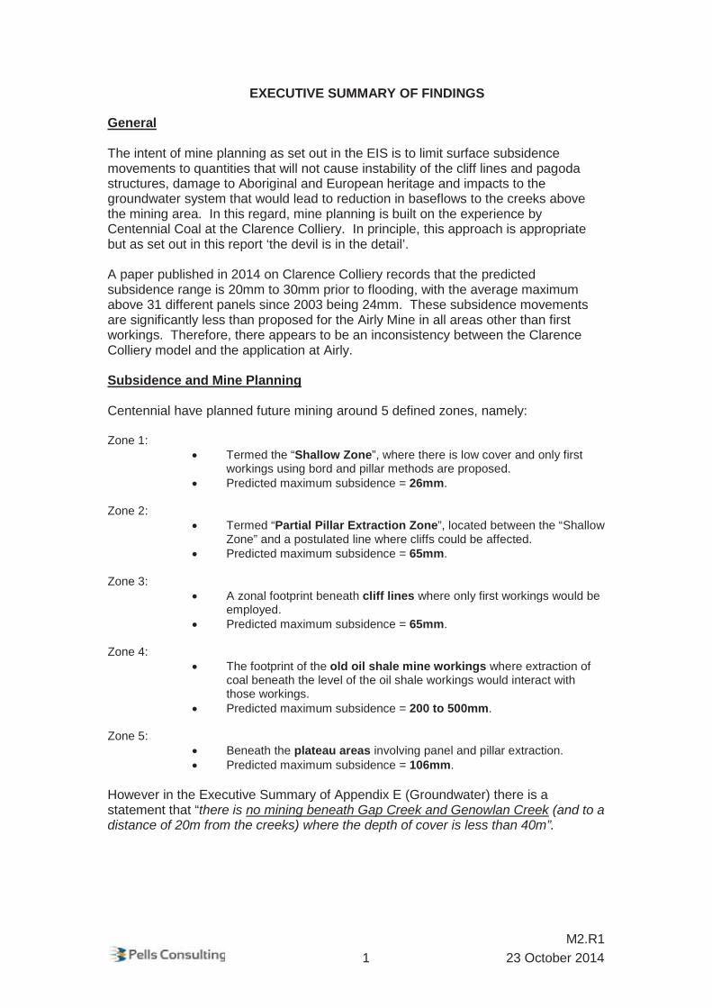


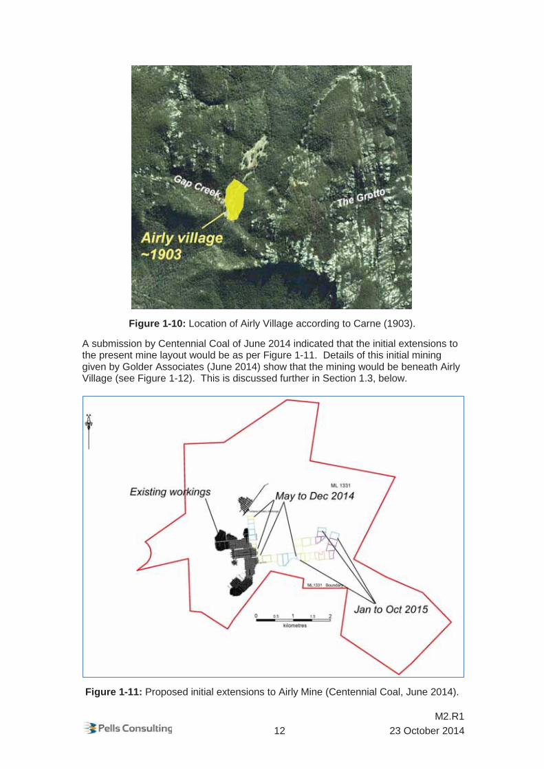


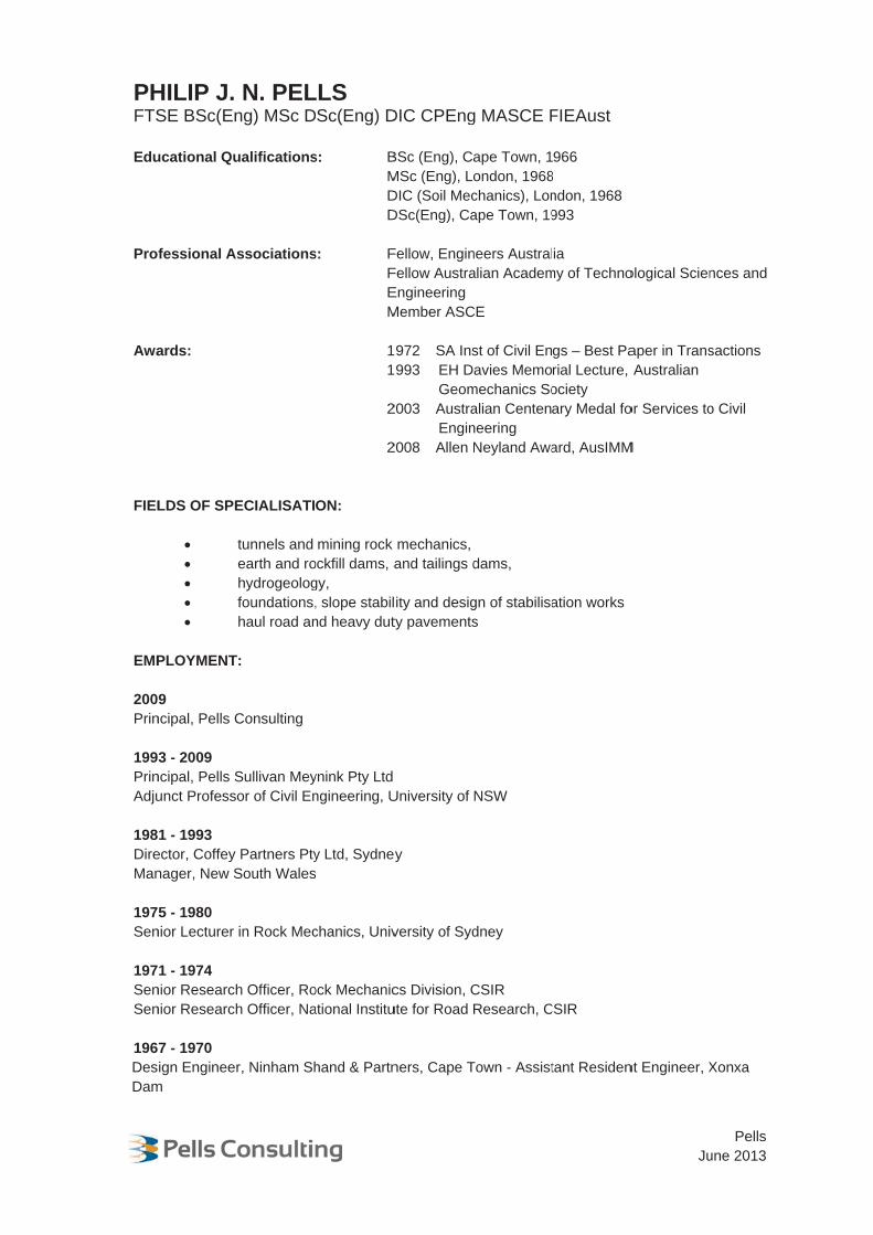


![MEMORANDUM FOR RESPONDENT - Murdoch … of Queensland Memorandum for Respondent vi British Foreign Marine Insurance Company v Samuel Sanday & Co [1916] 1 AC 650 Budgett v Binnington](https://img.pdfslide.us/doc/110x75/5affdb377f8b9a6a2e8bcc75/memorandum-for-respondent-murdoch-of-queensland-memorandum-for-respondent.jpg)