Embed Size (px)
Citation preview
Fraser Island (K'gari) World Heritage Area
Recreation AreaGreat Sandy National Park
Maryborough
Cooloola Recreation Area
Great Sandy Marine Park
South Pacific Ocean
HerveyBay
Rainbow Beach
FreshwaterDouble Island Point
Hook PointInskip Point
Elanda PointTewantin
Noosa Heads
Bruce Highway
Gympie
To Maroochydore
Sandy Cape
EurongCentral Station
Dundubara Moon Point
RiverHeads
50kmScale0
(Above) The stunning Fraser Island Great Walk meanders 90km from Dilli Village to Happy Valley; (below) Eli Creek boardwalk; (right) Wallum banksia (Banksia aemula) growing on coastal sand dune heath plain.
Photos: (above) © Ben Blanche; (below and background) © Lise Pedersen; (right) Adam Creed © Qld Govt
Photos: (above) © Lise Pedersen; (right) Jenna Tapply © Qld Govt
(Right) Pile Valley circuit; (far right) Be still and, like magic, Kreffts river turtles pop out of the tea-coloured waters as they swim past the Lake Allom viewing platform.
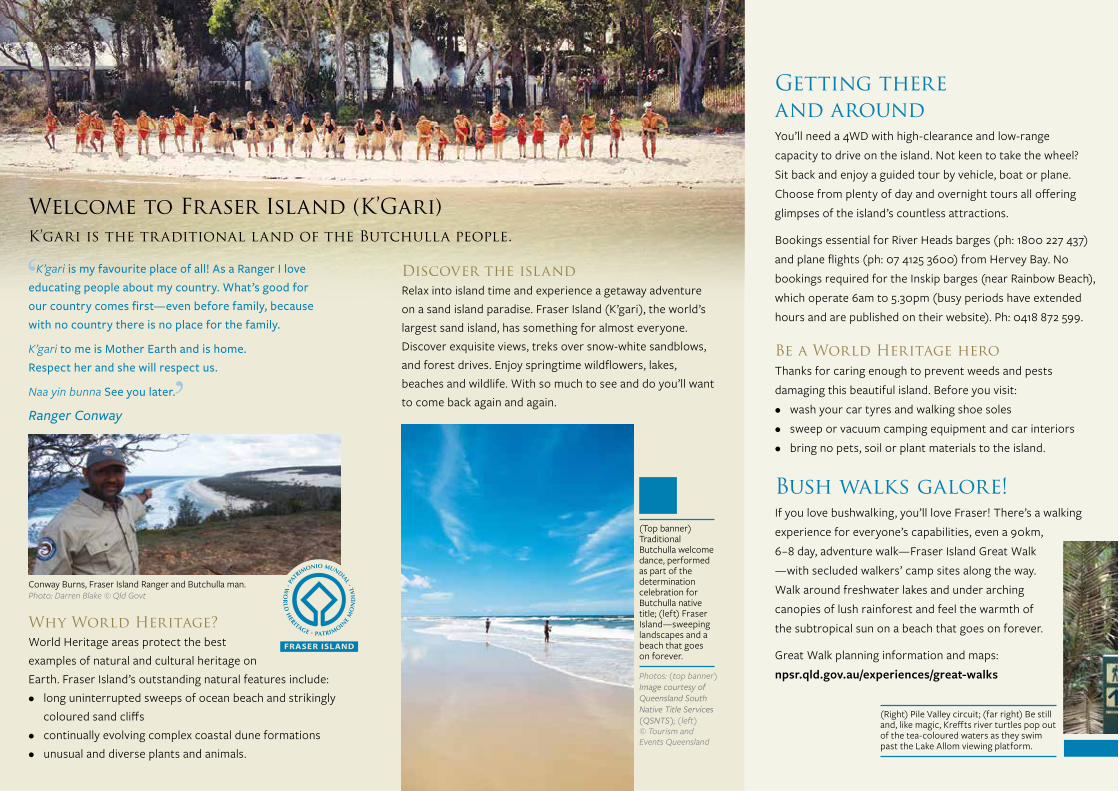
(Top banner) Traditional Butchulla welcome dance, performed as part of the determination celebration for Butchulla native title; (left) Fraser Island—sweeping landscapes and a beach that goes on forever.
Photos: (top banner) Image courtesy of Queensland South Native Title Services (QSNTS); (left) © Tourism and Events Queensland
Photo: Robert Ashdown
All photos © Queensland Government unless otherwise stated.Front cover photo: Lake McKenzie © Tourism and Events Queensland
©State of Queensland. BP2070 June 2016. Queensland Parks and Wildlife Service, Department of National Parks, Sport and Racing. Printed on eco-friendly paper to save energy and resources.
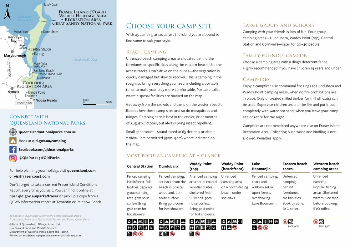
Connect with Queensland National Parks
queenslandnationalparks.com.au
Book at qld.gov.au/camping
facebook.com/qldnationalparks
@QldParks ; #QldParks
Welcome to Fraser Island (K’Gari) K’gari is the traditional land of the Butchulla people.
Why World Heritage? World Heritage areas protect the best examples of natural and cultural heritage on Earth. Fraser Island’s outstanding natural features include:• long uninterrupted sweeps of ocean beach and strikingly
coloured sand cliffs• continually evolving complex coastal dune formations• unusual and diverse plants and animals.
K’gari is my favourite place of all! As a Ranger I love educating people about my country. What’s good for our country comes first—even before family, because with no country there is no place for the family.
K’gari to me is Mother Earth and is home. Respect her and she will respect us.
Naa yin bunna See you later.
Ranger Conway
Conway Burns, Fraser Island Ranger and Butchulla man.Photo: Darren Blake © Qld Govt
Discover the islandRelax into island time and experience a getaway adventure on a sand island paradise. Fraser Island (K’gari), the world’s largest sand island, has something for almost everyone. Discover exquisite views, treks over snow-white sandblows, and forest drives. Enjoy springtime wildflowers, lakes, beaches and wildlife. With so much to see and do you’ll want to come back again and again.
For help planning your holiday, visit queensland.com or visitfrasercoast.com
Don’t forget to take a current Fraser Island Conditions Report every time you visit. You can find it online at npsr.qld.gov.au/parks/fraser or pick up a copy from a QPWS information centre at Tewantin or Rainbow Beach.
Getting there and aroundYou’ll need a 4WD with high-clearance and low-range capacity to drive on the island. Not keen to take the wheel? Sit back and enjoy a guided tour by vehicle, boat or plane. Choose from plenty of day and overnight tours all offering glimpses of the island’s countless attractions.
Bookings essential for River Heads barges (ph: 1800 227 437) and plane flights (ph: 07 4125 3600) from Hervey Bay. No bookings required for the Inskip barges (near Rainbow Beach), which operate 6am to 5.30pm (busy periods have extended hours and are published on their website). Ph: 0418 872 599.
Be a World Heritage heroThanks for caring enough to prevent weeds and pests damaging this beautiful island. Before you visit:• wash your car tyres and walking shoe soles• sweep or vacuum camping equipment and car interiors• bring no pets, soil or plant materials to the island.
Bush walks galore!If you love bushwalking, you’ll love Fraser! There’s a walking experience for everyone’s capabilities, even a 90km, 6–8 day, adventure walk—Fraser Island Great Walk —with secluded walkers’ camp sites along the way. Walk around freshwater lakes and under arching canopies of lush rainforest and feel the warmth of the subtropical sun on a beach that goes on forever.
Great Walk planning information and maps: npsr.qld.gov.au/experiences/great-walks
Rangers’ picksThere are more than 30 walks on Fraser Island you and your friends can enjoy. Here are some of the best.
Pile Valley 4km circuit. Class 4. Allow 2hrs from Central Station
Breathe ‘fresh air’ as you walk through rainforest and along crystal-clear Wanggoolba Creek silently flowing past rainforest giants.
Kirrar Sandblow 1.9km return. Class 3. Allow 1hr from eastern beach
See striking ‘sandscapes’ at Rainbow Gorge, where layers of ochre reds, yellows and browns swirl into the sand profiles creating earthy-coloured artpieces. The gorge opens up to Kirrar Sandblow, an awesome, lunar-like landscape.
Lake Allom 1.4km circuit. Class 2. Allow 1hr from Lake Allom day-use area (off Northern Forest scenic drive)
An easy stroll with picture-perfect water reflections mirroring the towering brushbox and satinay trees. On warm days the air is scented with the spicy fragrance emitted by the leaves of the carrol shrubs that grow close to shore.
Find out more ways to explore on foot—visit npsr.qld.gov.au/parks/fraser/walking-tracks
Walking track classification
Class 2
Formed track. May have gentle hills and some steps. Clearly signposted. No experience required.
Class 3
Formed track, some obstacles, 20km or less. May have short steep hills and many steps. Some experience recommended.
Class 4
Rough track. May be long and very steep with few directional signs. For experienced bushwalkers.
Choose your camp siteWith 45 camping areas across the island you are bound to
find some to suit your style.
Beach campingUnfenced beach camping areas are located behind the
foredunes at specific sites along the eastern beach. Use the
access tracks. Don’t drive on the dunes—the vegetation is
quickly damaged but slow to recover. This is camping in the
rough, so bring everything you need, including a portable
toilet to make your stay more comfortable. Portable toilet
waste disposal facilities are marked on the map.
Get away from the crowds and camp on the western beach.
Boaties love these camp sites and so do mosquitoes and
midges. Camping here is best in the cooler, drier months
of August–October, but always bring insect repellent.
Small generators—sound-rated at 65 decibels or about
2.0Kva—are permitted (9am–9pm) where indicated on
the map.
Large groups and schoolsCamping with your friends is lots of fun. Four group
camping areas—Dundubara, Waddy Point (top), Central
Station and Cornwells—cater for 20–40 people.
Family-friendly campingChoose a camping area with a dingo deterrent fence.
Highly recommended if you have children 14 years and under.
CampfiresEnjoy a campfire? Use communal fire rings at Dundubara and
Waddy Point camping areas, when no fire prohibitions are
in place. Only untreated milled timber (or mill off-cuts) can
be used. Supervise children around the fire and put it out
completely with water not sand, when you leave your camp
site or retire for the night.
Campfires are not permitted anywhere else on Fraser Island
Recreation Area. Collecting bush wood and kindling is not
allowed. Penalties apply.
Central StationDundubaraWaddy Point (top)
Waddy Point (beachfront)
Lake Boomanjin
Eastern beach zones
Western beach camping areas
Fenced camping in rainforest. Full facilities. Separate group camping area. 9pm noise curfew. Bring gold coins for hot showers.
Fenced camping, set back from the beach in coastal woodland. 9pm noise curfew. Bring gold coins for hot showers.
A fenced camping area set in coastal woodland sites sheltered from SE winds. 9pm noise curfew. Bring gold coins for hot showers.
Unfenced camping area on a north-facing beach, under she-oaks.
Fenced camping, (park and walk-in) set in open forest, overlooking Lake Boomanjin.
Unfenced camping behind foredunes. No facilities. Book by zone. BYO toilet.
Unfenced camping. Popular fishing areas. Sheltered waters. See map before booking. BYO toilet.
9am–9pm
9am–9pm
Most popular camping at a glance
Venture safelyMake your visit to Fraser Island memorable for all the right reasons.
Let dingoes live wildDingoes are protected by law on Fraser Island (K’gari) and are significant to Butchulla people. You might see these wild predatory animals any time of day or night. Follow these simple rules to stay safe around dingoes.
Be dingo-safe! NEVER feed dingoes. Always stay within arm’s reach of children, even small teenagers.
Walk in groups. Do not run or jog. Camp in fenced areas where possible. Lock up food stores and iceboxes (even on a boat). Never store food or food containers in tents. Secure all rubbish, fish and bait.
Report dingo interactions:• email: [email protected]• ph: (07) 4127 9150.
Look up and look outFraser’s eastern beach is Queensland’s sandiest national highway. Some parts are also a landing strip for authorised small planes. Give way to planes landing or taking off. Aircraft landing zones are clearly marked with cones and signs and ground crew will direct you if required.
Walkers on the beach cannot hear cars approaching over the sound of wind and waves. People, especially children, can move unexpectedly. Drivers, please remember that ‘slower is safer’ and all Queensland road rules apply.
Stay safe!• Never dive or jump into Lake Wabby or other lakes and
creeks—they are often more shallow than they look and have hidden obstacles. Spinal injuries have resulted from these actions.
• Do not run, slide or roll down sand dunes. They are steep and unstable. Spinal injuries have resulted from these actions.
• Do not swim in the ocean; rips and sharks are common and it’s not patrolled.
• Take extra care at Champagne Pools. Serious injuries have happened here.
• Where campfires are permitted, put your campfire out with water, not sand. Children have suffered terrible burns walking over fires covered with sand.
• Beach driving is best 2hrs either side of low tide. • Avoid night driving—obstacles and wash-outs are very
difficult to see especially when sea mists blow onshore.• Do not take trailers on inland roads in dry conditions.
Bogged vehicles can hold up traffic for hours. Be self sufficient with vehicle recovery gear. QPWS Rangers, if nearby, can offer some assistance, they cannot pull you free.
• Tune into local radio stations for weather updates.• Best walking conditions are in the cooler months from
May to September and in the cooler parts of the day, especially over sandblows.
• For the longer walks, let someone know where you’re going, when you plan to return and what to do if you fail to return.
• In case of bushfires, stay away from thick bushland, and stay low to the ground where the air is coolest.
PermitsBook your vehicle and camping permits online before your visit to avoid disappointment at qld.gov.au/camping
To From Class Distance & time
Best boardwalks
Eli Creek boardwalk
Eastern beach, Eli Creek 2 400m return
Allow 30mins
Wanggoolba Creek boardwalk
Central Station day-use area 2 700m circuit
Allow 30mins
Champagne Pools boardwalk Middle Rocks 3 700m return
Allow 30mins
Best circuit
Wun’gul Sandblow circuit Dundubara 4 5.5km
Allow 2.5hrs
Best lookouts
Lake Wabby lookout
Lake Wabby lookout car park, along Central Lakes scenic drive
3 900m return Allow 30mins
Knifeblade lookout
Small car park on Woralie Road, part of Northern Lakes scenic drive
3 1km return Allow 45mins
Dundonga Creek walk
Kingfisher Bay Resort 3 3km return
Allow 1.5hrs
Best lake walks
Basin Lake Central Station day-use area 4 5.6km return
Allow 3hrs
Lake Allom Lake Allom car park 2 1.4km circuit
Allow 1hr
Best long walks
Lake McKenzie Kingfisher Bay Resort 4 23.2km circuit
Allow 9hrs
Fraser Island Great Walk
Dilli Village or Happy Valley 4
90km one way Allow 6–8 days 8 walkers’ camps along the way
Best walks at a glance
Fraser Island (K’Gari)
World Heritage Area and Recreation Area
Great Sandy National Park
Discovery guide
Breathe refreshingly
Fraser Island (K'gari) World Heritage Area
Recreation AreaGreat Sandy National Park
Maryborough
Cooloola Recreation Area
Great Sandy Marine Park
South Pacific Ocean
HerveyBay
Rainbow Beach
FreshwaterDouble Island Point
Hook PointInskip Point
Elanda PointTewantin
Noosa Heads
Bruce Highway
Gympie
To Maroochydore
Sandy Cape
EurongCentral Station
Dundubara Moon Point
RiverHeads
50kmScale0
(Above) The stunning Fraser Island Great Walk meanders 90km from Dilli Village to Happy Valley; (below) Eli Creek boardwalk; (right) Wallum banksia (Banksia aemula) growing on coastal sand dune heath plain.
Photos: (above) © Ben Blanche; (below and background) © Lise Pedersen; (right) Adam Creed © Qld Govt
Photos: (above) © Lise Pedersen; (right) Jenna Tapply © Qld Govt
(Right) Pile Valley circuit; (far right) Be still and, like magic, Kreffts river turtles pop out of the tea-coloured waters as they swim past the Lake Allom viewing platform.
(Top banner) Traditional Butchulla welcome dance, performed as part of the determination celebration for Butchulla native title; (left) Fraser Island—sweeping landscapes and a beach that goes on forever.
Photos: (top banner) Image courtesy of Queensland South Native Title Services (QSNTS); (left) © Tourism and Events Queensland
Photo: Robert Ashdown
All photos © Queensland Government unless otherwise stated.Front cover photo: Lake McKenzie © Tourism and Events Queensland
©State of Queensland. BP2070 June 2016. Queensland Parks and Wildlife Service, Department of National Parks, Sport and Racing. Printed on eco-friendly paper to save energy and resources.
Connect with Queensland National Parks
queenslandnationalparks.com.au
Book at qld.gov.au/camping
facebook.com/qldnationalparks
@QldParks ; #QldParks
Welcome to Fraser Island (K’Gari) K’gari is the traditional land of the Butchulla people.
Why World Heritage? World Heritage areas protect the best examples of natural and cultural heritage on Earth. Fraser Island’s outstanding natural features include:• long uninterrupted sweeps of ocean beach and strikingly
coloured sand cliffs• continually evolving complex coastal dune formations• unusual and diverse plants and animals.
K’gari is my favourite place of all! As a Ranger I love educating people about my country. What’s good for our country comes first—even before family, because with no country there is no place for the family.
K’gari to me is Mother Earth and is home. Respect her and she will respect us.
Naa yin bunna See you later.
Ranger Conway
Conway Burns, Fraser Island Ranger and Butchulla man.Photo: Darren Blake © Qld Govt
Discover the islandRelax into island time and experience a getaway adventure on a sand island paradise. Fraser Island (K’gari), the world’s largest sand island, has something for almost everyone. Discover exquisite views, treks over snow-white sandblows, and forest drives. Enjoy springtime wildflowers, lakes, beaches and wildlife. With so much to see and do you’ll want to come back again and again.
For help planning your holiday, visit queensland.com or visitfrasercoast.com
Don’t forget to take a current Fraser Island Conditions Report every time you visit. You can find it online at npsr.qld.gov.au/parks/fraser or pick up a copy from a QPWS information centre at Tewantin or Rainbow Beach.
Getting there and aroundYou’ll need a 4WD with high-clearance and low-range capacity to drive on the island. Not keen to take the wheel? Sit back and enjoy a guided tour by vehicle, boat or plane. Choose from plenty of day and overnight tours all offering glimpses of the island’s countless attractions.
Bookings essential for River Heads barges (ph: 1800 227 437) and plane flights (ph: 07 4125 3600) from Hervey Bay. No bookings required for the Inskip barges (near Rainbow Beach), which operate 6am to 5.30pm (busy periods have extended hours and are published on their website). Ph: 0418 872 599.
Be a World Heritage heroThanks for caring enough to prevent weeds and pests damaging this beautiful island. Before you visit:• wash your car tyres and walking shoe soles• sweep or vacuum camping equipment and car interiors• bring no pets, soil or plant materials to the island.
Bush walks galore!If you love bushwalking, you’ll love Fraser! There’s a walking experience for everyone’s capabilities, even a 90km, 6–8 day, adventure walk—Fraser Island Great Walk —with secluded walkers’ camp sites along the way. Walk around freshwater lakes and under arching canopies of lush rainforest and feel the warmth of the subtropical sun on a beach that goes on forever.
Great Walk planning information and maps: npsr.qld.gov.au/experiences/great-walks
Rangers’ picksThere are more than 30 walks on Fraser Island you and your friends can enjoy. Here are some of the best.
Pile Valley 4km circuit. Class 4. Allow 2hrs from Central Station
Breathe ‘fresh air’ as you walk through rainforest and along crystal-clear Wanggoolba Creek silently flowing past rainforest giants.
Kirrar Sandblow 1.9km return. Class 3. Allow 1hr from eastern beach
See striking ‘sandscapes’ at Rainbow Gorge, where layers of ochre reds, yellows and browns swirl into the sand profiles creating earthy-coloured artpieces. The gorge opens up to Kirrar Sandblow, an awesome, lunar-like landscape.
Lake Allom 1.4km circuit. Class 2. Allow 1hr from Lake Allom day-use area (off Northern Forest scenic drive)
An easy stroll with picture-perfect water reflections mirroring the towering brushbox and satinay trees. On warm days the air is scented with the spicy fragrance emitted by the leaves of the carrol shrubs that grow close to shore.
Find out more ways to explore on foot—visit npsr.qld.gov.au/parks/fraser/walking-tracks
Walking track classification
Class 2
Formed track. May have gentle hills and some steps. Clearly signposted. No experience required.
Class 3
Formed track, some obstacles, 20km or less. May have short steep hills and many steps. Some experience recommended.
Class 4
Rough track. May be long and very steep with few directional signs. For experienced bushwalkers.
Choose your camp siteWith 45 camping areas across the island you are bound to
find some to suit your style.
Beach campingUnfenced beach camping areas are located behind the
foredunes at specific sites along the eastern beach. Use the
access tracks. Don’t drive on the dunes—the vegetation is
quickly damaged but slow to recover. This is camping in the
rough, so bring everything you need, including a portable
toilet to make your stay more comfortable. Portable toilet
waste disposal facilities are marked on the map.
Get away from the crowds and camp on the western beach.
Boaties love these camp sites and so do mosquitoes and
midges. Camping here is best in the cooler, drier months
of August–October, but always bring insect repellent.
Small generators—sound-rated at 65 decibels or about
2.0Kva—are permitted (9am–9pm) where indicated on
the map.
Large groups and schoolsCamping with your friends is lots of fun. Four group
camping areas—Dundubara, Waddy Point (top), Central
Station and Cornwells—cater for 20–40 people.
Family-friendly campingChoose a camping area with a dingo deterrent fence.
Highly recommended if you have children 14 years and under.
CampfiresEnjoy a campfire? Use communal fire rings at Dundubara and
Waddy Point camping areas, when no fire prohibitions are
in place. Only untreated milled timber (or mill off-cuts) can
be used. Supervise children around the fire and put it out
completely with water not sand, when you leave your camp
site or retire for the night.
Campfires are not permitted anywhere else on Fraser Island
Recreation Area. Collecting bush wood and kindling is not
allowed. Penalties apply.
Central StationDundubaraWaddy Point (top)
Waddy Point (beachfront)
Lake Boomanjin
Eastern beach zones
Western beach camping areas
Fenced camping in rainforest. Full facilities. Separate group camping area. 9pm noise curfew. Bring gold coins for hot showers.
Fenced camping, set back from the beach in coastal woodland. 9pm noise curfew. Bring gold coins for hot showers.
A fenced camping area set in coastal woodland sites sheltered from SE winds. 9pm noise curfew. Bring gold coins for hot showers.
Unfenced camping area on a north-facing beach, under she-oaks.
Fenced camping, (park and walk-in) set in open forest, overlooking Lake Boomanjin.
Unfenced camping behind foredunes. No facilities. Book by zone. BYO toilet.
Unfenced camping. Popular fishing areas. Sheltered waters. See map before booking. BYO toilet.
9am–9pm
9am–9pm
Most popular camping at a glance
Venture safelyMake your visit to Fraser Island memorable for all the right reasons.
Let dingoes live wildDingoes are protected by law on Fraser Island (K’gari) and are significant to Butchulla people. You might see these wild predatory animals any time of day or night. Follow these simple rules to stay safe around dingoes.
Be dingo-safe! NEVER feed dingoes. Always stay within arm’s reach of children, even small teenagers.
Walk in groups. Do not run or jog. Camp in fenced areas where possible. Lock up food stores and iceboxes (even on a boat). Never store food or food containers in tents. Secure all rubbish, fish and bait.
Report dingo interactions:• email: [email protected]• ph: (07) 4127 9150.
Look up and look outFraser’s eastern beach is Queensland’s sandiest national highway. Some parts are also a landing strip for authorised small planes. Give way to planes landing or taking off. Aircraft landing zones are clearly marked with cones and signs and ground crew will direct you if required.
Walkers on the beach cannot hear cars approaching over the sound of wind and waves. People, especially children, can move unexpectedly. Drivers, please remember that ‘slower is safer’ and all Queensland road rules apply.
Stay safe!• Never dive or jump into Lake Wabby or other lakes and
creeks—they are often more shallow than they look and have hidden obstacles. Spinal injuries have resulted from these actions.
• Do not run, slide or roll down sand dunes. They are steep and unstable. Spinal injuries have resulted from these actions.
• Do not swim in the ocean; rips and sharks are common and it’s not patrolled.
• Take extra care at Champagne Pools. Serious injuries have happened here.
• Where campfires are permitted, put your campfire out with water, not sand. Children have suffered terrible burns walking over fires covered with sand.
• Beach driving is best 2hrs either side of low tide. • Avoid night driving—obstacles and wash-outs are very
difficult to see especially when sea mists blow onshore.• Do not take trailers on inland roads in dry conditions.
Bogged vehicles can hold up traffic for hours. Be self sufficient with vehicle recovery gear. QPWS Rangers, if nearby, can offer some assistance, they cannot pull you free.
• Tune into local radio stations for weather updates.• Best walking conditions are in the cooler months from
May to September and in the cooler parts of the day, especially over sandblows.
• For the longer walks, let someone know where you’re going, when you plan to return and what to do if you fail to return.
• In case of bushfires, stay away from thick bushland, and stay low to the ground where the air is coolest.
PermitsBook your vehicle and camping permits online before your visit to avoid disappointment at qld.gov.au/camping
To From Class Distance & time
Best boardwalks
Eli Creek boardwalk
Eastern beach, Eli Creek 2 400m return
Allow 30mins
Wanggoolba Creek boardwalk
Central Station day-use area 2 700m circuit
Allow 30mins
Champagne Pools boardwalk Middle Rocks 3 700m return
Allow 30mins
Best circuit
Wun’gul Sandblow circuit Dundubara 4 5.5km
Allow 2.5hrs
Best lookouts
Lake Wabby lookout
Lake Wabby lookout car park, along Central Lakes scenic drive
3 900m return Allow 30mins
Knifeblade lookout
Small car park on Woralie Road, part of Northern Lakes scenic drive
3 1km return Allow 45mins
Dundonga Creek walk
Kingfisher Bay Resort 3 3km return
Allow 1.5hrs
Best lake walks
Basin Lake Central Station day-use area 4 5.6km return
Allow 3hrs
Lake Allom Lake Allom car park 2 1.4km circuit
Allow 1hr
Best long walks
Lake McKenzie Kingfisher Bay Resort 4 23.2km circuit
Allow 9hrs
Fraser Island Great Walk
Dilli Village or Happy Valley 4
90km one way Allow 6–8 days 8 walkers’ camps along the way
Best walks at a glance
Fraser Island (K’Gari)
World Heritage Area and Recreation Area
Great Sandy National Park
Discovery guide
Breathe refreshingly
Fraser Island (K'gari) World Heritage Area
Recreation AreaGreat Sandy National Park
Maryborough
Cooloola Recreation Area
Great Sandy Marine Park
South Pacific Ocean
HerveyBay
Rainbow Beach
FreshwaterDouble Island Point
Hook PointInskip Point
Elanda PointTewantin
Noosa Heads
Bruc
e High
way
Gympie
To Maroochydore
Sandy Cape
EurongCentral Station
DundubaraMoon Point
RiverHeads
50kmScale0
(Above) The stunning Fraser Island Great Walk meanders 90km from Dilli Village to Happy Valley; (below) Eli Creek boardwalk; (right) Wallum banksia (Banksia aemula) growing on coastal sand dune heath plain.
Photos: (above) © Ben Blanche; (below and background) © Lise Pedersen; (right) Adam Creed © Qld Govt
Photos: (above) © Lise Pedersen; (right) Jenna Tapply © Qld Govt
(Right) Pile Valley circuit; (far right) Be still and, like magic, Kreffts river turtles pop out of the tea-coloured waters as they swim past the Lake Allom viewing platform.
(Top banner) Traditional Butchulla welcome dance, performed as part of the determination celebration for Butchulla native title; (left) Fraser Island—sweeping landscapes and a beach that goes on forever.
Photos: (top banner) Image courtesy of Queensland South Native Title Services (QSNTS); (left) © Tourism and Events Queensland
Photo: Robert Ashdown
All photos © Queensland Government unless otherwise stated.Front cover photo: Lake McKenzie © Tourism and Events Queensland
©State of Queensland. BP2070 June 2016. Queensland Parks and Wildlife Service, Department of National Parks, Sport and Racing. Printed on eco-friendly paper to save energy and resources.
Connect with Queensland National Parks
queenslandnationalparks.com.au
Book at qld.gov.au/camping
facebook.com/qldnationalparks
@QldParks ; #QldParks
Welcome to Fraser Island (K’Gari) K’gari is the traditional land of the Butchulla people.
Why World Heritage? World Heritage areas protect the best examples of natural and cultural heritage on Earth. Fraser Island’s outstanding natural features include:• long uninterrupted sweeps of ocean beach and strikingly
coloured sand cliffs• continually evolving complex coastal dune formations• unusual and diverse plants and animals.
K’gari is my favourite place of all! As a Ranger I love educating people about my country. What’s good for our country comes first—even before family, because with no country there is no place for the family.
K’gari to me is Mother Earth and is home. Respect her and she will respect us.
Naa yin bunna See you later.
Ranger Conway
Conway Burns, Fraser Island Ranger and Butchulla man.Photo: Darren Blake © Qld Govt
Discover the islandRelax into island time and experience a getaway adventure on a sand island paradise. Fraser Island (K’gari), the world’s largest sand island, has something for almost everyone. Discover exquisite views, treks over snow-white sandblows, and forest drives. Enjoy springtime wildflowers, lakes, beaches and wildlife. With so much to see and do you’ll want to come back again and again.
For help planning your holiday, visit queensland.com or visitfrasercoast.com
Don’t forget to take a current Fraser Island Conditions Report every time you visit. You can find it online at npsr.qld.gov.au/parks/fraser or pick up a copy from a QPWS information centre at Tewantin or Rainbow Beach.
Getting there and aroundYou’ll need a 4WD with high-clearance and low-range capacity to drive on the island. Not keen to take the wheel? Sit back and enjoy a guided tour by vehicle, boat or plane. Choose from plenty of day and overnight tours all offering glimpses of the island’s countless attractions.
Bookings essential for River Heads barges (ph: 1800 227 437) and plane flights (ph: 07 4125 3600) from Hervey Bay. No bookings required for the Inskip barges (near Rainbow Beach), which operate 6am to 5.30pm (busy periods have extended hours and are published on their website). Ph: 0418 872 599.
Be a World Heritage heroThanks for caring enough to prevent weeds and pests damaging this beautiful island. Before you visit:• wash your car tyres and walking shoe soles• sweep or vacuum camping equipment and car interiors• bring no pets, soil or plant materials to the island.
Bush walks galore!If you love bushwalking, you’ll love Fraser! There’s a walking experience for everyone’s capabilities, even a 90km, 6–8 day, adventure walk—Fraser Island Great Walk —with secluded walkers’ camp sites along the way. Walk around freshwater lakes and under arching canopies of lush rainforest and feel the warmth of the subtropical sun on a beach that goes on forever.
Great Walk planning information and maps: npsr.qld.gov.au/experiences/great-walks
Rangers’ picksThere are more than 30 walks on Fraser Island you and your friends can enjoy. Here are some of the best.
Pile Valley 4km circuit. Class 4. Allow 2hrs from Central Station
Breathe ‘fresh air’ as you walk through rainforest and along crystal-clear Wanggoolba Creek silently flowing past rainforest giants.
Kirrar Sandblow 1.9km return. Class 3. Allow 1hr from eastern beach
See striking ‘sandscapes’ at Rainbow Gorge, where layers of ochre reds, yellows and browns swirl into the sand profiles creating earthy-coloured artpieces. The gorge opens up to Kirrar Sandblow, an awesome, lunar-like landscape.
Lake Allom 1.4km circuit. Class 2. Allow 1hr from Lake Allom day-use area (off Northern Forest scenic drive)
An easy stroll with picture-perfect water reflections mirroring the towering brushbox and satinay trees. On warm days the air is scented with the spicy fragrance emitted by the leaves of the carrol shrubs that grow close to shore.
Find out more ways to explore on foot—visit npsr.qld.gov.au/parks/fraser/walking-tracks
Walking track classification
Class 2
Formed track. May have gentle hills and some steps. Clearly signposted. No experience required.
Class 3
Formed track, some obstacles, 20km or less. May have short steep hills and many steps. Some experience recommended.
Class 4
Rough track. May be long and very steep with few directional signs. For experienced bushwalkers.
Choose your camp siteWith 45 camping areas across the island you are bound to
find some to suit your style.
Beach campingUnfenced beach camping areas are located behind the
foredunes at specific sites along the eastern beach. Use the
access tracks. Don’t drive on the dunes—the vegetation is
quickly damaged but slow to recover. This is camping in the
rough, so bring everything you need, including a portable
toilet to make your stay more comfortable. Portable toilet
waste disposal facilities are marked on the map.
Get away from the crowds and camp on the western beach.
Boaties love these camp sites and so do mosquitoes and
midges. Camping here is best in the cooler, drier months
of August–October, but always bring insect repellent.
Small generators—sound-rated at 65 decibels or about
2.0Kva—are permitted (9am–9pm) where indicated on
the map.
Large groups and schoolsCamping with your friends is lots of fun. Four group
camping areas—Dundubara, Waddy Point (top), Central
Station and Cornwells—cater for 20–40 people.
Family-friendly campingChoose a camping area with a dingo deterrent fence.
Highly recommended if you have children 14 years and under.
CampfiresEnjoy a campfire? Use communal fire rings at Dundubara and
Waddy Point camping areas, when no fire prohibitions are
in place. Only untreated milled timber (or mill off-cuts) can
be used. Supervise children around the fire and put it out
completely with water not sand, when you leave your camp
site or retire for the night.
Campfires are not permitted anywhere else on Fraser Island
Recreation Area. Collecting bush wood and kindling is not
allowed. Penalties apply.
Central Station DundubaraWaddy Point (top)
Waddy Point (beachfront)
Lake Boomanjin
Eastern beach zones
Western beach camping areas
Fenced camping in rainforest. Full facilities. Separate group camping area. 9pm noise curfew. Bring gold coins for hot showers.
Fenced camping, set back from the beach in coastal woodland. 9pm noise curfew. Bring gold coins for hot showers.
A fenced camping area set in coastal woodland sites sheltered from SE winds. 9pm noise curfew. Bring gold coins for hot showers.
Unfenced camping area on a north-facing beach, under she-oaks.
Fenced camping, (park and walk-in) set in open forest, overlooking Lake Boomanjin.
Unfenced camping behind foredunes. No facilities. Book by zone. BYO toilet.
Unfenced camping. Popular fishing areas. Sheltered waters. See map before booking. BYO toilet.
9am–9pm
9am–9pm
Most popular camping at a glance
Venture safelyMake your visit to Fraser Island memorable for all the right reasons.
Let dingoes live wildDingoes are protected by law on Fraser Island (K’gari) and are significant to Butchulla people. You might see these wild predatory animals any time of day or night. Follow these simple rules to stay safe around dingoes.
Be dingo-safe! NEVER feed dingoes. Always stay within arm’s reach of children, even small teenagers.
Walk in groups. Do not run or jog. Camp in fenced areas where possible. Lock up food stores and iceboxes (even on a boat). Never store food or food containers in tents. Secure all rubbish, fish and bait.
Report dingo interactions:• email: [email protected]• ph: (07) 4127 9150.
Look up and look outFraser’s eastern beach is Queensland’s sandiest national highway. Some parts are also a landing strip for authorised small planes. Give way to planes landing or taking off. Aircraft landing zones are clearly marked with cones and signs and ground crew will direct you if required.
Walkers on the beach cannot hear cars approaching over the sound of wind and waves. People, especially children, can move unexpectedly. Drivers, please remember that ‘slower is safer’ and all Queensland road rules apply.
Stay safe!• Never dive or jump into Lake Wabby or other lakes and
creeks—they are often more shallow than they look and have hidden obstacles. Spinal injuries have resulted from these actions.
• Do not run, slide or roll down sand dunes. They are steep and unstable. Spinal injuries have resulted from these actions.
• Do not swim in the ocean; rips and sharks are common and it’s not patrolled.
• Take extra care at Champagne Pools. Serious injuries have happened here.
• Where campfires are permitted, put your campfire out with water, not sand. Children have suffered terrible burns walking over fires covered with sand.
• Beach driving is best 2hrs either side of low tide. • Avoid night driving—obstacles and wash-outs are very
difficult to see especially when sea mists blow onshore.• Do not take trailers on inland roads in dry conditions.
Bogged vehicles can hold up traffic for hours. Be self sufficient with vehicle recovery gear. QPWS Rangers, if nearby, can offer some assistance, they cannot pull you free.
• Tune into local radio stations for weather updates.• Best walking conditions are in the cooler months from
May to September and in the cooler parts of the day, especially over sandblows.
• For the longer walks, let someone know where you’re going, when you plan to return and what to do if you fail to return.
• In case of bushfires, stay away from thick bushland, and stay low to the ground where the air is coolest.
PermitsBook your vehicle and camping permits online before your visit to avoid disappointment at qld.gov.au/camping
ToFromClassDistance & time
Best boardwalks
Eli Creek boardwalk
Eastern beach, Eli Creek2400m return
Allow 30mins
Wanggoolba Creek boardwalk
Central Station day-use area2700m circuit
Allow 30mins
Champagne Pools boardwalkMiddle Rocks3700m return
Allow 30mins
Best circuit
Wun’gul Sandblow circuitDundubara 45.5km
Allow 2.5hrs
Best lookouts
Lake Wabby lookout
Lake Wabby lookout car park, along Central Lakes scenic drive
3900m return Allow 30mins
Knifeblade lookout
Small car park on Woralie Road, part of Northern Lakes scenic drive
31km return Allow 45mins
Dundonga Creek walk
Kingfisher Bay Resort33km return
Allow 1.5hrs
Best lake walks
Basin LakeCentral Station day-use area 45.6km return
Allow 3hrs
Lake AllomLake Allom car park2 1.4km circuit
Allow 1hr
Best long walks
Lake McKenzieKingfisher Bay Resort 423.2km circuit
Allow 9hrs
Fraser Island Great Walk
Dilli Village or Happy Valley4
90km one way Allow 6–8 days 8 walkers’ camps along the way
Best walks at a glance
Fraser Island (K’Gari)
World Heritage Area and Recreation Area
Great Sandy National Park
Discovery guide
Breathe refreshingly
oct 2016
prin
ted june 2016
Wathumba
RiverHeads
Hervey Bay
Dilli Village walk
Inskip Point
Bullock Pointboat ramp
Kingfisher Bay
Red Canyon
North Ngkala rocks
Browns rocks
South Ngkala rocks
Middle Rocks
Waddy Point
Indian Head
The Pinnacles
YidneyRocks
Kirrar Sandblow
PoyunganRocks
Lake Boomanjin
Lake Benaroon
Lake Birrabeen
Lake Garawongera
Sandy Cape
LakeBowarrady
Wun’gulSandblow
Ungowa
To Rainbow Beach
WoralieCreek
Coongul Creek
Bowarrady Creek
Awinya Creek
Moon Point
Great SandyMarine Park
CorroboreeBeach
Teebing(Wathumba
Spit)
Platypus Bay
Rooney Point
South Pacific Ocean
South Pacific Ocean
Puth
oo C
reek
Coongul Creek
Woralie Creek
Bowarrady Creek
Aw
inya Ck
Towoi Creek
Lake Wabby
Lake McKenzie
Happy Valley
Dundubara
Cathedral Beach
K’gari
Maheno Wreck
Eli Creek
Moon Point
Great Sandy Strait
Great Sandy Strait
Dilli Village
Eurong
Central Station
Wanggoolba Creekbarge landing site
Urang Creek
GarrysAnchorage
Hook Point
Ocean Lake
Orange Creek
Orchid Beach
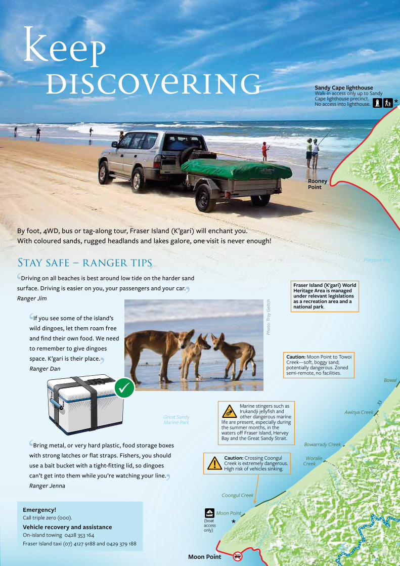
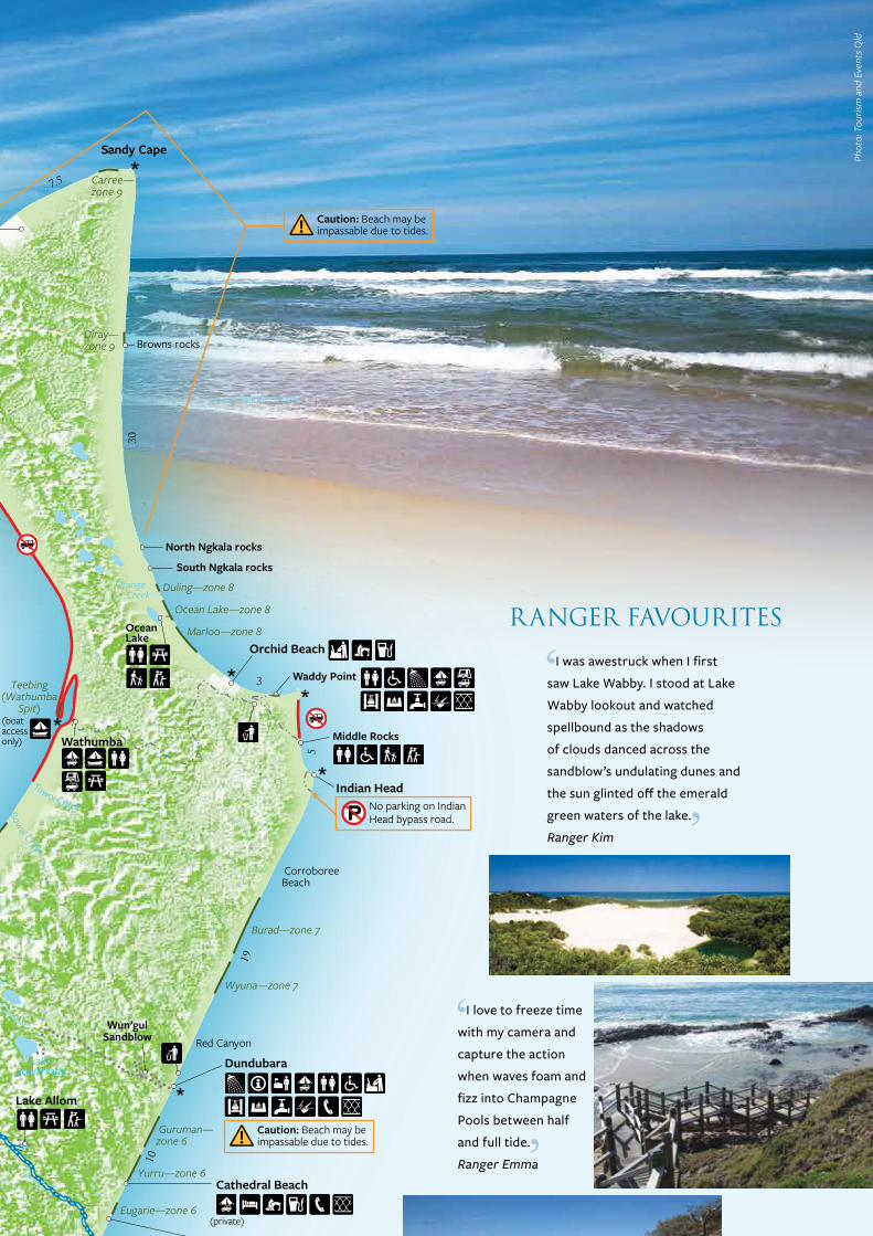
Sandy Cape lighthouseWalk-in access only up to Sandy Cape lighthouse precinct. No access into lighthouse.
No parking on IndianHead bypass road.
18km beach access ramp
11km beach access ramp
Caution: Approach with caution, may be impassable on higher tides.
Caution: Moon Point to Towoi Creek—soft, boggy sand; potentially dangerous. Zoned semi-remote, no facilities.
Caution: Crossing Coongul Creek is extremely dangerous. High risk of vehicles sinking.
Warning: estuarine crocodiles have been sighted in Great Sandy Strait. Be croc wise. Stay back from the water’s edge.
* Fraser Island Great Walk topographic map enquiries to npsr.qld.gov.au/parks/fraser
(walkers)
(walkers)
(walkers)
(walkers)
(walkers)
(walkers)
Lake Allom
Hook PointInland Road
(boataccessonly)
Campfires are prohibited on QPWS managed areas of Fraser Island, except in fire rings at Dundubara and Waddy Point.
Fraser Island (K'gari) World Heritage Area is managed under relevant legislations as a recreation area and a national park.
9am–9pm
(boataccessonly)
Bowal Creek
(boataccessonly)
To Maryborough
Wang goolba Creek
(walkers)
9am–9pm
(walkers)
(private)
(private)
(private)
Urangan
Warning: Do not swim in the ocean; it is unpatrolled and there are rips and sharks.
Hammerstone Sandblow
Caution: Beach may be impassable due to tides.
5
19
10
11
11
5
20
33
30
7.5
14
3
10.5
10.5
11
One Tree Rocks—zone 2
Wongai—zone 1
Winnam”—zone 3
Poyungan—zone 3
Gabala—zone 2
Cornwells—zone 2
Eli—zone 4
Guluri—zone 4
Wyuna—zone 7
Guruman—zone 6
Yurru—zone 6
Eugarie—zone 6
Wahba—zone 5
Maheno—zone 5
Burad—zone 7
Diray—zone 9
Carree—zone 9
Duling—zone 8
Midyim
Dulara
Govi—zone 1
Garulim
CoolooloiCreek
Marloo—zone 8
Ocean Lake—zone 8
Bowal
20km105 15Scale0
LegendFraser Island Recreation Areapart of Great Sandy National Park
Other lands
Waterway
Inland sand track
Walking track
No beach drivingFraser Island Great Walktopographic map needed *Vehicular barge route
Beach camping area
Distance (kilometres)
QPWS information
Ranger station
Bush camping—walkers
4WD-based camping
Bush camping—boat access
Boat rampOff-road camper trailers(or high clearance trailers)Private accomodation
Shop, gas, ice
Restaurant
Fuel
Toilet
Toilet—wheelchair access
Waste transfer station
Drinking water
Telephone
Shower
Picnic table
Sheltered picnic table
Gas barbecue
Dingo-deterrent fencing
Communal fire ring
Short or easy walking track
Viewpoint
Lookout
Barge landing
Police station
Ambulance
Wreck
Lighthouse
Dishwashing area
Portable toilet waste disposal facilityGenerators permitted
Water—treat before drinking
Submerged vehicle risk
Be croc wise
Marine stingers
No fires
No vehicle access
No campervanning
No swimming
No parking
Generator use prohibited
Caution: Beach may be impassable due to tides.
Caution: Beach may be impassable due to tides.
Marine stingers such as Irukandji jellyfish and other dangerous marine life are present, especially during the summer months, in the waters off Fraser Island, Hervey Bay and the Great Sandy Strait.
By foot, 4WD, bus or tag-along tour, Fraser Island (K’gari) will enchant you. With coloured sands, rugged headlands and lakes galore, one visit is never enough!
Keep discovering
Drive Distance Features Extra hints
Central Lakes scenic drive Start at Central Station and head north
27.2km allow 3hrs
Through tall forest and open banksia woodland to eastern beach with a stop at Lake Wabby Lookout.
Peak visitor numbers between 10am–3pm daily. Consider car pooling with others in your group to improve chances of getting a car park.
Southern Lakes scenic drive 27.6km allow 3hrs
Through scribbly gums and banksia to lakes Birrabeen and Boomanjin.
Not suitable for vehicles towing trailers or camper trailers.
Lake Garawongera scenic drive 19km allow 2hrs
A remote rough drive through tall closed forest with a stop at tannin-stained Lake Garawongera. Head to Poyungan Valley and back to the eastern beach.
Experienced four-wheel drivers in high clearance 4WDs only.
Good recovery and communication equipment essential. No mobile phone reception. Sections may be overgrown or blocked by recent tree falls.
Northern Forests scenic drive
42.4km allow 4hrs
Remote driving experience through Yidney Scrub’s huge brush box and kauri trees. Short walk at Lake Allom and great viewpoint at Knifeblade Sandblow and finish near the ochre red sandcliffs at The Pinnacles.
Experienced four-wheel drivers in high clearance 4WDs only.
Good recovery and communication equipment essential. No mobile phone reception. Sections may be overgrown or blocked by recent tree falls.
Scenic drives at a glanceDrive times vary depending on track conditions and your driving ability. Always allow extra time for stops and drive along the beach around low tide.
Phot
o: T
ouris
m a
nd E
vent
s Qld
Emergency!Call triple zero (000).
Vehicle recovery and assistanceOn-island towing 0428 353 164Fraser Island taxi (07) 4127 9188 and 0429 379 188
RANGER FAVOURITES
Stay safe – ranger tipsDriving on all beaches is best around low tide on the harder sand
surface. Driving is easier on you, your passengers and your car.
Ranger Jim
If you see some of the island’s
wild dingoes, let them roam free
and find their own food. We need
to remember to give dingoes
space. K’gari is their place.
Ranger Dan
Bring metal, or very hard plastic, food storage boxes
with strong latches or flat straps. Fishers, you should
use a bait bucket with a tight-fitting lid, so dingoes
can’t get into them while you’re watching your line.
Ranger Jenna
What diversity! Stingrays, sharks,
dolphins, and in spring, whales
cruising around Hervey Bay.
Ranger Sven
I love to freeze time
with my camera and
capture the action
when waves foam and
fizz into Champagne
Pools between half
and full tide.
Ranger Emma
My favourite?
Eli Creek—a great
cooling off place
for families!
Ranger Jason
On days off I love to join
my mates for a bit of fishing.
We throw our catch straight
onto the barbecue and
savour the fresh sea taste.
Ranger Daniel
Photos: (top to bottom) Briony Masters © Qld Govt; © Qld Govt; © Lise Pedersen; © Qld Govt; © Tourism and Events Qld
Phot
o: T
roy
Gel
tch I was awestruck when I first
saw Lake Wabby. I stood at Lake
Wabby lookout and watched
spellbound as the shadows
of clouds danced across the
sandblow’s undulating dunes and
the sun glinted off the emerald
green waters of the lake.
Ranger Kim
Wathumba
RiverHeads
Hervey Bay
Dilli Village walk
Inskip Point
Bullock Pointboat ramp
Kingfisher Bay
Red Canyon
North Ngkala rocks
Browns rocks
South Ngkala rocks
Middle Rocks
Waddy Point
Indian Head
The Pinnacles
YidneyRocks
Kirrar Sandblow
PoyunganRocks
Lake Boomanjin
Lake Benaroon
Lake Birrabeen
Lake Garawongera
Sandy Cape
LakeBowarrady
Wun’gulSandblow
Ungowa
To Rainbow Beach
WoralieCreek
Coongul Creek
Bowarrady Creek
Awinya Creek
Moon Point
Great SandyMarine Park
CorroboreeBeach
Teebing(Wathumba
Spit)
Platypus Bay
Rooney Point
South Pacific Ocean
South Pacific Ocean
Puth
oo C
reek
Coongul Creek
Woralie Creek
Bowarrady Creek
Aw
inya Ck
Towoi Creek
Lake Wabby
Lake McKenzie
Happy Valley
Dundubara
Cathedral Beach
K’gari
Maheno Wreck
Eli Creek
Moon Point
Great Sandy Strait
Great Sandy Strait
Dilli Village
Eurong
Central Station
Wanggoolba Creekbarge landing site
Urang Creek
GarrysAnchorage
Hook Point
Ocean Lake
Orange Creek
Orchid Beach
Sandy Cape lighthouseWalk-in access only up to Sandy Cape lighthouse precinct. No access into lighthouse.
No parking on IndianHead bypass road.
18km beach access ramp
11km beach access ramp
Caution: Approach with caution, may be impassable on higher tides.
Caution: Moon Point to Towoi Creek—soft, boggy sand; potentially dangerous. Zoned semi-remote, no facilities.
Caution: Crossing Coongul Creek is extremely dangerous. High risk of vehicles sinking.
Warning: estuarine crocodiles have been sighted in Great Sandy Strait. Be croc wise. Stay back from the water’s edge.
* Fraser Island Great Walk topographic map enquiries to npsr.qld.gov.au/parks/fraser
(walkers)
(walkers)
(walkers)
(walkers)
(walkers)
(walkers)
Lake Allom
Hook PointInland Road
(boataccessonly)
Campfires are prohibited on QPWS managed areas of Fraser Island, except in fire rings at Dundubara and Waddy Point.
Fraser Island (K'gari) World Heritage Area is managed under relevant legislations as a recreation area and a national park.
9am–9pm
(boataccessonly)
Bowal Creek
(boataccessonly)
To Maryborough
Wang goolba Creek
(walkers)
9am–9pm
(walkers)
(private)
(private)
(private)
Urangan
Warning: Do not swim in the ocean; it is unpatrolled and there are rips and sharks.
Hammerstone Sandblow
Caution: Beach may be impassable due to tides.
5
19
10
11
11
5
20
33
30
7.5
14
3
10.5
10.5
11
One Tree Rocks—zone 2
Wongai—zone 1
Winnam”—zone 3
Poyungan—zone 3
Gabala—zone 2
Cornwells—zone 2
Eli—zone 4
Guluri—zone 4
Wyuna—zone 7
Guruman—zone 6
Yurru—zone 6
Eugarie—zone 6
Wahba—zone 5
Maheno—zone 5
Burad—zone 7
Diray—zone 9
Carree—zone 9
Duling—zone 8
Midyim
Dulara
Govi—zone 1
Garulim
CoolooloiCreek
Marloo—zone 8
Ocean Lake—zone 8
Bowal
20km105 15Scale0
LegendFraser Island Recreation Areapart of Great Sandy National Park
Other lands
Waterway
Inland sand track
Walking track
No beach drivingFraser Island Great Walktopographic map needed *Vehicular barge route
Beach camping area
Distance (kilometres)
QPWS information
Ranger station
Bush camping—walkers
4WD-based camping
Bush camping—boat access
Boat rampOff-road camper trailers(or high clearance trailers)Private accomodation
Shop, gas, ice
Restaurant
Fuel
Toilet
Toilet—wheelchair access
Waste transfer station
Drinking water
Telephone
Shower
Picnic table
Sheltered picnic table
Gas barbecue
Dingo-deterrent fencing
Communal fire ring
Short or easy walking track
Viewpoint
Lookout
Barge landing
Police station
Ambulance
Wreck
Lighthouse
Dishwashing area
Portable toilet waste disposal facilityGenerators permitted
Water—treat before drinking
Submerged vehicle risk
Be croc wise
Marine stingers
No fires
No vehicle access
No campervanning
No swimming
No parking
Generator use prohibited
Caution: Beach may be impassable due to tides.
Caution: Beach may be impassable due to tides.
Marine stingers such as Irukandji jellyfish and other dangerous marine life are present, especially during the summer months, in the waters off Fraser Island, Hervey Bay and the Great Sandy Strait.
By foot, 4WD, bus or tag-along tour, Fraser Island (K’gari) will enchant you. With coloured sands, rugged headlands and lakes galore, one visit is never enough!
Keep discovering
Drive Distance Features Extra hints
Central Lakes scenic drive Start at Central Station and head north
27.2km allow 3hrs
Through tall forest and open banksia woodland to eastern beach with a stop at Lake Wabby Lookout.
Peak visitor numbers between 10am–3pm daily. Consider car pooling with others in your group to improve chances of getting a car park.
Southern Lakes scenic drive 27.6km allow 3hrs
Through scribbly gums and banksia to lakes Birrabeen and Boomanjin.
Not suitable for vehicles towing trailers or camper trailers.
Lake Garawongera scenic drive 19km allow 2hrs
A remote rough drive through tall closed forest with a stop at tannin-stained Lake Garawongera. Head to Poyungan Valley and back to the eastern beach.
Experienced four-wheel drivers in high clearance 4WDs only.
Good recovery and communication equipment essential. No mobile phone reception. Sections may be overgrown or blocked by recent tree falls.
Northern Forests scenic drive
42.4km allow 4hrs
Remote driving experience through Yidney Scrub’s huge brush box and kauri trees. Short walk at Lake Allom and great viewpoint at Knifeblade Sandblow and finish near the ochre red sandcliffs at The Pinnacles.
Experienced four-wheel drivers in high clearance 4WDs only.
Good recovery and communication equipment essential. No mobile phone reception. Sections may be overgrown or blocked by recent tree falls.
Scenic drives at a glanceDrive times vary depending on track conditions and your driving ability. Always allow extra time for stops and drive along the beach around low tide.
Phot
o: T
ouris
m a
nd E
vent
s Qld
Emergency!Call triple zero (000).
Vehicle recovery and assistanceOn-island towing 0428 353 164Fraser Island taxi (07) 4127 9188 and 0429 379 188
RANGER FAVOURITES
Stay safe – ranger tipsDriving on all beaches is best around low tide on the harder sand
surface. Driving is easier on you, your passengers and your car.
Ranger Jim
If you see some of the island’s
wild dingoes, let them roam free
and find their own food. We need
to remember to give dingoes
space. K’gari is their place.
Ranger Dan
Bring metal, or very hard plastic, food storage boxes
with strong latches or flat straps. Fishers, you should
use a bait bucket with a tight-fitting lid, so dingoes
can’t get into them while you’re watching your line.
Ranger Jenna
What diversity! Stingrays, sharks,
dolphins, and in spring, whales
cruising around Hervey Bay.
Ranger Sven
I love to freeze time
with my camera and
capture the action
when waves foam and
fizz into Champagne
Pools between half
and full tide.
Ranger Emma
My favourite?
Eli Creek—a great
cooling off place
for families!
Ranger Jason
On days off I love to join
my mates for a bit of fishing.
We throw our catch straight
onto the barbecue and
savour the fresh sea taste.
Ranger Daniel
Photos: (top to bottom) Briony Masters © Qld Govt; © Qld Govt; © Lise Pedersen; © Qld Govt; © Tourism and Events Qld
Phot
o: T
roy
Gel
tch I was awestruck when I first
saw Lake Wabby. I stood at Lake
Wabby lookout and watched
spellbound as the shadows
of clouds danced across the
sandblow’s undulating dunes and
the sun glinted off the emerald
green waters of the lake.
Ranger Kim
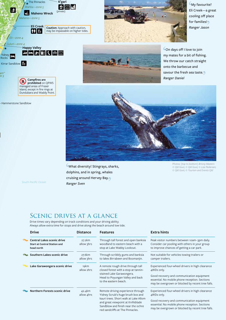