Embed Size (px)
Citation preview
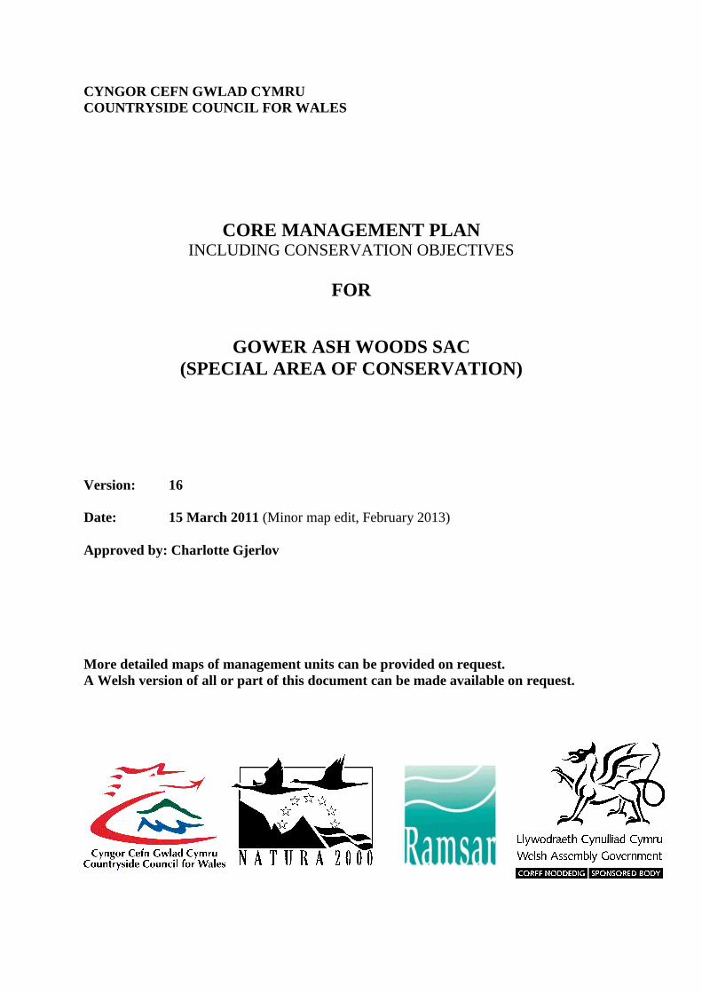
CYNGOR CEFN GWLAD CYMRU COUNTRYSIDE COUNCIL FOR WALES
CORE MANAGEMENT PLAN INCLUDING CONSERVATION OBJECTIVES
FOR
GOWER ASH WOODS SAC (SPECIAL AREA OF CONSERVATION)
Version: 16 Date: 15 March 2011 (Minor map edit, February 2013) Approved by: Charlotte Gjerlov More detailed maps of management units can be provided on request. A Welsh version of all or part of this document can be made available on request.
2
CONTENTS Preface: Purpose of this document 1. Vision for the Site 2. Site Description
2.1 Area and Designations Covered by this Plan 2.2 Outline Description 2.3 Outline of Past and Current Management 2.4 Management Units
3. The Special Features
3.1 Confirmation of Special Features 3.2 Special Features and Management Units
4. Conservation Objectives Background to Conservation Objectives 4.1 Conservation Objective for Feature 1:
Tilio-Acerion forests of slopes, screes and ravines
4.2 Conservation Objective for Feature 2: Alluvial forests with Alnus glutinosa and Fraxinus excelsior
5. Assessment of Conservation Status and Management Requirements:
5.1 Conservation Status and Management Requirements of Feature 1: Tilio-Acerion forests of slopes, screes and ravines
5.2 Conservation Status and Management Requirements of Feature 2: Alluvial forests with Alnus glutinosa and Fraxinus excelsior
6. Action Plan: Summary 7. Glossary 8. References and Annex PREFACE This document provides the main elements of CCW’s management plan for the site named. It sets out what needs to be achieved on the site, the results of monitoring and advice on the action required. This document is made available through CCW’s web site and may be revised in response to changing circumstances or new information. This is a technical document that supplements summary information on the web site. One of the key functions of this document is to provide CCW’s statement of the Conservation Objectives for the relevant Natura 2000 site. This is required to implement the Conservation (Natural Habitats, &c.) Regulations 1994, as amended (Section 4). As a matter of Welsh Assembly Government Policy, the provisions of those regulations are also to be applied to Ramsar sites in Wales.

3
1. VISION FOR THE SITE
This is a descriptive overview of what needs to be achieved for conservation on the site. It brings together and summarises the Conservation Objectives (part 4) into a single, integrated statement about the site: The steep sided valleys found across most of the site will be covered with woodland dominated by ash. On rocky slopes, a rich ground flora of dog’s mercury, hart’s tongue fern and ramsons will be found amongst fallen trees left on the ground providing homes for invertebrates and fungi. The steep slopes prevent the canopy trees reaching full size. Amongst the canopy ash will dominate, with other species such as field maple, oak and sycamore also present. A shrub layer of hazel, hawthorn, spindle and saplings of ash will fill the spaces between the ground flora and the canopy, while mosses and hart’s tongue fern cover limestone boulders that pepper the ground. The ground flora on the slopes and on the flatter ground will continue to be full of colour in the spring, with bluebells and ransoms providing a haze of blue and white. As the leaves of the trees in the canopy and shrub layer emerge, the colours of the ground flora change as the bluebells and ransom leaves turn yellow and wilt. There will be mature rotting trees, standing and fallen. Young trees will grow in the ground flora and shrub layer ready to take the place of a fallen tree. Some uncommon vascular plants can be found in the woods these include herb Paris, purple gromwell, butcher’s broom and spurge laurel. The varied structure will sustain populations of mammals and birds. On the flatter areas fallen planted conifers support mosses and ferns and ash trees will grow between the fallen trees. Old conifer and beech plantations support developing ash woodland. Along side the Pennard Pill and the Ilston stream alluvial woodland will continue to thrive in the silts from the river, dominated by alder but hazel and elder also grow here, with creeping buttercup, nettles and meadowsweet dominating the ground flora. There will be no signs of disturbance such as over-grazing or fly-tipping and no non-native species grow in these areas.
4
2. SITE DESCRIPTION
2.1 Area and Designations Covered by this Plan
Grid reference: SS574882 (this is the centre point of a large SAC) Unitary authority: City and County of Swansea Area (hectares): 233.15 ha Designations covered: The Gower Ash Woods SAC is notified as six component SSSIs:
• Parkmill Woodlands and Llethrid Valley SSSI • Pennard Valley SSSI • Bishop’s Wood SSSI • Pwll Du Head and Bishopston Valley SSSI • Oxwich Bay SSSI (part of Oxwich NNR) • Nicholaston Woods SSSI (Oxwich NNR)
All of the above SSSIs have been unitised, however this management plan covers the SAC features only. Detailed maps of the designated sites are available through CCW’s web site: http://www.ccw.gov.uk/interactive-maps/protected-areas-map.aspx A summary map showing the coverage of this document is provided in the Annex to this report.
2.2 Outline Description
The site was selected as a SAC because of the presence of such an extensive area of woodland, which is largely all connected. This connectivity makes the woodland a more sustainable unit. It means plants and animals have a sufficiently large area of similar habitat to allow them to move and survive. The steep sided limestone valleys of South Gower provide ideal conditions for the ash woodlands to thrive. Ash woodlands with mosses, ferns and overhanging trees with limestone crags and boulders are represented in the Gower Ash Woods. This site is considered one of the best areas of ash woodland in the UK. Where small rivers flood the flatter river valleys small areas of alluvial woodland develop. Wet and rich in nutrients, these areas support different types of woodland species.
2.3 Outline of Past and Current Management
The management of the site varies from area to area but generally the site has been ungrazed and subject to minimum intervention management. The land at Park Woods owned by the Forestry Commission has been the most actively managed. At Park Woods planted beech and spruces have been cleared, cherry laurel has been removed and some areas are under a coppice management. At Bishop’s Wood, Bishopston Valley, Oxwich and Nicolaston the management has historically been based around public access, where trees are only felled if they are a hazard or affect a footpath. Some active management to remove non-native species
5
has taken place at Nicholaston where the land is owned by CCW. At Pennard Valley the woodland has not been actively managed in recent years, this is the most ‘natural’ of component woodlands.
The main focus of management within the SAC is the ashwoods, since other features, eg. of geological interest, are considered to only require occasional intervention management. Areas of alluvial woodland may also require occasional management.
2.4 Management Units
The plan area has been divided into management units to enable practical communication about features, objectives, and management. This will also allow us to differentiate between the different designations where necessary. In this plan the management units have been based on land ownership, current management and required management. A map showing the management units referred to in this plan is attached.

6
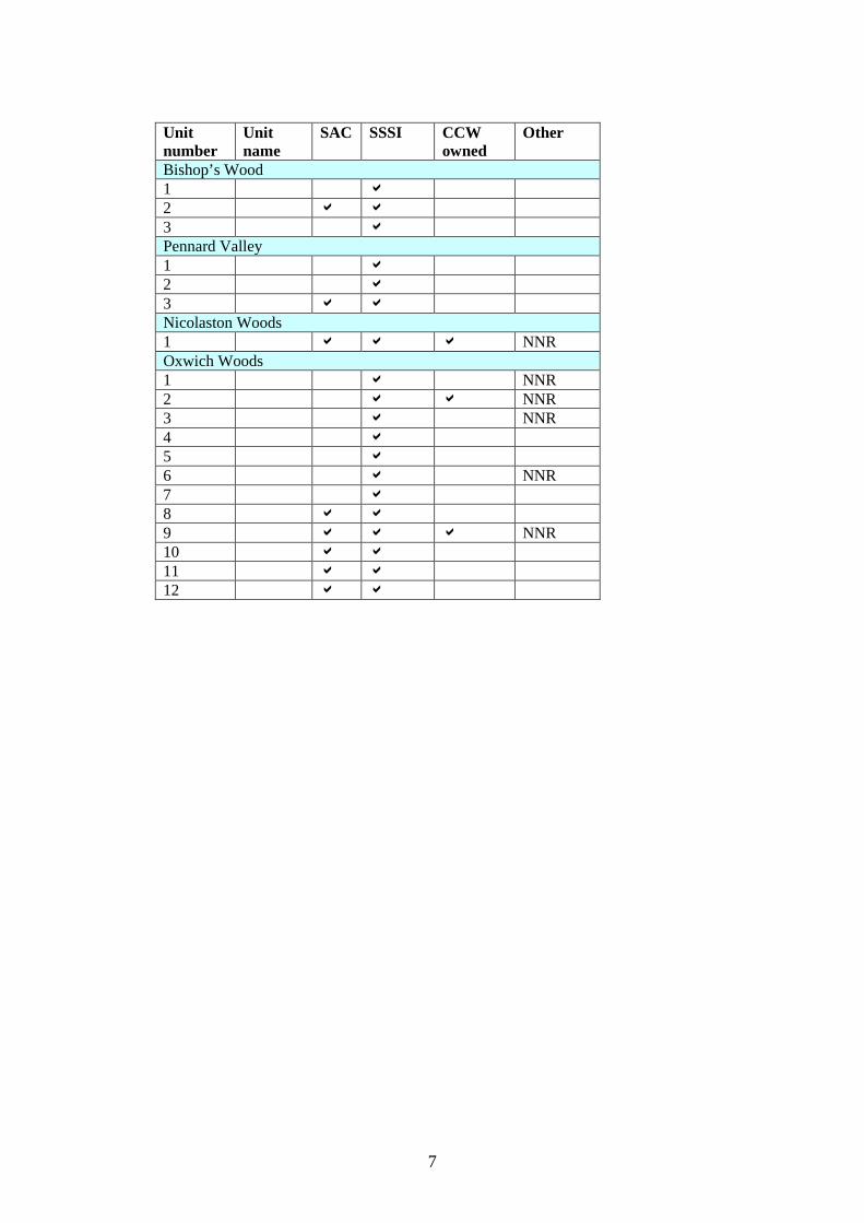
The following table confirms the relationships between the management units and the designations covered: Unit number
Unit name
SAC SSSI CCW owned
Other
Parkmill Woodlands 1 a 2 a 3 a 4 a 5 a 6 a 7 a 8 a a 9 a 10 a 11 a 12 a 13 a 14 a 15 a a 16 a a 17 a a 18 a a 19 a a 20 a a 21 a a 22 a a 23 a a 24 a a 25 a a 26 a a 27 a a 28 a a 29 a a 30 a a 31 a 32 a 33 a a 34 a 35 a 36 a a 37 a a Pwll Du Head and Bishopston Valley SSSI 1 a a 2 a a 3 a 4 a a 5 a a 6 a
7
Unit number
Unit name
SAC SSSI CCW owned
Other
Bishop’s Wood 1 a 2 a a 3 a Pennard Valley 1 a 2 a 3 a a Nicolaston Woods 1 a a a NNR Oxwich Woods 1 a NNR 2 a a NNR 3 a NNR 4 a 5 a 6 a NNR 7 a 8 a a 9 a a a NNR 10 a a 11 a a 12 a a
8
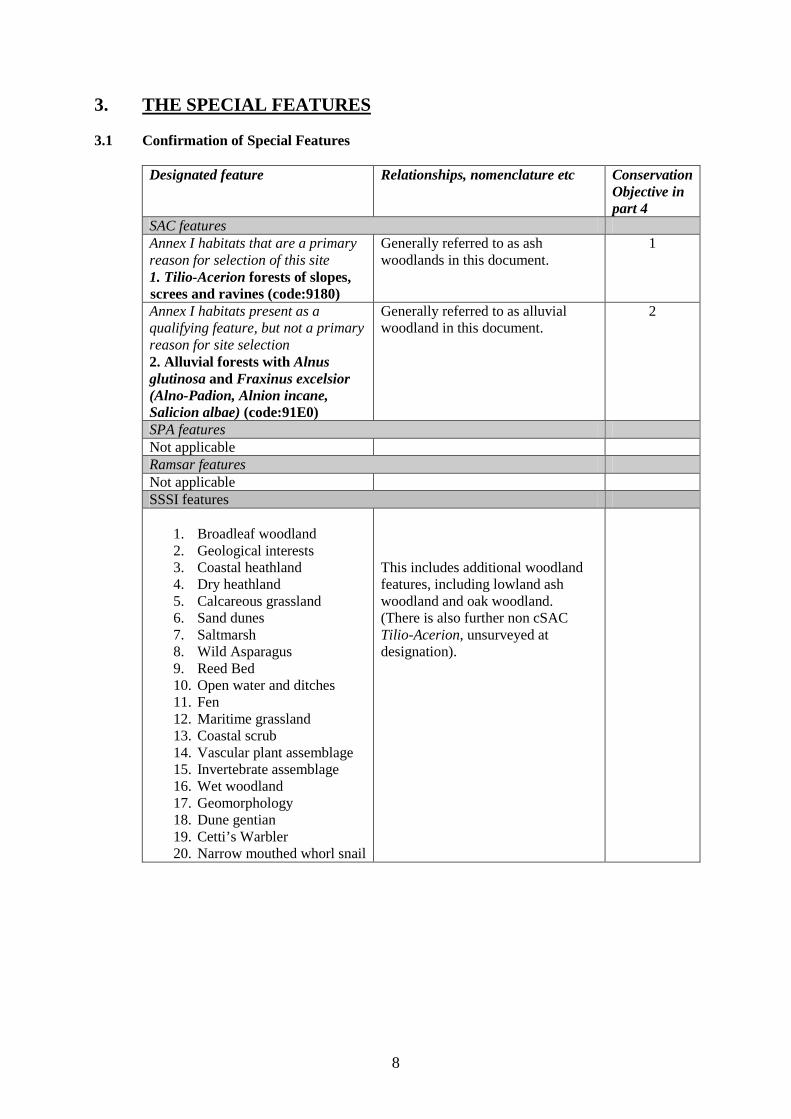
3. THE SPECIAL FEATURES 3.1 Confirmation of Special Features
Designated feature Relationships, nomenclature etc Conservation Objective in part 4
SAC features Annex I habitats that are a primary reason for selection of this site 1. Tilio-Acerion forests of slopes, screes and ravines (code:9180)
Generally referred to as ash woodlands in this document.
1
Annex I habitats present as a qualifying feature, but not a primary reason for site selection 2. Alluvial forests with Alnus glutinosa and Fraxinus excelsior (Alno-Padion, Alnion incane, Salicion albae) (code:91E0)
Generally referred to as alluvial woodland in this document.
2
SPA features Not applicable Ramsar features Not applicable SSSI features
1. Broadleaf woodland 2. Geological interests 3. Coastal heathland 4. Dry heathland 5. Calcareous grassland 6. Sand dunes 7. Saltmarsh 8. Wild Asparagus 9. Reed Bed 10. Open water and ditches 11. Fen 12. Maritime grassland 13. Coastal scrub 14. Vascular plant assemblage 15. Invertebrate assemblage 16. Wet woodland 17. Geomorphology 18. Dune gentian 19. Cetti’s Warbler 20. Narrow mouthed whorl snail
This includes additional woodland features, including lowland ash woodland and oak woodland. (There is also further non cSAC Tilio-Acerion, unsurveyed at designation).
9
3.2 Special Features and Management Units
This section sets out the relationship between the special features and each management unit. This is intended to provide a clear statement about what each unit should be managed for, taking into account the varied needs of the different special features. All special features are allocated to one of seven classes in each management unit. These classes are:
Key Features KH - a ‘Key Habitat’ in the management unit, i.e. the habitat that is the main driver of management and focus of monitoring effort, perhaps because of the dependence of a key species (see KS below). There will usually only be one Key Habitat in a unit but there can be more, especially with large units. KS – a ‘Key Species’ in the management unit, often driving both the selection and management of a Key Habitat. Geo – an earth science feature that is the main driver of management and focus of monitoring effort in a unit. Other Features Sym - habitats, species and earth science features that are of importance in a unit but are not the main drivers of management or focus of monitoring. These features will benefit from management for the key feature(s) identified in the unit. These may be classed as ‘Sym’ features because: a) they are present in the unit but may be of less conservation importance than the key
feature; and/or b) they are present in the unit but in small areas/numbers, with the bulk of the feature in
other units of the site; and/or c) their requirements are broader than and compatible with the management needs of the key
feature(s), e.g. a mobile species that uses large parts of the site and surrounding areas. Nm - an infrequently used category where features are at risk of decline within a unit as a result of meeting the management needs of the key feature(s), i.e. under Negative Management. These cases will usually be compensated for by management elsewhere in the plan, and can be used where minor occurrences of a feature would otherwise lead to apparent conflict with another key feature in a unit. Mn - Management units that are essential for the management of features elsewhere on a site e.g. livestock over-wintering area included within designation boundaries, buffer zones around water bodies, etc. x – Features not known to be present in the management unit.
The tables below sets out the relationship between the special features and management units identified in this plan:
Gower Ash Woods SAC Gower Ash Woods SAC comprises six component SSSIs: Parkmill Woodlands and Llethrid Valley SSSI; Pennard Valley SSSI; Pwll Du Head and Bishopston Valley SSSI; Bishop’s Wood SSSI; Nicolaston Woods SSSI and Oxwich Bay SSSI. These sites are included in the Natura 2000 series primarily for the areas of ash woodlands present. The sites also host a number of SSSI features, which can be found listed in the tables below.
10
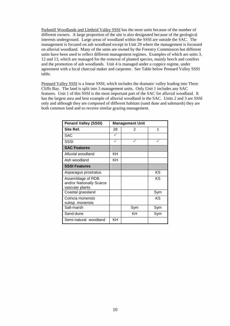
Parkmill Woodlands and Llethrid Valley SSSI has the most units because of the number of different owners. A large proportion of the site is also designated because of the geological interests underground. Large areas of woodland within the SSSI are outside the SAC. The management is focused on ash woodland except in Unit 29 where the management is focussed on alluvial woodland. Many of the units are owned by the Forestry Commission but different units have been used to reflect different management regimes. Examples of which are units 3, 12 and 13, which are managed for the removal of planted species, mainly beech and conifers and the promotion of ash woodlands. Unit 4 is managed under a coppice regime, under agreement with a local charcoal maker and carpenter. See Table below Pennard Valley SSSI table. Pennard Valley SSSI is a linear SSSI, which includes the dramatic valley leading into Three Cliffs Bay. The land is split into 3 management units. Only Unit 1 includes any SAC features. Unit 1 of this SSSI is the most important part of the SAC for alluvial woodland. It has the largest area and best example of alluvial woodland in the SAC. Units 2 and 3 are SSSI only and although they are composed of different habitats (sand dune and saltmarsh) they are both common land and so receive similar grazing management.
Penard Valley (SSSI) Management Unit
Site Ref. 28 2 1
SAC �
SSSI � � �
SAC Features Alluvial woodland KH
Ash woodland KH
SSSI Features Asparagus prostratus KS
Assemblage of RDB and/or Nationally Scarce vascular plants
KS
Coastal grassland Sym
Coincia monensis subsp. monensis
KS
Salt-marsh Sym Sym
Sand-dune KH Sym
Semi-natural woodland KH
11
Coedydd Parkmill a Cwm Llethrid/Parkmill Woodlands and Llethrid Valley (SSSI)
Management Unit
Site Ref. 1 2 3 4 5 6 7 8 9 10 11 12 13 14 15
SAC � � � � � � � � � � � � � � �
SSSI � � � � � � � � � � � � � � �
SAC Features Alluvial woodland KH
Ash woodland KH KH KH KH KH KH KH KH KH KH KH KH KH KH KH
SSSI Features Karst Geo Geo
Semi-natural woodland KH KH KH KH KH KH KH KH KH KH KH KH KH KH KH
Coedydd Parkmill a Cwm Llethrid/Parkmill Woodlands and Llethrid Valley (SSSI)
Management Unit
Site Ref. 16 17 18 19 20 21 31 A B C E F G H I
SAC � � � � � � �
SSSI � � � � � � � � � � � � � � �
SAC Features Alluvial woodland
Ash woodland KH KH KH KH KH KH KH
SSSI Features Karst Geo Geo Geo Geo Geo
Semi-natural woodland KH KH KH KH KH KH KH KH KH KH KH KH KH KH KH

12
Coedydd Parkmill a Cwm Llethrid/Parkmill Woodlands and Llethrid Valley (SSSI)
Management Unit
Site Ref. J K L M N O
SAC
SSSI � � � � � �
SAC Features Alluvial woodland
Ash woodland
SSSI Features Karst Geo Geo
Semi-natural woodland KH KH KH KH KH KH
13
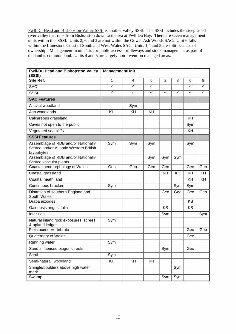
Pwll Du Head and Bishopston Valley SSSI is another valley SSSI. The SSSI includes the steep sided river valley that runs from Bishopston down to the sea at Pwll Du Bay. There are seven management units within this SSSI. Units 2, 6 and 3 are not within the Gower Ash Woods SAC. Unit 6 falls within the Limestone Coast of South and West Wales SAC. Units 1,4 and 5 are split because of ownership. Management in unit 1 is for public access, bridleways and stock management as part of the land is common land. Units 4 and 5 are largely non-invention managed areas.
Pwll-Du Head and Bishopston Valley (SSSI)
ManagementUnit
Site Ref. 1 4 5 2 3 6 8
SAC � � � � �
SSSI � � � � � � �
SAC Features Alluvial woodland Sym
Ash woodlands KH KH KH
Calcareous grassland KH
Caves not open to the public Sym
Vegetated sea cliffs KH
SSSI Features Assemblage of RDB and/or Nationally Scarce and/or Atlantic-Western British bryophytes
Sym Sym Sym Sym
Assemblage of RDB and/or Nationally Scarce vascular plants
Sym Sym Sym
Coastal geomorphology of Wales Geo Geo Geo Geo Geo Geo
Coastal grassland KH KH KH KH
Coastal heath land KH KH
Continuous bracken Sym Sym Sym
Dinantian of southern England and South Wales
Geo Geo Geo Geo
Draba aizoides KS
Galeopsis angustifolia KS KS
Inter-tidal Sym Sym
Natural inland rock exposures, screes & upland ledges
Sym
Pleistocene Vertebrata Geo Geo
Quaternary of Wales Geo
Running water Sym
Sand influenced biogenic reefs Sym Geo
Scrub Sym
Semi-natural woodland KH KH KH
Shingle/boulders above high water mark
Sym
Swamp Sym Sym
14
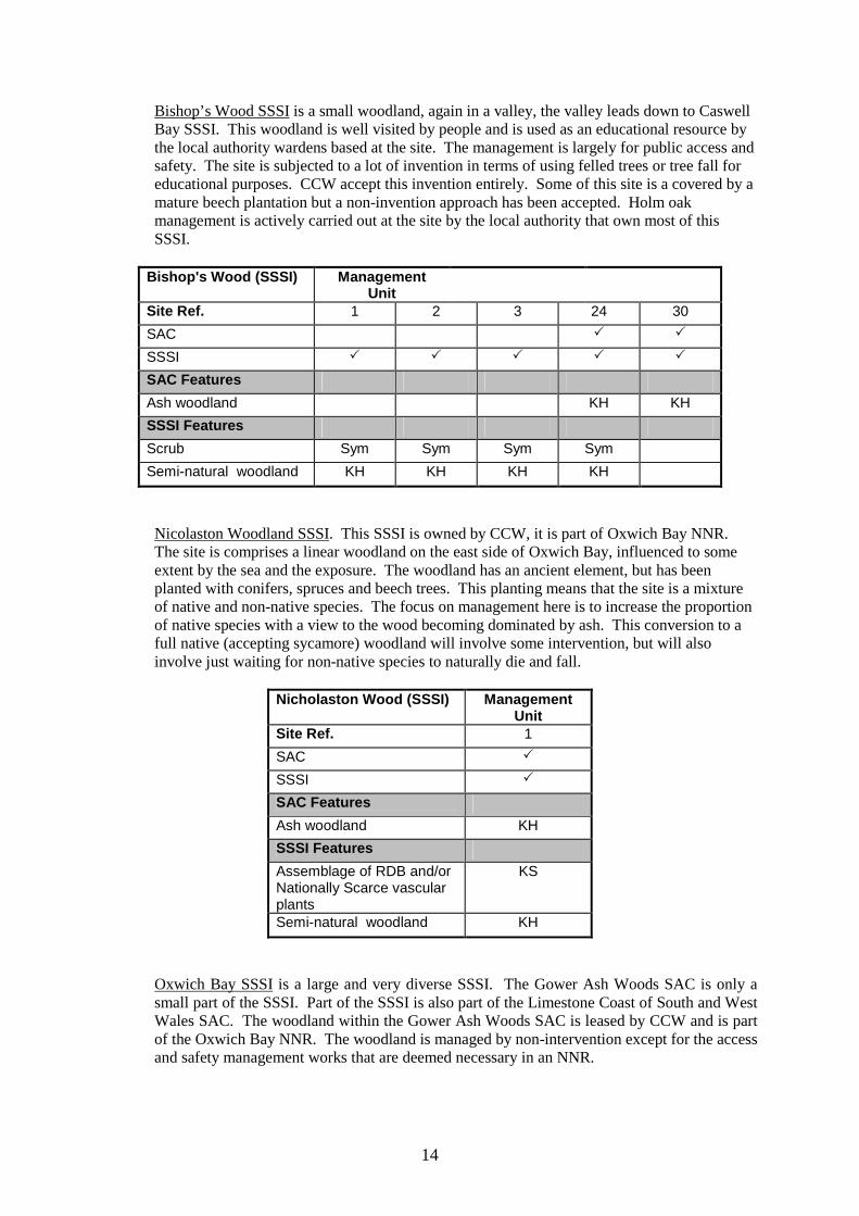
Bishop’s Wood SSSI is a small woodland, again in a valley, the valley leads down to Caswell Bay SSSI. This woodland is well visited by people and is used as an educational resource by the local authority wardens based at the site. The management is largely for public access and safety. The site is subjected to a lot of invention in terms of using felled trees or tree fall for educational purposes. CCW accept this invention entirely. Some of this site is a covered by a mature beech plantation but a non-invention approach has been accepted. Holm oak management is actively carried out at the site by the local authority that own most of this SSSI.
Bishop's Wood (SSSI) Management
Unit
Site Ref. 1 2 3 24 30
SAC � �
SSSI � � � � �
SAC Features Ash woodland KH KH
SSSI Features Scrub Sym Sym Sym Sym
Semi-natural woodland KH KH KH KH
Nicolaston Woodland SSSI. This SSSI is owned by CCW, it is part of Oxwich Bay NNR. The site is comprises a linear woodland on the east side of Oxwich Bay, influenced to some extent by the sea and the exposure. The woodland has an ancient element, but has been planted with conifers, spruces and beech trees. This planting means that the site is a mixture of native and non-native species. The focus on management here is to increase the proportion of native species with a view to the wood becoming dominated by ash. This conversion to a full native (accepting sycamore) woodland will involve some intervention, but will also involve just waiting for non-native species to naturally die and fall.
Nicholaston Wood (SSSI) Management Unit
Site Ref. 1
SAC �
SSSI �
SAC Features Ash woodland KH
SSSI Features Assemblage of RDB and/or Nationally Scarce vascular plants
KS
Semi-natural woodland KH
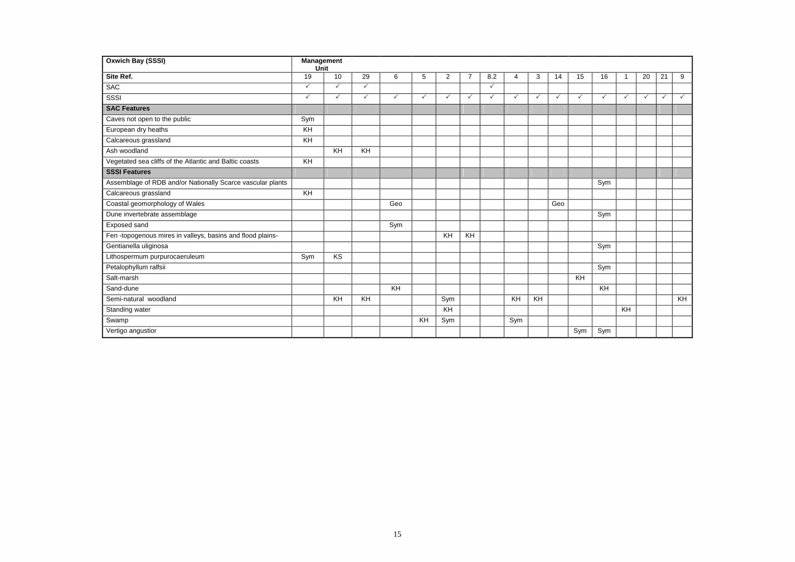
Oxwich Bay SSSI is a large and very diverse SSSI. The Gower Ash Woods SAC is only a small part of the SSSI. Part of the SSSI is also part of the Limestone Coast of South and West Wales SAC. The woodland within the Gower Ash Woods SAC is leased by CCW and is part of the Oxwich Bay NNR. The woodland is managed by non-intervention except for the access and safety management works that are deemed necessary in an NNR.
15
Oxwich Bay (SSSI) Management
Unit
Site Ref. 19 10 29 6 5 2 7 8.2 4 3 14 15 16 1 20 21 9
SAC � � � �
SSSI � � � � � � � � � � � � � � � � �
SAC Features Caves not open to the public Sym
European dry heaths KH
Calcareous grassland KH
Ash woodland KH KH
Vegetated sea cliffs of the Atlantic and Baltic coasts KH
SSSI Features Assemblage of RDB and/or Nationally Scarce vascular plants Sym
Calcareous grassland KH
Coastal geomorphology of Wales Geo Geo
Dune invertebrate assemblage Sym
Exposed sand Sym
Fen -topogenous mires in valleys, basins and flood plains- KH KH
Gentianella uliginosa Sym
Lithospermum purpurocaeruleum Sym KS
Petalophyllum ralfsii Sym
Salt-marsh KH
Sand-dune KH KH
Semi-natural woodland KH KH Sym KH KH KH
Standing water KH KH
Swamp KH Sym Sym
Vertigo angustior Sym Sym

16
Species have been identified as ‘Key’ where the management in that unit is driven by the needs of the species. Often though, where important species exist, the habitat is still the ‘key’ management driver because when the habitat is in good condition it can be presumed that the species is also in good condition. This philosophy can work the other way too. Where the species is in good condition it can be presumed that the habitat where it grows is also in good condition.
4. CONSERVATION OBJECTIVES
Background to Conservation Objectives:
a. Outline of the legal context and purpose of conservation objectives.
Conservation objectives are required by the 1992 ‘Habitats’ Directive (92/43/EEC). The aim of the Habitats Directives is the maintenance, or where appropriate the restoration of the ‘favourable conservation status’ of habitats and species features for which SACs and SPAs are designated (see Box 1).
In the broadest terms, 'favourable conservation status' means a feature is in satisfactory condition and all the things needed to keep it that way are in place for the foreseeable future. CCW considers that the concept of favourable conservation status provides a practical and legally robust basis for conservation objectives for Natura 2000 and Ramsar sites.
Achieving these objectives requires appropriate management and the control of factors that may cause deterioration of habitats or significant disturbance to species.
Box 1 Favourable conservation status as defined in Articles 1(e) and 1(i) of the Habitats Directive “The conservation status of a natural habitat is the sum of the influences acting on it and its typical species that may affect its long-term natural distribution, structure and functions as well as the long term survival of its typical species. The conservation status of a natural habitat will be taken as favourable when:
• Its natural range and areas it covers within that range are stable or increasing, and • The specific structure and functions which are necessary for its long-term
maintenance exist and are likely to continue to exist for the foreseeable future, and • The conservation status of its typical species is favourable.
The conservation status of a species is the sum of the influences acting on the species that may affect the long-term distribution and abundance of its populations. The conservation status will be taken as ‘favourable’ when:
• population dynamics data on the species indicate that it is maintaining itself on a
long-term basis as a viable component of its natural habitats, and • the natural range of the species is neither being reduced nor is likely to be reduced
for the foreseeable future, and • There is, and will probably continue to be, a sufficiently large habitat to maintain
its populations on a long-term basis.”
17
As well as the overall function of communication, Conservation objectives have a number of specific roles: • Conservation planning and management.
The conservation objectives guide management of sites, to maintain or restore the habitats and species in favourable condition.
• Assessing plans and projects. Article 6(3) of the ‘Habitats’ Directive requires appropriate assessment of proposed plans and projects against a site's conservation objectives. Subject to certain exceptions, plans or projects may not proceed unless it is established that they will not adversely affect the integrity of sites. This role for testing plans and projects also applies to the review of existing decisions and consents.
• Monitoring and reporting.
The conservation objectives provide the basis for assessing the condition of a feature and the status of factors that affect it. CCW uses ‘performance indicators’ within the conservation objectives, as the basis for monitoring and reporting. Performance indicators are selected to provide useful information about the condition of a feature and the factors that affect it.
The conservation objectives in this document reflect CCW’s current information and understanding of the site and its features and their importance in an international context. The conservation objectives are subject to review by CCW in light of new knowledge. b. Format of the conservation objectives There is one conservation objective for each feature listed in part 3. Each conservation objective is a composite statement representing a site-specific description of what is considered to be the favourable conservation status of the feature. These statements apply to a whole feature as it occurs within the whole plan area, although section 3.2 sets out their relevance to individual management units. Each conservation objective consists of the following two elements:
1. Vision for the feature 2. Performance indicators
As a result of the general practice developed and agreed within the UK Conservation Agencies, conservation objectives include performance indicators, the selection of which should be informed by JNCC guidance on Common Standards Monitoring1. There is a critical need for clarity over the role of performance indicators within the conservation objectives. A conservation objective, because it includes the vision for the feature, has meaning and substance independently of the performance indicators, and is more than the sum of the performance indicators. The performance indicators are simply what make the conservation objectives measurable, and are thus part of, not a substitute for, the conservation objectives. Any feature attribute identified in the performance indicators
1 Web link: http://www.jncc.gov.uk/page-2199

18
should be represented in the vision for the feature, but not all elements of the vision for the feature will necessarily have corresponding performance indicators. As well as describing the aspirations for the condition of the feature, the Vision section of each conservation objective contains a statement that the factors necessary to maintain those desired conditions are under control. Subject to technical, practical and resource constraints, factors which have an important influence on the condition of the feature are identified in the performance indicators.
19
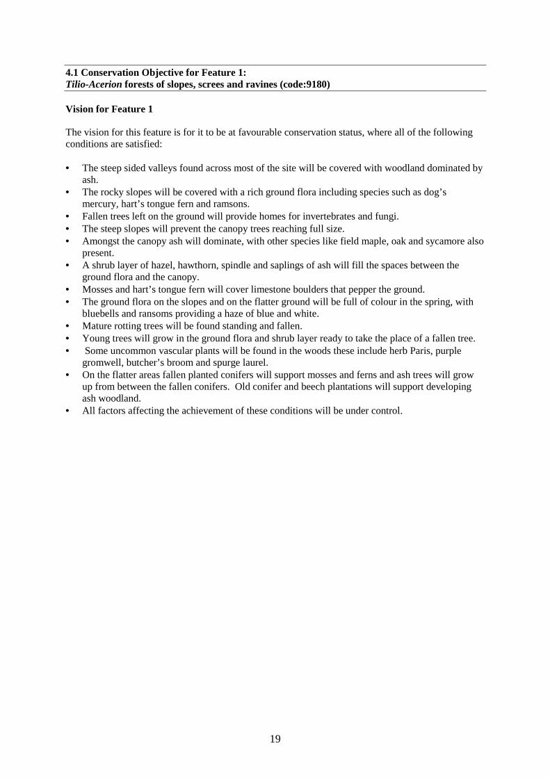
4.1 Conservation Objective for Feature 1: Tilio-Acerion forests of slopes, screes and ravines (code:9180) Vision for Feature 1 The vision for this feature is for it to be at favourable conservation status, where all of the following conditions are satisfied: • The steep sided valleys found across most of the site will be covered with woodland dominated by
ash. • The rocky slopes will be covered with a rich ground flora including species such as dog’s
mercury, hart’s tongue fern and ramsons. • Fallen trees left on the ground will provide homes for invertebrates and fungi. • The steep slopes will prevent the canopy trees reaching full size. • Amongst the canopy ash will dominate, with other species like field maple, oak and sycamore also
present. • A shrub layer of hazel, hawthorn, spindle and saplings of ash will fill the spaces between the
ground flora and the canopy. • Mosses and hart’s tongue fern will cover limestone boulders that pepper the ground. • The ground flora on the slopes and on the flatter ground will be full of colour in the spring, with
bluebells and ransoms providing a haze of blue and white. • Mature rotting trees will be found standing and fallen. • Young trees will grow in the ground flora and shrub layer ready to take the place of a fallen tree. • Some uncommon vascular plants will be found in the woods these include herb Paris, purple
gromwell, butcher’s broom and spurge laurel. • On the flatter areas fallen planted conifers will support mosses and ferns and ash trees will grow
up from between the fallen conifers. Old conifer and beech plantations will support developing ash woodland.
• All factors affecting the achievement of these conditions will be under control.
20
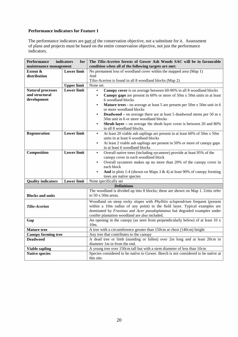
Performance indicators for Feature 1 The performance indicators are part of the conservation objective, not a substitute for it. Assessment of plans and projects must be based on the entire conservation objective, not just the performance indicators.
Performance indicators for maintenance management
The Tilio-Acerion forests of Gower Ash Woods SAC will be in favourable condition when all of the following targets are met:
Lower limit No permanent loss of woodland cover within the mapped area (Map 1) And Tilio-Acerion is found in all 8 woodland blocks (Map 2)
Extent & distribution
Upper limit None set. Natural processes and structural development
Lower limit • Canopy cover is on average between 60-90% in all 8 woodland blocks • Canopy gaps are present in 60% or more of 50m x 50m units in at least
6 woodland blocks • Mature trees - on average at least 5 are present per 50m x 50m unit in 6
or more woodland blocks • Deadwood – on average there are at least 5 deadwood stems per 50 m x
50m unit in 6 or more woodland blocks • Shrub layer – on average the shrub layer cover is between 20 and 80%
in all 8 woodland blocks. Regeneration Lower limit • At least 20 viable ash saplings are present in at least 60% of 50m x 50m
units in at least 6 woodland blocks • At least 2 viable ash saplings are present in 50% or more of canopy gaps
in at least 6 woodland blocks Composition Lower limit • Overall native trees (including sycamore) provide at least 95% of the
canopy cover in each woodland block • Overall sycamore makes up no more than 20% of the canopy cover in
each block • And in plots 1-4 (shown on Maps 3 & 4) at least 90% of canopy forming
trees are native species Quality indicators Lower limit None specifically set
Definitions
Blocks and units The woodland is divided up into 8 blocks; these are shown on Map 1. Units refer to 50 x 50m areas.
Tilio-Acerion Woodland on steep rocky slopes with Phyllitis sclopendrium frequent (present within a 10m radius of any point) in the field layer. Typical examples are dominated by Fraxinus and Acer pseudoplatanus but degraded examples under conifer plantation woodland are also included.
Gap An opening in the canopy (as seen from perpendicularly below) of at least 10 x 10m.
Mature tree A tree with a circumference greater than 150cm at chest (140cm) height Canopy forming tree Any tree that contributes to the canopy Deadwood A dead tree or limb (standing or fallen) over 2m long and at least 20cm in
diameter 1m in from the end. Viable sapling A young tree over 150cm tall but with a stem diameter of less than 10cm Native species Species considered to be native to Gower. Beech is not considered to be native at
this site.

21
. 4.2 Conservation Objective for Feature 2: Alluvial forests with Alnus glutinosa and Fraxinus excelsior (Alno-Padion, Alnion incane, Salicion albae) (code: 91E0) Vision for Feature 2 The vision for this feature is for it to be at favourable conservation status, where all of the following conditions are satisfied: • Alongside the Pennard Pill and the Ilston stream alluvial woodland will grow in the silts from the
river, • Alder will dominate these areas but hazel and elder will also grow here, • Creeping buttercup, nettles and meadowsweet will dominate the ground flora. • There will be no signs of disturbance such as over-grazing or fly-tipping and no non-native species
will grow in these areas. • Young saplings of alder and hazel will be numerous and waiting to fill the spaces left by fallen
trees. • All other factors will be under control.
22
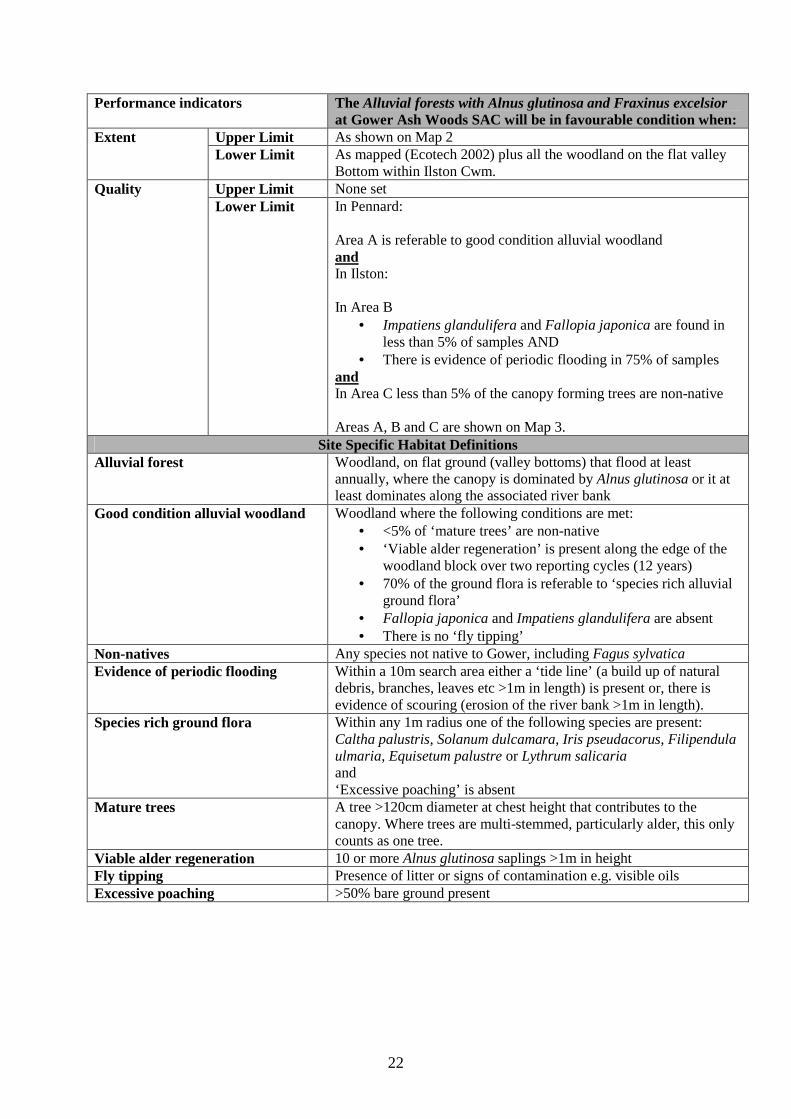
Performance indicators The Alluvial forests with Alnus glutinosa and Fraxinus excelsior at Gower Ash Woods SAC will be in favourable condition when:
Upper Limit As shown on Map 2 Extent Lower Limit As mapped (Ecotech 2002) plus all the woodland on the flat valley
Bottom within Ilston Cwm. Upper Limit None set Quality Lower Limit In Pennard:
Area A is referable to good condition alluvial woodland and In Ilston: In Area B
• Impatiens glandulifera and Fallopia japonica are found in less than 5% of samples AND
• There is evidence of periodic flooding in 75% of samples and In Area C less than 5% of the canopy forming trees are non-native Areas A, B and C are shown on Map 3.
Site Specific Habitat Definitions Alluvial forest Woodland, on flat ground (valley bottoms) that flood at least
annually, where the canopy is dominated by Alnus glutinosa or it at least dominates along the associated river bank
Good condition alluvial woodland Woodland where the following conditions are met: • <5% of ‘mature trees’ are non-native • ‘Viable alder regeneration’ is present along the edge of the
woodland block over two reporting cycles (12 years) • 70% of the ground flora is referable to ‘species rich alluvial
ground flora’ • Fallopia japonica and Impatiens glandulifera are absent • There is no ‘fly tipping’
Non-natives Any species not native to Gower, including Fagus sylvatica Evidence of periodic flooding Within a 10m search area either a ‘tide line’ (a build up of natural
debris, branches, leaves etc >1m in length) is present or, there is evidence of scouring (erosion of the river bank >1m in length).
Species rich ground flora Within any 1m radius one of the following species are present: Caltha palustris, Solanum dulcamara, Iris pseudacorus, Filipendula ulmaria, Equisetum palustre or Lythrum salicaria and ‘Excessive poaching’ is absent
Mature trees A tree >120cm diameter at chest height that contributes to the canopy. Where trees are multi-stemmed, particularly alder, this only counts as one tree.
Viable alder regeneration 10 or more Alnus glutinosa saplings >1m in height Fly tipping Presence of litter or signs of contamination e.g. visible oils Excessive poaching >50% bare ground present
23
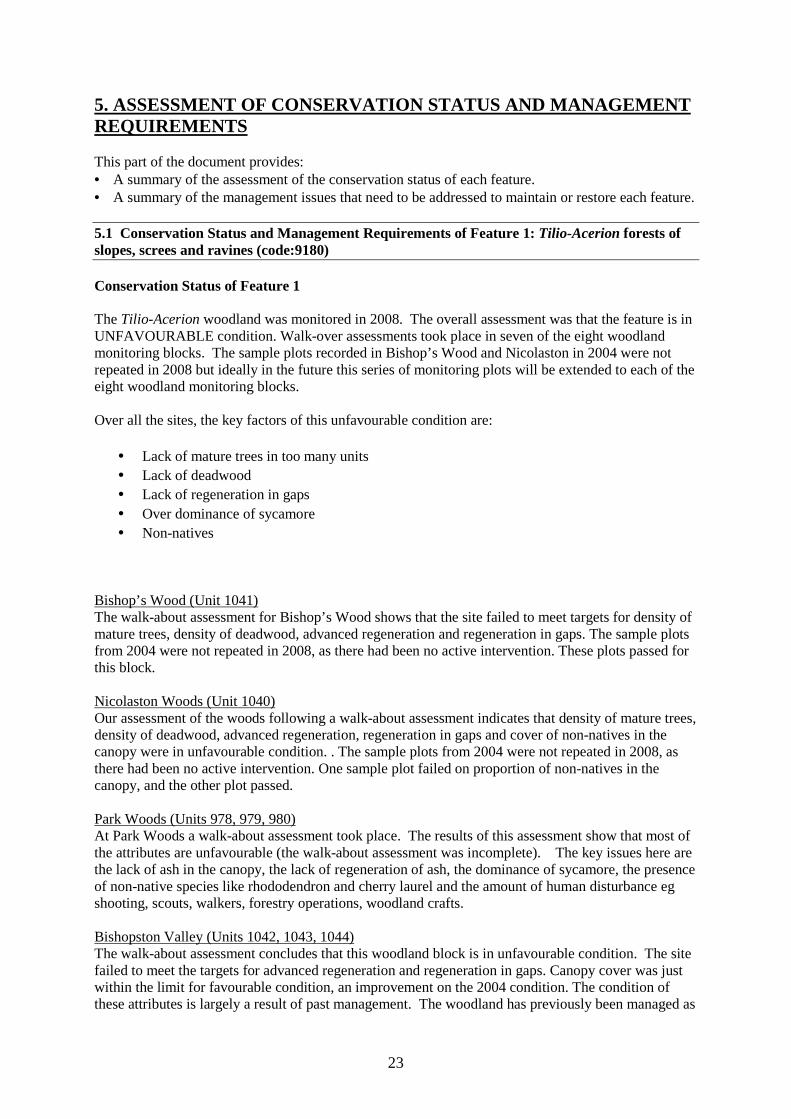
5. ASSESSMENT OF CONSERVATION STATUS AND MANAGEMENT REQUIREMENTS This part of the document provides: • A summary of the assessment of the conservation status of each feature. • A summary of the management issues that need to be addressed to maintain or restore each feature. 5.1 Conservation Status and Management Requirements of Feature 1: Tilio-Acerion forests of slopes, screes and ravines (code:9180) Conservation Status of Feature 1 The Tilio-Acerion woodland was monitored in 2008. The overall assessment was that the feature is in UNFAVOURABLE condition. Walk-over assessments took place in seven of the eight woodland monitoring blocks. The sample plots recorded in Bishop’s Wood and Nicolaston in 2004 were not repeated in 2008 but ideally in the future this series of monitoring plots will be extended to each of the eight woodland monitoring blocks. Over all the sites, the key factors of this unfavourable condition are:
• Lack of mature trees in too many units • Lack of deadwood • Lack of regeneration in gaps • Over dominance of sycamore • Non-natives
Bishop’s Wood (Unit 1041) The walk-about assessment for Bishop’s Wood shows that the site failed to meet targets for density of mature trees, density of deadwood, advanced regeneration and regeneration in gaps. The sample plots from 2004 were not repeated in 2008, as there had been no active intervention. These plots passed for this block. Nicolaston Woods (Unit 1040) Our assessment of the woods following a walk-about assessment indicates that density of mature trees, density of deadwood, advanced regeneration, regeneration in gaps and cover of non-natives in the canopy were in unfavourable condition. . The sample plots from 2004 were not repeated in 2008, as there had been no active intervention. One sample plot failed on proportion of non-natives in the canopy, and the other plot passed. Park Woods (Units 978, 979, 980) At Park Woods a walk-about assessment took place. The results of this assessment show that most of the attributes are unfavourable (the walk-about assessment was incomplete). The key issues here are the lack of ash in the canopy, the lack of regeneration of ash, the dominance of sycamore, the presence of non-native species like rhododendron and cherry laurel and the amount of human disturbance eg shooting, scouts, walkers, forestry operations, woodland crafts. Bishopston Valley (Units 1042, 1043, 1044) The walk-about assessment concludes that this woodland block is in unfavourable condition. The site failed to meet the targets for advanced regeneration and regeneration in gaps. Canopy cover was just within the limit for favourable condition, an improvement on the 2004 condition. The condition of these attributes is largely a result of past management. The woodland has previously been managed as
24
coppiced woodland and in places the shrub layer is quite dense, but canopy forming trees are sparse and the canopy is open. Ash regeneration is not abundant in this woodland, this could be due to the shading in the shrub layer but also part of site is common land and therefore grazed by sheep and cattle, which could be impacting on the regeneration. Pennard Valley (units 1045) We did not complete a full assessment of Block 3 (Pennard Valley), due to access restrictions and lack of time. The extent of the woodland in this block has been checked on recent aerial photographs and the presence of Tilio-Acerion was confirmed by looking at the woodland from Pennard Burrows, which is adjacent to the woodland. Ilston Cwm (units 983, 984, 985) The walk-about assessment concludes that this block is in unfavourable condition. The site failed to meet targets for density of mature trees, deadwood, advanced regeneration, visible regeneration and the presence of non-native canopy cover. Parkmill Woodland (units 981, 982, 983, 984, 985, 986, 987, 988, 989, 990, 991, 992, 993, 994, 995, 996, 997, 998) The walk-about assessment covered only a limited area, and the results should be treated with caution. The site failed to meet targets for canopy gaps, density of mature trees, density of deadwood, advanced regeneration, regeneration in gaps, cover of sycamore in the canopy and cover of non-natives in the canopy. Management Requirements of Feature 1 The current status of feature 1 is Unfavourable. The principle reasons for this are lack of regeneration, too many canopy gaps, presence of non-native species and dominance of sycamore. Over all the sites, the key issues requiring attention are:
i. Lack of mature trees in too many units – this cannot be addressed through intervention. Trees approaching maturity must be identified and protected from removal.
ii. Lack of deadwood – where removal of sycamore or non-native canopy species is required, leaving cut material in-situ should be considered.
iii. Lack of regeneration in gaps – a better understanding of the processes affecting regeneration is required before any intervention can be attempted.
iv. Over dominance of sycamore – where sycamore in the canopy is exceeding the upper limit for this feature, intervention in the form of felling and removal is required.
v. Non-natives – too many woodlands have non-native species in the canopy and this needs to be managed by intervention.
Air Quality (Affects All Sites) An increase in nitrogen deposition will lead to changes in species composition of the woodland especially the ground flora. Where acidification of woodland habitat occurs, changes in ground flora and impacts on plant and lichen health are problems. Critical loads and levels of have been defined where possible (www.apis.ac.uk) for the conservation features of the European site. If particularly damaging, point sources (or groups of point sources) can be identified, then emissions should be regulated to minimise the impacts. This is particularly important in areas where background
25
levels are already exceeded or close to exceedance, where there is a requirement to reduce potential impacts not only by reducing existing pollution but also by ensuring that the potential for additional atmospheric inputs are minimised. It is also important for wider measures, such as local and national policy to take air pollution (impacts) at these sites into account. Bishop’s Wood – ash woodlands
• Access and safety management (non-conservation management) This site requires access and safety management for non-conservation reasons.
• Non-native species Holm oak is present at this site and it spreading into the SSSI. Holm oak threatens the condition of the site, because it is an evergreen species which affects the light, water and nutrient conditions of the woodland having a detrimental affect on the ground flora and shrub layer. It is necessary to remove holm oak from the within the SSSI. The source of the holm oak is adjacent local authority owned land, it is possible to work with the local authority to develop a programme of control. Beech trees also grow on the site, but the beech does not seem to be regenerating. The trees on the site are very large and it has been decided that we will allow them to fall naturally as the area where they grow is an important area used for the activities carried out by the site wardens. Sycamore also grows on the site, but has been accepted as naturalised unless it is more than 20% dominant in the canopy, so no action will be taken. However, we would support the removal of sycamore saplings if this were a project that the landowners want to carry out.
• Grazing There is no grazing at Bishop’s Wood and grazing is not required.
• Dead Wood Opportunities to create standing dead wood may be limited in some areas of this woodland due to public safety. Where conditions allow, dead wood should be created or left in situ.
• Mature trees The lack of mature trees in woodland cannot be addressed through intervention; trees must be allowed to become mature. Coppicing or felling requirements should take this into account and avoid removing trees of an almost mature size. Park Woods – ash woodlands
• Access and safety management (non-conservation management) This site requires access and safety management for non-conservation reasons.
• Non-native species This site was subject to a lot of landscape planting (as part of the Parc Le Breos Estate) and forestry activity. Elements of this are still present, beech plantations, conifers, large oaks, beech, sycamore, cherry laurel and rhododendron. There are programmes in place to actively remove rhododendron and cherry laurel from the site. A beech plantation has been cleared in recent years. The conifer plantations are not a priority for removal unless they are regenerating.
• Grazing
26
The site has very occasional grazing from stock which have strayed from the road at Parkmill. A gate was put in at the entrance to the site and it has been suggested that a cattle grid might be needed. At the present time the grazing levels are not at a level which causes concern.
• Coppice An area of the site is managed under a coppice regime by a local charcoal maker and woodsperson. We would want to see this continue if possible. This kind of management adds a diversity to the woodland habitat which can benefit some wildlife.
• High forest The remaining woodland will be generally managed as high forest. This would mean taking a non-intervention approach and allowing the woodland to develop and change on its own. This approach will be taken until a time where our monitoring shows up problems.
• Mature trees The lack of mature trees in woodland cannot be addressed through intervention; trees must be allowed to become mature. Coppicing or felling requirements should take this into account and avoid removing trees approaching maturity.
• Dead Wood Opportunities to create standing dead wood may be more in some areas of this woodland due to public safety. Where conditions allow, dead wood should be created or left in situ.
• Sycamore
The upper limit for sycamore as a proportion of the canopy is exceeded. It was considered that ring barking of selected sycamore would both create standing deadwood and eliminate large sycamore from the canopy. However, observations from other woodlands suggest that the ring-barking of sycamore can lead to a final flush of seeds, thus promoting further regeneration of sycamore. As such, felling of sycamore needs to be considered.
• Regeneration
Further research into the ideal conditions for regeneration is required. Even where conditions appear to be ideal (gaps) regeneration is limited or absent. Where sycamore or dead wood creation is carried out, monitoring should be undertaken to get a better understanding of regeneration processes in these areas. Ilston Cwm – ash woodlands
• Access and safety management (non-conservation management) This site requires access and safety management for non-conservation reasons.
• Non-native species The site has a relatively large proportion of non-native species, mainly conifer species. Although these conifer species make up a large part of the site, there is still a good amount of regeneration of ash and little regeneration of the non-native species. This means that it is not a priority to remove the
27
conifers and we could allow them to fall naturally and for ash woodland to return. This approach would mean that a ‘good condition’ woodland would not be seen for hundreds of years, but the site can be classed as unfavourable recovering for this attribute until this point is reached.
• Mature trees The lack of mature trees in woodland cannot be addressed through intervention; trees must be allowed to become mature. Coppicing or felling requirements should take this into account and avoid removing trees of an almost mature size.
• Mature trees The lack of mature trees in woodland cannot be addressed through intervention; trees must be allowed to become mature. Coppicing or felling requirements should take this into account and avoid removing trees approaching maturity.
• Dead Wood Opportunities to create standing dead wood may be more in some areas of this woodland due to public safety. Where conditions allow, dead wood should be created or left in situ.
• Sycamore
The upper limit for sycamore as a proportion of the canopy is exceeded. It was considered that ring barking of selected sycamore would both create standing deadwood and eliminate large sycamore from the canopy. However, observations from other woodlands suggest that the ring-barking of sycamore can lead to a final flush of seeds, thus promoting further regeneration of sycamore. As such, felling of sycamore needs to be considered.
• Regeneration
Further research into the ideal conditions for regeneration is required. Even where conditions appear to be ideal (gaps) regeneration is limited or absent. Where sycamore or dead wood creation is carried out, monitoring should be undertaken to get a better understanding of regeneration processes in these areas. Oxwich Bay – ash woodlands
• Access and safety management (non-conservation management) This site requires access and safety management for non-conservation reasons.
• Regeneration
Further research into the ideal conditions for regeneration is required. Even where conditions appear to be ideal (gaps) regeneration is limited or absent. Where sycamore control or access and safety management is carried out, monitoring should be undertaken to get a better understanding of regeneration processes in these areas.
• Sycamore
The site is approaching the upper limit for sycamore as a proportion of the canopy. It was considered that ring barking of selected sycamore would both create standing deadwood and eliminate large sycamore from the canopy. However, observations from other woodlands suggest that the ring-barking
28
of sycamore can lead to a final flush of seeds, thus promoting further regeneration of sycamore. As such, felling of sycamore needs to be considered. Parkmill Woods – ash woodlands
• Access and safety management (non-conservation management) This site requires access and safety management for non-conservation reasons. This site is made up of a network of small woodland blocks which are often part of people’s gardens or small blocks of privately owned land. CCW take a very flexible approach to woodland management in this area. We take the view that providing the woodland connectivity is maintained we are likely to approve proposals, not necessarily connected to the management of the woodland. An example of this could include felling to prevent shading on gardens or property.
• Grazing Some of the woodland in this block has some ad-hoc grazing by cattle. Often cattle roam along roads from nearby common land and into the woodland. Currently the cattle do not have a big impact on the vegetation, but depending on the intensity and the time of year there is a possibility that they might start impacting on the ecology of the woodland. A small part of the site is currently grazed by goats, this was agreed with CCW as a way of preventing scrub and regenerating trees getting too big, for health and safety reasons.
• Regeneration
Further research into the ideal conditions for regeneration is required. Even where conditions appear to be ideal (gaps) regeneration is limited or absent. Where sycamore or dead wood creation is carried out, monitoring should be undertaken to get a better understanding of regeneration processes in these areas.
• Dead Wood Opportunities to create dead wood are limited in some areas of this woodland due to proximity to the road. Standing dead wood is not an option due to highway safety and piled dead wood is taken for firewood. Where conditions allow, dead wood should be created or left in situ.
• Mature trees The lack of mature trees in woodland cannot be addressed through intervention; trees must be allowed to become mature. Coppicing or felling requirements should take this into account and avoid removing trees of an almost mature size. This site is adjacent to property in some areas, where this is the case, felling for safety should be considered.
• Non-natives The site has a relatively large proportion of non-native species, mainly conifer species, these conifer species make up a large part of the site and there is not enough regeneration. This means that intervention should be considered to remove the conifers or we could allow them to fall naturally and for ash woodland to return. Either approach would mean that a ‘good condition’ woodland would not be seen for hundreds of years, but the site can be classed as unfavourable recovering for this attribute until this point is reached.
29
Bishopston Valley – ash woodlands
• Access and safety management (non-conservation management) This site requires access and safety management for non-conservation reasons.
• Coppice There is an area which was previously managed under a coppice regime. This management has not been carried out in recent years, but we would support the renewal of the regime. This kind of management adds a diversity to the woodland habitat which can benefit some wildlife.
• Grazing This site is grazed on an ad-hoc basis. The grazing at the site is from sheep and cattle that stray, as the site includes some common land. The stock can cause poaching which damages ground flora. And the stock browse on ground flora and saplings, which can have a detrimental affect on the woodland and it’s future. Some grazing is tolerable and can benefit some wildlife, but overgrazed woodlands can take a long time to recover. It is important to regularly record the level of grazing and the damage done by grazing. A permanent plot would be a good way to record this. Grazing can be controlled by working with the commoners and reducing stock levels, or we can consider fencing the areas of the woodland that aren’t common land, however this might have the affect of worsening the damage in the areas of common land.
• Regeneration
Further research into the ideal conditions for regeneration is required. Even where conditions appear to be ideal (gaps) regeneration is limited or absent. Where sycamore or dead wood creation is carried out, monitoring should be undertaken to get a better understanding of regeneration processes in these areas. Nicolaston Woods – ash woodland
• Access and safety management (non-conservation management) This site requires access and safety management for non-conservation reasons.
• Non-native species This site has a large proportion of non-native species. The site was planted with beech trees, conifers and spruces. As an NNR the site can be actively managed however management would be done sensitively. The proposed management for this site involves the slow removal of beech trees and conifers and allowing some non-natives to fall naturally. Sycamore will be managed, by pulling the saplings where there are working parties available.
• Dead Wood Opportunities to create dead wood are limited in some areas of this woodland due to proximity to the road. Standing dead wood is not an option due to highway safety and piled dead wood is taken for firewood. Where conditions allow, dead wood should be created or left in situ.
• Mature trees The lack of mature trees in woodland cannot be addressed through intervention; trees must be allowed to become mature. Coppicing or felling requirements should take this into account and avoid removing

30
trees of an almost mature size. This site is adjacent to property in some areas, where this is the case, felling for safety should be considered.
• Regeneration
Further research into the ideal conditions for regeneration is required. Even where conditions appear to be ideal (gaps) regeneration is limited or absent. Where sycamore or dead wood creation is carried out, monitoring should be undertaken to get a better understanding of regeneration processes in these areas.
• Sycamore
The upper limit for sycamore as a proportion of the canopy is exceeded. It was considered that ring barking of selected sycamore would both create standing deadwood and eliminate large sycamore from the canopy. However, observations from other woodlands suggest that the ring-barking of sycamore can lead to a final flush of seeds, thus promoting further regeneration of sycamore. As such, felling of sycamore needs to be considered.

31
5.2 Conservation Status and Management Requirements of Feature 2: Alluvial forests with Alnus glutinosa and Fraxinus excelsior (Alno-Padion, Alnion incane, Salicion albae) (code:91E0) Conservation Status of Feature 2 Monitoring that took place in 2008 concluded that the alluvial woodland is in unfavourable condition. Three areas of alluvial woodland were sampled in detail at Ilston Cwm and Pennard Valley. Of the two areas of alluvial woodland at Ilston sampled, one was considered to be unfavourable because of the presence of Japanese Knotweed and Himalayan Balsam, while the other failed due to the canopy consisting of >5% non-native cover. The alluvial woodland at Pennard Valley was also considered to be unfavourable due to the presence of Japanese Knotweed, Himalayan Balsam and fly-tipped rubbish. Management Requirements of Feature 2 Air Quality (Affects All Sites) An increase in atmospheric concentrations of some pollutants (e.g. nitrogen oxides, sulphur dioxide) will have impacts on lichen and bryophyte health. Critical levels of have been defined where possible (www.apis.ac.uk) for the conservation features of the European site. If particularly damaging, point sources (or groups of point sources) can be identified, then emissions should be regulated to minimise the impacts. This is particularly important in areas where background levels are already exceeded or close to exceedance, where there is a requirement to reduce potential impacts not only by reducing existing pollution but also by ensuring that the potential for additional atmospheric inputs are minimised. It is also important for wider measures, such as local and national policy to take air pollution (impacts) at these sites into account. Ilston Cwm At Ilston Cwm the alluvial woodland is threatened by non-native species. Both Japanese knotweed and Himalayan balsam grow in the area of alluvial woodland, this must be addressed as this species will spread and threaten habitat outside the SAC as well as features within the SAC. It is necessary to implement a programme of Japanese knotweed and Himalayan balsam removal. Until these species are under control the feature cannot be classed as unfavourable recovering. Also affecting feature condition at Ilston Cwm is the proportion of non-native poplar trees. But because they are not regenerating, they are not thought to be a problem at the moment. Pennard Valley At Pennard, the woodland requires control of non-native species. However, because Ilston Cwm is upstream of Pennard Valley and the likely source of these species, Ilston should be tackled first.
32
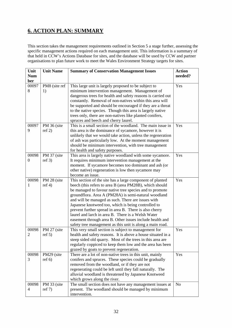
6. ACTION PLAN: SUMMARY This section takes the management requirements outlined in Section 5 a stage further, assessing the specific management actions required on each management unit. This information is a summary of that held in CCW’s Actions Database for sites, and the database will be used by CCW and partner organisations to plan future work to meet the Wales Environment Strategy targets for sites. Unit Number
Unit Name Summary of Conservation Management Issues Action needed?
000978
PM8 (site ref 1)
This large unit is largely proposed to be subject to minimum intervention management. Management of dangerous trees for health and safety reasons is carried out constantly. Removal of non-natives within this area will be supported and should be encouraged if they are a threat to the native species. Though this area is largely native trees only, there are non-natives like planted conifers, spruces and beech and cherry laurel.
Yes
000979
PM 36 (site ref 2)
This is a small section of the woodland. The main issue in this area is the dominance of sycamore, however it is unlikely that we would take action, unless the regeneration of ash was particularly low. At the moment management should be minimum intervention, with tree management for health and safety purposes.
Yes
000980
PM 37 (site ref 3)
This area is largely native woodland with some sycamore. It requires minimum intervention management at the moment. If sycamore becomes too dominant and ash (or other native) regeneration is low then sycamore may become an issue.
Yes
000981
PM 28 (site ref 4)
This section of the site has a large component of planted beech (this refers to area B (area PM28B), which should be managed to favour native tree species and to promote groundflora. Area A (PM28A) is semi-natural woodland and will be managed as such. There are issues with Japanese knotweed too, which is being controlled to prevent further spread in area B. There is also cherry laurel and larch in area B. There is a Welsh Water easement through area B. Other issues include health and safety tree management as this unit is along a main road.
Yes
000982
PM 27 (site ref 5)
This very small section is subject to management for health and safety reasons. It is above a house situated in a steep sided old quarry. Most of the trees in this area are regularly coppiced to keep them low and the area has been grazed by goats to prevent regeneration.
Yes
000983
PM29 (site ref 6)
There are a lot of non-native trees in this unit, mainly conifers and spruces. These species could be gradually removed from the woodland, or if they are not regenerating could be left until they fall naturally. The alluvial woodland is threatened by Japanese Knotweed which grows along the river.
Yes
000984
PM 33 (site ref 7)
The small section does not have any management issues at present. The woodland should be managed by minimum intervention.
No
33
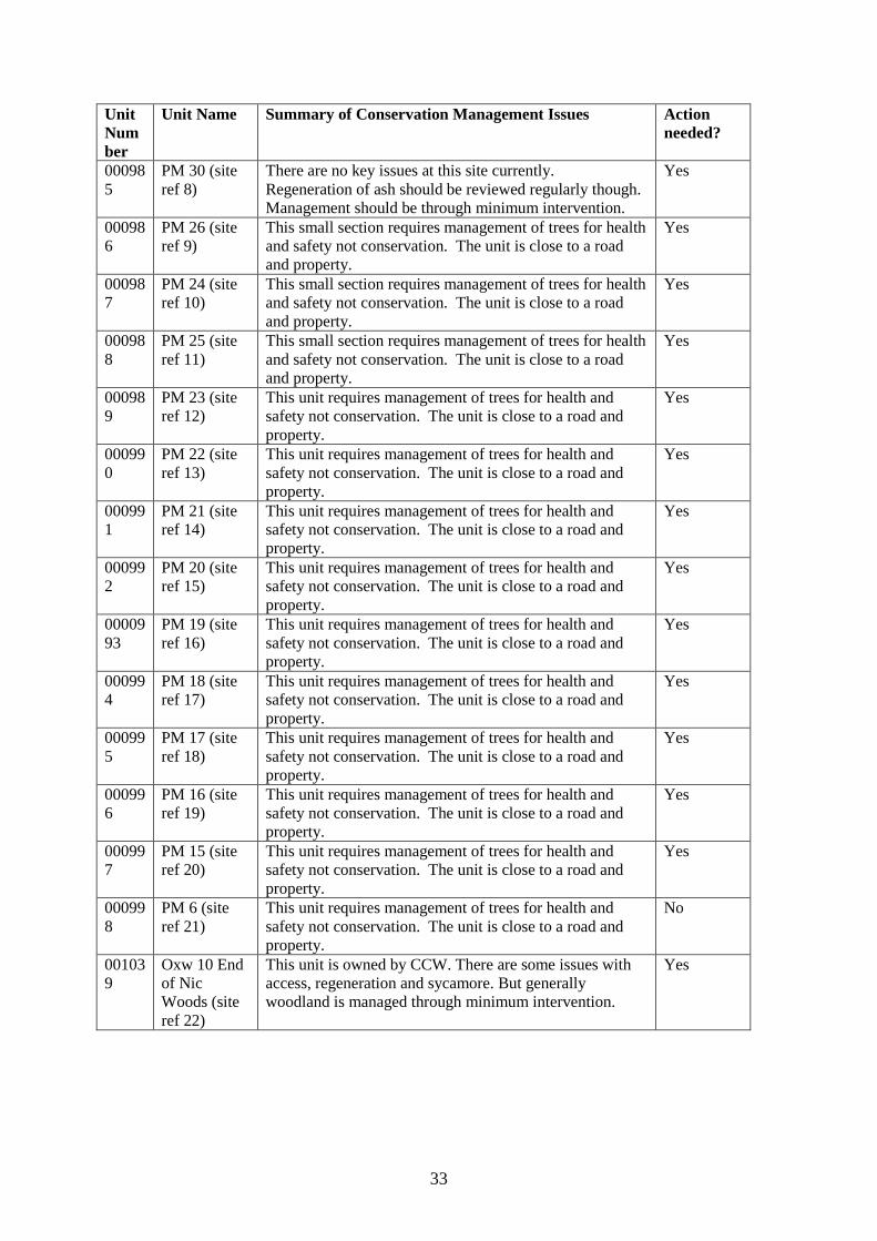
Unit Number
Unit Name Summary of Conservation Management Issues Action needed?
000985
PM 30 (site ref 8)
There are no key issues at this site currently. Regeneration of ash should be reviewed regularly though. Management should be through minimum intervention.
Yes
000986
PM 26 (site ref 9)
This small section requires management of trees for health and safety not conservation. The unit is close to a road and property.
Yes
000987
PM 24 (site ref 10)
This small section requires management of trees for health and safety not conservation. The unit is close to a road and property.
Yes
000988
PM 25 (site ref 11)
This small section requires management of trees for health and safety not conservation. The unit is close to a road and property.
Yes
000989
PM 23 (site ref 12)
This unit requires management of trees for health and safety not conservation. The unit is close to a road and property.
Yes
000990
PM 22 (site ref 13)
This unit requires management of trees for health and safety not conservation. The unit is close to a road and property.
Yes
000991
PM 21 (site ref 14)
This unit requires management of trees for health and safety not conservation. The unit is close to a road and property.
Yes
000992
PM 20 (site ref 15)
This unit requires management of trees for health and safety not conservation. The unit is close to a road and property.
Yes
0000993
PM 19 (site ref 16)
This unit requires management of trees for health and safety not conservation. The unit is close to a road and property.
Yes
000994
PM 18 (site ref 17)
This unit requires management of trees for health and safety not conservation. The unit is close to a road and property.
Yes
000995
PM 17 (site ref 18)
This unit requires management of trees for health and safety not conservation. The unit is close to a road and property.
Yes
000996
PM 16 (site ref 19)
This unit requires management of trees for health and safety not conservation. The unit is close to a road and property.
Yes
000997
PM 15 (site ref 20)
This unit requires management of trees for health and safety not conservation. The unit is close to a road and property.
Yes
000998
PM 6 (site ref 21)
This unit requires management of trees for health and safety not conservation. The unit is close to a road and property.
No
001039
Oxw 10 End of Nic Woods (site ref 22)
This unit is owned by CCW. There are some issues with access, regeneration and sycamore. But generally woodland is managed through minimum intervention.
Yes
34
Unit Number
Unit Name Summary of Conservation Management Issues Action needed?
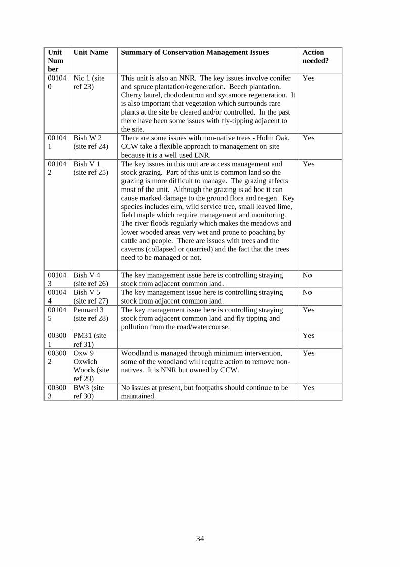
001040
Nic 1 (site ref 23)
This unit is also an NNR. The key issues involve conifer and spruce plantation/regeneration. Beech plantation. Cherry laurel, rhododentron and sycamore regeneration. It is also important that vegetation which surrounds rare plants at the site be cleared and/or controlled. In the past there have been some issues with fly-tipping adjacent to the site.
Yes
001041
Bish W 2 (site ref 24)
There are some issues with non-native trees - Holm Oak. CCW take a flexible approach to management on site because it is a well used LNR.
Yes
001042
Bish V 1 (site ref 25)
The key issues in this unit are access management and stock grazing. Part of this unit is common land so the grazing is more difficult to manage. The grazing affects most of the unit. Although the grazing is ad hoc it can cause marked damage to the ground flora and re-gen. Key species includes elm, wild service tree, small leaved lime, field maple which require management and monitoring. The river floods regularly which makes the meadows and lower wooded areas very wet and prone to poaching by cattle and people. There are issues with trees and the caverns (collapsed or quarried) and the fact that the trees need to be managed or not.
Yes
001043
Bish V 4 (site ref 26)
The key management issue here is controlling straying stock from adjacent common land.
No
001044
Bish V 5 (site ref 27)
The key management issue here is controlling straying stock from adjacent common land.
No
001045
Pennard 3 (site ref 28)
The key management issue here is controlling straying stock from adjacent common land and fly tipping and pollution from the road/watercourse.
Yes
003001
PM31 (site ref 31)
Yes
003002
Oxw 9 Oxwich Woods (site ref 29)
Woodland is managed through minimum intervention, some of the woodland will require action to remove non-natives. It is NNR but owned by CCW.
Yes
003003
BW3 (site ref 30)
No issues at present, but footpaths should continue to be maintained.
Yes
35
7. GLOSSARY This glossary defines the some of the terms used in this Core Management Plan. Some of the definitions are based on definitions contained in other documents, including legislation and other publications of CCW and the UK nature conservation agencies. None of these definitions is legally definitive. Action A recognisable and individually described act, undertaking or project of any kind,
specified in section 6 of a Core Management Plan or Management Plan, as being required for the conservation management of a site.
Attribute A quantifiable and monitorable characteristic of a feature that, in combination with
other such attributes, describes its condition. Common Standards Monitoring A set of principles developed jointly by the UK conservation
agencies to help ensure a consistent approach to monitoring and reporting on the features of sites designated for nature conservation, supported by guidance on identification of attributes and monitoring methodologies.
Condition A description of the state of a feature in terms of qualities or attributes that are
relevant in a nature conservation context. For example the condition of a habitat usually includes its extent and species composition and might also include aspects of its ecological functioning, spatial distribution and so on. The condition of a species population usually includes its total size and might also include its age structure, productivity, relationship to other populations and spatial distribution. Aspects of the habitat(s) on which a species population depends may also be considered as attributes of its condition.
Condition assessment The process of characterising the condition of a feature with
particular reference to whether the aspirations for its condition, as expressed in its conservation objective, are being met.
Condition categories The condition of feature can be categorised, following condition
assessment as one of the following1: Favourable: maintained; Favourable: recovered;
Favourable: un-classified Unfavourable: recovering; Unfavourable: no change; Unfavourable: declining; Unfavourable: un-classified Partially destroyed; Destroyed. Conservation management Acts or undertaking of all kinds, including but not necessarily limited
to actions, taken with the aim of achieving the conservation
1 See JNCC guidance on Common Standards Monitoring http://www.jncc.gov.uk/page-2272
36
objectives of a site. Conservation management includes the taking of statutory and non-statutory measures, it can include the acts of any party and it may take place outside site boundaries as well as within sites. Conservation management may also be embedded within other frameworks for land/sea management carried out for purposes other than achieving the conservation objectives.
Conservation objective The expression of the desired conservation status of a feature,
expressed as a vision for the feature and a series of performance indicators. The conservation objective for a feature is thus a composite statement, and each feature has one conservation objective.
Conservation status A description of the state of a feature that comprises both its condition and
the state of the factors affecting or likely to affect it. Conservation status is thus a characterisation of both the current state of a feature and its future prospects.
Conservation status assessment The process of characterising the conservation status of a
feature with particular reference to whether the aspirations for it, as expressed in its conservation objective, are being met. The results of conservation status assessment can be summarised either as ‘favourable’ (i.e. conservation objectives are met) or unfavourable (i.e. conservation objectives are not met). However the value of conservation status assessment in terms of supporting decisions about conservation management, lies mainly in the details of the assessment of feature condition, factors and trend information derived from comparisons between current and previous conservation status assessments and condition assessments.
Core Management Plan A CCW document containing the conservation objectives for a site
and a summary of other information contained in a full site Management Plan.
Factor Anything that has influenced, is influencing or may influence the condition of a
feature. Factors can be natural processes, human activities or effects arising from natural process or human activities, They can be positive or negative in terms of their influence on features, and they can arise within a site or from outside the site. Physical, socio-economic or legal constraints on conservation management can also be considered as factors.
Favourable condition See condition and condition assessment Favourable conservation status See conservation status and conservation status
assessment.2
Feature The species population, habitat type or other entity for which a site is designated. The ecological or geological interest which justifies the designation of a site and which is the focus of conservation management.
Integrity See site integrity
2 A full definition of favourable conservation status is given in Section 4.
37
Key Feature The habitat or species population within a management unit that is the primary focus of conservation management and monitoring in that unit.
Management Plan The full expression of a designated site’s legal status, vision, features,
conservation objectives, performance indicators and management requirements. A complete management plan may not reside in a single document, but may be contained in a number of documents (including in particular the Core Management Plan) and sets of electronically stored information.
Management Unit An area within a site, defined according to one or more of a range of criteria,
such as topography, location of features, tenure, patterns of land/sea use. The key characteristic of management units is to reflect the spatial scale at which conservation management and monitoring can be most effectively organised. They are used as the primary basis for differentiating priorities for conservation management and monitoring in different parts of a site, and for facilitating communication with those responsible for management of different parts of a site.
Monitoring An intermittent (regular or irregular) series of observations in time, carried out to
show the extent of compliance with a formulated standard or degree of deviation from an expected norm. In Common Standards Monitoring, the formulated standard is the quantified expression of favourable condition based on attributes.
Operational limits The levels or values within which a factor is considered to be acceptable in
terms of its influence on a feature. A factor may have both upper and lower operational limits, or only an upper limit or lower limit. For some factors an upper limit may be zero.
Performance indicators The attributes and their associated specified limits, together with
factors and their associated operational limits, which provide the standard against which information from monitoring and other sources is used to determine the degree to which the conservation objectives for a feature are being met. Performance indicators are part of, not the same as, conservation objectives. See also vision for the feature.
Plan or project Project: Any form of construction work, installation, development or other
intervention in the environment, the carrying out or continuance of which is subject to a decision by any public body or statutory undertaker. Plan: a document prepared or adopted by a public body or statutory undertaker, intended to influence decisions on the carrying out of projects. Decisions on plans and projects which affect Natura 2000 and Ramsar sites are subject to specific legal and policy procedures.
Site integrity The coherence of a site’s ecological structure and function, across its whole area, that
enables it to sustain the habitat, complex of habitats and/or the levels of populations of the species for which it is designated.
Site Management Statement (SMS) The document containing CCW’s views about the management
of a site issued as part of the legal notification of an SSSI under section 28(4) of the Wildlife and Countryside Act 1981, as substituted.
Special Feature See feature.

38
Specified limit The levels or values for an attribute which define the degree to which the
attribute can fluctuate without creating cause for concern about the condition of the feature. The range within the limits corresponds to favourable, the range outside the limits corresponds to unfavourable. Attributes may have lower specified limits, upper specified limits, or both.
Unit See management unit. Vision for the feature The expression, within a conservation objective, of the aspirations
for the feature concerned. See also performance indicators. Vision Statement The statement conveying an impression of the whole site in the state that is
intended to be the product of its conservation management. A ‘pen portrait’ outlining the conditions that should prevail when all the conservation objectives are met. A description of the site as it would be when all the features are in favourable condition.
39
8. REFERENCES AND ANNEX Ecotech Surveys, NVC Gower Ash Woodlands 2002. NVC Survey of Woodland SSSI in Wales, Gill Castle and Robert Mileto, 1998. National Trust Biological Surveys of Bishopston Valley (various). Rare Plant Survey, Vicky Morgan, 1998. NNR Management Plans (Oxwich NNR).
JNCC, 2004. Common Standards Monitoring Guidance for Woodland Habitats, 2004
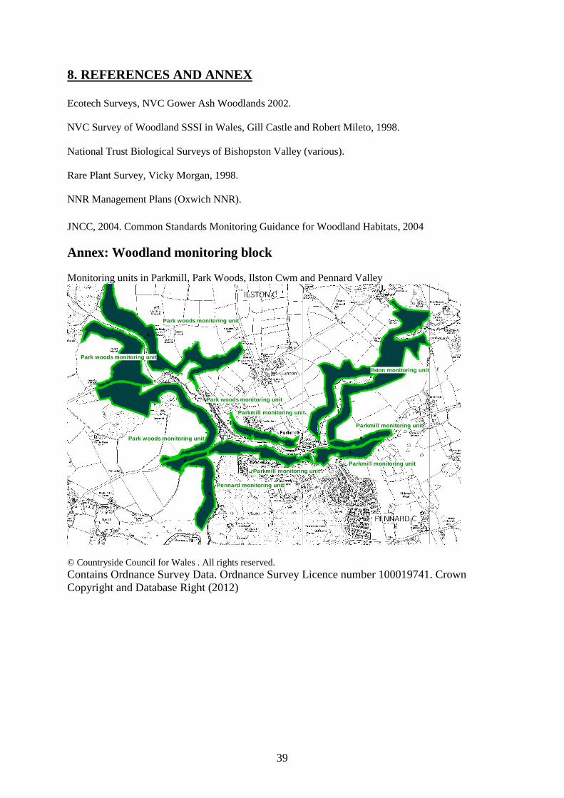
Annex: Woodland monitoring block Monitoring units in Parkmill, Park Woods, Ilston Cwm and Pennard Valley
Parkmill monitoring unit
Park woods monitoring unit
Parkmill monitoring unit
Parkmill monitoring unitParkmill monitoring unit
Pennard monitoring unit
Park woods monitoring unit
Ilston monitoring unit
Park woods monitoring unit
Park woods monitoring unit
© Countryside Council for Wales . All rights reserved. Contains Ordnance Survey Data. Ordnance Survey Licence number 100019741. Crown Copyright and Database Right (2012)

40
Monitoring units in Nicholaston and Oxwich woods
Nicholaston monitoring unit
Oxwich monitoring unit
© Countryside Council for Wales . All rights reserved. Contains Ordnance Survey Data. Ordnance Survey Licence number 100019741. Crown Copyright and Database Right (2012) Monitoring unit in Bishopston Valley and Bishop’s Wood
Bishopston Valley monitoring unit
Bishop woods monitoring unit
© Countryside Council for Wales . All rights reserved. Contains Ordnance Survey Data. Ordnance Survey Licence number 100019741. Crown Copyright and Database Right (2012)
41
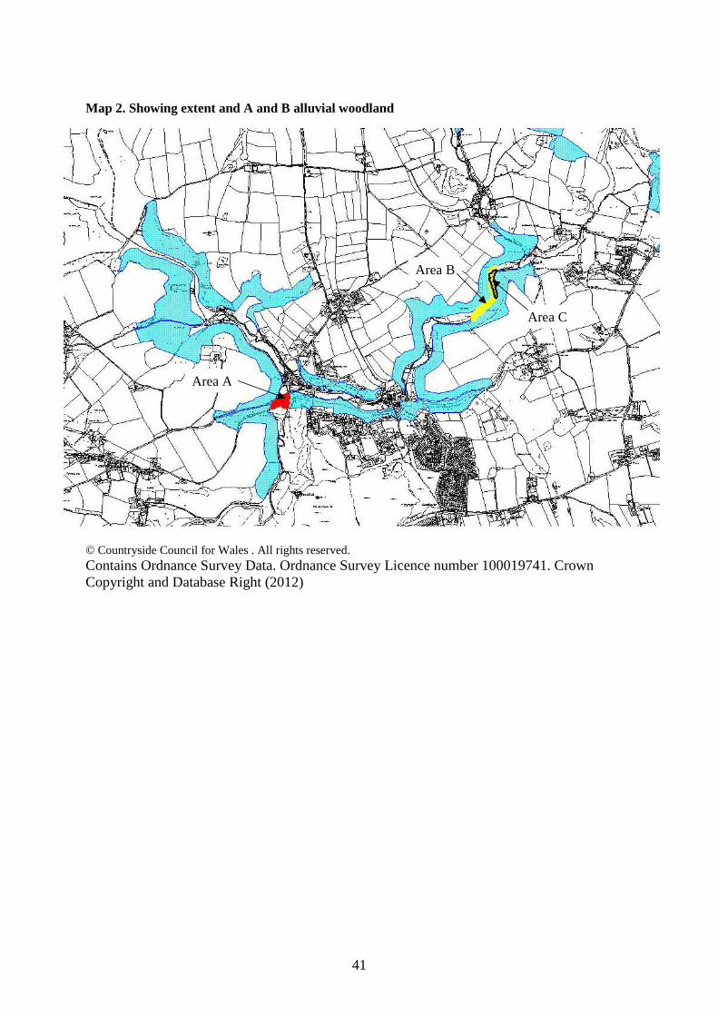
Map 2. Showing extent and A and B alluvial woodland
© Countryside Council for Wales . All rights reserved. Contains Ordnance Survey Data. Ordnance Survey Licence number 100019741. Crown Copyright and Database Right (2012)
Area A
Area B
Area C
Area A
Area B
Area C