Embed Size (px)
Citation preview
Fire Weather Services
for
North Carolina
Operating Plan
NWS Blacksburg, VA
NWS Greenville-Spartanburg, SC
NWS Morehead City, NC
NWS Morristown, TN
NWS Raleigh, NC
NWS Wakefield, VA
NWS Wilmington, NC
2020
This operating plan will be a semi-permanent document, specifying Fire Weather services provided by the National Weather Service in North Carolina. The plan incorporates procedures detailed in the Interagency Agreement for Meteorological Services.
1
Table of Contents
Introduction 5 Purpose of AOP 5 Explanation of Relationship between AOP and MOU 5
Service Area and Organizational Directory 6 NWS Service Area and Organizational Information 6 National Weather Service Headquarters 6 National Weather Service Regional Headquarters 6 Weather Forecast Offices (WFO) 7 Meteorologist-in-Charge (MIC) 7 Program Leaders (or Focal Points) 7 Participating Agencies 11
Services Provided by the National Weather Service 12 Routine Services 13
Fire Weather Planning Forecast (FWF) 13 Product Overview and Issuance Criteria 14 Format/Content of the FWF 14 Update Criteria for the Fire Weather Planning Forecast 19
Fire Weather Point Forecast Matrix (PFW) 19 Product Overview and Issuance Criteria 20
Fire Weather Area Forecast Matrix (AFW) 20 Product Overview and Issuance Criteria 20
Site Specific Wildland Fire Forecasts (Spot Forecasts) 21 Criteria 21 Contents 21 Procedures for Requesting a Spot Forecast 21
National Fire Danger Rating System (NFDRS) Forecasts 23 Issuance 23 Contents 24 Procedures 25
Fire Weather Watch and Red Flag Programs 26 Definition of a Red Flag Event 26
2
Red Flag Warning 27 Fire Weather Watch 27 Fire Danger Statements 27
Communications 28 Participation in Interagency Groups 28 Special Services 29 Incident Support 29 Other Special Services 31 Fire Weather Training 32
Natural Resource Agency Responsibilities 32 Operational Support and Predictive Services 32
Program Management 32 Monitoring, Feedback and Improvement 32 Technology Transfer 32 Agency Computer Resources 33 Fire Weather Observations 33 On - Site Support 34 Training 34
Joint Responsibilities 35 Meetings Between the NWS Offices and the Natural Resource Agencies 35
Conference Calls 35 Maintenance and Revision of the Annual Operating Plan 35
Notification of NWS Changes in Operating Procedures 36 Agreements on Services Provided 36
Workplace Visits 36 Service Evaluation 36 Numbering and Archiving of Observation Stations 36
Effective Dates on the AOP 37 Signatory Page 38
Appendices 42 Appendix A: Interagency Agreement 42 Appendix B: Fire Weather Zone Maps 42 Appendix C: Catalog of Fire Weather Observation Sites 43
Remote Automated Weather Stations 43 ASOS Observation Sites 46
3
AWOS Observation Sites 47 Military Observation Sites 49
Appendix D: All Hazards NOAA Weather Radio 50 Appendix E: Red Flag Criteria 56 Appendix F: Fire Weather Products and Examples 57 Appendix G: Fire Weather Parameter Definitions 58
Burn Category Table 58 Dispersion Table 58 Lavdas Atmospheric Dispersion Index (ADI) 58 Low Visibility Occurrence Risk index (LVORI) 60 Lightning Activity Level 61 Lightning Strokes 61 Wind Profile Analysis 62
Adverse Wind Profiles 62 Appendix H: FWF Update Criteria 63 Appendix I: Table of Specialized Products Produced By WFO’s 64
Fire Weather Experimental Grids 64 Activity Planner and Hourly Weather Graph products 65
Appendix J: AMRS Locations 66 Appendix K: Record of Changes to the AOP 67
4
Introduction Purpose of AOP This Operating Plan serves as the official document governing the interaction and relationships between the National Weather Service, and the federal, state and local natural resource and land management agencies or cooperators in North Carolina. Explanation of Relationship between AOP and MOU This State Operating Plan is issued in lieu of a formal Memorandum of Understanding (MOU) between the National Weather Service, federal, state, and other agencies that rely on fire weather support. The plan will outline forecast operations and services available to users. This includes products and formats, dissemination and coordination, and the responsibilities of the partners. This Operating Plan will be the governing document for fire weather procedures and cooperation among the following agencies:
● NOAA National Weather Service ● US Forest Service ● USDI National Park Service ● NC Forest Service ● US Fish and Wildlife Service ● US Army - Fort Bragg ● US Marine Corps - Camp Lejeune ● US Air Force - Dare County Bomb Range ● The Nature Conservancy ● USDI Bureau of Indian Affairs ● NC Division of Parks & Recreation ● US Army - Sunny Point Military Ocean Terminal ● US Marine Corps - Cherry Point ● NC Wildlife Resources Commission
The Southern Area Mobilization Guide and the National Mobilization Guide further define the relationship between the natural resource agencies and the NWS Incident Meteorologist. This Operating Plan for Fire Weather Services conforms with the Interagency Agreement for Meteorological Services, valid from 2017 through 2022.
5
Service Area and Organizational Directory
NWS Service Area and Organizational Information The service area covered by this AOP is the state of North Carolina, served by the National Weather Service Weather Forecast Offices at Blacksburg, VA (RNK), Greenville - Spartanburg, SC (GSP), Morehead City, NC (MHX), Morristown, TN (MRX), Raleigh, NC (RAH), Wakefield, VA (AKQ), and Wilmington, NC (ILM). Forecast areas are tied to the "radar umbrella" of the WSR-88D Doppler Radar. The umbrella is the area which is covered by the radar volume scan. This means that forecasts are not bound by state political borders, although county borders are generally observed. The North Carolina portion of the Great Smoky Mountains National Park is covered by the NWS office in Greenville-Spartanburg, SC. For a map of the fire weather zones in NC, see Appendix B.
National Weather Service Headquarters NWS Headquarters, located in Silver Spring, Maryland, establishes policies and coordinates the national fire weather program. The national program manager coordinates the program with the regional program managers. The national program manager also works with the national headquarters of the Federal forestry and other natural resource management agencies and the Association of State Foresters in determining overall requirements for meteorological support. The national program manager coordinates national training in forestry and fire weather for NWS forecasters.
National Weather Service Regional Headquarters Regional Headquarters manage the technical operational aspects of the fire weather program within each region. They also provide guidance and assistance to the meteorologist-in-charge (MIC) on program operations and developing issues through Supplements to the National Directives System (NDS) and conferences. Regional Headquarters advise National Headquarters on matters pertaining to technical planning and operations. The regional program managers coordinate the regions' fire weather programs and advise the Regional Directors on the operational and administrative aspects of the regions' programs.
6
Weather Forecast Offices (WFO) Weather Forecast Offices prepare and disseminate forecast products for all sectors of the population, including those for the Fire Weather program. These offices are responsible for providing forecasts for user agencies within their County Warning and Forecast Area (CWFA). Most offices have a designated fire weather focal point or fire weather program leader. Meteorologist-in-Charge (MIC) The Meteorologists-in-Charge are responsible for the provision of adequate weather services for the offices' assigned areas of program responsibility. The MIC's will ensure that the focal points or program leaders are provided adequate time for user liaison and assistance activities. Program Leaders (or Focal Points) Fire weather focal points and program leaders are the "customer service representatives" for the program. The focal points or program leaders, as representatives of the MIC's, are in regular contact with the partner agencies, helping them assess their meteorological needs, informing them of NWS products and services available to meet these needs, and educating them in the most effective use of the various NWS products and resources, including NOAA Weather Radio (NWR). Focal points and program leaders will work with users to utilize existing NWS products and services produced for other programs that could meet the requirements of natural resource management. The focal points and program leaders are also tasked with ensuring staff meteorologists are trained and remain proficient in preparing forecast products for support of the fire weather program. Fire Program Leaders can be reached via e-mail on their NWS office fire weather homepage. The National Weather Service Weather Forecast Offices will provide 24-hour, 365 days a year service. The NWS WFO's can be reached using the contact information below. NOTE: Unlisted telephone numbers used for coordination cannot be listed here. All user agencies have been or will be provided voice and fax numbers to be used for official purposes only.
Blacksburg Weather Forecast Office Blacksburg Weather Forecast Office VA Tech Corporate Research Center
7
1750 Forecast Drive Blacksburg, Virginia 24060
MIC: Vacant Program Leader: Phil Manuel (Certified IMET)
Email: [email protected] WFO RNK (Blacksburg, VA) serves the following counties in northwest North Carolina:
Alleghany Ashe Caswell Rockingham
Stokes Surry Watauga Wilkes
Yadkin
Greenville-Spartanburg Weather Forecast Office Greenville-Spartanburg Weather Forecast Office 1549 GSP Drive Greer, South Carolina 29651 MIC: Stephen Wilkinson Program Leader: Scott Krentz
Email: [email protected] WFO GSP (Greenville-Spartanburg, SC) serves the following counties in southwest North Carolina:
Alexander Avery Buncombe Burke
Cabarrus Caldwell Catawba Cleveland
Davie Gaston Graham Haywood
Henderson Iredell Jackson Lincoln
Macon Madison McDowell Mecklenburg
Mitchell Polk Rowan Rutherford
Swain Transylvania Union Yancey
8
Morehead City Weather Forecast Office Morehead City Weather Forecast Office 533 Roberts Road Newport, North Carolina 28570 MIC: David Glenn Program Leader: Scott Kennedy (Certified IMET)
Email: [email protected] IMET Trainee: Tom Lonka
Email: [email protected] WFO MHX (Morehead City, NC) serves the following counties in eastern North Carolina:
Beaufort Carteret Craven Dare
Duplin Greene Hyde Jones
Lenoir Martin Onslow Pamlico
Pitt Tyrrell Washington
Morristown Weather Forecast Office Morristown Weather Forecast Office 5974 Commerce Blvd. Morristown, Tennessee 37814 MIC: George Matthews Program Leader: Sam Roberts (IMET Trainee)
Email: [email protected] WFO MRX (Morristown, TN) serves the following counties in western North Carolina:
Cherokee Clay
9
Raleigh Weather Forecast Office Raleigh Weather Forecast Office Centennial Campus 1005 Capability Drive Research Building III, Suite 300 Raleigh, North Carolina 27606 MIC: Jonathan Blaes Program Leader: James Morrow
Email: [email protected] WFO RAH (Raleigh, NC) serves the following counties in central North Carolina:
Alamance Anson Chatham Cumberland
Davidson Durham Edgecombe Forsyth
Franklin Granville Guilford Halifax
Harnett Hoke Johnston Lee
Montgomery Moore Nash Orange
Person Randolph Richmond Sampson
Scotland Stanly Vance Wake
Warren Wayne Wilson
Wakefield Weather Forecast Office Wakefield Weather Forecast Office 10009 General Mahone Highway Wakefield, Virginia 23888 MIC: Jeff Orrock Program Leader: Jonathan McGee (IMET Trainee)
Email: [email protected] WFO AKQ (Wakefield, VA) serves the following counties in northeast North Carolina:
10
Bertie Camen Chowan Currituck
Gates Hartford Northampton Pasquotank
Perquimans
Wilmington Weather Forecast Office Wilmington Weather Forecast Office 2015 Gardner Drive Wilmington, North Carolina 28405 MIC: Mark Willis Program Leader: Jordan Baker
Email: [email protected] Certified IMET: Terry Lebo
Email: [email protected] WFO ILM (Wilmington, NC) serves the following counties in southeast North Carolina:
Bladen Brunswick Columbus New Hanover
Pender Robeson
Participating Agencies The following agencies are participants of this operating plan: National Park Service
NOAA National Weather Service
Nature Conservancy
NC Forest Service
US Army - Fort Bragg
11
US Army - Sunny Point Military Ocean Terminal
US Marine Corps - Camp Lejeune
US Air Force - Dare County Bomb Range
US Fish and Wildlife Service
US Forest Service USDI Bureau of Indian Affairs NC Wildlife Resources Commission
NC Division of Parks & Recreation
Services Provided by the National Weather Service The National Weather Service provides several products to support local, state, and federal fire agencies. Some products provide weather data for large areas (county or multi-county wide) and are intended to be a general overview for planning purposes. Others are point specific down to a 2.5 km gridpoint and are intended for detailed site specific forecasts intended for incidents, such as wildfires and prescribed burning plans. The Fire Weather Planning Forecast (FWF) and Fire Weather Area Forecast Matrix (AFW) are area wide forecasts and primarily should be used for input in decision-making related to pre-suppression and other planning or resource management activities, as well as for determining general weather trends. Generally, these products are not recommended to be used with wildfire or prescribed burning plans. The Fire Weather Point Forecast Matrix (PFW) is a site specific tabular forecast for predetermined locations in the forecast area, generally for RAWS and ECONet locations. It is intended for decision support related to pre-suppression and other planning or resource management activities at or near a specific point. The PFW is only updated twice daily and may not reflect the latest NWS forecast update. The Activity Planner and Hourly Weather Graph are web based tools that provide graphical and tabular point specific forecasts for a 2.5 km gridpoint for the latitude and longitude input by the user. Forecast data in these products are sampled from the NWS
12
National Digital Forecast Database (NDFD). This database is updated several times a day and will generally reflect the most up to date forecast from the NWS. Most fire weather forecast elements are available in this database and is suitable for most prescribed burn plans or short-lived wildfires. An experimental tool developed at NWS Duluth, MN named Fire Weather Dashboard or Fire Poker is similar to the hourly weather graph and tabular point specific forecast, but uses a different interface and may provide a more desirable look of the forecast data. There are also helpful overlays available on the “point and click” map. The Spot Forecast is a point specific forecast for a 2.5 km gridpoint and is the most up to date and scrutinized forecast from the NWS. In addition, spot requests provide the NWS forecast office situational awareness of critical incidents within their forecast area. This allows the NWS to provide additional decision support to discuss specific concerns about the forecast, relay critical forecast updates, and provide notification of an impending significant weather event directly to the incident officials. Spot Forecasts are recommended for most wildfires and large or potentially impactful prescribed burns (such as near environmentally sensitive areas, near critical infrastructure, or if changeable or significant weather is predicted). Several of the NWS forecast elements can also be found on the NC State Climate Office Fire Weather Intelligence Portal in gridded format. This data originates from several sources. Elements listed under NWS Gridded Forecasts come from the NDFD. Elements listed under NWS Gridded Fire Products for NC are not available from NDFD and sent by NWS forecast offices to NWS Eastern Region servers, which the NC State Climate Office then downloads for the Portal. Elements listed under NWS Fire Weather Zone Forecast are graphical representations of the FWF and are zone or multi-zone averages of these elements. Elements listed under National Blend of Models Forecasts are a blend of many forecast models to achieve an average forecast for this element. Blended model forecasts should be used cautiously, especially when changeable weather is expected as blending models tend to smooth out the details of these changes.
Routine Services Fire Weather Planning Forecast (FWF) The Fire Weather Planning Forecast (FWF) is a zone-type product used by natural resource management personnel primarily for input in decision-making related to pre-suppression and other planning or resource management activities, as well as for determining general weather trends that might impact burning condition and thereby fire behavior of wildfires and prescribed fires. The decisions impact firefighter safety, protection of the public, property, and the natural resource and resource allocation.
13
Generally, the FWF is not recommended to be used with prescribed burning or wildfire burning plans as it provides an average of the conditions over a large area and may not provide the detail required for a site specific forecast. This is especially true in coastal and mountain counties where coastal influences and terrain can cause weather conditions to vary over relatively short distances. Product Overview and Issuance Criteria The FWF provides a detailed prediction of elements for three specific 12-hour periods (four 12-hour periods with the afternoon forecast), a general 3 to 7 day forecast, and an 8 to 14 day extended outlook. The FWF is issued twice daily, once during the morning (between 3:00 and 6:30 AM), and the other during the afternoon (between 2:00 and 4:00 PM). The morning forecast, to be disseminated no later than 8:30 AM, consists of three periods: "Today" (valid from issuance through 6 PM local time), "Tonight" (6 PM to 6 AM), and "Tomorrow" (6 AM to 6 PM). The afternoon version, to be disseminated no later than 4:00 PM, consists of four periods: "Tonight" (6 PM to 6 AM), "Tomorrow" (6 AM to 6 PM), "Tomorrow Night" (6 PM to 6 AM), and the "Following Day" (6 AM to 6 PM). Format/Content of the FWF The format of the Fire Weather Forecast is specified in National Weather Service Directive 10-401. ● Headlines - A headline is required when Red Flag Warnings and/or Fire Weather
Watches are in effect. The headline will include the warning type, location, reason for issuance (e.g., high winds and low humidity), and effective time period(s). The headline is also included in the body of the FWF, in each appropriate zone grouping. Other headlines are requested since the natural resource agencies are also considered "all risk agencies". When significant weather trends of locally-defined critical weather elements are forecast or observed during non-watch/warning periods, they will be identified in the headline.
● Discussion - The discussion should be a brief, clear, non-technical description of
the weather patterns that influence the weather in the forecast area. ● Cloud Cover ("CLOUD COVER") - This is an indication of the expected sky
condition. "Clear" or "Sunny" descriptors are designated when the forecast cloud cover is < 10%; "Mostly Clear" or "Mostly Sunny" are used when cloud cover is forecast to be >= 10% and < 30%; "Partly Cloudy" or "Partly Sunny" are used when
14
cloud cover is forecast to be >= 30% and < 60%; "Mostly Cloudy" is used when cloud cover is >= 60% and < 80%; "Cloudy" is used when cloud cover is forecast to be >= 80%.
● Precipitation Type ("PRECIP TYPE") - This refers to the predominant precipitation
type during the forecast period, with an exception. When both "showers" and "thunderstorms" are included in the public forecast, "thunderstorms" will be designated as the precipitation type in the FWF.
● Chance of Precipitation ("CHANCE PRECIP") - Refers to the probability of
measurable precipitation (0.01 inches or more) during the forecast period. This will be rounded to the nearest 10%. Note: Drizzle and snow flurries are not considered measurable precipitation and thus will not be given a probability.
● Temperature ("MAX/MIN TEMP") - Refers to the forecasted maximum and
minimum temperature for the zone, in degrees F, as measured at a standard 4.5 ft above the ground level. Also may include a 24 hour trend value, noting the difference from the previous day's maximum/minimum temperature (such as at WFO MRX).
● Relative Humidity ("MAX/MIN RH") - Forecasted minimum relative humidity is
provided during the daytime periods, while maximum RH is included at night. Also, as with temperature, a 24- hour trend may be provided, such as at WFO MRX. Note: The lowest average humidity typically occurs during the warmest part of the day. However, if it is expected to occur at a different time of the day, this will be noted in the "Remarks" portion of the forecast.
● Surface Winds ("WND20FT/EARLY and WND20FT/LATE") - Surface wind speed
and direction represent an average at 20 feet above the ground or 20 ft above the vegetative cover. Wind direction is the direction the wind blows from, to eight points of the compass. The "EARLY" designation refers to morning hours (before noon) during daytime periods, and also the evening hours (before midnight) during nighttime periods. "LATE" refers to the afternoon hours during the daytime periods, and also the pre-dawn hours (after midnight) during the nighttime periods. Wind gusts, which are rapid fluctuations in wind speed of usually less than 30 seconds in duration, are indicated in the forecast if gustiness is expected. Forecasts for highest probable gust will be preceded by "G".
15
● Precipitation Amount ("PRECIP AMOUNT") - Refers to the forecasted
precipitation amount (in hundredths of an inch) whenever the chance of precipitation is 20% or greater.
● Precipitation Duration ("PRECIP DURATION") - Refers to the duration of
measurable precipitation (in hours) when the probability of measurable precipitation is greater than or equal to 20%. A precipitation duration forecast of "1" is used for "1 hour or less" duration.
● Precipitation Begin/End ("PRECIP BEGIN/END") - Refers to the time measurable
precipitation begins or ends. ● Mixing Height ("MIXING HGT") - Mixing height is defined as the atmospheric limit
above which vigorous vertical mixing does not take place. Mixing height forecasts are given in feet above the ground ("FT-AGL"), except at WFO MRX, where mixing heights are given in both feet above the ground ("FT-AGL"), and feet above mean sea level ("FT-MSL"), and will give AGL in a spot forecast upon customer request. Note: WFO RAH uses the Potential Temperature method for calculating mixing height, while WFO AKQ uses a Holzworth-Stull Hybrid method. All other WFO’s utilize the Miller-Holzworth method. Offices serving North Carolina have agreed to attempt to keep mixing heights within 1000 feet of those from neighboring offices.
● Transport Wind ("TRANSPORT WND") - Defined as the average wind direction
and speed from the surface to the top of the mixed layer. Direction of the transport wind (where the wind is blowing from) and speed will be given. The speed will be in MPH.
● Ventilation Rate ("VENT RATE") - Refers to a multiplication of the mixing height and
transport wind, With units in ft-MPH. Ventilation rates, forecasted during the daytime, are used to calculate the Burn Category for each day. The ventilation rate gives the potential for the atmosphere to disperse smoke. Refer to Appendix G for further details regarding the correlation of the Ventilation Rate and Burn Category.
● Dispersion ("DISPERSION") - Dispersion refers to the forecasted smoke dispersion
category at night, based on the surface wind speed. The dispersion category gives a general indication of the state of the atmosphere with respect to its ability to disperse smoke. The dispersion forecast (nighttime) is analogous to the daytime Ventilation Rate, though only a forecast during the evening hours is provided as a large majority of controlled/prescribed fire operations are completed before midnight. A spot forecast
16
is recommended for critical operations that might involve smoke drift towards a populated area. Refer to Appendix G for further details on dispersion categories.
● Atmospheric Dispersion Index ("ADI" ) - ADI refers to Lavdas atmospheric dispersion index (ADI), a forecast computed from mixing height, transport wind, and stability class. The value reported is the average maximum value for the zone grouping, which filters out extremes. Refer to Appendix G for further details of the Lavdas dispersion index (ADI).
Note: All WFO's except MRX produce early and late period values of ADI both night and day.
● Low Visibility Occurrence Risk Index ("LVORI") - An index derived from the
Lavdas ADI and the relative humidity, that gages the probability of visibility restrictions in fog or smoke. The index is based on a study of traffic accidents in Florida. The value reported is the maximum value for the zone grouping, in order to capture the highest values. Refer to Appendix G for further details on LVORI categories.
● Minimum Surface Visibility and Obstruction ("MIN VSBY") - The minimum surface
visibility, and if restricted below 7 miles, the obstruction causing the restriction. The value reported is the minimum value for the zone grouping, in order to capture the lowest values. Visibility values of 7 to 10 miles are considered unrestricted.
● Lightning Activity Level ("LAL") - A numerical value, which is used to describe the
expected lightning activity for that day. Refer to Appendix G for further details on the LAL.
● Haines Index ("HAINES INDEX") - The index infers the stability of the atmosphere.
In the North Carolina Coastal Plain and Piedmont, "low elevation" is assumed for the calculation of the Haines Index. It utilizes the atmospheric temperature at 950 mb and 850 Mb as well as taking into account the moisture levels (dew point depression) at 850 mb. In the North Carolina mountains, the "mid level" Haines Index is calculated using the temperatures at 850 mb and 700 mb, and the dew point depression at 850 mb.
Haines Index values range from 2 through 6.
On western fires, Haines Index values of 5 or 6 serve as an alert that fires or prescribed burns can experience control challenges. Local regional studies in North Carolina have shown that a Haines Index of 4 represents the initiating threshold whereby the atmosphere can support large fire growth. In the absence of strong winds, fire growth will be primarily "plume dominated", with crowning and spotting on all sides. As wind speeds increase, coupled with a starting Haines Index of 4 or greater, there is an increased threat for large wind-driven fires.
17
● DSI (Davis Stability Index) - The Davis Stability Index is the maximum surface
temperature (in deg C) minus the 850 mb temperature (in deg C). If the difference is <10 deg C, it is considered a Category 1 (stable); between 10 deg C and 14 deg C, it is considered a Category 2 (conditionally unstable); between 15 deg C and 17 deg C, it is considered a Category 3 (unstable); and >17 deg C, it is considered a Category 4 (absolutely unstable). Note: DSI is only computed for the daytime period. DSI was requested by the South Carolina Forestry Commission, therefore only computed by WFO's GSP and ILM, who also serve SC counties.
● Turner Stability Class - Turner Stability is another measure of atmospheric
stability, incorporating the parameters of ceiling height, solar radiation, day/night time period, and wind speed. Values A, B, C (or 1, 2, 3) are only possible for daytime period, while vaules E,F, G (or 5, 6, &) are only used for night time period. Value D (4) is possible for both day or night. Turner Stability values (A-G) range from extremely unstable, moderately unstable, slightly unstable, neutral, slightly stable, moderately stable, extremely stable
● 3 through 7 Day Forecast - The outlook period is an extended forecast for the
zone, or the entire forecast area, provided in narrative form (non-digital, non-tabular), and appended either at the bottom of each zone grouping (for just that zone), or at the end of all the zone groupings (for the entire area).
● Inversion Information - Refers to the time and/or temperature at which the morning
inversion will burnoff, or the time the inversion will setup in the evening. If the inversion is not surface based (yet still at low levels, e.g. below 1000 feet), meteorological factors other than nighttime radiational cooling may be taking place and as such, inversion information may not be given ("Inversion" remains in the forecast through the day, which would be reflected by a low mixing height). Conversely, there will be situations when a low level inversion does not develop at night; during these situations a "NO INV" or "NONE" will be noted. Note: WFO's GSP and ILM will include burnoff time and temperature in the morning, as well as setup time in the evening. WFO MHX includes burnoff temperature only. Other inversion notation includes CONT (for continued inversion), and MIXED/HHMM (when an inversion mixes out at local time HH:MM).
Note: WFO's AKQ, MRX, RAH and RNK do not produce an inversion forecast.
● Wind Profile Analysis - It is recognized that the profile of wind speed with altitude on
active fire days is an important factor in fire behavior. Certain profiles of wind speed marked by decreasing speed above a maximum or a jet within 2000 ft of the surface
18
can cause fires to behave erratically when combined with a rapid decrease in air temperature with altitude on the order of 5.5 degrees F per 1000 ft. The WPA section of Appendix G describes these types of profiles (Adverse Wind Profiles) that contribute toward adverse fire behavior.
The WPA is included in the remarks section of zone groupings that include North Carolina non-mountain counties from March through May. At the request of one or more partner agencies, the WPA can be included at other times of the year during periods of high fire danger.
Note: Only produced at WFO’s GSP, ILM and MHX. Note: Included at ILM year-round, immediately below the discussion section and above zone groupings.
Update Criteria for the Fire Weather Planning Forecast The Fire Weather Forecaster will maintain a weather watch to ensure that the forecast remains accurate. When unexpected changes occur or are forecast to occur which significantly deviate from the previous forecast, the forecast will be updated. The decision to update, to an extent, is at forecaster discretion. The update criteria for various elements are listed in the Appendix H. It is a shared responsibility for the WFO's and the natural resource agencies to monitor the need to update a forecast. Respective agency personnel will also provide feedback as to the updating of an FWF, NFDRS Point, or Spot Forecast. Fire Weather Point Forecast Matrix (PFW) The Fire Weather Point Forecast Matrix (PFW) is a tabular-type product used by natural resource management personnel for decision support related to pre-suppression and other planning or resource management activities at or near a specific point. These points are predetermined by the customers, and are semi-permanent in nature, meaning they can be changed from time to time, but not on a daily basis. Generally, the forecast points listed in the PFW are those that are included in the National Fire Danger Rating System (NFDRS) Forecasts (i.e. RAWS locations and NC ECONet sites). If an agency has a critical burn they are planning or there is a prolonged wildfire, they may request to have a point added to the PFW to aid in their planning and decision making processes. If an agency would like to have a point added to the PFW, contact the NWS Fire Weather program manager responsible for the location. A name,
19
elevation, latitude, and longitude for the location is required to have the point added. It may take 2-3 days (sometimes longer) to have a point added to the PFW, so it is not advantageous to make a request for a near-term project or short-lived wildfire where a Spot Forecast is more appropriate. Note: WFO MRX does not issue a PFW, but includes this information in the PFM for RAWS points. Product Overview and Issuance Criteria The PFW provides a detailed prediction of elements for three days out at 3-hour intervals, including smoke management parameters through day 2, and a more general 3 to 7 day forecast without smoke management parameters. The winds given in this forecast are not terrain corrected winds. The PFW is issued twice daily, once in the morning (between 3:00 and 6:30 AM), and the other in the afternoon (between 2:00 and 4:00 PM). For an example and information on decoding the product, click on PFW Guide.
Fire Weather Area Forecast Matrix (AFW) The Fire Weather Area Forecast Matrix (AFW) is a tabular-type product used by natural resource management personnel for decision support related to pre-suppression and other planning or resource management activities in a specific fire weather zone. These forecasts are produced for each individual fire weather zone, normally a whole county (example: Buncombe County), but in some cases a part of one county (example: Polk Mountains), or parts of several counties (example: Great Smoky Mountains National Park which is in Swain and Haywood Counties). Generally, the AFW should not be used for prescribed burning or wildfire burning plans as it provides an average of the conditions over a large area and may not provide the detail required for a site specific forecast. This is especially true in coastal and mountain counties where coastal influences and terrain can cause weather conditions to vary over relatively short distances. Product Overview and Issuance Criteria The AFW provides a detailed prediction of elements for three days out at 3-hour intervals, including smoke management parameters through day 2, and a more general 3 to 7 day forecast without smoke management parameters. The winds given in this forecast are not terrain corrected winds. The AFW is issued twice daily, once in the morning (between 3:00 and 6:30 AM), and the other in the afternoon (between 2:00 and
20
4:00 PM). For an example and information on decoding the product, click on AFW Guide.
Note: Experimental product issued only by WFO GSP. Site Specific Wildland Fire Forecasts (Spot Forecasts) Criteria Spot forecasts are special, non-routine forecasts prepared upon request of any federal agency, or state agency when there is some aspect of federal resources involved and/or interagency protection agreements currently exist, that needs site specific weather forecasts for: 1) controlling the spread of wildfire; 2) planning and managing prescribed fires; or 3) other specialized forest management activities. In the event of an emergency which threatens life and/or property, spot forecasts can also be provided to any federal, state, or local agency. Requesting a Spot Forecast provides the NWS forecast office situational awareness of critical incidents within their forecast area. This allows the NWS to provide additional decision support to discuss specific concerns about the forecast, relay critical forecast updates, and provide notification of an impending significant weather event directly to the incident officials. Spot Forecasts are recommended for most wildfires and large or potentially impactful prescribed burns (such as near environmentally sensitive areas, near critical infrastructure, or if changeable or significant weather is predicted). Contents Spot forecasts are highly detailed forecasts for a specific location within the forecast area. The format of the spot forecast is specified in National Weather Service Directive 10-401. The forecasts will be headlined for a Red Flag Warning or Fire Weather Watch. The forecasts will begin with a discussion, and may contain any or all of the following weather elements: sky conditions; maximum and minimum temperatures, minimum and maximum relative humidity values, wind speed and direction; probability of precipitation; precipitation type, duration and amount; mixing heights; transport wind; inversion height; inversion onset and burnoff times or temperatures; ventilation and smoke management levels; wind profiles; stability indices (IE., Haines Index), and lightning activity levels (LAL). Since these are site specific and can be initiated because of critical circumstances, tailored products can be requested (e.g. temperature, relative humidity, and wind speed forecasts on a two hour incremental time period). Procedures for Requesting a Spot Forecast
21
Spot forecasts will be prepared when requested by a user agency. Federal, state and local agencies may request spot forecasts in support of wildfire suppression or other emergencies where lives and/or property may be threatened. Due to the detailed and specific nature of this forecast product, it is imperative that the user provide the forecaster with necessary and sufficient information so that a reliable forecast can be prepared. Requests for spot forecasts should be made using the web based spot forecast request form https://www.weather.gov/spot/request/. This form, along with instructions on how to use it, is available on the fire weather web pages of the local NWS sites. The web based spot forecast request form should be filled out as completely as possible by the user agency prior to submitting the request. In times when internet access is hindered or not possible, spot forecasts may be requested and disseminated via fax or phone. If faxing a request, users should use the Fire Weather Special Forecast Request Form, WS Form D-1. Section I of WS Form D-1 should be filled out as completely as possible by the user agency prior to submitting the request by the fax to the forecast office. If the request is made by phone, all information in Section I should be provided to the forecast office. While there is no dedicated fire weather forecaster, the forecast office will give a high priority to spot forecasts in the absence of weather phenomena in the CWFA that pose a threat to life and property. To ensure that the request for a spot forecast is handled properly and appropriately, users should adhere to the following guidelines:
1) Allow adequate time for the forecaster to prepare the forecast. This will normally be between 20 and 30 minutes. On particularly busy fire weather days, spot forecasts will be handled on a first-come, first-serve basis, with wildfires or other life threatening events taking the highest priority.
2) Provide as much on-site or near-site weather information as possible. At a minimum, the user must provide at least one observation within an hour of the request. This observation must contain the following: location of the observation; elevation at the observation site; time of the observation; wind direction, speed, and level (eye or 20 foot); dry and wet bulb temperatures (or dry bulb temperature and relative humidity); any remarks about the state of the weather, particularly anything that may affect fire behavior. If possible, include some observations from the previous day that might give the forecaster an indication of daily trends. Note: Current, local observations allow the forecaster to change the forecast based on current conditions, including important weather elements such as temperature, dew point and wind direction and speed.
3) As much as possible, specify the time period for which the forecast is needed.
22
4) As much as possible, specify the weather elements of most importance for which a
forecast is needed, and/or critical values of these elements.
5) Provide a contact point name and phone number where the forecaster can call if there are questions about the spot request or if the NWS needs to notify the requesting official about a forecast update or an impending significant weather event approaching the area. Ensure this is a number that will reach the appropriate personnel, either someone at the fire location or dispatch that can immediately relay the information to the fire location.
6) Natural resource agency personnel should contact the appropriate NWS forecast office for a spot update if the forecast conditions appear unrepresentative of the actual weather conditions. Whenever possible, users should provide feedback, positive or negative, to the NWS forecast office concerning the performance of the spot forecast during or shortly after an event. This will assist forecasters in subsequent forecasts for the same or similar conditions.
Click for example of Spot Request WS Form D-1.
National Fire Danger Rating System (NFDRS) Forecasts Issuance NFDRS forecasts will be issued for all RAWS and North Carolina ECONet stations within the County Warning Area on a daily basis. NFDRS Forecast is currently a 24 hour forecast, but is planned to become a 7 day forecast in June 2020. Initiation of NFDRS forecasts for a new site will be coordinated with the NWS, and the agency requesting new NFDRS service will provide the NWS with information about the site location. As NFDRS 2016 is gradually implemented across the Geographic Area, the observations should automatically flow on the NWS Collective (FWO) product that is received from WIMS. It is not certain if the collective will even be necessary once NFDRS 2016 is fully implemented. The NWS will still need to notify the station owner if they deem the data received from a RAWS to be bad, especially if it is internally inconsistent with general meteorological practices. An example of internal inconsistency would include: a negative humidity, an abnormally high temperature, or an abnormally low temperature for the season. These things, when they occur, are normally an indication that sensors need to be replaced. The information needed by the NWS to produce the NFDRS forecast can be supplied by either the GACC meteorologist or the agency representative within the state or local area. This data is readily available from the WIMS catalog.
23
WIMS access for NWS personnel is also available. The GACC meteorologist can assist with that as needed. WIMS access is through the National Application Portal (NAP) and a username and password is required for each individual that requires access. NAP does not allow for group accounts due to security concerns and regulations. Contents The NFDRS forecast will be a forecast of the next day observation at 1300 LT. The format of the NFDRS forecast is specified in National Weather Service Directive 10-401. The forecast will include the following elements:
a. ZONE/FCTS: Shows whether this forecast is for an NFDRS zone or individual station. Zone average trends are forecast when enough observations are available for the zone area. Individual site forecasts are done where only a few observations are available.
b. NO: NFDRS Zone Number (or individual NFDRS site number).
c. YYMMDD: Year, month and day of valid forecast time.
d. 13: Valid forecast time. Always 1300 LST.
e. WX: Weather valid at 1300 LST tomorrow. Valid entries are: 0 = clear 1 = scattered clouds (1/8 to 4/8) 2 = broken clouds (5/8 to 7/8) 3 = overcast clouds (more than 7/8) 4 = fog 5 = drizzle 6 = rain 7 = snow or sleet 8 = showers (in sight or at the station) 9 = thunderstorm Note: Categories 5, 6 or 7 sets NFDRS index to 0.
f. TEMP: Temperature in degrees F valid at 1300 LST (or temperature trend + or - degrees F, though not currently used at any sites).
g. RH: Relative Humidity in percent valid at 1300 LST (or RH trend + or - percent, though not currently used at any sites).
24
h. LAL1: Lightning Activity Level 1400 LST to 2300 LST.
i. LAL2: Lightning Activity Level 2300 LST to 2300 LST.
j. WDIR: Wind Direction. Used only for point forecast (FCST) version. Enter direction using sixteen a point compass (N, NNE, NE, ENE, etc.) valid at 1300 LST (20 ft level, 10 minute average).
k. WSPD: Wind Speed. Enter wind speed in mph (or wind speed trend + or - mph) valid at 1300 LST (20 ft, 10 minute average).
l. 10HR: 10 hour time lag fuel moisture in percent valid at 1300 LST (or trend + or - percent).
m. Tx: Maximum temperature from 1300 LST to 1300 LST tomorrow.
n. Tn: Minimum temperature from 1300 LST to 1300 LST tomorrow.
o. RHx: Maximum relative humidity from 1300 LST to 1300 LST tomorrow.
p. RHn: Minimum relative humidity from 1300 LST to 1300 LST tomorrow.
q. PD1: Precipitation duration in hours 1300 LST to 0500 LST.
r. PD 2: Precipitation duration in hours 0500 LST to 1300 LST.
s. WETFLAG: Y or N. Indicates whether liquid water will be on the fuels at 1300 LST tomorrow. (Use with caution, a "Y" will set all the NFDRS indices to zero!).
Format. The NFDRS Forecast will follow the comma delimited format as shown: For zone average forecasts: ZONE,NO,YYMMDD,13,WX,TEMP,RH,LAL1,LAL2,WSPD,10HR,TX,TN,RHx,RHn,PD1, PD2,WETFLAG For individual site forecasts: FCST,NO,YYMMDD,13,WX,TEMP,RH,LAL1,LAL2,WDIR,WSPD,10HR,TX,TN,RHx,RH n,PD1,PD2,WETFLAG Procedures The Land Management Agencies are responsible for taking, quality controlling,
25
transmitting, and the archiving of NFDRS observations from RAWS sites and other mutually agreed upon observation networks (such as NC ECONet). Forecasts will be prepared for all sites, unless obvious errors are transmitted or the observation is internally inconsistent for prolonged periods of time. The observation(s) should be received by the NWS in a timely manner. Missing observations sometimes occur due to signal override, satellite outages, or other elements beyond the control of the station owner. In these types of situations, NFDRS forecasts should still be issued. Suspension of the NFDRS forecast should be coordinated with the GACC meteorologist, the Regional RAWS coordinator for that geographic area, and the station owner. If the station owner, typically a Land Management employee, is unable to service the sensors on his station, the NFDRS forecast can be suspended until the station comes back into service. When regular maintenance is being performed on a timely basis, long term outages beyond five days should not occur, or at least occur very infrequently. The Land Management Agencies do not have a mandatory turn-around time on maintenance issues. An NFDRS forecast can be made based on conditions in the surrounding area, even though a particular RAWS site may be temporarily out of service. NFDRS 2016 will require a continuum of observations spanning 24 hours every day. Short term outages of an hour or so will generally not pose too much of a problem in the computation of indices; however, long term outages of eight hours or more could lead to significant errors. This is due to the fact that every observation throughout the day is needed to accurately model fuel moisture values. The NWS will prepare and transmit the NFDRS forecasts no later than 4 PM. Although the data cutoff time for ingest into the NFDRS software is 7 PM, preliminary calculations based on the forecast are used by land managers to make staffing decisions at shift briefing time (4 PM). Fire Weather Watch and Red Flag Programs During periods in which critical fire weather conditions are expected or imminent, the NWS will issue statements, watches and warnings to describe the level of urgency to the appropriate user agencies. These issuances will be coordinated with natural resource agencies. WFO Raleigh is the primary NWS liaison office to the NC Forest Service and will collaborate with all NWS offices serving NC during times of critical fire weather conditions. Definition of a Red Flag Event A Red Flag Event occurs when critical weather conditions develop which could lead to
26
extensive wildfire occurrence or to extreme fire behavior. Red Flag Events represent a threat to life and property, and may adversely impact firefighting personnel and resources. Critical weather conditions include combinations of the following: strong, gusty winds; very low relative humidity; high to extreme fire danger; significant wind shifts; and lightning. Specific criteria can be found in the Appendix E. Red Flag Warning A Red Flag Warning will be issued, after coordination with the appropriate natural resource agencies, when a Red Flag Event is occurring or is imminent. The warning will be issued for all or a portion of the forecast area. It will be issued immediately once the forecaster and appropriate natural resource agency have determined that a Red Flag Event is ongoing. Otherwise, it shall be issued for impending Red Flag conditions when there is a high degree of confidence that conditions will develop within 48 hours. The warning will continue until the conditions cease to exist or fail to develop as forecast. At such time, the warning will be canceled. The format of the Red Flag Warning is specified in National Weather Service Directive 10-401. A sample Red Flag Warning and cancellation are in the Appendix F. Fire Weather Watch A Fire Weather Watch will be issued, after coordination with the appropriate natural resource agencies, to advise of the possible development of a Red Flag Event in the near future. It will be issued for all or part of the forecast area. A Fire Weather Watch is issued when the forecaster and appropriate natural resource agencies are reasonably confident that a Red Flag Event will occur. A watch should be issued 12 to 96 hours in advance of the expected onset of the critical weather conditions. The watch will remain in effect until either it is determined the Red Flag Event will not develop, or that the watch should be upgraded to a warning. If conditions are not expected to occur as forecast, the watch will be canceled. A Fire Weather Watch will not be carried over into the first period of the forecast. The format of the Fire Weather Watch is specified in National Weather Service Directive 10-401. A sample Fire Weather Watch and cancellation are in the Appendix F. Fire Danger Statements When fire danger or fire occurrence is high and is coupled with critical weather conditions, user agencies may request that the NWS issue a Fire Danger Statement. This statement will be issued in coordination with the requesting agency and will
27
only be issued with their approval. The NWS will use the Special Weather Statement (SPS) for these issuances. The statements will normally be issued 12 to 24 hours in advance (or for the next operational day time period). The following criteria will be used for Fire Danger Statements:
1. RH within 5% of Red Flag Criteria (30% or lower) AND
2. 20 ft wind speeds or gusts within 5 MPH of Red Flag Criteria (sustained 15 MPH
or gusts to 25 MPH) AND
3. Low fuel moisture as determined by land managers.
These criteria may be waived at the request of the land managers, typically for unusual or dangerous situations. Communications The primary means of communication used by the NWS is the Advanced Weather Interactive Processing System (AWIPS). Products transmitted by this means include pre-suppression forecasts, Fire Weather Watches, Red Flag Warnings, and Fire Danger Statements. Spot Forecasts will be disseminated only to the requesting agency by means of the Internet, or as a backup, relayed verbally by phone call and/or personalized email. Spot requests should include a reachable voice number (such as a cell phone or dispatch) in case NWS forecasters need to reach out with questions about the spot request and/or to notify the requesting official about critical forecast updates. Other means of communication may be utilized upon mutual agreement with the user agencies. Public products produced by the National Weather Service are available over All Hazards NOAA Weather Radio (NWR). See Appendix D for a listing of NWS transmitters serving North Carolina.
Participation in Interagency Groups At a minimum, one NWS representative (usually the State Liaison WFO Fire Weather Program Leader or MIC) will attend the State Interagency meetings or working groups where fire weather or smoke management policy is discussed as an integral part of the
28
meeting. However, it is strongly recommended that all NWS offices with fire weather responsibility attend the meetings to ensure uniform representation.
Special Services Special fire weather services are those services that are uniquely required by natural resource agencies and go beyond the normal forecast operations of the NWS. Special services include Incident Meteorologist (IMET) deployment, station visits, training, and other pertinent meteorological services that are designated as non-routine. Typically, special services require NWS personnel to be away from the Forecast Office and, in some instances, be in overtime status. User agencies are responsible for covering the cost of NWS overtime, travel and per diem expenses. Reimbursement of costs for special services will be as outlined in the Interagency Agreement for Meteorological Services
Incident Support On-site forecast service support is available for wildfires and prescribed burns. This includes the deployment of an Incident Meteorologist (IMET) and related service equipment such as the All Hazards Meteorological Response System (AMRS), and the Incident Remote Automated Weather Station (IRAWS). The IMET, AMRS, and the IRAWS are considered national firefighting resources, and can be requested through the North Carolina Interagency Coordination Center. The AMRS is a modularized mobile system of equipment used by an Incident Meteorologist (IMET) for data collection and forecast preparation. Only trained personnel will operate the AMRS, and this service equipment will only be dispatched to an incident when a certified IMET is requested. The IMET is responsible for arranging shipment of the AMRS. AMRS workstations are collocated with Weather Forecast Offices that have certified IMETS. These AMRS workstations are maintained by the IMETS and are typically shipped with the IMET being mobilized. As of 2020, the AMRS workstations located in NC are at NWS Wilmington and NWS Morehead City. Other nearby AMRS workstations are located at NWS Columbia in SC, NWS Roanoke in VA, and NWS Morristown in TN. (see map in Appendix J for AMRS locations). The AMRS is composed of two pelican cases, one large shipping box and one medium size. The large case contains a laptop computer, extra monitor, belt weather kit, smartphone with wireless internet connectivity for obtaining weather data, a printer and
29
office supplies. The volume is about 7 cubic feet, and its weight is about 90 pounds. The medium case consists of an upper air balloon sounding system, radiosondes with balloons, a nozzle and regulator for a helium tank, and miscellaneous expendables. Its volume is about 3 cubic feet and it weighs 55 pounds. Total weight of the AMRS is 145 lbs. with a volume of 10 cubic feet. The cubic feet and weight are necessary for shipment by air. Requests for the IMET should be made through the North Carolina Interagency Coordination Center. Typically, the IMET nearest the incident will be deployed. However, during times of limited resources, IMETs from other areas of the country may be called. The decision will be made by the National Fire Weather Operations Coordinator (NFWOC) in conjunction with the MIC and IMET from the affected offices. It is the responsibility of the IMET to arrange shipment of the AMRS workstation. The success of the operation depends in part on the user agency providing shelter and logistical support. Prior to the use of this equipment, the IMET is expected to have coordinated with the local user agency to ensure proper field support. If an IMET determines that IRAWS are desirable, it is the IMET's responsibility to ensure the IRAWS have also been ordered for the incident. The requesting agency is responsible for any storage of service equipment while in transit, and shelter for the IMET and service equipment at the site. A sheltered work area, of at least 50 square feet with a table and chair, must be protected from excessive dust, free of standing water or condensation, and must be heated and/or cooled sufficiently to allow efficient operation of equipment. Power (120V AC) must be provided for the AMRS's electrical equipment, and priority telephone access during certain short periods each day must be made available. The procedure for requesting IMETs will follow the guidelines outlined in the national MOA, the National Mobilization Guide, and the Southern Area Interagency Mobilization Guide. The following information will be provided to the requested IMET:
1. Name of fire.
2. Location of fire.
3. Directions to the location where the IMET is to report and the location of ICP.
4. Name of Incident Commander, Plans Chief, and FBAN, if available.
5. Request and Resource Order number for IMET.
30
6. Resource orders should include the following statement: “Laptop, cellphone,
excess baggage fees, and rental of a 4WD vehicle authorized by National Mobilization Guide, Chapter 20, Section 22.7.”
Upon arrival at the incident and after going through the appropriate check-in procedures, the IMET will:
1. Brief the Fire Behavior Analyst (FBAN), Planning Section Chief (PSC), and the Incident Commander (IC) on current and expected weather as it affects the fire.
2. Establish a schedule with the IC and the FBAN for written forecasts and formal briefings.
3. Request a briefing on the fire situation and potential behavior problems from the FBAN. As time and resources permit, incident management should arrange for an aerial inspection trip for the meteorologist and should provide the forecaster with current fire line maps. If possible, the IMET should be assigned a radio with the fire line frequency.
4. Arrange for a schedule of observations from key points around the fire and from nearby lookouts and fire danger stations, in cooperation with the FBAN and PSC. On large fires, some personnel (at least two) should be permanently assigned to this duty. On smaller fires, this information can be provided by Division Supervisors equipped with belt weather kits.
IMET duties will vary with incident management team requirements, but the IMET is expected to provide daily weather forecasts for the incident, participate in shift briefings, planning and strategy meetings, and coordinate daily with the local Weather Forecast Office (WFO) and /or other IMETs at nearby incidents. Demobilization is initiated at the incident, and will be coordinated through the North Carolina Interagency Coordination Center. Upon release, the user agency will arrange transport of the Fire RAWS back to its cache location or to the controlling fire weather office. The user agency will also arrange transport of any peripheral equipment (e.g. helium tanks for supporting the AMRS) back to the local vendor. Travel arrangements will be made for the IMET back to his or her home office. The IMET is responsible for arranging transport of the AMRS workstation back to the home office. If the AMRS unit resides at a different location than the IMET’s home office, the IMET must make arrangements to ship the equipment to the proper office, and charge any shipping cost to the fire.
Other Special Services 31
Other special services may include weather station visits by partner agency personnel, RAWS site surveys and inspections, weather observer training, and course development work or related program work. These activities would typically be at the full expense of the requesting agency unless other arrangements have been made. NWS meteorologists may also be asked to assist in other non-routine services (e.g. briefings or coordination calls) during periods of high fire danger or fire occurrence. MICs and Fire Program Leaders are to ensure the natural resource agency needs are met with little expense to either agency. Fire Weather Training NWS meteorologists will be available to assist in user-oriented training. This includes fire behavior courses, such as S-190 and S-290, where the meteorologist will serve as part of the cadre for that course. Requests for training assistance should be made through the NWS office's Fire Weather Program Leader or Meteorologist-in-Charge (MIC). Sufficient advance notice should be given to allow for scheduling and proper preparation. Costs incurred by the NWS in providing training assistance will be borne by the requesting agency.
Natural Resource Agency Responsibilities Operational Support and Predictive Services Program Management The natural resource agencies will oversee the fire weather observation program, including the siting and maintenance of the observing equipment, fire weather training of their personnel, and the proficiency of their personnel in the use of the NWS Spot software. Monitoring, Feedback and Improvement Natural resource agencies will monitor the quality and timeliness of NWS fire weather products, and provide feedback the NWS in order to improve services to the agencies. Technology Transfer
32
The natural resource agencies may, from time to time, advise the NWS of new technologies being implemented to monitor meteorological or fuel parameters, or to improve communication, coordination, training or reference. Natural resource agency personnel may, with prior arrangement, visit an NWS office to acquire knowledge of NWS technologies used in the monitoring of weather, or the preparation of products. Agency Computer Resources Internet will be the primary method of obtaining the Fire Weather Forecast, Red Flag Warning, Fire Weather Watch, and for both requesting and receiving a Spot Forecast. As a backup method, a request can be made to the NWS for a product to be faxed to the customer agency. NFDRS observations will be entered into WIMS, and forecasts and calculations based on these observations will be received by WIMS, or by internet via a WIMS website. Fire Weather Observations Fire weather observation stations provide the specialized weather observations for fire weather forecasts, wildfire control and suppression, and various other land management operations. These stations were selected very carefully in each state and federal district. Sites were chosen to represent homogeneous weather conditions across a district. Stations may either be manned sites operated by land management agencies, or unmanned, Remote Automatic Weather Stations (RAWS) maintained by any of the federal or state land management agencies in the area. All observation stations are assigned a 6-digit identification/location number. The first two digits indicate the state, the second two digits indicated the county, and the last two digits indicated the consecutively-assigned station number for that county. Land managers who wish to have a number assigned to a station should contact the GACC meteorologist at SACC in Atlanta. RAWS stations are also assigned an 8 character alphanumeric identifier based on satellite transmission time. The NESDIS ID, transmit channel and time are assigned by the US Forest Service National RAWS program. Observations from a satellite telemetered RAWS will automatically flow into WIMS via the NESDIS ID. If a station is not satellite telemetered, the data must be manually entered into WIMS. As NFDRS 2016 is implemented, the previous requirement of changing R to O will no longer be present. All 24 observations will be needed to accurately compute fire danger indices. State of the Weather will no longer be needed as that part of the computation is handled by an algorithm that utilizes Solar Radiation data. NFDRS 2016 will feature a much higher degree of automation than the
33
previous system. For those stations that do not embrace NFDRS 2016, the manual change from R to O will still be required. However, the state of the weather is computed by the Nelson Model. The station owner has an opportunity to edit that value if he deems it inappropriate or erroneous on a given day. Non-NFDRS stations are exempt from these procedures. Even with automated observations, the responsibility still rests with the RAWS owner to ensure that observations are being transmitted, recorded, and archived properly in WIMS. Automation greatly simplifies the daily process; however, there will still be the need for observations to be checked for integrity and consistency. Managing the NFDRS model parameters will still be a manual process in WIMS prior to the implementation of NFDRS 2016. Once the station owner opts to implement NFDRS 2016, the manual model management will be greatly reduced or possibly eliminated altogether. Automation helps streamline the WIMS collective that is distributed to the NWS via AWIPS. NFDRS forecasts are based on RAWS observations that appear on the daily collective and it is important these observations are accurate. Sensor failure will often result in erroneous or (at best) suspicious values. If the NWS becomes aware of such a situation, it is prudent to contact the station owner. Similarly, if a station owner becomes aware of a sensor failure, he should relay that information to the appropriate NWS office. It is that station owner's responsibility to make sure that their station is and remains in good working order and repairs are made in a timely manner. Owners of NFDRS stations can still (and should) correct any errors in their respective observations. It is important to note, observations are the most important single effort the control agencies put into the Fire Weather Program. Potential fire danger is derived from these observations. The Fire Danger Rating System is the guidance tool that, together with the weather forecast, is used to make a variety of management decisions. It is important that observers be well trained and informed of the necessity for accurate, timely, and representative observations. On - Site Support The user agencies are also responsible for maintaining observation site equipment. NWS personnel may accompany the user on maintenance trips or for annual inspection visits, which could also serve as liaison with the users. Training The responsibility of training natural resource agency employees will be that of the agencies themselves. However, the NWS will be available to assist when requested to do so. Any expenses incurred by the NWS will normally be charged to the user agency,
34
unless other arrangements have been made.
Joint Responsibilities Joint responsibilities include the following: Meetings Between the NWS Offices and the Natural Resource Agencies At least one statewide meeting hosted by the NWS is normally attempted each year, usually coordinated by the NWS State Liaison Offices in Raleigh. Individual NWS offices normally conduct a meeting with all of their customers, from all affected states, either each year or every other year. The NC Forest Service conducts at least two meetings per year, roughly every summer and winter, with all natural resource agencies and NWS offices serving North Carolina invited to attend. These meetings typically will be held in central North Carolina, to minimize travel distance. Although the agenda includes many internal division matters they are of interagency consequence. Therefore, the NWS is a Strategic Partner and is invited to these meetings since topics often include NWS operations. Conference Calls During times of very high or extreme fire danger, or a Readiness Plan of 4 or higher (on a scale from 1 to 5), the NCFS Central Office may initiate a conference call to discuss fire danger and weather. This call may include various partner agencies, and either some, or all of the NWS offices serving North Carolina, depending on the extent of the area of concern. When more than one NWS office is participating, NCFS will ask one NWS office to lead the weather discussion, which may be followed by input from the other NWS offices for their area. At times when the entire state is the area of concern, the NWS State Liaison Office in Raleigh will normally lead the discussion, but this may vary if the area of concern is skewed toward another NWS office's area. Conference calls will normally be held in the late morning, when NWS offices are beginning to consider their afternoon forecast package. Maintenance and Revision of the Annual Operating Plan The AOP should be revised each year by the end of January, with cooperation and participation from each NWS office and each natural resource agency. The state liaison office will be custodian of the plan.
35
Notification of NWS Changes in Operating Procedures From time to time, NWS headquarters, or NWS Eastern Region Headquarters, will send draft versions of future directives to their forecast offices for review and comment. To ensure that the natural resource partner agencies have an opportunity to review and comment on proposed changes, the NWS State Liaison Office in Raleigh will forward a copy of draft directives to NCFS when they are received. NCFS will then forward draft NWS directives to the rest of the natural resource partner agencies for review. Comments and suggestions can be forwarded to the NWS State Liaison Office in Raleigh, which will forward them to NWS Eastern Region Headquarters. Agreements on Services Provided Agreements on services and standards are normally reached at statewide meetings, but may be achieved at by a series of local meetings or by other means such as telephone or e-mail. NWS offices and land managers should be aware of the ripple effect an agreement might have on other NWS offices and their customers, particularly when service areas cross state lines. Workplace Visits Natural resource agencies and the NWS collaborate on familiarization of personnel in each other’s fields of expertise, operations and equipment. Visits to offices and work centers, as well as field job sites can meet part of these requirements.
Service Evaluation Services provided by the NWS, and delivery of observations and information from the natural resource agencies to the NWS in support of these services, shall be under constant evaluation by both parties. Numbering and Archiving of Observation Stations The GACC, when requested to do so by a natural resource agency, shall assign a station ID number for fire weather observation platforms. The land management agency will provide the station name, location (county, latitude, and longitude), and elevation to the GACC meteorologist. The GACC meteorologist will assign the number and assist the station owner in establishing a station catalog in WIMS. The numbering convention uses a six digit number, starting with 31 (for NC). The following two digit number designates the county, and the counties are numbered from
36
01 in the northwest, to 99 in the southeast. The GACC meteorologist is responsible for maintaining a database of RAWS stations in his area. This information can be provided to the NWS regional program manager upon request. The master list for North Carolina will be the list included in Appendix C of this operating plan, which will be updated at least annually with any new or changed stations.
Effective Dates on the AOP The effective dates of this Annual Operating Plan will be from January 1 through December 31 of the current calendar year. This plan will be subject to review and revision by all signatory parties each year, or more frequently as operations warrant. This plan will be available on the WFO fire weather webpages. A copy of this plan will be made available to NWS Eastern Region Headquarters, NIFC, and NWS Headquarters by January 31 of the current year. The State Liaison Office will retain a copy of the AOP for five years.
37
Signatory Page The following signatories have agreed to the terms and conditions of this Annual Operating Plan, which is subject to revision on at least an annual basis, or more frequently as operations necessitate. Actual signatures are maintained on file. /Signed Electronically/ 5/28/2020
Greg Hicks Date NC Forest Service Department of Agriculture and Consumer Services /Signed Electronically/ 5/28/2020
Laura Hendrick Date USMC Cherry Point /Signed Electronically/ 2/29/2020
Phillip Manuel Date Fire Weather Program Leader NWS Blacksburg, VA /Signed Electronically/ 2/21/2020
Scott Krentz Date Fire Weather Program Leader NWS Greenville-Spartanburg, SC /Signed Electronically/ 2/19/2020
James Morrow Date Fire Weather Program Leader NWS Raleigh, NC
38
/Signed Electronically/ 2/18/2020
Scott Kennedy Date Fire Weather Program Leader NWS Morehead City/Newport, NC /Signed Electronically/ 2/19/2020
Sam Roberts Date Fire Weather Program Leader NWS Morristown, TN /Signed Electronically/ 2/23/2020
Jon McGee Date Fire Weather Program Leader NWS Wakefield, VA /Signed Electronically/ 2/23/2020
Jordan Baker Date Fire Weather Program Leader NWS Wilmington, NC /Signed Electronically/ 2/24/2020
Pete Steponkus Date Forest Fire Management Officer Environmental Conservation Branch USMC Camp Lejeune
39
/Signed Electronically/ 2/28/2020
Greg Salansky Date Appalachian-Piedmont-Coastal Zone FMO Great Smoky Mountains National Park National Park Service /Signed Electronically/ 2/28/2020
Steven Little Date National Forests in North Carolina U.S. Forest Service /Signed Electronically/ 2/19/2020
Bert Plante Date Zone Fire Management Officer U.S. Fish & Wildlife Service /Signed Electronically/ 2/23/2020
Chris Jordan Date Lands Program Coordinator North Carolina Wildlife Resources Commission /Signed Electronically/ 2/21/2020
Denver Ingram Date Predictive Services Program Manager Southern Area Coordination Center /Signed Electronically/ 5/26/2020
Margit Bucher Date The Nature Conservancy - North Carolina Chapter
40
/Signed Electronically/ 2/22/2020
Thomas Crate Date NC Division of Parks and Recreation Department of Natural and Cultural Resources /Signed Electronically/ 2/20/2020
Rod Fleming Date Chief, Forestry Branch US Army Fort Bragg /Signed Electronically/ 2/19/2020
Robert Montgomery Date USAF Dare County Bomb Range
Larry Blythe Date Fire Management Officer USDI Bureau of Indian Affairs /Signed Electronically/ 2/23/2020
Chris Jordan Date NC Prescribed Fire Council
41
Appendices Appendix A: Interagency Agreement Click here for the Interagency Agreement for Meteorological Services in Support of Agencies with Land and Fire Management Responsibilities.
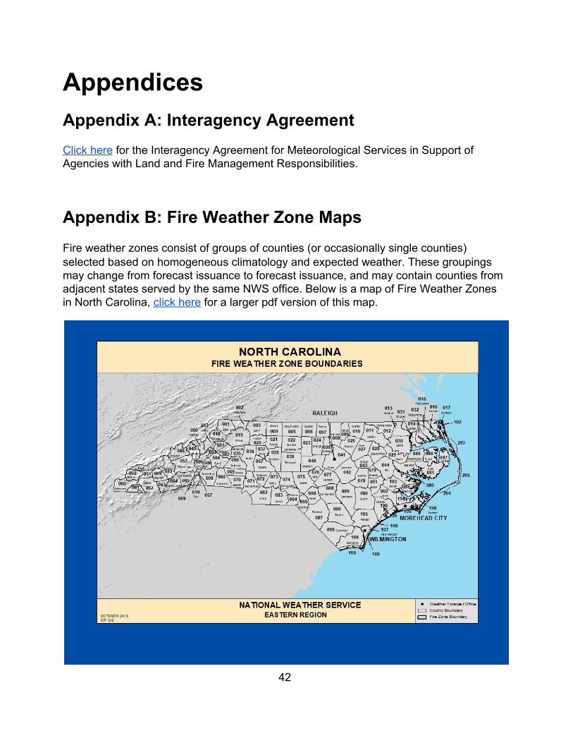
Appendix B: Fire Weather Zone Maps Fire weather zones consist of groups of counties (or occasionally single counties) selected based on homogeneous climatology and expected weather. These groupings may change from forecast issuance to forecast issuance, and may contain counties from adjacent states served by the same NWS office. Below is a map of Fire Weather Zones in North Carolina, click here for a larger pdf version of this map.
42
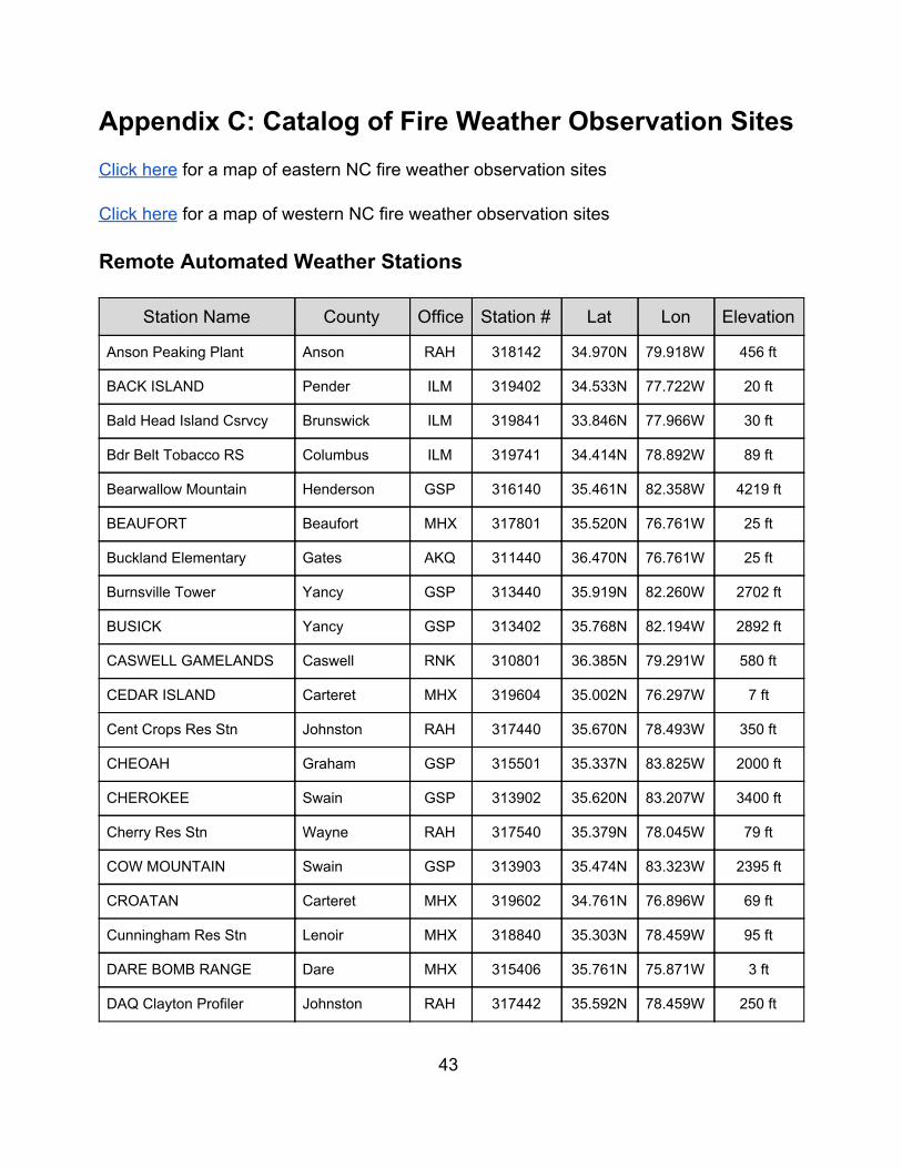
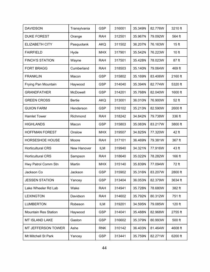
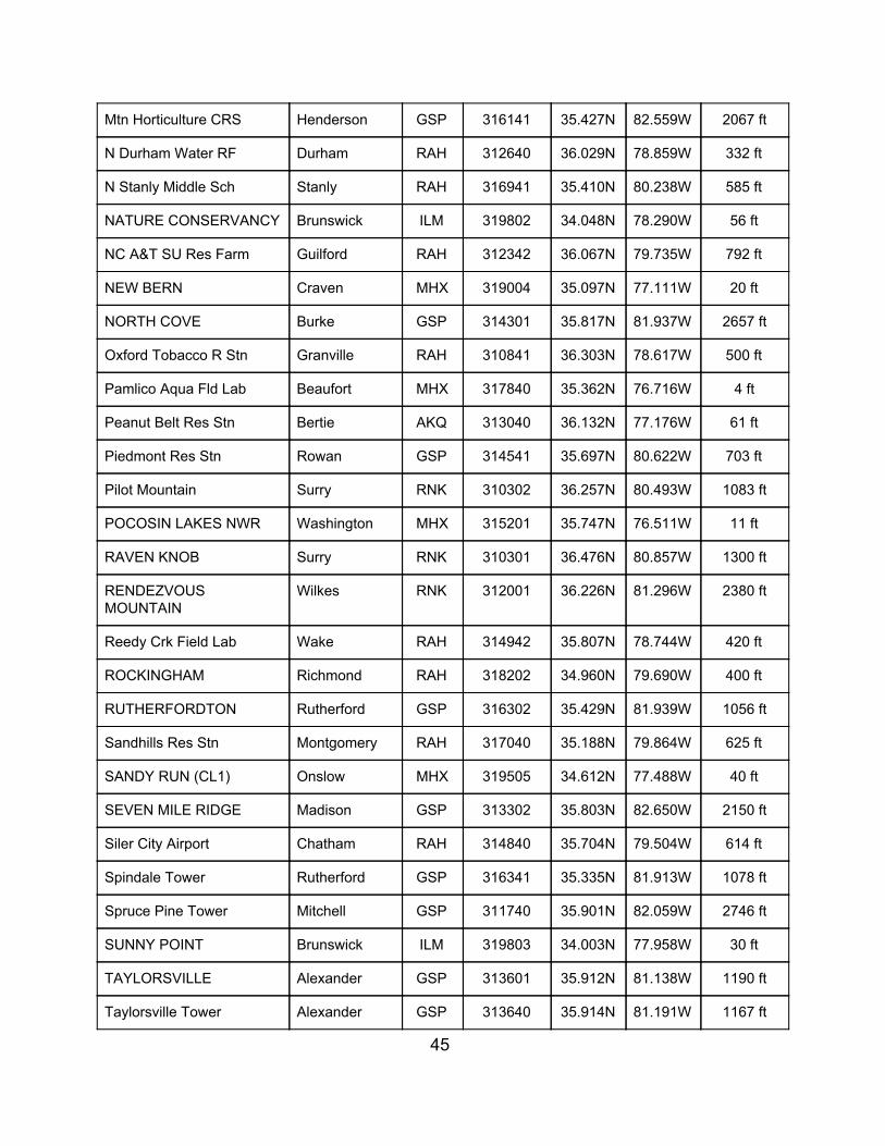
Appendix C: Catalog of Fire Weather Observation Sites Click here for a map of eastern NC fire weather observation sites Click here for a map of western NC fire weather observation sites
Remote Automated Weather Stations
Station Name County Office Station # Lat Lon Elevation
Anson Peaking Plant Anson RAH 318142 34.970N 79.918W 456 ft
BACK ISLAND Pender ILM 319402 34.533N 77.722W 20 ft
Bald Head Island Csrvcy Brunswick ILM 319841 33.846N 77.966W 30 ft
Bdr Belt Tobacco RS Columbus ILM 319741 34.414N 78.892W 89 ft
Bearwallow Mountain Henderson GSP 316140 35.461N 82.358W 4219 ft
BEAUFORT Beaufort MHX 317801 35.520N 76.761W 25 ft
Buckland Elementary Gates AKQ 311440 36.470N 76.761W 25 ft
Burnsville Tower Yancy GSP 313440 35.919N 82.260W 2702 ft
BUSICK Yancy GSP 313402 35.768N 82.194W 2892 ft
CASWELL GAMELANDS Caswell RNK 310801 36.385N 79.291W 580 ft
CEDAR ISLAND Carteret MHX 319604 35.002N 76.297W 7 ft
Cent Crops Res Stn Johnston RAH 317440 35.670N 78.493W 350 ft
CHEOAH Graham GSP 315501 35.337N 83.825W 2000 ft
CHEROKEE Swain GSP 313902 35.620N 83.207W 3400 ft
Cherry Res Stn Wayne RAH 317540 35.379N 78.045W 79 ft
COW MOUNTAIN Swain GSP 313903 35.474N 83.323W 2395 ft
CROATAN Carteret MHX 319602 34.761N 76.896W 69 ft
Cunningham Res Stn Lenoir MHX 318840 35.303N 78.459W 95 ft
DARE BOMB RANGE Dare MHX 315406 35.761N 75.871W 3 ft
DAQ Clayton Profiler Johnston RAH 317442 35.592N 78.459W 250 ft
43
DAVIDSON Transylvania GSP 316001 35.349N 82.776W 3210 ft
DUKE FOREST Orange RAH 312501 35.967N 79.092W 564 ft
ELIZABETH CITY Pasquotank AKQ 311502 36.207N 76.163W 15 ft
FAIRFIELD Hyde MHX 317901 35.542N 76.223W 10 ft
FINCH’S STATION Wayne RAH 317501 35.428N 78.023W 87 ft
FORT BRAGG Cumberland RAH 318503 35.140N 79.064W 469 ft
FRANKLIN Macon GSP 315802 35.169N 83.406W 2160 ft
Frying Pan Mountain Haywood GSP 314040 35.394N 82.774W 5320 ft
GRANDFATHER McDowell GSP 314201 35.768N 82.040W 1600 ft
GREEN CROSS Bertie AKQ 313001 36.010N 76.900W 52 ft
GUION FARM Henderson GSP 316102 35.213N 82.590W 2600 ft
Hamlet Tower Richmond RAH 318242 34.842N 79.738W 336 ft
HIGHLANDS Macon GSP 315803 35.083N 83.217W 3800 ft
HOFFMAN FOREST Onslow MHX 319507 34.825N 77.320W 42 ft
HORSESHOE HOUSE Moore RAH 317101 36.469N 79.381W 367 ft
Horticultural CRS New Hanover ILM 319940 34.321N 77.916W 43 ft
Horticultural CRS Sampson RAH 318640 35.022N 78.282W 166 ft
Hwy Patrol Comm Stn Martin MHX 315140 35.839N 77.094W 72 ft
Jackson Co Jackson GSP 315902 35.316N 83.207W 2800 ft
JESSEN STATION Yancey GSP 313404 36.053N 82.379W 3634 ft
Lake Wheeler Rd Lab Wake RAH 314941 35.728N 78.680W 382 ft
LEXINGTON Davidson RAH 314602 35.792N 80.312W 751 ft
LUMBERTON Robeson ILM 319201 34.595N 79.085W 120 ft
Mountain Res Station Haywood GSP 314041 35.488N 82.968W 2755 ft
MT ISLAND LAKE Gaston GSP 316602 35.379N 80.993W 500 ft
MT JEFFERSON TOWER Ashe RNK 310142 36.403N 81.464W 4608 ft
Mt Mitchell St Park Yancey GSP 313441 35.759N 82.271W 6200 ft
44
Mtn Horticulture CRS Henderson GSP 316141 35.427N 82.559W 2067 ft
N Durham Water RF Durham RAH 312640 36.029N 78.859W 332 ft
N Stanly Middle Sch Stanly RAH 316941 35.410N 80.238W 585 ft
NATURE CONSERVANCY Brunswick ILM 319802 34.048N 78.290W 56 ft
NC A&T SU Res Farm Guilford RAH 312342 36.067N 79.735W 792 ft
NEW BERN Craven MHX 319004 35.097N 77.111W 20 ft
NORTH COVE Burke GSP 314301 35.817N 81.937W 2657 ft
Oxford Tobacco R Stn Granville RAH 310841 36.303N 78.617W 500 ft
Pamlico Aqua Fld Lab Beaufort MHX 317840 35.362N 76.716W 4 ft
Peanut Belt Res Stn Bertie AKQ 313040 36.132N 77.176W 61 ft
Piedmont Res Stn Rowan GSP 314541 35.697N 80.622W 703 ft
Pilot Mountain Surry RNK 310302 36.257N 80.493W 1083 ft
POCOSIN LAKES NWR Washington MHX 315201 35.747N 76.511W 11 ft
RAVEN KNOB Surry RNK 310301 36.476N 80.857W 1300 ft
RENDEZVOUS MOUNTAIN
Wilkes RNK 312001 36.226N 81.296W 2380 ft
Reedy Crk Field Lab Wake RAH 314942 35.807N 78.744W 420 ft
ROCKINGHAM Richmond RAH 318202 34.960N 79.690W 400 ft
RUTHERFORDTON Rutherford GSP 316302 35.429N 81.939W 1056 ft
Sandhills Res Stn Montgomery RAH 317040 35.188N 79.864W 625 ft
SANDY RUN (CL1) Onslow MHX 319505 34.612N 77.488W 40 ft
SEVEN MILE RIDGE Madison GSP 313302 35.803N 82.650W 2150 ft
Siler City Airport Chatham RAH 314840 35.704N 79.504W 614 ft
Spindale Tower Rutherford GSP 316341 35.335N 81.913W 1078 ft
Spruce Pine Tower Mitchell GSP 311740 35.901N 82.059W 2746 ft
SUNNY POINT Brunswick ILM 319803 34.003N 77.958W 30 ft
TAYLORSVILLE Alexander GSP 313601 35.912N 81.138W 1190 ft
Taylorsville Tower Alexander GSP 313640 35.914N 81.191W 1167 ft
45
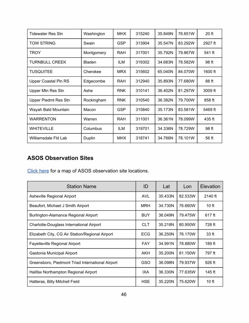
Tidewater Res Stn Washington MHX 315240 35.849N 76.651W 20 ft
TOW STRING Swain GSP 313904 35.547N 83.292W 2927 ft
TROY Montgomery RAH 317001 35.792N 79.867W 541 ft
TURNBULL CREEK Bladen ILM 319302 34.683N 78.582W 98 ft
TUSQUITEE Cherokee MRX 315602 65.040N 84.070W 1600 ft
Upper Coastal Pln RS Edgecombe RAH 312940 35.893N 77.680W 88 ft
Upper Mtn Res Stn Ashe RNK 310141 36.402N 81.297W 3009 ft
Upper Piedmt Res Stn Rockingham RNK 310540 36.382N 79.700W 858 ft
Wayah Bald Mountain Macon GSP 315840 35.173N 83.581W 5469 ft
WARRENTON Warren RAH 311001 36.361N 78.099W 435 ft
WHITEVILLE Columbus ILM 319701 34.336N 78.729W 98 ft
Williamsdale Fld Lab Duplin MHX 318741 34.766N 78.101W 56 ft
ASOS Observation Sites Click here for a map of ASOS observation site locations.
Station Name ID Lat Lon Elevation
Asheville Regional Airport AVL 35.433N 82.533W 2140 ft
Beaufort, Michael J Smith Airport MRH 34.730N 76.660W 10 ft
Burlington-Alamance Regional Airport BUY 36.049N 79.475W 617 ft
Charlotte-Douglass International Airport CLT 35.218N 80.950W 728 ft
Elizabeth City, CG Air Station/Regional Airport ECG 36.250N 76.170W 33 ft
Fayetteville Regional Airport FAY 34.991N 78.880W 189 ft
Gastonia Municipal Airport AKH 35.200N 81.150W 797 ft
Greensboro, Piedmont Triad International Airport GSO 36.098N 79.937W 926 ft
Halifax Northampton Regional Airport IXA 36.330N 77.635W 145 ft
Hatteras, Billy Mitchell Field HSE 35.220N 75.620W 10 ft
46
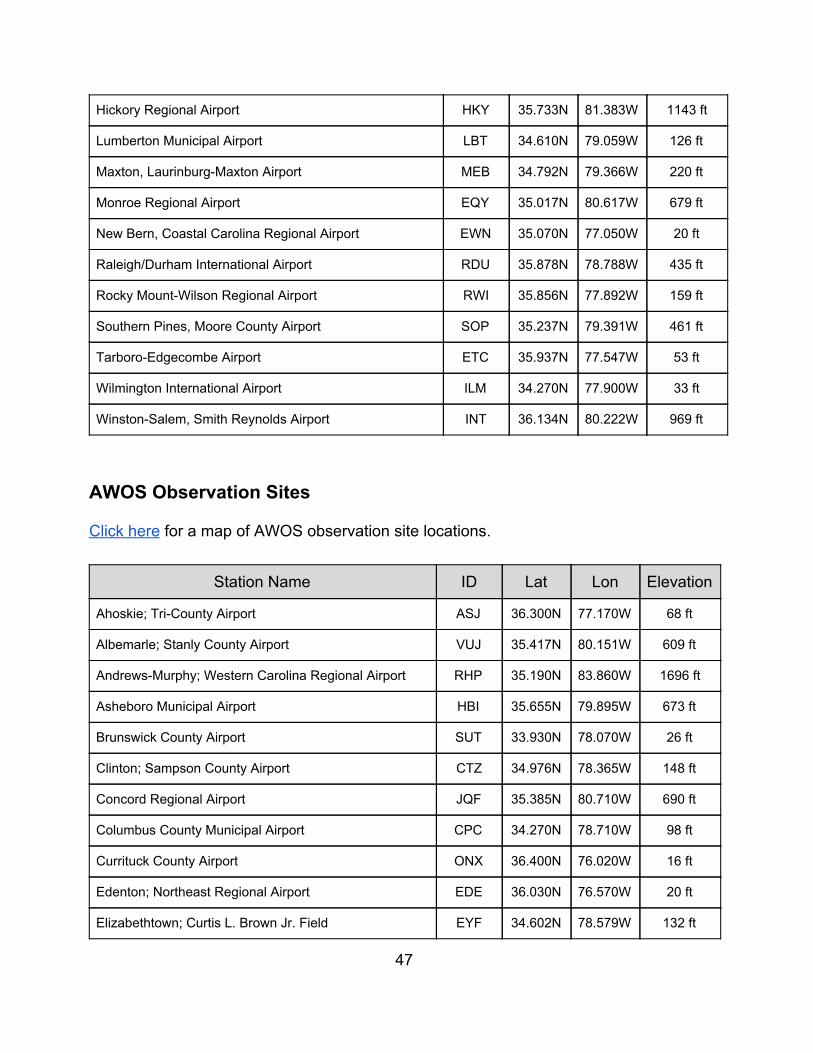
Hickory Regional Airport HKY 35.733N 81.383W 1143 ft
Lumberton Municipal Airport LBT 34.610N 79.059W 126 ft
Maxton, Laurinburg-Maxton Airport MEB 34.792N 79.366W 220 ft
Monroe Regional Airport EQY 35.017N 80.617W 679 ft
New Bern, Coastal Carolina Regional Airport EWN 35.070N 77.050W 20 ft
Raleigh/Durham International Airport RDU 35.878N 78.788W 435 ft
Rocky Mount-Wilson Regional Airport RWI 35.856N 77.892W 159 ft
Southern Pines, Moore County Airport SOP 35.237N 79.391W 461 ft
Tarboro-Edgecombe Airport ETC 35.937N 77.547W 53 ft
Wilmington International Airport ILM 34.270N 77.900W 33 ft
Winston-Salem, Smith Reynolds Airport INT 36.134N 80.222W 969 ft
AWOS Observation Sites Click here for a map of AWOS observation site locations.
Station Name ID Lat Lon Elevation
Ahoskie; Tri-County Airport ASJ 36.300N 77.170W 68 ft
Albemarle; Stanly County Airport VUJ 35.417N 80.151W 609 ft
Andrews-Murphy; Western Carolina Regional Airport RHP 35.190N 83.860W 1696 ft
Asheboro Municipal Airport HBI 35.655N 79.895W 673 ft
Brunswick County Airport SUT 33.930N 78.070W 26 ft
Clinton; Sampson County Airport CTZ 34.976N 78.365W 148 ft
Concord Regional Airport JQF 35.385N 80.710W 690 ft
Columbus County Municipal Airport CPC 34.270N 78.710W 98 ft
Currituck County Airport ONX 36.400N 76.020W 16 ft
Edenton; Northeast Regional Airport EDE 36.030N 76.570W 20 ft
Elizabethtown; Curtis L. Brown Jr. Field EYF 34.602N 78.579W 132 ft
47
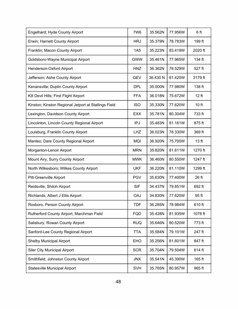
Engelhard; Hyde County Airport 7W6 35.562N 77.956W 6 ft
Erwin; Harnett County Airport HRJ 35.379N 78.783W 199 ft
Franklin; Macon County Airport 1A5 35.223N 83.419W 2020 ft
Goldsboro-Wayne Municipal Airport GWW 35.461N 77.965W 134 ft
Henderson-Oxford Airport HNZ 36.362N 78.529W 527 ft
Jefferson; Ashe County Airport GEV 36.430 N 81.420W 3179 ft
Kenansville; Duplin County Airport DPL 35.000N 77.980W 138 ft
Kill Devil Hills; First Flight Airport FFA 36.018N 75.672W 12 ft
Kinston; Kinston Regional Jetport at Stallings Field ISO 35.330N 77.620W 10 ft
Lexington, Davidson County Airport EXX 35.781N 80.304W 733 ft
Lincolnton, Lincoln County Regional Airport IPJ 35.483N 81.161W 875 ft
Louisburg, Franklin County Airport LHZ 36.023N 78.330W 369 ft
Manteo; Dare County Regional Airport MQI 36.920N 75.700W 13 ft
Morganton-Lenoir Airport MRN 35.820N 81.611W 1270 ft
Mount Airy, Surry County Airport MWK 36.460N 80.550W 1247 ft
North Wilkesboro; Wilkes County Airport UKF 36.220N 81.110W 1299 ft
Pitt-Greenville Airport PGV 35.630N 77.400W 26 ft
Reidsville, Shiloh Airport SIF 34.437N 79.851W 692 ft
Richlands; Albert J Ellis Airport OAJ 34.830N 77.620W 95 ft
Roxboro, Person County Airport TDF 36.285N 78.984W 610 ft
Rutherford County Airport, Marchman Field FQD 35.428N 81.935W 1078 ft
Salisbury, Rowan County Airport RUQ 35.646N 80.520W 773 ft
Sanford-Lee County Regional Airport TTA 35.584N 79.101W 247 ft
Shelby Municipal Airport EHO 35.256N 81.601W 847 ft
Siler City Municipal Airport SCR 35.704N 79.504W 614 ft
Smithfield, Johnston County Airport JNX 35.541N 45.390W 165 ft
Statesville Municipal Airport SVH 35.765N 80.957W 965 ft
48
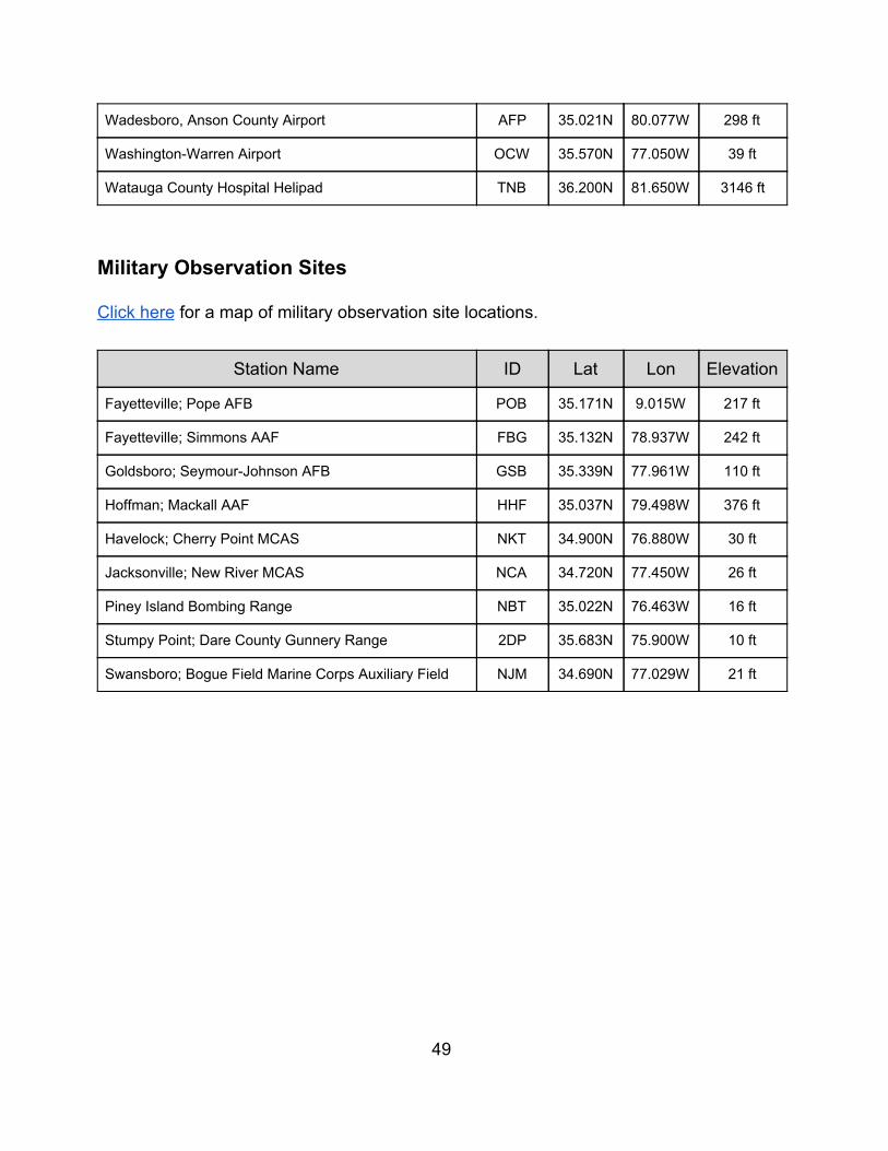
Wadesboro, Anson County Airport AFP 35.021N 80.077W 298 ft
Washington-Warren Airport OCW 35.570N 77.050W 39 ft
Watauga County Hospital Helipad TNB 36.200N 81.650W 3146 ft
Military Observation Sites Click here for a map of military observation site locations.
Station Name ID Lat Lon Elevation
Fayetteville; Pope AFB POB 35.171N 9.015W 217 ft
Fayetteville; Simmons AAF FBG 35.132N 78.937W 242 ft
Goldsboro; Seymour-Johnson AFB GSB 35.339N 77.961W 110 ft
Hoffman; Mackall AAF HHF 35.037N 79.498W 376 ft
Havelock; Cherry Point MCAS NKT 34.900N 76.880W 30 ft
Jacksonville; New River MCAS NCA 34.720N 77.450W 26 ft
Piney Island Bombing Range NBT 35.022N 76.463W 16 ft
Stumpy Point; Dare County Gunnery Range 2DP 35.683N 75.900W 10 ft
Swansboro; Bogue Field Marine Corps Auxiliary Field NJM 34.690N 77.029W 21 ft
49
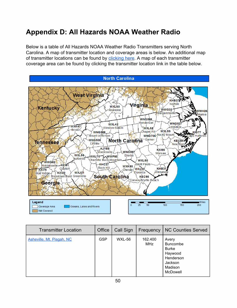
Appendix D: All Hazards NOAA Weather Radio Below is a table of All Hazards NOAA Weather Radio Transmitters serving North Carolina. A map of transmitter location and coverage areas is below. An additional map of transmitter locations can be found by clicking here. A map of each transmitter coverage area can be found by clicking the transmitter location link in the table below.
Transmitter Location Office Call Sign Frequency NC Counties Served
Asheville, Mt. Pisgah, NC GSP WXL-56 162.400 MHz
Avery Buncombe Burke Haywood Henderson Jackson Madison McDowell
50
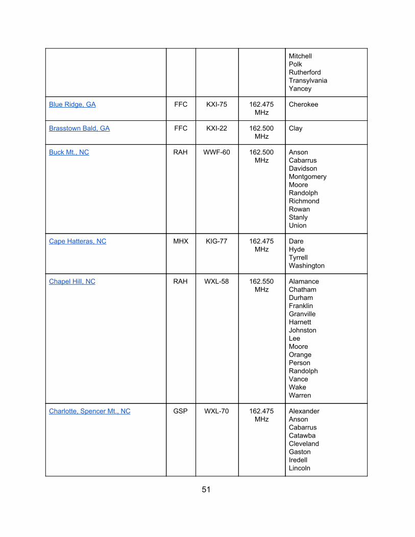
Mitchell Polk Rutherford Transylvania Yancey
Blue Ridge, GA FFC KXI-75 162.475 MHz
Cherokee
Brasstown Bald, GA FFC KXI-22 162.500 MHz
Clay
Buck Mt., NC RAH WWF-60 162.500 MHz
Anson Cabarrus Davidson Montgomery Moore Randolph Richmond Rowan Stanly Union
Cape Hatteras, NC MHX KIG-77 162.475 MHz
Dare Hyde Tyrrell Washington
Chapel Hill, NC RAH WXL-58 162.550 MHz
Alamance Chatham Durham Franklin Granville Harnett Johnston Lee Moore Orange Person Randolph Vance Wake Warren
Charlotte, Spencer Mt., NC GSP WXL-70 162.475 MHz
Alexander Anson Cabarrus Catawba Cleveland Gaston Iredell Lincoln
51
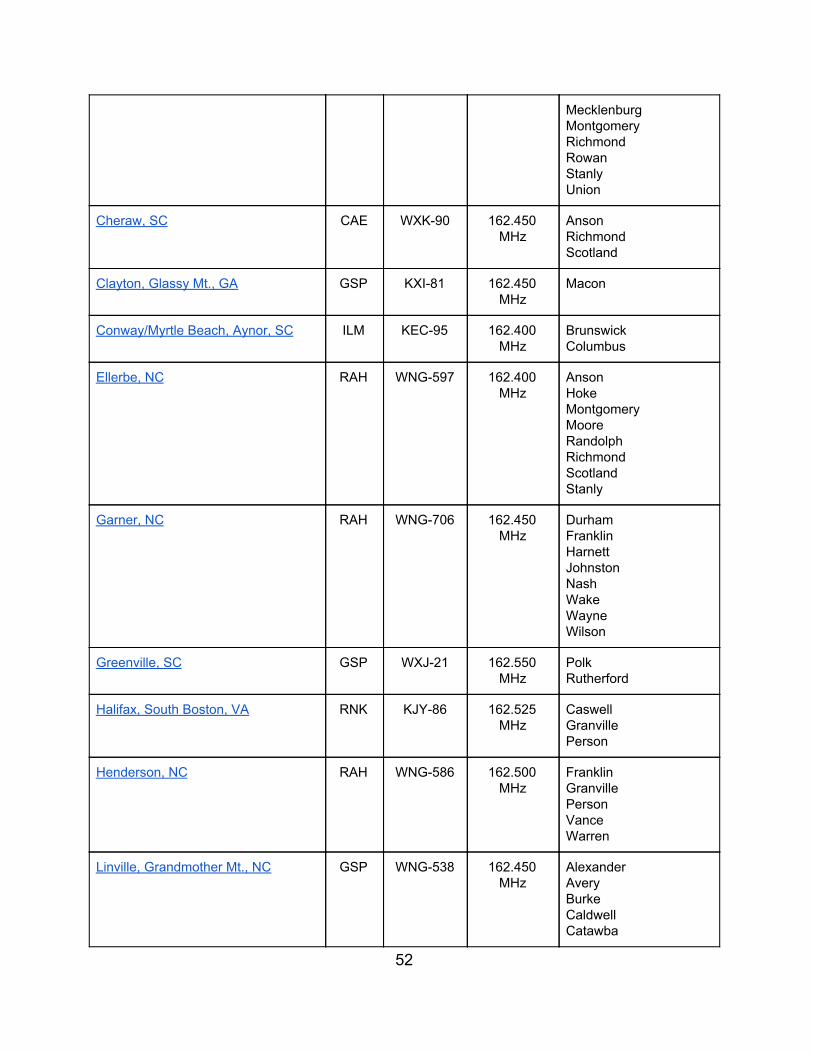
Mecklenburg Montgomery Richmond Rowan Stanly Union
Cheraw, SC CAE WXK-90 162.450 MHz
Anson Richmond Scotland
Clayton, Glassy Mt., GA GSP KXI-81 162.450 MHz
Macon
Conway/Myrtle Beach, Aynor, SC ILM KEC-95 162.400 MHz
Brunswick Columbus
Ellerbe, NC RAH WNG-597 162.400 MHz
Anson Hoke Montgomery Moore Randolph Richmond Scotland Stanly
Garner, NC RAH WNG-706 162.450 MHz
Durham Franklin Harnett Johnston Nash Wake Wayne Wilson
Greenville, SC GSP WXJ-21 162.550 MHz
Polk Rutherford
Halifax, South Boston, VA RNK KJY-86 162.525 MHz
Caswell Granville Person
Henderson, NC RAH WNG-586 162.500 MHz
Franklin Granville Person Vance Warren
Linville, Grandmother Mt., NC GSP WNG-538 162.450 MHz
Alexander Avery Burke Caldwell Catawba
52
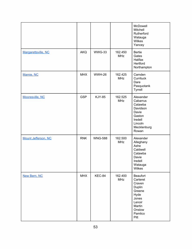
McDowell Mitchell Rutherford Watauga Wilkes Yancey
Margarettsville, NC AKQ WWG-33 162.450 MHz
Bertie Gates Halifax Hertford Northampton
Mamie, NC MHX WWH-26 162.425 MHz
Camden Currituck Dare Pasquotank Tyrrell
Mooresville, NC GSP KJY-85 162.525 MHz
Alexander Cabarrus Catawba Davidson Davie Gaston Iredell Lincoln Mecklenburg Rowan
Mount Jefferson, NC RNK WNG-588 162.500 MHz
Alexander Alleghany Ashe Caldwell Catawba Davie Iredell Watauga Wilkes
New Bern, NC MHX KEC-84 162.400 MHz
Beaufort Carteret Craven Duplin Greene Hyde Jones Lenoir Martin Onslow Pamlico Pitt
53
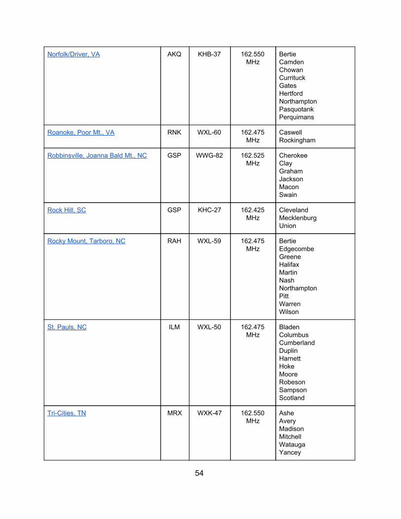
Norfolk/Driver, VA AKQ KHB-37 162.550 MHz
Bertie Camden Chowan Currituck Gates Hertford Northampton Pasquotank Perquimans
Roanoke, Poor Mt., VA RNK WXL-60 162.475 MHz
Caswell Rockingham
Robbinsville, Joanna Bald Mt., NC GSP WWG-82 162.525 MHz
Cherokee Clay Graham Jackson Macon Swain
Rock Hill, SC GSP KHC-27 162.425 MHz
Cleveland Mecklenburg Union
Rocky Mount, Tarboro, NC RAH WXL-59 162.475 MHz
Bertie Edgecombe Greene Halifax Martin Nash Northampton Pitt Warren Wilson
St. Pauls, NC ILM WXL-50 162.475 MHz
Bladen Columbus Cumberland Duplin Harnett Hoke Moore Robeson Sampson Scotland
Tri-Cities, TN MRX WXK-47 162.550 MHz
Ashe Avery Madison Mitchell Watauga Yancey
54
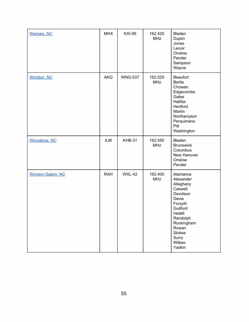
Warsaw, NC MHX KXI-95 162.425 MHz
Bladen Duplin Jones Lenoir Onslow Pender Sampson Wayne
Windsor, NC AKQ WNG-537 162.525 MHz
Beaufort Bertie Chowan Edgecombe Gates Halifax Hertford Martin Northampton Perquimans Pitt Washington
Winnabow, NC ILM KHB-31 162.550 MHz
Bladen Brunswick Columbus New Hanover Onslow Pender
Winston-Salem, NC RAH WXL-42 162.400 MHz
Alamance Alexander Alleghany Caswell Davidson Davie Forsyth Guilford Iredell Randolph Rockingham Rowan Stokes Surry Wilkes Yadkin
55
Appendix E: Red Flag Criteria For North Carolina, two or more of the following weather criteria (1 to 4) must be occurring or expected, in addition to high (or greater) fire danger (5):
1. Relative Humidity of 25% or less.
2. Sustained wind (20 ft) of 20 mph or greater, or gusts to 30 mph. Note: WFO MRX uses sustained winds of 18 mph or greater.
3. Dry Lightning
4. A significant wind shift during times of active fire suppression.
5. High, Very High, or Extreme fire danger, as assessed by the natural resource agencies, and/or as generated by the processor in the Weather Information Management System (WIMS) and posted in the Wildland Fire Assessment System (WFAS). This will be obtained by the National Weather Service from the respective natural resource agency personnel and from WIMS or WFAS.
6. WFO MRX only: rainfall less than 0.25 inches during the past two days. Note: In periods of prolonged drought, adjustments may be made to the criteria.
56
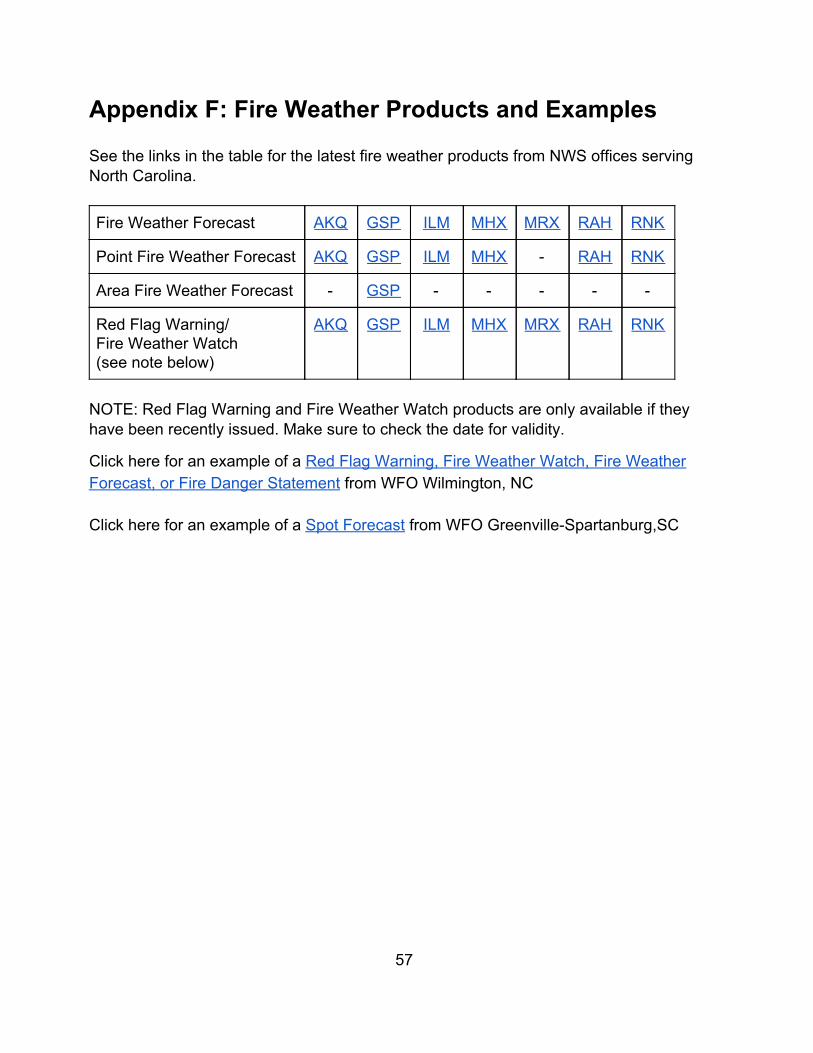
Appendix F: Fire Weather Products and Examples See the links in the table for the latest fire weather products from NWS offices serving North Carolina.
Fire Weather Forecast AKQ GSP ILM MHX MRX RAH RNK
Point Fire Weather Forecast AKQ GSP ILM MHX - RAH RNK
Area Fire Weather Forecast - GSP - - - - -
Red Flag Warning/ Fire Weather Watch (see note below)
AKQ GSP ILM MHX MRX RAH RNK
NOTE: Red Flag Warning and Fire Weather Watch products are only available if they have been recently issued. Make sure to check the date for validity.
Click here for an example of a Red Flag Warning, Fire Weather Watch, Fire Weather Forecast, or Fire Danger Statement from WFO Wilmington, NC
Click here for an example of a Spot Forecast from WFO Greenville-Spartanburg,SC
57
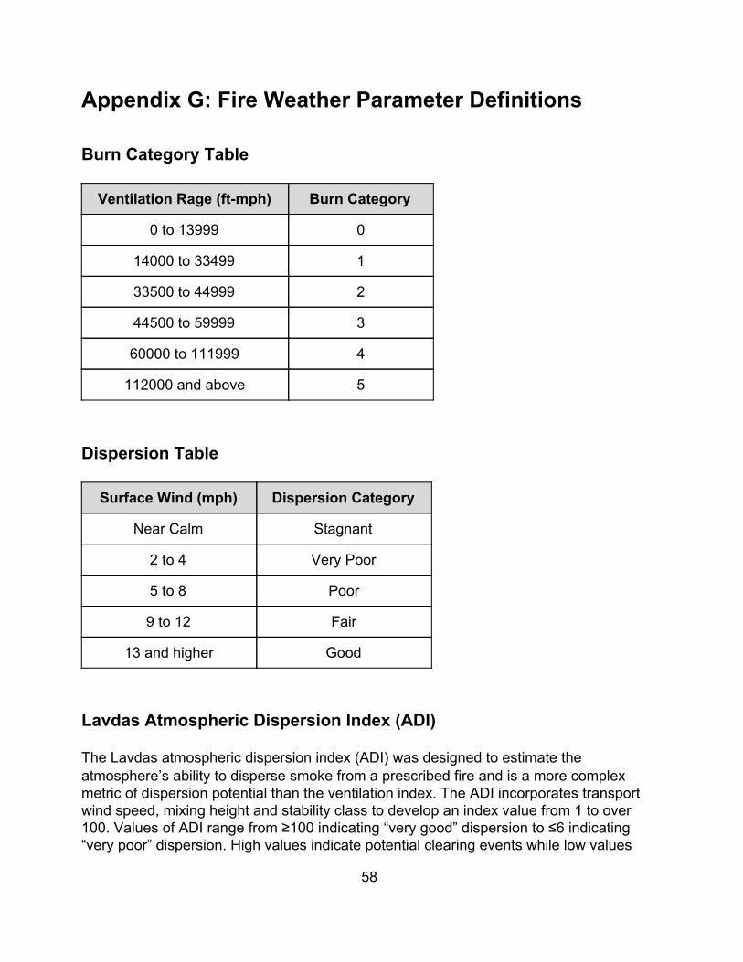
Appendix G: Fire Weather Parameter Definitions
Burn Category Table
Ventilation Rage (ft-mph) Burn Category
0 to 13999 0
14000 to 33499 1
33500 to 44999 2
44500 to 59999 3
60000 to 111999 4
112000 and above 5
Dispersion Table
Surface Wind (mph) Dispersion Category
Near Calm Stagnant
2 to 4 Very Poor
5 to 8 Poor
9 to 12 Fair
13 and higher Good
Lavdas Atmospheric Dispersion Index (ADI) The Lavdas atmospheric dispersion index (ADI) was designed to estimate the atmosphere’s ability to disperse smoke from a prescribed fire and is a more complex metric of dispersion potential than the ventilation index. The ADI incorporates transport wind speed, mixing height and stability class to develop an index value from 1 to over 100. Values of ADI range from ≥100 indicating “very good” dispersion to ≤6 indicating “very poor” dispersion. High values indicate potential clearing events while low values
58
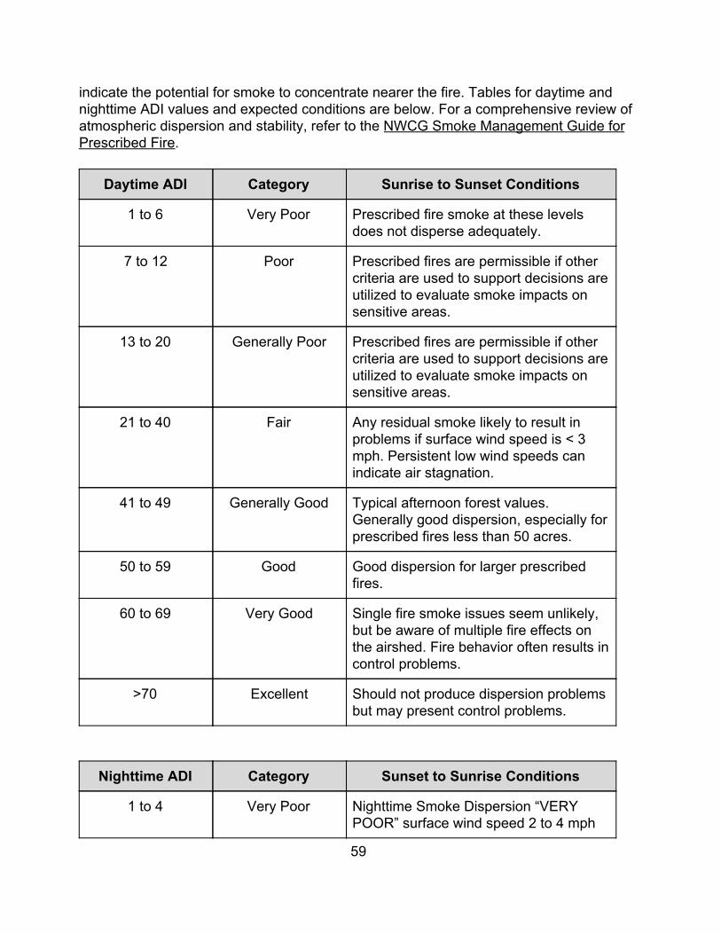
indicate the potential for smoke to concentrate nearer the fire. Tables for daytime and nighttime ADI values and expected conditions are below. For a comprehensive review of atmospheric dispersion and stability, refer to the NWCG Smoke Management Guide for Prescribed Fire.
Daytime ADI Category Sunrise to Sunset Conditions
1 to 6 Very Poor Prescribed fire smoke at these levels does not disperse adequately.
7 to 12 Poor Prescribed fires are permissible if other criteria are used to support decisions are utilized to evaluate smoke impacts on sensitive areas.
13 to 20 Generally Poor Prescribed fires are permissible if other criteria are used to support decisions are utilized to evaluate smoke impacts on sensitive areas.
21 to 40 Fair Any residual smoke likely to result in problems if surface wind speed is < 3 mph. Persistent low wind speeds can indicate air stagnation.
41 to 49 Generally Good Typical afternoon forest values. Generally good dispersion, especially for prescribed fires less than 50 acres.
50 to 59 Good Good dispersion for larger prescribed fires.
60 to 69 Very Good Single fire smoke issues seem unlikely, but be aware of multiple fire effects on the airshed. Fire behavior often results in control problems.
>70 Excellent Should not produce dispersion problems but may present control problems.
Nighttime ADI Category Sunset to Sunrise Conditions
1 to 4 Very Poor Nighttime Smoke Dispersion “VERY POOR” surface wind speed 2 to 4 mph
59
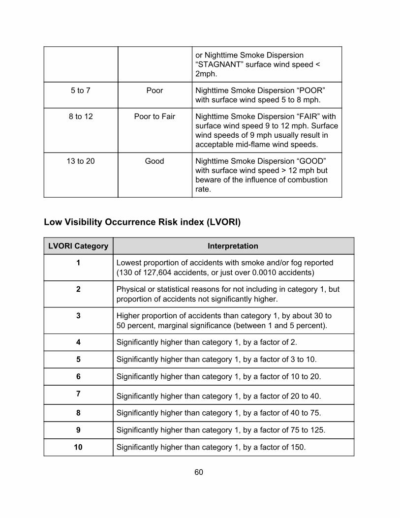
or Nighttime Smoke Dispersion “STAGNANT” surface wind speed < 2mph.
5 to 7 Poor Nighttime Smoke Dispersion “POOR” with surface wind speed 5 to 8 mph.
8 to 12 Poor to Fair Nighttime Smoke Dispersion “FAIR” with surface wind speed 9 to 12 mph. Surface wind speeds of 9 mph usually result in acceptable mid-flame wind speeds.
13 to 20 Good Nighttime Smoke Dispersion “GOOD” with surface wind speed > 12 mph but beware of the influence of combustion rate.
Low Visibility Occurrence Risk index (LVORI)
LVORI Category Interpretation
1 Lowest proportion of accidents with smoke and/or fog reported (130 of 127,604 accidents, or just over 0.0010 accidents)
2 Physical or statistical reasons for not including in category 1, but proportion of accidents not significantly higher.
3 Higher proportion of accidents than category 1, by about 30 to 50 percent, marginal significance (between 1 and 5 percent).
4 Significantly higher than category 1, by a factor of 2.
5 Significantly higher than category 1, by a factor of 3 to 10.
6 Significantly higher than category 1, by a factor of 10 to 20.
7 Significantly higher than category 1, by a factor of 20 to 40.
8 Significantly higher than category 1, by a factor of 40 to 75.
9 Significantly higher than category 1, by a factor of 75 to 125.
10 Significantly higher than category 1, by a factor of 150.
60
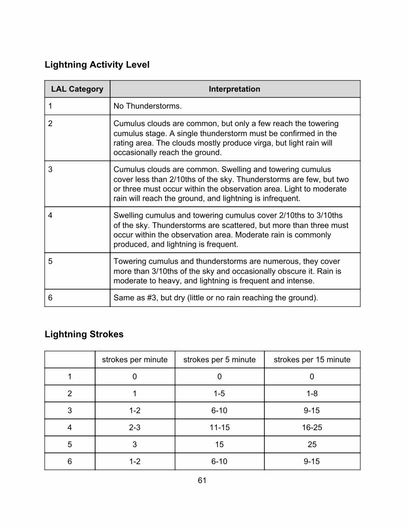
Lightning Activity Level
LAL Category Interpretation
1 No Thunderstorms.
2 Cumulus clouds are common, but only a few reach the towering cumulus stage. A single thunderstorm must be confirmed in the rating area. The clouds mostly produce virga, but light rain will occasionally reach the ground.
3 Cumulus clouds are common. Swelling and towering cumulus cover less than 2/10ths of the sky. Thunderstorms are few, but two or three must occur within the observation area. Light to moderate rain will reach the ground, and lightning is infrequent.
4 Swelling cumulus and towering cumulus cover 2/10ths to 3/10ths of the sky. Thunderstorms are scattered, but more than three must occur within the observation area. Moderate rain is commonly produced, and lightning is frequent.
5 Towering cumulus and thunderstorms are numerous, they cover more than 3/10ths of the sky and occasionally obscure it. Rain is moderate to heavy, and lightning is frequent and intense.
6 Same as #3, but dry (little or no rain reaching the ground).
Lightning Strokes
strokes per minute strokes per 5 minute strokes per 15 minute
1 0 0 0
2 1 1-5 1-8
3 1-2 6-10 9-15
4 2-3 11-15 16-25
5 3 15 25
6 1-2 6-10 9-15
61
Wind Profile Analysis During the months of March, April, and May at GSP, and MHX, and year round at ILM, forecast wind profiles for areas east of the mountains will be evaluated and categorized as favorable (for fire control), unfavorable (for fire control), or neutral (indeterminate for fire control). The wind profile category for each zone grouping that includes NC counties east of the mountains will be placed in remarks. If the category is neutral, an updated forecast will be issued once the morning soundings have been received and analyzed, categorizing each neutral grouping as either favorable or unfavorable. Adverse Wind Profiles Click here for a brief overview of Adverse Wind Profiles; those that are deemed unfavorable for fire control. (For a more complete treatment of the topic, reference "Vertical Wind Profiles and Associated Fire Behavior in Flat Country", Division of Fire Research, Southeastern Forest Experiment Station, August 20, 1957.")
62
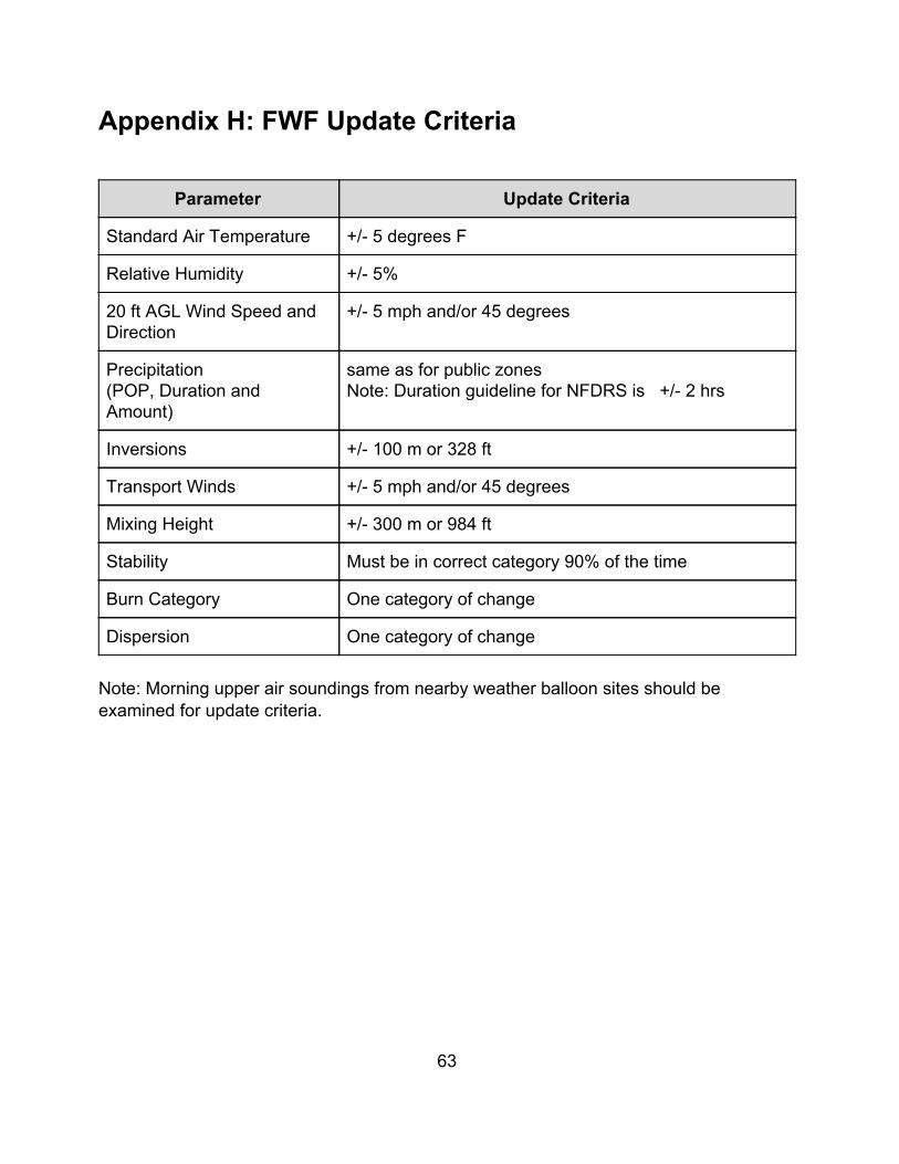
Appendix H: FWF Update Criteria
Parameter Update Criteria
Standard Air Temperature +/- 5 degrees F
Relative Humidity +/- 5%
20 ft AGL Wind Speed and Direction
+/- 5 mph and/or 45 degrees
Precipitation (POP, Duration and Amount)
same as for public zones Note: Duration guideline for NFDRS is +/- 2 hrs
Inversions +/- 100 m or 328 ft
Transport Winds +/- 5 mph and/or 45 degrees
Mixing Height +/- 300 m or 984 ft
Stability Must be in correct category 90% of the time
Burn Category One category of change
Dispersion One category of change Note: Morning upper air soundings from nearby weather balloon sites should be examined for update criteria.
63
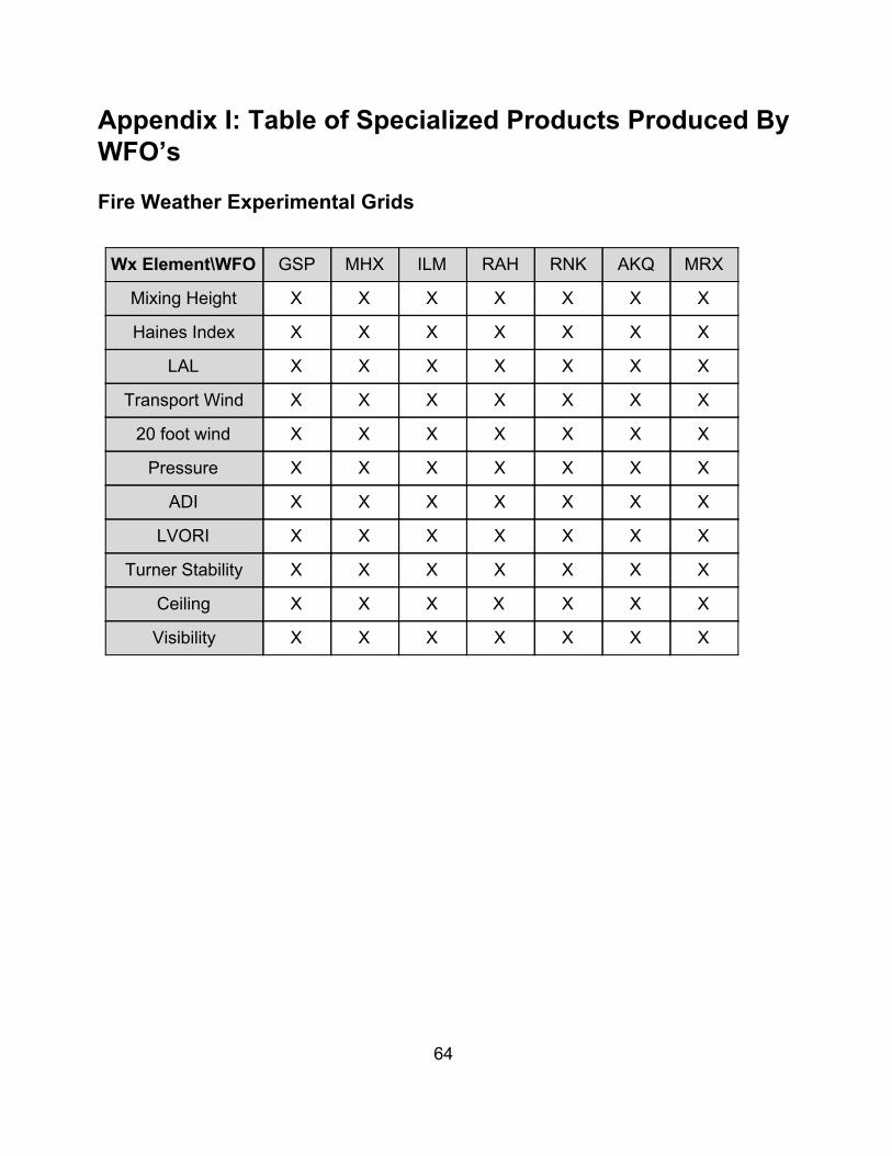
Appendix I: Table of Specialized Products Produced By WFO’s Fire Weather Experimental Grids
Wx Element\WFO GSP MHX ILM RAH RNK AKQ MRX
Mixing Height X X X X X X X
Haines Index X X X X X X X
LAL X X X X X X X
Transport Wind X X X X X X X
20 foot wind X X X X X X X
Pressure X X X X X X X
ADI X X X X X X X
LVORI X X X X X X X
Turner Stability X X X X X X X
Ceiling X X X X X X X
Visibility X X X X X X X
64
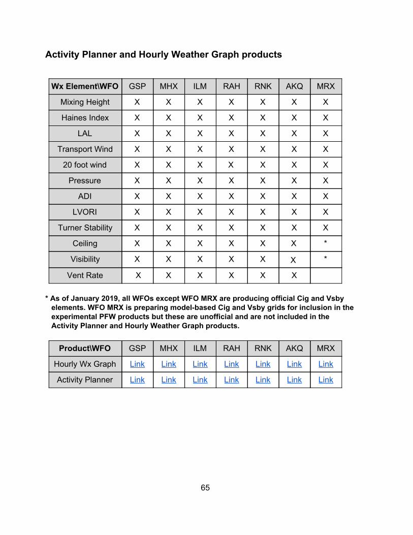
Activity Planner and Hourly Weather Graph products
Wx Element\WFO GSP MHX ILM RAH RNK AKQ MRX
Mixing Height X X X X X X X
Haines Index X X X X X X X
LAL X X X X X X X
Transport Wind X X X X X X X
20 foot wind X X X X X X X
Pressure X X X X X X X
ADI X X X X X X X
LVORI X X X X X X X
Turner Stability X X X X X X X
Ceiling X X X X X X *
Visibility X X X X X X *
Vent Rate X X X X X X * As of January 2019, all WFOs except WFO MRX are producing official Cig and Vsby
elements. WFO MRX is preparing model-based Cig and Vsby grids for inclusion in the experimental PFW products but these are unofficial and are not included in the Activity Planner and Hourly Weather Graph products.
Product\WFO GSP MHX ILM RAH RNK AKQ MRX
Hourly Wx Graph Link Link Link Link Link Link Link
Activity Planner Link Link Link Link Link Link Link
65
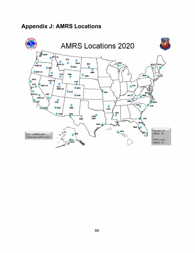
Appendix J: AMRS Locations
66
Appendix K: Record of Changes to the AOP July 2005: Noted in Appendix that adjustments may be made to Red Flag Criteria in periods of prolonged drought. Added Conference Calls section to Joint Responsibilities. Noted in Joint Responsibilities that NWS State Liaison Office forwards NWS draft directives to NCFS for review. Noted in Appendix that NWS offices should check morning upper air soundings for update criteria. Added Record of Change section to Appendix. Added
Table of Contents to printable version of AOP.
Made hot links to e-mail for names of NWS Fire Program Leaders in Service Area and Organizational Directory. Noted in Service Area and Organizational Directory that NWS Fire Program Leaders can be reached via e-mail from their office's fire weather homepage. January 2007: Added the Lavdas Dispersion table used by MRX in the Appendix. Noted the upcoming automation of R to O type NFDRS observations in Natural Resource Agency Responsibilities. Noted in Services Provided by the National Weather Service the units for mixing height provided by MRX, and also that MRX provides the Lavdas Dispersion Index. January 2008: Added Cherokee RAWS site to the Appendix. Noted that MRX provides FWF in the afternoon on request during drought in Services Provided by the National Weather Service.
67
Noted that MRX serves the Great Smoky Mountain portions of Haywood and Swain Counties under in Service Area and Organizational Directory, and changed the service area map to reflect this. Noted that the Wind Profile Analysis can be provided at customer request outside of the spring fire season during high fire danger in Services Provided by the National Weather Service.
February 2008:
Updated NWR transmitter list in appendix.
January 2009:
Added information on ADI and LVORI to appendix. Updated RAWS and NWR transmitter lists in appendix. January 2010: Added new information on ADI and LVORI to content of the planning forecast, and links to a map and listing of NWR transmitters in NC, under Services Provided by the NWS. Updated location of Cheoah RAWS, Gastonia and Monroe ASOS's, and added maps of observation sites in the appendix. Corrected NOAA Weather Radio information for several transmitters. Added information on the Fire Weather Point Forecast Matrix (PFW). January 2011: Added information on visibility and obstruction to visibility as carried in the planning forecast and PFW by GSP. Removed mention of Great Smoky Mountain National Park from WFO MRX's area of responsibility. January 2012: Changed NC Division of Forest Resources to NC Forest Service under Introduction and Organization. Added section on AFW and link to AFW decoder. Changed name of WAYAH RAWS to FRANKLIN, and changed CHEROKEE RAWS from MRX area to GSP area. Added JESSEN STATION RAWS in GSP area. Changed Wakefield, VA MIC from Bill Sammler to Jeff Orrock, and FPL from Larry Brown to Jonathan McGee. Changed Wilmington, NC FPL from Ron Steve to Josh Weiss. January 2013:
68
Corrected the location of several RAWS sites, added new RAWS sites, and added new RAWS sites maps. Updated the Interagency Agreement to the latest version. Made the AOP conform to CMS standards. January 2014: Corrected the location of the Davidson RAWS site. Added the Mount Jefferson RAWS site. Removed MATTAMUSKEET RAWS site. Clarified criteria for Fire Danger Statements. Replaced link to AMRS sites. Removed or replaced some dead links. January 2015: Changed names of Fire Program Leaders at NWS WFO’s RAH (Phil Badgett to Scott Sharp) and MRX (David Gaffin to Timothy Doyle). Added GSO as RAH sounding site. Updated several ASOS locations. Updated links to NWR sites and maps. Updated information on products produced by each office. January 2016: Made changes to list of Meteorologists in Charge due to recent retirements. Added state agreement on Mixing Height discrepancies. Removed or replaced some dead links. January 2017: Made changes to list of Meteorologists in Charge. Change Fire Program Leader at GSP from John Tomko to Scott Krentz. Added/removed/corrected Lat/Lon info on 8 ECONet sites. Added/deleted/edited information for 4 RAWS sites. January 2018: Made changes to list of Meteorologists in Charge. Corrected Mixing Height information to indicate that WFO MRX reports in both FT-MSL and AGL. Changed Fire Program Leader at WFO MRX to Sam Roberts. Added/deleted/edited information for 8 RAWS sites. Deleted mention of Blowup Alert. January 2019: Changes made to list of Meteorologists in Charge. Changed Fire Program Leader at MHX from James Merrell to Scott Kennedy; and at ILM from Joshua Weiss to Terry Lebo. Removed Chapel Hill/IGX from list of ASOS sites (decommissioned). Added
69
Siler City Airport (SCR) to lists of AWOS sites. Amended Burn Category for Burn Category 0 (0 to 13,999). January 2020: Combined office information by location (rather than several lists). Fixed broken links and updated others to more modern examples. Created tables for RAWS, ASOS, AWOS, RAWS, and NOAA Weather Radio information. Updated ADI information to agree with the NWCG Smoke Management Guide. Updated NFDRS section with input from SACC to reflect NFDRS2016 information. Added descriptions to the Services Provided by the NWS to more clearly state the sampling area and intent of each NWS product. Changes made to list of Meteorologists in Charge. Changed Fire Program Leader at RAH from Scott Sharpe (Retired) to James Morrow; and at ILM from Terry Lebo to Jordan Baker. Added DARE BOMB RANGE and removed CAMP LEJEUNE 2 (CL2) and ALLIGATOR RIVER from RAWS table. Added IXA and ETC and removed IGX and RZZ from ASOS table. Added 7W6 and FFA to AWOS table. Moved NCA and NKT from ASOS table to Military ASOS table and added NBT, 2DP and NJM to Military ASOS table.
70