Embed Size (px)
Citation preview
1
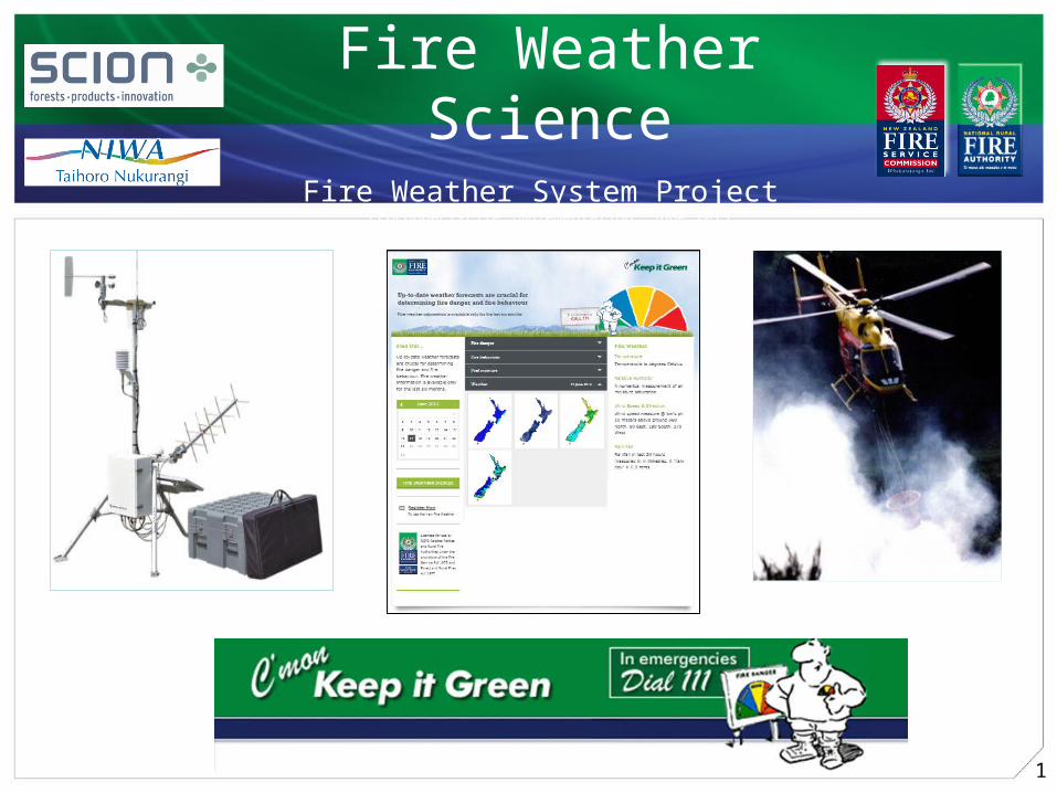
Fire Weather ScienceFire Weather System Project
EcoConnect-Fire Implementation, June 2013
April 2011
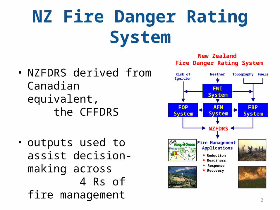
NZ Fire Danger Rating System
• NZFDRS derived from Canadian equivalent, the CFFDRS
• outputs used to assist decision-making across 4 Rs of fire management
FWISystem
FBPSystem
FOPSystem
New Zealand Fire Danger Rating System
AFMSystem
WeatherRisk ofIgnition
Topography Fuels
NZFDRS
Reduction
Readiness
Recovery
Fire Management Applications
Response
2
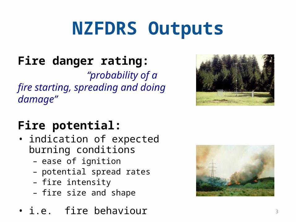
NZFDRS Outputs
Fire danger rating: “probability of a fire starting, spreading and doing damage”
Fire potential:• indication of expected burning
conditions– ease of ignition– potential spread rates– fire intensity– fire size and shape
• i.e. fire behaviour3
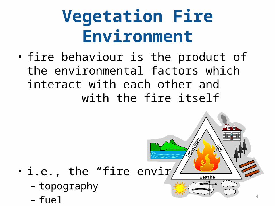
Vegetation Fire Environment
• fire behaviour is the product of the environmental factors which interact with each other and with the fire itself
• i.e., the “fire environment”:– topography– fuel – weather
Weather
Topo
grap
hy
Fuel
4
NZ Fire Danger Rating System
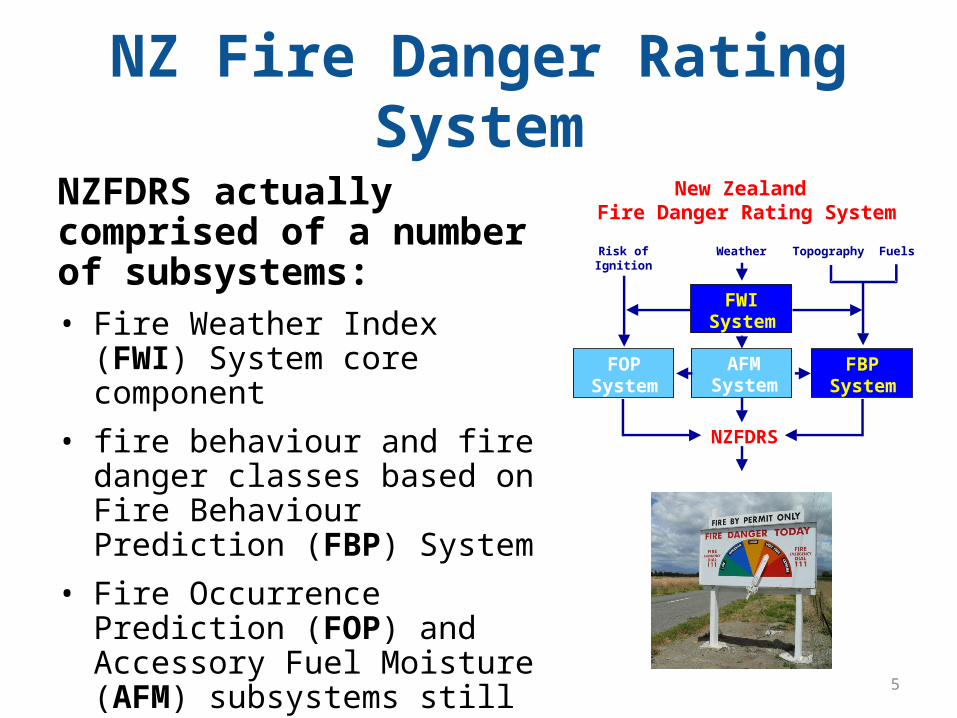
NZFDRS actually comprised of a number of subsystems:• Fire Weather Index (FWI) System
core component • fire behaviour and fire danger
classes based on Fire Behaviour Prediction (FBP) System
• Fire Occurrence Prediction (FOP) and Accessory Fuel Moisture (AFM) subsystems still under development
FWISystem
FBPSystem
FOPSystem
New Zealand Fire Danger Rating System
AFMSystem
WeatherRisk ofIgnition
Topography Fuels
NZFDRS
5
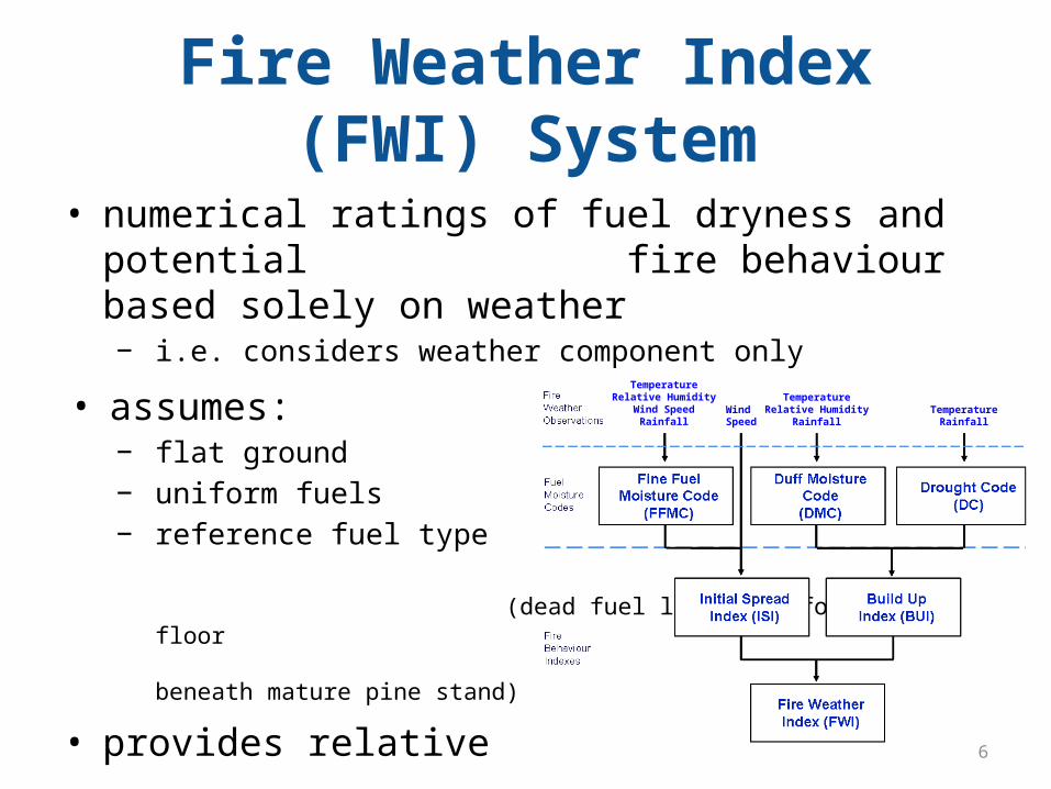
Fire Weather Index (FWI) System
• numerical ratings of fuel dryness and potential fire behaviour based solely on weather− i.e. considers weather component only
• assumes:− flat ground − uniform fuels − reference fuel type
(dead fuel layers in forest floor beneath mature pine stand)
• provides relative indicators of fire potential
TemperatureRelative Humidity
Wind SpeedRainfall
Wind Speed
TemperatureRelative Humidity
RainfallTemperature
Rainfall
6
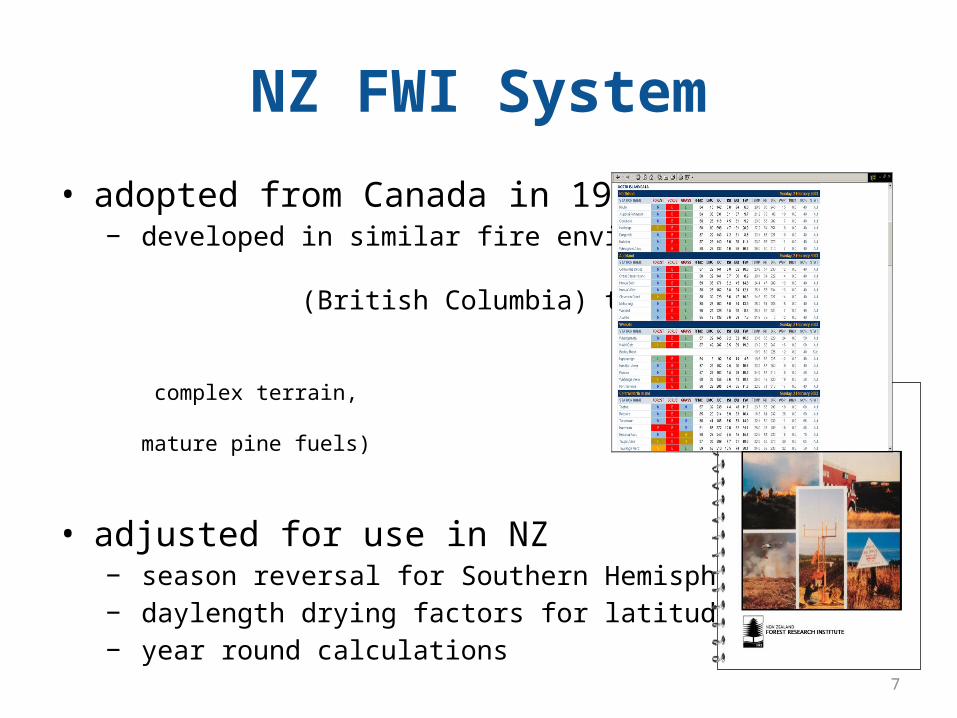
NZ FWI System
• adopted from Canada in 1980− developed in similar fire environment
(British Columbia) to NZ (maritime climate, complex terrain, mature pine fuels)
• adjusted for use in NZ− season reversal for Southern Hemisphere− daylength drying factors for latitude 40°S− year round calculations
• table and computer calculations (incl. new FWSYS)
7
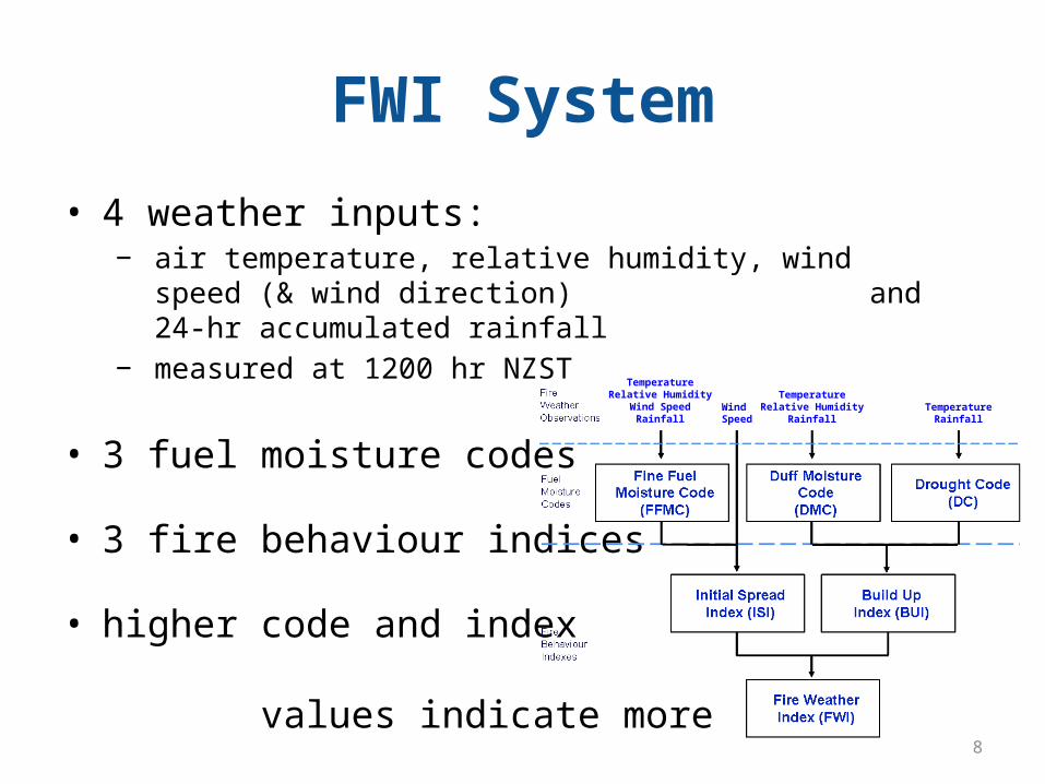
FWI System
• 4 weather inputs:− air temperature, relative humidity, wind speed (& wind direction)
and 24-hr accumulated rainfall− measured at 1200 hr NZST
• 3 fuel moisture codes
• 3 fire behaviour indices
• higher code and index values indicate more severe fire potential
TemperatureRelative Humidity
Wind SpeedRainfall
Wind Speed
TemperatureRelative Humidity
RainfallTemperature
Rainfall
8
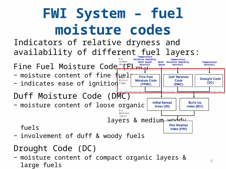
FWI System – fuel moisture codesIndicators of relative dryness and availability of different fuel layers:
Fine Fuel Moisture Code (FFMC)− moisture content of fine fuels− indicates ease of ignition
Duff Moisture Code (DMC)− moisture content of loose organic
layers & medium woody fuels− involvement of duff & woody fuels
Drought Code (DC)− moisture content of compact organic layers & large fuels− involvement of deep organic fuels− indicates potential for mop-up problems, and general seasonal dryness 9
TemperatureRelative Humidity
Wind SpeedRainfall
Wind Speed
TemperatureRelative Humidity
RainfallTemperature
Rainfall
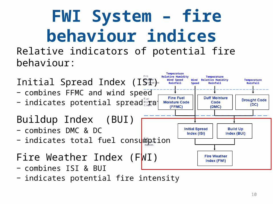
FWI System – fire behaviour indices Relative indicators of potential fire behaviour:
Initial Spread Index (ISI)− combines FFMC and wind speed− indicates potential spread rate
Buildup Index (BUI)− combines DMC & DC− indicates total fuel consumption
Fire Weather Index (FWI)− combines ISI & BUI− indicates potential fire intensity
10
TemperatureRelative Humidity
Wind SpeedRainfall
Wind Speed
TemperatureRelative Humidity
RainfallTemperature
Rainfall
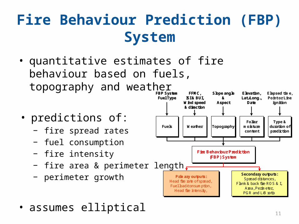
Fire Behaviour Prediction (FBP) System
• quantitative estimates of fire behaviour based on fuels, topography and weather
• predictions of:− fire spread rates− fuel consumption− fire intensity− fire area & perimeter length− perimeter growth
• assumes elliptical fire growth
Primary outputs:Head fire rate of spread, Fuel load/consumption,
Head fire intensity,
Primary outputs:Head fire rate of spread, Fuel load/consumption,
Head fire intensity,
Secondary outputs:Spread distances,
Flank & back fire ROS & I, Area, Perimeter,
PGR and L/B ratio
Secondary outputs:Spread distances,
Flank & back fire ROS & I, Area, Perimeter,
PGR and L/B ratio
FuelsFuels WeatherWeather TopographyTopographyFoliar
moisturecontent
Foliarmoisturecontent
Type &duration ofprediction
Type &duration ofprediction
Fire Behaviour Prediction(FBP) System
Fire Behaviour Prediction(FBP) System
FBP SystemFuel Type
FFMC, ISI & BUI,
Wind speed& direction
Slope angle&
Aspect
Elevation,Lat./Long.,
Date
Elapsed time,Point or Line
ignition
Primary outputs:Head fire rate of spread, Fuel load/consumption,
Head fire intensity,
Primary outputs:Head fire rate of spread, Fuel load/consumption,
Head fire intensity,
Secondary outputs:Spread distances,
Flank & back fire ROS & I, Area, Perimeter,
PGR and L/B ratio
Secondary outputs:Spread distances,
Flank & back fire ROS & I, Area, Perimeter,
PGR and L/B ratio
FuelsFuels WeatherWeather TopographyTopographyFoliar
moisturecontent
Foliarmoisturecontent
Type &duration ofprediction
Type &duration ofprediction
Fire Behaviour Prediction(FBP) System
Fire Behaviour Prediction(FBP) System
FBP SystemFuel Type
FFMC, ISI & BUI,
Wind speed& direction
Slope angle&
Aspect
Elevation,Lat./Long.,
Date
Elapsed time,Point or Line
ignition
11
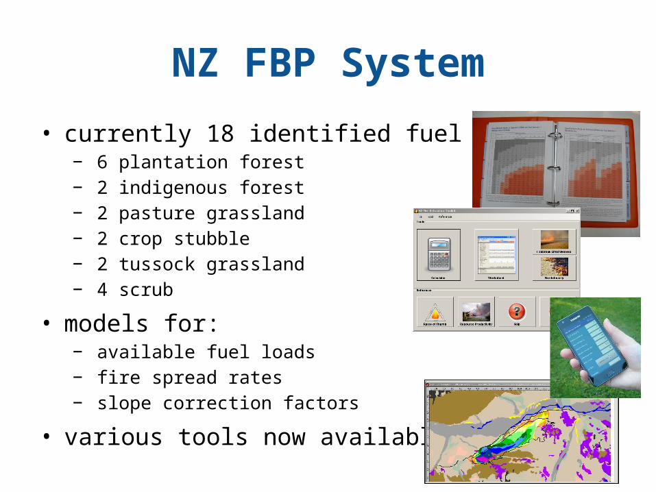
NZ FBP System
• currently 18 identified fuel types − 6 plantation forest− 2 indigenous forest− 2 pasture grassland− 2 crop stubble− 2 tussock grassland− 4 scrub
• models for:− available fuel loads− fire spread rates− slope correction factors
• various tools now available12
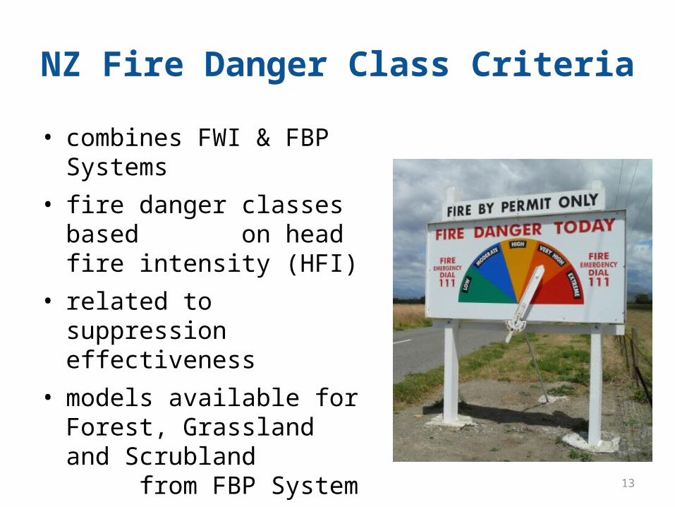
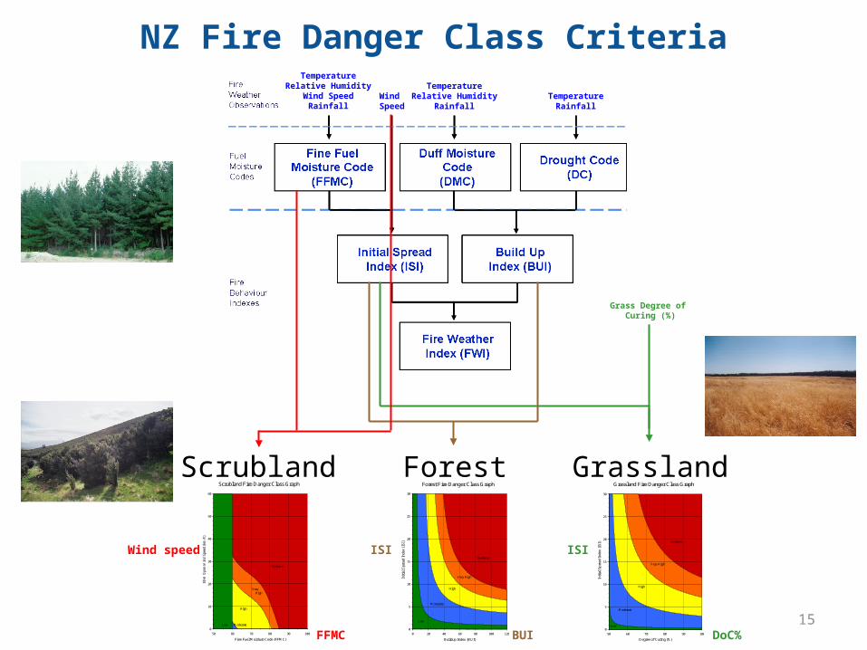
NZ Fire Danger Class Criteria
• combines FWI & FBP Systems • fire danger classes based
on head fire intensity (HFI)• related to suppression
effectiveness• models available for Forest,
Grassland and Scrubland from FBP System
• principal use for notifying the public
13
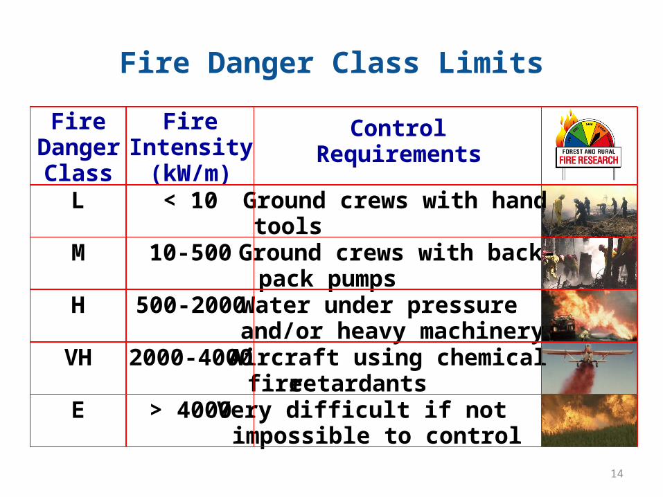
Fire Danger Class Limits
FireDangerClass
FireIntensity(kW/m)
ControlRequirements
L < 10 Ground crews with handtools
M 10-500 Ground crews with back-pack pumps
H 500-2000 Water under pressureand/or heavy machinery
VH 2000-4000 Aircraft using chemicalfire retardants
E > 4000 Very difficult if notimpossible to control
14
NZ Fire Danger Class CriteriaTemperature
Relative HumidityWind Speed
RainfallWind Speed
TemperatureRelative Humidity
RainfallTemperature
Rainfall
Scrubland GrasslandForestScrubland Fire Danger Class Graph
0
10
20
30
40
50
60
50 60 70 80 90 100
Fine Fuel Moisture Code (FFMC)
10-m
Ope
n W
ind
Spe
ed (
km/h
)
Low
Extreme
Very High
High
Moderate
Grassland Fire Danger Class Graph
0
5
10
15
20
25
30
50 60 70 80 90 100
Degree of Curing (%)
Init
ial
Spr
ead
Inde
x (I
SI)
Low
Moderate
High
Very High
Extreme
Forest Fire Danger Class Graph
0
5
10
15
20
25
30
0 20 40 60 80 100 120
Buildup Index (BUI)
Init
ial
Spr
ead
Inde
x (I
SI)
Low
Moderate
High
Very High
Extreme
Grass Degree of Curing (%)
Wind speed
FFMC
ISIISI
BUI DoC%15
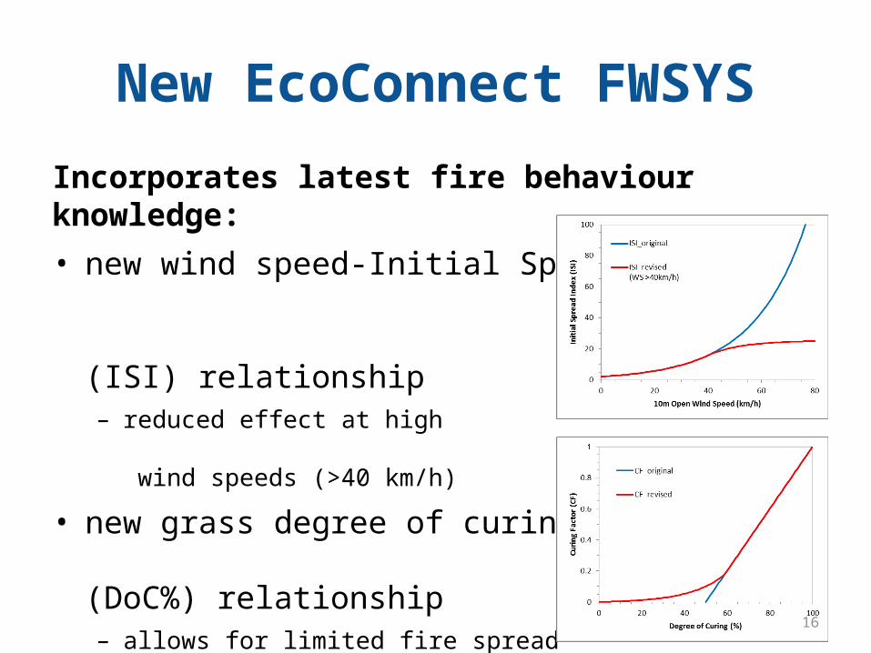
New EcoConnect FWSYS
Incorporates latest fire behaviour knowledge: • new wind speed-Initial Spread
Index (ISI) relationship– reduced effect at high
wind speeds (>40 km/h)
• new grass degree of curing (DoC%) relationship– allows for limited fire spread
below DoC of 50%
• also able to incorporate future new science (e.g. FWI, curing)
16
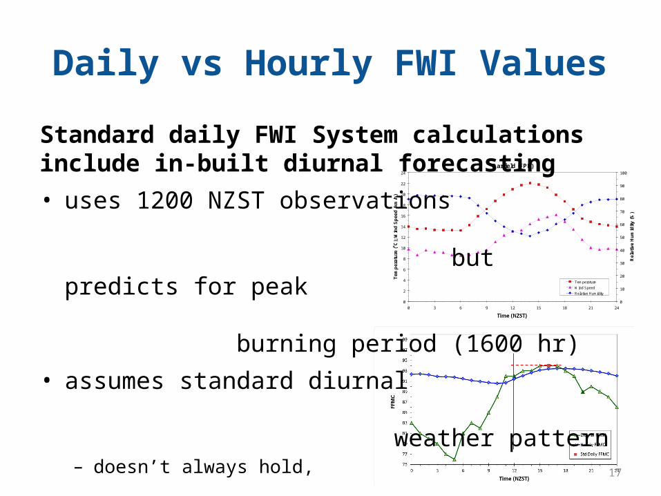
Daily vs Hourly FWI Values
0
2
4
6
8
10
12
14
16
18
20
22
24
0 3 6 9 12 15 18 21 24
Local Standard Time
Te
mp
era
ture
(oC
); W
ind
Sp
ee
d (
km
/h)
0
10
20
30
40
50
60
70
80
90
100
Darfield (FPL)
Re
lati
ve
Hu
mid
ity
(%
)
Temperature
Wind Speed
Relative Humidity
Standard daily FWI System calculations include in-built diurnal forecasting • uses 1200 NZST observations
but predicts for peak burning period (1600 hr)
• assumes standard diurnal weather pattern– doesn’t always hold,
e.g. frontal change, sea breeze
• hourly FWIs more accurate– based on actual hourly weather– hourly FWIs in new FWSYS coming!
17
Conclusions
• NZFDRS provides outputs that assist fire management decision-making
• NZFDRS is more than just the FWI System– FWI is core, but also FBP and FDCC
• Noon daily FWI predicts for mid-afternoon peak burning period (1600 hr)– but assumes standard diurnal cycle, will not always be valid
• New EcoConnect-Fire package provides key tool for accessing important fire weather outputs – includes latest science, will be updated as new results produced
18