Embed Size (px)
Citation preview
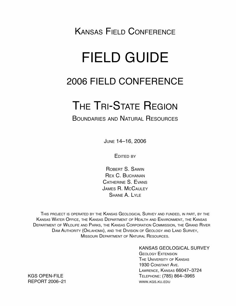
KANSAS FIELD CONFERENCE
FIELD GUIDE
2006 FIELD CONFERENCE
THE TRI-STATE REGIONBOUNDARIES AND NATURAL RESOURCES
JUNE 14–16, 2006
EDITED BY
ROBERT S. SAWIN
REX C. BUCHANAN
CATHERINE S. EVANS
JAMES R. MCCAULEY
SHANE A. LYLE
THIS PROJECT IS OPERATED BY THE KANSAS GEOLOGICAL SURVEY AND FUNDED, IN PART, BY THE KANSAS WATER OFFICE, THE KANSAS DEPARTMENT OF HEALTH AND ENVIRONMENT, THE KANSAS
DEPARTMENT OF WILDLIFE AND PARKS, THE KANSAS CORPORATION COMMISSION, THE GRAND RIVER DAM AUTHORITY (OKLAHOMA), AND THE DIVISION OF GEOLOGY AND LAND SURVEY,
MISSOURI DEPARTMENT OF NATURAL RESOURCES.
KANSAS GEOLOGICAL SURVEY GEOLOGY EXTENSION
THE UNIVERSITY OF KANSAS
1930 CONSTANT AVE. LAWRENCE, KANSAS 66047–3724KGS OPEN-FILE TELEPHONE: (785) 864–3965REPORT 2006–21 WWW.KGS.KU.EDU

KANSAS FIELD CONFERENCE
The Tri-State RegionBoundaries and Natural Resources
2006 FIELD CONFERENCEJune 14-16, 2006
TABLE OF CONTENTS
CONFERENCE PARTICIPANTS
Participants List ........................................................................................................1 - 1 Biographical Information ..........................................................................................1 - 5
KANSAS FIELD CONFERENCE
2006 Field Conference – “The Tri-State Region – Boundaries and Natural Resources” ............................2 - 1 Sponsors ....................................................................................................................2 - 3 Kansas Geological Survey ..................................................................................2 - 3 Kansas Department of Wildlife and Parks ..........................................................2 - 4 Kansas Water Offi ce ...........................................................................................2 - 5 Kansas Department of Health and Environment ...............................................2 - 5 Kansas Corporation Commission .......................................................................2 - 6 Division of Geology and Land Survey, Missouri Department of Natural Resources ...........................................................................................2 - 7 Grand River Dam Authority ...............................................................................2 - 8
WEDNESDAY, JUNE 14 Schedule and Itinerary ..............................................................................................3 - 1 Lead and Zinc Mining in Kansas (Public Information Circular 17) ...................... Insert Tri-State Lead and Zinc Mining Superfund Projects ................................................3 - 2 Subaqueous Disposal of Lead-Zinc Waste Demonstration Project – Waco Subdistrict of Kansas and Missouri .......................................................3 - 3 Oronogo–Duenweg Mining Belt (Jasper County, Missouri) Superfund Site ...........3 - 6 Cherokee County (Kansas) Superfund Site ..............................................................3 - 8 Tar Creek (Ottawa County, Oklahoma) Superfund Site .........................................3 - 13 THURSDAY, JUNE 15 Schedule and Itinerary ..............................................................................................4 - 1 Tri-State Region Aquifers .........................................................................................4 - 2 Water Supply Issues ..................................................................................................4 - 6 Grand Lake O’ the Cherokees Watershed .................................................................4 - 8 Legal Issues and Water ........................................................................................... 4 - 11 Schermerhorn Park and Southeast Kansas Nature Center ......................................4 - 12 Grand Lake O’ the Cherokees ................................................................................4 - 14
FRIDAY, JUNE 16 Schedule and Itinerary ..............................................................................................5 - 1 Oil and Gas Well Plugging in Kansas .......................................................................5 - 2 Neosho Energy Center ..............................................................................................5 - 5 Economics and the Future of the Tri-State Region ...................................................5 - 6
Acknowledgments We want to acknowledge graphic artist Jennifer Sims for the preparation of the brochure, the Field Guide cover, and many of the fi gures; and Marla Adkins–Heljeson for editing and preparation of the Field Guide.

1-1
PARTICIPANTS LIST
Name Title Affi liation Business Address
Steve Adams Natural Resource Kansas Department of 1020 S. Kansas Ave. Coordinator Wildlife & Parks Topeka KS 66612 785/296-2281
Virginia Beamer Representative Kansas House of P.O. Box 85 118th District Representatives / Oakley KS 67748 Utilities Committee 785/672-4230
Gary Blackburn Director of Bureau Kansas Department of 1000 SW Jackson, Suite 410 of Environmental Health and Environment Topeka KS 66612-1367 Remediation 785/296-1662
Constantine Cotsoradis Assistant Secretary Kansas Department 109 SW 9th St., 4th Floor of Agriculture Topeka KS 66612 785/296-3902
Susan Duffy Executive Director Kansas Corporation 1500 S.W. Arrowhead Commission Topeka KS 66604-4027 785/271-3166
Lon Frahm Member Geological Survey PO Drawer F Advisory Council Colby KS 67701 785/460-6719
Marci Francisco Senator Kansas Senate / Natural 1101 Ohio 2nd District Resources Committee Lawrence KS 66044 785/842-6402
Joe Fund Chief Fiscal Offi cer Kansas Water Offi ce 901 S. Kansas Ave. Topeka KS 66612 785/296-0872
Mimi Garstang Director & Division of Geology and PO Box 250 State Geologist Land Survey, Missouri Rolla MO 65402 Dept. of Natural Resources 573/368-2101
Raney Gilliland Assistant Director Kansas Legislative 300 SW 10th, Rm 545-N for Research Research Department Topeka KS 66612 785/296-3181
KANSAS FIELD CONFERENCE
The Tri-State RegionBoundaries and Natural Resources
2006 FIELD CONFERENCE
June 14-16, 2006
1-2
Bob Grant Representative Kansas House of 407 W. Magnolia 2nd District Representatives Cherokee KS 66724 620/457-8496
Kevin Gustavson Grand Lake Project Oklahoma Conservation 1731 S. Rockford Ave. Coordinator / Writer Commission Tulsa OK 74120 918/801-2150
Steve Hatfi eld Operations Manager Lafarge NA Aggregates 3500 N. West St. Wichita KS 67205 316/943-3500
Mike Hayden Secretary Kansas Department of 1020 S. Kansas Ave., Suite 200 Wildlife and Parks Topeka KS 66612 785/296-2282
Dave Heinemann Chairman Geological Survey 3826 SW Cambridge Ct. Advisory Council Topeka KS 66610 785/267-5033 Carl Holmes Representative Kansas House of P.O. Box 2288 125th District / Representatives / Liberal KS 67905 Chair Utilities Committee 620/624-7361 Mitch Holmes Representative Kansas House of 211 SE 20th Ave. 114th District Representatives / Wildlife, St. John KS 67576 Parks & Tourism Committee 620/234-5834 Steve Irsik Chairman Kansas Water Authority 5405 Six Rd. Ingalls KS 67853 620/335-5363 Dan Johnson Representative Kansas House of P.O. Box 247 110th District / Representatives / Hays KS 67601-0247 Chair Agriculture Committee 785/625-6476
Annie Kuether Representative Kansas House of 1346 SW Wayne Ave. 55th District Representatives / Topeka KS 66604 Utilities Committee 785/232-0717
Wayne Lebsack President / Lebsack Oil Production, Inc. / 603 S. Douglas Trustee The Nature Conservancy, Lyons KS 67554 Kansas Chapter 620/938-2396
Janis Lee Senator Kansas Senate / 2032 90th Rd. 36th District Utilities Committee Kensington KS 66951 785/476-2294
Earl Lewis Operations Manager Kansas Water Offi ce 901 S. Kansas Ave. Topeka KS 66612 785/296-3185
Judy Loganbill Representative Kansas House of 215 S. Erie 86th District Representatives / Economic Wichita KS 67211 Development Committee 316/683-7382
1-3
Margaret Long Representative Kansas House of 1801 N. 126th St. 36th District Representatives / Kansas City KS 66109 Utilities Committee 913/721-2322
Brad Loveless Manager, Biology Westar Energy / 122 SW 2nd St. & Conservation KACEE (KS Assoc. for Topeka KS 66603 Programs Conservation and 785/575-8115 Environmental Education)
Ed Martinko Director Kansas Biological Survey 2101 Constant Ave. Lawrence KS 66047 785/864-1505
Peggy Mast Representative Kansas House of 765 Road 110 76th District Representatives / Emporia KS 66801 Utilities Committee 620/343-2465
Carolyn McGinn Senator Kansas State Senate / 11047 N. 87 W. 31st District / Natural Resources Committee Sedgwick KS 67135 Chair 316/772-0147
Karl Mueldener Director of Bureau Kansas Department of 1000 SW Jackson, Suite 420 of Water Health and Environment Topeka KS 66612-1367 785/296-5502
Don Paxson Vice Chair Kansas Water Authority P.O. Box 487 Penokee KS 67659 785/421-2480
Roger Pine Senator Kansas Senate / 1783 E. 1500 Rd. 3rd District Utilities Committee Lawrence KS 66044 785/843-6949
David Pope Chief Engineer Division of Water Resources, 109 SW 9th St., 2nd Floor Kansas Department of Topeka KS 66612 Agriculture 785/296-3710
Larry Powell Representative Kansas House of 2209 Grandview East 117th District Representatives / Garden City KS 67846 Agriculture Committee 620/275-6789
David Pruitt Environmental Oklahoma Department of PO Box 1677 Programs Manager, Environmental Quality Oklahoma City OK 73101 Water Quality Division 405/702-8154
Tracy Streeter Director Kansas Water Offi ce 901 S. Kansas Ave. Topeka KS 66612 785/296-3185
John Strickler Past Chairman / The Nature Conservancy, 1523 University Drive Trustee Board Kansas Chapter / Manhattan KS 66502-3447 KACEE 785/565-9731
J. D. Strong Chief of Staff Offi ce of the Secretary 3800 N. Classen Blvd. of Environment Oklahoma City OK 73118 405/530-8998
1-4
Steve Thompson Executive Director Oklahoma Department of PO Box 1611 Environmental Quality Oklahoma City OK 73101 405/702-7163
Mary Torrence Senior Assistant Revisor of Statutes 300 SW 10th, Ste. 010-E Revisor Offi ce Topeka KS 66612-1592 785/296-5239
Darrell Townsend Director of Ecosystems Grand River Dam PO Box 409 Management Authority Vinita OK 74301 918/256-5545
Jim Triplett Chairman Biology Department 1701 S. Broadway Pittsburgh State University Pittsburg KS 66762 620/235-4732
Mike Wells Deputy Director Missouri Department of PO Box 176 for Water Resources Natural Resources Jefferson City MO 65102 573/751-4732

1-5
BIOGRAPHICAL INFORMATION
Steve AdamsTitle
Natural Resource CoordinatorAffi liation
Kansas Department of Wildlife & ParksAddress and Telephone
1020 S. Kansas Ave.Topeka KS 66612785/[email protected]
Current ResponsibilitiesNatural Resource Coordinator, Wildlife & Parks
ExperienceFisheries biologist, Florida Game & Fish; Aquatic ecologist, Environmental Services, Kansas Depart-ment of Wildlife & Parks
EducationNortheastern State University – BS, 1980Oklahoma State University – MS, 1983
Virginia BeamerTitle
Representative, 118th DistrictAffi liation
Kansas House of RepresentativesAddress and Telephone
P.O. Box 85Oakley KS 67748785/[email protected]
Current ResponsibilitiesMember, Utilities; Transportation; Wildlife, Tourism and Parks; and Governmental Organization and Elec-tions Committees
ExperienceCounty Commissioner (Logan), Clerk of the District Court
Gary BlackburnTitle
Director of Bureau of Environmental RemediationAffi liation
Kansas Department of Health and EnvironmentAddress and Telephone
1000 SW Jackson, Suite 410Topeka KS 66612-1367785/296-1662
Current Responsibilities Manage the Kansas environmental programs respon- sible for performing soil and ground-water monitor- ing and cleanup. Oversee coal mine reclamation and drycleaner and storage tank regulatory programs to prevent releases.
Experience Started in 1979 as geologist, then became Northeast District Geologist, section chief of the Storage Tank Section, and Director of BER (since 1999)Education Emporia State University – BS, 1979
Constantine CotsoradisTitle
Assistant SecretaryAffi liation
Kansas Department of AgricultureAddress and Telephone
109 SW 9th St., 4th Floor Topeka KS 66612785/[email protected]
Current ResponsibilitiesAssist in the management of the agency, developmentof policy, and work with legislature and agency CIO
ExperienceProgram manger of KDA Laboratory, agricultural commodities assurance program, and weights and measures program
EducationLoyola College, Baltimore MD – Bachelors, 1979University of Kansas – Masters, 2000
Susan DuffyTitle
Executive DirectorAffi liation
Kansas Corporation CommissionAddress and Telephone
1500 S. W. Arrowhead RoadTopeka KS 66604-4027785/[email protected]
Current Responsibilities Executive Director, Kansas Corporation CommissionExperience 26 years in state governmentEducation Wichita State University – MS, 1980
Lon FrahmTitle
Geological Survey Advisory Council MemberAffi liation
Frahm Farmland, Inc.

1-6
Address and TelephonePO Drawer FColby KS 67701
Current ResponsibilitiesFarm 11,000 acres irrigated and dryland crops, direc-tor of Midwest Energy
ExperienceGroundwater Management Dist. #4 board member, Thomas County Historical Society Board, and many years on High Plains Public Radio Board
EducationKansas State University – BS, 1980Kansas State University – MAB, 2006
Marci FranciscoTitle
Senator, 2nd DistrictAffi liation
Kansas State Senate and University of KansasAddress and Telephone
1101 OhioLawrence KS 66044785/842-6402maf@sunfl ower.com
Current ResponsibilitiesMember, Agriculture, Natural Resources, Utilities, and Arts and Cultural Resources (joint) Committees.Space Analyst for University of Kansas.
EducationUniversity of Kansas– B.E.D., 1973University of Kansas– B-Arch., 1977
Joe FundTitle
Chief Fiscal Offi cerAffi liation
Kansas Water Offi ceAddress and Telephone
901 S. Kansas Ave.Topeka KS 66612785/[email protected]
Current ResponsibilitiesManagement and oversight of agency budget, legisla-tive activity, and Kansas Water Authority
ExperienceFour years in current position. Four years at the Kan-sas Department of Health and Environment managing Legislative/Governmental Affairs
EducationKansas State University – BS, 1993
Mimi GarstangTitle
Director & State GeologistAffi liation
Division of Geology and Land Survey, Missouri Department of Natural Resources
Address and TelephonePO Box 250Rolla MO 65402573/[email protected]
Current ResponsibilitiesRepresent the state on geological, mineral resources, geologic hazards, earthquake risk, water contamina-tion, and aquifer hydrology issues. Oversee Land Survey Program
ExperienceDirector, 2000-06; Deputy Director and Assist. State Geologist, DNR, 1994–2000; Environmental Geol-ogy, DNR, 1986-94; Mine Inventory Geology, DNR, 1982-86; White Engineering, 1972-75
EducationMissouri State University, 1972
Raney GillilandTitle
Assistant Director for ResearchAffi liation
Kansas Legislative Research DepartmentAddress and Telephone
Rm 545-N, State Capitol300 SW 10th Topeka KS 66612785/[email protected]
Current ResponsibilitiesStaff House and Senate Agriculture Committees; House Environment Committee; Senate Natural Re-sources and Administrative Rules and Regulations Committees
ExperienceLegislative Research, 28 years
EducationKansas State University – BS, 1975Kansas State University – MS, 1979
Bob GrantTitle
Representative, 2nd DistrictAffi liation
Kansas House of RepresentativesAddress and Telephone
407 W. MagnoliaCherokee KS 66724620/[email protected]

1-7
Current ResponsibilitiesMember Commerce & Labor, Education Budget, Financial Institutions, Insurance, State Buildings Construction (Joint), and Special Claims Against the State (Joint) Committees
ExperienceSelf-employed bar and grill owner; Mayor of Chero-kee for 16 years
EducationLabette Community College – AA, 1971Pittsburg State University
Kevin GustavsonTitle
Grand Lake Project Coordinator/WriterAffi liation
Oklahoma Conservation CommissionAddress and Telephone
1731 S. Rockford Ave.Tulsa OK 74120918/[email protected]
Current ResponsibilitiesCoordinate 319 implementation (Clean Water Act) project for Grand Lake Watershed and will coordinate larger-scale planning effort
ExperienceProfessor of Earth Science and Geology at Eastern Michigan University. Visiting professor of Geology at Earlham College (IN) and St. Nobert College (WI).
EducationCarleton College (MN) – 1993University of Wisconsin-Madison – PhD, 1998Michigan State Watershed Management Certifi cate Program – 2004
Steve Hatfi eldTitle
Operation ManagerAffi liation
Lafarge NA AggregatesAddress and Telephone
3500 N. West StWichita KS 67205316/943-3500steven.hatfi [email protected]
Current ResponsibilitiesManage operations of aggregate plants (sand) in Wichita and Oxford, KS, and Coweta, OK. Member of the Geological Survey Advisory Council
ExperienceWorked for former owners since 1968. Designed and built plants, management, sales, and marketing.
EducationKansas Teachers College of Emporia – BA 1973
Mike HaydenTitle SecretaryAffi liation Kansas Department of Wildlife & ParksAddress and Telephone 1020 S. Kansas Ave., Suite 200 Topeka KS 66612 785/296-2282 [email protected] Responsibilities Secretary of Kansas Department of Wildlife & ParksExperience President, American Sportfi shing Assoc.; Assistant
Secretary of Interior of Fish, Wildlife and Parks; Governor of Kansas, 1987-91; Speaker of the Kansas House, 1983-87
Education Kansas State University – BS, 1966 Ft. Hays State University – MS, 1974
David HeinemannTitle
ChairmanAffi liation
Geological Survey Advisory CouncilAddress and Telephone
3826 SW Cambridge CourtTopeka KS 66610785/[email protected]
Current ResponsibilitiesChairman of Geological Survey Advisory Council
ExperienceState Representative, 27 years; General Counsel, KCC, 2 years; Executive Director, KCC, 2 years; Department of Revenue, Special Assistant to the Secretary, 5 years
EducationAugustana College – BA, 1967University of Kansas – 1967-68Washburn Law School – JD, 1973
Carl HolmesTitle
Representative, 125th DistrictAffi liation
Kansas House of RepresentativesAddress and Telephone
P.O. Box 2288Liberal KS 67905620/[email protected]
Current Responsibilities Chair, Utilities Committee; Vice-Chair, Joint Com-
1-8
mittee on Administrative Rules and Regulations; Member, Agriculture & Natural Resources Budget Committee; Chair, Kansas Electric Transmission Authority; Chair, NCSL Energy & Electric Utilities Committee; Member, N-Council on Electric Policy
ExperienceChair, House Energy & Natural Resources Commit-tee; President, Kansas League of Municipalities
EducationUniversity of Kansas, 1958-1960Colorado State University – BS, 1962
Mitch HolmesTitle
Representative, 114th DistrictAffi liation
Kansas House of RepresentativesAddress and Telephone
211 SE 20th Ave.St. John KS 67576620/[email protected]
Current ResponsibilitiesMember, House Wildlife, Parks & Tourism; Utilities; Insurance; Public Safety Budget; and Veteran Affairs Committees
ExperienceUnskilled labor, skilled labor, tutoring, military, retail sales, computer programming
EducationHutchinson Community College – AA, 1984Friends University – BS, 1988De Paul University – Cert., 1995
Steve IrsikTitle
ChairmanAffi liation
Kansas Water AuthorityAddress and Telephone
5405 Six Rd.Ingalls KS 67853620/335-5363
Current ResponsibilitiesChair Kansas Water Authority
ExperienceFarmer, rancher, and entrepreneur
EducationKansas State University – BS, 1969
Dan JohnsonTitle
Representative, 110th District
Affi liationKansas House of Representatives
Address and TelephoneP.O. Box 247Hays KS 67601-0247785/[email protected]
Current ResponsibilitiesChair, House Agriculture Committee; Owner Johnson Ranch
Experience Instructor of Industrial Arts, Fort Hays State University, 1961-69. Automotive test equipment sales; 20 years in Kansas Army National Guard (Retired Lt. Col.)Education
Fort Hays State University – BS, 1958Fort Hays State University – MS, 1968
Annie KuetherTitle
Representative, 55th DistrictAffi liation
Kansas House of RepresentativesAddress and Telephone
1346 SW Wayne Ave.Topeka KS 66604785/[email protected]
Current ResponsibilitiesMember, Utilities; General Government and Commerce Budget (Ranking Democrat); and Higher Education Committees
ExperienceAdministrative Assistant to Kathleen Sebelius; retail sales; special education paraprofessional
EducationBowling Green State University
Wayne LebsackTitle
President / TrusteeAffi liation
Lebsack Oil Production Inc. / The Nature Conservancy, Kansas Chapter
Address and Telephone603 S. DouglasLyons KS 67554 620/938-2396
Current ResponsibilitiesChair, Stewardship Committee, The Nature Conservan-cy; Manage oil and gas exploration and development
ExperienceOil and gas exploration; ground-water exploration and pollution research
1-9
EducationColorado School of Mines – Geol. Eng., 1949Colorado School of Mines – Pet. Geol., 1951Colorado School of Mines – 2 years grad. studies
Janis LeeTitle Senator, 36th DistrictAffi liation Kansas State SenateAddress and Telephone 2032 90th Rd. Kensington KS 66951 785/476-2294Current Responsibilities Asst. Minority Leader, Ranking Minority Member, Utilities; Ranking Member, Assessment and Taxation, Member, Natural Resources and Agriculture Com- mittees; Member, KETAExperience Farmer and rancherEducation Kansas State University – B.S., 1970
Earl LewisTitle
Operations ManagerAffi liation
Kansas Water Offi ceAddress and Telephone
901 S. Kansas Ave.Topeka KS 66612785/[email protected]
Current ResponsibilitiesOversight of operations and technical work at Kansas Water Offi ce
ExperienceSeven years with Division of Water Resources in compliance, water use, water management, and interstate issues
EducationUniversity of Kansas – B.S., 1992
Judith LoganbillTitle
Representative, 86th DistrictAffi liation
Kansas House of RepresentativesAddress and Telephone
215 S. ErieWichita KS 67211316/[email protected]
Current ResponsibilitiesMember, Economic Development, Education, Federal & State Affairs, and Kansas Security (Joint) Commit-tees. Elementary teacher in Wichita.
EducationBethel College – BS, 1975Northern Arizona University – MA, Ed., 1981
Margaret LongTitle
Representative, 36th DistrictAffi liation
Kansas House of Representatives Address and Telephone
1801 N. 126th St.Kansas City KS 66109913/721-2322
Current ResponsibilitiesMember, Utilities; Transportation; and Wildlife, Parks, and Tourism Committees
ExperienceAccountant, TWA (40 years)
EducationKansas City Kansas Community College
Brad LovelessTitle
Manager, Biology & Conservation ProgramsAffi liation
Westar Energy / Kansas Association of Conservation and Environmental Education (KACEE)
Address and Telephone122 SW 2nd St.Topeka KS 66603785/[email protected]
Current ResponsibilitiesResponsible for environmental issues with transmis-sion/distribution line design, construction, and main-tenance and electrical generation-sensitive species interactions. Chair of Westar’s Green Team volunteer group.
ExperienceBiologist with Westar for 21 years
EducationThe Ohio State University – BS, 1981University of Kansas – MS, 1983
Ed MartinkoTitle Director / ProfessorAffi liation Kansas Biological Survey

1-10
Address and Telephone 2101 Constant Ave. Higuchi Hall University of Kansas Lawrence KS 66047 785/864-1505 [email protected] Responsibilities Director of Kansas Biological Survey; Professor of EcologyEducation College of Emporia – BS, 1967 University of Colorado – MA, 1970 University of Kansas – PhD, 1976
Peggy MastTitle Representative, 76th DistrictAffi liation Kansas House of RepresentativesAddress and Telephone 765 Road 110 Emporia KS 66801 620/343-2465 [email protected] Responsibilities Member, Utilities CommitteeExperience Twenty-six years working for oil-fi eld servicing business
Carolyn McGinnTitle Senator, 31st DistrictAffi liation Kansas State SenateAddress and Telephone 11047 N. 87 W. Sedgwick KS 67135 [email protected] Responsibilities Chair, Natural Resources CommitteeExperience County Commissioner, farmerEducation Wichita State University – BBA, 1983 Friends University – Masters, 1998
Karl MueldenerTitle Director, Bureau of WaterAffi liation Kansas Department of Health and Environment
Address and Telephone 1000 SW Jackson St., Ste. 420 Topeka KS 66612-1367Current Responsibilities Director of Bureau of Water, KDHE; Water-quality programs for drinking and surface waterExperience 31 years with KDHE; Director, Bureau of Water since 1987Education Kansas State University – BS, 1973 Kansas State University – MS, 1974
Don PaxsonTitle Vice ChairAffi liation Kansas Water AuthorityAddress and Telephone PO Box 487 Penokee KS 67659 785/421-2480 [email protected] Responsibilities Vice Chair, Kansas Water AuthorityExperience Farmer, irrigator, electrical and water contractorEducation High School – 1956
Roger PineTitle Senator, 3rd DistrictAffi liation Kansas State SenateAddress and Telephone 1783 E. 1500 Rd. Lawrence KS 66044 785/843-6949 [email protected] Responsibilities Member, Utilities, Agriculture, Assessment and Taxation, and Education CommitteesExperience FarmerEducation Kansas Sate University – BS, 1961
David PopeTitle Chief EngineerAffi liation Kansas Department of Agriculture, Division of Water Resources

1-11
Address and Telephone 109 SW 9th St., 2nd Floor Topeka KS 66612 785/296-3710 [email protected] Responsibilities Administration of water laws in KansasExperience
Manager of GMD #3; Extension Irrigation Engineer for KSU in Manhattan and Garden City
EducationOklahoma State University – BS, 1970Oklahoma State University – MS, 1971
Larry PowellTitle Representative, 117th DistrictAffi liation Kansas House of RepresentativesAddress and Telephone 2209 Grandview East Garden City KS 67846 620/275-6789 [email protected] Responsibilities Member, Agriculture, Agriculture and Natural Resources Budget, and Appropriations CommitteesExperience Rancher, custom cutter, implement dealer
David PruittTitle
Environmental Programs Manager, Water Quality Division
Affi liationOklahoma Department of Environmental Quality
Address and TelephonePO Box 1677Oklahoma City OK 73101
Current ResponsibilitiesProgram administration for water-quality programs: public water supply, NPDES, and compliance
ExperienceUSGS hydrologic investigations, DEQ various programs (permit writer, hydrologic investigations, GIS, GPS, adminstration)
EducationOklahoma State University – BS, 1984
Tracy StreeterTitle
DirectorAffi liation
Kansas Water Offi ce
Address and Telephone901 S. Kansas Ave.Topeka KS 66612785/[email protected]
Current ResponsibilitiesAgency Head
ExperienceState Conservation Commission Executive Director, 1995-2004
EducationHighland Community College – AS, 1983Missouri Western State – BS, 1985University of Kansas – MPA, 1993
John StricklerTitle
Trustee / TreasurerAffi liation
The Nature Conservancy, Kansas Chapter / KACEE (Kansas Association for Conservation and Environ-mental Education)
Address and Telephone1523 University DriveManhattan KS 66502-3447785/[email protected]
Current ResponsibilitiesBoard of Trustees, Kansas Chapter, The Nature Con-servancy; Treasurer, KACEE
ExperienceChair, The Nature Conservancy, Kansas Chapter; Executive Director, KACEE; Special Assistant for Environment and Natural Resources to Gov. Hayden, 2 years; Acting Secretary, Kansas Department of Wildlife and Parks, 1987 and 1995; Kansas State and Extension Forestry, KSU, 33 years; U.S. Forest Service, 4 years
EducationUniversity of Missouri – BS, 1957Kansas State University – MS, 1968
J. D. StrongTitle Chief of StaffAffi liation Offi ce of the Secretary of EnvironmentAddress and Telephone 3800 N. Classen Blvd. Oklahoma City OK 73118 405/530-8998 [email protected] Responsibilities Public policy development, legislative affairs, public relations, interagency and interstate coordination for environmetal cabinet

1-12
Experience 1996-present: Offi ce of the Secretary of Environment; 1993-96: Oklahoma Water Resources BoardEducationOklahoma State University – BS, 1993
Steve ThompsonTitle
Executive DirectorAffi liation
Oklahoma Department of Environmental QualityAddress and Telephone
PO Box 1611Oklahoma City OK 73101
Current ResponsibilitiesExecutive Director of Oklahoma Environmental Agency
EducationOklahoma University – BA, 1970
Mary TorrenceTitle
Assistant Revisor of StatutesAffi liation
Revisor of Statutes Offi ceAddress and Telephone
State House, Suite 010-E300 SW 10th
Topeka KS 66612785/[email protected]
Current ResponsibilitiesLegislative staff; drafting legislation and legal advi-sor
ExperienceRevisor of Statutes Offi ce, 31 years
EducationUniversity of Kansas – BA, 1971University of Kansas – JD, 1974
Darrell TownsendTitle Director of EcosystemsAffi liation Grand River Dam AuthorityAddress and Telephone PO Box 409 Vinita OK 74301Current Responsibilities Director of Ecosystems Management, GRDAExperience Instructor of freshman biology, Tulsa Community College and Oklahoma State University
Education Oklahoma State University – PhD, 2004
Jim TriplettTitle ChairAffi liation Biology Department Pittsburg State UniversityAddress and Telephone
Biology Department 1701 S. BroadwayPittsburg State UniversityPittsburg KS 66762620/[email protected]
Current ResponsibilitiesChair, Biology Department; Chair, Neosho Basin Advisory Council; Chair, Council of BAC Chairs; Member, Geological Survey Advisory Council; and Governor’s Solid Waste Advisory Committee
Experience1975-81, Ohio State Fisheries & Wildlife Division; 1981-present, PSU; 1984-present, Chair of Biology Dept.; aquatic ecology
EducationPittsburg State University – BA, 1966Pittsburg State University – MS, 1968University of Kansas – PhD, 1976
Mike WellsTitle
Deputy Director for Water ResourcesAffi liation
Missouri Department of Natural ResourcesAddress and Telephone
PO Box 176Jefferson City MO 65102573/[email protected]
Current ResponsibilitiesRepresent the state in interstate water issues; oversee department staff responsible for drought and fl ood assessment, state water plan, water supply analysis, dam and reservoir safety, and department’s soil and water conservation program
ExperienceJoined MO DNR in 2001 as Deputy Div. Director & Chief of Water Resources in Div. of Geol. & Land Survey; before, worked 34 years at U.S. Dept. of Agriculture, Natural Resources Conservation Service
EducationArkansas State University, BS – 1967University of Arkansas, MS – 1978

1-13
KANSAS GEOLOGICAL SURVEY STAFF
Bill HarrisonTitle
Director and State GeologistAffi liation
Kansas Geological SurveyAddress and Telephone
1930 Constant Ave.University of KansasLawrence KS 66047-3724785/[email protected]
Current ResponsibilitiesPlan and initiate major research programs; Assess scientifi c quality of current programs
ExperienceKansas Geological Survey, 9 years; Lockheed Martin Idaho Technologies; EG&G Idaho, Inc.; ARCO Exploration & Technology; University of Oklahoma/Oklahoma Geological Survey, Faculty/Staff Geologist
EducationLamar State College of Technology - BS, 1966University of Oklahoma – MS, 1968Louisiana State University – PhD, 1976
Rex BuchananTitle
Associate DirectorAffi liation
Public Outreach, Kansas Geological SurveyAddress and Telephone
1930 Constant Ave.University of KansasLawrence KS 66047-3724785/[email protected]
Current ResponsibilitiesSupervise publication and public outreach activities, media relations, and non-technical communications
ExperienceKansas Geological Survey, 28 years; University-In-dustry Research, University of Wisconsin, 3 years; Salina Journal, 4 years
EducationKansas Wesleyan University – BA, 1975University of Wisconsin-Madison – MA, 1978University of Wisconsin-Madison – MS, 1982
Cathy EvansTitle
Publication Assistant
Affi liationKansas Geological Survey
Address and Telephone1930 Constant Ave.University of KansasLawrence KS 66047-3724785/[email protected]
Current ResponsibilitiesWork with coordinator of fi eld conference and guide-book; news releases; help produce non-technical or semi-technical publications
ExperienceKansas Geological Survey; University Press of Kan-sas; Spencer Museum of Art
EducationUniversity of Kansas – BA, 1978University of Kansas – MS, 1990
Shane LyleTitle
Research AssistantAffi liation
Geology Extension, Public Outreach Section, Kansas Geological Survey
Address and Telephone1930 Constant Ave.University of KansasLawrence KS 66047-3724785/[email protected]
Current ResponsibilitiesGeology Extension Coordinator; Kansas Field Con-ference
ExperienceKansas Geological Survey; Environmental and Engi-neering Geology, 12 years
EducationKansas State University – BS, 1993
Jim McCauleyTitle
Assistant ScientistAffi liation
Stratigraphic Research Section, Kansas Geological Survey
Address and Telephone1930 Constant Ave.University of KansasLawrence KS 66047-3724785/[email protected]
Current ResponsibilitiesGeologic mapping, remote sensing, public inquiries

1-14
ExperienceKansas Geological Survey, 29 years; KU Remote Sensing Laboratory, 6 years
EducationUniversity of Kansas – BS, 1970University of Kansas – MS, 1973University of Kansas – PhD, 1977
Bob SawinTitle
Research AssociateAffi liation
Geology Extension, Public Outreach Section, Kansas Geological Survey
Address and Telephone1930 Constant Ave.University of KansasLawrence KS 66047-3724785/[email protected]
Current ResponsibilitiesGeology Extension; Kansas Field Conference; geo-logic mapping
ExperienceKansas Geological Survey, 14 years; Petroleum Geology, 15 years; Engineering Geology, 6 years
EducationKansas State University – BS, 1972Kansas State University – MS, 1977
2-1
KANSAS FIELD CONFERENCE
The Tri-State RegionBoundaries and Natural Resources
2006 FIELD CONFERENCE
June 14-16, 2006______________________
Welcome to the 2006 Field Conference, co-sponsored by the Kansas Geological Survey (a division of the University of Kansas), the Kansas Department of Health and Environment, the Kansas Corporation Commission, the Kansas Department of Wildlife and Parks, the Kansas Water Offi ce, the Grand River Dam Authority (Oklahoma), and the Division of Geology and Land Survey at the Missouri Department of Natural Resources. Previous Field Conferences have focused exclusively on natural resource issues facing the state of Kansas. This year’s trip will attempt to do something slightly different—to examine those natural resource issues that cut across state lines.
In the late 1800’s, famed geologist John Wesley Powell proposed using watersheds to guide the settling of the American West. Instead, political boundaries continued to dominate our thinking and our approach to natural-resource issues. Nonetheless, most natural resources and related problems do not obey political boundaries. Rivers and streams fl ow across state lines, ground water can move slowly from one state to another, contamination in one location can migrate underground and affect another location miles away. Through the last half of the 20th century, there was a growing realization that, when it comes to natural resources, political boundaries and natural boundaries are two very different things.
Yet political boundaries are very real. Regulatory requirements and laws vary dramatically from one state to the next. Knowledge of contaminant levels can differ considerably, according to the requirements for sampling from one place to another. Some states provide more support for natural-resource agencies, and natural-resource efforts, than others. In all, our understanding of, our support for, and our regulatory approach to natural-resource issues can be dramatically different within the space of a few miles.
The Tri-State region of Kansas, Oklahoma, and Missouri is an ideal place to consider all this. Not only do three states come together here, but the area has a long history of mining that has led to environmental
issues that they all share, like it or not. More recently, the three states are confronting common water issues. The purpose of this year’s fi eld trip is threefold: First, we will explore the natural-resource issues in each of these three states, particularly focusing on water, energy, and environmental contamination. Second, we will look particularly closely at those issues that cut across state lines, to help participants begin to think of these issues in terms of the natural units they obey (such as drainage basins) rather than the political distinctions that we have imposed. Finally, and perhaps most important, we hope to learn more about how other states approach the natural-resource issues that we all share, and perhaps learn techniques and methods that might be applicable in our own states.
A Preview
We will be spending the next two-and-a-half days in the Ozark Plateau Physiographic Region (the name, by the way, comes from the French name for the Arkansas Indians, whom the French called “Aux Arcs,” which was Anglicized to “Ozarks”). This region is strongly identifi ed with Arkansas and Missouri, but it also covers small parts of Kansas and Oklahoma. It is a hilly, densely forested area. Only about one-fourth of the area has been cleared for pasture and cropland. Humid, wet summers are typical and precipitation is generally greater than 40 inches per year.
The Ozark Plateau, or Ozark Mountains, is one of two mountainous areas (the other being the Black Hills) between the Appalachian Mountains to the east and the Rockies to the west. The Precambrian granite core of the Ozarks was covered by younger sediments that were deposited over the top of the granite. Subsequent uplift and erosion removed some of those sedimentary rocks, exposing the granite core of the Ozarks in some places, such as the St. Francis Mountains in Missouri.
These younger sedimentary rocks contain the minerals that led to much of the mining in the Tri-State district. Lead and zinc ore here is found in rocks of Mississippian age, deposited in a shallow sea about 345
2-2
million years ago. While these sedimentary rocks—mainly limestones and chert—are much younger than the underlying Precambrian rocks, they are still very ancient rocks. In fact, the Mississippian rocks that crop out in extreme southeastern Kansas are the oldest rocks exposed at the surface of Kansas.
After they were deposited, erosion attacked these Mississippian rocks and produced areas of caverns and sinkholes, a type of landscape known as “karst topography.” In later geologic time, mineral-laden solutions deposited zinc, lead, and other minerals in some of the karst features and in fractures in the Mississippian rocks. Some of these deposits were linear, some were curved, so that early miners here referred to these ore-rich zones as “circles and runs.” Also, some of these lead and zinc deposits occurred within the limestone and chert layers and were called “sheet ground deposits.”
Mining took place here for about 100 years, from about 1870 to 1970, and today the remains are primarily apparent in the huge piles of chat (see the photo on the cover of the fi eld guide), or chert and limestone gravel, that were left behind after the ore was removed. These chat piles also contain traces of unrecovered lead and zinc. They were once common across the landscape here, but many have since been removed and used in a variety of construction projects.
We will begin examining the issues of the Tri-State region on the fi rst day by discussing the legacy of that mining history. We will look at some of those historic mining areas and the way they were changed by mining, along with recent attempts to reclaim and improve those lands. Also we will look at the water-quality problems that are related to the mining and attempts at remediation.
On the second day we will explore more general water issues in the Tri-State district. We will discuss the area’s ground-water system, how water moves from place to place underground, and how it is being used and monitored. We will talk about the coalitions that residents have developed to attempt to deal with ground-water issues and the variety of governmental and non-governmental organizations that are involved with them. Then we will turn to surface-water issues, learning what the issues are and how water law differs from state to state in this area. We will also get a closer look at the local Mississippian-age rocks and one of the many caves that are found in the region. Then we will end the day on the Grand Lake O’ the Cherokees, where we will talk about the issues of water-quality,
siltation, and development, and how the lake is affected by the entire area that drains into it.
Finally, on day three, we will turn our attention to energy and economics. We will talk about the possible location of a new electrical power plant in this area. Later in the morning, we will visit about the long history of oil and gas exploration in this area and see how to deal with the some of the wells that have been left behind. And, on this last morning, we will begin looking ahead, with a panel discussion of the economic future of the Tri-State area. With the perspective of the legacy of natural-resource use, we should be better equipped to consider the future of this region.
The result should be a new appreciation of the Ozark Plateau, with its unusual beauty and storehouse of natural resources. It should be a better understanding of how issues of natural resources and their use cut across state and local governmental boundaries, how individuals and organizations are attempting to deal with these issues, and what the future holds for this unique area.
About the Field Conference
Some issues are impossible to understand without seeing them fi rst-hand. The 2006 Field Conference marks the 12th year the Kansas Geological Survey (KGS) has worked with co-sponsors to develop this opportunity for decision-makers to see and experience many of the natural-resource issues with which they grapple. Participants have been selected to provide a range of legislative, governmental, education, and private-business expertise. Local and regional experts in natural-resource issues will meet us at each site and describe the location and the issues related to it. The objective is to let participants see the results of their decisions and to talk with local, state, and federal governmental offi cials, environmental groups, business people, and citizens’ organizations. The result should give participants a broader, more-informed perspective useful in formulating policies. In addition, the Field Guide you are holding provides background on sites and issues and serves as a handy reference long after the Field Conference is over.
During the Field Conference, participants are expected to be just that—participants. We want you to contribute to the discussion, to ask questions, and to otherwise join in on deliberations. The bus microphone is open to everyone, and we encourage everyone to participate.
2-3
Please remember that in the course of the Field Conference, we do not seek to resolve policy or regulatory confl icts. We do try to provide opportunities to familiarize policymakers with resource problems. By bringing together experts who examine the unique technical, geographical, geological, environmental, social, and economic realities of this region, we hope to go beyond merely identifying issues. We want this combination of fi rst-hand experience and interaction among participants to result in a new level of understanding of the state’s natural-resource issues.
In doing this, we attempt to present, as nearly as possible, all sides of contentious issues. Please know that the opinions presented during the Field Conference are not necessarily those of the KGS or Field Conference co-sponsors. Nonetheless, we do believe it is important for participants to hear various viewpoints on complex issues.
The Kansas Field Conference is an outreach program of the Kansas Geological Survey, administered through its Geology Extension program. Its mission is to provide educational opportunities to individuals who make and infl uence policy about natural-resource and related social, economic, and environmental issues in Kansas. The Survey’s Geology Extension program is designed to develop materials, projects, and services that communicate information about the geology of Kansas, the state’s natural resources, and the products of the Kansas Geological Survey to the people of the state.
The Kansas Field Conference was begun in 1995 with the support of Lee Gerhard, then the Survey’s director and state geologist. The Field Conference is modeled after a similar program of national scope, the Energy and Minerals Field Institute, operated by the Colorado School of Mines. The KGS appreciates the support of Erling Brostuen, Director of the Energy and Field Institute, in helping develop the Kansas project.
The KGS Field Conference has been recognized by
• The National Institute of Standards and Technology as among 50 Best Practices for Communication of Science and Technology for the Public, 2001; and
• The Division of Environmental Geosciences of the American Association of Petroleum Geologists, which presented the Field Conference with its Public Outreach Award in 1998.
The KGS appreciates your attendance at this year’s Field Conference and your willingness to share your insights for its improvements. Your input has helped make the Field Conference a model that has been adopted by other state geological surveys.
SPONSORS
Kansas Geological Survey
Since 1889, the Kansas Geological Survey has studied and reported on the state’s geology. Today the KGS mission is to study and provide information about the state’s geologic resources and hazards, particularly ground water, oil, natural gas, and other minerals. In many cases, the Survey’s work coincides with the state’s most pressing natural-resource issues.
By statutory charge, the Survey’s role is strictly one of research and reporting. The KGS has no regulatory function. It is a division of the University of Kansas. The KGS employs about 70 full-time staff members and about 80 students and grant-funded staff. It is administratively divided into research and research-support sections. KGS programs can be divided by subject into water, energy, geology, and information dissemination.
Water—Water issues affect the life of every Kansan. Western Kansas agriculture and industry rely heavily on ground water; in eastern Kansas, growing populations and industry generally use surface water. KGS water research and service include an annual water-level measurement program (in cooperation with the Kansas Department of Agriculture, Division of Water Resources), studies of recharge rates, water quality in the Arkansas River, depletion of the Ogallala aquifer, the interaction between streams and aquifers, and a variety of other topics.
Energy—Kansas produces more than $4 billion worth of oil and natural gas each year. Because much of the state has long been explored for oil and gas, maintaining that production takes research and information. The KGS studies the state’s coal resources and one newly developed source of energy, coalbed methane. The KGS does research on the state’s petroleum reservoirs, new methods of providing information (such as a digital petroleum atlas), and new methods of exploring for and producing oil. The KGS is completing a multi-year study of the resources of the Hugoton Natural Gas Area and issues related to carbon dioxide sequestration. The KGS also has a branch offi ce in Wichita, the Wichita Well Sample Library,
2-4
that stores and loans rock samples collected during the drilling of oil and gas wells in the state.
Geology—Much of the KGS’s work is aimed at producing basic information about the state’s geology, information that can be applied to a variety of resource and environmental issues. The KGS develops and applies methods to study the subsurface, such as high-resolution seismic refl ection, undertakes mapping of the surfi cial geology of the state’s counties, and studies specifi c resources, such as road and highway materials. The KGS reports on non-fuel minerals (such as salt, gypsum, aggregates, etc.) and is charged with studying geologic hazards, such as subsidence, earthquakes, and landslides.
Geologic Information—To be useful, geologic information must be disseminated in a form that is most appropriate to the people who need it. The KGS provides information to the general public, to policymakers, to oil and gas explorationists, water specialists, other governmental agencies, and academic specialists. Information is disseminated through a publication sales offi ce, automated mapping, the state’s Data Access and Support Center (located at the KGS), a data library, electronic publication, and Geology Extension.
KGS staff participating in the 2006 Field Conference:
Bill Harrison, Director and State GeologistRex Buchanan, Associate Director, Public OutreachJim McCauley, Assistant Scientist, Stratigraphic Research SectionBob Sawin, Research Associate, Geology ExtensionShane Lyle, Research Assistant, Geology ExtensionCathy Evans, Publication Assistant
Kansas Geological Survey1930 Constant Ave.Lawrence, KS 66047-3724785-864-3965785-864-5317 (fax)www.kgs.ku.edu
Kansas Department of Wildlife and Parks
The Kansas Department of Wildlife and Parks is responsible for management of the state’s living natural resources. Its mission is to conserve and enhance Kansas’ natural heritage, its wildlife, and its habitats. The Department works to assure future generations the benefi ts of the state’s diverse living resources; provide the public with opportunities for the use
and appreciation of the natural resources of Kansas consistent with the conservation of those resources; and inform the public of the status of the natural resources of Kansas to promote understanding and gain assistance in achieving this mission.
The Department’s responsibility includes protecting and conserving fi sh and wildlife and their associated habitats while providing for the wise use of these resources and providing associated recreational opportunities. The Department is also responsible for providing public outdoor-recreation opportunities through the system of state parks, state fi shing lakes, wildlife-management areas, and recreational boating on all public waters of the state.
In 1987, two state agencies, the Kansas Fish and Game Commission and the Kansas Park and Resources Authority, were combined into a single, cabinet-level agency operated under separate comprehensive planning systems. The Department operates from offi ces in Pratt, Topeka, fi ve regional offi ces, and a number of state park and wildlife area offi ces.
As a cabinet-level agency, the Department of Wildlife and Parks is administered by a Secretary and is advised by a seven-member Wildlife and Parks Commission. All positions are appointed by the Governor with the Commissioners serving staggered four-year terms. As a regulatory body for the Department, the Commission is a non-partisan board, made up of no more than four members of any one political party, advising the Secretary on planning and policy issues regarding administration of the Department. Regulations approved by the Commission are adopted and administered by the Secretary.
Mike Hayden is the Secretary of Wildlife and Parks.
Kansas Department of Wildlife and ParksSecretaryLandon State Offi ce Building1020 S. Kansas AvenueTopeka, KS 66612-1327785-296-2281785-296-6953 (fax)
Kansas Department of Wildlife and ParksOperations Offi ce512 SE 25th Ave.Pratt, KS 67124-8174316-672-5911316-672-6020 (fax)www.kdwp.state.ks.us
2-5
Kansas Water Offi ce
The mission of the Kansas Water Offi ce (KWO) is to provide the leadership to ensure that water policies and programs address the needs of all Kansans. The KWO evaluates and develops public policies, coordinating the water-resource operations of agencies at all levels of government. The KWO administers the Kansas Water Plan Storage Act, the Kansas Weather Modifi cation Act, and the Water Assurance Act. It also reviews plans of any state or local agency for the management of the water and related land resources of the state. The KWO advises the Governor on drought conditions and coordinates the Governor’s drought-response team. The Drought Monitoring Program collects climate data from a variety of sources, monitors drought activities, and publishes a weekly Drought Report during periods of drought.
The KWO develops the Kansas Water Plan, which is revised periodically and addresses the management, conservation, and development of the water resources of the state. Numerous water-related public and private entities, as well as the general public, are involved in its preparation and planning. The Water Plan is approved by the Kansas Water Authority, a 13-member board whose members are appointed, along with 11 non-voting ex offi cio members who represent various state water-related agencies. Besides approving the Water Plan, the Authority approves water-storage sales, federal contracts, administrative regulations, and legislation proposed by the KWO. Much of the input for the Water Plan comes via twelve Basin Advisory committees. These committees are composed of volunteer members from each of the drainage basins in the state. During this year’s Field Conference, we will be in the Neosho River basin.
The Water Plan Projects Initiative, endorsed by the Kansas Water Authority, sets out projects to
• Conserve and extend the life of the Ogallala-High Plains aquifer
• Protect and restore Kansas watersheds
• Assure coordinated water-infrastructure development
• Trim debt for water storage in federal reservoirs
In addition, the KWO has the statutory responsibility to develop and maintain guidelines for water-conservation plans and practices, and to provide,
or arrange to provide, technical assistance for water users required to adopt and implement conservation plans and practices. The Water Conservation program has developed guidelines for municipal, industrial, and irrigation water use.
Tracy Streeter is the Director of the Kansas Water Offi ce.
Kansas Water Offi ce901 S. Kansas AvenueTopeka, KS 66612-1249785-296-3185785-296-0807 (fax)www.kwo.org
Kansas Department of Health and Environment
In Kansas, health and environmental issues are regulated by this agency. Its mission is “to protect the health and environment of all Kansans by promoting responsible choices.” The Kansas Department of Health and Environment is divided into two major divisions—health and environment—along with a branch of laboratory services. The Division of Environment, the part of the agency involved with this year’s Field Conference, operates the following programs:
• The Bureau of Air and Radiation protects the public and the environment from radiation and air pollution.
• The Bureau of Environmental Remediation responds to environmental emergencies and manages environmental contamination through pollution-source control, containment, or remedial action.
• The Bureau of Environmental Field Services administers all environmental program operations at the six KDHE district offi ces and provides scientifi c, technical, and operational support for KDHE Division of Environment programs.
• The Bureau of Waste Management is responsible for programs associated with the handling and disposal of waste materials in Kansas.
• The Bureau of Water administers programs related to public water supplies, wastewater-treatment systems, the disposal of sewage, and nonpoint sources of pollution. Its programs are designed to provide safe drinking water, prevent water
2-6
pollution, and assure compliance with state and federal laws and regulations, such as the Clean Water Act and Safe Drinking Water Act. The programs cover geology, industry, livestock management, municipalities, public water supply, watershed management, technical services, and watershed planning and Total Maximum Daily Load (or TMDL) of pollutants in streams. The Bureau of Water is responsible for much of the regulation of the water-related issues in Kansas being discussed on this year’s Field Conference, particularly those related to municipal water supplies, streamwater quality, watershed management, and TMDLs.
Roderick Bremby is Secretary of the Kansas Department of Health and Environment. Ronald Hammerschmidt is Director of the Division of Environ-ment, Karl Mueldener is Director of the Bureau of Water, and Gary Blackburn is Director of the Bureau of Environmental Remediation.
SecretaryCurtis State Offi ce Building1000 SW JacksonTopeka, KS 66612-1367785-296-1500785-368-6368 (fax)
Division of Environment1000 SW Jackson, Suite 400Topeka, KS 66612-1367785-296-1535785-296-8464 (fax)
Bureau of Water1000 SW Jackson St., Suite 420Topeka, KS 66612-1367785-296-5500785-296-5509 (fax)
Bureau of Environmental Remediation1000 SW Jackson St., Suite 410Topeka, KS 66612-1367785-296-1660785-296-1686 (fax)www.kdheks.gov
Kansas Corporation Commission
The mission of the Kansas Corporation Commission (KCC) is to protect the public interest through impartial and effi cient resolution of all jurisdictional issues. The agency regulates rates, service, and safety of
public utilities, common carriers, and motor carriers, and regulates oil and gas production by protecting correlative rights and environmental resources. The KCC has the responsibility of ensuring that natural gas, electricity, telephone, and transportation vendors provide safe, adequate, and reliable services at reasonable rates. It also houses the Kansas Energy Offi ce and Kansas Energy Council.
Much of the responsibility for overseeing regulation of oil and gas production in the state rests with the KCC’s Conservation Division, which is located in Wichita, where many of the state’s oil and gas exploration business are headquartered. The Conservation Division establishes and enforces regulations related to drilling and completing oil and gas wells, storage and disposal of saltwater produced with oil and gas, and oversight of coalbed methane production. The Division is also responsible for remediating contaminated sites related to saltwater spills from oil and gas production and for locating and plugging abandoned wells, a particularly important issue in a state with a long history of oil and gas exploration. The Division also oversees the proration of oil and gas production, making sure that production is apportioned fairly among all mineral-rights owners in a fi eld.
In addition to its headquarters in Topeka and offi ces in Wichita, the KCC has fi eld offi ces in Dodge City, Chanute, and Hays.
The three-member Commission is appointed by the Governor with the approval of the Senate. Members serve staggered four-year terms. Law provides that no more than two of the three commissioners may belong to the same political party. Commissioners elect one of their colleagues as Chair. The Chair acts as agency head with input from the other members. The Commission acts independently as a quasi-judicial branch of the government with authority to render judgments and decisions on regulated utilities.
Current commissioners are Brian J. Moline (chair), Robert Krehbiel, and Michael Moffet. The KCC executive director is Susan Duffy. The director of the Conservation Division is M. L. Korphage.
Topeka Offi ce1500 SW Arrowhead RoadTopeka, KS 66604-4027785-271-3100785-271-335 (fax)

2-7
Conservation Division Offi ceFinney State Offi ce Building130 S. Market, Room 2078Wichita, KS 67202-3802316-337-6200316-337-6211 (fax)www.kcc.state.ks.us
Division of Geology and Land Survey, Missouri Department of Natural Resources
The Division of Geology and Land Survey, located in Rolla, is part of the Missouri Department of Natural Resources. Its mission is to provide technical assistance, education, and guidance in the use and protection of Missouri’s natural resources; interpret the state’s geological setting and availability of its energy and mineral resources; evaluate and interpret geological hazards; and determine land boundaries.
The Division of Geology and Land Survey is organized into two sections. The Geologic Data Acquisition and Management Section acquires and maintains basic geologic data that are used by the other section and provides technical assistance to both the private and public sectors. The Environmental Geology Section conducts fi eld investigations and provides services in determining the environmental hazards posed by waste-disposal practices and spills.
The Geologic Data Acquisition and Management Section, more specifi cally, is responsible for
• Providing maps and reports that identify, describe, and classify surface and subsurface rocks, fractures and faults, landforms, surfi cial material characteristics, stratigraphy, and paleontology;
• Examining drill cuttings and core and preparing written and graphic logs that describe the geologic characteristics of the rock, along with its potential for water resources, minerals resources, and environmental risk;
• Developing information regarding the potential for geologic hazards, including earthquakes, landslides, and sinkhole collapse;
• Determining the availability, quantity, and quality of the metallic, industrial minerals, and coal resources of the state;
• Providing technical assistance and geologic information to those who are developing, marketing, managing, or regulating the state's mineral resources;
• Maintaining production and value records for minerals and energy commodities produced in the state;
• Compiling and maintaining data bases containing information on drill logs, described sections, mineral prospects, abandoned underground mines, geologic mapping, and active mineral producers;
• Maintaining a repository of nearly 3,000 drill cores containing nearly three million feet of core;
• Conducting programs to improve the public's understanding of the geologic and mineral resources of the state and to increase the public's appreciation of geology and mining to our society.
The mission of the Environmental Geology Section is to apply geologic and hydrologic information to the protection of Missouri citizens and the environment from wastes and hazardous materials. This section is composed of three units. The Waste Management Unit provides technical assistance to the Hazardous Waste Program of the department's Air and Land Protection Division in the siting, monitoring, and clean up of hazardous-waste sites throughout the state. The Environmental Assistance Unit conducts geological evaluations on wastewater-treatment facilities and subdivisions in support of the Water Protection Program of the department's Water Protection and Soil Conservation Division. This unit also provides technical assistance to the Solid Waste Management Program of the department's Air and Land Protection Division in the permitting and monitoring of Missouri landfi lls. The Subsurface Investigations Unit performs hydrogeologic site investigations to determine ground-water contamination sources at selected sites in support of the Hazardous Waste Program. The Environmental Geology Section staffs and houses the Missouri Water Tracing Laboratory.
The Director and State Geologist of the Division of Geology and Land Survey is Mimi Garstang.

2-8
Division of Geology and Land SurveyMissouri Department of Natural ResourcesP.O. Box 250Rolla, MO 65402573-368-2100573-368-2111 (fax)www.dnr.mo.gov/geology/
Grand River Dam Authority
The Grand River Dam Authority (GRDA) is an agency of the State of Oklahoma, created by the Oklahoma Legislature in 1935 to be a “conservation and reclamation district for the waters of the Grand River.” The legislation that created GRDA outlined its primary responsibilities this way:
• To control, store, and preserve, within the boundaries of the District, the water of the Grand River and its tributaries for any useful purpose and to use, distribute, and sell the same within the boundaries of the District.
• To develop and generate water power and electric energy within the boundaries of the District.
GRDA fulfi lls its responsibilities by operating three hydroelectric facilities, and managing two lakes, along the Grand River system. These facilities, along with the GRDA Coal-Fired Complex (thermal generation), combine for a total generation capability of 1,480 megawatts (MW). GRDA transmits and delivers this wholesale electricity across its 24-county service area in northeast Oklahoma via sophisticated energy-delivery systems. GRDA sells electricity to three customer classes: municipals, electric cooperatives, and industries.
The GRDA was created by the Oklahoma legislature in 1935. Construction on Pensacola Dam was begun in December 1938 and was completed in March 1940. By August the Grand Lake O’ the Cherokees was full. In January 1962 the GRDA began construction of the Robert S. Kerr Dam, which is completed in May 1964, creating Lake Hudson. Both dams provide fl ood control and hydroelectricity. In 1981 the GRDA began operating its own coal-fi red electrical generating plant.
The GRDA mission is to provide low-cost, reliable electric power and related services to its customers and to be responsive to the interests and concerns of public power users, the communities it affects, and the people of the state of Oklahoma. The GRDA pledges to assist in area economic development and to help customers adapt to changes in their business environments, as well as making certain that GRDA lakes support recreational development, environmental awareness, and good safety practices to ensure the continued improvement of the quality of life for all of those who utilize GRDA resources.
The GRDA is governed by a seven-member board of directors composed of representatives from each GRDA customer class (municipals, electric cooperatives, and industrials) as well as the GRDA lakes area. Two at-large representatives also sit on the board. Appointments are made by the Oklahoma Governor, Speaker of the Oklahoma State House of Representatives, and President Pro Tempore of the Oklahoma State Senate. Two other board positions are ex-offi cio positions, fi lled by the general manager of the Oklahoma Association of Electric Cooperatives and the executive director of the Municipal Electric Systems of Oklahoma (or by their designees).
Members of the GRDA Board serve staggered, seven-year terms, with one position opening each year, to ensure continuity. Such customer representation on the GRDA Board is characteristic of GRDA’s status as a customer-owned, customer-controlled public power entity. The GRDA Board meets on the second Wednesday of each month, and meetings are open to the public.
The current chair of the GRDA is Jim Frasier of Afton. The Executive Director is Kevin Easley.
Grand River Dam AuthorityAdministration HeadquartersP.O. Box 409Vinita, OK 74301918-256-5545918-256-5289 (fax)www.grda.com
3-1
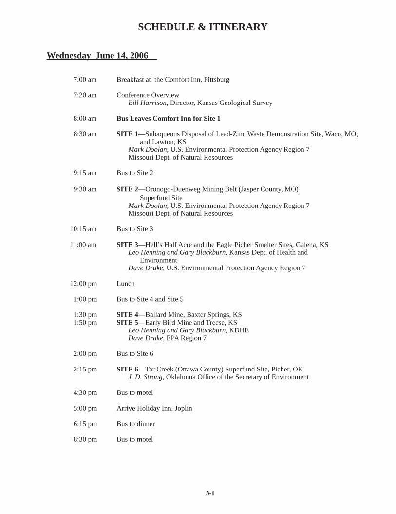
SCHEDULE & ITINERARY
Wednesday June 14, 2006
7:00 am Breakfast at the Comfort Inn, Pittsburg
7:20 am Conference OverviewBill Harrison, Director, Kansas Geological Survey
8:00 am Bus Leaves Comfort Inn for Site 1
8:30 am SITE 1—Subaqueous Disposal of Lead-Zinc Waste Demonstration Site, Waco, MO, and Lawton, KS
Mark Doolan, U.S. Environmental Protection Agency Region 7Missouri Dept. of Natural Resources
9:15 am Bus to Site 2
9:30 am SITE 2—Oronogo-Duenweg Mining Belt (Jasper County, MO) Superfund Site
Mark Doolan, U.S. Environmental Protection Agency Region 7Missouri Dept. of Natural Resources
10:15 am Bus to Site 3
11:00 am SITE 3—Hell’s Half Acre and the Eagle Picher Smelter Sites, Galena, KSLeo Henning and Gary Blackburn, Kansas Dept. of Health and EnvironmentDave Drake, U.S. Environmental Protection Agency Region 7
12:00 pm Lunch
1:00 pm Bus to Site 4 and Site 5
1:30 pm SITE 4—Ballard Mine, Baxter Springs, KS 1:50 pm SITE 5—Early Bird Mine and Treese, KS
Leo Henning and Gary Blackburn, KDHEDave Drake, EPA Region 7
2:00 pm Bus to Site 6
2:15 pm SITE 6—Tar Creek (Ottawa County) Superfund Site, Picher, OKJ. D. Strong, Oklahoma Offi ce of the Secretary of Environment
4:30 pm Bus to motel
5:00 pm Arrive Holiday Inn, Joplin
6:15 pm Bus to dinner
8:30 pm Bus to motel
3-2
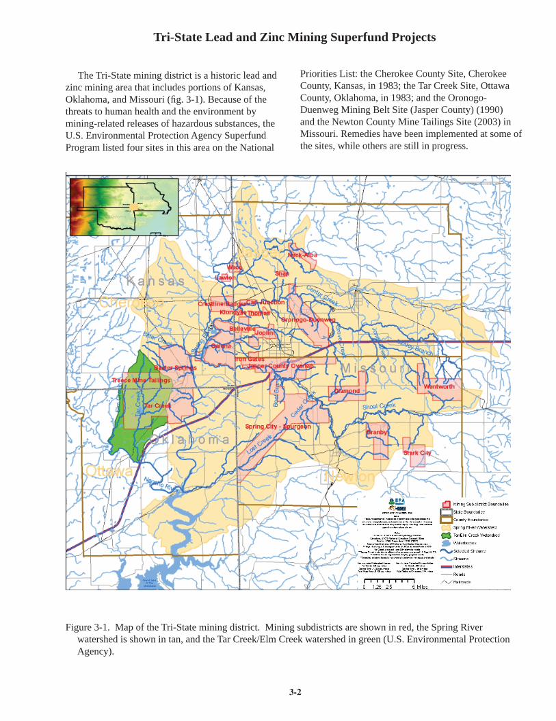
Tri-State Lead and Zinc Mining Superfund Projects
The Tri-State mining district is a historic lead and zinc mining area that includes portions of Kansas, Oklahoma, and Missouri (fi g. 3-1). Because of the threats to human health and the environment by mining-related releases of hazardous substances, the U.S. Environmental Protection Agency Superfund Program listed four sites in this area on the National
Priorities List: the Cherokee County Site, Cherokee County, Kansas, in 1983; the Tar Creek Site, Ottawa County, Oklahoma, in 1983; and the Oronogo-Duenweg Mining Belt Site (Jasper County) (1990) and the Newton County Mine Tailings Site (2003) in Missouri. Remedies have been implemented at some of the sites, while others are still in progress.
Figure 3-1. Map of the Tri-State mining district. Mining subdistricts are shown in red, the Spring River watershed is shown in tan, and the Tar Creek/Elm Creek watershed in green (U.S. Environmental Protection Agency).
3-3
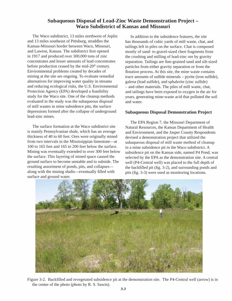
Subaqueous Disposal of Lead-Zinc Waste Demonstration Project –Waco Subdistrict of Kansas and Missouri
The Waco subdistrict, 13 miles northwest of Joplin and 13 miles southeast of Pittsburg, straddles the Kansas-Missouri border between Waco, Missouri, and Lawton, Kansas. The subdistrict fi rst opened in 1917 and produced over 300,000 tons of zinc concentrates and lesser amounts of lead concentrates before production ceased by the mid-20th century. Environmental problems created by decades of mining at the site are ongoing. To evaluate remedial alternatives for improving water quality in streams and reducing ecological risks, the U.S. Environmental Protection Agency (EPA) developed a feasibility study for the Waco site. One of the cleanup methods evaluated in the study was the subaqueous disposal of mill wastes in mine subsidence pits, the surface depressions formed after the collapse of underground lead-zinc mines.
The surface formation at the Waco subdistrict site is mainly Pennsylvanian shale, which has an average thickness of 40 to 60 feet. Ores were originally mined from two intervals in the Mississippian limestone—at 100 to 165 feet and 165 to 200 feet below the surface. Mining was eventually extended to over 300 feet below the surface. This layering of mined space caused the ground surface to become unstable and to subside. The resulting assortment of ponds, pits, and collapses—along with the mining shafts—eventually fi lled with surface and ground water.
Figure 3-2. Backfi lled and revegetated subsidence pit at the demonstration site. The P4-Central well (arrow) is in the center of the photo (photo by R. S. Sawin).
In addition to the subsidence features, the site has thousands of cubic yards of mill waste, chat, and tailings left in piles on the surface. Chat is composed mostly of sand- to gravel-sized chert fragments from the crushing and milling of lead-zinc ore by gravity separation. Tailings are fi ne-grained sand and silt-sized particles from either gravity separation or from the fl otation process. At this site, the mine waste contains trace amounts of sulfi de minerals – pyrite (iron sulfi de), galena (lead sulfi de), and sphalerite (zinc sulfi de) – and other materials. The piles of mill waste, chat, and tailings have been exposed to oxygen in the air for years, generating mine-waste acid that polluted the soil and water.
Subaqueous Disposal Demonstration Project
The EPA Region 7, the Missouri Department of Natural Resources, the Kansas Department of Health and Environment, and the Jasper County Respondents devised a demonstration project that utilized the subaqueous disposal of mill waste method of cleanup in a mine subsidence pit in the Waco subdistrict. A subsidence pit on the Kansas side, named P4 Pond, was selected by the EPA as the demonstration site. A central well (P4-Central well) was placed to the full depth of the backfi lled pit (fi g. 3-2), and surrounding ponds and pits (fi g. 3-3) were used as monitoring locations.

3-4
Monitoring wells were installed to detect potential chemistry changes in the shallow aquifer. The contaminated mill wastes were backfi lled into the fl ooded subsidence pit between March and July 2002, and capped with soil and vegetated to isolate the material from erosion and rainwater leaching. An estimated 58,000 cubic yards of tailings were placed in the pit, capped by 1.5 feet of topsoil.
Subaqueous disposal is designed to establish a stable environment for the mining waste by greatly reducing its exposure to oxygen. The maximum concentration of dissolved oxygen found in surface water is about 25,000 times lower than that found in the atmosphere. As the rate of sulfi de oxidation partly depends on the concentration of oxygen, reduced rates of acid generation and metals release should occur in a subaqueous setting compared to having the mine waste exposed to the atmosphere in a surface setting. In addition, the rate of oxygen transfer through water is nearly 10,000 times slower than in air so that the reduced oxygen supply underwater might eventually result in anoxic conditions that would stabilize the sulfi de minerals. If anoxic conditions were achieved,
Figure 3-3. Mine subsidence pit just east of the demonstration project site. This pit is analogous to the pit that was backfi lled, and it was also used as a monitoring location during and after the demonstration project pit was backfi lled (photo by R. S. Sawin).
Figure 3-4. Geochemical reactions in a subaqueous setting, Jasper County, Missouri (from NewFields, 2003).
3-5
metals release from sulfi de minerals would be controlled entirely by their very low solubility in water (fi g. 3-4).
As expected, the placement of mill tailings in the P4 Pond caused large increases in the concentration of several constituents, as detected in the P4-Central well, notably calcium (10x), iron (350x), sulfate (15x), total dissolved solids (12x), and zinc (100x). Post-backfi ll sampling of the nearby subsidence ponds and monitoring wells did not identify any parameter increases that could be confi dently attributed to backfi lling the subsidence pit; the only exception was one pond that experienced increased calcium, hardness, magnesium, manganese, sulfate, total dissolved solids, and zinc concentrations. The increase may have been a result of runoff recharge, or impacts from the demonstration site, or both.
Reference
NewFields, 2003, Final Report – Subaqueous Mill Waste Disposal Demonstration Project, Waco Subdistrict, Jasper County, Missouri and Cherokee County, Kansas.
Resource Contact
Mark DoolanU.S. EPA Region 7901 N. 5th StreetKansas City KS 66101913-551-7169 or [email protected]

3-6
Oronogo-Duenweg Mining Belt (Jasper County, Missouri) Superfund Site
Lead and zinc mining began in Jasper County in the mid-19th century and reached peak production around 1916. Hundreds of mines and 17 smelters were established in the county. Mining operations were principally underground and involved sinking shafts to subsurface ore bodies. The raw ore was brought to the surface and crushed in stages. Metals were separated by gravity separation or fl otation and the waste rock, development rock, chat, and tailings materials were usually dumped at the surface in waste piles. Many wastes were re-milled as more effi cient separation techniques became available.
Diminishing production led to the closure of the mining industry in Jasper County by 1957, although one smelter in the city of Joplin operated until the 1970’s. While a substantial portion of the 150 million tons of the mine waste was eventually removed and used in aggregate for buildings and roads, approximately 9 million tons remain.
The waste piles were left uncovered and unstable, and runoff from the piles contaminated the soil, ground water, and surface streams with lead, zinc, cadmium, and other hazardous substances. Flooded mine shafts also led to contamination when ground water came in contact with ore and subsurface wastes. The estimated amount of contaminated ground water at the site range from 400,000 to 740,000 acre-feet. Airborne pollutants also affected the area. Smelters released metals directly into the air, and winds picked up hazardous materials from waste piles.
Unvegetated and partially vegetated mine wastes cover more than 3,600 acres of the Oronogo-Duenweg mining belt site. Soils within 200 feet of mine waste piles contain hazardous substances that are on average several times greater than normal. These contaminated soils within 200 feet of the waste piles cover approximately 4,000 additional acres at the site.
The principal drainage system for Jasper County is the Spring River and its tributaries, including Shoal Creek, Turkey Creek, Short Creek, and Center Creek. Turkey Creek, Center Creek, and Short Creek have been impacted by the release of hazardous substances. The other streams and adjacent intermittent drainages may be impacted as well.
Average concentrations of cadmium, lead, and zinc in the shallow aquifer of the Oronogo-Duenweg mining
belt site exceed background concentrations by up to 10 times. Mean cadmium, lead, and zinc concentrations in surface water can be even higher. High concentrations of cadmium, lead, and zinc are also found in the stream sediments.
Before cleanup began, approximately 500 homes on the east side of the site relied on private, shallow ground-water wells for drinking water. EPA identifi ed at least 100 of these wells as containing lead and cadmium above safe levels. At least 2,500 residential yards were contaminated with lead above acceptable levels. A 1994 human-health exposure study by the Missouri Department of Health showed that 14 percent of the children under seven years old had blood-lead concentrations exceeding the health-based standard of 10 micrograms per deciliter. Investigations indicated the mining waste also caused risks to the fl ora and fauna, particularly fi sh and mammals. Concentrations of lead, zinc, and cadmium were elevated in fi sh and invertebrate tissues from organisms collected in Jasper County.
Remedial Actions and Environmental Progress
This site is being addressed through Federal and potentially responsible parties’ (PRPs) actions. In 1991 the EPA signed an Administrative Order on Consent with the PRPs to investigate the mining waste. A Unilateral Administrative Order was issued to the PRPs to provide bottled water to residents in 1994. A second Unilateral Administrative Order was issued to the PRPs in 1994 to conduct additional private water-well sampling and provide bottled water where acceptable levels of contamination were exceeded. EPA signed an Administrative Order on Consent with the PRPs in 1995 to sample residential yard soil and prioritize areas for soil removal. A Consent Decree was completed in 1999 for the PRPs to install public water-supply systems.
EPA established four Operable Units (OUs) at the site to address the risks associated with contaminated soil and water. OU1 addressed mining-waste piles. OU2 addressed lead-contaminated residential-yard soils in the smelter area. OU3 addressed lead-contaminated residential-yard soils in the mining-wastes areas. OU4 addressed contaminated ground water.
In 2004 the EPA conducted a fi ve-year review of the site and concluded that the remedies were functioning
3-7
as designed, and the immediate threats to people had been addressed. As part of the project, 50 mine shafts have been closed, 2,600 residential yards have been cleaned up, and 550 homes with contaminated private wells have been hooked up to the public water supply. Studies before and after the yard cleanup show a 78 percent reduction in the number of children with elevated lead levels in their blood. The 2004 EPA report emphasized, however, that for the remedy to work in the long term, institutional controls in the form of residential-development ordinances must be adopted by local governments to ensure safe development in contaminated areas.
While the most pressing dangers to the population had been remediated, the EPA review noted that the piles of mining waste, which had not been dealt with, were still a serious environmental problem. Although the risk assessment completed for the site concluded there was not a signifi cant risk for people exposed to mine waste, the piles would continue to pollute the soil and water. Plans are underway for the Missouri Department of Transportation to use some of the waste for fi ll in highway construction, and negotiations are being conducted with the PRPs to ensure the cleanup of mine-waste source areas and stream-tributary sediments. Future plans include safely disposing of 7,000 acres of mine waste and monitoring the progress of site-streams cleanup and institutional controls. Several pilot studies are underway to assess innovative technology involving biosolids treatment and revegetation, phosphate-treatment bioavailability, and subaqueous disposal. These techniques could potentially result in signifi cant cost savings over conventional cleanup methods.
References
Missouri Department of Natural Resources and U.S. Department of Interior, Preassessment Screen and Determination: Jasper County Superfund Site, Jasper County, Missouriwww.dnr.mo.gov/env/hwp/news/fi nal-jasper-county-pas-tds-02-06-18.pdf
EPA Region 7, Oronogo-Duenweg Mining Belt, Missouri, EPA ID# MOD980686281www.epa.gov/region07/cleanup/index_missouri.htm
EPA Region 7, March 2004, Five-Year Review Completed, Oronogo-Duenweg Mining Belt Site, Jasper County, Missouriwww.epa.gov/region07/superfund/index
Resource Contacts
Mark DoolanU.S. EPA Region 7901 N. 5th StreetKansas City KS 66101913-551-7169 or [email protected]
Superfund Records Center901 N. 5th St.Kansas City, KS 66101913-551-4038
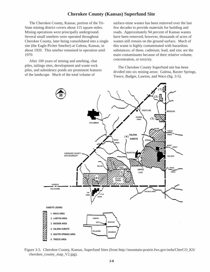
3-8
Cherokee County (Kansas) Superfund Site
Figure 3-5. Cherokee County, Kansas, Superfund Sites (from http://mountain-prairie.fws.gov/nrda/CherCO_KS/ cherokee_county_map_V2.jpg).
The Cherokee County, Kansas, portion of the Tri-State mining district covers about 115 square miles. Mining operations were principally underground. Several small smelters were operated throughout Cherokee County, later being consolidated into a single site (the Eagle-Picher Smelter) at Galena, Kansas, in about 1920. This smelter remained in operation until 1970.
After 100 years of mining and smelting, chat piles, tailings sites, development and waste rock piles, and subsidence ponds are prominent features of the landscape. Much of the total volume of
surface-mine wastes has been removed over the last few decades to provide materials for building and roads. Approximately 94 percent of Kansas wastes have been removed; however, thousands of acres of wastes still remain on the ground surface. Much of this waste is highly contaminated with hazardous substances; of these, cadmium, lead, and zinc are the main contaminants because of their relative volume, concentration, or toxicity.
The Cherokee County Superfund site has been divided into six mining areas: Galena, Baxter Springs, Treece, Badger, Lawton, and Waco (fi g. 3-5).
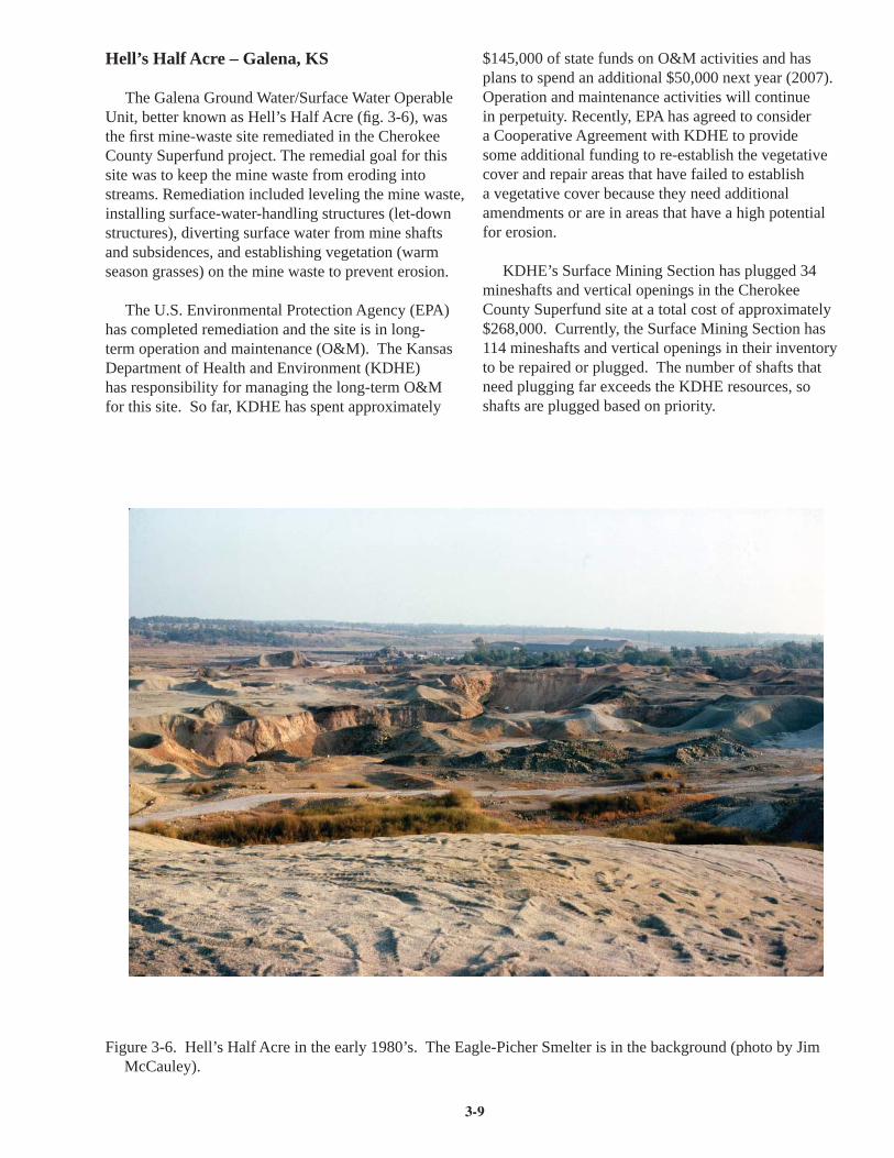
3-9
Figure 3-6. Hell’s Half Acre in the early 1980’s. The Eagle-Picher Smelter is in the background (photo by Jim McCauley).
Hell’s Half Acre – Galena, KS
The Galena Ground Water/Surface Water Operable Unit, better known as Hell’s Half Acre (fi g. 3-6), was the fi rst mine-waste site remediated in the Cherokee County Superfund project. The remedial goal for this site was to keep the mine waste from eroding into streams. Remediation included leveling the mine waste, installing surface-water-handling structures (let-down structures), diverting surface water from mine shafts and subsidences, and establishing vegetation (warm season grasses) on the mine waste to prevent erosion.
The U.S. Environmental Protection Agency (EPA) has completed remediation and the site is in long-term operation and maintenance (O&M). The Kansas Department of Health and Environment (KDHE) has responsibility for managing the long-term O&M for this site. So far, KDHE has spent approximately
$145,000 of state funds on O&M activities and has plans to spend an additional $50,000 next year (2007). Operation and maintenance activities will continue in perpetuity. Recently, EPA has agreed to consider a Cooperative Agreement with KDHE to provide some additional funding to re-establish the vegetative cover and repair areas that have failed to establish a vegetative cover because they need additional amendments or are in areas that have a high potential for erosion.
KDHE’s Surface Mining Section has plugged 34 mineshafts and vertical openings in the Cherokee County Superfund site at a total cost of approximately $268,000. Currently, the Surface Mining Section has 114 mineshafts and vertical openings in their inventory to be repaired or plugged. The number of shafts that need plugging far exceeds the KDHE resources, so shafts are plugged based on priority.

3-10
Figure 3-7. Photo of the Ballard mine site taken in the early 1980’s (photo by Jim McCauley).
Eagle-Picher Smelter Site – Galena, KS
The Eagle-Picher smelter site has recently been abandoned through bankruptcy by Eagle-Picher Technologies. The smelter wastes around the facility, which are highly contaminated with lead, mercury, cadmium, arsenic, and zinc, are leaching into Short Creek. The wastes impact water quality and sediments in Short Creek, which does not support aquatic life. Only life forms that are highly tolerant to the heavy metals are present. Remediation at this site will include consolidation, sediment dredging, capping, and establishment of a vegetative cap.
KDHE has been actively seeking funds from the bankruptcy court to remediate this site. KDHE has negotiated the cost ($6,566,667) to remediate the site, but the fi nal legal document has not been completed. Because this site has been designated an orphan site (no known responsible party), KDHE will be required to perform the long-term operation and maintenance activities. KDHE was able to negotiate a portion of the settlement for long-term O&M. Had those negotiations been unsuccessful, Kansas taxpayers would have been responsible for funding the remedy and long-term O&M.
Ballard Mine – Baxter Springs, KS
The Ballard mine (fi g. 3-7) is part of the Baxter Springs subsite that includes the Ballard, Hartley, Bruger, and portions of the Homestake mines. Remediation at the Ballard mine was recently completed. The responsible parties that have been identifi ed for the Baxter Springs subsite include Sunoco, NL Industries, Phelps-Dodge, and ASARCO. The remedy at the Ballard mine included consolidation of mine waste, cleaning out the surface waterways, capping the mine waste with 6-18 inches of soil, and establishing a vegetative cover. The cost for these activities was a little over $6,000,000.
Soil from a local borrow pit was transported to the site for the soil cap. The soil cap, which was not used at Hell’s Half Acre, has greatly helped with establishment of the vegetative cover (warm-season native grasses). All future remedies in the Cherokee County site will include a soil cap over the waste because it helps prevent erosion and human contact, and it will greatly reduce the cost of long-term O&M.
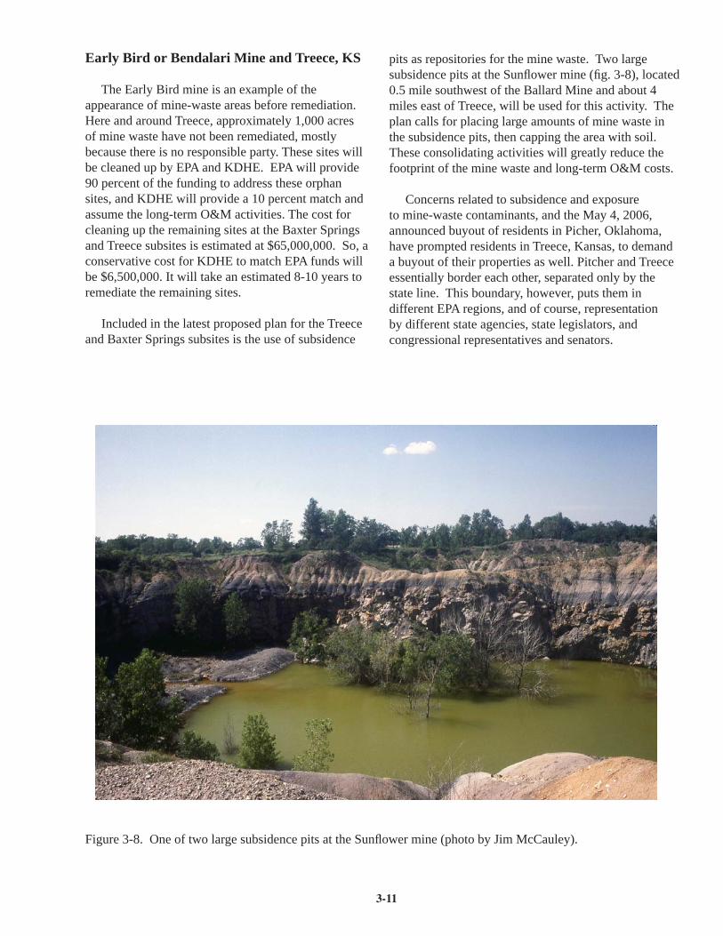
3-11
Early Bird or Bendalari Mine and Treece, KS
The Early Bird mine is an example of the appearance of mine-waste areas before remediation. Here and around Treece, approximately 1,000 acres of mine waste have not been remediated, mostly because there is no responsible party. These sites will be cleaned up by EPA and KDHE. EPA will provide 90 percent of the funding to address these orphan sites, and KDHE will provide a 10 percent match and assume the long-term O&M activities. The cost for cleaning up the remaining sites at the Baxter Springs and Treece subsites is estimated at $65,000,000. So, a conservative cost for KDHE to match EPA funds will be $6,500,000. It will take an estimated 8-10 years to remediate the remaining sites.
Included in the latest proposed plan for the Treece and Baxter Springs subsites is the use of subsidence
pits as repositories for the mine waste. Two large subsidence pits at the Sunfl ower mine (fi g. 3-8), located 0.5 mile southwest of the Ballard Mine and about 4 miles east of Treece, will be used for this activity. The plan calls for placing large amounts of mine waste in the subsidence pits, then capping the area with soil. These consolidating activities will greatly reduce the footprint of the mine waste and long-term O&M costs.
Concerns related to subsidence and exposure to mine-waste contaminants, and the May 4, 2006, announced buyout of residents in Picher, Oklahoma, have prompted residents in Treece, Kansas, to demand a buyout of their properties as well. Pitcher and Treece essentially border each other, separated only by the state line. This boundary, however, puts them in different EPA regions, and of course, representation by different state agencies, state legislators, and congressional representatives and senators.
Figure 3-8. One of two large subsidence pits at the Sunfl ower mine (photo by Jim McCauley).

3-12
In Treece, the responsible parties, under EPA and KDHE oversight, have cleaned up the residential yards by replacing the soil. Residents’ immediate worries, however, are about subsidence. EPA and KDHE have acknowledged the residents’ concerns, but EPA and KDHE cannot address these concerns because they are limited to dealing only with hazardous wastes and contaminants and cannot address safety issues.
References
U.S. Environmental Protection Agency Region 7, Cherokee County, Kansas, EPA ID# KSD980741862 http://www.epa.gov/region7/cleanup/npl_fi les/ksd980741862.pdf
U.S. Fish &Wildlife Service, Region 6, Environmental Contaminants, Cherokee County, Kansas http://mountain-prairie.fws.gov/nrda/CherCO_KS/CherokeeCounty.htm
Resource Contacts
Leo HenningKansas Dept. of Health and Environment1000 SW Jackson, Ste. 430Topeka, KS [email protected]
Dave DrakeU.S. Environmental Protection Agency, Region 7901 N. 5th StreetKansas City, KS [email protected]

3-13
Tar Creek (Ottawa County, Oklahoma) Superfund Site
Figure 3-9. Tar Creek at Douthat Bridge, 1 mile south of Cardin, Oklahoma (photo by R. S. Sawin).
Lead and zinc mining started in northeastern Oklahoma near Peoria, Ottawa County, in 1891. During the peak years of 1907 through 1946, nearly 2 million tons of lead and zinc were mined at a value of more than $202 million. By the time the last mining company closed its doors in 1970, the Picher mining fi eld had produced 1.7 million tons of lead and 8.8 million tons of zinc.
The mining and milling of lead and zinc ore left approximately 300 miles of underground tunnels, 165 million tons of tailings and chat, more than 1,320 mine shafts, and thousands of drill holes in the Oklahoma portion of the Tri-State mining district alone. Tangible natural-resource threats were fi rst realized in 1979, when metals-laden mine water began discharging to surface streams in the Tar Creek watershed (fi g. 3-9). The 40-square-mile site was added to the fi rst National Priorities List when Congress created the Superfund program in 1983. The Tar Creek Superfund site includes the Old Picher Field lead and zinc mining area and the towns of Picher, Cardin, Quapaw, Commerce,
and North Miami. Approximately 19,556 people live in the area.
Early attempts to halt polluted mine seepage were largely unsuccessful, and the U.S. Environmental Protection (EPA) Agency was ready to give up on restoring and protecting the water quality of Tar and Lytle creeks. As interest in restoring the blighted area began to wane, a 1993 study of blood-lead levels conducted by the Indian Health Service showed that 34% of area Native American children exhibited blood lead levels above the thresholds considered dangerous to human health. This threat to human health propelled the Tar Creek Superfund site to the top of the National Priorities List, making it the highest-ranking Superfund site in the nation. To address the problems at the Tar Creek Superfund site, the EPA established fi ve Operable Units (OU) – a discrete action that comprises an incremental step toward comprehensively addressing site problems – focusing on water quality, residential contamination, hazardous materials, and mine waste.
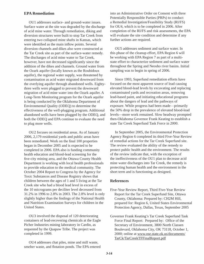
3-14
EPA Remediation OU1 addresses surface- and ground-water issues.
Surface water at the site was degraded by the discharge of acid mine water. Through remediation, diking and diversion structures were built to stop Tar Creek from entering two collapsed mine shafts in Kansas, which were identifi ed as the main infl ow points. Several diversion channels and dikes also were constructed at the Tar Creek site as part of the surface-water remedy. The discharges of acid mine water to Tar Creek, however, have not decreased signifi cantly since the addition of the dikes and channels. Ground water from the Ozark aquifer (locally known as the Roubidoux aquifer), the regional water supply, was threatened by contamination as acid water migrated downward from the overlying aquifer through abandoned wells. Eighty-three wells were plugged to prevent the downward migration of acid mine water into the Ozark aquifer. A Long-Term Monitoring program for the Ozark aquifer is being conducted by the Oklahoma Department of Environmental Quality (ODEQ) to determine the effectiveness of the well-plugging program. Additional abandoned wells have been plugged by the ODEQ, and both the ODEQ and EPA continue to evaluate the need to plug more wells.
OU2 focuses on residential areas. As of January 2006, 2,179 residential yards and public areas have been remediated. Work on the fi nal 100 properties began in December 2005 and is expected to be completed in 2006. EPA also is funding community health education and blood-lead screening for the fi ve-city mining area, and the Ottawa County Health Department is working with local health professionals to provide education to the medical community. The October 2004 Report to Congress by the Agency for Toxic Substances and Disease Registry shows that children between the ages of 1 and 5 living at the Tar Creek site who had a blood lead level in excess of the 10 micrograms per deciliter level decreased from 31.2% in 1996 to 2.8% in 2003. The 2.8% level is only slightly higher than the fi ndings of the National Health and Nutrition Examination Surveys for children in the United States.
OU3 involved the disposal of 120 deteriorating containers of lead-recovering chemicals at the Eagle Picher Industries mining laboratory in Cardin, as requested by the Quapaw Tribe. The project was completed in 1999.
OU4 addresses chat piles, mine and mill waste, smelter waste, and fl otation ponds. The EPA entered
into an Administrative Order on Consent with three Potentially Responsible Parties (PRPs) to conduct a Remedial Investigation/Feasibility Study (RI/FS) for OU4, which is to be completed in 2006. After completion of the RI/FS and risk assessments, the EPA will evaluate the site condition and determine if any further actions are required.
OU5 addresses sediment and surface water. In this phase of the cleanup effort, EPA Region 6 will be working with EPA Region 7 as part of a multi-state effort to characterize sediment and surface water throughout the Spring and Neosho river basins. Initial sampling was to begin in spring of 2006.
Since 1993, Superfund remediation efforts have focused on the most apparent source of lead causing elevated blood-lead levels by excavating and replacing contaminated yards and recreation areas, removing lead-based paint, and initiating educational programs about the dangers of lead and the pathways of exposure. While progress had been made—primarily the 50% drop in the prevalence of elevated blood-lead levels—more work remained. Slow headway prompted then-Oklahoma Governor Frank Keating to establish a state Tar Creek Superfund Task Force in 2000.
In September 2005, the Environmental Protection Agency Region 6 completed its third Five-Year Review of remedial actions for the Tar Creek Superfund site. The review evaluated the ability of the remedy to protect public health and the environment. The results of the review indicate that, with the exception of the ineffectiveness of the OU1 plan to decrease acid mine water discharges into Tar Creek, the remedy is protecting human health and the environment in the short term and is functioning as designed.
References
Five-Year Review Report, Third Five-Year Review Report for the Tar Creek Superfund Site, Ottawa County, Oklahoma: Prepared by: CH2M Hill, prepared for: Region 6, United States Environmental Protection Agency, Dallas, Texas, September 2005
Governor Frank Keating’s Tar Creek Superfund Task Force Final Report: Prepared by: Offi ce of the Secretary of Environment, 3800 North Classen Boulevard, Oklahoma City, OK 73118, October 1, 2000; online at www.ose.state.ok.us/documents/TarCk/TarCreekTFFinalReport.pdf

3-15
Tar Creek (Ottawa County) Oklahoma, EPA Region 6, updated: April 2006
epa.gov/region6/index.htm
Oklahoma Plan for Tar Creek www.deq.state.ok.us/lpnew/tarcreek/Okplan.pdf
Resource Contacts
J. D. Strong, Chief of StaffOffi ce of the Secretary of Environment3800 North Classen BoulevardOklahoma City, OK [email protected]
Oklahoma Department of Environmental Quality707 N RobinsonOklahoma City, OK 73102Mailing Address:P.O. Box 1677Oklahoma City, OK 73101-1677405-702-1000405-702-1001 (fax)www.deq.state.ok.us/lpdnew/tarcreek
EPA Region 6 Main Offi ce1445 Ross AvenueSuite 1200Dallas, TX 75202214-665-6444www.epa.gov/region6

4-1
SCHEDULE & ITINERARY
Thursday June 15, 2006
7:00 am Breakfast at the Holiday Inn, Joplin
8:00 am Bus Leaves Holiday Inn for Site 7
8:15 am SITE 7—Ground Water Supply Issues, Wildcat Park, Joplin, MOAllen Macfarlane, Kansas Geological SurveyBob Nichols, Tri-State Water Resources CoalitionJonathan Long, U.S. Army Corps of EngineersDavid Pope, Kansas Dept. of Agriculture, Division of Water ResourcesWalt Aucott, U.S. Geological Survey
9:30 am Bus to Site 8
10:00 am SITE 8—Surface Water Issues, Shoal Creek at Schermerhorn Park, Galena, KS
Tracy Streeter and Kerry Wedel, Kansas Water Offi ceJaci Ferguson, U.S. Environmental Protection Agency Region 7Karl Mueldener, Kansas Dept. of Health and EnvironmentEd Miller and Mike Hayden, Kansas Dept. of Wildlife and ParksMike Pope, U.S. Geological SurveyJohn Peck, School of Law, University of Kansas
11:30 am Tour Southeast Kansas Nature Center and Schermerhorn Cave
12:00 pm Lunch
1:00 pm Bus to Site 9
2:00 pm SITE 9—Grand Lake O’ the CherokeesDarrell Townsend, Grand River Dam AuthorityJ.D. Strong, Offi ce of the Secretary of Environment (Oklahoma)
6:30 pm Refreshments and Dinner at the Arrowhead Yacht Club
8:00 pm Bus to Holiday Inn Express, Vinita, OK

4-2
Tri-State Region Aquifers
In the Tri-State region of southeast Kansas, southwest Missouri, and northeast Oklahoma, the Ozark Plateaus aquifer system is an important source of freshwater for municipal water supplies, industry, and agriculture. In this area, the Ozark Plateaus aquifer system consist of two aquifers—the Springfi eld Plateau and Ozark aquifers—separated by an impermeable zone known as the Ozark confi ning unit (fi g. 4-1). The Springfi eld Plateau aquifer is above the confi ning unit and is in the same Mississippian-age rocks that have been mined for lead and zinc in the Tri-State region. Below the confi ning unit, the Ozark aquifer occupies Cambrian- and Ordovician-age rocks. It is locally referred to as the Roubidoux aquifer—named for the Roubidoux Formation, a signifi cant water-producing zone within the Ozark aquifer.
Historically, the Ozark Plateaus aquifer system has been the single most important source of ground water in the Tri-State region. Ground water was primarily used for lead and zinc mining and milling activities and for coal-washing operations in the coal fi elds farther north. The Ozark aquifer was secondarily used for drinking water by public supplies. With the decline of the mining industry in the mid 20th century, the primary
use of water from the Ozark aquifer has been for public supplies of drinking water and for industries other than mining.
Ozark Aquifer
The Ozark aquifer is a thick sequence of water-bearing dolomites, limestones, and sandstones. The thickness of the Ozark aquifer in the Tri-State region varies from 800 to 1,500 feet. The recharge area for the Ozark aquifer is in the topographically higher region of southern Missouri where the aquifer’s rocks crop out in an area that roughly coincides with the crest of the Ozark uplift south of Springfi eld, Missouri. Rainwater enters the aquifer through the outcrop area and moves by gravity in a westerly direction into the deeper part of the aquifer in southeast Kansas and northeast Oklahoma (fi g. 4-2). There it encounters saltwater moving east from deeper rocks in western Kansas and Oklahoma, where the rocks are known as the Arbuckle Group. The Arbuckle is an important source of hydrocarbons farther west and is also used for waste disposal. Where these two water masses meet, a 20-30-mile-wide fresh-to-saline transition zone stretches northeast to southwest across the region (fi g. 4-3).
Figure 4-1. Cross section from southeast Kansas to southwest Missouri showing the aquifers and confi ning units that form the Ozark Plateaus aquifer system in the Tri-state region (from Macfarlane, 2005).
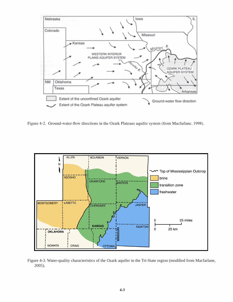
4-3
Figure 4-2. Ground-water-fl ow directions in the Ozark Plateaus aquifer system (from Macfarlane, 1998).
Figure 4-3. Water-quality characteristics of the Ozark aquifer in the Tri-State region (modifi ed from Macfarlane, 2005).
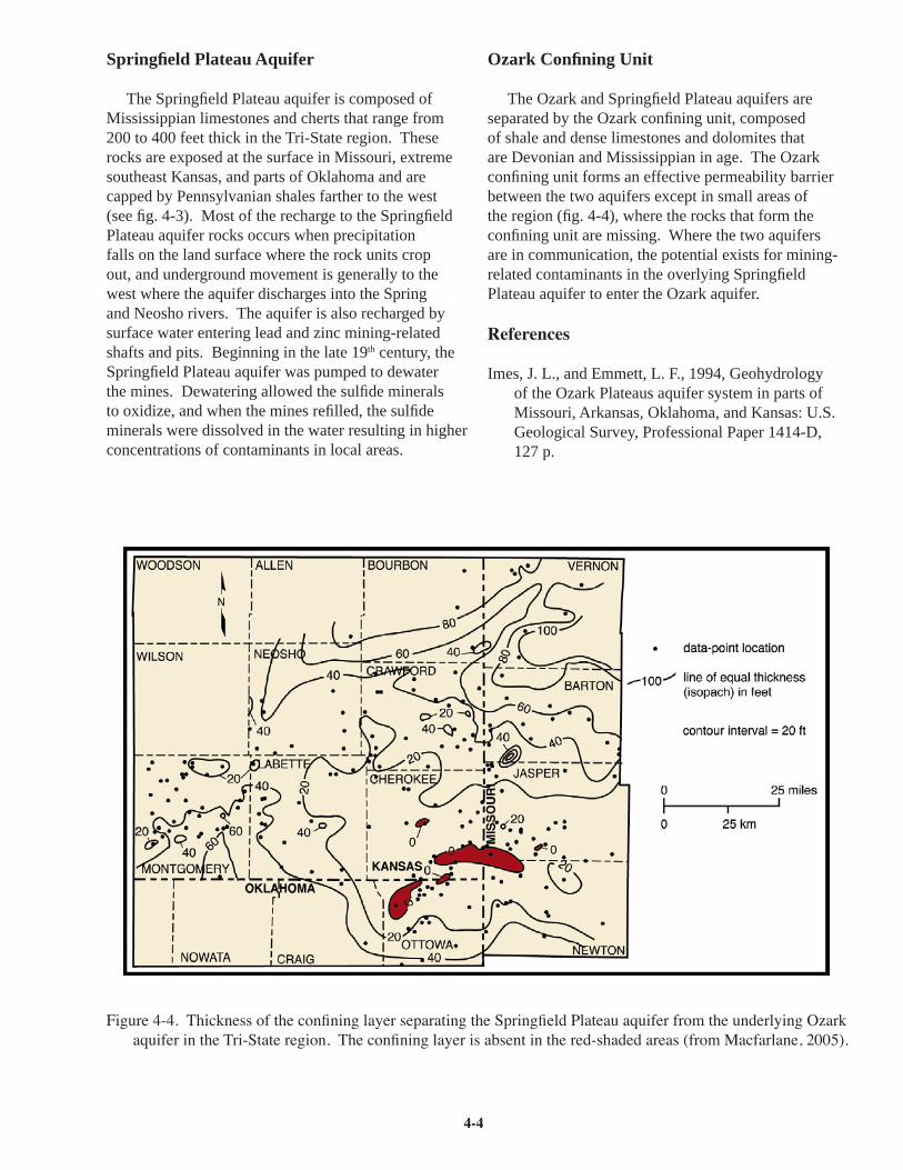
4-4
Springfi eld Plateau Aquifer
The Springfi eld Plateau aquifer is composed of Mississippian limestones and cherts that range from 200 to 400 feet thick in the Tri-State region. These rocks are exposed at the surface in Missouri, extreme southeast Kansas, and parts of Oklahoma and are capped by Pennsylvanian shales farther to the west (see fi g. 4-3). Most of the recharge to the Springfi eld Plateau aquifer rocks occurs when precipitation falls on the land surface where the rock units crop out, and underground movement is generally to the west where the aquifer discharges into the Spring and Neosho rivers. The aquifer is also recharged by surface water entering lead and zinc mining-related shafts and pits. Beginning in the late 19th century, the Springfi eld Plateau aquifer was pumped to dewater the mines. Dewatering allowed the sulfi de minerals to oxidize, and when the mines refi lled, the sulfi de minerals were dissolved in the water resulting in higher concentrations of contaminants in local areas.
Ozark Confi ning Unit
The Ozark and Springfi eld Plateau aquifers are separated by the Ozark confi ning unit, composed of shale and dense limestones and dolomites that are Devonian and Mississippian in age. The Ozark confi ning unit forms an effective permeability barrier between the two aquifers except in small areas of the region (fi g. 4-4), where the rocks that form the confi ning unit are missing. Where the two aquifers are in communication, the potential exists for mining-related contaminants in the overlying Springfi eld Plateau aquifer to enter the Ozark aquifer.
References
Imes, J. L., and Emmett, L. F., 1994, Geohydrology of the Ozark Plateaus aquifer system in parts of Missouri, Arkansas, Oklahoma, and Kansas: U.S. Geological Survey, Professional Paper 1414-D, 127 p.
Figure 4-4. Thickness of the confi ning layer separating the Springfi eld Plateau aquifer from the underlying Ozark aquifer in the Tri-State region. The confi ning layer is absent in the red-shaded areas (from Macfarlane, 2005).

4-5
Macfarlane, P. A., and Hathaway, L. R., 1987, The hydrogeology and chemical quality of ground waters in the lower Paleozoic aquifers in the Tri-state region of Kansas, Missouri, and Oklahoma: Kansas Geological Survey, Ground-water Series 9, 37 p.
Macfarlane, P. A., 1998, Is sustainability a viable concept in the management of confi ned aquifers in Kansas?; in, Perspectives on Sustainable Development of Water Resources in Kansas, M. Sophocleous, ed.: Kansas Geological Survey, Bulletin 239, p. 97-115.
Macfarlane, P. A., 2000, Revisions to the nomenclature for Kansas aquifers: Kansas Geological Survey Bulletin 244, part 2, available online at http://www.kgs.ku.edu/Current/2000/macfarlane1.html
Macfarlane, P. A., Healey, J. M., and Wilson, B. B., 2005, The southeast Kansas Ozark aquifer water supply program—phase 1 project results: Kansas Geological Survey, Open-fi le Report 2005-15, 52 p.
Wittman, J., Kelson, V., and Wilson, T., 2003, Final report source of supply investigation for Joplin, Missouri: Wittman Hydro Planning Associates, 97 p.
Resource Contacts
Allen MacfarlaneKansas Geological Survey1930 Constant Ave.Lawrence, KS [email protected]

4-6
Water Supply Issues
Demand for water in the Tri-State region continues to grow as the population increases, and as demand increases, more wells are being drilled into the Ozark aquifer, the primary source of water for most industries and municipalities. Three major concerns have been identifi ed:
• Increasing reliance on the Ozark aquifer. Projected population growth will increase demands for water by public supplies and some industries, causing more wells to be drilled. More wells increase the likelihood that water levels and pumping rates will be affected in neighboring wells.
• Contamination of the Ozark aquifer from the overlying Springfi eld Plateau aquifer. Local contamination of the Springfi eld Plateau aquifer from mining and industrial activity can migrate downward as more water is pumped from the deeper aquifer.
• Saltwater encroachment from the west. As more water is pumped from the Ozark aquifer, saline water is drawn from the deeper aquifer into the freshwater zone, effectively shifting the transition zone (fi g. 4-3) to the east. Some public water suppliers in western Crawford and Cherokee counties have abandoned the Ozark aquifer because of poor water quality.
The sensitivity of the Ozark aquifer to development suggests that management of the aquifer system should be coordinated across state lines to minimize the potential for depletion, contamination from the overlying aquifer, and saltwater encroachment. Recent studies suggest additional data and a cooperative effort are needed for reliable management of the ground-water resource to protect the Ozark aquifer.
Tri-State Water Resources Coalition
The Tri-State Water Resources Coalition, a non-profi t group founded by economic development interests, was organized in 2002 to address water-supply issues in the region. The Coalition’s goal is to develop a water resource for the area with adequate, good quality water to ensure the growth of the geographical area. Members of the Coalition include cities, water districts, private companies, regulatory agencies, and citizen and user groups from the three-state area.
The Coalition has contracted with a consultant, Black and Veatch, which is working with the U.S. Army Corps of Engineers to look for a place to construct a reservoir that will hold surface water for periods when demand is placed on the aquifer during a drought. The study should be completed in 2006.
Kansas Studies
The Kansas Department of Agriculture, Division of Water Resources, which regulates water usage in Kansas, has issued a moratorium on new water rights and the drilling of deep wells in southeast Kansas. The moratorium was designed to give the U.S. Geological Survey (USGS) enough time to complete a study of the aquifer. State water agencies are also working with the Kansas Geological Survey to establish a long-term ground-water monitoring network in southeast Kansas.
The USGS study, initiated in July 2005, will evaluate the long-term availability of ground-water supplies from the Ozark Plateaus aquifer system in the Tri-State region, and determine the effects of existing and proposed ground-water withdrawals on ground-water levels and water quality. The study should be completed in 2008 at a cost of approximately $886,000. State and federal funds are contributing to the study, and an interstate technical advisory committee has been organized to provide input to the USGS. Results of the study will be used by water managers to determine the impacts of proposed water developments and assist in making long-term management decisions.
Resource Contacts
Bob NicholsFreese and NicholsOne South Main, Ste. 102Webb City, MO [email protected]
Jonathan LongU.S. Army Corps of EngineersP.O. Box 867Little Rock, AR [email protected]

4-7
David Pope, Chief EngineerKansas Department of AgricultureDivision of Water Resources109 SW 9th Street, 2nd FloorTopeka, KS 66612-1283 [email protected]
Walt Aucott, DirectorWater Resources DivisionU.S. Geological Survey4821 Quail Crest PlaceLawrence, KS [email protected]
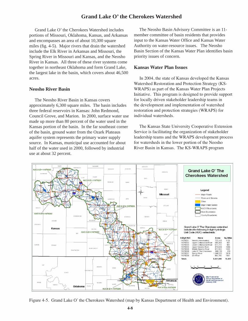
4-8
Grand Lake O’ the Cherokees Watershed
Grand Lake O’ the Cherokees Watershed includes portions of Missouri, Oklahoma, Kansas, and Arkansas and encompasses an area of about 10,300 square miles (fi g. 4-5). Major rivers that drain the watershed include the Elk River in Arkansas and Missouri, the Spring River in Missouri and Kansas, and the Neosho River in Kansas. All three of these river systems come together in northeast Oklahoma and form Grand Lake, the largest lake in the basin, which covers about 46,500 acres.
Neosho River Basin
The Neosho River Basin in Kansas covers approximately 6,300 square miles. The basin includes three federal reservoirs in Kansas: John Redmond, Council Grove, and Marion. In 2000, surface water use made up more than 80 percent of the water used in the Kansas portion of the basin. In the far southeast corner of the basin, ground water from the Ozark Plateaus aquifer system represents the primary water supply source. In Kansas, municipal use accounted for about half of the water used in 2000, followed by industrial use at about 32 percent.
The Neosho Basin Advisory Committee is an 11-member committee of basin residents that provides input to the Kansas Water Offi ce and Kansas Water Authority on water-resource issues. The Neosho Basin Section of the Kansas Water Plan identifi es basin priority issues of concern.
Kansas Water Plan Issues
In 2004, the state of Kansas developed the Kansas Watershed Restoration and Protection Strategy (KS-WRAPS) as part of the Kansas Water Plan Projects Initiative. This program is designed to provide support for locally driven stakeholder leadership teams in the development and implementation of watershed restoration and protection strategies (WRAPS) for individual watersheds.
The Kansas State University Cooperative Extension Service is facilitating the organization of stakeholder leadership teams and the WRAPS development process for watersheds in the lower portion of the Neosho River Basin in Kansas. The KS-WRAPS program
Figure 4-5. Grand Lake O’ the Cherokees Watershed (map by Kansas Department of Health and Environment).
4-9
is administered by the Kansas Department of Health and Environment in conjunction with an interagency WRAPS Work Group.
The U.S. Environmental Protection Agency is conducting a watershed assessment and planning effort in the Spring River watershed with involvement from stakeholder groups in Kansas, Missouri, and Oklahoma. A WRAPS project is also being initiated to help organize local stakeholders and support future watershed planning and management activities.
Total Maximum Daily Loads (TMDLs) in the Kansas portion of the basin were established in 2002 and will be re-evaluated in 2007. Nine streams and three lakes have been identifi ed as high priority for TMDL implementation. The primary stream impairment is low dissolved oxygen, although the Spring River is impaired by metals. Lake impairments include eutrophication (nutrient loading) and siltation. TMDLs in Kansas are developed by the Kansas Department of Health and Environment.
Water-quality issues affecting Grand Lake in Oklahoma, including eutrophication and siltation, represent an interstate watershed issue. Interagency cooperation has been initiated to address interstate water-quality concerns in the basin.
The Kansas Department of Health and Environment has worked with public water suppliers in the basin to complete source-water assessments in Kansas. Local nonpoint source pollution-management plans are being implemented through county conservation districts in sixteen Kansas counties in the basin, and county sanitary/environmental codes are being administered through county or multi-county health agencies in all but one county. Also, 17 local watershed districts have been organized in the basin.
The Neosho River is an area of high biological importance in Kansas. Priority issues include populations of freshwater mussels, sensitive species such as the Neosho madtom, and populations that have declined from historic levels, such as the paddlefi sh. Minimum Desirable Streamfl ow (MDS) values have been established on the Cottonwood, Neosho, and Spring rivers in Kansas.
The Kansas Department of Agriculture, Division of Water Resources, has conducted an assessment of instream fl ow for the Neosho River basin. This included an evaluation of historic fl ow, reservoir operations and management, water rights, and
consideration of options to meet instream needs for habitat and species protection, including water quality.
Drought is an ongoing concern in the region. All counties in the lower portion of the basin in Kansas are under a drought warning in 2006. In April 2006, the Spring River was under MDS administration by the Kansas Department of Agriculture, Division of Water Resources.
There are 111 public water suppliers in the Neosho basin in Kansas, including 56 rural water districts and six public wholesale water supply districts. The Cottonwood/Neosho Water Assurance District has 24 public water supply members and four industrial water-right holders as members who work with the Kansas Water Offi ce and U.S. Army Corps of Engineers to operate the reservoirs as a system to meet members’ needs during periods of low fl ow.
Interstate cooperation is underway to address the future availability of water from the Ozark Plateaus aquifer system, a major water-supply source for communities in the Tri-State region. The Kansas Department of Agriculture, Division of Water Resources, has imposed a moratorium on approval of new ground-water rights in southeast Kansas until after the U.S. Geological Survey completes a regional ground-water availability study. Interstate management of the Spring River is also an important long-term water supply consideration in the basin.
Source
Kansas Water Plan http://www.kwo.org/Kansas%20 Water%20Plan/Kansas%20Water%20Plan.htm
Resource Contacts
Tracy Streeter, DirectorKansas Water Offi ce901 S. Kansas AvenueTopeka, KS [email protected]
Kerry WedelKansas Water Offi ce901 S. Kansas AvenueTopeka, KS [email protected]

4-10
Jaci Ferguson, Environmental EngineerU.S. Environmental Protection Agency Region 7901 St. Louis Street, Ste. 200-13Springfi eld, MO 65809417-579-8028417-459-1187 [email protected]
Karl Mueldener, DirectorBureau of WaterKansas Department of Health and Environment1000 SW Jackson St., Suite 420Topeka, KS [email protected]
Mike PopeWater Resources DivisionU.S. Geological Survey4821 Quail Crest PlaceLawrence, KS [email protected]
Ed MillerKansas Dept. of Wildlife and Parks4825 Squaw Creek RoadP.O. Box 945Independence, KS 67301-0945620-331-6820
Mike Hayden, SecretaryKansas Department of Wildlife and Parks1020 S. Kansas Ave.Topeka, KS [email protected]

4-11
Legal Issues and Water
“Whiskey is for drinking, water is for fi ghting.” That may sound like a joke, but in parts of the country where water is in short supply, at least the second half of the sentence is true. And when issues become contentious in the U.S., they typically involve the law.
In this country, water issues are largely regulated by the states. While regulation differs from state to state, in very general terms, states can be grouped into those that have adopted eastern water law—those east of and along the Mississippi River that typically are more humid and have more substantial water supplies—and those states that have adopted western water law—those farther west, as the name implies, where water is increasingly in short supply.
Again, in very general terms, eastern states have adopted regulation based on riparian principles, rooted in common law from England. According to riparian doctrine, landowners adjacent to a stream own the river channel, can make reasonable use of the water in the stream, and are entitled to have the stream continue to fl ow past them in its natural condition. In general, these rights are attached to the land and not transferable or lost when they are not used.
Where water is less abundant, out west, most states adopted the doctrine of prior appropriation. This appropriation is often summed up as “fi rst in time, fi rst in right,” meaning that the fi rst user to put water to a benefi cial use has legal rights that supersede those of
later users. Although the water itself may belong to the state (as it does in Kansas), owners of water rights have the legal right to use water in order of priority. When water supplies are short and water use must be curtailed, the most recent water rights are the fi rst to be curtailed. Older, or more senior rights, are the last to be affected. Under this doctrine, water rights are not tied to the land and can be severed from it. Water can be moved from its source—as it often is in irrigation—but rights can be lost if they are not used.
Nearly all states, either east or west, have developed standards and regulations for planning and utilizing water. Registration and permitting of water use has become more common. Thus, while states fall into two very broad categories of water regulation, each state goes about regulating water in different fashions. Both Kansas and Oklahoma have adopted the western, or prior appropriation, doctrine for water regulation, while Missouri follows eastern or riparian water law.
Resource Contact
John Peck, ProfessorUniversity of KansasLaw School301 Green HallLawrence, KS [email protected]

4-12
Schermerhorn Park and Southeast Kansas Nature Center
Edgar Backus Schermerhorn of Galena donated land south of town on Shoal Creek (fi g. 4-6) in 1922 for a city park. During the mid 1930’s and early 1940’s, the WPA built stone terrace walls and other structures in the park, including a Boy Scout cabin. The cabin has now been transformed into the Southeast Kansas Nature Center, which features exhibits of animals and plants native to the area and exploration drawers fi lled with hands-on materials. Environmental education classes and workshops are offered each month. The Southeast Kansas Nature Center Foundation is a not-for-profi t organization founded to maintain an environmental resource center for area schools, educators, and the community at large.
Schermerhorn Park is the most accessible spot to view Kansas’ oldest surface rocks. Deposited about 345 million years ago, outcrops of late-Mississippian limestone are found only in the southeastern tip of Cherokee County encompassed by a line running from Galena to Baxter Springs and along the Oklahoma and Missouri borders. The Spring River and its tributaries, including Shoal Creek that fl ows through the 24-acre park, helped shape this Mississippian landscape into rolling hills and steep river bluffs. The distinctive
features of this small triangular corner of Kansas make it part of the Ozark Plateau, more commonly associated with Missouri, Arkansas, and northeastern Oklahoma. Because this environment is different from the rest of the state, some of the state’s rarest animals and plants are found in the park.
Schermerhorn Cave, located in the park, is the source of a spring-fed stream that is home to four species of amphibians—the dark-sided (or longtailed) salamander, cave salamander, graybelly (or many-ribbed) salamander, and grotto salamander. All are on the Kansas endangered or threatened species list. Rare fi sh in the stream and adjacent Spring River include the Ozark minnow, black redhouse, and greenside darter. Also found in the area are the spring peeper, pickerel frog, fox squirrel, fl ying squirrel, chuck-will’s-widow, whip-poor-will, great horned owl, barred owl, and eastern screech-owl. Woodland birds include the red-shouldered hawk, pileated woodpecker, Carolina chickadee, scarlet tanager, and yellow-throated warbler. White and Shumard’s oaks and bitternut and shagbark hickories, all typical of the Ozarks, dominate the hillside.
Figure 4-6. Shoal Creek at Schermerhorn Park (photo by R. S. Sawin).

4-13
Schermerhorn Cave
Schermerhorn Cave, the largest in the area, appears deceptively welcoming with its 58 x 80-foot entrance (fi g. 4-7). Although the cave is nearly 1/2-mile long, within 80 feet of the entrance the passage becomes a crawlway, most of which is a low streambed rarely exceeding 2 feet in height. The stream adds a risk of hypothermia for spelunkers. In addition, the cave is prone to fl ooding, as evidenced by fl ood debris in the ceiling cracks. Due to these potential dangers, the cave is locked and not accessible to the public. Management is overseen by the Kansas Department of Wildlife and Parks, and the U.S. Fish and Wildlife Service has provided support in a number of maintenance activities associated with the cave.
References
Gress, B. and Potts, G., 1993, Watching Kansas Wildlife: A Guide to 101 Sites, 112 p.
Sperry-Galligar Audubon Society www.apexcorp.com/~rmangile/Sgas/GalenaNC.html
Young, J. and Beard, J. C., 1993, Caves in Kansas: Kansas Geological Survey, Educational Series 9, 48 p.
Resource Contacts
Linda PhippsSoutheast Kansas Nature Center7693 SE 77th TerraceGalena, KS [email protected]
Ed MillerKansas Dept. of Wildlife and Parks4825 Squaw Creek RoadP.O. Box 945Independence, KS 67301-0945620-331-6820
Figure 4-7. Schermerhorn Cave (photo by R. S. Sawin).
4-14
Grand Lake O’ the Cherokees
Grand Lake O’ the Cherokees (Grand Lake) is the third largest reservoir in Oklahoma, with 46,500 acres of water and a 1,300-mile shoreline. Its watershed spans four states and two U.S. Environmental Protection Agency (EPA) regions. The drainage area for Grand Lake covers 10,298 square miles in Arkansas, Kansas, Missouri, and Oklahoma, and includes the Neosho, Spring, and Elk rivers.
Pensacola Dam, which holds back Grand Lake, was constructed by the Grand River Dam Authority (GRDA) in 1940 as the state’s fi rst hydroelectric facility and is the longest multiple-arch dam in the world. The GRDA, a state agency, was created in 1935 to control, store, and preserve the water of the Grand River and its tributaries and to develop and generate water power and electric energy. Grand Lake is one of two GRDA lakes on the Grand River. A third lake on the river is under the authority of the U.S. Army Corps of Engineers.
While Grand Lake is one of the fastest growing retirement destinations in the United States and one of the top recreational destinations in the region, accelerated water-quality decline presents a serious threat. Recognizing the implications of this trend, the Oklahoma Legislature passed Senate Bill 408 in 2003. The statute charged Oklahoma’s Secretary of the Environment with coordinating an investigation into the problems plaguing the Grand Lake watershed.
Previous studies indicate that eutrophication—the reduction of oxygen due to increased mineral and organic nutrients—is occurring in Grand Lake at a much faster rate than is natural. Research suggests that the primary sources of impairment within the watershed stem from the explosive growth of industrial-scale poultry operations, heavy metals associated with the historical lead and zinc mining of the former Tri-State mining district, and discharges from municipal and industrial wastewater-treatment plants. The lack of centralized wastewater treatment for the expanding residential development along Grand Lake’s shoreline also may be contributing contaminants, particularly bacterial, although further scientifi c research is needed to confi rm that. Nutrient and sediment runoff from other watershed activities, including construction, urban development, golf courses, and agricultural operations, contribute additional pollutant loads.
Modeling of Grand Lake and its watershed has estimated that 72 percent of the phosphorus loading stems from nonpoint source runoff, while 28 percent comes from point sources. Although the vast majority of the Grand Lake watershed’s land area lies in Kansas, the bulk of its population and the largest number of point-source dischargers are in Missouri. The Lower Spring River subwatershed, which includes Joplin, Missouri, has been identifi ed as the area contributing the most phosphorus from both point and nonpoint sources (Dutnell et al., 1995).
The latest water-quality information shows that, in general, the lake continues to exhibit signs of accelerated eutrophication caused by elevated levels of nutrients entering the lake. An analysis of harmful algae blooms in the lake found no serious occurrences yet, although the Oklahoma Water Resources Board notes that continued increases in nutrient loading and eutrophication of the reservoir will increase the likelihood of harmful algae blooms in future years.
The Oklahoma Department of Environmental Quality (DEQ) coordinates with other agencies to focus on the heavy metals and other contaminants associated with historical lead and zinc mining in the Tar Creek sub-watershed. Several new monitoring initiatives are beginning under the leadership of the EPA Region 6 and Region 7 offi ces, all of which will serve to better quantify the impacts of releases from the former mines on Grand Lake sediments, biota, and water quality.
In addition to water-quality studies, the Oklahoma Legislature requested that the Oklahoma Water Resources Board conduct an intensive sedimentation survey and develop a bathymetric map of the lake in order to determine the degree to which sedimentation has decreased lake volume. This study will seek to predict changes in lake volume and storage capacity over time.
Today, Grand Lake and many of its tributaries are identifi ed as impaired on the 303(d) lists of Oklahoma, Missouri, and Kansas for such causes as nutrients, sedimentation, low dissolved oxygen, lead, zinc, and cadmium. Additionally, the DEQ has issued a warning against consumption of whole fi sh caught in the Spring and Neosho rivers at the upper end of the lake due to its preliminary fi ndings of high lead levels in fi sh
4-15
tissue. State monitoring activities continue to detect impaired water-quality conditions in Grand Lake and its tributaries.
To advance the restoration and protection effort, the Oklahoma Secretary of the Environment proposes to coordinate the development of a network of watershed stakeholders representing all four states. This collaboration would serve as the principal vehicle for enlisting participation, developing a sound restoration action strategy, implementing measures to improve the Grand Lake watershed, and educating watershed residents about the importance of protecting their natural resources.
Sources
Comprehensive Study of the Grand Lake Watershed Final Report (per Senate Bill 408) prepared by Offi ce of the Secretary of Environment, December 31, 2005
Comprehensive Study of the Grand Lake Watershed Initial Report (per Senate Bill 408) prepared by Offi ce of the Secretary of Environment, January 30, 2004
Dutnell, R. C., Storm, D. E., Waits, D., Umbach, D., and Woodruff, D., 1995, Grand Lake Basin Management Plan Phase 1: Identifi cation of Critical Area: Oklahoma Conservation Commission, 110 p.
Grand River Dam Authority www.grda.com
Offi ce of the Secretary of Environment www.ose.state.ok.us
Resource Contacts
Darrell Townsend, Ph.D.Grand River Dam AuthorityP.O. Box 409Vinita, OK 74301918-256-5545, ext. [email protected]
J. D. Strong, Chief of StaffOffi ce of the Secretary of Environment3800 North Classen BoulevardOklahoma City, OK [email protected]
5-1
SCHEDULE & ITINERARY
Friday June 16, 2006
7:00 am Breakfast at the Holiday Inn Express, Vinita, OK
8:00 am Bus Leaves Holiday Inn Express for Site 10
9:00 am SITE 10—Oil and Gas Well Plugging Demonstration, Labette County, KS Morris Korphage and Bob Jenkins, Kansas Corporation Commission
9:45 am Bus to Site 11
10:00 am SITE 11—Neosho Energy Center, Parsons, KS John Cigainero, Westar Energy Electrical Generation Issues in the Tri-State Region Jim Ludwig, Westar Energy Economics and the Future of the Tri-State Region Gordon Elliott, Pittsburg, KS Sen. Derek Schmidt, Independence, KS Chuck Surface, Jasper County, MO
12:15 pm Bus to Pittsburg
12:45 pm Arrive Comfort Inn, Pittsburg

5-2
Oil and Gas Well Plugging in Kansas
The regulation of oil and gas wells by the Kansas Corporation Commission (KCC) began in 1935. Plugging and abandonment procedures were in place in 1935, and were revised and expanded in 1982. During fi scal year 2005, 1,618 wells of all types were plugged by the oil and gas industry.
Before plugging begins, the operator must give written notice to the Conservation Division of the intention to plug and abandon the well, and notify the appropriate district offi ce of the proposed plan at least fi ve days prior to plugging, unless an exception is granted. District offi ces are in Dodge City (Southwest Kansas), Wichita (South and North Central Kansas), Chanute (Eastern Kansas), and Hays (Northwestern Kansas).
The KCC requires operators to comply with the following plugging regulations:
• For productive or past-productive oil or gas formations, a cement plug not less than 50 feet in length or a bridge capped with cement shall be placed above each such formation.
• Cement plugs of 50 feet or more in length shall be placed both above and below any fresh or usable water horizons. The lower plug shall extend at
least 50 feet below the base of water zones, and the upper plug shall extend at least 50 feet above the top of the water zones.
• In each well plugged, a cement plug shall be placed near the surface of the ground in a manner that does not interfere with soil cultivation.
Additional regulations may apply in specifi c circumstances, such as when a wellbore has penetrated both a highly permeable formation and a major salt formation or when a well is located near the lease or unit boundary. On occasion, alternative plugging methods may be used if authorized by the KCC. All plugging operations are conducted in a manner that is protective of water resources and correlative rights of mineral owners.
Abandoned Oil and Gas Well/Site Remediation Program
The Abandoned Oil and Gas Well/Site Remediation Fund was established in 1996 to provide additional fi nancial support to the Conservation Division so that the agency could address the problems of both abandoned oil and gas wells and sites contaminated by exploration and production activities (fi g. 5-1). Under K.S.A. 55-179, monies could be used to plug
Figure 5-1. Abandoned well leaking saltwater, Verdigris River fl oodplain, Montgomery County, KS (photo by KCC).
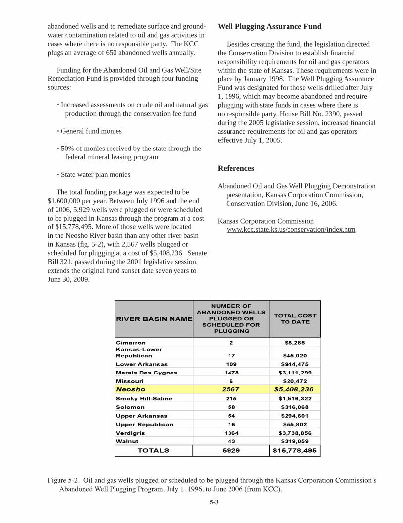
5-3
abandoned wells and to remediate surface and ground-water contamination related to oil and gas activities in cases where there is no responsible party. The KCC plugs an average of 650 abandoned wells annually.
Funding for the Abandoned Oil and Gas Well/Site Remediation Fund is provided through four funding sources:
• Increased assessments on crude oil and natural gas production through the conservation fee fund
• General fund monies
• 50% of monies received by the state through the federal mineral leasing program
• State water plan monies
The total funding package was expected to be $1,600,000 per year. Between July 1996 and the end of 2006, 5,929 wells were plugged or were scheduled to be plugged in Kansas through the program at a cost of $15,778,495. More of those wells were located in the Neosho River basin than any other river basin in Kansas (fi g. 5-2), with 2,567 wells plugged or scheduled for plugging at a cost of $5,408,236. Senate Bill 321, passed during the 2001 legislative session, extends the original fund sunset date seven years to June 30, 2009.
Well Plugging Assurance Fund
Besides creating the fund, the legislation directed the Conservation Division to establish fi nancial responsibility requirements for oil and gas operators within the state of Kansas. These requirements were in place by January 1998. The Well Plugging Assurance Fund was designated for those wells drilled after July 1, 1996, which may become abandoned and require plugging with state funds in cases where there is no responsible party. House Bill No. 2390, passed during the 2005 legislative session, increased fi nancial assurance requirements for oil and gas operators effective July 1, 2005.
References
Abandoned Oil and Gas Well Plugging Demonstration presentation, Kansas Corporation Commission, Conservation Division, June 16, 2006.
Kansas Corporation Commission www.kcc.state.ks.us/conservation/index.htm
Figure 5-2. Oil and gas wells plugged or scheduled to be plugged through the Kansas Corporation Commission’s Abandoned Well Plugging Program, July 1, 1996, to June 2006 (from KCC).

5-4
Resource Contacts
Morris Korphage, DirectorConservation DivisionKansas Corporation Commission130 S. Market, Room 2078Wichita, KS 67202-3802316-337-6233
Bob JenkinsCoordinator of Abandoned Well Plugging and Site RemediationKansas Corporation Commission130 S. Market, Room 2078Wichita, KS [email protected]
Kansas Geological Survey Plugged Well Databasewww.kgs.ku.edu/Magellan/Plug/

5-5
Neosho Energy Center
Neosho Energy Center dates back to 1923, when the original generating unit was placed in service. By 1927, a second unit was in service, bringing the total station capability to 50 megawatts. At that time, both units were located on the east side of the Neosho River. The two turbine generators were supplied steam from six stoker-fi red boilers. The fuel source was local coal transported to the site by rail. Both units experienced heavy operation through 1960, when more effi cient, natural gas-fueled units relegated them to “peaking” and emergency duty. The coal-fi red units were retired in 1979 and completely demolished in 1990.
In 1954, construction was completed on the No. 3 generating unit and No. 7 boiler (70 megawatts) on the west side of the river. It can be fueled by natural gas and can also burn #6 heavy oil as a secondary fuel. This unit saw heavy operation until 1986. The No. 3 unit was “moth-balled” when LaCygne, Jeffrey, and Wolf Creek generating stations were brought on-line.
In 1998, the unit was brought back into service and updated with numerous control and fl ame management systems and emission controls. It operated successfully until 2003, when new gas turbines were constructed in the Wichita area, which again put this unit in the role of “peak” use and emergency back-up generation. The unit is currently in a semi-moth-balled status, operating occasionally during the summer months as required.
Resource Contacts
John CigaineroNeosho Energy Center2365 22000 RoadParsons, KS 67357620-423-7902
Jim LudwigWestar EnergyP.O. Box 889Topeka, KS 66601-0889785-575-8411

5-6
Economics and the Future of the Tri-State Region
The economic history of southeastern Kansas, southwestern Missouri, and northeastern Oklahoma is one of dramatic change. Probably owing primarily to its topography, this area has never been as dominated by agriculture as other parts of Missouri, Kansas, and Oklahoma. On the other hand, the use of other natural resources—coal, oil and gas, and metallic minerals—is much more important to the economy here. Coal mining began in the 19th century, but it was the mining and smelting of lead and zinc in the late 1800’s that produced a boom in the area’s economy. Oil was discovered in this area in the 1890’s, and exploration and production thrived in the early 20th century. In addition, natural gas was used to develop a variety of industries, including the production of cement, glass, brick, tile, and other materials.
The result was an expanding economy and a jump in area population. Cherokee County, Kansas, for example, increased in population from 27,000 in 1890 to 42,000 just 10 years later. The entire population of the 10 counties that make up southeastern Kansas (Allen, Bourbon, Chautauqua, Cherokee, Crawford, Montgomery, Wilson, Woodson, Labette, and Neosho) increased from 105,000 to 186,000 from 1890 to 1920. But nearly as quickly as this boom developed, some parts of it went away. Supplies of natural gas in some areas were quickly depleted, and higher energy costs, combined with the impact of prices, supply, and demand on the national scale, dealt severe blows to the cement, glass, and clay industries. While the oil fi elds of southeastern Kansas and northeastern Oklahoma were highly productive in the early 20th century, they produced less and less over time and the oil industry in both states turned its attention to larger, more productive fi elds farther west.
For a time in the early 20th century, the Tri-State region was the world’s largest producer of lead and zinc ore. However, production of lead and zinc in Kansas peaked in 1926, and the history of lead/zinc mining in the area ended in 1970 with the closing of the Eagle-Picher Industries Swalley mine near Baxter Springs and the closing of the Eagle-Picher central mill at Cardin, Oklahoma. The history of coal mining in the area is slightly different. Its production peaked in 1918. Coal continued to be heavily mined through the 1960s, when concerns about the environment made low-sulfur coals from the western U.S. more attractive, and reclamation laws made the thin coal seams from
this area more expensive to mine. The result was a drop in demand for Kansas coal from the Tri-State region. Coal continues to be mined here, but at a much lower level than in the past.
The demise of lead and zinc mining, along with dramatic declines in production of oil, gas, and coal, resulted in economic dislocation and a change in the area’s population. For example, in the year 2000, the population of Cherokee County was about 22,000, or about half of its level in 1900. Today the economy of this region is much more dominated by manufacturing and retail activity. While there has been a recent resurgence in the production of at least one natural resource, coalbed methane, a mix of manufacturing, wholesale and retail trade, and construction remain the primary drivers of economic activity in this area.
References
Clark, J. G., 1970, Towns and minerals in southeastern Kansas: A study in regional industrialization: Kansas Geological Survey, Special Distribution Publication 52, 148 p.
Policy Research Institute, Kansas Statistical Abstract, University of Kansas Policy Research Institute, 2005 (online at www.ku.edu/pri/ksdata/ksah).
Resource Contacts
Gordon Elliott342 E. 126th HighwayPittsburg, KS [email protected]
Senator Derek SchmidtP.O. Box 747Independence, KS [email protected]
Chuck SurfaceCounty CommissionerJasper County Courthouse302 South Main StreetCarthage, MO [email protected]