Embed Size (px)
Citation preview
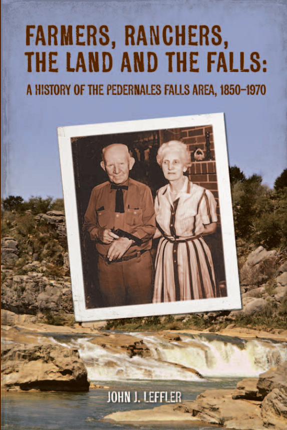
Farmers, Ranchers, the Land and the Falls: A History of the Pedernales Falls Area, 1850–1970 John J. Leffler
This is the story of a special place—a 5,000-acre stretch of land along the Pedernales River, the area that is now Pedernales Falls State Park. In words, photographs, and maps, Farmers, Ranchers, the Land and the Falls explains how nature and human dreams intertwined in an isolated and untamed place, leaving a lasting mark on the land.
The author charts the evolution of the area from savannah grassland to the hill country brush and cedar trees that we know today. Deftly interwoven are the stories of those who settled and worked it—the German settlers who established the community of Cypress Mill, the farmers who moved into the Pedernales Falls area during the 1870s and 1880s, and the ranchers who moved in after the dry years of the late 1880s and 1890s. Focused on the one hundred years between 1870—when Indian incursions declined and a wave of farmers began to move in, and 1970—when the Wheatleys, the last owners of the land, sold it to the state of Texas—the human narrative moves like a quick distant tune dying on the wind.
Anyone visiting the state park today will want to read this book, not only to see some of the real footprints of those one hundred years, but also for the window it eloquently opens into the lives of the farmers and ranchers who briefly peopled this land.
Janice Pinney, Past Director of Publications,Texas State Historical Association
John J. Leffler has been researching and writing Texas history for more than twenty years. He received his B.A. in history from the College of William and Mary and his Ph.D. in history from the University of Texas at Austin. He has taught history at Southwestern University and Southwest Texas State University, and now teaches at the University of Texas at Austin. He lives in Austin with his wife and sons.
r

Farmers, Ranchers, the Land and the Falls:
A History of the Pedernales Falls Area,1850–1970
by John J. Leffler
Historic Sites and Structures ProgramState Parks Division
Texas Parks and Wildlife Department

iii
TPWD receives federal assistance from the U.S. Fish and Wildlife Service and other federal agencies and is subject to Title VI of the Civil Rights Act of 1964, Section 504 of the Rehabilitation Act of 1973, Title II of the Americans with Disabilities Act of 1990, the Age Discrimination Act of 1975, Title IX of the Education Amendments of 1972, and state anti-discrimination laws which prohibit discrimina-tion the basis of race, color, national origin, age, sex or disability. If you believe that you have been discriminated against in any TPWD program, activity or facility, or need more information, please contact Civil Rights Coordinator for Public Access, U.S. Fish and Wildlife Service, 4401 N. Fairfax Drive, Mail Stop: MBSP-4020, Arlington, VA 22203.
© 2010 TPWD. PWD BK P4507-0026M (8/10)
In accordance with Texas State Depository Law, this publication is available at the Texas State Publications Clearinghouse and/or Texas Depository Libraries.

iii
A History of the Pedernales Falls Area, 1850–1970
Acknowledgments Researching history is always collaborative work, but for this project I have
been even more fortunate than usual in finding people who have been willing and able to help me understand my subject. Many others have worked, in ways large and small, to encourage me to begin this study and to complete it.
I’m particularly indebted to Bobby, Maude and Cheryl Wilson; Dena, Loma and Jerry Wenmohs; Joyce Brock; Sherill East, and his granddaughters Diana L. Cooper and Candace Sandefur; Lila Jean Hobbs; Bill Casparis; and Polly Miller. Bobby Wilson spent many hours with me graciously sharing his extensive knowledge of the early settlers in the Pedernales Falls area, especially the Wilson, Raines and Trammell families. Bobby and his daughter Cheryl walked me around the area their ancestors settled, and Bobby and Maude very kindly shared family materials, including an old family Bible, that informed and enriched my understanding of the people who first settled in the Pedernales Falls area. Joyce Brock generously shared genealogical knowledge she had acquired over the years. Dena, Loma and Jerry Wenmohs also spent hours of their time helping me to understand the Cypress Mill/Pedernales Falls area, and shared documents and research materials that were very helpful. Sherill East talked with me for several hours about his experiences with the Wheatleys and the Circle Bar ranch, and shared many photographs documenting them; his granddaughters, particularly Diana Cooper, very graciously and patiently volunteered old photographs and family knowledge. I will never forget their generosity in troubled times. Lila Jean Hobbs talked with me about Herman Reiner and her own life near the Pedernales Falls, and Bill Casparis and Polly Miller also helped me to understand. Even a brief look at the endnotes attached to this study will show how important these people have been: without them, this history could never have been written.
Thanks also to several people at the Texas Parks and Wildlife Department. I did most of the research and writing for this study back in 1995 and 1996, when Dr. Cynthia Brandimarte was TPWD’s Cultural Resources program director (currently the Historic Sites and Structures program director). Cindy and Clay Brewer, then regional resource coordinator, provided support for my work then, and Cindy was an able and sympathetic administrator. Most recently, in 2010, Dr. Brandimarte asked me to revisit the project and to work up the
iv
Farmers, Ranchers, the Land and the Falls
v
present history. This would not have been written without her help and support. Particular thanks to Bill McDaniel, then and now the superindent at Pedernales Falls State Park, who spent hours sharing his historical knowledge and materials with me. Also many thanks to Aina Dodge, Margaret Howard and Logan McNatt at TPWD’s Archeology Lab. This time around Aina found for me old photographs and documents central to the study. Diane Dismukes, currently the Region 7 cultural resource coordinator, helped me, too.
I’d also like to thank C.A. Cowsert, who in 1996 was the range management specialist at the USDA Natural Resources Conservation Service office in Johnson City, Texas. John Cotter, who back in 1996 was teaching and playing pool at Southwestern University, did a great job on the maps. Many thanks also to the librarians and staff at the Texas State Library and Archives, the Texas General Land Office, the Blanco County Courthouse, the Texas Historical Commission, the Center for American History, The University of Texas at Austin, and the Johnson City Public Library, Johnson City, Texas.
My wife Vivian, and my sons Ben, Jamie, Danny and David, all know how they helped.
John J. LefflerJuly 2010

iv v
A History of the Pedernales Falls Area, 1850–1970
Contents
Illustrations ...............................................................................................................vii
Introduction ................................................................................................................1
Early Settlement in the Pedernales Falls Area .........................................................2
New Settlers in “The Land of 1,000 Springs”: Farmers and Ranchers in the Pedernales Falls Area, 1870–1885 ......................5
“Starved Out”: The Decline of the Pedernales Falls Community, 1885–1900 ........................ 18
Tough and Gritty: J.B. Wenmohs and the Development of the Wenmohs Ranch, 1900–1937 ......................................... 22
Oil Money and Anglers: The Wheatleys and the Circle Bar Ranch, 1937–1970 .................................... 27
Endnotes ................................................................................................................... 46
Bibliography ............................................................................................................. 57
Maps:Pedernales Falls State Park and the Surrounding Area ..........................................xLand Grants in Pedernales Falls State Park.............................................................7Historic Areas in Pedernales Falls State Park ...................................................... 14

vi
Farmers, Ranchers, the Land and the Falls
vii
Pedernales Falls State Park is here because of C.A. and Harriett Wheatley’s desire to assure that their beloved ranch would enhance the lives of future generations, as it had done for their own lives. There is something about the human mind and spirit that needs places like this, where tranquility and peace pervade, to help us all escape and rejuvenate—if only for a brief time. As the American naturalist and essayist John Burroughs wrote, “I come here to find myself, it is so easy to get lost in the world.”
Bill McDanielPark Superintendent, 1990 to present
vi vii
A History of the Pedernales Falls Area, 1850–1970
Illustrations
Figure 1. Giant cypress tree on Cypress Creek, date unknown. Photo from Ottilie Goeth, Memoirs of a Texas Grandmother, reprinted with permission from Eakin Press. ...................................................................3
Figure 2. Fuchs’ mill on Cypress Creek, 1880. Photo from Ottilie Goeth, Memoirs of a Texas Grandmother, reprinted with permission from Eakin Press. .........4
Figure 3. The rock house near Jones Spring on the A.C. Hughes tract, probably built by T.J. Trammell in the early 1870s, later occupied by D.G. and Nannie Jones. Photo 2010 by author. ...............................................................9
Figure 4. One of the rock walls on the A.C. Hughes tract, which probably enclosed the field where Trammell and Jones raised their crops. Photo 2010 by author. .........................................................................9
Figure 5. The Cypress Mill schoolhouse in 1875. The schoolhouse on Greene Wilson’s land was about the same size. Photo from Ottilie Goeth, Memoirs of a Texas Grandmother, reprinted with permission from Eakin Press. ...... 11
Figure 6. Tombstone of Annie Raines, in the Pedernales Falls community’s cemetery. Photograph taken in 1944, donated to Pedernales Falls State Park by C.A. Wheatley (the Younger), C.A.’s nephew. ............................. 12
Figure 7. The Cypress Mill store and post office, where the settlers in the Pedernales Falls area collected their mail. Photo from Ottilie Goeth, Memoirs of a Texas Grandmother, reprinted with permission from Eakin Press. ...................... 13
Figure 8. Sketch of the F. Schroeder survey, showing the 200 acres Edward Maume set aside for his homestead. From “Abstract of Title, 1476 acres F. Schroeder Survey…,” courtesy of Dena Wenmohs. ............................... 16
Figure 9. Aerial photograph of part of what is now Pedernales Falls State Park, taken in 1951. The light rectangular area to the right of the river near the top of the photo still shows the outline of the field worked by T.J. Trammell until about 1900, and possibly worked by others until about 1915. Photo courtesy of C.A. Cowsert, Range Management Specialist at the Johnson City office of the USDA Natural Resource Conservation Service. ....................................................................................................... 20
Figure 10. John B. Wenmohs, with his wife Louise and children Charles and Patty. Photo from Ottilie Goeth, Memoirs of a Texas Grandmother, reprinted with permission from Eakin Press. ........................................ 23

viii
Farmers, Ranchers, the Land and the Falls
ix
Figure 11. The distinctive “wine glass” Wenmohs brand. Source: Jerry Wenmohs.................................................................................................... 24
Figure 12. This photograph of J.B. Wenmohs accompanied his biographical sketch published in The Historical Encyclopedia of Texas. ....................... 25
Figure 13. J.B. Wenmohs, in photo illustrating an article about him published in the Austin American in 1940. ............................................................ 26
Figure 14. Charles A. and Harriet (“Hattie”) Wheatley, circa 1950. Photo courtesy of Sherill East, Diana L. Cooper, and Candace K. Sandefur. ........... 28
Figure 15. Herman Reiner and Sherill East, Harriet Wheatley’s brother-in-law, with giant catfish, late 1950s. Photo in newspaper clipping, courtesy of Sherill East, Diana L. Cooper, and Candace K. Sandefur. ....................... 29
Figure 16. James Smith (Harriet Wheatley’s brother) and Sherill East with catfish caught near the Falls, 1950s. Photo in clipping courtesy of Sherill East, Diana L. Cooper, and Candace K. Sandefur. ...................................... 29
Figure 17. The Wheatley “manse” in 1947. Photo courtesy of Sherill East, Diana L. Cooper, and Candace K. Sandefur. ...................................... 30
Figure 18. Detail of the manse exterior, showing the front porch. Photo courtesy of Sherill East, Diana L. Cooper, and Candace K. Sandefur. ........... 30
Figure 19. Rear view of the Wheatley manse, 1950s. Photo courtesy of Sherill East, Diana L. Cooper, and Candace K. Sandefur. ....................... 31
Figure 20. A view of the Wheatley dining room in the late 1950s. Photo courtesy of Sherill East, Diana L. Cooper, and Candace K. Sandefur. ........... 31
Figure 21. Cattle on the Circle Bar ranch, date unknown. Photo courtesy of Sherill East, Diana L. Cooper, and Candace K. Sandefur. ...................................... 32
Figure 22. Cattle on the Circle Bar ranch, in 1956. Note the corral fencing and outbuilding in the background. Photo courtesy of Sherill East, Diana L. Cooper, and Candace K. Sandefur. ........................................... 32
Figure 23. Sherill East and Angora goats in 1962, when East was working as the foreman of the Circle Bar. Photo courtesy of Sherill East, Diana L. Cooper, and Candace K. Sandefur. ........................................... 32
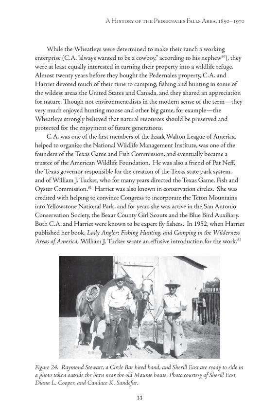
Figure 24. Raymond Stewart, a Circle Bar hired hand, and Sherill East are ready to ride in a photo taken outside the barn near the old Maume house. Photo courtesy of Sherill East, Diana L. Cooper, and Candace K. Sandefur. ........... 33
Figure 25. Deer proliferated on the Circle Bar after the Wheatleys limited hunting on the property; many of them were quite tame. This photo was taken sometime in the late 1950s. Photo courtesy of Sherill East, Diana L. Cooper, and Candace K. Sandefur. ...................................... 34
Figure 26. Harriet Wheatley feeds one of the deer outside her home. Photo courtesy of Sherill East, Diana L. Cooper, and Candace K. Sandefur. ........... 34

viii ix
A History of the Pedernales Falls Area, 1850–1970
Figure 27. C.A. and Harriet Wheatly pose with wild turkeys killed in a hunt on the Circle Bar, 1951. Photo courtesy of Sherill East, Diana L. Cooper, and Candace K. Sandefur. ........................................... 35
Figure 28. Sherill East poses with a deer he killed on the ranch. To the right is his grandson, Doug Roberts. Photo courtesy of Sherill East, Diana L. Cooper, and Candace K. Sandefur. ........................................... 35
Figure 29. The area now covered by Duck Lake just before it was bulldozed to create the lake in 1958. From left: Raymond Smith (Harriet’s brother); Pearl East, Harriet’s daughter; Raymond Stewart, a hired hand who at that time lived with his wife in the “foreman’s quarters” over the garage at the Wheatley “manse”; and C.A. Wheatley. Photo courtesy of Sherill East, Diana L. Cooper, and Candace K. Sandefur. ................................................................. 36
Figure 30. Christmas at the Wheatley’s home on the Circle Bar in 1957. Here (left to right) Diana, Janet, Candy and Doug Roberts, Harriet Wheatley’s great-grandchildren, pose in front of the fireplace. Photo courtesy of Sherill East, Diana L. Cooper, and Candace K. Sandefur. ....................... 37
Figure 31. The Wheatley living room on Christmas, 1957, was bursting with gifts around the tree. Photo courtesy of Sherill East, Diana L. Cooper, and Candace K. Sandefur. ................................................................. 38
Figure 32. Doug Roberts, Harriet’s great-grandson, leads his little sister Candy on a ride at the ranch. Photo courtesy of Sherill East, Diana L. Cooper, and Candace K. Sandefur. ........................................... 38
Figure 33. Richard Garcia, who worked as a ranch hand for the Wheatleys in the late 1950s or early 1960s, poses with Sherill East. Behind them are the frame house and outbuildings that were built when J.B. Wenmohs owned the ranch. Photo courtesy of Sherill East, Diana L. Cooper, and Candace K. Sandefur. .......... 39
Figure 34. At the Wheatley “manse,” from left: Pearl East (Harriet Wheatley’s daughter; Shirley Whitcome (a woman who worked in the manse); and Sherill East, Pearl’s husband and foreman of the ranch during the early 1960s. Photo courtesy of Sherill East, Diana L. Cooper, and Candace K. Sandefur. ........... 40
Figure 35. Raymond Stewart, a hired hand, in front of the Wheatley manse. Originally from Odessa, Stewart worked on the Circle Bar on “five or six” different occasions, according to Sherill East: “He would go and come” when he felt like it. Photo courtesy of Sherill East, Diana L. Cooper, and Candace K. Sandefur. ........... 40
Figure 36. C.A., Harriet and the “lady’s pistol” they found near Eagle Bluff. C.A. looks a lot more enthused than Harriet does. Photo donated to Pedernales Falls State Park by C.A. Wheatley (the Younger), C.A.’s nephew. ......... 41
Figure 37. The “manse” on January 1, 1960, after it was destroyed by a fire the night before. Photo courtesy of Sherill East, Diana L. Cooper, and Candace K. Sandefur. ................................................................. 43
Figure 38. The Pedernales River at the Circle Bar after the great flood of 1952. Photo courtesy of Sherill East, Diana L. Cooper, and Candace K. Sandefur. ........... 44

x
Farmers, Ranchers, the Land and the Falls
1
Pedernales Falls State Park and the Surrounding Area

x 1
A History of the Pedernales Falls Area, 1850–1970
Introduction When the State of Texas purchased the Circle Bar Ranch from Harriet
Wheatley in March 1970 and created Pedernales Falls State Park, the land was described by the press and park officials alike as a pristine, undisturbed “wilderness.”1 But while the new park contained areas of rare, even spectacular beauty, people have been living in the vicinity of Pedernales Falls for 10,000 years, and since the 1870s much of the land and vegetation in the area has been shaped and reshaped by farming and ranching.
Between 1870 and the early 1880s at least six and perhaps eight or nine separate farms and ranches were established in what is now Pedernales Falls State Park, and a small community grew. Roads, a school and a cemetery emerged, and church services were held for the forty or so men, women and children who lived there. The area’s schoolhouse, the local church services and graveyard, the baseball games played on Schoolhouse Flats and the emerging network of roads all show that the settlers had created an interconnected community.
By the mid-1890s that little community had been uprooted by death, drought and economic hardships. The farming and ranching methods used by the early settlers, though, had already set into motion significant ecological changes. These continued after 1900, when John B. Wenmohs, a prominent Blanco County rancher, bought most of what is now the park and devoted the land to raising livestock. Charles and Harriet Wheatley bought the land in 1937 and attempted to preserve it in its “natural state,” but continued ranching activity, and the Wheatley’s work to attract wildlife to the area also altered the land in significant ways. Visitors to Pedernales Falls State Park today are impressed by the area’s quiet isolation and beautiful vistas, but now they can only dimly glimpse the original landscape, and they might completely overlook the many men, women and children who have lived, worked and died there.
2
Farmers, Ranchers, the Land and the Falls
3
Early Settlement in the Pedernales Falls Area
People have lived in or traveled through what is now Blanco County, including the Pedernales Falls area, for about 10,000 years. Projectile points dating to the Paleoindian period (9,500 years B.C. to 7,000 B.C.) have been found in the Pedernales Falls area, along with many artifacts produced and used by native people during the Archaic and Prehistoric periods.2 By the 16th century, when the Spanish first entered Texas, Lipan Apaches roamed the region. Spanish explorers and missionaries slowly became familiar with the general area, and were using the name “Pedernales”—from Spanish for the flint rock found in the river’s bed—by the 1700s. In 1750 Father Benito Fernandez de Santa Ana, president of the Spanish missions in San Antonio, suggested that a mission be established on the Pedernales. That idea never bore fruit, but during the late 18th and early 19th centuries a number of Spanish expeditions and prospectors traveled through what is now Blanco County, sometimes crossing the Pedernales River.3 Land agents began scouting the region about 1821, and in 1835 the Mexican government granted Horace Eggleston, Jesse L. McCroklin, Joel Mixon, and Benjamin Williams each a league of land (4,428 acres) in the area. By 1836, however, hostile Comanches had pushed the Apaches out of what is now Blanco County, and fiercely resisted white settlement in the region. Though Anglos sometimes traveled there to fight Indians, white settlement in the Blanco County area did not begin until after Texas had become part of the United States.4
In 1853 James H. Callahan and Eli Clemens Hinds became perhaps the first white settlers in what is now Blanco County when they established holdings on the north branch of the Blanco River. Several others followed later that year, and by 1855 dozens of families had moved into the area. Among the first to move into the general vicinity of Pedernales Falls were Christian Evans and Joel Casey, who settled on Miller’s Creek in 1853; William Evans, who in 1854 set up on 320 acres which included the future site of the town of Cypress Mill; and Edward Cruezbar and J. T. Cleveland, who settled on Cypress Creek in 1855.5 A 1,476-acre tract within the present boundaries of Pedernales Falls State Park was patented by Ferdinand A. Schroeder in March, 1857, but this land seems to have remained unoccupied for many years thereafter.6 (See map of land grants in Pedernales Falls State Park on page 7.)
By 1858, when Blanco County was created, William Evans had built a lumber mill on Cypress Creek, and a number of settlers had established themselves in the area that would later be known as Cypress Mill (about two miles north of Pedernales Falls). Evans, one of the vicinity’s most prosperous
2 3
A History of the Pedernales Falls Area, 1850–1970
settlers, owned 300 cattle in 1859, and L. Cleveland, another prominent landowner in the area, owned four slaves, 370 cattle, and 130 hogs that year.7
In 1860 the U.S. Census counted 1,281 people, including ninety-eight slaves, scattered across Blanco County; about 87 percent of the county’s land remained in the public domain. While a few large plantations had been established, many of the area’s inhabitants probably lived at the subsistence level, growing crops and raising cattle and hogs; some also raised sheep. Partly because about half of the people living in the county at that time were foreign-born Germans who opposed slavery, in 1861 Blanco County’s voters rejected secession from the Union by 170 to 86. When the Civil War came nevertheless, and federal soldiers stopped patrolling the frontier, Indian attacks in Blanco County increased so much that a number of families moved out of the area.8
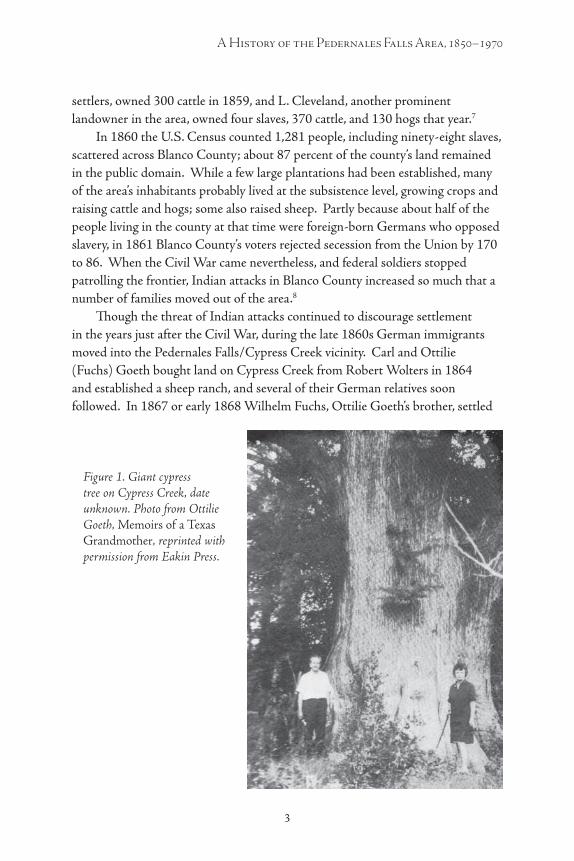
Though the threat of Indian attacks continued to discourage settlement in the years just after the Civil War, during the late 1860s German immigrants moved into the Pedernales Falls/Cypress Creek vicinity. Carl and Ottilie (Fuchs) Goeth bought land on Cypress Creek from Robert Wolters in 1864 and established a sheep ranch, and several of their German relatives soon followed. In 1867 or early 1868 Wilhelm Fuchs, Ottilie Goeth’s brother, settled
Figure 1. Giant cypress tree on Cypress Creek, date unknown. Photo from Ottilie Goeth, Memoirs of a Texas Grandmother, reprinted with permission from Eakin Press.
4
Farmers, Ranchers, the Land and the Falls
5
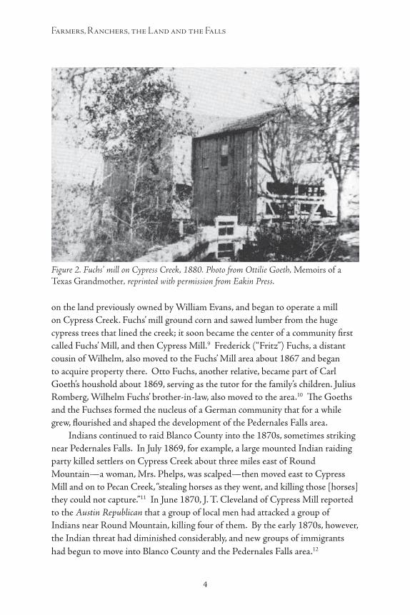
on the land previously owned by William Evans, and began to operate a mill on Cypress Creek. Fuchs’ mill ground corn and sawed lumber from the huge cypress trees that lined the creek; it soon became the center of a community first called Fuchs’ Mill, and then Cypress Mill.9 Frederick (“Fritz”) Fuchs, a distant cousin of Wilhelm, also moved to the Fuchs’ Mill area about 1867 and began to acquire property there. Otto Fuchs, another relative, became part of Carl Goeth’s houshold about 1869, serving as the tutor for the family’s children. Julius Romberg, Wilhelm Fuchs’ brother-in-law, also moved to the area.10 The Goeths and the Fuchses formed the nucleus of a German community that for a while grew, flourished and shaped the development of the Pedernales Falls area.
Indians continued to raid Blanco County into the 1870s, sometimes striking near Pedernales Falls. In July 1869, for example, a large mounted Indian raiding party killed settlers on Cypress Creek about three miles east of Round Mountain—a woman, Mrs. Phelps, was scalped—then moved east to Cypress Mill and on to Pecan Creek, “stealing horses as they went, and killing those [horses] they could not capture.”11 In June 1870, J. T. Cleveland of Cypress Mill reported to the Austin Republican that a group of local men had attacked a group of Indians near Round Mountain, killing four of them. By the early 1870s, however, the Indian threat had diminished considerably, and new groups of immigrants had begun to move into Blanco County and the Pedernales Falls area.12
Figure 2. Fuchs’ mill on Cypress Creek, 1880. Photo from Ottilie Goeth, Memoirs of a Texas Grandmother, reprinted with permission from Eakin Press.

4 5
A History of the Pedernales Falls Area, 1850–1970
New Settlers in “The Land of 1,000 Springs”:Farmers and Ranchers in the
Pedernales Falls Area, 1870–1885
The settlement of the area that is now Pedernales State Park during the 1870s and 1880s mirrored the general development of Blanco County and the Edwards Plateau during that period. Only 176 farms and ranches had been established in Blanco County by 1870, and the U.S. Census counted only 1,187 people living there that year. By 1880, however, there were 519 ranches and farms in the area, and the population had increased to 3,353; “improved” acres in farms jumped from only 3,690 to over 35,000 during the same period. By 1890 there were 645 farms and ranches in Blanco County, over 42,400 acres of improved land, and the population had increased to 4,644. 13 Most of these new residents came from old-stock southern roots, part of a huge wave of immigrants from the Old South who moved into Texas in the years after the Civil War.
The landscape of Blanco County, including most of the Pedernales Falls area, appeared much different to early settlers than it does to us now. During the 1870s, before settlement brought overgrazing, erosion, and the proliferation of ashe juniper (“cedar”) trees, much of the area was a savannah covered by tall native grasses, particularly bluestem and hairy grama, interspersed with clumps of trees which tended to concentrate in the river valleys and creek beds.14 “Nearly the whole county is prairie,” wrote Julius Herrman for the Texas Almanac in 1871, “but there is plenty of wood for fuel and fences, the growth being cypress, post-oak, hickory, pecan, etc. Stone is very fine and the best material for building.” Though much of the area seemed wonderfully suited for grazing livestock, early settlers also found good cropland. In 1877 a Blanco County resident reported to the Austin Daily Statesman that Blanco “was mostly a stock county until 1866, when farming began in good earnest. ...This year the acreage in cultivation has increased, and the [cotton] crop yield, with favorable seasons from now on, will be 1,200 to 1,500 bales. ...We have fine grass, fine stock, and fat sheep and plenty of mast. ...This county is fast settling up.”15 In 1885, a settler in the Cypress Mill vicinity described the area for the San Marcos Press:
I am about two miles from the Perdinaless [sic] river, and one mile from Cypress. The Pedronalles [sic] is rough, but the Cypress is very different. It contains large bodies of the very best farming lands. Hundreds of acres may be put into one solid farm, all of the very best land—some black and some sandy. It is a high, healthy country. Stock of all kinds does well, especially hogs.16
6
Farmers, Ranchers, the Land and the Falls
7
Even in the “rough” areas surrounding the Pedernales River, there were meadows and flatlands with soil that, with adequate rainfall, would support farming. And for about two decades following the Civil War, water was not a problem: the 1870s and early 1880s were relatively wet years in the vicinity, which for a time was called “the land of 1,000 springs.”17
Responding to positive reports about opportunities in Blanco County, and with the Indian threat constantly diminishing, during the 1870s thousands of people began to move into the area, and some of them moved into the general vicinity of Pedernales Falls. Like some of the earlier settlers, a few of these were German immigrants and first-generation German-Americans, who gravitated to the already established German community at Cypress Mill. Among these was John B. ( J.B.) Wenmohs, the future owner of much of the land in what is now Pedernales Falls State Park. Wenmohs was born September 25, 1855 in Washington County, Texas; he was the son of Adolph and Annie (Brandes) Wenmohs, who had migrated to Texas from Saxony in 1849. With only a limited education, J.B. Wenmohs moved to Cypress Mill in 1874, when he was 19 years old, and began to work hauling cypress trees to Wilhelm Fuchs’ mill for a dollar a day.18
As new settlers moved to the area, the growing German community of Cypress Mill was granted a post office in 1874, and by 1875 it also had a school. In the immediate vicinity of Pedernales Falls, however (as in Blanco County and Texas as a whole), most of the newcomers in the post-war wave of immigrants were old-stock Americans with roots in North Carolina, Tennessee, Mississippi, Arkansas and other southern states.19
Henry Wilson and Greene Calvin Wilson, half-brothers, were probably the first to settle in the area that is now Pedernales Falls State Park.20 Their father, Jesse Wilson, had been born in 1788 in North Carolina, but had moved his family steadily westward: first to Virginia, then Kentucky, then Tennessee (where Henry was born about 1810), then to Mississippi (where Greene was born to Henry’s second wife in 1844) and then to Hot Springs County, Arkansas by 1850. By 1860 much of the Wilson family, which included about 14 children through Jesse’s two marriages, had moved to Colorado County, Texas. Greene was married there in 1865. By 1870, when Jesse, the family’s patriarch, was 82 years old, Henry about 60, and Greene about 36, several members of this four-generation extended family were living in Williamson County, Texas, probably somewhere near Round Rock.21 After Jesse died in 1870, Greene Wilson moved to Blanco County with his family in 1873 and established his new homestead near Pedernales Falls. Though it is not clear whether Henry and his family moved into the area at exactly the same time as Greene, by the end of 1873, both

6 7
A History of the Pedernales Falls Area, 1850–1970
Land Grants in Pedernales Falls State Park
8
Farmers, Ranchers, the Land and the Falls
9
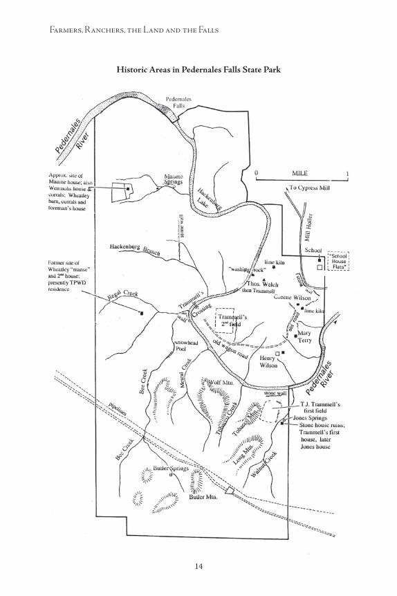
families had homesteaded adjoining 160-acre tracts. (See map of land grants in the Pedernales Falls State Park.)22
A number of other settlers moved into the immediate vicinity of the Falls at about the same time as the Wilsons did, or soon afterward. In March 1874 Mrs. Mary Terry, who seems to have been a widow with children, homesteaded a 160-acre tract adjoining the lands occupied by the Wilsons a few months earlier.23 At about that same time, J.H. Davis, James B. Raines and others brought their families and established farmsteads in the area north and east of Greene Wilson’s tract. The family of Thomas Jay Hugh (T.J.) Trammell also moved to the Pedernales area during this period, traveling (according to family lore) in a wagon train with other families, perhaps including the Raineses.24 Like the Wilsons, the Raineses and the Trammells were old-stock families with southern roots; the three families were interrelated, and it is possible, even probable, that they had known each other well during the 1850s, when all three families had been living in Hot Springs County, Arkansas.
James B. Raines had been born in North Carolina about 1824, and had married his wife Nancy in Mississippi in 1844. In 1850 the Raineses lived in Clear Creek, Hot Springs County, Arkansas, where they probably met the Wilson family, who were also living in that area at the time. In September 1865, the Raineses’ first daughter, Mary Ann, married Greene Wilson in Colorado County, Texas. Three years later, in 1868, their fifth daughter, Elizabeth (Betsy), married T.J. Trammell in Colorado County.25
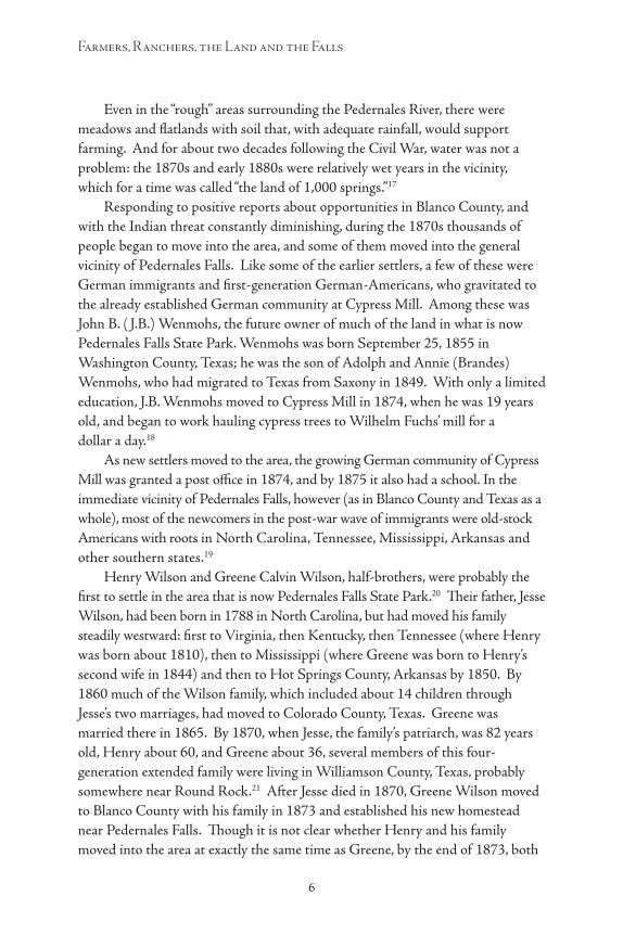
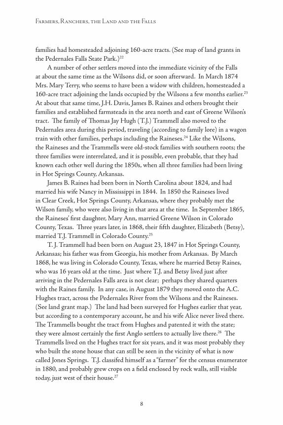
T. J. Trammell had been born on August 23, 1847 in Hot Springs County, Arkansas; his father was from Georgia, his mother from Arkansas. By March 1868, he was living in Colorado County, Texas, where he married Betsy Raines, who was 16 years old at the time. Just where T.J. and Betsy lived just after arriving in the Pedernales Falls area is not clear; perhaps they shared quarters with the Raines family. In any case, in August 1879 they moved onto the A.C. Hughes tract, across the Pedernales River from the Wilsons and the Raineses. (See land grant map.) The land had been surveyed for Hughes earlier that year, but according to a contemporary account, he and his wife Alice never lived there. The Trammells bought the tract from Hughes and patented it with the state; they were almost certainly the first Anglo settlers to actually live there.26 The Trammells lived on the Hughes tract for six years, and it was most probably they who built the stone house that can still be seen in the vicinity of what is now called Jones Springs. T.J. classifed himself as a “farmer” for the census enumerator in 1880, and probably grew crops on a field enclosed by rock walls, still visible today, just west of their house.27
8 9
A History of the Pedernales Falls Area, 1850–1970
Figure 3. The rock house near Jones Spring on the A.C. Hughes tract, probably built by T.J. Trammell in the early 1870s, later occupied by D.G. and Nannie Jones. Photo 2010 by author.
Figure 4. One of the rock walls on the A.C. Hughes tract, which probably enclosed the field where Trammell and Jones raised their crops. Photo 2010 by author.

10
Farmers, Ranchers, the Land and the Falls
11
It is possible that Mary Terry, who homesteaded land adjacent to the Wilsons’ Pedernales Falls tracts, and who arrived in the area just after they did, was also related to the Wilson family in some way. Perhaps she had traveled to the area in the wagon train with the Trammells and Raineses. In any case, it was almost certainly not simply coincidence that brought the Wilsons, the Raineses and the Trammells together in the Pedernales Falls area in the early 1870s.
Over the next several years the Wilsons and the other old-stock settlers in the Pedernales Falls area worked hard to improve their properties by building houses, and stone fences and corrals, while also putting in crops. Their houses were usually constructed of wood, with stone used for chimneys and foundations. The settlers’ way of life, an extension of generations of southern agricultural traditions, centered around the cattle, hogs and crops they raised to feed themselves and their families. The Wilsons and Trammells, for example, planted corn, and perhaps some cotton and tobacco, on the fields they plowed out of the virgin grasslands, and took meat and lard from their hogs; to build their homes they manufactured their own lime in homemade kilns.28
The settlers’ many children undoubtedly helped in the fields and around the house. Henry Wilson was a white-bearded, 70-year-old patriarch by 1880, but he and his wife Elizabeth, 50 years old, still had three children living with them that year: their son Newton, who was 21 but could not read or write; their daughter, Anna R., was 18 and also illiterate; and their youngest son, J.R., who was eight years old. A widowed 30-year-old female house servant, E. Edwards, was also living in Henry’s household then. Greene and Mary Anne Wilson had five sons who lived with them in 1880: James Calvin (age 12), John Riley (9), Aaron Elijah (8), William Henry (5), and David Jackson (3). By 1885, they also had two daughters: Mae (born in 1882) and Mary Lee Minnie (born in 1885).29 T.J. and Betsy Trammell had four children by 1880: Nancy Farnety (also known as “Babe”), 10 years old; Annie Jane (“Davie”), 7 years old; Mary (5); and Thomas (3). By 1886 they had three more daughters: Susan Emiline (born in 1881); Alice Wilburn (born 1884); and Marthy Ellen (born 1886). The Trammells’ last child, William (or “Willie”), was born in 1891, when Betsy was 39 years old. It is not clear how many children Mary Terry supported.30
Though many of the early old-stock settlers in the Pedernales Falls area were illiterate,31 they did try to provide for their children’s education and religious training. Sometime probably in the 1870s, not long after Greene Wilson established his homestead, a schoolhouse was built on his tract. A small wood-frame building measuring approximately 12 feet by 20 feet, the school probably attracted mostly students from the old-stock families in the immediate area who could not (or would not) attend the Cypress Mill school, where lessons were
10 11
A History of the Pedernales Falls Area, 1850–1970
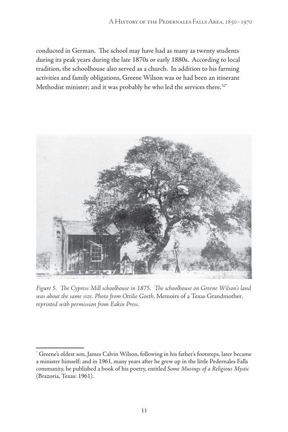
conducted in German. The school may have had as many as twenty students during its peak years during the late 1870s or early 1880s. According to local tradition, the schoolhouse also served as a church. In addition to his farming activities and family obligations, Greene Wilson was or had been an itinerant Methodist minister; and it was probably he who led the services there.32*
* Greene’s oldest son, James Calvin Wilson, following in his father’s footsteps, later became a minister himself; and in 1961, many years after he grew up in the little Pedernales Falls community, he published a book of his poetry, entitled Some Musings of a Religious Mystic (Brazoria, Texas: 1961).
Figure 5. The Cypress Mill schoolhouse in 1875. The schoolhouse on Greene Wilson’s land was about the same size. Photo from Ottilie Goeth, Memoirs of a Texas Grandmother, reprinted with permission from Eakin Press.

12
Farmers, Ranchers, the Land and the Falls
13
Figure 6. Tombstone of Annie Raines, in the Pedernales Falls community’s cemetery. Photograph taken in 1944, donated to Pedernales Falls State Park by C.A. Wheatley (the Younger), C.A.’s nephew.

12 13
A History of the Pedernales Falls Area, 1850–1970
The school/church building and the surrounding grounds became the symbolic center of this emerging old-stock community. People who died in the area were interred in a small cemetery near the school/church; by 1900 about nineteen people, including several infants, had been buried there. The flat, open meadow just east of the school (outside the present park boundary) became known as “Schoolhouse Flats,” and locals gathered there to play baseball games. At about this same time, a wagon road called “Mill Holler” was worn into the ground between this area and Cypress Mill, as the old-stock farmers in the Pedernales Falls area traveled to Cypress Mill to visit the store and the post office, or to gin whatever cotton they produced. (Wagon ruts identifying some sections of the old Mill Holler road can still be seen on surrounding ranchland and in Pedernales Falls State Park, next to the trail that runs through what was once Greene Wilson’s tract.) Those living on the western side of the river could connect to the road by taking their horses and wagons across the low-water ford that came to be known as the Trammell Crossing.33
Figure 7. The Cypress Mill store and post office, where the settlers in the Pedernales Falls area collected their mail. Photo from Ottilie Goeth, Memoirs of a Texas Grandmother, reprinted with permission from Eakin Press.
14
Farmers, Ranchers, the Land and the Falls
15
Historic Areas in Pedernales Falls State Park
14 15
A History of the Pedernales Falls Area, 1850–1970
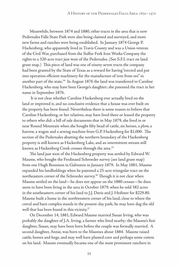
Meanwhile, between 1874 and 1880, other tracts in the area that is now Pedernales Falls State Park were also being claimed and surveyed, and more new farms and ranches were being established. In January 1874 George P. Hackenberg, who apparently lived in Travis County and was a Union veteran of the Civil War, purchased from the Sulfur Fork Iron Works Company the rights to a 320-acre tract just west of the Pedernales. (See S.F.I. tract on land grant map.) This piece of land was one of ninety-seven tracts the company had been granted by the State of Texas as a reward for having “erected and put into operation efficient machinery for the manufacture of iron from ore” in another part of the state.34 In August 1876 the land was transferred to Caroline Hackenberg, who may have been George’s daughter; she patented the tract in her name in September 1876.
It is not clear whether Caroline Hackenberg ever actually lived on the land or improved it, and no conclusive evidence that a house was ever built on the property has been found. Nevertheless there is some reason to believe that Caroline Hackenberg, or her relatives, may have lived there or leased the property to others who did: a bill of sale documents that in May 1879, she lived in or near Round Mountain when she bought fifty head of cattle, six horses, a plow, a harrow, a wagon and a sewing machine from G.P. Hackenberg for $1,000. The section of the Pedernales abutting the northern boundary of the Hackenberg property is still known as Hackenberg Lake, and an intermittent stream still known as Hackenberg Creek crosses through the area.35
The land just west of the Hackenberg property was settled by Edward W. Maume, who bought the Ferdinand Schroeder survey (see land grant map) from one Hugh Bennison in Galveston in January 1879. In May 1881, Maume expanded his landholdings when he patented a 25-acre triangular tract on the northeastern corner of the Schroeder survey.36 Though it is not clear when Maume settled on the land—he does not appear on the 1880 census—he does seem to have been living in the area in October 1879, when he sold 382 acres in the southeastern corner of his land to J.J. Davis and J. Heifsner for $229.80. Maume built a home in the northwestern corner of his land, close to where the corral and barn complex stands in the present-day park; he may have dug the old well that has been found in this vicinity.37
On December 14, 1881, Edward Maume married Susan Irving, who was probably the daughter of J.A. Irving, a farmer who lived nearby; the Maume’s first daughter, Susan, may have been born before the couple was formally married. A second daughter, Annie, was born to the Maumes about 1884. Maume raised cattle, horses and hogs, and may well have planted corn and perhaps some cotton on his land. Maume eventually became one of the most prominent ranchers in

16
Farmers, Ranchers, the Land and the Falls
17
Blanco County: by 1890 he owned, in addition to the 1,476-acre Schroeder tract and the adjoining 25-acre parcel patented in his own name, another 1,476-acre tract in the R. Lewis survey, and a lot on the courthouse square in Johnson City.38
J. J. Davis and J. Heifsner, who bought the southeastern corner of the Schroeder tract from Maume in 1879, may have established a ranch or farm on their property. If so, their home may have been at a site in the vicinity where a Texas Parks and Wildlife archeological team found dressed limestone, whiteware, and other evidence of habitation. There is no conclusive evidence that anyone ever lived in the area, however, and in any case in 1881 Heifsner sold his interest in the property to Davis. Two year later Davis, acting on behalf of the estate of his recently deceased wife, sold the tract along with “other real and personal property” back to Edward Maume for $10,250, a very considerable sum of money at the time.
In June 1880, about six months after the Trammells had moved onto their homestead on the Hughes tract, another family moved into the area. Thomas A. Welch and his wife Patsy were both probably illiterate and, like many others who settled near Pedernales Falls, they had white southern roots. Thomas had been born in Alabama about 1835 to a father born in Saxony and a mother born in Alabama; Patsy had been born in Alabama about 1845 to parents born in Louisiana. The Welches moved to Texas about 1870 and by June 1880, when they settled near Henry Wilson, they had four sons living at home with them: Paul, born in Alabama, 11 years old and illiterate; Graham (9 years old); Wesley (7); Watson (6); and Eban (1). William Hoffert, an illiterate 10-year-old boy, was also living in the Welch household then.39 On Christmas Eve 1880, the Welches moved onto a 160-acre parcel just north of Henry Wilson’s land, just
Figure 8. Sketch of the F. Schroeder survey, showing the 200 acres Edward Maume set aside for his homestead. From “Abstract of Title, 1476 acres F. Schroeder Survey…,” courtesy of Dena Wenmohs.

16 17
A History of the Pedernales Falls Area, 1850–1970
east of Greene Wilson, and running along the east bank of the Pedernales River. They had their land surveyed four days later.40 (See land grant map.)
By the early 1880s only a few tracts of land in the area that would later become Pedernales Falls State Park remained unsettled—or at least unclaimed. These included the parcels that would later be identified as Survey 34 ( J.B. Wenmohs), Survey 500 (I.W. Davis), and Survey 6 ( J.B. Wenmohs). For whatever reasons, these tracts would not be claimed or patented until the late 1890s. One of the largest surveys in the area, the 1, 235-acre Willis West tract, had remained in the public domain until 1879, when it was claimed by the heirs of Willis West, who had served in the Texas Revolution. Almost immediately, it seems, the land became tied up in a complicated legal battle waged among various heirs to West’s estate and several assignees who also claimed partial title to it. Though the tract was finally patented in 1887, the lawsuit was not settled until 1894, effectively delaying development of the land for about fifteen years.41
While these tracts remained legally vacant during the 1880s and into the early 1890s, it is not at all clear whether or not people actually lived on them or to what extent the land was used by people who did not live there. Short sections of stone fencing, much like the stone fences built by the Wilsons and Trammells, for example, have been found on Survey 34, which was supposedly vacant until 1899.42 And several natural features in the Willis West survey have over the years acquired names (like Tobacco Creek, Tobacco Mountain, Butler Springs and Butler Mountain) that suggest people lived in these areas or used them before the late 1890s and early 1900s, when J.B. Wenmohs acquired the properties. According to a local tradition passed on by Harriet Wheatley, two brothers once raised tobacco in the Tobacco Creek area.
By the early 1880s at least six farms and ranches had been established in what is now Pedernales Falls State Park, including the areas worked by the two Wilson families, the Trammells, the Maumes, the Welches and Mary Terry. At least thirty-six people, including twenty-three children, eleven adult householders and two boarders or servants lived in the area at that time; since it is not known how many dependents lived with Mary Terry, there were probably even more children living in the area. It is also quite possible that the Hackenberg and Davis tracts were also being worked, and that other, unknown people were living or working in the vicinity of the Falls then. In any case the area’s schoolhouse, the local church services and graveyard, the baseball games played on Schoolhouse Flats, and the emerging network of roads all show that the settlers had created an interconnected community.
18
Farmers, Ranchers, the Land and the Falls
19
But just when the Pedernales Falls area was almost fully settled, the old-stock community there had reached its peak and may already have begun to decline. The school on Greene Wilson’s property may still have been operating in the early 1880s, but probably by 1885, and certainly by 1886, local children were already taking their lessons at another school south of the Pedernales.43 By 1900 virtually all of the original residents of the Pedernales Falls area had died or moved away, and the place had moved into the next phase of its development.
“Starved Out”:The Decline of the Pedernales Falls Community,
1885–1900
During the mid-1880s death cut down some members of the original Pedernales Falls community, but the droughts that began to afflict the area then, and which continued well into the 1890s, were probably the main reason that the community disappeared by 1900. The droughts not only forced farmers to leave the Pedernales Falls area; they also discouraged others from taking the places of those who left or died, thus helping to ensure that for many years thereafter the land would be very lightly populated and devoted almost entirely to raising livestock and not crops. A few settlers, most notably Edward Maume and T.J. Trammell, remained in the area until the late 1890s, but by 1900 even these had moved on.
Blanco County’s agricultural economy had continued to grow between 1880 and 1890, but farmers in the area also began to have water problems during that period. The early settlers in Blanco County had enjoyed a good string of wet years that fed springs and reliably watered crops; but in the mid-1880s farmers in the area experienced their first serious drought. In 1887, when only about 20 inches of rain were recorded in nearby San Antonio, 60 percent of Blanco county’s crops were lost to drought.44 During the 1890s drought years occurred in the region with dulling regularity: about 26 inches of rain were recorded in San Antonio in 1892, about 18 inches in 1893, less than 22 inches in 1894, about 26 inches in 1895, only 16 inches in 1897, 22 inches in 1898, less than 20 inches in 1899.45
Those years were hard enough on farmers sitting on good land in Blanco County: by 1900, only about 31,400 acres in the area were reported as “improved,” 25 percent fewer than ten years earlier. For farmers trying to eke out an existence on the marginal lands near the Pedernales Falls, the dry years of the late 1880s and 1890s must have been devastating. According to Ottilie Goeth, who had lived in the Cypress Mill area since the 1860s, most of the “formerly
18 19
A History of the Pedernales Falls Area, 1850–1970
numerous dependable springs, including some of the largest ones, gradually ran dry” by1900; by that time, the area “appeared to have become quite unusable for cultivating any crops.”46
Family ties had helped to bring the Wilson, the Raineses and the Trammells together in the Pedernales Falls area, but their oldstock community began to disintegrate after Henry Wilson, the aged, white-bearded patriarch of his family, died in 1884 or 1885. The cause of Henry’s death is not known, nor is it clear what happened to his wife Elizabeth after he passed away; according to family tradition, Elizabeth inherited all of Henry’s land. If so, she died soon after her husband, for by March 1885 the property had been divided.47 The new owners were Henry’s daughter, Nancy Raines; his son Newton; his nephew William Wilson; Louisa Gatlin (connection unknown); and Ama Long (connection unknown). Greene Wilson bought their interests in the property between March and May 1885 (for a total of $262); then, in November, he sold both Henry’s Pedernales land and his own for $1,500 to M.T. Holton, who lived in Austin and seems to have been an investor or speculator. Within a few months, in 1886, Greene left the Pedernales behind and took his family west; they settled in Junction City, Kimble County, later that year. Greene died there in 1894.48
Mary Terry seems to have left her Pedernales homestead tract at about the same time; by early 1887, when she sold her property, she was living in Bell County and married to one E.R. Underwood.49 The depopulation of the area continued over the next several years. On September 19, 1886, a few months after Greene Wilson’s family moved away, death disrupted the area again when Susanne Maume, Edward’s wife, died; their oldest daughter, Susan, died shortly thereafter. And in 1890 Thomas and Patsy Welch sold their land to T.J. and Betsy Trammell, and moved their family out of the area.50
After the Wilsons and the Terrys left, it is not clear whether anyone ever lived on their lands again. Properties in the Pedernales Falls area changed hands relatively quickly between 1885 and 1890, but most of the new owners never seem to have moved in. There is no evidence, for example, that M.T. Holton, who bought the Wilsons’ surveys 407 and 408 from Greene Wilson, ever lived on the land himself; and while he may have leased it to a sharecropper or rancher, there is no evidence that he did. Similarly, there is no evidence that anybody worked Mary Terry’s lands for years after she left.51 It is possible, though, and perhaps even probable, that T.J. and Betsy Trammell’s family lived on one or more of the old Wilson tracts between 1885 and 1890.
T.J. and Betsy had originally lived on and farmed the A.C. Hughes tract. In 1885, however, they moved to another (unknown) piece of land, perhaps Henry Wilson’s old farm; and in 1886, they sold the A.C. Hughes tract to D.G. and

20
Farmers, Ranchers, the Land and the Falls
21
Nannie Jones. In September 1890, as noted earlier, they bought out Thomas and Patty Welch and moved onto their place. Why did the Trammells leave the land they owned just as the Wilsons were leaving? Where were the Trammells living for the four years between the time they sold the Hughes tract and the year they bought out the Welches? Given everything that is known about these families, it seems likely that after the Wilsons and Mary Terry left the area, the Trammells moved to the north side of the river, still living within the confines of present-day Pedernales Falls State Park.52
When, in 1890, the Trammells moved onto the land they had bought from the Welches, the family lived in a home built next to a “wet-weather” spring, probably the same house the Welches once occupied. Their homesite included a frame house with a stone chimney, the spring, and quite possibly a dug well. A line of stone fencing just east of the house set it apart from an area probably used for grazing animals, and a large wild grapevine hung from a tree overshadowing the spring. Nearby was a lime kiln. During the 1890s, and maybe earlier, the Trammells worked a field near their home, growing corn and possibly some cotton. The outlines of this field were still visible in 1951, when an aerial photograph was taken of the area.53
Figure 9. Aerial photograph of part of what is now Pedernales Falls State Park, taken in 1951. The light rectangular area to the right of the river near the top of the photo still shows the outline of the field worked by T.J. Trammell until about 1900, and possibly worked by others until about 1915. Photo courtesy of C.A. Cowsert, Range Management Specialist at the Johnson City office of the USDA Natural Resource Conservation Service.
20 21
A History of the Pedernales Falls Area, 1850–1970
By 1891 it is entirely possible that the Trammell family, Edward Maume and his surviving daughter Annie, and D.G. and Nannie Jones were the only people left living in the area that eventually became Pedernales Falls State Park—they were certainly the only families who owned the land they lived on there. None of them would remain much longer. Maume and his daughter apparently continued to live on his Pedernales property into the 1890s, and by 1894 he had a new wife, Alice. In 1897, however, he lost the land in a foreclosure suit brought by the American Freehold Mortgage Co. of London, Ltd.54 Nannie and D.G. Jones left by 1899.55 The only documented new settler in the area during the 1890s was I.W. Davis, who in February 1895 established a homestead on the 94.3-acre tract just south of the land once owned by Henry Wilson. (See land grant map.) But in 1899 he sold the property for $100 to Matt Huff, an old Blanco County settler; and there is no reason to believe Huff ever lived on the land.56
By 1900 only T.J. Trammell and his family were still living in the area. The family may somehow have prospered for a while in spite of the drought; in 1899 they expanded their holdings when they bought the old Mary Terry place.57 The following year, however, T.J. and Betsy Trammell, the last members of the first generation of settlers in the Pedernales Falls area, sold their land there to J.B. Wenmohs and moved their family out.1*
While Henry Wilson’s death may have played a part in Greene Wilson’s earlier decision to leave the area, local tradition holds that Greene and his family were “starved out,”58 and Mary Terry, the Welches and the Joneses may well have suffered the same fate. Though their circumstances varied, poor rainfall probably played a role in each case. Edward Maume had been a prominent rancher in Blanco County, with thousands of acres of land and a town lot, only seven years before he lost his property because he could not pay his note, another casualty of withering drought.
The decline of the Pedernales Falls community both reflected and anticipated general trends that shaped Blanco County during the 1890s and the early 20th century, as crop farming declined and ranching increased. The rapid population growth that the area had experienced during the 1870s and 1880s ended during the 1890s, when the county experienced virtually no growth at all; and through the following thirty years the area’s population steadily declined, falling to only 3,842 by 1930. When the Trammells sold their land to J.B. Wenmohs in 1900, the last remnant of the old Pedernales Falls community had disappeared, and a new pattern of life in the area was beginning to unfold.
* T.J. Trammell died March 11, 1916, and was buried in the Henley Cemetery, a few miles away from his old Pedernales lands. Betsy lived on until April 9, 1953, and was buried next to her husband.
22
Farmers, Ranchers, the Land and the Falls
23
Tough and Gritty:J.B. Wenmohs and the Development of the Wenmohs Ranch, 1900–1937
John B. ( J.B.) Wenmohs, the son of German immigrants, moved to Cypress Mill in 1874, when he was 19 years old. Though J.B. had little formal education, he did have energy, ambition and an unusual acquaintance with the ways of the world. His outlook and character had been shaped during the Civil War, when his father, a Union sympathizer, had been forced to flee with his family to Mexico to escape the wrath of his Confederate neighbors. Years later, J.B. claimed that he had seen Emperor Maximilian land on the shores of Mexico when the French began their ill-fated attempt to plant an empire there.59
Soon after he arrived in Blanco County, Wenmohs was hired by the Fuchs sawmill as a freighter, hauling logs and lumber in a wagon pulled by six yokes of longhorn oxen. He sometimes carried loads through Austin to the Texas coast. About this time he also became involved in the cattle business, and once participated in a cattle drive taking 3,000 steers from Blanco County to Abilene, Kansas. By 1876 he had accumulated enough money to travel with Carl Goeth to visit the Philadelphia Centennial Exposition.60 About 1878 he became a deputy sheriff for Blanco County, though he remained in the cattle business; he may have continued to serve as a deputy until 1886. In any case, by 1880 he was living as a boarder in the household of Carl and Ottilie Goeth, and described himself as a “cattle trader.”61 Wenmohs began to buy property in the county in 1881. In 1882, he purchased a 4,800-acre spread east of Johnson City, and the next year “created a sensation” when he fenced the land with barbed wire—he was the first in the county to use wire fences.62
J.B.’s close association with Carl and Ottilie Goeth led to a romance with their oldest daughter, Louise. On September 19, 1884, when she was 18 years old and he 29, the two were married in a ceremony at her parents’ spacious home in Cypress Mill. After their honeymoon in New Orleans, the couple set up housekeeping in a home about ten miles from her parents. They apparently remained there until sometime in the 1890s, when they moved to a renovated log ranch house near Cypress Mill—in the 1860s, it had been the Goeths’ first home in Blanco County.63 The couple was a study in contrasts: J.B., eleven years older than his wife, was an earthy man whose salty language eventually led people to refer to him as J.B. “Goddam” Wenmohs; Louise, on the other hand, was a refined and musically talented woman who played piano, loved the opera and took care to dress well. By 1904 the couple had four children: Charles Adolf, born in 1885;

22 23
A History of the Pedernales Falls Area, 1850–1970
Alexa (or “Patty”), born 1887; Ottilie (“Tila”), born 1898; and Max John, born 1904. (Another child, Adolf, birth date unknown, died in infancy.) For many years, German was the only language spoken in the family home.64
As his family grew J.B. Wenmohs prospered, and he continued to add to his land holdings around Blanco County. In the late 1890s, when he was already becoming one of the best-known and prominent ranchers in the area, he began a series of transactions to purchase the parcels that, when fully assembled years later, would eventually define the original boundaries of Pedernales Falls State Park.
In September 1898 Wenmohs purchased the old Maume ranch from the American Freehold Mortgage Co. of London, Ltd., the same firm that had taken the land from Maume. In April 1899, he surveyed the 320-acre vacant parcel (Survey 34) sandwiched between the Willis West and Ferdinand Schroeder surveys, and bought it from the state. Then, in July 1899, he bought Caroline Hackenberg’s property; in December 1899, he acquired the A.C. Hughes tract from Nannie Jones. In September 1900, he bought out T.J. and Betsy Trammell, who sold him both the old Welch and Mary Terry tracts. Later that year he
Figure 10. John B. Wenmohs, with his wife Louise and children Charles and Patty. Photo from Ottilie Goeth, Memoirs of a Texas Grandmother, reprinted with permission from Eakin Press.

24
Farmers, Ranchers, the Land and the Falls
25
purchased the Greene and Henry Wilson tracts from M.T. Holton, and in December he bought the I.W. Davis survey from Matt and Susan Huff. Also in 1900, he surveyed Survey 6, just north of the Welch tract. That land was patented in his name in 1901, and that year Wenmohs also bought a narrow 4.5-acre parcel, wedged between the old Mary Terry and Greene Wilson surveys, from Henry Ulrich, a neighboring rancher. The last major addition to Wenmohs’ Pedernales ranch took place in 1906, when J.B. bought almost all of the old Willis West survey from one Henry F. Good. The ranch was filled out in 1926, when Wenmohs purchased 11 acres north of the Pedernales from neighboring rancher Herman F. Reiner.65
Almost immediately after purchasing these properties Wenmohs began
to improve them. About 1901 he built “a good and substantial fence” around much of the land, and began to graze cattle there, branding his animals with his distinctive “wineglass” pattern. At about this same time, Wenmohs apparently also built a house, barn and shed in the northwestern corner of the property, close to where Edward Maume had once lived. Meanwhile, the old field north of the Pedernales once tilled by T.J. Trammell may have been used until about 1915 to grow corn, and maybe some cotton.66
By 1915, J.B. Wenmohs was one of the most prominent ranchers in the county, and his ranch properties (he ultimately owned about 12,000 acres) were described as being “among the best in Texas.” J.B. and Louise never lived on the Pedernales lands, though, preferring to remain in their house near Cypress Mill. 67 Though Wenmohs eventually became famous in the area for riding out every day to inspect his ranchlands, the house on the Pedernales ranch was probably occupied by hired hands until the fall of 1919.
Figure 11. The distinctive “wine glass” Wenmohs brand. Source: Jerry Wenmohs.

24 25
A History of the Pedernales Falls Area, 1850–1970
That year Wenmohs leased his Pedernales ranch to Emory Stribling and two brothers, Fred and Gus Ulrich, whose family lived just east of the present park boundary. Together the three men planned to graze goats on Wenmohs’ land, and between 1919 and 1920 Stribling and the Ulrich brothers built a “goat proof ” fence through the property to enclose the lower 3,000 acres for their goats. At the same time, they used net wire to reinforce the existing cattle fences along the western and southern boundaries of the ranch, and did the same for the fencing that already enclosed the property north of the Pedernales. The entire ranch was then “goat and sheep proof.” From 1919 to June 1922, the Ulrich brothers lived in the house on the northwest part of the ranch, raising goats and maybe also some sheep.68
Stribling and the Ulrichs dropped their lease in 1922, and Wenmohs returned to grazing cattle, and now also goats and sheep, on the property. After about 1926, the ranch was occupied and operated by two of Wenmohs’ sons, Victor and Max. In 1931, the second year of the Great Depression, Max Wenmohs took over the
Figure 12. This photograph of J.B. Wenmohs accompa-nied his biographical sketch published in The Historical Encyclopedia of Texas.

26
Farmers, Ranchers, the Land and the Falls
27
lease himself and moved onto the ranch with his new wife, Loma. When they first moved into the ranch house, Loma later remembered, it was just a four-room “shell,” but they soon added a bathroom. A windmill pulled water out of a well in front of their home to use in the house and to fill troughs for livestock. Goats and hogs ran wild across the land, and had to be chased down with dogs before they could be caught. Once caught, some were slaughtered and eaten on the ranch, others were sold. Wild turkeys were also plentiful, and provided good eating for Christmas and Easter dinners. No crops at all were grown on the ranch then, according to Loma, and not many cedar (ashe juniper) trees were growing on the land. Since the couple did not own a car, they rode horseback on their occasional trips to Cypress Mill to collect their mail or shop at the village store. By this time, Cypress Mill had long since fallen into a protracted decline, and by 1931 its cotton gin had closed down. Life on the Wenmohs Pedernales ranch then was isolated, tough and gritty; in 1932 Max and Loma moved away.69
Figure 13. J.B. Wenmohs, in photo illustrating an article about him published in the Austin American in 1940.

26 27
A History of the Pedernales Falls Area, 1850–1970
At this point, the last landowners living in what is now Pedernales Falls State Park were Herman Reiner and his wife Esther, who lived across the Pedernales River immediately north of the old Wenmohs house where Max and Loma had lived. Their daughter Lila Jean, who lived there with her parents in the 1930s, later described her family’s simple, difficult, but somehow satisfying life then: “Living up there, everything was survival. What we had to eat, we grew—we had hogs, chicken, we ate sausage—it was survival. I didn’t realize it at the time—it was just a way of life. 70
After Max and Loma left the Wenmohs ranch in 1932, it was probably worked by hired hands. J.B. continued to graze cattle, goats and sheep on the property. Although still hale and hearty at 77 years of age, J.B. started considering the future of his ranch. According to Loma Wenmohs, J.B. probably began looking for a buyer for his Pedernales property because “there was no one to take care of it.” The severely depressed economy also might have played some role in the decision. In any case, in December 1936, J.B. and Louise Wenmohs sold the Pedernales ranch to Charles A. (C.A.) and Harriet Wheatley.71
Oil Money and Anglers:The Wheatleys and the Circle Bar Ranch, 1937–1970
Little is known about Charles Andrew Wheatley’s early life. Born in Jackson County, Missouri on February 12, 1882, by 1916 he was living in Ohio, where he met his future wife, Harriet Virginia Smith; he was a nephew of the pastor at the church she attended. Harriet had been born August 30, 1889 in Griffithsville, West Virginia. Later, her family moved to Ohio, where, according to Harriet, she grew up playing with her brothers in nearby woods and streams. She learned to enjoy the outdoors as a young girl, and took up fishing, horseback riding, baseball and other sports. She also enjoyed writing, and some of her girlhood verses were published in local newspapers. According to Harriet, she worked for the American Issue Publishing Company until about 1916, when she met C.A. Wheatley. The couple apparently married sometime shortly after they met, and by about 1918 they were beginning to enjoy hunting and fishing trips together.72
At about that same time, C.A. and Harriet began to work together (“as a team,” Harriet later wrote) to build an oil business in Kentucky. Quickly successful, they sold their interest in the company and moved to South Texas during the early 1920s. There they formed yet another oil company, and again were successful. Before long they had drilled a number of producing wells in
28
Farmers, Ranchers, the Land and the Falls
29
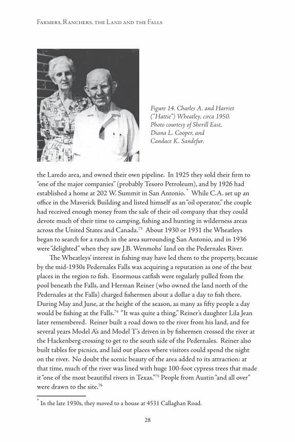
the Laredo area, and owned their own pipeline. In 1925 they sold their firm to “one of the major companies” (probably Tesoro Petroleum), and by 1926 had established a home at 202 W. Summit in San Antonio.2
* While C.A. set up an office in the Maverick Building and listed himself as an “oil operator,” the couple had received enough money from the sale of their oil company that they could devote much of their time to camping, fishing and hunting in wilderness areas across the United States and Canada.73 About 1930 or 1931 the Wheatleys began to search for a ranch in the area surrounding San Antonio, and in 1936 were “delighted” when they saw J.B. Wenmohs’ land on the Pedernales River.
The Wheatleys’ interest in fishing may have led them to the property, because by the mid-1930s Pedernales Falls was acquiring a reputation as one of the best places in the region to fish. Enormous catfish were regularly pulled from the pool beneath the Falls, and Herman Reiner (who owned the land north of the Pedernales at the Falls) charged fishermen about a dollar a day to fish there. During May and June, at the height of the season, as many as fifty people a day would be fishing at the Falls.74 “It was quite a thing,” Reiner’s daughter Lila Jean later remembered. Reiner built a road down to the river from his land, and for several years Model A’s and Model T’s driven in by fishermen crossed the river at the Hackenberg crossing to get to the south side of the Pedernales. Reiner also built tables for picnics, and laid out places where visitors could spend the night on the river. No doubt the scenic beauty of the area added to its attraction: at that time, much of the river was lined with huge 100-foot cypress trees that made it “one of the most beautiful rivers in Texas.”75 People from Austin “and all over” were drawn to the site.76
* In the late 1930s, they moved to a house at 4531 Callaghan Road.
Figure 14. Charles A. and Harriet (“Hattie”) Wheatley, circa 1950. Photo courtesy of Sherill East, Diana L. Cooper, and Candace K. Sandefur.

28 29
A History of the Pedernales Falls Area, 1850–1970
The Wheatleys named their new ranch the Circle Bar. In 1937, almost immediately after they bought the place, they began a series of improvement projects. Their first concern was to build a road to the outside world: when they first purchased the land, the only outlet to the nearest county road (the unpaved A. Robinson Road) was through the Robinson ranch west of their property. Graders were brought in, and a new road was cut south to A. Robinson Road, roughly along the path of the present road leading from the park entrance to park headquarters. As soon as the road was completed, work on their new home (or “the manse,” as they called it) began. Situated at the present site of the park superintendent’s residence, the Wheatley’s ranch home was constructed of “Cagen” stone, which Mrs. Wheatley believed had been used to build the pyramids in Egypt. Stonemasons from Blanco County were employed to do the work.
Figure 15. Herman Reiner and Sherill East, Harriet Wheatley’s son-in-law, with giant catfish caught in the Pedernales near the Falls, ca. late 1950s. Photo in newspaper clipping, courtesy of Sherill East, Diana L. Cooper, and Candace K. Sandefur.
Figure 16. James Smith (Harriet Wheatley’s brother) and Sherill East with catfish caught near the Falls, ca. 1950s. Photo in newspaper clipping, courtesy of Sherill East, Diana L. Cooper, and Candace K. Sandefur.
30
Farmers, Ranchers, the Land and the Falls
31
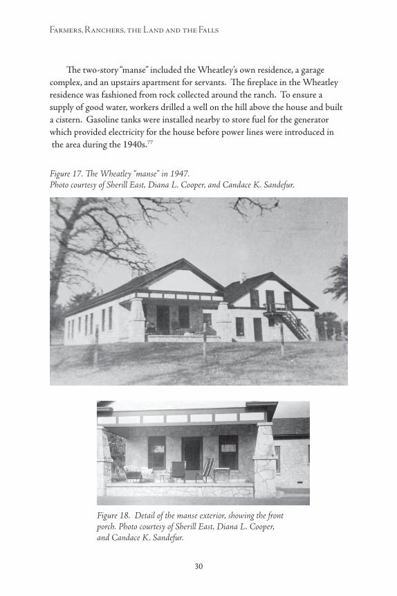
The two-story “manse” included the Wheatley’s own residence, a garage complex, and an upstairs apartment for servants. The fireplace in the Wheatley residence was fashioned from rock collected around the ranch. To ensure a supply of good water, workers drilled a well on the hill above the house and built a cistern. Gasoline tanks were installed nearby to store fuel for the generator which provided electricity for the house before power lines were introduced in the area during the 1940s.77
Figure 17. The Wheatley “manse” in 1947. Photo courtesy of Sherill East, Diana L. Cooper, and Candace K. Sandefur.
Figure 18. Detail of the manse exterior, showing the front porch. Photo courtesy of Sherill East, Diana L. Cooper, and Candace K. Sandefur.

30 31
A History of the Pedernales Falls Area, 1850–1970
About the same time that the “manse” was being built, the Wheatleys also began to stock the ranch with cattle, bringing in about 300 purebred Hereford cows and calves. (Within “a couple years,” this original herd would be replaced by steers and goats.)78 Using the graders, the Wheatleys eventually cut other roads around the ranch, or, as in the area north of the Pedernales where the Wilsons used to live, they widened existing paths. Workers also built a new barn in the ranch complex around the old Wenmohs house, near Maume’s old residence. About 1958 another fence enclosed the southern third of the property. Over the years, different parts of the Circle Bar Ranch acquired names. The area north of the fence built by the Ulrich brothers, for example, became known as the “Mum (Maume) trap”; the area between that fence and the area south of it was called the “south pasture,” and the part of the ranch north of the Pedernales became “the north pasture.”79
Figure 19. Rear view of the Wheatley manse, ca. 1950s. Photo courtesy of Sherill East, Diana L. Cooper, and Candace K. Sandefur.
Figure 20. A view of the Wheatley dining room in the late 1950s. Photo courtesy of Sherill East, Diana L. Cooper, and Candace K. Sandefur.

32
Farmers, Ranchers, the Land and the Falls
33
Figure 21. Cattle on the Circle Bar ranch, date unknown. Photo courtesy of Sherill East, Diana L. Cooper, and Candace K. Sandefur.
Figure 22. Cattle on the Circle Bar ranch, in 1956. Note the corral fencing and outbuilding in the background. Photo courtesy of Sherill East, Diana L. Cooper, and Candace K. Sandefur.
Figure 23. Sherill East and Angora goats in 1962, when East was working as the foreman of the Circle Bar. Photo courtesy of Sherill East, Diana L. Cooper, and Candace K. Sandefur.
32 33
A History of the Pedernales Falls Area, 1850–1970
While the Wheatleys were determined to make their ranch a working enterprise (C.A. “always wanted to be a cowboy,” according to his nephew80), they were at least equally interested in turning their property into a wildlife refuge. Almost twenty years before they bought the Pedernales property, C.A. and Harriet devoted much of their time to camping, fishing and hunting in some of the wildest areas the United States and Canada, and they shared an appreciation for nature. Though not environmentalists in the modern sense of the term—they very much enjoyed hunting moose and other big game, for example—the Wheatleys strongly believed that natural resources should be preserved and protected for the enjoyment of future generations.
C.A. was one of the first members of the Izaak Walton League of America, helped to organize the National Wildlife Management Institute, was one of the founders of the Texas Game and Fish Commission, and eventually became a trustee of the American Wildlife Foundation. He was also a friend of Pat Neff, the Texas governor responsible for the creation of the Texas state park system, and of William J. Tucker, who for many years directed the Texas Game, Fish and Oyster Commission.81 Harriet was also known in conservation circles. She was credited with helping to convince Congress to incorporate the Teton Mountains into Yellowstone National Park, and for years she was active in the San Antonio Conservation Society, the Bexar County Girl Scouts and the Blue Bird Auxiliary. Both C.A. and Harriet were known to be expert fly fishers. In 1952, when Harriet published her book, Lady Angler: Fishing Hunting, and Camping in the Wilderness Areas of America, William J. Tucker wrote an effusive introduction for the work.82
Figure 24. Raymond Stewart, a Circle Bar hired hand, and Sherill East are ready to ride in a photo taken outside the barn near the old Maume house. Photo courtesy of Sherill East, Diana L. Cooper, and Candace K. Sandefur.

34
Farmers, Ranchers, the Land and the Falls
35
While they owned the ranch, the Wheatleys’ conservationist ideas shaped the way they managed the area. One of their first decisions was to limit hunting and fishing on the Circle Bar. There were almost no deer on the property in 1937. According to Harriet, they owned the place for months before they saw their first deer there. Almost immediately after buying the property, they entirely cut off deer hunting for about three years, and deer began to reappear.83 Thereafter hunting on the property was restricted to only a few close friends and relatives. Though fish in the Pedernales were “plentiful” in 1937, the Wheatleys also closed their property to the fishing parties that before had driven their cars and trucks across the Hackenberg crossing. While a few Boy Scout and church groups were later sometimes allowed onto the Circle Bar, hunting continued to be restricted as long as the Wheatley’s owned the property. Perhaps partly because of this, and partly because of their rather patrician attitudes, the Wheatleys never established close relations with their neighbors. “We left them alone, and they left us alone,” a former neighbor remembered. “They were well-liked in their class,” their son-in-law recalled, “but they didn’t have much use for people below them.”84
Figure 25. Deer proliferated on the Circle Bar after the Wheatleys limited hunting on the property; many of them were quite tame. This photo was taken sometime in the late 1950s. Photo courtesy of Sherill East, Diana L. Cooper, and Candace K. Sandefur.
Figure 26. Harriet Wheatley feeds one of the deer outside her home. Photo courtesy of Sherill East, Diana L. Cooper, and Candace K. Sandefur.

34 35
A History of the Pedernales Falls Area, 1850–1970
Perhaps to encourage larger bird populations, the Wheatleys allowed the ashe juniper (“cedar”) trees, which were already beginning to impinge on the property, to proliferate. In an aerial photograph of the area taken in 1951, the land occupied by the Circle Bar is clearly much more densely wooded than the ranches around it. By the early 1960s the land contained some of the largest juniper trees in the state. By 1970, the “cedars” were spreading so rapidly that a number of previously unobstructed views were completely blocked.85 In a few areas, they cut back the cedar and tried to encourage the growth of native grasses. In 1958, hoping to attract more ducks to the area, the Wheatleys bulldozed a
Figure 27. C.A. and Harriet Wheatly pose with wild turkeys killed in a hunt on the Circle Bar, 1951. Photo courtesy of Sherill East, Diana L. Cooper, and Candace K. Sandefur.
Figure 28. Sherill East poses with a deer he killed on the ranch. To the right is his grandson, Doug Roberts. Photo courtesy of Sherill East, Diana L. Cooper, and Candace K. Sandefur.
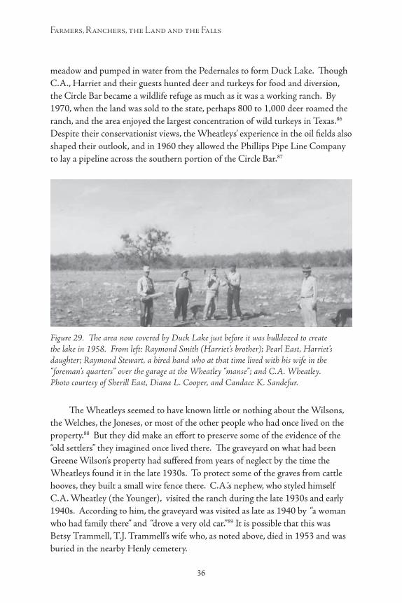
36
Farmers, Ranchers, the Land and the Falls
37
meadow and pumped in water from the Pedernales to form Duck Lake. Though C.A., Harriet and their guests hunted deer and turkeys for food and diversion, the Circle Bar became a wildlife refuge as much as it was a working ranch. By 1970, when the land was sold to the state, perhaps 800 to 1,000 deer roamed the ranch, and the area enjoyed the largest concentration of wild turkeys in Texas.86 Despite their conservationist views, the Wheatleys’ experience in the oil fields also shaped their outlook, and in 1960 they allowed the Phillips Pipe Line Company to lay a pipeline across the southern portion of the Circle Bar.87
The Wheatleys seemed to have known little or nothing about the Wilsons, the Welches, the Joneses, or most of the other people who had once lived on the property.88 But they did make an effort to preserve some of the evidence of the “old settlers” they imagined once lived there. The graveyard on what had been Greene Wilson’s property had suffered from years of neglect by the time the Wheatleys found it in the late 1930s. To protect some of the graves from cattle hooves, they built a small wire fence there. C.A.’s nephew, who styled himself C.A. Wheatley (the Younger), visited the ranch during the late 1930s and early 1940s. According to him, the graveyard was visited as late as 1940 by “a woman who had family there” and “drove a very old car.”89 It is possible that this was Betsy Trammell, T.J. Trammell’s wife who, as noted above, died in 1953 and was buried in the nearby Henly cemetery.
Figure 29. The area now covered by Duck Lake just before it was bulldozed to create the lake in 1958. From left: Raymond Smith (Harriet’s brother); Pearl East, Harriet’s daughter; Raymond Stewart, a hired hand who at that time lived with his wife in the “foreman’s quarters” over the garage at the Wheatley “manse”; and C.A. Wheatley. Photo courtesy of Sherill East, Diana L. Cooper, and Candace K. Sandefur.

36 37
A History of the Pedernales Falls Area, 1850–1970
The Wheatleys also collected what Harriet called “memorabilia”—artifacts relating to the people who once lived on their land. They were particularly fond of two pistols they found: one, a .45-caliber revolver, embedded in a tree limb near the cemetery; another, a .31-caliber Colt “lady’s pistol,” picked off the ground near Eagle Bluff. Visitors to the ranch were often given arrowheads found by the Wheatleys or their employees as souvenirs of their stay at the Circle Bar.90
C.A. and Harriet never lived on the ranch year-round. For them, the Circle Bar served as something like a retreat. From the beginning of autumn to the end of spring, they normally spent much of the week at their home in San Antonio: Harriet remained active in church and civic groups in the city during the time they owned the ranch, and C.A. continued to rent office space in the Maverick Building until 1961. Usually they spent “a few days a week” at the Circle Bar. During the hot Texas summers, they repaired to another home they had in Colorado, or traveled to various wilderness areas around the U.S. and Canada for hunting, fishing and camping.91
Figure 30. Christmas at the Wheatley’s home on the Circle Bar in 1957. Here (left to right) Diana, Janet, Candy and Doug Roberts, Harriet Wheatley’s great-grandchildren, pose in front of the fireplace. Photo courtesy of Sherill East, Diana L. Cooper, and Candace K. Sandefur.

38
Farmers, Ranchers, the Land and the Falls
39
During the 1950s and early 1960s Harriet’s daughter, Pearl East, and Pearl’s husband Sherill East, frequently visited the Circle Bar. For about a year beginning in 1961, Pearl and Sherill lived on the ranch full-time, living in the old Wenmohs house, while Sherill worked as the ranch’s foreman. Pearl and Sherill’s daughter and her husband, Jane and Bob Roberts, also visited the ranch frequently after 1957 with their children Diana, Doug, Candy and Janet. After 1959, when Jane and Bob moved their family to Austin, their family visited at the ranch even more often, “normally at Thanksgiving, Christmas and the summertime.” Much of what we know now about the Wheatley’s ranch operations, and most of the photographs we have of the place at that time, come from Sherill and Pearl East and the Roberts family.92
Figure 31. The Wheatley living room on Christmas, 1957, was bursting with gifts around the tree. Photo courtesy of Sherill East, Diana L. Cooper, and Candace K. Sandefur.
Figure 32. Doug Roberts, Harriet’s great-grandson, leads his little sister Candy on a ride at the ranch. Photo courtesy of Sherill East, Diana L. Cooper, and Candace K. Sandefur.

38 39
A History of the Pedernales Falls Area, 1850–1970
C.A. and Harriet did some of the work around the ranch (Harriet liked to remember that once she spent “14 hours in the saddle” during a roundup), but most of the day-to-day work on the Circle Bar was done by hired hands, contractors, or by the tenants who rented all or parts of the ranch during various years. For at least several years, the Wheatleys also hired servants to maintain the “manse” in their absence, and to cook and serve their meals when they were there. The hired hands often lived with their families (when they had families) in the old Wenmohs house on the northwest part of the ranch. After that house burned down in 1958, two house trailers were brought in to replace it. The foreman and/or house servants lived in the “foreman’s quarters” in the manse. Employees’ children took lessons at the old A. Robinson School, just south and west of the ranch on A. Robinson Road.93
The names of most of the people who worked at the ranch for the Wheatleys have been lost. As noted earlier, much of our information about the Wheatleys and the Circle Bar, comes from Sherill East, Harriet Wheatleys’ son-in-law, who worked as the Circle Bar’s foreman from about 1961 to 1963. While East was there, he and the Wheatleys grazed about 1,300 Angora goats and some cattle on the Circle Bar. The names of several tenants are known. From 1939 to 1942, H.M. Ulrich, a neighboring rancher, leased the north pasture (the area north of the
Figure 33. Richard Garcia, who worked as a ranch hand for the Wheatleys in the late 1950s or early 1960s, poses with Sherill East. Behind them are the frame house and outbuildings that were built when J.B. Wenmohs owned the ranch. Photo courtesy of Sherill East, Diana L. Cooper, and Candace K. Sandefur.
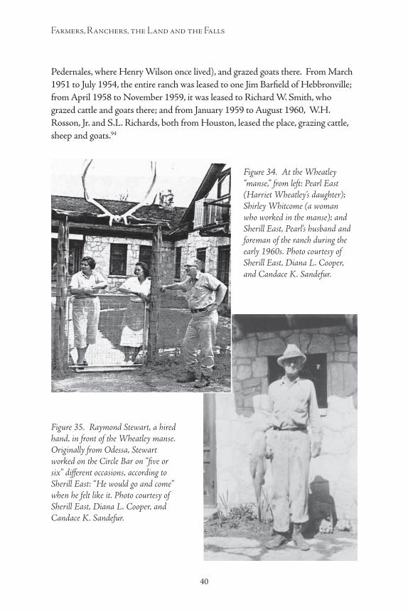
40
Farmers, Ranchers, the Land and the Falls
41
Pedernales, where Henry Wilson once lived), and grazed goats there. From March 1951 to July 1954, the entire ranch was leased to one Jim Barfield of Hebbronville; from April 1958 to November 1959, it was leased to Richard W. Smith, who grazed cattle and goats there; and from January 1959 to August 1960, W.H. Rosson, Jr. and S.L. Richards, both from Houston, leased the place, grazing cattle, sheep and goats.94
Figure 34. At the Wheatley “manse,” from left: Pearl East (Harriet Wheatley’s daughter); Shirley Whitcome (a woman who worked in the manse); and Sherill East, Pearl’s husband and foreman of the ranch during the early 1960s. Photo courtesy of Sherill East, Diana L. Cooper, and Candace K. Sandefur.
Figure 35. Raymond Stewart, a hired hand, in front of the Wheatley manse. Originally from Odessa, Stewart worked on the Circle Bar on “five or six” different occasions, according to Sherill East: “He would go and come” when he felt like it. Photo courtesy of Sherill East, Diana L. Cooper, and Candace K. Sandefur.

40 41
A History of the Pedernales Falls Area, 1850–1970
In spite of the Wheatleys’ sometimes successful efforts to preserve their land in its “natural” state and to enhance its wildlife population, their work with the land could not stop ecological changes already taking place when they bought the ranch—and sometimes, their actions actually accelerated the property’s degradation. The crop farming during the 1870s, 1880s and later had in some places stripped the land of grasses that had held thin and fragile soils in place. The grazing and overgrazing of cattle, goats and sheep during the late 19th and early 20th centuries had also worked to eliminate native grasses and encourage erosion, while the proliferation of ashe juniper (“cedar”) trees robbed the area of needed water. The Wheatley’s apparent decision to encourage (or at least not
Figure 36. C.A., Harriet and the “lady’s pistol” they found near Eagle Bluff. C.A. looks a lot more enthused than Harriet does. Photo donated to Pedernales Falls State Park by C.A. Wheatley (the Younger), C.A.’s nephew.

42
Farmers, Ranchers, the Land and the Falls
43
to stop) the spread of these trees in some ways made the land more scenic but unknowingly had also helped to perpetuate a harmful trend.
Although the area’s grasslands were certainly damaged during the many years of use before the Wheatleys bought the property, particular damage seems to have been inflicted during the extreme drought years of the 1950s, when the vegetation was stressed by both severely dry conditions and overuse by tenants. According to Sherill East, the Wheatleys’ son-in-law who visited the area several times during the 1950s, and worked as the Circle Bar’s foreman in the early 1960s, the lessees of the 1950s had “run the place into the ground.” When East began to work the ranch as the Wheatleys’ foreman in 1961, the forage on the place was so poor that the steers “went backward”—they weighed less when sold than when they had been bought. 95
Farming and overgrazing in the area since the 1870s, and the Wheatleys’ apparent decision to let the ashe juniper grow, had led to serious degradation of the original environment and a transformation of the landscape. By 1970, when the state bought the Circle Bar, a study conducted by the federal Soil Conservation Service concluded:
Those responsible for planning the development of the park must realize that the present ecological conditions on the ranch are in no way natural. . . . The entire park area is presently a severely “disturbed” area ecologically, and the balance of nature is distinctly upset. Vegetation on the ranch is the result of more than one hundred years of very heavy grazing with cattle, goats, and sheep coupled with recurring droughts. Many of the native forage plants . . . are now extinct or severely reduced . . . woody plants and weeds now dominate the vegetation, “polluting” the grassland, and giving a “scrub forest” aspect.96
“Dense stands of ashe juniper are now extensive,” the report noted. “A considerable portion of the junipers, estimated at least 50 percent, are trees of less than 50 years of age, indicating the phenomenal increase of this plant. Numerous young trees of less than 20 years are found in the open areas.” The area’s slopes and ground cover had also led to “severe” erosion, the report stated.97
Fires and floods also changed the land. One fire that spread across several hundred acres of the Circle Bar destroyed valuable ground cover and helped to intensify soil erosion. Another fire, in the late 1950s, destroyed the old Wenmohs house. On January 1, 1960, flames also gutted the Wheatley manse, leaving only a stone shell. The Wheatleys quickly rebuilt on the same site, but on a smaller scale: the present park superintendent’s residence was once C.A. and Harriet’s second home on the Circle Bar.98
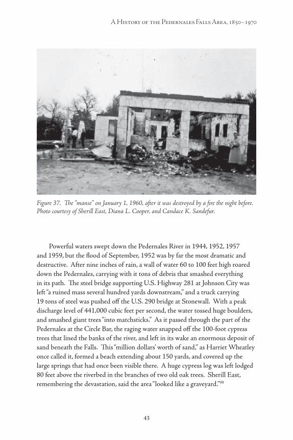
42 43
A History of the Pedernales Falls Area, 1850–1970
Powerful waters swept down the Pedernales River in 1944, 1952, 1957 and 1959, but the flood of September, 1952 was by far the most dramatic and destructive. After nine inches of rain, a wall of water 60 to 100 feet high roared down the Pedernales, carrying with it tons of debris that smashed everything in its path. The steel bridge supporting U.S. Highway 281 at Johnson City was left “a ruined mass several hundred yards downstream,” and a truck carrying 19 tons of steel was pushed off the U.S. 290 bridge at Stonewall. With a peak discharge level of 441,000 cubic feet per second, the water tossed huge boulders, and smashed giant trees “into matchsticks.” As it passed through the part of the Pedernales at the Circle Bar, the raging water snapped off the 100-foot cypress trees that lined the banks of the river, and left in its wake an enormous deposit of sand beneath the Falls. This “million dollars’ worth of sand,” as Harriet Wheatley once called it, formed a beach extending about 150 yards, and covered up the large springs that had once been visible there. A huge cypress log was left lodged 80 feet above the riverbed in the branches of two old oak trees. Sherill East, remembering the devastation, said the area “looked like a graveyard.”99
Figure 37. The “manse” on January 1, 1960, after it was destroyed by a fire the night before. Photo courtesy of Sherill East, Diana L. Cooper, and Candace K. Sandefur.
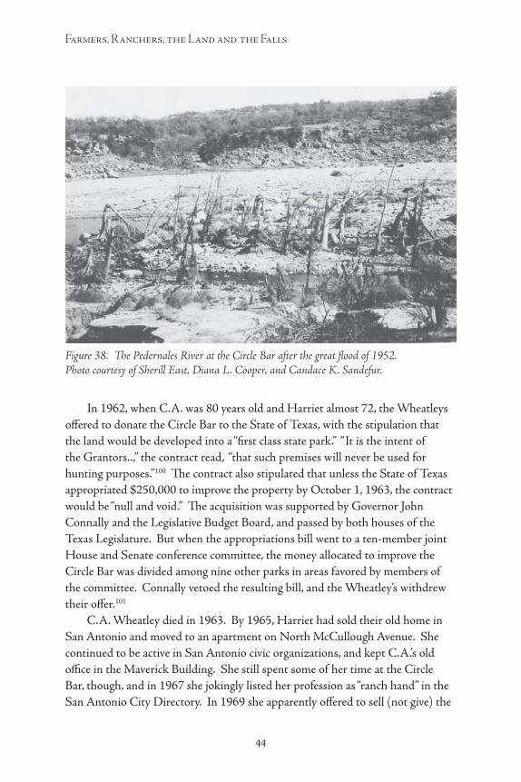
44
Farmers, Ranchers, the Land and the Falls
45
In 1962, when C.A. was 80 years old and Harriet almost 72, the Wheatleys offered to donate the Circle Bar to the State of Texas, with the stipulation that the land would be developed into a “first class state park.” “It is the intent of the Grantors..,” the contract read, “that such premises will never be used for hunting purposes.”100 The contract also stipulated that unless the State of Texas appropriated $250,000 to improve the property by October 1, 1963, the contract would be “null and void.” The acquisition was supported by Governor John Connally and the Legislative Budget Board, and passed by both houses of the Texas Legislature. But when the appropriations bill went to a ten-member joint House and Senate conference committee, the money allocated to improve the Circle Bar was divided among nine other parks in areas favored by members of the committee. Connally vetoed the resulting bill, and the Wheatley’s withdrew their offer.101
C.A. Wheatley died in 1963. By 1965, Harriet had sold their old home in San Antonio and moved to an apartment on North McCullough Avenue. She continued to be active in San Antonio civic organizations, and kept C.A.’s old office in the Maverick Building. She still spent some of her time at the Circle Bar, though, and in 1967 she jokingly listed her profession as “ranch hand” in the San Antonio City Directory. In 1969 she apparently offered to sell (not give) the
Figure 38. The Pedernales River at the Circle Bar after the great flood of 1952. Photo courtesy of Sherill East, Diana L. Cooper, and Candace K. Sandefur.

44 45
A History of the Pedernales Falls Area, 1850–1970
Circle Bar to the state, and a study of the property was conducted that year. In March 1970, Mrs. Wheatley deeded the Circle Bar to the state a second time, but this contract did not contain any restrictions against hunting on the land. The purchase was paid for with funds provided by under a $75 million state bond issue approved by Texas voters in 1967.
In a public ceremony held on March 27, 1970, Mrs. Wheatley accepted a check from Governor Preston Smith for $930,465 in payment for the Circle Bar. “I think you have the best of the bargain,” Mrs. Wheatley told the governor. “It wrenches my heart to part with the ranch. But it would be harder if it were not going to the state. ... It is my wish that it be conserved, and all of the wildlife be taken care of, and that it be enjoyed from generation to generation.”102
Harriet Wheatley died in 1985, and was buried next to her husband in Mission Park Cemetery in San Antonio. A few years later, in 1992, Herman Reiner died; to help pay estate taxes, his heirs sold two parcels of his land to the state, thus enlarging the park. Reiner had witnessed more than a century of life along the Pedernales, from the days of the Trammells and the Maumes through the Wenmohses and the Wheatleys. His passage in a way marked the end of an era. Visitors to the park today can enjoy its scenic beauty, and they are surrounded by reminders of those who walked the ground before them—if only they will look.
46
Farmers, Ranchers, the Land and the Falls
47
Endnotes1 See, for example, “A New State Park on the Pedernales,” Austin American-
Statesman (April 12, 1970), and Ernest Stromberger, “A Park is Born,” Dallas Times-Herald (April 5, 1970). The park was enlarged in 1992 when the state acquired two additional tracts to the north of the Pedernales River. Pedernales Falls State Park acquisition files, Texas Parks and Wildlife Department, Austin.
2 Margaret Howard, Christine G. Ward, and Amy Ringstaff, “Prehistoric Background,” in Margaret Howard, Amy Ringstaff, John J. Leffler, et al, Archeological Survey and History of Pedernales Falls State Park, Blanco County, Texas. (Austin: Texas Parks and Wildlife Department, Cultural Resources Program, 2003), 19-23.
3 Mary Ogilvie and John Leffler, “Blanco County,” in Ron Tyler, ed., The New Handbook of Texas [hereafter NHT] (6 vols.: Austin: Texas State Historical Society, 1986), 1:583; Vivian Elizabeth Smyrl, “Pedernales River,” NHT 5:126; John Stribling Moursund, Blanco County History (Burnet, Texas: Nortex Press, 1979), 1-6.
4 Moursund, Blanco County History, 7-11, 64; Ogilvie and Leffler, “Blanco County,” 583.
5 Ogilvie and Leffler, “Blanco County,” 584; Moursund, Blanco County History, 99, 106, 102.
6 Schroeder was living in San Francisco at about the time the tract was patented, and after being patented the land was transferred a number of times in transactions concluded in Galveston County: “Abstract of Title, 1,476 acres F. Schroeder survey, 25 acres E.W. Maume, Belonging to the American Freehold Land Mortgage Company of London Limited 118971,” document in possession of Dena Wenmohs, Blanco County, Texas. See also discussion of the settlement of this tract later in this history.
7 Moursund, Blanco County History, 115.
8 Population and Agricultural Statistics for Blanco County, 1860-1990, in New Handbook of Texas files, Texas State Historical Association, Austin; Moursund, Blanco County History, 278, 325, 195-197, 178-79.
9 Carl Goeth had known Wolters for years, and the Goeths were related to Wolters by marriage: see Goeth, Memoirs of a Texas Pioneer Grandmother, 68-69, 79-80. In her brief history of the Circle Bar Ranch, Harriet Wheatley mistakenly asserts that ancestors of the Fuchs and Wenmohs families were veterans of the Texas
46 47
A History of the Pedernales Falls Area, 1850–1970
Revolution, and implies that both families received land grants for their services: see Wheatley, “Memories of Mrs. C.A. (Harriet) Wheatley,” undated typescript (probably written in the 1970s or early 1980s) in the historical files of Johnson City Library, Johnson City, Texas. Actually, neither family had any such roots, as evidenced in genealogical materials relating to the Wenmohs family in possession of Dena Wenmohs, Blanco County, Texas. It is not clear whether or not Fuch’s first mill was the same mill previously owned by William Evans. Conflicting accounts of the origins of the Cypress Mill community have been offered over the years. Moursund, in Blanco County History, p. 115, citing tax records, places Evan’s mill seemingly at or near this site “about 1857”; in his companion volume, Blanco County Families for One Hundred Years, Moursund writes that Fuchs “established” his mill about 1867 or 1868. Bessie Brigham, in “Cypress Mill,” in Walter Prescott Webb, ed., Handbook of Texas (Austin: Texas State Historical Society, 1952), places a lumber mill there after the Civil War; Vivian Smyrl’s “Cypress Mill” in The New Handbook of Texas places the mill there after the Civil War. See also Ottilie Fuchs Goethe, Memoirs of a Texas Pioneer Grandmother, Irma Goeth Gunter, trans. (Austin: Eakin Press, 1982 [1915], 81-82, 89. Another water-powered mill was engineered and built for Fuchs at Cypress Mill about 1874 by Robert G. Kelley, Sr.; see Moursund, Blanco County Families for One Hundred Years, 248.
10 Goeth, Texas Pioneer Grandmother, 89; Moursund, Blanco County Families for One Hundred Years, 135, 141-142.
11 Moursund, Blanco County Families for One Hundred Years, 182. The raiders took four horses from the Goeth family on Cypress Creek: Goeth, Texas Pioneer Grandmother, 92.
12 Moursund, Blanco County History, 188-189, 93.
13 Population and agricultural statistics for Blanco County, Texas, in New Handbook of Texas files, Texas State Historical Association.
14 Moursund, Blanco County History, 26-27; C.A. Rechenthin and James Henson, “Evaluation and Recommendations for Conservation of Pedernales Falls State Park” (U.S. Department of Agriculture, Soil Conservation Service, 1970), typescript in Pedernales State Park file, USDA Natural Resources Conservation Service office, Johnson City, Texas; author’s conversation with C.A. Cowsert, Range Management Specialist, July 1996.
15 Quotes in Moursund, Blanco County History, 330, 331.
16 Moursund, Blanco County History, 334.
17 Soils: Rechenthin and Henson, 3; author’s interview with Bobby Wilson, a local rancher whose family settled early in the area. Water: Goeth, Memoirs of a Texas Pioneer Grandmother, 133; Speer, History of Blanco County, 1-4.

48
Farmers, Ranchers, the Land and the Falls
49
18 “John B. Wenmohs,” in Arthur Davis Ellis, ed., The Historical Encyclopedia of Texas (n.p.: Texas Historical Society, n.d. [1938?], vol. 2, 801; Alice Watts, “If Ponce de Leon Hadn’t Lived Too Soon He Could Have Gotten Good Tip from Cen Texan,” Austin American (October 9, 1940); Wenmohs family genealogical material in possession of Dena Wenmohs, Blanco County, Texas.
19 Smyrl, “Cypress Mill,” 465; Goeth, Memoirs of a Texas Pioneer Grandmother, 88; ethnic composition of settlers in immediate vicinity of Pedernales Falls based upon author’s examination of U.S. Census Manuscript Population Schedule, Blanco County, Texas, 1880, Precinct 2.
20 Conclusion based on author’s analysis of land grant applications and homestead affidavits for the various tracts within the confines of present-day Pedernales Falls State Park. Greene Wilson filed the first homestead application in the area on May 5, 1873, but it was witnessed by Henry Wilson. In a subsequent Proof of Settlement, Greene Wilson affirmed that he had “occupied and improved” this land (Survey 407) beginning November 10, 1873. Henry Wilson filed the next homestead affidavit in the Pedernales State Park area (for Survey 408) on December 15, 1873. Texas General Land Office (hereafter TGLO), Land Grant Records, files P-245 and P-609.
21 Wilson family genealogical materials supplied by Joyce Brock, Wimberly, Texas. According to Brock, Jesse Wilson is buried in Round Rock in an unmarked grave in Sam Bass Cemetery.
22 Joyce Brock genealogy materials; James Calvin Wilson, Some Musings of a Religious Mystic (Brazoria, Texas, 1961), biographical preface; Wilson homestead affidavits in TGLO, Land Grant Records, Files P-245 and P-609. Greene appears to have taken his widowed mother, Winna Wood Wilson, with him to his Pedernales land, since she died in Blanco County in 1876 (date from Brock materials). But this has not been confirmed by any source. Winna may be buried in one of the graves in the “Pioneer Cemetery” once located on Greene Wilson’s land.
23 Mrs. Mary Terry Homestead Affidavit and Proof of Settlement, March 1874, in TGLO, Land Grant Records, file P-2070. Her honorific “Mrs.” appears on this document, as does her statement that she was “head of the family.”
24 Interview with Bobby Wilson, Blanco County, Texas; approximate date of Trammell’s arrival in the area established by his signature on Mary Terry’s 1874 homestead affidavit (see note 21 above); Trammell’s full name established from entry in Bible once belonging to Annie Jane Trammell, now in possession of Bobby Wilson; Joyce Brock genealogical materials.
25 The account above was pieced together from information in Joyce Brock’s genealogy materials and notations in a Bible that once belonged to Annie Jane Trammell; Bible in possession of Bobby Wilson. Betsy Raines, born in 1852 in Clear Creek, Arkansas, was about 16 years old when she married T.J. Trammell.

48 49
A History of the Pedernales Falls Area, 1850–1970
26 Joyce Brock genealogical materials; birth dates confirmed by information on T.J. and Betsy’s tombstones as noted in Hearn, Henly Cemetery, p. 3.
27 Bobby Wilson interview; 1880 manuscript census; and Trammell’s 1886 homestead affidavit, in which Trammell affirmed that he had “occupied, improved, and cultivated” the land in the A.C. Hughes tract.
28 Author’s interview with Bobby Wilson for constructions, fields, way of life and economy, lime kilns, crops planted; his remembrances and assertions, passed down through his family, are supported by visible configurations of stone fencing and foundations, physical evidence of lime kilns and other artifacts on sites occupied by the Wilsons and other settlers, observed by the author during a tour of the area guided by Bobby Wilson, July 1996. Tobacco speculation based partly on Harriet Wheatley’s reference to “two brothers” who, according to local legend, once grew tobacco in the area, and partly on the Wilsons’ tobacco-country roots.
29 Names of children and description of Henry Wilson and names of children from genealogical materials and family stories supplied by Joyce Brock; ages and illiteracy information from 1880 manuscript census, Blanco County.
30 1880 manuscript census, Blanco County; names and birthdates of Trammell children from a Bible that once belonged to Annie Jane Trammell, in possession of Bobby Wilson. As late as 1900, seven of the Trammell’s children were still living with their parents: 1900 manuscript census, Blanco County.
31 Mary Terry, Greene C. Wilson, Matt Huff, and Thomas Welch (see below) were among those adult settlers in the area who could not sign their names to legal contracts, and instead signed their assent with a simple “X” (his/her mark). Henry Wilson could sign his name, but since his own children could not read or write, the literacy skills of Henry and his wife Elizabeth were probably limited.
32 Bobby Wilson interview for cemetery, schoolhouse and “Schoolhouse Flats,” testimony based on stories handed down through his family, reinforced by physical evidence of schoolhouse. Bobby Wilson’s grandmother, Annie Jane Trammell, attended the school in the 1870s and perhaps a bit later. Additional proof lies in the 1900 contract in which M.T. Holton sold the Greene Wilson tract to J.B. Wenmohs; the contract excludes from the sale 2 acres of land on the tract “heretofore deeded for School House.” Interestingly, no previous or future contracts for the land mentioned this 2-acre tract, and the author could find no record of the donation in Blanco County deed or trust records: this could be because Blanco County’s records were destroyed in a courthouse fire in 1875. Greene Wilson as itinerant minister: information from Joyce Brock. For tradition concerning the schoolhouse, see Harriet Wheatley, “Memories of Mrs. C.A. (Harriet) Wheatley.” Mrs. Wheatley mentions the school and the remnant foundation near the graveyard, but also suggests that the building might have been “one of the first Lutheran churches in this area.” This is unsubstantiated and runs counter to what is now known about the building, the
50
Farmers, Ranchers, the Land and the Falls
51
area and its inhabitants. Given Mrs. Wheatley’s knowledge of the schoolhouse, it is interesting that in an affidavit “to the People of Blanco County” which she signed in 1971, she categorically denied any knowledge that any school had ever existed on any part of her ranch property at any time.
33 Bobby Wilson interview and tour, July 1996. During an inspection of the graveyard, Bobby Wilson and the author counted nineteen probable gravesites there.
34 Land scrip certificate 13 to Sulfur Forks Iron Works Company, in file S-952, Land Grant Records, Texas General Land Office. The company was awarded the land as provided by an 1863 state law intended “to encourage the erection of certain machinery by donations of land and otherwise.” See scrip certificate and Thomas Lloyd Miller, The Public Lands of Texas, 1519-1970 (Univ. of Oklahoma Press, Norman, 1972), 93-94. Neither George P. or Caroline Hackenberg appear in the manuscript census returns for Blanco County for 1870, 1880, or 1900; one G.P. Hackenberg is listed as living in Travis County in a special military census of Union veterans taken in 1890.
35 Based on examination of census indexes for Texas for 1870, 1880, and 1900, and on results of inspection of the tract conducted by a Texas Parks and Wildlife archeological team in 1996. (The 1890 census for the county no longer exists.) The Hackenbergs also do not appear in John Moursund’s Blanco County Families for One Hundred Years; bill of sale from G.P. Hackenberg to Caroline Hackenberg, May 10, 1879, Blanco County Deed Records 2:40.
36 Blanco County Deed Records, 3:499. Since granted to Schroeder in 1857, the property was transferred a number of times, always in Galveston County. Schroeder sold the tract to William Henley for $501.84 in February 1857; Henley sold it for the same amount in August 1862 to Walter H. Bennison, who in 1866 sold it to Hugh Bennison for “$2,214 in property.” Maume bought the property for “$10 and other good consideration”: “Abstract of Title, 1476 Acres F. Schroeder….”
37 Blanco County Deed Records, 4:170.
38 The location of Maume’s home roughly described in Designation of Homestead in Blanco County Deed of Trust Records, 2:501-502 and map in “Abstract of Title, 1476 Acres F. Schroeder; author’s conversation with Logan McNatt, a member of Texas Parks and Wildlife archeological team, 1996. Maume’s livestock, wife’s name, marriage, etc. from field notes attached to “Abstract of Title, 1476 Acres F. Schroeder…” The 1880 manuscript census shows J.A. Irving living in the general vicinity of Miller’s Creek; it also lists a daughter, single and 19 years old, living in the Irving household. According to field notes attached to “Abstract of Title, 1467 Acres F. Schroeder,” daughter Susan was five years old when her mother died September 19, 1886; Annie was two. See also Moursund, Blanco County Families for One Hundred Years, 307; Blanco County Deed Records 6:618.
50 51
A History of the Pedernales Falls Area, 1850–1970
39 Both Thomas and Patsy later signed a lien release using an “X” (his/her mark): sse release of lien to T.J. Trammell, October 17, 1900, filed Feb. 2, 1919, Blanco County Deed Records, 31:195. Other information from 1880 manuscript census, Blanco County.
40 Settlement and survey dates taken from Welch’s homestead affidavit, December 16, 1885, in file P-1825 [T.A.W. Welch survey], Land Grant Records, Texas General Land Office. The Welches actually may have settled on this land earlier; they were certainly living in the immediate vicinity of Greene and Henry Wilson in June, 1880 because the census enumerator working the area at that time placed the Welches in Dwelling Unit 48, while Greene Wilson’s home was Dwelling Unit 47 and Henry Wilson’s was unit 46. Dates of census survey from Moursund, Blanco County History, 468.
41 Some of the documentation of the Willis West land grant, including the original certificate, is missing from the land grant files concerning the tract in the Texas General Land Office. The files do contain some letters, however, that hint at the origins of the controversy. See Willis West files, Travis abstract 918, file 1-602, Milam file 1.2004. Also consulted for this discussion was a copy of a Travis County court document, “Judgement in cause 11080, Willis West, et al, plaintiffs, John T. Lytle, et al, defendants” [1894], in possession of Dena Wenmoh, Blanco County, Texas. By the time the suit was settled, there were sixteen plaintiffs and twelve defendants involved in the litigation.
42 The stone fencing was found by a Texas Parks and Wildlife archeological team that traversed the area in 1996, according to a map of historical sites in the area provided to the author by that team in March, 1996. See also Margaret Howard, et al, Archeological Survey and History of Pedernales Falls State Park, Blanco County, Texas (Austin: Texas Parks and Wildlife Department, Cultural Resources Program, 2003).
43 These conclusions are based largely on various pieces of information supplied by Bobby Wilson and information already presented. Wilson believes that the school probably disappeared by 1880, but this seems inconsistent with other evidence he provided, particularly his strong belief (based on family stories handed down) that his grandmother, Annie Jane Trammell, attended the school until she could read and write. She was born in 1873. School superintendents’ reports for Blanco County at the Texas State Archives and Bessie Brigham’s M.A. thesis, “The History of Education in Blanco County” (University of Texas-Austin, 1935) were consulted but not useful for this question. It is difficult to imagine the school running after 1886, when Greene Wilson left the area.
44 Crop loss in Moursund, Blanco County History, 335. Rainfall figures for Blanco County for this period could not be provided by the Johnson City Branch of the USDA Natural Resources Conservation Service. Rainfall figures for San Antonio provided by that office, however, show a yearly rainfall of 31.62 inches in 1885 (the earliest year figures are available), 26.32 inches in 1886, and only 20.13

52
Farmers, Ranchers, the Land and the Falls
53
inches in 1897. From 1884 to 1886 west Texas experienced “one of the worst droughts in Texas history”: see Roy Sylvan Dunn, “Droughts,” in NHT 2:705.
45 Rounded figures from rainfall table supplied by Johnson City branch of the USDA Natural Resources Conservation Service, 1996.
46 Blanco County statistics from Population and Agricultural Statistics for Blanco County, New Handbook of Texas files; Goeth quotes from Memoirs of a Texas Pioneer Grandmother, 133.
47 These dates are the author’s best guess based on the deposition of Henry’s property and subsequent movements in the family. The precise date of Henry’s death is unknown; he might have died anytime between 1880 and 1885. The date and place that his wife died is also unknown. The Blanco County index of the probate records for this period is full of gaps and lapses for the late 19th century, and contains no reference to Wilson’s estate. Henry is probably buried in the graveyard near the schoolhouse; Elizabeth may be buried there, too. Wilson family tradition regarding Elizabeth’s inheritance from Joyce Brock.
48 Deeds from Nancy Raines, Louisa J. Gatlin, Ama Long, and William and Newton Wilson to G.C. Wilson, variously dated from March to May, 1885, all filed Feb. 2, 1917, Blanco County Deed Records 31:196-200; G.C. Wilson sells surveys 407 and 408 to M.T. Holton in contract dated November 19, 1885, filed March 1, 1886, Blanco County Deed Records 9:511. G.C.’s departure date and destination from James Calvin Wilson, preface to Some Musings of a Religious Mystic; date and place of Greene’s death from information supplied by Joyce Brock.
49 Information from Mary Terry deed to Morris in Mrs. Mary Terry Land Grant file, Travis Preemption abstract 1268, file P-2070.
50 Information about the Maume family from field notes, Sheriff ’s deed, and other documents in “Abstract of Title, 1475 acres Ferdinand Schroeder Tract”; deed from Welches to T.J. Trammell, September 30, 1890, Blanco County Deed Records 18:301.
51 J.G. Morris, who bought the rights to the tract from Mrs. Terry, may or may not have occupied the tract, but in 1891 he sold it to Julius Randolph Kellersberger. Kellersberger, born in California in 1858, moved to the Cypress Mill area in the 1880s and soon took over the Fuchs sawmill. He became the town’s postmaster in 1882, and sometime after that he established a cotton gin there; he served as the postmaster until 1911. Kellersberger patented the Mary Terry land, which Mrs. Terry had never bothered to do; but he almost certainly never lived there, and there is no evidence that anybody ever did. (See Mary Terry Land Grant file, Texas General Land Office.
52 Deed from Trammells to Joneses, Blanco County Deed Records, 10:33-34.
52 53
A History of the Pedernales Falls Area, 1850–1970
53 Bobby Wilson showed the author this site and its features during a tour of the land in July 1996. He also showed the author a photograph of the Trammell family taken during 1890s in front of the grape vine, but unfortunately the photo could not be copied. According to Bobby Wilson, the spring only ran in wet weather, but his information was based on the experiences of the Trammell family. It may have run continuously when the Welches moved onto the property before the droughts that dried up a number of springs in the area.
54 Information from field notes, Sheriff ’s deed, and other documents in “Abstract of Title, 1475 acres Ferdinand Schroeder Tract…”
55 D.G. may have been dead by 1899, because that year Nannie sold the property herself to J.B. Wenmohs; deed in Blanco County Deed Records 17:22.
56 Huff proof of homestead affidavit, and deed from I.W. Davis dated July 21, 1899, in I.W. Davis Land Grant file, Travis Preemption survey, abstract 1320, file P-2199, Texas General Land Office. Bobby Wilson interview for information on Huff ’s background.
57 Deed from Kellersberger to T.J. Trammell, Blanco County Deed Records 18:303.
58 Bobby Wilson interview.
59 Ellis, “John B. Wenmohs,” 801; Watt, “If Ponce de Leon Hadn’t Lived.” See also discussion of Wenmohs’ early years in Chapter 2, above.
60 Watt, “If Ponce de Leon Hadn’t Lived”; Goeth, Memoirs of a Texas Pioneer Grandmother, 96.
61 Goeth, Memoirs of a Texas Pioneer Grandmother, 105-06; manuscript census, Blanco County, 1880.
62 Purchases in 1881: see for example, deed from George Hoppe to Wenmohs, Jan. 15, 1881, Blanco County Deed Records 4:360. Ranch purchase, barbed wire: Watt, “If Ponce de Leon Hadn’t Lived”; Ellis, “John B. Wenmohs,” 801.
63 Goeth, Memoirs of a Texas Pioneer Grandmother, 105, 108, 113.
64 Interviews with Dena Wenmohs, Loma Wenmohs and Jerry Wenmohs, July 1996; manuscript census, Blanco County, 1900; Wenmohs genealogy chart supplied by Dena Wenmohs; Goeth, Memoirs of a Texas Pioneer Grandmother, 120.
65 Blanco County Deed Records 16:415; 17:26; 17:22: 50:519; 18:306; 18:308; 18:309; 18:577; J.B. Wenmohs Land Grant file, Abstract 1486, file 1028, Texas General Land Office; Blanco County Deed Records 19:253; 22:339; 39:394.
66 Wenmohs residence, fences and buildings: H.M. Ulrich, “Affidavit of Use, Occupancy, and Possession,” filed September 15, 1960, Blanco County Deed Records. Ulrich, 68 years old when he swore this affidavit, had been living on an adjacent
54
Farmers, Ranchers, the Land and the Falls
55
ranch since 1894. He asserted that Wenmohs had built the house that was still on the property when the Wheatleys bought the land in 1936. While Ulrich is probably the best source for when the house was built, it remains possible that the Wenmohs house was actually the same dwelling previously built by E.W. Maume in about the same place. Wenmohs brand: Jerry Wenmohs interview. Old Trammell field possibly tilled and planted until 1915: Bobby Wilson interview.
67 Ellis, “John B. Wenmohs,” 81; Goethe, Texas Pioneer Grandmother, 118.
68 Ulrich, “Affidavit of Use, Occupancy and Possession.”
69 Loma Wenmohs interview with author, July 1996.
70 Herman Reiner’s land had been patented in 1862 to the heirs of D. Gamble, who had died at the Goliad massacre, but it had been purchased by Wilhelm Fuchs, the early owner of the sawmill at Cypress Mill. Herman Reiner’s father, Frederick, was originally from Germany and had moved to Cypress Mill area after serving in the Union army during the Civil War. There he met, and eventually married, Wilhelm Fuch’s daughter, Dora. When Wilhelm Fuchs died, Frederick and Dora received the D. Gamble land as part of Dora’s inheritance. Herman (born January 15, 1891) was Frederick and Dora’s only son, and he had inherited the land. Moursund, Blanco County Families for One Hundred Years, 142; Lila Jean Hobbs interview with author.
71 Loma Wenmohs interview; deed from J.B. and Louise Wenmohs to C.A. and Harriet Wheatley, December 30, 1936, Blanco County Deed Records 50:518-519. The deed states the price paid by the Wheatleys as “Ten dollars and other valuable consideration.” According to Sherrill East, the Wheatley’s son-in-law, C.A. once told him that he paid ten dollars an acre for the ranch. If that is true, the actual price was about $47,780. Sherrill East interview with author, February 1996.
72 “Death Takes Prominent S.A. Oilman,” San Antonio Light (September 16, 1963); liner notes to Harriet V. Wheatley, Lady Angler: Fishing, Hunting and Camping in the Wilderness Areas of North America (San Antonio: 1952). Birth date for C.A. supplied by the Porter Loring Funeral Home, San Antonio, Texas.
73 Liner notes, Lady Angler; Sherrill East interview with author; undated newspaper clipping in autographed copy of Lady Angler, now in possession of Pedernales Falls State Park; email to author from Diana L. Cooper, Harriet Wheatley’s great-granddaughter, June 30, 2010; Worley’s San Antonio City Directory ( John F. Worley Directory Co., Dallas and San Antonio, 1926 and 1927). While Mrs. Wheatley’s obituary states that she moved to San Antonio in 1919, a search for both Wheatleys in the Soundex index for the 1920 census proved futile.
74 Bill Casparis interview with author, January 1996.
75 Lila Jean Hobbs interview; Bobby Wilson interview.
76 Bill Casparis interview.

54 55
A History of the Pedernales Falls Area, 1850–1970
77 Wheatley, “Memories,” 1; Sherill East interview; correspondence between C.A. Wheatley (the Younger) and Bill McDaniel; Bill Casparis interview; Lila Jean Hobbs interview.
78 Ullrich, “Affidavit of Use, Occupancy, and Possession”; Wheatley, “Memories,” 1.
79 Ullrich, “Affidavit of Use, Occupancy, and Possession”; Wheatley, “Affidavit of Use, Occupancy, and Possession”; Sherill East interview.
80 Correspondence between C.A. Wheatley (the Younger) and Bill McDaniel, 1991.
81 Wheatley, Liner Notes, Lady Angler; William J. Tucker, introduction to Lady Angler; Thomas E. Turner, “Neff, Pat Norris,” NHT 4:970; “Death Takes Prominent Oilman”; C.A. Wheatley (the Younger) correspondence with Bill McDaniel.
82 Wheatly, Liner Notes, Lady Angler; William J. Tucker, introduction to Lady Angler, xiii-xiv; “Wheatley loved outdoors, wrote ‘Lady Angler’ book”; Sherrill East interview.
83 Wheatley, “Memories,” 2.
84 Lila Jean Hobbs interview; Sherrill East interview. Similar sentiments surfaced in correspondence between C.A. Wheatley (the Younger) and Bill McDaniel, and in Dena Wenmohs’ interview with the author.
85 East interview; “Wheatley State Park Ten Year Development Plan” (undated, but probably 1962 or 1963), p.13; “Report on Circle Bar Ranch” (October, 1969). Documents in Pedernales Falls State Park acquisition files, Texas Parks and Wildlife Department, Austin.
86 East interview; “New State Park Being Sought,” San Angelo Standard Times (November 2, 1969); Wheatley State Park Ten Year Development Plan,” 13.
87 Option from Wheatleys to Phillips Pipe Line Co., June 21, 1960 and deed from Wheatleys to Phillips Pipe Line Co., September 8, 1960, Blanco County Deed Records 68:501 and 68:580.
88 Harriet Wheatley’s account of the history of the Circle Bar, for example, does not even mention the Wilsons, the Joneses, the Welches or Mary Terry; and it contains a number of assertions that do not square with the facts.
89 Correspondence between C.A. Wheatley (the Younger) and Bill McDaniel, October 1991.
90 Wheatley, “Memories,” p. 4; East interview.
56
Farmers, Ranchers, the Land and the Falls
57
91 East interview; Worley’s San Antonio City Directory for 1938, 1941, 1943, 1948; San Antonio phone book for 1961; “Wheatley loved outdoors, wrote ‘Lady Angler’ book”; Ulrich, “Affidavit of Use, Occupancy, and Possession; Wheatley, “Affidavit of Occupancy, Use, and Possession.” Their San Antonio address was 4531 Callaghan Road.
92 East interview; email communications with Diane L. Cooper, one of the East’s grandchildren, June 2010.
93 Wheatley, “Memories,” 2; Sherrill East interview; C.A. Wheatley (the Younger), correspondence with Bill McDaniel; Wheatley, “Affidavit of Occupation, Use, and Possession”; “Report on Circle Bar Ranch,” 2.
94 East interview; Wheatley, “Affidavit of Occupation, Use and Possession.”
95 East interview.
96 Recenthin and Henson, “Evaluation and Recommendations,” 1.
97 Recenthin and Henson, “Evaluation and Recommendations,” 4.
98 Recenthin and Henson, “Evaluation and Recommendations,” 4: East interview.
99 U.S. Army Corps of Engineers, Fort Worth District, “Special Flood Hazard Information Study, Pedernales River, Pedernales Falls State Park, Blanco County, Texas” (February, 1982), 2; Mark Yemma, “Pedernales Falls,” Daily Texan (March 1, 1974); David Baxter, “Pedernales Falls,” Texas Parks and Wildlife ( July, 1972), 24-27; Bobby Wilson interview; Lila Jean Hobbs interview; “Centex Tour,” Austin American-Statesman (April 12, 1970); Ernest Stromberger, “A Park is Born,” Dallas Times Herald (April 5, 1970); Sherill East interview.
100 Deed from Wheatleys to State Parks Board, June 22, 1962, Blanco County Deed Records 70:351.
101 “Conference Committee Made Gift Cost Taxpayers Almost $1 Million,” San Antonio Express and News (March 28, 1970); “Legislative Inaction Adds to Park Cost,” unidentified clipping (March 28, 1970), in Pedernales Falls State Park vertical file, Center for American History, University of Texas-Austin.
102 Quotes conjoined from “State Takes Over Circle Bar for Park System Addition,” San Antonio Express-News (March 28, 1970) and “Legislative Inaction Adds to Park Cost.”

56 57
A History of the Pedernales Falls Area, 1850–1970
Bibiliography
Government Documents and RecordsBlanco County Deed and Trust Records, Blanco County Courthouse,
Johnson City, Texas.
Texas Department of Education. School District Records. School Superindents’ Annual Reports, 1880-1911.
Texas Parks and Wildlife Department. Acquisition files, Pedernales Falls State Park, Texas Parks and Wildlife Department (TPWD), Austin.
Texas Parks and Wildlife Department. Historic Sites and Restoration Branch, “Wheatley State Park Ten Year Development Program” (1969) in Pedernales Falls State Park files, TPWD, Austin.
Texas State Department of Highways and Public Transportation, and U.S. Department of Agriculture. Map of Blanco County, Texas, for the year 1936, fully updated to 1948.
Texas Land Grant Records. Texas General Land Office, Austin.
U.S Army Corps of Engineers, “Special Flood Hazard Information Study, Pedernales River, Pedernales State Park, Blanco County, Texas.” U.S. Army Corps of Engineers, Fort Worth District, 1982.
U.S. Census Bureau. Manuscript Population Schedules, Blanco County, Texas, for 1870, 1880, 1900, and 1920.
U.S. Department of Agriculture, Soil Conservation Service. C.A. Rechenthin and James Henson, “Evaluation and Recommendations for Conservation of Resources: Pedernales Falls State Park.” Typescript (1970) in Pedernales Falls State Park file at Johnson City Office of the USDA Natural Resources Conservation Service.
U.S. Department of Agriculture, Soil Conservation Service. Rainfall table for San Antonio, Texas, 1885-1991, provided to author by the Johnson City office of the USDA Natural Resources Conservation Service.
U.S. Department of Agriculture, Soil Conservation Service. Aerial photo of Blanco County, Texas, 1951, in photo files of the Johnson City office of the USDA Natural Resources Conservation Service.

58
Farmers, Ranchers, the Land and the Falls
59
Published Books, Essays, and Periodical LiteratureBaxter, David, “Pedernales Falls.” Texas Parks and Wildlife ( July, 1972), 24-27.
Blanco County News, Heritage of Blanco County. Dallas: Curtis Media Corporation, 1987.
Goeth, Ottilie Fuchs, Memoirs of a Texas Pioneer Grandmother (Was Grosmutter Erzaehit). Irma Goeth, trans. and ed. Austin: Eakin Press, 1982 [1915].
Greer, John W., “Neo-American Occupation at the Wheatley Site, Pedernales Falls State Park, Blanco County, Texas. Bulletin of the Texas Archeological Society 47 (1976), 89-169.
Hearn, Jo Ann Elam, et al, comps., Henley Cemetery and Miller Creek Cemetery in Blanco County, Texas. n.p.: Hays County Historical Commission, 1994.
Howard, Margaret, Amy Ringstaff, John J. Leffler, Christopher Ringstaff, Logan McNatt, Steve Tomka, et al, Archeological Survey and History of Pedernales Falls State Park, Blanco County, Texas. Austin: Texas Parks and Wildlife Department, Cultural Resources Program, 2003.
Ing, J. David, An Archeological Study of Pedernales Falls State Park, Blanco County, Texas. Austin: 1971.
“John B. Wenmohs,” in Arthur Davis Ellis, ed., The Historical Encyclopedia of Texas. n.p.: Texas Historical Society, n.d. [1938?], 800-801.
Jules A. Appler’s General Directory and Householder Directory of Greater San Antonio. San Antonio: Jules A. Appler, 1918.
Moursund, John Stribling, Blanco County Families for One Hundred Years. Austin: 1958.
Moursund, John Stribling, Blanco County History. Burnet, Texas: Nortex Press, 1979.
Miller, Thomas Lloyd, The Public Lands of Texas, 1519-1970. Norman: University of Oklahoma Press, 1972.
Ogilvie, Mary and John Leffler, “Blanco County,” in Ron Tyler, ed., The New Handbook of Texas [hereafter NHT] 6 vols. Austin: Texas State Historical Association, 1996, 1:583-584.
Polk’s San Antonio (Bexar County, Texas) City Directory. Dallas: R.L. Polk and Co., 1959-1972.
“Pedernales Falls State Park.” Texas Highways (October, 1985), 20-24.
Smyrl, Vivian E., “Cypress Mill, Texas.” NHT 2:465.
Speer, John W., A History of Blanco County. Austin: The Pemberton Press, 1965.

58 59
A History of the Pedernales Falls Area, 1850–1970
Wheatley, Harriet, Lady Angler: Fishing, Hunting, and Camping in Wilderness Areas of North America. San Antonio: The Naylor Company, 1952.
Wilson, James Calvin, Some Musings of a Religious Mystic. Brazoria, Texas: Privately published, James Calvin Wilson. Lithographed by Lith-Art Press, Woodstock N.Y., 1961.
Worley’s San Antonio City Directory. Dallas and San Antonio: John F. Worley Directory Co., 1926-1957.
Miscellaneous Documents, Papers and Unpublished Manuscripts“Abstract of Title, 1476 acres F Schroeder survey, 25 acres E.W. Maume, Belonging
to the American Freehold Land Mortgage Company of London, Ltd.” [1897]. In possession of Dena Wenmohs, Blanco County, Texas.
Brigham, Bessie, “The History of Education in Blanco County.” M.A. thesis, University of Texas at Austin, 1935.
Brock, Joyce, Geneaological materials relating to the Wilson family, in possession of Joyce Brock, Wimberly, Texas.
Cooper, Diana L., Email correspondence with author, June 2010, in author’s personal possession.
“Genealogy of the Wenmohs Family, 1712-1982,” in possession of Dena Wenmohs, Blanco County, Texas.
Ogilvie, Mary, and John Leffler, comps., Population and agricultural statistics for Blanco County, in New Handbook of Texas files, Texas State Historical Association, Austin.
Wheatley, C.A. the Younger, correspondence (September-December 1991) with Bill McDaniel, Superintendent, Pedernales Falls State Park, in historical files, Pedernales Falls State Park.
Wheatley, Harriet, “Memories of Mrs. C.A. (Harriet) Wheatley,” undated [post-1970] typescript in historical files, Johnson City Library, Johnson City, Texas.
Newspaper Articles“Camping facilities now open.” Dallas Times-Herald, April 20, 1973.
Carmack, George, “Pedernales—A lush neighbor.” San Antonio Express-News, September 3, 1988.
Castlebury, Glen, “Rigid Restrictions Keep State Park Primitive.” Austin American-Statesman, June 12, 1970.

60
Farmers, Ranchers, the Land and the Falls
61
“Conference Committee Made Gift Cost Taxpayers Almost $1 Million.” San Antonio Express and News, March 28, 1970.
“Death Takes Prominent S.A. Oilman.” San Antonio Light, September 15, 1963.
“Donated telescope to be star of new observatory.” Austin American-Statesman, July 7, 1996.
“Legislative Inaction Adds to Park Cost.” Unidentified clipping, March 28, 1970, in Pedernales Falls State Park vertical file, Center for American History, University of Texas at Austin.
Miller, George, “Pedernales State Park offers a step into the wilds.” Austin American-Statesman, November 13, 1982.
“Nature Painted Pictures of Proposed State Park.” Houston Chronicle, July 15, 1962.
“A New State Park on the Pedernales.” Austin American-Statesman, April 12, 1970.
“New State Park Being Sought.” San Angelo Times-Standard, November 2, 1969.
“Pedernales Falls—paradise found.” San Antonio Express-News, August 28, 1977.
“Pedernales Wonders Nearby.” Austin American-Statesman, August 20, 1977.
“State Loses Ranch as New Park Site.” Austin American, December 1, 1962.
“State Takes over Circle Bar for Park System Addition.” San Antonio Express-News, March 28, 1970.
Stromberger, Ernest, “A Park is Born.” Dallas Times-Herald, April 5, 1970.
“Too-Pretty Section of Pedernales Falls Park Is Closed by People Traffic.” Houston Chronicle, July 20, 1975.
“Vandalism, Erosion Trigger Closing of Twin Falls Site.” Daily Texan [University of Texas at Austin], July 22, 1975.
Watts, Alice Williams, “If Ponce de Leon Hadn’t Lived Too Soon He Could Have Gotten Good Tip From Cen-Texan.” Austin American, October 9, 1940.
“Wheatley loved outdoors, wrote ‘Lady Angler’ book.” San Antonio Express-News, November 7, 1985.
Yenna, Mark, “Pedernales Falls.” Daily Texan [University of Texas at Austin], March 1, 1974.
60 61
A History of the Pedernales Falls Area, 1850–1970
Personal InterviewsCasparis, Bill, interviewed by the author at his business, the Antique Emporium,
Johnson City, Texas, January 3, 1996.
East, Sherrill, interviewed by the author at his home in Round Rock, Texas, January 13, 1996.
Hobbs, Lila Jean, telephone interview with author, July 26, 1996.
McDaniel, Bill, Superintendent, Pedernales Falls State Park, interviewed by author at Pedernales Falls State Park, December 1995.
Wenmohs, Dena, interviewed by the author at her home in Blanco County, Texas, July 27, 1996.
Wenmohs, Loma, interviewed by the author at her home Round Mountain, Texas, July 27, 1996.
Wenmohs, Jerry, interviewed by the author at the home of Loma Wenmohs, July 27, 1996.
Wilson, Bobby, interviewed by the author at his ranch and during tour of adjoining Pedernales Falls State Park, Blanco County, Texas, July 20, 1996.
Wilson, Maude, interviewed by author and Bobby Wilson at her home on the Wilson Ranch, Blanco County, Texas, July 20, 1996.

Farmers, Ranchers, the Land and the Falls: A History of the Pedernales Falls Area, 1850–1970 John J. Leffler
This is the story of a special place—a 5,000-acre stretch of land along the Pedernales River, the area that is now Pedernales Falls State Park. In words, photographs, and maps, Farmers, Ranchers, the Land and the Falls explains how nature and human dreams intertwined in an isolated and untamed place, leaving a lasting mark on the land.
The author charts the evolution of the area from savannah grassland to the hill country brush and cedar trees that we know today. Deftly interwoven are the stories of those who settled and worked it—the German settlers who established the community of Cypress Mill, the farmers who moved into the Pedernales Falls area during the 1870s and 1880s, and the ranchers who moved in after the dry years of the late 1880s and 1890s. Focused on the one hundred years between 1870—when Indian incursions declined and a wave of farmers began to move in, and 1970—when the Wheatleys, the last owners of the land, sold it to the state of Texas—the human narrative moves like a quick distant tune dying on the wind.
Anyone visiting the state park today will want to read this book, not only to see some of the real footprints of those one hundred years, but also for the window it eloquently opens into the lives of the farmers and ranchers who briefly peopled this land.
Janice Pinney, Past Director of Publications,Texas State Historical Association
John J. Leffler has been researching and writing Texas history for more than twenty years. He received his B.A. in history from the College of William and Mary and his Ph.D. in history from the University of Texas at Austin. He has taught history at Southwestern University and Southwest Texas State University, and now teaches at the University of Texas at Austin. He lives in Austin with his wife and sons.
r