Embed Size (px)
Citation preview

CC OO RR PP OO RR AA TT EE PP RR OO FF II LL EE
Falcon Survey Engineering Consultants P.O. Box : 18124 | Ajman – United Arab Emirates Tel.: +971 6 7463650 | Fax.: +971 6 7463682
Falcon Surveying Engineering L.L.C. P.O. Box : 113765 | Abu Dhabi – United Arab Emirates
Tel.: +971 2 4930295 | Fax.: +971 2 493295
www.falconsurveyme.com | [email protected]
FALCON SURVEY ENGINEERING CONSULTANTS Your Perfect Surveying Partner
Contents
About Us
Introduction 4
Our Mission 4
Our Vision 4
Our Services 5
Our Clients 6
List of Recent Projects 7
Survey Methodologies
GPS Survey 9
Total Station Survey 10
Automatic Level Survey 11
Certificate
ISO 9001 : 2008 for Quality 12
Licenses
Trade License – Abu Dhabi 13
Trade License – Ajman 14

ABOUT US
INTRODUCTION
MISSION
VISION
FALCON is a pioneering UAE Company established in 2004, built on a strong work ethic, honesty and a
commitment to relationships. Today Falcon is one of the leading organizations in the field of Land, GIS,
and Geographic Surveys and as well as calibration services which has International Standard and
Quality. We have achieved a solid reputation for providing conscientious and reliable engineering survey
solutions to a wide range of infrastructure, construction and development projects for International
Clients, Government Sectors, Consultants & Constructions Companies in U.A.E. With more than 8 years
of experience, Falcon continues to improve its heritage by strengthening its dedication & sincerity to
each & everyone.
Our firm has always attempted to work with the latest technological advances in the industry. We use
sufficient quantity of the latest surveying equipments like GPS (Trimble R10, Leica VIVA 15, &Sokkia etc.)
, Total Station (Leica, Topcon, Trimble, Nikon etc.), Auto level machine, computers, laptops,
drafting/plotting instruments, vehicles etc, for projects like Infra Structure Developments, Major Roads
& Bridges, High Rise Towers in UAE and INDIA as a consultant and contractor for surveying services.
It is therefore rightly looking forward to be invited by your esteemed organizations, to provide
surveying, drafting/plotting/Supply of manpower (Qualified Surveyors) with all surveying equipment etc,
for your present and future projects, wishing to maintain best business relation all the time.
We strive to carry out jobs with a straightforward attitude, working closely with clients, and to provide
prompt execution that result in a professional product at a cost-effective fee. We have been very
successful in working with other professionals as part of a team to meet complex development
challenges throughout U.A.E. Our policy is to anticipate any issues on a project and give our clients a
fair and realistic cost and scheduling estimate. We dedicate at least one and sometimes several
Professional Land Surveyors to the project.
To become a leader provider of Quality Surveying & Engineering Services in a sector, signing under the
prestigious projects for tomorrow’s world business, harmonizing innovative and progressive technology
with its experience, excellence and high- caliber work.
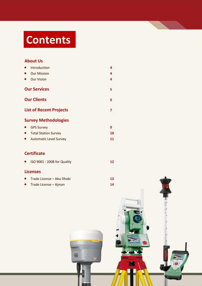
OUR SERVICES
SURVEY ENGINEERING
If you are looking for precision GPS+ control for surveying and engineering application or layout and
grade management on a construction job site(building and infrastructure), we are here with highly
trained professionals with most modern equipments and technologies to do your job more quickly &
accurate and provides following survey engineering services.
Archaeological Surveys
Condition Survey
Digital Terrain Profiling
Cadastral Surveys
Hydrographic Surveys
Land Survey & Leveling Surveys
GPS Surveys
Traffic Time Surveys
Demarcation Surveys
Setting out Surveys
Establishment of control Points
Establishment of Benchmarks
Pipeline surveys
Topographic Surveys
Building Surveys
Earthwork Volume Surveys (Cut & Fill)
Precise & Differential Leveling
Underground Utilities Survey
Road Alignment Surveys
GIS data Collection Services
Civil CAD Services
Gate Level Computation
Gate Level Fixing
Monitoring Surveys
Hiring Survey Teams
Contour Mapping
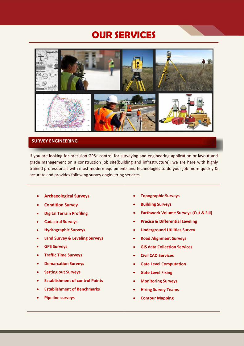
GIS SOLUTIONS & SERVICES
Government, Public utilities, and private business require GIS to be built upon accurate and complete
geospatial data that supports the multiple uses and daily operations within an enterprise. Falcon will
work as your partner to design, build, and implement a robust geospatial dataset to realize the full
potential of GIS. Falcon’s suite of products and services focus on all phases of building GIS, which
includes:
GIS Design
GIS Data Creation
GIS Implementation
GIS Data Maintenance
CALIBRATION SERVICES
With the benefit of having manufacturer trained technicians and state of the art test equipment we
can give you not only the highest level of service, but also great value for money. We are able to offer
full service, calibration and repair facilities for Survey & Laser equipment including robotic Total
Station and GPS equipment.
Our Technicians have a solid experience in servicing surveying instruments from all different
manufacturers, so if you need the job to be done correctly then we are the team for you. We have
competitive calibration rates, and also give a free quotation service for all works, including repairs,
which are helping you to check whether your damaged instrument is serviceable or not free of cost.

OUR CLIENTS

RECENT PROJECTS
Project Title Client/Consultant Scope of Work
Dubai Water Canal – Infrastructure, Package 2 – Elevating Al Wasl and Jumeira Street
China State Construction Engineering Corporation LLC
Control Network Establishment & Topographical Survey
Topographical Survey for the Industrial Stret at Industrial Area No.1 of Sharjah
Sharjah General Services Co. LLC (KHADAMT)
Topographical Survey of 7KM Road
MTC Landside Primary & Secondary Roads, Abu Dhabi
China State Construction Engineering Corporation LLC
Control Network Establishment
Remodeling & Modification of Bus stops (Al Ain) and Taxi Facilities at Abu Dhabi
Khatib & Alami GIS & Topographic survey
Traffic Calming Survey – Abu Dhabi City & Islands
International Vision for Engineering Solutions (IVES)
Traffic Survey
Five Star Hotel | Plot No.: H24(E12-C42) Saraya, Mina Road – Abu Dhabi, U.A.E
Al Futtaim Carillion Demarcation & Topographical Survey
DPDP-6009 Infrastructure works for Phase 1 Dubai Parks
Kier Dubai LLC Topographical Survey & Road Corridor Survey (8 KM)
Al-Madam, Al Dhaid, Al-Juwaiza & Al Maliha Indus. & Commercial Areas
WSP Middle East / Sharjah Town Planning (DTPS)
Topographical Survey
Survey of the hilly area132 KV Overhead Transmission Line From Fujairah Qidfa to Tayween /Dibba
Inabensa Topographic Survey
Electric Overhead Travelling Cranes at Khalifa Port Industrial Area in Taweela, Abu Dhabi
EMAL Construction Survey, As built Survey &Topographic survey
Abu Dhabi Plot Survey Project Phase II Abu Dhabi Municipality, Spatial Data Division for Navayuga
GIS & Topographic Survey
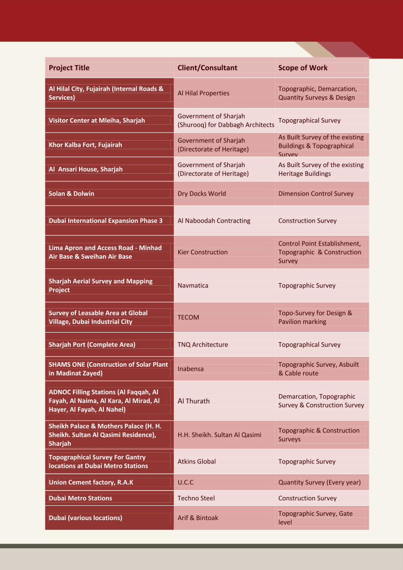
Project Title Client/Consultant Scope of Work
Al Hilal City, Fujairah (Internal Roads & Services)
Al Hilal Properties Topographic, Demarcation, Quantity Surveys & Design
Visitor Center at Mleiha, Sharjah Government of Sharjah (Shurooq) for Dabbagh Architects
Topographical Survey
Khor Kalba Fort, Fujairah Government of Sharjah (Directorate of Heritage)
As Built Survey of the existing Buildings & Topographical Survey
Al Ansari House, Sharjah Government of Sharjah (Directorate of Heritage)
As Built Survey of the existing Heritage Buildings
Solan & Dolwin Dry Docks World Dimension Control Survey
Dubai International Expansion Phase 3 Al Naboodah Contracting Construction Survey
Lima Apron and Access Road - Minhad Air Base & Sweihan Air Base
Kier Construction Control Point Establishment, Topographic & Construction Survey
Sharjah Aerial Survey and Mapping Project
Navmatica Topographic Survey
Survey of Leasable Area at Global Village, Dubai Industrial City
TECOM Topo-Survey for Design & Pavilion marking
Sharjah Port (Complete Area) TNQ Architecture Topographical Survey
SHAMS ONE (Construction of Solar Plant in Madinat Zayed)
Inabensa Topographic Survey, Asbuilt & Cable route
ADNOC Filling Stations (Al Faqqah, Al Fayah, Al Naima, Al Kara, Al Mirad, Al Hayer, Al Fayah, Al Nahel)
Al Thurath Demarcation, Topographic Survey & Construction Survey
Sheikh Palace & Mothers Palace (H. H. Sheikh. Sultan Al Qasimi Residence), Sharjah
H.H. Sheikh. Sultan Al Qasimi Topographic & Construction Surveys
Topographical Survey For Gantry locations at Dubai Metro Stations
Atkins Global Topographic Survey
Union Cement factory, R.A.K U.C.C Quantity Survey (Every year)
Dubai Metro Stations Techno Steel Construction Survey
Dubai (various locations) Arif & Bintoak Topographic Survey, Gate level
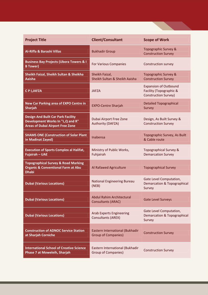
Project Title Client/Consultant Scope of Work
Al-Riffa & Barashi Villas Bukhadir Group Topographic Survey & Construction Survey
Business Bay Projects (Ubora Towers & I B Tower)
For Various Companies Construction survey
Sheikh Faizal, Sheikh Sultan & Sheikha Aaisha
Sheikh Faizal, Sheikh Sultan & Sheikh Aaisha
Topographic Survey & Construction Survey
C P I,JAFZA JAFZA Expansion of Outbound Facility (Topographic & Construction Survey)
New Car Parking area of EXPO Centre in Sharjah
EXPO-Centre Sharjah Detailed Topographical Survey
Design And Built Car Park Facility Development Works In "L,Q and R" Areas of Dubai Airport Free Zone
Dubai Airport Free Zone Authority (DAFZA)
Design, As Built Survey & Construction Survey
SHAMS ONE (Construction of Solar Plant in Madinat Zayed)
Inabensa Topographic Survey, As Built & Cable route
Execution of Sports Complex al Halifat, Fujairah – UAE
Ministry of Public Works, Fuhjairah
Topographical Survey & Demarcation Survey
Topographical Survey & Road Marking Organic & Conventional Farm at Abu Dhabi
Al Rafawed Agriculture Topographical Survey
Dubai (Various Locations) National Engineering Bureau (NEB)
Gate Level Computation, Demarcation & Topographical Survey
Dubai (Various Locations) Abdul Rahim Architectural Consultants (ARAC)
Gate Level Surveys
Dubai (Various Locations) Arab Experts Engineering Consultants (AREX)
Gate Level Computation, Demarcation & Topographical Survey
Construction of ADNOC Service Station at Sharjah Corniche
Eastern International (Bukhadir Group of Companies)
Construction Survey
International School of Creative Science Phase 7 at Moweleih, Sharjah
Eastern International (Bukhadir Group of Companies)
Construction Survey
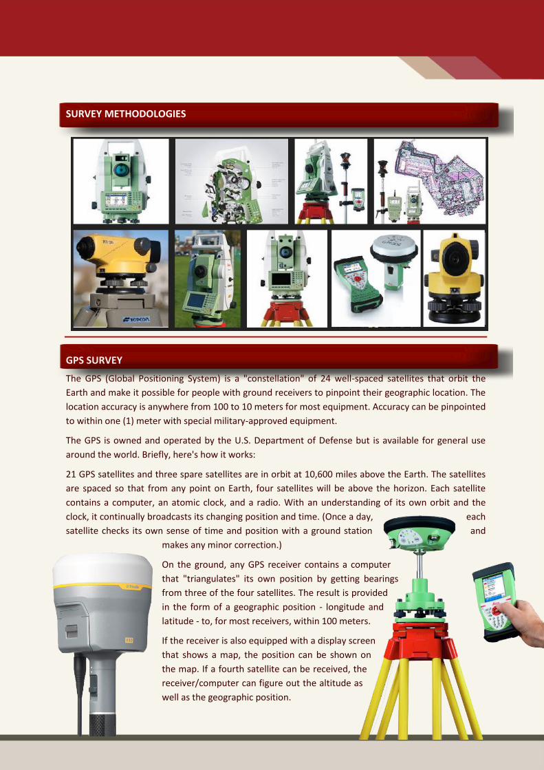
SURVEY METHODOLOGIES
GPS SURVEY
The GPS (Global Positioning System) is a "constellation" of 24 well-spaced satellites that orbit the
Earth and make it possible for people with ground receivers to pinpoint their geographic location. The
location accuracy is anywhere from 100 to 10 meters for most equipment. Accuracy can be pinpointed
to within one (1) meter with special military-approved equipment.
The GPS is owned and operated by the U.S. Department of Defense but is available for general use
around the world. Briefly, here's how it works:
21 GPS satellites and three spare satellites are in orbit at 10,600 miles above the Earth. The satellites
are spaced so that from any point on Earth, four satellites will be above the horizon. Each satellite
contains a computer, an atomic clock, and a radio. With an understanding of its own orbit and the
clock, it continually broadcasts its changing position and time. (Once a day, each
satellite checks its own sense of time and position with a ground station and
makes any minor correction.)
On the ground, any GPS receiver contains a computer
that "triangulates" its own position by getting bearings
from three of the four satellites. The result is provided
in the form of a geographic position - longitude and
latitude - to, for most receivers, within 100 meters.
If the receiver is also equipped with a display screen
that shows a map, the position can be shown on
the map. If a fourth satellite can be received, the
receiver/computer can figure out the altitude as
well as the geographic position.
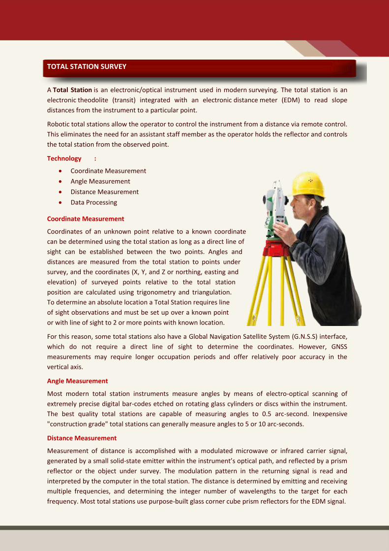
TOTAL STATION SURVEY
A Total Station is an electronic/optical instrument used in modern surveying. The total station is an
electronic theodolite (transit) integrated with an electronic distance meter (EDM) to read slope
distances from the instrument to a particular point.
Robotic total stations allow the operator to control the instrument from a distance via remote control.
This eliminates the need for an assistant staff member as the operator holds the reflector and controls
the total station from the observed point.
Technology :
Coordinate Measurement
Angle Measurement
Distance Measurement
Data Processing
Coordinate Measurement
Coordinates of an unknown point relative to a known coordinate
can be determined using the total station as long as a direct line of
sight can be established between the two points. Angles and
distances are measured from the total station to points under
survey, and the coordinates (X, Y, and Z or northing, easting and
elevation) of surveyed points relative to the total station
position are calculated using trigonometry and triangulation.
To determine an absolute location a Total Station requires line
of sight observations and must be set up over a known point
or with line of sight to 2 or more points with known location.
For this reason, some total stations also have a Global Navigation Satellite System (G.N.S.S) interface,
which do not require a direct line of sight to determine the coordinates. However, GNSS
measurements may require longer occupation periods and offer relatively poor accuracy in the
vertical axis.
Angle Measurement
Most modern total station instruments measure angles by means of electro-optical scanning of
extremely precise digital bar-codes etched on rotating glass cylinders or discs within the instrument.
The best quality total stations are capable of measuring angles to 0.5 arc-second. Inexpensive
"construction grade" total stations can generally measure angles to 5 or 10 arc-seconds.
Distance Measurement
Measurement of distance is accomplished with a modulated microwave or infrared carrier signal,
generated by a small solid-state emitter within the instrument’s optical path, and reflected by a prism
reflector or the object under survey. The modulation pattern in the returning signal is read and
interpreted by the computer in the total station. The distance is determined by emitting and receiving
multiple frequencies, and determining the integer number of wavelengths to the target for each
frequency. Most total stations use purpose-built glass corner cube prism reflectors for the EDM signal.

A typical total station can measure distances with an accuracy of about 1.5 millimeters (0.0049 ft) + 2
parts per million over a distance of up to 1,500 meters (4,900 ft).Reflector less total stations can
measure distances to any object that is reasonably light in color, to a few hundred meters.
Data Processing
Some models include internal electronic data storage to record distance, horizontal angle, and vertical
angle measured, while other models are equipped to write these measurements to an external data
collector, such as a handheld computer. When data is downloaded from a total station onto a
computer, application software can be used to compute results and generate a map of the surveyed
area.
AUTO LEVEL SURVEY
An automatic level is an optical instrument used to establish or checkpoints in the same horizontal
plane. It is used in surveying and building to transfer, measure, or set horizontal
levels.
The level instrument is set up on a tripod and, depending on the type, either
roughly or accurately set to a leveled condition using foot screws (leveling
screws). The operator looks through the eyepiece of the telescope while an
assistant holds a tape measure or graduated staff vertical at the point under
measurement. The instrument and staff are used to gather and/or transfer
elevations (levels) during site surveys or building construction. Measurement
generally starts from a benchmark with known height determined by a
previous survey, or an arbitrary point with an assumed height.
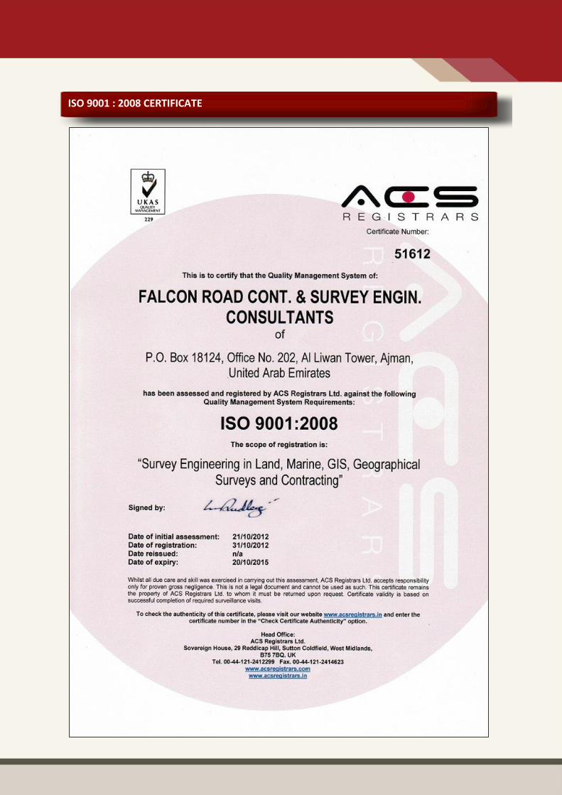
ISO 9001 : 2008 CERTIFICATE
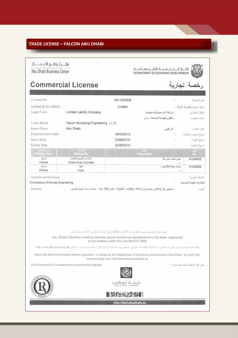
TRADE LICENSE – FALCON ABU DHABI
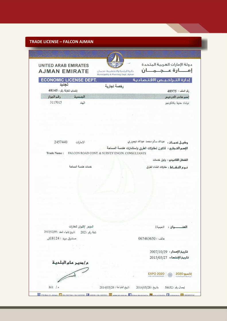
TRADE LICENSE – FALCON AJMAN