Embed Size (px)
Citation preview
Open Journal of Geology, 2013, 3, 46-49 doi:10.4236/ojg.2013.32B011 Published Online April 2013 (http://www.scirp.org/journal/ojg)
Geoelectrical Survey for Engineering Investigation
A. H. A Teh Saufia, Rosli Saad, M.M. Nordiana, I.N. Azwin, Andy A. Bery, Noer El Hidayah Ismail, Nisa’ Ali, Mark Jinmin, Y.C. Kiu, S.L. Ragu Ragava R.
Geophysics Section, School of Physics, Universiti Sains Malaysia, Penang, Malaysia Email: [email protected]
Received 2013
ABSTRACT
Water seepage erosion has been and remains one of the major engineering problems. However, most engineers will much depend on borehole data and soil test for designing and problem detection. By considering of the cost and de-structive method, selection of geoelectrical prospecting would be appropriate. Therefore, two electrical geophysical surveys were carried out in Sekolah Menengah Kebangsaan Dato’ Haji Mohd Nor, Gelugor, Pulau Pinang to map the presence of the unknown underground water sources (saturated zones) and its movement. With the total of seven resis-tivity lines parallel to each other and self potential (SP) with 5 m × 5 m gridding survey were successfully done. The resistivity result from line 1 (R1) to line 6 (R6) shows the subsurface consist of saturated zones with range between 3 m up to 10 m depth, before it reaches the R7 which is believed as the accumulation zone. Meanwhile, as for SP result it shows the water flow from higher value (north-east) towards the lower value which is mostly at the south area. In con-clusion, geoelectrical survey could assist in detecting and solving engineering problems as it proven by the result from each method. Keywords: Geoelectrical; 2D Resistivity; Self Potential; Engineering
1. Introduction
Geoelectrical survey is commonly known in environ-mental or engineering prospecting. Geophysical studies which provide nondestructive methods have recently been employed to reduce cost and numerous problems [1]. With advantages of non-invasive, low cost and fast, geophysical method always become as a primary solution in various exploration. One of the common problems engineering field would be soil erosion due to water movement either on the surface or beneath the surface. In general, soil erosion can be defined as one form of soil degradation along with soil compaction, low organic matter, loss of soil structure, poor internal drainage, salinization, and soil acidity problems. Due to the changes of the properties and behavior of the soil, therefore, it can influence both construction operations and the perform-ance of completed construction [2]. Hence, geoelectrical survey would be appropariate tool as it is most likely measured the changes of resistivity (or conductivity) which is one of the most important physical properties of the rock. In this study, the overflowing of unknown water sources at the retaining wall has created a tremendous interest. It is because it could be the factor of water seepage beneath the subsurface which could leads to landslide or soil erosion. Hence, this study is aimed to locate the unknown water source and its movement.
2. Study Area
The survey was conducted at Gelugor, Penang within SMK Dato Haji Mohd Nor Ahmad’s compound. The survey was done on the school’s field which was recently undergoing a piping reconstruction beneath it. During monitoring and observation session at this area, it pre-dictably was facing several engineering problems. With heavy and unstoppable flow of water through retaining wall which can be clearly seen from the outside of the school as well as few pools or water puddles on the field ground, it strengthen the fact that currently experience water seepage problems. Following Figure 1 is the loca-tion of the study area with survey lines.
Legend Self Potential 2D Resistivity
Figure 1. Location of the study area.
Copyright © 2013 SciRes. OJG
A. H. A. T. SAUFIA ET AL. 47
3. Methodology
Electrical prospecting uses a large variety of techniques based on some different electrical property or character-istic of materials in the Earth. In this study, two geoelec-trical methods were applied. Each of these methods has its own advantages and disadvantages. Further explana-tions can be seen in the following topics:
3.1. 2D Resistivity
Resistivity is a property possessed by all materials [3]. The 2D electrical resistivity method utilizes the knowl-edge that in soil and rock materials, the resistivity values differ sufficiently to permit the property to be used for identification purposes. A low resistivity indicates a ma-terial that readily allows the movement of electrical
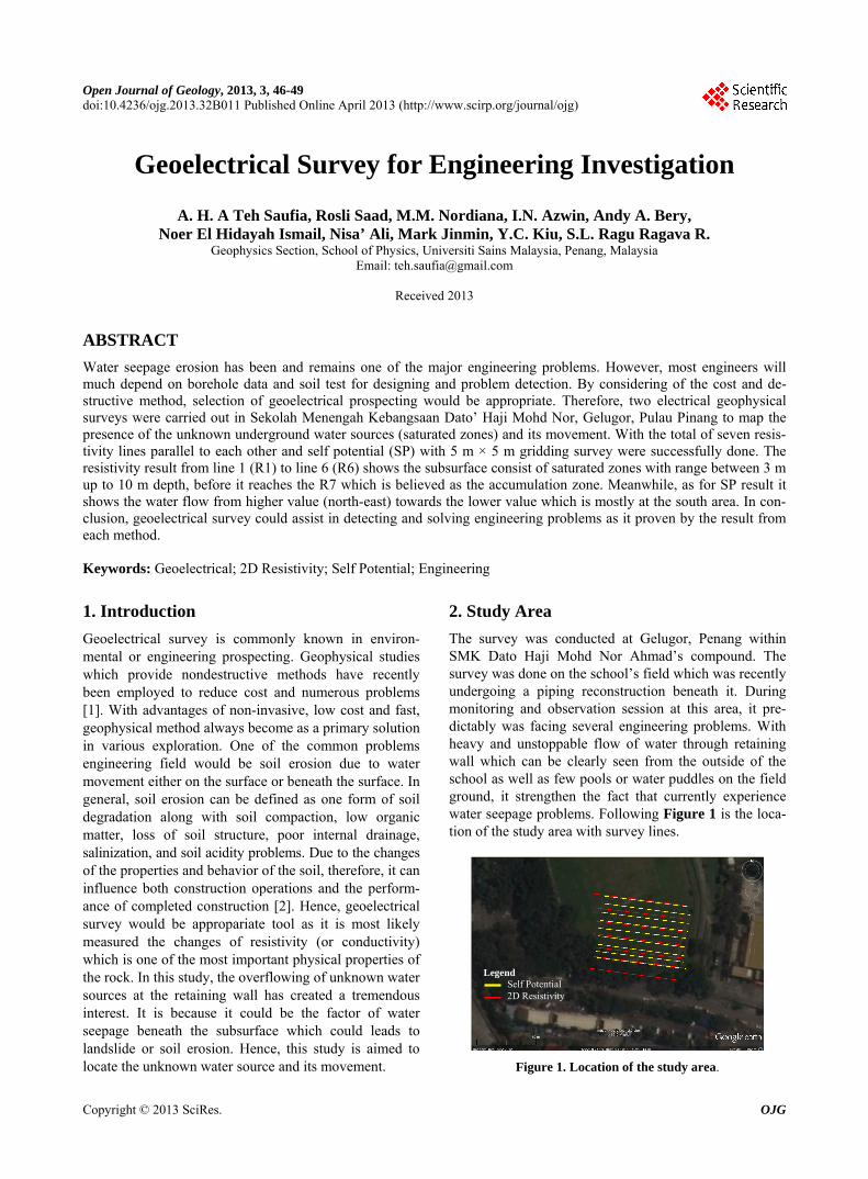
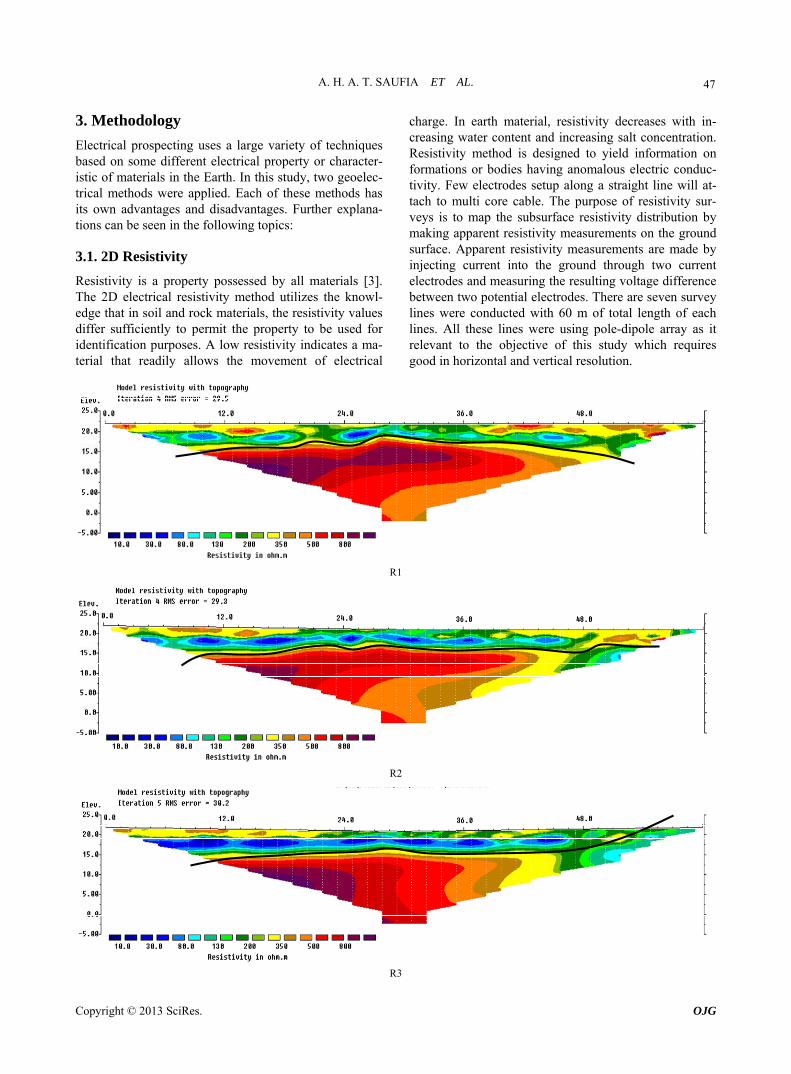
charge. In earth material, resistivity decreases with in-creasing water content and increasing salt concentration. Resistivity method is designed to yield information on formations or bodies having anomalous electric conduc-tivity. Few electrodes setup along a straight line will at-tach to multi core cable. The purpose of resistivity sur-veys is to map the subsurface resistivity distribution by making apparent resistivity measurements on the ground surface. Apparent resistivity measurements are made by injecting current into the ground through two current electrodes and measuring the resulting voltage difference between two potential electrodes. There are seven survey lines were conducted with 60 m of total length of each lines. All these lines were using pole-dipole array as it relevant to the objective of this study which requires good in horizontal and vertical resolution.
R1
R2
R3
Copyright © 2013 SciRes. OJG
A. H. A. T. SAUFIA ET AL. 48
R4
R5
R6
R7
Figure 2. Resistivity result (R1 to R7). 3.2. Self Potential
SP signals are electrical fields passively measured at the ground surface of the Earth using non-polarizing elec-trodes [4]. Self potential surveys measure the difference in potential between any two points on the ground pro-duced by small, naturally produced currents that occur beneath the Earth’s surface. This method is non-destruc-tive, fast, inexpensive, and very simple to be applying in
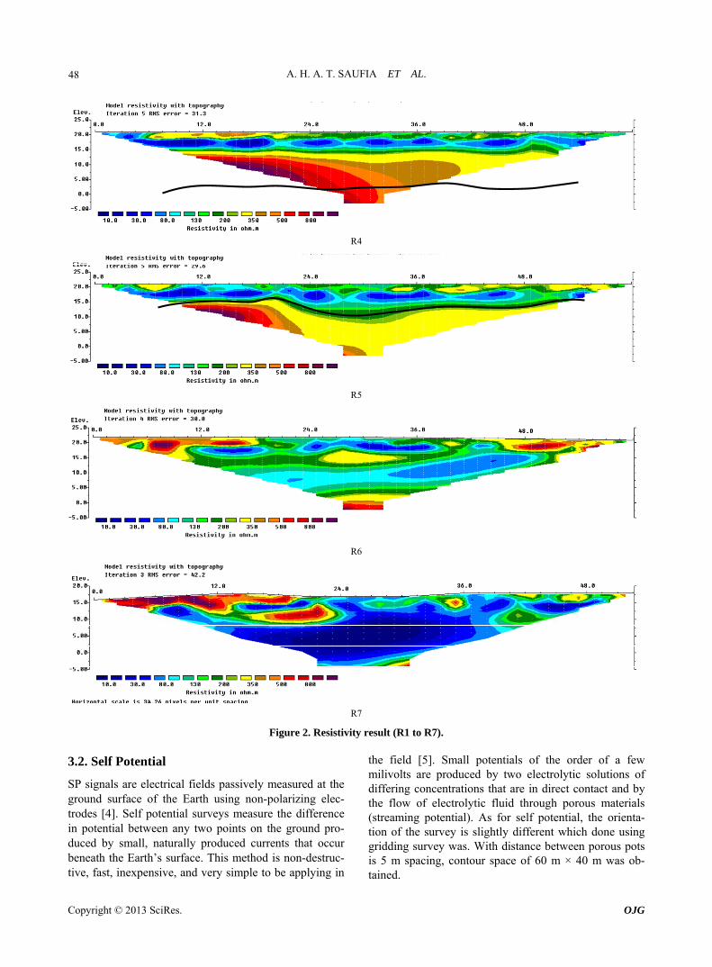
the field [5]. Small potentials of the order of a few milivolts are produced by two electrolytic solutions of differing concentrations that are in direct contact and by the flow of electrolytic fluid through porous materials (streaming potential). As for self potential, the orienta-tion of the survey is slightly different which done using gridding survey was. With distance between porous pots is 5 m spacing, contour space of 60 m × 40 m was ob-tained.
Copyright © 2013 SciRes. OJG

A. H. A. T. SAUFIA ET AL. 49
0 5 10 15 20 25 30 35 40 45 50 55 600
5
10
15
20
25
30
35
40
25
30
35
40
45
50
55
60
65
70
75
80
85
90
0 5 10 15 20 25 30 35 40 45 50 55 600
5
10
15
20
25
30
35
40
Figure 3. SP result. 4. Results & Discussion
Based on 2D resistivity results, it shows that this area can be divided into two major resistivity zones. The first zone would be at the top with resistivity value of < 80Ωm and thickness varies 3 m to 10 m depth. Therefore, it was classified as saturated zone. A higher value of re-sistivity layers which is > 80 Ωm with depth range be-tween 10 m to 35 m classified as dry and compacted zones. However it differs for R7 as it is believed to be the accumulation zone for the water before it reaches the retaining wall. As from, the SP result, it can be clearly seen from the arrow that the flow comes from the higher value (red) to lower value (blue). As in this case, the lower value indicates infiltration zone for the subsurface. These two methods correlate well with each other.
5. Conclusions
In conclusion, the aim of the research was successfully obtained. The saturated zone can be clearly defined. To-gether with the flow of the water obtained from SP result, really help in determining the source. The worrisome matter regarding water seepage is the occurrence of soil erosion which could lead major engineering problems if non-active action taken.
6. Acknowledgements
The authors would like to thank to Principal of SMK Hj. Mohd Nor Ahmad for his cooperation in giving permis-sion to do this research project in school compound. Not forgotten, to all technical staffs of Geophysics Section, Universiti Sains Malaysia and fellow colleagues for their tremendous help in the lab and during the data acquisition.
REFERENCES [1] S. Komatina and Z. Timotijevic, “Some Case Studies of
Geophysical Exploration of Archaeolgical Sites in Yugo-slavia,” Journal of Applied Geophysics, Vol. 41, No. 2-3, 1999, pp. 205-213. doi:10.1016/S0926-9851(99)00002-6
[2] D. F. McCarthy, “Essentials of Soil Mechanics and Foun-dations: Basic Geotechnics,” 7th Edition, Prentice Hall, 2007.
[3] C. Venkatramaiah, “Geotechnical Engineering,” NewAge International (P) Ltd Publishers, Delhi, 2006.
[4] A. A. Ogilvy, “Studies of Undergroundwater Movement,” Geol. Surv. Can. Rep., Vol. 26, 1967, pp. 540-543
[5] A. Revil, V. Naudet and J. D. Meunier, “The Hydroelec-tric Problem of Porous Rocks: Inversion of the Position of the Water Table from Self-Potential Data,” Geophysics Journal International, Vol. 159, 2004, pp. 435-444. doi:10.1111/j.1365-246X.2004.02422.x
Copyright © 2013 SciRes. OJG


![Geoelectrical Survey for Engineering Investigation · C. Venkatramaiah, “Geotechnical Engineering,” NewAge International (P) Ltd Publishers, Delhi, 2006. [4] A. A. Ogilvy, “Studies](https://img.pdfslide.us/doc/110x75/5ac3458d7f8b9a220b8b9661/geoelectrical-survey-for-engineering-investigation-venkatramaiah-geotechnical.jpg)