Embed Size (px)
Citation preview
no of pages attached:
prefix revisionWoods Mill, Glossop
1of 14Scheme :
Client :
ref
w3138Eden Court, Lon Parcwr, Ruthin, 01824 702220 Calculations
Lofthouse Property Ltd.
SWR ASurface Water RunoffSection :
date:
date:
N.B. These calculations are for planning purposes only and will need to be reviewed at the detailed design stage.
Deepak Kharat
Aled Williams
Angharad Llewelyn 07/08/2014
08/08/2014
08/08/2014
prepared by:
checked by:
date:approved by:
Comparison of pre-development and post-development run-off rates and volumes for greenfield or brownfield sites up to 200 Ha
Site descriptionProposed development of land at adjacent to Glossop Brook, Woods Mill, Glossop, Derbyshire.Development includes the erection of a superstore with associated car parking area, and residential builidngs with associated landscaped and hard standing areas see page SWR14.National Grid Reference (centre of site) approx. 403855E 394000N
Design BriefTo calculate both pre and post development rainfall runoff in accordance with the requirements of the Interim Code of Practice for Sustainable Drainage Systems. The peak runoff rates are to be estimated for return periods of up to 100 years and the runoff volumes are also to be calculated for a 1 in 100 year event of 6 hour duration. An allowance for climate change should be included only in the case of the post-development runoff calculation.
Documents Referenced1. Interim Code of Practice for Sustainable Drainage Systems (ICP-SUDS)(July 2004)2. I o H Report 124 - Flood Estimation for Small Catchments (Marshall & Bayliss, 1994)3. FSSR 16 runoff model - Fixed Percentage Runoff Method4. Wallingford Procedure 19815. CIRIA C697 - The SUDS Manual (Feb 2007)
Basis of estimatesThe Interim Code of Practice for Sustainable Drainage Systems (July 2004)[1] recommends the use of I o H 124[2]
for calculating peak greenfield runoff rates for sites up to 200 Ha. For site less than 50 Ha, the runoff should be calculated for 50 Ha and adjusted in proportion for the actual area. For sites greater than 200 Ha, the FEH runoff model should be used. CIRIA C697[5] recommends the use of the FSSR 16[3] runoff method for calculating the runoff volume for greenfield sites.
For brownfield sites with a recognised drainage system, the Rational Method[4] has been used to calculate the runoff for the impermeable portions of the catchment (pre- & post development). For sites without a proper drainage system, the pre-development runoff is calclulated as for a greenfield site, assuming soil type 5, regardless of type indicated on mapping.
In accordance with National Planning Policy Framework (NPPF) and assuming a 100yr projection, a 30% on peak rainfall intensity increase in rainfall / runoff has been included to allow for the climate change anticipated in the years 2085 - 2115.
Rainfall data is taken from maps in Defra / EA Tech Report W5-074/A Rev D (see page SWR10 & 11).
Standard Average Annual Rainfall and Soil classification from maps in FSR Report (see page SWR8 & 9).
File Ref: F - w3138-141125-SWR calcsForm Ref: w042-CT-04.03-F
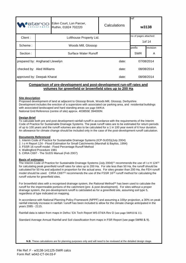
Basis of calculations
Catchment Details - input data
Proportions of soil type (from maps)
Prop S1 (fraction) ( x 0.15)Prop S2 (fraction) ( x 0.30)Prop S3 (fraction) ( x 0.40)Prop S4 (fraction) 1.000 ( x 0.45)Prop S5 (fraction) ( x 0.50)Total fraction 1.000 OK - total = 1Calculated value of SOIL 0.450Calculated value of SPR 47.000
SOIL = (0.15S1+0.3S2+0.4S3+0.45S4+0.5S5) / (S1+S2+S3+S4+S5)SPR = 10S1 + 30S2 + 37S3 + 47S4 + 53S5
Region number 10 Select from listAREA (Ha) 3.8000 (1Ha =0.01Km2)SOIL (fraction) 0.450 Calculated aboveSAAR (mm) 1150 From FSR mapsCWI 124.5 From FSR graph
20.00 From Defra / EA maps0.30 From Defra / EA maps
M100-6hr rainfall (mm) 70.00 From Defra / EA maps
Storm duration (min) 15 ( To give peak run-off-15 min for small site)
PIMP Pre-develop (%) 42.00 Provided by clientPIMP Post-develop (%) 58.00 Provided by client
Pre-dev drain system? Yes If "No", whole site assumed pervious - Soil type 5& pre-dev PIMP taken as zero in following calcs
Climate changeRainfall increase (%) 30 Based on NPPF (for years 2085 - 2115)
Applied to post development case only
N.B. These calculations are for planning purposes only and will need to be reviewed at the detailed design stage.
Calculations
Scheme :
Section :
Woods Mill, Glossop
ref :
M5-60 rainfall (mm)
w3138
prefix - page no.
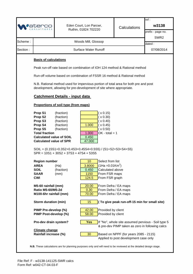
N.B. Rational method used for impervious portion of total area for both pre and post development, allowing for pre-development of site where appropriate.
dated :
07/08/2014
Eden Court, Lon Parcwr, Ruthin, 01824 702220
Ratio M5-60/M5-2d
Surface Water Runoff
Peak run-off rate based on combination of IOH 124 method & Rational method
Run-off volume based on combination of FSSR 16 method & Rational method
SWR2
File Ref: F - w3138-141125-SWR calcsForm Ref: w042-CT-04.03-F
Pre- & Post-development peak run-off - Rational Method(for impervious portions of catchment only)
Input data from sheet 2
Total area (Ha) 3.8000 from sht 2Pre dev PIMP (%) 42.00 from sht 2 Or zero if no pre-development drainagePost dev PIMP (%) 58.00 from sht 2Pre-dev Imp area (Ha) 1.5960 calculatedPost-dev Imp area (Ha) 2.2040 calculated
M5-60min rain (mm) 20.00 from sht 2Ratio "r" 0.30 from sht 2Climate change (%) 30 from sht 2Storm duration (min) 15.00 from sht 2
Rational Method
Peak run-off Qi = 2.78 Cv Cr i A
Z1 Factor from table 0.590 pro-rataVolume coeff Cv 0.75 (Typical 0.75)Routing coeff Cr 1.30 (Standard value 1.3)
Calculation
M5-Dmin rain (mm) 11.800 M5-60min * Z1 factor
Climate change factor 1.30 Applied to post-development run-off only
Return period 1 yr 30 yr 100 yrZ2 factor from table 0.614 1.531 1.939Rainfall (mm) 7.25 18.07 22.88Rainfall intensity (mm/hr) 29.0 72.3 91.5Rainfall + CC (mm) 9.43 23.49 29.74R. Intensity + CC (mm/hr) 37.7 94.0 119.0
Peak run-off rate
Pre-development Qi (l/s) 125.45 312.77 395.83
Post-development Qi(l/s) 225.22 561.55 710.90
Section : Surface Water Runoff
N.B. These calculations are for planning purposes only and will need to be reviewed at the detailed design stage.
07/08/2014
Eden Court, Lon Parcwr, Ruthin, 01824 702220 Calculations
ref :
w3138
prefix - page no.
SWR3Scheme : Woods Mill, Glossop
dated :
File Ref: F - w3138-141125-SWR calcsForm Ref: w042-CT-04.03-F
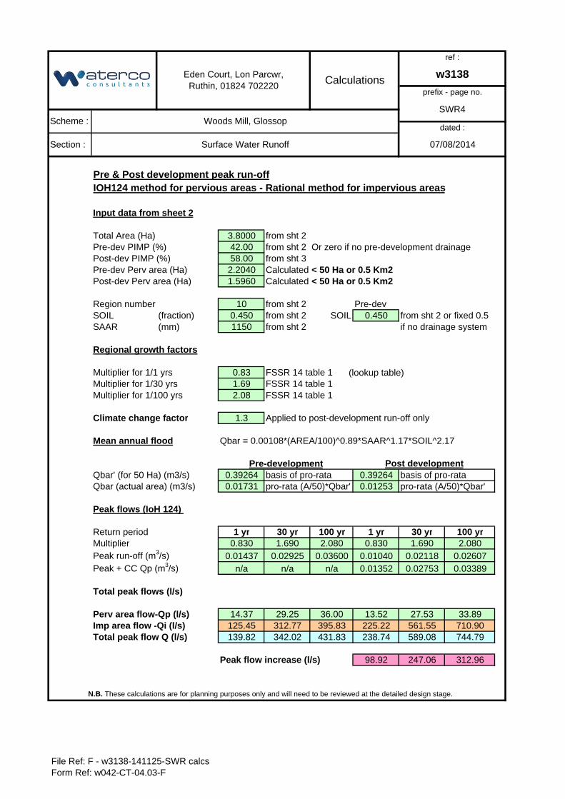
Pre & Post development peak run-offIOH124 method for pervious areas - Rational method for impervious areas
Input data from sheet 2
Total Area (Ha) 3.8000 from sht 2Pre-dev PIMP (%) 42.00 from sht 2 Or zero if no pre-development drainagePost-dev PIMP (%) 58.00 from sht 3Pre-dev Perv area (Ha) 2.2040 Calculated < 50 Ha or 0.5 Km2Post-dev Perv area (Ha) 1.5960 Calculated < 50 Ha or 0.5 Km2
Region number 10 from sht 2 Pre-devSOIL (fraction) 0.450 from sht 2 SOIL 0.450 from sht 2 or fixed 0.5SAAR (mm) 1150 from sht 2 if no drainage system
Regional growth factors
Multiplier for 1/1 yrs 0.83 FSSR 14 table 1 (lookup table)Multiplier for 1/30 yrs 1.69 FSSR 14 table 1Multiplier for 1/100 yrs 2.08 FSSR 14 table 1
Climate change factor 1.3 Applied to post-development run-off only
Mean annual flood Qbar = 0.00108*(AREA/100)^0.89*SAAR^1.17*SOIL^2.17
Qbar' (for 50 Ha) (m3/s) 0.39264 basis of pro-rata 0.39264 basis of pro-rataQbar (actual area) (m3/s) 0.01731 pro-rata (A/50)*Qbar' 0.01253 pro-rata (A/50)*Qbar'
Peak flows (IoH 124)
Return period 1 yr 30 yr 100 yr 1 yr 30 yr 100 yrMultiplier 0.830 1.690 2.080 0.830 1.690 2.080Peak run-off (m3/s) 0.01437 0.02925 0.03600 0.01040 0.02118 0.02607Peak + CC Qp (m3/s) n/a n/a n/a 0.01352 0.02753 0.03389
Total peak flows (l/s)
Perv area flow-Qp (l/s) 14.37 29.25 36.00 13.52 27.53 33.89Imp area flow -Qi (l/s) 125.45 312.77 395.83 225.22 561.55 710.90Total peak flow Q (l/s) 139.82 342.02 431.83 238.74 589.08 744.79
Peak flow increase (l/s) 98.92 247.06 312.96
Section :
Scheme :
Surface Water Runoff
N.B. These calculations are for planning purposes only and will need to be reviewed at the detailed design stage.
Pre-development Post development
07/08/2014
Calculations
Woods Mill, Glossop
Eden Court, Lon Parcwr, Ruthin, 01824 702220
w3138
ref :
prefix - page no.
SWR4
dated :
File Ref: F - w3138-141125-SWR calcsForm Ref: w042-CT-04.03-F
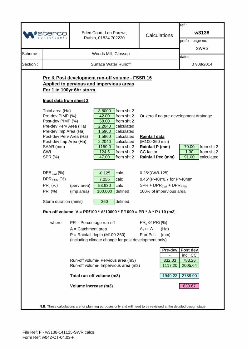
Pre & Post development run-off volume - FSSR 16Applied to pervious and impervious areasFor 1 in 100yr 6hr storm
Input data from sheet 2
3.8000 from sht 242.00 from sht 2 Or zero if no pre-development drainage58.00 from sht 22.2040 calculated
Pre-dev Imp Area (Ha) 1.5960 calculated1.5960 calculated Rainfall data2.2040 calculated1150.0 from sht 2 Rainfall P (mm) 70.00 from sht 2124.5 from sht 2 1.30 from sht 247.00 from sht 2 Rainfall Pcc (mm) 91.00 calculated
DPRCWI (%) -0.125 calc 0.25*(CWI-125)
DPRRAIN (%) 7.055 calc 0.45*(P-40)^0.7 for P>40mm
PRp (%) (perv area) 53.930 calc SPR + DPRCWI + DPRRAIN
PRi (%) (imp area) 100.000 defined 100% of impervious area
Storm duration (mins) 360 defined
Run-off volume V = PR/100 * A*10000 * P/1000 = PR * A * P / 10 (m3)
where PR = Percentage run-off PRp or PRi (%)
A = Catchment area Ap or Ai (Ha)
P = Rainfall depth (M100-360) P or Pcc (mm)(including climate change for post development only)
Pre-dev Post dev- incl CC
Run-off volume- Pervious area (m3) 832.03 783.26Run-off volume- Impervious area (m3) 1117.20 2005.64
Total run-off volume (m3) 1949.23 2788.90
Volume increase (m3) 839.67
Pre-dev PIMP (%)
Pre-dev Perv Area (Ha)
07/08/2014
Eden Court, Lon Parcwr, Ruthin, 01824 702220 Calculations
ref :
w3138
prefix - page no.
N.B. These calculations are for planning purposes only and will need to be reviewed at the detailed design stage.
Scheme : Woods Mill, Glossop
Section : Surface Water Runoff
SWR5
SPR (%)
Post-dev PIMP (%)
Post-dev Perv Area (Ha)Post-dev Imp Area (Ha)SAAR (mm)CWI
dated :
CC factor
(M100-360 min)
Total area (Ha)
File Ref: F - w3138-141125-SWR calcsForm Ref: w042-CT-04.03-F
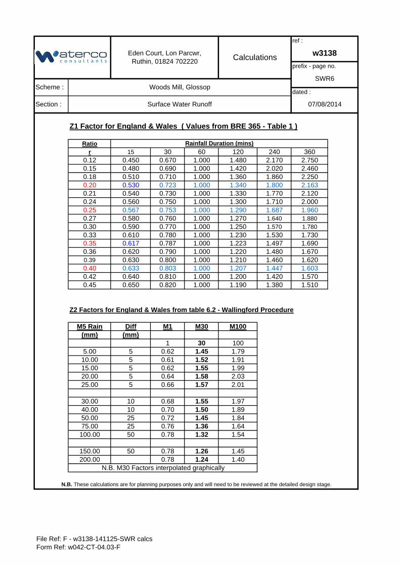
Z1 Factor for England & Wales ( Values from BRE 365 - Table 1 )
Ratior 15 30 60 120 240 360
0.12 0.450 0.670 1.000 1.480 2.170 2.7500.15 0.480 0.690 1.000 1.420 2.020 2.4600.18 0.510 0.710 1.000 1.360 1.860 2.2500.20 0.530 0.723 1.000 1.340 1.800 2.1630.21 0.540 0.730 1.000 1.330 1.770 2.1200.24 0.560 0.750 1.000 1.300 1.710 2.0000.25 0.567 0.753 1.000 1.290 1.687 1.9600.27 0.580 0.760 1.000 1.270 1.640 1.8800.30 0.590 0.770 1.000 1.250 1.570 1.7800.33 0.610 0.780 1.000 1.230 1.530 1.7300.35 0.617 0.787 1.000 1.223 1.497 1.6900.36 0.620 0.790 1.000 1.220 1.480 1.6700.39 0.630 0.800 1.000 1.210 1.460 1.6200.40 0.633 0.803 1.000 1.207 1.447 1.6030.42 0.640 0.810 1.000 1.200 1.420 1.5700.45 0.650 0.820 1.000 1.190 1.380 1.510
M5 Rain Diff M1 M30 M100(mm) (mm)
1 30 1005.00 5 0.62 1.45 1.7910.00 5 0.61 1.52 1.9115.00 5 0.62 1.55 1.9920.00 5 0.64 1.58 2.0325.00 5 0.66 1.57 2.01
30.00 10 0.68 1.55 1.9740.00 10 0.70 1.50 1.8950.00 25 0.72 1.45 1.8475.00 25 0.76 1.36 1.64100.00 50 0.78 1.32 1.54
150.00 50 0.78 1.26 1.45200.00 0.78 1.24 1.40
Eden Court, Lon Parcwr, Ruthin, 01824 702220 Calculations
ref :
w3138
prefix - page no.
SWR6Scheme : Woods Mill, Glossop
dated :
Section : Surface Water Runoff 07/08/2014
N.B. These calculations are for planning purposes only and will need to be reviewed at the detailed design stage.
Z2 Factors for England & Wales from table 6.2 - Wallingford Procedure
Rainfall Duration (mins)
N.B. M30 Factors interpolated graphically
File Ref: F - w3138-141125-SWR calcsForm Ref: w042-CT-04.03-F
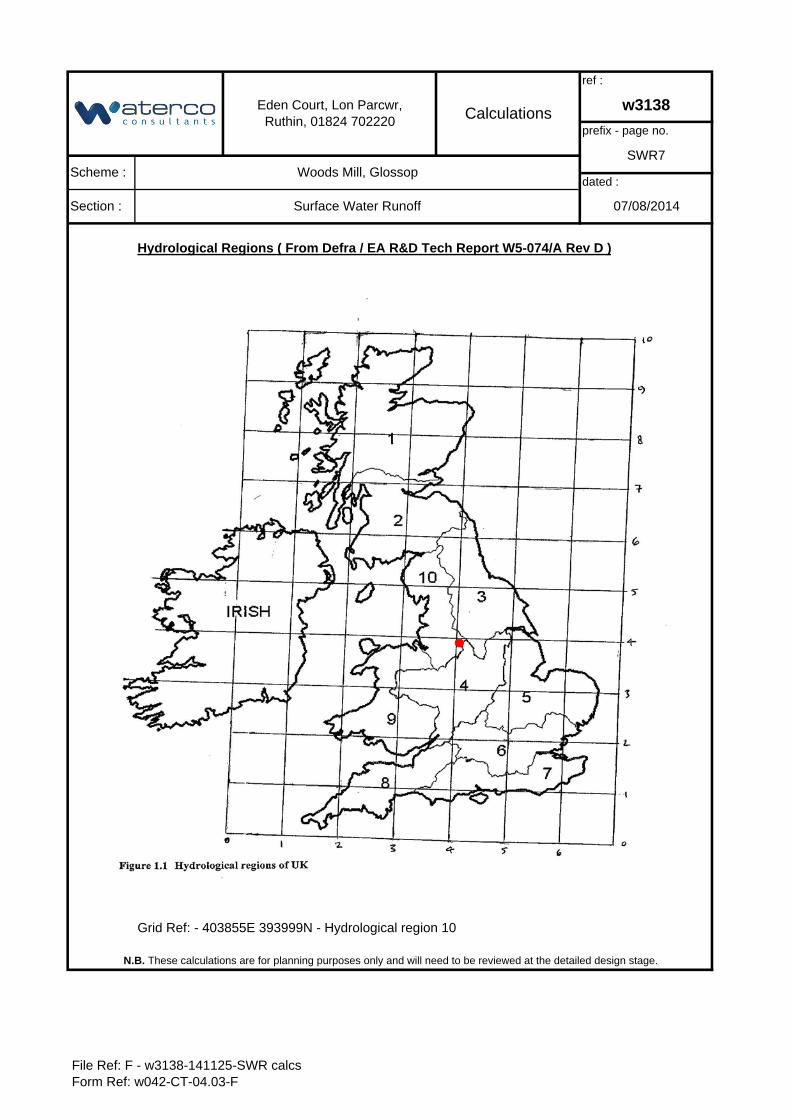
Hydrological Regions ( From Defra / EA R&D Tech Report W5-074/A Rev D )
Grid Ref: - 403855E 393999N - Hydrological region 10
prefix - page no.
SWR7
dated :
07/08/2014
N.B. These calculations are for planning purposes only and will need to be reviewed at the detailed design stage.
Eden Court, Lon Parcwr, Ruthin, 01824 702220 Calculations
ref :
w3138
Scheme : Woods Mill, Glossop
Section : Surface Water Runoff
File Ref: F - w3138-141125-SWR calcsForm Ref: w042-CT-04.03-F
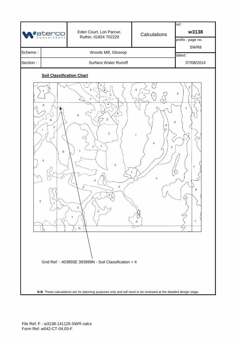
Soil Classification Chart
Grid Ref: - 403855E 393999N - Soil Classification = 4
Section : Surface Water Runoff
N.B. These calculations are for planning purposes only and will need to be reviewed at the detailed design stage.
dated :
07/08/2014
Eden Court, Lon Parcwr, Ruthin, 01824 702220 Calculations
ref :
w3138
prefix - page no.
SWR8Scheme : Woods Mill, Glossop
File Ref: F - w3138-141125-SWR calcsForm Ref: w042-CT-04.03-F
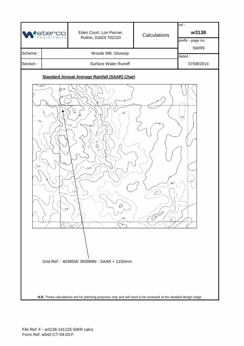
Standard Annual Average Rainfall (SAAR) Chart
Grid Ref: - 403855E 393999N - SAAR = 1150mm
prefix - page no.
SWR9
dated :
07/08/2014
N.B. These calculations are for planning purposes only and will need to be reviewed at the detailed design stage.
Eden Court, Lon Parcwr, Ruthin, 01824 702220 Calculations
ref :
w3138
Scheme : Woods Mill, Glossop
Section : Surface Water Runoff
File Ref: F - w3138-141125-SWR calcsForm Ref: w042-CT-04.03-F
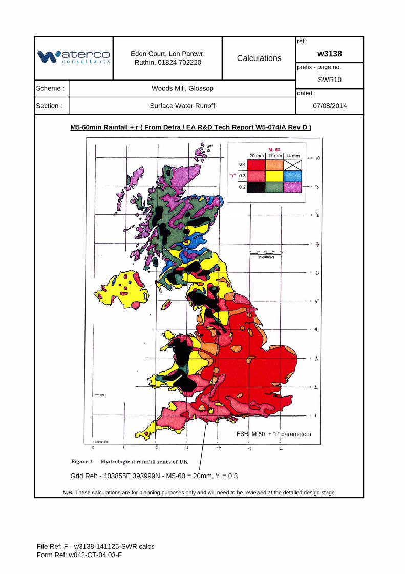
M5-60min Rainfall + r ( From Defra / EA R&D Tech Report W5-074/A Rev D )
Grid Ref: - 403855E 393999N - M5-60 = 20mm, 'r' = 0.3
prefix - page no.
SWR10
dated :
07/08/2014
N.B. These calculations are for planning purposes only and will need to be reviewed at the detailed design stage.
Eden Court, Lon Parcwr, Ruthin, 01824 702220 Calculations
ref :
w3138
Scheme : Woods Mill, Glossop
Section : Surface Water Runoff
File Ref: F - w3138-141125-SWR calcsForm Ref: w042-CT-04.03-F
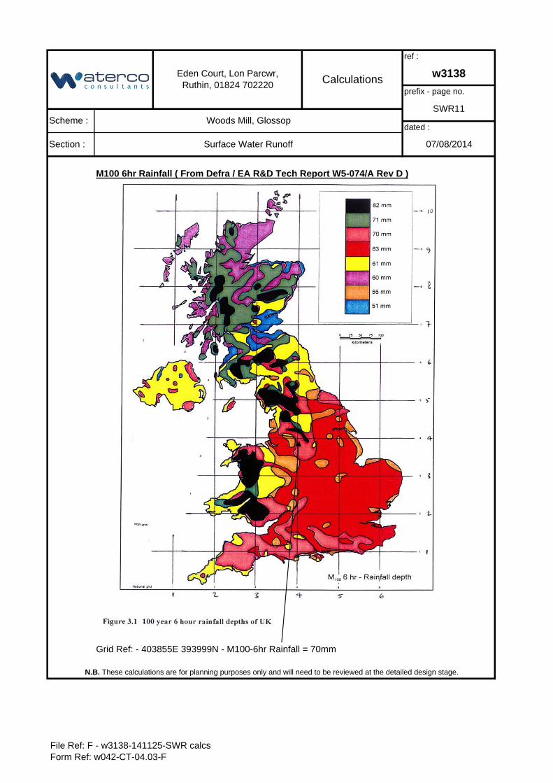
M100 6hr Rainfall ( From Defra / EA R&D Tech Report W5-074/A Rev D )
Grid Ref: - 403855E 393999N - M100-6hr Rainfall = 70mm
prefix - page no.
SWR11
dated :
07/08/2014
N.B. These calculations are for planning purposes only and will need to be reviewed at the detailed design stage.
Eden Court, Lon Parcwr, Ruthin, 01824 702220 Calculations
ref :
w3138
Scheme : Woods Mill, Glossop
Section : Surface Water Runoff
File Ref: F - w3138-141125-SWR calcsForm Ref: w042-CT-04.03-F
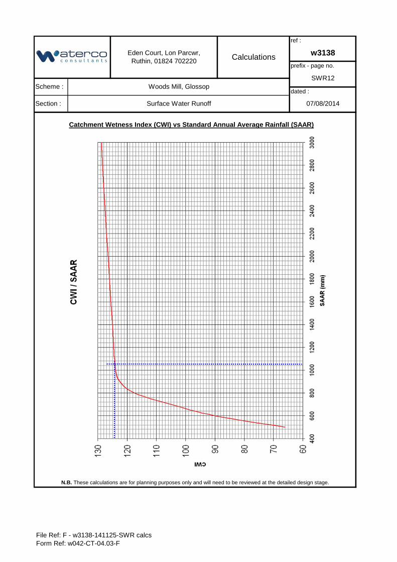
Catchment Wetness Index (CWI) vs Standard Annual Average Rainfall (SAAR)
Section : Surface Water Runoff
N.B. These calculations are for planning purposes only and will need to be reviewed at the detailed design stage.
dated :
07/08/2014
Eden Court, Lon Parcwr, Ruthin, 01824 702220 Calculations
ref :
w3138
prefix - page no.
SWR12Scheme : Woods Mill, Glossop
File Ref: F - w3138-141125-SWR calcsForm Ref: w042-CT-04.03-F
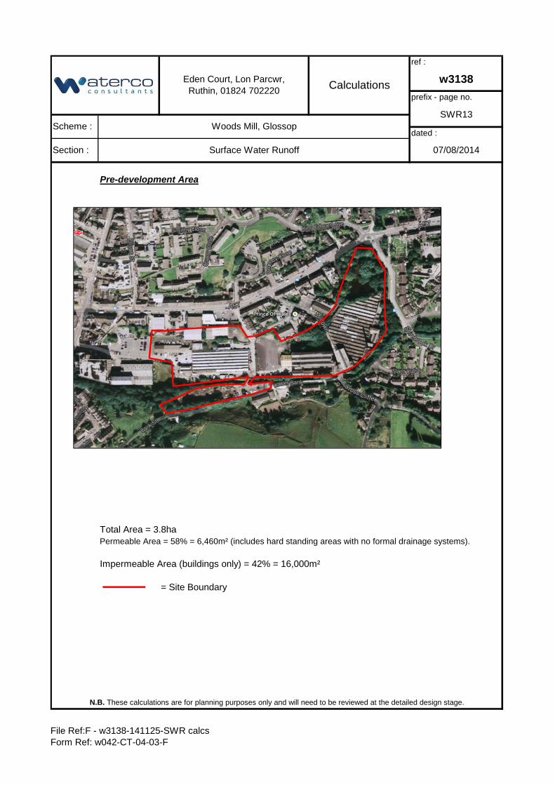
Pre-development Area
Total Area = 3.8haPermeable Area = 58% = 6,460m² (includes hard standing areas with no formal drainage systems).
Impermeable Area (buildings only) = 42% = 16,000m²
= Site Boundary
prefix - page no.
SWR13
dated :
07/08/2014
N.B. These calculations are for planning purposes only and will need to be reviewed at the detailed design stage.
Eden Court, Lon Parcwr, Ruthin, 01824 702220 Calculations
ref :
w3138
Scheme : Woods Mill, Glossop
Section : Surface Water Runoff
File Ref:F - w3138-141125-SWR calcsForm Ref: w042-CT-04-03-F
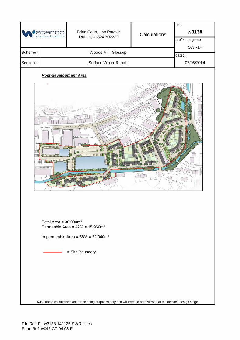
Post-development Area
Total Area = 38,000m²
Impermeable Area = 58% = 22,040m²
= Site Boundary
N.B. These calculations are for planning purposes only and will need to be reviewed at the detailed design stage.
Eden Court, Lon Parcwr, Ruthin, 01824 702220 Calculations
ref :
w3138
Scheme : Woods Mill, Glossop
Section : Surface Water Runoff
prefix - page no.
SWR14
dated :
07/08/2014
Permeable Area = 42% = 15,960m²
File Ref: F - w3138-141125-SWR calcsForm Ref: w042-CT-04.03-F
w3138
Client: Page 1 of 1
Scheme: Prefix SWS
Section: revision A
Prepared by: 19/09/2014
Checked by: 19/09/2014
Approved by: 19/09/2014
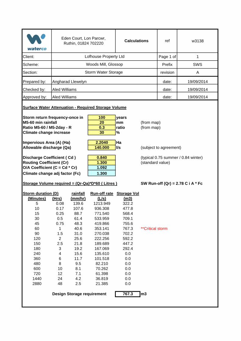
Surface Water Attenuation - Required Storage Volume
100 yearsM5-60 min rainfall 20 mm (from map)Ratio M5-60 / M5-2day - R 0.3 ratio (from map)Climate change increase 30 %
Impervious Area (A) (Ha) 2.2040 HaAllowable discharge (Qa) 140.000 l/s (subject to agreement)
Discharge Coefficient ( Cd ) 0.840 (typical 0.75 summer / 0.84 winter)Routing Coefficient (Cr) 1.300 (standard value)O/A Coefficient (C = Cd * Cr) 1.092
Climate change adj factor (Fc) 1.300
Storage Volume required = (Qr-Qa)*D*60 ( Litres ) SW Run-off (Qr) = 2.78 C i A * Fc
rainfall Run-off rate Storage Vol(Minutes) (Hrs) (mm/hr) (L/s) (m3)
5 0.08 139.6 1213.949 322.210 0.17 107.6 936.308 477.815 0.25 88.7 771.540 568.430 0.5 61.4 533.959 709.145 0.75 48.3 419.866 755.660 1 40.6 353.141 767.3 **Critical storm90 1.5 31.0 270.038 702.2120 2 25.6 222.256 592.2150 2.5 21.8 189.689 447.2180 3 19.2 167.069 292.4240 4 15.6 135.610 0.0360 6 11.7 101.518 0.0480 8 9.5 82.210 0.0600 10 8.1 70.262 0.0720 12 7.1 61.398 0.01440 24 4.2 36.819 0.02880 48 2.5 21.385 0.0
Design Storage requirement 767.3 m3
Storm duration (D)
Storm return frequency-once in
Eden Court, Lon Parcwr, Ruthin, 01824 702220
Calculations
Angharad Llewelyn date:
Aled Williams date:
Aled Williams date:
ref
Lofhouse Property Ltd
Woods Mill, Glossop
Storm Water Storage