Embed Size (px)
Citation preview
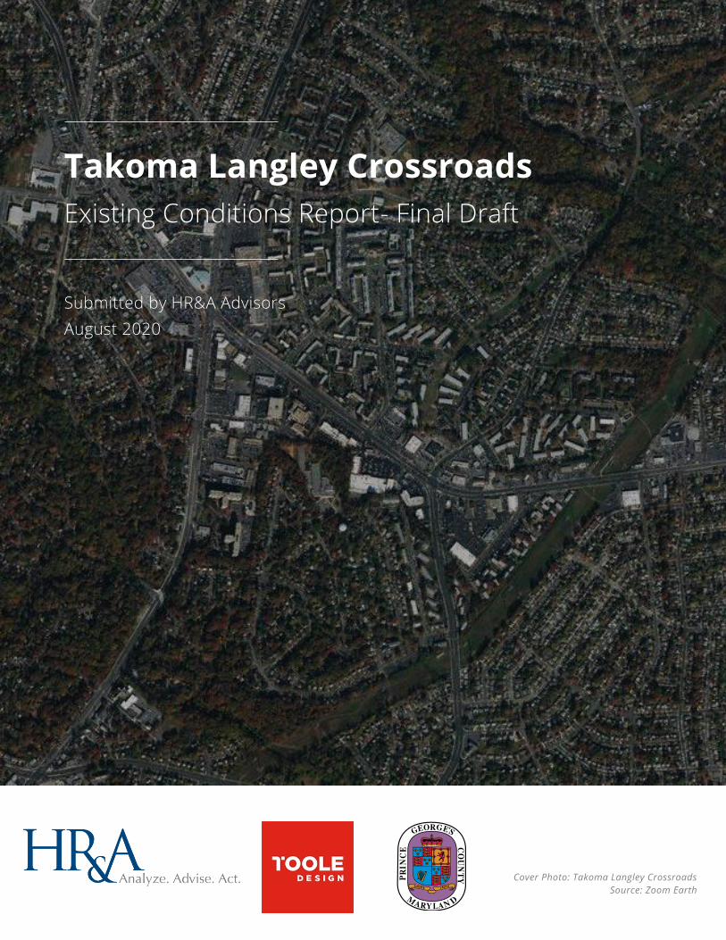
Takoma Langley Crossroads
Existing Conditions Report- Final Draft
Submitted by HR&A Advisors
August 2020
Cover Photo: Takoma Langley Crossroads
Source: Zoom Earth
Takoma Langley Crossroads Existing Conditions Report
HR&A Advisors, Inc. – Final Draft 1
1. INTRODUCTION Takoma Langley Crossroads (TLC) is a low- to mid-density area made up of socioeconomically
and ethnically diverse residential communities and multicultural retail establishments. The
area has been designated as a Local Center in Plan 2035’s Growth Policy Map. Centered around
the commercial node and transit hub at the intersection of New Hampshire Avenue and
University Boulevard, TLC extends across three jurisdictions: Prince George’s County, the City
of Takoma Park, and Montgomery County. The predominant development typology along the
central corridor is single story strip retail, with adjoining residential garden-style apartments to
the north and single-family homes to the south. Across the various uses that exist in the area,
TLC is defined by a majority foreign-born population and a dense concentration of international
and small businesses, hence its designation as Maryland’s International Corridor.
As part of the construction of the Purple Line, a new light rail line extending from Bethesda to
New Carrollton, two stations will be built within TLC along University Boulevard: one at the New
Hampshire Avenue intersection and one at the Riggs Road intersection. On October 23, 2018,
the Prince George's County Council adopted a new Zoning Ordinance that includes five Transit-
Oriented/Activity Center zones designed to realize high-intensity, mixed-use development at
transit stations, including Purple Line stations. On July 23, 2019, a Countywide Map Amendment
(CMA) was initiated to apply the zones of the new Zoning Ordinance to land in Prince George's
County so that the new Zoning Ordinance can take effect. Planning Department staff have
prepared a proposed zoning map in accordance with the Council's initiation of the CMA and
simultaneous adoption of rezoning guidance contained in the Approved Guide to New Zones.
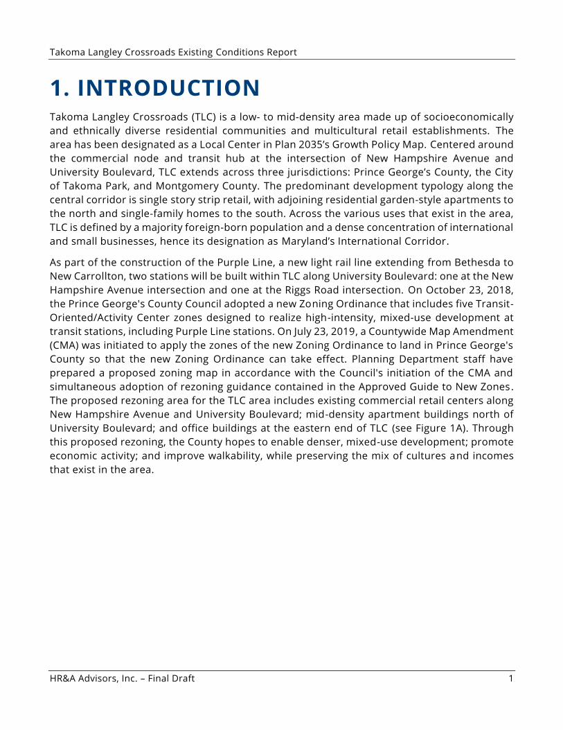
The proposed rezoning area for the TLC area includes existing commercial retail centers along
New Hampshire Avenue and University Boulevard; mid-density apartment buildings north of
University Boulevard; and office buildings at the eastern end of TLC (see Figure 1A). Through
this proposed rezoning, the County hopes to enable denser, mixed-use development; promote
economic activity; and improve walkability, while preserving the mix of cultures and incomes
that exist in the area.
Takoma Langley Crossroads Existing Conditions Report
HR&A Advisors, Inc. – Final Draft 2
1A. Staff Proposed Zoning Pursuant to Countywide Map Ame ndment
The purpose of this report is to review the existing conditions within the boundaries of the
proposed rezoning area for the TLC area under Prince George’s County proposed new Zoning
Ordinance. The following analysis leverages demographic and market data to provide insight
into current and future development opportunities and challenges within the study area. This
review of existing conditions will inform identification of actions the County can take to support
TOD and future analysis of specific parcels within TLC that represent the strongest
opportunities for adding density and new TOD to the area.
In preparing this report, HR&A and Toole Design reviewed existing multifamily and commercial
development, with a particular focus on retail; connectivity and circulation across sites; and
precedent TOD projects in the region that illustrate the types of mixed-use development that
may be feasible in TLC.
Source: Prince George’s County GIS Data, HR&A
Advisors, Inc.
Takoma Langley Crossroads Existing Conditions Report
HR&A Advisors, Inc. – Final Draft 3
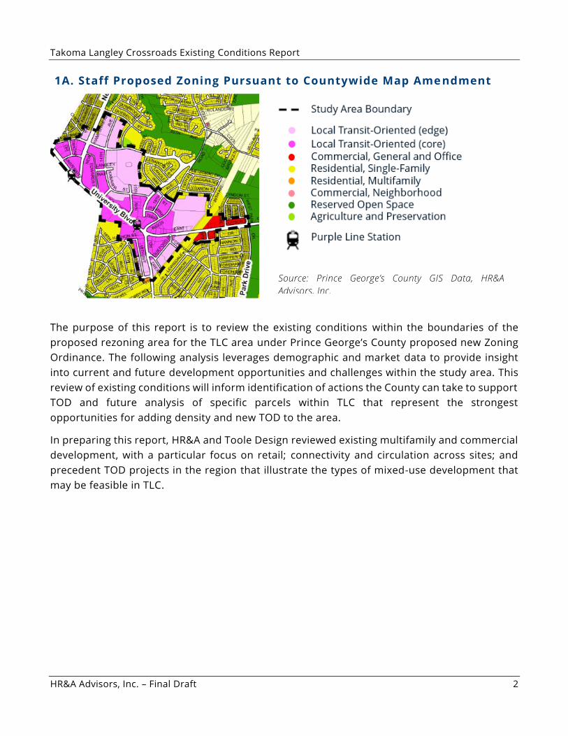
1B. Study Area Boundaries
Source: Esri, HR&A Advisors, Inc.
Takoma Langley Crossroads Existing Conditions Report
HR&A Advisors, Inc. – Final Draft 4
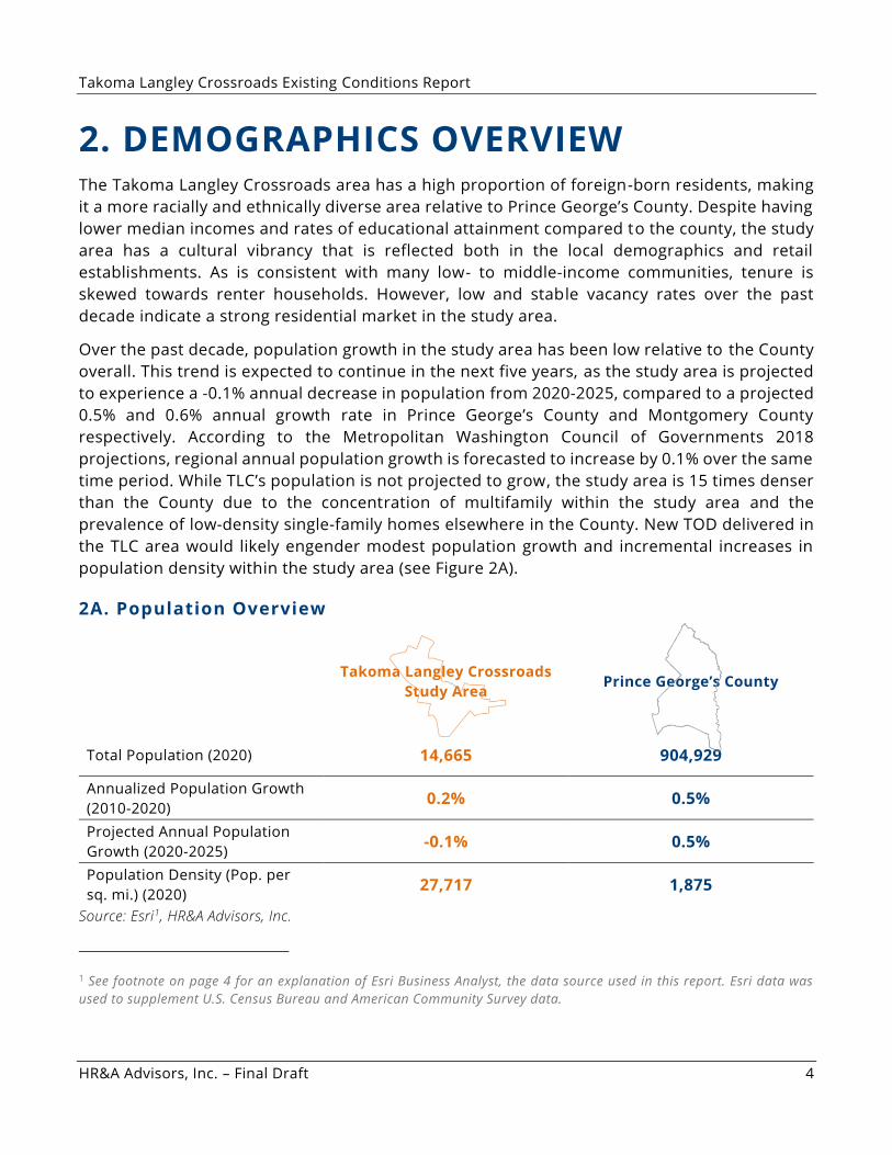
2. DEMOGRAPHICS OVERVIEW The Takoma Langley Crossroads area has a high proportion of foreign-born residents, making
it a more racially and ethnically diverse area relative to Prince George’s County. Despite having
lower median incomes and rates of educational attainment compared to the county, the study
area has a cultural vibrancy that is reflected both in the local demographics and retail
establishments. As is consistent with many low- to middle-income communities, tenure is
skewed towards renter households. However, low and stable vacancy rates over the past
decade indicate a strong residential market in the study area.
Over the past decade, population growth in the study area has been low relative to the County
overall. This trend is expected to continue in the next five years, as the study area is projected
to experience a -0.1% annual decrease in population from 2020-2025, compared to a projected
0.5% and 0.6% annual growth rate in Prince George’s County and Montgomery County
respectively. According to the Metropolitan Washington Council of Governments 2018
projections, regional annual population growth is forecasted to increase by 0.1% over the same
time period. While TLC’s population is not projected to grow, the study area is 15 times denser
than the County due to the concentration of multifamily within the study area and the
prevalence of low-density single-family homes elsewhere in the County. New TOD delivered in
the TLC area would likely engender modest population growth and incremental increases in
population density within the study area (see Figure 2A).
2A. Population Overview
Takoma Langley Crossroads
Study Area Prince George’s County
Total Population (2020) 14,665 904,929
Annualized Population Growth
(2010-2020) 0.2% 0.5%
Projected Annual Population
Growth (2020-2025) -0.1% 0.5%
Population Density (Pop. per
sq. mi.) (2020) 27,717 1,875
Source: Esri1, HR&A Advisors, Inc.
1 See footnote on page 4 for an explanation of Esri Business Analyst, the data source used in this report. Esri data was
used to supplement U.S. Census Bureau and American Community Survey data.
Takoma Langley Crossroads Existing Conditions Report
HR&A Advisors, Inc. – Final Draft 5
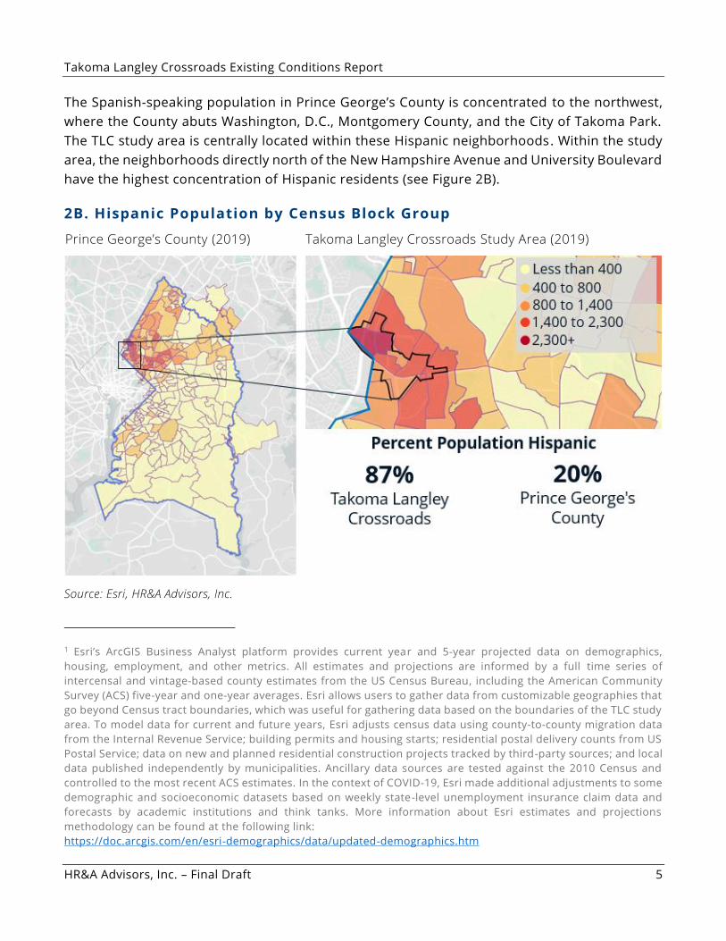
The Spanish-speaking population in Prince George’s County is concentrated to the northwest,
where the County abuts Washington, D.C., Montgomery County, and the City of Takoma Park.
The TLC study area is centrally located within these Hispanic neighborhoods. Within the study
area, the neighborhoods directly north of the New Hampshire Avenue and University Boulevard
have the highest concentration of Hispanic residents (see Figure 2B).
2B. Hispanic Population by Census Block Group
Prince George’s County (2019) Takoma Langley Crossroads Study Area (2019)
Source: Esri, HR&A Advisors, Inc.
1 Esri’s ArcGIS Business Analyst platform provides current year and 5-year projected data on demographics,
housing, employment, and other metrics. All estimates and projections are informed by a full time series of
intercensal and vintage-based county estimates from the US Census Bureau, including the American Community
Survey (ACS) five-year and one-year averages. Esri allows users to gather data from customizable geographies that
go beyond Census tract boundaries, which was useful for gathering data based on the boundaries of the TLC study
area. To model data for current and future years, Esri adjusts census data using county-to-county migration data
from the Internal Revenue Service; building permits and housing starts; residential postal delivery counts from US
Postal Service; data on new and planned residential construction projects tracked by third-party sources; and local
data published independently by municipalities. Ancillary data sources are tested against the 2010 Census and
controlled to the most recent ACS estimates. In the context of COVID-19, Esri made additional adjustments to some
demographic and socioeconomic datasets based on weekly state-level unemployment insurance claim data and
forecasts by academic institutions and think tanks. More information about Esri estimates and projections
methodology can be found at the following link:
https://doc.arcgis.com/en/esri-demographics/data/updated-demographics.htm
Takoma Langley Crossroads Existing Conditions Report
HR&A Advisors, Inc. – Final Draft 6
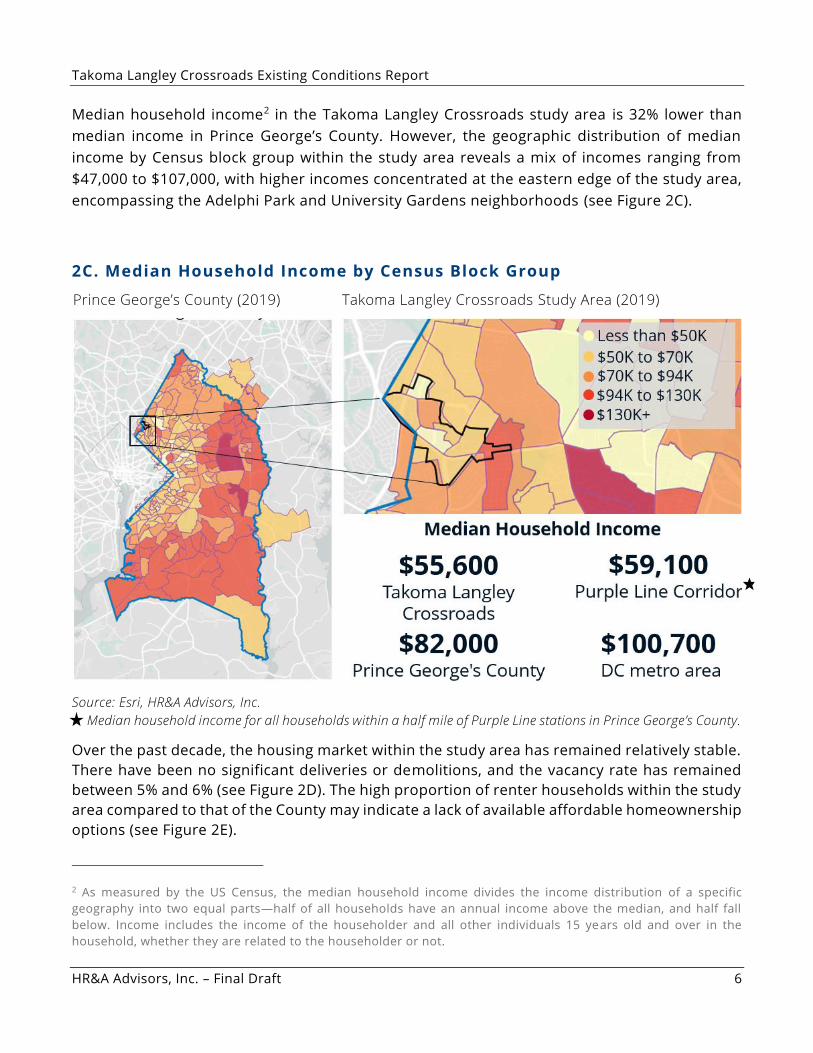
Median household income2 in the Takoma Langley Crossroads study area is 32% lower than
median income in Prince George’s County. However, the geographic distribution of median
income by Census block group within the study area reveals a mix of incomes ranging from
$47,000 to $107,000, with higher incomes concentrated at the eastern edge of the study area,
encompassing the Adelphi Park and University Gardens neighborhoods (see Figure 2C).
2C. Median Household Income by Census Block Group
Prince George’s County (2019) Takoma Langley Crossroads Study Area (2019)
Source: Esri, HR&A Advisors, Inc.
Median household income for all households within a half mile of Purple Line stations in Prince George’s County.
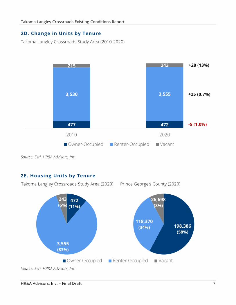
Over the past decade, the housing market within the study area has remained relatively stable.
There have been no significant deliveries or demolitions, and the vacancy rate has remained
between 5% and 6% (see Figure 2D). The high proportion of renter households within the study
area compared to that of the County may indicate a lack of available affordable homeownership
options (see Figure 2E).
2 As measured by the US Census, the median household income divides the income distribution of a specific
geography into two equal parts—half of all households have an annual income above the median, and half fall
below. Income includes the income of the householder and all other individuals 15 years old and over in the
household, whether they are related to the householder or not.
Takoma Langley Crossroads Existing Conditions Report
HR&A Advisors, Inc. – Final Draft 7
2D. Change in Units by Tenure
Takoma Langley Crossroads Study Area (2010-2020)
Source: Esri, HR&A Advisors, Inc.
2E. Housing Units by Tenure
Takoma Langley Crossroads Study Area (2020) Prince George’s County (2020)
Source: Esri, HR&A Advisors, Inc.
477 472
3,530 3,555
215 243
2010 2020
Owner-Occupied Renter-Occupied Vacant
472
(11%)
3,555
(83%)
243
(6%)
198,386
(58%)
118,370
(34%)
26,698
(8%)
-5 (1.0%)
+25 (0.7%)
+28 (13%)
Takoma Langley Crossroads Existing Conditions Report
HR&A Advisors, Inc. – Final Draft 8
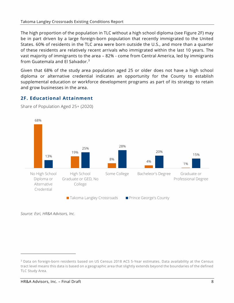
The high proportion of the population in TLC without a high school diploma (see Figure 2F) may
be in part driven by a large foreign-born population that recently immigrated to the United
States. 60% of residents in the TLC area were born outside the U.S., and more than a quarter
of these residents are relatively recent arrivals who immigrated within the last 10 years. The
vast majority of immigrants to the area – 82% - come from Central America, led by immigrants
from Guatemala and El Salvador.3
Given that 68% of the study area population aged 25 or older does not have a high school
diploma or alternative credential indicates an opportunity for the County to establish
supplemental education or workforce development programs as part of its strategy to retain
and grow businesses in the area.
2F. Educational Attainment
Share of Population Aged 25+ (2020)
Source: Esri, HR&A Advisors, Inc.
3 Data on foreign-born residents based on US Census 2018 ACS 5-Year estimates. Data availability at the Census
tract level means this data is based on a geographic area that slightly extends beyond the boundaries of the defined
TLC Study Area.
68%
19%
8%4%
1%
13%
25%28%
20%15%
No High School
Diploma or
Alternative
Credential
High School
Graduate or GED, No
College
Some College Bacheleor's Degree Graduate or
Professional Degree
Takoma Langley Crossroads Prince George's County
Takoma Langley Crossroads Existing Conditions Report
HR&A Advisors, Inc. – Final Draft 9
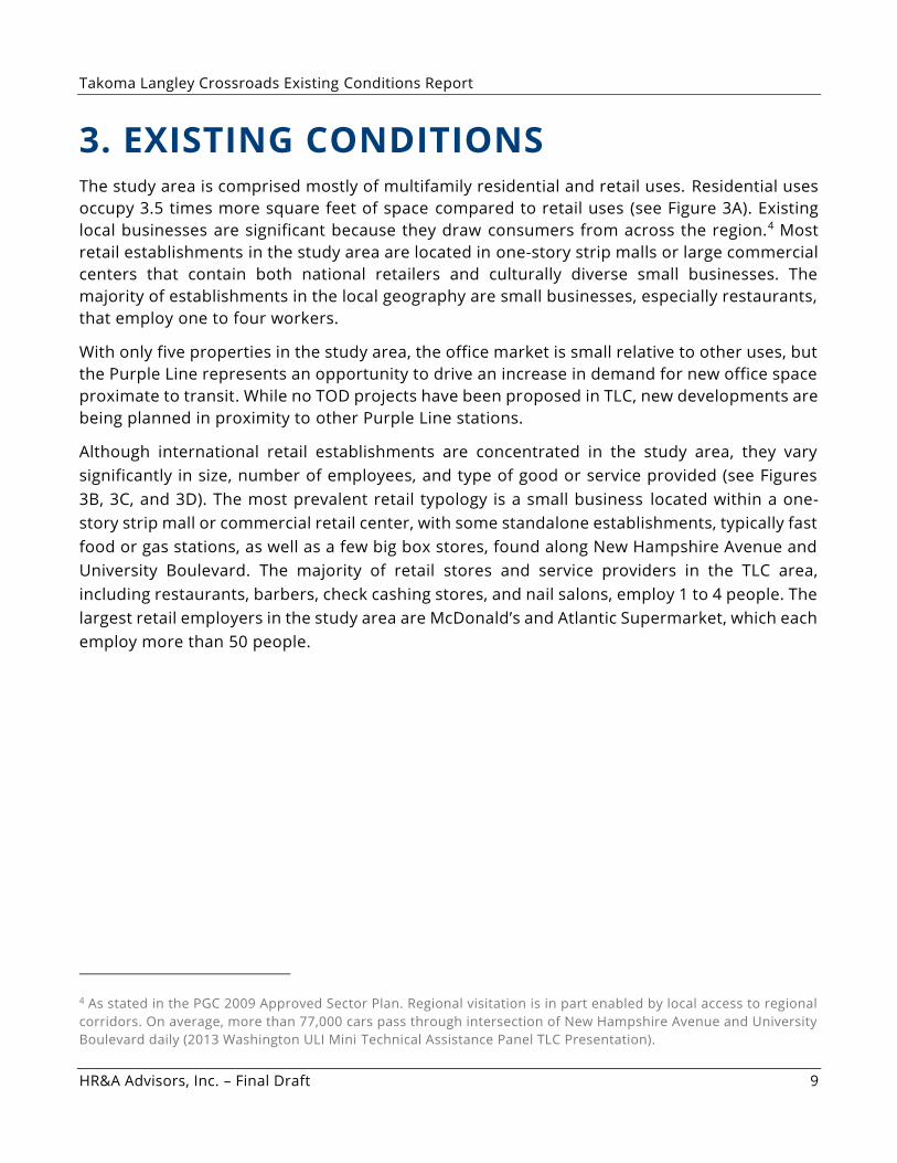
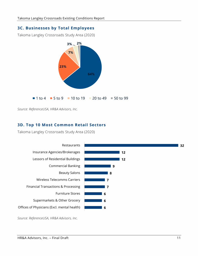
3. EXISTING CONDITIONS The study area is comprised mostly of multifamily residential and retail uses. Residential uses
occupy 3.5 times more square feet of space compared to retail uses (see Figure 3A). Existing
local businesses are significant because they draw consumers from across the region.4 Most
retail establishments in the study area are located in one-story strip malls or large commercial
centers that contain both national retailers and culturally diverse small businesses. The
majority of establishments in the local geography are small businesses, especially restaurants,
that employ one to four workers.
With only five properties in the study area, the office market is small relative to other uses, but
the Purple Line represents an opportunity to drive an increase in demand for new office space
proximate to transit. While no TOD projects have been proposed in TLC, new developments are
being planned in proximity to other Purple Line stations.
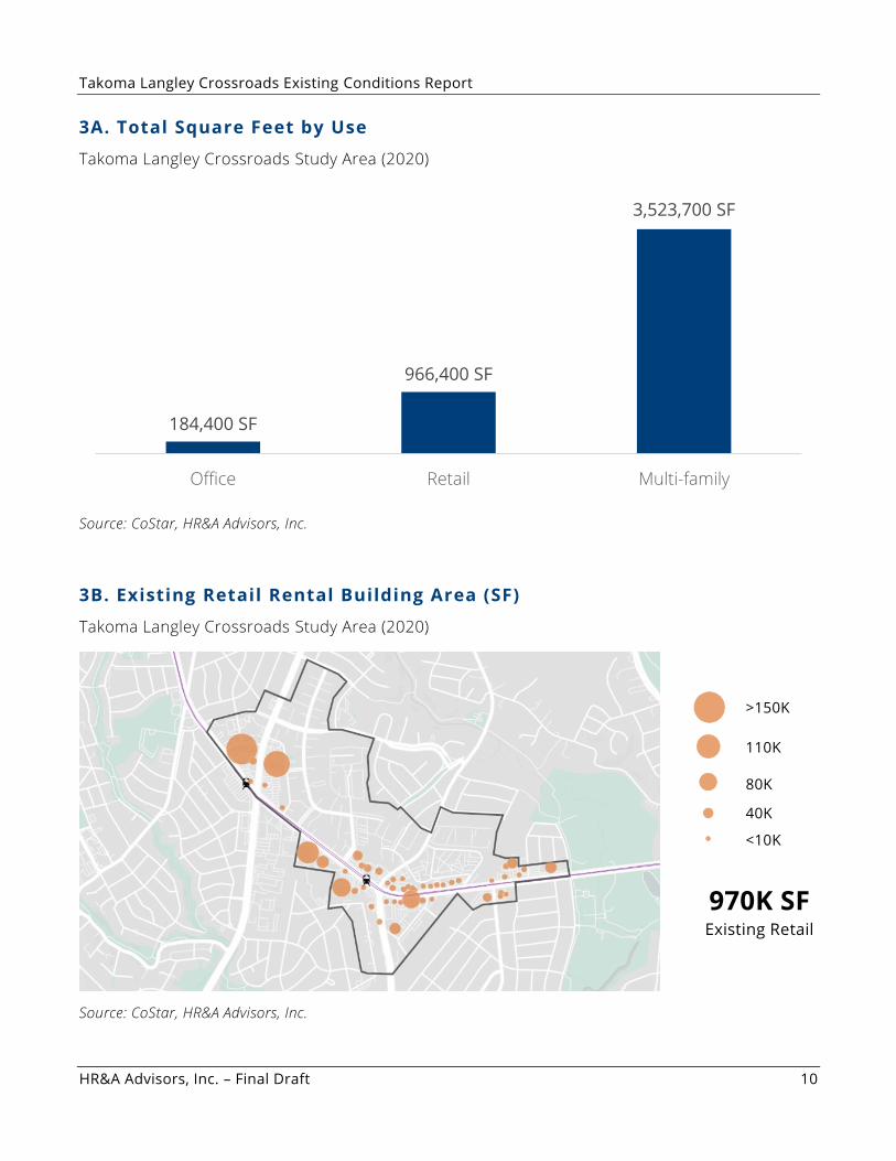
Although international retail establishments are concentrated in the study area, they vary
significantly in size, number of employees, and type of good or service provided (see Figures
3B, 3C, and 3D). The most prevalent retail typology is a small business located within a one-
story strip mall or commercial retail center, with some standalone establishments, typically fast
food or gas stations, as well as a few big box stores, found along New Hampshire Avenue and
University Boulevard. The majority of retail stores and service providers in the TLC area,
including restaurants, barbers, check cashing stores, and nail salons, employ 1 to 4 people. The
largest retail employers in the study area are McDonald’s and Atlantic Supermarket, which each
employ more than 50 people.
4 As stated in the PGC 2009 Approved Sector Plan. Regional visitation is in part enabled by local access to regional
corridors. On average, more than 77,000 cars pass through intersection of New Hampshire Avenue and University
Boulevard daily (2013 Washington ULI Mini Technical Assistance Panel TLC Presentation).
Takoma Langley Crossroads Existing Conditions Report
HR&A Advisors, Inc. – Final Draft 10
3A. Total Square Feet by Use
Takoma Langley Crossroads Study Area (2020)
Source: CoStar, HR&A Advisors, Inc.
3B. Existing Retail Rental Building Area (SF)
Takoma Langley Crossroads Study Area (2020)
Source: CoStar, HR&A Advisors, Inc.
184,400 SF
966,400 SF
3,523,700 SF
Office Retail Multi-family
970K SF Existing Retail
>150K
110K
80K
40K
<10K
Takoma Langley Crossroads Existing Conditions Report
HR&A Advisors, Inc. – Final Draft 11
3C. Businesses by Total Employees
Takoma Langley Crossroads Study Area (2020)
Source: ReferenceUSA, HR&A Advisors, Inc.
3D. Top 10 Most Common Retail Sectors
Takoma Langley Crossroads Study Area (2020)
Source: ReferenceUSA, HR&A Advisors, Inc.
64%
23%
7%
3% 2%
1 to 4 5 to 9 10 to 19 20 to 49 50 to 99
32
12
12
9
8
7
7
6
6
6
Restaurants
Insurance Agencies/Brokerages
Lessors of Residential Buildings
Commercial Banking
Beauty Salons
Wireless Telecomms Carriers
Financial Transactions & Processing
Furniture Stores
Supermarkets & Other Grocery
Offices of Physicians (Excl. mental health)
Takoma Langley Crossroads Existing Conditions Report
HR&A Advisors, Inc. – Final Draft 12
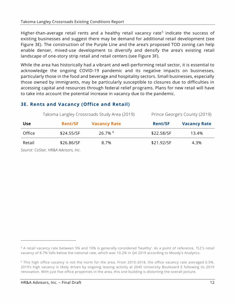
Higher-than-average retail rents and a healthy retail vacancy rate5 indicate the success of
existing businesses and suggest there may be demand for additional retail development (see
Figure 3E). The construction of the Purple Line and the area’s proposed TOD zoning can help
enable denser, mixed-use development to diversify and densify the area’s existing retail
landscape of one-story strip retail and retail centers (see Figure 3F).
While the area has historically had a vibrant and well-performing retail sector, it is essential to
acknowledge the ongoing COVID-19 pandemic and its negative impacts on businesses,
particularly those in the food and beverage and hospitality sectors. Small businesses, especially
those owned by immigrants, may be particularly susceptible to closures due to difficulties in
accessing capital and resources through federal relief programs. Plans for new retail will have
to take into account the potential increase in vacancy due to the pandemic.
3E. Rents and Vacancy (Office and Retail)
Takoma Langley Crossroads Study Area (2019) Prince George’s County (2019)
Use Rent/SF Vacancy Rate Rent/SF Vacancy Rate
Office $24.55/SF 26.7% 6 $22.58/SF 13.4%
Retail $26.86/SF 8.7% $21.92/SF 4.3%
Source: CoStar, HR&A Advisors, Inc.
5 A retail vacancy rate between 5% and 10% is generally considered ‘healthy’. As a point of reference, TLC’s retail
vacancy of 8.7% falls below the national rate, which was 10.2% in Q4 2019 according to Moody’s Analytics.
6 This high office vacancy is not the norm for the area. From 2010-2018, the office vacancy rate averaged 6.5%.
2019’s high vacancy is likely driven by ongoing leasing activity at 2045 University Boulevard E following its 2019
renovation. With just five office properties in the area, this one building is distorting the overall picture.
Takoma Langley Crossroads Existing Conditions Report
HR&A Advisors, Inc. – Final Draft 13
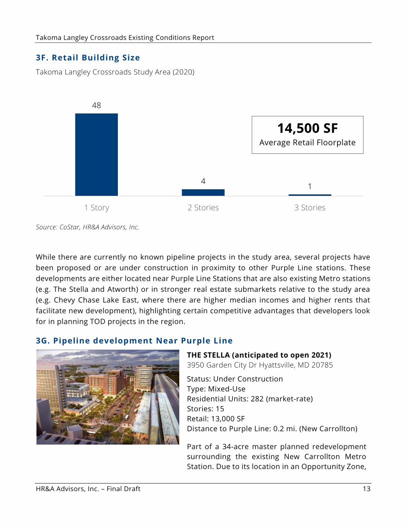
3F. Retail Building Size
Takoma Langley Crossroads Study Area (2020)
Source: CoStar, HR&A Advisors, Inc.
While there are currently no known pipeline projects in the study area, several projects have
been proposed or are under construction in proximity to other Purple Line stations. These
developments are either located near Purple Line Stations that are also existing Metro stations
(e.g. The Stella and Atworth) or in stronger real estate submarkets relative to the study area
(e.g. Chevy Chase Lake East, where there are higher median incomes and higher rents that
facilitate new development), highlighting certain competitive advantages that developers look
for in planning TOD projects in the region.
3G. Pipeline development Near Purple Line
THE STELLA (anticipated to open 2021)
3950 Garden City Dr Hyattsville, MD 20785
Status: Under Construction
Type: Mixed-Use
Residential Units: 282 (market-rate)
Stories: 15
Retail: 13,000 SF
Distance to Purple Line: 0.2 mi. (New Carrollton)
Part of a 34-acre master planned redevelopment
surrounding the existing New Carrollton Metro
Station. Due to its location in an Opportunity Zone,
48
4 1
1 Story 2 Stories 3 Stories
14,500 SF Average Retail Floorplate
Takoma Langley Crossroads Existing Conditions Report
HR&A Advisors, Inc. – Final Draft 14
the project has access to statewide incentives and
subsidies.
ATWORTH (anticipated to open 2022)
7201 River Rd College Park, MD 20740
Status: Proposed
Type: Mixed-Use
Residential Units: 451 (market-rate)
Stories: 5
Retail: 12,000 SF
Distance to Purple Line: 0.2 mi. (College Park)
Joint development project between a private
developer and Metro in proximity to the existing
College Park Metro Station.
CHEVY CHASE LAKE EAST (Phase 1 anticipated to
open 2021)
8531 Connecticut Ave Chevy Chase, MD 20815
Status: Under Construction
Type: Mixed-Use
Residential Units: 534 (market-rate)
Stories: 7
Retail: 100,000 SF
Distance to Purple Line: <0.1 mi. (Connecticut Ave)
Phase 1 of this project includes 279 apartment
units, 86,500 SF of retail, and a 685-space parking
garage.
Source: CoStar, HR&A Advisors, Inc.
Takoma Langley Crossroads Existing Conditions Report
HR&A Advisors, Inc. – Final Draft 15
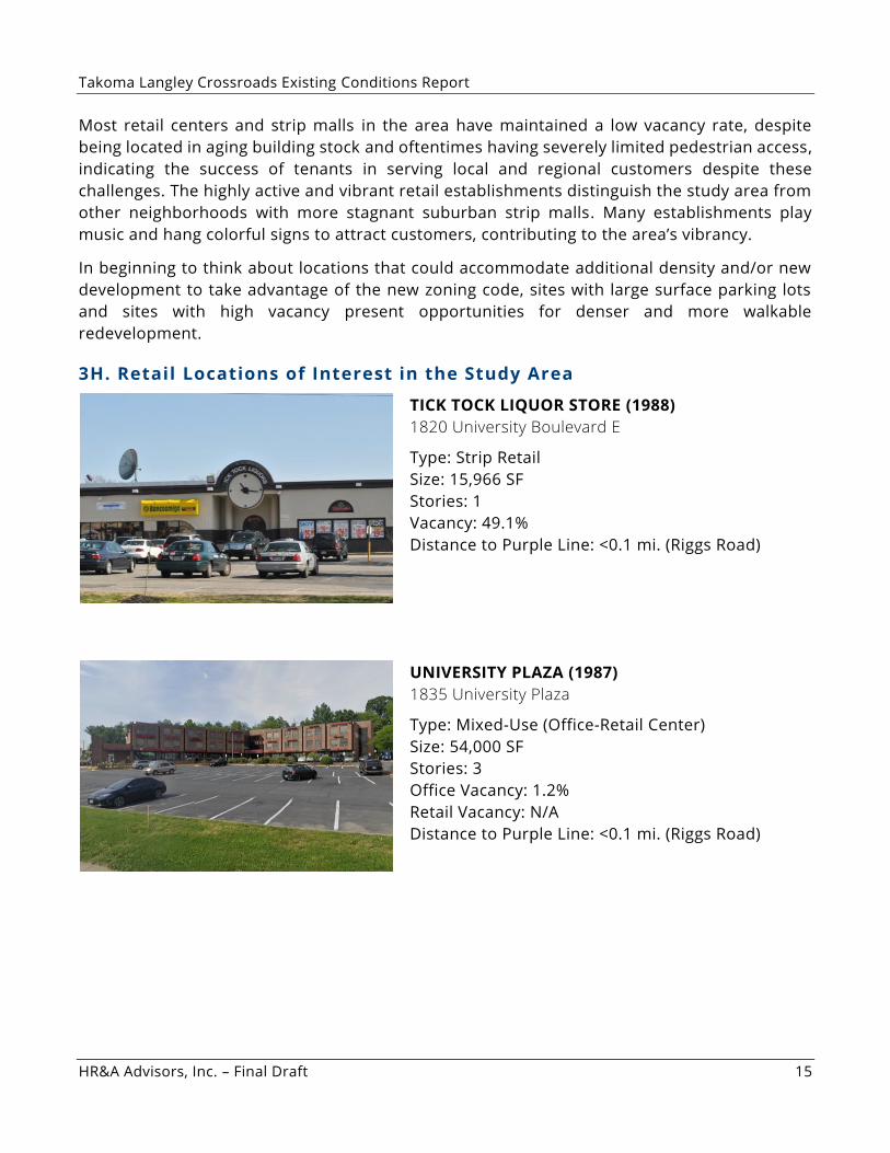
Most retail centers and strip malls in the area have maintained a low vacancy rate, despite
being located in aging building stock and oftentimes having severely limited pedestrian access,
indicating the success of tenants in serving local and regional customers despite these
challenges. The highly active and vibrant retail establishments distinguish the study area from
other neighborhoods with more stagnant suburban strip malls. Many establishments play
music and hang colorful signs to attract customers, contributing to the area’s vibrancy.
In beginning to think about locations that could accommodate additional density and/or new
development to take advantage of the new zoning code, sites with large surface parking lots
and sites with high vacancy present opportunities for denser and more walkable
redevelopment.
3H. Retail Locations of Interest in the Study Area
TICK TOCK LIQUOR STORE (1988)
1820 University Boulevard E
Type: Strip Retail
Size: 15,966 SF
Stories: 1
Vacancy: 49.1%
Distance to Purple Line: <0.1 mi. (Riggs Road)
UNIVERSITY PLAZA (1987)
1835 University Plaza
Type: Mixed-Use (Office-Retail Center)
Size: 54,000 SF
Stories: 3
Office Vacancy: 1.2%
Retail Vacancy: N/A
Distance to Purple Line: <0.1 mi. (Riggs Road)
Takoma Langley Crossroads Existing Conditions Report
HR&A Advisors, Inc. – Final Draft 16
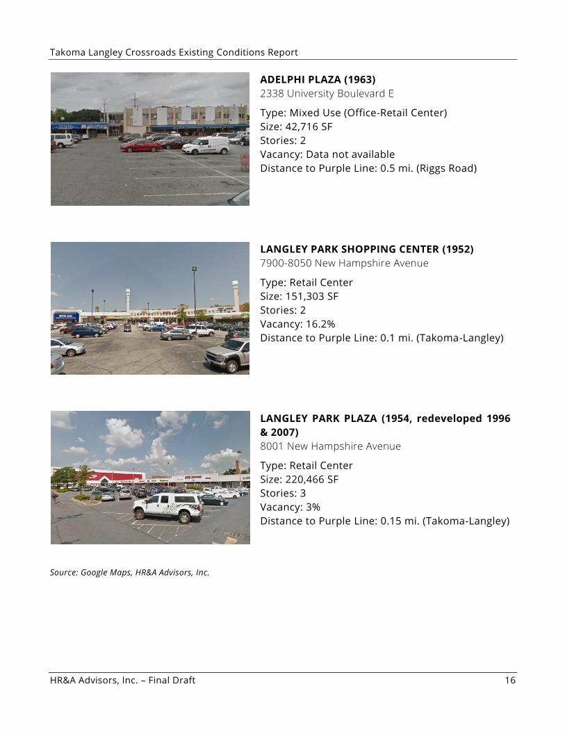
ADELPHI PLAZA (1963)
2338 University Boulevard E
Type: Mixed Use (Office-Retail Center)
Size: 42,716 SF
Stories: 2
Vacancy: Data not available
Distance to Purple Line: 0.5 mi. (Riggs Road)
LANGLEY PARK SHOPPING CENTER (1952)
7900-8050 New Hampshire Avenue
Type: Retail Center
Size: 151,303 SF
Stories: 2
Vacancy: 16.2%
Distance to Purple Line: 0.1 mi. (Takoma-Langley)
LANGLEY PARK PLAZA (1954, redeveloped 1996
& 2007)
8001 New Hampshire Avenue
Type: Retail Center
Size: 220,466 SF
Stories: 3
Vacancy: 3%
Distance to Purple Line: 0.15 mi. (Takoma-Langley)
Source: Google Maps, HR&A Advisors, Inc.
Takoma Langley Crossroads Existing Conditions Report
HR&A Advisors, Inc. – Final Draft 17
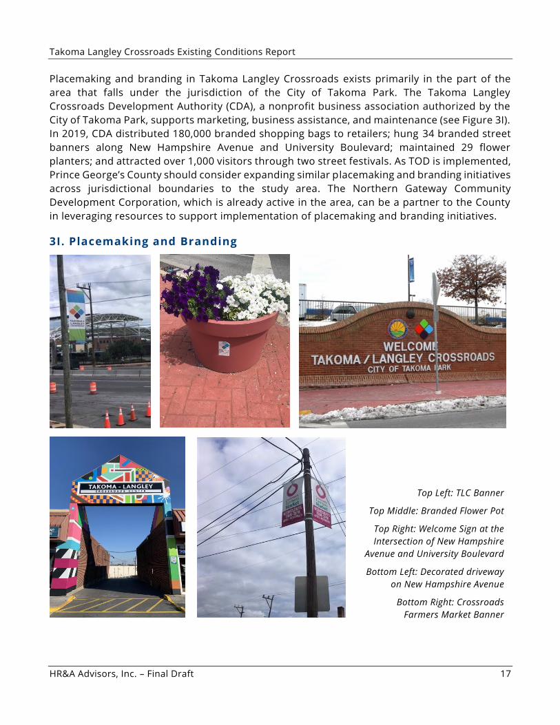
Placemaking and branding in Takoma Langley Crossroads exists primarily in the part of the
area that falls under the jurisdiction of the City of Takoma Park. The Takoma Langley
Crossroads Development Authority (CDA), a nonprofit business association authorized by the
City of Takoma Park, supports marketing, business assistance, and maintenance (see Figure 3I).
In 2019, CDA distributed 180,000 branded shopping bags to retailers; hung 34 branded street
banners along New Hampshire Avenue and University Boulevard; maintained 29 flower
planters; and attracted over 1,000 visitors through two street festivals. As TOD is implemented,
Prince George’s County should consider expanding similar p lacemaking and branding initiatives
across jurisdictional boundaries to the study area. The Northern Gateway Community
Development Corporation, which is already active in the area, can be a partner to the County
in leveraging resources to support implementation of placemaking and branding initiatives.
3I. Placemaking and Branding
Top Left: TLC Banner
Top Middle: Branded Flower Pot
Top Right: Welcome Sign at the
Intersection of New Hampshire
Avenue and University Boulevard
Bottom Left: Decorated driveway
on New Hampshire Avenue
Bottom Right: Crossroads
Farmers Market Banner
Takoma Langley Crossroads Existing Conditions Report
HR&A Advisors, Inc. – Final Draft 18
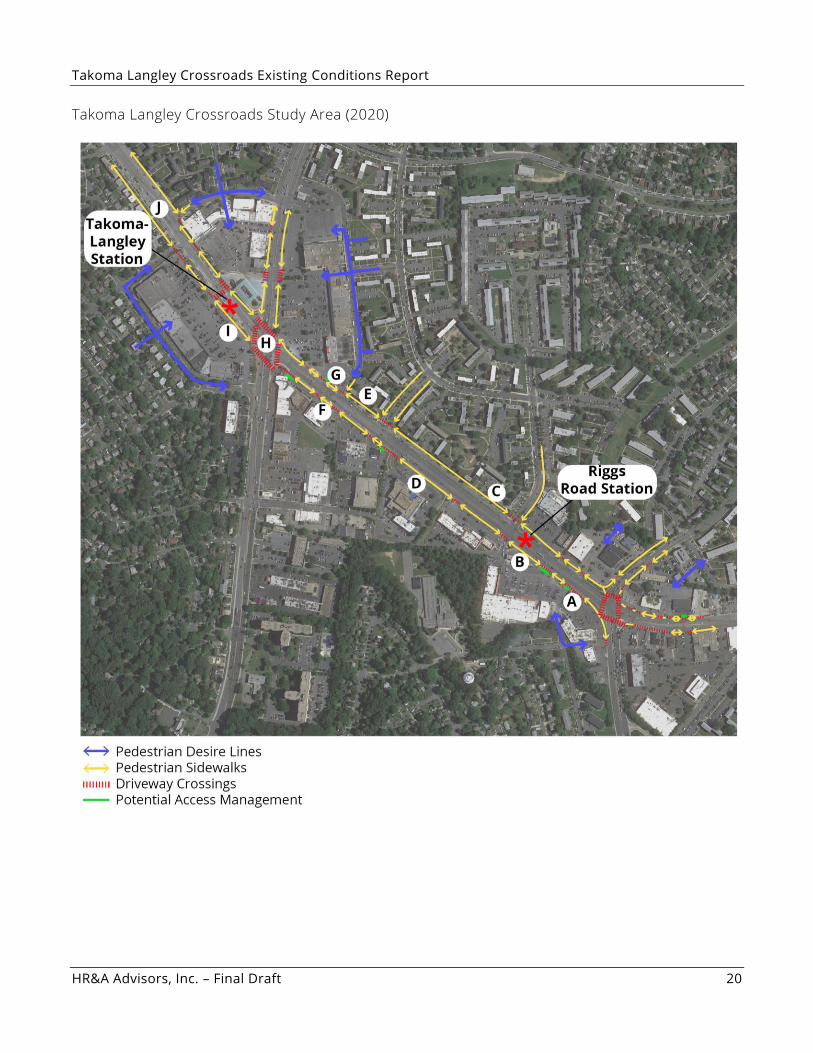
3J. Connectivity Among Sites
As identified in the 2009 Prince George’s County Takoma Langley Approved Sector Plan,
significant barriers to walkability and connectivity persist in the study area. In evaluating
existing conditions, Toole Design observed the following challenges for pedestrian walkability
and safety:
• The existing slip turn lanes at Riggs and New Hampshire lengthen the distance
pedestrians must cross at the intersection and force them to cross the street in
segments. If the signal changes before pedestrians make it across the intersection, they
must wait on slip turn islands for minutes before the signal changes back again. It can
be unsafe for pedestrians to cross accelerating traffic moving through the slip turn lanes.
• The connectivity from the neighborhoods to the sidewalks is circuitous, as the strip form
of the shopping centers create a barrier for direct routing. Many of the centers also have
berms, walls, and/or fences to restrict walking across the parking lots, which inhibits
movement from both directions. The pedestrian desire lines from the residential
neighborhoods intersect with the existing retail developments.
• Existing driveways are numerous, excessively wide, and many are designed with multiple
lanes in and out. The parking lots for various shopping centers are disconnected from
one another, which requires vehicles to rely on University Blvd to travel between retail
establishments. requires vehicles to rely on University Blvd to travel between retail
Specific insights on existing conditions to help inform future recommendations on improved
walkability and pedestrian experience include the following observations from Toole Design
(letters correspond to map on the following page):
A. The south side of University Boulevard near the Riggs Road intersection has a 5’ sidewalk
adjacent to the right turn lane without any buffer space. There are buffers located between
the sidewalk and the parking lot, which combined with the overhead utilities and lack of
trees, makes for a poor pedestrian experience. A lack of trees, overhead utilities and poles,
and narrow sidewalks are common conditions along the corridor.
B. On the southside of University, near the Wendy’s, there is an elevated berm between the
sidewalk and the parking lot and that continues up past 15th Street. Dedicated turn lanes at
15th Street and University lengthen the distance of pedestrian crossing.
C. West of 15th Street has a frontage lane on the north side with a narrow 5’ grass buffer
between University Boulevard and the lane. This creates an extra lane of asphalt to cross
when traversing University Boulevard. In addition, the transit stops are in a narrow buffer
and not wide enough for any transit shelters or facilities. The south side has a narrow 3’ grass
buffer between the curb and the sidewalk.
Takoma Langley Crossroads Existing Conditions Report
HR&A Advisors, Inc. – Final Draft 19
D. In the segment of the La Union Mall, the 3’ grass strip is not present, and the berm is much
taller. The sidewalk is right next to the curb and it feels like the pedestrians are being pushed
into the roadway. There is no sidewalk between the western entrance into La Union and the
entrance into Pollo Campero. Pedestrians walk through the grass/landscaping on a dirt path.
E. West of 14th Street has the same frontage lane condition on the north. The south has a 5’
grass buffer between the curb and the 5’ sidewalk. The crossing of the Walgreens driveway
entrance is unmarked and is designed in a way that pedestrians feel they are walking on the
edge of the outside lane, and the retaining wall in front of Walgreens makes the pedestrians
feel trapped between the traffic on University and the wall.
F. The signal/intersection at Langley Park Plaza is extremely wide on the north side because it
has a combined entrance with the Exon station and the Plaza. The north side goes back to
the 5’ grass buffer between the curb and the 5’ sidewalk, but there is a fence on the back of
the sidewalk between the parking lot and the walk, so pedestrians must walk around to get
to a destination within the Plaza.
G. The south side has the sidewalk back against the curb with no buffer.
H. The current crossing of New Hampshire Avenue and University Boulevard is over 215’. The
slip lanes and the islands significantly extend the distance of pedestrian crossing.
I. The south side of the street along the Hampshire Langley Shopping Center has a 2’ grass
strip between the curb and the 5’ sidewalk. The north side has a 5’ grass buffer next to the 5’
sidewalk.
J. After the Lebanon intersection, the frontage lane is present on both the north and south
sides but is only separated by a 1’ wide concrete curb, which is not enough to stand on or
walk along. The sidewalks are shifted back to walk between the adjacent parking along the
frontage lanes. The sidewalks are 155’ apart with parked cars, frontage lanes, and University
Boulevard between them.
Takoma Langley Crossroads Existing Conditions Report
HR&A Advisors, Inc. – Final Draft 20
Takoma Langley Crossroads Study Area (2020)
Takoma Langley Crossroads Existing Conditions Report
HR&A Advisors, Inc. – Final Draft 21
4. SWOT ANALYSIS Strengths
• Accessibility to major roadways (i.e. New Hampshire Avenue, University Boulevard, Riggs
Road) and connection to regional arterials (Capital Beltway, I -95) supports retail establishments
within the study area.
• Significant recent investments in transit infrastructure such as the Takoma Langley Crossroads
Transit Center (as recommended in the PGC 2009 Approved Sector Plan) improved transit
accessibility and promoted safe boarding/ disembarking for residents, workers, and visitors.
• Local and regional support for further transit improvements, namely the implementation of
the Purple Line in the study area (as recommended in the PGC 2009 Approved Sector Plan), will
enhance existing connectivity and allow for ease of travel from TLC throughout the region.
• Proximity to Silver Spring, White Oak, the University of Maryland, and Prince George’s Plaza
enables access to regional employment and entertainment centers.
• The socioeconomically and ethnically diverse residential population supports a concentration
of small international businesses in the study area.
• Takoma Langley Crossroads is known throughout the region for its international, vibrant
character, a reputation that is enhanced by the 2010 founding of CASA de Maryland’s
Multicultural Center in the study area (as recommended in the PGC 2009 Approved Sector Plan),
as well as the Takoma Langley Crossroads Development Authority’s (CDA) marketing,
maintenance, technical assistance, and event planning efforts within the City of Takoma Park.
Weaknesses
• Educational attainment is low in the study area relative to the County overall, which
contributes to lower household incomes.
• Major roadways (New Hampshire Avenue, University Boulevard, Riggs Road) remain heavily
congested at times, limiting the circulation of motorists and local connectivity within the study
area (as noted in the PGC 2009 Approved Sector Plan)
• Wide, multi-lane streets, slip turn lanes, curb cuts, large parking lots (and setbacks), physical
barriers (berms, walls, fences, etc.) limit walkability and bikeability in the study area,
especially along New Hampshire Avenue and University Boulevard (as noted in the PGC 2009
Approved Sector Plan).
• The lack of trees and planters, lighting, and signage further detracts from the pedestrian
experience in the study area, especially along New Hampshire Avenue and University Boulevard
(as noted in the PGC 2009 Approved Sector Plan). The County’s ongoing SPACES project will
provide recommendations for street furniture and plantings within the available right of way.
• The high percentage of renter households may indicate a lack of affordable homeownership
opportunities within the area.
• The high utilization of existing surface parking lots may limit opportunities for infill development.
Takoma Langley Crossroads Existing Conditions Report
HR&A Advisors, Inc. – Final Draft 22
Opportunities
• Support TOD and denser mixed-use development in coordination with the construction of the
Purple Line to provide affordable housing and denser retail typologies different from the
existing garden apartments and strip retail centers (as recommended in the PGC 2009 Approved
Sector Plan).
• Encourage affordable housing and retail space development to preserve the mixed-income,
multicultural character of the area (as recommended in the PGC 2009 Approved Sector Plan).
• Improve the pedestrian and bicycle experience in the study area, especially along major
corridors such as New Hampshire Avenue, University Boulevard, and Riggs Road, to allow for
multimodal access to retail establishments (as recommended in the PGC 2009 Approved Sector
Plan). Consolidating driveways; creating an access management plan; removing slip turn lanes;
improving signage and visibility; and increasing porosity through the creation of small alley streets,
walkways, and urban frontage are all interventions that can help enhance pedestrian access and
safety. The County’s new FTA grant will enable more detailed accessibility analysis, which
can support these types of accessibility improvements. Further, the County has two projects
already underway designed to improve the pedestrian and bicycle experience: a SPACES plan
focused on the existing right of way along University Blvd. between the Takoma Langley Transit
Center and the planned Adelphi Rd. transit stop; and the Northern Gateway Wayfinding and
Signage Plan to help users navigate throughout the Northern Gateway to reach transit and other
destinations.
• Develop a cohesive brand for the study area by coordinating with relevant parties in adjacent
jurisdictions (i.e. Takoma Langley Crossroads Development Authority, City of Takoma Park
Planning, Montgomery County Planning) to expand existing marketing and programming
initiatives and establish new ones (as recommended in the PGC 2009 Approved Sector Plan).
• Provide social services and community programs in partnership with PGC Health Department
and local organizations such as CASA de Maryland as part of new development, similar to the
existing PGC Health Department multi-service center location in La Union Mall.
• Redesign minor streets in the study area to allow for better internal circulation for local
motorists (as recommended in the PGC 2009 Approved Sector Plan).
• Retain small businesses through local partnerships with nearby community development
organizations, banks, brokers, and collegiate institutions.
• Redevelop underutilized spaces, especially surface parking lots and building facades, to
provide amenities such as open plazas, common seating, shared signage, and cultural event
programming to attract new businesses and support existing businesses. In the short-term,
temporary adaptive reuse strategies such as pop-up retail and/or open space, farmer’s markets,
and festivals may be feasible (as recommended in the 2013 ULI Mini Technical Assistance Panel
TLC Presentation).
• Establish a formal space for existing street vendors, who are predominately women, to help
them expand their business and promote an authentic experience for visitors to the area.
Potential interventions could include a commercial kitchen with space for vending, an open-air
food market, or kiosks.
Takoma Langley Crossroads Existing Conditions Report
HR&A Advisors, Inc. – Final Draft 23
Threats
• TOD around the new Purple Line could lead to gentrification and the loss of cultural identity
in the study area. An influx of affluent residents and higher end businesses may detract from the
rich and diverse culture that exists in TLC (as noted in the PGC 2009 Approved Sector Plan).
• Existing foreign-born, low-income households and small international businesses may be
especially vulnerable to displacement as a result of Purple Line-related redevelopment
pressures, which also may result in a loss of TLC’s distinct mixed-use and multicultural character
(as noted in the PGC 2009 Approved Sector Plan).
• New, denser development projects in the study area may increase traffic on already-
congested streets.
• A lack of pedestrian and bike access along major corridors may impede connectivity within
the study area and safe access to public transit (as noted in the PGC 2009 Approved Sector
Plan).
• TLC residents and businesses may be especially vulnerable to the negative health and
economic impacts of COVID-19, including poor access to health services, depressed consumer
confidence, and increased unemployment.
• Lack of formal education and workforce and business development training may limit the
ability of local residents and businesses to adjust to a changing neighborhood.
Takoma Langley Crossroads Existing Conditions Report
HR&A Advisors, Inc. – Final Draft 24
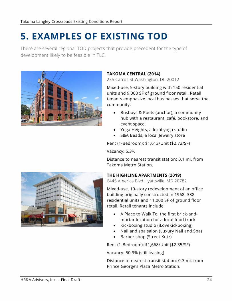
5. EXAMPLES OF EXISTING TOD There are several regional TOD projects that provide precedent for the type of
development likely to be feasible in TLC.
TAKOMA CENTRAL (2014)
235 Carroll St Washington, DC 20012
Mixed-use, 5-story building with 150 residential
units and 9,000 SF of ground floor retail. Retail
tenants emphasize local businesses that serve the
community:
• Busboys & Poets (anchor), a community
hub with a restaurant, café, bookstore, and
event space.
• Yoga Heights, a local yoga studio
• S&A Beads, a local Jewelry store
Rent (1-Bedroom): $1,613/Unit ($2.72/SF)
Vacancy: 5.3%
Distance to nearest transit station: 0.1 mi. from
Takoma Metro Station.
THE HIGHLINE APARTMENTS (2019)
6445 America Blvd Hyattsville, MD 20782
Mixed-use, 10-story redevelopment of an office
building originally constructed in 1968. 338
residential units and 11,000 SF of ground floor
retail. Retail tenants include:
• A Place to Walk To, the first brick-and-
mortar location for a local food truck
• Kickboxing studio (iLoveKickboxing)
• Nail and spa salon (Luxury Nail and Spa)
• Barber shop (Street Kutz)
Rent (1-Bedroom): $1,668/Unit ($2.35/SF)
Vacancy: 50.9% (still leasing)
Distance to nearest transit station: 0.3 mi. from
Prince George’s Plaza Metro Station.
Takoma Langley Crossroads Existing Conditions Report
HR&A Advisors, Inc. – Final Draft 25
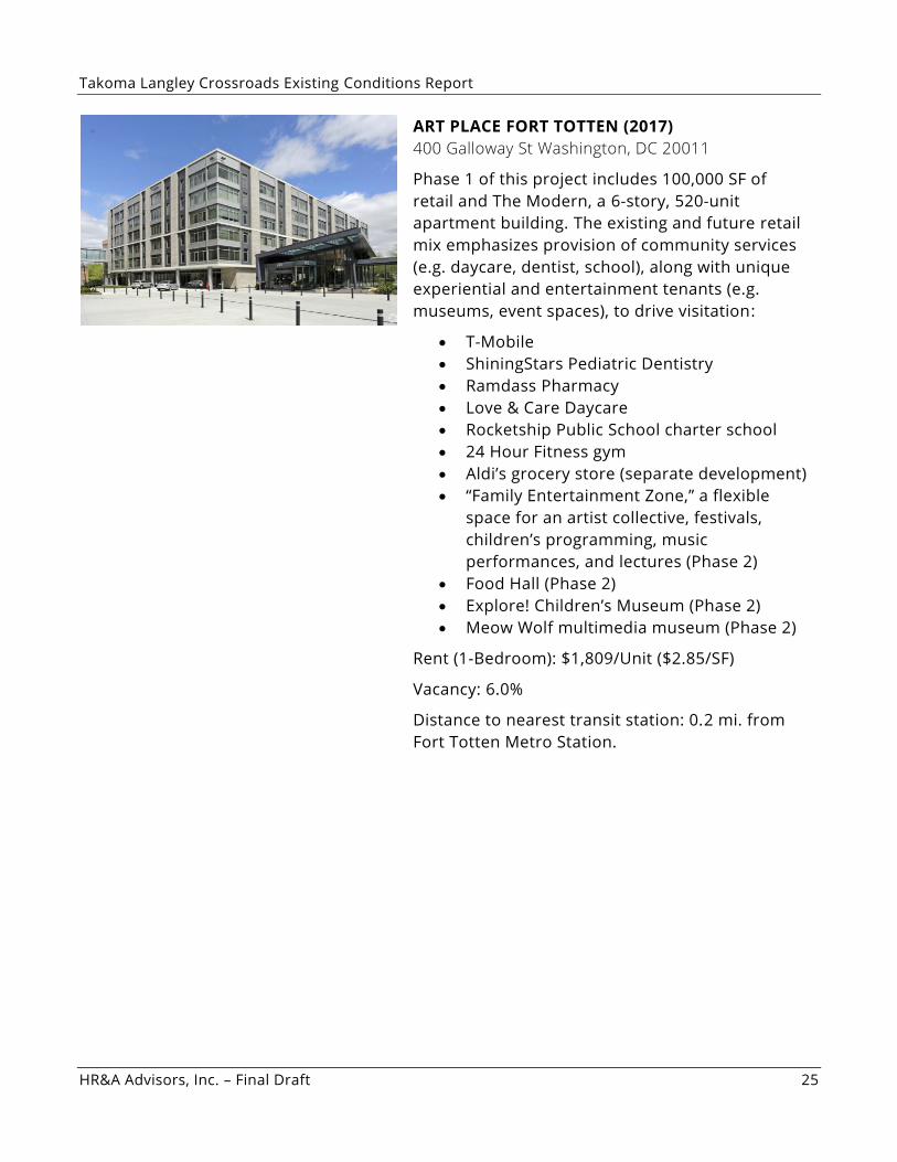
ART PLACE FORT TOTTEN (2017)
400 Galloway St Washington, DC 20011
Phase 1 of this project includes 100,000 SF of
retail and The Modern, a 6-story, 520-unit
apartment building. The existing and future retail
mix emphasizes provision of community services
(e.g. daycare, dentist, school), along with unique
experiential and entertainment tenants (e.g.
museums, event spaces), to drive visitation:
• T-Mobile
• ShiningStars Pediatric Dentistry
• Ramdass Pharmacy
• Love & Care Daycare
• Rocketship Public School charter school
• 24 Hour Fitness gym
• Aldi’s grocery store (separate development)
• “Family Entertainment Zone,” a flexible
space for an artist collective, festivals,
children’s programming, music
performances, and lectures (Phase 2)
• Food Hall (Phase 2)
• Explore! Children’s Museum (Phase 2)
• Meow Wolf multimedia museum (Phase 2)
Rent (1-Bedroom): $1,809/Unit ($2.85/SF)
Vacancy: 6.0%
Distance to nearest transit station: 0.2 mi. from
Fort Totten Metro Station.