Embed Size (px)
Citation preview
Volcano Heights Sector Development Plan - August 2012 April 2013 - LUPZ DRAFT
DRAFT
DRAFT
A-1
Appendix APre-exist ing Condit ions
Volcano Heights Sector Development Plan - August 2012 April 2013 - LUPZ DRAFT
DRAFT
A-2
Appendix A. Pre-existing ConditionsAPPendix
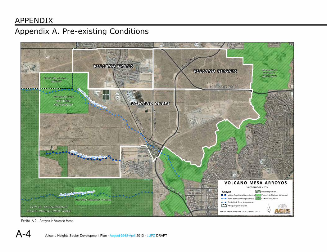
A. Environment and Open Space Volcano Heights lies between publicly owned lands preserving the volcanic Escarpment to the east and lands protecting the volcanoes and geologic windows to the west. (See Exhibit A.1.) Arroyos generally run west to east between these features. (See Exhibit A.2.)
Volcano Heights provides a unique portal into New Mexico’s rich interplay of cultures. Most Albuquerque residents recognize the Monument as an important asset and associate it with the five volcanic cones and the 17-mile Escarpment containing petroglyphs.
There are more than 20,000 petroglyphs dating between 700 to 3,000 years ago carved here and in other places within the Petroglyph National Monument. A 2002 National Park Service ethnographic study — “That Place People Talk About: The Petroglyph National Monument, Ethnographic Landscape Report,” by Anschuetz, et al. (hereinafter referred to as “Ethnographic Landscape Report”) — illuminates the still active religious and cultural value these sacred places hold for many Native Americans.
This rich document explores the meaning of the West Mesa volcanic area for Pueblo and other Native American and Hispanic people. Because of space limitations, the present document approaches the meaning of the West Mesa area from the Rio Grande Pueblos’ perspective; for other perspectives, the reader is encouraged to read the entire Ethnographic Landscape Report.
The legal boundaries of the Petroglyph National Monument were constrained by the financial resources available at the time for land acquisition. For the Pueblos, the important areas include the entire lava bed, the volcanoes’ caves and shafts, the petroglyphs,
and additional features of comparable importance in meaning and use. The Ethnographic Landscape Report states, “Land-use planning in the face of development, to be successful, needs to consider how to sustain extant landscape traditions within an ongoing historical process” (Anschuetz 2002: 3.31, 9.9).
1. PetroglyphsAccording to the Ethnographic Landscape Report, the petroglyphs focus Pueblo people’s concentration and prayer. Not just representations of specific animals or people, the images are used to transmit thought, energy, and learning across space and time into other dimensions within a defined and bounded world.
As Celestino Gachupin of Zia Pueblo said, “The petroglyphs... belong to all of us now, not only the native people....The individual family that has a home that abuts the Monument... you are our eyes and ears now, as far as ensuring that nothing bad happens to the place.”
2. Shrines, Caves, Lava Tubes in Volcanoes, Recesses in the Escarpment Face, and ElsewhereVarious other West Mesa sites function with the petroglyphs as in interlocking system of spiritual communication. The lava tubes and caves near two northernmost Volcanoes west of the Plan area contained shell beads, pendants, turquoise, hematite, selenite, mica, colored pebbles, prayer sticks, and feathers. These are places “where the world breathes” and prayers are directed. Arrangements of stones, boulders with pecked ground facets, stone piles, prominent bounders, recesses in the Escarpment, or rock spires are similarly meaningful (Anschuetz 2002: 3.24-25).

Volcano Heights Sector Development Plan - August 2012 April 2013 - LUPZ DRAFT
DRAFT
DRAFT
A-3
Appendix A. Pre-existing ConditionsAPPendix
4.84
mile
s
4.53
mile
s
4.01 m
iles
3.30 miles
3.12 miles
UNSER
PASEO DEL NORTE
PIEDRASMARCADAS
CANYON
VOLCANO HEIGHTS PLAN BOUNDARY
PETROGLYPH NATIONAL MONUMENT
CABQ OPEN SPACE
ESCARPMENT´
Path: Q:\AGISFILE\PROJECTS\PetraMorris\THG-Nov11-VolcanoHeights\December2012\VH_views.mxdExhibit A.1 – Volcano Heights, Volcanoes, and Petroglyph National Mounument
Volcano Heights Sector Development Plan - August 2012 April 2013 - LUPZ DRAFT
DRAFT
A-4
Appendix A. Pre-existing ConditionsAPPendix
#####
##
#######
###
#######
#######
#####
######
!!
!
!!
!
!
!
"""
"
"
""
"""""""
"
"""
"""""
""
!
!!
!!
!!
!
!
!!!
!
!!!
!
!!
!!!
!
!
!
!!!!!!
!!!!
!!
!!
!!!!!
!
!
!
!!
!
!
!!
!!
!!
!
!!!!!!!!!!!!!!!!!
!!
!!
!!
!!!!
!!
!
!
!
!
!!!
!!
UNSER BLVD
South Fork Boca Negra Arroyo
North Fork Boca Negra Arroyo
Middle Fork Boca Negra Arroyo
Mar
iposa
Dive
rsion
Cha
nnel
PASEO DE L NO RT E
MONTANO RD
U N S ER BLVD
UN
IVER
SE B
LVDRA IN
BOW
BLVD
´AERIAL PHOTOGRAPHY DATE: SPRING 2012
VO L C A N O M E S A A R R OYO SSeptember 2012
§̈¦4 0Path: Q:\AGISFILE\PROJECTS\PetraMorris\THG-Nov11-VolcanoHeights\December2012\VCPlanArroyos.mxd
CITY O F ALBU QUE RQU EMAJOR PU BL IC O PEN S PAC E
PET RO GLY PHNAT ION AL
MON UME N T
PETR OG LYPHNAT IO NAL
M ON U M EN T
SOU T H ER N G EO LO G I C WI ND OW
NORT HE R N G EO LO G ICWI ND OW
BOCA NEGRA PA RK
Arroyos" " Middle Fork Boca Negra Arroyo
! ! North Fork Boca Negra Arroyo
# # South Fork Boca Negra Arroyo
Albuquerque City Limit
Boca Negra Park
Petroglyph National Monument
CABQ Open Space
VO LCA N O CLIF FS
VO LCA N O TRAI LSVO LCA N O HE IGH TS
Exhibit A.2 – Arroyos in Volcano Mesa
Volcano Heights Sector Development Plan - August 2012 April 2013 - LUPZ DRAFT
DRAFT
DRAFT
A-5
Appendix A. Pre-existing ConditionsAPPendix
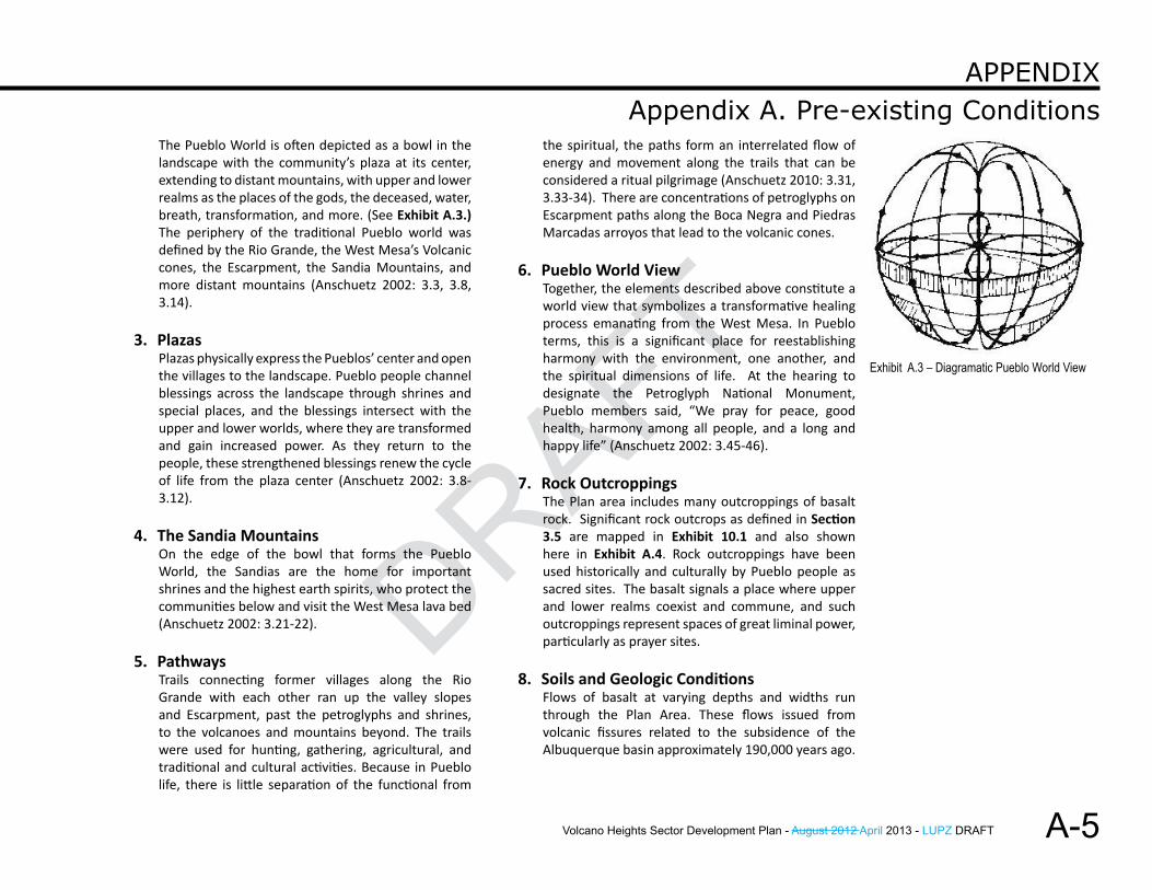
The Pueblo World is often depicted as a bowl in the landscape with the community’s plaza at its center, extending to distant mountains, with upper and lower realms as the places of the gods, the deceased, water, breath, transformation, and more. (See Exhibit A.3.) The periphery of the traditional Pueblo world was defined by the Rio Grande, the West Mesa’s Volcanic cones, the Escarpment, the Sandia Mountains, and more distant mountains (Anschuetz 2002: 3.3, 3.8, 3.14).
3. PlazasPlazas physically express the Pueblos’ center and open the villages to the landscape. Pueblo people channel blessings across the landscape through shrines and special places, and the blessings intersect with the upper and lower worlds, where they are transformed and gain increased power. As they return to the people, these strengthened blessings renew the cycle of life from the plaza center (Anschuetz 2002: 3.8-3.12).
4. The Sandia MountainsOn the edge of the bowl that forms the Pueblo World, the Sandias are the home for important shrines and the highest earth spirits, who protect the communities below and visit the West Mesa lava bed (Anschuetz 2002: 3.21-22).
5. PathwaysTrails connecting former villages along the Rio Grande with each other ran up the valley slopes and Escarpment, past the petroglyphs and shrines, to the volcanoes and mountains beyond. The trails were used for hunting, gathering, agricultural, and traditional and cultural activities. Because in Pueblo life, there is little separation of the functional from
the spiritual, the paths form an interrelated flow of energy and movement along the trails that can be considered a ritual pilgrimage (Anschuetz 2010: 3.31, 3.33-34). There are concentrations of petroglyphs on Escarpment paths along the Boca Negra and Piedras Marcadas arroyos that lead to the volcanic cones.
6. Pueblo World ViewTogether, the elements described above constitute a world view that symbolizes a transformative healing process emanating from the West Mesa. In Pueblo terms, this is a significant place for reestablishing harmony with the environment, one another, and the spiritual dimensions of life. At the hearing to designate the Petroglyph National Monument, Pueblo members said, “We pray for peace, good health, harmony among all people, and a long and happy life” (Anschuetz 2002: 3.45-46).
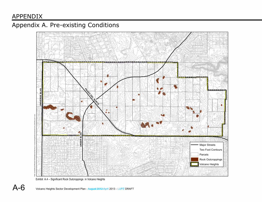
7. Rock OutcroppingsThe Plan area includes many outcroppings of basalt rock. Significant rock outcrops as defined in Section 3.5 are mapped in Exhibit 10.1 and also shown here in Exhibit A.4. Rock outcroppings have been used historically and culturally by Pueblo people as sacred sites. The basalt signals a place where upper and lower realms coexist and commune, and such outcroppings represent spaces of great liminal power, particularly as prayer sites.
8. Soils and Geologic ConditionsFlows of basalt at varying depths and widths run through the Plan Area. These flows issued from volcanic fissures related to the subsidence of the Albuquerque basin approximately 190,000 years ago.
Exhibit A.3 – Diagramatic Pueblo World View
Volcano Heights Sector Development Plan - August 2012 April 2013 - LUPZ DRAFT
DRAFT
A-6
Appendix A. Pre-existing ConditionsAPPendix
UN
SER
BLV
D
PASEO DEL NORTE
UN
IVER
SE B
LVD
Major Streets
Two Foot Contours
Parcels
Rock Outcroppings
XY
XY XY XY XY
XY
XYXYXYXYXY
Volcano Heights
Path
: Q:\A
GIS
FILE
\PR
OJE
CTS
\Pet
raM
orris
\TH
G-N
ov11
-Vol
cano
Hei
ghts
\Dec
embe
r201
2\VH
_RO
CKS
_8x1
1.m
xd
Exhibit A.4 – Significant Rock Outcroppings in Volcano Heights
Volcano Heights Sector Development Plan - August 2012 April 2013 - LUPZ DRAFT
DRAFT
DRAFT
A-7
Appendix A. Pre-existing ConditionsAPPendix
According to a June 1987 Albuquerque West Mesa Petroglyph Study by the National Park Service, “Soil has formed on West Mesa as the rocks have slowly weathered. The common parent materials are basalt and fine alluvial silt and sand. Sand is common in this environment and, if not part of the parent rock, is soon added by the wind. On the mesa top, soil varies in depth from 0 feet on the Escarpment rim and volcanic cones to more than 5 feet in broad areas of little slope.”
According to the Northwest Mesa Escarpment Plan (NWMEP), soils in Volcano Heights are Alameda sandy loam at 0-5% slopes. Moderately deep and well drained, runoff is medium and water erosion is slight.
9. Drainage ChannelsNo named arroyos managed by the Albuquerque Metropolitan Arroyo Flood Control Authority (AMAFCA) lie within the Plan area. (See Exhibit A.2.)Water does flow to the northeast in the Plan area near Piedras Marcadas Canyon.
Drainage channels have played an important cultural role for prehistoric communities, connecting ceremonial sites on the volcanic mesa through the Escarpment to former Pueblo villages along the Rio Grande. Arroyos and drainage channels maintain rich habitat for plant and animal species along wildlife corridors that ecologically link the largest expanses of open space to each other.
Existing Open Space adjacent to the Plan does not have a fully developed formal trail system to link open space into a consolidated network. Drainage channels can be important corridors for walking and biking trails that could link natural open areas.
Volcano Heights Sector Development Plan - August 2012 April 2013 - LUPZ DRAFT
DRAFT
A-8
Appendix A. Pre-existing ConditionsAPPendix
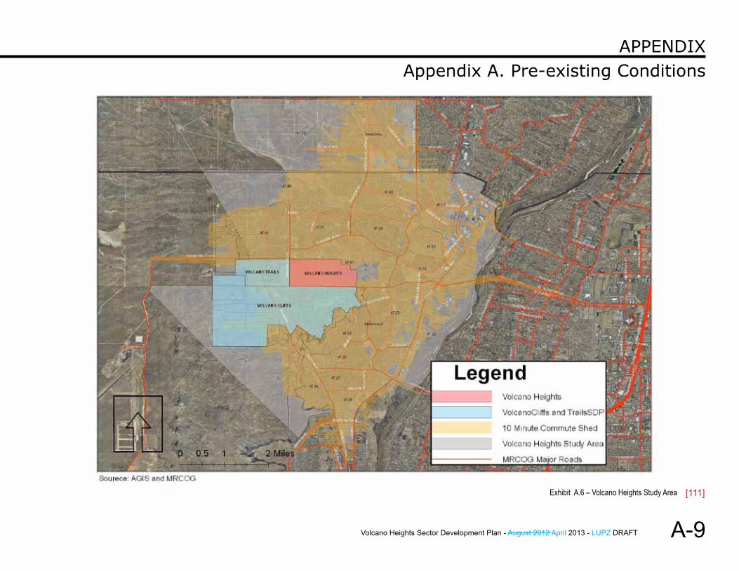
B. Demographics1. Methodology
Because the land within Volcano Heights is undeveloped, City staff worked with the Mid-Region Council of Governments (MRCOG) to create a study area for Volcano Heights that could be compared to the larger geographies of the City of Albuquerque and the City of Rio Rancho.
MRCOG generated a 10-minute commute shed from the intersection of Paseo del Norte and Unser Boulevard using its Transportation Accessibility Model (TRAM) and current posted speeds. The 10-minute commute shed provides a study area of adequate size and coincides well with 2010 Census Tracts.
Nineteen (19) census tracts are included in the study area, shown in Exhibit A.6. Census tract 9406 west of Volcano Heights extends to Cibola County and includes tribal lands and other areas not comparable to the other census tracts. In order to avoid skewing figures for the Volcano Heights study area, MRCOG staff only incorporated individual census blocks out of tract 9406, including 4,603 residents in West Ventana Ranch.
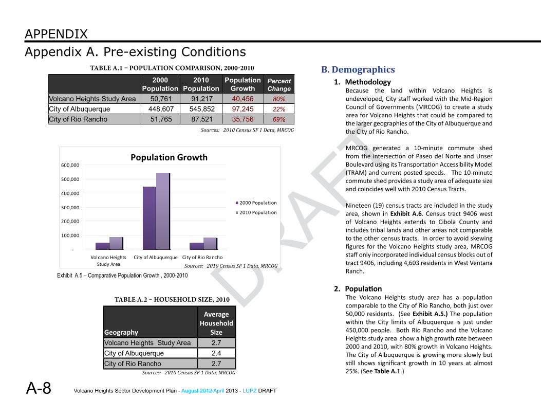
2. PopulationThe Volcano Heights study area has a population comparable to the City of Rio Rancho, both just over 50,000 residents. (See Exhibit A.5.) The population within the City limits of Albuquerque is just under 450,000 people. Both Rio Rancho and the Volcano Heights study area show a high growth rate between 2000 and 2010, with 80% growth in Volcano Heights. The City of Albuquerque is growing more slowly but still shows significant growth in 10 years at almost 25%. (See Table A.1.)
2000 Population
2010 Population
Population Growth
Percent Change
Volcano Heights Study Area 50,761 91,217 40,456 80%City of Albuquerque 448,607 545,852 97,245 22%City of Rio Rancho 51,765 87,521 35,756 69%
Population Growth
-
100,000
200,000
300,000
400,000
500,000
600,000
Volcano HeightsStudy Area
City of Albuquerque City of Rio Rancho
2000 Population
2010 Population
Exhibit A.5 – Comparative Population Growth , 2000-2010
Table a.1 – PoPulaTion ComParison, 2000-2010
Geography
Average Household
SizeVolcano Heights Study Area 2.7City of Albuquerque 2.4City of Rio Rancho 2.7
Table a.2 – HouseHold size, 2010
Sources: 2010 Census SF 1 Data, MRCOG
Sources: 2010 Census SF 1 Data, MRCOG
Sources: 2010 Census SF 1 Data, MRCOG
Volcano Heights Sector Development Plan - August 2012 April 2013 - LUPZ DRAFT
DRAFT
DRAFT
A-9
Appendix A. Pre-existing ConditionsAPPendix
Exhibit A.6 – Volcano Heights Study Area [111]
Volcano Heights Sector Development Plan - August 2012 April 2013 - LUPZ DRAFT
DRAFT
A-10
Appendix A. Pre-existing ConditionsAPPendix
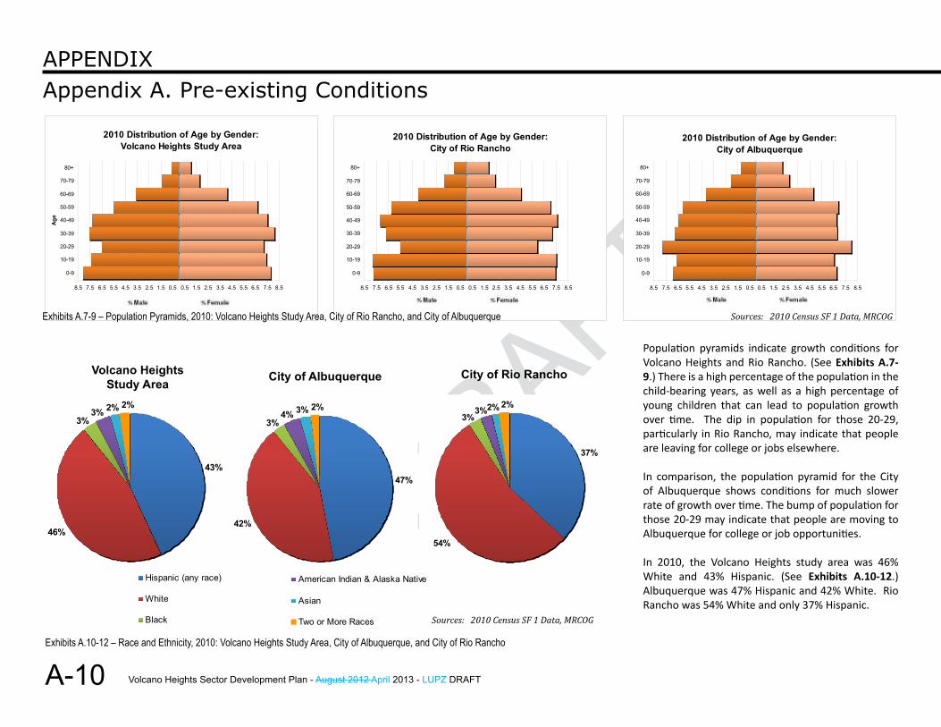
Population pyramids indicate growth conditions for Volcano Heights and Rio Rancho. (See Exhibits A.7-9.) There is a high percentage of the population in the child-bearing years, as well as a high percentage of young children that can lead to population growth over time. The dip in population for those 20-29, particularly in Rio Rancho, may indicate that people are leaving for college or jobs elsewhere.
In comparison, the population pyramid for the City of Albuquerque shows conditions for much slower rate of growth over time. The bump of population for those 20-29 may indicate that people are moving to Albuquerque for college or job opportunities.
In 2010, the Volcano Heights study area was 46% White and 43% Hispanic. (See Exhibits A.10-12.) Albuquerque was 47% Hispanic and 42% White. Rio Rancho was 54% White and only 37% Hispanic.
2010 Distribution of Age by Gender: Volcano Heights Study Area
8.5 7.5 6.5 5.5 4.5 3.5 2.5 1.5 0.5 0.5 1.5 2.5 3.5 4.5 5.5 6.5 7.5 8.5
0-9
10-19
20-29
30-39
40-49
50-59
60-69
70-79
80+
Age
2010 Distribution of Age by Gender: City of Rio Rancho
8.5 7.5 6.5 5.5 4.5 3.5 2.5 1.5 0.5 0.5 1.5 2.5 3.5 4.5 5.5 6.5 7.5 8.5
0-9
10-19
20-29
30-39
40-49
50-59
60-69
70-79
80+
2010 Distribution of Age by Gender: City of Albuquerque
8.5 7.5 6.5 5.5 4.5 3.5 2.5 1.5 0.5 0.5 1.5 2.5 3.5 4.5 5.5 6.5 7.5 8.5
0-9
10-19
20-29
30-39
40-49
50-59
60-69
70-79
80+
2010 Race and Ethnicity:Volcano Heights Study Area
43%
46%
2%
3%2%3%
Hispanic (any race)
White
Black
American Indian & Alaska Native
Asian
Two or More Races
2010 Race and Ethnicity:City of Albuquerque
47%
42%
4% 3%3%
2%
Hispanic (any race)
White
Black
American Indian & Alaska Native
Asian
Two or More Races
Volcano HeightsStudy Area City of Albuquerque City of Rio Rancho
2010 Race and Ethnicity:City of Rio Rancho
37%
54%
2%3%
2%3%
Hispanic (any race)
White
Black
American Indian & Alaska Native
Asian
Two or More Races
2010 Race and Ethnicity:Volcano Heights Study Area
43%
46%
2%
3%2%3%
Hispanic (any race)
White
Black
American Indian & Alaska Native
Asian
Two or More Races
Exhibits A.7-9 – Population Pyramids, 2010: Volcano Heights Study Area, City of Rio Rancho, and City of Albuquerque
Exhibits A.10-12 – Race and Ethnicity, 2010: Volcano Heights Study Area, City of Albuquerque, and City of Rio Rancho
2010 Race and Ethnicity:Volcano Heights Study Area
43%
46%
2%
3%2%3%
Hispanic (any race)
White
Black
American Indian & Alaska Native
Asian
Two or More Races
Sources: 2010 Census SF 1 Data, MRCOG
Sources: 2010 Census SF 1 Data, MRCOG
Volcano Heights Sector Development Plan - August 2012 April 2013 - LUPZ DRAFT
DRAFT
DRAFT
A-11
Appendix A. Pre-existing ConditionsAPPendix
Area
Total Housing
Units
Occupied Housing
UnitsPercent
Occupied
Vacant Housing
UnitsPercent Vacant
Owner-Occupied Housing
Units
Percent Owner-
Occupied
Renter-Occupied Housing
Units
Percent Renter-
OccupiedVolcano Heights Study Area 35,726 33,896 95% 1,830 5% 24,596 73% 9,300 27%City of Albuquerque 239,166 224,330 94% 14,836 6% 135,267 60% 89,063 40%City of Rio Rancho 33,964 31,892 94% 2,072 6% 25,149 79% 6,743 21%
Housing Types: Volcano Heights Study Area
82.9%
16.7%0.5%
Single Family
Multifamily
Mobile Home
Housing Types: City of Rio Rancho
89.3%
9.1% 1.6%
Single Family
Multifamily
Mobile Home
Housing Types: City of Albuquerque
67.4%
28.5%
4.1%
Single Family
Multifamily
Mobile Home
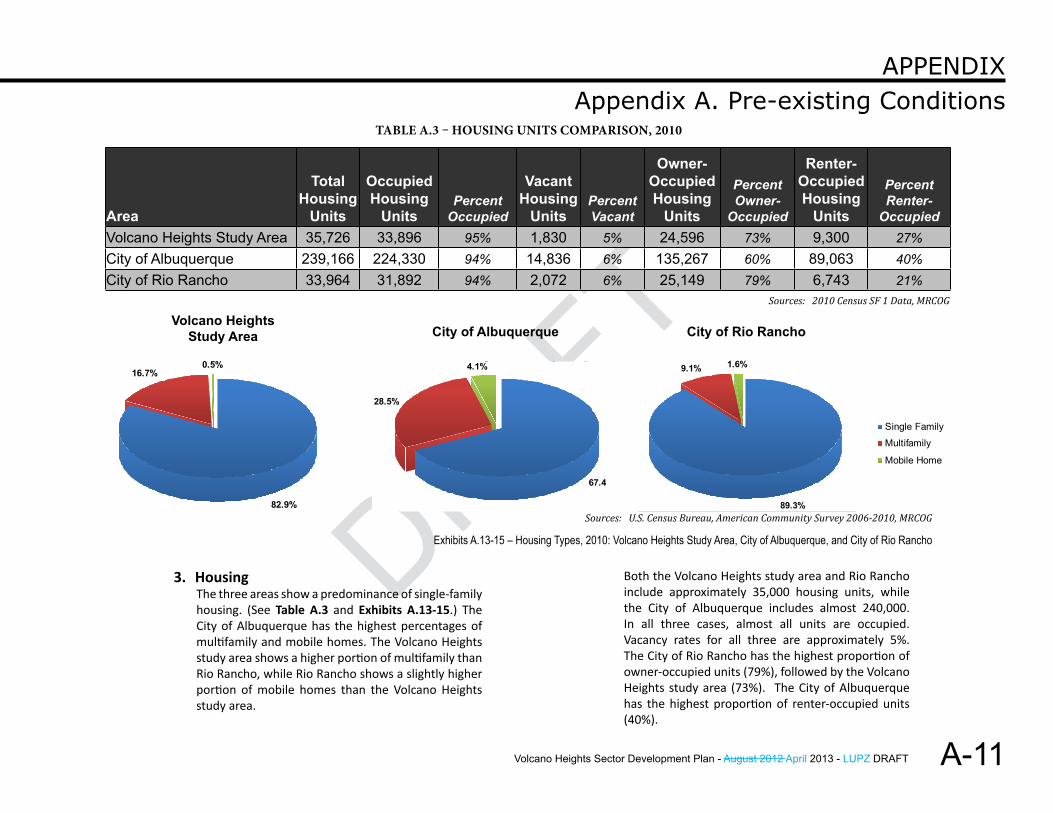
3. HousingThe three areas show a predominance of single-family housing. (See Table A.3 and Exhibits A.13-15.) The City of Albuquerque has the highest percentages of multifamily and mobile homes. The Volcano Heights study area shows a higher portion of multifamily than Rio Rancho, while Rio Rancho shows a slightly higher portion of mobile homes than the Volcano Heights study area.
Volcano HeightsStudy Area City of Albuquerque City of Rio RanchoHousing Types:
Volcano Heights Study Area
82.9%
16.7%0.5%
Single Family
Multifamily
Mobile Home
Both the Volcano Heights study area and Rio Rancho include approximately 35,000 housing units, while the City of Albuquerque includes almost 240,000. In all three cases, almost all units are occupied. Vacancy rates for all three are approximately 5%. The City of Rio Rancho has the highest proportion of owner-occupied units (79%), followed by the Volcano Heights study area (73%). The City of Albuquerque has the highest proportion of renter-occupied units (40%).
Exhibits A.13-15 – Housing Types, 2010: Volcano Heights Study Area, City of Albuquerque, and City of Rio Rancho
Table a.3 – Housing uniTs ComParison, 2010
Sources: 2010 Census SF 1 Data, MRCOG
Sources: U.S. Census Bureau, American Community Survey 2006-2010, MRCOG
Volcano Heights Sector Development Plan - August 2012 April 2013 - LUPZ DRAFT
DRAFT
A-12
Appendix A. Pre-existing ConditionsAPPendix
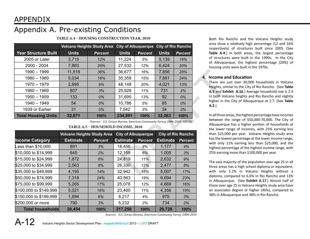
Both Rio Rancho and the Volcano Heights study area show a relatively high percentage (12 and 16% respectively) of structures built since 2005. (See Table A.4.) In both areas, the largest percentage of structures were built in the 1990s. In the City of Albuquerque, the highest percentage (20%) of housing units were built in the 1970s.
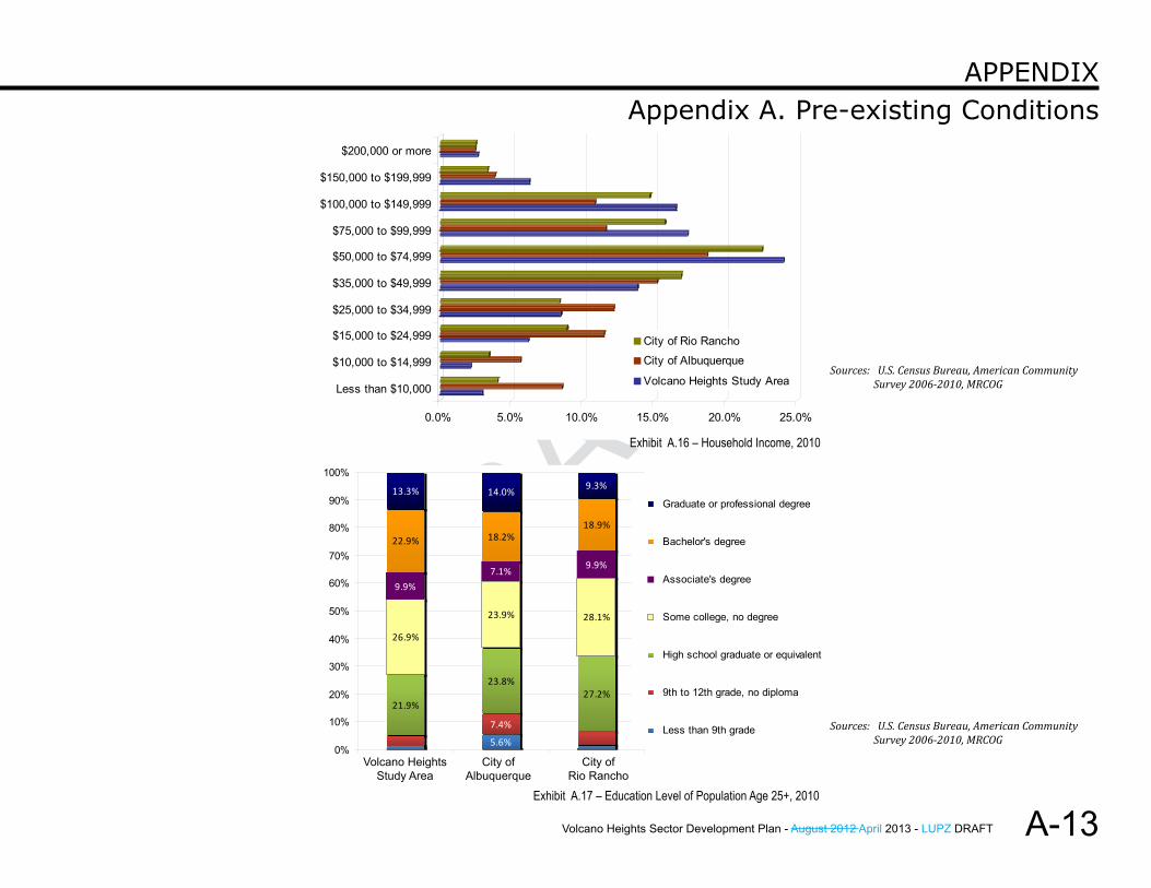
4. Income and EducationThere are just over 30,000 households in Volcano Heights, similar to the City of Rio Rancho. (See Table A.5 and Exhibit A.16.) Average household size is 2.4 in both Volcano heights and Rio Rancho and slightly higher in the City of Albuquerque at 2.7. (See Table A.2.)
In all three areas, the highest percentage have incomes between the range of $50,000-70,000. The City of Albuquerque has a higher portion of households at the lower range of incomes, with 25% earning less than $25,000 per year. Volcano Heights study area has the lowest percentage at the lower income range, with only 11% earning less than $25,000, and the highest percentage of the highest income range, with 25% earning more than $100,000 per year.
The vast majority of the population over age 25 in all three areas has a high school diploma or equivalent, with only 5.2% in Volcano Heights without a diploma, compared to 6.6% in Rio Rancho and 13% in Albuquerque. (See Exhibit A.17.) Almost half of those over age 25 in Volcano Heights study area have an associates degree or higher (46%), compared to 38% in Albuquerque and 38% in Rio Rancho.
Volcano Heights Study Area City of Albuquerque City of Rio RanchoIncome Category Estimate Percent Estimate Percent Estimate Percent Less than $10,000 891 3% 18,456 8% 1,177 4%$10,000 to $14,999 645 2% 12,159 6% 1,005 3%$15,000 to $24,999 1,872 6% 24,819 11% 2,632 9%$25,000 to $34,999 2,563 8% 26,330 12% 2,477 8%$35,000 to $49,999 4,195 14% 32,942 15% 5,007 17%$50,000 to $74,999 7,318 24% 40,563 19% 6,694 23%$75,000 to $99,999 5,265 17% 25,078 12% 4,669 16%$100,000 to $149,999 5,021 16% 23,460 11% 4,356 15%$150,000 to $199,999 1,894 6% 8,217 4% 975 3%$200,000 or more 790 3% 5,232 2% 734 2%
Total households 30,454 100% 217,256 100% 29,726 100%
Volcano Heights Study Area City of Albuquerque City of Rio Rancho
Year Structure Built Units Percent Units Percent Units Percent 2005 or Later 3,715 12% 11,224 5% 5,139 16%2000 - 2004 7,883 25% 27,532 12% 6,424 20%1990 – 1999 11,519 36% 36,677 16% 7,856 25%1980 – 1989 5,034 16% 35,359 15% 7,681 24%1970 – 1979 2,895 9% 48,148 20% 4,021 13%1960 – 1969 807 3% 25,928 11% 731 2%1950 – 1959 133 0% 31,695 13% 92 0%1940 – 1949 54 0% 10,786 5% 85 0%
1939 or Earlier 31 0% 7,542 3% 34 0%Total Housing Units 32,071 100% 234,891 100% 32,063 100%
Table a.4 – Housing ConsTruCTion Year, 2010
Table a.5 – HouseHold inCome, 2010Sources: U.S. Census Bureau, American Community Survey 2006-2010, MRCOG
Sources: U.S. Census Bureau, American Community Survey 2006-2010
Volcano Heights Sector Development Plan - August 2012 April 2013 - LUPZ DRAFT
DRAFT
DRAFT
A-13
Appendix A. Pre-existing ConditionsAPPendix
2010 Educational Attainment
21.9%
23.8%27.2%
26.9%
23.9% 28.1%
9.9%7.1% 9.9%
22.9% 18.2%18.9%
13.3% 14.0% 9.3%
5.6%
7.4%
0%
10%
20%
30%
40%
50%
60%
70%
80%
90%
100%
Graduate or professional degree
Bachelor's degree
Associate's degree
Some college, no degree
High school graduate or equivalent
9th to 12th grade, no diploma
Less than 9th grade
Volcano Heights Study Area
City of Albuquerque
City of Rio Rancho
0.0% 5.0% 10.0% 15.0% 20.0% 25.0%
Less than $10,000
$10,000 to $14,999
$15,000 to $24,999
$25,000 to $34,999
$35,000 to $49,999
$50,000 to $74,999
$75,000 to $99,999
$100,000 to $149,999
$150,000 to $199,999
$200,000 or more
2010 Household Income
City of Rio Rancho
City of Albuquerque
Volcano Heights Study Area
Exhibit A.16 – Household Income, 2010
Exhibit A.17 – Education Level of Population Age 25+, 2010
Sources: U.S. Census Bureau, American Community Survey 2006-2010, MRCOG
Sources: U.S. Census Bureau, American Community Survey 2006-2010, MRCOG
Volcano Heights Sector Development Plan - August 2012 April 2013 - LUPZ DRAFT
DRAFT
A-14
Appendix A. Pre-existing ConditionsAPPendix
C. Economic Development 1. Major Activity Centers
The land within Volcano Heights is undeveloped, but the area has been recommended to be designated as a Major Activity Center by the Volcano Mesa amendment to the Rank II West Side Strategic Plan. A Major Activity Center would provide an opportunity to address the imbalance of jobs east of the river and predominantly housing on west of the river by serving the region with employment, commercial, service, and retail opportunities. The Comprehensive Plan’s Centers and Corridor Plan would need to be updated to finalize the designation. It is unknown at this time when that final step will be taken.
Major Activity Centers (MACs) are meant to focus area employment and commercial and retail opportunities in particular locations well-served by existing transportation systems. Per the Comprehensive Plan, Major Activity Centers must be located on large tracts of undeveloped land (300 acres or more) and must be located at the intersection of two major roadways. Opportunities for designation of a Major Activity Center on the West Side other than Volcano Heights are limited due to a lack of undeveloped land near two critical roadways. The Volcano Heights area provides a critical opportunity for the West Side to locate a mix of employment, commercial, service and residential uses to meet the needs of the wider area and decrease cross-river traffic.
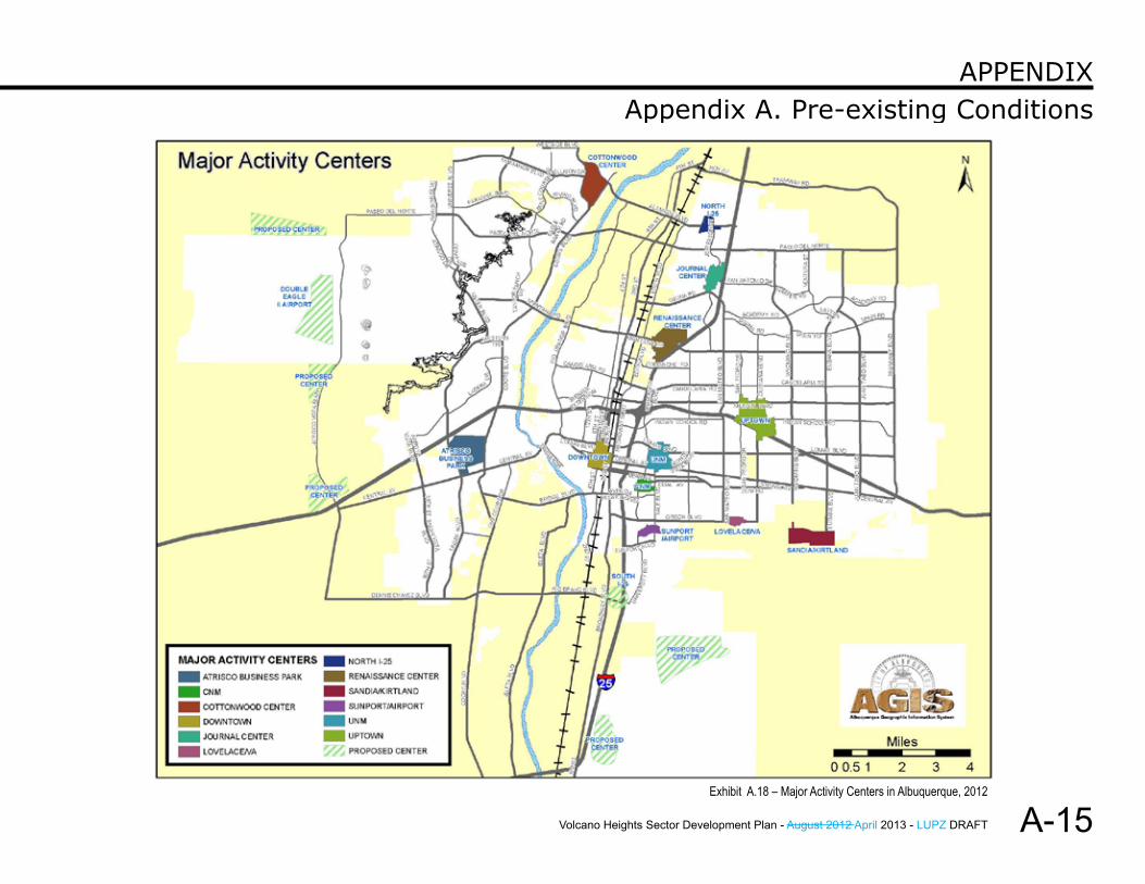
The Albuquerque-Bernalillo County Comprehensive Plan designates two areas on the West Side of Albuquerque as Major Activity Centers (MAC): the Cottonwood Center and the Atrisco Business Park. (See Exhibit A.18.) These areas have developed in a low-density, auto-oriented, and single-use pattern.
Four areas on the West Side are designated as Proposed Major Activity Centers; however, these are all west of Paseo del Volcan.
The east side of Albuquerque contains ten designated Major Activity Centers. According to MRCOG, in 2008, there were 152,300 jobs provided on the east side of Albuquerque in the top seven activity centers on the east side, including Downtown, Uptown, UNM/CNM/Hospitals, Jefferson/I-25, Midtown, Sunport, and Kirtland Air Force Base. This is in stark contrast to the 14,400 jobs available in 2008 on the west side in the Intel/Cottonwood and Atrisco Business Park centers.
This suggests that the majority of people who live on the west side find their employment on the east side of the river, and, as an auto-oriented city, this has led to significant traffic problems today, which are predicted to continue and worsen over time. According to MRCOG, based on present-day land-use and zoning policies, the current trend of employment growth concentrated on the east side of the Rio Grande will continue and will far outpace employment growth on Albuquerque’s West Side. The only way to reverse this trend is to provide significant and attractive opportunities for employers to locate on the West Side.
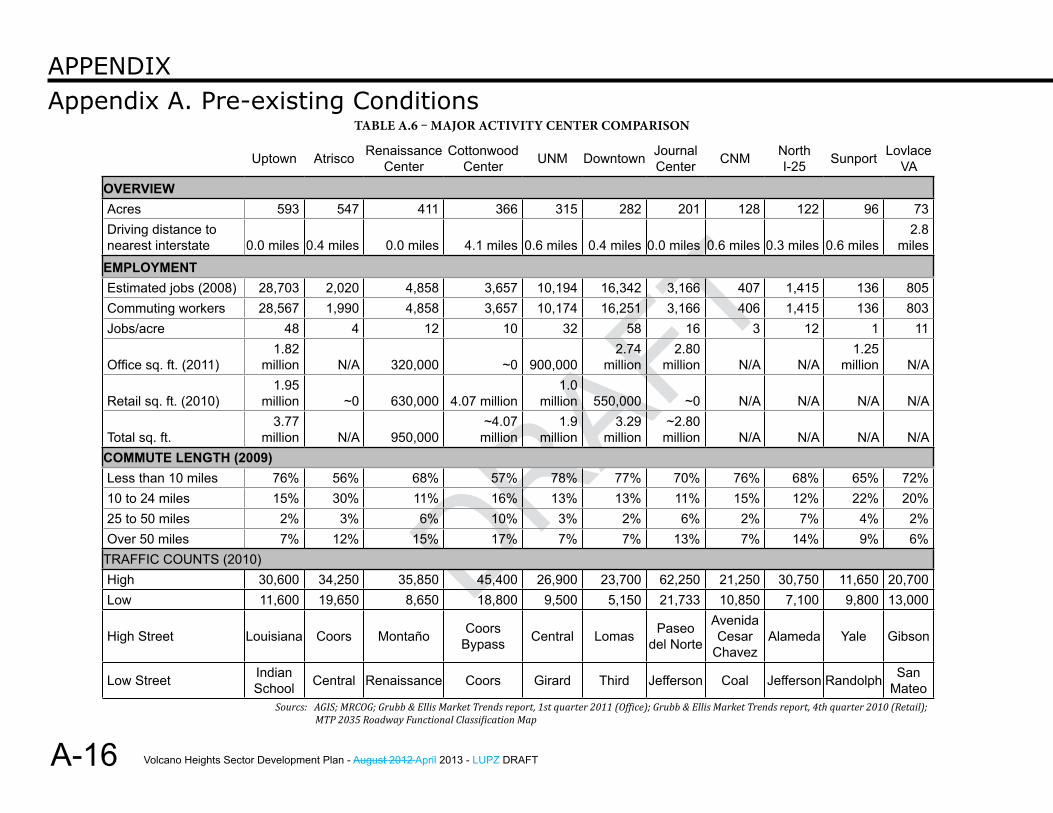
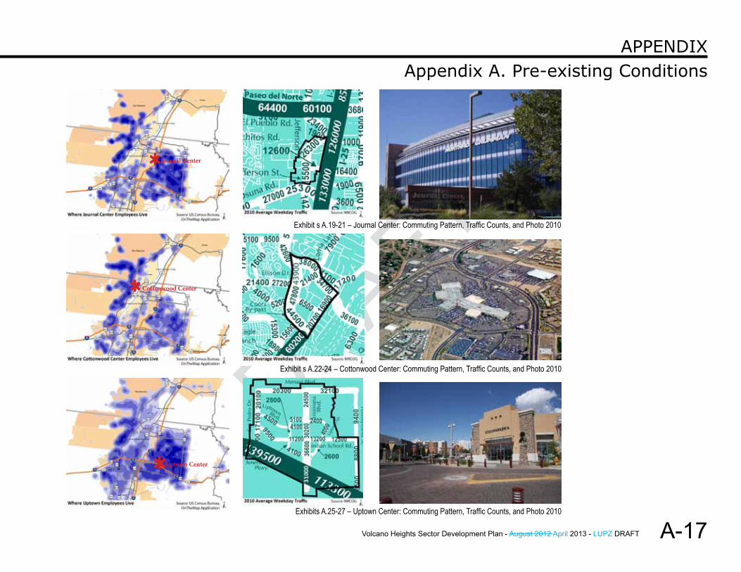
A comparison of several comparable MACs is shown in Table A.6. Commuting patterns are shown for Uptown MAC, Cottonwood MAC, and Journal Center MAC in Exhibits A.25-27.
Volcano Heights Sector Development Plan - August 2012 April 2013 - LUPZ DRAFT
DRAFT
DRAFT
A-15
Appendix A. Pre-existing ConditionsAPPendix
Exhibit A.18 – Major Activity Centers in Albuquerque, 2012
Volcano Heights Sector Development Plan - August 2012 April 2013 - LUPZ DRAFT
DRAFT
A-16
Appendix A. Pre-existing ConditionsAPPendix
Uptown Atrisco Renaissance Center
Cottonwood Center UNM Downtown Journal
Center CNM North I-25 Sunport Lovlace
VA
OVERVIEWAcres 593 547 411 366 315 282 201 128 122 96 73Driving distance to nearest interstate 0.0 miles 0.4 miles 0.0 miles 4.1 miles 0.6 miles 0.4 miles 0.0 miles 0.6 miles 0.3 miles 0.6 miles
2.8 miles
EMPLOYMENTEstimated jobs (2008) 28,703 2,020 4,858 3,657 10,194 16,342 3,166 407 1,415 136 805Commuting workers 28,567 1,990 4,858 3,657 10,174 16,251 3,166 406 1,415 136 803Jobs/acre 48 4 12 10 32 58 16 3 12 1 11
Office sq. ft. (2011)1.82
million N/A 320,000 ~0 900,0002.74
million2.80
million N/A N/A1.25
million N/A
Retail sq. ft. (2010)1.95
million ~0 630,000 4.07 million1.0
million 550,000 ~0 N/A N/A N/A N/A
Total sq. ft.3.77
million N/A 950,000~4.07
million1.9
million3.29
million~2.80
million N/A N/A N/A N/ACOMMUTE LENGTH (2009)Less than 10 miles 76% 56% 68% 57% 78% 77% 70% 76% 68% 65% 72%10 to 24 miles 15% 30% 11% 16% 13% 13% 11% 15% 12% 22% 20%25 to 50 miles 2% 3% 6% 10% 3% 2% 6% 2% 7% 4% 2%Over 50 miles 7% 12% 15% 17% 7% 7% 13% 7% 14% 9% 6%
TRAFFIC COUNTS (2010)High 30,600 34,250 35,850 45,400 26,900 23,700 62,250 21,250 30,750 11,650 20,700Low 11,600 19,650 8,650 18,800 9,500 5,150 21,733 10,850 7,100 9,800 13,000
High Street Louisiana Coors Montaño Coors Bypass Central Lomas Paseo
del Norte
Avenida Cesar
ChavezAlameda Yale Gibson
Low Street Indian School Central Renaissance Coors Girard Third Jefferson Coal Jefferson Randolph San
Mateo
Table a.6 – major aCTiviTY CenTer ComParison
Sourcs: AGIS; MRCOG; Grubb & Ellis Market Trends report, 1st quarter 2011 (Office); Grubb & Ellis Market Trends report, 4th quarter 2010 (Retail); MTP 2035 Roadway Functional Classification Map
Volcano Heights Sector Development Plan - August 2012 April 2013 - LUPZ DRAFT
DRAFT
DRAFT
A-17
Appendix A. Pre-existing ConditionsAPPendix
journal Center
Cottonwood Center
uptown Center
Exhibit s A.19-21 – Journal Center: Commuting Pattern, Traffic Counts, and Photo 2010
Exhibit s A.22-24 – Cottonwood Center: Commuting Pattern, Traffic Counts, and Photo 2010
Exhibits A.25-27 – Uptown Center: Commuting Pattern, Traffic Counts, and Photo 2010
Volcano Heights Sector Development Plan - August 2012 April 2013 - LUPZ DRAFT
DRAFT
A-18
Appendix A. Pre-existing ConditionsAPPendix
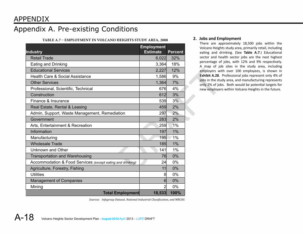
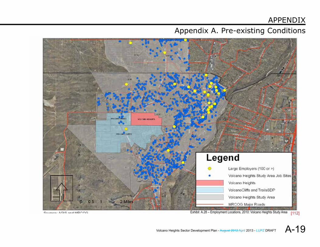
2. Jobs and EmploymentThere are approximately 18,500 jobs within the Volcano Heights study area, primarily retail, including eating and drinking. (See Table A.7.) Educational sector and health sector jobs are the next highest percentage of jobs, with 12% and 9% respectively. A map of job sites in the study area, including employers with over 100 employees, is shown in Exhibit A.28. Professional jobs represent only 4% of jobs in the study area, and manufacturing represents only 2% of jobs. Both would be potential targets for new employers within Volcano Heights in the future.
Industry Employment
Estimate Percent Retail Trade 6,022 32% Eating and Drinking 3,364 18% Educational Services 2,227 12% Health Care & Social Assistance 1,586 9% Other Services 1,364 7% Professional, Scientific, Technical 676 4% Construction 612 3% Finance & Insurance 539 3% Real Estate, Rental & Leasing 459 2% Admin, Support, Waste Management, Remediation 297 2% Government 283 2% Arts, Entertainment & Recreation 259 1% Information 197 1% Manufacturing 195 1% Wholesale Trade 185 1% Unknown and Other 141 1% Transportation and Warehousing 76 0% Accommodation & Food Services (except eating and drinking) 24 0% Agriculture, Forestry, Fishing 11 0% Utilities 8 0% Management of Companies 6 0% Mining 2 0%
Total Employment 18,533 100%
Table a.7 – emPloYmenT in volCano HeigHTs sTudY area, 2008
Sources: Infogroup Dataset, National Industrial Classification, and MRCOG
Volcano Heights Sector Development Plan - August 2012 April 2013 - LUPZ DRAFT
DRAFT
DRAFT
A-19
Appendix A. Pre-existing ConditionsAPPendix
Exhibit A.28 – Employment Locations, 2010: Volcano Heights Study Area [112]
Volcano Heights Sector Development Plan - August 2012 April 2013 - LUPZ DRAFT
DRAFT
A-20
Appendix A. Pre-existing ConditionsAPPendix
D. Transportation In its 2035 Metropolitan Transportation Plan, MRCOG forecast that the four county Mid-Region Metropolitan Planning Organization (MRMPO) area (Bernalillo, Sandoval, Valencia and Torrance counties) would grow by 668,000 people, 310,000 new homes, and 210,000 new jobs. If the area continues to develop with its current land-use pattern of generally low density, auto-oriented growth on the fringe of the urbanized area, the growing gap between homes and jobs will increase congestion on the region’s transportation corridors and, particularly, the region’s river crossings.
1. Regional RoadsMRCOG is the designated Metropolitan Planning Organization (MPO) for the Albuquerque Metropolitan Planning Area (AMPA). MRCOG convenes meetings for decision-makers from jurisdictions within the AMPA to come together to plan for transportation and other decisions affecting the region.
Relevant Documents: Future Albuquerque Area Bikeways and Streets
(FAABS) Metropolitan Roadway Access Policies for
the Albuquerque Metropolitan Planning Area (2010 Appendix to FAABS)
Long-range Roadway System Map (2004) 2035 Metropolitan Transportation Plan (5-year
plan)
Relevant Agencies, Boards, & Committees: Mid-region Council of Governments (MRCOG) New Mexico Department of Transportation
(NMDOT) City of Albuquerque Department of Municipal
Development (DMD)
Metropolitan Transportation Board (MTB) Transportation Coordinating Committee (TCC) Roadway Access Committee (RAC) TPTG (Transportation Program Task Group)
The Metropolitan Transportation Board (MTB) is made up of elected officials from the jurisdictions within the AMPA and sets policy for transportation issues in the urban area. The MTB coordinates local government transportation planning and project development, identifies federal funding for transportation projects, including roadway widenings and extensions, sets policy for roadway access, identifies corridors and alignments for new roadways, identifies bicycle facilities and federal funding for them, and makes decisions about long-range issues such as Bus Rapid Transit proposals.
Limited Access Roadways are identified and the Access Control Policies are stated in the Future Albuquerque Area Bikeways and Streets (FAABS) in Appendix D – III, Access Limitations. The components of the FAABS, including the Limited Access Roadways and the Access Control Policies, are integrated into the 2035 Metropolitan Transportation Plan (MTP) and all future MTP updates.
a. Road ClassificationAs of 2012, the functional classifications for Paseo del Norte and Unser Boulevard are Urban Principal Arterials on the Long Range Roadway System Map.
Paseo del Norte and Unser Boulevard are identified in FAABS as limited-access roadways. Full intersections are limited to half-mile (1/2 mile) intervals, with right-in/right-out (RI/RO) intersections allowed at quarter-mile intervals (1/4 mile). Access points
Volcano Heights Sector Development Plan - August 2012 April 2013 - LUPZ DRAFT
DRAFT
DRAFT
A-21
Appendix A. Pre-existing ConditionsAPPendix
allowed by policy are described in Section d. Intersection below. All additional access points on these roadways must be sponsored by the City and gain approval by the MTB via a process described in subsection d. iii. Access Modification below or a comparable process that involves gaining approval by the TCC.
b. Ownership and ConstructionIn this area, the City owns, controls, and is responsible for the planning and maintenance of both Paseo del Norte and Unser Boulevard. Paseo del Norte is a state facility east of Eagle Ranch Road. A 1989 working agreement between the City and State sets out the intention that once Paseo del Norte is constructed to four (4) lanes, it will revert to a State facility to Universe Boulevard.
The City’s Department of Municipal Development (DMD) developed plans in 2007 for the extension of Paseo del Norte, the cross sections for which show the two-lane construction as of 2011 and the future construction configurations of six (6) lanes with separate or shared bus rapid transit lanes. Future construction will be the responsibility of private developers as abutting land is developed.
As of 2011, the City has constructed Unser to 2 lanes with 36-foot median between Boca Negra Dam and Paradise Boulevard. Small portions north of Volcano Heights were constructed privately in conjunction with abutting development. The road widens and median narrows to provide turn lanes near major intersections. The city-owned 156-foot right-of-way from Boca Negra Dam to Paseo del Norte will allow the expansion of Unser to four (4) lanes in the future, to be constructed by developers as abutting projects warrant.
Assessments paid by Volcano Cliffs property owners for Special Assessment District (SAD) 228 will pay for the construction of the full cross section of the first third (1/3) of Unser north of Boca Negra Dam. A new SAD (229) is proposed for the area north of SAD 228, where Unser would straddle the boundary between Volcano Cliffs and Volcano Heights, to pay for the build out of Unser to Paseo del Norte.
The City completed construction in 2011 on roadway segments and intersections connecting Unser to Rainbow and Universe Boulevard on the southern edge of the Volcano Cliffs SDP and recently contructed a temporary road connecting Unser north of Paseo del Norte to the northern boundary of Heights. A segment of Unser north of the Plan area was constructed as Sundance Estates developed, and a new segment of Unser north of will be constructed as a new subdivision, Boulders, develops.
Permanent improvements to build Unser out fully will be the responsibility of developers as abutting property develops.
c. Right-of-Way (ROW)As of 2011, right-of-way (ROW) on Paseo del Norte varies between 50-200 feet. Through the Escarpment, ROW is around 200 feet and quickly narrows to a temporary cross section at the top of the Escarpment to the existing Avenida de Jaimito, where ROW is only 50 feet. ROW is 50 feet for about 3,000 feet west along the Town of Alameda Grant line. Paseo del Norte then heads north and west within a 70-foot ROW (to be widened to 156 feet as abutting property owners dedicate land and construct the road to 4 lanes) all the way to Universe.
Volcano Heights Sector Development Plan - August 2012 April 2013 - LUPZ DRAFT
DRAFT
A-22
Appendix A. Pre-existing ConditionsAPPendix
From Universe Boulevard to Rainbow Boulevard, the City owns 156 feet of ROW.
The City owns 156 feet of ROW for Unser Boulevard between the Escarpment to Paseo del Norte. As of 2011, the City has obtained right-of-entry and is in the process of acquiring ownership of the center 78 feet of the ultimate 156-foot ROW north of Paseo del Norte to Paradise Boulevard. The remaining 78 feet of ROW will require dedication as land on either side of the road develops (i.e. 39 feet per side). Some blading and permanent fill has taken place as easements allow.
d. Intersections
i. Paseo del NorteThe FAABS Access Control Policy lists the following full intersections for Paseo del Norte in this area: Woodmont Avenue - Ventana Parkway
R-06-01 TCC Rainbow Boulevard Universe Boulevard Unser Boulevard Kimmick Drive
The 2010 Access Control Policy does not list any partial-access intersections in the Volcano Mesa area.
DMD’s 2007 plans for Paseo del Norte between the top of the Escarpment and Universe Boulevard call for right-in-right-out intersections (for as-yet unplatted streets) at two locations approximately halfway between Kimmick and Unser and Unser and Universe as Paseo travels diagonally across the Volcano Heights Plan area.
ii. UnserThe FAABS Access Control Policy lists the following full access intersections in this area: Compass Drive (in Volcano Cliffs to the
South) Rosa Parks (previously Squaw Road in
Volcano Cliffs to the South) Paseo del Norte A point approximately halfway between
Paseo del Norte and Lilienthal Ave. Lilienthal Ave. (north of Heights plan
boundary) Paradise Boulevard (north of Heights plan
boundary)
The FAABS Access Control Policy lists the following partial access intersections (RI/RO) in this area: Buglo Ave (just North of Lilienthal, north
of Heights boundary)
DMD’s September 2010 construction plan set for Unser from Universe/Compass to Paseo del Norte includes more intersections in the Volcano Mesa area than the FAABS Access Control Policy: Heading north from the intersection of
Compass/Universe, Unser intersects with Kimmick (full intersection).
North of there, it intersects again with Rosa Parks (formerly Squaw, full intersection)
The next intersection to the north is Avenida de Jaimito (right-in/right-out). [113]

Volcano Heights Sector Development Plan - August 2012 April 2013 - LUPZ DRAFT
DRAFT
DRAFT
A-23
Appendix A. Pre-existing ConditionsAPPendix
iii. Access ModificationsAdditional access to either Paseo del Norte or Unser Boulevard must be sponsored by the City and approved by the MTB. The Access Modification process as of 2012 is described below. The MRCOG website (www.mrcog-nm.gov) should be consulted for the most current information.
As of 2012, the City is working on a request to either amend this process for larger land-use and transportation coordination at the sector-planning or master-planning level or to grant an alternative process to modify access on the portions of Paseo del Norte and Unser Boulevard within Volcano Heights..
Under the current process, to initiate an access modification, the City must send MRCOG a written Notice of Intent as the Sponsor of the request, including any required Traffic Impact Assessment (TIA) or Traffic Impact Study (TIS) as well as any other necessary information to analyze the request. (All requests to modify roadway access on Limited Access Roadways must be sponsored by a member agency of the MPO.)
Transportation Coordinating Committee (TCC). Modifications to Limited Access Roadways must be requested through the Transportation Coordinating Committee (TCC), which provides technical advice to the MTB. The TCC reviews items that are scheduled to come before the MTB and provides recommendations from a technical viewpoint. MRCOG reviews modification requests on a monthly basis.
The TCC is composed of staff-level representatives from each of the local member agencies and the New Mexico Department of Transportation. The TCC has two standing committees and the Intelligent Transportation System Subcommittee.
The Transportation Program Task Group (TPTG) includes technical staff from various local agencies and the New Mexico Department of Transportation (NMDOT) that meet to provide advice to the TCC regarding the long range system maps for the urban area and the Transportation Improvement Program (TIP). The TPTG reviews and comments on proposals to amend the long range transportation system maps when the maps are updated. The TPTG also develops the draft Transportation Improvement Program using a set of evaluation criteria prior to its release for public review and comment.
Intelligent Transportation Systems (ITS) Subcommittee includes federal, state, and local stakeholders. The Intelligent Transportation System Subcommittee makes recommendations to the TCC involving technology to enhance and coordinate travel management through traffic modeling, advanced communications, synchronized traffic lights, and dynamic message signs.
Volcano Heights Sector Development Plan - August 2012 April 2013 - LUPZ DRAFT
DRAFT
A-24
Appendix A. Pre-existing ConditionsAPPendix
Roadway Access Committee (RAC) composed of traffic engineers from the NMDOT, the City of Albuquerque, the City of Rio Rancho, Bernalillo County, and staff traffic engineers from any other MPO member agency wishing to participate will review the Notice of Intent and supporting documentation in order to determine a scope for the access justification analysis. Once the scope is determined, the RAC will send a letter detailing the scope of work through the MPO to the Sponsor. The scope will, at a minimum, inform the Sponsor as to the geographic area to be analyzed to determine the influence the access modification has on the transportation system. The RAC can require additional analyses on a case-by-case basis (e.g. weaving analysis and queuing analysis).
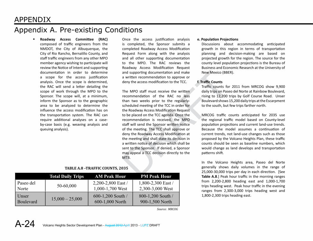
Total Daily Trips AM Peak Hour PM Peak HourPaseo del Norte 50-60,000 2,200-2,800 East /
1,000-1,700 West1,800-2,300 East / 2,300-3,000 West
Unser Boulevard 15,000 – 25,000 600-1,200 South /
600-1,000 North800-1,200 South / 900-1,500 North
TABlE A.8 –TrAffiC COunTS, 2035
e. Population ProjectionsDiscussions about accommodating anticipated growth in this region in terms of transportation planning and decision-making are based on projected growth for the region. The source for the county level population projections is the Bureau of Business and Economic Research at the University of New Mexico (BBER).
f. Traffic CountsTraffic counts for 2011 from MRCOG show 9,900 daily trips on Paseo del Norte at Rainbow Boulevard, rising to 12,200 trips by Golf Course Road. Unser Boulevard shows 15,200 daily trips at the Escarpment to the south, but few trips farther north.
MRCOG traffic counts anticipated for 2035 use the regional traffic model based on County-level population projections and current land-use trends. Because the model assumes a continuation of current trends, not land-use changes such as those proposed by the Volcano Heights Plan, these traffic counts should be seen as baseline numbers, which would change as land develops and transportation patterns shift.
In the Volcano Heights area, Paseo del Norte generally shows daily volumes in the range of 25,000-30,000 trips per day in each direction. [See Table A.8.] Peak hour traffic in the morning ranges from 2,200-2,800 heading east and 1,000-1,700 trips heading west. Peak hour traffic in the evening ranges from 2,300-3,000 trips heading west and 1,800-2,300 trips heading east.
Once the access justification analysis is completed, the Sponsor submits a completed Roadway Access Modification Request Form along with the analysis and all other supporting documentation to the MPO. The RAC reviews the Roadway Access Modification Request and supporting documentation and make a written recommendation to approve or deny the access modification to the TCC.
The MPO staff must receive the written recommendation of the RAC no less than two weeks prior to the regularly-scheduled meeting of the TCC in order for the Roadway Access Modification Request to be placed on the TCC agenda. Once the recommendation is received, the MPO staff will send the Sponsor written notice of the meeting. The TCC shall approve or deny the Roadway Access Modification at the meeting and shall state its decision in a written notice of decision which shall be sent to the Sponsor. If denied, a Sponsor may appeal a TCC decision directly to the MTB.
Source: MRCOG
Volcano Heights Sector Development Plan - August 2012 April 2013 - LUPZ DRAFT
DRAFT
DRAFT
A-25
Appendix A. Pre-existing ConditionsAPPendix
In the same area, Unser Boulevard generally shows daily volumes in the range of 7,500-13,500 trips per day in each direction. Peak hour traffic in the morning ranges from 600-1,200 trips heading south and 600-1,000 heading north. Peak hour traffic in the evening ranges from 800-1,200 heading south and 900-1,500 heading north.
These numbers support the general perception that residents leave the area via Paseo del Norte in the morning to head east across the river and return home after work in the evenings. Traffic counts for Unser Boulevard seem to indicate that the roadway is used equally for travel north and south, with slightly higher traffic in the evenings than in the mornings, regardless of the direction of travel.
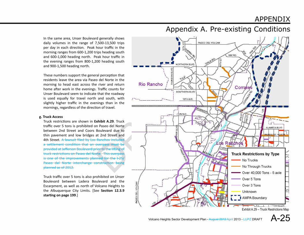
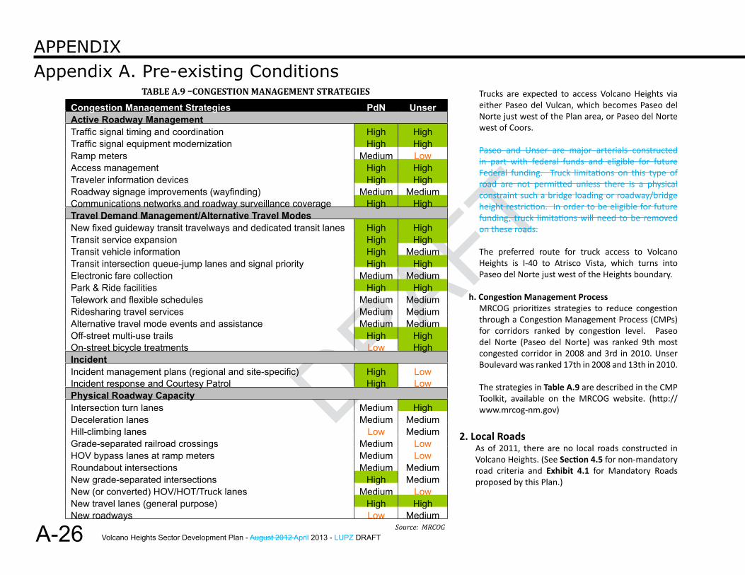
g. Truck AccessTruck restrictions are shown in Exhibit A.29. Truck traffic over 5 tons is prohibited on Paseo del Norte between 2nd Street and Coors Boulevard due to thin pavement and low bridges at 2nd Street and 4th Street. A lawsuit filed by Los Ranchos included a settlement condition that an overpass must be provided at Jefferson Boulevard prior to the lifting of truck restrictions on Paseo del Norte. This overpass is one of the improvements planned for the I-25/Paseo del Norte interchange construction being planned as of 2012.
Truck traffic over 5 tons is also prohibited on Unser Boulevard between Ladera Boulevard and the Escarpment, as well as north of Volcano Heights to the Albuquerque City Limits. [See Section 12.3.9 starting on page 199.]
Exhibit A.29 – Truck Restrictions Map
Volcano Heights Sector Development Plan - August 2012 April 2013 - LUPZ DRAFT
DRAFT
A-26
Appendix A. Pre-existing ConditionsAPPendix
Trucks are expected to access Volcano Heights via either Paseo del Vulcan, which becomes Paseo del Norte just west of the Plan area, or Paseo del Norte west of Coors.
Paseo and Unser are major arterials constructed in part with federal funds and eligible for future Federal funding. Truck limitations on this type of road are not permitted unless there is a physical constraint such a bridge loading or roadway/bridge height restriction. In order to be eligible for future funding, truck limitations will need to be removed on these roads.
The preferred route for truck access to Volcano Heights is I-40 to Atrisco Vista, which turns into Paseo del Norte just west of the Heights boundary.
h. Congestion Management ProcessMRCOG prioritizes strategies to reduce congestion through a Congestion Management Process (CMPs) for corridors ranked by congestion level. Paseo del Norte (Paseo del Norte) was ranked 9th most congested corridor in 2008 and 3rd in 2010. Unser Boulevard was ranked 17th in 2008 and 13th in 2010.
The strategies in Table A.9 are described in the CMP Toolkit, available on the MRCOG website. (http://www.mrcog-nm.gov)
2. Local RoadsAs of 2011, there are no local roads constructed in Volcano Heights. (See Section 4.5 for non-mandatory road criteria and Exhibit 4.1 for Mandatory Roads proposed by this Plan.)
Congestion Management Strategies PdN UnserActive Roadway Management Traffic signal timing and coordination High HighTraffic signal equipment modernization High HighRamp meters Medium LowAccess management High HighTraveler information devices High HighRoadway signage improvements (wayfinding) Medium MediumCommunications networks and roadway surveillance coverage High HighTravel Demand Management/Alternative Travel Modes New fixed guideway transit travelways and dedicated transit lanes High HighTransit service expansion High HighTransit vehicle information High MediumTransit intersection queue-jump lanes and signal priority High HighElectronic fare collection Medium MediumPark & Ride facilities High HighTelework and flexible schedules Medium MediumRidesharing travel services Medium MediumAlternative travel mode events and assistance Medium MediumOff-street multi-use trails High HighOn-street bicycle treatments Low HighIncident Incident management plans (regional and site-specific) High LowIncident response and Courtesy Patrol High LowPhysical Roadway Capacity Intersection turn lanes Medium HighDeceleration lanes Medium MediumHill-climbing lanes Low MediumGrade-separated railroad crossings Medium LowHOV bypass lanes at ramp meters Medium LowRoundabout intersections Medium MediumNew grade-separated intersections High MediumNew (or converted) HOV/HOT/Truck lanes Medium LowNew travel lanes (general purpose) High HighNew roadways Low Medium
Table a.9 –CongesTion ManageMenT sTraTegies
Source: MRCOG
Volcano Heights Sector Development Plan - August 2012 April 2013 - LUPZ DRAFT
DRAFT
DRAFT
A-27
Appendix A. Pre-existing ConditionsAPPendix
There are very few opportunities to connect to local roads abutting the Plan area. These include Oakridge Street, Treeline Avenue, and Woodmont Avenue to the west, Urraca Street to the south, and Adina Lane to the north.
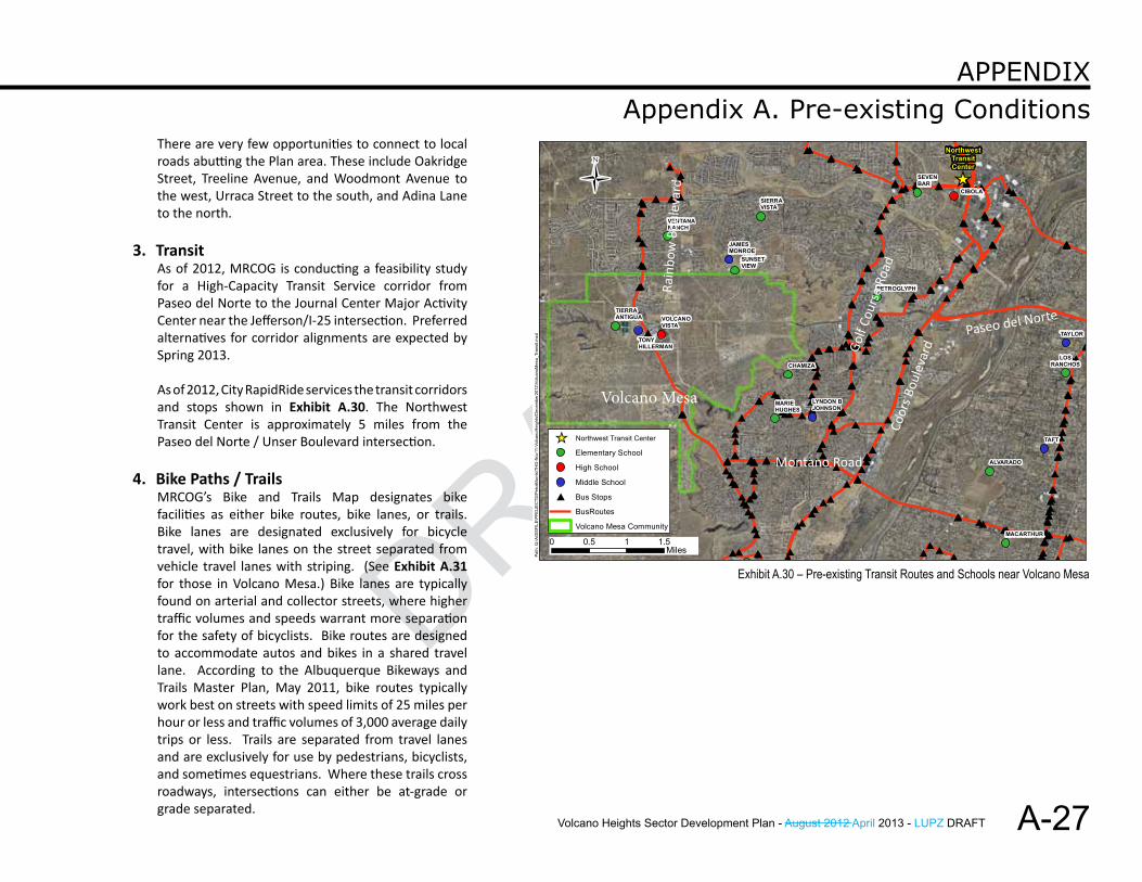
3. TransitAs of 2012, MRCOG is conducting a feasibility study for a High-Capacity Transit Service corridor from Paseo del Norte to the Journal Center Major Activity Center near the Jefferson/I-25 intersection. Preferred alternatives for corridor alignments are expected by Spring 2013.
As of 2012, City RapidRide services the transit corridors and stops shown in Exhibit A.30. The Northwest Transit Center is approximately 5 miles from the Paseo del Norte / Unser Boulevard intersection.
4. Bike Paths / TrailsMRCOG’s Bike and Trails Map designates bike facilities as either bike routes, bike lanes, or trails. Bike lanes are designated exclusively for bicycle travel, with bike lanes on the street separated from vehicle travel lanes with striping. (See Exhibit A.31 for those in Volcano Mesa.) Bike lanes are typically found on arterial and collector streets, where higher traffic volumes and speeds warrant more separation for the safety of bicyclists. Bike routes are designed to accommodate autos and bikes in a shared travel lane. According to the Albuquerque Bikeways and Trails Master Plan, May 2011, bike routes typically work best on streets with speed limits of 25 miles per hour or less and traffic volumes of 3,000 average daily trips or less. Trails are separated from travel lanes and are exclusively for use by pedestrians, bicyclists, and sometimes equestrians. Where these trails cross roadways, intersections can either be at-grade or grade separated.
##
##
#
#
##
#
###
#
#
## # ##
###
#####
#
#
##
#
#
#
#
###### # # ########
#
#
#
#
#
#
#
##
#
##
#
#
#### ####
#
##
##
#
##
#
#
##
#
#
#
##
# #
# #
####### # ##
#
##
###
##
#
##
#
##
####
#######
####
##
#
#
#
#
#
#
#
#
#
#
##
#
#
#
#
#
#
#
#
#
#
#
#
#
#
#
##
#
#
##
##
###
###
########
##
###
#
#
###
#
#
#
#
#
#
###
#
######
#
##
####
## ##
#
##
##
## ##
##
#
#
##
###
#
#
#
##
##
##
# #
#
##
#
##
####
##
####
_̂
NorthwestTransitCenter
MACARTHUR
SIERRAVISTA
VENTANARANCH
SEVENBAR
MARIEHUGHES
ALVARADO
PETROGLYPH
CIBOLA
LYNDON BJOHNSON
VOLCANOVISTA
TAYLOR
LOSRANCHOS
TAFT
JAMESMONROE
SUNSETVIEW
TIERRAANTIGUA
TONYHILLERMAN
CHAMIZA
Path
: Q:\A
GIS
FILE
\PR
OJE
CTS
\Pet
raM
orris
\TH
G-N
ov11
-Vol
cano
Hei
ghts
\Dec
embe
r201
2\Vo
lcan
oMes
a_Tr
ansi
t.mxd
Elementary School
High School
Middle School
# Bus Stops
BusRoutes
Volcano Mesa Community
_̂ Northwest Transit Center
Ü
0 0.5 1 1.5Miles
Volcano Mesa
Rain
bow
Bou
leva
rd
Golf
Cour
se R
oad
Montano Road
Coor
s Bou
leva
rd
Paseo del Norte
Exhibit A.30 – Pre-existing Transit Routes and Schools near Volcano Mesa

Volcano Heights Sector Development Plan - August 2012 April 2013 - LUPZ DRAFT
DRAFT
A-28
Appendix A. Pre-existing ConditionsAPPendix
Unser Boulevard and Paseo del Norte incorporate both on-street bike lanes and an off-street, multi-use trail. See cross sections in Exhibits 4.15 and 4.16, respectively.
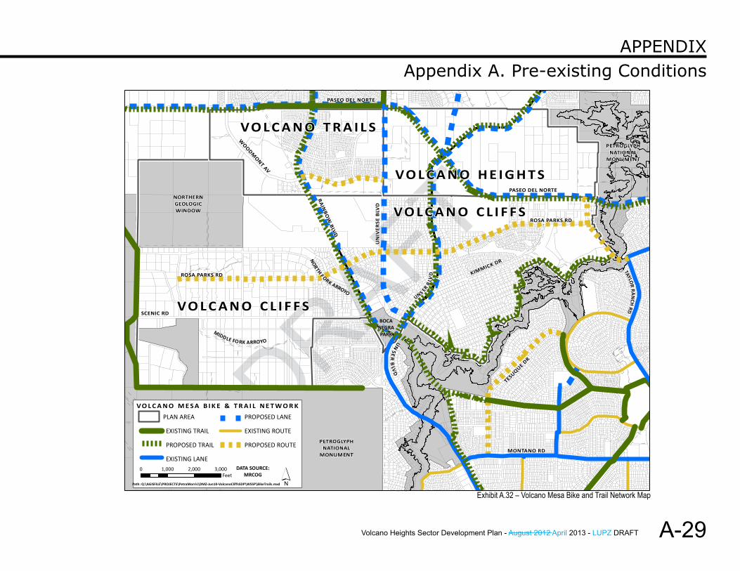
Mayor Berry’s “Albuquerque: The Plan” proposes to construct links to connect existing bicycle trails that would create a 50-mile bike loop around Albuquerque, a portion of which would link Paseo del Norte to existing bike trails on the East Side. See Exhibit A.31.
MRCOG’s Long Range Bikeways Plan indicates a proposed bike route from Taylor Ranch Road south and west of the Plan area to Paseo del Norte, where it meets with an existing pedestrian bridge over Paseo del Norte providing access to the Petroglyph National Monument. This route offers an opportunity to extend the bike route north along the Mandatory Park Edge Road and/or along a multi-use trail from the pedestrian bridge north within the Petroglyph National Monument boundary.
MRCOG’s Long Range Bikeways Plan also shows a proposed bicycle route from Universe Boulevard west to Rainbow Boulevard along Woodmont Avenue within Volcano Trails. The Mandatory Road network for Heights extends Woodmont Avenue into Volcano Heights. A bicycle route along this corridor would link to the eventual bike lanes and multi-use trails on Unser Boulevard and Paseo del Norte, as well as continuing east to connect to the Park Edge Road and potential north/south multi-use trail on the Monument edge.
Exhibit A.31 –Mayor Berry’s Proposed 50-mile Bike Loop
Volcano Heights Sector Development Plan - August 2012 April 2013 - LUPZ DRAFT
DRAFT
DRAFT
A-29
Appendix A. Pre-existing ConditionsAPPendix
ROSA PARKS RD
SCENIC RD
KIMMICK DR
RA
INB
OW
BLV
D
UN
IVER
SE B
LVD
UN
SER
BLV
D
PASEO DEL NORTE
WO
ODMONT AV
ROSA PARKS RD
PETROGLYPHNATIONAL
MONUMENT
NORTHERNGEOLOGICWINDOW
BOCANEGRAPARK
VO L C A N O H E I G H T S
VO L C A N O C L I F F S
VO L C A N O C L I F F S
VO L C A N O T R A I L S
MIDDLE FO RK ARROYO
NO
RTH FORK ARROYO
0 1,000 2,000 3,000Feet
Path: Q:\AGISFILE\PROJECTS\PetraMorris\DMZ-Jun10-VolcanoCliffsSDP\WSSP\BikeTrails.mxd
PETROGLYPHNATIONAL
MONUMENT
PLAN AREA
EXISTING TRAIL
PROPOSED TRAIL
EXISTING LANE
PROPOSED LANE
EXISTING ROUTE
PROPOSED ROUTE
´
V O L C A N O M E S A B I K E & T R A I L N E T W O R K
MONTANO RD
TESUQUE DR
TAYLOR
RA
NCH
RD
UNS ER B
LVD
PASEO DEL NORTE
DATA SOURCE:MRCOG
Exhibit A.32 – Volcano Mesa Bike and Trail Network Map
Volcano Heights Sector Development Plan - August 2012 April 2013 - LUPZ DRAFT
DRAFT
A-30
Appendix A. Pre-existing ConditionsAPPendix
Finally, on the north boundary of the Plan area, MRCOG’s Long Range Bikeways Plan shows a proposed bike lane extending north from the Unser Boulevard / Paseo del Norte intersection toward Paradise Boulevard. Because the configuration of the subdivision and roads north of the Plan boundary, the best opportunity for connection with minimal impact to existing residents might be across a property owned by the Ventana Ranch Community Association to the existing Adina Lane, which leads to Vivaldi Trail that connects to Paradise Boulevard.
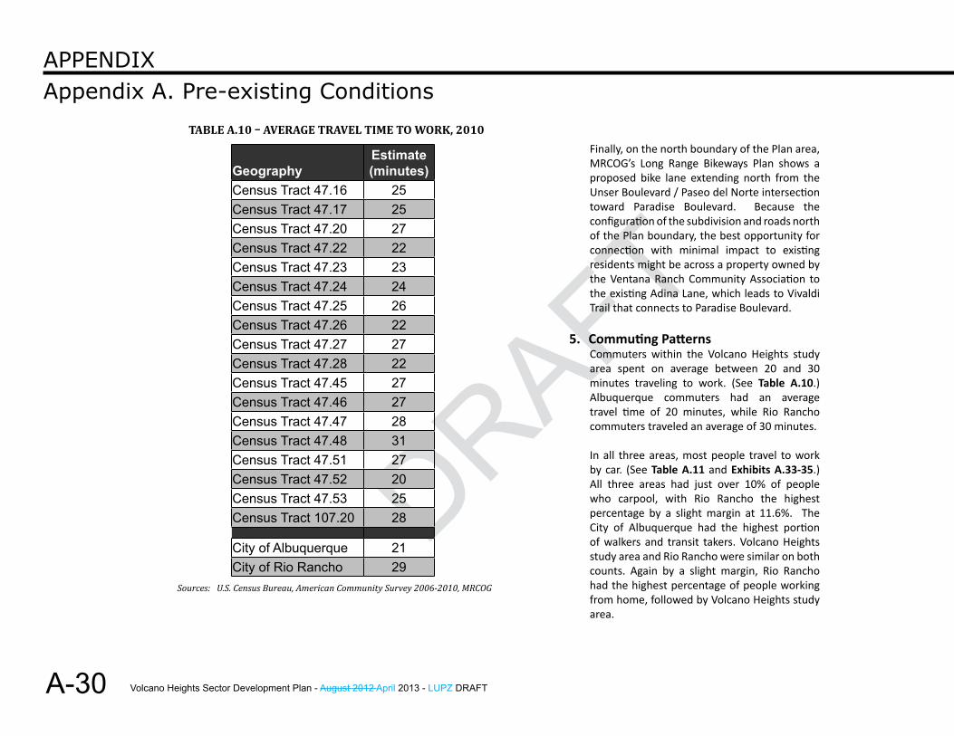
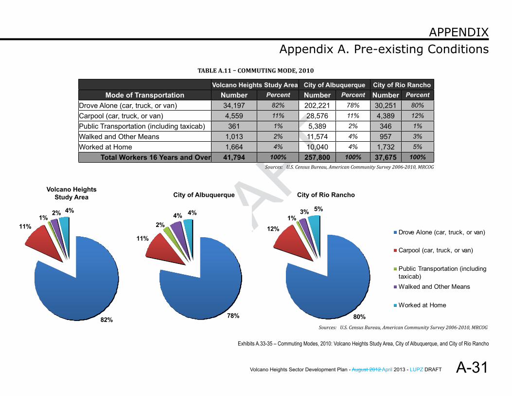
5. Commuting PatternsCommuters within the Volcano Heights study area spent on average between 20 and 30 minutes traveling to work. (See Table A.10.) Albuquerque commuters had an average travel time of 20 minutes, while Rio Rancho commuters traveled an average of 30 minutes.
In all three areas, most people travel to work by car. (See Table A.11 and Exhibits A.33-35.) All three areas had just over 10% of people who carpool, with Rio Rancho the highest percentage by a slight margin at 11.6%. The City of Albuquerque had the highest portion of walkers and transit takers. Volcano Heights study area and Rio Rancho were similar on both counts. Again by a slight margin, Rio Rancho had the highest percentage of people working from home, followed by Volcano Heights study area.
Geography Estimate (minutes)
Census Tract 47.16 25Census Tract 47.17 25Census Tract 47.20 27Census Tract 47.22 22Census Tract 47.23 23Census Tract 47.24 24Census Tract 47.25 26Census Tract 47.26 22Census Tract 47.27 27Census Tract 47.28 22Census Tract 47.45 27Census Tract 47.46 27Census Tract 47.47 28Census Tract 47.48 31Census Tract 47.51 27Census Tract 47.52 20Census Tract 47.53 25Census Tract 107.20 28
City of Albuquerque 21City of Rio Rancho 29
Table a.10 – average Travel TiMe To Work, 2010
Sources: U.S. Census Bureau, American Community Survey 2006-2010, MRCOG
Volcano Heights Sector Development Plan - August 2012 April 2013 - LUPZ DRAFT
DRAFT
DRAFT
A-31
Appendix A. Pre-existing ConditionsAPPendix
2010 Commuting to Work:City of Albuquerque
78.4%
11.1%
4.5% 3.9%
2.1%Drove Alone (car, truck, or van)
Carpool (car, truck, or van)
Public Transportation (includingtaxicab)Walked and Other Means
Worked at Home
Volcano HeightsStudy Area City of Albuquerque City of Rio Rancho
Exhibits A.33-35 – Commuting Modes, 2010: Volcano Heights Study Area, City of Albuquerque, and City of Rio Rancho
Volcano Heights Study Area City of Albuquerque City of Rio Rancho Mode of Transportation Number Percent Number Percent Number Percent
Drove Alone (car, truck, or van) 34,197 82% 202,221 78% 30,251 80%
Carpool (car, truck, or van) 4,559 11% 28,576 11% 4,389 12%
Public Transportation (including taxicab) 361 1% 5,389 2% 346 1%
Walked and Other Means 1,013 2% 11,574 4% 957 3%
Worked at Home 1,664 4% 10,040 4% 1,732 5%
Total Workers 16 Years and Over 41,794 100% 257,800 100% 37,675 100%
Table a.11 – CoMMuTing Mode, 2010
Sources: U.S. Census Bureau, American Community Survey 2006-2010, MRCOG
2010 Commuting to Work:Volcano Heights Study Area
82%
11%1%
4%2%
Drove Alone (car, truck, or van)
Carpool (car, truck, or van)
Public Transportation (includingtaxicab)Walked and Other Means
Worked at Home
2010 Commuting to Work:City of Albuquerque
78%
11%
4% 4%
2%Drove Alone (car, truck, or van)
Carpool (car, truck, or van)
Public Transportation (includingtaxicab)Walked and Other Means
Worked at Home
2010 Commuting to Work:City of Rio Rancho
80%
12%1%
5%3%
Drove Alone (car, truck, or van)
Carpool (car, truck, or van)
Public Transportation (includingtaxicab)Walked and Other Means
Worked at Home
Sources: U.S. Census Bureau, American Community Survey 2006-2010, MRCOG
Volcano Heights Sector Development Plan - August 2012 April 2013 - LUPZ DRAFT
DRAFT
A-32
Appendix A. Pre-existing ConditionsAPPendix
VTUR
SU-1FORR-2
R-D
SU-2R-1
R-D
R-LTSU-1 FORSCHOOLR-2
R-D
SU-1 FORC-2
RO-20
RO-20R-LT
R-LT
R-1
SU-1 FOR
R-LT
SU-1 FOR
R-LT
R-1
R-1
R-1
R-1
VCLL
VCUR
VCLL
PRD -FAR 0.5
PRD -FAR 0.5
VCMX
VCLL
VCMX
VCUR
VTVC
VCUR
VTRD
VCLL
VCLL
VCMX
C-1 USES
VCMX
VTSL
C-1 USES
VCLL
VCUR
VCLLVCLLVCUR
0 500 1,000 1,500
Feet
/
LANDUSERESIDENTIAL SINGLE FAMILY
RESIDENTIAL MULTI FAMILY
COMMERCIAL
MIXED USE
RESIDENTIAL/AGRICULTURAL
INSTITUTIONAL
Path: Q:\AGISFILE\PROJECTS\PetraMorris\THG-Nov11-VolcanoHeights\December2012\ExistingLanduse.mxd
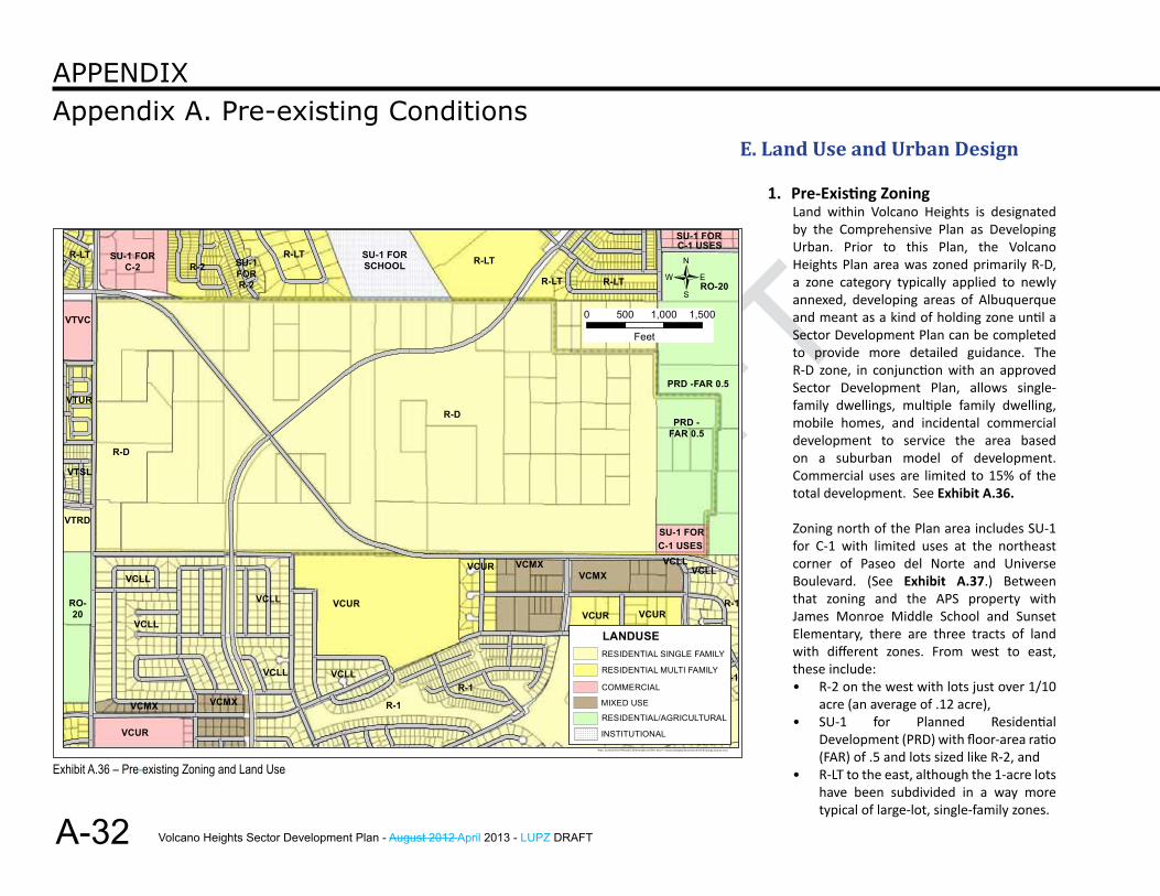
Exhibit A.36 – Pre-existing Zoning and Land Use
E. land use and urban Design
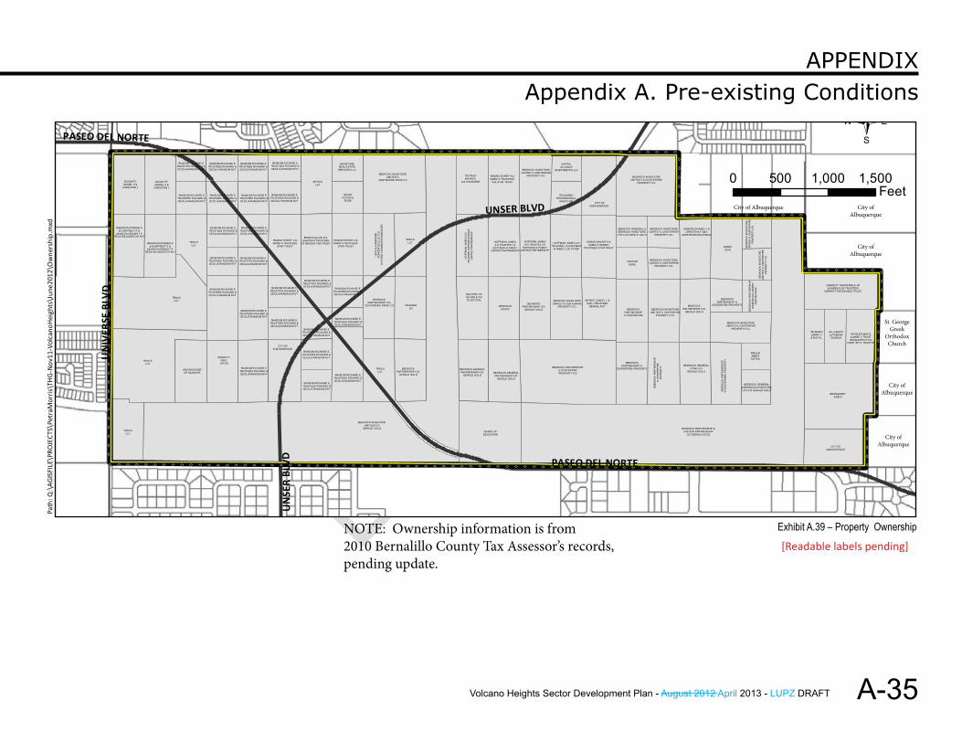
1. Pre-Existing ZoningLand within Volcano Heights is designated by the Comprehensive Plan as Developing Urban. Prior to this Plan, the Volcano Heights Plan area was zoned primarily R-D, a zone category typically applied to newly annexed, developing areas of Albuquerque and meant as a kind of holding zone until a Sector Development Plan can be completed to provide more detailed guidance. The R-D zone, in conjunction with an approved Sector Development Plan, allows single-family dwellings, multiple family dwelling, mobile homes, and incidental commercial development to service the area based on a suburban model of development. Commercial uses are limited to 15% of the total development. See Exhibit A.36.
Zoning north of the Plan area includes SU-1 for C-1 with limited uses at the northeast corner of Paseo del Norte and Universe Boulevard. (See Exhibit A.37.) Between that zoning and the APS property with James Monroe Middle School and Sunset Elementary, there are three tracts of land with different zones. From west to east, these include: • R-2 on the west with lots just over 1/10
acre (an average of .12 acre), • SU-1 for Planned Residential
Development (PRD) with floor-area ratio (FAR) of .5 and lots sized like R-2, and
• R-LT to the east, although the 1-acre lots have been subdivided in a way more typical of large-lot, single-family zones.
Volcano Heights Sector Development Plan - August 2012 April 2013 - LUPZ DRAFT
DRAFT
DRAFT
A-33
Appendix A. Pre-existing ConditionsAPPendix
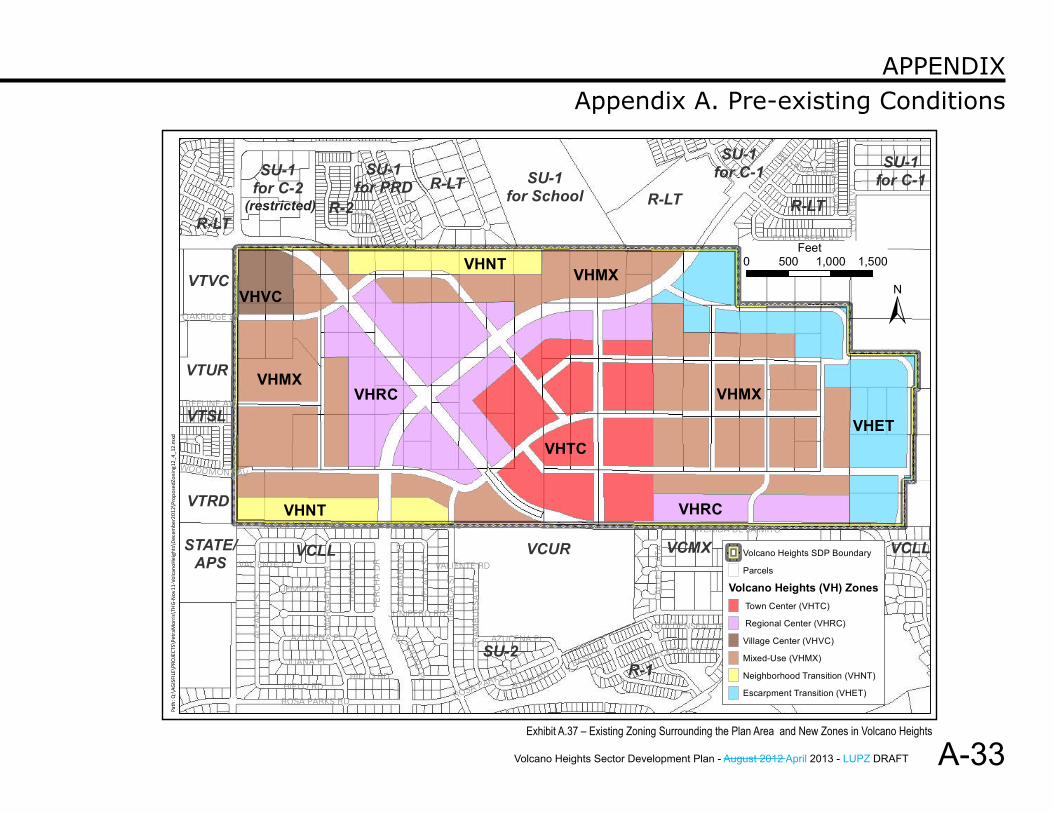
Exhibit A.37 – Existing Zoning Surrounding the Plan Area and New Zones in Volcano Heights
VHRC
VHMXVHMX
VHNT
VHNT
VHTC
VHRC
VHMX
R-1
VCUR
R-LTSU-1
for SchoolR-2
SU-1for C-2 R-LT
VTUR
VCMX
VTVC
SU-1for C-1
SU-2
VTRD
R-LT
VCLLSTATE/APS
VTSL
SU-1for PRD
SU-1for C-1
VCLL
R-LT
VALIENTE RD
UR
RA
CA
ST
ROSA PARKS RD
ALF
AN
JES
T
PER
CH
AD
R
MA
RG
AR
ITA
DR
LYO
NB
LVD
HIELO RD A LOE RD
BUCKTHORN TRL
FRA
MB
UES
AR
D
JUNIPERO RD
AZUCENA PL
HE
LAD
AS
T
AVENIDA DE JAIMITO
COLD CREEK AV
TER
NE
RO
ST
CA
LLE
PLA
TAJUANA PL
ADINA
LA
JEMEZ PL
AB
EJA
RR
ON
ST
JAC
KSC
RE
EK
DR
BASIL WY
TREELINE AV
OAKRIDGE ST
GOLDENSEAL TRL
TAP
ATI
OD
R
CA
LLE
NO
RTE
NA
RED RIVE R RD
WOODMONT AV
FELICID
AD
PL
CE
RR
OA
ZUL
PLVALIENTE RD
ROSA PARKS RD
HIELO RD
AZUCENA PL
VALIENTE RD
ROSA PARKS RD
AVENIDA DE JAIMITOAVENIDA DE JAIMITO
±XY
XY XY
XYXYXY Volcano Heights SDP Boundary
Parcels
Volcano Heights (VH) ZonesTown Center (VHTC)
Regional Center (VHRC)
Village Center (VHVC)
Mixed-Use (VHMX)
Neighborhood Transition (VHNT)
Escarpment Transition (VHET)
0 500 1,000 1,500Feet
Path
:Q:\
AGIS
FILE
\PRO
JECT
S\Pe
traM
orris
\TH
G-N
ov11
-Vol
cano
Hei
ghts
\Dec
embe
r201
2\Pr
opos
edZo
ning
12_4
_12.
mxd
VHVC
VHET
(restricted)
Volcano Heights Sector Development Plan - August 2012 April 2013 - LUPZ DRAFT
DRAFT
A-34
Appendix A. Pre-existing ConditionsAPPendix
2. Pre-Existing Land UseIn general, the West Side remains predominantly single-family subdivisions served by few major arterials, leading to almost exclusive vehicle travel and congestion at peak hours. In the last 10 years, more commercial and retail has filled in along corridors, particularly at major intersections. The development pattern, limited river crossings, and imbalance of jobs on the east side of the river and housing on the West Side concentrates traffic onto few arterials. The Major Activity Center proposed for Volcano Heights is intended to provide the opportunity for major employment on the West Side to counteract the commuting pattern, mitigate congestion at peak hours, and diversify land uses on the West Side.
Land use surrounding Volcano Heights is largely residential. (See Exhibit A.36). The Petroglyph National Monument provides an open space and culturally rich amenity. The northeast and southwest corner of Universe Boulevard and Paseo del Norte are reserved for commercial development. Land farther north of the Plan area near Paradise and Unser Boulevards is also reserved for commercial development.
Volcano Trails and Volcano Cliffs Sector Development Plans changed zoning to encourage higher-density residential development near mixed-use and Village Center areas for neighborhood-serving commercial and retail services. This movement toward mixed use development offers support and additional opportunities for higher-density residential and more intense non-residential activity in Volcano Heights, which can support regional retail and office uses in addition to neighborhood-serving commercial land uses.
East of the schools, one large tract of land is zoned R-LT. East of Unser Boulevard, the first tract of land is zoned R-LT. East of Lyon, land is zoned SU-1 for C-1.
West of the Plan area, zoning is R-LT on the northwest corner of Universe Boulevard and Paseo del Norte. The southwest corner is zoned SU-2 Volcano Trails Village Center (VTVC). Moving south, the remaining zones abutting the Volcano Heights Plan boundary are residential:
• a medium-density SU-2 Volcano Trails Urban Residential (VTUR),
• a slightly lower-density SU-2 Volcano Trails Small Lot (VTSL), and
• a low-density SU-2 Volcano Trails Residential Developing (VTRD) zone.
South of the Plan area, the zones are predominantly residential, with one mixed-use zone (SU-2 Volcano Cliffs Mixed Use - VCMX) south of Paseo del Norte near Kimmick Drive. The residential zones from west to east include the following:• SU-2 Volcano Cliffs Large Lot (VCLL) with average lot
size of 1/4 acre (.25).• SU-2 Volcano Cliffs Urban Residential (VCUR), which
is a large tract of land being master-planned as La Cuentista II, and
• SU-2 Volcano Cliffs Large Lot (VCLL) on the eastern edge of the Volcano Cliffs Plan area.
Volcano Heights Sector Development Plan - August 2012 April 2013 - LUPZ DRAFT
DRAFT
DRAFT
A-35
Appendix A. Pre-existing ConditionsAPPendix
XYXYXYXYXYXYXYXYXYXYXYXYXYXYXYXYXYXYXYXYXYXYXYXYXYXYXYXYXYXYXYXYXYXYXYXYXYXYXYXYXYXYXYXYXYXYXYXYXYXYXYXYXYXYXYXYXYXYXYXYXYXYXYXYXYXYXYXYXYXYXYXYXYXYXYXYXYXYXYXYXYXYXYXY
XY
XY
XY
XY
XY
XY
XY
XY
XY
XY
XY
XY
XY
XY
XY
XY
XY
XY
XY
XY
XY
XY
XY
XY
XY
XY
XY
XY
XY
XY
XY
XY
XY
XY XY XY XY XY XY XY XY XY XY XY XY XY XY XY XY XY XY XY XY XY XY XY XY XY XY XY XY XY XY XY XY XY XY XY XY XY XY XY XY XY XY XY XY XY XY XY XY XY XY XY XY XY XY XY XY XY XY XY XY XY XY XY XY
XY
XY
XY
XY
XY
XY
XY XY XY XY XY XY XY XY XY XY XY XY XY XY XY
XY
XY
XY
XY
XY
XY XY XY XY XY XY XY XY XY XY
XY
XY
XY
XYXY
XY
XY
XY
XY
XY
XY
XY
XY
XY
XY
XYXY
XY
XY
XY
XY
XY
XY
CITY OFALBUQUERQUE
CITY OFALBUQUERQUE
BINDRA RUPINDER S& GURPREET K &
MONTOYA ERNEST PTRUSTEE MONTOYA RVT
RANSOM RICHARD ETRUSTEES RICHARD &CECILIA RANSOM RVT
RANSOM RICHARD ETRUSTEES RICHARD &CECILIA RANSOM RVT
PIETRUKMICHAEL
A & CHARLENE
TRAILSLLC
BRUNSONLOUISE
BEDROCK PARTNERSHIP% CENTERFIREPROPERTY CO
RANSOM RICHARD ETRUSTEES RICHARD &CECILIA RANSOM RVT
BEDROCK INVESTORSLIMITED % CENTERFIRE
PROPERTY CO.
RANSOM RICHARD ETRUSTEES RICHARD &CECILIA RANSOM RVT
MYSTICLLC
CAPITALALLIANCE
INVESTMENTS LLC
MERKEL DANIEL L &SUE J TRUSTEES
MERKEL RVT
RANSOM RICHARD ETRUSTEES RICHARD &CECILIA RANSOM RVT
BEDROCK GENERALPARTNERSHIP C/O
GERALD GOLD
BEDROCKPARTNERSHIP C/O
CENTERFIRE PROP CO
TRAILSLLC
RANSOM RICHARD ETRUSTEES RICHARD &CECILIA RANSOM RVT
BEDROCKPARTNERSHIP %
CENTERFIRE PROPERTY
BEDROCK INVESTORSLIMITED C/O CENTERFIRE
PROPERTY CO
BEDROCK INVESTORSLIMITED C/O
GERALD GOLD
BRIGGS ALLAN D &JUANITA M TRUSTEES
OF BRIGGS FAM TRUST
BEDROCK INVESTORSLIMITED % CENTERFIRE
PROPERTY CO.
BE
DR
OC
K IN
VE
STO
RS
LIM
ITE
D %
CE
NT
ER
FIR
EP
RO
PE
RT
Y C
O.
RANSOM RICHARD ETRUSTEES RICHARD &CECILIA RANSOM RVT
TECUMSEHPROFESSIONAL
ASSOC INC
RANSOM RICHARD ETRUSTEES RICHARD &CECILIA RANSOM RVT
TRAILSLLC
BE
DR
OC
K P
AR
TN
ER
SH
IP&
BE
DR
OC
K L
IMIT
ED
PAR
TN
ER
SH
IP
NGUYEN CHIQUYEN & THITUYET ETAL
RABADI SHARIF A &SAMIA S TRUSTEES
STAR TRUST
RANSOM RICHARD ETRUSTEES RICHARD &CECILIA RANSOM RVT
HOFFMAN JAMESA III TRUSTEE J A
HOFFMAN III FAMILYLIMITED PARTNERSHIP
TRAILSLLC
BEDROCK INVESTORSLIMITED % CENTERFIRE
PROPERTY CO.
TRAILSLLC
CHACONGENE
BEDROCK GENERAL& BEDROCK INVESTORSLTD C/O GERALD GOLD
BRUNGARDTGUIDO
CITY OFALBUQUERQUE
DOUGHTYDANIEL H &
CHRISTINE L
WEISMANLARRY H& RUTH L
ALL SAINTSLUTHERANCHURCH
BEDROCKPARTNERSHIP C/O
GERALD GOLD
BEDROCKPARTNERSHIP %
CENTERFIRE PROPERTY
WILMANNLIV
WHISLER MAX E& ANNE V TRUST
WHISLER RVT C/OCINDY SEYL TRUSTEE
BEDROCKPARTNERSHIP C/O
GERALD GOLD
BEDROCK INVESTORSLIMITED %
CENTERFIRE PROP CO
BEDROCK INVESTORSLIMITED % CENTERFIRE
PROPERTY CO.
BANDISAID
BEDROCK GENERAL &BEDROCK INVESTORSLTD C/O GERALD GOLD
ARCHDIOCESEOF SANTA FE
RABADI SHARIF A &SAMIA S TRUSTEES
THE STAR TRUST
RANSOM RICHARD ETRUSTEES RICHARD &CECILIA RANSOM RVT
BOARD OFEDUCATION
RANSOM RICHARD ETRUSTEES RICHARD &CECILIA RANSOM RVT
HOFFMAN JAMESA III TRUSTEE J A
HOFFMAN III FAMILYLIMITED PARTNERSHIP
SIGNATUREREAL ESTATE
SERVICES LLC
BINDRA RUPINDER S& GURPREET K &
MONTOYA ERNEST PTRUSTEE MONTOYA RVT
HO
FFM
AN
JA
ME
S A
III
TRU
ST
EE
HO
FF
MA
N F
AM
ILY
LIM
ITE
D P
AR
TNE
RS
HIP
BEDROCK PARTNERSHIP &N M GEN PARTNERSHIP
C/O GERALD GOLD
RANSOM RICHARD ETRUSTEES RICHARD &CECILIA RANSOM RVT
RANSOM RICHARD ETRUSTEES RICHARD &CECILIA RANSOM RVT
RABADI SHARIF A &SAMIA S TRUSTEES
STAR TRUST
BEDROCK GENERALPARTNERSHIP C/O
GERALD GOLD
RANSOM RICHARD ETRUSTEES RICHARD &CECILIA RANSOM RVT
CROWLEYPAUL
J ETUX
RANSOM RICHARD ETRUSTEES RICHARD &CECILIA RANSOM RVT
BE
DR
OC
K P
AR
TN
ER
SH
IP%
CE
NT
ER
FIR
E P
RO
PE
RTY
RANSOM RICHARD ETRUSTEES RICHARD &CECILIA RANSOM RVT
BEDROCK GENERALPTNS C/O
GERALD GOLD
RANSOM RICHARD ETRUSTEES RICHARD &CECILIA RANSOM RVT
BE
DR
OC
K IN
VE
STO
RS
LIM
ITE
D %
CE
NT
ER
FIR
EP
RO
PE
RT
Y C
O.
RANSOM RICHARD ETRUSTEES RICHARD &CECILIA RANSOM RVT
RANSOM RICHARD ETRUSTEES RICHARD &CECILIA RANSOM RVT
BEDROCKPARTNERSHIP
% CENTERFIRE
HOFFMAN JAMES A IIITRUSTEE J A HOFFMAN
III FAMILY LTD PTNSP
RANSOM RICHARD ETRSUTEES RICHARD &CECILIA RANSOM RVT
DOUGHTYDANIEL H &
CHRISTINE L
WOWKVICTOR &
ROSE
BE
DR
OC
K P
AR
TN
ER
SH
IP%
CE
NT
ER
FIR
EP
RO
PE
RT
Y
KINLENJAMESG ETUX
RANSOM RICHARD ETRUSTEES RICHARD &CECILIA RANSOM RVT
BEDROCKPARTNERSHIP C/O
GERALD GOLD
RANSOM RICHARD ETRUSTEES RICHARD &CECILIA RANSOM RVT
GARRETT THEODORE E JR& KAREN SUE TRUSTEES
GARRETT REVOCABLE TRUST
ANDERSON ANDY J &CHRISTINA F DBA
ANDERSON MACHINING
RABADI SHARIF A &SAMIA S RABADI
TRUSTEES STAR TRUST
BEDROCK INVESTORSLIMITED % CENTERFIRE
PROPERTY CO.
BEDROCK INVESTORSLIMITED % CENTERFIRE
PROPERTY CO.
TRAILSLLC
RANSOM RICHARD ETRUSTEES RICHARD &CECILIA RANSOM RVT
HA
YS
& H
AM
MO
ND
PO
RP
ER
TIE
S L
LC C
/OC
LIF
OR
D C
HA
MM
ON
D M
AN
AG
ER
RANSOM RICHARD ETRUSTEES RICHARD &CECILIA RANSOM RVT
PARADISE BLVD
PASEO DEL NORTE
UNSER BLVD
UN
IVER
SE BL
V D
UN
SER
BLVD PASEO DEL NORTE
/0 500 1,000 1,500
Feet
NOTE: Ownership informaton is from �2010 Bernalillo County Tax Assesor's records, pending update.
Path
: Q:\
AGIS
FILE
\PRO
JECT
S\Pe
traM
orris
\THG
-Nov
11-V
olca
noHe
ight
s\De
cem
ber2
012\
Ow
ners
hip.
mxd
Exhibit A.39 – Property Ownership
XYXYXYXYXYXYXYXYXYXYXYXYXYXYXYXYXYXYXYXYXYXYXYXYXYXYXYXYXYXYXYXYXYXYXYXYXYXYXYXYXYXYXYXYXYXYXYXYXYXYXYXYXYXYXYXYXYXYXYXYXYXYXYXYXYXYXYXYXYXYXYXYXYXYXYXYXYXYXYXYXYXYXYXY
XY
XY
XY
XY
XY
XY
XY
XY
XY
XY
XY
XY
XY
XY
XY
XY
XY
XY
XY
XY
XY
XY
XY
XY
XY
XY
XY
XY
XY
XY
XY
XY
XY
XY
XY XY XY XY XY XY XY XY XY XY XY XY XY XY XY XY XY XY XY XY XY XY XY XY XY XY XY XY XY XY XY XY XY XY XY XY XY XY XY XY XY XY XY XY XY XY XY XY XY XY XY XY XY XY XY XY XY XY XY XY XY XY XY XY XY
XY
XY
XY
XY
XY
XY
XY
XY XY XY XY XY XY XY XY XY XY XY XY
XY
XY
XY
XY
XY
XY
XY XY XY XY XY XY XY XY XY
XY
XY
XY
XY
XY
XY
XY
XY
XY
XY
XY
XY
XY
XY
XY
XY
XY
XY
XY
XY
XY
XY
XY
CIT
Y O
FA
LBU
QU
ER
QU
E
CITY OFALBUQUERQUE
CITY OFALBUQUERQUE
BINDRA RUPINDER S& GURPREET K &
MONTOYA ERNEST PTRUSTEE MONTOYA RVT
RANSOM RICHARD ETRUSTEES RICHARD &CECILIA RANSOM RVT
RANSOM RICHARD ETRUSTEES RICHARD &CECILIA RANSOM RVT
PIETRUKMICHAEL
A & CHARLENE
TRAILSLLC
CITY OFALBUQUERQUE %
REAL ESTATE DEPT
BRUNSONLOUISE
BEDROCK PARTNERSHIP% CENTERFIREPROPERTY CO
RANSOM RICHARD ETRUSTEES RICHARD &CECILIA RANSOM RVT
BEDROCK INVESTORSLIMITED % CENTERFIRE
PROPERTY CO.
RANSOM RICHARD ETRUSTEES RICHARD &CECILIA RANSOM RVT
MYSTICLLC
CAPITALALLIANCE
INVESTMENTS LLC
MERKEL DANIEL L &SUE J TRUSTEES
MERKEL RVT
RANSOM RICHARD ETRUSTEES RICHARD &CECILIA RANSOM RVT
BEDROCK GENERALPARTNERSHIP C/O
GERALD GOLD
BEDROCKPARTNERSHIP C/O
CENTERFIRE PROP CO
TRAILSLLC
RANSOM RICHARD ETRUSTEES RICHARD &CECILIA RANSOM RVT
BEDROCKPARTNERSHIP %
CENTERFIRE PROPERTY
BEDROCK INVESTORSLIMITED C/O CENTERFIRE
PROPERTY CO
BEDROCK INVESTORSLIMITED C/O
GERALD GOLD
BRIGGS ALLAN D &JUANITA M TRUSTEES
OF BRIGGS FAM TRUST
BEDROCK INVESTORSLIMITED % CENTERFIRE
PROPERTY CO.
BE
DR
OC
K IN
VE
STO
RS
LIM
ITE
D %
CE
NT
ER
FIR
EP
RO
PE
RT
Y C
O.
RANSOM RICHARD ETRUSTEES RICHARD &CECILIA RANSOM RVT
TECUMSEHPROFESSIONAL
ASSOC INC
RANSOM RICHARD ETRUSTEES RICHARD &CECILIA RANSOM RVT
TRAILSLLC
BE
DR
OC
K P
AR
TN
ER
SH
IP&
BE
DR
OC
K L
IMIT
ED
PAR
TN
ER
SH
IP
NGUYEN CHIQUYEN & THITUYET ETAL
RABADI SHARIF A &SAMIA S TRUSTEES
STAR TRUST
RANSOM RICHARD ETRUSTEES RICHARD &CECILIA RANSOM RVT
HOFFMAN JAMESA III TRUSTEE J A
HOFFMAN III FAMILYLIMITED PARTNERSHIP
TRAILSLLC
BEDROCK INVESTORSLIMITED % CENTERFIRE
PROPERTY CO.
TRAILSLLC
CHACONGENE
BEDROCK GENERAL& BEDROCK INVESTORSLTD C/O GERALD GOLD
BRUNGARDTGUIDO
CITY OFALBUQUERQUE
DOUGHTYDANIEL H &
CHRISTINE L
WEISMANLARRY H& RUTH L
ALL SAINTSLUTHERANCHURCH
BEDROCKPARTNERSHIP C/O
GERALD GOLD
BEDROCKPARTNERSHIP %
CENTERFIRE PROPERTY
WILMANNLIV
WHISLER MAX E& ANNE V TRUST
WHISLER RVT C/OCINDY SEYL TRUSTEE
BEDROCKPARTNERSHIP C/O
GERALD GOLD
BEDROCK INVESTORSLIMITED %
CENTERFIRE PROP CO
BEDROCK INVESTORSLIMITED % CENTERFIRE
PROPERTY CO.
BANDISAID
BEDROCK GENERAL &BEDROCK INVESTORSLTD C/O GERALD GOLD
ARCHDIOCESEOF SANTA FE
RABADI SHARIF A &SAMIA S TRUSTEES
THE STAR TRUST
RANSOM RICHARD ETRUSTEES RICHARD &CECILIA RANSOM RVT
BOARD OFEDUCATION
RANSOM RICHARD ETRUSTEES RICHARD &CECILIA RANSOM RVT
HOFFMAN JAMESA III TRUSTEE J A
HOFFMAN III FAMILYLIMITED PARTNERSHIP
SIGNATUREREAL ESTATE
SERVICES LLC
BINDRA RUPINDER S& GURPREET K &
MONTOYA ERNEST PTRUSTEE MONTOYA RVT
HO
FFM
AN
JA
ME
S A
III
TRU
ST
EE
HO
FFM
AN
FA
MIL
YLI
MIT
ED
PA
RTN
ER
SH
IP
BEDROCK PARTNERSHIP &N M GEN PARTNERSHIP
C/O GERALD GOLD
RANSOM RICHARD ETRUSTEES RICHARD &CECILIA RANSOM RVT
RANSOM RICHARD ETRUSTEES RICHARD &CECILIA RANSOM RVT
RABADI SHARIF A &SAMIA S TRUSTEES
STAR TRUST
BEDROCK GENERALPARTNERSHIP C/O
GERALD GOLD
RANSOM RICHARD ETRUSTEES RICHARD &CECILIA RANSOM RVT
CROWLEYPAUL
J ETUX
RANSOM RICHARD ETRUSTEES RICHARD &CECILIA RANSOM RVT
BE
DR
OC
K P
AR
TN
ER
SH
IP%
CE
NT
ER
FIR
E P
RO
PE
RT
Y
RANSOM RICHARD ETRUSTEES RICHARD &CECILIA RANSOM RVT
BEDROCK GENERALPTNS C/O
GERALD GOLD
RANSOM RICHARD ETRUSTEES RICHARD &CECILIA RANSOM RVT
BE
DR
OC
K IN
VE
STO
RS
LIM
ITE
D %
CE
NT
ER
FIR
EP
RO
PE
RT
Y C
O.
RANSOM RICHARD ETRUSTEES RICHARD &CECILIA RANSOM RVT
RANSOM RICHARD ETRUSTEES RICHARD &CECILIA RANSOM RVT
BEDROCKPARTNERSHIP% CENTERFIRE
HOFFMAN JAMES A IIITRUSTEE J A HOFFMAN
III FAMILY LTD PTNSP
RANSOM RICHARD ETRSUTEES RICHARD &CECILIA RANSOM RVT
DOUGHTYDANIEL H &
CHRISTINE L
WOWKVICTOR &
ROSE
BE
DR
OC
K P
AR
TN
ER
SH
IP%
CE
NT
ER
FIR
EP
RO
PE
RT
Y
KINLENJAMESG ETUX
RANSOM RICHARD ETRUSTEES RICHARD &CECILIA RANSOM RVT
BEDROCKPARTNERSHIP C/O
GERALD GOLD
RANSOM RICHARD ETRUSTEES RICHARD &CECILIA RANSOM RVT
GARRETT THEODORE E JR& KAREN SUE TRUSTEES
GARRETT REVOCABLE TRUST
ANDERSON ANDY J &CHRISTINA F DBA
ANDERSON MACHINING
RABADI SHARIF A &SAMIA S RABADI
TRUSTEES STAR TRUST
BEDROCK INVESTORSLIMITED % CENTERFIRE
PROPERTY CO.
BEDROCK INVESTORSLIMITED % CENTERFIRE
PROPERTY CO.
TRAILSLLC
RANSOM RICHARD ETRUSTEES RICHARD &CECILIA RANSOM RVT
HA
YS
& H
AM
MO
ND
PO
RP
ER
TIE
S L
LC C
/OC
LIF
OR
D C
HA
MM
ON
D M
AN
AG
ER
RANSOM RICHARD ETRUSTEES RICHARD &CECILIA RANSOM RVT
PARADISE BLVD
PASEO DEL NORTE
UNSER BLVDU
NIV
ERSE
BLV D
UN
SER
B LVD PASEO DEL NORTE
/0 500 1,000 1,500
Feet
NOTE: Ownership informaton is from �2010 Bernalillo County Tax Assesor's records,. pending update.
Path
: Q:\
AGIS
FILE
\PRO
JECT
S\Pe
traM
orris
\THG
-Nov
11-V
olca
noHe
ight
s\Ju
ne20
12\O
wne
rshi
p.m
xd
NOTE: Ownership information is from 2010 Bernalillo County Tax Assessor’s records, pending update.
[Readable labels pending]
St. George Greek
Orthodox Church
City of Albuquerque
City of Albuquerque
City of Albuquerque
City of Albuquerque
City of Albuquerque
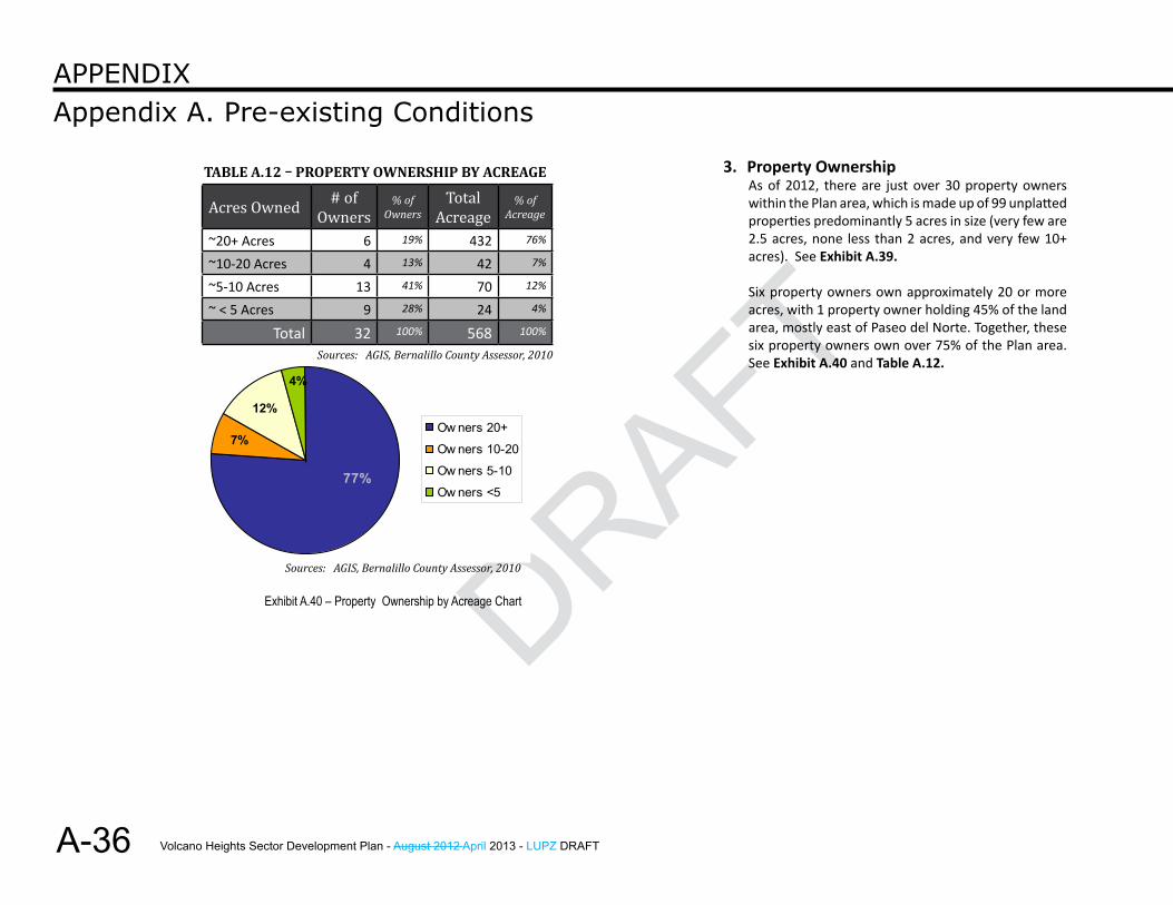
Volcano Heights Sector Development Plan - August 2012 April 2013 - LUPZ DRAFT
DRAFT
A-36
Appendix A. Pre-existing ConditionsAPPendix
3. Property OwnershipAs of 2012, there are just over 30 property owners within the Plan area, which is made up of 99 unplatted properties predominantly 5 acres in size (very few are 2.5 acres, none less than 2 acres, and very few 10+ acres). See Exhibit A.39.
Six property owners own approximately 20 or more acres, with 1 property owner holding 45% of the land area, mostly east of Paseo del Norte. Together, these six property owners own over 75% of the Plan area. See Exhibit A.40 and Table A.12.
77%
4%
12%
7%Ow ners 20+
Ow ners 10-20
Ow ners 5-10
Ow ners <5
Exhibit A.40 – Property Ownership by Acreage Chart
Acres Owned # of Owners
% of Owners
Total Acreage
% of Acreage
~20+ Acres 6 19% 432 76%
~10-20 Acres 4 13% 42 7%
~5-10 Acres 13 41% 70 12%
~ < 5 Acres 9 28% 24 4%
Total 32 100% 568 100%
Table a.12 – ProPerTy oWnershiP by aCreage
Sources: AGIS, Bernalillo County Assessor, 2010
Sources: AGIS, Bernalillo County Assessor, 2010
Volcano Heights Sector Development Plan - August 2012 April 2013 - LUPZ DRAFT
DRAFT
DRAFT
A-37
Appendix A. Pre-existing ConditionsAPPendix
f. infrastructure
1. Volcano Heights Water & Wastewater OverviewVolcano Heights is located in the 4W & 3WR Pressure Zones within the Volcano and Corrales Service Trunks. Currently, no water or sewer infrastructure exists within the majority of the Volcano Heights study area. Any water service to this area must come from developer-funded line extensions from the surrounding areas. [See Exhibit A.41.]
Volcano Heights is outside the existing service areas of the Albuquerque Bernalillo County Water Utility Authority (ABCWUA). As such, any development in the study area will require the execution of a development agreement between the property owners and the ABCWUA.
a. Pre-existing Conditions – Corrales Trunk Water System• The area north of the study area has been
designated as the Corrales Trunk service area. The Corrales Trunk corresponds to the former New Mexico Utility service area.
• Water sources within the Corrales Trunk all require arsenic treatment before the water can be used in the public water system.
b. Pre-existing Conditions – Volcano Trunk Water System• The Volcano Trunk represents the
northernmost water distribution system in the ABCWUA service area prior to the acquisition of New Mexico Utilities.
• Water sources within the Volcano Trunk require arsenic treatment before the water can be used in the public water system.
• Treated San Juan Chama water is used to supplement the water sources within the Volcano Trunk.
c. Pre-existing Conditions – Wastewater• Wastewater generated within the old New
Mexico Utilities (now Corrales Trunk) service area is metered and enters the existing ABCWUA system at several metering manholes located along the Paseo del Norte corridor. [See Exhibit A.42.]
• For planning purposes, all of the wastewater generated within the Volcano Heights study area will be contributory to the existing sewer line in Paseo del Norte.
2. Public Service Company of New MexicoNew lines are planned primarily to increase system reliability and serve new stations. New stations and lines are planned to serve load growth in developing areas. PNM has electric facilities within the Plan area as shown in Exhibit A.41 on page A-38. There is an existing 115kV electric transmission line with an approximate right-of-way width of 100 feet on the western boundary of the Plan area and a new substation called Scenic Substation is under development as of 2012. [See Exhibit A.43.] [114]
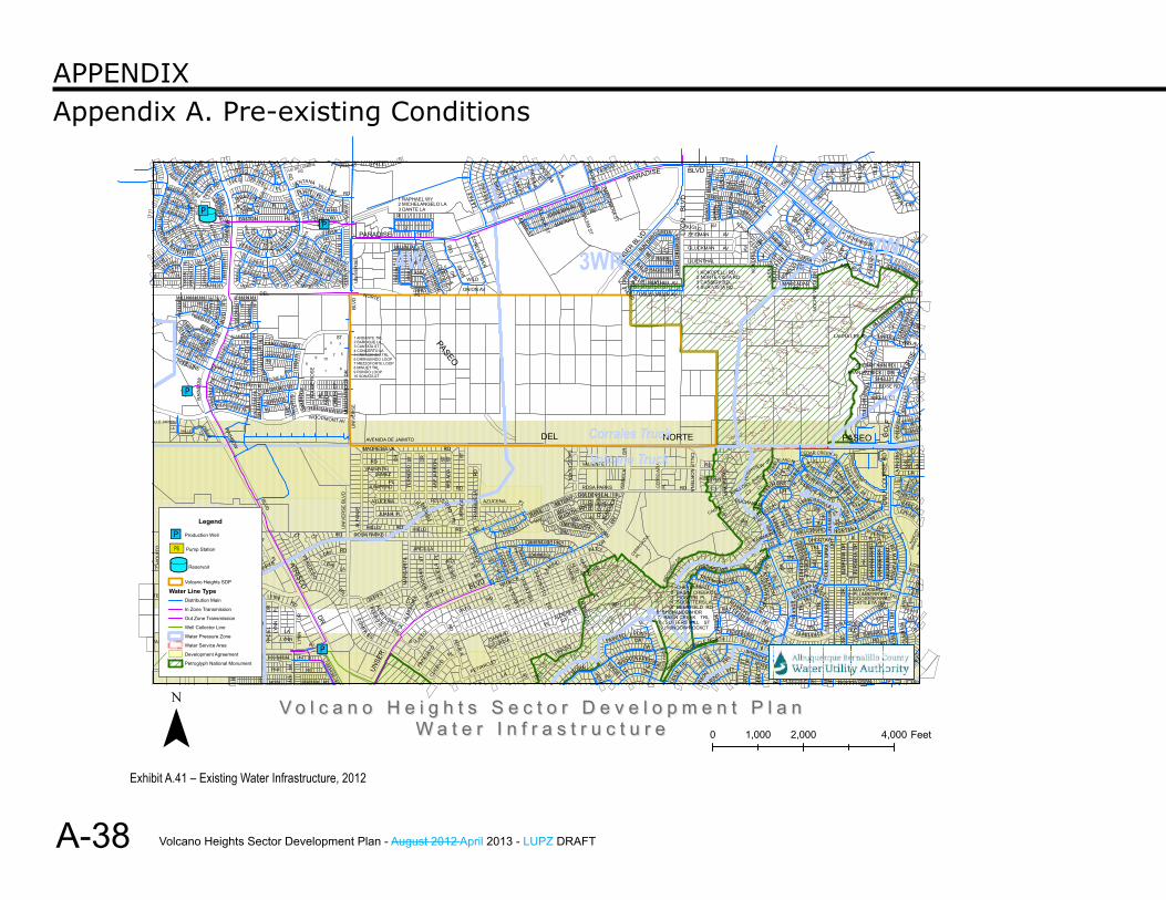
Volcano Heights Sector Development Plan - August 2012 April 2013 - LUPZ DRAFT
DRAFT
A-38
Appendix A. Pre-existing ConditionsAPPendix
kj
"M
"M
"M"M
ST
SA
NT A
LA
POINTE
RD
RD
RD
ST
ST
VE
NTO
SE
PL
TRAV
ILLA
RAI
NB
OW
DR
DAL
E
BLVD
RD
LORETE
DR
NOR
THPO
INTE
SOL
CT
RD
HEATHER
LORI
9 10
CTM
ON
TER
IA
RD
ROSA PARKS
LA RO
CC
A
ALM
END
RA
MAR
GA
RIT
A
CIRUELA
TRL
3 DANTE LA
PL
CT
RD
PETIRROJO
RD
WILD
CT
ALTO REY
CH
ICORY D
RPRADO
CA
MINO
CT
CT
BUCKTHORN
LAC
HAPAR
RAL ST
CLO
VER
BU
RDO
CKLA
CACHE CR
EEK
BLU E FEATHER AV
TRL
8
SHENANDOAH
WINDOW ROCK
BLV
D
CREEKCT
BUGLO
GLUCKMAN
1
RD
RID
GE
WAY
GE
NE
VA D
R
WHEEL
8
IN GTON
DR
JUSTIN
TRLCHISHOLM
SUNDANCETRL
OHOCTAWWELLSBURG
CT
RDMARCADAS
CTDRAK
E
SUN
RO
SE
FI
SUN
RO
SE
DR
LEW
ISB
UR
G
CUMBER-
SIMON
RD
1
2
BURGpiedras m
arcadas
RYAN PATRICK
OLS
E
DR
RED
BER
RYS
T
CALLE
COUR
SE
COLUM
BUS
LONGVICE
SIL
VERT
ON
DR
BRECKENRIDGE R
D
RD
JALISCO
VENTRE CT
TAHO
E
T
RD
TRL
BATT
LE C
RE
EK
DR
VISTA
ST LUZ
SCENIC
DR
LYNN
CT
KAYSER MILL RD
RD
LAD
RO
ND
R
RD
CT
CT
AV
CT
PL
MES
A P
L
LA ROCCA
PL
CT
3
CT
RD
UN
IVE
RSE
BLV
DM
ISS
ION
RID
GE
DR
TAPA
TIO
HIELO
AZUCENA
ST
PASEO
CALLE
RD
AZUCENA
CAYENN
E DR
SAMIA ST
CAMINO DE PAZ
AJLOUN
ST
CAM
INO
VALIENTE
AV
DR
WY
LA
DR
DR
RED RIVER
HOMESTEAD CIRCLE NORTH
3
PL
RD
YUMA
CAR
SON
CHESAPE AKE
ZEIDMAN
M
PL
ARTH
6
RD
MO
RE
NA
CT
ABIN
RA
NC
H
STAUNTON
CT
CT
DRFAIRM
ONT
HILL
SB ORO
1
FAIRFAX
TRL
PECOS
MO
UN
DD
R
SU
MMERSVILLE
IGNACI O
VISTA
PLUME
DR
PL
RD
MAR
TIN
LOBELIARD
MAHONIA
WAYNESBORO
LANDRD
PL
CT
RD
RANCHO
MOUNTVAL
GLENCR
ROSE RD
YVO
NNE
MAR
IE
DR
BROO
CA
CIR
TABIRA
PLPOINTE
T
DR
HEARTHSTO
NESENECU RD
WILLIAMSBURG
WE
ST
LANTANA AV
L AKE
CT
GLYNDON TRL
WINTERSET
ALAMILLO
EDISON RD
VIS
TA
DR
CT
BA
LSA
M G
LAD
E R
D
RD
DR
DEL SOL
RD
OAK
RID
GE
PIEDRA QUEMADA
RD
PL
RD
CT
TETON
RD
HOOD
G TANA HILLS RD
COM
PA
SS
RD
MADRESELVA
1 ANDANTE TRL2 BAROQUE LA3 CANTATA ST4 CONCERTO LA5 CRESCENDO TRL6 DIMINUENDO LOOP7 MEZZOFORTE LOOP8 MINUET TRL9 RONDO LOOP10 SONATA ST
DR
RD
BELLINI LA
PAPA
GAYO
PL
ORFEO
21
PATO
ABEJ
ARR
ON
BIG
PL
KOLA
FRAM
BU
ESA
CT
KIMMICK AGU
A FRIA
CT
ALOE RD
CT
PL
ALDER
ETE
TARGET
RD
PL
BABY DEENA ST
LA
BAL D EAGLE RD
E
9
1BASINPIONEER
CT
PL TRL
RIDGEWAY
RD
1 KOKOPELLI RD
AV
WY
SPINNING
AV
RD
PL
4
CT
WAVER
LY
CRES
SM
ONT
CEDAR CREEK PL
RADCLIFF
E
MR
OSE
DR
WAYNESBORO
CT
STRAS-
BURG R
D
3
1
PLUMBERRYGOOSEBERRY
DR ST
FERRY C
T
RD
MILL-
CT
RD
DR
TRU
M
PEROS C
RID
GE
VIE
W D
RG
OLF
DR
RIO
BRAV
O D
R
LA
CT
SP
RIN
G
DR
N
TEMPSTAD
CH
IQU
ITO PL
VE
NTANA RANCH R D
T
LA
LAPRADO
KUAN
A
PL
PL
TRIAN A PL
AV
R
D
TEM
PSTA
DW
INN
CR
ES
T TR
L AV
LAS NUTRIAS
ST
GROS
3
WESTON
AM
AN
EC
ER
VE
RIL
CANYON CLIFF
ALL
EG
IAN
CE
JARALES
WE
ST
FORD PL
DR
RA
ZA
LA
DR
DR
PL
STOU
GH
TON
RD
ADO
BE R
OSE
SNO
W
CR
EEK
CT
8
1
PL
ST
ST
3
RD
CIRU
ELA
CIRU
ELA
FELICIDAD
ST
CH
AMISA
BLVD
DR
CONEFLO
WER
LA P
AZ PLU
NKE
TT
LA ST
BLANDA
UNITAS
DR
BASIL
ERMEMIN AV
ALTO
REDROOT
CALLE P
LATA
JERU
SALEM ST
9
SUN D
ANCER DR
boca
neg
ra
DEERFIELD
RID
GEWAY
D
R
SQUATTERS
CE
RR
O A
ZUL
CT
TRL
2 NORTE VISTA RD
RABADI
BR
AD
FOR
D
DOMINION CT
TRL
RD
KOKOPELLI
AV
THORN
WO
OD
5
AVLITTLETON
BA
JAD
A DR
TRE
TRL 2
IND
EPEND
ENC
E
WAG
ON
DR
SNAPDRAGON
FAR
GO
REWHEEL
TRL
DR
DR
CT
CT
AV
THIE
L
RD
JILL P
ATRICIA ST
CT
NEL
SON
DR
RIV
ERTO
N
JUN
EBER
RY
DR
GO
LF C
OU
RS
E
SHELLY
LYNN AV
PL
AV
SALA
DO
DR
RAN
RE
YE
S
NOIS
TAS DR
SPANISH
VANCOUVER
EN
RI VER
RAI
NB
OW
CT
TOU
CA
N
ENTR
ADA
PL
ALLANO
CT
A
NBY
ST
PILABO
ACTON
RD
CHILTE
CT
SENDERO RD
VENTANA
LUZ D
E
DR
PL
OS
O
CORSICO
PLATT
VISTA DEL SO
LORI
PLST
PRADOS RD
PL
UN
IVE
RSE
BLVD
RD
JUANA
JUNIPERO
AVENIDA DE JAIMITO
PU
CC
I NI T
RL
CALLE
RD
DR
VIV
ALD
I TR
L
CUER
VO
AGUILA
PL
ST
ARBOL
OR
PICARDIA
ONION AV
CHAPARRAL
DR
ALDERETE
DEL
HORN JASMI
BROKEN
RD
RED
FIRETHORN
DR
6
NORTE
JAC
KS C
REE
K D
R LYO
N
ARSO
N
DR
CT
LARD
RICHMO ND HILL
LILIENTHAL
3 CASSIDY RD
BLVD
DR
CT
SA
RAG
OS
SA
CATALONIA
CASTLE AV
CT
CA
SSID
Y DR
MIDNIGHT
PL
WELLS FARGO
DR
CT
CT
TRL
LAURA LEE PL
NO
CH
E VI
STA
DR
CO
LBY
PL
TRL
4
2
4
WOOD
PASEO
TIA
CH
RIS
TIN
APL
RD
RD
ST
R
ANCHO
LOS
WO
OD
CR
OFT
PL
P
DOLA
D
OS
W
EST
STTREE LINE
SABI
NAL
NU
EVA
TOME
JAM
ES
ON
PL
SALID
A
CUCHILLO
HA
VE
N S
T
RG
BOUVARDIA
ROSA PARKS
RESOLANA
TREELINE AV
RD
RD
ST
DR
CA
LICO
ATRISCO
PL
PL
PIEDRA
PL
PALO
MIT
A
GLA C
IER
LUZ DE LUMBRE
RD
RD
PEREZOSO
WOODMONT AV
TRL
LA
5
CT
CH
ELO
N P
L
UNSE
R
PERR
O
ZO
ALMENDRA
CIERVO
PL
PL
VALIENTE
S U JETO
PL
CT
ROC
KIAR
ST
1 RAPHAEL WY
PL
CALLE SAGE
URRACA
RD
CANO
NC
ITO
MAFRAQ
DOUGLAS
CT
WY
TRL
LA
PAINTED
UNSER BL
VD
AV
FAIRFAX
DR
ARROW
PL
BASIN CREEK
4 SUR VISTA RD
SIE
RR
A
ROANOKE
DR
HIG
HVIEW
AV
MANSFIELD
CT
AV
FAIRMONT
C T
CU
MBE
RLAND PL
CT
BUTTERFIELD
DR
DR
CT
DR
7
GO
LDE
N
AV
ASBURY
CTLE
E
CAL
YX
SAMARA
BUR
SER
A
SNO
WBE
RR
Y
4
R
I VER
CED
AR CREEK
DR
HAR PERS
SHERRY ANN RD
RD
RD
HIL L
LAS
RAN
CHO
WES
TRID
GE
PLDR
OLE
T D
R
QUAIL RIDGE
MES
RIO
META
RANC
HO
RED
OND
RAN
AV
GLO
LA
ALLE JARDIN
CANELO
CT
WINSLOW PL
TEYPANA
SEVI
LLA
ST
RD
RD
VE
RLA
IN
1 RALEIGH
DR
CASC
ADA
E S
OL
DR
CH
AIN
OLD
MIL
L
NAT
ION
WID
EBL
VD
RD
BRAVE
HAWKWATCH
PL TIJERAS CREEK RD
ST
MONT AR
A
DEL
DEL D
IA
PINE
LYNN
LYN
N
PL
CT
TALA
RA
RANCH
PL
PL
RD
DR
OASIS CANYON RD
4
TERES INA
RD
VALLE VERDE
VILLAGE
ALFA
NJE
2
NORTE
RD
TRL
JEMEZ
PER
CHA
CALLE
ADINA LA
UR
RAC
A
HEL
ADA
RD
PI NON
RD
TREV
INO
HOPS
CIN
NAM
ON
D EL
WY
BETONY
CT
CAMINO
ROSA PARKSGOLDENSEAL TRL
ALTO
Y
CERRO AZU
L
KIM
MIC
K
COLD CREEK AV
DR
PARADISE
DODG
E
7SUTTERS MILL
4
RD
EM
ENT
ST
CT
CARTER
ST
MALLORY
BUCHANAN
AV
DR
ST
TRL
SUN
DA
NC
E TRL
TRL
BURSERA DR
CUMBERLAND R D
3
BATE
S
RUS
SE
SPIK
E DR
HARRISON-
FRO
NT
MIKELL CT
DR
CT
HOWARDDR
RO
SETT
E
DR
3
arroyo
LA P
ALO
MA C
T
ER
HILLC
LOS
SENE
ESTES AV
PL
VALLE
RD
RD
RAINBOW
CROSSWINDS TRL
DR
CANTER
A LA
FAC
IEL
RD
HA
LLS
T ON
TR
L
RD
RIO
GA
LIST
EO
HA
R
TF ORD
SO
UTH
PO
INTE
EASTON
LUZ
DEL
MOCK
LYN
N
COR
RID
OR
COLINA
LAS PIEDRAS
EASTFOR
D P
L
T
VENTANA
LOS
WIN
D C
AVE
DR
6
7
UN
IVE
RSE
PARADISE
DR
ARCILLA
RD HIELO
TER
NER
O
WYVERDI
2 MICHELANGELO LA
RD
DR
CANAVIO
CT
PL
COMFREY RD
PALMER
TRL
DRPONY
D
TRL
5
2CHEYENNE
NO
RTEN
A CT
CALLE
BA
SHA
ST
VICKSBURG
HATTIESBURG
TIMBERFALL S
PRESTIGE
DR
VERO
NA
B U RL-FA
IRMONT
KO
KOPE
LLI D
RBR
UN
SW
ICK
PL
HOMESTEAD
RO
YAL
2
JUST
IN
OR
EGO
N
ECO
S
TRL
TRL
WEL
LS
DR
CT
NORTENA
BURG
MAR
TINS-
CATTLEYA
ASB
UR
Y
TRL
RD
DR
MARNA
LA
1
CT
Legend
"M Production Well
[Ú Pump Station
kj Reservoir
Volcano Heights SDP
Water Line TypeDistribution Main
In Zone Transmission
Out Zone Transmission
Well Collector Line
Water Pressure Zone
Water Service Area
Development Agreement
Petroglyph National Monument
V o l c a n o H e i g h t s S e c t o r D e v e l o p m e n t P l a nV o l c a n o H e i g h t s S e c t o r D e v e l o p m e n t P l a nW a t e r I n f r a s t r u c t u r eW a t e r I n f r a s t r u c t u r e¯ 0 2,000 4,0001,000 Feet
3WR4W 2W
Corrales TruckVolcano Truck
Exhibit A.41 – Existing Water Infrastructure, 2012
Volcano Heights Sector Development Plan - August 2012 April 2013 - LUPZ DRAFT
DRAFT
DRAFT
A-39
Appendix A. Pre-existing ConditionsAPPendix
ST
SA
NT A
LA
POINTE
RD
RD
RD
ST
ST
VE
NTO
SE
PL
TRAV
ILLA
RAI
NB
OW
DR
DAL
E
BLVD
RD
LORETE
DR
NOR
THPO
INTE
SOL
CT
RD
HEATHER
LORI
9 10CT
MO
NTE
RIA
RD
ROSA PARKS
LA RO
CC
A
ALM
END
RA
MAR
GA
RIT
A
CIRUELA
TRL
3 DANTE LA
PL
CT
RD
PETIRROJO
RD
WILD
CT
ALTO REY
CH
ICORY D
R
PRADO
CA
MINO
CT
CT
BUCKTHORN
LAC
HAPAR
RAL ST
CLO
VER
BU
RDO
CKLA
CACHE CR
EEK
BLU E FEATHER AV
TRL
8
SHENANDOAH
WINDOW ROCK
BLV
D
CREEKCT
BUGLO
GLUCKMAN
1
RD
RID
GE
WAY
GE
NE
VA D
R
WHEEL
8
IN GTON
DR
JUSTIN
TRLCHISHOLM
SUNDANCETRL
OHOCTAWWELLSBURG
CT
RDMARCADAS
CTDRAK
E
SUN
RO
SE
FI
SUN
RO
SE
DR
LEW
ISB
UR
G
CUMBER-
SIMON
RD
1
2
BURGpiedras m
arcadas
RYAN PATRICK
OLS
E
DR
RED
BER
RYS
T
CALLE
COUR
SE
COLUM
BUS
LONGVICE
SIL
VERT
ON
DR
BRECKENRIDGE R
D
RD
JALISCO
VENTRE CT
TAHO
E
T
RD
TRL
BATT
LE C
RE
EK
DR
VISTA
ST LUZ
SCENIC
DR
LYNN
CT
KAYSER MILL RD
RD
LAD
RO
ND
R
RD
CT
CT
AV
CT
PL
MES
A P
L
LA ROCCA
PL
CT
3CT
RD
UN
IVE
RSE
BLV
DM
ISS
ION
RID
GE
DR
TAPA
TIO
HIELO
AZUCENAST
PASEO
CALLE
RD
AZUCENA
CAYENN
E DR
SAMIA ST
CAMINO DE PAZ
AJLOUN
ST
CAM
INO
VALIENTE
AV
DR
WY
LA
DR
DR
RED RIVER
HOMESTEAD CIRCLE NORTH
3
PL
RD
YUMA
CAR
SON
CHESAPE AKE
ZEIDMAN
M
PL
ARTH
6
RD
MO
RE
NA
CT
ABIN
RA
NC
H
STAUNTON
CT
CT
DRFAIRM
ONT
HILL
SB ORO
1
FAIRFAX
TRL
PECOS
MO
UN
DD
R
SU
MMERSVILLE
IGNACI O
VISTA
PLUME
DR
PL
RD
MAR
TIN
LOBELIARD
MAHONIA
WAYNESBORO
LANDRD
PL
CT
RD
RANCHO
MOUNTVAL
GLENCR
ROSE RD
YVO
NNE
MAR
IE
DR
BROO
CA
CIR
TABIRA
PLPOINTE
T
DR
HEARTHSTO
NESENECU RD
WILLIAMSBURG
WE
ST
LANTANA AV
L AKE
CT
GLYNDON TRL
WINTERSET
ALAMILLO
EDISON RDV
ISTA
DR
CT
BA
LSA
M G
LAD
E R
D
RD
DR
DEL SOL
RD
OAK
RID
GE
PIEDRA QUEMADA
RD
PL
RD
CT
TETON
RD
HOOD
G TANA HILLS RD
COM
PA
SS
RD
MADRESELVA
1 ANDANTE TRL2 BAROQUE LA3 CANTATA ST4 CONCERTO LA5 CRESCENDO TRL6 DIMINUENDO LOOP7 MEZZOFORTE LOOP8 MINUET TRL9 RONDO LOOP10 SONATA ST
DR
RD
BELLINI LA
PAPA
GAYO
PL
ORFEO
21
PATO
ABEJ
ARR
ON
BIG
PL
KOLA
FRAM
BU
ESA
CT
KIMMICK AGU
A FRIA
CT
ALOE RD
CT
PL
ALDER
ETE
TARGET
RD
PL
BABY DEENA ST
LA
BAL D EAGLE RD
E
9
1BASINPIONEER
CT
PL TRL
RIDGEWAY
RD
1 KOKOPELLI RD
AV
WY
SPINNING
AV
RD
PL
4
CT
WAVER
LY
CRES
SM
ONT
CEDAR CREEK PL
RADCLIFF
E
MR
OSE
DR
WAYNESBORO
CT
STRAS-
BURG R
D
3
1
PLUMBERRYGOOSEBERRY
DR ST
FERRY C
T
RD
MILL-
CT
RD
DR
TRU
M
PEROS C
RID
GE
VIE
W D
RG
OLF
DR
RIO
BRAV
O D
R
LA
CT
SP
RIN
G
DR
N
TEMPSTAD
CH
IQU
ITO PL
VE
NTANA RANCH R D
T
LA
LAPRADO
KUAN
A
PL
PL
TRIAN A PL
AV
R
D
TEM
PSTA
DW
INN
CR
ES
T TR
L AV
LAS NUTRIAS
ST
GROS
3
WESTON
AM
AN
EC
ER
VE
RIL
CANYON CLIFF
ALL
EG
IAN
CE
JARALES
WE
ST
FORD PL
DR
RA
ZA
LA
DR
DR
PL
STOU
GH
TON
RD
ADO
BE R
OSE
SNO
W
CR
EEK
CT
8
1
PL
ST
ST
3
RD
CIRU
ELA
CIRU
ELA
FELICIDAD
ST
CH
AMISA
BLVD
DR
CONEFLO
WER
LA P
AZ PLU
NKE
TT
LA ST
BLANDA
UNITAS
DR
BASIL
ERMEMIN AV
ALTO
REDROOT
CALLE P
LATA
JERU
SALEM ST
9
SUN D
ANCER DR
boca
neg
ra
DEERFIELD
RID
GEWAY
D
R
SQUATTERS
CE
RR
O A
ZUL
CT
TRL
2 NORTE VISTA RD
RABADI
BR
AD
FOR
D
DOMINION CT
TRL
RD
KOKOPELLI
AV
THORN
WO
OD
5
AVLITTLETON
BA
JAD
A DR
TRE
TRL 2
IND
EPEND
ENC
E
WAG
ON
DR
SNAPDRAGON
FAR
GO
REWHEEL
TRL
DR
DR
CT
CT
AV
THIE
L
RD
JILL P
ATRICIA ST
CT
NEL
SON
DR
RIV
ERTO
N
JUN
EBER
RY
DR
GO
LF C
OU
RS
E
SHELLY
LYNN AV
PL
AV
SALA
DO
DR
RAN
RE
YE
S
NOIS
TAS DR
SPANISH
VANCOUVER
EN
RI VER
RAI
NB
OW
CT
TOU
CA
N
ENTR
ADA
PL
ALLANO
CT
A
NBY
ST
PILABO
ACTON
RD
CHILTE
CT
SENDERO RD
VENTANA
LUZ D
E
DR
PL
OS
O
CORSICO
PLATT
VISTA DEL SO
LORI
PLST
PRADOS RD
PL
UN
IVE
RSE
BLVD
RD
JUANA
JUNIPERO
AVENIDA DE JAIMITO
PU
CC
I NI T
RL
CALLE
RD
DR
VIV
ALD
I TR
L
CUER
VO
AGUILA
PL
ST
ARBOL
OR
PICARDIA
ONION AV
CHAPARRAL
DR
ALDERETE
DEL
HORN JASMI
BROKEN
RD
RED
FIRETHORN
DR
6
NORTE
JAC
KS C
REE
K D
R LYO
N
ARSO
N
DR
CT
LARD
RICHMO ND HILL
LILIENTHAL
3 CASSIDY RD
BLVD
DR
CT
SA
RAG
OS
SA
CATALONIA
CASTLE AV
CT
CA
SSID
Y DR
MIDNIGHT
PL
WELLS FARGO
DR
CT
CT
TRL
LAURA LEE PL
NO
CH
E VI
STA
DR
CO
LBY
PL
TRL
4
2
4
WOOD
PASEO
TIA
CH
RIS
TIN
APL
RD
RD
ST
R
ANCHO
LOS
WO
OD
CR
OFT
PL
P
DOLA
D
OS
W
EST
STTREE LINE
SABI
NAL
NU
EVA
TOME
JAM
ES
ON
PL
SALID
A
CUCHILLO
HA
VE
N S
T
RG
BOUVARDIA
ROSA PARKS
RESOLANA
TREELINE AV
RD
RD
ST
DR
CA
LICO
ATRISCO
PL
PL
PIEDRA
PL
PALO
MIT
A
GLA C
IER
LUZ DE LUMBRE
RD
RD
PEREZOSO
WOODMONT AV
TRL
LA
5
CT
CH
ELO
N P
L
UNSE
R
PERR
O
ZO
ALMENDRA
CIERVO
PL
PL
VALIENTE
S U JETO
PL
CT
ROC
KIAR
ST
1 RAPHAEL WY
PL
CALLE SAGE
URRACA
RD
CANO
NC
ITO
MAFRAQ
DOUGLAS
CT
WY
TRL
LA
PAINTED
UNSER BL
VD
AV
FAIRFAX
DR
ARROWPL
BASIN CREEK
4 SUR VISTA RD
SIE
RR
A
ROANOKE
DR
HIG
HVIEW
AV
MANSFIELD
CT
AV
FAIRMONT
C T
CU
MBE
RLAND PL
CT
BUTTERFIELD
DR
DR
CT
DR
7
GO
LDE
N
AV
ASBURY
CTLE
E
CAL
YX
SAMARA
BUR
SER
A
SNO
WBE
RR
Y
4
R
I VER
CED
AR CREEK
DR
HAR PERS
SHERRY ANN RD
RD
RD
HIL L
LAS
RAN
CHO
WES
TRID
GE
PLDR
OLE
T D
R
QUAIL RIDGE
MES
RIO
META
RANC
HO
RED
OND
RAN
AV
GLO
LA
ALLE JARDIN
CANELO
CT
WINSLOW PL
TEYPANA
SEVI
LLA
ST
RD
RD
VE
RLA
IN
1 RALEIGH
DR
CASC
ADA
E S
OL
DR
CH
AIN
OLD
MIL
L
NAT
ION
WID
EBL
VD
RD
BRAVE
HAWKWATCH
PL TIJERAS CREEK RD
ST
MONT AR
A
DEL
DEL D
IA
PINE
LYNN
LYN
N
PL
CT
TALA
RA
RANCH
PL
PL
RD
DR
OASIS CANYON RD
4
TERES INA
RD
VALLE VERDE
VILLAGE
ALFA
NJE
2
NORTE
RD
TRL
JEMEZ
PER
CHA
CALLE
ADINA LA
UR
RAC
A
HEL
ADA
RD
PI NON
RD
TREV
INO
HOPS
CIN
NAM
ON
D EL
WY
BETONY
CT
CAMINO
ROSA PARKSGOLDENSEAL TRL
ALTO
Y
CERRO AZU
L
KIM
MIC
K
COLD CREEK AV
DR
PARADISE
DODG
E
7SUTTERS MILL
4
RD
EM
ENT
ST
CT
CARTER
ST
MALLORY
BUCHANAN
AV
DR
ST
TRL
SUN
DA
NC
E TRL
TRL
BURSERA DR
CUMBERLAND R D
3
BATE
S
RUS
SE
SPIK
E DR
HARRISON-
FRO
NT
MIKELL CT
DR
CT
HOWARDDR
RO
SETT
E
DR
3
arroyo
LA P
ALO
MA C
T
ER
HILLC
LOS
SENE
ESTES AV
PL
VALLE
RD
RD
RAINBOW
CROSSWINDS TRL
DR
CANTER
A LA
FAC
IEL
RD
HA
LLS
T ON
TR
L
RD
RIO
GA
LIST
EO
HA
R
TF ORD
SO
UTH
PO
INTE
EASTON
LUZ
DEL
MOCK
LYN
N
COR
RID
OR
COLINA
LAS PIEDRAS
EASTFOR
D P
L
T
VENTANA
LOS
WIN
D C
AVE
DR
6
7
UN
IVE
RSE
PARADISE
DR
ARCILLA
RD HIELO
TER
NER
O
WYVERDI
2 MICHELANGELO LA
RD
DR
CANAVIO
CT
PL
COMFREY RD
PALMER
TRL
DRPONY
D
TRL
5
2CHEYENNE
NO
RTEN
A CT
CALLE
BA
SHA
ST
VICKSBURG
HATTIESBURG
TIMBERFALL S
PRESTIGE
DR
VERO
NA
B U RL-FA
IRMONT
KO
KOPE
LLI D
RBR
UN
SW
ICK
PL
HOMESTEAD
RO
YAL
2
JUST
IN
OR
EGO
N
ECO
S
TRL
TRL
WEL
LS
DR
CT
NORTENA
BURG
MAR
TINS-
CATTLEYA
ASB
UR
Y
TRL
RD
DR
MARNA
LA
1
CT
LegendCOLLECTOR
INTERCEPTOR
Volcano Heights SDP
Petroglyph National Monument
Wastewater Service Area
Development Agreement
V o l c a n o H e i g h t s S e c t o r D e v e l o p m e n t P l a nV o l c a n o H e i g h t s S e c t o r D e v e l o p m e n t P l a nS e w e r I n f r a s t r u c t u r eS e w e r I n f r a s t r u c t u r e¯ 0 2,000 4,0001,000 Feet
Exhibit A.42 – Existing Sewer Infrastructure, 2012
Volcano Heights Sector Development Plan - August 2012 April 2013 - LUPZ DRAFT
DRAFT
A-40
Appendix A. Pre-existing ConditionsAPPendix
Exhibit A.43 – Volcano Mesa Area Electrical Facilities Map
Volcano Heights Sector Development Plan - August 2012 April 2013 - LUPZ DRAFT
DRAFT
DRAFTAppendix BSector Planning Process
B-1
Volcano Heights Sector Development Plan - August 2012 April 2013 - LUPZ DRAFT
DRAFT
B-2
Appendix B. Sector Planning ProcessAPPendix
In 2004, the City Council called for a planning study of Volcano Mesa, an area west of the volcanic Escarpment of the City’s Northwest Mesa that includes three Sector Development Plan areas: Volcano Cliffs, Volcano Trails, and Volcano Heights.
The City Council expressed concerns over development trends with subdivisions being approved piecemeal without the guidance of an overall plan for the area, which “has long been considered a unique landscape that requires special protection.” The Council recognized the need for a plan that would bring development in line with the West Side Strategic Plan (WSSP), the Northwest Mesa Escarpment Plan (NWMEP), the Albuquerque / Bernalillo County Comprehensive Plan, and other previously established policies and regulations. Issues to be addressed included transportation, drainage, water and wastewater, land uses, view corridors, building height, massing and orientation, walls, parks, trails and open space, and phasing and timing of growth.
The planning study originally forecast over 100,000 additional residents at final build-out in the Volcano Mesa plan area and adjoining areas on the Northwest Mesa and identified how the build out of exclusively single-family residential subdivisions would increase the imbalance of jobs and housing, adding to traffic demands and increasing the burden on West Side and east-west transportation systems. The study identified an overall need for transit-supportive densities and design; additional mixed-use centers; a large-scale, regional, mixed-use employment center; consolidation and connection of open space and trails along drainage channels; and retained access to exceptional views.
The City sought input from stakeholders and property owners in a renewed planning process and used that input to guide the development of the three plans that were based on the original planning effort, but more specifically tailored to the goals and visions of affected stakeholders and property owners of each area.
The planning study led to the original Volcano Heights Sector Plan, which was adopted in 2006 but appealed to district court by the Volcano Cliff Property Owners Association. Upon remand from court, the Plan was divided into three separate, but related, Rank III Sector Development Plans in order to address the diverse needs of and issues within each planning area.
In 2010, at the direction of City Councilor Dan Lewis and Planning Director Deborah Stover, in consultation with area property owners, the Planning Department and Council Services initiated a new approach to developing long-range plans for this special area of Albuquerque. Language related to the overall development of the plan area, including analysis of existing conditions and consideration and general goals and policies for land use, transportation and open space were separated into the companion “Volcano Mesa” amendment to the WSSP, the Rank II Area Plan that governs Albuquerque’s West Side.
• The Volcano Cliffs Sector Development Plan (VCSDP), which includes the areas where small lots are individually owned and lower-density residential development will predominate, was adopted in May 2011.
• The Volcano Trails Sector Development Plan (VTSDP), primarily designated for medium-density, single-family residential development held in consolidated ownership, with larger tracts being developed by a master developer, Longford Homes, was adopted in August 2011.
• The Volcano Heights Sector Development Plan (VHSDP) which includes unplatted land in tracts larger than 2 acres, was designated a Major Activity Center by the WSSP Volcano Mesa Amendment. It is intended to include a mix of employment, commercial, and high- and medium-density residential development opportunities.
Volcano Heights Sector Development Plan - August 2012 April 2013 - LUPZ DRAFT
DRAFT
DRAFT
B-3
Appendix B. Sector Planning ProcessAPPendix
The Volcano Heights Sector Development Plan was initially submitted to the Environmental Planning Commission in July 2010, after being developed largely by consultant Strata Design, with input from multiple property owners and stakeholders. Initial feedback indicated that some property owners had concerns that certain requirements in the Plan intended to create a dense, urban built environment were unrealistic given market conditions. Other stakeholders had concerns that the Plan would result in development that was too dense, too high, and too intense to coexist with existing residential neighborhoods to the north and south of the Plan area and protect sensitive lands near the Petroglyph National Monument in a unique volcanic, cultural, and historical landscape.
As a result of this feedback, Council Services hired Gateway Planning Group to analyze the Plan regulations to ensure that they were flexible enough to meet market conditions in the short- and long-term. Gateway worked with sub-consultant Gibbs Consulting Group to conduct a market study for office and retail uses to confirm the assumptions underlying the Plan’s regulations.
The market study indicated that the original Planning study done in 2004 no longer accurately represented the reduced market potential for retail and office in this area. Gateway confirmed that certain regulations from the July 2010 Draft Plan – such as required parking structures and a minimum 2-story building height – would not provide flexibility for property owners to meet market conditions in the short- and long-term.
The planning team withdrew the July 2010 Draft Plan from the adoption process in October 2011 and worked with Gateway Planning Group, property owners, and stakeholders to rework the Plan based on the following zoning and regulation strategy: • all mixed-use zones to allow maximum flexibility of land
use to match market conditions and opportunities; • new transition zones to ensure low-density, predominantly
residential development adjacent to existing residential neighborhoods and sensitive lands;
• a smaller Town Center zone to concentrate density and create gravity for more urban development;
• a new Regional Center zone lining Paseo del Norte and Unser Boulevard to capitalize on the potential for auto-oriented development along these high-traffic volume, regional roads;
• a network of mandatory roads with frontage standards as well as mandatory building design standards for each character zone to ensure predictability of high-quality development across property lines, along corridors, and over time; and
• a bonus height strategy to balance height and density with additional protections and incentives for preserving sensitive lands.
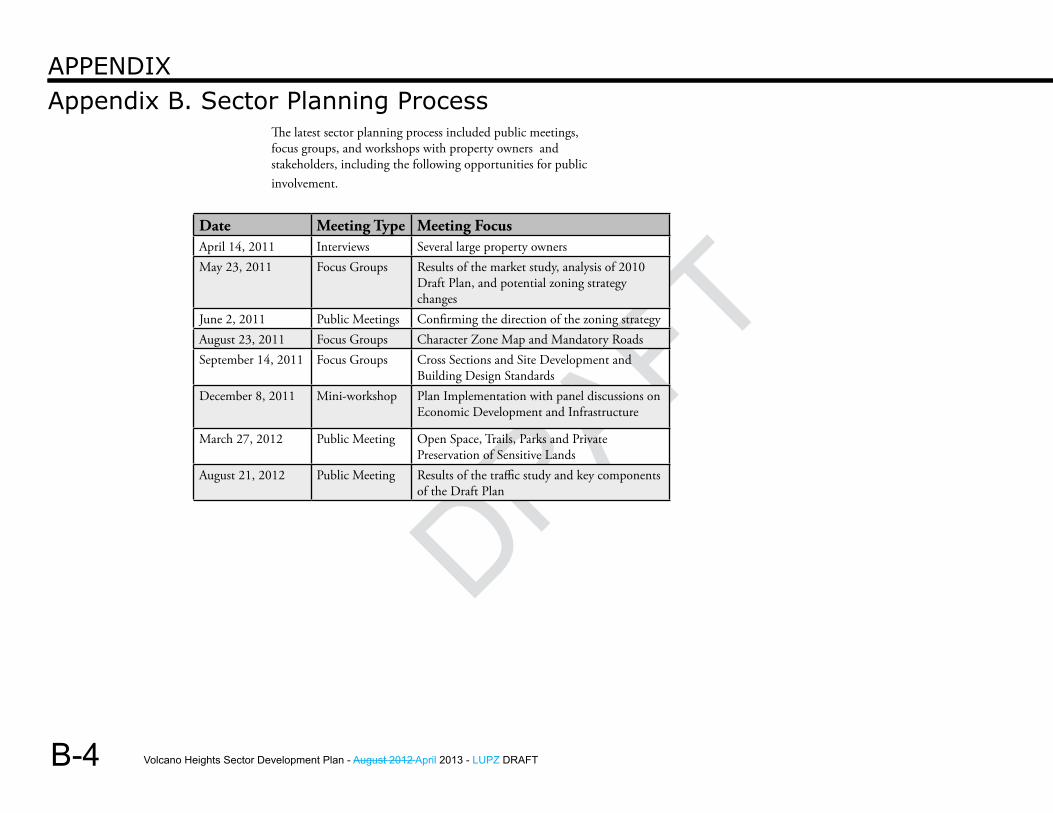
Volcano Heights Sector Development Plan - August 2012 April 2013 - LUPZ DRAFT
DRAFT
B-4
Appendix B. Sector Planning ProcessAPPendix
The latest sector planning process included public meetings, focus groups, and workshops with property owners and stakeholders, including the following opportunities for public involvement.
Date Meeting Type Meeting FocusApril 14, 2011 Interviews Several large property ownersMay 23, 2011 Focus Groups Results of the market study, analysis of 2010
Draft Plan, and potential zoning strategy changes
June 2, 2011 Public Meetings Confirming the direction of the zoning strategyAugust 23, 2011 Focus Groups Character Zone Map and Mandatory RoadsSeptember 14, 2011 Focus Groups Cross Sections and Site Development and
Building Design StandardsDecember 8, 2011 Mini-workshop Plan Implementation with panel discussions on
Economic Development and Infrastructure
March 27, 2012 Public Meeting Open Space, Trails, Parks and Private Preservation of Sensitive Lands
August 21, 2012 Public Meeting Results of the traffic study and key components of the Draft Plan
Volcano Heights Sector Development Plan - August 2012 April 2013 - LUPZ DRAFT
DRAFT
DRAFT Traff ic StudyAppendix C
C-1
Volcano Heights Sector Development Plan - August 2012 April 2013 - LUPZ DRAFT
DRAFTThis Page Left Intentionally Blank
Volcano Heights Sector Development Plan - August 2012 April 2013 - LUPZ DRAFT
DRAFT
DRAFTPrivate Preservation OptionsAppendix D
D-1
Volcano Heights Sector Development Plan - August 2012 April 2013 - LUPZ DRAFT
DRAFT
D-2
Appendix D. Private Preservation OptionsAPPenDix
ALTERNATIVE STRATEGIES FOR PRESERVING ROCK OUTCROPPINGS
IN VOLCANO HILLS
Anita P. MillerAssistant City Attorney
October 5, 2011
I. Transfer of Development Rights
A Transfer of Development Rights (“TDR”) strategy was considered in the 1990s in Albuquerque as a means of preserving significant natural and/or archaeological features on subdivided private land on the West Side of Albuquerque. One of the catalysts for the study was the petroglyphs which are located adjacent to already subdivided land. The Petroglyphs National Monument was becoming a reality, and the City did not want to see subdivision sprawl engulf private land near the Monument.
A Feasibility and Planning Analysis of TDRs in this context was prepared by Eric Damian Kelly, then a land use attorney and planner on contract with the City. At the time that the study was prepared, there was neither a state statute nor an Albuquerque ordinance governing TDRs. In 2003, NMSA 1978, §5-8-43 was adopted by the Legislature to provide guidance to counties and municipalities in regulating transfer of development rights.
A. The purpose of this section is to (1) clarify an application of existing
authority;(2) provide guidelines for counties and
municipalities to regulate transfer of development rights consistent with comprehensive plans;
(3) encourage the conservation of ecological, agricultural and historical land; and
(4) require public notification of transfers of development rights.
B. A municipality or county may, by ordinance, provide for voluntary transfer of all, or partial development rights from one parcel of land to another parcel of land.
C. The ordinance shall identify on a zoning map areas from which development rights may be transferred and areas to which development rights may be transferred.
D. The ordinance shall provide for:(1) the voluntary transfer of a
development right from one parcel of land to increase the intensity of development of another parcel of land;
(2) joint powers agreements, if applicable, for administration of transfers of development rights across jurisdictional boundaries;
(3) the method of transfer of development rights, including methods of determining the accounting for the rights transferred;
Volcano Heights Sector Development Plan - August 2012 April 2013 - LUPZ DRAFT
DRAFT
DRAFT
D-3
Appendix D. Private Preservation OptionsAPPenDix
(4) the reasonable rules to effect and control transfers and ensure compliance with the provisions of the ordinance; and
(5) public notification to the areas to which development rights may be transferred.
E. Transference of a development right shall be in writing and executed by the owner of the parcel from which the development right is being transferred and acknowledged by the transferor. A development right shall not be subject to condemnation.
F. As used in the section, “development right” means the rights permitted on a lot, parcel or area of land under a zoning ordinance or local law respecting permissible use, area, density or height of improvements executed thereon, and development rights may be calculated and allocated in accordance with density or height limitations or any criteria that will effectively quantify a development right in a reasonable and uniform manner.
G. Nothing in this section shall be construed to authorize a municipality or a county to impair existing property rights.
Neither Albuquerque nor Bernalillo County has adopted TDR ordinances. It should be noted that in the Feasibility and Planning Analysis, Eric Kelly determined that New Mexico municipalities and counties could adopt TDR programs without a statute or local ordinance, based on already adopted planning and zoning statutes and ordinances.
“Transferable development rights” are rights to develop property that are valued based on existing zoning, or based on market potential of the property as developed. The TDR process is usually used to preserve historic property, archaeological sites, and open space; to preserve agricultural land from development; or to create incentives for high-density development in another area of a municipality.
Kelly sees “cluster zoning” as a simple example of TDR. In cluster zoning, a landowner may develop a part of his property at a high density, leaving the rest of the property as undeveloped open space. Since only one property is involved, cluster zoning doesn’t usually create controversy, although neighboring property owners adjacent to a receiving area which will be more dense than their properties may object based on the impact that this development might have on their neighboring property values.
Likewise, when a TDR process is applied to an undeveloped property currently in agriculture, but there also is designated land elsewhere in the jurisdiction for dense development, the process succeeds. The agricultural land is retained, and the farmer reaps the economic benefit of higher valued developed property.
TDRs often become controversial when the existing zoning in a receiving area is changed to enable development rights to be transferred into it. Therefore, TDRs work best when both the sending area and receiving area haven’t been permanently zoned or are in a “holding area,” and are designated as part of a planning process. TDRs, then, might succeed in preserving rock outcroppings in Volcano Heights if an underdeveloped receiving area for development rights transferred in order to preserve the rocks is designated in the current planning process.

Volcano Heights Sector Development Plan - August 2012 April 2013 - LUPZ DRAFT
DRAFT
D-4
Appendix D. Private Preservation OptionsAPPenDix
It should be noted that a variation of TDR, “Purchase of Development Rights” (“PDR”) has successfully been implemented in Massachusetts. The state purchased development rights from farmers on land which it wished to remain in agriculture. A variation of PDR can be found in Chicago, where development rights in the Hyde Park area were purchased by the City, and placed in a “bank”. Developers could then purchase them from the “bank”, and utilize them to create more dense development in a new area which the City wanted to see densely developed.
In the context of Albuquerque, owners of land containing rock outcroppings that are designated for preservation might also transfer their development rights to redevelopment areas elsewhere in the City. Redevelopment areas recently have been rezoned for higher density mixed uses, which might make them appropriate as “receiving areas.”
Kelly mentions that a TDR program can be defeated by popular opposition when an existing zoning designation is changed to accommodate receipt of development rights. It is assumed that the original zoning served the health, safety and general welfare of the area. When the area receives development rights and thus higher densities, the justification for the lower densities of adjacent properties no longer exists, and property owners in adjacent neighborhoods believe that their property values will plummet.
When Eric Kelly prepared his study in the 1990s, his conclusion was that they wouldn’t work in Albuquerque, except when a property owner had sufficient land to “receive” higher density. In those days, even cluster development in the developed areas of the City was met with harsh opposition from adjacent and nearby neighborhood associations. Whether a TDR program, with receiving areas designated elsewhere in the City, would succeed today, given today’s growing preference for higher density development,
is open to question. Kelly suggested that conservation easements might provide a better strategy for preserving land without the City actually owning it.
II. Conservation Easements
In New Mexico, “conservation easements” are defined as “Land Use Easements,” as follows:
NMSA 1978, §47-12-1 (1991)
H. “land use easement” means a holder’s nonpossessory interest in real property imposing any limitation or affirmative obligation the purpose of which includes retaining or protecting natural or open space values of real property, assuring the availability of real property for agricultural, forest, recreational or open space use or protecting natural resources;
At A. of the statute, “holder” means any non-profit corporation, nonprofit association or nonprofit trust, the purposes or powers of which include retaining or protecting the natural or open space values of real property, assuring the availability of real property for agricultural, forest, recreational or open space use, protecting natural resources or maintaining production uses of real property.
Local governments qualify as “holders.” Thus the City could protect the rock outcroppings in Volcano Heights by obtaining conservation easements on areas of land containing those
Volcano Heights Sector Development Plan - August 2012 April 2013 - LUPZ DRAFT
DRAFT
DRAFT
D-5
Appendix D. Private Preservation OptionsAPPenDix
rock outcroppings identified as desirable to preserve. The easements are recorded, and are governed by their specific terms. Their terms could include conditions for termination, as well as other limitations if so desired. The owner of the property would continue to own the land burdened by the easement, and would be responsible for its care and maintenance, but would not be able to develop it. The New Mexico Tax Code gives tax benefits to the landowner whose property is burdened by the easement, as does the Internal Revenue Code.
The property owner could fence in the property burdened by the easement and exclude the public; it’s still his private property. If a property owner is going to develop the property as a shopping center or office park, inviting the public in, he could also invite citizens to the area protected by the easement. Terminology in the drafted easement could reflect the property owner’s particular responsibilities as negotiated.
Although the Open Space Division would like to see the rock outcroppings purchased outright by the City, given budgetary limitations, obtaining a conservation easement would preserve them from development, pending availability of funds for their purchase. If such funds never were available, at the very least they’d be preserved.
It should be noted that Santa Fe County, as a result of two successful bond issues, was able to purchase land in the Galisteo Basin which contained archaeological sites. When it realized that there was additional land which also had archaeological value, and didn’t have funding to purchase it as well, it utilized a conservation easement to protect it from development. A third bond issue provided sufficient funds for purchase of the land, and the easement was terminated. Thus Albuquerque could “tie up” the rock outcroppings pending obtaining funding for purchase of the sites. If preservation is the ultimate goal, lack of public access is a small price to pay.
Conclusion
If there are areas in Volcano Heights where TDRs would “work,” either on the property where rocks are to be preserved or another property within the Plan area or in a specific zone where mixed use zoning and density are encouraged, existing incentives, such as increased density on the receiving site might be utilized to “reward” a property owner for transferring development rights. Certainly neighborhood associations would oppose the creation of receiving areas on Albuquerque’s east side, although they might be acceptable on large redevelopment sites that might encourage high density development.
Conservation easements are easier to administer and create than TDRs. Considering that the Open Space Division prefers acquisition of property which it has designated as open space, but cannot now afford to purchase, conservation easements could preserve the designated property until funding is available to purchase it. On October 4th Albuquerque citizens voted down one of the Mayor’s proposals for bond issues, reflecting public opposition to two public projects. In the current economic climate, it’s likely that bond issues for purchase of open space might also be voted down. Conservation easements at least provide a method for preserving designated open space when funding isn’t available to purchase it.
Volcano Heights Sector Development Plan - August 2012 April 2013 - LUPZ DRAFT
DRAFT
D-6
Appendix D. Private Preservation OptionsAPPenDix
Qualifications: The City of Albuquerque is a qualified “holder” as described by NMSA 1978, Section 47-12A-2 and an eligible holder pursuant to the Land Conservation Incentives Act NMSA 1978, Sections 75-9-1 to 75-9-6 (2003).
Intent of Conveyance:The land owner intends to make a charitable gift of the development interest conveyed by this deed for the purpose of assuring that under the holder’s perpetual oversight, the conservation values will be maintained forever and that any misuse of the property inconsistent with the conservation values will be corrected or prevented. The intent of this conveyance is to permit all other uses of the land not inconsistent with the conservation values as determined by the City of Albuquerque in its sole discretion that are not expressly prohibited in this deed. Nothing in this deed is intended to compel the property holder to use the property in any way other than maintaining protection and conservation values. Conveyance of this deed will not adversely affect the property owner’s property rights to develop the remainder of the property not covered by the conservation easement.
Conservation Easement for rock Outcropping (Sample)
This Deed of Conservation Easement is granted on the day of ____ by ____ concerning the address of____ to the City of Albuquerque for the purpose of forever conserving the cultural values of said property.
Recitals:
Significance:The property contains special cultural significance to Pueblo people, including several nearby tribal nations. This land consists of open space containing various rock outcroppings scattered throughout. The preservation of these outcroppings shall be preserved pursuant to the NM Cultural Properties Preservation Easement Act, NMSA 1978, Sections 47-12A-1 through 47-12A-6. This act aids the landowner who wishes to voluntarily donate a conservation easement intended to restrict the use of this specified parcel so as to maintain in perpetuity the significant cultural and/or geological aspects of this land. Conserving the property is consistent with and important to the environment, culture, and economy of the surrounding area because the development of the property would jeopardize the cultural significance of the area to native people. These sites provide Pueblo people with spiritual areas to hold sacred rituals and ceremonies that have held great cultural significance for countless generations. It is important to hold these areas open to future generations of interested parties to keep the spiritual significance of the area alive.
Volcano Heights Sector Development Plan - August 2012 April 2013 - LUPZ DRAFT
DRAFT
DRAFT
D-7
Appendix D. Private Preservation OptionsAPPenDix
Agreement:
Now therefore, in consideration of the mutual promises and covenants contained herein, the landowner voluntarily grants and conveys the land in trust to the City of Albuquerque, and the City of Albuquerque voluntarily accepts a perpetual “land use easement” over the property herein described as subject to the easement as defined by NMSA 1978, Section 47-12A-2B of the Cultural Properties Preservation Easement Act, which is also a “qualified real property interest” as defined by the C.F.R. 170(h)(2)(c), the conveyance of which is a “charitable contribution” as defined by C.F.R. 170(h).
Property Rights Retained by Owner: Landowner reserves to himself/herself, and to his/her personal representatives, heirs successors, and assigns, all rights not expressly prohibited or limited by this easement, including all ownership rights of the Property, the right to include or exclude others, the right to sell or otherwise transfer ownership, and the right to mortgage the Property so long as the Mortgage is subordinated to this Deed.General Uses of the Property: The landowner shall not perform nor knowingly allow others to perform acts that are inconsistent with the conservation or preservation purposes enumerated by this deed. The City of Albuquerque and the landowner acknowledge that any uses of the property or improvements of the property enumerated in this deed are consistent with the Conservation purposes. The landowner agrees that any other use of the land that is inconsistent with the law imposed on the Property is not protected by this deed.
Various Specific Uses:A. Subdivisions: The landowner and the City of Al-
buquerque agree that the property must be sold or transferred as a single unit and that any further subdivision of the Property is prohibited, unless approved by the City of Albuquerque, in its sole discretion. Any adjustments to the lot lines must be approved by the City of Albuquerque. If the property is transferred or sold, the landowner must provide to the City the address and name of the grantee.
B. Construction: Any existing structure on the Property can be repaired, maintained, or replaced in its cur-rent location, but construction of new structures on the Property is prohibited unless at least 30 days prior to undertaking any construction, and prior to applying for a building permit for such construction, the landowner shall notify the City of Albuquerque in writing and provide the City of Albuquerque with the opportunity to review the plans for such construc-tion for compliance with the terms of this deed. The City has the power to deny any such development that does not meet the terms of this deed.
C. Water Rights: The voluntary separation of water rights from the Property is hereby prohibited, ex-cept as provided herein. The landowner shall take all prudent measures to ensure that forfeiture or abandonment do not occur for the Property, includ-ing maintaining timely payments, beneficial use and participation in conservation programs. If for any reason the landowner cannot beneficially use the water rights on the Property, the rights can be trans-ferred to the City of Albuquerque for purposes of conservation or elsewhere as long as it is consistent with the conservation purposes of this easement. If transferred elsewhere, the landowner must receive written consent by the City of Albuquerque to lease or transfer the rights.
Volcano Heights Sector Development Plan - August 2012 April 2013 - LUPZ DRAFT
DRAFT
D-8
Appendix D. Private Preservation OptionsAPPenDix
D. Agriculture: All agricultural practices should be conducted in a sustainable manner. This includes ranching, farming and other agricultural practices. Agricultural practices shall use stewardship and management practices generally consistent with the standards of the U.S. Natural Resources Conservation Service or other commonly accepted sound manage-ment practices approved by the City to meet the conservation purpose of this deed.
E. Timber: The cutting of any timber from on the Property is strictly prohibited except for fire manage-ment, to control insects or disease, to prevent per-sonal injury and property damage, to maintain the character and nature of the existing natural habitat, and/or to prevent encroachment into agricultural fields and pastures.
F. Utilities: The construction of new utilities on the property is prohibited without the prior written ap-proval of the City of Albuquerque. This includes un-derground utilities.
G. Roads: The construction of new roads shall be pro-hibited from the Property. If for some reason there is a specific need for a road, the landowner may present the City of Albuquerque with plans at least 30 days prior to receiving any permits or beginning any actual construction and must receive written consent from the City of Albuquerque to proceed.
H. Off-road Vehicle Use: The use of any motorized vehicle is prohibited on the property except for the purposes of maintenance, conservation, agriculture, or emergency access.
I. Impervious Surfaces: The construction of any per-manent, impervious surface such as pavement or asphalt is prohibited except for those approved pur-suant to paragraph G of this deed.
J. Mining: The mining of gravel, rock, sand soil and other minerals is prohibited as consistent with the conservation values proposed in this deed.
K. Refuse: The dumping, storing, or accumulation of any form of refuse is strictly prohibited from the property. Should any refuse be found on the prop-erty it is the landowner’s duty to remove it. This pro-hibition does not apply to any form of composting as long as it is done in a manner consistent with the Conservation values expressed in this deed.
L. Hazardous Materials: The storage, release, or treat-ment of hazardous chemicals on, from, or under the property is prohibited. For the purposes of this deed, any “Hazardous material” shall be any hazard-ous or toxic, material or waste considered hazardous according to any state, federal, or local laws.
M. Commercial Activity:
a. Generally: Any commercial activity includ-ing producing, buying, selling or trading of goods or services shall be prohibited with the exceptions of recreational or home ac-tivities described below.
b. Commercial Recreational Activities: Use of the property other than “de minimis” uses as described in the Code of Federal Regula-tions (C.F.R.) 2031(c)(8)(B) are prohibited.
c. Commercial Home Activities: This deed does not prohibit home commercial activi-ties legally permitted within the home by local zoning laws, as long as they are con-sistent with the conservation values in this deed.
Volcano Heights Sector Development Plan - August 2012 April 2013 - LUPZ DRAFT
DRAFT
DRAFT
D-9
Appendix D. Private Preservation OptionsAPPenDix
N. Recreation: Only low-impact recreational activities are permitted, such as rock study, wildlife viewing, hiking, biking, horse-back riding, snowshoeing, or cross country skiing not inconsistent with the conser-vation values of this deed. Recreational facilities may only be constructed in accordance with the restric-tions pursuant to section B of this Deed. The use of motorized vehicles for recreational purposes is pro-hibited pursuant to section H of this deed.
O. Public Access: This deed is not intended to allow public access to the property, and the landowner maintains his/her property right to exclude any trespassers, as well as his/her right to include any public access he/she sees fit in accordance with the conservation values expressed in this deed. The City of Albuquerque maintains no obligation to take any actions to prevent trespassers on the property.
P. Signs: The use of signs shall be prohibited other than those warning trespassers of private land, signs that explain it is in the care of the City of Albuquerque, for sale signs, or any notice or postings required by law. The signs shall not exceed two by two feet, be made of reflective material, or be artificially illuminated.
Duration of the Deed: This deed shall last with the title of the land in perpetuity, and every provision of the deed shall likewise apply to any heirs, assigns, successors, executors, administrators, and all other successors. The transfer of title shall excuse the grantor of the obligations of the provisions of this deed except those for which he/she is liable before the transfer of title. The City of Albuquerque maintains the right to review the provisions of the deed and shall do so every five years and shall be at liberty to cancel or transfer their position as a holder for this easement.
Responsibilities of Landowner: Other than as specified herein, this deed is not intended to impose any legal or other responsibility on the City of Albuquerque, or in any way to affect any obligation of the landowner as owner of the property. Unless otherwise specified below, nothing in this Deed shall require the landowner to take any action to restore the condition of the property after any Act of God or other event over which landowner had no control. The landowner shall continue to be solely responsible, and the City of Albuquerque shall have no obligation for the upkeep and maintenance of the property. The landowner acknowledges that nothing in this Deed relieves the landowner of any obligation or restriction on the use of the Property imposed by law. Among other things, this shall apply to:
a. Taxes: The landowner is solely responsible for the payment of all taxes and assessments levied against the property. If for any reason the City of Albuquer-que is forced to pay any taxes or assessments on its interest in the Property, the landowner shall reim-burse the City of Albuquerque for the full amount, and such payment shall constitute a lien on the prop-erty.
b. Upkeep and Maintenance: The landowner shall be solely responsible for the upkeep and maintenance of the property.
c. Liability and Indemnification: The landowner shall be solely responsible for any liability arising from or related to the property, including injury or damage to any person or organization related directly or in-directly to the action or omission by the landowner. If for any reason the City of Albuquerque has to pay for any damages, the landowner shall indemnify and reimburse the City for the amount as well as any attorney fees resulting from the costs of defending itself. The landowner shall not have to reimburse the City of Albuquerque if the City is to be the proximate cause of the injury.
Volcano Heights Sector Development Plan - August 2012 April 2013 - LUPZ DRAFT
DRAFT
D-10
Appendix D. Private Preservation OptionsAPPenDix
d. Insurance: The landowner warrants that the City of Albuquerque is and will continue to be an additional insured on the landowner’s liability insurance policy covering the property. The landowner shall provide certificates of such insurance to the City of Albu-querque within thirty days after the date of recorda-tion of this deed and subsequently, upon the City of Albuquerque’s written request. Landowner shall advise the City of Albuquerque at least thirty days in advance of cancellation of any insurance policy.
Landowner Warranties: a. Title warranty: The landowner warrants that he/she
has good and sufficient title to the property, and that there are no liens on, leases to, pending or threat-ened litigation relating to the Property, or other in-terests in the property, including verbal agreements, that have not been disclosed to the City of Albuquer-que in writing. The landowner hereby promises to defend the property and the easement against all claims from persons claiming by, through, or under the landowner. In the event any cloud of title exists, the landowner shall be responsible for procuring a release of claim signed by the relevant parties.
a. If the landowner has a mortgage on prop-erty: The landowner warrants that he/she has good and sufficient title to the prop-erty, that the lien on the property held by ______________________________ dated _____________________________, has been subordinated to this deed, and that there are no other liens on, leases to, or other interests in the property that have not been disclosed to the City of Albuquerque in writing. The landowner hereby promises to defend the property and the easement against all claims from persons claiming by, through, or under the landowner.
b. Environmental Warranty: The landowner warrants that he/she has no knowledge of a release or threat-ened release of hazardous material on the property. The landowner will indemnify, defend, and hold harmless the City of Albuquerque against any litiga-tion, claims, costs, damages, losses, or any other ex-penses of any kind arising from the release of hazard-ous material on the property. Nothing in this deed is intended to convey any sort of day-to-day managerial right to the City of Albuquerque from the landowner. The owner of the property retains the right to man-age the property, subject to restrictions in this ease-ment and any federal, state, or local laws, regulations or ordinances governing environmental conditions on the property.
Inspection: The City of Albuquerque maintains the right to inspect the property as long as the City gives the landowner reasonable, advance notice. The City of Albuquerque will typically inspect the property annually but reserves the right to inspect it any time as long as the City gives the owner proper notice. If the City of Albuquerque has reason to believe that there is an ongoing, imminent, or threatened violation of the provisions of this deed, the City of Albuquerque will make good faith efforts to contact the landowner but may enter the Property in an effort to advert this emergency without needing to give prior notice to the landowner.
Enforcement: The City of Albuquerque has all the rights, remedies, and power to enforce the terms of this deed against the landowner that are provided by law or in equity including actions prior to court action such as mediation or arbitration. Except when an ongoing or imminent violation could irreversibly diminish or impair the conservation values described in this easement, the City of Albuquerque will give written notice of the violation to the landowner and he/she will have thirty days before the City of Albuquerque will take
Volcano Heights Sector Development Plan - August 2012 April 2013 - LUPZ DRAFT
DRAFT
DRAFT
D-11
Appendix D. Private Preservation OptionsAPPenDix
legal action. If a court with jurisdiction determines that a violation may exist or has occurred, the City of Albuquerque may obtain an injunction to stop the violation, temporarily or permanently, and to restore the Property to its condition prior to the violation. In any case where a court finds that a violation has occurred, the landowner shall reimburse the City of Albuquerque for all its expenses incurred in stopping and correcting the violation, including reasonable attorneys’ fees and court costs. If the court finds no violation, the landowner and the City of Albuquerque shall each bear individual expenses and attorneys’ fees. The landowner and the City of Albuquerque agree that this allocation of expenses is appropriate.
Transfer of Easement: The City of Albuquerque maintains the right to transfer this easement to another qualified holder according to the subsections below:
a. Voluntary: if the City of Albuquerque ever wants to voluntarily transfer the easement, the City will give notice sixty days before the transfer takes place in order to allow the landowner to voice any prefer-ences as to who the new holder shall be. The City of Albuquerque shall take due consideration of this suggestions and shall choose accordingly. This ease-ment can only be transferred to an organization that is qualified as a holder under NMSA 1978, Section 47-12A-2B and that agrees to uphold the terms of this Deed.
b. Involuntary: If the City of Albuquerque ceases to qualify under C.F.R. 170(h)(3), or NMSA 1978, Sec-tion 47-12A-1 through 47-12A-6, a court with proper jurisdiction shall dictate the transfer or this deed to another qualified organization that agrees to uphold the terms of this Deed.
Amendment of Easement: The City of Albuquerque and the landowner agree that there may be situations in which the need to amend various provisions of the deed may arise and agree that in order to amend any provisions, both the City of Albuquerque and the landowner must agree in writing to any such changes. Any written agreement, executed by both the City of Albuquerque and the landowner, to amend this deed must be filed with the County Clerk’s office in which this deed is filed.
Termination of the Easement: a. Condemnation: The City of Albuquerque shall be
informed by the property owner of any condemna-tion action undertaken by the federal or state goven-rmnt within 10 days of initiation of that action. If all or a part of the property is taken for public use (or sold to a public authority under threat of condemna-tion), and the easement is terminated in whole or in part, then the City of Albuquerque shall be entitled to a percentage of the condemnation award or sale proceeds (including any increase in value caused by improvements made after the date of this Deed) equal to the ratio, as of the date of this Deed, of the appraised value of the Easement to the unrestricted fair market value of the property.
b. Changed Conditions: The landowner and the City of Albuquerque recognize that in some cases all conser-vation value of the property may be irreversibly lost due to changes not caused by any particular party. The City of Albuquerque and the landowner retain the right to jointly request a court with jurisdiction to terminate all or a portion of this deed and order the sale of the property. The irreversible loss of all conservation value is the only grounds upon which to terminate this deed. Upon the sale of the land, the City of Albuquerque shall be entitled to a percentage of the sale proceeds (including any increase in value caused by improvements made after the date of this
Volcano Heights Sector Development Plan - August 2012 April 2013 - LUPZ DRAFT
DRAFT
D-12
Appendix D. Private Preservation OptionsAPPenDix
deed) equal to the ratio, as of the date of this Deed, of the appraised value of the Easement to the unre-stricted fair market value of the property.
c. Other Termination Conditions: This Deed constitutes a property right conveyed to the City of Albuquerque that shall immediately vest once this deed has been signed by the County Clerk and filed in the official records of Bernalillo County and shall give the City of Albuquerque the rights to the fair market value of the apportioned land, which will be stipulated to be-tween the landowner and the City of Albuquerque. Any funds the City of Albuquerque receives from the termination of this easement shall be used in a way consistent with the conservation values expressed in this agreement.
d. Economic Termination Conditions: In no circum-stances will the economic devaluation of the proper-ty or economic infeasibility of this easement be seen as grounds appropriate to terminate this easement.
Approvals: Before doing anything that requires the approval of the City of Albuquerque, the landowner agrees to request the approval from the City of Albuquerque in writing. The City of Albuquerque shall be given forty-five days from the day of receipt to respond in writing to the written request of the landowner.
Notices: Any written notices required by this deed shall be hand delivered or sent through the US mail services. The current addresses as of the date of creating this deed for the landowner and the City of Albuquerque are as follows: To the Landowner: To the City of Albuquerque:All parties must be notified of any changes of addresses.Also the address of the Property shall be a suitable address for the City of Albuquerque to address any notices they are required to send to the landowner.
Transfer of the Property: The landowner retains the right to transfer or sell his property rights at any time as long as this deed remains attached to the property rights in the conveyance and that he/she gives the City of Albuquerque written notice sixty days before said transfer or sale. The City of Albuquerque retains the right to deny the sale of the property associated with this deed, and the landowner must receive written permission from the City of Albuquerque before selling this land. Purchasers of the property subject to the conservation easement are bound by its terms, as are heirs of the original property owner in the event of its death. If the property is foreclosed, then both the foreclosing institution and purchaser in a foreclosure sale are also subject to the terms of this provision.
Subsequent Mortgages: This deed in no way impairs the property owner from receiving additional mortgages or liens against the property as long as these liens are subordinate to the provisions of this Deed.
Waiver: No portion of this deed shall be waived without the written consent of both parties.
Incorporation: Any recitals set forth at the beginning of this deed as well as any attached exhibits referenced herein shall be incorporated to this deed by this reference.
Interpretation: Any interpretations of the contents of this deed shall be governed by the laws of the State of New Mexico. Furthermore any interpretations of the content of this deed shall be done so without regard to the authorship of the contents, but rather with regards to maximizing the proposed conservational and protectoral values associated with this deed.
No Third Party Beneficiaries: This deed was entered into by the landowner and the City of Albuquerque and was intended for their sole benefit. No rights or responsibilities shall be created in any third party pursuant to this Deed.
Volcano Heights Sector Development Plan - August 2012 April 2013 - LUPZ DRAFT
DRAFT
DRAFT
D-13
Appendix D. Private Preservation OptionsAPPenDix
Counterparts: This deed can be broken into two or more parts, each of which shall be executed by both parties, and each part will be considered an original document, but in the aggregate this deed shall still be considered a single agreement.
Severability: If any provision of this deed is found to be illegal, this illegal content shall not affect any other provision of this deed, and the deed shall still remain legally enforceable.
Integration: This deed sets forth all provisions of the agreements between the landowner and the City of Albuquerque and supersedes any prior and subsequent negotiations, understandings, documents, or agreements relating to this deed.
Recording: the City of Albuquerque shall record this deed in a timely fashion in the official records of Bernalillo County, New Mexico. The City of Albuquerque shall also re-record this deed anytime there are changes to any provision or other information contained in this deed in order to preserve the rights and protections of this deed.
Acceptance: The City of Albuquerque has accepted the easement conveyed by this deed and the rights and responsibilities contained herein. The City of Albuquerque agrees to have and to hold this Deed of Conservation Easement unto the City of Albuquerque forever in perpetuity.
Reviewed by:
______________________________________(City Attorney)
Volcano Heights Sector Development Plan - August 2012 April 2013 - LUPZ DRAFT
DRAFT
D-14
Appendix D. Private Preservation OptionsAPPenDix
Signatures and Acknowledgements:
The landowner:
__________________________(Print name)
County of _________________) ) SSState of ___________________)
The foregoing Deed was acknowledged before me on the day of _________________________ by _______________
______________________________________(Notary Public Seal)
My Commission Expires: ____________________________
The City of Albuquerque,A New Mexico Municipality
________________________(Print Name of Representative)
County of _______________)
) SSState of ________________ )
The foregoing Deed was acknowledged before me on the day of ________________ by ______________, representative of the City of Albuquerque
____________________(Notary Public Seal)
My commission expires: __________________________
Volcano Heights Sector Development Plan - August 2012 April 2013 - LUPZ DRAFT
DRAFT
DRAFT Plant L istsAppendix E
E-1
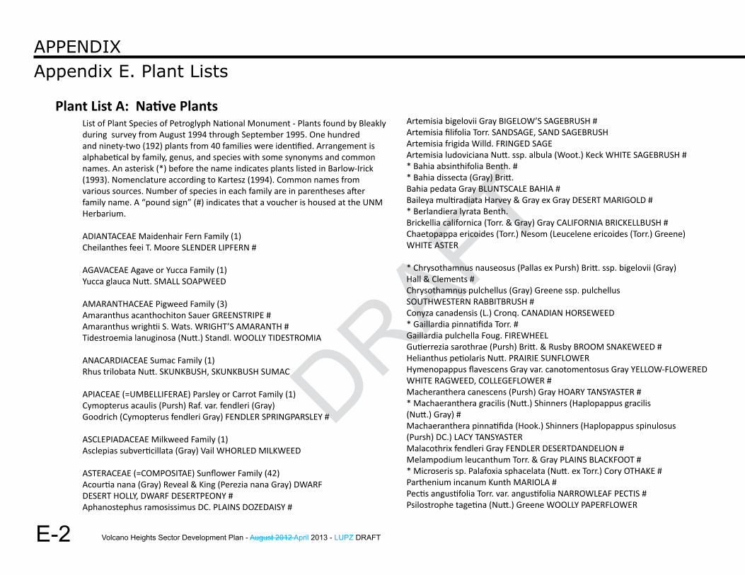
Volcano Heights Sector Development Plan - August 2012 April 2013 - LUPZ DRAFT
DRAFT
E-2
Appendix E. Plant ListsAPPEndix
List of Plant Species of Petroglyph National Monument - Plants found by Bleakly during survey from August 1994 through September 1995. One hundred and ninety-two (192) plants from 40 families were identified. Arrangement is alphabetical by family, genus, and species with some synonyms and common names. An asterisk (*) before the name indicates plants listed in Barlow-Irick (1993). Nomenclature according to Kartesz (1994). Common names from various sources. Number of species in each family are in parentheses after family name. A “pound sign” (#) indicates that a voucher is housed at the UNM Herbarium.
ADIANTACEAE Maidenhair Fern Family (1)Cheilanthes feei T. Moore SLENDER LIPFERN #
AGAVACEAE Agave or Yucca Family (1)Yucca glauca Nutt. SMALL SOAPWEED
AMARANTHACEAE Pigweed Family (3)Amaranthus acanthochiton Sauer GREENSTRIPE #Amaranthus wrightii S. Wats. WRIGHT’S AMARANTH #Tidestroemia lanuginosa (Nutt.) Standl. WOOLLY TIDESTROMIA
ANACARDIACEAE Sumac Family (1)Rhus trilobata Nutt. SKUNKBUSH, SKUNKBUSH SUMAC
APIACEAE (=UMBELLIFERAE) Parsley or Carrot Family (1)Cymopterus acaulis (Pursh) Raf. var. fendleri (Gray)Goodrich (Cymopterus fendleri Gray) FENDLER SPRINGPARSLEY #
ASCLEPIADACEAE Milkweed Family (1)Asclepias subverticillata (Gray) Vail WHORLED MILKWEED
ASTERACEAE (=COMPOSITAE) Sunflower Family (42)Acourtia nana (Gray) Reveal & King (Perezia nana Gray) DWARFDESERT HOLLY, DWARF DESERTPEONY #Aphanostephus ramosissimus DC. PLAINS DOZEDAISY #
Artemisia bigelovii Gray BIGELOW’S SAGEBRUSH #Artemisia filifolia Torr. SANDSAGE, SAND SAGEBRUSHArtemisia frigida Willd. FRINGED SAGEArtemisia ludoviciana Nutt. ssp. albula (Woot.) Keck WHITE SAGEBRUSH #* Bahia absinthifolia Benth. #* Bahia dissecta (Gray) Britt.Bahia pedata Gray BLUNTSCALE BAHIA #Baileya multiradiata Harvey & Gray ex Gray DESERT MARIGOLD #* Berlandiera lyrata Benth.Brickellia californica (Torr. & Gray) Gray CALIFORNIA BRICKELLBUSH #Chaetopappa ericoides (Torr.) Nesom (Leucelene ericoides (Torr.) Greene)WHITE ASTER
* Chrysothamnus nauseosus (Pallas ex Pursh) Britt. ssp. bigelovii (Gray)Hall & Clements #Chrysothamnus pulchellus (Gray) Greene ssp. pulchellusSOUTHWESTERN RABBITBRUSH #Conyza canadensis (L.) Cronq. CANADIAN HORSEWEED* Gaillardia pinnatifida Torr. #Gaillardia pulchella Foug. FIREWHEELGutierrezia sarothrae (Pursh) Britt. & Rusby BROOM SNAKEWEED #Helianthus petiolaris Nutt. PRAIRIE SUNFLOWERHymenopappus flavescens Gray var. canotomentosus Gray YELLOW-FLOWEREDWHITE RAGWEED, COLLEGEFLOWER #Macheranthera canescens (Pursh) Gray HOARY TANSYASTER #* Machaeranthera gracilis (Nutt.) Shinners (Haplopappus gracilis(Nutt.) Gray) #Machaeranthera pinnatifida (Hook.) Shinners (Haplopappus spinulosus(Pursh) DC.) LACY TANSYASTERMalacothrix fendleri Gray FENDLER DESERTDANDELION #Melampodium leucanthum Torr. & Gray PLAINS BLACKFOOT #* Microseris sp. Palafoxia sphacelata (Nutt. ex Torr.) Cory OTHAKE #Parthenium incanum Kunth MARIOLA #Pectis angustifolia Torr. var. angustifolia NARROWLEAF PECTIS #Psilostrophe tagetina (Nutt.) Greene WOOLLY PAPERFLOWER
Plant List A: Native Plants
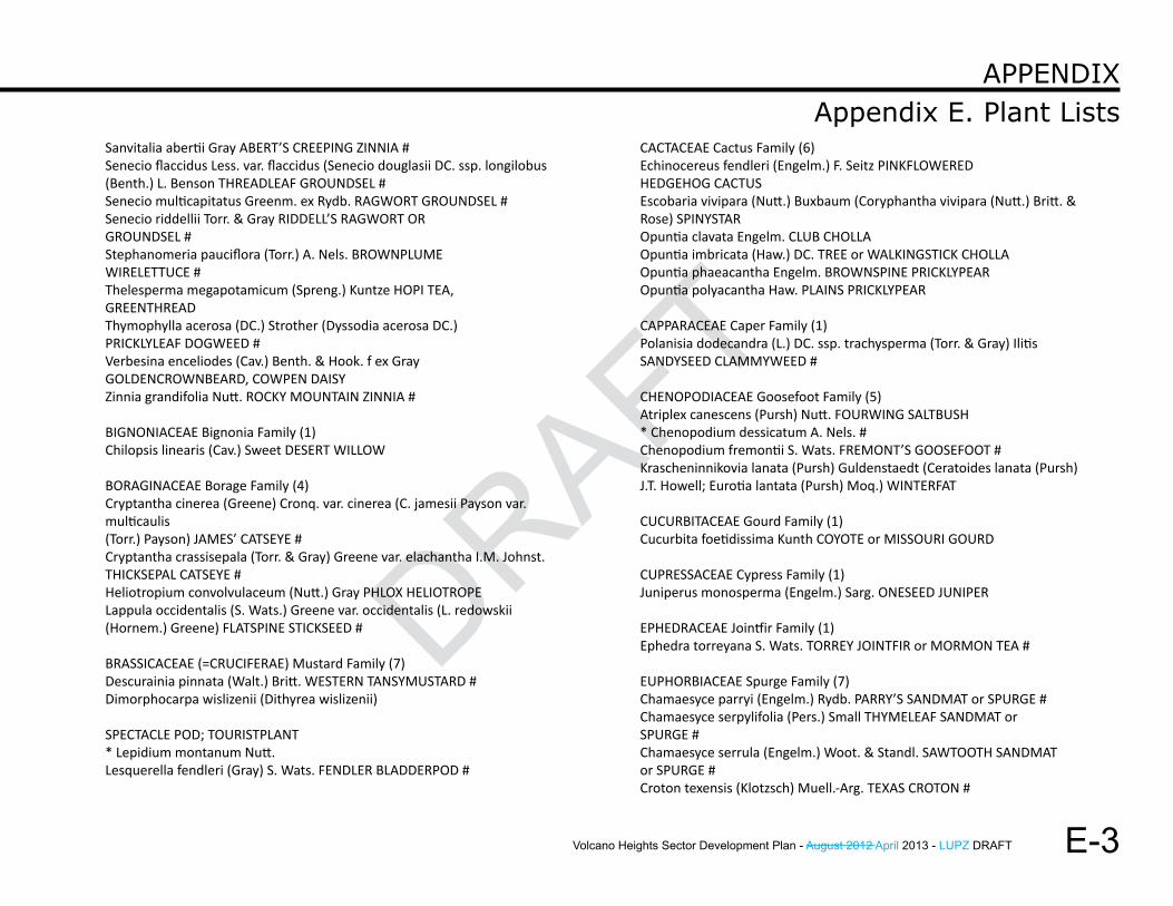
Volcano Heights Sector Development Plan - August 2012 April 2013 - LUPZ DRAFT
DRAFT
DRAFT
E-3
Appendix E. Plant ListsAPPEndix
Sanvitalia abertii Gray ABERT’S CREEPING ZINNIA #Senecio flaccidus Less. var. flaccidus (Senecio douglasii DC. ssp. longilobus(Benth.) L. Benson THREADLEAF GROUNDSEL #Senecio multicapitatus Greenm. ex Rydb. RAGWORT GROUNDSEL #Senecio riddellii Torr. & Gray RIDDELL’S RAGWORT ORGROUNDSEL #Stephanomeria pauciflora (Torr.) A. Nels. BROWNPLUMEWIRELETTUCE #Thelesperma megapotamicum (Spreng.) Kuntze HOPI TEA,GREENTHREADThymophylla acerosa (DC.) Strother (Dyssodia acerosa DC.)PRICKLYLEAF DOGWEED #Verbesina enceliodes (Cav.) Benth. & Hook. f ex GrayGOLDENCROWNBEARD, COWPEN DAISYZinnia grandifolia Nutt. ROCKY MOUNTAIN ZINNIA #
BIGNONIACEAE Bignonia Family (1)Chilopsis linearis (Cav.) Sweet DESERT WILLOW
BORAGINACEAE Borage Family (4)Cryptantha cinerea (Greene) Cronq. var. cinerea (C. jamesii Payson var. multicaulis(Torr.) Payson) JAMES’ CATSEYE #Cryptantha crassisepala (Torr. & Gray) Greene var. elachantha I.M. Johnst.THICKSEPAL CATSEYE #Heliotropium convolvulaceum (Nutt.) Gray PHLOX HELIOTROPELappula occidentalis (S. Wats.) Greene var. occidentalis (L. redowskii(Hornem.) Greene) FLATSPINE STICKSEED #
BRASSICACEAE (=CRUCIFERAE) Mustard Family (7)Descurainia pinnata (Walt.) Britt. WESTERN TANSYMUSTARD #Dimorphocarpa wislizenii (Dithyrea wislizenii)
SPECTACLE POD; TOURISTPLANT* Lepidium montanum Nutt.Lesquerella fendleri (Gray) S. Wats. FENDLER BLADDERPOD #
CACTACEAE Cactus Family (6)Echinocereus fendleri (Engelm.) F. Seitz PINKFLOWEREDHEDGEHOG CACTUSEscobaria vivipara (Nutt.) Buxbaum (Coryphantha vivipara (Nutt.) Britt. &Rose) SPINYSTAROpuntia clavata Engelm. CLUB CHOLLAOpuntia imbricata (Haw.) DC. TREE or WALKINGSTICK CHOLLAOpuntia phaeacantha Engelm. BROWNSPINE PRICKLYPEAROpuntia polyacantha Haw. PLAINS PRICKLYPEAR
CAPPARACEAE Caper Family (1)Polanisia dodecandra (L.) DC. ssp. trachysperma (Torr. & Gray) IlitisSANDYSEED CLAMMYWEED #
CHENOPODIACEAE Goosefoot Family (5)Atriplex canescens (Pursh) Nutt. FOURWING SALTBUSH* Chenopodium dessicatum A. Nels. #Chenopodium fremontii S. Wats. FREMONT’S GOOSEFOOT #Krascheninnikovia lanata (Pursh) Guldenstaedt (Ceratoides lanata (Pursh)J.T. Howell; Eurotia lantata (Pursh) Moq.) WINTERFAT
CUCURBITACEAE Gourd Family (1)Cucurbita foetidissima Kunth COYOTE or MISSOURI GOURD
CUPRESSACEAE Cypress Family (1)Juniperus monosperma (Engelm.) Sarg. ONESEED JUNIPER
EPHEDRACEAE Jointfir Family (1)Ephedra torreyana S. Wats. TORREY JOINTFIR or MORMON TEA #
EUPHORBIACEAE Spurge Family (7)Chamaesyce parryi (Engelm.) Rydb. PARRY’S SANDMAT or SPURGE #Chamaesyce serpylifolia (Pers.) Small THYMELEAF SANDMAT orSPURGE #Chamaesyce serrula (Engelm.) Woot. & Standl. SAWTOOTH SANDMATor SPURGE #Croton texensis (Klotzsch) Muell.-Arg. TEXAS CROTON #
Volcano Heights Sector Development Plan - August 2012 April 2013 - LUPZ DRAFT
DRAFT
E-4
Appendix E. Plant ListsAPPEndix
Euphorbia dentata Michx. TOOTHED SPURGE #* Tragia ambylodonta (Muell.-Arg.) Pax & K. HoffmannTragia ramosa Torr. BRANCHED NOSEBURN
FABACEAE (=LEGUMINOSAE) Bean or Pea Family (14)Astragalus amphioxys Gray var. amphioxys CRESCENT MILKVETCH #Astragalus ceramicus Sheld. var. ceramicus PAINTED MILKVETCH #Astragalus lentiginosus Dougl. var. diphysus (Gray) Jones SPECKLEDPODMILKVETCH #Astragalus nuttallianus DC. SMALLFLOWERED MILKVETCH #Caesalpinia jamesii (Torr. & Gray) Fisher JAMES’ HOLDBACKDalea compacta Spreng. var. compacta COMPACT PRAIRIECLOVER #Dalea formosa Torr. FEATHERPLUMEDalea lanata Spreng. var. terminalis (Jones) Barneby WOOLLYPRAIRIECLOVER #Dalea nana Torr. ex Gray var. carnescens Kearney & Peebles DWARFPRAIRIECLOVER #Dalea scariosa S. Wats. (Petalostemon scariosa (S. Wats.) Wemple) ALBUQUERQUEPRAIRIECLOVER #Hoffmannsegia glauca (Ortega) Eifert INDIAN RUSHPEAPediomelum hypogaeum (Nutt.) Rydb. (Psoralea hypogaea Nutt.) SCURFPEA #Psorothamnus scoparius (Gray) Rydb. (Dalea scoparia Gray) BROOM
DALEA; PURPLE SAG
FUMARIACEAE Fumitory Family (1)Corydalis aurea Willd. GOLDEN CORYDALIS, SCRAMBLED EGGS,GOLDENSMOKE, BUTTER AND EGGSGROSSULARIACEAE Gooseberry Family (1)Ribes sp. GOOSEBERRY
HYDROPHYLLACEAE Waterleaf Family (4)Nama hispidum Gray BRISTLY NAMAPhacelia crenulata Torr. var. crenulata CLEFTLEAF WILDHELIOTROPE #Phacelia integrifolia Torr. GYPSUM SCORPIONWEED #Phacelia ivesiana Torr. IVES PHACELIA #
LINACEAE Flax Family (2)Linum aristatum Engelm. BRISTLE FLAX*Linum australe Heller #
LOASACEAE Stickleaf Family (2)Mentzelia albicaulis (Dougl.) Dougl. WHITESTEM BLAZINGSTARMentzelia pumila (Nutt.) Torr. & Gray DWARF MENTZELIA #
MALVACEAE Mallow Family (5)Sida abutifolia P. Mill. (Sida filicaulis Torr. & Gray)SPREADING FANPETALS #* Sida neomexicana GraySpheralcea angustifolia (Cav.) G. Don ssp. lobata (Woot.) KearneyCOPPER GLOBEMALLOW #Spheralcea hastulata Gray (Spheralcea subhastata Coult.)SPEAR GLOBEMALLOW #Spheralcea incana Torr. ex Gray GRAY GLOBEMALLOW #
NYCTAGINACEAE Four O-clock Family (7)Abronia fragrans Nutt. ex Hook. FRAGRANT WHITE SAND VERBENA* Allionia choysia Standl. #Allionia incarnata L. TRAILING WINDMILLS #Boerhavia spicata Choisy (B. torreyana (S. Wats.) Standl.) CREEPING SPIDERLING#* Mirabilis glabra (S. Wats.) Standl. (Oxybaphus glaber S. Wats.) #Mirabilis linearis (Pursh) Heimerl NARROWLEAF FOUR O’CLOCKSelinocarpus diffusus Gray SPREADING MOONPOD #
OLEACEAE Olive Family (1)Menodora scabra Gray ROUGH MENODORA
ONAGRACEAE Evening Primrose Family (2)Gaura coccinea Nutt. ex Pursh SCARLET BEEBLOSSOMOenothera pallida Lindl. PALE EVENINGPRIMROSE #
Volcano Heights Sector Development Plan - August 2012 April 2013 - LUPZ DRAFT
DRAFT
DRAFT
E-5
Appendix E. Plant ListsAPPEndix
OROBANCHACEAE Broomrape Family (1)Orobanche ludoviciana Nutt. (O. multiflora Nutt.) LOUISIANABROOMRAPE #
PEDALIACEAE Sesame Family (1)Proboscidea louisianica (P. Mill.) Thelleng COMMON DEVILSCLAW,DEVILSHORN, RAM’S HORN
PLANTAGINACEAE Plantain Family (1)Plantago patagonica Jacq. (P. purshii Morris) WOOLLY PLANTAIN #Plantago lanceolota L. NARROWLEAF PLANTAIN
POACEAE (=GRAMINAE) Grass Family (42)Aristida adscensionis L. SIXWEEKS THREEAWN #* Aristida arizonica VaseyAristida havardii Vasey HAVARD’S THREEAWN #* Aristida pansa Woot. & Standl.Aristida purpurea Nutt. var. fendleriana (Steud.) VaseyFENDLER’S THREEAWN #* Aristida purpurea Nutt. var. neallyi (Vasey) Allred #* Aristida purpurea Nutt. var purpurea #* Bothriochloa barbinodis (Lag.) Herter #Bothriochloa laguroides (DC.) Herter ssp. torreyana (Steud.) Allred & Gould(Andropogon saccharoides Sw.) SILVER BEARDGRASS or SILVERBLUESTEM #Bouteloua aristoides (H.B.K.) Griseb. var. aristoides NEEDLE GRAMA #Bouteloua barbata Lag. var. barbata SIXWEEKS GRAMA #Bouteloua curtipendula (Michx.) Torr. SIDEOATS GRAMABouteloua eriopoda (Torr.) Torr. BLACK GRAMA #Bouteloua gracilis (Willd. ex Kunth) Lag. ex Griffiths BLUE GRAMABouteloua hirsuta Lag. HAIRY GRAMA* Cenchrus carolinianus Walt. (Cenchrus incertus M.A. Curtis)* Digitaria californica (Benth.) Henr.#Elymus elymoides (Raf.) Swezey (Sitanion hystrix (Nutt.) J.G. Sm.; Elymuslongifolius (J.G. Sm.) Gould) SQUIRRELTAIL #Enneapogon desvauxii Beauv. NINEAWN PAPPUSGRASS #Erioneuron pulchellum (Kunth) Tateoka (Dasyochloa pulchella (Kunth) Willd.ex Rydb.) FLUFFGRASS, LOW WOOLLYGRASS #
Hilaria jamesii (Torr.) Benth. (Pleuraphis jamesii Torr.) GALLETA #* Koeleria macrantha (Ledeb.) J.A. Schultes(Koeleria cristata auct. p.p. non Pers.)* Lycurus phleoides KunthMonroa squarrosa (Nutt.) Torr. (Munroa squarrosa (Nutt.) Torr.)FALSE BUFFALOGRASS #* Muhlenbergia arenacea (Buckl.) A.S. Hitchc.Muhlenbergia arenicola Buckl. SAND MUHLY #Muhlenbergia porteri Scribn. BUSH MUHLY #Muhlenbergia pungens Thurb. SANDHILL MUHLY #Muhlenbergia torreyi (Kunth) A.S. Hitchc. ex Bush RING MUHLYOryzopsis hymenoides (Roemer & J.A. Schultes)Ricker ex Piper INDIAN RICEGRASS* Poa bigelovii Vasey & Scribn.Scleropogon brevifolius Phil. BURROGRASS #Setaria leucopila (Scribn. & Merr.) K. Schum.STREAMBED BRISTLEGRASS #* Setaria lutescens (Weigel) F.T. Hubbard ?Sporobolus contractus A.S. Hitchc. SPIKE DROPSEEDSporobolus cryptandrus (Torr.) Gray SAND DROPSEED #* Sporobolus flexuosus (Thurb. ex Vasey) Rydb. #Sporobolus giganteus Nash GIANT DROPSEED #Stipa comata Trin & Rupr. var. comata NEEDLEANDTHREAD #* Stipa neomexicana (Thurb. ex Coult.) Scribn.Stipa spartea Trin. PORCUPINEGRASS #Vulpia octoflora (Walt.) Rydb. (Festuca octoflora Walt.)SIXWEEKS FESCUE #
POLEMONIACEAE Phlox Family (1)Ipomopsis pumila (Nutt.) V. Grant DWARF GILIA #
POLYGONACEAE Knotweed Family (4)Eriogonum abertianum Torr. var. abertianum ABERT BUCKWHEAT #* Eriogonum effusum Nutt.Eriogonum polycladon Benth. SORREL BUCKWHEAT #Eriogonum rotundifolium Benth. ROUNDLEAF BUCKWHEAT #Rumex hymenosepalus Torr. CANAIGRE; DOCK #
Volcano Heights Sector Development Plan - August 2012 April 2013 - LUPZ DRAFT
DRAFT
E-6
Appendix E. Plant ListsAPPEndix
PORTULACACEAE Purslane Family (1)Portulaca sp. PURSLANE
RANUNCULACEAE Crowfoot Family (1)Delphinium sp. LARKSPUR
ROSACEAE Rose Family (1)Fallugia paradoxa (D. Don) Endl. ex Torr. APACHE PLUME
SALICACEAE Willow FamilySalix sp .WILLOW
SCROPHULARIACEAE Figwort Family (3)Epixiphium wislizenii (Engelm. ex Gray) Munz (Maurandya wislizeniiEnglem. ex Gray) BALLOONBUSH #Penstemon ambiguus Torr. GILIA PENSTEMON or BEARDTONGUE* Penstemon sp.
SOLANACEAE Potato Family (6)Chamaesaracha coronopus (Dunal) Gray GREENLEAF FIVE EYES #Datura inoxia P. Mill. THORNAPPLE; JIMSONWEED #Lycium pallidum Miers PALE WOLFBERRYNicotiana trigonophylla Dunal DESERT TOBACCO #Physalis acutifolia (Miers) Sandw. (P. wrightii Gray) SHARPLEAFGROUNDCHERRY #
VERBENACEAE Vervain Family (2)Aloysia wrightii Heller ex Abrams WRIGHT’S BEEBRUSH #* Tetraclea coulteri Gray #
ZYGOPHYLLACEAE Caltrop Family (2)Kallstroemia sp. CALTROP
A list of official xeric or low-water plant species periodically updated by the Albuquerque Bernalillo County Water Utility Authority (ABCWUA).
To obtain the most current information, contact ABCWUA: Telephone: 505-842-WATRWebsite: http://www.abcwua.org/pdfs/xeriplantlist.pdf
For additional information, see ABCWUA’s “How-To Guide to Xeriscaping”:
http://www.abcwua.org/content/view/73/63/
Plant List B: Xeric Plants
Volcano Heights Sector Development Plan - August 2012 April 2013 - LUPZ DRAFT
DRAFT
DRAFT
A-1
Approved ColorsAppendix F
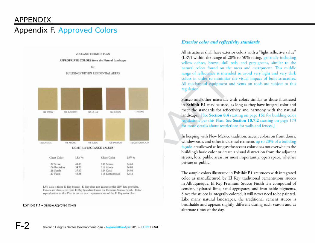
Volcano Heights Sector Development Plan - August 2012 April 2013 - LUPZ DRAFT
DRAFT
F-2
Appendix F. Approved ColorsAppendix
Exterior color and reflectivity standards
All structures shall have exterior colors with a “light reflective value” (LRV) within the range of 20% to 50% rating, generally including yellow ochres, brows, dull reds, and grey-greens, similar to the natural colors found on the mesa and escarpment. This middle range of reflectance is intended to avoid very light and very dark colors in order to minimize the visual impact of built structures. All mechanical equipment and vents on roofs are subject to this regulation.
Stucco and other materials with colors similar to those illustrated in Exhibit F.1 may be used, as long as they have integral color and meet the standards for reflectivity and harmony with the natural landscape. [See Section 8.4 starting on page 151 for building color regulations per this Plan. See Section 10.7.2 starting on page 173 for more details about restrictions for walls and fences.]
In keeping with New Mexico tradition, accent colors on front doors, window sash, and other incidental elements up to 20% of a building façade are allowed as long as the accent color does not overwhelm the building’s basic color or create a visual distraction from the adjacent streets, lots, public areas, or most importantly, open space, whether private or public.
The sample colors illustrated in Exhibit F.1 are stucco with integrated color as manufactured by El Rey traditional cementitious stucco in Albuquerque. El Rey Premium Stucco Finish is a compound of cement, hydrated lime, sand aggregates, and iron oxide pigments. Since the stucco is integrally colored, it will never need to be painted. Like many natural landscapes, the traditional cement stucco is breathable and appears slightly different during each season and at alternate times of the day.
Exhibit F.1 – Sample Approved Colors
Volcano Heights Sector Development Plan - August 2012 April 2013 - LUPZ DRAFT
DRAFT
DRAFTQuick Reference Zone MatrixAppendix G
G-1
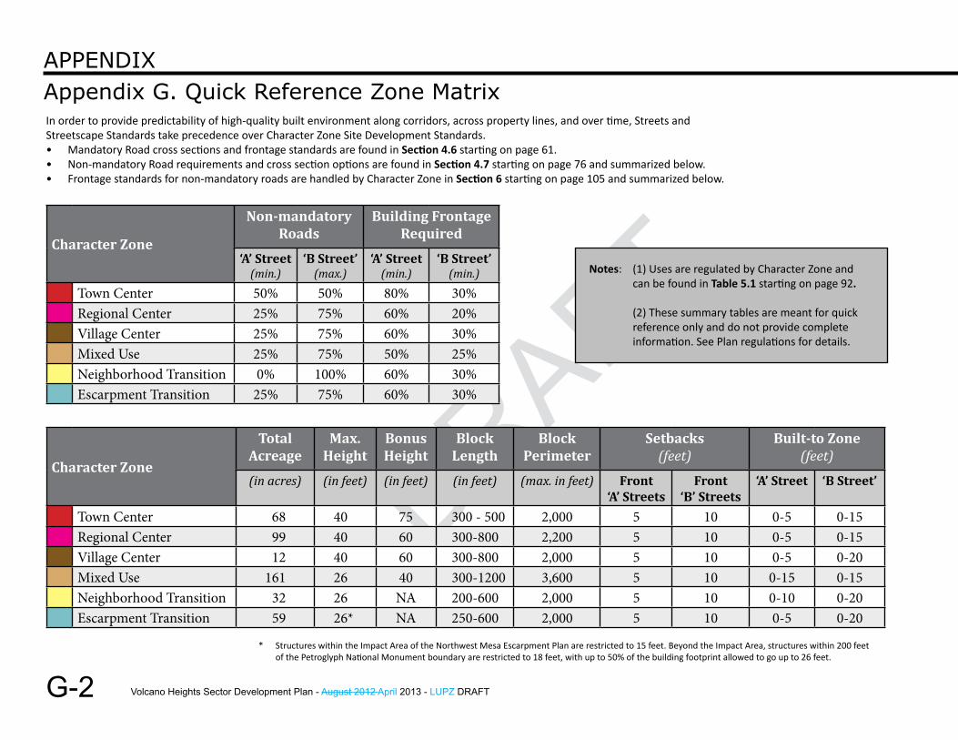
Volcano Heights Sector Development Plan - August 2012 April 2013 - LUPZ DRAFT
DRAFT
G-2
Appendix G. Quick Reference Zone MatrixAppendix
Character Zone
Total Acreage
Max. height
Bonus height
Block length
Block Perimeter
Setbacks (feet)
Built-to Zone(feet)
(in acres) (in feet) (in feet) (in feet) (max. in feet) front‘A’ Streets
front ‘B’ Streets
‘A’ Street ‘B Street’
Town Center 68 40 75 300 - 500 2,000 5 10 0-5 0-15Regional Center 99 40 60 300-800 2,200 5 10 0-5 0-15Village Center 12 40 60 300-800 2,000 5 10 0-5 0-20Mixed Use 161 26 40 300-1200 3,600 5 10 0-15 0-15Neighborhood Transition 32 26 NA 200-600 2,000 5 10 0-10 0-20Escarpment Transition 59 26* NA 250-600 2,000 5 10 0-5 0-20
* Structures within the Impact Area of the Northwest Mesa Escarpment Plan are restricted to 15 feet. Beyond the Impact Area, structures within 200 feet of the Petroglyph National Monument boundary are restricted to 18 feet, with up to 50% of the building footprint allowed to go up to 26 feet.
Character Zone
non-mandatory roads
Building frontagerequired
‘A’ Street(min.)
‘B Street’(max.)
‘A’ Street(min.)
‘B Street’(min.)
Town Center 50% 50% 80% 30%Regional Center 25% 75% 60% 20%Village Center 25% 75% 60% 30%Mixed Use 25% 75% 50% 25%Neighborhood Transition 0% 100% 60% 30%Escarpment Transition 25% 75% 60% 30%
In order to provide predictability of high-quality built environment along corridors, across property lines, and over time, Streets and Streetscape Standards take precedence over Character Zone Site Development Standards. • Mandatory Road cross sections and frontage standards are found in Section 4.6 starting on page 61. • Non-mandatory Road requirements and cross section options are found in Section 4.7 starting on page 76 and summarized below. • Frontage standards for non-mandatory roads are handled by Character Zone in Section 6 starting on page 105 and summarized below.
Notes: (1) Uses are regulated by Character Zone and can be found in Table 5.1 starting on page 92.
(2) These summary tables are meant for quick reference only and do not provide complete information. See Plan regulations for details.