Embed Size (px)
Citation preview

“Double Fourier Series as a mapping tool in marine cartography : analyses
and use”
Lic. Ing. Vande Wiele Tom

Area
Modelling
Settings
Results
Sampling
Data Set
Economical Factor
Cartographic Factor
Relief
Pattern
Quality

Double Fourier Series Model
Introduction
Periodic function
kTxfxf
aT
a
Tdxxfdxxf
0
unambiguous, finite, continuous and periodic function
1
021 sincos
kkk kxbkxaaxf
T
Tk dxkxxfa0
2 cos
T
Tk dxkxxfb0
2 sin
converging, infinite, trigonometric series
The General Equation
1 1 21
1 1 21
1 1 21
1 1 21
2sin
2sin
2cos
2sin
2sin
2cos
2cos
2cos
n m
jinm
n m
jinm
n m
jinm
n m
jinmij
ymxn
ymxn
ymxn
ymxnZ
2
*
1
2
*
1
2sin
2sin
2cos
2cos
jm
in
jm
in
ymS
xnS
ymC
xnC
1 1
****
n mmnnmmnnmmnnmmnnm SSCSSCCCijZ
Adjustment to the Data
0
0
0
0
1
2
1
2
1
2
1
2
nm
s
tijt
nm
s
tijt
nm
s
tijt
nm
s
tijt
ZZ
ZZ
ZZ
ZZ
Interpretation
z f x yi T i i i ,
z f x y Li T i i i i ,

Model Comparison
Model Results
properties
Construction Set
Test Set
Test
Method
H1
H2

Test Method
YX
Z0
Zp
TestSet
Model
TestMethod

Study Area
The Data Sets
Construction Sets :
main patterns according to orientation :
North West - South East oriented tracks [t]

The Data Sets
Construction Sets :
main patterns according to orientation :
North West - South East oriented tracks [t]
South West - North East oriented tracks [l]

The Data Sets
Construction Sets :
main patterns according to orientation :
North West - South East oriented tracks [t]
South West - North East oriented tracks [l]
combination of previous tracks [lt]

The Data Sets
Construction Sets :
main patterns according to orientation :
North West - South East oriented tracks [t]
South West - North East oriented tracks [l]
combination of previous tracks [lt]
distances between tracks differentiation :
l1 l2 l3 l4 l5

The Data Sets
Construction Sets :
main patterns according to orientation :
North West - South East oriented tracks [t]
South West - North East oriented tracks [l]
combination of previous tracks [lt]
distances between tracks differentiation :
l1 l2 l3 l4 l5

The Data Sets
Construction Sets :
main patterns according to orientation :
North West - South East oriented tracks [t]
South West - North East oriented tracks [l]
combination of previous tracks [lt]
distances between tracks differentiation :
l1 l2 l3 l4 l5

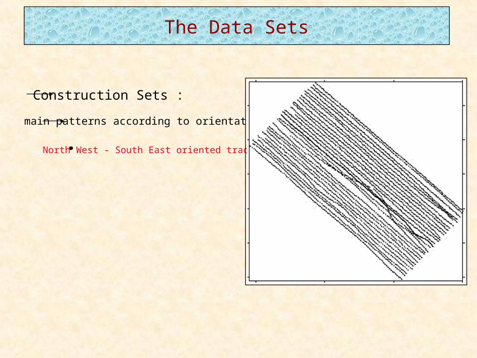
The Data Sets
Construction Sets :
main patterns according to orientation :
North West - South East oriented tracks [t]
South West - North East oriented tracks [l]
combination of previous tracks [lt]
distances between tracks differentiation :
t1 t5
l1 l5
lt1 lt5
Test Set
Results - Analyses
Influence Pattern
0.990
0.991
0.992
0.993
0.994
0.995
0.996
0.997
0.998
2x2 3x3 4x4 5x5 6x6
(m x n)
r -
corr
elat
ion
r-l1
r-l2
r-l3
0.00
0.10
0.20
0.30
0.40
0.50
0.60
0.70
0.80
0.90
1.00
2x2 3x3 4x4 5x5 6x6 7x7 8x8 9x9 10x10
(m x n)
r -
corr
elat
ion
r-t1
r-t2
r-t3
r-l1
r-l2
r-l3
r-lt1
r-lt2
r-lt3
r-lt4
r-lt5
Influence Test Set
0.990
0.992
0.994
0.996
0.998
1.000
2x2 3x3 4x4 5x5 6x6 7x7 8x8 9x9 10x10
(m x n)
r -
corr
elat
ion
test set
constr.set
lt4 (mxn) D) D) Min(D) Max(D) MAE RMSE RMSEs RMSEu a b r d2x2 0.24 0.62 -3.68 2.55 0.5027 0.6614 0.2507 0.6120 -0.038 0.9826 0.9919 0.9953
test set 3x3 0.25 0.49 -3.02 2.29 0.4201 0.5448 0.2542 0.4819 0.040 0.9869 0.9950 0.99684x4 0.25 0.44 -2.52 1.90 0.4028 0.5084 0.2541 0.4403 0.076 0.9890 0.9958 0.99725x5 0.25 0.42 -2.21 1.90 0.3821 0.4836 0.2515 0.4131 0.085 0.9897 0.9963 0.99756x6 0.24 0.40 -1.95 1.51 0.3707 0.4643 0.2405 0.3972 0.110 0.9919 0.9966 0.99777x7 0.25 0.40 -1.79 1.84 0.3845 0.4729 0.2593 0.3954 0.086 0.9893 0.9966 0.99768x8 0.24 0.43 -1.92 1.85 0.3874 0.4924 0.2430 0.4283 0.114 0.9920 0.9961 0.99749x9 0.24 0.60 -2.51 2.75 0.4843 0.6471 0.2488 0.5973 0.067 0.9888 0.9923 0.9955
10x10 0.22 1.60 -10.05 9.11 0.8506 1.6192 0.2208 1.6040 0.097 0.9923 0.9487 0.97302x2 0.00 0.67 -4.23 3.15 0.4533 0.6706 0.0834 0.6654 -0.255 0.9845 0.9922 0.9961
constr. 3x3 0.00 0.48 -3.25 2.27 0.3194 0.4817 0.0430 0.4798 -0.131 0.9920 0.9960 0.99804x4 0.00 0.39 -2.47 2.09 0.2661 0.3912 0.0284 0.3902 -0.087 0.9947 0.9974 0.9987
set 5x5 0.00 0.33 -2.41 1.88 0.2222 0.3318 0.0204 0.3311 -0.062 0.9962 0.9981 0.99916x6 0.00 0.29 -1.92 1.16 0.1975 0.2940 0.0160 0.2936 -0.049 0.9970 0.9985 0.99937x7 0.00 0.27 -1.78 1.28 0.1809 0.2737 0.0139 0.2734 -0.042 0.9974 0.9987 0.99948x8 0.00 0.26 -1.89 1.40 0.1775 0.2616 0.0120 0.2614 -0.037 0.9978 0.9988 0.99949x9 0.00 0.24 -1.90 1.47 0.1616 0.2438 0.0108 0.2436 -0.033 0.9980 0.9990 0.9995
10x10 0.00 0.23 -1.87 1.20 0.1488 0.2269 0.0095 0.2267 -0.029 0.9982 0.9991 0.9996
475000 475500 476000 476500 477000 477500 478000
Easting
5680500
5681000
5681500
5682000
5682500
5683000
Nor
thin
g
L1 = 3500L2 = 3000m = 10n = 10Data Set = lt4
Differences in m eter.
-5 .0
-4.0
-3.0
-2.0
-1.0
0.0
1.0
2.0
3.0
4.0
5.0
25 .0Influence Point Density
0.990
0.991
0.992
0.993
0.994
0.995
0.996
0.997
0.998
2x2 3x3 4x4 5x5 6x6 7x7 8x8 9x9 10x10
(m x n)
r -
corr
elat
ion
r-100
r-50
r-25
r-10
r-5
r-1

Results - Use of the Model
Direct Mapping
Mean D 0.20Variance D 0.36
Min D -1.80Max D 1.35MAE 0.3328
RMSE 0.4161RMSEs 0.2039RMSEu 0.3627
a 0.1611b 0.9973r 0.9972d 0.9982
475000 475500 476000 476500 477000 477500 478000
Easting
5680500
5681000
5681500
5682000
5682500
5683000
Nor
thin
g
-1 .00
-0 .80
-0 .60
-0 .40
-0 .20
0.00
0.20
0.40
0.60
0.80
1.00
2.00Differences in m eter.
L1 = 3500L2 = 3000m = 10n = 10Data Set = lt1
Mapping Tool
(Semivariogram original data set)(Semivariogram reduced data set)
Combination - Double Fourier Series & Kriging
DFS - model
476000 476500 477000 477500 478000
Easting (m )
5681500
5682000
5682500
5683000
No
rth
ing
(m
)
-1.5 m
-1.3 m
-1.1 m
-0.9 m
-0.7 m
-0.5 m
-0.3 m
-0.1 m
0.1 m
0.3 m
0.5 m
0.7 m
0.9 m
1.1 m
1.3 m
1.5 m
UTM zone 31(ED 50)
Kriging - model
0.00
0.05
0.10
0.15
0.20
0.25
1 2 3 4 5 6 7 8 9 10 11 12 13 14 15 16 17 18 19 20 21
SV 14°
SV 104°
sferical model
hole effect model
-1.0
-0.5
0.0
0.5
1.0
1.5
2.0
0 500 1000 1500 2000Distance along track (m)
Devia
tio
ns f
rom
DF
S m
od
el
(m)
Z 0
Z Kriging
-0.8-0.6-0.4
-0.20.00.20.4
0.60.8
0 500 1000 1500 2000Distance along track (m)
Dif
fere
nces b
etw
een
mo
del
an
d
ob
serv
ati
on
s (
m)
Model Performance
-2.00
-1.50
-1.00
-0.50
0.00
0.50
1.00
Mean D Variance D Min D Max D
DFS
Kriging-DFS
0.00
0.05
0.10
0.15
0.20
0.25
0.30
0.35
0.40
0.45
MAE RMSE RMSEs RMSEu
DFS
Kriging-DFS
0.950
0.955
0.960
0.965
0.970
0.975
0.980
0.985
0.990
0.995
1.000
b r d
DFS
Kriging-DFS
-20
-18
-16
-14
-12
-10
-8
0 500 1000 1500 2000
Z o
-20
-18
-16
-14
-12
-10
-8
0 500 1000 1500 2000
Z o
Z DFS
-20
-18
-16
-14
-12
-10
-8
0 500 1000 1500 2000
Z o
Z DFS
Z Kriging

Conclusions
Influence number of terms used
Influence validation/test set
Influence pattern
Analyses :
Use :
Direct mapping
Indirect mapping / tool