Embed Size (px)
Citation preview
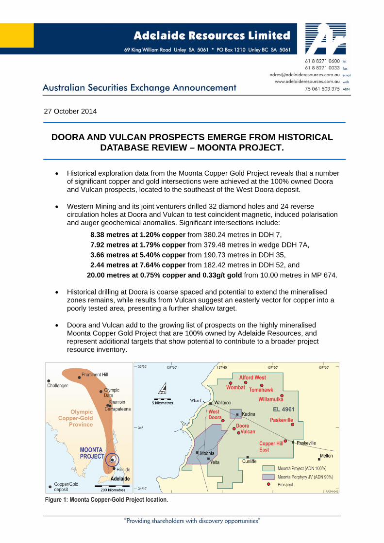
27 October 2014
DOORA AND VULCAN PROSPECTS EMERGE FROM HISTORICAL DATABASE REVIEW – MOONTA PROJECT.
Historical exploration data from the Moonta Copper Gold Project reveals that a number
of significant copper and gold intersections were achieved at the 100% owned Doora and Vulcan prospects, located to the southeast of the West Doora deposit.
Western Mining and its joint venturers drilled 32 diamond holes and 24 reverse circulation holes at Doora and Vulcan to test coincident magnetic, induced polarisation and auger geochemical anomalies. Significant intersections include:
8.38 metres at 1.20% copper from 380.24 metres in DDH 7,
7.92 metres at 1.79% copper from 379.48 metres in wedge DDH 7A,
3.66 metres at 5.40% copper from 190.73 metres in DDH 35,
2.44 metres at 7.64% copper from 182.42 metres in DDH 52, and
20.00 metres at 0.75% copper and 0.33g/t gold from 10.00 metres in MP 674.
Historical drilling at Doora is coarse spaced and potential to extend the mineralised zones remains, while results from Vulcan suggest an easterly vector for copper into a poorly tested area, presenting a further shallow target.
Doora and Vulcan add to the growing list of prospects on the highly mineralised Moonta Copper Gold Project that are 100% owned by Adelaide Resources, and represent additional targets that show potential to contribute to a broader project resource inventory.
Page 2
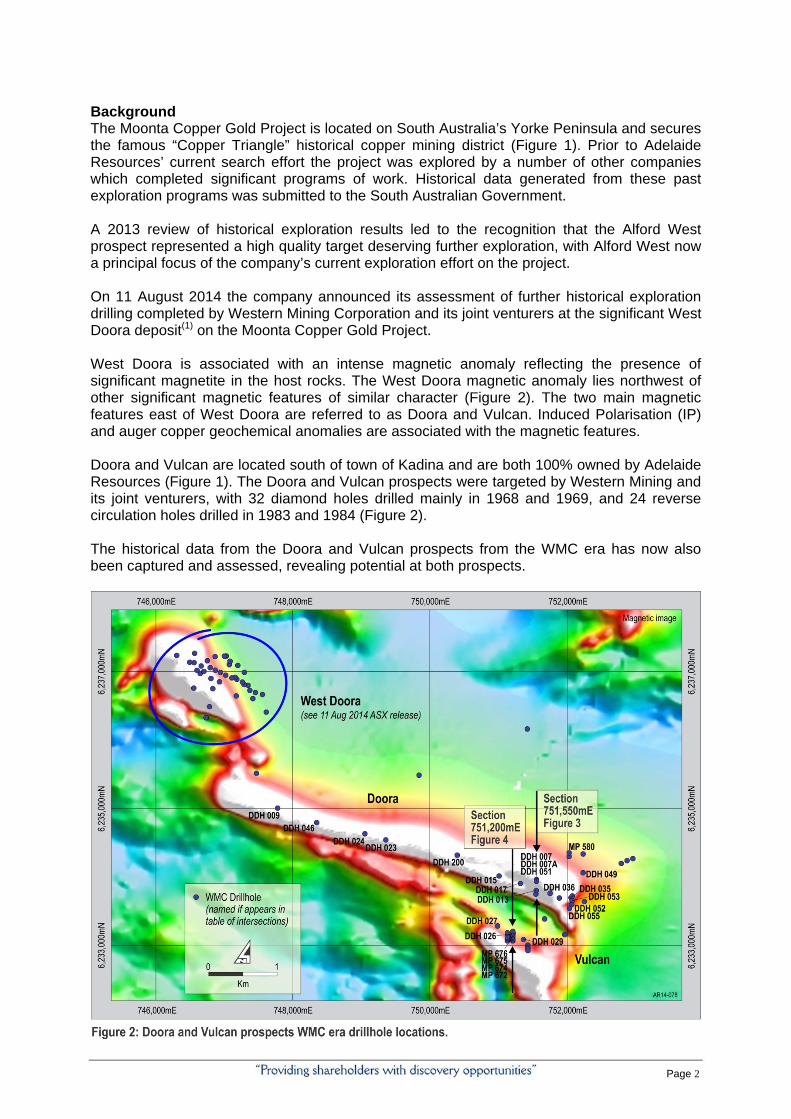
Background The Moonta Copper Gold Project is located on South Australia’s Yorke Peninsula and secures the famous “Copper Triangle” historical copper mining district (Figure 1). Prior to Adelaide Resources’ current search effort the project was explored by a number of other companies which completed significant programs of work. Historical data generated from these past exploration programs was submitted to the South Australian Government. A 2013 review of historical exploration results led to the recognition that the Alford West prospect represented a high quality target deserving further exploration, with Alford West now a principal focus of the company’s current exploration effort on the project. On 11 August 2014 the company announced its assessment of further historical exploration drilling completed by Western Mining Corporation and its joint venturers at the significant West Doora deposit(1) on the Moonta Copper Gold Project. West Doora is associated with an intense magnetic anomaly reflecting the presence of significant magnetite in the host rocks. The West Doora magnetic anomaly lies northwest of other significant magnetic features of similar character (Figure 2). The two main magnetic features east of West Doora are referred to as Doora and Vulcan. Induced Polarisation (IP) and auger copper geochemical anomalies are associated with the magnetic features. Doora and Vulcan are located south of town of Kadina and are both 100% owned by Adelaide Resources (Figure 1). The Doora and Vulcan prospects were targeted by Western Mining and its joint venturers, with 32 diamond holes drilled mainly in 1968 and 1969, and 24 reverse circulation holes drilled in 1983 and 1984 (Figure 2). The historical data from the Doora and Vulcan prospects from the WMC era has now also been captured and assessed, revealing potential at both prospects.
Page 3
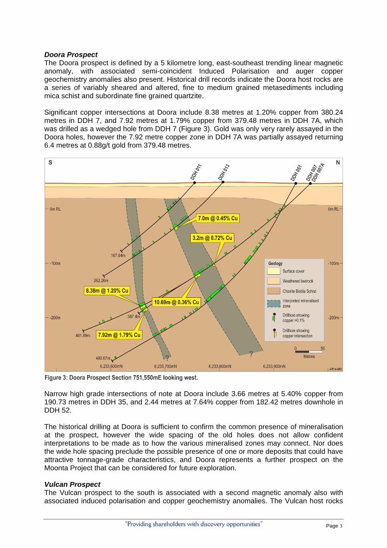
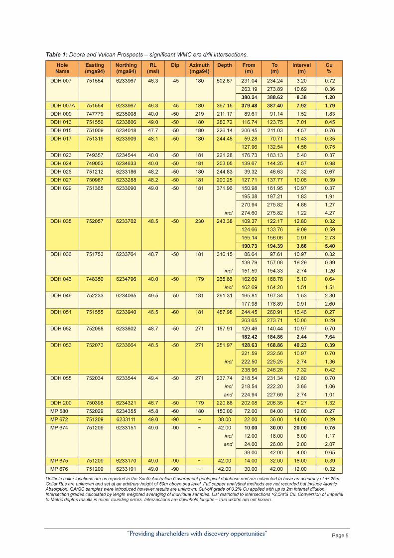
Doora Prospect The Doora prospect is defined by a 5 kilometre long, east-southeast trending linear magnetic anomaly, with associated semi-coincident Induced Polarisation and auger copper geochemistry anomalies also present. Historical drill records indicate the Doora host rocks are a series of variably sheared and altered, fine to medium grained metasediments including mica schist and subordinate fine grained quartzite. Significant copper intersections at Doora include 8.38 metres at 1.20% copper from 380.24 metres in DDH 7, and 7.92 metres at 1.79% copper from 379.48 metres in DDH 7A, which was drilled as a wedged hole from DDH 7 (Figure 3). Gold was only very rarely assayed in the Doora holes, however the 7.92 metre copper zone in DDH 7A was partially assayed returning 6.4 metres at 0.88g/t gold from 379.48 metres.
Narrow high grade intersections of note at Doora include 3.66 metres at 5.40% copper from 190.73 metres in DDH 35, and 2.44 metres at 7.64% copper from 182.42 metres downhole in DDH 52. The historical drilling at Doora is sufficient to confirm the common presence of mineralisation at the prospect, however the wide spacing of the old holes does not allow confident interpretations to be made as to how the various mineralised zones may connect. Nor does the wide hole spacing preclude the possible presence of one or more deposits that could have attractive tonnage-grade characteristics, and Doora represents a further prospect on the Moonta Project that can be considered for future exploration. Vulcan Prospect The Vulcan prospect to the south is associated with a second magnetic anomaly also with associated induced polarisation and copper geochemistry anomalies. The Vulcan host rocks
Page 4
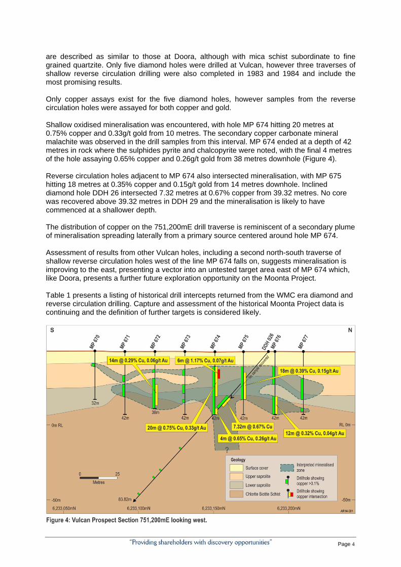
are described as similar to those at Doora, although with mica schist subordinate to fine grained quartzite. Only five diamond holes were drilled at Vulcan, however three traverses of shallow reverse circulation drilling were also completed in 1983 and 1984 and include the most promising results. Only copper assays exist for the five diamond holes, however samples from the reverse circulation holes were assayed for both copper and gold. Shallow oxidised mineralisation was encountered, with hole MP 674 hitting 20 metres at 0.75% copper and 0.33g/t gold from 10 metres. The secondary copper carbonate mineral malachite was observed in the drill samples from this interval. MP 674 ended at a depth of 42 metres in rock where the sulphides pyrite and chalcopyrite were noted, with the final 4 metres of the hole assaying 0.65% copper and 0.26g/t gold from 38 metres downhole (Figure 4). Reverse circulation holes adjacent to MP 674 also intersected mineralisation, with MP 675 hitting 18 metres at 0.35% copper and 0.15g/t gold from 14 metres downhole. Inclined diamond hole DDH 26 intersected 7.32 metres at 0.67% copper from 39.32 metres. No core was recovered above 39.32 metres in DDH 29 and the mineralisation is likely to have commenced at a shallower depth. The distribution of copper on the 751,200mE drill traverse is reminiscent of a secondary plume of mineralisation spreading laterally from a primary source centered around hole MP 674. Assessment of results from other Vulcan holes, including a second north-south traverse of shallow reverse circulation holes west of the line MP 674 falls on, suggests mineralisation is improving to the east, presenting a vector into an untested target area east of MP 674 which, like Doora, presents a further future exploration opportunity on the Moonta Project. Table 1 presents a listing of historical drill intercepts returned from the WMC era diamond and reverse circulation drilling. Capture and assessment of the historical Moonta Project data is continuing and the definition of further targets is considered likely.
Page 5
Page 6
Chris Drown Managing Director Enquiries should be directed to Chris Drown. Ph (08) 8271 0600 or 0427 770 653. Competent Person Statement and 2012 JORC Statements The information in this report that relates to Exploration Targets, Exploration Results, Mineral Resources or Ore Reserves is based on information compiled by Chris Drown, a Competent Person, who is a Member of The Australasian Institute of Mining and Metallurgy. Mr Drown is employed by Drown Geological Services Pty Ltd and consults to the Company on a full time basis. Mr Drown has sufficient experience that is relevant to the style of mineralisation and type of deposit under consideration and to the activity being undertaken to qualify as a Competent Person as defined in the 2012 Edition of the ‘Australasian Code for Reporting of Exploration Results, Mineral Resources and Ore Reserves’. Mr Drown consents to the inclusion in the report of the matters based on his information in the form and context in which it appears. (1) See ADN’s ASX release dated 11 August titled “Review of historical data confirms West Doora as significant IOCG prospect – Moonta Project.”
1 JORC CODE, 2012 EDITION – TABLE 1
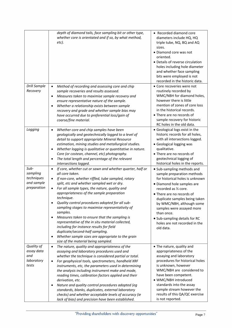
1.1 Section 1 Sampling Techniques and Data (Criteria in this section apply to all succeeding sections.) Criteria JORC Code explanation Commentary
Sampling techniques
Nature and quality of sampling (eg cut channels, random chips, or specific specialised industry standard measurement tools appropriate to the minerals under investigation, such as down hole gamma sondes, or hand held XRF instruments, etc) These examples should not be taken as limiting the broad meaning of sampling.
Include reference to measures taken to ensure sample representivity and the appropriate calibration of any measurement tools or systems used.
Aspects of the determination of mineralisation that are Material to the Public Report.
In cases where ‘industry standard’ work has been done this would be relatively simple (eg ‘reverse circulation drilling was used to obtain 1 m samples from which 3 kg was pulverised to produce a 30 g charge for fire assay’). In other cases more explanation may be required, such as where there is coarse gold that has inherent sampling problems. Unusual commodities or mineralisation types (eg submarine nodules) may warrant disclosure of detailed information.
Sampling protocols for historical holes is not recorded in the historical reports, however it is known that any assays reported from diamond holes were from ½ core samples.
Historical records show some QA/QC measures were undertaken with the inclusion of standard samples to the analytical stream, however the results of this QA/QC work is unknown.
Drilling Techniques
Drill type (air core, reverse circulation, open‐hole hammer, rotary air blast , auger, Bangka, sonic, etc) and details (eg core diameter, triple or standard tube,
WMC/NBH completed rotary mud precollars prior to diamond coring.
Page 7
depth of diamond tails, face sampling bit or other type, whether core is orientated and if so, by what method, etc).
Recorded diamond core diameters include HQ, HQ triple tube, NQ, BQ and AQ sizes.
Diamond core was not oriented.
Details of reverse circulation holes including hole diameter and whether face sampling bits were employed is not recorded in the historic data.
Drill Sample Recovery
Method of recording and assessing core and chip sample recoveries and results assessed.
Measures taken to maximise sample recovery and ensure representative nature of the sample.
Whether a relationship exists between sample recovery and grade and whether sample bias may have occurred due to preferential loss/gain of coarse/fine material.
Core recoveries were not routinely recorded by WMC/NBH for diamond holes, however there is little mention of zones of core loss in the historical records.
There are no records of sample recovery for historic RC holes in the old data.
Logging Whether core and chip samples have been geologically and geotechnically logged to a level of detail to support appropriate Mineral Resource estimation, mining studies and metallurgical studies.
Whether logging is qualitative or quantitative in nature. Core (or costean, channel, etc) photography.
The total length and percentage of the relevant intersections logged.
Geological logs exist in the historic records for all holes, with all intersections logged.
Geological logging was qualitative.
There are no records of geotechnical logging of historical holes in the reports.
Sub‐sampling techniques and sample preparation
If core, whether cut or sawn and whether quarter, half or all core taken.
If non‐core, whether riffled, tube sampled, rotary split, etc and whether sampled wet or dry.
For all sample types, the nature, quality and appropriateness of the sample preparation technique.
Quality control procedures adopted for all sub‐sampling stages to maximise representativity of samples.
Measures taken to ensure that the sampling is representative of the in situ material collected, including for instance results for field duplicate/second‐half sampling.
Whether sample sizes are appropriate to the grain size of the material being sampled.
Sub‐sampling methods and sample preparation methods for historical holes is unknown
Diamond hole samples are recorded as ½ core.
There are no records of duplicate samples being taken by WMC/NBH, although some samples were assayed more than once.
Sub‐sampling details for RC holes are not recorded in the old data.
Quality of assay data and laboratory tests
The nature, quality and appropriateness of the assaying and laboratory procedures used and whether the technique is considered partial or total.
For geophysical tools, spectrometers, handheld XRF instruments, etc, the parameters used in determining the analysis including instrument make and mode, reading times, calibration factors applied and their derivation, etc.
Nature and quality control procedures adopted (eg standards, blanks, duplicates, external laboratory checks) and whether acceptable levels of accuracy (ie lack of bias) and precision have been established.
The nature, quality and appropriateness of the assaying and laboratory procedures for historical holes is unknown, however WMC/NBH are considered to have been competent.
WMC/NBH introduced standards into the assay sample stream however the results of this QA/QC exercise is not reported.
Page 8
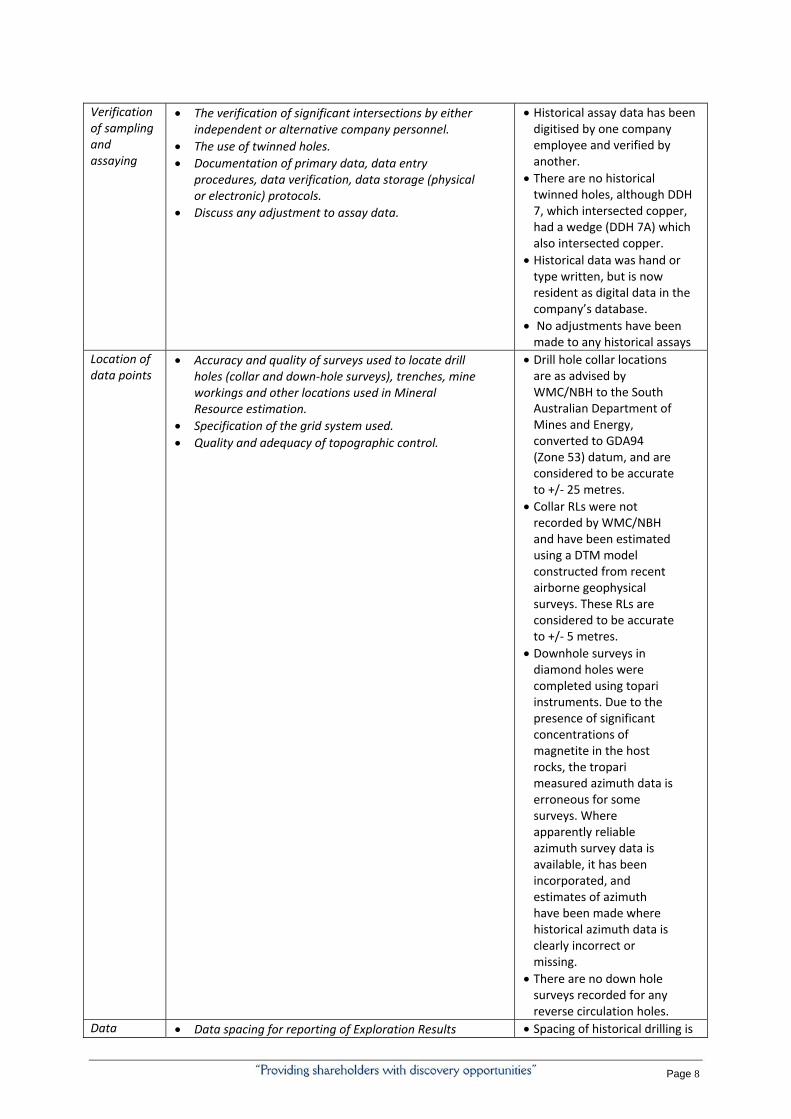
Verification of sampling and assaying
The verification of significant intersections by either independent or alternative company personnel.
The use of twinned holes.
Documentation of primary data, data entry procedures, data verification, data storage (physical or electronic) protocols.
Discuss any adjustment to assay data.
Historical assay data has been digitised by one company employee and verified by another.
There are no historical twinned holes, although DDH 7, which intersected copper, had a wedge (DDH 7A) which also intersected copper.
Historical data was hand or type written, but is now resident as digital data in the company’s database.
No adjustments have been made to any historical assays
Location of data points
Accuracy and quality of surveys used to locate drill holes (collar and down‐hole surveys), trenches, mine workings and other locations used in Mineral Resource estimation.
Specification of the grid system used.
Quality and adequacy of topographic control.
Drill hole collar locations are as advised by WMC/NBH to the South Australian Department of Mines and Energy, converted to GDA94 (Zone 53) datum, and are considered to be accurate to +/‐ 25 metres.
Collar RLs were not recorded by WMC/NBH and have been estimated using a DTM model constructed from recent airborne geophysical surveys. These RLs are considered to be accurate to +/‐ 5 metres.
Downhole surveys in diamond holes were completed using topari instruments. Due to the presence of significant concentrations of magnetite in the host rocks, the tropari measured azimuth data is erroneous for some surveys. Where apparently reliable azimuth survey data is available, it has been incorporated, and estimates of azimuth have been made where historical azimuth data is clearly incorrect or missing.
There are no down hole surveys recorded for any reverse circulation holes.
Data Data spacing for reporting of Exploration Results Spacing of historical drilling is
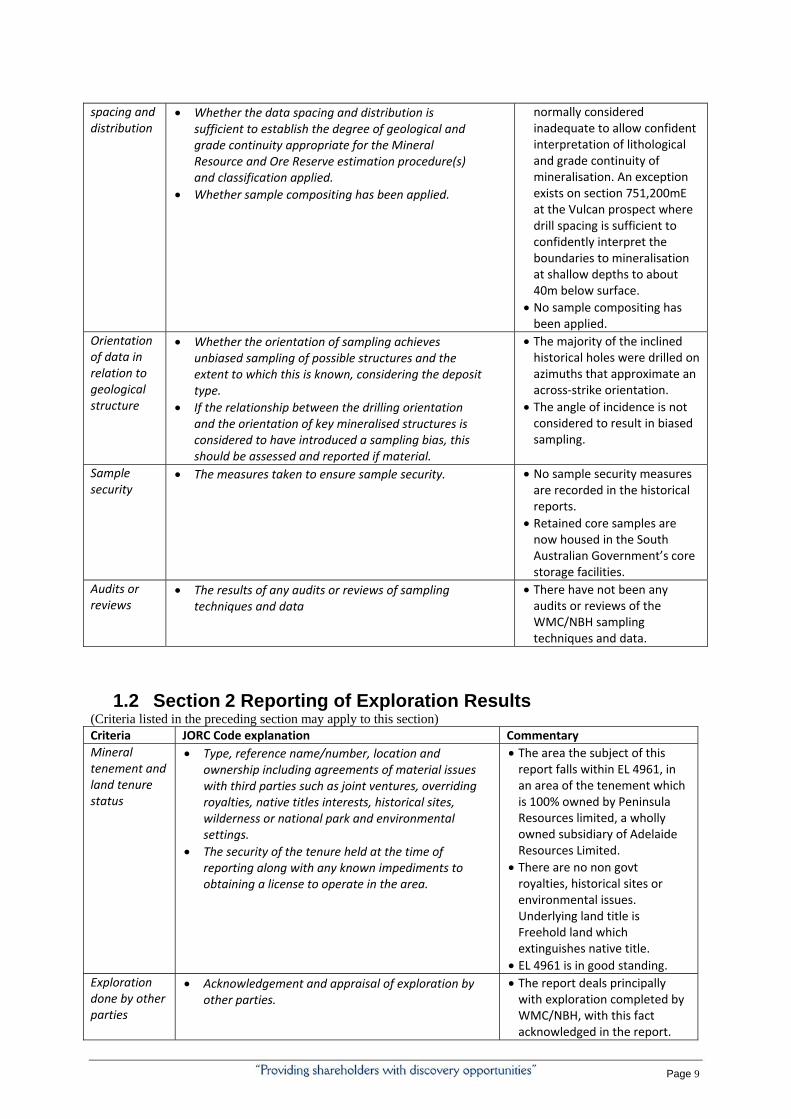
Page 9
spacing and distribution
Whether the data spacing and distribution is sufficient to establish the degree of geological and grade continuity appropriate for the Mineral Resource and Ore Reserve estimation procedure(s) and classification applied.
Whether sample compositing has been applied.
normally considered inadequate to allow confident interpretation of lithological and grade continuity of mineralisation. An exception exists on section 751,200mE at the Vulcan prospect where drill spacing is sufficient to confidently interpret the boundaries to mineralisation at shallow depths to about 40m below surface.
No sample compositing has been applied.
Orientation of data in relation to geological structure
Whether the orientation of sampling achieves unbiased sampling of possible structures and the extent to which this is known, considering the deposit type.
If the relationship between the drilling orientation and the orientation of key mineralised structures is considered to have introduced a sampling bias, this should be assessed and reported if material.
The majority of the inclined historical holes were drilled on azimuths that approximate an across‐strike orientation.
The angle of incidence is not considered to result in biased sampling.
Sample security
The measures taken to ensure sample security. No sample security measures are recorded in the historical reports.
Retained core samples are now housed in the South Australian Government’s core storage facilities.
Audits or reviews
The results of any audits or reviews of sampling techniques and data
There have not been any audits or reviews of the WMC/NBH sampling techniques and data.
1.2 Section 2 Reporting of Exploration Results
(Criteria listed in the preceding section may apply to this section) Criteria JORC Code explanation Commentary
Mineral tenement and land tenure status
Type, reference name/number, location and ownership including agreements of material issues with third parties such as joint ventures, overriding royalties, native titles interests, historical sites, wilderness or national park and environmental settings.
The security of the tenure held at the time of reporting along with any known impediments to obtaining a license to operate in the area.
The area the subject of this report falls within EL 4961, in an area of the tenement which is 100% owned by Peninsula Resources limited, a wholly owned subsidiary of Adelaide Resources Limited.
There are no non govt royalties, historical sites or environmental issues. Underlying land title is Freehold land which extinguishes native title.
EL 4961 is in good standing. Exploration done by other parties
Acknowledgement and appraisal of exploration by other parties.
The report deals principally with exploration completed by WMC/NBH, with this fact acknowledged in the report.
Page 10
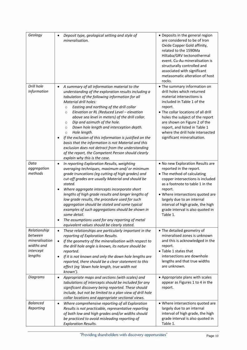
Geology Deposit type, geological setting and style of mineralisation.
Deposits in the general region are considered to be of Iron Oxide Copper Gold affinity, related to the 1590Ma Hiltaba/GRV tectonothermal event. Cu‐Au mineralisation is structurally controlled and associated with significant metasomatic alteration of host rocks.
Drill hole Information
A summary of all information material to the understanding of the exploration results including a tabulation of the following information for all Material drill holes: o Easting and northing of the drill collar o Elevation or RL (Reduced Level – elevation
above sea level in meters) of the drill collar. o Dip and azimuth of the hole. o Down hole length and interception depth. o Hole length.
If the exclusion of this information is justified on the basis that the information is not Material and this exclusion does not detract from the understanding of the report, the Competent Person should clearly explain why this is the case.
The summary information on drill holes which returned material intersections is included in Table 1 of the report.
The collar locations of all drill holes the subject of the report are shown on Figure 2 of the report, and listed in Table 1 where the drill hole intersected significant mineralisation.
Data aggregation methods
In reporting Exploration Results, weighting averaging techniques, maximum and/ or minimum grade truncations (eg cutting of high grades) and cut‐off grades are usually Material and should be stated.
Where aggregate intercepts incorporate short lengths of high grade results and longer lengths of low grade results, the procedure used for such aggregation should be stated and some typical examples of such aggregations should be shown in some detail.
The assumptions used for any reporting of metal equivalent values should be clearly stated.
No new Exploration Results are reported in the report.
The method of calculating copper intersections is included as a footnote to table 1 in the report.
Where intersections quoted are largely due to an internal interval of high grade, the high grade interval is also quoted in Table 1.
Relationship between mineralisation widths and intercept lengths
These relationships are particularly important in the reporting of Exploration Results.
If the geometry of the mineralisation with respect to the drill hole angle is known, its nature should be reported.
If it is not known and only the down hole lengths are reported, there should be a clear statement to this effect (eg ‘down hole length, true width not known’).
The detailed geometry of mineralised zones is unknown and this is acknowledged in the report.
Table 1 states that intersections are downhole lengths and that true widths are unknown.
Diagrams Appropriate maps and sections (with scales) and tabulations of intercepts should be included for any significant discovery being reported. These should include, but not be limited to a plan view of drill hole collar locations and appropriate sectional views.
Appropriate plans with scales appear as Figures 1 to 4 in the report.
Balanced Reporting
Where comprehensive reporting of all Exploration Results is not practicable, representative reporting of both low and high grades and/or widths should be practiced to avoid misleading reporting of Exploration Results.
Where intersections quoted are largely due to an internal interval of high grade, the high grade interval is also quoted in Table 1.

Page 11
Other substantive exploration data
Other exploration data, if meaningful and material, should be reported including (but not limited to): geological observations; geophysical survey results; geochemical survey results; bulk samples – size and method of treatment; metallurgical test results; bulk density, ground water, geotechnical and rock characteristics; potential deleterious or contaminating substances.
Observations on basement geology, weathering, alteration, geochemistry, and mineralisation have been included in the report.
Further work The nature and scale of planned further work (eg tests of lateral extensions or depth extensions or large scale step‐out drilling).
Diagrams clearly highlighting the areas of possible extensions, including the main geological interpretations and future drilling areas, provided this information is not commercially sensitive.
The report advises that the two prospects the subject of the report represent targets that will be considered for future exploration work.


![VULCAN VIZU HOLDA - Amazon S3...VULCAN CATERING EQUIPMENT (PTY)LTD [ 6 ] VULCAN VIZU HOLDA VULCAN CATERING EQUIPMENT (PTY)LTD VULCAN VIZU HOLDA WIRING DIAGRAM Item No. Stores Ref.No](https://img.pdfslide.us/doc/110x75/60e756b4cf711d2301079486/vulcan-vizu-holda-amazon-s3-vulcan-catering-equipment-ptyltd-6-vulcan.jpg)
![VULCAN HIGH SPEED DEEP FAT FRYER (ELECTRIC) › vulcan-website...Vulcan catering equipment (ptY)ltD [ 2 ] VULCAN HIGH SPEED DEEP FAT FRYER (ELECTRIC) GENERAL DATA: MANUFACTURER: Vulcan](https://img.pdfslide.us/doc/110x75/60c05ae5c355355f26327394/vulcan-high-speed-deep-fat-fryer-electric-a-vulcan-website-vulcan-catering.jpg)