Embed Size (px)
Citation preview
DISTRICT BACKGROUND Background of Mahendergarh The district Mahendergarh is located in the southwestern part of Haryana
bordering, Alwar district of Rajasthan in south, Sikar in the South East, Jaipur in
the west, Bhiwani district of Haryana in the North and Gurgaon in the east. There
are three ranges in Mahendergarh Forest Division, namely Mahendergarh,
Narnaul and Nangal Chaudhary. Mahendergarh district head quarter is at
Narnaul. A total area is about 3,21,422.70 ha. The tract dealt with an Indo
Gangetic alluvial plain marked vast stretch of almost flat land. Broadly speaking
the tract can be divided into five distinct land scapes with elevation varying from
200 m to 325 m namely Aravalli hills, foot hills flood plains, Aeolian plains and
sand dunes Alluvium deposits.
1.1 Geographic location The area is comprised of plain tract and some parts of Siwalik hills.
Geographically the area is situated between 280-27’-30” to 270-50’ North latitude
and 750-58’ to 760-50 East longitude. This plain deals with the block and strip
forests. Aravali hills in the division are the northern extension of the Aravali which
is the oldest northern system of India sub-continent. Most of the area is situated
along strips. Strip forest are situated along railway lines, roads, canals, areas
under various categories of strip forest in the division in 5,873.58 ha. Total areas
of reserve forests is 2,160.68 ha. In general the tract is not well drained. Low
lying areas get flooded and remain submerged during rainy season. Water
logging along unlined channels and kuhals and due to barrow pits is very
common. There is no perennial river in the tract. The seasonal river in
Mahendergarh district like Krishnawati and Dohan run parallel to each other from
South West to North East. According to the census of 1991 the population of
Mahendergarh is 6,65,416. The density of the per sq Km in Mahendergarh is 396
persons. The rural population is 87.63 per cent.
About 70 per cent of the total area of the district are used for agriculture. Animal
husbandry provides an additional source of income. It also supplements the
income of schedule caste and backward class families. The reserve forests are
free from all kind of rights and no one has any claim or right in any part of the
forests or forest produce.
1.2 Soil types description
The Aravali hillocks are in the form of extensions of igneous groups and are
supposed to have came into existence during the close of Dharwar era (Archean
system) by riding up marine sediments by an up heaval. Mining of Marbel and
Slate on commercial scale is being carried out in Mahendergarh. The soil depth
and texture varies from place to place. In the plains the soil is deep but shallow
on hill slops. The soils texture various from sandy loam to clay loam in plains and
sandy loam to sandy on the hills. Hills slopes are practically soil less or have
same partially decomposed parent rock and conspicuous bare rock at places soil
depth varies from 5-15 cms
1.3 Climate The climate of Mahendergarh is very hot tropical to sub tropical characterised by
high temperature and moisture deficiency for the greater part of the year. There is
prolonged hot period extending from March to June. Hot dust laden winds locally
known as “Loo” blow from April onwards and cause further desiccation December
and January are the coldest month when temperature reach near freezing point
of water. The highest incidence of dust storms and thunder storms occurs during
April to June. Temperature during June is around 420 C and minimum 280C.
Temperature may exceed 480C. About 70 to 80 percent of the total annual rain
falls received during the monsoon period. South west Monsoon are the main
source of rainfall and the relative humidity is high being over 75-80 percent in
the morning and 55-65 percent in the afternoon. High humidity’s of more than
70 percent also prevail during the winter month of December to February.
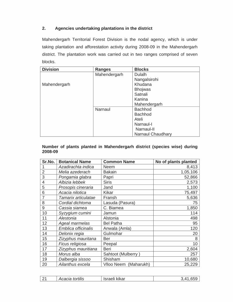
2. Agencies undertaking plantations in the district
Mahendergarh Territorial Forest Division is the nodal agency, which is under
taking plantation and afforestation activity during 2008-09 in the Mahendergarh
district. The plantation work was carried out in two ranges comprised of seven
blocks.
Division Ranges Blocks Mahendergarh
Mahendergarh Dulalh Nangalsirohi Khudana Bhojwas Satnali Kanina Mahendergarh
Narnaul Bachhod Bachhod Ateli Narnaul-I Narnaul-II Narnaul Chaudhary
Number of plants planted in Mahendergarh district (species wise) during 2008-09 Sr.No. Botanical Name Common Name No of plants planted 1 Azadirachta indica Neem 8,4132 Melia azederach Bakain 1,05,1063 Pongamia glabra Papri 52,8664 Albizia lebbek Siris 2,5735 Prosopis cineraria Jand 1,1006 Acacia nilotica Kikar 75,4977 Tamarix articulatae Fransh 5,6368 Cordial dichtoma Lasuda (Pasura) 759 Cassia siamea C. Biamea 1,85010 Syzygium cumini Jamun 11411 Alestonia Alstonia 49812 Ageal marmelas Bel Patha 9513 Emblica officinalis Anwala (Amla) 12014 Delonix regia Gulmohar 2015 Zizyphus mauritana Ber 816 Ficus religiosa Peepal 1017 Zizyphus mauritiana Beri 2,60418 Morus alba Sahtoot (Mulberry ) 25719 Dalbergia sissoo Shisham 10,68020 Ailanthus excela Vlloo Neem (Maharukh) 25,229
21 Acacia tortilis Israeli kikar 3,41,659
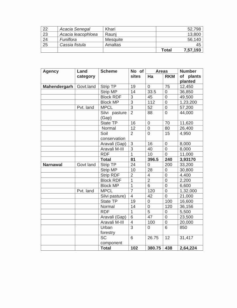
22 Acacia Senegal Khari 52,79823 Acacia leacophloea Raunj 13,80024 Funiflora Mesquite 56,14025 Cassia fistula Amaltas 45 Total 7,57,193
Agency Land category
Scheme No of sites
Areas Number of plants planted
Ha RKM
Mahendergarh Govt.land Strip TP 19 0 75 12,450 Strip MP 14 33.5 0 36,850 Block RDF 3 45 0 49,500 Block MP 3 112 0 1,23,200 Pvt. land MPCL 3 52 0 57,200 Silvi pasture
(Gap) 2 88 0 44,000
State TP 16 0 70 11,620 Normal 12 0 80 26,400 Soil
conservation 2 0 15 4,950
Aravali (Gap) 3 16 0 8,000 Aravali M-III 3 40 0 8,000 RDF 1 10 0 11,000 Total 81 396.5 240 3,93170 Narnawal Govt land Strip TP 24 0 200 33,200 Strip MP 10 28 0 30,800 Strip RDF 2 4 0 4,400 Block RDF 1 2 0 2,200 Block MP 1 6 0 6,600 Pvt. land MPCL 7 120 0 1,32,000 Silvi pasture) 4 42 0 21,000 State TP 19 0 100 16,600 Normal 14 0 120 36,156 RDF 1 5 0 5,500 Aravali (Gap) 6 47 0 23,500 Aravali M-III 4 100 0 20,000 Urban
forestry 3 0 6 850
SC component
6 26.75 12 31,417
Total 102 380.75 438 2,64,224
3. Inventory of plantation in Mahendergarh district during 2008-09
Agency Land category
Scheme Name of site Area Plants planted Ha RKM
Mahendergarh Range
Forest land
Strip TP Balana Sohla Rd L/R
- 3 498
Sihma Khanina Rd L/R
- 4 664
Nangwas opp. Rd L/R
- 3 498
Nangwas Dongra Ahir K/Path
4 664
Beri Stop Rd L/R - 3 498 Vskoda Khudan
Rd L/R - 3 498
Khudana Kadms Rd L/R
- 4.5 747
Mahendergarh Khana Rd L/R
- 10 1660
Gudda Rasulpur Rd L/R
- 4 664
Shima Kanina Rd L/R
- 8 1328
Sundrah Behawina Rd L/R
- 5 830
Mandola Nangal Rd
- 4 664
Kanina Kanira Rd L/R
- 2.5 415
Kanina Garh Rd - 1 116 Kanina Kakul Rd - 3.5 581 Bharaph Spp. Rd - 1 166 Bagat Chairya
Rs. - 4.5 747
Pota Sange Rd - 2 332 Mahendergarh
Barwan Rd - 5 830
Total - 75 12450 Forest
land Strip TP Kaniana Gahra
Rd 1.5 1,650
Ramgarh dist 3 3,300 Rampuri dist 3 3,300 Mahendergarh
Canal 4 4,400
Sihore Chitroli Rd 0.5 550 Balana Bumdh 2 2,200 Dadhal Bundh 3 3,300 Satnali Lohru Rd 3 3,300 Jarwa Dist 3 3,300
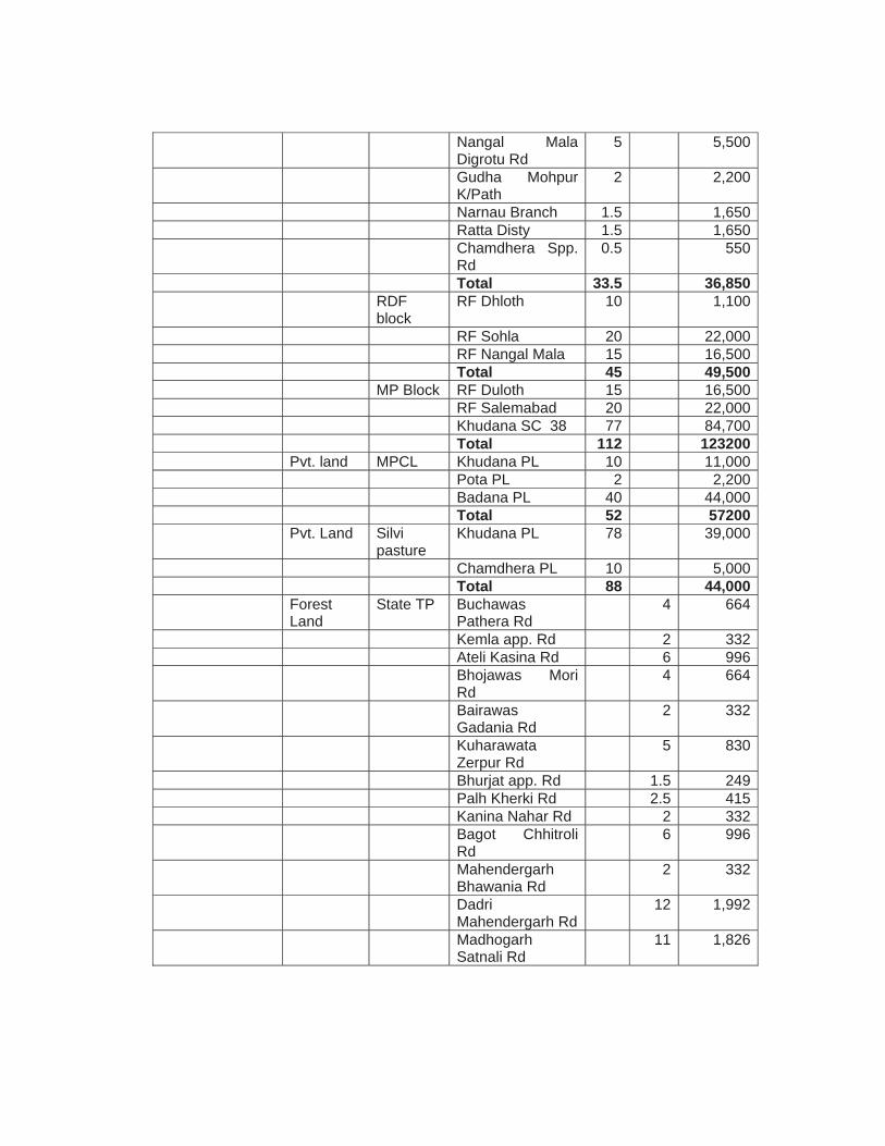
Nangal Mala Digrotu Rd
5 5,500
Gudha Mohpur K/Path
2 2,200
Narnau Branch 1.5 1,650 Ratta Disty 1.5 1,650 Chamdhera Spp.
Rd 0.5 550
Total 33.5 36,850 RDF
block RF Dhloth 10 1,100
RF Sohla 20 22,000 RF Nangal Mala 15 16,500 Total 45 49,500 MP Block RF Duloth 15 16,500 RF Salemabad 20 22,000 Khudana SC 38 77 84,700 Total 112 123200 Pvt. land MPCL Khudana PL 10 11,000 Pota PL 2 2,200 Badana PL 40 44,000 Total 52 57200 Pvt. Land Silvi
pasture Khudana PL 78 39,000
Chamdhera PL 10 5,000 Total 88 44,000 Forest
Land State TP Buchawas
Pathera Rd 4 664
Kemla app. Rd 2 332 Ateli Kasina Rd 6 996 Bhojawas Mori
Rd 4 664
Bairawas Gadania Rd
2 332
Kuharawata Zerpur Rd
5 830
Bhurjat app. Rd 1.5 249 Palh Kherki Rd 2.5 415 Kanina Nahar Rd 2 332 Bagot Chhitroli
Rd 6 996
Mahendergarh Bhawania Rd
2 332
Dadri Mahendergarh Rd
12 1,992
Madhogarh Satnali Rd
11 1,826
Dodri Mahendergarh Rd
6 996
Gaushala Rd 1 166 Satnali Modiyan
Rd 3 498
Total 70 11,620 Forest
Land Normal Jhook Distry 2 660
Narnaul Branch 7 2,310 Balred Distry 6 1,980 Akoda Bassai Rd 2 660 Jhagrili Bachini
Rd 7 2,310
Jatwas Disty 4 1,320 Mahendergarh
Disty 22 7,260
Jatwas Disty 6 1,980 Bhawana Disty 9 2,970 Nihalawas app
Rd 2 660
Ratta Disty 5 1,650 Bhandore Disty 8 2,640 Total 80 26,400 Forest
Land SMC RF Sohla 7.5 2,475
Chhilaro Nala 7.5 2,475 Total 15 4,950 RFD Section 38
khudana 10 11,000
Total 10 11,000 Pvt. Land Aravalli
(gap) Khudana PL 5 2,500
Zerpur PL 4 2,000 Nangalmala PL 7 3,500 Total 16 8,000 Pvt. Land Aravalli
M-III Khudana PL 10 2,000
Nangal Mala PL 14 2,800 Zerpur PL 16 3,200 Total 40 8,000
Agency Land Scheme Name of site Area Plants
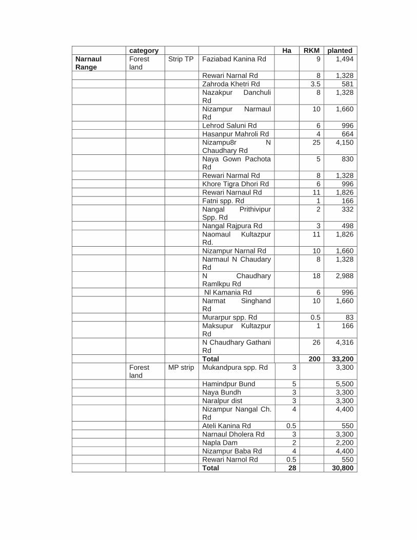
category Ha RKM planted Narnaul Range
Forest land
Strip TP Faziabad Kanina Rd 9 1,494
Rewari Narnal Rd 8 1,328 Zahroda Khetri Rd 3.5 581 Nazakpur Danchuli
Rd 8 1,328
Nizampur Narmaul Rd
10 1,660
Lehrod Saluni Rd 6 996 Hasanpur Mahroli Rd 4 664 Nizampu8r N
Chaudhary Rd 25 4,150
Naya Gown Pachota Rd
5 830
Rewari Narmal Rd 8 1,328 Khore Tigra Dhori Rd 6 996 Rewari Narnaul Rd 11 1,826 Fatni spp. Rd 1 166 Nangal Prithivipur
Spp. Rd 2 332
Nangal Rajpura Rd 3 498 Naomaul Kultazpur
Rd. 11 1,826
Nizampur Narnal Rd 10 1,660 Narmaul N Chaudary
Rd 8 1,328
N Chaudhary Ramlkpu Rd
18 2,988
Nl Kamania Rd 6 996 Narmat Singhand
Rd 10 1,660
Murarpur spp. Rd 0.5 83 Maksupur Kultazpur
Rd 1 166
N Chaudhary Gathani Rd
26 4,316
Total 200 33,200 Forest
land MP strip Mukandpura spp. Rd 3 3,300
Hamindpur Bund 5 5,500 Naya Bundh 3 3,300 Naralpur dist 3 3,300 Nizampur Nangal Ch.
Rd 4 4,400
Ateli Kanina Rd 0.5 550 Narnaul Dholera Rd 3 3,300 Napla Dam 2 2,200 Nizampur Baba Rd 4 4,400 Rewari Narnol Rd 0.5 550 Total 28 30,800
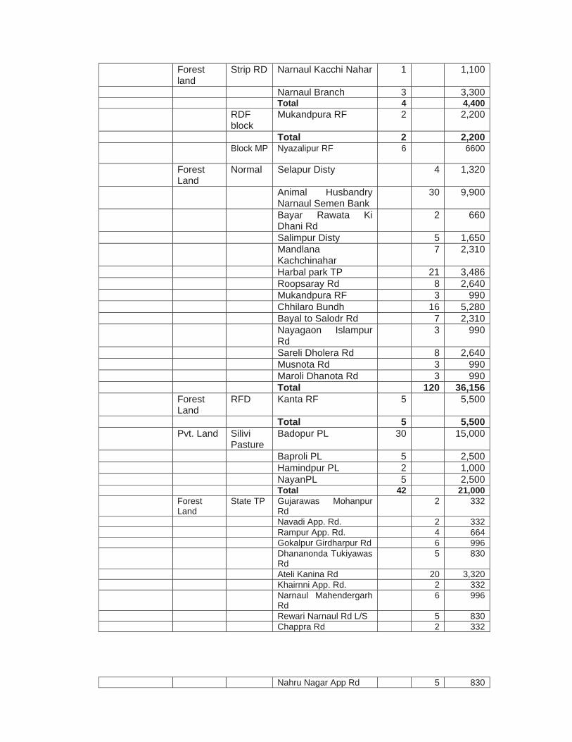
Forest land
Strip RD Narnaul Kacchi Nahar 1 1,100
Narnaul Branch 3 3,300 Total 4 4,400 RDF
block Mukandpura RF 2 2,200
Total 2 2,200
Block MP Nyazalipur RF 6 6600
Forest Land
Normal Selapur Disty 4 1,320
Animal Husbandry Narnaul Semen Bank
30 9,900
Bayar Rawata Ki Dhani Rd
2 660
Salimpur Disty 5 1,650 Mandlana
Kachchinahar 7 2,310
Harbal park TP 21 3,486 Roopsaray Rd 8 2,640 Mukandpura RF 3 990 Chhilaro Bundh 16 5,280 Bayal to Salodr Rd 7 2,310 Nayagaon Islampur
Rd 3 990
Sareli Dholera Rd 8 2,640 Musnota Rd 3 990 Maroli Dhanota Rd 3 990 Total 120 36,156 Forest
Land RFD Kanta RF 5 5,500
Total 5 5,500 Pvt. Land Silivi
Pasture Badopur PL 30 15,000
Baproli PL 5 2,500 Hamindpur PL 2 1,000 NayanPL 5 2,500 Total 42 21,000 Forest
Land State TP Gujarawas Mohanpur
Rd 2 332
Navadi App. Rd. 2 332 Rampur App. Rd. 4 664 Gokalpur Girdharpur Rd 6 996 Dhananonda Tukiyawas
Rd 5 830
Ateli Kanina Rd 20 3,320 Khairnni App. Rd. 2 332 Narnaul Mahendergarh
Rd 6 996
Rewari Narnaul Rd L/S 5 830 Chappra Rd 2 332
Nahru Nagar App Rd 5 830
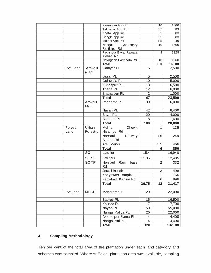
Kamaniya App Rd 10 1660 Talmahal App Rd 0.5 83 Khatoli App Rd 0.5 83 Dongle app Rd 0.5 83 Mulodi App Rd 1.5 249 Nangal Chaudhary
Ranilikpur Rd 10 1660
Pachnota Bayal Rawata Kidhani Rd
8 1328
Nayagaon Pachnota Rd 10 1660 Total 100 16,600 Pvt. Land Aravalli
(gap) Ganiyar PL 5 2,500
Bazar PL 5 2,500 Gulawala PL 10 5,000 Kultazpur PL 13 6,500 Thana PL 12 6,000 Shaharpur PL 2 1,000 Total 47 23,500 Aravalli
M-III Pachnota PL 30 6,000
Nayan PL 42 8,400 Bayal PL 20 4,000 Banihari PL 8 1,600 Total 100 20,000 Forest
Land Urban Forestry
Mehta Chowk Nizampur Rd
1 135
Narnaul Railway Station Rd
1.5 249
Ateli Mandi 3.5 466 Total 6 850 SC Latuflur 15.4 16,940 SC SL Latufpur 11.35 12,485 SC TP Nornaul Ram bass
Rd 2 332
Jorasi Bundh 3 498 Koriyawas Temple 1 166 Faizabad. Kanina Rd 6 996 Total 26.75 12 31,417
Pvt Land MPCL Maharampur 20 22,000
Baproti PL 15 16,500 Kojinda PL 7 7,700 Nayan PL 50 55,000 Nangal Kaliya PL 20 22,000 Akabaspur Ramu PL 4 4,400 Nangal Atti PL 4 4,400 Total 120 132,000 4. Sampling Methodology Ten per cent of the total area of the plantation under each land category and
schemes was sampled. Where sufficient plantation area was available, sampling
units measuring 50 m x 20 m of unit size of 0.1 ha were laid out at random from
one end to the other end of the plantations. In strip plantations, line samples of
1000 m long were taken along roadside, railway line side and canal side
plantations. The samples taken were unbiased and random. In all these sampling
units, all the live and dead plants were separately counted, recorded and survival
percentage was calculated.
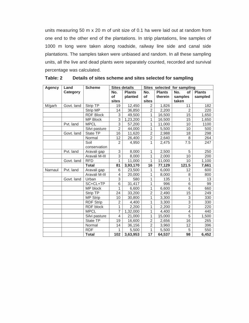
Table: 2 Details of sites scheme and sites selected for sampling
Agency Land Category
Scheme Sites details Sites selected for sampling No. of sites
Plants planted
No. of sites
Plants therein
No. of samples taken
Plants sampled
M/garh Govt. land Strip TP 19 12,450 2 1,826 11 182 Strip MP 14 36,850 2 2,200 2 220 RDF Block 3 49,500 1 16,500 15 1,650 MP Block 3 1,23,200 1 16,500 15 1,650 Pvt. land MPCL 3 57,200 1 11,000 10 1100 Silvi pasture 2 44,000 1 5,500 10 500 Govt. land State TP 16 11,620 2 2,988 18 298 Normal 12 26,400 2 2,640 8 264 Soil
conservation 2 4,950 1 2,475 7.5 247
Pvt. land Aravali gap 3 8,000 1 2,500 5 250 Aravali M-III 3 8,000 1 2,000 10 200 Govt. land RFD 1 11,000 1 11,000 10 1,100 Total 81 3,93,170 16 77,129 121.5 7,661Narnaul Pvt. land Aravali gap 6 23,500 1 6,000 12 600 Aravali M-III 4 20,000 1 8,000 8 800 Govt. land Urban 3 580 1 135 1 13 SC+CL+TP 6 31,417 1 996 6 99 MP block 1 6,600 1 6,600 6 660 Strip TP 24 33,200 2 2,490 15 249 MP Strip 10 30,800 1 3,300 3 330 RDF Strip 2 4,400 1 3,300 3 330 RDF block 1 2,200 1 2,200 2 220 MPCL 7 1,32,000 1 4,400 4 440 Silvi pasture 4 21,000 1 15,000 5 1,500 State TP 19 16,600 2 2,656 16 265 Normal 14 36,156 2 3,960 12 396 RDF 1 5,500 1 5,500 5 550 Total 102 3,63,953 17 64,537 98 6,452
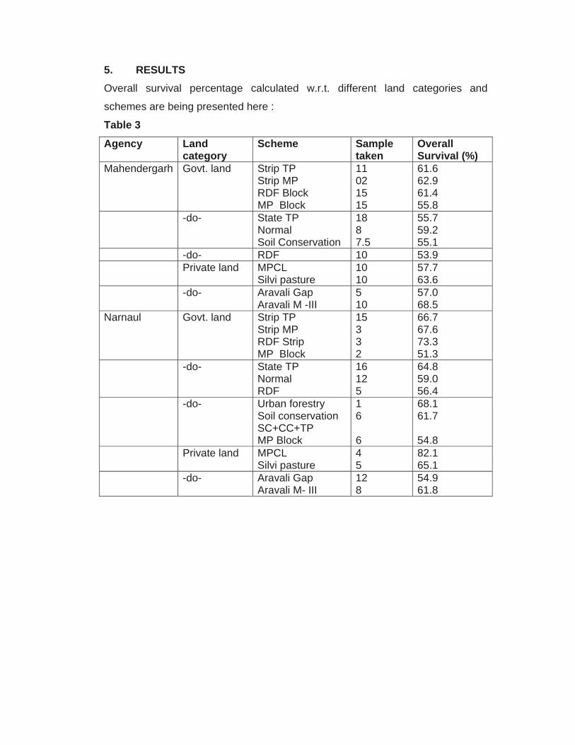
5. RESULTS Overall survival percentage calculated w.r.t. different land categories and
schemes are being presented here :
Table 3
Agency Land category
Scheme Sample taken
Overall Survival (%)
Mahendergarh Govt. land Strip TP Strip MP RDF Block MP Block
11 02 15 15
61.6 62.9 61.4 55.8
-do- State TP Normal Soil Conservation
18 8 7.5
55.7 59.2 55.1
-do- RDF 10 53.9 Private land MPCL
Silvi pasture 10 10
57.7 63.6
-do- Aravali Gap Aravali M -III
5 10
57.0 68.5
Narnaul Govt. land Strip TP Strip MP RDF Strip MP Block
15 3 3 2
66.7 67.6 73.3 51.3
-do- State TP Normal RDF
16 12 5
64.8 59.0 56.4
-do- Urban forestry Soil conservation SC+CC+TP MP Block
1 6 6
68.1 61.7 54.8
Private land MPCL Silvi pasture
4 5
82.1 65.1
-do- Aravali Gap Aravali M- III
12 8
54.9 61.8
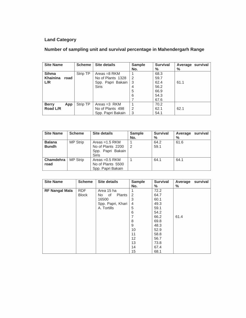
Land Category
Number of sampling unit and survival percentage in Mahendergarh Range Site Name Scheme Site details Sample
No. Survival %
Average survival %
Sihma Khainina road L/R
Strip TP Areas =8 RKM No of Plants 1328 Spp. Papri Bakain Siris
1 2 3 4 5 6 7
68.3 59.7 62.4 56.2 66.9 54.3 67.6
61.1
Berry App Road L/R
Strip TP Areas =3 RKM No of Plants 498 Spp. Papri Bakain
1 2 3
70.2 62.1 54.1
62.1
Site Name Scheme Site details Sample
No. Survival %
Average survival %
Balana Bundh
MP Strip Areas =1.5 RKM No of Plants 2200 Spp. Papri Bakain Siris
1 2
64.2 59.1
61.6
Chamdehra road
MP Strip Areas =0.5 RKM No of Plants 5500 Spp. Papri Bakain
1
64.1 64.1
Site Name Scheme Site details Sample No.
Survival %
Average survival %
RF Nangal Mala RDF Block
Area 15 ha No of Plants 16500 Spp. Papri, Khari A. Tortills
1 2 3 4 5 6 7 8 9 10 11 12 13 14 15
72.2 64.7 60.1 49.3 59.1 54.2 66.2 69.8 48.3 52.9 58.8 56.7 73.8 67.4 68.1
61.4
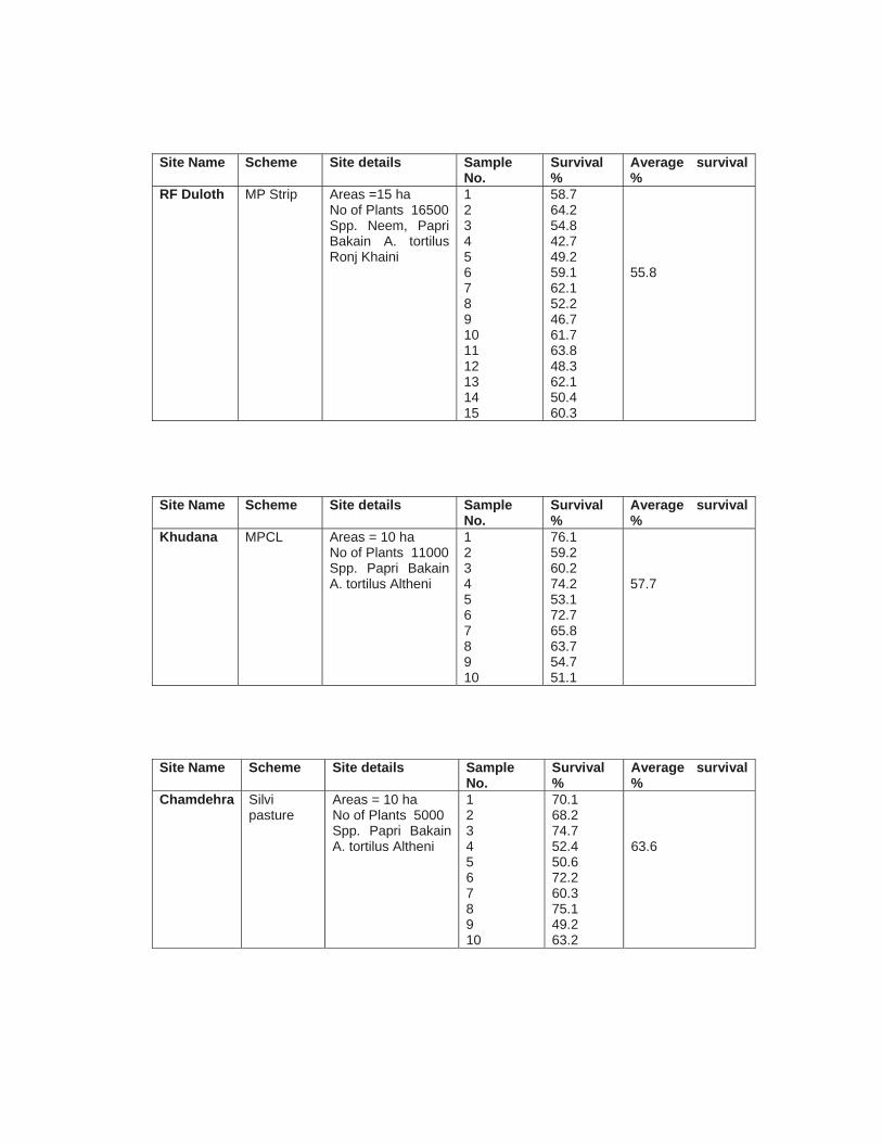
Site Name Scheme Site details Sample
No. Survival %
Average survival %
RF Duloth MP Strip Areas =15 ha No of Plants 16500 Spp. Neem, Papri Bakain A. tortilus Ronj Khaini
1 2 3 4 5 6 7 8 9 10 11 12 13 14 15
58.7 64.2 54.8 42.7 49.2 59.1 62.1 52.2 46.7 61.7 63.8 48.3 62.1 50.4 60.3
55.8
Site Name Scheme Site details Sample No.
Survival %
Average survival %
Khudana MPCL Areas = 10 ha No of Plants 11000 Spp. Papri Bakain A. tortilus Altheni
1 2 3 4 5 6 7 8 9 10
76.1 59.2 60.2 74.2 53.1 72.7 65.8 63.7 54.7 51.1
57.7
Site Name Scheme Site details Sample No.
Survival %
Average survival %
Chamdehra Silvi pasture
Areas = 10 ha No of Plants 5000 Spp. Papri Bakain A. tortilus Altheni
1 2 3 4 5 6 7 8 9 10
70.1 68.2 74.7 52.4 50.6 72.2 60.3 75.1 49.2 63.2
63.6
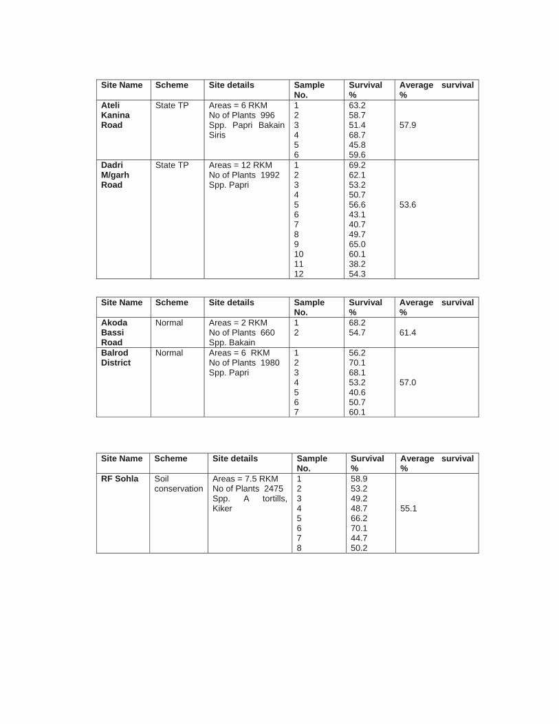
Site Name Scheme Site details Sample
No. Survival %
Average survival %
Ateli Kanina Road
State TP Areas = 6 RKM No of Plants 996 Spp. Papri Bakain Siris
1 2 3 4 5 6
63.2 58.7 51.4 68.7 45.8 59.6
57.9
Dadri M/garh Road
State TP Areas = 12 RKM No of Plants 1992 Spp. Papri
1 2 3 4 5 6 7 8 9 10 11 12
69.2 62.1 53.2 50.7 56.6 43.1 40.7 49.7 65.0 60.1 38.2 54.3
53.6
Site Name Scheme Site details Sample
No. Survival %
Average survival %
Akoda Bassi Road
Normal Areas = 2 RKM No of Plants 660 Spp. Bakain
1 2
68.2 54.7
61.4
Balrod District
Normal Areas = 6 RKM No of Plants 1980 Spp. Papri
1 2 3 4 5 6 7
56.2 70.1 68.1 53.2 40.6 50.7 60.1
57.0
Site Name Scheme Site details Sample
No. Survival %
Average survival %
RF Sohla Soil conservation
Areas = 7.5 RKM No of Plants 2475 Spp. A tortills, Kiker
1 2 3 4 5 6 7 8
58.9 53.2 49.2 48.7 66.2 70.1 44.7 50.2
55.1
Site Name Scheme Site details Sample No.
Survival %
Average survival %
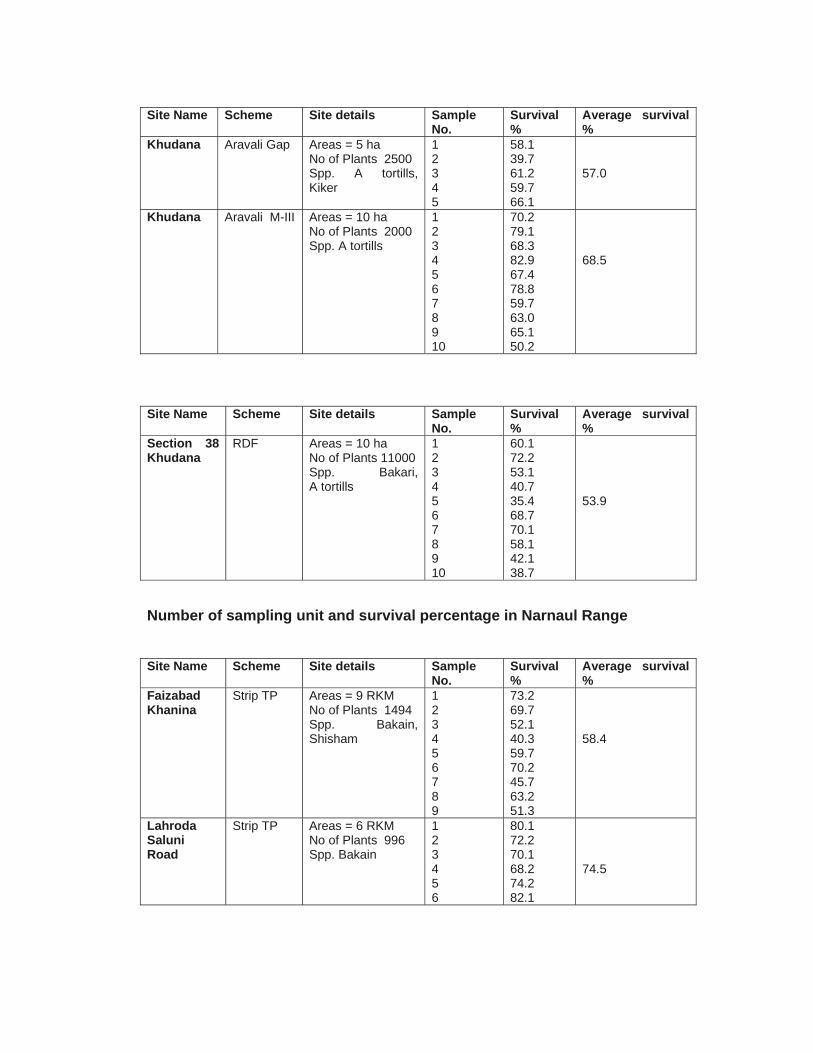
Khudana Aravali Gap Areas = 5 ha No of Plants 2500 Spp. A tortills, Kiker
1 2 3 4 5
58.1 39.7 61.2 59.7 66.1
57.0
Khudana Aravali M-III Areas = 10 ha No of Plants 2000 Spp. A tortills
1 2 3 4 5 6 7 8 9 10
70.2 79.1 68.3 82.9 67.4 78.8 59.7 63.0 65.1 50.2
68.5
Site Name Scheme Site details Sample
No. Survival %
Average survival %
Section 38 Khudana
RDF Areas = 10 ha No of Plants 11000 Spp. Bakari, A tortills
1 2 3 4 5 6 7 8 9 10
60.1 72.2 53.1 40.7 35.4 68.7 70.1 58.1 42.1 38.7
53.9
Number of sampling unit and survival percentage in Narnaul Range Site Name Scheme Site details Sample
No. Survival %
Average survival %
Faizabad Khanina
Strip TP Areas = 9 RKM No of Plants 1494 Spp. Bakain, Shisham
1 2 3 4 5 6 7 8 9
73.2 69.7 52.1 40.3 59.7 70.2 45.7 63.2 51.3
58.4
Lahroda Saluni Road
Strip TP Areas = 6 RKM No of Plants 996 Spp. Bakain
1 2 3 4 5 6
80.1 72.2 70.1 68.2 74.2 82.1
74.5
Site Name Scheme Site details Sample
No.Survival %
Average survival %
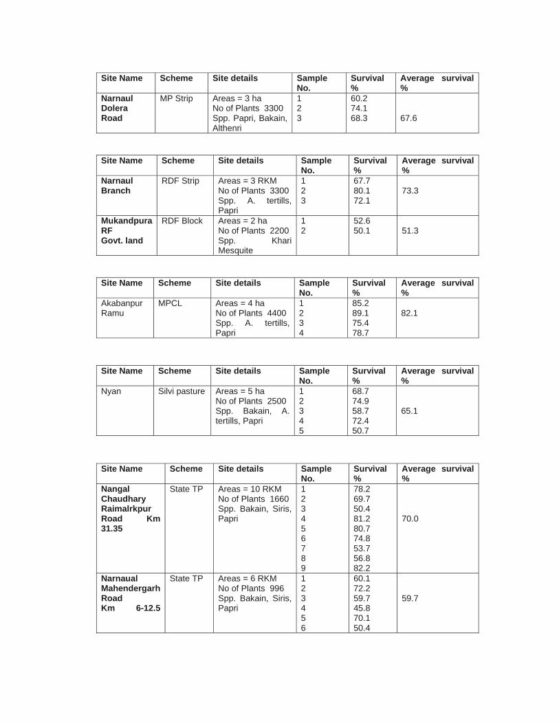
Narnaul Dolera Road
MP Strip Areas = 3 ha No of Plants 3300 Spp. Papri, Bakain, Althenri
1 2 3
60.2 74.1 68.3
67.6
Site Name Scheme Site details Sample
No. Survival %
Average survival %
Narnaul Branch
RDF Strip Areas = 3 RKM No of Plants 3300 Spp. A. tertills, Papri
1 2 3
67.7 80.1 72.1
73.3
Mukandpura RF Govt. land
RDF Block Areas = 2 ha No of Plants 2200 Spp. Khari Mesquite
1 2
52.6 50.1
51.3
Site Name Scheme Site details Sample
No. Survival %
Average survival %
Akabanpur Ramu
MPCL Areas = 4 ha No of Plants 4400 Spp. A. tertills, Papri
1 2 3 4
85.2 89.1 75.4 78.7
82.1
Site Name Scheme Site details Sample
No. Survival %
Average survival %
Nyan
Silvi pasture Areas = 5 ha No of Plants 2500 Spp. Bakain, A. tertills, Papri
1 2 3 4 5
68.7 74.9 58.7 72.4 50.7
65.1
Site Name Scheme Site details Sample
No. Survival %
Average survival %
Nangal Chaudhary Raimalrkpur Road Km 31.35
State TP Areas = 10 RKM No of Plants 1660 Spp. Bakain, Siris, Papri
1 2 3 4 5 6 7 8 9
78.2 69.7 50.4 81.2 80.7 74.8 53.7 56.8 82.2
70.0
Narnaual Mahendergarh Road Km 6-12.5
State TP Areas = 6 RKM No of Plants 996 Spp. Bakain, Siris, Papri
1 2 3 4 5 6
60.1 72.2 59.7 45.8 70.1 50.4
59.7
Site Name Scheme Site details Sample
No. Survival %
Average survival %
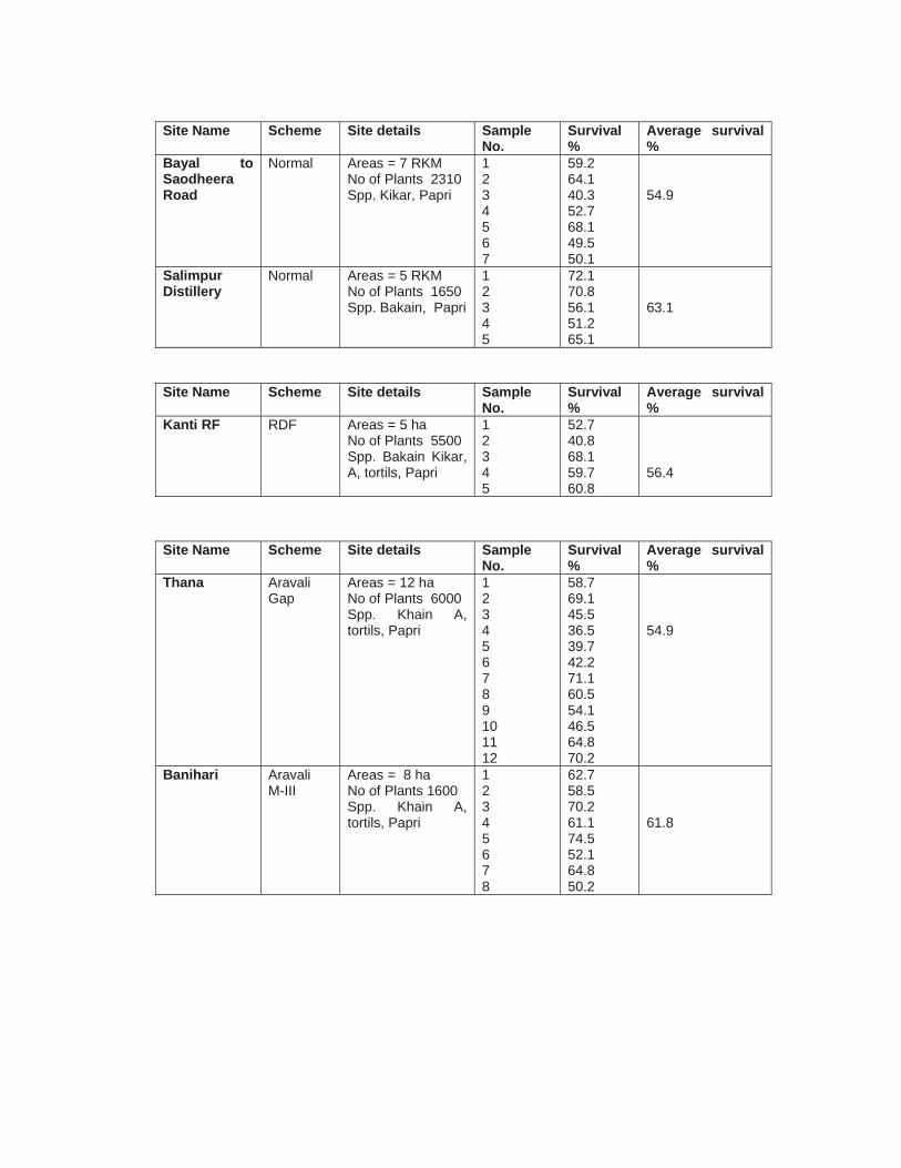
Bayal to Saodheera Road
Normal Areas = 7 RKM No of Plants 2310 Spp. Kikar, Papri
1 2 3 4 5 6 7
59.2 64.1 40.3 52.7 68.1 49.5 50.1
54.9
Salimpur Distillery
Normal Areas = 5 RKM No of Plants 1650 Spp. Bakain, Papri
1 2 3 4 5
72.1 70.8 56.1 51.2 65.1
63.1
Site Name Scheme Site details Sample No.
Survival %
Average survival %
Kanti RF
RDF Areas = 5 ha No of Plants 5500 Spp. Bakain Kikar, A, tortils, Papri
1 2 3 4 5
52.7 40.8 68.1 59.7 60.8
56.4
Site Name Scheme Site details Sample
No. Survival %
Average survival %
Thana
Aravali Gap
Areas = 12 ha No of Plants 6000 Spp. Khain A, tortils, Papri
1 2 3 4 5 6 7 8 9 10 11 12
58.7 69.1 45.5 36.5 39.7 42.2 71.1 60.5 54.1 46.5 64.8 70.2
54.9
Banihari
Aravali M-III
Areas = 8 ha No of Plants 1600 Spp. Khain A, tortils, Papri
1 2 3 4 5 6 7 8
62.7 58.5 70.2 61.1 74.5 52.1 64.8 50.2
61.8
Site Name Scheme Site details Sample
No. Survival %
Average survival %
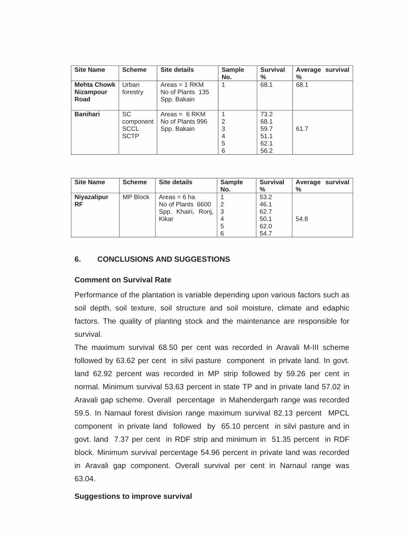
Mehta Chowk Nizampour Road
Urban forestry
Areas = 1 RKM No of Plants 135 Spp. Bakain
1
68.1 68.1
Banihari
SC component SCCL SCTP
Areas = 6 RKM No of Plants 996 Spp. Bakain
1 2 3 4 5 6
73.2 68.1 59.7 51.1 62.1 56.2
61.7
Site Name Scheme Site details Sample
No. Survival %
Average survival %
Niyazalipur RF
MP Block Areas = 6 ha No of Plants 6600 Spp. Khairi, Ronj, Kikar
1 2 3 4 5 6
53.2 46.1 62.7 50.1 62.0 54.7
54.8
6. CONCLUSIONS AND SUGGESTIONS
Comment on Survival Rate
Performance of the plantation is variable depending upon various factors such as
soil depth, soil texture, soil structure and soil moisture, climate and edaphic
factors. The quality of planting stock and the maintenance are responsible for
survival.
The maximum survival 68.50 per cent was recorded in Aravali M-III scheme
followed by 63.62 per cent in silvi pasture component in private land. In govt.
land 62.92 percent was recorded in MP strip followed by 59.26 per cent in
normal. Minimum survival 53.63 percent in state TP and in private land 57.02 in
Aravali gap scheme. Overall percentage in Mahendergarh range was recorded
59.5. In Narnaul forest division range maximum survival 82.13 percent MPCL
component in private land followed by 65.10 percent in silvi pasture and in
govt. land 7.37 per cent in RDF strip and minimum in 51.35 percent in RDF
block. Minimum survival percentage 54.96 percent in private land was recorded
in Aravali gap component. Overall survival per cent in Narnaul range was
63.04.
Suggestions to improve survival
The survival rate was found good due to sincere efforts of the field staff. The
involvement of the local community can be further incurred through organizing
regular meeting, training and awareness camp. More employment opportunity
should be provided to the villager. Bush cutting should be carried out for the
better growth and survival
• Proper fencing to minimize the biotic pressure
• Working provision increased because the area under hand climate
condition
• Migratory grazing pressure from Rajasthan should be regularized by
giving them permit and charged damaged cast
Comment on choice of species and condition of planting stock
Site selection and choice of species have been made in consultation with the
local people. The choice of the species was found good, but it was observed that
planting of fodder species was not given due preference. In this context, the
officials stated that there is heavy incidence of grazing and browsing by the wild
animals like Neel gai, Langur, Porcupine etc. which was also observed during
field visit. Therefore, only those species were preferred by the villagers which
are resistant to grazing and browsing and have economic importance. The
choice of species was good and accordingly to the soil texture and climate
condition. Raising of good plantation depends on the quality of planting stock.
Comments on survival
Ailanthus excels seedlings in Mahendergarh are damaged by Nil Gai and goats
from across the border of Rajasthan. People are cutting the plantations for fire
wood although section-4, people cannot cut plants without the permission of
forest department.
According to Dharam Singh Forest Block Officer (BO) : Better survival or
establishment of plants are due to continues rainfall up 3 months in 2008-09.
This is a plus point for better survival of plants.
Species planted in Nursery : Fraush, Rose, Anar, Vougisvillia, Sahtoot Kaner,
both (Pili and lal), Shisham, Papri, Bakain.

According to Desh Raj Forest Guard (FG) : There is lots of pressure of
grazing from Rajasthan but we cannot chhalan because of unavailability of the
addresses of defaulters. Reason for poor survival are irrigation problem in rainfed
areas.
Thanwas Nursery : Bakain (TP), Kikar, Papri, Mosquite, A. tortilis, Jand, Anar,
Peepal, Beri, Nimboo, Amrood, Amal, Gulmohar, Sisham, Rose, Fransh,
Chandani, Kanner, Papita vouganbillia and Sahtoo.
Technical and administrative changes to improve survival
• They should have made more liaison with local villager through regular
meeting & camp
• Vigorous seedling should be planted and poor plant should not planted
• Beating up should be done with original species
• Maintenance and culture should be done in time
• Provision for more than forme watering during summer
• Along road site only tall plantation should be done
• Watch and ward after wheat harvest to prevent fire incidence
• Employment opportunity should be provided
• Adequate field staff
• Social fencing concept made to be strengthen
Acknowledgements
Regional Centre, National Afforestation and Eco-development Board,
Ministry of Environment and Forests, Govt. of India Solan (Nauni). has
conducted the survival rate studies in respect of afforestation and tree
planting activities undertaken during the year 2008-09 in Mahendergarh
district (Haryana). This study is the outcome of the sincere efforts of members
of the research team who are associated with preparation of this report.
We are thankful to the Haryana State Forest Department Divisional Forest
Officer, Range Officer and the Field Staff of Mahendergarh Forest Division
for providing necessary information and kind cooperation during the field
visits.
The cooperation and valuable contribution made by the secretarial staff for
typing this document is also acknowledged.
P Kaushal Regional Coordinator / Director
Contents
Particulars Page(s)
District Background 1-2
Agencies undertaking plantations in the district 3-4
Inventory of plantation 5-10
Sampling Methodology 11
Results of the survival study 12-18
Conclusion and suggestions 19-21
Study of Survival Rates for One Year Old Plantation of 2008-09 in Mahendergarh District (Haryana)
Regional Centre National Afforestation and Eco-Development Board
(Ministry of Environment and Forests, GOI) Dr YS Parmar University of Horticulture and Forestry
Nauni, Solan (HP) 173 230

WORKING TEAM
Dr P Kaushal : Regional Coordinator/Director
Dr JK Dubey : Sr Scientist (Entomology)
Dr HP Sankhyan : Scientist (Forestry)
Dr Dinesh Sharma : Research Associate
Sh Joginder Tomer : Field Investigator
Study Of Survival Rates For One Year Old Plantation Of 2008-09 In
Mahendergarh District (Haryana)
REGIONAL CENTRE National Afforestation and Eco development Board
(Ministry of Environment and Forests, GoI) Dr YS Parmar University of Horticulture and Forestry Nauni,
Solan, Himachal Pradesh 173 230
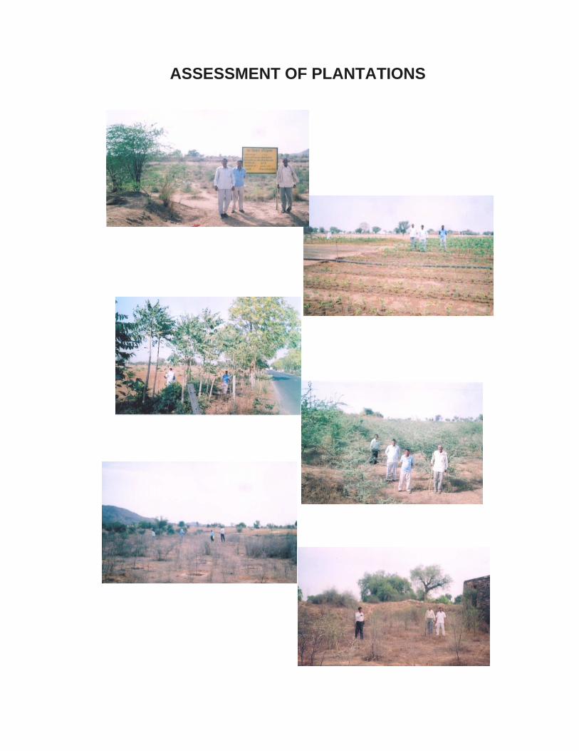
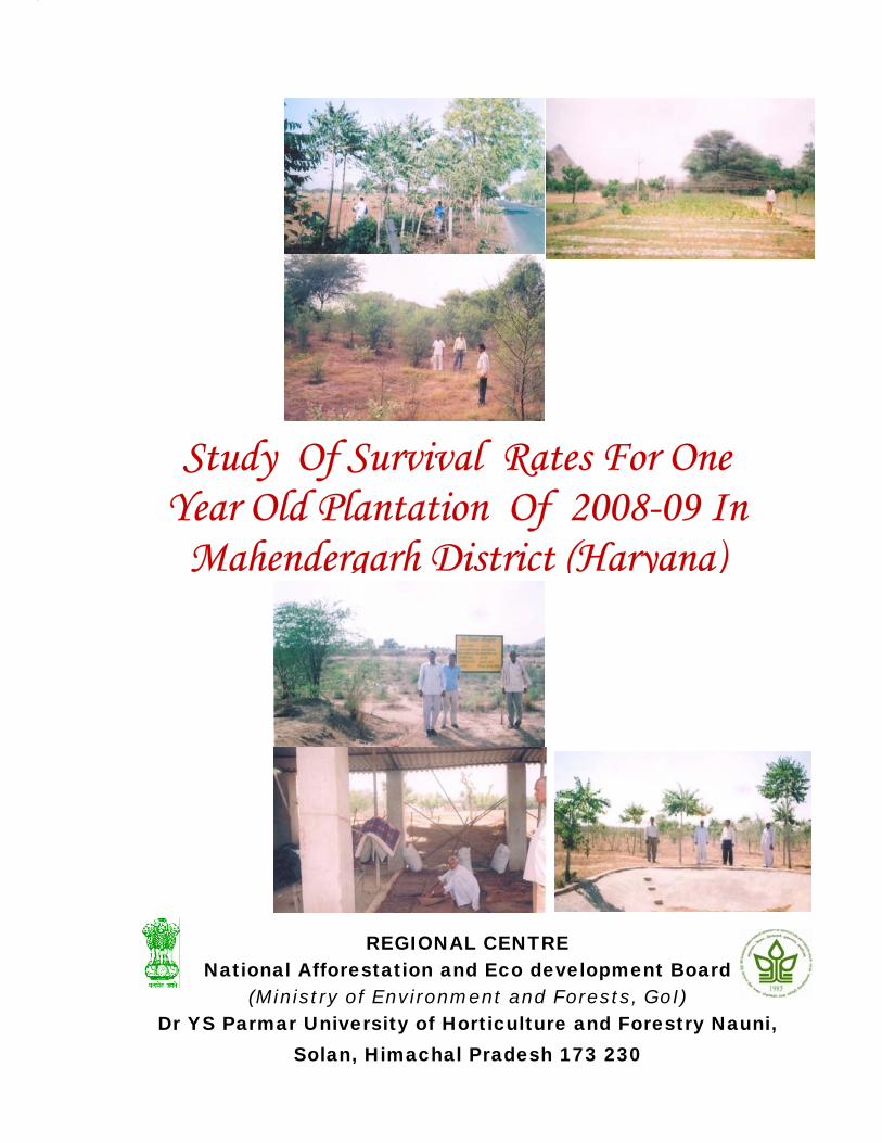
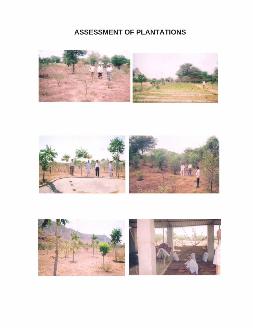
ASSESSMENT OF PLANTATIONS
ASSESSMENT OF PLANTATIONS
To
Sh Ashok Kumar Scientific Officer National Afforestation and Eco-development Board Ministry of Environment and Forests, GOI Paryavaran Bhawan, CGO Complex Lodhi Road, New Delhi-110003 Subject : Study of Survival Rate for One Year Old Plantation of 2008-09
in Panipat and Mahendergarh District (Haryana)- Submission of Reports
Sir, Please find enclosed herewith five copies of the each reports entitled “Study of Survival Rate for One Year Old Plantation of 2008-09 in Panipat and Mahendergarh District (Haryana)”. This is for your kind information and necessary action, please. Thanking you,
Yours faithfully,
Regional Coordinator/Director