Embed Size (px)
Citation preview
DisclaimerThe information and data contained in this document aresubject to change without prior notification. The names anddata used in the examples are imaginary, if not statedotherwise. No part of this document may be reproduced ortransmitted for any use, in any form or by any means,electronically or mechanically without the prior writtenpermission of PTV AG.
Warranty RestrictionsAlthough every precaution has been taken in the preparationof this guide, the publisher and author assume noresponsibility for errors or omissions. Notes on errors will begratefully received at any time.
ImprintPTV Planung Transport Verkehr AGHaid-und-Neu-Straße 1576131 Karlsruhe, Germany
Copyrights© 2012 PTV, NAVTEQ, TomTom
All brand or product names are trademarks or registeredtrademarks of the corresponding companies ororganisations. All rights reserved.
Other CopyrightsNAVTEQ maps
The following licence conditions apply when using NAVTEQmaps:
© 2012 NAVTEQ. All rights reserved.
For Austria: © Bundesamt für Eich- und Vermessungswesen
For Croatia, Cyprus, Estonia, Latvia, Lithuania, Moldova,Poland, Slovenia and/or Ukraine: EuroGeographics
For France: © IGN 2009 - BD TOPO ®
For Germany: Die Grundlagendaten wurden mitGenehmigung der zuständigen Behörden entnommen.
For Great Britain: Based upon Crown Copyright material.
For Greece: Copyright Geomatics Ltd
For Hungary: Copyright © 2003; Top-Map Ltd.
For Italy: La Banca Dati Italiana è stata prodotta usando qualeriferimento anche cartografia numerica ed al tratto prodotta efornita dalla Regione Toscana.
For Norway: Copyright © 2000; Norwegian MappingAuthority
For Portugal: Source: IgeoE – Portugal
For Spain: Información geográfica propiedad del CNIG
For Sweden: Based upon electronic data © National LandSurvey Sweden.
For Switzerland: Topografische Grundlage: © Bundesamt fürLandestopographie.
TomTom maps
The following licence conditions apply when using TomTommaps:
© 2011 TomTom. All rights reserved. This material isproprietary and the subject of copyright protection and/ordatabase right protection and/or other intellectual propertyrights owned by TomTom or its suppliers. The use of thismaterial is subject to the terms of a license agreement. Anyunauthorized copying or disclosure of this material will lead tocriminal and civil liabilities.
Data Source © 2012 TomTom
For Austria: © BEV, GZ 1368/2003
For Denmark: © DAV, violation of these copyrights shall causelegal proceedings
For France: © IGN France. Michelin data © Michelin 2012
For United Kingdom: © Crown copyright and/or databaseright. All rights reserved. Licence number 100026920
For Northern Ireland: © Ordnance Survey of Northern Ireland
For Norway: © Norwegian Mapping Authority, Public RoadsAdministration / © Mapsolutions.
For Russia: © Roskartographia
For Switzerland: © Swisstopo
For The Netherlands: Topografische onderground Copyright© dienst voor het kadaster en de openbare registers,Apeldoorn 2006.
For Truck Attribute Data: © 2004 – 2012 ProMiles SoftwareDevelopment Corporation. All rights reserved.
Last amended: 24.7.12 EN-GB


Structure
Before You Start.... . . . . . . . . . . . . . . . . . . . . . . . . . . . . . . 9
Mobile Navigation with a CarPC/PDA . . . . . . . . . . . . . . 35
Further information. . . . . . . . . . . . . . . . . . . . . . . . . . . . 133
1

2
Contents
Before You Start.... . . . . . . . . . . . . . . . . . . . . . . . . . . . . . . 9
1 Welcome! . . . . . . . . . . . . . . . . . . . . . . . . . . . . . . . . . . . . . . . . . 11
1.1 PTV Navigator highlights at a glance. . . . . . . . . . . . . . . . . . . . 111.1.1 Truck-specific routing . . . . . . . . . . . . . . . . . . . . . . . . . . . . . .121.1.2 PTV TruckNavigator: Includes road blocks, restrictions and
hazardous goods. . . . . . . . . . . . . . . . . . . . . . . . . . . . . . . . . .121.1.3 Connected navigation. . . . . . . . . . . . . . . . . . . . . . . . . . . . . .13
1.2 Basic functions. . . . . . . . . . . . . . . . . . . . . . . . . . . . . . . . . . . . . 13
2 Important Information . . . . . . . . . . . . . . . . . . . . . . . . . . . . . . . 15
2.1 Safety advice . . . . . . . . . . . . . . . . . . . . . . . . . . . . . . . . . . . . . .16
2.2 Further notes . . . . . . . . . . . . . . . . . . . . . . . . . . . . . . . . . . . . . . 17
3 Installation and Registration . . . . . . . . . . . . . . . . . . . . . . . . . 19
3.1 Installation on your CarPC . . . . . . . . . . . . . . . . . . . . . . . . . . .193.1.1 System requirements for installation on a CarPC . . . . . . . .193.1.2 Installing PTV Navigator on your CarPC . . . . . . . . . . . . . . . 20
3.2 Installation on your PDA . . . . . . . . . . . . . . . . . . . . . . . . . . . . 203.2.1 System requirements for installation on a PDA . . . . . . . . 203.2.2 Installing PTV Navigator on your PDA. . . . . . . . . . . . . . . . . .21
3.3 Loading additional maps and addresses on your navigation device (CarPC and PDA) . . . . . . . . . . . . . . . . . . . . . . . . . . . . . 233.3.1 Example of country-to-country routing . . . . . . . . . . . . . . . 24
3.4 Registering the program on your navigation device (CarPC and PDA). . . . . . . . . . . . . . . . . . . . . . . . . . . . . . . . . . . . . . . . . . . . . 283.4.1 Step 1: Determining the reference number . . . . . . . . . . . . 303.4.2 Step 2: Determining the registration PIN code on the Internet
30
3.5 PTV Navigator interface and third-party software . . . . . . . . 32
3
3.6 The GPS receiver. . . . . . . . . . . . . . . . . . . . . . . . . . . . . . . . . . . 32
3.7 TMC receiver (optional) . . . . . . . . . . . . . . . . . . . . . . . . . . . . . 33
Mobile Navigation with a CarPC/PDA. . . . . . . . . . . . . . . 35
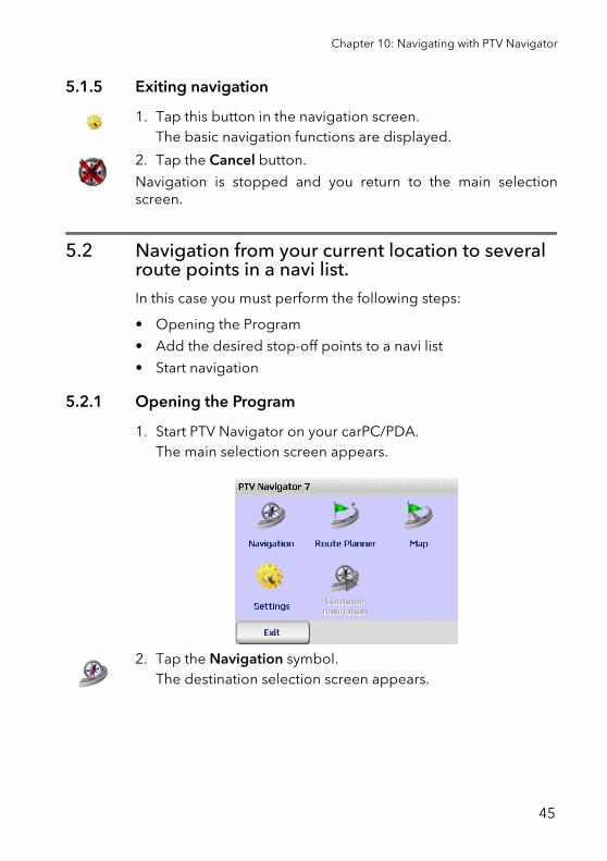
4 Quick Overview PTV Navigator . . . . . . . . . . . . . . . . . . . . . . . . 37
4.1 The main selection screen of PTV Navigator . . . . . . . . . . . . .374.1.1 Navigation . . . . . . . . . . . . . . . . . . . . . . . . . . . . . . . . . . . . . . 384.1.2 Route Planner. . . . . . . . . . . . . . . . . . . . . . . . . . . . . . . . . . . . 384.1.3 Map. . . . . . . . . . . . . . . . . . . . . . . . . . . . . . . . . . . . . . . . . . . . 394.1.4 Settings . . . . . . . . . . . . . . . . . . . . . . . . . . . . . . . . . . . . . . . . 394.1.5 Continue navigation . . . . . . . . . . . . . . . . . . . . . . . . . . . . . . 394.1.6 Exiting PTV Navigator. . . . . . . . . . . . . . . . . . . . . . . . . . . . . . 39
4.2 Selecting an entry in a list . . . . . . . . . . . . . . . . . . . . . . . . . . . 39
5 Navigating with PTV Navigator . . . . . . . . . . . . . . . . . . . . . . . . 41
5.1 Navigation from your current location to one specific destina-tion . . . . . . . . . . . . . . . . . . . . . . . . . . . . . . . . . . . . . . . . . . . . . 425.1.1 Opening the Program. . . . . . . . . . . . . . . . . . . . . . . . . . . . . . 425.1.2 Selecting a Destination . . . . . . . . . . . . . . . . . . . . . . . . . . . . 435.1.3 Calculating the route and displaying it on the map . . . . . 435.1.4 Start navigation . . . . . . . . . . . . . . . . . . . . . . . . . . . . . . . . . . 445.1.5 Exiting navigation . . . . . . . . . . . . . . . . . . . . . . . . . . . . . . . . 45
5.2 Navigation from your current location to several route points in a navi list. . . . . . . . . . . . . . . . . . . . . . . . . . . . . . . . . . . . . . . . . 455.2.1 Opening the Program. . . . . . . . . . . . . . . . . . . . . . . . . . . . . . 455.2.2 Calculating the route . . . . . . . . . . . . . . . . . . . . . . . . . . . . . . 465.2.3 Start navigation . . . . . . . . . . . . . . . . . . . . . . . . . . . . . . . . . . 465.2.4 Arrival at a stop-off point. . . . . . . . . . . . . . . . . . . . . . . . . . . 475.2.5 Exiting navigation . . . . . . . . . . . . . . . . . . . . . . . . . . . . . . . . 47
6 Route Planning with PTV Navigator . . . . . . . . . . . . . . . . . . . . 49
6.1 Planning a route – step by step. . . . . . . . . . . . . . . . . . . . . . . 496.1.1 Opening the Route Planner . . . . . . . . . . . . . . . . . . . . . . . . . 496.1.2 Selecting the starting point and destination . . . . . . . . . . . 50
4
Contents
6.2 Overview of Route Description . . . . . . . . . . . . . . . . . . . . . . . . 516.2.1 Starting the navigation simulation. . . . . . . . . . . . . . . . . . . 526.2.2 Ending the navigation simulation . . . . . . . . . . . . . . . . . . . 53
7 Selecting a Destination . . . . . . . . . . . . . . . . . . . . . . . . . . . . . . 55
7.1 Using an address as the destination . . . . . . . . . . . . . . . . . . 567.1.1 Overview of the address selection screen. . . . . . . . . . . . . .577.1.2 Using an address as the destination . . . . . . . . . . . . . . . . . 59
7.2 Selecting destinations in different countries . . . . . . . . . . . . 62
7.3 Using coordinates as the destination. . . . . . . . . . . . . . . . . . 64
7.4 Selecting favourite destinations . . . . . . . . . . . . . . . . . . . . . . 64
7.5 Selecting previous destinations . . . . . . . . . . . . . . . . . . . . . . 65
7.6 Creating and managing navi lists . . . . . . . . . . . . . . . . . . . . . 667.6.1 The navi list overview . . . . . . . . . . . . . . . . . . . . . . . . . . . . . 667.6.2 Editing the stop-off points of a navi list. . . . . . . . . . . . . . . 687.6.3 Options for the stop-off point list. . . . . . . . . . . . . . . . . . . . 70
7.7 Selecting your home address as the destination. . . . . . . . . . 71
7.8 Point on the map - show/use as destination . . . . . . . . . . . . .72
8 Routing in an area with restricted or blocked access . . . . . . 75
8.1 Start area control . . . . . . . . . . . . . . . . . . . . . . . . . . . . . . . . . . .75
8.2 Destination area control . . . . . . . . . . . . . . . . . . . . . . . . . . . . 76
9 Finding special destinations . . . . . . . . . . . . . . . . . . . . . . . . . . 79
9.1 Searching for POIs during navigation . . . . . . . . . . . . . . . . . . 79
9.2 Searching for POIs within a town/street . . . . . . . . . . . . . . . . .819.2.1 Example of a POI search: Finding a hotel in London. . . . . 83
9.3 Searching for POIs using the destination selection screen. 83
10 Using the Map . . . . . . . . . . . . . . . . . . . . . . . . . . . . . . . . . . . . . 87
5
11 The Navigation Screen. . . . . . . . . . . . . . . . . . . . . . . . . . . . . . . 89
11.1 Quick overview of navigation screen . . . . . . . . . . . . . . . . . . 8911.1.1 Manoeuvre display . . . . . . . . . . . . . . . . . . . . . . . . . . . . . . . 9211.1.2 Speed warning display . . . . . . . . . . . . . . . . . . . . . . . . . . . . 9311.1.3 TMC status . . . . . . . . . . . . . . . . . . . . . . . . . . . . . . . . . . . . . . 93
11.2 Navigation options . . . . . . . . . . . . . . . . . . . . . . . . . . . . . . . . . 9711.2.1 Turning pages . . . . . . . . . . . . . . . . . . . . . . . . . . . . . . . . . . . 9711.2.2 Cancel. . . . . . . . . . . . . . . . . . . . . . . . . . . . . . . . . . . . . . . . . . 9711.2.3 Back . . . . . . . . . . . . . . . . . . . . . . . . . . . . . . . . . . . . . . . . . . . 9711.2.4 Volume + / Volume - . . . . . . . . . . . . . . . . . . . . . . . . . . . . . . 9711.2.5 Day / night . . . . . . . . . . . . . . . . . . . . . . . . . . . . . . . . . . . . . . 9811.2.6 Automatic zoom. . . . . . . . . . . . . . . . . . . . . . . . . . . . . . . . . . 9811.2.7 Avoid road . . . . . . . . . . . . . . . . . . . . . . . . . . . . . . . . . . . . . . 9811.2.8 3D / 2D . . . . . . . . . . . . . . . . . . . . . . . . . . . . . . . . . . . . . . . . . 9911.2.9 Speed warning on/off . . . . . . . . . . . . . . . . . . . . . . . . . . . . 10111.2.10 Hazard warning on/off (for trucks only) . . . . . . . . . . . . . . 10111.2.11 Special destinations . . . . . . . . . . . . . . . . . . . . . . . . . . . . . 10211.2.12 Recalculate. . . . . . . . . . . . . . . . . . . . . . . . . . . . . . . . . . . . . 10211.2.13 Add to favourites . . . . . . . . . . . . . . . . . . . . . . . . . . . . . . . . 10211.2.14 Navigation info page . . . . . . . . . . . . . . . . . . . . . . . . . . . . . 10211.2.15 Route . . . . . . . . . . . . . . . . . . . . . . . . . . . . . . . . . . . . . . . . . 102
12 Showing a position on the map . . . . . . . . . . . . . . . . . . . . . . 103
12.1 Exit map mode . . . . . . . . . . . . . . . . . . . . . . . . . . . . . . . . . . . .104
13 Configuring the Settings . . . . . . . . . . . . . . . . . . . . . . . . . . . . 105
13.1 Setting the volume for voice alerts . . . . . . . . . . . . . . . . . . . 106
13.2 Specifying a home address . . . . . . . . . . . . . . . . . . . . . . . . . 106
13.3 Adding/editing favourites . . . . . . . . . . . . . . . . . . . . . . . . . . .10713.3.1 Adding new favourites. . . . . . . . . . . . . . . . . . . . . . . . . . . . 10813.3.2 Editing favourites. . . . . . . . . . . . . . . . . . . . . . . . . . . . . . . . 109
13.4 Selecting POI categories . . . . . . . . . . . . . . . . . . . . . . . . . . . . 111
13.5 Setting a profile for route planning . . . . . . . . . . . . . . . . . . . . 11213.5.1 Creating a new vehicle profile. . . . . . . . . . . . . . . . . . . . . . .11313.5.2 Editing vehicle profiles . . . . . . . . . . . . . . . . . . . . . . . . . . . 120
6
Contents
13.6 Setting hazard warning for trucks . . . . . . . . . . . . . . . . . . . . . 12113.6.1 Selecting hazard type . . . . . . . . . . . . . . . . . . . . . . . . . . . . 12213.6.2 Configure the Warning options. . . . . . . . . . . . . . . . . . . . . 122
13.7 Setting speed warning . . . . . . . . . . . . . . . . . . . . . . . . . . . . . .12313.7.1 Selecting the Road type . . . . . . . . . . . . . . . . . . . . . . . . . . .12413.7.2 Configuring the warning options . . . . . . . . . . . . . . . . . . . .125
13.8 Viewing the program version information . . . . . . . . . . . . . .127
13.9 System settings . . . . . . . . . . . . . . . . . . . . . . . . . . . . . . . . . . .12713.9.1 Hanging the unit of measurement . . . . . . . . . . . . . . . . . . .12713.9.2 Selecting the voice and language . . . . . . . . . . . . . . . . . . .12713.9.3 Selecting the time format . . . . . . . . . . . . . . . . . . . . . . . . . 12813.9.4 Viewing the copyright information. . . . . . . . . . . . . . . . . . 128
13.10 Configuring TMC Settings . . . . . . . . . . . . . . . . . . . . . . . . . . .128
13.11 Configuring the settings for the data connection. . . . . . . . .13013.11.1 Configuring GPS settings . . . . . . . . . . . . . . . . . . . . . . . . . . 13113.11.2 Configuring TMC Settings . . . . . . . . . . . . . . . . . . . . . . . . . . 131
13.12 Setting the time zone. . . . . . . . . . . . . . . . . . . . . . . . . . . . . . .132
13.13 Day/Night auto setting. . . . . . . . . . . . . . . . . . . . . . . . . . . . . .132
Further information. . . . . . . . . . . . . . . . . . . . . . . . . . . . 133
Tips and Tricks . . . . . . . . . . . . . . . . . . . . . . . . . . . . . . . . . . . . . . . . 135
Glossary. . . . . . . . . . . . . . . . . . . . . . . . . . . . . . . . . . . . . . . . . . . . . . 137
Licence agreement . . . . . . . . . . . . . . . . . . . . . . . . . . . . . . . . . . . . . 139
Index . . . . . . . . . . . . . . . . . . . . . . . . . . . . . . . . . . . . . . . . . . . . . . . . 147
7

8

Before You Start...
9

10
1 Welcome!
... to the world of mobile navigation with PTV Navigator.Painstakingly trying to figure out your route with a road atlas orconstantly having to regain your bearings because of trafficdiversions are now things of the past.Wherever your destinationis, PTV Navigator always gets you there quickly and easily.
PTV Navigator is supplied for various platforms:
• CarPC / Notebook (Win32 systems)PTV Navigator CarPC / Notebook Edition
• Pocket PCPTV Navigator Pocket PC Edition
• Industry platforms based on Windows CE
This user's guide explains step by step how to use the PTVNavigator.
Enjoy using our product and we wish you a safe trip.
1.1 PTV Navigator highlights at a glancePTV Navigator is the software solution for navigating trucks andvehicle fleets. PTV Navigator is optimised for the requirements ofprofessional users while providing the functionality and user-friendliness of a complete navigation system.
PTV TruckNavigator adds truck-specific attributes such asclearance height or blocks to the route calculation, optimisingthe journey and arrival of your transports.
NoteIf you are using PTV Navigator on an industry device with theMicrosoft® Windows CE.NET operating system, then thescreen format may differ from the format on a PDA.However, the program interface and basic use of theprogram are the same.
11
PTV FleetNavigator efficiently controls vehicle fleets and in real-time using and interface to the fleet management.
1.1.1 Truck-specific routing
Normal navigation systems are designed for car navigation.Truck drivers have different requirements:
• Narrow side roads and residential areas are automaticallyavoided to ensure realistic truck navigation. The truck enters aresidential area at the very last moment before reaching itsdestination.
• The driver decides the extent to which narrow side roads anddriving through cities is avoided. He can decide betweendifferent routing profiles and customise them.
• Turning manoeuvres on unsuitable roads are avoided.
• The navigation is able to recognise when destination and startaddresses lie in areas of blocked access, e.g. pedestrianzones or factory grounds. In these cases you are also safelyguided to your destination.
• Roll-on/Roll-off terminals and RoLa terminals (rolling roads)are shown on the map and can be selected as start ordestination.
• Low-emission zones are shown on the map.
1.1.2 PTV TruckNavigator: Includes road blocks, restrictions and hazardous goods
PTV TruckNavigator includes the attributes stored in the mapdata in route planning.
• Roads closed to trucks.
• Restrictions such as weight, axle load, vehicle length, vehicleclearance heights and widths.
• Blocks for hazardous goods, water-hazardous goods andexplosive goods as well as blocks for trailers (depending onthe map data used).
• Tunnel restrictions codes according to the Europeanagreement on the international transportation of hazardous
12
Chapter 5: Welcome!
goods on roads (ADR = Accord européen relatif au transportinternational des marchandises Dangereuses par Route).
The truck's vehicle profile (height, width, weight, axle load,hazardous goods etc.) can be set to the end device at any time.In this way the navigation always takes the relevant road closuresor other information (for example empty or loaded runs) intoaccount. There is no limit to the number of profiles that can bestored and selected with a click.
During navigation you are warned of important dangers, forexample sharp turns, overhanging trees, steep inclines, unevenroads or cross winds.
1.1.3 Connected navigation
The planner can manage the navigation from the control system:order files (RC interface) and interfaces in C and C# (RI interface)enable communication between PTV Navigator and a secondsoftware, which creates the communication to the control centre.
These functions are used to:
• send the addresses of one or more stop-off points to thenavigation from the control center
• request GPS positions from the navigation and make themavailable to third-party applications
• start and end mobile navigation
• transfer and display messages to the navigation
• read and set vehicle profiles in the control centre.
1.2 Basic functions PTV Navigator provides:
• Door-to-door cross-border navigation
• Intuitive, easy operation
• Precise visual cues and spoken instructions
13
• 2D and 3D navigation using map&guide's clear, intuitivemaps
• Proven, professional map&guide routing and navigation
• Extrapolated positioning in tunnels
• Dynamic navigation: The latest TMC information is receivedon a TMC receiver free of charge and used to update theroute while on the road.
• Speed limit warnings for cars in many European countries
• Auto-Smartzoom for optimum map information whenapproaching a manoeuvre
• Incorporates directional information on highway signs
• Automatically switches between day and night view
• Realistic motorway signs and junction views
• Coordinates can be entered as destination
NoteVoice outputs with the ID "TTS" as name extension also saythe turning direction and the name of the street whichshould be turned into.
14
2 Important Information
The PTV Navigator has been developed, tested andmanufactured with the greatest of care and in line with currentsafety guidelines.
Nevertheless, not every theoretically possible operational errorand malfunction occurring in everyday use can be ruled out.
Therefore please keep the following safety advice in mind:
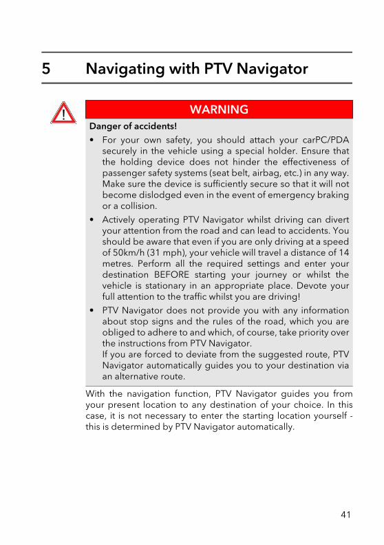
15
2.1 Safety advice
WARNINGDanger of accidents!• For your own safety, you should attach your navigation
device securely in the vehicle using a special holder. Ensurethat the holding device does not hinder the effectiveness ofpassenger safety systems (seat belt, airbag, etc.) in any way.Make sure the device is sufficiently secure so that it will notbecome dislodged even in the event of emergency brakingor a collision.
• Actively operating the PTV Navigator whilst driving candivert your attention from the road and can lead toaccidents. You should be aware that even if you are onlydriving at a speed of 50km/h (31 mph), your vehicle willtravel a distance of 14 metres. Perform all the requiredsettings and enter your destination BEFORE starting yourjourney or whilst the vehicle is stationary in an appropriateplace. Devote your full attention to the traffic whilst you aredriving!
• PTV Navigator does not provide you with any informationabout stop signs and the rules of the road, which you areobliged to adhere to and which, of course, take priority overthe instructions from PTV Navigator.If you are forced to deviate from the suggested route, PTVNavigator automatically guides you to your destination viaan alternative route.
16
Chapter 6: Important Information
2.2 Further notes
NotePlease note:
• PTV Navigator can be used on many devices in both portraitand landscape mode. The illustrations of the device screenshown in this user's guide are in landscape format. The layoutand operation of the functions in PTV Navigator are howeveridentical regardless of the screen format.
• Our program is constantly being developed and optimised. Itis therefore possible that the illustrations shown in this user'sguide differ from the screen display on your device.
17

18
3 Installation and Registration
Installation of the program differs according to your navigationdevice (CarPC, PDA). Please read the section that refers to yourdevice type:
• Installation on your CarPC (see "Installation on your CarPC"on page 19)
• Installation on your PDA (see "Installation on your PDA" onpage 20)
The transfer of address and additional map data as well asregistration are the same for both device types (see "Loadingadditional maps and addresses on your navigation device(CarPC and PDA)" on page 23).
3.1 Installation on your CarPC This chapter tells you how to install PTV Navigator on yourCarPC.
3.1.1 System requirements for installation on a CarPC
• Pentium processor 1GHz or higher
• 512 MB free RAM
• Graphics card that supports TrueColour or HighColour mode
• Screen with a resolution of 800x600 or higher
• Pointing device (for example mouse, trackball, touchpad,touchscreen)
• DVD drive
NoteNormally PTV Navigator would have already been preinstalledon your device by one of our partners. The installation notestherefore only apply in the case of a manual installation later.
19
• Microsoft® Windows 2000, Windows XP, Windows Vista,Windows 7
3.1.2 Installing PTV Navigator on your CarPC
1. Insert the PTV Navigator CD/DVD into your DVD drive of yourCarPC.
2. Start the program installation file (*.EXE) on the CD/DVD inWindows Explorer by double-clicking.
3. Follow the rest of the wizard's instructions.
3.2 Installation on your PDAThis chapter tells you how to install PTV Navigator on your PDA.
3.2.1 System requirements for installation on a PDA
PC requirements• Pentium processor 233 GHz or higher. Pentium 3 with at least
1 MHz is recommended
• Graphics card with a minimum resolution of 800 x 600 pixelsas well as TrueColour or HighColour mode
• Microsoft® compatible mouse / trackball / touchpad /touchscreen
• DVD drive
• Microsoft® Windows 2000, Windows XP, Windows Vista,Windows 7
• Microsoft®ActiveSync® software version 3.7.1 or higher.
This software is supplied with the PDA and is used tosynchronise data with the PC. You will find out how to installActiveSync® in the user documentation of your PDA.
NoteThe synchronisation mode must be active in theMicrosoft®ActiveSync® program to allow files to beexchanged between PTV Navigator and your PDA.
20
Chapter 7: Installation and Registration
1. Switch to the Microsoft®ActiveSync® program.2. In the Tools menu, select the Options command or click on
the Options button.3. In the Sync Options tab, choose the options that you want
to synchronise.4. Confirm with OK.
PDA requirements • Any standard Pocket PCS with the operating systems:
• Microsoft® Windows Mobile 2003 for Pocket PC (includingsecond edition)
• Microsoft® Windows Mobile 5 for Pocket PC (includingphone edition)
• Microsoft® Windows Mobile 6.0 Classic• Microsoft® Windows Mobile 6.0 Professional
• At least 64 MB RAM
• GPS receiver (NMEA 0183 version 2.0 or higher)
• A memory card with sufficient free storage space (dependson map data being used)
• We recommend you use a memory card reader fortransferring map data.
• PTV Navigator supports TMC receivers of GNS/Navilock(optional).
3.2.2 Installing PTV Navigator on your PDA
The installation data can be transferred to your device in thefollowing ways:
NoteIn PTV Navigator you can configure the GPS receiver (see"Configuring GPS settings" on page 131).
NoteIn PTV Navigator you can configure the TMC receiver (see"Configuring TMC Settings" on page 131).
21
• using a direct connection with Microsoft® ActiveSync®
• via a USB 2.0 card reader
Installation using a direct connection with Microsoft® ActiveSync®1. Ensure that Microsoft® ActiveSync® is installed on your PC
and that your navigation system is connected to your PC.2. Insert the PTV Navigator CD/DVD into your DVD drive of your
PC.3. Transfer the program installation file (*.CAB) from your CD/
DVD to your PDA and start the installation from there.4. Transfer at least one of the program files from the CD/DVD for
the voice (*.CAB) to your PDA and start the installation fromthere.
5. Transfer the map folder "tb-navi" from the CD/DVD to themain folder on your PDA's memory card.
Once you have transferred and installed all the files, you can thentransfer additional maps and addresses to your navigationdevice.
Installation via a USB 2.0 card reader1. Connect your card reader to your PC and insert your
navigation device's memory card into the card reader.2. Insert the PTV Navigator CD/DVD into your DVD drive of your
PC.3. Transfer the program installation file (*.CAB) from your CD/
DVD to the memory card.4. Transfer at least one of the program files from the CD/DVD for
the voice (*.CAB) to your memory card.5. Transfer the map folder "tb-navi" from the CD/DVD to the
main folder on your memory card.6. Reinsert your memory card into the navigation device.7. Execute the transferred program installation file (*.CAB) and
the program file for the voice (*.CAB) on your navigationdevice.
Once you have transferred and installed all the files, you can thentransfer additional maps and addresses to your navigationdevice.
22
Chapter 7: Installation and Registration
Please read BEFORE first starting!
3.3 Loading additional maps and addresses on your navigation device (CarPC and PDA)With PTV Navigator you can access a comprehensive choice ofmaps for various countries and also Europe.
The maps are very up to date and contain detailed map material,some of which is house-number accurate. The maps are basedon the same material which is used in fixed built-in navigationsystems.
PTV Navigator is supplied with at least one country map.
NoteNormally PTV Navigator is installed in your device's mainmemory. In order to save memory, it is possible to move thefiles to your PDA's memory card. If you have already started theprogram before moving files, you should rename the filenavigator.uni. NoteIn order to use the full functionality of PTV Navigator withoutregistering for 30 days, ensure, BEFORE first starting, that thedate and time is correctly set on your device. Otherwise you willhave to register PTV Navigator before being able to use theprogram.
23
3.3.1 Example of country-to-country routing
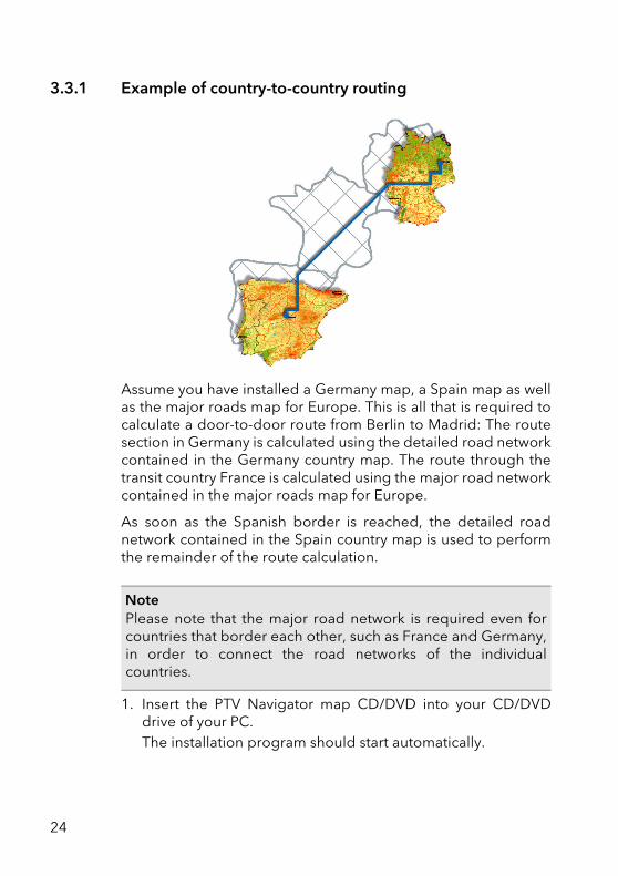
Assume you have installed a Germany map, a Spain map as wellas the major roads map for Europe. This is all that is required tocalculate a door-to-door route from Berlin to Madrid: The routesection in Germany is calculated using the detailed road networkcontained in the Germany country map. The route through thetransit country France is calculated using the major road networkcontained in the major roads map for Europe.
As soon as the Spanish border is reached, the detailed roadnetwork contained in the Spain country map is used to performthe remainder of the route calculation.
1. Insert the PTV Navigator map CD/DVD into your CD/DVDdrive of your PC.The installation program should start automatically.
NotePlease note that the major road network is required even forcountries that border each other, such as France and Germany,in order to connect the road networks of the individualcountries.
24
Chapter 7: Installation and Registration
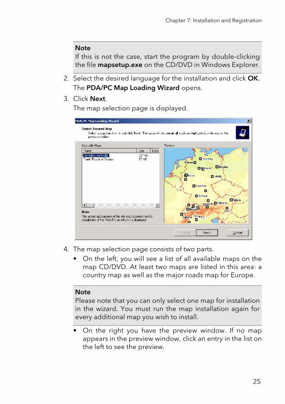
2. Select the desired language for the installation and click OK.The PDA/PC Map Loading Wizard opens.
3. Click Next.The map selection page is displayed.
4. The map selection page consists of two parts.• On the left, you will see a list of all available maps on the
map CD/DVD. At least two maps are listed in this area: acountry map as well as the major roads map for Europe.
• On the right you have the preview window. If no mapappears in the preview window, click an entry in the list onthe left to see the preview.
NoteIf this is not the case, start the program by double-clickingthe file mapsetup.exe on the CD/DVD in Windows Explorer.
NotePlease note that you can only select one map for installationin the wizard. You must run the map installation again forevery additional map you wish to install.
25
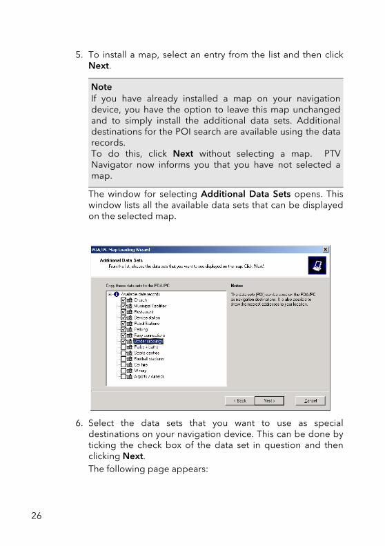
5. To install a map, select an entry from the list and then clickNext.
The window for selecting Additional Data Sets opens. Thiswindow lists all the available data sets that can be displayedon the selected map.
6. Select the data sets that you want to use as specialdestinations on your navigation device. This can be done byticking the check box of the data set in question and thenclicking Next.The following page appears:
NoteIf you have already installed a map on your navigationdevice, you have the option to leave this map unchangedand to simply install the additional data sets. Additionaldestinations for the POI search are available using the datarecords. To do this, click Next without selecting a map. PTVNavigator now informs you that you have not selected amap.
26
Chapter 7: Installation and Registration
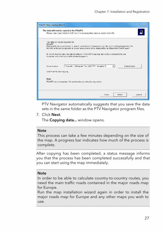
PTV Navigator automatically suggests that you save the datasets in the same folder as the PTV Navigator program files.
7. Click Next.The Copying data... window opens.
After copying has been completed, a status message informsyou that the process has been completed successfully and thatyou can start using the map immediately.
NoteThis process can take a few minutes depending on the size ofthe map. A progress bar indicates how much of the process iscomplete.
NoteIn order to be able to calculate country-to-country routes, youneed the main traffic roads contained in the major roads mapfor Europe.Run the map installation wizard again in order to install themajor roads map for Europe and any other maps you wish touse.
27
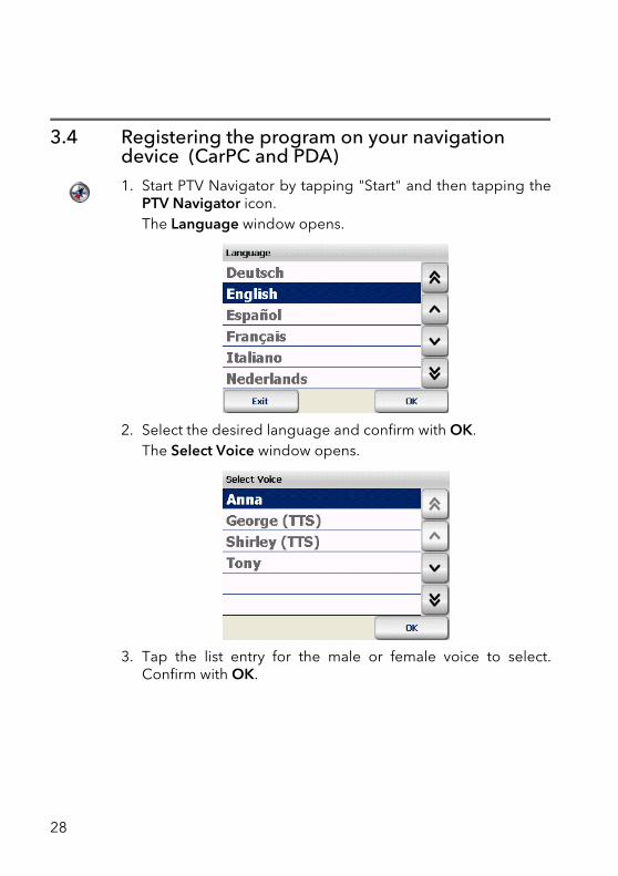
3.4 Registering the program on your navigation device (CarPC and PDA)1. Start PTV Navigator by tapping "Start" and then tapping the
PTV Navigator icon.The Language window opens.
2. Select the desired language and confirm with OK.The Select Voice window opens.
3. Tap the list entry for the male or female voice to select.Confirm with OK.
28
Chapter 7: Installation and Registration
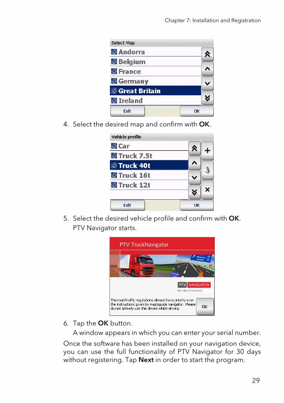
4. Select the desired map and confirm with OK.
5. Select the desired vehicle profile and confirm with OK.PTV Navigator starts.
6. Tap the OK button.A window appears in which you can enter your serial number.
Once the software has been installed on your navigation device,you can use the full functionality of PTV Navigator for 30 dayswithout registering. Tap Next in order to start the program.
29
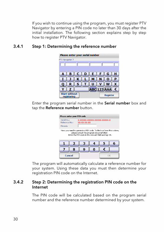
If you wish to continue using the program, you must register PTVNavigator by entering a PIN code no later than 30 days after theinitial installation. The following section explains step by stephow to register PTV Navigator.
3.4.1 Step 1: Determining the reference number
Enter the program serial number in the Serial number box andtap the Reference number button.
The program will automatically calculate a reference number foryour system. Using these data you must then determine yourregistration PIN code on the Internet.
3.4.2 Step 2: Determining the registration PIN code on the Internet
The PIN code will be calculated based on the program serialnumber and the reference number determined by your system.
30
Chapter 7: Installation and Registration
The PIN code that is generated can be used to register PTVNavigator on one single device only.
The PIN code is calculated on the service pages of the PTV AGwebsite:
1. Firstly, ensure that your desktop PC has an active Internetconnection.
2. Next, open your Internet browser and enter the followingInternet address:http://logistics.ptvag.com/software/navigation/pin-code/
The online form for PIN code generation is loaded.
3. Enter the program serial number and the reference number inthe online form.
4. Finally, click the Calculate PIN Code button.A PIN code is then calculated and displayed on the screen.
5. Now enter the PIN code in the PIN code box on yournavigation device and tap OK.
NoteProvided that you always use the program on the samenavigation device, you won't require a new PIN code shouldyou need to reinstall the software.
NoteIf you do not have an Internet connection or if you are unableto generate a PIN code despite having entered your serialand reference numbers correctly, then you can contact ourhotline on +49 721-9651-8577 or send an e-mail [email protected] (only regarding either of the above twosituations).
NoteNext enter the name of your company as well as yourcountry, postcode and town. These details allow us to helpyou more quickly if you have any questions or queries.
31
6. If the PIN code was correct, a message will appear. Click OKto confirm.
You have now successfully completed the registration process.
3.5 PTV Navigator interface and third-party softwarePTV Navigator has a file-based interface as well as a DLL-basedinterface with which you can exchange important information(e.g. points en route, your current position or stop-off point listsetc.) between PTV Navigator and another software program (forexample a CRM or fleet management system).
An exact interface description can be found on the installationdata carrier or in the download folder in the subdirectory \documentation\development\
3.6 The GPS receiverA GPS receiver localises the current position of your vehicle. TheGPS receiver continuously receives signals from the at least 24US NavStar satellites orbiting the Earth. The current position ofthe vehicle is determined from the data of four satellites. PTVNavigator displays the position on the road map in the exactlane. Please understand that we are unable to offer telephonesupport on the topic of installing the GPS receiver.
32
Chapter 7: Installation and Registration
3.7 TMC receiver (optional)Dynamically avoid traffic jams using TMC: Connect a TMCreceiver to your device and you will be able to request the latesttraffic information - continuously and free of charge - and ifnecessary, PTV Navigator calculates an alternative route. Trafficjams are displayed on the map using various traffic symbols.
NotePTV Navigator supports TMC receivers of GNS/Navilock(optional).
33

34
Mobile Navigation with a CarPC/PDA
35

36
4 Quick Overview PTV Navigator
Here you will find an overview of the basic functions available inthe main selection screen of PTV Navigator.
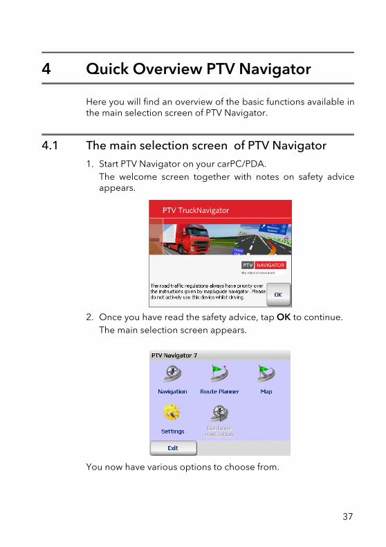
4.1 The main selection screen of PTV Navigator1. Start PTV Navigator on your carPC/PDA.
The welcome screen together with notes on safety adviceappears.
2. Once you have read the safety advice, tap OK to continue.The main selection screen appears.
You now have various options to choose from.
37
4.1.1 Navigation
Tap the Navigation symbol if you want PTV Navigator to guideyou from your present location straight to a specific destinationor via several stop-off points (see "Navigating with PTVNavigator" on page 41).
4.1.2 Route Planner
Tap the Route Planner symbol if you wish to plan a route from aspecific starting point to a particular destination (see "RoutePlanning with PTV Navigator" on page 49).
NoteThere are many different ways to specify the destination; entera new address, choose from your favourite destinations,previous destinations as well as various Points of Interest - forexample hotels & restaurants - contained in PTV Navigator'sdata records (see "Selecting a Destination" on page 55).
NoteNavigation and Route Planner are basically structured in thesame way. With the Navigation function, the point of departureis always automatically set as the current GPS position. Yousimply have to enter your destination. With Route Plannerhowever, you can manually enter the point of departure (as wellas the destination).
NoteWith the Route Planner, you can perform a navigationsimulation for your calculated route even if you don't have aGPS signal, e.g. if you are in an enclosed area (see "Starting thenavigation simulation" on page 52).
38
Chapter 9: Quick Overview PTV Navigator
4.1.3 Map
If you simply want to display your current GPS position on themap, tap the Map symbol (see "Showing a position on the map"on page 103).
As a route is not calculated here, there are no driving instructionsor route-specific display functions/buttons.
4.1.4 Settings
Tap the Settings symbol if you wish to change the programoptions for example map, volume, language, system etc.(see"Configuring the Settings" on page 105).
4.1.5 Continue navigation
If you have interrupted navigation, (for example in order to takea break at a service station), simply tap the Continue navigationsymbol. Navigation to your previously entered destination isthen resumed.
4.1.6 Exiting PTV Navigator
Tap Exit in order to close PTV Navigator.
4.2 Selecting an entry in a list
In PTV Navigator there are various methods of selecting an entryin a list:
39
• To scroll up or down the list line by line, use the "arrow up "and "arrow down" buttons. To scroll up or down the list pageby page, use the "double arrow up" and "double arrow down"buttons.
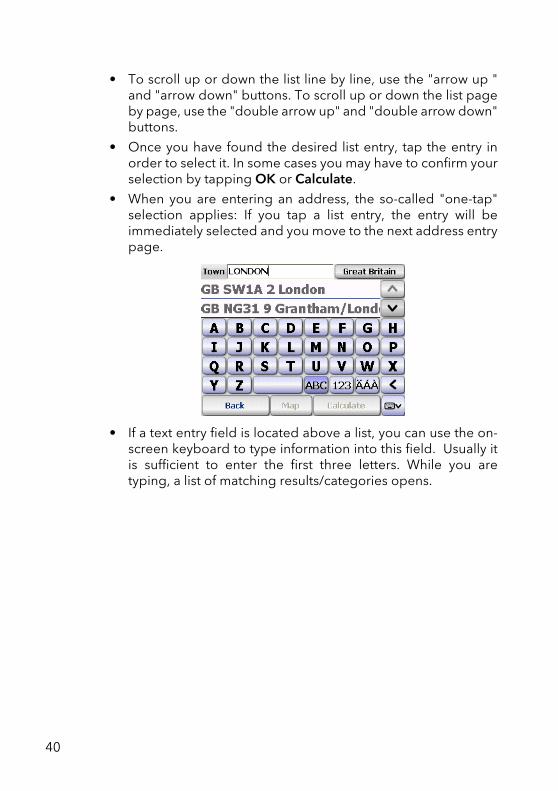
• Once you have found the desired list entry, tap the entry inorder to select it. In some cases you may have to confirm yourselection by tapping OK or Calculate.
• When you are entering an address, the so-called "one-tap"selection applies: If you tap a list entry, the entry will beimmediately selected and you move to the next address entrypage.
• If a text entry field is located above a list, you can use the on-screen keyboard to type information into this field. Usually itis sufficient to enter the first three letters. While you aretyping, a list of matching results/categories opens.
40
5 Navigating with PTV Navigator
With the navigation function, PTV Navigator guides you fromyour present location to any destination of your choice. In thiscase, it is not necessary to enter the starting location yourself -this is determined by PTV Navigator automatically.
WARNINGDanger of accidents!• For your own safety, you should attach your carPC/PDA
securely in the vehicle using a special holder. Ensure thatthe holding device does not hinder the effectiveness ofpassenger safety systems (seat belt, airbag, etc.) in any way.Make sure the device is sufficiently secure so that it will notbecome dislodged even in the event of emergency brakingor a collision.
• Actively operating PTV Navigator whilst driving can divertyour attention from the road and can lead to accidents. Youshould be aware that even if you are only driving at a speedof 50km/h (31 mph), your vehicle will travel a distance of 14metres. Perform all the required settings and enter yourdestination BEFORE starting your journey or whilst thevehicle is stationary in an appropriate place. Devote yourfull attention to the traffic whilst you are driving!
• PTV Navigator does not provide you with any informationabout stop signs and the rules of the road, which you areobliged to adhere to and which, of course, take priority overthe instructions from PTV Navigator. If you are forced to deviate from the suggested route, PTVNavigator automatically guides you to your destination viaan alternative route.
41
5.1 Navigation from your current location to one specific destinationIn this scenario, navigation consists of the following steps:
• Opening the Program
• Selecting a Destination
• Calculating the route automatically and displaying it on themap
• Start navigation
5.1.1 Opening the Program
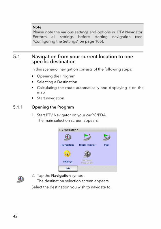
1. Start PTV Navigator on your carPC/PDA.The main selection screen appears.
2. Tap the Navigation symbol.The destination selection screen appears.
Select the destination you wish to navigate to.
NotePlease note the various settings and options in PTV NavigatorPerform all settings before starting navigation (see"Configuring the Settings" on page 105).
42
Chapter 10: Navigating with PTV Navigator
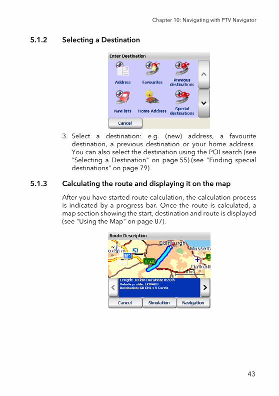
5.1.2 Selecting a Destination
3. Select a destination: e.g. (new) address, a favouritedestination, a previous destination or your home address You can also select the destination using the POI search (see"Selecting a Destination" on page 55).(see "Finding specialdestinations" on page 79).
5.1.3 Calculating the route and displaying it on the map
After you have started route calculation, the calculation processis indicated by a progress bar. Once the route is calculated, amap section showing the start, destination and route is displayed(see "Using the Map" on page 87).
43
5.1.4 Start navigation
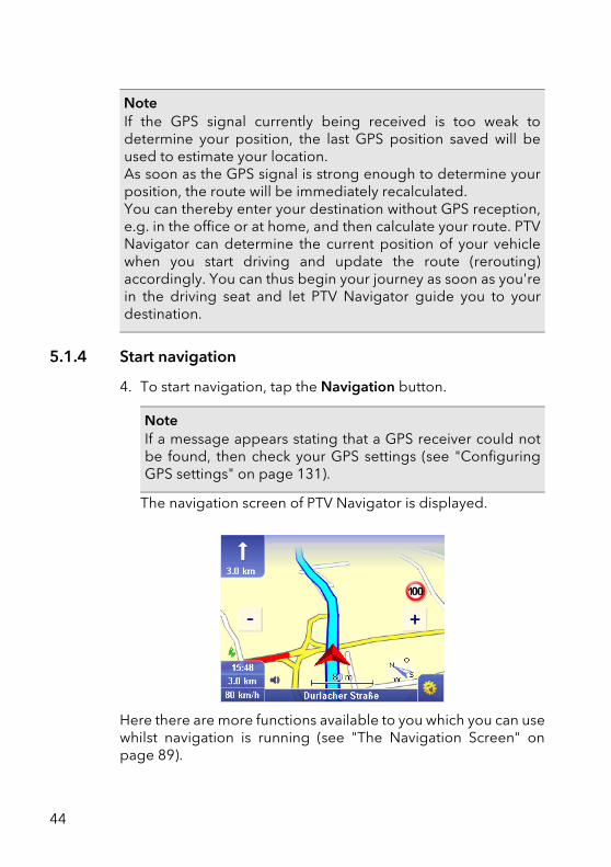
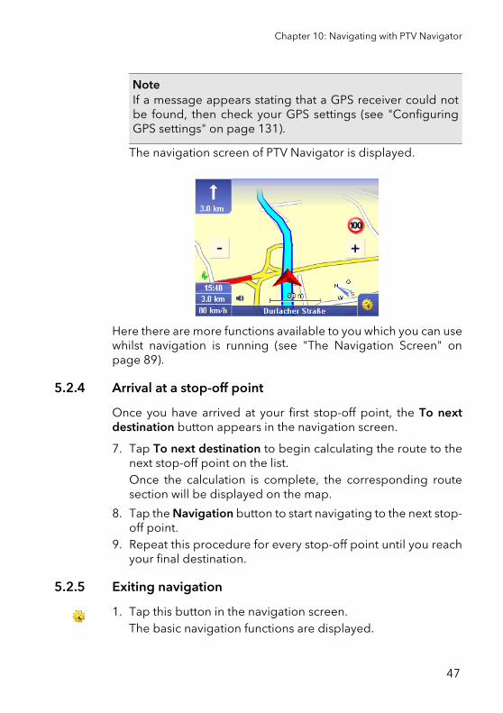
4. To start navigation, tap the Navigation button.
The navigation screen of PTV Navigator is displayed.
Here there are more functions available to you which you can usewhilst navigation is running (see "The Navigation Screen" onpage 89).
NoteIf the GPS signal currently being received is too weak todetermine your position, the last GPS position saved will beused to estimate your location.As soon as the GPS signal is strong enough to determine yourposition, the route will be immediately recalculated.You can thereby enter your destination without GPS reception,e.g. in the office or at home, and then calculate your route. PTVNavigator can determine the current position of your vehiclewhen you start driving and update the route (rerouting)accordingly. You can thus begin your journey as soon as you'rein the driving seat and let PTV Navigator guide you to yourdestination.
NoteIf a message appears stating that a GPS receiver could notbe found, then check your GPS settings (see "ConfiguringGPS settings" on page 131).
44
Chapter 10: Navigating with PTV Navigator
5.1.5 Exiting navigation
1. Tap this button in the navigation screen.The basic navigation functions are displayed.
2. Tap the Cancel button.
Navigation is stopped and you return to the main selectionscreen.
5.2 Navigation from your current location to several route points in a navi list.In this case you must perform the following steps:
• Opening the Program
• Add the desired stop-off points to a navi list
• Start navigation
5.2.1 Opening the Program
1. Start PTV Navigator on your carPC/PDA.The main selection screen appears.
2. Tap the Navigation symbol.The destination selection screen appears.
45
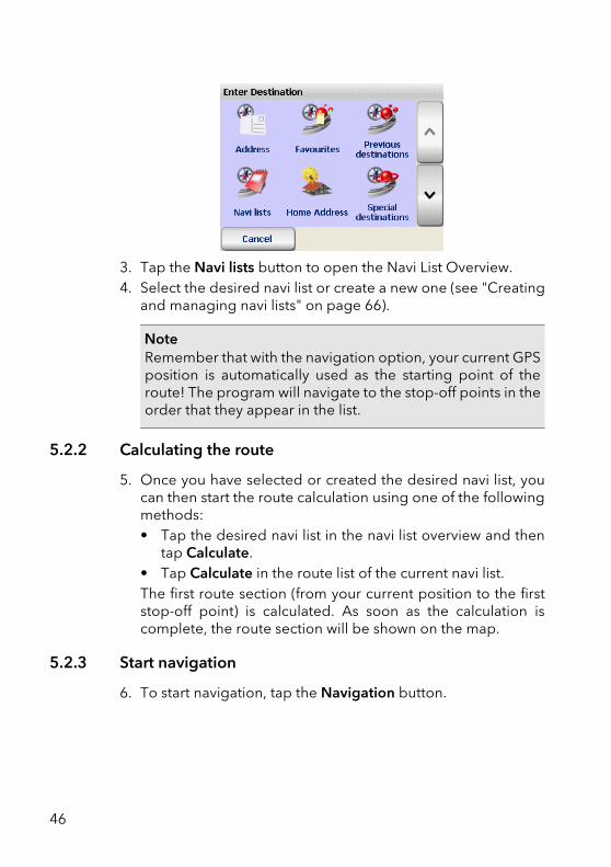
3. Tap the Navi lists button to open the Navi List Overview.4. Select the desired navi list or create a new one (see "Creating
and managing navi lists" on page 66).
5.2.2 Calculating the route
5. Once you have selected or created the desired navi list, youcan then start the route calculation using one of the followingmethods:• Tap the desired navi list in the navi list overview and then
tap Calculate.• Tap Calculate in the route list of the current navi list.The first route section (from your current position to the firststop-off point) is calculated. As soon as the calculation iscomplete, the route section will be shown on the map.
5.2.3 Start navigation
6. To start navigation, tap the Navigation button.
NoteRemember that with the navigation option, your current GPSposition is automatically used as the starting point of theroute! The program will navigate to the stop-off points in theorder that they appear in the list.
46
Chapter 10: Navigating with PTV Navigator
The navigation screen of PTV Navigator is displayed.
Here there are more functions available to you which you can usewhilst navigation is running (see "The Navigation Screen" onpage 89).
5.2.4 Arrival at a stop-off point
Once you have arrived at your first stop-off point, the To nextdestination button appears in the navigation screen.
7. Tap To next destination to begin calculating the route to thenext stop-off point on the list.Once the calculation is complete, the corresponding routesection will be displayed on the map.
8. Tap the Navigation button to start navigating to the next stop-off point.
9. Repeat this procedure for every stop-off point until you reachyour final destination.
5.2.5 Exiting navigation
1. Tap this button in the navigation screen.The basic navigation functions are displayed.
NoteIf a message appears stating that a GPS receiver could notbe found, then check your GPS settings (see "ConfiguringGPS settings" on page 131).
47

2. Tap the Cancel button.
Navigation is stopped and you return to the main selectionscreen.
48
6 Route Planning with PTV Navigator
Navigation and Route Planner have a similar structure in terms ofthe way the two modes are used. With the Navigation function,the point of departure is always automatically set as the currentGPS position. You simply have to enter your destination. WithRoute Planner however, you can manually enter the point ofdeparture (as well as the destination). This means you cancalculate routes between any locations you wish and specify thedesired route before the trip.
6.1 Planning a route – step by stepRoute planning with a starting point and destination consists ofthe following steps:
• Opening the Route Planner
• Selecting the starting point and destination
• Starting the navigation simulation
6.1.1 Opening the Route Planner
1. Start PTV Navigator on your carPC/PDA.
The main selection screen appears.
NotePlease note the various settings and options in .(see"Configuring the Settings" on page 105).
49
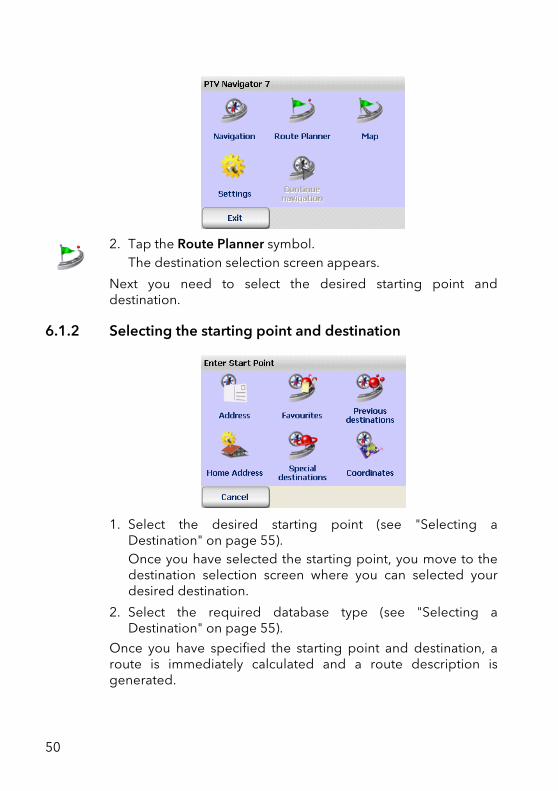
2. Tap the Route Planner symbol.The destination selection screen appears.
Next you need to select the desired starting point anddestination.
6.1.2 Selecting the starting point and destination
1. Select the desired starting point (see "Selecting aDestination" on page 55).Once you have selected the starting point, you move to thedestination selection screen where you can selected yourdesired destination.
2. Select the required database type (see "Selecting aDestination" on page 55).
Once you have specified the starting point and destination, aroute is immediately calculated and a route description isgenerated.
50
Chapter 11: Route Planning with PTV Navigator
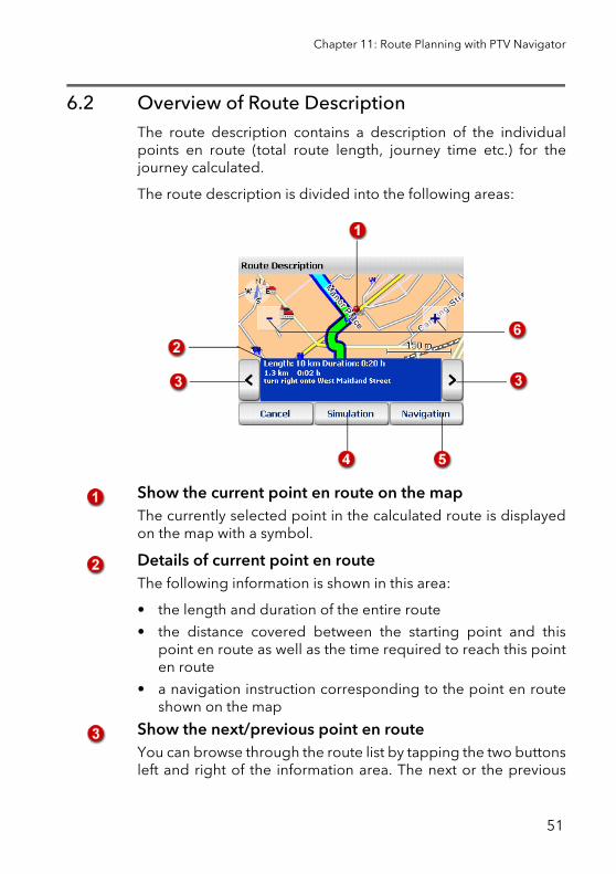
6.2 Overview of Route DescriptionThe route description contains a description of the individualpoints en route (total route length, journey time etc.) for thejourney calculated.
The route description is divided into the following areas:
Show the current point en route on the mapThe currently selected point in the calculated route is displayedon the map with a symbol.
Details of current point en routeThe following information is shown in this area:
• the length and duration of the entire route
• the distance covered between the starting point and thispoint en route as well as the time required to reach this pointen route
• a navigation instruction corresponding to the point en routeshown on the map
Show the next/previous point en routeYou can browse through the route list by tapping the two buttonsleft and right of the information area. The next or the previous
51
point en route is shown. At the same time, the map sectionfocuses on this point on route.
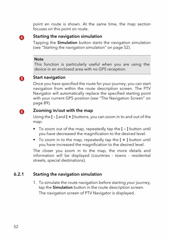
Starting the navigation simulationTapping the Simulation button starts the navigation simulation(see "Starting the navigation simulation" on page 52).
Start navigationOnce you have specified the route for your journey, you can startnavigation from within the route description screen. The PTVNavigator will automatically replace the specified starting pointwith your current GPS position (see "The Navigation Screen" onpage 89).
Zooming in/out with the mapUsing the [ – ] and [ + ] buttons, you can zoom in to and out of themap:
• To zoom out of the map, repeatedly tap the [ – ] button untilyou have decreased the magnification to the desired level.
• To zoom in to the map, repeatedly tap the [ + ] button untilyou have increased the magnification to the desired level.
The closer you zoom in to the map, the more details andinformation will be displayed (countries - towns - residentialstreets, special destinations).
6.2.1 Starting the navigation simulation
1. To simulate the route navigation before starting your journey,tap the Simulation button in the route description screen.The navigation screen of PTV Navigator is displayed.
NoteThis function is particularly useful when you are using thedevice in an enclosed area with no GPS reception.
52
Chapter 11: Route Planning with PTV Navigator
6.2.2 Ending the navigation simulation
1. Tap this button in the navigation screen.The basic navigation functions are displayed.
2. Tap the Cancel button.
You exit the navigation screen and return to the main selectionscreen.
NoteIn (see "The Navigation Screen" on page 89)., the functions inthe Route Planner are similar to those in Navigation - except forthe fact that in Route Planner you can simulate navigation ratherthan actually navigating
TipOnce you have specified the route for your journey, you canstart navigation from within the route description screen. Tapthe Navigation button to switch to the navigation screen andstart navigating. The PTV Navigator will automatically replacethe specified starting point with your current GPS position (see"The Navigation Screen" on page 89).
53

54
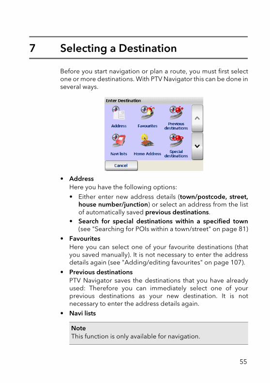
7 Selecting a Destination
Before you start navigation or plan a route, you must first selectone or more destinations. With PTV Navigator this can be done inseveral ways.
• Address Here you have the following options:
• Either enter new address details (town/postcode, street,house number/junction) or select an address from the listof automatically saved previous destinations.
• Search for special destinations within a specified town(see "Searching for POIs within a town/street" on page 81)
• FavouritesHere you can select one of your favourite destinations (thatyou saved manually). It is not necessary to enter the addressdetails again (see "Adding/editing favourites" on page 107).
• Previous destinationsPTV Navigator saves the destinations that you have alreadyused: Therefore you can immediately select one of yourprevious destinations as your new destination. It is notnecessary to enter the address details again.
• Navi lists
NoteThis function is only available for navigation.
55
Navi lists contain several route points that you can navigate to- one after the other. Here you can load and edit your navi lists(stop-off point lists) (see "Creating and managing navi lists"on page 66).
• Home addressIf you have not specified a home address and you tap thissymbol, NAVIGATOR will automatically switch to the programsettings where you can enter the details of your home address(see "Specifying a home address" on page 106). You will thenbe able to your home address as a navigation destination.
• Special destinations
This function allows you to select special destinations (POIs)close to your current location and use them for navigation(see "Finding special destinations" on page 79).
• CoordinatesThe geographic coordinates for your destination can beentered here (see "Using coordinates as the destination" onpage 64).
7.1 Using an address as the destination1. Tap the Address button in the destination selection screen.
The address selection screen appears.
NoteThis function is only available for navigation.
TipDisplay point on the map / Manually select point on the map asdestinationIf you wish to use a new address, a favourite destination or aprevious destination as the navigation destination, you canfirstly show the corresponding location on the map. You alsohave the option of repositioning the point on the map and inthis way you can select the point as a new destination.
56
Chapter 12: Selecting a Destination
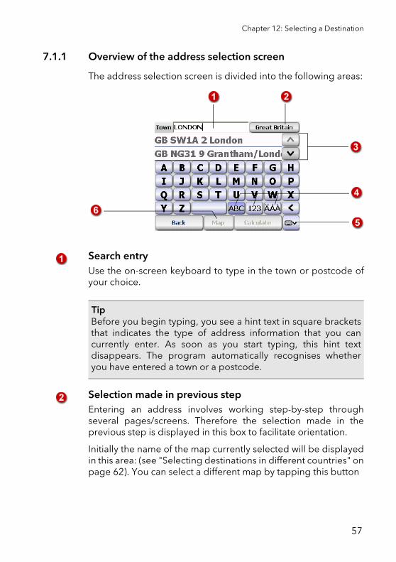
7.1.1 Overview of the address selection screen
The address selection screen is divided into the following areas:
Search entryUse the on-screen keyboard to type in the town or postcode ofyour choice.
Selection made in previous stepEntering an address involves working step-by-step throughseveral pages/screens. Therefore the selection made in theprevious step is displayed in this box to facilitate orientation.
Initially the name of the map currently selected will be displayedin this area: (see "Selecting destinations in different countries" onpage 62). You can select a different map by tapping this button
TipBefore you begin typing, you see a hint text in square bracketsthat indicates the type of address information that you cancurrently enter. As soon as you start typing, this hint textdisappears. The program automatically recognises whetheryou have entered a town or a postcode.
57
List of previous entries/list of resultsBefore you begin typing, your previous entries will be visible inthe list - unless you are using PTV Navigator for the first time, inwhich case no entries will exist yet. Whilst you are typing, theprogram searches for matching results and displays them in thelist (e.g. towns or postcodes, depending on what you selected).If you wish to view these previous entries again, simply delete thecurrent contents of the entry field.
In addition:
• To scroll up or down the list line by line, use the "arrow up "and "arrow down" buttons.
• If you tap a list entry, the entry will be selected and you moveto the next address entry page. Here it is irrelevant whetherthe entry is already highlighted or not (so-called "one-tap"selection).
On-screen keyboardAn on-screen keyboard is available in PTV Navigator to make iteasier for you to enter (i.e. type in) information. PTV Navigatorautomatically changes the entry mode of the keyboard,depending on the type of information you wish to enter. You canalso switch between the entry modes manually by using thefollowing buttons:
• To enter letters, tap the ABC button.
• To enter numbers, tap the 123 button.
• To enter special characters, tap the ÄÁÀ button.
Using the backspace key, you can delete your entry character bycharacter.
TipIf you wish to calculate the route before you have entered allthe address elements, do not tap the desired list entry.Instead use the arrow buttons to scroll in the list until thedesired entry is selected. Then tap the Calculate button. Thiswill not take you to the next address entry page. Instead itwill start the route calculation.
58
Chapter 12: Selecting a Destination
Show/hide on-screen keyboardUsing the Show/hide keyboard button, you can choose whetheror not the on-screen keyboard is displayed. The list of previousentries/results is shortened or lengthened respectively.
Show on mapTo show the selected entry in the centre of a zoomed mapsection, tap the Map button. You also have the option ofrepositioning the point on the map and in this way you can selectthe point as a new destination - all map functions are availablehere (see "Using the Map" on page 87).
7.1.2 Using an address as the destination
1. Tap the Address button in the destination selection screen.The address selection screen appears (see "Overview of theaddress selection screen" on page 57).
TipIf you search for an address component in PTV Navigator with along name, that consists of several words, it is sufficient if youjust type in one of these words (partial name search).Example: "Winston Churchill Street" is found if you simply enter"Winston" or "Churchill". In order to find "Avenue des Champs-Élysées" you therefore only need to enter "Champs" or "Elysé".
TipIf you search for an address component in PTV Navigator thatcontains special characters, it is not necessary to enter thesecharacters (special-character-tolerant search)Example: "Ciadueña" (in Spain) is found if you simply enter"Ciad". In order to find "Avenue des Champs-Élysées" youtherefore only need to enter "Elyse".
59
Selecting the town
2. Firstly you must specify the location of your destination byeither entering the name of the town itself or the postcode:
While you are typing, a list of matching results opens. Thetowns in this list are sorted according to size which makes iteasier for you to quickly select the required location.
3. Now tap the desired town in the list.The next screen appears: Here you can select the street (or insome cases a special destination=POI).
NoteIf your destination address lies in another country, thenchoose the relevant map at the start of the destinationselection process (see "Selecting destinations in differentcountries" on page 62).
NoteThe program automatically recognises whether you haveentered a town or a postcode.
TipBefore you enter a new town/postcode, check to see if thedesired entry is in the list of previous results - this will saveyou time.
60
Chapter 12: Selecting a Destination
Select the street4. Enter the name of your destination.
While you are typing, a list of matching results opens.
5. Tap the desired street in the list.The next screen appears: Here you can select the housenumber or junction.
Selecting the house number/junction
6. Enter the desired house number or junction name.While you are typing, a list of matching results opens.
7. Choose the desired entry from the list as previouslydescribed.
NoteSelecting the appropriate input mode for the keyboardensures that the program can recognise whether you haveentered the name of a junction or a house number.
61
You have now selected all the address elements for yourdestination. The route will now be calculated automaticallyand displayed on the map.
8. To start navigation, tap the Navigation button (see "Startnavigation" on page 44).
7.2 Selecting destinations in different countriesYou can purchase various different maps for PTV Navigator andthen integrate them into the program (see "Loading additionalmaps and addresses on your navigation device (CarPC andPDA)" on page 23).
If your destination address lies in another country, then choosethe relevant map at the start of the destination selection process.
1. Tap the Address button in the destination selection screen.The address selection screen appears (see "Overview of theaddress selection screen" on page 57). The map currentlyselected is shown in the upper right corner of the screen.
NoteIf you wish to calculate a route that leads through differentcountries, the relevant country maps as well as the major roadnetwork must be installed on your PDA. These establish aconnection between individual country maps. Please note that the major road network is required even forcountries that border each other, such as France and Germany,in order to connect the road networks of the individualcountries.
62
Chapter 12: Selecting a Destination
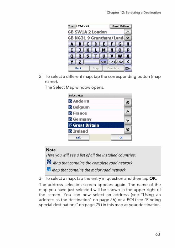
2. To select a different map, tap the corresponding button (mapname).The Select Map window opens.
3. To select a map, tap the entry in question and then tap OK.
The address selection screen appears again. The name of themap you have just selected will be shown in the upper right ofthe screen. You can now select an address (see "Using anaddress as the destination" on page 56) or a POI (see "Findingspecial destinations" on page 79) in this map as your destination.
NoteHere you will see a list of all the installed countries:
Map that contains the complete road network
Map that contains the major road network
63
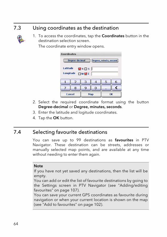
7.3 Using coordinates as the destination1. To access the coordinates, tap the Coordinates button in the
destination selection screen.The coordinate entry window opens.
2. Select the required coordinate format using the buttonDegree-decimal or Degree, minutes, seconds.
3. Enter the latitude and logitude coordinates.4. Tap the OK button.
7.4 Selecting favourite destinationsYou can save up to 99 destinations as favourites in PTVNavigator. These destination can be streets, addresses ormanually selected map points, and are available at any timewithout needing to enter them again.
NoteIf you have not yet saved any destinations, then the list will beempty.You can add or edit the list of favourite destinations by going tothe Settings screen in PTV Navigator (see "Adding/editingfavourites" on page 107).You can save your current GPS coordinates as favourite duringnavigation or when your current location is shown on the map(see "Add to favourites" on page 102).
64
Chapter 12: Selecting a Destination
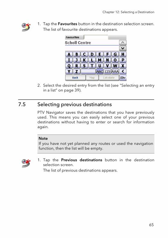
1. Tap the Favourites button in the destination selection screen.The list of favourite destinations appears.
2. Select the desired entry from the list (see "Selecting an entryin a list" on page 39).
7.5 Selecting previous destinationsPTV Navigator saves the destinations that you have previouslyused. This means you can easily select one of your previousdestinations without having to enter or search for informationagain.
1. Tap the Previous destinations button in the destinationselection screen.The list of previous destinations appears.
NoteIf you have not yet planned any routes or used the navigationfunction, then the list will be empty.
65
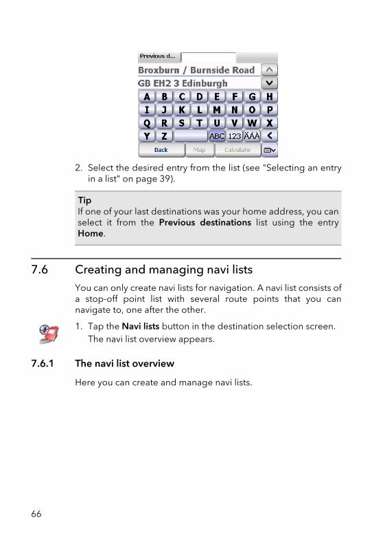
2. Select the desired entry from the list (see "Selecting an entryin a list" on page 39).
7.6 Creating and managing navi listsYou can only create navi lists for navigation. A navi list consists ofa stop-off point list with several route points that you cannavigate to, one after the other.
1. Tap the Navi lists button in the destination selection screen.The navi list overview appears.
7.6.1 The navi list overview
Here you can create and manage navi lists.
TipIf one of your last destinations was your home address, you canselect it from the Previous destinations list using the entryHome.
66
Chapter 12: Selecting a Destination
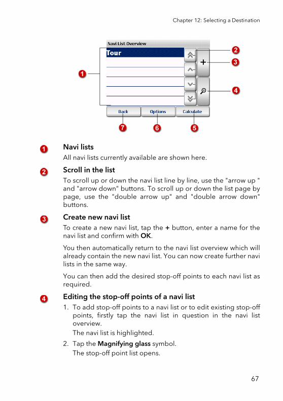
Navi listsAll navi lists currently available are shown here.
Scroll in the listTo scroll up or down the navi list line by line, use the "arrow up "and "arrow down" buttons. To scroll up or down the list page bypage, use the "double arrow up" and "double arrow down"buttons.
Create new navi listTo create a new navi list, tap the + button, enter a name for thenavi list and confirm with OK.
You then automatically return to the navi list overview which willalready contain the new navi list. You can now create further navilists in the same way.
You can then add the desired stop-off points to each navi list asrequired.
Editing the stop-off points of a navi list1. To add stop-off points to a navi list or to edit existing stop-off
points, firstly tap the navi list in question in the navi listoverview. The navi list is highlighted.
2. Tap the Magnifying glass symbol. The stop-off point list opens.
67
3. You can now edit the stop-off point list as required, forexample add or delete stop-off points (see "Editing the stop-off points of a navi list" on page 68).
Calculating a transport runProvided that the stop-off point list contains at least one stop-offpoint, you can calculate the route for the navi list by tappingCalculate. You can then start navigation in the usual way.
Options for navi lists: Delete navi list or edit navi listHighlight the desired navi list in the Navi List Overview and thenclick the Options button.
• To delete the selected navi list, tap Delete.
• To rename a navi list, click Edit.
Back to destination selection screenTap the Back button to return to the destination selection screen.
7.6.2 Editing the stop-off points of a navi list
1. To add stop-off points to a navi list or to edit existing stop-offpoints, firstly tap the navi list in question in the navi listoverview. The navi list is highlighted.
2. Tap the Magnifying glass symbol. The stop-off point list opens.
3. You can now edit the stop-off point list as required, forexample add or delete stop-off points.
68
Chapter 12: Selecting a Destination
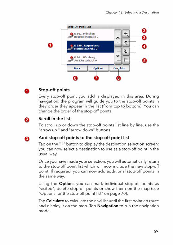
Stop-off pointsEvery stop-off point you add is displayed in this area. Duringnavigation, the program will guide you to the stop-off points inthey order they appear in the list (from top to bottom). You canchange the order of the stop-off points.
Scroll in the listTo scroll up or down the stop-off points list line by line, use the"arrow up " and "arrow down" buttons.
Add stop-off points to the stop-off point listTap on the "+" button to display the destination selection screen:you can now select a destination to use as a stop-off point in theusual way.
Once you have made your selection, you will automatically returnto the stop-off point list which will now include the new stop-offpoint. If required, you can now add additional stop-off points inthe same way.
Using the Options you can mark individual stop-off points as"visited", delete stop-off points or show them on the map (see"Options for the stop-off point list" on page 70).
Tap Calculate to calculate the navi list until the first point en routeand display it on the map. Tap Navigation to run the navigationmode.
69
Change the order of the stop-off points in the listTo change the position of a stop-off point, firstly tap the stop-offpoint in question. Now you can move the selected stop-off pointup or down in the list using the arrow buttons.
Select all entries in the listUse this button to select all entries in the list and then choose thedesired options (see "Options for the stop-off point list" onpage 70).
Calculating a transport runProvided that the stop-off point list contains at least one stop-offpoint, you can calculate the route for the navi list by tappingCalculate. You can then start navigation in the usual way.
You can mark individual stop-off points as "visited", deletestop-off points or show them on the map.If you have selected a stop-off point, tap the Options button. Youcan then either delete the stop-off point, mark it as "visited" ordisplay it on the map (see "Options for the stop-off point list" onpage 70).
Back to the navi list overviewTap the Back button to return to the navi list screen.
7.6.3 Options for the stop-off point list
There are various options available to you for editing the stop-offpoint list. You can mark individual stop-off points as "visited",delete stop-off points or show them on the map.
1. In the stop-off point list, tap the stop-off point for which youwant to perform the action.
2. To open the options, tap the corresponding button.The options for the selected stop-off point are shown.
70
Chapter 12: Selecting a Destination
Marking a stop-off point as "visited"1. If you wish to mark a stop-off point as "visited", tap the Visited
symbol.The stop-off point list appears. The selected stop-off point isnow shown with a tick in the list. This point will no longer beused for navigation.
Delete stop-off point1. To delete the selected stop-off point from the list, tap the
Delete symbol.A confirmation prompt appears.
2. Confirm that you want to proceed by tapping Yes.The stop-off point list appears. The selected stop-off point isdeleted.
Showing a stop-off point on the mapA stop-off point can be shown on the map.
1. To display the selected stop-off point on the map, tap theMap symbol.The position of the stop-off point is shown by a marker pin inthe centre of a map section.
7.7 Selecting your home address as the destinationWith the Home option, the address that you specified as yourhome address in the PTV Navigator settings will be used as thedestination (see "Specifying a home address" on page 106).
NoteIf you wish to undo this change and use this stop-off point fornavigation again, open the options and tap the Not visitedsymbol.
71
1. Tap the Home button in the destination selection screen.
7.8 Point on the map - show/use as destination If you wish to use a new address, a favourite destination or aprevious destination as the navigation destination, you can firstlyshow the corresponding location on the map. You also have theoption of manually selecting a point on the map and using it as anavigation destination.
1. In the destination selection screen, choose the desiredselection method: address, favourite destinations, previousdestinations.The corresponding selection screen appears..
2. Enter an address, or select a favourite or your last destination.3. To show the address or selected destination on the map, tap
the Map button.The address or selected destination is shown by a marker pinin the centre of a map section.
Here you can use all the typical map functions (zoom, moveetc.) (see "Using the Map" on page 87).
4. If you want select another point on the map as the destination,navigate to the relevant map section and then tap the desiredlocation on the map. The new destination will be marked on the map with a markerpin.
5. Tap Calculate to accept the selected point as the navigationselection and to start route calculation.Once the route has been calculated, it is displayed on themap.
NoteUntil you have specified a home address, the name of thesymbol is Set Home Address and takes you directly to theSettings screen.
72

Chapter 12: Selecting a Destination
6. To start navigation, tap the Navigation button (see "Startnavigation" on page 44).
73

74
8 Routing in an area with restricted or blocked access
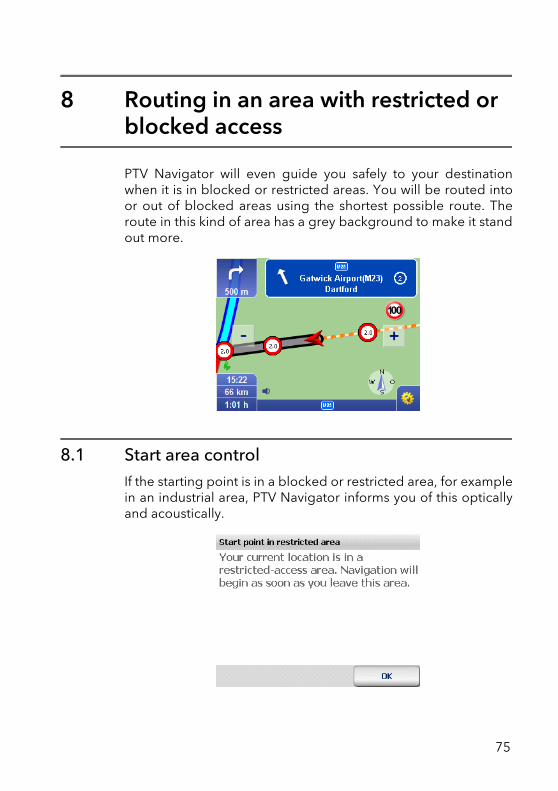
PTV Navigator will even guide you safely to your destinationwhen it is in blocked or restricted areas. You will be routed intoor out of blocked areas using the shortest possible route. Theroute in this kind of area has a grey background to make it standout more.
8.1 Start area controlIf the starting point is in a blocked or restricted area, for examplein an industrial area, PTV Navigator informs you of this opticallyand acoustically.
75
After you have confirmed the message with OK you are guidedto the next drivable road.
When you leave the point of departure, navigation to the actualdestination is automatically started.
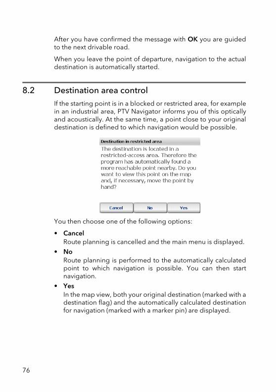
8.2 Destination area controlIf the starting point is in a blocked or restricted area, for examplein an industrial area, PTV Navigator informs you of this opticallyand acoustically. At the same time, a point close to your originaldestination is defined to which navigation would be possible.
You then choose one of the following options:
• CancelRoute planning is cancelled and the main menu is displayed.
• NoRoute planning is performed to the automatically calculatedpoint to which navigation is possible. You can then startnavigation.
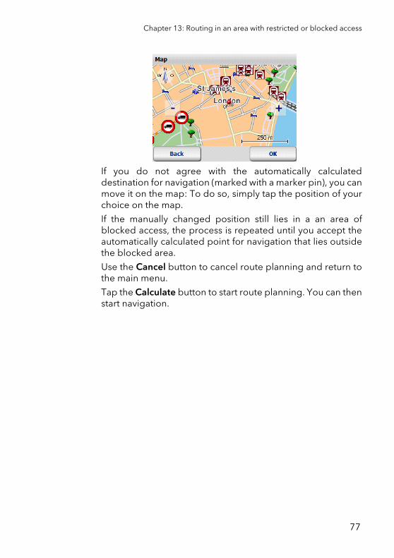
• YesIn the map view, both your original destination (marked with adestination flag) and the automatically calculated destinationfor navigation (marked with a marker pin) are displayed.
76
Chapter 13: Routing in an area with restricted or blocked access
If you do not agree with the automatically calculateddestination for navigation (marked with a marker pin), you canmove it on the map: To do so, simply tap the position of yourchoice on the map.
If the manually changed position still lies in a an area ofblocked access, the process is repeated until you accept theautomatically calculated point for navigation that lies outsidethe blocked area.
Use the Cancel button to cancel route planning and return tothe main menu.
Tap the Calculate button to start route planning. You can thenstart navigation.
77

78
9 Finding special destinations
PTV Navigator allows you to search for special destinations (alsoknown as "POIs" = Points of Interest) that are located in thevicinity of your current position and to use them for navigation
You can search for POIs during navigation or select these via thedestination selection.
9.1 Searching for POIs during navigationWith PTV Navigator you can search for a POI in your direct vicinitywhilst navigation is running. This is useful if, for example, you arelooking for a car park whilst on the move. If you select a POIwhilst you are on the move, this POI will be added to the top ofthe stop-off point list (i.e. the POI will be used as the nextdestination).
Overview of the key steps:
• Start navigation mode
• Open the list of POIs
• Select category
• Select the desired POI
And off you go:
1. Select a destination and start the navigation mode.
79
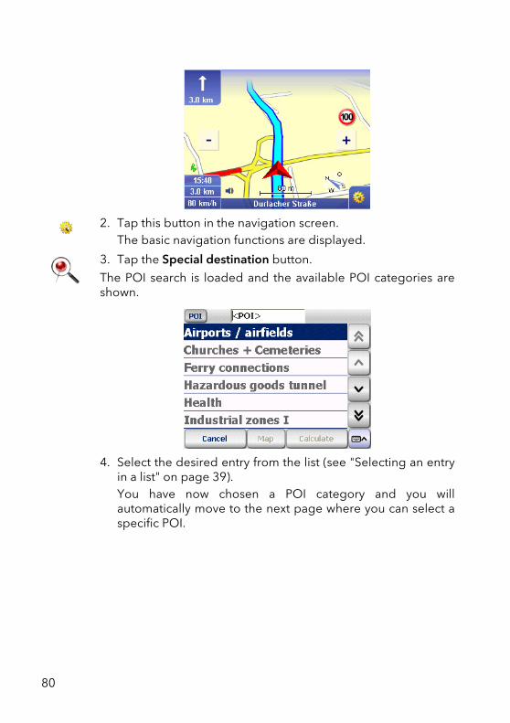
2. Tap this button in the navigation screen.The basic navigation functions are displayed.
3. Tap the Special destination button.
The POI search is loaded and the available POI categories areshown.
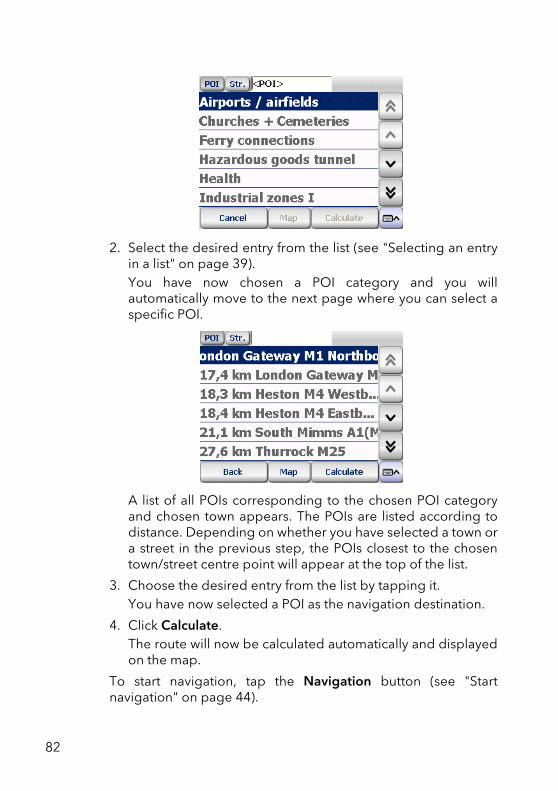
4. Select the desired entry from the list (see "Selecting an entryin a list" on page 39). You have now chosen a POI category and you willautomatically move to the next page where you can select aspecific POI.
80
Chapter 14: Finding special destinations
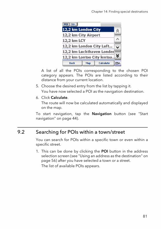
A list of all the POIs corresponding to the chosen POIcategory appears. The POIs are listed according to theirdistance from your current location.
5. Choose the desired entry from the list by tapping it.You have now selected a POI as the navigation destination.
6. Click Calculate.The route will now be calculated automatically and displayedon the map.
To start navigation, tap the Navigation button (see "Startnavigation" on page 44).
9.2 Searching for POIs within a town/streetYou can search for POIs within a specific town or even within aspecific street.
1. This can be done by clicking the POI button in the addressselection screen (see "Using an address as the destination" onpage 56) after you have selected a town or a street.The list of available POIs appears.
81
2. Select the desired entry from the list (see "Selecting an entryin a list" on page 39). You have now chosen a POI category and you willautomatically move to the next page where you can select aspecific POI.
A list of all POIs corresponding to the chosen POI categoryand chosen town appears. The POIs are listed according todistance. Depending on whether you have selected a town ora street in the previous step, the POIs closest to the chosentown/street centre point will appear at the top of the list.
3. Choose the desired entry from the list by tapping it.You have now selected a POI as the navigation destination.
4. Click Calculate.The route will now be calculated automatically and displayedon the map.
To start navigation, tap the Navigation button (see "Startnavigation" on page 44).
82
Chapter 14: Finding special destinations
9.2.1 Example of a POI search: Finding a hotel in London
Assume you want to be guided to a particular hotel in London,then proceed as follows:
1. First, select London as the town of your destination.2. Make sure that the POI button is pressed in and select "Hotel"
from the list of POI categories.
A list of all the hotels in London is displayed according todistance. The hotels nearest to the centre point of the town willbe at the top of the list.
9.3 Searching for POIs using the destination selection screenIf you know the category and name of the POI, you can directlyaccept the destination in the navigation.
Overview of the key steps:
• Opening the Program
• Open the list of POIs
• Select the desired category
• Select the desired POI
And off you go:
1. Tap the Navigation symbol.The destination selection screen appears.
TipUsing the on-screen keyboard, type in "HOT" in the entrybox and then tap the corresponding list entry.
83
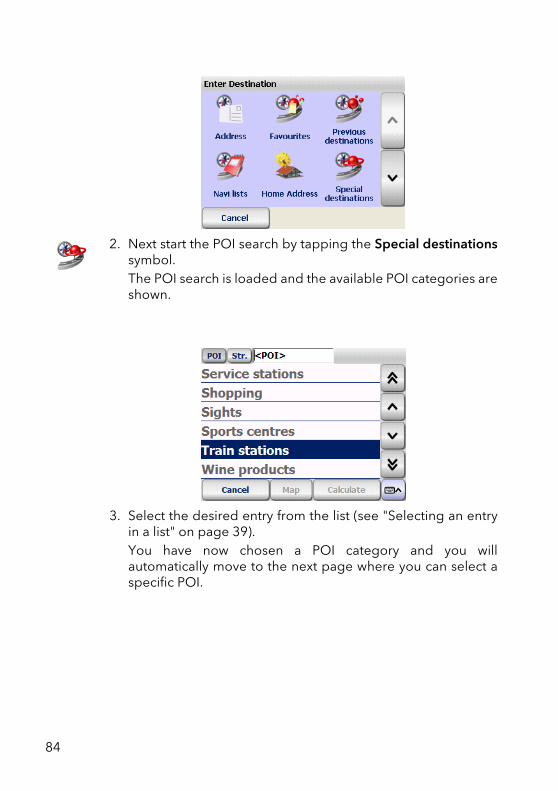
2. Next start the POI search by tapping the Special destinationssymbol.The POI search is loaded and the available POI categories areshown.
3. Select the desired entry from the list (see "Selecting an entryin a list" on page 39). You have now chosen a POI category and you willautomatically move to the next page where you can select aspecific POI.
84
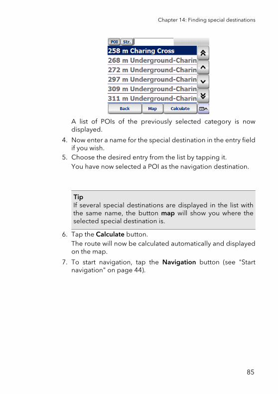
Chapter 14: Finding special destinations
A list of POIs of the previously selected category is nowdisplayed.
4. Now enter a name for the special destination in the entry fieldif you wish.
5. Choose the desired entry from the list by tapping it.You have now selected a POI as the navigation destination.
6. Tap the Calculate button.The route will now be calculated automatically and displayedon the map.
7. To start navigation, tap the Navigation button (see "Startnavigation" on page 44).
TipIf several special destinations are displayed in the list withthe same name, the button map will show you where theselected special destination is.
85

86
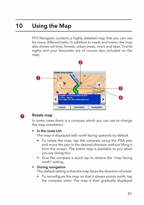
10 Using the Map
PTV Navigator contains a highly detailed map that you can usefor many different tasks. In addition to roads and towns, the mapalso shows rail lines, forests, urban areas, rivers and seas. Touristsights and your favourites are of course also included on themap.
Rotate mapIn some views there is a compass which you can use to changethe map orientation.
• In the route ListThe map is displayed with north facing upwards by default.
• To rotate the map, tap the compass using the PDA penand move the pen in the desired direction without lifting itfrom the screen. The entire map is available to you whenyou are doing this.
• Give the compass a quick tap to restore the "map facingnorth" setting.
• During navigationThe default setting is that the map faces the direction of travel.
• To reconfigure the map so that it always points north, tapthe compass once. The map is then gradually displayed
87
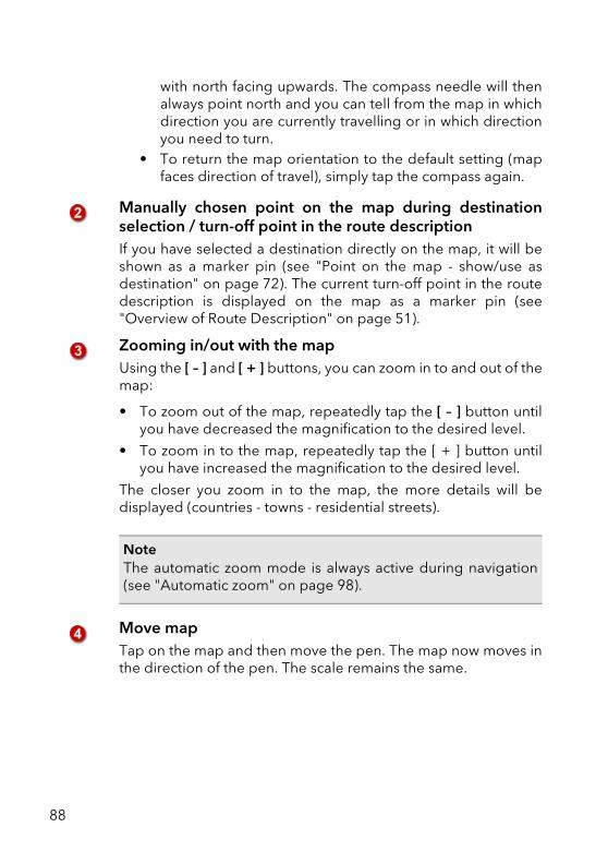
with north facing upwards. The compass needle will thenalways point north and you can tell from the map in whichdirection you are currently travelling or in which directionyou need to turn.
• To return the map orientation to the default setting (mapfaces direction of travel), simply tap the compass again.
Manually chosen point on the map during destinationselection / turn-off point in the route descriptionIf you have selected a destination directly on the map, it will beshown as a marker pin (see "Point on the map - show/use asdestination" on page 72). The current turn-off point in the routedescription is displayed on the map as a marker pin (see"Overview of Route Description" on page 51).
Zooming in/out with the mapUsing the [ – ] and [ + ] buttons, you can zoom in to and out of themap:
• To zoom out of the map, repeatedly tap the [ – ] button untilyou have decreased the magnification to the desired level.
• To zoom in to the map, repeatedly tap the [ + ] button untilyou have increased the magnification to the desired level.
The closer you zoom in to the map, the more details will bedisplayed (countries - towns - residential streets).
Move mapTap on the map and then move the pen. The map now moves inthe direction of the pen. The scale remains the same.
NoteThe automatic zoom mode is always active during navigation(see "Automatic zoom" on page 98).
88
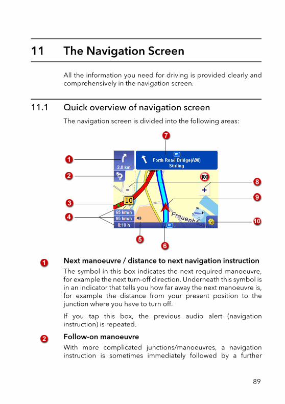
11 The Navigation Screen
All the information you need for driving is provided clearly andcomprehensively in the navigation screen.
11.1 Quick overview of navigation screenThe navigation screen is divided into the following areas:
Next manoeuvre / distance to next navigation instructionThe symbol in this box indicates the next required manoeuvre,for example the next turn-off direction. Underneath this symbol isin an indicator that tells you how far away the next manoeuvre is,for example the distance from your present position to thejunction where you have to turn off.
If you tap this box, the previous audio alert (navigationinstruction) is repeated.
Follow-on manoeuvreWith more complicated junctions/manoeuvres, a navigationinstruction is sometimes immediately followed by a further
89
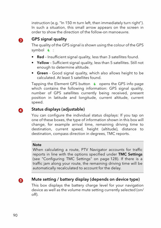
instruction (e.g. "In 150 m turn left, then immediately turn right").In such a situation, this small arrow appears on the screen inorder to show the direction of the follow-on manoeuvre.
GPS signal qualityThe quality of the GPS signal is shown using the colour of the GPSsymbol :
• Red – Insufficient signal quality, less than 3 satellites found.
• Yellow – Sufficient signal quality, less than 5 satellites. Still notenough to determine altitude.
• Green – Good signal quality, which also allows height to becalculated. At least 5 satellites found.
Tapping the Element GPS button opens the GPS info pagewhich contains the following information: GPS signal quality,number of GPS satellites currently being received, presentposition in latitude and longitude, current altitude, currentspeed.
Status displays (adjustable)You can configure the individual status displays: If you tap onone of these boxes, the type of information shown in this box willchange, for example arrival time, remaining driving time todestination, current speed, height (altitude), distance todestination, compass direction in degrees, TMC reports.
Mute setting / battery display (depends on device type)This box displays the battery charge level for your navigationdevice as well as the volume mute setting currently selected (on/off).
NoteWhen calculating a route, PTV Navigator accounts for trafficreports in line with the options specified under TMC Settings(see "Configuring TMC Settings" on page 128). If there is atraffic jam along your route, the remaining driving time will beautomatically recalculated to account for the delay.
90
Chapter 16: The Navigation Screen
You can activate or deactivate the mute setting by clicking oneither of the two symbols (battery display or mute setting) - this isfor greater ease of use.
Name of the road you are currently onHere you see the name of the road that you are currently drivingon.
Name of the street after the next manoeuvre / signpost Here you will see, for example, the name of the next road thatyou have to turn in to. Additional signposts are often shownwhich are based on the road signs.
Zooming in the navigation screen PTV Navigator adjusts the size/zoom level of the map sectionaccording to the current speed. You can also manually adjust thezoom level of the map:
• To zoom out of the map, repeatedly tap the [ – ] button untilyou have decreased the magnification to the desired level.
• To zoom in to the map, repeatedly tap the [ + ] button untilyou have increased the magnification to the desired level.
Map viewThe map view is constantly updated using the GPS signal andalways shows you your current position. You can choosebetween a two dimensional or three dimensional map display(see "3D / 2D" on page 99).
NoteAs soon as you change the volume in the basic navigationfunctions, the mute setting is deactivated.
NoteWhen zooming in the navigation screen the automatic zoomfunction is deactivated. In order to activate the automatic zoomagain, access the navigation options in the navigation screen
using the button and click the symbol Automatic Zoom.
91
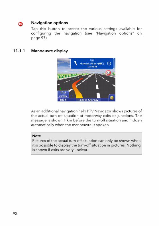
Navigation optionsTap this button to access the various settings available forconfiguring the navigation (see "Navigation options" onpage 97).
11.1.1 Manoeuvre display
As an additional navigation help PTV Navigator shows pictures ofthe actual turn-off situation at motorway exits or junctions. Themessage is shown 1 km before the turn-off situation and hiddenautomatically when the manoeuvre is spoken.
NotePictures of the actual turn-off situation can only be shown whenit is possible to display the turn-off situation in pictures. Nothingis shown if exits are very unclear.
92
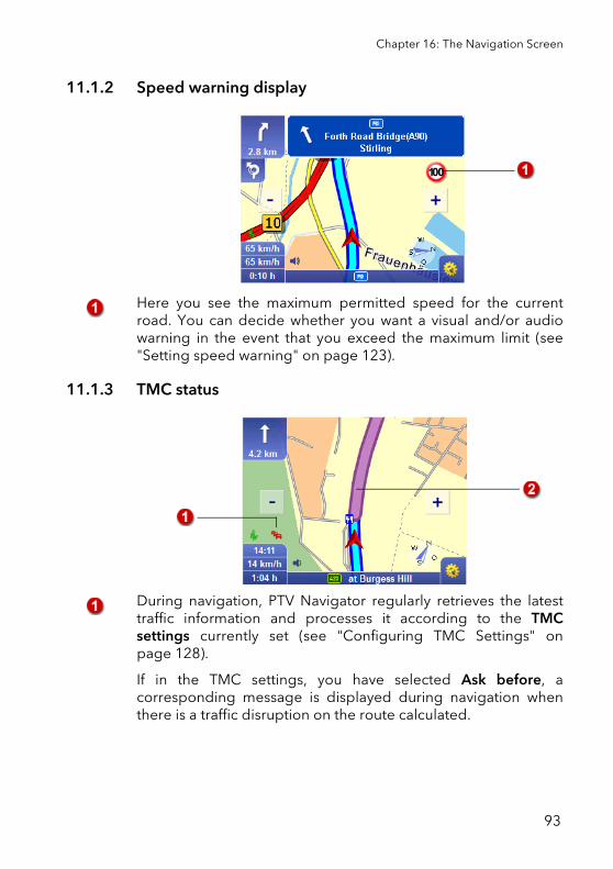
Chapter 16: The Navigation Screen
11.1.2 Speed warning display
Here you see the maximum permitted speed for the currentroad. You can decide whether you want a visual and/or audiowarning in the event that you exceed the maximum limit (see"Setting speed warning" on page 123).
11.1.3 TMC status
During navigation, PTV Navigator regularly retrieves the latesttraffic information and processes it according to the TMCsettings currently set (see "Configuring TMC Settings" onpage 128).
If in the TMC settings, you have selected Ask before, acorresponding message is displayed during navigation whenthere is a traffic disruption on the route calculated.
93
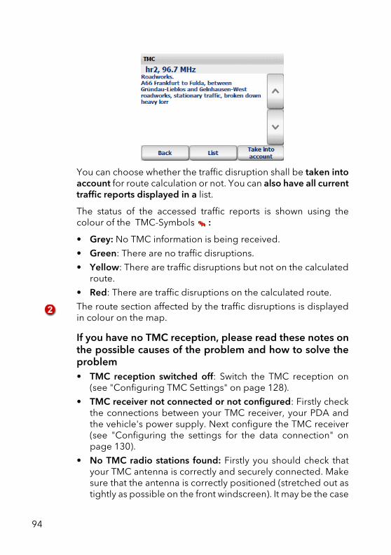
You can choose whether the traffic disruption shall be taken intoaccount for route calculation or not. You can also have all currenttraffic reports displayed in a list.
The status of the accessed traffic reports is shown using thecolour of the TMC-Symbols :
• Grey: No TMC information is being received.
• Green: There are no traffic disruptions.
• Yellow: There are traffic disruptions but not on the calculatedroute.
• Red: There are traffic disruptions on the calculated route.
The route section affected by the traffic disruptions is displayedin colour on the map.
If you have no TMC reception, please read these notes onthe possible causes of the problem and how to solve theproblem• TMC reception switched off: Switch the TMC reception on
(see "Configuring TMC Settings" on page 128).
• TMC receiver not connected or not configured: Firstly checkthe connections between your TMC receiver, your PDA andthe vehicle's power supply. Next configure the TMC receiver(see "Configuring the settings for the data connection" onpage 130).
• No TMC radio stations found: Firstly you should check thatyour TMC antenna is correctly and securely connected. Makesure that the antenna is correctly positioned (stretched out astightly as possible on the front windscreen). It may be the case
94
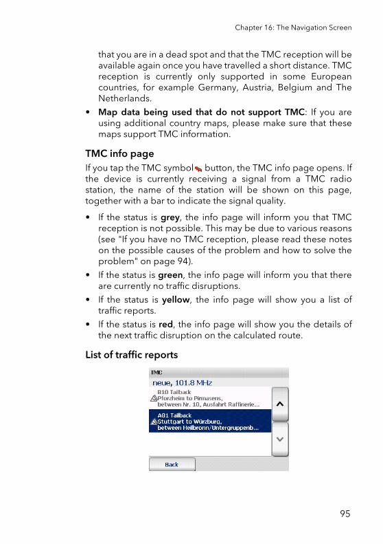
Chapter 16: The Navigation Screen
that you are in a dead spot and that the TMC reception will beavailable again once you have travelled a short distance. TMCreception is currently only supported in some Europeancountries, for example Germany, Austria, Belgium and TheNetherlands.
• Map data being used that do not support TMC: If you areusing additional country maps, please make sure that thesemaps support TMC information.
TMC info page If you tap the TMC symbol button, the TMC info page opens. Ifthe device is currently receiving a signal from a TMC radiostation, the name of the station will be shown on this page,together with a bar to indicate the signal quality.
• If the status is grey, the info page will inform you that TMCreception is not possible. This may be due to various reasons(see "If you have no TMC reception, please read these noteson the possible causes of the problem and how to solve theproblem" on page 94).
• If the status is green, the info page will inform you that thereare currently no traffic disruptions.
• If the status is yellow, the info page will show you a list oftraffic reports.
• If the status is red, the info page will show you the details ofthe next traffic disruption on the calculated route.
List of traffic reports
95
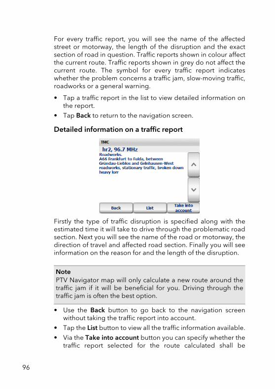
For every traffic report, you will see the name of the affectedstreet or motorway, the length of the disruption and the exactsection of road in question. Traffic reports shown in colour affectthe current route. Traffic reports shown in grey do not affect thecurrent route. The symbol for every traffic report indicateswhether the problem concerns a traffic jam, slow-moving traffic,roadworks or a general warning.
• Tap a traffic report in the list to view detailed information onthe report.
• Tap Back to return to the navigation screen.
Detailed information on a traffic report
Firstly the type of traffic disruption is specified along with theestimated time it will take to drive through the problematic roadsection. Next you will see the name of the road or motorway, thedirection of travel and affected road section. Finally you will seeinformation on the reason for and the length of the disruption.
• Use the Back button to go back to the navigation screenwithout taking the traffic report into account.
• Tap the List button to view all the traffic information available.
• Via the Take into account button you can specify whether thetraffic report selected for the route calculated shall be
NotePTV Navigator map will only calculate a new route around thetraffic jam if it will be beneficial for you. Driving through thetraffic jam is often the best option.
96
Chapter 16: The Navigation Screen
considered for route planning or not.However PTV Navigatorwill only calculate a new route if it will be beneficial for you.Driving through the traffic jam is often the best option.
11.2 Navigation options1. To open the navigation options, tap this symbol in the
navigation screen.The window with the navigation options opens.
11.2.1 Turning pages
The navigation options are divided amongst several pages. Thenext page is shown by clicking the arrow.
11.2.2 Cancel
Tapping the Cancel button will exit the navigation mode and youreturn to the destination selection screen.
11.2.3 Back
Tap Back to return to the navigation screen.
11.2.4 Volume + / Volume -
Tap the Volume - symbol to reduce the volume level. A voicealert is played as an example to indicate the volume level of thenew setting. Keep tapping the symbol until the desired volumelevel has been reached.
Tap the Volume + symbol to increase the volume level. A voicealert is played as an example to indicate the volume level of thenew setting. Keep tapping the symbol until the desired volumelevel has been reached.
97
11.2.5 Day / night
If you tap the Day/Night symbol, you can switch between daymode and night mode for the map.
If you are driving at night or through a tunnel, select night mode.The brightness of the CarPC/PDA screen is reduced so that youare not dazzled by the brightness of the screen.
11.2.6 Automatic zoom
The automatic zoom mode is always active during navigation.With this function, the map scale will automatically changeaccording to the current speed of the vehicle. This means that ifyou drive slowly, the program will zoom into the map and if youdrive faster, the program will zoom out of the map.
If you manually change the zoom level in the navigation screen,automatic zoom is disabled.
Click Automatic zoom, if you wish to enable the automatic zoomwith the preset values again.
11.2.7 Avoid road
1. Tap the symbol Avoid road to close a road between 1 and 20km/miles in length for navigation.
2. Select the length of road you wish to avoid for navigation.3. Confirm your changes with OK.
NoteIf during navigation you manually switch to the day or nightmode, the Day/Night auto setting is deactivated (see "Day/Night auto setting" on page 132).
NoteThe length of the road section will be calculated in kilometres (km) ormiles (mi), depending on the unit of measurement you are using onyour CarPC/PDA (see "Hanging the unit of measurement" onpage 127).
98
Chapter 16: The Navigation Screen
PTV Navigator takes you off the specified road via the nearestpossible junction and then recalculates the route. On amotorway, the next exit is used as the starting point of thediversion.
11.2.8 3D / 2D
If you tap the 3D/2D symbol, you can switch between a twodimensional or three dimensional map display.
The 3D map viewThe 3D map view supports the spatial arrow view and map viewfor navigation.
The 2D map viewThe 2D map view supports the two-dimensional arrow view andmap view for navigation.
99
This arrow indicates your current GPS position and direction oftravel.
The course of the route is highlighted on the map in colour.Therefore you can see at a glance whether you are still on course.
The default setting is that the map faces the direction of travel.Using the compass you can change the orientation of the map.
• Map points northTo reconfigure the map so that it always points north, tap thecompass once. The map orientation is then graduallyadjusted until it is facing north. The compass needle thenalways points north and you can tell from the map in whichdirection you are currently travelling or in which direction youneed to turn.
• Map turns to driving directionTo return the map orientation to the default setting (mapfaces direction of travel), simply tap the compass again.
A scale for the current map view is shown.
100
Chapter 16: The Navigation Screen
11.2.9 Speed warning on/off
By tapping the Speed warning on/off button, you can activate/deactivate the speed limit warnings.
The maximum permitted speed is always displayed in thenavigation screen regardless of this setting.
You can configure various settings for the speed limit warnings(see "Setting speed warning" on page 123).
11.2.10 Hazard warning on/off (for trucks only)
During your trip the hazard warning warns you of typical hazardsfor trucks, for example cross wind, downhill roads, dangerouscurves etc.
You can configure various settings for the hazard warnings (see"Setting hazard warning for trucks" on page 121).
WARNINGDanger of accidents!You can now also activate speed warnings for car speed limitswhen a truck profile has been selected. Please note thatdifferent speed limits may apply to trucks than to cars.
101
11.2.11 Special destinations
If you tap Special destinations, you can then search for POIs (forexample car parks) close to your current position and thennavigate to the chosen POI (see "Searching for POIs within atown/street" on page 81).
11.2.12 Recalculate
If you tap the Recalculate button during the journey, the route tothe specified destination will be recalculated - starting from yourcurrent position.
This recalculation is useful, for example, when you select a roadduring the journey which is different to the one suggested byPTV Navigator.
11.2.13 Add to favourites
If you tap the Add to favourites button, your current GPS positionwill be added to your list of favourites and can be quicklyselected as a destination in future.
11.2.14 Navigation info page
Tapping the Info button opens the navigation info page whichcontains the following information: distance to destination,estimated time of arrival, current altitude, current speed,distance to next manoeuvre and destination.
11.2.15 Route
If you tap the Route symbol, the route description for thecalculated route is displayed (see "Route Planning with PTVNavigator" on page 49).
102
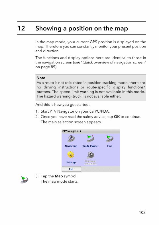
12 Showing a position on the map
In the map mode, your current GPS position is displayed on themap: Therefore you can constantly monitor your present positionand direction.
The functions and display options here are identical to those inthe navigation screen (see "Quick overview of navigation screen"on page 89).
And this is how you get started:
1. Start PTV Navigator on your carPC/PDA.2. Once you have read the safety advice, tap OK to continue.
The main selection screen appears.
3. Tap the Map symbol.The map mode starts.
NoteAs a route is not calculated in position-tracking mode, there areno driving instructions or route-specific display functions/buttons. The speed limit warning is not available in this mode.The hazard warning (truck) is not available either.
103
12.1 Exit map mode1. Tap this button in the navigation screen.
The basic navigation functions are displayed.
2. Tap the Cancel button.
The map mode is stopped and you return to the main selectionscreen.
104
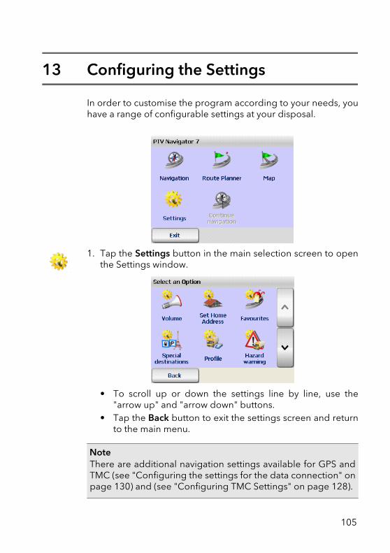
13 Configuring the Settings
In order to customise the program according to your needs, youhave a range of configurable settings at your disposal.
1. Tap the Settings button in the main selection screen to openthe Settings window.
• To scroll up or down the settings line by line, use the"arrow up" and "arrow down" buttons.
• Tap the Back button to exit the settings screen and returnto the main menu.
NoteThere are additional navigation settings available for GPS andTMC (see "Configuring the settings for the data connection" onpage 130) and (see "Configuring TMC Settings" on page 128).
105
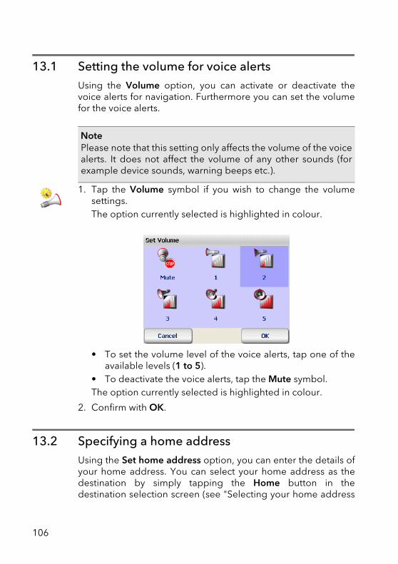
13.1 Setting the volume for voice alertsUsing the Volume option, you can activate or deactivate thevoice alerts for navigation. Furthermore you can set the volumefor the voice alerts.
1. Tap the Volume symbol if you wish to change the volumesettings.The option currently selected is highlighted in colour.
.
• To set the volume level of the voice alerts, tap one of theavailable levels (1 to 5).
• To deactivate the voice alerts, tap the Mute symbol.The option currently selected is highlighted in colour.
2. Confirm with OK.
13.2 Specifying a home addressUsing the Set home address option, you can enter the details ofyour home address. You can select your home address as thedestination by simply tapping the Home button in thedestination selection screen (see "Selecting your home address
NotePlease note that this setting only affects the volume of the voicealerts. It does not affect the volume of any other sounds (forexample device sounds, warning beeps etc.).
106
Chapter 18: Configuring the Settings
as the destination" on page 71). It is also possible to choose yourhome address as the starting point for route planning (see"Selecting the starting point and destination" on page 50).
Therefore you can quickly navigate your way back home or plana route from your home to any address of your choice.
1. Tap Set home address to use your home address asdestination for navigation or route planning.The destination selection screen appears.
2. When specifying your home address, you can use newaddresses, favourite addresses or previous addresses (see"Selecting a Destination" on page 55).Once you have chosen an address, you will automaticallyreturn to the settings screen.
Your chosen home address will be displayed above the Homesymbol in the destination selection screen (see "Selecting yourhome address as the destination" on page 71).
13.3 Adding/editing favouritesIn PTV Navigator you can create new favourite destinations aswell as edit existing ones.
1. Tap Favourites in the Settings screen to add new favourites oredit existing favourites.The list of favourite destinations appears.
NoteIn the list of Previous destinations you can select the homeaddress using the entry Home.
107
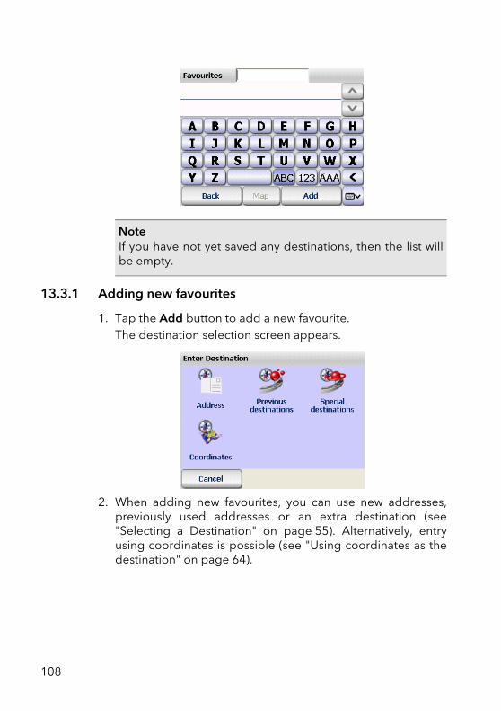
13.3.1 Adding new favourites
1. Tap the Add button to add a new favourite.The destination selection screen appears.
2. When adding new favourites, you can use new addresses,previously used addresses or an extra destination (see"Selecting a Destination" on page 55). Alternatively, entryusing coordinates is possible (see "Using coordinates as thedestination" on page 64).
NoteIf you have not yet saved any destinations, then the list willbe empty.
108
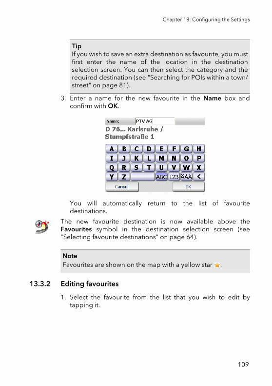
Chapter 18: Configuring the Settings
3. Enter a name for the new favourite in the Name box andconfirm with OK.
You will automatically return to the list of favouritedestinations.
The new favourite destination is now available above theFavourites symbol in the destination selection screen (see"Selecting favourite destinations" on page 64).
13.3.2 Editing favourites
1. Select the favourite from the list that you wish to edit bytapping it.
TipIf you wish to save an extra destination as favourite, you mustfirst enter the name of the location in the destinationselection screen. You can then select the category and therequired destination (see "Searching for POIs within a town/street" on page 81).
NoteFavourites are shown on the map with a yellow star .
109
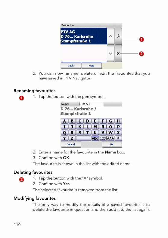
2. You can now rename, delete or edit the favourites that youhave saved in PTV Navigator.
Renaming favourites1. Tap the button with the pen symbol.
2. Enter a name for the favourite in the Name box.3. Confirm with OK.
The favourite is shown in the list with the edited name.
Deleting favourites1. Tap the button with the "X" symbol.2. Confirm with Yes.
The selected favourite is removed from the list.
Modifying favouritesThe only way to modify the details of a saved favourite is todelete the favourite in question and then add it to the list again.
110
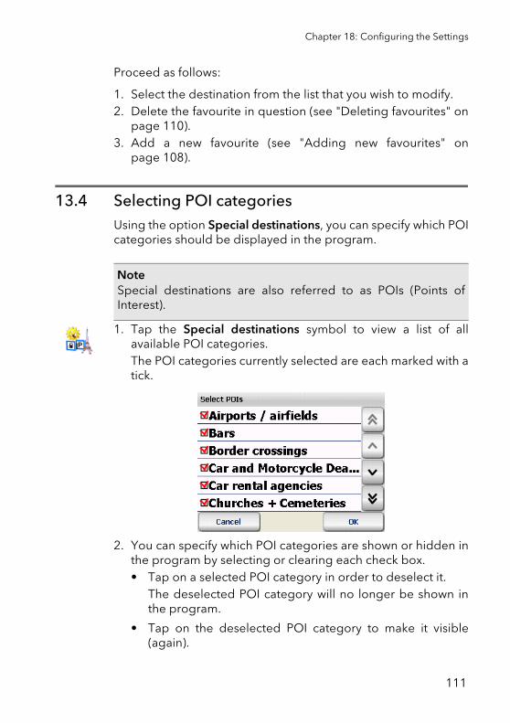
Chapter 18: Configuring the Settings
Proceed as follows:
1. Select the destination from the list that you wish to modify.2. Delete the favourite in question (see "Deleting favourites" on
page 110).3. Add a new favourite (see "Adding new favourites" on
page 108).
13.4 Selecting POI categoriesUsing the option Special destinations, you can specify which POIcategories should be displayed in the program.
1. Tap the Special destinations symbol to view a list of allavailable POI categories.The POI categories currently selected are each marked with atick.
2. You can specify which POI categories are shown or hidden inthe program by selecting or clearing each check box.• Tap on a selected POI category in order to deselect it.
The deselected POI category will no longer be shown inthe program.
• Tap on the deselected POI category to make it visible(again).
NoteSpecial destinations are also referred to as POIs (Points ofInterest).
111
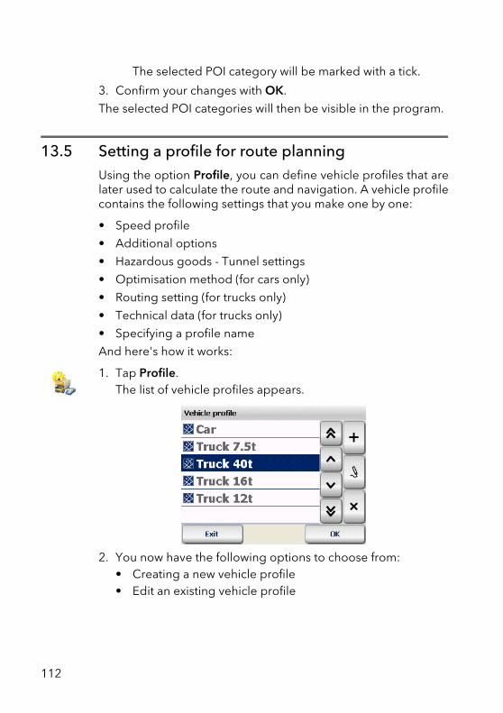
The selected POI category will be marked with a tick.
3. Confirm your changes with OK.
The selected POI categories will then be visible in the program.
13.5 Setting a profile for route planningUsing the option Profile, you can define vehicle profiles that arelater used to calculate the route and navigation. A vehicle profilecontains the following settings that you make one by one:
• Speed profile
• Additional options
• Hazardous goods - Tunnel settings
• Optimisation method (for cars only)
• Routing setting (for trucks only)
• Technical data (for trucks only)
• Specifying a profile name
And here's how it works:
1. Tap Profile.The list of vehicle profiles appears.
2. You now have the following options to choose from:• Creating a new vehicle profile• Edit an existing vehicle profile
112
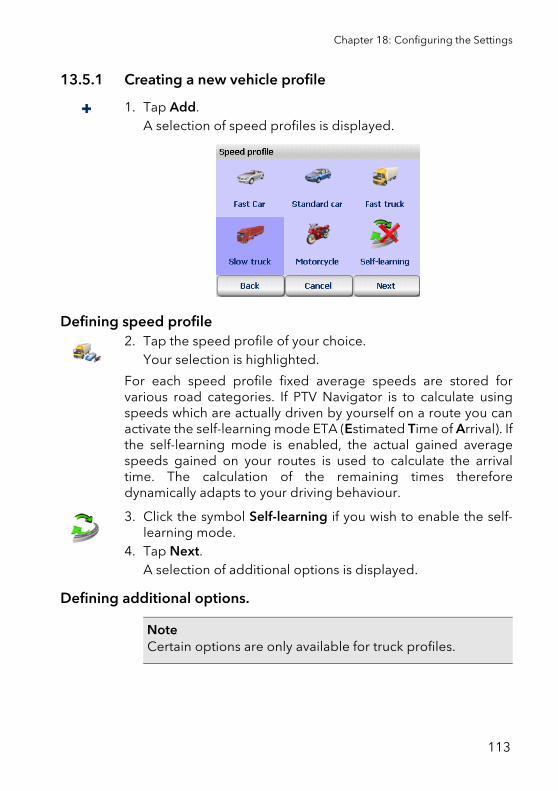
Chapter 18: Configuring the Settings
13.5.1 Creating a new vehicle profile
1. Tap Add.A selection of speed profiles is displayed.
Defining speed profile2. Tap the speed profile of your choice.
Your selection is highlighted.
For each speed profile fixed average speeds are stored forvarious road categories. If PTV Navigator is to calculate usingspeeds which are actually driven by yourself on a route you canactivate the self-learning mode ETA (Estimated Time of Arrival). Ifthe self-learning mode is enabled, the actual gained averagespeeds gained on your routes is used to calculate the arrivaltime. The calculation of the remaining times thereforedynamically adapts to your driving behaviour.
3. Click the symbol Self-learning if you wish to enable the self-learning mode.
4. Tap Next.A selection of additional options is displayed.
Defining additional options.
NoteCertain options are only available for truck profiles.
113
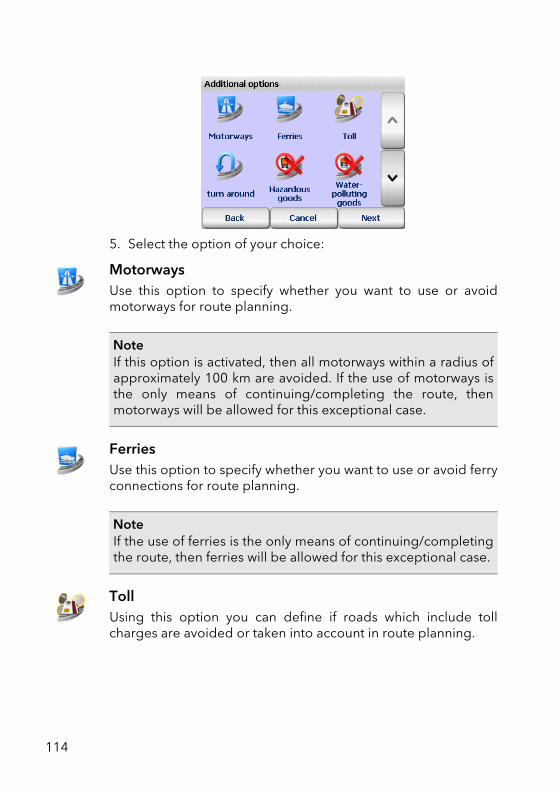
5. Select the option of your choice:
MotorwaysUse this option to specify whether you want to use or avoidmotorways for route planning.
FerriesUse this option to specify whether you want to use or avoid ferryconnections for route planning.
TollUsing this option you can define if roads which include tollcharges are avoided or taken into account in route planning.
NoteIf this option is activated, then all motorways within a radius ofapproximately 100 km are avoided. If the use of motorways isthe only means of continuing/completing the route, thenmotorways will be allowed for this exceptional case.
NoteIf the use of ferries is the only means of continuing/completingthe route, then ferries will be allowed for this exceptional case.
114
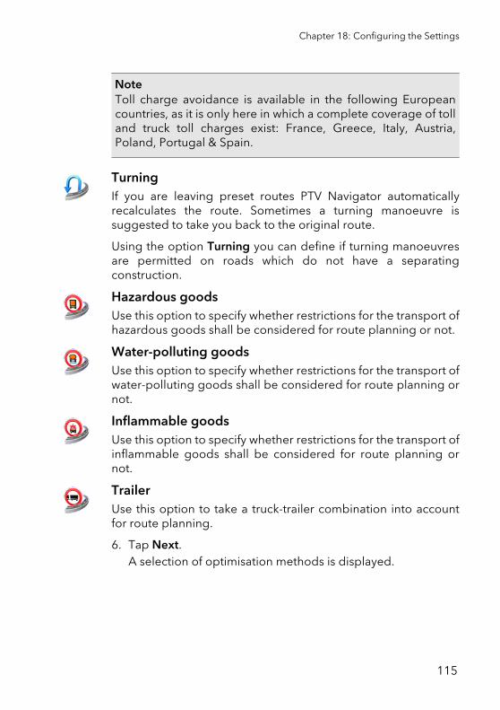
Chapter 18: Configuring the Settings
TurningIf you are leaving preset routes PTV Navigator automaticallyrecalculates the route. Sometimes a turning manoeuvre issuggested to take you back to the original route.
Using the option Turning you can define if turning manoeuvresare permitted on roads which do not have a separatingconstruction.
Hazardous goodsUse this option to specify whether restrictions for the transport ofhazardous goods shall be considered for route planning or not.
Water-polluting goodsUse this option to specify whether restrictions for the transport ofwater-polluting goods shall be considered for route planning ornot.
Inflammable goodsUse this option to specify whether restrictions for the transport ofinflammable goods shall be considered for route planning ornot.
TrailerUse this option to take a truck-trailer combination into accountfor route planning.
6. Tap Next.A selection of optimisation methods is displayed.
NoteToll charge avoidance is available in the following Europeancountries, as it is only here in which a complete coverage of tolland truck toll charges exist: France, Greece, Italy, Austria,Poland, Portugal & Spain.
115
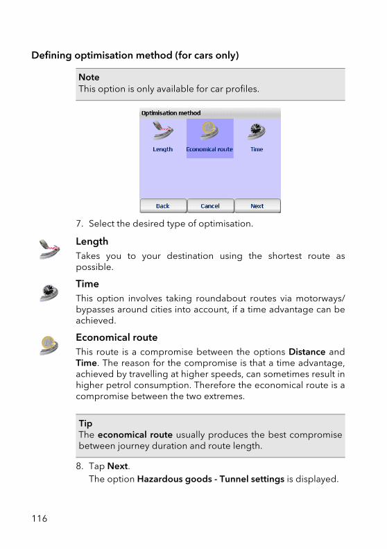
Defining optimisation method (for cars only)
7. Select the desired type of optimisation.
LengthTakes you to your destination using the shortest route aspossible.
Time This option involves taking roundabout routes via motorways/bypasses around cities into account, if a time advantage can beachieved.
Economical routeThis route is a compromise between the options Distance andTime. The reason for the compromise is that a time advantage,achieved by travelling at higher speeds, can sometimes result inhigher petrol consumption. Therefore the economical route is acompromise between the two extremes.
8. Tap Next.The option Hazardous goods - Tunnel settings is displayed.
NoteThis option is only available for car profiles.
TipThe economical route usually produces the best compromisebetween journey duration and route length.
116
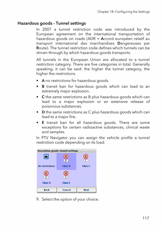
Chapter 18: Configuring the Settings
Hazardous goods - Tunnel settingsIn 2007 a tunnel restriction code was introduced by theEuropean agreement on the international transportation ofhazardous goods on roads (ADR = Accord européen relatif autransport international des marchandises Dangereuses parRoute). The tunnel restriction code defines which tunnels can bedriven through by which hazardous goods transports.
All tunnels in the European Union are allocated to a tunnelrestriction category. There are five categories in total. Generallyspeaking, it can be said: the higher the tunnel category, thehigher the restrictions.
• A no restrictions for hazardous goods.
• B transit ban for hazardous goods which can lead to anextremely major explosion.
• C the same restrictions as B plus hazardous goods which canlead to a major explosion or an extensive release ofpoisonous substances.
• D the same restrictions as C plus hazardous goods which canlead to a major fire.
• E transit ban for all hazardous goods. There are someexceptions for certain radioactive substances, clinical wasteand samples.
In PTV Navigator you can assign the vehicle profile a tunnelrestriction code depending on its load.
9. Select the option of your choice.
117
No restrictionAll tunnels are included in route planning.
Class BA vehicle with a class B load may not drive through tunnels withcategory B, C, D and E.
Only tunnels with category A are included in route planning.
Class CA vehicle with a class C load may not drive through tunnels withcategory C, D and E.
Only tunnels with category A and B are included in routeplanning.
Class DA vehicle with a class D load may not drive through tunnels withcategory D and E.
Only tunnels with category A, B and C are included in routeplanning.
Class EA vehicle with a class E load may not drive through tunnels withcategory E.
Only tunnels with category A, B, C and D are included in routeplanning.
10.Tap Next.A selection of routing settings is displayed.
Defining route settings (only for trucks)
NoteThis option is only available for truck profiles.
118
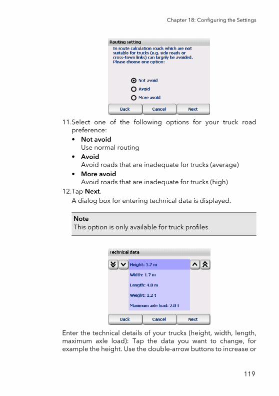
Chapter 18: Configuring the Settings
11.Select one of the following options for your truck roadpreference:• Not avoid
Use normal routing• Avoid
Avoid roads that are inadequate for trucks (average)• More avoid
Avoid roads that are inadequate for trucks (high)12.Tap Next.
A dialog box for entering technical data is displayed.
Enter the technical details of your trucks (height, width, length,maximum axle load): Tap the data you want to change, forexample the height. Use the double-arrow buttons to increase or
NoteThis option is only available for truck profiles.
119
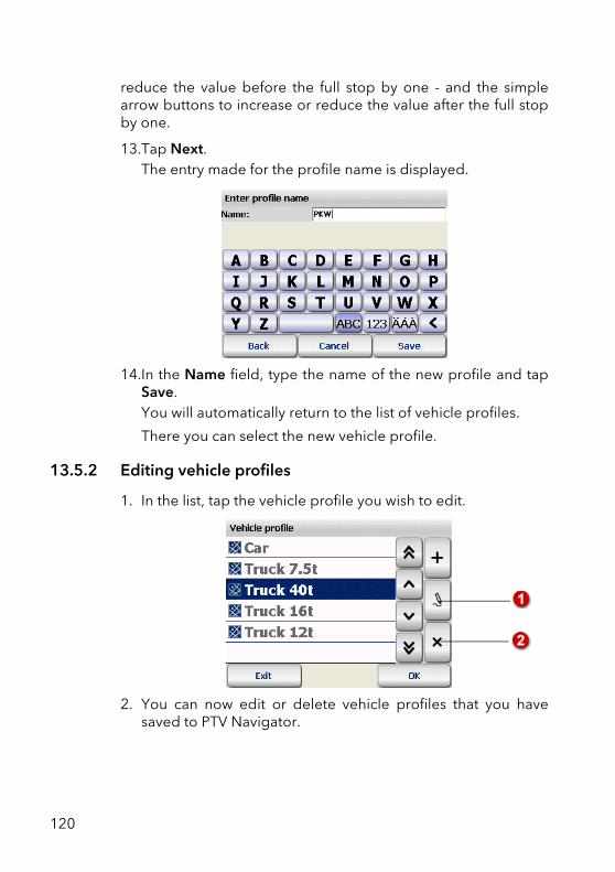
reduce the value before the full stop by one - and the simplearrow buttons to increase or reduce the value after the full stopby one.
13.Tap Next.The entry made for the profile name is displayed.
14.In the Name field, type the name of the new profile and tapSave.You will automatically return to the list of vehicle profiles.
There you can select the new vehicle profile.
13.5.2 Editing vehicle profiles
1. In the list, tap the vehicle profile you wish to edit.
2. You can now edit or delete vehicle profiles that you havesaved to PTV Navigator.
120
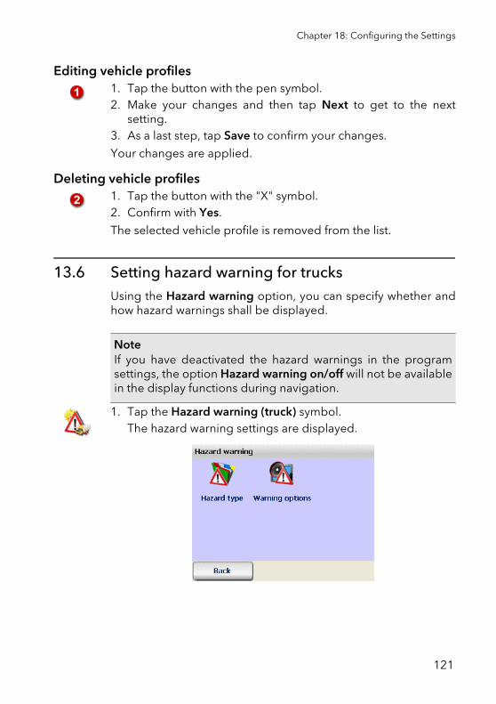
Chapter 18: Configuring the Settings
Editing vehicle profiles1. Tap the button with the pen symbol.2. Make your changes and then tap Next to get to the next
setting.3. As a last step, tap Save to confirm your changes.
Your changes are applied.
Deleting vehicle profiles1. Tap the button with the "X" symbol.2. Confirm with Yes.
The selected vehicle profile is removed from the list.
13.6 Setting hazard warning for trucksUsing the Hazard warning option, you can specify whether andhow hazard warnings shall be displayed.
1. Tap the Hazard warning (truck) symbol. The hazard warning settings are displayed.
NoteIf you have deactivated the hazard warnings in the programsettings, the option Hazard warning on/off will not be availablein the display functions during navigation.
121
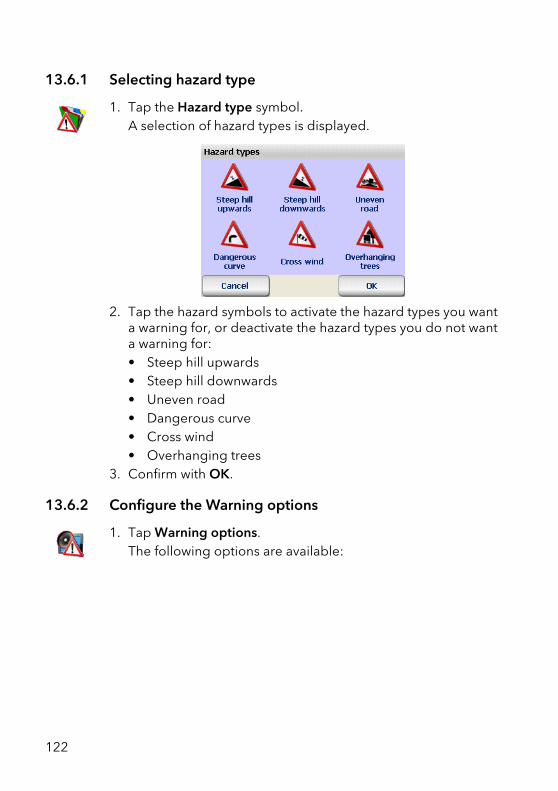
13.6.1 Selecting hazard type
1. Tap the Hazard type symbol. A selection of hazard types is displayed.
2. Tap the hazard symbols to activate the hazard types you wanta warning for, or deactivate the hazard types you do not wanta warning for:• Steep hill upwards• Steep hill downwards• Uneven road• Dangerous curve• Cross wind• Overhanging trees
3. Confirm with OK.
13.6.2 Configure the Warning options
1. Tap Warning options. The following options are available:
122
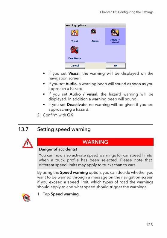
Chapter 18: Configuring the Settings
• If you set Visual, the warning will be displayed on thenavigation screen.
• If you set Audio, a warning beep will sound as soon as youapproach a hazard.
• If you set Audio / visual, the hazard warning will bedisplayed. In addition a warning beep will sound.
• If you set Deactivate, no warning will be given if you areapproaching a hazard.
2. Confirm with OK.
13.7 Setting speed warning
By using the Speed warning option, you can decide whether youwant to be warned through a message on the navigation screenif you exceed a speed limit, which types of road the warningsshould apply to and what speed should trigger the warnings.
1. Tap Speed warning.
WARNINGDanger of accidents!You can now also activate speed warnings for car speed limitswhen a truck profile has been selected. Please note thatdifferent speed limits may apply to trucks than to cars.
123
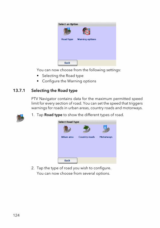
You can now choose from the following settings:
• Selecting the Road type• Configure the Warning options
13.7.1 Selecting the Road type
PTV Navigator contains data for the maximum permitted speedlimit for every section of road. You can set the speed that triggerswarnings for roads in urban areas, country roads and motorways.
1. Tap Road type to show the different types of road.
2. Tap the type of road you wish to configure.You can now choose from several options.
124
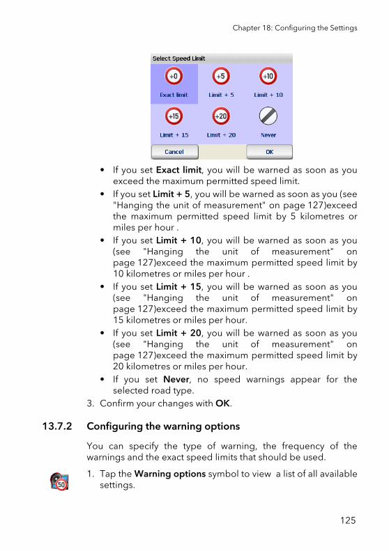
Chapter 18: Configuring the Settings
• If you set Exact limit, you will be warned as soon as youexceed the maximum permitted speed limit.
• If you set Limit + 5, you will be warned as soon as you (see"Hanging the unit of measurement" on page 127)exceedthe maximum permitted speed limit by 5 kilometres ormiles per hour .
• If you set Limit + 10, you will be warned as soon as you(see "Hanging the unit of measurement" onpage 127)exceed the maximum permitted speed limit by10 kilometres or miles per hour .
• If you set Limit + 15, you will be warned as soon as you(see "Hanging the unit of measurement" onpage 127)exceed the maximum permitted speed limit by15 kilometres or miles per hour.
• If you set Limit + 20, you will be warned as soon as you(see "Hanging the unit of measurement" onpage 127)exceed the maximum permitted speed limit by20 kilometres or miles per hour.
• If you set Never, no speed warnings appear for theselected road type.
3. Confirm your changes with OK.
13.7.2 Configuring the warning options
You can specify the type of warning, the frequency of thewarnings and the exact speed limits that should be used.
1. Tap the Warning options symbol to view a list of all availablesettings.
125
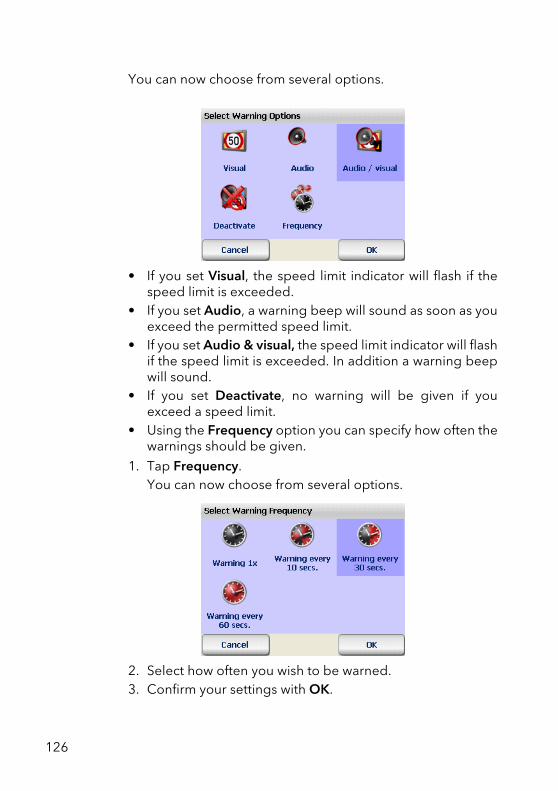
You can now choose from several options.
• If you set Visual, the speed limit indicator will flash if thespeed limit is exceeded.
• If you set Audio, a warning beep will sound as soon as youexceed the permitted speed limit.
• If you set Audio & visual, the speed limit indicator will flashif the speed limit is exceeded. In addition a warning beepwill sound.
• If you set Deactivate, no warning will be given if youexceed a speed limit.
• Using the Frequency option you can specify how often thewarnings should be given.
1. Tap Frequency.You can now choose from several options.
2. Select how often you wish to be warned.3. Confirm your settings with OK.
126
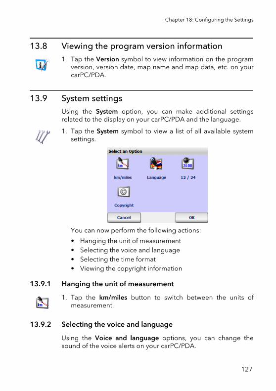
Chapter 18: Configuring the Settings
13.8 Viewing the program version information1. Tap the Version symbol to view information on the program
version, version date, map name and map data, etc. on yourcarPC/PDA.
13.9 System settingsUsing the System option, you can make additional settingsrelated to the display on your carPC/PDA and the language.
1. Tap the System symbol to view a list of all available systemsettings.
You can now perform the following actions:
• Hanging the unit of measurement• Selecting the voice and language• Selecting the time format• Viewing the copyright information
13.9.1 Hanging the unit of measurement
1. Tap the km/miles button to switch between the units ofmeasurement.
13.9.2 Selecting the voice and language
Using the Voice and language options, you can change thesound of the voice alerts on your carPC/PDA.
127
1. Tap the Language symbol to view a list of all availablelanguages.
2. Tap a language to select it.The selected language will be shown in the list.
3. Confirm with Yes.A new page opens. Here you can select the type of voice forthe voice alerts.
4. Tap the male or female voice to select.
5. Confirm your changes with OK.
The voice instructions you hear during navigation will now bespoken in your chosen language and by your chosen narrator.
13.9.3 Selecting the time format
1. Tap the 12 /24 button to switch the time format between the12 hour or 24 hour system.
13.9.4 Viewing the copyright information
1. Tap the Copyright symbol to view the copyright information.
13.10 Configuring TMC SettingsPTV Navigator has the capability to receive the latest trafficreports transmitted via RDS/TMC radio signals and process thisinformation while navigation is running. In order for this functionto work, the TMC receiver must be configured correctly (see"Configuring the settings for the data connection" on page 130).
The TMC traffic reports provide you with information on thecause of the traffic disruption, the name of the affected street or
NoteVoice outputs with the ID "TTS" (Text To Speech) as nameextension also say the turning direction and the name of thestreet which should be turned into.
128
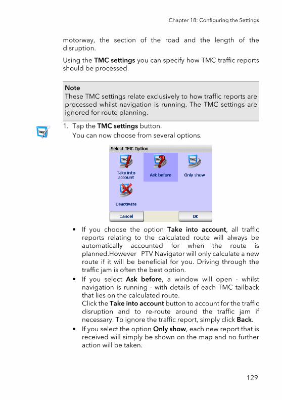
Chapter 18: Configuring the Settings
motorway, the section of the road and the length of thedisruption.
Using the TMC settings you can specify how TMC traffic reportsshould be processed.
1. Tap the TMC settings button.You can now choose from several options.
• If you choose the option Take into account, all trafficreports relating to the calculated route will always beautomatically accounted for when the route isplanned.However PTV Navigator will only calculate a newroute if it will be beneficial for you. Driving through thetraffic jam is often the best option.
• If you select Ask before, a window will open - whilstnavigation is running - with details of each TMC tailbackthat lies on the calculated route.Click the Take into account button to account for the trafficdisruption and to re-route around the traffic jam ifnecessary. To ignore the traffic report, simply click Back.
• If you select the option Only show, each new report that isreceived will simply be shown on the map and no furtheraction will be taken.
NoteThese TMC settings relate exclusively to how traffic reports areprocessed whilst navigation is running. The TMC settings areignored for route planning.
129
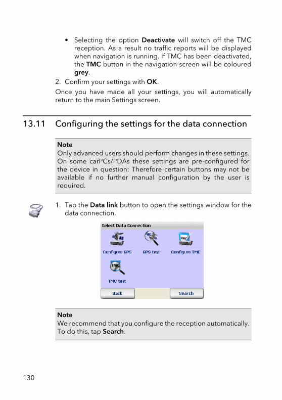
• Selecting the option Deactivate will switch off the TMCreception. As a result no traffic reports will be displayedwhen navigation is running. If TMC has been deactivated,the TMC button in the navigation screen will be colouredgrey.
2. Confirm your settings with OK.
Once you have made all your settings, you will automaticallyreturn to the main Settings screen.
13.11 Configuring the settings for the data connection
1. Tap the Data link button to open the settings window for thedata connection.
NoteOnly advanced users should perform changes in these settings.On some carPCs/PDAs these settings are pre-configured forthe device in question: Therefore certain buttons may not beavailable if no further manual configuration by the user isrequired.
NoteWe recommend that you configure the reception automatically.To do this, tap Search.
130
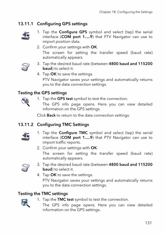
Chapter 18: Configuring the Settings
13.11.1 Configuring GPS settings
1. Tap the Configure GPS symbol and select (tap) the serialinterface (COM port 1.....9) that PTV Navigator can use toimport position data.
2. Confirm your settings with OK.The screen for setting the transfer speed (baud rate)automatically appears.
3. Tap the desired baud rate (between 4800 baud and 115200baud) to select it.
4. Tap OK to save the settings.PTV Navigator saves your settings and automatically returnsyou to the data connection settings.
Testing the GPS settings1. Tap the GPS test symbol to test the connection.
The GPS info page opens. Here you can view detailedinformation on the GPS settings.
Click Back to return to the data connection settings.
13.11.2 Configuring TMC Settings
1. Tap the Configure TMC symbol and select (tap) the serialinterface (COM port 1.....9) that PTV Navigator can use toimport traffic reports.
2. Confirm your settings with OK.The screen for setting the transfer speed (baud rate)automatically appears.
3. Tap the desired baud rate (between 4800 baud and 115200baud) to select it.
4. Tap OK to save the settings.PTV Navigator saves your settings and automatically returnsyou to the data connection settings.
Testing the TMC settings1. Tap the TMC test symbol to test the connection.
The GPS info page opens. Here you can view detailedinformation on the GPS settings.
131
2. Click Back to return to the data connection settings.
13.12 Setting the time zone
By using the option Set time zone, you can set the clock time tomatch the time zone you are in or adjust the clock time for winteror summer time.
1. Tap the Set time zone symbol.The GPS time and the current clock time are displayed. Younow have various options to choose from:
• Tap the minus symbol to move the current clock timebackwards by one hour.
• Tap the plus symbol to move the current clock timeforwards by one hour.
13.13 Day/Night auto settingIf you activate the Day/Night auto setting, the program willautomatically switch to the day or night setting for the map view.
The sunrise and sunset data for the current position arecalculated using GPS data.
1. Tap Day/Night auto setting.Automatic switching between day and night mode will be(de)activated.
NoteThis option is not available for all devices.
NoteIf during navigation you manually switch to the day or nightmode, the Day/Night auto setting is deactivated (see "Day /night" on page 98).
132

Further information
133

134
Tips and Tricks
Here you will find the answers to frequently asked questionsrelating to the use of PTV Navigator.
• What happens if I leave the calculated route? If this is the case PTV Navigator, will re-calculate the route.
• Why doesn't the voice alert work for me? In this case check the volume settings. The volume may be setto quiet or mute (see "Setting the volume for voice alerts" onpage 106).
• Whilst navigation is running, I encounter some roadworksand I am unable to continue driving on the calculated route.What can I do?In PTV Navigator you can close road sections for navigation inadvance: In the navigation tree access the options onnavigation using the button PTV Navigator and click the symbol
Avoid. Specify the length of the road section that you wishto close in advance. PTV Navigator will now close thespecified length of road and will recalculate the route.
• How can I navigate my way back to my parked vehicle in anunfamiliar town?As soon as you have parked your car, go to the navigation
screen and use the button to select the navigation optionsand click Favourites. Now PTV Navigator has saved yourparking location to the Favourites list.
In order to be guided back to your vehicle, you simply have toselect this favourite as the navigation destination.
TipIt is recommended that you close a relatively small roadsection when avoiding roadworks and a longer road sectionwhen avoiding traffic jams.
135

• How can I view more information on the current navigationoperation (for example speed, destination)?
Open the navigation options on the screen using button .
• Detailed information on the current navigation is availableby clicking the button Navi-Info.
• The route description is shown when the symbol Route isclicked.
136
Glossary
ActiveSyncA program that manages synchronisation between the PDA andthe desktop computer and/or a server.
Baud rateIndicates the speed at which two devices (for example PC andmodem) communicate.
GPSThe abbreviation GPS stands for Global Positioning System. AGPS receiver localises the current position of your vehicle. TheGPS receiver continuously receives signals from the at least 24US NavStar satellites orbiting the Earth. The current position ofthe vehicle is determined from the data of four satellites. PTVNavigator displays the position on the road map in the exactlane. Please understand that we are unable to offer telephonesupport on the topic of installing the GPS receiver.
PDAThe abbreviation PDA stands for Personal Digital Assistant.
POIThe abbreviation POI stands for Point of Interest (specialdestination). The navigation software is supplied with variousaddresses (POIs) grouped in to categories, for example hotels,restaurants, car parks. These addresses can be selected asnavigation destinations.
TMCThe abbreviation TMC stands for Traffic Message Channel. Thisrelates to a digital radio data service that transmits up-to-datetraffic reports to devices fitted with TMC receivers. Duringnavigation, the TMC traffic reports can be used in order to avoidtraffic jams on the calculated route.
137

138
Licence agreement
Please read the following conditions before opening thepackaging of this software data package. By opening this sealedpackage you accept the following licence agreement. If you donot agree with these terms, please return the unopened packand all other appertaining material without delay to the selleronly. In this case, the vendor shall reimburse you the fullpurchase price.
1. Subject Matter of the License AgreementThe subject matter of the License Agreement is the purchaseditem contained in this software and data pack.
The software and data are protected by copyright. PTV AG holdsall the legal powers necessary to grant the customer the rightsidentified under Section 2. Inasmuch as third-party data stocksare incorporated, PTV AG holds the appropriate rights ofexploitation.
2. Scope of Utilisation RightsPTV AG grants the Licensee (purchaser) a non-exclusive (simple)right to use the software and data for their intended purpose ona computer, this being without any time limitation but subject tothe following rulings.
The data may only be used in conjunction with the software byone single user on one single computer. The Licensee ispermitted to install the software on a hard disk and to use theresults for internal purposes only. In addition, the licensee shallbe permitted to create one backup, which is to be identified assuch. This copy is to be used for back-up only and will remain inthe possession and under the lock and key of the Licensee. Noother duplication is permitted.
If the scope of supply of the purchased item includes a datacarrier identified as a back-up copy, it may only be used for thispurpose. It must remain in the possession of the Licensee and bekept under lock and key. Such a back-up copy may only be
139
passed on to third parties in association with the hardware onwhich the original software is stored in compliance with theprovisions of this agreement; any other supply to third partieswill constitute a breach of copyright and is expressly prohibited.Action will be taken against any such breach under copyrightlaw.
The software and data are only permitted to be used in a networkor multi-user system if the Licensee has obtained a speciallicence for this purpose, such a licence being for every monitoror every workstation from which the software and data can beused at any given time.
The Licensee shall not translate, adapt, modify or arrange thesoftware and data, nor use the results attained from their use tocreate a proprietary product. Software and data are notpermitted to be made accessible, rented, disseminated orpublicly reproduced as part of business or non-businessactivities. In particular, they are not to be made accessible on theInternet, unless a written agreement to this effect has been madewith PTV AG.
The Licensee has the right to assign the title to the software anddata to third parties, provided that he/she presents a writtensubmission to PTV AG, stating that he/she is passing on theproduct and not retaining a copy of the data carrier or softwareand provided that the third party submits a written undertakingdirectly to PTV AG in which he/she enters into an obligation toobserve these present rulings on use.
3. Term of the LicenceThis License Agreement takes effect on purchase of the softwareand data and on opening of the packaging. If no other ruling ismade, this Agreement shall be effective on a long-term basis.
PTV AG can revoke authorisation to use the product for goodcause. An important cause is particularly given if the Licenseeexceeds the rights of use granted to him in section 2, or if hebreaches the obligation of secrecy in section 4 and does notimmediately refrain from these breaches of contract even after aletter of reminder threatening revocation has been issued.
140
Licence agreement
On revocation of his rights of use, the Licensee shall return theoriginal storage medium and any copies thereof, as well asdelete the saved software and data. He/she must submit toPTV AG written confirmation of full surrender and deletion.
4. Confidentiality and StorageThe Licensee undertakes to store in a suitable manner both thecontractual items and any copies made of the same and tosecure these items in a way ensuring that no third parties haveaccess to them or can learn of their content. Employees of theLicensee shall be informed of the legal relationships with regardto the software and data.
5. Test VersionsAuthorisation to use test versions is restricted to a period of 30days after software installation. Trial versions shall also only havea technically restricted running time. Contrary to Section 2 Para.6, they are not to be passed on to third parties under anycircumstances.
6. Licensing FeeThe Licensee shall pay a once-off licence fee for the rights of useof the software and data presented above and upon which thecontract partners shall agree in a separate agreement. Thislicence fee shall simultaneously satisfy licence fees for the use ofthe third party software and data basis for use within this scope.
7. Reservation of OwnershipThe software and data package will remain the property ofPTV AG until the licensing fee under Section 6 has been paid infull.
Pledging of the package or assignment of the same as securityby the Licensee are not permitted before the licensing fee hasbeen paid in full. In the event that the software data package isaccessed by third parties, the Licensee will give notification thatthe package is the property of PTV AG – insofar as the licensingfee has not been paid in full – and will inform PTV AG withoutdelay.
141
If the Licensee fails to comply with the Agreement – in particularif he/she is in default on payment –, PTV AG has the right torepossess the software data package or, if applicable, to requireassignment of the Licensee's claim to recovery of possessionfrom third parties, without such repossession by PTV AGrepresenting rescission of the contract.
8. Guaranteea) The Licensee shall give notice of obvious defects within areasonable period of time and in writing by giving an exactdescription of the fault. If the Licensee is a commercial trader, he/she shall also examine the supplies and services of PTV AGwithout delay and give notice of defects discovered withoutdelay according to sentence 1. It is the obligation of the Licenseeto detect and list any faults. Delayed, insufficient or unfoundednotifications of defects shall release PTV AG from its duties toperform. If in this case PTV AG still corrects any faults, PTV AGshall bill the expenses incurred to the Licensee.
b) PTV AG warranties that the program functions are executablewithout error in line with the program descriptions andcontractual documents. The parties agree that, at the currentstate of the art, it is not possible to exclude errors in the softwareand data even on careful compilation.
In particular, PTV AG does not warrant that the programfunctions of the software and data meet the requirements of theLicensee.
c) PTV AG may also effect subsequent improvements under aguarantee for received standard products. Subsequentimprovement shall take place through debugging, throughreplacement with a new program or data, or through PTV AGindicating possibilities that involve a new program and dataelement even if this leads to considerable adaptation andconversion expense.
d) The Licensee must give PTV AG sufficient opportunity andtime to carry out any subsequent improvements and providereplacements appearing necessary to PTV AG; otherwisePTV AG shall be discharged from any liability for theconsequences resulting therefrom.
142
Licence agreement
The Licensee shall support PTV AG in correcting faults (byproviding descriptions of faults and test data, employeeinformation, enabling access to the installation etc.). TheLicensee shall take reasonable precautions if the software is notfunctioning either partially or fully correctly, particularly bybacking up data.
The Licensee shall be entitled to remove the defect himself or tocommission a third party to do so, and to demand recompensefor expenses incurred from PTV AG only in the case ofemergency - if operational safety is at risk or to avoiddisproportionately large damage - in which case the Licenseeshall also inform PTV AG immediately.
e) The Licensee is entitled to withdraw from the contract inaccordance with statutory provisions if, taking into account thestatutory exceptions, PTV AG allows in writing a reasonableadditional period of time to pass by in vain which is granted to itto effect a subsequent improvement or make a substitutedelivery due to a material defect.
The Licensee shall however simply be entitled to reduce thecontractual relationship in so far as there is only one insubstantialdefect.
The right to reduce the contractual relationship is otherwiseexcluded.
PTV AG shall not accept any guarantee in particular for
- defective improper commissioning, use and handling by thelicensee
- improper maintenance
- natural wear and tear.
f) PTV AG shall support the Licensee during fault diagnosis andrectification even if it is not certain that a fault is due to thesupplies and services of PTV AG. If it is established that thesupplies and services of PTV AG are not faulty, PTV AG shall billthe expenses incurred to the Licensee.
143
g) Should the Licensee or a third party carry out a subsequentimprovement improperly, PTV AG shall not be liable for anyconsequences resulting therefrom.
Guarantee claims shall also expire if the subject matter is alteredand the Licensee fails to furnish proof that the fault has occurredirrespective thereof.
Moreover, PTV AG shall not accept a guarantee for as long as theLicensee uses the subject matter contrary to the restrictions onuse.
9. Liabilitya) If it is not possible for the customer to use the subject matter inthe manner stipulated in the contract and if PTV AG is at fault forthis, the claims under section 8 apply accordingly to theexclusion of further claims of the Licensee.
b) For damage which has not occurred to the subject matteritself, PTV AG shall be liable, irrespective of the legal grounds,only in case of
- wilful intent
- the gross negligence of the managing director or of executiveemployees
- death, injury or an impairment to health for which it isresponsible
- defects which were fraudulently concealed or the absence ofwhich was guaranteed
- defects in the subject matter insofar as PTV AG is liable forpersonal injury and damage to property of privately used objectsunder the Product Liability Act.
c) In the event of a culpable breach of essential obligations underthe contract PTV AG shall be liable also for the gross negligenceof non-executive employees and for slight negligence, in thelatter case restricted to damage typical for the contract whichwas reasonably foreseeable.
d) Additional claims are excluded.
144
Licence agreement
e) PTV AG may plead that the Licensee is jointly responsible forthe damage.
f) Insofar as insurance cover exists, PTV AG shall place theinsurance payment in full at the Licensee’s disposal irrespectiveof the limitation of liability agreed.
10. Statute of LimitationsAll of the Licensee’s claims, irrespective of the legal grounds,shall become statute-barred after 12 months; if the subjectmatter concerns new items of moveable property and theLicensee is a consumer, all claims shall become statute-barredafter 24 months.
Statutory provisions shall apply for intentional or maliciousbehaviour, as well as for claims according to the Product LiabilityAct.
Limitation shall begin in line with statutory provisions.
11. Final ClausesThe Licensing Agreement made here shall be governed by thelaw of the Federal Republic of Germany with exclusion ofUNCITRAL commercial law. The place of fulfilment of allobligations resulting from this Agreement is Karlsruhe. Thepartners agree that the place of jurisdiction for all disputesarising from this licence agreement shall be Karlsruhe, if theLicensee is a registered business person or the legal equivalentthereof.
Last amended: 22/08/2007
PTV AG
In supplementation of the existing License Agreements, thefollowing Licensing Conditions apply to the use of the trafficnews:
The traffic news is permitted to be used only by authorisedowners of PTV AG products and only for such owners’ ownpurposes. The traffic news is not to be passed on to third parties.Neither are the results gained with the traffic news to be passed
145

on to third parties, in particular not for use in call centres,automatic information services or any other commercial use. Useof the traffic news is limited to 1 year and only applicable for thelatest version of software in each case.
146
Index
Numerics2D map view 99
3D map view 99
AActivating
PTV Navigator 28
ActiveSync 137Address entry
house number 61location 60overview 57street 61
Addressesloading onto navigation device 23
Avoiding road 98
BBaud rate 137
CChanging time format 128
Changing unit of measurement 127
Configuring settings for data connection 130
Configuring system settings 127Coordinates
selecting as destination for navigation 64
Country map 62
DDestination
Coordinates 64Destination selection
favourites 64home address 71in different countries 62POI search 83previous destinations 65showing on map 59
determine PIN code 28
determine reference number 30
Distance to next turn-off point 90
FFavourite destinations
adding 108deleting 110editing 109modifying 110renaming 110
Favouritessaving current GPS position 102selecting as navigation destination 64
GGPS 137
adding current position to favourites 102configuring 131function 32, 137quality 90receiver 32satellite 32, 137testing 131
HHazard warning
settings 121
Highlights 11
147
Home addressselecting as navigation destination 71
IInstallation 19
interface to third-party software 32
JJourney time, remaining 90
MMain selection screen 37
Main traffic roads 24, 62, 63
Manoeuvres 92Map
loading onto navigation device 23position 103show destination 59using 87
Map sectionzooming in the navigation screen 91
Map view2D 993D 99
NName of road after next turn-off 91Navi lists
creating and managing 66Navigation
cancelling 97manoeuvres 92overview 41to one specific destination 42to several stop-off points in a navi list 45
Navigation info 102
Navigation options 923D/2D map view 99adding to favourites 102
avoiding road 98cancelling navigation 97day/night mode 98navigation info 102POIs 102recalculating the route 102route 102speed warning (car) on/off 101speed warning on/off 101
Navigation screenoptions 97quick overview 89
Navigation simulationend 53starting 52
Navigatorinstalling on your CarPC 19installing on your PDA 21
OOn-screen keyboard 58
show/hide 59
Opening route planner 49
PPDA 137
POI 79, 137
POI search 56, 79destination selection 83during navigation 79within a town/street 81
Point en routearrival at 47
Position on the map 103Previous destinations in destination
selection 58program
exit 39PTV Navigator
install 20start 28
148
Index
QQuality
GPS 90TMC 93
RRecalculating the route
during navigation 102
Registration 19Result list
in destination selection screen 58
Route description 51showing during navigation 102
Route list 51Route planner
cancelling simulation 53opening 49overview 49selecting stop-off points 50starting the navigation simulation 52
SSelecting map 62Selecting previous destination as
navigation destination 65
Selecting voice and language 127
Settings 105data connection 130favourite destinations
adding 108deleting 110editing 109modifying 110renaming 110
GPSconfiguring 131testing settings 131
hazard warning 121selecting POI categories 111setting home address 106setting volume 106
showing system information 127speed limit warning 123, 125
road type 124time zone 132TMC
configuring 131configuring settings 129testing settings 131
using/avoiding motorways 123
Showing program version information 127
Signpost 91Speed limit (car)
indicator 93Speed limit warning
settings 123Speed warning
on/off 101
Speed warning (car) 123on/off 101
StatusTMC 93
Status displays 90Switching
3D/2D map view 99day/night mode 98
System requirements 19System settings
changing display brightness 127changing time format 128changing unit of measurement 127selecting voice and language 127
TTMC 137
configuring 131configuring settings 128info page 95status 93testing settings 131
149

ZZooming with the map 88
150