Embed Size (px)
Citation preview
Unclassified
Land Information Ontario Data Description
ANSI (Areas of Natural and Scientific Interest)
Disclaimer This technical documentation has been prepared by the Ministry of Natural Resources (the “Ministry”), representing Her Majesty the Queen in right of Ontario. Although every effort has been made to verify the information, this document is presented as is, and the Ministry makes no guarantees, representations or warranties with respect to the information contained within this document, either express or implied, arising by law or otherwise, including but not limited to, effectiveness, completeness, accuracy, or fitness for purpose. The Ministry is not liable or responsible for any loss or harm of any kind arising from use of this information. Some of the information in this document is nonconvertible or has not yet been made accessible and may not be compatible with assistive technologies. If you need any of the information in an alternate format, please contact LIO Support at [email protected] or (705) 755-1878.
©Queens Printer for Ontario, 2012
LIO Class Catalogue ANSI
Class Short Name:
Version Number:
Class Description:
ANSI 3
ANSIs (Areas of Natural and Scientific Interest) are polygon features that represent lands and waters containing important natural landscapes or features that are important for natural heritage, protection, appreciation, scientific study or education.
Abstract Class Name:
Abstract Class Description:
SPMNTCREGION
Spatial Multi-Non-Tessellating-Constrained-Region: An object is represented by ONE or MORE polygons. Polygons MAY overlap ONLY when their respective Geographic Unit Types are different. HOLES within and GAPS between polygons ARE allowed. Example: "Areas of Natural and Scientific Interest" (ANSI). An "Earth Science" ANSI may overlap a "Life Science" ANSI, but Earth Science ANSIs are not permitted to overlap one another.
Tables in LIO Class:
ANSI ANSI_FT
(Area of Natural and Scientific Interest). An area of land and/or water containing natural landscapes or features which have been identified by MNR as having value related to protection, natural heritage appreciation, scientific study or education purposes.
Column Name Column Type Mandatory Short Name Valid Values
OGF_ID NUMBER(13,0) Yes OGF_ID
A unique numeric provincial identifier assigned to each object.
CLASS_SUBTYPE VARCHAR2(75) Yes SUBTYPE
The data class subtype - Original GEOG_UNIT_TYPE_NAME.
CLASS_SUBTYPE_NUM NUMBER(7,0) Yes STYPE_NUM
The data class subtype number - Original GEOG_UNIT_TYPE_NUM.
PROTECTED_SITE_IDENT VARCHAR2(12) No SITE_IDENT
The identifier sanctioned and used by Ontario Parks to uniquely identify land under some form of protection. This identifier is used in the @PAR system, where it is called Site ID.
ANSI_NAME VARCHAR2(100) No ANSI_NAME
Name of the area.
ANSI_SIGNIFICANCE VARCHAR2(10) Yes SIGNIF Provincial,Regional,Local
Level of importance for the Area of Natural or Scientific Interest eg. provincial, regional, or local.
PLANNING_CONSIDERATIONS VARCHAR2 (2000)
No PLN_CONSID
Free-form text describing factors to be weighed when planning is done.
RES_MGMT_PLAN_PREP_IND VARCHAR2(3) No MGMT_PLAN Yes,No
An indication of whether a resource management plan has been prepared for the area.
LANDOWNER_CONTACT_FLG VARCHAR2(7) No LO_CONTACT Yes,No,Partial
An indication of whether a "Landowner Contact" program has been carried out to advise landowners of the location and importance of the ANSI. (Yes, No, Partial)
ACTIVITY_RESTRICTIONS VARCHAR2
(2000)
Indicates any use restrictions within the geographic unit.
No ACT_RESTR
NHIC_AREA_ID NUMBER(13,0) No NHIC_AR_ID
The link to information recorded about a feature in the NHIC database.
IUCN_CATEGORY VARCHAR2(3) No IUCN_CAT Ia,Ib,II,III,IV,V,VI
A classification of a protected area by The World Conservation Union (IUCN). The IUCN system discourages the narrow view that protected areas are single-purpose areas, and instead, promotes a broader concept of varying degrees of conservation and development. In addition to strict conservation, scientific research, and wildlife habitat protection, many protected areas have great value in watershed and soil protection, carbon sequestration, recreational benefits, defining indigenous territory, and the maintenance of cultural and spiritual values.Ia: Strict Nature ReserveIb: Wilderness AreaII: National ParkIII: Natural MonumentIV: Habitat/Species Management AreasV: Protected Landscape/SeascapeVI: Managed Resource Protected Area

LOCATION_ACCURACY VARCHAR2(25) Yes ACCURACY Not Applicable, Over 10,000 metres, Within 1 metre, Within 10 metres, Within 10,000 metres, Within 100 metres, ... (See LOCATION_ACCURACY_LIST table)
SENSITIVITY_CLASS VARCHAR2(15) Yes SENS_CLASS
The ranking of the sensitivity of the information embodied in the feature. Often wide-spread knowl edge of the location of some rare aspect of our natural heritage will endanger it. On the other han d, this knowledge by some parties is also extremely important for its protection. High - informatio n that is extremely sensitive and intended for use by named individuals only. Refers to information that could have negative impacts on human life or health if released. Currently no data classes me et this Medium - information that is sensitive and intended for use only by specified groups of employees an d approved agents of the Crown. For OLIW/NRVIS refers to information where the entire data type has been flagged as sensitive (i.e. Stick Nests for Vulnerable Threatened and Endangered (VTE) species) Low - information generally available to employees and approved agents of the Crown. Refers to se nsitive features within a data type not normally sensitive (i.e. specific instances of Pileated Wood pecker) Non-Sensitive - data and information that does not fall into any of the three sensitivity l evels. If disclosed will not result in any injury to individuals, government or private sector insti tutions (i.e. base data).
SENSITIVITY_DATE DATE Yes SENS_DATE
The date that the sensitivity classification was established.
SENSITIVITY_RATIONALE VARCHAR2(50) Yes SENS_RAT
The primary reason for the information sensitivity classification. Examples: "VTE Species", "Data Provider Agreement", "No Restriction Needed" (for Non-Sensitive data ), "Protect Feature Type", "Protect Single Feature", "Legislative or Legal Reqt", "Cultural Heritage Site", "Other". Note: For Species at Risk (SAR) features, please use "Legislative or Legal Reqt" as a rationale.
SENS_RATIONALE_OTHER_DESCR VARCHAR2(250) No SENS_DESCR
Description of the reason(s) for the information classification when "Other" is selected as the rationale.
SYSTEM_CALCULATED_AREA NUMBER(16,3) No SYS_AREA
The area of a polygon measured in square metres by the system.
USER_CALCULATED_METRIC NUMBER(16,3) No USER_CALC
The length, perimeter or area of an object in metres or square metres as measured or provided by the user.
GENERAL_COMMENTS VARCHAR2 (2000)
No GNL_CMT
General comments.
GEOMETRY_UPDATE_DATETIME DATE No GEO_UPD_DT
Date/time the geometry was created or last modified in the source database.
EFFECTIVE_DATETIME DATE Yes EFF_DATE
Date/time the record was created or last modified in the source database.
SHAPE SDO_GEOMETRY No SHAPE
Geometry attribute.
AREA_AND_SPECIES
A list of species associated with an area. Associative Entity.
Column Name Column Mandatory Short Name Valid Values
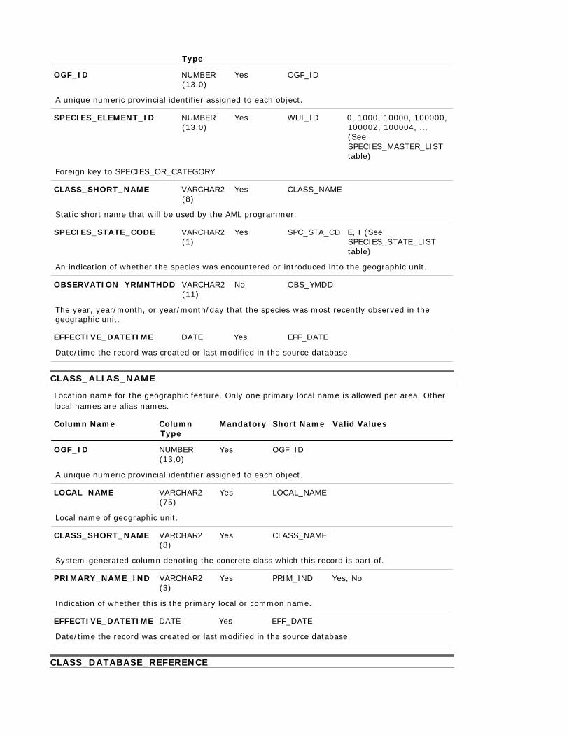
Type
OGF_ID NUMBER (13,0)
Yes OGF_ID
A unique numeric provincial identifier assigned to each object.
SPECIES_ELEMENT_ID NUMBER (13,0)
Foreign key to SPECIES_OR_CATEGORY
CLASS_SHORT_NAME VARCHAR2 (8)
Yes WUI_ID 0, 1000, 10000, 100000, 100002, 100004, ... (See SPECIES_MASTER_LIST table)
Yes CLASS_NAME
Static short name that will be used by the AML programmer.
SPECIES_STATE_CODE VARCHAR2 (1)
Yes SPC_STA_CD E, I (See SPECIES_STATE_LIST table)
An indication of whether the species was encountered or introduced into the geographic unit.
OBSERVATION_YRMNTHDD VARCHAR2 (11)
No OBS_YMDD
The year, year/month, or year/month/day that the species was most recently observed in the geographic unit.
EFFECTIVE_DATETIME DATE Yes EFF_DATE
Date/time the record was created or last modified in the source database.
CLASS_ALIAS_NAME
Location name for the geographic feature. Only one primary local name is allowed per area. Other local names are alias names.
Column Name Column Type
Mandatory Short Name Valid Values
OGF_ID NUMBER
(13,0)
Yes OGF_ID
A unique numeric provincial identifier assigned to each object.
LOCAL_NAME VARCHAR2 (75)
Local name of geographic unit.
CLASS_SHORT_NAME VARCHAR2 (8)
Yes LOCAL_NAME
Yes CLASS_NAME
System-generated column denoting the concrete class which this record is part of.
PRIMARY_NAME_IND VARCHAR2 (3)
Yes PRIM_IND Yes, No
Indication of whether this is the primary local or common name.
EFFECTIVE_DATETIME DATE Yes EFF_DATE
Date/time the record was created or last modified in the source database.
CLASS_DATABASE_REFERENCE
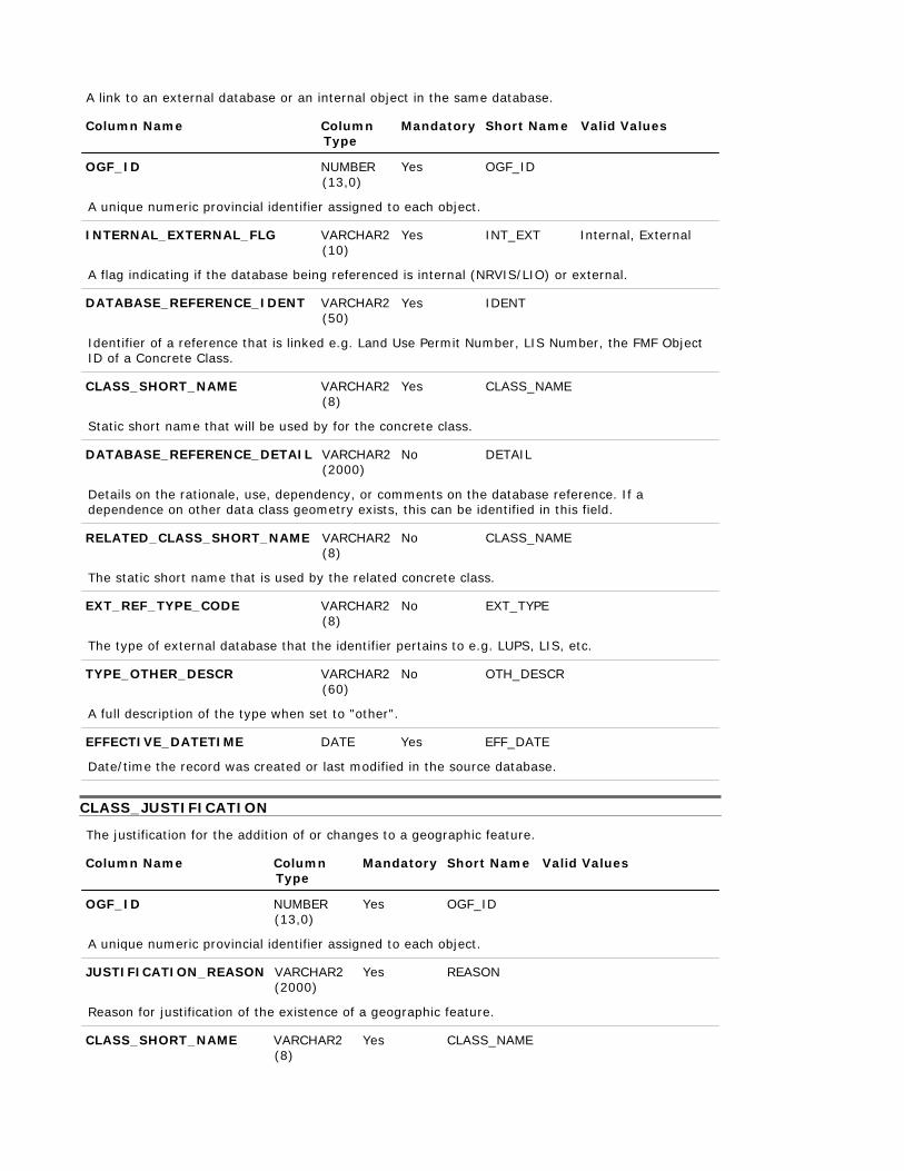
A link to an external database or an internal object in the same database.
Column Name Column Type
Mandatory Short Name Valid Values
OGF_ID NUMBER
(13,0)
Yes OGF_ID
A unique numeric provincial identifier assigned to each object.
INTERNAL_EXTERNAL_FLG VARCHAR2 (10)
Yes INT_EXT Internal, External
A flag indicating if the database being referenced is internal (NRVIS/LIO) or external.
DATABASE_REFERENCE_IDENT VARCHAR2 (50)
Yes IDENT
Identifier of a reference that is linked e.g. Land Use Permit Number, LIS Number, the FMF Object ID of a Concrete Class.
CLASS_SHORT_NAME VARCHAR2
(8) Yes CLASS_NAME
Static short name that will be used by for the concrete class.
DATABASE_REFERENCE_DETAIL VARCHAR2 (2000)
No DETAIL
Details on the rationale, use, dependency, or comments on the database reference. If a dependence on other data class geometry exists, this can be identified in this field.
RELATED_CLASS_SHORT_NAME VARCHAR2
(8)
No CLASS_NAME
The static short name that is used by the related concrete class.
EXT_REF_TYPE_CODE VARCHAR2 (8)
No EXT_TYPE
The type of external database that the identifier pertains to e.g. LUPS, LIS, etc.
TYPE_OTHER_DESCR VARCHAR2 (60)
A full description of the type when set to "other".
No OTH_DESCR
EFFECTIVE_DATETIME DATE Yes EFF_DATE
Date/time the record was created or last modified in the source database.
CLASS_JUSTIFICATION
The justification for the addition of or changes to a geographic feature.
Column Name Column
Type Mandatory Short Name Valid Values
OGF_ID NUMBER
(13,0)
Yes OGF_ID
A unique numeric provincial identifier assigned to each object.
JUSTIFICATION_REASON VARCHAR2 (2000)
Yes REASON
Reason for justification of the existence of a geographic feature.
CLASS_SHORT_NAME VARCHAR2 (8)
Yes CLASS_NAME
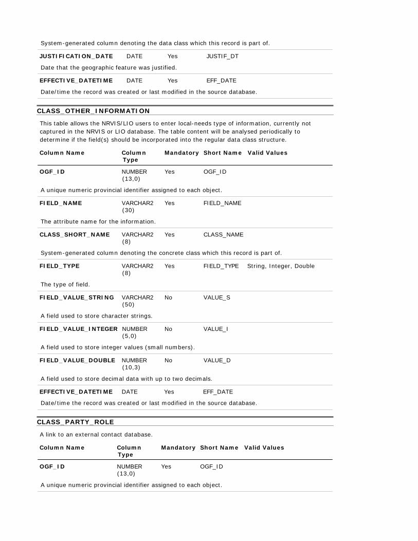
System-generated column denoting the data class which this record is part of.
JUSTIFICATION_DATE DATE Yes JUSTIF_DT
Date that the geographic feature was justified.
EFFECTIVE_DATETIME DATE Yes EFF_DATE
Date/time the record was created or last modified in the source database.
CLASS_OTHER_INFORMATION
This table allows the NRVIS/LIO users to enter local-needs type of information, currently not captured in the NRVIS or LIO database. The table content will be analysed periodically to determine if the field(s) should be incorporated into the regular data class structure.
Column Name Column
Type Mandatory Short Name Valid Values
OGF_ID NUMBER
(13,0)
Yes OGF_ID
A unique numeric provincial identifier assigned to each object.
FIELD_NAME VARCHAR2 (30)
The attribute name for the information.
CLASS_SHORT_NAME VARCHAR2 (8)
Yes FIELD_NAME
Yes CLASS_NAME
System-generated column denoting the concrete class which this record is part of.
FIELD_TYPE VARCHAR2 (8)
Yes FIELD_TYPE String, Integer, Double
The type of field.
FIELD_VALUE_STRING VARCHAR2 (50)
A field used to store character strings.
FIELD_VALUE_INTEGER NUMBER (5,0)
No VALUE_S
No VALUE_I
A field used to store integer values (small numbers).
FIELD_VALUE_DOUBLE NUMBER (10,3)
No VALUE_D
A field used to store decimal data with up to two decimals.
EFFECTIVE_DATETIME DATE Yes EFF_DATE
Date/time the record was created or last modified in the source database.
CLASS_PARTY_ROLE
A link to an external contact database.
Column Name Column
Type Mandatory Short Name Valid Values
OGF_ID NUMBER
(13,0)
Yes OGF_ID
A unique numeric provincial identifier assigned to each object.
EFFECTIVE_DATETIME DATE Yes EFF_DATE
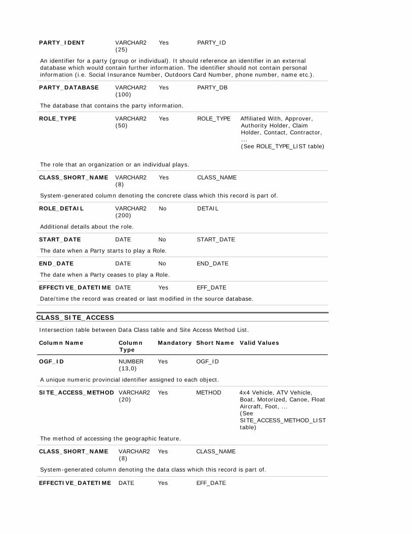
PARTY_IDENT VARCHAR2 (25)
Yes PARTY_ID
An identifier for a party (group or individual). It should reference an identifier in an external database which would contain further information. The identifier should not contain personal information (i.e. Social Insurance Number, Outdoors Card Number, phone number, name etc.).
PARTY_DATABASE VARCHAR2 (100)
Yes PARTY_DB
The database that contains the party information.
ROLE_TYPE VARCHAR2 (50)
Yes ROLE_TYPE Affiliated With, Approver, Authority Holder, Claim Holder, Contact, Contractor, ... (See ROLE_TYPE_LIST table)
The role that an organization or an individual plays.
CLASS_SHORT_NAME VARCHAR2
(8) Yes CLASS_NAME
System-generated column denoting the concrete class which this record is part of.
ROLE_DETAIL VARCHAR2 (200)
Additional details about the role.
No DETAIL
START_DATE DATE No START_DATE
The date when a Party starts to play a Role.
END_DATE DATE No END_DATE
The date when a Party ceases to play a Role.
EFFECTIVE_DATETIME DATE Yes EFF_DATE
Date/time the record was created or last modified in the source database.
CLASS_SITE_ACCESS
Intersection table between Data Class table and Site Access Method List.
Column Name Column
Type Mandatory Short Name Valid Values
OGF_ID NUMBER
(13,0)
Yes OGF_ID
A unique numeric provincial identifier assigned to each object.
SITE_ACCESS_METHOD VARCHAR2 (20)
Yes METHOD 4x4 Vehicle, ATV Vehicle, Boat, Motorized, Canoe, Float Aircraft, Foot, ... (See SITE_ACCESS_METHOD_LIST table)
The method of accessing the geographic feature.
CLASS_SHORT_NAME VARCHAR2 (8)
Yes CLASS_NAME
System-generated column denoting the data class which this record is part of.
Date/time the record was created or last modified in the source database.
CLASS_SOURCE
Intersection table between the data class and Source List table.
Column Name Column
Type Mandatory Short Name Valid Values
OGF_ID NUMBER
(13,0)
Yes OGF_ID
A unique numeric provincial identifier assigned to each object.
SOURCE_NAME VARCHAR2 (100)
Yes SOURCE_NAM AFFM Provincial Administrative Maps, Aerial Photography, Aerial Survey, Book/Publication, CIR Photograpy, City of Ottawa Borehole Database, ... (See SOURCE_LIST table)
The name of the source.
SOURCE_DETAIL VARCHAR2
(254) Yes SOURCE_DET
What part of the source pertains to the feature. Examples: Summary data from a data base, pages in a book or atlas, figure number and page from a publication, a section of a map, record in a database.
CLASS_SHORT_NAME VARCHAR2
(8)
Yes CLASS_NAME
Unique abbreviation of the concrete class name (primary key)
SOURCE_DESCR VARCHAR2 (2000)
Text providing details about the source.
METHOD_DESCR VARCHAR2 (2000)
No SOURCE_DES
No METHOD
The type of method, tools, and techniques used in observing/collecting/recording the Source. It may also include a URL where users could get further information on the method used.
SOURCE_APPLICABILITY VARCHAR2
(20)
No APPLICABIL
How the source contributes to the feature's definition.
EFFECTIVE_DATETIME DATE Yes EFF_DATE
Date/time the record was created or last modified in the source database.
CLASS_SUPPORTING_MATERIAL
Material (document/file/picture) that provides more information on a geographic feature.
Column Name Column
Type Mandatory Short Name Valid Values
OGF_ID NUMBER
(13,0)
Yes OGF_ID
A unique numeric provincial identifier assigned to each object.
FUEL_CLASS VARCHAR2 (40)
Yes FUEL_CLASS
MATERIAL_NAME VARCHAR2 (200)
Yes NAME
A name or brief description of the material.
MATERIAL_LOCATION VARCHAR2 (200)
Yes LOCATION
The location where the supporting material is stored. This may be a physical location or a link to a storage location.
CLASS_SHORT_NAME VARCHAR2
(8)
Yes CLASS_NAME
System-generated column denoting the concrete class which this record is part of.
URL_ENG VARCHAR2 (500)
No URL_ENG
The address of a computer or a document in English on the Internet that consists of a communications protocol followed by a colon and two slashes (as http://), the identifier of a computer (as www.m-w.com) and usually a path through a directory to a file -- called also universal resource locator.
URL_FRE VARCHAR2 (500)
No URL_FRE
The address of a computer or a document in French on the Internet that consists of a communications protocol followed by a colon and two slashes (as http://), the identifier of a computer (as www.m-w.com) and usually a path through a directory to a file -- called also universal resource locator.
EFFECTIVE_DATETIME DATE Yes EFF_DATE
Date/time the record was created or last modified in the source database.
EXTERNAL_REF_TYPE_LIST
List of valid EXTERNAL_REFERENCE_TYPE codes.
Column Name Column
Type Mandatory Short Name Valid Values
EXT_REF_TYPE_CODE VARCHAR2
(8)
Yes EXT_REF_TY
The type of external database that the identifier pertains to e.g. LUPS, LIS, Other.
EXT_REF_TYPE_DESCR VARCHAR2 (60)
Yes EXT_REF_TY
Description of the type of external reference.
EFFECTIVE_DATETIME DATE Yes EFF_DATE
Date/time the record was created or last modified in the source database.
EXPIRY_DATETIME DATE No EXP_DATE
Date/time that the record was expired from use.
FIRE_FUEL_CLASS_LIST
List of valid Fuel Class codes.
Column Name Column
Type Mandatory Short Name Valid Values
The forest fire danger rating fuel class, as defined by the Canadian Forest Fire Behavior Prediction System, for the area in and around the feature i.e. immature jack pine, leafless aspen, grass
EFFECTIVE_DATETIME DATE Yes EFF_DATE
Date/time the record was created or last modified in the source database.
EXPIRY_DATETIME DATE No EXP_DATE
Date/time that the record was expired from use.
LOCATION_ACCURACY_LIST
List of valid LOCATION_ACCURACYs.
Column Name Column
Type Mandatory Short Name Valid Values
LOCATION_ACCURACY VARCHAR2
(25)
Yes ACCURACY
The accuracy of the location of the feature at an OBM scale. The degree of conformity or closeness of a measurement to the true value.
EFFECTIVE_DATETIME DATE Yes EFF_DATE
Date/time the record was created or last modified in the source database.
EXPIRY_DATETIME DATE No EXP_DATE
Date/time that the record was expired from use.
ROLE_TYPE_LIST
List of valid party role types.
Column Name Column
Type Mandatory Short Name Valid Values
ROLE_TYPE VARCHAR2
(50)
Yes ROLE_TYPE
The role that an organization or an individual plays.
ROLE_TYPE_DESCR VARCHAR2 (2000)
Yes DESCR
Description of Role Type.
EFFECTIVE_DATETIME DATE Yes EFF_DATE
Date/time the record was created or last modified in the source database.
EXPIRY_DATETIME DATE No EXP_DATE
Date/time that the record was expired from use.
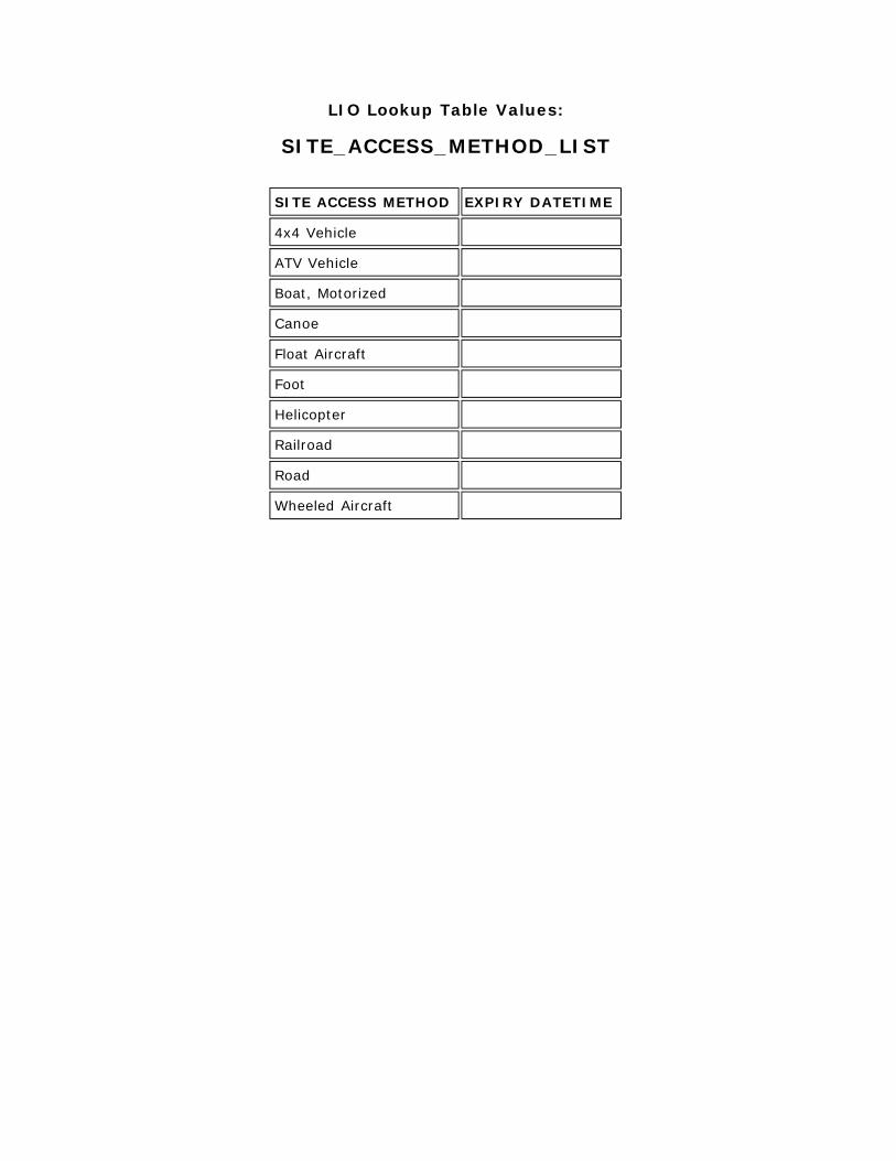
SITE_ACCESS_METHOD_LIST
A list of valid SITE_ACCESS_METHODs (e.g. Road, Helicopter, Boat, etc.)
Column Name Column
Type Mandatory Short Name Valid Values
SITE_ACCESS_METHOD VARCHAR2
(20)
Yes METHOD
The method of accessing the geographic unit.
EFFECTIVE_DATETIME DATE Yes EFF_DATE

Date/time the record was created or last modified in the source database.
EXPIRY_DATETIME DATE No EXP_DATE
Date/time that the record was expired from use.
SOURCE_LIST
A description of the source information that is the basis for creating or changing information about a geographic feature. In may be an observation, possibly resulting from a field survey or an adhoc report or a reference to a published or unpublished document.
SPECIES_STATE_LIST
null
Column Name Column Type
Mandatory Short Name
Valid Values
SPECIES_STATE_CODE VARCHAR2
(1)
Yes STATE_C
SPECIES_STATE_DESCR VARCHAR2 (20)
Yes STATE
EFFECTIVE_DATETIME DATE Yes EFF_DATE
Date/time the record was created or last modified in the source database.
EXPIRY_DATETIME DATE No EXP_DATE
Date/time that the record was expired from use.
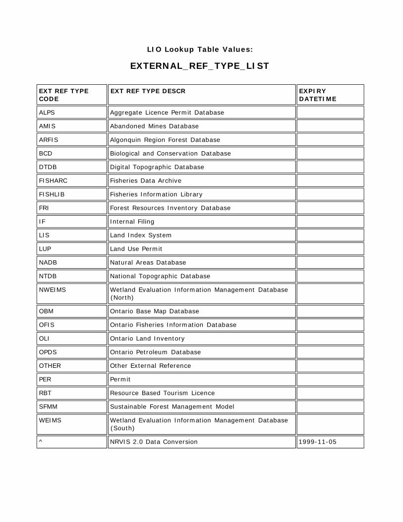
LIO Lookup Table Values:
EXTERNAL_REF_TYPE_LIST EXT REF TYPE CODE
EXT REF TYPE DESCR EXPIRY DATETIME
ALPS Aggregate Licence Permit Database
AMIS Abandoned Mines Database
ARFIS Algonquin Region Forest Database
BCD Biological and Conservation Database
DTDB Digital Topographic Database
FISHARC Fisheries Data Archive
FISHLIB Fisheries Information Library
FRI Forest Resources Inventory Database
IF Internal Filing
LIS Land Index System
LUP Land Use Permit
NADB Natural Areas Database
NTDB National Topographic Database
NWEIMS Wetland Evaluation Information Management Database (North)
OBM Ontario Base Map Database
OFIS Ontario Fisheries Information Database
OLI Ontario Land Inventory
OPDS Ontario Petroleum Database
OTHER Other External Reference
PER Permit
RBT Resource Based Tourism Licence
SFMM Sustainable Forest Management Model
WEIMS Wetland Evaluation Information Management Database (South)
^ NRVIS 2.0 Data Conversion 1999-11-05

LIO Lookup Table Values:
FIRE_FUEL_CLASS_LIST
FUEL CLASS EXPIRY DATETIME
Boreal Mixedwood - Green
Boreal Mixedwood - Leafless
Boreal Spruce
Coastal Cedar-Hemlock-Douglas-fir S
Conifer Plantation
Dead Balsam Fir Mixedwood - Green
Dead Balsam Fir Mixedwood - Leafles
Grass
Immature Jack or Lodgepole Pine
Jack or Lodgepole Pine Slash
Leafless Aspen
Mature Jack or Lodgepole Pine
Ponderosa Pine-Douglas-fir
Red and White Pine
Spruce-Lichen Woodland
White Spruce-Balsam Slash
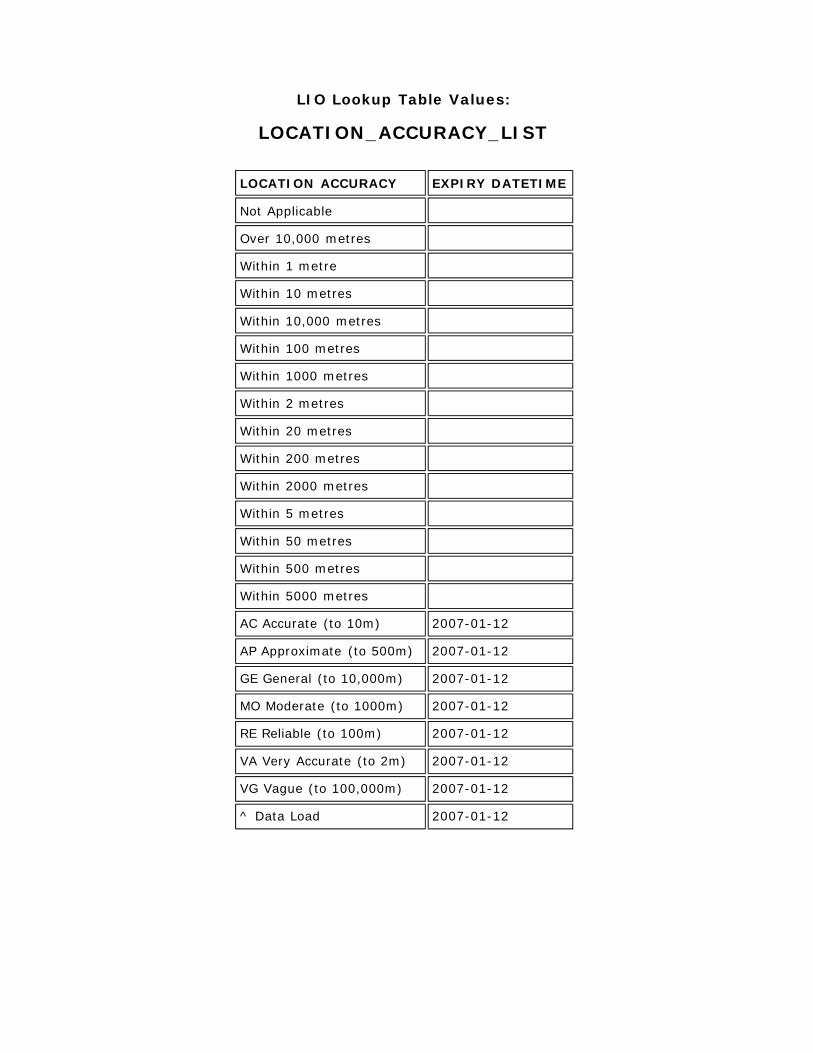
LIO Lookup Table Values:
LOCATION_ACCURACY_LIST
LOCATION ACCURACY EXPIRY DATETIME
Not Applicable
Over 10,000 metres
Within 1 metre
Within 10 metres
Within 10,000 metres
Within 100 metres
Within 1000 metres
Within 2 metres
Within 20 metres
Within 200 metres
Within 2000 metres
Within 5 metres
Within 50 metres
Within 500 metres
Within 5000 metres
AC Accurate (to 10m) 2007-01-12
AP Approximate (to 500m) 2007-01-12
GE General (to 10,000m) 2007-01-12
MO Moderate (to 1000m) 2007-01-12
RE Reliable (to 100m) 2007-01-12
VA Very Accurate (to 2m) 2007-01-12
VG Vague (to 100,000m) 2007-01-12
^ Data Load 2007-01-12
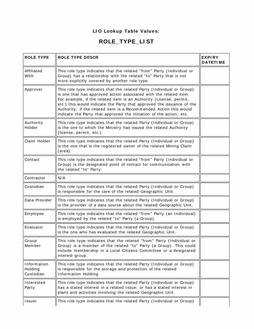
LIO Lookup Table Values:
ROLE_TYPE_LIST ROLE TYPE ROLE TYPE DESCR EXPIRY
DATETIME
Affiliated With
This role type indicates that the related "from" Party (Individual or Group) has a relationship with the related "to" Party that is not more explicitly covered by another role type.
Approver This role type indicates that the related Party (Individual or Group) is one that has approved action associated with the related item. For example, if the related item is an Authority (License, permit, etc.) this would indicate the Party that approved the issuance of the Authority; if the related item is a Recommended Action this would indicate the Party that approved the initiation of the action; etc.
Authority Holder
This role type indicates that the related Party (Individual or Group) is the one to which the Ministry has issued the related Authority (license, permit, etc.).
Claim Holder This role type indicates that the related Party (Individual or Group) is the one that is the registered owner of the related Mining Claim (area).
Contact This role type indicates that the related "from" Party (Individual or Group) is the designated point of contact for communication with the related "to" Party.
Contractor N/A
Custodian This role type indicates that the related Party (Individual or Group) is responsible for the care of the related Geographic Unit.
Data Provider This role type indicates that the related Party (Individual or Group) is the provider of a data source about the related Geographic Unit.
Employee This role type indicates that the related "from" Party (an Individual) is employed by the related "to" Party (a Group).
Evaluator This role type indicates that the related Party (Individual or Group) is the one who has evaluated the related Geographic Unit.
Group Member
This role type indicates that the related "from" Party (Individual or Group) is a member of the related "to" Party (a Group). This could include membership in a Local Citizens Committee or a designated interest group.
Information Holding Custodian
This role type indicates that the related Party (Individual or Group) is responsible for the storage and protection of the related Information Holding.
Interested Party
This role type indicates that the related Party (Individual or Group) has a stated interest in a related Issue; or has a stated interest in plans and activities involving the related Geographic Unit.
Issuer This role type indicates that the related Party (Individual or Group)
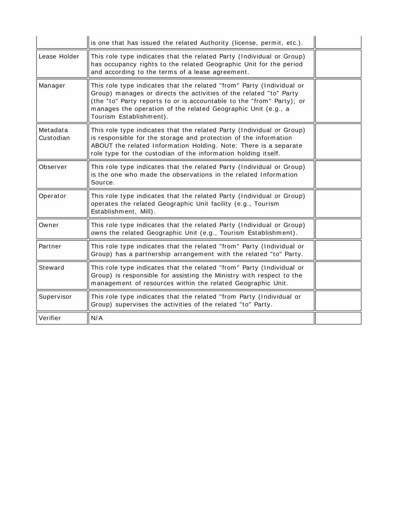
is one that has issued the related Authority (license, permit, etc.).
Lease Holder This role type indicates that the related Party (Individual or Group) has occupancy rights to the related Geographic Unit for the period and according to the terms of a lease agreement.
Manager This role type indicates that the related "from" Party (Individual or Group) manages or directs the activities of the related "to" Party (the "to" Party reports to or is accountable to the "from" Party); or manages the operation of the related Geographic Unit (e.g., a Tourism Establishment).
Metadata Custodian
This role type indicates that the related Party (Individual or Group) is responsible for the storage and protection of the information ABOUT the related Information Holding. Note: There is a separate role type for the custodian of the information holding itself.
Observer This role type indicates that the related Party (Individual or Group) is the one who made the observations in the related Information Source.
Operator This role type indicates that the related Party (Individual or Group) operates the related Geographic Unit facility (e.g., Tourism Establishment, Mill).
Owner This role type indicates that the related Party (Individual or Group) owns the related Geographic Unit (e.g., Tourism Establishment).
Partner This role type indicates that the related "from" Party (Individual or Group) has a partnership arrangement with the related "to" Party.
Steward This role type indicates that the related "from" Party (Individual or Group) is responsible for assisting the Ministry with respect to the management of resources within the related Geographic Unit.
Supervisor This role type indicates that the related "from Party (Individual or Group) supervises the activities of the related "to" Party.
Verifier N/A
LIO Lookup Table Values:
SITE_ACCESS_METHOD_LIST
SITE ACCESS METHOD EXPIRY DATETIME
4x4 Vehicle
ATV Vehicle
Boat, Motorized
Canoe
Float Aircraft
Foot
Helicopter
Railroad
Road
Wheeled Aircraft
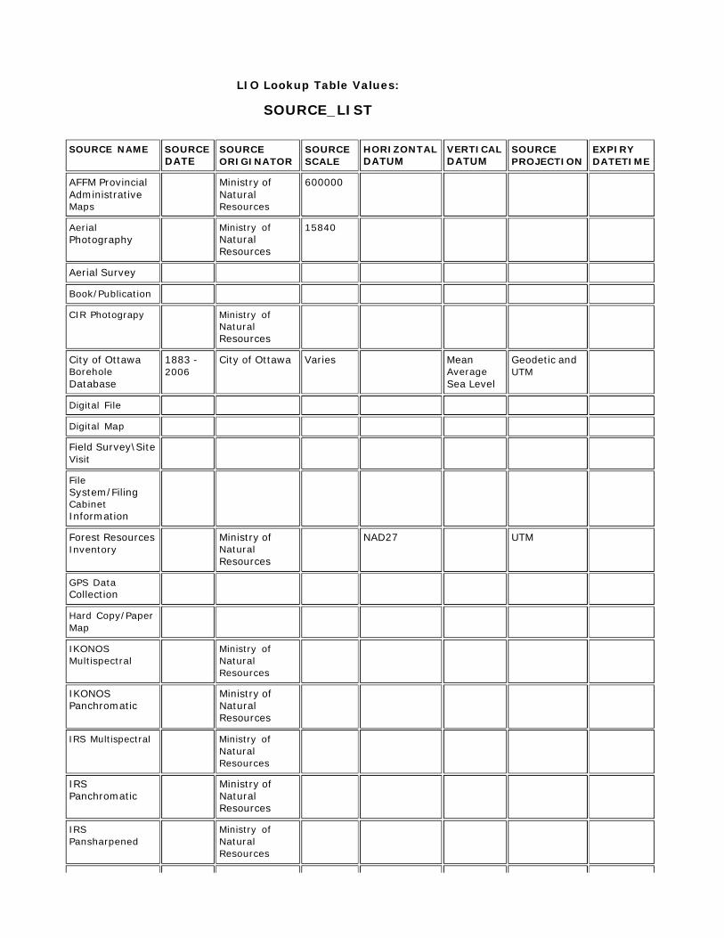
LIO Lookup Table Values:
SOURCE_LIST SOURCE NAME SOURCE
DATE SOURCE ORIGINATOR
SOURCE SCALE
HORIZONTAL DATUM
VERTICAL DATUM
SOURCE PROJECTION
EXPIRY DATETIME
AFFM Provincial Administrative Maps
Ministry of Natural Resources
600000
Aerial Photography
Ministry of Natural Resources
15840
Aerial Survey
Book/Publication
CIR Photograpy Ministry of
Natural Resources
City of Ottawa Borehole Database
1883 - 2006
City of Ottawa Varies Mean
Average Sea Level
Geodetic and UTM
Digital File
Digital Map
Field Survey\Site Visit
File System/Filing Cabinet Information
Forest Resources Inventory
Ministry of Natural Resources
NAD27 UTM
GPS Data Collection
Hard Copy/Paper Map
IKONOS Multispectral
Ministry of Natural Resources
IKONOS Panchromatic
Ministry of Natural Resources
IRS Multispectral Ministry of
Natural Resources
IRS Panchromatic
Ministry of Natural Resources
IRS Pansharpened
Ministry of Natural Resources
Landsat-1,2,3 MSS
Ministry of Natural Resources
Landsat-4,5 MSS
Ministry of Natural Resources
Landsat-7 ETM Ministry of
Natural Resources
Local Borehole Drilling Program Results
2006 Ministry of
Northern Development and Mines
Mean Average Sea Level
Local Knowledge
MNDM Assesment File
MNDM Client/Company Information
MNR Based Observation
MTO Engineering Reports
Varies Ministry of
Transportation
Varies Mean
Average Sea Level
NRCan - CanVec 2008 Natural
Resources Canada
50000 NAD83
NRCan - National Hydro Network
2008 Natural
Resources Canada
50000 NAD83
NTS Map 1:250000
1970 to 2003
Department of Natural Reosurces
250000 NAD27
NTS Map 1:50000
1970 to 2003
Department of Natural Resources
50000 NAD27
Ontario Base Map 1:10000
1978 to 1995
Ministry of Natural Resources
10000 NAD27 UTM
Ontario Base Map 1:20000
1978 to 1995
Ministry of Natural Resources
20000 NAD27 UTM
Ontario Geological Survey Fieldwork Mapping
Varies to 2004
Ontario Geological Survey
1:50,000 NAD83 Mean
Average Sea Level
Universal Transvers Mercator
Ontario Parcel NAD83
OrthoImagery Ministry of
Natural Resources
Public Observation
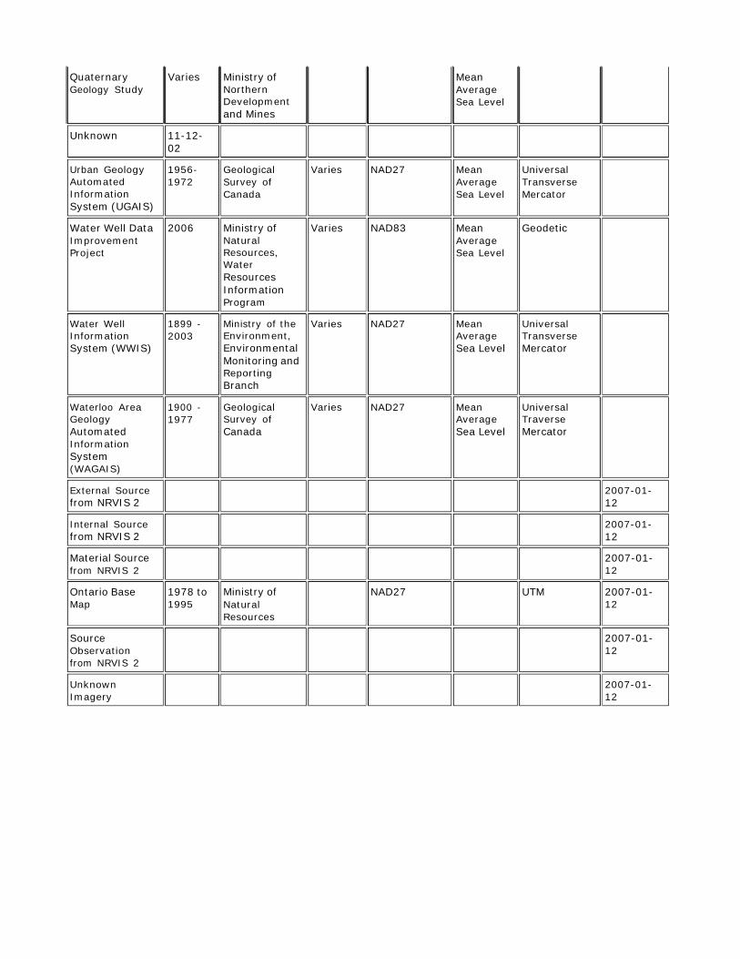
Quaternary Geology Study
Varies Ministry of Northern Development and Mines
Mean Average Sea Level
Unknown 11-12- 02
Urban Geology Automated Information System (UGAIS)
1956- 1972
Geological Survey of Canada
Varies NAD27 Mean Average Sea Level
Universal Transverse Mercator
Water Well Data Improvement Project
2006 Ministry of Natural Resources, Water Resources Information Program
Varies NAD83 Mean Average Sea Level
Geodetic
Water Well Information System (WWIS)
1899 - 2003
Ministry of the Environment, Environmental Monitoring and Reporting Branch
Varies NAD27 Mean Average Sea Level
Universal Transverse Mercator
Waterloo Area Geology Automated Information System (WAGAIS)
1900 - 1977
Geological Survey of Canada
Varies NAD27 Mean Average Sea Level
Universal Traverse Mercator
External Source from NRVIS 2
2007-01- 12
Internal Source from NRVIS 2
2007-01- 12
Material Source from NRVIS 2
2007-01- 12
Ontario Base Map
1978 to 1995
Ministry of Natural Resources
NAD27 UTM 2007-01- 12
Source Observation from NRVIS 2
2007-01- 12
Unknown Imagery
2007-01- 12
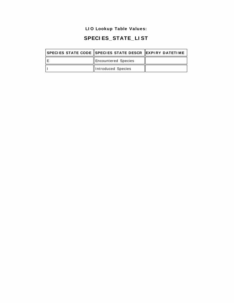
LIO Lookup Table Values:
SPECIES_STATE_LIST
SPECIES STATE CODE SPECIES STATE DESCR EXPIRY DATETIME
E Encountered Species
I Introduced Species


![[ ANSI C37.20 and NEMA SG-5 ]€¦ · ANSI C37.20 and NEMA SG-5 04 Description and Application The HMS Vacuum Medium Voltage Metal-clad Switchgear is an integrated set of drawout](https://img.pdfslide.us/doc/110x75/60b1aa739f7bfd38ee6b2815/-ansi-c3720-and-nema-sg-5-ansi-c3720-and-nema-sg-5-04-description-and-application.jpg)