Embed Size (px)
Citation preview

Contact: Kelly JethwaContact: Kelly JethwaContact: Kelly JethwaContact: Kelly Jethwa
Direct Line: 01737 2767Direct Line: 01737 2767Direct Line: 01737 2767Direct Line: 01737 276725252525 Fax No: 01737 276018Fax No: 01737 276018Fax No: 01737 276018Fax No: 01737 276018
EEEEmmmmaaaaiiiillll:::: KKKKeeeellllllllyyyy....JJJJeeeetttthhhhwwwwaaaa @@@@rrrreeeeiiiiggggaaaatttteeee----bbbbaaaannnnsssstttteeeeaaaadddd....ggggoooovvvv....uuuukkkk
Development Department
The Planning Inspectorate 3/20 Kite Wing Temple Quay House 2 The Square Temple Quay, Bristol BS1 6PN
Our Ref:
Your Ref:
Date:
P/10/00232/F
APP/L3625/A/10/2139917/WF
31 January 2011
Dear Sir / Madam Planning Appeal - Town & Country Planning Act 1990 Appeal Site : Garden Farmhouse, Copt Hill Lane, Kingswood, Surrey
KT20 6HN Appellant(s) : Mrs P. Farries Please find enclosed the required information with regard to the above appeal. I can confirm the status of the Development Plan is as follows: South East Plan 2009: adopted 6 May 2009 Reigate and Banstead Borough Local Plan 2005: adopted 7 April 2005 (saved by the Secretary of State 24 September 2007) The Supplementary Planning Guidance is as follows: Reigate and Banstead Local Distinctiveness Design Guide 2004: adopted March 2004 The Supplementary Planning Document is as follows: Planning Obligations and Infrastructure: adopted April 2008 An appeal statement forms the Council’s case in connection with this appeal, subject to the following additional submissions:
• Hearing Statement
• Appendix 1: Letter sent regarding grounds of appeal; • Appendix 2: Justification for Planning Infrastructure Contribution from
Surrey County Council and relevant appeal decisions; • Appendix 3: Location plans showing the Metropolitan Green Belt and Tree
Preservation Orders (scale 1:2500)
• Appendix 4: Photographs of the site; • Appendix 5: Front cover and policies CC7, T14, S3, S6 and LF10 of the
South East Plan • Appendix 6: Front cover and policies Mo4 and Mo7 of the Borough Local
Plan; • Appendix 7: Confirmation of the status, front cover and extracts from
Reigate and Banstead Local Distinctiveness Design Guide;
• Appendix 8: Copy of Planning Obligations and Infrastructure Supplementary Planning Document
• Appendix 9: Suggested Conditions

Yours faithfully Kelly Jethwa Enforcement Planning Officer

TOWN AND COUNTRY PLANNING ACT 1990
SITE: GARDEN FARMHOUSE, COPT HILL LANE, KINGSWOOD, SURREY KT20 6HN
APPEAL BY: MRS P. FARRIES
PROPOSAL: DEMOLITION OF HOUSE AND OUTBUILDINGS AND REPLACEMENT WITH NEW BUILDING OF 8 NO. 2 BEDROOM FLATS WITH GARAGES
TOWN AND COUNTRY PLANNING APPEALS (HEARING PROCEDURE)
HEARING STATEMENT
JANUARY 2011
PLANNING INSPECTORATE REF: APP/L3625/A/10/2139917/WF
REIGATE AND BANSTEAD BOROUGH COUNCIL REF: P/10/00232/F

1.0 INTRODUCTION 1.1 The application referenced P/10/00232/F was registered on 23 March
2010. The application sought permission for the “Demolition of house and
outbuildings and replacement with new building of 8 No. 2 bedroom flats
with garages.”
1.2 This appeal is against the refusal by Reigate and Banstead Borough
Council to grant planning permission. The application was considered by
the Planning Committee at their meeting on the 26 May 2010, following a
Committee site visit on 24 May 2010.
1.3 The application was recommended for approval, however, the Committee
resolved to refuse planning permission, contrary to the recommendation
of officers.
1.4 The Committee concluded the development represented an inappropriate
transition to the Green Belt beyond and the application was refused. The
reason for refusal reflects this conclusion and the Decision Notice was
issued on 04 June 2010.
1.5 The reason for refusal was as follows: -
1.6 The proposal, by virtue of its scale, bulk and siting, would fail to maintain
an appropriate transition to the adjoining green belt where the layout and
density of development on the edge of the urban areas should be such as
to achieve the appropriate transition to the countryside beyond.
Therefore the development would be contrary to the provisions of policy
Ho9 of the Reigate and Banstead Borough Local Plan 2005.
2.0 THE APPEAL SITE AND SURROUNDINGS 2.1 The site is located on the south side of Copt Hill Lane and comprises a
detached two-storey house set in a spacious plot, with a number of
outbuildings. The house is positioned in the north west part of the plot,
and is set back from Copt Hill Lane by approximately 11 metres. Land
levels fall towards the north and to the east so that the neighbouring
properties are set a lower level. The boundaries comprise mature trees
and vegetation. The site contains a number of mature trees and groups
of trees that are the subject of Tree Preservation Order RE850.
2.2 The neighbouring properties comprise a mix of detached single and two-
storey dwellings, set in predominantly smaller plots than the application
site. The adjoining site at Long Orchards contains a large apartment
building containing ten flats and two covered parking wings resembling
stable blocks to the front for garaging.

2.3 The site is on the periphery of Kingswood and is adjacent to the A217 dual
carriageway (Brighton Road). The A217 and a mature, dense belt of trees
between it and the application site lie within the Metropolitan Green Belt.
The western boundary of the site is the point at which the urban area and
the green belt meet. Within the site, boundaries are predominantly
marked by mature trees and shrubs.
2.4 The existing property is set back from the road and screened by mature
vegetation. The properties along Copt Hill Lane are largely obscured from
the road by the screen of high hedges and shrubs, so that buildings do not
interrupt the long views along the private road. Consequently the
character of the area is one where the landscape dominates the built
form, which has an Arcadian character.
3.0 POLICY CONTEXT 3.1 The site lies within the following Development Plan designations: -
• Urban area • Adjacent to the Metropolitan Green Belt
3.2 South East Plan 2009
The decision of the Secretary of State for Communities and Local
Government to revoke all regional spatial strategies has been quashed by
the High Court. As a result, the South East Plan again forms part of the
development plan. The plan was adopted in May 2009 after full public
consultation and examination. It forms the current statutory Regional
Spatial Strategy for the South East. The most relevant policies to this
appeal are: -
Cross-Cutting Policies CC7 Transport T14 Social and Community Infrastructure S3 and S6 London Fringe LF10
(see Appendix 5)
3.3 Reigate and Banstead Borough Local Plan 2005
The Borough Council adopted this plan in April 2005 after full public
consultation and saved by a Secretary of State’s Direction on 24
September 2007. It forms the current statutory Local Plan for this site.
Policies referred to in the reasons for refusal are: -
Housing Ho9
3.4 In addition to this policies Mo4 and Mo7 also considered relevant in
regards to the justification for an infrastructure contribution for highways
(see Appendix 6).
3.5 Supplementary Planning Guidance: Reigate and Banstead Local
Distinctiveness Design Guide 2004, adopted in March 2004.

3.6 Supplementary Planning Document: Planning Obligations and
Infrastructure, adopted in April 2008
3.7 Other material considerations to be taken into account include Planning
Policy Statement 1: Delivering Sustainable Development, Planning Policy
Guidance 2: Green Belts and Planning Policy Statement 3: Housing.
4.0 THE COUNCIL’S CASE 4.1 The Local Planning Authority considers that the principal issue to be
considered in this appeal is:
• Transition to the Green Belt
Transition to the Green Belt
4.2 Copt Hill Lane is a private road characterised by a mix of single and two
storey dwellings in substantial plots with generous levels of trees and
hedging on the boundaries that create an almost rural appearance
particularly along Copt Hill Lane. The setting of the appeal site is that of
low density residential development. There is a two storey dwelling
currently occupying the site. The existing screening and landscaping of the
site is mature and has a sylvan character.
4.3 With the exception of the development at Long Orchards, the predominant
character of the area is large houses set in substantial plots with mature
landscaping dominating the built form. Consequently the density of the
site (3.5 dph) and the surrounding area (6.4 dph), is low. The proposed
scheme would introduce a density of development nearly 4 and half times
that in the vicinity and would also be higher than Long Orchards as the
site is smaller.
Existing site density 3.5 dwellings per hectare
Proposed site density 28.2 dwellings per hectare
Density of the surrounding area 6.4 dwellings per hectare (Heath Corner, Windrush, Firbank, Fourways, Garden Farmhouse, Tudor House)
20.8 dwellings per hectare (Long Orchards)
4.4 The proposed building would be up to approximately 8.7 metres in height
from the ground floor level to the ridge of the roof. This would be greater
in height than the existing property and given the size and massing of the
building, this would be at variance with the majority of surrounding
development.
4.5 The appearance of the building in terms of its bulk and scale is more a
feature of urban areas, where larger buildings form part of higher density
settlements. Therefore, the development would appear at odds with the
prevailing character of the neighbouring properties, which are smaller in
scale.
4.6 The proposed development would introduce residential accommodation
that has a suburban design and scale, which fails to respect the sylvan
setting of the area and would create a visual intrusion and would not
maintain the character and appearance of the rural-urban fringe.
4.7 Policy Ho9 (vii) states that “the layout and density of development on the
edge of the urban areas should be such as to achieve the appropriate
transition to the countryside beyond”, amplification (4) goes on to say
that “generally residential densities decrease towards the edge of the
built-up areas and are screened from view from the surrounding
countryside. It is considered that these features should be perpetuated as
far as possible so as to safeguard the visual amenities of the countryside.
Particular attention will be given to the retention and reinforcing of the
natural screening in such locations”. The proposed development would
increase the dwellings per hectare from 3.5 to 28.2. The height and
massing of the building does not conform to the existing pattern of
development and would introduce an urban form of development adjacent
to the Green Belt. The existing dwelling is two storeys and set in a large
plot. The proposed development scheme would be two storey with greater
floor to ceiling heights, therefore they would be visible to a greater
degree.
4.8 The dwellings are set in large plots, with substantial landscaping that
contributes to the spacious pattern of development in this part of Copt Hill
Lane. Given the characteristics of the locality and the site adjoining the
Green Belt, development should reduce in scale and density to achieve a
transition to the Green Belt, which lies approximately 44 metres to the
west, to the A217 (Brighton Road).
4.9 This would not maintain a transition to the Green Belt and would introduce
an invasive, urbanising effect that would harm the visual amenity of the
verdant streetscene, adjacent to the Green Belt. Given that this site
adjoins the Green Belt along its western boundary, there should be a
reduction in the scale and density of development to the countryside
beyond. This would constitute a significant increase in density at a point
where a gradual transition should be achieved from the built up, urban
area to the openness of the Green Belt.
CONCLUSION
4.10 For the above-mentioned reasons the Local Planning Authority respectfully
asks that the Inspector dismiss this appeal.

TOWN AND COUNTRY PLANNING ACT 1990
SITE: GARDEN FARMHOUSE, COPT HILL LANE, KINGSWOOD, SURREY KT20 6HN
APPEAL BY: MRS P. FARRIES
PROPOSAL: DEMOLITION OF HOUSE AND OUTBUILDINGS AND REPLACEMENT WITH NEW BUILDING OF 8 NO. 2 BEDROOM FLATS WITH GARAGES
TOWN AND COUNTRY PLANNING APPEALS (HEARING PROCEDURE)
APPENDIX 1: LETTER SENT REGARDING GROUNDS OF APPEAL
JANUARY 2011
PLANNING INSPECTORATE REF: APP/L3625/A/10/2139917/WF
REIGATE AND BANSTEAD BOROUGH COUNCIL REF: P/10/00232/F
Development Department
Mr H Parkinson Foskett Marr Gadsby & Head 181 High Street Epping Essex CM16 4BQ
Our Ref:
Your Ref:
Date:
P/10/00232/F
APP/L3625/A/10/2139917/NWF
07 December 2010
Dear Mr Parkinson RE: Garden Farmhouse, Copt Hill Lane, Kingswood, Surrey KT20 6HN Following the appeal being lodged on the above site on 15 November, I would like to take this opportunity to respond to the ground for appeal in relation to the planning infrastructure contribution. The unilateral undertaking submitted to secure the infrastructure contributions is a properly executed and dated document, so is a completed unilateral undertaking (as stated in the committee report) and has been registered as a local land charge on the appeal site. As the undertaking had been submitted in a completed form, the securing of infrastructure contributions was no longer an issue of contention and the decision notice therefore, did not include a reason for refusal based on lack of infrastructure contributions. It is not therefore an issue for the appeal. The Inspector cannot require the modification or the discharge of the undertaking (see below), and so any argument on its terms is outside the remit of the appeal. Section 106A of the Town and Country Planning Act clearly states that a planning obligation (covers both agreements and unilateral undertakings) may not be modified or discharged except by: - agreement executed as a deed between the Local Planning Authority and the person against whom the obligation is enforceable or - in accordance with the section (which allows for an application to be made after 5 years from the date of the 106 agreement or undertaking and a right of appeal against refusal). Thus the unilateral undertaking cannot be changed or discharged unless the local authority enters into an agreement to that effect with the owner.

The appellant cannot withdraw the undertaking even though it was given by them. The Inspector cannot withdraw it by order or require the authority to enter into an agreement to modify or discharge it. Therefore, it is the Council’s position after seeking legal advice that this is a closed matter and is not open to challenge in the appeal. It would be of course be open to the appellant, if successful in the appeal, or during the appeal to approach the Council with a view to reaching agreement on modification/discharge. I can confirm that the Council would review the infrastructure contribution in light of the CIL Regulations 2010. It is the Council’s view that it is not possible to advance the ground of appeal in relation to infrastructure contributions as a completed unilateral undertaking exists and is not variable by the appeal in progress. However, in the event that it is, the Council would constitute this to amount to unreasonable behaviour and would reserve the right to make an application for costs against the appellant. I trust this clarifies the Council’s position on this matter. I would also appreciate it if you could please contact me to mutually agree some dates for the informal hearing. Yours sincerely Kelly Jethwa Enforcement Planning Officer
c.c. Mr Guy Pinney, Case Officer, The Planning Inspectorate

TOWN AND COUNTRY PLANNING ACT 1990
SITE: GARDEN FARMHOUSE, COPT HILL LANE, KINGSWOOD, SURREY KT20 6HN
APPEAL BY: MRS P. FARRIES
PROPOSAL: DEMOLITION OF HOUSE AND OUTBUILDINGS AND REPLACEMENT WITH NEW BUILDING OF 8 NO. 2 BEDROOM FLATS WITH GARAGES
TOWN AND COUNTRY PLANNING APPEALS (HEARING PROCEDURE)
APPENDIX 2: JUSTIFICATION FOR PLANNING INFRASTRUCTURE CONTRIBUTION FROM
SURREY COUNTY COUNCIL AND RELEVANT APPEAL DECISIONS
JANUARY 2011
PLANNING INSPECTORATE REF: APP/L3625/A/10/2139917/WF
REIGATE AND BANSTEAD BOROUGH COUNCIL REF: P/10/00232/F

LIBRARIES AND MONITORING CHARGE JUSTIFICATION FOR PLANNING OBLIGATIONS AND INFRASTRUCTURE CHARGE 1. Introduction 1.1 I am the Principal Infrastructure & Agreement Officer with Surrey County Council and I am employed within their Environment and Infrastructure Service. 1.2 My post was created by Surrey County Council with a view to it carrying out, in addition to a number of other roles, the required monitoring and auditing of section 106 works and monies including the:-
• recording and monitoring all section 106 agreements and undertakings executed across Surrey,
• monitoring in collaboration with the 11 Local Planning Authorities all development with s106 obligations,
• ensuring all s106 financial and other obligations are complied with in accordance with their agreed timescales and their terms,
• recording the receipt of any financial obligations and monitor the progress of any resulting works or services
• maintaining a central point of contact and liaison with all services within Surrey County Council and with Local Planning Authorities and Developers as regards all s106 matters
• authorizing the release of monies once the agreed scheme has been implemented and
• recording and reporting back to the Local Planning Authority, Developer and SCC Area Committee once the development related monies have been spent or services commenced,
and since being employed I have undertaken both these and other roles. 1.3 Contacts with the eleven Boroughs/Districts have been established in order to provide day to day liaison and a trouble shooting contact providing an initial contact point through which information or queries in relation to all s106 matters can flow to be more efficient and to maintain a pro active response mechanism and an overview of the implementation of the Planning Infrastructure Contribution Policy within those Surrey Planning Authorities who have adopted it. 1.4 It is understood that the Local Planning Authority’s planning witness will address the policy considerations and process relating to the adoption of the infrastructure policy in Reigate & Banstead within their evidence and as a result such evidence does not form part of this Statement. 1.5 The breakdown of the individual infrastructure contribution requests are also to be found in the planning witness’s Statement. 1.6 The evidence in respect of the Surrey County Council monitoring and an overview of the implementation of the Planning Infrastructure Contribution Policy across Surrey is to be found within this Statement. 2. Appeal Decisions 2.1 As a result of Inspectors in a small number of appeal decisions, in late 2008 and early 2009, criticizing the lack of witnesses to support the Surrey County Council and Local Planning Authority requests for infrastructure contributions, Surrey County Council now give evidence in support of the Highways and Transportation, Education and Libraries contributions sought in respect of this and other proposed development in Surrey.

2.2 Such evidence and appearances at appeals have, over the intervening period, led to a number of Inspector’s decisions confirming support, on a case by case basis, for one or more of the infrastructure contributions being sought. 2.3 I list below a number of Inspector’s appeal decisions, which have supported one or more of the Surrey infrastructure contribution requests since detailed evidence began being given in support of such appeals in early 2009. 2.4 APP/L3625/A/08/2089933 – 12 Russells Crescent Horley : 15th April 2009
The Inspector in his decision letter supported the infrastructure contributions and made inter alia the following comments :
• the proposal would in my view undoubtedly give rise to additional
burdens on public transport infrastructure to which the development
would have a direct functional link • I am satisfied some contribution would be necessary, reasonable and
relevant as a result of the likely increase in child population and foreseeable school capacity and that this would fairly and reasonably relate in scale and kind to the development
• A tariff based system, as in the case here, is helpful in providing a degree of certainty to developers in knowing what infrastructure
contributions may be required • It has been sufficiently demonstrated that there would be a direct
geographical and functional linkage between the development and items
of infrastructure provision that are seen as necessary in Horley and • I see no inconsistency with the decisions of my fellow inspectors who, in
dealing with other quoted cases, have not been convinced by the evidence before them that the contributions sought would satisfy the tests in Circular 05/2005, the Council in this particular case has, within
the context of the appeal, provided sufficient evidence to back its stance. 2.5 APP/L3625/A/09/2096181 – 16 – 18 Carlton Road Redhill : 19th May 2009 The Inspector supported the Libraries and Education infrastructure contribution requests.
2.6 APP/K3605/A/08/2092113 – Former Ambleside and Swansmere Schools Ambleside Avenue Walton upon Thames : 26th May 2009 The Inquiry Inspector supported all infrastructure contribution requests. 2.7 APP/R3650/A/08/2091330 – Hastie Cottage Ewhurst Road Cranleigh : 8th June 2009 The Inspector supported all infrastructure contribution requests. 2.8 APP/L3625/A/09/2097762 – Clovelly 110 Brighton Road Redhill : 9th June 2009 The Inspector supported the Highways infrastructure contribution request. 2.9 APP/L3625/A/09/2094463 – 37 & 39 Croydon Road Reigate : 15th June 2009 The Inspector supported all infrastructure contribution requests. 2.10 APP/L3625/A/09/2096740 – 40 Earlswood Road Redhill : 15th June 2009 The Inspector supported the Education and Highways infrastructure contribution requests. 2.11 APP/L3625/A/09/2097411 – 150 – 152 Croydon Road Reigate : 17th June 2009
The Inspector supported all infrastructure contribution requests.
2.12 APP/R3650/A/09/2095178 – Heath House Heath Lane Farnham :16th July
2009 The Inquiry Inspector supported all infrastructure contribution requests.
2.13 APP/K3605/A09/2096076 – 12 Broom Close Esher : 27th July 2009 The Inspector supported the Education and Highways infrastructure contribution requests. 2.14 APP/K3605/A/08/2093289 – 133 Queens Road & 1Oatlands Drive
Weybridge (17th August 2009) The Inquiry Inspector supported a reduced Highways infrastructure contribution request.
2.15 APP/L3625/A/09/2101892 - South Tadworth Farm & 16 Epsom
Lane North, Tadworth (17th September 2009) The Inspector supported the Highways infrastructure contribution request. 2.16 APP/C3620/A/09/2103625 – Harriotts Acre and 2 Harriotts Lane Ashtead (20th October 2009) The Inquiry Inspector supported the Highways infrastructure contribution
request.
2.17 APP/L3625/A/09/2102104 – Dacre Cottage Outwood Lane Chipstead (20th October 2009) The Inspector supported all infrastructure contribution requests.
2.18 APP/R3650/A/09/2105465 – Wiggins Yard Bridge Street
Godalming (21st October 2009) The Inspector supported all infrastructure contribution requests.
2.19 APP/R3650/A/09/2107857 – The Old Bakery Crossways Churt (26th October 2009)
The Inspector supported all infrastructure contribution requests.
2.20 APP/L3625/A/09/2106834 – 58 Cockshot Hill Reigate (29th October 2009) The Inspector supported the Education, Highways and Library infrastructure contribution requests but refused permission as a result of no Unilateral
Undertaking being offered.
2.21 APP/L/3625/A/09/2107280 – Downside Hazel Way Chipstead (5th November 2009) The Inspector supported the Highways infrastructure contribution request. 2.22 APP/R3650/A/09/2108220 – Silver Hill 53 Dene Lane Lower Bourne Farnham (3rd December 2009) The Inspector supported the Unilateral Undertaking for Highways, Education and Libraries contributions. 2.23 APP/R3650/A/09/2107168 – Manor Farm Old Lane Dockenfield (3rd December 2009) The Inspector supported the Unilateral Undertaking for Education and Libraries contributions.

2.24 APP/L3625/A/09/2110833 – Water Colour Development Trowers Way
Redhill (21st December 2009) The Inspector supported the Education, Transport and Libraries contributions.
2.25 APP/L3625/A/09/2107847 – 19 Colman Way Redhill (30th December 2009)
The Inspector supported the Education Highways and Library infrastructure contributions but refused permission as a result of no Unilateral Undertaking being offered.
2.26 APP/L3625/A/09/2106774 – 9 Beechen Lane Lower Kingswood
Tadworth (31st December 2009) The Inspector supported the Education, Transport and Libraries contributions.
2.27 APP/C3620/A/09/2109970 – Knole Croft Merridale & Woodlands Longfield Road Dorking (11th January 2010)
The Inspector supported the Education and Transport contributions. 2.28 APP/L3625/A/09/2113566 – High Banks Waterhouse Lane Kingswood Tadworth (21st January 2010) The Inspector supported the Education and Libraries contributions and refused to award costs. 2.29 APP/L3625/A/09/2115612 – 19 Barons Way Reigate (5th
February 2010) The Inspector supported the Education, Transport and Libraries contributions.
2.30 APP/L3625/A/09/2115794 – 2 Yorke Road Reigate (9th February 2010) The Inspector supported the Unilateral Undertaking for all contributions and gave the document “substantial weight”. 2.31 APP/L/3625/A/09/2109686 – Blue Haze Outwood Lane Chipstead (16th
February 2010) The Inspector supported the Unilateral Undertaking for Education, Transport and Libraries contributions.
2.32 APP/L3625/A/09/2116877 & E/09/2116878 – The Old Nurseries Coppice
Lane Reigate (17th March 2010) The Inspector supported the Education, Transport and Libraries contributions stating that the contributions “comply with all the tests set out in Circular 05/2005”. 2.33 APP/C3620/A/09/2113382 – Winstanley The Marld Ashtead (25th March 2010) The Inspector supported the requested infrastructure contributions. 2.34 APP/L3625/A/09/2119207 – 6 Yew Tree Close Chipstead Coulsdon (31st March 2010) The Inspector supported the Unilateral Undertaking for Education, Transport and Libraries contributions. Decisions received since 6th April 2010 when Regulation 122 tests introduced. 2.35 APP/K3605/A/09/2112345 – 23 Water Lane Cobham (7th April 2010)

The Inspector supported the Education, Transport and Libraries infrastructure contribution requests stating that the undertaking “meets the tests set out in Circular 05/2005”. 2.36 APP/K3605/A/10/2122579 & 2122584 – St Martins Court York Road Weybridge (7th June 2010) The Inspector supported Transport and Libraries infrastructure contribution requests. 2.37 APP/K3605/A/09/2115133 – 36 Campbell Road Weybridge (6th July 2010) The Inspector supported all infrastructure contribution requests. 2.38 APP/R3650/A/09/2118803 – A. R. E. Ltd Hare Lane Farncombe Godalming
(8th July 2010) The Inspector supported the highways, libraries and primary education infrastructure contribution requests. 2.39 APP/L3625/A/09/2119689 – 2 Garibaldi Road Redhill (2nd August 2010) The Inspector supported the Education, Transport and Libraries infrastructure contribution requests stating that the undertaking “meets the tests set out in Circular 05/2005”. 2.40 APP/L3625/A/09/2114557 – 30 Brighton Road Salfords Redhill (5th August 2010) The Inspector supported all the infrastructure contribution requests (but
technical issues with the Undertaking meant it could not accepted). 2.41 APP/C3620/A/10/2120672 – Rear of 14/16 Gilmais Bookham (18th August 2010) The Inspector supported all infrastructure contribution requests confirming that
they met the Regulation 122 and Circular 05/05 tests. 2.42 APP/L3625/A/10/2120280 – 3 Fairfield Avenue & 13 Cheyne Walk Horley
(24th August 2010)
The Inspector supported all infrastructure contribution requests and confirmed that the Unilateral was necessary and met the tests of Circular 05/2005 and Regulation 122 (but technical issues with the Undertaking meant it could not
accepted which was the only reason for dismissal of the appeal).
2.43 APP/C3620/A/10/2122996 – 53-57 The Street Ashtead (24th August 2010) The Inquiry Inspector supported the infrastructure contribution requests, when
granting planning permission, which included highway works, a travel plan and monitoring and confirmed that the Unilateral met the relevant tests of propriety,
Circular 05/05 and Regulation 122 and was lawful. 2.44 APP/R3650/A/10/2124265 – Land at Gong Hill Drive Lower Bourne
Farnham (8th September 2010)

The Inspector accepted that the Unilateral Undertaking dealt with the need for infrastructure contributions. 2.45 APP/R3650/A/10/2121527 – 2 The Bungalow Roke Lane Witley Godalming (10th September 2010) The Inspector was satisfied that the Unilateral Undertaking accorded with the
tests set out in Regulation 122 of the CIL Regulations 2010 and paragraph B5 of Circular 05/05 and the infrastructure contribution requests carried “substantial
weight” in his decision. 2.46 APP/K3605/A/10/2121427 – 60 Hare Lane Claygate (14th September 2010)
The Inspector, in supporting all infrastructure contribution requests, found that
the provisions of the Undertaking “are necessary, relate directly to the development and fairly relate in scale and kind to the proposed development” and “meet the tests in Regulation 122”, allowing the appeal.
2.47 APP/K3605/A/10/2126350 – 1 Oatlands Close Weybridge (30th September
2010) The Inspector accepted that the Unilateral Undertaking met the policy objectives
and was in accordance with Circular 05/2005. 2.48 APP/C3650/A/10/2123980 – 24 Lickfolds Road Farnham (6th October 2010) The Inspector found the Undertaking, which included contribution requests for
secondary and primary education, transport and libraries, met the 5 tests in Circular 05/2005 and attached “substantial weight” to it when granting planning permission.
2.49 APP/C3620/A/10/2125923 – Land rear of 32 Aquila Close and 50-55 Stag
Leys Leatherhead (6th October 2010) The Inspector supported the infrastructure contribution request for education.
2.50 APP/K3605/A/10/2130519 – Fantasia Four Wents Cobham (6th October
2010) The Inspector confirmed that “the need for contributions arises from the
development” and that the Undertakings were in line with the statutory tests set out in Regulation 122 (but the appeal was dismissed as the Undertakings were
not signed) 2.51 APP/L3625/A/10/2126946 – Land adjacent to the Farmhouse PH Langshott
Horley (8th October 2010)
The Inquiry Inspector found that all the infrastructure contribution requests were “necessary” and that there was “a direct link between the contributions sought
and the necessary infrastructure”. 2.52 APP/L3625/A/10/2125669 - Land at rear of 1 Oatfield Road Tadworth (12th
October 2010)

The Inspector supported the infrastructure contribution requests for
transportation and libraries having regard to the cumulative impact of small developments upon the library service and highway safety and found that the
evidence submitted met the tests in Circular 05/2005.
2.53 APP/L3625/A/10/2126755 – 32 – 34 Brighton Road Horley (15th October 2010)
The Inspector supported the infrastructure contribution requests and found that “they would be necessary to make the proposed development acceptable in
planning terms, would be directly related to the proposed development and reasonably related in scale and kind”. She also found that the Unilateral Undertaking would meet the tests set out in Regulation 122 but as the document
was not signed “the proposal would not make satisfactory provision for infrastructure”.
2.54 APP/K3605/A/10/2129775 – Arbroath Adelaide Road Walton on Thames (21st October) The Inspector supported the infrastructure contribution requests confirming that “there is an accountable basis for justifying the contribution and it therefore meets the statutory tests in paragraph 122” of the Regulations. 2.55 APP/L3625/A/10/2127291 – 25 Yew Tree Bottom Road Epsom Downs (2nd November 2010) The Inspector confirmed that had he been “minded to grant planning permission the Unilateral Undertaking would be necessary to make the development acceptable, directly related to the development and fairly and reasonably related in scale and kind; and meets the tests set out in Regulation 122” 2.56 APP/C3620/A/10/2128378 – 177-179 Lower Road Bookham (3rd November 2010) The Inspector was satisfied that the “contributions would meet the tests set out in Regulation 122” in the light of the evidence presented. 2.57 APP/K3605/A/10/2129450 – 75 St Mary’s Road Weybridge (5th November 2010) The Inspector found that the justification for the contributions in the SPD provide “a well derived basis of justification and the aforementioned CIL tests are therefore satisfied in this case” when granting planning permission. 2.58 APP/L3625/A/10/2130843 – 6 Sandersfield Gardens Banstead (19th November 2010) In the absence of a completed undertaking the Inspector found that the proposed development does not comply fully with the development plan policy 2.59 APP/K3605/A/10/2123944 – Nicholson House Thames Street Weybridge (19th November 2010) When considering whether the proposed contributions met the tests in Regulation 122 the Inspector found the contribution to be fairly and reasonably related in scale and kind to the proposed development, reasonable in all other respects, meeting the requirements of Regulation 122 and attracted substantial weight.

2.60 APP/L3625/A/10/2129860 – 22-28 Brighton Road Banstead (25th November 2010) The Inspector found the obligations met the tests in Circular 05/2005 and Regulation 122 when granting permission. 2.61 APP/L3625/A/10/2135812 – 1 Church Walk Horley (15th December 2010) In the absence of a planning obligation the Inspector found that the proposed development would not meet the additional needs arising from the erection of two houses in this area, which would be “harmful to the provision and improvement of local infrastructure and facilities in Horley”, when refusing permission. 2.62 By way of specific illustration I attach copies of four of the decision letters referred to above; one decision issued before the introduction of the Regulation 122 tests referred to at paragraph 2.20 (58 Cockshot Hill Reigate) and three decisions, following the introduction of the Regulation 122 tests, at paragraph 2.43 (53-57 The Street Ashtead), paragraph 2.46 (60 Hare Lane Claygate) and paragraph 2.59 (Nicholson House Thames Street Weybridge), the decisions supporting inter alia infrastructure requests for highways & transportation, education, libraries and monitoring. 3. Infrastructure Requirements 3.1 To place the County Council’s infrastructure requirements in relation to this development into context, the current position as regards the infrastructure contributions regime within Surrey is summarized below. 3.2 The Surrey Infrastructure Contributions scheme has been adopted by the following Local Planning Authorities:
Elmbridge from 1st July 2007 Reigate & Banstead from 1st November 2007 Mole Valley from 1st February 2008 Runnymede from 1st April 2008 Waverley from 23rd April 2008 Epsom & Ewell from 24th June 2008 and Surrey Heath from 5th February 2009.
3.3 As regards the remaining Local Planning Authorities in Surrey the position is that Guildford and Woking have implemented their own version of an infrastructure contribution scheme and Spelthorne and Tandridge have not as yet adopted any infrastructure contribution scheme. 3.4 Surrey County Council have started to receive the contributions collected on
its behalf by the majority of these Local Planning Authorities, the first monies being received in April 2008, the current financial position with regard to all participating Authorities being summarized in Appendix 1 attached hereto.
3.5 The contributions are currently received by Surrey County Council for
Transportation/Highways, Education (secondary and primary) and Libraries and are being spent on the respective infrastructure requirements within the locality of the respective development, that have been identified by those services, in
accordance with Circular advice.

4. Monitoring
4.1 Some early appeal decisions made reference to there being no evidence of a
clear audit trail between the infrastructure contribution requests and the infrastructure provided by Surrey County Council and it is that lack of evidence
that this Statement also seeks to address in respect of this appeal by explaining my role and both the existing and proposed monitoring and auditing systems.
4.2 The information relating to the planning permissions giving rise to the contributions is passed upon a quarterly basis to the Principal Agreement Officer
and following receipt of such information and monies the respective Surrey services are notified that the monies have been received to enable the necessary planning and works/service co-ordination to be undertaken.
4.3 Currently the information is held within a number of the County Council’s
electronic systems and is not accessible to anyone except County Council staff but it is intended that in the future the detailed information will be held in a web based system which will be accessible to the Local Planning Authorities and
Developers alike.
4.4 It is intended that the database will record all s106 contributions (including infrastructure contributions) from the date of an individual planning approval through to the date when the monies have actually been spent, to ensure there
is an available and transparent record and audit trail for the whole process.
4.5 This database is currently the subject of a scoping report which it is intended will give all interested parties the opportunity to participate in the development of a system that will monitor such contributions with the minimum of input and
avoidance of double data entry, at the same time giving all interested parties access to the updated information, thereby assisting in answering questions or
queries quickly and efficiently and providing an opportunity for the external monitoring of Surrey’s s106 monies and contributions.
4.6 It will also be necessary for any system to integrate with the County Council’s financial systems, the necessary interface requirements currently also
being scoped, this in turn assisting with the formal reporting back process and the submission of invoices when these are required.
4.7 Once the s106 monies have been spent or utilised it will be necessary for confirmation to be given to the Local Planning Authority, the Developer and any
other interested party in addition to the formal reporting back to each of the Surrey County Council Local Committee’s.
4.8 It is the responsibility of the Principal Infrastructure & Agreement Officer to monitor and record all s106 information, documentation and monies received
from the planning application approval through to confirmation of the spend to ensure a clear audit trail exists and is maintained in respect of any development
related monies or charges received by Surrey County Council. 4.9 The PIC includes a 5% element for monitoring the contributions. This
includes all administrative functions relating to the monitoring, recording, collection, enforcement and in due course the spending of the contribution on
the appropriate infrastructure projects and any necessary and related auditing.

4.10 The monitoring contribution is divided between the Local Planning Authority
and the County Council, 4% being held by the Local Planning Authority and 1% being held by the County Council, the County Council element being utilised to
construct the IT monitoring system referred to earlier, their being no current funding available to pay for the necessary specialist resources.
4.11 The experience of operating the PIC process with its different planning, legal and financial functions, as well as the number and range of individual
obligations and triggers that can be generated by the process, has demonstrated the need for the monitoring and enforcement role to ensure that the system
operates efficiently and effectively. 4.12 It is recognised that there will be a continuous need to develop the
monitoring system to ensure co-ordination of the infrastructure delivery and in order to maximize the benefits to the general public, as well as provide a greater
degree of transparency and responsiveness for developers. 4.13 Current initiatives at both County Council and Planning Authority levels
include developing more sophisticated databases that can be accessed by multiple users; the provision of clear and robust governance arrangements;
better web-based information and evidence and monitoring information on the delivery of the required infrastructure.
4.14 These long term objectives are very much dependant on the collection of a monitoring contribution in order to provide the necessary funding for the system
as there are currently no alternative funding streams available to draw upon. Paul Druce
Principal Infrastructure & Agreement Officer 28th January 2011

Elmbridge : as @ 30th June 2010.
Out of the PIC developments granted planning permission 71 have been
implemented.
The PIC monies that have been received to date from Elmbridge total : £464,725.99 for Transportation
£447,796.15 for Primary Education
£491,661.87 for Secondary Education and £38,049.20 for Libraries
Epsom & Ewell : as @ 1st April 2010 Out of the 16 PIC developments granted planning permission 4 have been implemented. £88,372.90 for Transportation £3,535.69 for Education (Secondary & Primary) and
£4,088.16 for Libraries Mole Valley : as @ 30th June 2010. Out of the PIC developments granted planning permission 26 have been
implemented. The PIC monies that have been received to date from Mole Valley total :
£181,856.37 for Transportation
£188,022.23 for Education (Secondary & Primary) and £13,518.63 for Libraries Reigate & Banstead : as @ 30th June 2010. Out of the PIC developments granted planning permission 25 have been implemented.
The PIC monies received to date from Reigate & Banstead to date total :
£141,430.48 for Transportation
£210,988.70 for Education (Secondary & Primary) and
£10,138.03 for Libraries Runnymede : as @ 30th June 2010.

Out of the PIC developments granted planning permission 16 have been implemented. The PIC monies that have been received to date from Runnymede total :
£55,799.50 for Transportation and
£4,411.84 for Libraries Surrey Heath : as @ 30th June 2010. Out of the 22 PIC developments granted planning permission 3 have been
implemented. £15,344.38 for Transportation £1,059.03 for Libraries
No monies have been collected for Education (Primary or Secondary) due to the difficulties in relation to the Thames Basin Heath issues. Waverley : as @ 30th June 2010 Out of the PIC developments granted planning permission 25 have been implemented. The PIC monies that have been received to date from Waverley total : £ 104,767.16 for Transportation £ 77,094.79 for Primary Education
£ 75,727.33 for Secondary Education and
£ 5,178.21 for Libraries

EDUCATION JUSTIFICATION FOR PLANNING OBLIGATIONS AND INFRASTRUCTURE CHARGE 1.0 Introduction
1.1 I am Mark Nicholas Burton and I have a Master of Arts degree in Natural
Sciences from Trinity College Cambridge and a Post Graduate Certificate of
Education, specialising in Physics, from Cambridge University Department of
Education. I have completed the requisite number of Master of Education
Modules via distance learning at the University of Bath, which have entailed
research methods and analysis of data, and I am in the process of writing my
final dissertation.
1.2 I am a School Place Planning Manager at Surrey County Council. I have
responsibility for Education S106 policy. I have worked in the education field for
over 28 years. The majority of this time was as a teacher, as a Head of
Department. I was Subject Leader for Science at the Awarding Body Edexcel
Foundation for 3 years. I have worked for Surrey County Council for 4 years and
was previously Access & Planning Manager at Reading Borough Council, with
responsibility for School Admissions and School Place Planning.
1.3 My evidence concerns analysis of the impact of the proposed development
regarding educational provision and justification of the need for education
infrastructure to mitigate the effects of the proposed development.
1.4 The South East Plan (SE Plan), published on 6 May 2009, which replaces
Regional Planning Guidance for the South East (RPG9, 2001) and is the Regional
Spatial Strategy (RSS) in force in this case. Policy CC7: Infrastructure and
Implementation states that the scale and pace of development will depend on
sufficient capacity being available in existing infrastructure to meet the needs of
new development. Furthermore, it states that to help achieve this, contributions
from development will also be required to help deliver necessary infrastructure.
1.5 The Secretary of State for Communities and Local Government attempted
to revoke the South East Plan (SE Plan) on 6 July 2010. The SE Plan would then
have previously been the Regional Spatial Strategy (RSS) in force in this case.
This decision was quashed in the High Court on 10 November 2010 (case
number CO/8474/2010) in that revocation of all Regional Spatial Strategies
would have frustrated the policy of the Local Democracy, Economic Development
and Construction (LDEDC) Act 2009. Therefore, the SE Plan is currently in force
until such time as legislation is enacted by Parliament to amend or repeal the
provision for it. The SE Plan was published on 6 May 2009, and replaces
Regional Planning Guidance for the South East (RPG9, 2001) and should be
given considerable weight.
1.6 The DCLG has challenged this High Court decision and the current position
is that pending determination of the challenge, decision makers in local planning
authorities and at the Planning Inspectorate will in their determination of

planning applications and appeals need to consider whether the existence of the
challenge and the basis of it, affects the significance and weight which they
judge may be given to the secretary of state’s statements and to the letter of
the chief planner.
1.7 The DCLG previously issued guidance on 6 July 2010, which may be given
weight, although clearly, weight must be given to the Regional Spatial Strategies
that remain in force. In determining planning applications local planning
authorities should have regard to other material considerations, including
national policy. Evidence that informed the preparation of the Regional
Strategies may also be a material consideration, depending on the facts of the
case. The Planning Policy Statements that are in force should be taken into
account as material considerations and be given significant weight. Relevant
statutory provisions should be given significant weight.
1.8 S39 of the Planning and Compulsory Purchase Act 2004 places a duty on
any person or body which exercises any function relating to a regional spatial
strategy or local development documents to exercise the function with the
objective of contributing to the achievement of sustainable development. Whilst
the SE Plan has been revoked, the principle of promoting sustainable
development remains.
1.9 Paragraph 5 of PPS1 Delivering Sustainable Development states that
planning should facilitate and promote sustainable development by ensuring that
development supports existing communities and contributes to the creation of
communities with good access to key services. PPS4 Planning for Sustainable
Economic Growth is a material consideration and the development management
policies can be applied directly by the decision maker when determining planning
applications. Para 4 of PPS4 defines economic development to include public and
community uses as well as development within B Use Classes. Therefore PPS4 is
a material consideration regarding provision of educational infrastructure. Were
development of the proposed site to go ahead without an increase in capacity of
education infrastructure, then it would not be sustainable development, and it
would be in contravention of PPS1 and PPS4.
1.10 S108 of the Local Government and Public Involvement in Health Act 2007
places a duty on a local authorities to have regard to every local improvement
target specified in the local area agreement which relates to it when exercising
its functions. Para 1.3 of PPS12 Creating strong safe and prosperous
communities though local spatial planning reiterates this duty, stating that local
authorities are under a duty to have regard to Local Area Agreement (LAA)
targets in exercising their day-to-day functions. Therefore, there is a duty on a
local authorities to have regard to every local improvement target specified in
the local area agreement which relates to it when exercising the function of
determining a planning application. Therefore, in determining the application the
borough council must have regard to the extent to which this development
would support the promotion of attainment LAA targets or otherwise, and the

harm that would be caused to the attainment of LAA targets were this
development permitted without mitigation. The LAA targets are contained within
the Surrey Community Strategy (SCS).
1.11 SCS Priority A in the LAA is to improve the learning, health and
employment outcomes for children and young people, particularly the vulnerable
and disadvantaged. SCS Priority E is to make Surrey's economy more inclusive,
and is linked with performance indicators National Indicator (NI) 163 and
NI 164, which relate to the percentage of the working age population qualified to
Level 2 and Level 3 respectively. LAs have a duty to have regard to these
targets, and to support SCC as the Local Education Authority which performs its
functions in order to enable children and young people to be appropriately
educated and gain appropriate qualifications. Therefore, a LA should give
significant weight to supporting SCC's education functions when determining
planning applications, and consider the effect of a proposed development on the
attainment of these LAA targets.
1.12 SCS Priority G in the LAA is to help people in Surrey to achieve more
sustainable lifestyles, with NI 186, which relates to reduction in CO2 emissions,
linked to it. NI 56 relates to reducing childhood obesity. Enabling children to
walk or cycle safely to school would promote achieving both of these National
Indicators as well as the associated LAA priorities. Therefore significant weight
ought to be given to whether a proposed development makes provision for
enabling more children to walk or cycle safely to school when determining
planning applications.
1.13 SCS Priority H in the LAA is to create better, more sustainable
developments that deliver more social environmental and economic benefits,
whilst SCS Priority G is to help people in Surrey to achieve more sustainable
lifestyles. Therefore, significant weight should be given to the requirement for
developments to be sustainable in terms of education provision, which will
require sufficient education infrastructure to be in place.
1.14 Moreover, if a development were to take place without sufficient
educational infrastructure being in place then current infrastructure would be
placed under increased pressure. It is clear that increasing the pressure on
educational infrastructure would not support the achievement of improved
educational outcomes. Therefore, were a development were to take place
without sufficient educational infrastructure being in place it would not support
improving learning and subsequent employment outcomes for young people, nor
improve the global competitiveness of Surrey's economy, and nor would it
specifically support increasing the number of young people achieving Level 2 and
Level 3 qualifications. Nor would this allow the creation of better, more
sustainable developments. Moreover, if the development were detrimental to the
achieving of LAA targets, then the development could be considered as one that
would cause harm to the achievement of LAA targets were it to be permitted to
take place. Therefore, if a development were to take place without sufficient

educational infrastructure being in place, the LPA that permitted this
development would not be having regard to the LAA targets. Therefore
significant weight ought to be given to whether a proposed development makes
provision for ensuring sufficient educational infrastructure will be in place when
determining planning applications.
1.15 SE Plan Para 15.1 sets the context and purpose of social and community
infrastructure and states the region must facilitate the development of education
amenities necessary to meet the needs of a growing population and manage the
implications of demographic and settlement change. Para 15.2 states that the
local planning authorities should take a lead role in tackling barriers to cohesion
and promoting integration between existing and new communities. Appropriately
located education provision promotes community cohesion.
1.16 SE Plan Policy S3 Education and Skills states that local planning
authorities, taking into account demographic projections, should work with
partners to ensure the adequate provision of pre–school, school and community
learning facilities. Policies should advocate the widening and deepening of
participation through better accessibility, reflecting the role the planning system
can play in developing and shaping healthy sustainable communities. Para 15.16
states that the phased provision of primary and secondary education, along with
early years and lifelong learning, will be needed throughout the region, to
accommodate population growth and behavioural changes.
1.17 SE Plan Policy S6 Community Infrastructure states that local planning
authorities, in consultation with those delivering services using community
infrastructure will ensure facilities are located and designed appropriately, taking
account of local needs and a whole life costing approach. It further states that
policies should also ensure that: (i) community infrastructure supports economic
growth and regeneration, with particular priority for health and education
provision; (ii) creative thinking and action on new mixes of cultural and
community facilities is encouraged; and (iii) appropriate facilities are made
accessible to all sections of the community, in both urban and rural settlements.
1.18 Reigate & Banstead Borough Council (RBBC) is the Local Planning
Authority in this case. The Borough is within the London Fringe Sub-Region. RSS
Policy LF10 Small Scale Site Tariff states that local planning authorities will work
jointly with infrastructure and service providers and developers to establish a
programme for the provision of infrastructure within the sub-region which takes
into account the cumulative impact of small scale development. Also, that
contributions from new development, based on a co-ordinated and consistent
approach, will be secured to support delivery of the infrastructure and services
required to mitigate the impact of cumulative development and to maintain
quality of life in the area. RBBC requires S106 contributions in accordance with
their Planning Obligations and Infrastructure Provision Supplementary Planning
Document (SPD).

1.19 Regulation 123 of the Community Infrastructure Levy, England and Wales
(CIL) Regulations 2010 allows for the pooling of contributions provided that no
more than 5 separate planning obligations relating to the infrastructure have
been entered into prior to such an obligation. The CIL is not in place in the
borough, but the principle is established that pooling of contributions is allowed
now and would continue to be allowed after the adoption of a CIL.
1.21 Surrey County Council (SCC) is the Local Authority with responsibility for
the functions of education in the area in which any proposed development is
located (ie the Local Education Authority or LEA). Requests for contributions to
mitigate the effects of developments are made according to Section 106 of the
Town & Country Planning Act 1990. ODPM circular 05/2005 gives guidance on
such requests for contributions.
1.22 SCC S106 Education policy is contained within Surrey Planning
Collaboration Project S106 Planning Obligations and Infrastructure Provision
Code of Practice, (Code of Practice) which was approved by the SCC Executive
Committee on 10 April 2007. This document also details the rationale for
requesting contributions and gives explanations regarding various circumstances
that may arise. This gives details of the Surrey Education Formula which was
used for calculating S106 contributions, and is used where a local planning
authority does not apply a tariff approach.
1.23 SCC performs is statutory functions as a LEA in accordance with legislation
and statutory guidance as well as in accordance with local and national policies.
These policies and guidance have the same weight regarding a LA discharging its
educational functions as Planning Policy Statements have regarding a LPA
discharging its functions. If a developer were to impede SCC in the performance
of any of its functions, then the proposed development should be considered
unacceptable. A development should only be considered acceptable if the
developer were to mitigate the effects of the proposed development.
1.24 It is an important principle that the legislative framework be construed in
accordance with the intent of Parliament. The planning system includes spatial
planning which is wider than merely considering the quantum of housing to be
allocated and considers the effect of development on communities. The Planning
Policy Statements and Guidance thread the considerations of wider community
implications into the planning system. The SE Plan contains considerable
provision for considering the nature and function of community infrastructure. A
holistic approach to planning that considers the intent of all legislation relevant
to communities should be taken, and this is reinforced by the provisions of the
Local Government and Public Involvement in Health Act 2007. Therefore, where
development would have an impact on educational considerations, these
considerations should be given significant weight, rather be considered to be
separate issues that are of less relevance than other 'traditional' planning
considerations.

2.0 THE REQUIREMENT TO MITIGATE PRESSURE ON SCHOOLS IN AN
AREA
2.1 The Education Act 1996 S14 places a duty on Local Authorities to secure
that schools are sufficient in number, character and equipment to provide for all
pupils the opportunity of appropriate education. Therefore, there needs to be
sufficient appropriate places to accommodate pupils. The meaning of sufficient in
number is salient as there is a need for more places to be available than the
projected number of children who would take up those places.
2.2 The Audit Commission recommends that schools should not operate at full
capacity. The 1996 report Trading Places: The Supply & Allocation of School
Places notes in paragraph 9 that value for money in the supply of school places
is served by avoiding the both too many and too few places and that LAs need to
secure a close fit between pupils and places at a wider level and with regards to
individual schools. It further recommends that LAs plan for a 95 per cent
occupancy rate at schools, with a variation of plus or minus 10 per cent, around
this target.
2.3 Furthermore, the 2002 report Trading Places – A Review of Progress on
the Supply and Allocation of School Places, recommends in paragraph 9 that it is
unrealistic and probably undesirable to aim for a perfect match of pupils and
places at each school. Some margin of capacity is necessary to allow parents
choice, given that there will be volatility in preferences from one year to the
next. It further notes that not all unfilled places are ‘surplus’. Therefore, a
reasonable figure is for there to be 5% spare places in any school and these
places should not be considered surplus places.
2.4 An additional factor not considered by the Audit Commission is the need
to plan for the provision of places for children who move into an area after
places have been allocated, or at other times during the year. Therefore there
needs to be some ‘headroom’ in the provision of places to allow for such late
applicants.
2.5 The total capacity of a school relates to the total number of pupils that
may be admitted into a school. This number can be compared to the total
number of pupils in a school – the Number on Roll (NOR). The Department for
Education (DfE) uses this methodology to calculate surplus places. This is a
suitable measure for circumstances when a school population is relatively stable
and gives a useful long-term measure of capacity. This method does not,
however account for trends in numbers, where, for example, higher year groups
may have fewer children than lower year groups, but the surplus places measure
indicates the average number of surplus places across a school.
2.6 The second important measure is the availability of places for first
admission into schools. Even if there were surplus places further up a school, if
there are insufficient places for new children to be admitted to a school, then

that school does not have sufficient places. An example is where there has been
a historic decline in population, followed by a steady increase. Thus if the
population of 4 yr old children is steadily increasing, it is possible to have
insufficient places to admit new children into YR (the Reception Year) even
though there may be spare places in higher year groups. A similar argument
applies for entry into Y3 (Year 3) in junior (KS2) schools. Section 2 of the
Education and Inspections Act 2006 inserts sub-section 3A into S14 of the
Education Act 1996, which places a duty on local education authorities to
exercise their functions under this section with a view to securing diversity in the
provision of schools, and increasing opportunities for parental choice.
2.7 Therefore, a LA needs to secure sufficient places for children to enter a
school, notwithstanding whether there are or are not spare places further up a
school.
3.0 GIVING DUE REGARD TO PARENTAL PREFERENCE
3.1 Section 86 of the School Standards and Framework Act 1998 places a
duty on SCC to comply with any preference expressed provided compliance with
the preference would not prejudice the provision of efficient education or the
efficient use of resources. Section 1 of the Education and Inspections Act 2006
inserts sub-section 1(b) into S13 of the Education Act 1996, which places a duty
on local education authorities in England (ie Local Authorities with responsibility
for the functions of education in their area) to exercise their functions under this
section with a view to ensuring fair access to educational opportunity. Section 2
of the Education and Inspections Act 2006 inserts sub-section 3A into S14 of the
Education Act 1996, which places a duty on local education authorities to
exercise their functions under this section with a view to securing diversity in the
provision of schools, and increasing opportunities for parental choice.
3.2 Parents/carers will invariably apply for some schools in preference to
other schools. This leads to some schools being more popular than other
schools. Sub-section 3A of S14 of the Education Act 1996, places a duty on SCC
to give regard to this in discharging its statutory functions. Therefore, even if
there were an overall surplus of school places in a local area, pressure would be
applied to the popular schools by pupils yielded by developments and this effect
needs to be mitigated.
4.0 THE LOSS OF THE AMENITY VALUE OF PLACES AT A POPULAR
SCHOOL BY DISPLACEMENT
4.1 The loss of amenity for current residents in the area of a development is a
material consideration. The amenity of access to a preferred school is of very
high value to residents with school age children, and the children themselves,
and potential loss of such an amenity should be given significant weight.

4.2 Where a school is very popular, there is a tendency for the pupils that
attend a school to come from a larger area than is the case for a less popular
school. This means that pupils at a popular school may live a greater distance
away from that school than children in a proposed new development. It is SCC
policy that when there are more applicants than places available at a school then
straight line distance from the school is the criterion for allocation of places
within an admission category. Therefore, children who live in a development
close to a popular school would be allocated places instead of the pre-existing
resident children who live further away than the new development who would
otherwise have been allocated places had the development not taken place.
Thus pre-existing resident children would be displaced by new children who
come to live in a new development. Developers should mitigate this effect by
facilitating the provision additional places at schools in the area of a proposed
new development.
4.3 If a developer will not make a contribution when there would be the loss
of enjoyment by existing residents of an educational amenity, then the LEA
would not be provided with funding to be able to compensate for this loss or
otherwise mitigate the effect of the development. Therefore a contribution is
required, or the development would be unacceptable.
4.4 An analogy may be drawn between provision of school places where there
is a statutory duty to provide places for children and that of providers of a
service such as train or bus operators. If a train has insufficient spaces for all the
passengers at a station, then not all the passengers may be accommodated on
the train. Those passengers who succeed in obtaining a place would be
determined either by a ‘first come first served’ basis, with the earlier passengers
being successful, or through other methods whereby passengers manage to
obtain a place in front of others. The train operator may argue that the
unsuccessful passengers can get to their destination later on an alternative train.
Whilst a slower progress on a journey via a train of second choice may only be
an inconvenience for most passengers, slower progress at a second choice
school would be a significant consideration for those involved.
4.5 The analogy with an overcrowded bus would be that the second bus may
go via a different route and not to the same destination, which again may be an
inconvenience to passengers who would need to find a method of reaching their
ultimate destination, but the nature and outcomes of an educational would be a
significant consideration for those involved. Therefore a contribution is required,
or the development would be unacceptable.

5.0 MITIGATING THE IMPACT OF THE PROPOSED DEVELOPMENT
5.1 There is much evidence within the legislative framework relating to the
planning system that development should not be permitted regardless of its
impact on communities. The effects of development should be mitigated in order
to make otherwise unacceptable development acceptable. If the effects of a
development cannot be mitigated, than that development would be unacceptable
and should not be permitted. S106 of the Town and Country Planning Act 1990
makes provision for Local Planning authorities to require planning conditions or
planning obligations (referred to as "S106 agreements") to make otherwise
unacceptable development acceptable. A S106 agreement may prescribe the
nature of a development; secure compensation for loss or damage created by a
development; or mitigate a development's impact. S106 education contributions
are usually for the mitigation of the effects of a development.
5.2 The effects of a development are assessed through calculating the number
of children that would be yielded by a proposed development. These additional
children would put pressure on educational infrastructure and this effect must be
mitigated. The SCC policy, which was in place prior to the tariff approach was to
require contributions for large developments. The policy is now to request a
S106 contribution from all proposed eligible residential developments. Several of
the districts in the County have adopted the tariff approach, or 'PIC' (Planning
Infrastructure Contributions) approach.
5.3 An average yield is used in the Surrey Education Formula, which allows for
a straight forward, transparent calculation that has the additional advantage that
developers may amend the housing mix without the requirement to re-calculate
the S106 contribution and seek a variation of the deed. Large developments
rarely included 1 bedroom dwellings, and so the average yield for dwellings of 2
or more bedrooms is currently used for the SCC S106 Education Formula. The
S106 Education Formula assumes an average yield for all dwellings, including
affordable housing, of 2 or more bedrooms. This does not mean, however, that 1
bedroom dwellings are not occupied by children.
5.4 The contribution required according to the Surrey Education Formula is to
multiply the number of primary pupils yielded by a development by the cost per
primary place, and the number of secondary pupils yielded by the cost per
secondary place. However, the primary and secondary multipliers were
determined in April 2007 and these sums were used in the calculation. Therefore
the tariff figures have not been increased year on year, for example by index
linking, so the contribution required underestimates the true cost of providing
places.
5.5 The Department for Education (DfE), which was the former Department
for Children Schools and Families (DCSF) estimates the average cost for new
build and extensions to schools across the country. The DfE also provide location
factors in recognition that costs are different in different areas. There has been

more building in areas where funding has been made available, and these are
typically in areas of deprivation, and hence where building costs are lower.
Therefore, the figures used to estimate the average cost are skewed towards
lower costs, reducing the figure derived for the average cost. There has been
insufficient building of new schools in Surrey from which to derive the estimate
for the regional factor applicable to Surrey, with one primary school being
completed in 2004, at a cost significantly above the average cost estimate
provided by the DfE. Therefore the regional factor provided by the DfE to be
applied to the build cost in Surrey significantly underestimates actual costs in
Surrey. Both of these underestimates lead to the notional build cost for schools
in Surrey to be a significant underestimate. Moreover, the DfE build costs do not
include ICT equipment or site abnormals and they are likely to underestimate
the level of fees that are normally paid.
5.6 The DfE cost per place is obtained from the primary and secondary cost
multipliers multiplied by the regional factor. The 2008-9 Multipliers, based on
projected pricing levels at Q4 2008 are £12,257 for primary and £18,469 for
secondary, with the location factor for Surrey being 1.12; giving a DfE Q4 2008
cost per place of £13,728 for primary and £20,685 for secondary. The SCC
figures used to calculate the tariff figures in 2007 are 14% and 16% below the
current DfE estimates of the cost per primary and secondary places, or 15%
below current estimated costs when aggregated.
5.7 SCC has built few primary schools recently upon which to base building
costs. Southfield Park Primary School in Epsom was built in 2004 as a 1FE
primary School, (with 7 classes of 30 pupils) with sufficient infrastructure to
expand it to a 2FE school. The cost was £4.4m, and discounting the estimated
cost of the additional infrastructure beyond that required for a 1FE school gives a
cost of £4.2m in March 2004. Applying PUBSEC indexation gives an estimated
cost of £6.0m in Apr 2010. A 1FE primary school accommodates 210 pupils,
giving a cost of £28,685 per primary pupil. This is considerably in excess of the
DfE estimated costs. There would clearly be economies of scale in building a 2FE
primary school compared with a 1 FE. Thus the estimated cost for a 2FE primary
school, that accommodates 420 pupils, in April 2010 would be about £9.0m, with
a cost of £21,514 per pupil. Therefore, the Surrey actual costs for permanent
infrastructure are about 50% greater than the DfE estimates.
5.8 Therefore, SCC errs on the side of not requiring a sufficient contribution
for the provision of permanent infrastructure. Therefore, any contribution
requested would be below a level which is fairly related in scale to the
development. This proposed development will yield children and young people
and the effect of these should be mitigated if the development is to be
permitted. There is a functional and geographic link between the children and
young people yielded from this proposed development and the identified
educational infrastructure. Therefore, the required contribution is directly related
to the proposed development. Without such a contribution, the development
would be unacceptable in planning terms.

5.9 The requirement for mitigation of the impact of new development on
education infrastructure is not a blanket policy. Each proposal should be
considered on its own merits. Firstly, where there is a geographical and
functional link between the proposed site and education infrastructure the need
for mitigation is identified. Secondly, the extent of the mitigation required, which
depends on the number of children likely to move into the dwelling(s), is
ascertained and the sum required is calculated.
The time before mitigation is required
5.10 In a time when the economy is strong and the housing market is buoyant,
it is assumed that pupils yielded from new housing will require a place in the
year following commencement. This allows time for housing to be completed and
for housing to be purchased and families to move in, or in the case of non-owner
occupiers for tenants to move in. Some developments progress at a slower pace
and do not commence for some years after the granting of planning permission
and completions may take place more than five years after the granting of
planning permission.
5.11 This is now a time of austerity and there is a lack of certainty about when
this housing would come forward after the granting of planning permission, were
permission to be granted. It would not represent best value for provision to be
made for the additional pupils that are yielded from residential development
before it is necessary to do so. Therefore, it would be appropriate to analyse the
rate of increased pressure on school provision and for SCC to plan to provide
additional infrastructure when it is needed. This provision may not, therefore, be
provided for some years after the granting of permission for a development.
Mitigating the effects on Early Years provision in the area
5.12 This proposed development will yield Early Years children, and the effect
of these children should be mitigated if the development is to be permitted. SE
Plan Policy CC7 requires such mitigation. The developer should identify how they
will mitigate the effects of the proposed development on Early Years. If they are
unable to do so, then they should pay a contribution to SCC and SCC will identify
and appropriate site upon which to spend the contribution. The current PIC
calculator does not allow for a request to be calculated. Using the updated
Surrey Education Formula, the appropriate contribution is £673 per eligible
dwelling. Without such a contribution, or the developer identifying how they
would mitigate the effect on early years provision, the development would be
unacceptable and should not be permitted.
Number of Units 1 New 2010 Policy
Forecast Child Yield 0.5 Early Years Contribution £4,808

Education Contribution requested
5.13 The primary contribution required, calculated according to the Planning
Implementation Calculator is indicated in the table below. Whilst the proposed
development is for 8 dwellings of 2 bedrooms, it is proposed to demolish 1
dwelling of more than 4 bedrooms. Therefore these give a net increase in
occupancy, which is used to calculate the contribution required, which is
rounded.
Phase Housing
Unit Occupancy
Number
units
Total
Occupancy
Contribution per
Occupant Contribution
primary 4+ bed 3.73 -1 -3.73 - -
primary 2 bed 1.76 8 14.08 - -
primary net
increase - - 10.35
£1,285 £13,300
The infrastructure to be provided
5.14 There is an identified need for additional primary provision in the area.
The appropriate school for additional infrastructure is Kingswood Primary School.
There is a lack of certainty about when this housing will come forward if it were
permitted and the principle of sustainable development would require the most
appropriate project to be undertaken, and it would not be appropriate to identify
a major infrastructure project at this stage. This cannot be done until the
cumulative impact of all development in the area has become known.
6.0 PROJECTED DEMAND FOR PLACES IN SCHOOLS IN REIGATE &
BANSTEAD
6.1 Children enter school as 4 year olds into the Reception Year (YR). Demand
for YR places from resident children is forecast using data on births in an area.
Forecasts are made for Primary Planning Areas and these are aggregated into
larger areas. Pupils enter secondary school in Year 7 (Y7). Y7 pupil numbers are
forecast from the Y6 pupil numbers in primary schools that feed into the
secondary schools.
6.2 Data on housing completions, housing trajectories and housing supply is
obtained from the Local Planning Authorities. The forecast numbers are
increased by the projected number of pupils yielded from housing developments.
The number of pupils yielded from social housing is typically greater than that
for market housing. However, an average yield for all types of housing is used.
Using an average pupil yield is appropriate both as it is commonly policy for
social housing and market housing to be interspersed in order to enhance
community cohesion, and that pupils will attend primary schools from across a
primary planning area as well as from adjacent areas and both types of housing
will be included within such areas.
6.3 It is assumed that pupils yielded from new housing will require a place in
the year following commencement. This allows time for housing to be completed

and for housing to be purchased and families to move in, or in the case of non-
owner occupiers for tenants to move in. Assuming no undue delay between the
granting of permission and commencement, it would be reasonable to assume
places would be required in the year following the granting of planning
permission.
6.4 The tables below show the trends in fertility (births per thousand females)
and in births for Reigate & Banstead. Future fertility is forecast using historic
trends in fertility. This is used to calculate fertilities for females in 5 year age
groups. These fertilities are applied to ONS population estimates, both historic
and projections, and future births are projected from these.
Table 1: Trend in fertility (GFR) births per 1000 females for Reigate &
Banstead, Nov 2010
Year 200220032004200520062007200820092010
Surrey 54.1 57.3 57.1 57.2 60.6 61.9 62.3 62.0 62.9
Reigate & Banstead 56.9 61.6 60.3 59.2 68.2 66.1 66.7 67.5 68.6
data from ONS, projected from 2010
Table 2: Trend in births for Reigate & Banstead, Nov 2010
Births projected from 2010 using Fertility trend and ONS female population
projections
School Year 199819992000200120022003200420052006200720082009201020112012
Reigate & Banstead153614951454144515301539150216381740176317731804183618551867
data derived from ONS Vital Statistics table VS4
6.5 The number of births per thousand women has been increasing, and is
higher than previously forecast. This has resulted in increasing births. It can be
seen that births have risen significantly since around the millennium and are
projected to continue to rise. This increase in births will lead to a continuously
increasing number of children starting school for the foreseeable future.
Therefore, there will be increased numbers of children requiring school places on
the basis of births only. Children yielded from housing developments will
increase demand for places. This effect needs to be mitigated.
7.0 SCHOOLS IN THE AREAS OF PROPOSED DEVELOPMENTS
7.1 Schools are arranged in Planning Areas. Primary school provision is
planned according to Primary Planning Areas rather than by individual schools.
In terms of primary pupils a reasonable distance for pupils to travel may extend
beyond the boundaries of a Planning Area, particularly in urban areas. In rural
areas schools are further apart and so the distance children may travel is
significantly greater than that in urban areas. Therefore, planning is often
carried out on the basis of more than one Planning Area, particularly in
conurbations, to take account of the distance pupils travel. It is SCC policy to

provide local schools for local children, although parents/carers can exercise
their right to apply for schools that are not the nearest to their home.
7.2 The site is in Kingswood, which is in the Tadworth, Walton & Preston
primary planning area. This planning area is polarised, with significant pressure
on school places in South Tadworth and the Kingswood, Lower Kingswood and
Walton-on-the-Hill settlements, though less pressure in the Preston & Nork
Wards. Thus the development is in the geographic area with a current shortage
of primary places. Notwithstanding the current spare places in part of the
planning area, the number of places is forecast to go below the Audit
Commission 5% threshold by 2010. Were planning permission to be granted, it
would take some months for dwellings to be built, and it is likely that pupils
would not be yielded until 2010, when the spare places are forecast to be
significantly below the 5% threshold.
Map 1: the site of the proposed development and schools in the area
7.3 Pupils attend secondary schools from a wide area. Secondary school
provision is usually planned according to more than one primary planning area.
Secondary schools often serve a whole District/Borough. In this case, although
all secondary schools may serve residents of the whole Borough in Reigate &
Banstead there are 3 areas: Banstead, Reigate/Redhill and Horley. There is a
greater choice of secondary schools in the Reigate/Redhill area and applications
are made for places at secondary schools in the Reigate/Redhill area from
residents from the other two areas. Therefore increased numbers of pupils
yielded by housing developments in any of the 3 areas will apply pressure on
secondary schools in Reigate/Redhill as well as the more local area.

7.4 In the Banstead area the secondary school currently has more than the
Audit Commission threshold of 5% spare places. Whilst the proposed
development would apply pressure on schools in the Reigate area, and this
would need to be mitigated, a request for a secondary contribution cannot
currently be justified.
7.5 The tables below indicate the historic Number on Roll (NOR) and
projections which including additional pupils that would be yielded from future
housing developments based on the housing allocated to Reigate & Banstead as
per the SE Plan targets for the whole of Reigate & Banstead and for the Planning
Areas into which the Error! Reference source not found. is divided for the
purposes of education planning. The borough is currently working on its housing
trajectories and this will be reflected in the 2010 Surrey forecasts Pupils yielded
by new housing increases demand on school places and this additional demand
should be mitigated by developers. 'PAN' is the Published Admission Number;
'1pref' is the number of first preferences (now referred to as "Highest Ranked
Preferences") for reception places; 'Spare' indicate the number of spare
reception places, with a negative number indicating a shortage of places; 'I' is
the infant total; 'J' is the junior total; 'Cap' is the capacity (the number of places
for all year groups).
Table 3: Reigate & Banstead Primary Historic NOR & Projections, Nov
2009
Year PAN 1Pref Spare % YR Y1 Y2 I Y3 Y4 Y5 Y6 J Total Cap Surplus %
2003 1417 1346 73 5.2 1344 1278 1316 3938 1326 1316 1293 1297 5232 9170 10027 857 8.5
2004 1391 1286 83 6.0 1308 1342 1271 3921 1318 1309 1334 1283 5244 9165 9732 567 5.8
2005 1380 1235 140 10.1 1240 1299 1338 3877 1308 1318 1317 1331 5274 9151 9768 617 6.3
2006 1380 1240 107 7.8 1273 1250 1304 3827 1374 1312 1338 1320 5344 9171 9768 597 6.1
2007 1380 1503 22 1.6 1358 1288 1253 3899 1310 1367 1306 1346 5329 9228 9768 540 5.5
2008 1398 1366 11 0.8 1387 1387 1289 4063 1232 1287 1340 1257 5116 9179 9608 429 4.5
2009 1418 1366 50 3.5 1368 1426 1378 4172 1305 1256 1320 1395 5276 9448 9768 320 3.3
2010 1418 -107 -7.5 1525 1391 1419 4335 1373 1304 1256 1327 5260 9595 9768 173 1.8
2011 1418 -119 -8.4 1537 1550 1383 4470 1415 1370 1306 1263 5354 9824 9768 -56 -0.6
2012 1418 -109 -7.7 1527 1560 1542 4629 1379 1413 1372 1315 5479 10108 9768 -340 -3.5
2013 1418 -105 -7.4 1523 1550 1550 4623 1534 1374 1413 1377 5698 10321 9768 -553 -5.7
2014 1418 -113 -8.0 1531 1546 1540 4617 1540 1528 1375 1420 5863 10480 9768 -712 -7.3
2015 1418 -122 -8.6 1540 1554 1536 4630 1530 1535 1527 1379 5971 10601 9768 -833 -8.5
2016 1418 -124 -8.7 1542 1564 1544 4650 1527 1525 1534 1533 6119 10769 9768 -1001 -
10.2
2017 1418 -123 -8.7 1541 1566 1554 4661 1536 1522 1524 1540 6122 10783 9768 -1015 -
10.4
2018 1418 -131 -9.2 1549 1565 1556 4670 1545 1531 1521 1530 6127 10797 9768 -1029 -
10.5
2019 1418 -131 -9.2 1549 1573 1555 4677 1547 1540 1529 1527 6143 10820 9768 -1052 -
10.8
NB future PANs are subject to change - the current PANs are simply carried
forward in the table
7.6 It can be seen that numbers of primary children have increased
significantly across the Borough and are forecast to continue to do so. Children
yielded from housing developments will increase demand for places above the
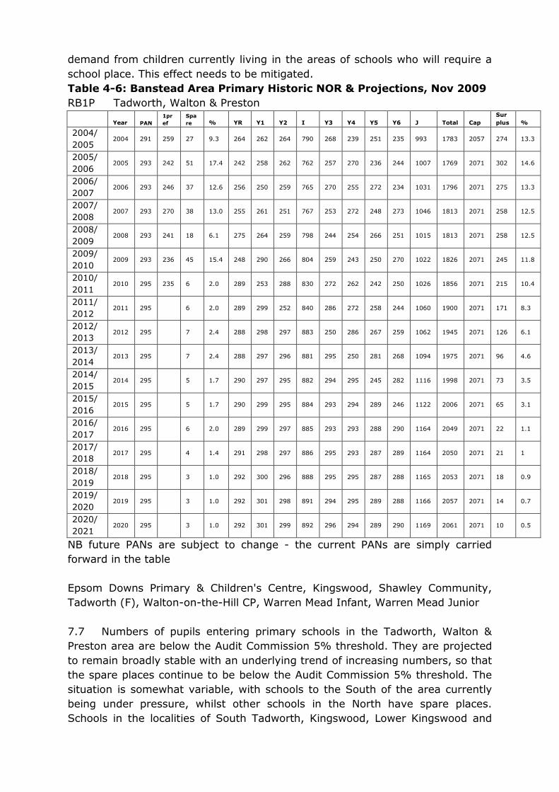
demand from children currently living in the areas of schools who will require a
school place. This effect needs to be mitigated.
Table 4-6: Banstead Area Primary Historic NOR & Projections, Nov 2009
RB1P Tadworth, Walton & Preston
Year PAN
1pr
ef
Spa
re % YR Y1 Y2 I Y3 Y4 Y5 Y6 J Total Cap
Sur
plus %
2004/
2005 2004 291 259 27 9.3 264 262 264 790 268 239 251 235 993 1783 2057 274 13.3
2005/
2006 2005 293 242 51 17.4 242 258 262 762 257 270 236 244 1007 1769 2071 302 14.6
2006/
2007 2006 293 246 37 12.6 256 250 259 765 270 255 272 234 1031 1796 2071 275 13.3
2007/
2008 2007 293 270 38 13.0 255 261 251 767 253 272 248 273 1046 1813 2071 258 12.5
2008/
2009 2008 293 241 18 6.1 275 264 259 798 244 254 266 251 1015 1813 2071 258 12.5
2009/
2010 2009 293 236 45 15.4 248 290 266 804 259 243 250 270 1022 1826 2071 245 11.8
2010/
2011 2010 295 235 6 2.0 289 253 288 830 272 262 242 250 1026 1856 2071 215 10.4
2011/
2012 2011 295 6 2.0 289 299 252 840 286 272 258 244 1060 1900 2071 171 8.3
2012/
2013 2012 295 7 2.4 288 298 297 883 250 286 267 259 1062 1945 2071 126 6.1
2013/
2014 2013 295 7 2.4 288 297 296 881 295 250 281 268 1094 1975 2071 96 4.6
2014/
2015 2014 295 5 1.7 290 297 295 882 294 295 245 282 1116 1998 2071 73 3.5
2015/
2016 2015 295 5 1.7 290 299 295 884 293 294 289 246 1122 2006 2071 65 3.1
2016/
2017 2016 295 6 2.0 289 299 297 885 293 293 288 290 1164 2049 2071 22 1.1
2017/
2018 2017 295 4 1.4 291 298 297 886 295 293 287 289 1164 2050 2071 21 1
2018/
2019 2018 295 3 1.0 292 300 296 888 295 295 287 288 1165 2053 2071 18 0.9
2019/
2020 2019 295 3 1.0 292 301 298 891 294 295 289 288 1166 2057 2071 14 0.7
2020/
2021 2020 295 3 1.0 292 301 299 892 296 294 289 290 1169 2061 2071 10 0.5
NB future PANs are subject to change - the current PANs are simply carried
forward in the table
Epsom Downs Primary & Children's Centre, Kingswood, Shawley Community,
Tadworth (F), Walton-on-the-Hill CP, Warren Mead Infant, Warren Mead Junior
7.7 Numbers of pupils entering primary schools in the Tadworth, Walton &
Preston area are below the Audit Commission 5% threshold. They are projected
to remain broadly stable with an underlying trend of increasing numbers, so that
the spare places continue to be below the Audit Commission 5% threshold. The
situation is somewhat variable, with schools to the South of the area currently
being under pressure, whilst other schools in the North have spare places.
Schools in the localities of South Tadworth, Kingswood, Lower Kingswood and

Walton-on-the-Hill are under pressure, the two schools under most pressure
being Kingswood and Walton-on-the-Hill Primary Schools. This is shown in the
Kingswood and Walton-on-the-Hill Historic NOR table. Therefore developments in
these areas would be unacceptable without mitigation.
Kingswood and Walton-on-the-Hill Historic NOR
Year
PA
N
1pr
ef
Spa
re % YR Y1 Y2 I Y3 Y4 Y5 Y6 J Total Cap
Sur
plus %
2004/
2005 2004 57 54 -1 -1.8 58 55 57 170 48 44 49 47 188 358 399 41 10.3
2005/
2006 2005 58 57 5 8.6 53 54 56 163 50 53 45 48 196 359 406 47 11.6
2006/
2007 2006 58 57 4 6.9 54 56 55 165 56 58 56 47 217 382 406 24 5.9
2007/
2008 2007 58 79 -1 -1.7 59 55 58 172 55 58 57 58 228 400 406 6 1.5
2008/
2009 2008 58 82 -2 -3.4 60 59 53 172 59 54 57 60 230 402 406 4 1
2009/
2010 2009 58 62 2 3.4 56 60 59 175 52 58 52 58 220 395 406 11 2.7
2010/
2011 2010 60 79 3 5.0 57 59 60 176 59 54 58 52 223 399 406 7 1.7
RB2P Banstead & Woodmansterne
Year
PA
N
1pr
ef
Spa
re % YR Y1 Y2 I Y3 Y4 Y5 Y6 J Total Cap
Sur
plus %
2004/20
05 2004 192 191 7 3.6 185 202 170 557 162 172 165 156 655 1212 1252 40 3.2
2005/20
06 2005 192 180 16 8.3 176 187 202 565 168 156 170 162 656 1221 1304 83 6.4
2006/20
07 2006 192 175 16 8.3 176 171 189 536 191 172 160 161 684 1220 1304 84 6.4
2007/20
08 2007 192 210 13 6.8 179 174 175 528 178 189 169 157 693 1221 1304 83 6.4
2008/20
09 2008 192 195 8 4.2 184 189 174 547 168 173 189 167 697 1244 1304 60 4.6
2009/20
10 2009 192 175 15 7.8 177 192 188 557 164 169 172 189 694 1251 1304 53 4.1
2010/20
11 2010 192 220 -1 -0.5 193 184 194 571 181 170 164 172 687 1258 1304 46 3.5
2011/20
12 2011 192 15 7.8 177 201 184 562 185 181 168 163 697 1259 1324 65 4.9
2012/20
13 2012 192 19 9.9 173 184 200 557 175 185 178 167 705 1262 1344 82 6.1
2013/20
14 2013 192 22 11.5 170 180 183 533 190 175 182 177 724 1257 1344 87 6.5
2014/20
15 2014 192 21 10.9 171 177 179 527 174 190 172 180 716 1243 1344 101 7.5
2015/20
16 2015 192 21 10.9 171 178 176 525 170 174 187 171 702 1227 1344 117 8.7
2016/20
17 2016 192 20 10.4 172 178 177 527 167 170 171 185 693 1220 1344 124 9.2
2017/20
18 2017 192 20 10.4 172 179 177 528 168 167 167 170 672 1200 1344 144 10.7
2018/20
19 2018 192 20 10.4 172 179 178 529 168 168 164 166 666 1195 1344 149 11.1
2019/20
20 2019 192 20 10.4 172 179 178 529 169 168 165 163 665 1194 1344 150 11.2
2020/20
21 2020 192 19 9.9 173 179 178 530 169 169 165 164 667 1197 1344 147 10.9
NB future PANs are subject to change - the current PANs are simply carried
forward in the table
Banstead Infant, Banstead Junior, St Anne's Catholic Banstead, Woodmansterne

7.8 Numbers of pupils entering primary schools in the Banstead &
Woodmansterne area exceeded the number of places available in 2010. The
number of 1st preference applications for places for September 2010 increased
significantly above that of the pervious year. There has been increased pressure
on places in this area from children living in Netherne on the Hill, where the
former Netherne Hospital site has been developed over the years. It is likely that
this trend will continue, although as the forecast is based on average historical
trends, this would not be reflected in the forecast until next year. Children
yielded from housing developments increase demand for places. This effect
needs to be mitigated.
8.0 CONCLUSION
8.1 Regulation 122 of the Community Infrastructure Levy, England and Wales
(CIL) Regulations 2010 allows for a planning obligation to be made provided it
fulfils three tests. Proposed developments yield children, the cumulative effect of
which needs to be mitigated. This proposed development would put
unacceptable pressure on educational infrastructure, were it not to be mitigated.
RBBC requires S106 contributions to provide Infrastructure to mitigate the
effects of development. The SE Plan requires that the scale and pace of
development will depend on sufficient capacity being available. Development
would be detrimental to LAA targets in the Surrey Community Strategy (SCS)
were it to go ahead without sufficient educational infrastructure being in place.
PPS1 Delivering Sustainable Development and PPS4 Planning for Sustainable
Economic Growth require sufficient educational infrastructure to be in place to
support development. Therefore a contribution is an obligation which is
necessary to make the development acceptable in planning terms. If a
contribution is unable to be made, then the development would be unacceptable
and should not be permitted.
8.2 The need to apply regulation 122 of the CIL regulations only arises if in
determining this planning application it is considered that a planning obligation
may make it acceptable. If this is the case, then the first test is fulfilled in that it
would be an obligation that is necessary to make the development acceptable.
8.3 The proposed development is located in an area where there will be
pressure by the pupils yielded by the proposed development on education
infrastructure. There is a geographic and functional link between the proposed
development and the education infrastructure that needs to be provided.
Therefore the required contribution is an obligation that is directly related to the
proposed development.
8.4 The required contribution is substantially lower than the actual cost of
provision of permanent infrastructure and so any deficiency in fairness or
proportionality is to the benefit of the developer. Therefore, an education
contribution is considered an obligation that is fairly and reasonably related in
scale and kind to the proposed development.

8.5 Paragraphs B21 & B22 of ODPM Circular 05/2005 allows for contributions
from developers to be pooled where the combined impact of a number of
developments creates the need for education infrastructure. The cumulative
impact of developments in this area does provide a need for education
infrastructure, and each developer should contribute a fair proportion towards
the total cost.
8.6 Paragraph B23 of ODPM Circular 05/2005 allows for later developers to be
required to contribute the relevant proportion of the costs item of infrastructure
necessitated by the cumulative impact of a series of developments. In this case
the cumulative impact of developments in this area will require provision of
education infrastructure, some of which will be provided before the full need has
been manifested, and developers should contribute a fair proportion towards the
total cost.
8.7 This proposed development is located in an area where there are currently
insufficient primary school places and pressure on secondary provision. It is
reasonable to require a contribution towards the cost of provision of education
infrastructure, either towards future costs, or to offset costs that have already
been incurred.
8.8 The contribution towards education infrastructure, calculated according to
the tariff sought in respect of this development, would be spent on:
Primary – £13,300 – infrastructure at Kingswood Primary School.

HIGHWAYS JUSTIFICATION FOR PLANNING OBLIGATIONS AND INFRASTRUCTURE CHARGE The Reigate and Banstead Borough Council Planning Obligations and
Infrastructure Supplementary Planning Document (SPD) provides a mechanism to ensure that the impacts resulting from development are mitigated against.
One of the impacts that are mitigated through the SPD relates to highway and transport infrastructure. This statement has been prepared to justify the transportation element of the Infrastructure Contributions, which would be
appropriate, should the Inspector allow the appeal.
POLICY The provision of additional infrastructure to support new development, whilst protecting the character of the area and the level of amenity enjoyed currently by residents, is a key objective of the LDF process and the Reigate & Banstead Borough Local Plan. In addition the primary aim of the Borough Local Plan and emerging core strategy is to contribute to a sustainable pattern of development within the Borough…which promotes sustainable forms of travel (see para 7.2 of the SPD). Policy Mo4 and Mo7 of the Borough Local Plan support the need for the applicant to provide a financial contribution toward new transport infrastructure to mitigate the impact of the proposed development: Policy Mo4: If proposals would exacerbate transport problems or make conditions more hazardous for highway users, the County Highway Authority and Borough Council will ensure where appropriate that necessary improvements are designed, fully funded by the developer and completed to accommodate safely the traffic related to the development. Policy Mo7: New development will be required to provide parking provision in accordance with the current adopted standards. Where appropriate, the developer will be requested to provide and fund enhanced facilities to encourage alternative means of travel to the private car. Planning Policy Guidance 13 provides the national policy guidance on seeking transport related benefits from developers. The guidance states that planning obligations may be used to achieve improvements to public transport, walking and cycling, where such matters would be likely to influence travel patterns in relation to development. In addition limiting traffic growth is an objective of the County Council’s Local Transport Plan 2006/7- 2010/11. The provision of non-car modes of transport infrastructure would promote use of sustainable forms of transport thus contributing towards limiting growth. In this particular case it is appropriate and necessary that improvements to non car modes of transport are made within the vicinity of the site as the proposal increases the occupancy of the site and as a result increases the travel demand and highway impact on the local transportation network. The South East Plan Regional Spatial Strategy for the South East of England was introduced by the Government Office for the South East on 6 May 2009. The South East Plan Regional Spatial Strategy formed part of the emerging Local Development Framework (LDF) at the time application P/10/00232/F was being considered. That document also provided additional policy backing to the Planning Obligations and Infrastructure Charge mechanism. In particular the Highway Authority cite Policies CC7 (Infrastructure & Implementation) and LF10 (Small scale site tariff) as the relevant policies in use at the time. (See Appendix 2)

Policy CC7 (Infrastructure & Implementation) of the South East Plan supported the general principal that contributions from development will be required to help deliver new infrastructure Policy LF10 applied to the London Fringe sub-regional strategy area. The policy strongly supported a tariff-based approach to collecting infrastructure contributions from relatively small sites within established urban areas. It recognised the cumulative impact on infrastructure and services from many small developments, and the need to address that impact CONTRIBUTION Applying a formulaic approach to contributions (as outlined in the SPD) ensures that even small-scale development will contribute towards transportation improvements in the locality of the planning application site. The formula used to assess the impact of a development on the highway infrastructure can be quantified by determining the total travel generated by a particular development, however due to the complex nature of travel demand, this level of impact can only be made by approximation. The baseline charge is calculated by dividing Surrey County Council’s annual expenditure on transport1 by the existing Surrey related travel demand2. Within cost benefit analysis of road schemes a typical design life of 25 years is used in such calculations. As an incentive towards locating development in highly accessible areas, a differential of plus or minus 30% has been applied to the baseline cost per trip. The calculation used is outlined in more detail within paragraph’s 10.4 to 10.8 of the Borough’s adopted Planning Obligations and Infrastructure SPD April 2008. The tariff system itself is based upon a Surrey wide model which 7 out of 11 boroughs have now adopted. The Highway Authority believes that the tariff provides a robust mechanism for ensuring that the cumulative highway and transport impact of new development is suitably mitigated in Reigate & Banstead and across the whole of the County. Using this formulaic approach, the transportation element of the tariff charge for this proposed development is £13,796.55 (based on demolition of existing dwelling and erection of 8 x 2 bedroom dwellings outside town centre). The transportation improvement schemes required within close proximity to the appeal site include the following works (See Appendix 1): - Increases to cycle storage facilities at Kingswood Railway Station where there is currently not enough storage to meet demand. Kingswood is the nearest rail station to the appeal site and within a short and comfortable cycling distance of approximately 1km. Approximate cost £8,000. Pedestrian accessibility improvements including improved crossing facilities at Waterhouse Lane / A217 junction and improved pedestrian crossing facilities at the junction of St Monica’s Road/Waterhouse Lane/Bonsor Drive, all incorporating dropped kerbs and tactile paving. This is all to improve routes potential occupants of the proposed development would take to access local shops, facilities and public transport. Approximate cost £12,000. Pedestrians include people of all ages, sizes and abilities, therefore the design of streets needs to satisfy a wide range of requirements to encourage sustainable travel for all. This includes wheelchair users, the visually impaired and people pushing wheeled equipment such as prams. The Department for Transport Document
1 Surrey Local Transport Plan Annual Delivery Report 2001 – 2006 2.1.3
2 Surrey County Transport Model – Approx 2.7million daily trips
Manual for Streets provides technical guidance on the design of residential streets. It states “Dropped kerbs should be marked with appropriate tactile paving and aligned with those on the other side of the carriageway”. It also states “all crossings should be provided with tactile paving”. It is for these reasons the above pedestrian accessibility improvements are being sought. Bus stop facility and accessibility improvements along A217. Approximate cost £20,000. It is possible to access the A217, on foot, relatively easily from the appeal site due to an un-surfaced path. This provides access to the nearest public transport facilities in the bus network along the A217. In order the encourage the use of these services improvements are required to shelters, stands, lighting, kerbs and timetables. As well as the above schemes, the highway authority has identified a highway safety improvement scheme involving traffic calming features along the 30mph stretch of Outwood Lane. An area of the local highway network occupants of the proposed development, may use on a regular basis. Approximate cost £60,000. CIRCULAR 05/05 AND COMMUNITY INFRASTRUCTURE LEVY
Regulation 122 of the Community Infrastructure Levy Regulations states it is unlawful for a planning obligation to be taken into account in a planning decision on a development which is capable of being charged CIL if the obligation does not meet all of the following tests:
(a) necessary to make the development acceptable in planning terms;
(b) directly related to the development; and,
(c) fairly and reasonably related in scale and kind to the development This overlaps with the tests for financial contributions as set out by ODPM Circular 05/05. The contribution satisfies the requirements of both tests as follows: (i) relevant to planning; Increasing accessibility to key services and facilities and improving road safety and security are objectives of the County Council’s Local Transport Plan 2006/07-2010/11. The promotion of the use of sustainable travel modes plays an important role in enhancing accessibility, and supports policies set out within PPG13. Policy Mo4 and Mo7 of the Reigate & Banstead Borough Local Plan 2005 state that developers will be required to make financial contribution to safely accommodate new development, and encourage sustainable travel.
(ii) necessary to make the proposed development acceptable in planning terms; The proposed development will increase the occupancy of the site and increase the travel demand on the transportation network. The transportation element of the infrastructure tariff seeks to mitigate this impact and secure improved accessibility to local facilities. Without the contribution, no measures to improve accessibility, safety and promote sustainable travel choices would be secured. (iii) directly related to the proposed development; the contribution is required to provide improvements within the close vicinity of the appeal site and on areas of the highway network that would be regularly used by occupants of the proposed development.
(iv) fairly and reasonably related in scale and kind to the proposed development; There are a package of improvement measures required in the local area to improve safety and accessibility totaling approx £100,00. The proposed development will be providing a contribution (approximately 13%)
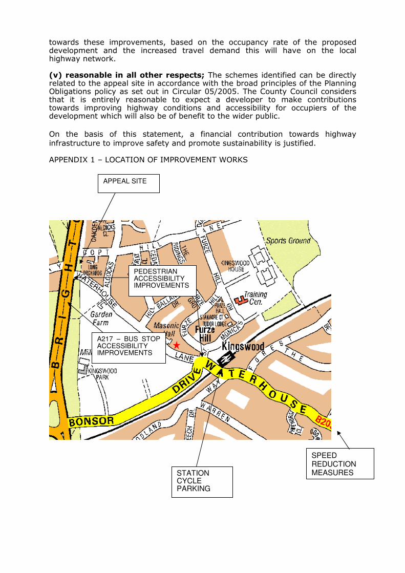
towards these improvements, based on the occupancy rate of the proposed development and the increased travel demand this will have on the local highway network.
(v) reasonable in all other respects; The schemes identified can be directly related to the appeal site in accordance with the broad principles of the Planning Obligations policy as set out in Circular 05/2005. The County Council considers that it is entirely reasonable to expect a developer to make contributions towards improving highway conditions and accessibility for occupiers of the development which will also be of benefit to the wider public.
On the basis of this statement, a financial contribution towards highway infrastructure to improve safety and promote sustainability is justified. APPENDIX 1 – LOCATION OF IMPROVEMENT WORKS
APPEAL SITE
A217 – BUS STOP
ACCESSIBILITY
IMPROVEMENTS
PEDESTRIAN
ACCESSIBILITY
IMPROVEMENTS
STATION
CYCLE
PARKING
SPEED
REDUCTION
MEASURES

SURREY COUNTY COUNCIL LOCAL TRANSPORT PLAN 2006/7 – 2010/11 There are five objectives for the LTP. 1. Tackling congestion to limit delays 2. Increasing accessibility to key services and facilities 3. Improving road safety and security 4. Enhancing the environment and quality of life 5. Improving management and maintenance of our transport network

http://www.planning-inspectorate.gov.uk
Appeal Decision Site visit made on 2 November 2010
by Paul Jackson B Arch (Hons) RIBA
an Inspector appointed by the Secretary of State for Communities and Local Government
Decision date: 19 November 2010
Appeal Ref: APP/K3605/A/10/2123944
Nicholson House, Thames Street, Weybridge, Surrey KT13 8JG
• The appeal is made under section 78 of the Town and Country Planning Act 1990
against a refusal to grant planning permission. • The appeal is made by Pembridge Estates (Weybridge) Ltd against the decision of
Elmbridge Borough Council. • The application Ref 2009/2074, dated 31 October 2009, was refused by notice dated
8 January 2010.
• The development proposed is erection of new B1 accommodation behind Nicholson House following the demolition of existing B1 office buildings (annexe). Erection of 3
No. 3 bedroom houses and 1 No. 4 bedroom house with associated car parking and landscaping for both elements.
Preliminary matters
1. The postcodes given on the application form and the appeal form are different.
The correct postcode is KT13 8JG.
2. The north point given on the application drawings differs from that shown on the Daylight and Sunlight report dated 29 October 2009. I have considered the
proposal on the basis of the north point indicated in the Daylight and Sunlight
report and revised drawings with a corrected north point received subsequent to
the site visit.
3. A revised Unilateral Undertaking (UU) dated 5 May 2010 has been submitted which
provides for the improvement of local infrastructure. It incorporates changes
requested by the Council and subsequently, I have been advised that the Council no longer contests the reason for refusal relating to this matter. I have, however,
in this decision, considered whether the proposed contributions meet the tests set
out in Regulation 122 of the Community Infrastructure Levy Regulations (CIL).
Decision
4. I allow the appeal, and grant planning permission for erection of new B1
accommodation behind Nicholson House following the demolition of existing B1 office buildings (annexe). Erection of 3 No. 3 bedroom houses and 1 No. 4
bedroom house with associated car parking and landscaping for both elements at
Nicholson House, Thames Street, Weybridge, Surrey KT13 8JG in accordance with the terms of the application, Ref 2009/2074, dated 31 October 2009, subject to the
conditions in the schedule at the end of this decision.
Main Issues
5. The main issues are the effect of the proposed housing element of the
development on the living conditions of adjacent occupiers in terms of noise and

Appeal Decision APP/K3605/A/10/2123944
http://www.planning-inspectorate.gov.uk 2
disturbance; and whether the security of nearby occupiers would be unacceptably
compromised.
Reasons
6. The site is currently used as a car park associated with the offices towards the
front of the site. The parking required for this purpose would be reduced as part of
the scheme and 4 new dwellings are proposed in the rear part of the car park area. Dwellings in Montrose Walk lie immediately on the other side of the northern
boundary of the site and Nos. 9, 11 and 13 have very restricted outside space.
Habitable rooms in these houses would be in relatively close proximity to the
proposed access to the new dwellings, on the other side of a varied boundary of brick walls and timber fences.
7. The number of vehicle movements associated with 4 houses is likely to be less
than that associated with office use. Nearby occupiers are concerned that residential vehicle movements and deliveries to houses would be likely to occur all
day as opposed to mainly mornings and evenings, but there is no evidence to
suggest that that would be the case. Nor is there anything to suggest that, were the development not to take place, office vehicle movements would necessarily be
restricted in that way in the future; much would depend on the type of business
carried out. Moreover, engine noise associated with future residents’ vehicles (which would be parked on the other side of the site) is likely to be less noticeable
than vehicles reversing out of parking spaces adjacent to the boundary.
8. I have taken into account the likelihood that the flank wall of the dwelling on plot 4 would reflect vehicle noise towards No. 11 Montrose Walk, but consider that the
limited level of passing traffic and relatively short length of the wall would be
sufficient for this to be an insignificant factor. Overall, the potential for noise and disturbance would be reduced as a result of the development.
9. The Council and local residents refer to the effect on the character and residential
amenity of Darnley Park, a residential road bordering the site to the west. The
concern relates to a proposed gate in the boundary fence which would allow residential refuse from the development to be collected at the same time as
Darnley Park, there being insufficient space for a refuse collection vehicle to turn
round within the appeal scheme. I accept that it would be impossible to ensure by means of a planning condition that the gate would be kept locked when not
required for refuse collection. However, the potential for harm to character or
residential amenity would be very limited. The introduction of a gate in the fence, whether locked or not, would not in itself harm the character of the area and new
houses on the opposite side would be likely to improve the quality of the
environment in Darnley Park, compared to the existing use as a car park.
10. It would be unlikely that the gate would be used as a ‘cut-through’ because the
appeal development would itself be gated at its access and again at the entrance
from Thames Street. I understand the concern that opportunities for crime may result from unsecured links between different residential schemes but for the
reasons given above, consider that the increased risk here would be extremely low.
It would also be in the interests of future residents of the scheme to prevent access through the gate when it is not required.
Section 106 Undertaking
11. The Council has provided a justification for the proposed contribution of £37572.32
towards education, libraries, play spaces and pitches, community facilities, re-cycling, environmental improvements and transport. The figure is arrived at using
the small site tariff in line with policy LF10 of the South East Plan and policies

Appeal Decision APP/K3605/A/10/2123944
http://www.planning-inspectorate.gov.uk 3
GEN4, HSG1 and LER4 of the Replacement Elmbridge Borough Local Plan 2000
(LP). I find that the contribution is fairly and reasonably related in scale and kind
to the proposed development and reasonable in all other respects. It meets the requirements of Regulation 122 of the CIL Regulations and attracts substantial
weight.
Other matters
12. I have taken account of all the other matters raised including the effect on daylight
and sunlight to properties in Montrose Walk. There would be a marked
improvement in the amount of daylight and sunlight received by the occupants of
Nos. 5 and 7. There would be a reduction in levels of daylight and hours of winter sunlight received at Nos. 11 and 13, most noticeably at No. 11, where winter
sunlight in particular would be reduced at ground floor. However, bearing in mind
the anticipated daylight level, the existing window area and the recommendations contained in the BRE Report 209 Site Layout Planning for Daylight and Sunlight: A
Guide to Good Practice, I do not find that the circumstances would represent
unacceptable living conditions for the occupants.
13. I conclude that the proposed development would not conflict with the amenity or
security protection objectives of saved policies HSG16, ENV1, ENV2, ENV3, ENV9,
MOV2, MOV4 and MOV7 of the LP.
Conditions
14. Details of the materials to be used for the external surfaces of the development
need to be approved to ensure that it is visually acceptable. Details of hard and soft landscaping and boundary treatment are required for the same reason and
because of the poor condition of the existing boundary with properties in Montrose
Walk. Model conditions are imposed with the effect of ensuring the protection of existing trees which are the subject of a Tree Preservation Order. The parking
spaces shown on the application drawings must be provided before occupation. A
scheme of archaeological investigation is required in view of the potential for items
of interest to emerge during the building works. The site is sloping and in view of the difference in levels with Darnley Close, slab levels of the dwellings need to be
approved by the Council.
15. Finally, in accordance with the advice in Government guidance in Greater Flexibility for Planning Permissions issued in November 2009, otherwise than as set out in
this decision and conditions, it is necessary that the development shall be carried
out in accordance with the approved plans, for the avoidance of doubt and in the interests of proper planning.
Paul Jackson
INSPECTOR

Appeal Decision
Site visit made on 16 August 2010
by Tim Wood BA(Hons) BTP MRTPI
The Planning Inspectorate
4/11 Eagle Wing
Temple Quay House 2 The Square
Temple Quay
Bristol BS1 6PN
� 0117 372 6372 email:[email protected]
ov.uk
an Inspector appointed by the Secretary of State
for Communities and Local Government
Decision date: 14 September 2010
Appeal Ref: APP/K3605/A/10/2121427
60 Hare Lane, Claygate, Surrey KT10 0QU
• The appeal is made under section 78 of the Town and Country Planning Act 1990 against a refusal to grant planning permission.
• The appeal is made by Mr Robert O’Reilly against the decision of Elmbridge Borough Council.
• The application Ref 2009/1715, dated 23 September 2009, was refused by notice dated
10 November 2009. • The development proposed is a plot sub-division; demolition of the existing double
garage; erection of a new dwelling.
Decision
1. I allow the appeal, and grant planning permission for a plot sub-division;
demolition of the existing double garage; erection of a new dwelling at 60 Hare
Lane, Claygate, Surrey KT10 0QU in accordance with the terms of the
application, Ref 2009/1715, dated 23 September 2009, subject to the
conditions set out in schedule 1 of this decision.
Preliminary Matter
2. The Council and the appellant have provided me with their respective
comments on the appeal in relation to the recent revisions to Planning Policy
Statement 3 ‘Housing’ (PPS3). I have taken account of these comments in
determining this appeal.
Main Issues
3. The main issue in this appeal are as follows;
• the effects of the proposal on the character of the area and provision of
amenity space
• the effects of the proposal on car parking
• whether suitable provision for refuse storage can be made.
Reasons
The effects of the proposal on the character of the area and provision of
amenity space
4. The appeal site currently forms part of the side and rear garden of this 2 storey
house which sits at the end of a run of houses. The rear of the site rises
steeply towards the adjacent railway and car park. The proposed house would

Appeal Decision APP/K3605/A/10/2121427
2
match the existing height of the existing house and would complement its
design. It would be separated from No 60 by 2m and would be on the same
front building line.
5. The other flank wall of the proposed house would be sited around 5m-6m from
the boundary with the adjacent electricity sub-station. Taking these points
together, I consider that the proposal would have due regard to the character
of the existing dwellings and would retain a suitable degree of spaciousness
such that the street-scene would not be harmed.
6. The proposal indicates that the rear area of the house would be altered to
provide a larger garden area at the same level of the house and the rearmost
section would be at a higher level on the far side of a retaining wall. The
proposal also shows a similar alteration to the retained rear garden of the
existing house. The maximum depth of the proposed rear garden for the new
house would be about 14m and a minimum of about 6.5m. In addition the
area to the side of the house could also be used as private garden space.
7. The Council’s Supplementary Planning Guidance ‘Elmbridge Residential Design
Guidance’ (SPG) states that the Council will normally expect a minimum garden
length of 11m. This is met across part of the width of the proposed garden but
not across all of its width. However, the proposed rear garden is wide and the
area to the side of the house could be used as garden. Therefore, I consider
that there would be sufficient provision for the needs of the future occupiers of
the house. In addition, the visual setting space for the proposed house would
be enhanced by the overall width of the site and the overgrown embankment
to the rear, outside the site. In this respect, I consider that the proposal would
not appear cramped and would have no unacceptable effects on the character
of the locality.
8. In the particular circumstances of this appeal where I consider there to be no
unacceptable effects on the character of the area, I judge that the revision to
PPS3, which removes private gardens from the definition of previously
developed land, does not mean that the proposal is unacceptable.
Furthermore, I note that the Council accept in their supplementary statement
that the redevelopment of private garden land may be acceptable where it
would cause no harm to the character of the area or to amenity. I judge this
to be the case here.
The effects of the proposal on car parking
9. The proposal would not contain provision for any off-street car parking for
either the existing or proposed houses. I noted that parking is not restricted
on Hare Lane nor on the immediately adjacent streets. In addition, bus stops
are close-by and the site is within walking distance of Claygate railway station.
10. I consider that the appeal site is within an area where alternative means of
transport are readily available and the use of the private car for journeys can
be expected to be reduced. Combined with the availability of on-street car
parking, I consider that the proposal is acceptable and the failure to meet the
Council’s maximum provision is justified in this case. In addition, I note that
Surrey County Council as Highways Authority has raised no objections to the
proposal.
Appeal Decision APP/K3605/A/10/2121427
3
Provision for refuse storage
11. The Council are critical of the fact that the proposal does not indicate facilities
for the storage of recycling and refuse bins and is concerned that if such
provision is made it should have an acceptable effect on the character of the
area.
12. In my judgement the site is spacious enough such that there would be
sufficient space to provide such storage facilities in areas accessible to the
collection services. Furthermore, it would be possible to site such facilities in a
position where it would not have any unacceptable effects on the locality, or to
provide screening for it. I consider that the provision of storage facilities could
be controlled by a suitable condition, as could any required screening.
Other Matters
13. The appellant has completed a Section 106 Undertaking which contains the
provision to make a financial contribution for education, libraries, recreational
space, community facilities, recycling, environmental improvements and
transport. The Council has stated that the Undertaking is acceptable to them
and meets its policy objectives. From the representations received in respect
of this matter I am satisfied that the provisions of the Undertaking are
necessary, relate directly to the development and fairly relate in scale and kind
to the proposed development and therefore meet the tests in Regulation 122 of
The Community Infrastructure Levy (CIL) Regulations 2010.
Conditions
14. I have considered the conditions suggested by the parties having regard to the
advice in Circular 11/95 ‘The Use of Conditions in Planning Permissions’. I have
modified the suggested conditions in order to reflect the advice in Circular
11/95 where necessary.
15. In order to protect the appearance of the area I agree that it is necessary to
ensure that the proposal is finished in materials which are appropriate to the
area and that an agreed landscaping scheme is implemented. Due to the
physical characteristics of the site and the resultant disposition of garden space
I agree that the exceptional circumstances required to remove permitted
development rights, as suggested by the Council, exist here.
16. In addition the appellant has suggested that a condition requiring the provision
of the refuse and recycling storage facilities should be the subject of a
condition. For the reasons set out above, I agree. Otherwise than as set out in
this decision and conditions, it is necessary that the development shall be
carried out in accordance with the approved plans, for the avoidance of doubt
and in the interests of proper planning.
Conclusion
17. For the reasons set out above and taking account of all other matters raised, I
conclude that the appeal should be allowed.
S T Wood
INSPECTOR
Appeal Decision Hearing held on 29 September 2009
Site visit made on 29 September 2009
by Simon Rawle BA (Hons) Dip TP MRTPI Solicitor
The Planning Inspectorate
4/11 Eagle Wing
Temple Quay House 2 The Square
Temple Quay
Bristol BS1 6PN
� 0117 372 6372 email:[email protected]
ov.uk
an Inspector appointed by the Secretary of State
for Communities and Local Government
Decision date:
29 October 2009
Appeal Ref: APP/L3625/A/09/2106834
58 Cockshot Hill, Reigate, RH2 8AN
• The appeal is made under section 78 of the Town and Country Planning Act 1990 against a refusal to grant planning permission.
• The appeal is made by Gold Property Resources LLP against the decision of Reigate & Banstead Borough Council.
• The application Ref P/09/00267/F, dated 17 February 2009, was refused by notice
dated 11 May 2009. • The development proposed is the erection of a detached dwelling.
Application for costs
1. At the Hearing an application for costs was made by the appellant against the
Council. This application is the subject of a separate Decision.
Decision
2. I dismiss the appeal.
Main issues
3. I consider that the main issues in this case are; whether the proposal would
have an adverse impact on the character and appearance of the area; and
whether appropriate arrangements have been put in place to secure any
contributions made necessary by the proposal.
Reasons
4. The development plan for the area includes the South East Plan – Regional
Spatial Strategy for the South East (RSS) and the saved policies contained
within the Reigate and Banstead Borough Local Plan.
Character and Appearance
5. The appeal site is located within a residential area. The majority of houses in
the vicinity are detached. Although gaps between them vary, they appear to sit
comfortably on their plots. The proposal would involve the construction of a
detached house within an existing gap in the streetscene. The proposed house
would be narrower than others in the road. However, I cannot agree that it
would appear incongruous. Rather, in accordance with Local Plan Policy Ho9,
the scale of development would be compatible with the surrounding
development and the set back from the site boundary on either side would
ensure that the proposal would sit comfortably on its plot and would not appear
cramped. Overall I consider that the proposal has been designed to a high
standard. In accordance with Local Plan Policies Ho13 and Ho16, the proposed
Appeal Decision APP/L3625/A/09/2106834
2
dwelling would conform to the existing pattern of development and would be
compatible with the character of the surrounding area.
6. I therefore conclude that the proposal would not have an adverse impact on
the character and appearance of the area. Accordingly, the proposal would
accord with the objectives of the relevant development plan policies.
Contributions
7. Originally, the Council sought contributions in respect of many matters. At the
Hearing, they reduced the number to three which were for, a highways
contribution, an education contribution and a library service contribution.
8. The appellant and the Council have submitted a number of appeal decisions for
other cases which have pulled both ways on whether certain contributions
sought were justified. I do not have the full details of these other cases and
certainly not the level of information supplied to justify such contributions.
Consequently, whilst these are of interest as background information it is
necessary for me to determine whether based on the evidence specific to this
case the contributions requested are justified taking account of the
development plan context and the tests set out in Circular 05/2005 – Planning
Obligations. For a similar reason, the approach taken by a different Council in a
different location can only be given limited weight in the determination of this
appeal as the circumstances of both cases are materially different.
9. RSS Policy CC7 sets out that contributions from development will be required
to help deliver necessary infrastructure which includes transport, education and
public services (including libraries). RSS Policy LF10 seeks to ensure that the
cumulative impact of small scale development is taken into account. In
addition, the Council have adopted a Supplementary Planning Document –
Planning Obligations and Infrastructure (SPD). Amongst other things, this sets
out formulae and standard charges for various items including transportation,
education and libraries.
10. To my mind, the general approach set out within the relevant development
plan policies and within the SPD are consistent with the advice contained within
Circular 05/2005. I also agree that formulae and standard charges can be
helpful to indicate the level of contribution required by different types of
development, ensure predictability and promote transparency. However, that is
not the end of the matter. Government advice is clear. Whilst the use of
formulae and standard charges is encouraged, they should not be applied in a
blanket form. Therefore it is necessary to ensure that the contribution sought
also meet all of the tests set out in the Circular.
11. The highways contribution sought is £3345.83. This is based on a formulaic
approach as set out in the SPD. That approach seems reasonable. I therefore
consider that the contribution would be relevant to planning. In addition, given
the cumulative impact that small residential developments have on transport
infrastructure, I consider that it would be necessary to make the proposed
development acceptable in planning terms. Moreover, as the Highways
Authority have identified a number of local projects which would assist future
residents of the proposal reach local services and facilities by foot and public
transport I am satisfied that it would be directly related to the proposed
development and would improve highway safety and accessibility. I therefore

Appeal Decision APP/L3625/A/09/2106834
3
find that the contribution sought for highway infrastructure would be fairly and
reasonably related in scale and kind to the proposed development and would
be reasonable in all other respects.
12. The education contribution sought is £3,225.35 for primary education and
£3,549.14 for secondary education. The evidence presented by the Education
Authority is detailed and compelling. I am satisfied that the projected demand
figures for school places are reasonable. I am also satisfied that for both
primary and secondary education there are insufficient school places within the
Reigate/Redhill conurbation to meet current demand. Moreover, the appeal site
is in the Reigate primary planning area, close to Sandcross Primary School
where additional Reception and Junior Places have been provided to meet
increased demand for places. It is reasonable to assume that primary school
age children may live at the proposed house and that if they did they would put
additional pressure on primary school places if not mitigated.
13. Similarly, the appeal site is located in the area served by Reigate School, which
has had additional infrastructure provided to increase the number of places to
meet increased demand. I accept that there is a deficit of secondary school
places within the relevant catchment. Again, it is reasonable to assume that
secondary school age children may live at the proposed house and if they did
they would put additional pressure on secondary school places if not mitigated.
14. I am satisfied that the contribution would be spent within an appropriate
geographical location. As a result, the education contribution sought meets the
tests set out in Circular 05/2005, would be directly related to the proposed
development and would be fairly and reasonably related in scale and kind to
the proposed development.
15. The library services contribution sought is £230.92. It is reasonable to assume
that the residents of the proposed house may use the available library services
within the area which would increase demand for library facilities. I am also
satisfied that the proposed use of the contribution to enhance the existing IT
facilities at Reigate Library would be reasonable. As a result, the library
services contribution sought meets the tests set out in Circular 05/2005, it
would be directly related to the proposed development and it would be fairly
and reasonably related in scale and kind to the proposed development.
16. I therefore conclude that certain contributions made necessary by the proposal
would be required. The appellant has failed to make the necessary
arrangements to secure such contributions and consequently, the proposal
conflicts with the objectives of the relevant development plan policies and with
the national advice contained within Circular 05/2005.
17. I have found that the proposal would not have an adverse impact on the
character and appearance of the area. However, this is outweighed by the fact
that no arrangements have been put in place to secure the contributions made
necessary by the proposal. For that reason I conclude that the appeal should
be dismissed.
S.M Rawle INSPECTOR
Appeal Decisions Inquiry held 20th to 30th July 2010
Site visits made on 25th, 29th July 2010
by Nicholas Hammans FRSA FRTPI
FRGS PPBEng
The Planning Inspectorate 4/11 Eagle Wing Temple Quay House 2 The Square Temple Quay Bristol BS1 6PN � 0117 372 6372 email:[email protected]
an Inspector appointed by the Secretary of State
for Communities and Local Government
Decision date:
24 August 2010
Appeal 1
Ref: APP/C3620/A/09/2112341
53-57 The Street, Ashtead KT21 1AA.
• The appeal is made under section 78 of the Town and Country Planning Act 1990 against a refusal to grant planning permission.
• The appeal is made by Tesco Stores Ltd against the decision of Mole Valley District Council.
• The application Ref MO/2008/1127/PLAMAJ, dated 31 July 2007, was refused by notice dated 9 March 2009.
• The development proposed is redevelopment of a former petrol filling station to provide a retail food store of 2,177 square metres gross external floor area over ground, first and second floors [net sales area 1,115 square metres at ground level] nine 2-bedroom flats on the first and second floors (with nine dedicated car parking spaces) realigned and enlarged car park to serve Ashtead village comprising 212 spaces [including twelve disabled spaces and four parent/toddler spaces] including the demolition of Hobson’s Choice; cycle and motorcycle parking; repositioned recycling centre; highway improvements to the junction of Woodfield Lane and the Street; and new and improved boundary treatment in the car park with retaining walls and fencing.
Appeal 2
Ref: APP/C3620/A/10/2122996
53-57 The Street, Ashtead KT21 1AA.
• The appeal is made under section 78 of the Town and Country Planning Act 1990 against a refusal to grant planning permission.
• The appeal is made by Tesco Stores Ltd against the decision of Mole Valley District Council.
• The application Ref MO/2009/1322/PLAMAJ, dated 9 November 2009, was refused by notice dated 5 February 2010.
• The development proposed is redevelopment of former petrol filling station to provide a retail food store of 1,499 square metres gross external floor area over ground, first and second floors [planning net sales area 750 square metres] realigned and enlarged car park to serve Ashtead village comprising a total 172 spaces [including a total of nine disabled spaces and four parent/toddler spaces], plus nine additional residential spaces; demolition of Hobson’s Choice; 12 cycle and 4 motorcycle parking spaces; repositioned recycling centre; highway improvements to the junction of Woodfield Lane and the Street; and new boundary treatment in the car park with retaining walls and fencing and new pedestrian link between car park and The Street.
Decisions
Appeal 1
I dismiss this appeal.
Appeal Decisions APP/C3620/A/09/2112341 and 2122996
2
Appeal 2
I allow the appeal, and grant planning permission for a supermarket on ground floor and 2 one-bedroom, 4 two-bedroom and 3 three-bedroom flats on first and second floors. Realigned and enlarged car park with repositioned recycling centre. Highway improvements to junction of Woodfield Lane and The Street. Demolition of Hobsons Choice, The Marld; at 53-57 The Street, Ashtead in accordance with the terms of the application, Ref MO/2009/1322/ PLAMAJ, dated 9 November 2009, and the plans submitted with it, subject to conditions set out in the schedule attached to this decision.
Procedural Matters
1. Appeal 1 was submitted on 8 September 2009 and held in abeyance at the request of both parties, pending the Council’s decision on the subsequent application. Appeal 2 was submitted on 17 February 2010 following their decision to refuse planning permission for this subsequent application.
2. The description of the proposed development is amended in a statement of common ground dated 20 July 2010. A complete list and agreed sequence of all relevant submitted plans were deposited at the Inquiry. Application 1 was refused in 2009 on grounds of retail vitality and viability by reference to Planning Policy Statement 6 [PPS6]; but Application 2 was refused on grounds of retail vitality and viability by reference to Planning Policy Statement 4 [PPS4]. The Council does not now defend the reason for refusal on Appeal 2 on grounds of retail impact. A late rebuttal proof of evidence concerning noise was submitted by the appellants and copied to the Council and Rule 6 parties.
3. Appeal 1 relates to:
Redevelopment of site to provide a supermarket on ground floor and 9 No two-bedroom flats on first and second floors. Realigned and enlarged car park with repositioned recycling centre. Highway improvements to junction of Woodfield Lane and The Street. Demolition of Hobsons Choice, The Marld.
Appeal 2 relates to:
Redevelopment of site to provide a supermarket on ground floor and 2 No one-bedroom, 4 No two-bedroom and 3 No three bedroom flats on first and second floors. Realigned and enlarged car park with repositioned recycling centre. Highway improvements to junction of Woodfield Lane and The Street. Demolition of Hobsons Choice, The Marld.
4. The Inquiry was advertised in the Surrey Advertiser. The Council notified 1,600 people interested in the appeal by letter. By agreement with the Inspectorate they were not all re-notified when the date, time and venue were arranged afterwards. Deadlines for written representations expired on 9 April 2010. Before the Inquiry opened 1,231 objections were received by the Council, 6,396 signatures on petitions, and 39 letters of support. These written representations relate to either or both of the applications and have all been taken into account. Written representations from Chris Grayling MP object to both schemes, because of the lack of parking spaces, access which ought to be from The Street rather than the car park; and impact of the car park on
Appeal Decisions APP/C3620/A/09/2112341 and 2122996
3
residential amenity. I am satisfied that proper publicity was afforded to both appeals and that no-one has been disadvantaged.
5. Before the Inquiry opened the Inspectorate drew attention to announcements by the Secretary of State about the revision of Planning Policy Statement 3 [PPS3] and the publication of Planning Policy Statement 5 [PPS5] in 2010. The Government’s Noise Policy Statement for England was published on 15 March 2010. Everyone was aware of the Secretary of State’s revocation of Regional Spatial Strategies. I have taken account of all these changes in National Policy and I have determined these appeals in the light of current Government Policy.
6. Surrey Structure Plan has been superseded. Mole Valley Core Strategy had been published for the purposes of Application 1, and adopted for the purposes of Application 2. A Character Appraisal for Ashtead has recently been adopted as a Supplementary Planning Document. It conforms with Policy CS14 of the Core Strategy. Several policies in the adopted Mole Valley Local Plan, 2000, have been saved for the purposes of the Planning and Compulsory Purchase Act 2004. It is still a material consideration, but all parties recognise that the weight of the Local Plan is affected by the adoption of the Local Development Framework Core Strategy. These changes affect the current Policy background, which is common ground.
7. Notwithstanding advice in Circular 5/2005 that Obligations should not be left to the later stages of an appeal, the appellants found it expedient to submit Unilateral Obligations in draft as late as 12 July 2010. These were not completed and submitted until 29 July, just before the close of the Inquiry. I have considered these in the light of the Circular, Community Infrastructure Levy Regulations 2010 and evidence available at the Inquiry; I refer to them in my conclusions.
Main issues, in either appeal.
8. Whether either of the alternative supermarkets would be too large in the context of Ashtead village centre or likely to harm the choice, vitality and viability of local shopping.
Whether the design, scale or bulk of either building would be out of scale with the character of the village centre.
Whether the additional use of Ashtead Peace Memorial Hall car park as parking space for the supermarket would be inconvenient, leaving inadequate space for long-term or short-term parking.
Whether the development would generate a significant increase in traffic at the junction of Woodfield Lane and The Street A24, and what effect it would have on the free flow and safety of traffic.
Whether the increase in traffic on Woodfield Lane north of the appeal site would harm the local infrastructure and environment.
Whether additional activity in the realigned and extended car park, and deliveries to the supermarket, would cause unacceptable harm to the residential amenity of the neighbourhood.

Appeal Decisions APP/C3620/A/09/2112341 and 2122996
4
Whether either scheme would lead to unacceptable loss of trees of public amenity value.
Background
9. These two appeals relate to alternative proposals for the same site. Application 2 was amended after negotiations between Tesco and the Council, intended to meet the reasons for refusing Application 1. The Council’s officers recom-mended conditional planning permission for Application 2; nevertheless it was refused by elected members. This has become extremely controversial.
10. I am impressed by the volume of objections submitted by local people as individuals, and the weight and quality of evidence prepared by campaigners anxious, for various reasons, to reduce the scale of the supermarket. The Council’s reasons for refusal are differently worded in each decision, but they arise from similar concerns; and a host of objectors oppose the development for their own reasons. I have considered every relevant issue afresh, in the light of evidence available at the Inquiry, to arrive at balanced decisions on each appeal. It is convenient to examine the alternative schemes separately, beginning with Application 2.
Appeal 2
Size of the supermarket
11. The appeal site is the cleared, vacant site of a former petrol filling station in the main shopping centre of Ashtead Village. It has frontage on The Street, with shops and business premises on either side. To my mind, it occupies part of the prime frontage. I recognise and endorse a widespread consensus of opinion that this vacant site is ripe for redevelopment and could beneficially be occupied by a supermarket.
12. In the interests of sustainable economic growth, up-to-date Government Policy PPS4 seeks to direct new shopping facilities to existing centres. It defines the characteristics of typical District Centres. The Council’s vision for Ashtead Village is set out in the recently adopted Core Strategy for Mole Valley, October 2009. In terms of retail hierarchy, this is a District Centre catering for day to day needs of the local community. The strategy for delivering this vision includes maintaining vitality and viability, safeguarding the existing provision of shopping floorspace and providing for an increase in convenience shopping floorspace that is appropriate to the scale, nature and function of Ashtead and complements its existing provision. This strategy is in step with the sequential approach to current Government policy. Accordingly this is the right place for a supermarket, of the right size.
13. I saw for myself that the character of shopping at The Street is unusual; there are several small businesses such as butchers, fishmongers, delicatessen and service shops, café, newsagent, banks and post office all within quick and easy walking distance of one another, together with pubs and a very small supermarket with a limited range of convenience goods. This cluster of local businesses, within a short compass, shares ample parking space with a remarkably popular community centre - Ashtead Peace Memorial Hall. Although Ashtead is not far from the conurbations of London, I recognise those

Appeal Decisions APP/C3620/A/09/2112341 and 2122996
24
134. In accordance with BS5837:2005, an arboricultural method statement shows what could have been done to conserve existing trees if planning permission had been granted. In my opinion this would still amount to a grievous loss. In particular, a conspicuous group of trees, with a specimen plane and three pines, would be lost in the footprint of the supermarket. This group is widely visible. It graces The Village. As it makes such a significant contribution, it should be retained. The loss would be unacceptable.
135. Many more losses would occur among trees along the western boundary of the car park, several more along the boundary with Appletrees, The Marld, conifers and a horse chestnut on the boundary of Hobsons Choice. So much felling would conflict with Local Plan Policy ENV25 and the objectives of Core Strategy Policy CS14 and CS13. Cumulative harm weighs heavily in the balance.
Unilateral Obligation
136. The appellants have submitted Unilateral Obligations pursuant to section 106 of the Town and Country Planning Act 1990 in respect of both applications. Intensive and protracted negotiations with the Local Planning Authority closed only with the end of the Inquiry. Obligation 2 concerning Appeal 2 is dated 29 July. It comes into effect with the grant of planning permission.
137. The Council’s Planning Obligations and Infrastructure Provision - Code of
Practice is available to prospective developers. A Supplementary Planning Document on affordable housing is also published, in accordance with PPS3. And I have received core documents, including those dealing with the Council’s standard charge formulæ, tariff justification, or education, libraries and infrastructure; all submitted to show which contributions are necessary to make the development acceptable.
138. This Obligation 2 offers a series of cash payments by Tesco Stores Limited to Mole Valley District Council. These were negotiated after the Executive of the Council adopted a tariff system on 8 June 2010; drawn up in the light of Community Infrastructure Levy Regulations which came into force on 6 April. Any subsequent levy or tax, which might duplicate the Obligation would have to be answered in terms which make the deal no better or worse. Contribu-tions have to be spent for the purpose to which they were made. They must be paid at specified stages: either before development commences, or before the building is occupied. Money unspent, after five years, must be given back to Tesco’s with interest.
139. Either proposed supermarket scheme would inevitably impose burdens on local infrastructure. Obligation 2 includes the following: a contribution to the provision of affordable housing; specified contributions for equipped play-spaces; highway works off-site at the junction of Woodfield Lane and The Street; footway and townscape improvements along the north side of The Street and a further contribution towards footway and townscape improve-ments; a transport contribution towards highway works in the vicinity; a Travel Plan and contribution towards the cost of monitoring it; recycling contribution, and a contribution toward the cost of monitoring the equipped play-space, recycling and transport contributions. The precise sums of money were argued out until the parties came to agreement. Each contribution meets a specific

Appeal Decisions APP/C3620/A/09/2112341 and 2122996
25
need arising as a result of the development. The Council might have hoped for more, as they told me at the opening of the Inquiry. But that does not challenge the propriety of the final offer in principle.
140. Five relevant and well-known tests of the propriety of any Obligation are set out in Circular 05/2005. For the reasons set out above, I conclude that this Obligation is relevant to planning, necessary to make the development acceptable in planning terms, directly related to the proposed development, properly related in scale and kind to the proposed development and reasonable in all other respects. The Obligation meets the requirements of 05/2005. So it also meets the three equivalent tests in the Levy Regulations. I conclude that it meets all relevant tests of propriety and is lawful. It carries appropriate weight in my decision and comes into effect, with this planning permission.
Summary and conclusions
141. I have considered each of these alternative applications separately, having regard to the Development Plan and Government Policy so far as material to each application, knowing that planning permission might have been given for both. I have taken account of the saved policies of the Mole Valley Local Plan in conjunction with the more recently adopted Local Development Framework Core Strategy. For the reasons given above I conclude that Appeal 2 should be allowed subject to planning conditions; and Appeal 1 should be dismissed.
142. PPS1 declares that significant adverse environmental impacts should be avoided and alternative options which might reduce those impacts pursued. Options are indeed open in these two applications, but the main issues are common to both. Many objections are levelled at both. By the same token both might have been refused. For the foregoing reasons I find on balance that one scheme is acceptable and the other is not.
143. The development proposed in Application 1 would have several significant adverse environmental impacts. These have been balanced with the obvious and demonstrable benefits, including customer choice, convenient shopping, sustainable travel and the powerful positive retail diversion which a big Tesco supermarket would bring to Ashtead District Centre as a whole. There is also some potential to minimise carbon dioxide emissions. Such benefits are established in evidence at the Inquiry; but I find they are outweighed by the evident detriment and cumulative risk of harm arising from the scheme as a whole, associated with a supermarket of that size. I would have refused planning permission for this development even had there been no alternative application.
144. In the case of Appeal 2 the supermarket would be smaller and the positive impact on the District Centre more restrained; but still comparable, and still ample to meet the objectives of Development Plan and Government Policy. I agree that this store could provide a main food shopping destination for Ashtead residents. The appellants provide illustrations of public realm improvements which could be achieved in Ashtead if the development takes place. A contribution towards such improvements is explicit in the appellants’ Obligation 2. In this case I find the benefits outweigh all aspects of harm, most of which would be mitigated: as shown in approved plans; and in
TOWN AND COUNTRY PLANNING ACT 1990
SITE: GARDEN FARMHOUSE, COPT HILL LANE, KINGSWOOD, SURREY KT20 6HN
APPEAL BY: MRS P. FARRIES
PROPOSAL: DEMOLITION OF HOUSE AND OUTBUILDINGS AND REPLACEMENT WITH NEW BUILDING OF 8 NO. 2 BEDROOM FLATS WITH GARAGES
TOWN AND COUNTRY PLANNING APPEALS (HEARING PROCEDURE)
APPENDIX 3 LOCATION MAP SHOWING METROPOLITAN GREEN BELT &
TREE PRESERVATION ORDERS SCALE (1:2500)
JANUARY 2011
PLANNING INSPECTORATE REF: APP/L3625/A/10/2139917/WF
REIGATE AND BANSTEAD BOROUGH COUNCIL REF: P/10/00232/F

Garden Farmhouse
Reproduced from the Ordnance Survey mapping with the permission of the
Controller of Her majesty's Stationery Office (c) Crown Copyright. Unauthorised
reproduction infringes Crown Copyright and may lead to prosecution or civil
proceedings. Reigate and Banstead Borough Council. License No : 100019405.
Dated 2008.
Scale: 1:2500
Town Hall
Castlefield Road
Reigate
Tel: 01737 276000
RH2 0SH

Key

TOWN AND COUNTRY PLANNING ACT 1990
SITE: GARDEN FARMHOUSE, COPT HILL LANE, KINGSWOOD, SURREY KT20 6HN
APPEAL BY: MRS P. FARRIES
PROPOSAL: DEMOLITION OF HOUSE AND OUTBUILDINGS AND REPLACEMENT WITH NEW BUILDING OF 8 NO. 2 BEDROOM FLATS WITH GARAGES
TOWN AND COUNTRY PLANNING APPEALS (HEARING PROCEDURE)
APPENDIX 4: PHOTOGRAPHS OF THE SITE
JANUARY 2011
PLANNING INSPECTORATE REF: APP/L3625/A/10/2139917/WF
REIGATE AND BANSTEAD BOROUGH COUNCIL REF: P/10/00232/F

Copt Hill Lane looking East
Western boundary to Metropolitan Green Belt

Contact: Kelly JethwaContact: Kelly JethwaContact: Kelly JethwaContact: Kelly Jethwa
Direct Line: 01737 2767Direct Line: 01737 2767Direct Line: 01737 2767Direct Line: 01737 276725252525 Fax No: 01737 276018Fax No: 01737 276018Fax No: 01737 276018Fax No: 01737 276018
Email: Kelly.Jethwa @reigateEmail: Kelly.Jethwa @reigateEmail: Kelly.Jethwa @reigateEmail: Kelly.Jethwa @reigate----banstead.gov.ukbanstead.gov.ukbanstead.gov.ukbanstead.gov.uk
Aerial Photograph
Contact: Kelly JethwaContact: Kelly JethwaContact: Kelly JethwaContact: Kelly Jethwa
Direct Line: 01737 2767Direct Line: 01737 2767Direct Line: 01737 2767Direct Line: 01737 276725252525 Fax No: 01737 276018Fax No: 01737 276018Fax No: 01737 276018Fax No: 01737 276018
EEEEmmmmaaaaiiiillll:::: KKKKeeeellllllllyyyy....JJJJeeeetttthhhhwwwwaaaa @@@@rrrreeeeiiiiggggaaaatttteeee----bbbbaaaannnnsssstttteeeeaaaadddd....ggggoooovvvv....uuuukkkk
TOWN AND COUNTRY PLANNING ACT 1990
SITE: GARDEN FARMHOUSE, COPT HILL LANE, KINGSWOOD, SURREY KT20 6HN
APPEAL BY: MRS P. FARRIES
PROPOSAL: DEMOLITION OF HOUSE AND OUTBUILDINGS AND REPLACEMENT WITH NEW BUILDING OF 8 NO. 2 BEDROOM FLATS WITH GARAGES
TOWN AND COUNTRY PLANNING APPEALS (HEARING PROCEDURE)
APPENDIX 5: FRONT COVER AND POLICIES CC7, T14, S3, S6 AND LF10 OF THE SOUTH EAST
PLAN
JANUARY 2011
PLANNING INSPECTORATE REF: APP/L3625/A/10/2139917/WF
REIGATE AND BANSTEAD BOROUGH COUNCIL REF: P/10/00232/F
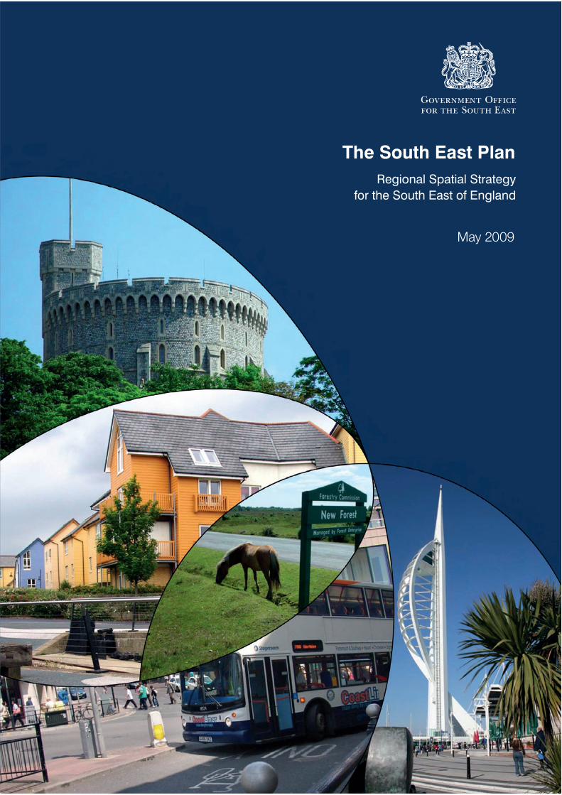
The South East Plan
Regional Spatial Strategy
for the South East of England
May 2009


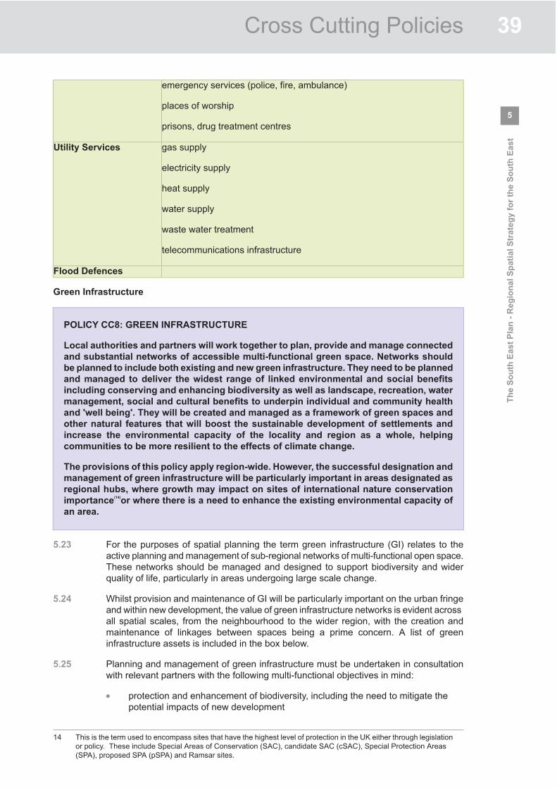


TOWN AND COUNTRY PLANNING ACT 1990
SITE: GARDEN FARMHOUSE, COPT HILL LANE, KINGSWOOD, SURREY KT20 6HN
APPEAL BY: MRS P. FARRIES
PROPOSAL: DEMOLITION OF HOUSE AND OUTBUILDINGS AND REPLACEMENT WITH NEW BUILDING OF 8 NO. 2 BEDROOM FLATS WITH GARAGES
TOWN AND COUNTRY PLANNING APPEALS (HEARING PROCEDURE)
APPENDIX 6: FRONT COVER AND POLICIES MO4 AND MO7 OF THE BOROUGH LOCAL PLAN
JANUARY 2011
PLANNING INSPECTORATE REF: APP/L3625/A/10/2139917/WF
REIGATE AND BANSTEAD BOROUGH COUNCIL REF: P/10/00232/F
1
BOROUGH LOCAL PLAN 2005WRITTEN STATEMENTAND PROPOSALS MAP
THIS PLAN COMBINES
THE 2005 FIRST ALTERATION ADOPTED ON 7 APRIL 2005
AND THE UNALTERED PARTS OF THE 1994 PLAN ADOPTED ON 21 JULY 1994
Ms Anna CroninDirector of Policy and EnvironmentReigate & Banstead Borough CouncilTown HallReigateSurrey RH2 0SH
COPYRGHT RESERVED

Reigate and Banstead Borough Local Plan 2005
Vehicular Provision for New Developments 201
VEHICULAR PROVISION FOR
NEW DEVELOPMENTS Development related Funding for Highway Schemes
11.5 The Local Plan seeks to ensure that the provision for new development should be
integrated as satisfactorily as possible within the transport network and that
improvements to the network should be made, where necessary, as part of those
developments. The highway system in the Borough will remain under pressure in the
peak traffic periods over the Local Plan period, particularly on more urbanised
sections of the main traffic routes. Any additional traffic generated alongside these
routes therefore would further impede movement and make conditions more
hazardous.
Policy Mo 4
If proposals would exacerbate transport problems or make conditions
more hazardous for highway users, the County Highway Authority and
Borough Council will ensure where appropriate that necessary
improvements are designed, fully funded by the developer and completed
to accommodate safely the traffic related to the development.
In furtherance of this Policy, the County and Borough Councils will seek,
as part of Integrated Mixed Use Schemes and other proposals included in
this Local Plan:-
(i) the provision of a new access road into the Holmethorpe
Employment Area, Redhill, Completed:
(ii) improvements to Gloucester Road and its junction with London
Road, Redhill, Completed;
(iii) the provision of a satisfactory means of access to the South East
Quadrant, Redhill, and any consequential improvements to the
highway network;
(iv) the provision of an access road from Salbrook Road into land
identified for industrial and storage and distribution use at
Salfords Goods Yard;
(v) the extension of Consort Way, Horley, eastward from its junction
with Albert Road to Consort Way East - Deleted (2005).

Reigate and Banstead Borough Local Plan 2005
202 Vehicular Provision for New Developments
Amplification
(1) Where works on the transport system are deemed necessary either to service
the needs of the development, or to ameliorate problems on the transport
system which would be created by the proposals, costs will normally be
recovered by Agreement.
(2) The South East Quadrant of Redhill lies between Marketfield Way (A23) and
the pedestrian priority areas of High Street and Station Road. Junctions on
the A23 have limited additional capacity and normally direct access onto
Marketfield Way would not be permitted by the Highway Authority. As part
of any redevelopment proposals for this area, consideration will need to be
given to the functioning of the highway network in addition to the provision
of a satisfactory means of access (see also Policy Rd 3).
(3) Current road access to an aggregate depot and vacant land at Salfords
Goods Yard is via Southern Avenue, a residential street. The development of
the vacant land will require the provision of a new access into Salbrook
Road. Such an access road has previously received the grant of planning
permission (see also Policy Em 9).
Vehicular Provision for New Developments 205
Car Parking Strategy and Standards
11.8 Introduction: Car parking standards in Surrey are reviewed at intervals
by the County Council. To provide a context for setting standards and for
comprehensiveness the County Council adopted a Car Parking Strategy in
2003 as SPG, which covers on and off-street provision and also management
issues in relation to the public car parking stock. For development related
parking provision the Strategy introduces a zonal approach to parking
standards whereby on-site provision is less in locations with good accessibility
to public transport.
11.9 The Borough Council is responsible for providing, maintaining and managing
off street public car parking spaces. The Borough Council will need to
consider increasing car parking charges as a part of the County Strategy and
the movement strategy of this Local Plan and as a way of discouraging
excessive dependence on the private car. New development will not normally
be permitted unless there is an appropriate level of off-street car parking
provision. Under the adopted County Strategy this will be a maximum
provision, with the exception of housing outside town centres, determined
primarily by the location of the development. Dependant upon the location
and accessibility of new development, contributions towards public transport,
cycling or walking initiatives will be sought.
11.10 Purpose: To ensure that the provision and management of parking space
contributes to the promotion of sustainable travel alternatives and that new
development proposals provide an appropriate level of off-street car parking.
Policy Mo 7
New development will be required to provide parking provision in
accordance with the current adopted standards, as set out in Appendix
3. Where appropriate, the developer will be requested to provide and
fund enhanced facilities to encourage alternative means of travel to the
private car. In the case of non-residential development such facilities
may relate to the submission and approval of a Travel Plan secured
through a legal agreement or planning condition.
Amplification
(1) A parking strategy will be promoted with the aim of reducing dependency
on car use and encouraging the use of alternative forms of transport. As
part of that strategy and following comprehensive detailed assessments,
including the monitoring of improvements in the provision of public
transport, the Borough Council with the County Council, will:
(i) progressively reduce the supply of Local Authority long stay commuter
and private non-residential car parking in town centres, in conjunction
with improved public transport and, where appropriate, alternative

Vehicular Provision for New Developments 205
provision of long-stay off-street car parking away from town centres in
sites suitable for park and ride or walking;
(ii) give priority to short-stay car parking over long-stay in town centres
in order to support shopping, leisure and community activities; and
(iii) restrain on-street parking where necessary, having regard to the
needs of residents, in order to protect and enhance the local environment
and promote road safety.
(2) Parking standards, with the exception of residential development outside
town centres, will apply on a ‘maximum basis’. In locations well served by
other transport modes a lower level of provision may be required. In the
case of the allocated housing sites in Horley, where high quality public
transport networks and facilities, together with those which encourage
cycling and walking are planned to be provided from the outset as part of
a comprehensive approach, there should be opportunities to reduce the
normal level of parking provision.
(3) A ‘Travel Plan’ should be provided for all non residential developments of
over 1000m2 gross floorspace, individually or cumulatively, and will be
encouraged on smaller proposals depending on the nature of the business.
These plans are a proven technique for reducing car use especially by
employees at peak times, and for increasing cycling, walking, public
transport and car sharing.

TOWN AND COUNTRY PLANNING ACT 1990
SITE: GARDEN FARMHOUSE, COPT HILL LANE, KINGSWOOD, SURREY KT20 6HN
APPEAL BY: MRS P. FARRIES
PROPOSAL: DEMOLITION OF HOUSE AND OUTBUILDINGS AND REPLACEMENT WITH NEW BUILDING OF 8 NO. 2 BEDROOM FLATS WITH GARAGES
TOWN AND COUNTRY PLANNING APPEALS (HEARING PROCEDURE)
APPENDIX 7: CONFIRMATION OF THE STATUS, FRONT COVER AND EXTRACTS FROM REIGATE
AND BANSTEAD LOCAL DISTINCTIVENESS DESIGN GUIDE
JANUARY 2011
PLANNING INSPECTORATE REF: APP/L3625/A/10/2139917/WF
REIGATE AND BANSTEAD BOROUGH COUNCIL REF: P/10/00232/F

Explanation of the adoption procedure for the Local
Distinctiveness Design Guide Supplementary Planning Guidance. The Local Distinctiveness Design Guide SPG was adopted on 11 March 2004 (under delegated powers). At the meeting of the Executive on 31 July 2003, a report was considered in response to the public consultation on the Local Distinctiveness Design Guide SPG that took place in May 2003. Executive resolved that the adoption of the guidance in its final amended form should be delegated to the Director of Policy and Environment in consultation with the Executive Member for the Environment. All of the Borough Council’s Supplementary Planning Guidance was prepared in accordance with relevant procedural advice set out in national policy. Saved Policies and the Local Distinctiveness Design Guide The Local Distinctiveness Design Guide SPG “hangs off” Policy Ho 9 of the Reigate and Banstead Borough Local Plan 2005. As with all the policies in the Local Plan, Policy Ho 9 has had to be “saved” in accordance with the requirements of the Planning and Compulsory Purchase Act 2004. When the Planning and Compulsory Purchase Act 2004 came into force in September 2004, policies in both Structure and Local Plans were saved for three years from either the date of the Act or the date of their adoption. Therefore in 2007 Reigate & Banstead Borough Council had to request, from the Secretary of State for Communities and Local Government, to save 139 policies from the Borough Local Plan beyond the three-year period to be used in determining planning applications. A schedule of all our saved policies is available on request, together with a copy of the direction issued by the Secretary of State. All of these policies (including Ho 9) are therefore considered up to date and should be afforded significant weight. Therefore the Local Distinctiveness Design Guide SPG is still valid until such time as the policy is replaced. As new Development Plan Documents in the Reigate and Banstead Local Development Framework are adopted, they will replace saved policies in the Borough Local Plan.


R E I G AT E A N D B A N S T E A D L O C A L D I S T I N C T I V E N E S S D E S I G N G U I D E
48
part 5
case
studie
s
Case Study 6 –Countryside Edge
Character Areas:
1980 – 1990 Estates
Most Recent Trends
This Case Study has been included
primarily to assist with
comprehensive development, but
some aspects will be relevant to
smaller developments.
1. Dwellings should be orientated
to face onto the woodland edge/
countryside edge, providing
natural surveillance.
2. Rear property boundaries
adjoining woodland/open
countryside should be avoided to
minimise the impact of domestic
fly tipping on the rural landscape.
3. Where appropriate treatment of
access roads should reflect
country lanes with minimal
carriageway widths/single
carriageways with passing places
as a sensitive means of achieving
traffic calming. Surface treatment
should be rural in character e.g.
bound gravel.
4. Woodland timber stock fences
should be set back from the
woodland edge so they are not
visible.
5. A neighbourhood or ‘village’
green should provide a focus for
activities e.g. play area, while also
providing a setting for new
development.
6. A 30 metre woodland buffer to
integrate new housing areas
adjoining the countryside would
be encouraged.
7. On the edge of the urban area,
the layout and density of
development should achieve a
transition to the adjacent
countryside.
8. Higher density of development
adjoining existing settlement or
more central areas.

TOWN AND COUNTRY PLANNING ACT 1990
SITE: GARDEN FARMHOUSE, COPT HILL LANE, KINGSWOOD, SURREY KT20 6HN
APPEAL BY: MRS P. FARRIES
PROPOSAL: DEMOLITION OF HOUSE AND OUTBUILDINGS AND REPLACEMENT WITH NEW BUILDING OF 8 NO. 2 BEDROOM FLATS WITH GARAGES
TOWN AND COUNTRY PLANNING APPEALS (HEARING PROCEDURE)
APPENDIX 8: COPY OF PLANNING OBLIGATIONS AND INFRASTRUCTURE SUPPLEMENTARY
PLANNING DOCUMENT
JANUARY 2011
PLANNING INSPECTORATE REF: APP/L3625/A/10/2139917/WF
REIGATE AND BANSTEAD BOROUGH COUNCIL REF: P/10/00232/F

Planning Obligations and Infrastructure
Supplementary Planning Document
Adopted April 2008 DECEMBER 2007

We are here Adopted as Council policy 24th
April 2008
Finalise SPD
Consultation and participation on Consultation and participation on draft SPD
Representations on draft SPD
What will the Reigate & Banstead LDF include?
The policies from the previous local plan system are saved. The current project plan, including timescales, for the LDF is set out in the Local Development Scheme. The first LDS includes a Core Strategy, the Statement of Community Involvement, an Area Action Plan for Redhill Town Centre, and a number of supplementary planning documents. The LDS itself will be reviewed and the previous plan either replaced or continued as an ongoing process. Check the Council’s website for the latest information www.reigate-banstead.gov.uk under Business and Planning > Planning > Planning policies > Local Development Framework > Local Development Scheme
What are Supplementary Planning Documents (SPDs)?
They are used to expand policy or provide further details to policies in Development Plan documents or saved policies. While not having development plan status, they are subject to community involvement and Sustainability Appraisal.
What is the Planning Obligations and Infrastructure SPD?
It contains guidance on how infrastructure contributions, which are required to provide facilities and infrastructure to meet the needs of developments, will be managed.
The diagram below shows the process for preparation of this SPD.
What is the Local Development Framework?
The Local Development Framework, referred to as the LDF, is a folder of documents called Local Development Documents, as shown below.
(Source: Creating LDFs, page 18)
Planning Obligations and Infrastructure Supplementary Planning Document
Contents
SUPPLEMENTARY PLANNING DOCUMENT..........................................................................1
1.0 Background............................................................................................................................1
2.0 Introduction...........................................................................................................................2
3.0 What is a Planning Obligation? ..........................................................................................3
4.0 Legislation and Planning Guidance .................................................................................3
5.0 Community Plan...................................................................................................................5
6.0 Corporate Plan ......................................................................................................................5
7.0 Reigate & Banstead’s strategic plan-led approach...........................................................5
8.0 Planning obligations – Reigate & Banstead’s approach ..................................................5
9.0 Education ...............................................................................................................................6
10.0 Transportation.......................................................................................................................8
11.0 Libraries................................................................................................................................10
12.0 Children’s and Young People’s Play................................................................................11
13.0 Green Space, Parks, Gardens ............................................................................................12
14.0 Sports and Leisure .............................................................................................................14
15.0 Community Facilities .........................................................................................................15
16.0 Recycling ..............................................................................................................................15
17.0 Environmental Improvement ...........................................................................................16
18.0 Primary Health Care ..........................................................................................................17
19.0 Land Use Occupancy Levels .............................................................................................18
20.0 Exemptions ..........................................................................................................................19
21.0 What types of planning obligations will be sought? .....................................................20
22..0 Formulae & Standard Charges..........................................................................................20
23.0 Process of negotiation and securing planning obligations ...........................................21
24.0 Planning Obligation monitoring.......................................................................................22

APPENDICES
APPENDIX 1 – Formulae and Standard Infrastructure contributions
APPENDIX 2 - Calculating Standard Infrastructure contributions
APPENDIX 3 - Standard Charges Sheet template
APPENDIX 4 - Map of Borough illustrating wards applicable to Planning Obligations and Infrastructure SPD
APPENDIX 5– Model legal agreement

Supplementary Planning Document
1.0 BACKGROUND
1.1 This Supplementary Planning Document (SPD) expands upon planning obligation policy DN1 in the Surrey Structure Plan 2004. This document also builds upon the interim Surrey wide ‘Planning Obligation and Infrastructure Code of Practice & Basis for calculating Formulae and Standard Charges’ approach which was adopted by Reigate & Banstead Borough Council on 14 June 2007 and implemented on 1 November 2007. The Executive adopted this SPD on 24th April 2008.
1.2 The Supplementary Planning Document was prepared in the context of national planning policy and other forms of best practice guidance. The Supplementary Planning Document should always be read within the current context of local, county, regional and national planning guidance. The Council may wish to update some or all sections of this document, to ensure it remains current and reflects the changing needs of the Borough. Any future amendments to the Supplementary Planning Document will be subject to consultation in line with the Statement of Community Involvement.
1.3 The most current version of all Reigate & Banstead Borough Council Supplementary Planning Documents and related information is available at www.reigate-banstead.gov.uk.
1.4 The Supplementary Planning Document on adoption will form part of the Reigate & Banstead Local Development Framework. Whilst Supplementary Planning Documents are not mandatory documents within the Local Development Framework they are of material consideration when assessing planning applications.
The case for infrastructure contributions
1.5 Traditionally very few local planning authorities in Surrey had any formal high-level policy or guidance relating to planning obligations. As a result, the cumulative effect of small windfall schemes has had a significant impact on infrastructure. Due to inconsistencies in the approach to planning obligations across Surrey, there is a significant shortfall in potential contributions to public services. The Borough of Reigate & Banstead is entering an exciting time of Regeneration and New Growth Point status. In recognition of this, the Council has adopted a tariff-based approach for infrastructure contributions. These payments are sought to address the provision of additional infrastructure needed to support new developments.
1.6 This SPD builds on work carried out by the Surrey wide Planning Collaboration project. The collaboration project involved working together with other Surrey districts and the County Council. It has enabled a consistent approach to be taken towards County Council infrastructure contributions across Surrey, while enabling local variation in contributions sought by district councils towards service provision in individual Boroughs. The collaboration project has enabled this interim system for the collection of financial contributions to be developed, which will enhance each Council’s ability to collect and make use of planning obligation contributions. A more comprehensive SPD based on the emerging local Core Strategy policies will follow; it will build upon the information and best practice in this document.
- 1 -

2.0 INTRODUCTION
2.1 This draft Supplementary Planning Document (SPD) outlines the policies and procedures for planning obligations.
2.2 The Local Planning Authority will apply the tariffs as a consistent policy for all qualifying developments. The tariff will apply to residential developments and commercial developments with a minimum net increase of 50sqm floor space. They will not apply to
Commercial developments with a net increase less than 50sqm floor space;
Domestic extensions;
Community infrastructure projects including health, education and other public service developments that are providing direct benefit to the local area; or
Large-scale development. This is because larger sites may be capable of meeting the infrastructure needs generated by a development with onsite provision and in such circumstances, it may be necessary to negotiate an alternative planning obligation package. A financial contribution towards some elements of infrastructure may not be required on the condition that the infrastructure provided onsite meets the Council’s standard.
2.3 Other exceptions apply; some types of development will be exempt from some tariffs where residents or workers associated with the development are unlikely to use particular community infrastructure. For example, a nursing home or similar institution development will be exempt from the education tariff, which is designed to support primary and secondary education facilities. Please refer to the section 20.0 for more information about Exemptions for the tariff.
2.3 This SPD has not followed the South East Plan infrastructure costs or the Implementation Plan. However, Annex 4 of the Implementation Plan and any other Regional plan will feed into subsequent versions of this SPD. Overall the charges per equivalent development would be higher using the South East Plan figures.
2.4 The Borough wide tariff does not apply to Horley. The Horley Infrastructure Provision Supplementary Planning Document governs planning obligations in Horley Central, Horley West and Horley East.
2.5 The aim of this SPD is to ensure that adequate infrastructure is provided to support new development and to provide developers, the community, and the Council with a transparent, fair and predictable foundation for negotiating planning obligation contributions. When a Planning obligation is sought, it will be used to achieve the primary aims and strategic objectives of local and regional plans, and where appropriate help to deliver the strategic themes of the Reigate & Banstead Local Strategic Partnership’s Community Plan and the Council’s Corporate Plan.
2.6 Government policy statements recognise that where existing infrastructure is inadequate to address the impact of new development, it is reasonable to expect the developer to contribute towards the financing of new or improved infrastructure directly relating to the development.
- 2 -

2.7 This Supplementary Planning Document sets out the use of planning obligations, instances when they will be sought, the rationale and basis for charges. Planning obligation contributions will be sought towards:
Transportation
Education
Libraries
Community Facilities
Children’s and Young People’s Play
Green Spaces, Parks and Gardens
Sports & Leisure
Recycling
Environmental Improvements
Primary Health Care
3.0 WHAT IS A PLANNING OBLIGATION?
3.1 Planning obligations are legally binding agreements negotiated between local planning authorities and persons with an interest in land. A planning obligation can be enacted through a section 106 agreement or unilateral undertakings made by the applicant. Planning obligations are a recognised delivery mechanism for matters that are necessary to make a development both sustainable and acceptable in planning terms. Unilateral undertakings are the preferred method to secure community benefits through planning applications when using this tariff-based approach.
3.2 The planning system works on the principle that planning permissions cannot be bought or sold. Negotiations to gain benefits from development proposals must be fair and
reasonably related in scale and kind to the proposed development and reasonable in all other respects. By working in this way, planning obligations can improve the quality of development proposals, which would otherwise be refused. It follows that the Council acting as a Local Planning Authority cannot approve unacceptable developments because of unrelated benefits being offered by the applicant. Equally the applicant through planning obligations cannot be expected to pay or contribute towards improving existing shortfalls in infrastructure.
3.3 Planning obligations may be development specific, stipulating essential infrastructure work, which must take place in order for the development to proceed. Alternatively they may contribute towards strategic objectives of national planning guidance and local planning policy, which are relevant to the proposal which are required to make development acceptable in planning terms.
4.0 LEGISLATION AND PLANNING GUIDANCE
4.1 The statutory framework for planning obligations is documented in section 106 of Town and Country Planning Act 1990 as amended by section 12 (1) of the Planning and Compensation Act 1991.
ODPM Circular 05/05 requires Planning Obligations to meet the following tests. They have to be:
Necessary to make a proposal acceptable in planning terms;
Relevant to planning;
- 3 -
Directly related to the proposed development;
Fairly and reasonably related in size and type to the proposed development; and
Reasonable in all other respects.
4.2 The Circular and the related best practice guide contain important information about ensuring that planning obligation procedures encourage transparency, predictability and an efficient process.
4.3 Further national guidance is provided through Planning Policy Statements (PPS) and guidance notes. The status of some Planning Policy Guidance (PPG) will change as each is reviewed and replaced with Planning Policy Statements. The most current PPGs and PPSs can be found at the Department of Communities and Local Government website: www.communities.gov.uk.
Regional Planning Guidance
4.4 The South East Plan will supersede the Surrey Structure Plan 2004. Until then, the Surrey Structure Plan 2004 provides the framework for Surrey local authorities to develop detailed planning obligation and site-specific policies for their Borough through Local Plans and the emerging Local Development Frameworks.
4.5 This document is in general conformity with the adopted Regional Spatial Strategy (RPG9 and Alteration). The tariff-based approach is also consistent with the Implementation Plan for the South East Plan.
4.6 Surrey County Council produced the Surrey Good Practice Guide ‘Infrastructure and Amenity Requirements to Support New Development’ (2002). The document sets out infrastructure standards to help developers contribute to County services.
4.7 The requirement to provide infrastructure contributions in the Borough is set out in policies contained in the Surrey Structure Plan 2004 (Policy DN1) and the Reigate & Banstead Borough Local Plan 2005. Policy DN1 states:
Local planning authorities will not permit development unless the infrastructure that is required to service the development is available or will be provided within a timescale determined by the local authorities.
In assessing infrastructure requirements local planning authorities will have regard to the cumulative impact of development.
The developer will be expected to provide or contribute to the infrastructure improvements related to new development including any requirements emerging out of the Local Development Frameworks (LDFs).
4.8 The provision of additional infrastructure to support new development, whilst protecting the character of the area and the level of amenity enjoyed currently by residents, is a key objective of the Local Development Framework process and the Reigate & Banstead Borough Local Plan (2005).
- 4 -

5.0 COMMUNITY PLAN
5.1 The Borough’s Community Plan 2007 – 2020 sets out a long-term vision and priorities for improving the quality of life for people in the Borough.
5.2 The aim of the Community Plan is to improve the coordination of services that affect people’s daily lives, to encourage all to take personal responsibility in improving Reigate & Banstead’s social, economic and environmental well being. The Community Plan has four themes and related priorities; the themes are your environment, neighbourhoods for the future, vibrant communities and the right services in the right places. Planning obligations are a recognised tool to implement the goals and priorities of the Community Plan. The Community Plan also has an important relationship with the Borough’s emerging Local Development Framework (LDF). The LDF will deliver the physical and spatial elements of the Community Plan.
6.0 CORPORATE PLAN
6.1 Reigate & Banstead Borough Council is dedicated to achieving a sustainable, thriving and self-reliant community, within an attractive, accessible and well maintained Borough. The Corporate Plan will achieve this through themes and priorities that relate to caring for the local community, by creating a small number of new neighbourhoods and by regenerating those areas that need improving. Where appropriate, planning obligations will be sought to further the strategic aims of the Corporate Plan.
7.0 REIGATE & BANSTEAD’S STRATEGIC PLAN-LED APPROACH
7.1 Planning obligations will be sought to support the implementation of the primary aim and strategic objectives of local, regional and county policies based on new development; and where appropriate further the strategic aims of the Borough’s Community Plan and Reigate & Banstead Council’s Corporate Plan.
7.2 The primary aim of the Borough Local Plan and the emerging Core Strategy is to contribute to a sustainable pattern of development within the Borough, which improves the quality of life for local people. Its also protects environmental quality; promotes regeneration, smart economic growth, and sustainable forms of travel. The emerging Local Development Framework evidence base will identify future infrastructure requirements and provisions for the Borough.
7.3 The exact type and range of planning obligations sought will depend on the development. The exact contribution required from a development will be determined according to the individual site circumstances and development proposed, taking into consideration the impact on the local environment, local services and facilities.
8.0 PLANNING OBLIGATIONS – REIGATE & BANSTEAD’S APPROACH
8.1 It is this Council’s aim to provide early guidance on the services, facilities and the priorities of provision that will be required when land is proposed for development. However, it is not always possible to be specific about all the land that will come forward for development. The most favourable way in which this can be achieved is through phased allocations of land assisted by the emerging Local Development Framework process which will provide greater certainty through its plan led system.
- 5 -

8.2 As the Local Planning Authority, this Council will be able to determine, through consultation with relevant service providers, details of locations where provision would be adequate to meet the needs arising from a particular development.
8.3 It is the Council’s aim to carry out negotiations and to agree planning obligations prior to a planning application being formally submitted to the Local Planning Authority. This aims to ensure that developers are informed of the likely contribution required for a proposed development at the earliest opportunity, preferably at the pre application stage. The pre application stage may involve consultation with relevant service providers who will provide accurate detail about the required infrastructure and the level of contribution needed.
9.0 EDUCATION
9.1 Surrey County Council is the authority primarily legally responsible to deliver education planning obligations and infrastructure improvements.
9.2 Section 14 of the Education Act 1996 places a duty on local authorities to ensure that schools are sufficient in number, character and equipment to provide all pupils with the opportunity to appropriate education. The planning obligation education contribution is based upon the assumption that all newly built dwellings will typically yield a certain number of children, who are expected to attend maintained schools in Surrey. The impact of extra pupils as a result of a new development must be considered at the application stage of planning permission. There is legal justification and Government advice dictating the need to provide additional infrastructure in such circumstances.
Factors affecting pressure on education infrastructure
9.3 The downward trend in births some years ago led to a decline in school population. A number of school provision reviews took place owing to surplus pupil vacancies. Birth rates in Surrey declined until around 2002, and have since recovered. The birth rate over a large area is not necessarily a predictor of the local population or birth rate.
9.4 There is geographic variation in the distribution of births in Surrey. Birth rate statistics are aggregated and hide local fluctuations in births. For example, Surrey Heath and Epsom and Ewell had a minimum number of births in 2001, whereas in Guildford and Spelthorne the births were higher in 2001 than 2002. Such fluctuations also exist at Ward level. Therefore, birth rate over a district/borough is not necessarily a predictor of birth rate in a local area.
9.5 However, even if there were a surplus of school places in a locality, there would still be pressure on school places in a wider area. There are many areas in Surrey where the number of births has increased. This is leading to an increased number of pupils subsequently attending schools, increasing pressure on schools generally.
9.6 Section 86 of the School Standards and Framework Act 1998 places a duty on Local Education Authorities (LEA) to enable an expression of parental preference as to which school they wish their child to attend. Section 86 places a further duty on the LEA to comply with any preference expressed providing compliance with the preference would not prejudice the provision of efficient education or the efficient use of resources.
9.7 Parents/carers will invariably apply for schools with good Ofsted reports within close proximity of their home. Ofsted reports can bring a significant change in demand for
- 6 -
school places. Unbalanced demand between schools can be exacerbated by an influx of families yielded by movement within the housing market or new development.
9.8 There are circumstances where a school is not full to capacity, but the educational infrastructure available is not sufficient to manage additional pupils yielded by a new development. Their admission to the school would stress existing facilities and adversely prejudice the education of the children at the school. In order to accommodate these additional pupils, substantial widening of provision and infrastructure is needed.
9.9 Section 94 of the School Standards and Framework Act 1998 enables pupils to be admitted to schools subsequent to a successful appeal to the Independent Appeal Panel. The Independent Appeal Panel weighs the prejudice to the school’s ability to provide efficient education against the needs of the pupil. Pupils may be admitted to schools despite deficiency and capacity constraints on the schools’ infrastructure.
9.10 There may be circumstances where low demand for school places has necessitated a school reorganisation, which may include the removal of school provision. Any new pupils yielded by new development after this point will apply pressure on the education infrastructure. The re-provisioning of school infrastructure will incur capital costs.
9.11 The Disability Discrimination Act 2005 and the Disability Discrimination Act 1995 make it unlawful for a public authority to discriminate against a disabled person in carrying out its functions. All local authorities must make reasonable adjustments to allow pupils with disabilities to access services.
9.12 In all these circumstances, the impact must be mitigated. The additional costs to fulfill the Disability Discrimination duties have not been included in the calculation of contribution requested; this has lowered the contribution level requested. The calculation has been carefully designed to ensure it is fair and reasonably related in scale to the impact of development.
Education tariff and contribution methodology
9.13 The education tariff is based on the Department of Education and Skills (DfES) cost multiplier. The education formula uses the numbers of pupils yielded by a new development. This is obtained from a fraction called the pupil yield. Pupil yield is the average number of children yielded by new dwellings of 2 or more bedrooms.
9.14 The method of calculating planning obligation education contributions involves 4 factors. The factors are phase, pupil yield, DfES build cost and DfES location factor.
Phase
The Phase is either primary or secondary schooling. At present no contribution is requested for post 16 or nursery aged children despite their impact on existing education infrastructure.
Pupil Yield
Pupil yield is the average number of children from new dwellings of 2 or more bedrooms.
- 7 -

DfES Build Cost
The DfES Build Cost is a figure provided by the DfES that represents the capital cost of providing a school place.
DfES Location Factor
The DfES Location Factor is a scaling factor that recognises that some parts of the country are more expensive than others.
9.15 The calculation multiplies the pupil yield by using the DfES Cost Multiplier. The education formula assumes an average yield for all dwellings of 2 or more bedrooms.
9.16 The tariff uses occupancy. The tariff figures have been calculated so the same average contribution would be obtained either through the planning obligation education formula, or through the tariff. The methodology was as follows:
The planning obligation requests for 2005-06 were analysed.
The fraction of each number of bedrooms was calculated.
A yield ratio was calculated so that the occupancy is multiplied by the yield ratio, the same average pupil yield for that number of dwellings is achieved.
To simplify the formula, a contribution per occupant figure is calculated so that the same average planning obligation contribution is obtained through the tariff as would be obtained through the new education formula.
Contribution is obtained through the tariff as would be obtained through the new education formula.
9.17 The matrix below identifies which types of development will be expected to contribute towards Education.
Education contribution
Houses
Flats
Nursing homes and similar institutions
Commercial
10.0 TRANSPORTATION
10.1 For the purpose of planning obligations, transportation issues lie with Surrey County Council as the Highway Authority legally responsible to deliver infrastructure improvements. Planning Policy Guidance 13 provides the national policy guidance on seeking transport related benefits from developers. The guidance mentions that planning obligations may be used to achieve improvements to public transport, walking and
- 8 -

cycling, where such matters would be likely to influence travel patterns in relation to development, either as a single initiative or a package of measures. Planning obligations where appropriate will be based around securing improved accessibility to sites by all modes of transport with emphasis on improved access by public transport, walking and cycling.
10.2 The Surrey Local Transport Plan 2006/07 – 2010/11, Surrey Structure Plan 2004 and the Infrastructure and Amenity Requirements to support new development (July 2006) identify the regional policy, design and priorities for transportation as set out in South East Plan and Implementation Plan.
10.3 The impact of a development on the highway infrastructure can be quantified by determining the total travel generated by a particular land use. The transportation contribution of the tariff seeks to secure improved accessibility by all modes of transport, mitigating the impact of development and particularly access to the development by car. It is based on the principle that developers can reasonably be expected to mitigate against new travel demands to a level which is proportionate to that which is currently being expended by Surrey County Council on managing existing travel demands.
Calculation of Baseline
10.4 Given the complex nature of travel demand, which include variables such as trip lengths, trip chaining, trip timings, trip frequencies and mode choice values, the level of impact placed on the transportation infrastructure can only be made by approximation. The following process has been used to derive a baseline charge, which represents an approximation of the financial burden that is placed on the transport infrastructure by an additional movement. This baseline value is adjusted within the formula on the basis of land use occupancy, to produce a site-specific level of developer contributions.
10.5 The baseline charge is calculated by dividing the current Surrey County Council annual expenditure on transport1 by the existing Surrey related travel demand2. Within cost benefit analysis of road schemes a typical design life of 25 years is used in such calculations. This baseline calculation will be reviewed on an annual basis.
10.6 As an incentive towards locating development in highly accessible areas (as definedbelow), a differential of plus or minus 30% has been applied to the baseline cost per trip.
10.7 The lower unit cost per occupant/worker associated with those sites within town centres will encourage the development of sustainable sites at higher densities and reflect the emphasis on achieving the greatest degree of access by public transport, walking and cycling.
10.8 A Town Centres tariff would apply to the below mentioned areas, see the Borough Local Plan for the defined primary and secondary shopping areas, and the town centre business area. These boundaries will be used as a proxy measure until town centre boundaries are defined through the Local Development Framework process.
Redhill
Reigate
1 Surrey Local Transport Plan Annual Delivery Report 2001 – 2006 2.1.3
2 Surrey County Transport Model – Approx 2.7 million daily trips.
- 9 -
Banstead
10.9 It should be noted that the transport contribution of the tariff will be sought in addition to any specific access improvements (that also include the costs of licence fees, deposits and bonds), deemed necessary for a particular development, and any costs associated with a travel plan for a particular development.
10.10 The calculation for commercial developments is simply based upon the occupancy rates as set out in table 1 (see 19.3) and these are then multiplied by the appropriate contribution per worker dependent upon location, as set out in above.
10.11 The matrix below identifies which types of development will be expected to contribute towards Transportation.
Transportation
Houses
Flats
Nursing homes/ similar institution
Commercial
11.0 LIBRARIES
11.1 Surrey County Council is the authority legally responsible to deliver infrastructure improvements for the purpose of library planning obligations.
11.2 Public libraries are at the heart of communities, providing free access to books, information, information technology and opportunities for learning. As a statutory service, local authorities must ensure that their libraries meet national standards and provide the quality of service people need and expect. The existing pattern of libraries will need to expand and adapt to serve the needs of the new population. Existing provision will need to be enhanced or upgraded, and new outlets (often in joint service centres with other community services) will be required.
11.3 Museums Libraries and Archives South East is a regional body that is co-ordinating the South East Public Library Tariff. This is already being collected by a number of authorities and the intention is that it should be rolled out nationally.
11.4 The MLA tariff is calculated to accommodate a suite of enhancements to the library service across Surrey. The library tariff is based on:
A minimum standard of 30 sqm of new library space per 1000 population
A construction and initial equipment cost per square metre
No cost for land purchase is included.
- 10 -

11.6 The matrix below identifies which types of development will be expected to contribute towards Libraries.
Libraries
Houses
Flats
Nursing homes/ similar institution
Commercial
12.0 CHILDREN’S AND YOUNG PEOPLE’S PLAY
12.1 The Council recognises that play is vital to children’s development; play has a profound impact on a child’s health, education and social well-being. The provision of children's play space is recognised in Planning Policy Guidance 17 and Policy Planning Statement 3; they highlight the importance to ensure that the needs of children are taken into account. They emphasise the importance of good provision, including both play areas and informal play space.
12.2 Through the Local Development Framework process an audit of existing open space, sports and recreation facilities is being undertaken. This will allow the authority to identify specific needs and deficits or surpluses in provision, and tailor contributions to provide additional facilities needed to cope with additional population or workers.
12.3 The open space and play space provision in developments is assessed against policy Re 5 and Re 6 in the Local Plan which requires that all new residential development should make provision or contribute towards outdoor playing space provisions. If children’s and young people’s play space is not provided onsite a contribution would be required in lieu of the onsite provision. The formulae uses the average costs and average size for play spaces in the Borough, which is less than the National Playing Fields Association minimum standards.
12.4 In Reigate & Banstead there is currently a deficit of young people’s casual play space and children's play space throughout the Borough depending on the locality. However, there is a greater shortage of equipped children's play space across the whole Borough. Our approach has been informed by the Council’s Play Strategy 2007 and consultation gathered through the Local Community Action Plan process. The tariff is based on the annual build cost for the different types of children’s and young people’s facilities and calculated on a per person basis.
12.5 The National Playing Fields Association defines children’s play space as follows; an unsupervised area equipped for children of early school age (4-8 years of age) with consideration for the needs of supervised children from birth to 4 years and unaccompanied children slightly older than 8. It should be enclosed by fencing with self-closing gates, overlooked by housing, pedestrian routes or other well used public spaces and be within 5 minutes walking time from home. The area should have at least 5 types of
- 11 -
play activity complying with current safety standards, with seating for accompanying adults.
12.6 The National Playing Fields Association defines young people’s play space as follows; an unsupervised site equipped mainly for older children (8-17 years of age) with consideration for slightly younger supervised or accompanied children, older children and those with special needs. It should offer at least 8 types of play activity, be enclosed by fencing and self-closing gates, and include a kick about area, opportunities for wheeled play (such as facilities for skateboards, roller skating or bicycles) with seating for accompanying adults or for teenagers to use as a meeting place. The site should service a substantial residential area and be within 15 minutes walking time from home. The young persons’ play space is primarily designed for teenage play. The standards are as follows:
Children’s play space 0.16ha per 1000 population for equipped play
Young people’s space 0.04ha per 1000 population for casual play space
12.7 The matrix below identifies which types of development will be expected to contribute towards Children’s and Young People’s Play.
Children’s and Young Peoples Play
Houses
Flats
Nursing homes/ similar institution
Commercial
13.0 GREEN SPACE, PARKS, GARDENS
13.1 Reigate & Banstead is a borough with almost 70% of its area designated as Green Belt. The Borough contains nationally protected landscape areas and habitats apart from Local Nature Reserves and Sites of Nature Conservation Importance that are host to a wealth of locally significant wildlife habitats and species. The openness of the vast Green Belt is also highly valued by the borough’s residents.
13.2 Under Circular 05/05, it is legitimate to compensate for the loss of open space or mitigate a development’s impact. Planning obligations for green space could therefore be sought provided they meet the policy tests set out in the Circular.
13.3 Planning Policy Statement 3 sets out that planning obligations may be used to ensure that sufficient open space and playing fields are provided in residential developments. Planning obligations may also be sought to ensure that sufficient quality and quantity of open spaces are provided where an increase in demand may be expressed, as stated within Planning Policy Guidance 17. The open space and play space provision in developments is assessed against policy Re 5 and Re 6 in the Local Plan which requires that all new residential development should make provision or contribute towards outdoor playing space provisions. Onsite provision of Green Space, Parks or Gardens is unlikely to be
- 12 -

accommodated, for example, due to design and ownership issues. If green space, parks, or gardens are not provided onsite, a contribution would be required in lieu of the onsite provision.
13.4 The planning obligation contribution has been based on land use occupancy levels. It will address the various impacts development places on green space, and reflect the importance of green space forming part of a development’s character. The formula for calculating a contribution towards off-site green space provision or enhancement is based on the following standards:
Size of unit
AverageOccupancy
Provision(8.32m2
perperson)
1 bed 1.31 10.89
2 bed 1.76 14.6
3 bed 2.51 20.88
4 bed 2.86 23.79
5 bed 3.73 31.03
The cost per sqm of open space has been sourced from the Sports England/Milton Keynes/English Partnerships Joint pilot project (2004).
13.5 Where new development takes place in an area of identified deficiency, it would be required to provide green space provision. If there is no identified deficiency, a financial contribution towards green space, parks and gardens will be required, the contribution will be towards green space enhancements of existing land, a 50% reduction of the total cost of providing green space, parks or gardens will apply.
13.6 The matrix below identifies which types of development will be expected to contribute towards Green Space, Parks and Gardens:
Green Spaces, Parks and Gardens
Houses
Flats
Nursing homes/ similar institution
Commercial
- 13 -

14.0 SPORTS AND LEISURE
14.1 Government guidance PPG17 Open Space, Sport and Recreation (2002) recognises that sport, open space and recreation contribute to people’s quality of life, it is concerned with meeting the diversity of recreational needs from formal, organised sport through to the enjoyment of local open spaces and countryside. Paragraph 23 states ‘local authorities should ensure that provision is made for local sports and recreational facilities (either through an increase in the number of facilities or through improvements to existing facilities).
14.2 PPG17 confirms that planning obligations can be used as a means to remedy local deficiencies in the quantity or quality of open space, sports and recreational provision. It states that local authorities will be justified in seeking planning obligations where the quantity or quality of provision is inadequate or under threat, or where new development increases local need.
14.3 The Council has undergone a comprehensive leisure and sports needs assessment. The Council commissioned consultants to undertake an options appraisal and to develop a sports facilities strategy for the Borough in 2006, the appraisal informed the Council’s high-level Leisure Strategy (2008).
14.4 The Sports and Leisure standards are:
Facility ha per 1000 population
Provisionneeded per additional
person (sqm)
Swimmingpools
0.00098 0.0098
Sports halls 0.0042 0.042
Grass pitches 0.64 6.4
Synthetic courts 0.16 1.6
14.5 The matrix below identifies which types of development will be expected to contribute towards Sports and Leisure.
Sports & Leisure
Houses
Flats
Nursing homes/ similar institution
Commercial
- 14 -
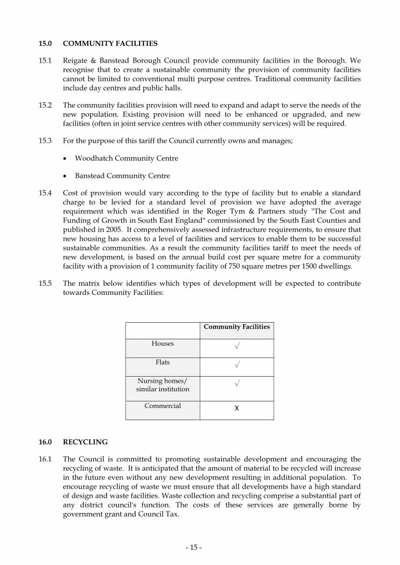
15.0 COMMUNITY FACILITIES
15.1 Reigate & Banstead Borough Council provide community facilities in the Borough. We recognise that to create a sustainable community the provision of community facilities cannot be limited to conventional multi purpose centres. Traditional community facilities include day centres and public halls.
15.2 The community facilities provision will need to expand and adapt to serve the needs of the new population. Existing provision will need to be enhanced or upgraded, and new facilities (often in joint service centres with other community services) will be required.
15.3 For the purpose of this tariff the Council currently owns and manages;
Woodhatch Community Centre
Banstead Community Centre
15.4 Cost of provision would vary according to the type of facility but to enable a standard charge to be levied for a standard level of provision we have adopted the average requirement which was identified in the Roger Tym & Partners study "The Cost and Funding of Growth in South East England" commissioned by the South East Counties and published in 2005. It comprehensively assessed infrastructure requirements, to ensure that new housing has access to a level of facilities and services to enable them to be successful sustainable communities. As a result the community facilities tariff to meet the needs of new development, is based on the annual build cost per square metre for a community facility with a provision of 1 community facility of 750 square metres per 1500 dwellings.
15.5 The matrix below identifies which types of development will be expected to contribute towards Community Facilities:
Community Facilities
Houses
Flats
Nursing homes/ similar institution
Commercial
16.0 RECYCLING
16.1 The Council is committed to promoting sustainable development and encouraging the recycling of waste. It is anticipated that the amount of material to be recycled will increase in the future even without any new development resulting in additional population. To encourage recycling of waste we must ensure that all developments have a high standard of design and waste facilities. Waste collection and recycling comprise a substantial part of any district council's function. The costs of these services are generally borne by government grant and Council Tax.
- 15 -
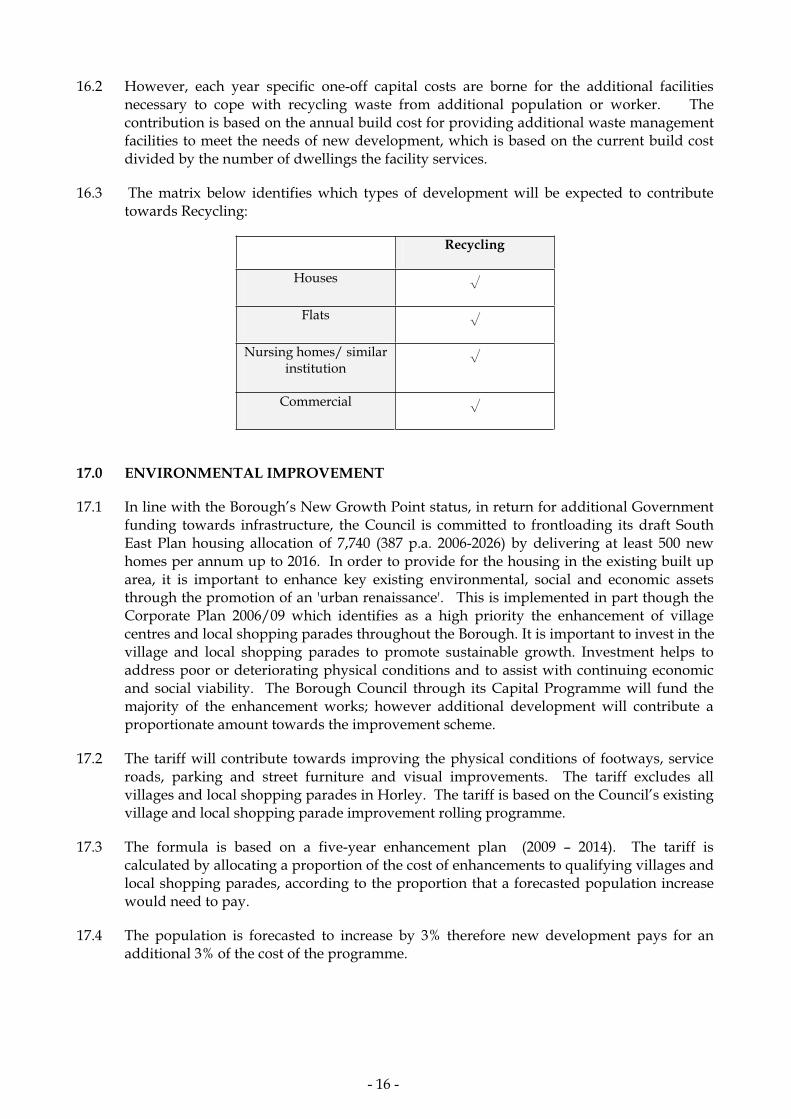
16.2 However, each year specific one-off capital costs are borne for the additional facilities necessary to cope with recycling waste from additional population or worker. The contribution is based on the annual build cost for providing additional waste management facilities to meet the needs of new development, which is based on the current build cost divided by the number of dwellings the facility services.
16.3 The matrix below identifies which types of development will be expected to contribute towards Recycling:
Recycling
Houses
Flats
Nursing homes/ similar institution
Commercial
17.0 ENVIRONMENTAL IMPROVEMENT
17.1 In line with the Borough’s New Growth Point status, in return for additional Government funding towards infrastructure, the Council is committed to frontloading its draft South East Plan housing allocation of 7,740 (387 p.a. 2006-2026) by delivering at least 500 new homes per annum up to 2016. In order to provide for the housing in the existing built up area, it is important to enhance key existing environmental, social and economic assets through the promotion of an 'urban renaissance'. This is implemented in part though the Corporate Plan 2006/09 which identifies as a high priority the enhancement of village centres and local shopping parades throughout the Borough. It is important to invest in the village and local shopping parades to promote sustainable growth. Investment helps to address poor or deteriorating physical conditions and to assist with continuing economic and social viability. The Borough Council through its Capital Programme will fund the majority of the enhancement works; however additional development will contribute a proportionate amount towards the improvement scheme.
17.2 The tariff will contribute towards improving the physical conditions of footways, service roads, parking and street furniture and visual improvements. The tariff excludes all villages and local shopping parades in Horley. The tariff is based on the Council’s existing village and local shopping parade improvement rolling programme.
17.3 The formula is based on a five-year enhancement plan (2009 – 2014). The tariff is calculated by allocating a proportion of the cost of enhancements to qualifying villages and local shopping parades, according to the proportion that a forecasted population increase would need to pay.
17.4 The population is forecasted to increase by 3% therefore new development pays for an additional 3% of the cost of the programme.
- 16 -

17.5 The matrix below identifies which types of development will be expected to contribute towards Environmental Improvements:
Environmental Improvement
Houses
Flats
Nursing homes/ similar institution
Commercial
18.0 PRIMARY HEALTH CARE
18.1 Local healthcare services within the Borough are the responsibility of the Surrey Primary Care Trust (SPCT). SPCT is responsible for:
Improving local health and well being
Providing high quality and efficient services either through direct provision or commissioning these through external providers within the resources available.
18.2 SPCT work closely with GP’s, dentists, opticians and pharmacists and provide many community services themselves - e.g. district and school nursing, health visiting, therapy services and the running of our community hospitals - under the umbrella of Surrey Community Health Services.
18.3 In support of the SPCT, this tariff seeks a financial contribution towards a key element in the delivery of primary healthcare – the network of GP surgeries in the Borough.
18.4 The formula for this tariff is based on the optimum number of patients that should be registered with a GP in the Borough. This is determined by national best practices and government guidance. The tariff would be required to fund a new build premises or an extension to an existing facility or any other capacity enhancement costs of physical premises to meet the needs of new residents.
18.5 The RBBC Local Healthcare tariff is based on the construction costs of a new surgery of 800m2. The estimated construction cost for a surgery of this size, is based on the current build cost as specified by the Department of Health. An appropriately designed surgery of this size will house a 5 GP practice and will adequately serve an appropriate sized patient list per GP.
- 17 -

18.6 The matrix below identifies which types of development will be expected to contribute towards Primary Health Care:
Primary Health Care
Houses
Flats
Nursing homes/ similar institution
Commercial
19.0 LAND USE OCCUPANCY LEVELS
19.1 Below sets out the land use occupancy levels for the Borough wide tariff, the point at which a particular development will trigger the need to make an infrastructure contribution as a result of a development.
19.2 The calculation of the charge is based on the needs generated as a result of a development; table 1 sets out the land use occupancy levels to be used in quantifying the need for infrastructure associated with new residential and commercial development. To determine a net change in demand for infrastructure, the existing demand associated with the site’s lawful use will be calculated by using the average occupancy levels in table 1. All occupancy figures will be reviewed and where necessary amended to reflect the most current relevant data available.
19.3 Table 1 – Average land use occupancy levels
Housing Unit Occupancy
1 bed 1.31
2 bed 1.76
3 bed 2.51
4 bed 2.86
5 + bed 3.73
Land Use Sqm per worker
Retailing 34.4
Financial/Professional services 15
Restaurant or Pub 31.6
Offices 16.4
Research & Development 67
Light Industrial 37.5
Manufacturing 33.1
Storage & Distribution 46.2
Private Leisure 25.4
- 18 -

Source: Survey of occupiers of new houses in Surrey 1997 - 1999 Source: New Businesses in Surrey 2001& Use of Business Space and Changing Working Practices in the South East May 2004.
19.4 This method of calculation is likely to produce contribution levels that fall below the full infrastructure cost to support the increased demand. If a development has a net reduction in occupancy or worker, the Council will not be expected to repay the applicant.
19.5 When assessing the number of bedrooms for the purposes of calculating the contribution, additional habitable rooms capable of realistic conversion to bedrooms will be included. Habitable rooms capable of future conversion into a bedroom will include any room of a dwelling with more than one storey, at first floor level and above with an external window (excluding bathrooms), with a floor area greater than 6.5 sqm.
19.6 The Borough wide tariff will be sought for all appropriate full planning applications and for appropriate outline planning applications. Where insufficient information is available to calculate the tariff at the outline application stage, the most accurately estimated amount, based on the predicted likely occupancy, would be sought. Should this estimated amount fail to reflect the actual necessary tariff, when reviewed at the reserved matters application stage, a deed of variation will be sought from the applicant to accompany that application to correct this.
20.0 EXEMPTIONS
20.1 The tariff will not apply to house extensions that do not result in an additional residential unit, or commercial extension with a minimum net increase below 50sqm. Average land use occupancy levels are identified in table 1 at 19.3.
20.2 Reigate & Banstead Borough Council encourages the provision of affordable housing. The infrastructure tariff will not apply to:
1. Affordable housing being developed on sites already owned by a Registered Social Landlord (RSL); or
2. Affordable housing where the whole site will be developed for affordable housing; or
3. Sites being developed by an RSL with a mixture of affordable and market housing; where the sale of the market housing will be used to subsidise the development of affordable housing on the same site.
Provided in all cases that the proposed affordable housing meets local housing need in terms of access to it, tenure split, dwelling sizes, and affordability. Where a site meets one of the above criteria a planning agreement will be required to ensure that the site is developed wholly or partially for affordable housing, and that any capital receipts from the sale of market housing, if the development is to be exempt, is reinvested to provide affordable housing in the Borough.
20.3 Affordable housing, or sites, not meeting one of the above criteria will be subject to the standard charges.
20.4 For larger developments the level of contribution will be negotiated on a site-by-site basis. The tariff method can be applied to these developments, however the applicant should be mindful that the tariff does not include all infrastructure or service requirements that may
- 19 -

be needed. Larger sites may be capable of meeting the infrastructure needs generated by a development with onsite provision and in such circumstances, it may be necessary to negotiate an alternative planning obligation package. A financial contribution towards some elements of infrastructure may not be required on the condition that the infrastructure provided onsite meets the Council’s standards.
20.5 If a development does not meet any of the current categories for development the LPA will determine on a case-by-case basis whether any exemptions should apply. Nursing homes will be processed to constitute a number of 1-bedroom units.
21.0 WHAT TYPES OF PLANNING OBLIGATIONS WILL BE SOUGHT?
21.1 This document sets out the types of planning obligations, and the thresholds for the size and type of developments from which such obligations will be sought. The planning obligations are sought under different topic areas. They are set out in this SPD and are not exhaustive, and the Local Planning authority may wish to negotiate other obligations where they are necessary and relevant to a development.
21.2 ODPM Circular 05/05 permits planning obligations to be used in the following ways to ensure that proposed developments are acceptable in planning terms:
To prescribe the nature of a development
Planning obligations will be used to secure the implementation of infrastructure supported by planning policy to make acceptable a development proposal that would otherwise be unacceptable in planning terms.
To secure a contribution from a developer to compensate for the loss and damage created by development
Planning obligations will be used where appropriate to offset through substitution, replacement or regeneration, the loss of or damage to a feature or resources present or nearby to development.
To mitigate a development’s impact on the locality
Planning obligations will be used where a proposed development would, if implemented, create a need for a particular facility that is relevant to planning but cannot be required through the use of planning conditions.
22..0 FORMULAE & STANDARD CHARGES
22.1 The Government though ODPM Circular 05/05 encourages the use of standard charges and formulae to calculate contributions.
22.2 The Council has embraced the formulae and standard charges approach as this helps to speed up the planning obligation process and ensure a consistent approach for applicants. The application of standard charges is built on the foundation of a fair, predictable and transparent planning obligation process because it helps applicants to know in advance the likely size and type of contribution required. In cases where planning obligations do not meet the criteria of the tariff based approach (large and complex developments) standard charges may act as a starting point for negotiations.
- 20 -

22.3 The Surrey wide Planning Obligations tariff primarily sought to address the collective impact of small-scale developments on existing local infrastructure. In cases where developments have some impact but not sufficient to justify the need for a discrete piece of infrastructure, contributions will be sought from applicants towards future provision where, the combined impact on a number of developments creates a need for infrastructure.
22.4 In order to allow for infrastructure to be secured in a fair and equitable way, contributions will be collected based on a formulae and standard charge and then pooled until a sufficient amount is collected to provide infrastructure.
22.5 ODPM Circular 05/05 supports this approach, and clearly advises that spare capacity in existing infrastructure provision should not be credited to earlier developers. The Local Planning Authority will take into account any relevant circumstances in each case to ensure that any negotiation for planning obligation complies with Circular 05/05.
* A standard charges sheet template is annexed to this document (Appendix 2), and should be completed and submitted with applications to the Local Planning Authority.
Maintenance
22.6 Circular 05/05 provides limited scope for Local Planning Authorities and Service Providers to seek maintenance payments. Maintenance payments may be legitimately sought only where payments are for facilities, which are predominately for users of the associated development. However, where payments are required for wider public use, the maintenance and other recurrent costs with the applicant’s contribution should be borne by the body or authority with whom the asset is to be vested. Initial support (pump priming) for new facilities can be sought to reflect a time lag between the provision of the new facility and its inclusion in public sector funding streams; or its ability to recover its own costs in cases of a privately run bus service. Where pump priming maintenance costs are requested they will be time limited, and have a clear audit trail.
23.0 PROCESS OF NEGOTIATION AND SECURING PLANNING OBLIGATIONS
23.1 The formal planning obligation process must be determined within the Government set target for determining a planning application (currently 8 weeks for minor and other applications, 13 weeks for major applications). The applicant will be informed of the target date for completion in the acknowledgment letter received upon submission of application. If the obligation to support the application cannot be successfully completed within the time frame, the Local Planning Authority may refuse the application on this reason alone or as an additional reason for refusal on an already unacceptable scheme.
23.2 It is important that applicants enter into discussions with the Local Planning Authority at the pre application stage. The nature of tariff based planning obligation process is one of simplicity, transparency, predictability and speed, as such the likely required contribution for a particular development will be made known at the pre application stage. These early discussions help to ensure that the formal application process can be carried out in a certain and streamlined way. Applicants will be expected to have familiarised themselves with the planning policy and related model agreement and standard charges sheet, annexed to this document and available on line at www.reigate-banstead.gov.uk.
23.3 A model unilateral agreement should be used and amended accordingly before formally being submitted. Applicants should raise any questions about the clauses or terms in the model agreement at the pre application stage.
- 21 -

23.4 All submitted applications will be recorded on a monitoring database with the aspiration for this to be viewable on line at www.reigate-banstead.gov.uk. Planning Obligations will be treated with confidentiality during negotiations in accordance with the Freedom of Information Act. Requests for the release of Planning Obligations whilst at negotiation stage will be referred to the Council’s legal team for advice. All approved planning obligations will be registered as local land charges.
23.5 Once development is commenced it is important that the planning obligations are implemented or enforced in a transparent way. The applicant will be expected to inform the Local Planning Authority of key milestones in delivery such as when development is about to commence. Notification will trigger the necessary steps to be undertaken to comply with the terms of the agreement.
23.6 Variation and discharge of undertakings will only be considered formally, whether by a deed of agreement or an application following the necessary publicity. If specific obligations are time limited and cannot be met within the prescribed period then arrangements will be made for any unspent financial contributions to be returned to the applicant. This would not apply to contributions derived from the tariff-based approach.
23.7 Annual reports will be produced informing the community of the various benefits resulting from planning obligations. The reports will demonstrate how contributions have improved infrastructure to meet increased demand for essential public services in the locality.
24.0 PLANNING OBLIGATION MONITORING
24.1 It is a requirement that the negotiation and expenditure of any contributions received as a result of development be monitored and recorded in a public and accountable way. An analysis of contributions received for each beneficiary and a list of infrastructure or service enhancements will be recorded in a planning obligation monitoring database. It is the Council’s aspiration to make the monitoring database viewable online in the future.
24.2 Planning obligations may be tied to specific schemes where they are necessary to make a development acceptable in planning terms. In cases where planning obligations are sought for a number of smaller developments and pooled towards the provision of a scheme, wherever possible the developer will be informed of the projects their contributions are likely to fund.
Index linking
24.3 Contributions sought from developers will be index linked in the legal agreement, in order to maintain the value in money in delivering future provisions. The Retail Price Index is the most commonly used index of inflation; however alternative indices may be applied where appropriate. They will be index linked between the date of the legal agreement and the date that the first payment is made.
Fees
24.4 Both residential and commercial developments will attract a five percent administration fee to the total tariff charge. Four percent of the fee will remain with Reigate & Banstead Council and one percent will be paid to Surrey County Council. The fee will fund the operation, administration and monitoring of the planning obligation process. The developer is also expected to pay on submission of their planning application the reasonable legal costs, which are non refundable.
- 22 -

TOWN AND COUNTRY PLANNING ACT 1990
SITE: GARDEN FARMHOUSE, COPT HILL LANE, KINGSWOOD, SURREY KT20 6HN
APPEAL BY: MRS P. FARRIES
PROPOSAL: DEMOLITION OF HOUSE AND OUTBUILDINGS AND REPLACEMENT WITH NEW BUILDING OF 8 NO. 2 BEDROOM FLATS WITH GARAGES
TOWN AND COUNTRY PLANNING APPEALS (HEARING PROCEDURE)
APPENDIX 9: SUGGESTED CONDITIONS
JANUARY 2011
PLANNING INSPECTORATE REF: APP/L3625/A/10/2139917/WF
REIGATE AND BANSTEAD BOROUGH COUNCIL REF: P/10/00232/F
SUGGESTED CONDITIONS
1. The development hereby permitted shall be begun before the expiration of three years from the date of this permission. Reason: To comply with Section 91(1) of the Town and Country Planning Act 1990 as amended by Section 51 (1) of the Planning and Compulsory Purchase Act 2004.
2. The development hereby permitted shall be carried out in accordance with the following approved plans: EOU_01, 02, 110 B,
11 B, 12 C, 13 B, 14 C, 15 B, 16 B, 17, 18. Reason: To define the permission and ensure that the development is completed in a satisfactory manner and in accordance with “Greater Flexibility for Planning Permissions Guidance” (DCLG) 2009.
3. Before the development hereby permitted is commenced the
developer shall obtain the Local Planning Authority’s written approval of samples of the materials to be used in the construction
of the external surfaces of the building works hereby permitted. The development shall be carried out in accordance with the
approved details. Reason: To ensure that a satisfactory external appearance is achieved of the development with regard to Reigate and Banstead Borough Local Plan 2005 policies Ho9 and Ho13.
4. No new development shall be occupied until space has been laid out
within the site in accordance with the approved plans to provide for 8 cars and 16 cycles to be parked and for vehicles to turn so that
they may enter and leave the site in forward gear. The parking/turning area shall be used and retained exclusively for its
designated purpose. Reason: The above condition is required in order that the development should not prejudice highway safety nor cause inconvenience to other highway users, with regard to Planning Policy Guidance Note 13 - Transport with regard to Reigate and Banstead Borough Local Plan 2005 policies Mo7 and Mo13.
5. No pruning, removal or other works to the retained trees and
hedges located both within and overhanging the site, shall take place during construction, or for one year after completion except
with the prior written approval of the Local Planning Authority. Any tree work already approved as part of this consent and any other
work undertaken should be done in accordance with British Standard 3998 “Recommendations for Tree Work”. If any of the
retained trees or hedges, within the site, controlled by this condition, are removed, dies, or become significantly damaged or
diseased within one year of completion, it shall be replaced before
the expiry of one calendar year by tree/s or hedge/s, to a planting specification agreed in writing by the Local Planning Authority. Reason: To ensure good arboricultural and landscape practice in the interests of the maintenance of the character and appearance of the area and to comply with policies Pc4 and Ho9 of the Reigate and Banstead Borough Local Plan 2005.
6. Prior to the commencement of any development works, including ground preparation or demolition, a detailed, scaled Tree Protection
Plan (TPP) and the related Arboricultural Method Statement (AMS) shall be submitted to and approved in writing by the Local Planning
Authority. These shall include details of the specification and
location of exclusion fencing, ground protection, any construction activity that may take place within the Root Protection Areas of
trees (RPA) shown to scale on the TPP and a supervisory regime for their implementation and monitoring with a report back provision.
These shall include all level changes, services, construction and excavation within or immediately adjacent to the RPAs of retained
trees and hedges and those of significant overhanging trees. All works shall be carried out in strict accordance with these details
when approved or as otherwise agreed in writing by the Local Planning Authority. Reason: To ensure good arboricultural practice in the interests of the maintenance of the character and appearance of the area and to comply with policy Pc4 of the Reigate and Banstead Borough Local Plan 2005 and British Standard 5837 “Trees in Relation to Construction – Recommendations”.
7. No development shall take place until a Method of Construction Statement, to include of:
(a) parking for vehicles of site personnel, operatives and visitors; (b) loading and unloading of plant and materials;
(c) storage of plant and materials; (d) a programme of works (including measures for traffic
management); and (e) provision of boundary hoarding has been submitted to and approved in writing by the Local Planning Authority. Only the approved details shall be implemented during the construction period. Reason: In the interests of highway safety with regard to Reigate and Banstead Borough Local Plan 2005 policy Mo5.