Embed Size (px)
Citation preview

• Distributed Information Services for Climate and Ocean Products
and Visualizations for Earth Research
• We provide multi-sensor, multi-platform highly accurate, long-term satellite microwave data products suitable for Earth research applications via easy-to-use display and data access tools.
• Collaboration between: Remote Sensing Systems
ITSC at the University of Alabama in Huntsville
NASA / Global Hydrology & Climate Center
Improving Satellite Microwave Products
Deborah K. Smith, Chelle Gentemann, Thomas Meissner, Kyle Hilburn, Frank J. Wentz

1) Fixing rain effects on scatterometer data
2) Progress in obtaining radiometer wind retrievals in rain
3) TC intensity studies using Microwave SSTs
4) TC archive interface useful for retrospective studies
Tropical Cyclone Related Work at RSS

Reported storm location at0 Z Mar 18 2000
Rain effects:Cross swath vectorsHigher wind speeds

We Need More Than Just Rain Rate
28 June 03, West of the Marshall Islands, Rev 2806

Tropical convective rain off the western Central American coast on 10 April 2003The uncorrected winds are TOP-CENTER and the corrected winds are TOP-RIGHT
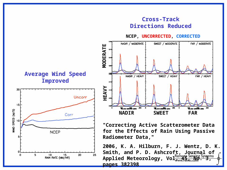
Average Wind Speed Improved
Cross-Track Directions Reduced
NCEP, UNCORRECTED, CORRECTED
MO
DE
RA
TE
HE
AV
Y
NADIR SWEET FAR
"Correcting Active Scatterometer Data for the Effects of Rain Using Passive Radiometer Data,"
2006, K. A. Hilburn, F. J. Wentz, D. K. Smith, and P. D. Ashcroft, Journal of Applied Meteorology, Vol. 45, No. 3, pages 382 398

Hurricane Fabian
Max=44 Max=51
1930 Z
1500 Z
Max = 110 kts = 57 m/s = 50 m/sUS NAVY:0.88 x 1-min mean = 10-min mean
04 Sep 03, Rev 3770
No scat in H*Wind

1) Fixing rain effects on scatterometer data
2) Progress in radiometer wind retrievals in rain
3) TC intensity studies using Microwave SSTs
4) TC archive interface useful for retrospective studies
Tropical Cyclone Related Work at RSS

Problems to Retrieve Passive MW Winds Under RainPossible Mitigations
• Attenuation– Signal/Noise decreases. Especially at higher
frequencies. Use C- Band + X- Band Lower resolution
• Rain signal very similar to wind signal– Algorithm treats increase in rain the same way as
increase in wind. Train algorithm under rain Try to find channel combinations that are less or not
sensitive to rain but sensitive to wind.
• Wind speed retrieval algorithm without rain is based on physical radiative transfer model (RTM)
Rain is difficult to model in RTM– Cloud type– Beamfilling (rain filling part of retrieval cell)– Depression in atmospheric temperature (scattering, …) Use statistical algorithm (measured TBs) rather than
physical algorithm (modeled TBs)

Study Data Sets• Wind vectors from Surface Wind Analysis from the NOAA’s Hurricane Research
Division (HRD)
• Collocated with WindSat brightness temperatures– NRL Level0 data processed by RSS into Level2– Calibrated– Optimum interpolated onto 1/8 deg fixed Earth grid (X-band resolution)
• 17 storms during 2003 and 2004
• Rain flagged (TB exceeds boundary for rain free ocean scenes)
• 3 hour time window
• Scale HRD winds (1 minute sustained) by 0.88 to compare with satellite winds (10 minute sustained)
• Resample HRD winds (5 km) onto WindSat footprint (30 km for X-band)
• Visual shift of HRD field so that storm center coincides with WindSat
• Half of the set is used for training, the other half for testing
• About 24,000 wind vector cells for test set
• Triple matchup: WindSat – QuikScat – HRD– within 3 hours– 8 storms during 2003 and 2004– exclude if HRD analysis uses QuikScat– about 16,000 wind vector cells for testing

HRDHRD NCEP GDASNCEP GDAS
No –Rain Wind AlgoNo –Rain Wind Algo Rain RateRain Rate
FABIAN 03 September 2003
Algorithm trained under rain free conditions measures rain rather than wind

HRDHRD Rain RateRain Rate NCEP GDASNCEP GDAS
C-Band AlgoC-Band Algo X-Band AlgoX-Band Algo K-Band AlgoK-Band Algo

HRDHRD
H-Wind Algo C-BandH-Wind Algo C-Band
Rain RateRain Rate
Global Algo C-BandGlobal Algo C-Band
WindSat H-Wind versus Global Algorithm

Radiometer Wind Vectors in RainCapability Chart
Wind Speed
Hurricanes
Wind Speed
Global Rain
Wind Direction
Hurricanes
SSM/I K no no
SSMIS K no no
TMI X K X no
GMI X K X no
AMSR-E C X K C X no
GCOM C X K C X no
WindSat C X K C X X wspd > 8 m/s
rain rate < 8 mm/h
MIS C X K C X X
wspd > 8 m/s
rain rate < 8 mm/h
3rd Stokes at X-band
KXC KXC resolution

1) Fixing rain effects on scatterometer data
2) Progress in obtaining radiometer wind retrievals in rain
3) TC intensity studies using Microwave SSTs
4) TC archive interface useful for retrospective studies
Tropical Cyclone Related Work at RSS
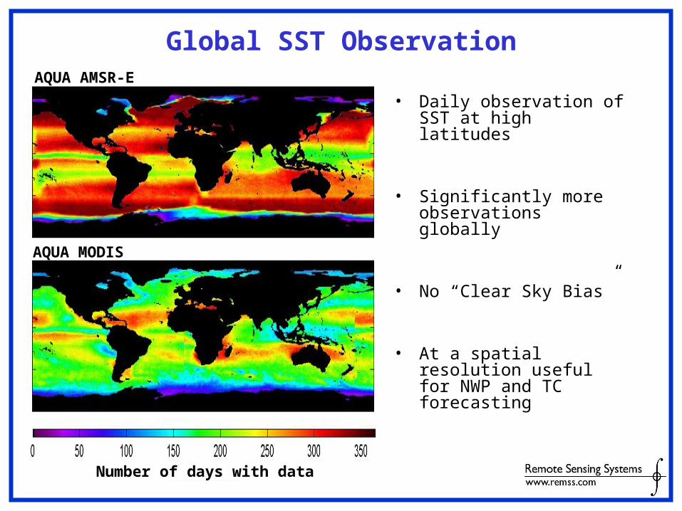
Global SST Observation
• Daily observation of SST at high latitudes
• Significantly more observations globally
• No “Clear Sky Bias”
• At a spatial resolution useful for NWP and TC forecasting
Number of days with data
AQUA MODIS
AQUA AMSR-E

Reynolds RTG RSS MW RSS MW+IR
Weekly Daily Daily Daily
100km 50km 25km 9km
AVHRR AVHRR AMSRE, TMI MODIS, AMSRE & TMI

OI SSTs uses strengths of both MW and IR
AMSRE MODIS 9km OI SST
Occasional Rain Contamination Frequent Cloud Contamination
Version-2, improved and now available

MW SSTs Improve TC Intensity Prediction
Hurricane Genevieve
Intensity forecast errors (especially 3-5 day forecasts) are significantly reduced using AMSR-E OI SSTs due to the improved temporal resolution of cold wakes.

MW SSTs Improve TC Track Prediction
Time series of Hurricane Katrina every 6 hours (12 UCT 27 August to 0600 UTC 30 August 2005, from the best track data (black), the IR-only SST analysis run (blue) and the IR+MW SST run (red). A) The sea level pressure. (SLP) B) The track forecast errors. Image from J. Cummings

Storm-Centric Database
• Designed to easily handle satellite data, analysis data, and in situ data
• Track orthogonal vectors yield an evenly spaced storm-centric grid for collocation and data discovery
• Can be easily expanded to include PI contributed collocated datasets

Typhoon Man-Yi
MW OI SST in the storm centric database.
The variability in the cold wake is substantial and related to storm translation speed
15 days after storm passage, the cold wake is almost negligible

Proposed Data Set
To be included in database:
Remote Sensing
IR and MW SSTs (AVHRR, MODIS, TMI, AMSR-E, WindSAT, …)
Diffuse atten. & Chl-A (SEAWIFS, MODIS)
10-m wind speed (SSM/Is, TMI, AMSR-E)
10-m wind vectors (QuikSCAT, WindSATE and MetOp ASCAT)
SSH (Jason-1,Topex, ERS-2)
In Situ
ARGO profiling drifters
Moored buoy data
NWP products
MLD climatology
MLD, SST, SSH from NCOM (C.Barron)
Shortwave and longwave radiation, air temp, rel. hum, SLP, precip., wind vectors from NOGAPS and H*WIND
Wave height and direction from FNMOC WW3
Other analyses
New high-resolution Cross-Cal wind analysis from J. Ardizzone
Several new high-resolution SST analyses from GHRSST/MISST project
Proposed to: Physical Oceanography (Code 322): Impact of Typhoons on the Western Pacific Ocean (Linwood Vincent)

1) Fixing rain effects on scatterometer data
2) Progress in obtaining radiometer wind retrievals in rain
3) TC intensity studies using Microwave SSTs
4) TC archive interface for retrospective studies
Tropical Cyclone Related Work at RSS


Simple Interface Designed for Easy Use

1) We continue to advance microwave instrument capabilities.
2) The method of scatterometer rain correction works, but can only be used if collocated radiometer data available.
3) WindSat winds in rain are much improved with new algorithms. C-band is required for best results. We’ll add WindSat data to the TC Archive in the near future.
4) The SST storm-track database is a useful tool for studying tropical cyclone cold wakes and storm intensities. We are looking for development funding.
Summary