Embed Size (px)
Citation preview
Trail hours and useHoursTheTrailopensat8am.Closingtimechanges
seasonally,andisposted.
PetsPetsarenotallowedonthetrail.
SmokingNosmokinginCountyparks,ontrails,orathistoricalsites.
TrailsSan Andreas segment 2.6miles
Sawyer Camp segment 6.0miles
Crystal Springs segment 6.7miles
Hikers,runners,bicyclists,andequestrianssharethesetrails.Pleasebealertandcourteoustoalltrailusers.
Alwaysyieldtoequestriansbysteppingtotheedgeofthepath.
Bicyclistsalwaysyieldtoothertrailusers.
Bicyclistsyoungerthan18arerequiredbylawtowearhelmets.
Bicyclistsshouldannouncetheirpresencetoothertrailusers,particularlywhenapproachingfrombehind.
Weatherconditions,firedanger,ortrailmaintenancemaycausetrailclosures.Checktrailsignsforclosurenotices.
For more trail information and routes, visit www.SMCoParks.org.
PeterLaTourrette
Natural featuresThevarietyofhabitatsfoundalongtheCrystalSpringsRegionalTrailisduetothediversityofclimate,topography,geology,andsoils.Theseincludeold-growthDouglasfirforests,oakwoodland,serpentinegrasslands,nativebunchgrasses,areasofcoastalscrub,andchaparral.Trailsidehabitatshostawidevarietyofplantsincludingninerare,threatened,andendangeredspecies.
WildlifeOpportunitiestoseewildlifealongthetrailareabundant.Trailuserscanspotseveralspeciesofsongbirds,ducks,andraptors–includingbaldeaglesandgoldeneagles.Squirrels,rattlesnakes,coyote,andotherwildlifecanalsobeseen,includingtheoccasionalbobcatormountainlion.
Sevenrare,threatened,andendangeredanimalsarefoundinthearea,includingthreespeciesofbutterflyandtheSanFranciscogartersnake.Springtimevisitorsmaycomeacrossyoungdeerseparatedfromaparentbyfencing;theygenerallyreunitewithoutassistance.
Crystal SpringsA San Mateo County Regional Trail
San Mateo County ParksReservations650-363-4021General information 650-363-4020www.SMCoParks.org
The Departmentmanagesparks,trails,andhistoricsitestopreservepubliclandsandprovideopportunitiesforeducationandrecreation.Thesystem’s18parks,regional,county,andlocaltrails,andtwohistoricsitesarelocatedthroughouttheCountyandencompassnearly16,000acres.
The parksrepresentourregion’swondrouslydiversenaturalsettings,fromruggedtidepools,lushmountainforests,andremotecampsitestoBayfrontshoreline,sunnypicnicareas,andpopularplaygrounds.
TheDepartmentsellsannualpasses,offeringunlimitedentrancestoallCountyParksforayear.
Support your parksYou can volunteer tohelprangersprotectandimproveparklandsandserveparkvisitorsthroughongoingvolunteerprograms,includingTrailPatrol,VolunteerHorsePatrol,Trailworkdays,andspecialevents.
The San Mateo County Parks Foundation raisesfundstoimprovethequalityofCountyParksforourcommunity.Forinformation,visitwww.SupportParks.org.
Crystal Springs Regional TrailParkHeadquarters650-589-5708Police, Fire, or Medical Emergency 911
Toph
erS
imon
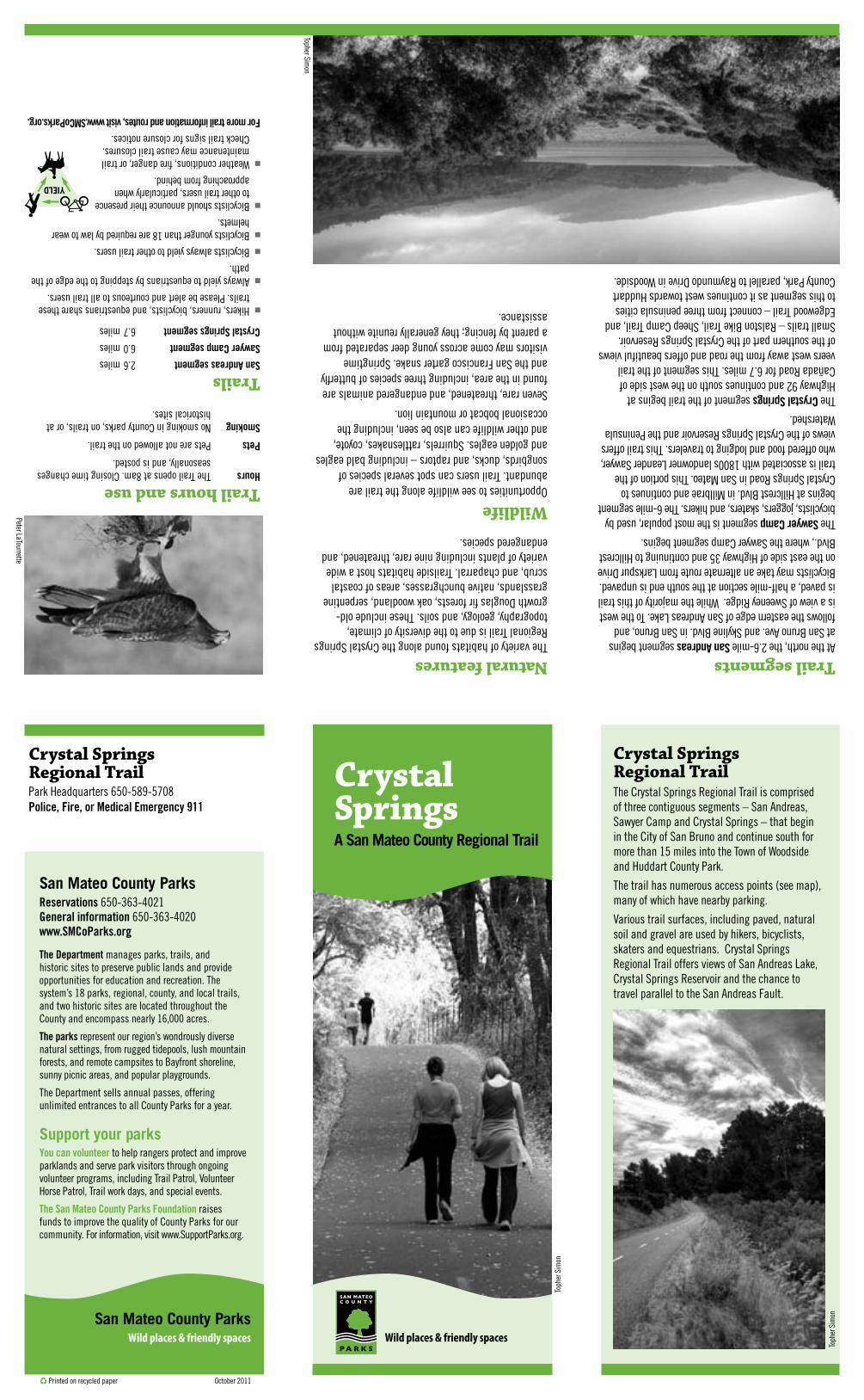
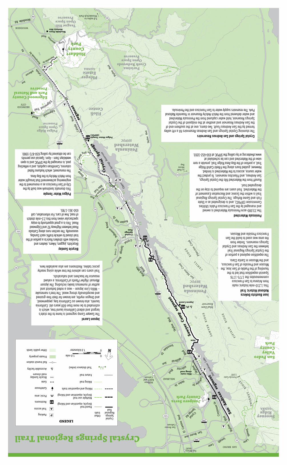
Crystal Springs Regional TrailTheCrystalSpringsRegionalTrailiscomprisedofthreecontiguoussegments–SanAndreas,SawyerCampandCrystalSprings–thatbeginintheCityofSanBrunoandcontinuesouthformorethan15milesintotheTownofWoodsideandHuddartCountyPark.
Thetrailhasnumerousaccesspoints(seemap),manyofwhichhavenearbyparking.
Varioustrailsurfaces,includingpaved,naturalsoilandgravelareusedbyhikers,bicyclists,skatersandequestrians.CrystalSpringsRegionalTrailoffersviewsofSanAndreasLake,CrystalSpringsReservoirandthechancetotravelparalleltotheSanAndreasFault.
Toph
erS
imonSan Mateo County Parks
Wild places & friendly spaces Wild places & friendly spaces
CPrintedonrecycledpaper October2011
Trail segmentsAtthenorth,the2.6-mileSan AndreassegmentbeginsatSanBrunoAve.andSkylineBlvd.inSanBruno,andfollowstheeasternedgeofSanAndreasLake.TothewestisaviewofSweeneyRidge.Whilethemajorityofthistrailispaved,ahalf-milesectionatthesouthendisunpaved.BicyclistsmaytakeanalternateroutefromLarkspurDriveontheeastsideofHighway35andcontinuingtoHillcrestBlvd.,wheretheSawyerCampsegmentbegins.
TheSawyer Camp segmentisthemostpopular,usedbybicyclists,joggers,skaters,andhikers.The6-milesegmentbeginsatHillcrestBlvd.inMillbraeandcontinuestoCrystalSpringsRoadinSanMateo.Thisportionofthetrailisassociatedwith1800slandownerLeanderSawyer,whoofferedfoodandlodgingtotravelers.ThistrailoffersviewsoftheCrystalSpringsReservoirandthePeninsulaWatershed.
TheCrystal Springs segmentofthetrailbeginsatHighway92andcontinuessouthonthewestsideofCañadaRoadfor6.7miles.ThissegmentofthetrailveerswestawayfromtheroadandoffersbeautifulviewsofthesouthernpartoftheCrystalSpringsReservoir.Smalltrails–RalstonBikeTrail,SheepCampTrail,andEdgewoodTrail–connectfromthreepeninsulacitiestothissegmentasitcontinueswesttowardsHuddartCountyPark,paralleltoRaymundoDriveinWoodside.
TopherSimon
Lane
400
1200
1600
800
600
1600
800
600
800
600
400
800
400
1600
800
800
800
800
800
1200
800
600
800
800
400
Raymundo Dr
Cres
tmoo
r Dr
Blvd
Skyli
ne
Helen Dr
Ave
Crystal
Springs Rd
El C
amin
o R
eal
Portola Gate1195'
Jepson Laurel
Crystal Springs Dam
Dam
Rd
Woodside Rd
WOODSIDE
Bike routealong road
5.8 miles toWunderlich Park
Cryst
al S
prin
gs R
eser
voir
Bunker Hill D
r
P
P
P
A
A
A
A
A
A
A
A
Upper
Cry
stal
Spr
ings
Res
ervo
ir
Ralston
Bike Trail
Shee
p
Cam
p
Larkspur Dr
Millbrae
Hillcrest BlvdTrousdale Dr
280
380 35
92
35
92
92
280
35
84 35
35
280
101
101
Black
Mtn
.
Road
Skyli
ne
Blvd
92
Ralst
on
Ave
San BrunoCaltrain
to Half Moon Bay
SanBrunoBART
Millbrae BART andCaltrain
PhlegerEstateGGNRA
FiloliCenter
Huddart County
Park
Edgewood CountyPark and NaturalPreserve
Sweeney RidgeGGNRA
PeninsulaWatershed
SFPUC
PeninsulaWatershed
SFPUC
Pulgas Ridge Open SpacePreserve
Junipero SerraCounty Park
San PedroValleyCountyPark
PurisimaCreek Redwoods
Open SpacePreserve
Teague HillOpen Space
Preserve
Skyli
ne
segm
ent
San
And
reas
seg
men
t San
And
reas
Lak
e
Woodside StoreHistoric Site
Pulgas Water Temple(SFPUC)
CAHILL
R
IDG
E
FIF
IEL
D
R
IDG
E
SW
EE
NE
Y
RID
GE
Caña
da
Trail
EdgewoodRoad
Runn
ymea
de Rd
Caña
da
Roa
d
Jefferson
Ave
Sneath
Kings Mountain
Road
San Bruno Ave
Mud DamReservoir
San Mateo
Cree
k
Pila
rcito
s Cre
ek
San Mateo C
reek
Skyl
ine
Blv
d
Skyli
ne
Blvd
Cry
stal
Sp
rings
Sneath Lane
MILLBRAE
SAN BRUNO
SAN MATEO
REDWOODCITY
Crystal Springs Road
Polhe
mus Roa
d
3.5
1.2
0.5
0.5
1.8
0.3
2.1
0.4
1.9
2.5
1.3
Edgewood Trail
Blvd
1.0
0.6
0.2
0.5
3.1
1.4
1.0
0.3
2.0
0.6
Saw
yer
Cam
p se
gmen
t
Crystal Springs Regional Trail
SA
WY
ER
R
IDG
E
Jepson LaurelTheSawyerCampsegmentishometothestate’slargestandoldestCalifornialaureltree,whichisestimatedtobemorethan600yearsold.Californialaurels,alsoknownasCaliforniabay,pepperwood,andOregonmyrtle,areknownfortheirfine-grainedandexceptionallystrongwood.Thetree’snamesake–WillisLinnJepson–wasanotedbotanistandauthorofnumerousbooksincludingThe Jepson Manual: Higher Plants of California,avaluedresourceforteachersandnaturalists.
Trailuserscanadmirethetreewhileusingnearbypicnictables.Restroomsarealsoavailablehere.
Pulgas Water TempleThisdramaticlandmarkwasbuiltbytheCityofSanFranciscoasamonumenttotheengineeringachievementthatbroughtwaterfromHetchHetchytotheBayArea.
Themonument,whichfeaturesflutedcolumns,Corinthiancapitals,andareflectingpool,ismanagedbytheSFPUCandisopenweekdays9am–4pm.Specialusepermitscanbeobtainedbycalling650-872-5900.
Bicycle SundayBicyclists,joggers,hikers,skatersandfamilieswithstrollersflocktoaportionofthetrailclosedtovehicletrafficeachSunday,seasonally.ThesectionrunsalongCañadaRoadbetweenHighway92andEdgewoodRoad.Thisisagreatopportunitytoenjoyspectacularviewsfromthis2.5-milestretchofroad,freeofcars.Forinformation,call650-361-1785.
Juan Bautista DeAnza National Historic TrailThis1,210-milehistoricroutefromArizonatoSanFranciscocommemoratesthe1775-1776SpanishexpeditionthatledtothefoundingofthePuebloofSanJose,theMissionandPresidioofSanFrancisco,andtheMissioninSantaClara.
TheexpeditionexploredaportionoftheCrystalSpringsRegionalTrailbetweentheSanAndreasandCrystalSpringsreservoirs.TimberfromtheareawasusedtobuildtheSanFranciscoPresidioandMission.
Peninsula WatershedThe23,000-acrePeninsulaWatershedisownedandmanagedbytheSanFranciscoPublicUtilitiesCommission(SFPUC),andisdesignatedasaStateFishandGameRefuge.TheCrystalSpringsRegionalTrailiswithintheScenicandRecreationEasementoftheWatershed.Trailusersarerequiredtostayonthedesignatedtrail.
RunofffromtheWatershedfillstheCrystalSprings,SanAndreas,andPilarcitosreservoirs.Toprotectthewatersource,accesstotheWatershedislimited.However,guidedtoursalongtheFifield-CahillRidgeTrail,aportionoftheBayAreaRidgeTrail,providearareviewoftheWatershedandcanbescheduledatwww.sfwater.orgorbycallingtheSFPUCat650-652-3203.
Crystal Springs and San Andreas ReservoirsThestunningCrystalSpringsandSanAndreasReservoirsfillariftvalleyformedbytheSanAndreasFault.Twodams,oneatthesouthernendoftheSanAndreasReservoirandanotheratthemidpointoftheCrystalSpringsReservoir,holdwatercapturedfromthePeninsulaWatershedandwaterdeliveredfromtheHetchHetchyReservoirinYosemiteNationalPark.ThereservoirssupplywatertoSanFranciscoandthePeninsula.
N
Parking
Picnic area
RestroomsMultiple use trail(bicycle, equestrian and hiking)
Othertrails
Crystal Springs
RegionalTrail
Hiking trail
Trail distance (miles)
Gate
P
LEGEND
Accessible facility
Gatehouse Hiking and equestrian trails
0.2
Paved trail(bicycle, equestrian and hiking)
Bicycle Sundayroad closure
Trail access A
Future trail
Rail transit station
Private property
Other public lands 0
01.0 mile
1.0 kilometer