Embed Size (px)
Citation preview

ContentsSlide No.
1. Inventory of Offshore Cambodia Database 11.1 Khmer Basin Data of Offshore Cambodia (books) 21.2 Well Completion Reports (Well Logs) 151.3 Seismic Surveys 20
1.3.1 Uninterpreted Lines 201.3.2 Interpreted Lines 251.3.3 Maps 251.3.4 Interpretation Reports 25
1.4 Interpretation/Regional Reports. 262. Data Acquisitions and Technical Work Done by CNPA 26
2.1 Data Acquisitions 26
2.1.1 Geological Data 26
2.1.2 Geophigical Data 27
2.2 Technical Work Done by CNPA 30
2.2.1 Seismic Interpretaion (Time Contour Map) 30
2.2.2 Well Planning (Drilling) 30

Well Name: Apsara-1Block III Oprator: Campex
Calibrated Sonic Synthetic Seismogram Vertical Seismic Profile.A Geological Evaluation.Geochemical Data Report.DST Report.Drilling Report of Apsara-1 & Devada-1.Geoservices end of Well Report.10-10N Water Analysis (3 books).Bulk Mineral Analysis by x-ray Diffraction.Rocks Properties Report.Final Report of Core Description and Deposional Environment Interpretation.Daily Drilling Report.Bulk and Clay Mineral XRD Analysis Report.Side Wall Core Analysis Report.Petrographie Study of Side Wall Core (volume 1-2, 2 books)
1 23456789
1011121314
Title of BooksNo.
1. Inventory of Offshore Cambodia Data1.1 Khmer Basin Data of Offshore Cambodia (books)

Well Name: Apsara-1 (continued)
Petrographie Study of Core Plug end Trims and Side Wall Cores ( volume 1-2, 2 books). Core Petrographie.Advanced Rock Properties Report.Analysis of Fluid Inclusions in Samples from the Apsara-1 and Devada-1 Well.Apsara-1 Well Proposal.Biostratigraphy of the Apsara-1 Well (380m-3300m).A Biostratigraphical & Geochemical Review of Wells Apsar-1 & Devada-1 & Comparisionwith Tertiary Basins.A Biostratigraphical & Palynofacies Correlation between the H-1, B1-1, Apsara-1 & Devada-1.A Biostratigraphical & Palynofacies Correlation of the Koah Tang-1, Apsara-1 & Angko-1.FMI Interpretation.Final Report Volume 1.Well Completion Report (2 boxes).
15161718192021
2223242526
Title of BooksNo.

Well Name: Angkor-1Block II Operator: Enterprise
Well Completion Report.Drilling Well History.Daily Drilling Report.Drilling Chart.Daily Geological ReportPalonostratigraghie Re-appraisal of the interval 570m-3950m(SWC). Report No. 1433.Composite Well log.
1234567
Title of BooksNo.

Well Name: Devada-1Block III Operator: Campex
Daily Geological Report.Well Completion Report (2 books).Geoservices end of Well Report.A Geochemical Evaluation (volume I & II).Biostratigraghy of the Devada-1 (380m-3200m).Rock Properties Report.Core Laboratories.Site Wall Core Analysis Report.Site Wall Core and TRIM-ENDS Samples ( 2 books).Palinostratigraghie Re-Appraisal of the interval 380m-3200m.FMS Interpretaion.Calibrated Sonic.Mineralogy Analyses.Bulk Mineral XRD Analysis.Master Log. Geogram- (No. 4 – No. 13)
123456789
10111213141516
Title of BooksNo.

Well Name: Kaoh Tang-1Block IV Operator: Premier
Final Well Report.Final Well Report (Volume B: Drilling Report, 2 books)Morning Drilling Report (Appendex J).DST Report (Daily Geological Report).Daily Operational Summary (2 books).Master Log & Drilling Log.Annual Report 1995 Block IV.
1234567
Title of BooksNo.

Well Name: Da-1Block I Operator: Enterprise
Well History.Well Completion Report.Daily Drilling and Geological Report.Combined Drilling Programme and Geological Well Plan (2 books)Prospect DA Pre-drill Evaluation Including DA-1 Well Track.Well log.
123456
Title of BooksNo.

Well Name: Preah Khan-1Block II Operator : Enterprise
Well History.Well Completion Report.Daily Drilling and Geological Report.Combined Drilling Program and Geological Well Plan.Mud Log.Gas Log.
123456
Title of BooksNo.

Well Name: Poulo Wai-1Block III Operator: Campex
Final Well Report.Daily Drilling and Geological Report.Drilling Report.Drilling Program.Master Log.Marine Site Hazard Survey.Rock Properties Report.Core Description and Petrography Study.The Palynology of Outcrop Samples.Palynostratigraphic Re-appraisal of the Interval 360 m-3440 m (SWC). Report No. 1435.Sonic Calibration Log (Figure 5).Calibrated Sonic, Synthetic Seismogram, Vertical Seismic Profile. (Using the CSI & WST tools). Physical Characterization on Two MDT Fluid Samples Recovered. Biostratigrphic and Palinofacie of the Interval 540 m-3440 m.Vertical Seismic Profile (Figure 2).Vertical Seismic Profile (Figure 3) (WST).Poulo Wai-1 Log # 1, 2, 3.
123456789
1011121314151617
Title of BooksNo.

Well Name: Bayon-1Block II Operator: Enterprese
Well History.Combined Drilling Program and Geological Well Plan.Daily Drilling and Geological Report.Well Site Lithology.Mud Log.Gas Log.Pressure.
1234567
Title of BooksNo.

Well Name: Kaoh Pring-1Block IV Operator: Idemitsu
Final Well Report (Geology, 2 books).Final Well Report (Drilling).Master Log.Drilling Fluid Recap.Rig Positioning Report.Dull Bit Report.Geological Screening of Kaoh Pring-1 Well , Golf of Thailand.Site Survey Report.Advanced Rock Properties Report.Rock Properties Report.Core Description & Depositional Envirnment interpretation Report.Core Photographs.Petrography, Study of Sidewall Core & Core Plug Trim-end Samples.Famm Analyses of Suite of Samples.Calibrated Sonic (2 books).
123456789
101112131415
Title of BooksNo.
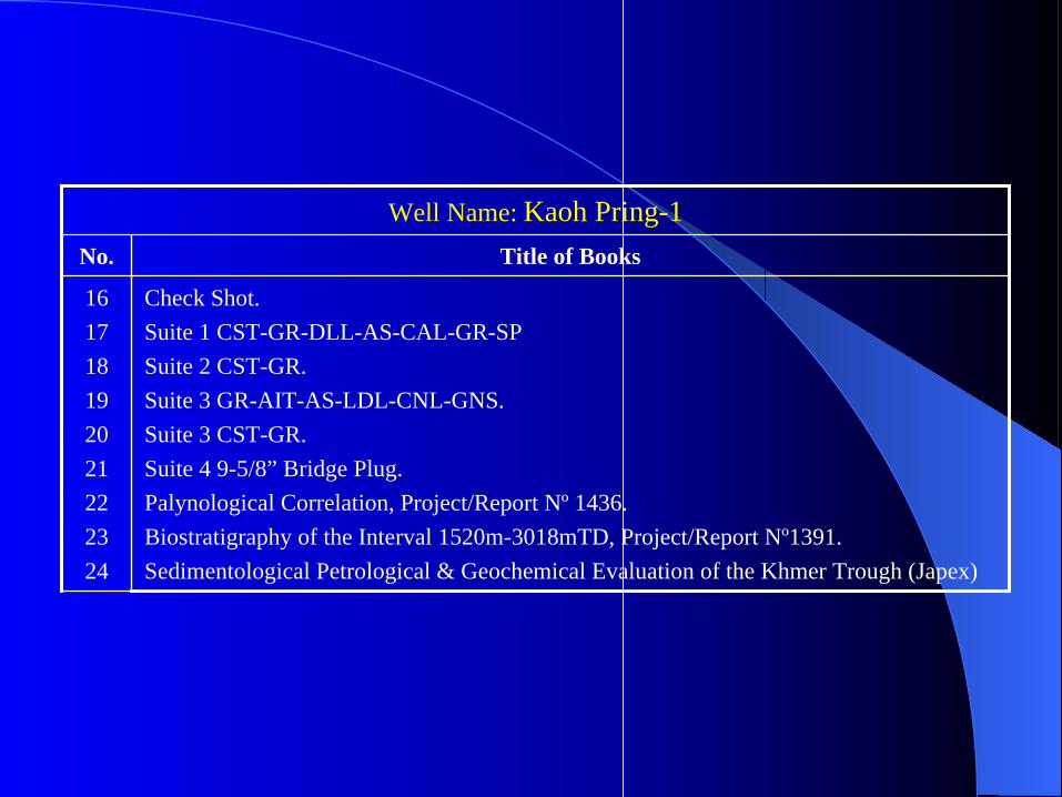
Well Name: Kaoh Pring-1
Check Shot.Suite 1 CST-GR-DLL-AS-CAL-GR-SPSuite 2 CST-GR.Suite 3 GR-AIT-AS-LDL-CNL-GNS.Suite 3 CST-GR.Suite 4 9-5/8” Bridge Plug.Palynological Correlation, Project/Report Nº 1436.Biostratigraphy of the Interval 1520m-3018mTD, Project/Report Nº1391.Sedimentological Petrological & Geochemical Evaluation of the Khmer Trough (Japex)
161718192021222324
Title of BooksNo.

Other BooksBlock I & II Operator: Enterprise
Interpretation Reports of 3D Survey of Offshore Cambodia Block I & II. Technical Evaluation of Offshore Cambodia, Block I & II.Emergency Response Procedures, Block I & II (2 books).Oil Split Contingency Plan, Block I & II (2 books).Final Technical Report 3D Survey (Volume). Geological Evaluation of Cambodia A/A Samples. Petroleum Evaluation of Two Outcrop Samples.Environment Conditions.Report on Seismic Interpretaion.
1 23456789
Title of BooksNo.

Other BooksBlock III Operator: Campex
Final Report Volume 1, Drilling Hazard Site Survey ( 2 books).Final Report Volume 2, Drilling Hazard Site Survey ( 2 books).Final Operation Report Marine Seismic Survey.Final Report of Petrographie Study.Marine Gravity and Magnetic Data Acquisition.New Findings on Source Rocks & Oil & Gas Migration Habital in the Offshore Area, Cambodia.Micropaleontology of Outcrop Samples from Krabi Area, Thailand & the MAE SOT.PHITSANULOK, PICHABUN-UDON THANI & Krabi Areas of Thailand.Computerized Basin Analysis on the Block III, Offshore Cambodia (2 books)Computerized Basin Analysis for Campex.Regional Study on Petroleum Geology the Extended Area of Block.
123456
789
1011
Title of BooksNo.

1.2. Well Completion Reports (Well Logs)
Apsara-1 QTYMaster Log (0m-3350m) 1: 500 1
DLL-AS-MSFL-GR-AMS-SP 1: 500 1
LDL-CNL-NGS-AMS 1: 500 1
DLL-AS-MSFL-GR-AMS-SP
LDL-CNL-NGS-AMS 1: 500 1
MSD 1: 500 1
CEMENT VOLUME LOG 1: 500 1
CST 1: 200 1
MDT-GR-AMS 1
VSP SURVEY 1
4-1/2” HSD PERFORRATION For DST # 3 1
PERFORATION 4-1/2” HSD 1
CYBERDIP 1: 500 1
NGS RATIOS 1: 500 1
HP-RFTB-GRAMS 1

Angkor-1 QTY
Composite Well Log 1: 500 1
Apsara-1 (continued) QTYCBL-VDL-GR-CCL 1: 500 1
CET-GR-CCL 1: 500 1
7”EZSV SET AT 2870M 1
7”EZSV SET AT 2603M 1
PERFORATION 4-1/2” HSD GUN # 1 1

Devada-1 QTYMDT-GR-AMS 1
RFT-GR-AMS 1
MDT-GR-AMS
DLL-AS-MSFL-GR-AMS-SP
LDL-CNL-NGS-AMS 1: 500 1
CST-GR 1
LDL-LNL-GNS-AMS 1: 500 1
MSD 1: 500 1
NGS RATIOS 1: 500 1
DLL-AS-MSFL-GR-AMS-SP 1: 500 1
DIPMETER ADVISOR 1
STRUCTURE ANALYSIS
DIPMETER ADVISOR 1
SCAT TAZI = 180 DEG.
SEIMIC CALIBRETION LOG 1: 500 1
FMS IMAGE INTERPRETATION 1: 200 1
TIME DEPTH CURVE 1
GEOGRAPM 4-13
MASTER LOG 1: 500 1

Da-1 QTY
Mud Log 1: 500 1
Pressure Log 1: 500 1
Gas Log 1: 500 1
Kaoh Tang-1 QTY
Drilling Log (2110m-3870m) 1: 500 1
Master Log (2110m-3800m) 1: 500 1
Master Log (2600m-3042m) 1: 500 1
Gas Ratios (2600m-3042m) 1: 500 1
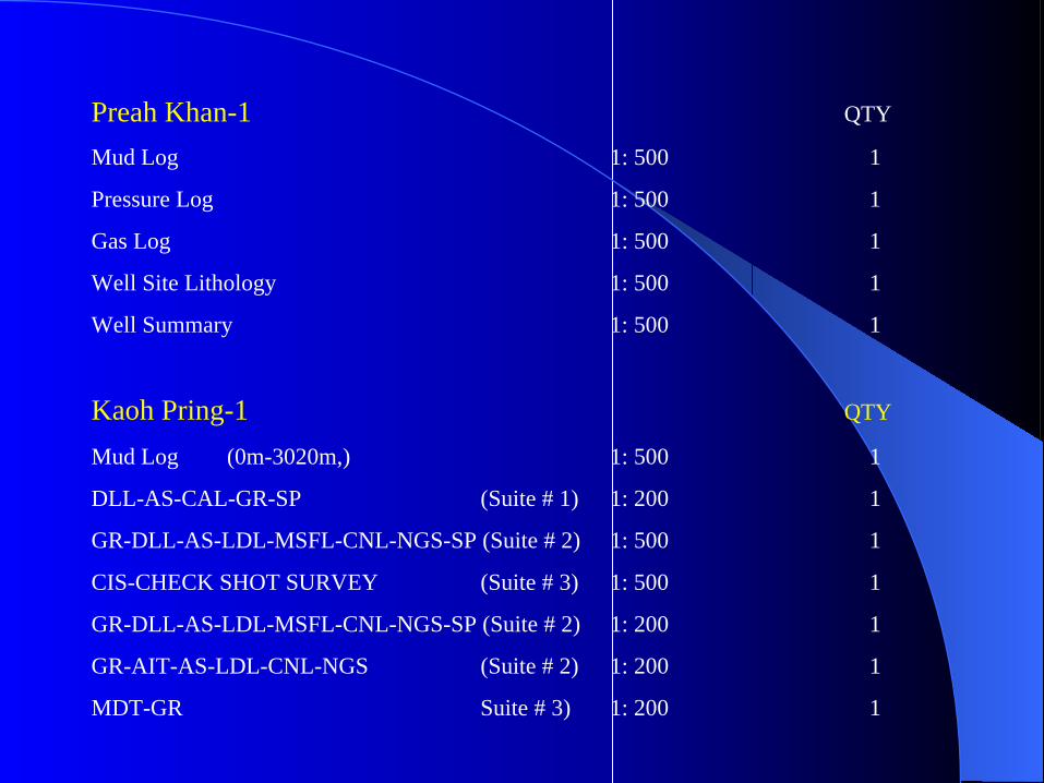
Preah Khan-1 QTY
Mud Log 1: 500 1
Pressure Log 1: 500 1
Gas Log 1: 500 1
Well Site Lithology 1: 500 1
Well Summary 1: 500 1
Kaoh Pring-1 QTY
Mud Log (0m-3020m,) 1: 500 1
DLL-AS-CAL-GR-SP (Suite # 1) 1: 200 1
GR-DLL-AS-LDL-MSFL-CNL-NGS-SP (Suite # 2) 1: 500 1
CIS-CHECK SHOT SURVEY (Suite # 3) 1: 500 1
GR-DLL-AS-LDL-MSFL-CNL-NGS-SP (Suite # 2) 1: 200 1
GR-AIT-AS-LDL-CNL-NGS (Suite # 2) 1: 200 1
MDT-GR Suite # 3) 1: 200 1

1.3. Seismic Surveys
1.3.1 Uninterprated Lines.
1.3.1.a Data Processing Report of the Offshore Cambodia Block I & II
Operator : Enterprise
- Migrated Stack of 2D Seismic Survey 1992 QTY
Scale 1: 50, 000 88
1.3.1.b Data Processing Report of Offshore Cambodia Block III.
Operator : Campex
- Time Migration of 2D Seismic Surevy 1992
Scale 1: 50, 000 11

Uninterpreted (Continued)- Time Migration of 2D Seismic Survey 1992 QTY
Scale 1: 50, 000 76
- Time Migration of 2D Seismic Survey 1992
Scale 1: 25, 000 26
- Final DMO Migration of 2D Seismic Survey 1992.
Scale 1: 25, 000 25
- Filtered & Scaled Migration of 2D Seismic Survey 1994
Scale 1: 25, 000 21
- Filtered & Scaled Migration of 2D Seismic Survey 1994Scale 1: 25, 000 3
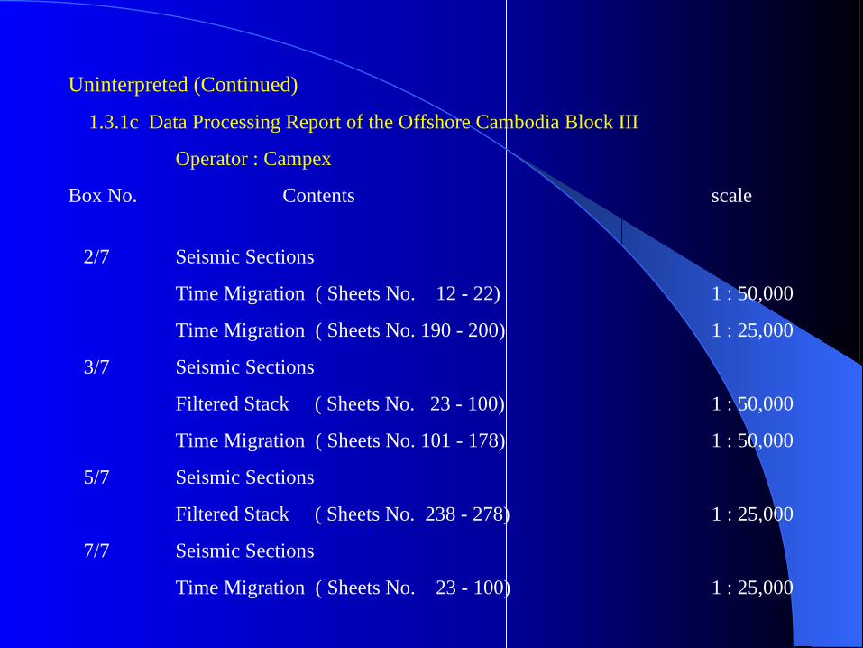
Uninterpreted (Continued)
1.3.1c Data Processing Report of the Offshore Cambodia Block III
Operator : Campex
Box No. Contents scale
2/7 Seismic Sections
Time Migration ( Sheets No. 12 - 22) 1 : 50,000
Time Migration ( Sheets No. 190 - 200) 1 : 25,000
3/7 Seismic Sections
Filtered Stack ( Sheets No. 23 - 100) 1 : 50,000
Time Migration ( Sheets No. 101 - 178) 1 : 50,000
5/7 Seismic Sections
Filtered Stack ( Sheets No. 238 - 278) 1 : 25,000
7/7 Seismic Sections
Time Migration ( Sheets No. 23 - 100) 1 : 25,000

Uninterpreted Lines (Continued) 1.3.1.d . Paper Sections of 1994 2D Seismic Survey QTY
- Filtered & Scaled Migration
1994, 1: 25, 000 44
- Filtered & Scaled Migration
1994, 1: 50, 000 44
1.3.1.e Offshore Cambodia Reprocessing 1994.
- Filtered and Scaled Migration
1992, 1 : 25,000 18
- Filtered and Scaled Migration
1992, 1 : 50,000 18

Uninterpreted Lines (Continued)1.3.1.f Paper Sections of 1994 2D Seismic Survey QTY
- Filtered & Scaled Stack
1994, 1: 25, 000 44
- Filtered & Scaled Stack
1994, 1: 50, 000 44
1.3.1.g Offshore Cambodia Reprocessing 1994.
- Filtered and Scaled Stack
1992, 1 : 25,000 18
- Filtered and Scaled Stack
1992, 1 : 50,000 18

1.3.3 MapsOperatorYearsBlockQTYScaleName of MapNo.
Contoured
2
1: 250,0001: 50,0001: 100,0001: 100,0001: 50.0001: 100,0001: 25,0001: 100,000
14222316
Position MapPosition MapPosition Map
Final Location MapShot point
Position MapDepth MapBase Map
CampexCampexcampexCampexPremierPremier
EnterpriseEnterprise
1992199219921992
199319951996
IIIIIIIIIIIIIVIVI
I & II
12345678
1.3.2 Interpreted Lines
58 lines = 4900 km2 in Block I and II
1.3.4 Interpretation Reports
- Seismic Interpretation (Time Contour Map)

2. Data Acquisition and Technical Work Done by CNPA
2.1. Data Acquisition
2.1.1 Geological Data
The Khmer Basin is elongate and oriented in north-south direction situated between the Khmer shelfto the east and the Central Basin High to west. The basin is approximately 200 km long and 100 kmwide. The thickness of the Tertiary sedements is estimated up to 7,000 meters in the center of the basin.
1.4 Interpretation/Regional Reports (books)
- Report on Seismic Interpretation (Enterprise).
- Interpretation Reports of 3D Survey Block I & II of Offshore Cambodia (Enterprise).
- Regional Study on Petroleum Geology the Extended Area of Block ( Campex).

2.1.2.a 2D Seismic
During 1992 Enterprise acquired 7344 km of 2D seismic data, Split as follows:
3079 km in Block I, 3352 km in Block II and 913 km of regional data in Block III and IV.
The data was acquired by HGS and provided a 2.5 x 2.5 km grid over Block I and II,
and a 20 x 20 km grid over block III and IV. The data was processed by Ensign between
June and October 1992. In addition, Enterprise traded seismic data with Campex to gain
a further 3600km of 2D data over Block III.
By the end of 1998 Woodside Petroleum (Australian Company) was awarded PSCs
for offshore blocks 5 & 6. Woodside acquired 5 000 km of 2D seismic lines.
2.1.2 Geophysical Data
Prior to acquisition of the EO92CB06 survey Enterprise‘s Seismic database over Block I andBlock II consisted of some 800 km of data acquired by Elf during the early 1970’s.

2.1.2.b 3D Seismic
The 2D dataset was considered in adequate for detailed mapping of complex structures foundalong the mergins of the Khmer Basin. The way forward was identified to be the acquisitionof the 3D survey was part of the work commitment for a first licence extension.
The 3D survey was acquired by the vessel M/V Western Atlas between 9 October 1994 and2 December 1994. It covered 860 km2 and comprised over 35,000 subsurface line km of data,creating a normal 40 fold cube of data, with a crossline seperation of 25 m and an in linespacing of 12.5m.
As a result, a total nine Wells were drilled and about 13 675.150 km of 2D seismic lines and1050 km2 of 3D seismic survey were acquired and processed in these offshore blocks by thosecamponies during 1990-1997.
2.1.2.c Gravity and Magnetics
7275 km of marine gravity and 7406 km of marine magnetics were acquired by Edcon inconcurrence with the EO92 survey. The gravity and magnetics data were processed by ARKGeophysics.

2.1.2.d Well Data Table
Dry3018mBlock IV, Khmer Basin1998IdemitsuKaoh Pring-1
Gas Show
Gas Show
Dry
Untested Early Mioc. Oil & Late Olig. Gas Show
1180 BOPD + 1.3MMSCFGD from Early Miocence
Dry
4.7 MMSCFGD + 180BOPD from Early Mioc
224 BOPD + 0.07MMSCFGD from Early Miocence
Dry
Dry
Dry
Hyrocarbon
2437mBlock III, Khmer Ridge1972ElfH-1
1983mBlock IV, Eastern Platform1974ElfB1-1
1714mBlock I, Eastern Basin 1974ElfL-1
3308mBlock III, Khmer Basin1994CampexApsara-1
3744mBlock II, Khmer Basin1996EnterpriseBayon-1
3050mBlock II, Central Sag Margin1996EnterprisePreah Khan-1
3867mBlock IV, Khmer Basin1994PremierKaoh Tang-1
3951mBlock II, Khmer Basin1994EnterpriseAngkor-1
3460mBlock III, Khmer Basin1996CampexPoulo Wai-1
3923mBlock I, Khmer Basin1996EnterpriseDa-1
3207mBlock III, Central Sag Margin1994CampexDevada-1
TDPlayYearOperatorWell
2.2 Technical Work Done by CNPA
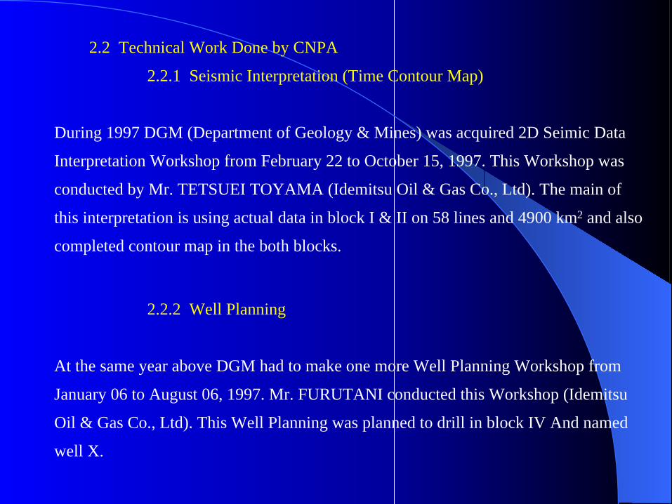
2.2.1 Seismic Interpretation (Time Contour Map)
During 1997 DGM (Department of Geology & Mines) was acquired 2D Seimic Data
Interpretation Workshop from February 22 to October 15, 1997. This Workshop was
conducted by Mr. TETSUEI TOYAMA (Idemitsu Oil & Gas Co., Ltd). The main of
this interpretation is using actual data in block I & II on 58 lines and 4900 km2 and also
completed contour map in the both blocks.
2.2.2 Well Planning
At the same year above DGM had to make one more Well Planning Workshop from
January 06 to August 06, 1997. Mr. FURUTANI conducted this Workshop (Idemitsu
Oil & Gas Co., Ltd). This Well Planning was planned to drill in block IV And named
well X.

End of slide
Thank you