Embed Size (px)
Citation preview
Conceptual approach toREDD+ MRV in the PhilippinesAn Overview
Climate-relevant Forest Policy and Piloting of REDDUpdated Version 2.0June 10, 2013
Prepared by
Imprint
This publication is by the Deutsche Gesellschaft für Internationale Zusammenarbeit through the Climate-relevant Modernization of Forest Policy and Piloting of Reducing Emissions from Deforestation and Forest Degradation (REDD) Project in the Philippines, funded by the German Federal Ministry for the Environment, Nature Conservation and Nuclear Safety (BMU) under its International Climate Initiative. The BMU sup-ports this Initiative based on a decision of the German Parliament. For more information, see http://www.international-climate-initiative.com.
As a federally owned enterprise, GIZ supports the German Government in achieving its objectives in the field of international cooperation for sustainable development.
Published byDeutsche Gesellschaft für Internationale Zusammenarbeit (GIZ) GmbH
Registered officesBonn and Eschborn, GermanyT +49 228 44 60-0 (Bonn)T +49 61 96 79-0 (Eschborn)
ResponsibleDr. Bernd-Markus LissPrincipal AdvisorClimate-relevant Modernization of Forest Policy and Piloting of REDDE: [email protected]
Department of Environment and Natural ResourcesClimate Change Office2nd Floor, FASPO BuildingVisayas Avenue, Quezon City, 1101 Philippines
T: +63 2 929 6626 local 207F: +63 2 829 3374
Source and Copyrights© 2013 Deutsche Gesellschaft für Internationale Zusammenarbeit (GIZ) GmbH
AuthorJörg Seifert-Granzin
Copyright on PhotosThe photos in this publication are owned by GIZ unless otherwise indicated in the photo.
Printed and distributed byDeutsche Gesellschaft für Internationale Zusammenarbeit (GIZ) GmbH
Place and date of publicationManila, PhilippinesJune 2013
Conceptual approach to REDD+ MRV in the Philippines ____________________________________________________________________________________________________________________________________________________________
2
Table of contents
Introduction ................................................................................................................................................................ ............... 3
1. MRV of GHG Emission Reductions and Removals ............................................................................................ 4
1.1 Eligible activities under REDD+ ............................................................................................................................ 4
1.2 The REDD+ pilot environment............................................................................................................................... 4
1.3 The GHG inventory approach ................................................................................................................................. 5
1.4 Deforestation monitoring and accounting ........................................................................................................ 7
1.5 Perspectives of degradation monitoring ......................................................................................................... 11
1.6 Monitoring enhancement of forest carbon stocks ....................................................................................... 12
2. MRV of safeguards compliance .............................................................................................................................. 12
2.1 The scope of the safeguards information system ........................................................................................ 12
2.2 Assessing REDD+ impacts on biodiversity ..................................................................................................... 13
2.3 Assessing socioeconomic impacts ...................................................................................................................... 14
3. MRV within a nested accounting approach ....................................................................................................... 14
4. Outlook ................................................................................................................................................................ ............. 15
Acronyms .................................................................................................................................................................................. 16
References ................................................................................................................................................................ ................ 17
Annex 1: Phased approach of the remote sensing workflow for deforestation detection………………19
Conceptual approach to REDD+ MRV in the Philippines ____________________________________________________________________________________________________________________________________________________________
3
Introduction Reducing Emissions from Deforestation and Forest Degradation, sustainable management of forests, enhancement and conservation of forest carbon stocks (REDD+) is considered one of the most cost-effective options to mitigate climate change. The Conference of the Parties (COP) of the United Nations Framework Convention on Climate Change (UNFCCC) frames REDD+ as one of the building blocks of the post-Kyoto architecture, which has been negotiated in the Ad-hoc Working Group on Long-term Cooperative Action (AWG-LCA) and the Subsidiary Body on Scientific and Technological Advice (SBSTA) over the last 5 years. Although the Parties have not yet concluded on all aspects of REDD+, particularly regarding Measurement, Reporting, and Verification (MRV) of greenhouse gas emission reductions and removals (ERR), early actions can build on the decisions of the COP framing the evolving REDD+ framework.
The project “Climate-relevant Modernization of the National Forest Policy and Piloting of REDD Measures in the Philippines”, funded under the International Climate Initiative of the German Federal Ministry for the Environment, Nature Conservation and Nuclear Safety (BMU), supports the country’s efforts toward forest and climate protection, and the development of appropriate policy and instruments. The project is implemented by the Deutsche Gesellschaft für Internationale Zusammenarbeit (GIZ) GmbH with the Department of Environment and Natural Resources (DENR) as the main partner, in cooperation with local government units (LGUs) and a wide range of stakeholders.
This document introduces the key elements of the Philippines’ MRV approach, which was tested on Leyte Island. Founded in the Philippines National REDD+ Strategy (PNRPS), these elements anticipate UNFCCC decisions, technical guidance and certain standards:
• The design of the MRV system follows the decisions of the COP 16 (“Cancun Agreements”) and COP 17 in Durban (12/CP.17).
• The GHG accounting approach anticipates the IPCC 2006 Guidelines for national GHG Inventories (Eggleston et al. 2006).
• The forest monitoring system builds on recommendations provided by the GOFC-GOLD REDD+ Sourcebook (GOFC-GOLD 2012).
• To provide information on multiple benefits, biodiversity and socioeconomic impacts, the MRV of safeguards anticipates elements of the REDD+ Social and Environmental Standards (REDD+ SES 2012).
• Finally, as the Philippines is committed to implement REDD+ at different levels, the MRV framework anticipates the Technical Recommendations of the Verified Carbon Standard (VCS 2012a) and its Jurisdictional and Nested REDD Initiative (VCS 2012b).
Section 1 introduces the foundations of the GHG MRV approach and its application to the activities eligible under REDD+. Section 2 describes the monitoring approach to assess the socioeconomic and biodiversity impacts. All elements were field-tested and will be adjusted according to future decisions of the government of the Philippines and the COP.
Conceptual approach to REDD+ MRV in the Philippines ____________________________________________________________________________________________________________________________________________________________
4
1. MRV of GHG emission reductions and removals
1.1 Eligible activities under REDD+ With the “Cancun Agreements” (FCCC/CP/2010/7/Add.1), the COP adopted the definition (1/CP.16) of the following mitigation actions in the forest sector of developing country parties:
(a) Reducing emissions from deforestation;
(b) Reducing emissions from forest degradation;
(c) Conservation of forest carbon stocks;
(d) Sustainable management of forests;
(e) Enhancement of forest carbon stocks.
In its current stage, the Philippines’ national MRV scheme focuses on emission reductions and removals (ERR) from planned and unplanned deforestation, enhancement of forest carbon stocks through afforestation and reforestation (agroforestry, assisted natural regeneration, reforestation), and unplanned degradation caused by illegal logging. Conserved forest areas and corresponding carbon stocks are being reported as a residual. ERRs from sustainable management of forests are not yet reported but could be included into the activity-based accounting scheme on request.
The ERR accounting for these three activities follows a common approach established by IPCC: For each eligible activity, appropriate activity data1 and emission factors have to be processed to quantify corresponding carbon fluxes. Both emission factors and activity data have to be combined for each of the eligible activities, anticipating the variability of carbons stocks and fluxes across different forest ecosystems and management practices.
1.2 The REDD+ pilot environment DENR and GIZ chose Leyte Island as a pilot environment. Being part of the Visayan Island in the Philippines, Leyte extends about 180 km north to south and is about 65 km at its width covering roughly 800,300 ha. Forests are concentrated in the Anonang-Lobi Mountain Range in the north-western part of Leyte and around Mt. Nacolod in eastern Leyte. Most forests can be classified as Dipterocarp residual forests, usually degraded but still with pockets of high-volume stands. Forest plantations account for close to 10,000 ha (DfS Deutsche Forstservice GmbH 2013a).
1 According to IPCC, LULUCF GPG 2003 activity data refer to data on the magnitude of human activity resulting in emissions or removals taking place during a given period of time. Emission factors are coefficients that relate the activity data to the amount of chemical compound, which is the source of later emissions. Emission factors are often based on a sample of measurement data, averaged to develop a representative rate of emission for a given activity level under a given set of operating conditions.
Conceptual approach to REDD+ MRV in the Philippines ____________________________________________________________________________________________________________________________________________________________
5
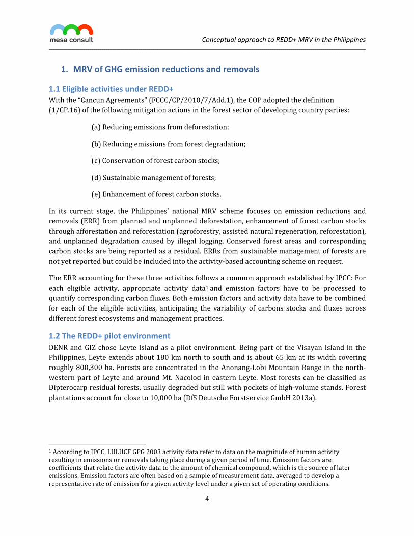
The REDD+ pilot area in Southern Leyte covers 47 forested barangays (villages) within the municipalities of Silago, Bontoc, Tomas Oppus, Sogod and Maasin (cf. Figure 1). The topography is characterized by rolling hills with intersecting valleys, with some steep mountains in Sogod and Silago. According to radar-based results of the forest monitoring for 2010 (cf. Section 1.4), the forested area extends to about 30,000 ha. The dominant forest type is Dipterocarp residual forest, often dissected and mixed with coconut palms. The forests are threatened by degradation (uncontrolled wood harvesting) and deforestation mainly for agriculture and coconuts.
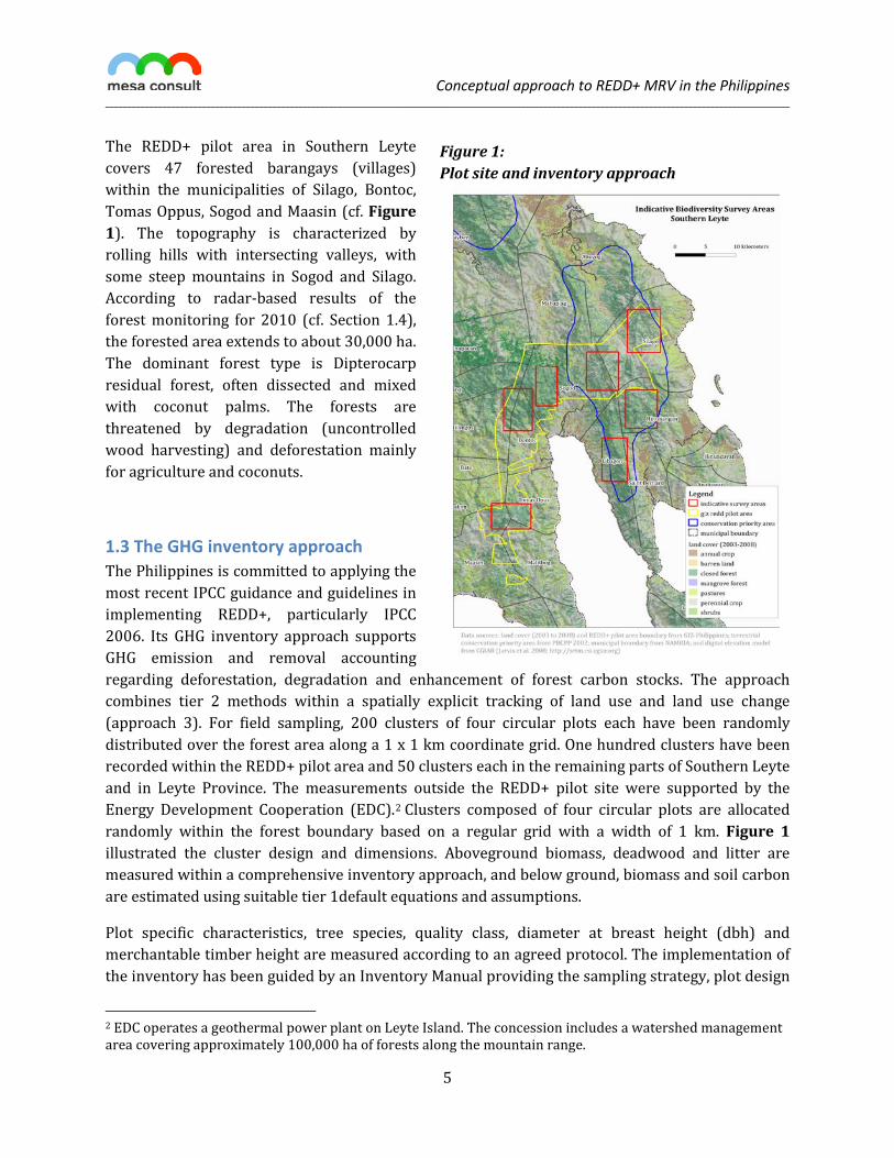
1.3 The GHG inventory approach The Philippines is committed to applying the most recent IPCC guidance and guidelines in implementing REDD+, particularly IPCC 2006. Its GHG inventory approach supports GHG emission and removal accounting regarding deforestation, degradation and enhancement of forest carbon stocks. The approach combines tier 2 methods within a spatially explicit tracking of land use and land use change (approach 3). For field sampling, 200 clusters of four circular plots each have been randomly distributed over the forest area along a 1 x 1 km coordinate grid. One hundred clusters have been recorded within the REDD+ pilot area and 50 clusters each in the remaining parts of Southern Leyte and in Leyte Province. The measurements outside the REDD+ pilot site were supported by the Energy Development Cooperation (EDC).2 Clusters composed of four circular plots are allocated randomly within the forest boundary based on a regular grid with a width of 1 km. Figure 1 illustrated the cluster design and dimensions. Aboveground biomass, deadwood and litter are measured within a comprehensive inventory approach, and below ground, biomass and soil carbon are estimated using suitable tier 1default equations and assumptions.
Plot specific characteristics, tree species, quality class, diameter at breast height (dbh) and merchantable timber height are measured according to an agreed protocol. The implementation of the inventory has been guided by an Inventory Manual providing the sampling strategy, plot design
2 EDC operates a geothermal power plant on Leyte Island. The concession includes a watershed management area covering approximately 100,000 ha of forests along the mountain range.
Figure 1: Plot site and inventory approach
Conceptual approach to REDD+ MRV in the Philippines ____________________________________________________________________________________________________________________________________________________________
6
and measurement protocols (DfS Deutsche Forstservice GmbH 2011). A MS Access 2010 database has been developed to store and process the field measurements. The final inventory results have been compiled, analyzed and documented (DfS Deutsche Forstservice GmbH 2013a):
“According to the FRA results, the average bole volume amounts to 180 m3/ha. The average above-ground tree biomass in Leyte island reaches 255 tons per ha, equal to 127.4 tons of carbon/ha. Forest tree carbon accounted for 96.7% of all forest carbon, deadwood carbon for 1.7%, litter for 1.3%, and mangroves for 0.3%. The average tree volume and biomass measured in 2012 were 20% lower than recorded during the RP-German Forest Resources Inventory (FRI) in 1986/87. Especially, the commercial diameter classes of 40 cm and above contained much less timber, only 64% of the volume recorded in 1987. This reflects a severe forest degradation resulting in the loss of 30.3 tons of carbon per ha.”
Figure 2: Cluster design and allocation
Distance 50 m
12 m radius 452 m²– trees > 20 cm DBH
6 m radius 113 m² – trees 06-20 cm DBH
Source: DfS Deutsche Forstservice GmbH (2011)
Table 1 provides the carbon densities for the three pools measured inside the REDD+ pilot site and the whole island.
Table 1: Measured carbon densities for REDD+ Carbon pool Leyte Island [t/ha] REDD+ pilot site [t/ha] Aboveground biomass 127.4 102.0 Aboveground biomass mangroves 20.6 Deadwood 2.2 1.7 Litter 1.7 1.7 Belowground biomass* 25.1 20.7
Source: DfS Deutsche Forstservice GmbH 2013a. * Estimated applying default allometrics for tropical forests (Pearson, Walker, and Brown 2005).

Conceptual approach to REDD+ MRV in the Philippines ____________________________________________________________________________________________________________________________________________________________
7
The measurements indicate that the forests within the REDD+ pilot site have been more degraded than the forested areas covering the mountain range.
1.4 Deforestation monitoring and accounting As with other tropical countries, the Philippines is facing the challenge of limited availability of suitable remote sensing data to detect past and current deforestation patterns. To assess past deforestation patterns, three tasks focusing on the processing of optical and radar data have to be conducted:
(1) Multispectral optical data (Landsat TM/ETM, SPOT) is being processed to assess the deforestation of the period 1990–2000. Images are being preprocessed, radiometrically corrected and processed jointly to detect land use changes. Clouded areas are masked out and processed separately using radar data (JERS-1, ERS 1/2).
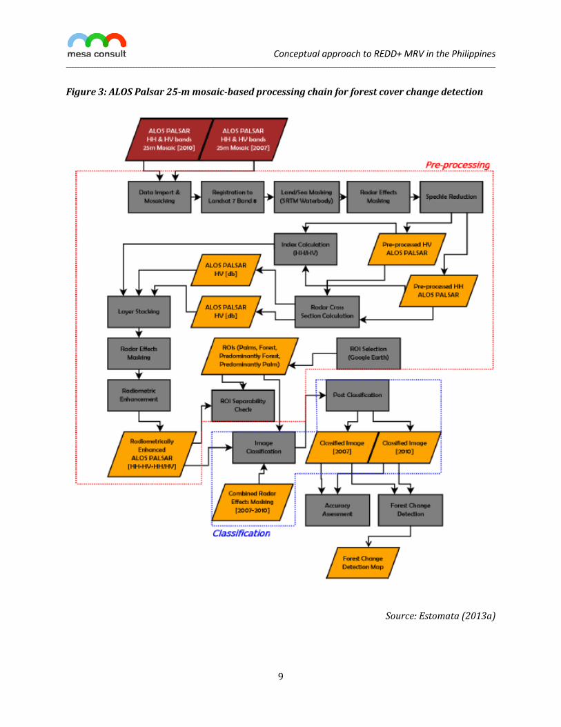
(2) Due to the limited availability of optical data, radar data have been processed for the period 2007–2010. Peer-reviewed methodologies (Almeida-Filho et al. 2009; Mitchard et al. 2011) were adjusted to the circumstances of the Philippines. The accuracy of the deforestation analysis has been step-wise increased, testing the processing chain with medium resolution (50 m) Alos Palsar 50-m Kyoto & Carbon coverage (Figure 2) to fully apply it to FBD 25-m Palsar mosaics.
(3) Deforestation during the period 2000–2007 will be detected using a synergetic approach combing multispectral optical and microwave processing (Lehmann et al. 2012).
So far, task 2 has been concluded and comprehensively documented. Together with the Institute of Geodetic Engineering of the University of the Philippines and Fauna & Flora International (FFI), several step-by-step training manuals have been developed:
• LANDSAT Step-by-step Processing Manual: Feature Extraction Processing Using LANDSAT 7 ETM+ (Tavora et al. 2011);
• ALOS PALSAR 50-meter Mosaic Step-by-step Processing Manual on Forest Cover Classification (Monzon et al. 2012); and
• ALOS PALSAR 25-meter Mosaic Step-by-step Manual on Extraction of Forest Cover and Change Detection Analysis (Estomata 2013a) and the documentation of the results (Estomata 2013b).
The 3rd Kyoto and Carbon Science Program operated by the Japan Aerospace Exploration Agency (JAXA) kindly collaborated by providing ALOS Palsar fine beam dual-polarization 25-m mosaic data of 2007, 2008, 2009 and 2010 covering the whole Philippines for free. In close cooperation with the Institute of Geodetic Engineering of the University of the Philippines and Fauna & Flora International (FFI), GIZ implemented a forest cover and forest cover change detection methodology, which was applied to the ALOS Palsar 25-m mosaics of 2007 and 2010 (ibid.). Figure 3 illustrates the approach further detailed in Estomata 2013a,b.
Conceptual approach to REDD+ MRV in the Philippines ____________________________________________________________________________________________________________________________________________________________
8
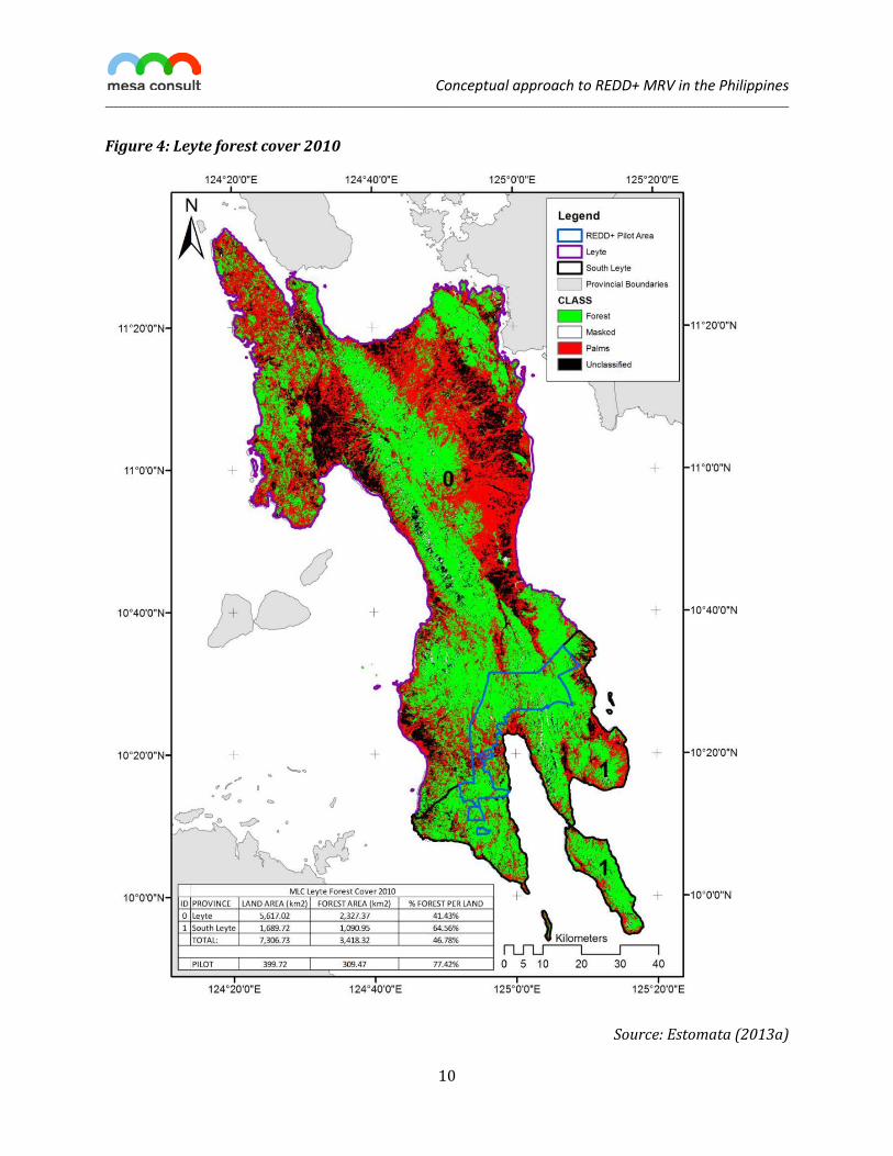
The forest cover change detection revealed that a total of 55,103 ha (2.68%) were deforested during 2007-2010, whereas 50,041 ha (2.43%) were changed from non-forest to forest, corresponding to a net deforestation by 5,062 ha (0.25%) for the entire Island of Leyte (ibid.). However, these results are still affected by the confusion between forest and palm stands, which are difficult to distinguish. An initial verification exercise using Google Earth as a reference shows that the Producer’s Accuracy for Palm is only 67.6% for 2010 and even lower for 2007 at only 56.5%, whereas the Producer’s and User’s Accuracy of the forest class reaches 90.8% to 94.3%. Further work is required to improve the separation of forest and palm stands. For 2010, an overall accuracy of 87% was achieved, whereas the accuracy of the 2007 forest cover map reached 86.3%. Figure 4 presents the 2010 forest cover map.
Conceptual approach to REDD+ MRV in the Philippines ____________________________________________________________________________________________________________________________________________________________
9
Figure 3: ALOS Palsar 25-m mosaic-based processing chain for forest cover change detection
Source: Estomata (2013a)
Conceptual approach to REDD+ MRV in the Philippines ____________________________________________________________________________________________________________________________________________________________
10
Figure 4: Leyte forest cover 2010
Source: Estomata (2013a)
Conceptual approach to REDD+ MRV in the Philippines ____________________________________________________________________________________________________________________________________________________________
11
Combining the detected gross deforestation rate of 55,103 ha for a 3-year period with the measured carbon densities (cf. Table 1) indicates a carbon loss of 2.87 Mt/year.
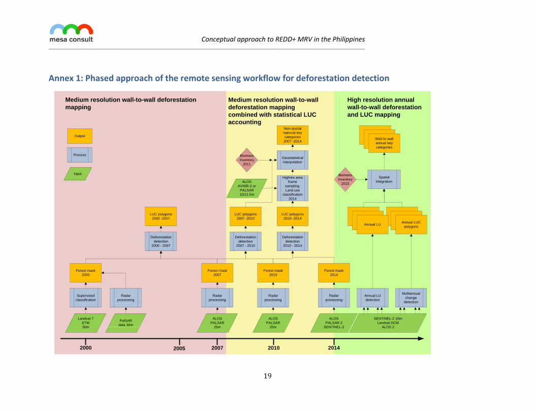
Future deforestation monitoring will rely on the availability of new sensors (e.g. Sentinel 2, ALOS Palsar 2) and methods. A roadmap for future image processing has been developed anticipating current and future sensor technologies (Annex 1).
1.5 Perspectives of degradation monitoring Although project-based activities could opt for monitoring specific degradation activities (illegal logging, fuelwood extraction and charcoal production), the national MRV scheme will focus on illegal logging only. The limited availability of optical remote sensing imagery makes it impossible to generate reliable activity data on degradation for past reporting periods at the national level. Consequently, the Philippines’ national MRV system is pursuing an indirect approach (GOFC-GOLD 2012), quantifying the net decrease of carbon stocks in the category “Forest land remaining forest land”. Three approaches will be tested and compared in the near future:
Information on canopy closure can be used to identify degraded forest strata, for which the forest inventory would have to provide carbon stock measurements. This approach requires higher resolution data acquired during different seasons. Once the forthcoming Sentinel-2 sensor reaches its operation status expected for early 2014, the data requirements can be met. For the time being, Landsat 8 data available since April 2013 shall be tested.
Spatial features (roads, settlements, rivers) and concepts (e.g. access, proximity) can be used to determine the boundaries of degraded strata conservatively (distinction between intact and non-intact forest following GOFC-GOLD [2012]). Although applying this approach to Leyte would tag almost all forests as non-intact, this approach might be suitable for bigger islands such as Luzon or Mindanao, which have extensive intact forest stands.
Direct radar-based biomass assessments might soon become a third option to assess degradation on islands with aboveground biomass densities below 150-180 t/ha. Although the direct radar-based biomass methods using L-band SAR data are well founded by recent research (Englhart, Keuck and Siegert 2011; Mitchard et al. 2011; Ryan et al. 2012; Mermoz et al. submitted), the ALOS Palsar 2 sensor needs to become operational until March 2014.
All modes imply that carbon benefit can only be achieved if recovering degraded areas maintain their size or increase over time. Performance gains due to a successful reduction of degradation practices would only materialize in the long run by repeating the forest inventory (approach 1 and 2) or ongoing remote sensing-based aboveground biomass monitoring (approach 3).
Conceptual approach to REDD+ MRV in the Philippines ____________________________________________________________________________________________________________________________________________________________
12
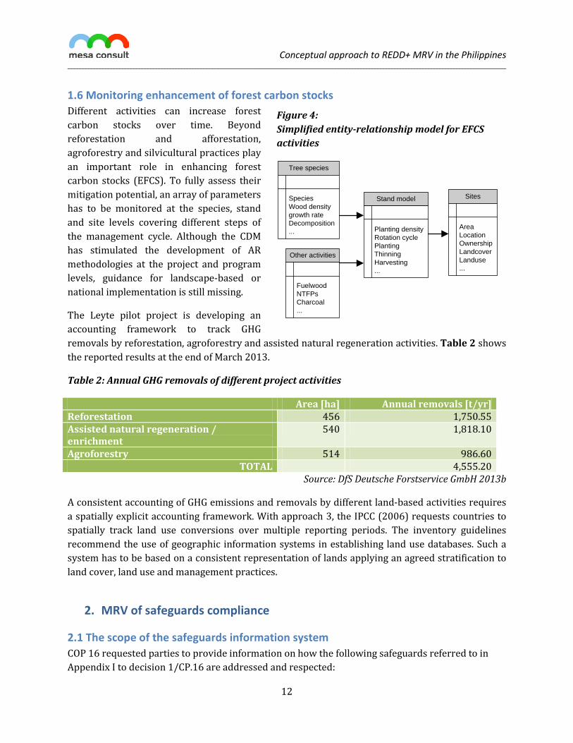
Figure 4: Simplified entity-relationship model for EFCS activities
Tree species
Species Wood density growth rate Decomposition ...
Stand model
Planting density Rotation cycle Planting Thinning Harvesting ...
Sites
Area Location Ownership Landcover Landuse ...
Other activities
Fuelwood NTFPs Charcoal ...
1.6 Monitoring enhancement of forest carbon stocks Different activities can increase forest carbon stocks over time. Beyond reforestation and afforestation, agroforestry and silvicultural practices play an important role in enhancing forest carbon stocks (EFCS). To fully assess their mitigation potential, an array of parameters has to be monitored at the species, stand and site levels covering different steps of the management cycle. Although the CDM has stimulated the development of AR methodologies at the project and program levels, guidance for landscape-based or national implementation is still missing.
The Leyte pilot project is developing an accounting framework to track GHG removals by reforestation, agroforestry and assisted natural regeneration activities. Table 2 shows the reported results at the end of March 2013.
Table 2: Annual GHG removals of different project activities
Area [ha] Annual removals [t/yr] Reforestation 456 1,750.55 Assisted natural regeneration / enrichment
540 1,818.10
Agroforestry 514 986.60 TOTAL 4,555.20
Source: DfS Deutsche Forstservice GmbH 2013b
A consistent accounting of GHG emissions and removals by different land-based activities requires a spatially explicit accounting framework. With approach 3, the IPCC (2006) requests countries to spatially track land use conversions over multiple reporting periods. The inventory guidelines recommend the use of geographic information systems in establishing land use databases. Such a system has to be based on a consistent representation of lands applying an agreed stratification to land cover, land use and management practices.
2. MRV of safeguards compliance
2.1 The scope of the safeguards information system COP 16 requested parties to provide information on how the following safeguards referred to in Appendix I to decision 1/CP.16 are addressed and respected:
Conceptual approach to REDD+ MRV in the Philippines ____________________________________________________________________________________________________________________________________________________________
13
(1) Consistency with the objectives of national forest programmes and relevant international conventions;
(2) Transparent and effective national forest governance structures; (3) Respect for the knowledge and rights of indigenous peoples and members of local
communities; (4) The full and effective participation of relevant stakeholders; (5) Consistency with the conservation of natural forests and biological diversity; (6) Actions to address the risks of reversals; (7) Actions to reduce displacement of emissions.
Decision 12/CP.17 of the COP held in Durban 2011 established that parties should periodically provide a summary of information on safeguards to be included in national communications. Although parties have not yet agreed on reporting methods or approaches, several safeguards monitoring and reporting frameworks are emerging (Roe et al. 2013). The Leyte pilot project builds on the requirements established by the REDD+ Social and Environmental Standards (REDD+ SES 2012). The project identified and develops key elements to be anticipated in the emerging safeguards information framework, particularly in the field of biodiversity and socioeconomic impact assessment. In both areas, a before/after-control/intervention (BACI) approach (Smith 2002) is being followed, which can be extended according to future reporting requirements.
2.2 Assessing REDD+ impacts on biodiversity REDD+ biodiversity impact monitoring builds on three data sources:
(1) The forest inventory already provides information about tree species diversity, forest resilience (changes in the deadwood pool), standing timber volume and vegetation structure, which will be extracted, analyzed and reported.
(2) The deforestation monitoring provides complementary data (deforestation rates and patterns) for a forest fragmentation analysis, which can be related to other sources on biodiversity distribution.
(3) To establish the basis for future monitoring efforts, the project implemented a comprehensive biodiversity inventory following a partial3 BACI approach (Fauna & Flora International 2012). The biodiversity inventory (cf. Figure 1) assessed habitat characteristics, species richness, (key) species population, occupancy and habitat extent inside and outside the pilot site. In order to assess the interplay of habitat and disturbance variables to the key tree species, tree community ordination was done by canonical correspondence analysis (CCA).
Although a partial inventory cannot provide for a comprehensive analysis of all potential project or program impacts, it can guide future efforts to achieve a full BACI design. The inventory results
3 The compliance with the BACI design has to be considered partial as the Philippines does not count with biodiversity inventories reflecting the situation before the project started. However, the current inventory results will serve as a reference for future inventory efforts on Leyte, which will contribute to full compliance with the BACI design.
Conceptual approach to REDD+ MRV in the Philippines ____________________________________________________________________________________________________________________________________________________________
14
clearly indicate that anthropogenic disturbances such as “Kaingin”, illegal hunting of wildlife and conversion of land use to abaca, banana and mahogany plantations “influenced the diversity of species in the surveyed localities where the lowest diversity was observed in cultivated areas” (ibid.).
2.3 Assessing socioeconomic impacts To capture the future socioeconomic impacts of REDD+, a baseline survey has been conducted in 71 barangays (597 households) inside and 22 barangays (200 households) outside the project site (Armenia et al. 2012). The comprehensive survey assesses the differences between households based on eight indicator sets:
• Socio-demographic characteristics of households and communities; • Credit and loan information; • Marketing of farm products; • Access to land and natural resources; • Farm characteristics and upland farming system; • Income and expenditure; • Household characteristics, amount of income and expenditure by income clusters; • Environmental activities and awareness.
Future monitoring efforts will be based on key indicators selected from each of the eight indicator sets. As barangays have been used as a spatial reporting unit, the survey and the monitoring framework can be embedded into the spatiotemporal reporting framework to be established within a geodatabase. This approach allows relating socioeconomic changes to changes in deforestation patterns and vice versa. The current results will serve as a benchmark or “before” reference according to the BACI design for any future efforts to nest the Leyte pilot into a national REDD+ scheme.
3. MRV within a nested accounting approach As framed by the PNRPS (DENR-FMB and CoDe REDD-plus Philippines 2010), the Philippines is committed to implement REDD+ at different levels. The MRV approach for emission reductions, removals and safeguards outlined so far anticipates the technical requirements of the Verified Carbon Standard (VCS 2012a) and its Jurisdictional and Nested REDD Initiative (VCS 2012b). To fully meet those requirements, the MRV system will operate within temporal boundaries established by forthcoming COP decisions and the emerging national REDD+ framework.
In particular, the system will report on
• GHG impacts caused by natural disturbances in general, excluding disturbances affecting ≥1,000 ha from geologic impacts (i.e. volcanos and landslides) and hurricanes with a return interval of >10 years;
• Changes in the stratification with a special focus on activity data related to degradation impacts;
Conceptual approach to REDD+ MRV in the Philippines ____________________________________________________________________________________________________________________________________________________________
15
• Trends and impacts on deforestation drivers and underlying causes; and • Leakage occurring at the project level operating within a subnational accounting
framework.
The MRV system will anticipate the forthcoming reporting format provided by VCS’s JNRI, which will be consistent with IPCC’s reporting requirements. Going beyond IPCC, the JNRI established specific accuracy and precision requirements to operationalize the conservativeness principle in GHG emission and removal accounting. In instances where these accuracy and precision benchmarks will not be met, the MRV system will either apply the conservative discounting rules or improve the accuracy by applying suitable corrective actions (e.g. by increasing the sampling density in certain strata).
4. Outlook REDD+ imposed substantial monitoring and measurement requirements on the participants. Finding the right level of detail considering the scale and implementation level is still considered a challenge. The Leyte pilot project features MRV tools that can be used at different levels. They will have to be complemented and adjusted considering the forthcoming COP decisions on MRV, related technical requirements established by the most recent IPCC guidance and guidelines, and VCS’s JNRI. The technical options of MRV of GHG emissions and removals also frame the characteristics of the reference level. Actually, the REL design has to be based on what can be monitored through applying an operational MRV framework at the national scale.
MRV of GHG emissions, removals and safeguards compliance is closely linked. Rather than constructing parallel disconnected reporting frameworks, the links and synergies between them have to be explored and tested: Linking the occupancy modelling and remote sensing-based disturbance detection seems to be a promising approach. Along this line, spatially explicit socioeconomic income scenarios could be developed using estimates of financial incentives derived from past deforestation patterns as a proxy for the future avoidance potential.
As the UNFCCC parties have not yet concluded on MRV modalities, the MRV framework has to adjust to both the emerging multilateral framework and the evolving JNRI modalities. Besides, technology change in earth observation provides for new remote sensors and methodologies. As launches of several new terrestrial sensors (ALOS Palsar 2, Sentinel 2, SPOT6) have been announced for 2014, methodologies for activity data measurement will have to be adjusted in the near future.
So far, degradation remains an uncharted territory. The current methodological options are either so conservative that it might be hard to achieve any measurable emission reductions on the medium term or they are still experimental. The development of practical approaches will be one of the challenges of the forthcoming years once new sensor technologies have become available.

Conceptual approach to REDD+ MRV in the Philippines ____________________________________________________________________________________________________________________________________________________________
16
Acronyms A/R Afforestation and reforestation
BACI “Before/After-Control/Intervention” model
BIP Biodiversity Indicators Partnership
BMU German Federal Ministry for the Environment, Nature Conservation and Nuclear Safety
CCA Canonical correspondence analysis
CCBA Climate, Community and Biodiversity Alliance
CCBS Climate, Community and Biodiversity Standards
CDM Clean development mechanism
COP Conference of the Parties
DENR Department for Environment and Natural Resources
EFCS Enhancement of forest carbon stocks
ERR Emission reductions and removals
GHG Greenhouse gases
FRA Forest resources assessment
GOFC-GOLD Global Observation of Forest and Land Cover Dynamics
IPCC Intergovernmental Panel on Climate Change
JAXA Japan Aerospace Exploration Agency
KBA Key biodiversity area
LULUCF Land use, land use change and forestry
MRV Measurement, reporting and verification
NGP National Greening Program
PNRPS Philippines National REDD+ Strategy
REDD+ Reducing Emissions from Deforestation and Forest Degradation, conservation, sustainable management of forests and enhancement of carbon stocks
SAR Synthetic aperture radar
SBSTA Subsidiary Body on Scientific and Technological Advice
UNFCCC United Nations Framework Convention on Climate Change
VCS Verified Carbon Standard
Conceptual approach to REDD+ MRV in the Philippines ____________________________________________________________________________________________________________________________________________________________
17
References
Almeida-Filho, R., Y. E. Shimabukuro, A. Rosenqvist, and G. A. Sánchez. 2009. “Using Dual-polarized ALOS PALSAR Data for Detecting New Fronts of Deforestation in the Brazilian Amazônia.” International Journal of Remote Sensing 30 (14) (July): 3735–3743. doi:10.1080/01431160902777175.
Armenia, Pedro T., Salome B. Bulayog, Teofanes A. Patindol, Nelfa M. Glova, and Moises Neil V. Seriño. 2012. “Socio-economic Baseline for the REDD+ Project Sites in Southern Leyte, Philippines”. Deutsche Gesellschaft für Internationale Zusammenarbeit (GIZ) GmbH.
DENR-FMB, and CoDe REDD-plus Philippines. 2010. “DENR-FMB Department of Environment and Natural Resources – Forest Management Bureau and CoDe REDD-plus Philippines 2010: The Philippine National REDD-plus Strategy.”
DfS Deutsche Forstservice GmbH. 2011. “Manual for Assessment of Field Sampling Points for Monitoring of REDD+ Activities on Leyte and Panay Island, Philippines. Version 5. GIZ German Technical Cooperation with the Philippines. Climate Relevant Forest Policy and Piloting of REDD.”
———. 2013a. “Forest Carbon Baseline Study Leyte. Draft Report. GIZ German Technical Cooperation with the Philippines. Climate Relevant Forest Policy and Piloting of REDD.”
———. 2013b. “EFCS Accounting for the Leyte Pilot Project. Excel File. GIZ German Technical Cooperation with the Philippines. Climate Relevant Forest Policy and Piloting of REDD.”
Eggleston, H.S., L. Buendia, K. Miwa, T. Ngara, and K. Tanabe, ed. 2006. 2006 IPCC Guidelines for National Greenhouse Gas Inventories. Vol. 4: Agriculture, Forestry, and Other Land Use. IGES, Japan.
Englhart, S., V. Keuck, and F. Siegert. 2011. “Aboveground Biomass Retrieval in Tropical Forests — The Potential of Combined X- and L-band SAR Data Use.” Remote Sensing of Environment 115 (5): 1260–1271. doi:10.1016/j.rse.2011.01.008.
Estomata, Mari Trix L. 2013a. “ALOS PALSAR 25-meter Mosaic Step-by-step Manual on Extraction of Forest Cover and Change Detection Analysis”. Deutsche Gesellschaft für Internationale Zusammenarbeit (GIZ) GmbH.
———. 2013b. “Support to Processing of Remote Sensing Data for the Establishment of a Pilot MRV System for REDD+ on Leyte Island. GIZ German Technical Cooperation with the Philippines. Climate Relevant Forest Policy and Piloting of REDD.”
Fauna & Flora International. 2012. “Final Report: Biodiversity Assessment in Southern Leyte. Biodiversity Baseline Assessment in the REDD+ Pilot Area on Leyte Lsland as an Input for the Elaboration of a MRV System for REDD+ Including Biodiversity Co-benefits Project.”
GOFC-GOLD. 2012. A Sourcebook of Methods and Procedures for Monitoring and Reporting Anthropogenic Greenhouse Gas Emissions and Removals Caused by Deforestation, Gains and Losses of Carbon Stocks in Forests Remaining Forests, and Forestation. GOFC-GOLD Report version COP18-1. Alberta, Canada: GOFC-GOLD Land Cover Project Office, Wageningen University, The Netherlands.
Lehmann, E.A., P.A. Caccetta, Zheng-Shu Zhou, S.J. McNeill, Xiaoliang Wu, and A.L. Mitchell. 2012. “Joint Processing of Landsat and ALOS-PALSAR Data for Forest Mapping and Monitoring.”
Conceptual approach to REDD+ MRV in the Philippines ____________________________________________________________________________________________________________________________________________________________
18
IEEE Transactions on Geoscience and Remote Sensing 50 (1): 55–67. doi:10.1109/TGRS.2011.2171495.
Mermoz, Stephane, Thuy LeToan, Ludovic Villard, Maxime Réjou-Méchain, and Jörg Seifert-Granzin. submitted. “Biomass Assessment in Cameroon Savanna Using ALOS PALSAR Data.” Remote Sensing of Environment
Mitchard, E.T.A., S.S. Saatchi, S.L. Lewis, T.R. Feldpausch, I.H. Woodhouse, B. Sonké, C. Rowland, and P. Meir. 2011. “Measuring Biomass Changes Due to Woody Encroachment and Deforestation/degradation in a Forest–savanna Boundary Region of Central Africa Using Multi-temporal L-band Radar Backscatter.” Remote Sensing of Environment 115 (11) (November): 2861–2873. doi:10.1016/j.rse.2010.02.022.
Monzon, Angelica Kristina, Rosario Ang, Francisco Tavora, Enrico Paringit, Jose Don de Alban and Mari Trix Estomata. 2012. “ALOS PALSAR 50-meter Mosaic Step-by-step Processing Manual on Forest Cover Classification”. Deutsche Gesellschaft für Internationale Zusammenarbeit (GIZ) GmbH.
Pearson, Timothy, Sarah Walker, and Sandra Brown. 2005. “Sourcebook for Land Use, Land-Use Change an Forestry Projects”. BioCarbon Fund /Winrock International.
REDD+ SES. 2012. “REDD+Social & Environmental Standards. Version 2.” http://www.redd-standards.org/files/REDDSES_Version_2/REDDSES_Version_2_-_10_September_2012.pdf.
Roe, Stephanie, Charlotte Streck, Luke Pritchard, and John Costenbader. 2013. “Safeguards in REDD+ and Forest Carbon Standards: A Review of Social, Environmental and Procedural Concepts and Application”. Climate Focus.
Ryan, Casey M., Timothy Hill, Emily Woollen, Claire Ghee, Edward Mitchard, Gemma Cassells, John Grace, Iain H. Woodhouse, and Mathew Williams. 2012. “Quantifying Small-scale Deforestation and Forest Degradation in African Woodlands Using Radar Imagery.” Global Change Biology 18 (1) (January): 243–257. doi:10.1111/j.1365-2486.2011.02551.x.
Smith, Eric P. 2002. “BACI Design.” In Encyclopedia of Environmetrics. Chichester: John Wiley & Sons, Ltd.
Tavora, Francisco, Julius Bañgate, Jörg Seifert-Granzin and Mari Trix Estomata. 2011. “LANDSAT Step-by-step Processing Manual: Feature Extraction Processing Using LANDSAT 7 ETM+”. Deutsche Gesellschaft für Internationale Zusammenarbeit (GIZ) GmbH.
VCS. 2012a. “Agriculture, Forestry and Other Land Use (AFOLU) Requirements. Requirements Document Version 3.2, 1. February, 2012”. Verified Carbon Standard.
———. 2012b. “Jurisdictional and Nested REDD+ (JNR) Requirements. Proposal for Inclusion of Jurisdictional and Nested REDD+.Public Consultation Document.” http://v-c-s.org/sites/v-c-s.org/files/Jurisdictional%20and%20Nested%20REDD%2B%20Requirements%201May.pdf.
Conceptual approach to REDD+ MRV in the Philippines ____________________________________________________________________________________________________________________________________________________________
19
Annex 1: Phased approach of the remote sensing workflow for deforestation detection
Landsat 7 ETM30m
ALOS PALSAR
25m
Supervisedclassification
Forest mask2000
Forest mask2010
LUC polygons2007 -2010
Deforestationdetection
2007 - 2010
Radar processing
Highres area frame
sampling: Land use
classification 2014
2000 2005 2007 2010
Radar processing
PolSAR data 30m
ALOS AVNIR-2 or
PALSAR10/12.5m
ALOS PALSAR
25m
Forest mask2007
Radar processing
Deforestationdetection
2000 - 2007
Non-spatial national key categories2007 -2014
LUC polygons2000 -2007
ALOS PALSAR 2
SENTINEL-2
Forest mask2014
Radar processing
2014
SENTINEL-2 10mLandsat DCM
ALOS 2
Multiannual change
detection
Annual LU detection
Annual LUC polygonsAnnual LUC
polygonsAnnual LUC polygons
Annual LUC polygonsAnnual LUC
polygonsAnnual LU
Spatial integration
Geostatistical interpolation
Annual LUC polygonsAnnual LUC
polygonsWall-to-wall annual key categories
Biomass Inventory
2015
Biomass Inventory
2011
LUC polygons2010 -2014
Deforestationdetection
2010 - 2014
Output
Process
Input
Medium resolution wall-to-wall deforestation mapping
High resolution annualwall-to-wall deforestation and LUC mapping
Medium resolution wall-to-wall deforestation mapping combined with statistical LUC accounting